Christchurch City Council
Agenda
Notice of Meeting Te Pānui o te Hui:
An ordinary meeting of the Christchurch
City Council will be held on:
Date: Wednesday 6 August 2025
Time: 9.30 am
Venue: Boardroom, Fendalton Service Centre, Corner
Jeffreys and Clyde Roads, Fendalton
Membership
|
Chairperson
Deputy Chairperson
Members
|
Mayor Phil Mauger
Deputy Mayor Pauline Cotter
Councillor Kelly Barber
Councillor Melanie Coker
Councillor Celeste Donovan
Councillor Tyrone Fields
Councillor James Gough
Councillor Tyla Harrison-Hunt
Councillor Victoria Henstock
Councillor Yani Johanson
Councillor Aaron Keown
Councillor Sam MacDonald
Councillor Jake McLellan
Councillor Andrei Moore
Councillor Mark Peters
Councillor Tim Scandrett
Councillor Sara Templeton
|
30 July 2025
Website: www.ccc.govt.nz
TABLE OF CONTENTS NGĀ IHIRANGI
Karakia Tīmatanga................................................................................................... 5
1. Apologies Ngā Whakapāha................................................................................. 5
2. Declarations of Interest Ngā Whakapuaki Aronga.................................................. 5
3. Public
Participation Te Huinga
Tūmatanui............................................................ 5
3.1 Public Forum Te Huinga Whānui.......................................................................................... 5
3.2 Deputations by
Appointment Ngā Huinga Whakaritenga...................................................... 5
4. Presentation
of Petitions Ngā
Pākikitanga............................................................ 5
Council
5. Council
Minutes - 2 July 2025.............................................................................. 7
6. Council
Minutes - 11 June 2025.......................................................................... 15
7. Council
Minutes - 16 July 2025........................................................................... 25
Committee Minutes Reports
8. Health,
Safety and Wellbeing Committee Minutes - 27 June 2025........................... 37
9. Civic
Awards Committee Minutes - 14 July 2025................................................... 41
Community Board Monthly
Reports
10. Monthly
Report from the Community Boards - July 2025....................................... 45
Community Board Part A
Reports
11. Oaklands
School Safety Improvements - Dunbars Road Signalised Crossing........... 111
12. Knights
Stream School Safety Improvement - Signalised Crossing on Halswell Junction
Road............................................................................................................ 137
13. Barrington/Frankleigh/Milton
Intersection Improvements.................................. 161
14. Spreydon,
Somerfield, Waltham, Beckenham CRAF - Selwyn Street pedestrian and cycle safety
improvements..................................................................................... 173
15. Spreydon,
Somerfield, Waltham, Beckenham CRAF - Lyttelton Street safety improvements............................................................................................... 203
Staff Reports
16. Development
Contributions Remission Application - The Arts Centre.................... 221
17. 151/153
Gilberthorpes Road - Future Use Issues and Options............................... 231
18. Proposed
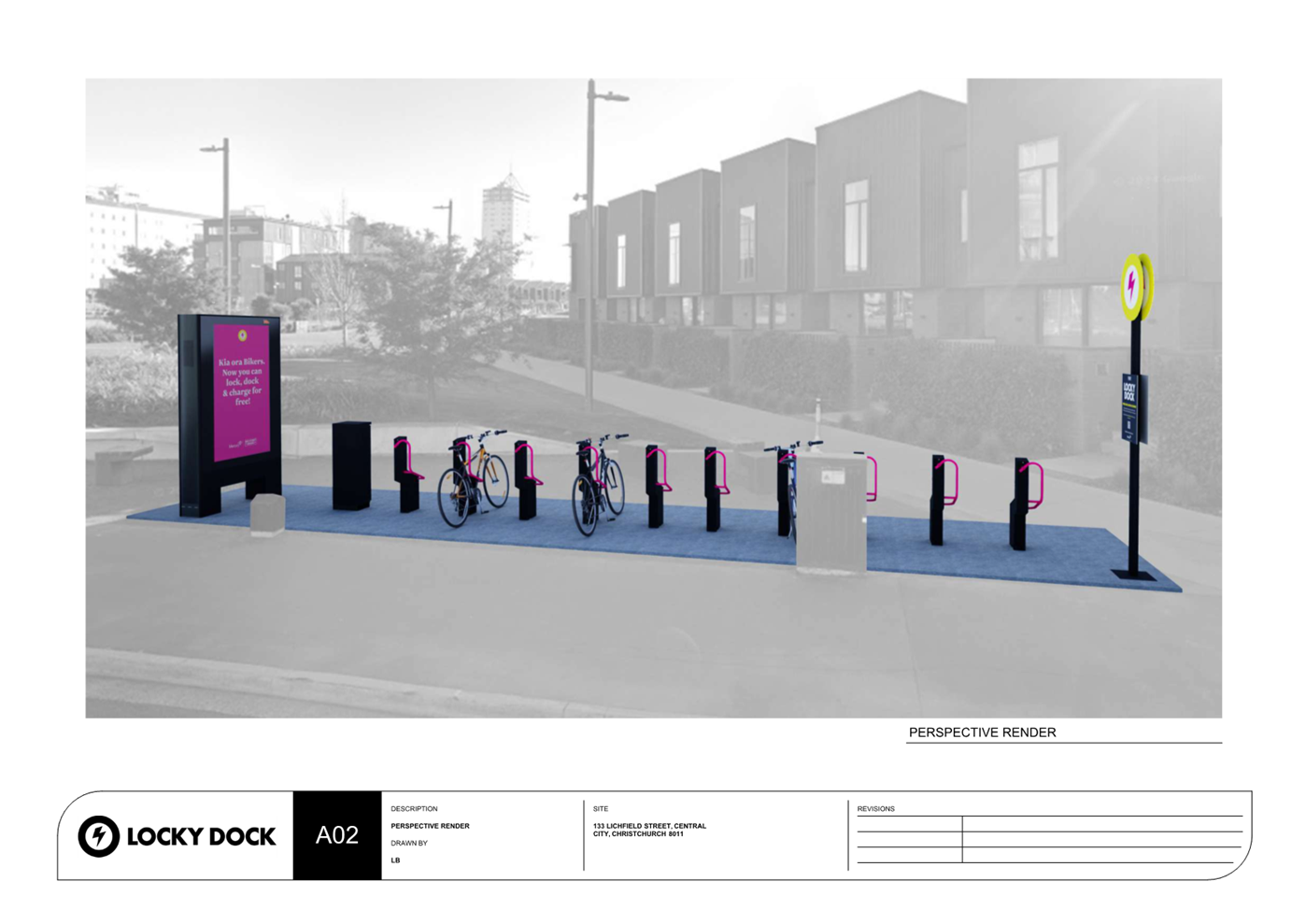
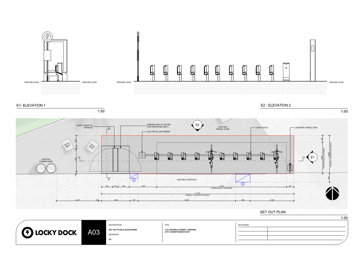
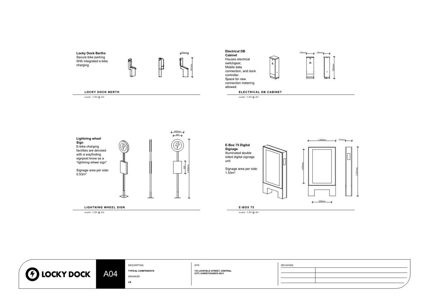
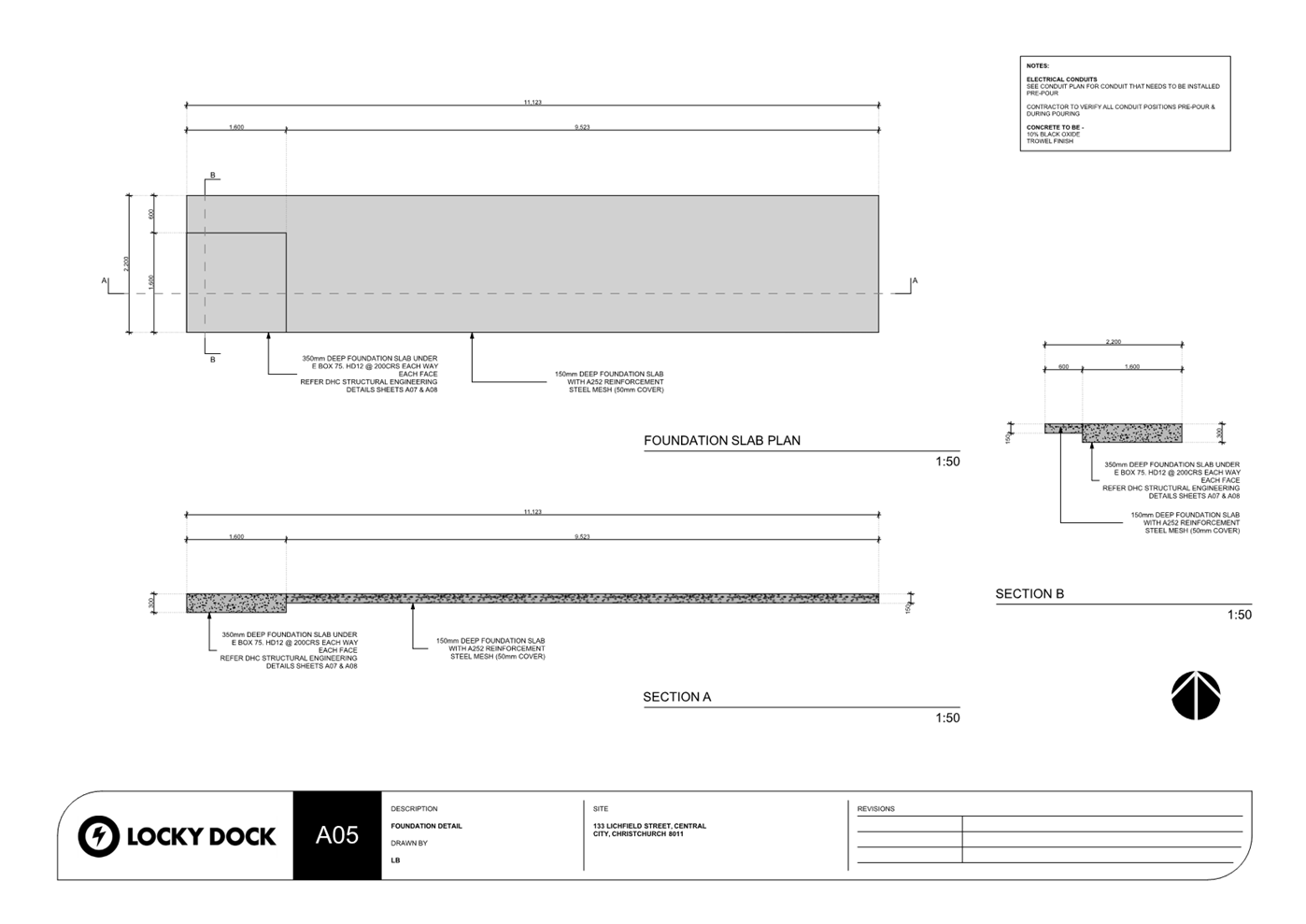
Locky Dock cycle parking and charging station in Rauora Park, Lichfield St 247
19. Setting
of Speed Limits Rule 2024: Management of Non-Installed Limits - Nor'West Arc
Section 3 (University to Harewood Road).......................................................... 267
20. Setting
of Speed Limits Rule 2024: Management of Non-Installed Limits - Worcester
Street (Latimer Square to Fitzgerald Ave)................................................................... 309
21. Setting
of Speed Limits Rule 2024: Management of Non-Installed Limits - Antigua Street
(Moorhouse to St Asaph)................................................................................. 325
22. Extension
of Time for Heritage Incentive Grant to 527 Colombo Street, New City Hotel 335
23. Council
submission on Going for Housing Growth proposals................................ 355
24. Resolution
to Exclude the Public...................................................................... 378
Karakia Whakamutunga
Actions
Register Ngā Mahinga Tuwhera
Karakia Tīmatanga
Whakataka te hau ki te uru
Whakataka te hau ki te tonga
Kia mākinakina ki uta
Kia mātaratara ki tai
E hī ake ana te atakura
He tio, he huka, he hau hū
Tihei mauri ora
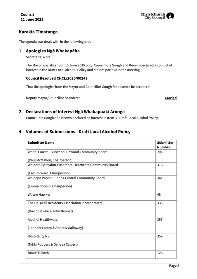
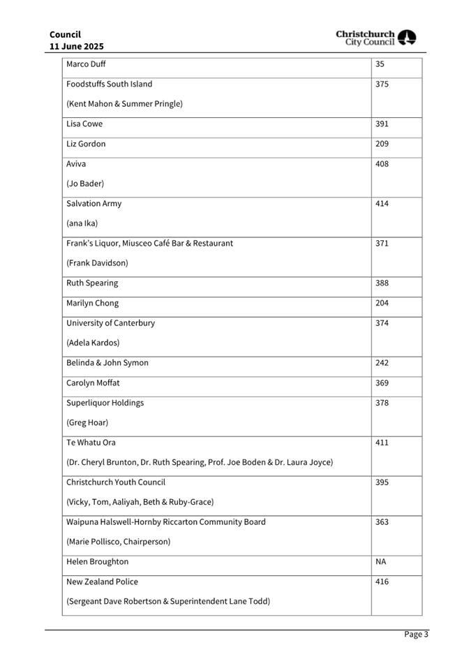
1. Apologies Ngā Whakapāha
Apologies will
be recorded at the meeting.
2. Declarations of Interest Ngā
Whakapuaki Aronga
Members are
reminded of the need to be vigilant and to stand aside from decision-making
when a conflict arises between their role as an elected representative and any
private or other external interest they might have.
3. Public Participation Te Huinga
Tūmatanui
3.1 Public Forum Te Huinga Whānui
A period of up to 30 minutes is available
for people to speak for up to five minutes on any issue that is not the subject
of a separate hearings process.
|
3.1.1
|
Drucilla Kingi-Patterson
Drucilla Kingi-Patterson will speak
regarding a community and Council working party for rail, as well as one for
a flood protection management centre, and the Bus Exchange toilets.
|
3.2 Deputations by Appointment Ngā
Huinga Whakaritenga
Deputations may be heard on a matter, or
matters, covered by a report on this agenda and approved by the Chairperson.
|
3.2.1
|
The Arts Centre
Daniel Stirland and Philip Aldridge will
speak on behalf of the Arts Centre regarding Item 16 – Developments
Contributions Remission Application – The Arts Centre.
|
4. Presentation of Petitions Ngā
Pākikitanga
There were no
Presentations of Petitions at the time the agenda was prepared.
To present to the Council, refer
to the Participating in decision-making webpage or
contact the meeting advisor listed on the front of this agenda.
|
5. Council
Minutes - 2 July 2025
|
|
Reference Te Tohutoro:
|
25/1321761
|
|
Responsible Officer(s) Te Pou Matua:
|
Katie
Matheis - Senior Democratic Services Advisor
|
|
Accountable ELT Member Pouwhakarae:
|
Mary
Richardson, Chief Executive
|
1. Purpose of Report Te
Pūtake Pūrongo
For the Council
to confirm the minutes from the Council meeting held 2
July 2025.
2. Recommendation Te Tūtohu Council
That the Council confirms the Minutes from the Council
meeting held 2 July 2025.
Attachments Ngā Tāpirihanga
|
No.
|
Title
|
Reference
|
Page
|
|
A⇩
|
Minutes Council - 2 July 2025
|
25/1296115
|
8
|
Signatories Ngā Kaiwaitohu
|
Author
|
Katie Matheis
- Senior Democratic Services Advisor
|
|
6. Council
Minutes - 11 June 2025
|
|
Reference Te Tohutoro:
|
25/1365381
|
|
Responsible Officer(s) Te Pou Matua:
|
Natasha
McDonnell, Democratic Services Advisor
|
|
Accountable ELT Member Pouwhakarae:
|
Helen
White, General Counsel / Director of Legal & Democratic Services
|
1. Purpose of Report Te Pūtake Pūrongo
For the Council
to confirm the minutes from the Council meeting held 11
June 2025.
2. Recommendation Te Tūtohu Council
That the Council confirms the Minutes from the Council
meeting held 11 June 2025.
Attachments Ngā Tāpirihanga
|
No.
|
Title
|
Reference
|
Page
|
|
A⇩
|
Minutes Council - 11
June 2025
|
25/1116371
|
16
|
Signatories Ngā Kaiwaitohu
|
Author
|
Natasha
McDonnell - Democratic Services Advisor
|
|
7. Council
Minutes - 16 July 2025
|
|
Reference Te Tohutoro:
|
25/1428640
|
|
Responsible Officer(s) Te Pou Matua:
|
Samantha
Kelly, Team Leader Democratic Services Support
|
|
Accountable ELT Member Pouwhakarae:
|
Mary
Richardson, Chief Executive
|
1. Purpose of Report Te Pūtake Pūrongo
For the Council
to confirm the minutes from the Council meeting held 16
July 2025.
2. Recommendation Te Tūtohu Council
That the Council confirms the Minutes from the Council
meeting held 16 July 2025.
Attachments Ngā Tāpirihanga
|
No.
|
Title
|
Reference
|
Page
|
|
A⇩
|
Minutes Council - 16
July 2025
|
25/1396489
|
26
|
Signatories Ngā Kaiwaitohu
|
Author
|
Samantha Kelly
- Team Leader Democratic Services Support
|
|
8. Health,
Safety and Wellbeing Committee Minutes - 27 June 2025
|
|
Reference Te Tohutoro:
|
25/1292572
|
|
Responsible Officer(s) Te Pou Matua:
|
Simone
Gordon, Democratic Services Advisor
|
|
Accountable ELT Member Pouwhakarae:
|
Helen
White, General Counsel / Director of Legal & Democratic Services
|
1. Purpose of Report Te Pūtake
Pūrongo
The Health,
Safety and Wellbeing Committee held a meeting on 27
June 2025 and is circulating the Minutes recorded to the Council for its
information.
2. Recommendation Te Tūtohu Council
That the Council receives the Minutes from the Health,
Safety and Wellbeing Committee meeting held 27 June 2025.
Attachments Ngā Tāpirihanga
|
No.
|
Title
|
Reference
|
Page
|
|
A⇩
|
Minutes Health, Safety and Wellbeing
Committee - 27 June 2025
|
25/1263212
|
38
|
Signatories Ngā Kaiwaitohu
|
Author
|
Simone Gordon
- Democratic Services Advisor
|
|
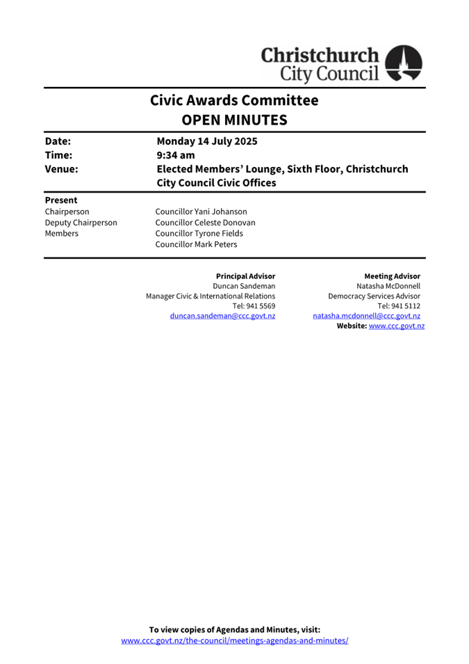
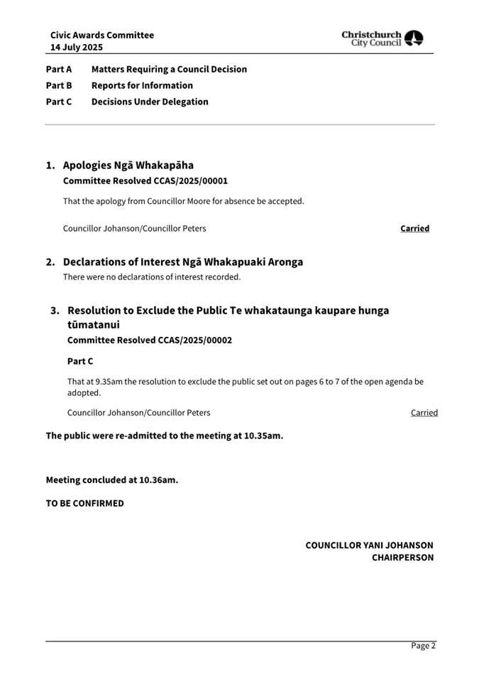
9. Civic
Awards Committee Minutes - 14 July 2025
|
|
Reference Te Tohutoro:
|
25/1409790
|
|
Responsible Officer(s) Te Pou Matua:
|
Natasha
McDonnell, Democratic Services Advisor
|
|
Accountable ELT Member Pouwhakarae:
|
Helen
White, General Counsel / Director of Legal & Democratic Services
|
1. Purpose of Report Te Pūtake
Pūrongo
The Civic Awards
Committee held a meeting on 14 July 2025 and is circulating the Minutes recorded to the Council for its information.
2. Recommendation Te Tūtohu Council
That the Council receives the Minutes from the Civic
Awards Committee meeting held 14 July 2025.
Attachments Ngā Tāpirihanga
|
No.
|
Title
|
Reference
|
Page
|
|
A⇩
|
Minutes Civic Awards Committee - 14
July 2025
|
25/1355121
|
42
|
Signatories Ngā Kaiwaitohu
|
Author
|
Natasha
McDonnell - Democratic Services Advisor
|
|
10. Monthly
Report from the Community Boards - July 2025
|
|
Reference Te Tohutoro:
|
25/1384891
|
|
Report of Te Pou Matua:
|
The
Chairpersons of all Community Boards
|
|
Accountable ELT Member Pouwhakarae:
|
Andrew
Rutledge, General Manager Citizens and Community
|
1. Purpose and Origin of the Report Te
Pūtake Pūrongo
1.1 The
purpose of this report is to provide the Council with an overview of
initiatives and issues recently considered by the Community Boards. This
report attaches the most recent Community Board Area Report included in each
Board's public meeting. Please see the individual agendas for the attachments
to each report.
1.2 Each
Board will present important matters from their respective areas during the
consideration of this report and these presentations will be published with the
Council minutes after the meeting.
2. Community Board Recommendations Ngā Tūtohu a te Poari
Hapori
That the Council:
1. Receives the information in the Monthly Report from the Community Boards -
July 2025 Report.
Attachments Ngā Tāpirihanga
|
No.
|
Title
|
Reference
|
Page
|
|
a ⇩
|
Waimāero
Fendalton-Waimairi-Harewood Community Board Area Report July 2025
|
25/1386606
|
46
|
|
b ⇩
|
Waipapa
Papanui-Innes-Central Community Board Area Report July 2025
|
25/1386608
|
53
|
|
c ⇩
|
Waipuna
Halswell-Hornby-Riccarton Community Board Area Report July 2025
|
25/1386609
|
71
|
|
d ⇩
|
Waitai
Coastal-Burwood-Linwood Community Board Area Report July 2025
|
25/1386610
|
80
|
|
e ⇩
|
Te Pātaka
o Rākaihautū Banks Peninsula Community Board Area Report July 2025
|
25/1386612
|
95
|
|
f ⇩
|
Waihoro
Spreydon-Cashmere-Heathcote Community Board Area Report July 2025
|
25/1386613
|
101
|
Report from Waipuna Halswell-Hornby-Riccarton Community Board – 10 July
2025
|
11. Oaklands
School Safety Improvements - Dunbars Road Signalised Crossing
|
|
Reference Te Tohutoro:
|
25/1397130
|
|
Responsible Officer(s) Te Pou Matua:
|
Gemma
Dioni, Principal Advisor - Transport
|
|
Accountable ELT Member Pouwhakarae:
|
Andrew
Rutledge, General Manager Citizens and Community
|
|
1. Waipuna Halswell-Hornby-Riccarton Community Board
Consideration Te
Whaiwhakaarotanga
|
|
|
The Board took into consideration the deputations by Matt Stewart,
and Carina Duke on behalf of Living Streets Aotearoa.
|
|
2. Waipuna Halswell-Hornby-Riccarton Community Board Recommendation to Council
|
|
|
That the
Council:
1. Approves in accordance with Section 8.5 of
the Land Transport Rule – Traffic Control Devices: 2004 that a
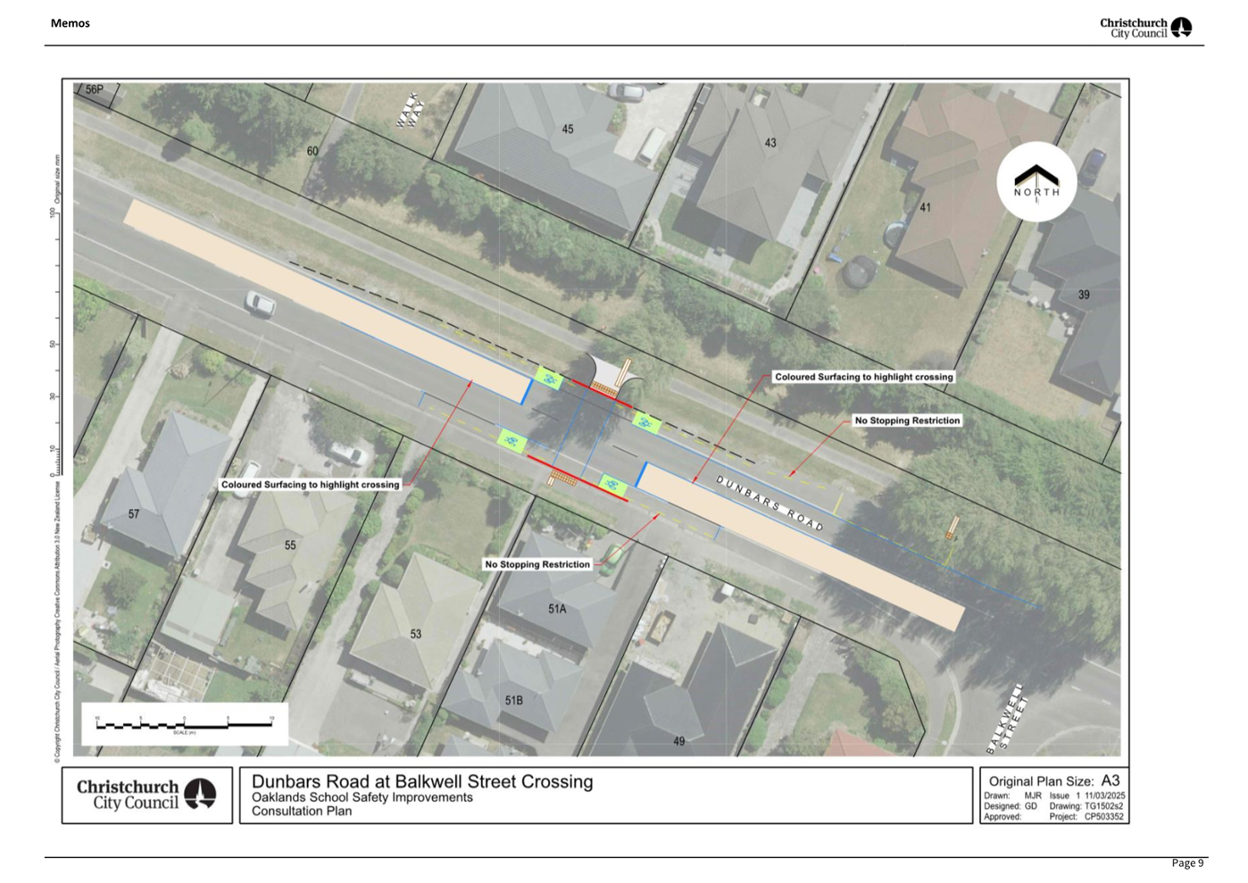
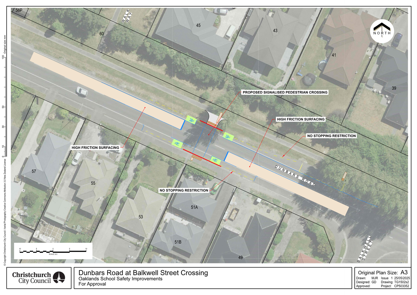
signalised roadway crossing be installed on Dunbars Road, located 53 metres
northwest of its intersection with Balkwell Street, and as detailed on Plan
TG1502s2 dated 25/05/2025 included in Attachment A. This signalised crossing
is for use by the classes of road user as defined in Section 11.1A of the
Land Transport (Road User) Rule: 2004.
2. Approves in accordance with Clause 18 of the Christchurch City
Council Traffic and Parking Bylaw 2017, that a Special Vehicle Lane for the
use of southeastbound road users be installed on the southeast side of
Dunbars Road commencing at a point approximately
23 metres north of its intersection with Balkwell Street and extending in a
northwesterly direction for a distance of 51 metres.
3. Approves in accordance with Clause 18 of the Christchurch City
Council Traffic and Parking Bylaw 2017, that a Special Vehicle Lane for the
use of northwestbound road users be installed on the southwest side of
Dunbars Road commencing at a point approximately
34 metres northwest of its intersection with Balkwell Street and extending in
a northwesterly direction for a distance of 37 metres.
|
|
3. Waipuna
Halswell-Hornby-Riccarton Community Board Decisions Under Delegation Ngā Mana kua Tukuna
|
|
|
Officer recommendations accepted without change
Part C
That the Waipuna
Halswell-Hornby-Riccarton Community Board:
4. Receives the information in the Oaklands
School Safety Improvements - Dunbars Road Signalised Crossing Report.
5. Notes that the decision in this report is assessed as medium
significance based on the Christchurch City Council’s Significance and
Engagement Policy.
6. Approves pursuant to Christchurch City Council Traffic and Parking
Bylaw 2017 and Part 21 of the Local Government Act 1974 all kerb alignments,
road surface treatments, and road markings on Dunbars Road, as detailed on Attachment
A to the report on the meeting agenda.
7. Approves that in accordance with Clause 7
of the Christchurch City Council Traffic and Parking Bylaw 2017, that the
stopping of vehicles be prohibited at all times:
a. On the northeast side of Dunbars Road, commencing at a point
approximately 23 metres north of its intersection with Balkwell Street and
extending in a northwesterly direction for a distance of 51 metres.
b. On the southwest side of Dunbars Road, commencing at a point
approximately 34 metres northwest of its intersection with Balkwell Street
and extending in a northwesterly direction for a distance of 37 metres.
8. Revokes any previous resolutions pertaining to traffic controls
made pursuant to any bylaw to the extent that they are in conflict with the
traffic controls described in resolutions 4 to 7 above.
9. Approves that these resolutions take effect when parking signage
and/or road markings that evidence the restrictions described in 1 to 8 are
in place (or removed in the case of revocations).
|
In addition to the attached documents, the following background
information is available:
|
Document
Name – Location / File Link
|
|
Not
applicable
|
Attachments Ngā Tāpirihanga
|
No.
|
Report Title
|
Reference
|
Page
|
|
1
|
Oaklands School Safety Improvements -
Dunbars Road Signalised Crossing
|
25/862396
|
114
|
|
No.
|
Title
|
Reference
|
Page
|
|
a ⇩
|
Dunbars Road Signalised Crossing
|
25/1031007
|
123
|
|
b ⇩
|
Memo - Halswell School Package of
Improvements
|
25/1031003
|
124
|
|
c ⇩
|
Dunbars Road - Option 2
|
25/1270596
|
136
|
|
Oaklands School Safety Improvements - Dunbars Road Signalised
Crossing
|
|
Reference Te Tohutoro:
|
25/862396
|
|
Responsible Officer(s) Te Pou Matua:
|
Gemma
Dioni, Principal Advisor - Transport
|
|
Accountable ELT Member Pouwhakarae:
|
Brent
Smith, General Manager City Infrastructure
|
1. Purpose and Origin of the Report Te Pūtake Pūrongo
1.1 For
the Waipuna Halswell-Hornby-Riccarton Community Board to approve a new
signalised crossing on Dunabrs Road and to make recommendations to Council for
the items within the proposed design that rest with Council for decision
making.
1.2 The
report has been written in response to ongoing safety concerns at this location,
particularly children walking, cycling and scooting to Oaklands Te Kura o
Ōwaka School.
1.2.1 In
July 2023 (Minutes, Item 7),
the Waipuna Halswell-Hornby-Riccarton Community Board
resolved the following Notice of Motion (HHRB/2023/00051):
Requests staff investigate safe pedestrian access between Halswell
School and Country Palms (Sabys Road) as well as between Oaklands School and
Aidanfield (Dunbars Road).
1.2.2 There is no
existing crossing point on Dunbars Road between the Dunbars Road/Hindess
Street/McMahon Drive roundabout and the Halswell Road traffic signals. Children
cross at this location close to Balkwell Street from the Aidanfield sub-division
to access the school. There are also bus stops in the vicinity.
1.3 The recommendation is to install a traffic signal-controlled
crossing, with high-friction surfacing in advance of the crossing as shown
in Attachment A. Due to the existing and potential traffic volumes
and the speed of vehicles along this corridor, other options for low-cost
treatments were not considered reasonably practicable or were not the
recommended option.
2. Officer Recommendations Ngā Tūtohu
That the Waipuna
Halswell-Hornby-Riccarton Community Board recommends that the Council:
1. Approves in accordance with Section 8.5 of the Land Transport Rule
– Traffic Control Devices: 2004 that a signalised roadway crossing be
installed on Dunbars Road, located 53 metres northwest of its intersection with
Balkwell Street, and as detailed on Plan TG1502s2 dated 25/05/2025 included in
Attachment A. This signalised crossing is for use by the classes of road user
as defined in Section 11.1A of the Land Transport (Road User) Rule: 2004.
2. Approves in accordance with Clause 18 of the
Christchurch City Council Traffic and Parking Bylaw 2017, that a Special
Vehicle Lane for the use of southeastbound road users be installed on the southeast
side of Dunbars Road commencing at a point approximately
23 metres north of its intersection with Balkwell Street and extending in a
northwesterly direction for a distance of 51 metres.
3. Approves in accordance with Clause 18 of the
Christchurch City Council Traffic and Parking Bylaw 2017, that a Special
Vehicle Lane for the use of northwestbound road users be installed on the
southwest side of Dunbars Road commencing at a point approximately
34 metres northwest of its intersection with Balkwell Street and extending in a
northwesterly direction for a distance of 37 metres.
That the Waipuna
Halswell-Hornby-Riccarton Community Board:
4. Receives the information in the Oaklands
School Safety Improvements - Dunbars Road Signalised Crossing Report.
5. Notes that the decision in this report is assessed as medium significance
based on the Christchurch City Council’s Significance and Engagement
Policy.
6. Approves pursuant to Christchurch City Council Traffic and Parking
Bylaw 2017 and Part 21 of the Local Government Act 1974 all kerb alignments,
road surface treatments, and road markings on Dunbars Road, as detailed on Attachment
A to the report on the meeting agenda.
7. Approves that in accordance with Clause 7 of
the Christchurch City Council Traffic and Parking Bylaw 2017, that the stopping
of vehicles be prohibited at all times:
a. On the northeast side of Dunbars Road, commencing at a point
approximately 23 metres north of its intersection with Balkwell Street and
extending in a northwesterly direction for a distance of 51 metres.
b. On the southwest side of Dunbars Road, commencing at a point
approximately 34 metres northwest of its intersection with Balkwell Street and
extending in a northwesterly direction for a distance of 37 metres.
8. Revokes any previous resolutions pertaining to traffic controls made
pursuant to any bylaw to the extent that they are in conflict with the traffic
controls described in resolutions 4 to 7 above.
9. Approves that these resolutions take effect when parking signage
and/or road markings that evidence the restrictions described in 1 to 8 are in
place (or removed in the case of revocations).
3. Executive Summary Te Whakarāpopoto Matua
3.1 Concerns
have been raised around safety for people, particularly school children
crossing Dunbars Road from the Aidanfield sub-division on the east side of the
road to access Oaklands Te Kura o Ōwaka School.
3.2 It
is proposed to install a signal-controlled crossing at this location with high-friction surfacing in advance of the crossing.
4. Background/Context Te Horopaki
4.1 Improving
safety and accessibility on local roads in Christchurch is a priority for the
Council.
4.1.1 There are a number of
levels of service agreed as part of the Long-Term Plan 24-34 which are relevant
to this decision, such as measuring: safety statistics for pedestrians and
cyclists; and perceptions that Christchurch is a “walking friendly city”.
4.1.2 Providing safe
infrastructure is a key tool for helping people get to where they are going
safely, irrespective of their mode of travel.
4.2 Dunbars
Road is classified as an urban connector in the NZTA-Waka Kotahi One Network
Framework.
4.3 The
seven-day average daily traffic volumes on Dunbars Road in the vicinity of the
proposal for all traffic lanes is 8,450 vehicles (2022 count). This is split
into 3,750 vehicles per day westbound and 4,700 vehicles per day eastbound. The
percentage of heavy vehicles is 6.5%. A recent 2025 count, has highlighted an
increase in traffic volumes on Dunbars Road with over 10,000 vehicles being
recorded. As a growth area, and with a new connection at the Dunbars
Road/Halswell Road being provided that will link with Sparks Road, traffic is
likely to continue to increase.
4.4 The current posted speed limit is 50km/h. A speed count undertaken
in 2022 showed that the 85th percentile speed (the speed at
which 85% of people are driving) is 56.2 km/h for westbound traffic and 58.9
km/h for eastbound traffic.
4.5 During the morning peak hour, there is a consistent flow of traffic
meaning that it can be difficult for children to assess suitable gaps in the
traffic to cross the road. In addition vehicles are travelling over the posted
speed limit, increasing the risk and severity of a crash.
4.6 A
pedestrian count was undertaken on Wednesday 21 May, between the hours of 8am to
9am. It was a school day, and was blue sky, dry conditions with no rain. There
was no traffic management in the area to change the normal operation of the
road / crossing.
4.7 In
total, 27 pedestrian movements were counted including 12 adults and 15 children
(including high school students).
4.7.1 The majority
of these movements were counted between the bus stop (south of Balkwell Street)
and the first lamp post to the north.
4.7.2 Dunbars Road
at this location was identified as an area that is difficult to cross by the
children at Oaklands School and is considered a barrier for children walking to
school.
4.7.3 As traffic
volumes are likely to continue to increase due to residential growth and the
connection to Sparks Road, it is likely to become more difficult to cross.
4.8 There
have been no reported crashes in the past five-year period (2020-2024) in the
location of the proposed crossing.
4.9 The following related memos/information were circulated to the
meeting members:
|
Date
|
Subject
|
|
17/03/2025
|
Halswell Schools Package of Improvements
(Attachment B)
|
Options Considered Ngā
Kōwhiringa Whaiwhakaaro
4.10 The following reasonably
practicable options were considered and are assessed in this report:
4.10.1 Option 1 – Signal
controlled crossing with high-friction surfacing in advance of the crossing.
4.10.2 Option 2 – Pedestrian
island
4.10.3 Option 3 – Do
nothing
4.11 The following
options were considered but were not considered reasonably practicable:
4.11.1 Pedestrian (Zebra)
Crossing. As per NZTA Guidance, this is because:
· Unless on a platform, or without other measures like kerb extensions
and median refuge, zebra crossings do not improve pedestrian safety or may even
decrease it. Vehicle speed is a critical factor for whether drivers yield to
pedestrians. As vehicle speeds increase, the percentage of drivers who yield to
pedestrians at a priority crossing decreases. Hence when zebra crossings are
recommended, raised traffic calming devices to slow vehicles to safe system
speeds are required.
· They can increase rear end crashes between vehicles; however, these
tend to be low severity, subject to the speed of the vehicle.
Options Descriptions Ngā
Kōwhiringa
4.12 Preferred
Option: Signal controlled crossing with high friction surfacing
4.12.1 Option Description: Provide
a signal-controlled crossing for people crossing Dunbars Road with
high-friction surfacing in advance of the crossing.
4.12.2 Option Advantages
· Provides people crossing with a designated phase to cross, reducing
uncertainty and potential conflicts with vehicles.
· Vehicles are required to stop when the pedestrian signal is active,
ensuring a safer crossing environment compared to a refuge island, where
pedestrians must judge gaps in traffic.
· These crossings are beneficial for visual and mobility impaired people,
as they provide a dedicated phase for people to cross.
· High-friction surfacing in advance of the traffic signal-controlled
crossing to enhance road safety and reduce crash risks. This is by:
o Improved
Skid Resistance: High-friction surfaces provide better grip for vehicles,
reducing the likelihood of skidding, especially in wet conditions.
o Shorter
Stopping Distances: Vehicles approaching a red light can stop more effectively,
preventing rear-end collisions.
o Enhanced
Visibility: The textured and often coloured surface alerts drivers to an
upcoming crossing, encouraging them to slow down.
o Pedestrian
Safety: By reducing vehicle speeds and improving stopping ability, these
surfaces can help to protect pedestrians at crossings.
4.12.3 Option Disadvantages
· Cost to Council
· Loss of approximately four car parking spaces.
4.13 Option 2
– Build out and pedestrian refuge island
4.13.1 Option Description: Pedestrian
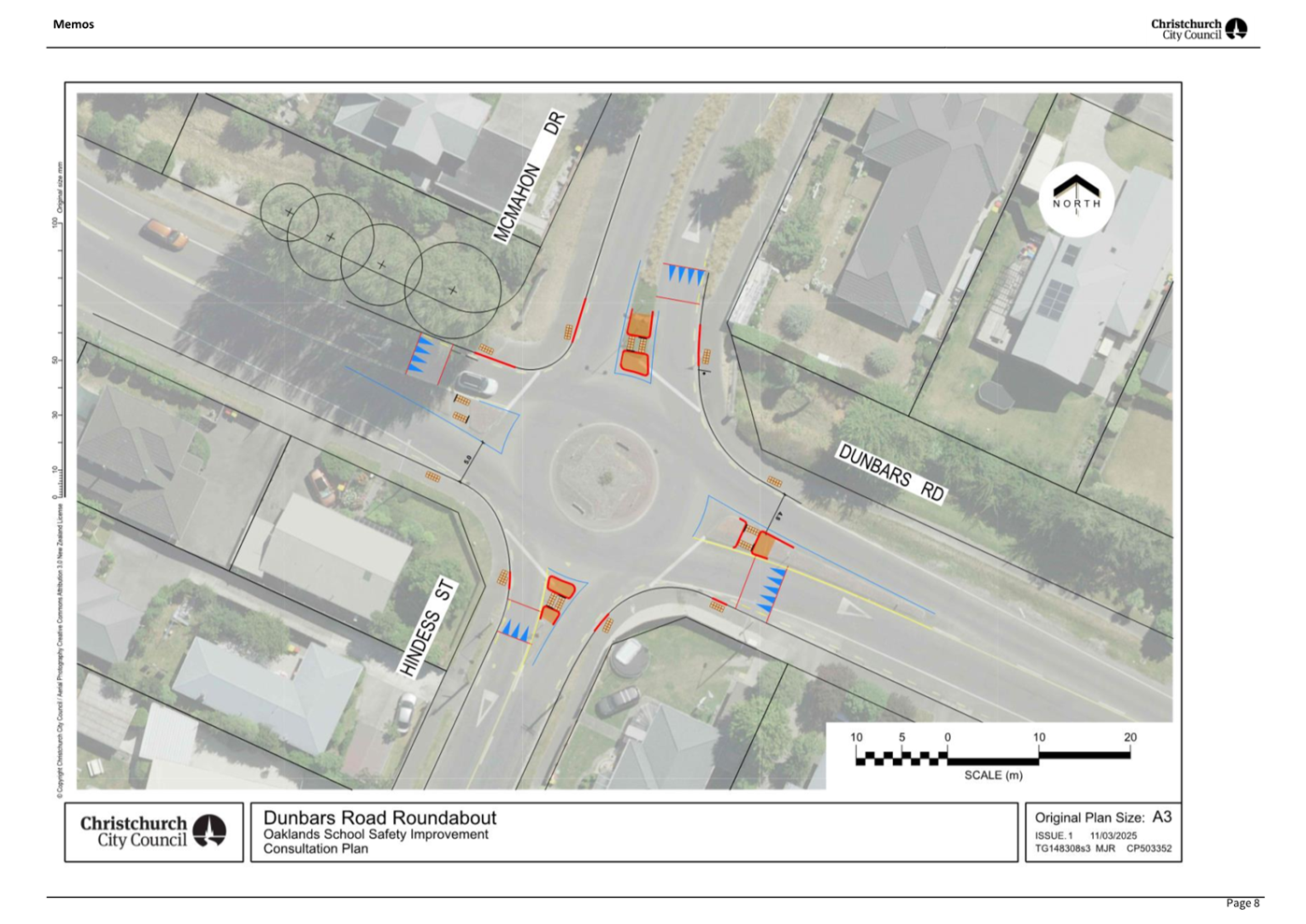
refuge island, as shown in Attachment C.
4.13.2 Option Advantages
· Provides a crossing point for people to cross Dunbars Road in two
stages.
· Lower cost to Council.
4.13.3 Option Disadvantages
· The speed and volume of traffic on Dunbars Road will continue to
make it difficult to cross the road, which would be similar to the concerns
raised by school children crossing Halswell Junction Road outside Knights
Stream School. Traffic is likely to continue to grow on Dunbars Road due
to residential growth and the new connection to Sparks Road at the Dunbars
Road/Halswell Road signal-controlled intersection.
· The width of the Dunbars Road is approximately 9m (kerb to edge of
seal). As per option 1, it is not possible to accommodate the option
without road widening. However, this option is likely to require more widening.
At this location there are steep shoulders, an existing dish channel and a high
crown. Road widening at this location would require road re-shaping to
reduce the height of the centre of the road and the gradients of the shoulders.
A pavement design would be required at detailed design.
· There is a risk around additional consents being required due to the
amount of impermeable area that would need to be added to the swale. It would
need to be determined if the swale would have sufficient capacity to carry the
same or an additional amount of stormwater. Pipes and sumps maybe required for
stormwater management.
· Currently the parking lane on the south side can block visibility of
pedestrians waiting to cross the road, accommodating a pedestrian island would
require additional parking to be removed (6 more than option 1) to provide the
crossing sigh distance. A buildout would help address this and reduce the
crossing distance by approximately 2.4 metres, but this leads to a significant
increase in costs due to the amount of additional road widening that would be
needed.
· This option has not been consulted on. If the board choose to
proceed with this option, consultation and a road safety audit would need to
undertaken prior to being brought back to the board for a final decision to
proceed.
4.14 Option 3
– Do nothing
4.14.1 Option Description: Do
not change the current road layout
4.14.2 Option Advantages
· No cost to Council
· No loss of on-street parking
4.14.3 Option Disadvantages
· Does not address the safety concerns raised
5. Financial Implications Ngā Hīraunga Rauemi
Capex/Opex Ngā Utu Whakahaere
|
|
Recommended Option
|
Option 2 – Pedestrian island
|
Option 3 – Do nothing
|
|
Cost to Implement
|
$525k
|
$150k
|
$0
|
|
Maintenance/Ongoing Costs
|
Covered
by existing maintenance contracts – traffic signals and road
maintenance
|
Covered
by existing maintenance contracts
|
Nil
|
|
Funding Source
|
50462
Minor Road Safety
|
50462
Minor Road Safety
|
Nil
|
|
Funding Availability
|
Funding
available in the above-named budget.
|
Funding
available in the above-named budget.
|
Nil
|
|
Impact on Rates
|
Nil
|
Nil
|
Nil
|
5.1 The
cost are high-level estimates and are not tendered prices.
5.2 In
terms of the recommended option, due to the swale on the northern side of
Dunbars Road, and in addressing the crossing over the old dish channel, there
could be additional costs associated with stormwater management. A higher
contingency has been allowed for in the estimated costs above.
6. Considerations Ngā Whai Whakaaro
Risks and Mitigations Ngā
Mōrearea me ngā Whakamātautau
6.1 The
proposal includes traffic safety measures that will reduce risk for all road
users at this location.
Legal Considerations Ngā
Hīraunga ā-Ture
6.2 Statutory
and/or delegated authority to undertake proposals in the report:
6.2.1 Section 331 and 334
of the Local Government Act 1974 for controlling traffic by traffic signals. Section
8.5 of the Land Transport Rule - Traffic Control Devices: 2004, details the
design, construction, installation, operation, and maintenance of traffic
control devices. The Council has not sub-delegated this power.
6.2.2 The Community Boards
have delegated authority from Council to exercise the delegations as set out in
the Register of Delegations. The list of delegations for the Community Boards
includes the resolution of stopping and traffic controls.
6.2.3 Part 1, Clause 7 of
the Christchurch City Council Traffic and Parking Bylaw 2017 provides Council
with the authority to install parking or stopping restrictions by resolution.
6.2.4 The installation of
any signs and/or markings associated with traffic control devices must comply
with the Land Transport Rule: Traffic Control Devices 2004.
6.3 Other
Legal Implications:
6.3.1 There is no
legal context, issue, or implication relevant to this decision.
Strategy and Policy Considerations Te Whai
Kaupapa here
6.4 The
required decision:
6.4.1 Aligns with the Christchurch
City Council’s Strategic Framework and Community Outcomes.
Improving the safety of our roads aligns with the Strategic Priorities and
Community Outcomes, in particular to be an inclusive and equitable city; build
trust and confidence by listening to and working with our residents; and
providing safe crossing points for people who walk and cycle will contribute to
a green, liveable city, where our neighbourhoods and communities are accessible
and well-connected.
6.4.2 This project is
assessed as medium significance based on
the Christchurch City Council’s Significance and Engagement Policy.
The level of significance was determined by the
number of school communities and residents affected by the safety proposals in
this rapidly growing suburb.
6.4.3 The recommended
option is consistent with the Council’s Plans and Policies, in
particular:
· LTP Activity Plan - Level of Service target to reduce the number of
deaths or serious injuries (DSI) from all crashes by 40% in 2030.
· The changes made align with Goals 3, 5 and 6 in the Ōtautahi
Christchurch Future Transport Strategy 2024–54.
· Improving safety on local roads is a priority for the Council.
6.5 Transport
6.5.1 Activity: Transport
· Level of Service: 10.0.6.1 Reduce the number of
death and serious injury crashes on the local road network (DIA 1) - 4 less
than previous FY
· Level of Service: 10.0.2 Increase the share of
non-car modes in daily trips - >=37% of trips undertaken by non-car modes
· Level of Service: 10.0.6.2 Reduce the number of
death and serious injury crashes on the local road network - Five year rolling
average <100 crashes per year
· Level of Service: 10.5.1 Limit deaths and
serious injury crashes per capita for cyclists and pedestrians - <=12
crashes per 100,000 residents
· Level of Service: 10.5.42 Increase the
infrastructure provision for active and public modes - >= 625 kilometres
(total combined length)
· Level of Service: 16.0.10 Maintain the
perception (resident satisfaction) that Christchurch is a walking friendly city
- >=85% resident satisfaction
Community Impacts and Views Ngā Mariu
ā-Hāpori
6.6 Early
engagement with Oaklands School started in March 2025, to understand issues
related to pedestrian safety and access, and discuss proposed options.
6.7 Consultation
on the proposals for roads around Oaklands School started on 27 March and ran until 28 April, as part of the wider
engagement campaign ‘Safer Streets for Halswell', which included proposed safety measures on streets around all three
Halswell schools.
6.8 Consultation
details, including links to the project information shared on the Kōrero mai | Let’s
Talk webpage were advertised via:
· An email was sent to 35 key stakeholders, including local schools,
sports clubs, NZTA and emergency services.
· Leaflets letterbox dropped to properties directly impacted by
proposed safety treatments on each street.
· The council Facebook page and 3 local community group pages, which
reached over 13,685 people.
· On-street posters outside the school.
· Consultation flyers provided to schools to hand out.
· A Newsline story.
6.9 The
Kōrero
mai | Let’s Talk page had 1,362 views throughout the
consultation period.
Summary of Submissions Ngā Tāpaetanga
6.10 Submissions on
proposed signalised crossing on Dunbars Road were made by seven recognised
organisations and 28 individuals. All submissions are available on the
Kōrero mai webpage.
6.11 Organisations
that submitted were Halswell Residents Association, Spokes Canterbury, Greater
Ōtautahi, Waka Kotahi – NZTA, Hato Hone St John, FENZ,
Canterbury/West Coast Automobile Association District Council and Living
Streets Aotearoa. The organisations were largely in support of the proposed
treatments.
6.12 Of those
submitters, 78% (28) supported the proposal, 3% (1) somewhat supported and 8%
(3) did not (three did not provide this information).
6.13 Reasons for
supporting the proposal was the volume of traffic on the road and vehicles that
travel at speed, making it very difficult for pedestrians to cross.
6.14 Those who did
not agree with a signal-controlled crossing felt the numbers of pedestrians
using it did not justify the cost of implementation and maintenance. A
pedestrian island, barriers and narrowing the road would be better value for
money than a signalised crossing.
6.15 Additional
requests and suggestions were:
· Move the proposed crossing closer to the path from Eaglesome Avenue
to mitigate any issues with buses accessing and exiting the bus stop or between
Balkwell Street and Halswell Road where people are crossing the road.
· Include pedestrian warning signs near the crossing to increase
driver awareness.
· Install variable speed signs and utilise them during school drop off
and pick up hours.
· Consider a road renewal along Dunbars Road that supports slower
speeds and includes space for a cycleway.
Additional comments
6.16 Submitters to ‘Safer Streets for Halswell’ were asked if
they had any other comments. This analysis of feedback is included in all four
reports related to the campaign.
6.17 Of the 188 submitters to ‘Safer Streets for Halswell’,
105 provided additional comments.
6.18 Common themes in the feedback were:
· That the proposed changes significantly improve safety for school
children and those using active transport.
· Suggestions that other streets have crossings or safety treatments
installed, such as Cobra Street, Balkwell Street, and Lancewood Drive.
6.19 The decision
affects the following wards/Community Board areas:
6.19.1 Waipuna Halswell-Hornby-Riccarton Community Board.
Impact on Mana Whenua Ngā Whai Take
Mana Whenua
6.20 The decision
does not involve a significant decision in relation to ancestral
land or a body of water or other elements of intrinsic value, therefore this
decision does not specifically impact Mana
Whenua, their culture, and traditions.
6.21 The decision does not involve a matter of interest to Mana Whenua
and will not impact on our agreed
partnership priorities with Ngā Papatipu
Rūnanga.
Climate Change Impact Considerations Ngā
Whai Whakaaro mā te Āhuarangi
6.22 The decisions in
this report are likely to:
6.22.1 Contribute positively to
adaptation to the impacts of climate change.
6.22.2 Contribute positively to
emissions reductions.
6.23 The emission
reductions associated with this project have not been estimated.
6.24 Improving the
ability for people to walk, cycle, scoot and catch the bus are a key part of
the Council’s emissions reduction efforts by providing a safe, low
emission way for residents to move around the city.
6.25 Improving safety
and making Dunbars Road feel safer would address some of the barriers to people
making sustainable travel choices. Removing these barriers will lead to
reductions in vehicle kilometres travelled and consequently emissions from
transport.
7. Next Steps Ngā Mahinga ā-muri
7.1 If
the Council agrees to the recommendations in this report, the next step will be
to complete detailed design and tendering prior to construction.
Attachments Ngā Tāpirihanga
|
No.
|
Title
|
Reference
|
Page
|
|
a
|
Dunbars Road
Signalised Crossing
|
25/1031007
|
|
|
b
|
Memo -
Halswell School Package of Improvements
|
25/1031003
|
|
|
c
|
Dunbars Road -
Option 2
|
25/1270596
|
|
In addition to the attached documents, the following background
information is available:
|
Document
Name – Location / File Link
|
|
Not
applicable
|
Signatories Ngā Kaiwaitohu
|
Author
|
Gemma Dioni -
Principal Advisor Transportation - Safety
|
|
Approved By
|
Stephen Wright
- Manager Operations (Transport)
Tony
Richardson - Finance Business Partner
Jacob Bradbury
- Manager Planning & Delivery Transport
|
Report from Waipuna
Halswell-Hornby-Riccarton Community Board – 10 July 2025
|
12. Knights
Stream School Safety Improvement - Signalised Crossing on Halswell Junction
Road
|
|
Reference Te Tohutoro:
|
25/1397261
|
|
Responsible Officer(s) Te Pou Matua:
|
Gemma
Dioni, Principal Advisor - Transport
|
|
Accountable ELT Member Pouwhakarae:
|
Andrew
Rutledge, General Manager Citizens and Community
|
|
1. Waipuna Halswell-Hornby-Riccarton Community Board Consideration Te Whaiwhakaarotanga
|
|
|
The
Board took into consideration the deputation by Carina Duke on behalf of
Living Streets Aotearoa.
|
|
2. Waipuna Halswell-Hornby-Riccarton Community Board Recommendation
to Council
|
|
|
That the Council:
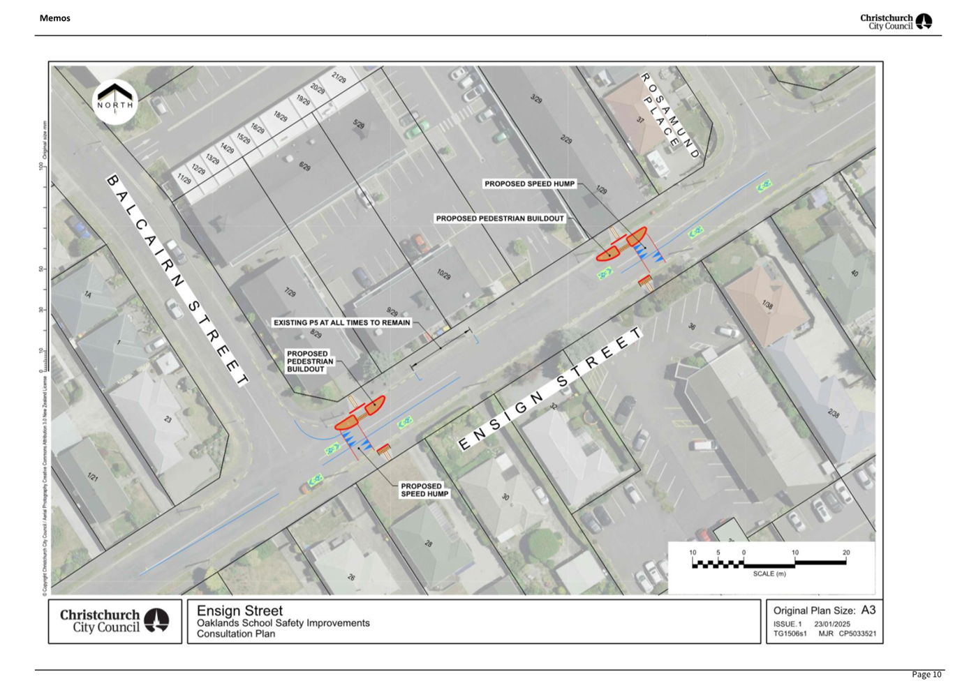
1. Approves in accordance with Section 8.5 of the Land Transport Rule
– Traffic Control Devices: 2004 that a signalised roadway crossing be
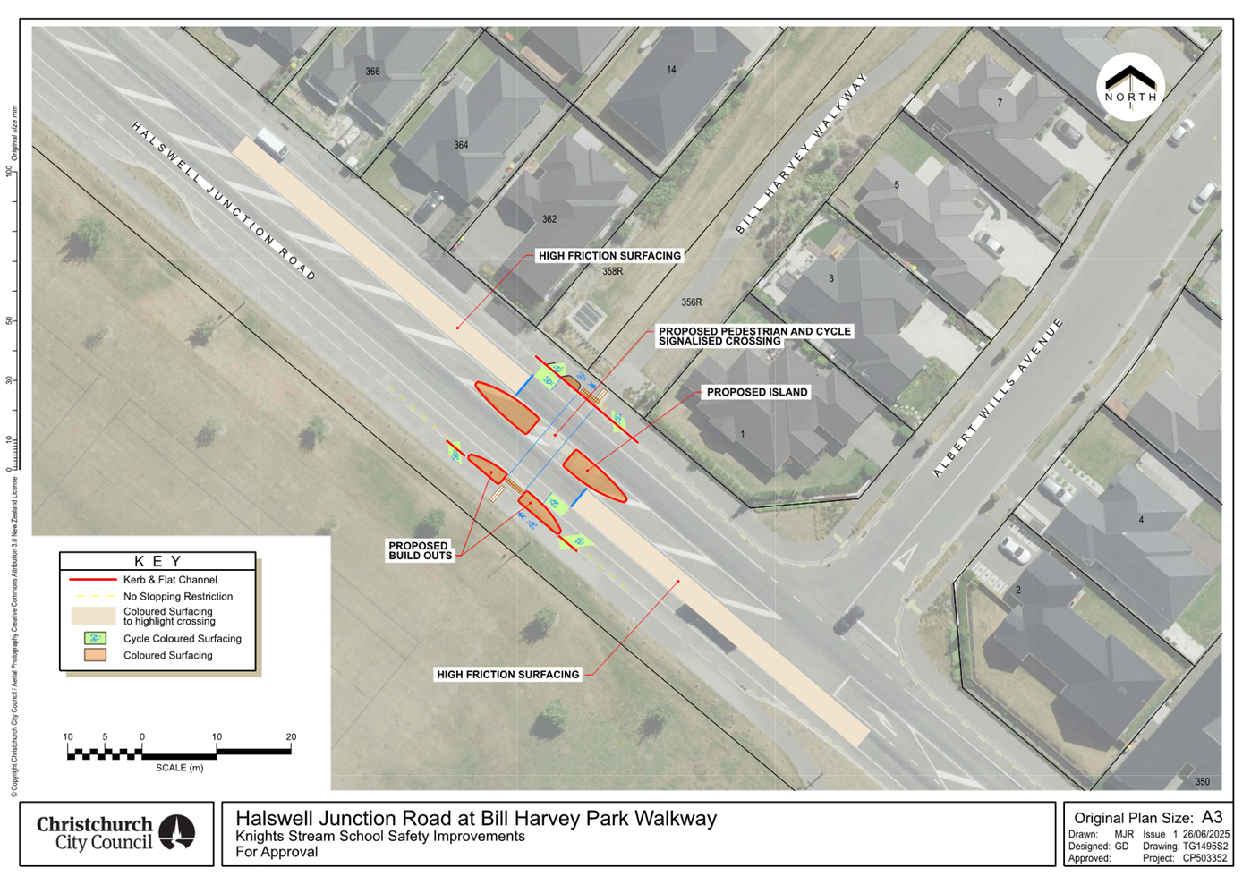
installed on Halswell Junction Road, located 38 metres north of its intersection with Albert Wills Avenue, and as detailed on
Plan TG1495s2 dated 20/05/2025 included in Attachment A to the report on the
meeting agenda. This signalised crossing is for use by the classes of road
user as defined in Section 11.1A of the Land Transport (Road User) Rule:
2004.
|
|
3. Waipuna Halswell-Hornby-Riccarton Community Board Decisions
Under Delegation Ngā
Mana kua Tukuna
|
|
|
Officer
recommendations accepted without change
Part C
That the Waipuna Halswell-Hornby-Riccarton Community
Board:
2. Receives the information in the Knights Stream School
Safety Improvement - Signalised Crossing on Halswell Junction Road Report.
3. Notes that the decision in this report is
assessed as medium significance based on the Christchurch City
Council’s Significance and Engagement Policy.
4. Approves pursuant to Christchurch City
Council Traffic and Parking Bylaw 2017 and Part 21 of the Local Government
Act 1974 all kerb alignments, road surface treatments, traffic islands and
road markings on Halswell Junction Road, as detailed on Attachment A to the report on the meeting agenda.
5. Approves that in accordance with Clause
21 of the Christchurch City Council Traffic & Parking Bylaw 2017, that
the path on the southwest side of Halswell Junction Road, commencing at a
point 28 metres north of its intersection with Albert Wills Avenue and
extending in a northwesterly direction for a distance of 23 metres be
resolved as a Shared Path and in accordance with section 11.4 of the Land
Transport Act - Traffic Control Devices Rules: 2004. This Shared Path is for
the use by the classes of road user only as defined in Section 11.1A of the
Land Transport (Road User) Rule: 2004.
6. Approves that in accordance with Clause
21 of the Christchurch City Council Traffic & Parking Bylaw 2017, that
the path on the northeast side of Halswell Junction Road, commencing at a
point 32 metres north of its intersection with Albert Wills Avenue and
extending in a northwesterly direction for a distance of 14 metres be
resolved as a Shared Path and in accordance with section 11.4 of the Land
Transport Act - Traffic Control Devices Rules: 2004. This Shared Path is for
the use by the classes of road user only as defined in Section 11.1A of the
Land Transport (Road User) Rule: 2004.
7. Approves that in accordance with Clause 7 of the Christchurch City
Council Traffic and Parking Bylaw 2017, that the stopping of vehicles be
prohibited at all times:
a. On the southwest side of Halswell
Junction Road, commencing at a point approximately 19 metres north of its
intersection with Albert Wills Avenue and extending in a northerly direction
for a distance of 42 metres.
8. Revokes any previous resolutions
pertaining to traffic controls made pursuant to any bylaw to the extent that
they are in conflict with the traffic controls described in resolutions 4 to
7 above.
9. Approves that these resolutions take
effect when parking signage and/or road markings that evidence the
restrictions described in 1 to 8 are in place (or removed in the case of
revocations).
|
In addition to the attached documents, the following background
information is available:
|
Document
Name – Location / File Link
|
|
Not
applicable
|
Attachments Ngā Tāpirihanga
|
No.
|
Report Title
|
Reference
|
Page
|
|
1
|
Knights Stream School Safety
Improvement - Signalised Crossing on Halswell Junction Road
|
25/667120
|
139
|
|
No.
|
Title
|
Reference
|
Page
|
|
a ⇩
|
Halswell Junction
Road Signalised Crossing
|
25/990506
|
148
|
|
b ⇩
|
Memo - Halswell
Schools Package of Improvements
|
25/1031003
|
149
|
|
Knights Stream School Safety Improvement - Signalised Crossing
on Halswell Junction Road
|
|
Reference Te Tohutoro:
|
25/667120
|
|
Responsible Officer(s) Te Pou Matua:
|
Gemma
Dioni, Principal Advisor - Transport
|
|
Accountable ELT Member Pouwhakarae:
|
Brent
Smith, General Manager City Infrastructure
|
1. Purpose and Origin of the Report Te Pūtake Pūrongo
1.1 For
the Waipuna Halswell-Hornby-Riccarton Community Board to approve safety
improvements to a pedestrian crossing at Knights Stream Park on Halswell
Junction Road and to make recommendations to Council for the items within the
proposed design that rest with Council for decision making.
1.2 The
report has been written in response to ongoing safety concerns at this location.
1.2.1 A parent, whose child was hit by a car on Halswell Junction Road,
presented during Public Participation Te Huinga Tūmatanui at Council in
June 2023, (Item 3.1.5). The main concerns
were around safety and the speed of vehicles on Halswell Junction Road. The
parent requested measures to provide for a safer crossing for children
travelling to Mingimingi Hautoa Knights Stream School and the wider community wanting to access the rugby fields and
skatepark.
1.2.2 Staff also received a request from a representative of Kainga Ora
about the provision of safer and direct access to the school, when constructing
units on the northeast side of Halswell Junction Road.
1.3 There
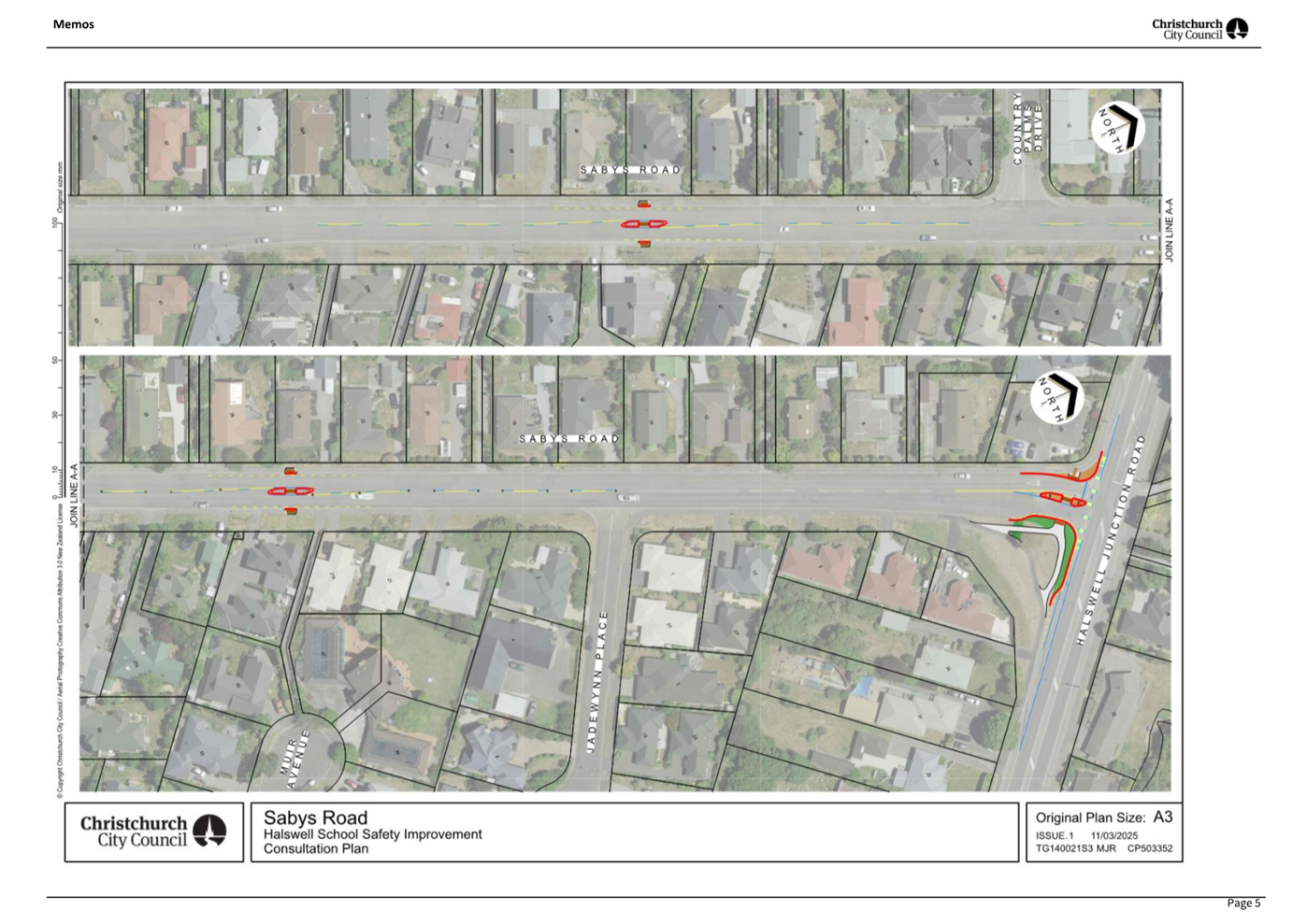
is an existing traffic island on Halswell Junction Road to support crossing
movements to the school. However, on-site observations have identified that
there are very few gaps in traffic for children to cross the road due to the
traffic volumes and speed of traffic on Halswell Junction Road.
1.4 The
recommendation is to install a traffic signal-controlled crossing, with
high-friction surfacing in advance of the crossing as shown in Attachment
A.
2. Officer Recommendations Ngā Tūtohu
That the Waipuna
Halswell-Hornby-Riccarton Community Board recommends that the Council:
1. Approves in accordance with Section 8.5 of the Land Transport Rule
– Traffic Control Devices: 2004 that a signalised roadway crossing be
installed on Halswell Junction Road, located 38 metres north of its
intersection with Albert Wills Avenue, and as detailed on Plan TG1495s2 dated
20/05/2025 included in Attachment A to the report on the meeting agenda. This
signalised crossing is for use by the classes of road user as defined in
Section 11.1A of the Land Transport (Road User) Rule: 2004.
That the Waipuna
Halswell-Hornby-Riccarton Community Board:
2. Receives the information in the Knights
Stream School Safety Improvement - Signalised Crossing on Halswell Junction
Road Report.
3. Notes that the decision in this report is assessed as medium significance
based on the Christchurch City Council’s Significance and Engagement
Policy.
4. Approves pursuant to Christchurch City Council Traffic and Parking
Bylaw 2017 and Part 21 of the Local Government Act 1974 all kerb alignments,
road surface treatments, traffic islands and road markings on Halswell Junction
Road, as detailed on Attachment A to the report on the meeting agenda..
5. Approves that in accordance with Clause 21 of the Christchurch City
Council Traffic & Parking Bylaw 2017, that the path on the southwest side
of Halswell Junction Road, commencing at a point 28 metres north of its
intersection with Albert Wills Avenue and extending in a northwesterly
direction for a distance of 23 metres be resolved as a Shared Path and in
accordance with section 11.4 of the Land Transport Act - Traffic Control
Devices Rules: 2004. This Shared Path is for the use by the classes of road
user only as defined in Section 11.1A of the Land Transport (Road User) Rule:
2004.
6. Approves that in accordance with Clause 21 of the Christchurch City
Council Traffic & Parking Bylaw 2017, that the path on the northeast side
of Halswell Junction Road, commencing at a point 32 metres north of its
intersection with Albert Wills Avenue and extending in a northwesterly
direction for a distance of 14 metres be resolved as a Shared Path and in
accordance with section 11.4 of the Land Transport Act - Traffic Control
Devices Rules: 2004. This Shared Path is for the use by the classes of road
user only as defined in Section 11.1A of the Land Transport (Road User) Rule:
2004.
7. Approves that in accordance with Clause 7 of
the Christchurch City Council Traffic and Parking Bylaw 2017, that the stopping
of vehicles be prohibited at all times:
a. On the southwest side of Halswell Junction Road, commencing at a
point approximately 19 metres north of its intersection with Albert Wills
Avenue and extending in a northerly direction for a distance of 42 metres.
8. Revokes any previous resolutions pertaining to traffic controls made
pursuant to any bylaw to the extent that they are in conflict with the traffic
controls described in resolutions 4 to 7 above.
9. Approves that these resolutions take effect when parking signage
and/or road markings that evidence the restrictions described in 1 to 8 are in
place (or removed in the case of revocations).
3. Executive Summary Te Whakarāpopoto Matua
3.1 Concerns
have been raised around safety for people crossing Halswell Junction Road from
the Copper Ridge sub-division on the east side of the road to access Mingimingi
Hautoa Knights Stream School, the park and the skate park.
3.2 It
is proposed to install a signal-controlled crossing to replace the current
pedestrian refuge island.
4. Background/Context Te Horopaki
4.1 Improving
safety and accessibility on local roads in Christchurch is a priority for the
Council.
4.1.1 There are a number of
levels of service agreed as part of the Long-Term Plan 24-34 which are relevant
to this decision, such as measuring: safety statistics for pedestrians and
cyclists; and perceptions that Christchurch is a “walking friendly city”.
4.1.2 Providing safe
infrastructure is a key tool for helping people get to where they are going
safely, irrespective of their mode of travel.
4.2 Halswell Junction Road is classified as an urban connector in the
NZTA-Waka Kotahi One Network Framework. There is an existing pedestrian island
for people to use to cross the road.
4.3 A
pedestrian count was undertaken on Wednesday 21 May 2025, between the hours of
8am – 9am. It was a school day, and was blue sky, dry conditions with no
rain. There was no traffic Management in the area to change the normal
operation of the road / crossing.
4.4 There
were 50 people crossing on Halswell Junction Road, at or close to the existing
pedestrian refuge crossing, as shown below:
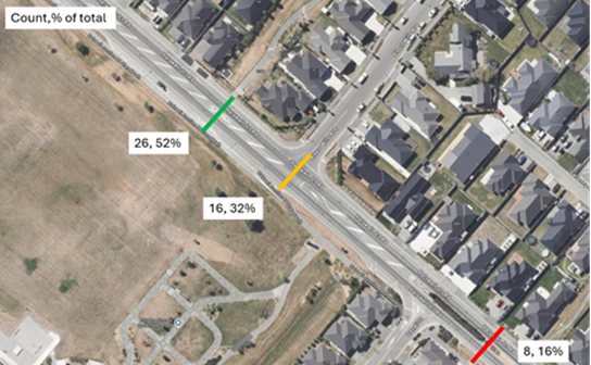
Pedestrians observed crossing Halswell Junction Road
4.5 The
seven-day average daily traffic volumes on Halswell Junction Road at the
pedestrian island for all traffic lanes is 10,100 vehicles (2024 count). This
is split into 4,900 vehicles per day northbound and 5,200 vehicles per day
southbound. The percentage of heavy vehicles is 9.5%.
4.6 During
the morning peak hour, there is a consistent flow of traffic meaning that it
can be difficult for children to assess suitable gaps in the traffic to cross
the road.
4.7 The current posted speed limit is 50km/h. A speed count undertaken
in 2024 showed that the 85th percentile speed (the speed at
which 85% of people are driving) is 57.1 km/h for northbound traffic and 56.3
km/h for southbound traffic.
4.8 This crossing location was due to have a 30 km/h variable speed
limit installed through the approved Safe Speed Neighbourhood Plan, which was
signed off under the Setting of Speed limits 2022 Rule. This can no longer
proceed under the Setting of Speed Limits Rule 2024. Under the new Rule there
is no ability to install a variable speed limit along Halswell Junction Road as
it is outside the extents allowed for a school variable speed limit.
4.9 There
have been two reported crashes in the past five-year period (2020-2024). One
crash involved a child on a bicycle crossing at the island on the way to school
and being hit by a vehicle, this crash resulted in a minor injury. The second
crash involved a driver travelling southbound and leaving the road, crashing
into a fence.
4.10 The following related memos/information were circulated to the
meeting members:
|
Date
|
Subject
|
|
17/03/2025
|
Halswell Schools Package of Improvements
(Attachment B)
|
Options Considered Ngā
Kōwhiringa Whaiwhakaaro
4.11 The
following reasonably practicable options were considered and are assessed in
this report:
4.11.1 Option 1
– Signal controlled crossing with high-friction surfacing in advance of
the crossing
4.11.2 Option 2 – Do nothing
4.12 The
following options were considered but were not considered reasonably
practicable:
4.12.1 Pedestrian (Zebra) Crossing. As
per NZTA Guidance, this is because:
· Unless on a platform, or without other measures like kerb extensions
and median refuge, zebra crossings do not improve pedestrian safety or may even
decrease it. Vehicle speed is a critical factor for whether drivers yield to
pedestrians. As vehicle speeds increase, the percentage of drivers who yield to
pedestrians at a priority crossing decreases. Hence when zebra crossings are
recommended, raised traffic calming devices to slow vehicles to safe system
speeds are required.
· They can increase rear end crashes between vehicles; however, these
tend to be low severity, subject to the speed of the vehicle.
Options Descriptions Ngā
Kōwhiringa
4.13 Preferred
Option: Signal-controlled crossing
4.13.1 Option Description: Provide a signal-controlled crossing for people crossing
Halswell Junction Road with high-friction surfacing in advance of the crossing.
4.13.2 Option Advantages
· Provides people crossing with a designated phase to cross, reducing
uncertainty and potential conflicts with vehicles.
· Vehicles are required to stop when the pedestrian signal is active,
ensuring a safer crossing environment compared to a refuge island, where
pedestrians must judge gaps in traffic.
· These crossings are beneficial for visual and mobility impaired people,
as they provide a dedicated phase for people to cross.
· Addresses the safety concerns raised by the residents and Kainga
Ora.
· High-friction surfacing in advance of the traffic signal-controlled
crossing to enhance road safety and reduce crash risks. This is by:
o Improved
Skid Resistance: High-friction surfaces provide better grip for vehicles,
reducing the likelihood of skidding, especially in wet conditions.
o Shorter
Stopping Distances: Vehicles approaching a red light can stop more effectively,
preventing rear-end collisions.
o Enhanced
Visibility: The textured and often coloured surface alerts drivers to an
upcoming crossing, encouraging them to slow down.
o Pedestrian
Safety: By reducing vehicle speeds and improving stopping ability, these
surfaces can help to protect pedestrians at crossings.
4.13.3 Option Disadvantages
· Cost to Council
4.14 Option 2
– Do nothing
4.14.1 Option Description: Retain
the existing pedestrian island
4.14.2 Option Advantages
· No cost to Council.
4.14.3 Option Disadvantages
· Does not address the safety concerns raised by the residents and
Kainga Ora.
5. Financial Implications Ngā Hīraunga Rauemi
Capex/Opex Ngā Utu Whakahaere
|
|
Recommended Option
|
Option 2 – Do Nothing
|
|
Cost to Implement
|
$475k
|
$0
|
|
Maintenance/Ongoing Costs
|
Covered by existing maintenance contracts
|
Nil
|
|
Funding Source
|
50462 Minor Road Safety
|
Nil
|
|
Funding Availability
|
Funding available in the above-named
budget.
|
Nil
|
|
Impact on Rates
|
Nil
|
Nil
|
5.1 The
cost are high-level estimates and are not tendered prices.
5.2 Ducting
for the traffic signals was installed in 2024 (cost approximately $15k in
addition to Traffic Management costs), when the CCC Maintenance Team was
undertaking work along this corridor. This has reduced the cost to the project,
as this work is already complete. Further, it is proposed to retain the
existing alignments of kerb and channel to reduce any significant costs to
address stormwater management.
5.3 This
project has been brought forward in the minor Road Safety Programme from the
2029 Financial Year, due to the high risk nature of the site with volumes and
speeds on Halswell Junction Road creating a barrier between the new growth
areas and residential development and the local school and pre-schools. This
will result in less funding to deliver similar projects in Financial Year 2029.
It is anticipated that savings could be identified through detailed design and
procurement strategy over the Halswell Schools package.
6. Considerations Ngā Whai Whakaaro
Risks and Mitigations Ngā
Mōrearea me ngā Whakamātautau
6.1 The proposal includes
traffic safety measures that will reduce risk for all road users at this
location.
Legal Considerations Ngā
Hīraunga ā-Ture
6.2 Statutory
and/or delegated authority to undertake proposals in the report:
6.2.1 Section
331 and 334 of the Local Government Act 1974 for controlling traffic by traffic
signals. Section 8.5 of the Land Transport Rule - Traffic Control Devices:
2004, details the design, construction, installation, operation, and
maintenance of traffic control devices. The Council has not sub-delegated
this power.
6.2.2 The Community Boards
have delegated authority from Council to exercise the delegations as set out in
the Register of Delegations. The list of delegations for the Community Boards
includes the resolution of stopping and traffic controls.
6.2.3 Part 1, Clause 7 of
the Christchurch City Council Traffic and Parking Bylaw 2017 provides Council
with the authority to install parking or stopping restrictions by resolution.
6.2.4 The installation of
any signs and/or markings associated with traffic control devices must comply
with the Land Transport Rule: Traffic Control Devices 2004.
6.3 Other Legal Implications:
6.3.1 There is no legal
context, issue, or implication relevant to this decision.
Strategy and Policy Considerations Te Whai
Kaupapa here
6.4 The
required decision:
6.4.1 Aligns
with the Christchurch City Council’s Strategic Framework and Community
Outcomes. Improving
the safety of our roads aligns with the Strategic Priorities and Community
Outcomes, in particular to be an inclusive and equitable city; build trust and
confidence by listening to and working with our residents; and providing safe
crossing points for people who walk and cycle will contribute to a green,
liveable city, where our neighbourhoods and communities are accessible and
well-connected.
6.4.2 This project is
assessed as medium significance based on
the Christchurch City Council’s Significance and Engagement Policy.
The level of significance was determined by the
number of school communities and residents affected by the safety proposals in
this rapidly growing suburb.
6.4.3 The recommended
option is consistent with the Council’s Plans and Policies, in
particular:
· LTP Activity Plan - Level of Service target to reduce the number of
deaths or serious injuries (DSI) from all crashes by 40% in 2030.
· The changes made align with Goals 3, 5 and 6 in the Ōtautahi
Christchurch Future Transport Strategy 2024–54.
· Improving safety on local roads is a priority for the Council.
6.5 This
report supports the Council's Long Term Plan (2024 - 2034):
6.6 Transport
6.6.1 Activity: Transport
· Level of Service: 10.0.6.1 Reduce the number of
death and serious injury crashes on the local road network (DIA 1) - 4 less
than previous FY
· Level of Service: 10.0.6.2 Reduce the number of
death and serious injury crashes on the local road network - Five year rolling
average <100 crashes per year
· Level of Service: 10.5.1 Limit deaths and
serious injury crashes per capita for cyclists and pedestrians - <=12
crashes per 100,000 residents
· Level of Service: 16.0.10 Maintain the
perception (resident satisfaction) that Christchurch is a walking friendly city
- >=85% resident satisfaction
· Level of Service: 10.0.2 Increase the share of
non-car modes in daily trips - >=37% of trips undertaken by non-car modes
· Level of Service: 10.5.42 Increase the
infrastructure provision for active and public modes - >= 625 kilometres
(total combined length)
Community Impacts and Views Ngā Mariu
ā-Hāpori
6.7 Early
engagement with Knight Stream School started in March to understand issues
related to pedestrian safety access and discuss proposed options.
6.8 Consultation
on the proposal for Halswell Junction Road started on 27 March and ran until 28
April, as part of the wider engagement campaign ‘Safer Streets for
Halswell', which included proposed safety measures on streets around all three
Halswell schools.
6.9 Consultation
details, including links to the project information shared on the Kōrero
mai | Let’s Talk webpage was advertised via:
· An email was sent to 35 key stakeholders, including local schools,
sports clubs, NZTA and emergency services.
· Leaflets letterbox dropped to properties directly impacted by
proposed safety treatments on each street.
· The council Facebook page and 3 local community group pages, which
reached over 13,685 people.
· On-street posters outside the school.
· Consultation flyers provided to schools to hand out.
· A Newsline story.
6.10 The Kōrero
mai | Let’s Talk page had 1,362 views throughout the consultation period.
Summary of Submissions Ngā
Tāpaetanga
6.11 Submissions
about the proposal for Halswell Junction Road were made by seven organisations
and 16 individuals. All submissions are available on the Kōrero mai
webpage.
6.12 Organisations
that submitted were Halswell Residents Association, Spokes Canterbury, Greater
Ōtautahi, Waka Kotahi – NZTA, Hato Hone St John, FENZ,
Canterbury/West Coast Automobile Association District Council and Living
Streets Aotearoa. The organisations were largely in support of the proposed
signalised crossing.
6.13 Of the 23
submitters, 74% (17) supported the proposal, 13% (3) somewhat supported the
proposal, and 9% (2) did not (one did not provide this information).
6.14 Reasons for
supporting the proposal included:
· The volume of traffic on the road makes it hard to cross.
· This road is used by heavy vehicles, which cannot stop as quickly as
cars.
· A signalised crossing is much safer for children and pedestrians
than other crossing types.
6.15 Reasons for not
supporting the proposal included:
· Educating children to cross existing roads safely should be
prioritised, and it is their behaviour crossing roads that is dangerous.
· The existing islands are sufficient for the number of pedestrians
using it.
Additional comments
6.16 Submitters to
‘Safer Streets for Halswell’ were asked if they had any other
comments. This analysis of feedback is included in all four reports related to
the campaign.
6.17 Of the 188
submitters to ‘Safer Streets for Halswell’, 105 provided additional
comments.
6.18 Common themes in
the feedback were:
· That the proposed changes significantly improve safety for school
children and those using active transport.
· Requesting a signalised pedestrian crossing on Halswell Junction
Road, for people to access New World Supermarket, shopping area, bus stops and
fitness classes in the Halswell area. The road currently creates a barrier.
6.19 The decision affects the following wards/Community Board areas:
6.19.1 Waipuna Halswell-Hornby-Riccarton Community Board.
Impact on Mana Whenua Ngā Whai Take
Mana Whenua
6.20 The decision does not involve a significant
decision in relation to ancestral land or a body of water or other elements of
intrinsic value, therefore this decision does not specifically
impact Mana Whenua, their culture, and traditions.
6.21 The decision does not involve a matter of interest to Mana Whenua
and will not impact on our agreed
partnership priorities with Ngā Papatipu
Rūnanga.
Climate Change Impact Considerations Ngā
Whai Whakaaro mā te Āhuarangi
6.22 The decisions in this report are likely to:
6.22.1 Contribute positively to
adaptation to the impacts of climate change.
6.22.2 Contribute positively to
emissions reductions.
6.23 The emission
reductions associated with this project have not been estimated.
6.24 Improving the
ability for people to walk, cycle, scoot and catch the bus are a key part of
the Council’s emissions reduction efforts by providing a safe, low
emission way for residents to move around the city.
6.25 Improving safety
and making Halswell Junction Road feel safer would address some of the barriers
to people making sustainable travel choices. Removing these barriers will lead
to reductions in vehicle kilometres travelled and consequently emissions from transport.
7. Next Steps Ngā Mahinga ā-muri
7.1 If
the Council agrees to the recommendations in this report, the next step will be
to complete detailed design and tendering prior to construction.
Attachments Ngā Tāpirihanga
|
No.
|
Title
|
Reference
|
Page
|
|
a
|
Halswell
Junction Road Signalised Crossing
|
25/990506
|
|
|
b
|
Memo -
Halswell Schools Package of Improvements
|
25/1031003
|
|
In addition to the attached documents, the following background
information is available:
|
Document
Name – Location / File Link
|
|
Not
applicable
|
Signatories Ngā Kaiwaitohu
|
Author
|
Gemma Dioni -
Principal Advisor Transportation - Safety
|
|
Approved By
|
Stephen Wright
- Manager Operations (Transport)
Tony
Richardson - Finance Business Partner
Jacob Bradbury
- Manager Planning & Delivery Transport
|
Report from Waihoro Spreydon-Cashmere-Heathcote Community Board – 10
July 2025
|
13. Barrington/Frankleigh/Milton
Intersection Improvements
|
|
Reference Te Tohutoro:
|
25/1411695
|
|
Responsible Officer(s) Te Pou Matua:
|
Barry
Woodland, Property Consultant, Property Consultancy; Jon King, Project
Manager, Wastewater Delivery
|
|
Accountable ELT Member Pouwhakarae:
|
Brent
Smith, General Manager City Infrastructure
|
|
1. Waihoro Spreydon-Cashmere-Heathcote Community Board Consideration Te Whaiwhakaarotanga
|
|
|
The
Board accepted all the Officer Recommendations and included an additional
resolution requesting a response back on the improvements 6 months after
their installation.
A member asked whether as part of the
installation process additional green paint marking could be added for the
Special Vehicle Lane leading up to the intersection. Staff noted the request
and said that this could be included as part of the implementation process.
|
|
2. Waihoro Spreydon-Cashmere-Heathcote Community Board Recommendation
to Council
|
|
|
That the Council:
1. In accordance with Clause 18 of the
Christchurch City Council Traffic and Parking Bylaw 2017, that a Special
Vehicle Lane for the use of northwestbound road users as defined in Section
11.1A of the Land Transport (Road User) Rule: 2004, excepting pedestrians and
riders of mobility devices, be installed on the southwest side of Barrington
Street commencing at its
intersection with Frankleigh Street and extending in a northwesterly
direction for a distance of 25 metres.
2. In accordance with Clause 18 of the
Christchurch City Council Traffic and Parking Bylaw 2017, that a Special
Vehicle Lane for the use of southeastbound road users as defined in Section
11.1A of the Land Transport (Road User) Rule: 2004, excepting pedestrians and
riders of mobility devices, be installed on the northeast side of Barrington
Street commencing at its
intersection with Milton Street and extending in a southeasterly direction for a distance of 20 metres.
|
|
3. Officer Recommendations Ngā Tūtohu
|
|
|
That the Waihoro Spreydon-Cashmere-Heathcote Community Board
recommends that the Council:
1. In accordance with Clause 18 of the Christchurch City Council
Traffic and Parking Bylaw 2017, that a Special Vehicle Lane for the use of
northwestbound road users as defined in Section 11.1A of the Land Transport
(Road User) Rule: 2004, excepting pedestrians and riders of mobility devices,
be installed on the southwest side of Barrington Street commencing at its intersection with Frankleigh Street and extending in a
northwesterly direction for a distance of 25 metres.
2. In accordance with Clause 18 of the Christchurch City Council
Traffic and Parking Bylaw 2017, that a Special Vehicle Lane for the use of
southeastbound road users as defined in Section 11.1A of the Land Transport
(Road User) Rule: 2004, excepting pedestrians and riders of mobility devices,
be installed on the northeast side of Barrington Street commencing at its intersection with Milton Street and extending in a
southeasterly direction for a distance of 20 metres.
That the Waihoro
Spreydon-Cashmere-Heathcote Community Board:
3. Receives the information in the
Barrington/Frankleigh/Milton Intersection Improvements Report.
4. Notes that the decision in this report is assessed as low
significance based on the Christchurch City Council’s Significance and
Engagement Policy.
5. Approves pursuant to Section 331 and 334 of the Local Government
Act 1974 all kerb alignments and road markings at the intersection of
Barrington Street, Frankleigh Street and Milton Street as detailed in
Attachment A of this report (plan TG151620, dated
11/06/2025).
|
|
4. Waihoro Spreydon-Cashmere-Heathcote Community Board Decisions
Under Delegation Ngā
Mana kua Tukuna
|
|
|
That the
Waihoro Spreydon-Cashmere-Heathcote Community Board:
3. Receives the information in the
Barrington/Frankleigh/Milton Intersection Improvements Report.
4. Notes that the decision in this report is assessed as low
significance based on the Christchurch City Council’s Significance and
Engagement Policy.
5. Approves pursuant to Section 331 and 334 of the Local Government
Act 1974 all kerb alignments and road markings at the intersection of
Barrington Street, Frankleigh Street and Milton Street as detailed in
Attachment A of the agenda report (plan TG151620,
dated 11/06/2025).
6. Requests a staff response back to the Board on the improvements in
resolution 6, six months after they are installed.
|
In addition to the attached documents, the following background
information is available:
|
Document
Name – Location / File Link
|
|
Not
applicable
|
Attachments Ngā Tāpirihanga
|
No.
|
Report Title
|
Reference
|
Page
|
|
1
|
Barrington/Frankleigh/Milton
Intersection Improvements
|
25/1135548
|
164
|
|
No.
|
Title
|
Reference
|
Page
|
|
a ⇩
|
Barrington/Frankleigh/Milton
- For Approval Plan
|
25/1174479
|
169
|
|
b ⇩
|
Milton Street
Corridor - Memo to the Community Board
|
25/1174851
|
170
|
|
Barrington/Frankleigh/Milton Intersection Improvements
|
|
Reference Te Tohutoro:
|
25/1135548
|
|
Responsible Officer(s) Te Pou Matua:
|
Gemma
Dioni, Principal Advisor – Transportation Safety
|
|
Accountable ELT Member Pouwhakarae:
|
Brent
Smith, General Manager City Infrastructure
|
1. Purpose and Origin of the Report Te Pūtake Pūrongo
1.1 For
the Waihoro Spreydon-Cashmere-Heathcote Community Board to consider
improvements at the Barrington/Frankleigh/Milton intersection.
1.2 The
report has been prepared in response to upgrades being undertaken at the
intersection to renew the traffic signals. Orion has been working in the area
since late April this year, installing a new underground 66kV power cable that
will run between the Milton Substation and the Halswell Substation on Sparks
Road.
1.3 Staff
identified an opportunity to make essential upgrades at this intersection
during this time, to make the most of the traffic management in the area, and
to reduce disruption to the people who live in or travel through this area.
1.4 The
essential work includes a full upgrade of the traffic signals at this
intersection including underground cables, new signal poles and lanterns, as critical
assets are at the end of their working life and in need of replacement. The
additional improvements include implementing tactile pavers and additional road
marking.
2. Officer Recommendations Ngā Tūtohu
1. That the Waihoro Spreydon-Cashmere-Heathcote Community Board
recommends that the Council:
2. In accordance with Clause 18 of the Christchurch City Council
Traffic and Parking Bylaw 2017, that a Special Vehicle Lane for the use of northwestbound
road users as defined in Section 11.1A of the Land Transport (Road User) Rule:
2004, excepting pedestrians and riders of mobility devices, be installed on the
southwest side of Barrington Street commencing at its
intersection with Frankleigh Street and extending in a northwesterly direction
for a distance of 25 metres.
3. In accordance with Clause 18 of the Christchurch City Council
Traffic and Parking Bylaw 2017, that a Special Vehicle Lane for the use of southeastbound
road users as defined in Section 11.1A of the Land Transport (Road User) Rule:
2004, excepting pedestrians and riders of mobility devices, be installed on the
northeast side of Barrington Street commencing at its
intersection with Milton Street and extending in a southeasterly direction for
a distance of 20 metres.
That the Waihoro
Spreydon-Cashmere-Heathcote Community Board:
4. Receives the information in the Barrington/Frankleigh/Milton
Intersection Improvements Report.
5. Notes that the decision in this report is assessed as low significance
based on the Christchurch City Council’s Significance and Engagement
Policy.
6. Approves pursuant to Section 331 and 334 of the Local Government Act
1974 all kerb alignments and road markings at the intersection of Barrington
Street, Frankleigh Street and Milton Street as detailed in Attachment A of this
report (plan TG151620, dated 11/06/2025).
3. Background/Context Te Horopaki
3.1 A
full upgrade of the traffic signals is required at this site as critical assets
are at the end of their working life. There is therefore an opportunity to
include improvements as part of the work being undertaken by Orion Waitaha
Canterbury's lines company, while they are working on Milton Street. This work
is adding strength and resilience to the electricity network.
3.2 The
traffic signals at this intersection are at the end of their service life and
need to be replaced. As part of the full upgrade, staff will introduce
pedestrian protection. In addition, it is proposed to make the intersection
safer by:
3.2.1 Implementing
tactile paving.
3.2.2 Implementing
hook turn boxes for people on bicycles.
3.2.3 Implementing
small sections of cycle lane on the intersection departures of Barrington
Street (north) and Barrington Street (south). As well as improving the extent
of coloured surfacing on existing sections.
3.3 The following related memos/information were circulated to the
meeting members:
|
Date
|
Subject
|
|
16/05/2025
|
Milton/Selwyn &
Barrington/Frankleigh/Milton Intersections (Attachment B)
|
Options Considered Ngā
Kōwhiringa Whaiwhakaaro
3.4 The
following reasonably practicable options were considered and are assessed in
this report:
3.4.1 Proposed
(preferred) option
3.4.2 Option 2
– do minimum
Options Descriptions Ngā
Kōwhiringa
3.5 Preferred
Option: Make improvements as part of the signal renewals project
3.5.1 Option
Description: Implement improvements for safety while undertaking the signal
renewal project.
3.5.2 Option
Advantages
· Improves crossings for people walking, particularly people who are
low/blind vision or people who need more time to cross the road.
· Completing this work when Orion are working on this corridor will
save costs for Council if undertaken together.
· Improves facilities for people cycling by introducing hook turn
boxes and additional sections of cycle lane. As well as improving the extent of
coloured surfacing on existing sections.
3.5.3 Option
Disadvantages
· Additional costs for road marking when completing the traffic signal
renewals.
3.6 Option
two: Do minimum.
3.6.1 Option
Description: Provide no changes for people walking and cycling while
completing the signals renewal.
3.6.2 Option
Advantages
· No additional costs to the project for road marking and tactile
pavers.
3.6.3 Option
Disadvantages
· Does not achieve any benefits for people walking and crossing the
road.
4. Financial Implications Ngā Hīraunga Rauemi
Capex/Opex Ngā Utu Whakahaere
|
|
Recommended Option
|
Option 2 – Do minimum
|
|
Cost to Implement
|
$550k
|
$525k
|
|
Maintenance/Ongoing Costs
|
To be covered under the roading
maintenance and traffic signals maintenance contract. Would reduce the cost
of maintenance in the medium-term due to new assets being provided.
|
To be covered under the roading
maintenance and traffic signals maintenance contract. Would reduce the cost
of maintenance in the medium-term due to new assets being provided.
|
|
Funding Source
|
#37293 Delivery Package - Traffic Signals Renewals
|
#37293 Delivery Package - Traffic Signals Renewals
|
|
Funding Availability
|
Funding available in the above-named
budget.
|
Funding available in the above-named
budget.
|
|
Impact on Rates
|
None
|
None
|
4.1 The
cost are high-level estimates and are not tendered prices.
4.2 The traffic signals require renewal at this site, as the cables are
at the end of their working life. As part of the traffic signal renewal, it is
proposed to undertake further improvements.
5. Considerations Ngā Whai Whakaaro
Risks and Mitigations Ngā
Mōrearea me ngā Whakamātautau
5.1 There
is a risk that people may continue to feel unsafe while crossing if the
proposed changes are not approved. Completing this work alongside the traffic
signal renewal project reduces cost and risk to Council and impact on the local
community.
Legal Considerations Ngā
Hīraunga ā-Ture
5.2 Statutory
and/or delegated authority to undertake proposals in the report:
Local Government Act 1974
5.2.1 Section 331 provides
authority to approve concept plans for forming or upgrading footpath, kerbs and
channels.
5.2.2 The installation of
any signs and/or markings associated with traffic control devices must comply
with the Land Transport Rule: Traffic Control Devices 2004.
5.3 Other Legal Implications:
5.3.1 There is no other
legal context, issue, or implication relevant to this decision.
5.3.2 This specific report
has not been reviewed and approved by the Legal Services Unit however the
report has been written using a general approach previously approved of by the
Legal Services Unit, and the recommendations are consistent with the policy and
legislative framework outlined in this report.
Strategy and Policy Considerations Te Whai
Kaupapa here
5.4 The
required decision:
5.4.1 Aligns with the Christchurch
City Council’s Strategic Framework and Community Outcomes.
Improving the safety of our roads aligns with the Strategic Priorities and
Community Outcomes, in particular to be an inclusive and equitable city; build
trust and confidence by listening to and working with our residents; and
providing safe crossing points for people who walk and improved cycle
infrastructure, will contribute to a green, liveable city, where our
neighbourhoods and communities are accessible and well-connected.
5.4.2 Is assessed as low significance based on the Christchurch City
Council’s Significance and Engagement Policy. The level of
significance was determined by the low level of impact and low number of people
affected by the recommended decision.
5.4.3 The recommended
option is consistent with the Council’s Plans and Policies, in
particular:
· LTP Activity Plan - Level of Service target to reduce the number of
deaths or serious injuries (DSI) from all crashes by 40% in 2030.
· The changes made align with the safe and healthy streets for
everyone goal in the draft Ōtautahi Christchurch Future Transport Strategy
2024-2054.
· Improving safety on local roads is a priority for the Council.
5.5 This
report supports the Council's
Long Term Plan (2024 - 2034):
5.5.1 Transport
5.5.2 Activity: Transport
· Level of Service: 10.0.6.1 Reduce the number of
death and serious injury crashes on the local road network (DIA 1) - 4 less
than previous FY
· Level of Service: 10.0.6.2 Reduce the number of
death and serious injury crashes on the local road network - Five year rolling
average <100 crashes per year
· Level of Service: 10.5.1 Limit deaths and
serious injury crashes per capita for cyclists and pedestrians - <=12
crashes per 100,000 residents
Community Impacts and Views Ngā Mariu
ā-Hāpori
5.6 Due
to the very minor nature of improvements at the intersection, consultation has
not been undertaken.
5.7 The decision affects the following Community Board areas:
5.7.1 Waihoro
Spreydon-Cashmere-Heathcote
Impact on Mana Whenua Ngā Whai Take
Mana Whenua
5.8 The decision
does not involve a significant decision concerning ancestral land or a body of
water or other elements of intrinsic value, therefore this decision does not
specifically impact Mana Whenua, their culture and traditions.
5.9 The decision
does not involve a matter of interest to Mana Whenua and will not impact on our
agreed partnership priorities with Ngā Papatipu Rūnanga.
Climate Change Impact Considerations Ngā
Whai Whakaaro mā te Āhuarangi
5.10 The proposals in this report are
unlikely to contribute significantly to adaptation to the impacts of climate
change or emissions reductions.
5.11 This is a
minor proposal that is principally intended to improve accessibility and safety
for people crossing and cycling through the intersection.
6. Next Steps Ngā Mahinga ā-muri
6.1 If
approved, staff will proceed with construction.
Attachments Ngā Tāpirihanga
|
No.
|
Title
|
Reference
|
Page
|
|
a
|
Barrington/Frankleigh/Milton
- For Approval Plan
|
25/1174479
|
|
|
b
|
Milton Street
Corridor - Memo to the Community Board
|
25/1174851
|
|
In addition to the attached documents, the following background
information is available:
|
Document
Name – Location / File Link
|
|
Not
applicable
|
Signatories Ngā Kaiwaitohu
|
Author
|
Gemma Dioni -
Principal Advisor Transportation - Safety
|
|
Approved By
|
Lachlan Beban
- Principal Advisor Transportation Signals
Stephen Wright
- Manager Operations (Transport)
|
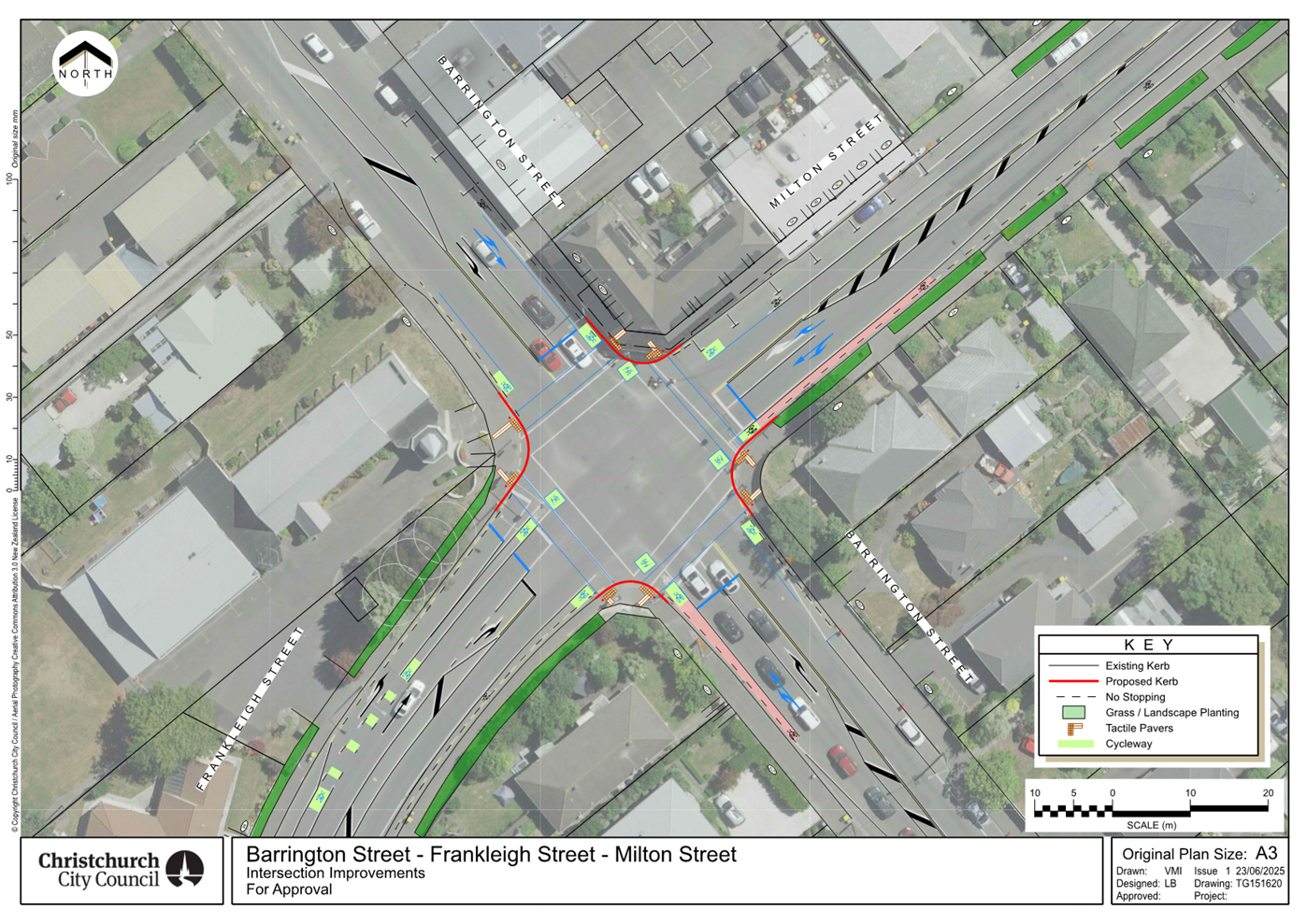
Report from Waihoro Spreydon-Cashmere-Heathcote Community Board – 10
July 2025
|
14. Spreydon,
Somerfield, Waltham, Beckenham CRAF - Selwyn Street pedestrian and cycle
safety improvements
|
|
Reference Te Tohutoro:
|
25/1431811
|
|
Responsible Officer(s) Te Pou Matua:
|
Ann
Tomlinson, Project Manager
Gemma Dioni, Principal Advisor Transportation Safety
|
|
Accountable ELT Member Pouwhakarae:
|
Brent
Smith, General Manager City Infrastructure
|
|
1. Waihoro Spreydon-Cashmere-Heathcote Community Board Consideration Te Whaiwhakaarotanga
|
|
|
The
Board accepted all the Officer Recommendations and included an additional
resolution requesting staff investigate kerb cutdowns at the proposed
Pedestrian Crossing on Selwyn Street.
The Board took into consideration the
deputation received from Spokes Canterbury. Spokes Canterbury overall
supported the proposed changes in the staff recommendations in agenda report,
which in its view will make Selwyn Street safer for pedestrians. However,
Spokes Canterbury considered that more could be done for cyclists.
|
|
2. Waihoro Spreydon-Cashmere-Heathcote Community Board Recommendation
to Council
|
|
|
That the Council:
1. Approves
in accordance with Clause 18 of the Christchurch City Council Traffic &
Parking Bylaw 2017 for Plan TG151619, dated 05/06/2025 as shown in Attachment
C of the agenda report:
a. That
a Special Vehicle Lane (cycle lane) be installed on the north-east side of
Selwyn Street, commencing at its intersection with Milton Street and
extending in a north-westerly direction for a distance of 36 metres.
b. That
a Special Vehicle Lane (cycle lane) be installed on the south-west side of
Selwyn Street, commencing at its intersection with Milton Street and
extending in a south-easterly direction for a distance of 34 metres.
|
|
3. Officer Recommendations Ngā Tūtohu
|
|
|
That the
Waihoro Spreydon-Cashmere-Heathcote Community Board:
1. Receives the information in the Spreydon,
Somerfield, Waltham, Beckenham CRAF - Selwyn Street pedestrian and cycle
safety improvements Report.
2. Notes that the decision in this report is
assessed as low significance based on the Christchurch City Council’s
Significance and Engagement Policy.
3. Revokes any previous resolutions
pertaining to traffic controls made pursuant to any bylaw to the extent that
they are in conflict with the parking or stopping restrictions described in
resolutions 4 to 13 below.
4. Approves the design, including kerb
alignments, road surface treatments, raised pedestrian crossing, pedestrian
islands, pedestrian cut-downs, resurfacing footpaths, tactile pavers and road
markings as detailed in the following plans and attached to this report as Attachments
A, B and C.
5. Approves, pursuant to Clause 7 of the
Christchurch City Council Traffic and Parking Bylaw 2017 for Plan
60720368-SHT-GE-9006, dated 18/12/2024 and attached to this report as
Attachment A:
a. That the parking of all vehicles be
restricted to a maximum period of 3 minutes on the north-east side of Selwyn
Street, commencing at a point 111 metres south-east of its intersection with
Bletsoe Avenue and extending in a south-easterly direction for a distance of
26.5 metres. This restriction is to apply from 8am-9am, and from 2:30-3:30pm,
on school days only.
b. That the stopping of vehicles be
prohibited at any time on the north-east side of Selwyn Street, commencing at
a point 137.5 metres south-east of its intersection with Bletsoe Avenue and
extending in a south-easterly direction for a distance of 12 metres.
c. That a Bus Stop be installed, on the
north-east side of Selwyn Street, commencing at a point 149.5 metres
south-east of its intersection with Bletsoe Avenue and extending in a
south-easterly direction for a distance of 30 metres.
d. That the stopping of vehicles be
prohibited at any time on the north-east side of Selwyn Street, commencing at
a point 179.5 metres south-east of its intersection with Bletsoe Avenue and
extending in a south-easterly direction for a distance of 38 metres.
e. That the stopping of vehicles be
prohibited at any time on the south-west side of Selwyn Street, commencing at
a point 44 metres north-west of its intersection with Dobson Street and
extending in a north-westerly direction to its intersection with Cheviot
Street.
f. That the stopping of vehicles be
prohibited at any time on the south-west side of Selwyn Street, commencing at
its intersection with Cheviot Street and extending in a north-westerly
direction for a distance of 6 metres.
g. That a Bus Stop be installed, on the
south-west side of Selwyn Street, commencing at a point 6 metres north-west
of its intersection with Cheviot Street and extending in a north-westerly
direction for a distance of 15 metres.
h. That the stopping of vehicles be
prohibited at any time on the south-west side of Selwyn Street, commencing at
a point 21 metres north-west of its intersection with Cheviot Street and
extending in a north-westerly direction for a distance of 7 metres.
Pedestrian
Crossing
6. Approves that in accordance with Section 8.2 of the
Land Transport Rule – Traffic Control Devices: 2004, that a Pedestrian
Crossing be installed on Selwyn Street, located 66.5 metres northwest of its intersection with Dobson Street, and as detailed
on plan 60720368-SHT-GE-9006, dated 18/12/2024 and attached to this report as
Attachment A.
School
Patrol
7. Approves that pursuant to Section 8.3(1) of The Land
Transport Rule- Traffic Control Devices: 2004, and the Local Government Act
1974, The Christchurch City Council hereby authorises the Board of Trustees
of Christchurch South Intermediate School, to appoint the appropriately
trained persons to act as school patrols at the pedestrian crossing (zebra
crossing) on Selwyn Street, located 66.5 metres northwest of its intersection
with Dobson Street.
Selwyn
Street – Roker Street to Somerfield Street
8. Approves, pursuant to Clause 7 of the Christchurch
City Council Traffic and Parking Bylaw 2017 for Plan 60720368-SHT-GE-9009, dated 19/12/2024 as shown
in Attachment B:
a. That the stopping of vehicles be
prohibited at any time on the northeast side of Selwyn Street, commencing at
its intersection with Roker Street and extending in a south-easterly
direction for a distance of 27.5 metres.
b. That the stopping of vehicles be
prohibited at any time on the southwest side of Selwyn Street, commencing at
its intersection with Roker Street and extending in a south-easterly
direction for a distance of 36.5 metres.
9. Approves, pursuant to Clause 7 of the Christchurch
City Council Traffic and Parking Bylaw 2017 for Plan 60720368-SHT-GE-9010, dated 19/12/2024 as shown
in Attachment B:
a. That the stopping of vehicles be
prohibited at any time on the northeast side of Selwyn Street, commencing at
a point 53 metres south-east of its intersection with Penrith Avenue and
extending in a south-easterly direction for a distance of 15 metres.
b. That the stopping of vehicles be
prohibited at any time on the northeast side of Selwyn Street, commencing at
a point 90 metres south-east of its intersection with Penrith Avenue and
extending in a south-easterly direction for a distance of 10.5 metres.
c. That the stopping of vehicles be
prohibited at any time on the southwest side of Selwyn Street, commencing at
its intersection with Cooke Street and extending in a north-westerly
direction for a distance of 26 metres.
d. That the stopping of vehicles be
prohibited at any time on the southwest side of Selwyn Street, commencing at
its intersection with Cooke Street and extending in a south-easterly
direction for a distance of 17 metres.
e. That the stopping of vehicles be
prohibited at any time on the northwest side of Cooke Street, commencing at
its intersection with Selwyn Street and extending in a south-westerly
direction for a distance of 21.5 metres.
f. That the stopping of vehicles be
prohibited at any time on the southeast side of Cooke Street, commencing at
its intersection with Selwyn Street and extending in a south-westerly
direction for a distance of 12.5 metres.
10. Approves, pursuant to Clause 7 of the Christchurch
City Council Traffic and Parking Bylaw 2017 for Plan 60720368-SHT-GE-9011, dated 19/12/2024 as shown
in Attachment B:
a. That the stopping of vehicles be
prohibited at any time on the northeast side of Selwyn Street, commencing at
its intersection with Leitch Street and extending in a north-westerly
direction for a distance of 11 metres.
b. That the stopping of vehicles be
prohibited at any time on the northeast side of Selwyn Street, commencing at
its intersection with Leitch Street and extending in a south-easterly
direction for a distance of 11 metres.
c. That the stopping of vehicles be
prohibited at any time on the northwest side of Leitch Street, commencing at
its intersection with Selwyn Street and extending in a north-easterly
direction for a distance of 14 metres.
d. That the stopping of vehicles be
prohibited at any time on the southeast side of Leitch Street, commencing at
its intersection with Selwyn Street and extending in a north-easterly
direction for a distance of 13.5 metres.
e. That the stopping of vehicles be
prohibited at any time on the northeast side of Selwyn Street, commencing at
its intersection with Dunn Street and extending in a north-westerly direction
for a distance of 11 metres.
f. That the stopping of vehicles be
prohibited at any time on the northeast side of Selwyn Street, commencing at
its intersection with Dunn Street and extending in a south-easterly direction
for a distance of 11 metres.
g. That the stopping of vehicles be
prohibited at any time on the northwest side of Dunn Street, commencing at
its intersection with Selwyn Street and extending in a north-easterly
direction for a distance of 13 metres.
h. That the stopping of vehicles be
prohibited at any time on the southeast side of Dunn Street, commencing at
its intersection with Selwyn Street and extending in a north-easterly
direction for a distance of 13 metres.
11. Approves, pursuant to Clause 7 of the Christchurch
City Council Traffic and Parking Bylaw 2017 for Plan 60720368-SHT-GE-9012,
dated 19/12/2024 as shown in
Attachment B:
a. That the stopping of vehicles be
prohibited at any time on the northeast side of Selwyn Street, commencing at
a point 34 metres south-east of its intersection with Dunn Street and
extending in a south-easterly direction for a distance of 11 metres.
b. That the stopping of vehicles be
prohibited at any time on the northeast side of Selwyn Street, commencing at
a point 65 metres south-east of its intersection with Dunn Street and
extending in a south-easterly direction for a distance of 11 metres.
c. That the stopping of vehicles be
prohibited at any time on the southwest side of Selwyn Street, commencing at
its intersection with Stenness Avenue and extending in a north-westerly
direction for a distance of 21 metres.
d. That the stopping of vehicles be
prohibited at any time on the southwest side of Selwyn Street, commencing at
its intersection with Stenness Avenue and extending in a south-easterly
direction for a distance of 15.5 metres.
e. That the stopping of vehicles be
prohibited at any time on the northwest side of Stenness Avenue, commencing
at its intersection with Selwyn Street and extending in a south-westerly
direction for a distance of 22 metres.
f. That the stopping of vehicles be
prohibited at any time on the southeast side of Stenness Avenue, commencing
at its intersection with Selwyn Street and extending in a south-westerly
direction for a distance of 12 metres.
12. Approves, pursuant to Clause 7 of the Christchurch
City Council Traffic and Parking Bylaw 2017 for Plan 60720368-SHT-GE-9013, dated 18/12/2024 as shown
in Attachment B:
a. That the stopping of vehicles be
prohibited at any time on the northeast side of Selwyn Street, commencing at
its intersection with Somerfield Street and extending in a north-westerly
direction for a distance of 23.5 metres.
b. That the stopping of vehicles be
prohibited at any time on the southwest side of Selwyn Street, commencing at
its intersection with Somerfield Street and extending in a north-westerly
direction for a distance of 23.5 metres.
c. That the stopping of vehicles be
prohibited at any time on the northwest side of Somerfield Street, commencing
at its intersection with Selwyn Street and extending in a north-easterly
direction for a distance of 28.5 metres.
d. That the stopping of vehicles be
prohibited at any time on the northwest side of Somerfield Street, commencing
at its intersection with Selwyn Street and extending in a south-westerly
direction for a distance of 24 metres.
e. That the stopping of vehicles be
prohibited at any time on the southeast side of Somerfield Street, commencing
at its intersection with Selwyn Street and extending in a north-easterly
direction for a distance of 24.5 metres.
f. That the stopping of vehicles be
prohibited at any time on the southeast side of Somerfield Street, commencing
at its intersection with Selwyn Street and extending in a south-westerly
direction for a distance of 23.5 metres.
13. Approves that these resolutions take effect when
parking signage and/or road markings that evidence the restrictions described
in the staff report are in place (or removed in the case of revocations).
That the Waihoro
Spreydon-Cashmere-Heathcote Community Board recommend that Council:
14. Approves in accordance with Clause 18 of the
Christchurch City Council Traffic & Parking Bylaw 2017 for Plan TG151619,
dated 05/06/2025 as shown in Attachment C:
a. That a Special Vehicle Lane (cycle lane) be
installed on the north-east side of Selwyn Street, commencing at its
intersection with Milton Street and extending in a north-westerly direction
for a distance of 36 metres.
b. That a Special Vehicle Lane (cycle lane) be
installed on the south-west side of Selwyn Street, commencing at its
intersection with Milton Street and extending in a south-easterly direction
for a distance of 34 metres.
|
|
4. Waihoro Spreydon-Cashmere-Heathcote Community Board Decisions
Under Delegation Ngā
Mana kua Tukuna
|
|
|
That the Waihoro Spreydon-Cashmere-Heathcote Community Board:
1. Receives the information in the Spreydon,
Somerfield, Waltham, Beckenham CRAF - Selwyn Street pedestrian and cycle safety
improvements Report on the agenda.
2. Notes that the decision in this report is
assessed as low significance based on the Christchurch City Council’s
Significance and Engagement Policy.
3. Revokes any previous resolutions
pertaining to traffic controls made pursuant to any bylaw to the extent that
they are in conflict with the parking or stopping restrictions described in
resolutions 4 to 13 below.
4. Approves the design, including kerb
alignments, road surface treatments, raised pedestrian crossing, pedestrian
islands, pedestrian cut-downs, resurfacing footpaths, tactile pavers and road
markings as detailed in the following plans and attached to the agenda report
as Attachments A, B and C.
5. Approves, pursuant to Clause 7 of the
Christchurch City Council Traffic and Parking Bylaw 2017 for Plan
60720368-SHT-GE-9006, dated 18/12/2024 and attached to the agenda report as
Attachment A:
a. That the parking of all vehicles be
restricted to a maximum period of 3 minutes on the north-east side of Selwyn
Street, commencing at a point 111 metres south-east of its intersection with
Bletsoe Avenue and extending in a south-easterly direction for a distance of
26.5 metres. This restriction is to apply from 8am-9am, and from 2:30-3:30pm,
on school days only.
b. That the stopping of vehicles be
prohibited at any time on the north-east side of Selwyn Street, commencing at
a point 137.5 metres south-east of its intersection with Bletsoe Avenue and
extending in a south-easterly direction for a distance of 12 metres.
c. That a Bus Stop be installed, on the
north-east side of Selwyn Street, commencing at a point 149.5 metres
south-east of its intersection with Bletsoe Avenue and extending in a
south-easterly direction for a distance of 30 metres.
d. That the stopping of vehicles be
prohibited at any time on the north-east side of Selwyn Street, commencing at
a point 179.5 metres south-east of its intersection with Bletsoe Avenue and
extending in a south-easterly direction for a distance of 38 metres.
e. That the stopping of vehicles be
prohibited at any time on the south-west side of Selwyn Street, commencing at
a point 44 metres north-west of its intersection with Dobson Street and
extending in a north-westerly direction to its intersection with Cheviot
Street.
f. That the stopping of vehicles be
prohibited at any time on the south-west side of Selwyn Street, commencing at
its intersection with Cheviot Street and extending in a north-westerly
direction for a distance of 6 metres.
g. That a Bus Stop be installed, on the
south-west side of Selwyn Street, commencing at a point 6 metres north-west
of its intersection with Cheviot Street and extending in a north-westerly
direction for a distance of 15 metres.
h. That the stopping of vehicles be
prohibited at any time on the south-west side of Selwyn Street, commencing at
a point 21 metres north-west of its intersection with Cheviot Street and
extending in a north-westerly direction for a distance of 7 metres.
Pedestrian
Crossing
6. Approves that in accordance with Section 8.2 of the
Land Transport Rule – Traffic Control Devices: 2004, that a Pedestrian
Crossing be installed on Selwyn Street, located 66.5 metres northwest of its intersection with Dobson Street, and as detailed
on plan 60720368-SHT-GE-9006, dated 18/12/2024 and attached to the agenda
report as Attachment A.
7. Requests staff investigate kerb cutdowns at the
Pedestrian Crossing on Selwyn Street, in resolution 6, as part of the
detailed design process.
School
Patrol
8. Approves that pursuant to Section 8.3(1) of The Land
Transport Rule- Traffic Control Devices: 2004, and the Local Government Act
1974, The Christchurch City Council hereby authorises the Board of Trustees
of Christchurch South Intermediate School, to appoint the appropriately
trained persons to act as school patrols at the pedestrian crossing (zebra
crossing) on Selwyn Street, located 66.5 metres northwest of its intersection
with Dobson Street.
Selwyn
Street – Roker Street to Somerfield Street
9. Approves, pursuant to Clause 7 of the Christchurch
City Council Traffic and Parking Bylaw 2017 for Plan 60720368-SHT-GE-9009, dated 19/12/2024 as shown
in Attachment B of the agenda report:
a. That the stopping of vehicles be
prohibited at any time on the northeast side of Selwyn Street, commencing at
its intersection with Roker Street and extending in a south-easterly
direction for a distance of 27.5 metres.
b. That the stopping of vehicles be
prohibited at any time on the southwest side of Selwyn Street, commencing at
its intersection with Roker Street and extending in a south-easterly
direction for a distance of 36.5 metres.
10. Approves, pursuant to Clause 7 of the Christchurch
City Council Traffic and Parking Bylaw 2017 for Plan 60720368-SHT-GE-9010, dated 19/12/2024 as shown
in Attachment B of the agenda report:
a. That the stopping of vehicles be
prohibited at any time on the northeast side of Selwyn Street, commencing at
a point 53 metres south-east of its intersection with Penrith Avenue and
extending in a south-easterly direction for a distance of 15 metres.
b. That the stopping of vehicles be
prohibited at any time on the northeast side of Selwyn Street, commencing at
a point 90 metres south-east of its intersection with Penrith Avenue and
extending in a south-easterly direction for a distance of 10.5 metres.
c. That the stopping of vehicles be
prohibited at any time on the southwest side of Selwyn Street, commencing at
its intersection with Cooke Street and extending in a north-westerly
direction for a distance of 26 metres.
d. That the stopping of vehicles be
prohibited at any time on the southwest side of Selwyn Street, commencing at
its intersection with Cooke Street and extending in a south-easterly
direction for a distance of 17 metres.
e. That the stopping of vehicles be
prohibited at any time on the northwest side of Cooke Street, commencing at
its intersection with Selwyn Street and extending in a south-westerly
direction for a distance of 21.5 metres.
f. That the stopping of vehicles be
prohibited at any time on the southeast side of Cooke Street, commencing at
its intersection with Selwyn Street and extending in a south-westerly
direction for a distance of 12.5 metres.
11. Approves, pursuant to Clause 7 of the Christchurch
City Council Traffic and Parking Bylaw 2017 for Plan 60720368-SHT-GE-9011, dated 19/12/2024 as shown
in Attachment B of the agenda report:
a. That the stopping of vehicles be
prohibited at any time on the northeast side of Selwyn Street, commencing at
its intersection with Leitch Street and extending in a north-westerly
direction for a distance of 11 metres.
b. That the stopping of vehicles be
prohibited at any time on the northeast side of Selwyn Street, commencing at
its intersection with Leitch Street and extending in a south-easterly
direction for a distance of 11 metres.
c. That the stopping of vehicles be
prohibited at any time on the northwest side of Leitch Street, commencing at
its intersection with Selwyn Street and extending in a north-easterly
direction for a distance of 14 metres.
d. That the stopping of vehicles be
prohibited at any time on the southeast side of Leitch Street, commencing at
its intersection with Selwyn Street and extending in a north-easterly
direction for a distance of 13.5 metres.
e. That the stopping of vehicles be
prohibited at any time on the northeast side of Selwyn Street, commencing at
its intersection with Dunn Street and extending in a north-westerly direction
for a distance of 11 metres.
f. That the stopping of vehicles be
prohibited at any time on the northeast side of Selwyn Street, commencing at
its intersection with Dunn Street and extending in a south-easterly direction
for a distance of 11 metres.
g. That the stopping of vehicles be
prohibited at any time on the northwest side of Dunn Street, commencing at
its intersection with Selwyn Street and extending in a north-easterly
direction for a distance of 13 metres.
h. That the stopping of vehicles be
prohibited at any time on the southeast side of Dunn Street, commencing at
its intersection with Selwyn Street and extending in a north-easterly
direction for a distance of 13 metres.
12. Approves, pursuant to Clause 7 of the Christchurch
City Council Traffic and Parking Bylaw 2017 for Plan 60720368-SHT-GE-9012,
dated 19/12/2024 as shown in
Attachment B of the agenda report:
a. That the stopping of vehicles be
prohibited at any time on the northeast side of Selwyn Street, commencing at
a point 34 metres south-east of its intersection with Dunn Street and
extending in a south-easterly direction for a distance of 11 metres.
b. That the stopping of vehicles be
prohibited at any time on the northeast side of Selwyn Street, commencing at
a point 65 metres south-east of its intersection with Dunn Street and
extending in a south-easterly direction for a distance of 11 metres.
c. That the stopping of vehicles be
prohibited at any time on the southwest side of Selwyn Street, commencing at
its intersection with Stenness Avenue and extending in a north-westerly
direction for a distance of 21 metres.
d. That the stopping of vehicles be
prohibited at any time on the southwest side of Selwyn Street, commencing at
its intersection with Stenness Avenue and extending in a south-easterly
direction for a distance of 15.5 metres.
e. That the stopping of vehicles be
prohibited at any time on the northwest side of Stenness Avenue, commencing
at its intersection with Selwyn Street and extending in a south-westerly
direction for a distance of 22 metres.
f. That the stopping of vehicles be
prohibited at any time on the southeast side of Stenness Avenue, commencing
at its intersection with Selwyn Street and extending in a south-westerly
direction for a distance of 12 metres.
13. Approves, pursuant to Clause 7 of the Christchurch
City Council Traffic and Parking Bylaw 2017 for Plan 60720368-SHT-GE-9013, dated 18/12/2024 as shown
in Attachment B of the agenda report:
a. That the stopping of vehicles be
prohibited at any time on the northeast side of Selwyn Street, commencing at
its intersection with Somerfield Street and extending in a north-westerly
direction for a distance of 23.5 metres.
b. That the stopping of vehicles be
prohibited at any time on the southwest side of Selwyn Street, commencing at
its intersection with Somerfield Street and extending in a north-westerly
direction for a distance of 23.5 metres.
c. That the stopping of vehicles be
prohibited at any time on the northwest side of Somerfield Street, commencing
at its intersection with Selwyn Street and extending in a north-easterly
direction for a distance of 28.5 metres.
d. That the stopping of vehicles be
prohibited at any time on the northwest side of Somerfield Street, commencing
at its intersection with Selwyn Street and extending in a south-westerly
direction for a distance of 24 metres.
e. That the stopping of vehicles be
prohibited at any time on the southeast side of Somerfield Street, commencing
at its intersection with Selwyn Street and extending in a north-easterly
direction for a distance of 24.5 metres.
f. That the stopping of vehicles be
prohibited at any time on the southeast side of Somerfield Street, commencing
at its intersection with Selwyn Street and extending in a south-westerly
direction for a distance of 23.5 metres.
14. Approves that these resolutions take effect when
parking signage and/or road markings that evidence the restrictions described
in the staff report are in place (or removed in the case of revocations).
|
In addition to the attached documents, the following background information
is available:
|
Document
Name – Location / File Link
|
|
Not
applicable
|
Attachments Ngā Tāpirihanga
|
No.
|
Report Title
|
Reference
|
Page
|
|
1
|
Spreydon, Somerfield, Waltham,
Beckenham CRAF - Selwyn Street pedestrian and cycle safety improvements
|
24/2253692
|
182
|
|
No.
|
Title
|
Reference
|
Page
|
|
a ⇩
|
Selwyn Street -
Christchurch South Karamata Intermediate School
|
25/80618
|
195
|
|
b ⇩
|
Selwyn Street - Roker
Street to Somerfield Street
|
25/80620
|
196
|
|
c ⇩
|
Selwyn Street -
Milton Street intersection
|
25/1142338
|
201
|
|
Spreydon, Somerfield, Waltham, Beckenham CRAF - Selwyn Street
pedestrian and cycle safety improvements
|
|
Reference Te Tohutoro:
|
24/2253692
|
|
Responsible Officer(s) Te Pou Matua:
|
Ann
Tomlinson, Project Manager
Gemma Dioni, Principal Advisor Transportation Safety
|
|
Accountable ELT Member Pouwhakarae:
|
Brent
Smith, General Manager City Infrastructure
|
1. Purpose and Origin of the Report Te Pūtake Pūrongo
1.1 The
purpose of this report is for the Waihoro Spreydon-Cashmere-Heathcote Community
Board to consider the Selwyn Street pedestrian safety scheme design following
community engagement. This will allow the project to proceed to detailed design
and construction.
1.2 Selwyn
Street pedestrian safety improvements are a component of the Colombo Street,
Somerfield Street and Selwyn Street project within the Spreydon, Somerfield,
Waltham, Beckenham Christchurch Regeneration Acceleration Facility (CRAF)
programme.
1.3 The report has been written to address safety improvement of the
transport assets on Selwyn Street.
2. Officer Recommendations Ngā Tūtohu
That the Waihoro
Spreydon-Cashmere-Heathcote Community Board:
1. Receives the information in the Spreydon, Somerfield, Waltham,
Beckenham CRAF - Selwyn Street pedestrian and cycle safety improvements Report.
2. Notes that the decision in this report is assessed as low
significance based on the Christchurch City Council’s Significance and
Engagement Policy.
3. Revokes any previous resolutions pertaining to traffic controls made
pursuant to any bylaw to the extent that they are in conflict with the parking
or stopping restrictions described in resolutions 4 to 13 below.
4. Approves the design, including kerb alignments, road surface
treatments, raised pedestrian crossing, pedestrian islands, pedestrian
cut-downs, resurfacing footpaths, tactile pavers and road markings as detailed
in the following plans and attached to this report as Attachments A, B and
C.
5. Approves, pursuant to Clause 7 of the Christchurch City Council
Traffic and Parking Bylaw 2017 for Plan 60720368-SHT-GE-9006, dated 18/12/2024
and attached to this report as Attachment A:
a. That the parking of all vehicles be restricted to a maximum period
of 3 minutes on the north-east side of Selwyn Street, commencing at a point 111
metres south-east of its intersection with Bletsoe Avenue and extending in a
south-easterly direction for a distance of 26.5 metres. This restriction is to
apply from 8am-9am, and from 2:30-3:30pm, on school days only.
b. That the stopping of vehicles be prohibited at any time on the
north-east side of Selwyn Street, commencing at a point 137.5 metres south-east
of its intersection with Bletsoe Avenue and extending in a south-easterly
direction for a distance of 12 metres.
c. That a Bus Stop be installed, on the north-east side of Selwyn
Street, commencing at a point 149.5 metres south-east of its intersection with
Bletsoe Avenue and extending in a south-easterly direction for a distance of 30
metres.
d. That the stopping of vehicles be prohibited at any time on the
north-east side of Selwyn Street, commencing at a point 179.5 metres south-east
of its intersection with Bletsoe Avenue and extending in a south-easterly
direction for a distance of 38 metres.
e. That the stopping of vehicles be prohibited at any time on the
south-west side of Selwyn Street, commencing at a point 44 metres north-west of
its intersection with Dobson Street and extending in a north-westerly direction
to its intersection with Cheviot Street.
f. That the stopping of vehicles be prohibited at any time on the
south-west side of Selwyn Street, commencing at its intersection with Cheviot
Street and extending in a north-westerly direction for a distance of 6 metres.
g. That a Bus Stop be installed, on the south-west side of Selwyn
Street, commencing at a point 6 metres north-west of its intersection with
Cheviot Street and extending in a north-westerly direction for a distance of 15
metres.
h. That the stopping of vehicles be prohibited at any time on the
south-west side of Selwyn Street, commencing at a point 21 metres north-west of
its intersection with Cheviot Street and extending in a north-westerly
direction for a distance of 7 metres.
Pedestrian Crossing
6. Approves
that in accordance with Section 8.2 of the Land Transport Rule – Traffic
Control Devices: 2004, that a Pedestrian Crossing be installed on Selwyn
Street, located 66.5 metres northwest of its
intersection with Dobson Street, and as detailed on plan 60720368-SHT-GE-9006,
dated 18/12/2024 and attached to this report as Attachment A.
School Patrol
7. Approves
that pursuant to Section 8.3(1) of The Land Transport Rule- Traffic Control
Devices: 2004, and the Local Government Act 1974, The Christchurch City Council
hereby authorises the Board of Trustees of Christchurch South Intermediate
School, to appoint the appropriately trained persons to act as school patrols
at the pedestrian crossing (zebra crossing) on Selwyn Street, located 66.5 metres
northwest of its intersection with Dobson Street.
Selwyn Street – Roker Street to
Somerfield Street
8. Approves,
pursuant to Clause 7 of the Christchurch City Council Traffic and Parking Bylaw
2017 for Plan 60720368-SHT-GE-9009, dated 19/12/2024 as shown
in Attachment B:
a. That the stopping of vehicles be prohibited at any time on the
northeast side of Selwyn Street, commencing at its intersection with Roker
Street and extending in a south-easterly direction for a distance of 27.5
metres.
b. That the stopping of vehicles be prohibited at any time on the
southwest side of Selwyn Street, commencing at its intersection with Roker
Street and extending in a south-easterly direction for a distance of 36.5
metres.
9. Approves,
pursuant to Clause 7 of the Christchurch City Council Traffic and Parking Bylaw
2017 for Plan 60720368-SHT-GE-9010, dated 19/12/2024 as shown
in Attachment B:
a. That the stopping of vehicles be prohibited at any time on the
northeast side of Selwyn Street, commencing at a point 53 metres south-east of
its intersection with Penrith Avenue and extending in a south-easterly
direction for a distance of 15 metres.
b. That the stopping of vehicles be prohibited at any time on the
northeast side of Selwyn Street, commencing at a point 90 metres south-east of
its intersection with Penrith Avenue and extending in a south-easterly
direction for a distance of 10.5 metres.
c. That the stopping of vehicles be prohibited at any time on the
southwest side of Selwyn Street, commencing at its intersection with Cooke
Street and extending in a north-westerly direction for a distance of 26 metres.
d. That the stopping of vehicles be prohibited at any time on the
southwest side of Selwyn Street, commencing at its intersection with Cooke
Street and extending in a south-easterly direction for a distance of 17 metres.
e. That the stopping of vehicles be prohibited at any time on the
northwest side of Cooke Street, commencing at its intersection with Selwyn
Street and extending in a south-westerly direction for a distance of 21.5
metres.
f. That the stopping of vehicles be prohibited at any time on the
southeast side of Cooke Street, commencing at its intersection with Selwyn
Street and extending in a south-westerly direction for a distance of 12.5
metres.
10. Approves,
pursuant to Clause 7 of the Christchurch City Council Traffic and Parking Bylaw
2017 for Plan 60720368-SHT-GE-9011, dated 19/12/2024 as shown
in Attachment B:
a. That the stopping of vehicles be prohibited at any time on the
northeast side of Selwyn Street, commencing at its intersection with Leitch
Street and extending in a north-westerly direction for a distance of 11 metres.
b. That the stopping of vehicles be prohibited at any time on the
northeast side of Selwyn Street, commencing at its intersection with Leitch
Street and extending in a south-easterly direction for a distance of 11 metres.
c. That the stopping of vehicles be prohibited at any time on the
northwest side of Leitch Street, commencing at its intersection with Selwyn
Street and extending in a north-easterly direction for a distance of 14 metres.
d. That the stopping of vehicles be prohibited at any time on the
southeast side of Leitch Street, commencing at its intersection with Selwyn
Street and extending in a north-easterly direction for a distance of 13.5
metres.
e. That the stopping of vehicles be prohibited at any time on the
northeast side of Selwyn Street, commencing at its intersection with Dunn
Street and extending in a north-westerly direction for a distance of 11 metres.
f. That the stopping of vehicles be prohibited at any time on the
northeast side of Selwyn Street, commencing at its intersection with Dunn
Street and extending in a south-easterly direction for a distance of 11 metres.
g. That the stopping of vehicles be prohibited at any time on the
northwest side of Dunn Street, commencing at its intersection with Selwyn
Street and extending in a north-easterly direction for a distance of 13 metres.
h. That the stopping of vehicles be prohibited at any time on the
southeast side of Dunn Street, commencing at its intersection with Selwyn
Street and extending in a north-easterly direction for a distance of 13 metres.
11. Approves,
pursuant to Clause 7 of the Christchurch City Council Traffic and Parking Bylaw
2017 for Plan 60720368-SHT-GE-9012, dated 19/12/2024 as shown
in Attachment B:
a. That the stopping of vehicles be prohibited at any time on the
northeast side of Selwyn Street, commencing at a point 34 metres south-east of
its intersection with Dunn Street and extending in a south-easterly direction
for a distance of 11 metres.
b. That the stopping of vehicles be prohibited at any time on the
northeast side of Selwyn Street, commencing at a point 65 metres south-east of
its intersection with Dunn Street and extending in a south-easterly direction
for a distance of 11 metres.
c. That the stopping of vehicles be prohibited at any time on the
southwest side of Selwyn Street, commencing at its intersection with Stenness
Avenue and extending in a north-westerly direction for a distance of 21 metres.
d. That the stopping of vehicles be prohibited at any time on the
southwest side of Selwyn Street, commencing at its intersection with Stenness
Avenue and extending in a south-easterly direction for a distance of 15.5
metres.
e. That the stopping of vehicles be prohibited at any time on the
northwest side of Stenness Avenue, commencing at its intersection with Selwyn
Street and extending in a south-westerly direction for a distance of 22 metres.
f. That the stopping of vehicles be prohibited at any time on the
southeast side of Stenness Avenue, commencing at its intersection with Selwyn
Street and extending in a south-westerly direction for a distance of 12 metres.
12. Approves,
pursuant to Clause 7 of the Christchurch City Council Traffic and Parking Bylaw
2017 for Plan 60720368-SHT-GE-9013, dated 18/12/2024 as shown
in Attachment B:
a. That the stopping of vehicles be prohibited at any time on the
northeast side of Selwyn Street, commencing at its intersection with Somerfield
Street and extending in a north-westerly direction for a distance of 23.5
metres.
b. That the stopping of vehicles be prohibited at any time on the
southwest side of Selwyn Street, commencing at its intersection with Somerfield
Street and extending in a north-westerly direction for a distance of 23.5
metres.
c. That the stopping of vehicles be prohibited at any time on the
northwest side of Somerfield Street, commencing at its intersection with Selwyn
Street and extending in a north-easterly direction for a distance of 28.5
metres.
d. That the stopping of vehicles be prohibited at any time on the
northwest side of Somerfield Street, commencing at its intersection with Selwyn
Street and extending in a south-westerly direction for a distance of 24 metres.
e. That the stopping of vehicles be prohibited at any time on the
southeast side of Somerfield Street, commencing at its intersection with Selwyn
Street and extending in a north-easterly direction for a distance of 24.5
metres.
f. That the stopping of vehicles be prohibited at any time on the
southeast side of Somerfield Street, commencing at its intersection with Selwyn
Street and extending in a south-westerly direction for a distance of 23.5
metres.
13. Approves
that these resolutions take effect when parking signage and/or road markings
that evidence the restrictions described in the staff report are in place (or
removed in the case of revocations).
That the Waihoro Spreydon-Cashmere-Heathcote Community Board
recommend that Council:
14. Approves
in accordance with Clause 18 of the Christchurch City Council Traffic &
Parking Bylaw 2017 for Plan TG151619, dated 05/06/2025 as shown in Attachment
C:
a. That
a Special Vehicle Lane (cycle lane) be installed on the north-east side of
Selwyn Street, commencing at its intersection with Milton Street and extending
in a north-westerly direction for a distance of 36 metres.
b. That
a Special Vehicle Lane (cycle lane) be installed on the south-west side of
Selwyn Street, commencing at its intersection with Milton Street and extending
in a south-easterly direction for a distance of 34 metres.
3. Executive Summary Te Whakarāpopoto Matua
3.1 In
August 2022, staff presented a package of improvements to the Waihoro
Spreydon-Cashmere and Waikura Linwood-Central-Heathcote Community Boards (Agenda, Item 5). The Community Boards
jointly approved a number of projects for the Spreydon, Somerfield, Waltham,
Beckenham CRAF programme (Minutes, Item 5) which included a
package of improvements for Colombo Street, Somerfield Street and Selwyn
Street.
3.2 The
Community Boards requested staff to install a number of improvements on Selwyn
Street.
3.3 The
following sites on Selwyn Street were identified as Board priorities for
improvements and are included in the scheme for approval:
3.3.1 Investigate the
intersection deficiencies at the Selwyn Street/Somerfield Street intersection
and implement appropriate safety improvements, including pedestrian and cycle
crossing facilities.
3.3.2 Implement safety
improvement at the kea crossing outside Christchurch South Karamata
Intermediate School on Selwyn Street, by raising the crossing and installing
red surfacing, or through the implementation of a similar treatment.
3.3.3 Investigate the
locations for three pedestrian islands or crossings on Selwyn Street.
Selwyn Street/Somerfield Street intersection
3.4 The
recommended option is to install improved pedestrian and cycle facilities at
the intersection, as shown in Attachment A, and summarised below:
· Install pedestrian refuge islands on Somerfield Street on both sides
of the Selwyn Street intersection
· Install tactile pavers at the existing Selwyn Street (north side)
crossing to improve accessibility and promote pedestrian desire lines
· New green cycle marking on the existing cycle lanes on Somerfield
Street across the intersection of Selwyn Street
· Install new speed humps on Selwyn Street, north side of Somerfield
Street, on the exit and entry
Selwyn Street intersections between Roker Street and
Somerfield Street
3.5 The
recommended option is to install improved pedestrian crossing facilities, as
shown in Attachment A and summarised below:
· Install kerb buildouts on Selwyn Street at the intersections of
Stenness Avenue, Dunn Street, Leitch Street and Cooke Street
· Install tactile pavers at each crossing on either side of the
carriageway to improve accessibility
· Increase no-stopping on Selwyn Street at the existing crossing
location at Roker Street to improve sightlines for pedestrians.
Selwyn Street/Milton Street intersection
3.6 In
May/early June 2025, Orion were installing an underground 66kV electricity
cable at this intersection. The traffic signals at this intersection were at
the end of their service life and staff worked alongside Orion to replace the
traffic signals. This allowed for safety improvements to be installed such as
pedestrian protection for tamariki-children travelling to and from Christchurch
South Karamata Intermediate School.
3.7 The
recommended option is to install road marking for people cycling through the
intersection, as shown in Attachment C, and summarised below:
· Sharrow markings on the kerbside lanes on Milton Street
· Advanced cycle boxes on each approach
· Hook turn boxes on each corner
Selwyn Street - Christchurch South Karamata
Intermediate School
3.8 The
recommended option is to install improved pedestrian facilities at the school,
as shown in Attachment B, and summarised below:
· New raised pedestrian crossing at existing crossing location on
Selwyn Street
· Kerb buildouts to reduce the crossing distance
· New tactile pavers
· Extend existing bus parking outside school
4. Background/Context Te Horopaki
4.1 CRAF
is a funding package from the Treasury for transport projects in Christchurch.
The CRAF investment in roading and transport improvements will address
condition and safety and access issues. It will act as a catalyst towards the
development of a high-quality, safe and reliable transport network.
4.2 Improving
safety on local roads in Christchurch is a priority for the Council. Providing
safe and key infrastructure is key to ensure people get to where they are going
safely, irrespective of their mode of travel.
4.3 Selwyn Street has been identified as an important link for
pedestrians and cyclists as part of the initial street reviews and through
public consultation. There are several schools and two retail centres along the
corridor. Selwyn Street has traffic flows of over 8,000 vehicles per day with
85th percentile vehicle speed of 54km/h north of its intersection with
Coronation Street, and traffic flows of approximately 3,500 vehicles per day
north of Somerfield Street with 85th percentile vehicle speed of 53.6 km/h.
4.4 Selwyn
Street is a flat, wide (12-14m) moderate collector route that connects the
Central City to Christchurch South and is surrounded by residential properties.
4.5 Residents
and students cross Selwyn Street at several locations to access Somerfield Te
Kura Wairepo located on Somerfield Street and Christchurch South Karamata
Intermediate School, located on Selwyn Street.
4.6 Wide
lanes on Selwyn Street passively increase drivers speed, leading to potentially
high operating speeds making it unsafe for pedestrians crossing.
4.7 The
large radius of the corners at some intersections allows vehicles to turn into
the side streets without sufficiently reducing speed.
Selwyn Street/Somerfield Street intersection
4.8 Somerfield
Te Kura Wairepo is located on Somerfield Street between Studholme Street and
Barrington Street catering for years 1-6 with a roll of approximately 500
students.
4.9 The
main entrance to the school is located on Somerfield Street, with another
entrance on Studholme Street.
4.10 The intersection
of Selwyn Street/Somerfield Street is used by a number of students travelling
to schools in the area.
4.11 There is a
Montessori Preschool located on the northwest corner of the intersection.
4.12 The intersection
generates a lot of activity, especially in peak times with vehicles heading
into the city, students travelling to and from school, and preschool drop off
and pick-ups.
Selwyn Street intersections between Milton Street and Somerfield
Street
4.13 Students from
both Somerfield Te Kura Wairepo and Christchurch South Karamata Intermediate
School travel along Selwyn Street through Selwyn Street/Milton Street
intersection, Selwyn Street/Somerfield Street intersection as well as crossing
smaller side streets.
4.14 During an
afternoon site visit it was noted that the main travel modes were pedestrians
and cyclists heading southbound along the road and footpath.
4.15 The side streets
onto Selwyn Street have large radii which allows vehicles to enter at speed.
4.16 There are many
children that use the Milton/Selwyn intersection for their journey to school,
on foot and by bicycle. Pedestrian protection is being introduced through the
current re-cabling works and separation is also being provided between the
crosswalks. There are cycle lanes marked on the Selwyn Street approach but
there are currently no cycle facilities on Milton Street.
Selwyn Street - Christchurch South Karamata Intermediate School
4.17 Christchurch
South Karamata Intermediate School is located on Selwyn Street and caters for
Years 7 and 8 with a roll of approximately 530 students. Its catchment is
bounded by the Port Hills, Heathcote River and the city.
4.18 The main
entrance to the school is on Selwyn Street, with a secondary entrance from
Dominion Avenue.
4.19 The school
operates a kea crossing on Selwyn Street before and after school.
4.20 The school
utilises the existing bus stop on the east side of Selwyn Street.
4.21 Improvements on
Selwyn Street are designed to improve safety and accessibility specifically for
students attending Somerfield Te Kura Wairepo located on Somerfield Street and
Christchurch South Karamata Intermediate School, located on Selwyn Street.
4.22 At the time of
approving the project improvements the Community Board requested staff to
closely work with the key stakeholders to understand their needs for
improvements. Schools advised the project team the improvements that was needed
for the area, which was later developed and consulted on.
4.23 The following related information session/workshops have taken place
for the members of the meeting:
Options Considered Ngā
Kōwhiringa Whaiwhakaaro
4.24 The following
reasonably practicable options were considered and are assessed in this report:
4.24.1 Option 1 – Selwyn
Street safety improvements as shown in Attachments A and B.
4.24.2 Option 2 – Do
nothing.
Options Descriptions Ngā
Kōwhiringa
4.25 Preferred
Option: Selwyn Street – pedestrian and cycle safety improvements
4.25.1 Option Description: Pedestrian
and cycle safety improvements including intersection safety improvements:
· Installing pedestrian refuge islands on Somerfield Street on both
sides of the Selwyn Street intersection with associated tactile pavers.
· Installing speed humps on Selwyn Street at the northern entry and
exit at Somerfield Street.
· New green cycle marking on the existing cycle lanes on Somerfield
Street across the intersection of Selwyn Street.
· New pedestrian buildouts and tactile pavers at the following
locations:
· Crossing Selwyn Street either side of Stenness Avenue and crossing
Stenness Avenue
· Crossing Dunn Street at the Selwyn Street intersection
· Crossing Leitch Street at the Selwyn Street intersection
· Crossing Selwyn Street either side of Cooke Street and crossing
Cooke Street
· Parking removal on Selwyn Street at Roker Street to improve
sightlines at the existing refuge crossings
· New green cycle paint and extension for the existing cycle lanes on
Selwyn Street at the intersection of Milton Street
Christchurch South Karamata Intermediate (Selwyn Street)
· Install a raised pedestrian crossing with associated linemarking,
tactile pavers and kerb buildouts in current crossing location on Selwyn Street
· Extend existing bus parking bay outside the school
4.25.2 Option Advantages
· Meets all project objectives
· Improved pedestrian safety
· Improved crossing facilities at four intersections on Selwyn Street
between Somerfield Street and Milton Street
· Improved crossing facilities on Somerfield Street at Selwyn Street
intersection
· Improved cycle safety on Selwyn Street at the Somerfield Street and Milton
Street intersections
· Improved cycle safety on Somerfield Street at Selwyn Street
intersection
· Improved crossing facilities at Christchurch South Karamata
Intermediate on Selwyn Street
· Additional bus parking at Christchurch South Karamata Intermediate
on Selwyn Street
4.25.3 Option Disadvantages
· Removal of 35 carparks on Selwyn Street between Milton Street and
Somerfield Street
4.26 Selwyn Street
– Do nothing
4.26.1 Option Description: Existing
layout remains with no improvements for pedestrians or cyclists
4.26.2 Option Advantages
· Funding could be spent on other projects within the programme
· No parking removal
4.26.3 Option Disadvantages
· Does not meet project objectives
· No safe crossing points for pedestrians on Selwyn Street,
specifically students from Somerfield Te Kura Wairepo and Christchurch South
Karamata Intermediate
· No improved cycle facilities
· No improved crossing facilities for Christchurch South Karamata
Intermediate students
5. Financial Implications Ngā Hīraunga Rauemi
Capex/Opex Ngā Utu Whakahaere
|
|
Recommended Option 1
|
Option 2 – Do nothing
|
|
Cost to Implement
|
$512,000
|
N/A
|
|
Maintenance/Ongoing Costs
|
Covered by existing maintenance contract
- minor increase due to requirement for hand sweeping channel behind kerb
buildouts – approx. $2,000/year for whole project area
|
Covered by existing maintenance contract.
|
|
Funding Source
|
LTP Budget 73818 – Spreydon,
Somerfield, Waltham, Beckenham CRAF – Colombo Street, Somerfield
Street, Selwyn Street improvements
|
N/A
|
|
Funding Availability
|
Funds are available
|
Funds are available
|
|
Impact on Rates
|
Nil*
|
N/A
|
*This project is funded from the
Christchurch Regeneration Acceleration Fund so does not impact on rates
6. Considerations Ngā Whai Whakaaro
Risks and Mitigations Ngā
Mōrearea me ngā Whakamātautau
6.1 None
identified above BAU
Legal Considerations Ngā
Hīraunga ā-Ture
6.2 Statutory
and/or delegated authority to undertake proposals in the report:
6.2.1 The Community Boards have delegated authority from Council to
exercise the delegations as set out in the Register of Delegations. The list of
delegations for the Community Boards includes the resolution of stopping and
traffic control devices.
6.2.2 The installation of any signs and/or marking associated with traffic
control devices must comply with the Land Transport Rule: Traffic Control
Devices 2004.
6.2.3 Part 1, Clause 7 of the Christchurch City Council Traffic and
Parking Bylaw 2017 provides Council with the authority to install parking or
stopping restrictions by resolution.
6.3 Other Legal Implications:
6.3.1 There is no legal
context, issue, or implication relevant to this decision.
Strategy and Policy Considerations Te Whai
Kaupapa here
6.4 The
required decisions:
6.4.1 Align with the Christchurch City Council’s Strategic Framework.
6.4.2 Are of low
significance in relation to the Christchurch City Council’s Significance and Engagement Policy
2019. The level of significance was determined by
the low number of people affected and/or with an interest, limited
benefits/opportunities and costs/risks to Council, and modest level of
community influence.
6.5 This
report supports the Council's Long Term Plan (2024 - 2034):
6.6 Transport
6.6.1 Activity: Transport
· Level of Service: 10.5.3 More people are
choosing to travel by cycling - >=12,500 average daily cyclist detections
· Level of Service: 10.5.42 Increase the
infrastructure provision for active and public modes - >= 625 kilometres
(total combined length)
· Level of Service: 16.0.10 Maintain the
perception (resident satisfaction) that Christchurch is a walking friendly city
- >=85% resident satisfaction
Community Impacts and Views
Ngā Mariu ā-Hāpori
Public Consultation Te Tukanga
Kōrerorero
6.7 Initial
discussions with Christchurch South Karamata Intermediate and Somerfield Te
Kura Wairepo started in February 2024, to understand safety concerns for their
students travelling to and from the schools.
6.8 Christchurch
South Karamata Intermediate raised issues related to parking behaviours and
demand at school pick up time, and bus stop concerns and requested a raised
crossing.
6.9 The
draft plans were shared at a follow-up meeting on 4 August 2024. The school
were positive about the plan but queried whether kerb narrowing would be
sufficient without a raised crossing and requested the bus stop length be
extended, which it was. The school did not support a cycleway as this would
remove already limited parking.
6.10 Somerfield Te
Kura Wairepo supported any pedestrian safety improvements, specifically at the
Somerfield Street/Selwyn Street intersection. They raised concerns about any
parking loss and were happy to share the information through their channels
once consultation was underway.
6.11 Fire and
Emergency NZ were provided with the plan prior to consultation, and while their
position on speed platforms remains unchanged, they had no further issues with
the plans.
6.12 Environment
Canterbury were supportive of the plans, stating that the raised crossing will
allow pedestrians, including school students, to cross more safely, and make it
safer to access the bus stops. Consultation started on 16 October 2024 and ran
until 6 November 2024.
6.13 An email was
sent to 87 key stakeholders, including Spreydon Neighbourhood Network,
Somerfield Residents Association, and key transport and emergency services
stakeholders such as Fire and Emergency NZ, Environment Canterbury and AA. Christchurch
South Karamata Intermediate was encouraged to share the consultation to their
parent newsletter.
6.14 Consultation details including links to the project information
shared on the Kōrero
mai | Let’s Talk webpage were advertised
via:
6.14.1 Local community Facebook pages,
including Sydenham Neighbourhood, Beckenham Neighbourhood, West Spreydon
Neighbourhood Link, Spreydon Connection, Spreydon Neighbourhood Network, and
Somerfield Residents Association.
6.14.2 Flyers delivered to impacted
residents on 16 October, which included the relevant plan for their property,
the link to the website and an invitation to get in touch or meet with staff if
they had questions.
6.15 The Kōrero mai | Let’s
Talk had 612 views throughout the consultation period.
6.16 At a
post-consultation meeting with Courtyard Montessori to discuss their parking
removal concerns it was agreed three car parks on Selwyn Street closest to the
preschool could be retained.
Summary of Submissions Ngā
Tāpaetanga
6.17 Submissions were
made by three recognised organisations, one business and 52 individuals. All 56
submissions are available on our Kōrero mai webpage.
6.18 Submitters were
asked what they like about the plan, what they don’t like about the plan,
their level of overall support for the plan, and if there’s anything else
the Waihoro Spreydon-Cashmere-Heathcote Community Board should consider before
making a decision about these plans.
6.19 Community
organisation/business feedback
· Spokes were supportive of the
plan, and specifically supportive of safer crossing points, reducing
width/narrowing, the raised crossing, changes at Somerfield/Selwyn and the bus
bay. They were disappointed in a lack of cycle lanes, and requested improvements
to the crossing, kerb cutdowns, Selwyn/Milton Street improvements, lower
speeds, and out of scope requests for the project area.
· Somerfield Residents Association
were supportive of the plan, and were also supportive of safer crossing points,
kerb narrowing, the raised crossing, and changes at Somerfield/Selwyn, and
similarly were disappointed with a lack of cycle lanes. They requested kerb
cutdowns to the crossing, cycle lanes on Selwyn Street, more traffic calming
elsewhere in the neighbourhood, and to plant trees.
· Spreydon Neighbourhood Network were
supportive of the plan, safer crossing points, kerb narrowing, changes at
Somerfield/Selwyn, and the drop off zone. They disliked some parking loss.
· Courtyard Montessori Preschool were
not supportive, due to loss of car parks. The project team met with them
following consultation and discussed the plan and why we were proposing it. Based
on the discussion 3 car parks were reintroduced on Selwyn Street, on the side
closest to the Preschool.
6.20 Of the 53
individual submissions:
· 39 supported the plan
· 7 somewhat supported the plan
· 7 did not support the plan
6.21 Submitters liked
the following elements of the plan:
· Safer crossing points for pedestrians / tamariki / cyclists (38)
· Reducing width / narrowing at side streets (13)
· Raised crossing (12)
· Changes at Somerfield/Selwyn streets (8)
· Roker Street visibility improvements (3)
6.22 Submitters
disliked the following elements of the plan:
· No cycle lane (10)
· Parking loss (8)
· Speed bumps/raised crossings (5)
· Perceived cost (3)
6.23 Submitters
requested the following changes:
· Cycle lane on Selwyn Street (11)
· Safety improvements for cyclists and pedestrians at the
Selwyn/Milton Street intersection (3)
· Lower speeds (3)
· Kerb cutdowns at the zebra crossing (2)
· Sharrows (2)
· New trees (2)
6.24 Out of scope requests included a renewal of Selwyn Street (3),
traffic calming elsewhere (3), improving the Simeon/Milton crossing (2), and a
smoother crossing at Roker Street for the Quarryman’s trail cycleway (2).
Summary of Submissions Ngā
Tāpaetanga
6.25 The decision
affects the following wards/Community Board areas:
6.25.1 Waihoro
Spreydon-Cashmere-Heathcote Community Board
6.25.2 Spreydon Ward
Impact on Mana Whenua Ngā Whai Take
Mana Whenua
6.26 The decision does not involve a significant
decision in relation to ancestral land, a body of water or other elements of
intrinsic value, therefore this decision does not
specifically impact Mana Whenua, their culture, and traditions.
6.27 The decision does not involve a
matter of interest to Mana Whenua and will not impact
on our agreed partnership priorities with Ngā Papatipu
Rūnanga.
Climate Change Impact Considerations Ngā
Whai Whakaaro mā te Āhuarangi
6.28 The decisions in
this report are likely to:
6.28.1 Contribute positively to
adaptation to the impacts of climate change.
6.28.2 Contribute positively to
emissions reductions.
6.29 The proposals in this report are
unlikely to contribute significantly to adaptation to the impacts of climate
change or emissions reductions.
6.30 This
is a minor scheme and will not have a significant impact, however it will
provide safer crossing for the local residents and nearby schools.
7. Next Steps Ngā Mahinga ā-muri
7.1 If
approved staff will progress the scheme to detailed design and construction.
Attachments Ngā Tāpirihanga
|
No.
|
Title
|
Reference
|
Page
|
|
a
|
Selwyn Street
- Christchurch South Karamata Intermediate School
|
25/80618
|
|
|
b
|
Selwyn Street
- Roker Street to Somerfield Street
|
25/80620
|
|
|
c
|
Selwyn Street
- Milton Street intersection
|
25/1142338
|
|
In addition to the attached documents, the following background
information is available:
|
Document
Name – Location / File Link
|
|
Not
applicable
|
Signatories Ngā Kaiwaitohu
|
Authors
|
Ann Tomlinson
- Project Manager
Gemma Dioni -
Principal Advisor Transportation - Safety
|
|
Approved By
|
Jacob Bradbury
- Manager Planning & Delivery Transport
Tony
Richardson - Finance Business Partner
Lynette Ellis
- Head of Transport & Waste Management
|
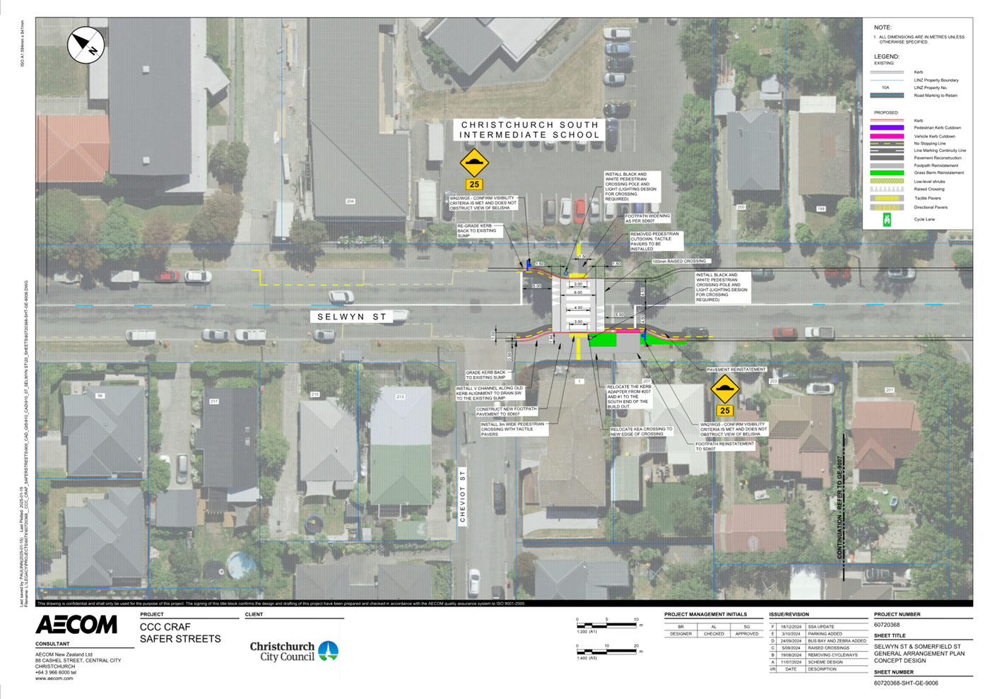
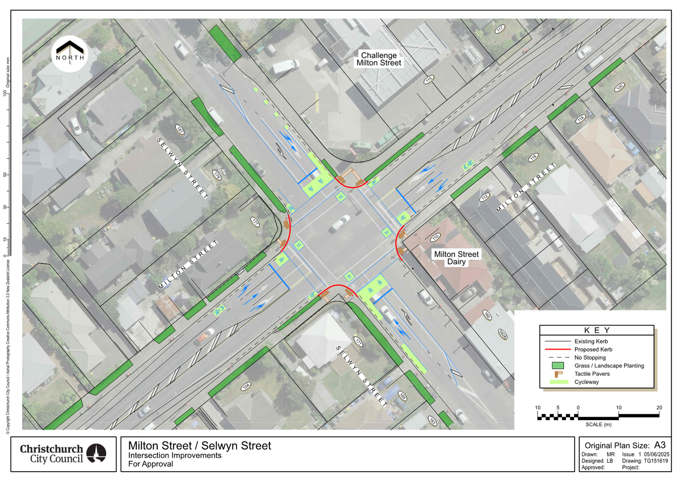
Report from Waihoro
Spreydon-Cashmere-Heathcote Community Board – 10 July 2025
|
15. Spreydon,
Somerfield, Waltham, Beckenham CRAF - Lyttelton Street safety improvements
|
|
Reference Te Tohutoro:
|
25/1431871
|
|
Responsible Officer(s) Te Pou Matua:
|
Ann
Tomlinson, Project Manager
Hannah Ballantyne, Senior Engagement Advisor
|
|
Accountable ELT Member Pouwhakarae:
|
Brent
Smith, General Manager City Infrastructure
|
|
1. Waihoro Spreydon-Cashmere-Heathcote Community Board Consideration Te Whaiwhakaarotanga
|
|
|
The
Board accepted all the Officer Recommendations and included an additional
resolution requesting staff investigate kerb cutdowns at the proposed
Pedestrian Crossing on Lyttelton Street.
|
|
2. Waihoro Spreydon-Cashmere-Heathcote Community Board Recommendation
to Council
|
|
|
That the Council:
1. Approves that a Special Vehicle Lane, in accordance with Clause 18
of the Christchurch City Council Traffic and Parking Bylaw 2017 as defined in
Section 11.1A of the Land Transport (Road User) Rule 2004:
a. For the use of southbound road users, excepting pedestrians and
riders of mobility devices, be installed on the east side of Lyttelton
Street, commencing at a point 11.5 metres south of its intersection with
Frankleigh Street and extending in a southerly direction for a distance of
556.5 metres.
b. For the use of northbound users, excepting pedestrians and riders
of mobility devices, be installed on the west side of Lyttelton Street,
commencing at a point 11 metres south of its intersection with Sparks Road
and extending in a southerly direction for a distance of 571 metres.
|
|
3. Officer Recommendations Ngā Tūtohu
|
|
|
That the
Waihoro Spreydon-Cashmere-Heathcote Community Board:
1. Receives the information in the Spreydon, Somerfield, Waltham,
Beckenham CRAF - Lyttelton Street safety improvements Report.
2. Notes that the decision in this report is
assessed as low significance based on the Christchurch City Council’s
Significance and Engagement Policy.
3. Approves the design, including kerb
alignments, raised safety platform, road surface treatments, widening and
resurfacing footpaths, tactile pavers, road markings and pedestrian islands
as detailed on plans 60720368-SHT-SK-4003, dated
09/06/2025 and 60720368-SHT-SK-4050, dated 27/05/2025 and attached to this
report as Attachments A and B.
4. Approves, pursuant to Clause 7 of the
Christchurch City Council Traffic and Parking Bylaw 2017:
Lyttelton Street – Frankleigh
Street to Rose Street
a. That the stopping of vehicles be
prohibited at any time on the east side of Lyttelton Street, commencing at a
point 56 metres from its intersection with Frankleigh Street and extending in
a southerly direction for a distance of 34 metres.
b. That the stopping of vehicles be
prohibited at any time on the east side of Lyttelton Street, commencing at
its intersection with Roberta Drive and extending in a northerly direction
for a distance of 12 metres.
c. That the stopping of vehicles be
prohibited at any time on the east side of Lyttelton Street, commencing at
its intersection with Roberta Drive and extending in a southerly direction
for a distance of 117 metres.
d. That a Bus Stop be installed on the east
side of Lyttelton Street, commencing at a point 117 metres south of its
intersection with Roberta Drive and extending in a southerly direction for a
distance of 26.5 metres.
e. That the stopping of vehicles be
prohibited at any time on the east side of Lyttelton Street, commencing at a
point 143.5 metres south of its intersection with Roberta Drive and extending
in a southerly direction to its intersection with Conway Street.
f. That the stopping of vehicles be
prohibited at any time on the east side of Lyttelton Street, commencing at
its intersection with Conway Street and extending in a southerly direction
for a distance of 17 metres.
g. That the stopping of vehicles be
prohibited at any time on the east side of Lyttelton Street, commencing at a
point 72 metres south of its intersection with Conway Street and extending in
a southerly direction to its intersection with Stanbury Avenue.
h. That the stopping of vehicles be
prohibited at any time on the east side of Lyttelton Street, commencing at
its intersection with Stanbury Avenue and extending in a southerly direction
for a distance of 16.5 metres.
i. That the stopping of vehicles be
prohibited at any time on the west side of Lyttelton Street, commencing at a
point 200 metres south of its intersection with Sparks Road and extending in
a southerly direction for a distance of 13 metres.
j. That the west side of Lyttelton Street,
commencing at a point 213 metres south of its intersection with Sparks Road
and extending in a southerly direction for a distance of 22.5 metres, be
reserved for Passenger Service Vehicles only, for the purposes of setting
down or picking up passengers only, as part of an Excluded Passenger Service
as defined in the Land Transport Management Act 2003, Section 5. This
restriction is to apply from 8.15am to 8.45am and 2:45pm to 3:15pm on school
days.
k. That the stopping of vehicles be
prohibited at any time on the west side of Lyttelton Street, commencing at a
point 237 metres south of its intersection with Sparks Road and extending in
a southerly direction for a distance of 5 metres.
l. That the stopping of vehicles be
prohibited at any time on the west side of Lyttelton Street, commencing at a
point 247 metres south of its intersection with Sparks Road and extending in
a southerly direction for a distance of 9.5 metres.
Lyttelton Street - West Spreydon School
m. That the stopping of vehicles be
prohibited at any time on the northeast side of Lyttelton Street, commencing
at a point 154 metres southeast of its intersection with Wychbury Street and
extending in a south-easterly direction for a distance of 51 metres.
n. That the stopping of vehicles be
prohibited at any time on the south-west side of Lyttelton Street, commencing
at a point 157 metres south-east of its intersection with Urella Place and
extending in a south-easterly direction for a distance of 44.5 metres.
5. Approves that in accordance with Section
8.2 of the Land Transport Rule – Traffic Control Devices: 2004, that a
pedestrian crossing be installed on Lyttelton Street, located 178 metres
southeast of its intersection with Wychbury Street, and as detailed on plan
60720368-SHT-SK-4050, dated 27/05/2025 and attached to this report as Attachment
B.
6. Revoke any previous resolutions
pertaining to traffic controls made pursuant to any bylaw to the extent that
they are in conflict with the traffic controls described in resolution 4 and
5 above.
7. Approves that these resolutions take
effect when parking signage and/or road markings that evidence the
restrictions described in the staff report are in place (or removed in the
case of revocations).
That the Waihoro
Spreydon-Cashmere-Heathcote Community Board recommend that Council:
8. Approves that a Special Vehicle Lane, in
accordance with Clause 18 of the Christchurch City Council Traffic and
Parking Bylaw 2017 as defined in Section 11.1A of the Land Transport (Road
User) Rule 2004:
a. For the use of southbound road users,
excepting pedestrians and riders of mobility devices, be installed on the
east side of Lyttelton Street, commencing at a point 11.5 metres south of its
intersection with Frankleigh Street and extending in a southerly direction
for a distance of 556.5 metres.
b. For the use of northbound users,
excepting pedestrians and riders of mobility devices, be installed on the
west side of Lyttelton Street, commencing at a point 11 metres south of its
intersection with Sparks Road and extending in a southerly direction for a
distance of 571 metres.
|
|
4. Waihoro Spreydon-Cashmere-Heathcote Community Board Decisions
Under Delegation Ngā
Mana kua Tukuna
|
|
|
That the Waihoro Spreydon-Cashmere-Heathcote Community Board:
1. Receives the information in the Spreydon, Somerfield,
Waltham, Beckenham CRAF - Lyttelton Street safety improvements Report on the
agenda.
2. Notes that the decision in this report is
assessed as low significance based on the Christchurch City Council’s
Significance and Engagement Policy.
3. Approves the design, including kerb
alignments, raised safety platform, road surface treatments, widening and
resurfacing footpaths, tactile pavers, road markings and pedestrian islands
as detailed on plans 60720368-SHT-SK-4003, dated 09/06/2025 and 60720368-SHT-SK-4050,
dated 27/05/2025 and attached to the agenda report as Attachments A and B.
4. Approves, pursuant to Clause 7 of the
Christchurch City Council Traffic and Parking Bylaw 2017:
Lyttelton Street – Frankleigh
Street to Rose Street
a. That the stopping of vehicles be
prohibited at any time on the east side of Lyttelton Street, commencing at a
point 56 metres from its intersection with Frankleigh Street and extending in
a southerly direction for a distance of 34 metres.
b. That the stopping of vehicles be
prohibited at any time on the east side of Lyttelton Street, commencing at
its intersection with Roberta Drive and extending in a northerly direction
for a distance of 12 metres.
c. That the stopping of vehicles be
prohibited at any time on the east side of Lyttelton Street, commencing at
its intersection with Roberta Drive and extending in a southerly direction
for a distance of 117 metres.
d. That a Bus Stop be installed on the east
side of Lyttelton Street, commencing at a point 117 metres south of its
intersection with Roberta Drive and extending in a southerly direction for a
distance of 26.5 metres.
e. That the stopping of vehicles be
prohibited at any time on the east side of Lyttelton Street, commencing at a
point 143.5 metres south of its intersection with Roberta Drive and extending
in a southerly direction to its intersection with Conway Street.
f. That the stopping of vehicles be
prohibited at any time on the east side of Lyttelton Street, commencing at
its intersection with Conway Street and extending in a southerly direction
for a distance of 17 metres.
g. That the stopping of vehicles be
prohibited at any time on the east side of Lyttelton Street, commencing at a
point 72 metres south of its intersection with Conway Street and extending in
a southerly direction to its intersection with Stanbury Avenue.
h. That the stopping of vehicles be
prohibited at any time on the east side of Lyttelton Street, commencing at
its intersection with Stanbury Avenue and extending in a southerly direction
for a distance of 16.5 metres.
i. That the stopping of vehicles be
prohibited at any time on the west side of Lyttelton Street, commencing at a
point 200 metres south of its intersection with Sparks Road and extending in
a southerly direction for a distance of 13 metres.
j. That the west side of Lyttelton Street,
commencing at a point 213 metres south of its intersection with Sparks Road
and extending in a southerly direction for a distance of 22.5 metres, be
reserved for Passenger Service Vehicles only, for the purposes of setting
down or picking up passengers only, as part of an Excluded Passenger Service
as defined in the Land Transport Management Act 2003, Section 5. This
restriction is to apply from 8.15am to 8.45am and 2:45pm to 3:15pm on school
days.
k. That the stopping of vehicles be
prohibited at any time on the west side of Lyttelton Street, commencing at a
point 237 metres south of its intersection with Sparks Road and extending in
a southerly direction for a distance of 5 metres.
l. That the stopping of vehicles be
prohibited at any time on the west side of Lyttelton Street, commencing at a
point 247 metres south of its intersection with Sparks Road and extending in
a southerly direction for a distance of 9.5 metres.
Lyttelton Street - West Spreydon School
m. That the stopping of vehicles be
prohibited at any time on the northeast side of Lyttelton Street, commencing
at a point 154 metres southeast of its intersection with Wychbury Street and
extending in a south-easterly direction for a distance of 51 metres.
n. That the stopping of vehicles be
prohibited at any time on the south-west side of Lyttelton Street, commencing
at a point 157 metres south-east of its intersection with Urella Place and
extending in a south-easterly direction for a distance of 44.5 metres.
5. Approves that in accordance with Section
8.2 of the Land Transport Rule – Traffic Control Devices: 2004, that a
pedestrian crossing be installed on Lyttelton Street, located 178 metres
southeast of its intersection with Wychbury Street, and as detailed on plan
60720368-SHT-SK-4050, dated 27/05/2025 and attached to the agenda report as Attachment
B.
6. Revoke any previous resolutions
pertaining to traffic controls made pursuant to any bylaw to the extent that
they are in conflict with the traffic controls described in resolution 4 and
5 above.
7. Approves that these resolutions take
effect when parking signage and/or road markings that evidence the
restrictions described in the staff report are in place (or removed in the
case of revocations).
8. Requests staff investigate kerb cutdowns at the
Pedestrian Crossing on Lyttelton Street, in resolution 5, as part of the
detailed design process.
|
In addition to the attached documents, the following background
information is available:
|
Document
Name – Location / File Link
|
|
Not
applicable
|
Attachments Ngā Tāpirihanga
|
No.
|
Report Title
|
Reference
|
Page
|
|
1
|
Spreydon, Somerfield, Waltham,
Beckenham CRAF - Lyttelton Street safety improvements
|
24/1756989
|
208
|
|
No.
|
Title
|
Reference
|
Page
|
|
a ⇩
|
SSWB CRAF - Lyttelton
Street, Frankleigh Street to Rose Street
|
25/80569
|
218
|
|
b ⇩
|
SSWB CRAF - West
Spreydon School pedestrian improvements
|
25/412853
|
219
|
|
Spreydon, Somerfield, Waltham, Beckenham CRAF - Lyttelton
Street safety improvements
|
|
Reference Te Tohutoro:
|
24/1756989
|
|
Responsible Officer(s) Te Pou Matua:
|
Ann
Tomlinson, Project Manager
Hannah Ballantyne, Senior Engagement Advisor
|
|
Accountable ELT Member Pouwhakarae:
|
Brent
Smith, General Manager City Infrastructure
|
1. Purpose and Origin of the Report Te Pūtake Pūrongo
1.1 The
purpose of this report is for the Waihoro Spreydon-Cashmere-Heathcote Community
Board to consider the Lyttelton Street safety improvements scheme designs
following community engagement. This would allow the project to proceed to
detailed design and construction.
1.2 The
proposed Lyttelton Street safety works are a component of the Barrington
Street, Milton Street, Lyttelton Street improvements project, which sits within
the Spreydon, Somerfield, Waltham and Beckenham Christchurch Regeneration
Acceleration Facility (CRAF) programme.
1.3 The report has been written to address safety improvements of the
transport assets on Lyttelton Street.
2. Officer Recommendations Ngā Tūtohu
That the Waihoro
Spreydon-Cashmere-Heathcote Community Board:
1. Receives the information in the Spreydon,
Somerfield, Waltham, Beckenham CRAF - Lyttelton Street safety improvements
Report.
2. Notes that the decision in this report is assessed as low significance
based on the Christchurch City Council’s Significance and Engagement
Policy.
3. Approves the design, including kerb alignments, raised safety
platform, road surface treatments, widening and resurfacing footpaths, tactile
pavers, road markings and pedestrian islands as detailed on plans 60720368-SHT-SK-4003,
dated 09/06/2025 and 60720368-SHT-SK-4050, dated 27/05/2025 and attached to
this report as Attachments A and B.
4. Approves, pursuant to Clause 7 of the Christchurch City Council
Traffic and Parking Bylaw 2017:
Lyttelton
Street – Frankleigh Street to Rose Street
a. That the stopping of vehicles be prohibited at any time on the east
side of Lyttelton Street, commencing at a point 56 metres from its intersection
with Frankleigh Street and extending in a southerly direction for a distance of
34 metres.
b. That the stopping of vehicles be prohibited at any time on the east
side of Lyttelton Street, commencing at its intersection with Roberta Drive and
extending in a northerly direction for a distance of 12 metres.
c. That the stopping of vehicles be prohibited at any time on the east
side of Lyttelton Street, commencing at its intersection with Roberta Drive and
extending in a southerly direction for a distance of 117 metres.
d. That a Bus Stop be installed on the east side of Lyttelton Street,
commencing at a point 117 metres south of its intersection with Roberta Drive
and extending in a southerly direction for a distance of 26.5 metres.
e. That the stopping of vehicles be prohibited at any time on the east
side of Lyttelton Street, commencing at a point 143.5 metres south of its
intersection with Roberta Drive and extending in a southerly direction to its
intersection with Conway Street.
f. That the stopping of vehicles be prohibited at any time on the east
side of Lyttelton Street, commencing at its intersection with Conway Street and
extending in a southerly direction for a distance of 17 metres.
g. That the stopping of vehicles be prohibited at any time on the east
side of Lyttelton Street, commencing at a point 72 metres south of its
intersection with Conway Street and extending in a southerly direction to its
intersection with Stanbury Avenue.
h. That the stopping of vehicles be prohibited at any time on the east
side of Lyttelton Street, commencing at its intersection with Stanbury Avenue
and extending in a southerly direction for a distance of 16.5 metres.
i. That the stopping of vehicles be prohibited at any time on the west
side of Lyttelton Street, commencing at a point 200 metres south of its
intersection with Sparks Road and extending in a southerly direction for a
distance of 13 metres.
j. That the west side of Lyttelton Street, commencing at a point 213
metres south of its intersection with Sparks Road and extending in a southerly
direction for a distance of 22.5 metres, be reserved for Passenger Service
Vehicles only, for the purposes of setting down or picking up passengers only,
as part of an Excluded Passenger Service as defined in the Land Transport
Management Act 2003, Section 5. This restriction is to apply from 8.15am to
8.45am and 2:45pm to 3:15pm on school days.
k. That the stopping of vehicles be prohibited at any time on the west
side of Lyttelton Street, commencing at a point 237 metres south of its
intersection with Sparks Road and extending in a southerly direction for a
distance of 5 metres.
l. That the stopping of vehicles be prohibited at any time on the west
side of Lyttelton Street, commencing at a point 247 metres south of its
intersection with Sparks Road and extending in a southerly direction for a
distance of 9.5 metres.
Lyttelton Street - West Spreydon School
m. That the stopping of vehicles be prohibited at any time on the
northeast side of Lyttelton Street, commencing at a point 154 metres southeast
of its intersection with Wychbury Street and extending in a south-easterly
direction for a distance of 51 metres.
n. That the stopping of vehicles be prohibited at any time on the
south-west side of Lyttelton Street, commencing at a point 157 metres
south-east of its intersection with Urella Place and extending in a
south-easterly direction for a distance of 44.5 metres.
5. Approves that in accordance with Section 8.2 of the Land Transport
Rule – Traffic Control Devices: 2004, that a pedestrian crossing be
installed on Lyttelton Street, located 178 metres southeast of its intersection
with Wychbury Street, and as detailed on plan 60720368-SHT-SK-4050, dated
27/05/2025 and attached to this report as Attachment B.
6. Revoke any previous resolutions pertaining to traffic controls made
pursuant to any bylaw to the extent that they are in conflict with the traffic
controls described in resolution 4 and 5 above.
7. Approves that these resolutions take effect when parking signage
and/or road markings that evidence the restrictions described in the staff
report are in place (or removed in the case of revocations).
That the Waihoro Spreydon-Cashmere-Heathcote Community Board
recommend that Council:
8. Approves that a Special Vehicle Lane, in accordance with Clause 18
of the Christchurch City Council Traffic and Parking Bylaw 2017 as defined in
Section 11.1A of the Land Transport (Road User) Rule 2004:
a. For the use of southbound road users, excepting pedestrians and
riders of mobility devices, be installed on the east side of Lyttelton Street,
commencing at a point 11.5 metres south of its intersection with Frankleigh
Street and extending in a southerly direction for a distance of 556.5 metres.
b. For the use of northbound users, excepting pedestrians and riders of
mobility devices, be installed on the west side of Lyttelton Street, commencing
at a point 11 metres south of its intersection with Sparks Road and extending
in a southerly direction for a distance of 571 metres.
3. Executive Summary Te Whakarāpopoto Matua
3.1 In
August 2022, staff presented a package of improvements to the Waihoro
Spreydon-Cashmere and Waikura Linwood-Central-Heathcote Community Boards (Agenda,
Item 5). The Community Boards jointly approved a number of projects for the
Spreydon, Somerfield, Waltham, Beckenham CRAF programme
(Minutes, Item 5) which included a package of improvements for Barrington
Street, Milton Street and Lyttelton Street.
3.2 The
Community Boards requested staff to investigate a number of improvements on
Lyttelton Street.
3.2.1 The following sites
on Lyttelton Street were identified as Board priorities for improvement:
· A bus bay outside Te
Kura Kaupapa Maori O Te Whanau Tahi School on Lyttelton Street.
· Raising the existing crossing outside Te Ara Koropiko West Spreydon
School on Lyttelton Street.
· Cycle lanes on Lyttelton Street between Frankleigh Street and Rose
Street.
· Green paint at conflict points on Lyttelton Street between Lincoln
Road and Rose Street.
Te Kura Kaupapa Maori O Te Whanau Tahi School – Lyttelton
Street
3.3 The
recommended option is to install improved pedestrian and cycle facilities, as
shown in Attachment A, and summarised below:
· An extended bus bay, to operate for before and after school drop
offs and pick-ups (8.15am – 8.45am and 2.45pm – 3.15pm) on the west
side of Lyttelton Street near the entrance to the school. This space will be
available for parking outside of these hours.
· New cycle lanes, on both sides of Lyttelton Street between Rose
Street and Frankleigh Street.
· Minor relocation of the existing three pedestrian refuge islands to
allow space for the new cycle lanes.
3.4 Staff
are recommending the proposed improvements as this will provide safer crossing
facilities with improved refuge islands, additional space for a safer school
bus drop off and pick up location. It also provides safe on road cycle
facilities through this section of Lyttelton Street, connecting with the
existing cycle lanes on Lyttelton Street north of Frankleigh Street.
Te Ara Koropiko West Spreydon School
3.5 The
recommended option is to raise the existing pedestrian crossing outside Te Ara
Koropiko West Spreydon School, as shown in Attachment B, and summarised
below:
· Raised existing pedestrian crossing
· Red paint on the approaches
· Green paint on existing cycle lanes
3.6 Staff
are recommending the proposed improvements as this will provide a safer school
crossing facility for students at Te Ara Koropiko West Spreydon School and the
wider community.
3.7 Once
final costs for the above works are known, additional projects identified
within this package for Milton Street and Barrington Street will be
investigated if there is surplus budget in the project.
4. Background/Context Te Horopaki
4.1 CRAF
is a funding package from the Treasury for transport projects in Christchurch.
The CRAF investment in roading and transport improvements will address
condition and safety and access issues. It will act as a catalyst towards the
development of a high-quality, safe and reliable transport network.
4.2 Lyttelton
Street has been identified as an important link for pedestrians and cyclists as
part of the initial street reviews and through public consultation, with several
schools and Centennial Park being high use destinations. The northern end of
Lyttelton Street has traffic flows of over 8,000 vehicles per day, and the 85th
percentile vehicle speed is 56km/h; and the southern end has traffic flows of over
6,000 vehicles per day, and the 85th percentile vehicle speeds is 48.2 km/h.
4.3 The
Community Boards requested staff to work closely with key stakeholders to
understand their needs for this project. Schools in the area advised the
project team of the improvements they would like that aligned with the project
objectives, which were later developed and included in the plan for
consultation.
Te Kura Kaupapa Maori O Te Whanau Tahi School – Lyttelton
Street
4.4 Many
pupils at Te Kura Kaupapa Maori O Te Whanau Tahi School are from out of zone
and are being dropped off by private vehicle or buses to the school.
4.5 The
roll at the kura is currently at 212 and is expected to reach 250 students by
the end of 2025.
4.6 The
kura runs three buses every day to drop off and pick up students from across
the city.
4.7 There
is a housing development at 87 Lyttelton Street (just north of the school) that
may impact travel demand on Lyttelton Street.
4.8 Centennial
Park, a major sports park, Pioneer Recreation Sports Centre and the Lyttelton
Street Playcentre are also located in this section of Lyttelton Street.
Te Ara Koropiko West Spreydon School
4.9 The
roll at the kura is approximately 300 students and caters for years 1 to 6.
4.10 The speed limit
on Lyttelton Street is 50km/h with a variable speed limit of 30km/h outside Te
Ara Koropiko West Spreydon School.
4.11 The existing
pedestrian crossing is not raised and operates as a school kea crossing.
4.12 Improvements on
Lyttelton Street are designed to improve safety and accessibility. These
changes will benefit students attending Te Ara Koropiko West Spreydon School
and Te Kura Kaupapa Māori o Te Whānau Tahi, both located on Lyttelton
Street within the project areas. The changes will also improve safety and
access for users of Centennial Park and Pioneer Sports Stadium in the section
of Lyttelton Street between Frankleigh Street and Rose Street.
4.13 The following related information session/workshops have taken place
for the members of the meeting:
Options Considered Ngā
Kōwhiringa Whaiwhakaaro
4.14 The following
reasonably practicable options were considered and are assessed in this report:
4.14.1 Option 1 – Lyttelton
Street safety improvements as shown in Attachments A and B.
4.14.2 Option 2 – Do
nothing.
4.15 The following
options were considered but ruled out:
4.15.1 Relocate the crossing outside
Te Ara Koropiko West Spreydon School 40 metres north – this was ruled
out as the crossing would be between two exit/entry points to the school rather
than close to one and away from the connection through to Windsor Crescent.
This could lead to an increased number of people crossing the road without
using the zebra crossing. This would also require the loss of eight carparks
and the removal of two street trees, relocation of pedestrian lights and more
extensive drainage works.
4.15.2 In most cases, the interventions
recommended within this report are distinct and could be installed
individually. However, proposing a large number of combinations would likely
not help with decision-making, so staff have not included this. However, further
advice regarding combinations of the interventions can be supplied to Board on
request.
Options Descriptions Ngā
Kōwhiringa
4.16 Preferred
Option: Lyttelton Street safety improvements
4.16.1 Option Description:
Safety improvements including cycle lanes and green paint at conflict points,
new school bus bay, and raising existing school crossing with red paint on the
approaches.
4.16.2 Option Advantages
· Meets project objectives.
· Aligns with community feedback.
· Aligns with feedback from local schools.
· Provides a cycle network that connects from Rose Street to cycling
facilities on Lyttelton Street north of Frankleigh Street.
· Provides improved crossing facilities for two local school students
and residents.
· Relocation of school pedestrian crossing slightly north of existing
location providing more space for vehicle movements at the school gate at Te
Ara Koropiko West Spreydon School.
· Provides a safe school bus drop off and pick up location for Te Kura
Kaupapa Māori o Te Whānau Tahi.
· Slows down traffic before pedestrian crossing approaches.
· Allows for improvements to be delivered within the project budget.
4.16.3 Option Disadvantages
· Loss of 10 carparks on Lyttelton Street between Frankleigh Street
and Rose Street to accommodate the cycle facility.
· Does not allow for any improvements to the landscaping.
4.17 Option 2
– Do nothing
4.17.1 Option Description: Lyttelton
Street remains as it is.
4.17.2 Option Advantages
· Budget can be spent elsewhere.
· No parking loss on Lyttelton Street within the project area.
4.17.3 Option Disadvantages
· Does not meet the project objectives.
· Does not improve pedestrian safety at both school locations.
· Does not provide cycle lanes and additional safety improvements for
cyclists.
· Does not provide bus parking improvements for Te Kura Kaupapa Maori O Te Whanau Tahi
School.
5. Financial Implications Ngā Hīraunga Rauemi
Capex/Opex Ngā Utu Whakahaere
|
|
Recommended Option 1
|
Option 2 – Do nothing
|
|
Cost to Implement
|
$700,000.00
|
No further expenditure
|
|
Maintenance/Ongoing Costs
|
Negligible above existing maintenance
allowances
|
No change to existing
|
|
Funding Source
|
LTP Budget 73836 – Spreydon,
Somerfield, Waltham, Beckenham CRAF – Barrington Street, Milton Street,
Lyttelton Street improvements
|
N/A
|
|
Funding Availability
|
Funds are available
|
N/A
|
|
Impact on Rates
|
Funded from external sources, so no
impact on rates
|
N/A
|
5.1 The
cost estimate is a detailed scheme phase estimate. The final cost will be
completed at detailed design by the contractor.
6. Considerations Ngā Whai Whakaaro
Risks and Mitigations Ngā
Mōrearea me ngā Whakamātautau
6.1 Construction Risks: These
projects are considered BAU, using a qualified and competent contractor.
6.2 Safety:
The proposal includes traffic safety measures that will reduce risk for all
road users at these locations. The safety assessment shows that the proposal
has benefits for all road users.
6.3 Public
Perception: Cycle lanes and parking loss can generate negative feedback however
the scheme has retained as much parking as possible, with the loss of just 10
carparks.
Legal Considerations Ngā
Hīraunga ā-Ture
6.4 Statutory
and/or delegated authority to undertake proposals in the report:
6.4.1 The Community Boards have delegated authority from Council to
exercise the delegations as set out in the Register of Delegations. The list of
delegations for the Community Boards includes the resolution of stopping and
traffic control devices.
6.4.2 The installation of any signs and/or marking associated with traffic
control devices must comply with the Land Transport Rule: Traffic Control
Devices 2004.
6.4.3 Part 1, Clause 7 of the Christchurch City Council Traffic and
Parking Bylaw 2017 provides Council with the authority to install parking or
stopping restrictions by resolution.
6.5 Other Legal Implications:
6.5.1 There
is no legal context, issue, or implication relevant to this decision.
Strategy and Policy Considerations Te Whai
Kaupapa here
6.6 The
required decisions:
6.6.1 Align with the Christchurch
City Council’s Strategic Framework.
6.6.2 Are assessed as
low significance based on the Christchurch
City Council’s Significance and Engagement Policy 2019.
The level of significance was determined by the low number of people affected
and/or with an interest, limited benefits/opportunities and costs/risks to
Council, and modest level of community influence.
6.7 This
report supports the Council's
Long Term Plan (2024 - 2034):
6.8 Transport
6.8.1 Activity: Transport
· Level of Service: 10.5.1 Limit deaths and
serious injury crashes per capita for cyclists and pedestrians - <=12
crashes per 100,000 residents
· Level of Service: 10.5.3 More people are
choosing to travel by cycling - >=12,500 average daily cyclist detections
· Level of Service: 10.5.42 Increase the
infrastructure provision for active and public modes - >= 625 kilometres
(total combined length)
· Level of Service: 16.0.10 Maintain the
perception (resident satisfaction) that Christchurch is a walking friendly city
- >=85% resident satisfaction
Community Impacts and Views
Ngā Mariu ā-Hāpori
Public
Consultation Te Tukanga Kōrerorero
6.9 Te
Ara Koropiko West Spreydon School were engaged from December 2023. They were
supportive of the initial scheme advising that they often observe high speeds
from vehicles travelling through the pedestrian crossing and that visibility is
limited as the school’s driveway is located right on the crossing.
6.10 Te
Kura Kaupapa Māori o Te Whānau Tahi were also engaged from December
2023 to understand if they had any issues with crossing to or parking near
their kura. A bus bay to service the kura was identified as a need and included
in the consultation plans.
6.11 Cashmere
High School were engaged in February 2024. They questioned whether the
additional cycle connection was required, as they had observed students using
the cycle path through Centennial Park.
6.12 Staff
discussed the project with Lyttleton Street Playcentre via email in August
2024. They would like support in finding alternative parking locations, as the
whānau using their facility typically park on both sides of the road and
stay for the duration of the session (9am-1pm). They suggested that the park
next to the centre could be turned into a carpark, however this is outside the
scope of this project. They have contacted Pioneer Recreation Centre about an
informal relationship for parents to park there.
6.13 Public
consultation ran from 11 to 29 September 2024. An email was sent to 55 key
stakeholders including emergency services, residents’ associations, local
schools and businesses, and known users of Centennial Park. The consultation
was posted on seven local Facebook community pages, inviting submissions on the
Kōrero mai | Let’s talk webpage.
6.14 Consultation
documents were delivered to residents of Lyttelton Street (between Sparks Road
and Rose Street, and Stourbridge Street to Wychbury Street) on 11 September
2024. Documents were also available at Pioneer Recreation and Sports Centre.
Summary of Submissions Ngā
Tāpaetanga
6.15 Submissions were
made by Environment Canterbury, Spreydon Neighbourhood Network, Spokes
Canterbury, Te Kura Kaupapa Māori o Te Whānau Tahi, Lyttelton Street
Dairy and 80 individuals. All submissions are available on the Kōrero mai webpage.
6.16 53 submitters
discussed the proposed crossing upgrade outside Te Ara Koropiko West Spreydon
School. Of these, 33 (60%) clearly stated their support while eight (15%)
clearly stated their opposition. The remaining 12 provided arguments for and
against the proposal or had observations or requests.
· The most common feedback in support of the crossing was:
· Safety (11)
· Slowing vehicles down (10)
· The most common feedback critiquing the crossing was:
· Waste of money (5)
· It’s unnecessary - the crossing is well-supervised when it
needs to be (4)
· Five submitters requested the inclusion of a safe crossing point at
Lyttelton Street/Neville Street intersection.
6.17 33 submitters
discussed the proposed bus bay outside Te Kura Kaupapa Māori O Te
Whānau Tahi School. Of these, 23 (70%) clearly stated their support while
one (3%) clearly stated their opposition. The remaining nine
provided mixed feedback or had observations or requests.
· The most common feedback in support of the bus bay was safety and
accessibility improvements for school students (4).
6.18 71 submitters
discussed the proposed addition of a cycle lane on both sides of Lyttelton
Street, from Sparks Road to Rose Street. Of these, 40 (56%) clearly stated
their support of this while 14 (20%) clearly stated their opposition. The
remaining 17 provided mixed feedback or had observations or requests.
· The most common feedback in support of the cycle lanes was enhanced
safety for cyclists (16).
· The most common feedback critiquing the cycle lanes was:
· Parking loss (16). Note: seven submitters mentioned their support of
parking loss as part of the plan or requested the removal of more.
· There is already a cycle lane through Centennial Park (9)
· Not required (7)
· Waste of money (4)
· Four submitters requested better provision for cyclists and
pedestrians crossing at the Pioneer Recreation and Sports Centre entrance.
6.19 The decision
affects the following wards/Community Board areas:
6.19.1 Waihoro
Spreydon-Cashmere-Heathcote Community Board
Impact on Mana Whenua Ngā Whai Take
Mana Whenua
6.20 The decision does not involve a significant
decision in relation to ancestral land, a body of water or other elements of
intrinsic value, therefore this decision does not
specifically impact Mana Whenua, their culture, and traditions.
6.21 The decision does not involve a
matter of interest to Mana Whenua and will not impact
on our agreed partnership priorities with Ngā Papatipu
Rūnanga.
Climate Change Impact Considerations Ngā
Whai Whakaaro mā te Āhuarangi
6.22 The decisions in
this report are likely to:
6.22.1 Contribute positively to
adaptation to the impacts of climate change.
6.22.2 Contribute positively to
emissions reductions.
6.23 The proposals in this report are
unlikely to contribute significantly to adaptation to the impacts of climate
change or emissions reductions.
6.24 This is a minor
scheme and will not have a significant impact, however it will provide safer
crossings and cycle facilities for the local residents, park users and nearby
schools.
7. Next Steps Ngā Mahinga ā-muri
7.1 If
approved staff will progress the scheme to detailed design and construction.
Attachments Ngā Tāpirihanga
|
No.
|
Title
|
Reference
|
Page
|
|
a
|
SSWB CRAF -
Lyttelton Street, Frankleigh Street to Rose Street
|
25/80569
|
|
|
b
|
SSWB CRAF -
West Spreydon School pedestrian improvements
|
25/412853
|
|
In addition to the attached documents, the following background
information is available:
|
Document
Name – Location / File Link
|
|
|
Signatories Ngā Kaiwaitohu
|
Authors
|
Ann Tomlinson
- Project Manager
Hannah
Ballantyne - Senior Engagement Advisor
|
|
Approved By
|
Jacob Bradbury
- Manager Planning & Delivery Transport
Tony
Richardson - Finance Business Partner
Lynette Ellis
- Head of Transport & Waste Management
|
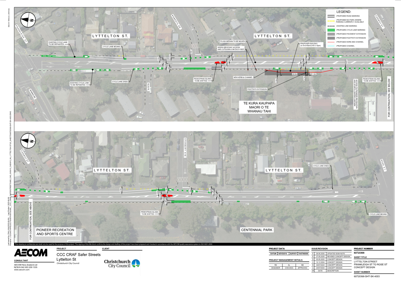
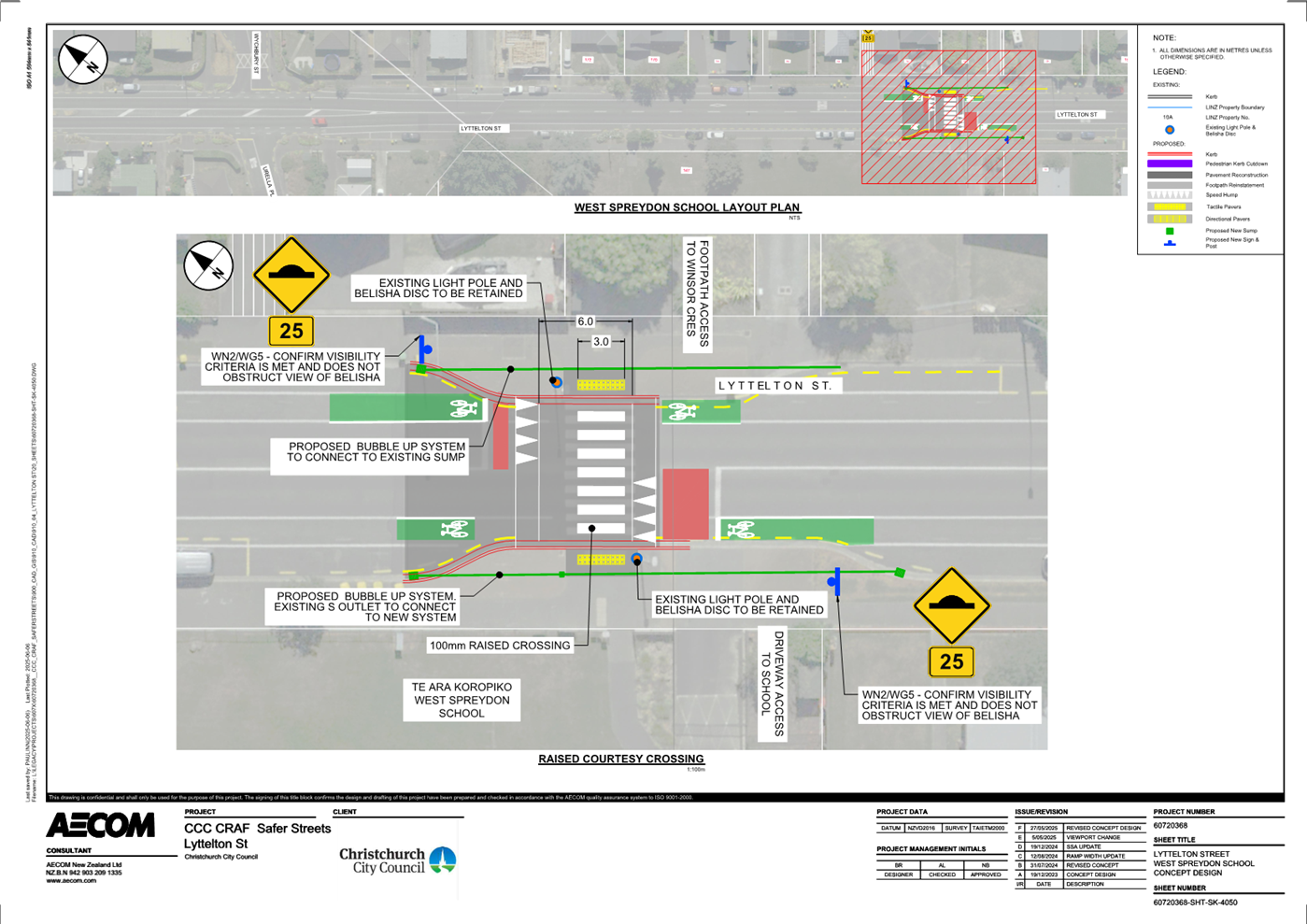
|
16. Development Contributions Remission
Application - The Arts Centre
|
|
Reference Te Tohutoro:
|
25/925530
|
|
Responsible Officer(s) Te Pou Matua:
|
Katrina
Mansell, Team Leader, Planning and Consents Business Support
|
|
Accountable ELT Member Pouwhakarae:
|
John
Higgins, General Manager Strategy, Planning & Regulatory Services
|
1. Purpose and Origin of the Report Te Pūtake Pūrongo
1.1 The purpose of
this report is for the Council to consider a development contributions
remission application from The Arts Centre. The Arts Centre have been levied a development
contribution of $17,019.70, under RMA/2024/3600, being a resource consent for
the establishment of 20 food trucks.
1.2 The
Arts Centre is requesting the Council to remit development contributions under
clause 6.3.2 of the Council’s Development Contributions Policy 2021 which
provides for the remission of development contributions in “unique and
compelling circumstances”.
2. Officer
Recommendations Ngā Tūtohu
That the Council:
1. Receives the information in the Development
Contributions Remission Application - The Arts Centre Report.
2. Notes that the decision sought in this report is assessed as low
significance based on the Christchurch City Council’s Significance and
Engagement Policy.
3. Declines the Development Contributions remission application from
the Arts Centre for $17,019.70 in accordance with the Development Contributions
Policy 2021 as it is considered that unique and compelling circumstances do not
sufficiently exist to justify a remission of development contribution.
4. Notes that if the remission is declined, staff will discuss a
payment plan with the Arts Centre to allow the payment of the $17,019.70 to
occur over a 24-month timeframe.
3. Executive Summary Te Whakarāpopoto Matua
3.1 This report
presents a request from The Arts Centre for remission of development
contributions totalling $17,019.70, levied under resource consent RMA/2024/3600
for the establishment of 20 permanent food trucks on site. The Arts Centre
seeks remission under clause 6.3.2 of the Council’s Development
Contributions Policy 2021, citing “unique and compelling
circumstances” relating to its heritage status and charitable objectives.
3.2 While the Arts
Centre plays a significant cultural and historical role in Christchurch and
receives ongoing financial support from the Council, the current Development
Contributions Policy does not include a general exemption for heritage
buildings or charitable organisations.
3.3 The Council has
previously approved very few remission applications,
and each has been considered an exceptional case. The Council needs to consider
whether the application meets the high threshold of being sufficiently
“unique and compelling” to warrant remission under the current
policy framework.
4. Background/Context Te Horopaki
4.1 The
Arts Centre Christchurch has applied for a remission of Developments
Contributions of $17,019.70 which were levied under RMA/2024/3600. The Resource
Consent is to establish 20 food-trucks at the Arts Centre on a permanent basis.
A copy of the remission application is attached to this report as Attachment
C.
4.2 The
Arts Centre also applied for a reconsideration of the Development Contributions
Assessment on the grounds that the assessment was incorrect, however, the
reconsideration was declined as the assessment was completed in accordance with
the DC Policy 2021.
4.3 The
application notes that the Arts Centre Trust is a charity and limited by the
Arts Centre of Christchurch Trust Act 2015.
The letter also describes the Arts Centre being protected as a heritage item
while noting it is restrictive. A copy of the application is attached to
this report and their main points are summarised below.
4.3.1 The
Arts Centre is in the process of being recognised by Heritage NZ Pouhere Taonga
as a National Historic Landmark.
4.3.2 The Arts Centre is the largest group of protected
heritage buildings in the country.
4.3.3 The
heritage protections can be restrictive; those restrictions would make the cost
of converting one building into a food court unviable.
4.3.4 They
are constrained by the Arts Centre of Christchurch Trust Act 2015 and cannot
undertake any activity they please in order to grow their revenue. Clause 5(2)
of the Act states “All income, benefits, and advantages received by or
accruing to the trust board must be applied for a charitable purpose in
advancing the trust’s objects.”
4.3.5 They are visited by almost one million people each
year and must provide these visitors with facilities and activities.
4.3.6 They
are competing in an open market with other central city businesses that do not
have the same restrictions.
4.4 The
proposal did draw attention several months ago from some other established
businesses who were concerned that food-trucks amounted to unfair
competition. This was because they do not carry the same overheads.
5. Development
Contributions
5.1 The
Council requires development contributions in accordance with Sections 197,
198(2) and 199 of the Local Government Act and in accordance with its
Development Contributions Policy. Development
contributions enable the Council to require developers to make a fair
contribution towards the provision of growth infrastructure. Without this
revenue stream, these costs would fall entirely on ratepayers.
5.2 The
Development Contributions Policy 2021 (DC Policy) states that the
Council can only remit payment of development contributions in unique and
compelling circumstances. The term ‘unique and compelling’ is
not defined in the Development Contributions Policy. However, a
dictionary definition describes ‘unique’ as ‘having no
like or equal’, ‘remarkable’ or ‘unusual, and ‘compelling’
as ‘not able to be refuted’, convincing’ or
‘persuasive’. The decision for the Council is largely based
on whether it considers a specific situation to be unique and compelling in the
sense that it is such a remarkable case that it justifies a remission to be
granted.
5.3 The
Council can also develop a rebate scheme to waive development contributions
where strategic outcomes are sought. There are no rebate schemes that
would relate to the Arts Centre site or food-trucks.
5.4 Two
remission applications have previously been approved for The Cancer Society,
and The Brain Tree Trust, on the basis that both organisations were considered
unique and compelling circumstances. This related to the specific
services they provided.
5.5 A
further remission was approved to adapt and reuse Spreydon Lodge as a
café/restaurant as part of Halswell Commons – being part of an
exemplar development site following the earthquakes. However, this
development did not proceed. All other requests for remissions have
been declined.
6. Discussion
6.1 The
Arts Centre has previously been provided with significant funding from the
Council and at the Council Long Term Plan meeting on 25 June 2024, the Council
agreed to provide the following funding to the Arts Centre:
6.1.1 $500,000 per annum for the life
of the Long-Term Plan (10 Years).
6.1.2 $250,000 from the Capital
Endowment Fund in FY24/25 and in FY25/26.
6.1.3 Noted the
continuation of $110,000 per year in FY24/25 and FY25/26 from the Strengthening
Communities Fund.
6.1.4 In addition to the above, they have received
grants through various funds and information on these are attached as Attachment
B.
6.2 At
the Long-Term Plan meeting on 25 June 2024, the Council requested staff to work
with the Arts Centre to develop a sustainable funding model and asset
management plan, and report back in time for the Annual Plan process for Year
three of the Long-Term Plan. Staff will report back
to the Council on this separately.
6.3 In
addition to the funding provided by the Council, the food truck operators pay a
monthly licence fee. Details of these fees are attached to this report as Public
Excluded Attachment A. The agreements are on a month-to-month basis, with
no long-term commitments.
6.4 While
each remission request must be assessed on its own merits, any remission
granted must clearly demonstrate that the development qualifies as
“unique and compelling.”
6.5 The
Arts Centre’s value to Christchurch is undeniable. Its heritage values
are significant, and the heritage buildings are notable in a national context,
reflected in its Category 1 heritage listing by Heritage NZ Pouhere Taonga.
6.6 Notwithstanding
the importance of the site in a national, regional and local context, the
resource consent against which the development contributions are payable is for
20 permanent food trucks.
6.7 Consistency
and clarity in applying the Policy are essential. Granting a remission may not
align with the Council’s advice to move toward greater commercial
sustainability. Other charities and heritage buildings have also been required
to pay development contributions, as have other food truck operators.
6.8 Approving
a remission in this case could set a precedent for similar developments and on
this basis, it is recommended that the application for a remission be
declined. Staff note this is a finely balanced recommendation given the
significance the of the Arts Centre to Christchurch and the initiative to
generate more income from the site.
Options Considered Ngā
Kōwhiringa Whaiwhakaaro
6.9 The
following reasonably practicable options were considered and are assessed in
this report:
6.9.1 Decline the
remission application.
6.9.2 Approve the
remission application.
6.9.3 Approve a
partial remission of the application.
Options Descriptions Ngā
Kōwhiringa
6.10 Preferred
Option: Decline the remission application.
6.10.1 Option Description: The
application for remission of the development contributions payable by the Arts
Centre Trust ($17,019.70) is declined.
6.10.2 Option Advantages
· It aligns with the Council’s current Development Contributions
Policy 2021 that there are not unique and compelling circumstances.
· Costs will fall to the Trust rather than the ratepayer.
6.10.3 Option Disadvantages
·
It will increase costs for the Arts Centre.
· It may negate the benefits for the Arts Centre of additional
revenue associated with the food trucks.
6.11 Option 2:
Approve the remission application of $17,019.70.
6.11.1 Option Description: The
application for remission of the development contributions payable by the Arts
Centre Trust ($17,019.70) is approved.
6.11.2 Option Advantages
· The Arts Centre Trust benefit from the additional revenue associated
with the food trucks without the expense of development contributions.
· The amount remitted contributes towards the Trust’s objects in
accordance with clause 5(2) of the Arts Centre of Christchurch Trust Act 2015.
6.11.3 Option Disadvantages
· It does not align with the Council’s current Development
Contributions Policy as it is not considered that unique and compelling
circumstances sufficiently exist.
·
Costs will fall to the ratepayer rather than the
Trust.
·
It sets a precedent for other circumstances that
are similar in nature such that the integrity of the Policy is eroded.
· It may be viewed as supporting business activities in an inequitable
manner i.e., the Council not contributing to the costs that other businesses
incur.
6.12 Option 3:
Approve a partial remission of the application
6.12.1 Option Description: The
application for remission of the development contributions payable by the Arts
Centre Trust is partially approved, with a reduction in the amount payable.
6.12.2 Option Advantages
· Same as Option 2 but to a lesser extent
6.12.3 Option Disadvantages
· Same as Option 2 but to a lesser extent
Analysis Criteria Ngā Paearu
Wetekina
6.13 The
considerations in evaluating the options include the following:
6.13.1 Whether it is in
accordance with the Development Contributions Policy 2021.
6.13.2 Any precedent, effect or
impact on the integrity of the Policy.
6.13.3 Who bears the costs of
the remission.
7. Financial Implications Ngā Hīraunga Rauemi Capex/Opex
Ngā Utu Whakahaere
|
|
Recommended Option
Decline the remission application
|
Option 2 – Approve the remission
|
Option 3 – Approve a partial remission
|
|
Cost to Implement
|
Nil
|
Nil
|
Nil
|
|
Maintenance/Ongoing Costs
|
Nil
|
$1,400
per annum over 30 years.
|
%
of $1,400 per annum over 30 years, proportionate to remission granted.
|
|
Funding Source
|
N/A
|
Rates
|
Rates
|
|
Funding Availability
|
N/A
|
Via
debt
|
Via
debt
|
|
Impact on Rates
|
Nil
|
0.0001%
|
%
of 0.0001% p. a, proportionate to remission granted.
|
7.1 If
the development contributions are remitted, the amount remitted will need to be
funded from rates. As development contributions revenue is largely used to
repay debt incurred to fund infrastructure to service growth, the cost of the
remission will be funded over time as though it is debt.
8. Considerations Ngā Whai Whakaaro
Risks and Mitigations Ngā
Mōrearea me ngā Whakamātautau
8.1 As
set out below, approving a remission may set a precedent and an expectation
that other similar applications be accepted.
Legal Considerations Ngā
Hīraunga ā-Ture
8.2 Statutory
and/or delegated authority to undertake proposals in the report:
8.2.1 The Council’s ability to
levy development contributions comes from section 198 of the Local Government
Act 2002. This is a discretionary power, meaning that the Council retains
the discretion to remit a development contribution if it chooses to do
so. This discretion has not been sub-delegated.
8.2.2 Clause 4.2.1 of the
Council’s Development Contributions Policy 2021 provides that the Council
will exercise its discretion in “unique and compelling”
circumstances and that Council officers will provide the Council with a report
such as this analysing whether the remission should be granted.
8.2.3 Approving a remission may set a
precedent and set an expectation that other similar applications be
accepted. The Council has previously approved remissions for two
charitable organisations (see paragraph 5.4 above).
8.3 Other
Legal Implications:
8.3.1 There is no other legal context,
issue, or implication relevant to this decision.
Strategy and Policy Considerations Te Whai
Kaupapa here
8.4 The
required decision:
8.4.1 Aligns with
the Christchurch
City Council’s Strategic Framework, in particular the community
outcome to be a thriving and prosperous city.
8.4.2 Is assessed as
low significance based on the Christchurch
City Council’s Significance and Engagement Policy. The level of
significance was determined by the number of
persons affected by the remission.
8.4.3 Is consistent
with the Council’s Plans and Policies. The Council’s Development
Contributions Policy 2021 provides for the Council to approve remission
applications in unique and compelling circumstances, which do not apply here.
Community Impacts and Views Ngā Mariu
ā-Hāpori
8.5 The
remission application from the Arts Centre Trust does not have wider impacts on
the community beyond the Arts Centre Trust. Notwithstanding this, there may be
secondary impacts associated with the costs incurred by the Trust in paying the
development contributions i.e. reduced revenue towards the objects of the Arts
Centre and wider public benefits.
8.6 The decision affects the following wards/Community Board areas:
8.6.1 Waipapa Papanui-Innes-Central Community Board.
Impact on Mana Whenua Ngā Whai Take
Mana Whenua
8.7 The decisions do not
involve a significant decision in relation to ancestral land, a body of
water or other elements of intrinsic value, therefore this decision does not specifically impact Mana Whenua, their culture, and
traditions.
8.8 The decisions do
not involve a matter of interest to Mana Whenua and will not
impact on our agreed partnership priorities with Ngā
Papatipu Rūnanga
8.9 The consideration of the development contributions remission is
directly related to the Arts centre and has no impact of Mana Whenua, their
culture, and traditions.
Climate Change Impact Considerations Ngā
Whai Whakaaro mā te Āhuarangi
8.10 The proposals in this report are
unlikely to contribute significantly to adaptation to the impacts of climate
change or emissions reductions.
8.11 The consideration of the
development contributions remission does not impact climate change.
9. Next Steps Ngā Mahinga ā-muri
9.1 If
the Council declines the application for a remission as per the Officer
recommendation, staff will notify the Arts Centre Trust of the Council’s
decision in writing. If declined, staff could explore a payment
plan over 24 months to ease the financial burden.
9.2 If
the Council approves the application for a remission, staff will make the
necessary arrangements to remit the development contributions payable.
Attachments Ngā Tāpirihanga
|
No.
|
Title
|
Reference
|
Page
|
|
a
|
Arts Centre
Food Vendor licence fees. (Under Separate Cover) - Confidential
|
25/1419074
|
|
|
b ⇩
|
Arts Centre
previous funding
|
25/1415251
|
228
|
|
c ⇩
|
Arts Centre
Development Contributions Remission Application
|
25/1501858
|
229
|
In addition to the attached documents, the following background
information is available:
|
Document
Name – Location / File Link
|
|
Not
applicable
|
Signatories Ngā Kaiwaitohu
|
Authors
|
Katrina
Mansell - Team Leader Planning & Consents Support
Mark Stevenson
- Head of Planning & Consents
Andrew
Campbell - Legal Counsel
|
|
Approved By
|
Mark Stevenson
- Head of Planning & Consents
John Higgins -
General Manager Strategy, Planning & Regulatory Services
|
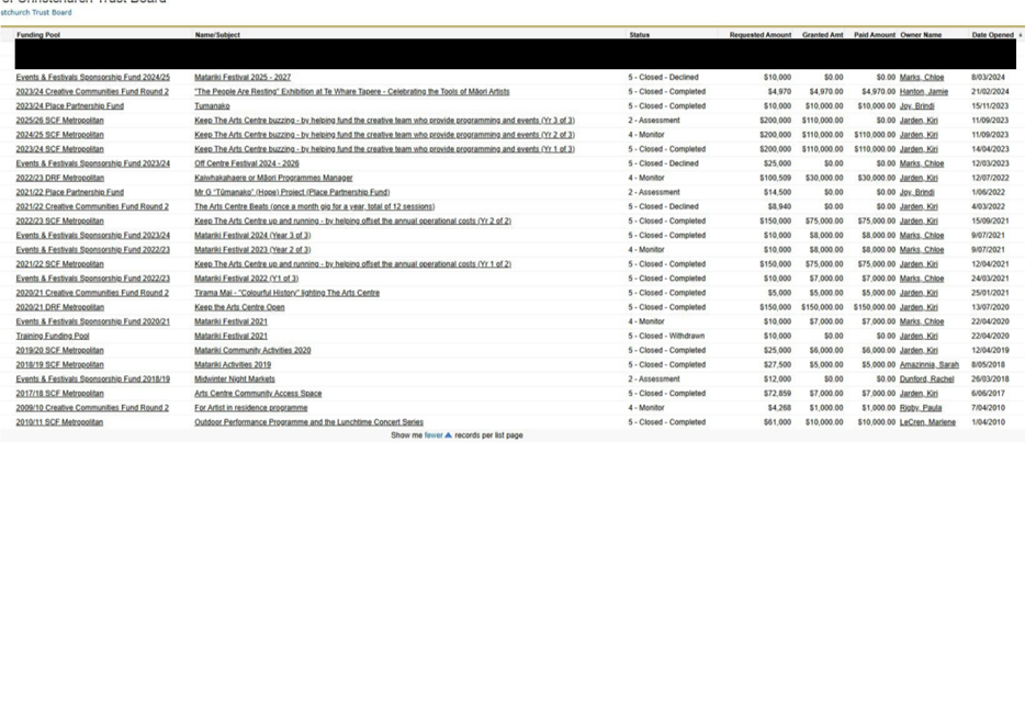
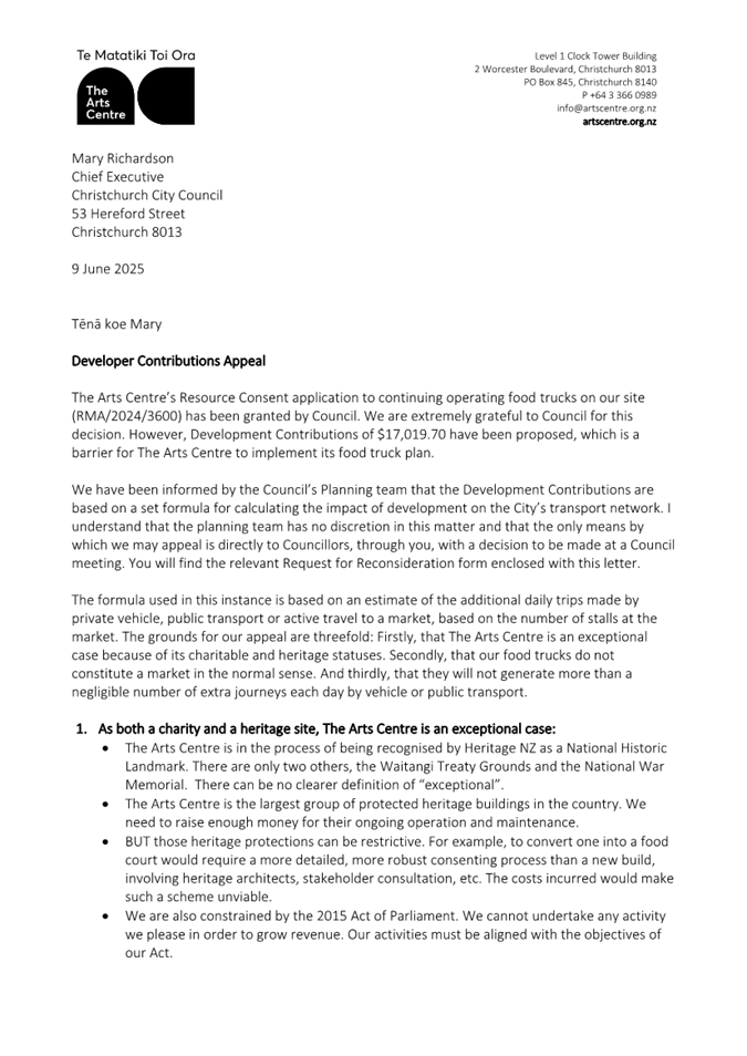
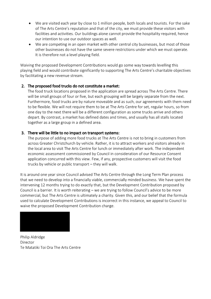
|
17. 151/153
Gilberthorpes Road - Future Use Issues and Options
|
|
Reference Te Tohutoro:
|
25/1222434
|
|
Responsible Officer(s) Te Pou Matua:
|
Matthew
Pratt, Principal Policy Advisor, Strategic Policy & Resilience Barry
Woodland, Property Consultant, Property Consultancy
|
|
Accountable ELT Member Pouwhakarae:
|
Anne
Columbus, General Manager Corporate Services/Chief People Officer
|
1. Purpose and Origin of the Report Te Pūtake Pūrongo
1.1 The
purpose of this report is to seek a decision from the Council regarding the
future use of the Council-owned land and buildings located at 151/153
Gilberthorpes Road.
1.2 The
Council approved the sale of the property in June 2021. At its 4 September 2024
Council meeting in accordance with Standing Order 6.8:
“Item
13 – 151 Gilberthorpes Road – Future Use issues and Options was
withdrawn from the agenda on the basis that new information was presented at
the meeting and to allow time for staff to come back with further information
on use of the facility by interested community groups”.
1.3 This report is staff generated and outlines the current status of
the property, presents viable options for its future use, and recommends a
course of action to address the ongoing inertia.
1.4 The recommendations ensure that the site will be used in a way that
aligns with the Council’s strategic priorities, delivers value to the
community, and supports long-term sustainability for the site.
2. Officer
Recommendations Ngā Tūtohu
That the Council:
1. Receives the information in the 151/153
Gilberthorpes Road - Future Use Issues and Options Report.
2. Notes that the decision in this report is assessed as low significance
based on the Christchurch City Council’s Significance and Engagement
Policy.
3. Approves the sale of 151/153 Gilberthorpes Road (described as Part
Lot 1 DP 9514 and part Lot DP 15320 held in Record of Title CB674/99 and Lot 2
DP 20850 held in Record of Title CB6C/339) to the Purapura Whetu Trust for
community and social housing purposes and subject to:
a. The Purapura Whetu Trust being responsible for securing all required
resource, building or other statutory consents required to operate from the
Land; and
b. The sale being at a financially viable figure having regard to
market value.
4. Authorises the Property Consultancy Manager to do all things
necessary to make any decisions at his sole discretion that are consistent with
the intent of this report to implement the recommendation above including but
not limited to finalising the documentation necessary to implement the sale.
5. Notes that staff will continue to work with the MenzShed and the
Philipino Church (if required) to help meet their needs at other existing
Council owned community locations.
3. Executive Summary Te Whakarāpopoto Matua
3.1 The
sale of the Council owned property at 151/153 Gilberthorpes Road was approved
by the Council through the Council’s Long Term Plan 2021 - 31.
3.2 An
initial Expression of Interest (EOI) process was conducted in 2022, followed by
a second process, at the request of Council, in 2023. Both processes attracted
proposals from local community groups, however, none of the submissions were
assessed as sustainable or financially viable in the long term.
3.3 In September
2024, a staff report was due to be presented to the Council recommending
the sale of the property at 151/153 Gilberthorpes Road.
3.4 This
recommendation was prompted by growing interest from several community-based
entities expressing a desire to develop the site for social and
affordable housing. The staff report acknowledged that, while previous EOI
processes had not yielded viable proposals, the renewed interest in housing
development presented a potential opportunity to repurpose the site in a way
that aligned with the Council’s strategic objectives and address local
housing needs.
3.5 Following
deputations to the Council, the September 2024 staff report recommending the
sale of the property was withdrawn. The Council resolved to provide
community-based groups with additional time to develop and submit proposals for
the future use of the site.
3.6 To
facilitate this, a Request for Proposal (RFP) process was initiated in March
2025. The outcome of this process forms the basis and purpose of this report,
which seeks a decision on the future use of the property at 151/153
Gilberthorpes Road.
3.7 Following
the RFP process, three proposals were received from not-for-profit community-based
entities: Purapura Whetu Trust, Home Capital Partners, and Philipino Church (God’s
Ministry Christian Church).
3.8 Each
proposal was evaluated against a set of criteria designed to ensure alignment
with Council objectives and long-term viability. The criteria included:
conceptual plan, funding and financial viability, capability and experience,
and community impact.
3.9 Following
this evaluation, the proposal from Purapura Whetu Trust was identified as the
preferred option. Staff recommend the sale of the property to
Purapura Whetu Trust based on the strength of their submission and its
potential to deliver meaningful outcomes for the local community.
4. Background/Context Te Horopaki
Context
4.1 The
property at 151/153 Gilberthorpes Road was identified as not meeting
Council’s retention criteria and therefore considered for disposal
through the Council’s 2021-2031 Long Term Plan (LTP). This resulted
in a resolution to declare it surplus and therefore sell it.
4.2 The
property (the land and the Hall and Barracks buildings) has been vacant since
January 2022.
4.3 An
initial Expression of Interest (EOI) in 2022 sought proposals from parties
interested in taking over ownership of the property on an as is where is, no
cost to Council, basis.
4.4 Four
EOI’s were received from commercial entities interested in clearing the
site for development as social / affordable housing. A further EOI from a
coalition of Hornby Community groups was declined on the basis that it lacked a
sustainable business case and a staff assessment that the coalitions property
requirements could be satisfied within other existing Council owned community
facilities.
4.5 Subsequent
steps to sell the property were suspended following the Council’s
approval of a Notice of Motion at its March 2023 meeting (CNCL/2023/00025)
which required staff to:
“Put
on hold the commencement of the sale of 151-153 Gilberthorpes Road, Hornby, for
at least 6 months to allow time for the community to refine their work on
alternative options, including community ownership and operation of part or all
of the facility, noting that there has been insufficient time for this to occur
in robust and genuine manner”.
4.6 Two
alternative EOI proposals on behalf of the coalition of Hornby groups were
subsequently received. The resulting staff report to be considered at the 4
September 2024 Council meeting recommended that the Council sell the property
as the two proposals failed to provide for a sustainable, financial, no cost to
ratepayer solution.
4.7 However,
in accordance with Standing Order 6.8, the report was withdrawn as follows:
“Item 13 – 151/153 Gilberthorpes Road - Future Use Issues and
Options was withdrawn from the agenda on the basis that new information was
presented at the meeting and to allow time for staff to come back with further
information on use of the facility by interested community groups
(referenced as “MenzShed, the Philipino Church, etc”).
4.8 As
such, the future use of the vacant property has been the subject of continued
discussions, meetings and reports over a four-year period and there is yet to
be a decision about the future use of the property.
4.9 To
address this inertia, and to enable the Council to reach a decision based on
sound community and social outcomes, and sustainable financial principles, a
Request for Proposal (RFP) process was initiated, the outcome of which is the
purpose of this report.
The Property
4.10 The
property is situated on the corner of Gilberthorpes Road and Kaniere Avenue in
Hei Hei. Access is currently off Gilberthorpes Road. The fee simple site has a
land area of 3146m2 and is held in two contiguous
titles outlined green and pink in Figure 1 below.
151
Gilberthorpes Road (Green) – Part Lot DP 9514 and Part Lot DP 15320
(CB674/99) – 2245m2.
153
Gilberthorpes Road (Pink) – Lot 2 DP 20850 (CB6C/339) – 901m2.
|
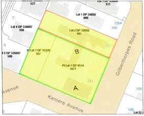
|
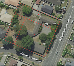
|
|
Figure 1
|
Figure 2
|
4.11 There
are two buildings on the site.
4.12 The Hall
Building (A), constructed circa 1960, is a single-storey portal framed
building with reinforced and filled concrete masonry walls. It incorporates a
main hall with ancillary office and kitchen space and rear toilet block with a
gross floor area of around 200m2.
4.13 The
Administration Building (B) comprises a number of interconnected single
storey former barrack buildings of weatherboard construction dating from the
1940’s, providing general office and toilet facilities.
4.14 The land and
buildings were acquired by the Council from The Presbyterian Church Property
Trustees in the late 1990’s. Their intended use as a multicultural centre
failed to materialise as envisaged and the property has remained vacant since
the departure of the last tenant (Te Puawaitanga o Ōtautahi) in January
2022.
Current Physical Status of the Land and Buildings
4.15 The land and
buildings have been vacant and fenced off to the public since January 2022.
4.16 Both buildings
are generally suitable for occupation in terms of the structural code but
require significant works to meet a healthy building standard to achieve
building and fire code compliance and consent prior to reoccupation.
4.17 A broad
assessment of the works required, and associated costs, for both buildings is
appended as Attachment A.
4.18 Hall Building:
repair and refurbishment costs are broadly estimated to be in the region of
$360,000, a significant portion of which is associated with the demolition and
rebuild of the rear toilet block, works to achieve code compliance and general
site works.
4.19 Administration
Building: the northwest part of the building was damaged by fire in August
2022 and demolished (refer Figure 2 above). The remainder of the building,
which consists of aging, semi-temporary, construction is in poor condition.
Estimated costs to strip out, refit and potentially rebuild the buildings to
meet current code requirements could be as much as $1,000,000.
4.20 The estimated
timeframe (excluding design and consenting) for completing the repair and
compliance work to either of the buildings to enable re-occupation is in the
order of 6 to 9 months.
4.21 Estimated costs
to demolish each building is in the order of $30,000 - $50,000.
Planning Context
4.22 The site, which
is flat and categorised TC1 Grey, has frontages to both Gilberthorpes Road and
Kaniere Avenue. It is zoned Residential Suburban and is suitable for intensive
development with the usual services available at the property boundary.
4.23 Permitted
activities include housing, educational and spiritual activities, welfare and
community garden activities, social housing, multi-unit residential complexes
and retirement villages.
4.24 Resource consent
requirements will be dependent on the nature of the activity and design
proposed for the site.
4.25 Environment
Canterbury’s Listed Land Use register has no hazardous activities and
industries noted on the site.
Request for Proposal (RFP)
4.26 In
context, there is no LTP-approved Council funding for the repair, operation or
management of the property. Proposals were invited from respondents committed
to operating the site for community-based purposes on an as is where is, no
cost to Council, basis.
4.27 The RFP noted
that respondents may include community groups, not-for-profit organisations and
church groups as well as entities interested in developing the site for
community purposes or social / affordable housing.
4.28 The RFP process
went live on 31 March 2025 and closed on 6 June 2025.
4.29 The RFP was
advertised via the GETs website, The Press and Council’s Public Notice
site. Details were also provided to the Council’s Community Governance
Managers for circulation to their respective Community Boards and extensive
local networks.
4.30 Three
submissions were received.
Response 1 - Purapura Whetu Trust Proposal
4.31 The Purapura
Whetu Trusts (PWT) preference is to own the land and buildings. Their proposal
is based on purchasing the property at a viable figure having regard to market
value. A copy of their proposal is appended as Attachment B.
4.32 PWT is a
not-for-profit Māori health, wellbeing and social service provider in the
Canterbury region addressing mental health needs within the local Māori
and wider community to enable supported housing people ‘to have a
home, a stable and constant place to live, love, grow and become citizens of
Otautahi’.
4.33 The proposal is
to demolish the Administration Building, redevelop the site for community
housing with outdoor communal areas and repurpose the existing Hall as a
community hub for the wider Hornby community.
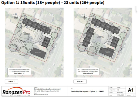
4.34 Their staged
concept is to provide 15-23 one bed and two bed units. This will include 15
single unit dwellings for male and female rangatahi aged 16 to 24 who have been
in Oranga Tamariki or Youth Justice care.
4.35 The additional
tenants will meet social housing criteria and will either be: young parents
with State care history; women coming out of Refuge or residential care; women
reintegrating into society after time in prison; Kaumatua in an
intergenerational living community for ongoing support for our rangatahi; those
who may be on a wait list for the Youth Hub Hostel in Bealey Avenue.
4.36 The Hall will be
available for use as a communal space for group / support activities for the
tenants and a community hub available for use and hire by the wider Hei Hei and
Hornby community e.g. Church service on Sundays, community meetings during the
weekdays and evenings and regular sports events.
4.37 The design and
construction of Stage 1 is expected to take 18 months. A similar period is
anticipated for Stage 2, which contemplates the demolition and replacement of
the Hall with a purpose-built communal and community hub building with staff
office space and activity space as well as additional housing.
4.38 PWT’s
proposal provides robust financials with audited accounts, positive cashflows,
detailed capital and operational budgets, confirmed funding sources and strong
financial partnerships. As such it indicates that the proposal would be funded
by the PWT with or without external funding i.e. no cost to the Council.
4.39 PWT has
extensive experience and a track record in developing and operating successful
community-based facilities for their 27 wellbeing services across multiple
sites.
4.40 Development of
the property would be managed by Rangzen Pro, who have considerable experience
in managing and delivering community housing and community hall construction /
development projects.
4.41 Day to day
operation would be managed by PWT’s Purapura Whetu Management and
Ngā Maihi staff and team onsite.
Response 2 - Home Capital Partners Proposal
4.42 Home Capital
Partners’ (HCP) preference is to own the land and buildings. Their
proposal contemplates the property being transferred to HCP for a nominal sum
of $1. A copy of their proposal is appended as Attachment C.
4.43 HCP is part of the Home Group which is a collective of
organisations with a shared purpose: ‘Through Homes, flourishing
communities – because a home is the foundation of a thriving life’.
4.44 HCP is an
investment fund manager which collaborates and partners with Community Housing
Providers and other stakeholders to use investment funds to create affordable,
secure, and healthy housing solutions.
4.45 Their concept
has been developed in conjunction with the Greater Hornby Residents Association
(GHRA), Philipino Church (God’s Ministry Christian Church), Te Whare
Awhero and Hornby MenzShed.
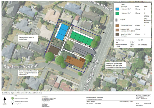
4.46 It contemplates
the demolition of the Administration Building, retention and refurbishment of
the Hall (and potential future extension), the provision of 400m2 for a
MenzShed (Hornby Chapter) and the construction of eight (8) Older Persons
Housing (OPH) villas.
4.47 HCP propose that
the OPH will address a critical shortage of fit-fit-purpose accessible housing
for over 65’s in the area. The extended Hall will provide Te Whare Awhero
with a base for its social services and a shared space for multiple community stakeholders.
4.48 A staged design
and construction timeframe of around 24 months is envisaged beginning with site
clearance and demolition, enabling works, repairs to the Hall, and then
proceeding with the new build elements (MenzShed and OPH villas).
4.49 From a capital
expenditure perspective HCP’s proposal suggests that it has the financial
capability and committed resources necessary to fund the development and
ongoing maintenance of the OPH and refurbishment and extension of the Hall
‘at no net cost to Council’. In this context HCP’s model is
to partner with Councils, Government, Community Housing Providers, Impact
Investors and Philanthropic Donors to provide the required investment funds.
4.50 It is not clear
from the proposal response, however, exactly how this model would be
implemented. HCP’s financial status is unclear as is their financial
position within the project. The financial information provided is limited. It
is also apparent that the development would be contingent on a significant
interest only loan with no indication of how that debt would be serviced during
design and construction when there would be no rental income.
4.51 The Hall is
intended to operate under a head lease arrangement with operational costs being
funded through lease and hire income. The MenzShed would construct and own
their own building and lease their space from the head lessee.
4.52 Aside from HCP,
the Home Group encompasses: Kainga Maha (residential development management
company); Home Construction (construction company); Te Wawata Kainga (property
and tenancy management service); and Home Foundation (charitable trust and
Kaitiaki of the Home Group). This collaboration, and experienced personnel, has
delivered and managed a number of similar community focused development
initiatives.
Response 3 – Philipino Church (God’s Ministry Christian
Church) Proposal
4.53 The proposal
from the Philipino Church assumes ownership of the Hall and utilising only
around 50% of the land area of 151 Gilberthorpes Road (shown cross-hatched in
Figure 1 below) under a ground lease at a peppercorn from the Council. The
balance of the site, including the Administration Building, would not be
required. A copy of their proposal is appended as Attachment D.
|
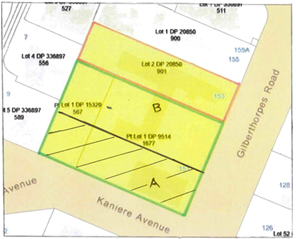
|
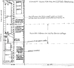
|
|
Figure 1
|
Figure 2
|
4.54 Their concept
plan (refer Figure 2 above) envisages upgrading the Hall and toilet, providing
an area for the MenzShed and incorporating an outdoor basketball court. It is
noted that a larger land area would likely be required to accommodate these
features.
4.55 The Philipino Church
clearly have a strong community ethic and have access to an experienced
construction workforce. However, the general approach to the design, consenting
and construction process and the costs associated with that appears to be
under-estimated. Equally the funds available to the Philipino Church for
capital works are relatively limited.
4.56 Operating income
would be derived from community groups and other users of the Hall.
4.57 In isolation
this proposal would require the Council to subdivide the site and run a further
process (i.e. RFP, open market sale) to resolve the future use of the balance
of the site, including the demolition of the Administration building.
4.58 It is noted that
the Philipino Church have collaborated with HCP and MenzShed in developing
their proposal. Given that both the PWT and HCP proposals intend to retain and
upgrade the Hall for community purposes it is suggested that these may provide
better, and more feasible, options for accommodating the requirements of the
Philipino Church.
RFP Evaluation
4.59 The submissions
were reviewed and evaluated by a panel of three: one each from the
Council’s Community Support and Partnerships, Finance, and Facilities and
Property Units. Probity was provided by the Legal and Democratic Services Unit.
4.60 The RFP
responses were graded in relation to the RFP weighted attribute criteria,
summarised as follows:
· Eligible Applicant - 10%: an
incorporated non-profit with charitable purpose, charitable trust, church group,
community housing provider, or private entity committed to a community use.
· Concept Plan – 15%: a clear vision
for the site/buildings including a high-level implementation plan.
· Funding & Financial Viability – 50%: a robust business case demonstrating secured financial resources
(at no cost to Council) including: pre-planning (design, consents); structural
repairs and site works; demolition and subdivision (if required); staged
development; cash-flow projections.
· Capability and Experience – 10%:
demonstrate an ability to manage, deliver and operate the proposed community
initiative.
· Community Impact – 15%:
demonstrate the extent of community benefit and outreach.
4.61 The RFP
responses were graded with results as scheduled below:
|
|
Purapura Whetu Trust
|
Home Capital Partners
|
Philipino Church (GMCC)
|
|
Ranking
|
1
|
2
|
Fail – Funding and Financial
viability
|
4.62 The completed
evaluation process has determined Purapura Whetu Trust as the preferred
respondent, with Home Capital Partners second. The Philipino Church submission
was deemed a fail due principally to insufficient financial and project
delivery information.
Valuation and Costs to Council
4.63 In April 2024
Bayley’s were commissioned to provide an independent valuation report to
inform this decision-making process. This assessment of value has been updated
recently and is referenced within the Public Excluded Attachment E.
4.64 The current book
value of the property is $857,000. The rateable value is $820,000.
4.65 These factors
would inform negotiations around the sale of the property.
4.66 The
total costs associated with the facility including both non-controllable
costs (depreciation, insurance, and rates) and controllable
costs (maintenance and operating expenses), amounted
to $138,609.84 over the three fiscal years from FY 2023 to FY
2025.
4.67 Annual
breakdown:
· FY 2023: $45,417.43
· FY 2024: $47,736.47
· FY 2025: $45,455.94
4.68 These
figures reflect the ongoing financial commitment required to maintain the
property in its current state.
4.69 In
addition to direct facility costs, it is estimated that approximately $80,000 in staff
time has been charged to the disposal process for the property
since June 2021, when the Council approved the sale through the LTP process.
4.70 This
figure reflects the cumulative staff effort involved in managing the ongoing
decision-making, community engagement, and administrative processes related to
the property.
Options Considered Ngā
Kōwhiringa Whaiwhakaaro
4.71 The following
reasonably practicable options were considered and are assessed in this report:
4.71.1 Purapura Whetu Trust
Proposal: PWT purchase the property, demolish the Administration building,
develop and operate the site for 15-23 social housing units and repurpose (and
eventually redevelop) the Hall for PWT staff, tenant and wider community use.
4.71.2 Council Retains the
Property: repairs the Hall, demolishes the Administration Building, leases
the land and Hall building to community groups.
4.71.3 Council Sells the
Property: as is where is on the open market.
4.72 The following
options were considered but ruled out:
4.72.1 Retain the Status
Quo: the land and buildings remain fenced and closed.
The property continues to deteriorate, provides a target for ongoing
vandalism and the inertia around the future use of the site will continue
indefinitely.
4.72.2 Home Capital
Partners Proposal: HCP acquire the property for $1, demolish the
Administration Building, develop and operate the site for 8 Older Person
Housing (OPH) villas, repurpose (and potentially extend) the Hall for community
use and provide space for a MenzShed building.
All proposals provide community space through the repurpose of the
hall. In comparison to PWT’s proposal HCP’s mixed model
delivers more community use, less social housing and a lower financial benefit
to the ratepayer. The proposal comes from a new subsidiary of a Group
with a proven track record, however, there is a lack of clarity in the proposal
around the financial and development framework.
4.72.3 Philipino Church
(God’s Ministry Christian Church) Proposal: repurpose the Hall,
set aside space for a MenzShed building and a basketball court and utilise
approximately one third of the site on a ground lease.
Although well intentioned, and with a strong community focus, their
proposal lacked financial and funding rigour and under-estimated the likely
costs and resources required to support the lifecycle of a project of this
nature. In isolation the proposal would require the Council to invest in the
sub-division of the site and further work required to determine the future use
of the balance of the site.
Options Descriptions Ngā
Kōwhiringa
4.73 Option 1 (Preferred
Option) - Purapura Whetu Trust Proposal
4.74 Option
Description: PWT purchase the property, demolish the Administrative
Building, develop and operate the site for 15-23 social housing units and
re-purpose (and eventually redevelop) the Hall for PWT staff, tenants and wider
community use.
|
Advantages
|
Disadvantages
|
|
A positive response to ongoing inertia
and vandalism
|
MenzShed requirements not accommodated on
site
|
|
No cost to Council
|
Possible negative response from
neighbours
|
|
Council receives revenue from the sale of
the property
|
|
|
Council’s unbudgeted CAPEX/OPEX
liability is extinguished
|
|
|
Significant social housing / community
benefit
|
|
|
Hall repurposed for community / other
uses – i.e., Philipino Church, GHRA etc.
|
|
|
Staff continue to work with MenzShed /
other groups to resolve their accommodation requirements
|
|
4.75 Option 2 -
Council Retain and Repair the Property
4.76 Option
Description: Council repairs the Hall, demolishes the Administration
Building, leases the land and re-purposed Hall building to community groups.
|
Advantages
|
Disadvantages
|
|
The property remains in Council ownership
|
Unbudgeted CAPEX – Hall Repair and
siteworks (c$360k); Demolition (c$50k);
|
|
Hall and land available for use by
community groups
|
Unbudgeted OPEX – annual repair,
maintenance and management (c$10 - $20k)
|
|
A positive response to the current
inertia and vandalism
|
Retention not supported by the
Council’s approved Community Facilities Network Plan 2020 – i.e.
community need is adequately provided for within existing Council community
facilities
|
|
|
While there is claimed demand for
additional community space, the evidence that the existing network of
facilities is failing to meet this is less clear.
|
|
|
Direct impact on rates
|
4.77 Option 3 -
Council Sells the Property
4.78 Option
Description: as is where is on the open market.
|
Advantages
|
Disadvantages
|
|
No cost to Council (net of selling agents
fees)
|
No control over the development / future
use of the site
|
|
Council receives revenue from the sale of
the property
|
Potential use of the site to address
social housing and / or local community issues cannot be guaranteed
|
|
Council’s unbudgeted CAPEX / OPEX
liabilities extinguished
|
|
|
A positive response to the current
inertia and vandalism
|
|
Analysis Criteria Ngā Paearu
Wetekina
4.79 The key elements
of the three proposals received are outlined above at 4.31 to 4.58. These were
evaluated against the weighted RFP criteria listed at 4.60 to 4.62 and further
discussed, together with several other alternative options, within the ‘Options
Description’ section above at 4.73 to 4.78.
4.80 This evaluation
process has determined that the proposal from the PWT provides the most
favourable option in terms of beneficial social and community outcomes and,
also, in terms of an as is where is, no cost to Council, basis.
5. Financial Implications Ngā Hīraunga Rauemi
Capex/Opex Ngā Utu Whakahaere
|
|
Recommended Option – PWT Proposal
|
Option 2 – CCC Retain & Repair
Property
|
Option 3 – CCC Sell the Property
|
|
Cost to Implement
|
Nil (staff time only)
|
Est $410k to repair the Hall/Demolish
Admin Building
(forego sale proceeds)
|
Nil (selling agents fees / legal costs
deducted from sale proceeds)
|
|
Maintenance/Ongoing Costs
|
Nil (assuming early sale)
|
Est $10-20k per annum
|
Nil (assuming early sale)
|
|
Funding Source
|
Unbudgeted
|
Unbudgeted
|
Unbudgeted
|
|
Funding Availability
|
Unbudgeted
|
Unbudgeted
|
Unbudgeted
|
|
Impact on Rates
|
Nil
|
Nominal
|
Nil
|
5.1 With
regard to property sales, the Council has an LTP revenue budget of $3.0 million
per annum. Revenue from the sale off the property to PWT will provide a
significant contribution and reduce the risk of not achieving that target.
5.2 This
report has been reviewed by Finance.
6. Considerations Ngā Whai Whakaaro
Risks and Mitigations Ngā
Mōrearea me ngā Whakamātautau
6.1 Although
site security is in place, further delay is likely to increase the ongoing risk
to the land and buildings of vandalism and arson. While the property remains
unoccupied the negative visual and anti-social impact on the adjoining
neighbours and neighbourhood will continue.
6.2 There
may be some residual feedback from immediate neighbours regarding the provision
of social and community housing on the site.
6.3 While
considered low, there is a risk around securing a mutually acceptable Sale and
Purchase Agreement with the PWT.
Legal Considerations Ngā
Hīraunga ā-Ture
6.4 Statutory
and/or delegated authority to undertake proposals in the report:
6.4.1 The disposal
of the property was approved by the Council through the Long-Term Plan
2021-2031 (resolution C-LTP/2021/00106 (M191A).
6.4.2 The powers of
competence set out in section 12(2) “Status and Powers” of the
Local Government Act.
6.5 Other Legal Implications:
6.5.1 The legal
consideration is the Council’s ‘Disposal of Council Property’
policy which was addressed when the property was deemed available for disposal
through the 2021-2023 LTP process.
6.5.2 The previous
owner of the property, The Presbyterian Church Property Trustees, declined the
opportunity to purchase the property pursuant to section 40 Public Works Act
1981.
6.5.3 Ngāi Tahu
confirmed that they have no right of first refusal over the site.
6.5.4 This report
has been reviewed by Legal Services.
Strategy and Policy Considerations Te Whai
Kaupapa here
6.6 The
required decision:
6.6.1 Aligns with
the Christchurch
City Council’s Strategic Framework. The decision will facilitate the
sale of an operationally redundant property and save ongoing repair,
maintenance and holding costs and, through development of the site, mitigate
the existing vandalism and arson issues.
6.6.2 Is assessed as
low significance based on the Christchurch City Council’s Significance
and Engagement Policy. The level of significance was determined by
recognising that the decision is of a local nature, affects a small number of
the city and local community and recognises that the preferred proposal
provides shared community space in addition to the available space within
existing Council community facilities.
6.6.3 Is consistent with the Council’s Plans and
Policies as the disposal of the property is provided for within the 2021-2031
LTP.
6.7 This
report supports the Council's
Long Term Plan (2024 - 2034):
6.8 Communities & Citizens
6.8.1 Activity: Community Development and Facilities
· Level of Service: 2.0.1.1 Provide a sustainable
network of community facilities to empower resilient, active, and connected
communities owning their own future - 78 - 82 Facilities
Community Impacts and Views Ngā Mariu
ā-Hāpori
6.9 Through
the LTP 2021-31 process, the Council made the decision in June 2021 to sell 57
properties that were no longer required for their purposes. One of the
properties declared surplus was 151-153 Gilberthorpes Road.
6.10 In arriving at
the decision, the Council undertook both general and targeted consultation,
resulting in over 500 submissions. Targeted consultation went to Community
Boards, the 6 Rūnanga, Ngāi Tahu (both Iwi and corporate), tenants,
and housing providers. 253 submissions clearly supported disposals, 54 clearly
opposed and 180 suggested a mix of outcomes. There were no submissions on
Gilberthorpes Road.
6.11 The Waipuna
Halswell-Hornby-Riccarton Community Board was aware of the consultation and
made a submission on other properties but did not mention Gilberthorpes Road.
6.12 Following the
adoption of the 2021-31 LTP where the sale of 151-153 Gilberthorpes Road was
approved, there was a level of surprise within the local Hornby and Hei Hei
communities over the decision. Community members expressed a lack of awareness
of the proposal within the LTP and requested that the facility be retained for
community use.
6.13 The Waipuna
Halswell-Hornby-Riccarton Community Board ‘s submission to the 2022-23
Annual Plan included that “The Board….supports in principle the
disposal of properties that are surplus to the Council’s requirements but
cautions against disposal of property for which there is or could be a current
or future community use….the Board has become aware that there are now a
number of potential community uses being put forward for these premises and it
therefore ask that the disposal of this property be revisited”.
6.14 Two subsequent
widely promoted EOI processes were run which attracted proposals from local
community groups. None of these were assessed as sustainable or financially
viable which precipitated the 2024 staff report to Council recommending the
sale of the property.
6.15 A further
process, the RFP which is the subject of this report, was initiated to provide
a further opportunity for local community groups and community-based entities
to submit sustainable ana financially viable proposals for the future use of
the property.
6.16 The decision
affects the Waipuna Halswell-Hornby-Riccarton Community Board area.
Impact on Mana Whenua Ngā Whai Take
Mana Whenua
6.17 The decision
does not involve a significant decision in relation to ancestral land, a
body of water or other elements of intrinsic value, therefore this decision does not specifically impact Mana Whenua, their culture, and
traditions.
6.18 The decision does
not involve a matter of interest to Mana Whenua and will
not impact on our agreed partnership priorities with
Ngā Papatipu Rūnanga.
6.19 The proposal to
dispose of the property has been communicated to Mana Whenua through the LTP
and the previous EOI process.
Climate Change Impact Considerations Ngā
Whai Whakaaro mā te Āhuarangi
6.20 The decision
attempts to create certainty over the future use of the property. The preferred
use and development of the property is unlikely to have a direct effect on
climate change or emissions reduction.
6.21 Users of the
facility will ultimately access the site through a range of transport measures,
which are considered by other Council policies and regulatory processes.
7. Next Steps Ngā Mahinga ā-muri
7.1 If
the Council resolves to approve the Officer recommendation, which endorses a
prior Council resolution, staff will negotiate the sale of the property to PWT
on an as is where is, no cost to Council, basis.
Attachments Ngā Tāpirihanga
|
No.
|
Title
|
Reference
|
Page
|
|
a ⇨
|
Cost Estimates
(Under Separate Cover)
|
25/1405208
|
|
|
b ⇨
|
Purapura Whetu
Trust Proposal (Under Separate Cover)
|
25/1408419
|
|
|
c ⇨
|
Home Capital
Partners Proposal (Under Separate Cover)
|
25/1475322
|
|
|
d ⇨
|
Philipino
Church (GMCC) Proposal (Under Separate Cover)
|
25/1476055
|
|
|
e
|
Property
Purchase Context (Under Separate Cover) - Confidential
|
25/1418994
|
|
In addition to the attached documents, the following background
information is available:
|
Document
Name – Location / File Link
|
|
Not
applicable
|
Signatories Ngā Kaiwaitohu
|
Authors
|
Barry Woodland
- Property Consultant
Angus Smith -
Manager Property Consultancy
Matthew Pratt
- Principal Policy Advisor
|
|
Approved By
|
Angus Smith -
Manager Property Consultancy
Bruce Rendall
- Head of Facilities & Property
Anne Columbus
- General Manager Corporate Services/Chief People Officer
|
|
18. Proposed Locky Dock cycle parking and charging
station in Rauora Park, Lichfield St
|
|
Reference
Te Tohutoro:
|
25/672349
|
|
Responsible Officer(s) Te Pou Matua:
|
Anne
Heins, Community Travel Advisor
Sarah Anderson, Team Leader Travel Demand Management
|
|
Accountable ELT Member Pouwhakarae:
|
Brent
Smith, General Manager City Infrastructure
|
1. Purpose
and Origin of the Report Te Pūtake Pūrongo
1.1 The purpose of this report is to seek the Council’s approval
for a Locky Dock to be installed in Rauora Park on Lichfield St.
1.2 This report follows a 2023/24 Annual Plan action for staff to work
with Big Street Bikers to investigate a network of Locky Docks on Council land,
and the Memo of 5 February 2025 outlining progress including the signing of a
Licence to Occupy (Attachment A).
2. Officer Recommendations Ngā
Tūtohu
That the Council:
1. Receives the information in the Proposed
Locky Dock cycle parking and charging station in Rauora Park, Lichfield St
Report.
2. Notes that the decision in this report is assessed as low
significance based on the Christchurch City Council’s Significance and
Engagement Policy.
3. Approves the site in Rauora Park (200R Cashel St) adjacent to 133
Lichfield St (shown in Attachment B of this report) to be added to the
Licence to Occupy (public excluded Attachment C to this report) to
enable the installation of a Locky Dock cycle parking and charging station,
subject to the granting of a Resource Consent.
4. Subject to the approval of Recommendation 3:
a. Delegates to the Manager Property Consultancy the power to sign all
required documentation to complete the Licence to Occupy.
5. Notes that Public Excluded Attachment C to this report, the Licence
to Occupy signed with Locky Docks, will be released upon the review of Head of
Transport.
3. Executive
Summary Te Whakarāpopoto Matua
3.1 Locky Docks are cycle infrastructure which provide free secure
parking and charging, and associated marketing screens, the revenue of which
funds Big Street Bikers’ capital and operational costs of the
infrastructure (plus a commercial profit margin).
3.2 In December 2024, the Council entered into an initial 3-year Licence
to Occupy agreement with Big Street Bikers to pilot up to three Locky Dock
stations on Council land.
3.3 The pilot is designed to be cost neutral for the Council, with the
exception of staff time. Any costs for installation, operations, and removal
sit with Big Street Bikers
3.4 Two of the three sites for Locky Docks, situated on Road Reserve
land, have been agreed in the Licence to Occupy as per the Memo that was sent
to the Mayor and Councillors on 5 February 2025 (Attachment A). These
two locations are now installed and operational. This report recommends a third
and final Locky Dock site to fulfill the pilot agreement. This third site,
unlike the other two sites, requires approval by the Council because it is
situated on park land within the Central City area.
3.5 The proposed site is in Rauora Park (200R Cashel St), located
adjacent to 133 Lichfield St.
3.6 The Locky Dock, if approved, would have space for up to 10 bicycles,
depending on detailed site investigations and Resource Consent process.
4. Background/Context
Te Horopaki
4.1 As part of the 2023/24 Annual Plan, an action was agreed by the
Council for staff to work with Big Street Bikers on a network of Locky Docks
across the city.
4.2 In December 2024, the Council entered into an initial 3-year Licence
to Occupy agreement with Big Street Bikers to pilot up to three Locky Dock
stations on Council land. The license was granted and signed off through the
Manager of Property Consultancy in accordance with their delegated authority.
This Licence to Occupy is included in this report as Public Excluded Attachment
C.
4.3 Two of the three sites for the pilot of Locky Docks on public
Council land have been agreed in the Licence to Occupy, as per the Memo sent to
the Mayor and Councillors on 5 February 2025 (Attachment A). This report
recommends a third and final Locky Dock site to fulfill the pilot agreement.
This third site, unlike the other two sites, requires approval by the Council
because it is situated on park land within the Central City area.
4.4 The approach of the pilot is to test the demand and usage of Locky
Docks. It will allow for collection of public feedback for the facilities as
well as test the marketing return that could generate future revenue for
Council, should there be a decision to extend the network and/or renew the
license agreements for the trial sites.
4.5 Council staff have been working with Big Street Bikers to determine
an appropriate third site for the 3-year pilot.
4.6 Many other site options have been considered to date. It is noted
that finding a workable site is difficult because:
4.6.1 Often a location
with high cycle parking demand is at odds with Big Street Bikers’
requirement for high levels of adjacent vehicle and foot traffic to provide
sufficient profile for the marketing screen.
4.6.2 In many
locations there is simply insufficient space on the footpath or other public
Council land to install a Locky Dock without severely impeding pedestrian
thoroughfare.
4.6.3 To be
workable, a site needs nearby power access, as trenching and surface
reinstatement can make installation costs prohibitive for Big Street Bikers.
4.6.4 The Locky
Dock’s associated large marketing screen has the potential to impede road
user sightlines, especially near vehicle exits or intersections, as well
sensitivities around marketing screens in public spaces of high cultural,
historical or civic value.
4.7 The following related memos/information were circulated to the
meeting members:
|
Date
|
Subject
|
|
5
February 2025
|
Locky Docks Pilot - Memo
|
Options Considered Ngā
Kōwhiringa Whaiwhakaaro
4.8 The following reasonably practicable options were considered and are
assessed in this report:
4.8.1 Option 1:
Approve the proposed site: Grant approval (subject to Resource Consent and
any other relevant Council requirements) for a Locky
Dock to be installed on the triangle of land at the edge of Rauora Park,
adjacent to the terraced housing at 133 Lichfield St, and directly bordering
the footpath.
4.8.2 Option 2:
Do not approve the site for Locky Dock installation, seek alternative site
4.8.3 Option 3:
Do not agree to a third site for the 3-year pilot
4.9 The following options were considered but ruled out:
4.9.1 Installation
on one of five sites on Cashel and High Streets in the pedestrian mall:
ruled out because the area is already busy with people and existing street
furniture, and a Locky Dock would add clutter and impede pedestrian
circulation. Local commercial property owners were opposed, and the proximity
to the tram tracks was problematic from a safety point of view. The Heritage
layer in the District Plan was also likely to cause resistance to additional
marketing screens being visible from key historical sites like the Bridge of
Remembrance.
4.9.2 Installation
near Margaret Mahy Playground: ruled out because of a lack of projected
demand for cycle parking there, as the proposed site was a greater distance
from the playground than existing and underutilised cycle parks, and the site
was adjacent to a Phantom Billboard bollard creating a high cumulative impact
of advertising in public space.
4.9.3 Installation
on the footpath outside Child Sister café on Manchester St: ruled
out because a Resource Consent application for the adjacent bare land shows a
future vehicle entrance across the proposed Locky Dock location.
4.9.4 Installation
on the footpath adjacent to the Court Theatre: ruled out because the
footpath width is insufficient to accommodate it without creating narrow
pinchpoints in a prime pedestrian area.
4.9.5 Installation
on one of the Tūranga frontages: ruled out because the footpath widths
were insufficient on the Gloucester St side. On the Cathedral Square side of
Tūranga, the marketing screen would have obscured the view of the flagship
entrance and Tūranga signage. It would impede pedestrian circulation, as
well as complications with the Heritage protection of Cathedral Square.
4.9.6 Installation
near the Mt Pleasant Community Centre to serve the centre, preschool, and
weekend market: ruled out because the vehicle and foot traffic in the area
were deemed to provide insufficient profile for the marketing screen.
4.9.7 Installation
adjacent or near to the new Sumner Skate Park: ruled out because there is
not enough space on the footpath to install a Locky Dock without severely
impeding pedestrian thoroughfare.
Options Descriptions Ngā
Kōwhiringa
4.10 Option 1: Approve the proposed site Grant
approval (subject to Resource Consent and any other relevant Council requirements) for
a Locky Dock to be installed on the triangle of land at the edge of Rauora
Park, adjacent to the terraced housing at 133 Lichfield St, and directly
bordering the footpath.
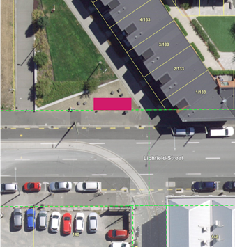
Figure 1: Aerial showing
proposed location in pink: Rauora Park (200R Cashel St), adjacent to 133
Lichfield St
4.10.1 Option Advantages
· There is proven demand for cycle parking in this area with its
nearby restaurants and bars, and small offices without their own secure cycle
parking for staff.
· There is an existing Locky Dock diagonally across the road next to
Earl Restaurant which has space for 10 bikes, but it will soon be removed as
the vacant site it is on is being developed. This Locky Dock is well-used, with
the third highest use rate of all of Christchurch’s Locky Docks.
· The Parks Team support the proposal.
· An initial assessment from the Resource Consents team raised no
concerns that cannot be managed via the consent process.
· The proposed location is marked up in Figure 1 above, and is shown
in Attachment B.
4.10.2 Option Disadvantages
· None identified.
4.11 Option 2: Do not approve the site for Locky Dock installation, seek
alternative site
4.11.1 Option Advantages
· It is possible that a more optimal site exists.
4.11.2 Option Disadvantages
· Further staff time is committed to trying to identify an alternative
feasible site.
· A further delay in installing the third and final Locky Dock site,
to assess against the criteria of the 3-year pilot.
4.12 Option 3: Do not agree to a third site for the 3-year pilot
4.12.1
Option Advantages:
· Does not cost additional staff time.
4.12.2
Option Disadvantages:
· Limits the pilot to only two Locky Dock sites.
· Undermines staff’s informal agreement with Big Street Bikers
to identify a third site under the pilot agreement.
Analysis Criteria Ngā Paearu
Wetekina
4.13 Criteria that potential sites are assessed against include:
4.13.1 Are there trip generators
(shops, restaurants, bars, small businesses, other facilities) nearby to drive
demand for cycle parking in the area.
4.13.2 Is there sufficient
physical space on the footpath or other area for a Locky Dock without impeding
pedestrian circulation or access.
4.13.3 Does the site have
longevity, i.e. are there likely changes in the near future that will require
removal of the Locky Dock, such as adjacent development or plans to put a
vehicle access across the site to access adjacent land.
4.13.4 Is there a power source
nearby that can be connected to for the Locky Dock’s operation (trenching
and surface reinstatement is expensive and highly dependent on distance).
4.13.5 Does the site have a high
enough profile for the marketing screen to reach a large audience, i.e. minimum
pedestrian and vehicle traffic volumes.
4.13.6 Are there road safety
concerns, such as the marketing screen obstructing sightlines or creating
distractions around vehicle entrances or intersections.
4.13.7 Are there Heritage
protections over the site that make the marketing screen inappropriate.
4.13.8 Are there significant
Urban Design and Cultural design factors for the public space that make a Locky
Dock marketing screen there inappropriate.
4.13.9 Are there other outdoor
advertising structures nearby that would create a high cumulative impact of
advertising in a public space.
5. Financial
Implications Ngā Hīraunga Rauemi Capex/Opex Ngā Utu Whakahaere
|
|
Recommended Option
|
Option 2 - Do not approve the site for Locky
Dock installation, seek alternative site
|
Option 3 - Do not agree to a third site for
the 3-year pilot
|
|
Cost to Implement
|
$2000 (cost to complete this report)
|
Estimated $5,000 - $10,000 for further
staff time
|
$2000 (cost to complete this report)
|
|
Maintenance/Ongoing Costs
|
N/A
|
N/A
|
N/A
|
|
Funding Source
|
Workplace Travel Planning budget
|
Workplace Travel Planning budget
|
Workplace Travel Planning budget
|
|
Funding Availability
|
Existing LTP budget
|
Existing LTP budget
|
Existing LTP budget
|
|
Impact on Rates
|
None
|
None
|
None
|
5.1 The 3-year pilot under which all three Locky Docks are to be
installed is designed to be cost neutral for the Council, aside from staff time
involved in the partnership with Big Street Bikers to identify feasible sites and
monitor the pilot parameters. Any costs for installation, operation and removal
of the Locky Docks sit with Big Street Bikers as per the pilot agreement.
5.2 While being rates-neutral, it is noted that staff time invested in
this project over the past 2 years has been substantial, due to the broad range
of Council teams involved in providing advice on the marketing screens in
particular and the complexity of negotiating the Licence to Occupy.
6. Considerations
Ngā Whai Whakaaro
Risks and Mitigations Ngā Mōrearea me ngā
Whakamātautau
6.1 There is a small risk that members of the public will object to
additional marketing screens in the public realm. This wider issue will be
considered through the development of the Advertising on structures in Road
Reserve/Public Places policy.
Legal Considerations Ngā
Hīraunga ā-Ture
6.2 Statutory and/or delegated authority to undertake proposals in the
report:
6.2.1 The Council
has the power under the Local Government Act 2002 to enter into licences of
land.
6.2.2 The proposed
site, unlike the other two confirmed sites which are on Road Reserve land,
requires approval by the Council because it is situated on park land within the
Central City area.
6.3 Other Legal Implications:
6.3.1 The proposed
site is ‘park’ in accordance with section 138 of the Local
Government Act 2002. The Council is not required to consult in accordance with
s138(1), as the proposed licence does not have the effect of excluding or
substantially interfering with the public’s access to the park.
Strategy and Policy Considerations Te Whai
Kaupapa here
6.4 The required decision:
6.4.1 Aligns with
the Christchurch
City Council’s Strategic Framework and reflects the strategic
priority of reducing emissions, and the community outcome of a thriving and
prosperous city in Council partnering with enterprises to trial innovative
ideas like Locky Docks.
6.4.2 Is assessed as
low significance based on the Christchurch City Council’s Significance
and Engagement Policy. The level of significance was determined by the fact
that this relates to one site for cycle parking infrastructure, which has
marginal alternative public use.
6.4.3 Is consistent
with the Council’s Plans and Policies.
6.5 This report supports the Council's
Long Term Plan (2024 - 2034):
6.6 Transport
6.6.1 Activity: Transport
· Level of Service: 10.5.39 Increase the numbers
of people cycling in the central city - >=2,000 cyclists
· Level of Service: 10.0.2 Increase the share of
non-car modes in daily trips - >=37% of trips undertaken by non-car modes
6.7 It is noted that the Council is
currently reviewing its Advertising on
structures in Road Reserve/Public Places policy, which is one of the reasons for the short term of the
Licence to Occupy of three years. The Advertising on structures in
Road Reserve/Public Places policy is expected
to be finalised and operative by the time the 3-year licence expires at the end
of 2027.
Community Impacts and Views Ngā Mariu
ā-Hāpori
6.8 A letter was sent to residents who might have sightline of the Locky
Dock marketing screen from their property (133 Lichfield Street, units 1-5) on
14 May 2025. The letter provided information on the proposal for a Locky Dock
in this location and invited them to provide feedback if there was anything we
needed to know before a decision was made. No feedback was received.
6.9 Fletcher Residential who are currently building an apartment
building next to the site were also informed of the plans through their
Development Manager and given the opportunity to provide information. Fletcher
raised no concerns, providing the site is well maintained. This is covered by
the Maintenance Schedule of the Licence to Occupy.
6.10 The decision affects the following wards/Community Board areas:
6.10.1 Waipapa Papanui-Innes-Central
Ward.
Impact on Mana Whenua Ngā Whai Take
Mana Whenua
6.11 The decision does not involve a significant decision in relation to
ancestral land, a body of water or other elements of intrinsic value, therefore
this decision does not specifically impact Mana Whenua, their culture, and
traditions.
6.12 The decision does not involve a matter of interest to Mana Whenua
and will not impact on our agreed partnership priorities with Ngā Papatipu
Rūnanga.
Climate Change Impact Considerations Ngā
Whai Whakaaro mā te Āhuarangi
6.13 The decisions in this report:
6.13.1 Have the potential to contribute
positively to emissions reductions by helping provide travel choice, and more
secure cycle parking options.
7. Next
Steps Ngā Mahinga ā-muri
7.1 If approved, and subject to the granting of a Resource Consent, Big
Street Bikers will install, operate and maintain the Locky Dock and its
associated marketing screen at this site in accordance with the agreed Licence
to Occupy.
Attachments Ngā Tāpirihanga
|
No.
|
Title
|
Reference
|
Page
|
|
a ⇩
|
Locky Dock
Pilot Memo 5 February 2025
|
25/700653
|
255
|
|
b ⇩
|
Lichfield St
Rauora Park 10-berth Locky Dock Plan
|
25/1369234
|
257
|
|
c
|
Locky Docks
Licence to Occupy, 20.12.2024 (Under Separate Cover) - Confidential
|
25/1376322
|
|
In addition to the attached documents, the following background
information is available:
|
Document
Name – Location / File Link
|
|
Not
applicable
|
Signatories Ngā Kaiwaitohu
|
Authors
|
Anne Heins -
Community Travel Advisor
Sarah Anderson
- Team Leader Travel Demand Management
|
|
Approved By
|
Stephen Wright
- Manager Operations (Transport)
Lynette Ellis
- Head of Transport & Waste Management
Brent Smith -
General Manager City Infrastructure
|
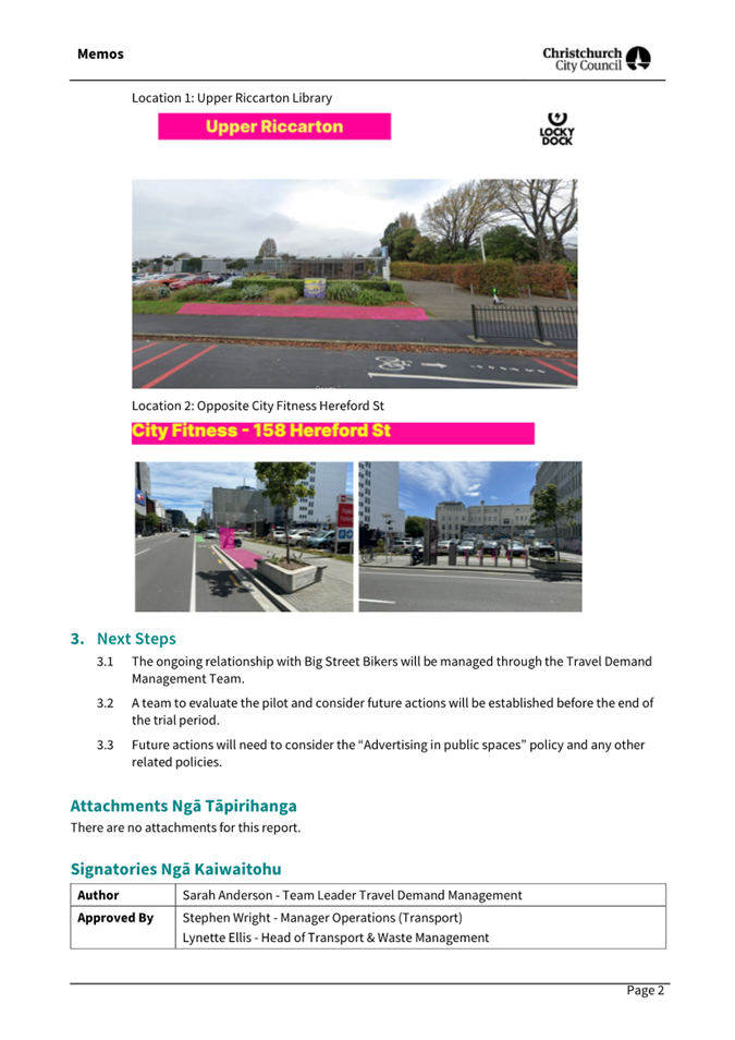
|
19. Setting of
Speed Limits Rule 2024: Management of Non-Installed Limits - Nor'West Arc
Section 3 (University to Harewood Road)
|
|
Reference Te Tohutoro:
|
25/1199106
|
|
Responsible Officer(s) Te Pou Matua:
|
Jacob
Bradbury, Manager Planning and Delivery Transport
|
|
Accountable ELT Member Pouwhakarae:
|
Brent
Smith, General Manager City Infrastructure
|
1. Purpose and Origin of the Report Te Pūtake Pūrongo
1.1 The
purpose of this report is for the Council to consider next steps for
Nor’West Arc Major Cycle Route along Ilam Road, Aorangi Road, Condell
Ave, Matsons Ave and associated cul-de-sacs, where its previously approved
speed limit changes cannot now be installed due to a change in the law.
1.2 The
report is in response to the Land Transport Rule: Setting of Speed Limits
2024 which came into force in October 2024, and after feedback from
Councillors during an Information Session held on 20 May 2025.
1.3 Background
to the change in the law was supplied to Elected Members via Memo on 14 April
2025, and supplied here as Attachment A.
2. Officer
Recommendations Ngā Tūtohu
That
the Council:
1. Receives the information in the Setting of
Speed Limits Rule 2024: Management of Non-Installed Limits - Nor'West Arc
Section 3 (University to Harewood Road) Report.
2. Notes that the decision in this report is assessed as medium significance
based on the Christchurch City Council’s Significance and Engagement
Policy.
3. In accordance with the requirements set out in the Land Transport
Rule: Setting of Speed Limits 2024:
a. Revokes the 40km/h speed limits approved by the Urban Development
and Transport Committee on 3 February 2022 for Nor’West Arc Section 3 [UDATC/2022/00005
resolution 2, see Attachment C] on streets where Detailed Traffic
Resolutions were not approved before the Rule. This applies to the following
streets:
i. Aorangi Road (Ilam Road – Condell Ave).
ii. Condell Ave (Aorangi Road – Matsons Ave).
iii. Matsons Ave (Condell Ave – Matsons Ave).
iv. Kemp Lane (full length).
v. 14-14a Aorangi Road (full length).
vi. Royal Elm Lane (full length).
vii. 102 Aorangi Road (full length).
b. Revokes the 40km/h speed limits approved by the Council on 25 August
2022 for Nor’West Arc Section 3A [CNCL/2022/00091 resolutions 61 a ii
– ix, see Attachment D] on streets where the limits had not been
installed before the Rule. This applies to the following streets:
i. Moorpark Place (full length).
ii. Joyce Crescent (full length).
iii. Tuirau Place (full length).
iv. Swanleigh Place (full length).
v. Ryeland Ave (full length).
vi. Braithwaite Street (full length).
vii. Chateau Drive (full length).
viii. Matisse Place (full length).
4. Approves the removal of all associated signage and road markings
from the design, that are associated with the revocation of the 40km/h speed
limit as outlined in Recommendation 3 above.
5. Approves that the existing 50km/h speed limit be retained for the
streets set out in Recommendations 3(a)(i)-(vii) and 3(b)(i)-(viii) above.
3. Executive Summary Te Whakarāpopoto Matua
3.1 Due
to changes in the law, it is not possible to install the changes to speed
limits that were approved before the date the law came into force.
3.1.1 This has
affected the change to 40km/h speed limits previously approved for much of
Nor’West Arc Section 3. These streets are currently 50km/h.
3.1.2 It is likely
that the Council could install a 40km/h speed limit on Aorangi Road, Condell
Ave, and Matsons Ave. Due to the proposed Major Cycleway these would likely
fall into the classification of an “Urban street with significant
levels of pedestrian and/or cycling activity”.
3.1.3 However, it is
unlikely that the associated cul-de-sacs would meet the bar of pedestrian/cycle
activity to be classified in this way, so would need to remain at 50km/h.
3.1.4 Should the
Council wish to pursue a change in speed limit for Aorangi, Condell and/or
Matsons, this would require public consultation and a further Council decision.
3.2 Staff
are therefore seeking direction from the Council on proposed changes to Aorangi
Road, Condell Avenue (Aorangi to Matsons), and Matsons Avenue; and whether it
wishes to consult on changing to a 40km/h speed limit or retain the existing
50km/h speed limit.
3.3 The
staff recommendation is to retain the existing speed limits (50km/h). This is
due to:
3.3.1 The proposed
design in this area should support lower operational speeds, due to the
narrower vehicle lanes, and physical features such as chicanes, buildouts and
surfacing changes.
3.3.2 Vulnerable
users are physically separated from the roadway along the length, in most cases
with wide separators with landscaping.
3.3.3 The additional
cost and time associated with consultation, redesign and approval, and
installation of the new design. Due to the requirements of the law and local
body elections, it is extremely likely that:
· Any
Council recommendation to request a speed limit change from the Director of
Land Transport would happen after local body elections.
· Some
sections of the route are currently under construction, so would incur
additional revisit costs to install signage.
3.4 However,
staff note that this recommendation is finely balanced, and not reducing the
speeds would also have significant disbenefits:
3.4.1 The posted
speeds would be at odds to the desired operational speeds and street design.
3.4.2 Maintaining
the speed limit does not reflect the cycle priority of the route.
3.4.3 This would not
reflect feedback received during the original public consultation.
4. Background/Context Te Horopaki
Speed Limit Rule Changes
4.1 On
28 September 2024, the Land Transport Rule: Setting of Speed Limits 2024 was
signed, before coming into force on the 30 October 2024.
4.1.1 The Rule
change was widely publicised as reversing previous blanket speed limit changes.
4.1.2 However, it
also does not allow for implementation of speeds which have not yet been
installed, that were set by the Council under the Setting of Speed Limits 2022
Rule or previous Council Bylaws.
4.2 For
all future speed limit changes on existing roads, the Rule also places
restrictions on Road Controlling Authorities (RCAs) around the limits that can
be set, depending on the street classification.
4.2.1 Most notably,
it is no longer possible to install 30km/h limits on normal urban streets.
4.2.2 The full list
of urban street classifications and allowable speed limits is shown in Schedule
3 (page 58) of Attachment A.
4.3 The
process for changing speed limits has changed in recent years compared to the
previous rules and bylaws. Key facets of the requirements in the 2024 Rule are:
4.3.1 Any proposed
change to speed limits must be submitted to the Director of Land Transport for
approval.
4.3.2 In order to
submit proposals for consideration, the Council must have carried out a public
consultation process with the following requirements:
· Minimum consultation period of 6 weeks, notified on an internet
site.
· The material must include information showing:
o The
role and function of the road; how the road is used (including the different
types of road user); and why a speed limit change has been proposed rather than
any other speed management intervention.
o An
explanation of how the road safety aspects of the [Government Policy Statement]
have been had regard to.
o A
cost benefit disclosure statement.
· Must have used reasonable efforts to reach a number of groups,
including: schools, communities, road users (including freight providers), businesses,
and adjoining RCAs.
· Must have reasonably practicable efforts to consult with Māori
where the changes affect Māori land or land subject to any Māori
claims settlement act.
4.3.3 A summary of
feedback must be provided, including an explanation of how feedback was taken
into account in any final draft plan. This point in particular is no change to the
current engagement processes.
4.3.4 The RCA must
have considered this information and feedback when making a decision about
their proposal for the speed limit on a piece of road.
Affected Council Projects
4.4 The
Council has identified a number of projects with speed limit changes that have
been approved but, due to the law changes, cannot be installed in their current
form.
4.4.1 Two of these
projects have, or are, being dealt with separately:
· Gloucester Street: the Council decision to retain the pre-existing
speed limit of 30km/h (Council meeting 16 April 2025).
· Te Kaha Surrounding Streets: At the time of writing, the Council is
consulting on amended speed limits.
4.4.2 Three
remaining projects require an agreement from the Council on how to proceed:
· Antigua Street (Moorhouse to St Asaph).
· Worcester Street (Latimer Square to Fitzgerald Ave).
· Nor’West Arc along Aorangi Road, Condell Ave and Matsons Ave
(Ilam Road to Harewood Road).
Nor’West Arc Section 3 (University
to Harewood Road)
4.5 The
design for Section 3 of Nor’West Arc (from the University to Harewood
Road) was approved at the Urban Development and Transport Committee meeting of 3
February 2022 (see Attachment B), following the design and feedback
being considered by a Hearings Panel which convened on 15 November 2021.
4.5.1 Detailed
Traffic Resolutions were approved for the southern section (from the University
to the Ilam/Aorangi intersection) at the Council meeting of 25 August 2022.
This included the speed limit reductions, using the Christchurch City Council
Traffic and Parking Bylaw 2017.
4.5.2 Detailed
Traffic Resolutions for the northern section (from the Ilam/Aorangi
intersection to Harewood Road) were approved by the Council on 16 October 2024.
Due to uncertainty around speed limits caused by the Land Transport Rule
Setting of Speed Limits 2024, this did not include the approved reductions to
40km/h for this section.
4.6 The
delivery of this work is funded from #23101 Major Cycleway - Nor'West Arc Route
(Section 3) University to Harewood, with the project included within (and
receiving funding from) the “Shovel Ready” programme
4.6.1 Section 3A
– from the University to the Aorangi/Ilam intersection: Physical works
were completed in July 2024. This installed 40km/h speed limits along Ilam
Road. However, speed limit changes on the associated cul-de-sacs were not
installed at that time, as it was felt that it would be more consistent for
these to be installed with the wider speed management changes planned for the
area.
Section 3B – from the Aorangi/Ilam intersection to Harewood
Road. This is being delivered in three phases, which will also incorporate
planned 3 Waters renewals along the route. As the speed limit changes have not
had Detailed Traffic Resolutions approved, the contracts will not currently
install the slower speeds along Aorangi Road, Condell Ave, Matsons Ave, or
associated cul-de-sacs.
Planning Context
4.7 Nor’West
Arc is one of the 13 Major Cycle Routes (MCRs) that were identified in the
original business case. It runs from Princess Margaret Hospital in the south,
to Harewood Road in Papanui in the north.
4.7.1 Nor’West
Arc has an important function within the cycle network, as it is one of only
two MCRs that runs around the city, rather than providing a link into the
Central City. At completion of the network, this is planned to provide links to
7 other MCRs.
4.7.2 Much of the
Nor’West Arc route is complete, meaning it is possible to use
MCR-standard facilities to travel from Cashmere to Birmingham Drive, and from
Blenheim Road to Jellie Park.
4.8 The
modelling done for the MCR business case forecast that Section 3 of
Nor’West Arc would grow to some of the highest cycle numbers on the
network. This is due to the proximity of a number of high travel generators
along the route: the university, a number of schools, Jellie Park recreation
centre, etc.
Current Usage
4.9 Several
traffic counts have been taken along Aorangi/Matsons in recent years. These
vary slightly depending on the location, but show a pattern of a road with
medium usage and speeds often slightly above the current speed limits:
· Average daily traffic between 2,000 and 4,000 vehicles per day, of
which 2 to 3% are heavy vehicles
· Average speed: typically around 47 km/h
· 85%ile speed: typically around 53km/h
4.10 A cycle counter was
installed on Ilam Road near Joyce Crescent during the construction of the first
part of the Section 3 works. Since installation this has picked up an average
of 182 cycle movements per day.
4.10.1 As this has only been
gathering data since the end of May 2024 it is too early to evaluate if there
are any trends in usage.
4.11 There are a
number of physical features of the design which would be expected to reduce
speeds and/or improve safety from the current layout. These include:
4.11.1 Fully separated,
bi-directional cycleway along the majority of the route.
4.11.2 Footpaths behind the
cycleway, providing separation between pedestrians and cyclists, for most of
the route.
4.11.3 Narrower road corridor,
with additional trees in the berms, which would be expected to reduce traffic
speeds.
4.11.4 Improved crossing points,
including texture changes at many intersections.
4.12 Due to the
requirements of the 2024 Rule, and timelines for local body elections, it is
extremely unlikely that any speed limit changes could be approved ahead of the
completion of construction.
4.13 The following related memos/information were circulated to the
meeting members:
|
Date
|
Subject
|
|
14
Apr 2025
|
Setting of Speed Limits Rule: Impact on
Capital Projects
|
|
|
|
4.14 The following related information session/workshops have taken place
for the members of the meeting:
|
Date
|
Subject
|
|
23
Jul 2025
|
Antigua Street – Design and Options
to Proceed (Information Session)
|
|
|
|
Options Considered Ngā
Kōwhiringa Whaiwhakaaro
4.15 The following
reasonably practicable options were considered and are assessed in this report:
4.15.1 Revoke speed limit
changes
4.15.2 Consult on reducing to a
40km/h speed limit along the MCR route
4.16 The following
options were considered but ruled out:
4.16.1 Do not deliver Section 3b
of the Nor’West Arc – this has been ruled out as there is an
external funding agreement which would be hard to break; the project has
received support through multiple Long Term and Annual Plans; and parts of the
route are under construction.
4.16.2 Consult on reducing to a
40km/h speed limit on all streets identified by the Hearings Panel – this
has been ruled out as staff do not believe that the associated cul-de-sacs
would meet the criteria to be accepted for reductions by the Director of Land
Transport.
Options Descriptions Ngā
Kōwhiringa
4.17 Preferred
Option: Revoke speed limit changes
4.17.1 Option Description: The
Council will revoke its previous resolution to convert Aorangi Road, Condell
Ave, Matsons Ave, and associated cul-de-sacs to 40km/h streets, and approve
that these will retain their existing speed limit (50km/h).
All signage and road markings associated with the speed limit change
would be removed from the design. All other features would be installed as per
the approved design.
4.17.2 Option Advantages
· No budget would be spent on re-consultation, or signage and marking
associated with speed limit reductions that are not already in place.
Additional cost is limited to a drawing update and some administrative changes.
· No additional resource is required to produce specialist
information, carry out consultation, and produce a report to the Council.
· Reduces confusion of having some local roads off the MCR route being
one speed limit, and others being another.
4.17.3 Option Disadvantages
· Creates inconsistent speed limits along the MCR route when
travelling north from the university. The MCR route follows 40km/h roads along
Ilam Road, before it would switch to 50km/h roads along
Aorangi/Condell/Matsons.
· Speed limits would not reinforce the cycle priority nature of the
route.
· May not reflect public sentiment: during the original cycleway
consultation, a number of submitters expressed support for the lower speeds.
From Attachment D of the report to Hearings Panel (15 November 2021):
“We received 29 submissions on the proposal to reduce the
speed limit to 40km/h along the entire route. Of those, 23 were in support of
the speed reduction - five requested the speed drop to 30km/h and four
requested speed humps along the route.
Five submitters were in opposition to the reduced speed.”
4.18 Alternative
Option - Consult on reducing to a 40km/h speed limit.
4.18.1 Option Description: Staff
consult on changing the speed limit along Aorangi Road (Ilam to Condell);
Condell Ave (Aorangi to Matsons); and Matsons Ave (Condell to Harewood).
· This would not apply to associated cul-de-sacs: speed limit changes
and these would need to be revoked.
· Public feedback, along with Detailed Traffic Resolutions, would then
be brought to the Council for consideration. Given the timeframes, it is extremely
likely that any report to the Council will be after the local body elections.
4.18.2 Option Advantages
· Better aligns with original approval.
· Reinforces the expected operational speeds along the corridor.
· Better reflects the wishes of a number of submitters to the original
scheme.
4.18.3 Option Disadvantages
· Cost and resource to produce consultation information, carry out
public consultation, and produce a report to the Council.
· Potential for re-visit costs to install signage and marking in areas
where construction work is complete.
Analysis Criteria Ngā Paearu
Wetekina
4.19 Staff believe
the decision is finely balanced, and a strong case for either option could be
put forward.
4.19.1 There are clear benefits
to having a lower speed limit: it would likely improve perceptions of safety;
would reinforce the cycle priority intent of the corridor; would be consistent
with the physical design; and reflects public support from the original consultation.
4.19.2 Staff believe that the
physical design (narrower road corridor, texture changes, etc) will naturally
curb higher speeds along this corridor, even in the event that the speed limit
is not reduced.
4.19.3 Maintaining the existing
speed limit is the easiest from an operational point of view, as it will not
impact on staff time and resource availability, would eliminate any additional
costs associated with carrying out consultation, and alleviate concerns around
consultation fatigue in this area.
4.20 International
and local evidence demonstrates that reducing speed limits to around the 30km/h
mark typically improves safety. This is due to the reduced likelihood of having
accidents, and lower severity outcomes in the event that an accident should
occur.
4.20.1 From a purely safety
perspective, therefore, it is likely that the alternative option would lead to
better safety outcomes over the life of the asset.
4.20.2 However, the Major
Cycleway Routes are typically separated facilities, so there are a number that
operate successfully with similar layouts and speed limits to that proposed,
for example: Frankleigh Street/Sparks Road (Quarryman’s Trail); Main South
Road (South Express); and Hansons Lane (Nor’West Arc).
5. Financial Implications Ngā Hīraunga Rauemi
Capex/Opex Ngā Utu Whakahaere
|
|
Recommended Option:
Revoke speed limit changes
|
Alternative Option:
Consult for 40km/h
|
|
Cost to Implement
|
$5,000
|
$45,000 *
|
|
Maintenance/Ongoing Costs
|
Small reduction due to fewer signs and
removal of threshold treatments
|
No change from approved design
|
|
Funding Source
|
#23101 - Major Cycleway - Nor'West Arc
Route (Section 3) University to Harewood
|
#23101 - Major Cycleway - Nor'West Arc
Route (Section 3) University to Harewood
|
|
Funding Availability
|
Yes
|
Yes
|
|
Impact on Rates
|
<0.01%
|
<0.01%
|
* This includes an estimate for a revisit
to install signs and all other features
5.1 The
majority of the estimated implementation cost in Option 2 is related to the
resource cost of producing information, carrying out the consultation and
associated marketing costs, and writing and approving the decision report.
5.1.1 There are
other costs to the Council for this process that are booked to overheads that
are therefore not included in this figure, for example: management oversight
and reviews, working time from the engagement and communication teams, etc.
6. Considerations Ngā Whai Whakaaro
Risks and Mitigations Ngā
Mōrearea me ngā Whakamātautau
6.1 Budget
risk: re-consultation and re-design have not been factored into the cost of the
project. These additional costs are expected to be relatively small for a
Transport project and would be expected to be incorporated through the
contingency allowances.
6.2 Engineering/delivery
risk: none above BAU
6.3 Reputational
risk: There may be a perception from the public that any re-consultation is due
to a Council mistake or omission. The reasons for needing to reconsult will be
clearly communicated through the supporting information.
6.4 Political
risk: Speed limit changes are often contentious, and consultation and
decision-making would be required in the lead up to local body elections.
Legal Considerations Ngā
Hīraunga ā-Ture
6.5 Statutory
and/or delegated authority to undertake proposals in the report:
6.5.1 The Council is
the delegated authority for recommending changes to speed limits.
6.6 Other Legal Implications:
6.6.1 The other
legal implications related to the speed limit changes are set out in the body
of this report. There is no further legal context, issue, or implication
relevant to this decision.
Strategy and Policy Considerations Te Whai
Kaupapa here
6.7 The
required decision:
6.7.1 Aligns with
the Christchurch
City Council’s Strategic Framework. As this decision relates to the
potential need for consultation, it specifically aligns with the “Build
trust and confidence” strategic priority.
6.7.2 Is assessed as
medium significance based on the Christchurch City Council’s Significance
and Engagement Policy. The level of significance was determined by the large numbers of people who are resident along the
route, the high interest in the MCR programme, and recent political and media
interest in the design of Section 3 of Nor’West Arc. However, the overall
impact of the speed limit change is low and reversable.
6.7.3 Is consistent with the Council’s Plans and Policies.
6.8 This
report supports the Council's
Long Term Plan (2024 - 2034):
6.9 Transport
6.9.1 Activity: Transport
· Level of Service: 10.0.6.1 Reduce the number of
death and serious injury crashes on the local road network (DIA 1) - 4 less
than previous FY
· Level of Service: 10.0.6.2 Reduce the number of
death and serious injury crashes on the local road network - Five year rolling
average <100 crashes per year
· Level of Service: 10.5.1 Limit deaths and
serious injury crashes per capita for cyclists and pedestrians - <=12
crashes per 100,000 residents
· Level of Service: 10.5.2 Improve the perception
(resident satisfaction) that Christchurch is a cycling friendly city - >=67%
· Level of Service: 16.0.10 Maintain the
perception (resident satisfaction) that Christchurch is a walking friendly city
- >=85% resident satisfaction
Community Impacts and Views Ngā Mariu
ā-Hāpori
6.10 The decision
affects the following wards/Community Board areas:
6.10.1 Waipapa
Papanui-Innes-Central Community Board
6.10.2 Waimāero
Fendalton-Waimairi-Harewood Community Board
6.11 However,
the Nor’West Arc cycleway continues south into two other board areas, so
they may also have an interest in the design for this section:
6.11.1 Waipuna
Halswell-Hornby-Riccarton Community Board
6.11.2 Waihoro
Spreydon-Cashmere-Heathcote Community Board
Impact on Mana Whenua Ngā Whai Take
Mana Whenua
6.12 The decision
does not involve a significant decision in relation to ancestral land, a
body of water or other elements of intrinsic value, therefore this decision does
not specifically impact Mana Whenua, their culture, and traditions.
6.13 The decision does not involve a
matter of interest to Mana Whenua and will not impact on our agreed partnership
priorities with Ngā Papatipu Rūnanga.
Climate Change Impact Considerations Ngā
Whai Whakaaro mā te Āhuarangi
6.14 The decisions in
this report are likely to:
6.14.1 Contribute neutrally to
adaptation to the impacts of climate change.
6.14.2 Contribute positively to emissions reductions.
6.15 This
recommendation may slightly suppress cycle use along the Major Cycle Route.
However, the effect is likely to be small.
7. Next Steps Ngā Mahinga ā-muri
7.1 Depending
on the decision, staff will:
· Remove all speed limit changes that have not yet been installed from
the design of Nor’West Arc Section 3; or
· Consult with the public on changing Aorangi Road, Condell Ave and
Matsons Ave – along the length of the cycleway – to a 40km/h speed
limit.
Attachments Ngā Tāpirihanga
|
No.
|
Title
|
Reference
|
Page
|
|
a ⇨
|
Memo - Setting
of Speed Limits Rule (Under Separate Cover)
|
25/1041851
|
|
|
b ⇩
|
Nor'West Arc
design as Approved 03 Feb 2022
|
25/1199688
|
278
|
|
c ⇩
|
Minutes of
Urban Development & Transport Committee 3 February 2022
|
25/1326579
|
290
|
|
d ⇩
|
Minutes of
Council - Thursday, 25 August 2022
|
25/1326580
|
293
|
In addition to the attached documents, the following background
information is available:
|
Document
Name – Location / File Link
|
|
Not
applicable
|
Signatories Ngā Kaiwaitohu
|
Authors
|
Jacob Bradbury
- Manager Planning & Delivery Transport
Clarrie Pearce
- Senior Project Manager
|
|
Approved By
|
Ron Lemm -
Manager Legal Service Delivery
Lynette Ellis
- Head of Transport & Waste Management
Brent Smith -
General Manager City Infrastructure
|
|
20. Setting of
Speed Limits Rule 2024: Management of Non-Installed Limits - Worcester Street
(Latimer Square to Fitzgerald Ave)
|
|
Reference Te Tohutoro:
|
25/1050092
|
|
Responsible Officer(s) Te Pou Matua:
|
Jacob
Bradbury, Manager Planning and Delivery Transport
|
|
Accountable ELT Member Pouwhakarae:
|
Brent
Smith, General Manager City Infrastructure
|
1. Purpose and Origin of the Report Te Pūtake Pūrongo
1.1 The
purpose of this report is for the Council to consider next steps for Worcester
Street, where its previously approved speed limit changes cannot now be
installed due to a change in the law.
1.2 The
report is in response to the Land Transport Rule: Setting of Speed Limits
2024 which came into force in October 2024, and after feedback from
Councillors during an Information Session held on 20 May 2025.
1.3 Background
to the change in the law was supplied to Elected Members via Memo on 14 April
2025, and supplied here as Attachment A.
2. Officer
Recommendations Ngā Tūtohu
That the Council:
1. Receives the information in the Setting of
Speed Limits Rule 2024: Management of Non-Installed Limits - Worcester Street
(Latimer Square to Fitzgerald Ave) Report.
2. Notes that the decision in this report is assessed as low significance
based on the Christchurch City Council’s Significance and Engagement
Policy.
3. In accordance with the requirements set out in the Land Transport
Rule: Setting of Speed Limits 2024:
a. Revokes the 30km/h speed limits established for Worcester Street
between Latimer Square East and Fitzgerald Avenue (Council Meeting 12 May 2022
(CNCL/2022/00055), resolutions 23 – 28 as specified in Attachment C
of this report); and
b. Approves that the existing 50km/h speed limit be retained for Worcester
Street (Latimer Square East to Fitzgerald Avenue).
4. Revokes the following resolutions related to layout and associated
operational changes along Worcester Street made by the Council at its 12 May
2022 meeting (CNCL/2022/00055 and as specified in Attachment C of this
report):
a. General approval of layouts and stopping lines (resolution 5).
b. Localised education around the use of sharrows (resolution 6).
c. Road markings, kerb alignments and road surface changes west of
Latimer Square (resolution 12).
d. Road markings, kerb alignments, road surface changes and special
vehicle lanes Latimer Square to Barbadoes Street (resolutions 14 and 15).
e. Road markings, kerb alignments, and road surface changes at the
Worcester Street - Barbadoes Street intersection (resolution 16).
f. Road markings, kerb alignments, road surface changes, road hump, and
parking and stopping restrictions Barbadoes Street to Fitzgerald Ave
(resolutions 17 to 22).
5. Approves that Worcester Street (Manchester to Fitzgerald) is removed
from the scope of #52228 Cycle Facilities & Connections Improvements.
3. Executive Summary Te Whakarāpopoto Matua
3.1 Due
to changes in the law, it is not possible to install the changes to speed
limits that were approved before the date the law came into force.
3.1.1 This has
affected the change to 30km/h speed limits previously approved for Worcester
Street between Latimer Square and Fitzgerald Avenue. These are currently
50km/h.
3.1.2 There is no
mechanism for the Council to install a 30km/h speed limit on these streets,
with the closest limit available being 40km/h.
3.1.3 Any change in
speed limit requires public consultation and a further Council decision.
3.2 Staff
are therefore seeking direction from the Council on the proposed changes:
3.2.1 Whether it
wishes to consult on changing to a 40km/h speed limit or retain the existing
50km/h speed limit.
3.2.2 Whether other
proposed marking and layout changes should be removed from the scope of the
project.
3.3 The
staff recommendation is to retain the existing layouts and speed limits
(50km/h). This is due to:
3.3.1 Traffic count
data from 2010 suggests the street operates safely without changes: appropriate
numbers of vehicles (<1,000vpd) and average speeds ~34km/h for a
greenway-style cycle treatment.
3.3.2 Most of the
approved design features are there to support the speed limit changes, so would
need to be re-considered and re-approved in light of any speed limit changes.
3.3.3 The additional
cost and time associated with consultation, redesign and approval, and
installation of the new design. Due to the requirements of the law and local
government elections, it is extremely likely that any Council recommendation to
request a speed limit change from the Director of Land Transport would happen
after local body elections.
4. Background/Context Te Horopaki
Speed Limit Rule Changes
4.1 On
28 September 2024, the Land Transport Rule: Setting of Speed Limits 2024 was
signed, before coming into force on the 30 October 2024.
4.1.1 The Rule
change was widely publicised as reversing previous blanket speed limit changes.
4.1.2 Further, it
also does not allow for implementation of speeds which have not yet been
installed, that were set by the Council under the Setting of Speed Limits 2022
Rule or previous Council Bylaws.
4.2 For
all future speed limit changes on existing roads, the Rule also places
restrictions on Road Controlling Authorities (RCAs) around the limits that can
be set, depending on the street classification.
4.2.1 Most notably,
it is no longer possible to install 30km/h limits on normal urban streets.
4.2.2 The full list
of urban street classifications and allowable speed limits is shown in Schedule
3 (page 58) of Attachment A.
4.3 The
process for changing speed limits has changed in recent years compared to the
previous rules and bylaws. Key facets of the requirements in the 2024 Rule are:
4.3.1 Any proposed
change to speed limits must be submitted to the Director of Land Transport for
approval.
4.3.2 In order to
submit proposals for consideration, the Council must have carried out a public
consultation process with the following requirements:
· Minimum consultation period of 6 weeks, notified on an internet
site.
· The material must include information showing:
o The
role and function of the road; how the road is used (including the different
types of road user); and why a speed limit change has been proposed rather than
any other speed management intervention.
o An
explanation of how the road safety aspects of the [Government Policy Statement]
have been had regard to.
o A
cost benefit disclosure statement.
· Must have used reasonable efforts to reach a number of groups,
including: schools, communities, road users (including freight providers), businesses,
and adjoining RCAs.
· Must have reasonably practicable efforts to consult with Māori
where the changes affect Māori land or land subject to any Māori
claims settlement act.
4.3.3 A summary of
feedback must be provided, including an explanation of how feedback was taken
into account in any final draft plan. This point in particular is no change to the
current engagement processes.
4.3.4 The RCA must
have considered this information and feedback when making a decision about
their proposal for the speed limit on a piece of road.
Affected Council Projects
4.4 The
Council has identified a number of projects with speed limit changes that have
been approved, but - due to the law changes - cannot be installed in their
current form.
4.4.1 Two of these
projects have, or are, being dealt with separately:
· Gloucester Street: Council decision to retain the pre-existing speed
limit of 30km/h (Council meeting 16 April 2025).
· Te Kaha Surrounding Streets: At the time of writing, the Council is
consulting on amended speed limits.
4.4.2 Three
remaining projects require an agreement from the Council on how to proceed:
· Antigua Street (Moorhouse to St Asaph).
· Worcester Street (Latimer Square to Fitzgerald Ave).
· Nor’West Arc along Aorangi Road, Condell Ave and Matsons Ave
(Ilam Road to Harewood Road).
Worcester Street (Lichfield to
Fitgerald)
4.5 The
design for Worcester Street between Manchester Street and Fitzgerald Avenue was
approved at the Council meeting of 12 May 2022 (see Attachment B),
following the design and feedback being considered by a Hearings Panel which
convened on 11 April 2022.
4.5.1 Between
Manchester Street and Latimer Square the speed limit was already 30km/h, and
the approvals were for Sharrow markings to support the speed limit changes, and
a shared path through Latimer Square.
4.5.2 From Latimer
Square to Fitzgerald Ave there were resolutions to change the speed limit from
50km/h to 30km/h. Other elements of the approved design are mostly in place to
support the slower speeds and function as a connector to the Rapanui-Shag Rock
Major Cycleway.
4.6 The
delivery of this work is funded from #52228 Cycle Facilities & Connection
Improvements.
4.6.1 At the Finance
and Performance Meeting of 22 February 2023, this project was identified for a
deferral to free up resources for the Transport Choices projects.
4.6.2 When the
Transport Choices programme was cut, staff brought a report to the 28 February
2024 Finance and Performance meeting with a list of projects to restart. This
was not one of the identified projects, so funding had not been made available
for delivery until after the approval of the 24-34 Long Term Plan.
4.6.3 Beyond the
Worcester Street scope, this project also includes two other pieces of work:
· Works to the planter beds north of the Antigua Street bridge, which
was approved by the Council on 22 May 2022. At the time of writing this work is
underway.
· Changes to Armagh Street between Park Terrace and the Avon River,
which are mostly road marking and signage, although they require the removal of
a number of on-street parks. This was approved by the Council on 7 July 2022,
and has not yet been delivered.
4.6.4 The project
does not currently have available funding to deliver all the scope. There is
currently funding to complete the Antigua Street bridge works, and either the
Armagh Street or Worcester Street works.
Planning Context
4.7 In
the Streets and Spaces Design Guide, this section of Worcester Street is
identified as a Slow Street, with a function as a priority cycle route.
4.7.1 West of
Latimer Square is within the maximum 30km/h core zone, and east of Latimer
Square is identified as a maximum 50km/h zone.
4.7.2 While there is
not a specific recommended cross section for this part of Worcester Street, the
example layout of a Slow Street from the guide is shown below.
4.8 To
the east of Fitzgerald Ave, Worcester Street marks the beginning of the
Rapanui-Shag Rock Major Cycleway.
4.8.1 This has a
“Neighbourhood Greenway” style design where cyclists and vehicles
mix on a street with traffic calming measures. This has a 30km/h speed limit.
Current Usage
4.9 Traffic
counts were last taken in September 2020. These showed:
· Average daily traffic of 868 vehicles per day, of which 3.3% are
heavy vehicles
· Average speed: 33.6km/h
· 85%ile speed: 44.0km/h
4.9.2 It is noted
that these numbers could be affected by COVID-related changes in travel
patterns. However, the previous counts were taken in March 2018 and show very
similar traffic numbers.
4.9.3 Staff
observations are that there are typically low traffic numbers and speeds
currently using the street, which would suggest that these traffic numbers are
probably a reasonable representation of current usage.
4.10 There is no
cycle counter on this section of road, however, there is a one-way cycle
counter on Worcester Street a block away (just east of the Worcester/Stanmore
Rd intersection). If we assume that the majority of cyclists continue across Fitzgerald
Ave, and that eastbound and westbound flows are relatively similar, this works
out to:
· Average cycle movements: ~200 per day
4.11 Should the
50km/h speed limit remain, the operating speeds will differ from the posted
speed. This may discourage some interested but concerned cyclists from trying
the route.
4.12 Due to the
requirements of the 2024 Rule, and timelines for Local Government elections, it
is extremely unlikely that any speed limit changes could be approved ahead of
the completion of construction.
Options Considered Ngā
Kōwhiringa Whaiwhakaaro
4.13 The following
reasonably practicable options were considered and are assessed in this report:
4.13.1 Retain existing layout /
50km/h speed limit.
4.13.2 Consult on reducing to a
40km/h speed limit.
4.13.3 Install features not
associated with a lower speed limit.
4.14 The following
options were considered but ruled out:
4.14.1 Install previously
approved 30km/h speed limit – This does not meet the requirements of the
current speed limit rule.
Options Descriptions Ngā
Kōwhiringa
4.15 Preferred
Option: Retain existing layout
4.15.1 Option Description: The
Council will revoke its previous resolution to convert the street to a
30km/h speed limit. In this option, no further work is carried out on the
street, and this street would be removed from the scope of the project.
4.15.2 Option Advantages
· No further budget is spent, allowing other works within the project
scope to be completed.
· No additional staff costs to produce specialist information, carry
out consultation, and produce a report to the Council.
· 50km/h speed limit aligns with Central City Transport Plan (Streets
and Spaces design guide).
4.15.3 Option Disadvantages
· Creates inconsistent speed limits: along Worcester Street, the speed
is 30km/h east of Fitzgerald; and also 30km/h west of Latimer Square. (Noting
however, that this inconsistency cannot be resolved as 30km/h is not possible
to achieve, and also that it is not possible for vehicles to travel this length
of Worcester Street due to restrictions on vehicle movements at both Latimer
Square and Fitzgerald Ave).
· Likely incongruity between operational and posted speeds along
corridor.
· A number of the original submitters expressed support for the works
at that time.
4.16 Alternative
Option - Consult on reducing to a 40km/h speed limit.
4.16.1 Option Description: Staff
continue to public consultation on changing the speed along Worcester Street
between Latimer Square and Fitzgerald Ave. The design will be tweaked, and a
report brought to the Council to approve a change to a 40km/h speed limit on
those sections where it is currently 50km/h.
Given the timeframes, it is extremely likely that any report to the
Council will be after local elections.
4.16.2 Option Advantages
· Better aligns with original approval.
· Reinforces the expected operational speeds along the corridor.
· Better reflects the wishes of a few submitters to the original
scheme.
4.16.3 Option Disadvantages
· Cost and effort to produce consultation information, carry out
public consultation, and produce report to the Council.
· Additional budget would be required to re-design and deliver the
works.
· Perceived confusion between 40km/h and 30km/h speed limits along the
corridor (noting that there is no option that can resolve this at this time).
4.17 Alternative
Option - Install features not associated with lower speed limit.
4.17.1 Option Description: Install
all features that are not directly associated with the change in speed
limit. For clarity, this would mean that following are installed:
Manchester Street - Latimer Square:
· Sharrow markings.
Latimer Square – Fitzgerald Ave:
· Sharrow markings.
· Advance cycle stop lines.
· Speed bump.
4.17.2 Option Advantages
· Clearly signals a cycle priority route on link road to Major
Cycleway.
· A few submitters to the original scheme were supportive of traffic
calming measures.
4.17.3 Option Disadvantages
· Additional budget would be required to deliver the works.
· Perceived confusion between 50km/h and 30km/h speed limits along the
corridor (noting that there is no option that can resolve this at this time).
· East of Latimer Square, the road geometry does not lend itself to
the use of sharrows: NZTA best practice is that sharrows are only required
where lane widths are over 3.8m wide; and the distance between parking ticks on
this section is around 9.9m.
Analysis Criteria Ngā Paearu
Wetekina
4.18 Staff have
recommended retaining the existing layout for the following reasons:
· Street already operates close to appropriate speed and volumes
· Staff time and cost associated with consulting on lower speed limits
· There is not available budget to deliver the scope as approved
4.18.2 However, staff also note
that this would leave operating and posted speeds that are not aligned, and
does not deliver a scheme that had support during consultation.
5. Financial Implications Ngā Hīraunga Rauemi
Capex/Opex Ngā Utu Whakahaere
|
|
Recommended Option
Do Nothing
|
Option 2
Consult for 40km/h
|
Option 3
Install features not associated with speed
limit changes
|
|
Cost to Implement
|
$0
|
$32,000 for consultation
Plus $150,000 for installation if
approved
|
$10,000 for design changes, local
consultation and decision
Plus $140,000 for installation if
approved
|
|
Maintenance/Ongoing Costs
|
No change
|
$1,240
|
$600
|
|
Funding Source
|
N/A
|
#52228 Cycle
Facilities & Connection Improvements
|
#52228 Cycle
Facilities & Connection Improvements
|
|
Funding Availability
|
N/A
|
Requires additional budget through Annual
or Long Term Plan
|
Requires additional budget through Annual
or Long Term Plan
|
|
Impact on Rates
|
N/A
|
<0.01%
|
<0.01%
|
5.1 There
are other costs to the Council for Options 2 and 3 that are booked to overheads
and are therefore not included in this figure, for example: management
oversight and reviews, working time from the engagement and communication
teams, etc.
6. Considerations Ngā Whai Whakaaro
Risks and Mitigations Ngā
Mōrearea me ngā Whakamātautau
6.1 Budget
risk: re-consultation and re-design have not been factored into the cost of the
project. While any costs are expected to be relatively small for a Transport
project, there is currently no available budget, so a decision to go ahead
would require commitment for additional budget to be added through a future
Annual or Long Term Plan.
6.2 Engineering/delivery
risk: none above BAU.
6.3 Reputational
risk: There may be a perception from the public that any re-consultation is due
to a Council mistake or omission. The reasons for needing to reconsult will be
clearly communicated through the supporting information.
6.4 Political
risk: Speed limit changes are often contentious, and consultation and
decision-making would be required in the lead up to local elections.
Legal Considerations Ngā
Hīraunga ā-Ture
6.5 Statutory
and/or delegated authority to undertake proposals in the report:
6.5.1 The Council is
the delegated authority for recommending changes to speed limits.
6.6 Other Legal Implications:
6.6.1 The other
legal implications related to the speed limit changes are set out in the body
of this report. There is no further legal context, issue, or implication
relevant to this decision.
Strategy and Policy Considerations Te Whai
Kaupapa here
6.7 The
required decision:
6.7.1 Aligns with
the Christchurch
City Council’s Strategic Framework. As this decision relates to the
potential need for consultation, it specifically aligns with the “Build
trust and confidence” strategic priority.
6.7.2 Is assessed as
low significance based on the Christchurch
City Council’s Significance and Engagement Policy. The level of
significance was determined by assuming that the
impacts are broadly similar to Antigua Street (which was assessed as low) but
affecting fewer people due to the lower numbers of users of the corridor.
6.7.3 Is consistent with the Council’s Plans and Policies.
6.8 This
report supports the Council's
Long Term Plan (2024 - 2034):
6.9 Transport
6.9.1 Activity: Transport
· Level of Service: 10.0.6.1 Reduce the number of
death and serious injury crashes on the local road network (DIA 1) - 4 less
than previous FY
· Level of Service: 10.0.6.2 Reduce the number of
death and serious injury crashes on the local road network - Five year rolling
average <100 crashes per year
· Level of Service: 10.5.1 Limit deaths and
serious injury crashes per capita for cyclists and pedestrians - <=12
crashes per 100,000 residents
· Level of Service: 10.5.2 Improve the perception
(resident satisfaction) that Christchurch is a cycling friendly city - >=67%
· Level of Service: 16.0.10 Maintain the
perception (resident satisfaction) that Christchurch is a walking friendly city
- >=85% resident satisfaction
Community Impacts and Views Ngā Mariu
ā-Hāpori
6.10 The decision
affects the following wards/Community Board areas:
6.10.1 Waipapa
Papanui-Innes-Central Community Board
6.11 This
section of road leads to the Rapanui-Shag Rock Major Cycleway, so may impact on
people travelling from within the Community Board areas of Waitai
Coastal-Burwood-Linwood Community Board; and Waihoro
Spreydon-Cashmere-Heathcote Community Board.
Impact on Mana Whenua Ngā Whai Take
Mana Whenua
6.12 The decision
does not involve a significant decision in relation to ancestral land, a
body of water or other elements of intrinsic value, therefore this decision does
not specifically impact Mana Whenua, their culture, and traditions.
6.13 The decision does not involve a
matter of interest to Mana Whenua and will not impact on our agreed partnership
priorities with Ngā Papatipu Rūnanga.
Climate Change Impact Considerations Ngā
Whai Whakaaro mā te Āhuarangi
6.14 The decisions in
this report are likely to:
6.14.1 Contribute neutrally to
adaptation to the impacts of climate change.
6.14.2 Contribute positively to emissions reductions.
6.15 This decision may
slightly suppress cycle use along the Major Cycle Route.
7. Next Steps Ngā Mahinga ā-muri
7.1 Depending
on the decision, staff will:
· Remove Worcester Street from the scope of #52228 Cycle Connections
and Facilities;
· Consult with the public on changing Worcester Street (Latimer Square
to Fitzgerald) to a 40km/h speed limit, before reporting back to Council, or;
· Re-design the project so all features not directly associated with
the speed limit change can be installed. This will require a further decision
by the Council.
Attachments Ngā Tāpirihanga
|
No.
|
Title
|
Reference
|
Page
|
|
a ⇨
|
Memo - Setting
of Speed Limits Rule - Refer Item 19, Attachment A (Under Separate Cover)
|
25/1041851
|
|
|
b ⇩
|
Worcester
Street - Approved Design 12 May 2022
|
25/1191945
|
319
|
|
c ⇩
|
Worcester
Street Resolutions - 12 May 2022
|
25/1260465
|
320
|
In addition to the attached documents, the following background
information is available:
|
Document
Name – Location / File Link
|
|
Not
applicable
|
Signatories Ngā Kaiwaitohu
|
Authors
|
Jacob Bradbury
- Manager Planning & Delivery Transport
Chris Strydom
- Project Manager
|
|
Approved By
|
Ron Lemm -
Manager Legal Service Delivery
Lynette Ellis
- Head of Transport & Waste Management
Brent Smith -
General Manager City Infrastructure
|
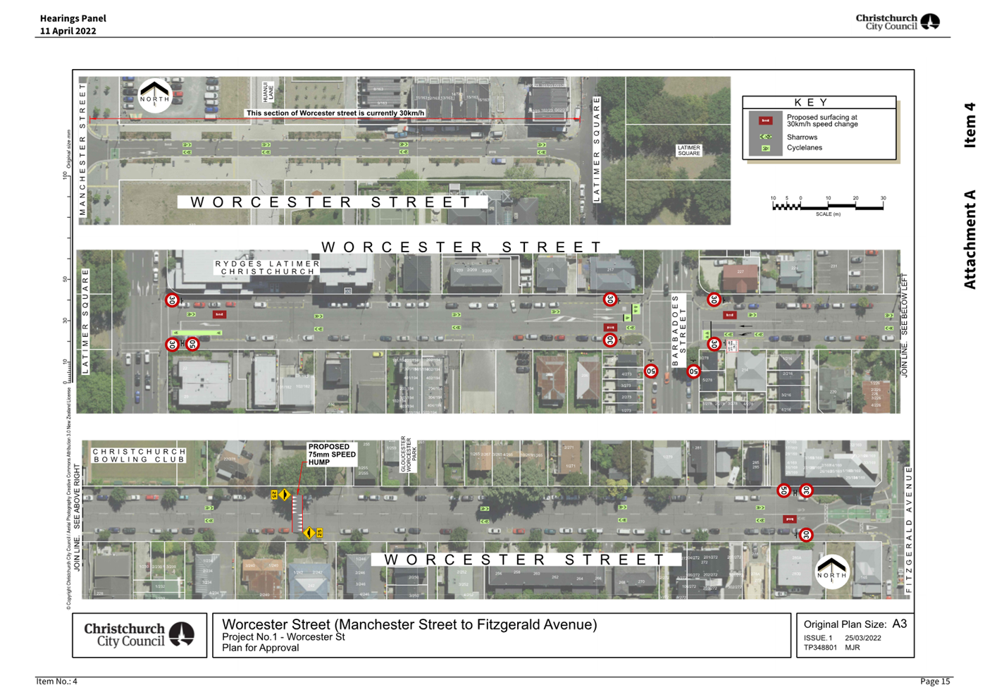
|
21. Setting of
Speed Limits Rule 2024: Management of Non-Installed Limits - Antigua Street
(Moorhouse to St Asaph)
|
|
Reference Te Tohutoro:
|
25/1031700
|
|
Responsible Officer(s) Te Pou Matua:
|
Jacob
Bradbury, Manager Planning and Delivery Transport
|
|
Accountable ELT Member Pouwhakarae:
|
Brent
Smith, General Manager City Infrastructure
|
1. Purpose and Origin of the Report Te Pūtake Pūrongo
1.1 The
purpose of this report is for the Council to consider next steps for Antigua
Street, where its previously approved speed limit changes cannot now be installed
due to a change in the law.
1.2 The
report is in response to the Land Transport Rule: Setting of Speed Limits
2024 which came into force in October 2024, and after feedback from
Councillors during an Information Session held on 20 May 2025.
1.3 Background
to the change in the law was supplied to Elected Members via Memo on 14 April
2025, and supplied here as Attachment A.
2. Officer
Recommendations Ngā Tūtohu
That the Council:
1. Receives the information in the Setting of
Speed Limits Rule 2024: Management of Non-Installed Limits - Antigua Street
(Moorhouse to St Asaph) Report.
2. Notes that the decision in this report is assessed as low significance
based on the Christchurch City Council’s Significance and Engagement
Policy.
3. In accordance with the requirements set out in the Land Transport
Rule: Setting of Speed Limits 2024:
a. Revokes the following 30km/h speed limits established for the full
length of Halkett Street and for Antigua Street between Moorhouse Ave and St
Asaph Street (Council meeting 12 May 2022 (CNCL/2022/00055], resolutions 32 and
33:
32. Approves that the speed limit on Antigua
Street from its intersection with Saint Asaph Street to its intersection with
Moorhouse Avenue be set at 30 kilometres per hour.
33. Approves that the speed limit on Halkett
Street, from its intersection with Antigua Street to its eastern road
termination, be set at 30 kilometres per hour.
b. Approves that the existing 50km/h speed limit be retained for:
i. Halkett Street (Antigua Street to eastern road termination).
ii. Antigua Street (Moorhouse Ave – St Asaph Street).
3. Executive Summary Te Whakarāpopoto Matua
3.1 Due
to changes in the law, it is not possible to install the changes to speed
limits that were approved before the date the law came into force.
3.1.1 This has
affected the change to 30km/h speed limits previously approved for Halkett
Street, and Antigua Street between Moorhouse Ave and St Asaph Street. These are
currently 50km/h.
3.1.2 There is no
mechanism for the Council to install a 30km/h speed limit on these streets,
with the closest limit available being 40km/h.
3.1.3 Any change in
speed limit requires public consultation and a further Council decision.
3.2 Staff
are therefore seeking direction from the Council around whether to retain the
existing 50km/h speed limit or consult on changing to a 40km/h speed limit.
3.3 The
Officer recommendation is to retain the existing speed limits (50km/h). This is
due to:
3.3.1 The additional
cost and time associated with consultation and installation of new speed limit
signs. Due to the requirements of the law and local government elections, it is
extremely likely that:
· The Council recommendation to request a speed limit change from the
Director of Land Transport would happen after local body elections.
· Installation of speed limit signs would happen after the main works
are complete, incurring re-visit costs.
3.3.2 Conflict
points between different users is expected to be low, except at locations where
speed can be well managed:
· The design includes physical separation between vehicles, cyclists,
and pedestrians.
· Operational speeds are expected to be close to the safe zone due to
physical treatments such as narrowings and vertical deflection.
· Due to the developments in the area, there is not expected to be
much crossing of the corridor other than at formal crossing points (with
signals or vertical deflection).
3.3.3 Noting that
there would be a likely incongruity between posted and operational speeds.
4. Background/Context Te Horopaki
Speed Limit Rule Changes
4.1 On
28 September 2024, the Land Transport Rule: Setting of Speed Limits 2024 was
signed, before coming into force on the 30 October 2024.
4.1.1 The Rule
change was widely publicised as reversing previous blanket speed limit changes.
4.1.2 However, it
also does not allow for implementation of speeds which have not yet been
installed, that were set by Council under the Setting of Speed Limits 2022 Rule
or previous Council Bylaws.
4.2 For
all future speed limit changes on existing roads, the Rule also places
restrictions on Road Controlling Authorities (RCAs) around the limits that can
be set, depending on the street classification.
4.2.1 Most notably,
it is no longer possible to install 30km/h limits on normal urban streets.
4.2.2 The full list
of urban street classifications and allowable speed limits is shown in Schedule
3 (page 58) of Attachment A.
4.3 The
process for changing speed limits has changed in recent years compared to the
previous rules and bylaws. Key requirements in the 2024 Rule are:
4.3.1 Any proposed
change to speed limits must be submitted to the Director of Land Transport for
approval.
4.3.2 In order to
submit proposals for consideration, the Council must have carried out a public
consultation process with the following requirements:
· Minimum consultation period of 6 weeks, notified on an internet site
· The material must include information showing:
o The
role and function of the road; how the road is used (including the different
types of road user); and why a speed limit change has been proposed rather than
any other speed management intervention.
o An
explanation of how the road safety aspects of the [Government Policy Statement]
have been had regard to.
o A
cost benefit disclosure statement.
· Must have used reasonable efforts to reach a number of groups,
including: schools, communities, road users (including freight providers), businesses,
and adjoining RCAs.
· Must have reasonably practicable efforts to consult with Māori
where the changes affect Māori land or land subject to any Māori
Claims Settlement Act.
4.3.3 A summary of
feedback must be provided, including an explanation of how feedback was taken
into account in any final draft plan. This point in particular is no change to the
current engagement processes that are undertaken.
4.3.4 The RCA must
have considered this information and feedback when making a decision about
their proposal for the speed limit on a piece of road.
Affected Council Projects
4.4 The
Council has identified a number of projects with speed limit changes that have
been approved, but - due to the law changes - cannot be installed in their
current form.
4.4.1 Two of these
projects have, or are, being dealt with separately:
· Gloucester Street: the Council decision to retain the pre-existing
speed limit of 30km/h (Council meeting 16 April 2025).
· Te Kaha Surrounding Streets: At the time of writing, the Council is
consulting on amended speed limits.
4.4.2 Three
remaining projects require an agreement from the Council on how to proceed:
· Antigua Street (Moorhouse to St Asaph).
· Worcester Street (Latimer Square to Fitzgerald Ave).
· Nor’West Arc along Aorangi Road, Condell Ave and Matsons Ave
(Ilam Road to Harewood Road).
Antigua Street (Moorhouse to St
Asaph)
4.5 The
design for Antigua Street between Moorhouse Ave and St Asaph was approved at
the Council meeting of 12 May 2022 (see Attachment B).
4.5.1 Included with
this were resolutions to change the speed limit from 50km/h to 30km/h along the
length of Halkett Street, and along Antigua Street between St Asaph Street to
Moorhouse Ave.
4.5.2 The design of
the street requires a transfer of land that is currently part of the Parakiore
Metro Sports Centre site. Due to delays with the construction of this facility,
the street upgrade works were not able to progress to construction until
mid-2025. At the time of writing these works are underway, and are expected to
be completed by November 2025.
Context
4.6 In
the Streets and Spaces Design Guide, this section of street sits outside the
identified 30km/h core zone, although is identified as a priority cycle route.
4.7 Traffic
counts were last taken in August 2023. These showed:
· Average daily traffic 6,060 vehicles per day, of which 6.4% are
heavy vehicles
· Average speed: 32.7km/h
· 85%ile speed: 40.4km/h
4.7.2 There is no
cycle counter on this section of road, however, there is a one-way cycle
counter just south of Moorhouse Ave. If we assume that the majority of cyclists
continue across Moorhouse Ave, and that northbound and southbound flows are
relatively similar, this works out to:
· Average cycle movements: ~1,100 per day
4.7.3 It should be
noted that in August 2023, due to the construction of Parakiore, there was no
footpath and a fence against the western edge of Antigua Street, and temporary
cycle lanes painted on the road. Therefore, the data from these counts may be
unrepresentative of the road under “normal” conditions.
4.8 There
are a number of features of the approved design which are expected to improve
safety from the current layout. These include:
· Fully separated, uni-directional cycleways on both sides
· Footpaths behind the cycleways, providing separation between
pedestrians and cyclists
· 2 speed humps at either end of the road, with a further mid-block
raised crossing between Halkett Street and the southern edge of Parakiore
4.8.2 There is very
little on the western side of the road that would attract people to cross away
from the formal crossing points.
4.9 Staff
believe that the street will mostly operate in a safe manner without speed
limit changes, due to:
· Vertical deflection features should keep speeds in the safe zone,
particularly at the formal crossing points
· Development patterns mean most users will travel along the corridor,
rather than across it
· The physical separation, which will reduce conflicts between users
4.10 However, it is
acknowledged that, should the 50km/h speed limit remain, the expected and
desirable speeds will differ from the posted speed.
4.11 Due to the
requirements of the 2024 Rule, and timelines for Local Government elections, it
is extremely unlikely that any speed limit changes could be approved ahead of
the completion of construction.
4.12 The following related memos/information were circulated to the
meeting members:
|
Date
|
Subject
|
|
14
Apr 2025
|
Setting of Speed Limits Rule: Impact on
Capital Projects
|
|
15
Apr 2025
|
Antigua St Cycleway Project –
Purchase of Orion Land Title
|
|
2
May 2025
|
Antigua Street Cycle Network (Tuam
– Moorhouse) and Watermain Renewal- Contract Award
|
4.13 The following related information session/workshops have taken place
for the members of the meeting:
|
Date
|
Subject
|
|
23
Jul 2025
|
Antigua Street – Design and Options
to Proceed (Information Session)
|
|
26
Feb 2025
|
Antigua Street – Request to proceed
ahead of Annual Plan completion (Finance & Performance)
|
Options Considered Ngā
Kōwhiringa Whaiwhakaaro
4.14 The following
reasonably practicable options were considered and are assessed in this report:
4.14.1 Make no change to
permanent speed limit.
4.14.2 Consult on a 40km/h speed
limit.
4.15 The following
options were considered but ruled out:
4.15.1 Install previously
approved 30km/h speed limit – This does not meet the requirements of the
current speed limit rule.
Options Descriptions Ngā
Kōwhiringa
4.16 Preferred
Option: Option 1 - Make no change to permanent speed limit.
4.16.1 Option Description: Council
will revoke its previous resolution to convert the street to a 30km/h speed
limit. The street will revert back to the existing 50km/h speed limit.
4.16.2 Option Advantages
· No additional revisit cost to install new signs.
· No additional staff costs to produce specialist information, carry
out consultation, and produce a report to the Council.
· 50km/h speed limit aligns with Central City Transport Plan (Streets
and Spaces design guide).
· No perceived confusion due to multiple speed limits in a short
stretch of road.
4.16.3 Option Disadvantages
· Likely incongruity between operational and posted speeds along
corridor.
· A number of the original submitters expressed support for the change
to a 30km/h speed limit that was proposed at that time.
4.17 Option 2 - Consult
on a 40km/h speed limit.
4.17.1 Option Description: Staff
continue to public consultation on changing the speed along Halkett Street and
Antigua Street between Moorhouse Ave and St Asaph Street. Given the timeframes,
it is extremely likely that any report to the Council will be after local
elections, as well as after the project is complete.
4.17.2 Option Advantages
· Better aligns with original approval.
· Reinforces the expected operational speeds along the corridor.
· Better reflects the wishes of a number of submitters to the original
scheme.
4.17.3 Option Disadvantages
· Cost and effort to produce consultation information, carry out
public consultation, and produce report to the Council.
· Should the Council choose to reduce the speed limit, there will be a
further revisit cost as the current project is completed.
· Perceived confusion between speed limits: Antigua at 40km/h, with
50km/h streets to the south and 30km/h streets to the north.
Analysis Criteria Ngā Paearu
Wetekina
4.18 The Officer recommendation
is to retain the existing speed limits (50km/h). This is due to:
· The additional costs associated with consultation and installation
of new speed limit signs.
· Operational speeds are expected to be close to the safe zone due to
physical treatments such as narrowings and vertical deflection.
· Due to the developments in the area, there is not expected to be
much crossing of the corridor other than at formal crossing points (with
signals or vertical deflection), so conflict between different users will be
minimised and controlled.
5. Financial Implications Ngā Hīraunga Rauemi
Capex/Opex Ngā Utu Whakahaere
|
|
Recommended Option:
Revert to existing speed limit
|
Option 2:
Consult on 40km/h speed limit
|
|
Cost to Implement
|
$0 **
|
$45,000 *
|
|
Maintenance/Ongoing Costs
|
$0
|
Negligible
|
|
Funding Source
|
N/A
|
Project #59181
|
|
Funding Availability
|
N/A
|
|
|
Impact on Rates
|
N/A
|
<0.01%
|
* This includes an estimate for the installation of
signs
** The current contract for construction
include the installation of 50km/h speed signs
5.1 The
majority of the estimated implementation cost in Option 2 is related to the
resource cost of producing information, carrying out the consultation and associated
marketing costs, and writing and approving the decision report.
5.1.1 There are
other costs to the Council for this process that are booked to overheads that
are therefore not included in this figure, for example: management oversight
and reviews, working time from the engagement and communication teams, etc.
6. Considerations Ngā Whai Whakaaro
Risks and Mitigations Ngā
Mōrearea me ngā Whakamātautau
6.1 Budget
risk: Consultation and/or changing signs has not been factored into the cost of
the project. While the costs are expected to be small relative to the overall
project budget, it will eat into contingency allowances, which may be required
to complete the work already contracted. Mitigation is for staff to clearly
communicate the likely costs to Elected Members ahead of deciding to consult.
6.2 Engineering/delivery
risk: none above BAU
6.3 Reputational
risk: There may be a perception from the public that any consultation is due to
a Council mistake or omission. The reasons for needing to reconsult will be
clearly communicated through the supporting information.
6.4 Political
risk: Speed limit changes are often contentious, and consultation and
decision-making would be required in the lead up to local elections.
Legal Considerations Ngā
Hīraunga ā-Ture
6.5 Statutory
and/or delegated authority to undertake proposals in the report:
6.5.1 The Council is
the delegated authority for recommending changes to speed limits.
6.6 Other Legal Implications:
6.6.1 The other
legal implications related to the speed limit changes are set out in the body
of this report. There is no further legal context, issue, or implication
relevant to this decision.
Strategy and Policy Considerations Te Whai
Kaupapa here
6.7 The
required decision:
6.7.1 Aligns with
the Christchurch
City Council’s Strategic Framework. As this decision relates to the
potential need for consultation, it specifically aligns with the “Build
trust and confidence” strategic priority.
6.7.2 Is assessed as
low significance based on the Christchurch
City Council’s Significance and Engagement Policy. The level of
significance was determined by the low cost, impact and reversibility. This
keeps the overall assessment score low, despite the likely public interest.
6.7.3 Is consistent with the Council’s Plans and
Policies.
6.8 This
report supports the Council's
Long Term Plan (2024 - 2034):
6.9 Transport
6.9.1 Activity: Transport
· Level of Service: 10.0.6.1 Reduce the number of
death and serious injury crashes on the local road network (DIA 1) - 4 less
than previous FY
· Level of Service: 10.0.6.2 Reduce the number of
death and serious injury crashes on the local road network - Five year rolling
average <100 crashes per year
· Level of Service: 10.5.1 Limit deaths and
serious injury crashes per capita for cyclists and pedestrians - <=12
crashes per 100,000 residents
· Level of Service: 10.5.2 Improve the perception
(resident satisfaction) that Christchurch is a cycling friendly city - >=67%
· Level of Service: 16.0.10 Maintain the
perception (resident satisfaction) that Christchurch is a walking friendly city
- >=85% resident satisfaction
Community Impacts and Views Ngā Mariu
ā-Hāpori
6.10 The decision
affects the following wards/Community Board areas:
6.10.1 Waipapa
Papanui-Innes-Central Community Board
6.10.2 The project sits adjacent to
the boundary with the Waihoro Spreydon-Cashmere-Heathcote Community board area,
with much of the travel to and from the site coming from this board area, so
they are likely to retain a high level of interest.
Impact on Mana Whenua Ngā Whai Take
Mana Whenua
6.11 The decision
does not involve a significant decision in relation to ancestral land, a
body of water or other elements of intrinsic value, therefore this decision does
not specifically impact Mana Whenua, their culture, and traditions.
6.12 The decision does not involve a
matter of interest to Mana Whenua and will not impact on our agreed partnership
priorities with Ngā Papatipu Rūnanga.
Climate Change Impact Considerations Ngā
Whai Whakaaro mā te Āhuarangi
6.13 The decisions in
this report are likely to:
6.13.1 Contribute neutrally to
adaptation to the impacts of climate change.
6.13.2 Contribute neutrally to emissions reductions.
6.14 Given the scope of
the decision, this will not affect climate change considerations in any
meaningful way.
7. Next Steps Ngā Mahinga ā-muri
7.1 Depending
on the decision, staff will either:
· Install speed signs at the intersection of Antigua and St Asaph to
demarcate the transition between the 50 and 30km/h zones.
· Consult with the public on changing Antigua Street & Halkett
Street to a 40km/h speed limit.
Attachments Ngā Tāpirihanga
|
No.
|
Title
|
Reference
|
Page
|
|
a ⇨
|
Memo - Setting
of Speed Limits Rule - Refer Item 19 Attachment A (Under Separate Cover)
|
25/1041851
|
|
|
b ⇩
|
Antigua Street
Approved Design
|
25/1051137
|
334
|
In addition to the attached documents, the following background
information is available:
|
Document
Name – Location / File Link
|
|
Not
applicable
|
Signatories Ngā Kaiwaitohu
|
Authors
|
Jacob Bradbury
- Manager Planning & Delivery Transport
Lindsay White
- Senior Project Manager
Ron Lemm -
Manager Legal Service Delivery
|
|
Approved By
|
Lynette Ellis
- Head of Transport & Waste Management
Brent Smith -
General Manager City Infrastructure
|
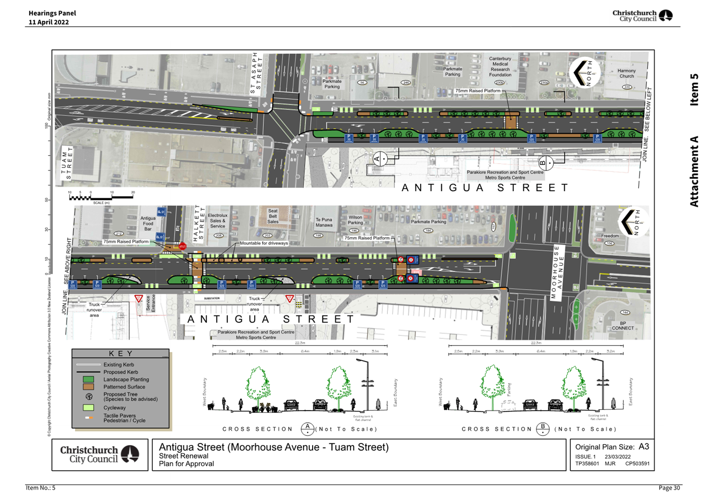
|
22. Extension of Time for Heritage Incentive Grant
to 527 Colombo Street, New City Hotel
|
|
Reference Te Tohutoro:
|
25/1206319
|
|
Responsible Officer(s) Te Pou Matua:
|
Victoria
Bliss Heritage Conservation Projects Planner
|
|
Accountable ELT Member Pouwhakarae:
|
John
Higgins, General Manager Strategy, Planning & Regulatory Services
|
1. Purpose and Origin of the Report Te Pūtake Pūrongo
1.1 The
purpose of this report is to seek approval for an 18-month extension of time
for the Heritage Incentive Grant awarded to 527 Colombo Street, New City Hotel.
This grant was awarded when the Heritage Incentive Grant scheme was provided
for in the 2018-28 and 2021-31 Long Term Plans.
1.2 This
report is staff generated in response to a request for an extension of time to an
approved Heritage Incentive Grant. The Operational Guidelines require the Council’s
approval for extensions of time in the uptake of Heritage Incentive Grants.
2. Officer
Recommendations Ngā Tūtohu
That the Council:
1. Receives the information in the Extension of
Time for Heritage Incentive Grant to 527 Colombo Street, New City Hotel Report.
2. Notes that the decision in this report is assessed as low
significance based on the Christchurch City Council’s Significance and
Engagement Policy.
3. Approves an extension of time of eighteen months for the uptake of
the $162,376.00 Heritage Incentive Grant previously approved for the building
at 527 Colombo Street.
4. Notes that the new completion date for the project will be 28
February 2027.
3. Executive Summary Te Whakarāpopoto Matua
3.1 The
building at 527 Colombo Street is known as New City Hotel and is scheduled as a
‘Significant’ item in the Christchurch District Plan. The building
is also listed with Heritage New Zealand Pouhere Taonga as a Category 2 item
(Registration Number 3124). See Attachment A for the Heritage Statement of
Significance.
3.2 The
original grant was approved by the Sustainability and Community Resilience
Committee on 24 March 2021 (SACRC/2021/00015). The owners who were
awarded the grant did not undertake the works owing to the pandemic.
3.3 On
7 June 2022 the General Manager Infrastructure, Planning & Regulatory
Services under Committee delegation approved an extension of time for the grant
until 24 March 2024.
3.4 On
7 February 2024 the Council approved an extension of time of eighteen months
for the uptake of the Heritage Incentive Grant with a new completion date of 31
August 2025 (CNCL/2024/00007). The works were not undertaken, and the building was
sold.
3.5 The
current owners took possession of New City Hotel on 31 October 2024. At that
time ten months were remaining on the earlier extension of time.
3.6 In
the ten months since they took possession, the owners have made a significant
financial and time commitment to the restoration of the scheduled building.
This includes obtaining a new resource consent and working towards building
consent approval. An architect and a Quantity
Surveyor have been employed on the project, and it is anticipated that the
structural works will begin in January 2026.
3.7 The
owners are requesting an extension of time on the grant to enable them to
complete the necessary consenting process so they can commence works.
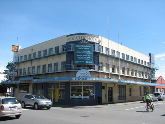
New City Hotel, 527 Colombo Street, corner of Bath
Street, East and North facades. G. Wright, 22.11.2019
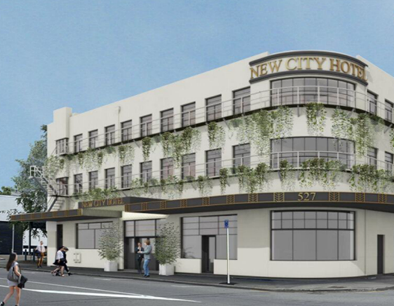
Proposed upgraded exterior of New City Hotel, 527
Colombo Street, corner of Bath Street, East and North facades. Rendering
supplied by applicants.
4. Background/Context Te Horopaki
4.1 The
‘Our Heritage, Our Taonga’ Heritage Strategy 2019-2029 was
developed in partnership with the six papatipu rūnanga together with the
communities of the district. This engagement affirmed a strong community desire
to understand, celebrate and protect its heritage and a recognition of the
responsibility to future generations to safeguard Ōtautahi
Christchurch’s rich and diverse taonga.
4.2 The
Heritage Incentive Grant Scheme supports delivery of the overarching strategic
principle of “Taking an intergenerational approach to sustainable
development, prioritising the social, economic and cultural wellbeing of people
and communities and the quality of the environment, now and into the
future.” This is because heritage is an intergenerational equity. It
contributes to our personal and community sense of identity and belonging and
enhances high levels of social connectedness and cohesion.
The Grant
4.3 The
current owners of the building are Lisa and John Plato. They are seeking an
extension of time to undertake and complete the proposed repair and upgrade
project to the New City Hotel.
4.4 On
24 March 2021 the Sustainability and Community Resilience Committee approved a
heritage Incentive grant of up to $162,376.00 for roof replacement, repainting
of the façade and fire alarm upgrades at 527 Colombo Street, with
payment of the grant being subject to a full conservation covenant (SACRC/2021/00015).
See Attachment B for the original grant report.
4.5 The original grant recipients requested an extension of
time following delays relating to the pandemic. On 7 June 2022 the General
Manager Infrastructure, Planning & Regulatory Services (under Committee
delegation) approved an extension of time for the grant until 24 March 2024.
The works were not undertaken, and the building was sold.
4.6 On 7 February 2024, the Council awarded an additional extension
of time for the approved grant, with the new completion date of 31 August 2025
(CNCL/2024/00007).
4.7 The
current owners are seeking a further extension of time. The remaining ten-month
grant extension which was in place when they took possession of the building
will lapse on 31 August 2025.
4.8 Over
the past 10 months the owners have been developing a proposal which will ensure
a long term, sustainable and economically viable use for the New City Hotel.
This will allow them to occupy the whole building as their company’s
office.
4.9 The
use as offices rather than the previously consented use for hospitality, retail
activity and guest accommodation will require alterations, including the removal
of the derelict lift and the addition of fire-access stairs to the rear of the
building. This proposed office use has involved complex engineering and
fire-compliance considerations to be worked through, which has taken time to
work through. The resource consent has been approved, and the building consent application
is in process.
4.10 The scope of
works approved under the grant includes:
· roof replacement
· repairs to and repainting of the façade
· fire alarm upgrades
4.11 These works
remain vital elements of the restoration and re-use of the New City Hotel and
are necessary to ensure the ongoing retention of the scheduled building.
Without the roofing and exterior works, the structure will continue to
deteriorate with water ingress, and a working fire system is essential to its
long-term protection.
4.12 While the
building is empty and unused, it is at ongoing risk of vandalism, fire, and
increasing deferred remedial maintenance. Its repair and re-use are now urgent
to ensure its retention.
4.13 The owners have
invested over $250,000 to date in detailed design and consenting processes.
They are hoping to commence the structural works in the next five months.
4.14 The Heritage
Incentive grant represents a significant incentive to the owners to undertake
this level of investment into one of the central city’s heritage
buildings.
4.15 New City Hotel
is a landmark for the community on a prominent corner site in the central city.
The building is one of only two traditional hotel buildings in the Moderne
style remaining in the centre of Christchurch. Having been vacant for so long,
the exterior is very degraded and has been subject to vandalism and graffiti.
The exterior works supported by this grant will revitalise its façade
onto Colombo Street and restore the landmark presence and public views of the
building.
4.16 If the extension
of time is not approved, the new owners will lose the Heritage Incentive Grant
(HIG). The grant scheme has not been renewed in the current LTP and
consequently they are not able to apply for a new grant.
4.17 The approved
funding has been allocated under the provisions of the former HIG scheme and
consequently will not constitute a new cost/unbudgeted cost to Council.
Options Considered Ngā
Kōwhiringa Whaiwhakaaro
4.18 The following
reasonably practicable options were considered and are assessed in this report:
4.18.1 Approve an additional
extension of time for 18 months until 28 February 2027.
4.18.2 Decline the extension of
time, allowing the grant to lapse.
Options Descriptions Ngā
Kōwhiringa
4.19 Preferred
Option: Approve an extension of time.
4.19.1 Option Description: An
extension of time for uptake of the grant until 28 February 2027.
4.19.2 Option Advantages:
· Supports the conservation of a landmark corner heritage building in
the central city, which has community social, economic and cultural wellbeing
outcomes.
· Supports the retention and reuse of a heritage building.
· Aligns with the 2019-2029 Heritage Strategy and is consistent with
the Heritage Incentive Grant Fund – Guidelines (2020).
· Incentivises significant investment by the owners into a prominent
building which is currently derelict.
· Potentially encourages further investment in the central city by
improving the local area and reinvigorating a derelict street corner.
· The grant was previously approved funding from the 2018-28 LTP and
so there is no additional cost implication to the Council.
4.19.3 Option Disadvantages
· A carry forward of the previously allocated grant funds is provided
for, but the funds will need to be uplifted from the Council.
4.20 4.16.2 Decline
the extension of time
4.20.1 Option Description: Decline
the extension of time and allow the grant to lapse
4.20.2 Option Advantages
· The allocated funding of $162,376.00 will not be uplifted.
4.20.3 Option Disadvantages
· Without the grant incentive, the applicants may not proceed with the
restoration of the building, or the works may be delayed further.
· The current condition of the building and its ongoing deterioration
means it is at risk of vandalism or total loss.
· Potential loss of the investment being made by the owners if they
are unable to proceed without the grant support.
· A prominent central city street corner may be left undeveloped and
remain a public eyesore.
Analysis Criteria Ngā Paearu
Wetekina
4.21 Degree to which
the purpose of the Heritage Incentive Grant Scheme is achieved.
4.22 Consideration of
the Heritage Incentive Grants Policy –Guidelines 2020
‘Assessment’ criteria.
4.23 Degree to which
the projects achieve the pou of the ‘Our Heritage, Our Taonga’
Heritage Strategy 2019-2029: Manaakitanga, Tohungatanga, Kaitiakitanga,
Rangatiratanga and Wairuatanga.
4.24 Degree to which
the works align with the International Council on Monument and Sites (ICOMOS)
New Zealand Charter 2010 (conservation principles).
4.25 Degree to which
the outcome will support delivery of the Community Outcomes ‘A
collaborative confident city’ and ‘A cultural powerhouse city’.
5. Financial Implications Ngā Hīraunga Rauemi
Capex/Opex Ngā Utu Whakahaere
|
|
Recommended Option
|
Option 2 – decline the extension of time
|
|
Cost to Implement
|
There are no new cost implications in
association with the resolutions sought in this report.
|
Previously allocated funding will not be
uplifted.
|
|
Maintenance/Ongoing Costs
|
none
|
none
|
|
Funding Source
|
Previously approved funding and carry
forward 2021/2031 LTP
|
n/a
|
|
Funding Availability
|
$162,376.00 funding has already been
allocated.
|
n/a
|
|
Impact on Rates
|
$0 as the grant has already been approved
|
$162,376.00 of allocated funding will not
be uplifted.
|
5.1 The
decision relates to an 18-month delay in the payment of an existing Council assessed
and approved grant.
6. Considerations Ngā Whai Whakaaro
Risks and Mitigations Ngā
Mōrearea me ngā Whakamātautau
6.1 The
grant scheme only allows funds to be paid out upon completion of the works;
certification by Council staff that the works have been undertaken in alignment
with the ICOMOS NZ Charter 2010; presentation of receipts and confirmation of
the conservation covenant (if required) having been registered against the
property title or on the Personal Properties Securities Register. This ensures
that the grant scheme is effective and that funds are not diverted or lost.
6.2 There
is the risk of loss of a significant heritage place and central city corner
landmark if the funding timeframe is not extended to support the restoration
project.
Legal Considerations Ngā
Hīraunga ā-Ture
6.3 Statutory
and/or delegated authority to undertake proposals in the report:
6.3.1 The delegated
authority for Heritage Incentive Grants decisions was with the Sustainability
and Community Resilience Committee but as this committee is no longer sitting,
this report is being submitted to the Council.
6.3.2 On the 1 June
2022, the Sustainability and Community Resilience Committee (SACR) delegated
one extension of time for both Heritage Incentive Grants and Central City
Landmark Heritage Grants to the General Manager Infrastructure, Planning &
Regulatory Services, with additional extensions of time requiring Committee
approval (SACRC/2022/00025).
6.4 Other Legal Implications:
6.4.1 There
is no legal context, issue, or implication relevant to this decision.
Strategy and Policy Considerations Te Whai
Kaupapa here
6.5 The
required decision:
6.5.1 Aligns with
the Christchurch
City Council’s Strategic Framework. An
extension of time for this Heritage Incentive Grant will support the Community
Outcomes- A collaborative confident city: “We have a
sense of belonging and identity: We support and help build connections between
communities and their places and spaces to foster a sense of local identity,
shared experience, and stewardship”, and A cultural powerhouse
city: “Our heritage is accessible to all, shared and celebrated
and includes and respects all the cultures and distinct communities of the
district”.
6.5.2 Is assessed as
low significance based on the Christchurch City Council’s Significance
and Engagement Policy. The level of significance is determined by the
heritage significance of the item, the cultural and community wellbeing
outcomes of the project, and the fact that the Council has already assessed and
approved the grant for these works. There are no engagement requirements in the
Heritage Incentive Grant Fund – Guidelines 2020 for this grant scheme.
6.5.3 Is consistent with the ‘Our Heritage, Our
Taonga’ Heritage Strategy 2019-2029.
6.6 The
grant was awarded in 2021 from funding allocated in the Council's
Long Term Plan (2021 - 2031).
Community Impacts and Views Ngā Mariu
ā-Hāpori
6.7 The
‘Our Heritage, Our Taonga’ Heritage Strategy 2019-2029 was
developed in partnership with the six papatipu rūnanga together with the
communities of the district. This engagement affirmed a strong community desire
to understand, celebrate and protect its heritage and a recognition of the
responsibility to future generations to safeguard Ōtautahi
Christchurch’s rich and diverse taonga.
6.8 The decision affects the following wards/Community Board areas:
6.8.1 Waipapa Papanui-Innes-Central Community
6.9 It is noted that Tūāhuriri Rūnanga hold mana whenua
rights and interests in the area.
Impact on Mana Whenua Ngā Whai Take
Mana Whenua
6.10 The
decision does not involve a significant decision in relation to ancestral land
or a body of water or other elements of intrinsic value.
6.11 The decision
involves a matter of interest to Mana Whenua insofar that the six papatipu
rūnanga are partners in the Our Heritage, Our Taonga - Heritage Strategy
2019-2029.
Climate Change Impact Considerations Ngā
Whai Whakaaro mā te Āhuarangi
6.12 The decisions in
this report are likely to:
6.12.1 Contribute positively to
adaptation to the impacts of climate change.
6.12.2 Contribute positively to emissions reductions.
6.13 The grant will
support the retention and reuse of a heritage building. Retention and
reuse of existing built stock reduces our carbon footprint and extends the
economic life of buildings.
7. Next Steps Ngā Mahinga ā-muri
7.1 Notify
the applicant of the Council’s decision.
7.2 If
approval is granted for the extension of time, inform the owner of the updated
grant timeframes.
Attachments Ngā Tāpirihanga
|
No.
|
Title
|
Reference
|
Page
|
|
a ⇩
|
Attachment A
Heritage Statement of Significance for New City Hotel
|
25/1436160
|
343
|
|
b ⇩
|
Attachment B
Heritage Incentive Grant Report for New City Hotel, 24 March 2012
|
25/1436162
|
347
|
In addition to the attached documents, the following background
information is available:
|
Document
Name – Location / File Link
|
|
Not
applicable
|
Signatories Ngā Kaiwaitohu
|
Author
|
Victoria Bliss
- Heritage Conservation Projects Planner
|
|
Approved By
|
Brendan Smyth
- Team Leader Heritage
Mark Stevenson
- Head of Planning & Consents
John Higgins -
General Manager Strategy, Planning & Regulatory Services
|
|
23. Council
submission on Going for Housing Growth proposals
|
|
Reference Te Tohutoro:
|
25/1214720
|
|
Responsible Officer(s) Te Pou Matua:
|
Helaina
Gregg, Principal Advisor Policy; Mark Stevenson, Head of Planning &
Consents
|
|
Accountable ELT Member Pouwhakarae:
|
John
Higgins, General Manager Strategy, Planning & Regulatory Services
|
1. Purpose and Origin of the Report Te Pūtake Pūrongo
1.1 The
purpose of this report to seek approval of the draft Council submission on the
Going for Housing Growth proposals.
1.2 The Government is seeking feedback on the Going for Housing Growth proposals
to help inform and shape the policy direction in the new resource management
system.
1.3 Staff presented an initial draft Council submission to the Mayor and
Councillors following the Council Information Session on Tuesday, 22 July 2025.
Staff have now revised the Council submission following feedback from
Councillors.
2. Officer
Recommendations Ngā Tūtohu
That the Council:
1. Receives the information in the Council
submission on Going for Housing Growth proposals Report.
2. Notes that the decision in this report is assessed as low
significance based on the Christchurch City
Council’s Significance and Engagement Policy.
3. Approves lodging the Council submission on the Going for Housing
Growth proposals (Attachment A and Attachment B to this report)
to the Ministry of Housing and Urban Development.
4. Delegates to the Head of Planning and Consents any correction, or
amendments of a minor nature arising from the Council meeting.
3. Executive Summary Te Whakarāpopoto Matua
3.1 The
Government is inviting submissions on the ‘Pillar 1’ Going for
Housing Growth proposals. This is to help inform the direction and development
of the new resource management system.
3.2 The
draft Council submission was circulated to Councillors for feedback following
the Council Information Session on Tuesday, 22 July 2025. Staff have revised
this submission based on feedback from Councillors.
3.3 The
draft Council submission is attached for Councillors’ consideration and
approval (see Attachment A and Attachment B).
3.4 Subject
to approval, the draft submission will be lodged with the Ministry of Housing
and Urban Development on or before Friday, 15 August 2025.
4. Background/Context Te Horopaki
4.1 The
proposed draft submission comprises a cover letter and detailed technical
appendix to respond to the Going for Housing Growth discussion document
questions.
4.2 Overall,
the submission acknowledges that there are components of the Going for Housing
Growth package that will provide appropriate mechanisms for managing growth and
delivering well-functioning urban environments envisioned by the Council. The
submission is supportive of specific proposals.
4.3 These
include proposals such as changes to spatial planning requirements, the
enablement of development around transport corridors and the integration
between land use planning and infrastructure planning and investment.
4.4 The
submission highlights the need for growth to be managed strategically to limit
the risk of uncosted and ad hoc growth. It raises concerns with the financial
costs that may arise from enabling ‘out of sequence’ development
and unplanned growth, and the importance of minimising any additional financial
burdens being placed on councils – particularly regarding infrastructure
planning and investment.
4.5 Council
Officers also note that they have not been able to consider how the proposed
NPS-UD changes and Going for Housing Growth proposals will interact with the
Planning Bill and other national direction instruments – which has
provided a limitation to the submission.
4.6 The following related memos/information were circulated to the
meeting members:
|
Date
|
Subject
|
|
22
July 2025
|
Draft Council submission on Going for Housing
Growth proposals circulated to Councillors for their feedback
|
4.7 The following related information session/workshops have taken place
for the members of the meeting:
|
Date
|
Subject
|
|
22
July 2025
|
Information session on the draft Council
submission on Going for Housing Growth proposals
|
Options Considered Ngā
Kōwhiringa Whaiwhakaaro
4.8 The
only reasonably practicable option considered and assessed in this report is
that the Council prepares a submission on the proposed changes to the Ministry
of Housing and Urban Development.
4.9 The
Council regularly makes submissions on proposals which may significantly impact
Christchurch residents or Council business. Submissions are an important
opportunity to influence thinking and decisions through external
agencies’ consultation processes.
4.10 The consultation
on the Going for Housing Growth proposals is intended to help inform and shape
the direction of the new resource management system, which will ultimately
result in a shift in planning legislation. It is therefore important that
through a submission, the Council can seek to influence the direction of the
proposals early to ensure that any changes are fit for purpose for local
authorities and the residents we serve.
4.11 The alternative
option would be to not submit on the Going for Housing Growth proposals. This
course of action is not recommended in this case as making a submission is a
valuable opportunity to influence the thinking of the proposals.
5. Financial Implications Ngā Hīraunga Rauemi
Capex/Opex Ngā Utu Whakahaere
|
|
Recommended Option
|
Option 2 – Not to submit on Going for
Housing Growth proposals
|
|
Cost to Implement
|
Met from existing operational budgets.
|
No cost
|
|
Maintenance/Ongoing Costs
|
As above
|
No cost
|
|
Funding Source
|
Existing operational budgets
|
No cost
|
|
Funding Availability
|
Available
|
N/A
|
|
Impact on Rates
|
No impact on rates as met from existing
operational budgets
|
N/A
|
6. Considerations Ngā Whai Whakaaro
Risks and Mitigations Ngā
Mōrearea me ngā Whakamātautau
6.1 The
decision to lodge a Council submission is of low risk.
Legal Considerations Ngā
Hīraunga ā-Ture
6.2 Statutory
authority to undertake proposals in the report:
6.2.1 The opportunity to
lodge a submission on the Going for Housing Growth proposals is open to any
person or organisation.
6.3 Other Legal Implications:
6.3.1 There is no
legal context, issue, or implication relevant to this decision. The Legal
Services team have provided input to and reviewed the submission.
Strategy and Policy Considerations Te Whai
Kaupapa here
6.4 The
required decision:
6.4.1 Aligns with the Christchurch
City Council’s Strategic Framework.
6.4.2 Is assessed as low significance based on the Christchurch City
Council’s Significance and Engagement Policy. This recognises that
while there may be community interest in the proposed direction, the specific
decision (to approve the draft submission) is of a lower level of significance.
6.4.3 Is consistent with the Council’s Plans and
Policies.
6.5 This
report supports the Council's
Long Term Plan (2024 - 2034):
6.6 Strategic Planning and Policy
6.6.1 Activity: Strategic Policy and Resilience
· Level of Service: 17.0.1.1 Advice meets emerging
needs and statutory requirements and is aligned with governance expectations in
the Strategic Framework.
Impact on Mana Whenua Ngā Whai Take
Mana Whenua
6.7 The decision to
lodge a Council submission on the Going for Housing Growth
proposals is not a significant decision in relation to ancestral land or
a body of water or other elements of intrinsic value, therefore this decision does not specifically impact Mana Whenua, their culture and
traditions.
6.8 The decision involves a matter of interest to Mana Whenua, however the
decision to submit on the Going for Housing Growth proposals will not impact on
our agreed partnership priorities with Ngā Papatipu
Rūnanga.
Climate Change Impact Considerations Ngā
Whai Whakaaro mā te Āhuarangi
6.9 The
decision to lodge a Council submission does not have any direct climate change
impacts.
7. Next Steps Ngā Mahinga ā-muri
7.1 Subject
to approval, the draft submission (Attachment A and Attachment B)
on the Going for Housing Growth proposals will be lodged with the Ministry of
Housing and Urban Development on or before Friday, 15 August 2025.
Attachments Ngā Tāpirihanga
|
No.
|
Title
|
Reference
|
Page
|
|
a ⇩
|
Draft CCC
Submission - Going for Housing Growth
|
25/1502375
|
359
|
|
b ⇩
|
Appendix 1 -
Draft Detailed CCC Submission on Going for Housing Growth
|
25/1502428
|
364
|
In addition to the attached documents, the following background
information is available:
|
Document
Name – Location / File Link
|
|
Not
applicable
|
Signatories Ngā Kaiwaitohu
|
Authors
|
Ruohan Zhao -
Senior Policy Analyst
Helaina Gregg
- Principal Advisor Policy
|
|
Approved By
|
Mark Stevenson
- Head of Planning & Consents
John Higgins -
General Manager Strategy, Planning & Regulatory Services
|
|
24. Resolution to Exclude the Public
|
Section
48, Local Government Official Information and Meetings Act 1987.
Note: The
grounds for exclusion are summarised in the following table. The full wording from
the Act can be found in section
6 or section
7, depending on the context.
I move that the public be excluded from the
following parts of the proceedings of this meeting, namely the items
listed overleaf.
Reason for passing this resolution: a good
reason to withhold exists under section 7.
Specific grounds under section 48(1) for
the passing of this resolution: Section 48(1)(a)
Note
Section 48(4) of the Local Government
Official Information and Meetings Act 1987 provides as follows:
“(4) Every resolution to exclude the
public shall be put at a time when the meeting is open to the public, and the
text of that resolution (or copies thereof):
(a) Shall
be available to any member of the public who is present; and
(b) Shall
form part of the minutes of the local authority.”
This resolution is made in reliance on
Section 48(1)(a) of the Local Government Official Information and Meetings Act
1987 and the particular interest or interests protected by Section 6 or Section
7 of that Act which would be prejudiced by the holding of the whole or relevant
part of the proceedings of the meeting in public are as follows:
|
ITEM NO.
|
GENERAL SUBJECT OF EACH MATTER TO BE CONSIDERED
|
SECTION
|
SUBCLAUSE AND REASON UNDER THE ACT
|
PUBLIC INTEREST CONSIDERATION
|
Potential Release Review Date and
Conditions
|
|
16.
|
Development Contributions Remission Application - The Arts Centre
|
|
|
|
|
|
|
Attachment a - Arts Centre Food Vendor
licence fees.
|
s7(2)(b)(ii)
|
Prejudice Commercial Position
|
The information is commercially sensitive and could impact on the Arts
Centre ability to negotiate contracts in the future. This outweighs the
public interest.
|
6 August 2026
Upon review and approval of the Head of Planning and Consents.
|
|
17.
|
151/153 Gilberthorpes Road - Future Use
Issues and Options
|
|
|
|
|
|
|
Attachment e - Property Purchase Context
|
s7(2)(b)(ii), s7(2)(i)
|
Prejudice Commercial Position, Conduct Negotiations
|
The Council needs to consider the preliminary financial details
relevant to the possible purchase of the property by the Purapura Whetu
Trust. These details are currently confidential, release of which would
prejudice subsequent negotiations.
|
15 December 2025
As and when an unconditional Agreement is entered into by Council
and the Purapura Whetu Trust.
|
|
18.
|
Proposed Locky Dock cycle parking and
charging station in Rauora Park, Lichfield St
|
|
|
|
|
|
|
Attachment c - Locky Docks Licence to
Occupy, 20.12.2024
|
s7(2)(h), s7(2)(i)
|
Commercial Activities, Conduct Negotiations
|
This information is commercially sensitive and could impact the
Big Street Bikers' ability to conduct negotiations with other parties in the
open market, which outweighs the public interest.
|
10 July 2026
Upon review and approval of the Head of Transport.
|
|
25.
|
Public Excluded Health, Safety and Wellbeing
Committee Minutes - 27 June 2025
|
|
|
Refer to the previous public excluded reason in the agendas for
these meetings.
|
|
|
26.
|
Public Excluded Civic Awards Committee
Minutes - 14 July 2025
|
|
|
Refer to the previous public excluded reason in the agendas for
these meetings.
|
|
|
27.
|
Public Excluded Council Minutes - 11 June
2025
|
|
|
Refer to the previous public excluded reason in the agendas for
these meetings.
|
|
|
28.
|
Public Excluded Council Minutes - 16 July
2025
|
|
|
Refer to the previous public excluded reason in the agendas for
these meetings.
|
|
|
29.
|
Christchurch Civic Awards 2025
|
s7(2)(a)
|
Protection of Privacy of Natural Persons
|
Protection of privacy of individuals outweighs public interest in
this item.
|
19 June 2026
Report can be released, with appropriate redactions, once successful
nominees have been publicly notified.
|
|
30.
|
Audit and Risk Management Committee -
Reappointment of an External Committee Member
|
s7(2)(a)
|
Protection of Privacy of Natural Persons
|
The public interest in this appointment is OUTWEIGHED by the need
to protect the candidate's reputation.
|
7 August 2025
Following the conclusion of the independent member appointment
process.
|
Karakia Whakamutunga
Kia whakairia te tapu
Kia wātea ai te ara
Kia turuki whakataha ai
Kia turuki whakataha ai
Haumi e. Hui e. Tāiki e
Actions Register Ngā Mahinga
When decisions are made at meetings, these
are assigned to staff as actions to implement. The following lists
detail any actions from this meeting that were:
·
Open at the time the agenda was generated.
·
Closed since the last ordinary meeting agenda
was generated.
Open Actions Ngā Mahinga Tuwhera
|
REPORT TITLE/AGENDA SECTION
|
MEETING DATE
|
ACTION DUE DATE
|
UNIT
|
TEAM
|
|
Annual Plan 2025/26
|
24 June 2025
|
8 July 2025
|
Transport & Waste
|
Management
|
|
Canterbury Museum Draft
2025/26 Annual Plan Request
|
16 April 2025
|
16 July 2025
|
Communications & Engagement
|
Engagement
|
|
Annual Plan 2025/26
|
24 June 2025
|
31 July 2025
|
Corporate Planning & Performance
|
Corporate Planning & Performance
|
|
Annual Plan 2025/26
|
24 June 2025
|
31 July 2025
|
Transport & Waste
|
Management
|
|
Notice of Motion -
Micromobility parking
|
7 May 2025
|
6 August 2025
|
Transport & Waste
|
Asset Planning
|
|
Community (Social) Housing
Update Report
|
19 March 2025
|
20 August 2025
|
Facilities & Property Unit
|
Management
|
|
Access along the Heathcote
Expressway MCR (past Scruttons Road level crossing)
|
6 November 2024
|
22 August 2025
|
Transport & Waste
|
Management
|
|
Grant an Easement for
Utilities Over a Council Reserve
|
10 April 2024
|
24 August 2025
|
Facilities & Property Unit
|
Property Consultancy
|
|
Beach Hospitality Limited -
Landlord Consent to Improvements and Request for Further Lease
|
2 April 2025
|
29 August 2025
|
Facilities & Property Unit
|
Property Consultancy
|
|
Schedule 2
|
14 February 2024
|
29 August 2025
|
Planning & Consents
|
Management
|
|
Ōtautahi Christchurch
Future Transport
|
19 March 2025
|
30 August 2025
|
Transport & Waste
|
Asset Planning
|
|
Schedule 1
|
14 February 2024
|
30 August 2025
|
Parks
|
Asset Management
|
|
Surveillance systems across
arterial routes
|
12 February 2025
|
30 August 2025
|
Transport & Waste
|
Traffic Operations
|
|
Three Waters Activities -
March, April, May, and June 2023
|
6 September 2023
|
31 August 2025
|
Three Waters
|
Service Excellence
|
|
Lichfield St Carpark Building
- Future Strategy
|
4 June 2025
|
3 September 2025
|
Facilities & Property Unit
|
Management
|
|
The Christchurch Foundation
Tranche Two Drawdown from the Capital Endowment Fund
|
4 June 2025
|
3 September 2025
|
Community Support & Partnerships
|
Partnerships & Planning
|
|
Annual Plan 2025/26
|
24 June 2025
|
10 September 2025
|
Strategic Policy & Resilience
|
Policy Team
|
|
Huanui Lane between
Gloucester Street and Armagh Street-Traffic Control Changes
|
11 December 2024
|
12 September 2025
|
Transport & Waste
|
Asset Planning
|
|
Discretionary Response Fund
Report - Ara Taiohi Incorporated
|
18 June 2025
|
17 September 2025
|
Community Support & Partnerships
|
Partnerships & Planning
|
|
Moorhouse Avenue - Pedestrian
Improvements
|
18 June 2025
|
17 September 2025
|
Transport & Waste
|
Asset Planning
|
|
Moorhouse Avenue - Pedestrian
Improvements
|
18 June 2025
|
17 September 2025
|
Transport & Waste
|
Traffic Operations
|
|
Setting of Speed Limits -
Speed limits around schools
|
18 June 2025
|
17 September 2025
|
Transport & Waste
|
Traffic Operations
|
|
Tsunami Alerting System
Review
|
18 June 2025
|
17 September 2025
|
Community Support & Partnerships
|
CDEM
|
|
Annual Plan 2025/26
|
24 June 2025
|
23 September 2025
|
Community Support & Partnerships
|
CDEM
|
|
Annual Plan 2025/26
|
24 June 2025
|
23 September 2025
|
Community Support & Partnerships
|
Governance (Ban Pen)
|
|
Annual Plan 2025/26
|
24 June 2025
|
23 September 2025
|
Corporate Planning & Performance
|
Corporate Planning & Performance
|
|
Annual Plan 2025/26
|
24 June 2025
|
23 September 2025
|
Corporate Services Management
|
Corporate Services Management
|
|
Annual Plan 2025/26
|
24 June 2025
|
23 September 2025
|
Facilities & Property Unit
|
Management
|
|
Annual Plan 2025/26
|
24 June 2025
|
23 September 2025
|
Finance Risk & Performance Management
|
Finance Risk & Performance Management
|
|
Annual Plan 2025/26
|
24 June 2025
|
23 September 2025
|
Parks
|
Community Parks
|
|
Annual Plan 2025/26
|
24 June 2025
|
23 September 2025
|
Parks
|
Management
|
|
Annual Plan 2025/26
|
24 June 2025
|
23 September 2025
|
Parks
|
Parks & Recreation Planning
|
|
Annual Plan 2025/26
|
24 June 2025
|
23 September 2025
|
Parks
|
Residential Red Zone
|
|
Annual Plan 2025/26
|
24 June 2025
|
23 September 2025
|
Planning & Consents
|
Management
|
|
Annual Plan 2025/26
|
24 June 2025
|
23 September 2025
|
Programme Management Office
|
Programme Management Office
|
|
Annual Plan 2025/26
|
24 June 2025
|
23 September 2025
|
Strategic Policy & Resilience
|
Management
|
|
Annual Plan 2025/26
|
24 June 2025
|
23 September 2025
|
Three Waters
|
Management
|
|
Annual Plan 2025/26
|
24 June 2025
|
23 September 2025
|
Transport & Waste
|
Management
|
|
Annual Plan 2025/26
|
24 June 2025
|
23 September 2025
|
Transport & Waste
|
Traffic Operations
|
|
(H-H-R) Templeton Cemetery
and Sports Park Development Plan - Preparation
|
12 September 2019
|
30 September 2025
|
Parks
|
Planning & Policy
|
|
Yaldhurst Memorial Hall
|
25 June 2024
|
30 September 2025
|
Facilities & Property Unit
|
Property Consultancy
|
|
New Brighton CRAF - Marine
Parade (Hawke to Bowhill) Street Renewal - Scheme Adjustments and Detailed
Traffic Resolutions
|
2 July 2025
|
1 October 2025
|
Transport & Waste
|
Project Management
|
|
Ōtākaro Avon River
Corridor Proposed Governance Model
|
19 February 2025
|
1 October 2025
|
Citizens & Community Management
|
Citizens & Community Management
|
|
Procurement Policy 2025
|
2 July 2025
|
1 October 2025
|
Procurement & Contracts
|
Management
|
|
Stop Road (airspace) and
Dispose of to Adjoining Landowners
|
5 June 2024
|
2 October 2025
|
Facilities & Property Unit
|
Property Consultancy
|
|
66E Hills Rd - Sale of Land
|
16 July 2025
|
15 October 2025
|
Facilities & Property Unit
|
Property Consultancy
|
|
Confirmation of Dates for
Adoption of the Local Alcohol Policy (LAP)
|
16 July 2025
|
15 October 2025
|
Strategic Policy & Resilience
|
Policy Team
|
|
Decision in-part on Plan
Change 14 - Only 265 Riccarton Road and 9 Daresbury Lane
|
16 July 2025
|
15 October 2025
|
Planning & Consents
|
City Planning
|
|
Decision in-part on Plan
Change 14 - Only 265 Riccarton Road and 9 Daresbury Lane
|
16 July 2025
|
15 October 2025
|
Planning & Consents
|
Management
|
|
Notice of Motion -
Feasibility of free overnight parking at Parakiore Recreation and Sport
Centre
|
16 July 2025
|
15 October 2025
|
Recreation, Sports & Events
|
Management
|
|
Unsolicited Proposal for sale
of 1 Kinsey Terrace
|
16 July 2025
|
15 October 2025
|
Facilities & Property Unit
|
Property Consultancy
|
|
Climate Change Portfolio Lead
Report
|
3 July 2024
|
31 October 2025
|
Strategic Policy & Resilience
|
Management
|
|
Stop Road (airspace) and Dispose of to Adjoining
Landowners
|
21 August 2024
|
31 October 2025
|
Facilities & Property Unit
|
Property Consultancy
|
|
Annual Plan 2025/26
|
24 June 2025
|
28 November 2025
|
Finance
|
Management
|
|
Transport speed bumps budget
|
12 February 2025
|
29 November 2025
|
Transport & Waste
|
Management
|
|
Acquisition of Deeds Land Along with Road Stopping and
Amalgamation - Corner Harmans and Voelas Roads Lyttelton
|
5 February 2025
|
30 November 2025
|
Facilities & Property Unit
|
Property Consultancy
|
|
Canterbury Museum Draft 2025/26 Annual Plan Request
|
16 April 2025
|
10 December 2025
|
Community Support & Partnerships
|
Management Team
|
|
Installation of Public Artwork - "The Godwits"
|
25 July 2019
|
15 December 2025
|
Parks
|
Asset Management
|
|
27 Hunters Road & 43 Whero Avenue, Diamond Harbour
– FENZ and Te Pā o Rākaihautū Unsolicited Proposals
|
5 June 2024
|
31 December 2025
|
Facilities & Property Unit
|
Property Consultancy
|
|
27 Hunters Road and 42 Whero Avenue Consultation Outcome
|
9 June 2022
|
31 December 2025
|
Planning & Consents
|
Management
|
|
Infrastructure Amendments - Parks
|
25 June 2024
|
31 December 2025
|
Parks
|
Parks & Recreation Planning
|
|
Koukourarata Port Levy - Bach on Public Land ( Road
Reserve)
|
16 April 2025
|
31 December 2025
|
Facilities & Property Unit
|
Property Consultancy
|
|
Lincoln Road (Wrights to Curletts) Project - Metropolitan
Significance and Property Purchase
|
13 August 2020
|
31 December 2025
|
Facilities & Property Unit
|
Property Consultancy
|
|
Notice of Motion - Fly Tipping Volunteer Removal Options
|
19 February 2025
|
31 December 2025
|
Transport & Waste
|
Resource Recovery
|
|
Ōtākaro Avon River Corridor Proposed Governance
Model
|
19 February 2025
|
31 December 2025
|
Citizens & Community Management
|
Citizens & Community Management
|
|
Schedule 2
|
14 February 2024
|
31 December 2025
|
Citizens & Community Management
|
Citizens & Community Management
|
|
Annual Plan 2025/26
|
24 June 2025
|
2 February 2026
|
Communications & Engagement
|
Engagement
|
|
Annual Plan 2025/26
|
24 June 2025
|
2 February 2026
|
Community Support & Partnerships
|
Management Team
|
|
Annual Plan 2025/26
|
24 June 2025
|
2 February 2026
|
Community Support & Partnerships
|
Partnerships & Planning
|
|
Annual Plan 2025/26
|
24 June 2025
|
2 February 2026
|
Recreation, Sports & Events
|
Management
|
|
Annual Plan 2025/26
|
24 June 2025
|
28 February 2026
|
Facilities & Property Unit
|
Property Consultancy
|
|
Orana Park
|
25 June 2024
|
31 March 2026
|
Community Support & Partnerships
|
Partnerships & Planning
|
|
Councillors' proposed amendments - Infrastructure and Regulation
|
14 February 2024
|
1 April 2026
|
Three Waters
|
Asset Planning Stormwater & Waterways
|
|
Capital Grant - Te Uaka/Lyttelton Museum
|
12 February 2025
|
1 May 2026
|
Community Support & Partnerships
|
Management Team
|
|
Hearings Panel report on the Gloucester Street
"Streets for People" Trial
|
2 October 2024
|
15 May 2026
|
Transport & Waste
|
Project Management
|
|
Ōtākaro-Avon Stormwater Management Plan
|
19 June 2024
|
29 May 2026
|
Three Waters
|
Asset Planning Stormwater & Waterways
|
|
Acquisition of Land 657 Pages Road Christchurch, Pages
Road Bridge Renewal Project
|
5 March 2025
|
4 June 2026
|
Facilities & Property Unit
|
Property Consultancy
|
|
Other Amendments - Planning, Property and Miscellaneous
|
25 June 2024
|
30 June 2026
|
Facilities & Property Unit
|
Management
|
|
Southshore South New Brighton Earthquake Legacy Project
|
29 August 2019
|
30 June 2026
|
Three Waters
|
Asset Planning Stormwater & Waterways
|
|
Report Requests
|
25 June 2024
|
31 October 2026
|
Transport & Waste
|
Asset Planning
|
|
Arts Centre
|
25 June 2024
|
31 March 2027
|
Community Support & Partnerships
|
Partnerships & Planning
|
|
Hearings Panel Report on Lincoln Road Peak Hour Bus Lane
Proposal
|
7 July 2022
|
1 June 2027
|
Transport & Waste
|
Project Management
|
Actions Closed Since the Last Meeting Ngā
Mahinga kua Tutuki nō Tērā Hui
|
REPORT TITLE/AGENDA SECTION
|
MEETING DATE
|
DUE DATE
|
ACTION CLOSURE DATE
|
UNIT
|
TEAM
|
|
Art by the River Commission -
Brett Graham, Erratic
|
1 March 2023
|
27 July 2025
|
2 July 2025
|
Parks
|
Asset Management
|
|
Report Requests
|
25 June 2024
|
10 September 2025
|
4 July 2025
|
Community Support & Partnerships
|
Community Planning & Projects
|
|
Application to the 2024/25
Capital Endowment Fund - Youth Hub Trust
|
18 September 2024
|
31 March 2026
|
2 July 2025
|
Community Support & Partnerships
|
Partnerships & Planning
|
|
3 Bantry Lodge Road, Wainui -
Revoke Reserve Status and Sale of Land
|
5 February 2025
|
31 August 2025
|
10 July 2025
|
Facilities & Property Unit
|
Property Consultancy
|
|
Eastern Orbital link
|
12 February 2025
|
14 May 2025
|
11 July 2025
|
Transport & Waste
|
Management
|
|
Petition - Ban on Freedom
Camping in the North Beach Foreshore Car Park
|
2 April 2025
|
2 July 2025
|
1 July 2025
|
Strategy, Planning and Regulatory Services Management
|
Strategy, Planning and Regulatory Services Management
|
|
Old Municipal Chambers -
Sublease Approval Process
|
16 April 2025
|
16 July 2025
|
8 July 2025
|
Facilities & Property Unit
|
Property Consultancy
|
|
Citywide Discretionary
Response Fund Applications May 2025
|
7 May 2025
|
6 August 2025
|
2 July 2025
|
Finance
|
Management
|
|
Hearings Panel report to the
Council on the Proposed Parks and Reserves Bylaw 2025
|
4 June 2025
|
3 September 2025
|
1 July 2025
|
Strategic Policy & Resilience
|
Policy Team
|
|
Draft Local Alcohol Policy
|
11 June 2025
|
10 September 2025
|
22 July 2025
|
Strategic Policy & Resilience
|
Policy Team
|
|
Annual Plan 2025/26
|
24 June 2025
|
21 July 2025
|
2 July 2025
|
Community Support & Partnerships
|
Partnerships & Planning
|
|
Annual Plan 2025/26
|
24 June 2025
|
20 August 2025
|
22 July 2025
|
Community Support & Partnerships
|
Community Planning & Projects
|
|
Annual Plan 2025/26
|
24 June 2025
|
23 September 2025
|
9 July 2025
|
Facilities & Property Unit
|
Property Consultancy
|
|
Annual Plan 2025/26
|
24 June 2025
|
23 September 2025
|
22 July 2025
|
Strategic Policy & Resilience
|
Coastal Hazards
|
|
Annual Plan 2025/26
|
24 June 2025
|
23 September 2025
|
25 July 2025
|
Finance
|
Corporate Reporting
|
|
Annual Plan 2025/26
|
24 June 2025
|
23 September 2025
|
31 July 2025
|
Parks
|
Community Parks
|
|
Annual Plan 2025/26
|
24 June 2025
|
28 February 2026
|
10 July 2025
|
Facilities & Property Unit
|
Property Consultancy
|
|
Development Contributions
Policy 2025
|
24 June 2025
|
23 September 2025
|
2 July 2025
|
Strategic Policy & Resilience
|
Policy Team
|
|
66E Hills Rd - Sale of Land
|
16 July 2025
|
15 October 2025
|
22 July 2025
|
Facilities & Property Unit
|
Property Consultancy
|
|
Te Pātaka o
Rākaihautū - Banks Peninsula Settlements Stormwater Management Plan
|
16 July 2025
|
15 October 2025
|
22 July 2025
|
Three Waters
|
Asset Planning Stormwater & Waterways
|
|
Unsolicited Proposal for sale
of 1 Kinsey Terrace
|
16 July 2025
|
15 October 2025
|
22 July 2025
|
Facilities & Property Unit
|
Property Consultancy
|