|
Linwood-Central-Heathcote
Community Board and Spreydon-Cashmere Community Board
12 August
2022
|

|
|
4. Tennyson
Street Pedestrian Improvement Options
|
|
Reference Te Tohutoro:
|
22/960425
|
|
Report of Te Pou Matua:
|
Gemma
Dioni, Senior Transport Engineer
[email protected]
|
|
General Manager Pouwhakarae:
|
Jane
Davis, General Manager Infrastructure, Planning and
Regulatory Services
[email protected]
|
1. Secretarial Note
1.1 The Waikura Linwood-Central-Heathcote and Waihoro Spreydon-Cashmere
Community Boards held a joint meeting on 13 April 2022 to consider the Tennyson
Street Pedestrian Improvement Options.
1.2 The Boards requested:
1.2.1 Lay
the Tennyson Street Pedestrian Improvement Options report on the table.
1.2.2 Request
that staff investigate options for a raised zebra crossing across Tennyson
Street near its intersection with Norwood Street.
1.2.3 Request that staff investigate options to
replace the two proposed raised platforms approaching the crossing point on Tennyson Street near its intersection with Norwood Street with other traffic calming measures, such as speed humps.
1.3 Staff have investigated the requested options and a memo is attached
outlining the investigations completed for 1.2.2 and 1.2.3 above. This
includes new resolutions for the revised plan.
2. Purpose of the Report Te Pūtake
Pūrongo
2.1 The purpose of this report is for the joint Waihoro /
Spreydon-Cashmere and Waikura / Linwood-Central-Heathcote Community Boards to
consider options for the Tennyson Street pedestrian improvements project.
This report is staff initiated following public consultation on proposed
improvements.
2.2 The decisions in this report are of low significance in relation to
the Christchurch City Council’s Significance and Engagement Policy. The
level of significance was determined by the low level of impact and low number
of people affected by the recommended decision.
2.3 The community engagement and consultation outlined in this report
reflect the assessment.
3. Officer Recommendations Ngā
Tūtohu
That the
Linwood-Central-Heathcote Community Board and Spreydon-Cashmere Community
Board:
1. Approve, pursuant to Clause 6 of the
Christchurch City Council Traffic and Parking Bylaw 2017, and s334 of the Local
Government Act 1974, that a Stop Control be placed against Norwood Street at
its intersection with Tennyson Street, as shown in Attachment A of the
agenda for this meeting.
2. Approve the road marking changes, kerb
alignment changes, raised safety platforms, traffic island changes and road
surface changes on Tennyson Street, from a point 12 metres west of its intersection
with Norwood Street and extending east to a point 4 metres west of its
intersection with Southampton Street as detailed on Attachment A.
3. Approve that the stopping of vehicles be
prohibited at any time on the southern side of Tennyson Street, commencing at
its intersection with Norwood Street and extending in an easterly direction for
56 metres.
4. Revoke any previous resolutions pertaining to
traffic controls made pursuant to any bylaw to the extent that they are in
conflict with the traffic controls described in resolution 1 above.
5. Approve that these resolutions take effect
when parking signage and/or road markings that evidence the restrictions
described in the staff report are in place (or removed in the case of
revocations).
4. Reason for Report Recommendations Ngā Take mō te
Whakatau
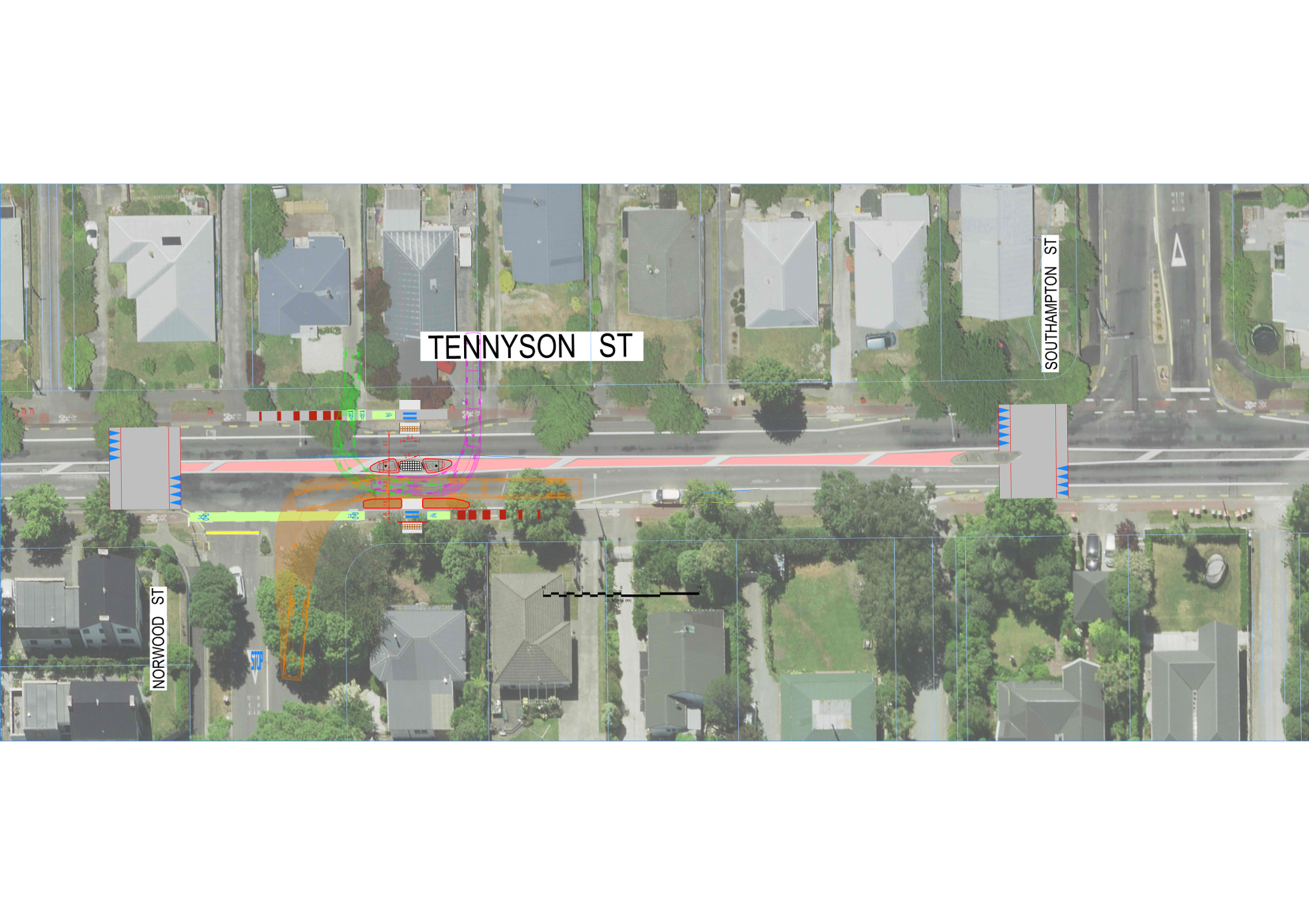
4.1 The preferred option is Option two.
4.2 Option Two: Incorporate changes into the
proposal to reflect comments and concerns from submitters, as shown in Attachment
A.
4.3 This option includes:
4.3.1 Installing
no stopping lines to increase the visibility for pedestrians towards oncoming
traffic (this feature is included in all options and it is noted that no
objections or concerns about the proposed no stopping were raised during
consultation).
4.3.2 Increase
space in the centre of the island to accommodate more crossing users.
4.3.3 Incorporate
vertical traffic calming and red coloured surfacing to create a slow zone from
Norwood Street to Southampton Street. Children and caregivers were
observed crossing at both islands within this section.
4.3.4 Incorporate
an island on the south side of Tennyson Street to further increase visibility
for people crossing and to reduce the crossing distance. This also
assists in slowing turning traffic into Norwood Street.
4.4 The major theme that emerged through consultation was a community
desire for slower speeds and a change in the nature of the existing crossing.
It is clear that there is little support for only the changes to the island as
proposed.
4.5 It is proposed to retain the median island crossings as this
provides consistency along the Tennyson Street corridor. It is not
proposed to implement a zebra crossing at this location. Pedestrian count
data shows that approximately 37 people are crossing in both directions at the
crossing point to the east of Norwood Street during the morning peak hour and
just over 30 during the after school period. Outside of these busier
periods the number reduces to around 5-10 people crossing at this location per
hour.
4.6 Raised platforms, as requested by several submitters, are proposed
to be incorporated into the scheme to the west of Norwood Street and to the
west of Southampton Street. It is proposed to provide the traffic calming
away from the crossing so that it doesn’t create ambiguity for children
at to whom has priority. Ambiguity could result in crashes occurring when
pedestrians expect vehicles to stop for them and there is no legal requirement
for them to do so.
4.7 Lower speeds at locations where pedestrians are exposed to traffic
is a key, safe system principle and will reduce both likelihood and severity of
any crashes that may occur in future. The lower speeds can also facilitate eye
contact between pedestrians and drivers resulting in a mutually negotiated
position over who goes first, and may result in a higher rate of vehicles
yielding to pedestrians, even when they are not required by law to do so.
4.8 It is not recommended to relocate this crossing further from Norwood
Street as that will further remove the crossing from the main desire lines. The
issue of vehicles hard braking when turning right from Norwood Street, and the
potential issue of right turning traffic experiencing sunstrike, can be
mitigated by requiring slower speeds with traffic calming measures.
4.9 It is proposed to incorporate a limit line and markings on the
cycleway to raise more awareness of the crossing facility and that people
riding bicycles should give-way to people crossing. Due to the number of people
crossing at this location it is unlikely to create delay for people riding but
increasing the visibility of the crossing and reducing speeds will result in a
more comfortable environment for all users.
4.10 There were no concerns raised about removal of parking to improve
visibility. This option includes the proposed no stopping as per the original
consultation as this was not a controversial part of the proposal and can be
implemented without any additional design or funding as it only requires
community board approval to proceed.
4.11 Advantages of this option include:
4.11.1 Addresses
the concerns and reflects the majority of community views expressed through
consultation.
4.11.2 Creates
a lower speed environment at the crossing point.
4.11.3 Supports
any future lower speed limits.
4.11.4 Improves
visibility for pedestrians by removal of parking.
4.12 Disadvantages of this option include:
4.12.1 Increased
cost.
4.12.2 Vertical
traffic calming may have negative amenity effects (eg. Noise) to surrounding
properties.
4.12.3 Minor
delay in travel times to traffic travelling along Tennyson Street, however
given the lack of viable alternative parallel routes this is unlikely to result
in a decrease in traffic volumes.
5. Alternative Options Considered Ētahi atu Kōwhiringa
5.1 Option One: Proceed with the proposal as
consulted on.
5.2 This option includes:
5.2.1 Installing
no stopping lines to increase the visibility for pedestrians towards oncoming
traffic (this feature is included in all options and it is noted that no objections
or concerns about the proposed no stopping were raised during consultation).
5.2.2 Widening
the existing island to increase its capacity to hold waiting pedestrians.
5.3 Consideration was given to possible minor (low-cost) line marking
and signage changes to the consultation proposal to address concerns raised in
feedback. However, no such changes were identified that were likely to address
concerns raised in feedback.
5.4 Advantages of this option include:
5.4.1 Provides
a wider island, with more storage room for pedestrians.
5.4.2 More
separation between waiting pedestrians and live traffic speeds, resulting in
more room for error if a pedestrian or driver makes a mistake.
5.4.3 Improves
visibility for pedestrians by removal of parking.
5.5 Disadvantages of this option include
5.5.1 Is
not consistent with the community views expressed through consultation.
5.5.2 Cost.
6. Detail Te Whakamahuki
6.1 Tennyson Street is a Collector Road which connects the suburb of St
Martins to the arterial road of Colombo Street. Collector roads are explained
in the District Plan as
6.1.1 “Roads
that distribute and collect local traffic between neighbourhood areas and the
arterial road network. These are of little or no regional significance, except
for the loads they place on the arterial road network. They link to the
arterial road network and act as local spine roads, and often as bus routes
within neighbourhoods, but generally do not contain traffic signals. Their
traffic movement function must be balanced against the significant property
access function which they provide. …”
6.2 The most recent traffic counts on Tennyson Street (2017, east of
Southampton Street) indicate the average weekday traffic is 9993 vehicles per
day, of which 4.1% are heavy vehicles. Tennyson Street does not carry a
scheduled bus route. This volume of traffic is similar to pre-earthquake
volumes which fluctuated between a low of 9,150 and a high of 10,323, and so it
does not appear that traffic volumes have increased. Historic data on traffic
speeds recorded at this location in 2009 also do not indicate that traffic
speeds have changed noticeably compared to 2017 data. 2017 data shows
that the 85%ile speed at this location is over the posted 50km/h speed limit.
6.3 Multiple pedestrian islands are located along Tennyson Street, at or
in the immediate vicinity of the major desire lines. Concerns have been raised
primarily surrounding the crossing at Norwood Street.
6.4 Staff have investigated this matter and proposed a plan to alter the
existing refuge islands to improve their storage capacity for pedestrians and
increase the separation from the live traffic lanes. Controlled priority
pedestrian crossings such as a marked zebra crossing and traffic signals have
been discounted due to low pedestrian demands and insufficient budget in the
programme for traffic signals. Traffic is not used to stopping at a controlled
pedestrian crossing when pedestrian demands are low, creating a safety issue.
When pedestrians expect to have the right of way and vehicles are not used to
stopping, this creates a conflict and over time often results in a poorer
safety performance of the crossing.
6.5 Staff briefed the joint Community Boards on this project on 9th
March, 2020. However, the financial impacts on Council of the COVID-19
pandemic which followed shortly afterwards resulted in delays in the
consultation for this project and a reduction in the scope, so that it no
longer includes removing the existing island near Southampton Street as this
incurred additional costs that was unnecessary in order to meet the project
goals.
6.6 Consultation on the Tennyson Street - Pedestrian island improvements
was open from 8 July to 16 August 2021. The plan that was distributed for
consultation (referred to as Option One in this report) is shown in Attachment
B. The consultation summary is attached as Attachment C.
6.7 Following consultation, due to the majority of feedback not in
support of the project, council staff briefed the joint community boards to
decide upon a way forward for this project. At this briefing the board also
requested staff advice on a number of matters relating to this project, the
answers to which are provided in the accompanying memorandum (Attachment D).
6.8 Based on the consultation feedback received, Option Two (as detailed
in Attachment A) best reflects desires expressed in the consultation
comments, in some cases explicitly requested. The vehicle tracking and swept
paths around the proposed islands for Option Two are also shown in Attachment
E for information.
6.9 The decision affects the following wards/Community Board areas:
6.9.1 Heathcote
Ward (Linwood-Central-Heathcote Community Board area)
6.9.2 Cashmere
Ward (Spreydon-Cashmere Community Board area)
7. Policy Framework Implications Ngā Hīraunga ā- Kaupapa here
Strategic
Alignment Te Rautaki
Tīaroaro
7.1 The New Zealand Road Safety Strategy - Road to
Zero: sets a target to reduce death and serious injuries on New Zealand roads
by 40% over the next 10 years. There are five key focus areas: infrastructure
improvements and speed management, vehicle safety, work related road safety,
road user choices, and system management.
7.2 This report supports the Council's
Long Term Plan (2021 - 2031):
7.2.1 Activity: Transport
· Level of Service: 10.0.2 Increase the share of
non-car modes in daily trips - ≥17% of trips undertaken by non-car modes
· Level of Service: 10.5.1 Limit deaths and serious injury crashes per
capita for cyclists and pedestrians - ≤ 12 crashes per 100,000 residents
· Level of Service: 16.0.10 Maintain the perception that Christchurch
is a walking friendly city - ≥85% resident satisfaction
Policy
Consistency Te Whai
Kaupapa here
7.3 The
decision is consistent with Council’s Plans and
Policies.
Impact
on Mana Whenua Ngā
Whai Take Mana Whenua
7.4 The
decision does not involve a significant decision in relation to ancestral land
or a body of water or other elements of intrinsic value, therefore this
decision does specifically impact Mana Whenua, their culture and traditions.
7.5 The effects of this proposal upon Mana Whenua
are expected to be insignificant.
Climate
Change Impact Considerations Ngā Whai Whakaaro mā te Āhuarangi
7.6 This proposal includes measures to slow vehicle
speeds and improve road safety. This could encourage people to use
alternative modes to the private vehicle which will result in positive changes
to reduce carbon emissions and the effects of Climate Change.
Accessibility
Considerations Ngā
Whai Whakaaro mā te Hunga Hauā
7.7 This proposal will result in vehicles travelling
at reduced speeds, which will provide a safer and more accessible environment
for all road users, including pedestrians and cyclists.
8. Resource Implications Ngā Hīraunga Rauemi
Capex/Opex Ngā Utu Whakahaere
8.1 Cost to Implement – estimated cost approximately in the
$100,000 to $300,000 range however this is subject to confirmation.
8.2 Maintenance/Ongoing costs – Estimated $5000 annual costs.
8.3 Funding Source – This project is funded from the School Safety
programme.
Other He mea anō
8.4 None identified.
9. Legal Implications Ngā Hīraunga ā-Ture
Statutory power to undertake proposals in the report
Te Manatū Whakahaere Kaupapa
9.1 Part 1, Clauses 7 and 8 of the Christchurch City Council Traffic and
Parking Bylaw 2017 provides Council with the authority to install parking
restrictions by resolution.
9.2 The Community Boards have delegated authority from the Council to
exercise the delegations as set out in the Register of Delegations. The
list of delegations for the Community Boards includes the resolution of
stopping restrictions, traffic islands and traffic restraints, and traffic
control devices.
9.3 The installation of any signs and/or markings associated with
traffic control devices must comply with the Land Transport Rule: Traffic
Control Devices 2004.
Other Legal Implications Ētahi atu
Hīraunga-ā-Ture
9.4 There is a legal context, issue or implication relevant to this
decision.
9.5 This specific report has not been reviewed and approved by the Legal
Services Unit however the report has been written using a general approach
previously approved of by the Legal Services Unit, and the recommendations are
consistent with the policy and legislative framework outlined in sections 8.1
– 8.3.
10. Risk Management Implications Ngā Hīraunga Tūraru
10.1 None identified
Attachments Ngā Tāpirihanga
|
No.
|
Title
|
Page
|
|
a ⇩
|
Tennyson
Street Pedestrian Improvements - Option Two (recommended option) Plan for
Approval
|
14
|
|
b ⇩
|
Tennyson
Street Pedestrian Improvements - Option One (plan during consultation) Plan
for information
|
15
|
|
c ⇩
|
Consultation
Summary - Tennyson Street
|
16
|
|
d ⇩
|
Tennyson
Street Pedestrian Improvements - additional information
|
17
|
|
e ⇩
|
Tennyson
Street Pedestrian Improvements - Vehicle tracking (Option Two, recommended
option) for information
|
19
|
|
f ⇩
|
Tennyson
Street Crossing Improvements Memo
|
20
|
|
g ⇩
|
Tennyson Street
Crossing Improvements for Approval
|
24
|
Additional background information may be noted in the below table:
|
Document
Name
|
Location
/ File Link
|
|
|
|
Confirmation of Statutory
Compliance Te
Whakatūturutanga ā-Ture
|
Compliance with Statutory Decision-making
Requirements (ss 76 - 81 Local Government Act 2002).
(a) This report contains:
(i) sufficient information about all reasonably
practicable options identified and assessed in terms of their advantages and
disadvantages; and
(ii) adequate consideration of the views and preferences of
affected and interested persons bearing in mind any proposed or previous
community engagement.
(b) The information reflects the level of significance of the
matters covered by the report, as determined in accordance with the Council's
significance and engagement policy.
|
Signatories Ngā Kaiwaitohu
|
Author
|
Gemma Dioni -
Senior Transportation Engineer
|
|
Approved By
|
Stephen Wright
- Acting Manager Operations (Transport)
Lynette Ellis
- Head of Transport & Waste Management
|
|
Linwood-Central-Heathcote
Community Board and Spreydon-Cashmere Community Board
12 August
2022
|

|
|
5. Confirmation of Spreydon,
Somerfield, Waltham and Beckenham Christchurch Regeneration Acceleration
Facility (CRAF) programme
|
|
Reference / Te Tohutoro:
|
22/1016964
|
|
Report of / Te Pou Matua:
|
Kelly
Griffiths, Senior Project Manager, [email protected]
|
|
General Manager / Pouwhakarae:
|
Jane
Davis, General Manager – Infrastructure, Planning and regulatory
Services, [email protected]
|
1. Purpose of the Report Te Pūtake
Pūrongo
1.1 The
purpose of this report is for the Waihoro Spreydon-Cashmere Community Board and
the Waikura Linwood-Central-Heathcote Community Board
to reach a joint decision on the Christchurch Regeneration Acceleration
Facility (CRAF) programme of work for the Spreydon, Somerfield, Waltham and
Beckenham area. This report has been written by staff to inform the boards of
the recommended programme for their approval.
1.2 The
decision in this report is of low significance in relation to Christchurch City
Council’s Significance and Engagement Policy. The level of significance
was determined by the low number of affected parties, and the extent and impact
of the work proposed.
2. Officer Recommendations Ngā
Tūtohu
That the
Linwood-Central-Heathcote Community Board and Spreydon-Cashmere Community
Board:
1. Jointly approve the following Christchurch
Regeneration Acceleration Facility (CRAF) projects for the Spreydon,
Somerfield, Waltham and Beckenham CRAF programme, for investigation and
delivery by staff:
a. A package of approximately 20 cycle
improvements, including new and improved cycle lanes, hook turn boxes, new
cycle connections, new markings and green surfacing.
b. A package of approximately 30 pedestrian
improvements including buildouts/refuge islands with tactile paving, and
crossings.
c. A package
of traffic calming on six streets and intersections.
d. A package of footpath widening and surface improvements
in seven locations.
e. An intersection improvement at the Strickland Street,
Somerfield Street and Colombo Street intersection.
f. An area wide speed restriction.
g. New line marking to provide marked car parks
on Rosewarne Street.
h. The rebuild of Huxley Street from Burlington Street to
Montrose Street.
i. The rebuild of the whole of Sefton Place.
j. The rebuild of Dominion Avenue from Milton Street to the
entrance of Christchurch South Intermediate.
Note: Detailed plans for the above projects have not
yet been completed. A decision report with plans will be brought back to the
appropriate Board for approval, before detailed design and construction.
3. Reason for Report Recommendations Ngā Take mō te
Whakatau
3.1 The
officer recommendations have been made because the projects included in the
recommendation will contribute to achieving the intended benefits of CRAF,
which are; improve the liveability, connectivity, safety and road condition in
Spreydon, Somerfield, Waltham and Beckenham.
3.2 The
Waihoro Spreydon-Cashmere Community Board and the Waikura
Linwood-Central-Heathcote Community Boards have been presented
with information on the options available, and staff have prepared this
recommendation on the Spreydon, Somerfield, Waltham and Beckenham CRAF
programme for their consideration.
4. Alternative Options Considered Ētahi atu Kōwhiringa
4.1 There
were 154 recommendations for work in Spreydon, Somerfield, Waltham and
Beckenham, which included the rebuild, restoration or repair of 27 streets, and
a large number of safety and access improvements for cyclists, pedestrians,
drivers and public transport users.
4.2 The
Boards have been provided with information about each of the 154
recommendations for work as potential alternative options to make up the
Spreydon, Somerfield, Waltham and Beckenham CRAF programme.
4.3 The
information provided on the recommendations included prioritisation, delivery
timeframes, high-level cost estimates, advantages and disadvantages of each
category of work, and impact on the Spreydon, Somerfield, Waltham and Beckenham
communities.
5. Detail Te Whakamahuki
5.1 In
the 2017 central government election campaign, the Christchurch Regeneration
Acceleration Facility (CRAF) was announced, as part of the ‘Plan for Canterbury’
to accelerate Christchurch’s recovery after the earthquakes.
5.2 After
the election, CRAF was allocated $300 million, $40 million of this was
allocated to transport projects.
5.3 To secure the $40 million, Council worked with Treasury to develop an
investment proposal, and then a more detailed investment case, which was
approved by Council before being submitted.
5.4 Of the $40 million, $30 million has been allocated to roading and
transport improvements in five areas in Christchurch that experienced
significant damage and disruption, or increased travel use following the
earthquakes – Spreydon, Somerfield, Waltham, and Beckenham, Riccarton and
Fendalton, Linwood and Woolston, Richmond, and New Brighton. The intended
benefits of the $30 million is to improve the liveability, connectivity, safety
and road condition in the five areas.
5.5 Of the $30 million, $6.5 million has been allocated to roading and
transport improvements to safety and access, and condition in Spreydon,
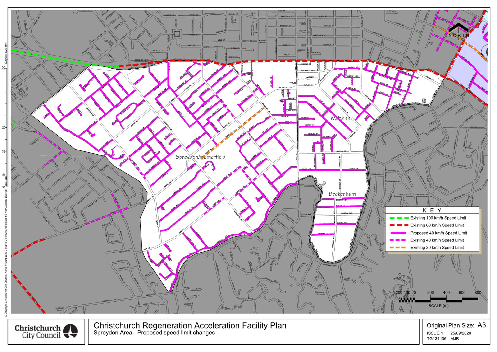
Somerfield, Waltham, and Beckenham, in the area shown in Attachment A.
5.6 Assessments of all the streets within the Spreydon, Somerfield,
Waltham, and Beckenham CRAF area were undertaken, to identify all the safety
and access faults (how safe and easy it is to access a location, street or
property) and condition faults (what is the condition of the street).
Community
Views and Preferences
5.7 To build on the list of faults identified in the assessments,
community consultation was undertaken to gain local knowledge of the issues and
faults in the Spreydon, Somerfield, Waltham, and Beckenham area.
5.8 The consultation was called ‘Better Safer Roads’ and was
open from 18 February to 15 March 2021.
5.9 Leaflets
were delivered to all the properties and businesses within the
Spreydon, Somerfield, Waltham, and Beckenham CRAF area.
5.10 Staff
also emailed key stakeholders, and had a ‘Have Your Say’ page which
included an interactive map where people could leave their comments.
5.11 A drop-in session was held for people to talk to staff and provide
feedback on
the Spreydon,
Somerfield, Waltham, and Beckenham CRAF programme at the Beckenham Service
Centre during the consultation period.
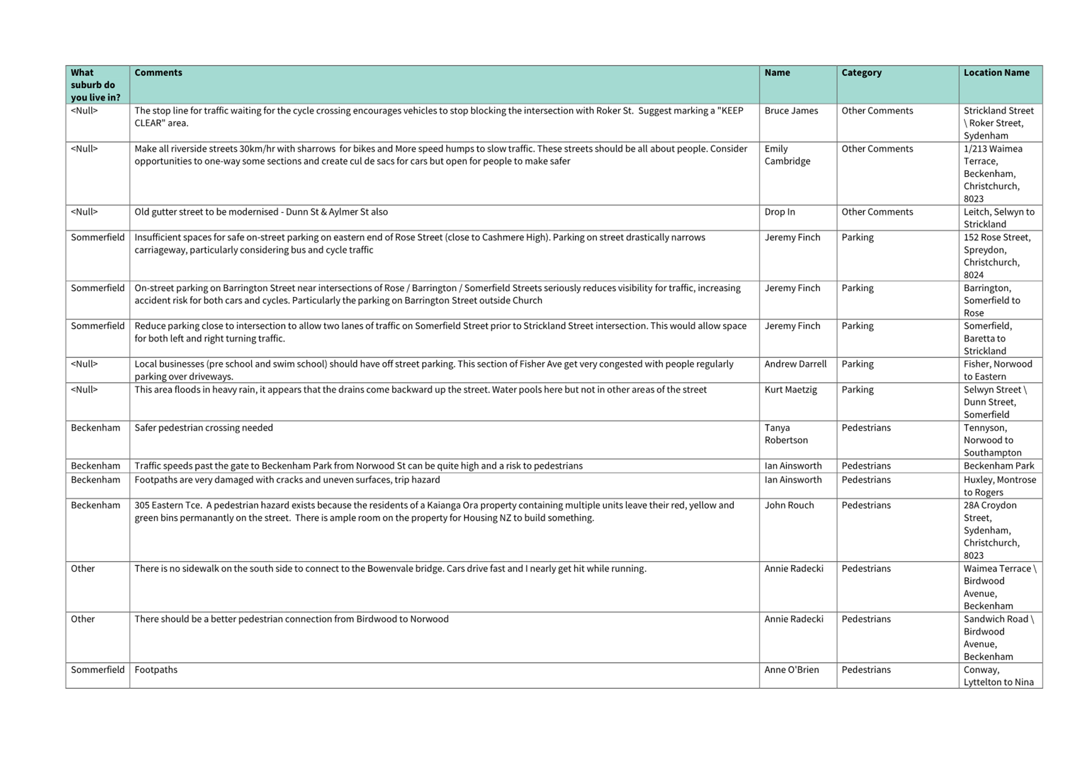
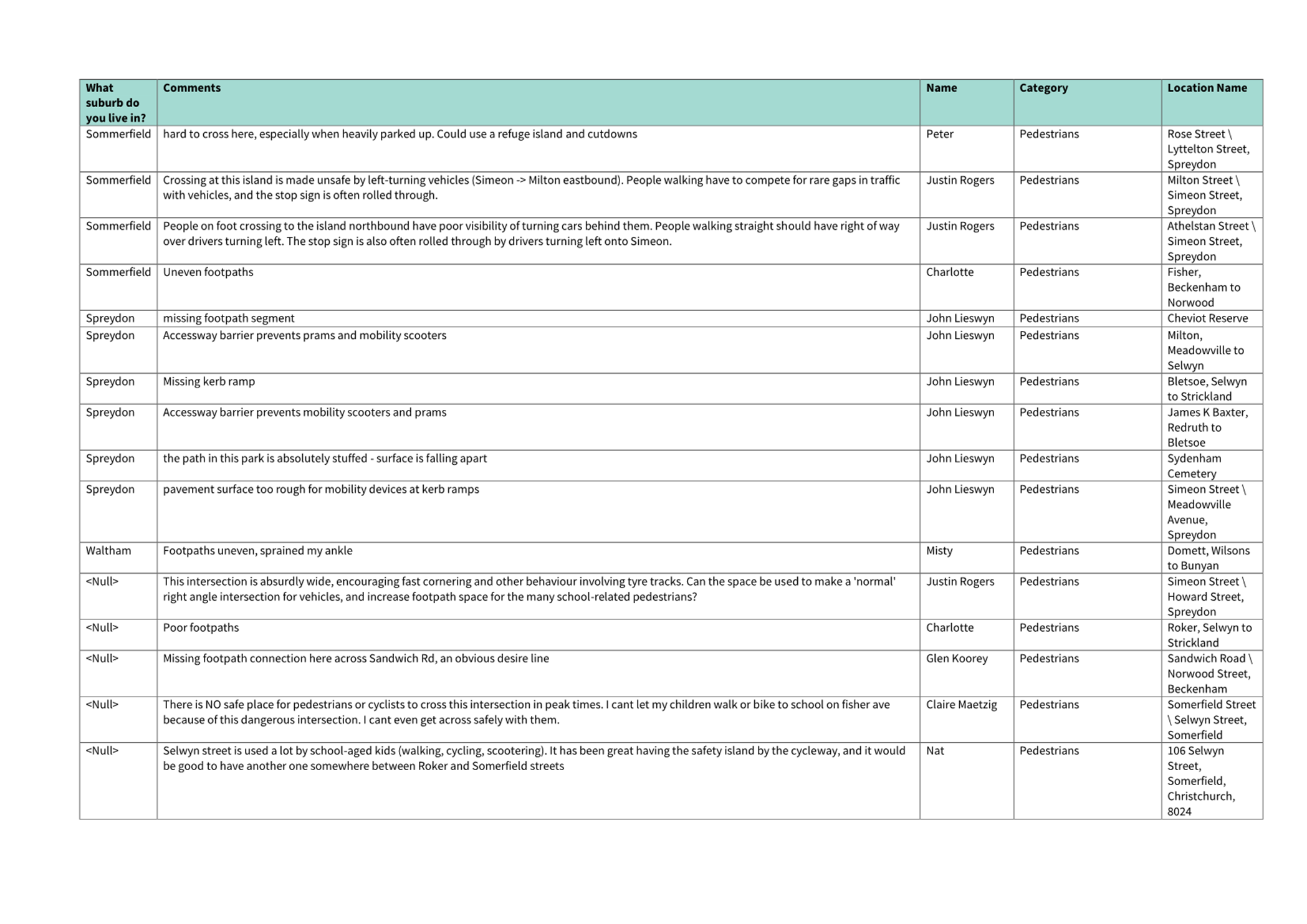
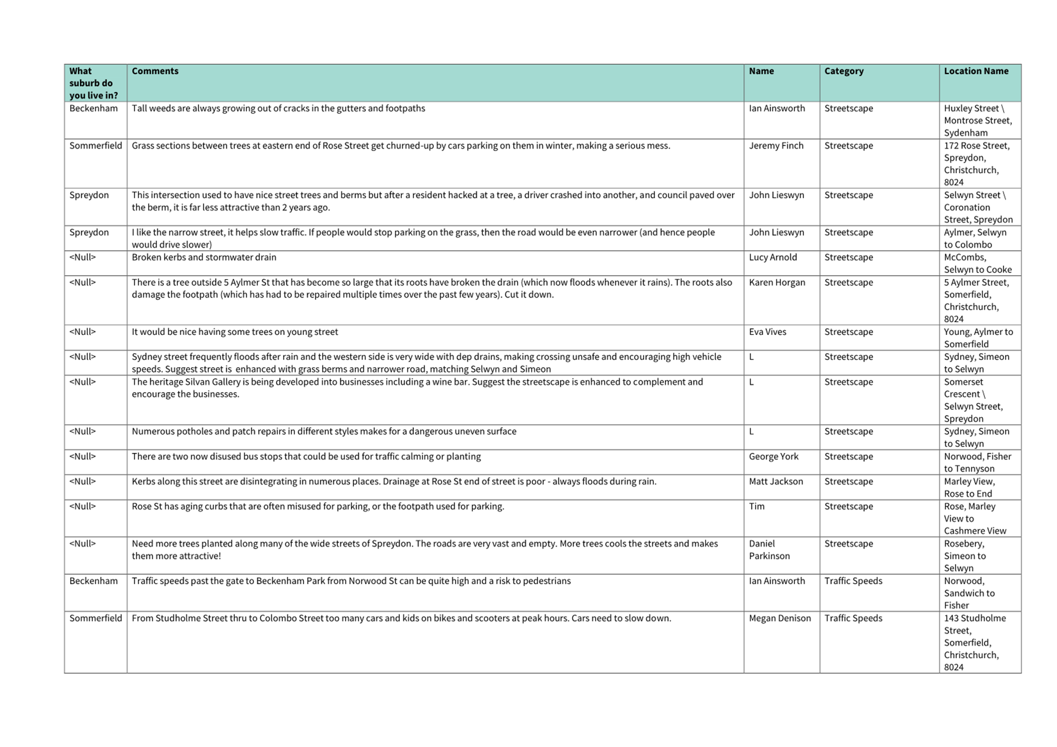
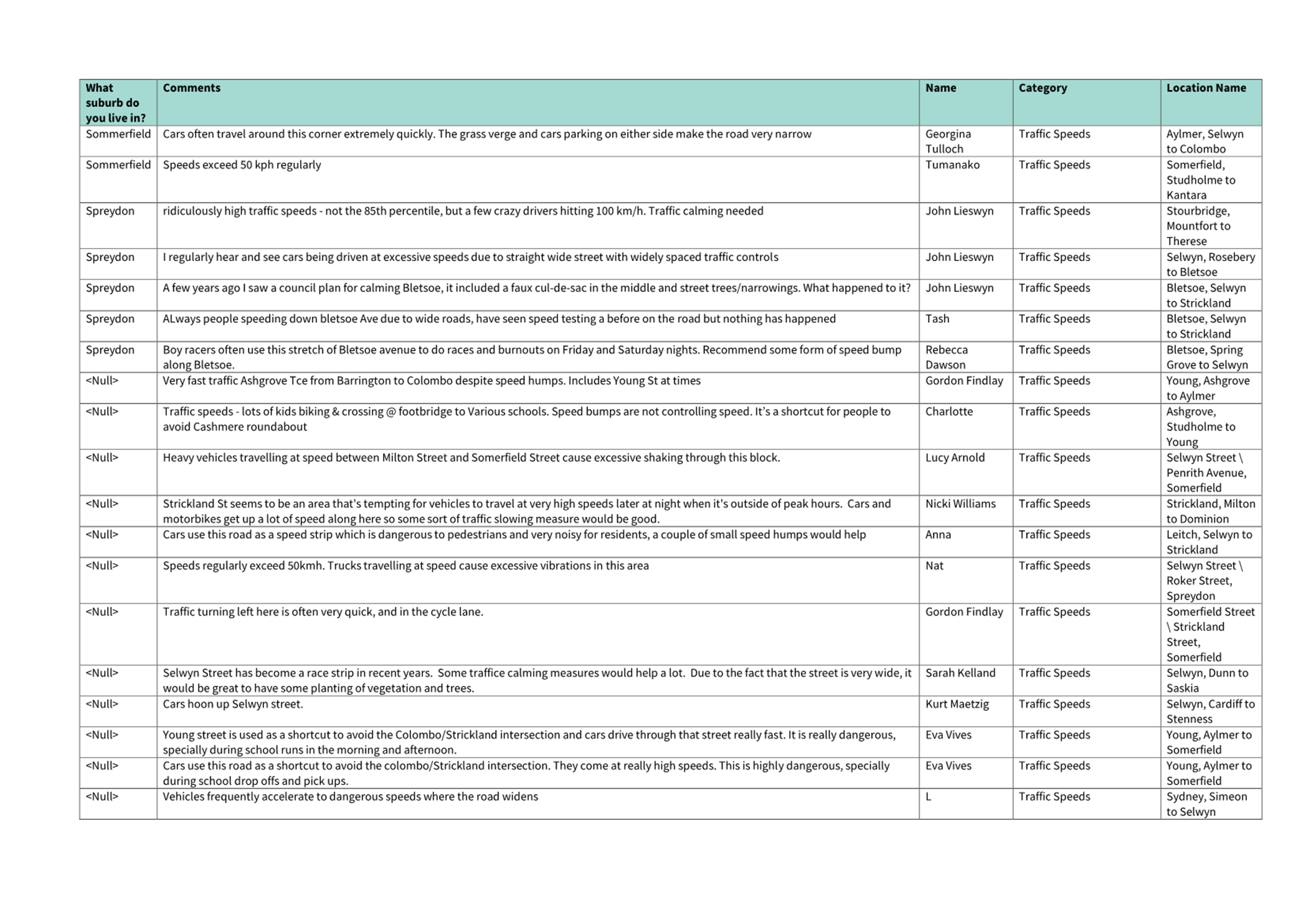
5.12 213 submissions
were received for the Spreydon, Somerfield, Waltham, and
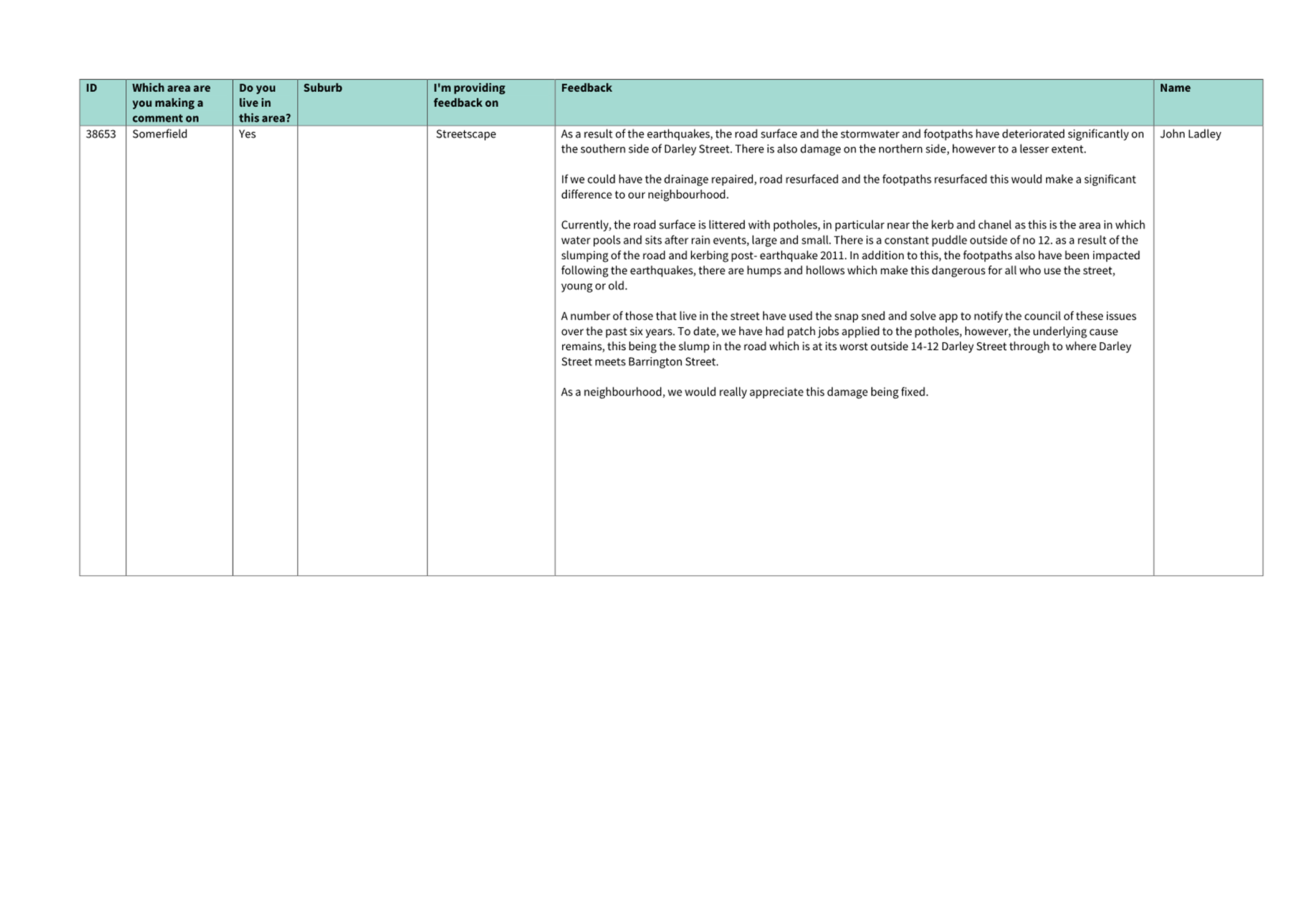
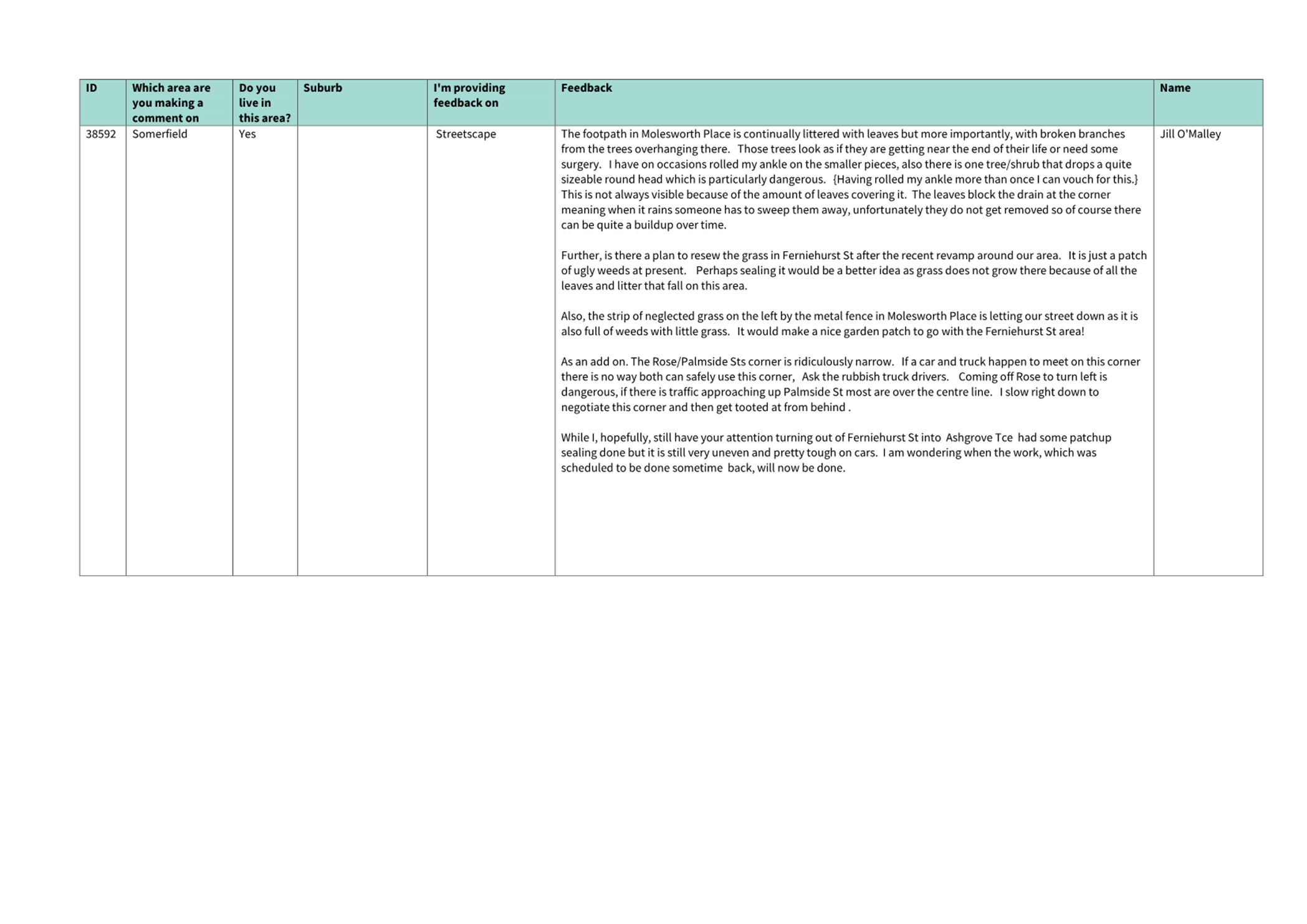
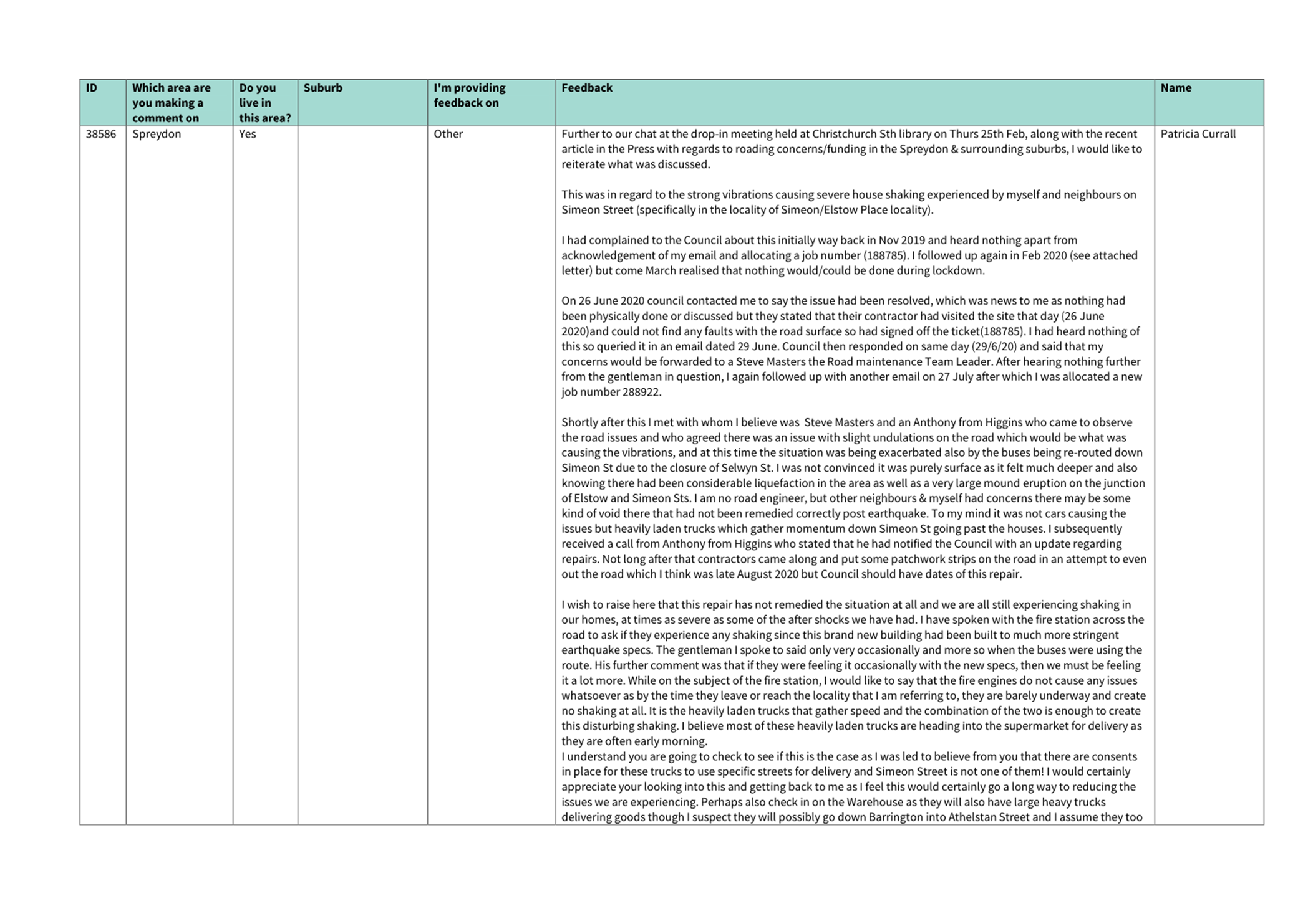
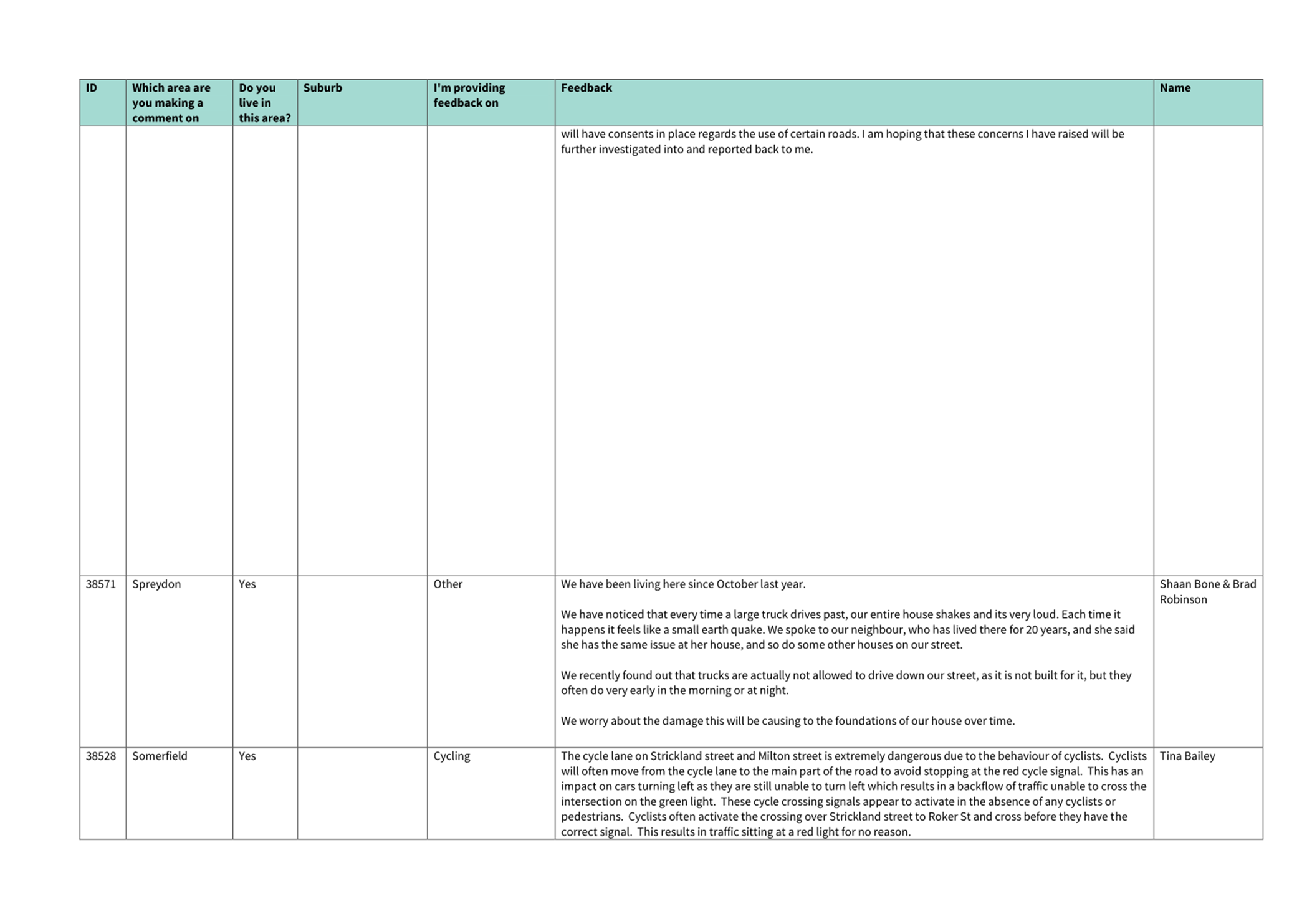
Beckenham area; these came from the ‘Have Your Say’ page,
the interactive map, and emails. The submissions can be viewed in Attachment B.
5.13 Requests for
pedestrian improvements, footpath repairs and cycle facility improvements were
the most common submitters themes.
5.14 There
were 154 recommendations for work in Spreydon, Somerfield, Waltham and
Beckenham, which included the rebuild, restoration or repair of 27 streets, and
a large number of safety and access improvements for cyclists, pedestrians,
drivers and public transport users.
5.15 The Boards were
given the following definitions for repair, rebuild, and restoration:
· Repair – Isolated damage requiring minimal construction to
return the complete asset to a suitable condition. This would generally require
no community engagement, no approvals, and minimal design. Work can generally
be completed within 6 months.
· Restoration – Multiple patches of damage greater than 20
metres. For the road carriageway, restoration is generally a reshaping of the
top surface. This would generally require some community engagement, some
approvals, and more detailed design. Work can generally be completed within 6
to 18 months.
· Rebuild – Significant damage to a street requiring a full
replacement of the damaged assets. This work will require community engagement,
Community Board or Council approval, and full detailed design. This work can be
completed within 18 to 36 months.
5.16 Each
of the 154 recommendations were prioritised by staff on a scale of one to five
– five being the highest priority, one being the lowest priority. The
prioritisation of the safety and access issues takes into account proximity to
key destinations, such as schools and commercial centres, and the impact of the
work. The prioritisation of the condition work is based on the level of
deterioration of the street.
5.17 The
Boards were given the prioritisation, delivery timeframes, and high-level cost
estimates for each of the 154 recommendations. They were informed the Spreydon, Somerfield, Waltham and
Beckenham CRAF budget is not sufficient to complete all
work identified, and that the Boards would need to work together to determine
how to allocate the budget.
5.18 The
Boards advised their preference for projects that generally improved safety and
access in the area, including improving the condition of footpaths, provided
new crossing facilities - including at the Somerfield Street and Selwyn Street
intersection, and the Milton Street and Everard Street intersection –
reducing speed, upgrading the Strickland Street, Somerfield Street and Colombo
Street intersection, and providing car park line marking on Rosewarne Street.
5.19 The Boards also
advised their preference to rebuild some of the most badly damaged streets in
the area.
5.20 The Boards
preferences have been incorporated into the Spreydon,
Somerfield, Waltham and Beckenham CRAF programme.
5.21 The
delivery of some of the projects will be coordinated with the delivery of a
number of projects from the Area Engineer, to ensure efficiencies with
construction and to minimise disruption to the residents.
5.22 Staff are
recommending a phased delivery of the projects in the programme to ensure there
is sufficient budget to deliver all the projects, in light of the recent
increases in construction costs. Once the scheme stage cost estimates for the
projects are completed, a review of the estimates will be undertaken prior to
community consultation, to ensure there is sufficient budget.
5.23 The
following programme of work is the staff recommendation for the Spreydon,
Somerfield, Waltham and Beckenham CRAF programme which has been compiled from
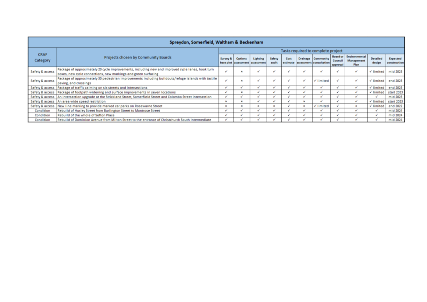
the Boards' feedback, for the Boards to consider:
a. A package of
approximately 20 cycle improvements, including new and improved cycle lanes,
hook turn boxes, new cycle connections, new markings and green surfacing.
b. A package of
approximately 30 pedestrian improvements including buildouts/refuge islands
with tactile paving, and crossing, including at the Somerfield
Street and Selwyn Street intersection, and the Milton Street and Everard Street
intersection.
c. A package of
traffic calming on six streets and intersections.
d. A package of
footpath widening and surface improvements in seven locations.
e. An
intersection upgrade at the Strickland Street, Somerfield Street and Colombo
Street intersection.
f. An
area wide speed restriction (Attachment C).
g. New line marking to provide marked car parks on Rosewarne Street.
h. The rebuild
of Huxley Street from Burlington Street to Montrose Street.
i. The
rebuild of the whole of Sefton Place.
j. The
rebuild of Dominion Avenue from Milton Street to the entrance of Christchurch
South Intermediate.
5.24 The anticipated
delivery timeframes for the programme can be viewed in Attachment D. The
timeframes have allowed for the 2022 Council elections.
5.25 The
decision affects the Spreydon, Cashmere and Heathcote wards. The Waihoro
Spreydon-Cashmere Community Board and the Waikura
Linwood-Central-Heathcote Community Board jointly have the
delegated authority to make this decision on the Spreydon, Somerfield, Waltham
and Beckenham CRAF programme.
5.26 Detailed
plans for the above projects have not yet been completed. A decision report
with plans will be brought back to the appropriate Board for approval, before
detailed design and construction.
5.27 Community
consultation on the individual projects will take place once draft designs are
completed, and this feedback will be presented to the appropriate Board.
6. Policy Framework Implications Ngā Hīraunga ā- Kaupapa here
Strategic
Alignment Te Rautaki
Tīaroaro
6.1 The projects listed above will deliver on a range of benefits that
align with Council’s policies and strategies associated with providing a
level of service for safety, accessibility and condition:
· The
Safer Christchurch Strategy (2016)
· The New Zealand Road Safety Strategy - Road to Zero: sets a target
to reduce death and serious injuries on New Zealand roads by 40% over the next
10 years. There are five key focus areas: infrastructure improvements and speed
management, vehicle safety, work related road safety, road user choices, and
system management.
· The Equity and Access for People with Disabilities Policy (2001)
· The Land Transport Rule: Setting of Speed Limits 2017: requires that
road controlling authorities must set speed limits that are safe and
appropriate, and encourages a consistent approach to speed management
throughout New Zealand.
· The
Transport Management Plan and the Transport Activity Plan,
which provide the foundations for Council’s Long Term Plan.
6.2 This report supports the Council's
Long Term Plan (2021 - 2031):
6.2.1 Activity: Transport
· Level of Service: 16.0.1 Maintain roadway
condition to an appropriate national standard, - ≥5% of the sealed local
road network is resurfaced per year
· Level
of Service: 10.5.1 Limit deaths and serious injury crashes per capita for
cyclists and pedestrians - ≤ 12 crashes per 100,000 residents
· Level
of Service: 16.0.10 Maintain the perception that Christchurch is a walking
friendly city - ≥85% resident satisfaction
· Level
of Service: 10.0.2 Increase the share of non-car modes in daily trips -
≥17% of trips undertaken by non-car modes
· Level
of Service: 10.5.2 Improve the perception that Christchurch is a cycling
friendly city) - ≥65% resident satisfaction
· Level
of Service: 10.5.3 More people are choosing to travel by cycling -
≥12,000 average daily cyclist detections
· Level
of Service: 10.0.41 Reduce emissions and greenhouse gases related to transport
- ≤1.10 million tonnes of CO2 equivalents
Policy
Consistency Te Whai
Kaupapa here
6.3 The
decision is consistent with Council’s Plans and
Policies.
Impact
on Mana Whenua Ngā
Whai Take Mana Whenua
6.4 The
decision does not involve a significant decision in relation to ancestral land
or body of water or other elements of intrinsic value, therefore this decision
does not specifically impact Mana Whenua, their culture and traditions.
Climate
Change Impact Considerations Ngā Whai Whakaaro mā te Āhuarangi
6.5 The majority of the work in the recommended programme will includes
measures to slow vehicle speeds and improve road safety. This could encourage
people to use alternative modes of transport, which will result in reduced
carbon emissions and have a positive effect on climate change.
Accessibility
Considerations Ngā
Whai Whakaaro mā te Hunga Hauā
6.6 The majority of the work in the recommended programme will result in vehicles travelling at reduced speeds,
which will provide a safer and more accessible environment for all road users,
including pedestrians and cyclists.
7. Resource Implications Ngā Hīraunga Rauemi
Capex/Opex / Ngā Utu Whakahaere
7.1 Cost
to Implement - $6.5 million has been allocated for the Spreydon, Somerfield,
Waltham and Beckenham programme, this includes all staff costs.
7.2 Maintenance/Ongoing
costs - these will be calculated for each project, and detailed in the decision
reports.
7.3 Funding
Source - the $40 million Christchurch Regeneration Acceleration Facility,
provided by Treasury.
Other / He mea anō
7.4 None
identified.
8. Legal Implications Ngā Hīraunga ā-Ture
Statutory power to undertake proposals in the report /
Te Manatū Whakahaere Kaupapa
8.1 The Waihoro Spreydon-Cashmere Community Board and the Waikura
Linwood-Central-Heathcote Community Board jointly have the
delegated authority to make this decision on the Spreydon, Somerfield, Waltham
and Beckenham CRAF programme.
Other Legal Implications / Ētahi atu
Hīraunga-ā-Ture
8.2 There
is no legal context, issue or implication relevant to this decision.
9. Risk Management Implications Ngā Hīraunga Tūraru
9.1 If
the Waihoro Spreydon-Cashmere Community Board and the Waikura
Linwood-Central-Heathcote Community Board do not approve a
CRAF programme for Spreydon, Somerfield, Waltham and Beckenham, there is a
reputational risk with Treasury that Council is unable to deliver on the CRAF
programme it committed to delivering in the Investment Case.
Attachments / Ngā Tāpirihanga
|
No.
|
Title
|
Page
|
|
a ⇩
|
Area map
|
32
|
|
b ⇩
|
Submissions
|
33
|
|
c ⇩
|
Speed limit
plan
|
74
|
|
d ⇩
|
Delivery
timeframes
|
75
|
In addition to the attached documents, the following background
information is available:
|
Document
Name
|
Location
/ File Link
|
|
<enter
document name>
|
<enter
location/hyperlink>
|
|
<enter
document name>
|
<enter
location/hyperlink>
|
Confirmation of Statutory
Compliance / Te
Whakatūturutanga ā-Ture
|
Compliance with Statutory Decision-making
Requirements (ss 76 - 81 Local Government Act 2002).
(a) This report contains:
(i) sufficient information about all reasonably
practicable options identified and assessed in terms of their advantages and
disadvantages; and
(ii) adequate consideration of the views and preferences of
affected and interested persons bearing in mind any proposed or previous
community engagement.
(b) The information reflects the level of significance of the
matters covered by the report, as determined in accordance with the Council's
significance and engagement policy.
|
Signatories / Ngā Kaiwaitohu
|
Author
|
Kelly
Griffiths - Senior Project Manager
|
|
Approved By
|
Lynette Ellis
- Head of Transport & Waste Management
|