Christchurch City Council
Agenda
Notice of Meeting Te Pānui o te Hui:
An ordinary meeting of the Christchurch
City Council will be held on:
Date: Wednesday 10 September 2025
Time: 9.30 am
Venue: Camellia Chambers, Level 2, Civic Offices,
53 Hereford Street
Please note that
while we will try to accommodate all those who wish to attend the meeting in
person, there is limited capacity in the Camellia Chambers, and priority will
be given to those who are presenting to the Council.
Membership
|
Chairperson
Deputy Chairperson
Members
|
Mayor Phil Mauger
Deputy Mayor Pauline Cotter
Councillor Kelly Barber
Councillor Melanie Coker
Councillor Celeste Donovan
Councillor Tyrone Fields
Councillor James Gough
Councillor Tyla Harrison-Hunt
Councillor Victoria Henstock
Councillor Yani Johanson
Councillor Aaron Keown
Councillor Sam MacDonald
Councillor Jake McLellan
Councillor Andrei Moore
Councillor Mark Peters
Councillor Tim Scandrett
Councillor Sara Templeton
|
4 September 2025
Website: www.ccc.govt.nz
TABLE OF CONTENTS NGĀ IHIRANGI
Karakia Tīmatanga................................................................................................... 4
1. Apologies Ngā Whakapāha................................................................................. 4
2. Declarations of Interest Ngā Whakapuaki Aronga.................................................. 4
3. Public
Participation Te Huinga
Tūmatanui............................................................ 4
3.1 Public Forum Te Huinga Whānui.......................................................................................... 4
3.2 Deputations by
Appointment Ngā Huinga Whakaritenga...................................................... 5
4. Presentation
of Petitions Ngā
Pākikitanga............................................................ 5
Committee Minutes Reports
5. Health,
Safety and Wellbeing Committee Minutes - 29 August 2025.......................... 7
Community Board Part A
Reports
6. Spreydon,
Somerfield, Waltham, Beckenham CRAF - Strickland Street/Somerfield Street
safety improvements....................................................................................... 11
Staff Reports
7. Lincoln
Road Passenger Transport Improvements Stage 2B, Curletts Road/Hoon Hay Road to
Wrights Road/Lyttelton Street....................................................................... 25
8. New
Footpaths Programme.............................................................................. 53
9. Plan
Change Programme - Plan Stop and Exemptions........................................... 75
10. Unsolicited
Proposal for Sale of Part of 177 Armagh Street.................................. 109
11. Taylors
Mistake Baches Working Party Update................................................... 165
12. Council
Policy and Practices 2024/2025 Section 10A requirements of the Dog Control Act
September 2025............................................................................................ 169
13. Resolution
to Exclude the Public...................................................................... 174
Karakia Whakamutunga
Karakia Tīmatanga
Whakataka te hau ki te uru
Whakataka te hau ki te tonga
Kia mākinakina ki uta
Kia mātaratara ki tai
E hī ake ana te atakura
He tio, he huka, he hau hū
Tihei mauri ora
1. Apologies Ngā Whakapāha
Apologies will
be recorded at the meeting.
2. Declarations of Interest Ngā
Whakapuaki Aronga
Members are
reminded of the need to be vigilant and to stand aside from decision-making
when a conflict arises between their role as an elected representative and any
private or other external interest they might have.
3. Public Participation Te Huinga
Tūmatanui
3.1 Public Forum Te Huinga Whānui
A period of up to 30 minutes is available
for people to speak for up to five minutes on any issue that is not the subject
of a separate hearings process.
|
3.1.1
|
Christchurch Methodist Mission
Executive Director Jill Hawkey and
Strategic Advisor Jane Higgins will present on behalf of the Christchurch
Methodist Mission regarding the launch of a campaign to raise awareness about
older person’s housing.
|
|
3.1.2
|
Dogwatch Sanctuary Trust
Ameila Ryman will speak on behalf of Dogwatch
Sanctuary Trust regarding waiving registration fees for rescue dogs in
temporary care, and ensuring all dogs adopted from the Council shelter are
desexed.
|
|
3.1.3
|
Simon Fenwick
Simon Fenwick will speak regarding outdoor
dining on Tramway Lane.
|
|
3.1.4
|
Peter Langlands
Peter Langlands will speak on behalf of
Wild Capture Research regarding the public availability of Council reports
relating to biodiversity and a publicly available index of reports.
|
|
3.1.5
|
Susan Thorpe
Susan Thorpe will speak regarding the
current unaffordability of rates and practical suggestions for effective cost
saving.
|
3.2 Deputations by Appointment Ngā
Huinga Whakaritenga
Deputations may be heard on a matter, or
matters, covered by a report on this agenda and approved by the Chairperson.
Deputations
will be recorded in the meeting minutes.
4. Presentation of Petitions Ngā
Pākikitanga
|
4.1
|
Jason
Hitchens will present a petition regarding the Grassmere Street Development:
The following people/residents are
‘OPPPOSED’ of the use of Grassmere Street as the access point for
the new development. We would prefer all development traffic to use an access
route off Cranford Street, though the council land.
|
To present to the Council, refer
to the Participating in decision-making webpage or
contact the meeting advisor listed on the front of this agenda.
|
5. Health,
Safety and Wellbeing Committee Minutes - 29 August 2025
|
|
Reference Te Tohutoro:
|
25/1769105
|
|
Responsible Officer(s) Te Pou Matua:
|
Simone
Gordon, Democratic Services Advisor
|
|
Accountable ELT Member Pouwhakarae:
|
Helen
White, General Counsel / Director of Legal & Democratic Services
|
1. Purpose of Report Te Pūtake Pūrongo
The Health,
Safety and Wellbeing Committee held a meeting on 29
August 2025 and is circulating the Minutes recorded to the Council for its
information.
2. Recommendation
Te Tūtohu Council
That the Council receives the Minutes from the Health,
Safety and Wellbeing Committee meeting held 29 August 2025.
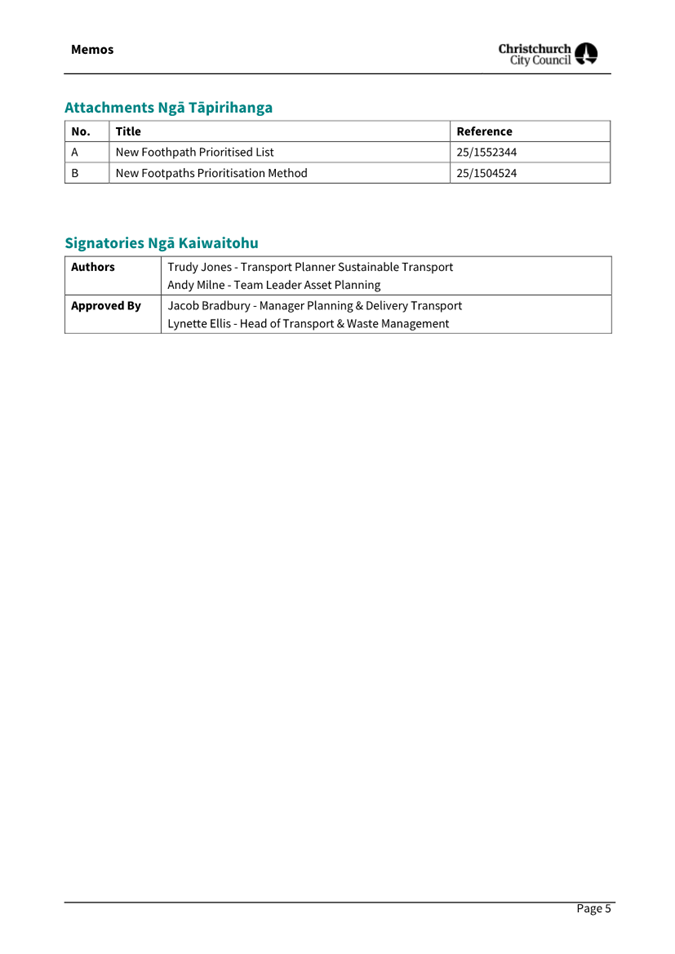
Attachments
Ngā
Tāpirihanga
|
No.
|
Title
|
Reference
|
Page
|
|
A⇩
|
Minutes Health,
Safety and Wellbeing Committee - 29 August 2025
|
25/1732912
|
7
|
Signatories Ngā Kaiwaitohu
|
Author
|
Simone Gordon
- Democratic Services Advisor
|

Health, Safety and Wellbeing Committee
Open Minutes
Date: Friday 29 August 2025
Time: 9.30 am
Venue: Ministry of Education Building, Conference
Room,
48 Hereford Street West End
Present
|
Chairperson
Deputy Chairperson
Members
|
Councillor Tim Scandrett
Councillor Kelly Barber
Councillor Melanie Coker
Councillor Mark Peters
Ms Helen Sadgrove
|
Website: www.ccc.govt.nz

Part
A Matters Requiring
a Council Decision
Part B Reports
for Information
Part C Decisions
Under Delegation
The agenda was dealt with in the following
order.
1. Apologies
Ngā Whakapāha
Part C
|
Committee Resolved HSCM/2025/00007
That the apology from Chris Jones for
absence be accepted.
Councillor
Scandrett/Councillor Barber Carried
|
2. Declarations
of Interest Ngā Whakapuaki Aronga
Part B
There were no
declarations of interest recorded.
3. Confirmation
of Previous Minutes Te Whakaāe o te hui o mua
Part C
|
Committee Resolved HSCM/2025/00008
That the
minutes of the Health, Safety and Wellbeing Committee meeting held on Friday,
27 June 2025 be confirmed.
Councillor Scandrett/Councillor
Peters Carried
|
4. Public
Forum Te Huinga Whānui
Part B
There were no public forum presentations.
5. Deputations
by Appointment Ngā Huinga Whakaritenga
Part B
There were no deputations by appointment.
6. Presentation
of Petitions Ngā Pākikitanga
Part B
There was no presentation of petitions.
|
7. Resolution
to Exclude the Public Te whakataunga kaupare hunga tūmatanui
|
|
|
Committee Resolved HSCM/2025/00009
Part C
That at 9:32am the resolution to exclude the public set out on
pages 11 to 12 of the agenda be adopted.
Councillor
Scandrett/Councillor Coker Carried
|
The public were re-admitted to the meeting
at 11.07am.
Meeting
concluded at 11.07am.
CONFIRMED BY THE CHAIRPERSON
AND PRINCIPAL ADVISOR ON [DATE] 2025
PURSUANT TO STANDING ORDER 23.4
Councillor Tim Scandrett
Chairperson
BEDE CARRAN
PRINCIPAL ADVISOR
Report from Waihoro Spreydon-Cashmere-Heathcote Community Board – 28
August 2025
|
6. Spreydon,
Somerfield, Waltham, Beckenham CRAF - Strickland Street/Somerfield Street
safety improvements
|
|
Reference Te Tohutoro:
|
25/1763397
|
|
Responsible Officer(s) Te Pou Matua:
|
Ann
Tomlinson, Project Manager
|
|
Accountable ELT Member Pouwhakarae:
|
Andrew
Rutledge, General Manager Citizens and Community
|
|
1. Waihoro Spreydon-Cashmere-Heathcote
Community Board Recommendation to Council
|
|
|
That the Council:
12. Approves that a Special Vehicle Lane, in
accordance with Clause 18 of the Christchurch City Council Traffic &
Parking Bylaw 2017, for the use of northwest bound road users as defined in
Section 11.1A of the Land Transport (Road User) Rule: 2004, excepting
pedestrians and riders of mobility devices, be installed on the south west
side of Strickland Street, commencing at its intersection with Colombo Street
and extending in a north westerly direction for a distance of 60 metres as
detailed on plan TP TP365001, dated 07.08.2025, and attached to the agenda
report as Attachment A.
13. Approves that a Special Vehicle Lane, in
accordance with Clause 18 of the Christchurch City Council Traffic &
Parking Bylaw 2017, for the use of southwest bound road users as defined in
Section 11.1A of the Land Transport (Road User) Rule: 2004, excepting
pedestrians and riders of mobility devices, be installed on the southeast
side of Somerfield Street, commencing at a point 5 metres southwest of its
intersection with Strickland Street, and extending in an south westerly
direction for a distance of 15 metres as detailed on plan TP TP365001, dated
07.08.2025, and attached to the agenda report as Attachment A.
|
|
2. Waihoro Spreydon-Cashmere-Heathcote Community Board Decisions
Under Delegation Ngā
Mana kua Tukuna
|
|
|
Original Officer Recommendations accepted without
change
Part C
That the
Waihoro Spreydon-Cashmere-Heathcote Community Board:
1. Receives the information in the Spreydon,
Somerfield, Waltham, Beckenham CRAF - Strickland Street/Somerfield Street
safety improvements Report.
2. Notes that the decision in this report is assessed as low
significance based on the Christchurch City Council’s Significance and
Engagement Policy. The level of significance was determined by the small
number of affected residents and businesses, the low impact the proposed
changes would have on residents and businesses and that the project is CRAF
funded.
3. Makes the following recommendations required for the
implementation of the project, including any traffic controls and /or
stopping restrictions, relying on its powers under the Christchurch City
Council Traffic and Parking Bylaw 2017 and Part 21 of the Local Government
Act 1974.
4. Revokes any previous resolutions pertaining to traffic controls or
parking and stopping restrictions made pursuant to any bylaw to the extent
that they are in conflict with the traffic controls or parking and stopping
restrictions described in recommendations 5 – 10 below.
5. Approves all kerb alignments, traffic calming devices, road
surface treatments, signage and road markings on Somerfield Street,
commencing at its intersection with Strickland Street and extending in a
south-westerly direction for a distance of 20 metres as detailed on plan
TP365001, dated 07.08.2025, and attached to the agenda report as Attachment
A.
6. Approves all kerb alignments, traffic calming devices, road
surface treatments, signage and road markings on Strickland Street,
commencing at its intersection with Colombo Street and extending in a
north-westerly direction for a distance of 60 metres as detailed on plan
TP365001, dated 07.08.2025, and attached to the agenda report as Attachment
A.
7. Approves that, pursuant to Clause 7 of the Christchurch City
Council Traffic and Parking Bylaw 2017, the stopping of vehicles be
prohibited at all times on the south-western side of Strickland Street
commencing at its intersection with Somerfield Street and extending in a
north-westerly direction for a distance of 26 metres as detailed on plan
TP365001, dated 07.08.2025, and attached to the agenda report as Attachment
A.
8. Approves that, pursuant to Clause 7 of the Christchurch City
Council Traffic and Parking Bylaw 2017, the stopping of vehicles be
prohibited at all times on the south-eastern side of Somerfield Street,
commencing at its intersection with Strickland Street and extending in a
south-westerly direction for a distance of 20 metres as detailed on plan
TP365001, dated 07.08.2025, and attached to the agenda report as Attachment
A.
9. Approves that, pursuant to Clause 7 of the Christchurch City
Council Traffic and Parking Bylaw 2017, the stopping of vehicles be
prohibited at all times on the north-western side of Somerfield Street
commencing at its intersection with Strickland Street and extending in a
south-westerly direction for a distance of 20 metres as detailed on plan
TP365001, dated 07.08.2025, and attached to the agenda report as Attachment
A.
10. Approves that in accordance with Section 4 of the Land Transport
Rule: Traffic Control Devices 2004 that the Somerfield Street approach to its
intersection with Strickland Street be controlled by a Give Way.
11. Approve that these resolutions take effect when parking signage
and/or road marking that evidence the restrictions described in the staff
report are in place (or removed in the case of revocations).
|
In addition to the attached documents, the following background
information is available:
|
Document
Name – Location / File Link
|
|
Not
applicable
|
Attachments Ngā Tāpirihanga
|
No.
|
Report Title
|
Reference
|
Page
|
|
1
|
Spreydon, Somerfield, Waltham, Beckenham
CRAF - Strickland Street/Somerfield Street safety improvements
|
25/1375222
|
13
|
|
No.
|
Title
|
Reference
|
Page
|
|
a ⇩
|
SSWB CRAF -
Somerfield St/Strickland St plan for approval
|
25/1529733
|
23
|
|
Spreydon, Somerfield, Waltham, Beckenham CRAF - Strickland
Street/Somerfield Street safety improvements
|
|
Reference Te Tohutoro:
|
25/1375222
|
|
Responsible Officer(s) Te Pou Matua:
|
Ann
Tomlinson, Project Manager
Krystle Anderson, Senior Engagement Advisor
|
|
Accountable ELT Member Pouwhakarae:
|
Brent
Smith, General Manager City Infrastructure
|
1. Purpose and Origin of the Report Te Pūtake Pūrongo
1.1 The
purpose of this report is for the Waihoro Spreydon-Cashmere-Heathcote Community
Board to consider the Strickland Street/Somerfield Street safety improvements
scheme design following community consultation. This will allow the project to
proceed to detailed design and construction.
1.2 Strickland
Street/Somerfield Street safety improvements is a component of the Colombo
Street, Somerfield Street and Selwyn Street project within the Spreydon,
Somerfield, Waltham, Beckenham Christchurch Regeneration Acceleration Facility
(CRAF) programme.
1.3 The
report has been written to address cyclist and pedestrian safety at the
Strickland Street/Somerfield Street intersection.
2. Officer Recommendations Ngā Tūtohu
That the Waihoro
Spreydon-Cashmere-Heathcote Community Board:
1. Receives the information in the Spreydon,
Somerfield, Waltham, Beckenham CRAF - Strickland Street/Somerfield Street
safety improvements Report.
2. Notes that the decision in this report is assessed as low significance
based on the Christchurch City Council’s Significance and Engagement
Policy. The level of significance was determined by the small number of
affected residents and businesses, the low impact the proposed changes would
have on residents and businesses and that the project is CRAF funded.
3. Makes the following recommendations required for the implementation
of the project, including any traffic controls and /or stopping restrictions,
relying on its powers under the Christchurch City Council Traffic and Parking
Bylaw 2017 and Part 21 of the Local Government Act 1974.
4. Revokes any previous resolutions pertaining to traffic controls or
parking and stopping restrictions made pursuant to any bylaw to the extent that
they are in conflict with the traffic controls or parking and stopping
restrictions described in recommendations 5 – 10 below.
5. Approves all kerb alignments, traffic calming devices, road surface
treatments, signage and road markings on Somerfield Street, commencing at its
intersection with Strickland Street and extending in a south-westerly direction
for a distance of 20 metres as detailed on plan TP365001,
dated 07.08.2025, and attached to this report
as Attachment A.
6. Approves all kerb alignments, traffic calming devices, road surface
treatments, signage and road markings on Strickland Street, commencing at its
intersection with Colombo Street and extending in a north-westerly direction for
a distance of 60 metres as detailed on plan TP365001, dated 07.08.2025, and
attached to this report as Attachment A.
7. Approves that, pursuant to Clause 7 of the Christchurch City Council
Traffic and Parking Bylaw 2017, the stopping of vehicles be prohibited at all
times on the south-western side of Strickland Street commencing at its
intersection with Somerfield Street and extending in a north-westerly direction
for a distance of 26 metres as detailed on plan TP365001, dated 07.08.2025, and
attached to this report as Attachment A.
8. Approves that, pursuant to Clause 7 of the Christchurch City Council
Traffic and Parking Bylaw 2017, the stopping of vehicles be prohibited at all
times on the south-eastern side of Somerfield Street, commencing at its
intersection with Strickland Street and extending in a south-westerly direction
for a distance of 20 metres as detailed on plan TP365001, dated 07.08.2025, and
attached to this report as Attachment A.
9. Approves that, pursuant to Clause 7 of the Christchurch City Council
Traffic and Parking Bylaw 2017, the stopping of vehicles be prohibited at all
times on the north-western side of Somerfield Street commencing at its
intersection with Strickland Street and extending in a south-westerly direction
for a distance of 20 metres as detailed on plan TP365001, dated 07.08.2025, and
attached to this report as Attachment A.
10. Approves that in accordance with Section 4 of the Land Transport
Rule: Traffic Control Devices 2004 that the Somerfield Street approach to its
intersection with Strickland Street be controlled by a Give Way.
11. Approve that these resolutions take effect when parking signage
and/or road marking that evidence the restrictions described in the staff
report are in place (or removed in the case of revocations).
That the Waihoro Spreydon-Cashmere-Heathcote Community Board
recommend that Council:
12. Approves that a Special Vehicle Lane, in accordance with Clause 18
of the Christchurch City Council Traffic & Parking Bylaw 2017, for the use
of northwest bound road users as defined in Section 11.1A of the Land Transport
(Road User) Rule: 2004, excepting pedestrians and riders of mobility devices,
be installed on the south west side of Strickland Street, commencing at its
intersection with Colombo Street and extending in a north westerly direction
for a distance of 60 metres as detailed on plan TP TP365001, dated 07.08.2025,
and attached to this report as Attachment A.
13. Approves that a Special Vehicle Lane, in accordance with Clause 18
of the Christchurch City Council Traffic & Parking Bylaw 2017, for the use
of southwest bound road users as defined in Section 11.1A of the Land Transport
(Road User) Rule: 2004, excepting pedestrians and riders of mobility devices,
be installed on the southeast side of Somerfield Street, commencing at a point
5 metres southwest of its intersection with Strickland Street, and extending in
an south westerly direction for a distance of 15 metres as detailed on plan TP TP365001,
dated 07.08.2025, and attached to this report as Attachment A.
3. Executive Summary Te Whakarāpopoto Matua
3.1 In
August 2022, staff presented a package of improvements to the Waihoro
Spreydon-Cashmere and Waikura Linwood-Central-Heathcote Community Board (Agenda,
Item 5). The Community Boards jointly approved a number of projects for the
Spreydon, Somerfield, Waltham, Beckenham CRAF programme (Minutes,
Item 5) which included a package of improvements for Colombo Street,
Somerfield Street and Selwyn Street.
3.2 The
Community Boards requested staff to look at implementing appropriate safety
improvements at the Colombo Street/Strickland Street/Somerfield Street
intersection. A number of options have been presented to, and workshopped with,
the Community Board and key stakeholders.
3.3 Because
of the extensive work done with the Board and key affected stakeholders, only
two options are presented in this report: do nothing; and improved pedestrian
and cycle facilities.
3.4 The
recommended option is to install improved pedestrian and cycle facilities, as
shown on Attachment A, and summarised below:
· Add tactile pavers and speed humps to the crossing on Somerfield
Street at the Strickland Street intersection
· Add a small section of cycle lane with a narrow median on Strickland
Street from Colombo Street intersection to Somerfield Street. This will slow
left turning vehicles from Colombo Street into Somerfield Street and prevent
vehicles from cutting into the cycle lane.
· Extend the kerb buildout in front of Moon Under Water to slow cars
around the left hand turns.
· Reconfigure the Moon Under Water’s lease area for outdoor
dining and fencing to improve pedestrian visibility. This would make their
outdoor seating area larger and all in one place and provide more space for the
footpath and crossing area.
· Add green paint to the existing cycle lanes to identify conflict
points.
· Add a narrow central median on Strickland Street to prevent cars
turning too early when turning right from Strickland Street into Somerfield
Street.
· Add no stopping restrictions outside 1/141 Strickland Street to
improve visibility.
· Add new landscaping and cycle stands.
4. Background/Context Te Horopaki
CRAF Funding
4.1 CRAF
is a funding package from the Treasury for transport projects in Christchurch.
The CRAF investment in roading and transport improvements will address
condition, safety and access issues. It will act as a catalyst towards the
development of a high-quality, safe and reliable transport network.
4.2 Improving
safety on local roads in Christchurch is a priority for the Council. Providing
safe and key infrastructure is key to ensure people get to where they are going
safely, irrespective of their mode of transport.
4.3 The
Board identified their key priorities for CRAF budgets in their area, which
included the Strickland Street/Somerfield Street intersection.
Network Context
4.4 Strickland
Street and Somerfield Street are both classified as primary collector roads,
and act as key links between the city, and suburbs within Christchurch south.
4.4.1 Strickland
Street is also a busy cycle connection from the south of the city connecting
the Quarrymans Trail MCR to the city.
4.4.2 The future
Southern Lights cycleway is proposed for Strickland Street connecting
Quarrymans Trail with the cycleway on Tennyson Street. These changes have been
developed in conjunction with early design optioneering for the Major Cycleway
route.
4.5 Traffic
counts for all modes taken during peak periods show:
Table 1 - Peak Time Traffic Counts 2024
|
Location
|
8am-9am
|
1pm – 2pm
|
4.45pm-5.45pm
|
|
Left turn from Colombo St to Strickland St
|
285
|
144
|
131
|
|
Left turn from Colombo St to Somerfield St
|
174
|
70
|
175
|
|
Right turn from Somerfield St to Strickland St (heading south on
Colombo St)
|
82
|
70
|
31
|
|
Right turn from Somerfield St to Strickland St (heading north on
Colombo St)
|
55
|
46
|
23
|
|
Left turn from Somerfield St to Strickland St
|
158
|
37
|
63
|
|
Right turn from Strickland St to Somerfield St
|
54
|
42
|
58
|
|
Right turn from Strickland St to Colombo St
|
206
|
145
|
331
|
|
Left turn from Strickland St to Colombo St
|
43
|
12
|
25
|
4.6 The
intersection is within the Beckenham Village which includes a number of dining
facilities, which can generate a lot of pedestrian movements.
4.6.1 It has been
noted that Moon Under Water, located near this intersection, can generate a
large number of cyclists visiting their venue.
4.7 Students
from a number of local schools also travel through the intersection
4.7.1 Within a
kilometre there are 4 primary schools, and 1 intermediate school
4.7.2 Cashmere High
School sits just over a kilometre from here, with a catchment that extends well
beyond the intersection
Crash History
4.8 One
crash has been reported at the Somerfield Street/Strickland Street intersection
within the five-year period 1 January 2020 to 31 December 2024. This was a
minor injury crash involving a vehicle turning right from Somerfield Street
failing to give way to a northbound cyclist on Strickland Street.
4.8.1 A further
minor injury crash was reported in July 2025, this was identified as a turning
crash involving a vehicle turning left from Somerfield Street who hit a
northbound cyclist when moving forward to check for oncoming traffic on
Strickland Street.
4.9 An
additional six vehicle only crashes were reported within 50 metres of the
intersection over this five-year period.
4.9.1 This includes
one non-injury rear end crash on Somerfield Street approach involving a vehicle
slowing to enter an on-street car park.
4.9.2 The remaining
five crashes were located at the Colombo Street/Strickland Street signalised
intersection or immediate approaches. These included one serious injury loss of
control crash, two minor injury turning crashes, one non-injury crash involving
a parked vehicle, and one non-injury crash involving a vehicle entering a
driveway.
Safety Issues
4.10 A number of
safety issues with the intersection have been raised
4.10.1 Visibility: There is poor
visibility for pedestrians crossing Somerfield Street near Moon Under Water due
to the layout of the outdoor seating area and the kerb location.
4.10.2 Stacking space:
Insufficient space for vehicles to turn right from Somerfield Street into
Strickland Street, often blocking the “KEEP CLEAR” box at
peak/afternoon times making it unclear and dangerous for cyclists.
4.10.3 Speed into the
intersection: Left turning vehicles from Colombo Street onto Strickland Street
and Somerfield Street cut off cyclists, enter too quickly and there is a blind
spot masked by the current fencing in place for Moon Under Water.
4.10.4 Clarity of priorities:
General road markings for cyclists are disjointed, unclear, and narrow. There
is no indication of cycle movement, mainly through the intersection. Cycle lane
markings are white only and cease for the “Keep Clear” zone.
4.10.5 Illegal movements: A
moderate number of drivers are undertaking a right turn from Strickland Street
into Somerfield Street early, driving up the northbound lane.
4.11 The following related information session/workshops have taken place
for the members of the meeting:
Options Considered Ngā
Kōwhiringa Whaiwhakaaro
4.12 The following
reasonably practicable options were considered and are assessed in this report:
4.12.1 Option 1 –
Strickland Street/Somerfield Street safety improvements as shown in Attachment
A.
4.12.2 Option 2 –
Do nothing.
4.13 The following
options were considered but ruled out:
4.13.1 Removal of the right
turn from Somerfield Street to Strickland Street via a shifted pedestrian
island and solid median on Strickland Street - while queuing on Somerfield
Street at the Strickland Street intersection would potentially be improved,
modelling also suggests that there would be negative impacts with additional
traffic on smaller local streets eg Boon Street and Devon Street. Cyclists
would need to dismount and cross Somerfield Street crossing on foot to access
Beckenham Village. Crash history shows just one crash involving a right turn
from Somerfield Street into Strickland Street. The proposed speed humps will
provide additional safety at the intersection.
4.13.2 Restrict both right
and left turns from Somerfield Street to Strickland Street by reducing to a
single lane for both turning movements at the intersection, via a shifted
pedestrian refuge on Somerfield Street - while queuing on Somerfield Street
at the Strickland Street intersection would potentially be improved, modelling
also suggests that there would be negative impacts with additional traffic on
smaller local streets eg Baretta Street and Leitch Street, also Selwyn Street.
Right-turning traffic could potentially impede left-turning traffic from
Somerfield Street. Crash history shows two crashes from Somerfield Street into
Strickland Street, one a left turn crash and the other a right turn crash. The
proposed speed humps will provide additional safety at the intersection.
Options Descriptions Ngā
Kōwhiringa
4.14 Preferred
Option: Strickland Street/Somerfield Street safety improvements
4.14.1 Option Description: Safety
improvements including small section of separated cycleway, green paint at
conflict points of existing cycle lanes, speed humps on both approaches to
crossing point on Somerfield Street, new tactile pavers, narrow central median
on Strickland Street to prevent cars turning early, new no stopping to improve
visibility, new cycle stands and landscaping, reconfiguration and new kerb
buildouts near Moon Under Water which will improve sightlines for pedestrians.
4.14.2 Option Advantages
· Improves the safety of cyclists turning left into Strickland Street
from Colombo Street.
· Slows vehicles entering Strickland Street and Somerfield Street be
extending the kerb buildout.
· Improved pedestrian safety on Somerfield Street with the addition of
speed humps and tactile pavers, and improved visibility with the
reconfiguration of the Moon Under Water lease area.
· New median island preventing cars turning early from Strickland
Street into Somerfield Street when heading south.
· Clearly marked cycle lanes at conflict points.
· New cycle stands for a high use cyclist area.
· Improved landscaping.
4.14.3 Option Disadvantages
· Loss of three carparks.
· Money could be spent on other projects.
4.15 Do Nothing
4.15.1 Option Description: Existing
layout remains with no improvements for pedestrians or cyclists.
4.15.2 Option Advantages
· Funding can be spent on other projects within the programme.
· No parking removal.
4.15.3 Option Disadvantages
· Does not meet project objectives.
· No improved crossing facilities for pedestrians on Somerfield
Street.
· No safe cycle facilities.
· No improved landscape.
· No additional cycle stands.
5. Financial Implications Ngā Hīraunga Rauemi
Capex/Opex Ngā Utu Whakahaere
|
|
Recommended Option 1
|
Option 2 – Do nothing
|
|
Cost to Implement
|
$300,000
|
N/A
|
|
Maintenance/Ongoing Costs
|
Covered by existing maintenance contract
– small saving with landscaping replacing lawn areas that no longer need
mowing
|
Covered by existing maintenance contract
|
|
Funding Source
|
LTP Budget 73818 – Spreydon,
Somerfield, Waltham, Beckenham CRAF – Colombo Street, Somerfield
Street, Selwyn Street improvements
|
N/A
|
|
Funding Availability
|
Funds are available
|
Funds are available
|
|
Impact on Rates
|
Nil*
|
N/A
|
*This project is funded from the Christchurch Regeneration
Acceleration Fund and does not impact on rates
6. Considerations Ngā Whai Whakaaro
Risks and Mitigations Ngā
Mōrearea me ngā Whakamātautau
6.1 None
identified above BAU.
Legal Considerations Ngā
Hīraunga ā-Ture
6.2 Statutory
and/or delegated authority to undertake proposals in the report:
6.2.1 The Community
Boards have delegated authority from Council to exercise the delegations as set
out in the Register of Delegations. The list of delegations for the Community
Boards include the resolution of stopping and traffic control devices.
6.2.2 The
installation of any signs and/or marking associated with traffic control
devices muse comply with the Land Transport Rule: Traffic Control Devices 2004.
6.2.3 Part 1, Clause
7 of the Christchurch City Council Traffic and Parking Bylaw 2017 provides
Council with the authority to install parking or stopping restrictions by
resolution.
6.3 Other Legal Implications:
6.3.1 There is no
legal context, issue, or implication relevant to this decision.
Strategy and Policy Considerations Te Whai
Kaupapa here
6.4 The
required decisions:
6.4.1 Align with the
Christchurch
City Council’s Strategic Framework.
6.4.2 Are of low significance in relation to the Christchurch City
Council’s Significance and Engagement Policy 2019. The level of
significance was determined by the low number of
people affected and/or with an interest, limited benefits/opportunities and
costs/risks to Council, and modest level of community influence.
6.5 This
report supports the Council's
Long Term Plan (2024 - 2034):
6.6 Transport
6.6.1 Activity: Transport
· Level of Service: 10.5.1 Limit deaths and
serious injury crashes per capita for cyclists and pedestrians - <=12
crashes per 100,000 residents
· Level of Service: 10.5.3 More people are
choosing to travel by cycling - >=13,000 average daily cyclist detections
· Level of Service: 10.5.42 Increase the
infrastructure provision for active and public modes - >= 635 kilometres
(total combined length)
Community Impacts and Views Ngā Mariu
ā-Hāpori
6.7 Early
engagement with residents and businesses started in May 2024.
6.8 Feedback
was provided by 10 businesses and organisations and 40 individuals.
Visibility, vehicle speed, congestion, and safety for people walking and
biking were key things the community wanted to see addressed.
6.9 The
early feedback was presented to the Waihoro Spreydon-Cashmere-Heathcote
Community Board on 24 October 2024.
6.10 Early feedback
shaped the draft plan. Consultation on the draft plan started on 11 July and
ran until 3 August 2025.
6.11 Project
details including links to the Kōrero
mai | Let’s Talk webpage were advertised
via:
· An email sent to 66 key stakeholders, including previous submitters.
· A post in the local community Facebook page.
· Signs around the intersection.
· A flyer to properties near the intersection.
6.12 The Kōrero mai |
Let’s Talk page had 1,182 views throughout the consultation period.
6.13 Staff met with
Moon Under Water in early July to discuss the reconfiguration of their lease
area and the wider plan. They supported the plan.
6.14 Staff met with
representatives of the Somerfield Residents Association on 5 August to discuss
the plan and answer questions.
Summary of Submissions Ngā
Tāpaetanga
6.15 Submissions were
made by four recognised organisations, two businesses and 66 individuals. All
submissions are available on our Kōrero mai
webpage.
6.16 Overall, the
majority of submitters supported (44, 61%), or somewhat supported the plan (24,
34%). Three submitters did not support the plan, and one said they
weren’t sure or didn’t know.
6.17 Key
things submitters liked about the plan:
· General
support for safety improvements (27)
· Cycling
improvements (13)
· Cycle parking (9)
· Cycle median (9)
· Median
on Somerfield St (9)
· Speed
bumps (7)
· No
stopping restrictions on Strickland Street near 1/141 Somerfield Street (4)
6.18 Key
things submitters didn’t like about the plan:
· Speed
bumps (8) - although one submitter said they would be ok with a raised platform
instead
· Cycle median/lane - would prefer cyclists take the lane (3)
· Overall unnecessary/waste of money (2)
6.19 Key
things requested by submitters:
· The right hand turns into or out of Somerfield Street should
be banned (5)
· Requests
for more no stopping restrictions – various locations (3)
6.20 The following changes have been made as a result of consultation
feedback:
· Extension of
no stopping restrictions on Strickland Street near 1/141 Somerfield Street
· Extension of
the green cycle paint on Strickland Street (up to the Keep Clear sign)
· New green
cycle paint on the existing Colombo Street cycle lane
· Addition of
sharrows on Somerfield Street nearing the intersection
6.21 The decision
affects the following wards/Community Board areas:
6.21.1 Waihoro
Spreydon-Cashmere-Heathcote Community Board.
Impact on Mana Whenua Ngā Whai Take
Mana Whenua
6.22 The decision does not involve a significant
decision in relation to ancestral land, a body of water or other elements of
intrinsic value, therefore this decision does not
specifically impact Mana Whenua, their culture, and traditions.
6.23 The decision does
not involve a matter of interest to Mana Whenua and will
not impact on our agreed partnership priorities with
Ngā Papatipu Rūnanga.
Climate Change Impact Considerations Ngā
Whai Whakaaro mā te Āhuarangi
6.24 The decisions in
this report are likely to:
6.24.1 Contribute neutrally to
adaptation to the impacts of climate change.
6.24.2 Contribute positively to emissions reductions.
6.25 This is a minor
scheme and is therefore unlikely to have a significant impact, however, it is
expected to support the use of active modes by providing safer pedestrian and
cyclist facilities at an intersection where concerns have previously been
raised.
7. Next Steps Ngā Mahinga ā-muri
7.1 If
approved staff will progress the scheme to detailed design and construction.
Attachments Ngā Tāpirihanga
|
No.
|
Title
|
Reference
|
Page
|
|
a
|
SSWB CRAF -
Somerfield St/Strickland St plan for approval
|
25/1529733
|
|
In addition to the attached documents, the following background
information is available:
|
Document
Name – Location / File Link
|
|
Not
applicable
|
Signatories Ngā Kaiwaitohu
|
Authors
|
Ann Tomlinson
- Project Manager
Krystle
Anderson - Senior Engagement Advisor
|
|
Approved By
|
Matt Goldring
- Transport Team Leader Project Management
Jacob Bradbury
- Manager Planning & Delivery Transport
|
|
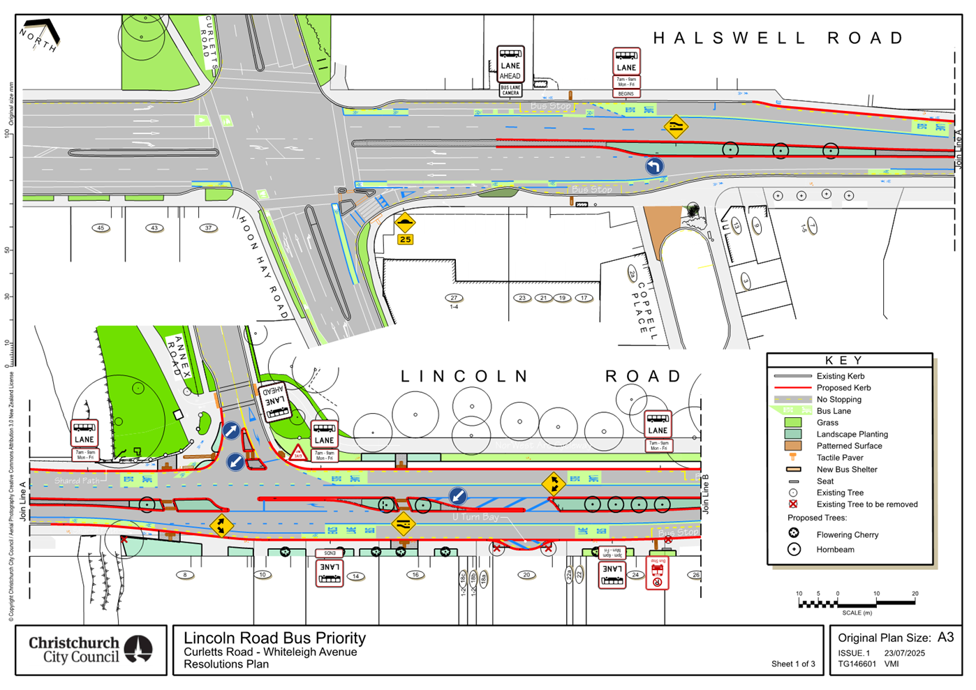
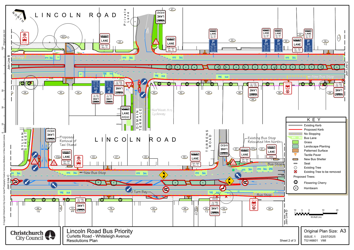
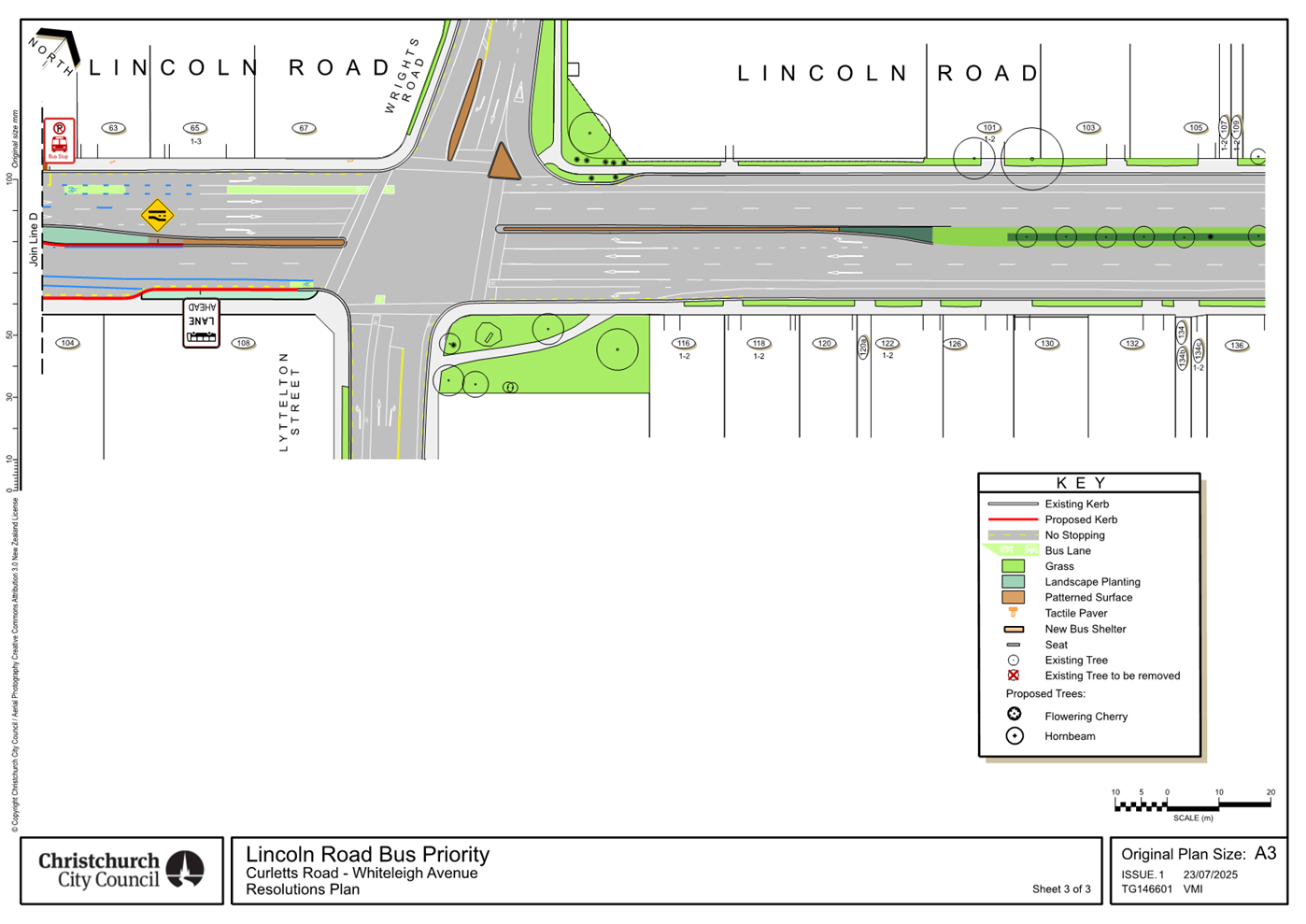
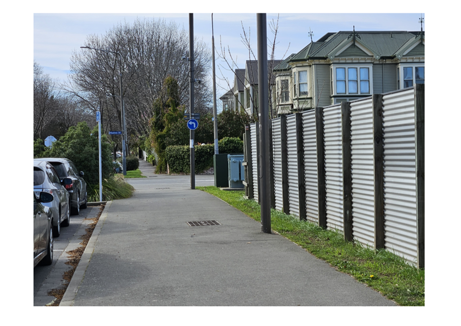
7. Lincoln Road Passenger Transport
Improvements Stage 2B, Curletts Road/Hoon Hay Road to Wrights Road/Lyttelton
Street.
|
|
Reference Te Tohutoro:
|
25/1263137
|
|
Responsible Officer(s) Te Pou Matua:
|
Katie
Smith, Transport Project Manager
Sharon O’Neil, Programme Manager Transport Capital Projects
|
|
Accountable ELT Member Pouwhakarae:
|
Brent
Smith, General Manager City Infrastructure
|
1. Purpose and Origin of the Report Te Pūtake Pūrongo
1.1 The
purpose of this report is to seek approval of the detailed traffic resolutions
for the Lincoln Road Passenger Transport Improvements (Annex Road to Wrights
Road/Lyttelton Street) Stage 2B project, seek approval to undertake further
investigations for the detailed design from Curletts Road/Hoon Hay Road to
Annex Road and approval of the recommended project budget allocations.
1.2 This
report has been written to meet two previous Council decisions:
1.2.1 Council
approved the Hearings Panel recommendations Minutes
of Council - Thursday, 7 July 2022, with a resolution that “the
detailed traffic resolutions required for the implementation of the project are
brought back to Council for approval at the end of the detailed design phase,
prior to the beginning of construction”
1.2.2 During
Annual Plan FY26, the Council resolved to bring forward Stage 2B to commence in
FY26.
1.3 Delegations
for approving this project lie with Council. The Lincoln Road Passenger
Transport project (Wrights to Curletts) was classified as a project of
Metropolitan Significance at the Council meeting of 13 August 2020.
2. Officer Recommendations Ngā
Tūtohu
That
the Council:
1. Receives the information in the Lincoln
Road Passenger Transport Improvements Stage 2B, Curletts Road/Hoon Hay Road to
Wrights Road/Lyttelton Street. Report.
2. Notes that the decision in this report is
assessed as medium significance based on the Christchurch City Council’s
Significance and Engagement Policy. The project has been deemed of Metropolitan
Significance.
3. Approves the reallocation of funds to #917
Lincoln Road (Curletts to Wrights) from the following projects:
a. $1.8 million: #66294 Public Transport CRAF - Bus Priority, Lincoln Road
(Whiteleigh Avenue to Wrights Road).
b. $1.5 million: #65814 Programme - Public Transport Network Improvements (CRAF).
c. $2.2 million: #73854 Programme – PT
Futures.
4. Approves that staff revisit the scheme design
for Lincoln Road Passenger Transport Improvements (Curletts Road/Hoon Hay Road
to Annex Road), to achieve peak time bus lanes in both directions and report
back to the Council with details of discussions with Mana Whenua, and for
approval of the detailed design, detailed traffic resolutions and budget
allocation.
5. Approves staff progress to construction the
section of the Lincoln Road Passenger Transport Improvements (Annex Road to
Wrights Road/Lyttelton Street).
6. Makes the following resolutions required for
the implementation of the project, including any kerb alignments, traffic
controls and/or parking/ stopping restrictions relying on its powers under the
Christchurch City Council Traffic and parking Bylaw 2017 and Section 334 of the
Local Government Act 1974, as detailed in plan TG146602, dated 21/8/2025 and
attached to this report as Attachment A.
7. Revokes any previous resolutions pertaining to
traffic controls, parking and stopping restrictions made pursuant to any Bylaw
to the extent that they are in conflict with the traffic controls, special
vehicle lanes, parking and stopping restrictions described in recommendations 8
- 47 below.
Detailed Traffic
Resolutions
8. Approves all kerb alignments, islands, paths,
road surface treatments, traffic controls, signage and road markings on Lincoln
Road, commencing at its intersection with Annex Road and extending in a
north-easterly direction until its intersection with Wrights Road/Lyttelton
Street as detailed in plan TG146602, dated 21/8/2025 and attached to this
report as Attachment A.
9. Approves all kerb alignments, islands, paths,
road surface treatments, traffic controls, signage and road markings on Annex
Road, commencing at its intersection with Halswell Road/Lincoln Road and
extending in a north-westerly direction for a distance of 16 metres as detailed
in plan TG146602, dated 21/8/2025 and attached to this report as Attachment
A.
10. Approves all kerb alignments, road surface
treatments, traffic controls, signage and road markings on the Private Lane
leading to Hillmorton Hospital, commencing at its intersection with Lincoln
Road and extending in a north-westerly direction for a distance of 15 metres as
detailed in plan TG146602, dated 21/8/2025 and attached to this report as Attachment
A.
11. Approves all kerb alignments, islands, paths,
road surface treatments, traffic controls, signage and road markings on Sylvan
Street commencing at its intersection with Lincoln Road and extending in a
north-westerly direction for a distance of 41 metres as detailed in plan
TG146602, dated 21/8/2025 and attached to this report as Attachment A.
12. Approves all kerb alignments, paths, road
surface treatments, traffic controls, signage and road markings on Torrens Road
commencing at its intersection with Lincoln Road and extending in a
north-westerly direction for a distance of 25 metres as detailed in plan
TG146602, dated 21/8/2025 and attached to this report as Attachment A.
13. Approves all kerb alignments, islands, paths,
road surface treatments, traffic controls, signage and road markings on Domain
Terrace commencing at its intersection with Lincoln Road and extending in a
south-easterly direction for a distance of 28 metres as detailed in plan
TG146602, dated 21/8/2025 and attached to this report as Attachment A.
Lincoln Road
– Annex Road to Wrights Road and Lyttelton Street - Special Vehicle Lanes
14. Approves that in accordance with Clause 21 of
the Christchurch City Council Traffic and Parking Bylaw 2017,that the path on
the southeastern side of Lincoln Road, commencing at its intersection with
Domain Terrace, and extending in a south westerly direction for a distance of
50 metres be resolved as a bi-directional Shared Path and in accordance
with section 11.4 of the Land Transport Act - Traffic Control Devices Rules:
2004. This Shared Path is for the use by the classes of road user only as defined
in Section 11.1A of the Land Transport (Road User) Rule: 2004, and as detailed
in plan TG146602, dated 21/8/2025 and attached to this report as Attachment
A.
15. Approves that a special vehicle lane in
accordance with Clause 18 of the Christchurch City Council Traffic and Parking
Bylaw 2017, for the use of north east bound road users as defined in Section
1.6 (definition of Bus lane) of the Land Transport ( Road User) Rule 2004 and
also as defined in Section 11.1A of the Land Transport (Road User) Rule: 2004,
excepting pedestrians and riders of mobility devices, be installed on the north
west side of Lincoln Road, commencing at its intersection with Annex Road/Halswell
Road and extending in a north easterly direction to a point 43 metres north
east of its intersection with Torrens Road, as detailed in plan TG146602, dated
21/8/2025 and attached to this report as Attachment A. This special
vehicle lane is to apply Monday to Friday, 7:00am to 9:00am.
16. Approves that a special vehicle lane in
accordance with Clause 18 of the Christchurch City Council Traffic and Parking
Bylaw 2017, for the use of north east bound road users as defined in Section
11.1A of the Land Transport (Road User) Rule: 2004, excepting pedestrians and
riders of mobility devices, be installed on the north west side of Lincoln
Road, commencing at a point 43 metres north east of its intersection with
Torrens Road, and extending in a north-easterly direction up to its
intersection with Wrights Road, as detailed in plan TG146602, dated 21/8/2025
and attached to this report as Attachment A.
17. Approves that a special vehicle lane in
accordance with Clause 18 of the Christchurch City Council Traffic and Parking
Bylaw 2017, for the use of south-westbound road users as defined in Section
11.1A of the Land Transport (Road User) Rule: 2004, excepting pedestrians and
riders of mobility devices, be established on the southeast side of Lincoln
Road, commencing at intersection with Lyttleton Street and extending in a
south-westerly direction for a distance of 105 metres, as detailed in plan
TG146602, dated 21/8/2025 and attached to this report as Attachment A.
18. Approves that a special vehicle lane in
accordance with Clause 18 of the Christchurch City Council Traffic and Parking
Bylaw 2017, for the use of south westbound road users as defined in
Section 1.6 (definition of Bus lane) of the Land Transport ( Road User) Rule
2004 and also as defined in Section 11.1A of the Land Transport (Road User)
Rule: 2004, excepting pedestrians and riders of mobility devices, be
established on the southeast side of Lincoln Road, commencing at a point 105
metres southwest of its intersection with Lyttleton Street and extending in a
south-westerly direction until its intersection with Halswell Road/Annex Road,
as detailed in plan TG146602, dated 21/8/2025 and attached to this report as Attachment
A. This special vehicle lane is to apply Monday to Friday, 3:00pm to
6:00pm.
19. Approves that in accordance with Section
11.4(5) of the Land Transport Rule – Traffic Control Devices: 2004, that
a signalised crossing be installed on Lincoln Road, located approximately 43
metres southwest from its intersection with Domain Terrace, as detailed in plan
TG146602, dated 21/8/2025 and attached to this report as Attachment A.
This signalised crossing is for the use by the classes of road user as defined
in Section 11.1A of the Land Transport (Road User) Rule: 2004.
Lincoln
Road – Traffic controls –No U Turns
20. Approves that in accordance with Clause 17(1)
(b) of the Christchurch City Council Traffic and Parking Bylaw 2017 that any
vehicle be prohibited from facing or travelling in a north-easterly direction
to facing or travelling in the opposite direction (performing a U-turn) on
Lincoln Road, at its intersection with Sylvan Street as detailed in plan
TG146602, dated 21/8/2025 and attached to this report as Attachment A.
21. Approves that in accordance with Clause 17(1)
(b) of the Christchurch City Council Traffic and Parking Bylaw 2017 that any
vehicle be prohibited from facing or travelling in a south-westerly direction
to facing or travelling in the opposite direction (performing a U-turn) on
Lincoln Road, at its intersection with Torrens Road as detailed in plan
TG146602, dated 21/8/2025 and attached to this report as Attachment A.
22. Approves that in accordance with Clause 17(1)
(b) of the Christchurch City Council Traffic and Parking Bylaw 2017 that any
vehicle facing or travelling in a south-westerly direction on Lincoln Road, be
prohibited from facing or travelling in the opposite direction (performing a
U-turn), from a point approximately 140 metres southwest of its intersection
with Lyttelton Street to a point 156 metres southwest of its intersection with
Lyttelton Street as detailed in plan TG146602, dated 21/8/2025 and attached to
this report as Attachment A.
23. Approves that in accordance with Clause 17(1)
(b) of the Christchurch City Council Traffic and Parking Bylaw 2017 that any
vehicle facing or travelling in a south-westerly direction on Lincoln Road, be
prohibited from facing or travelling in the opposite direction (performing a
U-turn), from a point approximately 122 metres southwest of its intersection
with Domain Terrace to a point 141 metres southwest of its intersection with
Lyttelton Street as detailed in plan TG146602, dated 21/8/2025 and attached to this
report as Attachment A.
24. Approves that in accordance with Clause 17(1)
(b) of the Christchurch City Council Traffic and Parking Bylaw 2017 that any
vehicle facing or travelling in a south-westerly direction on Lincoln Road, be
prohibited from facing or travelling in the opposite direction (performing a
U-turn), from a point approximately 42 metres southwest of its
intersection with Domain Terrace as detailed in plan TG146602, dated 21/8/2025
and attached to this report as Attachment A.
25. Approves that in accordance with Clause 17(1)
(b) of the Christchurch City Council Traffic and Parking Bylaw 2017 that any
vehicle facing or travelling in a north-easterly direction on Lincoln Road, be
prohibited from facing or travelling in the opposite direction (performing a
U-turn), from a point approximately 147 metres northeast of its intersection
with Annex Road as detailed in plan TG146602, dated 21/8/2025 and attached to
this report as Attachment A.
Lincoln Road – Annex Road to Wrights Road / Lyttelton
Street - Stopping Restrictions.
26. Approves, pursuant to Clause 7 of the
Christchurch City Council Traffic and Parking Bylaw 2017, that the stopping of
vehicles be prohibited at all times as detailed in plan TG146602, dated
21/8/2025 and attached to this report as Attachment A.
a) On
the northwest side of Lincoln Road commencing at its intersection with Halswell
Road/Annex Road and extending in a north-easterly direction for a distance of
41 metres.
b) On
the northwest side of Lincoln Road commencing at a point 94 metres northeast of
its intersection with Halswell Road/Annex Road and extending in a
north-easterly direction for a distance of 11 metres.
c) On
the northwest side of Lincoln Road commencing at a point approximately 119
metres northeast of its intersection with Halswell Road/Annex Road and
extending in a north-easterly direction for a distance of 81 metres.
d) On
the northwest side of Lincoln Road commencing at its intersection with the
Private Lane (Hillmorton Hospital entrance) and extending in a north-easterly
direction for a distance of 44 metres.
e) On
the northwest side of Lincoln Road commencing at a point 111.5 metres northeast
of its intersection with the Private Lane (Hillmorton Hospital entrance) and
extending in a north-easterly direction until its intersection with Sylvan
Street.
f) On
the northwest side of Lincoln Road commencing at its intersection with Sylvan
Street and extending in a north-easterly direction for a distance of eight
metres.
g) On
the northwest side of Lincoln Road commencing at a point 22 metres northeast of
its intersection with Sylvan Street and extending in a north-easterly direction
for a distance of 35 metres.
h) On
the northwest side of Lincoln Road commencing at a point 95 metres northeast of
its intersection with Sylvan Street and extending in a north-easterly direction
up to its intersection with Torrens Road.
i) On
the northwest side of Lincoln Road commencing at its intersection with Torrens
Road and extending in a north-easterly direction for a distance of 29 metres.
j) On
the northwest side of Lincoln Road commencing at a point 43 metres northeast of
its intersection with Torrens Road and extending in a north-easterly direction
up to its intersection with Wrights Road.
k) On
the southeast side of Lincoln Road commencing at its intersection with
Lyttelton Street and extending in a south-westerly direction for a distance of
67 metres.
l) On
the southeast side of Lincoln Road commencing at a point 81 metres southwest of
its intersection with Lyttelton Street and extending in a south-westerly
direction for a distance of 112 metres.
m) On
the southeast side of Lincoln Road commencing at a point 213.5 metres southwest
of its intersection with Lyttelton Street and extending in a south-westerly
direction for a distance of 67.5 metres
n) On
the southeast side of Lincoln Road commencing at a point 295 meters southwest
of its intersection with Lyttelton Street and extending in a south-westerly
direction for a distance of 21 metres.
o) On
the southeast side of Lincoln Road commencing at a point 330 metres southwest
of its intersection with Lyttelton Street and extending in a south-westerly
direction for a distance of 25 metres.
p) On
the southeast side of Lincoln Road commencing at a point 369 metres southwest
of its intersection with Lyttelton Street and extending in a south-westerly
direction up to its intersection with Domain Terrace.
q) On
the southeast side of Lincoln Road commencing at its intersection with Domain
Terrace and extending in a south-westerly direction for a distance of 14
metres.
r) On
the southeast side of Lincoln Road commencing at a point 26 metres southwest of
its intersection with Domain Terrace and extending in a south-westerly
direction for a distance of 59 metres.
s) On
the southeast side of Lincoln Road commencing at a point 99 metres southwest of
its intersection with Domain Terrace and extending in a south-westerly
direction for a distance of 125 metres.
Lincoln
Road – Annex Road to Wrights
Road and Lyttelton Street
– Bus stops
27. Approves, pursuant to Clause 7 of the
Christchurch City Council Traffic and Parking Bylaw 2017 that a bus stop be
installed, on the north west side of Lincoln Road commencing at a point 105
metres north east of its intersection with Halswell Road/Annex Road and
extending in a north-easterly direction for 14 metres as detailed in plan
TG146602, dated 21/8/2025 and attached to this report as Attachment A.
28. Approves, pursuant to Clause 7 of the
Christchurch City Council Traffic and Parking Bylaw 2017 that a bus stop be
installed, on the north west side of Lincoln Road commencing at a point 8
metres north east of its intersection with Sylvan Street and extending in a
north-easterly direction for 14 metres as detailed in plan TG146602, dated
21/8/2025 and attached to this report as Attachment A.
29. Approves, pursuant to Clause 7 of the
Christchurch City Council Traffic and Parking Bylaw 2017 that a bus stop be
installed, on the north west side of Lincoln Road commencing at a point
29 metres north east of its intersection with Torrens Road and extending in a
north-easterly direction for 14 metres as detailed in plan TG146602, dated
21/8/2025 and attached to this report as Attachment A.
30. Approves, pursuant to Clause 7 of the
Christchurch City Council Traffic and Parking Bylaw 2017 that a bus stop be
installed, on the south east side of Lincoln Road commencing at a point 67
metres south west of its intersection with Lyttelton Street and extending in a
south westerly direction for 14 metres as detailed in plan TG146602, dated
21/8/2025 and attached to this report as Attachment A.
31. Approves, pursuant to Clause 7 of the
Christchurch City Council Traffic and Parking Bylaw 2017 that a bus stop be
installed, on the south east side of Lincoln Road commencing at a point 281
metres south west of its intersection with Lyttelton Street and extending in a
south westerly direction for 14 metres as detailed in plan TG146602, dated
21/8/2025 and attached to this report as Attachment A.
32. Approves, pursuant to Clause 7 of the
Christchurch City Council Traffic and Parking Bylaw 2017, that a Bus Stop be
installed on the southeast side of Lincoln Road commencing at a point
approximately 85 metres southwest of its intersection with Domain Terrace and
extending in a south-westerly direction for a distance of 14 metres as detailed
in plan TG146602, dated 21/8/2025 and attached to this report as Attachment
A.
Lincoln Road
– Annex Road to Wrights Road and Lyttelton Street – Parking
restrictions – P120
33. Approves that the parking of vehicles be
restricted to a maximum period of 120 minutes on the northwest side of Lincoln
Road, commencing at point 253 metres northeast of its intersection with Annex
Road, and extending in a north-easterly direction for a distance of 38
metres. This restriction is to apply Monday to Friday, 9:00am to 6:00pm
and to apply Saturday to Sunday, 8:00am to 6:00pm.
34. Approves that the parking of vehicles be
restricted to a maximum period of 120 minutes on the southeast side of Lincoln
Road, commencing at point 14 metres southwest of its intersection with Domain
Terrace, and extending in a south-westerly direction for a distance of 12
metres. This restriction is to apply Monday to Friday, 8:00am to 3:00pm
and to apply Saturday to Sunday, 8:00am to 6:00pm.
Lincoln Road
– Annex Road to Wrights Road and Lyttelton Street – Parking
restrictions – P60
35. Approves that the parking of vehicles be
restricted to a maximum period of 60 minutes on the northwest side of Lincoln
Road, commencing at point 299 metres northeast of its intersection with Annex
Road, and extending in a north-easterly direction for a distance of 21
metres. This restriction is to apply Monday to Friday, 9:00am to 6:00pm
and to apply Saturday to Sunday, 8:00am to 6:00pm.
Annex Road
– Road layout, Parking and Stopping Restrictions
36. Approves that, in accordance with Section 4 of
the Land Transport Rule: Traffic Control Devices 2004, the south-eastern
approach of Annex Road at its intersection with Lincoln Road / Halswell Road be
controlled by a Give Way control as detailed in plan TG146602, dated 21/8/2025
and attached to this report as Attachment A.
37. Approves that in accordance with Clause 17(1)
(a) of the Christchurch City Council Traffic and Parking Bylaw 2017 that, the
Annex Road south eastern approach, right turn into Halswell Road, be prohibited
as detailed in plan TG146602, dated 21/8/2025 and attached to this report as Attachment
A.
38. Approves, pursuant to Clause 7 of the
Christchurch City Council Traffic and Parking Bylaw 2017, that the stopping of
vehicles be prohibited at all times as detailed in plan TG146602, dated
21/8/2025 and attached to this report as Attachment A.
a) On
the southwest side of Annex Road commencing at its intersection with Lincoln
Road and extending in a north-westerly direction for a distance of 38 metres.
b) On
the northeast side of Annex Road commencing at a point 27 metres northwest of
its intersection with Lincoln Road and extending in a south-easterly direction
until its intersection with Lincoln Road.
Hillmorton
Hospital Private Lane
39. Approves that, in accordance with Section 4 of
the Land Transport Rule: Traffic Control Devices 2004, the south-eastern
approach of the Hillmorton Hospital Private Lane at its intersection with
Lincoln Road be controlled by a Give Way control as detailed in plan TG146602,
dated 21/8/2025 and attached to this report as Attachment A.
40. Approves, pursuant to Clause 7 of the
Christchurch City Council Traffic and Parking Bylaw 2017, that the stopping of
vehicles be prohibited at all times as detailed in plan TG146602, dated
21/8/2025 and attached to this report as Attachment A.
a) On
the southwest side of the Hillmorton Hospital Private Lane, commencing at its
intersection with Lincoln Road and extending in a north-westerly direction for
a distance of 10 metres.
b) On
the northeast side of the Hillmorton Hospital Private Lane, commencing at a
point 15 metres northwest of its intersection with Lincoln Road and extending
in a south-easterly direction until its intersection with Lincoln Road.
Sylvan
Street – Traffic Control and Parking and Stopping Restrictions
41. Approves that, in accordance with Section 4 of
the Land Transport Rule: Traffic Control Devices 2004, the south-eastern
approach of Sylvan Street at its intersection with Lincoln Road be controlled
by a Give Way control as detailed in plan TG146602, dated 21/8/2025 and
attached to this report as Attachment A.
42. Approves, pursuant to Clause 7 of the
Christchurch City Council Traffic and Parking Bylaw 2017, that the stopping of
vehicles be prohibited at all times as detailed in plan TG146602, dated
21/8/2025 and attached to this report as Attachment A.
a) On
the southwest side of Sylvan Street, commencing at its intersection with
Lincoln Road and extending in a north-westerly direction for a distance of 36
metres.
b) On
the northeast side of Sylvan Street, commencing at a point approximately 41
metres northwest of its intersection with Lincoln Road and extending in a
south-easterly direction until its intersection with Lincoln Road.
Torrens Road
– Traffic Controls and Parking and Stopping Restrictions
43. Approves that, in accordance with Section 4 of
the Land Transport Rule: Traffic Control Devices 2004, the south-eastern
approach of Torrens Road at its intersection with Lincoln Road be controlled by
a Give Way control as detailed in plan TG146602, dated 21/8/2025 and attached
to this report as Attachment A.
44. Approves that in accordance with Clause 17(1)
(a) of the Christchurch City Council Traffic and Parking Bylaw 2017 that the
Torrens Road south eastern approach, right turn into Lincoln Road, be
prohibited as detailed in plan TG146602, dated 21/8/2025 and attached to this
report as Attachment A.
45. Approves, pursuant to Clause 7 of the
Christchurch City Council Traffic and Parking Bylaw 2017, that the stopping of
vehicles be prohibited at all times as detailed in plan TG146602, dated
21/8/2025 and attached to this report as Attachment A.
a) On
the southwest side of Torrens Road commencing at its intersection with Lincoln
Road and extending in north-westerly direction for a distance of 24 metres.
b) On
the northeast side of Torrens Road commencing at its intersection with Lincoln
Road and extending in a north-westerly direction for a distance of 11 metres.
Domain Terrace
– Road layout, Traffic Controls, Parking and Stopping Restrictions
46. Approves that, in accordance with Section 4 of
the Land Transport Rule: Traffic Control Devices 2004, the northwestern
approach of Domain Terrace at its intersection with Lincoln Road be controlled
by a Give Way control as detailed in plan TG146602, dated 21/8/2025 and
attached to this report as Attachment A.
47. Approves, pursuant to Clause 7 of the
Christchurch City Council Traffic and Parking Bylaw 2017, that the stopping of
vehicles be prohibited at all times as detailed in plan TG146602, dated
21/8/2025 and attached to this report as Attachment A.
a) On
the northeast side of Domain Terrace commencing at its intersection with
Lincoln Road and extending in south-easterly direction for a distance of 26
metres.
b) On
the southwest side of Domain Terrace commencing at a point approximately 26
metres south east of its intersection with Lincoln Road and extending in north
westerly direction until its intersection with Lincoln Road.
General approval
48. Approves that these resolutions 8 - 47 take
effect when parking signage and/or road marking that evidence the restrictions
described in the staff report are in place (or removed in the case of
revocations).
3. Executive Summary Te Whakarāpopoto Matua
3.1 The
Lincoln Road bus priority project scheme design was approved by the Council on
7 July 2022 following a hearings panel process. This included both:
· Stage 2A
from Whiteleigh Avenue/Barrington Street to Wrights Road/Lyttelton Street, and;
· Stage 2B
from Wrights Road/Lyttelton Street to Curletts Road/Hoon Hay Road.
3.1.2 The
Council resolved that the detailed traffic resolutions required for the
implementation of the project are brought back to Council for approval at the
end of the detailed design phase, prior to the commencement of construction.
3.2 The
Council, during its Annual Plan deliberations in June 2025, directed staff to
progress the construction of Stage 2B starting in financial year 2025/26, and
to defer the construction of Stage 2A.
3.3 Due
to difficulties purchasing all the necessary properties on the south side of
Halswell Road, plus cost pressures associated with widening the culvert and
relocating the substation in this location, the original approved scheme plans
were amended so the outbound bus lane terminated short of Curletts Road
(roughly opposite Annex Road). This would have created a pinch point where
buses would need to merge back into the single traffic lane.
3.3.1 However,
recent discussions with the Ministry of Education have indicated that they
would be willing to enter into negotiations with Christchurch City Council to
acquire land on the northern side, potentially creating space to provide peak
time bus lanes in both directions for the full extent.
3.3.2 This
will require a redesign of the section from Curletts Road/Hoon Hay Road to
Annex Road.
3.4 Therefore,
this report offers three options:
3.4.1 Option
1: Approval of:
· Detailed
traffic resolutions for Lincoln Road from Annex Road to Wrights Road/Lyttelton
Street as shown on Attachment A, allowing this section to progress to
construction.
· Approve
a redesign of the section from Curletts Road/Hoon Hay Road to Annex Road,
including negotiation with the Ministry of Education to attain land, to achieve
peak time bus lanes in both directions as shown on Attachment B. Staff
will aim to report back in early 2026, with a view to carrying out construction
in a single pass.
3.4.2 Option
2: Approval of:
· Detailed
traffic resolutions for Lincoln Road from Curletts Road/Hoon Hay Road to
Wrights Road/Lyttelton Street as shown in Attachment C, allowing this to
progress to construction.
· Noting
that this would not achieve peak time bus lanes in both directions for the full
extent.
3.4.3 Option
3: Approval for staff to revisit the entire project design with a view to
reduce project costs.
· Examples
of areas that could be investigated include narrowing and/or removal of the
central median.
· Noting
that construction of the Transport works would not start on FY26, and therefore
could not be aligned with planned 3 waters works.
3.5 Staff
recommend Option 1 for the following reasons:
· This
allows construction to start in FY26 in line with the Council decision during
Annual Plan FY26
· Allows
for efficiencies of scale through delivery of the project alongside planned
Three Waters renewal works for the replacement of all waste water assets from
Annex Road to Wrights Road/Lyttelton Street. In the Curletts Road/Hoon Hay Road
to Annex Road section Three Waters will redirect wastewater flows to the
existing sewer on Coppell Place thereby abandoning existing wastewater assets
across the Heathcote River.
· The
project would be consistent with the NZTA’s project on Halswell Road, and
Council’s Stage 1 between Moorhouse Ave and Whiteleigh Avenue/Barrington
Street.
· Future-proofs
improved journey times and reliability on a well-used part of the PT network,
and supports Environment Canterbury’s frequency uplift on Route 7.
· As
additional budget is drawn from the CRAF PT budget, this will have a limited
impact on rates.
· It is
considered unlikely that the cost could be reduced by redesigning the whole of
Stage 2B from Curletts Road/Hoon Hay Road to Wrights Road/Lyttelton Street to
within the original budget without impacting on the project outcomes.
4. Background/Context Te Horopaki
Decision timeline
4.1 The Council approved the
project to be declared Metropolitan Significance on 13 August 2020, item 22. https://christchurch.infocouncil.biz/Open/2020/08/CNCL_20200813_MIN_4048_AT_WEB.htm
4.2 The Council requested the
scheme design be revisited in August 2020. This was to consider
rationalising potential property purchases and to consider design changes,
particularly in relation to pedestrian connectivity.
4.3 Waihoro-Spreydon-Cashmere
Community Board were updated on the scheme design progress in July 2021 and briefed on the scheme design for
consultation in November 2021.
4.4 Stakeholder
engagement and public consultation took place between October and December
2021. Details of the engagement response and submissions received is set out in
the Hearings Panel report. Agenda
of Hearings Panel - Monday, 28 February 2022
4.5 The Hearings Panel report to the Council in July 2022 made a number
of recommendations. These have, where possible, been incorporated into
the final plans and detailed resolutions for approval. Agenda
of Council - Thursday, 7 July 2022
Background
4.6 Stage 2B Lincoln Road (Whiteleigh Avenue/ Barrington Street to
Curletts Road/Hoon Hay Road) provides one section of the key bus priority route
between the approved Lincoln Road Stage 1 (Whiteleigh Avenue to Moorhouse
Avenue); and the NZ Transport Agency Waka Kotahi section along Halswell Road
(Dunbars Road to Curletts Road) which is currently under construction. These
projects provide improved public transport services linking southwest
Christchurch with the Central City.
4.7 The
section between Curletts Road/Hoon Hay Road to Wrights Road/Lyttelton Street is currently a single lane
in either direction.
4.7.1 As
part of this public transport priority project, it is proposed to be upgraded
to a multilane arterial with peak hour bus lanes; access management will be
implemented to improve the traffic safety and efficiency. The design includes a
central raised median which will remove right turn movements into and out of
all the existing private and commercial driveways and restrict movements into
and out of side roads.
Project Objectives
4.8 The primary objectives for the project have been identified as
follows:
4.8.1 Improved journey time reliability for public transport services in
relation to private vehicles.
4.8.2 Improved connectivity, convenience and safety for all active travel
modes. This incorporates cyclists, pedestrians, public transport users and
micro-mobility users (scooters, electric longboards, etc.) and includes access
to improved public transport infrastructure.
4.8.3 Improved amenity consistent with the One Network Framework (ONF),
movement and place function.
4.8.4 A central median providing safety for all users. It improves safety
and efficiency on Lincoln Road by reducing right turning movements and creates
amenity space.
4.9 Peak
hour bus lanes have been installed in Addington (Whiteleigh Avenue to Moorhouse
Avenue) as part of stage one of this project. These are planned to connect with
stage two of the project to install peak hour bus lanes between Whiteleigh
Avenue and Curletts Road, on:
4.9.1 Weekdays
– 7am to 9am towards the city.
4.9.2 Weekdays
– 3pm to 6pm towards Halswell.
4.9.3 Saturdays
– The consultation proposed 10am to 2pm on both sides of the road.
However, based on submissions the Officer recommendation was to not implement
Saturday peak hour bus lanes.
4.10 Peak
hour bus lanes are being installed on SH75 by NZTA:
4.10.1 Weekdays –
between Augustine Drive and Curletts Road north side, 7am to 9am towards the
city.
4.10.2 Saturdays -
between Augustine Drive and Curletts Road north side, 10am to 2pm
4.10.3 Weekdays –
between Curletts Road and Monsaraz Bouleard south side, 3pm to 6pm towards
Halswell.
4.10.4 Saturdays –
between Curletts Road and Monsaraz Bouleard south side, 10am to 2 pm
4.10.5 Between
Augustine Drive/Monsaraz Boulevard and Dunbars Road - full time (24/7) in both
directions.
Design Changes
4.11 The Council
approved the scheme design in 2022, since then changes have been required to
the detailed design:
· The proposed
pedestrian island at the entrance to the Hillmorton Hospital private lane was
removed due to visibility issues for pedestrians waiting to cross from the
southwest, this was identified as part of a design review in June 2023. A new
kerb buildout on the southwestern side of the private lane has been included in
the design to reduce the crossing distance. This amendment was assessed as part
of the Detailed Design Road Safety Audit.
· The proposed raised
safety platform (RSP) at the intersection of Sylvan Street and Lincoln Road was
removed following the design review in 2023 as its position required vehicles
turning left from Lincoln Road to turn at an angle across the RSP ramp which
could result in loss of control type crashes.
4.12 The Detailed Design Safety Audit required minor amendments; where
appropriate additional further targeted consultation has taken place with
affected parties.
South-West Bound: Annex Road to Hoon
Hay Road
4.13 The
property purchase for the frontage of 5/7 Halswell Road required to accommodate
the bus lane on the approach to the Curletts Road intersection has proved
difficult.
4.13.1 Adjacent to this
location it was also required to widen the bridge over the existing Heathcote
River culvert, and to relocate the existing Orion substation. These added
significant cost to the overall project.
4.13.2 Therefore staff
were proposing to end the bus lane at #14 Lincoln Road, and keep the road
single lane heading south-west from #10 Lincoln Road to just after Coppell
Place, as shown in Attachment C.
4.14 However, staff have held recent discussions with the Ministry of
Education around purchasing a small portion of land at 2 Halswell Road. While
discussions are only at an early stage, they appear open to the idea.
4.14.1 This opens up options to achieve a design more reflective of the
original intent to provide peak time bus lanes in both directions for the full
extent.
4.14.2 A concept design has been developed as shown in Attachment B.
These options will require further investigation, detailed design, cost
estimates, budget allocation and the Council’s approval.
Delivery Timeframes
4.15 At
the Annual Plan meeting on the 26 June 2025 the Council agreed to proceed with
Lincoln Road Curletts/Hoon Hay to Wrights Road/Lyttelton Street Stage 2B with
Wrights Road/Lyttelton Street to Whiteleigh Avenue/Barrington Stage 2A being
deferred 2029/30.
4.16 Council’s
Three Waters team have an urgent Wastewater Renewal in this location which
needs to progress. A decision to proceed is likely to allow these projects to
be carried out in parallel, likely under a single contract, reducing disruption
to residents and road users and providing opportunities for economies of scale.
Financials
Estimates
4.17 The
Hearings Panel report to the Council in 2022 estimated the total project costs
to be approximately $12 million. Updated high-level cost estimates were
completed for the proposed scheme plan and included in the 2021-2031 Long Term
Plan.
4.18 There
has been an increase in costs for the original approved scheme for a number of
factors, including:
· Increased
construction contingency following ground investigations highlighting the need
to remove and dispose of coal tar, concrete and old tram lines.
· Increased
cost estimates from service providers associated with utility works.
· Project
overheads included in the cost estimates.
· Inflation
in the three years since the original cost estimates.
4.19 The
estimates for both Options 1 and 2 have increased beyond the project budget
available:
4.19.1 The estimate for
Option 1 is $15.4 Million
· There is
a high level of confidence in the Annex to Wrights section, as the design and
investigations are well progressed.
· This
also includes a high-level estimate for the land purchase, redesign and bridge
construction in the Curletts to Annex section. While there have been
investigations of the existing road in this location, the footpath design is at
an early stage so risks remain.
· These
costs will be refined before bringing back the detailed resolutions for the
Curletts Road/Hoon Hay Road to Annex Road section back to Council for approval.
4.19.2 The current
estimate for Option 2 Lincoln Road Curletts Road/Hoon Hay to Wrights
Road/Lyttelton Street Stage 2B transport project is $13.3 million.
· Due to
the design and investigations for this section, there is a high level of
confidence in the estimate.
4.19.3 Option 3 is for
staff to investigate redesigns with a view to reducing the overall project
cost, and report back to Council.
· Potential
options for reducing the cost of the project have been considered and are
covered in Section 4.31 of this report. This is likely to include investigating
narrowing or removing the central median
· Any
cost savings are subject to engineering design and road constraints, therefore
it is difficult to put a value on how big this could be. However, staff believe
that the savings will be 5-10% at most, and potentially less due to the costs
of re-design and potentially re-consultation, and loss of benefits associated
with combining with other projects.
Budget and Impact on
Rates
4.20 The
current remaining transport budget within #917 Lincoln Road Passenger
Transport Improvements (Curletts to Wrights) is $10.0 million, with
construction funding in financial years 2027 - 2030.
4.21 There
is sufficient budget in the overall CRAF Public Transport Programme and the PT
Futures Progamme that could be utilised to enable completion of these works.
The funding currently sits in the following projects:
· #66294
Public Transport CRAF - Bus Priority, Lincoln Road (Whiteleigh Avenue to
Wrights Road) - $1.8 million (FY26-28)
· #65814
Programme - Public Transport Network Improvements Programme (CRAF) - $1.5 million (FY26)
· #73854
Programme - PT Futures - $75 million (FY28-34)
4.22 It
is proposed to use Public Transport CRAF budget first.
4.22.1 Lincoln Road
(Whiteleigh to Wrights) has less immediate benefit than the Wrights to Curletts
section, as this section is already 4 lanes. Therefore, it is proposed that the
scope is transferred to the PT Futures Programme where there is funding
available in the later years of the LTP should the Council wish to continue
with the project at that time.
4.22.2 The budget in the
Public Transport Network Improvements Programme CRAF is currently not scoped.
The works proposed fits the criteria for funding under CRAF, so the budget can
be utilised to fund this shortfall.
4.22.3 A portion (about
$2m) of the budget in the PT Futures Programme could be utilised to complete
recommended Option 1.
4.23 CRAF
is proposed to be utilised first, as this funding source comes directly from
central government, so does not impact on rates.
4.24 In
the Annual Plan deliberations, the Council acknowledged that it is unlikely
that Waka Kotahi subsidy of 51% on the approved scheme for Stage 2B will be
provided. Ongoing discussions with NZTA have confirmed this: there are higher
priority projects already being considered for funding in this NLTP 2024-2027.
4.25 The following related memos/information were circulated to the
meeting members:
|
Date
|
Subject
|
|
13
August 2020
|
Lincoln Road Passenger Transport
Improvements Stage 2B, Curletts Road/Hoon Hay Road to Wrights Road/Lyttelton
Street.
|
|
28
February 2022
|
Lincoln Road Passenger Transport
Improvements Stage 2B, Curletts Road/Hoon Hay Road to Wrights Road/Lyttelton
Street.
|
|
7
July 2022
|
Hearings Panel Report on Lincoln Road
Peak Hour Bus Lane Proposal
|
4.26 The following related information session/workshops have taken place
for the members of the meeting:
|
Date
|
Subject
|
|
July
2021
|
Spreydon-Cashmere Community Board were briefed on the scheme design progress.
|
|
November
2021
|
Spreydon-Cashmere Community Board were briefed on the scheme design for consultation in November 2021
|
Options Considered Ngā Kōwhiringa Whaiwhakaaro
4.27 The
following reasonably practicable options were considered and are assessed in
this report:
4.27.1 Option 1 -
Proceed with Lincoln Road Passenger Transport Improvements Stage 2B, Annex Road
to Wrights Road/Lyttelton Street as shown in Attachment A and continue
further investigations and redesign of the section from Curletts Road/Hoon Hay
Road to Annex Road indicative scheme design as shown in Attachment B.
4.27.2 Option 2 - Proceed with Lincoln Road Passenger Transport Improvements Stage
2B, Curletts Road/Hoon Hay Road to Wrights Road/Lyttelton Street as shown in Attachment
C.
4.27.3 Option 3 -
Review the design of Stage 2B of the project Curletts Road/Hoon Hay Road to
Wrights Road/Lyttelton Street to seek cost reductions.
4.28 The
following options were considered but ruled out:
4.28.1 Do nothing
- the Council has through the Annual Plan Process for FY26 made a clear
direction that this project should proceed.
4.28.2 Amend the
detailed design to remove the trees and landscaping from the central median
– This was thought to be a simple way to remove costs due to the
requirement to break out the redundant tram slab under the surface, however,
further investigation has demonstrated that the costs of alternative materials
such as pressed concrete would not result in cost savings.
4.28.3 Complete
design as per previous Council decision – Property purchase on
southern side of Lincoln Road may not be possible, or may require use of the
Public Works Act to complete, leading to significant further delays.
Furthermore, extension of the culvert and relocation of the substation will require
significant additional budget.
Options Descriptions Ngā Kōwhiringa
4.29 Preferred Option: Option 1 Proceed
with Lincoln Road Passenger Transport Improvements Stage 2B, Annex Road to
Wrights Road/Lyttelton Street and continue further investigations and redesign
the section from Curletts Road/Hoon Hay Road to Annex Road to allow for peak
time bus lanes in both directions
4.29.1 Option
Description:
· Key
features and benefits of the scheme were set out in the original report to the
Hearings Panel
· Install
peak hour bus lanes between Annex Road and Wrights Road/Lyttelton Street, road
widening and street upgrade
· Continue further investigations into the land purchase of part of the
Ministry of Education site at 2 Halswell Road and redesign the section from
Curletts Road/Hoon Hay Road to Annex Road to allow for peak time bus lanes in
both directions
4.29.2 Option
Advantages
· As set
out in the Hearings Panel report however noting a recent change to Route 7
which is currently being trialled as a Turn Up and Go (TUAG) 10-minute
frequency.
· The
construction works can be undertaken in conjunction with the Three Waters sewer
main renewal from Annex Road to Wrights Road/Lyttelton Street, saving costs on
shared requirements such as Traffic Management and reducing disruption from
working on the road corridor for two separate projects.
· Fulfills
the recent Annual Plan resolution to commence the project in FY26.
4.29.3 Option
Disadvantages
· Construction
costs have escalated over recent years and site investigations have revealed
issues with the presence of coal tar, concrete and old tram lines in the sub
surface layers resulting in recent cost estimates indicating additional funding
is required to complete the project.
· Time and
budget required for further investigations into the land purchase of part of
the Ministry of Education site at 2 Halswell Road and redesign the section from
Curletts Road/Hoon Hay Road to Annex Road to allow for peak time bus lanes in
both directions.
· Risks
around the Curletts to Annex section mean there is a potential that the
Transport works will need to be completed in two phases
· Additional
budget, currently allocated to the Public Transport CRAF Bus Priority Lincoln
Road Stage 2A and Public Transport Network Improvements Programme (CRAF) will
be utilised, any additional budget requirements will be taken from the PT
Futures programme. This will result in other PT Futures projects not
being able to currently proceed.
4.30 Option
2 Proceed with Lincoln Road Passenger Transport
Improvements Stage 2B, Curletts Road/Hoon Hay Road to Wrights Road/Lyttelton
Street
4.30.1 Option Description:
· Key
features and benefits of the scheme were set out in the original report to the
Hearings Panel
· Install
peak hour bus lanes between Curletts Road/Hoon Hay Road Annex Road and Wrights
Road/Lyttelton Street, road widening and street upgrade.
· South-west
bound bus lane stops about 225m before the Curletts Road intersection (~150m
shorter than originally planned)
4.30.2 Option
Advantages
· As set
out in the Hearings Panel report however noting a recent change to Route 7
which is currently being trialled as a Turn Up and Go (TUAG) 10-minute
frequency.
· The
construction works will be undertaken in conjunction with the Three Waters
sewer main renewal from Curletts Road/Hoon Hay Road to Wrights Road/Lyttelton
Street, saving costs on shared requirements such as Traffic Management and
reducing disruption from working on the road corridor for two separate
projects.
· Fulfills
the recent Annual Plan resolution to commence the project in FY26.
· Lower
cost than Option 1, and more cost certainty due to the level of design and
investigation
4.30.3 Option
Disadvantages
· Construction
costs have escalated over recent years and site investigations have revealed
issues with the presence of coal tar, concrete and old tram lines in the sub
surface layers resulting in recent cost estimates indicating additional funding
is required to complete the project.
· Additional
budget, currently allocated to the Public Transport CRAF Bus Priority Lincoln
Road Stage 2A and Public Transport Network Improvements Programme (CRAF) will
be utilised, any additional budget requirements will be taken from the PT
Futures programme. This will result in other PT Futures projects not
being able to currently proceed.
4.31 Option
3 – Review the design of Lincoln Road
Passenger Transport Improvements Stage 2B of the project to seek cost
reductions
4.31.1 Option Description: Review the detailed
design to seek cost reductions by considering changes such as the removal of
the central median and overall width of the road, removal of the proposed
landscaping and therefore reducing ongoing maintenance costs.
4.31.2 Option
Advantages
· May reduce the
overall project budget nearer to the available budget.
4.31.3 Option
Disadvantages
· Review
of Stage 2B of the project may result in further escalation of construction
costs due to delay and additional costs associated with design, safety audit
and consultation costs.
· Review
would result in the Three Waters Sewer Renewal and Stage 2B Lincoln Road
Passenger Transport Improvements happening at separate times therefore any
shared cost benefits would be lost. Three Waters have confirmed the need to
proceed with the sewer renewal immediately.
· There
are risks associated with having two different contractors following on from
each other during the construction defects period.
· Changes
to the design may result in the need to go back out to consultation. Noted when
reviewing the summary of consultation responses in the Hearings Panel Report
some submitters were in support of turning restrictions at Domain Terrace and
Torrens Road, other submitters were concerned at the loss of the number of
trees. Options such as the removal of the central median will remove the right
turn restrictions and the opportunity to replace as many trees along this road
corridor.
· Will
require full redesign, safety audit, consultation and associated costs
Analysis Criteria Ngā Paearu Wetekina
4.32 The
recommended option has been selected for the following reasons:
· Allows work to
progress in timeframe demanded by the previous Council decision, and in line
with the planned sewer renewal works
· Provides the
best solution long term for improved journey time reliability for public
transport services
· Improved
safety for all road users
· Ensures assets
at or near end of life are renewed
· Improves
amenity of the street with addition of planted areas, street trees, and
improved footpaths
5. Financial Implications Ngā Hīraunga Rauemi
Capex/Opex Ngā Utu Whakahaere
|
|
Recommended Option
|
Option 2 proceed without redesign
|
Option 3 – Defer and redesign
|
|
Cost to Implement
|
$15.4 million
|
$ 13.3 million
|
TBC based on redesign outcome
|
|
Maintenance/Ongoing Costs
|
$12,000 per year
|
$11,500 per year
|
TBC based on redesign outcome
|
|
Funding Source
|
CPMS#917 Lincoln Road Passenger Transport
Improvements (Curletts to Wrights) Stage 2B
CPMS#66294 Public Transport CRAF - Bus
Priority, Lincoln Road (Whiteleigh Avenue to Wrights Road) Stage 2A
CPMS#65814 Programme - Public Transport
Network Improvements Programme (CRAF)
PT Futures Programme
|
CPMS#917 Lincoln Road Passenger Transport
Improvements (Curletts to Wrights) Stage 2B
CPMS#66294 Public Transport CRAF - Bus
Priority, Lincoln Road (Whiteleigh Avenue to Wrights Road) Stage 2A
CPMS#65814 Programme - Public Transport
Network Improvements Programme (CRAF)
|
CPMS#917 Lincoln Road Passenger Transport
Improvements (Curletts to Wrights) Stage 2B
|
|
Funding Availability
|
CPMS#917 Lincoln Road Passenger Transport
Improvements (Curletts to Wrights) Stage 2B -$10.0 million
CPMS#66294 Public Transport CRAF - Bus
Priority, Lincoln Road (Whiteleigh Avenue to Wrights Road) Stage 2A - $1.8
million.
CPMS#65814 Programme - Public Transport
Network Improvements Programme (CRAF) - $1.5 million.
PT futures Programme -$2.1 million
Total $15.4million
|
CPMS#917 Lincoln Road Passenger Transport
Improvements (Curletts to Wrights) Stage 2B -$10.0 million
CPMS#66294 Public Transport CRAF - Bus
Priority, Lincoln Road (Whiteleigh Avenue to Wrights Road) Stage 2A - $1.8
million.
CPMS#65814 Programme - Public Transport
Network Improvements Programme (CRAF) - $1.5 million.
Total $13.3 million
|
$10 Million in Stage 2B Lincoln Road
budget.
|
|
Impact on Rates
|
Budget change $2.1m future year to FY27
FY27 0.005%
FY28 0.009%
FY29 -0.014%
|
Nil as budget is available in the project
budget and CRAF Public Transport budgets.
|
Nil as budget is available in the project
budget and CRAF Public Transport budgets.
|
6. Considerations Ngā Whai Whakaaro
Risks and Mitigations Ngā Mōrearea me
ngā Whakamātautau
6.1 Coal
tar, contamination, concrete and old tram lines; Investigations have
highlighted there are multiple issues with the sub surface condition that will
require removal and specialist disposal.
6.2 The
quantity of works to be completed will lead to disruption over several sealing
seasons on a route that is in high demand, but by working together with Three
Waters the disruptions will be kept to a minimum.
6.3 The
level of design for the Curletts to Annex section is at an early stage, so
there may be risks associated with property purchase, structural design, CPTED,
consents, etc. This may impact on cost and time to complete the design
6.4 Delays
to the completion or approval of the design of the Curletts to Annex section
may result in the construction works not being delivered concurrently with the
Three Waters and other Transport works. This may lead to poor public perception
and cost increases.
Legal Considerations Ngā Hīraunga
ā-Ture
6.5 Statutory
and/or delegated authority to undertake proposals in the report:
6.5.1 The decision-making authority for all decisions in connection with
Metropolitan Significance projects sits with Council. The Waihoro
Spreydon-Cashmere-Heathcote Community Board will be kept informed.
6.6 Other Legal Implications:
6.6.1 There
is no other legal context, issue, or implication relevant to this decision
beyond the normal decision-making considerations for the Council under the
Local Government Act 2002.
Strategy
and Policy Considerations Te
Whai Kaupapa here
6.7 The
required decisions:
6.7.1 Align
with the Christchurch
City Council’s Strategic Framework..
6.7.2 The
decisions in this report are of medium significance based on the Christchurch
City Council’s Significance and Engagement Policy. The level of
significance was determined by the level of community interest in PT
infrastructure and the number of areas impacted by the future PT projects.
6.7.3 Are
consistent with Council’s Plans and Policies. Christchurch
Transport Strategic Plan.
6.8 This
report supports the Council's
Long Term Plan (2024 - 2034):
6.9 Transport
6.9.1 Activity: Transport
· Level of Service: 10.0.2 Increase the share of non-car
modes in daily trips - >=37% of trips undertaken by non-car modes
· Level of Service: 10.0.41 Reduce emissions and greenhouse
gases related to transport - <=1.00 million tonnes of CO2 equivalents
· Level of Service: 10.4.1 More people are choosing to travel
by public transport - >=14 million trips per year
· Level of Service: 10.4.4 Improve customer satisfaction with
public transport facilities (quality of bus stops and bus priority measures) -
>=73%
· Level of Service: 10.5.2 Improve the perception (resident
satisfaction) that Christchurch is a cycling friendly city - >=67%
· Level of Service: 10.5.42 Increase the infrastructure
provision for active and public modes - >= 635 kilometres (total combined
length)
Community
Impacts and Views Ngā Mariu ā-Hāpori
6.10 The
community were given the opportunity to provide their views on the projects as
part of the Hearings Panel process.
6.11 Targeted
consultation was undertaken with those directly impacted by minor changes
following the Detailed Design Safety Audit.
6.12 The
decision affects the following wards/Community Board areas:
6.12.1 As the works are
on bus route 7 and affect reliability of that route, it is likely residents in
more than one ward in the city will be affected by the changes.
6.12.2 Waihoro -
Spreydon-Cashmere-Heathcote Community Board is directly impacted by this
project.
Impact
on Mana Whenua Ngā
Whai Take Mana Whenua
6.13 The decisions may involve a significant decision in relation to
ancestral land, a body of water or other elements of
intrinsic value
6.13.1 The concept design shown in
Attachment B requires a bridging structure over the Ōpāwaho-Heathcote
River north-west of the intersection of Lincoln Road and Annex Road, that may
impact on Mana Whenua, their culture, and traditions.
6.13.2 As this option has only been
assessed for property impacts and engineering feasibility at this stage, these
discussions have not yet taken place. If Council is supportive of the option in
principle then staff will work with the Rūnanga to understand impacts.
Climate
Change Impact Considerations Ngā Whai Whakaaro mā te Āhuarangi
6.13 The
decisions in this report are likely to:
6.13.1 Contribute
neutrally to the impacts of climate change.
6.13.2 Contribute
positively to emissions reductions.
6.14 The
decisions do not have direct climate change impact considerations, however
increasing use of passenger transport will assist with the reduction in vehicle
trips and total CO2 emissions which assist with Council meetings its CO2
reduction targets.
7. Next Steps Ngā Mahinga ā-muri
7.1 If
the recommendations are accepted, staff will commence the procurement process
for construction services as a combined project with the Three Waters team,
with a view to commencing construction in the first quarter of 2026.
7.2 Staff
will undertake detailed design, property negotiation and any necessary
localised consultation for the Curletts to Annex section, before reporting back
to Council.
Attachments Ngā Tāpirihanga
|
No.
|
Title
|
Reference
|
Page
|
|
a ⇩
|
Attachment A
Option 1 Resolutions Plan Lincoln Road Passenger Transport Improvements Stage
2B (Annex Road to Wrights Road /Lyttelton Street) TG146602
|
25/1690599
|
45
|
|
b ⇩
|
Attachment B
Option 1 Indicative Scheme Design for Further Investigation RD3800S116
|
25/1690651
|
47
|
|
c ⇩
|
Attachment C
Option 2 Resolutions Plan Lincoln Road Passenger Transport Improvements Stage
2B (Curletts to Wrights) TG146601
|
25/1532074
|
48
|
In addition to the attached documents, the following background
information is available:
|
Document
Name – Location / File Link
|
|
Not
applicable
|
Signatories Ngā Kaiwaitohu
|
Authors
|
Katie Smith -
Project Manager
Jenny Rankin -
Senior Project Manager
Sharon O'Neill
- Programme Manager Transport Capital Programme
|
|
Approved By
|
Jacob Bradbury
- Manager Planning & Delivery Transport
Tiffany Su -
Finance Advisor
Lynette Ellis
- Head of Transport & Waste Management
Brent Smith -
General Manager City Infrastructure
|
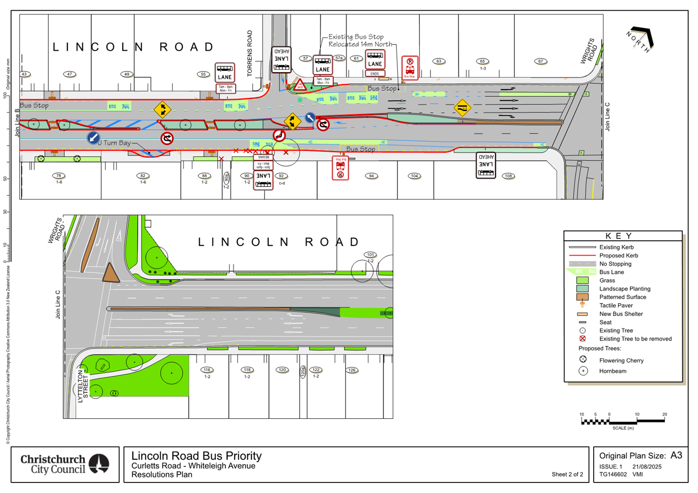
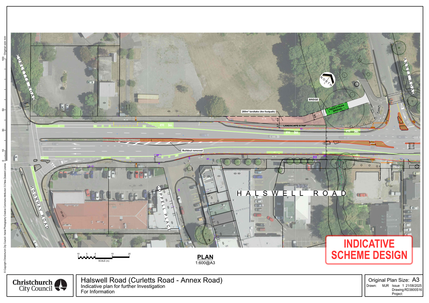
|
8. New Footpaths Programme
|
|
Reference Te Tohutoro:
|
25/1520048
|
|
Responsible Officer(s) Te Pou Matua:
|
Trudy
Jones, Sustainable Transport Planner
Andy Milne, Team Leader Asset Planning
Jacob Bradbury - Manager Planning & Delivery Transport
|
|
Accountable ELT Member Pouwhakarae:
|
Brent
Smith, General Manager City Infrastructure
|
1. Purpose and Origin of the Report Te Pūtake Pūrongo
1.1 The
purpose of this report is to seek the Council’s approval of the logic and
prioritisation of the New Footpaths Programme.
1.1.1 Staff
are also seeking Council’s approval to draw down for delivery those
planned for delivery within the current LTP period (FY25-FY27).
1.2 The
report follows from a Council Workshop held on 15 July 2025 to brief elected
members on the new programme and the prioritisation methodology.
1.2.1 A
Memo was then sent to Community Boards, asking for feedback. This has been
considered.
2. Officer Recommendations Ngā
Tūtohu
That
the Council:
1. Receives the information in the New Footpaths Programme report.
2. Notes that the decision in this report is
assessed as medium significance based on the Christchurch City Council’s
Significance and Engagement Policy.
3. Approves the prioritisation of locations for
New Footpaths as shown in Attachment A of this report.
4. Instructs staff to begin work on delivery of
locations 1-19 as shown in Attachment A of this report.
5. Notes that locations for delivery in FY28-30
will be agreed as part of the next Long-Term Plan.
3. Executive Summary Te Whakarāpopoto Matua
3.1 The
New Footpaths programme was approved as part of the FY24-34 Long Term Plan.
3.1.1 This
aimed to address areas with missing footpaths, particularly where new
subdivisions had been built, but were not linked to the existing footpath
network.
3.1.2 The
agreed timeline was for FY25 to be around developing the programme, before
moving into delivery from FY26.
3.2 A
list of candidate sites was gathered from Elected Members, community feedback,
staff knowledge, and other sources. Each of these sites was then scored against
a set of criteria.
3.2.1 The
logic and sites have been presented to the Executive Leadership Team and the
Council, and feedback has been sought from Community Boards.
3.2.2 The
Memo to Community Boards describing this is available as Attachment B.
3.3 Staff
are therefore seeking the Council’s approval of the New Footpaths
programme for LTP 2024-2034.
3.3.1 Attachment
A shows the list of sites, prioritised for delivery.
3.3.2 Of
this list, staff are seeking approval to start delivery of the top 19 sites in
FY26 & FY27.
4. Background/Context Te Horopaki
4.1 The
New Footpaths Programme was included as part of Council’s FY24-34 Long
Term Plan. While projects to link up some sections of missing footpath have
been included in previous Long Term Plans, this was the first time a programme
to pro-actively identify, prioritise and deliver new footpath links has been
included.
4.2 Staff
have provided the following information:
4.2.1 A
Council Information Session was held on 15 July 2025
· Agenda: https://christchurch.infocouncil.biz/Open/2025/07/ISCC_20250715_AGN_9968_AT.PDF
· Recording: https://councillive.ccc.govt.nz/meeting/15-07-25-new-footpath-programme/
4.2.2 A
Memo was sent to the Community Boards, covering the candidate identification
and prioritisation methodology, and addressing questions from the Information
Session. To avoid duplication, the Memo to the Community Boards is included
here as Attachment B.
Community Board Feedback
4.3 A
Community Board resolution in relation to a separate project (the Wigram/Hayton
intersection project) has resulted in the inclusion of Wigram Road (southside,
from new Ngā Puna Wai accessway towards Musgrove Close). This has been
ranked as the number 17 project, so is proposed for inclusion within the first
tranche.
4.4 Feedback
on the Programme was sought from the Community Boards. This included a number
of candidates that had not previously been ranked. These have now been included
in the long list.
4.4.1 Lower
Styx Road has not been ranked for delivery in the first tranche
4.4.2
Beach Road (Akaroa) has not been ranked for delivery in the first tranche
4.5 The
general Community Board feedback has been summarised into the following points
with staff responses provided as follows:
4.5.1 Staff
were asked to reconsider whether special consideration should be made to routes
where there was only one way in and out of a specific community.
· Staff
response: The roading hierarchy and expected levels of service for pedestrians
in that environment is a key determinant. The methodology also emphasised
latent demand by population density and destinations within a 1km walking
catchment. As such a lengthy rural road with few adjacent residents or
destinations is not prioritised as highly as a missing section of footpath in a
higher density residential environment.
4.5.2 Staff
were also asked to include further candidates including those emerging as a
result of evolving subdivision and development progress.
· Staff
response: Staff recommendations remain the same in
relation to the methodology and combination of weightings applied in order to
assess and rank new footpath candidates for the Long Term Plan. Ongoing network
changes are accounted for in that any new emerging candidates can and will be captured
and analysed using the prioritisation assessment
process on semi-regular basis in order to update the
programme accordingly.
4.5.3 Staff were asked regarding the sources of potential candidates and
the methodology applied for prioritising candidates.
· Staff
response: Potential candidates from all known sources; area engineers, internal
and external requests, Long Term Plan and Annual Plan feedback, community
boards, and Council resolutions have been collated. All potential candidates
were assessed and reviewed using the same multi factorial criteria to determine
metropolitan priorities.
· The type of
street within the roading hierarchy, operational speeds and traffic volumes
together make up the largest percentage weighting for safety. Destinations and
populations were quantified within the immediate walking catchment of the
potential candidate to ensure delivery meets the needs of the maximum number of
users. Deliverability considerations included both technical and costing
feasibility to ensure the programme best reflects value for money delivering
maximum benefit per population demand.
4.6 Changes
to the prioritisation criteria to take account of other factors (eg lack of
alternative routes for a community) will take significant time to decide on an
appropriate scoring mechanism, gather data, and then score each site.
4.6.1 If
the Council provides information on other factors that they would like to be
considered these can be investigated and evaluated, and staff will provide more
information and an updated prioritisation ahead of the next Long Term Plan.
Options Considered Ngā Kōwhiringa Whaiwhakaaro
4.7 The
following reasonably practicable options were considered and are assessed in
this report:
4.7.1 Option
One: Approve new footpath programme.
4.7.2 Option
Two: Investigate changes to the prioritisation of the programme.
4.7.3 It
should be noted that there is an almost unlimited number of options for the
Council to select: should Elected Members agree with the prioritisation in
general, but believe that a specific location is not adequately assessed, then
please advise staff.
4.8 The
following options were considered but ruled out:
4.8.1 Option
Three: Do nothing - This was ruled out because the outcome of this
option would be not to deliver a project which the Council has approved funding
for.
Options Descriptions Ngā Kōwhiringa
4.8.2 Preferred
Option: Option One: Approve new footpath programme.
4.8.3 Option
Description:
· The Council approves the prioritisation of new
footpaths as detailed in Attachment A of this report.
· The Council
approves the top ranked 19 locations to progress to delivery in the current
period.
· Any new
emerging candidates can and will be captured and analysed using the
prioritisation assessment process. This will be used to update the programme on
a semi-regular basis, to ensure that the highest priority locations are
approved for delivery. It is expected that the next approval of the delivery
programme will be incorporated in the Council’s next Long Term Plan.
4.8.4 Option
Advantages
· Allows
delivery to progress in the current Financial Year.
· Improves
levels of service for walking in line with One Network Framework roading
hierarchy expected levels of service and provides a robust evidence based
approach to analysing prioritised demand for footpath infrastructure over the
duration of the Long Term Plan.
· Flexibility to
adjust the program to accommodate new and emerging candidates through the same
prioritisation process.
4.8.5 Option
Disadvantages
· Some locations
with particular risks may be ranked low as the prioritisation method does not
reflect the specific site conditions
· Does not allow
for other factors (eg interim measures, shared facilities) to be considered
4.9 Alternative
Option: Option Two – investigate changes to the prioritisation of
the programme.
4.9.1 Option
Description:
· That staff
look at changes to the prioritisation, and therefore programme.
· This would
likely require a workshop with the Council in the new term, before information
is provided in a further report to the Council.
4.9.2 Option
Advantages
· May ensure
that the Council and Community Board wishes for the programme are better
served.
· Would provide
opportunities for other factors to be considered (eg shared facilities, interim
measures, etc).
4.9.3 Option
Disadvantages
· Further
re-assessment of the prioritisation would delay implementation. It is likely
that delivery would not start in the current Financial Year.
5. Financial Implications Ngā Hīraunga Rauemi Capex/Opex Ngā Utu Whakahaere
|
|
Recommended Option
|
Option 2 – investigate
changes
|
|
Cost to Implement
|
$20.5M over 10 years
|
$20.5M over 10 years
However, implementation will be delayed by 6 months or more and
will mean that few (if any) projects will start delivery in the FY26
financial year.
|
|
Maintenance/Ongoing Costs
|
No significant maintenance costs in the first three years
|
No significant maintenance costs in the first three years
|
|
Funding Source
|
CPMS 75051 Programme – New Footpaths (LTP 2024-2034)
|
CPMS 75051 Programme – New Footpaths (LTP 2024-2034)
|
|
Funding Availability
|
Yes
|
Yes
|
|
Impact on Rates
|
Within existing budgets
|
Within existing budgets
|
6. Considerations Ngā Whai Whakaaro
Risks and Mitigations Ngā Mōrearea me
ngā Whakamātautau
6.1 All
usual design and construction risks apply.
6.2 The
specific designs proposed in each location will remain subject to public
consultation and approvals through the delegated body (typically the relevant
Community Board(s)).
Legal Considerations Ngā Hīraunga
ā-Ture
6.3 Statutory
and/or delegated authority to undertake proposals in the report:
6.3.1 Decisions
relating to approval to progress programme agreed to be funded under LTP can be
made by the Council.
6.3.2 The
designs for each location will require approval by the delegated body
(typically the relevant Community Board).
6.4 Other Legal Implications:
6.4.1 There
is no legal context, issue, or implication relevant to this decision.
Strategy
and Policy Considerations Te
Whai Kaupapa here
6.5 The
required decision:
6.5.1 Aligns
with the Christchurch City Council’s Strategic direction in transport by
pursuing the Future Transport Plan’s stated intent regarding Safe and
Connected Walking Environments by ensuring that new housing development
have adequate footpath connections with amenities on the wider network.
6.5.2 The
recommended programme in this report is assessed as medium significance based
on Christchurch City Council’s Significance and Engagement Policy.
The level of significance was determined by the medium level of impact and
medium numbers of people impacted.
6.5.3 The
planned programme is consistent with Council’s
Plans and Policies regarding active travel and required levels of service. This
report supports;
· The Strategic
Transport Plan’s objectives for safe and connected walking environments.
· Transport.
· Activity:
Transport
· Level of Service: 16.0.10 Maintain the perception (resident
satisfaction) that Christchurch is a walking friendly city - >=85% resident
satisfaction.
Community
Impacts and Views Ngā Mariu ā-Hāpori
6.6 Considered
throughout the process of developing the New Footpaths Programme. Further
community engagement on specific projects arising from the program will happen
on a project by project basis as these individual projects progress through the
design, consultation and approval processes.
6.7 The
decision affects the metropolitan area of Christchurch.
6.8 The
Community Boards have been consulted regarding
proposed candidates and given feedback on draft programme.
Impact
on Mana Whenua Ngā
Whai Take Mana Whenua
6.9 The
decision does not involve a significant decision in
relation to ancestral land, a body of water or other elements of intrinsic
value, therefore this decision does not specifically
impact Mana Whenua, their culture, and traditions.
6.10 The decision does not involve a matter of interest to Mana Whenua and will not impact on our agreed partnership priorities
with Ngā Papatipu Rūnanga. The facilities proposed under this
programme are to be provided within the existing roading network.
Climate
Change Impact Considerations Ngā Whai Whakaaro mā te Āhuarangi
6.11 The
decisions in this report are likely to:
6.11.1 Contribute
neutrally to adaptation to the impacts of climate change.
6.11.2 Contribute positively to emissions reductions.
6.12 The
delivery of the programme recommended in this report will contribute to
emissions reductions with the potential to increase active modes for short
trips by improving connectivity and levels of service in the walking network.
7. Next Steps Ngā Mahinga ā-muri
7.1 Council
approval of the recommended programme ensures this can go on to the delivery
stage within the LTP first 3 years (FY25-27), with $17 million to deliver in
the remaining 7 years (FY28-34).
7.2 The
programme will be reviewed semi-regularly in order to capture changes to the
transport network, changes due to ongoing development and any other new
information which comes to light. This will allow Council to decide on the next
priorities for delivery.
Attachments
Ngā Tāpirihanga
|
No.
|
Title
|
Reference
|
Page
|
|
a ⇩
|
Proposed New Footpath Programme for
Approval
|
25/1720697
|
58
|
|
b ⇩
|
Memo to Community Boards - New Footpaths
Programme - 7 August 2025
|
25/1411056
|
67
|
In addition to the attached documents, the following
background information is available:
|
Document Name – Location / File Link
|
|
Not applicable
|
Signatories Ngā Kaiwaitohu
|
Authors
|
Trudy Jones - Transport Planner Sustainable
Transport
Andy Milne - Team Leader Asset Planning
Peter Rodgers - Transport Network Planner
|
|
Approved By
|
Jacob Bradbury - Manager Planning &
Delivery Transport
Lynette Ellis - Head of Transport &
Waste Management
Brent Smith - General Manager City
Infrastructure
|
|
9. Plan
Change Programme - Plan Stop and Exemptions
|
|
Reference Te Tohutoro:
|
25/1466741
|
|
Responsible Officer(s) Te Pou Matua:
|
Darren
Bridgett, Team Leader City Planning
Sarah Oliver, Team Leader City Planning
Mark Stevenson, Head of Planning and Consents
|
|
Accountable ELT Member Pouwhakarae:
|
John
Higgins, General Manager Strategy, Planning & Regulatory Services
|
1. Purpose and Origin of the Report Te Pūtake Pūrongo
1.1 The
purpose of this report is to seek agreement from the Council for seeking
exemptions from the bar in the Resource Management Act (RMA) on notifying plan
changes.
1.2 Recent
changes to the RMA prevent notification of plan changes until 31 December 2027
and require councils to withdraw plan changes that have not yet had a hearing,
unless exemptions apply (Plan Stop legislation).
1.3 Councils can apply to the Minister for an exemption that will allow
the Council to notify a plan change or continue with a notified plan change.
The Minister can grant an exemption if satisfied that criteria in the RMA are
met. This report seeks a Council decision on what, if any, plan changes to seek
that exemption for.
2. Officer
Recommendations Ngā Tūtohu
That the Council:
1. Receives the information in the Plan Change
Programme - Plan Stop and Exemptions Report.
2. Notes that the decision in this report is assessed as medium significance
based on the Christchurch City Council’s Significance and Engagement
Policy.
3. Agrees to apply under section 80V of the Resource Management Act for
the following plan changes to be exempt from section 80P (prohibition against
notifying a plan change) and section 80Q (requirement to withdraw a proposed
plan change):
a. Proposed Plan Change 7
EITHER
i. Proposed Plan Change 7 – Managing Significant Indigenous
Vegetation (version as notified).
OR
ii. Proposed Plan Change 7 (Variation) – to further implement the
updated National Policy Statement on Indigenous Biodiversity over and above the
notified version.
b. Proposed Plan Change 20/ Proposed
Plan Change on Rezoning
EITHER
(Proposed Plan Change 20)
i. Proposed Plan Change 20 – Industrial (all).
AND/OR
(Proposed Plan Change on Rezoning)
ii. Proposed Plan Change on Rezoning (all) – District Plan
maintenance plan change and specific rezoning requests.
OR ONLY
(A Combined Plan Change)
iii. A combined plan change comprising rezoning elements of each of the
following plan changes to support housing and/or economic growth: Proposed Plan
Change 20 and/ Proposed Plan Change on Rezoning.
c. Proposed Plan Change 17 (1 of 3 parts,
other parts automatically exempt) Earthworks.
d. Proposed Plan Change 21 – Central
City Noise.
e. Proposed Plan Change on Kerrs Reach
(Ōtākaro Avon River Corridor)(Flatwater Sports Hub).
4. Delegates authority to the Head of Planning and Consents to prepare
and lodge the applications for exemptions authorised by this report and to
engage in communication with the Minister regarding the applications.
3. Executive Summary Te Whakarāpopoto Matua
3.1 In order to continue parts of its plan change programme, the Council
needs to determine which of those plan changes not automatically exempt from
the Plan Stop legislation it will seek discretionary exemption for.
3.2 The RMA requires Council to apply for exemptions within 90 working
days from 20 August 2025 Officers have attached an assessment of plan changes
against exemption criteria, and broader considerations to inform this decision.
3.3 The purpose of the Plan Stop criteria to ensure that local
authorities do not expend resources unnecessarily is a guiding principle.
3.4 Plan changes which are not selected for the discretionary exemption
application, or those which are selected but which do not receive exemption,
may still be developed with a view to their inclusion in local planning
frameworks developed under the reformed Resource Management system –
expected to commence from 2027 onwards.
4. Background/Context Te Horopaki
4.1 The Resource Management (Consenting and Other System Changes)
Amendment Act 2025 was assented on 20 August 2025. From assent, the Council has
90 working days to withdraw any proposed plan changes that have already been
notified unless – an automatic exemption applies; the Council has applied
for a discretionary exemption; or the Minister for RMA Reform has directed
against withdrawal.
4.2 Any proposed plan change that has not yet been notified cannot now
be notified until 31 December 2027 unless an exemption, automatic or
discretionary – as agreed by the Minister, applies. Within the same 90
working days the Council must publicly notify the status of its plan changes
– withdrawn; continuing subject to automatic exemption; discretionary
exemption applied for; direction against withdrawal made by the Minister; or
continuing subject to exemption granted by the Minister.
4.3 The purpose of the Plan Stop legislation is to ensure that local
authorities do not expend resources unnecessarily in the period before
legislation to replace the RMA comes into force (anticipated around the end of
2026). Bearing that in mind, the Ministry for the Environment advises that the
key points in making any application – aside from meeting one or more of
the discretionary criteria in the Act, are to describe the benefits of acting
vs disadvantages of not acting, alignment or otherwise of the proposed plan
change with broader government policy, and justifying the urgency of a given
plan change to continue in that period. The latter point will likely be an acid
test in the context of the purpose of Plan Stop.
4.4 Given all of this, the Council’s proposed plan changes and how
they align for exemption purposes (whether an application is required), are as
follows – for detail of the assessment refer to attachment A:
4.4.1 Discretionary
– to be able to continue/notify these plan changes (or parts of) we
need to apply for an exemption. (See attachment for exemptions
criteria):
· Plan Change 7 – Managing Significant Indigenous Vegetation. Notified,
current extension of decision-making timeframe until 30 April 2026.
· Plan Change 17 – (1 of 3 parts) Earthworks. Draft.
· Plan Change 20 – Industrial. Draft.
· Plan Change 21 – Central City Noise. Draft.
· Plan Change Rezoning. Draft.
· Plan Change Kerrs Reach (Ōtākaro Avon River Corridor)(Flatwater
Sports Hub). Draft.
· Plan Change on Financial Contributions for Tree Canopy Cover.
4.4.2 Automatic
– (for information) these plan changes (or parts of) continue
automatically and we do not need to apply for an exemption. (See
attachment for exemptions criteria):
· Plan Change 12 – Coastal Hazards. This plan change is exempt
under the natural hazards automatic criterion. Draft.
· Plan Change 17 – (2 of 3 parts) Flood Management Areas,
Activities in the Waimakariri Stopbank Setbacks. These parts of the proposed
plan change are exempt under the natural hazards automatic criterion.
Draft.
4.4.3 Private
Plan Changes (for information): Accepted by Council for processing –
exempt.
4.4.4 These plan
changes can automatically continue:
· Plan Change 13 – Heritage. Plan change heard, recommendations
being reported for decision making purposes on 10 September. If the
recommendations are adopted, the plan change takes effect and becomes operative
if there are no appeals.
· Plan Change 14 – Housing and Business Choice. Some
parts operative, final decisions subject to report on 3 September 2025.
4.5 Legislation
for the next stage of Resource Management reform is awaited and it is expected
that this will guide the requirements that the council will be working to from
mid/late 2027 onwards. Council will need to be cognisant of this expected
switch in determining its interim work programme.
Options Considered Ngā
Kōwhiringa Whaiwhakaaro
4.6 The
following reasonably practicable option was considered and is assessed in this
report:
4.6.1 A selection of
plan changes based on criteria defined in Attachment A.
4.6.2 The preferred
option is to select some plan changes for an exemption application based on the
attached assessment. The alternative is the identification of a different
selection of plan changes, for which there are a number of scenarios.
4.7 The
following options were considered but ruled out:
4.7.1 Do not apply
for exemptions.
This is not considered appropriate given the Council’s
priorities and need to address issues that necessitate an exemption.
4.7.2 Apply for
exemptions on all plan changes.
This is not reasonable as an option on the basis that the Minister
for RM Reform is expecting a stop to plan changes, and Council would not be
engaging with the process if it sought to pursue all plan changes. There needs
to be consideration given to what is urgent and cannot wait til the new
planning system, alignment with government priorities as well as what can be
delivered in a short timeframe, given resources.
Options Descriptions Ngā
Kōwhiringa
4.8 Preferred
Option: (1) Selected exemptions.
4.8.1 Option
Description: choose from the attached assessment of plan changes those
which the Council will seek exemption for.
4.8.2 Option
Advantages
· Earlier rationalisation of the plan change programme ahead of
Resource Management reform being implemented.
· Collaboration with the Ministry for the Environment to implement the
purpose of the Plan Stop legislation.
· Opportunity to progress work that until now might have been a lower
priority weighed against the plan change programme.
4.8.3 Option
Disadvantages
· Not all plan changes that the council had been preparing prior to
the Plan Stop legislation will be able to be notified ahead of 31 December
2027.
Analysis Criteria Ngā Paearu
Wetekina
4.9 Noting
the criteria explained above, the recommendation is to use the attached
assessment to inform the exemptions decision. Any plan changes that do not
secure exemption to continue, or to be notified, ahead of 31 December 2027 are
not prohibited from ongoing policy development.
5. Financial Implications Ngā Hīraunga Rauemi
Capex/Opex Ngā Utu Whakahaere
|
|
Recommended Option
|
|
Cost to Implement
|
Preparation
of plan changes within existing budget
|
|
Maintenance/Ongoing Costs
|
Within
existing budgets for administration of District Plan
|
|
Funding Source
|
Planning
and Consents
|
|
Funding Availability
|
Available
|
|
Impact on Rates
|
No
additional impact on rates
|
5.1 This
assumes that in some or all cases, Council may continue to develop plan
changes/policy development (subject to review/confirmation) even where it does
not have exemption to be able to notify ahead of 31 December 2027.
6. Considerations Ngā Whai Whakaaro
Risks and Mitigations Ngā
Mōrearea me ngā Whakamātautau
6.1 There
is a risk that the Minister does not grant exemptions applied for. Mitigating
this is that the Plan Stop legislation does not prevent policy development
work. This refocuses the question around what is urgent between now and 31
December 2027.
6.2 If
Council decided to pursue more rather than fewer exemptions, it may be more
difficult for the Minister to accurately determine what the Council truly
considers to be urgent.
Legal Considerations Ngā
Hīraunga ā-Ture
6.3 Statutory
and/or delegated authority to undertake proposals in the report:
6.3.1 The recent
changes to the RMA provide the prohibition and the right for councils to seek
exemptions from the prohibition.
6.4 Other Legal Implications:
6.4.1 The legal
implications are described throughout this report.
Strategy and Policy Considerations Te Whai
Kaupapa here
6.5 The
required decisions:
6.5.1 Align with the
Christchurch
City Council’s Strategic Framework. The
decisions would enable the Council to seek to continue plan changes which it
considers are necessary to notify in the next two years ahead of 31 December
2027.
6.5.2 Are assessed
as medium significance based on the
Christchurch City Council’s Significance and Engagement Policy. The level
of significance was determined by considering the
origin of/reason for the individual plan changes and the level of engagement on
those plan changes which have been notified or had informal engagement.
6.5.3 Are consistent with Council’s Plans and
Policies. They would enable Council to continue developing its plans and
policies.
6.6 This
report supports the Council's
Long Term Plan (2024 - 2034):
6.7 Strategic Planning and Policy
6.7.1 Activity: Strategic Planning and Resource Consents
· Level of Service: 9.5.1.1 Prepare plan changes
to the District Plan to address issues and to implement national and regional
direction, identified as a high priority by Council - In accordance with
statutory processes and timeframes
· Level of Service: 9.5.1.6 Prepare plan changes
to the District Plan to address issues and to implement national and regional
direction, identified as a high priority by Council - Providing Council an
annual update on progress with plan changes
Community Impacts and Views Ngā Mariu
ā-Hāpori
6.8 Community
impacts/views vary by plan change. An indication of community engagement to
date is as follows:
· Plan Change 7 Managing Significant Indigenous Vegetation –
submissions following notification.
· Plan Change 20 Industrial – Korero Mai, pre-notification
engagement: 91 submissions.
· Plan Change 21 Central City Noise – Kōrero Mai, pre-notification
engagement: 1429 submissions.
· PC Kerrs Reach (Ōtākaro Avon River Corridor) –
Kōrero Mai, pre-notification engagement: 104 submissions.
· Note, Plan Change 17 pre-notification engagement was targeted due to
the nature of the topic/s and does not have comparable statistics.
6.9 The decision affects the following wards/Community Board areas:
6.9.1 All, dependent on
which plan changes Council seeks exemption for.
Impact on Mana Whenua Ngā Whai Take
Mana Whenua
6.10 The Plan Change
for the Ōtākaro Avon River Corridor involves a significant
decision in relation to ancestral land, a body of water or other elements of
intrinsic value, therefore this decision does
specifically impact Mana Whenua, their culture, and traditions.
6.11 The decisions involve
matters of interest to Mana Whenua insofar as they have or have not expressed
interest in individual plan changes and could impact on
our agreed partnership priorities with Ngā Papatipu
Rūnanga.
6.12 While the above
is noted, direct decision making and impacts stemming from those decisions
would be contained in the plan changes themselves. The decisions being sought
in this report are about whether the plan changes proceed in the period before
31 December 2027. None of these plan changes have been instigated as a result of
partnership requirements.
Climate Change Impact Considerations Ngā
Whai Whakaaro mā te Āhuarangi
6.15 The
proposals in this report are unlikely to contribute significantly to adaptation
to the impacts of climate change or emissions reductions.
6.16 The
primary plan changes responding to the impacts of climate change have automatic
exemption i.e. Plan Change 12 (Coastal Hazards) and 17 (Flood Management Areas,
Activities within the Waimakariri stop bank setbacks).
7. Next Steps Ngā Mahinga ā-muri
7.1 Officers
will prepare and lodge applications for exemptions in accordance with the
Council resolution, within the 90 working day period identified. Following the
decision of the Minister on the applications, officers will report back to
Council.
Attachments Ngā Tāpirihanga
|
No.
|
Title
|
Reference
|
Page
|
|
a ⇩
|
Assessment of
CCC Plan Changes for Plan Stop Exemptions
|
25/1756918
|
79
|
|
b ⇩
|
Resource
Management (Consenting and Other System Changes) Amendment Act 2025 (Subpart
5B)
|
25/1709042
|
86
|
|
c ⇩
|
Plan Stop
Exemptions Flowcharts (Ministry for the Environment)
|
25/1730434
|
96
|
|
d ⇩
|
Plan Stop
Exemption Application Process (Ministry for the Environment)
|
25/1731132
|
98
|
|
e ⇩
|
MfE Plan Stop
Exemption Application Template
|
25/1756921
|
100
|
In addition to the attached documents, the following background
information is available:
|
Document
Name – Location / File Link
|
|
Not
applicable
|
Signatories Ngā Kaiwaitohu
|
Authors
|
Darren
Bridgett - Team Leader City Planning (E)
Sarah Oliver -
Team Leader City Planning
|
|
Approved By
|
Brent Pizzey -
Senior Legal Counsel
Mark Stevenson
- Head of Planning & Consents
John Higgins -
General Manager Strategy, Planning & Regulatory Services
|

|
10. Unsolicited
Proposal for Sale of Part of 177 Armagh Street
|
|
Reference Te Tohutoro:
|
25/1350082
|
|
Responsible Officer(s) Te Pou Matua:
|
Nigel
Collings, Property Consultant
|
|
Accountable ELT Member Pouwhakarae:
|
Andrew
Rutledge, General Manager Citizens and Community
|
1. Purpose and Origin of the Report Te Pūtake Pūrongo
1.1 The
purpose of this report is to present for consideration the Unsolicited Proposal
received from Fletcher Residential Limited, the owners of 199 Armagh Street, to
acquire part of the adjoining Council-owned land situated at 177 Armagh Street
for incorporation into their adjoining development and subdivision.
1.2 The
report is staff generated in response to the Unsolicited Proposal as noted
above.
2. Officer
Recommendations Ngā Tūtohu
That the Council:
1. Receives the information in the Unsolicited Proposal for Sale of Part
of 177 Armagh Street Report.
2. Notes that the decision in this report is assessed as low
significance based on the Christchurch City Council’s Significance and
Engagement Policy.
3. Notes that if
the Council were to agree to the unsolicited proposal for sale of part of 177
Armagh Street, the sale to Fletcher Residential Limited
would be consistent with the Council’s Disposal of Property Policy 2000 (Attachment H of this
report) on the basis that there is a clear reason to do so i.e. Fletcher Residential Limited are the only
logical and practical purchaser.
4. Agrees to sell the portion of land shown as area H on Attachment
A of this report being part of lot 102 DP 497446 contained within Record of
Title 734774 to the adjoining property owner Fletcher
Residential Limited at the current market value as
determined by the Council appointed independent registered valuer, refer Public
Excluded Attachment G of this report.
5. Notes that the approval to sell the portion of land at 177 Armagh
Street is conditional upon public consultation as required under sections 78
and 138 of the Local Government Act 2002. In the event there are no unsatisfied
objections staff are authorised to proceed with the sale. In the event of
unsatisfied objections staff will report the matter back to the Council for
consideration and determination.
6. Authorises the Manager Property Consultancy, to undertake all
actions, negotiate and conclude all the agreements necessary to facilitate the
recommendations above on terms and conditions acceptable to him at his sole
discretion.
3. Executive Summary Te Whakarāpopoto Matua
3.1 Fletcher
Residential Ltd is undertaking the development of 46 apartments and 16
townhouses at 199 Armagh Street.
3.2 Resource
consent for the development was granted in December 2024, and the approved
consent plans are included as Attachment B. This incorporates the
council owned land which is the subject of this report. As of August 2025, the
associated building consent is under active processing.
3.3 The
site forms part of the wider East Frame residential precinct, established under
the Christchurch Central Recovery Plan (Blueprint Plan) in 2012. The Blueprint
outlined a strategic framework for rebuilding the central city following the
Canterbury earthquakes, identifying key anchor projects and enabling the
creation of super lots—large, amalgamated parcels of land designed to
support integrated, medium- to high-density development. This is one of several
such blocks, planned to deliver coordinated urban outcomes and support the
revitalisation of the city centre.
3.4 Adjacent
and to the north of 199 Armagh Street, between the development site and the
formed public footpath, lies an unused 3.5-metre-wide strip of land. This strip
forms part of the underlying title associated with the Margaret Mahy Family
Playground. Fletcher Residential Ltd have presented an unsolicited proposal to
purchase and incorporate this land into their development for stormwater
easements and pedestrian access.
4. Background/Context Te Horopaki
4.1 Staff
have been approached by the owner of 199 Armagh Street, Fletcher Residential
Limited, with request to acquire a strip of land located between their site and
the formed footpath.
4.2 This
173m2 strip is 49.59 metres long by 3.5 metres wide.
4.3 The
land described, forming part of Lot 102 DP 497446 and held in Record of Title
734774, is owned by the Christchurch City Council and encompasses the Margaret
Mahy Playground.
4.4 The
strip of land contains electricity cables and transformers owned by Orion and
protected by way of easements. It remains unimproved, is separate from the
Margaret Mahy Playground, and is located on the opposite side of the carpark
from the playground. Photographs of this land are appended as Attachment D
4.5 The
land in question is not suitable for any development on its own.
4.6 Now,
the adjoining owner, Fletcher Residential Limited, has obtained Land Use
Consent and is working through Building Consent to Develop 54 residential
dwellings. The land is adjacent to blocks A and B. A plan showing the extent of
the development is appended as Attachment C.
4.7 An
agreement has been entered into with the adjoining property owner to enable the
transfer of the land subject to Council approval. The purchaser is responsible
for completing the necessary subdivision at their own cost, paying for the
valuation by a valuer engaged by the Christchurch City Council, and paying the
consideration for the land based on that valuation.
4.8 The agreement also includes a restrictive covenant ensuring public
amenities are retained. This covenant is annexed as Attachment E
4.9 A
review has been completed to confirm the Council’s obligations pursuant
to Section 138 Of the Local Government Act 2002. This section of the Act
requires the Council, in the event land is deemed surplus to requirements, to
publicly consult on the proposal before it sells or disposes of, or agrees to
sell or dispose of, the park or part of the park. While this strip of land has
not been used as a park, it does form part of the underlying title with the
Margaret Mahy playground so Council will to satisfy this and its obligations
under sections 76 – 81 of the LGA “Decision Making”
consultation will be undertaken. The scope of this is currently being developed
with the Engagement Team and will be initiated following approval of the
resolutions in this report.
4.10 In consideration
of the land area being transferred, the value has been determined by valuation.
The valuation is appended as Public Excluded Attachment G.
4.11 In addition to
the valuation costs, the purchaser is responsible for covering all Council
expenses related to the negotiation and completion of the proposed transfer,
including staff time and legal fees up to a maximum of $10,000.
Options Considered Ngā
Kōwhiringa Whaiwhakaaro
4.12 The following
reasonably practicable options were considered and are assessed in this report:
4.12.1 Approve sale of land at
the current market value as assessed by the Council’s independent
registered valuer Public Excluded Attachment G.
4.12.2 Decline sale of land.
4.13 The following
options were considered but ruled out:
4.13.1 Nil.
Options Descriptions Ngā
Kōwhiringa
4.14 Preferred
Option: Approve the sale of the land.
4.14.1 Option Description: Authorise
the sale of part of 177 Armagh Street, as shown as 173m2 in Attachment A to the
adjoining owner.
4.14.2 Option Advantages
· Removes the Council’s obligations to maintain an unused
portion of land i.e. reduces operating costs.
· Provides unbudgeted revenue.
· Enables access for services and access to the 7 dwellings.
· Reduces rates paid by the Council and increases rates paid to the
Council.
· Enables the approved resource consent plan to proceed.
4.14.3 Option Disadvantages
· Nil.
4.15 Option 2 –
Decline the sale of land.
4.15.1 Option Description: Decline
the sale of land to the adjoining owner.
4.15.2 Option Advantages
· The Council will retain ownership of the land, albeit for no likely
operational purpose.
4.15.3 Option Disadvantages
· The land’s disjointed nature increases risks of unauthorized
use or liability.
· Regular maintenance, such as mowing and landscaping, is required to
ensure the land visually aligns with neighbouring properties, incurring ongoing
costs and effort.
Analysis Criteria Ngā Paearu Wetekina
4.16 In considering
the presented options and its decision, the Council should factor in the
operational requirement to retain this land (low), the financial implications
of retention (low) and the revenue gained from the recommended sale (moderate,
in relation to the utility of the land area).
5. Financial Implications Ngā Hīraunga Rauemi
Capex/Opex Ngā Utu Whakahaere
|
|
Recommended Option
|
Option 2 - Decline the sale
|
|
Cost to Implement
|
Nil – Costs borne by purchaser
|
Nil – No change from current
|
|
Maintenance/Ongoing Costs
|
Nil – Costs borne by purchaser
|
Minor
|
|
Funding Source
|
Not applicable
|
Not applicable
|
|
Funding Availability
|
Not applicable
|
Not applicable
|
|
Impact on Rates
|
Increase of rates received
|
|
6. Considerations Ngā Whai Whakaaro
Risks and Mitigations Ngā
Mōrearea me ngā Whakamātautau
6.1 There
is a low risk that, following transfer of the land, the property owner stalls
or does not complete their intended developments. Should this occur, the
Council will not be exposed to any form of financial claim or obligation.
Legal Considerations Ngā
Hīraunga ā-Ture
6.2 Statutory
and/or delegated authority to undertake proposals in the report:
6.2.1 The delegation
to divest land sits with the full elected Council.
6.3 Other Legal Implications:
6.3.1 The legal
consideration is the agreement necessary to facilitate the sale of land. This
has been drafted by the proposed purchasers’ solicitors and the Council
legal team. This agreement is annexed as Attachment F.
Strategy and Policy Considerations Te Whai
Kaupapa here
6.4 The
required decision:
6.4.1 Aligns with
the Christchurch
City Council’s Strategic Framework.
6.4.2 Is assessed as
low significance based on the Christchurch
City Council’s Significance and Engagement Policy. The level of
significance was determined by considering the low impact on the public
(unusable site).
6.4.3 Is consistent with the Council’s Plans and
Policies.
6.5 This
report does not support the Council's
Long Term Plan (2024 - 2034). This is a
one-off independent consideration through an unsolicited proposal but has a
positive financial impact on the Councils budgets and plans i.e. does not
affect levels of service, provides unplanned revenue by way of the sale and
reduces operating costs of holding the land.
6.6 Aligns with the Councils Disposal of Property Policy 2000 and
Councils Retention Criteria Appendix I.
Community Impacts and Views Ngā Mariu
ā-Hāpori
6.7 Through
the course of its decision-making processes, the Council is required to
consider the views and preferences of persons likely to be affected by, or to
have an interest in, the matter (Section 76 – 81 “ Decision
Making” of the Local Government Act 2002).
6.8 In
this instance, the land is not classified as Reserve under the Reserves Act
1977, nor is the site considered and open publicly accessible space (i.e.
deemed ‘park’ under Section 138 of the Local Government Act 2002).
6.9 In
consideration of the location, being adjacent to and on the same underlying
title as the Margrette Mahy playground, consultation will be undertaken. The
scope of this is currently being developed with the Engagement Team and will be
initiated following approval of the resolutions in this report.
6.10 The decision
affects the following wards/Community Board areas:
6.10.1 Waipapa Papanui-Innes-Central
Community Board.
6.11 The Community Board’s view has not been requested on this occasion, as
the delegation to divest the land is held by the full Council.
Impact on Mana Whenua Ngā Whai Take
Mana Whenua
6.12 The decision
does not involve a significant decision in relation to ancestral land, a body
of water or other elements of intrinsic value, therefore this decision does not
specifically impact Mana Whenua, their culture, and traditions.
6.13 The decision
does not involve a matter of interest to Mana Whenua and will not impact on our
agreed partnership priorities with Ngā Papatipu Rūnanga.
6.14 This strip of
land forms part of a modern title issued in 2017 and has not historically been
under Mana Whenua ownership.
Climate Change Impact Considerations
Ngā Whai Whakaaro mā te Āhuarangi
6.15 The proposals in
this report are unlikely to contribute significantly to adaptation to the
impacts of climate change or emissions reductions.
6.16 The transfer of
the of strip of land to the adjoining owner, will have no bearing on the
effects of climate change.
7. Next Steps Ngā Mahinga ā-muri
7.1 Following
approval of the resolutions in this report staff will undertake the required
consultation. The outcome of that will determine whether to proceed if there
are no objections or require a further consideration and determination by the
Council in the event there are objections.
Attachments Ngā Tāpirihanga
|
No.
|
Title
|
Reference
|
Page
|
|
a ⇩
|
Proposed
subdivision of land to transfer Title Plan
|
25/1408427
|
112
|
|
b ⇩
|
RC Plan
showing area to Transfer
|
25/1410861
|
113
|
|
c ⇩
|
Plan of 54
Residential Dwellings
|
25/1410864
|
114
|
|
d ⇩
|
Photography of
proposed area to transfer
|
25/1474840
|
115
|
|
e ⇩
|
Land Covenant
|
25/1436513
|
119
|
|
f ⇩
|
Sale and
Purchase Agreement
|
25/1447795
|
125
|
|
g
|
Valuation
(Under Separate Cover) - Confidential
|
25/1619627
|
|
|
h ⇩
|
Disposal of
Council Property Policy 2000
|
25/1719420
|
157
|
In addition to the attached documents, the following background
information is available:
|
Document
Name – Location / File Link
|
|
Not
applicable
|
Signatories Ngā Kaiwaitohu
|
Author
|
Nigel Collings
- Property Consultant
|
|
Approved By
|
Angus Smith -
Manager Property Consultancy
Rupert Bool -
Head of Parks
|
|
11. Taylors
Mistake Baches Working Party Update
|
|
Reference Te Tohutoro:
|
25/1575065
|
|
Responsible Officer(s) Te Pou Matua:
|
Kathy
Jarden, Team Leader Leasing Consultancy
|
|
Accountable ELT Member Pouwhakarae:
|
Anne
Columbus, General Manager Corporate Services/Chief People Officer
|
1. Purpose and Origin of the Report Te Pūtake Pūrongo
1.1 The
purpose of this report is to update the Council on the status of the issues
raised in the report to the Council on 4 December 2024 regarding the status of
the baches at Taylors Mistake and the requirement for Bach owners to enter into
Licences to Occupy Legal Road at Taylors Mistake.
1.2 This
report has been compiled following the establishment of the Taylors Mistake
Working Party and their findings and recommendations.
2. Officer Recommendations Ngā Tūtohu
That the Council:
1. Receives the information in the Taylors
Mistake Baches Working Party Update Report.
2. Notes that the Taylors Mistake Baches Working Party endorses the following strategies:
a. In instances where a Bach owner has not entered a Licence to Occupy
the matter will be reported to the Council for a decision to be made on the
retention or removal of the Bach from Taylors Mistake.
b. Applications for Museum Status licences will be reviewed by officers
with recommendations made to the Chief Executive to exercise their delegated
authority (as delegated by the Council as its meeting on 11 April 2019
CNCL/2019/00073) to grant or decline the applications.
c. Applications for connections to Three Water services will be
processed in accordance with normal practices and under existing staff
delegations.
d. Staff will report to the Council with a future options and decision
report on the rating matters raised in this report.
3. Notes that this concludes the work of the Taylor Mistake Working
Party.
3. Background/Context Te Horopaki
3.1 In
2019 the Taylors Mistake Bach Hearings Panel recommended to Council that
Licences to Occupy be issued to the 45 Bach owners at Taylors Mistake.
3.2 Officers
commenced the licensing process and identified several issues that were
hindering the completion of the licensing process.
4. Considerations Ngā Whai Whakaaro
4.1 The
Licence to Occupy status issues identified in the December 2024 report and the
updates / actions taken following the Taylors Mistake Working Party sessions
are listed below:
4.2 Licence
Status
Low Risk
– 35-year lease term
4.2.1 All Low Risk
licences have now been fully executed.
4.2.2 Total number
of licences: 33.
Moderate/High Risk – 2 year lease term within which the
mitigation of the risk and hazards needs to be satisfied so that a 35-year
licence can be issued.
4.2.3 Licences are
in place for Baches 1, 2, 31, 32 and 62.
4.2.4 Bach 8 –
No indication has been given that the owners will enter into a Moderate Risk
licence. The deadline to advise Council of their decision is 15 September
2025.
4.2.5 Bach 9 –
The owners have agreed to a licence, and staff are awaiting the signed
documentation. Mitigation plans and a proposed timeframe for works are
due by 15 December 2025. All works must be completed within 12 months, or
in accordance with an approved timeline that accounts for factors such as
contractor availability.
4.2.6 Bach 10
– The owners have advised that the cost of mitigation is not feasible and
have applied for a Museum Status licence.
4.2.7 Baches 31, 32
and 62 – Owners are progressing mitigation remedies. Mitigation
plans and timeframes are due by 15 December 2025, with completion required
within 12 months or per an approved timeline factoring in contractor
availability.
4.2.8 If the above
Baches 8, 9, 31, 32, and 62 do not present an approved mitigation plan by the
due date, a staff report will be presented to the Council outlining options for
retention or removal.
Offer of Licence Declined
4.2.9 Bach 63
– The owners advised in 2019 that they would not enter into a
licence. Council has treated this as an abandoned bach, which is now in
the process of demolition (refer 4.6).
4.3 Request
for Museum Status
4.3.1 Baches 1, 2
and 10 have applied for Museum Status. If approved, the current Moderate
Risk licences for Baches 1 and 2 would be cancelled and replaced with museum
licences and Bach 10 would receive a museum licence.
4.3.2 Applications
are being assessed, with the final recommendation to be made to the Chief
Executive for a decision under delegated authority.
4.4 Request
for Connection to Council Services
4.4.1 Requests were
received from Bach 48 and 49 for connection and services. In addition,
the Working Party requested that the potable water reticulation supply be
reviewed to get a current indication on what services were being provided to
all of the Taylors Mistake Baches.
4.4.2 The Three
Waters team carried out extensive investigations on the supply of services to
the Baches and indicated that further work will be undertaken to identify the
asset conditions to identify any maintenance work or upgrades.
4.4.3 Currently,
30 baches are supplied by Council mains and submains, with the remainder either
unconnected or supplied via the Department of Conservation. None of the baches
are confirmed to be connected to the wastewater network, though two appear to
have pump systems installed. Existing water supply assets dedicated to the
baches are aged, difficult to maintain, and costly to renew, with indicative
renewal costs exceeding $290,000 due to challenging terrain and access
constraints.
4.4.4 Payment of rates, even where bach occupations meet the statutory
definition of “separately used or inhabited,” does not create an
obligation for the Council to provide reticulated water or wastewater services
without additional charge. Rates are a general tax that fund a wide range of
Council activities and services across the district, and do not guarantee the
provision of specific infrastructure to any individual property. The
availability of water and wastewater connections depends on the physical location
of Council’s networks, the feasibility of connection, and the terms of
the licence to occupy. Where a bach owner requests a new connection, all
associated costs will be met by the owner, and the annual licence fee will need
to be reviewed to reflect the increased level of service and associated value.
4.4.5 The
Taylors Mistake Working Party supports staff approving applications for bach
owners to connect to the Council’s water or wastewater networks where it
is physically feasible to do so. All connection costs, including any pump sets,
laterals, or consents, will be met by the bach owner. Due to terrain and
varying proximity to Council mains, connection costs are likely to be
determined on a case-by-case basis.
4.5 Annual
Rates
It was
discovered that the baches at Taylors Mistake were subject to annual rates
charges which was not contemplated in the Licence to Occupy valuation and
licence preparation:
4.5.1 Council
licences the occupation of legal road at Taylors Mistake for private use as
baches. While the underlying land remains legal road, the occupation is
exclusive and for private benefit. Under the Local Government (Rating) Act 2002
(LGRA) and the Rating Valuations Rules (RVR), this type of use generally meets
the definition of being “separately used or inhabited” and is
therefore required to be assessed as a separate rating unit by the
Council’s valuation service provider.
4.5.2 It
has been identified that the bach improvements have been included within the
rateable parcel for 226 Taylors Mistake Road. This arrangement was not
considered during the Taylors Mistake Hearings Panel process in April 2019. At
present, this rating parcel includes 48 baches (noting that this is an aged
figure and its original accuracy has not been verified); however, following the
demolition of four baches, there are now only 41 bach improvements remaining.
The Council’s Rates team will be required to notify Quotable Value (QV)
of the licences and details. QV will then determine whether a separate
rating unit must be created and assign the appropriate capital and land
values.
4.5.3 The
licences to occupy are structured as gross leases, meaning the licence fee is
intended to cover all outgoings. Council will need to consider options for
addressing the rates assessed on the parcel, including whether to apportion
these costs, adjust licence fees, or review the rating treatment to reflect the
current number and status of baches.
4.5.4 The
total rate strike details for the rating year 2026 totals $12,315.56 with the
capital value of the improvements set being $1,750,000 which may include other
structures on this parcel of land.
4.5.5 The
requirement to pay rates is separate from the annual licence fee charged for
the right to occupy the legal road. The licence fee is a contractual
payment to Council for the use of its asset, whereas rates are a statutory tax
based on the value of the occupation.
4.5.6 A
separate options and decision report will be presented to the Council to
determine a suitable arrangement in respect of the licence fee and rates
charges. It was not the intention of the Hearings Panel in 2019 to have
rates charges for these baches.
4.6 Demolition
4.6.1 Four baches
– Baches 63, 64, 67 and 68 - were recommended for demolition after being
deemed dangerous under the Building Act.
4.6.2 The Working
Party recommended that the Chief Executive exercise delegated authority to
demolish these baches at Council’s cost due to their dangerous condition.
4.6.3 Demolition
works are currently underway.
Attachments Ngā Tāpirihanga
There are no
attachments to this report.
In addition to the attached documents, the following background
information is available:
|
Document
Name – Location / File Link
|
|
Not
applicable
|
Signatories Ngā Kaiwaitohu
|
Author
|
Kathy Jarden -
Team Leader Leasing Consultancy
|
|
Approved By
|
Angus Smith -
Manager Property Consultancy
Bruce Rendall
- Head of Facilities & Property
|
|
12. Council Policy and Practices 2024/2025 Section
10A requirements of the Dog Control Act September 2025
|
|
Reference Te Tohutoro:
|
25/1369237
|
|
Responsible Officer(s) Te Pou Matua:
|
Lionel
Bridger, Manager Animal Management
|
|
Accountable ELT Member Pouwhakarae:
|
John
Higgins, General Manager Strategy, Planning & Regulatory Services
|
1. Purpose and Origin of the Report Te Pūtake
Pūrongo
1.1 Section
10A of the Dog Control Act 1996 requires that the Council report on the
administration of its dog control policies and practices each year. The Council
must give public notice of the report and make it publicly available.
1.2 The
purpose of this report is to fulfill the legislative requirements in the Dog
Control Act 1996.
2. Officer
Recommendations Ngā Tūtohu
That
the Council:
1. Receives the information in the Council Policy and Practices 2024/2025 Section
10A requirements of the Dog Control Act September 2025 Report.
2. Notes that the report will be made publicly
available in accordance with the Dog Control Act.
3. Background/Context Te
Horopaki
3.1 Section
10A of the Dog Control Act 1996 (the Act), requires territorial authorities to
report on their dog control policies and dog control practices.
3.2 The
report must include, in respect of each financial year, information relating
to:
· the number of
registered dogs;
· the number of
probationary owners and disqualified owners;
· the number of dogs
classified as dangerous and how the classification was made;
· the number of dogs
classified as menacing and how the classification was made;
· the number of
infringement notices issued;
· the number of dog
related complaints and the nature of those complaints; and
· the number of
prosecutions taken.
3.3 The
territorial authority must give public notice of the report and make it
publicly available (section 10A of the Act).
4. The
Council’s Dog Control Policy (Section 10A(1a))
4.1 The
Act requires every council to have a policy on dogs and a bylaw to enforce
it. A replacement policy and bylaw has been out for consultation and
hearings have concluded. The Council has now adopted the
replacement Dog Control Policy and Bylaw 2025. It is set to become
operative from 3 November 2025.
4.2 The
Policy has provisions relating to the control of dogs in public places, which
are enforceable under the Christchurch City Council Dog Control Bylaw 2025.
4.3 The
purpose of the Dog Control Policy is to outline how the Christchurch City
Council addressed the requirements set out in the Dog Control Act.
4.4 The
Policy balances regulatory controls to allow for the recreational needs of dogs
and their owners, with appropriate controls to minimise the danger, distress or
nuisance that may be caused by dogs. It is designed as an educational tool to
help encourage and facilitate good dog behaviour and good dog ownership. The
policy should be read in conjunction with the Dog Control Bylaw 2025 and the
Dog Control Act.
4.5 The
full policy can be accessed here: Dog
owner obligations : Christchurch City Council. In summary, the policy
contains the following:
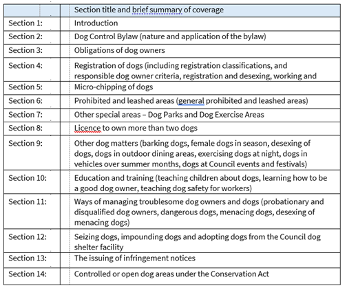
5. Christchurch City Council’s Practices
(Section 10A (1b))
To satisfy the requirements of section 10A of the Dog control Act 1996, the following information is
provided:
5.1 Dog Registration
The total
number of dogs recorded on the Council’s dog registration database for the period was
45,898.
5.2 Probationary and Disqualified Owners
The Council recorded 7 owners as
probationary, and 5 owners as disqualified over the period.
5.3 Dangerous
Dog Classifications
The Council classified 10 dogs as dangerous under section 31 of the
Act, adjusting the total
number of dogs on the dangerous dog
register to 40.
5.4 Menacing Dog Classifications
The Council has two separate menacing dog
classifications:
· Dogs classified as menacing based on the dog’s aggressive behavior (section 33A(1)(b)(i) of the Act). For the
period, 47 new dogs were classified as menacing, adjusting the total
number of
dogs classified in this category on the Council’s register to 238; and
· Dogs to be classified as menacing based on the
dog’s breed or breed type (section 33C of the Act). For the period, 1 new dog was
classified as menacing, adjusting the total number of dogs classified
in this category on the Council’s
register to 73.
5.5 Infringement Notices issued
The Council issued 1,025 infringement
notices for breaches against the Act:
· Obstruction
of a Dog Control Officer - 1 notice;
· Failure
to supply information - 5 notices;
· Failure
to comply with the bylaw - 7 notices;
· Failure
to comply with disqualification - 2 notices;
· Failure
to comply with a dog classification - 19 notices;
· Failure
to implant a microchip - 17 notices;
· Failure
to notify the death of a dog - 1 notice;
· Failure
to register a dog - 712 notices;
· Failure
to notify of a change of address - 1 notice;
· Failure
to keep a dog controlled or confined - 229 notices;
· Failure
to keep dogs under control - 26 notices;
· Failure
to provide proper care - 2 notices;
· Failure
to comply with a barking dog abatement notice - 1 notice; and
· Allowing
a dangerous dog to be unmuzzled - 1 notice.
5.6 Warnings
issued
A total of 754 warnings were issued:
· Warnings are issued in
cases where there is insufficient evidence to support the issuing of an
infringement or in cases where the breach of the Act is minor and there are no
previous recorded breaches.
5.7 Dog related complaints
The Council investigated 653 priority
one complaints (dogs attacking
persons, stock, poultry, domestic animals and protected wildlife or traffic
hazards relating to wandering
stock on roads).
The Council received
5,193 complaints relating to dogs barking, wandering, fouling, rushing and unregistered dogs.
The Council received a
total of 9,901 complaints relating to breaches of the Dog Control Act and/or
the Dog Control Bylaw 2016.
5.8 Prosecutions
1 prosecution was successfully completed due
to a breach of the effects of a
dangerous dog classification. The owner is to be disqualified from owning a dog
for a period of three years and the offending dog is to be
destroyed.
A further case is
currently pending before the Courts for dogs attacking persons and /or domestic
animals.
5.9 Found Dogs
Council found 1,913 dogs wandering. 1,372
were returned to their owners and 541
were impounded. Of these, 405 were claimed by their
owners from the animal shelter,
64 were adopted to new homes, and 44 were rehomed to dog
rescues.
Of the dogs found, 27
were euthanised. 17 dogs were euthanised due to their aggressive nature and could not be safely
rehomed, and 10 dogs were euthanised as they were classified as
Dangerous or Menacing.
5.10 Education
A total of 37 child education and adult
educational talks were provided free
of charge to the
community.
5.11 Free microchipping
The
Council continues to offer free
microchipping to all dog
owners, which is available every Wednesday.
6. Statistical
Summary
|
Category
|
|
|
Number
|
|
|
Total number of dogs on record
|
|
 45,892 45,892
|
|
Total number of probationary owners
|
|
8
|
|
Total number of disqualified owners
|
|
9
|
|
Total number of dogs classified as dangerous (live
records only)
|
|
4049
|
|
Total number of
dogs classified as menacing (live records only)
|
|
311306
|
|
Number of infringement notices
issued
|
|
1,0251,227
|
|
Dog attacks on people,
stock, poultry, domestic
animals or protected wildlife
|
|
653656
|
|
Dog rushing, intimidating people or
domestic animals.
|
|
627631
|
|
Dogs barking,
roaming or fouling, roaming dogs and miscellaneous
matters)
|
|
5,1935,241
|
|
Number of prosecutions taken
|
|
2
1
|
Attachments Ngā Tāpirihanga
There are no
attachments to this report.
In addition to the attached documents, the following background
information is available:
|
Document
Name – Location / File Link
|
|
Not
applicable
|
Signatories Ngā Kaiwaitohu
|
Author
|
Lionel Bridger
- Manager Animal Services
|
|
Approved By
|
Tracey Weston
- Head of Regulatory Compliance
John Higgins -
General Manager Strategy, Planning & Regulatory Services
|
|
13. Resolution to Exclude the Public
|
Section
48, Local Government Official Information and Meetings Act 1987.
Note: The
grounds for exclusion are summarised in the following table. The full wording from
the Act can be found in section
6 or section
7, depending on the context.
I move that the public be excluded from the
following parts of the proceedings of this meeting, namely the items
listed overleaf.
Reason for passing this resolution: a good
reason to withhold exists under section 7.
Specific grounds under section 48(1) for
the passing of this resolution: Section 48(1)(a)
Note
Section 48(4) of the Local Government
Official Information and Meetings Act 1987 provides as follows:
“(4) Every resolution to exclude the
public shall be put at a time when the meeting is open to the public, and the
text of that resolution (or copies thereof):
(a) Shall
be available to any member of the public who is present; and
(b) Shall
form part of the minutes of the local authority.”
This resolution is made in reliance on
Section 48(1)(a) of the Local Government Official Information and Meetings Act
1987 and the particular interest or interests protected by Section 6 or Section
7 of that Act which would be prejudiced by the holding of the whole or relevant
part of the proceedings of the meeting in public are as follows:
|
ITEM NO.
|
GENERAL SUBJECT OF EACH MATTER TO BE CONSIDERED
|
SECTION
|
SUBCLAUSE AND REASON UNDER THE ACT
|
PUBLIC INTEREST CONSIDERATION
|
Potential Release Review Date and
Conditions
|
|
10.
|
Unsolicited Proposal for Sale of Part of 177 Armagh Street
|
|
|
|
|
|
|
Attachment g - Valuation
|
s7(2)(h)
|
Commercial Activities
|
The release of information may impact on the Council's ability to
negotiate commercial outcomes beneficial to ratepayers which outweighs the
public interest.
|
19 August 2026
or after sale of property concludes
|
|
14.
|
Public Excluded Health, Safety and Wellbeing
Committee Minutes - 29 August 2025
|
|
|
Refer to the previous public excluded reason in the agendas for
these meetings.
|
|
|
15.
|
Appointment of Directors to
Council-controlled Organisations
|
s7(2)(a)
|
Protection of Privacy of Natural Persons
|
To protect the identity and reputations of candidates in the event
they are not appointed, the protection of which outweighs the public
interest.
|
20 September 2025
After the Council has made decisions and the candidates have been
notified.
|
|
16.
|
Property Matter
|
s7(2)(b)(ii), s7(2)(h)
|
Prejudice Commercial Position, Commercial Activities
|
This report contains commercially sensitive information about
upcoming decisions relating to a property leasing or sale arrangement and if
publicly available at this point in time could prejudice a commercial
position.
|
27 May 2036
Review when the site is sold or leased and that information
becomes public
|
Karakia Whakamutunga
Kia whakairia te tapu
Kia wātea ai te ara
Kia turuki whakataha ai
Kia turuki whakataha ai
Haumi e. Hui e. Tāiki e