Christchurch City Council
Agenda
Notice of Meeting Te Pānui o te Hui:
An ordinary meeting of the Christchurch
City Council will be held on:
Date: Wednesday 20 August 2025
Time: 9.30 am
Venue: Boardroom, Fendalton Service Centre, Corner
Jeffreys and Clyde Roads, Fendalton
Membership
|
Chairperson
Deputy Chairperson
Members
|
Mayor Phil Mauger
Deputy Mayor Pauline Cotter
Councillor Kelly Barber
Councillor Melanie Coker
Councillor Celeste Donovan
Councillor Tyrone Fields
Councillor James Gough
Councillor Tyla Harrison-Hunt
Councillor Victoria Henstock
Councillor Yani Johanson
Councillor Aaron Keown
Councillor Sam MacDonald
Councillor Jake McLellan
Councillor Andrei Moore
Councillor Mark Peters
Councillor Tim Scandrett
Councillor Sara Templeton
|
14 August 2025
Website: www.ccc.govt.nz
TABLE OF CONTENTS NGĀ IHIRANGI
Karakia Tīmatanga................................................................................................... 4
1. Apologies Ngā Whakapāha................................................................................. 4
2. Declarations of Interest Ngā Whakapuaki Aronga.................................................. 4
3. Public
Participation Te Huinga
Tūmatanui............................................................ 4
3.1 Public Forum Te Huinga Whānui.......................................................................................... 4
3.2 Deputations by
Appointment Ngā Huinga Whakaritenga...................................................... 4
4. Presentation
of Petitions Ngā
Pākikitanga............................................................ 4
Staff Reports
5. National
Erebus Memorial.................................................................................. 5
6. Water
Services Delivery Plan Adoption - Local Water Done Well............................. 41
7. Development
Contributions Policy 2025............................................................. 51
8. Development
Contributions Rebate Schemes...................................................... 73
9. Plan
Change 14 - Decision Making for Daresbury Heritage Listing........................... 89
10. Hagley
Golf Course Tree Removal and Planting.................................................... 95
11. Burwood
Landfill Site C Operational Extension.................................................. 103
12. Heathcote
Express Major Cycleway - Truscotts Road Detailed Traffic Resolutions... 111
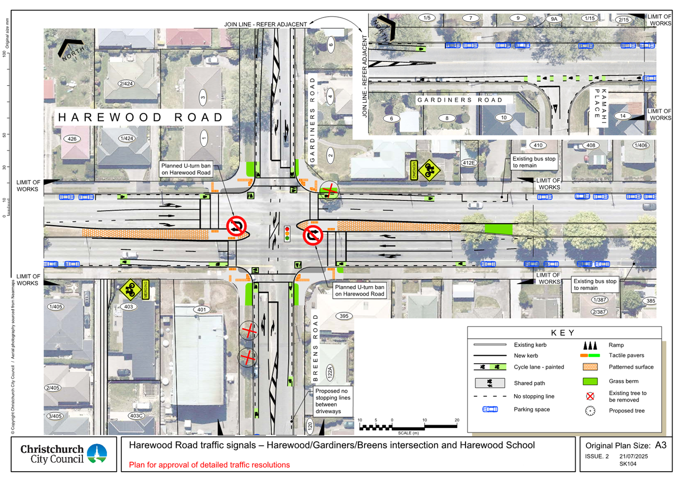
13. Harewood
Road traffic signals - Harewood/Gardiners/Breens intersection and Harewood
School - Detailed traffic resolutions.................................................................. 121
14. Manchester
Street Bus Gate Trial..................................................................... 145
15. Resolution
to Exclude the Public...................................................................... 161
Karakia Whakamutunga
Karakia Tīmatanga
Whakataka te hau ki te uru
Whakataka te hau ki te tonga
Kia mākinakina ki uta
Kia mātaratara ki tai
E hī ake ana te atakura
He tio, he huka, he hau hū
Tihei mauri ora
1. Apologies Ngā Whakapāha
Apologies will
be recorded at the meeting.
2. Declarations of Interest Ngā
Whakapuaki Aronga
Members are
reminded of the need to be vigilant and to stand aside from decision-making
when a conflict arises between their role as an elected representative and any
private or other external interest they might have.
3. Public Participation Te Huinga
Tūmatanui
3.1 Public Forum Te Huinga Whānui
A period of up to 30 minutes is available
for people to speak for up to five minutes on any issue that is not the subject
of a separate hearings process.
Public Forum presentations will be
recorded in the meeting minutes.
3.2 Deputations by Appointment Ngā
Huinga Whakaritenga
Deputations may be heard on a matter, or
matters, covered by a report on this agenda and approved by the Chairperson.
|
3.2.1
|
St Mary's Anglican Church
Vicar Mark Sullivan will speak on behalf
of St Mary's Anglican Church regarding Item 12 - Heathcote Express Major
Cycleway - Truscotts Road Detailed Traffic Resolutions.
|
4. Presentation of Petitions Ngā
Pākikitanga
There were no
Presentations of Petitions at the time the agenda was prepared.
To present to the Council, refer
to the Participating in decision-making webpage or
contact the meeting advisor listed on the front of this agenda.
|
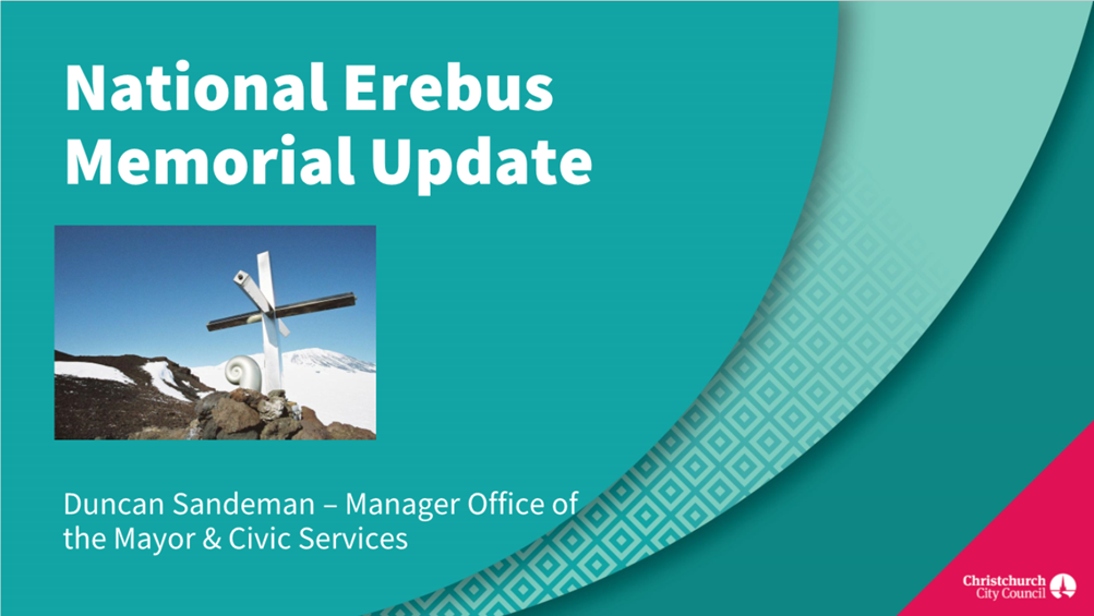
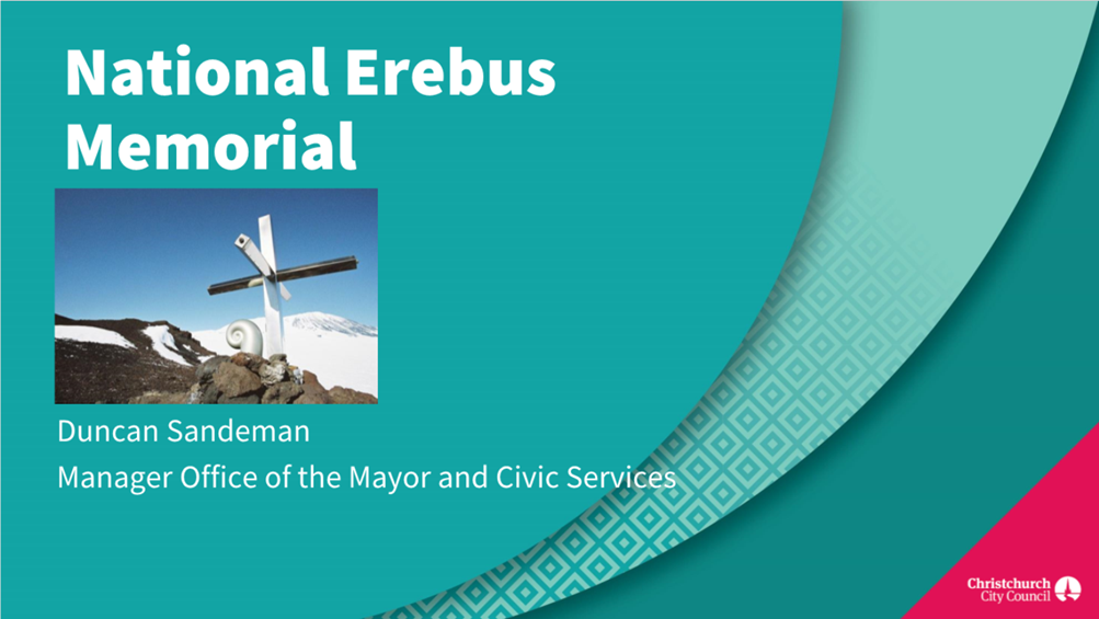
5. National
Erebus Memorial
|
|
Reference Te Tohutoro:
|
25/1416123
|
|
Responsible Officer(s) Te Pou Matua:
|
Duncan
Sandeman, Manager Office of the Mayor and Civic Services
|
|
Accountable ELT Member Pouwhakarae:
|
Mary
Richardson, Chief Executive
|
1. Purpose and Origin of the Report Te Pūtake Pūrongo
1.1 The
purpose of this report is to seek the Council’s agreement to offer a site
on Council-owned land in Christchurch to Manatū Taonga, Ministry for
Culture and Heritage (MCH), as a potential location for the National Erebus
Memorial.
1.2 This
report has been prepared in response to MCH’s ongoing efforts to secure a
suitable site for the memorial. While Auckland remains the preferred location
for many family members, prolonged delays in securing a viable site there have
led to consideration of alternative locations. Ōtautahi-Christchurch, with
its deep connections to Antarctic exploration and strong culture of
remembrance, presents a respectful and practical alternative. Through the
offer of a potential site, the Council now has an opportunity to support a
nationally significant project that honours the memory of those lost in New
Zealand’s worst civil disaster.
2. Officer Recommendations Ngā Tūtohu
That the Council:
1. Receives the information contained in the National
Erebus Memorial Report.
2. Agrees to offer Cracroft Reserve in Cashmere as a potential site for
the National Erebus Memorial and authorises the Mayor to formally convey this
offer to Manatū Taonga, Ministry for Culture and Heritage.
3. Authorises the Chief Executive to make decisions and/or sign any
documentation required for the purpose of effecting the offer.
4. Notes that the offer of a site in Christchurch is made in
recognition of the memorial’s national significance, and the
Council’s commitment to supporting the Erebus families and members of
Operation Overdue.
5. Notes that the offer will remain open for a 12-month period to enable
further investigations, visits and engagement with family members.
6. Notes that the decision in this report is assessed as medium significance
based on the Christchurch City Council’s Significance and Engagement
Policy.
3. Executive Summary Te Whakarāpopoto Matua
3.1 This report recommends offering Cracroft Reserve as the preferred
site for the National Erebus Memorial. The site was identified following a
robust investigation involving the Council, mana whenua, and Manatū
Taonga, Ministry for Culture and Heritage, followed by independent site
assessment undertaken by Barker & Associates.
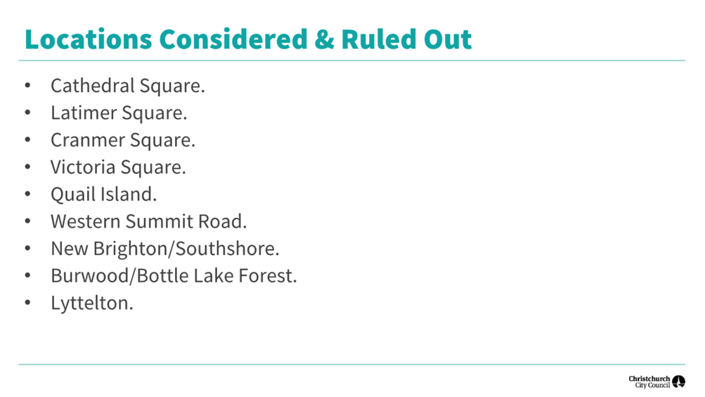
3.2 A
number of potential locations were considered across the city with two suitable
sites identified, as well as a third potential site. The three sites have the
attributes and qualities sought for the memorial, however one of these clearly
stood out once visited and assessed.
3.3 Cracroft Reserve in Cashmere offers a peaceful, elevated setting
with expansive views and strong cultural and experiential qualities. Upon
visiting the site these special qualities are immediately evident, something
which most Erebus families and members of Operation Overdue may not have had an
opportunity to experience. This is reflected in recent survey feedback provided
by MCH, which slightly favoured a site on the Ōtakaro-Avon riverbanks near
the Scott statue.
3.4 Conversations commenced with local stakeholders have been supportive
and welcoming of efforts to identify and offer a site, and of the potential for
Cracroft Reserve to accommodate the memorial.
3.5 An offer which remains open for a period of 12 months provides the
opportunity for further investigation and continued engagement.
3.6 The proposal aligns with Council’s strategic goals and has
received broad support from elected members and community boards.
4. Background/Context Te Horopaki
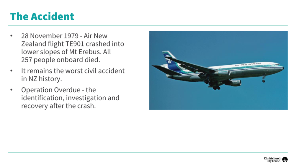
4.1 The Erebus disaster occurred on 28 November 1979, when Air New
Zealand Flight TE901, a sightseeing flight over Antarctica, tragically crashed
into Mount Erebus, killing all 257 passengers and crew on board. It remains New
Zealand’s worst civil disaster.
4.2 While the majority of passengers and all crew were from Auckland,
the tragedy had a profound national impact. The flight included
scientists, tourists, flight crew, guides and New Zealanders from across the
country as well as from overseas. In communities throughout Aotearoa and
overseas, families, friends, and colleagues grieved. The scale and suddenness
of the loss left a deep emotional scar that endures more than four decades
later. The disaster also deeply affected those involved in the investigation and
recovery, many of whom were drawn from around the country as well as places
like the United States.
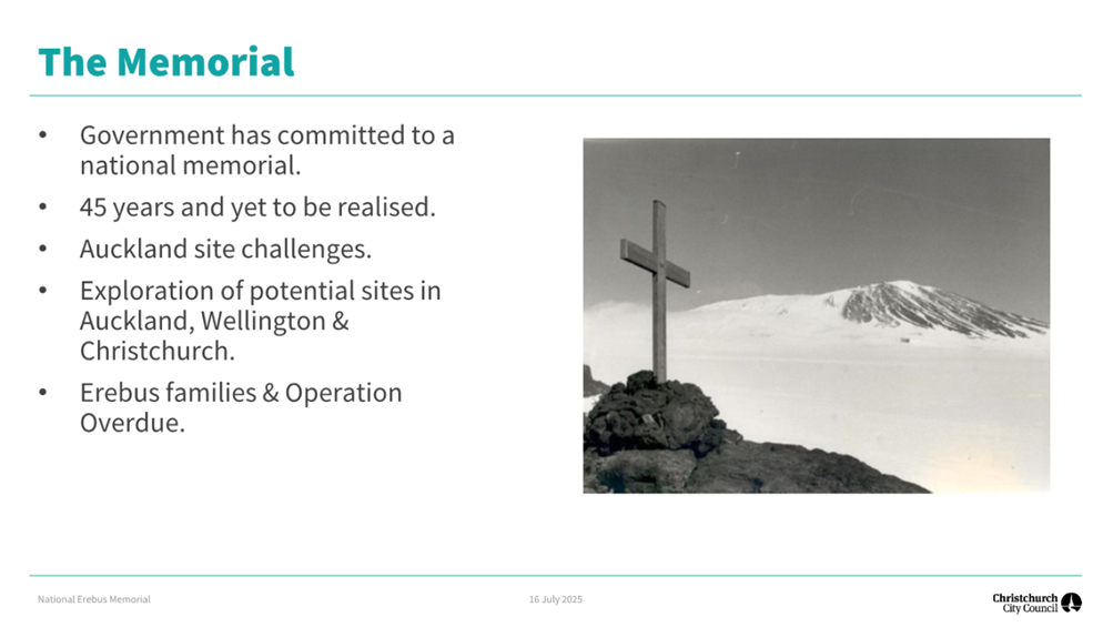
4.3 The New Zealand Government’s journey to establish a National
Erebus Memorial has been long and, at times, challenging. After decades of
advocacy by the families, the Government formally committed in 2017 to creating
a national memorial to honour the 257 lives lost in the disaster. Led by MCH,
the project aims to create a dedicated space for remembrance, reflection, and
education. Of the 257 passengers and crew on board, 60 were from overseas, 106
came from Auckland, and 77 were from other North Island towns/cities and 14
from the South Island.
4.4 The Ministry’s initial plans focused on Auckland, with
consideration of approximately 50 sites, including a detailed proposal for
Dove-Myer Robinson Park in Parnell. However, significant public opposition and damage
caused during Cyclone Gabrielle resulted in that location being set aside in
early 2023. Subsequent efforts to secure an alternative site in Auckland face
prolonged delays due to land access issues and stakeholder concerns. As a
result, other cities, including Christchurch, were considered as potential
hosts for the memorial.
4.5 Christchurch was informally approached in September 2024, via the
Christchurch Antarctic Office, to explore whether it could host the memorial.
In response, the Christchurch City Council established a small internal project
team and undertook briefings with the Executive Leadership Team and elected
members to assess interest. Councillors expressed unanimous support for the
Mayor to formally invite MCH to consider Christchurch as a home for the
memorial, and a letter of invitation was subsequently sent to the Secretary for
Culture and Heritage.
4.6 Christchurch offers a compelling and respectful alternative for the
memorial. As New Zealand’s gateway to Antarctica, the city has a rich
association with polar exploration and aviation history. Historic expeditions
(including those of Scott and Shackleton) launched from Christchurch, and TE901
was scheduled to return here for refuelling and a crew change. When news broke
that the flight was overdue, lights across the South Island were turned on in
hope that the aircraft might still find its way home.
4.7 More recently, Ōtautahi Christchurch has become known for the
strength of its response to tragedy, and for the expression of manaakitanga
shown to those who have experienced profound loss. From the Canterbury
earthquakes to the March 15 attacks, the city has learned the importance of
remembrance and of caring for those affected. This legacy gives Christchurch a
special understanding of the role a national memorial can play in honouring the
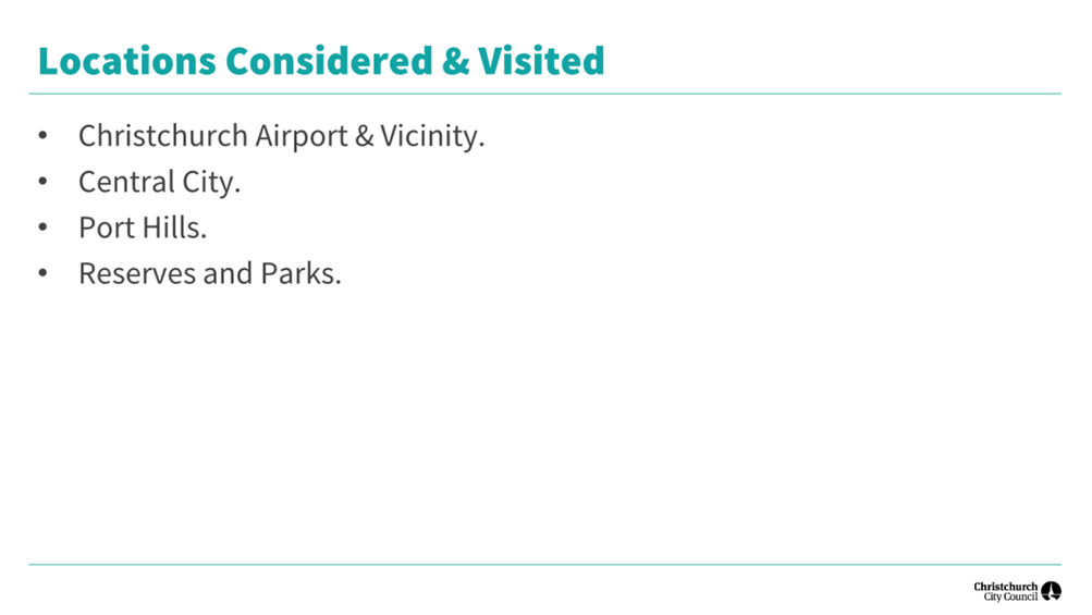
past and supporting healing.
4.8 A collaborative relationship developed between MCH and Council
staff. A multi-agency team was established to identify potential
sites. The team included representatives from the Council, MCH, mana
whenua (Whitiora), convened by memorials expert Professor Jacky Bowring. After
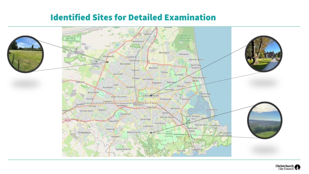
a robust assessment process, two Council-owned sites were shortlisted (Avon
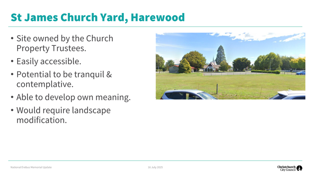
Riverbank in the Central city and Cracroft Reserve in Cashmere), and a third non-Council
owned option which would require further exploration (St James’ Church
grounds, Harewood).
4.9 In June and early July, elected members of the Council, along with
the Waihoro Spreydon-Cashmere-Heathcote and Waipapa
Papanui-Innes-Central Community Boards, were briefed on the site selection
process. These sessions were intended to confirm ongoing support for the
project and to help identify individuals and groups who could be engaged to
understand community sentiment toward the memorial. In mid-July, the
shortlisted sites were presented by MCH to family members and Operation
Overdue, through a series of online workshops.
4.10 Following the workshops a survey was sent to families and members of
Operation Overdue seeking their feedback on the three sites identified. MCH
received 109 responses of which 71 (65%) were supportive of one or more sites
in Christchurch. Ten (9%) were conditionally supportive and 28 (26%) did not
want the memorial to be located in Christchurch.
4.11 Of those who supported Christchurch as a potential location; 61
supported the Avon site, 54 Cracroft Reserve, and 25 St James. Comments and
questions for each site touched on accessibility, location within the city,
potential traffic noise, and constraints on the space.
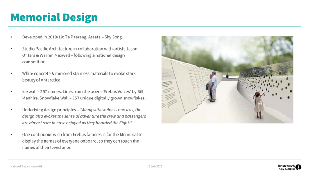
4.12 For any site selected, the memorial design would be adapted from
that previously developed for Auckland’s Dove-Myer Robinson Park, with
aspects drawn through and a process undertaken to adapt the design and scale
specific to the site.
4.13 The following related information session/workshops have taken place
for the members of the meeting. These briefings
were not open to the public due to the commitment that families and members of
Operation Overdue were to receive information ahead of any public
release.
|
Date
|
Subject
|
|
4
Dec 24
|
Erebus memorial briefing to Councillors.
|
|
10
Jun 25
|
Erebus memorial project briefing to
Councillors.
|
|
26
Jun 25
|
Erebus memorial project briefing to Waihoro
Spreydon-Cashmere-Heathcote Community Board.
|
|
3
Jul 25
|
Erebus memorial project briefing to Waihoro
Spreydon-Cashmere-Heathcote Community Board Deputy Chair.
|
|
10
Jul 25
|
Erebus memorial project briefing to Waipapa
Papanui-Innes-Central Community Board.
|
Options Considered Ngā
Kōwhiringa Whaiwhakaaro
4.14 The following
reasonably practicable options were considered and are assessed in this report:
4.14.1 Offering a single
site. Offering a single, carefully selected site
for the National Erebus Memorial demonstrates a clear and proactive commitment
by the Council to support this nationally significant initiative. This approach
provides clarity and focus for both MCH, the families and the community,
streamlining the planning and engagement process. The proposed site has been
identified based on the elevated city and mountain views, tranquillity,
accessibility, and its potential to respectfully accommodate the memorial. This
option reflects the Council’s desire to honour the Erebus tragedy in a
meaningful way, while ensuring the memorial is integrated thoughtfully into the
city’s landscape.
4.14.2 Offering two sites. The option of
offering two potential sites was considered as a way to provide flexibility and
support a collaborative decision-making process with the Ministry. Presenting
two viable locations allows for further investigations and comparative evaluation
based on technical, cultural, and community factors. While this option remains
available, it introduces additional complexity and may delay progress.
Nonetheless, it reflects the Council’s openness to dialogue and its
willingness to accommodate different perspectives and offer flexibility in
identifying the most appropriate site for the memorial.
4.15 The following
option was considered but ruled out:
4.15.1 Not offering a site.
The option of not offering any sites has been
considered and ruled out. While the Council acknowledges that many Erebus
family members have expressed a preference for the memorial to be located in
Auckland, we believe Christchurch can offer a meaningful and respectful
alternative and suitable sites have been identified. The city would warmly
welcome the memorial and the families, and by making an offer, we provide a
clear and constructive path forward for the memorial to be delivered. Declining
to offer a site would not reflect the Council’s values of remembrance,
partnership, and civic responsibility, nor would it support the national
significance of commemorating the Erebus tragedy. As such, this option is not
considered reasonable in the current context.
Options Descriptions Ngā
Kōwhiringa
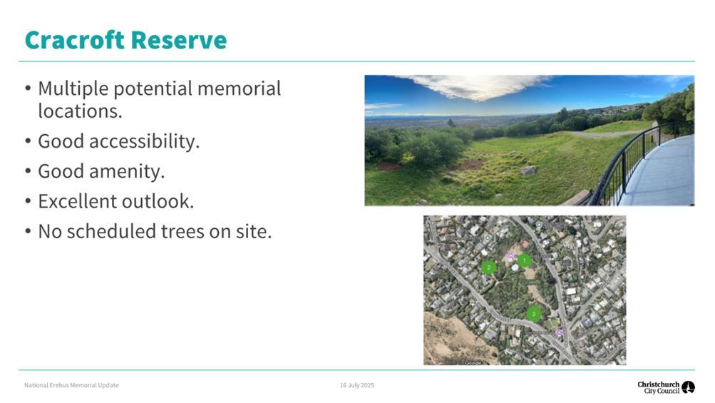
4.16 Preferred
Option: Single Site - Cracroft Reserve.
4.16.1 Site Description: Set adjacent to the renowned Sign of the Takahe (a recognised and protected heritage building
) in Cashmere, Cracroft Reserve offers expansive views across Christchurch and
out to the Southern Alps, stretching from the north to the south-west. The site
is quiet and green, with ample space for walking, reflection, and both private
contemplation and group gatherings. Its peaceful, spacious character is
complemented by practical amenities, including public toilets and a café
at the Sign of the Takahe. It is easily accessible by car or bus (approx.
15 minutes from the central city).
4.16.2 Site Advantages
· Peaceful and Reflective Setting. Cracroft Reserve offers a
tranquil, landscaped environment with mature native vegetation and elevated
views. Its natural serenity supports the memorial’s purpose of quiet
contemplation and remembrance.
· Experiential Qualities. The site’s topography and
pathways allow for a sense of journey and arrival, aligning well with the
design intention of the Erebus Memorial. It supports both individual reflection
and group gatherings.
· High Amenity and Visual Appeal. The reserve provides expansive
views over Christchurch and toward the Southern Alps, enhancing the
memorial’s connection to the sky and landscape. The mature trees and
natural features contribute to a high-quality setting.
· Cultural Sensitivity and Support. The site sits within a
cultural landscape. Mana whenua, through Whitiora, have expressed support for
the site, and no cultural sensitivities have been identified that would prevent
a memorial being established.
· Flexibility for Events. Cracroft Reserve includes several
large open spaces suitable for both formal commemorations and informal visits.
The site can accommodate a range of memorial activities without compromising
its natural character.
· Existing Facilities. The Sign of the Takahe venue and cafe on
the corner of Cracroft Reserve is an easy to locate landmark. The public
amenities block in the reserve also supports the needs of visitors.
· Planning Certainty. The site is zoned Open Space Community
Parks, where a public memorial is a permitted activity. While some
infrastructure considerations exist, these do not present significant barriers.
· Potential for Unique Identity. The reserve is of a scale and
character that allows the memorial to develop its own distinct meaning and
presence within the landscape, without competing with existing values or uses.
· Safety and Security. The site is not subject to significant
natural hazards and benefits from passive surveillance as a visitor destination
and through proximity to the Sign of the Takahe and local recreation areas.
4.16.3 Site Disadvantages
· Topographical Constraints. The sloping terrain at Cracroft
Reserve will need to be addressed through design and construction, and pathways
improved to ensure good accessibility. The required works will need to be
considered relative to the MCH budget.
· Infrastructure Considerations. The presence of three-waters
infrastructure within the reserve requires careful coordination during design
and construction.
· Location. Although just 15 minutes from the central city, the
site may be less visible and accessible to casual visitors or tourists,
potentially reducing spontaneous engagement with the memorial compared to a
more central location.
· Potential Vandalism Risks. While the site benefits from
some passive surveillance and does not raise particular CPTED concerns, this
will be a factor to consider during the design stage.
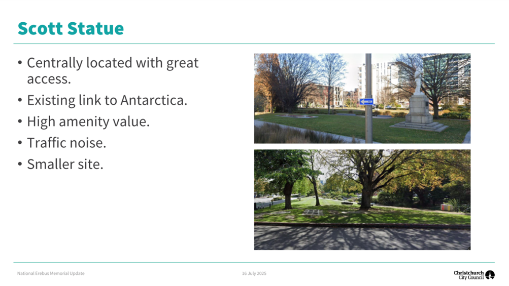
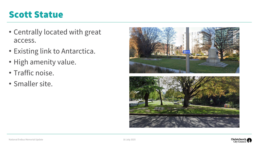
4.17 Site Two: Ōtākaro Avon River.
4.17.1 Site Description: Located along the Avon River, the Ōtākaro Avon River site
winds through the heart of Christchurch’s vibrant central city and offers
a peaceful, green setting within an urban landscape. Positioned near the Scott
Statue and not far from Oi Manawa Canterbury Earthquake National Memorial, it
provides a meaningful connection to existing places of remembrance. The area is
flat and open, with well-lit paths and lawns that support both quiet reflection
and large gatherings. It is easily accessible, with nearby parking,
cafés, and sheltered spaces, making it a practical and welcoming
location for visitors. Either side of the riverbank is a potential location.
4.17.2 Option Advantages
· Central Location. Situated in the heart of
Christchurch’s central city, the site is highly visible and easily accessible
to residents, visitors, and tourists.
· Strong Contextual Connections. The site is near existing
memorials, including the Scott Statue and Oi Manawa Canterbury Earthquake
National Memorial, creating a meaningful landscape of remembrance.
· Flat and Open Terrain. The area is flat and open, making it
relatively easy and cost-effective to construct the memorial.
· Accessible and Well-Serviced. The site is pedestrian-friendly,
with nearby public transport, car parking, cafés, and sheltered areas,
supporting both casual visits and formal events.
· Flexible Use. The open lawns and pathways allow for quiet
reflection and for larger gatherings both sides of the river could be utilised.
· Safe and Well-lit. The site benefits from good lighting,
visibility, and natural surveillance due to its central location and regular
public use.
· Amenity and Aesthetic Appeal. The river setting, mature trees,
and flowing water contribute to a peaceful and attractive environment that
enhances the memorial experience.
4.17.3 Option Disadvantages
· Heritage Values. The site contains several heritage items and
settings, including the Scott Statue and Mill Island. Any development will
require careful design to avoid compromising existing heritage values, which
will be a consideration within approvals processes.
· Planning Complexity. The site is within 30 metres of the Avon
River, a Ngāi Tahu site of cultural significance and a flood management
area. This will likely require resource consent, iwi consultation, and an
archaeological authority from Heritage New Zealand.
· Urban Noise and Activity. While centrally located, the site is
surrounded by traffic and urban activity, which may detract from the quiet,
contemplative atmosphere intended for the memorial.
· Potential for Adjacent Future Development. Development of
currently vacant land surrounding the site can be anticipated, potentially
altering the context and qualities.
· Flood Risk. The site is subject to occasional flooding from
the Avon River, which may require additional design considerations and
mitigation measures to ensure the memorial’s resilience and safety, particularly
if flooding events become more frequent over time.
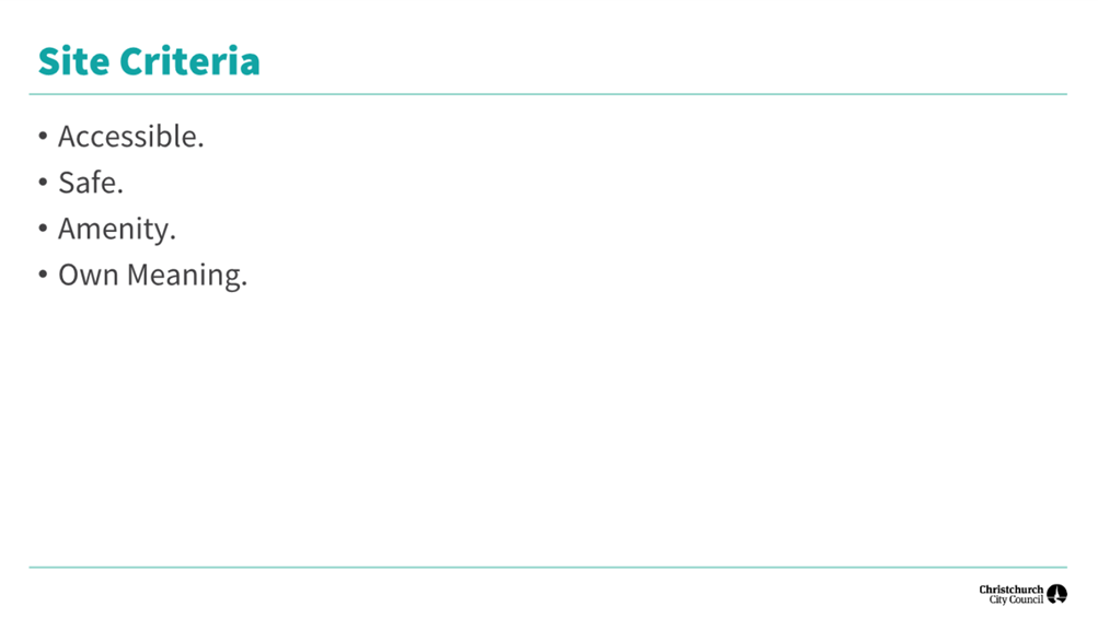
Analysis Criteria Ngā Paearu
Wetekina
4.18 The assessment of potential sites for the National Erebus Memorial
was guided by a structured set of criteria developed by MCH, in consultation
with Erebus families and Operation Overdue, and previously applied to the
selection of sites. These criteria were grouped into three overarching
categories:
|
Functionality
|
|
Accessible:
|
A location/site that is accessible so
people can easily get to it (public transport/vehicular access) and that can
be designed to have universal access.
|
|
Flexible:
|
A flexible space allowing for formal and
informal events, accommodating significant numbers as well as creating a more
private, intimate experience.
|
|
Safe:
|
Avoidance of threats and perceived
threats from adjacent structures or landforms, with particular attention paid
to geotechnical stability.
|
|
Context
|
|
Co-location:
|
The extent to which larger gatherings can
utilise adjacent spaces particularly if the site itself is restricted.
Co-location can mean a smaller memorial site could be workable/appropriate.
|
|
Adjacencies:
|
Compatibility with existing and potential
future adjacent development/activities.
|
|
Relevance:
|
A site that is located somewhere that is
conceptually connected to the function or purpose of the memorial.
|
|
Certainty:
|
A site that has sufficient certainty in
relation to security of tenure, iwi/hapu support, and authorising
environment, to ensure and enduring context for the memorial.
|
|
Meaning
|
|
Sensitivity:
|
A site where the memorial will not
affect/compromise existing cultural or social sensitivities.
|
|
Own meaning:
|
A site that can develop its own meaning
and significance over time, rather than a site which already has a fixed
meaning/symbolism or known significance.
|
|
Designer’s intention:
|
A site which can support the core
concepts of the selected design.
|
|
Amenity:
|
Whether the site has connection to
features that enhance the setting m(views, water, trees, shelter, aspect,
with particular attention to the site qualities expressed in the selected
design in relation to views and connections to the sea and sky.
|
4.19 Each criterion was weighted to reflect its relative importance, and
sites were scored accordingly to support a comparative evaluation. This
framework ensured a balanced consideration of both technical feasibility and
symbolic resonance in identifying the preferred location. The detailed
assessment report can be found on the MCH website: National Erebus Memorial Christchurch Site Assessments.
5. Financial Implications Ngā Hīraunga Rauemi
5.1 Government funding has been secured through MCH for the delivery of
the National Erebus Memorial, including its construction and ongoing maintenance.
Council staff will continue to provide operational support to MCH as needed.
Additionally, there may be an opportunity for the Parks Unit to reallocate
existing budget to undertake complementary works around the memorial site, if
deemed appropriate.
6. Considerations Ngā Whai Whakaaro
Risks and Mitigations Ngā
Mōrearea me ngā Whakamātautau
6.1 Perception of disregarding Erebus families’ preference for
Auckland. Many Erebus families have expressed a strong desire for the
memorial to be located in Auckland, where the original commitment was made.
Offering a site in Christchurch may be perceived as undermining that
preference. Providing MCH a window where our offer is open for up to 12
months will allow them to continue transparent communication with families,
emphasising that Christchurch is being considered due to delays in Auckland and
that the offer is made respectfully.
6.2 Approvals process for a selected site. The Avon Riverbank site
is located within an area that includes scheduled heritage items and cultural
sites. Construction of a memorial is likely to trigger resource consent, iwi
consultation, and archaeological authority requirements. Cracroft Reserve
offers fewer constraints in relation to approvals, although siting of the
memorial would need to work alongside existing three waters infrastructure.
Prioritising Cracroft Reserve as the preferred site provides a degree of
mitigation. If the Avon Riverbank is reconsidered, early engagement will be
needed with mana whenua, Heritage New Zealand Pouhere
Taonga, and Council’s planning and heritage teams
to ensure compliance and a sensitive design.
6.3 Community resistance to the memorial’s location. Some
residents may oppose the establishment of a national memorial in their
neighbourhood due to concerns about increased visitor numbers, changes to the
character of the area, or perceived lack of consultation. This could lead to
public opposition, negative media scrutiny, or delays in the consenting
process. To mitigate this we will continue to proactively engage with
local residents and community groups to share information, listen to concerns,
and build understanding of the memorial’s purpose and design. Messaging
will emphasise the respectful nature of the memorial and its alignment with the
area’s values. We will use targeted communications, in-person meetings
and events, and adaptive feedback channels to ensure transparency and
responsiveness.
Legal Considerations Ngā
Hīraunga ā-Ture
6.4 Preliminary
legal advice has been obtained and is outlined below. Should the Council
resolve to make the offer, further legal advice will be sought to confirm
compliance.
6.5 The legal considerations are as follows:
6.5.1 Cracroft Reserve (Record of Title CB385/51).
· Ownership & Purpose: The land in ROT CB385/51 is owned by
Christchurch City Council and is designated for the “health, amusement
and instruction of the public” under an old law (Municipal Corporations
Act 1933). This is considered a public purpose.
· Reserve Status: Although not explicitly labelled a reserve under the
current Reserves Act 1977, the land’s purpose strongly suggests it
qualifies as a recreation reserve. This is supported by its historical use and
alignment with the definitions in both the 1953 and 1977 reserve legislation.
· Leasing for Memorial: Under the Reserves Act 1977, the Council can
lease recreation reserve land for facilities that support public recreation or
enjoyment, which could reasonably include a memorial.
· Requirements:
Ministerial
Consent: The lease would need approval from the Minister for Conservation
unless the memorial is already included in the reserve’s management plan.
Public
Consultation: The public must be consulted before any lease is granted.
Lease Term:
Any lease would be limited to a maximum of 33 years.
· If Not a Reserve: If the land is later found not to be reserve land,
leasing it would be treated as a disposal of park land under the Local
Government Act 2002, which also requires public consultation.
6.5.2 Ōtākaro-Avon River.
· Ownership and Status:
These parcels
were vested in Christchurch City Council under the Christchurch City (Reserves)
Empowering Act 1971.
They are
considered reserves under the Reserves Act 1977, with the designated purpose of
“lawns, ornamental gardens, and ornamental buildings.”
The parcels
do not have individual titles and have not been formally classified under the
Reserves Act.
· Leasing Options:
Because of
their purpose, the land most closely aligns with a local purpose reserve. Under
section 61 of the Reserves Act, the Council can lease such land for things like
community buildings, which could reasonably include a memorial.
Alternatively,
the land could be treated as a recreation reserve under section 17, which also
allows leasing under section 54(1)(a). However, this option requires public
consultation before a lease is granted.
· The Council can lease or license the land to the Ministry for
Culture and Heritage for the memorial.
· If the Council treats the land as a local purpose reserve, public
consultation is not required.
· If the Council opts to treat it as a recreation reserve, public
consultation will be necessary, but could be covered by broader consultation on
the proposal if the site is clearly identified.
Strategy and Policy Considerations Te Whai
Kaupapa here
6.6 The
required decisions:
6.6.1 Align with the
Christchurch
City Council’s Strategic Framework. Offering
a site in Christchurch for the National Erebus Memorial aligns with the
Council’s Strategic Framework by contributing to a cultural powerhouse
city that honours its past while shaping a compassionate and connected future.
The proposal also reinforces our role as a gateway to Antarctica and champions
Ōtautahi Christchurch’s capacity to support national heritage
initiatives in ways that enhance civic pride, cultural expression, and
community wellbeing.
6.6.2 Are assessed
as medium significance based on the
Christchurch City Council’s Significance and Engagement Policy. The
level of significance was determined by the potential impact of the decision on
affected families and the level of national interest in the issue, weighed
against the minimal effect on Council service levels, financial cost, and
associated risk.
6.6.3 Are consistent with Council’s Plans and Policies. Aligns with Our Heritage,
Our Taonga Christchurch Heritage Strategy 2019-2029 vision, outcomes and goals.
In particular, Goal 3, Action 3. 'Acknowledge the importance of anniversaries,
traditional commemorations and events, and support communities to celebrate
them'.
6.7 This
report does not support the Council's
Long Term Plan (2024 - 2034).
6.8 While the proposal to host the National Erebus Memorial in
Christchurch does not align directly with the current Long Term Plan, given
that it was not anticipated or budgeted for within the Council’s planned
capital programme, this misalignment is largely immaterial. The project will be
fully funded by Manatū Taonga Ministry for Culture and Heritage, meaning
there is no financial impact on Council budgets. As such, the opportunity can
be considered on its strategic and civic merits without requiring amendment to
the Long Term Plan.
Community Impacts and Views Ngā Mariu
ā-Hāpori
6.9 Key stakeholders for Cracroft Reserve have been approached,
including the Friends of Cracroft reserve and the Sign of the Takahe operator and the local Scouts group which operates out of the reserve. Initial discussions have been positive, and information has been
shared more widely within local networks. Staff attended a community planting
day in the reserve and conversations with local residents focussed on the
memorial process and design, and to a lesser extent on the impact the memorial
could have on the site.
6.10 As a Central City location on public land there are no clear
community stakeholders for the Avon site. Should the site be offered to the MCH
business and development groups will be engaged. The shortlisting of the site
has been widely covered by the media and no groups or individuals have
expressed their interest to date.
6.11 The decision
affects the following wards/Community Board areas:
6.11.1 Waihoro
Spreydon-Cashmere-Heathcote Community Board, Cashmere Ward.
6.11.2 Waipapa
Papanui-Innes-Central Community Board.
6.12 Briefings were held with the two relevant Community Boards to
provide an overview of the memorial journey, outline why Christchurch is being
considered as a potential home for the National Erebus Memorial, and present
the specific sites identified within each Board’s area. Staff sought
feedback on likely community views and asked for guidance on who should be
engaged as part of the process. Both Boards were broadly supportive of the
proposal and recognised the significance of hosting a national memorial. However,
some concern was expressed regarding the views of Erebus family members,
particularly the perception that their preference for the memorial to remain in
Auckland may be overlooked in the decision to locate it in Christchurch.
Impact on Mana Whenua Ngā Whai Take
Mana Whenua
6.13 The decisions do not involve a significant
decision in relation to ancestral land, a body of water or other elements of
intrinsic value, therefore these decisions do not specifically impact Mana
Whenua, their culture, and traditions.
6.14 The decisions involve
a matter of interest to Mana Whenua and will not impact on our agreed
partnership priorities with Ngā Papatipu Rūnanga.
6.15 Mana whenua were involved in the
site selection process (through Whitiora) and provided valuable advice to
inform consideration of sites.
Heritage Considerations
6.16 While Cracroft Reserve is not
itself a scheduled heritage place, its adjacency to the Sign of the Takahe
introduces important design and planning sensitivities. These
require careful attention to ensure compliance alignment with heritage
conservation principles and to retain the heritage values of the adjacent
scheduled heritage item and setting.
6.17 The Avon River
site is highly sensitive from a heritage perspective, with multiple scheduled
heritage items and settings requiring careful design integration and likely
triggering resource consent. Mana whenua values are deeply embedded in the
area, and any memorial would need to respect and reflect these narratives.
While technically feasible, the Avon site presents greater planning complexity
and heritage constraints than Cracroft Reserve, and would require a more
intensive approvals and engagement process.
Climate Change Impact Considerations Ngā
Whai Whakaaro mā te Āhuarangi
6.15 The
proposals in this report are unlikely to contribute significantly to adaptation
to the impacts of climate change or emissions reductions.
6.16 While the memorial
itself will be designed with sustainability principles in mind (including
low-impact materials, landscaping, and passive design features) the broader
impact of the memorial includes increased travel by families and visitors, many
of whom may come from across New Zealand or overseas. This travel, particularly
by air, will contribute to greenhouse gas emissions. However, these
emissions are not directly attributable to the Council’s decision to
offer a site and are instead a consequence of the memorial’s national
significance and the desire of families to engage with it.
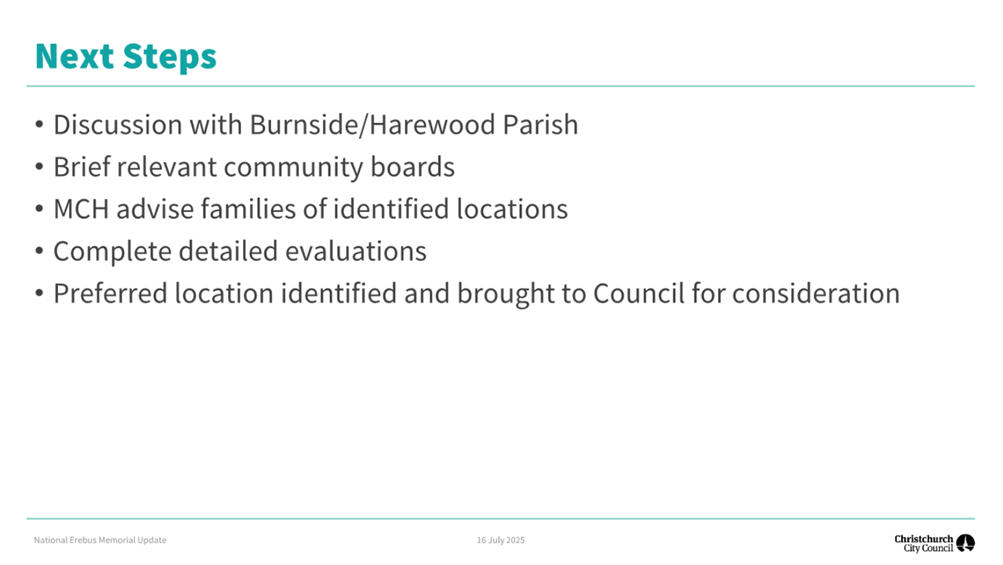
7. Next Steps Ngā Mahinga ā-muri
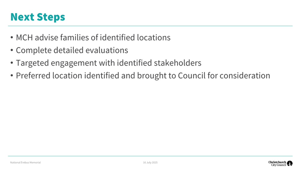
7.1 The Mayor will formally advise Manatū Taonga Ministry for
Culture and Heritage of the Council’s decision to offer Cracroft Reserve
as the preferred site.
7.2 Continue collaborative engagement with MCH, mana whenua (through Whitiora),
and relevant stakeholders to support their ongoing site confirmation and
concept development process.
7.3 Coordinate on MCH led community and family engagement, including
updates to Erebus families and Operation Overdue personnel, to ensure
transparent communication and respectful dialogue.
7.4 Support MCH in progressing any required planning and consenting
processes, including provision of relevant Council information, reports, and
staff input.
7.5 Provide regular updates to the Council and Community Boards as the
memorial proposal progresses through concept design, consultation, and
statutory processes.
7.6 Determine
the appropriate mechanism for giving effect to the offer.
7.7 Prepare a Memorandum of Understanding (MoU) or similar agreement
with MCH to outline roles, responsibilities, and the terms of the site offer,
should the site be confirmed.
Attachments Ngā Tāpirihanga
|
No.
|
Title
|
Reference
|
Page
|
|
a ⇩
|
Erebus
Memorial Project Briefing to Councillors
|
25/1422187
|
17
|
|
b ⇩
|
Erebus
Memorial Project Briefing to Community Boards
|
25/1422188
|
26
|
In addition to the attached documents, the following background
information is available:
Signatories Ngā Kaiwaitohu
|
Authors
|
Duncan
Sandeman - Manager Office of Mayor & Civic Services
Ceciel DelaRue
- Team Leader Urban Design
Tessa Zant -
Manager Engagement
|
|
Approved By
|
Mary
Richardson - Chief Executive
|
|
6. Water
Services Delivery Plan Adoption - Local Water Done Well
|
|
Reference Te Tohutoro:
|
25/1126909
|
|
Responsible Officer(s) Te Pou Matua:
|
Gavin
Hutchison, Head of Three Waters
|
|
Accountable ELT Member Pouwhakarae:
|
Brent
Smith, General Manager City Infrastructure
|
1. Purpose and Origin of the Report Te Pūtake Pūrongo
1.1 The
purpose of this report is to seek Council’s adoption of the Water
Services Delivery Plan (WSDP) and to approve its submission to the Secretary
for Local Government (Secretary) for review and acceptance.
1.2 The
report provides:
· A summary of the
legislative context, including the requirements of the Local Government (Water
Services Preliminary Arrangements) Act 2024 to prepare and submit the WSDP by 3
September 2025.
· An overview of the WSDP.
2. Officer Recommendations Ngā
Tūtohu
That the Council:
1. Receives the information in the Water Services Delivery Plan
Adoption - Local Water Done Well Report.
2. Notes that the decision in this report is
assessed as high significance based on Christchurch City Council’s
Significance and Engagement Policy.
3. Notes that prior to submission of the Water
Services Delivery Plan (WSDP), section 18 of the Local Government (Water
Services Preliminary Arrangements) Act 2024 (Act) requires the Chief Executive
to certify that:
a. the WSDP complies with the Act; and
b. the information contained in the WSDP is true
and accurate.
4. Adopts the Water Services Delivery Plan,
attached as Attachment A to this report.
5. Approves the submission of the Water Services
Delivery Plan to the Secretary for Local Government.
6. Notes that the Water Services Delivery Plan must
be submitted to Secretary for Local Government, for their consideration and
acceptance if compliant with the Act, no later than 3 September
2025.
7. Authorises the Chief Executive to make minor
amendments and corrections to the Water Services Delivery Plan, as may be
necessary to ensure accuracy and consistency, provided such changes are not
material.
3. Executive Summary Te Whakarāpopoto Matua
3.1 The
Local Government (Water Services Preliminary Arrangements) Act 2024 (the Act)
requires the Council to develop a WSDP. This must detail the current state of
water services and demonstrate publicly the Council’s commitment to
deliver water services in a way that:
3.1.1 ensures
it will meet relevant regulatory quality standards;
3.1.2 is
financially sustainable by 30 June 2028;
3.1.3 ensures
it will meet all drinking water quality standards; and
3.1.4 supports
housing growth and urban development as specified in its long-term plan.
3.2 The
content of a WSDP is prescribed in section 13 of the Act. A WSDP must
contain information such as the current state of a council’s water
services and infrastructure, its future investment needs, including projected
capital and operational expenditure and how these costs will be financed.
The WSDP must also demonstrate how water services will be financially sustainable,
including ringfencing water services revenue and outline how a council will
comply with current and anticipated regulatory standards set out under the LWDW
reform.
3.3 The
WSDP must also include detail on the Council’s proposed model for
delivering water services. Christchurch City Council evaluated and consulted on
three delivery models. These were an in-house delivery model, a water
services Council-controlled organisation model for three waters (WSCCO), and a
two-waters WSCCO model. In May 2025, Council approved delivery of waters
services through the in-house delivery model.
3.4 Staff
have developed a WSDP in accordance with the requirements of the Act and
following the template and guidance provided by the Department of Internal
Affairs (DIA), refer Attachment A for the proposed WSDP.
3.5 The
WSDP has been created using information from the Long-Term Plan 2024 –
2034 (LTP), Activity and Asset Management Plans, the Financial Strategy, the
Infrastructure Strategy, the Activity 10 Year Funding Impact Statements and the
10-year projected Statement of Financial Position in the LTP.
Additionally, the financial information has been updated to reflect changes
made in the 2025/26 Annual Plan.
3.6 The
Act requires the Council adopt’s its WSDP by resolution (section 17), and
the Chief Executive must certify that the WSDP complies with the Act and the
information contained in the plan is true and accurate (section 18). The
Council is required to submit its WSDP to the Secretary no later than 3
September 2025.
4. Background/Context Te Horopaki
General overview of LWDW
4.1 The
LWDW reform aims to ensure safe, reliable and financially sustainable water
services across New Zealand, while retaining both local ownership of assets and
decision-making. LWDW responds to several systemic issues identified in
water services delivery across the country, including aging infrastructure,
historic underinvestment, inconsistent services levels, and gaps in regulatory
oversight. The framework establishes a structured pathway for councils to
assess and adopt delivery models that meet more stringent standards for
quality, financial sustainability and environmental performance.
4.2 The
Government is implementing the LWDW framework in three legislative stages:
4.2.1 Water
Services Acts Repeal Act 2024 (repealed the previous water services
legislation).
4.2.2 Local
Government (Water Services Preliminary Arrangements) Act 2024 (the Act),
enacted in September 2024, which requires councils to develop and submit a WSDP
to the Secretary no later than 3 September 2025 (unless an exemption is
granted).
4.2.3 The
Local Government (Water Services) Bill establishes the enduring legislative
framework for water service delivery. In summary, it outlines arrangements for
a new delivery system, introduces an economic regulation and consumer
protection regime, and updates the regulatory framework for water quality and
the water services regulator. Council submitted feedback on the Bill, and
the Finance and Expenditure Committee has recommended significant amendments.
The Bill has passed its second reading and is currently in its final stages of
progression[1].
Selection of a Water Services Delivery Model
4.3 A
key requirement of a WSDP is to identify the Council’s proposed or
anticipated model for delivery water services.
4.4 In
February 2025, the Council considered an indicative business case and an
accompanying report which set out the rationale for consulting on three water
services delivery options. The three service delivery options were an
in-house option, a council-controlled organisation for three waters and thirdly
a two waters council-controlled organisation. The Council opted to use
the alternative consultation procedure provided under the Act for its
decision-making, including for the purposes of public consultation. It
resolved to consult on the three models and identified the in-house delivery
model as its “proposal” for public consultation.
4.5 The
public was consulted from 7 March 2025 to 6 April 2025. A total of 612
responses were received. Of these 80% of the responses indicated their
preference for retaining water services in-house.
4.6 In
May 2025, the Council resolved to adopt an in-house water services delivery
model for its WSDP.
Key requirements of a WSDP
4.7 The WSDP is a one-off, transitional requirement under the Act. It
enables councils to demonstrate their commitment to delivering water services
that meet regulatory standards, support growth and urban development and are
financially sustainable. The WSDPs also serve to inform the Commerce Commission
in developing the long-term economic regulation framework for water services.
4.8 The WSDPs must cover a ten-year period from 1 July 2024 to 30 June
2034. Councils must give effect to the proposals or undertakings relating
to the future delivery of water services that are included in the WSDP.
4.9 The Act requires that WSDPs are adopted by Council resolution.
Pursuant to section 18 of the
Act, the WSDP that is submitted to the Secretary for acceptance must include a
certification by the Chief Executive that:
4.9.1 the WSDP complies with the Act, and
4.9.2 the information contained in the WSDP is true and accurate.
4.10 The required content for a WSDP (that is not a joint WSDP) is
prescribed in section 13 of the Act. Section 13 has extensive
requirements, and a WSDP must include the following information:
4.10.1 an
explanation of how the revenue from, and delivery of, water services will be
separated from the Council’s other functions and activities
(‘ringfenced’);
4.10.2 an
explanation of what the Council proposes to do to ensure that the delivery of
water services will be financially sustainable by 30 June 2028; the Act defines
“financially sustainable” as:
· the revenue
applied to the Council’s delivery of those water services is sufficient
to ensure the authority’s long-term investment in delivering water
services; and
· the Council is
financially able to meet all regulatory standards and requirements for its
delivery of those water services, noting that to assess whether its WSDP is
financially sustainable, the Council is required to provide information about
three components: revenue sufficiency, investment sufficiency and financing
sufficiency.
4.10.3 information
about the anticipated or proposed model or arrangements for delivering water
services in a Council’s district.
4.10.4 an
implementation plan that sets out the process for delivering the proposed model
or arrangements in the plan.
4.11 The
Council consulted on the proposed model for delivering water services in its
WSDP. Councils are not required to consult on their draft or final
WSDP.
4.12 Once the WSDP is submitted, the Secretary must consider it and then
accept the WSDP if satisfied it complies with the Act.
4.13 A project team was established to support the development of the
WSDP. The team used various source documents (as outlined in paragraph 3.5) and
incorporated input from staff across multiple service units, including asset
management, asset planning, quality and compliance, monitoring and research
team, strategic policy and resilience, business improvement and finance.
Internal reviews have been undertaken to ensure the accuracy and integrity of
the WSDP prior to its submission to the DIA.
Overview of the WSDP and how it was developed
4.14 The
DIA provided a WSDP template that could be used ‘as-is’. The
template was designed to support councils develop compliant WSDP. The
template details the current state of Christchurch’s water
infrastructure, identifies future investment needs, and outlines the financial
and operational strategies required to comply with current and anticipated
regulatory standards set out under the LWDW reforms.
4.15 The
WSDP is divided into different parts (refer Attachment A: Part A to Part F).
4.16 Part
A provides an overview of water services delivery, the proposed delivery model
and an implementation plan for the proposed delivery model. As Council’s
proposed delivery method is to remain in-house, this reduces the transition
required. However, to enhance delivery and comply with current and future
regulatory requirements, certain steps are required. These are detailed in the
implementation plan (which is part of the WSDP).
4.17 Part
B provides an overview of the Council’s network assets and level of
investment required over the 10-year period. This section details information
on current state, condition and expected lifespan on water services
infrastructure assets and provides an overview of regulatory compliance.
4.18 Part
C details revenue, charging, funding and financing arrangements. It set outs
the Council’s revenue requirements and sources, affordability of
projected water services charges, water services financing requirements,
borrowing arrangements, debt allocation and insurance arrangements.
4.19 Part
D includes an explanation on what the Council proposes to do to ensure that the
delivery of water services will be financially sustainable by 30 June 2028.
4.20 Part
E Provides financial projections for water services covering financial years
2024/25 to 2033/2034.
4.21 Part
F details any additional information such as significant capital projects,
risks and assumptions for water services that have been included in the WSDP.
Summary of key
points in WSDP
4.22 The
Council will continue to deliver water services solely in-house. Water supply,
wastewater, stormwater as well as flood protection will be delivered by the
Water Services Business Unit.
4.23 Adopting
the in-house model does not preclude the Council from considering a WSCCO or
other more significant structural changes in the future. Once the WSDP is in
place and the regulatory environment has settled, the Council will be better
positioned to assess alternative models with greater clarity. This approach
avoids the risks of premature or unnecessary structural change, while
preserving the ability to make considered, evidence-based decisions at the
appropriate time.
4.24 While
the in-house water services delivery model has a lower borrowing cap, set at
280% of revenue compared to 500% for a WSCCO, the Council’s
proportionately higher revenue base means its borrowing capacity remains robust
and above what it could borrow through a WSCCO, based on its current water
revenues. Financial modelling confirms that the Council is currently in a
strong financial position, with sufficient headroom to support the forecast
investment programme.
4.25 The
proposed level of investment is fully funded by projected revenues and access
to financing, is sufficient to meet expected levels of service, regulatory
requirements and provide for growth. Water services asset investment ratio
remains positive in all years of the WSDP, demonstrating the capital investment
each year in water services assets exceeds the incurred depreciation expense.
4.26 The
Council will continue to derive the majority of its revenue from Council rates
with additional contributions from development fees.
4.27 The
Council can afford day to day operations with projected water services revenues
exceeding operating costs. This achievement in the operating surplus ratio is
largely due to the Council’s Long-Term Strategy to increase to 100%
rating renewals expenditure by 2032.
4.28 Revenue
generated from water services will be ringfenced from other Council revenue
streams by using cost objects and hierarchies, ensuring it is separately
identifiable within the Council’s cost and budget ledgers. Implementation
will follow a staged approach. While water services are already reported
separately through activity statements, the Council will enhance the separation
to make it more accessible and visible to support governance and management
oversight. This will ensure that all revenues, costs, overheads, and surpluses
associated with water services are applied exclusively to that activity.
4.29 The
Council will undertake a range of initiatives to strengthen its water service
delivery processes, ensuring compliance with current and future regulatory
requirements and achieve financial sustainability by 30 June 2028. The
implementation plan consists of several key tasks, including:
· Development of three
plans which will drive performance improvements. These are the capital delivery
asset management plan, the operating cost improvement plan and the maintenance
strategy.
· Checking and
adjusting service level agreements.
· Monitoring the Water
Services Business Unit financial sufficiency requirements.
· Completing the water
services operating model.
· Ensuring financial
separation of water services i.e. ringfencing.
· Reviewing and
updating asset data base.
· Completing and
adopting a water services strategy.
· Implementing any
operational and governance changes required.
· Implementing any
other changes required under the Local Government (Water Services) Bill.
4.30 The development of the WSDP also included related information
session/workshops that have been delivered for the members of the meeting:
|
Date
|
Subject
|
|
12.08.2025
|
Council Briefing on Water Services
Delivery Plan Update
|
Options Considered Ngā Kōwhiringa Whaiwhakaaro
4.31 The
following reasonably practicable options were considered and are assessed in
this report:
4.31.1 Council
adopts the WSDP – this is the recommended option.
4.31.2 Council
declines to adopt the WSDP.
Options Descriptions Ngā Kōwhiringa
4.32 Preferred
Option: Council adopts the WSDP
4.32.1 Option
Description: Council approves the submission of the WSDP to the Secretary.
4.32.2 Option
Advantages
· The Council
will meet the statutory deadline for submission no later than 3 September 2025.
· On the
assumption the WSDP is accepted, the Council can work towards giving effect to
the WSDP.
4.32.3 Option
Disadvantages
· None
identified.
4.33 Alternative
Option
4.33.1 Option
Description: Council declines to adopt the WSDP.
4.33.2 Option
Advantages
· None
identified.
4.33.3 Option
Disadvantages
· Council will
fail to meet the statutory of no later than 3 September 2025 for submitting its
WSDP. Failure to meet the deadline may result in the Minister (for Local
Government) exercising powers in relation to WSDP such as appointing a Crown
facilitator or Crown Water Services Specialist.
· The attached
WSDP reflects Council’s decision in May 2025, following public
consultation. Consultation feedback showed approximately 80%
support for the in-house delivery model, and a departure from this
approach without clear justification could be perceived as inconsistent with
the weight of public feedback and may raise concerns about Council’s
responsiveness to community input.
· The
implementation steps and financial sustainability measures outlined in the WSDP
are projected to be achieved by 30 June 2028, based on the financial forecasts
in the LTP, as amended by the 2025/26 Annual Plan. If the WSDP is not adopted,
the Council’s LTP will require amendment to reflect an alternative
approach to water services delivery
· Staff have
completed an internal review of content in the WSDP against the requirements of
the Act and DIA’s template, and declining would be inconsistent with
these requirements.
5. Financial Implications Ngā Hīraunga Rauemi
5.1 The
decisions outlined in this report do not result in additional capital or
operational expenditure requirements to the Council, water services financial
sustainability is projected to be achieved by 30 June 2028 within the existing
financial projections included in the LTP as varied by the Annual Plan 2025/26.
6. Considerations Ngā Whai Whakaaro
Risks and Mitigations Ngā Mōrearea me
ngā Whakamātautau
6.1 Risks
and mitigations that relate to the recommendation in this report:
|
Risk
|
Description
|
Mitigation Measures
|
|
Failing to address requirements in
the Act in response to LWDW
|
If the Secretary is not satisfied
the WSDP meets legislative requirements, they can request the Council to
amend and resubmit or decide not to accept the plan which may lead to
Ministerial assistance or intervention i.e. appoint a Crown Facilitator to oversee
plan development.
|
Using template provided by the DIA
covering including financial models.
Internal review of content against
DIA template and Act’s requirements.
Engaged with DIA as appropriate.
|
|
Failing to submit plans no later
than 3 Sept 2025
|
Non submission breaches the
Act’s requirement for councils to submit their WSDP no later than 3
September 2025.
|
Clear timeline set and monitored
with internal submissions, reviews and council decisions required.
|
Legal Considerations Ngā Hīraunga
ā-Ture
6.2 Statutory
and/or delegated authority to undertake proposals in the report:
6.2.1 The
Council has the authority to make decisions in the report.
6.3 Other Legal Implications:
Local Government (Water Services
Preliminary Arrangements Act 2024:
6.3.1 The
WSDP is required under section 8 of the Act. The WSDP has been prepared
to contain the information required by section 13.
6.3.2 Section
17 sets out that Councils must adopt a WSDP by resolution. Section 18
requires each WSDP that is submitted, to include certification from the Chief
Executive that the WSDP complies with the Act and the information contained in
the WSDP is true and accurate.
6.3.3 Section
22, the Council must give effect to the proposals or undertakings relating to
the future delivery of water services in the Council’s WSDP.
Local Government
(Water Services) Bill:
6.3.4 The
Bill sets out the key details relating to the water service delivery system,
the economic regulation and consumer protection regime and changes to the water
quality regulatory framework. The Bill is currently at the Committee of
Whole House stage. The Bill is therefore still subject to change.
Staff are monitoring amendments as the Bill progresses through the
House.
Strategy
and Policy Considerations Te
Whai Kaupapa here
6.4 The
required decision
6.4.1 Aligns
with the Christchurch
City Council’s Strategic Framework. In particular, the following
Strategic Priorities and Community Outcomes are relevant:
· Our residents have
shown trust and confidence in the Council through their support of the
preferred water services delivery model remaining in-house.
· Manage ratepayers'
money wisely, delivering quality core services to the whole community and
addressing the issues that are important to our residents.
· Actively balance the
needs of today's residents with the needs of future generations, with the aim
of leaving no one behind.
6.4.2 Is
assessed as high significance based on the Christchurch City Council’s
Significance and Engagement Policy. The level of significance was
determined by the potential number of residents affected across the district,
potential number of businesses affected, current level of community interest
and potential impact of the outcome on health, social and economic wellbeing.
6.4.3 Is consistent with Council’s Plans and
Policies. Current legislation is in development in the form of the Local
government (System Improvements) Amendment Bill and the Local Government (Water
Services) Bill. Both may have future policy and strategy implications for
Council.
6.5 The
ring-fencing and financial separation of water services is inconsistent with
the Council’s 2024–2034 Long Term Plan Financial Strategy, which
evaluates the Council’s financial approach in its entirety. The new
legislative framework now mandates the separation and ring-fencing of water
service delivery, from the delivery of other Council services.
Community
Impacts and Views Ngā Mariu ā-Hāpori
6.6 The
decisions in this report do not impact community. The community has been
consulted on the proposed model, and alternative models, and arrangements for
delivering water services.
6.7
The WSDP meets the legislative requirement to demonstrate publicly Councils
commitment to deliver water services, noting that when the plan is accepted, it
must be made publicly available on the Council’s website.
6.8 Council
consulted on the proposed model for delivering its water services. The
Local Government (Water Services Preliminary Arrangements) Act 2024 does not
require a territorial authority to consult on a draft or final water services
delivery plan.
Impact
on Mana Whenua Ngā
Whai Take Mana Whenua
6.9 The
decision in this report involves a matter of interest to mana Whenua and could
impact on our agreed partnership priorities with Ngā Papatipu
Rūnanga.
6.10 The WSDP has
implications for mana whenua, whose deep and enduring relationship with wai
(water) is grounded in cultural, spiritual, and environmental values. Mana
whenua have consistently expressed concerns that current water reforms fail to
uphold Te Tiriti o Waitangi, particularly in relation to tino rangatiratanga
and genuine partnership. This is exemplified by the Ngāi Tahu High Court
case, which seeks co-management of South Island freshwater resources, a clear
assertion of rangatiratanga and the right to participate meaningfully in
decision-making. The outcome of this case remains pending.
6.11 The legislation
introduces structural and procedural changes, including ringfencing water
services revenue, governance reviews, and new asset and financial systems which
are reflected in the WSDP. These may unintentionally impact on
mātauranga Māori and mana whenua identity.
6.12 While some
engagement has occurred, feedback from mana whenua indicates that consultation
to date has not met their expectations. Mana whenua have emphasised the need
for continuous involvement throughout the reform process, not just as
stakeholders, but as Treaty partners.
6.13 Staff will
prioritise ongoing engagement with mana whenua throughout the implementation of
the WSDP to embed their perspectives and values in future strategic planning.
Mana Whenua have indicated a desire for co-designing governance structure
options, recognition of mātauranga Māori in water management
practices and building enduring relationships that enhance outcomes for wai
(water), ngā tangata (people), and takiwā (place).
Climate
Change Impact Considerations Ngā Whai Whakaaro mā te Āhuarangi
6.14 The
decisions in this report to adopt and submit the WSDP to the Secretary for
Local Government do not have any climate change implications.
7. Next Steps Ngā Mahinga ā-muri
7.1 If
Council supports the officer recommendations, the following next steps will be
taken.
|
Date
|
Activity/event
|
|
20 Aug -1
Sept
2025
|
· Chief executive to
provide certification on behalf of Council that the WSDP complies with the
Act, and the information contained is true and accurate
|
|
2 Sept 2025
|
· WSDP submission to
the Secretary of Local Government
|
|
Sept –
October 2025
|
· Working with DIA
regarding any further information about the WSDP as required
|
|
October
– Dec 2025
|
· Receive WSDP
decision
|
|
Dec-2025 (or
as soon as reasonably practicable)
|
· Publish WSDP on
Council website
|
Attachments Ngā Tāpirihanga
|
No.
|
Title
|
Reference
|
Page
|
|
a ⇨
|
Water Services
Delivery Plan (Under Separate Cover)
|
25/1622224
|
|
In addition to the attached documents, the following background
information is available:
|
Document
Name – Location / File Link
|
|
|
Signatories Ngā Kaiwaitohu
|
Authors
|
Gavin
Hutchison - Head of Three Waters
Parul Sharma -
Project Manager
Naomi Soper -
Senior Legal Counsel
Mitchell Shaw
- Reporting Accountant
|
|
Approved By
|
Brent Smith -
General Manager City Infrastructure
Bede Carran -
General Manager Finance, Risk & Performance / Chief Financial Officer
Mary
Richardson - Chief Executive
|
|
7. Development Contributions Policy
2025
|
|
Reference Te Tohutoro:
|
25/1426631
|
|
Responsible Officer(s) Te Pou Matua:
|
Ellen
Cavanagh, Senior Policy Analyst
|
|
Accountable ELT Member Pouwhakarae:
|
John
Higgins, General Manager Strategy, Planning & Regulatory Services
|
1. Purpose and Origin of the Report Te Pūtake Pūrongo
1.1 The
purpose of this report is for the Council to adopt the draft Development
Contributions Policy 2025.
1.2 The Council has previously received the written and oral submissions
on the draft policy and resulting staff advice.
1.3 The Local Government Act 2002 (‘LGA’) requires
all local authorities to have a policy on development contributions or
financial contributions and to review it every three years. As the
Council’s policy was last adopted in 2021, it is due for review.
1.4 An earlier version of this report was first presented at the 24 June
2025 Council meeting. At this meeting, the Council resolved to defer a decision
on the draft policy until development contribution rebate schemes could be
considered.
2. Officer
Recommendations Ngā Tūtohu
That the Council:
1. Receives the information in the Development
Contributions Policy 2025 Report.
2. Notes that the decision in this report is assessed as medium
significance based on the Christchurch City Council’s Significance and
Engagement Policy.
3. Adopts the draft Development Contributions Policy 2025 (Attachment
A to this report).
4. Agrees that the Development Contributions Policy 2025 will come into
force from 1 September 2025.
5. Delegates to staff to correct any typographical or minor drafting
errors in the Development Contributions Policy 2025.
6. Agrees to remit the difference in cost
between a development contributions assessment undertaken under a previous
development contributions policy and the Development Contributions Policy 2025
where the total assessment is reduced under the 2025 policy.
3. Executive Summary Te Whakarāpopoto Matua
3.1 Development
contribution charges are derived directly from the cost the Council incurs to
provide infrastructure to service growth development. Developers that benefit
from growth are charged a development contribution to reflect the principle
that growth should pay for growth. If the Council does not collect development
contributions that reflect the cost of growth, then any shortfall is paid for
by ratepayers.
3.2 Section
102 of the LGA requires all
local authorities to have a policy on development contributions or financial
contributions. The Development Contributions Policy (‘the policy’)
must comply with the requirements of section 106 and sections 197AA to 211 of
the LGA. This includes the policy being reviewed at least once every three
years.
3.3 The
policy has been under review since mid-2023. On 19 February 2025, the Council
resolved to commence public consultation on the draft policy. Consultation ran
from 25 February to 26 March 2025 and submitters were heard between 3 and 15
April 2025 as part of the draft Annual Plan 2025/26 process.
3.4 A
post-consultation workshop was held with the Council on Monday 19 May where
submitter feedback and staff advice were discussed. The workshop focused on
issues where submitters requested changes to the policy. Elected member
feedback has informed the final draft policy that is presented for adoption.
Policy changes reflect principle
of averages
3.5 Many
of the key policy changes proposed are designed to ensure the development contribution assessment
provisions are aligned with the overarching principle of averaging.
3.6 The LGA provides for averaging or grouping of different development
types. The policy is built on the assumed average demand for a range of
development types and for most developments this averaging will be sufficient
to determine a development contribution requirement.
3.7 The policy should only look to adjust when actual demand is either
half or double assumed demand. This threshold aligns
with the Ryman Healthcare v Auckland Council objection decision. In this
decision, the Commissioner accepted that that a 50% threshold was appropriate
for demonstrating a substantial reduction in demand.
3.8 The current (2021) policy, however, provides several discounts when
this threshold has not been met. The policy does not do the same for
developments where actual demand is slightly higher than the averages. This approach has caused revenue leakages because the Council is
reducing the development contribution requirements within the averages built
into the policy. This means ratepayers are currently subsidising the cost
of growth.
Growth projections and charges reflect a return to
‘normal’
3.9 Another
change between the current and draft policies is the per-Household Unit
Equivalent (‘HUE’) development contributions charges.
Development contribution charges are calculated by dividing cost to deliver the
growth component of an asset by the number of new or additional households.
3.10 Overall,
the charges in the draft policy have increased compared to the 2021 policy, however
the 2021 charges were unusually low primarily due to a high rate of growth
projected due to post-earthquake population shifts and changes
in the district. The growth modelling that underpins the draft policy reflects a
‘return to normal’ growth patterns in the district.
Consequently, the draft charges reflect a return to more normal development
contributions charges and are in line with the pre-2021 charges.
Clear
split in opinions between developers and non-developers
3.11 Forty-four
submissions were received on the policy, most from developers or those
associated with the development sector. With respect to the policy changes,
there is a clear split in views between those submitters who have (developers)
and those who have not (non-developers) paid development contributions before.
This reflects the choice that the Council must make in deciding whether or not
ratepayers should subsidise growth development or growth should pay for growth.
Incorporation
of feedback into the draft policy
3.12 Staff have made
changes to the draft policy as a result of feedback received from submitters
and elected members. The proposed post-consultation changes are outlined in
section 10 of this report. A track changes version of the final draft policy is
included as Attachment B.
4. Follow up to 24 June Council meeting
4.1 The
draft policy was presented for approval at the 24 June 2025 Council meeting. At
this meeting, the Council resolved
to defer a decision on the draft policy until development contribution rebate
schemes could be considered.
4.2 Elected
members have previously received staff advice that the
2021 policy does not reflect the Council’s actual costs to deliver growth
infrastructure. Developers are currently paying development contributions based
on significantly outdated costs and are not contributing towards additional
projects approved in the 2024 Long Term Plan (‘LTP’). As development contributions are a one-off payment and councils
cannot require other developers to pay for infrastructure capacity that has
been taken up by a development that has not paid for it, the difference in
revenue becomes ratepayer funded.
4.3 Development
contributions rebate schemes are also ratepayer funded because a rebate is the
Council agreeing to waive a development contributions requirement to
incentivise a desirable development type. Staff therefore advise that this policy
should be adopted if the Council is to agree to any new rebate schemes. Otherwise, the Council would be providing rebates on top
of development contributions charges that are currently too low to cover the
cost of providing growth infrastructure.
Impact of capital programme deferrals on
development contributions
4.4 At
the 24 June meeting, elected members discussed the impact on development
contributions of an Annual Plan 2025/26 decision to defer $70m worth of capital
expenditure. Staff note most of these projects are not growth and are not in
the 2025 policy. Any change to development contributions would likely be a very
minor because the Council will still collect development contributions for the
project as long as it stays in the capital programme.
4.5 Development
contributions charges are directly tied to the Council’s investment and
projects in the LTP capital programme. The development contributions
model factors in when the asset will be delivered as part of the calculation of
the charges. The model is designed to ensure total development
contributions collected for the growth component of an asset equals the
Council’s total costs after accounting for interest and inflation.
4.6 If
a project were pushed out into a later LTP year, there may be a minor change to
the development contributions charge for that project. The development
contributions charge would not necessarily go down if a project is pushed out
because the model uses inflation-adjusted capital expenditure figures for
future projects.
4.7 If
growth projects remain in the capital programme, which these projects do as
they have been deferred not removed, staff are obligated to include them in the
policy.
4.8 The
policy review is not the avenue to add or remove projects from the capital
programme. Nor are decisions made in the policy review about what
projects will or will not be delivered.
4.9 Further,
going forward it is intended to review the schedule of assets in the policy on
an annual basis. This will ensure the schedule of assets in the policy
remain relatively current.
5. Background/Context Te Horopaki
5.1 Under
the LGA the Council is required to have a policy on development contributions
(s102(2)(d)) and to review it every three years (s106(6)). The current policy
was adopted in July 2021 and a review of the policy is required.
5.2 Development
contributions enable the Council to recover a fair share of the cost of
providing infrastructure to service growth development from those who benefit
from the provision of that investment.
5.3 Development
contributions are a cost recovery tool for the
growth component of projects agreed to in the capital programme. If the Council
did not recover these costs from development contributions, the costs would be
recovered from rates.
5.4 The
policy details the methodology used to establish development contribution
charges per HUE, the resulting cost of those charges, the methodology used to
assess a development for the level of development contributions required and
various process requirements associated with operating a fair and consistent
development contributions process.
6. Policy review process
6.1 Development
contribution charges are derived directly from the cost the Council incurs to
provide infrastructure to service growth development. The revenue is used to
pay down debt taken out to initially fund the investment in growth
infrastructure.
6.2 The
policy has many discrete inputs, all of which must be reviewed as part of any
policy review process. These include residential growth model, business growth
model, transport growth model, capital expenditure programmes related to
growth, interest and inflation rate forecasts and reviews of the numerous
methodologies used as the basis for the calculation and assessment of
development contributions.
6.3 In
addition, this review process has included reviewing the use of catchments to
calculate and assess development contributions. This review has also been an
opportunity to evaluate the content and structure of the policy to improve
clarity and legibility.
6.4 The following related memos/information were circulated to the
meeting members:
|
Date
|
Subject
|
|
22
November 2024
|
Draft Development Contributions Policy
|
|
13
February 2025
|
Development Contributions Policy review
|
|
3
March 2025
|
Going for Housing Growth Pillar 2 -
Infrastructure Funding and Financing Tools
|
|
15
April 2025
|
Development Contributions Policy Review
|
|
23
April 2025
|
Development Contributions Financial
Information
|
|
15
May 2025
|
Development Contributions Rebates
|
|
22
May 2025
|
Development Contributions Policy - follow
up to workshop
|
|
17
June 2025
|
Development Contributions Rebate Schemes
|
6.5 Ten information sessions/workshops have taken place for the members
of the meeting:
7. Community Views and Preferences
7.1 In
June 2024, early conversations with the Halswell Residents Association were had
at their Councillor’s request. This particularly concerned how catchments
work and growth components within transport projects.
7.2 Later
that month, staff presented to the Property Council New Zealand South Island
Regional Committee on all main policy changes. This was to give them a chance
to ask questions face-to-face prior to public consultation opening.
7.3 Staff
presented on or discussed the draft policy at several Developers’ Forums
(as well as sending emails about consultation delays) from mid-2024 until
consultation opened. At these meetings there was clear concern about the
increase in development contribution costs.
7.4 Public
consultation started on 25 February and ran until 26 March 2025.
7.5 Consultation
details, including links to the project information shared on the Kōrero
mai | Let’s talk webpage were advertised via:
· An email sent to over 420 identified stakeholders, including
residents’ associations, developers, interest-groups, and Kōrero mai
subscribers who requested to be notified when projects like this opened for
feedback. A follow-up email one week before consultation closed was also sent
to these stakeholders.
· A
Newsline story was published, receiving 469 views. This was shared to
Council’s Facebook page, where 10,741 accounts were reached and 1,153
users interacted (commented, interacted, clicked etc.).
· Consultation documents were available at all libraries and service
centres.
7.6 The
Kōrero mai
| Let’s talk page had 1, 504 views throughout the consultation
period.
7.7 Staff
hosted a webinar on
the consultation that was attended by 10 people at the time and has been viewed
126 times since.
Hearing of submissions
7.8 Submissions
on the draft policy were heard alongside submissions on the draft Annual Plan
2025/26 in April 2025.
7.9 Submissions
were heard by the full Council, chaired by the Mayor. The hearing was open to
the public and livestreamed on the Council’s website.
Overview of
submissions
7.10 Submissions were
made by 11 recognised organisations, 18 businesses and 15 individuals. All
submissions will be available on the Kōrero mai webpage.
7.11 Of the 44
submitters, 24 (55%) have previously paid development contributions or
anticipate paying them within the next three years. 20 (45%) haven’t paid
them and don’t expect to.
7.12 Overall, when
asked whether submitters supported the Development Contributions Policy Review,
23% (10) said yes, 20% (9) somewhat, 27% (12) said no, and the remaining 30%
(13) didn’t know or didn’t answer this question.
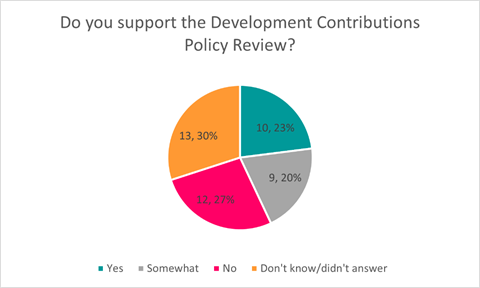
7.13 Submitters who
have never paid development contributions and don't anticipate doing so were
nearly twice as likely to support the policy review. Specifically, 30% of these
submitters (6 out of 20) expressed support, compared to 17% of those who have
paid (4 out of 24).
7.14 A thematic
analysis of submissions is available in section 8.
Council workshop
on consultation feedback
7.15 A workshop was
held on submissions and proposed post-consultation changes on Monday 19 May.
7.16 At the workshop,
elected members were informed on matters related to consultation, feedback from
submitters on the draft policy and resulting staff advice. Elected members had
the opportunity to provide feedback to staff as to their preferred policy
positions and to ask questions and seek clarification on the policy and
associated issues.
8. Principles of Setting and Calculating Development Contributions
Background - principles of averaging
8.1 The
LGA allows for the use of averaging by development types. This means developments
within a development type category will be assessed as having the same level of
demand, regardless of individual variations.
8.2 A
HUE is the unit of demand used in the policy to calculate development
contributions charges and determine the development contributions requirement
for each development. A HUE represents the average demand a household places on
Council infrastructure and it is assumed that all single households place this
level of demand on Council infrastructure. This is an efficient method of
assessing development contributions for residential development. Non-residential
developments are assessed as a proportion of the HUE.
8.3 The
policy assumes the average household contains 2.6 people, which is consistent
with the growth modelling used in the LTP 2024-34.
8.4 The
base unit measures for the HUE are outlined in clause 3.2.1 of the draft policy
and are summarised below. The base units are updated as part of each policy
review to ensure an accurate reflection of average household demand.
|
Activity
|
Demand per HUE
|
|
Water supply
|
644.30 litres per day
|
|
Wastewater
|
572 litres per day
|
|
Stormwater and Flood Protection
|
367 m2 impervious surface area (ISA)
|
|
Transport
|
6.35 vehicle trips per day
|
Background - Special assessments
8.5 The
policy is based on average demand for a range of development types. Development
contributions required for non-residential development are calculated as a
multiple of the HUE. For the transport, water supply and wastewater
activities the development contribution requirement is calculated according to
the average demand on infrastructure per square metre of gross floor area
(‘GFA’) by business type. For stormwater and flood
protection the development contribution is calculated according to the
impervious surface area (‘ISA’) of the development. The non-residential HUE equivalences (also referred to as HUE
multipliers) are detailed in Part 8 of the draft policy.
8.6 For
most developments, the use of the HUE equivalences will be appropriate to
determine a development contribution requirement. There will be some
developments, however, where actual demand is significantly different to the
demand assumptions built into the policy. In these instances, the Council will
undertake a special assessment or an actual demand assessment.
8.7 The
threshold for a special assessment is when actual demand is half or double what
is built into the policy. This aligns with the Ryman Healthcare v Auckland
Council objection decision. In this decision, the Commissioner accepted
that that a 50% threshold was appropriate for demonstrating a substantial
reduction in demand.
8.8 The
draft policy did not propose to remove the special assessment provision from
the policy. Some submitters appeared to confuse special assessments and
remissions, but these are quite different issues in the policy. Issues
related to remissions are detailed below.
9. Submission feedback and workshop
discussion
Residential unit adjustments
9.1 The
Council assesses each residential unit at a base rate of 1 HUE. However, there
will be circumstances where actual demand is half or double assumed demand and
therefore it is appropriate to provide a residential unit adjustment.
9.2 Providing
some kind of adjustment for small and/or large residential units is common
across development contributions policies. Councils across New Zealand have
taken a range of approaches to providing these adjustments.
9.3 The
Council has used GFA to make small residential unit adjustments since 2007.
However, there is no data that correlates the GFA of a residential unit with
number of usual residents or with demand on infrastructure. In 2024, 45%
of building consents were for homes less than 100m2. This means the
Council is providing a discount for close to half of all new homes, which is
not what the policy is intended to do.
9.4 Census
data shows that the greater the number of bedrooms in a residential unit the
more people are likely living in it. The more usual residents in a residential
unit, the greater level of demand on Council services.
Average number of usual residents per dwelling type as at Census
2023
|
Dwelling type
|
One bedroom
|
Two bedrooms
|
Three bedrooms
|
Four bedrooms
|
Five bedrooms
|
Six bedrooms
|
Seven bedrooms
|
Eight bedrooms
|
|
Average residents
|
1.36
|
1.82
|
2.56
|
3.19
|
3.83
|
4.80
|
5.07
|
5.10
|
9.5 The draft policy proposes to move to bedroom-based adjustments as a
result.
Small residential unit adjustment
9.5.1 What was
consulted on: The draft policy proposed moving to a residential unit adjustment based on bedrooms
and keeping a small unit adjustment for one-bedroom residential units only.
This will ensure that the Council only adjusts for developments that fall
outside the assumptions built into the policy.
9.5.2 Feedback from submitters: There were
mixed views on change to small unit adjustment. Five submitters supported the
change, eight were opposed and three expressed mixed views. Several submitters
also requested the Council introduce an adjustment for two-bedroom units. Two
submitters asked that the small unit adjustment just be applied to developments
in the central city.
9.5.3 Staff
advice in workshop: 2023 Census data shows that the average one-bedroom
residential unit in Christchurch has 1.36 usual residents living in it. As an
average household is 2.6 people, this dwelling type is assumed to put half the
average demand on Council infrastructure.
9.5.4 With respect to a two-bedroom adjustment, 2023
Census data confirms that the average two-bedroom residential unit in
Christchurch has 1.82 people, which does not meet the threshold for a special
assessment under the policy. If a change were to be
made, the large residential unit adjustment would need to come down, either to
four or five bedrooms, to reflect that an adjustment has been made within the
averages and ensure the Council continues to recover the cost of growth from
new development. This would increase the administrative complexity of the
policy and staff do not recommend making this change.
9.5.5 There is no data that would support having a one-bedroom adjustment
just for central city developments.
9.5.6 Workshop discussion: At the 19 May 2025
workshop, councillors provided no further guidance on the small
residential unit adjustment as proposed.
9.5.7 Recommendation for final policy: One-bedroom
residential units will be assessed at 0.6 HUE for all activities.
Large residential unit adjustment
9.5.8 What was
consulted on: The draft policy introduced
a large residential unit adjustment for dwelling types of seven or more
bedrooms assessed at 1.4 HUE. This was intended to ensure the development
contribution charge better reflects the usually higher demand on infrastructure
from larger homes.
9.5.9 Feedback from submitters: There were
mixed views on the change to the large residential unit adjustment with two
supporting, four opposed and three expressing mixed views. Some submitters
questioned whether the threshold should be lower or whether the adjustment
should increase with each additional bedroom.
9.5.10 Staff advice in
workshop: 2023 Census data shows that the average seven-bedroom residential
unit in Christchurch has 5.07 usual residents living in it. As an average
household is 2.6 people, this dwelling type is assumed to put double the
average demand on Council infrastructure.
9.5.11 Some submitters also
asked whether the adjustment could be for 0.4 per additional room. 0.4 HUE is
effectively the equivalent of one person so the Council could add 0.4 per
additional room for seven bedrooms and over. However, census data does not
support this change; eight-bedroom homes have only a slightly higher number of
residents compared to seven-bedroom homes. The overall impact of a change like
this is likely to be minimal given the small number of dwellings of this size
in the district. Therefore, staff did not recommend this change.
9.5.12 Workshop discussion: At the 19 May 2025
workshop, councillors provided no further guidance on the large
residential unit adjustment as proposed.
9.5.13 Recommendation for final policy: Houses
with seven or more bedrooms are charged an additional 0.4 HUE for all
activities except for stormwater.
Stormwater discounts
9.6 The
Council currently provides two reductions for stormwater activity. Both are out
of alignment with the special assessment threshold in the policy and the draft
proposed changes to bring the assessment of the stormwater activity back into
line with the overall principle of averages as discussed in section 7.
Developer provided infrastructure
9.6.1 What was
consulted on: The draft policy
provides that stormwater reductions will only be provided in instances where
developers provide on-site stormwater mitigation and the resulting demand on
Council infrastructure is less than half of the average assumed demand as
detailed in the policy. This would see relatively minor adjustments (such as
for the installation of a rainwater tank) cease.
9.6.2 Feedback from submitters: There were
mixed views on the proposal to bring stormwater adjustments for developer
provided infrastructure into line with the special assessment provisions of the
policy as outlined in paragraphs 7.5 – 7.7. Four submitters supported the change, six were opposed and two
expressed mixed views
9.6.3 Staff
advice in workshop: The change is intended to bring
stormwater adjustments into line with the rest of the policy. The Council
will still undertake a special assessment if the development exerts a level of
demand on infrastructure that will be significantly different from the level of
assumed demand in the policy for that type of development.
9.6.1 Staff follow a set methodology to determine degree to which demand
on the Council's network has been mitigated by the developer provided
infrastructure. Each relevant development is reviewed using this
methodology.
9.6.2 Staff note that on occasion, developer-provided infrastructure is
vested with the Council, but the assessment receives a stormwater discount of
less than 50% due to the level of mitigation provided. Council may consider it
fair to include a provision for these sites to still receive a stormwater
adjustment due to the asset being vested.
9.6.3 Workshop discussion: At the 19 May
workshop, councillors expressed concern about increased flood risk as a result
of infill development. Staff discussed the strategies, standards and programmes
in place to manage stormwater in infill areas.
9.6.4 Recommendation for final policy: In
instances where developers provide stormwater infrastructure, a special
assessment will be done only when the demand on Council stormwater
infrastructure is less than half of the average assumed demand as detailed in
the policy.
9.6.5 An additional
provision is proposed to allow for a reduction in the stormwater development
contributions assessment for developments where stormwater infrastructure is
vested with the Council regardless of whether the mitigation provided has
reached the threshold for a special assessment. This is wording is outlined in
section 10 of this report.
Stormwater discount for attached multi-unit
developments
9.6.6 What was
consulted on: The draft policy
proposed the Council cease providing a stormwater discount for developments
with at least two attached multi-units on this basis that the ISA averages
built into the policy already takes into account smaller residential units and
changing development patterns.
9.6.7 All base unit demand assumptions have been updated as part of this
review. Average ISA per site (parcel) has been reduced from 427m2 to
367m2 as a result. This reflects the changing development patterns
and increased intensification.
9.6.8 A special assessment would still be triggered if the threshold is
met in line with the special assessment provisions of the policy.
9.6.9 Feedback from submitters: Ten submitters
commented on the proposal to remove the multi-unit adjustment for stormwater.
Submitters presented mixed views - two supported the change, five opposed it and
three expressed a mixed view.
9.6.10 Workshop discussion: At the 19 May
workshop, councillors expressed concern about increased flood risk as a result
of infill development and questioned whether there should be any discounts
provided for multi-unit developments.
9.6.11 Staff advice in workshop: Staff noted
that under the broader principles of the policy, the Council would still need
to provide some kind of actual demand assessment for developments where actual
ISA was less than half of the ISA assumptions built into the policy. Staff
suggested a compromise would be to change the provision so that if the special
assessment threshold is met, multi-unit developments will be assessed as though
the entire site is impervious (as opposed to using the ISA stated on the
plans).
9.6.12 Recommendation for final policy: The
assessment for the stormwater activity will be undertaken using the HUE
multipliers outlined in paragraph 7.4 of this report. If the assessment results
in assumed demand (ISA) that is more than double the area of the development
site, the development site will instead be assessed as though it is 100%
impervious. This is wording is outlined in section 10 of this report.
Remissions
9.7 What
was consulted on: The current policy includes a clause that provides for
the Council to remit some or all development contribution charges for a
development in “unique and compelling circumstances”. The original
intent of this clause was to allow for the Council to address a matter directly
associated with the development contributions charge. The clause is being used
more widely with developers appealing to the Council to remit development
contributions charges for a range of reasons including that the organisation
applying provides services to the community.
9.8 The
remission provision was removed from the draft policy.
9.9 An
alternative remission provision was also drafted and included in the
consultation material. The alternative clause clarified that it is the
development itself (not the developer or future occupier of the site) that must
be unique, and that the development must be sufficiently distinct from other
developments that remitting a development contribution requirement does not
create a new precedent.
9.10 Feedback from submitters: Thirteen
submitters commented on the removal of the remissions provision. There were
mixed views on removing remission clause with some submitters confusing
remissions and special assessments, and some confusing remissions and
rebates. Submitters did not express a preference for one remission clause
over the other.
9.11 Staff advice in workshop: The term ‘remission’ is used differently by different
councils in their development contributions policies. The Council's policy uses
the term ‘remission’ to refer to the Council intervening on a
development contributions assessment when there is something about the
development that has not been considered in drafting the policy and therefore
the Council considers it necessary to address an aspect of the assessment via a
remission.
9.12 However, many
councils use the term 'remission' to refer to an actual demand remission -
where demand is materially different to the assumed demand built into the
policy. The Council's policy refers to this as a special assessment.
9.13 There is no
proposal to remove the ability for developers to seek a special assessment (or
actual demand assessment) provided that the threshold is met (of actual demand
being half assumed demand).
9.14 Noting the
feedback received on remissions, more generally, staff proposed the Council
adopt the inclusion of the alternative remission clause.
9.15 Workshop discussion: At the 19 May 2025
workshop, councillors provided no further guidance on the proposal to use the
alternative remission clause.
9.16 Recommendation for final policy: The
alternative remission clause be included in the policy. This is wording is outlined in section 10 of this report.
Life of
existing demand credits
9.17 What was
consulted on: The Council position has been to limit the life of existing
use credits to ten years from when the site last exerted demand on Council
infrastructure. Many credits have expired in the last four years on buildings
and sites of former buildings damaged in the 2010/11 earthquakes –
particularly in the central city. This issue was reconsidered as part of this
review and the policy retained the ten-year life of existing demand credits.
9.18 Feedback from submitters: Ten submitters
commented on the life of existing demand credits. Eight submitters asked that
the life of credits clause be extended either to 20 years or indefinitely. Two
submitters supported retention of the current provision.
9.19 Staff advice
in workshop: There is no explicit
requirement under the LGA to provide existing demand credits. The Department of
Internal Affairs provides guidance
on developing development contributions policies. While the guidance does not
provide direction of how to set existing demand credit policy provisions, it
does contemplate that councils might limit the life of credits based on when
previous demand was exerted on a site
“The DCP should specify conditions that must be met before
historic credits will be granted. Commonly used criteria relate to:
· The land or building currently generating a demand for the relevant
service, possibly setting limits on how far back in time the council will look
to consider previous development and uses. The land or building currently
generating a demand for the relevant service, possibly setting limits on how
far back in time the council will look to consider previous development and
uses”.
9.20 The purpose of existing demand
credits is to recognise that development may not result in additional demand on
infrastructure. Therefore, only net additional demand attracts a development
contribution requirement.
9.21 The Council provides credits to assess
for net additional demand, promote equity and encourage timely redevelopment.
9.22 The LGA requires the Council to
manage its infrastructure assets in a way that promotes prudent stewardship and
efficient and effective use of assets. Providing existing demand credits
requires the Council to effectively “reserve” infrastructure
capacity and guarantee infrastructure capacity (which developers
would not be required to pay for) for the life of the credits. This
creates increased risk for Council the longer the credit is in place but
unused.
9.23 Managing
that risk would require the Council to operate its infrastructure in such a way
as to always carry capacity sufficient to honour the credits. This means
infrastructure would need to have a high level of unused capacity sitting
waiting for redevelopment to again take up capacity once used at some point in
the past. This is not an efficient or prudent way to manage infrastructure and
will result in other ratepayers carrying the cost of having that capacity
available.
9.24 In terms
of actual asset planning, the Council does not reserve capacity –
capacity operates on a first-in-first-served basis. Once a site stops exerting
demand on Council infrastructure, that capacity is diverted elsewhere. Therefore, the policy is
more generous than asset planning. Existing demand
credits are a concession the Council makes in a funding policy only.
9.25 The current
policy setting, where existing demand credits expire after ten years strikes a
balance between managing infrastructure capacity wisely, being fair to
ratepayers in that a liability to provide infrastructure to service these lots
is not in place forever and being fair to developers in recognising that
development has occurred on a site previously.
9.26 Workshop
discussion: At the 19 May 2025 workshop, a question
was asked about the rationale to limit the life of existing demand credits and
what approaches were taken by other councils. Staff advised that other
councils have taken a range of approaches from providing no existing demand
credits through to providing for credits to have a perpetual life.
9.27 Staff also noted
that walking back a change to existing demand credits would be very difficult
and advised that a rebate scheme would be a sensible way to deal with central
city sites. Work on a rebate for existing demand credits is being progressed
separately.
9.28 Recommendation
for final policy: Existing demand credits expire 10
years after a site last exerts demand on Council infrastructure.
Fee for development contributions
assessments
9.29 What was
consulted on: The draft policy included a provision for the Council to charge a fee for development
contributions assessments.
9.30 Feedback from submitters: Submitters
presented mixed views on the Council charging a fee for development
contributions assessments. Seven submitters were opposed, although several
submitters appear to be mistaking the fee for the Development Contributions
Team to complete an assessment with development contributions charges. Six were
supportive of the proposal.
9.31 Staff advice in workshop: The proposed
fee for development contributions assessments is a one-off, flat fee charged at
invoicing. It was included in the draft Annual Plan 2025/26 fees and charges
and is $100 including GST.
9.32 The fee remains the same regardless of how many times a developer or
their agent contacts the Development Contributions Team or whether the
assessment is amended or revised. The Development Contributions Team time
is not charged for as part of a building and/or resource consent application;
it is currently paid for by rates only.
9.33 It is fair that the cost of preparing a
development contributions assessment is funded by the developer because they
both benefit from the assessment of their development and cause the assessment
to be required through submitting their development for consent.
9.34 Workshop discussion: At the 19 May 2025
workshop, councillors provided no further guidance on the fee for
development contributions assessments as proposed.
9.35 Recommendation for final policy: At the time of invoicing, a fee to cover the cost for the Council to
administer the development contribution assessment will be invoiced alongside
the development contribution requirement. The development contribution
assessment fee is set out in the Council’s schedule of fees and charges.
HUE equivalences/multipliers
9.36 What was
consulted on: A range of changes have been made to the HUE equivalences or
HUE multipliers, most notably the policy reverts to using a land or
activity-based methodology for transport activities. The HUE equivalences cover
a range of land-use types and are outlined in Part 8 of the policy (Tables 4, 6
and 8).
9.37 Feedback from submitters: Three
submitters opposed the proposed HUE equivalences for residential units and care
suites in retirement villages. One submitter opposed the changes to
activity-based HUE multipliers. Another submitter requested all non-residential
assessments be conducted as actual demand assessments.
9.38 Staff advice in workshop: The retirement
village HUE equivalences are based on stated average occupancy of 1.3 in a unit
in an objection to the Council in addition to the Ryman objection
decision. Staff have previously completed a survey of
all retirement villages and confirmed the average water use was accurate and
are therefore comfortable with this HUE equivalence.
9.39 It was also
noted the retirement village community facilities are not assessed for
development contributions and these facilities are assessed as ancillary to the
residential spaces.
9.40 Staff agreed with submitters that residential units in retirement
villages could be assessed at 0.1 HUE for the reserves activity.
9.41 Workshop discussion: At the 19 May 2025 workshop, staff were asked why industrial, and
warehousing and logistics development types were separated in the policy. Staff
advised the decision was made to separate the industrial and
warehousing/logistics categories, recognising the growth in warehouse-based
activities and the differing demands these sectors place on land use and
Council services.
9.42 Recommendation for final policy:
Residential units to be assessed at 0.1 HUE for the reserves activity. Several
clarifications are recommended for Table 4 of the policy; these are outlined in
section 10 of the report. No other changes recommended for the HUE equivalence
or land-use types.
Active Travel and Public Transport
catchments
9.43 What was
consulted on: No changes were proposed to the Active Travel and Public
Transport catchments between the current and draft policies.
9.44 Feedback from submitters: One submitter requested the public transport catchment be amended
to include Marshland Road. One submitter requested that Templeton be included
in the active travel catchment.
9.45 One submitter
felt that Lyttleton should be excluded from active travel.
9.46 Workshop discussion: At the 19 May workshop, councillors asked why Marshlands Road was
excluded from the Active Travel catchment and why Templeton was not part of the
Public Transport catchment.
9.47 Recommendation for final policy: Staff have made small changes to the Active Travel and Public
Transport catchments to reflect submitter and elected member feedback. The
final catchment maps are included in Appendix 3 of the policy.
9.48 As active travel
includes footpaths and cycleways, it is fair Lyttleton is included in this
catchment.
Development contributions charges
9.49 Feedback from submitters: Some developers submitted that the increase in charges may impact
the viability of developments and affordability of new homes.
9.50 Staff
advice: Development contributions is a cost recovery tool
for the growth component of projects that are in the Council’s capital
programme. Development contribution charges are calculated by dividing cost to
the growth component of an asset by projected growth.
9.51 The overall capital programme increased from $5.78B in 2021 to $6.51B
in 2024. The cost of
the growth component of those projects also increased –
from $730M in 2021 to $923M in 2024.
9.52 The 2024 growth
forecast has a slower rate of growth in all aspects compared to 2021 (an
average 0.52% per annum over 30 years compared to 2.06% in 2021). Growth projections that informed the 2021 policy were significantly
higher than in the previous policies due to post-earthquake population shifts
and changes in the district. Statistics New Zealand’s projections that
have informed the 2025 policy reflect the ‘return to normal’ growth
patterns in the district.
9.53 The increase in growth capital expenditure,
combined with slower growth projections compared to the 2021 LTP, has resulted
in development contributions charges that are higher than in the 2021 policy.
These charges are, however, in line with pre-2021 charges.
9.54 While the charges in the 2025
policy have increased compared to the 2021 policy, the 2021 charges were
unusually low. If Council were to set development contributions lower than what
is contained in this policy this would require ratepayers
across the district to meet the cost of the foregone revenue.
9.55 Workshop
discussion: At the 19 May 2025 workshop, councillors
provided no feedback on the development
contributions charges.
9.56 Recommendation for final policy:
Development contributions charges are outlined in Appendix 1 of the policy.
10. Submitter
feedback on issues not discussed at workshop
Neighbourhood Parks and Road Network catchments
10.1 What was
consulted on: The policy proposed to move
the neighbourhood parks and road network catchments from a concentric
configuration to localised catchments.
10.2 Feedback from
submitters: There
was overall support for the move to localised catchments, but some submitters
requested that the catchments be made smaller.
10.3 Staff advice: Smaller
catchments increase the complexity of developing and operating the policy and
the range of per-HUE charges across those catchments also tends to increase,
which may have unintended consequences for funding growth. Some small
catchments may pay very high, targeted contributions, while others may pay very
low contributions, depending on how the catchments are drawn.
10.4 Additionally, the risk of under-recovering
the cost of growth infrastructure increases with smaller catchments especially
if modelling has not allocated growth in the correct places. Overall, the
smaller the catchments, the greater the risk of error in the policy. This risk
is reflected in the number and size of the catchments for these
activities.
10.5 Recommendation
for final policy: No changes to Neighbourhood Parks
and Road Network catchments
Three Waters catchments
10.6 What was
consulted on: The policy proposed to move to
fewer and larger catchments for the three waters activities.
10.7 Feedback from
submitters: There was mixed support for these catchments, with two opposed, two
supportive and one suggesting sub-catchments may be required.
10.8 Staff
advice: Before 2021, water supply and wastewater
activities were grouped into a district-wide catchment. The 2025 policy
proposes to return to larger catchments for these activities to address several
issues.
10.8.1 Nature of water
infrastructure in the district: The Council has a unique integrated water
network which isn’t necessarily reflected in our current
catchments. The new catchments better reflect the Council’s
integrated delivery of water services. Additionally, infrastructure within the
urban catchment is interconnected within the city and three waters projects
generally benefit the related wider infrastructure network.
10.8.2 Unpredictable growth
and need to be responsive: The Council’s capital spending for
growth-related three waters infrastructure will need to become more dynamic,
reacting to patterns of intensification. Around two-thirds of all new
residential development is occurring in infill areas, and it is likely this
trend will continue. There is a lack of certainty with respect to where that
growth is going to occur
10.8.3 Whilst three waters
infrastructure plans consider growth for the next 50 years, LTP growth funding
is allocated 10 years in advance with specific projects identified every three
years. Development contributions based on smaller catchments may cause
under collection for growth provision not yet ring-fenced in the LTP.
Furthermore, because infrastructure plans are not fully aligned with the LTP
funding period, there may be misalignment when LTP provision has not yet been
made for development triggering upgrades. A grouped catchment will ensure
that development contributions are collected from all new development on a fair
and equitable basis.
10.9 Recommendation for final policy: No
changes to Three Waters catchments
Pause review
10.10 Feedback
from submitters: A
number of submitters suggested the Council pause the review the of the
Development Contributions Policy with some submitters stating development
levies would be coming in in September 2025 and implying the draft policy, if
adopted, would only be in effect for a few months. This is not correct. The
Government has indicated legislation will be introduced in September 2025 and
will be enacted by mid-2026. Levies will come into effect from mid-2027.
10.11 Staff advice: Until new legislation is enacted, councils have a legislative
requirement to have a policy on development contributions and to review it
every three years. The Council’s current Development Contributions
Policy was adopted in July 2021, and it is due for review.
10.12 The current policy does not
reflect the Council’s actual costs to deliver growth infrastructure. Developers
are currently paying development contributions based on significantly outdated
costs and are not contributing towards additional projects approved in the 2024
LTP. As development contributions are a one-off payment and councils cannot
require other developers to pay for infrastructure capacity that has been taken
up by a development that has not paid for it, the difference in revenue becomes
ratepayer funded.
10.13 Recommendation for
review: Staff do not recommend the policy review be paused.
Other comments made during hearing of submissions
Accuracy of technical
inputs
10.14 During the hearing of
submissions, some submitters questioned the accuracy of the cost
allocations/capital programme.
Growth projections
10.14.1 The growth inputs for the policy are
based on the Statistics New Zealand medium population and household growth
scenarios. This is consistent with past development contributions policies.
Christchurch has historically tracked very closely to the medium projections,
and they remain a good indication of future growth.
10.14.2 The Council’s growth models
are used to distribute future growth to a sub-city level. These models are all
connected and talk to each other, to tell a consistent growth story. The growth
models have been peer-reviewed by external agencies and have been found to be
fit for purpose
10.14.3 The models consider both
intensification and greenfield development. The capacity inputs into the model
include a picture of both infill and greenfield capacity.
Cost allocations for capital projects
10.14.4 The cost allocation process, which identifies the growth component
of each asset is outlined in Part 6 of the draft policy. Council staff review
each capital project and determine the allocation of cost drivers: renewal,
backlog, increase in current level of service or growth. Only the cost of
infrastructure to service growth is funded from development contributions. The
cost allocation methodology takes account of causation (the reason the asset is
being provided), as well as who benefits from the project. The methodology to
determine the exact allocation between the cost drivers varies between the
activities.
10.14.5 The capital programme, and the projects to be delivered for which
the Council collects development contributions, has been informed by the 2024
growth model. The cost allocations for projects not yet delivered, therefore,
reflect projected growth. Projects that have already been delivered (that is,
are noted as 'complete' in the Schedule of Assets) remain unchanged.
Trigger to assess for development
contributions
10.15 One submitter commented
that the Council has an incorrect trigger to assess for development
contributions in the draft policy.
10.16 Section 198(2A) of the LGA
requires councils assess for development contributions under the policy in
force at the time the consent/authorisation application was submitted,
accompanied by all required information. Section 4.1.3 confirms the
Council will assess using the policy in force at the time the complete
application for consent is received.
10.17 The developer will be
formally notified of their development contribution requirement as part of the
granting of the consent application.
11. Incorporation of feedback into the draft
policy
11.1 The consultation and hearing
process allowed submitters to share their insights, comments and suggestions
with the Council about the policy proposals. As a result of these
considerations, staff have incorporated the following items into the draft policy:
11.1.1 Clause 3.2.4 (4):
“The development provides infrastructure to be vested with the Council,
which reduces the impact of the development’s demand on Council
stormwater infrastructure, prior to discharge into the Council network”.
11.1.2 Clause 3.2.5: “Residential
units in retirement villages and care suites are assessed for
development contributions as set out in Table 4”.
11.1.3 Clause 5.6: “The Council
considers that there may be a development that is so unique it has not been
anticipated by the policy, so much so that the Council considers the full
development contribution assessment to be unfair and unable to be remedied
under the provision of a special assessment.
The development, itself, must be sufficiently distinct from other
developments that remitting a development contribution requirement would not
create a new precedent in terms of the Council’s current interpretation
and application of the policy.
In these cases, the Council may, at its sole discretion, consider
and grant a full or partial remission of development contributions in cases
where it is satisfied this threshold has been met.
The developer must write to the Chief Executive seeking a remission
and explaining how the development has met this threshold and why the Council
should grant a full or partial remission in the interest of fairness. The
explanation must be specific to the development (not the developer or intended
future occupier) and the features of the development that make it
unique”.
11.1.4 Table 4: Footnote:
“Community facilities within a retirement village for the predominant
use of residents and their guests are not subject to a development contribution
requirement”.
11.1.5 Table 4: 0.1 HUE
reserve assessment for retirement units.
11.1.6 Table 4: Care
suites are not charged for the community infrastructure activity.
11.2 At the 19 May
2025 workshop, elected members expressed concern about providing discounts for
attached multi-unit developments, citing the importance of stormwater
infrastructure in managing the impact of increased intensification in infill
areas. The following has been added to the draft policy:
11.2.1 3.2.2.5: “Developments
of two or more attached residential units on a single lot will be assessed for
the stormwater and flood protection based on the HUE rates outlined in section
3.2.1 and 3.2.2. If assessed HUEs result in ISA that is more than double the
area of the development site, the development site will instead be assessed as
though it is 100% impervious”.
11.3 On review of the
final draft policy, staff considered the wording of 3.2.4 could be amended to
better reflect the description of the tables contained in Part 8 of the policy.
11.3.1 Clause 3.2.4: Where
a development is not consistent with the land use or business type as detailed
in Part 8 of the policy the Council may require a special assessment for
development contributions for the activities considered to be outside the
expected demand. Situations where this may be required include:
1. Where the type of development proposed is not
adequately covered by Tables 4, 6 and 8.
2. Where the demand for an activity from the
development is expected to be more than double the value identified as average
for that type of development as set out in Tables 4, 6 and 8.
……
A developer may ask the Council to consider
undertaking a special assessment if:
The
development is expected to place less than half the assumed demand on
infrastructure for the value identified as average for that type of development
as set out in Tables 4, 6 and 8.
12. Transitional provision
12.1 Staff note the
policy may result in lower development contributions charges for some Akaroa
Harbour developments compared to the 2021 policy. Charges for Akaroa Harbour
under the 2021 policy are $68,189.73 including GST compared to $44,083.25
including GST under the 2025 policy.
12.2 Section 198 (2A)
of the LGA requires the Council to undertake its assessment of development
contribution requirement under the development contributions policy in place at
the time it receives a complete application for resource consent, building
consent or authorisation to connect to Council infrastructure.
12.3 Given the
difference in the development contributions requirements in Akaroa between the
two policies, there is risk that developers may surrender consents and then
reapply for consent to trigger a new development contribution assessment under
the 2025 policy. This is an inefficient use of Council consenting resources.
12.4 Clause 4.1.5 of
the policy provides for a remission of the difference in cost between a
development contributions assessment undertaken under a previous policy and the
2025 policy where the charge is less under the 2025 policy. A remission is only
available where the developer could lawfully surrender a resource consent or
building consent and reapply for consent and thereby trigger a requirement for
a new development contribution assessment under the 2025 policy.
12.5 The development
would still be assessed under the provisions of the relevant policy in
accordance with section 198(2A) of the LGA, it would just receive the benefit
of the lower per-HUE charge.
13. Options Considered Ngā Kōwhiringa Whaiwhakaaro
13.1 The following
reasonably practicable options were considered and are assessed in this report:
13.1.1 Adopt the draft policy.
13.1.2 Decline to adopt the
policy.
Options Descriptions Ngā
Kōwhiringa
13.2 Preferred
Option: Adopt the draft policy.
13.2.1 Option Description: The
Council would resolve to adopt the draft policy.
13.2.2 Option Advantages
· Complies with legislative requirements and ensures development
contributions charges accurately reflect current capital costs required to
service growth development. It also provides an opportunity to make updates to
the policy provisions.
13.2.3 Option Disadvantages
· Charges would increase for most development types under the new
charges. However, these new charges accurately reflect the cost to Council to
service growth infrastructure.
13.3 Decline to adopt
the policy.
13.3.1 Option Description: The
Council would resolve to not adopt the draft policy and direct staff to
continue working on the review.
13.3.2 Option Advantages
· This option would benefit developers who would continue to be
assessed for development contributions under the 2021 policy, which contains
significantly lower than average charges.
13.3.3 Option Disadvantages
· The 2021 development contributions charges do not accurately reflect
the Council’s current costs to service growth development. This option
therefore disadvantages ratepayers who would cover the difference between the
Council’s actual costs to provide growth infrastructure and the charges
developers are paying under the current policy.
· This does not comply with the legislative requirement to review the
policy every three years.
14. Financial Implications Ngā Hīraunga Rauemi
Capex/Opex Ngā Utu Whakahaere
14.1 Cost to
Implement – The cost of reviewing the policy and undertaking community
engagement is funded through existing operational budgets. This work has been
undertaken over more than one year and is funded as a general cost of business
rather than a discrete cost attributed to the project.
14.2 Maintenance/Ongoing
costs - Annual policy and administration costs vary depending on the policy
work required and the level of development needing to be assessed.
14.3 Funding Source
– The cost of preparing and administering the policy comes from the
general rate. The policy proposes to charge an administration fee at invoicing
stage to cover some of the costs associated with administering this policy. In
the previous 12 months, 900 development contributions invoices were issued, so
the anticipated revenue associated with this fee is around $90,000.
15. Considerations Ngā Whai Whakaaro
Risks and Mitigations Ngā
Mōrearea me ngā Whakamātautau
15.1 Development
contributions can be a litigious area of local government activity often with
significant financial implications for developers and councils. Because of this
there is a significant body of case law regarding what can and cannot be done
under the provisions of a development contributions policy.
15.2 As
with any decision made by the Council, there is a risk of judicial review. The
policy (or parts of it) could be quashed by the High Court if the policy is
challenged and the Court finds the decisions made relating to the policy are
unlawful or procedurally unfair. This is a risk of any decision made by
Council, but one that can be minimised as much as possible by ensuring that the
policy has been through a stringent review process and that the Council adheres
to an appropriate and fair consultation process.
15.3 The
Council’s Legal Services Team has provided advice throughout the policy
development process including full review of the proposed policy to ensure the
review and resulting policy reflect legislative requirements.
Legal Considerations Ngā
Hīraunga ā-Ture
15.4 Statutory and/or
delegated authority to undertake proposals in the report:
15.4.1 Section 102 of the LGA
requires all local authorities to have a policy on development contributions
and financial contributions.
15.4.2 The policy must comply
with the requirements of section 106 and sections 197AA to 211 of the LGA.
Section 106(6) of the LGA requires the Council to review its development
contributions policy at least once every three years.
15.5 Other Legal Implications:
15.5.1 This report and the
policy have been reviewed and approved by the Council’s Legal Services
Team.
Strategy and Policy Considerations Te Whai
Kaupapa here
15.6 The required
decisions:
15.6.1 Do align with the Christchurch
City Council’s Strategic Framework, particularly the strategic
priorities to manage ratepayers' money wisely and actively balance
the needs of today's residents with the needs of future generations.
15.6.2 Are assessed as medium significance based on the Christchurch
City Council’s Significance and Engagement Policy. The level of
significance was determined by importance of the policy to the wider community
who are largely unaffected (low significance) and to property developers of
Christchurch district (medium significance) who are directly affected through
the requirement to pay development contributions.
15.6.3 Are consistent with
Council’s Plans and Policies. In particular the decisions support the
Council’s approach to funding the provision of infrastructure to service
growth development outlined in the Council’s Revenue and Financing
Policy.
15.7 This report supports
the Council's
Long Term Plan (2024 - 2034):
15.8 Strategic Planning and Policy
15.8.1 Activity:
Strategic Policy and Resilience
· Level of Service: 17.0.1.2 Advice meets emerging
needs and statutory requirements, and is aligned with governance expectations
in the Strategic Framework - Carry out policy reviews in accordance with Unit
work programme and provide advice to meet emerging needs and statutory
requirements
Community Impacts and Views Ngā Mariu
ā-Hāpori
15.9 Consultation on
the draft policy was undertaken in in accordance with sections 82 and 82A of the
LGA. Consultation and submitter feedback is outlined in section 6 of this
report.
15.10 The decision
affects all wards/Community Board areas.
Impact on Mana Whenua Ngā Whai Take
Mana Whenua
15.11 The decisions in
this report do not involve a significant decision in relation to ancestral
land or a body of water or other elements of intrinsic value, therefore this
decision does not specifically impact Mana Whenua, their culture, and
traditions.
15.12 The decision is not a
matter of interest to Mana Whenua and will not impact on our agreed
partnership priorities with Ngā Papatipu Rūnanga.
15.13 This is a funding policy.
The Council had a development contributions rebate scheme
for Papakāinga/Kāinga Nohoanga developments, but the rebate
scheme sits outside the scope of this policy.
Climate Change Impact Considerations Ngā
Whai Whakaaro mā te Āhuarangi
15.15 The proposals in
this report are unlikely to contribute significantly to adaptation to the
impacts of climate change or emissions reductions.
15.16 The
policy details how the Council will fund infrastructure to service growth
development. Climate change considerations are dealt with outside the scope of
this policy.
16. Next Steps Ngā Mahinga ā-muri
16.1 If adopted by
the Council, the policy will come into effect from 1 September 2025.
Attachments Ngā Tāpirihanga
|
No.
|
Title
|
Reference
|
Page
|
|
a ⇨
|
Draft
Development Contributions Policy 2025 (Under Separate Cover)
|
25/1145731
|
|
|
b ⇨
|
Draft
Development Contributions Policy 2025 (with track changes) (Under Separate
Cover)
|
25/1145732
|
|
In addition to the attached documents, the following background
information is available:
|
Document
Name – Location / File Link
|
|
Not
applicable
|
Signatories Ngā Kaiwaitohu
|
Authors
|
Ellen Cavanagh
- Senior Policy Analyst
Hannah
Ballantyne - Senior Engagement Advisor
Andrew
Campbell - Legal Counsel
|
|
Approved By
|
David
Griffiths - Head of Strategic Policy & Resilience
John Higgins -
General Manager Strategy, Planning & Regulatory Services
|
|
8. Development Contributions Rebate
Schemes
|
|
Reference Te Tohutoro:
|
25/1426931
|
|
Responsible Officer(s) Te Pou Matua:
|
Ellen
Cavanagh, Senior Policy Analyst
Hannah Ballantyne, Senior Engagement Advisor
|
|
Accountable ELT Member Pouwhakarae:
|
John
Higgins, General Manager Strategy, Planning & Regulatory Services
|
1. Purpose and Origin of the Report Te Pūtake Pūrongo
1.1 The
purpose of this report is to advise the Council of the outcome of the
engagement taken on development contributions rebate schemes for development in
the central city, and for the Council to make a decision whether to adopt the
schemes.
1.2 The
first scheme provides a rebate for the expired existing demand credits on central
city sites where the existing structure was in place on
or after 1 March 2024. There is an option for the Council to extend this to all
sites within the Four Avenues.
1.3 The
second scheme provides a rebate for central city development,
where the residential component comprises at least six storeys.
1.4 This work has been undertaken to respond to a request from elected
members indicating an interest in considering rebate schemes alongside the
review of the Development Contributions Policy. The schemes reflect the
preferences indicated by elected members in workshops with staff.
2. Officer
Recommendations Ngā Tūtohu
That the Council:
1. Receives the information in the Development
Contributions Rebate Schemes Report.
2. Notes that the decision in this report is assessed as medium significance
based on the Christchurch City Council’s Significance and Engagement
Policy.
3. Agrees to adopt the existing demand credit rebate scheme
(Attachment A of this report).
4. Agrees to adopt the central city high density residential rebate
scheme (Attachment B of this report).
5. Delegates to the General Manager Strategy, Planning & Regulatory
Services authority to approve the final scheme criteria documents to reflect
any changes requested.
3. Executive Summary Te Whakarāpopoto Matua
3.1 The
Development
Contributions Rebate Policy (‘rebate policy’)
enables the Council to implement rebate schemes to help achieve certain strategic
development goals.
3.2 The
Development Contributions Policy (‘the policy’) has
been under review since mid-2023. During briefings and workshops on the policy
review, elected members expressed an interest in new development contributions
rebate schemes alongside the adoption of the new policy.
3.3 Elected
members provided guidance to staff on their rebate preferences on Tuesday 6 May
and Monday 19 May 2025. As a result, two draft rebates were prepared:
· The existing demand credits rebate scheme provides a rebate
for the expired existing demand credits on sites within the Four Avenues
of the central city where the existing structure was in place on or after 1
March 2024.
· The central city high density residential rebate scheme
provides a rebate for development within the Four Avenues of the central
city, where the residential component comprises at least six storeys.
3.4 These
proposed rebates reflect the Council’s strategic goals of a vibrant
central city that is attractive to residents, visitors and investors.
3.5 On
Wednesday 18 June 2025, the
Council resolved
to commence consultation on the draft schemes. Consultation ran from 23 June to
14 July 2025. Forty submissions were received on the proposed schemes.
3.6 The
Council heard from submitters on Tuesday 5 August 2025. At
this meeting, elected members also discussed the feedback and proposed schemes
with staff. As there was no consensus with respect to elected member views, the
proposed schemes are presented for consideration without amendment.
4. Background/Context Te Horopaki
4.1 The Local
Government Act 2002 (LGA) enables councils to charge development contributions
to help fund infrastructure to service growth development. Development
contribution requirements must be consistent with the provisions of the LGA.
This requires a consistent and transparent approach to be taken in setting a development
contributions requirement and there is very little scope for adjustments to
meet the Council’s strategic development goals.
4.2 As a result, the
Council’s rebate policy was established in 2015 to enable the Council to
promote its strategic objectives by establishing rebate schemes for
strategically desirable development types.
4.3 The rebate
policy has several key principles to be considered when setting schemes
including:
· A rebate scheme
will only be considered where there is a clearly identified benefit to the
wider community. For example, to encourage development to occur faster or on a
larger scale than it would without a rebate scheme in place.
· Rebate schemes
should not be used solely to address issues of affordability for the
developer.
· Development
contributions rebates are to address specific situations for a finite period of
time.
· Any rebate scheme
should be as user-friendly for the developer as possible while being as
efficient as possible for the Council to administer.
4.4 A
rebate is the waiving of development contributions. The LGA does not allow
councils to require other developers to pay for infrastructure capacity that
has been taken up by a development that has not paid for it. Development
contribution rebates therefore must be treated as revenue foregone by the
Council and are funded by rates.
Development
Contributions Policy and rebate schemes
4.5 Rebates sit outside the policy and are only intended to encourage
certain development types. They are not designed to ‘fix’ elements
of the policy and their existence should not be perceived as such. While
elected members have asked for rebates to be considered alongside the policy,
staff advice is that the two are separate matters.
4.6 Elected
members have previously received staff advice that the
2021 policy does not reflect the Council’s actual costs to deliver growth
infrastructure. Developers are currently paying development contributions based
on significantly outdated costs and are not contributing towards additional
projects approved in the 2024 Long Term Plan (LTP).
4.7 As development contributions are a one-off payment and councils
cannot require other developers to pay for infrastructure capacity that has
been taken up by a development that has not paid for it, the difference in
revenue becomes ratepayer funded.
4.8 Staff do not recommend adopting development contributions rebates
schemes without adopting the 2025 policy. To do so would mean the Council is
undercutting its development contributions revenue twice – first by
continuing with unusually low charges and then by waiving development
contributions requirements on top of that.
4.9 If
the policy is adopted with any amendments extending the expiry of existing
demand credits, then the rebate scheme would become superfluous, and staff
recommend that the rebate scheme for expired existing demand credits in the
central city not be adopted.
5. Proposed rebate schemes
Rebate
for expired existing demand credits in central city (Attachment A)
5.1 The Council provides
existing demand credits to assess for net additional demand, promote equity and
encourage timely redevelopment. The Council’s position
has been to limit the life of existing demand credits to ten years from when
the site last exerted demand on Council infrastructure. Many credits have
expired on sites of buildings damaged in the 2010/11 earthquakes – particularly
in central Christchurch.
5.2 The Council has limited the life of existing demand credits since
2006. Initially existing demand credits had a life of five years and had to
have been paid for. In 2007, the Council rewrote the policy with a working
group of councillors and developers. The expiry of credits was then changed to
ten years and the requirement removed for development contributions to have
been paid for previously.
5.3 The policy does not require development contributions to have been
paid in order for a site to receive the benefit of the credits and sites
developed pre-2004 were not required to pay development contributions at the
time of construction.
Consulted scheme criteria
5.4 The proposed
scheme is for any development within the Four Avenues of the central city where
the existing structure was in place on the lot on or after 1 March 2024. Staff
also consulted on extending the scheme to all sites with the Four Avenues.
5.5 The rebate is
for the existing demand credits on the site, assessed based on the previous use
of the site using the highest level of actual or otherwise verifiable demand
between 3 September 2010 and 3 September 2020. Essentially, the scheme provides
developers with the credits that were sitting on the development site the day
before the first earthquake on 4 September 2010.
5.6 It is proposed
the total funding limit of the scheme is $5 million and for the scheme to
expire on 30 June 2027 or when the total scheme funding is fully allocated.
This intended to align with the introduction of development levies and
encourage timely uptake. Rebates schemes can be extended by Council resolution.
Rebate for six
storey residential development in central city (Attachment
B)
5.7 The
Council has set an ambition to have 20,000 central city residents by 2028. The
current estimated population is 9,160.
The Council has a range of Plans, Strategies and programmes of work intended to
facilitate an increase in the number of central city residents.
5.8 The
Council has also set the goal to create a range of housing choices, including
high density housing. This is reflected in Project 8011 and the South-East
Central Neighbourhood Plan.
5.9 Despite
the progress of residential development in the central city, there remains a
lack of higher density residential development typologies with developers
currently preferring attached townhouse and lower-rise apartment developments.
5.10 The proposed
scheme is intended to encourage higher density residential development in the
central city. Higher density housing could boost population growth in this
area.
Consulted scheme criteria
5.11 The
proposed scheme is for any residential development within the Four Avenues of
the central city. The residential development, or residential component, must
comprise of at least six storeys.
5.12 The rebate is
for 100 per cent of the development contribution requirement.
5.13 Because the
purpose of the rebate is to support more permanent residents in the central
city, the draft rebate excludes any property used for any purpose other than
residential, including short term guest accommodation. The developer will be
required to register a covenant on each title to limit the use of residential
units within the development to residential use only.
5.14 It is
proposed the total funding limit of the scheme is $2 million. The scheme will
expire on 30 June 2027 or when the total scheme funding is fully allocated.
This intended to align with the introduction of development levies. Rebates
schemes can be extended by Council resolution.
5.15 The following related memos/information were circulated to the
meeting members:
|
Date
|
Subject
|
|
15
May 2025
|
Development Contribution Rebates
|
|
17
June 2025
|
Development Contributions Rebate Schemes
|
5.16 The following related information session/workshops have taken place
for the members of the meeting:
6. Options analysis
Options Considered Ngā
Kōwhiringa Whaiwhakaaro
6.1 The
following reasonably practicable options were considered and are assessed in
this report:
6.1.1 Introduce a
rebate for the value of expired existing demand credits in the central city.
6.1.2 Introduce a
rebate for residential develop with six or more stories in the central city.
6.1.3 Do not
introduce any rebate schemes.
Options Descriptions Ngā
Kōwhiringa
6.2 Option
One: Introduce a rebate for the value of expired existing demand credits in
the central city.
· Option Description: The proposed scheme
is for any development within the Four Avenues of the central city where the
existing structure was in place on or after 1 March 2024.
· Option Advantages
· Could encourage timely redevelopment of final central city sites
that are pending redevelopment.
· Allows the Council to be targeted in the outcomes of the
scheme by focussing on unrepaired buildings that may be considered unsightly
and impact negatively on the perceptions of the central city.
· Option Disadvantages
· Depending on the funding limit agreed by the Council, a rebate would
result in between $5 million and $30 million loss of development contribution
revenue or funding for the Council, which will be subsidised by
ratepayers.
· This scheme excludes sites that have been demolished already, and
some developers may consider that it unfairly penalises developers who cleared
their sites while rewarding others that did not.
6.3 Option
Two: Introduce a rebate for residential development with six or more
storeys in the central city.
· Option Description: The proposed scheme is for any
residential development, comprising at least six storeys, within the Four
Avenues of the central city.
· Option Advantages
· Could encourage greater residential intensification of the central
city.
· Supports the development of a residential typology that has had poor
uptake in the city.
· Supports the Council’s goal to increase the number of
permanent residents in the central city.
· Option Disadvantages
· Depending on the funding limit agreed by the Council, a rebate would
result in between $2 million and $10 million loss of development contribution
revenue or funding for the Council, which will be subsidised by
ratepayers.
· The requirement of the covenant to restrict short stay accommodation
could result in low uptake of the scheme.
6.4 Option
Three: Do not adopt any new rebate schemes.
· Option Description: The Council could
decide not to adopt any new rebate schemes.
· Option Advantages
· The Council would not forgo any development contributions revenue.
· Option Disadvantages
· The Council would miss an opportunity to encourage and support
desired development types in the central city.
7. Financial Implications Ngā Hīraunga Rauemi
7.1 Funding Source – The funding for
the schemes is development contribution revenue foregone rather than budgeted
expenditure. This results in the Council’s borrowing requirement
increasing, due to the lost capital revenue. The greater the funding limit of
the schemes, the greater the impact on rates.
7.2 Cost to Implement – The cost to
implement and administer the rebate scheme will come from existing operational
budgets.
7.3 Maintenance/Ongoing costs – The
ongoing costs of the schemes relate to the foregoing of development
contribution revenue. This revenue would have been used to reduce new borrowing
required in the provision of infrastructure to service growth development. The
cost incurred accumulates as the scheme funding is drawn on.
7.4 The estimated impact on rates has been based on the scheme limits as
consulted on and is outlined in the table below.
|
|
2025/26
|
2026/27
|
2027/28
|
2028/29
|
|
DC Rebate Drawdown
|
$2.0m
|
$3.0m
|
$2.0m
|
$0.0m
|
|
DC Rebate Rates Impact
|
0.01%
|
0.02%
|
0.02%
|
0.01%
|
8. Considerations Ngā Whai Whakaaro
Risks and Mitigations Ngā
Mōrearea me ngā Whakamātautau
8.1 Risk
– The draw down on the available funding is quicker than expected and
exhausts available funds.
8.2
Mitigation – Staff will monitor the uptake of the schemes. If
required, the Council or Finance and Performance Committee could approve an
extension of the funding limit.
Legal Considerations Ngā
Hīraunga ā-Ture
8.3 Statutory
and/or delegated authority to undertake proposals in the report:
· The Council requires development contributions in accordance with
sections 102, 106 and 197AA-211 of the LGA.
· The Development Contributions Rebate Policy enables the Council to
establish development contributions rebate schemes for strategically desirable
development types.
Strategy and Policy Considerations Te Whai
Kaupapa here
8.4 The
required decisions:
8.4.1 Aligns with
the Christchurch
City Council’s Strategic Framework in particular the community
outcome to be a thriving and prosperous city.
8.4.2 Are assessed as medium significance based on the Christchurch City
Council’s Significance and Engagement Policy. The level of significance
was determined by the number of people affected, financial cost of the schemes
and difficulty in reversing the decision once made.
8.4.3 Are consistent
with Council’s Plans and Policies. The Development Contribution Rebate
Policy provides for the Council to adopt rebate schemes for strategically
desirable development types.
8.5 This
report supports the Council's
Long Term Plan (2024 - 2034):
8.6 Strategic Planning and Policy
· Activity: Strategic Policy and Resilience
· Level of Service: 17.0.1.2 Advice meets emerging
needs and statutory requirements, and is aligned with governance expectations
in the Strategic Framework - Carry out policy reviews in accordance with Unit
work programme and provide advice to meet emerging needs and statutory
requirements
Community Impacts and Views Ngā Mariu
ā-Hāpori
8.7 On 5 June 2025 a memo was sent to the Development Forum members
regarding the proposed rebate schemes and consultation timelines.
8.8 Consultation started on 23 June and ran until 14 July 2025.
8.9 Consultation details including links to the project information
shared on the Kōrero
mai | Let’s Talk webpage were
advertised via:
8.10 An email sent to
430 identified stakeholders, including followers of the Development
Contributions Policy Review consultation, developers, residents’
associations, and subscribers to Kōrero mai who elected to be notified
when consultations of this nature open.
8.11 A Newsline story published (receiving 853 views) and shared to Council’s
Facebook page twice (receiving 35k views combined).
8.12 The Kōrero mai | Let’s Talk page had 456 views throughout the consultation
period.
8.13 Staff met with
the Inner City West Neighbourhood Association to answer their questions prior
to making a submission.
Summary of Submissions Ngā Tāpaetanga
8.14 Submissions were
made by 17 recognised organisation and 23 individuals. All submissions are
available on our Kōrero mai webpage.
8.15 17 submitters
(42%) have paid Development Contributions before or anticipate paying them in
the next two years.
8.16 Submitters were
asked whether they support the proposed existing demand credits in the
central city rebate scheme. Here, 13 submitters (33%) said yes, 11 (28%)
said somewhat, and 14 (40%) said no.
8.17 What submitters
liked about this scheme:
· It encourages development (14)
· It recognises that development had occurred on the site previously
(9)
· It provides assistance to landowners who are still recovering from
the Canterbury Earthquake Sequence (6)
· It encourages a vibrant central city (4)
· Development encourages a large rating-base for Council (4)
8.18 What submitters
didn’t like about this scheme:
· Ratepayers providing handouts or subsidies to developers (7)
· The funding limit limiting the impact that this scheme could have
(5)
· The 30 June 2027 expiry making it unfeasible for many, particularly
for complex buildings (5)
· The potential exclusion of vacant sites from the scheme penalising
landlords who proactively cleared their site(s) for to health and safety or
aesthetic reasons (4)
8.19 A further nine
submitters challenged the expiry of development contribution credits at all.
8.20 Submitters were
asked if this scheme were to go ahead, whether it should be limited to
buildings standing on 1 March 2024 or be extended to include vacant sites.
Here, 9 submitters (31% of those who responded to this question) said that the
scheme should be limited to buildings standing, while 20 (69%) thought that it
should be extended.
8.21 Submitters were
also asked, what funding limit they would support for the scheme, if any. Here,
no one selected 2 million, five agreed with the proposed 5 million, while three
supported 10 million, two 20 million, and ten 30 million.
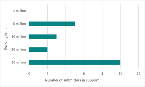
8.22 Submitters were asked whether they support the six-story
residential development in the central city rebate scheme. Here, eight
submitters (20%) said yes, 10 said somewhat (25%), and 20 (50%) said no.
8.23 What submitters
liked about this scheme:
· It encourages development (7)
· It encourages density in the right place (6)
8.24 What submitters
didn’t like about the scheme:
· The height threshold (9) – many of these submitters suggested
that 2 or 3 storeys would be more appropriate
· Ratepayers providing handouts or subsidies to developers (8)
· The financial benefit it provides to developers only and/or no
evidence that developers will pass on savings (6)
· Council encouraging high-rise buildings (6)
· That factors other than development contributions are what make
building six storey development unfeasible (5)
· The funding limit limiting the impact that this scheme could have
(4)
· The 30 June 2027 scheme expiry (too soon) (4)
8.25 Submitters were also asked, if any, what funding limit they would
support for the scheme. Here, one selected 1 million, three agreed with the
proposed 2 million, while two supported 3 million, two 5 million, and seven
supported 10 million.
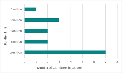
8.26 The decision
affects the following wards/Community Board areas:
8.26.1 Central ward
Impact on Mana Whenua Ngā Whai Take
Mana Whenua
8.27 The decisions do not involve a significant
decision in relation to ancestral land, a body of water or other elements of
intrinsic value, therefore this decision does not
specifically impact Mana Whenua, their culture, and traditions.
8.28 The decisions do not involve a
matter of interest to Mana Whenua and will not impact
on our agreed partnership priorities with Ngā Papatipu
Rūnanga.
8.29 The Council has
a separate rebate scheme, which seeks to encourage residential and community
development on Māori freehold and Māori-owned general land within the
Papakāinga/Kāinga Nohoanga zone of the Christchurch District Plan.
Climate Change Impact Considerations Ngā
Whai Whakaaro mā te Āhuarangi
8.30 The proposals in this report are
unlikely to contribute significantly to adaptation to the impacts of climate
change or emissions reductions.
8.31 There are no
direct climate change impact considerations associated with the decision
required. However, the residential rebate scheme looks to incentivise increased
housing density in the central city which could contribute to the
Council’s emissions reduction goals.
9. Next Steps Ngā Mahinga ā-muri
9.1 Staff
will make any required amendments to the schemes as agreed to by Council. The
decision will be communicated to stakeholders as required.
Attachments Ngā Tāpirihanga
|
No.
|
Title
|
Reference
|
Page
|
|
a ⇩
|
Rebate Scheme
Criteria - Existing Demand Credits
|
25/886936
|
83
|
|
b ⇩
|
Rebate Scheme
Criteria - Central City High Density Residential
|
25/885000
|
85
|
In addition to the attached documents, the following background
information is available:
|
Document
Name – Location / File Link
|
|
Not
applicable
|
Signatories Ngā Kaiwaitohu
|
Authors
|
Ellen Cavanagh
- Senior Policy Analyst
Andrew
Campbell - Legal Counsel
Hannah
Ballantyne - Senior Engagement Advisor
|
|
Approved By
|
David
Griffiths - Head of Strategic Policy & Resilience
John Higgins -
General Manager Strategy, Planning & Regulatory Services
|
|
9. Plan
Change 14 - Decision Making for Daresbury Heritage Listing
|
|
Reference Te Tohutoro:
|
25/1553868
|
|
Responsible Officer(s) Te Pou Matua:
|
Ike
Kleynbos, Principal Advisor Planning, Brent Pizzey, Senior Legal Counsel
|
|
Accountable ELT Member Pouwhakarae:
|
John
Higgins, General Manager Strategy, Planning & Regulatory Services
|
1. Purpose and Origin of the Report Te Pūtake Pūrongo
1.1 On
2 December 2024 the Council resolved to reject the Plan Change 14 (PC14)
Independent Hearing’s Panel (IHP) recommendation to retain the heritage
listing for Daresbury (9 Daresbury Lane).
1.2 The
Council decision making on PC14 must be confined to information that was in the
IHP record. In the debate in the Council meeting a Councillor stated that it
would cost $12 million to fix Daresbury. That figure was stated in error. It is
not the cost of repair identified in the IHP record.
1.3 The
report seeks that the 2 December 2024 Daresbury decision is rescinded and made
again, ensuring that decision making considerations are limited to those in the
IHP record.
2. Officer
Recommendations Ngā Tūtohu
That the Council:
1. Receives the information in the Plan Change
14 - Decision Making for Daresbury Heritage Listing Report.
2. Notes that the decision in this report is assessed as medium significance
based on the Christchurch City Council’s Significance and Engagement
Policy.
3. Receives the Independent Hearings Panel (the Panel) – Plan
Change 14 Housing and Business Choice recommendation reports, including
recommendations on submissions, further report addendums to the recommendations
report, and further minutes that modify the recommendations report, as provided
on the PC14 IHP Webpage: https://chch2023.ihp.govt.nz/recommendations-report/.
Decision only on PC14
recommendations regarding Daresbury (9 Daresbury Lane, Fendalton)
4. Limits all decision making to 9 Daresbury Lane, Fendalton (legally described as Lots 2, 3 DP 49363).
5. Rescinds the following 2 December 2024 Council resolution to reject
the Panel’s recommendation (CNCL/2024/00214) to
retain the Daresbury heritage listing (Item 185) and associated heritage
setting (Item 602):
Daresbury
House Heritage Listing
That
the Council:
68. Regarding
the heritage listing for Daresbury House [9 Daresbury Lane] and associated
heritage setting:
a. Accepts the
alternative recommendation to (refer to Attachment 2 to this report):
i. Reject
in-part the Panel’s Part 5 (section 10), specifically in relation to the
recommendation to retain the Daresbury heritage listing (Item 185) and
associated heritage setting (Item 602).
ii. Recommend
that the Daresbury heritage listing (Item 185) and associated heritage setting
(Item 602) are removed.
6. Notes that its reconsideration of the Panel’s recommendation regarding
Daresbury (9 Daresbury Lane, Fendalton) is limited to considering information
in the Panel’s records of PC14; and
7. Having confined the consideration of evidence to that presented to
the Panel:
EITHER
a. Accepts the alternative recommendation to:
i. Reject in-part the Panel’s Part 5 (section 10) recommendation,
specifically in relation to the retention of the Daresbury heritage listing
(Item 185) and associated heritage setting (Item 602).
ii. Recommend to the Minister that the Daresbury heritage listing (Item
185) and associated heritage setting (Item 602) are removed.
OR
b. Accepts the Panel’s recommendation to retain the Daresbury
heritage listing and associated heritage setting.
Clerical delegations and approvals:
8. Delegates authority to the Head of Planning and Consents to make
changes of minor effect or to correct minor errors in the accepted
Panel’s recommendations before publicly notifying its decisions on the recommendations
above.
9. Delegates authority to the Head of Planning and Consents to contact
the Minister regarding the referred recommendations for 9 Daresbury Lane and
any associated administration needed for the Minister to complete decision
making.
10. Resolves to publicly notify its decisions on resolutions 5 and 7 NO
LATER THAN 5 September 2025 and to serve that public notice on
every person who made a submission on Plan Change 14.
3. Executive Summary Te Whakarāpopoto Matua
3.1 The
Council’s decision making on IHP recommendations on PC14 “must not
consider any submission or other evidence unless it was made available to IHP before
the IHP made the recommendation”.
3.2 On
2 December 2024 the Council resolved to reject the Plan Change 14 (PC14)
Independent Hearing’s Panel (IHP) recommendation to retain the heritage
listing for Daresbury (9 Daresbury Lane). In the Council debate at that
meeting, a Councillor stated that it would cost $12m “to fix”
Daresbury.
That was incorrect, as the IHP record identifies a repair cost of between $6.8m
and $8.1m.
3.3 Evidence
presented to the IHP stated that the bare land value is $4.6m, so rather than $12m being a cost to “fix” Daresbury,
the figure approximates the maximum in the range for costs of repair ($8.1m)
plus how much the property would need to be sold for after repair if the owner
sought to recover repair costs.
3.4 Making
the decision again enables the Council to ensure that its decision making does
not make that error.
3.5 The
Minister’s 5 June 2025 decision on the Council’s 2 December 2024
recommendations deferred making a decision on Daresbury until after the Council
made a zoning decision for the site. The Council made that zoning
decision on 16 July 2025 but Council officers have asked the Minister to delay
a decision on whether Daresbury remains listed in the heritage schedule until
after the Council addresses this error.
4. Background/Context Te Horopaki
4.1 Plan
Change 14 is the Council’s response to national direction in the National
Policy Statement on Urban Development (NPS-UD) and the Resource Management
(Enabling Housing Supply and Other Matters) Amendment Act 2021 (RM Amendment
Act), by enabling intensification in and around commercial areas and permitting
development in accordance with Medium Density Residential Standards (MDRS) in
the District Plan except where a qualifying matter necessitates limiting that
development.
4.2 The
Daresbury heritage listing and associated heritage setting were listed in the
District Plan prior to PC14 and were valid considerations as a qualifying
matter.
4.3 Evidence
for and against scheduling Daresbury as a heritage item were presented by
Council experts and Daresbury Limited, respectively. Evidence included the
financial viability of repair.
4.4 This
report does not express any opinion on the evidence as the Council decision
making is limited to the information in the IHP record. That information was in
the “evidence pack” circulated to the Mayor and Councillors before
the 2 December 2024 meeting, as referenced in 4.6, below.
4.5 The following related memos/information were circulated to the
meeting members:
|
Date
|
Subject
|
|
19
July 2024
|
Plan Change 14: preparing for decision
making on panel recommendations
|
|
30
July 2024
|
Independent Hearings Panel Recommendations
Report – Plan Change 14 Housing and Business Choices
|
|
31
July 2024
|
Independent Hearings Panel
recommendations on PC14
|
|
2
August 2024
|
Updated IHP recommendations on PC14
|
|
9
August 2024
|
Plan Change 14
|
|
22
August 2024
|
Plan Change 14 decisions possible on 4
September
|
4.6 The
following evidence summaries have been provided to Councillors and has been
made available in the Big Tin Can:
|
Type
|
Subject
|
|
Qualifying matter
|
Daresbury heritage item qualifying matter
|
|
Qualifying
matter
|
Heritage qualifying matters
|
4.7 The following related information session/workshops have taken place
for the members:
Options Considered Ngā
Kōwhiringa Whaiwhakaaro
4.8 The
following reasonably practicable options were considered and are assessed in
this report:
4.8.1 Correcting the
error in the 2 December 2024 decision making by making the decision again.
4.8.2 There are no
other reasonably practical options to correct the error in the Council’s
decision making.
4.9 The
following options were considered but ruled out:
4.9.1 Not correcting
the error. Council staff have ruled this out as the Council has an opportunity
to ensure that it follows a correct decision-making process.
Options Descriptions Ngā
Kōwhiringa
4.10 Preferred
Option: Making the PC14 decision on the IHP scheduling recommendation for
Daresbury again, by rescinding the 2 December 2024 decision and making a new
decision.
4.10.1 Option Description: Making
the decision again and ensuring that considerations are confined to information
in the IHP record.
4.10.2 Option Advantages
· It ensures that the decision making is confined to relevant
considerations.
· It avoids risk of legal challenge about the decision-making having
regard to irrelevant considerations.
4.10.3 Option Disadvantages
· There are no disadvantages.
Analysis Criteria Ngā Paearu
Wetekina
4.11 Appropriate ways
for the Council to remedy an error in its decision making in circumstances in
which the decision-making process is not complete and the Council has a
reasonable opportunity to correct the error.
5. Financial Implications Ngā Hīraunga Rauemi
Capex/Opex Ngā Utu Whakahaere
|
|
Recommended Option
|
|
Cost to Implement
|
Within existing budget for Planning
|
|
Maintenance/Ongoing Costs
|
Nil
|
|
Funding Source
|
Within existing budget for Planning
|
|
Funding Availability
|
Funded in LTP
|
|
Impact on Rates
|
No additional impact beyond LTP
|
6. Considerations Ngā Whai Whakaaro
Risks and Mitigations Ngā
Mōrearea me ngā Whakamātautau
6.1 There
are no risks for the Council in correcting an error in its decision-making
process.
Legal Considerations Ngā
Hīraunga ā-Ture
6.2 Statutory
and/or delegated authority to undertake proposals in the report:
6.2.1 The Council is
able to rescind previous decisions and make them again.
6.3 Other Legal Implications:
6.3.1 The 2 December
2024 Daresbury decision could be vulnerable to legal challenge as the
Council’s recording of the decision indicates that incorrect information
was taken into account. Making the decision again, confining the decision
making to relevant considerations, removes that risk.
Strategy and Policy Considerations Te Whai
Kaupapa here
6.4 The
required decision:
6.4.1 Aligns with
the Christchurch
City Council’s Strategic Framework.
6.4.2 Is assessed as
medium significance based on the
Christchurch City Council’s Significance and Engagement Policy. The
level of significance was determined by the broader public interest in PC14 and
influence on the urban form outcomes of Ōtautahi Christchurch balanced
with this decision being about one site and therefore limited in the number of
persons affected.
6.4.3 Is consistent with Council’s Plans and Policies.
6.5 This
report supports the Council's
Long Term Plan (2024 - 2034):
6.6 Strategic Planning and Policy
6.6.1 Activity: Strategic Planning and Resource Consents
· Level of Service: 9.5.1.6 Prepare plan changes
to the District Plan to address issues and to implement national and regional
direction, identified as a high priority by Council - Providing Council an
annual update on progress with plan changes
Community Impacts and Views Ngā Mariu
ā-Hāpori
6.7 The
decisions in this report are of significant interest to the communities
affected. The effects of the plan change as recommended by the IHP on
communities has been considered as part of recommendations on the submissions
and evidence.
6.8 The decision affects the Waimāero Fendalton-Waimairi-Harewood
Community Board that Daresbury House (9 Daresbury Lane) is located in. The
views of the Community Board are expressed in their submission and verbal
presentation to the Independent Hearings Panel on Plan Change 14.
Impact on Mana Whenua Ngā Whai Take
Mana Whenua
6.9 Impact on mana
whenua is relevant solely to the extent that it appears in the IHP record.
6.10 The decision
does not involve a significant decision in relation to ancestral land, a body
of water or other elements of intrinsic value, therefore this decision does not
specifically impact Mana Whenua, their culture, and traditions.
6.11 The decision
does not involve a matter of interest to Mana Whenua and will not impact on our
agreed partnership priorities with Ngā Papatipu Rūnanga.
Climate Change Impact Considerations Ngā
Whai Whakaaro mā te Āhuarangi
6.12 Climate change impact considerations are
relevant solely to the extent that they appear in the IHP record.
7. Next Steps Ngā Mahinga ā-muri
7.1 If
the new Council decision is the same as in the 2 December 2024 Council meeting
– being to reject the IHP recommendation and recommend descheduling to
the Minister – then the Council will report that to the Minister and the
Minister will make the PC14 decision on whether Daresbury remains in the
heritage schedule.
7.2 If
the Council decision is to accept the IHP recommendation to retain heritage
scheduling for Daresbury that decision in PC14 will be final. There will no
longer be a scheduling decision for the Minister to make. The operative
District Plan will be that the land is zoned medium density (16 July 2025
Council decision accepting IHP recommendations) and that the Daresbury building
and setting are in the heritage schedule.
7.3 Heritage
scheduling of Daresbury has not yet been determined in the PC13 hearing
process. If the Minister does not deschedule Daresbury in the PC14 process, the
Council will be considering the same issue again when it receives Panel
recommendations in the PC13 process. Staff expect that to be in a report in
early September 2025.
Attachments Ngā Tāpirihanga
There are no
attachments to this report.
In addition to the attached documents, the following background
information is available:
|
Document
Name – Location / File Link
|
|
Not
applicable
|
Signatories Ngā Kaiwaitohu
|
Authors
|
Ike Kleynbos -
Principal Advisor Planning
Brent Pizzey -
Senior Legal Counsel
|
|
Approved By
|
Mark Stevenson
- Head of Planning & Consents
John Higgins -
General Manager Strategy, Planning & Regulatory Services
|
|
10. Hagley Golf Course Tree Removal and Planting
|
|
Reference Te Tohutoro:
|
25/1345207
|
|
Responsible Officer(s) Te Pou Matua:
|
Brittany
Walker – Arborist Central City, Toby Chapman - Urban Forest Manager
|
|
Accountable ELT Member Pouwhakarae:
|
Andrew
Rutledge, General Manager Citizens and Community
|
1. Purpose and Origin of the Report Te Pūtake Pūrongo
1.1 The
purpose of this report is to seek approval for the removal of three (3) trees
and to undertake tree planting of approximately thirty (30) trees to facilitate
changes to the layout of the Hagley Golf Course in North Hagley Park.
1.2 The
changes proposed by the Hagley Golf Course are aimed at improving the safety of
park visitors currently using pathways that go through and border the course.
1.3 The
report was prepared in response to a request from the Hagley Golf Club
Committee.
1.4 As the trees proposed for removal are healthy and structurally
sound, the decision falls outside of staff delegation and the decision to
remove them ultimately sits with Council.
2. Officer
Recommendations Ngā Tūtohu
That the Council:
1. Receives the information in the Hagley Golf
Course Tree Removal and Planting Report.
2. Notes that the decision in this report is assessed as low significance
based on the Christchurch City Council’s Significance and Engagement
Policy.
3. Approves the removal of the three trees in North Hagley Park as
detailed in Attachment A of this report, to facilitate proposed layout changes
to the Hagley Golf Course to improve safety of park users.
4. Notes that there is a significant number of trees proposed for
planting within the bounds of the golf course which will substantially exceed
the requirements of the Tree Policy of 1:2 replacement planting for any trees
removed.
3. Executive Summary Te Whakarāpopoto Matua
3.1 The
Hagley Golf Club has proposed layout changes to several holes of the course
located in North Hagley Park. The proposed changes would reduce the current
health and safety risks to park users and improve the playability of the
course. It is proposed to alter the angle of play and use new tree planting to
minimize the risk to pedestrians that utilise high-traffic footpaths in the
park.
3.2 Approximately
230 meters of new tree planting along the fairways will provide a physical
barrier which will enhance safety for park users. The proposed changes also
help to address seasonal flooding issues that render parts of the course
unusable during wetter months.
3.3 The
proposed adjustment would necessitate the removal of three (3) mature exotic
trees: one silver birch and two blue atlas cedars.
3.4 The
new plantings would consist of approximately 30 large tree species, selected in
accordance with the Hagley Park Management Plan to preserve the park’s
landscape values and character.
4. Background/Context Te Horopaki
4.1 The
Hagley Golf Course is located within North Hagley Park and was established in
the 1870’s. It is a par 72 course with 12 holes, with holes 1 to 6 being
played twice, often from a different tee or green. There are formal
competitions held twice weekly and an annual tournament.
4.2 The
golf course is intersected by various high use footpaths. There is a pedestrian
counter located at the southeastern end of the main North Hagley path that
transects the golf course. The average number of footpath
users recorded by the counter for 2025 is approximately 1,300
per day (recorded in both directions).
4.3 In
the current golf course layout, balls are driven from number 10 tee that runs
parallel with the alignment of the highly frequented main path. This angle of
play provides no protection from stray golf balls for pedestrians as the
section of path has no trees or other physical barrier between the fairway and
the footpath. This also increases wait times for players waiting for the path
to clear.
4.4 Number
10 green is also prone to flooding in wetter months, which results in this area
being unusable for a portion of the year.
4.5 It
is therefore proposed to move the tee for hole 10 which will direct the angle
of play away from the path and substantially reduce the likelihood of path
users being struck by golf balls. It is also proposed to add a significant
number of new trees along number 10 fairway (approximately 200m) which will
serve as a physical barrier that will continue to improve safety for footpath
users as the trees mature.
4.6 The
changes to hole 10 will reduce the length of this hole and therefore also
reduce its difficulty from a par 5 to a par 4. To maintain the difficulty
of the overall course, it is proposed that hole 6 is extended and therefore
increasing its difficulty form a current par 4 to par 5.
4.7 To
accommodate the change to number 10, 3 trees will need to be removed.
4.8 Details
of the trees proposed for removal are outlined below.
|
Tree ID
|
Species
|
Tree Details
|
|
112,393
|
Silver birch
|
A mature specimen in good health and with
typical branching habit and shape for the species. Located in the centre of
the proposed extension to number 6 green/fairway.
|
|
112,430
|
Blue atlas cedar
|
In reasonable health but has poor
branching structure and a history of limb failures.
|
|
112,432
|
Blue atlas
cedar
|
In
reasonable health but has poor branching structure.
|
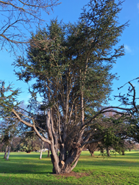
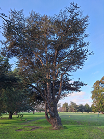
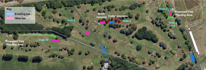
4.9 In
addition to the proposed planting along number 10, additional tree planting is
proposed to delineate hole 2 and proposed hole 3 as part of realignment to
those greens to improve both playability and safety for park visitors.
4.10 Proposed tree
planting would incorporate a mixture of large tree species in keeping with the
guidelines of the Hagley Park Management Plan and the landscape values of North
Hagley Park.
Options Considered Ngā
Kōwhiringa Whaiwhakaaro
4.11 The following
reasonably practicable options were considered and are assessed in this report:
4.11.1 Grant approvals for the
removal of the 3 trees and new planting as proposed in this report.
4.11.2 Decline the tree
removals.
Options Descriptions Ngā
Kōwhiringa
4.12 Preferred
Option: - Tree removals as proposed.
4.12.1 Option Description: Grant
approvals for the removal of the 3 trees and undertake tree planting as
proposed in this report.
4.12.2 Option Advantages
· Decreases risk to park users posed by current golf course layout.
· Substantial increase in canopy cover overtime in line with the aims
of the Urban Forest Plan.
4.12.3 Option Disadvantages
· Loss of three trees within Hagley Park.
· Short term loss of ecosystem benefits provided by the three trees.
4.13 Option 2:
Decline tree removal
4.13.1 Option description:
Decline the removal of the trees therefore also removing the ability for hole
10 to be changed to a par 5.
4.13.2 Option Advantages:
· The three trees would be retained.
4.13.3 Option Disadvantages:
· The course would not be able to retain the same difficulty of the
entire course.
· Hagley golf may choose not to implement the other alterations to the
course which are seen as benefiting other users of the park.
Analysis Criteria Ngā Paearu
Wetekina
4.14 Impact on
usability, safety and landscape character of the site.
4.15 Impact on budget.
4.16 Impact on
community and stakeholder expectations.
4.17 Public
perception.
5. Financial Implications Ngā Hīraunga Rauemi
Capex/Opex Ngā Utu Whakahaere
|
|
Recommended Option
|
Option 2 –No removals
|
|
Cost to Implement
|
$12000 (includes cost of planting and
aftercare for 7 years)
|
$0
|
|
Maintenance/Ongoing Costs
|
N/A
|
N/A
|
|
Funding Source
|
Existing capex
|
N/A
|
|
Funding Availability
|
Funding available
|
N/A
|
|
Impact on Rates
|
None
|
None
|
6. Considerations Ngā Whai Whakaaro
Risks and Mitigations Ngā
Mōrearea me ngā Whakamātautau
6.1 If
the tree removals and tree planting are not undertaken and the course layout
remains as it is currently, the ongoing risk of harm to members of the public
using the park will remain.
Legal Considerations Ngā
Hīraunga ā-Ture
6.2 Statutory
and/or delegated authority to undertake proposals in the report:
6.2.1 Council has the
authority to approve removals.
6.3 Other Legal Implications:
6.3.1 There is no
legal context, issue, or implication relevant to this decision.
Strategy and Policy Considerations Te Whai
Kaupapa here
6.4 The
required decision:
6.4.1 Aligns with the Christchurch
City Council’s Strategic Framework.
6.4.2 Is assessed as low significance based on the Christchurch City
Council’s Significance and Engagement Policy. The level of
significance was determined by assessing the impact this would have on the
local community.
6.4.3 Is consistent with Council’s Plans and Policies. The proposed
removals are considered against Section 4.7 of the Tree Policy.
6.5 This
report supports the Council's
Long Term Plan (2024 - 2034):
6.6 Parks, Heritage and Coastal Environment
6.6.1 Activity: Parks and Foreshore
· Level of Service: 6.8.2.1 Increasing tree canopy
in Parks - A net increase in total number of trees is achieved (1:2 replacement
policy), with a minimum of 50% of the trees being medium to very large species
· Level of Service: 6.8.2.3 Parks are managed and
maintained in a clean, tidy, safe, functional, and equitable manner (Asset
Performance) - At least 90% of parks and associated public recreational assets
are available for safe public use during opening hours
· Level of Service: 6.8.4.1 Customer satisfaction
with the presentation of Hagley Park - >=90%
Community Impacts and Views Ngā Mariu
ā-Hāpori
6.7 The
proposed tree removals and plantings were presented to the Hagley Park
Reference Group, with no concerns or objections raised during the consultation.
6.8 The decision affects the following wards/Community Board areas:
6.8.1 Waipapa Papanui-Innes-Central.
Impact on Mana Whenua Ngā Whai Take
Mana Whenua
6.9 The decision does not
involve a significant decision in relation to ancestral land, a body of
water or other elements of intrinsic value, therefore this decision does not
specifically impact Mana Whenua, their culture, and traditions.
6.10 The decision does
not involve a matter of interest to Mana Whenua and will
not impact on our agreed partnership priorities with
Ngā Papatipu Rūnanga.
Climate Change Impact Considerations Ngā
Whai Whakaaro mā te Āhuarangi
6.11 The proposals in this report are
unlikely to contribute significantly to adaptation to the impacts of climate
change or emissions reductions.
6.12 The number of
removals represent a small percentage of the trees within the park. Any impacts
will be offset by the planting of a significant number of replacement trees.
7. Next Steps Ngā Mahinga ā-muri
7.1 If
approval is granted, staff will proceed with proposed removals and replacement
planting.
Attachments Ngā Tāpirihanga
|
No.
|
Title
|
Reference
|
Page
|
|
a ⇩
|
Hagley Park
Tree Removal Plan
|
25/1534822
|
101
|
|
b ⇩
|
Proposed golf
course layout
|
25/1524321
|
102
|
In addition to the attached documents, the following background
information is available:
|
Document
Name – Location / File Link
|
|
Not
applicable
|
Signatories Ngā Kaiwaitohu
|
Authors
|
Brittany
Walker - Arborist
Toby Chapman -
Manager Urban Forest
|
|
Approved By
|
Rupert Bool -
Head of Parks
|
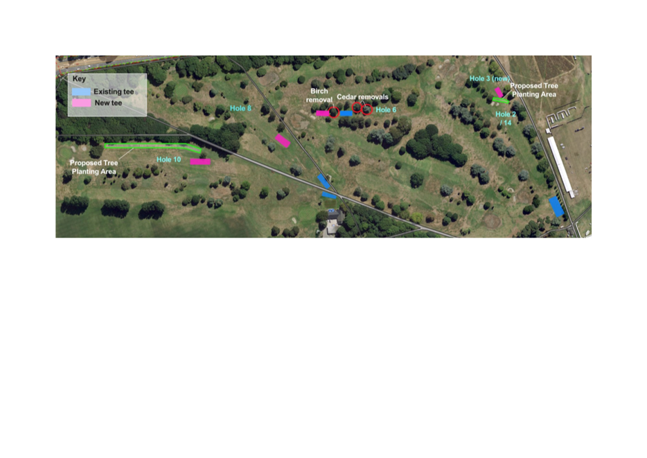
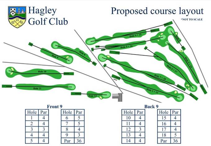
|
11. Burwood
Landfill Site C Operational Extension
|
|
Reference Te Tohutoro:
|
25/1408335
|
|
Responsible Officer(s) Te Pou Matua:
|
Grant
Gillard, Landfill Aftercare Supervisor
Dr Alec McNeil, Manager Resource Recovery
|
|
Accountable ELT Member Pouwhakarae:
|
Brent
Smith, General Manager City Infrastructure
|
1. Purpose and Origin of the Report Te Pūtake Pūrongo
1.1 The
purpose of this report is to seek approval to extend the operational life of the
Burwood Landfill Site C to 30 June 2028.
1.2 The
report is staff generated.
2. Officer
Recommendations Ngā Tūtohu
That the Council:
1. Receives the information in the Burwood
Landfill Site C Operational Extension Report.
2. Notes that the decision in this report is assessed as low significance
based on the Christchurch City Council’s Significance and Engagement
Policy.
3. Approves the operational extension of the Burwood Landfill Site C to
30 June 2028, subject to obtaining the necessary resource consents.
3. Executive Summary Te Whakarāpopoto Matua
3.1 The
Burwood Landfill Site C receives low-level contaminated soils from Council
projects and the commercial market.
3.2 The
operation of the site is subject to resource consent.
3.3 The
current operations are scheduled to cease by 30 June 2026.
3.4 Staff
analysis of the input tonnages to Burwood Landfill Site C has revealed the
reliance that both the Council and the wider commercial market have on
utilising the site.
3.5 This
report sets out the rationale and associated planning workflow to extend the
operational life of the site to 30 June 2028.
4. Background/Context Te Horopaki
4.1 The
Burwood Landfill Site C currently receives low-level contaminated soils from
Council and third-party projects. The soils are charged a gate fee which
includes the Government waste disposal levy.
4.2 The
Burwood Landfill Site C is scheduled to close on 30 June 2026, and this is
reflected in current Resource Recovery budgets.
4.3 The
closure of the landfill is not reflected in other Council department budgets
where soil disposal is anticipated which could result in increased unbudgeted
costs.
4.4 The
landfill does have additional airspace that could be utilised without
compromising future set down areas for disaster waste management.
4.5 The
following figures show the overall Burwood landfill footprint (Fig 1), landfill
Site C (Fig 2) and the disaster waste set down area (Fig 2 – white
delineated area).
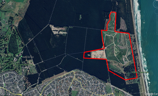
Figure 1
– Burwood Landfill Area
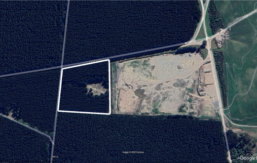
Figure 2
– Burwood Landfill Site C and disaster waste set down area (white)
4.6 Site
C would be effectively raised in height to accommodate additional soil inputs.
4.7 The
disaster waste set down area is currently under forest. This area will not be
replanted when the forest is harvested. Harvesting is anticipated to be within
a five-year period.
4.8 An
extension to the operational life of the site would be based on the following
assumptions/approach:
4.8.1 The annual
tonnage input assumption for any extended period is 65,000 tonnes per annum,
with the projected additional soil total over the extended 24-month operational
period being 130,000 tonnes. This input assumption is conservative based on the
decreasing number of projects that are expected to create large soil
volumes. Average inputs over the past three years were 96,204 tonnes.
4.8.2 The future
resource consent application would cover a five-year period to 30 June 2031.
4.8.3 The
operational activity set out in the resource consent application would cover a
2-year period ending 30 June 2028.
4.8.4 The resource
consent application would change the end date for site restoration by one year to
31 December 2032.
4.8.5 Projected
additional income over the extended 24-month operational period is $15.9m based
on current gate fees.
4.8.6 Projected
additional surplus over the extended 24-month operational period is $6.8m.
4.9 Extending
the closure date for the landfill would provide an opportunity for the Council
to account for the closure and its impact on internal department budgets where
soil disposal to Burwood is anticipated. Agreeing a standard budget impact for
those departments that use the landfill could be an additional option.
4.10 The planning
workflow required in support of the resource consent application is based on
the following:
4.10.1 4 months wet weather hard
stands for soils in winter (May -Aug).
4.10.2 Haul roads open in
all-weather at assessable gradients.
4.10.3 Stormwater management.
4.10.4 Dust management.
4.10.5 Capping materials.
4.10.6 Final landform to be flat
lying and grassed.
4.11 The planning
workflow above would require inputs from engineering consultants that are
familiar with the site, inputs from the current landfill operational Contractor
and inputs from Council staff. The planning workflow cost estimate is in the
region of $800k.
4.12 Workflow costs
can be funded from budgeted expenses.
4.13 Workflow costs
will be confirmed in detail with the relevant suppliers should extending the
landfill be progressed.
4.14 Should the
Council agree to extending the life of the landfill, and subject to the
approval of the resource consents (Environment Canterbury and the Council), the
extension will have additional implications that will be considered and managed
via early engagement with:
· Waitai Coastal-Burwood-Linwood Community Board
· Community Liaison Group
· Iwi
4.15 The post-closure
plan for the landfill would largely remain the same with minor adjustments to
the land area being restored in response to any change in the landfill profile.
The post-closure timeline would be reset based on new resource consents.
4.16 Extending
Burwood landfill Site C will not impact on emergency set down areas that have
been identified on site. These emergency areas are on undeveloped land within
the site that is being preserved for future disaster waste management purposes.
4.17 The following related memos/information were circulated to the
meeting members:
|
Date
|
Subject
|
|
|
Not applicable
|
|
|
|
4.18 The following related information session/workshops have taken place
for the members of the meeting:
|
Date
|
Subject
|
|
|
Not applicable
|
|
|
|
Options Considered Ngā
Kōwhiringa Whaiwhakaaro
4.19 The following
reasonably practicable options were considered and are assessed in this report:
4.19.1 Extend the operational
life of the site (Preferred) – extend the life of the site until 30
June 2028, subject to obtaining the necessary resource consents.
4.19.2 Status quo (Not
Recommended) – site closes on 30 June 2026 as currently planned and
budgeted.
Options Descriptions Ngā
Kōwhiringa
4.20 Preferred
Option: Extend the operational life of the site.
4.20.1 Option Description: the
site closure date would be extended from 30 June 2026 to the 30 June 2028.
4.20.2 Option Advantages
· Provides additional landfill capacity to the commercial market and Council
projects.
· Generates additional income and associated surplus.
4.20.3 Option Disadvantages
· Market continues to rely on the Burwood Landfill Site C as the
disposal point for low-level contaminated soils.
4.21 Other Option:
Status quo (Not Recommended).
4.21.1 Option Description: The
site closes on 30 June 2026 as currently planned and budgeted.
4.21.2 Option Advantages
· Market will have to provide an alternative disposal site capable of
handling up to 65,000 tonnes per annum.
4.21.3 Option Disadvantages
· Disposal costs for low-level contaminated soils are likely to
increase.
Analysis Criteria Ngā Paearu
Wetekina
4.22 The Burwood
Landfill Site C is scheduled to close on 30 June 2026. By comparing the
available airspace against projected input tonnages, it has been determined
that an additional 2-year minimum lifespan could be realised.
4.23 During 2024/25
Burwood Landfill Site C received 115,375 tonnes of low-level contaminated
soils. Around 30% of the soil inputs were derived from Council projects and the
balance from commercial operators.
4.24 Staff analysis
of the input tonnages to Burwood Landfill Site C has revealed the reliance that
both the Council and the wider commercial market have on utilising the site.
5. Financial Implications Ngā Hīraunga Rauemi
Capex/Opex Ngā Utu Whakahaere
|
|
Recommended Option – extend site life
|
Option 2 – Close site
|
|
Cost to Implement
|
$0.8m (planning workflow)
|
$0.6m
|
|
Maintenance/Ongoing Costs
|
$6.0m
|
$0.2 p/a
|
|
Funding Source
|
Landfill Gate fees
|
Resource Recovery budgets
|
|
Funding Availability
|
$15.9m (gate fee income)
|
$1.0m
|
|
Impact on Rates
|
$0
|
$0
|
5.1 The
following table summarises the controllable costs and revenue of the landfill
over the past three years and sets out the projections for the next three
years.
|
Description
|
2022/23
Actuals
|
2023/24
Actuals
|
2024/25 Actuals
|
2025/26
Annual Plan
|
2026/27
|
2027/28
|
|
Revenue
|
$7.4m
|
$7.0m
|
$11.9m
|
$6.8m
|
$7.8m
|
$8.1m
|
|
LEVY
|
|
$0.6m
|
$1.1m
|
$0.9m
|
$1.0m
|
$1.3m
|
|
Expense
|
$3.3m
|
$2.6m
|
$2.3m
|
**$3.8m
|
***$3.8m
|
$3.0m
|
|
Surplus
|
$4.1m
|
$3.8m
|
$8.5m
|
$2.1m
|
$3.0m
|
$3.8m
|
|
|
|
|
|
|
|
|
|
Tonnage
|
*107,447
|
65,790
|
115,375
|
65,000
|
65,000
|
65,000
|
|
Levy per tonne
|
$0
|
$10
|
$10
|
$15
|
$15
|
$20
|
|
Gate Fee per tonne (excl Levy)
|
$85
|
$100
|
$100
|
$110
|
$110
|
$110
|
* Includes Te Kaha site works, 19,000 tonnes.
** Includes close out and remediation costs.
*** Includes $0.8m of planning workflow costs.
6. Considerations Ngā Whai Whakaaro
Risks and Mitigations Ngā
Mōrearea me ngā Whakamātautau
6.1 The lifespan of the Burwood landfill Site C can be extended, subject
to resource consent approval. Council has previously been successful in gaining
resource consent for the site as recently as 2024.
6.2 Extending the
life of the landfill may cause a crowding out effect in the wider market. To
date several private organisations have expressed an interest in alternative
soil processing technologies but none have progressed.
6.3 Establishing an
alternative commercial landfill will be contingent on securing a site,
obtaining resource consent, and determining the gate fee.
6.4 Competition in
the landfill sector is limited, and the argument could be made that an
extension at Burwood would be a considered a disincentive for any new site
development.
6.5 To avoid any
confusion in the marketplace it is appropriate that Council confirm the closing
date for the site. Extending the life of the landfill will require appropriate
and timely engagement with the affected parties including Iwi, local community,
Council departments, and third-party users of the landfill.
6.6 There is a risk
that the community associates Site C with the closed municipal landfill. Site C
is a separate landfill to the original Municipal Solid Waste landfill which
closed in 2005.
6.7 There is a risk
that the community raises concerns about the proximity of the landfill to the
sea and any exposure to coastal erosion. Site C operations are at closest 940m
from the Pacific Ocean and unlikely to be affected by coastal erosion.
6.8 As part of the
resource consenting process, Council will engage with Iwi and the community
liaison group about the continuation of Site C works.
Legal Considerations Ngā
Hīraunga ā-Ture
6.9 Statutory
and/or delegated authority to undertake proposals in the report:
6.9.1 Whilst the
delegated financial authority sits at the Chief Executive level it has been
determined by the Executive Leadership Team that any decision for this proposal
should be via full Council.
6.10 Other Legal Implications:
6.10.1 There is no legal
context, issue, or implication relevant to this decision.
Strategy and Policy Considerations Te Whai
Kaupapa here
6.11 The required
decision:
6.11.1 Aligns with the Christchurch
City Council’s Strategic Framework.
6.11.2 Is assessed as low significance based on the Christchurch City
Council’s Significance and Engagement Policy. The level of
significance was determined by considering the number of residents affected by
the proposal. The volume of traffic and site access and egress arrangements
have low impact on the adjacent and surrounding community. The site has
received no formal complaints related to the operation since the current
consent was issued in 2024.
6.11.3 Is consistent with Council’s Plans and Policies.
6.12 This report supports
the Council's
Long Term Plan (2024 - 2034):
6.13 Solid Waste and Resource Recovery
6.13.1 Activity:
Solid Waste and Resource Recovery
· Level of Service: 8.1.8 Consent compliance for
operations at Burwood Resource Recovery Park (BRRP) - No major or persistent
breaches of consents
Community Impacts and Views Ngā Mariu
ā-Hāpori
6.14 The decision
affects the following wards/Community Board areas:
6.14.1 Waitai Coastal-Burwood-Linwood
Community Board.
6.15 Previous extensions to the Site C operating life have been subject
to discussion with the local Board and a community liaison group. The last
discussions took place in 2024 and had no objections or concerns raised.
Impact on Mana Whenua Ngā Whai Take Mana Whenua
6.16 The site is an
existing activity that will not have any additional impact as a result of this
proposal.
6.17 The decision does not involve a significant decision in relation to
ancestral land, a body of water or other elements of intrinsic value, therefore
this decision does not specifically impact Mana Whenua,
their culture, and traditions.
6.18 Previous successful resource
consent applications for Site C have confirmed that any decision to extend the
life of the site does not involve a matter of interest
to Mana Whenua and will not impact on our agreed
partnership priorities with Ngā Papatipu Rūnanga.
6.19 Should the
Council agree to extending the life of the landfill, and subject to the
approval of the resource consents (Environment Canterbury and the Council), the
extension will have additional implications that will be considered and managed
via early engagement with Iwi.
Climate Change Impact Considerations Ngā
Whai Whakaaro mā te Āhuarangi
6.20 The proposals in this report are unlikely
to contribute significantly to adaptation to the impacts of climate change or
emissions reductions. Whilst the height of the landfill will be raised to
accommodate the additional tonnage the profile of the site is engineered to
maintain slope stability in extreme weather events or natural disasters.
6.21 The waste inputs
to Burwood Landfill Site C have a negligible possibility of generating landfill
gas as they are soil based with low to nil organic content.
7. Next Steps Ngā Mahinga ā-muri
7.1 Obtain
a decision from the Council.
7.2 If
proposal is approved initiate the planning workflow in support of obtaining the
appropriate resource consents.
7.3 Communicate
the extension of the site closing date to Council departments and externally to
the commercial users of the site.
Attachments Ngā Tāpirihanga
There are no
attachments to this report.
In addition to the attached documents, the following background
information is available:
|
Document
Name – Location / File Link
|
|
Not
applicable
|
Signatories Ngā Kaiwaitohu
|
Authors
|
Grant Gillard
- Landfill Aftercare Supervisor
Alec McNeil -
Manager Resource Recovery
|
|
Approved By
|
Lynette Ellis
- Head of Transport & Waste Management
Brent Smith -
General Manager City Infrastructure
|
|
12. Heathcote Express Major Cycleway - Truscotts
Road Detailed Traffic Resolutions
|
|
Reference Te Tohutoro:
|
25/586954
|
|
Responsible Officer(s) Te Pou Matua:
|
Katharine
Jones, Project Manager Transport
|
|
Accountable ELT Member Pouwhakarae:
|
Brent
Smith, General Manager City Infrastructure
|
1. Purpose and Origin of the Report Te Pūtake Pūrongo
1.1 The
purpose of this report is for the Council to approve detailed traffic
resolutions on Truscotts Road following the post-construction safety audit, and
recent consultation with St. Mary’s Anglican Church and residents of
Truscotts Road.
1.2 The
report is staff generated to support the implementation of proposed new
parking and no stopping changes associated with the Heathcote Express Major
Cycleway Route Section 2D - Valia Place to Martindales Road.
1.3 The recommended option is to install two new P10 restricted car
parks and no stopping restrictions in accordance with Attachment A.
1.4 The report also includes the missing attachment (Attachment B)
from the approved traffic resolutions for Section 2D of the Heathcote
Expressway.
2. Officer Recommendations Ngā
Tūtohu
That the Council:
1. Receives the information in the Heathcote Express Major
Cycleway - Truscotts Road Detailed Traffic Resolutions Report.
2. Notes that the decision in this report is
assessed as low significance based on the Christchurch City Council’s
Significance and Engagement Policy.
3. Revokes any previous resolutions pertaining to
traffic controls made pursuant to any Bylaw to the extent that they are in
conflict with the traffic controls and parking and stopping restrictions
described in resolution 4 below.
4. Make the following resolutions relying on its
powers under the Christchurch City Council Traffic and Parking Bylaw 2017 and
Part 21 of the Local Government Act 1974:
Truscotts Road
(Deavoll Place to Martindales Road) – New Parking and Stopping
Restrictions
a. Approves, pursuant to clause 7 of the
Christchurch City Council Traffic and Parking Bylaw 2017, that the stopping of
vehicles be prohibited at any time
b. on the northeast side of Truscotts Road,
commencing at a point 9 metres northwest of its intersection with Martindales
Road and extending in a north-westerly direction for a distance of 7 metres, as
detailed on Attachment A TG151628, dated 01/08/2025.
c. on the northeast side of Truscotts Road,
commencing at a point 28 metres northwest of its intersection with Martindales
Road and extending in a north-westerly, then northerly direction following the
kerbline for a distance of 120 metres, as detailed on Attachment A
TG151628, dated 01/08/2025.
d. on the southwest side of Truscotts Road
commencing at a point 6 metres northwest of its intersection with Martindales
Road and extending in a north-westerly direction for a distance of 18 metres,
as detailed on Attachment A TG151628, dated 01/08/2025.
e. on the southwest side of Truscotts Road,
commencing at a point 18 metres northwest of its intersection with Deavoll
Place and extending in a south-easterly direction for a distance of 62 metres,
as detailed on Attachment A TG151628, dated 01/08/2025.
f. Approves, pursuant to clause 7 of the
Christchurch City Council Traffic and Parking Bylaw 2017, that the parking of
all vehicles be restricted to a maximum period of ten minutes, on the northeast
side of Truscotts Road, commencing at a point 16 metres northwest of its
intersection with Martindales Road and extending in a north-westerly direction
for a distance of 12 metres, as detailed on Attachment A TG151628, dated
01/08/2025. This restriction is to apply at all times.
5. Approves that these resolutions take effect
when parking signage and/or road markings that evidence the restrictions
described in this staff report are in place (or removed in the case of
revocations).
6. Notes that Attachment B of this report is
applicable to the detailed traffic resolutions for Section 2D of the Heathcote
Expressway as approved by the Urban Development and Transport Committee on the
21 November 2021.
7. Approves, in accordance with Section 1.6 of
the Land Transport (Road User) Rule 2004, that a cycle path, for the use of
bi-directional road users as defined by Section 11.1A of the Land Transport
(Road User) Rule 2004 only, but excepting pedestrians and riders of mobility
devices from this group of road users, be established between Martindales Road
and Station Road, intersecting with Martindales Road at a point 17 metres west
of Station Road, and extending in an easterly direction for a distance of 14 metres,
as detailed on Attachment B sheet R101, dated 19/08/2022.
8. Approves, in accordance with Section 1.6 of
the Land Transport (Road User) Rule 2004, that a cycle path, for the use of
bi-directional road users as defined by Section 11.1A of the Land Transport
(Road User) Rule 2004 only, but excepting pedestrians and riders of mobility
devices from this group of road users, be established between Martindales Road
and Station Road, intersecting with Station Road at a point 8 metres south of
Martindales Road, and extending in a westerly direction for a distance of 7 metres,
as detailed on Attachment B sheet R101, dated 19/08/2022.
3. Executive Summary Te Whakarāpopoto Matua
3.1 On
4 November 2021, a report recommending detailed traffic resolutions for the
Heathcote Expressway Major Cycleway Route Section 2 – The Tannery to
Martindales Road, was presented to the Urban Development and Transport
Committee for approval. The Committee adopted the Officer recommendations with
one minor amendment.
3.1.1 The
detailed traffic resolutions report referred to an attachment that included the
project limits for Section 2C only. Attachment B included in this report
covers the approved resolutions for Section 2D.
3.2 In
March 2021, May 2023 and June 2025, staff met with representatives of St.
Mary’s Anglican Church to discuss the new no stopping on the west side of
Truscotts Road, opposite the church, and the provision of two new carparks on
the east side outside the church. The carparks would support church activities
such as funerals and weddings.
3.3 In
December 2023, a post-construction safety audit was conducted on the completed
works. Recommendations made from the post-construction safety audit were
provided to staff for consideration.
3.3.1 One
recommendation included assessing the parking requirements along Truscotts Road
and to install additional no stopping lines to improve safety and visibility
for road users, particularly cyclists.
3.4 The
recommended option is to install two new P10 restricted car parks and no
stopping restrictions in accordance with Attachment A.
4. Background/Context Te Horopaki
4.1 On
23 March 2021 Council Officers met with a representative of St. Mary’s
Anglican Church to discuss the upcoming cycleway works and associated no
parking along Truscotts Road.
4.1.1 The
Church expressed support for the proposed no stopping outside the Church along
Truscotts Road. They also noted that the parking available is well utilised
during Sunday services.
4.1.2 The
meeting minutes recorded made no reference to any requests from the
representative or other representatives of the church for additional parking.
4.2 On
4 November 2021, a report recommending detailed traffic resolutions for the
Heathcote Express Major Cycleway Route Section 2 – The Tannery to
Martindales Road was presented to the Urban Development and Transport Committee
for approval.
4.2.1 The
Committee adopted the Officer recommendations with one minor amendment. The
approved recommendations were installed as part of the construction works for
the cycleway in 2022 and 2023.
4.3 On
29 May 2023, Council Officers members met with representatives of the St.
Mary’s Anglican Church to discuss public transport improvements on
Martindales Road and the cycleway construction along Truscotts Road.
4.3.1 Council
Officers briefed the church on the proposed/installed improvements and answered
queries that were raised.
4.3.2 The
church reiterated that parking along Truscotts Road continued to be well
utilised, and a request for two new carparks outside the church on Truscotts
Road was made. The church stated that the carparks would be in use during
events such as funerals for hearses and weddings.
4.3.3 From
June to September 2023, the project team evaluated different options for the
carparks. It was discussed whether the carparks could be signed as “for
church use only”, but that was determined to not be feasible or
enforceable. The alternative proposal was to time restrict the parking, and
there was consensus that P10 would be appropriate and in line with the intended
use.
4.4 On
1 December 2023, a post-construction Safety Audit was conducted on Section 2D
of the Heathcote Expressway Major Cycleway Route from Vaila Place to
Martindales Road.
4.4.1 Recommendations
from the Safety Audit included improving delineation, visibility and pathway
stability at various locations within the project limits. Most of these
recommendations were accepted and able to be installed/remedied without
triggering additional requirements.
4.4.2 Included
in the Safety Audit was an assessment of the parking requirements along
Truscotts Road and to install a small amount of additional no stopping lines to
improve safety and visibility for road users, particularly cyclists. This
recommendation was accepted and has necessitated this report to obtain approval
for the parking changes and additional no stopping.
4.5 In
June 2025, consultation was undertaken on the additional no stopping and
parking changes via a letter drop. An on-site meeting was also held with
representatives of St. Mary’s Anglican Church to discuss the changes.
4.5.1 Details
of this meeting and the consultation feedback are provided in Section 6 under
heading “Community Impacts and Views Ngā Mariu
ā-Hāpori.”
Options Considered Ngā Kōwhiringa Whaiwhakaaro
4.6 The
following reasonably practicable options were considered and are assessed in
this report:
4.6.1 Option
1 (“Preferred Option”) – Install two new P10 restricted car
parks on Truscotts Road and install no stopping changes recommended by the
post-construction Safety Audit, in accordance with Attachment A.
4.6.2 Option
2 – Install no stopping changes recommended by the post-construction
Safety Audit with no additional parking outside the church.
4.6.3 Option
3 – Do nothing.
4.7 The
following options were considered but ruled out:
4.7.1 Installation
of an improved crossing on Martindales Road to facilitate parking on Station
Road, rather than install additional parking on Truscotts Road
This was raised as alternative by
residents during consultation but has been ruled out as it does not address the
use cases raised by the church. The location already has a marked but
uncontrolled crossing which was installed as part of the MCR project in late
2023, and further improvements are likely to have a cost beyond the available
budget in the project.
Options Descriptions Ngā Kōwhiringa
4.8 Preferred
Option: Option 1 – Install two new P10 restricted car parks on
Truscotts Road and install no stopping changes recommended by the
post-construction Safety Audit, in accordance with Attachment A.
4.8.1 Option
Description: This option provides two new P10 parking spaces outside St
Mary’s Anglican Church and an additional small amount of no stopping.
4.8.2 Option
Advantages
· Will restrict
parking near the intersection of Truscotts Road and Deavoll Place, providing
clearer sightlines and visibility.
· Will provide
St. Mary’s Anglican Church with two carparks for short term use during
events.
· Considers the
feedback received by residents regarding potential safety concerns around cars
parking long-term near the intersection by allowing for short term parking
only.
4.8.3 Option
Disadvantages
· May reduce
visibility near the intersection of Truscotts Road and Martindales Road by
allowing parking for short term use.
4.9 Option
2: Install no stopping changes recommended by the post-construction Safety
Audit with no additional parking outside the church.
4.9.1 Option
Description: This option provides a small amount of additional no stopping
on Truscotts Road with no new carparks.
4.9.2 Option
Advantages
· Restricts
parking on Truscotts Road near its intersections with Martindales Road and
Deavoll Place, improving sightlines and visibility at these intersections.
· In line with
the consultation feedback received from all parties regarding the no stopping
restrictions.
· Supports the
consultation feedback received from the residents on Truscotts Road to not
install two new carparks.
4.9.3 Option
Disadvantages
· Does not
support the request of St. Mary’s Anglican Church for two new carparks.
4.10 Option
3: Do nothing.
4.10.1 Option
Description: This option retains the roadway markings from the previously
approved traffic resolutions on Truscotts Road.
4.10.2 Option
Advantages
· Will partially
restrict parking near the intersection of Truscotts Road and Martindales Road,
maintaining visibility at the intersection.
4.10.3 Option
Disadvantages
· Does not
support the request of St. Mary’s Anglican Church for two new carparks.
· Does not
support feedback received regarding the additional no stopping.
· Will not
improve visibility at the intersections of Truscotts Road with Martindales Road
and Deavoll Place.
5. Financial Implications Ngā Hīraunga Rauemi
Capex/Opex Ngā Utu Whakahaere
|
|
Preferred Option
|
Option 2
|
Option 3
|
|
Cost to Implement
|
$7,000
|
$7,000
|
$7,000
|
|
Maintenance/ Ongoing Costs
|
No change
|
No change
|
No change
|
|
Funding Source
|
Major Cycleway – Heathcote
Expressway Route Section 2 (Tannery to Martindales) (23100)
|
Major Cycleway – Heathcote
Expressway Route Section 2 (Tannery to Martindales) (23100)
|
Major Cycleway – Heathcote
Expressway Route Section 2 (Tannery to Martindales) (23100)
|
|
Funding Availability
|
$294,111
|
$294,111
|
$294,111
|
|
Impact on Rates
|
As rated
|
As rated
|
As rated
|
5.1 Due
to the small quantities of marking and removal noted in this recommendation
report, costs for all options are similar and minor in nature.
6. Considerations Ngā Whai Whakaaro
Risks and Mitigations Ngā Mōrearea me
ngā Whakamātautau
6.1 If
these resolutions are not approved:
6.1.1 The
legalities relating to the issues of the road space, including parking will not
be able to be enforced.
6.1.2 There
is the risk of potential safety implications through non-compliance with onsite
traffic restrictions if they cannot be enforced.
Legal Considerations Ngā Hīraunga
ā-Ture
6.2 Statutory
and/or delegated authority to undertake proposals in the report:
6.2.1 Part
1, Clauses 7 and 8 of the Christchurch City Council Traffic and Parking Bylaw
2017 provide Council with the authority to install parking or stopping
restrictions, designate an area to be a parking area and the restrictions that
apply in that area by resolution.
6.2.2 The
installation of any signs and/or markings associated with traffic control
devices must comply with the Land Transport Rule: Traffic Control Devices 2004.
6.3 Other Legal Implications:
6.3.1 There
is no legal context, issue, or implication relevant to this decision.
6.3.2 This
specific report has not been reviewed and approved by the Legal Services Unit
however the report has been written using a general approach previously
approved of by the Legal Services Unit, and the recommendations are consistent
with the policy and legislative framework outlined in this report.
Strategy
and Policy Considerations Te
Whai Kaupapa here
6.4 The
required decision:
6.4.1 Aligns
with the Christchurch
City Council’s Strategic Framework.
6.4.2 Is
assessed as low significance based on the Christchurch
City Council’s Significance and Engagement Policy. The level of
significance was determined by the low level of impact and low number of people
affected by the recommended decision.
6.4.3 Is
consistent with Council’s Plans and Policies.
6.5 This
report supports the Council's
Long Term Plan (2024 - 2034):
6.6 Transport
6.6.1 Activity: Transport
· Level of Service: 10.0.2 Increase the share of non-car
modes in daily trips - >=37% of trips undertaken by non-car modes
Community
Impacts and Views Ngā Mariu ā-Hāpori
6.7 Following engagement with St. Mary’s Anglican Church in 2021
and 2023, discussions were resumed in early June 2025. Staff met with church
representatives and discussed two additional carparks directly outside the
church on Truscotts Road being time restricted.
6.7.1 The
church raised concerns that time-restricted carparks would not meet their
needs, as people with limited mobility would not be able to use them to attend
a church service. Based on this feedback, the consultation document was amended
to include these two carparks as unrestricted.
6.8 Consultation ran from 11 June until 30 June 2025. Project
information and consultation details were advertised via a letter drop to all
residents on Truscotts Road between Deavoll Place and Martindales Road.
6.8.1 Feedback
was received from five residents on Truscotts Road. All responses opposed
having two carparks directly outside St. Mary’s Anglican Church. Their
concerns included the following:
· Truscotts Road is too narrow at that point to safely accommodate
parked cars, especially given how tight the turn is for vehicles turning off
Martindales Road.
· Having cars parked in that location limits visibility of the stop
sign.
· Although the space is only intended for two cars, more tend to park
behind them leading to congestion and cars being parked on both sides of the
road.
6.8.2 Respondents
suggested parking for the church could be accommodated by installing features
on Martindales Road (such as a pedestrian crossing) that would make it safer to
park on Station Road, or by shifting the carparks further along Truscotts Road.
6.9 The recommendations contained within this report were developed
following the post-construction Safety Audit, conversations with St.
Mary’s Anglican Church and consultation feedback from residents on
Truscotts Road and support the line marking already in place for the cycleway.
6.10 The
decision affects the following wards/Community Board areas:
6.10.1 Waihoro
Spreydon-Cashmere-Heathcote Community Board.
Impact
on Mana Whenua Ngā
Whai Take Mana Whenua
6.11 The decision does not
involve a significant decision in relation to ancestral land, a body of
water or other elements of intrinsic value, therefore this decision does not specifically impact Mana Whenua, their culture, and
traditions.
6.12 The decision does not involve a matter of interest to Mana Whenua and will not impact on our agreed partnership priorities
with Ngā Papatipu Rūnanga.
Climate
Change Impact Considerations Ngā Whai Whakaaro mā te Āhuarangi
6.13 The proposals in
this report are unlikely to contribute significantly to adaptation to the
impacts of climate change or emissions reductions.
7. Next Steps Ngā Mahinga ā-muri
7.1 If
approved, staff will arrange for the final changes and removal and/or
installation of new paint marking, as required.
Attachments Ngā Tāpirihanga
|
No.
|
Title
|
Reference
|
Page
|
|
a ⇩
|
Truscotts Road
Proposed Parking and No Stopping Improvements
|
25/1539846
|
119
|
|
b ⇨
|
MCR Heathcote
Expressway Section 2 Curries Road to Martindales Road Signage and Linemarking
Plans (Under Separate Cover)
|
25/1473622
|
|
In addition to the attached documents, the following background
information is available:
|
Document
Name – Location / File Link
|
|
|
Signatories Ngā Kaiwaitohu
|
Author
|
Katharine
Jones - Project Manager
|
|
Approved By
|
Jacob Bradbury
- Manager Planning & Delivery Transport
Tony
Richardson - Finance Business Partner
Lynette Ellis
- Head of Transport & Waste Management
|
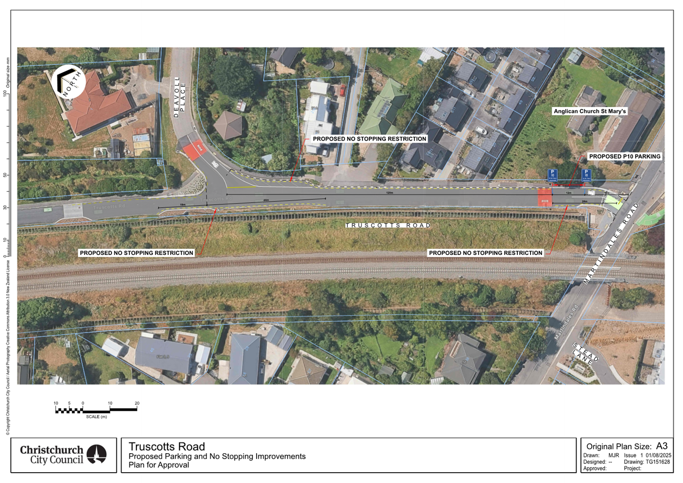
1. Purpose and Origin of the Report Te Pūtake Pūrongo
1.1 The
purpose of this report is for the Council to approve the detailed traffic
resolutions for the Harewood Road traffic signals - Harewood/Gardiners/Breens
intersection and Harewood School project on Harewood Road, and minor safety improvements
nearby.
1.2 The
resolutions in Section 2 of this report are required to ensure safe operation
of the two sets of traffic signals.
1.3 This
is a staff-generated report.
2. Officer
Recommendations Ngā Tūtohu
That
the Council:
1. Receives the information for the Harewood
Road traffic signals - Harewood/Gardiners/Breens intersection and Harewood
School - Detailed traffic resolutions in this Report.
2. Notes that the decision in this report is assessed as medium
significance based on the Christchurch City Council’s Significance and
Engagement Policy.
3. Revokes previous design decisions that conflict with the detailed
traffic resolutions detailed below and as outlined in Attachment A of
this report, which are only in relation to the implementation of the Harewood
Road traffic signals - Harewood/Gardiners/Breens intersection and Harewood
School sub-project.
4. Resolves the following which are required for the implementation of
the Harewood Road traffic signals - Harewood/Gardiners/Breens intersection and
Harewood School, including any traffic controls and /or Parking & Stopping Restrictions,
relying on its powers under the Christchurch City Council Traffic and Parking
Bylaw 2017, Part 21, Section 319 of the Local Government Act 1974 and the Land
Transport Rules- Traffic Control Devices Rule:2004 and the Road User Rule:
2004.
Whitchurch Place
5. Approves that any previously approved resolutions be revoked , in
accordance with Clause 6 (2) of the Christchurch City
Council Traffic & Parking Bylaw 2017, on Whitchurch
Place from its intersection with Waimakariri Road, and extending in a south
westerly direction to its south western roadway end, pertaining to Traffic Controls
(excluding speed limits), Parking and /or Stopping Restrictions, made pursuant
to any Bylaw, Local Government Act, or any Land Transport Act or Rule, to the
extent that they are in conflict with, or recommended to be removed in regard
to the Traffic Controls, Parking and /or Stopping Restrictions described in
recommendations 5-12 below.
6. Approves the new and remaining road markings, kerb alignments, path
alignments, roadway alignment and any road surface changes, in accordance with Part 21, Section 319 of
the Local Government Act 1974, on Whitchurch Place from its intersection
with Waimakariri Road, and extending in a south westerly direction to its
south- western roadway end, as detailed on Attachment A.
7. Approves that in accordance with Clause 21 of the Christchurch City
Council Traffic & Parking Bylaw 2017, that the path on the southern side of
Whitchurch Place, commencing at its intersection with Waimakariri Road, and
extending in a south westerly direction to its south- western roadway end, as
detailed on Attachment A be resolved as a bi-directional Shared Path. This Shared Path is for the use by the classes of road
user only as defined in Section 11.1A of the Land Transport (Road User) Rule:
2004.
8. Approves that in accordance with Section 4 of the Land Transport
Rule: Traffic Control Devices: 2004, that the Whitchurch Place approach at its
intersection with Waimakariri Road, be controlled by a Give Way.
9. Approves that the stopping of all vehicles
be prohibited at any time, in accordance with Clause 7 of the Christchurch City
Council Traffic & Parking Bylaw 2017, on the southern side of Whitchurch
Place commencing at its intersection with Waimakariri Road and extending in a
westerly direction for a distance of 30 metres.
10. Approves that the stopping of all vehicles
be prohibited at any time, in accordance with Clause 7 of the Christchurch City
Council Traffic & Parking Bylaw 2017, on the southern side of Whitchurch
Place commencing at a point 82 metres west of its intersection with Waimakariri
Road and extending in a south westerly direction for a distance of 22 metres.
11. Approves that the stopping of all vehicles
be prohibited at any time, in accordance with Clause 7 of the Christchurch City
Council Traffic & Parking Bylaw 2017, on the southern side of Whitchurch
Place commencing at a point 126 metres west of its intersection with
Waimakariri Road and extending to its south-western roadway end.
12. Approves that the stopping of all vehicles
be prohibited at any time, in accordance with Clause 7 of the Christchurch City
Council Traffic & Parking Bylaw 2017, on the northern side of Whitchurch
Place commencing at a point 18 metres west of its intersection with Waimakariri
Road and extending in an easterly direction to its intersection with
Waimakariri Road. Note that this includes the grass verge.
13. Approves that the stopping of all vehicles
be prohibited at any time, in accordance with Clause 7 of the Christchurch City
Council Traffic & Parking Bylaw 2017, on the northern side of Whitchurch
Place commencing at a point 110 metres west of its intersection with
Waimakariri Road and extending to its south-western roadway end.
Waimakariri Road
14. Approves that any previously approved
resolutions be revoked , in accordance with Clause 6
(2) of the Christchurch City Council Traffic & Parking Bylaw 2017, on Waimakariri Road from its intersection with Whitchurch Place, and
extending in a southerly direction to its intersection with Harewood Road,
pertaining to Traffic Controls ( excluding speed limits), Parking and /or
Stopping Restrictions, made pursuant to any Bylaw, Local Government Act, or any
Land Transport Act or Rule, to the extent that they are in conflict with, or
recommended to be removed in regard to the Traffic Controls, Parking and /or Stopping
Restrictions described in recommendations 14-20 below.
15. Approves the new and remaining road markings, kerb alignments, traffic
island, path alignments, roadway alignment and any road surface changes, in
accordance with Part 21, Section 319 of the Local Government Act 1974, on Waimakariri
Road from its intersection with Whitchurch Place, and extending in a southerly
direction to its intersection with Harewood Road, as detailed on Attachment
A.
16. Approves that in accordance with Clause 21 of the Christchurch City
Council Traffic & Parking Bylaw 2017, that the path on the western side of
Waimakariri Road, commencing at its intersection with Whitchurch Place, and
extending in a southerly direction for a distance of 24 metres, as detailed on Attachment
A. be resolved as a bi-directional Shared Path. This Shared Path is for the
use by the classes of road user only as defined in Section 11.1A of the Land
Transport (Road User) Rule: 2004.
17. Approves that in accordance with Clause 21 of the Christchurch City
Council Traffic & Parking Bylaw 2017, that the path on the eastern side of
Waimakariri Road, commencing at a point 19 metres south of its intersection
with Whitchurch Place, and extending in a southerly direction to its
intersection with Harewood Road, as detailed on Attachment A. be
resolved as a bi-directional Shared Path. This Shared Path is for the use by
the classes of road user only as defined in Section 11.1A of the Land Transport
(Road User) Rule: 2004.
18. Approves that in accordance with Section 4 of the Land Transport
Rule: Traffic Control Devices 2004 that the Waimakariri Road approach at its
intersection with Harewood Road, be controlled by a Give Way.
19. Approves that the stopping of all vehicles
be prohibited at any time, in accordance with Clause 7 of the Christchurch City
Council Traffic & Parking Bylaw 2017, on the western side of Waimakariri
Road commencing at its intersection with Harewood Road and extending in a
northerly direction to its intersection with Whitchurch Place.
20. Approves that the stopping of all vehicles
be prohibited at any time, in accordance with Clause 7 of the Christchurch City
Council Traffic & Parking Bylaw 2017, on the eastern side of Waimakariri
Road commencing at its intersection with Whitchurch Place and extending in a
southerly direction for a distance of 30 metres.
21. Approves that the stopping of all vehicles
be prohibited at any time, in accordance with Clause 7 of the Christchurch City
Council Traffic & Parking Bylaw 2017, on the eastern
side of Waimakariri Road commencing at its intersection with Harewood Road and
extending in a northerly direction for a distance of 14 metres.
Harewood Road- Waimakariri Road to 23 metres east of Stanleys Road
22. Approves that any previously approved resolutions be revoked , in
accordance with Clause 6 (2) of the Christchurch City
Council Traffic & Parking Bylaw 2017, on Harewood
Road from its intersection with Waimakariri Road, and extending in an easterly
direction to a point 23 metres east of Stanleys road ( excluding speed limits)
pertaining to Traffic Controls ( excluding speed limits) , Parking and /or
Stopping Restrictions, made pursuant to any Bylaw, Local Government Act, or any
Land Transport Act or Rule, to the extent that they are in conflict with, or
recommended to be removed in regard to the Traffic Controls, Parking and /or Stopping
Restrictions described in recommendations 22-32 below.
23. Approves the new and existing/remaining road markings, kerb
alignments, path alignments, traffic islands, roadway alignment and road
surface changes, in accordance with Part 21, Section 319 of the Local
Government Act 1974, on Harewood Road from its intersection with Waimakariri
Road, and extending in an easterly direction to a point 23 metres east of its
intersection with Stanleys Road, as detailed on Attachment A.
24. Approves that in accordance with Clause 21 of the Christchurch City
Council Traffic & Parking Bylaw 2017, that the path on the northern side of
Harewood Road, commencing at its intersection with Waimakariri Road, and
extending in an easterly direction for a distance of 41 metres, as detailed on Attachment
A. be resolved as a bi-directional Shared Path. This Shared Path is for the
use by the classes of road user only as defined in Section 11.1A of the Land
Transport (Road User) Rule: 2004.
25. Approves that in accordance with Clause 21 of the Christchurch City
Council Traffic & Parking Bylaw 2017, that the path on the southern side of
Harewood Road, commencing at a point 34 metres east of its intersection with
Waimakariri Road and extending in an easterly direction to a point 23 metres
east of its intersection with Stanleys Road, as detailed on Attachment A.
be resolved as a bi-directional Shared Path. This Shared Path is for the use by
the classes of road user only as defined in Section 11.1A of the Land Transport
(Road User) Rule: 2004.
26. Approves that in accordance with Section 6 of the Land Transport Rule
– Traffic Control Devices: 2004 that a signalised roadway crossing be
installed on Harewood Road, located at a point 37 metres east of its
intersection with Waimakariri Road, and as detailed on Attachment A. This signalised crossing is for the use by the classes of road user
as defined in Section 11.1A of the Land Transport (Road User) Rule: 2004.
27. Approves that the stopping of all vehicles
be prohibited at any time, in accordance with Clause 7 of the Christchurch City
Council Traffic & Parking Bylaw 2017, on the northern side of Harewood
Road, commencing at its intersection with Waimakariri Road and extending in an
easterly direction for a distance of 47 metres.
28. Approves that the parking of all vehicles be
restricted to a maximum period of three minutes, in accordance with Clause 7 of
the Christchurch City Council Traffic & Parking Bylaw 2017, on the southern
side of Harewood Road, commencing at a point 15 metres east of its intersection
with Waimakariri Road and extending in a westerly direction for a distance of
35 metres. This restriction is to apply from 8:15am to 9:15am, and 2:30pm to
3:30pm, on school days only.
29. Approves that the stopping of all vehicles
be prohibited at any time, in accordance with Clause 7 of the Christchurch City
Council Traffic & Parking Bylaw 2017, on the southern side of Harewood
Road, commencing at a point 15 metres east of its intersection with Waimakariri
Road and extending in an easterly direction for a distance of 44 metres.
30. Approves that the stopping of all vehicles
be prohibited at any time, in accordance with Clause 7 of the Christchurch City
Council Traffic & Parking Bylaw 2017, on the southern side of Harewood
Road, commencing at a point 68 metres east of its intersection with Waimakariri
Road and extending in an easterly direction for a distance of nine metres.
31. Approves that the stopping of all vehicles
be prohibited at any time, in accordance with Clause 7 of the Christchurch City
Council Traffic & Parking Bylaw 2017, on the southern side of Harewood
Road, commencing at a point 93 metres east of its intersection with Waimakariri
Road and extending in an easterly direction for a distance of 13 metres.
32. Approves that the stopping of all vehicles
be prohibited at any time, in accordance with Clause 7 of the Christchurch City
Council Traffic & Parking Bylaw 2017, on the southern side of Harewood
Road, commencing at a point 264 metres east of its intersection with Waimakariri
Road and extending in an easterly direction to its intersection with Stanleys
Road.
33. Approves that the stopping of all vehicles
be prohibited at any time, in accordance with Clause 7 of the Christchurch City
Council Traffic & Parking Bylaw 2017, on the southern side of Harewood
Road, commencing at its intersection with Stanleys Road and extending in an
easterly direction for a distance of 23 metres.
Stanleys Road
34. Approves that any previously approved resolutions be revoked , in
accordance with Clause 6 (2) of the Christchurch City
Council Traffic & Parking Bylaw 2017, on Stanleys
Road from its intersection with Harewood Road, and extending in a southerly
direction for a distance of 12 metres, pertaining to Parking and /or Stopping
Restrictions, made pursuant to any Bylaw, Local Government Act, or any Land
Transport Act or Rule, to the extent that they are in conflict with, or
recommended to be removed in regard to the Parking and /or Stopping Restrictions
described in recommendations 34-35 below.
35. Approves that the stopping of all vehicles
be prohibited at any time, in accordance with Clause 7 of the Christchurch City
Council Traffic & Parking Bylaw 2017, on the western side of Stanleys Road,
commencing at its intersection with Harewood Road and extending in a southerly
direction for a distance of 12 metres.
36. Approves that the stopping of all vehicles
be prohibited at any time, in accordance with Clause 7 of the Christchurch City
Council Traffic & Parking Bylaw 2017, on the eastern side of Stanleys Road,
commencing at its intersection with Harewood Road and extending in a southerly
direction for a distance of 12 metres.
Breens Road /Gardiners Road /Harewood Road Intersection
37. Approves that any
previously approved resolutions be revoked , in accordance with Clause 6 (2) of the Christchurch City Council Traffic &
Parking Bylaw 2017, at the Breens Road, Gardiners Road and Harewood Road
Intersection, pertaining to Traffic Controls (excluding
speed limits) , Parking and /or Stopping Restrictions, made pursuant to any
Bylaw, Local Government Act, or any Land Transport Act or Rule, to the extent
that they are in conflict with, or recommended to be removed in regard to the
Traffic Controls, Parking and /or Stopping Restrictions described in
recommendations 37-40 below.
38. Approves the new and remaining road markings, kerb alignments, road
crossing facilities and road surfaces, in accordance with Part 21, Section 319
of the Local Government Act 1974, at the Breens Road,
Gardiners Road and Harewood Road Intersection, as
detailed on Attachment A.
39. Approves that in
accordance with Section 6 of the Land Transport Rule: Traffic Control Devices
2004, all traffic movements at the Breens Road, Gardiners Road and Harewood
Road intersection be controlled by Traffic Signals.
40. Approves that in accordance with Clause 17(1) (b) of the
Christchurch City Council Traffic and Parking Bylaw 2017 that the Harewood road
northwest approach U turn movement at its intersection with Breens Road and
Gardiners Road, be prohibited.
41. Approves that in accordance with Clause 17(1) (b) of the
Christchurch City Council Traffic and Parking Bylaw 2017 that the Harewood road
southeast approach U turn movement at its intersection with Breens Road and
Gardiners Road, be prohibited.
Breens Road- Harewood Road to Lochmore Street
42. Approves that any previously approved resolutions be revoked , in
accordance with Clause 6 (2) of the Christchurch City
Council Traffic & Parking Bylaw 2017, on Breens
Road from its intersection with Harewood Road, and extending in a south-westerly
direction for a distance of 60 metres, pertaining to Traffic Controls
(excluding speed limits) , Parking and /or Stopping Restrictions, made pursuant
to any Bylaw, Local Government Act, or any Land Transport Act or Rule, to the
extent that they are in conflict with, or recommended to be removed in regard
to the Traffic Controls, Parking and /or Stopping Restrictions described in
recommendations 42-46 below.
43. Approves the new and remaining road markings, kerb alignments, path
alignments, roadway alignment and road surface changes, in accordance with Part
21, Section 319 of the Local Government Act 1974, on Breens Road from its
intersection with Harewood Road, and extending in a south-westerly direction
for a distance of 60 metres, as detailed on Attachment A.
44. Approves that a Special Vehicle Lane, in accordance with Clause 18
of the Christchurch City Council Traffic & Parking Bylaw 2017, for the use
of north-eastbound road users as defined in Section 11.1A of the
Land Transport (Road User) Rule: 2004, excepting pedestrians and riders of
mobility devices, be installed on the northwest side of Breens Road,
commencing at a point 46 metres southwest of its intersection with
Harewood Road and extending in a north- easterly direction to its
intersection with Harewood Road, as detailed on Attachment A.
45. Approves that a Special Vehicle Lane, in accordance with Clause 18
of the Christchurch City Council Traffic & Parking Bylaw 2017, for the use
of south-westbound road users as defined in Section 11.1A of the
Land Transport (Road User) Rule: 2004, excepting pedestrians and riders of
mobility devices, be installed on the southeast side of Breens
Road, commencing at its intersection with Harewood Road and
extending in a south-westerly direction for a distance of 37 metres, as
detailed on Attachment A.
46. Approves that the stopping of all vehicles
be prohibited at any time, in accordance with Clause 7 of the Christchurch City
Council Traffic & Parking Bylaw 2017, on the north-western side of Breens
Road, commencing at a point 46 metres southwest of its intersection with Harewood
Road and extending in a north-easterly direction to its intersection with
Harewood Road.
47. Approves that the stopping of all vehicles
be prohibited at any time, in accordance with Clause 7 of the Christchurch City
Council Traffic & Parking Bylaw 2017, on the south-eastern side of Breens
Road, commencing at its intersection with Harewood Road and extending in a
south-westerly direction for a distance of 50 metres.
Gardiners Road- Harewood Road to Goya Place
48. Approves that any previously approved resolutions be revoked , in
accordance with Clause 6 (2) of the Christchurch City
Council Traffic & Parking Bylaw 2017, on Gardiners
Road from its intersection with Harewood Road, and extending in a north-easterly
direction to a point 22 metres northeast of its intersection with Kamahi Place,
pertaining to Traffic Controls (excluding speed limits), Parking and /or Stopping
Restrictions, made pursuant to any Bylaw, Local Government Act, or any Land
Transport Act or Rule, to the extent that they are in conflict with, or
recommended to be removed in regard to the Traffic Controls, Parking and /or Stopping
Restrictions described in recommendations 48-53 below.
49. Approves the new and remaining road markings, kerb alignments, path
alignments, roadway alignment and road surface changes, in accordance with Part
21, Section 319 of the Local Government Act 1974, on Gardiners Road from its
intersection with Harewood Road, and extending in a north easterly direction to a point 22 metres northeast of its intersection with Kamahi Place, as detailed on Attachment A.
50. Approves that a Special Vehicle Lane, in accordance with Clause 18
of the Christchurch City Council Traffic & Parking Bylaw 2017, for the use
of north-eastbound road users as defined in Section 11.1A of the
Land Transport (Road User) Rule: 2004, excepting pedestrians and riders of
mobility devices, be installed on the northwest side of Gardiners
Road, commencing at its intersection with Harewood Road and
extending in a north- easterly direction for a distance of 56 metres, as
detailed on Attachment A.
51. Approves that a Special Vehicle Lane, in accordance with Clause 18
of the Christchurch City Council Traffic & Parking Bylaw 2017, for the use
of south-westbound road users as defined in Section 11.1A of the
Land Transport (Road User) Rule: 2004, excepting pedestrians and riders of
mobility devices, be installed on the southeast side of Gardiners
Road, commencing at a point 22 metres northeast of its intersection with Kamahi
Place and extending in a south-westerly direction to its intersection with
Harewood Road, as detailed on Attachment A.
52. Approves that the stopping of all vehicles
be prohibited at any time, in accordance with Clause 7 of the Christchurch City
Council Traffic & Parking Bylaw 2017, on the north-western side of Gardiners
Road, commencing at its intersection with Harewood Road and extending in a
north-easterly direction for a distance of 56 metres.
53. Approves that the stopping of all vehicles
be prohibited at any time, in accordance with Clause 7 of the Christchurch City
Council Traffic & Parking Bylaw 2017, on the south-eastern side of Gardiners
Road, commencing at a point 22 metres northeast of its intersection with Kamahi
Place and extending in a south-westerly direction to its intersection with
Kamahi Place.
54. Approves that the stopping of all vehicles
be prohibited at any time, in accordance with Clause 7 of the Christchurch City
Council Traffic & Parking Bylaw 2017, on the south-eastern side of Gardiners
Road, commencing at its intersection with Kamahi Place and extending in a
south-westerly direction to its intersection with Harewood Road.
Kamahi Place
55. Approves that any previously approved resolutions be revoked , in
accordance with Clause 6 (2) of the Christchurch City
Council Traffic & Parking Bylaw 2017, on Kamahi
Place from its intersection with Gardiners Road, and extending in a south-easterly
direction for a distance of 15 metres, pertaining to Traffic Controls (
excluding speed limits) , Parking and /or Stopping Restrictions, made pursuant
to any Bylaw, Local Government Act, or any Land Transport Act or Rule, to the
extent that they are in conflict with, or recommended to be removed in regard
to the Traffic Controls, Parking and /or Stopping Restrictions described in
recommendations 55-57 below.
56. Approves that in accordance with Section 4 of the Land Transport
Rule: Traffic Control Devices 2004 that the Kamahi Place approach at its
intersection with Gardiners Road, be controlled by a Give Way.
57. Approves that the stopping of all vehicles
be prohibited at any time, in accordance with Clause 7 of the Christchurch City
Council Traffic & Parking Bylaw 2017, on the south- western side of Kamahi
Place, commencing at its intersection with Gardiners Road and extending in a
south- easterly direction for a distance of 14 metres.
58. Approves that the stopping of all vehicles
be prohibited at any time, in accordance with Clause 7 of the Christchurch City
Council Traffic & Parking Bylaw 2017, on the north-eastern side of Kamahi
Place, commencing at its intersection with Gardiners Road and extending in a
south- easterly direction for a distance of 15 metres.
Harewood Road- Southeastern approach /departure at Breens /Gardiners
59. Approves that any previously approved resolutions be revoked , in
accordance with Clause 6 (2) of the Christchurch City
Council Traffic & Parking Bylaw 2017, on Harewood
Road from its intersection with Breens Road and Gardiners Road, and extending
in a south-easterly direction for a distance of 73 metres, pertaining to Traffic
Controls ( excluding speed limits) , Parking and /or Stopping Restrictions,
made pursuant to any Bylaw, Local Government Act, or any Land Transport Act or
Rule, to the extent that they are in conflict with, or recommended to be
removed in regard to the Traffic Controls, Parking and /or Stopping Restrictions
described in recommendations 59-64 below.
60. Approves the new and remaining road markings, kerb alignments, path
alignments, roadway alignment and road surface changes, in accordance with Part
21, Section 319 of the Local Government Act 1974, on Harewood Road from its
intersection with Breens Road and Gardiners Road, and extending in a
south-easterly direction for a distance of 73 metres, as detailed on Attachment A.
61. Approves that a Special Vehicle Lane, in accordance with Clause 18
of the Christchurch City Council Traffic & Parking Bylaw 2017, for the use
of south-eastbound road users as defined in Section 11.1A of the
Land Transport (Road User) Rule: 2004, excepting pedestrians and riders of
mobility devices, be installed on the northeast side of Harewood
Road, commencing at its intersection with Gardiners Road and
extending in a south-easterly direction for a distance of 43 metres, as
detailed on Attachment A.
62. Approves that a Special Vehicle Lane, in accordance with Clause 18
of the Christchurch City Council Traffic & Parking Bylaw 2017, for the use
of north-westbound road users as defined in Section 11.1A of the
Land Transport (Road User) Rule: 2004, excepting pedestrians and riders of
mobility devices, be installed on the southwest side of Harewood
Road, commencing at its intersection with Breens Road and extending
in a south-easterly direction for a distance of 52 metres, as detailed on Attachment
A.
63. Approves that the stopping of all vehicles
be prohibited at any time, in accordance with Clause 7 of the Christchurch City
Council Traffic & Parking Bylaw 2017, on the northeast side of Harewood
Road, commencing at its intersection with Gardiners Road and extending in a
south-easterly direction for a distance of 51 metres.
64. Approves that, in accordance with Clause 7 of the Christchurch
City Council Traffic & Parking Bylaw 2017 the northeast side of Harewood Road,
commencing at a point 51 metres southeast from its intersection with Gardiners
Road, and extending in a south-easterly direction for a distance of 14 metres,
be reserved for Large Passenger Service Vehicles only, for the purposes of
setting down or picking up passengers only, as part of a Bus Service as
defined in the Land Transport Management Act 2003, Section 5, - Bus
Service, (a) (i), only.
65. Approves that the stopping of all vehicles
be prohibited at any time, in accordance with Clause 7 of the Christchurch City
Council Traffic & Parking Bylaw 2017, on the southwest side of Harewood
Road, commencing at its intersection with Breens Road and extending in a
south-easterly direction for a distance of 55 metres.
Harewood Road- Northwestern approach /departure at Breens /Gardiners
66. Approves that any previously approved resolutions be revoked , in
accordance with Clause 6 (2) of the Christchurch City
Council Traffic & Parking Bylaw 2017, on Harewood
Road from its intersection with Breens Road and Gardiners Road, and extending
in a north-westerly direction for a distance of 67 metres, pertaining to Traffic
Controls (excluding speed limits), Parking and /or Stopping Restrictions, made
pursuant to any Bylaw, Local Government Act, or any Land Transport Act or Rule,
to the extent that they are in conflict with, or recommended to be removed in
regard to the Traffic Controls, Parking and /or Stopping Restrictions described
in recommendations 66-70 below.
67. Approves the new and remaining road markings, kerb alignments, path
alignments, roadway alignment and road surface changes, in accordance with Part
21, Section 319 of the Local Government Act 1974, on Harewood Road from its
intersection with Breens Road and Gardiners Road, and extending in a
north-westerly direction for a distance of 67 metres, as detailed on Attachment A.
68. Approves that a Special Vehicle Lane, in accordance with Clause 18
of the Christchurch City Council Traffic & Parking Bylaw 2017, for the use
of south-eastbound road users as defined in Section 11.1A of the
Land Transport (Road User) Rule: 2004, excepting pedestrians and riders of
mobility devices, be installed on the northeast side of Harewood
Road, commencing at a point 42 metres northwest of its intersection
with Gardiners Road and extending in a south-easterly direction to
its intersection with Gardiners Road, as detailed on Attachment A.
69. Approves that a Special Vehicle Lane, in accordance with Clause 18
of the Christchurch City Council Traffic & Parking Bylaw 2017, for the use
of north-westbound road users as defined in Section 11.1A of the
Land Transport (Road User) Rule: 2004, excepting pedestrians and riders of
mobility devices, be installed on the southwest side of Harewood
Road, commencing at its intersection with Breens Road and extending
in a north-westerly direction for a distance of 41 metres, as detailed on Attachment
A.
70. Approves that the stopping of all vehicles
be prohibited at any time, in accordance with Clause 7 of the Christchurch City
Council Traffic & Parking Bylaw 2017, on the northeast side of Harewood
Road, commencing at a point 48 metres northwest of its intersection with
Gardiners Road and extending in a south-easterly direction to its intersection
with Gardiners Road.
71. Approves that the stopping of all vehicles
be prohibited at any time, in accordance with Clause 7 of the Christchurch City
Council Traffic & Parking Bylaw 2017, on the southwest side of Harewood
Road, commencing at its intersection with Breens Road and extending in a
northwesterly direction for a distance of 53 metres.
Wooldridge Road
72. Approves that any previously approved resolutions be revoked , in
accordance with Clause 6 (2) of the Christchurch City Council Traffic &
Parking Bylaw 2017, on Wooldridge Road from its intersection with Harewood
Road, and extending in a south-westerly direction for a distance of 101 metres,
pertaining to Traffic Controls (excluding speed limits) made pursuant to any
Bylaw, Local Government Act, or any Land Transport Act or Rule, to the extent
that they are in conflict with, or recommended to be removed in regard to the
Traffic Controls described in recommendations 73 below.
73. Approves the new and remaining road markings, kerb alignments, path
alignments, roadway alignment, traffic island and any road surface changes, in
accordance with Part 21, Section 319 of the Local Government Act 1974, on
Wooldridge Road from its intersection with Harewood Road, and extending in a
south westerly direction for a distance of 101 metres, as detailed on Attachment
A.
74. Approves that these resolutions to take effect when parking signage
and/or road marking that evidence the restrictions described in this staff
report are in place (or removed in the case of revocations).
3. Executive Summary Te Whakarāpopoto Matua
3.1 In
the final FY26 Annual Plan the Council approved the installation of traffic
signals at the Harewood/Gardiners/Breens intersection and at Harewood School,
and minor safety improvements nearby which are part of the wider Wheels to
Wings Major Cycleway Route (MCR). This report seeks approval of the resolutions
required for the two sets of traffic signals and improvements.
3.1.1 The Council also
approved the construction of the section of the Wheels to Wings MCR that links
the Nor’West Arc and Northern Line MCR’s. The resolutions for this
section will be presented in a future report to the Council.
3.1.2 All remaining
sections of the MCR have been deferred to later years in the Long Term Plan
(LTP).
3.2 The
designs for the two sets of traffic signals were approved by the Council on 28
July 2022 to proceed to detailed design and construction, as part of the wider
Wheels to Wings MCR scheme.
3.2.1 The Council also
resolved that the detailed traffic resolutions required for the implementation
of the project be brought back to the Council or relevant Committee for
approval at the end of the detailed design phase, prior to the beginning of
construction.
3.2.2 The previously
approved designs needed to be amended to tie into the existing road layout,
however the general road layout remains the same. Approval of the revised
designs outlined in 4.15.1 are part of this report.
3.3 The
links to all of the previous decision reports and minutes associated with the
Wheels to Wings MCR, and the Annual Plan 2025/26 consultation document wording
and submissions are included in Attachment B.
3.4 The
exact scope for “associated improvements” at Harewood School as
agreed by the Council during Annual Plan FY26 is ambiguous. Therefore, staff
have provided two options:
· One that is narrowly focused on the crossing and widening the shared
path on Harewood Road outside the school.
· Another that improves wider connectivity by: widening the shared
path to Stanleys Road; improving crossing facilities at Stanleys Road and
Wooldridge Road, and adding a non-controlled crossing on Waimakariri Road.
3.5 Staff
are recommending the option including wider improvements, for the following
reasons:
· Relatively low-cost (~$0.5m).
· Provide improved connection to the rest of the network via the
underpass and Nunweek Park.
· Mostly supported by the school, and identified by students, during
initial consultation.
· Does not materially impact on traffic lanes or parking.
4. Background/Context Te Horopaki
Council Approval
4.1 As
part of the FY26 Annual Plan the Council approved the following:
4.1.1 To stage the delivery
of the Papanui ki Waiwhetū Wheels to Wings MCR, delaying some of the works
to later years in the LTP, and continuing in FY26 with the delivery of:
· Linking the Te Ara O-Rakipaoa Nor'West Arc and Puari ki
Pū-harakeke-nui Northern Line major cycle routes, which includes installing
a signalised pedestrian crossing on Harewood Road between Matsons Avenue and
Chapel Street.
· Installing traffic lights at the Harewood Road, Gardiners Road and
Breens Road intersection.
· Installing a signalised pedestrian crossing on Harewood Road at
Harewood School which includes a safe speed platform, and minor safety
improvements nearby.
4.1.2 The detailed traffic
resolutions in Section 2 of this report relate only to the delivery of the
traffic signals at the Harewood/Gardiners/Breens intersection and at Harewood
School.
4.2 The
scheme designs for the two sets of traffic signals were discussed between
February and April 2022 when a Hearings Panel consisting of five Elected
Members heard verbal submissions from 70 submitters. These included a mix of
groups and organisations, local businesses and residents, individuals and the
two affected Community Boards.
4.2.1 Following the
hearing, the Council approved the designs for the two sets of signals in line
with the Hearings Panel recommendation and resolved that the detailed traffic
resolutions required for the implementation of the project be brought back to
the Council or relevant Committee for approval at the end of the detailed
design phase, prior to the beginning of construction.
4.3 To
reflect the Council’s decisions relating to delivery of the cycleway
during Annual Plan FY26, the scope and budget within each section of the
cycleway has been amended:
4.3.1 #41663 Harewood Road
Traffic Signals - Harewood/Gardiners/Breens Intersection: this includes the
delivery of the traffic lights at the Harewood Road, Gardiners Road and Breens
Road intersection, and the safe speed platform and signalised pedestrian
crossing on Harewood Road at Harewood School, as well as minor safety
improvements nearby. This has funding in FY26 & FY27.
4.3.2 #26611 Major Cycleway
- Wheels to Wings Route (Section 1) Linking Nor’West Arc and Northern
Line MCRs: this includes the link between cycleways along Matsons Ave and along
Restell Street, including a crossing of Harewood Road. The resolutions relating
to this section will be addressed in a future report to the Council. This has
funding in FY26 & FY27.
4.3.3 #26612 and #26613 are
for the remaining sections of the Major Cycle Route. These projects have
available funding in FY29-31, so there is currently no further work underway.
Detailed design and required changes
4.4 As
the installation of traffic signals at the intersection and the school crossing
will now tie into existing road layouts, the following design changes have been
made, as detailed in Attachment A:
Traffic
lights at Harewood/Gardiners/Breens intersection
4.4.1 A through traffic
lane, and a through and left lane will be provided in each direction on
Harewood Road.
4.4.2 The painted cycle
lanes at the intersection are approximately 50 metres in length on the Harewood
Road and Breens Road approaches.
4.4.3 On Gardiners Road the painted cycle
lanes are longer, because the location of driveways and the sideroad Kamahi
Place means there is little opportunity for on-street parking in this section,
so the length of the cycle lanes has been maximised.
4.4.4 U-turns on the
Harewood Road approaches will not be allowed.
4.4.5 No stopping to be
marked between the driveways of 120 and 122 Breens Road, as this space is not
long enough for a car to park.
4.4.6 Three street trees
are to be removed. The removal of these trees and replacement with six new
trees is being delivered by a separate programme, which is Council’s
Infill Planting Programme. The decision-making for the removal of the trees is
not required in this report. Information regarding the consultation on this is
included in Section 6 – Community Impacts and Views.
Harewood Road School and minor safety improvements
4.4.7 The path adjacent to
99 Stanleys Road will be widened to 2 metres - instead of 3 metres in the full
MCR design - to reduce the stormwater impacts and will not have trees planted
alongside.
4.4.8 The improvements to
the intersection and path at the Stanleys Road intersection have been reduced
and now include only replacing the kerb on the western side, incorporating
minor road widening.
4.4.9 The pedestrian refuge
island at the Wooldridge Road intersection will be widened by 0.7 metres to
safely accommodate bikes, the intersection was to be signalised in the full MCR
design.
4.4.10 The new pedestrian crossing on
Waimakariri Road has been shifted approximately 20 metres north to reduce the
impact on stormwater infrastructure.
4.4.11 The above minor safety
improvements have been included in the design to make the existing shared path
from Nunweek Park to Harewood School more appealing for cyclists to use and
provides a safer route for pedestrians and cyclists to access the Johns Road
underpass.
4.5 Information regarding the consultation on the above design changes
is included in Section 6 – Community Impacts and Views.
Update on previous recommendations
4.6 When the Council approved the Wheels to Wings MCR scheme to proceed
to detailed design and construction on 28 July 2022, they provided further
recommendations and noting provisions, which they asked staff to investigate
through the detailed design process.
4.7 Below are the specific recommendations relevant to the delivery of
the Harewood Road traffic signals project, and how they have been addressed in
the detailed design process:
4.7.1 That red markings will be investigated and a high friction surface
will be included in the lead up to the signalised crossing opposite Harewood
School.
High-friction surface has been included in the design. Red surfacing
is generally only used on unsignalised crossings so has not been included in this
design.
4.7.2 That the raised safety platform at the signalised crossing opposite
Harewood School be built for a 50km/h speed limit.
This has
been included in the design.
4.7.3 That ‘look right’ or similar markings will be applied at
the signalised crossing opposite Harewood School.
These
have been included in the design.
4.7.4 Approves extending an existing 40km/h school speed zone on
Waimakariri Road and Whitchurch Place.
This has been included in a separate consultation carried out by Council’s Traffic Operations Team, in conjunction with other
consultations for the Setting of Speed Limit Rule 2024. The rule now specifies
the speed limit of 30km/h around schools, not 40km/h. The delivery of the speed limit change will be co-ordinated with the
construction of this project.
4.7.5 Approves extending an existing 50km/h speed restriction further northeast
along Waimakariri Road.
This has
been included in a separate consultation carried out by Council’s Traffic Operations Team, and is currently out for consultation. Depending on the timing and scope of
decisions, any speed limit change will be delivered as
part of this project.
Other design considerations
4.8 In
conjunction with the traffic signals at Harewood/Gardiners/Breens intersection
there will be an upgrade to the stormwater infrastructure to resolve existing
flooding issues.
4.9 The
delivery of the project will co-ordinate with the renewal of the watermains in
these locations, to reduce future disruption in the area.
4.10 The delivery
timing for the section linking the Te Ara O-Rakipaoa Nor'West Arc and Puari ki
Pū-harakeke-nui Northern Line major cycle routes, and the signalised
pedestrian crossing on Harewood Road between Matsons Avenue and Chapel Street
is yet to be determined. The Council will be informed when this is confirmed.
4.11 The following related memos/information were circulated to the
meeting members:
|
Date
|
Subject
|
|
11
October 2024
|
Wheels to Wings MCR October 2024 Options
Memo – Attachment C
|
|
5
June 2025
|
Waimakariri Road Speed Limit memo –
Attachment D
|
|
3
July 2025
|
Targeted consultation memo - Attachment
E
|
|
7
July 2025
|
Submitter update on Wheels to Wings MCR -
Attachment F
|
|
9
July 2025
|
Harewood/Gardiners/Breens intersection
stormwater upgrade plan - Attachment G
|
Options Considered Ngā
Kōwhiringa Whaiwhakaaro
4.12 The following
reasonably practicable options were considered and are assessed in this report:
4.12.1 Option 1 (staff recommended
option) - Harewood Road traffic signals - Harewood/Gardiners/Breens
intersection and Harewood School and minor safety improvements
4.12.2 Option 2 - Harewood Road
traffic signals - Harewood/Gardiners/Breens intersection and Harewood
School
4.13 The following
option was considered but ruled out:
4.13.1 Option 3 - Do nothing –
The Council has resolved to continue with the installation of the traffic
signals at the Harewood/Gardiners/Breens intersection and at Harewood School so
this option has not been pursued.
Options Descriptions Ngā
Kōwhiringa
4.14 Staff
recommended option: Option 1 - Harewood Road traffic signals – Harewood/Gardiners/Breens
intersection and Harewood School and minor safety improvements
4.14.1 Option Description:
· Installation of traffic signals at the Harewood Road, Gardiners Road
and Breens Road intersection, the safe speed platform and signalised pedestrian
crossing on Harewood Road at Harewood School.
· Widening the path at Harewood School to create a 4.5 metre shared
path.
· Widening the path adjacent to 99 Stanleys Road to 2 metres.
· Replacing the kerb on the western side of the Stanleys Road
intersection.
· Widening the pedestrian refuge island at the Wooldridge Road
intersection by 0.7 metres to safely accommodate bikes.
· A new pedestrian crossing on Waimakariri Road.
4.14.2 Option Advantages
· Provides accessibility and safety improvements for all mode users.
· Delivers on the feedback from the local community to signalise the
Harewood/Gardiners/Breens intersection, to provide a signalised pedestrian crossing
at Harewood School, and to improve the links to the school.
· The minor safety improvements make the existing shared path from
Nunweek Park to Harewood School safer and more appealing for cyclists to use,
and provides a safer route for pedestrians and cyclists to access the Johns
Road underpass.
4.14.3 Option Disadvantages
· The two sets of new signals will cause delays to some traffic along
Harewood Road.
4.15 Option 2 -
Harewood Road traffic signals - Harewood/Gardiners/Breens
intersection and Harewood School
4.15.1 Option Description:
· Installation of traffic signals at the Harewood Road, Gardiners Road
and Breens Road intersection, the safe speed platform and signalised pedestrian
crossing on Harewood Road at Harewood School.
· Widening the path at Harewood School to create a 4.5 metre shared
path.
4.15.2 Option Advantages
· Provides accessibility and safety improvements for all mode users.
· Delivers on the feedback from the local community to signalise the
Harewood/Gardiners/Breens intersection and provide a signalised pedestrian
crossing with a safe speed platform at Harewood School.
4.15.3 Option Disadvantages
· The two sets of new signals will cause delays to some traffic on
Harewood Road.
· Does not provide the minor safety
improvements, so does not make the existing shared path from Nunweek Park to
Harewood School safer and more appealing for cyclists to use, nor provide a
safer route for pedestrians and cyclists to access the Johns Road
underpass.
Analysis Criteria Ngā Paearu
Wetekina
4.16 The
following criteria were used to assess the available options and determine the
most appropriate course of action:
4.16.1 Option 1 - Harewood Road traffic
signals delivers on the Council’s decision to install traffic signals at
the Harewood/Gardiners/Breens intersection and outside Harewood School, and there
is approved funding in the FY26 Annual Plan to support this.
4.16.2 Option 1 delivers on the feedback
from the local community to signalise the Harewood/Gardiners/Breens
intersection and provide a signalised pedestrian crossing with safe speed
platform at Harewood School.
4.16.3 Option 1 addresses other concerns raised by the school around the existing
shared path from Nunweek Park to Harewood School, and provides a safer route
for pedestrians and cyclists to access the Johns Road underpass.
5. Financial Implications Ngā Hīraunga Rauemi
Capex/Opex Ngā Utu Whakahaere
|
|
Option 1 (Recommended)
Harewood Road traffic signals -
Harewood/Gardiners/Breens intersection and Harewood School, minor safety
improvements
|
Option 2
Harewood Road traffic signals -
Harewood/Gardiners/ Breens intersection and Harewood School
|
|
Cost
to Implement
|
$4.4m
|
$3.9m
|
|
Maintenance/
Ongoing
Costs
|
Covered
by existing maintenance budgets
|
Covered
by existing maintenance budgets
|
|
Funding
Source
|
LTP:
CPMS 41663 $4.2m and CPMS 26612 and 26613 (if required)
|
LTP:
CPMS 41663
|
|
Funding
Availability
|
$4.4m
|
$4.2m
|
|
Impact
on Rates
|
Nil
|
Nil
|
5.1 The
cost to implement Option 1 is based on the 85% detailed design.
5.1.1 Although the cost to
implement is higher than the budget, the final contract price will be informed
through the procurement process and completion of the detailed design process,
which will include refinement of the remaining risks.
5.1.2 The construction
contingency included in the cost to implement is 20%.
5.1.3 Should the estimate
remain above the project budget at the point when a contract is to be awarded,
further budget will be moved from Section 2 (26612) and Section 3 (26613) of
Wheels to Wings. Noting this has $22.4m of budget, spread across years FY29-31.
6. Considerations Ngā Whai Whakaaro
Risks and Mitigations Ngā
Mōrearea me ngā Whakamātautau
6.1 The
risk is that the construction will cause disruption to the surrounding
businesses, schools and residents, and those travelling around the construction
area.
6.1.1 The mitigation is
that the importance of minimising disruption to the surrounding businesses and
schools to accommodate their busy periods is included in the contractor tender
information and is part of the tender evaluation.
6.1.2 There will be clear
and timely information available across a variety of media platforms advising
of the construction work, the likely disruption and detour information.
Legal Considerations Ngā
Hīraunga ā-Ture
6.2 Statutory
and/or delegated authority to undertake proposals in the report:
6.2.1 The Council has the
delegated authority to approve the detailed traffic resolution in Section 2 of
this report, as they are delivering sections of the Wheels to Wings MCR which
has been assessed as having metropolitan significance.
6.3 Other Legal Implications:
6.3.1 There is no legal
context, issue, or implication relevant to this decision.
Strategy and Policy Considerations Te Whai
Kaupapa here
6.4 The
required decisions:
6.4.1 Align with the Christchurch
City Council’s Strategic Framework: Improving
the safety of our roads aligns with the Strategic Priorities and Community
Outcomes, in particular:
· Be an Inclusive and Equitable City
· Build Trust and Confidence in the Council - the public consultation
undertaken throughout this project has shown the Council listening to and
working with residents
· A Green, Liveable City –
providing safe crossing points and facilities for people who walk and cycle
will improve the accessibility and connectivity of our neighbourhoods and
communities
6.4.2 Is assessed as medium significance based on the Christchurch City
Council’s Significance and Engagement Policy. The level of
significance was determined by the level of community interest in the
signalisation of the Harewood/Gardiners/Breens intersection and at Harewood
School, and in the cycleway.
6.4.3 Is consistent with Council’s Plans and
Policies.
6.5 This
report supports the Council's
Long Term Plan (2024 - 2034):
6.6 Transport
6.6.1 Activity: Transport
· Level of Service: 10.0.2 Increase the share of
non-car modes in daily trips - >=37% of trips undertaken by non-car modes
· Level of Service: 10.0.6.1 Reduce the number of
death and serious injury crashes on the local road network (DIA 1) - 4 less
than previous FY
· Level of Service: 10.0.6.2 Reduce the number of
death and serious injury crashes on the local road network - Five year rolling
average <95 crashes per year
· Level of Service: 10.5.2 Improve the perception
(resident satisfaction) that Christchurch is a cycling friendly city - >=67%
· Level of Service: 10.5.42 Increase the
infrastructure provision for active and public modes - >= 635 kilometres
(total combined length)
Community Impacts and Views Ngā Mariu
ā-Hāpori
6.7 There
were a small number of design changes identified through the detailed
design for the Harewood Road signals standalone designs. A targeted
consultation for these design changes took place between Friday 4 July and
Sunday 20 July 2025.
6.8 The
Waimāero Fendalton-Waimairi-Harewood Community Board and
the Waipapa Papanui-Innes-Central Community Board were advised of the targeted
consultation in a memo prior to it starting, the memo is included as
Attachment E.
6.9 The
targeted consultations and submitter feedback are as follows:
6.9.1 Banning of
U-Turns on the Harewood Road approaches of the Harewood-Gardiners-Breens
intersection
· This is required to make the crossings safer for pedestrians and
makes the intersection operate more efficiently for vehicles.
· Drivers who need to make U-turns to access their properties on
Harewood Road would still be able to use the existing U-turn bays on Harewood
Road near Copenhagen Bakery to the west and 375 Harewood Road to the east.
· There
was no feedback received on this item.
6.9.2 No Stopping
between driveways at 120 and 122 Breens Road
· This is required to ensure safety for cyclists and to prevent
vehicles blocking driveways, the space between the driveways of 120 and 122
Breens Road is not large enough for a vehicle to park in.
· There was no feedback received on this item.
6.9.3 Bus Stop at
412 Harewood Road
· The bus stop outside 412 Harewood Road will remain in the current
location.
· In the previous Wheels to Wings MCR consultation and approved
design, the bus stop was moved closer to the Harewood/Gardiners/Breens
intersection to accommodate the proposed cycle lane on Harewood Road.
· One response was received, the resident at 410 Harewood Road was
concerned about a loss of parking outside their property due to the bus stop
remaining at 412 Harewood Road. Staff amended the design to include parking
ticks outside 410 Harewood Road rather than no stopping restrictions. The
resident was happy with this outcome.
6.9.4 Pedestrian crossing location on
Waimakariri Road
· The location of the new pedestrian crossing on Waimakariri Road is
moving approximately 20m north.
· In
the previous Wheels to Wings MCR consultation and approved design, the
pedestrian crossing was located approximately 20 metres closer to Harewood
Road. This design tied-in with the cycleway design in this location and the
associated stormwater drainage.
· Moving
the crossing is required to reduce costs, as we no longer need
to make changes to the stormwater infrastructure on Waimakariri Road. This will
result in the loss of one additional parking space.
· There was no feedback received on this item from the owner of 125
Waimakariri Road.
· An email was sent to Harewood School, Harewood Playcentre and St
James' Anglican Church.
· Harewood School said they were comfortable with the design.
6.9.5 Tree removal and replacement
· Three street trees at the Harewood/Gardiners/Breen intersection are
needed to be removed to allow for clear sightlines of the new signal lanterns.
· Six new street trees will be planted on Whitchurch Place, as per the
Council’s Tree Policy. The six new trees on Whitchurch Place were
included in the Council approval of the cycleway in July 2022.
· St James' Anglican Church thanked staff for the update and asked if
they could be involved in the selection of species for the new trees proposed
to be planted on Whitchurch Place, as they had concerns around the trees
potentially causing visibility issues and the loss of informal parking from the
new trees. The Church were informed they would be contacted to discuss their
suggestions and the placement of the trees, and that the trees would improve
visibility for those exiting the Church carpark as cars will no longer be able
to park next to the driveway.
· The removal of the three trees and replacement of six new trees will
not be undertaken as part of the Harewood Road traffic signals project. It will
be completed as part of the Infill Planting Programme carried out by
Council’s Asset Protection Team.
6.10 The decision
affects the following wards/Community Board areas:
6.10.1 Waimāero Fendalton-Waimairi-Harewood Community Board.
6.11 The Waimāero Fendalton-Waimairi-Harewood Community Board did
not provide feedback on the above design changes and targeted consultation.
Impact on Mana Whenua Ngā Whai Take
Mana Whenua
6.12 The decision
does not involve a significant decision in relation to ancestral land, a
body of water or other elements of intrinsic value, therefore this decision does not specifically impact Mana Whenua, their culture, and
traditions.
6.13 The decision does
not involve a matter of interest to Mana Whenua and will
not impact on our agreed partnership priorities with
Ngā Papatipu Rūnanga.
Climate Change Impact Considerations Ngā
Whai Whakaaro mā te Āhuarangi
6.14 The decisions in
this report are likely to:
6.14.1 Contribute positively to
adaptation to the impacts of climate change.
6.14.2 Contribute positively to
emissions reductions.
6.15 The provision of
controlled crossings along Harewood Road in the vicinity of Harewood School and
Breens Intermediate is likely to increase the number of students walking or
cycling to school.
6.16 Improvements to
the drainage at the Harewood/Breens/Gardiners intersection is likely to reduce
flooding during larger rain events.
6.17 For each tree
removed, two replacement trees will be planted within the project site as per
Council’s Tree Policy.
7. Next Steps Ngā Mahinga ā-muri
7.1 The
construction tender will be evaluated and a contractor appointed. Construction
is due to start in October 2025.
7.2 The
detailed traffic resolutions for the section of the Wheels to Wings MCR that
links the Nor’West Arc and Northern Line MCR’s will be brought to
Council in a future report.
Attachments Ngā Tāpirihanga
|
No.
|
Title
|
Reference
|
Page
|
|
a ⇩
|
Plan for
approval
|
25/1448328
|
140
|
|
b ⇨
|
Supporting
information (Under Separate Cover)
|
25/1450130
|
|
|
c ⇨
|
Wheels to
Wings MCR October 2024 options memo (Under Separate Cover)
|
24/1679264
|
|
|
d ⇨
|
Waimakariri
Road Speed Limit consultation memo (Under Separate Cover)
|
25/1092540
|
|
|
e ⇨
|
Harewood Road
traffic signals targeted consultation memo (Under Separate Cover)
|
25/1111379
|
|
|
f ⇨
|
Submitter
update July 2025 (Under Separate Cover)
|
25/1352398
|
|
|
g ⇨
|
Harewood/Gardiners/Breens
intersection stormwater upgrade plan (Under Separate Cover)
|
25/1372838
|
|
In addition to the attached documents, the following background
information is available:
|
Document
Name – Location / File Link
|
|
Not
applicable
|
Signatories Ngā Kaiwaitohu
|
Author
|
Kelly
Griffiths - Senior Project Manager
|
|
Approved By
|
Matt Goldring
- Transport Team Leader Project Management
Jacob Bradbury
- Manager Planning & Delivery Transport
Tony
Richardson - Finance Business Partner
Lynette Ellis
- Head of Transport & Waste Management
Brent Smith -
General Manager City Infrastructure
|
|
14. Manchester
Street Bus Gate Trial
|
|
Reference Te Tohutoro:
|
25/995591
|
|
Responsible Officer(s) Te Pou Matua:
|
Mansour
Johari, Passenger Transport Engineer
Jann Kuhlmann - Team Leader Real Time Operations
Hannah Ballantyne - Senior Engagement Advisor
|
|
Accountable ELT Member Pouwhakarae:
|
Brent
Smith, General Manager City Infrastructure
|
1. Purpose and Origin of the Report Te Pūtake Pūrongo
1.1 The purpose of this report is for the Council to:
1.1.1 Consider the
results of a trial that assessed the impact of removing the bus gates on
Manchester Street, between Hereford Street and Gloucester Street.
1.1.2 Make a
decision on the preferred option to proceed.
1.2 This report presents the outcome of this trial and proposes options
to improve the bus gates to provide better operation for buses and general
traffic.
1.3 The report originates from a request for a trial to temporarily switch
off the bus gates located adjacent to the super stops on Manchester Street, to
understand their impact on bus movements and general traffic on this corridor.
2. Officer
Recommendations Ngā Tūtohu
That the Council:
1. Receives the information in the Manchester
Street Bus Gate Trial Report.
2. Notes that the decision in this report is assessed as low
significance based on the Christchurch City Council’s Significance and
Engagement Policy.
3. Notes the consultant’s findings that the gates provide small
travel‑time and reliability benefits for northbound buses during morning peak
periods, with only minor negative effects on private vehicle travel times.
4. Notes that Manchester Street is a pivotal part of
Christchurch’s public transport network and is identified as a key public
transport route in the Christchurch Central Recovery Plan.
5. Approves the installation of detectors at the bus stops on Manchester
Street to ensure the bus gates operate only when a bus is present, and report
back to Council on the impact of adding detectors.
6. Requests staff carry out a corridor investigation of Manchester
Street (between Bealey Avenue and Moorhouse Avenue) to assess public transport
performance, including identifying potential priority measures, and report back
to the Council.
3. Executive Summary Te Whakarāpopoto Matua
3.1 Manchester Street is the main north–south public transport
corridor in the central city. It is designed primarily to ensure
north–south bus movements are prioritised so they can provide a reliable
and efficient service to and from the Bus Interchange (located south of
Lichfield Street) for customers.
3.2 This project was
initiated in response to requests from central city businesses on the operation
of the super stops and traffic flows on Manchester Street. The bus gates are a
set of traffic signals that require general traffic to stop on a red signal, so
that the buses can exit the super stops without delay from queued traffic from
the Manchester Street and Worcester Street intersection.
3.3 Abley, an external transport consultancy, were commissioned to
undertake an independent
analysis of the trial. In summary, the report by
Abley (Attachment A) demonstrates:
3.3.1 Bus
benefits and sensitivity to traffic volumes: Bus gates currently deliver
small travel time and reliability improvements for northbound buses during the
morning peak periods. This is likely due in part to
driver courtesy in yielding to buses regardless of bus gate presence
(potentially soon a legal requirement) and the lack of complementary priority
interventions, such as detectors at bus stops to activate bus gates or extend
signal green time at adjacent intersections.
3.3.2 Minimal
impact on general traffic: The gates had a small negative effect on private
vehicle travel times. Evidence from the trial indicates that turning off the
bus gates shifts queueing downstream somewhat, but overall throughput and
travel time is largely governed by signal phasing at key intersections with
Hereford and Gloucester streets.
3.3.3 Trial
duration limits insight: The short duration of the trial and post-trial
periods limited the ability to assess long-term changes for the corridor or
impacts on cross-street traffic, such as Gloucester Street and Hereford Street.
3.4 Following
this trial, staff recommend Option B proceed, with installing detectors
as this provides a short-term solution, while staff investigate other measures
along the corridor to support movement by public transport and for local access
requirements.
3.5 Feedback
has been sought from NZ Transport Agency Waka Kotahi (NZTA) as our funding
partner and Environment Canterbury (ECan) as public transport operation. Both
organisations expressed their support for bus priority measures on
Manchester Street that improve bus travel time and travel time reliability.
4. Background/Context Te Horopaki
4.1 Improving the quality of alternative low-emission transport options
in Christchurch is a priority for the Council. The Council has a Level of
Service to improve customer satisfaction with public transport facilities
including the quality of bus stops and bus priority measures (>=73%). This
is also a goal in the Ōtautahi Christchurch Future Transport 2024-54, to
address the quality of bus infrastructure, and to deliver the Public Transport
Futures programme.
4.2 Significantly
improving our public transport system is key to ensure that public transport in
Christchurch is efficient and competitive when compared with other ways of
travelling. For public transport to be a genuine alternative it must be more
appealing and convenient.
4.3 Manchester
Street is undergoing a transformation aligned with the strategic objectives of
the Central City Recovery Plan. The eastern edge of the
street is emerging as a vibrant residential precinct, with apartments and
townhouses currently under construction. This intensification supports the
city's vision for a compact urban form, increased central city living, and
sustainable growth. Future planned retail and hospitality developments through
the East Frame close to Rauroa Park, and the proximity of One New Zealand
Stadium at Te Kaha will continue to contribute to the revitalisation of the
central core. This will further reinforce Manchester Street’s role in
delivering a resilient, liveable, and well-connected urban environment, and a
key contributor to Christchurch’s vibrant city core.
Existing function and layout of Manchester Street
4.4 Manchester Street is the main
north–south public transport corridor in the central city. It is designed
primarily to ensure north–south bus movements are prioritised and can
therefore provide a reliable and efficient service to and from the Bus Interchange.
Please see Christchurch
Central Recovery Plan (CCRP) for more details.


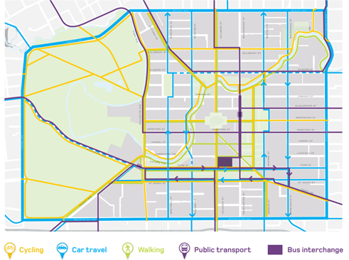
Figure
1: Central city road use hierarchy (diagram shows Manchester Street prioritised
for public transport), source: CCRP.
4.5 As
a result, the scheme that was implemented through An Accessible City by Central
Government delivered (further information can be found in the report to the
Infrastructure, Transport and Environment Committee on 2 April 2015 (Item
6):
4.5.1 Bus only lanes
and the use of traffic signal controls at a number of the intersections,
including at the super stops to ensure northbound and southbound buses have
priority.
4.5.2 A tree-lined
boulevard, high quality public spaces, a wide shared pedestrian and cycle path
on the eastern side of the street for local access needs, along with vehicle
access to local properties.
4.5.3 Turning
movements on Manchester Street were retained at the intersections with the
local distributor streets of Gloucester, Hereford and Lichfield (west), but
restricted at other intersections to prioritise public transport and make the
most efficient use of the transport network.
4.5.4 The design was
based on the road use hierarchy presented in An Accessible City, whereby
general traffic from the Avenues and eastern side of the Central City uses the
main distributor streets of Madras Street or Barbadoes Street, and the
east-west distributors of Gloucester Street and Hereford Street, to access
destinations in the City Centre.
4.6 Two bus gates (i.e. traffic signals) were
installed adjacent to the Manchester Street super stops:
· Outbound (heading north): beside the super stop (ID 53061) on
Manchester Street between Hereford Street and Worcester Street.
· Inbound (heading south): beside the super stop (ID 53074) on
Manchester Street between Gloucester Street and Worcester Street.
4.7 The traffic signals require general traffic to stop on a red signal,
so that the buses can exit the super stops without delay from queued traffic
from the intersection of Manchester Street and Worcester Street. Feedback
received from ECan suggests that this operation provides a good level of
service to the buses.
4.8 The
bus gates operate only during public transport operation hours (i.e. 5:30am to
12:30am). Outside these times, they display a green signal throughout the night
to allow general traffic to flow without obstruction.
4.9 The
current signal configuration activates the red signal at the bus gate six
seconds before the Manchester Street approach to the Worcester Street
intersection changes to red. This timing allows buses to have sufficient space
to exit the super stops.
4.10 Due to the lack
of bus and queue detection measures, the current bus gate signal operates
continuously. It activates regardless of whether a bus
is present at the indented super stop, or a queue exists on the Manchester
Street approaches to the intersection with Worcester Street.
Long-term plan for Manchester Street
4.11 The recently adopted Ōtautahi
Christchurch Future Transport strategy
includes a goal to significantly improve public transport provision as our city
grows. This includes, continued investment through the Public Transport Futures
programme in the near to medium term and progressing the Mass Rapid Transit
(MRT) project over the longer term.
4.12 In May 2023, the
Whakawhanake Kāinga Committee of the Greater Christchurch Partnership
endorsed the Mass Rapid Transit
Indicative Business Case (IBC). The
Indicative Business Case was approved by partner councils and the NZTA Waka
Kotahi Board in July 2023. As per the map below,
Manchester Street is a key component of the preferred MRT corridor through the
central city, as identified in the IBC.
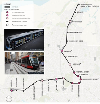
Figure 2: Preferred Mass Rapid Transit
Corridor source: MRT Indicative Business Case.
4.13 This project has
now moved into the ‘route protection’ phase, which is being led by
Council. In line with the endorsed IBC, this work will build on assumptions
that Manchester Street will continue to primarily function as a public
transport corridor over the longer-term.
Trial and
trial outcomes
4.14 Staff initiated
a trial removal of these bus gates (by covering the traffic signal lanterns),
followed by a before-and-after investigation into the
movements of both buses and general traffic. The trial lasted for four weeks,
commencing on Monday 12 May 2025. The signals became operational again (by
removing the covers) prior to a decision report being presented to the Council.
4.15 Staff
commissioned Abley to conduct a before-and-after analysis of bus movements and
general traffic to better understand the performance of the bus gates. The
report is presented in Attachment A.
4.16 On-site observations, vehicle counts, intersection counts, public
transport real time information (RTI), and connected vehicle probe data sources
were used to conduct the analysis. The following provides a summary of the key
findings of the analysis:
4.16.1 The
north bound bus gate reduces average bus travel times (covering 90% of trips)
between the Bus Interchange and Kilmore Street by 12 seconds in the morning
peak and 6 seconds in the interpeak, with no impact on evening peak travel
times.
4.16.2 The south bound
bus gates reduce average bus travel times (covering 90% of trips) between the
Kilmore Street and Bus Interchange by 6 seconds in the evening peak, with no
impact on morning peak and interpeak travel times.
4.16.3 These results
suggest that bus gates have a small positive impact on bus travel efficiency.
4.16.4 Travel
time variability was lower in the post-trial period compared to the trial,
indicating greater reliability when the bus gates were operating for northbound
buses during peak periods, based on the consultant’s report.
4.16.5 Evidence
from the pre-trial period – where Manchester Street had ≈10%
(approximately equal to 10%) higher southbound traffic than typical (due to
diversions to avoid temporary traffic management associated with nearby stadium
construction) – indicates that travel time and reliability for buses would
be significantly degraded by a sustained increase in general traffic. These
findings show that bus performance is highly sensitive to traffic volumes, and
removal of the gates could reduce reliability over time for public transport
customers.
4.16.6 The
Bus Interchange north bound bus gate increases average travel times for general
traffic between the and Kilmore Street by 6 seconds in the morning peak and
interpeak, with no impact on evening peak travel times. The south bound bus
gate reduces average travel times for general traffic between the Kilmore
Street and Lichfield Street by 6 seconds in the morning peak, with no impact on
evening peak and interpeak travel times.
4.16.7 In both directions,
disabling the bus gates decreased vehicle travel times upstream of the gates,
but this was offset by increased delays downstream, particularly at
intersections. This therefore shifted queues
downstream, particularly toward intersections of Hereford Street and Gloucester
Street, without significantly improving overall travel times. Overall
throughput and corridor efficiency is largely governed by signal phasing at these intersections, not by the presence or
absence of bus gates.
4.16.8 Importantly,
this analysis does not capture impacts to cross-traffic, such as delays or
blockages on Gloucester and Hereford Streets, which may worsen when queues are
shifted.
4.16.9 The
trial (four weeks) and post-trial (two weeks) were short durations. These
timeframes were not long enough to observe how travel behaviour might shift
over time. However, the data gathered can be considered a good representation
of the current operations on Manchester Street.
4.16.10 Given the
significant changes in traffic patterns within the Four Avenues (particularly
around Manchester Street) following the removal of traffic management for the
Te Kaha surrounding streets projects, the above results are based on a short
trial period compared with a two-week post-trial period used as the baseline.
A longer trial period (e.g., six months) would support more robust,
evidence-based decision-making by allowing all potential benefits and
limitations of the bus gates to be fully observed.
4.17 Feedback has been received from NZTA, ECan
and the bus operators (see report in Attachement A) on the trial. The
responses are provided below:
4.17.1 NZTA stated:
The
business cases jointly undertaken on public transport through Greater
Christchurch outline the importance of bus priority measures to give buses the
edge, beating general traffic and ensuring more reliable bus travel times.
Manchester Street is a key public transport corridor and should provide an
efficient level of service for buses as they access the interchange. NZTA Waka
Kotahi are therefore supportive of bus priority measures on core routes such as
Manchester Street that improve bus travel time and travel time reliability.
4.17.2 ECan stated:
Canterbury
Regional Council would like to stress the importance of Manchester Street as a
PT priority corridor which caters for the majority of the services on our
network and provides a key link to and from the bus interchange.
We support option B which retains and improves the performance of
the existing infrastructure. While we did not support the trial to turn the
gates off, and felt that similar outcomes could have been achieved in a more
collaborative manner which would have mitigated disruption to our passengers,
we believe that the assessment of the trial was an excellent example of CRC and
CCC working in partnership to achieve common goals.
4.17.3 Bus operators stated:
The block
between Hereford and Worcester Streets should hold 8-10 cars northbound but in practice
has much less capacity due to restrictive signal phasing (at both the bus gate
and Manchester / Worcester intersection), which creates congestion sometimes
extending to St Asaph Street. Similar capacity issues exist between Gloucester
and Worcester Street, exacerbated by the bus. gate signals. As a result,
traffic overflows into Gloucester Street intersection, preventing entry to the
bus lane from Gloucester Street or Manchester Street. The bus gates restrict
buses' ability to overtake when at the bottom stop.Right turns from Hereford
onto Manchester are severely limited (often only one vehicle per phase). Left-turning
traffic from Gloucester onto Manchester frequently blocks bus lane access. General
traffic commonly misuses the northbound bus lane at the Hereford intersection
for right turns and fail to clear the lane when the B light activates Traffic
waiting to turn right to Cashel Street can interrupt bus priority.
4.18 The following related memos/information were circulated to the meeting
members:
|
Date
|
Subject
|
|
07/05/2025
|
Memo – Manchester Street bus gates
trial (Attachment B)
|
Options Considered Ngā
Kōwhiringa Whaiwhakaaro
4.19 To address the issues raised through the trial, three options have
been identified as being reasonably practicable:
4.19.1 Option A: Do
nothing and continue to monitor the operation of the corridor.
4.19.2 Option B (preferred):
Install detectors at bus stops to ensure bus gates operate only when a bus is
present. The bus gate signals would then only go to red
for general traffic if a bus is present in any of the bus stops.
4.19.3 Option C: Remove
the bus gates. The low-cost option is to disconnect the signals and cover the
lanterns with bags and retain the poles in situ. A higher cost option would be
to also remove the poles and signal infrastructure. This could be done as
a further trial, over a longer period prior to staff reporting back on the
outcome of the wider investigation.
4.20 As discussed in
the Assessment Criteria section below, Option B will provide the greatest alignment with the objectives of the
corridor and is in line with the Council’s objective of improving public
transport for customers. This option would:
4.20.1 Make the corridor more
efficient for public transport by retaining the bus gates for priority, but
without unduly impeding local vehicle access.
4.20.2 Be undertaken quickly and
efficiently.
4.20.3 Allow staff to undertake
further investigations along the corridor to address issues identified in the
independent trial outcomes report.
Analysis Criteria Ngā Paearu Wetekina
4.21 The
analysis criteria is provided below in the following table:
|
|
Option A
|
Option B
|
Option C
|
|
|
Bus
gates are retained with no improvements
|
Bus
gates are retained and improved through implementation of detectors
|
Signals
at bus gates are disconnected/removed
|
|
Alignment with An Accessible City
(Recovery Plan)
|
Partially
|
Partially
|
No
|
|
Alignment with Endorsed Greater
Christchurch Public Transport Investment Cases
|
Partially
|
Partially
|
No
|
|
Community views and preferences
|
No change
|
No change
|
Staff would need to report back on the
community views of this option and its impacts. Unless done as a further
trial.
|
|
Impact on Public Transport Efficiency
|
No change
|
No change
|
Small increase in PT journey times for
north bound buses during the peak periods.
|
|
General Traffic Impacts
|
No change
|
Small Improvements to corridor efficiency
|
Small decrease in private vehicle journey
times through this block.
|
|
Ease and cost of implementation
|
No capex cost required
|
Low-cost measures
|
Low cost to disconnect and bag the
signals (retain poles and lanterns in-situ).
Higher capital costs to remove poles and
signal infrastructure.
|
4.22 Several issues have been raised through the independent
report by Abley that could further improve the corridor. Therefore, staff
recommend undertaking further investigations along the corridor to improve
efficiency, including (but not limited to):
4.22.1 Modifying traffic signal
activation and phasing based on detector input from the bus stops.
4.22.2 Physical changes to
intersections to remove pinch points and allow bus lanes to proceed all the way
through to intersections such as Manchester Street / Worcester Street, such as
that shown in Attachment C.
4.23 The following options were also considered but
were not assessed as being reasonably practicable for this report, for the
reasons outlined below:
4.23.1 Alternative options
for the layout of Manchester Street: Any significant changes to
the design of Manchester Street would require extensive consultation and
funding. This could be considered during the investigations that staff
recommend for the review of the whole corridor.
5. Financial Implications Ngā Hīraunga Rauemi
Capex/Opex Ngā Utu Whakahaere
5.1 The estimated costs for different options are provided in the
table below.
5.2 The
cost are high-level estimates
and are not tendered prices.
|
|
Option A
|
Option B
|
Option C
|
|
Cost to Implement
|
Nil
|
Up
to $10k to implement detection
|
Up
to $3k for disconnection and covering lanterns.
Up
to $10k for removal of signal poles and lanterns
|
|
Maintenance/Ongoing Costs
|
Nil
|
$500
per year
|
Nil
|
|
Funding Source
|
Nil
|
Real
Time Operations
|
Real
Time Operations
|
|
Funding Availability
|
Nil
|
Yes
|
Yes
|
|
Impact on Rates
|
Nil
|
Nil
|
Nil
|
6. Considerations Ngā Whai Whakaaro
Risks and Mitigations Ngā
Mōrearea me ngā Whakamātautau
6.1 There
is a reputational risk to the Council should it choose to remove public
transport infrastructure that provides priority for
buses. However, in this case the amount of priority provided is negligible.
This would be in direct conflict with the direction set through jointly
endorsed business cases, namely the Greater Christchurch
Public Transport Futures Business Case and the Mass Rapid Transit Indicative
Business Case. Both business cases emphasise the need for enhanced public
transport priority to support long-term mode shift, network efficiency, and
sustainable urban growth.
Legal Considerations Ngā
Hīraunga ā-Ture
6.2 The
intersection is located within the Central City Area marked on the Plan A area.
If staff have to report back on
Community Views and Preferences for Option C, it is recommended that this be
presented directly back to the Council.
6.3 Staff
would need to report back
on the community views of this option and its impacts.
6.4 This
report has not been reviewed
and approved by the Legal Services Unit.
Strategy and Policy Considerations Te Whai
Kaupapa
6.5 The
required decision:
6.5.1 Aligns with
the Christchurch
City Council’s Strategic Framework.
6.5.2 Is assessed as
low significance based on the Christchurch
City Council’s Significance and Engagement Policy. The level of
significance was determined by the low level
of impact and low number of people affected by the recommended decision in this
report.
6.5.3 Is consistent with Council’s Plans and Policies.
6.6 This
report supports
the Council's
Long Term Plan (2024 - 2034):
6.7 Transport
6.7.1 Activity: Transport
· Level of Service: 10.4.1 More people are
choosing to travel by public transport - >=14 million trips per year
· Level of Service: 10.4.4 Improve customer
satisfaction with public transport facilities (quality of bus stops and bus
priority measures) - >=73%
· Level of Service: 10.5.42 Increase the
infrastructure provision for active and public modes - >= 635 kilometres
(total combined length)
Community Impacts and Views
Ngā Mariu ā-Hāpori
6.8 As
staff were solely trialling the
impact of the existing bus gates, no public consultation or communications/marketing
campaign was undertaken.
6.9 Staff had communicated the details of this
trial with ECan and continued to work with ECan to understand any impact on the
bus services from them.
6.10 The decision affects the following wards/Community Board areas:
6.10.1 Waipapa Papanui-Innes-Central
Community Board.
Impact on Mana Whenua Ngā Whai Take
Mana Whenua
6.11 The decision does not involve a significant
decision in relation to ancestral land, a body of water or other elements of
intrinsic value, therefore this decision does not
specifically impact Mana Whenua, their culture, and traditions.
6.12 The decision does not involve a matter of
interest to Mana Whenua and will not impact on our
agreed partnership priorities with Ngā Papatipu
Rūnanga.
Climate Change Impact Considerations Ngā
Whai Whakaaro mā te Āhuarangi
6.13 The proposals in this report are
unlikely to contribute significantly to adaptation to the impacts of climate
change or emissions reductions.
6.14 However,
providing priority for buses will enhance public transport reliability, bus
user satisfaction, and encourage more people to use public transport.
7. Next Steps Ngā Mahinga ā-muri
7.1 If
this report and the staff recommendation is approved, staff will proceed with implementation
of the detectors and the corridor analysis and review.
Attachments Ngā Tāpirihanga
|
No.
|
Title
|
Reference
|
Page
|
|
a ⇨
|
Manchester
Street Bus Gate Trial Analysis report by Abley (Under Separate Cover)
|
25/1551499
|
|
|
b ⇩
|
Memo –
Manchester Street bus gates trial
|
25/1551500
|
156
|
|
c ⇩
|
Manchester
Worcester concept
|
25/1622463
|
159
|
In addition to the attached documents, the following background
information is available:
|
Document
Name – Location / File Link
|
|
Not
applicable
|
Signatories Ngā Kaiwaitohu
|
Authors
|
Mansour Johari
- Passenger Transport Engineer
Jann Kuhlmann
- Team Leader Real Time Operations
Hannah
Ballantyne - Senior Engagement Advisor
|
|
Approved By
|
Stephen Wright
- Manager Operations (Transport)
Lynette Ellis
- Head of Transport & Waste Management
Brent Smith -
General Manager City Infrastructure
|
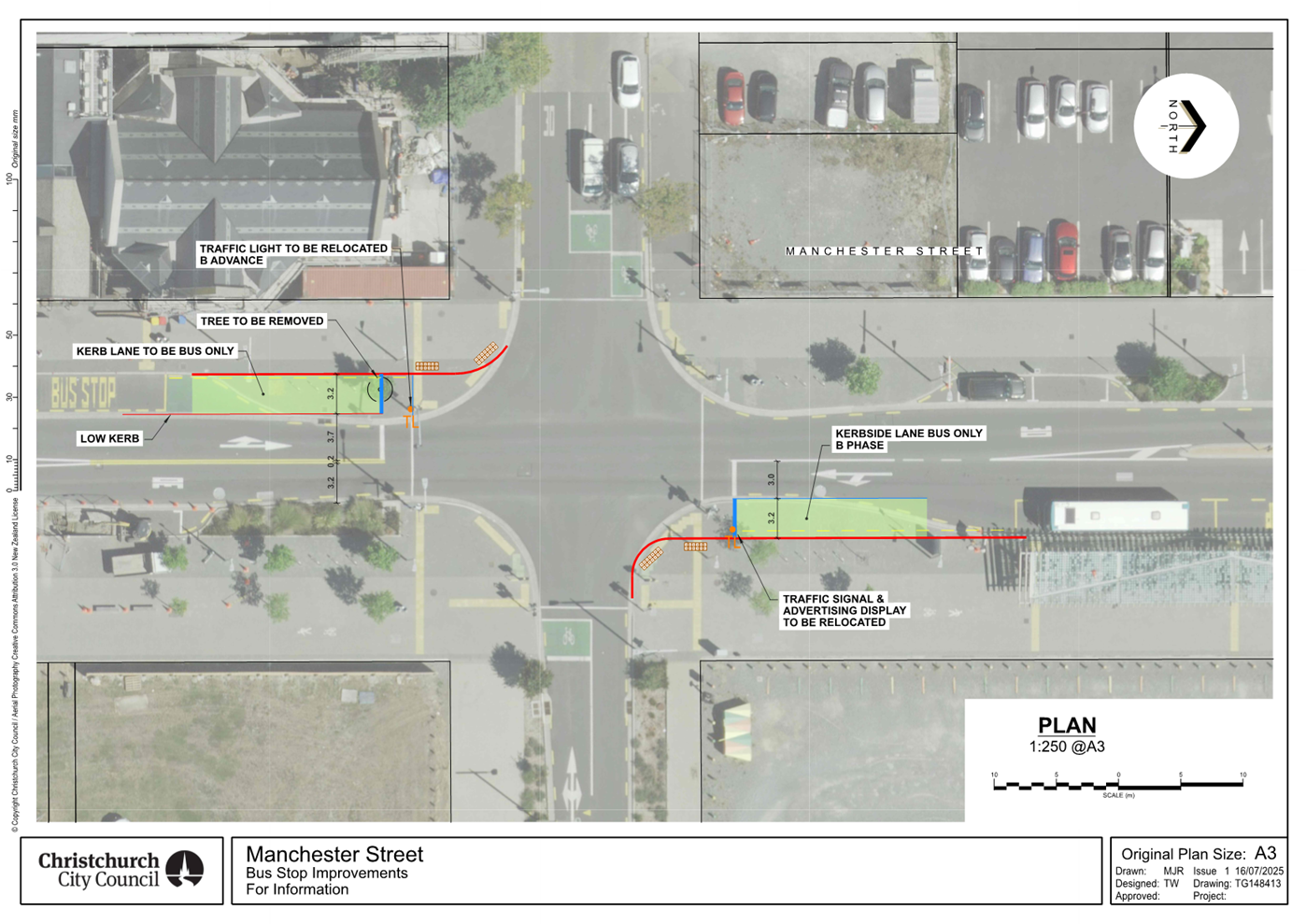
|
15. Resolution to Exclude the Public
|
Section
48, Local Government Official Information and Meetings Act 1987.
Note: The
grounds for exclusion are summarised in the following table. The full wording from
the Act can be found in section
6 or section
7, depending on the context.
I move that the public be excluded from the
following parts of the proceedings of this meeting, namely the items
listed overleaf.
Reason for passing this resolution: a good
reason to withhold exists under section 7.
Specific grounds under section 48(1) for
the passing of this resolution: Section 48(1)(a)
Note
Section 48(4) of the Local Government
Official Information and Meetings Act 1987 provides as follows:
“(4) Every resolution to exclude the
public shall be put at a time when the meeting is open to the public, and the
text of that resolution (or copies thereof):
(a) Shall
be available to any member of the public who is present; and
(b) Shall
form part of the minutes of the local authority.”
This resolution is made in reliance on
Section 48(1)(a) of the Local Government Official Information and Meetings Act
1987 and the particular interest or interests protected by Section 6 or Section
7 of that Act which would be prejudiced by the holding of the whole or relevant
part of the proceedings of the meeting in public are as follows:
|
ITEM NO.
|
GENERAL SUBJECT OF EACH MATTER TO BE CONSIDERED
|
SECTION
|
SUBCLAUSE AND REASON UNDER THE ACT
|
PUBLIC INTEREST CONSIDERATION
|
Potential Release Review Date and
Conditions
|
|
16.
|
Licence to Occupy Road Reserve
|
s7(2)(a), s7(2)(i)
|
Protection of Privacy of Natural Persons, Conduct Negotiations
|
The report relates to a property issue and contains personal
information which outweighs the public interest.
|
20 August 2027
To be reviewed after two years.
|
|
17.
|
Chief Executive's Performance Review
|
s7(2)(a)
|
Protection of Privacy of Natural Persons
|
The performance review of the Chief Executive is an employment
matter, and while it will have high public interest, it doesn't
outweigh the employment relationship between the Council and its employee.
|
15 September 2025
Once the final performance review has been approved by Council.
|
Karakia Whakamutunga
Kia whakairia te tapu
Kia wātea ai te ara
Kia turuki whakataha ai
Kia turuki whakataha ai
Haumi e. Hui e. Tāiki e