Christchurch City Council
Agenda
Notice of Meeting:
An ordinary meeting of the Christchurch
City Council will be held on:
Date: Wednesday 16 October 2024
Time: 9.30 am
Venue: Council Chambers, Civic Offices,
53 Hereford Street, Christchurch
Membership
|
Chairperson
Deputy Chairperson
Members
|
Mayor Phil Mauger
Deputy Mayor Pauline Cotter
Councillor Kelly Barber
Councillor Melanie Coker
Councillor Celeste Donovan
Councillor Tyrone Fields
Councillor James Gough
Councillor Tyla Harrison-Hunt
Councillor Victoria Henstock
Councillor Yani Johanson
Councillor Aaron Keown
Councillor Sam MacDonald
Councillor Jake McLellan
Councillor Andrei Moore
Councillor Mark Peters
Councillor Tim Scandrett
Councillor Sara Templeton
|
10 October 2024
Website: www.ccc.govt.nz
TABLE OF CONTENTS NGĀ IHIRANGI
Karakia Tīmatanga................................................................................................... 4
1. Apologies Ngā Whakapāha................................................................................. 4
2. Declarations of Interest Ngā Whakapuaki Aronga.................................................. 4
3. Public
Participation Te Huinga
Tūmatanui............................................................ 4
3.1 Public Forum Te Huinga Whānui.......................................................................................... 4
3.2 Deputations by
Appointment Ngā Huinga Whakaritenga...................................................... 4
4. Presentation
of Petitions Ngā
Pākikitanga............................................................ 4
Staff Reports
5. Main
South/Yaldhurst/Riccarton Road Intersection Safety Improvements................ 7
6. Nor'West
Arc Major Cycleway (Section 3) - Detailed Traffic Resolutions................... 39
7. Coastal
Hazards Adaptation Plan: Whakaraupo Lyttelton Harbour to Koukourarata Port Levy.............................................................................................................. 69
8. Review
of Gambling and TAB Venues Policy......................................................... 77
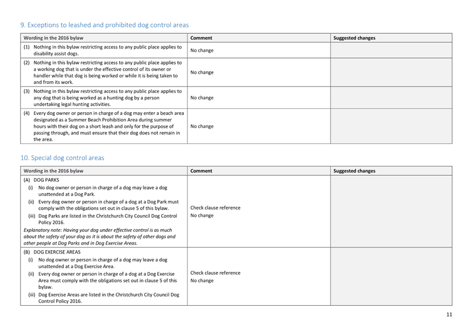
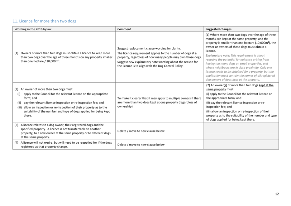
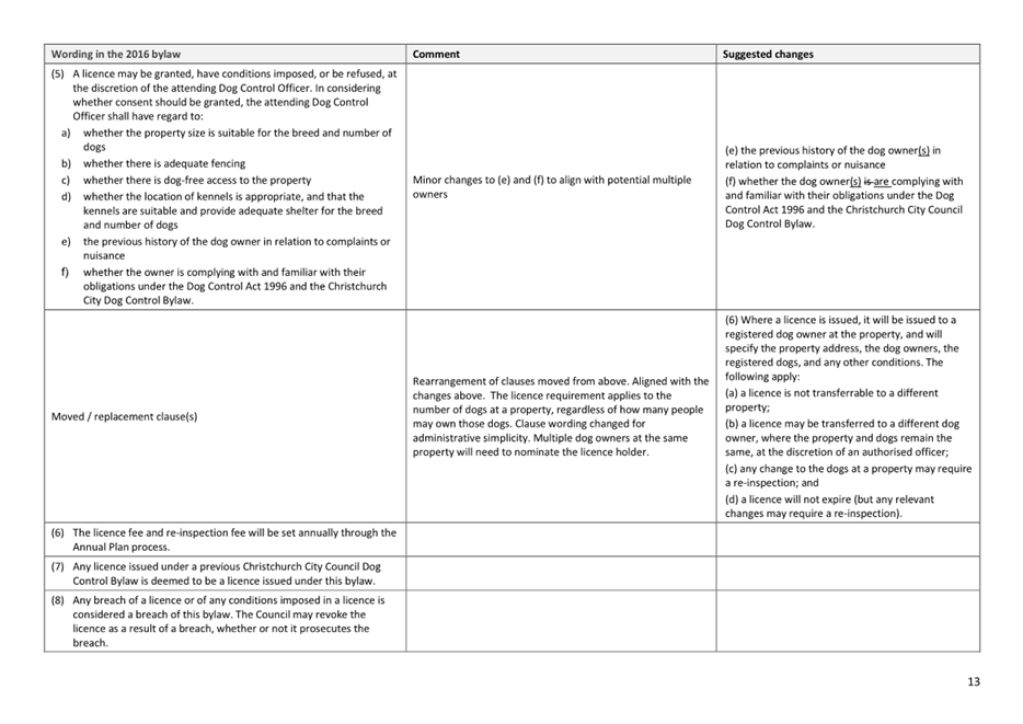
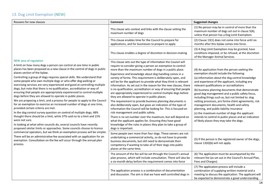
9. Review
of the Dog Control Policy 2016 and Dog Control Bylaw 2016...................... 123
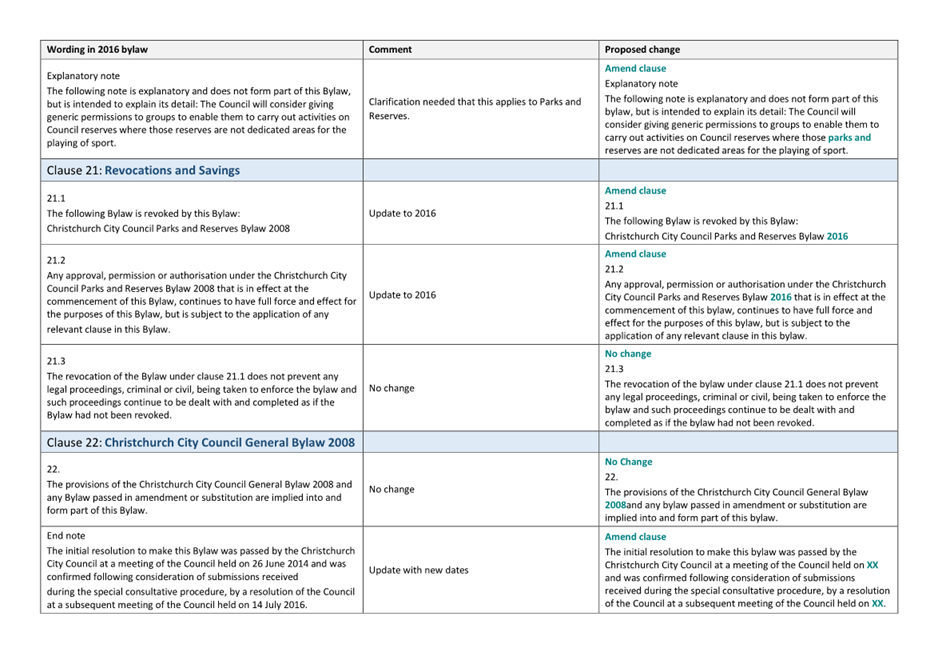
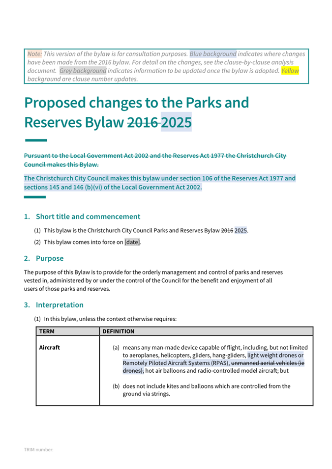
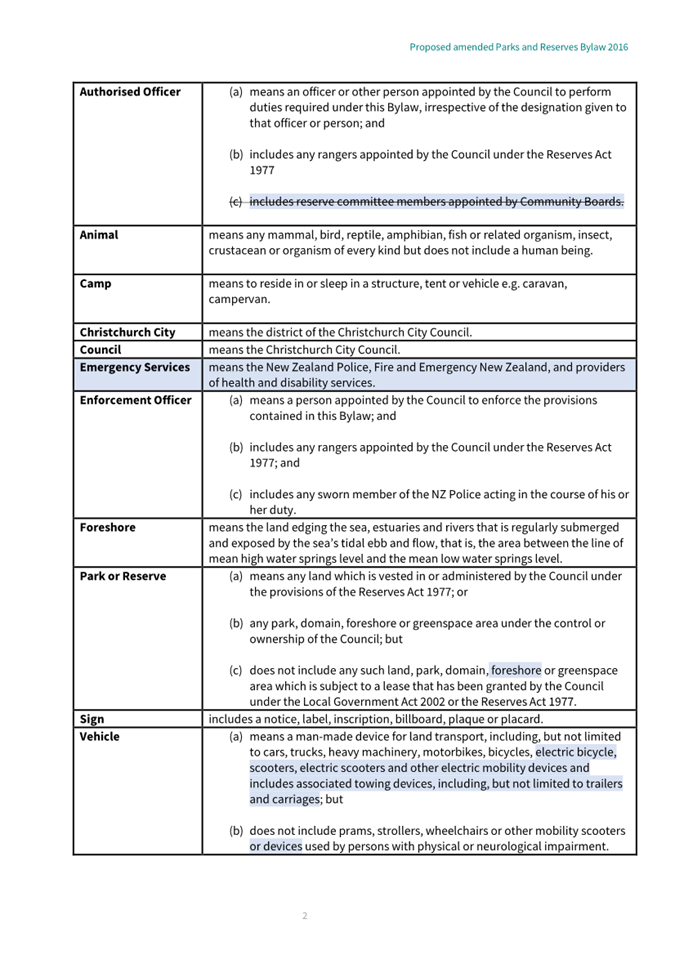
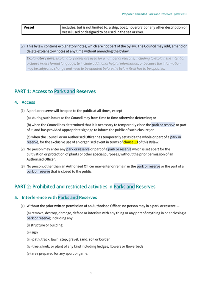
10. Review of
the Parks and Reserves Bylaw 2016................................................... 235
11. Elected
Member Professional Development Policy............................................. 289
12. Elected
Member Allowances and Expenses Policy............................................... 299
13. Libraries
and Information Unit Update............................................................. 309
Mayor and Councillor Reports
14. Mayor's
Monthly Report................................................................................. 325
15. Resolution
to Exclude the Public...................................................................... 330
Karakia Whakamutunga
Karakia Tīmatanga
Whakataka te hau ki te uru
Whakataka te hau ki te tonga
Kia mākinakina ki uta
Kia mātaratara ki tai
E hī ake ana te atakura
He tio, he huka, he hau hū
Tihei mauri ora
1. Apologies Ngā Whakapāha
At the close of
the agenda no apologies had been received.
2. Declarations of Interest Ngā
Whakapuaki Aronga
Members are
reminded of the need to be vigilant and to stand aside from decision making
when a conflict arises between their role as an elected representative and any
private or other external interest they might have.
3. Public Participation Te Huinga
Tūmatanui
Note: If you
would like to make a deputation in relation to Item 5 Main
South/Yaldhurst/Riccarton Road Intersection Safety Improvements, please get
in touch with Samantha Kelly at Samantha.Kelly@ccc.govt.nz or
03 941 6227 no later than midday Tuesday, 15 October 2024. Please
note that speaking time will be limited to accommodate all requests received.
3.1 Public Forum Te Huinga Whānui
A period of up to 30 minutes is available
for people to speak for up to five minutes on any issue that is not the subject
of a separate hearings process.
|
3.1.1
|
Community Law Canterbury
Lawrence Kimberley will speak on behalf
of Community Law Canterbury to provide an overview of their work.
|
|
3.1.2
|
Childrens’ University
Jack Swannell (Programme Manager) will
speak on behalf of the Childrens’ University regarding to raise
awareness of its programme and how the Council plays a supporting role.
|
3.2 Deputations by Appointment Ngā
Huinga Whakaritenga
Deputations may be heard on a matter or
matters covered by a report on this agenda and approved by the Chairperson. There
were no deputations by appointment at the time the agenda was prepared.
4. Presentation of Petitions Ngā
Pākikitanga
There were no Presentation
of Petitions at the time the agenda was prepared.
|
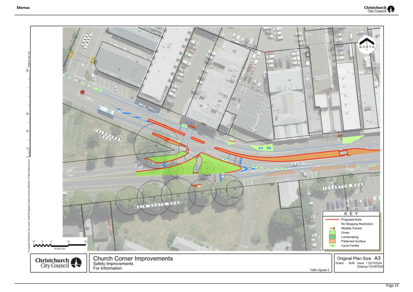
5. Main
South/Yaldhurst/Riccarton Road Intersection Safety Improvements
|
|
Reference Te Tohutoro:
|
24/673335
|
|
Responsible Officer(s) Te Pou Matua:
|
Gemma
Dioni, Principal Advisor Transportation - Safety
|
|
Accountable ELT Member Pouwhakarae:
|
Brent
Smith, Acting General Manager City Infrastructure
|
1. Purpose and Origin of the Report Te Pūtake Pūrongo
1.1 The
purpose of this report is for the Council to make a decision on the preferred
option for the layout of the Main South Road/Yaldhurst Road/Riccarton Road
intersection at Church Corner, to improve safety for all road users.
1.2 This
report has been written in response to a Notice of Motion presented at the
Extraordinary Meeting of the Waipuna Halswell-Hornby-Riccarton Community Board
(Community Board) on 9 April 2024. At that meeting, the Community Board
resolved to:
1.2.1 Revoke the decision made at its meeting on 15 February 2024
for Resolutions 6-10 on the Church Corner and Waimairi Road Safety Improvements
Report (HHRB/2024/00031).
1.2.2 Request staff to provide options that keep the right-hand
turn, dual crossing, and mitigates serious crash incidences
(HHRB/2024/00032).
1.2.3 Delegate to Council the decision on the original staff
recommendations 6-10, or alternative options (HHRB/2024/00033).
2. Officer Recommendations Ngā
Tūtohu
That the Council:
1. Receives the information in the Main South/Yaldhurst/Riccarton
Road Intersection Safety Improvements Report.
2. Notes that the decision in this report is
assessed as medium significance based on the Christchurch City Council’s
Significance and Engagement Policy.
3. Approves pursuant to Section 331 and 334 of the Local
Government Act 1974 all kerb alignments, traffic calming devices, traffic
islands and road markings on Main South Road, Yaldhurst Road, and Riccarton
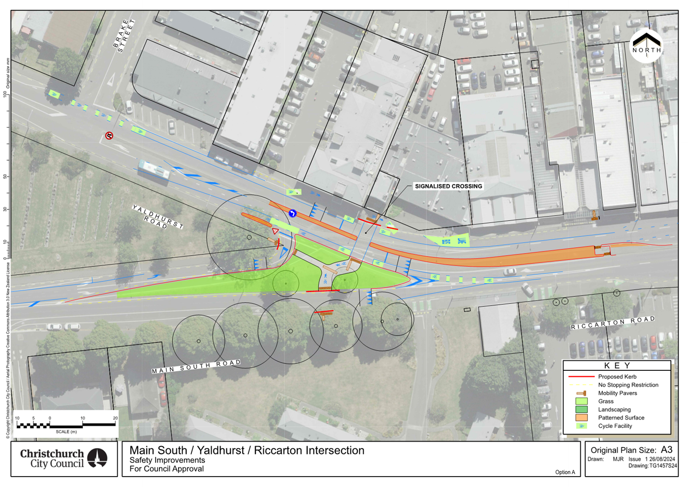
Road as detailed as Option A in Attachment A of this report (plan
TG1457S24, dated 26/08/2024),
which includes:
a. In accordance with Section 8.5 of the Land
Transport Rule – Traffic Control Devices: 2004, that a signalised
pedestrian and cycle crossing be installed
on Yaldhurst Road, located 65 metres south-east of its intersection with Brake
Street, and as detailed in
Attachment A of this report (plan TG1457S24).
b. In accordance with Clause 17 of the
Christchurch City Council Traffic and Parking Bylaw 2017, that a No Right Turn
control be placed against eastbound vehicles using the roadway on Main South
Road at its intersection with Riccarton Road.
c. In accordance with Clause 18 of the
Christchurch City Council Traffic and Parking Bylaw 2017, that a Special
Vehicle Lane for the use of westbound road users as defined in Section 11.1A of
the Land Transport (Road User) Rule: 2004, excepting pedestrians and riders of
mobility devices, be installed on the southwest side of Riccarton Road and
Yaldhurst Road, commencing at a point 55 metres southeast of intersection with
Main South Road and extending in a westerly direction to a point 123 metres
west of Main South Road.
d. In accordance with Clause 21 of the
Christchurch City Council Traffic & Parking Bylaw 2017, that the path on
the north side of Yaldhurst Road and Riccarton Road, commencing at a point 61
metres west of Brake Street, and extending in a easterly direction for a
distance of 34 metres, be resolved as a bi-directional Shared Path and in
accordance with section 11.4 of the Land Transport Act - Traffic Control
Devices Rules: 2004. This Shared Path is for the use by the classes of road
user only as defined in Section 11.1A of the Land Transport (Road User) Rule:
2004.
e. In accordance with Clause 21 of the
Christchurch City Council Traffic & Parking Bylaw 2017, that the path on
the north side of Yaldhurst Road and Riccarton Road, commencing at a point 21
metres west of Main South Road at Yaldhurst Road, and extending in a southerly
direction for a distance of 16 metres, be resolved as a bi-directional Shared
Path and in accordance with section 11.4 of the Land Transport Act - Traffic
Control Devices Rules: 2004. This Shared Path is for the use by the classes of
road user only as defined in Section 11.1A of the Land Transport (Road User)
Rule: 2004.
3. Executive Summary Te Whakarāpopoto Matua
3.1 The
Main South Road/Yaldhurst Road/Riccarton Road intersection (the intersection) at Church Corner is in the top
three per cent of intersections in Christchurch where there is a risk of having
a crash (excluding State Highway intersections). There have been 76 crashes at
this intersection in the 10-year period from 2013 to 2022, involving people
turning right from Main South Road to Riccarton Road, including three serious
injuries and seven minor injuries.
3.2 The
recurring crash type is attributed to the current design of the intersection,
particularly with people turning right from Main South Road into Riccarton
Road. Although the visibility of oncoming traffic travelling west on Riccarton
Road is clear to drivers waiting on Main South Road, the combination of the
curve in Riccarton Road and the two westbound lanes attributes to poor
perception of vehicle speed and gap selection by traffic waiting to exit Main
South Road.
3.3 On
26 October 2023, the Waipuna Halswell-Hornby-Riccarton Community Board was
briefed on a proposal for safety improvements in the wider Church Corner area.
Through the public consultation process on this proposal, 302 submissions were
received. Of the submitters who answered the question about how safe they feel
using the current layout at the Main South/Yaldhurst/Riccarton intersection,
58.6% perceived it as somewhat or very unsafe.
3.4 In
February 2024, the Community Board considered the written submissions from
consultation, and heard from submitters, on the staff proposal for the wider
Church Corner project. The consideration of this report was conducted over two
meetings, during which time staff revised the proposal to improve access to a
business and pre-school; and to incorporate a dual crossing on Riccarton Road.
The Community Board resolved most recommendations, other than Officer
Recommendations 6-10 (minutes,
item 8).
3.5 The
Community Board reconsidered its decision regarding Officer Recommendations
6-10 in March 2024, but the motion was declared lost. This was followed by a
Notice of Motion in April 2024, which revoked the Community Board’s
previous decision for Officer Recommendations 6-10; included a request for
staff to provide information on alternative options at the Main South
Road/Yaldhurst Road/Riccarton Road intersection; and for the decision to be
made by the Council.
3.6 Staff
undertook further investigations to assess options for safety improvements at
this intersection. Four options were developed, which have been independently
assessed for safety and network effects. Further refinements were made
following the independent assessments, resulting in two additional options that
would be safer and more efficient than the original four options. These two
additional options are proposed in this report:
3.6.1 Option A (Attachment A): Remove the right turn from Main
South Road to Riccarton Road and changes the main road crossing type from a
pedestrian crossing to a signalised crossing (preferred).
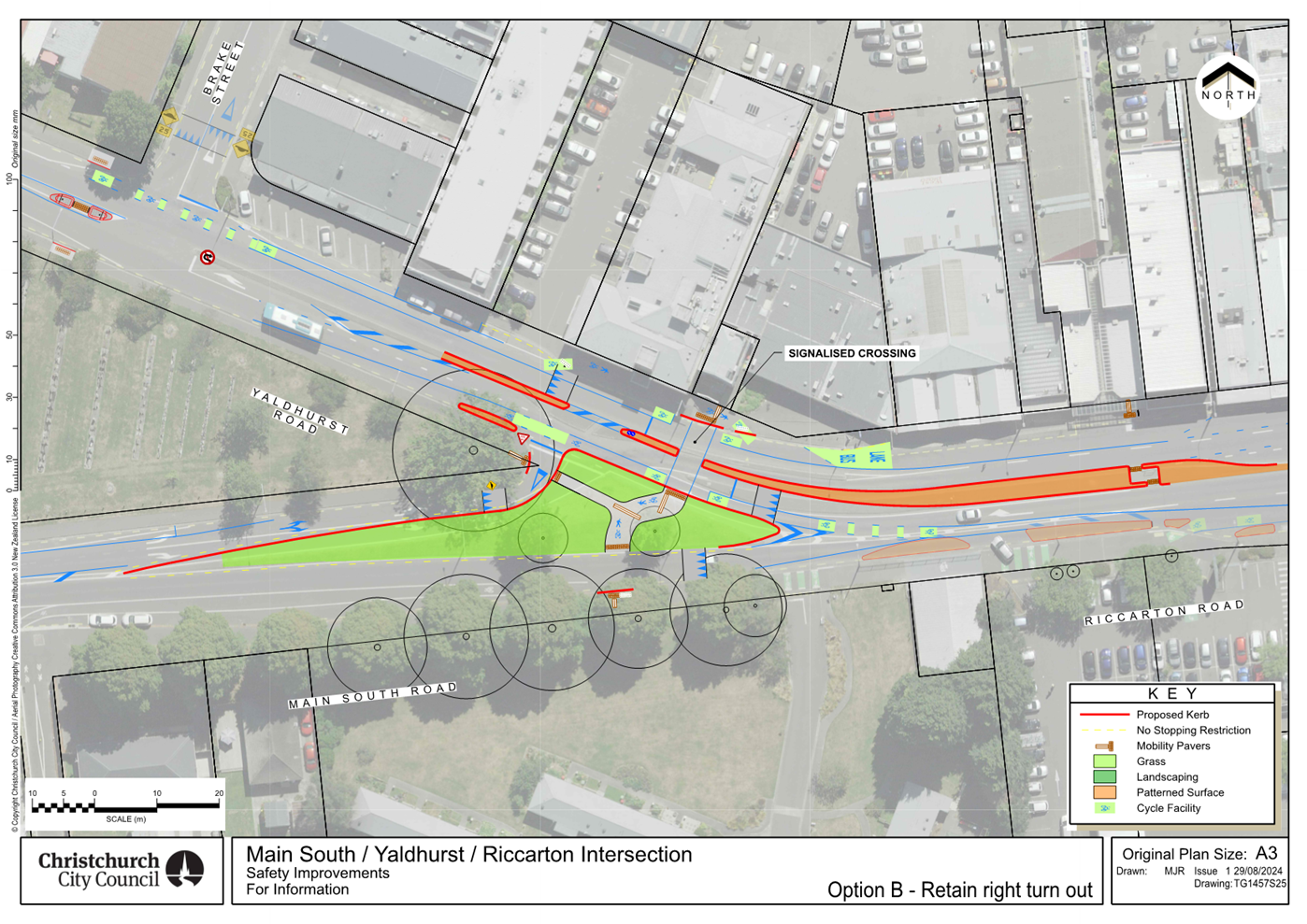
3.6.2 Option
B (Attachment B): Retain the right turn from Main South Road to
Riccarton Road and changes the main road crossing type from a pedestrian
crossing to a signalised crossing.
3.7 Staff
recommend Option A (Attachment A) as this presents the lowest risk
option to all road users as it:
3.7.1 Removes
the right turn from Main South Road into Riccarton Road to eliminate the
current crash risk.
3.7.2 Provides
a signalised crossing for people walking and cycling on Riccarton Road. The
signal-controlled crossing would provide a safer and more efficient option.
3.7.3 Includes
improvements for people who cycle to and through the area by providing a cycle
lane on the southern side of Riccarton Road and Yaldhurst Road.
4. Background/Context Te Horopaki
4.1 Improving safety on local roads in Christchurch is a
priority for the Council. Providing safe infrastructure is key to ensure people
get to where they are going safely, irrespective of their mode of travel.
4.2 The Council has a Level of Service target to reduce the
number of deaths or serious injuries from all crashes by 40% in 2030. This is
also a goal in the Road Safety Action Plan, which is a collaborative plan
between Christchurch City Council, Waka Kotahi NZTA, ACC, FENZ and New Zealand
Police. If the Council is to achieve this goal, it needs to create a safe
transport system.
4.3 Waka Kotahi NZTA guidance states that “the selection
of treatment measures should start with the objective of aiming to achieve a
Safe System by first considering interventions that are most likely to eliminate
the occurrence of fatal and serious injuries”. Other measures can be
implemented to manage a particular risk, such as reducing the speed
limit, reducing the operational speed of vehicles through traffic calming, and
providing additional signs and lines.
4.4 Church Corner is a busy area with many people walking,
cycling, accessing public transport and driving through. It is particularly
busy when people are travelling to and from school and work. Church Corner
includes the Bush Inn Centre, Church Corner Mall, St Peter’s Anglican
Church, a medical centre, a pre-school, supermarkets, other local shops and
businesses. The University of Canterbury and student accommodation is located
to the north of Riccarton Road, and there are large schools close by including
Villa Maria, Riccarton High, Middleton Grange and Kirkwood Intermediate.
4.5 The Main South/Yaldhurst /Riccarton intersection at Church
Corner is in the top three percent of Christchurch intersections in terms of
risk of being in a crash, compared to over 5,700 Council controlled
intersections citywide. The need for intersection safety improvements at this
location was identified through a co-design process with Waka Kotahi NZ
Transport Agency for the 2021-2024 National Land Transport Programme Funding
Cycle through the Pipeline Development Tool.
Existing layout at
the Main South Road/Yaldhurst Road/Riccarton Road intersection
4.6 The
existing layout of this intersection is shown below in Figure 1. It is
formed as a “half seagull” arrangement with the main road flow
along Riccarton Road and Yaldhurst Road. Vehicles turning right out of Main
South Road only need to give way to westbound vehicles on Riccarton Road and
can then merge with Riccarton Road eastbound traffic in their own lane
approaching the Hansons Lane intersection.
4.7 There is little guidance given to drivers on the westbound
approach to the intersection, which can lead to late lane change decisions.
There is nothing to prevent late lane changing, and this increases potential
for vehicles giving way and waiting to turn out of Main South Road to be
confused as to whether they need to give way to westbound traffic. Although the
visibility of oncoming traffic on Main South Road is clear, it is possible that
the combination of the curve in Riccarton Road and the two westbound lanes
attributes to poor perception of vehicle speed and gap selection by traffic
waiting to exit Main South Road.
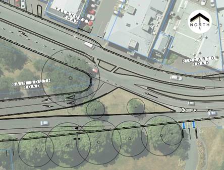
Figure
1: Existing layout at Main South/Riccarton/Yaldhurst
4.8 The crossing points are mostly median islands with no
priority given. The crossing at the bus stops requires people to cross two
lanes of busy free flowing traffic in each direction. There is one
signal-controlled crossing provided at the Hansons/Riccarton intersection for
people to cross Riccarton Road.
4.9 The Puari ki Niho-toto South Express Cycleway provides a
short local connection to the supermarket entrance on the south side of
Riccarton Road. There is no connection from the South Express Cycleway to Bush
Inn or Church Corner. There are no cycle lanes or paths for people riding
bicycles through the Main South Road/Yaldhurst Road intersection.
4.10 There are five bus routes that use the stops on Riccarton
Road to the west of Hansons Lane, including the numbers 5, 86, 100, 130 and
140. The 5, 100 and 130 bus routes turn left into Main South Road for the
outbound journey and use Curletts Road and the Peer St/Yaldhurst Road
intersection to travel east through Church Corner. There are bus stops located
on Riccarton Road. These routes are also used by school buses, however school
buses turn right at the signals at Peer/Yaldhurst/Curletts and do not turn right
from Main South Road to Riccarton Road.
Community Board
consideration - Proposed Church Corner safety improvements
4.11 On
26 October 2023, the Waipuna
Halswell-Hornby-Riccarton Community Board was briefed on a proposal for
safety improvements in the wider Church Corner area. For the section relating
to Main South/Yaldhurst/Riccarton intersection, it was
proposed that Main South Road would be closed at the intersection with
Yaldhurst Road and Riccarton Road via a cul-de-sac arrangement (as shown below
in Figure 2 and within the wider area in (Attachment C).
This proposal would remove the ability for people travelling along Main South
Road to turn left or right at Yaldhurst Road/Riccarton Road. The plans also
included a pedestrian crossing (zebra) on Riccarton Road.
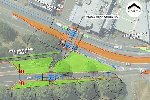
Figure
2: Proposal for Main South/Riccarton/Yaldhurst for consultation Nov-Dec 2023
4.12 The
public were consulted on this proposal between 9 November and 7 December 2023.
The results of the consultation on the wider Church Corner are provided in
Section 6, with a summary relating specifically to the Main South/Yaldhurst/Riccarton intersection.
4.13 On
15 February 2024 (item
8), the Community Board considered a report that summarised the submissions
received during consultation and made recommendations for the wider Church
Corner safety improvements. At that meeting, the Community Board heard
deputations from submitters both in support and against the package of
improvements at Church Corner (minutes,
item 5). The staff recommendations included traffic calming, slip lane
removals, an improved crossing and changes to parking on Waimairi Road.
4.14 The
meeting was adjourned until 20 February 2024 to continue the discussion on this
report. Between the two meetings, following Community Board questions on
the deputations, staff revised the proposal to retain the left turn out from
Main South Road to improve access for a business at the corner of
Peer/Yaldhurst/Curletts and the local pre-school; and to incorporate a dual
crossing on Riccarton Road. This revision is provided in Figure 3 below
and shown with the wider Church Corner project in Attachment D.
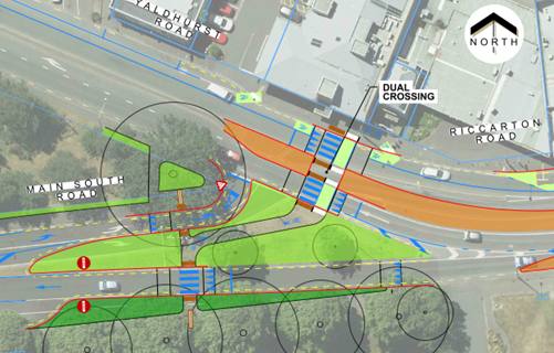
Figure
3: Proposal for Main South/Riccarton/Yaldhurst presented at the 20 February
Decision Meeting
4.15 The
Community Board resolved (minutes,
item 8) the majority of the recommendations, which are shown on the plan in
Attachment D. However, the Community Board did not approve Officer
Recommendations 6-10 Traffic Controls, which related to the traffic
restrictions at the Main South/Yaldhurst/Riccarton intersection and the
crossing on Riccarton Road.
4.16 Following
further staff advice, a report was tabled at the Community Board meeting
on 14 March 2024 (item
17) for the Board to reconsider its 15 February 2024 decision regarding
Officer Recommendations 6 –10. The motion was declared lost, and the
status quo upheld. Subsequently, a Notice of Motion was raised for the
Community Board to revoke its 15 February 2024 decision regarding Officer
Recommendations 6 – 10. Attachment E shows the programme of works
approved by the Community Board.
4.17 At
its Extraordinary Meeting on 9 April 2024 (item
3), the Community Board considered the Notice of Motion. The Mover, with
the agreement of the Community Board, amended the original Notice of Motion.
The Community Board resolved to revoke its previous decision; request that
Council retain the delegation to make a decision on the intersection; and
request staff to provide options to keep the right-hand turn and dual crossing
and to mitigate serious crash incidences. At this extraordinary meeting, the
Community Board also heard from community members through the Public Forum (minutes,
item 4).
4.18 On
6 August 2024 at a Public Information Session/Workshop with the Council (item
4), additional information was requested about crash risk and rates at the
adjacent intersection at the Peer/Yaldhurst/Curletts intersection. This
was due to a concern around transferring crash risk for users if the right turn
was removed at Main South/Yaldhurst/Riccarton. The crash history and risk
information are provided in Attachment F.
4.19 In
reviewing this information, staff identified that two crashes at the
Peer/Yaldhurst/Curletts intersection had been incorrectly coded, as they had
actually occurred at the Main South/Yaldhurst/Riccarton intersection. After a
review of all the crash information, it was determined that on a per-vehicle
basis, the Main South/ Yaldhurst/Riccarton intersection has 2.5x the injury
crashes compared to the Peer/Yaldhurst/Curletts intersection (6.7 injury
crashes v 2.64 injury crashes). The crash history and risk information are
provided in Attachment F and Attachment G.
4.20 The
updated data for the Main South/Yaldhurst/Riccarton
intersection is a total of 83 reported crashes occurring in the ten-year period
(2013-2022) at or within 50 metres of Main South/Yaldhurst/Riccarton. Of the 83
crashes:
o 76 were a result of
crossing/turning movements.
o Four were a result of loss of
control/head on.
o Two crashes were a result of
rear-end/obstruction.
o One crash involved a person
walking.
4.21 Of
the 76 crossing/turning crashes at the Main South/Yaldhurst/Riccarton, three
resulted in a serious injury, and seven resulted in a minor injury. A pattern
was identified within the three serious injury crashes, two of which occurred
when the driver failed to give-way when turning right from Main South Road onto
Riccarton Road crashing with westbound movements (one cycle and one bus). The
third was a driver misjudging the speed of the vehicle travelling west on
Riccarton Road and has entered the intersection from Main South Road and hit
the westbound vehicle.
4.22 The
seven crashes resulting in minor injury were similar to the serious crashes in
that all drivers exiting Main South Road have hit a vehicle travelling
westbound on Riccarton Road to Yaldhurst Road. In four crashes, the driver on
Main South Road had failed to give-way, and in three instances the driver on
Main South Road failed to see the vehicles approaching and exited into the path
of the oncoming traffic.
4.23 The
remaining 66 crashes were non-injury crashes, however on several occasions FENZ
attended due to the significant damage to vehicles. Ambulances have also been
dispatched to many of the crashes alongside Police.
4.24 In
the crash reports for the non-injury crashes, drivers exiting Main South Road
and turning right have stated that they have failed to see a vehicle, failed to
give-way and have mis-judged the speed of the vehicle approaching from the
east. In several crashes, the driver travelling westbound has been unable to
stop in time when seeing a driver exiting from Main South Road. Two crashes
involved buses travelling along Riccarton Road to Yaldhurst Road.
Memos/workshops
4.25 Following
the Information Session/Workshop held on 1 October 2024, further information
regarding the consideration of controlling the right turn from Main South Road
by traffic signals was provided to the Mayor and Councillors via a Memo (refer
to Attachment M).
4.26 The following related information session/workshops have taken place
for the members of the meeting:
Options Considered Ngā
Kōwhiringa Whaiwhakaaro
4.27 To
address the crash risk at the Main South/Yaldhurst/Riccarton intersection, two
options were identified as being reasonably practicable:
4.27.1 Option A: Remove the right turn from
Main South Road to Riccarton Road and change the main road crossing type from a
pedestrian crossing to a signalised crossing (preferred).
4.27.2 Option B:
Retain the right turn from Main South Road to Riccarton Road and change the
main road crossing type from a pedestrian crossing to a signalised crossing.
4.28 As
discussed below in the Assessment Criteria section, these two options will
provide safer outcomes for the intersection, with the change in crossing type
being more efficient for Riccarton Road (The options are explained in Attachment
H with larger plans provided in Attachment I). Staff recommend
Option A, which is the lowest risk option for all users and is in line with
the Council’s objective of improving safety on local roads. This option
will:
4.28.1 Remove the
right turn from Main South Road into Riccarton Road to eliminate the current
crash risk.
4.28.2 Install a
signalised crossing on Riccarton Road for people walking and cycling to cross
the road.
4.28.3 Install
improvements for people who cycle, by providing a cycle lane on the southern
side of Riccarton Road and Yaldhurst Road. The cycle lane on the northern side
was included in the previous scheme.
|
|
Option A
|
Option B
|
|
Keeps
the right-hand turn
|
This option
removes the right turn from Main South Road into Riccarton Road.
|
This option
retains the right turn from Main South Road into Riccarton Road.
However, delay does increase as traffic gives way to two lanes of traffic.
Alternative routes may be more attractive and more time efficient.
|
|
Impact
on network
|
Minimal impact.
Traffic would divert to other routes to access destinations.
|
Minimal impact.
Traffic may divert to other routes to access destinations due to increase in
delay from the design of the standard T-intersection.
|
|
Mitigates
serious crash incidences
|
Eliminates the risk of a serious crash type
involving right turning vehicles from Main South Road.
|
Manage the risk of a serious crash type
involving right turning vehicles from Main South Road. Risk reduction is
through speed management (inclusion of speed hump).
|
|
Dual
crossing
|
Signalised
crossing for people walking and cycling included. The signalised crossing is
more efficient than the original zebra proposed as there is more ability to
control when people cross the road.
|
Signalised
crossing for people walking and cycling included. The signalised crossing is
more efficient than the original zebra proposed as there is more ability to
control when people cross the road.
|
|
Speed
calming
|
To align with
the safe system principles, traffic calming is provided on the approaches to
the signal-controlled crossing.
|
To align with
the safe system principles, traffic calming is provided on the approaches to
the signal-controlled crossing. However,
there is no speed calming device between the limit line and the crossing.
This could increase the risk of a right turning vehicle from Main South Road
potentially being unaware of the crossing and travelling through on a red
signal.
|
|
Cycle
Facilities
|
Through
consultation, submitters requested additional cycle facilities. The Safety
Audit also raised a serious concern about the lack of cycle lane for
westbound users, particularly where drivers are turning left from Riccarton
Road to Main South Road.
A
westbound cycle lane has now been included in the proposal.
|
4.29 Preferred
Option: Option A – remove right hand turn from Main South Road and
install a traffic signal-controlled crossing on Riccarton Road.
4.29.1 Option
Description: Removes the right turn from Main South Road into Riccarton
Road and a new traffic signal-controlled crossing is installed on Riccarton
Road.
4.29.2 Option
Advantages
· Eliminates the
risk of right turn against crashes, as this movement is no longer available.
· Provides a
traffic signal-controlled crossing on Riccarton Road to accommodate people
walking and cycling to cross this busy road.
· Includes a
cycle lane on the southern side of Riccarton Road and Yaldhurst Road.
4.29.3 Option Disadvantages
· Drivers
wanting to make the right turn are no longer able to make the turn at this
location. However, there are multiple alternative options for people to access
the Church Corner area and further afield without drivers incurring significant
additional delays.
4.30 Option
B – retain right hand turn from Main South Road and install a traffic
signal-controlled crossing on Riccarton Road.
4.30.1 Option
Description: Retains the right turn from Main South Road into Riccarton
Road and install a new traffic signal-controlled crossing is installed on
Riccarton Road.
4.30.2 Option
Advantages
· Provides a
traffic signal-controlled crossing on Riccarton Road to accommodate people
walking and cycling to cross this busy road.
· Includes a
cycle lane on the southern side of Riccarton Road and Yaldhurst Road.
4.30.3 Option
Disadvantages
· Risk of a
right turn against crashes remains but the likelihood and severity of death or
serious injury crashes reduced through the use of speed management.
· Drivers
wanting to make the right turn can do this, however, they are now giving way to
two lanes of traffic, and delay may increase.
· The lack of
traffic calming between the right turn movement and the signalised crossing
could increase the risk of a right turning vehicle from Main South Road
potentially being unaware of the crossing and travelling through on a red
signal.
4.31 The
following options were also considered but were not assessed as being
reasonably practicable for the reasons outlined below:
4.31.1 Alternative
options for the intersection: Staff developed four options, which
were initially assessed for the right turn at the intersection:
· 1: Remove the
right turn and retain left-in and left-out movements (as per 14 March report
proposal)
· 2: Retain the
right turn out with the half seagull arrangement (retains most of the existing
layout with additional speed management devices).
· 3: Retain the
right turn out via a standard T-intersection layout (alternate arrangement to
retaining the right turn).
· 4: Remove the
right turn and retain left-in and left-out movements (Similar to Option 1 but
accommodates additional westbound cycle lane to address submitter feedback).
Following independent assessments which
considered these four options (discussed below in the Analysis Criteria
section, and referred to as Options 1-4), further refinements were made to the
plans to provide safer measures. This resulted in two additional options (Options
A and B) being developed. These two additional options are preferred over the
four independently assessed options, as they are safer and more efficient for
this intersection.
· Option A
combines Options 1 and 4; and
· Option B is a
revised Option 3.
· Option 2 was
disregarded as it was the least aligned to safe system principles and would be
difficult for people to use all the crossings.
· The options
are explained in Attachment H with full plans provided in Attachment I.
4.31.2 Main South
Road cul-de-sac as per the original proposal: Public consultation was
undertaken on an option to remove through traffic on Main South Road by forming
a cul-de-sac. This would eliminate the risk of crashes occurring. Following
deputations at the Community Board meeting on 15 February 2024, it was proposed
by staff to retain the left turn out of Main South Road for ease of access to
properties on the southeast corner of the Peer/Curletts/Yaldhurst intersection.
This option has therefore not been re-visited due to those concerns around
access.
4.31.3 Trial layout:
While the closure of the half seagull arrangement could be tested, it is not
feasible within the geometric constraints of the street to trial the raised
crossing also as a complete package. Due to the costs associated with trialling
an option coming from within the Minor Road Safety budget, it is most cost
effective to deliver the final solution. The independent reviews provide
confidence that the option will deliver the outcomes being sought by reducing
the number of crashes and improving accessibility for active modes.
4.31.4 Full
signalisation of the intersection This provides for the Main South Road
approach to be fully signalised with a dedicated phase that can be used to
separate turning traffic from conflicting vehicle movements. This would also be
co-ordinated with the crossing provided as per the Notice of Motion.
The delays to journeys on Riccarton Road
would increase as traffic would be required to stop every phase of the signal
cycle and every time a person wanted to cross Riccarton Road. This would
disrupt the flow of traffic on Riccarton Road, by imposing substantial delays
on each of the single lane approaches that can be accommodated within the road
space available.
This is likely to lead traffic to use
alternative routes to avoid the congestion that could occur. Attracting
additional traffic demand, would further deteriorate the performance of the
corridor, particularly for public transport movements. Speed management would
be recommended through the full signalisation to address residual safety
concerns around red light running and pedestrian safety.
Analysis Criteria Ngā Paearu Wetekina
4.32 The analysis criteria focuses on two issues: safety and
network effects.
Independent Safety
Review
4.33 Abley
were commissioned to undertake a Safe System Audit of the first four proposed
options as well as assessing the wider implications of each option (Options A
and B are a composition of these four options and have been created to address
the outcomes of the Safe System Audit). The wider implications include
alignment with strategic transport direction, user comfort and perception of
safety and alignment with best practice guidance. The Abley report is provided
in Attachment J.
4.34 A
Safe System Assessment scores each option in terms of seven crash types and the
exposure, likelihood and severity associated with each crash type. The safe
system scores from the Safe System Assessment for the existing intersection and
Options 1-4 are provided in the graph in Figure 4.
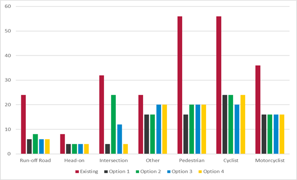
Figure
4: Safe System Assessment - The lower the score
the safer the outcome
4.35 The
following table presents the assessment of the four options against the
selected criteria:
4.36 Options
1 and 4 are most aligned with safe system principles as these options would
reduce the risk of intersection crashes the most while also significantly
improving pedestrian and cyclist safety. Option 2 is the least aligned to safe
system principles due to the risk associated with the right turn out movement
which is retained in this option.
4.37 All
of the options significantly reduce the crash risk for pedestrians and cyclists
by providing a priority crossing (for people walking and cycling to cross)
across the main road. The small differences in safe system scores for
pedestrian and cyclist crash risk depend on how the crossing is configured and
whether on-road cycle facilities are provided.
4.38 Option
1 and 4 provide the best alignment with the criteria considered. These options
have been combined and after incorporating feedback from the Safe System Audit,
is now presented as Option A.
4.39 The
independent report recommended that if the right turn out movement must be
retained for wider network efficiency, then Option 3 aligns with the criteria
more than Option 2, although with significant residual risk. Option 3 has
therefore been developed further based on the Safe System Audit. This option is
now presented as Option B.
Independent review
of network effects
4.40 An
independent analysis has been completed by QTP consultants to understand the
effects on traffic. The QTP review is provided in Attachment K. The
purpose of the review was to demonstrate the network effects of these options
and how this might impact on people who drive through this area.
4.41 In
terms of traffic modelling to understand differences in traffic flows and delay
between the options, these can be distilled down to just two options based on
the provided traffic movements at Main South/Riccarton/Yaldhurst intersection:
4.41.1 left-in/left-out
(Options 1,4 and A); or
4.41.2 retain both the
left and right turn movements (Options 2, 3 and B).
4.42 The
greatest impact (at all locations) occurs during the morning peak, so only the
morning has been assessed.
4.43 Options
1, 4 and A remove the right turn from Main south Road into Riccarton Road,
resulting in a left-in/left-out arrangement. The modelling shows:
· Approximately 100 vehicles
per hour (vph) are likely to divert to Yaldhurst Road (via Curletts Road
intersection) due to removing the right turn from Main South Road to Riccarton
Road. This is indicated to increase delay for the right turn movement from
Curletts Road to Yaldhurst Road by 10 seconds (from 22 to 32 seconds).
· For eastbound trips that
can no longer turn right from Main South Road into Riccarton Road, the
alternative route via Curletts Road and Yaldhurst Road will add 34 seconds of
overall travel time. This time consists of 10 seconds for additional distance
travelled, the time taken to turn at Curletts/Peer/Yaldhurst (32 seconds) minus
the 8 seconds of delay that people experience when turning right from Main
South Road to Riccarton Road.
· While the eastbound
movement on Main South Road decreases by 200 vph without the right turn onto
Riccarton Road, it also attracts 60 vph additional new trips consisting of left
turners (from Main South Road into Yaldhurst Road) that travel north via Brake
Street. This results in a net reduction of 140 vph travelling east on
Main South Road. The model shows only a very small amount of traffic is
estimated to divert to Brake Street (1 vehicle per minute peak and it could
potentially be less than modelled). Similarly, this is inconsequential
for the right turn at Curletts Road into Yaldhurst Road, which has more than
sufficient capacity (noting that it is indicated to operate at LoS C with or
without the right turn from Main South Road into Riccarton Road).
4.44 Option
2 retains the half seagull arrangement and therefore only negligible changes in
flow and delay are expected.
4.45 Option
3 and B which also include the right turn from Main South Road, are indicated
to have delays for the right turn increase by approximately 39 seconds because
right turners would have to give way to both directions simultaneously compared
to the existing seagull which separates these out.
4.46 The
model indicates that in Options 3 and B, with the right turn retained from Main
South Road to Riccarton Road, a small amount of eastbound traffic (40 vph) is
likely to divert to Yaldhurst Road (via Curletts intersection) to avoid the
increased delay on the Main South Road approach to Riccarton Road.
4.47 TomTom
travel time data has been used to understand where people travelling through
the area have come from and are going to. The sample origins and destinations
show a significant level of dispersal:
· Only around 12% of the
drivers using the right turn travel the whole way down to the eastern end of
Riccarton Road at Deans Avenue (5.3% turn north at that point, 6.2% carry on
towards the CBD down Riccarton Avenue and 0.4% turn south).
· Closer to the
intersection, around 7% of all right turners can be seen to then immediately
turn right at Hansons, with the majority of these clearly bound for Woolworths
at Church Corner (before proceeding with their journey).
· The sample suggests that
only a very small proportion (1.3%) of all existing right turners are bound for
the Bush Inn Centre.
· Drivers to both the
Woolworths at Church Corner and the Bush Inn Centre, as well as those further
afield (down Riccarton Road and beyond) would clearly have alternative options
for routing to their destinations, should the ability to turn right out of Main
South Road be removed (as provided by Options 1, 4 and A).
4.48 The
analysis suggests that restricting the right turn in Options 1, 4 and A, would
likely have a very small impact on their own overall journey time, or on other
road users. Given the dispersal of destinations, it is highly unlikely that all
would choose to reroute via the Curletts Road/Yaldhurst Road intersection given
other reasonably attractive alternative routes for many (e.g.,
Blenheim>Hansons if shopping at Woolworths Church Corner). Any additional
delays are likely to be less than 30 seconds on average (for peak periods) and
would not comprise more than approximately 5% of the average observed total
journey length of current users of the right turn. Average observed trip
length for the eastbound right turning (Main South Road to Riccarton Road)
traffic is 6 kilometres and takes an average time of 11.1 minutes (664 seconds)
resulting in an average speed of 32.5 kph. If the right turn was removed,
the average speed would drop by 1 kph.
5. Financial Implications Ngā Hīraunga Rauemi
Capex/Opex Ngā Utu Whakahaere
|
|
Option A
|
Option B
|
|
Cost to Implement the works at Main
South/Riccarton/Yaldhurst
|
$1,433k
|
$1,433k
|
|
Maintenance/Ongoing Costs
|
To be covered under the roading
maintenance contract, the effect will be minimal to the overall asset.
|
|
Funding Source
|
Traffic Operations
Minor Road Safety Budget.
|
|
Funding Availability
|
Not confirmed.
|
|
Impact on Rates
|
None.
|
5.1 The
cost are high-level estimates and are not tendered prices.
5.2 Cost
estimates were also completed for the original four options that were assessed.
These options all included additional kerb work, and a raised dual crossing.
The raised crossing and kerb-work would have required supporting stormwater
infrastructure and increase the likelihood for additional construction risks.
Option A and B do not require the supporting stormwater infrastructure, nor the
additional kerb works, which offsets the cost of the traffic signal-controlled
crossing.
6. Considerations Ngā Whai Whakaaro
Risks and Mitigations Ngā Mōrearea me
ngā Whakamātautau
6.1 If
the Council decides not to approve the preferred option (Option A), there is a
risk that there will continue to be crashes at this intersection that cause
death and serious injury. By removing the right turn, this risk is eliminated.
Option A also includes other traffic safety measures that will reduce risk for
all road users at that location.
Legal Considerations Ngā Hīraunga
ā-Ture
Decision
making
6.2 Section
76 of the Local Government Act 2002 provides that every legal decision made by
the Council must be made in accordance with sections 77, 78, 80, 81,
82.
6.3 In
relation to section 78, although compliance is mandatory, the Council has a
broad discretion as to how best it achieves compliance, relative to the
significance of the issue.
78 Community views in relation
to decisions
(1) A
local authority must, in the course of its decision-making process in relation
to a matter, give consideration to the views and preferences of person likely
to be affected by, or have an interest in, the matter.
(2) ..
(3) A
local authority is not required by this section alone to undertake any
consultation process or procedure.
(4) This
section is subject to section 79.
6.4 Section
79 enables the Council to decide how it achieves compliance with this
requirement which is to be largely in proportion to the significance of the
matter (determined in accordance with the Council’s significance and
engagement policy). As part of its decision on this report, the Council must
take into account the following relevant considerations:
6.4.1 The
results of the public engagement and deputations received on the proposed
changes for the wider Church Corner project, which included the Main South
Road/Yaldhurst Road/Riccarton Road intersection;
6.4.2 The
crash risk and crash history at the intersection;
6.4.3 The
assessment of options, including the analysis criteria and results of the
independent safety review.
6.5 Statutory
and/or delegated authority to undertake proposals in the report:
6.5.1 Clause
18 of the Christchurch City Council Traffic and Parking Bylaw 2017 provides
that the Council may, by resolution, prescribe a road or part of a road as a
special vehicle lane. The Council has not sub-delegated this power.
6.5.2 On 9
April 2024, the Community Board requested that the Council resume the
delegation for the purposes of dealing with the Main South Road/Yaldhurst
Road/Riccarton Road Intersection, and the relevant delegated powers are:
Christchurch City Council Traffic and
Parking Bylaw 2017
6.5.3 Clauses 7 and 8 provides the authority to install parking
restrictions by resolution.
6.5.4 Clause 17 provides for prohibiting or restricting vehicles or
classes of vehicles on any road from turning to the right or to the left or
from proceeding in any other direction.
Local Government Act 1974
6.5.5 Section
319 provides general powers of councils in respects of roads, including the
authority to:
· divert or alter the
course of any road
· increase or diminish
the width of any road subject to and in accordance with the provisions of the
district plan, if any, and to the Local Government Act 1974 and any other Act
· determine what part
of a road shall be carriageway, and what part a footpath or cycle track only
6.5.6 Section 331 provides authority to approve concept plans for forming
or upgrading footpath, kerbs and channels.
6.5.7 The installation of any signs and/or markings associated with
traffic control devices must comply with the Land Transport Rule: Traffic
Control Devices 2004.
Strategy
and Policy Considerations Te
Whai Kaupapa here
6.6 The
required decision:
6.6.1 Aligns
with the Christchurch
City Council’s Strategic Framework and Community Outcomes. Improving the safety of our roads aligns with
the Strategic Priorities and Community Outcomes, in particular to be an
inclusive and equitable city; build trust and confidence by listening to and
working with our residents; and providing safe crossing points for people who
walk and cycle will contribute to a green, liveable city, where our
neighbourhoods and communities are accessible and well-connected.
6.6.2 Is assessed
as medium significance based on the Christchurch City
Council’s Significance and Engagement Policy. The level of
significance was determined by the assessment for the wider Church Corner
safety improvement project, where it was considered medium due to the high risk
of crashes but is localised to this area. There is increased community interest
in this particular intersection, however the decision does not have any greater
impact on the community than it did originally.
6.6.3 The
recommended option is consistent with the Council’s
Plans and Policies, in particular:
· LTP Activity
Plan - Level of Service target to reduce the number of deaths or serious
injuries (DSI) from all crashes by 40% in 2030.
· The changes
made align with road safety and liveable streets goals in the Christchurch
Transport Strategic Plan 2012–2042, and similarly in the draft Transport
Plan (safe streets).
· The changes
made align with Kia tūroa te Ao - Ōtautahi Christchurch Climate
Resilience Strategy as set out in the Climate Change Impact Considerations
section below.
· Improving
safety on local roads is a priority for the Council.
· Church Corner
is poised to be one of the bigger growth areas in the city in coming years and
is identified as a priority development area in the Greater Christchurch
Spatial Plan (along with the rest of the Riccarton corridor). The area may
likely be upzoned (through Plan Change 14) to allow high density residential
development within a walkable catchment of these shops. This would lead to an
increase in the number of people wanting to walk and cross the road to access
local services.
6.7 This
report supports the Council's
Long Term Plan (2021 - 2031):
6.8 Transport
6.8.1 Activity: Transport
· Level of Service: 10.0.6.1 Reduce the number of death and
serious injury crashes on the local road network - <=96 crashes
· Level of Service: 10.0.2 Increase the share of non-car
modes in daily trips - >=37% of trips undertaken by non-car modes
· Level of Service: 10.5.1 Limit deaths and serious injury
crashes per capita for cyclists and pedestrians - <= 12 crashes per 100,000
residents
Community
Impacts and Views Ngā Mariu ā-Hāpori
6.9 The proposed options in this report consider the feedback received
in the consultation carried out for the wider Church Corner safety improvements
project. While not specifically consulted on, Option A includes removing the
right turn which was consulted on. Option B retains the right turn, which was
not consulted on, therefore we do not have specific community views on
retaining the right turn. Both options would, however, improve the safety risk
at the intersection for all users.
6.10 The
decision affects the following wards/Community Board areas:
6.10.1 Riccarton Ward.
6.10.2 Waipuna Halswell-Hornby-Riccarton Community Board.
Consultation on wider Church Corner
safety improvements
6.11 Consultation
on the wider Church Corner safety improvements project started on 9 November
and ran until 7 December 2023, with 302 submissions received (from 12
organisations and 292 individuals). For each section of the proposal,
submitters were asked how safe they feel using these intersections and crossing
points now, compared to how safe they think they would feel if the proposed
changes were made.
6.12 The
consultation was hosted on Kōrero mai | Let’s
Talk which had over
8,500 views throughout the consultation period. A flythrough video of the
proposed changes was created and posted on the Council’s YouTube
Channel which had over 5,000 views. A Chinese voiceover
version of the flythrough video was sent directly to Chinese groups in
Christchurch which had over 100 views.
6.13 The
consultation was emailed to 173 key stakeholders, posted on the Council
Facebook page and was shared to eight local community group pages which reached
over 8,800 people.
6.14 A
flyer was distributed, and a letter was sent to absentee owners of 300
residential properties around Church Corner on 13 November 2023. 100 copies of
the flyer were also dropped to St Peter’s Anglican Church and St
Peter’s Anglican Pre-School.
6.15 Paid
advertising promoted the consultation to the community, including digital and
newspaper ads, bus shelter and washroom posters, digital screens utilised in
Upper Riccarton Library, Riccarton Library and Jellie Park and signs put up
near pedestrian crossing points around Church Corner and Waimairi Road.
6.16 The consultation analysis and all feedback was provided in full to
the Community Board on 15 February 2024. Across the 15 February, 14 March and 9
April 2024 Community Board meetings, the Board heard deputations from 10
individuals and four organisations regarding the Church Corner safety
improvements.
Feedback relevant to the Main South
Road and Yaldhurst Road intersection
6.17 The
proposal that was consulted on showed that Main South Road would be closed at
the intersection with Yaldhurst Road and Riccarton Road via a cul-de-sac
arrangement.
6.18 Of
the 292 submitters who answered the question about how safe they feel at the
Main South Road and Yaldhurst Road intersection, 71 submitters (24.3%) perceive
the existing intersection as somewhat or very safe whereas 171 (58.6%) perceive
it as somewhat or very unsafe.
6.19 If
the proposed consultation changes were implemented, the number of submitters
who thought they would feel unsafe decreased with only 60 submitters (20.5%)
saying they would feel somewhat or very unsafe and the number of submitters who
thought they would feel safe increased with 173 submitters (59.2%) saying they
would feel somewhat or very safe.
6.20 An
extract of all comments made by submitters in the Main South Road and Yaldhurst
Road intersection section of the consultation is available in Attachment
L. All submissions are available in full online.
Impact
on Mana Whenua Ngā
Whai Take Mana Whenua
6.21 The decision does not involve a significant decision in relation
to ancestral land or a body of water or other elements of intrinsic value,
therefore this decision does not specifically impact
Mana Whenua, their culture, and traditions.
6.22 The decision does not involve a matter of interest to Mana Whenua and will not impact on our agreed partnership priorities
with Ngā Papatipu Rūnanga.
6.23 The
Ngāi Tahu Cultural Atlas identifies a route way running through the
project footprint. There is an opportunity to recognise the route mapped in the
Cultural Atlas and apply a Te Ao Māori lens to the landscape design of the
space.
Climate
Change Impact Considerations Ngā Whai Whakaaro mā te Āhuarangi
6.24 The decisions in
this report are likely to:
6.24.1 Contribute positively to
adaptation to the impacts of climate change.
6.24.2 Contribute positively to
emissions reductions.
6.25 The
emission reductions associated with this project have not been estimated.
6.26 Improving
the ability for people to walk, cycle, scoot and catch the bus are a key part
of the Council’s emissions reduction efforts by providing a safe, low
emission way for residents to move around the city.
6.27 Improving
safety and making the intersection feel safer would address some of the
barriers to people making sustainable travel choices. Removing these barriers
will lead to reductions in vehicle kilometres travelled and consequently
emissions from transport.
6.28 Options
that increase the area of permeable surface (increasing the amount of green
space) in the area will help contribute more positively to adaptation.
7. Next Steps Ngā Mahinga ā-muri
7.1 If
the Council agrees to the recommendations in this report, the next step will be
to undertake construction.
Attachments Ngā Tāpirihanga
|
No.
|
Title
|
Reference
|
Page
|
|
a ⇩
|
Option A Plan
for approval
|
24/1079513
|
25
|
|
b ⇩
|
Option B Plan
for information
|
24/1720021
|
26
|
|
c ⇨
|
Consultation
Plan (Under Separate Cover)
|
24/1513545
|
|
|
d ⇨
|
Plan provided
for Community Board approval (14 March 2024 meeting) (Under Separate
Cover)
|
24/1513611
|
|
|
e ⇨
|
Community
Board approved plan - wider programme (Under Separate Cover)
|
24/1367900
|
|
|
f ⇨
|
Crash history
and risk (Under Separate Cover)
|
24/1633845
|
|
|
g ⇨
|
SMART Safe
Survey Outputs (Under Separate Cover)
|
24/1079507
|
|
|
h ⇨
|
Proposed
options and options assessment table (Under Separate Cover)
|
24/1633839
|
|
|
i ⇨
|
Plans for
proposed options1 to 4, A and B (Under Separate Cover)
|
24/1079514
|
|
|
j ⇨
|
Abley Memo -
Safe System Audit (Under Separate Cover)
|
24/1079515
|
|
|
k ⇨
|
QTP Memo -
Traffic Modelling (Under Separate Cover)
|
24/1079516
|
|
|
l ⇨
|
Extract of
Submissions (Under Separate Cover)
|
24/1079550
|
|
|
m ⇩
|
Memo to
Councillors dated 2 October 2024
|
24/1774190
|
27
|
In addition to the attached documents, the following background
information is available:
|
Document
Name – Location / File Link
|
|
Not
applicable
|
Signatories Ngā Kaiwaitohu
|
Authors
|
Gemma Dioni -
Principal Advisor Transportation Safety
Maryem Al
Samer - Legal Counsel
Krystle
Anderson - Engagement Advisor
|
|
Approved By
|
Stephen Wright
- Manager Operations (Transport)
Lynette Ellis
- Head of Transport & Waste Management
Brent Smith -
Acting General Manager City Infrastructure
|
|
6. Nor'West
Arc Major Cycleway (Section 3) - Detailed Traffic Resolutions
|
|
Reference Te Tohutoro:
|
24/440200
|
|
Responsible Officer(s) Te Pou Matua:
|
Richard
Humm, Project Manager Transport
|
|
Accountable ELT Member Pouwhakarae:
|
Brent
Smith, Acting General Manager City Infrastructure
|
1. Purpose and Origin of the Report Te Pūtake Pūrongo
1.1 This
report refers to the section of Nor’West Arc Cycleway (Section 3 Stages 2
and 3) between the intersection of Ilam Road and Aorangi Road; to the
intersection of Matsons Ave and Harewood Road.
1.2 The purpose of the report is to seek approval for the
detailed traffic resolutions and for tree removals/relocations, assessed
in accordance with the Urban Development and Transport Committee (UDaT) and
the Council’s requests as part of the detailed
design process.
1.3 This
report is staff generated.
2. Officer
Recommendations Ngā Tūtohu
That the Council:
1. Receives the information in the Nor'West Arc Major Cycleway (Section
3) - Detailed Traffic Resolutions report.
2. Notes that the decisions in this report are assessed as low
significance based on the Christchurch City Council’s Significance and
Engagement Policy.
3. Revokes any previous resolutions pertaining to traffic controls made
pursuant to any Bylaw to the extent that they are in conflict with the parking
or stopping restrictions described in recommendations 4-35 below.
4. Aorangi Road (Ilam Road to Clyde Road) – Traffic Controls
a. Approves all kerb alignments, paths, islands, road surface
treatments, traffic calming features and road markings on Aorangi Road,
commencing at its intersection with Ilam Road and extending in a north-easterly
direction to its intersection with Clyde Road as shown on Attachment A of this
report sheet 4010B dated 13/09/2024.
b. Approves, pursuant to Clause 6 of the Christchurch City Council
Traffic and Parking Bylaw 2017, that a Stop control be placed against:
i. Aorangi Road at its intersection with Ilam Road, as shown on
Attachment A of this report sheet 4010B, dated 13/09/2024.
ii. Aorangi Road at its intersection with Clyde Road, as shown on
Attachment A of this report sheet 4011, dated 13/09/2024.
c. Approves, pursuant to Clause 6 of the Christchurch City Council
Traffic and Parking Bylaw 2017, that a Give Way control be placed against
Aorangi Road Shared path users as defined by Section 11.1A of the Land
Transport (Road User) Rule 2004 only but excepting pedestrians and riders of
mobility devices from this group of road users, travelling in a north-easterly
direction on the northwestern side of Aorangi Road, located at its intersection
with Clyde Road, as shown on Attachment A of this report sheet 4011, dated
13/09/2024.
d. Approves, in accordance with Clause 21 of the Christchurch City
Council Traffic and Parking Bylaw 2017, that the path be resolved as a
bi-directional Shared Path and in accordance with section 11.4 of the Land
Transport Act – Traffic Control Devices Rules 2004, for the use by the
classes of road users only as defined in Section 11.1A of the Land Transport
(Road User) Rule 2004, on
i. the northwestern side of Aorangi Road, commencing at its
intersection with Ilam Road, and extending in a north-easterly direction to its
intersection with Truman Road, as detailed on Attachment A of this report,
sheet 4010B, dated 13/09/2024.
ii. the northwestern side of Aorangi Road, commencing at a point 37
metres southwest of its intersection with Clyde Road and extending in a
north-easterly direction to its intersection with Clyde Road, as detailed on
Attachment A of this report, sheet 4011, dated 13/09/2024.
e. Approves, in accordance with clause 18 of the Christchurch City
Council Traffic and Parking Bylaw 2017, that a Special Vehicle Lane be
installed, for the use of north-easterly and south-westerly bound road users as
defined in Section 11.1A of the Land Transport (Road User) Rule 2004, expecting
pedestrians and riders of mobility devices, on the northwestern side of Aorangi
Road commencing at point 7 metres southwest of its intersection with Truman
Road and extending in a north-easterly direction to a point 7 metres northeast
of this intersection as detailed on Attachment A of this report, sheet 4010B, dated
13/09/2024.
5. Aorangi Road (Ilam Road to Clyde Road) – Parking and Stopping
Restrictions
a. Approves, pursuant to Clause 7 of the Christchurch City Council
Traffic and Parking Bylaw 2017, that the stopping of all vehicles be prohibited
at any time on:
i. the northwestern side of Aorangi Road commencing at its intersection
with Ilam Road and extending in a north-easterly direction for a distance of 28
metres, as detailed on Attachment A of this report, sheet 4010B, dated
13/09/2024.
ii. the northwestern side of Aorangi Road commencing at a point 14
meters south-west of its intersection with Truman Road and extending in a
north-easterly direction to its intersection with Truman Road, as detailed on
Attachment A of this report, sheet 4010B, dated 13/09/2024.
iii. the northwestern side of Aorangi Road commencing at a point 7 metres
northeast side of its intersection with Truman Road and extending in a
north-easterly direction to a point 30 metres southwest of its intersection
with Clyde Road, as detailed on Attachment A of this report, sheet 4010B and
4011, dated 13/09/2024.
iv. the northwestern side of Aorangi Road commencing at a point 11
metres southwest of its intersection with Truman Road and extending in a
north-easterly direction to its intersection with Clyde Road, as detailed on
Attachment A of this report, sheet 4011, dated 13/09/2024.
v. the southeastern side of Aorangi Road commencing at its intersection
with Clyde Road and extending in a south-westerly direction for a distance of
10 metres, as detailed on Attachment A of this report, sheet 4011, dated
13/09/2024.
vi. the southwestern side of Aorangi Road commencing at a point 49
metres southwest of its intersection with Clyde Road and extending in a
south-westerly direction for a distance of 4 metres, as detailed on Attachment
A of this report, sheet 4011, dated 13/09/2024.
vii. the southeastern side of Aorangi Road commencing at a point 105
metres southwest of its intersection with Clyde Road and extending in a
south-westerly direction for a distance of 2 metres, as detailed on Attachment
A of this report, sheet 4011, dated 13/09/2024.
viii. the southeastern side of Aorangi Road commencing at a point 132
metres southwest of its intersection with Clyde Road and extending in a
south-westerly direction for a distance of 5 metres, as detailed on Attachment
A of this report, sheet 4011, dated 13/09/2024.
ix. the southeastern side of Aorangi Road commencing at a point 158
metres southwest of its intersection with Clyde Road and extending in a
south-westerly direction for a distance of 5 metres, as detailed on Attachment
A of this report, sheet 4010B, dated 13/09/2024.
x. the southeastern side of Aorangi Road commencing at a point 229
metres southwest of its intersection with Clyde Road and extending in a
south-westerly direction for a distance of 11 metres, as detailed on Attachment
A of this report, sheet 4010B, dated 13/09/2024.
xi. the southeastern side of Aorangi Road commencing at a point 286
metres southwest of its intersection with Clyde Road and extending in a
south-westerly direction to its intersection with Ilam Road, as detailed on
Attachment A of this report, sheet 4010B, dated 13/09/2024.
6. Truman Road (Aorangi Road to northwestern project extent) –
Traffic Controls
a. Approves all kerb alignments, paths, islands, road surface
treatments, traffic calming features and road markings on Truman Road,
commencing at its intersection with Aorangi Road and extending in a
north-westerly direction for a distance of 16 metres, as shown on Attachment A
of this report, sheet 4010B, dated 13/09/2024.
b. Approves, pursuant to Clause 6 of the Christchurch City Council
Traffic and Parking Bylaw 2017, that a Stop control be placed against Truman
Road at its intersection with Aorangi Road, as shown on Attachment A of this
report, sheet 4010B, dated 13/09/2024.
7. Truman Road (Aorangi Road to northwestern project extent) –
Parking and Stopping Restrictions
a. Approves, pursuant to Clause 7 of the Christchurch City Council
Traffic and Parking Bylaw 2017, that the stopping of all vehicles be prohibited
at any time on both sides of Truman Road commencing at its intersection with
Aorangi Road and extending in a north-westerly direction for a distance of 16
metres, as detailed on Attachment A of this report, sheet 4010B, dated
22/08/0224.
8. Clyde Road (southwestern project extent to northeastern project
extent) – Traffic Controls
a. Approves all kerb alignments, paths, islands, road surface
treatments, traffic calming features and road markings on Clyde Road,
commencing at a point 25 metres southeast of intersection with the southern leg
of Aorangi Road, and extending a north-westerly direction to a point 50 metres
northwest of this intersection, as shown on Attachment A, of this report sheet
4011, dated 13/09/2024.
b. Approves, in accordance with clause 18 of the Christchurch City
Council Traffic and Parking Bylaw 2017, that a Special Vehicle Lane be
installed, for the use of north-westerly bound road users as defined in Section
11.1A of the Land Transport (Road User) Rule 2004, expecting pedestrians and
riders of mobility devices, on
i. the southwestern side of Clyde Road commencing at point 19 metres
southeast of its intersection with Aorangi Road and extending in a
north-westerly direction to a point 45 metres northwest of this intersection,
as detailed on Attachment A of this report, sheet 4011, dated 13/09/2024.
ii. the northeastern side of Clyde Road commencing at point 45 metres
northwest of its intersection with Aorangi Road and extending in a
south-easterly direction to a point 19 metres southeast of its intersection, as
detailed on Attachment A of this report, sheet 4011, dated 13/09/2024.
9. Clyde Road (southwestern project extent to northeastern project
extent) – Parking and Stopping Restrictions
a. Approves, pursuant to Clause 7 of the Christchurch City Council
Traffic and Parking Bylaw 2017, that the stopping of all vehicles be prohibited
at any time on
i. the southwestern side of Clyde Road commencing at a point 25 metres
southeast of its intersection with Aorangi Road and extending in a
north-westerly direction to a point 49 metres northwest of this intersection,
as detailed on Attachment A of this report, sheet 4011, dated 22/08/0224.
ii. the northeastern side of Clyde Road, commencing at a point 50 metres
northwest of its intersection with Aorangi Road, and extending in a
south-easterly direction to a point 19 metres southeast of this intersection,
as detailed on Attachment A of this report, sheet 4011, dated 13/09/2024.
10. Aorangi Road (Clyde Road to Wairakei Road) – Traffic Controls
a. Approves all kerb alignments, paths, islands, road surface
treatments, traffic calming features and road markings on Aorangi Road,
commencing at its intersection with Clyde Road and extending in a
north-easterly direction to its intersection with Wairakei Road as shown on
Attachment A of this report, sheet 4011 to 4015, dated 13/09/2024.
b. Approves, pursuant to Clause 6 of the Christchurch City Council
Traffic and Parking Bylaw 2017, that a Stop control be placed against Aorangi
Road at its intersection with Clyde Road, as shown on Attachment A of this
report sheet 4011, dated 13/09/2024.
c. Approves, pursuant to Clause 6 of the Christchurch City Council
Traffic and Parking Bylaw 2017, that a Give Way control be placed against
i. Aorangi Road Shared path users as defined by Section 11.1A of the
Land Transport (Road User) Rule 2004 only but excepting pedestrians and riders
of mobility devices from this group of road users, travelling in a
north-easterly direction on the northwestern side of Aorangi Road, located at
its intersection with Clyde Road, as shown on Attachment A of this report sheet
4011, dated 13/09/2024.
ii. Aorangi Road cycle path users traveling in an easterly direction on
the bi-directional cycle path on the northwestern side of Aorangi Road at a
point 14 metres southwest of its intersection with Wairakei Road, as shown on
Attachment of this report A, sheet 4015, date 13/09/2024.
iii. Aorangi Road shared path users travelling in a northbound direction
on the bi-directional shared path on the northwestern side of Aorangi Road,
located at its intersection with Wairakei Road, as shown on of this report
Attachment A, sheet 4015, dated 13/09/2024.
iv. Aorangi Road cycle path users traveling in a south-westerly
direction on the bi-directional cycle path on the southeast side of Aorangi
Road at a point 14 metres southwest of its intersection with Wairakei Road, as
shown on Attachment A, of this report sheet 4015, date 13/09/2024.
v. Aorangi Road at its intersection with Wairakei Road, as shown on
Attachment A of this report, sheet 4015, dated 13/09/2024.
d. Approves, in accordance with Clause 21 of the Christchurch City
Council Traffic and Parking Bylaw 2017, that the path be resolved as a
bi-directional Shared Path and in accordance with section 11.4 of the Land
Transport Act – Traffic Control Devices Rules 2004, for the use by the
classes of road users only as defined in Section 11.1A of the Land Transport
(Road User) Rule 2004, on
i. the northwest side of Aorangi Road, commencing at its intersection
with Clyde Road, and extending in a north-easterly direction to a point 32
metres northeast of this intersection, as detailed on Attachment A of this
report, sheet 4011, dated 13/09/2024.
ii. the western side of Aorangi Road commencing at a point 13 metres
south of its intersection with Wairakei Road and extending in a northerly
direction to this intersection, as detailed on Attachment A of this report,
sheet 4015, dated 13/09/2024.
iii. the eastern side of Aorangi Road, commencing at a point 6 metres
southwest of its intersection with Wairakei Road and extending in a
north-easterly direction to this intersection, as detailed on Attachment A of
this report, sheet 4015, dated 13/09/2024.
e. Approves, in accordance with Section 1.6 of the Land Transport (Road
User) Rule 2004, that a cycle path, for the use of bi-directional road users as
defined by Section 11.1A of the Land Transport (Road User) Rule 2004 only but
excepting pedestrians and riders of mobility devices from this group of road
users, be established on
i. the northwestern side of Aorangi Road, commencing at a point 32
metres northeast of its intersection with Clyde Road, and extending in a
north-easterly direction to a point 7 metres southwest of its intersection with
Brookside Terrace, as detailed on Attachment A of this report, sheet 4011-4013,
dated 13/09/2024.
ii. the northwestern side of Aorangi Road commencing at a point 7 metres
northeast of its intersection with Brookside Terrace and extending in a
north-easterly direction to a point 13 metres south of its intersection with
Wairakei Road, as detailed on Attachment A of this report, sheet 4013, dated
13/09/2024.
iii. the eastern side of Aorangi Road, commencing at a point 15 metres
southwest of its intersection with Wairakei Road and extending in a
north-easterly direction to a point 6 metres southwest of its intersection with
Wairakei Road, as detailed on Attachment A of this report, sheet 4015, dated
13/09/2024.
f. Approves, in accordance with clause 18 of the Christchurch City
Council Traffic and Parking Bylaw 2017, that a Special Vehicle Lane be
installed, for the use of north-easterly and south-westerly bound road users as
defined in Section 11.1A of the Land Transport (Road User) Rule 2004, expecting
pedestrians and riders of mobility devices, on the northwestern side of Aorangi
Road commencing at point 7 metres southwest of its intersection with Brookside
Terrace and extending in a north-easterly direction to a point 7 metres
northeast of this intersection as detailed on Attachment A of this report,
sheet 4013, dated 13/09/2024.
g. Approves, in accordance with Clause 17(1) (a) of the Christchurch
City Council Traffic and Parking Bylaw 2017, that right turns be prohibited on
the northbound approach of Aorangi Road at its intersection with Wairakei Road
as detailed on Attachment A of
this report, sheet 4015, dated 13/09/2024.
11. Aorangi Road (Clyde Road to Wairakei Road) – Parking and
Stopping Restrictions
a. Approves, pursuant to Clause 7 of the Christchurch City Council
Traffic and Parking Bylaw 2017, that the stopping of all vehicles be prohibited
at any time on
i. the northwestern side of Aorangi Road commencing at its intersection
with Clyde Road and extending in a north-easterly direction to its intersection
with Brookside Terrace, as detailed on Attachment A of this report, sheet 4011
to 4013, dated 13/09/2024.
ii. the northwestern side of Aorangi Road commencing at its intersection
with Brookside Terrace and extending in a north-easterly direction to its
intersection with Wairakei Road, as detailed on Attachment A of this report,
sheet 4013 to 4015, dated 13/09/2024.
iii. the southeast side of Aorangi Road commencing at its intersection
with Wairakei Road and extending in a south-westerly direction for a distance
of 38 metres, as detailed on Attachment A of this report, sheet 4015, dated
13/09/2024.
iv. on the southeastern side of Aorangi Road commencing at a point 22
metres northeast of its intersection with Colwyn Street and extending in a
south-westerly direction to this intersection, as detailed on Attachment A of
this report, sheet 4014, dated 13/09/2024.
v. the southeastern side of Aorangi Road commencing at its intersection
with Colwyn Street and extending in a south-westerly direction for a distance
of 11 metres, as detailed on Attachment A of this report, sheet 4014, dated
13/09/2024.
vi. the southeastern side of Aorangi Road commencing at a point 22
metres northeast of its intersection with Brookside Terrace and extending in a
south-westerly direction to this intersection, as detailed on Attachment A of
this report, sheet 4013, dated 13/09/2024.
vii. the southeastern side of Aorangi Road commencing at its intersection
Brookside Terrace and extending in a south-westerly direction for a distance of
11 metres, as detailed on Attachment A of this report, sheet 4013, dated
13/09/2024.
viii. the southeastern side of Aorangi Road commencing at a point 28
metres southwest of its intersection with Brookside Terrace and extending in a
south-westerly direction for a distance of 16 metres, as detailed on Attachment
A of this report, sheet 4012 to 4013, dated 13/09/2024.
ix. the southeastern side of Aorangi Road commencing at a point 66
metres southwest of its intersection with Brookside Terrace and extending in a
south-westerly direction for a distance of 8 metres, as detailed on Attachment
A of this report, sheet 4013, dated 13/09/2024.
x. the southeastern side of Aorangi Road commencing at a point 10
metres northeast of its intersection with Bateman Avenue and extending in a
south-westerly direction to this intersection, as detailed on Attachment A of
this report, sheet 4012, dated 13/09/2024.
xi. the southeastern side of Aorangi Road commencing at its intersection
Bateman Avenue and extending in a south-westerly direction for a distance of 11
metres, as detailed on Attachment A of this report, sheet 4012, dated
13/09/2024.
xii. the southeastern side of Aorangi Road commencing at a point 24
metres southwest of its intersection with Bateman Avenue and extending in a
south-westerly direction for a distance of 12 metres, as detailed on Attachment
A of this report, sheet 4012, dated 13/09/2024.
xiii. the southeastern side of Aorangi Road commencing at a point 49
metres southwest of its intersection with Bateman Avenue and extending in a
south-westerly direction for a distance of 15 metres, as detailed on Attachment
A of this report, sheet 4012, dated 13/09/2024.
xiv. the southeastern side of Aorangi Road commencing at a point 106
metres northeast of its intersection with Clyde Road and extending in a
south-westerly direction for a distance of 16 metres, as detailed on Attachment
A of this report, sheet 4012, dated 13/09/2024.
xv. the southeastern side of Aorangi Road commencing at a point 57
metres northeast of its intersection with Clyde Road and extending in a
south-westerly direction for a distance of 13 metres, as detailed on Attachment
A of this report, sheet 4012, dated 13/09/2024.
xvi. the southeastern side of Aorangi Road commencing at a point 22
metres northeast of its intersection with Clyde Road and extending in a
south-westerly direction to this intersection, as detailed on Attachment A of
this report, sheet 4011, dated 13/09/2024.
b. Approves, in accordance with Clause 7 of the Christchurch City
Council Traffic & Parking Bylaw 2017, that the parking of all vehicles be
restricted to
i. a maximum period of 10 minutes, on the southeastern side of Aorangi
Road commencing at a point 38 metres southwest of its intersection with
Wairakei Road and extending in a south-westerly direction for a distance of 5
metres, as detailed on Attachment A of this report, sheet 4015, dated
13/09/2024. This restriction is to apply Monday to Sunday between the hours
of 8am to 6pm
ii. a maximum period of 120 minutes on the southeastern side of Aorangi
Road, commencing at a point 43 metres southwest of its intersection with
Wairakei Road, and extending in a south-westerly direction for a distance of 17
metres, as detailed on Attachment A of this report, sheet 4014 to 4015, dated
13/09/2024. This restriction is to apply at all times.
12. Bateman Avenue (Aorangi Road to southeastern project extent) –
Traffic Controls
a. Approves all kerb alignments, paths, islands, road surface
treatments, traffic calming features and road markings on Bateman Avenue,
commencing at its intersection with Aorangi Road and extending in a
south-easterly direction for a distance of 15 metres, as shown on Attachment A of
this report, sheet 4012, dated 13/09/2024.
b. Approves, pursuant to Clause 6 of the Christchurch City Council
Traffic and Parking Bylaw 2017, that a Give Way control be placed against
Bateman Avenue at its intersection with Aorangi Road, as shown on Attachment A of
this report, sheet 4012, dated 13/09/2024.
13. Bateman Avenue (Aorangi Road to southeastern project extent) –
Parking and Stopping Restrictions
a. Approves, pursuant to Clause 7 of the Christchurch City Council
Traffic and Parking Bylaw 2017, that the stopping of all vehicles be prohibited
at any time on both sides of Bateman Avenue commencing at its intersection with
Aorangi Road and extending in a south-easterly direction for a distance of 15
metres, as detailed on Attachment A of this report, sheet 4012, dated
13/09/2024.
14. Brookside Terrace (Aorangi Road to northwestern project extent)
– Traffic Controls
a. Approves all kerb alignments, paths, islands, road surface
treatments, traffic calming features and road markings on Brookside Terrace,
commencing at its intersection with Aorangi Road and extending in a
north-westerly direction for a distance of 20 metres, as shown on Attachment A of
this report, sheet 4013, dated 13/09/2024.
b. Approves, pursuant to Clause 6 of the Christchurch City Council
Traffic and Parking Bylaw 2017, that a Stop control be placed against Brookside
Terrace at its intersection with Aorangi Road, as shown on Attachment A of this
report, sheet 4013, dated 13/09/2024.
15. Brookside Terrace (Aorangi Road to northwestern project extent)
– Parking and Stopping Restrictions
a. Approves, pursuant to Clause 7 of the Christchurch City Council
Traffic and Parking Bylaw 2017, that the stopping of all vehicles be prohibited
at any time on both sides of Brookside Terrace commencing at its intersection
with Aorangi Road and extending in a north-westerly direction for a distance of
20 metres, as detailed on Attachment A of this report, sheet 4013, dated
13/09/2024.
16. Brookside Terrace (Aorangi Road to southeastern project extent)
– Traffic Controls
a. Approves, pursuant to Clause 7 of the Christchurch City Council
Traffic and Parking Bylaw 2017, that the stopping of all vehicles be prohibited
at any time on both sides of Brookside Terrace commencing at its intersection
with Aorangi Road and extending in a north-westerly direction for a distance of
20 metres, as detailed on Attachment A, sheet 4013, dated 13/09/2024.
17. Brookside Terrace (Aorangi Road to southeastern project extent)
– Parking and Stopping Restrictions.
a. Approves, pursuant to Clause 7 of the
Christchurch City Council Traffic and Parking Bylaw 2017, that the stopping of
all vehicles be prohibited at any time on both sides of Brookside Terrace
commencing at its intersection with Aorangi Road and extending in a
south-easterly direction for a distance of 23 metres, as detailed on Attachment
A of this report, sheet 4013, dated 13/09/2024.
18. Colwyn Street (Aorangi Road to southeastern project extent) –
Traffic Controls
a. Approves all kerb alignments, paths, islands, road surface
treatments, traffic calming features and road markings on Colwyn Street,
commencing at its intersection with Aorangi Road and extending in a
south-easterly direction for a distance of 14 metres, as shown on Attachment A of
this report, sheet 4014, dated 13/09/2024.
b. Approves, pursuant to Clause 6 of the Christchurch City Council
Traffic and Parking Bylaw 2017, that a Give Way control be placed against
Colwyn Street at its intersection with Aorangi Road, as shown on Attachment A of
this report, sheet 4014, dated 13/09/2024.
19. Colwyn Street (Aorangi Road to southeastern project extent) –
Parking and Stopping Restriction
a. Approves, pursuant to Clause 7 of the Christchurch City Council
Traffic and Parking Bylaw 2017, that the stopping of all vehicles be prohibited
at any time on both sides of Colwyn Street commencing at its intersection with
Aorangi Road and extending in a south-easterly direction for a distance of 14
metres, as detailed on Attachment A of this report, sheet 4014, dated
13/09/2024.
20. Wairakei Road (northwestern project extent to southeastern project
extent) – Traffic Controls
a. Approves all kerb alignments, paths, islands, road surface
treatments, traffic calming features and road markings on Wairakei Road,
commencing at a point 15 metres southeast of its intersection with Aorangi Road
and extending in a north-westerly direction to a point 28 metres northwest of
its intersection with Aorangi Road, as shown on Attachment A of this report,
sheet 4015, dated 13/09/2024.
b. Approves, pursuant to Clause 6 of the Christchurch City Council
Traffic and Parking Bylaw 2017, that a Give Way control be placed against
Wairakei cycle path users travelling in an eastbound direction on the cycle
path, at a point 12 metres west of its intersection with Aorangi Road, as shown
on Attachment A of this report, sheet 4015, dated 13/09/2024.
c. Approves, in accordance with Clause 21 of the Christchurch City
Council Traffic and Parking Bylaw 2017, that the path be resolved as a
bi-directional Shared Path and in accordance with section 11.4 of the Land
Transport Act – Traffic Control Devices Rules 2004, for the use by the
classes of road users only as defined in Section 11.1A of the Land Transport
(Road User) Rule 2004, on
i. the southeastern side of Wairakei Road, commencing at a point 25
metres southeast of its intersection with Aorangi Road and extending in a
westerly direction to this intersection, as detailed on Attachment A of this
report, sheet 4015, dated 13/09/2024.
ii. the northeastern side of Wairakei Road, commencing at a point 12
metres northwest of its intersection with Aorangi Road and extending in a
southeasterly direction to this intersection, as detailed on Attachment A of
this report, sheet 4015, dated 13/09/2024.
d. Approves, in accordance with Section 1.6 of the Land Transport (Road
User) Rule 2004, that a cycle path, for the use road users as defined by
Section 11.1A of the Land Transport (Road User) Rule 2004 only but excepting
pedestrians and riders of mobility devices from this group of road users, be
established on the northeastern side of Wairakei Road, commencing at a point 14
metres northwest of its intersection with Aorangi Road and extending in an
easterly direction for a distance of 2 metres, as detailed on Attachment A of
this report, sheet 4015, dated 13/09/2024.
e. Approves, in accordance with clause 18 of the Christchurch City
Council Traffic and Parking Bylaw 2017, that a Special Vehicle Lane be
installed, for the use of north-easterly and south-westerly bound road users as
defined in Section 11.1A of the Land Transport (Road User) Rule 2004, expecting
pedestrians and riders of mobility devices, on:
i. the southwestern side of Wairakei Road commencing at a point 15
metres southeast of its intersection with Aorangi Road and extending in a
north-westerly direction for a distance of 41 metres, as detailed on Attachment
A of this report, sheet 4015, dated 13/09/2024.
ii. the northeastern side of Wairakei Road commencing at a point 28
metres northwest of its intersection with Aorangi Road and extending in a
south-easterly direction for a distance of 41 metres, as detailed on Attachment
A of this report, sheet 4015, dated 13/09/2024.
f. Approves, in accordance with Section 8.5 of the Land Transport Rule
– Traffic Control Devices: 2004 that a signalised roadway crossing, for
the use by the classes of road user as defined in Section 11.1A of the Land
Transport (Road User) Rule 2004, be installed on Wairakei Road, located 7
metres southeast of its intersection with the southwestern leg of Aorangi Road,
and as detailed on Attachment A of this report, sheet 4015, dated
13/09/2024.
21. Wairakei Road (western project extent to eastern project extent)
– Parking and Stopping Restrictions
a. Approves, pursuant to Clause 7 of the Christchurch City Council
Traffic and Parking Bylaw 2017, that the stopping of all vehicles be prohibited
at any time on
i. the southwestern side of Wairakei Road, commencing at a point 25
metres southeast of its intersection with the southern leg of Aorangi Road and
extending in a north-westerly direction for a distance of 41 metres, as
detailed on Attachment A of this report, sheet 4015, dated 13/09/2024.
ii. the northern side of Wairakei Road, commencing at a point 28 metres
northwest of its intersection with the northern leg of Aorangi Road and
extending in an easterly direction for a distance of 41 metres, as detailed on
Attachment A of this report, sheet 4015, dated 13/09/2024.
22. Aorangi Road (Wairakei Road to Condell Avenue) – Traffic
Controls
a. Approves all kerb alignments, paths, islands, road surface
treatments, traffic calming features and road markings on Aorangi Road,
commencing at its intersection with Wairakei Road, and extending in a
north-easterly direction to its intersection with Codell Avenue, as shown on
Attachment A of this report, sheets 4015 to 4018, dated 13/09/2024.
b. Approves, pursuant to Clause 6 of the Christchurch City Council
Traffic and Parking Bylaw 2017, that a Give Way control be placed against
i. Aorangi Road at its intersection with Wairakei Road, as shown on
Attachment A of this report, sheet 4015, dated 13/09/2024.
ii. Aorangi Road at its intersection with Condell Avenue, as shown on
Attachment A of this report, sheet 4018, dated 13/09/2024.
c. Approves, in accordance with Clause 21 of the Christchurch City
Council Traffic and Parking Bylaw 2017, that the path be resolved as a
bi-directional Shared Path and in accordance with section 11.4 of the Land
Transport Act – Traffic Control Devices Rules 2004, for the use by the
classes of road users only as defined in Section 11.1A of the Land Transport
(Road User) Rule 2004, on:
i. the northwestern side of Aorangi Road, commencing at its
intersection with Wairakei Road, and extending in a north-easterly direction to
a point 9 metres northeast of this intersection, as detailed on Attachment A of
this report, sheet 4015, dated 13/09/2024.
ii. the southeastern side of Aorangi Road, commencing at its
intersection with Wairakei Road, and extending in a south-westerly direction to
a point 13 metres southwest of this intersection, as detailed on Attachment A of
this report, sheet 4015, dated 13/09/2024.
d. Approves, in accordance with Section 1.6 of the Land Transport (Road
User) Rule 2004, that a cycle path, for the use of bi-directional road users as
defined by Section 11.1A of the Land Transport (Road User) Rule 2004 only but
excepting pedestrians and riders of mobility devices from this group of road
users, be established on
i. the northwestern side of Aorangi Road, commencing at a point 9
metres north of its intersection with Wairakei Road and extending in a
north-easterly direction to a point 8 metres southwest of its intersection with
Wallace Street, as detailed on Attachment A of this report, sheet 4015 to 4017,
dated 13/09/2024.
ii. on the northwestern side of Aorangi Road, commencing at a point 6
metres northeast of its intersection with Wallace Street and extending in a
north-easterly direction to its intersection with Condell Avenue, as detailed
on Attachment A of this report, sheets 4017 to 4018, dated 13/09/2024.
e. Approves, in accordance with clause 18 of the Christchurch City
Council Traffic and Parking Bylaw 2017, that a Special Vehicle Lane be
installed, for the use of north-easterly and south-westerly bound road users as
defined in Section 11.1A of the Land Transport (Road User) Rule 2004, expecting
pedestrians and riders of mobility devices, on the northwestern side of Aorangi
Road commencing at point 8 metres southwest of its intersection with Brookside
Terrace and extending in a north-easterly direction to a point 6 metres
northeast of this intersection as detailed on Attachment A of this report,
sheet 4017, dated 13/09/2024.
f. Approves, in accordance with Clause 17(1) (a) of the Christchurch
City Council Traffic and Parking Bylaw 2017, that right turns be prohibited on
the southbound approach of Aorangi Road at its intersection with Wairakei Road
as detailed on Attachment A of this report, sheet 4015, dated 13/09/2024.
g. Approves that a Give Way control be placed against Aorangi Road at
its intersection with Condell Avenue in accordance with section 4 and section
10.2 of the Land Transport Rule: Traffic Control Devices 2004 as detailed in
Attachment A of this report.
23. Aorangi Road (Wairakei Road to Condell Avenue) – Parking and
Stopping Restrictions
a. Approves, pursuant to Clause 7 of the Christchurch City Council
Traffic and Parking Bylaw 2017, that the stopping of all vehicles be prohibited
at any time on
i. the northwestern side of Aorangi Road, commencing at its
intersection with Wairakei Road and extending in a north-easterly direction for
a distance of 58 metres, as detailed on Attachment A of this report, sheets
4015 to 4016, dated 13/09/2024.
ii. the northwestern side of Aorangi Road, commencing at a point 70
metres northeast of its intersection with Wairakei Road and extending in a
north-easterly direction for a distance of 25 metres, as detailed on Attachment
A of this report, sheet 4016, dated 13/09/2024.
iii. the northwestern side of Aorangi Road, commencing at a point 106
metres northeast of its intersection with Wairakei Road and extending in a
north-easterly direction for a distance of 13 metres, as detailed on Attachment
A of this report, sheet 4016, dated 13/09/2024.
iv. the northwestern side of Aorangi Road, commencing at a point 126
metres northeast of its intersection with Wairakei Road and extending in a
north-easterly direction for a distance of 18 metres, as detailed on Attachment
A of this report, sheet 4016, dated 13/09/2024.
v. the northwestern side of Aorangi Road, commencing at a point 131
metres southwest of its intersection with Wallace Street and extending in a
north-easterly direction for a distance of 10 metres, as detailed on Attachment
A, of this report sheet 4016, dated 13/09/2024.
vi. the northwestern side of Aorangi Road, commencing at a point 115
metres southwest of its intersection with Wallace Street and extending in a
north-easterly direction for a distance of 74 metres, as detailed on Attachment
A of this report, sheet 4016, dated 13/09/2024.
vii. the northwestern side of Aorangi Road, commencing at a point 35
metres southwest of its intersection with Wallace Street and extending in a
north-easterly direction for a distance of 13 metres, as detailed on Attachment
A of this report, sheet 4016, dated 13/09/2024.
viii. the northwestern side of Aorangi Road, commencing at a point 11
metres southwest of its intersection with Wallace Street and extending in a
north-easterly direction to this intersection, as detailed on Attachment A of
this report, sheets 4016 to 4017, dated 13/09/2024.
ix. the northwestern side of Aorangi Road, commencing at its
intersection with Wallace Street and extending in a north-easterly direction
for a distance of 28 metres, as detailed on Attachment A of this report, sheet
4017, dated 13/09/2024.
x. the northwestern side of Aorangi Road, commencing at a point 44
metres northeast of its intersection with Wallace Street and extending in a
north-easterly direction for a distance of 12 metres, as detailed on Attachment
A of this report, sheet 4017, dated 13/09/2024.
xi. the northwestern side of Aorangi Road, commencing at a point 62
metres northeast of its intersection with Wallace Street and extending in a
north-easterly direction for a distance of 34 metres, as detailed on Attachment
A, sheet 4017, dated 13/09/2024.
xii. the northwestern side of Aorangi Road, commencing at a point 231
metres southwest of its intersection with Condell Avenue and extending in a
north-easterly direction for a distance of 9 metres, as detailed on Attachment
A of this report, sheet 4017, dated 13/09/2024.
xiii. the northwestern side of Aorangi Road, commencing at a point 215
metres southwest of its intersection with Condell Avenue and extending in a
north-easterly direction for a distance of 20 metres, as detailed on Attachment
A of this report, sheet 4017, dated 13/09/2024.
xiv. the northwestern side of Aorangi Road, commencing at a point 183
metres southwest of its intersection with Condell Avenue and extending in a
north-easterly direction for a distance of 51 metres, as detailed on Attachment
A of this report, sheets 4017 to 4018, dated 13/09/2024.
xv. the northwestern side of Aorangi Road, commencing at a point 125
metres southwest of its intersection with Condell Avenue and extending in a
north-easterly direction for a distance of 10 metres, as detailed on Attachment
A of this report, sheet 4018, dated 13/09/2024.
xvi. the northwestern side of Aorangi Road, commencing at a point 106
metres southwest of its intersection with Condell Avenue and extending in a
north-easterly direction for a distance of 9 metres, as detailed on Attachment
A of this report, sheet 4018, dated 13/09/2024.
xvii. the northwestern side of Aorangi Road, commencing at a point 91
metres southwest of its intersection with Condell Avenue and extending in a
north-easterly direction for a distance of 13 metres, as detailed on Attachment
A of this report, sheet 4018, dated 13/09/2024.
xviii. The northwestern side of Aorangi Road, commencing at a point 68
metres southwest of its intersection with Condell Avenue and extending in a
north-easterly direction for a distance of 9 metres, as detailed on Attachment
A of this report, sheet 4018, dated 13/09/2024.
xix. the northwestern side of Aorangi Road, commencing at a point 47
metres southwest of its intersection with Condell Avenue and extending in a
north-easterly direction to this intersection, as detailed on Attachment A of
this report, sheet 4018, dated 13/09/2024.
xx. the southeastern side of Aorangi Road, commencing at its
intersection with Condell Avenue and extending in a south-westerly direction
for a distance of 14 metres, as detailed on Attachment A of this report, sheet
4018, dated 13/09/2024.
xxi. the southeastern side of Aorangi Road, commencing at a point 11
metres northeast of its intersection with Christian Street and extending in a
south-westerly direction this intersection, as detailed on Attachment A of this
report, sheet 4017, dated 13/09/2024.
xxii. the southeastern side of Aorangi Road, commencing at its
intersection with Christian Street and extending in a south-westerly direction
for a distance of 16 metres, as detailed on Attachment A of this report, sheet
4017, dated 13/09/2024.
xxiii. the southeastern side of Aorangi Road commencing at a point 52
metres northeast of its intersection with Wairakei Road and extending in a
south-westerly direction to this intersection, as detailed on Attachment A of
this report, sheet 4017, dated 13/09/2024.
b. Approves, in accordance with Clause 7 of the Christchurch City
Council Traffic & Parking Bylaw 2017, that the parking of all vehicles be
restricted to a maximum period of 60 minutes, on the southeastern side of
Aorangi Street commencing at a point 62 metres northeast of its intersection
with Wairakei Road and extending in a south-westerly direction for a distance
of 10 metres, as detailed on Attachment A of this report, sheet 4015, dated
13/09/2024. This restriction is to apply Monday to Sunday between the hours
of 8am to 6pm.
24. Wallace Street (Aorangi Road to northwestern project extent) –
Traffic Controls
a. Approves all kerb alignments, paths, islands, road surface
treatments, traffic calming features and road markings on Wallace Street,
commencing at its intersection with Aorangi Road and extending in a
north-westerly direction for a distance of 14 metres, as shown on Attachment A of
this report, sheet 4017, dated 13/09/2024.
b. Approves, pursuant to Clause 6 of the Christchurch City Council
Traffic and Parking Bylaw 2017, that a Stop control be placed against Wallace
Street at its intersection with Aorangi Road, as shown on Attachment A of this
report, sheet 4017, dated 13/09/2024.
25. Wallace Street (Aorangi Road to northwestern project extent) –
Parking and Stopping Restrictions
a. Approves, pursuant to Clause 7 of the Christchurch City Council
Traffic and Parking Bylaw 2017, that the stopping of all vehicles be prohibited
at any time on both sides of Wallace Street, commencing at its intersection
with Aorangi Road and extending in a north-westerly direction for a distance of
14 metres, as detailed on Attachment A of this report, sheet 4017, dated
13/09/2024.
26. Christian Street (Aorangi Road to southeastern project extent)
– Traffic Controls
a. Approves all kerb alignments, paths, islands, road surface
treatments, traffic calming features and road markings on Christian Street,
commencing at its intersection with Aorangi Road and extending in a
south-easterly direction for a distance of 17 metres, as shown on Attachment A of
this report, sheet 4017, dated 13/09/2024.
b. Approves, pursuant to Clause 6 of the Christchurch City Council
Traffic and Parking Bylaw 2017, that a Give Way control be placed against
Christian Street at its intersection with Aorangi Road, as shown on Attachment
A, of this report sheet 4017, dated 13/09/2024.
27. Christian Street (Aorangi Road to southeastern project extent)
– Parking and Stopping Restriction
a. Approves, pursuant to Clause 7 of the Christchurch City Council
Traffic and Parking Bylaw 2017, that the stopping of all vehicles be prohibited
at any time on both sides of Christian Street, commencing at its intersection
with Aorangi Road and extending in a south-easterly direction for a distance of
17 metres, as detailed on Attachment A of this report, sheet 4017, dated
13/09/2024.
28. Condell Avenue (southeastern project extent to northwestern project
extent) – Traffic Controls
a. Approves all kerb alignments, paths, islands, road surface
treatments, traffic calming features and road markings on Condell Avenue,
commencing at a point 28 metres southeast of its intersection with Aorangi Road
and extending in a north-westerly direction to a point 18 metres northwest of
its intersection with Matsons Avenue, as shown on Attachment A of this report,
sheets 4018 to 4019, dated 13/09/2024.
b. Approves, pursuant to Clause 6 of the Christchurch City Council
Traffic and Parking Bylaw 2017, that a Give Way control be placed against
i. Condell Avenue cycle path users travelling in a north-westerly
direction on the bi-directional cycle path, and that this Give Way control be
located at a point 74 metres northwest of its intersection with Aorangi Road,
as shown on Attachment A of this report, sheet 4018, dated 13/09/2024.
ii. Condell Avenue cycle path users travelling in a north-westerly
direction, at a point 115 metres northwest of its intersection with Aorangi
Road, as shown on Attachment A of this report, sheet 4019, dated 13/09/2024.
iii. Condell Avenue cycle path users travelling in a south-easterly
direction, at a point 5 metres northwest of its intersection with Matsons
Avenue, as shown on Attachment A of this report, sheet 4019, dated 13/09/2024.
iv. Condell Avenue cycle path users travelling in a south-easterly
direction, at a point 20 metres southeast of its intersection with Matsons
Avenue, as shown on Attachment A of this report, sheet 4018, dated 13/09/2024.
c. Approves, in accordance with Clause 21 of the Christchurch City
Council Traffic and Parking Bylaw 2017, that the path be resolved as a
bi-directional Shared Path and in accordance with section 11.4 of the Land
Transport Act – Traffic Control Devices Rules 2004, for the use by the
classes of road users only as defined in Section 11.1A of the Land Transport
(Road User) Rule 2004, on
i. the southwestern side of Condell Avenue, commencing at a point 28
metres southeast of intersection with Aorangi Road and extending in a
north-westerly direction to this intersection, as detailed on Attachment A of
this report, sheet 4018, dated 13/09/2024.
ii. the southwestern side of Condell Avenue, commencing at its
intersection with Aorangi Road and extending in a north-westerly direction for
a distance of 3 metres, as detailed on Attachment A of this report, sheet 4018,
dated 13/09/2024.
iii. the northeastern side of Condell Avenue, commencing at a point 5
metres northwest of its intersection with Matsons Avenue and extending in a
south-easterly direction to this intersection, as detailed on Attachment A of
this report, sheet 4019, dated 13/09/2024.
iv. the northeastern side of Condell Avenue, commencing at its
intersection with Matsons Avenue and extending in a south-easterly direction
for a distance of 5 metres, as detailed on Attachment A of this report, sheet
4019, dated 13/09/2024.
d. Approves, in accordance with Section 1.6 of the Land Transport (Road
User) Rule 2004, that a cycle path, for the use
i. of bi-directional road users as defined by Section 11.1A of the Land
Transport (Road User) Rule 2004 only but excepting pedestrians and riders of
mobility devices from this group of road users, be established on the
southwestern side of Condell Avenue, commencing at a point 3 metres northwest
of its intersection with Aorangi Road and extending in a north-westerly
direction to a point 76 metres northwest of this intersection, as detailed on
Attachment A of this report, sheet 4018, dated 13/09/2024.
ii. of northwest bound road users as defined by Section 11.1A of the
Land Transport (Road User) Rule 2004 only but excepting pedestrians and riders
of mobility devices from this group of road users, be established on the
southwestern side of Condell Avenue, commencing at a point 76 metres northwest
of its intersection with Aorangi Road and extending in a north-westerly
direction for a distance of 39 metres, as detailed on Attachment A of this
report, sheet 4018 to 4019, dated 13/09/2024.
iii. of southeast bound road users as defined by Section 11.1A of the
Land Transport (Road User) Rule 2004 only but excepting pedestrians and riders
of mobility devices from this group of road users, be established on the
northeastern side of Condell Avenue, commencing at a point 14 metres northwest
of its intersection with Matsons Avenue and extending in a south-easterly
direction for a distance of 9 metres, as detailed on Attachment A of this
report, sheet 4019, dated 13/09/2024.
iv. of bi-directional road users as defined by Section 11.1A of the Land
Transport (Road User) Rule 2004 only but excepting pedestrians and riders of
mobility devices from this group of road users, be established on the
northeastern side of Condell Avenue, commencing at a point 5 metres southeast
of its intersection with Matsons Avenue and extending in a south-easterly
direction for a distance of 16 metres, as detailed on Attachment A of this
report, sheets 4018 to 4019, dated 13/09/2024.
29. Condell Avenue (southeastern project extent to northwestern project
extent) – Parking and Stopping Restrictions
a. Approves, pursuant to Clause 7 of the Christchurch City Council
Traffic and Parking Bylaw 2017, that the stopping of all vehicles be prohibited
at any time on
i. the southwestern side of Condell Avenue, commencing at point 28
metres southeast of its intersection with Aorangi Road and extending in a
north-easterly direction to this intersection, as detailed on Attachment A of
this report, sheet 4018, dated 13/09/2024.
ii. the southwestern side of Condell Avenue, commencing at its
intersection with Aorangi Road and extending in a north-westerly direction for
a distance of 124 metres, as detailed on Attachment A of this report, sheet
4018 to 4019, dated 13/09/2024.
iii. the northeastern side of Condell Avenue, commencing at a point 14
metres northwest of its intersection with Matsons Avenue and extending in a
south-easterly direction to this intersection, as detailed on Attachment A of
this report, sheet 4019, dated 13/09/2024.
iv. the northeastern side of Condell Avenue, commencing at its
intersection with Matsons Avenue and extending in a south-easterly direction
for a distance of 33 metres, as detailed on Attachment A of this report, sheets
4018 to 4019, dated 13/09/2024.
v. the northeastern side of Condell Avenue, commencing at a point 52
metres southeast of its intersection with Matsons Avenue and extending in a
south-easterly direction for a distance of 4 metres, as detailed on Attachment
A of this report, sheet 4018, dated 13/09/2024.
vi. the northeastern side of Condell Avenue, commencing at a point 84
metres southeast of its intersection with Matsons Avenue and extending in a
south-easterly direction for a distance of 35 metres, as detailed on Attachment
A of this report, sheet 4019, dated 13/09/2024.
30. Matsons Avenue (Condell Avenue to Harewood Road) – Traffic
Controls
a. Approves all kerb alignments, paths, islands, road surface
treatments, traffic calming features and road markings on Matsons Avenue,
commencing at its intersection with Condell Avenue and extending in a
northeasterly direction to its intersection with Harewood Road, as shown on
Attachment A of this report, sheets 4019 to 4021, dated 13/09/2024.
b. Approves, pursuant to Clause 6 of the Christchurch City Council
Traffic and Parking Bylaw 2017, that a Stop control be placed against Matsons
Avenue at its intersection with Harewood Road, as shown on Attachment A of this
report, sheet 4021, dated 13/09/2024.
c. Approves, pursuant to Clause 6 of the Christchurch City Council
Traffic and Parking Bylaw 2017, that a Give Way control be placed against
i. Matsons Avenue at its intersection with Condell Avenue, as shown on
Attachment A of this report, sheet 4019, dated 13/09/2024.
ii. the southeastern Matsons Avenue shared path users travelling in a
north-easterly direction on the bi-directional cycle path, at a point 33 metres
southwest of its intersection with Harewood Road, as shown on Attachment A of
this report, sheet 4021, dated 13/09/2024.
iii. the northwestern Matsons Avenue cycle path users travelling in a
south-westerly direction on the bi-directional cycle path, at a point 32 metres
southwest of its intersection with Harewood Road, as shown on Attachment A of
this report, sheet 4021, dated 13/09/2024.
d. Approves, in accordance with Clause 21 of the Christchurch City
Council Traffic and Parking Bylaw 2017, that the path be resolved as a
bi-directional Shared Path and in accordance with section 11.4 of the Land
Transport Act – Traffic Control Devices Rules 2004, for the use by the
classes of road users only as defined in Section 11.1A of the Land Transport
(Road User) Rule 2004, on:
i. the southeastern side of Matsons Avenue, commencing at its
intersection with Condell Avenue and extending in a north-easterly direction to
a point 8 metres northeast of this intersection, as detailed on Attachment A of
this report, sheet 4019, dated 13/09/2024.
ii. the southeastern side of Aorangi Road commencing at point 8 metres
southwest of its intersection with Windermere Road and extending in a
north-easterly direction this intersection as detailed on Attachment A of this
report, sheet 4019, dated 13/09/2024.
iii. the southeastern side of Aorangi Road commencing at its intersection
with Windermere Road and extending in a north-easterly direction to a point 8
metres northeast of this intersection as detailed on Attachment A of this
report, sheet 4019, dated 13/09/2024.
iv. the southeastern side of Matsons Avenue, commencing at a point 36
metres southwest of its intersection with Harewood Road and extending in a
north-easterly direction to this intersection, as detailed on Attachment A of
this report, sheet 4021, dated 13/09/2024.
v. the northwestern side of Matsons Avenue, commencing at a point 34
metres southwest of its intersection with Harewood Road and extending in a
north-easterly direction to this intersection, as detailed on Attachment A of
this report, sheet 4021, dated 13/09/2024.
e. Approves, in accordance with Section 1.6 of the Land Transport (Road
User) Rule 2004, that a cycle path, for the use of bi-directional road users as
defined by Section 11.1A of the Land Transport (Road User) Rule 2004 only but
excepting pedestrians and riders of mobility devices from this group of road
users, be established on:
i. the southeastern side of Matsons Avenue, commencing at a point 8
metres northeast of its intersection with Condell Avenue and extending in a
north-easterly direction to a point 8 metres southwest of its intersection with
Windermere Road, as detailed on Attachment A of this report, sheet 4019, dated
13/09/2024.
ii. the southeastern side of Matsons Avenue, commencing at a point 8 metres
northeast of its intersection with Windermere Road and extending in a
north-easterly direction to a point 36 metres southwest of its intersection
with Harewood Road, as detailed on Attachment A of this report, sheet 4019 to
4021, dated 13/09/2024.
f. Approves, in accordance with clause 18 of the Christchurch City
Council Traffic and Parking Bylaw 2017, that a Special Vehicle Lane be
installed, for the use of north-easterly and south-westerly bound road users as
defined in Section 11.1A of the Land Transport (Road User) Rule 2004, expecting
pedestrians and riders of mobility devices, on the southeastern side of Aorangi
Road commencing at point 8 metres southwest of its intersection with Windermere
Road and extending in a north-easterly direction to a point 8 metres northeast
of this intersection as detailed on Attachment A of this report, sheet 4019,
dated 13/09/2024.
31. Matsons Avenue (Condell Avenue to Harewood Road) – Parking and
Stopping Restrictions
a. Approves, pursuant to Clause 7 of the Christchurch City Council
Traffic and Parking Bylaw 2017, that the stopping of all vehicles be prohibited
at any time on:
i. the northwestern side of Matsons Avenue commencing at its
intersection with Condell Avenue and extending in a north-easterly direction
for a distance of 21 metres, as detailed on Attachment A of this report, sheet
4019, dated 13/09/2024.
ii. the northwestern side of Matsons Avenue commencing at point 412
metres southwest of its intersection with Harewood Road and extending in a
north-easterly direction for a distance of 15 metres, as detailed on Attachment
A of this report, sheet 4019, dated 13/09/2024.
iii. the northwestern side of Matsons Avenue commencing at a point 209
metres southwest of its intersection with Harewood Road and extending in a
north-easterly direction for a distance of 17 metres, as detailed on Attachment
A of this report, sheet 4020, dated 13/09/2024.
iv. the northwestern side of Matsons Avenue commencing at a point 44
metres southwest of its intersection with Harewood Road and extending in a
north-easterly direction to this intersection, as detailed on Attachment A of
this report, sheet 4021, dated 13/09/2024.
v. the southeastern side of Matsons Avenue, commencing at its
intersection with Harewood Road and extending in a south-westerly direction for
a distance of 53 metres, as detailed on Attachment A of this report, sheet
4021, dated 13/09/2024.
vi. the southeastern side of Matsons Avenue, commencing at a point 61
metres southwest of its intersection with Harewood Road and extending in a
south-westerly direction for a distance of 11 metres, as detailed on Attachment
A of this report, sheet 4021, dated 13/09/2024.
vii. the southeastern side of Matsons Avenue, commencing at a point 93
metres southwest of its intersection with Harewood Road and extending in a
south-westerly direction for a distance of 10 metres, as detailed on Attachment
A of this report, sheet 4021, dated 13/09/2024.
viii. the southeastern side of Matsons Avenue, commencing at a point 117
metres southwest of its intersection with Harewood Road and extending in a
south-westerly direction for a distance of 14 metres, as detailed on Attachment
A of this report, sheet 4021, dated 13/09/2024.
ix. the southeastern side of Matsons Avenue, commencing at a point 157
metres southwest of its intersection with Harewood Road and extending in a
south-westerly direction for a distance of 9 metres, as detailed on Attachment
A of this report, sheets 4020 to 4021, dated 13/09/2024.
x. the southeastern side of Matsons Avenue, commencing at a point 179
metres southwest of its intersection with Harewood Road and extending in a
south-westerly direction for a distance of 33 metres, as detailed on Attachment
A of this report, sheet 4020, dated 13/09/2024.
xi. the southeastern side of Matsons Avenue, commencing at a point 223
metres southwest of its intersection with Harewood Road and extending in a
south-westerly direction for a distance of 9 metres, as detailed on Attachment
A of this report, sheet 4020, dated 13/09/2024.
xii. the southeastern side of Matsons Avenue, commencing at a point 238
metres southwest of its intersection with Harewood Road and extending in a
south-westerly direction for a distance of 9 metres, as detailed on Attachment
A of this report, sheet 4020, dated 13/09/2024.
xiii. the southeastern side of Matsons Avenue, commencing at a point 259
metres southwest of its intersection with Harewood Road and extending in a
south-westerly direction for a distance of 13 metres, as detailed on Attachment
A of this report, sheet 4020, dated 13/09/2024.
xiv. the southeastern side of Matsons Avenue, commencing at a point 297
metres southwest of its intersection with Harewood Road and extending in a
south-westerly direction for a distance of 15 metres, as detailed on Attachment
A of this report, sheet 4020, dated 13/09/2024.
xv. the southeastern side of Matsons Avenue, commencing at a point 338
metres southwest of its intersection with Harewood Road and extending in a
south-westerly direction for a distance of 13 metres, as detailed on Attachment
A of this report, sheet 4020, dated 13/09/2024.
xvi. the southeastern side of Matsons Avenue, commencing at a point 357
metres southwest of its intersection with Harewood Road and extending in a
south-westerly direction for a distance of 9 metres, as detailed on Attachment
A of this report, sheet 4020, dated 13/09/2024.
xvii. the southeastern side of Matsons Avenue, commencing at a point 379
metres southwest of its intersection with Harewood Road and extending in a
south-westerly direction for a distance of 9 metres, as detailed on Attachment
A of this report, sheets 4019 to 4020, dated 13/09/2024.
xviii. the southeastern side of Matsons Avenue, commencing at a point 29
metres northeast of its intersection with Windermere Road and extending in a
south-westerly direction to this intersection, as detailed on Attachment A of
this report, sheet 4019, dated 13/09/2024.
xix. the southeastern side of Matsons Avenue, commencing at its
intersection with Windermere Road and extending in a south-westerly direction
for a distance of 38 metres, as detailed on Attachment A of this report, sheet
4019, dated 13/09/2024.
xx. the southeastern side of Matsons Avenue, commencing at a point 58
metres southwest of its intersection with Windermere Road and extending in a
south-westerly direction for a distance of 43 metres, as detailed on Attachment
A of this report, sheet 4019, dated 13/09/2024.
xxi. the southeastern side of Matsons Avenue, commencing at a point 48
metres northeast of its intersection with Condell Avenue and extending in a
south-westerly direction to this intersection, as detailed on Attachment A of
this report, sheet 4019, dated 13/09/2024.
32. Windermere Road (Matsons Avenue to southeastern project extent) – Traffic Controls
a. Approves all kerb alignments, paths, islands, road surface
treatments, traffic calming features and road markings on Matsons Avenue,
commencing at its intersection with Matsons Avenue and extending in a
south-easterly direction for a distance of 13 metres, as shown on Attachment A of
this report, sheet 4019, dated 13/09/2024.
b. Approves, pursuant to Clause 6 of the Christchurch City Council
Traffic and Parking Bylaw 2017, that a Stop control be placed against
Windermere Road at its intersection with Matsons Avenue, as shown on Attachment
A of this report, sheet 4019, dated 13/09/2024.
33. Windermere Road (Matsons Avenue to southeastern project extent) – Parking and Stopping Restrictions
a. Approves, pursuant to Clause 7 of the Christchurch City Council
Traffic and Parking Bylaw 2017, that the stopping of all vehicles be prohibited
at any time on
i. the southwestern side of Windermere Road, commencing at its
intersection with Matsons Avenue and extending in a south-easterly direction
for a distance of 11 metres, as detailed on Attachment A of this report, sheet
4019, dated 13/09/2024.
ii. the northeastern side of Windermere Road, commencing at its
intersection with Matsons Avenue and extending in a south-easterly direction
for a distance of 13 metres, as detailed on Attachment A of this report, sheet
4019, dated 13/09/2024.
34. Harewood Road (southeastern project extent to northwestern project
extent) – Traffic Controls
a. Approves all kerb alignments, paths, islands, road surface
treatments, traffic calming features and road markings on Harewood Road
commencing at a point 8 metres south-east of its intersection with Matsons
Avenue and extending in a north-westerly direction to a point 36 metres past
this intersection, as shown on Attachment A of this report, sheet 4021, dated
13/09/2024.
b. Approves, pursuant to Clause 6 of the Christchurch City Council
Traffic and Parking Bylaw 2017, that a Give Way control be placed against the
Harewood Road users travelling in a north-westbound direction on the cycle
path, and that this Give Way control be located at a point 3 metres northwest
of its intersection with Matsons Avenue, as shown on Attachment A of this
report, sheet 4021, dated 13/09/2024.
c. Approves, in accordance with Clause 21 of the Christchurch City
Council Traffic and Parking Bylaw 2017, that the path be resolved as a
bi-directional Shared Path and in accordance with section 11.4 of the Land
Transport Act – Traffic Control Devices Rules 2004, for the use by the
classes of road users only as defined in Section 11.1A of the Land Transport
(Road User) Rule 2004, on the southwestern side of Harewood Road, commencing at
a point 8 metres southeast of its intersection with Matsons Avenue and extending
in an north-westerly direction to this intersection, as detailed on Attachment
A of this report, sheet 4021, dated 13/09/2024.
d. Approves, in accordance with Section 1.6 of the Land Transport (Road
User) Rule 2004, that a cycle path, for the use of bi-directional road users as
defined by Section 11.1A of the Land Transport (Road User) Rule 2004 only but
excepting pedestrians and riders of mobility devices from this group of road
users, be established on the southwestern side of Harewood Road, commencing at
its intersection with Matsons Avenue and extending in a north-westerly
direction for a distance of 3 metres, as detailed on Attachment A of this
report sheet 4021, dated 13/09/2024.
35. Harewood Road (southeastern project extent to northwestern project
extent) – Parking and Stopping
Restrictions
a. Approves, pursuant to Clause 7 of the Christchurch City Council
Traffic and Parking Bylaw 2017, that the stopping of all vehicles be prohibited
at any time on
i. the southwestern side of Harewood Road, commencing 8 metres
southeast of its intersection with Matsons Avenue and extending in a
north-westerly direction to this intersection, as detailed on Attachment A of
this report, sheet 4021, dated 13/09/2024.
ii. the southwestern side of Harewood Road, commencing at its
intersection with Matsons Avenue and extending in a north-westerly direction
for a distance of 14 metres, as detailed on Attachment A of this report, sheet
4021, dated 13/09/2024.
36. Approves that these resolutions take effect when parking signage
and/or road marking that evidence the restrictions described in 4-35 are in
place or removed in the case of revocations.
37. Tree Removal & Planting
a. Notes that tree removals associated with this project and corridor
have previously been approved, including 23 trees by the Urban Development and
Transport Committee at its meeting on 3 February 2022. The previously approved
trees for removal are:
· 1. 36721 on the northwestern side of
Aorangi Road, near #192.
· 2. 99225 on the northwestern side of
Aorangi Road, near #190.
· 3. 99226 on the northwestern side of
Aorangi Road, near #190.
· 4. 99227 on the northwestern side of
Aorangi Road, near #188.
· 5. 99228 on the northwestern side of
Aorangi Road, near #188.
· 6. 131820/VC88 on the northeastern
side of Condell Avenue, near #98.
· 7. 131820/VC89 on the northeastern
side of Condell Avenue, near #98.
· 8. 37096 on the northwestern side of
Matsons Avenue, near #126 Condell Avenue.
· 9. 37064 on the southeastern side of
Matsons Avenue, near #108 Condell Avenue.
· 10. 37065 on the southeastern side of Matsons Avenue,
near #126.
· 11. 37095 on the northwestern side of Matsons Avenue,
near #149.
· 12. 37066 on the southeastern side of Matsons Avenue,
near #138
· 13. 37094 on the northwestern side of Matsons Avenue,
near #161
· 14. 37093 on the northwestern side of Matsons Avenue,
near #167
· 15. 37067 on the southeastern side of Matsons Avenue,
near #98 Windermere Road.
· 16. 37087 on the northwestern side of Matsons Avenue,
near #195.
· 17. 37072 on the southeastern side of Matsons Avenue,
near #176.
· 18. 37086 on the northwestern side of Matsons Avenue,
near #203.
· 19. 37074 on the southeastern side of Matsons Avenue,
near #186.
· 20. 37077 on the southeastern side of Matsons Avenue,
near #196.
· 21. 99613 on the southeastern side of Matsons Avenue,
near #200.
· 22. VC106 on the northwestern side of Matsons Avenue,
near #239.
· 23. 37252 on the southeastern side of Matsons Avenue,
near #51 Harewood Road.
ii. Approves the removal of two trees near #171 Wairakei Road that the Council
had previously provisionally approved through the Urban Development and
Transport Committee at its meeting on 3 February 2022.
· 1. 36897 on the northwest side of
Aorangi Road near #171 Wairakei Road. This tree is a Lime within the driveway
relocation.
· 2. 36896 on the northwest side of
Aorangi Road near #171 Wairakei Road. This tree is a Lime within the driveway relocation.
iii. Notes the removal of three trees that were approved by the Council
at its meeting on 25 August 2022. The previously approved trees for removal are:
· 1. 99319 on the northwestern side of
Aorangi Road, near #315 Clyde Road. This a Silver Birch in poor condition and
within the footpath realignment.
· 2. 99318 on the southeastern side of
Aorangi Road, near #159. This a Claret Ash in poor condition, within the
footpath realignment bay and within the overhead line encroachment zone.
· 3. 99317 on the southeastern side of
Aorangi Road, near #159. This a Claret Ash in poor condition, within the
footpath realignment bay and within the overhead line encroachment zone.
b. Approves tree removal as detailed in Attachment B of this report
which are tree numbers:
i. 36719 on the southeastern side of Aorangi Road, near #367 Ilam Road.
This tree is an English oak within the overhead lines' encroachment zone;
ii. 36718 on the southeastern side of Aorangi Road, near #367 Ilam Road.
This tree is an English oak within the footpath realignment;
iii. 15132 on the northwestern side of Aorangi Road, near #182. This tree
is a Silver Birch adjacent to the carriageway works;
iv. 15148 on the northwestern side of Aorangi Road, near #181. This tree
is a Silver Birch in poor condition, within the proposed parking bay and within
the overhead line encroachment zone;
v. 15149 on the northwestern side of Aorangi Road, near #179. This tree
is a Silver Birch in poor condition, within the proposed parking bay and within
the overhead lines' encroachment zone;
vi. 99139 on the northwestern side of Aorangi Road, near #173. This tree
is a Silver Birch in poor condition, within the proposed parking bay and within
the overhead lines' encroachment zone;
vii. 15151 on the southeastern side of Aorangi Road, near #171. This tree
is a Silver Birch in poor condition, within the proposed parking bay and within
the overhead lines' encroachment zone;
viii. 15152 on the southeastern side of Aorangi Road, near #169. This tree
is a Silver Birch within the proposed parking bay and within the overhead
lines' encroachment zone;
ix. 99316 on the southeastern side of Aorangi Road, near #49 Brookside
Terrace. This is a Golden Ash within the proposed parking bay.
x. 65963 on the southeastern side of Aorangi Road, near #49 Brookside
Terrace. This is a Flowering Cherry within the proposed parking bay.
xi. 15067 on the northeastern side of Clyde Road, near #316. This is a
Lime within the kerb realignment and highlighted by the Safety Audit as
creating an obstruction to intervisibility between traffic on Clyde Road and
users on the proposed Clyde Road crossing;
xii. 36895 on the northwestern side of Aorangi Road, near #171 Wairakei
Road;
xiii. 37075 on the southeastern side of Matsons Ave, near #190. This tree
is a Silver Birch within the carriageway construction.
c. Approves that tree relocation (or removal where not possible) to a
more suitable location as detailed in Attachment B of this report. Tree
numbers:
i. NEW1 on the southeastern side of Aorangi Road, near #167. This is a Magnolia Tree recently planted and within
the parking bay.
ii. NEW2 on the northwestern side of Aorangi Road, near #165. This is a
Magnolia Tree recently planted and within the parking bay.
iii. NEW3 on the southeastern side of Aorangi Road, near #165. This is
Ash Tree recently planted and within the parking bay.
iv. NEW4 on the southeastern side of Aorangi Road, near #163. This is a
Ash Tree recently planted and within the parking bay.
d. Notes:
i. Tree removals have been assessed in accordance with Urban
Development and Transport Committee and the Council’s requests on 3
February 2022 and 25 August 2022 for staff to investigate additional parking
bays on Aorangi Road between Clyde Road and Ilam Road.
ii. Approval for two tree removals (36897 and 36896) are requested in
accordance with the UDAT Committee request on 3 February 2022 to work with the
owner of 171 Wairakei Road in respect of the driveway to optimise safety of all
users.
iii. The above removals are supported by the Christchurch City Council
Arborist, except for the Lime tree at 316 Clyde Road (15067) and the 2 trees at
171 Wairakei (36897 and 36896). (Arboricultural Impact Assessment Reports
require for viewing).
iv. For every tree removed, a minimum of two new trees will be planted
in accordance with the Christchurch City Council Tree Policy.
3. Executive Summary Te Whakarāpopoto Matua
3.1 The
Urban Development and Transport Committee (UDaT) approved the scheme design for
the Nor’West Arc Cycleway in February 2022.
3.2 This
included a resolution that staff bring back the detailed traffic resolutions to
the Committee for approval at the end of the detailed design phase, prior to
entering construction. This report will therefore formalise and legalise the
traffic resolutions and allow the road changes previously approved.
3.3 In
line with requests from the UDaT Committee and the Council, staff have made two
minor changes to the design:
3.3.1 Inclusion of
additional parking near the Aorangi Road / Clyde Road intersection.
3.3.2 Removal of trees
adjacent to 171 Wairakei Road to improve safety.
3.4 The
amended design also includes the removal of a number of trees due to
encroachment into the area around overhead power lines. While it does not
directly form part of this project, this is an issue that Council will need to
address, and inclusion in the project scope will form the least disruptive and
most cost-effective way of managing the issue.
4. Background/Context Te Horopaki
4.1 The
Nor’West Arc is one of the 13 Major Cycleways Routes planned within
Christchurch.
4.2 This
cycleway will form a semi-orbital route linking Cashmere in the South, to
Papanui in the North, via Spreydon and the University. When the full Major
Cycleway network is constructed, it will also provide links between six other
major cycleways.
4.3 In
2020, the Nor’West Arc was one of a number of cycleways that was
successful in attracting “Shovel Ready” funding from central
government. The project as been mostly constructed, with the remaining parts to
be built being:
· Section 3 as outlined in this report – from the Ilam/Aorangi
intersection to the Matsons/Harewood intersection; and
· Annex Road, between Birmingham Road and Blenheim Road.
4.4 On
3 February 2022 the scheme design for Major Cycleway Nor’West Arc Section
3 project was approved for detailed design and construction by the UDaT
Committee: Minutes
of Urban Development and Transport Committee - Thursday, 3 February 2022
(infocouncil.biz)
4.4.1 The Committee resolved
that the detailed design traffic resolutions be brought back to the Committee
at the end of the detailed design prior to beginning of construction (UDATC/2022/00005).
4.4.2 The UDaT Committee no
longer sits, so the delegation for the Major Cycleways programme now lies with
the Council.
4.4.3 The Detailed Traffic
Resolutions for Stage 1 (from the University to the Ilam/Aorangi intersection)
were approved by the Council on 25 August 2022. This section has since been
constructed and opened.
4.5 On
6 September 2023 a Notice of Motion was raised to investigate changing the
design of part of this section of the cycleway: along Aorangi Road, from Ilam
Road to Brookside Terrace. Council Officers provided a report on this matter to
the Council on 15 May 2024 where the Council resolved to continue with the
approved design.
4.6 The
UDaT Committee and the Council requested that staff investigate a number of
options that affect parking and trees during detailed design:
4.6.1 UDaT Committee 3
February 2022:
· Request for staff to investigate additional parking on the Aorangi
Road corner by Clyde Road – Design amended to
include 8 car parking spaces resulting in the removal or relocation of 17
trees. Detailed in attachment B -sheets 5210 and 5211.
· Request for staff to work with the owner of 171 Wairakei Road in
respect of the driveway to optimise safety for all users - New driveway access agreed with resident as detailed in
attachment A - Sheet 4105.
· Notes that two additional trees may need to be removed outside 171
Wairakei Road and 315 Clyde Road depending on the detailed design and
consultation with affected parties - Detailed in
attachment B - Sheet 5215.
4.6.2 Council 25 August
2022:
· Approve those three trees be removed from the eastern side of
Aorangi Road outside #159 Aorangi Road and #315 Clyde Rd
· Request that staff investigate an additional multi-vehicle parking
bay on Aorangi Road, between Clyde Road and Ilam Road (approximately outside
number 169), by removing two additional silver birch trees
4.7 During
detailed design, Council Officers have also identified a number of trees that
are encroaching on the space required by overhead power lines.
4.7.1 The encroachment
issues will need to be addressed regardless of the project.
4.7.2 This has been
included within this report as the project provides the least disruptive and
most cost-effective way of resolving these issues.
4.8 Council
Officers have investigated these options and incorporated minor changes to the
design to accommodate these. This has resulted in:
· The removal of 13 trees; and
· The relocation (if possible) of 4 trees.
4.9 For
every tree removed two new trees will be planted as per the Council’s
Tree Policy. All new trees will be planted within the project area as detailed
in Attachment B.
4.10 This report is therefore to approve the minor changes to the design
and detailed traffic resolutions, in line with designs previously approved by
the Council.
4.11 The following related memos/information were circulated to the
members of the meeting:
|
Date
|
Subject
|
|
15/05/2024
|
N.O.M Process for Changing an approved
Design – MCR Nor’West Arc.
|
|
03/02/2022
|
Hearings Panel report on the Te Ara
O-Rakipaoa Nor’west Arc Cycleway Section 3 – Urban Development
and Transport Committee.
|
Options Considered Ngā
Kōwhiringa Whaiwhakaaro
4.12 The following
reasonably practicable options were considered and are assessed in this report:
· Approve the detailed traffic resolutions, including minor amendments
and tree removal.
4.13 The following
options were considered but ruled out:
· Do not
approve the detailed traffic resolutions report – this was ruled out as
it would not allow the Council to meet previous resolutions, and would mean the
changes could not be enforced after construction of the cycle route.
· Approve the detailed traffic resolutions without the additional tree removals – this was ruled out as it would not
allow the Council to meet expectations set with the community for improved
safety and parking and would likely have an increased cost for addressing trees
that are encroaching on overhead power lines.
Options Descriptions Ngā
Kōwhiringa
4.14 Preferred
Option: Approve detailed traffic resolutions, including minor amendments
and tree removal.
4.14.1 Option Description: Passing the resolutions would mean the previously approved
design can be legally enforced after construction of the cycle route.
The amendments
would reduce safety risks for users of cycleway at the location of 171 Wairakei
Road, will create space for additional parking bays as requested by the
Council, and will address concerns around trees and overhead power lines.
4.14.2 Option Advantages
· Would ensure that changes to the road layout associated with the
cycleway are enforceable.
· Increase the safety for users.
· Additional parking spaces close to a community facility.
· Reduce the risk that overhead lines will be damaged by their
proximity to trees.
4.14.3 Option Disadvantages
· Minor additional cost for the removal of trees and installation of
additional parking bays.
5. Financial Implications Ngā Hīraunga Rauemi
Capex/Opex Ngā Utu Whakahaere
|
|
Recommended Option
|
|
Cost to Implement
|
$14.35m
|
|
Maintenance/Ongoing Costs
|
$23,495 pa
|
|
Funding Source
|
Shovel Ready + CAPEX
|
|
Funding Availability
|
$13.79m remaining in #23101 (NWA Section
3)
$1.86m in #1993 (NWA Programme funds)
$15.65m Total budget remaining
|
|
Impact on Rates
|
0.07%, unchanged from that agreed at LTP
|
5.1 This
report has minor additional financial implications for the removal extra trees
and installation of the parking bays. The expected cost is between $175,000 and
$225,000 to complete, which is available within the available project budget.
5.2 Budget
for this project has been included in the Long-Term Plan and Annual Plan
processes. Expected forecast costs are available in the monthly Watchlist
report to Finance & Performance.
6. Considerations Ngā Whai Whakaaro
Risks and Mitigations Ngā
Mōrearea me ngā Whakamātautau
6.1 If
these resolutions are not approved the legalities relating to the users of the
road space including parking and cycle lanes will not be able to be enforced.
Legal Considerations Ngā
Hīraunga ā-Ture
6.2 Statutory
and/or delegated authority to undertake proposals in the report:
6.2.1 The statutory power
used to undertake proposals as contained in this report is under the Local
Government Act 2002.
6.2.2 Part 1, Clauses 7 and
8 of the Christchurch City Council Traffic and Parking Bylaw 2017 provides
Council with the authority to install parking restrictions by resolution.
6.2.3 The installation of
any signs and/or markings associated with traffic control devices must comply
with the Land Transport Rule: Traffic Control Devices 2004.
6.2.4 The decision within this report falls within the Councils
Terms of Reference.
6.3 There
is no legal context, issue or implication relevant to this decision.
6.4 This
report has not been reviewed by the Legal Services Unit.
Strategy and Policy Considerations Te Whai
Kaupapa here
6.5 The
required decisions:
6.5.1 Align with the Christchurch
City Council’s Strategic Framework. This project supports
Council’s Strategic Priority Increasing active, public and shared
transport opportunities by providing a safe option for cyclists
particularly those who would not normally feel comfortable biking among the
mainstream traffic.
6.5.2 The decisions
in this report are of low significance in relation to the Christchurch City
Council’s Significance and Engagement Policy. The level of
significance was determined on the basis that all the delivery decisions have
been previously made and this report seeks to set in place the traffic by-laws
for enforcement.
6.5.3 Is consistent with Council’s Plans and Policies.
6.6 This report supports the Council's
Long Term Plan (2024 - 2034):
6.7 Transport
6.7.1 Activity:
Transport
· Level
of Service: 10.5.2 Improve the perception that Christchurch is a cycling
friendly city - >=67% resident satisfaction
Community Impacts and Views Ngā Mariu
ā-Hāpori
6.8 This
report request is for traffic resolution approval. No additional engagement
with the community has taken place. The changes from the approved design
discussed in this report where at the request of the Hearings Panel review on 3
February 2022.
6.9 The decision affects the following wards/Community Board areas:
6.9.1 Waimaero Fendalton-Waimairi-Harewood
Community Board.
6.9.2 Waipapa
Papanui-Innes-Central Community Board.
6.10 The Community Boards have not been considered as the delegation for approval
sits with the Council. All Major Cycleway Route approvals have been delegated
to the Council.
Impact on Mana Whenua Ngā Whai Take
Mana Whenua
6.11 The decision does not involve a significant decision in relation to
ancestral land or a body of water or other elements of intrinsic value,
therefore this decision does not specifically impact Mana Whenua, their culture,
and traditions.
6.12 The decision does
not involve a matter of interest to Mana Whenua and will
not impact on our agreed partnership priorities with
Ngā Papatipu Rūnanga.
6.13 The report is for approval of
traffic resolutions only.
Climate Change Impact Considerations Ngā
Whai Whakaaro mā te Āhuarangi
6.14 The decisions in
this report are likely to:
6.14.1 Contribute positively to
adaptation to the impacts of climate change.
6.14.2 Contribute positively to
emissions reductions.
6.15 This option
helps reduce vehicle emissions by encouraging more residents to cycle or walk
for local trips and longer trips.
6.16 For each tree removed, two
replacement trees will be planted within the project site as per the
Council’s Tree Policy.
7. Next Steps Ngā Mahinga ā-muri
7.1 Complete
the procurement process and commence construction.
Attachments Ngā Tāpirihanga
|
No.
|
Title
|
Reference
|
Page
|
|
a ⇨
|
NWA Section 3B
Resolutions - Signage & Linemarking Plans (Under Separate Cover)
|
24/1472377
|
|
|
b ⇨
|
NWA Section 3B
resolutions - Tree Removal Plans (Under Separate Cover)
|
24/1472407
|
|
|
c ⇨
|
Arboricultural
Impact Assessment Report (Under Separate Cover)
|
24/1722542
|
|
In addition to the attached documents, the following background
information is available:
|
Document
Name – Location / File Link
|
|
Not
applicable
|
Signatories Ngā Kaiwaitohu
|
Authors
|
Richard Humm -
Project Manager
Andrew Hensley
- Traffic Engineer
Laurie Gordon
- Senior Arboricultural Advisor
|
|
Approved By
|
Jacob Bradbury
- Manager Planning & Delivery Transport
Stephen Wright
- Manager Operations (Transport)
Brent Smith -
Acting General Manager City Infrastructure
|
|
7. Coastal Hazards Adaptation Plan:
Whakaraupo Lyttelton Harbour to Koukourarata Port Levy
|
|
Reference Te Tohutoro:
|
24/1489381
|
|
Responsible Officer(s) Te Pou Matua:
|
Jane
Morgan, Team Leader, Coastal Adaptation,
Krystle Anderson, Engagement Advisor
Tom Simons-Smith, Principal Advisor, Coastal Adaptation
|
|
Accountable ELT Member Pouwhakarae:
|
John
Higgins, General Manager Strategy, Planning & Regulatory Services
|
1. Purpose and Origin of the Report Te Pūtake Pūrongo
1.1 The
purpose of this report is to seek the Council’s approval to adopt the
draft Coastal Hazards Adaptation Plan for Whakaraupō Lyttelton Harbour and
Koukourarata Port Levy for consultation.
2. Officer
Recommendations Ngā Tūtohu
That the Council:
1. Receives the information in the Coastal
Hazards Adaptation Plan: Whakaraupo Lyttelton Harbour to Koukourarata Port Levy
Report.
2. Agrees to adopt the draft Coastal Hazards Adaptation Plan:
Whakaraupo Lyttelton Harbour to Koukourarata Port Levy for consultation.
3. Notes that a Hearings Panel will be appointed to hear submissions
and make recommendations to the Council as the final decision-maker on the
Coastal Hazards Adaptation Plan.
4. Notes that the decision in this report is assessed as low significance
based on the Christchurch City Council’s Significance and Engagement
Policy.
3. Executive Summary Te Whakarāpopoto Matua
3.1 Staff
have been undertaking adaptation planning for public assets at risk of coastal
hazards in the Whakaraupō Lyttelton Harbour and Koukourarata Port Levy
Adaptation Area since late 2022.
3.2 In
line with the approach set out in the Council’s Coastal
Adaptation Framework, a Coastal Panel of community and rūnanga
representatives has identified their preferred adaption pathways for these
assets over the next 100 years. The Coastal Panel has been supported by a
Specialist and Technical Advisory Group (STAG) which includes the
Council’s asset owners as well as other specialists.
3.3 There
is strong alignment around the preferred pathways, reflecting that this process
of bringing Council asset owners and specialists together with community and
rūnanga representatives has resulted in a high level of agreement around
the relative priority and future pathway for these assets.
3.4 The
estimated costs of implementation of these pathways at this stage in the
process are $15.4m over the next decade, $164m between 2035-2065, and $35m from
2065 onwards, totalling $214.4m. There is more certainty about the more
proximate actions, and because the dynamic adaptive planning approach allows
for a range of feasible options to be retained in the process, the potential
for future changes in direction in the medium to long term is well signalled in
the draft Plan.
3.5 The
Coastal Panel’s preferred pathways are set out in the attached draft
Coastal Hazards Adaptation Plan for Whakaraupō Lyttelton Harbour and
Koukourarata Port Levy, (‘draft Plan’) which has been written by
Council staff.
3.6 Following
Council adoption of the draft Plan, the Council will invite submissions to
understand the wider community views and preferences. A Hearings Panel will
hear submissions, and staff analysis of submissions and will then make a
recommendation to Council for a Council meeting in early 2025.
3.7 Note
that the draft Plan has been endorsed by the Coastal Hazards Working Group.
4. Background/Context Te Horopaki
Process of
developing the draft Plan
4.1 The
Coastal Hazards Adaptation Planning (CHAP) programme has been progressing an
adaptation planning process in the Whakaraupō Lyttelton Harbour and
Koukourarata Port Levy Adaptation Area since late 2022. This is the first of a
number of climate adaptation planning processes that are expected to occur
across the district as Council and communities prepare for the impacts of
climate change.
4.2 The
process focuses on developing adaptation pathways for Council-owned assets in
areas at risk of coastal flooding, erosion and/or rising groundwater within the
next 30 years. The specific locations planned for are: Rāpaki, Allandale
Teddington, Te Wharau Charteris Bay, Purau and Koukourarata Port Levy. Assets
in other areas such as Lyttelton have been assessed as lower risk during this
30-year timeframe but may be subject to future adaptation planning processes.
4.3 Adaptation
planning uses the Dynamic Adaptive Planning Pathways (DAPP) approach which is
predicated on undertaking long-term planning (over a 100-year period for these
at-risk assets) in the context of deep uncertainty, and includes two key
features that differentiate it from standard planning processes:
· The timing of actions is based on signals and triggers, not on
concrete timelines meaning that we only act when we need to – this
responds to the uncertainty around the rate (and therefore timing) of sea level
rise;
· While a preferred pathway is identified, a range of alternative
options that are also feasible are retained in the pathway – this
responds to the possibility that we may need to change direction in the future.
4.4 In
line with its Coastal Adaptation Framework, the Council appointed a local
Coastal Panel of community and rūnanga representatives with the
responsibility of identifying their preferred adaptation pathways.
4.5 The
Coastal Panel have been guided through this process by the Specialist and
Technical Advisory Group (STAG) which includes Council asset owners and
specialists as well as representatives from Environment Canterbury, the
Department of Conservation, Te Whatu Ora and the University of Canterbury. The
involvement of asset owners from across Council has ensured that the draft Plan
reflects and aligns with existing activity and decision-making approaches in
these areas.
4.6 In
addition to the involvement of rūnanga representatives on the Coastal
Panel, CHAP staff have engaged directly throughout the process with the two
rūnanga whose takiwā is impacted: Te Hapū o Ngāti Wheke and
Te Rūnanga o Koukourarata.
4.7 There
have also been wider community engagement points during the process, to ensure
that the Coastal Panel has been able to integrate community values and feedback
as the planning has progressed.
4.8 The
Coastal Panel’s preferred pathways are set out in the attached draft
Plan.
4.9 Following
Council adoption of the draft Plan, the Council will invite submissions to
understand the wider community views and preferences. A Hearings Panel will
hear submissions, and staff analysis of submissions. The Hearings Panel will
then make a recommendation to Council in early 2025.
4.10 The draft Plan
has been reviewed by the following groups:
· The Coastal Panel
· The Specialist and Technical Advisory Group (and subject matter
experts in Council)
· The Independent Chair of the Coastal Panel
· Te Rūnanga o Koukourarata
· Te Hapū o Ngāti Wheke
· The Executive Leadership Team
· The Coastal Hazards Working Group
4.11 Feedback has
been very positive, with no significant changes required, reflecting that this
process of bringing Council asset owners and specialists together with
community and rūnanga representatives has resulted in a high level of
convergence around the preferred pathways.
Funding and
financing approach
4.12 As set out in
the table below,
it is currently anticipated that over the next ten years $15.9m will be
required to fund the adaptation of public assets, with the bulk of the
adaptation costs ($164m) projected to occur within the period 2035 – 2065
and the remainder in the decades after that ($35m). This indicates that the
burden of adaptation costs will fall on future generations and reinforces the
Council decision to establish the Climate Resilience Fund to address this
inter-generational equity issue.
5. Engagement considerations Ngā Whai Whakaaro
5.1 Significant
engagement has occurred with the wider Whakaraupō and Koukourarata
community throughout the process. The first engagement phase ran for eight
weeks, and the second phase ran for 14 weeks. This wider community feedback has
helped the Coastal Panel shape their preferred pathways.
5.2 The upcoming final consultation is intended to run for four weeks. A
range of tactics will be used to encourage the community to make submissions.
5.3 Early engagement has begun with residents’ groups to ensure
that they are ready to receive the draft Plan and provide feedback.
5.4 Due
to the complex technical nature of the work, and the inter-dependencies between
the adaptation pathways across the adaptation area (for example, the main
access route around the harbour is impacted in five locations), it was decided
that releasing the full draft Plan was the most effective way to seek feedback
in this final consultation. The draft Plan is lengthy, but considerable efforts
have been made using an informal style, plain language and an emphasis on
graphic design to make this document accessible.
5.5 Please
note that the following briefings have occurred in the lead up to this
decision:
|
Date
|
Subject
|
|
22 July
|
Te Pātaka o Rākahautū
Banks Peninsula Community Board briefing
|
|
6 Aug
|
Council information session (link to recording, which starts
at 39.50 minutes)
|
|
17 Sept
|
Draft Plan circulated to the Coastal
Hazards Working Group for feedback
|
|
17 Sept
|
Draft Plan circulated to the Te
Pātaka o Rākahautū Banks Peninsula Community Board for
feedback
|
|
26 Sept
|
Coastal Hazards Working Group provided
feedback and endorsed the draft Plan
|
Options Considered Ngā
Kōwhiringa Whaiwhakaaro
5.6 The
Council decision being sought in this report, is to adopt the draft Plan for
consultation.
5.7 The
following reasonably practicable options were considered and are assessed in
this report:
5.7.1 The Council could
agree to adopt the draft Plan for consultation.
5.7.2 The Council could
decline to adopt the draft Plan for consultation.
Options Descriptions Ngā
Kōwhiringa
5.8 Preferred
Option: Council agrees to adopt the draft Plan for consultation.
5.8.1 Option
Description: The draft Plan has been written by Council staff but sets out
preferred adaptation pathways for public assets at risk of coastal hazards in
the Whakaraupō Lyttelton Harbour and Koukourarata Port Levy area that have
been identified by the Coastal Panel, in line with the process established
through the Council’s Coastal Adaptation Framework.
5.8.2 If the Council adopts
the draft Plan, consultation will occur between 17 October and 17 November
2024. The Hearings Panel will make a recommendation to the Council on the draft
Plan, and/or amendments to the draft Plan, following submissions. This is
likely to be to a Council meeting in early 2025.
5.8.3 Option Advantages
· This option aligns with the Council’s Coastal Adaptation Framework
which allocates the responsibility for identifying preferred adaptation
pathways to the Coastal Panel, with the Council making the final decision on
whether to confirm the Plan and preferred adaptation pathways.
· Significant time and resource have been committed to this process,
and in particular the Coastal Panel and both rūnanga have dedicated many
evenings and weekends to technical assessment processes and the provision of
advice.
5.8.4 Option
Disadvantages
· None, as the draft Plan has followed the Council’s Coastal
Adaptation Framework.
5.9 Alternative
Option: The Council could decline to adopt the draft Plan for consultation.
5.9.1 Option
Description: Council could decline to adopt the draft Plan.
5.9.2 Option Advantages
· Council could instead seek to either develop its own proposed
adaptation pathways with less or no community participation; or Council could
choose to end the adaptation planning process and pursue a different course of
action.
5.9.3 Option
Disadvantages
· This option would create a reputational risk for Council given the
commitments made in the Council’s Coastal Adaptation Framework and the
degree of public participation involved in the process to date.
6. Financial Implications Ngā Hīraunga Rauemi
6.1 The
costs of the consultation are absorbed within the existing CHAP budget. Any
decision to not adopt the draft Plan and take a different approach to
progressing adaptation planning would need to be re-costed depending on the
direction set.
7. Considerations Ngā Whai Whakaaro
Legal Considerations Ngā
Hīraunga ā-Ture
7.1 Statutory
and/or delegated authority to undertake proposals in the report:
7.2 Council
has the power under the Local Government Act to adopt the draft Plan for
consultation.
7.3 Other
Legal Implications:
7.4 Council
also has the power under the Local Government Act to make the decisions
regarding maintaining or changing levels of service and provision of
infrastructure that are indicated in the preferred pathways.
7.5 Implementation
of the Plan will require separate future Council decisions on funding pathway
steps.
Strategy and Policy Considerations Te Whai
Kaupapa here
7.6 The
required decision:
7.6.1 Aligns with the Council’s
Strategic Framework in particular with the strategic priorities of investing in
adaptation, balancing the needs of today’s residents with the needs of
future generations, and building trust and confidence.
7.6.2 Is low significance
based on the Christchurch City Council’s Significance and Engagement
Policy, as this decision is to consult. Note that the final decision to approve
the Coastal Hazards Adaptation Plan: Whakaraupo Lyttelton Harbour to
Koukourarata Port Levy is of high significance.
7.6.3 Is consistent with
the Council’s Coastal Adaptation Framework which allocates responsibility
for identifying the preferred adaptation pathways to the Coastal Panel of
community and rūnanga representatives.
7.6.4 This report supports
the Council's Long Term Plan (2024 -
2034):
7.6.5 Regulatory and Compliance
7.6.6 Activity: Strategic Planning and Resource Consents
· Level of Service: 17.0.23.4 Work with
communities and rūnanga in low-lying coastal and inland communities to
develop adaptation plans that respond to the current and future impacts of
coastal hazards caused by climate change - Undertake adaptation planning in
accordance with Council expectations and in alignment with central government
guidance.
Community Impacts and Views Ngā Mariu
ā-Hāpori
7.7 The
Coastal Panel are a group of community and rūnanga representatives.
7.8 The
Te Pātaka o Rākahautū Banks Peninsula
Community Board have a representative and a member on
the Coastal Panel and have been briefed throughout the process. A briefing
regarding this stage of the process was provided on 22 July 2024 and a copy of
the draft Plan was circulated on 17 September 2024 for feedback.
7.9 The
Banks Peninsula Zone Committee have a representative on the Coastal Panel and
were briefed on the draft Plan on 17 September 2024.
7.10 As
outlined in this report, significant and multi-faceted engagement has occurred
throughout the process, with the analysis of previous community feedback being
summarised and publicly released on the Council website, as well as being used
to directly inform the Coastal Panel decision-making process.
7.11 Community
views from the upcoming consultation will direct the finalisation of the draft
Plan and preferred adaptation pathways.
Impact on Mana Whenua Ngā Whai Take
Mana Whenua
7.12 The draft Plan
has been developed with the benefit of extensive engagement with Te Hapū o
Ngāti Wheke and Te Rūnanga o Koukourarata as it involves the
development of adaptation pathways for public assets within their takiwā.
In particular, decisions related to the papakaianga and settlements of
Rāpaki, Purau, and Koukourarata are significant to each rūnanga.
7.13 Both Te
Hapū o Ngāti Wheke and Te Rūnanga o Koukourarata have heavily
invested their time and resources in this process through membership of the
Coastal Panel and through hosting a number of hui to provide feedback on the
adaptation pathways.
7.14 The decision to
adopt the draft Plan involves a matter of interest to Mana Whenua and could
impact on our agreed partnership priorities with Ngā Papatipu Rūnanga.
Climate Change Impact Considerations Ngā
Whai Whakaaro mā te Āhuarangi
7.15 The decisions in
this report will contribute positively and directly to adaptation to the
impacts of climate change.
7.16 This is the
Council’s first adaptation plan and signals the delivery of a Council
commitment to undertake adaptation planning in conjunction with communities.
The process undertaken in Whakaraupō Lyttelton Harbour and Port Levy
Koukourarata pilots the adaptation planning process agreed by Council through
the Coastal Adaptation Framework.
7.17 A decision to
adopt this draft Plan for consultation provides communities with confidence
that the Council is progressing adaptation planning in alignment with its
policy framework.
8. Next Steps Ngā Mahinga ā-muri
8.1 Following
Council adoption of the draft Plan, the Council will invite submissions to
understand the wider community views and preferences.
8.2 A
Hearings Panel will hear submissions and staff analysis of submissions. The
Hearings Panel will then make a recommendation to Council in early 2025.
Attachments Ngā Tāpirihanga
|
No.
|
Title
|
Reference
|
Page
|
|
a ⇨
|
Draft Coastal
Hazards Adaptation Plan: Whakaraupō Lyttelton Harbour & Koukourarata
Port Levy (Under Separate Cover)
|
24/1732645
|
|
In addition to the attached documents, the following background
information is available:
|
Document
Name – Location / File Link
|
|
Not
applicable
|
Signatories Ngā Kaiwaitohu
|
Authors
|
Jane Morgan -
Team Leader Coastal Hazards Adaptation Planning
Krystle
Anderson - Engagement Advisor
|
|
Approved By
|
David
Griffiths - Head of Strategic Policy & Resilience
John Higgins -
General Manager Strategy, Planning & Regulatory Services
|
|
8. Review of Gambling and TAB Venues
Policy
|
|
Reference Te Tohutoro:
|
24/1685879
|
|
Responsible Officer(s) Te Pou Matua:
|
Ellen
Cavanagh, Senior Policy Analyst
Sharna O’Neil, Policy Analyst
|
|
Accountable ELT Member Pouwhakarae:
|
John
Higgins, General Manager Strategy, Planning & Regulatory Services
|
Secretarial
Note:
On 4 September 2024 the Council resolved that, pursuant to Standing Order
20.2, this item be left to lie on the table in order to receive further advice
back from staff to enable the Item to be considered before the end of the year.
Council Officers have provided a Memorandum which contains the further advice
requested and two amendments to the original Officer Recommendations (refer to
Attachment D of this report).
1. Purpose and Origin of the Report Te Pūtake Pūrongo
1.1 The
purpose of this report is to inform the Council on the review of the Gambling
and TAB Venues Policy (the policy) so it can make a decision to retain,
replace or amend the existing policy.
1.2 The Gambling Act 2003 and Racing Industry Act 2020 require the
Council to have a policy on class 4 gambling and TAB venues, respectively.
Class 4 gambling refers to electronic gaming machines (commonly referred to as
pokies) outside of a casino. TAB venues are also known as TAB stores or
standalone TABs; the Council’s policy does not apply to any other form of
TAB.
1.3 The Council has a single policy covering both class 4 gambling
venues and TAB venues. The respective Acts require the policy to be reviewed at
least every three years. The Council’s policy has been in force since
2004 and has been retained without change through the reviews undertaken in the
intervening years.
2. Officer
Recommendations Ngā Tūtohu
That the Council:
1. Receives the information in the Review of
Gambling and TAB Venues Policy Report.
2. Notes that the decision in this report is assessed as medium significance
based on the Christchurch City Council’s Significance and Engagement
Policy.
3. Retains the existing Gambling and TAB Venues Policy, without
amendment, for a further three years.
4. Agrees to lodge the letter (Attachment C to this report) to the
Minister of Internal Affairs to advocate for gambling reform.
3. Executive Summary Te Whakarāpopoto Matua
3.1 The
Council must have a policy on class 4 gambling venues and TAB venues, stating
if new venues can be established and where they can be located. Legislation
requires that these policies are reviewed every three years. The policy was
last reviewed in 2021 and is due for review this year.
3.2 The
Council has had its current policy in place since 2004. In summary, the policy
provides for the following:
3.2.1 No new class 4
gambling venues can be established in the city nor can existing class 4 venues
increase their number of machines (commonly referred to as a “sinking
lid” policy).
3.2.2 No provision for the
relocation of class 4 gambling venues.
3.2.3 Clubs with class 4
machines can merge and have up to 18 machines.
3.2.4 New TAB venues can
establish subject to district plan requirements.
Review findings
3.3 As
part of this review process, staff have prepared a detailed background paper (Attachment
A) and overview of policy options (Attachment B), which provide
information on the current state of class 4 and TAB gambling, consider the
social impacts gambling has on the Christchurch district and summarise the
policy options available to the Council. These reports are designed to be read
in conjunction with this paper.
3.4 The
key findings of the review are:
3.4.1 The number of class 4
gaming machines, class 4 gambling venues and TAB venues are continuing to
decline at a slow rate.
3.4.2 Christchurch has more
class 4 gaming machines per venue and more class 4 gaming machines per head of
population compared to national averages.
3.4.3 Class 4 expenditure,
or money lost by gamblers, has been relatively steady in Christchurch, despite
a reduction in machine numbers.
3.4.4 Christchurch
continues to have significantly higher per capita rates of people seeking
assistance for problem gambling, compared to national averages.
3.4.5 There does not appear
to be a link between the density of machines and expenditure per machine.
However, research does show an association between density of machines and
rates of problem gambling. While fewer machines have not resulted in reduced
gambling expenditure, the evidence indicates that as the number of machines
declines, there is a consequent decline in the amount of problem gambling.
3.5 The following information session/workshops briefed the Council on
the approach to and findings of the review:
|
Date
|
Subject
|
|
19 March 2024
|
Upcoming Review of Gambling and TAB
Venues Policy
|
|
30 July 2024
|
Gambling and TAB Venues Policy Review
2024 – Policy Options
|
3.6 At
the Council workshop on 30 July, elected members made several requests for
information from staff. This information was provided to councillors by way of
a memo on Friday 16 August 2024.
3.7 On
the balance of current evidence discussed below, staff recommend that a
continuation of the sinking lid policy with no relocation provision is the best
approach to reducing class 4 gambling opportunities in Christchurch. Staff also
recommend retaining the TAB venue policy without amendment given the limited
role the Council has in TAB gambling, and the declining TAB venue numbers in
Christchurch.
4. Background/Context Te Horopaki
Gambling Act 2003
4.1 It
is a legislative requirement under the Gambling Act 2003 (section 101 and 102)
for territorial authorities to have a policy on class 4 venues and for this
policy to be reviewed every three years.
4.2 The
Gambling Act applies to all forms of gambling except for race and sports
betting which is covered by the Racing Industry Act 2020. Class 4 gambling is
gambling on electronic gaming machines (“pokies”) which are not
located in casinos. The purposes of the Gambling Act relevant to a class 4
venue policy are:
4.2.1 control the growth of
gambling;
4.2.2 prevent and
minimise harm from gambling, including problem gambling; and
4.2.3 facilitate community
involvement in decisions about the provision of gambling.
4.3 A
territorial authority’s class 4 venue policy:
4.3.1 must specify whether
or not class 4 venues may be established in the territorial authority’s
district and, if so, where they may be located; and
4.3.2 may specify any
restrictions on the maximum number of gaming machines that may be operated at a
class 4 venue; and
4.3.3 may include a
relocation policy.
Class 4 Venues:
Current Policy
4.4 The
current policy does not allow for an increase in class 4 gambling venues or
class 4 machine numbers except when two or more corporate societies are merging
and require Ministerial approval to operate up to the statutory limit in
accordance with section 95 (4) of the Gambling Act 2003. The total number of
machines that may operate at a venue must not exceed 18 machines.
Racing Industry
Act 2020
4.5 It
is a legislative requirement under the Racing Industry Act 2020 (s96 and 97)
for territorial authorities to have a policy on TAB Venues and to review the
policy every three years.
4.6 The
policy must specify whether or not new TAB venues may be established in the
district and, if so, where they may be located. In determining its policy on
whether TAB venues may be established and where any TAB venues may be located,
the territorial authority may have regard to any relevant matters, including:
4.6.1 the characteristics
of the district and parts of the district;
4.6.2 the location of
kindergartens, early childhood centres, schools, places of worship, and other
community facilities; and
4.6.3 the cumulative
effects of additional opportunities for gambling in the district.
TAB Venues:
Current Policy
4.7 The Council will grant consent to TAB New
Zealand to establish a TAB venue provided all other statutory requirements,
including District Plan requirements, are met.
Options Considered Ngā
Kōwhiringa Whaiwhakaaro
4.8 The
following reasonably practicable options were considered and are assessed in
this report:
4.8.1 Retain the current
policy settings.
4.8.2 Amend policy to cap
class 4 venue and machine numbers
4.8.3 Amend policy to allow
class 4 venue relocations
4.8.4 Amend policy to
remove the club merger clause
4.8.5 Amend policy and
introduce a sinking lid policy approach for TAB Venues.
4.9 The
following options were considered but ruled out:
4.9.1 Amend policy to
remove all restrictions on class 4 venues other than those provided by the Act.
Options Descriptions Ngā
Kōwhiringa
Policy options: Class 4 Gambling Venues
4.10 Option1: Sinking Lid (current approach): A sinking lid policy is the most restrictive policy a council has
the mandate to put in place. A sinking lid policy seeks to reduce the number of
venues through attrition. No new venue consents are granted and if an existing
venue ceases to operate, no new venue can apply for consent to replace it.
4.11 Option 2: Cap on total machine numbers and/or venue numbers: This policy option would place an upper limit on the number of
gaming venues and/or number of machines in Christchurch. The Council could only
issue a new venue consent if there is space within the cap. Depending on where the cap is set, this option could:
4.11.1 allow
some growth in venues and/or machines if the cap was higher than existing
numbers of venues/machines;
4.11.2 set
current levels as the maximum and prohibit any further growth, which would
enable new venues to open only when an existing venue closes, or;
4.11.3 set a
cap lower than current numbers and no consents would be granted until the
numbers fall below the cap set.
4.12 A cap on total
machine and/or venue numbers could also, in effect, enable a transfer
provision. Depending on how the policy provisions were structured, corporate
societies could move from one venue to another if the cap limit had not been
reached. A venue would only be allowed to have nine machines at the new
location, under this policy option.
4.13 Option 3: Allow class 4 relocations: A
venue or machine relocation policy enables a corporate society to either move
to a new location and retain the conditions of its existing venue consent, and/or
move all its machines from one venue to another, within the parameters of the
Gambling Act and Council policy.
A relocation provision can also include restrictions on the circumstances under
which a relocation would be consented.
4.14 Option 4: Prohibit clubs from merging: This
policy option would remove the current provision that allows two or more clubs
to merge with up to 18 machines. Clubs with class 4 gambling machines would no
longer be permitted to merge.
Consideration
of class 4 gambling policy options
4.15 The Council’s current policy continues to result in a
reduction of class 4 gambling availability over time. Given that Christchurch
has a higher number of gambling machines per head of population and higher
rates of problem gambling prevalence per capita compared to the national
average, it is considered appropriate to continue to focus on reducing gambling
opportunities (that is, the number of venues and machines) throughout the city.
A cap on venue and/or machine numbers would likely slow the reduction of class
4 gambling availability. Literature supports the use of a sinking lid to reduce
class 4 gambling expenditure.
4.16 Allowing relocations would be a “softening” of the
Council’s current policy approach and could considerably slow down the
reduction in the number of venues under a sinking lid policy approach. While a
relocation policy could theoretically result in less venues in areas of high
deprivation, councils cannot force a venue to relocate out of a high
deprivation community - the provision would just give licence holders the
mechanism to do so.
4.17 Feedback from problem gambling service providers has been that
relocation provisions simply shift the problem into another community. There is
limited research on the impact of relocation policies, but a study found that
adding a single venue into an area which did not have any electronic gaming
machines increased problem gambling more than increasing venues in an area with
existing machines.
Additionally, class 4 gambling expenditure data by deprivation score does not
reflect a clear relationship between deprivation and expenditure; it is
possible that allowing deprivation-based relocations will not decrease
gambling-related harm in the district.
4.18 With respect to club mergers, staff cannot
find any record of clubs having merged in the past, so this is not a provision
with significant (or any) uptake. Amending this clause would likely have little
impact on the number of machines and venues in Christchurch. Furthermore,
there are only seven clubs in Christchurch, six of which are licensed to have
18 machines (one with 12). This means allowing two clubs to merge could
actually reduce machine numbers, so we suggest there is no need to prohibit
mergers as a reduction in machines is aligned with the intent of the current
policy.
4.19 On the balance of current evidence, staff recommend a continuation
of the sinking lid policy with no relocation provision (option 1) as the best
approach to contribute to reducing gambling harm by limiting class 4 gambling
opportunities in Christchurch.
Policy options: TAB Venues
4.20 Option 1: New
TAB Venues may be established (current approach): This
policy option allows new TAB venues to establish in Christchurch. Under this
option, Council could choose to amend the policy to place restrictions on the
location of where new venues may establish.
4.21 Option 2: No new TAB Venues: This policy
option would not allow new TAB venues to be established in Christchurch. The
Council would have a sinking lid on TAB venues and as a venue closes it would
not be replaced.
Consideration of TAB Venue policy options
4.22 There has not been a proliferation of TAB venues under the
permissive policy in place over the last 20 years, nor is it expected there
would be in the next three years should the current policy be rolled over. When
the current policy was first introduced, Christchurch had 10 TAB venues; there
are now only three.
4.23 Comparatively, TAB products (race and sports betting) have a low
prevalence of being the preferred method of gambling for problem gamblers.
Limitations in the data mean it is impossible to tell the level of harm caused
by TAB stores, compared to pub TABs, self-service kiosks or online TAB gambling
(for which Council has no regulatory role).
4.24 Staff recommend the Council retain the status quo (option 1) as the
Council’s regulatory role and ability to influence the availability of
TAB gambling is limited to standalone TAB venues, of which numbers are
declining. As the Council has no regulatory role with respect to the other
forms of TAB gambling, the effect of a policy change on overall TAB gambling in
Christchurch is likely be minimal.
5. Financial Implications Ngā Hīraunga Rauemi
5.1 The
cost of reviewing this policy has been met through existing operational
budgets.
5.2 Should
the Council decide to make any changes to the current policy, the Council must
consult on a draft policy using the Special Consultative Procedure (SCP)
prescribed in section 83 of the Local Government Act 2002. This would primarily
require staff time, again met through existing operational budgets. There would
also be some small costs associated with the SCP, which have not been fully
scoped.
5.3 As
the Council does not grant consent for new class 4 gambling licences and
standalone TAB venues are not the preferred retail outlet, there is currently
little ongoing costs associated with this policy. Should the policy settings
change, the policy may require additional resources (staff time) to implement.
6. Considerations Ngā Whai Whakaaro
Risks and Mitigations Ngā
Mōrearea me ngā Whakamātautau
6.1 While
the Gambling and TAB Venues Policy is legislatively required to be reviewed
every three years, the policy settings can be re-considered at any time.
Legal Considerations Ngā
Hīraunga ā-Ture
6.2 Statutory
and/or delegated authority to undertake proposals in the report:
6.2.1 The Council is required under the Gambling Act 2003 and Racing
Industry Act 2020 to have a policy on class 4 gambling and TAB venues,
respectively.
6.2.2 The Council has the authority to adopt policies and has not
delegated this to a committee of Council.
6.3 Other Legal Implications:
6.3.1 There is no legal
context, issue, or implication relevant to this decision.
Strategy and Policy Considerations Te Whai
Kaupapa here
6.4 The
required decision:
6.4.1 Aligns with the Christchurch
City Council’s Strategic Framework. The primary aim of the Gambling
and TAB Venues Policy is to minimise problem gambling and gambling related harm
in the Christchurch community, noting the detrimental impact problem gambling
has – not just on the gambler, but on their friends, family and wider
community.
6.4.2 Is of medium
significance in relation to the Christchurch City Council’s Significance
and Engagement Policy. The level of significance reflects that while the
decision is of significant interest to some organisations and groups, the
decision is easily reversed and creates little cost to Council. Retaining the
policy without amendment does not require a SCP or further engagement beyond
what has been undertaken with stakeholders.
6.4.3 Is consistent with Council’s Plans and
Policies.
6.5 This report supports the Council's
Long Term Plan (2024 - 2034):
6.6 Strategic
Planning and Policy
6.6.1 Activity:
Strategic Policy and Resilience
· Level
of Service: 17.0.1.2 Advice meets emerging needs and statutory requirements,
and is aligned with governance expectations in the Strategic Framework - Carry
out policy reviews in accordance with Unit work programme and provide advice to
meet emerging needs and statutory requirements
Community Impacts and Views Ngā Mariu
ā-Hāpori
6.7 Staff
have undertaken targeted engagement with corporate societies
and problem gambling service providers to obtain stakeholder views on the
policy. Findings are below.
Class 4 Venue Policy
6.8 In
general, corporate societies opposed the current class 4 gambling policy
settings, regarded the sinking lid policy as a ‘blunt instrument’
which had been ineffective at reducing gambling harm, and suggested it had
limited the ability for corporate societies to provide grants to the community.
They asked the Council to move to a cap on class 4 gambling venue numbers and
introduce a relocation policy.
6.9 Problem
gambling service providers generally supported the current class 4 policy
settings, but raised some ways the policy could be strengthened. These included
being explicit in the policy in not allowing relocations and not allowing
mergers.
TAB Venue Policy
6.10 Not every
submitter commented on the TAB venue component of the policy. The corporate
societies who did comment expressed support for the current policy settings but
noted the inconsistency in how class 4 and TAB gambling are currently treated.
6.11 Problem gambling service providers were opposed to this component of
the policy as it could result in increased gambling opportunities. They
recommended that we have a sinking lid on TABs.
Impact on Mana Whenua Ngā Whai Take
Mana Whenua
6.12 The decision does not involve a
significant decision in relation to ancestral land or a body of water or other
elements of intrinsic value.
6.13 Māori are overrepresented in
problem gambling and gambling-related harm statistics. Problem gambling service
providers continue to put significant effort into addressing the
disproportionate burden of gambling harm experienced by Māori.
Climate Change Impact Considerations Ngā
Whai Whakaaro mā te Āhuarangi
6.15 The
proposals in this report are unlikely to contribute significantly to adaptation
to the impacts of climate change or emissions reductions as the report is
specifically rolling over the Council’s policy on gambling venues.
7. Next Steps Ngā Mahinga ā-muri
7.1 If
the recommendations are accepted, staff will update the adoption date on the
Gambling and TAB Venues Policy webpage on our website to reflect the decision
made today.
7.2 The
letter to the Minister will be signed by the mayor and sent to the Minister.
Attachments Ngā Tāpirihanga
|
No.
|
Title
|
Reference
|
Page
|
|
a ⇩
|
2024 Gambling
Venue Policy Review - Background Paper & Social Assessment Paper
|
24/1415302
|
83
|
|
b ⇩
|
2024 Gambling
Venue Policy Review – Discussion of Policy Options
|
24/1265750
|
111
|
|
c ⇩
|
Letter for
Minister of Internal Affairs on gambling reform
|
24/1419582
|
116
|
|
d ⇩
|
Memorandum
Review of Gambling and TAB Venues Policy 2024 - Further Officer Advice
|
24/1685506
|
118
|
In addition to the attached documents, the following background
information is available:
|
Document
Name – Location / File Link
|
|
Not
applicable
|
Signatories Ngā Kaiwaitohu
|
Authors
|
Ellen Cavanagh
- Senior Policy Analyst
Sharna O'Neil
- Policy Analyst
Maryem Al
Samer - Legal Counsel
|
|
Approved By
|
Elizabeth
Wilson - Team Leader Policy
David
Griffiths - Head of Strategic Policy & Resilience
John Higgins -
General Manager Strategy, Planning & Regulatory Services
|
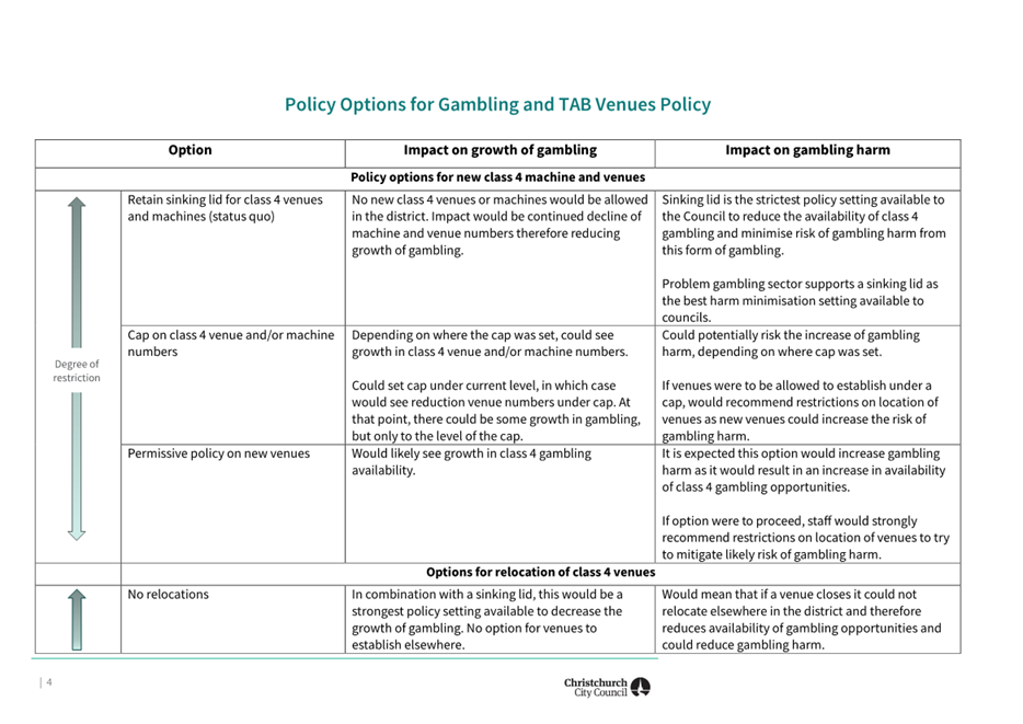
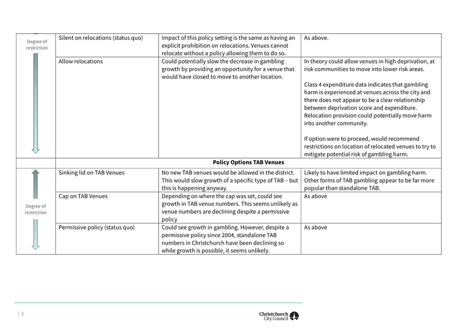
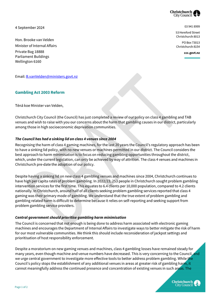
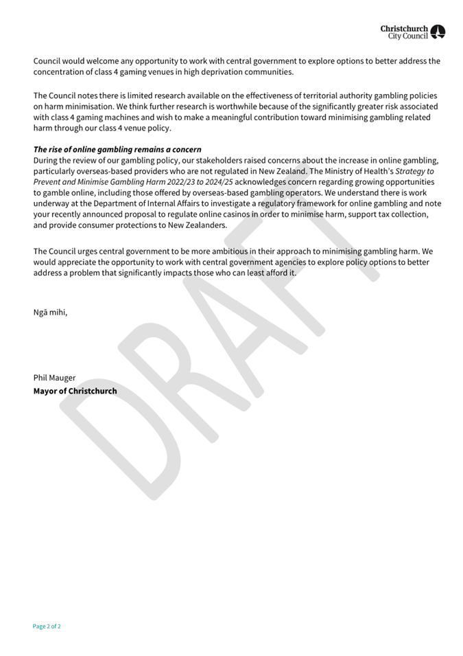
|
9. Review
of the Dog Control Policy 2016 and Dog Control Bylaw 2016
|
|
Reference Te Tohutoro:
|
24/796262
|
|
Responsible Officer(s) Te Pou Matua:
|
Teena
Crocker, Senior Policy Analyst
Lionel Bridger, Manager Animal Services
Andrew Campbell, Legal Counsel
|
|
Accountable ELT Member Pouwhakarae:
|
John
Higgins, General Manager Strategy, Planning & Regulatory Services
|
1. Purpose and Origin of the Report Te Pūtake Pūrongo
1.1 The
purpose of this report is to set out the review of the Council’s Dog
Control Policy 2016 and Dog Control Bylaw 2016 and to seek Council’s
agreement to go out for public consultation on proposed improvements arising
from the review.
1.2 The
review has been undertaken to comply with legislative requirements. In summary:
· every council must have a policy on dogs and a bylaw to enforce it;
· legislation requires that bylaws are reviewed at least once every
ten years;
· a dog control policy must be reviewed when a dog control bylaw is
reviewed;
· the Local Government Act 2002 (LGA) and the Dog Control Act 1996 set
out the requirements for the review, and for the scope of the bylaw and policy;
· the LGA requires that certain formal bylaw determinations are made
(these are reflected in the recommendations);
· consultation must be undertaken, whether any changes are proposed or
not;
· the special consultative procedure must be used, regardless of the
level of significance;
· all registered dog owners must be notified of the proposed changes;
and
· the statement of proposal prepared for consultation must include
certain things.
2. Officer
Recommendations Ngā Tūtohu
That
the Council:
1. Receives the information in the Review of
the Dog Control Policy 2016 and Dog Control Bylaw 2016 report and its
attachments.
2. Notes that the decisions in this report are assessed as medium
significance based on the Council’s Significance and Engagement Policy
and that the Dog Control Act 1996 requires consultation to be undertaken using
the Special Consultative Procedure.
3. Agrees that the proposed changes to the Dog Control Policy 2016 in Attachment
C of this report meet the requirements of section 10 of the Dog Control
Act 1996.
4. Determines, in accordance with section 155 of the Local Government
Act 2002, that the Dog Control Bylaw 2016 (incorporating the changes in
Attachment D of this report and based on the assessment in Attachment A of this
report):
a. is the most appropriate way of addressing the identified dog control
problems in the district;
b. is the most appropriate form of bylaw; and
c. does not give rise to any New Zealand Bill of Rights Act
implications.
5. Agrees to undertake a Special Consultative Procedure in relation to
the proposed changes to the Dog Control Bylaw 2016 and Dog Control Policy 2016 to
seek the community’s views, as required by sections 83 and 86 of the
Local Government Act 2002 and section 10(1) and 20(2) of the Dog Control Act
1996, and that the form of the consultation will comply with section 160 of the
Local Government Act 2002.
3. Executive Summary Te Whakarāpopoto Matua
3.1 This
report and its attachments present a review of:
· the Christchurch
City Council Dog Control Policy 2016 (the policy)
· the Christchurch
City Council Dog Control Bylaw 2016 (the bylaw).
3.2 The
policy and bylaw work together to impose reasonable regulatory controls on dogs
and their owners to minimise the danger, distress or nuisance that may be
caused by dogs, and to balance this by enabling appropriate recreational access
for dogs and their owners. The policy sets out how the Council will meet its
regulatory obligations under the Dog Control Act.
3.3 The
policy and bylaw have generally been working well since they were last reviewed
and adopted in 2016. Undertaking a review enables the Council to respond to
changes in the district and to meet its legislative obligations.
3.4 The
legal considerations section of this report sets out important detail about the
Council’s use of regulatory power in making this kind of policy and
bylaw. The key legislation requiring the council to have a policy and
bylaw, setting the scope of regulation, requiring the review, setting out the
nature of the review, and the consultation requirements after a review, are:
· the Dog
Control Act 1996 (the Act)
· the Local
Government Act 2002 (the LGA).
3.5 The
analysis of issues, options and proposed improvements are set out in more
detail in the attachments to this report. In summary, the review recommends
proposed changes based on:
· better control of dogs in public places;
· better protecting wildlife from dogs in key areas;
· continuing to provide a wide range of opportunities for people to
exercise their dogs on and off-leash;
· protecting areas for cultural reasons (eg wāhi tapu,
rongoā areas); and
· simplifying and updating the rules so they are easier to understand.
3.6 Christchurch
has one of the highest dog ownership rates in New Zealand, with over 37,000
registered dog owners and almost 45,000 registered dogs. Many people consider
their dogs to be part of the family, and there has historically been a high
degree of interest in dog control regulation, particularly where dogs can and
cannot be taken. In contrast, many people have concerns about dogs and the
potential negative impacts they can have. The proposed bylaw and policy seek to
find a balance between these views.
4. Background/Context Te Horopaki
4.1 The Act places obligations
on dog owners and on councils. It requires councils to regulate to ensure dogs
are well controlled in public places, that people feel safe, and that the
recreational needs of dogs can be met. The Act requires that when a council is
considering a dog control policy, it “must have regard to” the
following:
· the need to minimise danger, distress, and nuisance to the community
generally; and
· the need to avoid the inherent danger in allowing dogs to have
uncontrolled access to public places that are frequented by children, whether
or not the children are accompanied by adults; and
· the importance of enabling, to the extent that is practicable, the
public (including families) to use streets and public amenities without fear of
attack or intimidation by dogs; and
· the exercise and recreational needs of dogs and their owners.
4.2 The
bylaw then must give effect to the policy, making the dog controls enforceable.
A breach of a dog control bylaw can result in a $300 infringement fine (an
amount set in the Act).
4.3 We have 5,000 more dogs than when the policy and bylaw were last
reviewed in 2016. With almost 45,000 dogs, this equates to one dog for every
nine people. We also have an extraordinary network of parks and greenspace, a
long stretch of accessible coastline, and some important waterways, wetlands
and estuaries.
4.4 The
review has involved substantial cross-Council work to review the leashed and
prohibited areas in the policy, and any new or changed areas that may require
regulation, including with:
· the Animal Management Team (responsible for dog control in the
district);
· the Parks Unit (including staff from the biodiversity, garden parks,
community parks, metropolitan parks, regional parks, residential red zone,
planning and asset management, parks recreation planning, sports turf, and
visitor experience teams); and
· stormwater and waterways staff (including landscape planning and
asset planning).
4.5 The
review and proposed changes have been based on information including:
· dog control activities in the district (complaints, issues, trends,
data);
· advice from Council staff about land management, changing habitats,
priority wildlife protection areas, community access and dog behaviour;
· the strategic priorities of the Council (especially protecting
biodiversity), and recent Long-Term Plan investment in land and water
management; and
· any relevant trending national issues and the approaches of other
councils.
4.6 The
review has examined any areas or activities that might need special protections
or controls, and has focused on simplifying the rules and futureproofing them
where possible.
4.7 Key
areas for change have arisen from:
· changing landscapes and habitats, including to coastal wetlands and
estuaries, and new and restored wetlands and waterways;
· Te Ihutai Avon Heathcote Estuary being internationally recognised as
part of the East Asian-Australasian Flyway (EAAF) network, supporting
threatened and at-risk migratory birds of national and international
importance;[8]
· the Council’s strategic priority of protecting biodiversity,
and ongoing investment in habitat and ecological restoration; and
· the changing ways in which people use public spaces and the
activities of dogs and their owners.
4.8 The following related information session/workshops have taken
place:
|
Date
|
Subject
|
|
February
-March 2024
|
All community boards were briefed earlier
in 2024 and were able to give early input into the review (see community
views section, below):
o Waihoro
Spreydon-Cashmere-Heathcote, 22 February
o Waimāero
Fendalton-Waimairi-Harewood, 26 February
o Waipapa
Papanui-Innes-Central, 29 February
o Waitai
Coastal-Burwood-Linwood, 11 March
o Te
Pātaka o Rākaihautū Banks Peninsula, 25 March
o Waipuna
Halswell-Hornby-Riccarton, 28 March
|
|
3
September 2024
|
The Council received an information
session on the Dog Control Act, the Council’s current dog control
policy and bylaw, the review, and the results of the early engagement survey
|
Options Considered Ngā
Kōwhiringa Whaiwhakaaro
4.9 Legislation
requires bylaws to be periodically reviewed. When a dog control bylaw is
reviewed, a dog control policy must be reviewed. If no changes are proposed,
consultation must still be undertaken.
On this basis, the following reasonably practicable options were considered:
· update and improve the policy and bylaw (and consult on the proposed
changes)
· retain the policy and bylaw with no changes (and consult).
4.10 The
preferred option is to update and improve the policy and bylaw. The attached review report explores the options and
matters that were considered for how best to update and improve the policy and
bylaw in more detail.
Options Descriptions Ngā
Kōwhiringa
4.11 Preferred
Option: Update and improve the policy and bylaw
4.12 Option
Description: Legislation requires a review, and there are some matters that
need to be updated since the bylaw and policy were last reviewed in 2016.
4.12.1 Option Advantages
· Complies with legislative requirements and will ensure the bylaw and
policy are up to date and fit for purpose
· There have been changes to some land that the Council manages since
the last review, including the transfer of the former residential red zone and
development of new engineered stormwater basins
· Some of our communities have been asking for the policy and bylaw to
be updated
· There are changing views towards better protecting wildlife from
dogs
· The district has over 5,000 more dogs than the last review (almost
45,000 dogs)
· Consultation on the proposed changes will enable us to check in with
our communities to see if the level of dog regulation is appropriate
· There are identified improvements that we can make.
4.12.2 Option Disadvantages
· None. Legislation requires the review and requires consultation,
whether any changes are proposed or not.
4.13 Option
Description: Retain the policy and bylaw with no
changes
4.13.1 Option Advantages
· None, other than reduced staff time.
4.13.2 Option Disadvantages
· Legislation requires a review, and the review has revealed some
areas where updates are needed or where current settings are out of step. Not
proposing any changes, updates or improvements would be a missed opportunity.
Analysis Criteria Ngā Paearu Wetekina
4.14 Bylaws
are governed by the Local Government Act, and there are special analysis
requirements for bylaw reviews (including section 155 of the LGA). Much of the
analysis of issues, options and proposed improvements are set out in the
attached documents, including:
|
Attachment
|
Title
|
Purpose
|
|
Attachment A
|
Bylaw and Policy Review Report
|
Contains the section 155 assessment. Includes dog-related statistics,
enforcement data, information on evidence-based policy making, analysis of
the status quo and reasoning for the proposed changes
|
|
Attachment B
|
Bylaw clause-by-clause analysis
|
Sets out the bylaw changes and reasoning in detail
|
|
Attachment C
|
Proposed changes to the Dog Control Policy
|
Shows the full policy wording, with changes shown (and reasons for
changes)
Shows the proposed changes to leashed and prohibited areas (see the Schedule
1 tables in the policy)
|
|
Attachment D
|
Proposed changes to the Dog Control Bylaw
|
Shows full bylaw wording, with changes shown (and reasons for
changes)
|
|
Attachment E
|
Statement of proposal
|
Summarises changes for public consultation.
Required by section 86 of the Local Government Act - special consultative
procedure
|
5. Summary of proposed changes to leashed and prohibited areas
5.1 The
relationship between a dog control policy and a dog control bylaw is set out in
the Dog Control Act. The policy is the primary document, which leads to the
bylaw. For this reason, there is some duplication in content between the two
regulatory documents.
5.2 The
changes to the leashed and prohibited areas are listed in the Dog Control
Policy. The policy’s schedule contains tables listing the specific
leashed and prohibited areas. The policy also contains general prohibited areas
and leashed areas – these are where the rule always applies eg in all
playgrounds. These are then enforceable through the bylaw.
5.3 For
the full proposed changes and the reasons for the changes, in context, see the
attached bylaw and policy. For broader analysis, see the Bylaw and Policy
Review Report.
Top five changes likely to be of the
highest public interest
5.4 The
top five changes likely to be of the highest public interest are:
· the proposal to require dogs to be on a short leash on footpaths,
shared paths and tracks in all greenspace areas where dogs are allowed
(this includes parks, reserves and stormwater assets that function as parks),
so they are safer for everyone;
· the proposal to regulate the Ōtākaro Avon River
Corridor (former red zone) by prohibiting dogs in key areas to protect
wildlife (river, wetland and planted areas), while continuing to allow dogs off-leash
and under effective control on mown grass (noting that pathways would come
under the general leashed rule);
· the proposal to prohibit dogs from Te
Ihutai Avon Heathcote Estuary to protect wildlife from the landward
boundary inwards – including along the shoreline where birds nest and in
tidal areas where they feed. People could continue to walk dogs on land nearby,
including along the western edge of Southshore Spit, or on Te Ara Ihutai
Christchurch Coastal Pathway;
· the proposal to regulate stormwater basins like Te Kuru
Wetland, by prohibiting dogs in key areas to protect wildlife (wetland and
planted areas), while continuing to allow dogs off-leash and under effective
control on mown grass (noting that pathways would come under the general
leashed rule); and
· the proposal to limit the number of dogs one person can be in
control of in a public place (to two when unleashed and four when leashed),
with an exemption process for people with appropriate skills to apply to
control a greater number of dogs in public places.
5.5 We
asked some general questions about these issues in a recent survey and they
were largely well supported (see the Community Views section below).
5.6 The
changes to the Ōtākaro Avon River Corridor align with changes being
proposed to protect wildlife in other greenspace areas with a wetland or
waterway focus, including Blakes Road Wetland; Curletts Drainage Reserve;
Dickeys Reserve; Clare Park; Creamery Ponds; Quaifes Road Springlands; Quaifes
Drainage Reserve; Sparks Wetland; Te Kuru Wetland; and Worsley Valley 1
Drainage Reserve.
5.7 The
changes to Te Ihutai Avon Heathcote Estuary align with changes being proposed
to protect wildlife in new coastal wetland and mudflat areas, including Brooklands
red zone; Lower Styx Conservation Reserve; Bridge Reserve; South New Brighton
Park; Ferrymead Regional Park; and Sumner Beach Regional Park. We have proposed
similar areas around Banks Peninsula, see coverage below.
5.8 We
have proposed changes to existing entries for consistency and
clarification for other coastal wetland or mudflat areas including: Teddington
mudflats; Duvauchelle foreshore entries; Brooklands Spit and Lagoon, and
Seafield Park entries; Te Rauakaaka Nature Reserve; Styx Rivermouth
Conservation Reserve; Lower Avon and Bexley Saltmarshes; Southshore Spit
Reserve; and Te Huingi Manu Wildlife Refuge.
Other
changes likely to be of reasonable public interest
5.9 The
other changes likely to be of reasonable public interest are:
· the proposal to lift the leashing requirement in the central city
in three key greenspace areas to enable dogs to be exercised off leash and
under effective control (Latimer Square, Rauora Park and on the grassed area in
the Avon Loop);
· the proposal to change the Groynes to leashed (excluding the
dog park);
· the proposal to lift the leashing requirement on Lyttelton
Recreation Ground to enable a flat space for people to exercise dogs
(noting the proposed rule on sports fields, below);
· new general requirements to leash dogs on sports fields
(during games and practice sessions), on wharves, jetties and boardwalks,
and in community gardens; and
· the proposal to prohibit dogs from the Styx Mill Conservation
Reserve to better protect wildlife (except in and near the dog park, and
the path around the predator fence);
· the proposal to prohibit dogs from mudflats and other key wildlife
habitats around Banks Peninsula, including Children’s Bay mudflats
and foreshore (Akaroa), Robinson’s Bay mudflats and foreshore;
Barry’s Bay mudflats, saltmarsh and foreshore; French Farm mudflats and
foreshore; Charteris Bay foreshore (part of); Purau foreshore and mudflats; and
Birdlings Flat near the Bossu Road canal bridge;
· protecting areas for cultural reasons with new restrictions for Ōnawe Pā Historic Reserve (wāhi tapu);
Kaputone Confluence Conservation Park (rongoā / medicinal garden area);
and Janet Stewart Reserve (pa harakeke traditional flax harvesting area); and
· some changes to what under effective control means, to ensure
any dog owner or person in control of a dog in a public place is more actively
paying attention to the dog.
5.10 The
policy regulates more broadly than just leashed and prohibited areas. The
following changes are proposed in the policy and are reflected proposed changes
to the bylaw, where appropriate (see the attached policy and bylaw for more
context):
· clarifying that compostable or biodegradable bags can be used to
pick up after dogs (not just plastic bags), and an explanatory note that dog
faeces should always be disposed of in a rubbish bin or Council red wheelie bin
and cannot be composted through the green waste system, along with a note that dog
faeces that is left on the ground can contaminate waterways; and
· adding a statement that dog owners should not rely on signage, but
should be familiar with the policy – and that the Council provides an
interactive online map where people can check the dog control status.
5.11 We
are proposing:
· some minor administrative changes to simplify dog registration;
responsible dog owner status; and to the licence to own more than two dogs; and
· a minor change to make it administratively easier for the Council to
create new dog parks or dog exercise areas (and added the new Dog Exercise Area
in Little River to the policy).
5.12 For
full analysis of the changes, see the attached Bylaw and Policy Review Report.
For the specific wording changes and reasoning, see the attached Dog Control
Policy 2024.
6. Financial Implications Ngā Hīraunga Rauemi
Capex/Opex Ngā Utu Whakahaere
6.1 The
main costs from changes to the policy relate to updating the Council’s
online interactive dog control map, updating the Council’s website
information, installing new or updating existing signage, and undertaking
communication with dog owners and the general public on any new or changed
rules.
6.2 Many
of these costs are difficult to quantify until the changes to the policy and
bylaw are confirmed. While many are business-as-usual costs or anticipated
costs, major changes to the areas regulated in the policy will require new
signs to be installed. There are no legally prescribed requirements about dog
control signage, but we know that signs help people to understand the rules.
6.3 Dog
control activities are funded from dog registration fees, including compliance
and enforcement activities. Signs installed in parks and reserves come from the
Parks budget, with some funding from the Animal Management Unit.
7. Considerations Ngā Whai Whakaaro
Risks and Mitigations Ngā
Mōrearea me ngā Whakamātautau
7.1 Undertaking
a review of the bylaw and policy complies with legislative requirements, and is
necessary for good regulatory stewardship to ensure they are up to date and fit
for purpose.
7.2 The
proposed changes will provide better protections for wildlife (by prohibiting
dogs or requiring leashing in specified areas) and better protection for both
the public and other dogs (by increasing where dogs must be leashed, such as on
pathways).
7.3 Dog
owners may be unsatisfied with having to limit where they can take their dogs
or with having to leash them in new areas. Conversely, survey feedback suggests
dog owners want other dogs in public places to be better controlled (to protect
their own dogs) and are accepting of limits in some areas to better protect
wildlife. Some of the proposals prohibit dogs from areas that are unsuitable or
undesirable for recreation, such as in wetlands, mudflats and saltmarshes.
Regulation is necessary to prevent owners walking around the margins and
letting their dog(s) run free, not realising this can be damaging to wildlife.
7.4 Dog
owners may not know the current rules, so may assume greater restrictions are
being imposed than are being proposed. They may not be aware of where they can
take their dog (for example, some people assume the only off-leash areas are
dog parks or exercise areas).
7.5 A
key message is that any area not specified as leashed or prohibited (or
regulated by a general rule)
is an under effective control area – meaning dogs can be exercised
off-leash. We only limit access where necessary (the reason for each limitation
is set out in the policy schedule). Some councils require leashing in all
public places, by default.
|
Our approach
|
Apply dog
rules in specified areas
|
Allow dogs to be exercised off-leash in any area not specified
|
|
Alternative approach
|
Require leashing in all areas
Specify prohibited areas
|
Allow dogs to be exercised off-leash only in specified areas
|
7.6 There
is a danger that over time the areas regulated become increasingly numerous and
complex. An alternative approach would be to require leashing in all public
places, by default, and to only allow dogs to be exercised off-leash in
specified places. The downsides of this approach are that it would be more
limiting in effect than the approach we currently take, and the specified areas
for exercising dogs could become similarly numerous and complex.
7.7 Despite
having many areas specified as leashed or prohibited, much of the public land
in the district is not subject to specific controls.
7.8 As
the dog population increases, the social licence enjoyed by dog owners and
their access to public spaces may be threatened, unless good dog behaviour is
maintained. This includes things like picking up after dogs and appropriately
disposing faeces, keeping dogs under good control, and understanding and
following the leashing and prohibited rules.
7.9 Some
risk of opposition to the proposed changes has been mitigated by undertaking a
survey to gauge the views of both dog owners and the general public on some
early ideas as part of the review and development process (see later section on
Community Views).
Legal Considerations Ngā
Hīraunga ā-Ture
7.10 Statutory
and/or delegated authority to undertake proposals in the report:
· The statutory authority to undertake the review of the
Council’s Dog Control Policy and Dog Control Bylaw comes from both the
Dog Control Act 1996 and the Local Government Act 2002.
· The Council is required under the Dog Control Act to have a policy
in respect of dogs in its district. The Council must make any necessary bylaws
in order to give effect to the policy.
· Any bylaw authorised by the Dog Control Act must be made in
accordance with the Local Government Act.
· Under the Local Government Act, a new bylaw must be reviewed within
five years of being made, and then subsequently reviewed within ten years after
the date of any previous review. The Dog Control Bylaw 2016 is an amended
version of the Dog Control Bylaw 2008 and therefore the statutory deadline is
within ten years of the last review.
· Section 10AA(2) of the Dog Control Act provides that the Council
must review the bylaw by making the determinations required under section 155
of the Local Government Act 2002 in the context of a reconsideration of the
matters in section 10(4) of the Dog Control Act. Only the Council can
make these determinations and this authority cannot be delegated. The
section 155 report is attached to this report (see the Bylaw and Policy Review
Report).
· Section 10AA also outlines the processes that must be followed after
the review has been completed. If the Council considers that the bylaw
should be amended, revoked, or revoked and replaced, it must deal with the
bylaw under section 156 of the Local Government Act (relating to consultation
requirements) and if appropriate amend its policy. If the
Council considers that the bylaw should continue without amendment, it must use
the special consultative procedure as set out in section 83 of the Local
Government Act.
· The Dog Control Act requires the Council to review its policy if the
bylaw implementing the policy requires review. Section 10 of the Dog Control
Act allows the Council, in accordance with the special consultative procedure,
to adopt an amended policy at any time.
· The regulatory scope and requirements are set out in section 10 of
the Act for dog control policies, and section 20 for dog control bylaws.
· Section 10(2) of the Dog Control Act requires that the Council give
notice of any draft policy to all registered dog owners.
· As the bylaw is made under the authority of two Acts, the
requirements of both must be considered. The bylaw must be made
using the processes set out in the Local Government Act and may be made to
address a range of matters set out in section 20 of the Dog Control Act. As the
policy must be reviewed when the bylaw is reviewed, it is recommended that the
Council use the special consultative procedure for both the policy and the
bylaw, and that these processes be conducted concurrently.
· Section 83 of the Local Government Act requires that a Statement of
Proposal be prepared and adopted as part of the Special Consultative
Procedure. Accordingly, a Statement of Proposal has been attached to this
report.
Local Government Act section 155
analysis determination regarding the bylaw
7.11 As
outlined above, the review of the bylaw requires a section 155 analysis under
the Local Government Act. This analysis involves a determination of whether or
not a bylaw is the most appropriate way of addressing a perceived problem. If
it is identified as being the most appropriate way of addressing a problem, the
Council must decide whether the bylaw is the most appropriate form of bylaw,
and whether or not the bylaw gives rise to any implications under the New
Zealand Bill of Rights Act 1990 (NZBoRA). A section 155 report is
attached which details the above considerations.
7.12 The
NZBoRA protects certain rights and freedoms, including freedom of movement.
Section 5 of the NZBoRA allows limitations to these rights where a limitation
can be demonstrably justified in a free and democratic society.
7.13 The
attached Bylaw and Policy Review Report contains the section 155 analysis and
concludes that:
· The bylaw is appropriate for addressing the identified issues with
dog control in the district. Improvements are proposed in response to changes
in the district.
· The proposed changes to the bylaw are appropriate in form.
· The Dog Control Act expressly allows councils to develop bylaws that
restrict access to specified public places for the purposes of dog control.
Given that restrictions are permitted, a corresponding restriction on freedom
of movement (if any) can be understood as a reasonable and justified limitation.
In summary, there are no NZBoRA implications relating to the activities
regulated in the Dog Control Bylaw.
7.14 In
addition to the specific statutory requirements above, the law requires that
any bylaw must be intra vires (within the statutory powers that
authorise the bylaw), certain and reasonable. There is a considerable body of
case law on ‘reasonableness’ in the bylaw context. The Courts have
noted that in ascertaining the reasonableness of a bylaw, they will look to the
surrounding facts, including the nature and condition of the locality in which
it is to take effect, the problem it seeks to solve or proposes to remedy, and
whether public or private rights are unnecessarily or unjustly affected.
7.15 The
Act requires councils, in their dog control policies, to minimise danger,
distress, and nuisance to the community from dogs, and to enable the community
to access public amenities without fear of attack or intimidation by dogs. This means that the
overall sense of community safety and how people feel in public places is
relevant, not just reported incidents.
7.16 The
Act has broad bylaw-making powers. It includes a power to regulate “for
any other purpose that… is, in the opinion of the territorial authority,
necessary or desirable to further the control of dogs.” On this basis, the
dog control policy and bylaw focus on wildlife, biodiversity and habitat
protection, which has strong alignment with other work the Council is doing.
7.17 We
have considered both the section 155 analysis, as well as the proposed changes
to the bylaw and policy. It is our view that the proposed changes to the bylaw
and policy are within the authorising provisions of the Dog Control Act and the
Local Government Act; that the proposed amendments to the bylaw are not
inconsistent with the proposed amendments to the policy; and that the attached
report shows how the Council has considered its section 155 obligations for the
purposes of both the review of the policy and the bylaw.
7.18 The
recommendations in this report reflect that the requirements in sections 10 and
10AA of the Dog Control Act and sections 155 and 159 of the Local Government
Act have been met.
8. Strategy and Policy Considerations Te Whai Kaupapa here
8.1 Updating
and consulting on a replacement dog control policy and bylaw aligns with the Christchurch
City Council’s Strategic Framework, including the community outcomes:
· Collaborative and confident (Our residents have the opportunity
to actively participate in community and city life, have a strong sense of
belonging and identify, and feel safe)
· Green and liveable (Our neighbourhoods and communities are
accessible and well-connected, supporting our goals to…protect and
regenerate the environment, especially our biodiversity…).
8.2 Updating
and consulting on a replacement dog control policy and bylaw is of medium significance, based on the
Council’s Significance
and Engagement Policy.
· The level of significance was determined by the widespread nature of dog access to public places
across the district and our relatively high dog ownership rate - meaning
potentially widespread interest and impacts. The Dog Control Act requires the
use of the special consultative procedure (regardless of the level of
significance), and that every registered dog owner is notified (over 39,000
people).
8.3 Updating
and consulting on a replacement dog control policy and bylaw is consistent with
Council’s Plans and Policies, and ensures they are up to date and fit for
purpose.
8.3.1 This report supports the Council's
Long Term Plan (2024 - 2034):
· Strategic
Planning and Policy
· Activity:
Strategic Policy and Resilience
· Level
of Service: 17.0.19.4 Bylaws and regulatory policies meet emerging needs
and satisfy statutory requirements - Carry out bylaw reviews in accordance with
ten-year bylaw review schedule and statutory requirements
8.4 The
approach to dog control enforcement aligns with the Council’s Compliance
Strategy, which sets out a high-level approach to regulatory compliance
activities. This targets resources and interventions to achieve the best
possible outcomes for the community and the environment.
8.5 The
review has considered the Council’s approach to the protection and
enhancement of local biodiversity set out in its Biodiversity
Strategy 2008-2035 and in the Urban
Forest Plan.
It has considered how dogs may negatively impact on biodiversity outcomes, and
proposed reasonable limits where necessary.
8.6 We
have also considered the following Long-Term Plan 2024-34 Activity Plans,
particularly in relation to changing land and water management, habitat and
biodiversity outcomes, and recreational access, including:
· Ōtākaro
Avon River Corridor (OARC) – the regeneration plan, restoration of
the delta landscape, ongoing ecological and habitat restoration programme,
wetland and aquatic habitats, increasing local biodiversity, recreational
activities, mahinga kai, pest management, stormwater and flood management;
· Parks
and Foreshore – activities and aspirations for community parks,
cemeteries, inner city parks, regional parks, residential red zone, foreshore
and marine access;
· Stormwater
Drainage and Flood
Protection and Control Works – naturalised waterways and green
assets; improving our landscapes and biodiversity; treatment swales, wetlands
and basins; water quality in our waterways, wetlands and estuaries; greening of
our infrastructure; nature based design; and water sensitive urban design; and
· Recreation,
Sports, Community Arts and Events - active recreation creates
happier, healthier people, better connected communities and a stronger
Christchurch.
9. Community Impacts and Views Ngā Mariu ā-Hāpori
9.1 This
report seeks agreement to consult on the proposed changes to the dog control
policy and bylaw and a result of their review. Legislation requires the use of
the Special Consultative Procedure, which will seek the views of the community.
The attached Bylaw and Policy Review Report explores the options and matters that
were considered for how best to update and improve the policy and bylaw in more
detail.
9.2 The
decision affects the following wards/Community Board areas: All.
· Staff presented to community boards between February and April 2024 to
seek early input into the review, giving members the opportunity to raise any
concerns or make any suggestions about how to update or improve the bylaw or
policy.
9.3 There
was general support for the need to undertake the review to update dog controls
in the district, plenty of questions about the current rules, and recognition
of the known issues and direction (including better protecting wildlife in the
estuary, former red zone and engineered stormwater basins).
9.4 Staff
sought some initial feedback from the public via an online survey in July
2024. Over 6,000 responses were received, 84% of whom identified themselves as
a dog owner. The survey is covered in more detail in the attached Bylaw and
Policy Review Report, but in summary:
|
Question summary
|
|
Yes
|
No
|
Not sure
|
|
Requiring a leash
|
|
|
|
|
|
On shared paths?
|

|
76% yes
|
20% no
|
4% not sure
|
|
On footpaths in parks and reserves?
|
|
57% yes
|
38% no
|
5% not sure
|
|
On formed tracks in parks and reserves?
|

|
44% yes
|
49% no
|
7% not sure
|
|
Better wildlife protections
|
|
|
|
|
|
In the Avon Heathcote Estuary Te Ihutai?
|
|
77% yes
|
12% no
|
11% not sure
|
|
In the Ōtākaro Avon River Corridor (former Red
Zone)?
|
|
69% yes
|
19% no
|
12% not sure
|
|
In engineered wetlands (stormwater basins)?
|
|
64% yes
|
24% no
|
12% not sure
|
|
Owner/caretaker
responsibilities
|
|
|
|
|
|
Short leash on roads, footpaths (roadside and in parks), on
shared paths, and on formed tracks?
|
|
51% yes
|
42% no
|
8% not sure
|
|
Change the definition of 'under effective control' to make
it easier to understand?
|
|
54% yes
|
38% no
|
9% not sure
|
|
Limit the number of dogs a person can manage in a public
place?
|
|
48% yes
|
37% no
|
15% not sure
|
|
Leashing in community spaces
|
|
|
|
|
|
On sports fields during games and practice sessions?
|
|
80% yes
|
15% no
|
5% not sure
|
|
At community gardens?
|
|
72% yes
|
17% no
|
11% not sure
|
|
On jetties and wharves?
|
|
72% yes
|
19% no
|
9% not sure
|
9.5 The question about leashing on formed tracks was the only negative
majority response. It may indicate a misunderstanding of the current rules, as
most formed tracks tend to have a leashing requirement in the current policy
(eg in the Port Hills).
9.6 When asked if we
should limit the number of dogs a person should be able to be in charge of in a
public place, 48% of people said yes (37% said no and 15% were not sure). When
asked what the limit should be, we received the following responses, on average:
|
What should the limit be?
|
|
|
Maximum number of dogs when leashed
|
Three to four dogs
|
|
Maximum number of dogs when off-leash
|
Two to three dogs
|
9.7 In
the recent Life
in Christchurch Survey, a public safety theme emerged in relation to dogs.
In response to questions about negative experiences in playgrounds and
associated parks spaces, people indicated not feeling safe around dogs, dogs
not being well controlled, aggressive dogs, and people
not picking up after their dogs.
9.8 Staff
also met with two groups to discuss the review:
· the Avon-Heathcote Estuary Ihutai Trust to discuss the protection of
migratory birds from dogs in Te Ihutai Avon Heathcote Estuary; and
· a small group of professional dog walkers to discuss the limit on
how many dogs one person can be in charge of in a public place, and the
proposed exemption process.
10. Impact on Mana Whenua Ngā Whai Take Mana Whenua
10.1 The
decisions in this report do not involve a significant decision in relation to
ancestral land or a body of water or other elements of intrinsic value. The
decisions may involve a matter of interest to Mana Whenua and will not impact
on our agreed partnership priorities with Ngā Papatipu Rūnanga.
10.2 There
are some areas already in the dog control policy where dogs are prohibited at
the request of rūnanga. For example, Takapūneke Reserve (in Akaroa)
and Rāpaki Bay foreshore (near Lyttelton).
10.3 A
new prohibited area is being proposed for Ōnawe Pā Historic Reserve
(between Barry’s Bay and Duvauchelle). Ōnawe is held and
administered by Te Rūnanga o Ngāi Tahu and is publicly accessible. A
draft reserve management plan is underway.
It outlines tikanga and kawa set jointly by Ōnuku and Wairewa
Rūnanga, which identifies dog access as incompatible with the land’s
wāhi tapu status. To support this approach, the dog control policy
proposes prohibiting dogs.
10.4 There
are two other areas we are proposing that dogs are prohibited to protect
cultural values – one is the Kaputone Confluence Conservation Area, which
contains a rongoā Māori demonstration area, and the other is Janet
Stewart Reserve, which contains a pa harakeke traditional flax harvesting area.
Both of these are in the Lower Styx area, either side of Marshland Road.
11. Climate Change Impact Considerations Ngā Whai Whakaaro mā
te Āhuarangi
11.1 The
proposals in this report are likely to have very little impact on adaptation to
the impacts of climate change or emissions reductions.
11.2 Any
changes are unlikely to significantly impact the number of dogs in the
district. There may be an impact on where dog owners choose to exercise their
dogs, but whether this increases or decreases vehicle emissions is not clear.
11.3 Climate
change is having an effect on our biodiversity and habitats, and the proposed
changes seek to reduce the negative impacts from dogs in priority wildlife
protection areas.
12. Next Steps Ngā Mahinga ā-muri
12.1 If
the Council is comfortable with the proposed changes outlined in this report
and in the attachments, staff will proceed with undertaking a special
consultative procedure to seek the views of the community, including notifying
every registered dog owner, which is required by the Dog Control Act.
12.2 Elected
Members will be invited to form a Hearings Panel, which will provide submitters
with the opportunity to be heard. The Hearings Panel will then make
recommendations to the Council on the final form of the bylaw and policy.
12.3 If
the Council adopts the amended policy and bylaw, the bylaw will then be
enforceable, and will give effect to the policy.
Attachments Ngā Tāpirihanga
|
No.
|
Title
|
Reference
|
Page
|
|
a ⇩
|
Bylaw and
Policy Review Report - Dog Control Policy and Bylaw 2016 - 2024 review
|
24/978879
|
136
|
|
b ⇩
|
Clause-by-clause
analysis - Dog Control Bylaw 2016 - 2024 review
|
24/608222
|
157
|
|
c ⇩
|
Proposed
changes Dog Control Policy (2024) for consultation
|
24/1389798
|
174
|
|
d ⇩
|
Proposed
changes Dog Control Bylaw (2024) for consultation
|
24/1332196
|
217
|
|
e ⇩
|
Statement of
Proposal - Dog Control Policy and Bylaw Review 2024
|
24/1461024
|
229
|
In addition to the attached documents, the following background
information is available:
|
Document
Name – Location / File Link
|
|
Not
applicable
|
Signatories Ngā Kaiwaitohu
|
Authors
|
Teena Crocker
- Senior Policy Analyst
Andrew
Campbell - Legal Counsel
Lionel Bridger
- Manager Animal Services
|
|
Approved By
|
Tracey Weston
- Head of Regulatory Compliance
David
Griffiths - Head of Strategic Policy & Resilience
John Higgins -
General Manager Strategy, Planning & Regulatory Services
|
|
10. Review of
the Parks and Reserves Bylaw 2016
|
|
Reference Te Tohutoro:
|
24/1591022
|
|
Responsible Officer(s) Te Pou Matua:
|
Adam
Eggleton, Senior Policy Analyst
Naomi Soper, Senior Legal Counsel
|
|
Accountable ELT Member Pouwhakarae:
|
Nigel
Cox, Acting General Manager Citizens and Community
|
1. Purpose and Origin of the Report Te Pūtake Pūrongo
1.1 The
purpose of this report is to set out the review of the
Council’s Parks and Reserves Bylaw 2016 and to seek Council’s
agreement to go out to public consultation on the proposed improvements from
the review.
1.2 The
review has been undertaken to comply with legislative requirements that require
bylaws to be reviewed within 10 years. This bylaw was last reviewed in 2016 and
the current review does not propose significant changes.
2. Officer Recommendations Ngā Tūtohu
That the Council:
1. Receives the information in the Review of
the Parks and Reserves Bylaw 2016 Report.
2. Notes that the decision in this report is assessed as low significance
based on the Christchurch City Council’s Significance and Engagement
Policy.
3. Determines, in accordance with the requirements of section 155, of
the Local Government Act 2002, that the Parks and Reserves Bylaw 2016
(incorporating the changes in the proposed Parks and Reserves Bylaw 2024 (Attachment
C of this report), and based on the assessment in the Bylaw Review report (Attachment
A of this report) and the clause-by-clause analysis (Attachment B of this
report):
a) is the most appropriate way of addressing the
identified problems;
b) is the most appropriate form of bylaw; and that
c) the bylaw gives rise to some implications under
the New Zealand Bill of Rights Act 1990, but none that are inconsistent with
that Act, as is the required test.
4. Agrees to undertake public consultation on the proposed changes to
the Parks and Reserves Bylaw 2016 to seek the community’s views, in
accordance with section 156(1)(b) of the Local Government Act 2002.
3. Executive Summary Te Whakarāpopoto Matua
3.1 This
report and its attachments present a review of the Christchurch City Council
Parks and Reserves Bylaw 2016.
3.2 The
bylaw enables the Council to provide for the orderly management and control of
parks and reserves vested in, administered by or under the control of the
Council for the benefit and enjoyment of all users of those parks and reserves.
3.3 The
bylaw has generally been working well since it was last reviewed and adopted in
2016, and staff do not propose any significant changes to it.
3.4 The
bylaw is made under the Local Government Act 2002 (LGA) and the Reserves Act
1977 (RA). It is required to be reviewed now to comply with section 159 of the
LGA, and in accordance with the bylaw review procedure set out in section 160
of the LGA.
3.5 The
analysis of issues, options and proposed improvements are set out in more
detail in the attached documents, including the section 155 assessment required
under the LGA in the Bylaw Review Report.
3.6 It
is recommended that the proposed amended bylaw be approved for public
consultation.
4. Background/Context Te Horopaki
4.1 Parks
and reserves are public places that require particular protection that is
different from other public places. While the Council has management plans
which set the overall direction for the development and use of a park or
reserve, these management plans cannot bind the public to act in accordance
with those statements.
4.2 It
is important that activities in all Council parks and reserves are subject to
reasonable limitations through a bylaw to protect them from damage and also
protect the public legitimate use and enjoyment of those places.
4.3 Many
parks and green spaces under the Council’s control are not reserves under
the RA and the bylaw controls are therefore particularly relevant for those
areas not protected by provisions of the RA.
4.4 The
bylaw has a significant role in authorising the Council to carry out certain
management activities, such as the closure of parks or reserves or control
vehicles in parks or reserves.
4.5 The
review has involved substantial cross council work and has included feedback
from staff from:
· The Parks Unit – (including parks planning and asset
management, regional parks, metropolitan parks, community parks, botanic
gardens and garden parks, and residential red zone).
· Strategic Policy.
· Legal.
4.6 The
review and proposed changes have been based on information and approaches
including:
· Observations, feedback and advice from Council staff about parks
issues, problems, bylaw use and practical enforcement.
· The Council’s community outcomes, in particular protecting and
enhancing biodiversity, and a green liveable city
· Looking at any new developments that might require special controls.
· Simplifying the rules and future proofing them where possible; and
· Any relevant trending national issues and the approaches of other
councils.
4.7 The following related information sessions have taken place for the
members of the meeting:
|
Date
|
Subject
|
|
18
June
|
Combined Community Boards Information
session on the Parks and Reserves bylaw to inform them the review was
underway, the purpose of the bylaw, issues identified to date and to gather any
other views or issues they had at that stage.
|
|
26
August
|
A follow up individual session with the
Banks Peninsula Community Board to gather their views on the bylaw review
progress and to understand issues that were relevant to them.
|
Options Considered Ngā
Kōwhiringa Whaiwhakaaro
4.8 The
following reasonably practicable options were considered and are assessed in
this report:
4.8.1 Update and improve
the bylaw.
4.8.2 Review and retain the
bylaw with no changes.
4.8.3 Do not review the
bylaw.
Options Descriptions Ngā
Kōwhiringa
4.9 Preferred
Option: Update and improve the bylaw
4.9.1 Option
Description: Legislation requires a review, and there are some matters that
need to be updated since the bylaw was last reviewed in 2016.
4.9.2 Option Advantages
· Complies with legislative requirements.
· Will ensure the bylaw is up to date and fit for purpose.
· The bylaw can be improved to address issues that have been
identified since 2016.
· Consultation on the proposed changes will enable us to check in with
our communities to see if there are any issues we need to address.
4.9.3 Option
Disadvantages
· None.
4.10 Option
Description: Review and retain the bylaw with no changes
4.10.1 Option Advantages
· None, other than reduced staff time.
4.10.2 Option Disadvantages
· Misses a chance to make needed improvements and changes to provide
clarity.
· Means some references made within the bylaw to other legislation
will continue to be out of date.
· Means the bylaw will not keep pace with changes in technology and
parks use.
4.11 Option
Description: Do not review the bylaw
4.11.1 Option Advantages
· None, other than reduced staff time.
4.11.2 Option Disadvantages
· The bylaw will eventually be revoked if not reviewed by the
statutory deadline and the Council will lose an effective tool.
· A new bylaw would need to be made should Council wish to provide
similar protections in the future.
Analysis Criteria Ngā Paearu
Wetekina
4.12 Bylaws
made under the LGA have special analysis requirements for bylaw reviews
(including section 155 of the LGA). Detailed analysis of issues, options and
proposed improvements are set out in the attached documents, including:
|
Bylaw review report
Attachment A
|
· Sets out the bylaw-making powers and penalties.
· Describes the activities the bylaw regulates and the issues and
problems that require regulation.
· Sets out proposed changes to the bylaw, and reasons for the
proposed changes.
· Contains the section 155 analysis, including the New Zealand Bill
of Rights Act 1990 assessment.
|
|
Clause-by-clause analysis Attachment B
|
· Contains commentary and staff advice on proposed changes and
reasoning.
|
|
Proposed replacement bylaw Attachment C
|
· Sets out the 2016 bylaw, with the recommended changes incorporated.
· Changes are indicated with a blue background. Detail on the
changes is contained in the clause-by-clause analysis (Attachment B).
|
5. Summary of Proposed Changes
5.1 The
review has considered how the bylaw can best help manage, regulate and protect
parks and reserves from misuse or damage whilst also protecting the public from
nuisance and maintaining public health and safety.
5.2
A summary of the key changes proposed to the bylaw is included below:
5.3 Wider
Bylaw: Terminology across the bylaw has been aligned to refer to
“parks and reserves” throughout instead of just
“reserves” when both are intended to be covered. This change is
intended to make the document clearer to understand without having to refer to
the interpretation section to understand both are covered.
5.4 Introduction:
Updated legislation statement to refer to enabling provisions, amended
definition of Aircraft, Authorised Officer, Vehicle, Park or Reserve and new
definition of Emergency Services.
5.5 Part
1- Access to Parks and Reserves: No changes
5.6 Part
2 – Prohibited and restricted activities in Parks and Reserves:
We now propose:
· Section 7 – Amended clause 7.1 to clarify how the dog bylaw
applies in parks and reserves.
· Section 8 – Inclusion of electric bicycles, electric scooters
and scooters (alongside bicycles) as parking exclusions in clause 8.2.
· Section 8 - Inclusion of vessels and other mechanical devices in
clause 8.4 also being prohibited from being dumped in a park or reserve.
· Section 9 – Amended clause 9.3 to reflect that the
Christchurch City Council Urban Fire Safety Bylaw has been revoked when Fire
and Emergency New Zealand (FENZ) became the responsible agency for managing
fire risk nationally.
· Section 9 – New explanatory note to inform of the role of FENZ
in issuing restriction on fires, fireworks and fire risks and to encourage
residents to use their fire risk web page.
· Section 10 – New explanatory note setting out how camping can
be regulated across the Freedom Camping Bylaw 2021 and the Park and Reserves
Bylaw.
· Section 12 – Inclusion of updated terms lightweight drones or
Remotely Piloted Aircraft Systems in clauses 12.3 and 12.4.
· Section 12 – New explanatory note referring users to check the
Councils guidance and map on areas you can fly drones and Remotely Piloted
Aircraft Systems.
5.7 Part
3 – Special Areas:
We now propose:
· Section 15 – Inclusion of electric bicycles, electric scooters
and scooters (alongside bicycles) as prohibited things to ride in the Botanic
gardens without permission.
5.8 Part
4 – Other Matters:
We now propose:
· New Section 19 – New section on Offence and Penalty. States
that a person who breaches the bylaw could be liable for a penalty as set out
in the RA or LGA (as applicable).
· Section 20 – New clause 20.5 setting out clearly that any
permission given under this bylaw may be reviewed and revoked at any time.
6. Financial Implications Ngā Hīraunga Rauemi
Capex/Opex Ngā Utu Whakahaere
6.1 The
main costs from changes to the bylaw would include updating the Council’s
website information, installing new or updating existing signage, and
undertaking communication with the general public on any new or changed rules.
6.2 Many
of these costs are difficult to quantify until the changes to the bylaw are
confirmed. There are no legal requirements about signage, but we know that
signs help people to understand the rules. Signs installed in parks and
reserves come from the Parks budget.
6.3 There
may be reduced damage and associated costs to parks and reserves with updated
and improved bylaw provisions.
7. Considerations Ngā Whai Whakaaro
Risks and Mitigations Ngā
Mōrearea me ngā Whakamātautau
7.1 The
main risk to the Council in relation to the bylaw review is the risk of
judicial review.
A bylaw (or part of it) can be quashed by the High Court if it is deemed
invalid.
This is a risk for any bylaw the Council makes, and our bylaw review processes
are intended to minimise this risk as much as possible.
7.2 Bylaws
can be challenged by judicial review and in relation to the Bylaws Act
1910. Challenges can be on grounds such as unreasonableness, for being
ultra vires (outside of legal powers) or being repugnant to the laws of New
Zealand.
7.3 This
includes challenges in relation to the New Zealand Bill of Rights Act 1990
(NZBoRA). Section 155 of the LGA states that no bylaw may be made which
is inconsistent with the NZBoRA, noting that section 5 of NZBoRA enables
reasonable limits to be imposed where they are “demonstrably justified in
a free and democratic society”. Section 155(2)(b) of the LGA requires
that a council determines whether the proposed bylaw gives rise to any
implications under the NZBoRA. Assessment of the implications is included
in the attached Bylaw Review Report, and the requirements are reflected in the
recommendations to this report.
7.4 The
bylaw may give rise to implications and limitations on people’s freedom
of expression, freedom of peaceful assembly and freedom of movement under the
NZBoRA. However, our assessment is that any limitations imposed by the bylaw
are the minimum impairment, and the limit is proportional to the overall
objective of the bylaw.
7.5 The
attached documents, particularly the Bylaw Review Report, set out the relevant
matters that have been considered, and confirm that any NZBoRA implications
have been appropriately addressed.
Legal Considerations Ngā
Hīraunga ā-Ture
Statutory and/or
delegated authority to undertake proposals in the report:
7.6 The
Parks and Reserves Bylaw is made using the following bylaw-making powers:
· The LGA – Section 145 and 146 (protecting from nuisance,
keeping public safe and managing and protecting land)
· The RA – Section 106 (control of reserves)
7.7 The
bylaw must be reviewed to comply with section 159 of the LGA (ten-year review
requirement), and in accordance with the bylaw review procedure set out in
section 160 of the LGA (the procedure follows the same process as making a
bylaw).
7.8 Section
155 of the LGA requires that a council makes certain determinations as part of
the bylaw review process. This includes determining that the bylaw is the
most appropriate way of addressing the identified problems, and that is the
most appropriate form of bylaw. It also requires an assessment of the NZBoRA
implications.
7.9 The
review of the Parks and Reserve Bylaw where minimal and non-significant
amendments are proposed to be made is assessed as having a low significance
based on the Christchurch City Council’s Significance and Engagement
Policy. This means that it will follow the consultation requirements set out
under section 156(1b) of the LGA.
7.10 Staff
has considered both the section 155 analysis, as well as the proposed amendments
to the bylaw. It is their view that the amended bylaw is within the
authorising provisions of the RA and the LGA and that the attached section 155
report shows how the Council has considered its section 155 obligations for the
purposes of the bylaw. The recommendations in this report reflect that
the requirements of the RA and sections 155 and 159 of the LGA have been met.
Other Legal Implications:
7.11 The
bylaw is made under two different pieces of legislation, and both can only be
enforced by prosecution. Breaches enforced under the RA are covered in
section 104 of the Act. This states that on conviction a person who commits a
breach is liable to a fine not exceeding $5000 and where an offence continues a
further fine of $500 dollars for every day the offence continues. Breaches
enforced under the LGA are liable on conviction to a fine not exceeding
$20,000.
7.12 Bylaws
made under the RA need to be signed off by the Minister of Conservation before
they are enforceable under the RA. This process will be undertaken following
any future formal approval of the proposed amendments to the bylaw.
Strategy and Policy Considerations Te Whai
Kaupapa here
7.13 Updating
and consulting on an amended Parks and Reserves Bylaw aligns with the Christchurch City Council’s
Strategic Framework:
· Collaborative and confident (Our residents have the opportunity
to actively participate in community and city life, have a strong sense of
belonging and identify, and feel safe)
· Green and liveable (Our neighbourhoods and communities are
accessible and well-connected, supporting our goals to…protect and
regenerate the environment, especially our biodiversity…)
7.14 Updating
and consulting on the proposed amended Parks and Reserves Bylaw is of low significance
based on the Christchurch City Council’s Significance and Engagement
Policy. The level of significance was determined as the bylaw has been
largely working well and the changes and amendments suggested are not
considered to be significant or have a high impact on residents use or
enjoyments of our parks and reserves.
7.15 The
review has taken into account and is consistent with Council’s Plans and
Policies.
7.16 This
report supports the Council's Long Term Plan (2024 -
2034):
7.17 Strategic Planning and Policy
7.17.1 Activity:
Strategic Policy and Resilience
· Level of Service: 17.0.19.4 Bylaws and
regulatory policies meet emerging needs and satisfy statutory requirements -
Carry out bylaw reviews in accordance with ten-year bylaw review schedule and
statutory requirements.
7.18 The
approach to compliance, monitoring and enforcement activities in relation to
the Parks and Reserves Bylaw aligns with the Christchurch City Council
Compliance Strategy, which sets out a high-level approach to regulatory
compliance activities undertaken by the Council. The strategy approaches
compliance activities strategically, targeting resources and interventions in
accordance with a range of risk-based factors to achieve the best possible
outcomes for the community and the environment.
7.19 The
review has considered the Council’s approach to the protection and
enhancement of local biodiversity set out in its Biodiversity
Strategy 2008-2035 and the Urban
Forest Plan. It has considered how the bylaw may also
enable positive biodiversity outcomes.
7.20 As
part of this review we have also considered the agreed approaches in a number
of Long-Term Plan 2024-34 Activity Plans. These have included the Parks
and Foreshore and Recreation,
Sports, Community Arts and Events plans.
Community Impacts and Views Ngā Mariu
ā-Hāpori
7.21 The
report recommends public consultation on the proposed amended Parks and
Reserves Bylaw.
7.22 The
decision affects the following wards/Community Board areas: All
· Staff presented to the Combined Community Boards Information Session
in June to seek early input into the review, giving members the opportunity to
raise concerns or make any suggestions about how to update or improve the
bylaw.
· Staff also presented an individual information session after a
request from the Banks Peninsula Community Board in August and more feedback
was received.
7.23 The Community Boards views received were largely supportive that the
bylaw was an effective tool and that the early areas identified for
improvements would be beneficial.
Impact on Mana Whenua Ngā Whai Take
Mana Whenua
7.24 The
decisions in this report do not involve a significant decision in relation to
ancestral land, a body of water or other elements of intrinsic value, therefore
this decision does not specifically impact Mana Whenua, their culture, and
traditions.
7.25 The
decision does not involve a matter of interest to Mana Whenua and will not impact
on our agreed partnership priorities with Ngā Papatipu Rūnanga.
7.26 The proposed amended bylaw does not propose changes to the current
bylaw that are likely to impact Mana Whenua. When the bylaw was last reviewed
in 2016 extensive consultation was undertaken with Mahaanui Kurataiao prior to
the adoption of the bylaw. Staff are engaging with Mahaanui Kurataiao on the
proposed review to seek any views they may have on the proposed bylaws contents
and changes.
Climate Change Impact Considerations Ngā
Whai Whakaaro mā te Āhuarangi
7.27 The
decisions in this report may have some impact on adaptation to the impacts of
climate change. The bylaw proves an effective tool to manage and protect our
parks (including tools to protect biodiversity on our parks and reserves).
7.28 The
changes suggested to the bylaw will not significantly change these protections
but rather build on the existing protections of the current bylaw.
8. Next Steps Ngā Mahinga ā-muri
8.1 If
the Council is comfortable with the proposed changes outlined in this report
and in the attachments, staff will proceed with undertaking public consultation
to seek the views of the community. All Community Boards will also be invited
to participate.
8.2 Elected
Members will be invited to form a Hearings Panel, which will provide submitters
with the opportunity to be heard. The Hearings Panel can then make
recommendations to the Council on the final form of the bylaw.
8.3 If
the Council is comfortable with the amendment to the bylaw, the Council can
adopt it. Sign off by the Minister of Conservation is also required to be
enforceable under the RA.
Attachments Ngā Tāpirihanga
|
No.
|
Title
|
Reference
|
Page
|
|
a ⇩
|
Bylaw Review
Report - Parks and Reserves Bylaw 2016
|
24/1736963
|
243
|
|
b ⇩
|
Clause by
Clause table - Review of the Parks and Reserves Bylaw 2016
|
24/1736970
|
252
|
|
c ⇩
|
Draft Amended
Parks and Reserves Bylaw 2025
|
24/1736978
|
272
|
In addition to the attached documents, the following background
information is available:
|
Document
Name – Location / File Link
|
|
Not
applicable
|
Signatories Ngā Kaiwaitohu
|
Authors
|
Adam Eggleton
- Senior Policy Analyst
Naomi Soper -
Senior Legal Counsel
|
|
Approved By
|
Rupert Bool -
Acting Head of Parks
David
Griffiths - Head of Strategic Policy & Resilience
Nigel Cox -
Acting General Manager Citizens and Community
|
|
11. Elected
Member Professional Development Policy
|
|
Reference Te Tohutoro:
|
24/1136750
|
|
Responsible Officer(s) Te Pou Matua:
|
David
Corlett, Democratic Services Advisor, Democratic Services
|
|
Accountable ELT Member Pouwhakarae:
|
Helen
White, General Counsel / Head of Legal & Democratic Services
|
1. Purpose and Origin of the Report Te Pūtake Pūrongo
1.1 The
purpose of this report is to seek agreement from the Council to replace section
9 of the Elected Member Allowances and Expenses Policy 2019 with a separate
stand-alone policy document, and to agree revised provisions pertaining to
elected member professional development.
1.2 The
revised provisions acknowledge the need for a more responsive policy, that
better acknowledges the considerable responsibilities that elected members have
and the professional development training needs arising from their roles.
The revised policy also provides an authorisation process in accordance with
recommendations by Audit New Zealand.
1.3 This
report has been prepared following workshops with the Mayor and Councillors on
16 May and 24 September 2024 on elected member professional development.
2. Officer
Recommendations Ngā Tūtohu
That the Council:
1. Receives the Elected Member Professional Development report.
2. Agrees to remove and rescind Section 9 of the Elected Members
Allowances and Expenses Policy 2019 and replace it with a standalone Elected Members Professional Development Policy (refer
to Attachment A of this report).
3. Agrees that:
Either
a. The Mayor and Councillor receive an annual allocation of up to
$6,900.00 for individual professional development.
Or
b. The Mayor and Councillors receive a triennial allocation of up to
$20,700.00 for individual professional development.
4. Agrees that the balance of the Elected Member training budgets of
approximately $43,000 per annum is allocated towards group training and
representative activities.
5. Authorises the General Counsel / Head of Legal & Democratic
Services to make any amendments of minor effect, or to correct minor errors, to
the Elected Members Professional Development Policy.
6. Notes that the decisions in this report are assessed as low
significance based on the Christchurch City Council’s Significance and
Engagement Policy.
3. Executive Summary Te Whakarāpopoto Matua
3.1 This
report sets out proposed amendments to section 9 of the current Elected
Member Allowances and Expenses Policy 2019 and set it up as a separate
standalone policy document.
3.2 Section
9 covers the entitlement of elected members to allowances and contributions
towards conferences, courses, training, professional development and associated
travel.
3.3 The
proposed amendments recognise the responsibilities that Councillors have, and a
streamlined authorisation process for Councillors.
3.4 The
amended policy seeks to reflect the feedback provided by Councillors and the
Mayor at a workshop held on 16 June and 24 September 2024.
3.5 In
assessing the options consideration was given to effective coverage and
flexibility, equity, administrative efficiency, and the guidance provided in
the Auditor-General’s document Controlling sensitive expenditure:
Guide for public organisations (link given at the end of this report).
4. Background/Context Te Horopaki
4.1 The Elected Member Allowances and Expenses
Policy 2019 covers the
entitlement of elected members to allowances and contributions towards expenses
related to travel, milage, communication, childcare, and travel, conference and
training attendance and professional development. The
policy is guided by the Remuneration Authority which sets, on an annual basis,
the remuneration and allowances for all Elected Members through the Local Government Members Determination.
4.2 Section
9 covers the entitlement of elected members to allowances and contributions
towards conferences, courses, training, professional development and associated
travel. Section 9 is
not covered by Local Government Members Determination.
4.3 The
current policy in section 9 provides for:
· An
annual allocation of up to $4,000 per councillor for individual training
(course and conference fees, accommodation, travel).
· Up to $2,000 for Committee chairs to attend conferences, courses, or
training directly relevant to the business of their committee.
· Elected members formerly appointed to an external organisation to
attend conferences or seminars held by the relevant external organisations (no
express budget allocation).
4.4 As part of the discussion on
the Council’s Long-Term Plan Councillors asked staff to come back with
options for the allocation of the budget for elected member professional
development within existing budget limits. That budget has
increased as part of the savings from the Council’s decision to not renew
its membership with Local Government New Zealand.
4.5 Workshops were held on 16
May and 24 September 2024 with the Mayor and Councillors where elected member guidance was sought on
whether they were content with the current policy, and if not, what aspects
they would be interested in changing.
4.6 The following related memos/information were circulated to the
members of the meeting:
4.7 A link to the recording of the information session/workshop is set
out below.
Options Considered Ngā
Kōwhiringa Whaiwhakaaro
4.8 In
reviewing the professional development policy staff sought advice from the
Audit and Risk Management Committee (at its meeting on 20 June 2024) in
relation to two specific matters, and invited it to make any other comments it
considered appropriate for the Council to consider.
4.9 The
first specific matter was the identification of an appropriate person(s) to
approve Mayoral training/professional development requests. The Committee
confirmed that the Chair of the Audit and Risk Management Committee is
the appropriate person to approve the Mayor’s expenditure on professional
development, and related expenses.
4.10 The second
matter was whether it would be appropriate for elected members to receive an
allocation on a triennial basis for individual professional development, as
opposed to the current annual allocation. Although from an accounting
perspective it is preferable not to have operational expenditure carry overs,
it is feasible to do so.
4.11 In the
discussion the Audit and Risk Management Committee did not indicate a
preference for either an annual or triennial allocation but noted the need to
follow appropriate and transparent processes in relation to decisions to
approve the expenditure. However, the Audit and Risk Management Committee
requested that the expenditure is reported publicly.
4.12 The guidance
from the Audit and Risk Management Committee has been used in the assessment of
the options considered in this report.
4.13 The following
reasonably practicable options were considered and are assessed in this report:
· Option 1: An amended status quo.
· Option 2: All funding to go into a biddable
funding pool.
· Option3: (Preferred) Continue to provide an individual allocation
to elected members (on either an annual or triennial basis), better acknowledge
the potential demand for professional development training arising from the
role and responsibilities of Mayor and Councillor, specifically allow for group
training opportunities, and include a streamlined authorisation process for
Councillors.
· Option 4: As for option 3, but to include a reallocation of a
portion of the budget available to part fund a new position to provide
additional support to members that would include the duties of identifying and
supporting professional development. This option reduces the amounts for
individual allocation and group training.
4.13.2 For all options, any unspent
portion of the budget will be applied to the Council’s general operating
surplus/deficit.
Options Descriptions Ngā
Kōwhiringa
4.14 Preferred
Option: Option 3.
4.14.1 Option Description: A
streamlined funding authorisation process with an individual allocation of up
to $6,900 per financial year or $20,700 per triennium to Councillors and the
Mayor with the remaining funding used to fund:
· Councillors (subject to budget availability and subject to the Council
approving the attendance) to represent the Council on external bodies to attend
meetings and conferences of those external bodies.
· Group training including elected member induction following the next
triennial elections (an increase in budget has already allocated for this
purpose).
· Approval of Councillor applications for professional development to
be given by the Mayor.
· Approval of the Mayor’s applications for professional
development to be given by the Chair of the Council’s Audit and Risk
Committee.
· This is a prospective policy only.
4.14.2 Option Advantages
· Acknowledges the responsibilities arising from the roles of Mayor
and Councillor, and the need to be able to provide professional development
training to support these roles where required.
· Incorporates the additional funding for Councillor Professional
Development Training agreed to by Council at its meeting on 19 June 2024.
· Provides for a streamlined authorisation process for Councillors.
· Introduces greater transparency in the elected member expenditure on
professional development.
· Aligns with guidance from the Office of the Auditor General in
relation to sensitive expenditure.
4.14.3 Option Disadvantages
· The limited funding pool available for those elected members who
have additional responsibilities is on a first in first served basis, so if
this funding is exhausted late applications may miss out.
· Should the per triennium option be considered, then this would in
practice be available for the next Council term.
4.15 Amended
Status Quo: Option 1
4.15.1 Option Description: An
annual allocation of up to $4,000 per councillor (plus an additional amount to
Councillors from the annual allocation agreed to by Council on 19 June 2024) for
individual training (course and conference fees, accommodation, and associated travel);
and
· Up to $2,000 for Committee chairs to attend conferences, courses, or
training directly relevant to the business of their Committee; and
· Elected members formerly appointed to an external organisation to
attend conferences or seminars held by the relevant external organisations (no
express budget allocation).
· Approval of Councillor applications by the Mayor, and approval of
the Mayor’s requests by the Chair of the Audit and Risk Management
Committee.
4.15.2 Option Advantages
· Current entitlements and processes are understood.
· The approval process aligns with guidance from the Office of the
Auditor General in relation to sensitive expenditure.
4.15.3 Option Disadvantages
· No recognition or provision for group training (e.g. post-election
induction).
· No provision for professional development training for the Mayor.
4.16 All
funding to go into a biddable funding pool: Option 2.
4.16.1 Option
Description: All funding to go into a biddable funding pool.
4.16.2 Option Advantages
· Provides an expanded funding pool for those who are motivated to
undertake professional development.
· Priorities for professional development can by agreed by the
Council.
4.16.3 Option Disadvantages
· Not equitable because some elected members may miss out if the pool
is oversubscribed.
4.17 Staff support
component variation on preferred option: Option 4.
4.17.1 Option Description: As
for option 3, but with reduced allocations and a permanent transfer of a
portion to part fund staffing support to professional development for elected
members. This would be a position which would also provide additional
advice and support for elected members. If this option were to be
preferred, further details could be analysed and provided before the end of
this financial year. A breakdown of the budget could look like:
· $50 000.00 reallocated to part fund additional staff resource to
support elected members including identifying options for professional
development.
· $4 000 annual allocation (or $12 000 triennial allocation) for each
Mayor and Councillor.
· Approx $32 000 balance available for either group training and
representative duties.
4.17.2 Option Advantages
· This would part fund a staff resource that provides additional
advice and support for elected members.
· Councillors would still be able to apply their allocation across the
council term.
· There would still be resource for group training and representative
duties.
4.17.3 Option Disadvantages
· This would reduce the amount of funding available for self-directed
professional development and maintain at the level set in the 2019 policy.
· Once the funding is reallocated to a staffing resource, the budget
for professional development would reduce.
· The balance of the funding for the staff position would need to be
found from other funding sources.
· This position would not be able to be created until the next
financial year when the budget increases.
Analysis Criteria Ngā Paearu
Wetekina
4.18 In assessing the
options consideration was given to effective coverage and flexibility, equity,
administrative efficiency, and the guidance provided in the
Auditor-General’s document Controlling sensitive expenditure: Guide
for public organisations.
5. Financial Implications Ngā Hīraunga Rauemi
Capex/Opex Ngā Utu Whakahaere
5.1 No
changes are proposed to the current budget allocation for 2024/2025, and the
amount currently budgeted for the 2026 and 2027 financial years are to remain.
6. Considerations Ngā Whai Whakaaro
Risks and Mitigations Ngā
Mōrearea me ngā Whakamātautau
6.1 There
are no identified risks caused by the proposed changes to Section 9: Attendance
at Conferences, courses training, professional development and travel, and
splitting it out as a separate stand-alone policy document.
6.2 As
the implementation of the policy may require the approval of sensitive
expenditure, the internal audit work programme may include sampling of expense
claims and allowances paid to Elected Members. An external audit work programme
may be undertaken.
Legal
Considerations Ngā Hīraunga ā-Ture
6.3 As
the provisions in the current section 9 are not covered by the Local Government
Members Determination there is no legal context, issue, or implication relevant
to this decision.
Strategy and Policy Considerations Te Whai
Kaupapa here
6.4 The
required decision:
6.4.1 Align with the Christchurch
City Council’s Strategic Framework. The
on-going professional development of elected members will assist them in their
governance activities.
6.4.2 Is assessed as low significance based on the Christchurch City
Council’s Significance and Engagement Policy. The level of
significance was determined by considering the criteria of the Significance and Engagement Policy.
6.4.3 Is consistent with Council’s Plans and
Policies.
6.5 This report supports the Council's
Long Term Plan (2024 - 2034):
6.6 Governance
6.6.1 Activity:
Office of the Mayor and Chief Executive, and Treaty Partner Relations
· Level
of Service: 4.1.25.1 Provide direct advice and administrative support to the
Mayor, Deputy Mayor and Councillors - Provide information, support and advice
within 48 hours, or as priorities are agreed.
Community Impacts and Views Ngā Mariu
ā-Hāpori
6.7 The decision in this report does not have any direct community
impacts and makes no changes to the policy position in relation to Community
Board training.
Impact on Mana Whenua Ngā Whai Take
Mana Whenua
6.8 The decision does not involve a significant decision in relation
to ancestral land or a body of water or other elements of intrinsic value,
therefore this decision does not specifically impact Mana Whenua, their culture,
and traditions.
6.9 The decision does not involve a matter of interest to Mana Whenua and will not impact on our agreed partnership priorities
with Ngā Papatipu Rūnanga.
Climate Change Impact Considerations Ngā
Whai Whakaaro mā te Āhuarangi
6.10 The proposals in
this report are unlikely to contribute significantly to adaptation to
the impacts of climate change or emissions reductions.
7. Next Steps Ngā Mahinga ā-muri
7.1 If
the policy is adopted by the Council then the Elected Member Professional
Development (2024) policy document will be placed on the
Council’s website.
7.2 Expenditure
pursuant to the policy will be published at least six monthly on the
Council’s website and reported to the Audit and Risk Management
Committee.
7.3 Staff
will work with the Mayor and Councillors, on an on-going basis, to identify
professional development training need and a delivery program that can meet
that need.
Attachments Ngā Tāpirihanga
|
No.
|
Title
|
Reference
|
Page
|
|
a ⇩
|
Elected Member
Professional Development Policy October 2024
|
24/1700579
|
294
|
In addition to the attached documents, the following background
information is available:
Signatories Ngā Kaiwaitohu
|
Author
|
David Corlett
- Democratic Services Advisor
|
|
Approved By
|
Helen White -
General Counsel / Head of Legal & Democratic Services
|
|
12. Elected
Member Allowances and Expenses Policy
|
|
Reference Te Tohutoro:
|
24/1136729
|
|
Responsible Officer(s) Te Pou Matua:
|
Helen
White, General Counsel / Head of Legal & Democratic Services
|
|
Accountable ELT Member Pouwhakarae:
|
Helen
White, General Counsel / Head of Legal & Democratic Services
|
1. Purpose and Origin of the Report Te Pūtake Pūrongo
1.1 The
purpose of this report is to refresh the Elected Member Allowances and Expenses
Policy and to remove the section that covers training and conferences into a
standalone policy.
1.2 The
report is initiated by staff in response to requests to review the section on
training and conferences. The Council policy on Elected Members’
attendance at training and conferences will be considered separately.
2. Officer
Recommendations Ngā Tūtohu
That the Council:
1. Receives the information in the Elected
Member Allowances and Expenses Policy Report.
2. Revokes the Elected Member Allowances and Expenses Policy 2019.
3. Adopts the Elected Member Allowances and Expenses Policy (refer to
Attachment A of this report).
4. Authorises the General Counsel / Head of Legal & Democratic
Services to make any amendments to ensure compliance with the Local Government
Elected Members Determination, or to correct minor errors to the Elected
Members Allowances and Expenses Policy.
5. Notes that the decision in this report is assessed as low significance
based on the Christchurch City Council’s Significance and Engagement
Policy.
3. Executive Summary Te Whakarāpopoto Matua
3.1 This
report recommends a new policy to cover elected member allowances and expenses.
The new policy is set out in Attachment A.
3.2 The
current policy was adopted in 2019 and included allowances and contributions
towards training. The training and development component is now contained
within a separate Elected Member Professional Development Policy.
3.3 The
policy contained in Attachment A contains no substantive changes to the
residual components of the 2019 policy.
4. Background/Context Te Horopaki
4.1 Each
year, the Remuneration Authority sets entitlements, pay rates, and expense
expectations for Elected Members through the Local Government Elected Members
Determination (Determination). The Remuneration Authority has assessed that the
workload for a Christchurch City Councillor is approximately equivalent to a
full-time position.
4.2 The
draft policy (Attachment A), is substantively the same as the policy adopted by
the Council in 2019 and incorporates allowances and contributions towards
expenses relating to travel, mileage, communication and technology.
Attendance at conferences and training and associated costs are now contained
within the Elected Member Professional Development Policy.
4.3 The
Determination includes the ability for the Council’s to adopt allowances
including childcare for all members. The draft Policy includes childcare
allowances for Community Board members only.
4.4 Any
expenses incurred on Council business may be reimbursed on an actual and
reasonable basis and decisions on such payments are guided by the
Council’s policy and the Auditor-General’s guide about sensitive
expenditure.
4.5 The Remuneration Authority recently contacted all councils reminding
them of the requirement to keep their allowance policies up to date and
published on their websites.
4.6 As
the implementation of the policy may require the approval of sensitive
expenditure, the internal audit work programme may include sampling of expense
claims and allowances paid to Elected Members. An external audit work programme
may be undertaken.
4.7 Please also see the Elected Member Professional Development policy
which references the Auditor Generals guidance on controlling sensitive
expenditure.
Options Considered Ngā
Kōwhiringa Whaiwhakaaro
4.8 The
following reasonably practicable options were considered and are assessed in
this report:
· Status quo (with minor modification)
4.9 The
following options were considered:
· The Council can determine that some allowances should no longer be
payable, and this may lead to a small reduction in expenditure. However,
as the policy allows for Elected Members to not be out of pocket for the costs
of undertaking Council business, this option has not been further explored.
· Adoption of the Policy but with Childcare Allowance payable to
Councillors as well as Community Board Members. This option is not
preferred on the basis that Councillors are renumerated on a full-time
basis. There has been limited take-up of the Childcare allowance by the
Community Boards. If the Childcare Allowance is to be payable to
Councillors, this would need to be met under existing budgets as no provision
has been made in the Long Term Plan for increase.
Options Descriptions Ngā
Kōwhiringa
4.10 Preferred
Option: Status quo (with minor modification) – Adoption of the draft Elected
Member Allowances and Expenses Policy (Attachment A).
4.10.1 Option Description: This
option restates and updates the 2019 policy to reflect the current
practices. The only change is in relation to the
signoffs. The Chair of the Audit and Risk Committee to approve claims by
the Mayor and the Mayor to sign off all claims made by Councillors. All
international matters are to be first approved by the Council.
4.10.2 Option Advantages
· The policy is updated to acknowledge the current Determination, and
that training and professional development are now covered by a separate
policy.
· Continues to provide clarity to members regarding allowances and
expenses.
· The changes to the approvals are in line with the recommendations by
Audit New Zealand and supported by the Audit and Risk Management Committee.
· Can be reviewed at any time.
4.10.3 Option Disadvantages
· There are no identified disadvantages.
4.11 Alternative
option (not recommended): Reduce the types of allowances claimable. This
could include the ICT allowances or travel costs
4.11.1 Option Description: This
option would remove the discretionary allowances payable under the
Determination.
4.11.2 Option Advantages
· This would reduce the potential number of claims made and reduce
expenditure.
4.11.3 Option Disadvantages
· This could dissuade Elected Members from undertaking certain Council
business as they will be out of pocket.
· This may reduce the pool of potential candidates for election.
4.12 Alternative
option (not recommended): Widen the availability of the Childcare allowance
to include Councillors.
4.12.1 Option Description: This
option expands the availability of the Childcare allowance, currently set at
$6000.00 per determination term.
4.12.2 Option Advantages
· This may widen the pool of potential candidates for Council.
4.12.3 Option Disadvantages
· Councillors are remunerated on an approximately full-time basis and
are already expected to be available for Council business.
· The current budget for FY25 has made no allowance for Childcare for
Councillors.
5. Financial Implications Ngā Hīraunga Rauemi
5.1 Elected
member expenses and allowances as proposed in the draft policy are allowed for
within current operational budgets in the Long-Term Plan.
5.2 No
allowances can be paid from the governance remuneration pool allocated to the
Council in the Determination.
6. Considerations Ngā Whai Whakaaro
Risks and Mitigations Ngā
Mōrearea me ngā Whakamātautau
6.1 None.
Legal Considerations Ngā
Hīraunga ā-Ture
6.2 As
set out in this report.
Strategy and Policy Considerations Te Whai
Kaupapa here
6.3 The
required decision:
6.3.1 Aligns with the Christchurch
City Council’s Strategic Framework. <enter
text>.
6.3.2 Is assessed as low
significance in relation to the Council’s Significance and Engagement
Policy. This was determined by considering that this is a policy based on
the determination of the Remuneration Authority and that the draft policy is not
substantively different from the one adopted in 2019.
6.4 This report supports the Council's
Long Term Plan (2024 - 2034):
6.5 Governance
6.5.1 Activity:
Governance and decision-making
· Level
of Service: 4.1.18 Participation in and contribution to Council decision-making
- Percentage of respondents who understand how Council makes decisions: At
least 34%
Community Impacts and Views Ngā Mariu
ā-Hāpori
6.6 This
decision affects all Elected Members.
6.7 Community Board members have not been consulted in relation to the
draft policy as it proposes no substantive changes. Should the Council
consider it is appropriate to change the policy as to how it impacts Community
Board members it is recommended to undertake further engagement.
Impact on Mana Whenua Ngā Whai Take
Mana Whenua
6.8 The decision does
not involve a significant decision in relation to ancestral land or a
body of water or other elements of intrinsic value, therefore this decision does
not specifically impact Mana Whenua, their culture, and traditions.
6.9 The decision does
not involve a matter of interest to Mana Whenua and will not impact
on our agreed partnership priorities with Ngā Papatipu
Rūnanga.
Climate Change Impact Considerations Ngā
Whai Whakaaro mā te Āhuarangi
6.15 The
proposals in this report are unlikely to contribute significantly to adaptation
to the impacts of climate change or emissions reductions.
7. Next Steps Ngā Mahinga ā-muri
7.1 If
adopted this policy will take immediate effect and the rates for allowance will
be payable for claims backdated to 1 July 2024.
7.2 All
claims and allowances will be proactively published on the Council’s
website and reviewed by the Audit and Risk Management Committee on at least a
six-monthly basis.
Attachments Ngā Tāpirihanga
|
No.
|
Title
|
Reference
|
Page
|
|
a ⇩
|
Draft Elected
Member Allowances and Expenses Policy
|
24/1116948
|
302
|
In addition to the attached documents, the following background
information is available:
|
Document
Name – Location / File Link
|
|
Not
applicable
|
Signatories Ngā Kaiwaitohu
|
Author
|
Helen White -
General Counsel / Head of Legal & Democratic Services
|
|
Approved By
|
Helen White -
General Counsel / Head of Legal & Democratic Services
|
|
13. Libraries
and Information Unit Update
|
|
Reference Te Tohutoro:
|
24/1426514
|
|
Responsible Officer(s) Te Pou Matua:
|
Carolyn
Robertson, Head of Libraries and Information
|
|
Accountable ELT Member Pouwhakarae:
|
Nigel
Cox, Acting General Manager Citizens and Community
|
1. Purpose and Origin of the Report Te Pūtake Pūrongo
1.1 The
purpose of this report is to update the Council on the Libraries and
Information activity during the period from July to September 2024 as
well as an update on the first five months for Matatiki, the new Hornby
library.
1.2 The attached report was put together by staff in the Libraries and
Information Unit.
2. Officer Recommendations Ngā Tūtohu
That the Council:
1. Receives the information in the Libraries
and Information Unit Update Report.
3. Summary
3.1 The
latest Libraries and Information Report provides an update on Christchurch City
Libraries’ recent work. The information is a mix of data from the last
quarter (1 July to 30 September), the first five months of operation for our
newest library at Matatiki Hornby Centre, and some performance data from the
2023/24 financial year.
3.2 Future
reports will be twice a year, covering October to March and April to September.
3.3 The
Council saw a significant milestone in the last quarter, with the removal of
holds charges from 1 July. The Council is also anticipating several new
exhibitions and events, including Days of Ice to mark the opening of the
Antarctic season, and the demolition of the earthquake-damaged South Library in
early 2025 to make way for the new Ōmōkihi South Library and Customer
Service Hub.
Attachments Ngā Tāpirihanga
|
No.
|
Title
|
Reference
|
Page
|
|
a ⇩
|
Libraries and
Information Unit Update
|
24/1801795
|
309
|
In addition to the attached documents, the following background
information is available:
|
Document
Name – Location / File Link
|
|
Not
applicable
|
Signatories Ngā Kaiwaitohu
|
Authors
|
Carolyn
Robertson - Head of Libraries and Information
Vanessa Carey
- Team Leader Management Support/Personal Assistant
|
|
Approved By
|
Nigel Cox -
Acting General Manager Citizens and Community
|
|
14. Mayor's
Monthly Report
|
|
Reference Te Tohutoro:
|
24/795975
|
|
Report of Te Pou Matua:
|
Mayor
Phil Mauger
|
1. Purpose of Report Te Pūtake Pūrongo
1.1 The
purpose of this report is to provide an overview of the external activities
undertaken by the Mayor in his role as the city's and community's leader. It
also highlights key matters that require the attention of the Council.
1.2 This report has been compiled to ensure a record of the Mayor’s
engagements and any pertinent issues that have arisen.
2. Mayors Recommendations / Ngā Tūtohu o Te Koromatua
That the Council:
1. Receives and notes the information in the Mayor’s Monthly Report.
3. Mayor’s Activities
Announcement on the Christchurch
Wastewater Treatment Plant
3.1 I
was delighted to announce that the Council has finalised an $85 million
insurance settlement for the Christchurch Wastewater Treatment Plant, following
the fire in 2021 that destroyed two of its trickling filters. This settlement
marks a significant step forward in resolving the odour issues that have
affected the Bromley community since the fire.
3.2 With
the settlement approved, the Council will proceed with replacing the damaged
trickling filters with new activated sludge reactors. This modern system will
not only improve wastewater treatment but also provide better odour control,
contributing to a healthier environment for local residents. Design work is
underway, and the new system is expected to be fully operational within three
years.
3.3 The
total estimated cost of the upgrade is $140 million, and funding has already
been accounted for in the Long Term Plan, ensuring no additional impact on
rates. The Council remains committed to keeping the community updated as work
progresses and to managing the existing plant to minimise odour in the interim.
Engagements and events
3.4 Over
the past several weeks, the Mayor has been involved in a diverse range of
events, meetings, and activities that highlight the city's commitment to
community engagement, international partnerships, and sustainability.
3.5 Key
moments included the Women’s Suffrage commemoration on 19 September,
where the Mayor joined the city in recognising this important historical
milestone. Later that day, the Mayor presented the Duke of Edinburgh Awards,
and attended the first anniversary of the NZ-UK Free Trade Agreement.
3.6 Throughout
the month, the Mayor supported several community and charitable events, such as
The Breeze 'Putt for Prostate' event and the Champion Centre fundraising golf
tournament. Visits to local wards, including a Riccarton Ward visit with
Councillor Harrison-Hunt, reflected the ongoing focus on strengthening local
connections and supporting key community causes.
3.7 Regional
and international engagements also featured prominently, with the Mayor
actively participating in the Canterbury Mayoral Forum’s discussions on
regional deals, and hosting a delegation from Moreton Bay, Queensland. The
Mayor's speeches at high-profile events, including the NZ Aerospace Summit and
the Korea NZ Smart Co-operation Forum, reinforced Christchurch’s place on
the global stage. Additionally, a meeting with the Deputy Mayor of Moreton Bay
and the reception for the Wuhan Business University delegation further cemented
international ties.
3.8 In
line with Christchurch's commitment to sustainability and addressing climate
issues, the Mayor visited Kairos Food Rescue, highlighting efforts in local
food security, and engaged with School Strike for Climate protesters,
demonstrating the city’s responsiveness to environmental concerns.
3.9 Cultural
and community events were another focus, with the Mayor delivering speeches at
the Pasifika Matua Olympics, the Riverside Market 5th anniversary, and the
re-opening of Ferrymead Heritage Park. In addition, the Mayor participated in
events celebrating the city’s international and cultural diversity,
including the 75th anniversary of the People’s Republic of China, the
Diwali Festival, and the Antarctic Season Opening civic reception.
3.10 These engagements illustrate our city’s diverse priorities,
from fostering international connections to supporting local sustainability
initiatives, and underline the Council’s continued commitment to its
communities.
Official Opening of Te Kuru Wetlands
3.11 The Te Kuru
Wetlands, a $50 million project, was officially opened by the Mayor on 11
October during a public ceremony. The 109-hectare facility, located in the
upper catchment of the Ōpāwaho Heathcote River, marks the completion
of a significant flood protection and ecological project, which began
construction in 2019.
3.12 Te Kuru provides
essential stormwater storage and treatment, with its basins holding over one
million cubic metres of floodwater during major rain events, significantly
reducing downstream flooding risk. Additionally, the wetlands improve water
quality by treating stormwater runoff from nearby residential areas, enhancing
the health of Cashmere Stream.
3.13 The project
features extensive native planting with 150,000 trees and 650,000 plants,
alongside 14 kilometres of shared recreational paths for walking and cycling.
The wetlands have become a popular recreational area as stages of the project
were opened over the last few years.
3.14 Named by
Ngāi Tūāhuriri Rūnanga, Te Kuru holds historical
significance, with the name referencing the area’s past. The official
opening event offered the public an opportunity to explore the wetlands and
learn more about the project through guided walking tours. A community planting
day followed on 12 October, further contributing to the project’s
ecological and recreational benefits.
4. Key Issues and Matters for Council’s Attention
Annual Plan Workshops Are Underway
4.1 The
Annual Plan workshops have commenced, marking the start of a key process to
refine the Council’s financial plans for 2025/26. The Council is
reviewing the budget to ensure it aligns with the strategic direction set in
the Long-Term Plan (LTP), while also considering any new challenges or
opportunities.
4.2 At
the first public briefing on 24 September, the Council received an overview of
the Council's financial position, and plans for the Parks and Three Waters
units. These workshops, running through to December, will assess the expected
rates increase of 8.45% for 2025/26.
4.3 With higher-than-forecast inflation, the focus is on keeping rates
as low as possible while maintaining essential services. The Council will also
review the city’s debt levels, currently expected to be slightly lower
than forecast, and credit costs, which are anticipated to be higher.
4.4 The Draft Annual Plan is scheduled for adoption in February 2025,
ahead of public consultation in March.
Chief Executive Appointment
4.5 The
Council has appointed Mary Richardson as Chief Executive until 30 June 2026,
following a rigorous recruitment process. After receiving 37 applications and
interviewing a shortlist of three candidates, the Council decided to invite
Mary to apply for the role after the initial round did not result in an
appointment.
4.6 Mary,
who has served as Interim Chief Executive since November 2023, brings extensive
knowledge of local government and deep understanding of our communities. She
has worked in a number of key roles within the Council, most recently as
General Manager of Citizens and Community for over 10 years.
4.7 The
Mayor, along with Councillors, look forward to continuing to work with Mary as
we move through the next local body elections and beyond, with her leadership
providing stability for the Council and the city.
Recognising our Citizen & Customer
Services Team
4.8 Our
Citizen & Customer Services Team has once again been recognised as one of
the top performers in New Zealand, winning the Gold Award in the Supreme Awards
category at the CRM/CCNNZ Contact Centre Awards for the second year in a row.
This also marks the fifth consecutive year the Customer Services team has taken
home the Industry Sector Award for Public Services, a testament to their
continued excellence.
4.9 The
awards were determined through a thorough judging process, including
“mystery contacts” over a 10-week period, assessing key aspects of
customer service such as response times, listening quality, professionalism,
and overall attitude.
4.10 Council is incredibly proud of our Customer Services team. Winning
these prestigious awards year after year shows just how committed they are to
providing the best service possible for the people of Christchurch. Their
dedication and hard work make a real difference to our community, and they
deserve to be celebrated for their continued excellence.
5. Upcoming Engagements and Hui
5.1 Summary
of the Mayor’s upcoming engagements and hui include:
|
Date
|
Event
|
|
17 October
|
National Lifeline Utilities Forum
|
|
18 October
|
Greater Christchurch Partnership
meeting
|
|
Opening of Hungarian Honorary
Consulate
|
|
19 October
|
City Mission Plate Up dinner
|
|
20 October
|
I Am Climate Hope Ride
|
|
21 October
|
Canterbury Water Management Scheme
Zone Committee Review
|
|
22 October
|
Wuhan Business University delegation
|
|
23 October
|
Canterbury Antarctic Network
reception
|
|
24 October
|
Antarctic Season Opening
|
|
26 October
|
New Brighton Community Gardens Open
Day
|
|
Diwali Festival opening
|
|
27 October
|
Akaroa Yacht Club 60th Anniversary
|
|
31 October
|
2/1 Battalion RNZIR Colours Parade
|
|
4 November
|
Seattle City Council delegation
|
|
5 November
|
Refugee Driving Programme Graduation
Ceremony
|
|
7 November
|
Central City Development Forum
|
|
8 November
|
Canterbury and Westland Contractor of the
Year Awards dinner
|
Attachments Ngā Tāpirihanga
There are no attachments for this report.
|
15. Resolution to Exclude the Public
|
Section 48, Local Government Official
Information and Meetings Act 1987.
I move that the public be excluded from the
following parts of the proceedings of this meeting, namely items listed
overleaf.
Reason for passing this resolution: good reason
to withhold exists under section 7.
Specific grounds under section 48(1) for
the passing of this resolution: Section 48(1)(a)
Note
Section 48(4) of the Local Government
Official Information and Meetings Act 1987 provides as follows:
“(4) Every resolution to exclude the
public shall be put at a time when the meeting is open to the public, and the
text of that resolution (or copies thereof):
(a) Shall
be available to any member of the public who is present; and
(b) Shall
form part of the minutes of the local authority.”
This resolution is made in reliance on
Section 48(1)(a) of the Local Government Official Information and Meetings Act
1987 and the particular interest or interests protected by Section 6 or Section
7 of that Act which would be prejudiced by the holding of the whole or relevant
part of the proceedings of the meeting in public are as follows:
|
ITEM NO.
|
GENERAL SUBJECT OF EACH MATTER TO BE CONSIDERED
|
SECTION
|
SUBCLAUSE AND REASON UNDER THE ACT
|
PLAIN ENGLISH REASON
|
WHEN REPORTS CAN BE REVIEWED FOR POTENTIAL RELEASE
|
|
16.
|
Appointments to Committee
|
s7(2)(a)
|
Protection of Privacy of Natural Persons
|
Protection of Privacy
|
With the agreement of the Chief Executive
|
Karakia Whakamutunga
Kia
whakairia te tapu
Kia
wātea ai te ara
Kia
turuki whakataha ai
Kia
turuki whakataha ai
Haumi
e. Hui e. Tāiki e