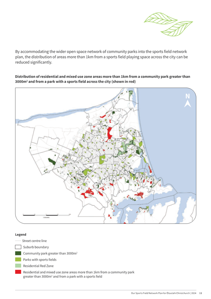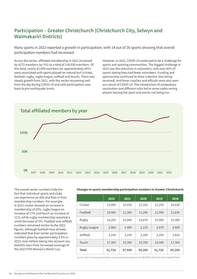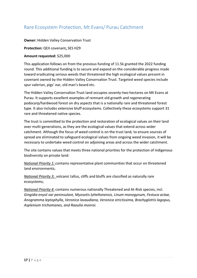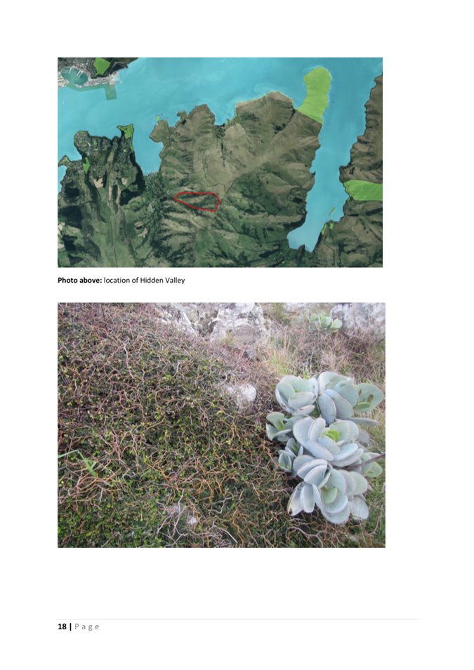
Christchurch City Council
Agenda
Notice of Meeting:
An ordinary meeting of the Christchurch
City Council will be held on:
Date: Wednesday 15 May 2024
Time: 9.30 am
Venue: Council Chambers, Civic Offices,
53 Hereford Street, Christchurch
Membership
|
Chairperson
Deputy Chairperson
Members
|
Mayor Phil Mauger
Deputy Mayor Pauline Cotter
Councillor Kelly Barber
Councillor Melanie Coker
Councillor Celeste Donovan
Councillor Tyrone Fields
Councillor James Gough
Councillor Tyla Harrison-Hunt
Councillor Victoria Henstock
Councillor Yani Johanson
Councillor Aaron Keown
Councillor Sam MacDonald
Councillor Jake McLellan
Councillor Andrei Moore
Councillor Mark Peters
Councillor Tim Scandrett
Councillor Sara Templeton
|
9 May 2024
|
|
|
Principal Advisor
Mary Richardson
Interim Chief Executive
Tel: 941 8999
|
|
Katie Matheis
Democratic Services Advisor
941 5643
Katie.Matheis@ccc.govt.nz
TABLE OF CONTENTS NGĀ IHIRANGI
Karakia Tīmatanga................................................................................................... 4
1. Apologies Ngā Whakapāha................................................................................. 4
2. Declarations of Interest Ngā Whakapuaki Aronga.................................................. 4
3. Public
Participation Te Huinga
Tūmatanui............................................................ 4
3.1 Public Forum Te Huinga Whānui.......................................................................................... 4
3.2 Deputations by
Appointment Ngā Huinga Whakaritenga...................................................... 4
4. Presentation
of Petitions Ngā
Pākikitanga............................................................ 4
Community Board Part A
Reports
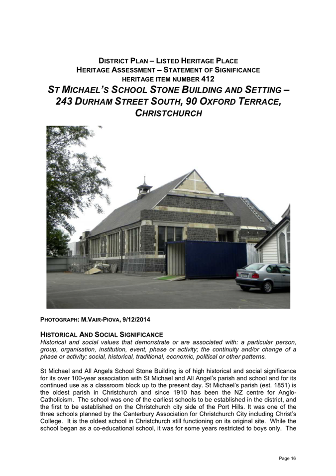
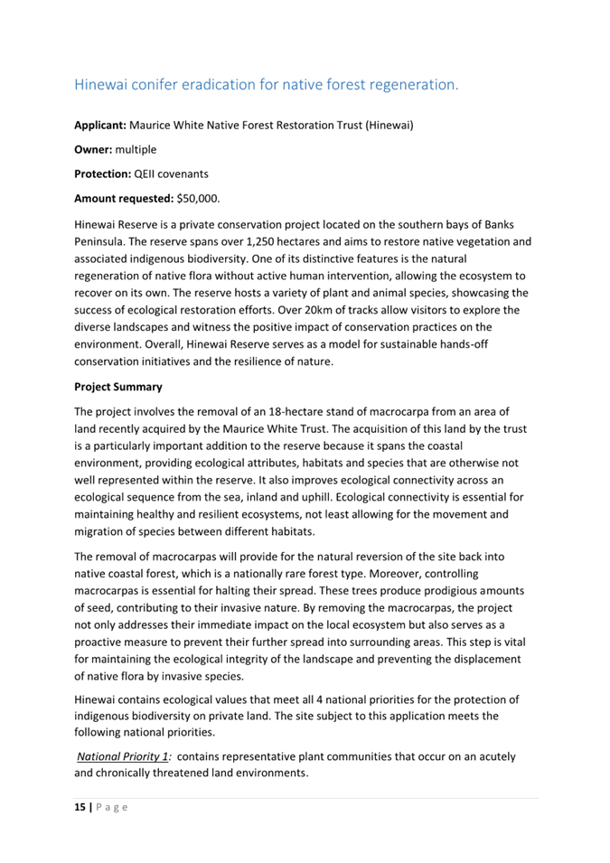
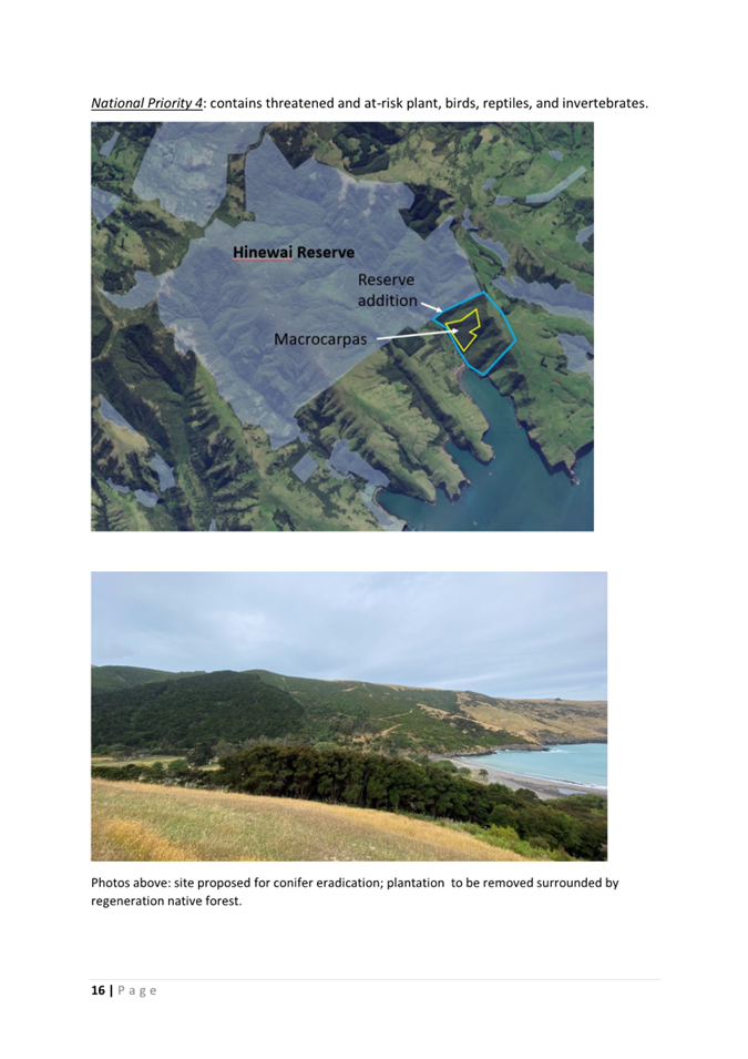
5. Church
Corner and Waimairi Road Safety Improvements........................................ 5
Staff Reports
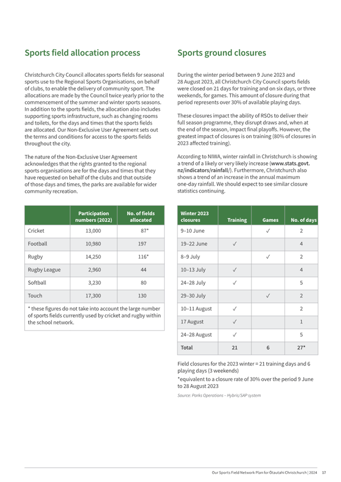
6. Sports
Field Network Plan................................................................................ 61
7. Better
Off Funding - Ferrymead Heritage Park Third Tranche............................... 111
8. Mount
Pleasant Community Centre - Community Loan Reschedule....................... 119
9. Discretionary
Response Fund - Green Effect Trust, The Christchurch Foundation.... 127
10. Heritage
Incentive Grant Applications.............................................................. 131
11. Biodiversity
Fund Project Approvals 2023-2024 FY............................................. 235
12. New
Zealand Local Government Association Inc: payment of annual membership
subscription.................................................................................................. 275
13. Council
Greenhouse Gas Emissions Inventory - Financial Year 2022/23.................. 283
14. MCR
Northern Line - Design Adjustment to Restell Street as Part of the Harewood
Road Railway Crossing Upgrade............................................................................... 309
15. Christchurch
Northern Corridor - Downstream Effects Bus Lane Trial: Request for Time
Extension..................................................................................................... 321
16. Process
for Changing Approved Design - MCR Nor'West Arc.................................. 329
17. Resolution
to Exclude the Public...................................................................... 374
Karakia Whakamutunga
Karakia Tīmatanga
Whakataka te hau ki te uru
Whakataka te hau ki te tonga
Kia mākinakina ki uta
Kia mātaratara ki tai
E hī ake ana te atakura
He tio, he huka, he hau hū
Tihei mauri ora
1. Apologies Ngā Whakapāha
At the close of
the agenda no apologies had been received.
2. Declarations of Interest Ngā
Whakapuaki Aronga
Members are
reminded of the need to be vigilant and to stand aside from decision making
when a conflict arises between their role as an elected representative and any
private or other external interest they might have.
3. Public Participation Te Huinga
Tūmatanui
3.1 Public Forum Te Huinga Whānui
A period of up to 30 minutes is available
for people to speak for up to five minutes on any issue that is not the subject
of a separate hearings process.
There were no public forum requests
received at the time the agenda was prepared.
3.2 Deputations by Appointment Ngā
Huinga Whakaritenga
Deputations may be heard on a matter or
matters covered by a report on this agenda and approved by the Chairperson.
|
3.2.1
|
Sport Canterbury
Julyan Falloon, Chief Executive, will
speak on behalf of Sport Canterbury regarding Item 6 – Sports Field
Network Plan.
|
4. Presentation of Petitions Ngā
Pākikitanga
There were no
Presentation of Petitions at the time the agenda was prepared.
Report from Waipuna Halswell-Hornby-Riccarton Community Board – 15
February 2024
|
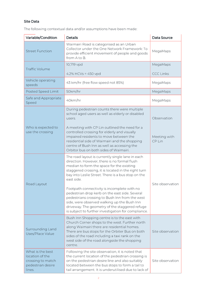
5. Church
Corner and Waimairi Road Safety Improvements
|
|
Reference Te Tohutoro:
|
24/431545
|
|
Responsible Officer(s) Te Pou Matua:
|
Gemma
Dioni, Principal Advisor Transportation – Safety
Ann Tomlinson, Project Manager
Krystle Anderson, Engagement Advisor
Georgia Greene, Traffic Engineer
|
|
Accountable ELT Member Pouwhakarae:
|
Andrew
Rutledge, Acting General Manager Citizens and Community
|
|
1. Waipuna Halswell-Hornby-Riccarton Community Board
Consideration Te
Whaiwhakaarotanga
|
|
|
At its meeting on 15 February 2024, the Board resolved the Part A
Officer Recommendations 1 – 4 which included an additional Officer
Recommendation 1(e) tabled at the meeting. These Recommendations were
resolved without change.
The Board further resolved the Part C
Officer Recommendations 5, 11 – 18, and 21 – 22 without change.
The Part C Officer Recommendations 6 – 10 were put to the vote and
declared lost. As such, the Part C Officer Recommendations 19 and 20 were not
required to be considered.
At its meeting on 14 March 2024 and
following the receipt of new information, the Board considered whether to
revoke its 15 February 2024 decision regarding Officer Recommendations 6
– 10 and approve these recommendations as originally put forward by
Council Officers. The Motion to revoke its previous decision and approve
Officer Recommendations 6 – 10 was declared lost and the status quo
upheld.
At its Extraordinary Meeting on 9
April 2024, the Board considered a Notice of Motion to revoke its 15 February
2024 decision regarding Officer Recommendations 6 – 10 and approve
these recommendations as originally put forward by Council Officers. The
Mover, with the agreement of the meeting, amended the original Notice of
Motion which was then considered by the Board.
The Board resolved to revoke its
previous decision regarding Officer Recommendations 6 – 10, delegate
the authority to make a decision on these recommendations to the Council, and
request staff to provide options to keep the right-hand turn and dual
crossing, and to mitigate serious crash incidences.
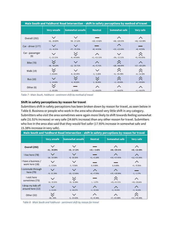
In accordance with the Board’s
resolution, Council Officers will put forward a report to the Council, likely
in July, for its consideration of options regarding the Main South /
Yaldhurst / Riccarton Road intersection safety improvements originally
addressed in Officer Recommendations 6 – 10. The remaining Part A
Recommendations 1 – 4 and Part C Recommendations 5, 11 – 18, and
21 – 22 remain intact.
The progression of the Board’s
15 February Part A Recommendations to Council was temporarily postponed until
the Notice of Motion could be considered and resolved consistent with the
Council’s Standing Orders - Section 19.4.
These Part A Recommendations 1
– 4 are now proceeding to the Council for its consideration via this
Part A report. These recommendations and the previously resolved Part C
recommendations will not be impacted by the forthcoming report to Council and
can proceed pursuant to normal process.
|
|
2. Officer Recommendations Ngā Tūtohu
|
|
|
That the Waipuna Halswell-Hornby-Riccarton Community Board
recommends that the Council:
1. Approves, pursuant to Clause 18 of the
Christchurch City Council Traffic and Parking Bylaw 2017:
a. That a Special Vehicle Lane for the use
of northbound road users as defined in Section 11.1A of the Land Transport
(Road User) Rule: 2004, excepting pedestrians and riders of mobility devices,
be installed on the west side of Waimairi Road, commencing at its
intersection with Riccarton Road and extending in a northerly direction to
its intersection with Bowen Street.
b. That a Special Vehicle Lane for the use
of southbound road users as defined in Section 11.1A of the Land Transport
(Road User) Rule: 2004, excepting pedestrians and riders of mobility devices,
be installed on the east side of Waimairi Road, commencing at a point 149
metres south of its intersection with Hanrahan Street and extending in a
southerly distance to its intersection with Riccarton Road.
c. That a Special Vehicle Lane for the use
of south eastbound road users as defined in Section 11.1A of the Land
Transport (Road User) Rule: 2004, excepting pedestrians and riders of
mobility devices, be installed on the north-east side of Yaldhurst Road, commencing
at a point 94 metres south-east of its intersection with Angela Street and
extending in a south easterly direction to its intersection with Riccarton
Road.
d. That a Special Vehicle Lane, in
accordance with Clause 18 of the Christchurch City Council Traffic &
Parking Bylaw 2017, for the use of eastbound road users as defined in Section
1.6 (definition of Bus lane) of the Land Transport ( Road User) Rule 2004 and
also as defined in Section 11.1A of the Land Transport (Road User)
Rule: 2004, excepting pedestrians and riders of mobility devices, be
installed on the north side of Riccarton Road, commencing at its intersection
with Yaldhurst Road and extending in an easterly direction to a point located
105 metres west of its intersection with Waimairi Road, as detailed on plan
TG145701, dated 23/01/2024 and attached to the report on the meeting agenda
as Attachment A.
2. Approves that in accordance with Section
8.5 of the Land Transport Rule – Traffic Control Devices: 2004 that a
signalised roadway crossing be installed on Waimairi Road, located 23 metres
north from its intersection with Leslie Street, and as detailed on plan
TG145701, dated 23/01/2024 and attached to the report on the meeting agenda
as Attachment A. This signalised crossing is for the use by the classes of
road user as defined in Section 11.1A of the Land Transport (Road User) Rule:
2004.
3. Approves that in accordance with Clause 21 of the
Christchurch City Council Traffic & Parking Bylaw 2017, that the path on
the west side of Waimairi Road, commencing at a point 20 metres north of its
intersection with Leslie Street, and extending in a northerly direction for a
distance of 11 metres be resolved as a Shared Path and in accordance with
section 11.4 of the Land Transport Act - Traffic Control Devices Rules: 2004.
This Shared Path is for the use by the classes of road user only as defined
in Section 11.1A of the Land Transport (Road User) Rule: 2004.
4. Approves that in accordance with Clause 21 of the
Christchurch City Council Traffic & Parking Bylaw 2017, that the path on
the east side of Waimairi Road, commencing at a point 165 metres south of its
intersection with Hanrahan Street, and extending in a southerly direction for
a distance of 13 metres be resolved as a Shared Path and in accordance with
section 11.4 of the Land Transport Act - Traffic Control Devices Rules: 2004.
This Shared Path is for the use by the classes of road user only as defined
in Section 11.1A of the Land Transport (Road User) Rule: 2004.
That the Waipuna Halswell-Hornby-Riccarton Community
Board:
General
5. Approves pursuant to Christchurch City Council
Traffic and Parking Bylaw 2017 and Part 21 of the Local Government Act 1974
all kerb alignments, road surface treatments, traffic calming devices,
traffic islands and road markings on Main South Road, Curletts Road,
Yaldhurst Road, Riccarton Road, Angela Street, Brake Street, Leslie Street,
Waimairi Road, and Hansons Lane, as detailed on plan TG145701, dated 23/01/2024
and attached to the report on the meeting agenda as Attachment A.
Traffic Controls
6. Approves that in accordance with Section 8.2 of the
Land Transport Rule – Traffic Control Devices: 2004, that a Pedestrian
Crossing be installed on Yaldhurst Road, located 65 metres south-east of its
intersection with Brake Street, and as detailed on plan TG145701, dated 23/01/2024
and attached to the report on the meeting agenda as Attachment A.
7. Approves that in accordance with Section 8.2 of the
Land Transport Rule – Traffic Control Devices: 2004, that a Pedestrian
Crossing be installed on Main South Road, located 313 metres east of its
intersection with Curletts Road, and as detailed on plan TG145701, dated 23/01/2024 and attached to the report on the meeting agenda as Attachment
A.
8. Approves, in accordance with Clause 16 (1) of the
Christchurch City Council Traffic and Parking Bylaw 2017, that Main South
Road, from its intersection with Riccarton Road and extending in a westerly
direction for a distance of 75 metres, be a one-way street, where vehicles
must travel in a westerly direction only.
9. Approves that in accordance with Section 4 of the
Land Transport Rule: Traffic Control Devices 2004 that the west bound traffic
on Main South Road at a point 295 metres east of its intersection with
Curletts Road be controlled by a Give Way.
10. Approves that in accordance with Clause 17(3) of the
Christchurch City Council Traffic and Parking Bylaw 2017 that a No Entry
control be placed against eastbound vehicles using the roadway on Main South
Road at a point 295 metres east of its intersection with Curletts Road.
Bus Stops
11. Approves that, in accordance with Clause
7 of the Christchurch City Council Traffic & Parking Bylaw 2017 the north
side of Riccarton Road, commencing at a point 158 metres west of its
intersection with Waimairi Road, and extending in an easterly direction for a
distance of 30 metres, be reserved for Large Passenger Service Vehicles only,
for the purposes of setting down or picking up passengers only, as part of a
Bus Service as defined in the Land Transport Management Act 2003, Section 5,
- Bus Service, (a) (i), only.
12. Approves that, in accordance with Clause
7 of the Christchurch City Council Traffic & Parking Bylaw 2017 the west
side of Waimairi Road, commencing at a point 72 metres north of its
intersection with Leslie Street, and extending in a northerly direction for a
distance of 12 metres, be reserved for Large Passenger Service Vehicles only,
for the purposes of setting down or picking up passengers only, as part of a
Bus Service as defined in the Land Transport Management Act 2003, Section 5,
- Bus Service, (a) (i), only.
13. Approves that, in accordance with Clause
7 of the Christchurch City Council Traffic & Parking Bylaw 2017 the east
side of Waimairi Road, commencing at a point 119 metres south of its
intersection with Hanrahan Street, and extending in a southerly direction for
a distance of 30 metres, be reserved for Large Passenger Service Vehicles
only, for the purposes of setting down or picking up passengers only, as part
of a Bus Service as defined in the Land Transport Management Act 2003,
Section 5, - Bus Service, (a) (i), only.
14. Approves that pursuant to Section 339(1)
of the local Government Act:1974, that a bus shelter be installed on the east
side of Waimairi Road, as detailed on plan TG145701, dated 23/01/2024, and
attached to the report on the meeting agenda as Attachment A.
Stopping and Parking restrictions
15. Approves that the stopping of all vehicles be
prohibited at any time, in accordance with Clause 7 of the Christchurch City
Council Traffic & Parking Bylaw 2017, on the east side of Waimairi Road
commencing at its intersection with Riccarton Road and extending in a
northerly direction for a distance of 168 metres.
16. Approves that the stopping of all vehicles be
prohibited at any time, in accordance with Clause 7 of the Christchurch City
Council Traffic & Parking Bylaw 2017, on the north-east side of Yaldhurst
Road commencing at a point 48 metres south-east of its intersection with
Brake Street and extending in a south easterly direction to its intersection
with Riccarton Road.
17. Approves that the stopping of all vehicles be
prohibited at any time, in accordance with Clause 7 of the Christchurch City
Council Traffic & Parking Bylaw 2017, on the south-west side of Yaldhurst
Road commencing at its intersection with Riccarton Road and extending in a
north westerly direction to a point 200 metres south-east of its intersection
with Curletts Road.
18. Approves that the stopping of all vehicles be
prohibited at any time, in accordance with Clause 7 of the Christchurch City
Council Traffic & Parking Bylaw 2017, on the north-west side of Main
South Road commencing at its intersection with Curletts Road and extending in
a south westerly direction for a distance of 52 metres.
19. Approves that the stopping of all vehicles be
prohibited at any time, in accordance with Clause 7 of the Christchurch City
Council Traffic & Parking Bylaw 2017, on the north side of Main South
Road commencing at a point 262 metres east of its intersection with Curletts
Road, and extending in a easterly direction to its intersection with
Riccarton Road, as detailed on
plan TG145701, dated 23/01/2024, and attached to the report on the
meeting agenda as Attachment A.
20. Approves that the stopping of all vehicles be
prohibited at any time, in accordance with Clause 7 of the Christchurch City
Council Traffic & Parking Bylaw 2017, on the south side of Main South
Road commencing at a point 286 metres east of its intersection with Curletts
Road, and extending in a easterly direction to its intersection with
Riccarton Road, as detailed on
plan TG145701, dated 23/01/2024, and attached to the report on the
meeting agenda as Attachment A.
21. Approves that any previously approved resolutions be
revoked, in accordance with Clause 6 (2) of the Christchurch City Council
Traffic & Parking Bylaw 2017, made pursuant to any Bylaw, Local
Government Act, or any Land Transport Rule, to the extent that they are in
conflict with, or recommended to be removed in regard to the parking and /or
stopping restrictions described in 1-21 above.
22. Approves that these resolutions take
effect when parking signage and/or road markings that described in 1 to 21
are in place (or removed in the case of revocations).
|
|
3. Waipuna Halswell-Hornby-Riccarton Community Board Decisions
Under Delegation Ngā
Mana kua Tukuna
|
|
|
Officer recommendations accepted without change
Part C
That the Waipuna Halswell-Hornby-Riccarton Community
Board:
General
5. Approves pursuant to Christchurch City Council
Traffic and Parking Bylaw 2017 and Part 21 of the Local Government Act 1974
all kerb alignments, road surface treatments, traffic calming devices,
traffic islands and road markings on Main South Road(west of Curletts Road),
Curletts Road, Yaldhurst Road, Riccarton Road, Angela Street, Brake Street,
Leslie Street, Bowen Street, Waimairi Road, and Hansons Lane, as detailed on
plan TG145703, dated 20
February 2024 and attached to the
minutes of the Waipuna Halswell-Hornby-Riccarton Community Board Meeting 15
February 2024 but excluding the changes shown at the Main South Road and
Yaldhurst Road intersection.
Bus Stops
11. Approves that, in accordance with Clause
7 of the Christchurch City Council Traffic & Parking Bylaw 2017 the north
side of Riccarton Road, commencing at a point 158 metres west of its
intersection with Waimairi Road, and extending in an easterly direction for a
distance of 30 metres, be reserved for Large Passenger Service Vehicles only,
for the purposes of setting down or picking up passengers only, as part of a
Bus Service as defined in the Land Transport Management Act 2003, Section 5,
- Bus Service, (a) (i), only.
12. Approves that, in accordance with Clause
7 of the Christchurch City Council Traffic & Parking Bylaw 2017 the west
side of Waimairi Road, commencing at a point 72 metres north of its
intersection with Leslie Street, and extending in a northerly direction for a
distance of 12 metres, be reserved for Large Passenger Service Vehicles only,
for the purposes of setting down or picking up passengers only, as part of a
Bus Service as defined in the Land Transport Management Act 2003, Section 5,
- Bus Service, (a) (i), only.
13. Approves that, in accordance with Clause
7 of the Christchurch City Council Traffic & Parking Bylaw 2017 the east
side of Waimairi Road, commencing at a point 119 metres south of its
intersection with Hanrahan Street, and extending in a southerly direction for
a distance of 30 metres, be reserved for Large Passenger Service Vehicles
only, for the purposes of setting down or picking up passengers only, as part
of a Bus Service as defined in the Land Transport Management Act 2003,
Section 5, - Bus Service, (a) (i), only.
14. Approves that pursuant to Section 339(1)
of the local Government Act:1974, that a bus shelter be installed on the east
side of Waimairi Road, as detailed on plan TG145701, dated 23/01/2024, and
attached to the report on the meeting agenda as Attachment A.
Stopping and Parking restrictions
15. Approves that the stopping of all vehicles be
prohibited at any time, in accordance with Clause 7 of the Christchurch City
Council Traffic & Parking Bylaw 2017, on the east side of Waimairi Road
commencing at its intersection with Riccarton Road and extending in a
northerly direction for a distance of 168 metres.
16. Approves that the stopping of all vehicles be
prohibited at any time, in accordance with Clause 7 of the Christchurch City
Council Traffic & Parking Bylaw 2017, on the north-east side of Yaldhurst
Road commencing at a point 48 metres south-east of its intersection with
Brake Street and extending in a south easterly direction to its intersection
with Riccarton Road.
17. Approves that the stopping of all vehicles be
prohibited at any time, in accordance with Clause 7 of the Christchurch City
Council Traffic & Parking Bylaw 2017, on the south-west side of Yaldhurst
Road commencing at its intersection with Riccarton Road and extending in a
north westerly direction to a point 200 metres south-east of its intersection
with Curletts Road.
18. Approves that the stopping of all vehicles be
prohibited at any time, in accordance with Clause 7 of the Christchurch City
Council Traffic & Parking Bylaw 2017, on the north-west side of Main
South Road commencing at its intersection with Curletts Road and extending in
a south westerly direction for a distance of 52 metres.
21. Approves that any previously approved resolutions be
revoked, in accordance with Clause 6 (2) of the Christchurch City Council
Traffic & Parking Bylaw 2017, made pursuant to any Bylaw, Local
Government Act, or any Land Transport Rule, to the extent that they are in
conflict with, or recommended to be removed in regard to the parking and /or
stopping restrictions described in Waipuna Halswell-Hornby-Riccarton
Community Board resolutions HHRB/2024/00012, HHRB/2024/00013, HHRB/2024/00014
and HHRB/2024/00016.
22. Approves that these resolutions take effect when parking signage
and/or road markings described in Waipuna Halswell-Hornby-Riccarton
Community Board resolutions HHRB/2024/00012, HHRB/2024/00013, HHRB/2024/00014
and HHRB/2024/00016 are in place (or removed in the case of revocations).
|
|
4. Waipuna Halswell-Hornby-Riccarton Community Board Recommendation
to Council
|
|
|
Part A
That the Council:
1. Approves, pursuant to Clause 18 of the Christchurch City Council
Traffic and Parking Bylaw 2017:
a. That a Special Vehicle Lane for the use of northbound road users
as defined in Section 11.1A of the Land Transport (Road User) Rule: 2004,
excepting pedestrians and riders of mobility devices, be installed on the
west side of Waimairi Road, commencing at its intersection with Riccarton
Road and extending in a northerly direction to its intersection with Bowen
Street.
b. That a Special Vehicle Lane for the use of southbound road users
as defined in Section 11.1A of the Land Transport (Road User) Rule: 2004,
excepting pedestrians and riders of mobility devices, be installed on the
east side of Waimairi Road, commencing at a point 149 metres south of its
intersection with Hanrahan Street and extending in a southerly distance to
its intersection with Riccarton Road.
c. That a Special Vehicle Lane for the use of south eastbound road
users as defined in Section 11.1A of the Land Transport (Road User) Rule:
2004, excepting pedestrians and riders of mobility devices, be installed on
the north-east side of Yaldhurst Road, commencing at a point 94 metres
south-east of its intersection with Angela Street and extending in a south
easterly direction to its intersection with Riccarton Road.
d. That
a Special Vehicle Lane, in accordance with Clause 18 of the Christchurch City
Council Traffic & Parking Bylaw 2017, for the use of eastbound road users
as defined in Section 1.6 (definition of Bus lane) of the Land Transport (
Road User) Rule 2004 and also as defined in Section 11.1A of the Land
Transport (Road User) Rule: 2004, excepting pedestrians and riders of
mobility devices, be installed on the north side of Riccarton Road,
commencing at its intersection with Yaldhurst Road and extending in an
easterly direction to a point located 105 metres west of its intersection
with Waimairi Road.
e. That
a Special Vehicle Lane for the use of eastbound road users as defined in
Section 11.1A of the Land Transport (Road User) Rule: 2004, excepting
pedestrians and riders of mobility devices, be installed on the northwest
side of Main South Road, commencing at its intersection with Curletts Road
and extending in a south-westerly direction for a distance of 50 metres as
detailed on plan TG145703, dated 20/02/2024 and attached to the minutes of
the Waipuna Halswell-Hornby-Riccarton Community Board Meeting 15 February
2024.
2. Approves that in accordance with Section 8.5 of the Land Transport
Rule – Traffic Control Devices: 2004 that a signalised roadway crossing
be installed on Waimairi Road, located 23 metres north from its intersection
with Leslie Street, and as detailed on plan TG145701, dated 23/01/2024 and
attached to the report on the meeting agenda as Attachment A. This signalised
crossing is for the use by the classes of road user as defined in Section
11.1A of the Land Transport (Road User) Rule: 2004.
3. Approves
that in accordance with Clause 21 of the Christchurch City Council Traffic
& Parking Bylaw 2017, that the path on the west side of Waimairi Road,
commencing at a point 20 metres north of its intersection with Leslie Street,
and extending in a northerly direction for a distance of 11 metres be
resolved as a Shared Path and in accordance with section 11.4 of the Land
Transport Act - Traffic Control Devices Rules: 2004. This Shared Path is for
the use by the classes of road user only as defined in Section 11.1A of the
Land Transport (Road User) Rule: 2004.
4. Approves
that in accordance with Clause 21 of the Christchurch City Council Traffic
& Parking Bylaw 2017, that the path on the east side of Waimairi Road,
commencing at a point 165 metres south of its intersection with Hanrahan
Street, and extending in a southerly direction for a distance of 13 metres be
resolved as a Shared Path and in accordance with section 11.4 of the Land
Transport Act - Traffic Control Devices Rules: 2004. This Shared Path is for
the use by the classes of road user only as defined in Section 11.1A of the
Land Transport (Road User) Rule: 2004.
|
Attachments
Ngā
Tāpirihanga
|
No.
|
Report Title
|
Reference
|
Page
|
|
1
|
Church Corner and Waimairi Road
Safety Improvements
|
23/1883677
|
13
|
|
No.
|
Title
|
Reference
|
Page
|
|
a ⇩
|
Church Corner Safety Improvements
|
24/95888
|
32
|
|
b ⇩
|
Waimairi Road Crossing Background Information
|
24/79397
|
33
|
|
c ⇩
|
Church Corner Ward and Pedestrian Information
|
24/79383
|
40
|
|
d
|
Church Corner safety improvements - all submissions (public)
(Additional Documents - Circulated Separately)
|
Link
to Submissions - starting on p. 56
|
|
e ⇩
|
Church Corner safety improvements - submission analysis
|
24/95777
|
48
|
|
f ⇩
|
Church Corner Safety Improvements - Plan TG145703 (Tabled at 15
February 2024 meeting)
|
24/290675
|
59
|
|
Church Corner and Waimairi Road Safety Improvements
|
|
Reference / Te Tohutoro:
|
23/1883677
|
|
Report of / Te Pou Matua:
|
Gemma
Dioni, Principal Advisor Transportation - Safety
Ann Tomlinson, Project Manager
Krystle Anderson, Engagement Advisor
Georgia Greene, Traffic Engineer
|
|
Senior Manager / Pouwhakarae:
|
Lynette
Ellis, Head of Transport & Waste Management (Lynette.Ellis@ccc.govt.nz)
|
1. Purpose and Origin of Report Te Pūtake Pūrongo
1.1 For the Waipuna Halswell-Hornby-Riccarton Community Board
to approve safety improvements to intersections around Church Corner and to
make recommendations to Council for the items within the proposed design that
rest with Council for decision making.
1.2 This report has been written in response to ongoing safety
concerns in the area particularly for people travelling across the community by
all different modes.
1.3 This
intersections of Riccarton/Hansons/Waimairi and Curletts/Main South are both
within the top 1% of intersections within the Christchurch District in terms of
risk of being in a crash, compared to over 5700 Council controlled
intersections citywide (Main South/Yaldhurst is in the top 3%). The
intersection safety improvements were identified through a co-design process
with Waka Kotahi NZ Transport Agency for the 2021-2024 National Land Transport
Programme Funding Cycle. The Pipeline Development Tool (PDT) used in this
process helps road controlling authorities and their funding partners plan road
safety interventions, understand their benefits, including the expected
reduction in death and serious injury, and identify the most effective
interventions at a local, regional, and national level.
1.4 Church Corner and Waimairi Road are busy locations used by
many people travelling to school, University or work, accessing the local shops
and Bush Inn Centre, or moving across the community. Whether people are
travelling through this intersection on foot, by bicycle, by bus or driving,
they should be able to do so safely.
1.5 The
decisions in this report are of medium significance in relation to the
Christchurch City Council’s Significance and Engagement Policy. The
level of significance was determined by this being a busy area used daily by
people travelling to the local amenities, travelling to school and commuting to
work. There is some community interest in the project due to existing safety
concerns.
1.6 The
recommended option is to construct a package of safety improvements in the
vicinity of Church Corner, as show in Attachment A, and summarised
below:
· Safe speed platforms on all approaches to the Riccarton Road,
Hansons Lane, and Waimairi Road intersection.
· Removing the slip lane from Riccarton Road onto Waimairi Road.
· Reconfiguration of angle parking to parallel parking on Waimairi
Road.
· Speed humps on Angela Street and Brake Street at their intersection
with Yaldhurst Road, Leslie Street at its intersection with Waimairi Road and
Bowen Street at its intersection with Peer Street.
· Making Main South Road (from Riccarton Road) entry only and removing
vehicle access out of Main South Road onto Riccarton Road and Yaldhurst Road.
· Installation of pedestrian zebra crossings on Yaldhurst Road and
Main South Road.
· Removing the left turn slip lane from Main South Road into Curletts
Road and providing a left turn lane at the signals.
· Raised signalised crossing on Waimairi Road (outside Bush Inn
Centre).
· Cycle improvements and bus stop improvements.
2. Officer Recommendations Ngā Tūtohu
That the Waipuna
Halswell-Hornby-Riccarton Community Board recommends that the Council:
1. Approves, pursuant to Clause 18 of the Christchurch City Council
Traffic and Parking Bylaw 2017:
a. That a Special Vehicle Lane for the use of northbound road users as
defined in Section 11.1A of the Land Transport (Road User) Rule: 2004,
excepting pedestrians and riders of mobility devices, be installed on the west
side of Waimairi Road, commencing at its intersection with Riccarton Road and
extending in a northerly direction to its intersection with Bowen Street.
b. That a Special Vehicle Lane for the use of southbound road users as
defined in Section 11.1A of the Land Transport (Road User) Rule: 2004,
excepting pedestrians and riders of mobility devices, be installed on the east
side of Waimairi Road, commencing at a point 149 metres south of its
intersection with Hanrahan Street and extending in a southerly distance to its
intersection with Riccarton Road.
c. That a Special Vehicle Lane for the use of south eastbound road
users as defined in Section 11.1A of the Land Transport (Road User) Rule: 2004,
excepting pedestrians and riders of mobility devices, be installed on the
north-east side of Yaldhurst Road, commencing at a point 94 metres south-east
of its intersection with Angela Street and extending in a south easterly direction
to its intersection with Riccarton Road.
d. That a Special Vehicle Lane, in accordance with Clause 18 of the
Christchurch City Council Traffic & Parking Bylaw 2017, for the use of eastbound
road users as defined in Section 1.6 (definition of Bus lane) of the Land
Transport ( Road User) Rule 2004 and also as defined in Section 11.1A of
the Land Transport (Road User) Rule: 2004, excepting pedestrians and riders of
mobility devices, be installed on the north side of Riccarton Road,
commencing at its intersection with Yaldhurst Road and extending in an easterly
direction to a point located 105 metres west of its intersection with Waimairi
Road, as detailed on plan TG145701, dated 23/01/2024 and attached to the report
on the meeting agenda as Attachment A.
2. Approves that in accordance with Section 8.5 of the Land Transport
Rule – Traffic Control Devices: 2004 that a signalised roadway crossing be
installed on Waimairi Road, located 23 metres north from its intersection with
Leslie Street, and as detailed on plan TG145701, dated 23/01/2024 and attached
to the report on the meeting agenda as Attachment A. This signalised crossing
is for the use by the classes of road user as defined in Section 11.1A of the
Land Transport (Road User) Rule: 2004.
3. Approves
that in accordance with Clause 21 of the Christchurch City Council Traffic
& Parking Bylaw 2017, that the path on the west side of Waimairi Road,
commencing at a point 20 metres north of its intersection with Leslie Street,
and extending in a northerly direction for a distance of 11 metres be resolved
as a Shared Path and in accordance with section 11.4 of the Land Transport Act
- Traffic Control Devices Rules: 2004. This Shared Path is for the use by the
classes of road user only as defined in Section 11.1A of the Land Transport
(Road User) Rule: 2004.
4. Approves
that in accordance with Clause 21 of the Christchurch City Council Traffic
& Parking Bylaw 2017, that the path on the east side of Waimairi Road,
commencing at a point 165 metres south of its intersection with Hanrahan Street,
and extending in a southerly direction for a distance of 13 metres be resolved
as a Shared Path and in accordance with section 11.4 of the Land Transport Act
- Traffic Control Devices Rules: 2004. This Shared Path is for the use by the
classes of road user only as defined in Section 11.1A of the Land Transport
(Road User) Rule: 2004.
That the Waipuna
Halswell-Hornby-Riccarton Community Board:
General
5. Approves
pursuant to Christchurch City Council Traffic and Parking Bylaw 2017 and Part
21 of the Local Government Act 1974 all kerb alignments, road surface
treatments, traffic calming devices, traffic islands and road markings on Main
South Road, Curletts Road, Yaldhurst Road, Riccarton Road, Angela Street, Brake
Street, Leslie Street, Waimairi Road, and Hansons Lane, as detailed on plan TG145701,
dated 23/01/2024 and attached to the report on the
meeting agenda as Attachment A.
Traffic Controls
6. Approves
that in accordance with Section 8.2 of the Land Transport Rule – Traffic
Control Devices: 2004, that a Pedestrian Crossing be installed on Yaldhurst
Road, located 65 metres south-east of its intersection with Brake Street, and
as detailed on plan TG145701, dated 23/01/2024 and
attached to the report on the meeting agenda as Attachment A.
7. Approves
that in accordance with Section 8.2 of the Land Transport Rule – Traffic
Control Devices: 2004, that a Pedestrian Crossing be installed on Main South
Road, located 313 metres east of its intersection with Curletts Road, and as
detailed on plan TG145701, dated 23/01/2024 and
attached to the report on the meeting agenda as Attachment A.
8. Approves,
in accordance with Clause 16 (1) of the Christchurch City Council Traffic and
Parking Bylaw 2017, that Main South Road, from its intersection with Riccarton
Road and extending in a westerly direction for a distance of 75 metres, be a
one-way street, where vehicles must travel in a westerly direction only.
9. Approves
that in accordance with Section 4 of the Land Transport Rule: Traffic Control
Devices 2004 that the west bound traffic on Main South Road at a point 295
metres east of its intersection with Curletts Road be controlled by a Give Way.
10. Approves
that in accordance with Clause 17(3) of the Christchurch City Council Traffic
and Parking Bylaw 2017 that a No Entry control be placed against eastbound
vehicles using the roadway on Main South Road at a point 295 metres east of its
intersection with Curletts Road.
Bus Stops
11. Approves that, in accordance with Clause 7 of the Christchurch City
Council Traffic & Parking Bylaw 2017 the north side of Riccarton Road,
commencing at a point 158 metres west of its intersection with Waimairi Road,
and extending in an easterly direction for a distance of 30 metres, be reserved
for Large Passenger Service Vehicles only, for the purposes of setting down or
picking up passengers only, as part of a Bus Service as defined in the Land
Transport Management Act 2003, Section 5, - Bus Service, (a) (i), only.
12. Approves that, in accordance with Clause 7 of the Christchurch City
Council Traffic & Parking Bylaw 2017 the west side of Waimairi Road,
commencing at a point 72 metres north of its intersection with Leslie Street,
and extending in a northerly direction for a distance of 12 metres, be reserved
for Large Passenger Service Vehicles only, for the purposes of setting down or
picking up passengers only, as part of a Bus Service as defined in the Land
Transport Management Act 2003, Section 5, - Bus Service, (a) (i), only.
13. Approves that, in accordance with Clause 7 of the Christchurch City
Council Traffic & Parking Bylaw 2017 the east side of Waimairi Road,
commencing at a point 119 metres south of its intersection with Hanrahan Street,
and extending in a southerly direction for a distance of 30 metres, be reserved
for Large Passenger Service Vehicles only, for the purposes of setting down or
picking up passengers only, as part of a Bus Service as defined in the Land
Transport Management Act 2003, Section 5, - Bus Service, (a) (i), only.
14. Approves that pursuant to Section 339(1) of the local Government
Act:1974, that a bus shelter be installed on the east side of Waimairi Road, as
detailed on plan TG145701, dated 23/01/2024, and attached to the report on the
meeting agenda as Attachment A.
Stopping
and Parking restrictions
15. Approves
that the stopping of all vehicles be prohibited at any time, in accordance with
Clause 7 of the Christchurch City Council Traffic & Parking Bylaw 2017, on
the east side of Waimairi Road commencing at its intersection with Riccarton
Road and extending in a northerly direction for a distance of 168 metres.
16. Approves
that the stopping of all vehicles be prohibited at any time, in accordance with
Clause 7 of the Christchurch City Council Traffic & Parking Bylaw 2017, on
the north-east side of Yaldhurst Road commencing at a point 48 metres
south-east of its intersection with Brake Street and extending in a south
easterly direction to its intersection with Riccarton Road.
17. Approves
that the stopping of all vehicles be prohibited at any time, in accordance with
Clause 7 of the Christchurch City Council Traffic & Parking Bylaw 2017, on
the south-west side of Yaldhurst Road commencing at its intersection with Riccarton
Road and extending in a north westerly direction to a point 200 metres
south-east of its intersection with Curletts Road.
18. Approves
that the stopping of all vehicles be prohibited at any time, in accordance with
Clause 7 of the Christchurch City Council Traffic & Parking Bylaw 2017, on
the north-west side of Main South Road commencing at its intersection with Curletts
Road and extending in a south westerly direction for a distance of 52 metres.
19. Approves
that the stopping of all vehicles be prohibited at any time, in accordance with
Clause 7 of the Christchurch City Council Traffic & Parking Bylaw 2017, on
the north side of Main South Road commencing at a point 262 metres east of its
intersection with Curletts Road, and extending in a easterly direction to its
intersection with Riccarton Road, as detailed on plan TG145701,
dated 23/01/2024, and attached to the report on the meeting agenda as
Attachment A.
20. Approves
that the stopping of all vehicles be prohibited at any time, in accordance with
Clause 7 of the Christchurch City Council Traffic & Parking Bylaw 2017, on
the south side of Main South Road commencing at a point 286 metres east of its
intersection with Curletts Road, and extending in a easterly direction to its
intersection with Riccarton Road, as detailed on plan TG145701,
dated 23/01/2024, and attached to the report on the meeting agenda as
Attachment A.
21. Approves
that any previously approved resolutions be revoked , in accordance with Clause
6 (2) of the Christchurch City Council Traffic & Parking Bylaw 2017, made
pursuant to any Bylaw, Local Government Act, or any Land Transport Rule, to the
extent that they are in conflict with, or recommended to be removed in regard
to the parking and /or stopping restrictions described in 1-21 above.
22. Approves that these resolutions take effect when parking signage
and/or road markings that described in 1 to 21 are in place (or removed in the
case of revocations).
3. Reason for Report Recommendations Ngā Take mō te Whakatau
3.1 The
Church Corner area is busy with many people walking, cycling, accessing public
transport and driving through, particularly at school times and when people are
travelling to work. Whether people are travelling through this area on foot, by
bicycle, bus or driving, they should be able to do so safely. If Council are to
achieve its goal in reducing death and serios injuries on our roads, we need to
create a safe transport system; one that recognises humans make mistakes and
that these mistakes do not need to cost us our lives.
3.2 Options
within this report have been assessed against relevant industry-standard
guidance including the Standard Safety Intervention Toolkit Handbook produced
by NZTA Waka Kotahi and Austroads design guides. Traffic signals are not
typically identified and promoted as a Safe System solution, primarily due to
the angle and impact speed of crashes at signalised intersections. Safe Speed
Platforms (Raised Safety Platforms) are a vertical deflection device
increasingly used to reduce the maximum comfortable operating speed for
vehicles to Safe System collision speeds. The tolerable limit (survivable
speed) for pedestrians and cyclists is 30 km/h.
3.3 Since
the installation of the platform at the Lincoln/Barrington/Whiteleigh
intersection, safer speeds by drivers entering the intersection have been
achieved as shown in the chart below. In the
preceding five-year period (2018-2022) there were 21 reported crashes at the
Lincoln/Barrington/Whiteleigh intersection including two crashes resulting in
serious injury. There have been no reported crashes at this intersection in
2023 (as of 16/01/2024).
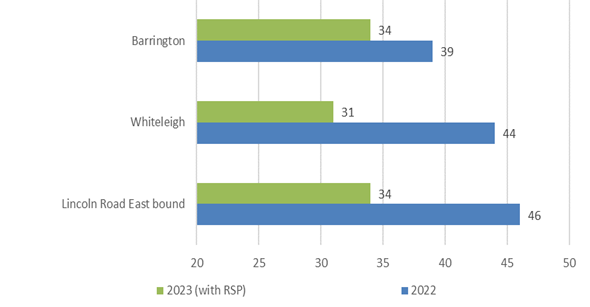
Approach 85th percentile operating speeds at the
Lincoln/Barrington/Whiteleigh intersection (vehicle speeds are at the bottom of
the graph)
3.4 During
consultation for Christchurch Regeneration Acceleration Facility (CRAF)
projects, a request was received from a local blind resident for improvements
to the section of Waimairi Road from Riccarton Road to Peer Street to help
improve safety and accessibility for vision-impaired, disabled and elderly
people. This included a project to investigate the need for a signalised
pedestrian crossing at the Bush Inn Centre.
3.5 The
recommendations in this report will help to achieve the desired community
outcome of having well-connected communities and neighbourhoods, so people can
take fewer and shorter trips to access goods and services and have access to
safe and reliable low-emission travel choices.
4. Alternative Options Considered Ētahi atu Kōwhiringa
Main
South Road/Yaldhurst/Riccarton
4.1 Three options were proposed by the design team for the Main
South Road/Yaldhurst Road/Riccarton Road intersection:
|
Option 1
|
Option 2
|
Option 3
|
|
Speed humps on Riccarton Rd on approach
to intersection (both east and west bound directions).
|
Cul de sac on Main South Road (9m radius)
to remove entry from MSR onto Riccarton/Yaldhurst. Provide westbound entrance
to Main South Rd with give way priority at the cul de sac to allow for bus
route access.
|
Create left in left out T-intersection at
Main South Rd/Yaldhurst.
|
|
Build out southern footpath at bus stop
outside countdown by approx. 0.8m, west of Hansons Ln.
|
Build out southern footpath at bus stop
outside countdown by approx. 0.8m, west of Hansons Ln.
|
Build out southern footpath at bus stop
outside countdown by approx. 0.8m, west of Hansons Ln.
|
|
Keep existing left turn lane from Main South Road
onto Yaldhurst and leave existing crossing point to medical centre.
|
Install raised ped and cyclist (dual)
crossing opposite medical centre, with shared path connection towards
southern shared path on Main South Road.
|
Install raised pedestrian crossing
opposite medical centre.
|
|
Retain crossing point opposite countdown.
|
Build out northern footpath along shops
by approx. 1.0m.
|
Build out northern footpath along shops
by approx. 1.0m.
|
|
Provide eastbound 1.8m cycle lane on
Yaldhurst/Riccarton Rd which ends just after the bus stop (cycle sharrow
markings to be provided after this point).
|
Provide eastbound 1.8m cycle lane on
Yaldhurst /Riccarton Rd which ends just after the bus stop.
|
Provide eastbound 1.8m cycle lane on
Yaldhurst /Riccarton Rd which ends just after the bus stop.
|
|
Reduce right turn bay for Brake St.
|
Reduce right turn bay for Brake St.
|
Retain existing length of right turn bay
to Brake St.
|
|
Reduce westbound lane on Riccarton Road
to one lane. Provide cycle ramp to enter existing shared path on southern
side.
|
Reduce westbound lane on Riccarton Road
to one lane. Provide cycle ramp to enter existing shared path on southern
side.
|
Reduce westbound lane on Riccarton Road
to one lane. Provide cycle ramp to enter existing shared path on southern
side.
|
4.2 The
advantages and disadvantages for each option are presented below.
|
|
Option 1
|
Option 2
|
Option 3
|
|
Advantages
|
Slows traffic on the approach to the intersection
to give people more time to react should a crash occur.
|
Simplifies layout by removing the turning
movements from Main South/Yaldhurst/ Riccarton
|
Removes right turn from Main
South/Yaldhurst/ Riccarton
|
|
Increases footpath width outside Countdown
|
Increases footpath width outside
Countdown
|
Increases footpath width outside Countdown
|
|
Slight improvement at the crossing point
outside the Medical Centre
|
Improves crossing opportunities outside
the medical centre.
|
Improves crossing opportunities outside
the medical centre.
|
|
|
Increases footpath width on the northern
side of Riccarton Road
|
Increases footpath width on the northern
side of Riccarton Road
|
|
|
Increases accessibility for people
walking/cycling on Main South Road to access shops and services on the north
side of Riccarton Road.
|
Increases accessibility for people
walking/cycling on Main South Road to access shops and services on the north
side of Riccarton Road.
|
|
Improves westbound cycle access to the
Major Cycleway on Ballantyne Ave.
|
Improves westbound cycle access to the
Major Cycleway on Ballantyne Ave.
|
Improves westbound cycle access to the
Major Cycleway on Ballantyne Ave.
|
|
Disadvantages
|
Right turn from Main South
Road to Yaldhurst is retained. While the consequence of a crash may be
reduced with the traffic calming, the likelihood of a crash remains.
|
Re-assignment of traffic on the network.
Modelling would need to be undertaken to understand the effects on the
network.
|
Re-assignment of traffic on the network. Modelling would
need to be undertaken to understand the effects on the network.
|
|
Cost to change kerblines on
south side, which may need altering again in future for MRT.
|
Cost to change kerblines on
north and south side, which may need altering again in future for MRT.
|
Cost to change kerblines on north and
south side, which may need altering again in future for MRT.
|
|
No safer crossing points for
people wanting to access shops and services on the north side of Riccarton
Road.
|
|
|
Riccarton/Hansons/Waimairi
4.3 Three
options were proposed by the design team for the Hanson/Waimairi/Riccarton
intersection:
|
Option
1
|
Option
2
|
Option
3
|
|
Westbound cycle lane on Riccarton Rd – 1.5m
|
Raised intersection
o Tapered down to kerblines so platforms do
not affect existing stormwater.
o New median islands on Waimairi Rd and
Hansons Lane installed to allow for different length intersection ramps for
the approach and departure side.
o Unable to fit a median island on
Riccarton Rd east so used a uniform 2m ramp across approach and departure
lanes
|
Create a signalised
Left-In-Left-Out intersection at Waimairi Road
o Provide ‘reverse-seagull’ island on Riccarton Rd to
allow busses only to turn right onto Waimairi and restrict right turn
movement out of Waimairi.
o Install median island on Riccarton Rd to physically remove right
turn to/from Waimairi Rd
o Green surfacing and bus only markings at right turn
· Provide traffic island on
Waimairi to reduce southbound traffic to 1 lane at the intersection.
· Waimairi approach to stay signalised.
· Staggered dual ped & cyclist signal
crossing on Riccarton Rd between Waimairi and Hansons, linked with signals.
|
|
Build out southern kerb and footpath (Between
Hansons Lane and Auburn Avenue). This removes one westbound through
lane at the signalised intersection.
|
Build out southern kerb and footpath (Between
Hansons Lane and Auburn Avenue). This removes one westbound through
lane at the signalised intersection.
|
Build out southern kerb and footpath
(Between Hansons Lane and Auburn Avenue). This removes one westbound
through lane at the signalised intersection.
|
|
Provide parallel parking markings on Waimairi Rd
(northbound lane) to remove angle parking.
|
Provide parallel parking markings on Waimairi Rd
(northbound lane) to remove angle parking.
|
Provide parallel parking markings on Waimairi Rd
(northbound lane) to remove angle parking.
|
|
Remove LT slip and slip island on
Waimairi Road - build out kerb to combine LT/TH movement into signalised
intersection.
|
Remove LT slip and slip island on
Waimairi Road - build out kerb to combine LT/TH movement into signalised
intersection.
|
Remove LT slip and slip island - build out kerb to
combine LT/TH movement.
|
|
Cyclist advanced
stop boxes on all approaches.
|
Cyclist advanced stop boxes on all
approaches.
|
Cyclist advanced stop boxes on all
approaches.
|
|
Remove filter
right turns.
|
Remove filter right turns.
|
Remove filter right turns.
|
4.4 The
advantages and disadvantages for each option are presented below.
|
|
Option
1
|
Option
2
|
Option
3
|
|
Advantages
|
Wider footpath on southern side.
|
Includes primary safe system treatment
that physically controls speeds into the intersection. Likely to achieve safe
system speeds for vulnerable users.
|
Restricts turn movements into and from
Waimairi Road, prioritising bus movements only. New crossing installed
between Hansons Lane and Waimairi Road to reduce the need for people to cross
multiple approaches.
|
|
|
Protected right turn from Riccarton Road
to Hansons Lane.
|
Protected right turn from Riccarton Road
to Hansons Lane.
|
|
|
|
Slip lane removed at Riccarton/Waimairi,
improving journeys for people walking.
|
Slip lane removed at Riccarton/Waimairi,
improving journeys for people walking.
|
Slip lane removed at Riccarton/Waimairi,
improving journeys for people walking.
|
|
|
Advanced boxes provided for people
riding. On-road cycle lane provided on Riccarton Road for westbound
users.
|
Advanced boxes provided for people
riding. On-road cycle lane provided on Riccarton Road for westbound
users.
|
Advanced boxes provided for people riding.
|
|
Disadvantages
|
Cost to change kerblines on
south side, which may need altering again in future for MRT.
|
Cost to change kerblines on
north and south side, which may need altering again in future for MRT.
|
Cost to change kerblines on north and
south side, which may need altering again in future for MRT.
|
|
|
|
Small benefits to walking and
cycling on Riccarton Road. Slowing of vehicles through the use of the safer
speed platform.
|
Re-assignment of traffic on the network. Modelling
undertaken to understand the effects on the network.
|
|
|
|
|
Block back effects from right turn
queuing overflowing onto adjacent through lanes.
|
Waimairi
Road crossing
4.5 An
independent assessment was undertaken to determine the most suitable and safest
crossing type. This is provided in Attachment B.
Safe
System Assessment
4.6 A
Safe System Assessment was completed as part of the optioneering for the
improvements. The Safe System Assessment is a formal examination of a
road related program, project or initiative that assesses the safety of the
existing intersection and the proposals. The process assesses if, and
how, existing or future changes aligns with safe system principles with a focus
on safer roads and safer speeds. The assessment provides a score for the
existing arrangement and a score for the options from a total score of 448 (the
lower score the safer the outcomes). A summary of the scores from the Safe
System Assessment can be found below. Note that the lower the score, the safer
the option.
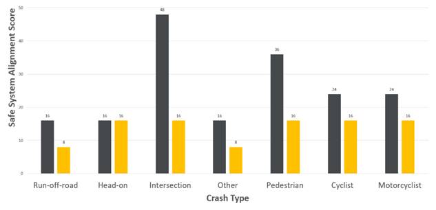
Chart 1: Summary safe system assessment collision type
at Main South, Yaldhurst and Riccarton/Waimairi/Hansons (black is existing and
orange is proposed)
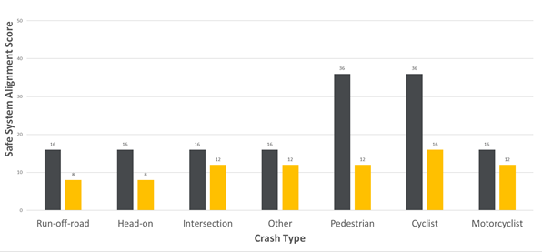
Chart 2: Summary safe system assessment collision type
at Waimairi Road (black is existing and orange is proposed)
4.7 Chart
1 summarises the assessment of the Riccarton Road changes, which demonstrates
that the closure of Main South Road at Yaldhurst and the Safe Speed Platforms
at Riccarton/Hansons/Waimairi reduces the likelihood and severity of crashes
for the intersections making them more safe system aligned. The Standard Safety
Intervention Toolkit assumes a death and serious injury reduction of 40% by
implementing raised safety platforms at existing signalised intersection.
4.8 The
signalised crossing on a raised platform on Waimairi Road has benefits for all
road users as shown in Chart 2.
5. Detail Te Whakamahuki
5.1 Improving safety on local roads in Christchurch is a
priority for the Christchurch City Council. Providing safe infrastructure
is key to ensure people get to where they are going safely irrespective of
their mode of travel. Council has a Level of Service to reduce the
number of deaths or serious injuries from all crashes by 40% in 2030. That is a
reduction of five or more per year, and for this to be under 71 crashes per
year within the 10-year period. This is also a goal in the Road Safety Action
Plan, which is a collaborative plan between Christchurch City Council, NZTA Waka
Kotahi, ACC, FENZ and New Zealand Police.
5.2 Information
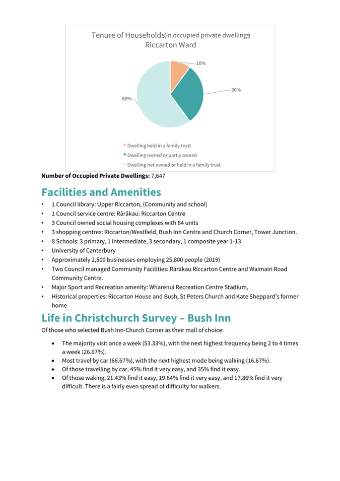
was extracted from the Life in Christchurch Survey to understand how people,
who selected Bush Inn-Church Corner as their mall of choice, travel to the
centre:
5.2.1 The majority visit
once a week (53.33%), with the next highest frequency being two to four times a
week (26.67%).
5.2.2 Most travel by car
(66.67%), with the next highest mode being walking (16.67%).
5.2.3 Of those travelling
by car, 45% find it very easy, and 35% find it easy.
5.2.4 Of those walking,
21.43% find it easy, 19.64% find it very easy, and 17.86% find it very difficult.
There is a fairly even spread of difficulty for walkers.
5.3 The Church Corner area includes the Bush Inn Centre, Church
Corner Mall, St Peters Anglican Church, a medical centre, supermarkets, other
local shops and businesses. The University of Canterbury and student
accommodation is located to the north of Riccarton Road, and there are two
large schools close by including Villa Maria and Kirkwood Intermediate. These
all generate foot traffic, so it needs to be safer for people wanting to cross
the road. Further information on pedestrian counts and ward data is provided in
Attachment C.
5.4 There are signalised crossing facilities at the Riccarton/Hansons/Waimairi
intersection and designated crossing points in the median island close to the
Main South Road/Yaldhurst Road intersection for people to cross.
5.5 It
is proposed to provide improvements for people walking by providing additional
crossing points and removing the slip lane from Riccarton Road into Waimairi
Road. The primary reason for the removal of the slip lane is that it can make
crossing a road feel unsafe for people walking, particularly children or
vulnerable pedestrians. Drivers are focussing on what traffic may be coming
from the right to see if they can pass through without stopping, which can
sometimes lead to people speeding up to take the gap.
5.6 Many
pedestrians have been observed crossing Riccarton Road using the median islands
between the Hansons Lane intersection and the Main South Road intersection, but
not at the designated crossing. This is an attractive place to cross given the
location of bus stops, however pedestrians are required to cross two lanes of
traffic in each direction in faster traffic.
5.7 There
are no facilities for people riding bicycles through the
Riccarton/Hansons/Waimairi intersection on Main South/Yaldhurst intersection.
The South Express Cycleway provides a short local connection to Countdown
entrance on the south side of Riccarton Road. The 2023 counts identified that
there were 43 people riding bicycles through the intersection of
Riccarton/Hansons in the morning peak hour, 72 in the afternoon peak hour and
17 during the off-peak lunchtime period. Some people were observed riding on
the footpaths.
5.8 There
are five bus routes that use the stops on Riccarton Road to the west of Hansons
Lane including the numbers 5, 86, 100, 130 and 140. The Orbiter bus route turns
right into Waimairi Road from Riccarton Road (and left out for return journey).
The 5, 100 and 130 bus routes turn left into Main South Road for the outbound
journey and use Curletts Road and the Peer/Yaldhurst intersection to travel
east through Church Corner. There are bus stops located through the project
area. There are no changes to bus routes, however there is a change to the stop
outside Bush Inn on Waimairi Road to accommodate the signalised crossing.
5.9 There
are approximately 2100 vehicles passing through the Riccarton/Hansons intersection
in the morning peak and 2400 in the evening peak. There are approximately 1900
vehicles passing through at lunchtime.
5.10 There is little
guidance given to drivers on the westbound approach to the Riccarton
Road/Yaldhurst Road/Main South Road intersection, which can lead to late lane
change decisions. There is nothing to prevent late lane changing, and this
increases potential for vehicles giving way on Main South Road to be confused
as to whether they need to give way to westbound traffic. Although the
visibility of oncoming traffic on Main South Road is clear, it is possible that
the combination of the curve of Riccarton Road and the two westbound lanes
attributes to poor perception of vehicle speed and gap selection by traffic
waiting to exit Main South Road.
Crash information for Main South/Yaldhurst/Riccarton
5.11 In the full
ten-year period between 2013 and 2022, and the partial year of 2023 (not all
crashes are recorded straight away), there were 83 reported crashes at or
within 50 metres of this intersection. Of the 83 crashes:
· 76 were a result of crossing/turning movements
· Four were a result of loss of control/head on
· Two crashes were a result of rear-end/obstruction
· One crash involved a person walking.
5.12 Of the 76
crossing/turning crashes, two resulted in a serious injury, and six resulted in
a minor injury. There was no pattern in the two serious injury crashes:
5.12.1 One driver failed to stop at the
give-way when turning right from Main South Road onto Riccarton Road and has
driven into the corner of a bus that was about to turn into Yaldhurst Road from
Riccarton Road.
5.12.2 One driver failed to stop at the
give-way when turning right from Main South Road onto Riccarton Road and has
driven into a cyclist travelling west on Yaldhurst Road from Riccarton Road.
5.12.3 The six minor crashes were also
similar to the serious crashes in that all drivers exiting Main South Road have
hit a vehicle travelling westbound on Riccarton Road to Yaldhurst Road. In four
crashes, the driver on Main South Road had failed to give-way, and in two
instances the driver on Main South Road failed to see the vehicles approaching
and have exited into the path of the oncoming traffic.
5.12.4 The remaining 68 crashes were
non-injury crashes, however on several occasions FENZ have attended due to the
significant damage to vehicles. Ambulances have also been dispatched to many of
the crashes alongside Police. This crash type varies from two to 12 per year.
Drivers exiting Main South Road have stated that they have failed to see a
vehicle, failed to give-way and have mis-judged the speed of the vehicle
approaching from the east. In several crashes, the driver travelling westbound
has been unable to stop in time when seeing a driver exiting from Main South
Road. Two crashes involved buses travelling along Riccarton Road to Yaldhurst
Road.
5.13 Two of the four
loss of control/head on crashes occurred in 2021, the remaining two occurred in
previous years. There are no trends in the data, with the following crashes
occurring:
· Vehicle travelling westbound, has swerved hit the central island and
then the driver has overcorrected ending up half on the footpath outside the
church.
· Vehicle approached intersection on giveway sign failed to see
motorcycle and failed to give way, motorcycle swerved to avoid head on
collision crossed centreline and was hit by a car driving the other way.
· A driver turning right from Main South Road has entered the
intersection, has panicked on seeing an eastbound driver approaching from
Yaldhurst Road, and hit the accelerator ending in the front of a building.
· A driver turning right from Main South Road has lost control turning
right. Was travelling over the temporary 30km/h limit used for the roadworks.
5.14 The two rear end
crashes happened in two different years, one has involved a vehicle turning
right into a side road away from the intersection and has hit a vehicle where
the driver has made a last minute change to turn into the same entrance, the
second crash involved a vehicle giving way to a rubbish truck collecting
rubbish travelling eastbound on Riccarton Road and has been hit at the rear.
5.15 The crash
involving the pedestrian resulted in minor injury only. The pedestrian had
walked out into the road when walking with friends.
Crash information for Riccarton/Waimari/Hansons
5.16 In the full
ten-year period between 2013 and 2022, and the partial year of 2023 (not all
crashes are recorded straight away), there were 41 reported number of crashes
at and within 50 metres of this intersection. During this time, there was one
fatal crash, two crashes that resulted in serious injury, 11 crashes resulting
in minor injury, and 27 that resulted in non-injury but mainly vehicle damage.
5.17 One crash
resulted in a person losing a life. The crash involved a vehicle performing a
filtered right turn onto Hansons Lane, who hit a westbound motorcyclist on
Riccarton Road during early morning hours in 2021.
5.18 Two crashes
resulted in serious injury to people travelling outside a vehicle:
5.18.1 One crash involved a vehicle
performing a filtered right turn onto Hansons Lane, who hit a westbound
motorcyclist on Riccarton Road during the evening hours in 2022.
5.18.2 One involved a person riding a
bicycle south on Waimairi Road towards Riccarton Road and has collided with the
rear of a vehicle. This crash occurred in 2021.
5.19 Of the remaining
38 crashes, 11 resulted in minor injury, this included three pedestrians being
hit when crossing the road. These crashes occurred in two different locations:
· Waimairi Road, north of the entrance to Bush Inn.
· Riccarton Road to the west of Hansons Lane (two crashes).
5.20 A further
collision occurred involving a pedestrian being hit when crossing the slip lane
on Waimairi Road at the intersection with Riccarton Road.
5.21 19 of the 38
crashes involved drivers turning at the intersection and being hit, six of
which have resulted in a minor injury.
5.21.1 Seven of the crashes occurred at
the Hansons/Riccarton intersection. Five vehicles turning right from Hansons
Lane were hit by vehicles travelling westbound on Riccarton Road that had
failed to stop at a red. A vehicle turning left from Hansons Lane was also hit
by a westbound vehicle that had failed to stop at a red. Two crashes involved a
vehicle turning right from Riccarton Road into Hansons Lane, which had failed
to give way to a westbound vehicle.
5.21.2 Ten of the crashes occurred at
the Riccarton/Waimairi Road intersection:
· Four crashes involved people turning right from Riccarton Road and
crashing with vehicles travelling eastbound that had proceeded through a very
late orange/start of red.
· Two crashes involved a vehicle turning right into Waimairi Road that
had failed to give-way, on one occasion this was failing to see the motorcycle
travelling east.
· One crash involved a vehicle waiting in the intersection to turn
right and was hit by an oncoming vehicle travelling east on Riccarton Road. One
crash involved a vehicle waiting to turn right into Waimairi Road when the
signals were not operating, and one vehicle has indicated to the driver to turn
but the driver has failed to see the car approaching in the other lane.
· Two vehicles exiting Waimairi Road were hit by people travelling on
Riccarton Road (one in each direction) that had passed through a red signal.
One vehicle that was hit was a bus.
5.21.3 Two of the crashes occurred on
Waimairi Road at the Bush Inn entrance. One involved a vehicle turning in to
the Bush Inn Centre and failing to see a vehicle travelling in the left turn
lane accessing the centre, and the other involved a vehicle exiting that had
failed to see a vehicle had exited Leslie Street.
5.22 Eight of the 38
crashes resulted in the rear end of a vehicle being hit (one was a cycle
travelling on the footpath). These were all non-injury crashes, with vehicle
only damage being reported. Four occurred on the approach to signals, two of
which occurred on the Waimairi Road approach. In each instance a vehicle was
following too closely with little time to react.
5.23 Five of the 38
crashes involved loss of control by the driver. Three drivers were attempting
to turn right into Waimairi Road from Riccarton Road, one turning left from
Riccaton Road into Waimairi Road, and one turning right from Riccarton Road to
Hansons Lane. On each occasion, the vehicle hit the traffic signals. Four of
the five crashes occurred at night after 10pm.
5.24 Two of the 38
crashes involved vehicles overtaking and hitting other vehicles. One was a
result of a late lane change to exit onto Main South Road, one was an
inexperienced and impatient driver.
Crash information for Waimairi Road crossing
5.25 In the full
ten-year period between 2013 and 2022, and the partial year of 2023 (not all
crashes are recorded straight away), there have been no reported crashes at the
location of the existing island.
Changes following engagement
5.26 Following
consultation, changes been made to the proposal, which include:
5.26.1 Adding a speed hump on Bowen Street at the
intersection with Peer Street to slow vehicle traffic entering this local
street.
5.26.2 Add sharrow markings in the shared through/left
lanes between Hansons Lane and Waimairi Road to remind drivers that people
riding bicycles are present.
5.26.3 Add additional coloured surfacing road marking
alongside the bus stop on Riccarton Road.
5.26.4 Futureproof the zebra crossing on Riccarton
Road/Yaldhurst Road to change to a dual crossing in future if people on
bicycles are observed crossing at this location.
5.27 The decision
affects the following wards/Community Board areas:
5.27.1 Riccarton Ward.
5.27.2 Waipuna
Halswell-Hornby-Riccarton
6. Community
Views and Preferences Ngā mariu ā-Hāpori
Public Consultation Te Tukanga Kōrerorero
6.1 Early
engagement with key stakeholders started in late October 2023. An email was
sent to key transport stakeholders, local organisations and schools to advise
them of the proposed changes and offer to meet with staff.
6.2 Staff
met with Bush Inn Centre on 2 November and St Peter’s Anglican Church, St
Peter’s Anglican Pre-School, and Petersgate Trust on 10 November 2023 to
discuss the proposed changes.
6.3 Staff
visited 66 local businesses around Church Corner on 6 and 8 November 2023.
Staff also door knocked eight residential properties around the proposed
Waimairi Road crossing. Flyers were left for anyone that was unavailable to
speak with staff.
6.4 Consultation
started on 9 November and ran until 7 December 2023. An email was sent to 173 key
stakeholders.
6.5 The
consultation was hosted on Kōrero
mai | Let’s Talk which had over 8,500 views throughout the
consultation period. A flythrough video of the proposed changes was created and
posted on the Council’s
YouTube Channel which had over 5,000 views. A Chinese voiceover version of
the flythrough video was sent directly to Chinese groups in Christchurch which
had over 100 views.
6.6 The
consultation was posted on the council Facebook page and was shared to eight
local community group pages which reached over 8,800 people.
6.7 A
flyer was distributed, and a letter was sent to absentee owners of 300
residential properties around Church Corner on 13 November 2023. 100 copies of
the flyer were also dropped to St Peter’s Anglican Church and St
Peter’s Anglican Pre-School.
6.8 Paid
advertising promoted the consultation to the community, including digital and
newspaper ads, bus shelter and washroom posters, digital screens utilised in
Upper Riccarton Library, Riccarton Library and Jellie Park and signs put up
near pedestrian crossing points around Church Corner and Waimairi Road.
Summary of Submissions Ngā
Tāpaetanga
6.9 Submissions
were made by 12 recognised organisations and 292 individuals.
6.10 A full table of
submission feedback is available online or in Attachment D.
6.11 Submitters were
asked questions about the following sections of the proposal:
· The Riccarton Road, Hansons Road and Waimairi Road intersection.
· The Main South Road and Yaldhurst Road intersection.
· The Curletts Road and Main South Road intersection.
· The raised signalised pedestrian crossing on Waimairi Road.
6.12 For each section
of the proposal, submitters were asked how safe they feel using these
intersections and crossing points now, compared to how safe they think they
would feel if the proposed changes were made.
6.13 The existing
Riccarton Road, Hansons Lane and Waimairi Road intersection is perceived as
somewhat or very safe by 93 submitters. If the proposed changes were
implemented, 171 submitters said they would feel somewhat or very safe.
6.14 The existing
Main South Road and Yaldhurst Road intersection is perceived as somewhat or
very safe by 71 submitters. If the proposed changes were implemented, 173
submitters said they would feel somewhat or very safe.
6.15 The existing
Curletts Road and Main South Road intersection is perceived as somewhat or very
safe by 98 submitters. If the proposed changes were implemented, 151 submitters
said they would feel somewhat or very safe.
6.16 Crossing
Waimairi Road near Bush Inn Centre currently is perceived as somewhat or very
safe by 66 submitters. If the proposed changes were implemented, 179 submitters
said they would feel somewhat or very safe.
6.17 The overall
shift in safety perception across all the proposed changes is shown below in
Table 1. A full breakdown analysis, key themes from submitters and a ‘how
to’ on reading these tables is available in Attachment E. This
also includes detailed feedback from key stakeholders including Environment
Canterbury and staff response.
6.18 Overall,
submitters indicated that they would feel safer if the proposed changes were
made to each of the intersections or crossing points. There is a general
increase in submitters saying they would feel somewhat safe (at least 11%) or
very safe (at least 5%).
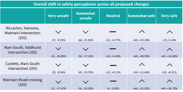 Table 1 - Overall shift in safety
perceptions across all proposed changes
Table 1 - Overall shift in safety
perceptions across all proposed changes
7. Policy
Framework Implications Ngā Hīraunga ā- Kaupapa
here
Strategic AlignmentTe Rautaki
Tīaroaro
7.1 Council’s strategic priorities have
been considered in formulating the recommendations in this report, including, residents
having equitable access to a range of transport options that make it easy and
safe to get around the city, and reduce emissions as a Council and as a City.
7.2 This report supports the Council's
Long Term Plan (2021 - 2031):
7.3 Transport
7.3.1 Activity: Transport
· Level
of Service: 10.0.6.1 Reduce the number of death and serious injury crashes on
the local road network - <=96 crashes
· Level
of Service: 10.5.1 Limit deaths and serious injury crashes per capita for
cyclists and pedestrians - <= 12 crashes per 100,000 residents
Policy Consistency Te Whai Kaupapa here
7.4 The decision is consistent with
Council’s Plans and Policies.
Impact on Mana Whenua Ngā Whai Take
Mana Whenua
7.5 The decision
does not involve a significant decision in relation to ancestral land or a body
of water or other elements of intrinsic value, therefore this decision does
specifically impact Mana Whenua, their culture and traditions.
7.6 The decision
does not involve a matter of interest to Mana Whenua and will not impact on our
agreed partnership priorities with Ngā Papatipu Rūnanga.
7.7 The effects of
this proposal upon Mana Whenua are expected to be insignificant as the proposal
involves minor work within the existing carriageway.
Climate Change Impact Considerations Ngā
Whai Whakaaro mā te Āhuarangi
7.8 The decisions in
this report are likely to:
7.8.1 Contribute neutrally to adaptation to
the impacts of climate change.
7.8.2 Contribute positively to emissions
reductions.
7.9 The emission
reductions associated with this project have not been estimated.
7.10 Improving the ability for people to walk and cycle are a
key part of council’s emissions reduction efforts by providing a safe,
low emission way for residents to move around the city.
7.11 From the 2022 Life in
Christchurch Transport Survey, 96 percent of respondents travel by car.
Inconsiderate and dangerous behaviour from other road users and sharing the
road with cars were the main reasons respondents found it difficult to bike.
7.12 Improving safety and making the
intersection feel safer would address some of the barriers to people making
sustainable travel choices. Removing these barriers will lead to reductions in
vehicle kilometres travelled and consequently emissions from transport.
7.13 The National Emissions Reduction Plan (ERP) states we will
have to ‘substantially improve infrastructure for walking and
cycling’ to meet our emissions targets (including a 20% reduction in
light Vehicle Kilometres Travelled by 2035 - required under the ERP). Improving
the quality of walking and cycling infrastructure is also a key part of the
Ministry of Transport and Waka Kotahi’s efforts to decarbonise the
transport system, so improving safety for these users would be consistent with
national direction.
Accessibility Considerations Ngā Whai
Whakaaro mā te Hunga Hauā
7.14 This proposal improves accessibility for
pedestrians/cyclists, by providing a safer means of crossing at the
intersection and on Waimairi Road.
8. Resource Implications Ngā Hīraunga Rauemi
Capex/Opex Ngā Utu Whakahaere
8.1 Cost
to Implement - $810k for the works on Riccarton Road and on Waimairi Road to
Leslie Street. The Waimairi Road signalised crossing is estimated to cost
$500k. These are estimates and not tendered prices.
8.2 Maintenance/Ongoing
costs - To be covered under the area maintenance
contract, the effects will be minimal to the overall asset.
8.3 Funding
Source –
8.3.1 Traffic Operations
Minor Road Safety Budget for Riccarton Road and Main South Road projects.
8.3.2 Waimairi Road
signalised pedestrian crossing (CPMS 73676) is funded through the Christchurch
Regeneration Acceleration Facility (CRAF) in the Long-Term Plan.
8.4 Funding
support - Waka Kotahi have confirmed that funding support at 51% is approved
for the intersection works on Riccarton Road and Main South Road through the
low-cost low-risk programme. Activities funded through the Low-Cost Low-Risk
investment pathway do not need to calculate a benefit-cost ratio. Funding
support is only guaranteed for this financial year.
Other He mea anō
8.5 None
identified.
9. Legal Implications Ngā Hīraunga ā-Ture
Statutory power to undertake proposals in
the report Te Manatū Whakahaere Kaupapa
9.1 Part
1, Clauses 7 and 8 of the Christchurch City Council Traffic and Parking Bylaw
2017 provides Council with the authority to install parking restrictions by
resolution.
9.2 The
Community Boards have delegated authority from the Council to exercise the
delegations as set out in the Register of Delegations. The list of
delegations for the Community Boards includes the resolution of stopping
restrictions and traffic control devices.
9.3 The
installation of any signs and/or markings associated with traffic control
devices must comply with the Land Transport Rule: Traffic Control Devices 2004.
Other Legal Implications Ētahi atu
Hīraunga-ā-Ture
9.4 There
is no other legal context, issue or implication relevant to this decision.
9.5 This
specific report has not been reviewed and approved by the Legal Services Unit
however the report has been written using a general approach previously
approved of by the Legal Services Unit, and the recommendations are consistent
with the policy and legislative framework outlined in sections 9.1 - 9.3.
10. Risk Management Implications Ngā Hīraunga Tūraru
10.1 None identified.
11. Next Steps Ngā Mahinga ā-muri
11.1 Should the
intersection and pedestrian safety improvements be approved, construction will
follow this financial year.
Attachments Ngā Tāpirihanga
|
No.
|
Title
|
Reference
|
Page
|
|
a
|
Church Corner
Safety Improvements
|
24/95888
|
|
|
b
|
Waimairi Road
Crossing Background Information
|
24/79397
|
|
|
c
|
Church Corner
Ward and Pedestrian Information
|
24/79383
|
|
|
d
|
Church Corner
safety improvements - all submissions (public)
|
24/94712
|
|
|
e
|
Church Corner
safety improvements - submission analysis
|
24/95777
|
|
In addition to the attached documents, the following background
information is available:
|
Document
Name – Location / File Link
|
|
Not
applicable
|
Confirmation of Statutory
Compliance Te Whakatūturutanga ā-Ture
|
Compliance with Statutory Decision-making
Requirements (ss 76 - 81 Local Government Act 2002).
(a) This report contains:
(i) sufficient information about all reasonably practicable
options identified and assessed in terms of their advantages and
disadvantages; and
(ii) adequate consideration of the views and preferences of
affected and interested persons bearing in mind any proposed or previous
community engagement.
(b) The information reflects the level of significance of the
matters covered by the report, as determined in accordance with the Council's
significance and engagement policy.
|
Signatories Ngā Kaiwaitohu
|
Authors
|
Gemma Dioni -
Principal Advisor Transportation - Safety
Ann Tomlinson
- Project Manager
Krystle
Anderson - Engagement Advisor
Georgia Greene
- Traffic Engineer
|
|
Approved By
|
Katie Smith -
Team Leader Traffic Operations
Stephen Wright
- Manager Operations (Transport)
Lynette Ellis
- Head of Transport & Waste Management
|
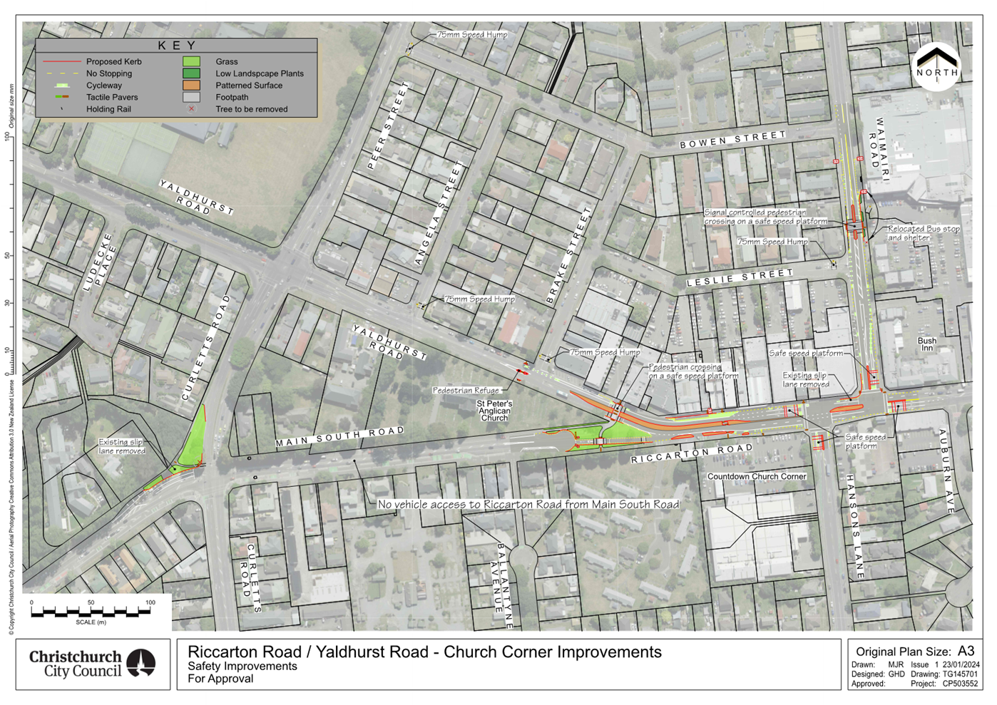
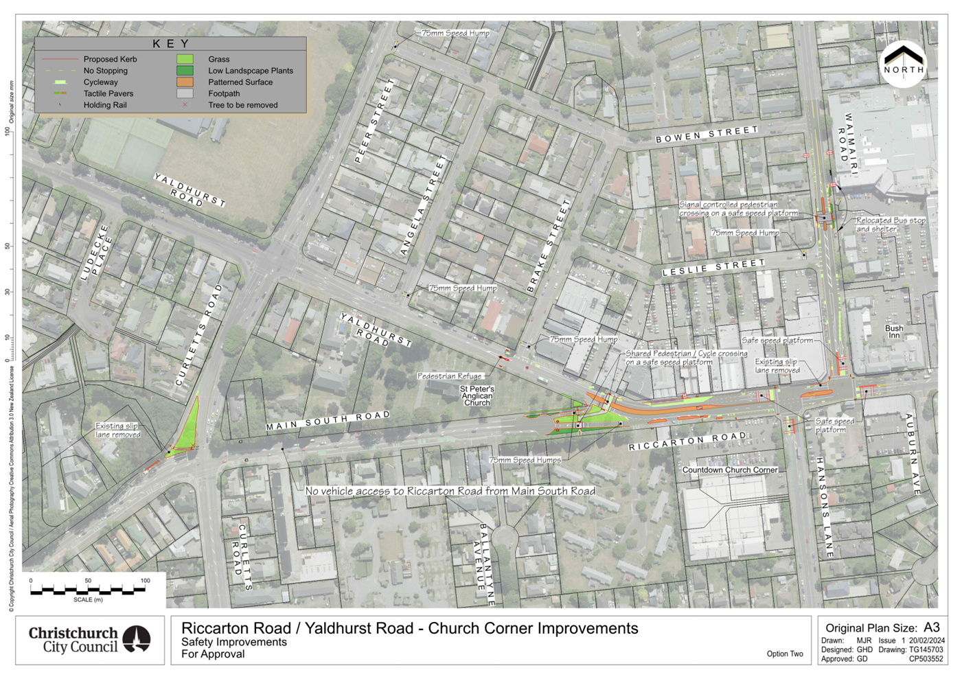
|
6. Sports Field Network Plan
|
|
Reference Te Tohutoro:
|
24/473714
|
|
Responsible Officer(s) Te Pou Matua:
|
Richard
Gibbs, Senior Project Manager
Rupert Bool, Acting Head of Parks
|
|
Accountable ELT Member Pouwhakarae:
|
Andrew
Rutledge, Acting General Manager Citizens and Community
|
1. Purpose and Origin of the Report Te Pūtake Pūrongo
1.1 The
purpose of this report is to present the draft Sports Field Network Plan to the
Council for approval.
1.2 This
report is staff generated and presents a summary of the content of the Sports
Field Network Plan, why it is needed and the collaborative process that was
carried out with regional sports organisations and their member clubs to
develop the Plan.
1.3 The
Council’s final approval of the Sports Field Network Plan is sought to
enable implementation of the plan in sync with the 2024-34 Long Term Plan once
adopted.
2. Officer Recommendations Ngā
Tūtohu
That the Council:
1. Receive the information in the Sports Field Network Plan report.
2. Note that the decision in this report is
assessed as having a medium to low level significance based on the Christchurch City Council’s Significance
and Engagement Policy.
3. Adopt the Sports Field Network Plan –
Attachment A to this report.
3. Executive Summary Te Whakarāpopoto Matua
3.1 The
draft Sports Field Network Plan (the Plan) is a strategic document that
articulates the desired goals and outcomes associated to a well performing
sports field asset to meet the sporting needs of our community for all levels
of sport and for all age groups over the next 10 years. It will help to ensure
that the sports field needs of our community are met in the face of a growing
pressure for the city’s open space to be used for a range of recreational
needs.
3.2 The
Plan acknowledges the need to incorporate other parkland open space demand such
as the urban forest and an increasing demand to accommodate localised
‘green storm water’ management solutions to alleviate pressure on
the city’s network infrastructure generated by increasingly diverse
seasonal weather events.
3.3 The
draft Plan has been developed in conjunction with stakeholders who represent
the key sporting groups and organisations that use the sports fields in the
summer and winter sports seasons, and who manage weekly sports opportunities
and events. These stakeholders include Sport Canterbury,
Regional Sports Organisations (RSOs) who have Council sports fields allocated
to them for the summer and winter sports seasons, and independent organisations
set up to manage weekly sports opportunities and events for schools.
3.4 The
scope of the Plan covers the land that Council has historically provided to
Regional Sports Organisations (RSOs) for sports traditionally played on natural
turf and which the RSOs have then allocated seasonally to their user groups.
3.5 The
Plan sets out how we aim to provide a sports field network that encourages
citizens to participate sport locally, and enjoy the multiple benefits of good
health, wellbeing and strengthened communities that result from participation.
3.6 The
Plan guides development and improvement of our sports fields: to address any
backlog; to meet the growth and changing use demands of our communities; and to
facilitate sporting performance at a community level.
3.7 The
Plan needs to consider the different seasonal needs of sports. The predominant
users of the land allocated in winter are rugby, league and football codes. In
summer, the predominate users of sports parks are cricket, softball and touch
rugby. Junior sports across codes often utilise senior fields for their games.
Touch rugby uses a high number of fields as it is a high participation sport.
3.8 Implementation
of the Plan will require additional investment over time. As such funding has
been included in the draft 2024-34 Long Term Plan to enable delivery of the
Plan’s objectives.
3.9 Implementation
of the Plan will strengthen Christchurch City’s reputation as an
increasingly confident city, one that promotes a green
liveable environment, and an increasingly vibrant city where people want to
live and thrive.
4. Background/Context Te Horopaki
4.1 Sporting
activity is at the heart of every community. It impacts our culture, society
and economy. An accessible and affordable network of sports fields provides
opportunity for our citizens to participate in and enjoy sport regardless of
age, ability, background, ethnicity or gender. Sport can break down many of the
barriers associated with challenging socio-economic challenges.
4.2 Year-on-year the Council has
failed to meet customer satisfaction levels of service associated with sports
field asset provision. The last point of contact resident satisfaction survey
results (2023/2024) showed 50% overall satisfaction with the range and quality
of sport parks against a target of 75%. Results have fluctuated year on year
but trend as an ongoing decline.
4.3 Increasingly
women are participating in a variety of sports including those traditionally
dominated by males. The city needs to adapt and invest in its infrastructure to
address this dynamic to support gender neutrality in sports infrastructure.
4.4 The Sports Field Network Plan provides the strategic framework for
delivering the above network of sports fields. At the Plan’s core are
three goals:
i. Play where you live;
ii. Participate for life; and
iii. Succeed.
4.5 These goals have been developed with the overall aim of encouraging
citizens to participate locally, and enjoy the multiple benefits of good
health, wellbeing and strengthened communities. By focussing on these three
goals, accessibility is delivered locally especially for young
people, supporting increased participation in sport whilst minimising barriers
such as travel and cost. Furthermore, local provision is supplemented by
quality, well-placed and appropriately configured community facilities that
support sport development and performance and build the city’s sporting
image.
4.6 The following related memos/information were
circulated to the members of the meeting:
|
Date
|
Subject
|
|
15/3/24
|
Email Sent to Councillor Johanson in his
capacity as Sports Promotion Portfolio Lead with the following attachments:
· Draft Sports Field Network Plan and
· All of the feedback submissions from Regional Sports Organisations
and associated clubs
|
|
26/4/24
|
Final draft Sports Field Network Plan
sent to Councillor Johanson in his capacity as Sports Promotion Portfolio
Lead.
|
4.7 The following related information session/workshops have taken place
for the members of the meeting:
|
Date
|
Subject
|
|
28-09-2023
|
Briefing to Waitai
Coastal-Burwood-Linwood Community Board Briefing
|
|
20-11-2023
|
Briefing to Waimāero
Fendalton-Waimairi-Harewood Community Board
|
|
23-11-2023
|
Briefing to Waipuna
Halswell-Hornby-Riccarton Community Board
|
|
23-11-2023
|
Briefing to Waipapa
Papanui-Innes-Central Community Board
|
|
30-11-2023
|
Briefing to Waihoro
Spreydon-Cashmere-Heathcote Community Board
|
|
06-05-2024
|
Briefing to Te
Pātaka o Rākaihautū Banks Peninsula Community Board
|
Options Considered Ngā Kōwhiringa Whaiwhakaaro
4.8 The
following reasonably practicable option was considered and is assessed in this
report:
· Provision of a Sports
Field Network Plan.
4.9 The
following option was considered but ruled out:
· Not to have a Sports
Field Network Plan - this option is not recommended
as it is important for the Council to be more strategic in its approach to
investment in the provision of sports field infrastructure on behalf of
ratepayers. Up until recently, capital expenditure has been in response to
earthquake recovery and improvements to support training facility demands for
global tournaments. Moving forward, having a planned approach with ongoing
collaboration with key stakeholders and clearly defined goals will enable
optimal decision making. This approach will enable the Council to achieve its
strategic objectives and community outcomes as well as meet the goals of its
other plans and strategies, including climate-related goals.
Options Descriptions Ngā Kōwhiringa
4.10 Preferred
Option: Adopt a citywide Sports Field Network Plan
4.10.1 Option
Description: A strategic framework for delivering a network of sports
fields across the city.
4.10.2 Option
Advantages
· There will be
a well-coordinated, objective and transparent approach to the provision of new,
upgraded and renewals of sports fields that consider existing supply, future growth
and changing use demands of our communities and to facilitate sporting
performance.
· Decision making relating to
prioritisation of future investment will be collaborative with RSOs and can be
shared with elected members in advance of annual and LTP plan adoption
year-on-year.
· Minimises reactive community
‘noise’ related decision making.
· Enables careful consideration
of the most cost-effective way to meet demand.
4.10.3 Option
Disadvantages
· The plan will
require additional funding over time to implement.
Analysis Criteria Ngā Paearu Wetekina
4.11 The
Sports Fields Network Plan will set out the development pathway for the network
of sports fields and associated infrastructure in Christchurch over the next 10
years. The draft Plan focuses on the provision, development and performance of
a network of well-placed, appropriately developed and accessible sports fields
across our city, balanced against other competing needs for use of our
city’s parks.
4.12 Through
implementing the Plan, we will be able to: capture what is working well or
requires improvement and where gaps exist; understand existing issues and
opportunities in response to changing community needs; and establish clear and
concise goals to help guide and prioritise sports field investment.
4.13 The
Plan does not identify provision for individual sports. The intention is for
the network of sports fields to be as flexible as possible, recognising that
demand and use change over time and that sports also use non-Council
facilities. It seeks to guide equitable sports field provision and development
based on community needs. This approach is considered the most cost-effective
way to deliver the appropriate Level of Service.
4.14 In
delivering the three goals of the Sports Field Network Plan (Play where you
live, Participate for life and Succeed), the provision and
development of the sports field network will need to balance the other
recreational needs of our community and competing and increasing demands for
use of open space.
4.15 This
Sports Field Network Plan will sit alongside other documents and plans that
contribute to the delivery of Council’s community outcomes and guide
policy or investment priorities.
5. Financial Implications Ngā Hīraunga Rauemi
Capex/Opex Ngā Utu Whakahaere
|
|
Recommended Option- network plan
|
Option 2 – No plan
|
|
Cost to Implement
|
$50M over the term of the current draft
Long Term Plan, Funding in the draft long term plan has funding commencing in
year 5 FY29/30 of the plan
|
Not investing in a planned approach would
mean funding would remain at low levels as it has in the past. Non network
plan funding averages $ 600K per annum and enables minor works only
|
|
Maintenance/Ongoing Costs
|
Maintenance costs will be defined once
individual projects are conceptualised. Any adjustment to Opex budgets (if
any) will be detailed in future LTP and Annual plans
|
Current annual sports field maintenance
costs including seasonal renovations average $2.5M per annum. Costs
fluctuate marginally driven by seasonal weather determining the level of
renovation required.
|
|
Funding Source
|
#61785 Programme - Community Parks Sports
Field Development
|
#70634 Community Parks Sports Field Development Delivery Package)
#74020
Community Parks Planned Sports Fields Renewals Delivery Package
#61806 Sports Fields Irrigation
Systems Development
#61816 Community Parks Planned Irrigation
System renewals
#61818
Programme - Community Parks Planned Sports Fields Renewals
|
|
Funding Availability
|
Dependent on finalisation of the draft
2024-2034
|
Dependent on finalisation of the draft
2024-2034
|
|
Impact on Rates
|
0.1% per annum average over last five
years of the current draft LTP
|
n/a- This is baseline funding from the
existing Long term plan
|
5.1 The
funding for this project is included in the draft 2024-34 Long Term Plan.
6. Considerations Ngā Whai Whakaaro
Risks and Mitigations Ngā Mōrearea me
ngā Whakamātautau
6.1 Any
delays in adopting a final Sports Park Network Plan will mean staff will most likely be received negatively by the sporting community in
Christchurch, particularly the Regional Sports Organisations who have
contributed to the Plan.
6.2 Resident
satisfaction surveys will most likely continue to not meet expectation.
6.3 Future
demand will not be met in a well-planned manner meaning the cost impacts may be
higher for rate payers.
Legal Considerations Ngā Hīraunga
ā-Ture
6.4 Statutory
and/or delegated authority to undertake proposals in the report:
6.4.1 The
Council has authority to adopt the final Sports Field Network Plan.
6.5 Other Legal Implications:
6.5.1 In
preparing the final Sports Park Network Plan (the Plan) consideration has been
given to the views and preferences of the persons likely to be affected. Those
views and preferences are well known to the Council, as is the impact of the
Plan from the perspective of the persons likely to be affected. It was
considered that cost of engaging in a full consultative procedure were not
warranted due to the likely affected persons being well known and there being
no additional benefits in engaging in such a procedure.
6.5.2 This
report has been reviewed by the Legal Services Unit in respect to their advice
relating to consultation in relation to the Local Government Act 2002.
Strategy
and Policy Considerations Te
Whai Kaupapa here
6.6 The
required decision:
6.6.1 Aligns
with the Christchurch
City Council’s Strategic Framework. In
particular this recommendation is strongly aligned with the community outcomes
of a collaborative confident city, giving residents the opportunity to actively
participate in community and city life, and supporting the community to pursue
their arts, cultural and sporting interests. It supports our key
Community Outcomes of being a collaborative confident city, a green liveable
city, a cultural powerhouse city and a thriving prosperous city.
6.6.2 Is
assessed as medium to low significance based on the
Christchurch City Council’s Significance and Engagement Policy. The
driving factors in assessing this level of significance are the level of
community interest, the number of people that the Plan could affect, and the
potential benefits to the wider community and the District.
6.6.3 Is consistent
with Council’s Plans and Policies. In particular, the:
· Te
Haumako Te Whitingia Strengthening Communities Together Strategy (2022)
· Kia
tūroa te Ao Ōtautahi Christchurch Climate Resilience Strategy (2021)
· Physical
Recreation and Sport Strategy (2002)
· The
Greater Christchurch Spatial Plan and the Mass Rapid Transit Indicative
Business Case
· The
Urban Forest Plan (2023)
6.7 This
report supports the:
6.8 Parks, heritage and coastal environment
6.8.1 Activity: Parks and Foreshore
· Level of Service: 6.3.5 Overall customer satisfaction with
the recreational opportunities and ecological experiences provided by the
City's Regional Parks - Regional Parks resident satisfaction >=80%. Citizens and communities
6.8.2 Activity: Community Development and Facilities
· Level of Service: 2.0.1.1 Support the development of
strong, connected and resilient communities by supporting the provision of a
sustainable network of community facilities.
6.9 Parks, heritage and coastal environment
6.9.1 Activity: Parks and Foreshore
· Level of Service: 6.8.5 Satisfaction with the overall
availability of recreation facilities within the city's parks and foreshore
network. Resident satisfaction with the availability of recreation
facilities across the parks and foreshore network: >= 70%.
Community
Impacts and Views Ngā Mariu ā-Hāpori
6.10 Parks
staff requested the Communications and Engagement team review the community
engagement carried out to date and how the feedback has been incorporated into
the draft Plan. The Communications and Engagement team concluded that the
community engagement has been comprehensive and consequently, further
consultation is not considered necessary.
6.11 The
Legal team were asked to consider whether the level of engagement undertaken on
the draft Sports Field Network Plan met the requirements of the Local
Government Act.
6.11.1 After
determining the significance of the Plan and having linked the level of
significance to the level of engagement, it was considered that the Plan is
significant only to the relatively small group of people (RSOs) who have been
identified and consulted and has a low impact on the wider community but has
the potential to benefit the wider community.
6.11.2 Prior to
initiating any specific projects under the Plan, it is recommended that there
is engagement with those members of the community that reside in the immediate
vicinity of the subject sports field(s) to discuss the means by which any
potential mitigation measures can be initiated to reduce the impact of any new
developments on their amenity value.
6.12 In
the development of the draft Sports Field Network Plan Council staff engaged
with stakeholders who represent the key sporting groups and organisations that
use the sports fields in the summer and winter sports seasons, and who manage
weekly sports opportunities and events for tamariki and rangatahi in Waitaha.
These stakeholders included:
6.12.1 Sport
Canterbury – an independent regional sports trust for Waitaha, dedicated
to fostering community and connection through sports. Sport Canterbury is
one of 17 regional sports trusts under the umbrella of Sport New Zealand.
6.12.2 Major regional
sports organisations who have Council sports fields allocated to them for the
summer and winter sports seasons have been engaged with and have contributed to
the development of the Plan. Collectively, these regional organisations
represent the majority of community sports clubs in Christchurch:
6.12.3 Canterbury
Rugby – representing 19 clubs (264 teams)
6.12.4 Canterbury
Rugby League – representing 11 clubs (92 teams)
6.12.5 Christchurch
Metro Cricket and Canterbury Cricket – representing 26 clubs (483 teams)
6.12.6 Canterbury
Softball – representing 13 clubs (181 teams)
6.12.7 Mainland
Football – representing 39 clubs (430 teams)
6.12.8 Touch
Canterbury – representing 24 modules (936 teams)
6.12.9 Canterbury
Schools Sport organisation
6.12.10 Independent
organisations set up to manage weekly sports opportunities and events for
tamariki and rangatahi in Waitaha (School Sports Canterbury, Primary Sports
Canterbury). Membership of these organisations consists of primary,
intermediate and secondary schools throughout Canterbury
6.13 A
minimum of two meetings/workshops were held with these stakeholders, where
Council staff presented the draft Plan and received feedback. Subsequent
meetings were held at the request of Mainland Football and Canterbury Softball
with their respective clubs, where Council staff received further feedback.
There was also a meeting held with the Secondary School Regional Sports
directors, with information sent out to all secondary schools in Ōtautahi.
6.14
In addition, staff met with RSO’s clubs when requested to discuss core
goals of the Plan and how the Plan is intended to be implemented.
6.15 A
high proportion of the feedback received at the meetings and workshops was
focused on operational detail rather than on the strategic direction of the
Plan. However, there was widespread support for the methodology that had been
used to develop the Plan and, in particular, the intent to establish a network
of six artificial turf hubs around the city.
6.16 One
of the key outcomes agreed through the engagement with the key stakeholders is
that the prioritisation of the projects implemented from the draft Plan would
be agreed in consultation with the regional sports organisations through
regular seasonal meetings and using an agreed decision-making matrix (Goal:
Succeed. Objective 3.2) This process will help ensure that community sports
clubs, through their regional organisations, will continue to have a voice as
the Plan is delivered.
6.17 The
Plan’s Framework also has other key actions recognising the importance of
ongoing collaboration with the Regional Sports Organisations, including working
with them to evaluate the city’s network of floodlights (Goal 2,
Objective 2.1) and seeking ongoing feedback on the performance of sports fields
(Goal 3: Objective 3.1).
6.18 The
decision affects the following wards/Community Board areas:
6.18.1 All Community
Boards.
6.19 The
Community Boards’ view is supportive, as judged
from the feedback given during the five briefings presented in 2023 and one in
2024.
Impact on Mana Whenua
Ngā Whai Take Mana Whenua
6.20 The decision does not involve a significant decision in relation
to ancestral land or a body of water or other elements of intrinsic value,
therefore this decision does not specifically impact
Mana Whenua, their culture, and traditions.
6.21 The decision does not involve a matter of interest to Mana Whenua and will not impact on our agreed partnership priorities
with Ngā Papatipu Rūnanga.
6.22 A
draft copy of the Sports Field Network Plan to all six local Rūnanga
(Ngāi Tūāhuriri, Rāpaki, Koukourarata, Wairewa, Ōnuku
and Taumutu) and asked for specific feedback. No feedback was received. It
should be noted that any individual sports field development on new land would
automatically trigger an early engagement with Mahaanui Kurataiao and the
Papatipu Rūnanga.
Climate
Change Impact Considerations Ngā Whai Whakaaro mā te Āhuarangi
6.23 The
decisions in this report are likely to:
6.23.1 Contribute
positively to adaptation to the impacts of climate change by designing
and constructing new or upgraded sports fields so that they can support climate
resilience by increasing their ability to store rainfall in severe weather
events.
6.23.2 Contribute
positively to emissions reductions by prioritising of sports fields within
walkable catchments and close to public transport (including proposed Mass
Rapid Transit), and cycle routes can support Council’s target to halve
our district’s emissions by 2030.
Accessibility
Considerations Ngā
Whai Whakaaro mā te Hunga Hauā
6.24 Accessibility
is embedded into the Sports Field Network Plan through the vision ‘Parks
are for everyone’ and guiding principles ‘For everyone’ and
‘Development is optimised and equitable’.
7. Next Steps Ngā Mahinga ā-muri
7.1 Deliver
on funded actions with the Plan.
Attachments Ngā Tāpirihanga
|
No.
|
Title
|
Reference
|
Page
|
|
a ⇩
|
Sports Field
Network Plan
|
24/765429
|
70
|
In addition to the attached documents, the following background
information is available:
|
Document
Name – Location / File Link
|
|
Not
applicable
|
Signatories Ngā Kaiwaitohu
|
Authors
|
Richard Gibbs
- Senior Project Manager
Angela
Leatherby - Sports Liaison Advisor
|
|
Approved By
|
Rupert Bool -
Acting Head of Parks
Andrew
Rutledge - Acting General Manager Citizens and Community
|
|
7. Better
Off Funding - Ferrymead Heritage Park Third Tranche
|
|
Reference Te Tohutoro:
|
24/440207
|
|
Responsible Officer(s) Te Pou Matua:
|
Joshua
Wharton, Community Funding Team Leader
|
|
Accountable ELT Member Pouwhakarae:
|
Andrew
Rutledge, Acting General Manager Citizens and Community
|
1. Purpose and Origin of the Report Te Pūtake Pūrongo
1.1 The purpose of this report is to enable the Council to consider
approving the payment of the third and final tranche of Better-Off funding
allocated to Ferrymead Heritage Park.
1.2 This report originated following the 21 June 2023 Council resolution
(CNCL/2023/00076):
1.2.1 $400,000 to the
Ferrymead Trust to accelerate or enhance their projects or operations so they
continue to contribute to important community experience and subject to the
following terms and conditions:
· Joint funding with the Ferrymead
Trust on a 50:50 basis for the operation of the Ferrymead Trust from 1 July
2023 to 21 December 2023;
· Ferrymead Trust retaining a suitable
qualified entity to develop a business plan that substantively implements the
February 2023 BDO Christchurch Limited Report “Final Strategic and
Opportunities Review Summary Report” by November 2023 with sufficient detail
to clearly demonstrate how Ferrymead Trust will achieve ongoing financial
sustainability including what actions will be taken, by whom, when, and at what
cost. This is to inform Council’s consideration of long-term
funding in the Long-Term Plan;
· Milestones that recognise progress
implementing the BDO Christchurch Limited Report;
· That staff work with Ferrymead Trust to agree to funding terms
and conditions and, if necessary, identify any milestones for grant payments,
prior to making the grant payments to the Trust.
1.2.2 $111,700 of the total
$400,000 grant was allocated as a first tranche to support business-plan
development until 31 December 2023.
1.2.3 A further $140,000 of
the remaining was then allocated as a second tranche to support identified
high-priority Park transformation initiatives at the Council Meeting of 12
December 2023.
· It was agreed that staff would bring a report to Council for
consideration of a third tranche payment in 2024 for allocation of the
remaining $148,300 in context of the Trust’s performance against key
milestones. These milestones were that:
i. Any expectation of future financial support
from the Council should be limited to an application to the contestable
Strengthening Communities Fund for an amount no greater than historical norms.
ii. The Ferrymead Trust should consider the impacts of climate change in
their future planning primarily their response to adverse events, sea level
rise and emissions.
iii. The business plan should contemplate how
the Ferrymead Trust will work with its stakeholder
organisations to secure the future of vulnerable buildings on site, be this
repair, removal, or demolition.
1.3
This report involves the third and final tranche.
2. Officer
Recommendations Ngā Tūtohu
That the Council:
1. Receive the information in the Better Off Funding – Ferrymead
Heritage Park Third Tranche Report.
2. Approve a third and final tranche payment of $148,300 from the
Metropolitan Better Off Fund to The Ferrymead Trust towards business plan
implementation for the betterment and long-term sustainability of Ferrymead
Heritage Park.
3. Note that the decision in this report is assessed as low
significance based on the Christchurch City
Council’s Significance and Engagement Policy.
3. Executive Summary Te Whakarāpopoto Matua
3.1 On
21 June 2023, the Council approved allocation of $400,000 from the Better Off
Fund to support a business transformation effort for Ferrymead Heritage Park,
who have struggled financially and structurally for several years.
3.2 This
funding has been awarded in two separate tranches so far, with staff working
closely alongside the Park governance board to ensure that they meet agreed
targets and have adequate support to do so.
3.3 Having
met all of the requirements of the second tranche, this decision relates to the
release of a third (and final) tranche, which would expend the remainder of the
allocated funds for the Park to continue delivering their transformative
efforts.
4. Background/Context Te Horopaki
4.1 The
Ferrymead Trust have demonstrated achievement of key milestones through regular
progress updates to Council staff. They have:
· Continued to operate the Park successfully throughout the start of
2024. There has been an increase in visitation numbers at the Park when
compared to the same period last year, due to a successful summer season and a
newly developed marketing and events role.
· Engaged further with Lyttelton Port & Christchurch NZ around
encouraging Cruise Ships and other City visitors to offer travel packages and
deals that include visits to the Heritage Park.
· Begun to implement a comprehensive business plan, demonstrating use
of the BDO (Business Advisory) strategic report recommendations, peer-reviewed
by Flourish Consulting (Attachment A).
· Developed a new business operating model at the Park, which will
minimise costs for the company without significantly disrupting the
member-society activities or general public. These proposals have been
co-designed with the societies at the Park over a number of months and will
continue to be implemented by the Trust in 2024.
· Operated with transparency with Council staff and a consistent
vision for positive change at the Park.
4.2 The following related closed information session/workshops have
taken place for the members of the meeting:
|
Date
|
Subject
|
|
21
June 2023
|
Decision to award total quantum of $400,000
to the Ferrymead Trust.
First tranche of $111,700 made.
|
|
12
December 2023
|
Considered progression against agreed
objectives for the Park.
Second tranche of $140,000 made.
|
Options Considered Ngā
Kōwhiringa Whaiwhakaaro
4.3 The
following reasonably practicable options were considered for this report:
4.3.1 To decline to award
of any of the remaining $148,300 allocated to The Trust.
· This option was not recommended as it withdraws financial support
part-way through a transformative process, where funding was released in
tranches to retain competitive integrity and pressure for positive progress
within the Park.
4.4 The
following options were considered but ruled out:
4.4.1 To award part of the
remaining $148,300 allocated to the trust.
· This option would serve no material benefit to either the Park or
the Council and would require additional staff time in the preparation of
information and further decisions for any of the remaining quantum.
Options Descriptions Ngā
Kōwhiringa
4.5 Preferred
Option: To approve a third and final tranche payment of $148,300 from the
Metropolitan Better Off Fund to The Ferrymead Trust.
4.6 Option
Description: This funding would specifically target business plan
implementation for the betterment and long-term sustainability of Ferrymead
Heritage Park.
4.6.1 Option Advantages
· This funding will see the park through until decisions are made for
the contestable Strengthening Communities Fund in August.
· It will support the continued transformative work of the new
Ferrymead Trust.
4.6.2 Option
Disadvantages
· Will prevent the Council re-purposing the funding to another output
within Ferrymead Park, if it has a mind to do so.
Analysis Criteria Ngā Paearu
Wetekina
4.7 Following
Council’s initial resolution on 21 June 2023, staff have worked with
representatives from the Ferrymead Trust on various funding terms and key
milestones. All milestones of this first tranche were met. Details of progress
against milestones of the second tranche are as follows:
4.7.1 The Park has
completed and begun implementation of a detailed business plan, peer reviewed
by an external body, clearly detailing a realistic route to future stability
for the Park (Attachment A).
4.7.2 There is continued
communication to the park that expectation of future financial support from the
Council should be limited to an application to the contestable Strengthening
Communities Fund rather than through Council’s Long-Term Plan.
4.7.3 The Trust has
considered the impacts of climate change in their future planning primarily
their response to adverse events, sea level rise and emissions.
· They have organised a subcommittee of the Trust that will address
buildings and infrastructure in the context of their geographical location, particularly
proximity to the coast. They have reviewed the most recent advice from NIWA and
continue to monitor the situation. The Trust will report annually to
stakeholders on mitigations and residual risk in this area.
4.7.4 The Trust has
considered how it will work with its stakeholder organisations to secure the
future of vulnerable buildings on site, be this repair, removal, or demolition.
· They have developed an early plan for which buildings are classified
for repair, replacement, or (in the worst case) isolation. They have
finished a capital-raising investment strategy that will seek money from
philanthropic and corporate sources. They are also looking to employ a
fundraising professional and have identified a professional chartered
accountant who is willing to work with the Park on a 0.4FTE basis to review its
finances and ensure it aligns with international accounting standards (this
is important for seeking major external and national funding).
· The intention is to have the infrastructure of the Park
fit-for-purpose by 2030.
4.7.5 The Trust have
completed a comprehensive governance review. This review embedded a new
structure with the Trust as the most senior body at the Park, overseeing the
Company, and supported by an advisory board with membership across societies at
the Park. This is a significant change to the existing structure and will be
supported by the NZ Institute of Directors to ensure proper training for new
and remaining Trustees.
5. Financial Implications Ngā Hīraunga Rauemi
Capex/Opex Ngā Utu Whakahaere
|
|
Recommended Option – Grant the remainder
|
Option 2 – No grant
|
|
Cost to Implement
|
$148,000
|
0.00
|
|
Maintenance/Ongoing Costs
|
None
|
Staff time/advice on use of the remaining
funds
|
|
Funding Source
|
The Better-Off Fund
|
N/A
|
|
Funding Availability
|
Available – allocated for this
purpose
|
N/A
|
|
Impact on Rates
|
None
|
None
|
5.1 All
of the costs of releasing this third and final tranche are accounted for,
because of the decision of Council on 21 June 2023 to ringfence $400,000 for
this purpose.
6. Considerations Ngā Whai Whakaaro
Risks and Mitigations Ngā
Mōrearea me ngā Whakamātautau
6.1 There
is a material risk that longer-term implementation of the transformative
business plan by Ferrymead Heritage Park will require substantial funding that
is not affordable to the Council’s contestable community funding pool
long-term.
· This risk is partially mitigated by the Council clearly
communicating to the Trust that the reliance on considerable annual support
from the Council does not meet the requirement of financial sustainability.
· This remains a material risk, which will be monitored and used to
inform any future advice provided to the Council.
Legal Considerations Ngā
Hīraunga ā-Ture
6.2 There
is no legal context, issue, or implication relevant to this decision.
Strategy and Policy Considerations Te Whai
Kaupapa here
6.3 The required decision:
6.3.1 Is consistent with Te
Haumako, Te Whitingia - Strengthening Communities Together Strategy:
· Objective 1.5: Support groups involved in providing access to arts,
culture, heritage, recreation, and those who care for the environment.
· Objective 1.6: Facilitate and promote lifelong learning
opportunities for all.
· Objective 1.7: Work with others to reduce loneliness and social
isolation, with particular focus on intergenerational approaches.
· Objective 2.3: Support the community activation and kaitiakitanga of
public places and spaces.
· Objective 3.4: Increase volunteering opportunities across the
Council and the wider community and support the organisations providing such
opportunities.
6.3.2 Is assessed as low significance based on the
Christchurch City Council’s Significance and Engagement Policy.
6.4 This report supports the Council's
Long Term Plan (2021 - 2031):
6.5 Citizens
and communities
6.5.1 Activity:
Community Development and Facilities
· Level
of Service: 2.3.1.1 Provide funding for projects and initiatives that build
partnerships; resilient, engaged and stronger communities, empowered at a local
or community of interest level. - 95% or more of reports presented
demonstrate benefits that align to CCC community outcomes, Council's strategic
priorities and, where appropriate Community Board plans
· Level
of Service: 2.3.1.2 Build volunteer participation through the effective
administration of the community grant schemes. - Strengthening Communities Fund
supports 2,185,000 volunteer hours annually, subject to eligible applications
Community Impacts and Views Ngā Mariu
ā-Hāpori
6.6 The decision
affects the following wards/Community Board areas:
6.6.1 Waihoro
Spreydon-Cashmere-Heathcote
6.6.2 The
Community Board has received briefings regarding the ongoing status of the
Park. However, the decision regarding allocation of Better Off Funding lies
with the Council.
Impact on Mana Whenua Ngā Whai Take
Mana Whenua
6.7 The decision does not involve a significant
decision in relation to ancestral land or a body of water or other elements of
intrinsic value, therefore this decision does not specifically impact Mana
Whenua, their culture and traditions.
6.8 The decision is
not a matter of interest to Mana Whenua and will not impact on our agreed
partnership priorities with Ngā Papatipu Rūnanga. This is
because the decision concerns the allocation of pre-approved community funding.
6.9 The Park have
indicated a commitment to improving their Mana-Whenua partnership (specifically Ngāi Tūāhuriri and Ngāti Wheke).
This relationship with hapū continues to mature month-by-month.
6.10 The Trust is working with the
University of Canterbury to incorporate more Te Ao Māori into the Park.
Climate Change Impact Considerations Ngā
Whai Whakaaro mā te Āhuarangi
6.11 The
decisions in this report are likely to:
6.11.1 Contribute positively to adaptation to
the impacts of climate change.
6.12 The Trust have
provided advice to Council staff on how they will consider the impacts of
climate change in their future planning, primarily their response to adverse
events, sea level rise and emissions.
7. Next Steps Ngā Mahinga ā-muri
7.1 The
recommended third and final Tranche would allow the Park to continue to operate
day-to-day, while continuing business plan implementation for long term
sustainability and addressing Council feedback.
7.2 It
would expend the remaining $148,300 from the initial allocation of $400,000 in
June 2023.
7.3 Any
future funding from the Council will be managed through applications to the
Contestable Strengthening Communities Fund and/or public submissions to
Council’s Long Term Plan.
Attachments Ngā Tāpirihanga
|
No.
|
Title
|
Reference
|
Page
|
|
a ⇨
|
Ferrymead Park
Better Business Case 2024 - 2029 (Under Separate Cover)
|
24/17832
|
|
In addition to the attached documents, the following background
information is available:
|
Document
Name – Location / File Link
|
|
Not
applicable
|
Signatories Ngā Kaiwaitohu
|
Author
|
Josh Wharton -
Team Leader Community Funding
|
|
Approved By
|
Gary Watson -
Manager Community Partnerships
John Filsell -
Head of Community Support and Partnerships
|
|
8. Mount Pleasant Community Centre -
Community Loan Reschedule
|
|
Reference Te Tohutoro:
|
24/479049
|
|
Responsible Officer(s) Te Pou Matua:
|
Joshua
Wharton, Community Funding Team Leader
|
|
Accountable ELT Member Pouwhakarae:
|
Andrew
Rutledge, Acting General Manager Citizens and Community
|
1. Purpose and Origin of the Report Te Pūtake Pūrongo
1.1 The
purpose of this report is for the Council to consider a term-restructuring of
the Mount Pleasant Community Loan Schedule.
1.2 The
report originated through the relationship with the Mt. Pleasant Memorial
Community Centre & Residents Association as part of management of their
existing community loan.
2. Officer
Recommendations Ngā Tūtohu
That the Council:
1. Receive the information in the Mount Pleasant Community Centre
– Community Loan Reschedule Report.
2. Agree to extend the existing community loan with the Mt. Pleasant
Memorial Community Centre & Residents’ Association from a total term
of 13 years to a total term of 16 years with interest rates maintained at 2%
and quarterly repayments increasing by $1,000 p/a.
3. Note that the decision in this report is assessed as low
significance based on the Christchurch City
Council’s Significance and Engagement Policy.
3. Executive Summary Te Whakarāpopoto Matua
3.1 As
per the current loan schedule, from 20 December 2024, the Mount Pleasant
Community Centre will move from quarterly repayments of $2,000.00 to $9,015.49.
3.2 The
Association believe that meeting these repayment commitments are not achievable
at this stage in their development and activation of the centre.
3.3 Staff
have met with the Association trustees to assess the status of the
organisation, gauge repayment ability confidence, and to propose a realistic
path forward. The recommended approach reflects the result of this assessment
and discussions with the association.
4. Background/Context Te Horopaki
4.1 The
Association have been making their scheduled quarterly repayments of $2,000, of
which, a large portion is interest on the loan.
4.2 From
December 2024, this quarterly repayment is set to increase to $9,015, a 350%
increase. The Association has indicated to Council that they are unable to meet
these increased repayments as they have not developed sufficient
income-generating streams.
4.3 Council
staff have met with officers of the Association to discuss their organisational
status and have developed a step-up approach that both parties agree is
realistic and achievable for the Association. A copy of this Draft Schedule is
included in Attachment A.
4.3.1 This schedule will
slowly increase the quarterly repayments each year, rather than seeing one
significant jump, to allow the Association to adjust to the increasing costs.
4.3.2 It would not come at
significant cost to the Community Loan Scheme over the period of the loan and
would extend the total loan period by three years.
Options Considered Ngā
Kōwhiringa Whaiwhakaaro
4.4 The
following reasonably practicable options were considered and are assessed in
this report:
· To implement a step-up rescheduling of the loan.
· This would involve increasing the quarterly payments by $1,000 each
year, until reaching the current maximum ‘table loan’ payments of
$9,078.72 per quarter.
· This approach would extend the final quarterly repayment from
September 2033 until September 2037.
· The cost to the Community Loan Scheme of this approach would be
$12,124, because of the extended period for the loan to be repaid.
· To award the Association with an interest-free loan:
· This would still involve stepping up the principal payments by
$1,000 a year. However, the Council would incur an additional cost to the fund
caused by the loss of 2%p.a. interest.
· This approach would extend the final quarterly repayment from
September 2033 until June 2036.
· The cost to the Community Loan Scheme of this approach would be
$46,345, both because of the extended period of the loan, as well as the lack
of interest being charged.
4.5 The
following options were considered but ruled out:
· Forgiving the entirety of the Community Loan.
· The balance of the Community Loan Scheme is maintained through
repayments of current loan holders.
· The Association can make repayments at the current level and are
reasonably confident in their ability to grow annual income in years to come.
Analysis Criteria Ngā Paearu
Wetekina
4.6 For
the integrity of the Loan Scheme as a whole and because of precedent for other
Community-Loan holders, it is preferred not to recommend that the Council
forgive the loan quantum.
4.7 Staff
have been careful to find an option for the Association that reflects a
realistic path to meeting their loan obligations to the Council, at the lowest
possible cost to the scheme.
5. Financial Implications Ngā Hīraunga Rauemi
Capex/Opex Ngā Utu Whakahaere
|
|
Recommended Option
A step-up rescheduling of the loan
|
Option 2
Award interest free
|
|
Cost to Implement
|
$12,124
|
$46,345
|
|
Maintenance/ Ongoing Costs
|
None
|
None
|
|
Funding Source
|
Community Loans Scheme
|
Community Loans Scheme
|
|
Date of Complete Loan Repayment
|
September 2037
|
June 2036
|
|
Impact on Rates
|
None, the loan scheme is already
considered largely impaired in the LTP.
|
None, the loan scheme is already
considered largely impaired in the LTP.
|
6. Considerations Ngā Whai Whakaaro
Risks and Mitigations Ngā
Mōrearea me ngā Whakamātautau
6.1 There
is a material risk that even with a more forgiving growth in quarterly
principal repayments, that the Mount Pleasant Community Centre may struggle to
afford the loan costs if they are unable to increase their income in the years
to come.
6.1.1 This risk is
mitigated by the confidence of the Association in their ability to do so.
6.1.2 The risk is also
mitigated by the fact that if they were unable to make the increased quarterly
repayments, that maintaining the status quo of low repayments is realistic
without any significant organisational change or growth in annual income.
Legal Considerations Ngā
Hīraunga ā-Ture
6.2 Statutory
and/or delegated authority to undertake proposals in the report:
6.2.1 The Council has the
authority to award community loans and make amendments to community loan
schedules where the extension of such a loan would come at cost to the loans
scheme.
6.3 Other Legal Implications:
6.3.1 This decision will
not impact security arrangements currently in place with the Mt. Pleasant
Memorial Community Centre & Residents Association over the building.
Strategy and Policy Considerations Te Whai
Kaupapa here
6.4 The
required decision:
6.4.1 Aligns with the Christchurch
City Council’s Strategic Framework. .
6.4.2 Is assessed as low significance based on the Christchurch City
Council’s Significance and Engagement Policy. The level of
significance was determined by the number of
individuals impacted by the decision and low cost to implement.
6.4.3 Is consistent with the Council’s Plans and Policies.
6.5 This report supports the Council's
Long Term Plan (2021 - 2031):
6.6 Citizens
and communities
6.6.1 Activity:
Community Development and Facilities
· Level
of Service: 2.3.1.1 Provide funding for projects and initiatives that build
partnerships; resilient, engaged and stronger communities, empowered at a local
or community of interest level. - 95% or more of reports presented
demonstrate benefits that align to CCC community outcomes, Council's strategic
priorities and, where appropriate Community Board plans
· Level
of Service: 2.2.5.1 Community partner relationships are prioritised, improves
and supported by robust information. - 130 Partner Organisations' relationship
with Council is health-checked and reported
· Level
of Service: 2.0.7 Support community management and activation of facilities
through a Council and Community partnership model. - At least 75% of community
facilities are activated / managed in partnership with the community
Community Impacts and Views Ngā Mariu
ā-Hāpori
6.7 The decision affects the following Wards/Community Board areas:
6.7.1 The Waihoro Spreydon-Cashmere-Heathcote
Community Board
6.7.2 Heathcote Ward.
Impact on Mana Whenua Ngā Whai Take
Mana Whenua
6.8 The decision does not involve a significant decision in relation
to ancestral land or a body of water or other elements of intrinsic value,
therefore this decision does not specifically impact
Mana Whenua, their culture, and traditions.
6.9 The decision does not a matter of interest to Mana Whenua and will not impact on our agreed partnership priorities
with Ngā Papatipu Rūnanga.
Climate Change Impact Considerations Ngā
Whai Whakaaro mā te Āhuarangi
6.15 The
proposals in this report are unlikely to contribute significantly to adaptation
to the impacts of climate change or emissions reductions.
7. Next Steps Ngā Mahinga ā-muri
7.1 Staff
will prepare an amended loan agreement with the Mt. Pleasant Memorial Community
Centre & Residents Association to reflects the nature of the new repayment
schedule.
Attachments Ngā Tāpirihanga
|
No.
|
Title
|
Reference
|
Page
|
|
a ⇩
|
DRAFT Mount Pleasant
Community Centre Loan Schedule - Step Up Model
|
24/486932
|
124
|
In addition to the attached documents, the following background
information is available:
|
Document
Name – Location / File Link
|
|
Not
applicable
|
Signatories Ngā Kaiwaitohu
|
Author
|
Josh Wharton -
Team Leader Community Funding
|
|
Approved By
|
Peter Langbein
- Finance Business Partner
John Filsell -
Head of Community Support and Partnerships
|
|
9. Discretionary
Response Fund - Green Effect Trust, The Christchurch Foundation
|
|
Reference Te Tohutoro:
|
24/476632
|
|
Responsible Officer(s) Te Pou Matua:
|
Jacqui
Jeffrey – Community Funding Advisor
|
|
Accountable ELT Member Pouwhakarae:
|
Andrew
Rutledge, Acting General Manager Citizens and Community
|
1. Purpose and Origin of the Report Te
Pūtake Pūrongo
1.1 The
purpose of this report is for the Council to consider an application for
funding from its 2023/24 Discretionary Response Fund from
the organisation(s) listed below.
|
Funding Request Number
|
Organisation
|
Project Name
|
Amount Requested
|
Amount Recommended
|
|
00067087
|
Green Effect Trust
(Trees for Canterbury
|
Expansion of Services
|
$25,000
|
$20,000
|
|
00067785
|
The Christchurch
Foundation
|
Short term funding support
|
$20,000
|
$20,000
|
1.2 There is currently a balance of $134,898 remaining in the fund.
2. Officer Recommendations Ngā
Tūtohu
That the Council:
1. Receive the information in the Discretionary Response Fund - Green Effect
Trust, The Christchurch Foundation Report.
2. Note that the decisions in this report are
assessed as low significance based on the Christchurch City Council’s Significance and
Engagement Policy.
3. Approve a grant of $20,000 from its 2023/24
Discretionary Response Fund to the Green Effect Trust (Trees for Canterbury)
towards salaries, wages, and equipment costs.
4. Approve a grant of $20,000 from its 2023/24
Discretionary Response Fund to The Christchurch Foundation towards short-term
funding support, including salaries, wages, and administration.
3. Key Points Ngā Take Matua
Strategic Alignment Te Rautaki Tīaroaro
3.1 The
recommendations are aligned to the Strategic Framework and in particular the
strategic priority of enabling active and connected communities to own
their future. It will contribute to three community outcomes, resilient
communities, a liveable city, and a healthy environment.
The recommendations are consistent with the Strengthening Communities Together
Strategy.
Decision Making Authority Te Mana Whakatau
3.2 The
Council determines the allocation of the Discretionary Response Fund for each
community.
3.3 Allocations
must be consistent with any policies, standards or criteria adopted by the
Council.
3.4 The
Fund does not cover:
· Legal challenges or the
Environment Court challenges against the Council,
Council Controlled organisations, or Community Board decisions.
· Projects or initiatives
that change the scope of a Council project or that will lead to ongoing
operational costs to the Council (though Community
Boards can recommend to the Council that it consider a grant for this purpose).
Assessment of Significance and Engagement Te Aromatawai Whakahirahira
3.5 The decisions in this report are assessed as low significance based
on the Christchurch City Council’s Significance and Engagement Policy.
3.6 The level of significance was determined by the number of people
affected and/or with an interest.
3.7 Due to the assessment of low significance, no further community
engagement and consultation is required.
Discussion Kōrerorero
3.8 At the time of writing, the balance of the 2023/24 Discretionary
Response Fund is as below.
|
Total Budget 2023/24
|
Granted To Date
|
Available for allocation
|
Balance If Staff Recommendation adopted
|
|
$585,679
|
$450,781
|
$134,898
|
$94,898
|
3.9 $135,198
has been awarded from the 2023/24 Discretionary Response Fund to 23
organisations under the delegation of the head of Community Support and
Partnerships.
3.10 Based
on the current Discretionary Response Fund criteria, the applications listed
above are eligible for funding.
3.11 The
attached Decision Matrix provides detailed information for the
applications. This includes organisational details, project details,
financial information, and a staff assessment.
Attachments Ngā Tāpirihanga
|
No.
|
Title
|
Reference
|
Page
|
|
a ⇩
|
Decision Matrix Green Effect &
The Christchurch Foundation
|
24/678183
|
129
|
Signatories Ngā Kaiwaitohu
|
Authors
|
Jacqui Jeffrey
- Community Funding Advisor
Julie Pearce -
Community Funding Advisor
|
|
Approved By
|
Gary Watson -
Manager Community Partnerships
John Filsell -
Head of Community Support and Partnerships
|
|
10. Heritage
Incentive Grant Applications
|
|
Reference Te Tohutoro:
|
24/440189
|
|
Responsible Officer(s) Te Pou Matua:
|
Victoria
Bliss, Heritage Conservation Projects Planner Victoria.Bliss@ccc.govt.nz
|
|
Accountable ELT Member Pouwhakarae:
|
John
Higgins, General Manager Strategy, Planning & Regulatory Services
|
1. Purpose and Origin of the Report Te Pūtake Pūrongo
1.1 The purpose of this report is for the Council to consider
applications for Heritage Incentive Grant funding from the organisations listed
below, noting that the recommendations can be accommodated within the funds
available.
1.2 The
report is staff generated in response to applications received for Heritage
Incentive Grant funding.
1.3 Approval of these grants would support the Community Outcomes:
“Resilient Communities”, “Liveable City” and
“Prosperous Economy”.
2. Officer Recommendations Ngā
Tūtohu
That the Council:
1. Receive the information in the Heritage Incentive Grant Applications Report.
2. Note that the decision in this report is
assessed as low significance based on the Christchurch City Council’s Significance and
Engagement Policy.
3. Approve a Heritage Incentive Grant of up to
$63,000 for relocation, conservation, maintenance and upgrade works to the
Rāpaki School building, located at 9 Kina Road, Rāpaki.
a. Note that the applicants have already entered
into a 20-year limited conservation covenant.
4. Approve a Heritage Incentive Grant of up to
$58,164 for stained glass conservation works at St Michael and All Angels
Church.
a. Note that the applicants have already entered
into a 10-year limited conservation covenant.
5. Approve a Heritage Incentive Grant of up to
$54,303 for conservation, maintenance and upgrade works at 860-862 Colombo
Street.
a. Note that payment of the 860-862 Colombo
Street grant is subject to the applicant entering a 20-year limited
conservation covenant with the signed covenant having the Council seal affixed
prior to registration against the property title.
6. Approve a Heritage Incentive Grant of $59,000
for reinstatement, upgrade and maintenance works at 210 St Asaph Street.
a. Note that payment of the 210 St Asaph Street
grant is subject to the applicant entering a 20-year limited conservation
covenant with the signed covenant having the Council seal affixed prior to
registration against the property title.
7. Approve a Heritage Incentive Grant of up to
$8,471 for maintenance and repair works to The Old Shipping Office, 3 Church
Street, Akaroa.
8. Approve a Heritage Incentive Grant of up to
$2,313 for the William Gilbert and Hine Te Marino Headstone Conservation
project.
9. Approve a Heritage Incentive Grant of up to
$405 for the Marion ‘Queenie’ McLean headstone repair project.
10. Approve a Heritage Incentive Grant of up to
$7,610 for conservation, repair and maintenance works to 38 Dublin Street,
Lyttelton.
11. Approve a Heritage Incentive Grant of up to
$22,800 for conservation, repair and maintenance works to 47 Oxford Street,
Lyttelton.
a. Note that payment of the 47 Oxford Street
grant is subject to the applicant entering a 10-year limited conservation
covenant with the signed covenant having the Council seal affixed prior to
registration against the property title.
12. Approve a Heritage Incentive Grant of up to
$12,811 for conservation, repair and maintenance works to 52 Longfellow Street.
13. Approve a Heritage Incentive Grant of $22,500
for the Lewe Summers Memorial Sculpture project at Mount Pleasant Community
Centre.
3. Executive Summary Te Whakarāpopoto Matua
3.1 Heritage
Incentive Grant funding aims to incentivise owners and kaitiaki to undertake
works to protect, maintain, repair and upgrade heritage buildings, places,
structures and objects. This financial support contributes to the protection of
the district’s heritage now, and for future generations.
3.2 The
Heritage Incentive Grant fund was an annual fund provided for in the 2018-28
Long Term Plan. Council approved funding to be diverted into this fund from the
now closed Central City Landmark Heritage Grant Fund in 2020. The carry forward
of the remaining funds of $1,042,169 was approved for inclusion in the
2021/2031 Long Term Plan, with the resolution to spread these funds over three
financial years. This equates to $347,389 per annum for each year.
3.3 Allocation
of $311,377 from the 2023-2024 funding provision is recommended by staff in
this report. This will leave a balance of $36,012 available for other
applicants.
3.4 The
staff recommendations will support eleven different heritage conservation
projects across the city. The range of projects seeking funding reflects the
breadth and diversity of Ōtautahi Christchurch’s taonga.
3.5 The
recommended sum of $311,377 will support and incentivise a total investment of
over $1,130,569.00 in heritage projects across the district.
3.6 All grants meet the
eligibility criteria for the grant scheme, which was approved by the
Sustainability and Community Resilience Committee on 17 December 2020
(SACRC/2020/000460).
4. Background/Context Te Horopaki
4.1 The
‘Our Heritage, Our Taonga’ Heritage Strategy 2019-2029 was
developed in partnership with the six papatipu rūnanga and together with
the communities of the district. This engagement affirmed a strong community
desire to understand, celebrate and protect its heritage and a recognition of
the responsibility to future generations to safeguard Ōtautahi
Christchurch’s rich and diverse taonga.
4.2 The
Heritage Incentive Grant Scheme supports delivery of the overarching strategic
principle of “Taking an intergenerational approach to sustainable
development, prioritising the social, economic and cultural wellbeing of people
and communities and the quality of the environment, now and into the
future.” This is because heritage is an intergenerational equity. It
contributes to our personal and community sense of identity and belonging and
enhances high levels of social connectedness and cohesion.
4.3 The
Heritage Incentive Grant Scheme aligns to the Community Outcome
“Resilient Communities” – ‘celebration of our identity
through arts, culture, heritage, sport and recreation’ and ‘strong
sense of community’. It also supports “Liveable City” –
‘21st century garden city we are proud to live in’ and
“Prosperous Economy” – ‘great place for people,
business and investment’.
4.4 Applications
for Heritage Incentive Grant funding received by staff are discussed below:
Rāpaki School relocation and
conservation project
4.5 On
24 November 2021 the Sustainability and Community Resilience Committee awarded
a Heritage Incentive grant of $71,000 (30% of eligible costs) to Rāpaki
Reserves Trust. The grant was to support the relocation, conservation,
maintenance and upgrade of Rāpaki school (SARC/2021/00072).
4.6 At
the time of the grant award, the total works were estimated to be $292,261,
with $177,932 of this cost eligible for HIG funding.
4.7 The
works have begun and there has been a considerable increase in the project
costs which have risen to c.$750,000. Project costs have arisen due to
construction inflation and unforeseen factors including additional ground and
superstructure works. The applicants are now seeking additional HIG funding.
4.8 The
Guidelines for the HIG scheme provide for additional funding being approved
within a five-year period in certain circumstances, such as:
4.8.1 An
increase in the assessed level of risk, including possible loss.
4.8.2 Essential
unforeseen maintenance or repairs identified as a consequence of other works
being carried out on the building, place, structure or object.
4.9 The
building risk has increased as a result of further deterioration to the
adjacent cliff edge and ongoing coastal erosion requiring additional
foundations once the building is moved, as well as further repairs being
identified.
4.10 The
applicants have successfully applied for grant funding from other sources,
including $140,000 from the Rata Foundation and $30,000 from Parkinsons Trust.
They currently have a shortfall of $350,000 and are actively fundraising
through a crowd funding campaign Rāpaki School Restoration -
Rapaki Marae
4.11 The
school is of architectural, cultural and social significance which Te Hapū
o Ngāti Wheke are seeking to preserve and restore for ongoing use by
hapū and manuhiri. This will sustain both the tangible architectural
heritage of the whare, as well as its cultural significance as part of
hapū life and the mauri of Rāpaki. It is a rare example of a
nineteenth century building that has survived and remained in use in a
Ngāi Tahu village to the present day.
4.12 Since
it was constructed around 1874, Rāpaki School has been an integral part of
the hapū community, cultural landscape and social history of the
kāika of Rāpaki. The publicly accessible building will benefit not
only mana whenua, but also manuhiri for another century and beyond, further
preserving the rich heritage of the area both European and Māori.
4.13 Staff
are recommending a grant of $63,000 (which equates to 18% of the current
funding shortfall) to support the works and note that a 20-year Heritage
Conservation Covenant is already in place.
4.14 The
sum recommended is based on the heritage values of the building; the
contribution the works will make to its retention; the contribution the
building makes to wider community heritage and wellbeing outcomes; the urgency
of the work required relating to the risk of damage if the work is not done,
and the extent to which the building is accessible to the public. Consideration
has also been given to the degree to which the proposed activities are
consistent with tikanga and kawa of mana whenua.
4.15 Without
this additional grant funding Te Hapū o Ngāti Wheke will not be able
to complete the works, which have begun, to relocate the school away from the
cliff edge. They are able to phase some elements of the project to allow for
fundraising. However additional funding is required as a matter of urgency to
complete the foundation system and relocate the building. This needs to be done
before winter weather and further coastal erosion.
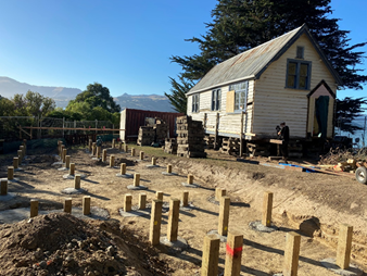
Rāpaki School showing works underway, April 2024.
Image supplied by Andrew Scott.

Rendering to show the relocated and repaired school
once completed. 2024, supplied by applicant.
4.16 The
applicant for the grant is Rāpaki Reserves Trust.
4.17 The
decision affects the following wards/Community Board areas:
4.17.1 Te Pātaka
o Rākaihautū Banks Peninsula.
4.17.2 Te Hapū o
Ngāti Wheke hold mana whenua rights and interests in the area.
St Michael and All Angels north
transept ‘Six Corporal Acts of Mercy’ and Rose windows conservation
project.
4.18 On
30 March 2022 the Sustainability and Community Resilience Committee awarded a
grant of $26,288 for conservation of the west Rose Window at St Michael and All
Angels Church, 243 Durham Street South, Christchurch (SACRC/2022/00011). At the
time the Committee sought to offer a higher funding sum given the high heritage
significance of the Church, its landmark status and the high heritage
significance of the stained-glass windows within the building.
4.19 At
the request of the Committee a further report was prepared and presented to
Council on 7 April 2022. Staff recommended that the grant remain at the
approved $26,288 as 50% of eligible works is the maximum percentage allowed by
the grant scheme Guidelines. Council therefore added a note to
CNCL/2022/00038 stating that: “the Anglican Parish of Christchurch -
St Michael and All Angels, are able to apply for a further Heritage Incentive
grant to support conservation works to the other significant stained-glass
windows of the Church.”
4.20 An
application has been received in response to the Council resolution, seeking
grant funding for the conservation and repair of the north transept ‘Six
Corporal Acts of Mercy’ and Rose windows.
4.21 These
windows are located on the north elevation of the Church, facing directly onto
Oxford Terrace, and are highly visible from both Durham Street and the
pedestrian focussed paved area of Oxford Terrace. They were installed in 1876
in memory of Isaac Cookson and are a key heritage feature of the building,
having been designed and made by some of the most notable and distinguished
English artists and craftsmen of the time. The stained glass windows are
specifically referenced in the ‘Statement of Significance’
for their craftsmanship and technological significance.
4.22 St
Michael and All Angels Church was the first Anglican parish established in
Christchurch in 1851, and integral to the foundation of the Anglican
settlement. The scheduled Church was opened in 1872 and has high heritage
significance. It is also listed with Heritage New Zealand Pouhere Taonga as a
Category I Heritage Place. See Statement of Significance (Attachment A)
for further details.
4.23 The
Church is an integral part of the Anglican and school communities it serves.
The building also attracts visitors and provides a space for gatherings, social
interaction and ceremonies, as well as quiet contemplation and reflection. It
is frequently included in central city heritage tours and heritage activities
and events such as the Heritage Festival, architectural tours and the Open
Christchurch Festival. A video was made during the 2023 Heritage Festival
to showcase the restoration of the west Rose Window: Stained Glass Windows
(tellinglives.co.nz)
4.24 The
north transept and Rose Windows are in a critical condition, with a number of
its eleven panels in danger of imminent collapse. The poor condition is due to
the age of the glass, failing and decaying lead, distortion, cracking and
warping of the timber frames and fractures to individual glass pieces. Works
undertaken in the 1980s to prevent leaking applied a coating to the glass that
has caused further and ongoing damage. This coating has discoloured the glass,
is degrading the kiln fired enamel details, and attacking the lead
construction. The conservation works require the removal of every segment of
glass, cleaning, stabilisation, repairs and replacement and re-leading to put
the windows back together again.
4.25 The
total cost of the eligible works is $116,328. This sum includes the removal,
conservation, repair and reinstatement of the windows by specialist
conservators.
4.26 Staff
are recommending a grant of $58,164 (which equates to
50% of eligible costs).
4.27 The
sum recommended is based on the high heritage significance of the Church and
the technological and craftsmanship significance of these windows; the extent
to which the building is accessible to the public and its landmark status on a
prominent city corner; the contribution the building makes to Heritage Festival
activities and wider community heritage and wellbeing outcomes, and the urgency
of the work required.
4.28 The
applicants have recently received a legacy which will enable them to partially
fund the conservation; however, they have stated that without grant support
they will not be able to undertake the works required to repair and conserve
the windows for future generations.
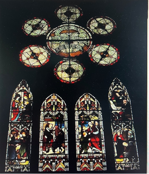
The north
transept ‘Six Corporal Acts of Mercy’ and Rose windows seen from
inside the church, c.2010, image supplied by applicant.


Images
of the studio showing the conservation of the west Rose Window, 2022, supplied
by applicant.
4.29 The
applicant for the grant is the Parish of Christchurch
on behalf of St Michael and All Angels Church.
4.30 The
decision affects the following wards/Community Board areas:
4.30.1 Waipapa Papanui-Innes-Central.
4.30.2
Tūāhuriri Rūnanga hold mana whenua rights and interests in the
area.
860-862 Colombo
Street exterior maintenance and structural upgrade project
4.31 The
building at 860-862 Colombo Street was completed in 1938. The two-storey
reinforced concrete building with a tower feature was designed in the Art
deco-Moderne style and is one of the few remaining buildings from this era in
the city. It has landmark presence on Colombo Street and contributes to the
distinct streetscape of this part of the central city.
4.32 The
building has architectural, technological, cultural and social significance for
the district, and the exterior remains largely unchanged since the original
construction. It is not currently scheduled in the Christchurch District Plan:
the Guidelines state that grant funding is available to
“…non-scheduled heritage buildings… which meet the current
Christchurch District Plan or equivalent criteria and threshold for
significance”. For further details please see Attachment B.
4.33 Originally
designed as the apartment complex ‘Langdown Flats’, the building
became the Holiday Lodge in the 1970s. It has now returned to residential use
as ten rental apartments which ensures the heritage building is publicly
accessible.
4.34 The
apartment block is in need of remedial maintenance and structural upgrades.
This includes a replacement roof, exterior repairs and repainting, drainage
renewal and structural repairs and upgrade of the reinforced concrete
walls. These works are part of a wider investment project which includes
interior upgrades. The interior works are not part of the grant application.
4.35 The
total cost of the eligible works is $217, 214. This sum includes
weatherproofing of the exterior envelope of the building and structural
upgrades.
4.36 Staff
are recommending a grant of $54,303 (which equates to 25% of eligible costs)
and a limited 20-year Heritage Conservation Covenant.
4.37 The
sum recommended is based on the heritage values of the building; the
contribution the proposed works will make to its retention; the contribution
the building makes to the wider heritage values of the area, and the extent to
which the building is accessible to the public. Staff also note the risk of
damage to the building’s structure if ongoing water ingress is not
addressed.
The Holiday Lodge, 862 Colombo Street, mid 1970s.
Image supplied by applicant.
View of the building from Colombo Street, 2021. Image
supplied by Laura Dunham.
4.38 The
applicant for the grant is the owner, Elizabeth Harris.
4.39 The
decision affects the following wards/Community Board areas:
4.39.1 Waipapa
Papanui-Innes-Central
4.39.2 Tūāhuriri
Rūnanga hold mana whenua rights and interests in the area.
210 St Asaph Street,
former R. Buchanan & Sons City Foundry reinstatement,
upgrade and maintenance project
4.40 The
building now at 210 St Asaph Street was completed in 1905 replacing an earlier
building from 1878. The two-storey brick and stone masonry building is one of
the few remaining industrial buildings from this era in the city. Sitting
adjacent to the P & D Duncans Foundry building, it has landmark presence on
St Asaph Street and contributes to the distinct streetscape of this part of the
central city.
4.41 It
is scheduled as a highly significant heritage place and is also listed by
Heritage New Zealand Pouhere Taonga as a Category 2 Historic Place. See the
attached Heritage Statement of Significance for full details (Attachment C).
4.42 The
building’s principal facade faces onto St Asaph Street and this part of
the building included a ground floor office, a show room, a pattern and
dressing shop and a first-floor pattern making shop and store. The actual
foundry was to the south and accessed via a carriage way entrance within the
façade. The whole complex was designed by the Architect William V
Wilson.
4.43 The
owners are undertaking an adaptive re-use project. This will maintain the
existing commercial activity on the ground floor and increase the number of
residential apartments. This is a major project which involves demolition of
non-heritage fabric and the replacement of the entire rear elevation of the
building with residential accommodation. A resource consent for this work has
been approved by Council as RMA 2022 1116.
4.44 As
part of the alterations and additions, the applicants are proposing to
reinstate and repair the architectural features of the north and east facades.
This includes the reconstruction of the lost parts of the parapets, and the
reinstatement of the windows removed in the 1990s. The brickwork of the
principal facades will be repaired, repointed and structurally upgraded.
4.45 Heritage
Incentive Grant funding is not available for demolition or removal of all or
part of a heritage building, nor to new extensions, alterations and additions.
Eligible works include maintenance, repair, structural upgrades and recognised
conservation works – in this case the reinstatement of the lost parapet
features and windows and the maintenance of the brickwork.
4.46 The
total cost of the works included in the application is $278,000. Of this
$236,000 is for eligible works: parapet and window reinstatement, brickwork
repairs, structural upgrades and professional fees.
4.47 Staff
are recommending a grant of $59,000 (which equates to 25% of eligible costs)
and a limited 20-year Heritage Conservation Covenant.
4.48 The
sum recommended is based on the high heritage values of the building; the
contribution the building makes to the wider heritage values of the area, and
the extent to which the building is accessible to the public. Staff also note
the applicants have chosen to reinstate the heritage form and features of the
principal facades of the building as part of their project which will enhance
the streetscape in the proximity of this landmark building.
210 St Asaph showing the north façade with the
1990s alterations. 2014, CCC Heritage files.
Rendering
to show the north façade with the heritage reinstatement works
completed. 2022, RC application.
4.49 The
applicant for the grant is the owner, MP Capital Investments Limited.
4.50 The
decision affects the following wards/Community Board areas:
4.50.1 Waipapa
Papanui-Innes-Central
4.50.2 Tūāhuriri
Rūnanga hold mana whenua rights and interests in the area.
The Old Shipping Office, 3 Church Street, Akaroa maintenance and
repair project.
4.51 The
‘Old Shipping Office’ is located close to the main wharf in Akaroa.
Built in 1895 for the Union Steam Ship Company it forms part of a group of
listed commercial and residential colonial buildings which are collectively
recognised as the Akaroa Historic Area, a well-known visitor attraction to the
district.
4.52 The
building has high historical, social and cultural significance and is a
reminder of the importance of shipping to the area. It has high technological
significance in the use of timber detailing to imitate stone on the
façade. It is scheduled as a highly significant heritage place and is
also listed by Heritage New Zealand Pouhere Taonga as a Category 2 Historic
Place. See the attached Heritage Statement of Significance for full details (Attachment
D).
4.53 The
building ceased to function as a shipping office in 1919 and became an office
space until the 1970s when it was a coffee shop. It now operates as holiday
rental accommodation which ensures the heritage building is publicly
accessible.
4.54 The
building is in need of urgent remedial repair and maintenance, especially to
the principal façade. Constructed of timber to imitate stone, the
façade is a landmark in the township and is highly decorative and
detailed. The marine environment makes the timber susceptible to rot, and it is
necessary to make repairs and repaint the building to retain and conserve this
highly significant architectural feature.
4.55 The
total costs of the eligible works are $16, 943 and include timber repairs and
replacement and exterior repainting.
4.56 Staff
are recommending a grant of $8,471 (which equates to 50% of eligible costs).
4.57 The
sum recommended is based on the heritage values of the building; the extent to
which the works protect and maximize the retention of the heritage fabric of
the façade; the contribution the building makes to the wider heritage
values of the area, and the extent to which the building is accessible to the
public. Staff also note the risk of damage to the building’s
architectural features if ongoing water ingress and rot is not addressed.
Façade of the Old Shipping Office on Church
Street, image from CCC files.
4.58 The
applicants for the grant are the owners, Glenn and Gayle Rose.
4.59 The
decision affects the following wards/Community Board areas:
4.59.1 Te Pātaka
o Rākaihautū Banks Peninsula.
4.59.2 Ōnuku
Rūnanga hold mana whenua rights and interests in the area.
William Gilbert and
Hine Te Marino Headstone Conservation project
4.60 Okains
Bay Cemetery opened in 1869 and is still open for casket and ash burials. The
cemetery has strong community associations and is maintained by the local
community, the local parish and the Okains Bay Cemetery Board. The plots are
laid out with double rows back-to-back facing northeast or southwest. Some of
the older graves at the back of the cemetery are arranged at a different angle
with no clear order to the paths.
4.61 William
Gilbert and Hine Marino were significant figures in the early settlement of
Banks Peninsula. Their history is displayed in both the Okains Bay and Akaroa
Museums, including a hand-coloured photograph of Hine. Hine (Ngāti Irakehu
and Ngāi Tahu) was one of the original inhabitants of Ōnawe Pa and
married carpenter William in 1854 in a pākehā ceremony in Pigeon
Bay. They had thirteen children, and it is estimated that they now
have 5,000 descendants.
4.62 The
headstone which marks William and Hine’s grave is marble with carved and
painted lettering. It is in need of conservation, structural support and
repair as the lettering has faded and is no longer readable in parts, and a
replacement structural berm is required to support the headstone. The stone is
listing and there is a risk it will fall and break if not stabilised soon.
4.63 The
great, great grandson of William and Hine is leading the project to restore the
headstone as a monument to these two key figures and has raised $1,655 through
whanau donations after an article in Te Pānui Rūnaka.
4.64 The
HIG Guidelines state that funding is available to support kaitiaki of
“non-scheduled heritage buildings, places, structures, or objects
which… include…memorials, bridges and gravestones…” and
“…places of identified significance to iwi and mana
whenua…”.
4.65 The total costs of the eligible works are
$4,626 and include removal, cleaning and repair of the marble headstone,
construction of a new concrete support berm, and reinstatement of the headstone
with structural support.
4.66 Staff
are recommending a grant of $2,313 (which equates to 50% of eligible costs).
4.67 The
sum recommended is based on the contribution the proposed work will make to the
retention of the headstone; the extent to which the grave is accessible to the
public; the contribution the memorial makes to wider community heritage and
wellbeing outcomes; the urgency of the work required relating to the risk of
damage if the work is not done in a timely manner, and the significance of the
whanau being marked by the headstone.

Hand coloured
photo of Hine from Okains Bay Museum and image of damaged headstone, supplied
by applicant.
4.68 The
applicant for the grant is Alan Bilyard, descendant of the whanau.
4.69 The
decision affects the following wards/Community Board areas:
4.69.1 Te Pātaka
o Rākaihautū Banks Peninsula.
4.69.2 Te Rūnanga
o Koukourārata hold mana whenua rights and interests in the area.
Marion
‘Queenie’ McLean headstone repair project
4.70 Bromley
cemetery is located at 429 Linwood Avenue and was opened in 1918 as an
extension of Linwood cemetery. The opening of the cemetery coincided with the
outbreak of the influenza epidemic, and it became the main burial place for
victims on the eastern side of the city. The cemetery is a typical traditional
monumental cemetery and is laid out in a highly regimented north-south
orientation, with graves facing due east or west.
4.71 The
majority of monuments tend to be lower and more conservative than other
cemeteries, providing a more orderly appearance which is accentuated by the
uniformity of the Services section. There are many Returned and Services
Association (RSA) graves, predominantly Great War veterans. Also found here is
a memorial for stillborn children and one of the few mausoleums in
Christchurch.
4.72 Marion
‘Queenie’ McLean died of stomach cancer in 1938 and is buried with
her daughter who died the following year. She had left her husband in Dunedin
and moved to Christchurch with her three children to live with her family. She
is an example of a woman of her generation moving to the city for family
support and employment during the 1930s before welfare support was available.
4.73 The headstone is constructed of marble with
carved and painted lettering, set onto part of the original cast concrete grave
border. It has been broken from the base and is currently laying in the grave
perimeter. When Council grant funding for repairs of monuments and headstones
in heritage cemetries ceased, Heritage Incentive Grant funding eligibility was
extended to provide an alternative funding source. The heritage and community
significance of the wider cemetery context as well as the significance of the
individual is considered when recommending grant funding for headstone and
grave repairs.
4.74 The
total costs of the eligible works are $810 and include pin drilling and
resetting the fallen headstone with structural support. Queenie’s
granddaughter is leading the project to reinstate the fallen headstone on
behalf of the family.
Bromley Cemetery
and the fallen headstone, 2024, images supplied by applicant.
4.75 Staff
are recommending a grant of $405 (which equates to 50% of eligible costs).
4.76 The sum recommended is based on the
contribution the proposed work will make to the retention of the headstone in
the wider heritage context of the cemetery; the extent to which the grave is
accessible to the public; the contribution the memorial makes to wider
community heritage and wellbeing outcomes across the cemetery as a whole, and
the risk of damage to the fallen headstone if it is not reinstated.
4.77 The
applicant for the grant is Sue Campbell, Queenie’s granddaughter.
4.78 The
decision affects the following wards/Community Board areas:
4.78.1 Waitai
Coastal-Burwood-Linwood.
4.78.2
Tūāhuriri Rūnanga hold mana whenua rights and interests in the
area.
38 Dublin Street (Lyttelton) conservation, repair and maintenance
project.
4.79 38
Dublin Street, Lyttelton is a two-storey residential dwelling constructed in c.
1875 and was formerly known as Pitcaithly House. It is easily visible from the
street for visitors and residents to view; contributes to the heritage
streetscape of this area and is included in walking tours of the
township. Sited on the west side of Dublin Street on the slope, it is one
of a group of timber houses constructed in the mid-late 1870s which reflect the
development of Lyttelton and contribute to the town’s aesthetic,
architectural, historical, social and archaeological significance.
4.80 The
dwelling is proposed to be scheduled as part of Plan Change 13 in the
Christchurch District Plan as a ‘defining’ item in the Residential
Heritage area as a colonial dwelling that upholds the historic architectural
and contextual values of the area. It is also included in Heritage New Zealand
Pouhere Taonga’s ‘Lyttelton Township Historic Area’.
4.81 The
dwelling is in need of immediate remedial repair and maintenance as it is no
longer weathertight which is threatening the heritage fabric and structure of
the building. The works are required to prevent ongoing deterioration and are
urgent as they are required before winter weather arrives.
4.82 The
total cost of the eligible works is $19,026 and includes a replacement roof,
rainwear and spouting, and repair of the exterior joinery, windows and frames.
4.83 Staff
are recommending a grant of $7,610 (which equates to 40% of eligible costs).
4.84 The
sum recommended is based on the heritage values of the building; the extent to
which the works protect the heritage fabric of the exterior- street elevation;
the contribution the building makes to the wider heritage values of the area,
and the extent to which the building is visibly accessible to the public. Staff
also note the risk of damage to the building’s structure if ongoing water
ingress is not addressed.
38 Dublin Street,
in the historic streetscape context, 2024. Image from CCC files.
4.85 The
applicants for the grant are the owners, Helen Taylor and Connor Taylor Brown.
4.86 The
decision affects the following wards/Community Board areas:
4.86.1 Te Pātaka
o Rākaihautū Banks Peninsula.
4.86.2 Te Hapū o
Ngāti Wheke hold mana whenua rights and interests in the area.
47 Oxford Street
conservation, repair and maintenance project
4.87 47
Oxford Street, Lyttelton was constructed in the early 1860s by Thomas Mutton
who also built eight of the other cottages in the street. It is significant as
one of the few dwellings from this time, which was not destroyed in the 1870
Lyttelton fire, and records the township’s original streetscape as well
as the living conditions of its early inhabitants. Situated prominently on the
footpath, the cottage is one of a number of heritage buildings in the immediate
vicinity and is included in walking tours of the township.
4.88 The
cottage is scheduled as ‘significant’ in the Christchurch District
Plan with historic, social and cultural as well as contextual significance. It
is included in Heritage New Zealand Pouhere Taonga’s ‘Lyttelton
Township Historic Area’. See the attached Heritage Statement of
Significance for full details (Attachment E).
4.89 The
building is in need of urgent remedial repair and maintenance as its timber
cladding and exterior joinery is failing. A number of weatherboards have
completely rotted, and others are decaying so that the building is no longer
weathertight which is threatening its structural integrity. The works are
required to prevent ongoing deterioration and are urgent as they are required
before winter weather arrives, and the structural integrity of the building is
seriously compromised.
4.90 The
total project cost is $79,925, and the eligible works total $57,000. This
includes replacement and repair of the timber cladding and joinery, and
exterior repainting.
4.91 Staff
are recommending a grant of $22,800 (which equates to 40% of eligible costs)
and a 10-year heritage Conservation Covenant.
4.92 The
sum recommended is based on the heritage values of the building and its
significance as a rare surviving example of a pre-fire timber cottage in the
township; the contribution the proposed work will make to the retention of the
building; the extent to which the works protect the heritage fabric and values;
the contribution the building makes to the wider heritage values of the area,
and the extent to which the building is highly visible to the public. Staff
also note the high risk of damage to the building’s structure if ongoing
water ingress is not addressed.
47 Oxford Street
(blue cottage) in the historic streetscape context; the dwelling in 2010, and
an image showing an example of deterioration of the exterior envelope, 2024.
Images from CCC files.
4.93 The
applicant for the grant is the owner Caro Allison.
4.94 The
decision affects the following wards/Community Board areas:
4.94.1 Te Pātaka
o Rākaihautū Banks Peninsula.
4.94.2 Te Hapū o
Ngāti Wheke hold mana whenua rights and interests in the area.
52 Longfellow Street
conservation, repair and maintenance project
4.95 52
Longfellow Street was originally built as a model home for the 1906-7 New
Zealand International Exhibition in Hagley Park. Designed as a Workers’
Dwelling Act model home, the building represented the new standard for low
cost, quality homes for workers in New Zealand established under the national
housing scheme of the 1905 Workers’ Dwelling Act. Following the
Exhibition, the dwelling was relocated to Sydenham, which was one of the
suburbs chosen for development under the Act.
4.96 The
dwelling has high heritage significance as one of the first 13 homes built in
Ōtautahi Christchurch under the Act and has high social and cultural
significance for its association with the foundation of New Zealand’s
social welfare system. It is a landmark building within the original Camelot
Settlement area in Sydenham as the only two storey workers settlement cottage
in Christchurch, and one of only two scheduled buildings from the Camelot
Settlement that remain. The dwelling is scheduled as ‘Significant’
in the Christchurch District Plan and listed by Heritage New Zealand Pouhere
Taonga as a Category 2 Historic Place. See the attached Heritage Statement of
Significance for full details (Attachment F).
4.97 The
dwelling is in need of immediate remedial repair and maintenance as it is no
longer weathertight which is threatening the heritage fabric and structure of
the building. The works are required to prevent ongoing deterioration and are
urgent as they are required before winter weather arrives. The applicants
propose to change the current colour scheme during the repainting to reinstate
the original colours used on the building for the Exhibition.
4.98 The
total cost of the eligible works is $25,622. This includes replacement and
repair of rotten areas of the timber cladding and joinery, and exterior
repainting.
4.99 Staff
are recommending a grant of $12,811 (which equates to 50% of eligible costs).
4.100 The sum
recommended is based on the heritage values of the building and its
significance as a unique example of a Workers’ Dwelling Act model home
and record of Christchurch’s leadership role in social welfare and social
housing; the contribution the proposed work will make to the retention of the
building; the extent to which the works protect the heritage fabric and values;
the contribution the building makes to the wider heritage values of the area,
and the extent to which the building is visible to the public from the street.
Image of
‘Workers dwelling built for the New Zealand International Exhibition in
Christchurch’ showing the dwelling when it was first relocated to its
current site on Longfellow Street in 1906, National Library Archives, (https://natlib.govt.nz/records/22343959?search%5Bi%5D%5Bsubject_authority_id%5D=-351974&search%5Bpath%5D=items)
52 Longfellow
Street c. 2020, CCC heritage files.
4.101 The
applicants for the grant are the owners Kaye Woodward and Paul Kean.
4.102 The
decision affects the following wards/Community Board areas:
4.102.1 Waihoro
Spreydon-Cashmere-Heathcote.
4.102.2
Tūāhuriri Rūnanga hold mana whenua rights and interests in the
area.
Lewe Summers Memorial
4.103 Mount
Pleasant Community Centre and Residents Association are seeking to
commemorate and celebrate the work of Llew Summers and his contribution to New
Zealand art and sculpture.
4.104 The sculptor has a national
and international reputation for his works. A resident of Mount Pleasant, he
was a neighbour of the Community Centre as well as a member of the association
and an active participant in their community works. His funeral in 2019 was
held at the Community Centre which he had advocated for and been instrumental
in fundraising for after the Canterbury earthquakes.
4.105 Over the
past three years the association have worked to develop the memorial concept,
working with the local community and Summers’ whanau to create a fitting
and appropriate way to commemorate the sculptor and honour his legacy for
future generations. This included community engagement, meetings, hui and the
engagement of professionals to design the memorial and work through the
consenting requirements.
4.106 The
memorial is one of Summers’ most famous sculptures ‘Flight’.
The sculpture portrays a large, abstracted bird in flight. The community chose
this as their memorial because it was Summers’ last major bronze work and
expresses his lifelong connection to this part of the city.
4.107 ‘Flight’
also emphasises the importance of the Avon Heathcote Ihutai estuary to
Ōtautahi Christchurch as one of only four international flyways in New
Zealand, and the only one completely enclosed by suburbs.
4.108 The
memorial has been sited fronting the main road to Sumner where it is highly
prominent along Main Road for both viewing from vehicles and easily accessible
to cyclists and walkers. It is also located adjacent to the Coastal Pathway,
and the Coastal Pathway and the Avon Heathcote Ihutai Estuary Trust are
including it in their information, interpretation and walks to attract local,
national and international visitors.
4.109 Neither the
sculpture nor the memorial are currently scheduled as heritage items. The
guidelines for the scheme allow for applications relating to
“non-scheduled heritage …objects…[including] heritage
significance identified by the community. Examples
include...memorials…”
4.110 The total
project costs are $125,000, which includes the memorial, installation,
landscaping and interpretation. The Association have actively fundraised
$80,000 from donations, other grants and in-kind donations of design, labour
and materials. They have a $45,000 shortfall for the project.
4.111 Staff are
recommending a grant of $22,500 which equates to 50% of the project shortfall.
4.112 The sum
recommended is based on the extent to which the memorial is accessible to the
public; the contribution it makes to wider community heritage and wellbeing
outcomes, and to the wider heritage values of the area.
4.113 Grants of
$15,000 to $149,999 are subject to a requirement for a Limited Conservation
Covenant under the grant scheme Guidelines. In this case staff are recommending
that a covenant is not required, given the fact that the sculpture is a
memorial and is located on Council owned land.
Images of the
Flight sculpture memorial to Lewe Summers, 2024. Images supplied by applicant.
4.114 The
applicants for the grant are Mount Pleasant Community Centre and Residents
Association Incorporated.
4.115 The
decision affects the following wards/Community Board areas:
4.115.1 Waihoro
Spreydon-Cashmere-Heathcote
4.115.2 Tūāhuriri
Rūnanga hold mana whenua rights and interests in the area.
Summary table of these grants are as follows:
|
Applicant
|
Project Name
|
Total eligible costs
|
Amount Recommended
|
|
Rāpaki Reserves Trust
|
Rāpaki
School relocation, repair and conservation project
|
$350,000
project shortfall
|
$63,000
|
|
Parish of Christchurch
|
St Michael and All Angels Church
‘Six Corporal Acts of Mercy’ rose window conservation project
|
$116,328
|
$58,164
|
|
Elizabeth Harris
|
860-862 Colombo Street conservation,
maintenance and upgrade project
|
$217, 214
|
$54,303
|
|
MP Capital Investments Limited
|
210 St Asaph Street reinstatement,
upgrade and maintenance project
|
$278,000
|
$59,000
|
|
Glen and Gayle Rose
|
The Old Shipping Office, maintenance and
repair project
|
$16,943
|
$8,471
|
|
Alan Bilyard
|
William Gilbert and Hine Te Marino
headstone conservation project
|
$4,626
|
$2,313
|
|
Sue Campbell
|
Marion ‘Queenie’ McLean
headstone repair project
|
$810
|
$405
|
|
Helen Taylor and Connor Taylor Brown
|
38 Dublin Street conservation, repair and
maintenance project
|
$19,026
|
$7,610
|
|
Caro Allison
|
47 Oxford Street conservation, repair and
maintenance project
|
$57,000
|
$22,800
|
|
Kaye Woodward and Paul Kean
|
52 Longfellow Street conservation, repair
and maintenance project
|
$25,622
|
$12,811
|
|
Mount Pleasant
Community Centre and Residents Association
|
Lewe Summers Memorial project
|
$45,000 project shortfall
|
$22,500
|
|
Totals
|
$1,130,569.00
|
$311,377
|
Options Considered Ngā Kōwhiringa Whaiwhakaaro
4.116 The
following reasonably practicable options were considered and are assessed in
this report:
· Approving the grants at
the funding levels recommended by staff.
· Recommending a higher or
lower level of funding.
4.117 The
following option was considered but ruled out:
· Declining the grant
applications. The option was ruled out as declining the applications would not
support the conservation of significant heritage/highly significant heritage
items; would reduce positive community wellbeing outcomes; would not align with
the Heritage Strategy and is not consistent with the Heritage Incentive Grant
Fund – Guidelines (2020).
Options Descriptions Ngā Kōwhiringa
4.118 Preferred
Option: Grant funding allocated as per staff recommendations.
· Option Description: The staff recommendations are for grants of between 18%-50% of
eligible costs.
· The maximum
grant allowed by the scheme is 50% of eligible works.
· The
recommendations are based on assessment against the scheme’s
‘Criteria for Assessment of Applications’, and with consideration
of the availability of funding, the significance of the heritage item and the
level of risk if funding is not approved.
· Details and
analysis for the recommended sums are included above in Section 4,
‘Background’, and specifically in: 4.14; 4.27; 4.37; 4.48; 4.57;
4.67; 4.76; 4.86; 4.94; 4.102, and 4.114.
4.118.2 Option
Advantages
· The levels of
funding recommended support the conservation, maintenance and upgrade of
significant and highly significant heritage places and items and ensures their
ongoing retention and use for future generations.
· The levels of
funding are sufficient to incentivise considerable investment by owners and
kaitiaki in the heritage items.
· The levels of
funding support the retention of places and items which in addition to their
heritage significance achieve community social, economic and cultural wellbeing
outcomes.
· The
recommended levels of funding can be accommodated within the available
budget.
4.118.3 Option
Disadvantages
· By not
providing higher levels of funding, some projects may need to be reduced in
scope or undertaken over a longer time period.
· Allocation at
the recommended sums leaves only $36,012 available for other applicants,
although staff note that no other applications have been received at this time.
4.119 Recommending
a higher level or lower level of funding.
· Option Description: Recommending a higher level or lower
level of funding.
· The Guidelines
allow for up to 0-50% of the eligible works to be awarded funding. Under this
option a percentage of up to 50% or as low as 1% could be recommended for
individual projects, or all grants could be awarded the same percentage.
4.119.2 Option
Advantages
· Higher levels
of funding would increase support of significant and highly significant places
and objects.
· Lower levels
of funding would provide funding for other applications should they be
received.
4.119.3 Option
Disadvantages
· There is
insufficient funding available to provide the maximum of 50% levels of funding
for all the applications received and staff have had to prioritise proposed
grants in alignment with the Guidelines.
· Recommending a
lower level of funding. Staff have carefully considered the applications and
the relative benefits and positive outcomes of each project. Staff
consider that the projects are unlikely to proceed with a reduced level of
funding which risks the ongoing deterioration and potential loss of the
significant/highly significant heritage taonga for future generations.
Analysis Criteria Ngā Paearu Wetekina
4.120 Degree to
which the purpose of the Heritage Incentive Grant Scheme is achieved.
4.121 Consideration
of the Heritage Incentive Grants Policy –Guidelines 2020
‘Assessment’ criteria.
4.122 Degree to
which the projects achieve the pou of the ‘Our Heritage, Our Taonga’
Heritage Strategy 2019-2029: Manaakitanga, Tohungatanga, Kaitiakitanga,
Rangatiratanga and Wairuatanga.
4.123 Impact on
mana whenua, noting that the six papatipu rūnanga hold the mana whenua
rights and interests over the district and are partners in the ‘Our
Heritage, Our Taonga’ Heritage Strategy 2019-2029.
4.124 Degree to
which the works align with the International Council on Monument and Sites
(ICOMOS) New Zealand Charter 2010 (conservation principles).
4.125 Extent to which the projects
achieve delivery of the overarching strategic principle of “Taking an
intergenerational approach to sustainable development, prioritising the social,
economic and cultural wellbeing of people and communities and the quality of
the environment, now and into the future.”
4.126 Extent to
which the projects achieve delivery of the Community Outcome “Resilient
Communities” – ‘celebration of our identity through arts,
culture, heritage, sport and recreation’ and ‘strong sense of
community’.
4.127 Extent to
which outcomes achieved support delivery of Te Haumako Te Whitingia
Strengthening Communities Together Strategy Pillars of People, Place,
Participation and Preparedness.
5. Financial Implications Ngā Hīraunga Rauemi
Capex/Opex Ngā Utu Whakahaere
|
|
Recommended Option
|
Option 2
|
|
Cost to Implement
|
$311,377
|
+/- $311,377
|
|
Maintenance/Ongoing Costs
|
none
|
none
|
|
Funding Source
|
2021/2031 Long Term Plan
|
2021/2031 Long Term Plan
|
|
Funding Availability
|
$347,389
|
$347,389
|
|
Impact on Rates
|
None - HIGs are an existing budgeted
level of service
|
None - HIGs are an existing budgeted
level of service
|
5.1 The
decisions relate to the allocation of an existing Council grant fund.
6. Considerations Ngā Whai Whakaaro
Risks and Mitigations Ngā Mōrearea me
ngā Whakamātautau
6.1 The
grant scheme only allows funds to be paid out upon completion of the works;
certification by Council staff that the works have been undertaken in alignment
with the ICOMOS NZ Charter 2010; presentation of receipts and confirmation of
the conservation covenant (if required) having been registered against the
property title or on the Personal Properties Securities Register. This ensures
that the grant scheme is effective and that funds are not diverted or lost.
6.2 There
is a risk of loss of significant and highly significant heritage places and
items if funding is not available to support the conservation projects.
Legal Considerations Ngā Hīraunga
ā-Ture
6.3 Statutory
and/or delegated authority to undertake proposals in the report:
6.3.1 The delegated authority for Heritage Incentive Grants decisions was
with the Sustainability and Community Resilience Committee but as this
committee is no longer sitting, this report is being submitted to Council.
6.4 Other Legal Implications:
6.4.1 There
is no legal context, issue, or implication relevant to this decision.
Strategy
and Policy Considerations Te
Whai Kaupapa here
6.5 The
required decisions:
6.5.1 Align
with the Christchurch
City Council’s Strategic Framework. The Heritage Incentive Grant
Scheme aligns to the Community Outcome “Resilient Communities”
– ‘celebration of our identity through arts, culture, heritage,
sport and recreation’ and ‘strong sense of community’. It
also supports “Liveable City” – ‘21st century garden
city we are proud to live in’ and “Prosperous Economy”
– ‘great place for people, business and investment’.
6.5.2 Are
assessed as low significance based on the Christchurch City Council’s
Significance and Engagement Policy. The level of significance is
determined by the heritage significance of the items, the cultural and
community wellbeing outcomes of the projects, the amount of funding requested,
and the fact that Council has approved Heritage Incentive Grant funds for
allocation in the 2023/2024 financial year. There are no engagement
requirements in the Heritage Incentive Grant Fund – Guidelines 2020 for
this grant scheme.
6.6 This
report supports the Council's
Long Term Plan (2021 - 2031):
6.7 Strategic Planning and Policy
6.7.1 Activity: Strategic Planning, Future Development and
Regeneration
· Level of Service: 1.4.2 Effectively administer grants
within this Activity (including Heritage Incentive Grants, Enliven Places,
Innovation and Sustainability) - 100% compliance with agreed management and
administration procedures for grants.
Community
Impacts and Views Ngā Mariu ā-Hāpori
6.8 The
decisions affect a number of Community Boards across the city, as detailed in
section 4, Background (above) under each specific project.
Impact
on Mana Whenua Ngā
Whai Take Mana Whenua
6.9 The
decision relating to the grant request from Rāpaki
involves a significant decision in relation to ancestral land or a
body of water or other elements of intrinsic value, therefore this decision
does specifically impact Mana Whenua, their culture, and traditions.
6.10 The other grant
applications do not involve a significant decision in relation to ancestral
land or a body of water or other elements of intrinsic value, but the decisions
do specifically impact Mana Whenua, their culture and traditions.
6.11 The decisions involve a matter of interest to Mana Whenua and could impact on our agreed partnership priorities
with Ngā Papatipu Rūnanga.
6.12 The six papatipu
rūnanga hold the mana whenua rights and interests over the district and
are partners in the Our Heritage, Our Taonga - Heritage Strategy 2019-2029. Te
Ngāi Tūāhuriri Rūnanga, Te Hapū o Ngāti Wheke, Te
Rūnanga o Koukourārata, Wairewa Rūnanga, Ōnuku Rūnanga
and Te Taumutu Rūnanga are primary kaitiaki for the taonga tuku iho of the
district. They are guardians for elements of mātauranga Māori
reaching back through many generations and are a significant partner in the
strategy implementation.
Climate
Change Impact Considerations Ngā Whai Whakaaro mā te Āhuarangi
6.13 The
decisions in this report are likely to:
6.13.1 Contribute
positively to adaptation to the impacts of climate change.
6.13.2 Contribute
positively to emissions reductions.
6.14 The
grants will:
6.14.1 Respond to
climate change and coastal erosion by supporting the relocation of a
significant taonga to ensure its ongoing retention for future generations.
6.14.2 Support the
retention of heritage buildings and the embodied energy within them.
Retention and reuse of heritage buildings can contribute to emissions reduction
and mitigate the effects of climate change. Retaining and reusing existing
built stock reduces our carbon footprint and extends the economic life of
buildings.
7. Next Steps Ngā Mahinga ā-muri
7.1 Applicants
will be notified of the outcome of their grant applications.
Attachments Ngā Tāpirihanga
|
No.
|
Title
|
Reference
|
Page
|
|
a ⇩
|
Attachment A:
St Michael and All Angels Church Statement of Significance
|
24/709511
|
155
|
|
b ⇩
|
Attachment B:
860-862 Colombo Street, Historical Overview
|
24/709513
|
175
|
|
c ⇩
|
Attachment C:
210 St Asaph Street, Statement of Significance
|
24/709516
|
219
|
|
d ⇩
|
Attachment D:
The Old Shipping Office, 3 Church Street, Akaroa, Statement of Significance
|
24/709521
|
223
|
|
e ⇩
|
Attachment E:
47 Oxford Street, Lyttelton Statement of Significance
|
24/709522
|
227
|
|
f ⇩
|
Attachment F:
52 Longfellow Street, Statement of Significance
|
24/709525
|
230
|
In addition to the attached documents, the following background
information is available:
|
Document
Name – Location / File Link
|
|
Not
applicable
|
Signatories Ngā Kaiwaitohu
|
Author
|
Victoria Bliss
- Heritage Conservation Projects Planner
|
|
Approved By
|
Brendan Smyth
- Team Leader Heritage
Mark Stevenson
- Acting Head of Planning & Consents
John Higgins -
General Manager Strategy, Planning & Regulatory Services
|
|
11. Biodiversity
Fund Project Approvals 2023-2024 FY
|
|
Reference Te Tohutoro:
|
24/504936
|
|
Responsible Officer(s) Te Pou Matua:
|
Nicholas
Head, Senior Ecologist CIPA Biodiversity; Hannah Murdoch, CIPA Community
Partnerships Ranger; Rosyln Kerr, Manager Parks Programmes and Partnerships;
Gary Watson, Manager Community Partnerships; Jacqui Jefferey, Community
Funding Advisor.
|
|
Accountable ELT Member Pouwhakarae:
|
Andrew
Rutledge, Acting General Manager Citizens and Community
|
1. Purpose and Origin of the Report Te Pūtake Pūrongo
1.1 This
report provides summary information on applications that meet criteria to
qualify for biodiversity funding to protect and enhance significant indigenous
biodiversity on private land.
1.2 Biodiversity funding supports the Council's statutory
obligations to protect significant indigenous biodiversity on private land and
empowers local communities to assist Council in this task.
1.3 The
decisions in this report are of low significance in relation to the
Christchurch City Council’s Significance and Engagement Policy.
This is because the decision affects a small number of people (the applicants),
and the impact is positive for both the applicants and the
environment; the decision allocates funding already provided for in the
Long-Term Plan 2021-2031.
2. Officer Recommendations Ngā
Tūtohu
That the Council:
1. Receive
the information in the Biodiversity Fund Project Approvals 2023-2024 FY Report.
2. Note
that the decision in this report is assessed as low significance in relation to
the Christchurch City Council’s Significance and Engagement Policy.
3. Approve
a total of $400,000 from the Christchurch Biodiversity Fund 2023/24 across the
following 14 projects:
a. $5,000 Tirowaikare
covenant (Beggs) weed control, Banks Peninsula
Conservation Trust
b. $31,760 Canty
Plains floodplain forest restoration
c. $52,000 Feral
pig control te Waihora catchments
d. $12,000 Coastal
forest protection and enhancement Raupo Bay
e. $50,000 Hinewai
conifer eradication for forest restoration
f. $40,000 Hukahukaturoa
catchment weed control QEII covenants
g. $7,680 Protection
Rare Ecosystems, Linda Woods weeds control
h. $36,000 Living
Springs Native Forest Enhancement
i. $25,000 Purau
catchment rare ecosystem protection,
j. $11,975 Stencliffe
farm – Manatu forest fencing
k. $16,336 Stony
Bay forest fencing
l. $41,000 Styx
Living Memorial Trust, willow control
m. $44,504 Tokoroa
Fencing and weed control
n. $26,744 Wainui
rewild
3.
3. Decline the
following applications to the Christchurch Biodiversity Fund 2023/24:
a. Decanter
Bay pigs ear study
b. Forest
Planting Lansdowne Valley
c. Pohatu
Penguins
d. Tupari
Reserve
3. Executive Summary Te Whakarāpopoto Matua
3.1 Fourteen
applications to the Biodiversity Fund have been recommended for approval.
Funding these applications will provide considerable assistance to local
landowners working to protect and restore the district’s significant and
vulnerable ecosystems and species.
3.2 For
this 2023/24 funding round, the fund was oversubscribed by ~$200,000. Four
projects that did not meet the criteria or lacked sufficient information were
not approved for funding this year, but they were recommended to reapply next
year.
3.3 The
recommendation for this 2023-2024 round of funding would allocate a combined
total of $400,000 across 14 projects as are outlined above. This means the fund
is fully allocated for the 2023/24 financial year. This contribution, together
with applicant-matched funding and funding from other contributions that far
exceeds grant contributions, totals a considerable investment in projects that
protect and enhance our local biodiversity.
4. Background/Context Te Horopaki
4.1 Halting
the decline of indigenous biodiversity is a matter of national importance, and
a core statutory function of District Councils. The Christchurch district
comprises a diverse assemblage of ecosystems that support internationally and
nationally important habitats for wildlife, as well as population strongholds
for numerous threatened and rare species. Most remnant ecosystems and
indigenous biodiversity occurs on private land in the district.
4.2 The
Biodiversity Fund supports landowners working to protect ecologically
significant sites on their land. Council will provide up to 50% of funding for
eligible projects on private land, with the maximum grant of $60,000 per
individual project/property per year. Up to $400,000 is available for
allocation this year.
4.3 The
Fund is an opportunity to support private landowners who are taking voluntary
action, and investing their own time and money, to protect and enhance
indigenous biodiversity on their properties. The projects provide real
protection for biodiversity in the Christchurch District through empowering
locals and local communities to take direct action.
4.4 Since
the fund was established in 2017, a total of $1,655.871.00 has been allocated
to 71 projects (excluding the current applications). 62 of these projects are
complete, with six still in progress.
4.5 Most
previous projects involved fencing (44 projects). Restoration planting (12
projects), pest plant control (19 projects), and pest mammal control (9
projects) are other activities that have been supported. Some projects involve
multiple activities.
4.6 Over
2000 hectares of ecologically significant vegetation has been protected, along
with the indigenous fauna that live in those habitats. Many projects have also
protected streams and important waterways.
Options Considered Ngā Kōwhiringa Whaiwhakaaro
4.7 The
following reasonably practicable options were considered and are assessed in
this report:
4.8 Alternative
options are not to fund. As the Biodiversity Fund (the Fund) is allocated
specifically to assist private landowners to protect and enhance indigenous
biodiversity and the applications received achieve this, this option was
discounted.
4.9 The
other option was to part fund projects. This option was used for a few
projects, resulting in some minor reductions to the original amount requested.
Analysis Criteria Ngā Paearu Wetekina
4.10 Applications
are assessed by a cross council panel of staff and prioritised accordingly.
Three primary criteria are used to determine applications eligibility:
1: must be private land
2: the site has
significant ecological values
3: the site has some
form of enduring protection.
4.11 To
determine relative priority of applications, further consideration was given to
the national priorities for protecting indigenous biodiversity on private land,
which provides a useful context to compare relative merits of applications if
required.
5. Financial Implications Ngā Hīraunga Rauemi
Capex/Opex Ngā Utu Whakahaere
|
|
Recommended Option
|
|
Cost to Implement
|
None other
than staff time to administer the fund.
|
|
Maintenance/Ongoing Costs
|
None other
than staff time to administer the fund.
|
|
Funding Source
|
The Fund is provided for in the 2021-2031
Long Term Plan
|
|
Funding Availability
|
Available for allocation
|
|
Impact on Rates
|
Minor
|
6. Considerations Ngā Whai Whakaaro
Risks and Mitigations Ngā Mōrearea me
ngā Whakamātautau
6.1 There
are no significant risks associated with allocating funds to the projects as
outlined. Processes are in place to ensure funding granted is spent in
accordance with the project plans and expectations.
6.2 Considerable
checks and balances are in place to ensure the funding granted to projects is
spent in accordance with the project plan and meets expectations, including
progress reports, proof of completions and inspections if necessary. Staff time
in relation to this is an inherent part of overseeing the fund.
Legal Considerations Ngā Hīraunga
ā-Ture
6.3 Statutory
and/or delegated authority to undertake proposals in the report:
6.3.1 The
Council has the delegation to consider applications to the Biodiversity Fund.
6.4 Other
Legal Implications:
6.4.1 The
Council has the delegation to consider applications to the Biodiversity Fund.
Strategy
and Policy Considerations Te
Whai Kaupapa here
6.5 The
required decision aligns with the strategic framework supporting principle of
“taking an inter-generational approach to sustainable development
prioritising the social, economic and cultural well-being of people and
communities and the quality of the environment, now and into the future,”
by supporting individual landowners to protect and enhance biodiversity on
private land.
6.6 The
decision is consistent with Council’s Plans and
Policies. The programme aligns with the Christchurch
City Council’s Strategic Framework supporting principle of
“actively collaborating and co-operating with other local,
regional and national organisations.” We work with
Environment Canterbury and covenanting agencies to ensure that projects have
adequate support and that our combined resources are efficiently allocated.
6.7 The
decisions in this report are assessed as low significance based on the
Christchurch City Council’s Significance and Engagement Policy.
This is because the decision affects a small number of people (the applicants),
and the impact is positive for both the applicants and the
environment; the decision allocates funding already provided for in the
Long-Term Plan 2021-2031.
6.8 The
programme aligns with District Plan policies regarding the protection of
ecologically significant sites, and the provision of advice and incentives for
landowners who wish to do this on private property. The programme supports the
goals of the Council’s Biodiversity Strategy.
6.9 This
report supports the Council's
Long Term Plan (2021 - 2031):
6.10 Strategic Planning and Policy
6.10.1 Activity: Strategic Planning, Future Development and
Regeneration
· Level of Service: 1.4.2 Effectively administer grants
within this Activity (including Heritage Incentive Grants, Enliven Places,
Innovation and Sustainability) - 100% compliance with agreed management and
administration procedures for grants
Community
Impacts and Views Ngā Mariu ā-Hāpori
6.11 The
community is very supportive of the Council contributing funds to assist with
conservation on private land. Several submissions were made by community groups
and individuals to the Long-Term Plan 2021-2031 requesting that Council
increase the annual allocation to the Biodiversity Fund. As a result, the fund
was increased to $400,000 - an outcome consistent with the Council declaring an
ecological and climate emergency.
6.12 The
decision affects the following wards/Community Board areas:
· Te
Pataka o Rakaihauta Banks Peninsula
· Waipuna
Halswell-Hornby-Riccarton
· Waihoro
Spreydon-Cashmere-Heathcote
· Waimāero
Fendalton-Waimairi-Harewood
6.13 The
Community Boards view is presumed to be positive
because the biodiversity fund is supporting and empowering local landowners to
take positive action to improve the outcome for indigenous biodiversity in
their rohe.
Impact
on Mana Whenua Ngā
Whai Take Mana Whenua
6.14 The
decision does not involve a significant decision in relation to
ancestral land or a body of water but does involve indigenous species and
ecosystems that have intrinsic values. Therefore, this decision does impact
Mana Whenua, their culture, and traditions. Staff note, however, that the
intent of all projects is to have a positive impact on indigenous biodiversity.
6.15 While matters of
indigenous biodiversity are of interest to Mana Whenua, this specific decision
to allocate funding to enhance biodiversity will not
impact our agreed partnership priorities with Ngā
Papatipu Rūnanga.
Climate
Change Impact Considerations Ngā Whai Whakaaro mā te Āhuarangi
6.16 The
decisions in this report are likely to contribute positively to adaptation to
the impacts of climate change. Most of the projects provide protection and
enhancement to regenerating forest habitats, which will boost the carbon
sequestration capacity of these areas. Protecting and enhancing the ecological
health of sites will improve the resilience of the district’s habitats
and species within them to the impacts of climate change.
7. Next Steps Ngā Mahinga ā-muri
7.1 Council
approves the report; successful applicants are informed and set up as vendors;
funds allocated; projects commenced.
Attachments Ngā Tāpirihanga
|
No.
|
Title
|
Reference
|
Page
|
|
a ⇩
|
Christchurch
Biodiversity Fund applications summary 2023-2024
|
24/654016
|
240
|
In addition to the attached documents, the following background
information is available:
|
Document
Name – Location / File Link
|
|
Not
applicable
|
Signatories Ngā Kaiwaitohu
|
Authors
|
Nicholas Head
- Senior Ecologist
Hannah Murdoch
- Community Partnerships Ranger
Gary Watson -
Manager Community Partnerships
Roslyn Kerr -
Manager Parks Programmes & Partnerships
Jacqui Jeffrey
- Community Funding Advisor
|
|
Approved By
|
David
Griffiths - Head of Strategic Policy & Resilience
|
|
12. New Zealand
Local Government Association Inc: payment of annual membership subscription
|
|
Reference Te Tohutoro:
|
24/728082
|
|
Responsible Officer(s) Te Pou Matua:
|
Helen
White, General Counsel / Head of Legal & Democratic Services
Bede Carran, General Manager Finance, Risk & Performance (CFO)
|
|
Accountable ELT Member Pouwhakarae:
|
Helen
White, General Counsel / Head of Legal & Democratic Services
|
1. Purpose and Origin of the Report Te Pūtake Pūrongo
1.1 The
purpose of this report is for Council to consider its continued membership of
New Zealand Local Government Association Inc (LGNZ) and if membership is
confirmed for the invoice to be paid.
1.2 The
report is in response to Council receiving the membership renewal invoice and
to provide analysis that supports the Council deciding whether or not to remain
a member.
2. Officer
Recommendations Ngā Tūtohu
That the Council:
1. Receive the information in the New Zealand
Local Government Association Inc: payment of annual membership subscription report.
EITHER:
2. Agree to renew its membership of Local Government New Zealand Inc
for the amount of $163,254.75 plus GST.
OR:
3. Decline to renew its membership of Local Government New Zealand Inc
and:
a. Resolve to resign its membership of Local Government New Zealand
Inc; and
b. Authorise the Mayor to give notice of the resignation in writing to
Local Government New Zealand Inc.
4. Note that the decision in this report is assessed as low significance
based on the Christchurch City Council’s Significance and Engagement
Policy, as it is a decision regarding membership of an organisation and does
not affect strategic assets or levels of services.
3. Executive Summary Te Whakarāpopoto Matua
3.1 The
annual subscription renewal of the Council’s membership of Local
Government New Zealand (LGNZ) is due. This year’s renewal fee for
membership is for the amount of $163,254.75 plus GST.
3.2 This
report provides analysis to support the Council decision on payment or not of
this year’s subscription. Should the Council decide not to
renew its membership, it must comply with LGNZ’s constitutional
requirement to give notice of resignation in writing. The Council will be
required to pay a proportion of the membership fee up to the date the
resignation takes effect (one month from notification).
3.3 A
number of the reasons for remaining a member are not readily
quantifiable. Council’s decision should be based on an overall
weighting of the merits of being a member of a body that advocates for local
government weighed against the merits of undertaking direct advocacy on its own
behalf. Being a member of an organisation such as LGNZ provides the
benefit of collective advocacy but with reduced influence on the policy and
advocacy postions. Alternatively, by not being a member Council may
consider it can advocate more effectively and specifically on the issues
important to the communities of the city and district, doing so as the South
Island’s largest city.
4. Background/Context Te Horopaki
4.1 LGNZ
is constituted as an incorporated society and is a membership
organisation. LGNZ’s members are local authorities constituted
under the Local Government Act 2002. LGNZ’s purpose is to champion,
connect, and support local government. The objects of LGNZ are set
out in its Rules
and summarised are to:
4.1.1 promote the national
interests of local government;
4.1.2 advocate on matters
affecting the national interests of local government and its communities;
4.1.3 promote and
facilitate regular dialogue with the Government, Parliamentarians, and the
agencies of the Government;
4.1.4 provide full,
accurate, and timely information to its members on matters affecting local
government and LGNZ;
4.1.5 research, survey, and
investigate matters in which LGNZ and its members have an interest;
4.1.6 provide advice,
education, and training opportunities for its members;
4.1.7 hold conferences and
forums to advance its objectives.
4.2 LGNZ
is governed by the National Council, comprised of the President and 17 members,
including three reserved for Auckland (although currently, it is not a member
of LGNZ). To ensure representation across the country, LGNZ’s Rules
prescribe membership from metropolitan (Christchurch City Council is a member
of the metropolitan sector), regional, provincial, and rural New Zealand, and
also geographically from across the country. The National Council
membership also includes the Chair of Te Maruata and one person appointed from
the Young Elected Members Network.
4.3 The
National Council appoints the Chief Executive of LGNZ who in turn employs
LGNZ’s staff.
4.4 For
the financial year ended 31 March 2023 membership subscriptions of $4.09
million made up approximately 42% of LGNZ’s total revenue of $9.812
million (LGNZ’s financial performance for the year ended 31 March 2024
and its financial position as at 31 March 2024 are not yet published or
available). For the year ended 31 March 2023 LGNZ made an operating
deficit of $578k (rounded).
4.5 LGNZ’s
invoice to Council for the current year (which runs from 1 April 2024 –
31 March 2025) is $163 254.75 (plus GST). By comparison for the year 1
April 2023 – 31 March 2024 Council paid $141,960.65 (plus GST).
4.6 One
of the reasons for the increased membership this year is that there is now full
access to Ākona, LGNZ’s professional development learning
platform. This had been optional in previous years. This platform
aims to provide training and information on subjects that will help build
council capacity and provide skills members need to do their job well such as
speechwriting, media advice, guidance on tax obligations as well as subject
information like climate change, financial governance, Te Tiriti partnerships.
It also provides a tool for elected members to identify their individual
professional development needs. A roadmap of modules is available at: Akona_roadmap.pdf
(d1pepq1a2249p5.cloudfront.net)
4.7 Council
also incurs some other associated costs such as hosting costs, media content,
and conference attendance, including travel and accommodation, totalling
approx. $25,000 per year.
4.8 The
Council also contributes $7,500 to the Mayor’s Taskforce for Jobs (MTFJ),
which is administered by LGNZ. Ceasing to be a member of LGNZ does not
preclude the Mayor/Council from continuing to participate in the
MTFJ.
4.9
This matter was last considered by the Council on 9 December 2021 and for a
full analysis of the services provided by LGNZ, please view item
32, page 15.
Options Considered Ngā
Kōwhiringa Whaiwhakaaro
4.10 The following
reasonably practicable options were considered and are assessed in this report:
· For the Council to pay the membership subscription and continue to
be a member of LGNZ, or
· For the Council to not pay the membership subscription and cease to
be a member of LGNZ.
4.11 The advantages
and disadvantages of membership may be summarised as follows:
|
Advantages
|
Disadvantages
|
|
Participation in the discussions and deliberations of the wider
local government sector on matters of national and local interest.
|
An annual membership cost of $163,254.75 (GST excl) this money
could be redeployed to other activities and/or services, which could include
governance and staff resources for direct advocacy on matters of specific
interest to Council.
|
|
Enhanced access to Central Government Ministers, MPs, and
officials through attendance at LGNZ events.
|
There is a risk that Council may not agree with policy and/or
advocacy positions that LGNZ might adopt or pursue.
Similarly, there is a risk that LGNZ may not advocate strongly
enough on issues that are important to Council and the community.
|
|
Right to vote in Presidential and National Council elections.
|
LGNZ work programmes may not align with the Council’s
priorities or wishes, resulting in a sense that value for the membership fee
is not being delivered.
|
|
Right to vote on and influence AGM remits.
|
There are travel costs associated with attendance at LGNZ events.
There are 6 in-person LGNZ meetings in a calendar year,
ranging from Metro sector to Combined sectors to Zone 5 & 6 .
Depending on the location and the number of days attended, travel
costs could range between $3k - $5k per person.
Depending on Council membership there are also 4-5 in-person
National Council meetings per year, but travel costs are paid for by LGNZ.
|
|
Right to participate in Zone 5 & 6 meetings (held in various
locations throughout the South Island), and right to participate in meetings
of the Metropolitan Sector (and with Auckland no longer a member Christchurch
is now the largest territorial authority member).
|
|
|
Ability and right to influence LGNZ positions and advocacy.
|
|
|
Access to training modules provided by LGNZ through Ākona.
|
|
|
Access to membership pricing for attendance at the annual LGNZ
Conference.
|
|
|
24/7 counselling and support service for all elected members and
access to wellbeing tools.
|
|
|
Neutral third party advice to LGNZ’s members.
|
|
Analysis Criteria Ngā Paearu
Wetekina
4.12 A number of the
reasons for remaining as a member are not readily quantifiable. The
benefits are related to an overall weighting of the merits of participating in
a membership body that advocates for local government both with central
government and more widely, and the Council may consider it important that
there is such a body. Christchurch as a large metropolitan council may
consider it important that it is an active member of LGNZ to influence its
advocacy on matters of importance to the Council and its communities.
4.13 In the
alternative, the Council may consider that it can be more influential and
represents the interests and concerns of its residents and ratepayers through
direct advocacy with government, ministries, and other organisations both in
Wellington and nationally. LGNZ with its requirement to reflect the views
of its wide and varying membership is hampered in taking positions that reflect
specifically the interests of the Council. Aligned to this, Council may
perceive that, while it is a large metro, it is unable to influence sufficiently
LGNZ’s policy and advocacy decisions it sees as important. As a
consequence, Council may consider the subscription monies are better targeted
to direct advocacy and representation, or redeployment on to other services and
activities. Council may also consider it has sufficient resources to
provide on a more direct and targeted basis the benefits that are provided by
being a member.
4.14 If the Council
considers that it should resign its membership of LGNZ, there would be some
work required to identify allocation of internal resourcing to focus on the
areas of advocacy and representation that better meet its needs. This resource
may be able to be partially (or wholly) redirected within existing staff
resource including what is utilised with supporting membership.
4.15 Broadly, as of
31 March 2023, LGNZ had equity, that is its assets were greater than its
liabilities of $3.76 million. Of the equity $550,000 (rounded) was held
in property, plant and equipment, and intangibles (largely software). The
balance of approximately $3.2 million is essentially held as current assets,
essentially cash and cash equivalents.
4.16 Assuming that
for the financial year ended 31 March 2024 LGNZ’s financial position has
not materially or substantially deteriorated, the Council’s membership,
or not as the case may be is unlikely to impugn LGNZ’s financial
viability for the current year. However, if the Council ceases to be a
member it will have unwelcome financial implications for LGNZ, and
consequently, it may be necessary for LGNZ to reassess its operating model and
what parts of its business it prioritises.
4.17 More broadly, if
Council does not renew its membership, is the reputational impact on LGNZ of
the country’s second-largest metro now ceasing to be a member.
5. Financial Implications Ngā Hīraunga Rauemi
Capex/Opex Ngā Utu Whakahaere
|
|
Option 1
|
Option 2
|
|
Description
|
Retain membership
|
Resign membership
|
|
Cost to Implement
|
$163,254.75
|
$27,209 (max of 2 months membership to
provide notice)
Further work is required to determine
what further staff resources, if any, may be required to fill any gaps
created by the absence of information and advocacy provided by LGNZ.
|
|
Maintenance/Ongoing Costs
|
Approx. $25,000 per year
|
Estimated $10-16k travel costs for
meetings
|
|
Funding Source
|
Rates
|
Rates
|
|
Funding Availability
|
Provided for in LTP/AP
|
Funding reapplied to direct advocacy -
provided for in LTP/AP
|
|
Impact on Rates
|
approx. 0.027%
|
Estimated 0.006% *
|
*subject to full analysis of whether
additional staff resource is required
6. Considerations Ngā Whai Whakaaro
Risks and Mitigations Ngā
Mōrearea me ngā Whakamātautau
6.1 There
are disadvantages and risks in remaining a member as set out above.
6.2 The
risks in leaving LGNZ would be the potential to be isolated within the sector,
to find it challenging to have Christchurch’s voice heard in isolation by
the sector body, and to convey the Council’s views effectively to the
government.
Legal Considerations Ngā
Hīraunga ā-Ture
6.3 Statutory
and/or delegated authority to undertake proposals in the report:
6.3.1 The Council can
determine whether it will renew its membership of LGNZ.
6.4 Other Legal Implications:
6.4.1 There is no legal
context, issue, or implication relevant to this decision.
Community Impacts and Views Ngā Mariu
ā-Hāpori
6.5 Membership
of LGNZ does not directly impact the community.
6.6 If the Council resigns its membership, this would also apply to
Community Board members and their ability to participate in their
representative bodies.
Impact on Mana Whenua Ngā Whai Take
Mana Whenua
6.7 The
decision does
not involve a significant decision in relation to ancestral land or a
body of water or other elements of intrinsic value, therefore this decision does not specifically impact Mana Whenua, their culture, and
traditions. This is principally because LGNZ is a
membership organisation advancing the interests of the local government sector
and organisations.
Climate Change Impact Considerations Ngā
Whai Whakaaro mā te Āhuarangi
6.15 The
proposals in this report are unlikely to contribute significantly to adaptation
to the impacts of climate change or emissions reductions.
7. Next Steps Ngā Mahinga ā-muri
7.1 Should
the Council decide to remain a member, the Chief Executive will arrange for the
invoice to be paid. Full access to all membership benefits will continue.
7.2 Should
the Council decide to resign its membership, notice will be given.
Attachments Ngā Tāpirihanga
There are no
attachments to this report.
In addition to the attached documents, the following background
information is available:
|
Document
Name – Location / File Link
|
|
Not
applicable
|
Signatories Ngā Kaiwaitohu
|
Authors
|
Helen White -
General Counsel / Head of Legal & Democratic Services
Niel Koch -
Group Financial Controller
Russell Holden
- Head of Finance
|
|
Approved By
|
Bede Carran -
General Manager Finance, Risk & Performance / Chief Financial Officer
|
|
13. Council Greenhouse Gas Emissions Inventory -
Financial Year 2022/23
|
|
Reference Te Tohutoro:
|
24/513172
|
|
Responsible Officer(s) Te Pou Matua:
|
Carey
Graydon, Principal Advisor Climate Resilience
Lisa Early, Team Leader Climate Resilience
|
|
Accountable ELT Member Pouwhakarae:
|
John
Higgins, General Manager Strategy, Planning & Regulatory Services
|
1. Purpose and Origin of the Report Te Pūtake Pūrongo
1.1 The
purpose of this report is to present the independently
audited and verified results of the Council Greenhouse Gas Emissions Inventory
(Inventory) for the financial year 2022/23 (Attachments A-B).
1.2 This report is staff generated and relates
to a Level of Service in both the current and draft Long Term Plans to measure
and report annually on the Council’s greenhouse gas emissions.
2. Officer Recommendations Ngā Tūtohu
That the Council:
1. Receive the information in the Council
Greenhouse Gas Emissions Inventory - Financial Year 2022/23 report.
3. Background/Context Te Horopaki
3.1 The Council has set a greenhouse gas emissions target for the
organisation of ‘being net carbon neutral by 2030’. Reporting on
emissions via an inventory enables the Council to understand what it needs to
do to meet its organisational target.
3.2 The Council has a level of service in the current and draft Long
Term Plans to report annually on Council’s organisational emissions.
Preparing the Inventory
3.3 Last year the Council implemented BraveGen’s ESP platform to
collate and view greenhouse gas (GHG) emissions data from all sources across
Council’s activities. The data can be broken down by emissions type,
council unit, or location.
3.4 Staff prepared an emissions Inventory for financial year 2022/23
(Attachment A), which was then independently audited for accuracy and
compliance. The data for FY2022/23 was audited and verified by Toitū in
accordance with ISO 14064- 1:2018 (Attachment B). Toitū Envirocare is a
subsidiary of Manaaki Whenua – Landcare Research, a Government-owned
Crown Research Institute.
3.5 The
auditors were complimentary of the accuracy and thoroughness of the
Council’s inventory. We met all requirements of the standard and achieved
the technical assurance levels of ‘reasonable assurance’ for the
majority of our inventory, and ‘limited assurance’ for several
sources which are harder to quantify and verify.
4. Considerations Ngā Whai Whakaaro
4.1 The inventory
results for FY23 show that Council operations produced a gross
total of 33,727.04 tonnes of carbon dioxide equivalent (CO2-e). A breakdown
summary of results is presented below. For context, the Council’s
emissions (33,727 tCO2-e) make up approximately 1.35% of the district’s
total gross emissions (2,507,475 tCO2-e).
4.2 The Council
previously prepared emissions inventories for the financial years 2016-2019,
which averaged between approximately 20,000 - 23,000 tCO2-e annually. However,
the methodology for calculating wastewater treatment emissions in New Zealand
has since been updated by Water NZ, resulting in significantly higher emissions
figures for wastewater treatment. For clarity, the increase in reported
emissions from wastewater treatment is primarily a result of changes to the
methodology for calculating emissions, not a result of operational changes
resulting in increased emissions.
4.3 The
inclusion of additional emissions sources in the FY23 Inventory also means the
new Inventory is not directly comparable to previous inventories. After
discussions with staff at Toitū (the auditors), we have set the FY23
Inventory as our baseline year to comply with the verification process and to
enable progress to be tracked in a consistent manner from now on.
4.4 While
this means there will be no useful comparable trend data until future
inventories are completed, it should be noted that unlike the district
emissions target, the Council’s own emissions target did not set a
baseline year, or interim reduction targets, so using FY23 will not impact
reporting on the net neutral 2030 target.
Methodology
4.5 The
Inventory aligns with ISO 14064- 1:2018, which is an international standard commonly
used by councils and organisations across New Zealand to measure operational
emissions. It covers all business units within the Council, and all Council
owned and operated facilities.
4.6 The
Council applies the ‘operational control’ approach under the ISO
standard for its inventory boundary. This means any third parties, including
Council Controlled Organisations (CCOs), Council Controlled Trading
Organisations (CCTOs), and related Trusts are excluded from the scope, as the
Council does not have day-to-day operational control of these organisations.
CCOs, CCTOs and Trusts have their own sustainability policies, and are
responsible for reporting and managing their own emissions.
4.7 The emissions sources included were categorised according to the ISO
standard:
· Direct
GHG emissions (Category 1): GHG emissions from sources that are owned or controlled
by the company.
· Indirect
GHG emissions (Category 2): GHG emissions from the generation of purchased
electricity, heat and steam consumed by the company.
· Limited
sources of indirect GHG emissions (Categories 3-4): GHG emissions that occur as
a consequence of the activities of the company, but occur from sources not
owned or controlled by the company.
4.8 The
Council’s Inventory includes all mandatory sources to meet the standard,
and staff also reviewed guidance in the Carbon Neutral Government Programme
(CNGP) on significant emissions sources for inclusion (noting this was to
inform thinking on best practice only, and that Councils are not required to
comply with that programme). Data was included for those suggested categories
where it was available and aligned with our reporting boundary.
4.9 The Council does
not currently collect data on staff commuting or working from home, so any
associated emissions are excluded from scope. Emissions from grazing on land
leased by Council are also currently excluded. Consideration
will be given to including these sources in future inventories, where it is
possible to collect data.
4.10 This Inventory
report focuses only on Council’s gross emissions. In future years it will
likely include removals (i.e., sequestration from trees on Council owned land)
to provide net emissions for each year. Cross-Council discussions are ongoing
regarding how best to capture and report this information in a verifiable way.
This will enable the Council to measure progress against the organisational
target to be net carbon neutral by 2030 for its operations.
Results
4.11 In FY22/23, Council
operations produced a gross 33,727.04 tonnes of carbon dioxide equivalent
(CO2-e). The main sources were:
· Wastewater
treatment (from processing – electricity use reported separately) –
63.26%
· Electricity
– 17.59%
· Fuel
– 15.99%
· Refrigerants
– 1.53%
· Business
travel – 0.74%
· Waste
– 0.5%
· Freight
– 0.25%
· Chemicals –
0.15%

4.12 63.26% of the
Council's operational emissions come from wastewater treatment. These emissions
primarily consist of methane and nitrous oxide resulting from biological
processes. Emissions associated with powering the plants and pumping wastewater
etc. are categorised under electricity and fuel.
4.13 Electricity
emissions are primarily caused by fossil fuel energy generation in the national
grid. Key sources of Council’s electricity use include wastewater
collection (4.4% of total Council emissions), water supply (3.56%), streetlights
(3.26%), and sports and recreation facilities (2.61%).
4.14 Key sources of
fuel emissions include landfill gas used to power/heat facilities (8.49% of
total emissions), stationary combustion of fuels such as diesel (4.09%), and
mobile combustion of diesel and petrol used to power vehicles (2.71%).
Next steps
4.15 The Inventory
will be published on the Council’s website.
4.16 The Inventory
will be updated annually using data collated from BraveGen’s ESP
platform. The next auditing date will be arranged with Toitū for the financial year 2023/24. Having detailed information
on both the volume and source of the Council’s emissions will enable the
Council to determine the most efficient way to reduce emissions over time, and
track progress towards the 2030 net carbon neutral target.
4.17 Staff are
currently working with a consultant to develop an Emissions Reduction Plan for Council’s
operational emissions, which will be delivered in July 2024. The Plan will
enable a whole of council approach to reducing operational emissions and will
quantify the costs and emissions reduction potential for specific emissions
reduction initiatives. This will ensure the organisation’s resources can
be focused on the most cost-effective and meaningful emissions reduction
initiatives. Any new initiatives identified as worthwhile would then go through
the normal business case process for funding through future Long Term or Annual
Plan processes.
4.18 Staff will
continue investigating options to account for carbon removals (i.e.
sequestration from trees) to better enable measurement of progress towards the
organisation’s 2030 net carbon neutral target.
Attachments Ngā Tāpirihanga
|
No.
|
Title
|
Reference
|
Page
|
|
a ⇩
|
CCC Greenhouse
Gas Emissions Inventory FY23
|
24/497049
|
287
|
|
b ⇩
|
Independent
Audit Opinion - Toitu Verification
|
24/496964
|
306
|
In addition to the attached documents, the following background
information is available:
|
Document
Name – Location / File Link
|
|
Not
applicable
|
Signatories Ngā Kaiwaitohu
|
Authors
|
Carey Graydon
- Principal Advisor Climate Resilience
Edward Lewis -
Advisor Climate Resilience
|
|
Approved By
|
Lisa Early -
Team Leader Climate Resilience
David
Griffiths - Head of Strategic Policy & Resilience
John Higgins -
General Manager Strategy, Planning & Regulatory Services
|
|
14. MCR Northern Line - Design Adjustment to
Restell Street as Part of the Harewood Road Railway Crossing Upgrade
|
|
Reference Te Tohutoro:
|
24/457741
|
|
Responsible Officer(s) Te Pou Matua:
|
Matt
Goldring, Project Manager - Transport
|
|
Accountable ELT Member Pouwhakarae:
|
Jane
Parfitt, General Manager City Infrastructure
|
1. Purpose and Origin of the Report Te Pūtake Pūrongo
1.1 The
purpose of this report is to seek approval for a change to the design of the
cycle facilities at Restell Street as part of the Major Cycleway Route -
Northern Line project which includes the Harewood Road railway crossing
upgrade.
1.2 This
report is staff generated following the need to finalise designs ready for
construction of the project.
1.3 The
decisions within this report fall within the Council's delegation, as the Major
Cycleway Route Northern Line is a project of metropolitan significance.
2. Officer Recommendations Ngā
Tūtohu
That the Council:
1. Receive the information in the MCR Northern Line - Design Adjustment to
Restell Street as Part of the Harewood Road Railway Crossing Upgrade Report.
2. Note that the decision in this report is
assessed as low significance based on the Christchurch City Council’s Significance and
Engagement Policy.
3. Revoke any previously approved resolutions
concerning Restell Street, commencing at its intersection with Harewood Road
and extending in a northerly direction for a distance of 30 metres, that are in
conflict with recommendations 4 and 5 below.
4. Approve all kerb alignments, raised platforms,
road surface treatments, road markings, and the removal of the traffic island
on Restell Street, commencing at its intersection with Harewood Road, and
extending in a northerly direction for a distance of 30 metres as detailed on
plan for approval RD3832, sheet R1 and attached to this report as Attachment A.
5. Approve, in accordance with Clause 7 of the
Christchurch City Council Traffic & Parking Bylaw 2017, that the stopping
of all vehicles be prohibited at any time on the west side of Restell Street
commencing at its intersection with Harewood Road and extending in a northerly
direction for a distance of 29 metres.
3. Executive Summary Te Whakarāpopoto Matua
3.1 The
Major Cycleway Route - Northern Line Crossings project includes an upgrade of
the Harewood Road railway crossing to improve the safety of both the road and
railway crossing points for all users.
3.2 While
the Harewood Road railway crossing is part of the MCR Northern Line, it will
also be a key connection that links to the MCR’s Wheels to Wings and
Nor’West Arc.
3.3 When
travelling north on the existing Northern Line cycleway route, the existing
path changes from the west side of the railway to the east side of the railway
when intersecting the Harewood Road railway crossing. This creates the need for
pedestrians and cyclists to cross Harewood Road on the western side of the
railway lines, and to then cross the railway on the northern side of Harewood
Road, in order to continue on the existing Northern Line cycleway route.
3.4 Council
staff work in collaboration with KiwiRail and align with their design standards
for railway crossings to ensure that an appropriate design is produced.
3.5 The
implementation of a new automatic gate for pedestrians and cyclists crossing
the railway line means a larger footprint is needed which has an impact on the
available shared path space on Restell Street.
3.6 This
has resulted in the proposal to remove the refuge island in Restell Street and
extend the western kerb on Restell Street by 3 metres. As a result, the shared
path space for users exiting the railway crossing onto Restell Street will be
safer for all users.
3.7 There
is no material difference in cost from the previously approved design on
Restell Street.
4. Background/Context Te Horopaki
Background
4.1 The
Northern Line Major Cycleway Route - Belfast to Riccarton represents one of the
13 MCRs which have been identified within the city, providing route connections
to an extended number of popular destinations and catchments enabling more
people to cycle. The Harewood Road railway crossing upgrade is part of the MCR
Northern Line project.
4.2 The
scheme design for the MCR Northern Line project was approved by the Major
Cycleway Routes Committee on 14 December 2016, with the recommendation that
detailed traffic resolutions be brought back to the appropriate Committee for
approval once detailed design was completed.
4.3 Detailed
design traffic resolutions were approved for the project by Council on 17 May
2023 under resolution number CNCL/2023/00067.
The Issue
4.4 Since
the previously approved design, KiwiRail’s design standards have changed
to improve safety for those crossing the railway.
4.5 KiwiRail,
through their latest design standards, require pedestrian automatic gates to be
installed at the Harewood Road level crossing. To comply with these standards,
the layout required for the north-side railway crossing on Harewood Road, puts
the entry/exit point of the automatic gate where the kerb and channel line is
currently proposed. Consequently, there would be no space for users to navigate
between the shared path and automatic gate without pedestrians and cyclists
using the traffic lane.
Options Considered Ngā Kōwhiringa Whaiwhakaaro
4.6 The
following reasonably practicable options were considered and are assessed in
this report:
· Remove the refuge
island and extend the western kerb on Restell Street.
4.7 The
following options were considered but ruled out:
· Leaving the design of
Restell Street as per the original scheme design – this option was not
pursued due to safety risks to footpath and road users. Leaving the scheme
design as-is but implementing the new KiwiRail automatic gates would mean
pedestrians and cyclists would exit directly into the traffic lane on Restell
Street.
· Make Restell Street
one-way - This option was not progressed due to it being a commercial area and
the alternative access points being heavily trafficked at Langdons Road and
Main North Road.
Options Description Ngā Kōwhiringa
4.8 Preferred
Option: Remove the refuge island and extend the western kerb on Restell
Street.
4.8.1 Option
Description: The proposed solution removes the existing refuge island on
Restell Street to allow the western kerb to be moved eastward by approximately
3m.
4.8.2 Option
Advantages
· This provides
the required space for KiwiRail’s automatic gates, allowing for swept
paths for cyclists with trailers and mobility vehicles using either the
gate’s standard entry or emergency exit.
4.8.3 Option
Disadvantages
· Without the
central refuge island pedestrians would have a continuous walking path across
both traffic lanes of Restell Street. However, the overall road crossing length
is being shortened compared to the existing layout and is further away from the
Harewood Road intersection. A raised safety platform is also to be
provided under this option to help improve safety.
Analysis Criteria Ngā Paearu Wetekina
4.9 A
design road safety audit was conducted on the proposed solution and no
significant issues were identified.
5. Financial Implications Ngā Hīraunga Rauemi
Capex/Opex Ngā Utu Whakahaere
|
|
Recommended Option
|
|
Cost to Implement
|
Costs have been accounted for in the
development of the original design.
|
|
Maintenance/Ongoing Costs
|
The cost for maintenance, monitoring, and
inspection of the new gates and railway infrastructure at the crossing is
approximately $2880 a year, depending on the need for any new parts. These
costs will need to be covered under the future maintenance budgets.
|
|
Funding Source
|
The project is funded by the Rau Paenga
Shovel-Ready agreement. Note that Council funds any shortfall on the project.
|
|
Funding Availability
|
In CPMS Project #64671 – Major
Cycleway - Northern Line Route (Section 1) Railway Crossings.
|
|
Impact on Rates
|
This project is included in the current
Annual Plan/draft LTP and has no additional impact on rates.
|
6. Considerations Ngā Whai Whakaaro
Risks and Mitigations Ngā Mōrearea me
ngā Whakamātautau
6.1 The
key risk at this crossing is the safety of pedestrians and cyclists.
6.2 The
recommended option will mitigate safety concerns and is aligned with KiwiRail
best practice standards.
6.3 A
Road Safety Audit has been completed and all solutions agreed with the audit
team.
Legal Considerations Ngā Hīraunga
ā-Ture
6.4 Statutory
and/or delegated authority to undertake proposals in the report:
6.4.1 The
statutory power used to undertake proposals as contained in this report is
under the Local Government Act 2002.
6.4.2 The
decisions within this report fall within the Council’s delegation as the
Major Cycleway Route Northern Line is a project of metropolitan significance.
6.5 Other Legal Implications:
6.5.1 There
is no legal context, issue, or implication relevant to this decision.
Strategy
and Policy Considerations Te
Whai Kaupapa here
6.6 The
required decision:
6.6.1
Aligns with the Christchurch City Council’s Strategic Framework. Encouraging people to cycle helps reduce emissions as a Council
and as a city, and invest in adaptation and resilience, leading a city-wide
response to climate change while protecting our indigenous biodiversity,
waterbodies and tree canopy.
6.6.2 Is
assessed as low significance based on the Christchurch City Council’s
Significance and Engagement Policy. The level of significance was
determined on the basis that the scheme design layout and traffic resolutions
have previously been approved for this design and the design change is not
significant and does not change the usage of the path.
6.6.3 Is consistent with the Council’s Plans
and Policies.
6.7 This
report supports the Council's Long Term Plan (2021 - 2031):
6.8 Transport
6.8.1 Activity: Transport
· Level of Service: 10.0.2 Increase the share of non-car
modes in daily trips - >=37% of trips undertaken by non-car modes
· Level of Service: 10.0.41 Reduce emissions and greenhouse
gases related to transport - <=1.08 million tonnes of CO2 equivalents
· Level of Service: 10.5.3 More people are choosing to travel
by cycling - >=13,500 average daily cyclist detections
Community
Impacts and Views Ngā Mariu ā-Hāpori
6.9 Feedback was sought from Spokes, Fire and Emergency, NZ Police, a Disability
Organisation Coordinator, and the AA. No responses were received.
6.10 The
decision affects the following wards/Community Board areas:
6.10.1 Waipapa
Papanui-Innes-Central Community Board
6.11 The
Board was briefed on this matter on 14 December 2023.
6.12 There
was no feedback given at the briefing, which resulted in no changes needing to
be made to the design or report.
Impact
on Mana Whenua Ngā
Whai Take Mana Whenua
6.13 The decision does
not involve a significant decision in relation to ancestral land or a body of
water or other elements of intrinsic value, therefore this decision does not
specifically impact Mana Whenua, their culture or traditions.
6.14 The
decision does not involve a matter of interest to Mana Whenua and will not
impact on our agreed partnership priorities with Ngā Papatipu Rūnanga
6.15 The
report seeks approval for the removal and relocation of minor traffic
infrastructure only.
Climate
Change Impact Considerations Ngā Whai Whakaaro mā te Āhuarangi
6.16 The
decisions in this report are likely to:
6.16.1 Contribute
positively to adaptation to the impacts of climate change.
6.16.2 Contribute
positively to emissions reductions.
6.17 The project once
implemented will help achieve these objectives by encouraging people to swap
car travel for bicycle travel.
7. Next Steps Ngā Mahinga ā-muri
7.1 If
the design is approved, construction of the crossing is currently planned for September
2024, subject to final confirmation by KiwiRail. The Council is dependent on
KiwiRail resources and the procurement of long-lead signalling materials to
complete these works.
Attachments Ngā Tāpirihanga
|
No.
|
Title
|
Reference
|
Page
|
|
a ⇩
|
Plan For
Approval - Harewood Road Crossing Upgrade Design - New layout drawing with
proposed Restell Street design changes
|
24/500228
|
315
|
|
b ⇩
|
Restell Street
Design Change Memo
|
23/1967813
|
316
|
In addition to the attached documents, the following background
information is available:
|
Document
Name – Location / File Link
|
|
Not
applicable
|
Signatories Ngā Kaiwaitohu
|
Authors
|
Matt Goldring
- Project Manager
Georgia Greene
- Traffic Engineer
|
|
Approved By
|
Oscar Larson -
Team Leader Project Management Transport
Jacob Bradbury
- Manager Planning & Delivery Transport
Lynette Ellis
- Head of Transport & Waste Management
Jane Parfitt -
General Manager City Infrastructure
|
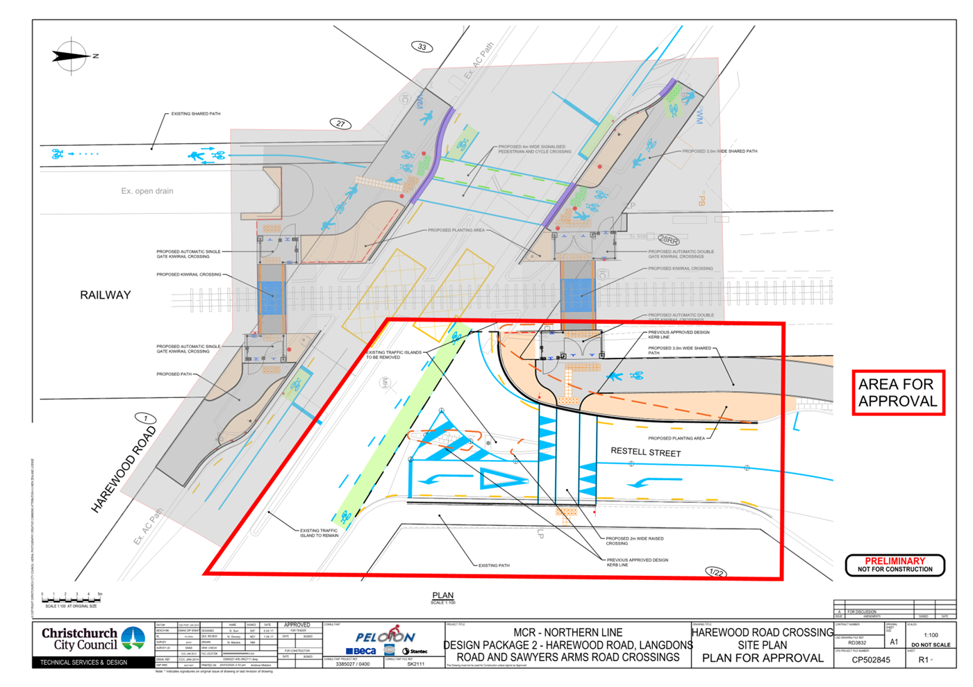
|
15. Christchurch
Northern Corridor - Downstream Effects Bus Lane Trial: Request for Time
Extension
|
|
Reference Te Tohutoro:
|
24/530633
|
|
Responsible Officer(s) Te Pou Matua:
|
David
Sun, Project Manager
Jacob Bradbury, Manager Planning & Delivery Transport
|
|
Accountable ELT Member Pouwhakarae:
|
Jane
Parfitt, General Manager City Infrastructure
|
1. Purpose and Origin of the Report Te Pūtake Pūrongo
1.1 The
purpose of this report is to seek the Council’s approval to extend the
Special Purpose Bus Lane trial on Cranford Street from Innes Road to Berwick
Street until the end of March 2025.
1.2 The
report has been generated by staff.
2. Officer
Recommendations Ngā Tūtohu
That the Council:
1. Receive the information in the Christchurch
Northern Corridor - Downstream Effects Bus Lane Trial: Request for Time
Extension Report.
2. Note that the decision in this report is assessed as medium
significance based on the Christchurch City
Council’s Significance and Engagement Policy.
3. Approve the continued operation and enforcement of special bus
priority lanes on Cranford Street between Innes Road and Berwick Street, in conjunction
with the approved temporary traffic management plan, until the end of March
2025 (or earlier if a decision on the permanent solution is made before then).
4. Note that staff will continue to review potential options for
Cranford Street between Innes Road and Berwick Street, which will then be
followed by a public consultation process.
3. Executive Summary Te Whakarāpopoto Matua
3.1 The
bus priority lane trial on Cranford Street ended in February 2024.
3.2 Staff
are investigating a number of options for the permanent layout of Cranford
Street. These will require public consultation, Council approval, design, and
implementation.
3.3 An
extension of the current bus lane trial is being sought to ensure continuity
until the permanent solution for Cranford Street is approved and implemented.
3.4 By
asking for an extension to March 2025, this will provide sufficient time for
the permanent solution to be fully implemented.
3.5 It
does not preclude changes being implemented earlier than March 2025 should the
process be completed earlier than planned.
4. Background/Context Te Horopaki
History of the Downstream Effects
package
4.1 As
part of the approval process for the Christchurch Northern Corridor (CNC), a
Notice of Requirement was issued. This put requirements on Council to monitor
and manage the effects of increased traffic volumes at the Southern end of the
motorway in line with the Downstream Effects and Property Amenity Traffic
Management Plan, for a period of 10 years after the opening of the motorway.
4.1.1 These documents are
available via links highlighted later in this report.
4.1.2 A key objective was
to mitigate the effects of increased traffic by keeping most traffic on the key
arterial routes – particularly Cranford/Sherborne - to prevent
“rat-running”.
4.1.3 Monitoring must be
undertaken on identified local roads and, should vehicle movements increase by
more than 30% above the traffic level that would have occurred without the
operation of CNC, then the Council has an obligation to improve the
Cranford/Sherborne corridor, and/or undertake calming work on the affected
street(s).
4.1.4 To reduce potential
rat-running, the Independent Traffic Expert had originally recommended peak
hour clearways along Cranford Street between Innes Road and Berwick Street. The
Council consulted on plans to manage the expected increases in traffic volumes
in early 2019, with feedback from the public and Elected Members indicating a
strong preference to not install clearways.
4.2 At
an Extraordinary Council meeting on 26 November 2020, the Council resolved to
commence a three-month trial of special purpose bus priority lanes on Cranford
Street between Innes Road and Berwick Street, starting in February 2021. The
Waipapa Papanui-Innes-Central Community Board was delegated the authority to
approve the design and operating hours for the trial installation.
4.3 The
special purpose bus priority lanes were approved by the Community Board and
installed on 26 February 2021 and the trial was active until 28 May 2021. The
Council subsequently resolved (CNCL/2021/00133) on 12 August 2021 to extend the
bus lane trial until the end of February 2022.
4.4 On
2 August 2023, the Council resolved (CNCL/2023/00101) to further extend the bus
lane trial until the end of February 2024. In the meantime, the evaluation of
options for a permanent solution for Cranford Street between Innes Road and
Berwick Street has been progressing.
4.4.1 At this time there
does not appear to be widespread rat-running pushing traffic volumes over the
30% increased traffic level noted above.
4.4.2 Council staff are
also working on solutions to issues on Flockton Street and Francis Avenue.
These have seen significant traffic increases, although these pre-date both the
opening of the motorway, and the installation of the bus lane trial.
4.5 Since
the end of February 2024, this corridor has been signed as a bus lane, but is
operating as an urban arterial.
Delay caused by exploration of further options
4.6 Initially
Council staff were looking to consult on some version of bus lanes, clearway
and/or urban arterial on this section of Cranford Street.
4.6.1 At that time, a High
Occupancy Vehicle (HOV) lane was not considered a viable option, due to
difficulties associated with enforcement on an urban arterial route and
inconsistencies between Council-owned and NZ Transport Agency Waka Kotahi
(NZTA)-owned sections.
4.7 During
the options evaluation phase, NZTA expressed strong interest in making changes
to their HOV lane, extending it along Cranford Street from its current end
point north of the Cranford Street roundabout to south of Berwick Street.
4.7.1 Council staff recognise
the potential benefits of collaborating with NZTA on all possible solutions
along the entire corridor and worked with NZTA staff to update the HOV lane
traffic modelling on the Christchurch Northern Corridor (CNC) and determine the
feasibility of this option.
4.7.2 Due to the need to
update and refine NZTA’s original HOV lane traffic model, traffic
modelling analysis took longer than planned.
4.7.3 The results were not
available until the end of March 2024. Given this timeframe, staff were not
able to undertake public consultation in November 2023 as originally scheduled.
In turn, the preferred option was not able to be presented to the Waipapa
Papanui-Innes-Central Community Board (Board) and the Council for approval before
the end of the bus lane trial at the end of February 2024.
4.7.4 Council staff have
also had preliminary discussions with providers who install and operate HOV
lanes elsewhere in New Zealand. While there are still risks with this option,
staff are now more confident of its viability in this environment than before
and are therefore comfortable to consult on an HOV lane option.
Next Steps
4.8 The
Council has received feedback from the Independent Traffic Expert regarding the
current trial layout.
4.8.1 While not opposed to
a bus lane concept, the feedback does suggest a number of changes to “squeeze
as much capacity as possible out of the current corridor”. These will be
considered as part of the permanent design process.
4.9 Staff
note that any significant changes require further consultation.
4.9.1 Based on this information, a revised timeline is as follows:
|
Date
|
Item
|
|
June 2024
|
Community
Board pre-consultation briefing
|
|
July 2024
|
Consultation
|
|
September 2024
|
Community
Board briefing on consultation results
|
|
September / October 2024
|
Post
consultation design changes and report
|
|
October 2024
|
Community
Board recommendation to the Council
|
|
November 2024
|
Council
decision
|
|
November 2024 to February 2025
|
Detailed
design
|
|
March / April 2025
|
Construction
|
4.9.2 Extending the date of
the trial to the end of March 2025 will provide a small buffer against possible
further delays.
4.10 The Council, along with its partners at Environment Canterbury and
NZTA, is developing plans for elements of the Public Transport Futures
programme to be included as part of Long Term Plans. Initial intentions are for
service uplifts on the 91 and 92 services (City to Rangiora and Kaiapoi
respectively) around FY27.
4.11 The Council has been briefed on this project on a number of
occasions. The Community Board (Waipapa Papanui-Innes-Central) is also
regularly briefed on issues and progress across the entire DEMP programme.
Options Considered Ngā
Kōwhiringa Whaiwhakaaro
4.12 The following
reasonably practicable options were considered and are assessed in this report:
· Extend the bus lane trial to the end of March 2025.
· Revert to an urban arterial.
4.13 The following
options were considered but ruled out due to not being appropriate for a
limited period. However, they remain potential outcomes of the permanent
decision-making process:
· Clearway Trial – Given previous feedback and Community Board
decisions, this would need to be re-consulted.
· HOV lane trial – This would need to be consulted on, and there
would be significant challenges and technology cost associated with
enforcement.
Option Descriptions Ngā
Kōwhiringa
4.14 Preferred
Option: Extend the bus lane trial to the end of March 2025
4.14.1 Option Description: This
would extend the bus lane trial along Cranford Street between Innes Road and
Berwick Street.
4.14.2 Option Advantages
· Maintains the current layout: low cost installation and minimal
confusion.
· Was a favoured option of many submitters during the original
consultation.
· Supports growing bus patronage.
· Safest option for cyclists and other active users.
4.14.3 Option Disadvantages
· Reduces general road capacity for the limited number of buses using
it (typically 16 buses running inbound between 6am & 9am).
· Most bus delays appear to be associated with intersections, so it
may not be the most effective way of resolving delays.
· Requires alterations to signage to be enforceable.
· Misses the opportunity to trial other layouts.
4.15 Revert to an
urban arterial
4.15.1 Option Description: This
would require the removal of all bus lane trial signage and road markings and
allow the road to revert to a configuration with one general traffic lane and a
cycle lane in each direction with on-street parking on both sides.
4.15.2 Option Advantages
· Potential for future capacity increase. While not offering immediate
capacity gains due to on-street parking, this option creates the physical space
to explore potential future capacity improvements.
· Provides local residents and businesses with on-road parking.
· This configuration includes an on-street cycle lane, though cyclists
are encouraged to utilise the Papanui Parallel Cycleway for a safer and more
separated riding experience.
· No special vehicle lanes so easier to enforce.
· May provide opportunities to improve crossing facilities.
4.15.3 Option Disadvantages
· It would negate any potential travel time saving for public
transport at peak hours.
· In initial discussions this was not favoured by key stakeholders and
was not popular during the initial consultation process.
· Does not support cyclists or other active travel users along the
corridor.
· There would be a reasonable cost associated with removing and
replacing signage and road markings.
· Change of layout likely to require some bedding in – resulting
in potential confusion for users.
Analysis Criteria Ngā Paearu
Wetekina
4.16 The preferred
option is recommended due to its low cost, maintenance of the status quo,
support for mode shift, and it was the favoured option in the original
consultation.
4.17 There is little
evidence at this stage of widespread rat-running causing the Notice of
Requirement limits to be breached.
5. Financial Implications Ngā Hīraunga Rauemi
Capex/Opex Ngā Utu Whakahaere
|
|
Recommended Option – extension of the
bus lane trial
|
Option 2 – urban arterial
|
|
Cost to Implement
|
$0
No change from existing layout. Ongoing
maintenance of the corridor is covered under existing budgets (see below).
|
$44,000
This cost covers the removal of all bus
lane signage and road markings, including traffic management and project
management costs.
|
|
Enforcement costs
|
To date, as the Bus Lanes have only been
a trial, staff have only been undertaking light enforcement. It is not
proposed to change this, so the costs for this are not expected to change.
If the Council wished to undertake
stricter enforcement to discourage parking and driving – such as is
undertaken on Lincoln Road – this would have operational costs for the
following:
· Tow truck vehicle removal
· Staff rates for monitoring and enforcing
|
Based on the current level of
enforcement, there would be minimal reduction to costs from this option.
|
|
Maintenance/Ongoing Costs
|
No change to maintenance and ongoing
costs
|
|
Funding Source
|
#17088 Christchurch Northern Corridor
Downstream Effects Delivery Package
FY24 Budget: $1.01m
FY24 Actual (to date): $0.41m
|
|
Impact on Rates
|
None – the costs are accounted for
in the Council’s Long Term Plan
|
6. Considerations Ngā Whai Whakaaro
Risks and Mitigations Ngā
Mōrearea me ngā Whakamātautau
6.1 There
is a risk that bus priority lanes are impacting the flow of traffic on Cranford
Street and local streets. Traffic monitoring is continuous and will be fully
reported on within the decision report due later this year.
6.2 There
is a risk that increased traffic volumes on local streets may be incorrectly
attributed to the presence of bus priority lanes.
6.3 It
is acknowledged that the views of the local community and the Independent
Traffic Expert may diverge regarding the permanent solution for Cranford
Street. These differences may pertain to the outcomes of the trial, staff
recommendations, or the proposed permanent solution for Cranford Street.
Legal Considerations Ngā
Hīraunga ā-Ture
6.4 Statutory
and/or delegated authority to undertake proposals in the report:
6.4.1 Bus priority lanes are a form of special vehicle lane authorised by
Council resolution under Clause 18 of the Traffic and Parking Bylaw 2017.
6.5 Other Legal Implications:
6.5.1 The legal
considerations are:
· The Waipapa Papanui-Innes-Central Community Board does not have the
delegation to approve the bus priority lane trial for longer than a three-month
period.
· The Council is obligated under the conditions of the resource
consent for the Christchurch Northern Corridor to follow the recommendations of
the Independent Traffic Engineer in the Downstream Effects Management Plan
(DEMP). The DEMP did not initially recommend this bus priority lane trial but
the Independent Traffic Expert has reviewed this trial and agrees with the time
frame to make recommendations and decisions.
· The Christchurch City Council Traffic and Parking Bylaw 2017
delegates to the Temporary Traffic Management Team the power to authorise
temporary bus lanes under an approved Temporary Traffic Management Plan.
· In terms of enforcement of the bus priority lane, the
Council’s parking compliance officers have the powers of parking wardens
under the Land Transport Act 1998. Parking wardens are authorised to
enforce the provisions of special vehicle lane offences, and in particular
infringement offences. Special vehicle lane infringement offences include
parking a vehicle in a special vehicle lane ($60 infringement fee), and the
unauthorised use of a special vehicle lane ($150 infringement fee).
Strategy and Policy Considerations Te Whai
Kaupapa here
6.6 The
required decision:
6.6.1 Aligns with the Christchurch
City Council’s Strategic Framework. The current implementation of bus
lanes is consistent with the Christchurch Transport Strategic Plan and is also
consistent with the Council’s Strategic Priorities as it supports
enabling active and connected communities to own their future.
6.6.2 Is assessed as medium significance based on the
Christchurch City Council’s Significance and Engagement Policy. The level of significance was determined by the
relatively small number of residents and businesses impacted by the bus lanes,
and because the decision is time-bound and reversable.
6.6.3 Is consistent with
Council’s Plans and Policies.
6.7 This report supports the Council's
Long Term Plan (2021 - 2031):
6.8 Transport
6.8.1 Activity:
Transport
Community Impacts and Views Ngā Mariu
ā-Hāpori
6.9 The decision affects the following wards/Community Board areas:
6.9.1 Waipapa Papanui-Innes-Central Community Board.
6.10 The Community Board has consistently advocated against the use of a clearway
in this area.
Impact on Mana Whenua Ngā Whai Take
Mana Whenua
6.11 The decision
does not involve a significant decision in relation to ancestral land or
a body of water or other elements of intrinsic value, therefore this decision does not specifically impact Mana Whenua, their culture, or
traditions.
6.12 The decision does not involve a
matter of interest to Mana Whenua and will not impact on our agreed partnership
priorities with Ngā Papatipu Rūnanga.
Climate Change Impact Considerations Ngā
Whai Whakaaro mā te Āhuarangi
6.13 The decisions in
this report are likely to:
6.13.1 Not impact on adaptation to the
impacts of climate change.
6.13.2 Have the potential to contribute
positively to emissions reductions through encouraging mode-shift towards
public transport and active modes.
7. Next Steps Ngā Mahinga ā-muri
7.1 Next
steps will be for Council staff to undertake public consultation for a
permanent solution.
7.1.1 A significant
engagement process is planned. This will include a social media campaign,
radio, billboard and bus stop advertisements, as well as traditional media. The
campaign will seek to reach local communities around Cranford Street, as well
as local and regional commuters.
Attachments Ngā Tāpirihanga
There are no
attachments to this report.
In addition to the attached documents, the following background
information is available:
Signatories Ngā Kaiwaitohu
|
Authors
|
Jacob Bradbury
- Manager Planning & Delivery Transport
David Sun -
Project Manager
|
|
Approved By
|
Lynette Ellis
- Head of Transport & Waste Management
Jane Parfitt -
General Manager City Infrastructure
|
|
16. Process for Changing Approved Design - MCR
Nor'West Arc
|
|
Reference Te Tohutoro:
|
24/457871
|
|
Responsible Officer(s) Te Pou Matua:
|
Richard
Humm, Project Manager Transport
Jacob Bradbury, Manager Planning & Delivery Transport
|
|
Accountable ELT Member Pouwhakarae:
|
Brent
Smith, Acting General Manager City Infrastructure
|
1. Purpose and Origin of the Report Te Pūtake Pūrongo
1.1 The
purpose of this report is to provide advice on the Notice of Motion relating to
the Nor’West Arc Major Cycle Route (Section 3) along Aorangi Road between
Ilam Road and Brookside Terrace, to enable the Council to decide on which
option to proceed with.
1.2 The Notice of Motion agreed by the Council on 6 September 2023
requested that staff report back to Council by 15 November 2023.
1.3 The Notice of Motion included:
1.3.1 Request
a report from staff by 15 November 2023 on the process for adopting design
‘Option B’ for the Nor’ West Arc MCR section along Aorangi
Road between Ilam Road and Brookside Terrace which includes the:
a. Process
for amending the existing design to adopt design ‘Option B’ for an
on-berm cycleway alongside the footpath;
b. Options
for removal and replacement of existing silver birch trees; and
c. Impacts
of any change on the delivery of the Nor’ West Arc MCR.
2. Officer Recommendations Ngā
Tūtohu
That the Council:
1. Receive the information in the Process for
Changing Approved Design – MCR Nor’West Arc report.
2. Agree to progress with one of the following
options for the Nor’West Arc Major Cycleway Route (Section 3) along
Aorangi Road between Ilam Road and Brookside Terrace:
a. Option A - Separated cycleway on the
carriageway (the current approved design).
i. Agree to retain Option A under the previous
decision made by the Urban Development and Transport Committee at its 3
February 2022 meeting (Item 9, Resolution 1(d): that Section 3 –
Aorangi Road from Ilam Road up to Brookside Terrace be a two-way cycleway)
and continue with the current approved design (Attachment A to this report);
and
ii. Note that staff will bring a report to Council
in mid-2024 to agree to the detailed traffic resolutions prior to completing
construction procurement.
OR
b. Option B - Shared path:
i. Revoke the previous decision made by the Urban
Development and Transport Committee at its 3 February 2022 meeting (Item 9,
Resolution 1(d): that Section 3 – Aorangi Road from Ilam Road up to
Brookside Terrace be a two-way cycleway), following the Committee’s
consideration of the Hearings Panel report (Attachment E to this report); and
ii. Approve the scheme design of the
Nor’West Arc section 3 between Ilam Road and Brookside Terrace as a
shared path (Attachment B to this report).
iii. Note that staff will bring a report to the
Council to agree the detailed traffic resolutions prior to completing
construction procurement.
iv. Note that this option has associated design,
budget, resource and delivery impacts and risks (as described in section 4.32
of this report).
OR
c. Option C – Separated cycleway and
footpath on the existing berm:
i. Agree to pause any further work as commenced
under Option A – Separated cycleway on the carriageway (the current
approved design).
ii. Direct staff to create a scheme design for a
separated cycleway and footpath on the existing berm.
iii. Note that this option has associated design,
budget, resource and delivery impacts and risks (as described in section 4.33
of this report).
iv. Note that this option is likely to require
additional consultation, including the formation of a Hearings Panel to
evaluate feedback and design options.
3. Note that the decision in this report is
assessed as medium significance based on the Christchurch City Council’s
Significance and Engagement Policy.
3. Executive Summary Te Whakarāpopoto Matua
3.1 A
Notice of Motion was agreed by the Council on 6 September 2023 to review the
design options for the Nor’West Arc Major Cycle Route.
3.1.1 The
Notice of Motion specifically relates to the section of Aorangi Road between
Ilam Road and Brookside Terrace (610m).
3.1.2 Council
Staff were asked to provide details about the process to change the design,
options for removal and replacement of trees, and advise of the impacts of any
change to delivery.
3.2 At
the beginning of the project two options were considered for this section of
cycleway: a neighbourhood greenway; and separated cycleway in the road
corridor. On the 5 March 2021 the greenway option was ruled out by the
Transport Steering Group due to the traffic volume and limited opportunities to
reduce traffic volumes.
3.3 The
project team carried out early engagement with non-resident stakeholders. After
early engagement analysis, further options were considered, including both on
berm shared path and on berm separated footpath and cycleway options, leading
to the two favoured options:
3.3.1 A
separated, two-way cycleway (Option A)
3.3.2 An
on-berm shared path (Option B)
3.4 A
Scheme Design and Network Functionality (SANF) review was completed on both
options. Option A was endorsed over Option B due to concerns around the risks
of conflict with shared path users and exiting vehicles from driveways.
3.5 On
3 August 2021, Council was briefed on Nor’West Arc Section 3 prior to
consultation.
3.5.1 Formal
consultation was conducted from 14 September to the 12 October 2021.
3.5.2 Results
of the consultation were 424 submissions with 339 selecting a preferred option:
· Option A - 62%
· Option B - 38%.
3.6 Based
on feedback from consultation, several revisions were made to Option A. These
included a 70m shared path, additional parking, including more on street
parking, and improved safety measures at the Ilam Road/Aorangi Road
intersection.
3.7 A
Hearings Panel convened on the 15 November 2021.
3.7.1 The
Panel accepted the Officer Recommendations for a revised Option A: a shared
path from Ilam Road to Truman Road, and separated cycleway in the existing
carriageway from Truman Road to Brookside Terrace.
3.7.2 The
Hearings Panel report and recommendations were adopted by the Urban Development
and Transport Committee on 3 February 2022, with 11 votes in favour and 4
against.
3.8 In
conclusion, the project has been through a thorough design analysis, public
consultation, and Hearings process to provide the current preferred design
option for the Nor’West Arc Major Cycleway.
3.8.1 While
it is difficult to cost any change exactly at this stage, staff can confidently
advise the Council that there is more cost and time associated with changing
the option from the current approved Option A, to either of the alternative
Options B or C.
3.8.2 This
is because changing the design will result in an increase in the scope to be
delivered, and there will be additional design costs and time associated with
any change.
4. Background/Context Te Horopaki
4.1 The
Nor’West Arc cycleway will provide a Major Cycleway standard design from
Cashmere to Papanui.
4.1.1 The
Notice of Motion and the content of this report relate specifically to the
section on Aorangi Road between the Ilam Road and Brookside Terrace
intersections (610m).
4.1.2 The
Major Cycleway Programme was declared a Metropolitan Programme on 29 January
2015, where it was agreed that the Council would have authority to make design
decisions. This was delegated to the Urban Development and Transport Committee
at the time of the original design decision on this section of the project.
4.1.3 Funding
for this section is partly from the government’s Shovel Ready programme,
with additional funds from the Council.
4.2 As noted in paragraph 1.3, the Council requested a report from staff
on the process for adopting an ‘amended Option B’, described as an
on-berm cycleway alongside the footpath. For clarity this ‘amended’
option will be referred to as Option C. Therefore, the
three options referred to in this report are:
· Option A – Separated
cycleway on the carriageway (current design)
· Option B – Shared
path on the existing berm
· Option C – Separated
cycleway on the existing berm, adjacent to the footpath
4.3 At the beginning of the
project two options for this section of the cycleway were considered –
these being a greenway and a separated cycleway. The greenway option was ruled
out by the Transport Steering Group on 5 March 2021 due to the existing traffic
volumes and limited opportunities to reduce them.
4.4 The
project team then took Option A, the separated cycleway option, to non-resident
stakeholders for early engagement. Following this process, further analysis was
undertaken on alternative options, including both an on berm shared path and an
on berm separated footpath and cycleway. The on berm shared path option was put
forward for wider public consultation as Option B.
4.5 The
existing berm varies from 5.1m to 5.8m. It includes a 1.6m wide footpath
against property boundaries with a wide grass berm, trees and power poles. A
shared path was considered the most practical option given the space available
and minimum dimensions that would be needed for a separated footpath and
cycleway. Additionally, the project team wanted to maintain the existing kerb
and channel to reduce costs to the project.
4.6 The
identified benefits of a shared path compared to a separated footpath and
cycleway included:
· A 1m offset from property boundaries.
· A 3.5m wide shared path.
· Retains power poles
– these being immediately behind the kerb line.
· Retains existing kerb and
channel.
· Allows users to choose how
they use the space.
4.7 A
Scheme Design Safety and Network Functionality (SANF) review was undertaken on
both options. Option A was endorsed by the review primarily due to concerns
relating to Option B’s shared path proximity to driveways and the risk of
conflict between reversing vehicles and users.
4.8 The
Waipapa Papanui-Innes, Waipuna Halswell-Hornby-Riccarton and Waimaero
Fendalton-Waimairi-Harewood Community Boards were briefed on the details of the
Nor’West Arc MCR Section 3 to be taken to consultation. This included two
options:
· Option A – A separated cycleway on the carriageway. This retained
the existing kerb, berm and footpath and positioned a 3-metre cycleway in the
existing road space. It resulted in the removal of on-street parking (about 113
parks) and included new indented parking bays to make up for some of the lost
parking. Currently the design includes 51 car parks (Attachment A).
· Option B – An on
berm shared path. This retained the existing road carriageway and on-street
parking and created a new 3.5m shared path on the existing berm. It includes a
1m offset from the property boundary and 0.7m offset from the kerb, and resulted
in the removal of all trees and the existing footpath (Attachment B).
· Note that both options
included the speed limit reduction from 50kmh to 40kmh. This was later changed
to a reduction to 30kmh under the Safer Speeds Plan.
4.9 On
3 August 2021 the Council was briefed on the details of the Nor’West Arc
MCR Section 3 to be taken to consultation.
4.10 Consultation
was conducted from 14 September 2021 to 12 October 2021. Below are the links to
the maps used during consultation.
· Map
6 - Aorangi Road (Ilam to Clyde)
· Map
7 – Aorangi Road (Clyde to Brookside)
4.11 424
submissions were received, with 339 selecting a preferred option.
· Option A (262, 62%).
· Option B (129, 38%).
4.12 When
reviewing submissions from those who live on the route and those from relevant
organisations, Option B (15) was preferred over Option A (1).
Submitters’ reasons for supporting Option A:
· Safer (40).
· Poor user behaviour on
shared paths (14).
· Consistent with the rest
of Aorangi Rd (10).
· Cyclist priority at
intersections (3).
· No tree loss (3).
Submitters’ reasons for supporting
Option B:
· Maintains on-road car
parking (30).
· Safer (5).
· Removes trees (3)
4.13 The
two options were then assessed using a multi-criteria analysis that considered
major cycleway standard design criteria, public submissions, and cost.
· Option A was considered to
be the better option under design aspects of safety, comfort, attractiveness,
and directness. It also received the greatest support by submitters (62%).
· Option B was considered to
be the better option under stakeholder impact and cost.
4.14 After
consultation, Option A was chosen by the project team as the preferred option
due to a) safety concerns with Option B which were raised in the SANF review
and b) most of the public submissions(62%) preferred Option A.
4.15 After
consultation the following actions/revisions were made to the preferred Option
A:
· A separated cycleway was
replaced with a shared path from Ilam Road to Truman Road (70m). The purpose of
this was to give cyclists a clear priority over Truman Road.
· Additional parking introduced on the southern side of Aorangi Road.
Provision of two P10 parking spaces on the northern side of Aorangi Road.
· Five
additional trees were removed due to the introduction of the shared path
between Ilam Road and Truman Road.
· Ongoing
work during detailed design phase with the Village Church on the shared area at
Ilam Road and Aorangi Road Intersection (now completed).
· Measures
to further improve safety at the Aorangi Road Ilam Road intersection considered
during detailed design (now completed).
4.16 A
Hearings Panel process was conducted on 15 November 2021 via video link due to
COVID -19 restrictions. The Hearings Panel consisted of Councillors Melanie
Coker (Chair), Catherine Chu, Mike Davidson, Jake McLellan, and Community Board
Member Simon Britten.
4.17 426
written submissions were received, and the Hearings Panel heard from 28
submitters.
4.18 At
the end of the hearing, Panel Members asked 60 questions. The questions and
Council Officer responses were recorded in the 15
November 2021 meeting minutes.
4.19 The
Hearings Panel accepted the Officer Recommendations of a revised Option A,
comprising a shared path from Ilam Road to Truman Road and a separated cycleway
in the existing carriageway from Truman Road to Brookside Terrace. The Hearings
Panel also requested staff to investigate additional parking on the Aorangi
Road corner by Clyde Road, as a result of submissions from the New Generation
Church.
4.20 The
design was amended at the Aorangi Road corner by Clyde Road to include an
additional eight car parks, resulting in the removal of two trees.
4.21 The
Hearings Panel report and recommendations were then adopted by the Urban
Development and Transport Committee on 3 February 2022 with 11 votes in favour
and 4 against.
4.22 Following
the resolution by the Urban Development and Transport Committee to adopt the
recommended Option A the project entered the detailed design phase.
4.23 Four
notable changes were made during the detailed design process:
4.23.1 The
project team identified additional opportunities to add indented parking bays
working with the Council arborists in identifying another three trees scheduled
for removal as part of their Orion Tree Compliance Project. This resulted in an
additional 2 silver birch trees being removed and 5 car parks added.
4.23.2 The
proposed speed limit reduction from 50kph to 40kph was further reduced to 30kph
to align with the Safer Speeds Plan.
4.23.3 The
design at the Clyde Road intersection was changed to a shared path crossing.
This removed the pedestrian versus cycle lane cross conflicts and would
encourage cyclists to be more careful on the approach to Clyde Road.
Additionally, the design more clearly indicated to cyclists that they must give
way to vehicles on Clyde Road.
4.23.4 The
scope of the project now includes the replacement of kerb and channel, and
resealing of the carriageway, due to observed poor asset condition.
4.24 This
section of the cycleway is now at the end of detailed design, and construction
was planned to start before Christmas 2023.
PROCESS TO CHANGE DESIGN
4.25 The
below describes the process requirements to progress each of the three options:
4.25.1 Option A – No further action. The project is at the
end of detailed design phase and can continue to the procurement phase, and
there are no other implications.
4.25.2 Option
B – Based on the information contained in the previous Hearings Panel report (Attachment E - Urban
Development and Transport Committee 3 February 2022), the Council could make a
resolution at this meeting to revoke the previous decision and progress with
Option B (Attachment B).
The Council would put itself in as good a
position as the original Hearings Panel which heard all parties. It can do so
by considering the Hearings Panel report which includes all submissions, a
summary of the written and verbal submissions that were presented at the
hearings and the Hearings Panel’s considerations and
deliberations.
4.25.3 Option C – Should Council wish to
proceed with the development of Option C:
A. Council should pass a
resolution to pause any further work on the Nor’ West Arc MCR Section 3
along Aorangi Road between Ilam Road and Brookside Terrace, as the current
Notice of Motion resolution has only paused the work until this report.
B. Work would not continue that
could prejudice any future Council decisions, until staff have developed a
scheme design for Option C, and consulted on this.
4.26 To meet the requirements of the Local Government Act, including our
Significance and Engagement Policy, consultation will be required to develop
and approve a new design (Option C).
PROCESS TO REMOVE
TREES
4.27 The
process to remove the silver birch trees associated with both Options B and C
will require:
· Neighbouring properties to
be informed of the proposed tree removals.
· A request to remove the
trees included in a transport resolution report to the Council.
· Removal of the trees will
be subject to the Council’s Tree Policy, requiring two new trees to
replace each tree removed.
· Due to location
constraints, it is likely that some replacement trees would have to be located
away from the project site.
4.28 The
decision affects the following wards/Community Board areas:
· Waimaero
Fendalton-Waimairi-Harewood Community Board.
Options Considered Ngā Kōwhiringa Whaiwhakaaro
4.29 The
following reasonably practicable options were considered and have been assessed
in this report:
· Option A – Separated cycleway on the carriageway (current
design).
· Option B – Shared path on the existing berm.
· Option C – Separated
cycleway on the existing berm, adjacent to the footpath.
4.30 The
following options were considered but ruled out:
· Greenway. At the beginning of the project two options for this section of
the cycleway were considered. A greenway and a separated cycleway in the road
corridor. A greenway option was ruled out due to the existing traffic volumes
and limited opportunities to reduce them.
Options Descriptions Ngā Kōwhiringa
4.31 Preferred
Option: Option A – Separated cycleway on the carriageway (current
design).
4.31.1 Option
Description: A separated cycleway on the carriageway. This retained the
existing kerb, berm and footpath and located a 3-metre cycleway in the existing
road space. This option resulted in the removal of the on-street parking (about
113 parks) and included new indented parking bays to make up for some of the
lost parking. Currently the design includes 51 car parks.
4.31.2 Option
Advantages
No further action.
The project is at the end of detailed design and will continue to the
procurement phase, and therefore has no implications.
4.31.3 Option
Disadvantages
Removal of some
parking along Aorangi Road
4.32 Option
B – Shared path on the existing berm.
4.32.1 Option
Description: An on berm shared path – retained the existing road
carriageway and on-street parking and located a 3.5m shared path on the
existing berm. It includes a 1m offset from the property boundary and 0.7m
offset from the kerb. This option resulted in the removal of all trees and
removal of the existing footpath (Attachment A)
4.32.2 Option
Advantages
Retention of most car
parking spaces.
4.32.3 Option
Disadvantages
A. Resource
to be sought for detailed design.
B. Technical
approvals will need to be reviewed. This includes Orion, Connetics, Enable,
One.NZ (formally Vodafone), CCC Three Waters, Chorus, landscaping, and safety
auditing.
C. Design
implications. Stormwater infrastructure to be reviewed due to increased
impermeable space. Other potential design implications due to underground
services not yet surveyed.
D. Lighting
review and upgrade likely required with poles and power connection to be
installed against property boundaries.
E. All
trees to be removed from the berm. Two trees to be planted in place of every
one removed as per the Council Tree Policy. These will likely be planted away
from this section of Aorangi Road due to a lack of green space.
F. Additional
costs compared to Option A. Option B has a rough estimate, of being $2.5
million more than Option A. Key contributors to the increase in cost for Option
B relate to potential service relocations, additional street lighting,
additional stormwater, intersection changes, tree removal and design costs.
G. Time.
4 month delay due to additional survey, design work and approvals. Some time
may be absorbed through the prioritisation of other work, such as the
construction of other parts of the cycleway.
Increased Risks:
H. Underground
service clashes in berm may add cost/time to project. Services will need to be
confirmed via survey.
4.33 Option
C – Separated cycleway on the existing berm, adjacent to the footpath.
4.33.1 Option
Description: ‘An
amended version of Option B’, described as an on-berm cycleway alongside
the footpath.
4.33.2 Option Advantages
Retention of the majority of existing car
parking.
4.33.3 Option
Disadvantages
A. Professional
services to be procured for scheme design, detailed design, consultation and
project management, with associated additional costs.
B. Additional
reports to the Council for approval to consult the public; and approval to
proceed to design and construction.
C. Hearings
Panel to be formed and process followed.
D. Technical
approvals will need to be revisited, his includes Orion, Connetics, Enable,
One.nz (formally Vodafone), CCC Three Waters, Chorus, landscaping, and safety
auditing.
E. Lighting
review and upgrade likely required. Lighting poles and power connections would
be installed against property boundaries.
F. Design
implications. Footpath to be replaced due to poor condition. Overhead power
poles would need to be undergrounded. Stormwater infrastructure to be reviewed
due to increased impermeable space. Other potential design implications due to
underground services not yet surveyed.
G. All
trees to be removed from the berm. Two trees to be planted in place of every
one removed as per the Council Tree Policy. These will likely be planted away
from this section of Aorangi Road due to a lack of green space.
H. Additional
Costs compared to Option A: Option C has a rough estimate being $4 million more
than Option A. The key contributors to the increase in cost for Option C are
the same as Option B with the addition of scheme design and consultation fees,
undergrounding of power lines to private properties and adjusting the kerb
alignment.
I. Time
– 11 months delay to programme.
· 1 month - Procure
resources.
· 3 months - Scheme
Design and approvals.
· 3 months –
Consultation and approvals.
· 4 months –
Detailed Design and approvals.
J. Some
time may be absorbed through the prioritisation of other work, such as the
construction of other parts of the cycleway.
Increased Risks:
K. There
is a risk that during consultation the public are not supportive of Option C
with a preference for Options A or B.
L. The
scheme may still result in a loss of on-street parking due to minimum widths
and offsets. It is noted that the retention of parking has been a driver for
this option.
4.34 To
meet the requirements of the Local Government Act, including our Significance
and Engagement Policy, we consider consultation will be required to develop and
approve a new design (Option C).
5. Financial Implications Ngā Hīraunga Rauemi
Capex/Opex Ngā Utu Whakahaere
|
|
Recommended Option
|
Option B
|
Option C
|
|
Additional cost to Implement
|
None
|
$2.5 million
|
$4 million
|
|
Maintenance/Ongoing Costs
|
All options are considered to have the
same ongoing costs.
|
All options are considered to have the
same ongoing costs.
|
All options are considered to have the
same ongoing costs.
|
|
Current Funding Source
|
|
|
|
|
Shovel Ready
|
$10,500,000
|
$10,500,000
|
$10,500,000
|
|
CO- funding
|
$16,125,995
|
$16,125,995
|
$16,125,995
|
|
Additional Cost to Implement (as above)
|
|
$2,500,000
|
$4,000,000
|
|
Total Budget to implement
|
$26,625,995
|
$29,125,995
|
$30,625,995
|
|
Funding Availability
|
Planned in LTP
|
$2.5m shortfall
|
$4m shortfall
|
|
Impact to Ratepayers
|
None as planned in LTP
|
Approx. 0.028%
|
Approx. 0.04%
|
5.1 It
was requested that staff provide greater explanation on the proposed additional
costs related to the alternative Options B and C. Attachment C of this report
provides high level indicative cost implications. As there are no detailed
designs of Option B and C the additional costs of each option provided in the
report are indicative rough order costs.
5.2 The
likely scope increases that cause the additional costs for Option B and C are
detailed in Attachment D - Table of items contributing to cost by option.
6. Considerations Ngā Whai Whakaaro
Risks and Mitigations Ngā Mōrearea me
ngā Whakamātautau
6.1 Identified
Risks include:
6.1.1 Legal
Risk – Ensure adequate engagement is undertaken if Option C is
considered. As stated in paragraph 4.34 of this report.
6.1.2 Reputational
Risk – Public criticism due to a previous Council decision being
reconsidered.
6.1.3 Financial
Risk – T An independent estimate has been requested and this may change
the expected costs. A change from Option A will lead to an increase in costs.
6.1.4 Delivery
Risk – Delivery date likely to be extended if Option B or C is
progressed.
Legal Considerations Ngā Hīraunga
ā-Ture
6.2 Statutory
power to undertake proposals in the report Te Manatū Whakahaere Kaupapa
6.2.1 The
statutory power used to undertake proposals as contained in this report is
under the Local Government Act 2002.
6.2.2 Part
1, Clauses 7 and 8 of the Christchurch City Council Traffic and Parking Bylaw
2017 provides Council with the authority to install parking restrictions by
resolution.
6.2.3 The
installation of any signs and/or markings associated with traffic control
devices must comply with the Land Transport Rule: Traffic Control Devices 2004.
6.2.4 The
decisions within this report falls within the Council’s decision-making
authority consistent with the Local Government Act.
6.2.5 Note:
Under Clause 12.9 of the Land Transport Rule Setting of Speed Limits 2022, if a
road controlling authority has, before 19 May 2022 (commencement of the Rule),
called for submissions on a proposal to set a speed limit under the previous
Rule, the road controlling authority may in the interim period set the speed
limit under the previous Rule under an existing Bylaw.
6.3 Other
Legal Implications Ētahi atu Hīraunga-ā-Ture
6.3.1 The
legal consideration is ensuring procedural obligations are met should Council
revisit the design, by considering the new design Option C.
Strategy
and Policy Considerations Te
Whai Kaupapa here
6.4 The
required decisions:
6.4.1 Align
with the Christchurch
City Council’s Strategic Framework.
· This project supports
Council’s Strategic Priority: Increasing
active, public and shared transport opportunities.
6.4.2 Are
assessed as medium significance based on the Christchurch City Council’s
Significance and Engagement Policy. The level of significance was
determined by the level of media and community interest in cycleways and
availability of Government funding, balanced with the relatively low impact on
the city as a whole.
6.4.3 Are
consistent with Council’s Plans and Policies by
increasing active, public and shared transport opportunities by providing a
safe option for cyclists particularly those who would not normally feel
comfortable biking within the main stream of traffic.
6.5 This
report supports the Council's
Long Term Plan (2021 - 2031):
6.6 Governance
6.6.1 Activity: Governance and decision-making
M. Level of Service: 4.1.28.3 Establish and maintain
documented governance processes that ensure compliance with the local
government legislation - Governance processes are maintained and
published on council's website.
Community
Impacts and Views Ngā Mariu ā-Hāpori
6.7 The decision affects the following wards/Community Board areas:
6.7.1 Waimaero
Fendalton-Waimairi-Harewood Community Board.
Impact
on Mana Whenua Ngā
Whai Take Mana Whenua
6.8 The
decision does
not involve a significant decision in relation to ancestral land or a
body of water or other elements of intrinsic value, therefore this decision
does specifically impact Mana Whenua, their culture, or traditions.
6.9 The
decision does not involve a matter of interest to Mana
Whenua and will not impact on our agreed partnership priorities with Ngā Papatipu Rūnanga.
6.10 The
decision does impact any ancestral land or a body of water or other elements of
intrinsic value, therefore this decision does not specifically impact Mana
Whenua, their culture, and traditions.
Climate
Change Impact Considerations Ngā Whai Whakaaro mā te Āhuarangi
6.11 The
decisions in this report are likely to:
6.11.1 Contribute
positively to adaptation to the impacts of climate
change.
6.11.2 Contribute
positively to emissions reductions.
6.12 For
each tree removed, two replacement trees will be planted within a local reserve
as per CCC Tree Policy.
7. Next Steps Ngā Mahinga ā-muri
7.1 The
decision will provide the direction of next steps.
Attachments Ngā Tāpirihanga
|
No.
|
Title
|
Reference
|
Page
|
|
a ⇩
|
Option A - As
previously approved
|
23/1855584
|
341
|
|
b ⇩
|
Option B - As
previously consulted
|
23/1855857
|
345
|
|
c ⇩
|
Nor'West Arc
Cycleway - Aorangi Road Notice of Motion Memo (31 March 2024)
|
24/308800
|
349
|
|
d ⇩
|
Table of Items
Contributing to Cost by Option
|
24/309304
|
352
|
|
e ⇩
|
Hearings Panel
Report - Nor'West Arc Section 3 - Te Ara O-Rakipaoa Cycleway
|
21/1475784
|
353
|
In addition to the attached documents, the following background
information is available:
|
Document
Name – Location / File Link
|
|
Not
applicable
|
Signatories Ngā Kaiwaitohu
|
Authors
|
Richard Humm -
Project Manager
Ron Lemm -
Manager Legal Service Delivery, Regulatory & Litigation
Tessa Zant -
Manager Engagement
Naomi Soper -
Senior Legal Counsel
|
|
Approved By
|
Jacob Bradbury
- Manager Planning & Delivery Transport
Lynette Ellis
- Head of Transport & Waste Management
Brent Smith -
Acting General Manager City Infrastructure
|
|
17. Resolution to Exclude the Public
|
Section 48, Local Government Official
Information and Meetings Act 1987.
I move that the public be excluded from the
following parts of the proceedings of this meeting, namely items listed
overleaf.
Reason for passing this resolution: good
reason to withhold exists under section 7.
Specific grounds under section 48(1) for
the passing of this resolution: Section 48(1)(a)
Note
Section 48(4) of the Local Government
Official Information and Meetings Act 1987 provides as follows:
“(4) Every resolution to exclude the
public shall be put at a time when the meeting is open to the public, and the
text of that resolution (or copies thereof):
(a) Shall
be available to any member of the public who is present; and
(b) Shall
form part of the minutes of the local authority.”
This resolution is made in reliance on
Section 48(1)(a) of the Local Government Official Information and Meetings Act
1987 and the particular interest or interests protected by Section 6 or Section
7 of that Act which would be prejudiced by the holding of the whole or relevant
part of the proceedings of the meeting in public are as follows:
|
ITEM NO.
|
GENERAL SUBJECT OF EACH MATTER TO BE CONSIDERED
|
SECTION
|
SUBCLAUSE AND REASON UNDER THE ACT
|
PLAIN ENGLISH REASON
|
WHEN REPORTS CAN BE REVIEWED FOR POTENTIAL RELEASE
|
|
18.
|
Governance Update
|
s7(2)(a), s7(2)(h)
|
Protection of Privacy of Natural Persons, Commercial Activities
|
Protection of Privacy of Natural Persons
|
At the discretion of the Chief Executive
|
Karakia Whakamutunga
Kia
whakairia te tapu
Kia
wātea ai te ara
Kia
turuki whakataha ai
Kia
turuki whakataha ai
Haumi
e. Hui e. Tāiki e