Waimāero
Fendalton-Waimairi-Harewood Community Board
Agenda
Notice of Meeting Te Pānui o te Hui:
The ordinary meeting of the Waimāero
Fendalton-Waimairi-Harewood Community Board will be held on:
Date: Monday 18 May 2026
Time: 4.30 pm
Venue: Boardroom, Fendalton Service Centre,
Corner Jeffreys and Clyde Roads, Fendalton
Membership Ngā
Mema
|
Chairperson
Deputy Chairperson
Members
|
Jason Middlemiss
Nicola McCormick
David Cartwright
James Gough
Aaron Keown
Lucy Keown
Sam MacDonald
Ben Spittle
Bridget Williams
|
12 May 2026
Website: www.ccc.govt.nz
Part A Matters
Requiring a Council Decision
Part B Reports
for Information
Part C Decisions
Under Delegation
TABLE OF CONTENTS NGĀ IHIRANGI
Karakia Tīmatanga................................................................................................... 4
C 1. Apologies Ngā Whakapāha.......................................................................... 4
B 2. Declarations of Interest Ngā Whakapuaki Aronga........................................... 4
C 3. Confirmation of Previous Minutes Te Whakaāe o te
hui o mua.......................... 4
B 4. Public Forum Te Huinga Whānui.................................................................. 4
B 5. Deputations by Appointment Ngā Huinga
Whakaritenga................................. 4
B 6. Presentation
of Petitions Ngā
Pākikitanga.................................................... 4
Staff Reports
C 7. Jeffreys
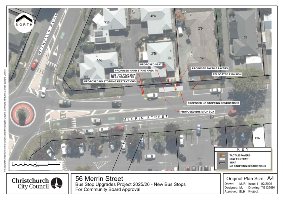
Reserve Bike Jump Trial and Future Options................................... 23
CA 8. Gardiners
Road Shared Path...................................................................... 33
C 9. Bus
stop upgrades within Waimāero Fendalton-Waimairi-Harewood Community Board
area.............................................................................................. 49
C 10. Waimāero
Fendalton-Waimairi-Harewood Community Board Area Report - May 2026............................................................................................................. 81
B 11. Elected Members’
Information Exchange Te Whakawhiti
Whakaaro o Te Kāhui Amorangi............................................................................................................. 94
Karakia Whakamutunga
Actions Register Ngā Mahinga Tuwhera
Karakia Tīmatanga
|
Whakataka te hau ki te uru
Whakataka te hau ki te tonga
Kia mākinakina ki uta
Kia mātaratara ki tai
E hī ake ana te atakura
He tio, he huka, he hau hū
Tīhei Mauri Ora
|
Cease the winds from the west
Cease the winds from the south
Let the breeze blow over the land
Let the breeze blow over the ocean
Let the red-tipped dawn come with a sharpened air.
A touch of frost, a promise of a glorious day.
|
1. Apologies Ngā Whakapāha
Apologies will
be recorded at the meeting.
2. Declarations of Interest Ngā
Whakapuaki Aronga
Members are
reminded of the need to be vigilant and to stand aside from decision-making
when a conflict arises between their role as an elected representative and any
private or other external interest they might have.
3. Confirmation of Previous Minutes Te
Whakaāe o te hui o mua
That the
minutes of the Waimāero Fendalton-Waimairi-Harewood Community Board
meeting held on Monday, 20 April 2026 be confirmed
(refer page 5).
4. Public Forum Te Huinga Whānui
A period of up
to 30 minutes will be available for people to speak for up to five minutes on
any issue that is not the subject of a separate hearing process.
Public Forum presentations will be
recorded in the meeting minutes.
5. Deputations by Appointment Ngā Huinga
Whakaritenga
Deputations may
be heard on a matter or matters covered by a report on this agenda and approved
by the Chairperson.
Deputations will be recorded in the
meeting minutes.
6. Presentation of Petitions Ngā
Pākikitanga
There were no petitions
received at the time the agenda was prepared.
To present to the Community
Board, refer to the Participating in decision-making webpage or
contact the meeting advisor listed on the front of this agenda.

Waimāero
Fendalton-Waimairi-Harewood
Community Board
Open
Minutes
Date: Monday 20 April 2026
Time: 4.32 pm
Venue: Boardroom, Fendalton Service
Centre,
Corner Jeffreys and Clyde Roads, Fendalton
Present
|
Chairperson
Deputy Chairperson
Members
|
Jason Middlemiss
Nicola McCormick
David Cartwright
Aaron Keown
Lucy Keown
Sam MacDonald
Ben Spittle
Bridget Williams
|
Website: www.ccc.govt.nz

Part A Matters
Requiring a Council Decision
Part B Reports
for Information
Part C Decisions
Under Delegation
Karakia
Tīmatanga
|
Whakataka te hau ki te uru
Whakataka te hau ki te tonga
Kia mākinakina ki uta
Kia mātaratara ki tai
E hī ake ana te atakura
He tio, he huka, he
hauhūnga
Tīhei mauri ora
|
Cease the winds from the
west
Cease the winds from the south
Let the breeze blow over the land
Let the breeze blow over the ocean
Let the red-tipped dawn come with a sharpened air.
A touch of frost, a promise of a glorious day.
|
The agenda was dealt
with in the following order. Where no voting record is shown, the item was
carried unanimously by those present.
1. Apologies Ngā Whakapāha
Part C
|
Community Board Resolved FWHB/2026/00017
That the apology from
James Gough for absence be accepted.
David Cartwright/Bridget Williams Carried
|
2. Declarations of Interest Ngā Whakapuaki Aronga
Part B
There were no declarations of interest recorded.
3. Confirmation of Previous Minutes Te Whakaāe o te hui o mua
Part C
|
Community Board Resolved FWHB/2026/00018
That the minutes of the Waimāero Fendalton-Waimairi-Harewood
Community Board meeting held on Monday, 16 March 2026 be confirmed.
Ben Spittle/David Cartwright Carried
|
4. Public Forum Te Huinga Whānui
Part B
There were no public forum presentations.
5. Deputations by Appointment Ngā Huinga Whakaritenga
Part B
|
5.1 Fox
Bennetts
|
|
Fox
Bennetts, local resident, addressed the Board regarding item 9. Radcliffe
Road Corridor Improvement.
|
|
5.2 Spokes
Canterbury
|
|
Anne
Scott addressed the Board on behalf of Spokes Canterbury regarding item 9.
Radcliffe Road Corridor Improvement, and item 16. Waimāero
Fendalton-Waimairi-Harewood Community Board Plan.
|
|
Attachments
a Spokes
Canterbury - PowerPoint Presentation
|
6. Presentation of Petitions Ngā Pākikitanga
Part B
There was no presentation of petitions.
|
7. Proposed Road Names - 232
Highsted Road, Casebrook
|
|
|
Community Board Resolved
FWHB/2026/00019
Officer recommendations
accepted without change.
Part C
That the Waimāero Fendalton-Waimairi-Harewood
Community Board:
1. Receives the information in the Proposed Road Names - 232 Highsted
Road, Casebrook Report.
2. Notes that the decision in this report is
assessed as low significance based on the Christchurch City Council’s
Significance and Engagement Policy.
3. Approves the following new road names for 232
Highsted Road (RMA/2023/2775)
a. Road 1 - MacKillop Avenue
b. Road 2 - Mother Teresa Drive
c. Road 3 - John Paul Crescent
d. Road 4 - Mooney Close
Lucy Keown/Ben Spittle Carried
|
|
8. Proposed Road Names - 65
Grampian Street, Casebrook
|
|
|
Community Board Resolved
FWHB/2026/00020
Officer recommendations
accepted without change.
Part C
That the Waimāero Fendalton-Waimairi-Harewood
Community Board:
1. Receives the information in the Proposed Road Names - 65 Grampian
Street, Casebrook Report.
2. Notes that the decision in this report is
assessed as low significance based on the Christchurch City Council’s
Significance and Engagement Policy.
3. Approves the following new road names for 65
Grampian Street (RMA/2021/2685)
a. Road 1 - Cairnie Street
b. Road 2 - Cowie Place
c. Lane 1 - Spey Lane
Aaron Keown/Nicola McCormick Carried
|
Sam MacDonald left the
meeting at 4:58 pm during the consideration of item 9.
|
9. Radcliffe Road Corridor
Improvement
|
|
|
Community Board Comment
1. The
Community Board accepted the officer recommendations in full, with additional
requests for staff to consider as part of the detailed design process:
a. Adding
a kerb cutdown opposite the Blakes Rd intersection, to allow cyclists turning
from Blakes Rd to enter the Radcliffe Rd shared path.
b. Enhanced
warning signage for the pedestrian crossing point near the railway line.
2. The
Community Board made an additional recommendation that the Council seek
advice about lowering the speed limit on Radcliffe Road between Blakes Road
and the Northwood Supa Centa.
|
|
|
Officer Recommendations
Ngā Tūtohu
That the Waimāero Fendalton-Waimairi-Harewood
Community Board:
1. Receives the information in the Radcliffe Road Corridor
Improvement Report.
2. Notes that the decision in this report is
assessed as medium significance based on the Christchurch City
Council’s Significance and Engagement Policy.
3. Revokes any previous resolutions pertaining to
parking and stopping restrictions and traffic controls made pursuant to any
Bylaw to the extent that they are in conflict with parking or stopping
restrictions described in resolutions 5 to 17 and 20 to 23 below.
4. Approves the following resolutions required
for the implementation of the project, relying on its powers under the
Christchurch City Council Traffic and Parking Bylaw 2017 and Part 21 of the
Local Government Act 1974.
Radcliffe
Road
5. Approves all kerb alignments, traffic islands,
road surface treatments, and road markings on Radcliffe Road commencing at a
point 172 metres east of its intersection with Main North Road, and extending
in an easterly direction for a distance of 245 metres, as detailed on plan
TP362601, Issue 1, dated 12/03/2026 and attached to this report as Attachment
A.
6. Approves, in accordance with Clause 7 of the
Christchurch City Council Traffic and Parking Bylaw 2017, that the stopping
of vehicles be prohibited at all times as detailed on plan TP362601, Issue 1,
dated 12/03/2026 and attached to this report as Attachment A:
a. On the northern side of Radcliffe Road,
commencing at a point 172 metres east of its intersection with Main North
Road and extending in an easterly direction for a distance of 245 metres.
b. On the southern side of Radcliffe Road,
commencing at a point 172 metres east of its intersection with Main North
Road and extending in a westerly direction for a distance of 225 metres.
7. Approves all kerb alignments, traffic islands,
road surface treatment, and road markings on Radcliffe Road commencing at a
point 96 metres east of its intersection with Blakes Road, and extending in a
westerly direction for a distance of 257 metres, as detailed on plan
TP362601, Issue 1, dated 12/03/2026 and attached to this report as Attachment
A.
8. Approves, in accordance with Clause 7 of the
Christchurch City Council Traffic and Parking Bylaw 2017, that the stopping
of vehicles be prohibited at all times as detailed on plan TP362601, Issue 1,
dated 12/03/2026 and attached to this report as Attachment A.
a. On the northern side of Radcliffe Road,
commencing at its intersection with Blakes Road and extending in a westerly
direction for a distance of 96 metres.
b. On the northern side of Radcliffe Road,
commencing at its intersection with Blakes Road and extending in an easterly
direction for a distance of 94 metres.
c. On the southern side of Radcliffe Road,
commencing at a point 96 metres east of its intersection with Blakes Road and
extending in a westerly direction for a distance of 257 metres.
9. Approves that in accordance with Clause 21 of
the Christchurch City Council Traffic & Parking Bylaw 2017, that the path
on the northern side of Radcliffe
Road, commencing at a point 291 metres east of its intersection with
Main North Road and extending in an easterly direction for a distance of 15
metres, as detailed on plan TP362601, dated 12/03/2026, and attached to
this report as Attachment A,
be resolved as an eastbound Shared Path, in accordance with section 11.4 of
the Land Transport Act - Traffic Control Devices Rules: 2004. This Shared
Path is for the use by the classes of road users only as defined in Section
11.1A of the Land Transport (Road User) Rule: 2004.
10. Approves that in accordance with Clause 21 of
the Christchurch City Council Traffic & Parking Bylaw 2017, that the path
on the southern side of Radcliffe
Road, commencing at a point 397 metres east of its intersection with
Main North Road and extending in a westerly direction for a distance of 55
metres, as detailed on plan
TP362601, dated 12/03/2026, and attached to this report as Attachment A,
be resolved as a bi-directional Shared Path, in accordance with section 11.4
of the Land Transport Act - Traffic Control Devices Rules: 2004. This Shared
Path is for the use by the classes of road users only as defined in Section
11.1A of the Land Transport (Road User) Rule: 2004.
11. Approves that in accordance with Clause 21 of
the Christchurch City Council Traffic & Parking Bylaw 2017, that the path
on the southern side of Radcliffe
Road, commencing at a point 302 metres east of its intersection with
Main North Road and extending in a westerly direction for a distance of 40
metres, as detailed on plan
TP362601, dated 12/03/2026, and attached to this report as Attachment A,
be resolved as an eastbound Shared Path, in accordance with section 11.4 of
the Land Transport Act - Traffic Control Devices Rules: 2004. This Shared
Path is for the use by the classes of road users only as defined in Section
11.1A of the Land Transport (Road User) Rule: 2004.
12. Approves that in accordance with Clause 21 of
the Christchurch City Council Traffic & Parking Bylaw 2017, that the path on the northern side of Radcliffe Road, commencing at a point
23 metres east of its intersection with Blakes Road and extending in an
easterly direction for a distance of 13 metres, as detailed on plan TP362601, dated 12/03/2026, and
attached to this report as Attachment A, be resolved as an eastbound
Shared Path, in accordance with section 11.4 of the Land Transport Act -
Traffic Control Devices Rules: 2004. This Shared Path is for the use by the
classes of road users only as defined in Section 11.1A of the Land Transport
(Road User) Rule: 2004.
13. Approves that in accordance with Clause 21 of
the Christchurch City Council Traffic & Parking Bylaw 2017, that the path
on the northern side of Radcliffe
Road, commencing at a point 36 metres east of its intersection with
Blakes Road and extending in an easterly direction for a distance of 58
metres, as detailed on plan
TP362601, dated 12/03/2026, and attached to this report as Attachment A,
be resolved as a bi-directional Shared Path, in accordance with section 11.4
of the Land Transport Act - Traffic Control Devices Rules: 2004. This Shared
Path is for the use by the classes of road users only as defined in Section
11.1A of the Land Transport (Road User) Rule: 2004.
14. Approves that in accordance with Clause 21 of
the Christchurch City Council Traffic & Parking Bylaw 2017, that the path
on the southern side of Radcliffe
Road, commencing at a point 96
metres east of its intersection with Blakes Road and extending in a westerly
direction for a distance of 588 metres, as detailed on plan TP362601, dated 12/03/2026, and attached to this report
as Attachment A, be
resolved as a bi-directional Shared Path, in accordance with section 11.4 of
the Land Transport Act - Traffic Control Devices Rules: 2004. This Shared
Path is for the use by the classes of road users only as defined in Section
11.1A of the Land Transport (Road User) Rule: 2004.
Blakes
Road
15. Approves all kerb alignments, traffic islands,
and road markings on Blakes Road commencing at its intersection with
Radcliffe Road, and extending in a northerly direction for a distance of 183
metres, as detailed on plan TP362601, Issue 1, dated 12/03/2026 and attached
to this report as Attachment A.
16. Approves that in accordance with Section 4 of
the Land Transport Rule: Traffic Control Devices 2004 that the southbound
approach of Blakes Road at its intersection with Radcliffe Road be controlled
by a Stop Control, as detailed on plan TP362601, Issue 1, dated 12/03/2026
and attached to this report as Attachment A.
17. Approves, in accordance with Clause 7 of the
Christchurch City Council Traffic and Parking Bylaw 2017, that the stopping
of vehicles be prohibited at all times as detailed on plan TP362601, Issue 1,
dated 12/03/2026 and attached to this report as Attachment A.
a. On the western side of Blakes Road, commencing
at its intersection with Radcliffe Road and extending in a northerly
direction for a distance of 183 metres.
b. On the easterly side of Blakes Road,
commencing at its intersection with Radcliffe Road and extending in a
northerly direction for a distance of 183 metres.
18. Approves that these resolutions take effect
when parking signage and/or road marking that evidence the restrictions
described in 5 to 17 above are in place (or removed in the case of
revocations).
19. Endorses staff’s recommended delivery
staging approach to construct the full intended design for Radcliffe Road and
Blakes Road, other than the upgrades to the level crossing, as one phase as
soon as possible. The railway level crossing will be delivered when ready to
do so.
That the
Waimāero Fendalton-Waimairi-Harewood Community Board recommend that
Council:
20. Approves that a Special Vehicle Lane, in
accordance with Clause 18 of the Christchurch City Council Traffic &
Parking Bylaw 2017, for the use of eastbound road users as defined in
Section 11.1A of the Land Transport (Road User) Rule: 2004, excepting
pedestrians and riders of mobility devices, be established on the northern
side of Radcliffe Road, commencing at a point 172 metres east of its
intersection with Main North Road and extending in an easterly direction for
a distance of 100 metres as detailed on plan TP362601, dated 12/03/2026, and
attached to this report as Attachment A.
21. Approves that a Special Vehicle Lane, in
accordance with Clause 18 of the Christchurch City Council Traffic &
Parking Bylaw 2017, for the use of eastbound road users as defined in
Section 11.1A of the Land Transport (Road User) Rule: 2004, excepting
pedestrians and riders of mobility devices, be established on the northern
side of Radcliffe Road, commencing at a point 280 metres east of its
intersection with Main North Road and extending in an easterly direction for
a distance of 11 metres as detailed on plan TP362601, dated 12/03/2026, and
attached to this report as Attachment A.
22. Approves that a Special Vehicle Lane, in
accordance with Clause 18 of the Christchurch City Council Traffic &
Parking Bylaw 2017, for the use of westbound road users as defined in
Section 11.1A of the Land Transport (Road User) Rule: 2004, excepting
pedestrians and riders of mobility devices, be established on the southern
side of Radcliffe Road, commencing at a point 382 metres east of its
intersection with Main North Road and extending in a westerly direction for a
distance of 97 metres as detailed on plan TP362601, dated 12/03/2026, and
attached to this report as Attachment A.
23. Approves that a Special Vehicle Lane, in
accordance with Clause 18 of the Christchurch City Council Traffic &
Parking Bylaw 2017, for the use of westbound road users as defined in
Section 11.1A of the Land Transport (Road User) Rule: 2004, excepting
pedestrians and riders of mobility devices, be established on the southern
side of Radcliffe Road, commencing at a point 269 metres east of its
intersection with Main North Road and extending in a westerly direction for a
distance of 63 metres as detailed on plan TP362601, dated 12/03/2026, and
attached to this report as Attachment A.
24. Approves that these resolutions take effect
when parking signage and/or road marking that evidence the restrictions
described in 20 to 23 above are in place (or removed in the case of
revocations).
25. Approves that for any traffic controls or
parking restrictions on land not yet vested with Council as Road Reserve,
these resolutions take effect when parking signage and/or road markings that
evidence the restrictions described in this staff report are in place and
when the land has been vested with Council.
|
|
|
Community Board Resolved
FWHB/2026/00021
Part C
That the Waimāero Fendalton-Waimairi-Harewood
Community Board:
1. Receives the information in the Radcliffe Road Corridor
Improvement Report.
2. Notes that the decision in this report is
assessed as medium significance based on the Christchurch City
Council’s Significance and Engagement Policy.
3. Revokes any previous resolutions pertaining to
parking and stopping restrictions and traffic controls made pursuant to any
Bylaw to the extent that they are in conflict with parking or stopping
restrictions described in resolutions 5 to 17 and 21 to 25 below.
4. Approves the following resolutions required
for the implementation of the project, relying on its powers under the
Christchurch City Council Traffic and Parking Bylaw 2017 and Part 21 of the
Local Government Act 1974.
Radcliffe
Road
5. Approves all kerb alignments, traffic islands,
road surface treatments, and road markings on Radcliffe Road commencing at a
point 172 metres east of its intersection with Main North Road, and extending
in an easterly direction for a distance of 245 metres, as detailed on plan
TP362601, Issue 1, dated 12/03/2026 and attached to this report as Attachment
A.
6. Approves, in accordance with Clause 7 of the
Christchurch City Council Traffic and Parking Bylaw 2017, that the stopping
of vehicles be prohibited at all times as detailed on plan TP362601, Issue 1,
dated 12/03/2026 and attached to this report as Attachment A:
a. On the northern side of Radcliffe Road,
commencing at a point 172 metres east of its intersection with Main North
Road and extending in an easterly direction for a distance of 245 metres.
b. On the southern side of Radcliffe Road,
commencing at a point 172 metres east of its intersection with Main North
Road and extending in a westerly direction for a distance of 225 metres.
7. Approves all kerb alignments, traffic islands,
road surface treatment, and road markings on Radcliffe Road commencing at a
point 96 metres east of its intersection with Blakes Road, and extending in a
westerly direction for a distance of 257 metres, as detailed on plan
TP362601, Issue 1, dated 12/03/2026 and attached to this report as Attachment
A.
8. Approves, in accordance with Clause 7 of the
Christchurch City Council Traffic and Parking Bylaw 2017, that the stopping
of vehicles be prohibited at all times as detailed on plan TP362601, Issue 1,
dated 12/03/2026 and attached to this report as Attachment A.
a. On the northern side of Radcliffe Road,
commencing at its intersection with Blakes Road and extending in a westerly
direction for a distance of 96 metres.
b. On the northern side of Radcliffe Road,
commencing at its intersection with Blakes Road and extending in an easterly
direction for a distance of 94 metres.
c. On the southern side of Radcliffe Road,
commencing at a point 96 metres east of its intersection with Blakes Road and
extending in a westerly direction for a distance of 257 metres.
9. Approves that in accordance with Clause 21 of
the Christchurch City Council Traffic & Parking Bylaw 2017, that the path
on the northern side of Radcliffe
Road, commencing at a point 291 metres east of its intersection with
Main North Road and extending in an easterly direction for a distance of 15
metres, as detailed on plan TP362601, dated 12/03/2026, and attached to
this report as Attachment A,
be resolved as an eastbound Shared Path, in accordance with section 11.4 of
the Land Transport Act - Traffic Control Devices Rules: 2004. This Shared
Path is for the use by the classes of road users only as defined in Section
11.1A of the Land Transport (Road User) Rule: 2004.
10. Approves that in accordance with Clause 21 of
the Christchurch City Council Traffic & Parking Bylaw 2017, that the path
on the southern side of Radcliffe
Road, commencing at a point 397 metres east of its intersection with
Main North Road and extending in a westerly direction for a distance of 55
metres, as detailed on plan
TP362601, dated 12/03/2026, and attached to this report as Attachment A,
be resolved as a bi-directional Shared Path, in accordance with section 11.4
of the Land Transport Act - Traffic Control Devices Rules: 2004. This Shared
Path is for the use by the classes of road users only as defined in Section
11.1A of the Land Transport (Road User) Rule: 2004.
11. Approves that in accordance with Clause 21 of
the Christchurch City Council Traffic & Parking Bylaw 2017, that the path
on the southern side of Radcliffe
Road, commencing at a point 302 metres east of its intersection with
Main North Road and extending in a westerly direction for a distance of 40
metres, as detailed on plan
TP362601, dated 12/03/2026, and attached to this report as Attachment A,
be resolved as an eastbound Shared Path, in accordance with section 11.4 of
the Land Transport Act - Traffic Control Devices Rules: 2004. This Shared
Path is for the use by the classes of road users only as defined in Section
11.1A of the Land Transport (Road User) Rule: 2004.
12. Approves that in accordance with Clause 21 of
the Christchurch City Council Traffic & Parking Bylaw 2017, that the path on the northern side of Radcliffe Road, commencing at a point
23 metres east of its intersection with Blakes Road and extending in an
easterly direction for a distance of 13 metres, as detailed on plan TP362601, dated 12/03/2026, and
attached to this report as Attachment A, be resolved as an eastbound
Shared Path, in accordance with section 11.4 of the Land Transport Act -
Traffic Control Devices Rules: 2004. This Shared Path is for the use by the
classes of road users only as defined in Section 11.1A of the Land Transport
(Road User) Rule: 2004.
13. Approves that in accordance with Clause 21 of
the Christchurch City Council Traffic & Parking Bylaw 2017, that the path
on the northern side of Radcliffe
Road, commencing at a point 36 metres east of its intersection with
Blakes Road and extending in an easterly direction for a distance of 58
metres, as detailed on plan
TP362601, dated 12/03/2026, and attached to this report as Attachment A,
be resolved as a bi-directional Shared Path, in accordance with section 11.4
of the Land Transport Act - Traffic Control Devices Rules: 2004. This Shared
Path is for the use by the classes of road users only as defined in Section
11.1A of the Land Transport (Road User) Rule: 2004.
14. Approves that in accordance with Clause 21 of
the Christchurch City Council Traffic & Parking Bylaw 2017, that the path
on the southern side of Radcliffe
Road, commencing at a point 96
metres east of its intersection with Blakes Road and extending in a westerly
direction for a distance of 588 metres, as detailed on plan TP362601, dated 12/03/2026, and attached to this report
as Attachment A, be
resolved as a bi-directional Shared Path, in accordance with section 11.4 of
the Land Transport Act - Traffic Control Devices Rules: 2004. This Shared
Path is for the use by the classes of road users only as defined in Section
11.1A of the Land Transport (Road User) Rule: 2004.
Blakes
Road
15. Approves all kerb alignments, traffic islands,
and road markings on Blakes Road commencing at its intersection with
Radcliffe Road, and extending in a northerly direction for a distance of 183
metres, as detailed on plan TP362601, Issue 1, dated 12/03/2026 and attached
to this report as Attachment A.
16. Approves that in accordance with Section 4 of
the Land Transport Rule: Traffic Control Devices 2004 that the southbound
approach of Blakes Road at its intersection with Radcliffe Road be controlled
by a Stop Control, as detailed on plan TP362601, Issue 1, dated 12/03/2026
and attached to this report as Attachment A.
17. Approves, in accordance with Clause 7 of the
Christchurch City Council Traffic and Parking Bylaw 2017, that the stopping
of vehicles be prohibited at all times as detailed on plan TP362601, Issue 1,
dated 12/03/2026 and attached to this report as Attachment A.
a. On the western side of Blakes Road, commencing
at its intersection with Radcliffe Road and extending in a northerly
direction for a distance of 183 metres.
b. On the easterly side of Blakes Road,
commencing at its intersection with Radcliffe Road and extending in a
northerly direction for a distance of 183 metres.
18. Requests
staff to consider during the detailed design phase:
a. A
kerb cutdown opposite the Blakes Road intersection to allow cyclists to turn
from Blakes Road and enter the Radcliffe Rd shared path.
b. Enhanced
warning signage for the pedestrian crossing point near the railway crossing.
19. Approves that these resolutions take effect
when parking signage and/or road marking that evidence the restrictions
described in 5 to 17 above are in place (or removed in the case of
revocations).
20. Endorses staff’s recommended delivery
staging approach to construct the full intended design for Radcliffe Road and
Blakes Road, other than the upgrades to the level crossing, as one phase as
soon as possible. The railway level crossing will be delivered when ready to
do so.
Aaron Keown/David Cartwright Carried
|
|
Community Board Decided FWHB/2026/00022
Part A
That the
Waimāero Fendalton-Waimairi-Harewood Community Board recommends that
Council:
21. Approves that a Special Vehicle Lane, in
accordance with Clause 18 of the Christchurch City Council Traffic &
Parking Bylaw 2017, for the use of eastbound road users as defined in
Section 11.1A of the Land Transport (Road User) Rule: 2004, excepting
pedestrians and riders of mobility devices, be established on the northern
side of Radcliffe Road, commencing at a point 172 metres east of its
intersection with Main North Road and extending in an easterly direction for
a distance of 100 metres as detailed on plan TP362601, dated 12/03/2026, and
attached to this report as Attachment A.
22. Approves that a Special Vehicle Lane, in
accordance with Clause 18 of the Christchurch City Council Traffic &
Parking Bylaw 2017, for the use of eastbound road users as defined in
Section 11.1A of the Land Transport (Road User) Rule: 2004, excepting
pedestrians and riders of mobility devices, be established on the northern
side of Radcliffe Road, commencing at a point 280 metres east of its
intersection with Main North Road and extending in an easterly direction for
a distance of 11 metres as detailed on plan TP362601, dated 12/03/2026, and
attached to this report as Attachment A.
23. Approves that a Special Vehicle Lane, in
accordance with Clause 18 of the Christchurch City Council Traffic &
Parking Bylaw 2017, for the use of westbound road users as defined in
Section 11.1A of the Land Transport (Road User) Rule: 2004, excepting
pedestrians and riders of mobility devices, be established on the southern
side of Radcliffe Road, commencing at a point 382 metres east of its
intersection with Main North Road and extending in a westerly direction for a
distance of 97 metres as detailed on plan TP362601, dated 12/03/2026, and
attached to this report as Attachment A.
24. Approves that a Special Vehicle Lane, in
accordance with Clause 18 of the Christchurch City Council Traffic &
Parking Bylaw 2017, for the use of westbound road users as defined in
Section 11.1A of the Land Transport (Road User) Rule: 2004, excepting
pedestrians and riders of mobility devices, be established on the southern
side of Radcliffe Road, commencing at a point 269 metres east of its
intersection with Main North Road and extending in a westerly direction for a
distance of 63 metres as detailed on plan TP362601, dated 12/03/2026, and
attached to this report as Attachment A.
25. Approves that these resolutions take effect
when parking signage and/or road marking that evidence the restrictions
described in 21 to 24 above are in place (or removed in the case of
revocations).
26. Approves that for any traffic controls or
parking restrictions on land not yet vested with Council as Road Reserve,
these resolutions take effect when parking signage and/or road markings that
evidence the restrictions described in this staff report are in place and
when the land has been vested with Council.
27. Requests
advice from staff on lowering the speed limit on Radcliffe Road between
Blakes Road and the Northwood Supa Centa.
Aaron Keown/David Cartwright Carried
|
|
10. Marshland Road / Main North Road /
Spencerville Road Intersection Improvements Report
|
|
|
Community Board Comment
1. The
Community Board accepted the officer recommendations in full, and in addition
requested staff to consider using rumble strips or tactile markings on the
approach to the give way control.
|
|
|
Officer Recommendations
Ngā Tūtohu
That the Waimāero Fendalton-Waimairi-Harewood
Community Board:
1. Receives the information in the Marshland Road / Main North
Road / Spencerville Road Intersection Improvements Report.
2. Notes that the decision in this report is
assessed as low significance based on the Christchurch City Council’s
Significance and Engagement Policy.
3. Approves that in accordance with Section 4 of
the Land Transport Rule: Traffic Control Devices 2004, that a stop control be
placed against Main North Road at its intersection with Marshland Road and
Spencerville Road, as detailed on plan TG1509S3 dated 20/01/2026 and attached
to this report as Attachment A.
4. Approves that any previously approved
resolutions be revoked, in accordance with Section 2 of the Land
Transport-Traffic Control Devices Rule:2004, pertaining to traffic controls,
made pursuant to any Bylaw, Local Government Act or any Land Transport Rule,
to the extent that they are in conflict with, or recommended to be removed,
in regard to the traffic controls described in recommendation 3 above.
5. Approves that these resolutions take effect
when parking signage and/or road marking that evidence the restrictions
described in 3 are in place (or removed in the case of revocations).
|
|
|
Community Board Resolved
FWHB/2026/00023
Part C
That the Waimāero Fendalton-Waimairi-Harewood
Community Board:
1. Receives the information in the Marshland Road / Main North
Road / Spencerville Road Intersection Improvements Report.
2. Notes that the decision in this report is
assessed as low significance based on the Christchurch City Council’s
Significance and Engagement Policy.
3. Approves that in accordance with Section 4 of
the Land Transport Rule: Traffic Control Devices 2004, that a stop control be
placed against Main North Road at its intersection with Marshland Road and
Spencerville Road, as detailed on plan TG1509S3 dated 20/01/2026 and attached
to this report as Attachment A.
4. Approves that any previously approved
resolutions be revoked, in accordance with Section 2 of the Land
Transport-Traffic Control Devices Rule:2004, pertaining to traffic controls,
made pursuant to any Bylaw, Local Government Act or any Land Transport Rule,
to the extent that they are in conflict with, or recommended to be removed,
in regard to the traffic controls described in recommendation 3 above.
5. Requests
staff to consider rumble strips or tactile markings on the approach to the
give way control.
6. Approves that these resolutions take effect
when parking signage and/or road marking that evidence the restrictions
described in 3 are in place (or removed in the case of revocations).
Jason Middlemiss/Lucy Keown Carried
|
|
11. Glandovey/Heaton/Rossall/Strowan - Right
turn arrows
|
|
|
Community Board Resolved
FWHB/2026/00024
Officer recommendations
accepted without change.
Part C
That the Waimāero Fendalton-Waimairi-Harewood
Community Board:
1. Receives the information in the Glandovey/Heaton/Rossall/Strowan
- Right turn arrows Report.
2. Notes that the decision in this report is
assessed as low significance based on the Christchurch City Council’s
Significance and Engagement Policy.
3. Approves, pursuant to Section 331 and 334 of
the Local Government Act 1974:
a. All kerb alignments and road markings changes
on Glandovey Road, Heaton Street, Rossall Street and Strowan Road as detailed in Attachment
A of this report.
b. The installation of hardware to facilitate
traffic signal control of the right turn movement from Rossall Street (south)
and Strowan Road (north).
4. Notes that staff will review the operation of
the intersection following completion of the three
waters and roading projects to
determine whether the right turn phases should be retained.
Bridget Williams/David Cartwright Carried
|
|
12. Grant an Easement for Fibre Installation to
Enable, at Tulett Park, Casebrook
|
|
|
Community Board Resolved
FWHB/2026/00025
Officer recommendations
accepted without change.
Part C
That the Waimāero Fendalton-Waimairi-Harewood
Community Board:
1. Receives the information in the Grant an Easement for Fibre
Installation to Enable, at Tulett Park, Casebrook Report.
2. Notes that the decision in this report is
assessed as low significance based on the Christchurch City Council’s
Significance and Engagement Policy.
3. Approves the installation of a fibre cable and
subsequent granting of an easement in favour of Enable Networks Limited to
convey underground utilities within the land described as Reserve 5136
comprising 6.0930 ha (Recreation Reserve) and Lot 126 Deposited Plan 82299
(Recreation Reserve) comprising 6179 m2, known as Tulett Park.
4. Notes that approval is subject to Section
48(1) of the Reserves Act 1977 and is subject to the Minister of Conservation
consent to the easement, as delegated to the Council Chief Executive under
the Instrument of Delegation for Territorial Authorities dated 12 June 2013.
The Community Board recommends the Chief Executive exercise their delegation
in this regard.
Jason Middlemiss/David Cartwright Carried
|
|
13. Waimāero Fendalton-Waimairi-Harewood -
Better-Off Fund Application for Consideration - Belfast Community Network
|
|
|
Community Board Resolved
FWHB/2026/00026
Officer recommendations
accepted without change.
Part C
That the Waimāero Fendalton-Waimairi-Harewood
Community Board:
1. Receives the information in the Waimāero Fendalton-Waimairi-Harewood -
Better-Off Fund Application for Consideration - Belfast Community Network Report.
2. Notes that the decisions in this report are
assessed as low significance based on the Christchurch City Council’s
Significance and Engagement Policy.
3. Revokes clause 3. of resolution
FWHB/2025/00071 passed on 8 December 2025 which read as follows:
Approves a grant
of $38,000 from its Better-Off Fund to the Anglican Diocese of Christchurch -
Parish of Merivale St Albans towards the purchase of a community van for use
by groups in the Waimāero Fendalton-Waimairi-Harewood Community Board
area.
4. Approves a grant of $38,000 from its Better-Off Fund to the Belfast
Community Network towards the purchase of a community van for use by groups
in the Waimāero Fendalton-Waimairi-Harewood Community Board area.
Aaron Keown/David Cartwright Carried
|
|
14. Waimāero Fendalton-Waimairi-Harewood
2025/26 Youth Development Fund Applications - Kaitlyn Adams and Burnside High
School
|
|
|
Community Board Resolved
FWHB/2026/00027
Officer recommendations
accepted without change.
Part C
That the Waimāero Fendalton-Waimairi-Harewood
Community Board resolve to:
1. Receives the information in the Waimāero Fendalton-Waimairi-Harewood
2025/26 Youth Development Fund Applications - Kaitlyn Adams and Burnside High
School Report.
2. Notes that the decisions in this report are
assessed as low significance based on the Christchurch City Council’s Significance and
Engagement Policy.
3. Approves a grant of $750 from its 2025/26
Youth Development Fund to Kaitlyn
Adams towards expenses to compete
at the Canoe Polo World
Championships in Germany from 15 to 19 September 2026.
4. Approves a grant of $800 from its 2025/26
Youth Development Fund to Burnside High School towards the costs of eight
ward-based students participating in the Spirit of Adventure Discovery Voyage
from 9 to 14 June 2026.
Aaron Keown/Ben Spittle Carried
|
Sam MacDonald returned
to the meeting at 5:22 pm during the consideration of item 15.
|
15. Fendalton-Waimairi-Harewood Youth
Development Fund - Approval Process
|
|
|
Officer Recommendations
Ngā Tūtohu
That the Waimāero Fendalton-Waimairi-Harewood
Community Board:
1. Receives the information in the Fendalton-Waimairi-Harewood Youth Development
Fund - Approval Process Report.
2. Considers the options below with regards to
the approval process for Youth Development Fund applications:
a. Option A - Increase the Community Governance Manager’s
delegation to approve applications up to $1,000.
b. Option B - Implement a process for Youth Development Fund
applications to be approved by the Board via email.
c. Option C - Staff to
complete a full options report to come to a Board meeting for consideration
of applications being recommended for over $500.
|
|
|
Community Board Resolved
FWHB/2026/00028
Part C
That the Waimāero Fendalton-Waimairi-Harewood
Community Board:
1. Receives the information in the Fendalton-Waimairi-Harewood Youth Development
Fund - Approval Process Report.
2. Approves the following option with regards to
the approval process for Youth Development Fund applications:
a. Option A - Increase the Community Governance Manager’s
delegation to approve applications up to $1,000.
Sam MacDonald/Aaron Keown Carried
|
|
16. Waimāero Fendalton-Waimairi-Harewood
2026-28 Community Board Plan
|
|
|
Community Board Resolved
FWHB/2026/00029
Officer recommendations
accepted without change.
Part C
That the Waimāero Fendalton-Waimairi-Harewood
Community Board:
1. Receives the information in the Waimāero Fendalton-Waimairi-Harewood
2026-28 Community Board Plan Report.
2. Notes
that the decision in this report is
assessed as low significance based on the Christchurch City Council’s
Significance and Engagement Policy.
3. Adopts the Waimāero Fendalton-Waimairi-Harewood 2026-28
Community Board Plan.
Jason Middlemiss/Nicola McCormick Carried
|
|
17. Waimāero Fendalton-Waimairi-Harewood
Community Board Area Report - April 2026
|
|
|
Community Board Resolved
FWHB/2026/00030
Officer recommendations
accepted without change.
Part B
That the Waimāero Fendalton-Waimairi-Harewood
Community Board:
1. Receives the information in the Waimāero Fendalton-Waimairi-Harewood
Community Board Area Report - April 2026.
Bridget Williams/Aaron Keown Carried
|
18. Elected Members’ Information Exchange Te Whakawhiti Whakaaro o Te Kāhui Amorangi
Part B
|
Members exchanged information on matters of interest to
the Community Board.
|
Karakia
Whakamutunga
Meeting
concluded at
5.30pm.
CONFIRMED THIS 18TH DAY OF MAY
2026
Jason Middlemiss
Chairperson
|
7. Jeffreys
Reserve Bike Jump Trial and Future Options
|
|
Reference Te Tohutoro:
|
26/340574
|
|
Responsible Officer(s) Te Pou Matua:
|
Millie
Stead- Community Partnership Ranger
|
|
Accountable ELT Member Pouwhakarae:
|
Andrew
Rutledge, General Manager Citizens and Community
|
1. Purpose and Origin of the Report Te Pūtake Pūrongo
1.1 The
purpose of this report is to seek approval from the Waimāero Fendalton‑Waimairi‑Harewood
Community Board for the proposed bike jump area at Jeffreys Reserve, following
completion of the temporary clay bike jump trial.
1.2 The
report incorporates new information gathered during the trial period,
including site use, user diversity, operational impacts, and community
feedback.
1.3 The report summarises the outcomes of the trial.
2. Officer
Recommendations Ngā Tūtohu
That the
Waimāero Fendalton-Waimairi-Harewood Community Board:
1. Receives the information in the Jeffreys Reserve Bike Jump Trial
and Future Options Report.
2. Notes that the decision in this report is
assessed as low significance based on the Christchurch City Council’s
Significance and Engagement Policy.
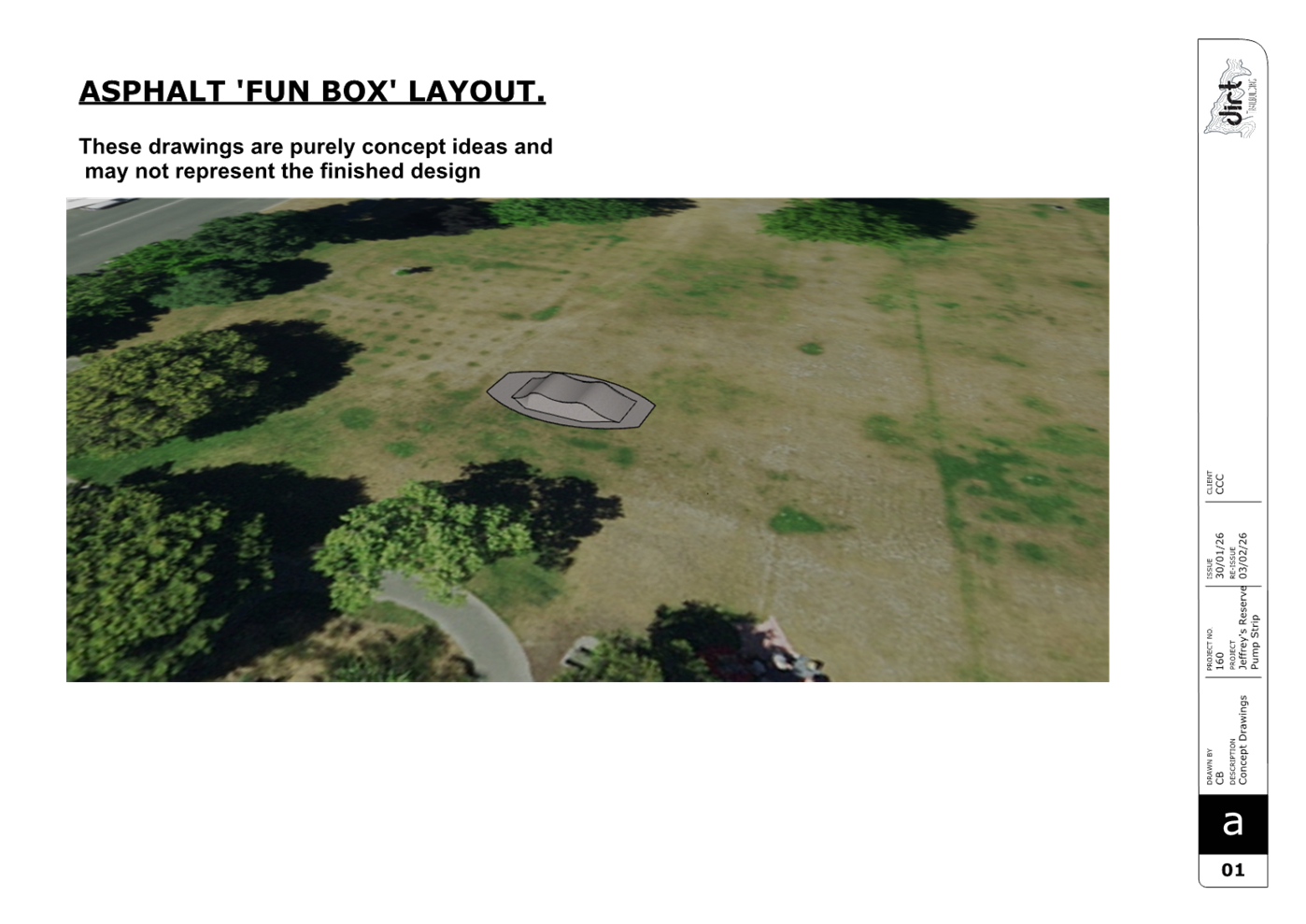
3. Approves the development of a permanent
asphalt bike jump feature at Jeffreys Reserve proceeding to detailed design and
construction, subject to the Board approving a grant towards the
construction costs from its 2025-26 Discretionary Response Fund at its next
meeting.
3. Executive Summary Te Whakarāpopoto Matua
3.1 At
its meeting on 7 May 2025, the Waimāero Fendalton-Waimairi-Harewood
Community Board approved temporary bike jumps at Jeffreys Reserve for a trial
period of eight months.
3.2 The
clay jump was built on 29 May 2025 with local tamariki.
3.3 Staff
have monitored the site to assess usage as well as operational, community and
environmental impacts.
3.4 Throughout
the trial, the jump area was used and interacted with by a significantly
broader range of user groups than initially anticipated, including families,
young children on balance bikes, intermediate and teenage riders, and
Council’s cycle safety and skills teams.
3.5 The
diversity of users demonstrated that the space caters to a wide range of ages
and abilities, with natural progression opportunities created by multiple jump
sizes, angles and lines.
3.6 Feedback
from community engagement before and after the trial indicated overall support
for a designated bike jump area at Jeffreys Reserve, while also identifying
some concerns relating to safety, amenity and visual impact.
3.7 These
insights have informed the staff assessment of the trial and the options
presented.
4. Background/Context Te Horopaki
4.1 There
is a history of informal bike jump construction in surrounding parks. These
have previously resulted in damage to garden beds, noise and safety concerns.
4.2 In
response to this and a request by a local parent, a clay bike jump area was
established at Jeffreys Reserve in May 2025 for a trial period of 8 months.
4.3 Council
staff organised clay for tamariki to build their own jumps and supervised the
trial.
4.4 Following
construction, staff have monitored the site and engaged with users to
understand how the space is being used and whether it is meeting its intended
purpose.
4.5 Tamariki
remained involved with the trial, advocating for the jumps via public
deputation and attending planning and building workshops.
4.6 The following related memos/information were circulated to the
meeting members:
|
Date
|
Subject
|
|
11/09/2023
|
Public forum by local parent- request for
bike jumps.
|
|
12/05/2025
|
Public deputation by Tamariki- support
for bike jump trial.
|
|
12/05/2025
|
Public deputation by local parent-
support for bike jump trial.
|
|
12/05/2025
|
Public deputation by local resident-
opposing bike jump trial.
|
Options Considered Ngā Kōwhiringa Whaiwhakaaro
4.7 The
following reasonably practicable options were considered and are assessed in
this report:
4.7.1 Option
1: Develop a permanent asphalt bike jump feature.
4.7.2 Option
2: Retain the clay bike jumps.
4.7.3 Option
3: Remove clay jumps and end trial.
4.8 The
following options were considered but ruled out:
4.8.1 Construct
a pump track utilising some existing pathways within the reserve. This option
was ruled out as the size, scale, and cost did not reflect community views.
Options Descriptions Ngā Kōwhiringa
4.8.1 Preferred
Option: Develop a permanent asphalt bike jump feature.
4.8.2 Option
Description: Remove the existing clay jump and construct an asphalt
bike jump feature that reflects the current layout as created by community use
and activities observed during the trial.
4.8.3 Option
Advantages
· Lower ongoing maintenance
requirements and reduced staff time.
· Provides a permanent, durable
solution suitable for year‑round use.
· Mimics the
current range of jump sizes and lines created by community use and supports
different ages and skill levels.
· Visually provides clean lines
and precise shapes with an urban aesthetic for neighbours concerned with the
look of a dirt jump.
4.8.4 Option
Disadvantages
· Higher upfront
construction cost.
· A more visually prominent built
feature within the reserve.
· Removes the
ability for tamariki to shape and modify the jumps themselves.
4.9 Option
2: Retain the clay bike jumps.
4.9.1 Option
Description: Continue with the existing clay jump area, adding more clay
and rock material for structure and durability.
4.9.2 Option
Advantages
· Allows tamariki to
shape and interact with the jumps directly.
· Lower initial cost
compared to a permanent structure.
4.9.3 Option
Disadvantages
· High ongoing maintenance and staff
time requirements.
· Ongoing visual and amenity concerns.
4.10 Option
3: Remove clay jumps and end trial.
4.10.1 Option
Description: Remove the clay jumps, re-turf the area and end trial.
4.10.2 Option
Advantages
· Addresses
perceived safety and aesthetic concerns.
4.10.3 Option
Disadvantages
· Missed
opportunity for youth involvement.
· Informal jump
construction may increase.
Analysis Criteria Ngā Paearu Wetekina
4.11 Specific
location of the bike jumps is limited due to district planning requirements for
noise setbacks and flood management. The current location is the only suitable
location in the park that complies with district planning requirements.
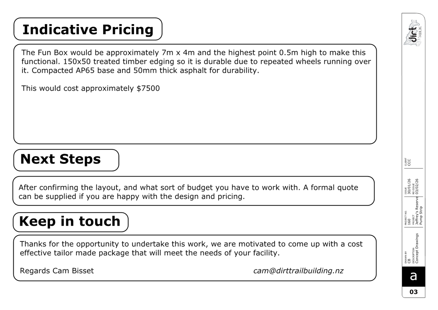
5. Financial Implications Ngā Hīraunga Rauemi
Capex/Opex Ngā Utu Whakahaere
|
|
Recommended Option-Asphalt Jump Feature
|
Option 2 –Retain clay and remediate
|
Option 3 – Remove clay jumps and end
trial
|
|
Cost to Implement
|
$15,500
|
$1000
|
$500
|
|
Maintenance/Ongoing Costs
|
Will be absorbed by existing OPEX
budgets.
|
Will be absorbed by existing OPEX
budgets.
|
Will be absorbed by existing OPEX
budgets.
|
|
Funding Source
|
FWH Community Board DRF TBC- ($9000)
CPMS #61803 ($6500)
|
N/A
|
N/A
|
|
Funding Availability
|
FY27
|
N/A
|
N/A
|
|
Impact on Rates
|
No impact
|
No impact
|
No impact
|
5.1 The
Parks unit would be able to fund costs associated with design, consenting (if
required) and future maintenance of the permanent asphalt option. There is
currently no budget to complete the construction of the project. The
Community Board may consider funding this portion from their 2025-2026
Discretionary Response Fund.
5.2 The
above costs are indicative only. A contingency of 30% has been applied to allow
for inflation and the potential for cost increases between the current estimate
and construction. Any increase would reflect wider global influences, including
fuel supply pressures and increases in construction costs.
6. Considerations Ngā Whai Whakaaro
Risks and Mitigations Ngā Mōrearea me
ngā Whakamātautau
6.1 The
condition of the clay jumps has varied throughout the course of the trial.
6.2 No
additional material was supplied during the trial to get an accurate assessment
of how the area would perform with regular use.
6.3 Through
monitoring, staff found the clay material is not suitable for long term use at
this site due to compaction, erosion and exposure.
6.4 This
can be partially mitigated by adding additional clay material, supplemented
with stones to improve the structure of the jumps.
6.5 A
permanent asphalt feature would significantly reduce maintenance demands. This
type of jump could be expanded on in future if so desired by the community.
Legal Considerations Ngā Hīraunga
ā-Ture
6.6 Statutory
and/or delegated authority to undertake proposals in the report:
6.6.1 The
Community Board has delegation to approve options presented in this report.
6.7 Other Legal Implications:
6.7.1 There
is no legal context, issue, or implication relevant to this decision
Strategy
and Policy Considerations Te
Whai Kaupapa here
6.8 The
required decision
6.8.1 Aligns
with the Christchurch
City Council’s Strategic Framework.
6.8.2 Is
assessed as low significance based on the Christchurch City Council’s
Significance and Engagement Policy.
6.8.3 Is
consistent with Council’s Plans and Policies including the Public Open
Space Strategy 2010-2040.
6.9 This
report supports the Council's
Long Term Plan (2024 - 2034):
6.10 Parks, Heritage and Coastal Environment
6.10.1 Activity: Parks and Foreshore
· Level of Service: 6.8.5 Resident satisfaction with the
overall availability of recreation facilities within the City's parks and
foreshore network - >= 70%
· Level of Service: 6.8.2.3 Parks are managed and maintained
in a clean, tidy, safe, functional, and equitable manner (Asset Performance) -
At least 90% of parks and associated public recreational assets are available
for safe public use during opening hours
· Level of Service: 6.0.3 - Customer satisfaction with the
presentation of Community Parks - >=60%
Community
Impacts and Views Ngā Mariu ā-Hāpori
6.11 Consultation started on 18 February
and ran until 4 March 2026.
6.12 Details
including links to the Kōrero
mai | Let’s Talk webpage were advertised via:
· Consultation letters
delivered to 80 surrounding households, and available at Fendalton Library.
· Emails sent to 17
previous submitters who live outside of the letter distribution area.
· Emails sent to
Wairarapa Cobham Intermediate, Medbury School and Tūora Fendalton School
asking them to share consultation information through their newsletters.
· A post on the Bishopdale/Papanui/Bryndwr & Surroundings Community
Facebook page, which reached over 998 people.
· Two signs in the
reserve.
6.13 The
Kōrero mai |
Let’s Talk page had 236 views throughout the consultation period.
Summary of Submissions
Ngā Tāpaetanga
6.14 Submissions were
made by Wairarapa Cobham Intermediate and 37 individuals. All submissions are
available on our Kōrero
mai webpage.
6.15 Overall, the
majority of submitters supported making the bike jump area permanent (25, 66%),
5% (2) somewhat supported, and 29% (11) did not support.
6.16 Wairarapa Cobham
Intermediate supported making the bike jump area permanent, noting that the
jump has provided active recreation opportunities and supported civic
participation.
6.17 Submitters
supported the proposal for the following reasons:
· It
is a great initiative (20)
· Tamariki
enjoy it (11)
· The
local area is good/safe to practice and socialise (8)
6.18 Submitters did
not support the proposal for the following reasons:
· The
reserve is relatively small and may impact other users, including dog walkers
(6) and play space users (3)
· Concerns
of damage to newly planted trees and landscaping (5)
· Amenity
and visual concerns (5)
6.19 Submitters who
somewhat support the proposal, suggested:
· Keeping
the clay jumps so tamariki can continue to be involved in jump building (3)
6.20 In addition, out
of scope suggestions included:
· Allocating
funding to the tennis area upgrade (2)
· Installing
a pedestrian refuge on Jeffreys Road near the library (1)
6.21 The
decision affects the following wards/Community Board areas:
6.21.1 Waimāero
Fendalton-Waimairi-Harewood Community Board
Impact
on Mana Whenua Ngā
Whai Take Mana Whenua
6.22 The decision does not involve a significant decision in relation to
ancestral land, a body of water or other elements of intrinsic value, therefore
this decision does not specifically impact Mana Whenua,
their culture, and traditions.
6.23 The decision does not involve a matter of interest to Mana Whenua and will not impact on our agreed partnership priorities
with Ngā Papatipu Rūnanga.
Climate
Change Impact Considerations Ngā Whai Whakaaro mā te Āhuarangi
6.15 The proposals in
this report are unlikely to contribute significantly to adaptation to the
impacts of climate change or emissions reductions.
7. Next Steps Ngā Mahinga ā-muri
7.1 If
option 1 is approved, staff will progress detailed design, planning checks, and
construction of a permanent asphalt bike jump feature.
7.2 Funding
allocation and construction timing will be confirmed following Board decisions.
7.3 Staff
will continue to use learnings from this trial to inform future youth‑focused
recreation projects across the parks network.
Attachments Ngā Tāpirihanga
|
No.
|
Title
|
Reference
|
Page
|
|
a ⇩ 
|
Asphalt Jump
Feature Design
|
26/871970
|
29
|
In addition to the attached documents, the following background
information is available:
Signatories Ngā Kaiwaitohu
|
Authors
|
Millie Stead -
Community Partnerships Ranger
Aviva Cui -
Engagement Assistant
|
|
Approved By
|
Hannah Murdoch
- Team Leader Community Partnership Rangers
Bridie
Gibbings - Manager Operations - Parks Development
Al Hardy -
Manager Community Parks
Rupert Bool -
Head of Parks
|
|
8. Gardiners
Road Shared Path
|
|
Reference Te Tohutoro:
|
26/548465
|
|
Responsible Officer(s) Te Pou Matua:
|
Katharine
Jones – Project Manager
|
|
Accountable ELT Member Pouwhakarae:
|
Andrew
Rutledge, General Manager Citizens and Community
|
1. Purpose and Origin of the Report Te Pūtake Pūrongo
1.1 The
purpose of this report is for the Waimāero Fendalton-Waimairi-Harewood
Community Board to approve the Gardiners Road shared path scheme design
following community engagement and to proceed to construction.
1.2 The
report is staff generated to address the lack of pedestrian and cyclist
facilities along Gardiners Road from Wilkinsons Road to Claridges Road.
2. Officer Recommendations Ngā
Tūtohu
That the
Waimāero Fendalton-Waimairi-Harewood Community Board recommends that the
Council:
1. Receives the information in the Gardiners Road Shared Path
Report.
2. Notes that the decision in this report is
assessed as low significance based on the Christchurch City Council’s
Significance and Engagement Policy.
3. Approves that a Special Vehicle Lane, in
accordance with Clause 18 of the Christchurch City Council Traffic &
Parking Bylaw 2017, for the use of southbound road users as defined
in Section 11.1A of the Land Transport (Road User) Rule: 2004, excepting
pedestrians and riders of mobility devices, be established on the eastern side
of Gardiners Road, commencing at a point 291 metres north of its intersection
with Claridges Road and extending in a southerly direction up to its
intersection with Claridges Road as detailed in plan RD3853S2a, Issue 1, dated
21/04/2026, and attached to this report as Attachment B.
4. Approves that a Special Vehicle Lane, in
accordance with Clause 18 of the Christchurch City Council Traffic &
Parking Bylaw 2017, for the use of southbound road users as defined
in Section 11.1A of the Land Transport (Road User) Rule: 2004, excepting
pedestrians and riders of mobility devices, be established on the eastern side
of Gardiners Road, commencing at its intersection with Claridges Road and
extending in a southerly direction for a distance of 192 metres as detailed in
plan RD3853S2a, Issue 1, dated 21/04/2026, and attached to this report as
Attachment B.
5. Approves that a Special Vehicle Lane, in
accordance with Clause 18 of the Christchurch City Council Traffic &
Parking Bylaw 2017, for the use of northbound road users as defined
in Section 11.1A of the Land Transport (Road User) Rule: 2004, excepting
pedestrians and riders of mobility devices, be established on the western side
of Gardiners Road, commencing at a point 177 metres south of its intersection
with Claridges Road and extending in a northerly direction to its intersection
with Claridges Road as detailed in plan RD3853S2a, Issue 1, dated 21/04/2026,
and attached to this report as Attachment B.
6. Approves that a Special Vehicle Lane, in
accordance with Clause 18 of the Christchurch City Council Traffic &
Parking Bylaw 2017, for the use of northbound road users as defined
in Section 11.1A of the Land Transport (Road User) Rule: 2004, excepting
pedestrians and riders of mobility devices, be established on the western side
of Gardiners Road, commencing at its intersection with Claridges Road and
extending in a northerly direction for a distance of 328 metres as detailed in
plan RD3853S2a, Issue 1, dated 21/04/2026, and attached to this report as
Attachment B.
7. Approves that a Special Vehicle Lane, in
accordance with Clause 18 of the Christchurch City Council Traffic &
Parking Bylaw 2017, for the use of eastbound road users as defined
in Section 11.1A of the Land Transport (Road User) Rule: 2004, excepting
pedestrians and riders of mobility devices, be established on the northern side
of Claridges Road, commencing at a point nine metres east of its
intersection with Gardiners Road and extending in an easterly direction for a
distance of six metres as detailed in plan RD3853S2a, Issue 1, dated
21/04/2026, and attached to this report as Attachment B.
8. Approves that a Special Vehicle Lane, in
accordance with Clause 18 of the Christchurch City Council Traffic &
Parking Bylaw 2017, for the use of eastbound road users as defined
in Section 11.1A of the Land Transport (Road User) Rule: 2004, excepting
pedestrians and riders of mobility devices, be established on the northern side
of Claridges Road, commencing at a point 15 metres east of its intersection
with Gardiners Road and extending in an easterly direction up to its
intersection with Kemsley Lane as detailed in plan RD3853S2a, Issue 1, dated
21/04/2026, and attached to this report as Attachment B.
9. Approves that a Special Vehicle Lane, in
accordance with Clause 18 of the Christchurch City Council Traffic &
Parking Bylaw 2017, for the use of eastbound road users as defined
in Section 11.1A of the Land Transport (Road User) Rule: 2004, excepting
pedestrians and riders of mobility devices, be established on the southern side
of Claridges Road, commencing at a point 18 metres east of its intersection
with Gardiners Road and extending in an easterly direction for a distance of
nine metres as detailed in plan RD3853S2a, Issue 1, dated 21/04/2026, and
attached to this report as Attachment B.
10. Resolves that these resolutions take effect
when parking signage and/or road marking that evidence the restrictions
described in 3 to 9 above are in place (or removed in the case of
revocations).
That
the Waimāero Fendalton-Waimairi-Harewood Community Board:
11. Revokes any previous resolutions pertaining to
parking and stopping restrictions and traffic controls made pursuant to any
Bylaw to the extent that they are in conflict with parking or stopping
restrictions described in resolutions 13 to 17 and 19 to 21 and 24 to 28 below.
12. Approves the following
resolutions required
for the implementation of
the project,
relying
on its powers under the Christchurch
City Council Traffic and Parking Bylaw 2017 and
Part 21 of the Local Government Act
1974.
Gardiners Road (Styx Mill Road to
Wilkinsons Road)
13. Approves all kerb alignments, traffic islands,
road surface treatments, pathways and road markings on the east side of
Gardiners Road commencing at a point 30 metres south its intersection with Styx
Mill Road and extending in a northerly direction for a distance of 394 metres,
as detailed in plan RD3853S6a, Issue 1, dated 21/04/2026 and attached to this
report as Attachment A.
14. Approves that in accordance with Section 4 of
the Land Transport Rule: Traffic Control Devices 2004 that the westbound
approach of Styx Mill Road at its intersection with Gardiners Road be
controlled by a Stop Control, as detailed on plan RD3853S6a, Issue 1, dated
21/04/2026 and attached to this report as Attachment
A.
15. Approves, in accordance with Clause 7 of the
Christchurch City Council Traffic and Parking Bylaw 2017, that the stopping of
vehicles be prohibited at all times as detailed in plan RD3853S6a, Issue 1,
dated 21/04/2026 and attached to this report as Attachment A:
a. On the east side of Gardiners Road, commencing
at its intersection with Styx Mill Road and extending in a northerly direction
for a distance of 85 metres.
b. On the east side of Gardiners Road, commencing
at a point 265 metres north of its intersection with Styx Mill Road and
extending in a northerly direction for a distance of 86 metres.
c. On the east side of Gardiners Road, commencing
at its intersection with Styx Mill Road and extending in a southerly direction
for a distance of 30 metres.
16. Approves that in accordance with Clause 21 of
the Christchurch City Council Traffic & Parking Bylaw 2017, that the
path on the eastern side of Gardiners Road, commencing at a point 40 metres
north of its intersection with Styx Mill Road and extending in a northerly
direction for a distance of 39 metres, as detailed in plan RD3853S6a,
Issue 1, dated 21/04/2026, and attached to this report as Attachment A,
be resolved as a southbound Shared Path, in accordance with section 11.4 of the
Land Transport Act - Traffic Control Devices Rules: 2004. This Shared Path is
for the use by the classes of road users only as defined in Section 11.1A of
the Land Transport (Road User) Rule: 2004.
Styx Mill Road
17. Approves, in accordance with Clause 7 of the
Christchurch City Council Traffic and Parking Bylaw 2017, that the stopping of
vehicles be prohibited at all times as detailed in plan RD3853S6a, Issue 1,
dated 21/04/2026 and attached to this report as Attachment A:
a. On the north side of Styx Mill Road,
commencing at its intersection with Gardiners Road and extending in an easterly
direction for a distance of 32 metres.
b. On the south side of Styx Mill Road,
commencing at its intersection with Gardiners Road and extending in an easterly
direction for a distance of 33 metres.
Gardiners Road (Claridges Road to
South of Styx Mill Road)
18. Approves all kerb alignments, traffic islands,
road surface treatments, pathways and road markings on Gardiners Road
commencing at a point 190 metres south of its intersection with Claridges Road
and extending in a northerly direction for a distance of 523 metres, as
detailed in plan RD3853S2a, Issue 1, dated 21/04/2026 and attached to this
report as Attachment B.
19. Approves, in accordance with Clause 7 of the
Christchurch City Council Traffic and Parking Bylaw 2017, that the stopping of
vehicles be prohibited at all times as detailed in plan RD3853S2a, Issue 1,
dated 21/04/2026 and attached to this report as Attachment B:
a. On the east side of Gardiners Road, commencing
at its intersection with Claridges Road and extending in a northerly direction
for a distance of 291 metres.
b. On the east side of Gardiners Road, commencing
at its intersection with Claridges Road and extending in a southerly direction
for a distance of 192 metres.
c. On the west side of Gardiners Road, commencing
at its intersection with Claridges Road and extending in a northerly direction
for a distance of 328 metres.
d. On the west side of Gardiners Road, commencing
at its intersection with Claridges Road and extending in a southerly direction
for a distance of 177 metres.
20. Approves that in accordance with Clause 21 of
the Christchurch City Council Traffic & Parking Bylaw 2017, that the
path on the eastern side of Gardiners Road, commencing at its intersection with
Claridges Road and extending in a northerly direction for a distance of
319 metres, as detailed in plan RD3853S2a, Issue 1, dated 21/04/2026, and
attached to this report as Attachment B, be resolved as a bi-directional Shared Path, in accordance with section 11.4 of the Land
Transport Act - Traffic Control Devices Rules: 2004. This Shared Path is for
the use by the classes of road users only as defined in Section 11.1A of the
Land Transport (Road User) Rule: 2004.
21. Approves that in accordance with Clause 21 of
the Christchurch City Council Traffic & Parking Bylaw 2017, that the
path on the eastern side of Gardiners Road, commencing at its intersection with
Claridges Road and extending in a southerly direction for a distance of
192 metres, as detailed in plan RD3853S2a, Issue 1, dated 21/04/2026, and
attached to this report as Attachment B, be resolved as a bi-directional Shared Path, in accordance with section 11.4 of the Land
Transport Act - Traffic Control Devices Rules: 2004. This Shared Path is for
the use by the classes of road users only as defined in Section 11.1A of the
Land Transport (Road User) Rule: 2004.
Claridges Road
22. Approves all kerb alignments, traffic islands,
road surface treatments, pathways and road markings on Claridges Road
commencing at its intersection with Gardiners Road and extending in an easterly
direction up to its intersection with Kemsley Lane, as detailed in plan
RD3853S2a, Issue 1, dated 21/04/2026 and attached to this report as Attachment
B.
23. Approves all kerb alignments, traffic islands,
road surface treatments, pathways and road markings on Claridges Road
commencing at its intersection with Gardiners Road and extending in a westerly
direction for a distance of 20 metres, as detailed in plan RD3853S2a, Issue 1,
dated 21/04/2026 and attached to this report as Attachment B.
24. Approves that in accordance with Section 4 of
the Land Transport Rule: Traffic Control Devices 2004 that the westbound
approach of Claridges Road at its intersection with Gardiners Road be
controlled by a Give Way, as detailed in plan RD3853S2a, Issue 1, dated
21/04/2026 and attached to this report as Attachment
B.
25. Approves that in accordance with Section 4 of
the Land Transport Rule: Traffic Control Devices 2004 that the eastbound
approach of Claridges Road at its intersection with Gardiners Road be
controlled by a Give Way, as detailed in plan RD3853S2a, Issue 1, dated
21/04/2026 and attached to this report as Attachment
B.
26. Approves, in accordance with Clause 7 of the
Christchurch City Council Traffic and Parking Bylaw 2017, that the stopping of
vehicles be prohibited at all times as detailed in plan RD3853S2a, Issue 1,
dated 21/04/2026 and attached to this report as Attachment B:
a. On the north side of Claridges Road,
commencing at its intersection with Gardiners Road and extending in a westerly
direction for a distance of 20 metres.
b. On the south side of Claridges Road,
commencing at its intersection with Gardiners Road and extending in a westerly
direction for a distance of 20 metres.
c. On the north side of Claridges Road,
commencing at its intersection with Gardiners Road and extending in an easterly
direction up to its intersection with Kemsley Lane.
d. On the south side of Claridges Road,
commencing at its intersection with Gardiners Road and extending in an easterly
direction for a distance of 33 metres.
27. Approves that in accordance with Clause 21 of
the Christchurch City Council Traffic & Parking Bylaw 2017, that the
path on the northern side of Claridges Road, commencing at its intersection
with Gardiners Road and extending in an easterly direction up to its
intersection with Kemsley Lane, as detailed in plan RD3853S2a, Issue 1, dated
21/04/2026, and attached to this report as Attachment B, be
resolved as a bi-directional Shared Path, in accordance with section 11.4 of the Land
Transport Act - Traffic Control Devices Rules: 2004. This Shared Path is for
the use by the classes of road users only as defined in Section 11.1A of the
Land Transport (Road User) Rule: 2004.
28. Approves that in accordance with Clause 21 of
the Christchurch City Council Traffic & Parking Bylaw 2017, that the
path on the southern side of Claridges Road, commencing at a point seven metres
east of its intersection with Gardiners Road and extending in an easterly
direction for a distance of 11 metres, as detailed in plan RD3853S2a, Issue 1,
dated 21/04/2026, and attached to this report as Attachment B, be
resolved as a bi-directional Shared Path, in accordance with section 11.4 of the Land
Transport Act - Traffic Control Devices Rules: 2004. This Shared Path is for
the use by the classes of road users only as defined in Section 11.1A of the
Land Transport (Road User) Rule: 2004.
29. Approves that these resolutions take effect
when parking signage and/or road marking that evidence the restrictions
described in 6 to 9 and 11 to 13 and 16 to 20 above are in place (or removed in
the case of revocations).
Tree removal
30. Approves tree removal as detailed in Attachment
B of this report, with the tree numbers listed below, noting that these
will be retained if on-site assessment allows.
a. Tree 163168 (corner of
Gardiners Road and Claridges Road). This is a Yoshino Cherry, in good
condition.
3. Executive Summary Te Whakarāpopoto Matua
3.1 At
the August 2025 Waimāero Fendalton-Waimairi-Harewood Community Board
Information Session/Workshop to brief the Board on the feasible options for
Gardiners Road, the Board provided feedback to staff on their preferred options
and priority rankings for each section of the corridor.
3.1.1 Staff
took the feedback collected at the workshop and revised their programme of
works to provide the funding necessary to deliver on the top two options as
noted by the Board. These are referred to as:
· Stage 1
– Styx Mill Road – Wilkinsons Road
· Stage 2
– Claridges Road – south of Styx Mill Road
3.2 Two
options for each of Stage 1 and Stage 2 have been considered, with a secondary
sub-option for lighting on Stage 2:
3.2.1 Stage
1 options are:
· Grit footpath
construction, including associated intersection improvements, kerb and channel,
signage and line marking as shown on Attachment A.
· Do Nothing
3.2.2 Stage
2 options are:
· Sealed shared
path construction, including associated intersection improvements, kerb and
channel, signage, and line marking as shown on Attachment B. This would
have full street lighting upgrades.
· A further
option with the physical layout as shown on Attachment B, but with
minimal lighting upgrades.
· Do Nothing
3.3 The
recommended options are to install the above improvements [with minimal
lighting upgrades for Stage 2] in accordance with Attachments A and B.
Key features of these options are:
· Improve
walkability through the addition of two sections of footpath along Gardiners
Road and one section of pathway along Claridges Road
· Improve safety
and amenity through the addition and upgrading of crossings on Styx Mill Road
and Claridges Road
3.3.2 Staff
have recommended these options as they will help achieve the desired community
outcome of expanding on the existing infrastructure by installing a continuous
pathway on the eastern side of Gardiners Road from Wilkinsons Road to south of
Claridges Road, improving pedestrian and cyclist safety, connectivity and
amenity.
3.3.3 Full
lighting upgrades are not recommended at this time due to the high cost. There
are likely to be opportunities to provide road and path lighting to current
standards in future when subdivisions are developed.
4. Background/Context Te Horopaki
Scope Development
4.1 At
the August 2025 Waimāero Fendalton-Waimairi-Harewood Community Board
Information Session/Workshop, Council staff presented the feasible options for
delivering improvements along Gardiners Road, including rationale, advantages
and disadvantages for each option.
4.1.1 The
Board members asked questions of staff and provided feedback on which option(s)
they preferred, as well as the prioritisation of each section of the corridor.
4.1.2 Staff
used the feedback provided by the Board and revised the programme of works to
obtain the funding required to deliver on the top two sections of the Gardiners
Road corridor.
4.2 The
top priority (noted as Stage 2) was for a section of sealed pathway from south
of Styx Mill Road to Claridges Road. The second priority (noted as Stage 1) was
for a section of grit pathway from Wilkinsons Road to Styx Mill Road.
4.3 The
inclusion of the top two sections of Gardiners Road to the capital programme
was in response to the lack of connectivity and amenity for active and public
modes (e.g., walking and cyclist), and the following objectives were developed:
4.3.1 Additional
footpaths and shared paths to increase infrastructure provision
4.3.2 Upgraded
intersection crossings to improve safety and amenity
Network Context
4.4 Gardiners
Road is classified as a Collector Road.
4.4.1 Traffic
volumes are 6050 vehicles per day between Wilkinsons Road and Claridges Road.
The posted speed limit is 60 km/h, with the operating speed of 53 km/h.
4.5 Claridges
Road is classified as a Collector Road.
4.5.1 Traffic
volumes are 910 vehicles per day west of Gardiners Road and 850 vehicles per
day east of Gardiners Road. The posted speed limit is 60 km/h, with the
operating speed of 47 km/h.
4.6 A
tree assessment has been completed during the development of the scheme design.
This identified that one street tree may need to be removed to allow this
project to progress (see Attachment B). Based on the Councils Tree
Policy, two trees would need to be planted to compensate for this. Locations
for these new street trees will be determined during detailed design.
Lighting Assessment
4.7 A
lighting assessment was completed by Connetics for Stages 1 and 2 to determine
what level of lighting upgrades and/or new installations would be required to
meet current lighting compliance for both the carriageway and pathways.
4.7.1 The
assessment for both stages concluded that upgrades to the existing lighting and
new lighting installations (including poles) are required to comply with
current standards on Gardiners Road. The existing lighting on Claridges Road is
currently compliant and would need no further upgrades.
4.7.2 The
assessment also concluded that, if the lighting was to remain on the eastern
[path] side of the roadway, the undergrounding of an existing overhead 11kV
cable would be required if new lighting was to be installed. The pole
infrastructure and cable are owned by Orion, and Connetics have indicated that
permissions from Orion would be required to complete these upgrades. There
would be no undergrounding required if the upgrades were limited to existing
lights.
4.8 Connetics
provided an alternate option and high-level costing for lighting the Stage 2
works by installing lighting infrastructure on the western side of the roadway
in lieu of the eastern side. This option would still require permissions from
Orion to trench for power, but would remove the need to underground the 11kV
power cable.
4.8.1 The
high-level cost for these works is estimated to be $150,000.
4.9 Council
staff have reached out to Orion to query if permissions are likely to be
granted for any upgrades to existing and/or installation of new infrastructure.
4.9.1 Orion
have indicated that permissions are likely to be granted for upgrades to
existing infrastructure on the eastern [path] and/or the installation of new
infrastructure on the western side.
4.9.2 However,
it is likely that permissions would not be granted for the installation of new
infrastructure on the eastern [path] side without the provision for
undergrounding.
4.9.3 Council
staff queried with Orion the high-level costs for undergrounding the 11kV cable
on the eastern [path] side. A response is forthcoming; however, based off a
previous estimate from another project the high-level cost for the underground
works is estimated to be in the region of $300,000.
4.10 In
conjunction with these conversations, staff have investigated several options
for each stage around lighting:
4.10.1 Include
full lighting upgrades on the eastern side to current standards and the
undergrounding of the 11kV cable
4.10.2 Include
the installation of new lighting infrastructure on the western side to current
standards
4.10.3 Include
only the installation of upgrades to the existing lighting on the eastern side,
recognising this would be an improvement to the existing but substandard.
4.10.4 Keep
the existing lighting configuration in lieu of any upgrades and undergrounding,
recognising the current configuration is substandard.
Engagement
4.11 Informed
engagement was undertaken with residents to understand their issues and to
gather any feedback, which was to be used to determine if the scheme design
addresses their concerns and aligns with their views (see Section 6.9-6.11)
4.11.1 No
feedback was received.
4.12 The following related memos/information were circulated to the
meeting members:
|
Date
|
Subject
|
|
20
March 2026
|
Notification of Consultation: Gardiners
Road shared path
|
Options Considered Ngā Kōwhiringa Whaiwhakaaro
4.13 The
following reasonably practicable options were considered for each stage and are
assessed in this report:
4.13.1 Preferred
Options for Stages 1 and 2 – Footpath/shared path construction,
including associated intersection improvements, kerb and channel, signage and
line marking as shown in Attachments A and B.
4.13.2 Alternate
Option for Stage 2 – Similar to Preferred Option for Stage 2 but with
full lighting upgrades on the western side of Gardiners Road as shown in Attachment
B.
4.13.3 Do
nothing.
4.14
The following options were considered but ruled out:
4.14.1 A
number of high-level options around scope, construction and priorities were
considered and ruled out by the board during a workshop in August 2025. These
can be seen in the agenda and minutes of this meeting:
· Agenda: https://christchurch.infocouncil.biz/Open/2025/08/ISWF_20250825_AGN_10097_AT.PDF
· Minutes: https://christchurch.infocouncil.biz/Open/2025/08/ISWF_20250825_MIN_10097_AT.PDF
4.14.2 Constructing
Stages 1 and 2 after lighting upgrades and undergrounding of 11kV Orion power
cable completed.
The works for Stage 1 would likely be
completed in tandem with any residential development in this location.
Requirements to upgrade the road frontage, including adequate shared path
facilities, would be included as part of any consent conditions for future
development. This would subsequently eliminate the need for any interim
improvements at this location. This option would also delay the implementation
of the Stage 2 improvements, which have been identified as the Board’s
top priority for this corridor. As a result, this was ruled out as an option.
4.14.3 Constructing
Stage 1 with either upgrades to existing lighting and/or fully upgraded
lighting and undergrounding of 11kV power cable.
The lighting assessment for the Stage 1
works concluded that lighting on the western side was not possible and that the
preferred option was to upgrade the existing lighting, install new lighting and
underground the 11kV power cable on the eastern [path] side. The additional
costs for this option are disproportionate in line with the costs for the
construction of the grit pathway and other associated improvements. In
addition, any poles within the limits of Stage 1 would likely be moved and/or
removed with future development, thus making these works redundant. Due to the
above, this was ruled out as an option.
Options Descriptions Ngā Kōwhiringa
4.15 Preferred
Option Stage 1 – Footpath/shared path construction, including
associated intersection improvements, kerb and channel, signage and line
marking
4.15.1 Option
Description:
· Construction
of a 1.5-metre-wide grit pathway on the eastern side of Gardiners Road from the
intersection of Wilkinsons Road and Styx Mill Road, construction of sections of
kerb and channel, pedestrian crossing at Styx Mill Road, associated seal
widening and the construction of short section of shared path at the Styx River
road culvert on Gardiners Road.
This option does not include any upgrades
to existing lighting.
4.15.2 Option
Advantages
· Meet the
project objectives of delivering increased footpath and shared path connections
and associated improvements.
· Respond to
concerns around lack of connectivity from residents.
· Provides
increased safety, connectivity and amenity for active and public modes (e.g.,
walking and cycling).
4.15.3 Option
Disadvantages
· Disruption
during construction to residents and commuters through possible road closures
and detours.
· Loss of
on-street parking due to one pedestrian cutdown located at intersection
(approximately 1 space).
· Existing light
falls below current standards for both roadway and pathway lighting.
4.16 Preferred
Option Stage 2 – Footpath/shared path construction, including
associated intersection improvements, kerb and channel, signage and line
marking
4.16.1 Option
Description:
· Construction
of a 2.5-metre-wide shared pathway on the eastern side of Gardiners Road from
south of Styx Mill Road to Claridges Road and on Claridges Road, construction
of sections of kerb and channel, formalisation of the existing path along
Gardiners Road south of Claridges Road as a shared path, provisions for a cycle
lane on the western side of Gardiners Road, minor intersection upgrades,
associated seal widening and minor realignment to accommodate.
This option also includes upgrades to the
existing lighting on the eastern [path] side of Gardiners Road.
4.16.2 Option
Advantages
· Meet the
project objectives of delivering increased footpath and shared path connections
and associated improvements.
· Respond to
concerns around lack of connectivity from residents.
· Provide
increased safety, connectivity and amenity for active and public modes (e.g.,
walking and cycling).
· Provide
improvements to existing lighting configuration and may comply with pathway
lighting standards.
4.16.3 Option
Disadvantages
· Disruption
during construction to residents and commuters through possible road closures
and detours.
· Loss of
on-street parking due to realignment of the carriageway (approximately 11
spaces) and one pedestrian refuge islands located at intersection
(approximately 1 space). The existing parking demand is low with limited
opportunities with narrow sealed road shoulder.
· Lighting
improvements would fall below current standards for roadway lighting.
4.17 Alternative
Option (Stage 2 only) – Footpath/shared path construction,
including associated intersection improvements, kerb and channel, signage and
line marking and full lighting upgrades on the western side
4.17.1 Options
Description: This option is physically identical to Stage 2, Option 1 apart
from the lighting upgrades.
This option seeks to complete full
lighting upgrades on the western side of Gardiners Road in lieu of the eastern
[path] side of the roadway.
4.17.2 Options
Advantages
· Meet the
project objectives of delivering increased footpath and shared path connections
and associated improvements.
· Respond to
concerns around lack of connectivity from residents.
· Provide
increased safety, connectivity and amenity for active and public modes (e.g.,
walking and cycling).
· Provides full
lighting upgrades to meet roadway and pathway lighting standards.
4.17.3 Options
Disadvantages
· Installation
of the lighting upgrades would incur additional unbudgeted costs.
· Disruption
during construction to residents and commuters through possible road closures
and detours.
· Loss of
on-street parking due to realignment of the carriageway (approximately 11
spaces) and one pedestrian refuge island located at intersection (approximately
1 space). The existing parking demand is low with limited opportunities
with narrow sealed road shoulder.
4.18 Do
Nothing (Stages 1 and 2)
4.18.1 Options
Description: Gardiners Road will remain as-is with no safety or
connectivity improvements.
4.18.2 Options
Advantages
· Project
funding can be spent elsewhere.
4.18.3 Options
Disadvantages
· Do not respond
to concerns around lack of connectivity from residents.
· Do not improve
pedestrian and cyclist safety.
· Do not provide
improved amenity to active and public modes.
5. Financial Implications Ngā Hīraunga Rauemi
Capex/Opex Ngā Utu Whakahaere
|
|
Preferred Option(s) Stages 1 and 2
|
Alternate Option
Stage 2
|
Do nothing
|
|
Cost to Implement (includes costs to date)
|
$0.5M
(Stage 1)
$1.3M
(Stage 2)
Total $1.8M
|
$1.4M
Total $1.9M [if built with Stage 1]
|
$0.3M
|
|
Maintenance/Ongoing Costs
|
Additional costs of $1425/year,
covered by the existing roading maintenance contract
|
Additional costs of $1470/year,
covered by the existing roading maintenance contract
|
No
change
|
|
Funding Source
|
65986
– Gardiners Road Shared Path – Wilkinsons to Claridges Road
|
65986
– Gardiners Road Shared Path – Wilkinsons to Claridges Road
|
65986
– Gardiners Road Shared Path – Wilkinsons to Claridges Road
|
|
Funding Availability
|
$1.6M
– funding available
$200K
Shortfall – Budget
to be sought from the ‘Programme – Network Improvements’
budget if project is approved.
|
$1.6M
– funding available
$300k
Shortfall [if built with Stage 1] –Budget to be sought from the
‘Programme – Network Improvements’ budget if project is
approved.
|
Funding
available
|
|
Impact on Rates
|
0.00048%
FY 27
0.00134%
FY 28
|
0.00072%
FY 27
0.00201%
FY 28
|
No
further impact on rates
|
5.1 The
Costs to Implement show the total cost for the project including spend to date,
with a 20% contingency on future construction items and professional fees. This
is considered appropriate given the state of design development and
investigation.
5.2 The project has also spent around $270k on design development and
consultation to date.
6. Considerations Ngā Whai Whakaaro
Risks and Mitigations Ngā Mōrearea me
ngā Whakamātautau
6.1 Construction
Risks: These are considered Business as Usual (BAU) and can be mitigated by
using a qualified and competent contractor to complete the works.
6.2 Safety:
Lighting for Stages 1 and 2 have been assessed to be below standard currently.
No lighting upgrades are planned for
Stage 1. It is expected that a permanent path, with full lighting upgrades,
will be installed when the subdivision is developed. The installation of
lighting at this time would therefore be high cost, and it is expected that the
developer would need to alter this anyway.
Only minimal lighting upgrades are
planned for Stage 2. To install lighting to standard would require
undergrounding the existing services, which is high cost. Improvements to the
existing can be made, although these are not expected to be fully compliant.
Further development is expected along this section in the medium to long term,
which may provide opportunities for further improvement.
Therefore the staff recommendation will
mean that light levels are below current standards, which may have safety and
CPTED implications.
The mitigation is that Council staff will
monitor pathway usage post construction, particularly nighttime usage, and
staff will log any requests or concerns around the lighting. If it is deemed
that any lighting upgrades are warranted, staff will discuss options at the
appropriate time.
6.3 Future
Development: Staff will continue to communicate with developers on the
progress and timing of any future works. Should any upcoming development be
cancelled or the timing be delayed beyond what is currently anticipated,
Council staff will discuss appropriate options and may seek to include further
upgrades to the interim pathway in future programmes/budgets.
Legal Considerations Ngā Hīraunga
ā-Ture
6.4 Statutory
and/or delegated authority to undertake proposals in the report:
6.4.1 The
Community Boards have delegated authority from Council to exercise the
delegations as set out in the Register of Delegations. The list of delegations
for the Community Boards includes the resolution of stopping and traffic
control devices.
6.4.2 The
installation of any signs and/or markings associated with traffic control
devices must comply with the Land Transport Rule: Traffic Control Devices 2004.
6.4.3 Part
1, Clause 7 of the Christchurch City Council Traffic and Parking Bylaw 2017
provides Council with the authority to install parking or stopping restrictions
by resolution.
6.5 Other Legal Implications:
6.5.1 There
is no legal context, issue, or implication relevant to this decision.
Strategy
and Policy Considerations Te
Whai Kaupapa here
6.6 The
required decisions:
6.6.1 Align
with the Christchurch
City Council’s Strategic Framework.
6.6.2 Are
assessed as low significance based on the Christchurch City Council’s
Significance and Engagement Policy. The level of significance was
determined by the low level of impact and low number of people affected by the
recommended decision.
6.6.3 Are consistent with Council’s Plans and
Policies.
6.7 This
report supports the Council's
Long Term Plan (2024 - 2034):
6.8 Transport
6.8.1 Activity: Transport
· Level of Service: 16.0.9 Improve resident satisfaction with
footpath condition - >=43%
· Level of Service: 16.0.10 Maintain the perception (resident
satisfaction) that Christchurch is a walking friendly city - >=85% resident
satisfaction
· Level of Service: 10.5.2 Improve the perception (resident
satisfaction) that Christchurch is a cycling friendly city - >=67%
· Level of Service: 10.5.41 Increase access within 15 minutes
to key destination types by walking (to at least four of the five basic
services: food shopping, education, employment, health, and open spaces) -
>=50% of residential addresses with a 15- minute walking access
Community
Impacts and Views Ngā Mariu ā-Hāpori
6.9 Consultation
started on 21 March and ran until 7 April 2026.
6.10 The
limited number of affected residents on Gardiners Road were informed about the
proposed scheme design via a letter. Residents were provided the details of the
project and how to provide feedback.
6.11 No
feedback was received. Given the low significance and less than minor impacts
of the proposed works, this is in line with the level of responses expected
through engagement.
6.12 The decision affects the following wards/Community Board areas:
6.12.1 Waimāero
Fendalton-Waimairi-Harewood Community Board.
Impact
on Mana Whenua Ngā
Whai Take Mana Whenua
6.13 The decision does not
involve a significant decision in relation to ancestral land, a body of
water or other elements of intrinsic value, therefore this decision does not
specifically impact Mana Whenua, their culture, and traditions.
6.14 The decision does not involve a matter of interest to Mana Whenua and will not impact on our agreed partnership priorities
with Ngā Papatipu Rūnanga.
Climate
Change Impact Considerations Ngā Whai Whakaaro mā te Āhuarangi
6.15 The decisions in this report are likely to:
6.15.1 Contribute
neutrally to adaptation to the impacts of climate change.
6.15.2 Contribute positively to emissions reductions.
6.15 The proposals in
this report are expected to have a relatively small impact on climate change
considerations, due to the nature and scope of the project. However, safer
footpaths and improved connectivity for residents may encourage more walking
and cycling.
7. Next Steps Ngā Mahinga ā-muri
7.1 If
approved staff will progress the schemes to detailed design, tender and
construction.
Attachments Ngā Tāpirihanga
|
No.
|
Title
|
Reference
|
Page
|
|
a ⇩
|
Attachment A:
Gardiners Road Shared Path - Styx Mill Road to Wilkinsons Road - Stage 1
|
26/824909
|
47
|
|
b ⇩
|
Attachment B:
Gardiners Road Shared Path - Claridges Road to south of Styx Mill Road -
Stage 2
|
26/824910
|
48
|
In addition to the attached documents, the following background
information is available:
|
Document
Name – Location / File Link
|
|
Not
applicable
|
Signatories Ngā Kaiwaitohu
|
Authors
|
Katharine
Jones - Project Manager
May Wong -
Engineer - Traffic Investigations
Daisy-Bea
Scrase - Engagement Advisor
Jenny Rankin -
Senior Project Manager
|
|
Approved By
|
Matt Goldring
- Transport Team Leader Project Management
Jacob Bradbury
- Manager Planning & Delivery Transport
Stephen Wright
- Head of Transport & Waste Management
|
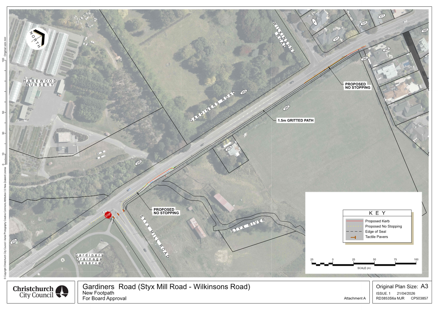
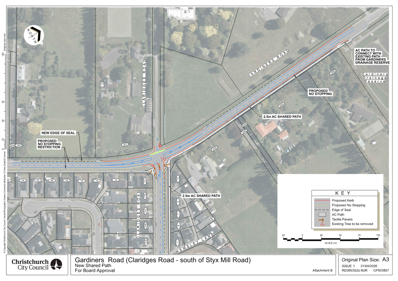
|
9. Bus stop upgrades within
Waimāero Fendalton-Waimairi-Harewood Community Board area
|
|
Reference Te Tohutoro:
|
26/378015
|
|
Responsible Officer(s) Te Pou Matua:
|
Mansour
Johari, Passenger Transport Engineer
|
|
Accountable ELT Member Pouwhakarae:
|
Brent
Smith, General Manager City Infrastructure
|
1. Purpose and Origin of the Report Te Pūtake Pūrongo
1.1 To
approve proposed bus stop improvements within Waimāero Fendalton-Waimairi-Harewood
Community Board area.
1.2 This
report has been prepared by staff in response to community requests.
1.3 The proposed bus stop upgrades were consulted on together and are
presented in a single report to streamline time and costs. However, the
decisions concerning each bus stop are independent, and they can be pursued
separately if necessary.
2. Officer Recommendations Ngā
Tūtohu
That the
Waimāero Fendalton-Waimairi-Harewood Community Board:
1. Receives the information in the Bus stop upgrades within
Waimāero Fendalton-Waimairi-Harewood Community Board area Report.
2. Notes that the decision in this report is
assessed as low significance based on the Christchurch City Council’s
Significance and Engagement Policy.
3. Under Clause 6(2) of the Christchurch City
Council Traffic and Parking Bylaw 2017 revokes any previous resolutions
pertaining to parking or stopping restrictions and traffic controls made
pursuant to any bylaw to the extent that they conflict with the parking or
stopping restrictions and traffic controls described in resolutions 4 to 14
below.
Bus stop 19999
– 150 Cavendish Road (Attachment A)
4. Pursuant to Section 339(1) of the Local
Government Act 1974:
a. Approves that a bus passenger shelter be
installed on the east side of Cavendish Road commencing at a point 115
metres north of its intersection with Sturrocks Road and
extending in a southerly direction for a distance of approximately 3.6 metres.
5. Approves that hardstand area be installed at the bus stop 19999
outside 150 Cavendish Road, as shown on Attachment A.
Bus stop 16764
– 126 Wairakei Road (Attachment A)
6. Pursuant to Section 339(1) of the Local
Government Act 1974:
a. Approves that a bus passenger shelter be
installed on the east side of Wairakei Road commencing at a point 63 metres
south of its intersection with Blighs
Road and extending in a southerly
direction for a distance of approximately 3.6 metres.
Bus stop 16362
– 20 Rossall Street (Attachment A)
7. Pursuant to Section 339(1) of the Local
Government Act 1974:
a. Approves that a bus passenger shelter be
installed on the east side of Rossall Street commencing at a point 27 metres
south of its intersection with Rhodes
Street and extending in a
southerly direction for a distance of approximately 3.6 metres.
Bus stop
10308– 198 Maidstone Road (Attachment A)
8. Pursuant to Clause 7 of the Christchurch City
Council Traffic and Parking Bylaw 2017:
a. Approves that the stopping of all vehicles be
prohibited at any time, on the northern side of Maidstone Road commencing at a
point 112 metres west of its intersection with Radbrook Street and extending in
an easterly direction for a distance of 12 metres.
b. Approves that a Bus Stop be installed, on the
northern side of Maidstone Road commencing at a point 100 metres west of its
intersection with Radbrook Street and extending in an easterly direction for a
distance of 14 metres.
9. Pursuant to Section 339(1) of the Local
Government Act 1974:
a. Approves that a bus passenger shelter be
installed on the northern side of Maidstone Road commencing at a point 93
metres west of its intersection with Radbrook Street and extending in an
easterly direction for a distance of approximately 3.6 metres.
10. Approves that tactile pavers and hardstand area be installed at
the bus stop 10308 outside 198 Maidstone Road, as shown on Attachment A.
Bus stop 24268
– 1 Bentley Street on Cutts Road (Attachment A)
11. Pursuant to Clause 7 of the Christchurch City
Council Traffic and Parking Bylaw 2017:
a. Approves that the stopping of all vehicles be
prohibited at any time, on the western side of Cutts Road commencing at a point
31 metres south of its intersection with Bentley Street and extending in a
northerly direction for a distance of 4 metres.
b. Approves that a Bus Stop be installed, on the
western side of Cutts Road commencing at a point 27 metres south of its
intersection with Bentley Street and extending in a northerly direction for a
distance of 14 metres.
c. Approves that the stopping of all vehicles be
prohibited at any time, on the western side of Cutts Road commencing at a point
13 metres south of its intersection with Bentley Street and extending in a
northerly direction to its intersection with Bentley Street.
12. Approves that tactile pavers and hardstand area be installed at
the bus stop 24268 outside 1 Bentley Street on Cutts Road, as shown on Attachment
A.
New bus stop
– 56 Merrin Street (Attachment A)
13. Pursuant to Clause 7 of the Christchurch City
Council Traffic and Parking Bylaw 2017:
a. Approves that the stopping of all vehicles be
prohibited at any time, on the northern side of Merrin Street commencing at its
intersection with Withells Road and extending in an easterly direction for a
distance of 42 metres.
b. Approves that a Bus Stop be installed, on the
northern side of Merrin Street commencing at a point 42 metres east of its
intersection with Withells Road and extending in an easterly direction for a
distance of 14 metres.
c. Approves that the stopping of all vehicles be
prohibited at any time, on the northern side of Merrin Street commencing at a
point 56 metres east of its intersection with Withells Road and extending in an
easterly direction for a distance of 2 metres.
14. Approves that a seat, tactile pavers, and
hardstand area be installed at the proposed new bus stop outside 56 Merrin
Street, as shown on Attachment A.
15. Approves that these resolutions, described in
clauses 4 to 14 above, take effect when traffic controls or parking signage
and/or road markings that evidence the restrictions described in the staff
report are in place (or removed in the case of revocations).
3. Executive Summary Te Whakarāpopoto Matua
3.1 Based
on community requests, staff are proposing several bus stop upgrades, as listed
in Table 1.
Table
1: Proposed bus stop upgrades.
|
Address and ID
|
Origin
|
Upgrades
|
|
150
Cavendish Road - 19999
|
Community
|
Shelter
installation
|
|
126
Wairakei Road - 16764
|
Community
|
Shelter
installation
|
|
20
Rossall Street - 16362
|
Community
|
Shelter
installation
|
|
198
Maidstone - 10308
|
Community
|
Shelter
installation, minor relocation, and line marking
|
|
1
Bentley Street - 24268
|
Community
|
Minor
relocation and line marking
|
|
56
Merrin Street - NA
|
(Multiple)
Community
|
New
bus stop
|
3.2 The
proposed plans include seats, tactile pavers, and hardstand areas, where
required, to improve accessibility and waiting areas, including for people
getting on and off the bus.
3.3 These
upgrades have been prioritised based on patronage, special land use (e.g.
retirement village), and community requests.
4. Background/Context Te Horopaki
4.1 Table
2 shows average boarding patronage per day, the bus routes that are served, and
the existing conditions for each bus stop. In this table, standard line marking
for a bus stop refers to approximately 12 metres of lead-in no-stopping
restriction, a 14 metre bus box, and approximately 6 metres of lead-out
no-stopping restriction.
Table
2: Patronage, bus routes, and existing conditions for each bus stop.
|
Address and ID
|
Patronage/day
|
Bus route
|
Current conditions
|
|
150
Cavendish Road - 19999
|
11
|
27
|
Standard
line marking, tactile pavers, signage, and a seat
|
|
126
Wairakei Road - 16764
|
32
|
8
|
Standard
line marking, tactile pavers, signage, and a seat
|
|
20
Rossall Street - 16362
|
29
|
8
|
Standard
line marking, tactile pavers, signage, and a seat
|
|
198
Maidstone Road- 10308
|
58
|
3
|
Bus
box marking and signage
|
|
1
Bentley Street - 24268
|
4
|
140
|
Signage
|
|
56
Merrin Street - NA
|
NA
|
130
|
NA
|
4.2 Staff
have received community requests for shelter installation at the first four bus
stops in Table 2.
4.3 A
bus stop is deemed well-used if, on average, it serves around 20 or more
passengers daily. This is the traditional Council threshold for bus shelter
installation.
4.4 Bus
stop 19999 outside 150 Cavendish Road does not meet the Council patronage
threshold to install a shelter. However, in addition to the patronage
threshold, staff also consider requests from elderly individuals, schools,
hospitals, retirement villages, and people with disabilities, who are highly
reliant on public transport. Staff therefore propose to
install a shelter at this bus stop.
4.5 Bus
stop 10308 outside 198 Maidstone Road includes an oversized bus box
(approximately 17 metres) compared with the standard 14-metre bus box. It also
blocks the driveway at 204 Maidstone Road and lacks the required lead-in and
lead-out no-stopping restrictions. In addition, the stop lacks a hardstand
area, meaning passengers currently step onto the grass berm when boarding or
alighting from the bus.
4.6 Bus
stop 24268 outside Bentley Street mainly performs as a drop-off bus stop. Staff
have received complaints about buses blocking the driveway of 1 Bentley Street.
The paired bus stop, 24544 outside 2/2 Bentley Street, has 30 boardings per
day, on average.
4.7 Staff
have received multiple community requests, including from Summerset at Avonhead
Retirement Village, to install a new eastbound bus stop on Merrin Street closer
to Avonhead Mall. Currently, passengers use either bus stop 47775 outside 26
Merrin Street (approximately 200 metres away) or bus stop 10349 outside 88
Merrin Street (approximately 250 metres away) and walk to the mall. While these
distances meet the NZTA guidance for suburban areas, staff have considered the
request due to its origin from elderly community members and a retirement
village whose residents are highly reliant on public transport. The preferred
location is outside 56 Merrin Street, which is currently a 120-minute parking
restriction area.
Options Considered Ngā Kōwhiringa Whaiwhakaaro
150
Cavendish and 126 Wairakei Roads and 20 Rossall Street – 19999 &
16764 & 16362
4.8 The
following reasonably practicable options were considered and are assessed in
this report:
4.8.1 Shelter
installation.
4.8.2 Do
nothing.
198
Maidstone Road - 10308
4.9 The
following reasonably practicable options were considered and are assessed in
this report:
4.9.1 Shelter
installation, minor relocation, and line marking.
4.9.2 Do
nothing.
4.10 The
following options were considered but were not assessed as reasonably
practicable:
4.10.1 Shelter
installation without further improvement.
· The existing
oversized bus box blocks a driveway. In addition, this bus stop lacks the
required lead-in and lead-out no-stopping restrictions. In addition, the stop
lacks a hardstand area, meaning passengers currently step onto the grass berm
when boarding or alighting from the bus. Given the number of passengers
boardings at this stop (58 passenger/day on average), this option would
represent poor value for money.
1 Bentley Street on Cutts Road - 24268
4.11 The
following reasonably practicable options were considered and are assessed in
this report:
4.11.1 Minor relocation and line marking.
4.11.2 Do
nothing.
4.12 The
following options were considered but were not assessed as reasonably
practicable:
4.12.1 Relocation
of bus stop to locations south of existing location (e.g. 41 and 39 Cutts
Road).
· Increase the
distance between the inbound and outbound stops.
· Bus stop
interruption with driveways.
· Tree removal.
56 Merrin
Street – New bus stop
4.13 The
following reasonably practicable options were considered and are assessed in
this report:
4.13.1 New
bus stop outside 56 Merrin Street.
4.13.2 Do
nothing.
4.14 The
following options were considered but were not assessed as reasonably
practicable:
4.14.1 Other
locations for the new bus stop like outside 52, 54, and 66 Merrin Street.
· Bus stop
interruption with driveways.
· Tree removal.
· More on street
parking loss compared to preferred option.
· Longer walking
distance and the need for passengers to cross two roads to reach the mall.
Options Descriptions Ngā Kōwhiringa
150
Cavendish and 126 Wairakei Roads and 20 Rossall Street – 19999 &
16764 & 16362
4.15 Preferred
Option: Shelter installation.
4.15.1 Option
Advantages
· Improves
customer satisfaction by providing weather protection for passengers.
4.15.2 Option
Disadvantages
· Costs
associated with shelter cleaning and maintenance.
4.16 Do
nothing Option.
4.16.1 Option
Advantages
· The Council
will not incur any costs.
4.16.2 Option
Disadvantages
· None of the
identified advantages associated with the preferred option would be realised.
198
Maidstone Road - 10308
4.17 Preferred
Option: Shelter installation, minor relocation, and
line marking.
4.17.1 Option Advantages
· Improves
customer satisfaction by providing weather protection for passengers.
· Improved access to bus stop for
buses.
· Improved
access to and from the bus for passengers.
· No
interruption with driveway.
4.17.2 Option
Disadvantages
· Costs associated with shelter
cleaning and maintenance.
· On-street parking loss (2
spaces)
4.18 Do
nothing Option.
4.18.1 Option
Advantages
· The Council
will not incur any costs.
4.18.2 Option
Disadvantages
· None of the
identified advantages associated with the preferred option would be realised.
1 Bentley Street on Cutts Road - 24268
4.19 Preferred
Option: Minor relocation, and line marking
4.19.1 Option
Advantages
· No
interruption with driveway.
· Improved access to bus stop for
buses.
· Improved access to and from the
bus for passengers.
4.19.2 Option
Disadvantages
· On-street parking loss (1
space)
4.20 Do
nothing Option.
4.20.1 Option
Advantages
· The Council
will not incur any costs.
4.20.2 Option
Disadvantages
· None of the
identified advantages associated with the preferred option would be realised.
56 Merrin
Street – New bus stop
4.21 Preferred
Option: New bus stop installation outside 56 Merrin
Street.
4.21.1 Option
Advantages
· Improves
public transport accessibility to a major trip generator (Avonhead Mall),
particularly benefiting elderly people and individuals with disabilities.
· Located close
to the pedestrian crossing at the roundabout.
4.21.2 Option
Disadvantages
· On-street parking loss (2
spaces)
4.22 Do
nothing Option.
4.22.1 Option
Advantages
· The Council
will not incur any costs.
4.22.2 Option
Disadvantages
· None of the
identified advantages associated with the preferred option would be realised.
5. Financial Implications Ngā Hīraunga Rauemi
Capex/Opex Ngā Utu Whakahaere
5.1 The
estimated costs for the recommended option and the do-nothing option are
provided in the table below.
5.2 The implementation costs in the table below include the expenses for
investigation, design, and construction of bus stop upgrades.
5.3 Maintenance/Ongoing costs - The Transport Unit Operational
Expenditure budgets include maintenance of bus stop infrastructure.
5.4 Funding
Source – Traffic Operations budget for public transport infrastructure
upgrades.
150
Cavendish Road – 19999
|
|
Recommended Option
|
Option 2 – Do nothing
|
|
Cost
to Implement
|
$31,000
|
$0
|
|
Funding
Source
|
CPMS
50465
|
N/A
|
|
Maintenance/Ongoing
Costs
|
Bus
stop maintenance contract - minimal effects to the overall asset
|
N/A
|
|
Funding
Availability
|
Available
|
N/A
|
|
Impact
on Rates
|
N/A
|
N/A
|
126
Wairakei Road – 16764
|
|
Recommended Option
|
Option 2 – Do nothing
|
|
Cost
to Implement
|
$31,000
|
$0
|
|
Funding
Source
|
CPMS
50465
|
N/A
|
|
Maintenance/Ongoing
Costs
|
Bus
stop maintenance contract - minimal effects to the overall asset
|
N/A
|
|
Funding
Availability
|
Available
|
N/A
|
|
Impact
on Rates
|
N/A
|
N/A
|
20 Rossall
Street – 16362
|
|
Recommended Option
|
Option 2 – Do nothing
|
|
Cost
to Implement
|
$31,000
|
$0
|
|
Funding
Source
|
CPMS
50465
|
N/A
|
|
Maintenance/Ongoing
Costs
|
Bus
stop maintenance contract - minimal effects to the overall asset
|
N/A
|
|
Funding
Availability
|
Available
|
N/A
|
|
Impact
on Rates
|
N/A
|
N/A
|
198
Maidstone Road - 10308
|
|
Recommended Option
|
Option 2 – Do nothing
|
|
Cost
to Implement
|
$36,000
|
$0
|
|
Funding
Source
|
CPMS
50465
|
N/A
|
|
Maintenance/Ongoing
Costs
|
Bus
stop maintenance contract - minimal effects to the overall asset
|
N/A
|
|
Funding
Availability
|
Available
|
N/A
|
|
Impact
on Rates
|
N/A
|
N/A
|
1 Bentley
Street on Cutts Road - 24268
|
|
Recommended Option
|
Option 2 – Do nothing
|
|
Cost
to Implement
|
$4,000
|
$0
|
|
Funding
Source
|
CPMS
50465
|
N/A
|
|
Maintenance/Ongoing
Costs
|
Bus
stop maintenance contract - minimal effects to the overall asset
|
N/A
|
|
Funding
Availability
|
Available
|
N/A
|
|
Impact
on Rates
|
N/A
|
N/A
|
56 Merrin
Street – New bus stop
|
|
Recommended Option
|
Option 2 – Do nothing
|
|
Cost
to Implement
|
$7,000
|
$0
|
|
Funding
Source
|
CPMS
50465
|
N/A
|
|
Maintenance/Ongoing
Costs
|
Bus
stop maintenance contract - minimal effects to the overall asset
|
N/A
|
|
Funding
Availability
|
Available
|
N/A
|
|
Impact
on Rates
|
N/A
|
N/A
|
6. Considerations Ngā Whai Whakaaro
Risks and Mitigations Ngā Mōrearea me
ngā Whakamātautau
6.1 Should
the Community Board proceed with the do-nothing options:
· None of the identified advantages associated with the preferred
options would be realised.
Legal Considerations Ngā Hīraunga
ā-Ture
6.2 The relevant Community Board or Committee have delegated authority
from the Council to exercise the delegations as set out in the Register of
Delegations. The list of delegations for the Community Boards includes the
resolutions of:
· Stopping, standing,
and parking restrictions (including bus stops) under Clause 7 of the Traffic
and Parking Bylaw 2017.
· The authority to
subsequently amend or revoke any resolution made at any time under Clause 6(2)
of the Traffic and Parking Bylaw 2017.
· Bus passenger
shelters under Section 339 (1) of the Local Government Act 1974.
· To hear and
determine objections to bus stop shelters.
6.3 Other Legal Implications:
6.3.1 This
specific report has not been reviewed and approved by the Legal Services Unit
however the report has been written using a general approach previously
approved of by the Legal Services Unit, and the recommendations are consistent
with the policy and legislative framework outlined in this report.
Strategy
and Policy Considerations Te
Whai Kaupapa here
6.4 The
required decisions:
6.4.1 Align
with the Christchurch
City Council’s Strategic Framework.
6.4.2 Are
assessed as low significance based on the Christchurch City Council’s
Significance and Engagement Policy. The level of significance was
determined by the number of people impacted by each individual plan, the low
risk and cost associated with the decision.
6.4.3 Are
consistent with Council’s Plans and Policies.
6.5 This
report supports the Council's
Long Term Plan (2024 - 2034):
6.6 Transport
6.6.1 Activity: Transport
· Level of Service: 10.4.1 More people are choosing to travel
by public transport - >=14 million trips per year
· Level of Service: 10.4.4 Improve customer satisfaction with
public transport facilities (quality of bus stops and bus priority measures) -
>=73%
Community
Impacts and Views Ngā Mariu ā-Hāpori
6.7 Consultation
has been carried out with affected property owners and tenants.
6.8 The
consultation period ran from 17 February to 10 March 2026. Letters were
delivered to the property owners and tenants affected.
6.9 Canterbury
Regional Council (CRC) support the proposed upgrades.
6.10 Staff
did not receive any submissions regarding the proposed plans for bus stops
16764 outside 126 Wairakei Road, 16362 outside 20 Rossall
Street, and 24268 outside 1 Bentley Street on Cutts Road.
6.11 Staff
received one submission regarding the proposed plan for bus stop 19999 outside
150 Cavendish Road. The submitter, on behalf of the Summerset on Cavendish
Retirement Village, supported the proposed plan:
· “There
are 500 people living across the road from the bus stop plus staff. As well as
residents some staff would use the bus. Particularly in
the winter it is often a very cold wait for the bus to arrive. The village
social committee organises mystery bus trips weekly which are well attended. A
bus shelter would be like a gift from heaven. A lot of residents in the village
either don't have a car or have lost their licence due to old age.
…”
6.12 Staff
received one objection regarding the plan proposed for bus stop 10308 outside
198 Maidstone Road. In summary, following concerns/recommendations were
provided (please see the detailed submission in Attachment B):
6.12.1 Consultation
letter, plan, and process: The submitter raised concerns and
provided suggestions regarding the detail, clarity, and dimensions shown in the
consultation letter and plan. They also raised concerns and suggestions about
staff response times and the consultation deadline.
Staff response: Staff advised that the consultation letter and plan follow standard
Council practice. Under this approach, the consultation material outlines the
main upgrades, while detailed specifications are provided on request to
affected residents. Staff also confirmed that the concerns and suggestions have
been shared with the relevant teams for future consideration. Staff also
extended the consultation deadline (1 week) following an on-site meeting with
the affected resident.
6.12.2 Justification
for upgrades: The submitter raised concerns that the average number
of daily boarding passengers is insufficient to justify installing a shelter.
They also noted there is no clear evidence that a shelter would increase
patronage. They further stated that the shelter may be underutilised due to
social distancing, and that current passengers already use nearby tree cover
for shelter. In addition, they suggested that, with reliable real-time
information, passengers do not wait long at stops and are exposed to weather while
walking, so a shelter may provide limited additional benefit.
Staff response: Staff advised that the use of average patronage is intended to
capture broader usage trends over time, rather than a single point measure.
More importantly, shelters are primarily provided to improve weather protection
and amenity for existing users, rather than to directly attract new patronage.
Factors such as reliance on tree cover or assumptions around social distancing
are not valid or sufficiently significant to offset the need for formal shelter
infrastructure. Furthermore, while real-time information can reduce
uncertainty, it does not remove waiting time entirely, and passengers may still
be exposed to adverse weather conditions.
6.12.3 Plan
details: The submitter also raised detailed questions and suggestions
regarding elements of the plan, including the shelter location and type,
tactile paving, rubbish bins, etc.
Staff response: Staff responded to each matter in line with best practice and public
transport guidelines. They confirmed the shelter size and position, glass type,
and bus stop sign location, and advised that a rubbish bin would not be
included. Recommendations regarding the shelter rear panel facing the road, the
hardstand area, and tactile pavers were not supported, as they do not align
with the relevant guidelines. Other suggestions, including those relating to
rubbish bins, have been referred to the appropriate team.
6.13 Staff
received 2 submissions from affected residents regarding the plan proposed for
the new bus stop proposed to be installed outside 56 Merrin Street. In summary,
following concerns/recommendations were provided (please see the detailed
submissions in Attachment C):
6.13.1 Proximity to
roundabout, traffic volume, and queue build up
Staff response: Staff advised that the current legislation permits vehicles to park
up to 6 metres from an intersection. Relevant guidance recommends that bus
stops be located at least 20 metres from an intersection. The proposed bus stop
is positioned approximately 40 metres from the roundabout and therefore exceeds
this recommendation. In addition, a 4-metre-wide traffic lane will remain
adjacent to the stop, allowing vehicles to pass a stationary bus without
interruption to traffic flow.
6.13.2 Safe
sight line: The submitter raised concerns that currently, the
vehicles parked in the concerned location interrupts the sight line for
oncoming traffic views.
Staff response: Staff advised that it is important to note that the proposed bus
stop would improve the current conditions. Once installed, the space will
remain clear for most hours of the day. Buses will only be present a few times
per day and typically for a short duration of around 30 seconds.
6.13.3 Passenger
crossing
Staff response: Staff advised that passengers using the proposed stop will
access the shopping centre via the pedestrian refuge at the roundabout. This
roundabout has undergone safety improvements in recent years, and significant
safety risks should have been addressed through those works.
6.13.4 Bus
stop interrupting the driveway, timing point
Staff response: Staff advised that the standard bus box length used by Council is
14 metres, in accordance with CCC guidance. This has been standard
practice for many years and has worked well in accommodating the range of bus
sizes operating in Christchurch. Another important factor is providing
sufficient lead-in “no stopping” restriction before the bus box.
This ensures buses have enough space to safely pull into the stop and correctly
position themselves within the marked bus box. For this reason, we do not see a
notable risk of buses blocking nearby driveways. CCC can also raise with CRC
that this bus stop should not be used as a timing point.
6.13.5 On-street
parking loss
Staff response: Staff advised that the new bus stop will remove 2 kerbside parking
spaces. Kerbside space is limited and must be managed to serve all road users,
particularly public transport, which is often an essential mode of travel for
disabled individuals, older people, and children. It is important to note that
the Council’s Suburban Car Parking Policy prioritises kerbside space for
bus stops over general parking. In addition, other on-street parking remains
available along Merrin Street and Withells Road for residents and visitors.
6.13.6 Existing bus stops
Staff response: Currently, passengers use either bus stop 47775 outside 26
Merrin Street (approximately 200 metres away) or bus stop 10349 outside 88
Merrin Street (approximately 250 metres away) and walk to the mall. While these
distances meet the NZTA guidance for suburban areas, staff have considered the
request due to its origin from elderly community members and a retirement
village whose residents are highly reliant on public transport.
6.13.7 Solution
suggested by submitters: Outside 66 Merrin Street
Staff response: Staff advised that the location outside 66 Merrin Street was
considered but not assessed as reasonably practicable for the following
reasons:
· It
is located further from the shopping centre and would require an additional
road crossing for passengers. Given that the request originated from elderly
members of the community, this was considered a significant factor.
· It
would result in the loss of two additional parking spaces compared with the
proposed plan.
· It
would require the removal of a tree.
6.13.8 The
Avonhead mall property management and Piccadilly Bookshop also raised the same
concerns on passenger crossing and safe sight lines. Staff provided above
answers to them as well.
6.14 The
decision affects the following wards/Community Board areas:
6.14.1 Waimāero
Fendalton-Waimairi-Harewood Community Board.
6.14.2 Fendalton,
Waimairi, and Harewood Wards.
Impact
on Mana Whenua Ngā
Whai Take Mana Whenua
6.15 The decisions do not
involve a significant decision in relation to ancestral land, a body of
water or other elements of intrinsic value, therefore these decisions do not specifically impact Mana Whenua, their culture, and
traditions.
6.16 The decisions do not involve a matter of interest to Mana Whenua and will not impact on our agreed partnership priorities
with Ngā Papatipu Rūnanga.
Climate
Change Impact Considerations Ngā Whai Whakaaro mā te Āhuarangi
6.17 The
proposals in this report are unlikely to contribute significantly to adaptation
to the impacts of climate change or emissions reductions. However,
providing shelters along with other bus stop upgrades will enhance public
transport user satisfaction and encourage more people to use public transport.
7. Next Steps Ngā Mahinga ā-muri
7.1 If
the staff recommendations are approved, staff will engage with contractors to
proceed with construction.
Attachments Ngā Tāpirihanga
|
No.
|
Title
|
Reference
|
Page
|
|
a ⇩ 
|
Attachment A:
Proposed bus stop improvments
|
26/751680
|
62
|
|
b ⇩
|
Attachment B:
Resident's feedback - Bus stop 10308 outside 198 Maidstone Road
|
26/769928
|
68
|
|
c ⇩
|
Attachment C:
Two submissions from affected residents by new bus stop outside 56 Merrin
Street
|
26/771551
|
76
|
In addition to the attached documents, the following background
information is available:
|
Document
Name – Location / File Link
|
|
Not
applicable
|
Signatories Ngā Kaiwaitohu
|
Author
|
Mansour Johari
- Passenger Transport Engineer
|
|
Approved By
|
Kathy Graham -
Acting Operations Manager
Tony
Richardson - Finance Business Partner
Stephen Wright
- Head of Transport & Waste Management
|
|
10. Waimāero
Fendalton-Waimairi-Harewood Community Board Area Report - May 2026
|
|
Reference Te Tohutoro:
|
26/891230
|
|
Responsible Officer(s) Te Pou Matua:
|
Maryanne
Lomax, Community Governance Manager, maryanne.lomax@ccc.govt.nz
|
|
Accountable ELT Member Pouwhakarae:
|
Andrew
Rutledge, General Manager Citizens and Community
|
1. Purpose of Origin of the Report Te
Pūtake Pūrongo
1.1 This
report provides the Board with an overview of initiatives and
issues current within the Community Board area.
1.2 This
report is staff-generated monthly.
2. Officer Recommendations Ngā
Tūtohu
That the Waimāero
Fendalton-Waimairi-Harewood Community Board:
1. Receives the information in the Waimāero Fendalton-Waimairi-Harewood
Community Board Area Report - May 2026.
3. Community Support, Governance and Partnership Activity
3.1 Community Governance Projects
3.1.1 Fendalton-Waimairi-Harewood
Community Liaison Meeting - April 2026
The April Community Liaison Meeting was
hosted by Council staff at the Fendalton Library and Service Centre, with
strong attendance from across the network (approximately 20 representatives
from community organisations and agencies). It was also positive to have three
Waimāero Fendalton-Waimairi-Harewood Community Board members in
attendance, reflecting continued Board support and engagement.
The meeting provided an opportunity to
share updates, strengthen relationships, and highlight key initiatives across
the community.
Christchurch City Council’s Active
Communities Team presented on a range of accessible recreation programmes,
including discounted organisation memberships, women-only swim sessions, free
swimming for under-5s during term time, and inclusive sensory-friendly
activities. An update was also provided on Jellie Park, where essential
strengthening works are underway, with staged reopening expected from late
2026.
Neighbourhood Support Christchurch
outlined its role in supporting safer, more connected communities through local
neighbourhood groups, information sharing, and emergency preparedness.
Upcoming initiatives were noted,
including the May 2026 Funding Hui (with both daytime and evening sessions to
meet demand), a Cultural Connections Hui planned for July, and a Youth Hui
scheduled for September. These initiatives aim to support capability building,
strengthen inclusion, and respond to community-identified priorities.
Community organisations also shared
updates on local services and programmes, including parenting and budgeting
courses, expanded community centre services, and support for migrant
communities. A reminder was provided on the importance of maintaining up-to-date
information in the Citizens Advice Bureau Community Directory to support
effective referrals.
Overall, the meeting reflected a
well-connected and collaborative community network, with a continued focus on
accessibility, inclusion, and supporting local organisations.
The next meeting is on 10 June 2026.
3.1.2 Nepal
Reserve - Community-Led Activation Update
 There
continues to be strong momentum at Nepal Reserve, led by local residents and
supported by Council staff working behind the scenes.
There
continues to be strong momentum at Nepal Reserve, led by local residents and
supported by Council staff working behind the scenes.
A recent highlight was the City Nature
Challenge Bioblitz held on 26 April, organised by community members, including
Beaulah Pragg. The event also featured support from Rob Cruickshank (University
of Canterbury), an insect specialist who attended to demonstrate techniques for
observing and recording insects. The event attracted around 25 participants
(including approximately 15 children.
The Bioblitz provided a hands-on
opportunity for families to explore local biodiversity as part of a global
citizen science initiative. Feedback reflected strong engagement, with one
student sharing they “liked seeing all the different plants and insects,”
while another highlighted spotting a huhu grub that “just jumped out of
the soil.”
A special acknowledgement is extended to
Beaulah Pragg, whose leadership has been instrumental in establishing the
Friends of Nepal Reserve group and driving ongoing activity in the space.
Council staff have supported the group to
build capacity and sustainability, including training a member as a first
aider, providing a first aid kit, and supplying volunteer-at-work signage to
support safe and visible working bees and events.
The group continues to build momentum,
with their third monthly working bee scheduled for Sunday, 3 May, supported by
Community Park Ranger Annaliese Caukwell-Mills.
The Parks team has also confirmed
upcoming wildflower planting within the reserve. These areas are being prepared
to enhance biodiversity, support pollinators such as bees and butterflies, and
add seasonal interest, while remaining accessible through mown pathways. While
the areas may initially appear bare, planting will establish over winter, with
flowering expected through spring and summer. Early community feedback has been
positive, with one resident noting the planting “sounds pretty cool and
something different.”
Overall, this reflects a strong example
of community-led stewardship, supported by Council, resulting in increased
activation, environmental enhancement, and community connection within the
reserve.
3.1.3  Bryndwr Banter -
Update and Latest Edition
Bryndwr Banter -
Update and Latest Edition
The Bryndwr Banter is a collaborative
community publication, produced through a partnership between local community
groups and central and local government organisations.
Following a review earlier this year and
feedback from the Burnside Bryndwr Community Network engagement project last
winter, the working group agreed to increase the publication from 8 to 12
pages. This will also allow the inclusion of a community directory.
Feedback highlighted that the Bryndwr
Banter is highly valued for its consistency, accessibility, and role as a
trusted source of local information, with residents also requesting more
community stories and local content.
The group considered a range of options
to create more space for community content, including separating the directory.
It was ultimately agreed that increasing the publication size was the most
effective approach while maintaining its current format.
The Bryndwr Banter will continue to be
published three times per year (Autumn, Winter, and Spring/Summer).
A key longer-term action is identifying a
community volunteer(s) to take on editorial responsibilities in future
editions.
The latest edition is currently being
delivered to 3,000 residents in Bryndwr and can be viewed here.
3.1.4 ANZAC
Day Service - Harewood
This year’s ANZAC Day service at
the Harewood Cenotaph drew an estimated 400-450 people, a strong and diverse
gathering that reflected the enduring significance of remembrance within our
community.
The service was led by Rev. Joe Keighley
from the Burnside Harewood Anglican Parish and Rev. Rob Thomson, chaplain in
the Royal NZ Navy Volunteer Reserves. Air Training Corps 17 Squadron provided
the honour guard and supported the formal elements of the morning, while the
Harewood Primary school helped with arrangements and the hospitality following
the gathering.
Harewood School’s kapa haka offered
waiata and a haka, which was appreciated by those gathered. We were also
fortunate to have RNZNR Lieutenant Rebecca Nelson sing Whakaaria Mai, a
contribution that added depth to the service.
Overall, it was a well-supported and
meaningful commemoration, marked by a steady sense of respect and shared
remembrance. The growing numbers of attendees show that our community
continues to value both what this day represents and the unity that we embody
in our coming together.
Lest We Forget.
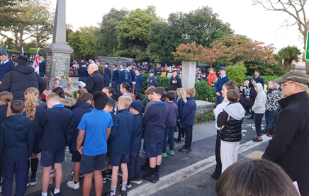
3.2 Community
Funding Summary
3.2.1 A
status report on the Board’s 2025-26 Discretionary Response Fund and
Youth Development Fund as at 30 April 2026 is attached (refer to Attachment
A).
3.2.2 Youth
Development Funds approved under delegation of Community Governance
Manager:
· Samuel Allan - Australasian Intervarsity Debating Championship -
$250
· Sophie Lampe - World Triathlon Finals in Spain - $500
· Rina Kim – Badminton NZ U17 Melbourne - $350
· Badminton Canterbury Inc – NZ Junior Championships (9 players
from our Board area - $1,00
· Soeren Wells – Oceania Swimming Championships in Fiji - $500
3.2.3 Better-Off
Fund Report Back – Nomads United AFC
On behalf of our entire club community,
we would like to extend our heartfelt thanks to the CCC Better Off Fund for
their incredible financial support, which made our clubroom bathroom
renovations possible.
The clubroom bathrooms had not been
updated since the original construction of the facility in the 1970s. Thanks to
your generous contribution, we have finally been able to bring them into the
modern era - creating clean, accessible, and functional spaces that are a huge
improvement for everyone who uses them. The upgrades also include water-saving
and energy-efficient features, making the facilities more sustainable for the
future.
This renovation has made an enormous
difference, not only to our club members but also to the wider community who
visit our clubrooms each week for games, trainings, and social gatherings. It
has enhanced the comfort and experience of all who walk through our doors.
We’re also proud to share that much
of the renovation work was carried out by local tradespeople who are also
members of our football club. Being able to support local talent within our
community added an extra layer of meaning to the project and helped strengthen
the bond we share as a club.
Once again, thank you to the CCC Better
Off Fund for your belief in community sport and for helping us create a
facility we can all be proud of for many years to come.
Before
After
3.3 Participation
in and Contribution to Decision Making
3.3.1 Report
back on other Activities contributing to Community Board Plan
· The 2026-28 Waimāero Fendalton-Waimairi-Harewood Community
Board Plan was adopted by the Board at their meeting on 20 April 2026. A
six-month progress report will be provided in September 2026.
· Council Engagement and Consultation
· Current open
consultations in our Board area:
- Elmwood
Park Bowling Club lease – The Elmwood Park Bowling Club has applied for a
lease for the existing bowling green near Heaton Street. More information
is available here.
Consultation closes 24 May 2026.
· Recently closed
consultations:
- Aorangi
Road street renewal and cycleway – closed on 3 May 2026.
A full list of open consultations city-wide
is available at
https://letstalk.ccc.govt.nz/
4. Advice Provided to the Community Board Ngā Kupu Tohutohu ka
hoatu ki te Poari Hapori
4.1 Customer
Service Request Report - Hybris monthly report for Marcy 2026 attached,
providing an overview of the number of Customer Service Requests that have been
received, including the types of requests being received and a breakdown of how
they are being reported (refer to Attachment B).
4.2 Fendalton-Waimairi-Harewood
Graffiti Snapshot - March 2026 (refer to Attachment C).
4.3 SWN - Strowan intersection - investigation works (night works) (circulated
1 April 2026)
4.4 SWN - Glandovey/Heaton/Rossall/Strowan intersection - signal
upgrades (circulated 10 April 2026)
4.5 SWN - Wairakei Road - water main renewal (circulated 17 April
2026)
4.6 SWN - Hawthorne St, Walnut Ave, Lansbury Ave - wastewater main
renewals - works update (circulated 17 April 2026)
4.7 SWN - Main North Road - road resurfacing (night works) (circulated
22 April 2026)
4.8 SWN - Harewood Road - water main renewal (circulated 22 April
2026)
4.9 Road
maintenance letters:
- Martbern Crescent - road
resurfacing (circulated 2 April 2026)
- Waimairi Road (between Greers and
Tudor) - footpath resurfacing (circulated 10 April 2026)
- Old West Coast Road - essential
road repairs update (circulated 10 April 2026)
- Annell Place - footpath
resurfacing (circulated 10 April 2026)
- Gregan Crescent (rescheduled) -
road resurfacing (circulated 10 April 2026)
- Wairakei Road - footpath
resurfacing (circulated 17 April 2026)
- Fairford Street - essential road
repairs (circulated 17 April 2026)
- Harakeke Street - road resurfacing
(circulated 24 April 2026)
Attachments Ngā Tāpirihanga
|
No.
|
Title
|
Reference
|
Page
|
|
a ⇩
|
Fendalton-Waimairi-Harewood
- Board Funding Update - May 2026
|
26/891569
|
88
|
|
b ⇩
|
Fendalton-Waimairi-Harewood
Hybris Ticket Report - March 2026
|
26/892000
|
89
|
|
c ⇩
|
Fendalton-Waimairi-Harewood
Graffiti Snapshot - March 2026
|
26/892280
|
92
|
Signatories Ngā Kaiwaitohu
|
Author
|
Maryanne Lomax
- Manager Community Governance, Fendalton-Waimairi-Harewood
|
|
Approved By
|
Matthew
McLintock - Manager Community Governance Team
John Filsell -
Head of Community Support and Partnerships
|
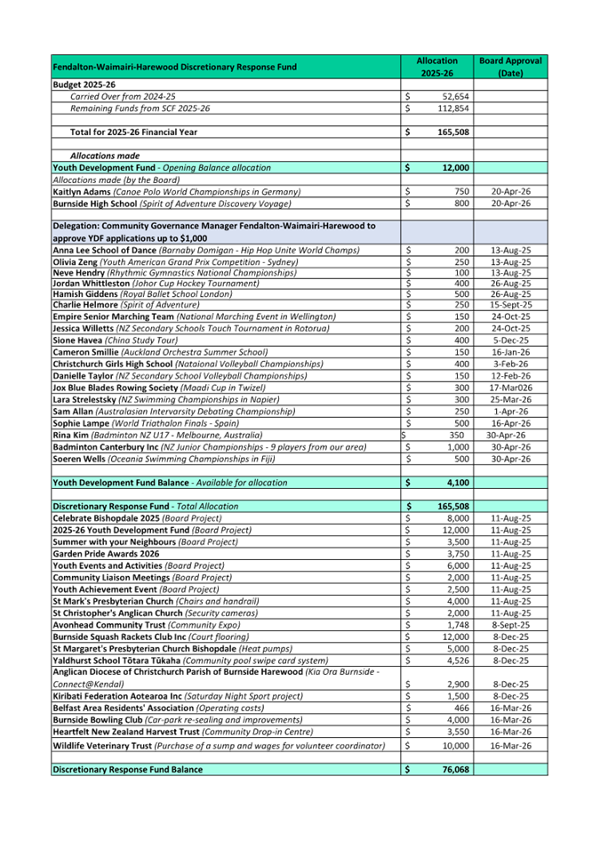
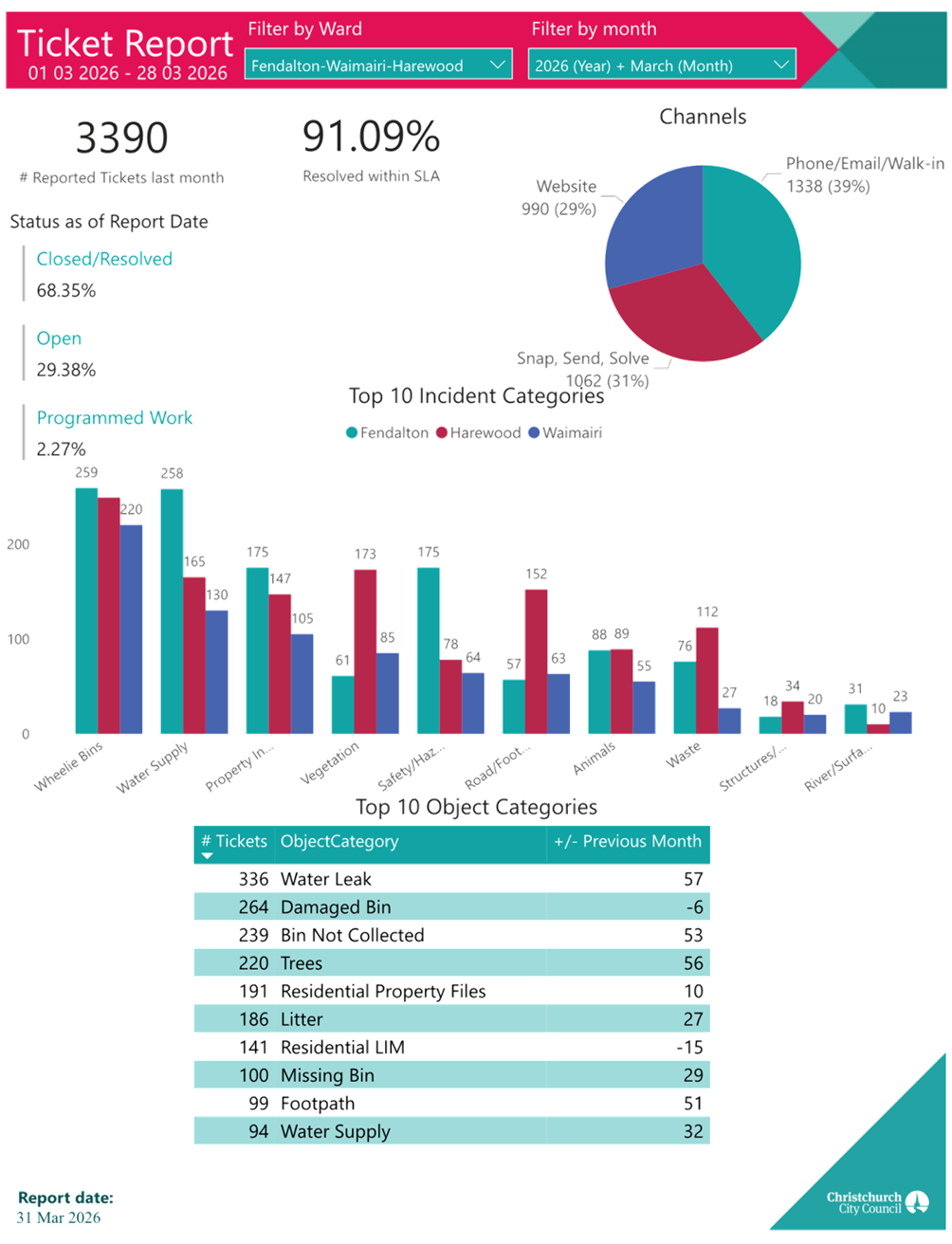
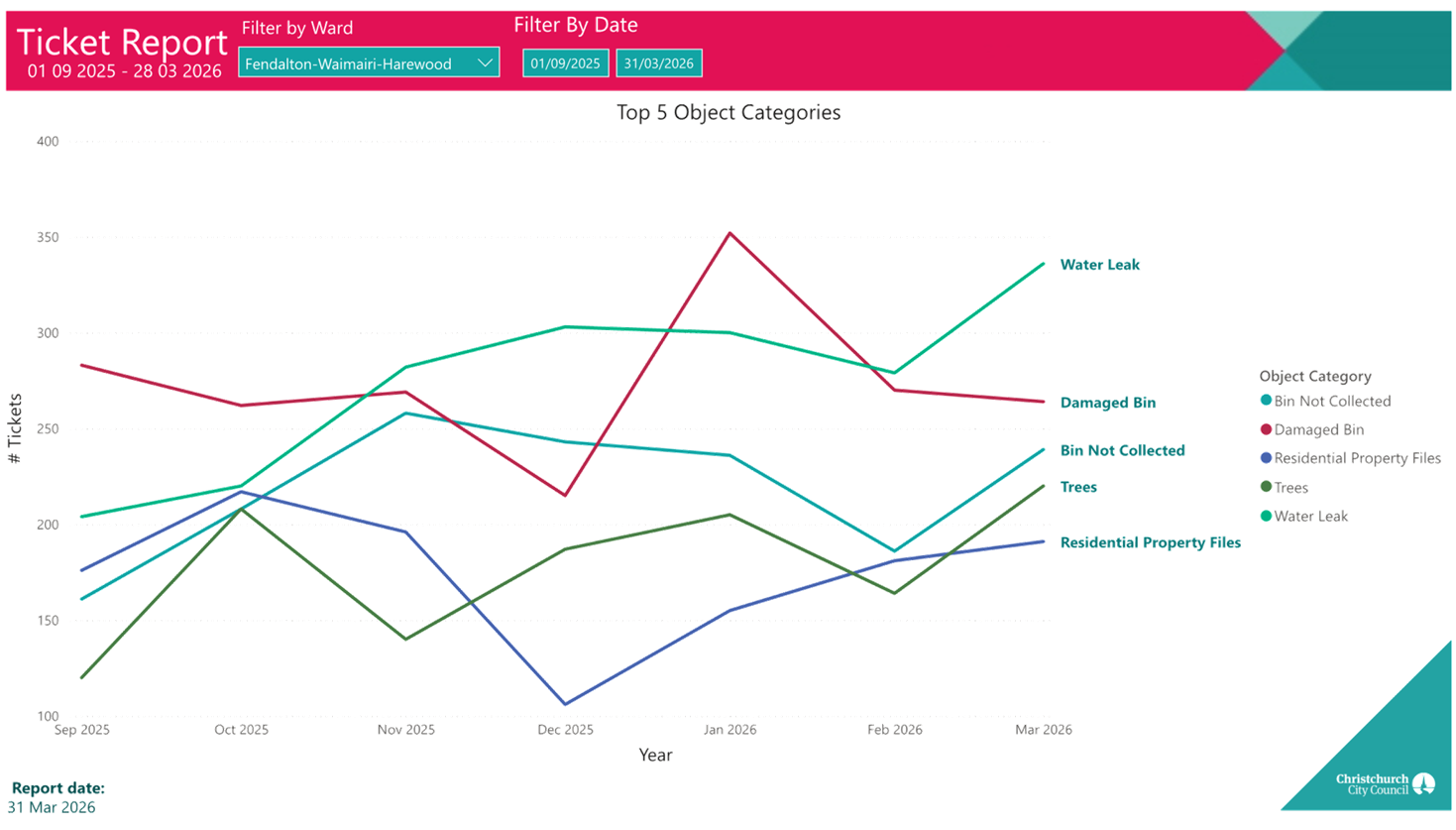
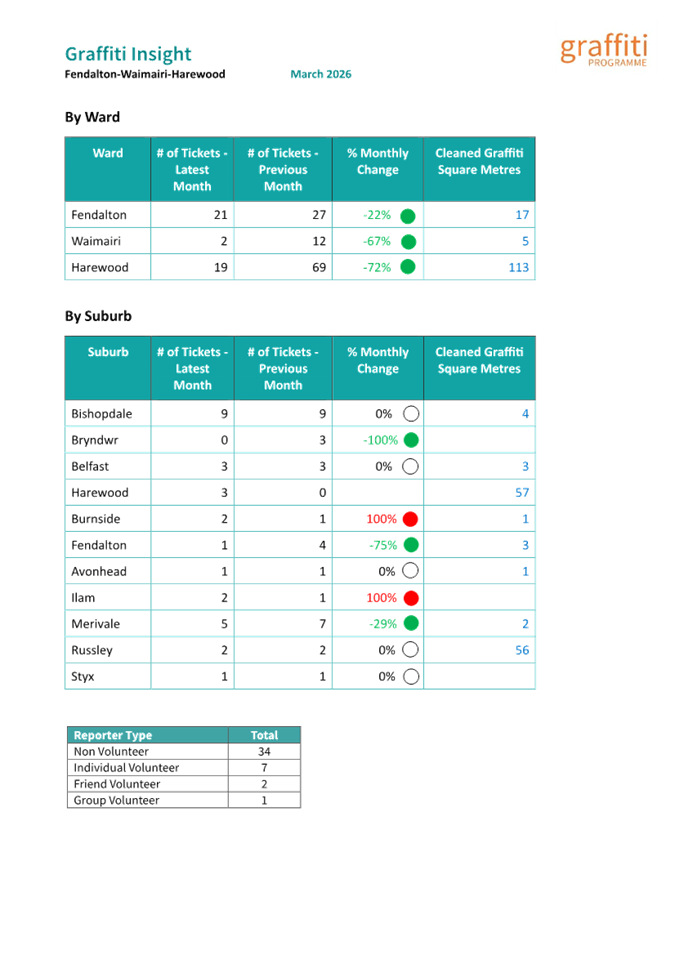
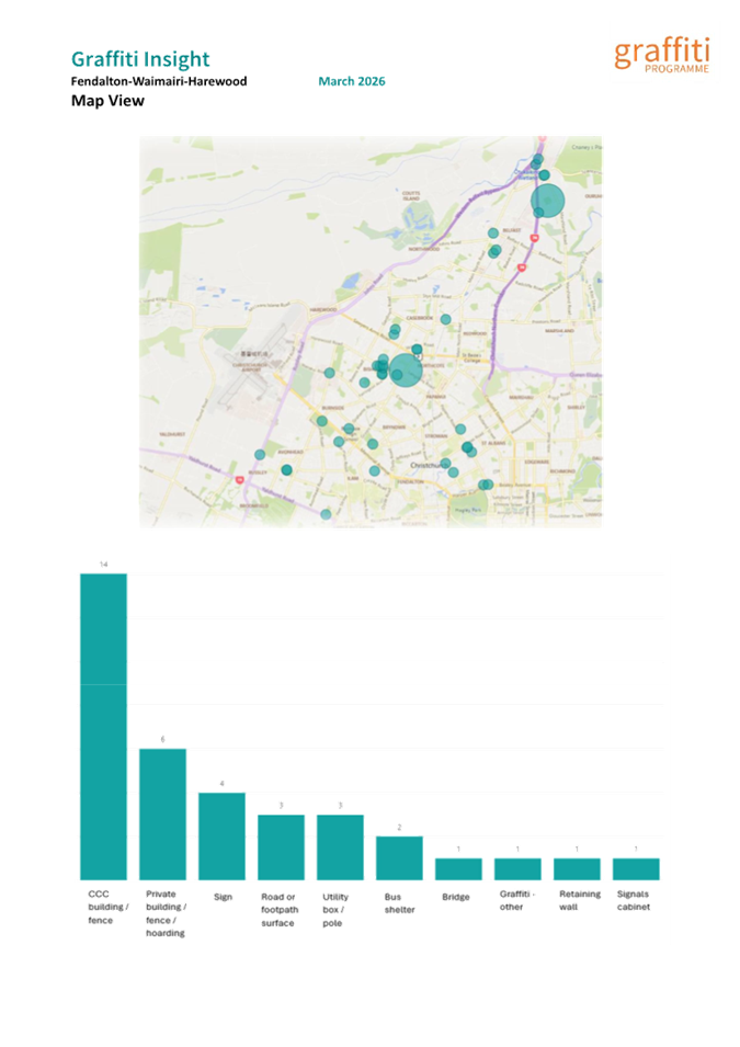
|
11. Elected
Members’ Information Exchange Te Whakawhiti Whakaaro o Te
Kāhui Amorangi
|
This item provides an opportunity for Board Members to
update each other on recent events and/or issues of relevance and interest to
the Board.
Karakia Whakamutunga
|
Unuhia, unuhia
Unuhia ki te uru tapu nui
Kia wātea, kia māmā, te ngākau,
Te tinana te wairua i te ara takatā
Koia rā e Rongo, whakairia ake ki runga
Kia tina! TINA! Hui e! TĀIKI E!
|
Draw on, draw on,
Draw on the supreme sacredness
To clear, to free the heart, the body and the spirit of mankind
Rongo, suspended high above us (i.e. in ‘heaven’)
Draw together! Affirm!
|
Actions Register Ngā Mahinga
When decisions are made at meetings, these
are assigned to staff as actions to implement. The following lists
detail any actions from this meeting that were:
- Open at the time the agenda was
generated.
- Closed since the last ordinary meeting
agenda was generated.
Open Actions Ngā Mahinga Tuwhera
|
REPORT TITLE/AGENDA SECTION
|
MEETING DATE
|
ACTION DUE DATE
|
UNIT
|
TEAM
|
|
Jellie Park Recreation &
Sport Centre Storeroom
|
16 March 2026
|
15 June 2026
|
RS&E
|
Operations
|
|
Fendalton-Waimairi-Harewood
Youth Development Fund - Approval Process
|
20 April 2026
|
20 July 2026
|
CS&P
|
CS&P - Governance (Fen-Wai-Har)
|
|
Grant an Easement for Fibre
Installation to Enable, at Tulett Park, Casebrook
|
20 April 2026
|
20 July 2026
|
F&P Unit
|
Property Consultancy
|
|
Radcliffe Road Corridor
Improvement
|
20 April 2026
|
20 July 2026
|
Transport & Waste
|
Project Management
|
|
Waimāero
Fendalton-Waimairi-Harewood 2026-28 Community Board Plan
|
20 April 2026
|
20 July 2026
|
CS&P
|
CS&P - Governance (Fen-Wai-Har)
|
|
Public Forum - Nicholas Tyler
|
9 June 2025
|
1 August 2026
|
Transport & Waste
|
Traffic Operations
|
|
Proposed P120 Parking
Restrictions - Staveley Street
|
8 December 2025
|
14 December 2026
|
Transport & Waste
|
Traffic Operations
|
|
Bryndwr Road Street Renewal
|
8 September 2025
|
30 June 2027
|
Transport & Waste
|
Project Management
|
Actions Closed Since the Last Meeting
Ngā Mahinga kua Tutuki nō Tērā Hui
|
REPORT TITLE/AGENDA SECTION
|
MEETING DATE
|
DUE DATE
|
ACTION CLOSURE DATE
|
UNIT
|
TEAM
|
|
Poynder Avenue and Garden
Road bridges - No Stopping Restrictions and Footpaths
|
16 February 2026
|
18 May 2026
|
4 May 2026
|
Transport & Waste
|
Project Management
|
|
Wairakei Road Intersections
|
16 February 2026
|
18 May 2026
|
4 May 2026
|
Transport & Waste
|
Traffic Operations
|
|
Glandovey/Heaton/Rossall/Strowan
- Right turn arrows
|
20 April 2026
|
20 July 2026
|
4 May 2026
|
Transport & Waste
|
Traffic Operations
|
|
Marshland Road / Main North
Road / Spencerville Road Intersection Improvements Report
|
20 April 2026
|
20 July 2026
|
21 April 2026
|
Transport & Waste
|
Traffic Operations
|
|
Proposed Road Names - 232
Highsted Road, Casebrook
|
20 April 2026
|
20 July 2026
|
21 April 2026
|
Planning & Consents
|
Resource Consents
|
|
Proposed Road Names - 65
Grampian Street, Casebrook
|
20 April 2026
|
20 July 2026
|
21 April 2026
|
Planning & Consents
|
Resource Consents
|
|
Waimāero
Fendalton-Waimairi-Harewood - Better-Off Fund Application for Consideration -
Belfast Community Network
|
20 April 2026
|
20 July 2026
|
29 April 2026
|
CS&P
|
CS&P - Governance (Fen-Wai-Har)
|
|
Waimāero
Fendalton-Waimairi-Harewood 2025/26 Youth Development Fund Applications -
Kaitlyn Adams and Burnside High School
|
20 April 2026
|
20 July 2026
|
21 April 2026
|
CS&P
|
CS&P - Governance (Fen-Wai-Har)
|