Christchurch City Council
Agenda
Notice of Meeting Te Pānui o te Hui:
An ordinary meeting of the Christchurch
City Council will be held on:
Date: Wednesday 4 March 2026
Time: 9.30 am
Venue: Camellia Chambers, Civic Offices,
53 Hereford Street, Christchurch
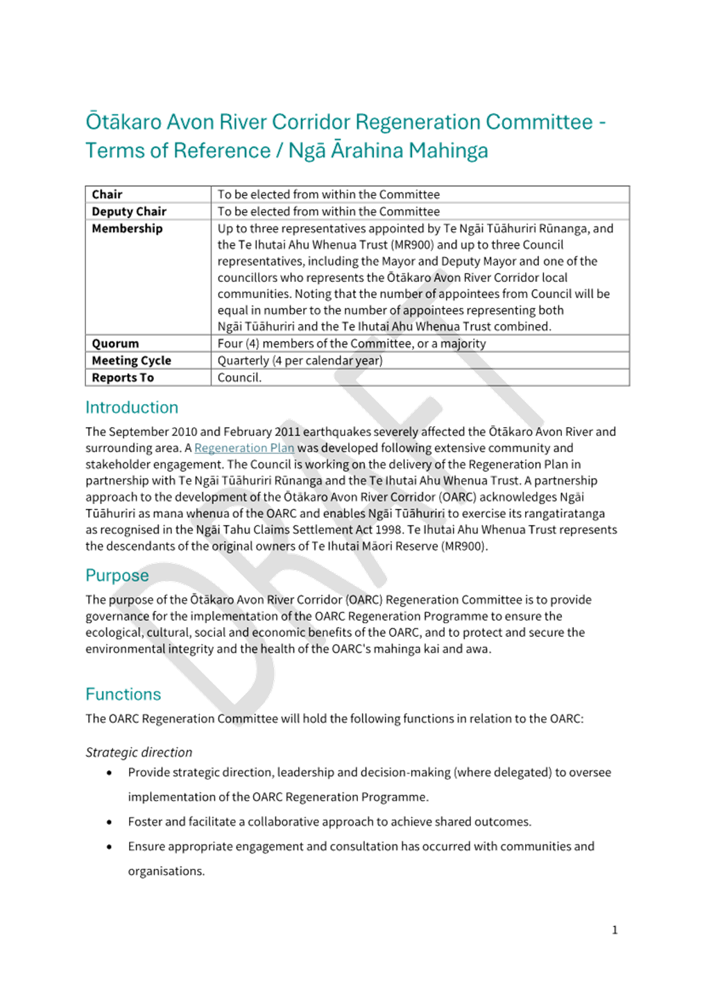
Membership
|
Chairperson
Deputy Chairperson
Members
|
Mayor Phil Mauger
Deputy Mayor Victoria Henstock
Councillor Kelly Barber
Councillor David Cartwright
Councillor Melanie Coker
Councillor Pauline Cotter
Councillor Celeste Donovan
Councillor Tyrone Fields
Councillor Tyla Harrison-Hunt
Councillor Nathaniel Herz Jardine
Councillor Yani Johanson
Councillor Aaron Keown
Councillor Sam MacDonald
Councillor Jake McLellan
Councillor Andrei Moore
Councillor Mark Peters
Councillor Tim Scandrett
|
27 February 2026
Website: www.ccc.govt.nz
TABLE OF CONTENTS NGĀ IHIRANGI
Karakia Tīmatanga................................................................. 5
1. Apologies Ngā Whakapāha.............................................. 5
2. Declarations of Interest Ngā Whakapuaki Aronga............. 5
Please note the Monthly
Report from the Community Boards will be considered between 9.30am and 10am.
Public
Participation and Presentation of Petitions will be considered from 10am.
3. Public
Participation Te Huinga
Tūmatanui....................... 5
3.1 Public Forum Te Huinga Whānui................................. 5
3.2 Deputations by
Appointment Ngā Huinga Whakaritenga............................................................. 6
4. Presentation
of Petitions Ngā
Pākikitanga....................... 6
5. Confirmation of Previous Minutes Te Whakaāe o te
hui o mua............................................................................... 6
Community Board Monthly
Reports
6. Monthly
Report from the Community Boards - February 2026...................................................... 25
Community Board Part A
Reports
7. Cashmere
- Penruddock Roundabout................... 103
Staff Reports
8. Hagley
Avenue - Clearway................................... 127
9. Pihipihi
Lane: Name Correction........................... 137
10. Bus stop
upgrades on Gloucester and St Asaph Streets............................................................... 141
11. Cathedral
Square Roading Network- Worcester Boulevard from Oxford Terrace to Cathedral
Square (Area 9B)............................................................ 151
12. Walking Access
Act 2008 - Request to be a Controlling Authority............................................................ 165
13. Environmental
Partnership Fund - Correction to report................................................................. 171
14. 2025/2026
Biodiversity Fund Allocation............... 173
15. 2025/26 Capital
Endowment Fund - March 2026.... 181
16. Discretionary
Response Fund March 2026............ 189
17. Ōtākaro
Avon River Corridor Regeneration Committee - draft Terms of Reference................. 195
18. Three Waters
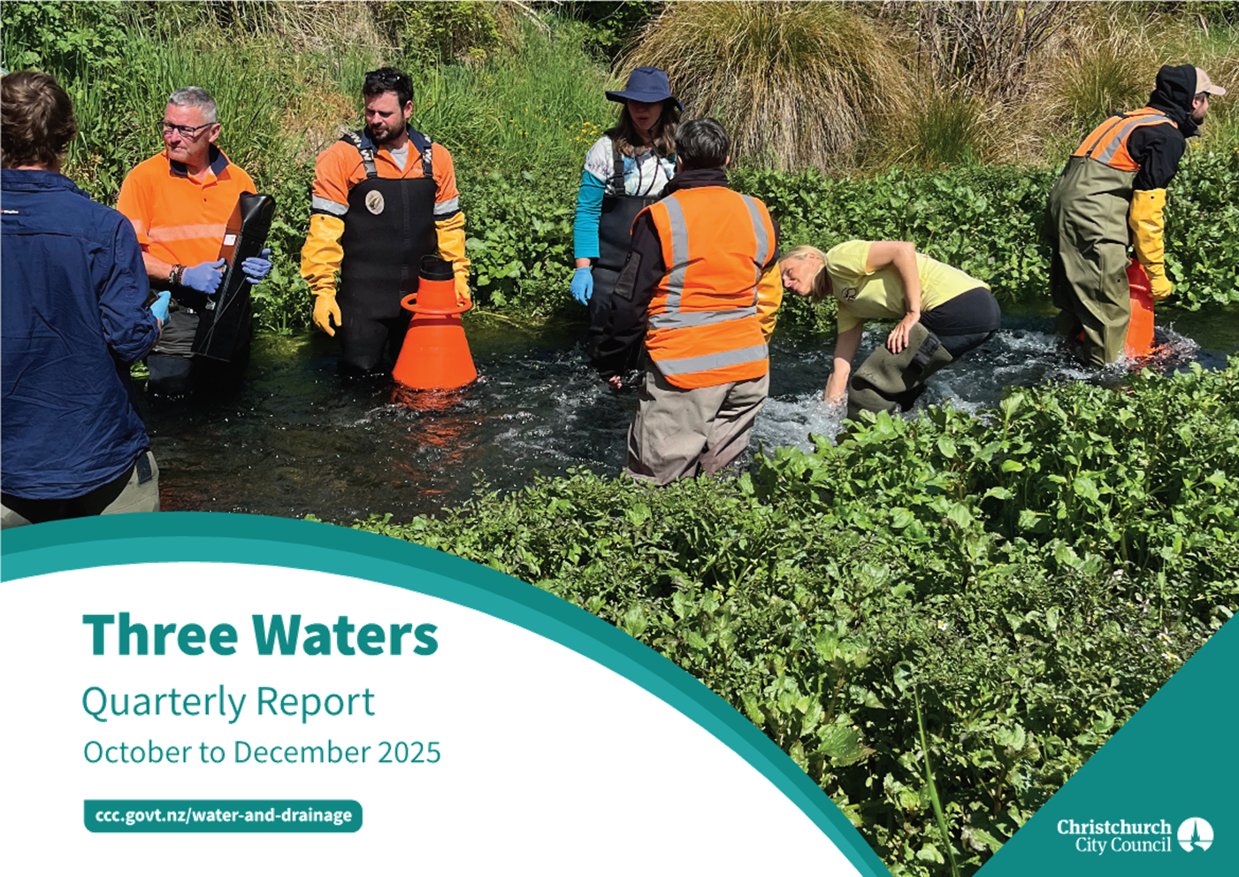
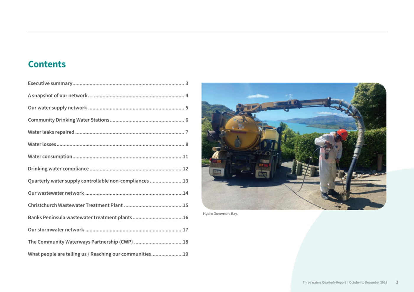
Quarterly Activities Update (October - December 2025).................................................. 209
Governance Items
19. Mayor's Monthly
Report...................................... 229
20. Notice of
Motion - Request for staff advice regarding protest free areas............................................... 237
21. Resolution to
Exclude the Public.......................... 239
Karakia Whakamutunga
Actions
Register Ngā Mahinga Tuwhera
Karakia Tīmatanga
Whakataka te hau ki te uru
Whakataka te hau ki te tonga
Kia mākinakina ki uta
Kia mātaratara ki tai
E hī ake ana te atakura
He tio, he huka, he hau hū
Tihei mauri ora
1. Apologies Ngā Whakapāha
Apologies will
be recorded at the meeting.
2. Declarations of Interest Ngā
Whakapuaki Aronga
Members are
reminded of the need to be vigilant and to stand aside from decision-making
when a conflict arises between their role as an elected representative and any
private or other external interest they might have.
Please note the Monthly Report from the Community Boards will
be considered between 9.30am and 10am.
Public Participation and Presentation of Petitions will be
considered from 10am.
3. Public Participation Te Huinga
Tūmatanui
3.1 Public Forum Te Huinga Whānui
A period of up to 30 minutes is available
for people to speak for up to five minutes on any issue that is not the subject
of a separate hearings process.
|
3.1.1
|
Stephen Wood
Stephen Wood will speak regarding
vulnerable road users.
|
|
3.1.2
|
Phillip Bates
Phillip Bates will speak regarding the
possible net benefit of large numbers of larval midges in the oxidation ponds.
|
|
3.1.3
|
Whaka-Ora Healthy Harbour
Co-Chair Yvette Couch will speak on
behalf of Whaka-Ora Healthy Harbour to update the Council on the Whaka-Ora
Healthy Harbour programme.
|
|
3.1.4
|
Rebecca Robin
Rebecca Robin will speak regarding
trauma-led emergency responses in Christchurch East, including Bromley,
Wainoni and Aranui, and evidence-based recommendations for strengthening
future emergency responses using Christchurch’s documented learnings,
national emergency management guidance, and Mātauranga Māori
frameworks.
|
|
3.1.5
|
Robina Dobbie and others
Robina Dobbie and other residents will
speak regarding the introduction of 5G and their concerns for
residents’ health.
|
3.2 Deputations by Appointment Ngā
Huinga Whakaritenga
Deputations may be heard on a matter, or
matters, covered by a report on this agenda and approved by the Chairperson.
Deputations
will be recorded in the meeting minutes.
4. Presentation of Petitions Ngā
Pākikitanga
There were no
Presentations of Petitions at the time the agenda was prepared.
To present to the Council, refer
to the Participating in decision-making webpage or
contact the meeting advisor listed on the front of this agenda.
5. Confirmation
of Previous Minutes Te Whakaāe o te hui o mua
That the
minutes of the Council meeting held on Wednesday, 4 February 2026 be
confirmed (refer page 7).

Christchurch City Council
Minutes
Date: Wednesday 4 February 2026
Time: 9.35 am
Venue: Camellia Chambers, Civic Offices,
53 Hereford Street, Christchurch
Present
|
Chairperson
Deputy Chairperson
Members
|
Mayor Phil Mauger
Deputy Mayor Victoria Henstock – partially
via audio/visual link
Councillor Kelly Barber
Councillor David Cartwright
Councillor Melanie Coker
Councillor Pauline Cotter
Councillor Celeste Donovan
Councillor Tyrone Fields
Councillor Tyla Harrison-Hunt
Councillor Nathaniel Herz Jardine
Councillor Yani Johanson
Councillor Aaron Keown
Councillor Sam MacDonald
Councillor Jake McLellan
Councillor Andrei Moore
Councillor Mark Peters
Councillor Tim Scandrett
|

Karakia Tīmatanga
The agenda was dealt with in the following
order. Where no voting record is shown, the item was carried unanimously by
those present.
Moments silence
The meeting held a moment’s silence
to acknowledge the passing of Nigel Harrison, Te Pātaka o
Rākaihautū Banks Peninsula Community Board Deputy Chair.
Councillor Barber
joined the meeting at 9.36 am.
1. Apologies
Ngā Whakapāha
|
Secretarial Note: The Mayor noted that Deputy Mayor Henstock joined the meeting via
audio/visual link and would be joining in person later in the meeting.
|
2. Declarations
of Interest Ngā Whakapuaki Aronga
There were no
declarations of interest recorded.
Councillor Cotter left the meeting at 9.40
am during consideration of Item 7.
Councillor McLellan joined the meeting at
9.41 am during consideration of Item 7.
Councillor Fields left the meeting at 9.44
am and returned at 9.46 am during consideration of Item 7.
Councillor Donovan left the meeting at
10.03 am and returned at 10.07 am during consideration of Item 7.
Councillor MacDonald left the meeting at
10.06 am and returned at 10.14 am during consideration of Item 7.
Deputy Mayor Henstock left the meeting via
audio/visual link at 10.08 am and returned at 10.09 am during consideration of
Item 7.
|
7. Monthly
Report from the Community Boards - December 2025
|
|
|
Lyn Leslie, Chairperson, and Penelope
Goldstone, Community Governance Manager, joined the meeting for presentation
of the Te Pātaka o
Rākaihautū Banks Peninsula Community Board area report.
Keir Leslie,
Chairperson, joined the meeting for presentation of the Waihoro Spreydon-Cashmere-Heathcote
Community Board area
report.
Jason
Middlemiss, Chairperson, and Nicola McCormick, Deputy Chair, joined the
meeting for presentation of the Waimāero Fendalton-Waimairi-Harewood Community Board area report.
Simon Britten, Deputy Chairperson, Emma
Pavey, Community Governance Manager, joined the meeting for presentation of
the Waipapa
Papanui-Innes-Central Community Board area report.
Marie Pollisco, Chairperson, and Sarah
Brunton, Deputy Chairperson, joined the meeting for presentation of the Waipuna Halswell-Hornby-Riccarton
Community Board area
report.
Jackie Simons, Deputy Chairperson, and
Chris Turner-Bullock, Community Governance Manager, joined the meeting for
presentation of the Waitai
Coastal-Burwood-Linwood Community Board area report.
|
|
|
Council Resolved CNCL/2026/00007
Officer Recommendation accepted without
change
That the Council:
1. Receives the information in the Monthly
Report from the Community Boards - December 2025 Report.
Mayor/Councillor
McLellan Carried
|
For
|
16
|
Councillor Barber, Councillor
Cartwright, Councillor Coker, Councillor Donovan, Councillor Fields,
Councillor Harrison-Hunt, Councillor Herz Jardine, Councillor Johanson,
Councillor Keown, Councillor MacDonald, Councillor McLellan, Councillor
Moore, Councillor Peters, Councillor Scandrett, Deputy Mayor Henstock,
Mayor Mauger
|
|
Against
|
0
|
|
|
Abstain
|
0
|
|
|
TOTAL
|
16
|
|
|
|
|
|
Absent
|
1
|
Councillor Cotter
|
|
|
|
Attachments
a Te
Pātaka o Rākaihautū Banks Peninsula Community Board -
Presentation to Council
b Waihoro
Spreydon-Cashmere-Heathcote Community Board - Presentation to Council
c Waimāero
Fendalton-Waimairi-Harewood Community Board - Presentation to Council
d Waipapa
Papanui-Innes-Central Community Board - Presentation to Council
e Waipuna
Halswell-Hornby-Riccarton Community Board - Presentation to Council
f Waitai
Coastal-Burwood-Linwood Community Board - Presentation to Council
|
3. Public
Participation Te Huinga Tūmatanui
3.2 Deputations by Appointment Ngā Huinga Whakaritenga
There were no
deputations by appointment.
4. Presentation
of Petitions Ngā Pākikitanga
|
4.1
|
Daniel O’Meara presented a petition
regarding ticketed events at Cathedral Square.
Whereas Cathedral Square has been
hired out to private event organisers on no less than eight occasions since
2023, and
Whereas the Christchurch City Council
has, in April of 2025, stated their intention to continue hiring out
Cathedral Square for concerts and other private, ticketed events, thereby
depriving the Christchurch public, at those times, of the right to use their
own town square, and
Whereas the Christchurch City Council
has further stated the intention to rent out Cathedral Square for private use
on as many as 120 days in the year, and
Whereas these concerts and other
private, ticketed events can perfectly well be held in Hagley Park, as they
have been in the past,
Therefore, we the undersigned, being
qualified electors of the city of Christchurch, petition the Christchurch
City Council to pass the following resolution:
That Cathedral Square shall once more
be designated as a space principally for public and civic use; that the
Christchurch City Council will cease to hire out Cathedral Square to private
organisations for exclusive, ticketed events; that Cathedral Square may not
be fenced off or closed to the public except for legitimate construction
purposes, for cleaning, or in case of emergency; that, should such an
emergency arise, an official public consultation on the measure will be
launched either immediately or as soon as practically possible; and that,
under ordinary circumstances, Cathedral Square is to be fenced off for
cleaning on no more than four days per year, these being weekdays, and the
time of closure falling between 10pm and 6am.
|
|
|
|
Attachments
a Daniel
O'Meara Petition - Presentation to Council
b Daniel
O'Meara - Presentation to Council
|
Councillor
Cotter returned at 10.35 am during consideration of Item 3.1.1.
3.1 Public Forum Te Huinga Whānui
|
3.1.1
|
Graham Sattler
Graham
Sattler and Hye-Won Suh (Principal Flute player) spoke on behalf of
Christchurch Symphony Orchestra regarding the Christchurch Symphony
Orchestra's direct and indirect value to the community.
|
|
|
|
Attachments
a Graham
Sattler - Presentation to Council
|
|
3.1.2 Graham Townsend
|
|
Graham Townsend spoke
on behalf of Climate Action Ōtautahi regarding Item 15 - Endorsing the
Fossil Fuel Treat Notice of Motion.
|
|
|
|
Attachments
a Graham
Townsend - Presentation to Council
|
Councillor
Barber left the meeting at 10.45 am during consideration of Item 3.1.3.
|
3.1.3 Gur Preet
|
|
Gur Preet spoke
regarding the Wastewater Treatment Plant.
|
|
|
Councillor
Barber returned at 10.47 am during consideration of Item 3.1.4.
|
3.1.4 Rebecca Robin
|
|
Rebecca Robin spoke
regarding the Wastewater Treatment Plant.
|
|
|
|
3.1.5 Kelly Gibson
|
|
Councillor Johanson
read, on behalf of Kelly Gibson, her speech regarding the Wastewater
Treatment Plant.
|
|
|
|
3.1.7 Ashley Campbell
|
|
Ashley Campbell spoke on behalf of her
Christchurch North East/Ōrei constituents, regarding the Wastewater
Treatment Plant.
|
|
|
Councillor
Donovan left the meeting during consideration of Item 5.
|
5. Council
Minutes - 21 January 2026
|
|
|
Council Resolved CNCL/2026/00008
That the Council confirms the Open and
Public Excluded Minutes (Item 18) from the Council meeting held 21 January
2026.
Mayor/Councillor
Keown Carried
|
|
6. Canterbury
Regional Landfill Joint Committee Minutes - 15 December 2025
|
|
|
Council Resolved CNCL/2026/00009
That the Council receives the Open and
Public Excluded Minutes (Item 19) from the Canterbury Regional Landfill Joint
Committee meeting held 15 December 2025.
Mayor/Councillor
Keown Carried
|
|
Report from Waimāero Fendalton-Waimairi-Harewood
Community Board - 8 December 2025
|
|
8. Dedication
of Local Purpose Reserve (Road) 3 R Tulett Park Drive Casebrook
|
|
|
Council Resolved CNCL/2026/00010
Community Board Recommendations accepted without
change
That the
Council:
1. Receives the information in the Dedication of Local
Purpose Reserve (Road) 3 R Tulett Park Drive Casebrook Report.
2. Notes that the decision in this report is
assessed as low significance based on the Christchurch City Council’s
Significance and Engagement Policy.
3. Resolves pursuant to Section 111 of the
Reserves Act 1977 to dedicate the Local Purpose Reserve (Road) containing
203m² described as 3R Tulett Park Drive Lot 160 DP 499649 Certificate of
Title 768569 as road.
4. Authorises the Manager Property
Consultancy to take all steps necessary to complete all necessary
documentation to conclude the dedication of Lot 160 DP 499649 Certificate of
Title 768569 as road.
Councillor
Keown/Mayor Carried
|
For
|
16
|
Councillor Barber, Councillor
Cartwright, Councillor Coker, Councillor Cotter, Councillor Fields,
Councillor Harrison-Hunt, Councillor Herz Jardine, Councillor Johanson,
Councillor Keown, Councillor MacDonald, Councillor McLellan, Councillor
Moore, Councillor Peters, Councillor Scandrett, Deputy Mayor Henstock,
Mayor Mauger
|
|
Against
|
0
|
|
|
Abstain
|
0
|
|
|
TOTAL
|
16
|
|
|
|
|
|
Absent
|
1
|
Councillor Donovan
|
|
|
Report from Waipuna Halswell-Hornby-Riccarton Community
Board - 11 December 2025
|
|
9. Waipuna
Halswell Hornby Riccarton Community Board: Representation on Committees and
External Organisations, 2025–2028
|
|
|
Council Resolved CNCL/2026/00011
Community Board Recommendation accepted without
change
That the
Council:
1. Appoints Cody Cooper to the Ruapuna Community Liaison Committee.
Councillor
Peters/Mayor Carried
|
For
|
16
|
Councillor Barber, Councillor
Cartwright, Councillor Coker, Councillor Cotter, Councillor Fields,
Councillor Harrison-Hunt, Councillor Herz Jardine, Councillor Johanson,
Councillor Keown, Councillor MacDonald, Councillor McLellan, Councillor
Moore, Councillor Peters, Councillor Scandrett, Deputy Mayor Henstock,
Mayor Mauger
|
|
Against
|
0
|
|
|
Abstain
|
0
|
|
|
TOTAL
|
16
|
|
|
|
|
|
Absent
|
1
|
Councillor Donovan
|
|
|
Report from Waitai Coastal-Burwood-Linwood Community
Board - 8 December 2025
|
|
10. Burwood
& Mairehau intersection improvements
|
|
|
Council Resolved CNCL/2026/00012
Community Board Recommendations accepted without
change
Signalised
intersection
That the
Council:
1. Approves that in accordance with Sections 6 and 10.5 of the Land
Transport Rule: Traffic Control Devices 2004, all traffic movements at the
Burwood Road and Mairehau Road intersection be controlled by Traffic Signals
as detailed on plan TP361401, sheet 1, dated 12/08/2025, and attached to this
report as Attachment C.
Special Vehicle
Lanes
2. Revokes any previous resolutions pertaining to special vehicle
lanes made pursuant to any Bylaw to the extent that they are in conflict with
the special vehicle lanes described in recommendations 3 - 10.
3. Approves that a special vehicle lane in accordance with Clause 18
of the Christchurch City Council Traffic & Parking Bylaw 2017, for the
use of northbound road users as defined in Section 11.1A of the Land
Transport (Road User) Rule: 2004, excepting pedestrians and riders of
mobility devices, be installed on the west side of Burwood Road, commencing
at its intersection with Mariehau Road and extending in a northerly direction
for a distance of approximately 186 metres, as detailed in plans TP364801,
and TP364802 dated 12/08/2025 and attached to this report as Attachment B
and Attachment C.
4. Approves that a special vehicle lane in accordance with Clause 18
of the Christchurch City Council Traffic & Parking Bylaw 2017, for the
use of southbound road users as defined in Section 11.1A of the Land
Transport (Road User) Rule: 2004, excepting pedestrians and riders of
mobility devices, be installed on the east side of Burwood Road, commencing
at a point approximately 207 metres north of its intersection with Mariehau
Road and extending in a southerly direction until its intersection with Mairehau
Road as detailed in plans TP364801, and TP364802 dated 12/08/2025 and
attached to this report as Attachment B and Attachment C.
5. Approves that a special vehicle lane in accordance with Clause 18
of the Christchurch City Council Traffic & Parking Bylaw 2017, for the
use of eastbound road users as defined in Section 11.1A of the Land Transport
(Road User) Rule: 2004, excepting pedestrians and riders of mobility devices,
be installed on the north side of Mairehau Road, commencing at its
intersection with Burwood Road and extending in a easterly direction for a
distance of approximately 22 metres as detailed in plan TP364801, dated 12/08/2025
and attached to this report as Attachment C.
6. Approves that a special vehicle lane in accordance with Clause 18
of the Christchurch City Council Traffic & Parking Bylaw 2017, for the
use of westbound road users as defined in Section 11.1A of the Land Transport
(Road User) Rule: 2004, excepting pedestrians and riders of mobility devices,
be installed on the south side of Mairehau Road, commencing at a point
approximately 90 metres east of its intersection with Burwood Road and
extending in a westerly direction for a until its intersection with Burwood Road
as detailed in plan TP364801, dated 12/08/2025 and attached to this report as
Attachment C.
7. Approves that a special vehicle lane in accordance with Clause 18
of the Christchurch City Council Traffic & Parking Bylaw 2017, for the
use of westbound road users as defined in Section 11.1A of the Land Transport
(Road User) Rule: 2004, excepting pedestrians and riders of mobility devices,
be installed on the south side of Mairehau Road, commencing at its
intersection with Burwood Road and extending in a westerly direction until
its intersection with Greenhaven Drive, as detailed in plan TP364801, dated 12/08/2025
and attached to this report as Attachment C.
8. Approves that a special vehicle lane in accordance with Clause 18
of the Christchurch City Council Traffic & Parking Bylaw 2017, for the
use of eastbound road users as defined in Section 11.1A of the Land Transport
(Road User) Rule: 2004, excepting pedestrians and riders of mobility devices,
be installed on the north side of Mairehau Road, commencing at a point
approximately 88 metres west of its intersection with Burwood Road and
extending in an easterly direction until its intersection with Burwood Road as
detailed in plan TP364801, dated 12/08/2025 and attached to this report as Attachment
C.
9. Approves that a special vehicle lane in accordance with Clause 18
of the Christchurch City Council Traffic & Parking Bylaw 2017, for the
use of westbound road users as defined in Section 11.1A of the Land Transport
(Road User) Rule: 2004, excepting pedestrians and riders of mobility devices,
be installed on the south side of Mairehau Road, commencing at its
intersection with Burwood Road and extending in a westerly direction until
its intersection with Greenhaven Drive, as detailed in plan TP364801, dated 12/08/2025
and attached to this report as Attachment C.
10. Approves that a special vehicle lane in accordance with Clause 18
of the Christchurch City Council Traffic & Parking Bylaw 2017, for the
use of eastbound road users as defined in Section 11.1A of the Land Transport
(Road User) Rule: 2004, excepting pedestrians and riders of mobility devices,
be installed on the north side of Mairehau Road, commencing at a point
approximately 88 metres west of its intersection with Burwood Road and
extending in an easterly direction until its intersection with Burwood Road, as
detailed in plan TP364801, dated 12/08/2025 and attached to this report as Attachment
C.
Councillor
Barber/Mayor Carried
|
For
|
15
|
Councillor Barber, Councillor
Cartwright, Councillor Coker, Councillor Fields, Councillor Harrison-Hunt,
Councillor Herz Jardine, Councillor Johanson, Councillor Keown, Councillor
MacDonald, Councillor McLellan, Councillor Moore, Councillor Peters, Councillor
Scandrett, Deputy Mayor Henstock, Mayor Mauger
|
|
Against
|
1
|
Councillor Cotter
|
|
Abstain
|
0
|
|
|
TOTAL
|
16
|
|
|
|
|
|
Absent
|
1
|
Councillor Donovan
|
|
|
11. Submission
on Proposed Rates Cap Model
|
|
|
Council Resolved CNCL/2026/00013
Officer Recommendations accepted without
change
That the
Council:
1. Receives the information in the Submission
on Proposed Rates Cap Model report.
2. Notes that the decision in this report is assessed as low
significance based on the Christchurch City Council’s Significance and
Engagement Policy.
3. Approves the Christchurch City Council submission on the rates
target model for New Zealand (Attachment A) to be submitted to the Department
of Internal Affairs.
4. Approves the Chief Executive to make minor edits to the submission
on the rates target model for New Zealand for consistency and accuracy prior
to its submission to the Department of Internal Affairs.
Mayor/Councillor
Harrison-Hunt Carried
|
For
|
16
|
Councillor Barber, Councillor
Cartwright, Councillor Coker, Councillor Cotter, Councillor Fields,
Councillor Harrison-Hunt, Councillor Herz Jardine, Councillor Johanson,
Councillor Keown, Councillor MacDonald, Councillor McLellan, Councillor
Moore, Councillor Peters, Councillor Scandrett, Deputy Mayor Henstock,
Mayor Mauger
|
|
Against
|
0
|
|
|
Abstain
|
0
|
|
|
TOTAL
|
16
|
|
|
|
|
|
Absent
|
1
|
Councillor Donovan
|
|
Councillor Donovan returned at 11.23 am
during consideration of Item 12.
|
12. Canterbury
Local Authorities’ Triennial Agreement 2025-2028
|
|
|
Council Resolved CNCL/2026/00014
Officer Recommendations accepted without
change
That the
Council:
1. Receives the information in the Canterbury
Local Authorities’ Triennial Agreement 2025-2028 Report.
2. Notes that the decision in this report is assessed as low
significance based on the Christchurch City Council’s Significance and
Engagement Policy.
3. Ratifies the Canterbury Local Authorities’ Triennial
Agreement for 2025-2028 and notes that the Agreement will be updated when the
anticipated change in statutory purpose is enacted (Attachment A of
this report).
Councillor
MacDonald/Councillor Peters Carried
|
For
|
14
|
Councillor Barber, Councillor
Cartwright, Councillor Cotter, Councillor Donovan, Councillor Fields,
Councillor Harrison-Hunt, Councillor Keown, Councillor MacDonald,
Councillor McLellan, Councillor Moore, Councillor Peters, Councillor
Scandrett, Deputy Mayor Henstock, Mayor Mauger
|
|
Against
|
2
|
Councillor Coker, Councillor Johanson
|
|
Abstain
|
1
|
Councillor Herz Jardine
|
|
TOTAL
|
17
|
|
|
|
13. Environmental
Partnership Fund
|
|
|
Council Resolved CNCL/2026/00015
Officer Recommendations accepted without
change
That the
Council:
1. Receives the information in the Environmental Partnership Fund
Report.
2. Notes that the decision in this report is assessed as low
significance based on the Christchurch City Council’s Significance and
Engagement Policy.
3. Notes that $469,840 has been granted to date via a non-contestable
process.
4. Approves the recommended allocations from the 2025/26
Environmental Partnership Fund amounting to $443,033 as detailed below:
|
Organisation
|
Project Name
|
Amount Recommended
|
|
Richmond
Community Garden Trust
|
Riverlution Biodiversity Resilience
Project
|
$18,000
|
|
Opāwaho
Heathcote River Network Incorporated
|
Predator Free
Opāwaho and Community Group Support
|
$67,000
|
|
Friends of
Coronation Reserve
|
Coronation
Reserve biodiversity enhancement
|
$32,580
|
|
New Zealand
Conservation Trust
|
Redwood Stream
Trapping Project
|
$4,781
|
|
The Living
Memorial Trust
|
The
Ōtukaikino Wildlife Management Reserve Restoration Project
|
$35,000
|
|
The Green Lab
|
Rāwhiti
Domain
|
$4,000
|
|
Living Springs
Trust
|
Living Springs
Ecological Restoration
|
$52,995
|
|
Banks
Peninsula Conservation Trust
|
Kaituna
Community Weeding
|
$15,000
|
|
Redcliffs
Residents Association
|
Regreening
Barnett Park/Te Awakura Valley
|
$8,650
|
|
Styx Living
Laboratory Trust
|
Pūharakekenui
Styx River Catchment Enhancement Planting
|
$20,000
|
|
Avon
Ōtākaro Network Inc
|
Avon
Ōtākaro Network catchment wide restoration and community
engagement
|
$30,000
|
|
The Little
River Wairewa Community Trust
|
Wairewa
Weedbusters
|
$20,000
|
|
Predator
FreeNB/Coastal Kaitiaki
|
Predator Free
NB/Coastal Kaitaiki
|
$10,000
|
|
Te Hapū o
Ngāti Wheke Inc
|
Rāpaki ki
uta ki tai
|
$54,700
|
|
Witch-Hazel
McAlister
|
Okuti Reserve
Education Trail
|
$14,327
|
|
Taumutu
Runanga Limited
|
Whakaora Te
Muriwai o Whata (The Restoration of Muriwai o Whata/Coopers Lagoon
|
$50,000
|
|
Takamatua
Ratepayers Association
|
Takamatua
Stream Esplanade Reserve restoration
|
$6,000
|
|
Total
|
|
$443,033
|
Secretarial Note: Attachment A omitted specifying the allocation of $650 for the
Redcliffs Residents Association newsletters. This omission does not change
the total grant amount of $8,650.
5. Approves the recommended allocations from the 2026/27 and 2027/28
Environmental Partnership Fund amounting to $214,000 detailed below noting
that allocation of these funds is subject to future Annual and Long-Term Plan
adoptions.
|
Organisation
|
Project Name
|
Amount Recommended
|
|
Richmond
Community Garden Trust
|
Riverlution Biodiversity Resilience
Project
|
2026/27 - $19,000
|
|
Banks
Peninsula Conservation Trust
|
Kaituna
Community Weeding
|
2026/27 - $10,000
2027/28 - $5,000
|
|
Styx Living
Laboratory Trust
|
Pūharakekenui
Styx River Catchment Enhancement Planting
|
2026/27 $20,000
|
|
Avon
Ōtākaro Network Inc
|
Avon
Ōtākaro Network catchment wide restoration and community
engagement
|
2026/27 - $30,000
2027/28 - $30,000
|
|
Taumutu
Runanga Limited
|
Whakaora Te
Muriwai o Whata (The Restoration of Muriwai o Whata/Coopers Lagoon
|
2026/27 - $50,000
2027/28 - $50,000
|
|
Total
|
|
$214,000
|
6. Adopts the staff recommendation to decline the applications for
the Environmental Partnerships Fund as detailed below:
|
Organisation
|
Project Name
|
Amount
|
Rationale for decline
|
|
New Zealand Chinese
Creative
Arts and Culture Troupe
Incorporated
|
Volunteer
Beach and Community Cleanup
|
$0
|
Project can be completed without funding
|
|
Cultivate
Christchurch
|
Cultivate
Explore
|
$0
|
Did not meet partnering criteria as per the TOR
|
|
Tegan Mackay
|
Swant’some:Caterpillars
to Classrooms
|
$0
|
Not an incorporated society
|
|
Sea Cleaners
|
Restoring the
mauri of Banks Peninsula’s coastline together
|
$0
|
Did not meet partnering criteria as per the TOR
|
|
Te Hapū o
Ngāti Wheke Inc
|
460 Governors
Bay Road Project
|
$0
|
Terms of Reference allow only one project to be
funded per group and the other project was higher priority
|
|
The Royal New
Zealand Society for the Prevention of Cruelty to Animals
|
Animal
Desexing to Help Protect the Taonga Species of Christchurch and Banks
Peninsula
|
$0
|
Did not meet partnering criteria as per the TOR
|
|
Food
Resilience Network Inc
|
Nature Works:
Exploring Green Infrastructure at Ōtākaro Orchard
|
$0
|
Already funded from a different Council source
|
Councillor
Scandrett/Councillor Cotter Carried
|
For
|
17
|
Councillor Barber, Councillor
Cartwright, Councillor Coker, Councillor Cotter, Councillor Donovan,
Councillor Fields, Councillor Harrison-Hunt, Councillor Herz Jardine,
Councillor Johanson, Councillor Keown, Councillor MacDonald, Councillor
McLellan, Councillor Moore, Councillor Peters, Councillor Scandrett, Deputy
Mayor Henstock, Mayor Mauger
|
|
Against
|
0
|
|
|
Abstain
|
0
|
|
|
TOTAL
|
17
|
|
|
The meeting adjourned at 11.27 am and
reconvened at 11.47 am. Upon reconvening, Deputy Mayor Henstock joined the
meeting in person.
|
14. Notice of
Motion - Investigation into the viability of a clearway on Memorial Avenue
|
|
|
Council Resolved CNCL/2026/00016
Councillor Recommendations accepted
without change
That the Council:
1. Requests staff to hold a workshop with the Waimāero
Fendalton-Waimairi-Harewood Community Board as early as possible within the
first half of 2026 regarding the viability of establishing a clearway on
Memorial Avenue between Greers Road and Clyde Road to:
a. Develop a shared understanding of the issues, potential options,
and associated trade‑offs.
b. Enable staff to provide a more accurate estimate of workload,
costs, and impacts.
c. Ensure any potential project can be considered as part of
Long-Term Plan deliberations.
2. Requests staff to rename, rescope and initiate capital project
#75070 Memorial Avenue Cycle Lanes to include changes to the section of
Memorial Avenue, enabling a more comprehensive assessment of effective and
efficient options and wider network impacts.
Councillor
Cartwright/Mayor Carried
|
For
|
17
|
Councillor Barber, Councillor
Cartwright, Councillor Coker, Councillor Cotter, Councillor Donovan,
Councillor Fields, Councillor Harrison-Hunt, Councillor Herz Jardine,
Councillor Johanson, Councillor Keown, Councillor MacDonald, Councillor
McLellan, Councillor Moore, Councillor Peters, Councillor Scandrett, Deputy
Mayor Henstock, Mayor Mauger
|
|
Against
|
0
|
|
|
Abstain
|
0
|
|
|
TOTAL
|
17
|
|
|
|
15. Notice of
Motion - Endorsing the Fossil Fuel Non-Proliferation Treaty Initiative
|
|
|
Council Resolved CNCL/2026/00017
Councillor Recommendations accepted
without change
That the Council:
1. Endorses the Fossil Fuel Non-Proliferation Treaty initiative which
includes the following three pillars:
a. “Non-Proliferation: Developing the plan that would allow
governments to stop building out the problem by ending the expansion of coal,
oil and gas production”.
b. “A fair phase-out: An equitable plan for the wind down of
existing fossil fuel production, where nations with the capacity and
historical responsibility for emissions transition fastest, providing support
to others around the world”.
c. “Just Transition: Fast track the adoption of renewable
energy and economic diversification away from fossil fuels so that no worker,
community or country is left behind”.
2. Agrees for the Christchurch City Council to be registered as an
endorser to the Fossil Fuel Non-Proliferation Treaty initiative on the Treaty
website: www.fossilfueltreaty.org
Councillor
Coker/Councillor Cotter Carried
|
For
|
9
|
Councillor Coker, Councillor Cotter,
Councillor Donovan, Councillor Fields, Councillor Harrison-Hunt, Councillor
Herz Jardine, Councillor Johanson, Councillor McLellan, Councillor Moore
|
|
Against
|
8
|
Councillor Barber, Councillor
Cartwright, Councillor Keown, Councillor MacDonald, Councillor Peters,
Councillor Scandrett, Deputy Mayor Henstock, Mayor Mauger
|
|
Abstain
|
0
|
|
|
TOTAL
|
17
|
|
|
|
16. Mayor's
Monthly Report
|
|
|
Council Resolved CNCL/2026/00018
Mayor’s Recommendation accepted
without change
That the Council:
1. Receives the information in this report.
Mayor/Deputy
Mayor Carried
|
For
|
17
|
Councillor Barber, Councillor
Cartwright, Councillor Coker, Councillor Cotter, Councillor Donovan,
Councillor Fields, Councillor Harrison-Hunt, Councillor Herz Jardine,
Councillor Johanson, Councillor Keown, Councillor MacDonald, Councillor
McLellan, Councillor Moore, Councillor Peters, Councillor Scandrett, Deputy
Mayor Henstock, Mayor Mauger
|
|
Against
|
0
|
|
|
Abstain
|
0
|
|
|
TOTAL
|
17
|
|
|
|
17. Resolution
to Exclude the Public Te whakataunga kaupare hunga tūmatanui
|
|
|
Council Resolved CNCL/2026/00019
That at 12.16 pm the resolution to exclude the public set out on
pages 217 to 218 of the agenda be adopted
Mayor/Councillor
Cotter Carried
|
The public were re-admitted to the meeting
at 12.34 pm.
Karakia
Whakamutunga
Meeting
concluded at 12.35 pm.
CONFIRMED THIS 4TH DAY OF MARCH 2026.
Mayor Phil Mauger
Chairperson
|
6. Monthly
Report from the Community Boards - February 2026
|
|
Reference Te Tohutoro:
|
26/369822
|
|
Report of Te Pou Matua:
|
The
Chairpersons of all Community Boards
|
|
Accountable ELT Member Pouwhakarae:
|
Andrew
Rutledge, General Manager Citizens and Community
|
1. Purpose and Origin of the Report Te
Pūtake Pūrongo
1.1 The
purpose of this report is to provide the Council with an overview of
initiatives and issues recently considered by the Community Boards. This
report attaches the most recent Community Board Area Report included in each
Board's public meeting. Please see the individual agendas for the attachments
to each report.
1.2 Each
Board will present important matters from their respective areas during the
consideration of this report and these presentations will be published with the
Council minutes after the meeting.
2. Community Board Recommendations Ngā Tūtohu a te Poari
Hapori
That the Council:
1. Receives the information in the Monthly Report from the Community Boards -
February 2026 Report.
Attachments Ngā Tāpirihanga
|
No.
|
Title
|
Reference
|
Page
|
|
a ⇩ 
|
Waipapa
Papanui-Innes-Central Community Board Area Report February 2026
|
26/370099
|
26
|
|
b ⇩
|
Waihoro
Spreydon-Cashmere-Heathcote Community Board Area Report February 2026
|
26/370117
|
43
|
|
c ⇩
|
Waimāero
Fendalton-Waimairi-Harewood Community Board Area Report February 2026
|
26/370106
|
58
|
|
d ⇩
|
Waipuna
Halswell-Hornby-Riccarton Community Board Area Report February 2026
|
26/370077
|
67
|
|
e ⇩
|
Waitai
Coastal-Burwood-Linwood Community Board Area Report Februrary 2026
|
26/370149
|
76
|
|
f ⇩
|
Te Pātaka
o Rākaihautū Banks Peninsula Community Board Area Report February
2026
|
26/370125
|
95
|
Report from Waihoro Spreydon-Cashmere-Heathcote Community Board – 12
February 2026
|
7. Cashmere
- Penruddock Roundabout
|
|
Reference Te Tohutoro:
|
26/308731
|
|
Responsible Officer(s) Te Pou Matua:
|
Peter
Rodgers, Transport Network Planner
|
|
Accountable ELT Member Pouwhakarae:
|
Brent
Smith, General Manager City Infrastructure
|
|
1. Waihoro Spreydon-Cashmere-Heathcote
Community Board Consideration Te
Whaiwhakaarotanga
|
|
|
1. The
Board took into consideration the deputations at Items 6.1 and 6.2 and
relevant correspondence in Item 8.
2. Council
Officers Jacob Bradbury, Peter Rodgers and Weng-Kei Chen joined the table to
speak to this Item and answered questions from elected members.
3. Council
Officers presented the image in Attachment A (tabled) to explain safe driving
speeds of the proposed roading layout.
4. Melanie Coker then Moved Option 2 from the
agenda report, to approve the proposed roundabout layout and traffic control
devices with speed humps on the approaches and exits from the roundabout
(Attachment B to the report on the meeting agenda). This was seconded by Kate
Hodgins.
5. Will
Hall then Moved a Foreshadowed Motion to approve a variation of Option 1 from
the agenda report with one speed hump on the northbound entry lane for the
new subdivision road. This was seconded by Nathaniel Herz Jardine.
6. At
conclusion of debate, the Board voted on the Motion as Moved by Melanie Coker and was declared carried.
|
|
2. Waihoro Spreydon-Cashmere-Heathcote Community Board Recommendation to Council
|
|
|
That the Council:
1. Receives the information in the Cashmere - Penruddock Roundabout Report.
2. Notes that the decision in this report is
assessed as low significance based on the Christchurch City Council’s Significance and
Engagement Policy.
3. Approves that a special vehicle lane in
accordance with Clause 18 of the Christchurch City Council Traffic &
Parking Bylaw 2017, for the use of westbound road users as defined in Section
11.1A of the Land Transport (Road User) Rule: 2004, excepting pedestrians and
riders of mobility devices, be installed on the south side of Cashmere Road,
commencing at a point approximately 166 metres east of its intersection with Penruddock Rise and extending in a westerly direction for
126 metres, as detailed on Attachment B to the report on the meeting agenda.
4. Approves that a special vehicle lane in
accordance with Clause 18 of the Christchurch City Council Traffic &
Parking Bylaw 2017, for the use of southbound road users as defined in
Section 11.1A of the Land Transport (Road User) Rule: 2004, excepting pedestrians
and riders of mobility devices, be installed on the east side of Penruddock Rise, commencing at a point approximately 21 metres south
of its intersection with Cashmere Road and extending in an southerly
direction for a distance of 10 metres, as detailed on Attachment B to the report on the meeting agenda.
5. Approves that a special vehicle lane in
accordance with Clause 18 of the Christchurch City Council Traffic &
Parking Bylaw 2017, for the use of northbound road users as defined in
Section 11.1A of the Land Transport (Road User) Rule: 2004, excepting pedestrians
and riders of mobility devices, be installed on the west side of Penruddock Rise, commencing at a point approximately 33 metres south
of its intersection with Cashmere Road and extending in a northerly direction
for a distance of 10 metres, as detailed on Attachment B to the report on the meeting agenda.
6. Approves that a special vehicle lane in
accordance with Clause 18 of the Christchurch City Council Traffic &
Parking Bylaw 2017, for the use of westbound road users as defined in Section
11.1A of the Land Transport (Road User) Rule: 2004, excepting pedestrians and
riders of mobility devices, be installed on the south side of Cashmere Road, commencing at a point approximately 31 metres west of its intersection with
Brookford Place and extending
in an easterly direction for a distance of 74 metres, as detailed on Attachment
B to the report on the
meeting agenda.
7. Approves that a special vehicle lane in
accordance with Clause 18 of the Christchurch City Council Traffic &
Parking Bylaw 2017, for the use of eastbound road users as defined in Section
11.1A of the Land Transport (Road User) Rule: 2004, excepting pedestrians and
riders of mobility devices, be installed on the north side of Cashmere Road, commencing at a point approximately 31 metres west of the prolongation of the western kerb line of its intersection with Brookford Place and extending in an easterly direction for
a distance of 76 metres, as detailed on Attachment B to the report on the meeting agenda.
8. Approves that a special vehicle lane in
accordance with Clause 18 of the Christchurch City Council Traffic &
Parking Bylaw 2017, for the use of eastbound road users as defined in Section
11.1A of the Land Transport (Road User) Rule: 2004, excepting pedestrians and
riders of mobility devices, be installed on the north side of Cashmere Road, commencing at a point approximately 39 metres east of
the prolongation of the eastern kerb line of Penruddock Rise and extending in
an easterly direction for a distance of 127 metres, as detailed on Attachment
B to the report on the
meeting agenda.
|
|
3. Officer Recommendations Ngā Tūtohu
|
|
|
That the Waihoro
Spreydon-Cashmere-Heathcote Community Board recommends that the Council:
1. Receives the information in the Cashmere -
Penruddock Roundabout Report.
2. Notes that the decision in this report is assessed as low
significance based on the Christchurch City
Council’s Significance and Engagement Policy.
3. Approves that a special vehicle lane in accordance with Clause 18
of the Christchurch City Council Traffic & Parking Bylaw 2017, for the
use of westbound road users as defined in Section 11.1A of the Land Transport
(Road User) Rule: 2004, excepting pedestrians and riders of mobility devices,
be installed on the south side of Cashmere Road, commencing at a point
approximately 166 metres east of its intersection
with Penruddock Rise and extending in a westerly
direction for 126 metres, as detailed on Attachment A to the report on the meeting agenda.
4. Approves that a special vehicle lane in accordance with Clause 18
of the Christchurch City Council Traffic & Parking Bylaw 2017, for the
use of southbound road users as defined in Section 11.1A of the Land
Transport (Road User) Rule: 2004, excepting pedestrians and riders of
mobility devices, be installed on the east side of Penruddock
Rise, commencing at a point approximately 21 metres
south of its intersection with Cashmere Road and extending in an southerly
direction for a distance of 10 metres, as detailed on Attachment A to the report on the meeting agenda.
5. Approves that a special vehicle lane in accordance with Clause 18
of the Christchurch City Council Traffic & Parking Bylaw 2017, for the
use of northbound road users as defined in Section 11.1A of the Land
Transport (Road User) Rule: 2004, excepting pedestrians and riders of
mobility devices, be installed on the west side of Penruddock
Rise, commencing at a point approximately 33 metres
south of its intersection with Cashmere Road and extending in a northerly
direction for a distance of 10 metres, as detailed on Attachment A to the report on the meeting agenda.
6. Approves that a special vehicle lane in accordance with Clause 18
of the Christchurch City Council Traffic & Parking Bylaw 2017, for the
use of westbound road users as defined in Section 11.1A of the Land Transport
(Road User) Rule: 2004, excepting pedestrians and riders of mobility devices,
be installed on the south side of Cashmere Road, commencing at a point approximately 31
metres west of its intersection with Brookford Place
and extending in an easterly direction for a distance of 74 metres, as
detailed on Attachment A to the report on the
meeting agenda.
7. Approves that a special vehicle lane in accordance with Clause 18
of the Christchurch City Council Traffic & Parking Bylaw 2017, for the
use of eastbound road users as defined in Section 11.1A of the Land Transport
(Road User) Rule: 2004, excepting pedestrians and riders of mobility devices,
be installed on the north side of Cashmere Road, commencing at a point approximately 31
metres west of the prolongation of the western kerb
line of its intersection with Brookford Place and extending in an easterly direction for a distance of 76
metres, as detailed on Attachment A to the
report on the meeting agenda.
8. Approves that a special vehicle lane in accordance with Clause 18
of the Christchurch City Council Traffic & Parking Bylaw 2017, for the
use of eastbound road users as defined in Section 11.1A of the Land Transport
(Road User) Rule: 2004, excepting pedestrians and riders of mobility devices,
be installed on the north side of Cashmere Road, commencing at a point approximately 39 metres east of the
prolongation of the eastern kerb line of Penruddock Rise and extending in an
easterly direction for a distance of 127 metres, as detailed on Attachment
A to the report on the meeting agenda.
That the Waihoro
Spreydon-Cashmere-Heathcote Community Board:
9. Receives the information in the Cashmere -
Penruddock Roundabout Report.
10. Notes that the decision in this report is assessed as low
significance based on the Christchurch City
Council’s Significance and Engagement Policy.
11. Under Clause 6(2) of the Christchurch City Council Traffic and
Parking Bylaw 2017 revokes any previous resolutions pertaining to traffic
controls made pursuant to any bylaw to the extent that they are in conflict
with the parking or stopping restrictions described in resolutions 12 –
17 below.
Cashmere Road frontage –
250-258 Cashmere Road
12. Approves the roundabout, new paths, kerb alignments, traffic
calming, road surface treatments and road markings, on Cashmere Road
commencing at a point 166 metres east of its intersection with Penruddock
Rise and extending in a westerly direction to a point 31 metres west of its
intersection with Brookford Place as detailed on Attachment A to the
report on the meeting agenda.
13. Approves the roundabout, new paths, kerb alignments, traffic
calming, road surface treatments and road markings, on Penruddock Rise
commencing at its intersection with Cashmere Road and extending in a
southerly direction for a distance of 36 metres as detailed on Attachment
A to the report on the meeting agenda.
No
Stopping and Bus Stops - Cashmere Road
14. Approves that in accordance with Clause 7 of the Christchurch City
Council Traffic and Parking Bylaw 2017, that the stopping of vehicles be
prohibited at any time:
a. On the southern side of Cashmere Road, commencing at a point 161
metres east of its intersection with Penruddock Rise and extending in a
westerly direction for a distance of 82 metres as detailed on Attachment A
to the report on the meeting agenda.
b. On the southern side of Cashmere Road, commencing at a point 65
metres east of its intersection with Penruddock Rise and extending in a
westerly direction to its intersection with Penruddock Rise as detailed on Attachment
A to the report on the meeting agenda.
c. On the southern side of Cashmere Road, commencing at its
intersection with Penruddock Rise and extending in a westerly direction to
its intersection with a point 65 metres east of its intersection with
Penruddock Rise and extending in a westerly direction to its intersection
with Brookford Place as detailed on Attachment A to the report on the meeting agenda.
d. On the southern side of Cashmere Road, commencing at its
intersection with Brookford Place and extending in a westerly direction for a
distance of 31 metres as detailed on Attachment A to the report on the meeting agenda.
e. On the northern side of Cashmere Road, commencing at a point 31
metres west of the prolongation of the western kerb line of Brookford Place
and extending in an easterly direction to its intersection with Penruddock
Rise and the new subdivision road as detailed on Attachment A to the report on the meeting agenda.
f. On the northern side of Cashmere Road, commencing at its
intersection with Penruddock Rise and the new subdivision road and extending
in an easterly direction for a distance of 87 metres as detailed on Attachment
A to the report on the meeting agenda.
g. On the northern side of Cashmere Road, commencing at a point 101
metres east of the prolongation of the eastern kerb line of Penruddock Rise
and extending in a easterly direction for a distance of 23 metres as detailed
on Attachment A to the report on the meeting
agenda.
15. Approves that a bus stop in accordance with Clause 7 of the
Christchurch City Council Traffic & Parking Bylaw 2017, be reserved for
large passenger service vehicles only, for the purposes of setting down or
picking up passengers only, as part of a bus service as defined in the Land
Transport Management Act 2003.
a. This restriction will apply on the
southern side of Cashmere Road commencing at a distance 79 metres east of its
intersection with Penruddock Rise and extending in a westerly direction for a
distance of 14 metres as detailed on Attachment A to the report on the
meeting agenda.
b. This restriction will apply on the northern side of Cashmere Road
commencing at a distance 87 metres east of the prolongation of the eastern
kerb line of Penruddock Rise and extending in a easterly direction for a
distance of 14 metres as detailed on Attachment A to the report on the
meeting agenda.
No Stopping
restrictions – Penruddock Rise
16. Approves that in accordance with Clause 7 of the Christchurch City
Council Traffic and Parking Bylaw 2017, that the stopping of vehicles be
prohibited at any time:
a. On the western side of Penruddock Rise, commencing at the new
intersection with Cashmere Road detailed on Attachment A and extending
in a southerly direction for a distance of 38 metres as detailed on
Attachment A to the report on the meeting agenda.
b. On the eastern side of Penruddock Rise, commencing at the new
intersection with Cashmere Road detailed on Attachment A and extending
in a southerly direction for a distance of 38 metres as detailed on
Attachment A to the report on the meeting agenda.
17. Approves that in accordance with Clause 21
of the Christchurch City Council Traffic & Parking Bylaw 2017, a bi-directional shared path, reserved for road users as defined
in Section 11.1A of the Land Transport (Road User) Rule: 2004 be established:
a. On the southern side of Cashmere Road commencing at its
intersection with Penruddock Rise and extending in an easterly direction for
a distance of 161 metres as detailed on Attachment A.
b. On the southern side of Cashmere Road commencing at its
intersection with Penruddock Rise and extending in a westerly direction for a
distance of 45 metres as detailed on Attachment A.
c. On the northern side of Cashmere Road commencing at a point 22
metres west of the prolongation of the western kerb line of Brookford Place
and extending in an easterly direction to its intersection with Penruddock
Rise and the new subdivision road as detailed on Attachment A.
d. On the northern side of Cashmere Road commencing at its
intersection with Penruddock Rise and the new subdivision road and extending
in an easterly direction for a distance of 116 metres as detailed on Attachment
A.
18. Approves that for any parking restrictions on land currently
vested with Council as Road Reserve, these resolutions take effect when
parking signage and/or road markings that evidence the restrictions described
in this staff report are in place.
19. Approves that for any parking restrictions on land not yet vested
with Council as Road Reserve, these resolutions take effect when parking
signage and/or road markings that evidence the restrictions described in this
staff report are in place and when the land has been vested with Council.
|
|
4. Waihoro
Spreydon-Cashmere-Heathcote Community Board Decisions Under Delegation Ngā Mana kua Tukuna
|
|
|
Part
C
That the Waihoro
Spreydon-Cashmere-Heathcote Community Board:
9. Receives the information in the Cashmere -
Penruddock Roundabout Report.
10. Notes that the decision in this report is assessed as low
significance based on the Christchurch City
Council’s Significance and Engagement Policy.
11. Under Clause 6(2) of the Christchurch City Council Traffic and
Parking Bylaw 2017 revokes any previous resolutions pertaining to traffic
controls made pursuant to any bylaw to the extent that they are in conflict
with the parking or stopping restrictions described in resolutions 12 –
17 below.
Cashmere Road frontage –
250-258 Cashmere Road
12. Approves the roundabout, new paths, kerb alignments, traffic
calming, road surface treatments and road markings, on Cashmere Road
commencing at a point 166 metres east of its intersection with Penruddock
Rise and extending in a westerly direction to a point 31 metres west of its
intersection with Brookford Place as detailed on Attachment B to the
report on the meeting agenda.
13. Approves the roundabout, new paths, kerb alignments, traffic
calming, road surface treatments and road markings, on Penruddock Rise
commencing at its intersection with Cashmere Road and extending in a
southerly direction for a distance of 36 metres as detailed on Attachment
B to the report on the meeting agenda.
No
Stopping and Bus Stops - Cashmere Road
14. Approves that in accordance with Clause 7 of the Christchurch City
Council Traffic and Parking Bylaw 2017, that the stopping of vehicles be
prohibited at any time:
a. On the southern side of Cashmere Road, commencing at a point 161
metres east of its intersection with Penruddock Rise and extending in a
westerly direction for a distance of 82 metres as detailed on Attachment B
to the report on the meeting agenda.
b. On the southern side of Cashmere Road, commencing at a point 65
metres east of its intersection with Penruddock Rise and extending in a
westerly direction to its intersection with Penruddock Rise as detailed on Attachment
B to the report on the meeting agenda.
c. On the southern side of Cashmere Road, commencing at its
intersection with Penruddock Rise and extending in a westerly direction to
its intersection with a point 65 metres east of its intersection with
Penruddock Rise and extending in a westerly direction to its intersection
with Brookford Place as detailed on Attachment B to the report on the meeting agenda.
d. On the southern side of Cashmere Road, commencing at its
intersection with Brookford Place and extending in a westerly direction for a
distance of 31 metres as detailed on Attachment B to the report on the meeting agenda.
e. On the northern side of Cashmere Road, commencing at a point 31
metres west of the prolongation of the western kerb line of Brookford Place
and extending in an easterly direction to its intersection with Penruddock
Rise and the new subdivision road as detailed on Attachment B to the report on the meeting agenda.
f. On the northern side of Cashmere Road, commencing at its
intersection with Penruddock Rise and the new subdivision road and extending
in an easterly direction for a distance of 87 metres as detailed on Attachment
B to the report on the meeting agenda.
g. On the northern side of Cashmere Road, commencing at a point 101
metres east of the prolongation of the eastern kerb line of Penruddock Rise
and extending in a easterly direction for a distance of 23 metres as detailed
on Attachment B to the report on the meeting
agenda.
15. Approves that a bus stop in accordance with Clause 7 of the
Christchurch City Council Traffic & Parking Bylaw 2017, be reserved for
large passenger service vehicles only, for the purposes of setting down or
picking up passengers only, as part of a bus service as defined in the Land
Transport Management Act 2003.
a. This restriction will apply on the
southern side of Cashmere Road commencing at a distance 79 metres east of its
intersection with Penruddock Rise and extending in a westerly direction for a
distance of 14 metres as detailed on Attachment B to the report on the
meeting agenda.
b. This restriction will apply on the northern side of Cashmere Road
commencing at a distance 87 metres east of the prolongation of the eastern
kerb line of Penruddock Rise and extending in a easterly direction for a
distance of 14 metres as detailed on Attachment B to the report on the
meeting agenda.
No Stopping
restrictions – Penruddock Rise
16. Approves that in accordance with Clause 7 of the Christchurch City
Council Traffic and Parking Bylaw 2017, that the stopping of vehicles be
prohibited at any time:
a. On the western side of Penruddock Rise, commencing at the new
intersection with Cashmere Road detailed on Attachment B to the report on the meeting agenda and
extending in a southerly direction for a distance of 38 metres as detailed on
Attachment B to the report on the meeting agenda.
b. On the eastern side of Penruddock Rise, commencing at the new
intersection with Cashmere Road detailed on Attachment B to the report on the meeting agenda and
extending in a southerly direction for a distance of 38 metres as detailed on
Attachment B to the report on the meeting agenda.
17. Approves that in accordance with Clause 21
of the Christchurch City Council Traffic & Parking Bylaw 2017, a bi-directional shared path, reserved for road users as defined
in Section 11.1A of the Land Transport (Road User) Rule: 2004 be established:
a. On the southern side of Cashmere Road commencing at its
intersection with Penruddock Rise and extending in an easterly direction for
a distance of 161 metres as detailed on Attachment B to the report on the meeting agenda.
b. On the southern side of Cashmere Road commencing at its
intersection with Penruddock Rise and extending in a westerly direction for a
distance of 45 metres as detailed on Attachment B to the report on the meeting agenda.
c. On the northern side of Cashmere Road commencing at a point 22
metres west of the prolongation of the western kerb line of Brookford Place
and extending in an easterly direction to its intersection with Penruddock
Rise and the new subdivision road as detailed on Attachment B to the report on the meeting agenda.
d. On the northern side of Cashmere Road commencing at its
intersection with Penruddock Rise and the new subdivision road and extending
in an easterly direction for a distance of 116 metres as detailed on Attachment
B to the report on the meeting agenda.
18. Approves that for any parking restrictions on land currently
vested with Council as Road Reserve, these resolutions take effect when
parking signage and/or road markings that evidence the restrictions described
in this staff report are in place.
19. Approves that for any parking restrictions on land not yet vested
with Council as Road Reserve, these resolutions take effect when parking
signage and/or road markings that evidence the restrictions described in this
staff report are in place and when the land has been vested with Council.
|
In addition to the attached documents, the following background
information is available:
|
Document
Name – Location / File Link
|
|
Not
applicable
|
Attachments Ngā Tāpirihanga
|
No.
|
Report Title
|
Reference
|
Page
|
|
1
|
Cashmere - Penruddock Roundabout
|
26/12797
|
111
|
|
No.
|
Title
|
Reference
|
Page
|
|
a ⇩
|
Option One - Plan for Approval -
Cashmere / Penruddock Roundabout without speed humps
|
26/191417
|
124
|
|
b ⇩
|
Option Two - Plan for Approval -
Cashmere / Penruddock Roundabout with speed humps (as consulted)
|
25/2628346
|
125
|
|
Cashmere - Penruddock
Roundabout
|
|
Reference Te Tohutoro:
|
26/12797
|
|
Responsible Officer(s) Te Pou Matua:
|
Peter
Rodgers, Transport Network Planner
Krystle Anderson, Senior Engagement Advisor
|
|
Accountable ELT Member Pouwhakarae:
|
Brent
Smith, General Manager City Infrastructure
|
1. Purpose and Origin of the Report Te Pūtake Pūrongo
1.1 The
purpose of this report is for the Waihoro Spreydon-Cashmere-Heathcote Community
Board to approve a roundabout and associated infrastructure at the
Cashmere Road / Penruddock Rise intersection required by subdivisions accessing
Cashmere Road.
1.2 The
report is staff-initiated, resulting from approved subdivision consents.
2. Officer Recommendations Ngā Tūtohu
That the Waihoro Spreydon-Cashmere-Heathcote Community Board
recommends that the Council:
1. Receives the information in the Cashmere -
Penruddock Roundabout Report.
2. Notes that the decision in this report is assessed as low
significance based on the Christchurch City
Council’s Significance and Engagement Policy.
3. Approves that a special vehicle lane in accordance with Clause 18 of
the Christchurch City Council Traffic & Parking Bylaw 2017, for the use of
westbound road users as defined in Section 11.1A of the Land Transport (Road
User) Rule: 2004, excepting pedestrians and riders of mobility devices, be
installed on the south side of Cashmere Road, commencing at a point
approximately 166 metres east of its intersection with Penruddock
Rise and extending in a westerly direction for 126
metres, as detailed on Attachment A.
4. Approves that a special vehicle lane in accordance with Clause 18 of
the Christchurch City Council Traffic & Parking Bylaw 2017, for the use of
southbound road users as defined in Section 11.1A of the Land Transport (Road
User) Rule: 2004, excepting pedestrians and riders of mobility devices, be
installed on the east side of Penruddock Rise, commencing at a point approximately 21 metres south of its
intersection with Cashmere Road and extending in an southerly direction for a
distance of 10 metres, as detailed on Attachment A.
5. Approves that a special vehicle lane in accordance with Clause 18 of
the Christchurch City Council Traffic & Parking Bylaw 2017, for the use of
northbound road users as defined in Section 11.1A of the Land Transport (Road
User) Rule: 2004, excepting pedestrians and riders of mobility devices, be
installed on the west side of Penruddock Rise, commencing at a point approximately 33 metres south of its
intersection with Cashmere Road and extending in a northerly direction for a
distance of 10 metres, as detailed on Attachment A.
6. Approves that a special vehicle lane in accordance with Clause 18 of
the Christchurch City Council Traffic & Parking Bylaw 2017, for the use of
westbound road users as defined in Section 11.1A of the Land Transport (Road
User) Rule: 2004, excepting pedestrians and riders of mobility devices, be
installed on the south side of Cashmere Road, commencing at a point approximately 31
metres west of its intersection with Brookford Place
and extending in an easterly direction for a distance of 74 metres, as detailed
on Attachment A.
7. Approves that a special vehicle lane in accordance with Clause 18 of
the Christchurch City Council Traffic & Parking Bylaw 2017, for the use of
eastbound road users as defined in Section 11.1A of the Land Transport (Road
User) Rule: 2004, excepting pedestrians and riders of mobility devices, be
installed on the north side of Cashmere Road, commencing at a point approximately 31
metres west of the prolongation of the western kerb
line of its intersection with Brookford Place and extending in an easterly direction for a distance of 76 metres,
as detailed on Attachment A.
8. Approves that a special vehicle lane in accordance with Clause 18 of
the Christchurch City Council Traffic & Parking Bylaw 2017, for the use of
eastbound road users as defined in Section 11.1A of the Land Transport (Road
User) Rule: 2004, excepting pedestrians and riders of mobility devices, be
installed on the north side of Cashmere Road, commencing at a point approximately 39 metres east of the
prolongation of the eastern kerb line of Penruddock Rise and extending in an easterly
direction for a distance of 127 metres, as detailed on Attachment A.
That the Waihoro
Spreydon-Cashmere-Heathcote Community Board:
9. Receives the information in the Cashmere -
Penruddock Roundabout Report.
10. Notes that the decision in this report is assessed as low
significance based on the Christchurch City
Council’s Significance and Engagement Policy.
11. Under Clause 6(2) of the Christchurch City Council Traffic and
Parking Bylaw 2017 revokes any previous resolutions pertaining to traffic
controls made pursuant to any bylaw to the extent that they are in conflict
with the parking or stopping restrictions described in resolutions 12 – 17
below.
Cashmere Road
frontage – 250-258 Cashmere Road
12. Approves the roundabout, new paths, kerb alignments, traffic
calming, road surface treatments and road markings, on Cashmere Road commencing
at a point 166 metres east of its intersection with Penruddock Rise and
extending in a westerly direction to a point 31 metres west of its intersection
with Brookford Place as detailed on Attachment A.
13. Approves the roundabout, new paths, kerb alignments, traffic
calming, road surface treatments and road markings, on Penruddock Rise
commencing at its intersection with Cashmere Road and extending in a southerly
direction for a distance of 36 metres as detailed on Attachment A.
No Stopping and Bus Stops - Cashmere Road
14. Approves that in accordance with Clause 7 of the Christchurch City
Council Traffic and Parking Bylaw 2017, that the stopping of vehicles be
prohibited at any time:
a. On the southern side of Cashmere Road, commencing at a point 161
metres east of its intersection with Penruddock Rise and extending in a
westerly direction for a distance of 82 metres as detailed on Attachment A.
b. On the southern side of Cashmere Road, commencing at a point 65
metres east of its intersection with Penruddock Rise and extending in a
westerly direction to its intersection with Penruddock Rise as detailed on Attachment
A.
c. On the southern side of Cashmere Road, commencing at its
intersection with Penruddock Rise and extending in a westerly direction to its
intersection with a point 65 metres east of its intersection with Penruddock
Rise and extending in a westerly direction to its intersection with Brookford
Place as detailed on Attachment A.
d. On the southern side of Cashmere Road, commencing at its
intersection with Brookford Place and extending in a westerly direction for a
distance of 31 metres as detailed on Attachment A.
e. On the northern side of Cashmere Road, commencing at a point 31
metres west of the prolongation of the western kerb line of Brookford Place and
extending in an easterly direction to its intersection with Penruddock Rise and
the new subdivision road as detailed on Attachment A.
f. On the northern side of Cashmere Road, commencing at its
intersection with Penruddock Rise and the new subdivision road and extending in
an easterly direction for a distance of 87 metres as detailed on Attachment
A.
g. On the northern side of Cashmere Road, commencing at a point 101
metres east of the prolongation of the eastern kerb line of Penruddock Rise and
extending in a easterly direction for a distance of 23 metres as detailed on
Attachment A.
15. Approves that a bus stop in accordance with Clause 7 of the
Christchurch City Council Traffic & Parking Bylaw 2017, be reserved for
large passenger service vehicles only, for the purposes of setting down or
picking up passengers only, as part of a bus service as defined in the Land
Transport Management Act 2003.
a. This restriction will apply on the southern
side of Cashmere Road commencing at a distance 79 metres east of its
intersection with Penruddock Rise and extending in a westerly direction for a
distance of 14 metres as detailed on Attachment A to the report on the
meeting agenda.
b. This restriction will apply on the northern side of Cashmere Road
commencing at a distance 87 metres east of the prolongation of the eastern kerb
line of Penruddock Rise and extending in a easterly direction for a distance of
14 metres as detailed on Attachment A to the report on the meeting
agenda.
No Stopping restrictions
– Penruddock Rise
16. Approves that in accordance with Clause 7 of the Christchurch City
Council Traffic and Parking Bylaw 2017, that the stopping of vehicles be
prohibited at any time:
a. On the western side of Penruddock Rise, commencing at the new
intersection with Cashmere Road detailed on Attachment A and extending
in a southerly direction for a distance of 38 metres as detailed on
Attachment A to the report on the meeting agenda.
b. On the eastern side of Penruddock Rise, commencing at the new
intersection with Cashmere Road detailed on Attachment A and extending
in a southerly direction for a distance of 38 metres as detailed on
Attachment A to the report on the meeting agenda.
17. Approves that in accordance with Clause 21
of the Christchurch City Council Traffic & Parking Bylaw 2017, a bi-directional shared path, reserved for road users as defined
in Section 11.1A of the Land Transport (Road User) Rule: 2004 be established:
a. On the southern side of Cashmere Road commencing at its intersection
with Penruddock Rise and extending in an easterly direction for a distance of
161 metres as detailed on Attachment A.
b. On the southern side of Cashmere Road commencing at its intersection
with Penruddock Rise and extending in a westerly direction for a distance of 45
metres as detailed on Attachment A.
c. On the northern side of Cashmere Road commencing at a point 22
metres west of the prolongation of the western kerb line of Brookford Place and
extending in an easterly direction to its intersection with Penruddock Rise and
the new subdivision road as detailed on Attachment A
d. On the northern side of Cashmere Road commencing at its intersection
with Penruddock Rise and the new subdivision road and extending in an easterly
direction for a distance of 116 metres as detailed on Attachment A.
18. Approves that for any parking restrictions on land currently vested
with Council as Road Reserve, these resolutions take effect when parking
signage and/or road markings that evidence the restrictions described in this
staff report are in place.
19. Approves that for any parking restrictions on land not yet vested
with Council as Road Reserve, these resolutions take effect when parking
signage and/or road markings that evidence the restrictions described in this
staff report are in place and when the land has been vested with Council.
3. Executive Summary Te Whakarāpopoto Matua
3.1 In
February 2024 Council granted subdivision / land use consent for RMA/2023/1256
for a residential subdivision of 250-258 Cashmere Road.
3.1.1 Part of
the requirements of the consent is for upgrades to the Cashmere Road frontage,
including a roundabout, service strip, 2.5m shared path, kerb and channel, bus
bay, pedestrian refuge, landscaping, undergrounding of services and lighting
(if required).
3.2 Council
has entered into a cost-share agreement with the developer for the design,
project management and delivery of the roundabout to pay for Council’s
share of the roundabout and upgraded existing roading.
3.3 Three
options have been proposed:
3.3.1 A
roundabout without speed humps (Attachment A)
3.3.2 A
roundabout with speed humps on the approaches and exits (as consulted, Attachment
B)
3.3.3 That the
board instructs staff to investigate further options
3.4 The
recommended option is to approve a roundabout without speed humps, for the
following reasons:
· A roundabout has been approved through the resource consent, so
changes to the design are likely to have a financial and reputational impact on
Council
· The removal of speed humps responds to feedback received during
consultation
· However, the design of the roundabout has enough horizontal
deflection to mostly bring speeds to within safe system recommendations
· Approval allows proposed parking restrictions to be enforceable.
4. Background/Context Te Horopaki
4.1 This
report seeks Community Board approval for the civil works within the legal road
required for the subdivision at 250-258 Cashmere Road, and for the
traffic and parking restrictions associated with those works.
4.1.1 The
internal roads have not yet been formally named.
4.1.2 250-258 Cashmere Road has been granted resource
consent for residential subdivision, including internal roading and
intersections with the existing road network.
4.1.3 The proposed roundabout offers significant
improvements to the operation of the existing road network beyond what can be
required of the developer under the Resource Management Act 1991 (RMA).
Therefore Council has entered into a cost-share agreement with the developer
for Council’s share of the roundabout and surrounding roading.
4.2 While
the requirements on the developer are set through the resource consent, for
enforcement of any restrictions to be effective, Detailed Traffic Resolutions
are required, with delegations set as per Council’s delegations policy.
4.2.1 The full
roading layout and restrictions within the existing road corridor requires
approval by the Community Board and/or Council.
4.2.2 For
roads within the subdivision, the design is approved through the RMA and the
resource consenting process; however, a post-construction report to the
Community Board will be required to formalise any intersection controls,
parking restrictions on internal roads, or parking restrictions deemed
necessary after construction. Therefore, the Community Board will receive a
report after these roads have been constructed and handed over to Council.
4.3 Cashmere
Road is classified as a minor arterial road in the District Plan. The design
therefore needs to accommodate larger heavy vehicles, light passenger vehicles,
pedestrians and cyclists.
4.4 Part
of the requirements of the subdivision consent is for upgrades to the Cashmere Road
frontage, including a roundabout at the Penruddock Rise intersection, service
strip, 2.5m shared path, kerb and channel, bus bay, pedestrian refuge,
landscaping, undergrounding of services and lighting (if required). The
Cashmere Road upgrade plan includes the following features:
· Refuge/splitter island(s) on Cashmere Road, Penruddock Rise and the
new subdivision road.
· Changes to the Cashmere Road kerb alignment between Penruddock Rise
and Brookford Place
· Shared path (minimum 2.5m) on both sides of Cashmere Road, including
within the splitter islands
· Alterations to existing on-road cycle lanes with the option to
transition to off-road shared path prior to the roundabout.
4.5 The following related memos/information were circulated to the
meeting members:
|
Date
|
Subject
|
|
19/12/2025
|
Update - Cashmere/Penruddock Roundabout
|
Options Considered Ngā
Kōwhiringa Whaiwhakaaro
4.6 The
following reasonably practicable options were considered and are assessed in
this report:
4.6.1 Option
One – approve proposed roundabout layout and traffic control devices (Attachment
A)
4.6.2 Option
Two – approve proposed roundabout layout and traffic control devices with
speed humps on the approaches and exits from the roundabout (Attachment B)
4.6.3 Option
Three –investigate changes to layouts and/or traffic control devices
4.7 The
following options were considered but ruled out:
4.7.1 Option
Four - Do not approve roundabout and traffic control devices.
This was ruled out as this would:
· result in any parking restrictions being unenforceable by the
Council, and would permit unsafe parking behaviour.
· Prevent development from fulfilling consent conditions.
· Delay development, including incurring costs to Council associated
with the delay.
4.7.2 Option
Five – Roundabout with additional left turn lane into Penruddock Rise
from Cashmere Road.
This was ruled out for the following reasons:
· Traffic modelling of the intersection indicates that this is
unnecessary for the efficient operation of the intersection, and is also not
feasible within the current and future road corridor, as described in further
detail in the staff response to engagement feedback in section 6.15 of this
report.
4.7.3 Option
Six – Traffic Signals
This was ruled out for the following reasons:
· A traffic light alternative has been modelled (including projected
traffic growth) but found to have less capacity than a roundabout and to
operate less efficiently and with higher average delay and longer queues on all
approaches.
· The proposed design does not preclude the possibility of a traffic
signal ‘metered’ roundabout where one (or more) approaches are
controlled by traffic signals when queues reach a certain length (a local
example of this is the NZTA controlled Springs Road / Halswell Junction Road
roundabout and entrance to the southern motorway). However this is not
considered necessary at present or in the foreseeable future.
· The subdivision consent conditions do not include traffic signals,
this would need to be re-designed from scratch at Council’s cost.
Options Descriptions Ngā
Kōwhiringa
4.8 Preferred
Option: Option One – approve proposed roundabout layout and
traffic control devices
4.8.1 Option
Description: That all proposed layouts and markings are approved by
the Board without change, so that any restrictions and violations can be
enforced.
This Option includes the plans as shown on Attachment A, including
· Roundabout and splitter islands with pedestrian crossing points
· Cycle lanes
· Shared paths
· Parking restrictions (No Stopping)
The existing path by Francis Reserve is known to flood and is
relatively low lying and flat. Staff in consultation with the designer and
contractor will look at mitigating this along the frontage of Francis Reserve.
4.8.2 Option
Advantages
· The roundabout will reduce delays for traffic exiting Penruddock
Rise.
· Cyclists have the option of either going off-road and crossing at
the refuge island crossings, or continuing on-road in the traffic lane.
· Includes a shared path on the north side of Cashmere Road fronting
the development, with the capability to extend it east and west as a
requirement of future development and/or future Council projects.
· Allows parking restrictions to be enforceable and for the road
environment to operate as intended by the design.
· The roundabout has been designed to manage approach speeds
· Responds to some concerns raised during consultation
· Traffic modelling including growth projections anticipates that this
intersection will have sufficient capacity to operate without significant
delays well into the foreseeable future.
4.8.3 Option
Disadvantages
· Not the consulted scheme, which received support from a number of
submitters
· Lack of vertical deflection may mean speeds can be higher for some
movements – particularly travelling east along Cashmere Road.
· Removing the vertical deflection was not considered in the initial
Safe System (Road Safety) Audits for the project. This option has been assessed
by our internal safety teams, and staff are seeking a safety audit addendum
which should be ready ahead of the meeting. Furthermore, this could be further
addressed post-construction through monitoring (as discussed in Section 4.12).
4.9 Alternative
Option: Option Two – approve proposed roundabout layout and
traffic control devices with speed humps on the approaches and exits from the
roundabout
4.9.1 Option
Description:
This is the same as Option One, but with speed humps at the
approaches and exits to manage speeds around the crossing points as shown on Attachment B. As
with Option 1, staff will look at flood mitigation options along the Francis
Reserve frontage.
4.9.2 Option
Advantages
· Advantages are mostly the same as Option 1
· However, this option further reduces the risk by more actively
managing speeds around pedestrian conflict points.
· Based on evidence from other roundabouts with vertical speed
deflections, it is likely that the effect on traffic efficiency and overall
journey times is extremely small.
4.9.3 Option
Disadvantages
· A number of submissions commented on the humps as a negative of the
design (noting that a smaller number of other submitters commented on this a
positive aspect)
· Due to the lack of developments on the northern side of Cashmere
Road at this time, there is likely to be limited pedestrians crossing
north-south for a number of years. This means the additional safety benefits
may not be realised for some time.
4.10 Alternative Option:
Option Three – investigate changes to layouts and/or traffic
control devices
4.10.1 Option Description: The
staff will investigate changes to the layout and/or traffic devices, and
provide this information in a further report to the Community Board
For this option to be worthwhile, the Board would need to provide
clear direction around the layout or device changes they are seeking, so that
staff can provide advice around implications, including cost, safety,
accessibility and timeframes.
4.10.2 Option Advantages
· May ensure that the Community Board's wishes for the area can be
better served
4.10.3 Option Disadvantages
· Does not allow installed parking restrictions to be enforceable and
for the road environment to operate as intended by the design
· Requires additional resources to evaluate alternative designs
· Delay development, including incurring costs to Council associated
with the delay.
· There is no obvious funding source to carry out any changes to the
installed design – this would likely come from the Subdivisions
programme, which is currently fully allocated
Analysis Criteria Ngā
Paearu Wetekina
4.11 The staff
recommended option has been selected for the following reasons:
· The technical details of the recommended layout have been accepted
through the RMA subdivisions process. Therefore there would be no additional
costs for the Council for investigation or physical costs (this is true of both
Options 1 & 2).
· Allows Council Parking Compliance to enforce parking restrictions if
needed (this is true of both Options 1 & 2).
· Safety is managed through the design of the roundabout: while Option
2 may be the safest for pedestrians, due to the time for subdivisions to be
developed there are not expected to be significant number of pedestrians
crossing many of the legs of the roundabout for a number of years. Therefore
the additional benefits of Option 2 may not be realised for some time.
· A number of submitters expressed frustration at speed bumps at
intersections, and the recommended option responds to this feedback.
4.12 If Elected
Members are concerned about the potential safety ramifications of option 1,
staff could undertake monitoring a few months after completion.
4.12.1 This would be similar in
nature to that undertaken at the Cashmere/Colombo roundabout, so would assess
movements, speeds and near incidents.
4.12.2 There would be an
additional cost for this, which would be of the order of $30,000 for monitoring
(excluding the cost for implementation of any future safety improvements).
4.12.3 If this identifies issues
that need resolving, this would require further budget and separate approvals.
5. Financial Implications Ngā Hīraunga Rauemi
Capex/Opex Ngā Utu Whakahaere
|
|
Recommended Option – Option One – approve
proposed roundabout layout and traffic control devices
|
Option Two –
approve proposed roundabout layout and traffic
control devices with speed humps
|
Option 3 –
investigate changes to layouts and traffic
control devices
|
|
Cost to Implement
|
· $1.18M to implement
· $750 for the preparation of this report
|
· $1.2M to implement
· $750 for the preparation of this report
|
· Not possible to quantify without knowing the changes requested.
· Likely to be a few thousand dollars for the investigation
|
|
Maintenance/Ongoing Costs
|
To be covered under the roading
maintenance contract, the effect will be minimal on the overall asset.
|
To be covered under the roading
maintenance contract, the effect will be minimal on the overall asset.
|
As above, it is not possible to quantify
without knowing the changes requested.
|
|
Funding Source
|
78070 Subdivisions - Penruddock - Cashmere
Roundabout,
Additional funding will be brought forward from:
60090 Programme
- Subdivisions Infrastructure
|
78070 Subdivisions - Penruddock - Cashmere
Roundabout,
Additional funding will be brought forward from:
60090 Programme
- Subdivisions Infrastructure
|
· 165 Transport Infrastructure for Subdivisions
· This would likely need topping up in future years through an
Annual Plan/LTP to ensure Council meets its obligations concerning new
subdivisions
|
|
Funding Availability
|
Yes
|
Yes
|
TBC
|
|
Impact on Rates
|
<0.01%
|
<0.01%
|
TBC
|
6. Considerations Ngā Whai Whakaaro
Risks and Mitigations Ngā
Mōrearea me ngā Whakamātautau
6.1 Risks
include:
6.1.1 If
parking restrictions are not approved, they will not be enforceable.
6.1.2 If
Option One is selected, there is a small risk of more and/or higher severity
crashes at the new roundabout compared to Option Two. Staff could undertake
post-construction analysis of the roundabout (similar to studies for
Cashmere/Colombo roundabout) to ensure it is operating safely, however, this
would have an additional cost (around $30k)
6.1.3 If
Option Three is selected, then all usual design and construction risks apply.
As the design has been approved through the Resource Consent process there is
likely to be a considerable cost and reputational risk for Council related to
redesign and/or delays to the construction of the roundabout.
Legal Considerations Ngā
Hīraunga ā-Ture
6.2 Statutory
and/or delegated authority to undertake proposals in the report:
6.2.1 The Community
Boards have delegated authority from the Council to exercise the delegations as
set out in the Delegations Register. The list of delegations for the Community
Boards includes the resolution of no-stopping and traffic control devices.
6.2.2 The installation
of any signs and/or markings associated with traffic control devices must
comply with the Land Transport Rule: Traffic Control Devices 2004.
6.3 Other
Legal Implications:
6.3.1 There is
no other legal context, issue, or implication relevant to this decision.
6.3.2 This
specific report has not been reviewed and approved by the Legal Services Unit;
however, the report has been written using a general approach previously
approved by the Legal Services Unit, and the recommendations are consistent
with the policy and legislative framework outlined in this report.
Strategy and Policy Considerations Te Whai
Kaupapa here
6.4 The
required decisions:
6.4.1 Align
with the Christchurch
City Council’s Strategic Framework.
6.4.2 Are
assessed as low significance based on the
Christchurch City Council’s Significance and Engagement Policy.
6.4.3 Are consistent with the Council’s Plans and Policies.
6.5 This
report supports the Council's
Long Term Plan (2024 - 2034):
6.6 Transport
6.6.1 Activity: Transport
· Level of Service: 10.0.6.1 Reduce the number of
death and serious injury crashes on the local road network (DIA 1) - 4 less
than previous FY.
Community Impacts and Views Ngā Mariu
ā-Hāpori
6.7 Consultation
started on 8 January and ran until 25 January 2026.
6.8 Project
details including links to the Kōrero mai | Let’s Talk webpage were advertised via:
· An email sent to the Westmorland Residents Association and the
Cracroft Residents Association.
· A flyer delivered to 70 properties around the intersection on 8
January 2026.
6.9 The
Kōrero
mai | Let’s Talk page had 781 views throughout the consultation
period.
Summary of Submissions Ngā
Tāpaetanga
6.10 Submissions were
made by one recognised organisation, and 44 individuals. All submissions are
available on our Kōrero
mai webpage.
6.11 Submitters were
asked if there was anything we needed to know before work starts.
6.12 The Westmorland
Residents Association had concerns about the speed bumps, and the removal of
the left-hand turning lane into Penruddock Rise. They also suggested moving the
pedestrian crossing points away from the roundabout.
6.13 Submitters liked
the following elements of the plan:
· Overall support / overall positive comment (13)
· Cycling improvements (4)
· Speed bumps (3)
6.14 Submitters
disliked the following elements of the plan:
· Speed bumps (17)
· Removal of the left-hand turning lane into Penruddock (14)
· Elements of the design are similar to the Cashmere/Colombo/Dyers
Pass roundabout design and this causes congestion (10)
· Lack of parking for tennis courts (3)
· Pedestrian crossing points at the roundabout (3)
· The plan is for a roundabout rather than traffic lights (3)
6.15 Staff have
provided responses to the common concerns raised by submitters:
|
Submitter concern
|
Staff response
|
|
Speed bumps
|
The roundabout needs to be designed to accommodate large and heavy
vehicles including buses and as a result, the lanes are wider than for a road
not designed for these larger vehicles. As far as possible this has been
mitigated through the turning radius and roundabout deflection, however,
there are some movements where it is insufficient to slow smaller vehicles to
within safe system recommended speeds (generally <30km/h).
The speed humps in Option Two reduce speeds specifically at or
before the locations where motor vehicles will be coming into conflict points
or sharing space with other motor vehicles, or with pedestrians, cyclists and
other vulnerable road users. This includes pedestrians or cyclists crossing
the road and any on-road cyclists continuing straight through on Cashmere
Road who will need to share the lane with motor vehicles (including heavy
vehicles).
|
|
Similarities to Cashmere/Colombo/Dyers Pass roundabout and
congestion concerns
|
The proposed Cashmere/Penruddock roundabout design is larger than
the Cashmere/Dyers roundabout, which was restricted by existing property
boundaries and by the terrain.
It is extremely unlikely that speed humps would increase delays
significantly. A pre-and
post-construction analysis of the Cashmere/Dyers Roundabout indicated
that the new design of that roundabout had reduced mean operating speeds and
reduced conflicts as intended, however had not resulted in reduced traffic
throughput.
|
|
Removal of left-hand turning lane into Penruddock
|
Cashmere Road in the vicinity of Penruddock Rise is increasingly
becoming urbanised with the current subdivision of land opposite Penruddock
Rise, however originally the intersection was designed when Cashmere Road was
a 100km/h road, the speed limit was reduced to 70km/h in 1997, followed by
60km/h in 2015, and was further reduced to 50km/h in December 2019.
The left hand turning lane from Cashmere Road into Penruddock Rise
functions as a deceleration lane for left turning traffic to slow to turning
speeds. This is a safety treatment usually used at rural high speed
intersections (ie with speed limits of 70 to 100km/h).
It is not necessary for the efficient operation of this
intersection to include a second dedicated left turn lane at the roundabout.
Traffic modelling of the proposed roundabout intersection has found that the
conversion of a T intersection to a roundabout results in no increased delay
to the left turn from Cashmere Road into Penruddock Rise during the PM peak
hour, and that inclusion of a left turn only lane into Penruddock Rise
results in negligible changes in average delays. The roundabout will
also result in a significant reduction in delays for the right turn from
Penruddock Rise during the AM peak hour.
Inclusion of a left turn lane will also require additional space
which is not currently accounted for in the design, will have safety
implications which have not been considered in the road safety audit process
so far, and is not currently technically feasible to include. For example, a
similar treatment to the Wigram / Aidanfield / Skyhawk intersection would not
be possible as the road carriageway would encroach into Francis Reserve,
which is not available for that purpose.
|
|
Lack of parking
|
There is insufficient road space available to include
footpath/shared path, cycle lane and traffic lanes on Cashmere Road outside
the tennis courts. Parking remains available a short distance away on
Penruddock Rise.
|
|
Pedestrian crossing points
|
It is standard practice to place pedestrian crossing points near
the intersection as this is on the main pedestrian desire line. Shifting the
pedestrian crossing points will not decrease the distance for pedestrians to
walk to the bus stops, and will move the crossing points further from the
desire lines, including the desire line for pedestrians walking to/from the
new subdivision to the north.
|
|
Traffic lights
|
A traffic light alternative has been modelled (including
projected traffic growth) but found to have less capacity than a roundabout,
and to operate less efficiently with higher average delay and longer queues
on all approaches. Based on the road classifications, the requirement for
Traffic lights is not met.
|
6.16 The decision
affects the following wards/Community Board areas:
6.16.1 Waihoro Spreydon-Cashmere-Heathcote Community Board.
Impact on Mana Whenua Ngā Whai Take
Mana Whenua
6.17 The decision does not involve a significant decision concerning
ancestral land or a body of water or other elements of
intrinsic value; therefore, this decision does not specifically impact Mana
Whenua, their culture, and traditions.
6.18 The decision
does not involve a matter of interest to Mana Whenua and will not impact our
agreed partnership priorities with Ngā Papatipu
Rūnanga.
Climate Change Impact Considerations Ngā
Whai Whakaaro mā te Āhuarangi
6.19 The proposals in this report are
unlikely to contribute significantly to adaptation to the impacts of climate
change or emissions reductions.
7. Next Steps Ngā Mahinga ā-muri
7.1 Roading
changes will be installed by the developer via the subdivision consent approval
process.
7.2 Later,
once the road is vested, a separate report will come to the community board for
approval of the detailed resolutions within the development.
Attachments Ngā Tāpirihanga
|
No.
|
Title
|
Reference
|
Page
|
|
a
|
Option One -
Plan for Approval - Cashmere / Penruddock Roundabout without speed humps
|
26/191417
|
|
|
b
|
Option Two -
Plan for Approval - Cashmere / Penruddock Roundabout with speed humps (as
consulted)
|
25/2628346
|
|
In addition to the attached documents, the following background
information is available:
|
Document
Name – Location / File Link
|
|
Not
applicable
|
Signatories Ngā Kaiwaitohu
|
Authors
|
Peter Rodgers
- Transport Network Planner
Krystle
Anderson - Senior Engagement Advisor
|
|
Approved By
|
Jacob Bradbury
- Manager Planning & Delivery Transport
|
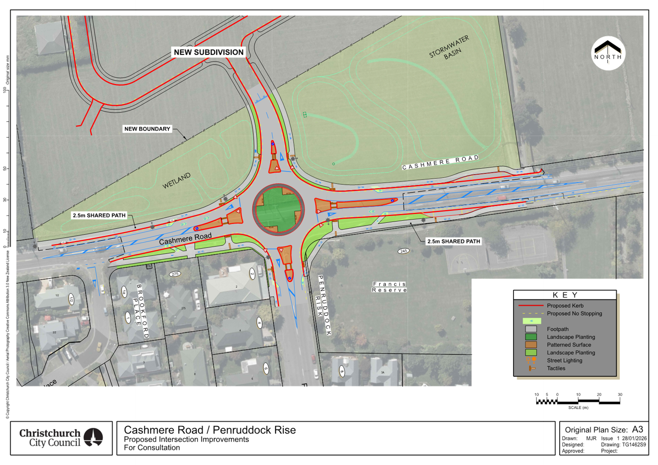
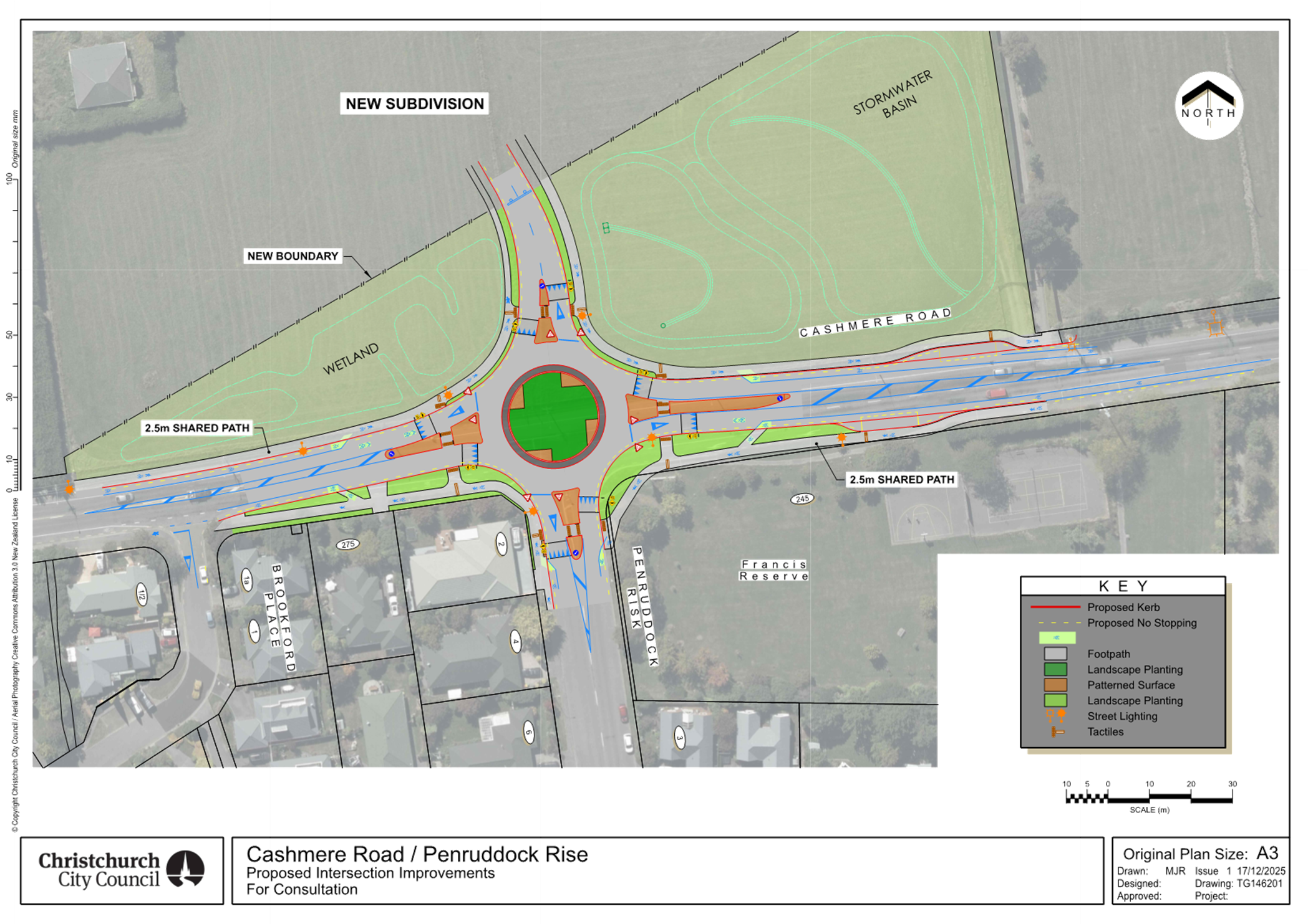
|
8. Hagley Avenue - Clearway
|
|
Reference Te Tohutoro:
|
26/203772
|
|
Responsible Officer(s) Te Pou Matua:
|
Kathy
Graham, Team Leader Traffic Operations
Gautham Praburam, Traffic Engineer
Hannah Ballantyne, Senior Engagement Advisor
|
|
Accountable ELT Member Pouwhakarae:
|
Brent
Smith, General Manager City Infrastructure
|
1. Purpose and Origin of the Report Te Pūtake Pūrongo
1.1 The purpose of this report is to seek the Council’s approval
to make permanent the clearway currently operating on the north side of Hagley
Avenue between 7:30 am and 7:30 pm.
1.2 The kerbside lane on Hagley Avenue between St Asaph Street and
Riccarton Avenue previously operated as a general traffic lane carrying
north-westbound traffic. Since March 2025, this lane has been trialled as a
clearway between 7:30 am and 7:30 pm, with parking permitted outside these
hours.
1.3 This report has been prepared following monitoring of the impacts of
this arrangement.
2. Officer
Recommendations Ngā Tūtohu
That the Council:
1. Receives the information in the Hagley
Avenue - Clearway Report.
2. Notes that the decision outlined in this report is assessed as low
significance based on the Christchurch City Council’s Significance and
Engagement Policy.
3. Approves, pursuant to Clause 7 of the Christchurch City Council
Traffic and Parking Bylaw 2017, that the existing no stopping restrictions on the northern side of Hagley Avenue, commencing at a point 82
metres northwest of its intersection with St Asaph Street and extending in a
north-westerly direction for 102 meters be revoked.
4. Approves that, in accordance with Clause 7 of the Christchurch City
Council Traffic and Parking Bylaw 2017 and Section 1.6 of the Land Transport
(Road User) Rule 2004, the stopping of vehicles is to be prohibited only during
the clearway hours on the northern side of Hagley Avenue, commencing at a point
82 metres northwest of its intersection with St Asaph Street and extending in a
north-westerly direction for 102 meters. The clearway is to apply between 07:30
AM – 07:30 PM, seven days a week, as detailed in Plan TG146302, dated
17/01/2025, and attached to this report as Attachment A.
5. Approves that these resolutions take effect when parking signage
and/or road markings that evidence the restrictions described in this staff
report are in place (or removed in the case of revocations).
3. Executive Summary Te Whakarāpopoto Matua
3.1 Since November 2022, several Notices of Motion have called for
reinstating on-street parking on the Hagley Park side at Hospital Corner.
3.2 In December
2024, the Finance and Performance Committee approved a six-month trial of a
time-restricted clearway on the north side of Hagley Avenue alone, operating
7:30 AM–7:30 PM, thereby allowing parking during the evening
and overnight hours, for approximately 18 vehicles.
3.3 The trial
commenced on 10 March 2025 and was scheduled to end on 9 September 2025.
3.4 Given the
imminent opening of the Parakiore Metro Sports Centre and the anticipated
increase in traffic volumes in the area, staff recommended extending the trial
for another six months to continue monitoring usage, assess future demand, and
evaluate the impacts of the new sports facility and investigate any alternative
parking options.
3.5 Despite
the increased parking demand following the trial extension, parked
vehicles—including those that overstayed—were not observed to
adversely affect traffic flow. This was particularly evident during the morning
peak period, when impacts were most anticipated.
3.6 Based
on observations undertaken during the trial, together with feedback received
from stakeholders and members of the public, staff recommend that the clearway
on Hagley Avenue be made permanent.
4. Background/Context Te Horopaki
4.1 Since
November 2022, several Notices of Motion have requested the reinstatement of
on-street parking on the Hagley Park side of the road at Hospital Corner as
soon as practically possible.
4.2 In
response, staff investigated a range of potential options to improve on-street
parking opportunities near Christchurch Hospital, evaluating each
option’s advantages and disadvantages.
4.3 In
October and November 2023, a temporary lane closure trial was conducted on the
kerbside lanes of both Hagley Avenue and Riccarton Avenue. The purpose of the
trial was to evaluate the potential impacts of permanently removing a traffic
lane to enable on-street parking along these corridors.
4.4 Following
the trial, and based on observations and feedback from key stakeholders, staff
recommended maintaining the current road layout. This recommendation was
primarily due to the potential for increased delays for all road users,
particularly emergency services, if a traffic lane were removed at this
location.
4.5 As
an alternative, staff also presented an option that would permit night-time
parking in the kerbside lanes of Hagley Avenue and Riccarton Avenue, while
maintaining a clearway during the day to ensure traffic efficiency.
4.6 While
this type of clearway arrangement could provide additional parking
opportunities, it also presented some operational challenges, including:
4.6.1 Increased
congestion and safety risks during morning peak hours, resulting from
non-compliant vehicles remaining in the clearway.
4.6.2 Ongoing
operational costs associated with enforcing the clearway and removing
non-compliant vehicles.
4.6.3 The
requirement to construct a new footpath along the Hagley Park side of Riccarton
Avenue to enable safe pedestrian access to existing signalised crossings at
Hagley Avenue / Riccarton Avenue / Oxford Terrace / Tuam Street and the
Hospital Entrance / Riccarton Avenue intersections. This would require
additional funding.
4.7 Taking
these challenges into account, staff maintained their recommendation to retain
the status quo at that time.
4.8 At
its meeting on 18 December 2024, the Council’s Finance and Performance
Committee approved a six-month trial for a time-restricted clearway on the
north side of Hagley Avenue alone, operating from 7:30 AM to 7:30 PM.
4.9 This
arrangement allowed for approximately 18 new on-street parking spaces in close
proximity to Christchurch Hospital during the evening and overnight hours (7:30
PM to 7:30 AM), without the need for significant additional infrastructure.
4.10 The purpose of
the trial was to assess safety impacts on other road users and the broader
operational impacts of permitting parked vehicles in this location.
4.11 The trial
commenced on 10 March 2025 and was scheduled to end on 9 September 2025.
4.12 Clearway signage
and markings were installed in accordance with NZ Transport Agency Waka Kotahi
guidelines and standard city-wide practice.
4.13 Information
about the trial was provided to the Mayor, Councillors, the Waipapa
Papanui–Innes–Central Community Board, and other key stakeholders
prior to the commencement of the trial. In addition, a Newsline story and a
Facebook post were published to inform the wider public about the trial.
4.14 When compared to
a typical introduction of parking restrictions, Council staff communicated this
parking trial more extensively than would normally be done. This was due to the
significant location of this clearway, and its proximity to Christchurch
Hospital.
4.15 Utilisation of
the clearway / parking area was monitored through traffic cameras. During the
first two months of the trial, demand was low, with most nights recording no
parked vehicles and only occasional use by one or two vehicles.
4.16 Upon observing
the low patronage, Council staff met with a senior operations staff member at
Te Whatu Ora to discuss ways to raise awareness of the clearway trial. As part
of this meeting, the Te Whatu Ora staff member offered to reinforce the
messaging through internal channels.
4.17 Following this engagement,
and increased media coverage at that time, a noticeable increase in patronage
was observed in the second half of June, with nightly occupancy reaching up to
14 vehicles.
4.18 Subsequently,
demand slightly declined and stabilised, with most nights showing between five
and ten vehicles parked along the clearway.
4.19 During the initial
trial, one vehicle overstayed during the initial two-week grace period and
departed shortly after 8:00 AM. A reminder notice was provided. Following this
period, there were 16 instances of non-compliance, including two longer
overstayers that required towing. The remaining vehicles vacated before 8:00
AM. Additionally, there were three instances of vehicles arriving before
clearway hours, including one as early as 6:00 PM.
4.20 At the time of
the initial trial, the nearby Parakiore Metro Sports Facility was scheduled to
open later in the year (2025) and was anticipated to generate additional
traffic and parking demand in the surrounding area. Given the uncertainty
around how the opening of the facility might influence traffic conditions,
parking behaviour, and overall network performance along Hagley Avenue, staff
considered it premature to draw final conclusions from the initial trial period
alone.
4.21 Accordingly, staff recommended extending the trial for a further six
months to allow continued monitoring of clearway usage, assessment of future
parking demand, and evaluation of the operational impacts associated with the
opening of the Parakiore Metro Sports Facility. The extended trial period also
enabled consideration of the effectiveness of the clearway in the context of
any alternative parking options that may become available as travel patterns
evolve.
4.22 Following the
extension of the trial, utilisation of the parking area increased noticeably.
Monitoring indicated that more than ten vehicles were parked per night on most
days, with demand exceeding 20 vehicles on multiple occasions over the 12 hour
duration.
4.23 43 instances of
non-compliance were observed during the extended trial (up to 31 December
2025), including 15 longer overstayers that required towing. The remaining
vehicles mostly vacated before 8:00 AM. Additionally, there were 8 instances of
vehicles arriving before clearway hours, including one as early as 06:29 PM.
4.24 Despite the
higher parking demand and comparatively higher non-compliance observed during
the extended trial period, parked vehicles—including those that exceeded
the permitted parking duration—were not found to have any major adverse
effect on traffic flow or network performance along Hagley Avenue. This was
particularly evident during the morning peak period, when the potential for
impacts was expected to be greatest.
4.25 Some minor
driver behaviour issues were observed during the trial. These included
instances where drivers initially queued behind parked vehicles before
recognising the clearway arrangement and moving into the adjacent traffic lane.
In addition, there were occasional observations of vehicles turning right from
St Asaph Street at normal speeds and subsequently slowing down abruptly upon
encountering parked vehicles ahead. While these behaviours were noted, they
were infrequent and did not result in any recorded crashes. Overall, these
observations were not considered to present a level of safety risk sufficient
to warrant early termination of the trial.
4.26 The Parakiore
Metro Sports Facility opened on 17 December 2025, introducing a new potential
source of traffic and parking demand in the area. Although the post-opening
monitoring period was relatively short, observations undertaken during this
time did not indicate that parked vehicles resulted in any significant safety
concerns, traffic congestion, or reductions in network efficiency.
4.27 Based on the observations undertaken throughout both the initial and
extended trial periods, and taking into account feedback received from
stakeholders and members of the public, staff consider the clearway to be
operating as intended. Accordingly, staff recommend that the clearway on Hagley
Avenue be made permanent.
4.28 The following information regarding parking near Christchurch
Hospital has been provided in the past to the Elected Members.
|
Date
|
Subject
|
|
18/07/2023
|
Memo - Options
for increasing on-street parking around Christchurch Hospital
|
|
18/07/2023
|
Briefing –
Options for increasing on street parking around Christchurch hospital
|
|
23/01/2024
|
Memo - Parking
near Christchurch Hospital – Road closure trial results and
recommendations
|
|
23/01/2024
|
Briefing - Parking near Christchurch Hospital – Road closure trial
results and recommendations
|
|
06/03/2025
|
Memo - Parking
near Christchurch Hospital - Clearway trial along Hagley Avenue
|
|
03/09/2025
|
Report - Extension
of Hagley Avenue Clearway Trial Period
|
Options Considered Ngā
Kōwhiringa Whaiwhakaaro
4.29 The following
reasonably practicable options were considered and are assessed in this report:
4.29.1 Make the clearway along
Hagley Avenue permanent.
4.29.2 Stop the trial and
reinstate the previous traffic lane arrangements.
Options Descriptions Ngā
Kōwhiringa
4.30 Preferred
Option: Make the clearway along Hagley Avenue permanent.
4.30.1 Option Description: This
option involves permanently permitting night-time parking on the north side of
Hagley Avenue near Christchurch Hospital.
4.30.2 Option Advantages
· On-street parking continues to be available along the kerb side lane
along Hagley Avenue.
· No additional cost as no infrastructure changes are needed.
4.30.3 Option Disadvantages
· Does not maintain full lane capacity at all times, increasing the
potential for delays to general traffic and emergency vehicles.
4.31 Option 2:
Stop the trial and reinstate the previous traffic lane arrangements.
4.31.1 Option Description: Cease
the current clearway trial and revert to the previous road layout, removing any
temporary night-time parking spaces along Hagley Avenue.
4.31.2 Option Advantages
· Restores full lane capacity at all times, potentially reducing risk
of delays for general traffic and emergency vehicles.
· Eliminates the need for ongoing enforcement.
4.31.3 Option Disadvantages
· Reduces the number of available on-street parking spaces near the
hospital during night-time hours.
5. Financial Implications Ngā Hīraunga Rauemi
Capex/Opex Ngā Utu Whakahaere
|
|
Recommended Option
|
Option 2
|
|
Cost to Implement
|
$0
|
$5000
|
|
Maintenance/Ongoing Costs
|
Covered by the existing maintenance
contract
|
Covered by the existing maintenance
contract
|
|
Funding Source
|
Traffic Operations Team traffic signs and
markings budget
|
Traffic Operations Team traffic signs and
markings budget
|
6. Considerations Ngā Whai Whakaaro
Risks and Mitigations Ngā
Mōrearea me ngā Whakamātautau
6.1 None
identified.
Legal Considerations Ngā
Hīraunga ā-Ture
6.2 Statutory
and/or delegated authority to undertake proposals in the report:
6.2.1 Part 1,
Clause 7 of the Christchurch City Council Traffic and Parking Bylaw 2017
provides Council with the authority to install parking or stopping restrictions
by resolution.
6.2.2 Clause
6(2) of the Christchurch City Council Traffic and Parking Bylaw 2017 provides
Council with the authority to subsequently amend or revoke any resolution made
under this bylaw at any time.
6.2.3 The
installation of any signs and/or markings associated with traffic control
devices must comply with the Land Transport Rule: Traffic Control Devices 2004.
6.2.4 Any
proposal that increases on-street car parking on Hagley Avenue (north of St
Asaph Street) or on Riccarton Avenue is deemed to be of metropolitan
significance as it is within the Part A area. So, the authority to make
decisions on this matter rests with the Council.
6.3 Other Legal Implications:
6.3.1 There is
no other legal context, issue or implication relevant to this decision.
6.3.2 This
specific report has not been reviewed and approved by Legal Services. However,
the report has been written using a general approach previously approved by
Legal Services.
Strategy and Policy Considerations Te Whai
Kaupapa here
6.4 The
Council’s strategic priorities have been considered in formulating the
recommendations in this report. However, this area of work is not specifically
covered by an identified priority.
6.5 The
required decision:
6.5.1 Aligns with
the Christchurch
City Council’s Strategic Framework.
6.5.2 Is of
low significance, given the minimal cost implications for the Council and the
relative ease with which the decision could be reversed if required.
6.5.3 As
approved at the Council meeting on 2 August 2023, parking near the hospital is
considered of metropolitan significance, and the decisions are to be exercised
by the Council.
6.5.4 Are consistent with Council’s Plans and
Policies.
6.6 This
report supports the Council's
Long Term Plan (2024 - 2034):
6.7 Transport
6.7.1 Activity: Transport
· Level of Service: 10.3.1 Provide an optimised
balance of Council operated parking spaces in the central city - <=85%
average occupancy.
Community Impacts and Views Ngā Mariu
ā-Hāpori
6.8 Consultation
on whether the trial should be retained permanently started on 30 January and
ran until 15 February 2026.
6.9 Project
details including links to the Kōrero mai |
Let’s Talk webpage were advertised via:
· An email sent to Te Whatu Ora Health New Zealand, Hato Hone St John,
Fire and Emergency NZ, New Zealand Police, Canterbury Health Laboratories,
Hagley College, and Otago School of Medicine.
· A
Newsline story which was shared to Council’s Facebook page.
· Signs alongside the clearway
6.10 The Kōrero mai |
Let’s Talk page had 432 views throughout the consultation period.
Summary of
Submissions Ngā Tāpaetanga
6.11 Submissions were
made by 50 individuals. All submissions are available on our Kōrero mai webpage.
6.12 38% of
submissions came from people who have used the carparks provided by the
clearway.
6.13 Of those who
have used the car parks (20), most said that working at the hospital was the
purpose of their trip.
Q: What
was the purpose of your trip? (multi-choice)
· Work at the hospital (12)
· Visiting someone in the hospital (7)
· Recreation (3)
· Work elsewhere in the city (2)
When
asked what works well about the clearway trial, the most common feedback was:
· Provision of parking near the hospital (24)
· It provides safer parking for hospital staff (10)
· Provision of free parking (6)
· It balances the need for parking with a live traffic lane when
required (6)
· They haven’t experienced an impact on traffic flow when the
clearway is operating (6)
When
asked what doesn’t work well about the clearway trial, the most common
feedback was:
· Cars overstay the clearway hours (12)
· The break in the traffic lane for parking is dangerous, e.g. causing
cars to swiftly change lanes with little notice (12)
· The hours of the clearway (8) – requests for different hours
to better accommodate the needs of different hospital shift workers or traffic
flows
· The disruption of traffic flow (6)
· It’s confusing (5)
· There isn’t
enough knowledge about the parks (4)
6.14 55%
(29) of the submissions were generally positive about the clearway trial, 30%
(16) were generally negative, and the remaining 15% (8) were either balanced or
did not provide enough information for this assessment to be made.
Impact on Mana Whenua Ngā Whai Take
Mana Whenua
6.15 The decision does
not involve a significant decision in relation to ancestral land or a
body of water or other elements of intrinsic value, therefore this decision
does not specifically impact Mana Whenua, their culture or traditions.
6.16 The decision does
not involve a matter of interest to Mana Whenua and will not impact on
our agreed partnership priorities with Ngā Papatipu
Rūnanga.
Climate Change Impact Considerations Ngā
Whai Whakaaro mā te Āhuarangi
6.15 The
proposals in this report are unlikely to contribute significantly to adaptation
to the impacts of climate change or emissions reductions.
7. Next Steps Ngā Mahinga ā-muri
7.1 If
approved, no further infrastructure changes will be required, as all necessary
measures have already been implemented as part of the trial.
7.2 Submitters
and key stakeholders will be formally notified of the Council’s decision.
Attachments Ngā Tāpirihanga
|
No.
|
Title
|
Reference
|
Page
|
|
a ⇩
|
Clearway -
Hagley Avenue
|
26/286821
|
135
|
In addition to the attached documents, the following background
information is available:
|
Document
Name – Location / File Link
|
|
Not
applicable
|
Signatories Ngā Kaiwaitohu
|
Authors
|
Gautham
Praburam - Traffic Engineer
Kathy Graham -
Team Leader Traffic Operations
Hannah
Ballantyne - Senior Engagement Advisor
|
|
Approved By
|
Stephen Wright
- Head of Transport & Waste Management
Brent Smith -
General Manager City Infrastructure
|
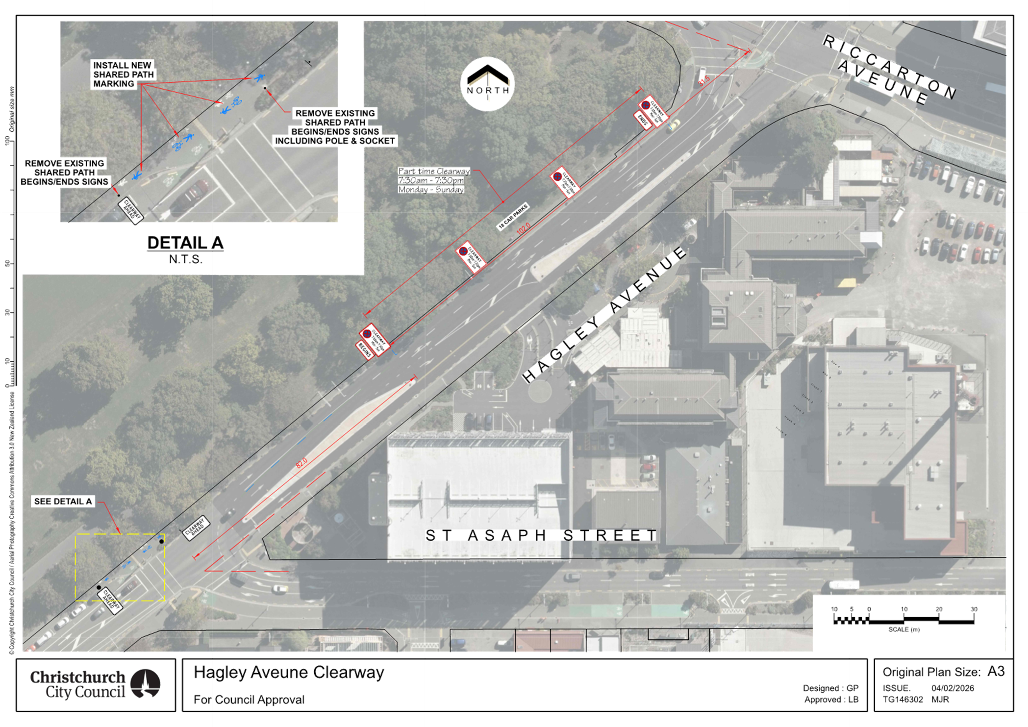
|
9. Pihipihi Lane: Name Correction
|
|
Reference Te Tohutoro:
|
25/2384578
|
|
Responsible Officer(s) Te Pou Matua:
|
Sahan
Lalpe, Traffic Engineer
|
|
Accountable ELT Member Pouwhakarae:
|
Brent
Smith, General Manager City Infrastructure
|
1. Purpose and Origin of the Report Te Pūtake Pūrongo
1.1 The
purpose of this report is to correct the minor spelling error of a lane name,
Pihipihi Lane, in a previous resolution made by the Central City Parking
Restrictions Committee (the Committee). As this Committee has not been
re-established in the new term, the decision-making authority sits with the
Council.
1.2 At
its meeting on 22 August 2025, the Committee approved parking controls, subject
to certain exceptions, on “Pipihihi” Lane.
1.2.1 The
following link can be used to access the Committee meeting minutes, Items 5:
https://christchurch.infocouncil.biz/Open/2025/08/CCPRC_20250822_MIN_10646_AT_WEB.htm
1.3 The
lane name was misspelled in the recommendations and is therefore also
incorrectly reflected in the resolutions (refer CCPRC/2025/00012).
1.4 The
correct spelling is “Pihipihi” Lane. This is the name that
was approved by Waipapa Papanui-Innes-Central Community Boad in accordance with
their delegated authority on 14 November 2024.
1.4.1 The
following link can be used to access the Board meeting minutes, Item 7: https://christchurch.infocouncil.biz/Open/2024/11/PCBCC_20241114_MIN_9132_AT_WEB.htm
1.5 This
report is staff generated and seeks to correct the administrative error to
enable enforcement of the parking restrictions previously approved by the
Committee. The original recommendations to the Committee are unchanged but for
the correction to the spelling of the lane name.
2. Officer Recommendations Ngā Tūtohu
That the Council:
1. Receives the information in the Pihipihi
Lane: Name Correction Report.
2. Notes that the decision in this report are assessed as low
significance based on the Christchurch City Council’s Significance
and Engagement Policy.
3. Under Clause 6(2) of the Christchurch City Council Traffic and
Parking Bylaw 2017 revokes the Central City Parking
Restrictions Committee’s resolution of 22 August 2025 (CCPRC/2025/00012)
regarding the stopping of vehicles on “Pipihihi” Lane, due to the
incorrect spelling of the lane name.
4. Under Clause 6(2) of the Christchurch City Council Traffic and
Parking Bylaw 2017 revokes any previous resolutions pertaining to traffic
controls made pursuant to any bylaw to the extent that they are in conflict
with the parking or stopping restrictions described in Recommendation 5 below.
5. Approves that, in accordance with Clause 7 of the Christchurch City
Council Traffic and Parking Bylaw 2017, the stopping of vehicles be prohibited
at any time on Pihipihi Lane, as detailed on Attachment A, plan TG151615, Issue 3, dated 19/11/2025,
subject to the following exceptions and conditions:
a. Goods Service Vehicles, for the purposes of loading /unloading
activities relating to properties within, or requiring access from, Pihipihi Lane only.
b. Street cleaning & rubbish collection vehicles operated by the
Christchurch City Council or its nominated contractor.
c. Trade
and other vehicles (including those operated by service authorities) of any
class of vehicle, if authorised to do so by the council officer who holds the
position of Head of Transport at that time.
d. Emergency vehicles
e. Any vehicle or specified class of vehicle that has entered Pihipihi Lane under the above provisions must
not be parked for longer than is necessary for its driver to carry out their
business or for the period of any emergency.
6. Approves that these resolutions take effect when parking signage
and/or road markings that evidence the restrictions are in place (or removed in
the case of revocations).
Background
2.1 The
original decision report to the Committee covering the parking restrictions to
be addressed can be accessed via this link:
https://christchurch.infocouncil.biz/Open/2025/08/CCPRC_20250822_AGN_10646_AT_WEB.htm
Attachments Ngā Tāpirihanga
|
No.
|
Title
|
Reference
|
Page
|
|
a ⇩
|
Pihipihi
Lane_Proposed No Stopping Restriction
|
25/2386088
|
139
|
In addition to the attached documents, the following background
information is available:
|
Document
Name – Location / File Link
|
|
Not
applicable
|
Signatories Ngā Kaiwaitohu
|
Author
|
Sahan Lalpe -
Traffic Engineer
|
|
Approved By
|
Kathy Graham -
Team Leader Traffic Operations
Stephen Wright
- Manager Operations (Transport)
|
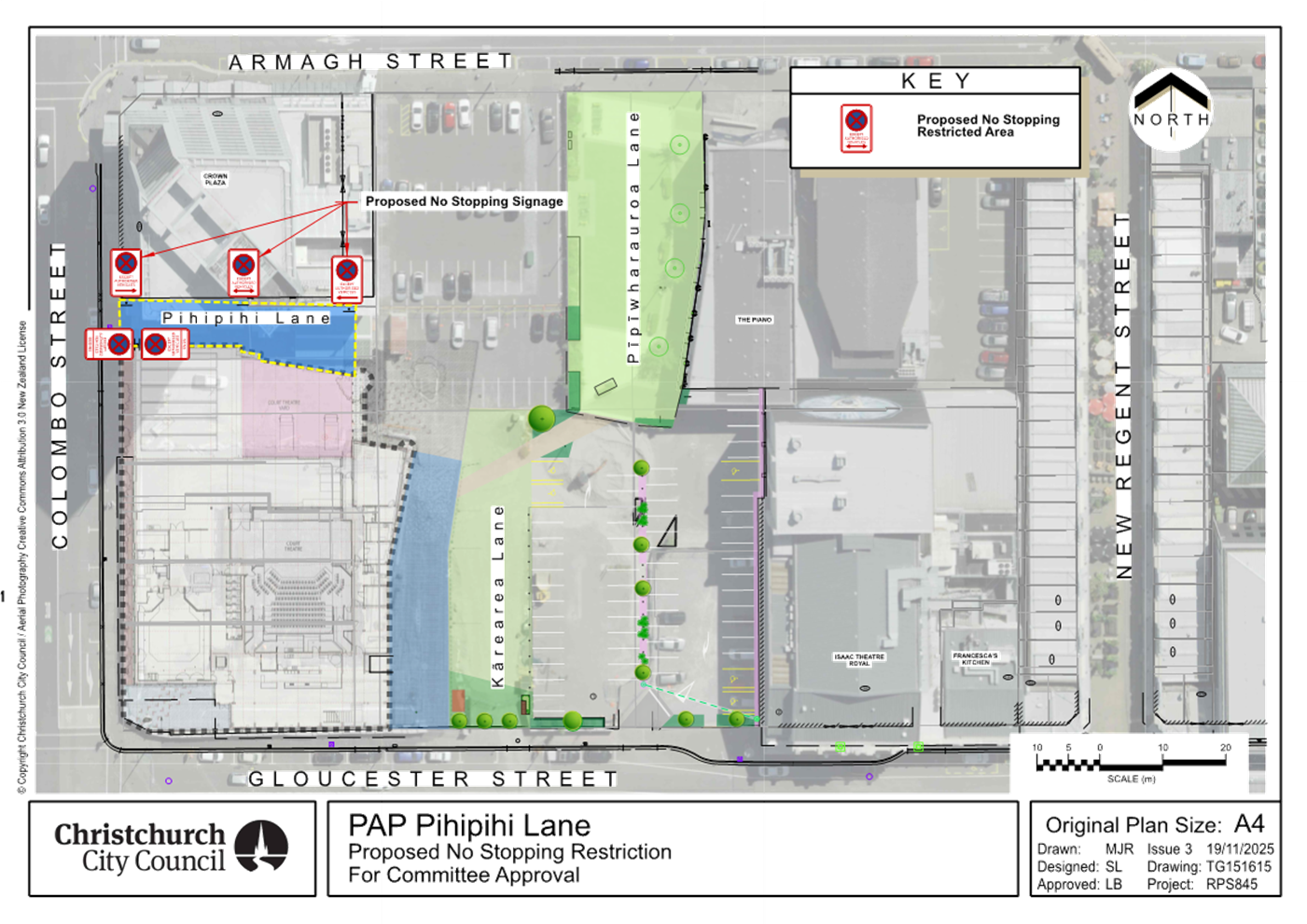
|
10. Bus stop upgrades on Gloucester and St Asaph Streets
|
|
Reference Te Tohutoro:
|
26/56202
|
|
Responsible Officer(s) Te Pou Matua:
|
Mansour
Johari, Passenger Transport Engineer
|
|
Accountable ELT Member Pouwhakarae:
|
Brent
Smith, General Manager City Infrastructure
|
1. Purpose and Origin of the Report Te Pūtake Pūrongo
1.1 The
purpose of this report is for the Council to approve bus stop improvements
within the Plan A area on Gloucester Street and St Asaph Street.
1.2 This
report has been prepared by staff in response to community requests.
1.3 The
proposed bus stop upgrades were consulted on concurrently and are presented in a
single report to streamline time and costs. However, the decisions concerning
each bus stop are independent, and they can be pursued separately if necessary.
2. Officer
Recommendations Ngā Tūtohu
That the Council:
1. Receives the information in the Bus stop
upgrades on Gloucester and St Asaph Streets Report.
2. Notes that the decision in this report is assessed as low significance
based on the Christchurch City Council’s Significance and Engagement
Policy.
3. Under Clause 6(2) of the Christchurch City Council Traffic and
Parking Bylaw 2017 revokes any previous resolutions pertaining to parking or
stopping restrictions and traffic controls made pursuant to any bylaw to the
extent that they conflict with the parking or stopping restrictions and traffic
controls described in resolutions 4 to 6 below.
Bus stop 14271 – 78 St Asaph Street (Attachment A)
4. Pursuant to Section 339(1) of the Local Government Act 1974:
a. Approves that a bus passenger shelter be installed on the south side
of St Asaph Street commencing at a point 37 metres west of its intersection
with Montreal Street and extending in a westerly direction for a distance of
approximately 3.6 metres.
Bus stop 30688 – 203 Gloucester Street (Attachment A)
5. Pursuant to Clause 7 of the Christchurch City Council Traffic and
Parking Bylaw 2017:
a. Approves that a bus stop on the northern side of Gloucester Street
commencing at a point 127 metres east of its intersection with Manchester
Street and extending in an easterly direction for a distance of 15 metres be
revoked.
b. Approves that the stopping of all vehicles be prohibited at any
time, on the north side of Gloucester Street commencing at a point 108 metres east
of its intersection with Manchester Street and extending in an easterly
direction for a distance of 4 metres.
c. Approves that a Bus Stop be installed, on the northern side of
Gloucester Street commencing at a point 118 metres east of its intersection
with Manchester Street and extending in a westerly direction for a distance of
14 metres.
d. Approves that the stopping of all vehicles be prohibited at any
time, on the north side of Gloucester Street commencing at a point 132 metres east
of its intersection with Manchester Street and extending in an easterly
direction for a distance of 5 metres.
6. Approves that a bus stop sign, a seat, and directional and warning
tactile pavers be installed at bus stop 30688 outside 203 Gloucester Street, as
shown on Attachment A.
7. Approves that these resolutions, described in clauses 4 to 6 above,
take effect when traffic controls or parking signage and/or road markings that
evidence the restrictions described in the staff report are in place (or
removed in the case of revocations).
3. Executive Summary Te Whakarāpopoto Matua
3.1 Based
on community requests staff are proposing two bus stop upgrades, which are
listed in Table 1.
Table 1:
Proposed bus stop upgrades.
|
Adress and ID
|
Origin
|
Upgrades
|
|
78
St Asaph Street - 14271
|
(2x)
Community
|
Shelter
installation
|
|
203
Gloucester Street - 30688
|
Community
|
Slight
relocation – improving access to bus stop and bus
|
3.2 The
proposed plan for bus stop (ID 30688) on Gloucester Street also incorporates
standard line markings, tactile pavers, and seat to improve accessibility and safety.
3.3 These
upgrades have been prioritised based on patronage and community requests.
4. Background/Context Te Horopaki
78
St Asaph Street – 14271
4.1 Staff
have received two community requests for a bus shelter at this stop. The bus stop serves nine bus routes (3, 5, 7, 60, 80, 81,
84, 85, and 86). On average, 69 passengers use this bus stop each day.
4.2 A
bus stop is deemed well-used if, on average, it serves around 20 or more
passengers daily. This is the traditional CCC threshold for bus shelter
installation.
4.3 The
existing bus stop includes standard line markings, signage, seat, and tactile
pavers.
203
Gloucester Street – 30688
4.4 Staff have received complaints that private vehicles park in this
space, preventing buses from pulling in safely and stopping parallel to the
kerb. This results in the rear of the bus blocking the traffic lane. In
addition, the parked private vehicles restrict sightlines for drivers exiting
the new driveway.
4.5 The bus stop serves bus routes 5 and 7. On average, 23 passengers
use this bus stop each day.
4.6 The bus stop previously featured a standard layout, including a bus
box, lead-out no-stopping restrictions, and a lead-in space provided by a
driveway immediately before the bus box.
4.7 The driveway has been moved away from the bus stop due to the new
adjacent housing developments, creating a space between the driveway and the
bus stop with no parking restrictions implemented.
Options Considered Ngā
Kōwhiringa Whaiwhakaaro
78 St Asaph Street – 14271
4.8 The
following reasonably practicable options were considered and are assessed in
this report:
4.8.1 Shelter
installation.
4.8.2 Do
nothing.
203 Gloucester Street - 30688
4.9 The
following reasonably practicable options were considered and are assessed in
this report:
4.9.1 Bus stop
relocation.
4.9.2 Do
nothing.
4.10 The following
options were considered but ruled out:
4.10.1 The option to provide
lead-in no-stopping restrictions at the existing bus stop location was ruled
out for the following reason:
· This
option would result in the loss of two parking spaces compared with the
preferred option.
Options Descriptions Ngā Kōwhiringa
78 St Asaph Street - 14271
4.11 Preferred
Option: Shelter installation.
4.11.1 Option Advantages
· Improves customer satisfaction by providing weather protection for
passengers.
· Responds to two community requests for the installation of a
shelter.
4.11.2 Option Disadvantages
· Costs
associated with shelter cleaning and maintenance.
4.12 Do nothing
Option:
4.12.1 Option Advantages
· The Council will not incur any costs.
4.12.2 Option Disadvantages
· Does not improve customer satisfaction.
· Does not respond to two community requests for the installation of a
shelter.
203 Gloucester Street - 30688
4.13 Preferred
Option: Bus stop relocation.
4.13.1 Option Advantages
· No loss of on-street parking.
· Improved
access to bus stop for buses.
· Improved
access to and from the bus for passengers.
· Buses would no longer block the traffic lane when stopping at the
stop.
· Improved
sightlines from driveway.
4.13.2 Option Disadvantages
· Staff
have not identified any specific disadvantages.
4.14 Do nothing
Option:
4.14.1 Option Advantages
· The Council will not incur any costs.
4.14.2 Option Disadvantages
· None of the identified advantages associated with the preferred
option would be realised.
5. Financial Implications Ngā Hīraunga Rauemi
Capex/Opex Ngā Utu Whakahaere
5.1 The
estimated costs for the recommended option and the do-nothing option are
provided in the table below.
5.2 The implementation costs in the table below include the expenses for
investigation, design, and construction of bus stop upgrades.
5.3 Maintenance/Ongoing costs - The Transport Unit Operational
Expenditure budgets include maintenance of bus stop infrastructure.
5.4 Funding Source – Traffic Operations budget for public
transport infrastructure upgrades.
78 St Asaph Street - 14271
|
|
Recommended Option
|
Option 2 – Do nothing
|
|
Cost
to Implement
|
$31,000
|
$0
|
|
Funding
Source
|
CPMS
50465
|
N/A
|
|
Maintenance/Ongoing
Costs
|
Bus
stop maintenance contract - minimal effects to the overall asset
|
N/A
|
|
Funding
Availability
|
Available
|
N/A
|
|
Impact
on Rates
|
N/A
|
N/A
|
203
Gloucester Street - 30688
|
|
Recommended Option
|
Option 2 – Do nothing
|
|
Cost
to Implement
|
$6,500
|
$0
|
|
Funding
Source
|
CPMS
50465
|
N/A
|
|
Maintenance/Ongoing
Costs
|
Bus
stop maintenance contract - minimal effects to the overall asset
|
N/A
|
|
Funding
Availability
|
Available
|
N/A
|
|
Impact
on Rates
|
N/A
|
N/A
|
6. Considerations Ngā Whai Whakaaro
Risks and Mitigations Ngā
Mōrearea me ngā Whakamātautau
6.1 Should
the Council proceed with Option 2, the do-nothing option:
· None of the identified advantages
associated with the preferred options would be realised.
Legal Considerations Ngā
Hīraunga ā-Ture
6.2
Statutory and/or delegated authority to undertake proposals in the report:
6.2.1 Part
1, Clause 7 of the Christchurch City Council Traffic and Parking Bylaw 2017
provides Council with the authority to install parking restrictions by
resolution.
6.2.2 Clause
6(2) of the Christchurch City Council Traffic and Parking Bylaw 2017 provides
Council with the authority to amend
or revoke any resolution made under this bylaw at any time.
6.2.3 The
installation of any signs and road markings associated with traffic control
devices must comply with the Land Transport Rule: Traffic Control Devices 2004.
6.2.4 The
council has delegation for resolution of bus passenger shelters under Section
339 (1) of the Local Government Act 1974.
6.2.5 The
council has delegation to hear and determine objections to bus stop shelters.
6.2.6 Staff
confirm the shelters will not prevent vehicular or pedestrian access to any
land having a frontage to the road.
6.3 Other Legal Implications:
6.3.1 This
report has not been reviewed and approved by the Legal Services Unit.
Strategy and Policy Considerations Te Whai
Kaupapa here
6.4 The
required decisions:
6.4.1 Align
with the Christchurch
City Council’s Strategic Framework.
6.4.2 Are
assessed as low significance based on the
Christchurch City Council’s Significance and Engagement Policy. The
level of significance was determined by the number of people impacted by each individual plan, the
low risk and cost associated with the decision.
6.4.3 Are consistent with Council’s Plans and Policies.
6.5 This
report supports the Council's
Long Term Plan (2024 - 2034):
6.6 Transport
6.6.1 Activity: Transport
· Level of Service: 10.4.1 More people are
choosing to travel by public transport - >=14 million trips per year
· Level of Service: 10.4.4 Improve customer
satisfaction with public transport facilities (quality of bus stops and bus
priority measures) - >=73%
Community Impacts and Views Ngā Mariu
ā-Hāpori
6.7 Consultation has been carried out with affected
property owners and tenants.
6.8 The consultation period ran
from 20 January to 10 February 2026. Letters were delivered to the property
owners and tenants affected.
6.9 Environment Canterbury
support the proposed upgrades.
78 St Asaph Street – 14271
6.10 Staff did not receive any submissions for
this proposed bus shelter.
203 Gloucester Street – 30688
6.11 Staff
have received five submissions for this bus stop:
6.11.1 One resident sought
clarification on the rationale for the proposed changes. Staff provided an
explanation, and no further feedback was received.
6.11.2 One resident supported
the proposed plan.
6.11.3 One resident raised
concerns that, if the proposed plan proceeds, their driveway could be blocked
in the event that multiple buses arrive at the same time.
· Staff responded that this bus stop has not been identified or
confirmed as a location where multiple buses regularly arrive at the same time.
6.11.4 Three resident raised
concerns regarding the proximity of the proposed bus stop to their driveway.
· Staff responded that the proposed bus stop would improve sightlines
from the driveway compared with existing conditions, as buses would only be
present a few times per day and for short durations of approximately 30 seconds
each time.
6.12 The decision affects the following wards/Community Board areas:
6.12.1 Waipapa Papanui-Innes-Central Community Board.
Impact on Mana Whenua Ngā Whai Take
Mana Whenua
6.13 The decisions do not
involve a significant decision in relation to ancestral land, a body of
water or other elements of intrinsic value, therefore these decisions do not specifically impact Mana Whenua, their culture, and
traditions.
6.14 The
decisions do not involve a matter of interest to Mana
Whenua and will not impact on our agreed partnership priorities with Ngā Papatipu Rūnanga.
Climate Change Impact Considerations Ngā
Whai Whakaaro mā te Āhuarangi
6.15 The
proposals in this report are unlikely to contribute significantly to adaptation
to the impacts of climate change or emissions reductions. However, providing
shelters along with other bus stop upgrades will enhance public transport user
satisfaction and encourage more people to use public transport.
7. Next Steps Ngā Mahinga ā-muri
7.1 If
the staff recommendations are approved, staff will engage with contractors to
proceed with construction.
Attachments Ngā Tāpirihanga
|
No.
|
Title
|
Reference
|
Page
|
|
a ⇩
|
Attachment A:
Proposed bus stop improvements
|
26/223645
|
148
|
In addition to the attached documents, the following background
information is available:
|
Document
Name – Location / File Link
|
|
Not
applicable
|
Signatories Ngā Kaiwaitohu
|
Authors
|
Mansour Johari
- Passenger Transport Engineer
Gemma Dioni -
Principal Advisor Transportation Safety
|
|
Approved By
|
Kathy Graham -
Team Leader Traffic Operations
Stephen Wright
- Head of Transport & Waste Management
Brent Smith -
General Manager City Infrastructure
|
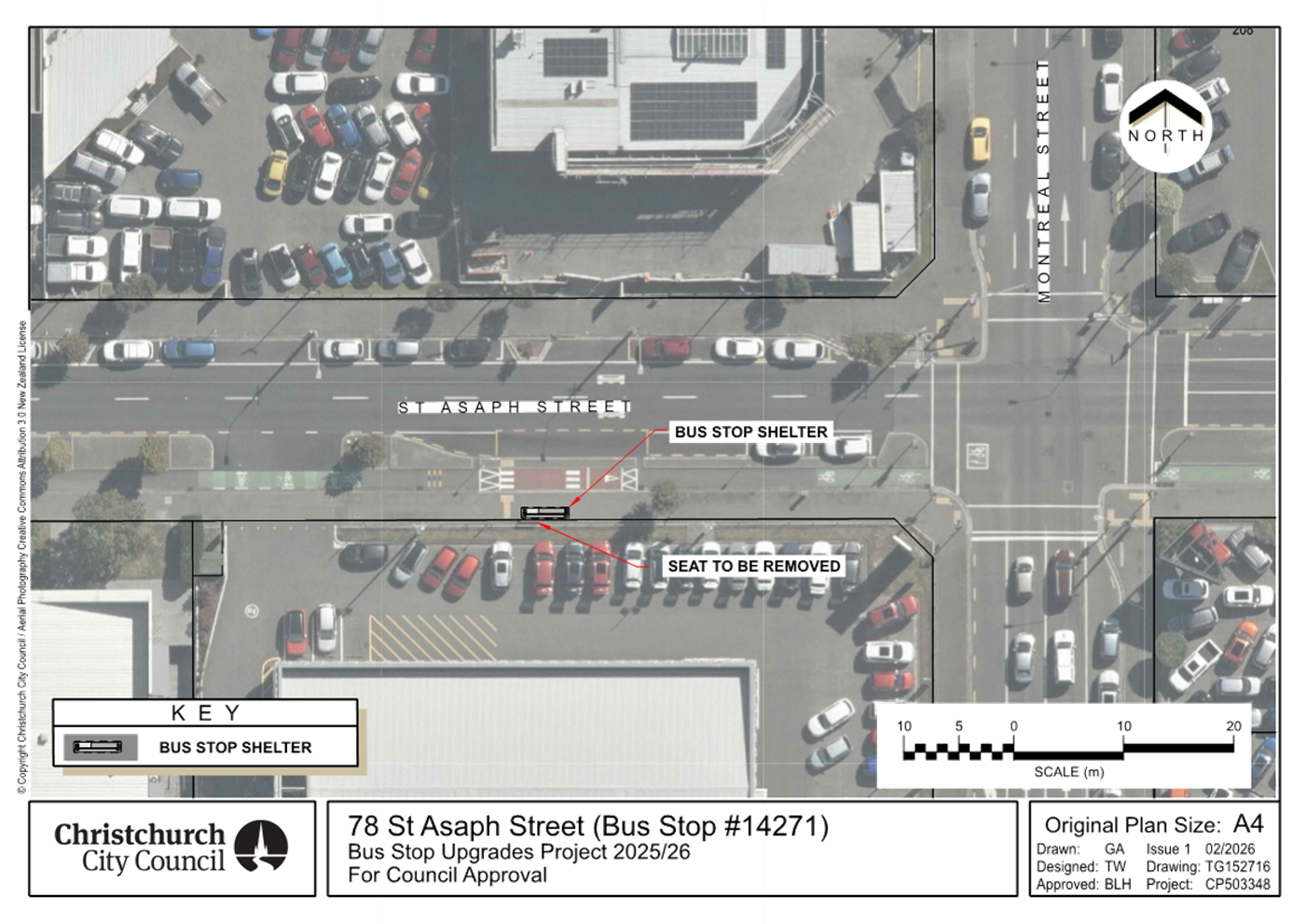
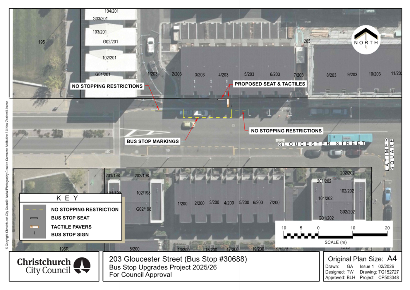
|
11. Cathedral Square
Roading Network- Worcester Boulevard from Oxford Terrace to Cathedral Square
(Area 9B)
|
|
Reference Te Tohutoro:
|
25/2540525
|
|
Responsible Officer(s) Te Pou Matua:
|
Jacob
Bradbury - Manager Planning & Delivery Transport
Hannah Pirie - Senior Project Manager
|
|
Accountable ELT Member Pouwhakarae:
|
Brent
Smith, General Manager City Infrastructure
|
1. Purpose and Origin of the Report Te Pūtake Pūrongo
1.1 The purpose of this report
is to seek approval of the design and detailed traffic resolutions for the
section of Worcester Boulevard between Oxford Terrace and Cathedral Square, as
part of the Cathedral Square Roading Network project and as shown in Attachment
A.
1.2 This
street upgrade forms a key component of the broader Cathedral Square Anchor
Project from the Christchurch Central Recovery Plan. It focuses on completing
the upgrade of the west end of Worcester Boulevard, spanning from Cathedral
Square to the Oxford Terrace River Walk.
1.3 The
report is staff generated to continue with the reinstatement and enhancement of
the Cathedral square and adjacent areas of the Cathedral Square and surrounds.
1.4 Delegation for approving this project sits with the Council.
Cathedral Square is located within the Central City and therefore is of
Metropolitan Significance.
2. Officer Recommendations Ngā
Tūtohu
That the Council:
1. Receives the information in the Cathedral
Square Roading Network- Worcester Street from Oxford Terrace to Cathedral
Square (Area 9B) Report.
2. Notes that the decision in this report is
assessed as low significance based on the Christchurch City Council’s
Significance and Engagement Policy.
3. Makes the following resolutions required for
the implementation of the project, including any traffic controls and /or
parking/ stopping restrictions, relying on its powers under the Christchurch
City Council Traffic and Parking Bylaw 2017 and Part 21 of the Local Government
Act 1974.
4. Revokes any previous resolutions pertaining to
kerb lines, traffic calming devices, traffic controls, parking, and stopping
restrictions made pursuant to any bylaw to the extent that they are in conflict
with the traffic calming, parking and stopping restrictions described in
recommendations 5 – 11 below.
5. Approves all kerb alignments, road surface
treatments, signage and road markings on Worcester Boulevard, commencing at its
intersection with Oxford Terrace and extending in an easterly direction to its
intersection with Cathedral Square as detailed on plan RD4011S7, dated
16/01/2026, and attached to this report as Attachment A.
6. Approves all kerb alignments, road surface
treatments, signage and road markings on Oxford Terrace, commencing at its
intersection with Club Lane and extending in a southerly direction to its
intersection with Worcester Boulevard as detailed on plan RD4011S7, dated
16/01/2026, and attached to this report as Attachment A.
No
stopping
7. Approves that, in accordance with Clause 7 of
the Christchurch City Council Traffic and Parking Bylaw 2017, the stopping of
vehicles be prohibited at all times:
a. On the east side of Oxford Terrace commencing
at a point six metres south of its intersection with Club Lane and extending in
a southerly direction for a distance of 34 metres, as detailed on plan
RD4011S7, dated 16/01/2026, and attached to this report as Attachment A.
b. On the west side of Oxford Terrace commencing
at a point four metres north of its intersection with Club Lane and extending
in a southerly direction for a distance of 59 metres, as detailed on plan
RD4011S7, dated 16/01/2026, and attached to this report as Attachment A.
c. On the north side of Worcester Boulevard
commencing at a point 10 metres east of its intersection with Oxford Terrace
and extending in an easterly direction for a distance of 40 metres as detailed
on plan RD4011S7, dated 16/01/2026, and attached to this report as Attachment
A.
d. On the north side of Worcester Boulevard
commencing at a point 65 metres east of its intersection with Oxford Terrace
and extending in an easterly direction for a distance of 19 metres as detailed
on plan RD4011S7, dated 16/01/2026, and attached to this report as Attachment
A.
e. On the north side of Worcester Boulevard
commencing at a point 93 metres east of its intersection with Oxford Terrace
and extending in an easterly direction to its intersection with Cathedral
Square as detailed on plan RD4011S7, dated 16/01/2026, and attached to this
report as Attachment A.
Parking
restrictions
8. Approves that, in accordance with Clause 7 of
the Christchurch City Council Traffic & Parking Bylaw 2017, a Loading
Zone be installed, on the north side of Worcester Boulevard commencing at
a point 50 metres east of its intersection with Oxford Terrace and extending in
a easterly direction for a distance of 15 metres, as detailed on plan RD4011S7,
dated 16/01/2026 and attached to this report as Attachment A. This
Loading Zone is to be restricted to the use of Goods Vehicles only for a
maximum loading period of five minutes. This restriction is to apply 6:00am to
10:00pm, Monday to Sunday.
9. Approves that, in accordance with Clause 7 of
the Christchurch City Council Traffic & Parking Bylaw 2017, a small
passenger service vehicles stand be installed on the north side of Worcester
Boulevard commencing at a point 50 metres east of its intersection with Oxford
Terrace and extending in an easterly direction for a distance of 15 metres, as
detailed on plan RD4011S7, dated 16/01/2026 and attached to this report as Attachment
A. This restriction is to apply 10:00 pm to 6:00 am (the following
day), Monday to Sunday.
10. Approves that, in accordance with Clause 7 of
the Christchurch City Council Traffic & Parking Bylaw 2017, a mobility
parking space be reserved for vehicles with an approved disabled person’s
parking permit, prominently displayed in the vehicle to a maximum period of 120
minutes, on the north side of Worcester Boulevard commencing at a point 84
metres east of its intersection with Oxford Terrace and extending in an
easterly direction for a distance of nine metres as detailed on plan RD4011S7,
dated 16/01/2026, and attached to this report as Attachment A. This
restriction is to apply at all times.
General
approval
11. Approve that these resolutions 4 – 11,
take effect when parking signage and/or road marking that evidence the
restrictions described in the staff report are in place (or removed in the case
of revocations).
3. Executive Summary Te Whakarāpopoto Matua
3.1 The
intent of this project is to upgrade the northern side of Worcester Boulevard,
alongside the Sheraton Hotel.
3.1.1 There
are developments ongoing in this area, and the timing of the work is planned to
tie in with the opening of these in 2027.
3.1.2 The
footpath is in poor condition, having had no maintenance since the 2011
earthquakes.
3.1.3 The
project seeks to integrate this with the recently completed upgrade of the
other side of Worcester Boulevard.
3.2 There
are two options provided within the report:
· The
recommended option is to repair and refurbish the footpath and road surface in
this area, including widening the footpath, and changes to parking to
complement adjacent developments.
· The
alternative option is to do the minimum changes to allow the hotel to function
in accordance with the consented design, and to provide safe pedestrian access
on the northern side of Worcester Street. It is likely that this would need to
be upgraded at some point, when there is more certainty around other
developments in the area.
3.3 Staff
have recommended this option for the following reasons:
· It meets
the post-earthquake vision for a high-quality public realm within the square,
and matches recently completed work on the southern side of Worcester Street.
· Ties in
to, and has been workshopped with, the developer of the Sheraton Hotel.
· Has been
discussed with stakeholders who have wider development interests in the square.
· The
alternative may eventually cost more, as a future project to improve this
section of Worcester Street is still likely to be required.
3.3.2 However,
staff note that the recommended option:
· Is
significantly more expensive.
· Provides
less flexibility for working around future developments.
· Reduces
public parking within the Central City.
4. Background/Context Te Horopaki
The Christchurch
Central Recovery Plan
4.1 Cathedral
Square was identified as an anchor project within the Christchurch Central
Recovery Plan, with Crown and Council funding identified under the Cost Share
Agreement.
4.1.1 A
regeneration strategy and action plan for Cathedral Square and the surrounding
area was publicly consulted on in 2017. 83% of respondents generally support
the plan. People supported the plan for:
· Creation
of dynamic people-friendly spaces; Making the city more vibrant and creating a
European feel.
· Making
the Square a destination rather than a thoroughfare; Creating a gathering place
for people of all ages.
· Rejuvenating
the Square by adding green space and water.
4.1.2 Concerns
were raised around maintaining vehicle access to local businesses (e.g. hotels)
and services available in the area.
4.2 To
work towards the vision developed by Regenerate Christchurch, staff have been
developing designs that can be delivered within available budgets, which
include the access requirements of adjoining land owners and users as they
become known.
Progress on
Cathedral Square
4.3 The
Council has progressively been redeveloping areas within Cathedral Square to
unlock the vision identified by Regenerate Christchurch and to create
welcoming, safe, and vibrant public spaces that enhance the urban realm
surrounding Cathedral Square and key facilities such as Te Pae and
Tūranga.
4.3.1 Plans
to progress with the redevelopment of Cathedral Square were first presented to
Council in March 2019 (CNCL/2019/00068), with approval sought to renew the
sections outside of the Old Government Buildings, Distinction hotel and the
Spark building. As the redevelopment of these sections of Cathedral Square did
not affect vehicle circulation within them, authority was delegated to the
Executive Leadership Team to proceed with these upgrades.
4.3.2 Since
the March 2019 report, elected members have been provided with progress updates
in 2021 and 2023. The update in 2023 involved an explanation of why the focus
of the renewal had shifted from the area outside the Cathedral to the section
of Worcester Blvd between Oxford Terrace and the Square, namely, to ensure that
the renewal of transport infrastructure in this section was timed to coincide
with the opening of the Regent and Sheraton developments.
4.4 Works
on the southern side of Worcester Boulevard have recently been completed to
align with the opening of the Regent building and to provide a pedestrian link
along Worcester Boulevard to the Museum and Botanic Gardens.
4.5 Area
9b – the Northern side of Worcester Street, to the east of the
intersection with Oxford Terrace - is the next area being developed.
4.5.1 With
the planned opening of the Sheraton Hotel in 2027, staff have prioritised this
section of Worcester Boulevard. The design would provide a streetscape and
footpath that is consistent with the recently completed works on the southern
side.
4.6 For
information, future stages of this project are being revised the
moment. Stage 9b is still required to be delivered due to the works
needing to be completed prior to them opening of the proposed Sheraton
Hotel. Council will be briefed soon on the process and reasons for
revising future stages of the project.
Site Context
4.7 The
current condition of the footpath on the northern side of Worcester Boulevard
is shown below. This is unchanged since the earthquakes in 2011, and has
multiple surface defects, an uneven surface, and is not in keeping with the
works completed on the southern side, nor will it be considered appropriate for
the frontage of a new high-quality hotel development.
|
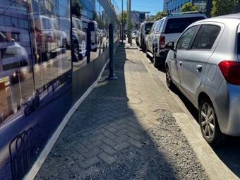
|
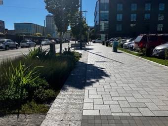
|
|
Worcester
Blvd (hotel frontage)
|
Worcester
Blvd (completed works)
|
4.8 As part of the development of the hotel, consent has been
granted for a porte cochere to be constructed facing onto
Worcester Boulevard. Council staff have worked with the hotel developer to
accommodate this in the design of the recommended option.
4.9 As
the redevelopment of this section of Worcester Boulevard will require removal
of a number of the 13 metered car parks on the north side of Worcester
Boulevard, this report has been presented to the Council to seek approval to
progress.
4.10 The following related memos/information were circulated to the
meeting members:
|
Date
|
Subject
|
|
28
March 2019
|
CNCL/2019/00068: Update to Council re
approach to the renewal of Cathedral Square and resolution sought to commence
works
|
|
2
November 2021
|
Progress update provided to elected
members
|
|
22
March 2023
|
Progress update provided to elected
members
|
Options Considered Ngā Kōwhiringa Whaiwhakaaro
4.11 The
following reasonably practicable options were considered and are assessed in
this report:
4.11.1 Option
1 (recommended option)- To repair and refurbish the northern side of Worcester
Blvd to be consistent with the works completed on the southern side.
4.11.2 Option
2 – Do the minimum works required to facilitate the opening of the hotel
and maintain public safety.
4.12 The
following options were considered but ruled out:
4.12.1 Option
3 -Traditional kerb and channel construction-this option was not pursued as it
does not reflect the work already undertaken on the southern side of this
section of the boulevard, and this does not best support the objective of
creating a shared space as outlined in the original regeneration intention.
4.12.2 Option
4- No change to the existing on-street parking restrictions. This option was
ruled out as it did not allow for the Porte Cochere or accessway off Worcester
Blvd to be constructed, both of which were consented as part of the hotel
redevelopment.
Options Descriptions Ngā Kōwhiringa
4.13 Preferred
Option: To repair and refurbish the northern
side of Worcester Blvd to be consistent with the works completed on the
southern side.
4.13.1 Option
Description: The design is shown in Attachment A. Key features of
this design include:
· Removal
of parking and physical obstructions to allow access for coaches to the
Sheraton Hotel entrance.
· The
construction of a flush road and footpath surface to maintain consistency with
the works completed elsewhere in the Square and on Oxford Terrace.
· Use of a paving design and type similar to elsewhere in the
Square to maintain consistency.
· Increasing footpath width (2.8m) and providing a clear
delineation strip to cater for increased footfall.
· Changes to drainage and underground services to accommodate
altered kerbline.
· Retention
of two 3.2m traffic lanes and the posted 30 km/h speed limit.
· Planting of up to 6 street trees, three on Worcester Blvd
and three on Oxford Terrace and landscape planting beds.
· Alterations to the supports for the tram overhead
powerlines to suit the porte cochere.
4.13.2 Option
Advantages
· This
option is supported by the developer of the Sheraton Hotel and has been
circulated to stakeholders with a development interest in Cathedral Square.
· This
enables the construction of the porte cochere and access off Worcester Blvd.
These have both been consented as part of the hotel's redevelopment.
· The
other proposed kerbside uses (mobility parks, taxi/loading zone) are proposed
to service the Regent development, the Sheraton Hotel and future land uses on
this section of Worcester Blvd.
· The
design of the recommended option is consistent with the recent upgrades
on the south side of the street and elsewhere in Cathedral Square.
· Completion
of the works along the northern side of Worcester Street in one pass will
reduce revisit costs and disruption for existing developments.
· The
hotel porte cochere requires changes to the way the tram power lines are
supported. The recommended option allows for this to be carried out along
Worcester Street in one pass, reducing the chance of future revisit costs.
4.13.3 Option
Disadvantages
· This
option will require the removal of the 13 existing metered carparks on this
side of Worcester Blvd. These are proposed for removal from the hotel's porte
cochere and access way (7 metered parks) and for implementing the tree-planting
and parking layout shown on the plan (6 metered parks). This will impact on
both revenue and public parking availability adjacent to the square.
· Due to
the inclusion of the loading zone and mobility park, it is not considered
practicable to include metered parking for the two proposed P30 car parks.
· This is
a high-quality, and therefore high-cost solution, which is expected to tie into
future, as yet unknown, works. Therefore there is little flexibility should
developments not materialise as expected.
4.14 Alternative
Option: Do the minimum works required to facilitate the opening of the
hotel and maintain public safety.
4.14.1 Option
Description: The design is shown in Attachment B. Key features of
this design include:
· Removal
of some metered parks, and installation of dropped kerb, across access to
Sheraton to facilitate access for coaches.
· Retention
of 6 of the 13 metered parking spaces
· Keep
existing kerb line and road surface
· Installation
of asphalt footpath surface
· Alterations
to tram overhead power supports only as necessary for the construction of the
porte cochere
4.14.2 Option
Advantages:
· This
enables the construction of the porte cochere and access off Worcester Blvd.
These have both been consented as part of the hotel's redevelopment.
· This is
a low-cost solution, that gives greater flexibility should future developments
not materialise as currently anticipated.
· Retains
metered parking adjacent to the square, with impacts on parking availability
and revenue.
4.14.3 Option
Disadvantages:
· The
hotel access has been designed based on expected levels where the footpath
meets the hotel entrance. Without changes to the kerbline, this may lead to the
footpath having inconsistent falls.
· This
option has not been circulated with key stakeholders within the square.
· This
option does not support other proposed kerbside uses (mobility parks,
taxi/loading zone) which have been proposed to service the Regent development,
the Sheraton Hotel and future land uses on this section of Worcester Blvd.
· The
design of this option is inconsistent with the recent upgrades on the south
side of the street and elsewhere in Cathedral Square.
· This
would likely result in further works along the northern side of Worcester
Street needed to be completed at a later date. This is likely to result in
higher overall costs, as well as disruption for existing developments.
· The
hotel porte cochere requires changes to the way the tram power lines are
supported. This option would likely mean completing changes to the tram power
in two stages.
Analysis Criteria Ngā Paearu Wetekina
4.15 Both
options support the consent conditions for the Sheraton Hotel, and address
known condition issues.
4.16 However,
the staff recommended option has been selected for the following reasons:
· It has a
finish consistent with the recovery plan, and the recently completed southern
side of Worcester Street
· Has been
consulted with, and supported by, the adjacent hotel developer to ensure a
compatible interface in terms of accessibility and function
· Is
likely to result in lower overall costs due to not requiring a second visit to
complete the works in this area.
4.17 However,
staff note that the recommended option is significantly more expensive
initially, and therefore provides less flexibility for adapting to future
developments.
5. Financial Implications Ngā Hīraunga Rauemi
5.1 The
recommended option is estimated to cost $2.5 million to construct, with the
main project costs components being:
· Carriageway repairs and
resurfacing
· Footpaths
· Stormwater management
· Lighting Poles and
Fittings
· Tram Work (Cost will be
offset in relationship to tram upgrade project)
· Planting and maintenance
· Works on Behalf of CCC
(e.g. Cameras, etc.)
5.1.2 Due
to the nature of works within the Central City, and the concentration of
underground utilities in this area, staff have allowed a higher contingency
allowance. This will be refined as the Detailed Design progresses.
Capex/Opex Ngā Utu Whakahaere
|
|
Recommended Option
|
Do Minimum
|
|
Cost to Implement
|
$2.5M
|
$0.5m
|
|
Maintenance/Ongoing Costs
|
Maintenance
of new street trees and planting beds is estimated to cost $3,000 per year
|
Minimal
change to existing
|
|
Funding Source
|
CPMS#83801 Cathedral Square - Worcester Boulevard
(Oxford Terrace - Cathedral Square)
And
CPMS#60273 Cathedral Square Roading Network
|
CPMS#83801 Cathedral Square - Worcester Boulevard
(Oxford Terrace - Cathedral Square)
And
CPMS#60273 Cathedral Square Roading Network
|
|
Funding Availability
|
$14.0m
|
$14.0m
|
|
Impact on Rates
|
Within
budget, so no additional impact on rates
|
Within
budget, so no additional impact on rates
|
6. Considerations Ngā Whai Whakaaro
Risks and Mitigations Ngā Mōrearea me
ngā Whakamātautau
6.1 There
is a risk that if work does not start on site by August 2026, it will not be
completed prior to the opening of the Sheraton Hotel.
6.2 There
are a high number of underground and overground services in this area. Some
allowances have been made to the rates for working around these (see point
5.1.2), but the extent and exact location has not yet been fully determined.
Legal Considerations Ngā Hīraunga
ā-Ture
6.3 Statutory
and/or delegated authority to undertake proposals in the report:
6.3.1 The
decision-making authority for all decisions in connection with Metropolitan
Significance projects sits with the Council.
6.3.2 The
Waipapa Papanui-Innes-Central Community Board will be kept informed.
6.4 Other Legal Implications:
6.4.1 There
is no other legal context, issue, or implication relevant to this decision
beyond the normal decision-making considerations for the Council under the
Local Government Act 2002.
Strategy and Policy Considerations Te Whai Kaupapa here
6.5 The
required decision:
6.5.1 Align
with the Christchurch City Council’s Strategic Framework.
6.5.2 Is
assessed as low significance based on the Christchurch City Council’s
Significance and Engagement Policy. The level of significance was determined by
the work being a refurbishment of the existing roadway while facilitating
access into the Hotel development.
6.5.3 Is
consistent with Council’s Plans and Policies.
6.6 This
report supports the Council's
Long Term Plan (2024 - 2034):
6.7 Transport
6.7.1 Activity: Transport
· Level of Service: 16.0.10 Maintain the perception (resident
satisfaction) that Christchurch is a walking friendly city - >=85% resident
satisfaction
· Level of Service: 16.0.2 Improve roadway condition, to an
appropriate national standard, measured by smooth travel exposure (STE)(DIA 2)
- >=75% of the sealed local road network meets the appropriate national
standard
· Level of Service: 16.0.9 Improve resident satisfaction with
footpath condition - >=43%
Community
Impacts and Views Ngā Mariu ā-Hāpori
6.8 The
recommended option has been developed alongside the hotel operator, and the
design is consistent with what has been constructed on the east side of the
road.
6.9 This
option has been shared with 24 people who have development interests in the
square and has received no objection.
6.10 The
development of this option has been discussed with the tram operator who has
confirmed that it has no impact on the tram operation.
6.11 The
decision affects the following wards/Community Board areas:
6.11.1 Waipapa
Papanui-Innes-Central Community Board
Impact
on Mana Whenua Ngā
Whai Take Mana Whenua
6.12 The decision does not
involve a significant decision in relation to ancestral land, a body of
water or other elements of intrinsic value, therefore this decision does not specifically impact Mana Whenua, their culture, and
traditions.
6.13 The decision does not involve a matter of interest to Mana Whenua and will not impact on our agreed partnership priorities
with Ngā Papatipu Rūnanga.
Climate
Change Impact Considerations Ngā Whai Whakaaro mā te Āhuarangi
6.14 The
decisions in this report are likely to:
6.14.1 Contribute
neutrally to the impacts of climate change.
6.14.2 Contribute neutrally to emissions reductions.
6.15 In
the development of this project, the following actions are proposed to reduce
the carbon footprint of the project:
· The
re-use of existing Cathedral Square granite pavers on the Worcester Boulevard
footpath to reduce the need to purchase new pavers.
· The
construction and installation of the majority of the pavers on a flexible base
to allow for access to services in the future.
· New
concrete carriageway pavers to be locally produced using local resources.
· Uplift
and storage of existing old concrete pavers from the carriageway for use in
repairs of areas where needed in the future further along Worcester Boulevard.
7. Next Steps Ngā Mahinga ā-muri
7.1 If
the recommendations are accepted, staff will progress the detailed design and
commence the procurement process for the streetscape works to progress in line
with the timeframes for the opening of the Sheraton Hotel in early 2027.
7.2 It
is expected that construction will begin in Spring 2026.
Attachments Ngā Tāpirihanga
|
No.
|
Title
|
Reference
|
Page
|
|
a ⇩
|
Cathedral
Square Area 9B For Approval
|
25/2619475
|
162
|
|
b ⇩
|
Worcester
Street (Oxford Tce to Cathedral Square, Design Area 9B) Do Minimum(3)
|
26/362850
|
163
|
In addition to the attached documents, the following background
information is available:
|
Document
Name – Location / File Link
|
|
Not
applicable
|
Signatories Ngā Kaiwaitohu
|
Authors
|
Jacob Bradbury
- Manager Planning & Delivery Transport
Hannah Pirie -
Senior Project Manager
Tom Williams -
Senior Traffic engineer
|
|
Approved By
|
Stephen Wright
- Head of Transport & Waste Management
Tony
Richardson - Finance Business Partner
John Higgins -
General Manager Strategy, Planning & Regulatory Services
Brent Smith -
General Manager City Infrastructure
|
|
12. Walking Access Act 2008 - Request to be a
Controlling Authority
|
|
Reference Te Tohutoro:
|
25/2555531
|
|
Responsible Officer(s) Te Pou Matua:
|
Elizabeth
Neazor, Manager, Legal and Democratic Services;
Paul Devlin, Manager Regional Parks, Parks
|
|
Accountable ELT Member Pouwhakarae:
|
Andrew
Rutledge, General Manager Citizens and Community
|
1. Purpose and Origin of the Report Te Pūtake Pūrongo
1.1 The
purpose of this report is to request that the Council considers becoming the
Controlling Authority for two walkways (Walkways) to be established
under the Walking Access Act (Act).
1.2 The
request in relation to this originated with the Rod Donald Banks Peninsula
Trust and the Little River Wairewa Community Trust in relation to separate
walkways. The requests from the separate Trusts are being put to the Council
for a decision within one report.
2. Officer
Recommendations Ngā Tūtohu
That the Council:
1. Receives the information in the Walking
Access Act 2008 - Request to be a Controlling Authority Report.
2. Notes that the decision in this report is assessed as low
significance based on the Christchurch City Council’s Significance and
Engagement Policy.
3. Approves the request made by the relevant community groups that
Council become a Controlling Authority of the two (unnamed) Walkways, to be
established pursuant to the Act.
3. Executive Summary Te Whakarāpopoto Matua
3.1 The Council
has been asked to be the Controlling Authority for two specified but unnamed
Walkways to be established pursuant to the Walking Access Act 2008.
3.2 A
Controlling Authority is legally responsible for
marking, controlling, maintaining, developing, and
funding walkways and related facilities, ensuring safe, enduring, and accessible
public walking routes across both public and private land.
3.3 The
Council already owns much of the land that these Walkways will cross (being
roads and other Council land) and each of the Trusts is anticipated to have all
required dealing with landowners where required in relation to land in private
ownership; the Council would need to negotiate these requirements with each
Trust. The default position is always that the Council retains the
statutory liabilities under the Act.
4. Background/Context Te Horopaki
4.1 The
Council has been approached by the Rod Donald Banks Peninsula Trust (RDBPT)
and the Little River Wairewa Community Trust (LRWCT) (jointly, Trusts)
to accept the role as a Controlling Authority in relation to two specific
walking paths (jointly, Walkways) to be established under the Act.
The decision as to whether to accept this role sits with the full Council.
Options Considered Ngā
Kōwhiringa Whaiwhakaaro
4.2 The
following reasonably practicable options were considered and are assessed in
this report:
4.2.1 To agree
to be a Controlling Authority.
4.2.2 To
decline to be a Controlling Authority.
Options Descriptions Ngā
Kōwhiringa
4.3 Preferred
Option: To agree to be a Controlling Authority.
4.3.1 Option
Description: To accept the role as a Controlling Authority in relation to
two specific walking paths (jointly, Walkways) to be established under the Act.
4.3.2 Option
Advantages
· Local Knowledge & Contextual Insight:
The Council has a thorough understanding of local terrain, user patterns,
cultural values, seasonal issues, and landholder relationships, enabling
responsive and context-aware walkway management. Its involvement helps align
walkway management with local priorities and planning frameworks.
· Resource Access & Coordination: The
proposed arrangement is that the individual Trusts will pay for the maintenance
and upkeep of the Walkways however, in the event that the trusts were not able
to cover these costs, the Council has access to budgets, grant funding,
maintenance teams, planning tools, and infrastructure capabilities which can
support formal upkeep of markers, gates, toilets, and other
facilities.
· Enhanced Promotion & Safety: The
Council can actively promote walkways through local marketing, signage,
integration with regional events, and emergency or safety awareness campaigns.
4.3.3 Option
Disadvantages
· Financial & Time Burden:
Managing walkways involves capital and operational costs (for example, regular
maintenance, infrastructure upgrades, and staffing). There is at present no
request for a council contribution, nor any dedicated funding for this and if
the Council was required to cover these costs they would have to come from
existing budgets.
Note: Notwithstanding that under
legislation these costs would sit with the Council, as a condition of agreeing
to be a controlling authority council proposes that it would enter into
agreements with the RDBPT and the LRWCT respectively, so that those costs will
sit with the appropriate Trust. Those agreements will not, however,
reduce the Council’s statutory obligations.
· Competing
Priorities: Councils juggle many responsibilities and walkway
management might not always align with urgent local priorities, potentially
leading to under-resourcing.
· Legal
& Liability Risks: Controlling
authorities have certain obligations/liabilities: ensuring public safety,
signage, maintenance, biosecurity issues, and GPS use. Councils may face
potential claims in case of accidents or environmental damage.
· Community
Tensions: Walkways often cross private land.
Councils may have to mediate landholder concerns, for example, relating to
trespass, litter, invasive species spread, and farm disruption.
4.4 Option
2: To decline to be a Controlling Authority.
4.4.1 Option
Description: To decline the role as a Controlling Authority in relation to
two specific walking paths (jointly, Walkways) to be established under the Act.
4.4.2 Option
Advantages
· The advantages and disadvantages of being a Controlling Authority
are set out in 4.3.2 and 4.3.3 above.
4.4.3 Option
Disadvantages
· The advantages and disadvantages of being a Controlling Authority
are set out in 4.3.2 and 4.3.3 above.
5. Financial Implications Ngā Hīraunga Rauemi
Capex/Opex Ngā Utu Whakahaere
5.1 The
costs for development and maintenance have already been secured by the RDBPT in
relation to one of the Walkways, and it is anticipated that the LRWCT will also
be able to contribute to costs for the other Walkways. If Council was
required to cover maintenance for the Walkways, this would be found within
existing budgets.
6. Considerations Ngā Whai Whakaaro
Risks and Mitigations Ngā
Mōrearea me ngā Whakamātautau
6.1 Set
out above in relation to the Pros and Cons of Council becoming a Controlling
Authority for the Walkways.
Legal Considerations Ngā
Hīraunga ā-Ture
Statutory and/or delegated authority to undertake proposals in the
report:
6.2 The
legal authorisation to consent (or not) to being a Controlling Authority sits
with the full Council. Under the Delegations Register, Council has
delegated all its responsibilities, duties and powers under the Act to the
Chief Executive except “ … (b) the decision to agree to be a
controlling authority (or not as the case may be) under section 36 [of the
Act]; …”.
Other Legal Implications:
6.3 The
pros and cons of this proposal are set out above. The following is
further information about the Act and being a Controlling Authority.
The purpose of the Act is:
6.4 To
provide the public with free, certain, enduring, and practical walking access
to the outdoors, including areas around the coast, lakes, rivers, and public
resources, enabling enjoyment of natural environments; and
6.5 To
establish the New Zealand Walking Access Commission (Commission).
The role of the Commission:
6.6 Among
other matters, the Commission is responsible for with leading and supporting
the negotiation, establishment, maintenance, and improvement of walking access
(including walkways) across both public and private land; and
6.7 The
Commission may be, and may appoint others to be, controlling authorities of
those walking access ways.
Walkways under the Act:
6.8 Walkways
are (essentially) paths across public or private land declared to be
walkways. With respect to private land, these pathways are set via leases
or easements.
The role of a Controlling Authority:
6.9 A
Controlling Authority is legally responsible for
marking, controlling, maintaining, developing, and
funding walkways and related facilities, ensuring safe, enduring, and
accessible public walking routes across both public and private land.
Interaction between Council as a Controlling Authority and the
respective Trusts:
6.10 Each of the Trusts
will enter into agreements with Council setting out the allocation of
obligations and responsibilities if Council does accept the role of the
Controlling Authority with respect to the Walkways. Those
agreements will not, however, reduce Council’s legal obligations under
the Act.
Strategy and Policy Considerations Te Whai
Kaupapa here
6.11 The required <decision/decisions>:
6.11.1 Aligns with the Christchurch
City Council’s Strategic Framework.
6.11.2 Is assessed as low significance based on the Christchurch City
Council’s Significance and Engagement Policy.
6.11.3 Is consistent with Council’s Plans and
Policies.
6.12 This report supports
the Council's
Long Term Plan (2024 - 2034):
6.13 Parks, Heritage and Coastal Environment
6.13.1 Activity:
Parks and Foreshore
· Level of Service: 6.3.5 Customer satisfaction
with the recreational opportunities and ecological experiences provided by the
City's Regional Parks - >=80%
Community Impacts and Views Ngā Mariu
ā-Hāpori
6.14 The decision in relation to both Walkways affects the Banks
Peninsula following wards/Community Board areas.
Impact on Mana Whenua Ngā Whai Take
Mana Whenua
6.15 The
decision does not involve a significant decision in relation to ancestral land,
a body of water or other elements of intrinsic value, therefore this decision <does/does not> specifically impact Mana Whenua, their
culture, and traditions.
6.16 The
decision does not involve a matter of interest to Mana
Whenua and not impact on our agreed partnership priorities with Ngā Papatipu Rūnanga.
Climate Change Impact Considerations Ngā
Whai Whakaaro mā te Āhuarangi
6.15 The
proposals in this report are unlikely to contribute significantly to adaptation
to the impacts of climate change or emissions reductions.
Attachments Ngā Tāpirihanga
There are no
attachments to this report.
In addition to the attached documents, the following background
information is available:
|
Document
Name – Location / File Link
|
|
Not
applicable
|
Signatories Ngā Kaiwaitohu
|
Authors
|
Elizabeth
Neazor - Manager Legal Service Delivery
Paul Devlin -
Manager Regional Parks
|
|
Approved By
|
Andrew
Rutledge - General Manager Citizens and Community
|
|
13. Environmental Partnership Fund - Correction to
report
|
|
Reference Te Tohutoro:
|
26/309163
|
|
Responsible Officer(s) Te Pou Matua:
|
Julie
Pearce – Community Funding Advisor
Roslyn Kerr – Parks, Programmes and Partnerships Manager
|
|
Accountable ELT Member Pouwhakarae:
|
Andrew
Rutledge, General Manager Citizens and Community
|
1. Purpose and Origin of the Report Te Pūtake Pūrongo
1.1 The
purpose of this report is to correct an administrative error in a previous
Council resolution relating to the allocation of a grant from the 2025/26
Environmental Partnership Fund to the Friends of Coronation Reserve and
Witch-Hazel McAlister.
1.2 At
its meeting on 4 February 2026 the Council allocated funds from the 2025/26
Environmental Partnership Fund. The following link can be used to access
the Council Meeting Minutes: Item 13 https://christchurch.infocouncil.biz/Open/2026/02/CNCL_20260204_MIN_10809_AT.PDF
1.3 The
Council’s resolution did not specify the host organisations that would
hold the funds for the Friends of Coronation Reserve and Witch-Hazel McAlister.
1.4 This
report is staff generated and seeks a correction to the administrative error to
enable payment to be made to the two groups previously approved by the Council.
2. Officer Recommendations Ngā Tūtohu
That the Council:
1. Receives the information in the Environmental Partnership Fund - Correction to
report.
2. Notes that the decision in this report is
assessed as low significance based on the Christchurch City Council’s
Significance and Engagement Policy.
3. Alters the 4 February 2026 Council decision
(CNCL/2026/00015) only in relation to the Environmental Partnership Fund
allocation to the Friends of Coronation Reserve and Witch-Hazel McAlister, as follows (underlining
being the addition):
4. Approves the
recommended allocations from the 2025/26 Environmental Partnership Fund
amounting to $443,033 as detailed below:
|
Organisation
|
Project Name
|
Amount Recommended
|
|
Opawaho Heathcote River Network Incorporated as the
fund holder on behalf of the Friends of Coronation Reserve
|
Coronation Reserve biodiversity enhancement
|
$32,580
|
|
The Little River Wairewa Community Trust as the fund
holder on behalf of the
Witch-Hazel McAlister
|
Okuti Reserve Education Trail
|
$14,327
|
3. Background/Context Te Horopaki
3.1 The
original decision report and attachments to the Council covering the
Environmental Partnership Fund to be addressed can be accessed via the
following links:
· Agenda Item 13: https://christchurch.infocouncil.biz/Open/2026/02/CNCL_20260204_AGN_10809_AT.PDF
· Attachments Item 13:
https://christchurch.infocouncil.biz/Open/2026/02/CNCL_20260204_ATT_10809_EXCLUDED.PDF
Attachments Ngā Tāpirihanga
There are no
attachments to this report.
In addition to the attached documents, the following background
information is available:
|
Document
Name – Location / File Link
|
|
Not
applicable
|
Signatories Ngā Kaiwaitohu
|
Authors
|
Julie Pearce -
Community Funding Advisor
Roslyn Kerr -
Manager Parks Programmes & Partnerships
|
|
Approved By
|
Paul Devlin -
Manager Regional Parks
Rupert Bool -
Head of Parks
Andrew
Rutledge - General Manager Citizens and Community
|
|
14. 2025/2026 Biodiversity Fund Allocation
|
|
Reference Te Tohutoro:
|
26/299378
|
|
Responsible Officer(s) Te Pou Matua:
|
David
Newey, Principal Policy Advisor Biodiversity
Nicholas Head, Senior Ecologist
Lynette Foster, Community Funding Advisor
|
|
Accountable ELT Member Pouwhakarae:
|
Andrew
Rutledge, General Manager Citizens and Community
|
1. Purpose and Origin of the Report Te Pūtake Pūrongo
1.1 The
purpose of this report is for the Council to consider applications for funding
to its 2025/26 Biodiversity Fund.
1.2 This report is the mechanism for the Council to allocate its 2025/26
Biodiversity Fund.
2. Officer Recommendations Ngā
Tūtohu
That the Council:
1. Receives the information in the 2025/2026 Biodiversity Fund
Allocation Report.
2. Notes that the decision in this report is
assessed as low significance based on the Christchurch City Council’s
Significance and Engagement Policy.
3. Approves a grant of
$20,000 from its 2025/26 Biodiversity Fund to Banks Peninsula Conservation
Trust towards Pig's Ear weed control - Le Bons Bay Conservation Trust covenant.
4. Approves a grant of
$20,000 from its 2025/26 Biodiversity Fund to Banks Peninsula Conservation
Trust towards Weed control Kōwhai Bush and Te Ara Pātiki covenants.
5. Approves the application of a grant totalling
$74,988 from the 2025/26 Biodiversity Fund to the Christchurch City Council
regional parks operations budget, to fund the delivery of specialist services
for the control of Pigs Ear and Mt Evans Spur Valerian in areas requiring
contracted abseiling techniques, across the next three years.
6. Approves a grant of
$51,745 from its 2025/26 Biodiversity Fund to The Summit Road Society towards
Ōhinetahi and Linda Woods Reserves Biodiversity Project.
7. Approves a grant of
$15,000 from its 2025/26 Biodiversity Fund to Conservation Volunteers New
Zealand towards Whaka Ora Pest Project.
8. Approves a grant of
$4,000 from its 2025/26 Biodiversity Fund to Little River Campground towards
Manaia Native Habitat Significant Ecological Site.
9. Approves a grant of
$60,000 from its 2025/26 Biodiversity Fund to Marie Neal towards Kaituna
Community Weeding.
10. Approves a grant of $8,475 from its 2025/26 Biodiversity
Fund to Orton Bradley Park Board towards Sea frontage and fish passage
restoration for possum traps only.
11. Approves a grant of
$25,272 from its 2025/26 Biodiversity Fund to Pikiraki Limited towards Owhetoro
Forest Restoration.
12. Approves a grant of $68,812 from its 2025/26 Biodiversity Fund to
Styx Living Laboratory Trust towards Pūharakekenui | Styx River
Restoration at 188 Radcliffe Road.
a. Notes the total amount to be paid in 2025/26
to be spent over two years with progress reporting to be provided in January
2027 and January 2028.
13. Approves a grant of $43,080 from its 2025/26 Biodiversity Fund to
Te Hapū o Ngāti Wheke Inc towards Hokinga Rāpaki Native Reserve
875.
14. Declines a grant from its 2025/26 Biodiversity
Fund to Living Springs Trust for Living Springs Weed control.
15. Declines a grant from its 2025/26 Biodiversity
Fund to Macbeth and Dann Farm Partnership for Macbeth and Dann Waterway and
Wetland Restoration Project.
16. Declines a grant from
its 2025/26 Biodiversity Fund to Reagan Knapp for Opara Riverside Biodiversity
Enhancement.
17. Declines a grant from its 2025/26 Biodiversity
Fund to Reagan Knapp for Opara Riverside Biodiversity Enhancement - site 2.
18. Declines a grant from its 2025/26 Biodiversity
Fund to Te Ara Kākāriki Greenway Canterbury Trust for Whakaora Hoon
Hay Valley Project.
19. Declines a grant from its 2025/26 Biodiversity
Fund to Te Hapū o Ngāti Wheke Inc for Whakamahere a Ngāti Wheke.
3. Executive Summary Te Whakarāpopoto Matua
3.1 Biodiversity funding supports the Council's statutory
obligations to protect significant indigenous biodiversity on private land and
empowers local communities to assist the Council in this task.
3.2 This
report presents staff recommendations on a number of eligible applications to
the 2025/26 Biodiversity Fund. A detailed matrix analysis of each
application is attached to this report as Attachment A. A summary of each
application is attached as Application B.
4. Background/Context Te Horopaki
4.1 Halting
the decline of indigenous biodiversity is a matter of national importance, and
a core statutory function of District Councils. The Christchurch district
comprises a diverse assemblage of ecosystems that support internationally and
nationally important habitats for wildlife, as well as population strongholds
for numerous threatened and rare species. Most remnant ecosystems and
indigenous biodiversity occur on private land in the district.
4.2 The
Biodiversity Fund supports landowners working to protect ecologically
significant sites on their land. The fund is a tool established to both support
landowners with Significant Ecological Sites (SES) on their property and as an
implementation tool for the Council’s Biodiversity Strategy. The Council
can provide funding for eligible projects on private land matched with a
similar in-kind contribution by the grant recipient. Up to $500,000 is
available for allocation this year.
4.3 Funding
supports a partnership approach with landowners or groups. The fund criteria
require the work to be based on private land, and for landowners or groups
carrying out the work to be contributing in a “like for like”
context through volunteer labour and/or materials.
4.4 The
Fund is an opportunity to support private landowners taking voluntary action,
and investing their own time and money, to protect and enhance indigenous
biodiversity on their properties. The projects provide real protection for
biodiversity in the Christchurch District through empowering locals and local
communities to take direct action.
4.5 Since
the fund was established in 2017, more than $2,500,000 has been allocated to
projects (excluding the current applications). Previous projects involved
fencing, restoration planting, pest plant control and pest mammal control. Some
projects involve multiple activities.
4.6 Over
approximately 2500 hectares of ecologically significant vegetation has been
protected, along with the indigenous fauna that live in those habitats. Many
projects have also protected streams and important waterways.
Options Considered Ngā Kōwhiringa Whaiwhakaaro
4.7 The
following reasonably practicable options were considered and are assessed in
this report:
4.7.1 Option
one is to either approve or decline applications as recommended.
4.7.2 Option
two is to change all or part of the recommendations.
4.7.3 Option
three to leave one of more applications on the table for further consideration
at a later date.
Options Descriptions Ngā Kōwhiringa
4.8 Preferred
Option: Either approve or decline applications as recommended.
4.8.1 Option
Description: Either approve or decline applications as recommended.
4.8.2 Option
Advantages
· Recommendations
are carefully considered and peer-reviewed, expert advice was obtained, they
are consistent with Biodiversity Fund eligibility and assessment criteria along
with Council’s strategic goals.
4.8.3 Option
Disadvantages
· Biodiversity
Fund balance would be reduced with less funding potentially available for other
opportunities.
4.9 Option
2: Change all or part of the recommendations.
4.9.1 Option
Description: Change all or part of the recommendations.
4.9.2 Option
Advantages
· Elected
Member scrutiny is an important element of the grant allocation process often
providing a wide-angle community lens over recommendations and a city-wide
perspective.
· Allows
for another layer of evidence-based consideration of the application.
4.9.3 Option
Disadvantages
· Changes
that are not evidence based can compromise a robust assessment process.
4.10 Option
3: Leave one or more applications on the table for further consideration at a
later date.
4.10.1 Option
Description: Leave one or more applications on the table for further
consideration at a later date.
4.10.2 Option
Advantages
· This
allows Elected Members to request further information and/or staff analysis to
inform their decision making, avoiding the need to reject an application
outright or make insufficiently informed changes.
4.10.3 Option
Disadvantages
· Delaying
the decision will extend the timeframe before the group can plan next steps,
potentially impacting project timelines and costs.
Analysis Criteria Ngā Paearu Wetekina
4.11 Applications
are assessed by a cross-Council panel of staff and prioritised accordingly.
Three primary criteria are used to determine applications’
eligibility:
· Must be private land.
· The site has significant
ecological values.
· The site has some form of
enduring protection, meaning there is work happening toward enduring
protection; or for landscape scale projects there is sufficient
governance/experience/expertise in place that staff are satisfied projects will
be managed appropriately.
4.12 In
addition to these primary criteria, applicants are required to contribute 50%
of the cost of the project, either “in kind” through their, or
others, voluntary actions or donation of goods and services.
4.13 The
Fund does not cover:
· Legal challenges or the
Environment Court challenges against the Council, Council Controlled
organisations or Community Board decisions.
· Projects or initiatives
that change the scope of a Council project or lead to ongoing operational costs
to the Council.
4.14 To
determine relative priority of applications, further consideration is given to
the national priorities for protecting indigenous biodiversity on private land,
which provides a useful context to compare relative merits of applications if
required.
4.15 Based
on the Biodiversity Fund criteria (see attachment X), the applications above
are eligible for funding. The attached Decision Matrix (see attachment Y)
provides detailed information on the applications. This includes
organisational details, project details, and financial information and a staff
assessment.
5. Financial Implications Ngā Hīraunga Rauemi
Capex/Opex Ngā Utu Whakahaere
|
|
Recommended Option
|
Option 2 – Change Recommendation
|
Option 3 – Leave applications on the
table
|
|
Cost to Implement
|
$391,372
|
To be determined
|
To be determined
|
|
Ongoing Costs
|
Nil
|
Nil
|
Nil
|
|
Funding Source
|
2025/26 Biodiversity Fund Total $500,000
|
2025/26 Biodiversity Fund Total $500,000
|
2025/26 Biodiversity Fund Total $500,000
|
|
Balance Remaining
|
$101,628
|
To be determined
|
To be determined
|
|
Impact on Rates
|
Nil
|
Nil
|
Nil
|
5.1 At the time of writing, the balance of the 2025/26 Biodiversity Fund
is $500,000.
5.2 $391,372
is recommended to be awarded from the 2025/26 Biodiversity Fund.
5.3 The
remaining balance of $108,628 will sit in the Biodiversity Fund for future
allocation.
6. Considerations Ngā Whai Whakaaro
Risks and Mitigations Ngā Mōrearea me
ngā Whakamātautau
6.1 There
are no significant risks associated with allocating funds to the projects as
recommended. Checks and balances are in place to ensure the funding granted to
projects is spent in accordance with the project plan and meets expectations,
including progress reports, proof of completions and inspections if necessary.
Staff time in relation to this is an inherent part of overseeing the
fund.
Legal Considerations Ngā Hīraunga
ā-Ture
6.2 Statutory
and/or delegated authority to undertake proposals in the report:
6.2.1 The
Council has the delegation to consider applications to the Biodiversity Fund.
6.3 Other Legal Implications:
6.3.1 There
is no legal context, issue, or implication relevant to this decision.
Strategy
and Policy Considerations Te
Whai Kaupapa here
6.4 The
required decision aligns with the Green and Liveable City community outcome
“Our neighbourhoods and communities are accessible and well connected,
supporting our goals to reduce emissions, build climate resilience and protect
and regenerate the environment, especially our biodiversity, water bodies and
tree canopy” by supporting individual landowners to protect and enhance
biodiversity on private land.
6.5 The
decision is consistent with Council Plans and Policies. The
programme aligns with the Council’s Biodiversity Strategy, supporting
implementation of Goal 1 “Conserve and restore Christchurch’s and
Banks Peninsula’s indigenous biodiversity” and Goal 3
“Encourage widespread participation in support of indigenous biodiversity
conservation.” To assist with implementation, staff work with Environment
Canterbury and covenanting agencies to ensure that projects have adequate support
and that our combined resources are efficiently allocated.
6.6 The
decisions in this report are assessed as low significance based on the
Council’s Significance and Engagement Policy. This is because the
decision affects a small number of people (the applicants), and the impact is
positive for both the applicants and the environment; the
decision allocates funding already provided for in the Long-Term Plan
2021-2031.
6.7 The
programme aligns with District Plan policies regarding the protection of
ecologically significant sites, and the provision of advice and incentives for
landowners who wish to do this on private property.
6.8 This
report supports the Council's
Long Term Plan (2024 - 2034):
6.9 Citizens and communities
6.9.1 Activity: Community Development and Facilities
· Level of Service: 2.3.1.1 Provide funding for projects and
initiatives that build partnerships; resilient, engaged and stronger
communities, empowered at a local or community of interest level - 100% of
funding assessments detail rationale and demonstrate benefits aligned to
Council's strategic priorities, and where appropriate, Community Board Plans
Community
Impacts and Views Ngā Mariu ā-Hāpori
6.10 The
community is very supportive of the Council contributing funds to assist with
conservation on private land. Several submissions were made by community groups
and individuals to the Long-Term Plan 2021-2031 requesting that the Council
increase the annual allocation to the Biodiversity Fund. As a result, the fund
was increased to $400,000 and further to $500,000 for the 2024/25 year - an
outcome consistent with the Council declaring an ecological and climate
emergency.
Impact
on Mana Whenua Ngā
Whai Take Mana Whenua
6.11 The
decision does not involve a significant decision in relation to
ancestral land or a body of water but does involve indigenous species and
ecosystems that have intrinsic values. Therefore, this decision does impact
Mana Whenua, their culture, and traditions. Staff note, however, that the
intent of all projects is to have a positive impact on indigenous biodiversity.
6.12 While matters of
indigenous biodiversity are of interest to Mana Whenua, this specific decision
to allocate funding to enhance biodiversity will not
impact our agreed partnership priorities with Ngā
Papatipu Rūnanga.
Climate
Change Impact Considerations Ngā Whai Whakaaro mā te Āhuarangi
6.13 The
decisions in this report are likely to contribute positively to adaptation to
the impacts of climate change. Most of the projects provide protection and
enhancement to regenerating vegetative habitats, which will boost the carbon
sequestration capacity of these areas. Protecting and enhancing the ecological
health of sites will improve the resilience of the district’s habitats
and species within them to the impacts of climate change.
7. Next Steps Ngā Mahinga ā-muri
7.1 Following
Council decision making staff will advise applicants. Staff will work
with successful applicants ensuring the respective projects are delivered in a
manner consistent with the application.
7.2 Successful
applicants will be required to complete the requisite report-back obligations.
Attachments Ngā Tāpirihanga
|
No.
|
Title
|
Reference
|
Page
|
|
a
|
Biodiversity
Fund 2025/26 Matrix (Under Separate Cover)
|
26/239937
|
|
|
b
|
Biodiversity
Fund 2025/26 Summary Applications (Under Separate Cover)
|
26/240218
|
|
In addition to the attached documents, the following background
information is available:
|
Document
Name – Location / File Link
|
|
Not
applicable
|
Signatories Ngā Kaiwaitohu
|
Authors
|
John Filsell -
Head of Community Support and Partnerships
Dave Newey -
Principal Advisor Policy - Biodiversity
Lynette Foster
- Community Funding Advisor
Jacqui Jeffrey
- Community Funding Advisor
|
|
Approved By
|
John Filsell -
Head of Community Support and Partnerships
Andrew
Rutledge - General Manager Citizens and Community
|
|
15. 2025/26 Capital Endowment Fund - March 2026
|
|
Reference Te Tohutoro:
|
26/112670
|
|
Responsible Officer(s) Te Pou Matua:
|
John
Filsell, Head of Community Support and Partnerships;
Jacqui Jeffrey, Community Funding Advisor
|
|
Accountable ELT Member Pouwhakarae:
|
Andrew
Rutledge, General Manager Citizens and Community
|
1. Purpose and Origin of the Report Te Pūtake Pūrongo
1.1 The
purpose of this report is for the Council to consider one application to its
Capital Endowment Fund (CEF) for the 2025/26 financial year.
1.2 This
is a staff generated report as a result of an application to the CEF from a
community-based organisation.
2. Officer Recommendations Ngā
Tūtohu
That the Council:
1. Receive the information in the 2025/26 Capital Endowment Fund -
March 2026 Report.
2. Notes that the decision in this report is
assessed as low significance based on the Christchurch City Council’s
Significance and Engagement Policy.
3. Approves a grant of $75,000 from its 2025/26
Capital Endowment Fund to the Governors Bay Jetty Restoration Trust towards the
relocation of the yacht club building to Governors Bay, conditional on the applicant demonstrating they have
sufficient resources to complete the project and the production of a robust project plan demonstrating how the
project will be delivered before
funds are drawdown.
3. Executive Summary Te Whakarāpopoto Matua
3.1 This
report presents an application for funding from the CEF 2025/26.
3.2 The Governors Bay Jetty Restoration Trust (Jetty Trust) are
requesting a grant to contribute to the cost of moving a historic structure
from storage to create a community space for kayak storage, community events
and art space. This will sit alongside the Historic Governors Bay Jetty
as part of a wider community precinct.
· This application is not
connected to the Jetty project currently supported by Council.
· Following a thorough
assessment this report will recommend that Council approve a grant of $75,000.
4. Background/Context Te Horopaki
Governors
Bay Jetty Restoration Trust (Jetty Trust)
4.1 Governors Bay Jetty Restoration Trust are proposing to relocate a
historic yacht club building to a space near the Governors Bay Jetty for use as
a community recreational space.
· The refurbished building
is intended to serve as a base for a proposed kayak park and provide amenities
for visitors to the jetty. The facility will include toilets, picnic tables,
equipment storage, and indoor space for public use, community events, and
marine education. It will also feature an information centre focused on the
history of Te Whakaraupō and a designated area for local artists and
craftspeople to exhibit and sell their work.
· The historic Canterbury
Yacht and Motorboat Club building, originally constructed in 1923, is currently
stored at Lyttelton port. The port company are keen for it to be
relocated.
· The Boat House, once
renovated, will not require ongoing operational investment from the
Council. The facility will be self-sustaining through rental income and
community support.
4.2 The
Jetty Trust has a track record of planning, fundraising for and delivering
large-scale capital projects, having overseen the rebuild of the Jetty itself
following earthquake damage to the structure. The yacht club building will
contribute to the ongoing financial sustainability of both the Boat House and
Jetty, generating revenue for maintenance
4.3 It
is recommended that Council approve a grant of $75,000 towards
the relocation of the yacht club building, conditional on the applicant demonstrating they have sufficient
resources to complete the project before funds are drawdown, because;
· The completed project will
establish a community-accessible kayak facility that accommodates educational
programs, recreation, equipment storage, and public use.
· The project improves
amenities at the Jetty by adding public toilets, seating, commercial space, and
historical displays for visitors. It activates the waters at the Head of
the Harbour.
· Christchurch’s
maritime heritage is preserved by relocating and repurposing a historic yacht
club building to reflect the history of Te Whakaraupō. The project
involves saving a historical asset of the community. Port
Lyttelton, who are storing the building wish to have it removed from their
site.
4.4 Whilst
the Jetty Trust requested a contribution of $200,000 the recommendation is for
$75,000 the specific rationale for this recommendation is that.
· A council contribution of
$75,000 will represent a valuable boost supporting the project for the reasons
detailed in section 4.8 of this report above.
· Whilst having a city-wide
perspective much of the benefit derived from this project will be of a local
nature. $75,000 is consistent with this delineation.
· The building is smaller in
size and the precinct in which it will be installed is confined. Physical
limitations will inhibit widespread and extensive use. Again, a
contribution of $75,000 fairly reflects this.
· A Council contribution of
$75,000 effectively balances a meaningful and willing up-front contribution
against the size, scale and focus of the project. It represents continued
Council investment in a unique community whilst recognising the anticipated
need for the CEF to support a wide range of initiatives in financially
constrained times.
Capital
Endowment Fund
4.5 This application is eligible
for funding from the CEF as there is evidence that;
· the proposal is for a
specific project or activity projects,
· the project demonstrates a
benefit for the city of Christchurch, or its citizens, or for a community of
people living in Christchurch, and
· the benefits will be
experienced now and in the future.
4.6 This
application has been assessed according to Council criteria and the assessment
peer reviewed. A summary of the assessment is attached to this report Attachment
A.
Options Considered Ngā Kōwhiringa Whaiwhakaaro
4.7 The
following reasonably practicable options are available to councillors
considering this report:
4.7.1 Option
1 (preferred option): Agree to the recommendation for a CEF grant to the
organisation as detailed in sections 4.8 and 4.9 of this report respectively.
4.7.2 Option
2: Change the amount recommended.
4.7.3 Option
3: Decline the application.
4.7.4 Option
3: Request that the application is left on the table or withdrawn and
re-presented.
Options Descriptions Ngā Kōwhiringa
4.8 Option 1 -
Preferred Option: Agree to the recommendations for CEF grants to the
organisations as discussed in the Background section and Attachment A of this
report.
4.8.1 Option
Description: Agree to the recommendations for CEF grants to the
organisations as detailed in sections 4.3 and 4.4 of this report respectively.
4.8.2 Option
Advantages
· Recommendations are
carefully considered and peer-reviewed, expert advice was obtained, they are
consistent with CEF eligibility and assessment criteria along with
Council’s strategic goals.
4.8.3 Option
Disadvantages
· CEF balance would be
reduced with less funding potentially available for other opportunities.
4.9 Option
2: Change the amount recommended.
4.9.1 Option
Description: Under this option, Councillors can make changes to the
recommendations made in this report.
4.9.2 Option
Advantages
· Councillor scrutiny is an
important element of the grant allocation process often providing a wide-angle
community lens over recommendations and a city-wide perspective.
· Allows for another layer
of evidence-based consideration of the application.
4.9.3 Option
Disadvantages
· Changes that are not
evidence based can compromise a robust assessment process.
4.10 Option
3: Decline the application
4.10.1 Option
Advantages
· CEF balance would remain
unchanged allowing greater scope to support future opportunities.
4.10.2 Option
Disadvantages
· The projects will not
proceed at his time or potentially at all.
4.11 Option
4: Request that the application is left on the
table or withdrawn and re-presented.
4.11.1 Option
Advantages
· This allows Councillors to
request further information and/or staff analysis to inform their decision
making, avoiding the need to reject an application outright or make
insufficiently informed changes.
4.11.2 Option
Disadvantages
· Delaying the decision will
extend the timeframe before the group can plan next steps, potentially
impacting project timelines and costs.
Analysis Criteria Ngā Paearu Wetekina
4.12 Analysis
criteria include but are not limited to an assessment of the application
against the criteria of the CEF, the Council’s strategic goals and the
availability of funds. There is often specialist or expert opinion sought, and
the provisional recommendations are moderated. Analysis criteria are
presented within the assessment of each application and attached to this report
as Attachment A.
5. Financial Implications Ngā Hīraunga Rauemi
Capex/Opex Ngā Utu Whakahaere
|
Organisation
|
Project Name
|
Amount Requested
|
Amount Recommended
|
|
Governors Bay Jetty Restoration Trust
|
Relocation of the historic yacht club
building to Governors Bay
|
$200,000
|
$75,000
|
|
|
Total
|
$200,000
|
$75,000
|
5.1 After
accounting for all current commitments to the CEF, the unallocated portion for
2025/26 is $1,757,344. If the recommendations in this report are
accepted, the remaining available balance for this financial year will be $1,682,344.
5.2 Anticipated
applications to the CEF include but are not limited to Halswell Tennis
Charitable Trust, Dogwatch Sanctuary Trust, Te Tahi Youth Board and Mainland
Rail.
6. Considerations Ngā Whai Whakaaro
Risks and Mitigations Ngā Mōrearea me
ngā Whakamātautau
6.1 Project
Delivery Delays. This risk is mitigated by the fact that project plans
have been reviewed; and that funding drawdowns are conditional on sufficient
resources being demonstrated. Council staff keep regular communication
with applicants to monitor project progress.
6.2 Cost
Overruns. This is mitigated by the one-off nature of CEF grants limiting
any future financial liability to the Council. Applicants are expected to
have contingency plans and secure co-funding for projects where
appropriate. Many of applicants have access to additional fundraising
opportunities, should a project scope expand between the time of applying for
funds, and delivery of their project. The drawdown of approved funding is often
conditional on the applicant confirming the funding targets have been reached
and he production of a robust project plan demonstrating how the project will
be delivered.
6.3 Underspend
of Funding. This risk is mitigated by the condition in the funding agreement
that any unspent funds should be returned to the Council.
6.4 Reputational
Risk. This risk is mitigated by Applications have been assessed
transparently against Council-approved criteria, with detailed staff
assessments available as Attachment A.
Legal Considerations Ngā Hīraunga
ā-Ture
6.5 Statutory
and/or delegated authority to undertake proposals in the report:
6.5.1 The
authority to make decisions relating to the allocation of the CEF sits with the
Council.
Strategy
and Policy Considerations Te
Whai Kaupapa here
6.6 The
required decision:
6.6.1 Align
with the Christchurch
City Council’s Strategic Framework. Particularly the Strategic
Priority to manage ratepayers’ money wisely.
6.6.2 Is
assessed as low significance based on the Christchurch City Council’s
Significance and Engagement Policy. The level of significance was
determined by considering the fact that the CEF is a recently consulted level
of service in the 2024/34 LTP.
6.6.3 Is
consistent with the Council’s Plans and Policies. Specifically, the
Strengthening Communities Together Strategy and the strategic pillar of People.
6.7 This
report supports the Council's
Long Term Plan (2024 - 2034):
6.8 Citizens and communities
6.8.1 Activity: Community Development and Facilities
· Level
of Service: 2.3.1.1 Provide funding for projects and initiatives that build
partnerships; resilient, engaged and stronger communities, empowered at a local
or community of interest level - 100% of funding assessments detail rationale
and demonstrate benefits aligned to Council's strategic priorities, and where
appropriate, Community Board Plans
Community
Impacts and Views Ngā Mariu ā-Hāpori
6.9 The
CEF is a recently consulted level of service in the 2024/34 LTP. Views
and impacts were sought from the applicants and others during the assessment
proves. Wider community views have not been sought.
6.10 Whilst
the CEF and the two projects assessed have a city-wider scope, the decision
affects the following wards/Community Board areas:
· Te Pātaka o Rākaihautū Banks
Peninsula
6.11 The
Community Board viewpoint has not been sought, as the delegation to consider
CEF sits with the Council.
Impact
on Mana Whenua Ngā
Whai Take Mana Whenua
6.12 The decision in this report does not involve a significant
decision in relation to ancestral land, a body of water or other elements of
intrinsic value, therefore this decision does not specifically impact Mana
Whenua, their culture, and traditions.
6.13 The decision does not involve a matter of interest to Mana Whenua
and will not impact on our agreed partnership priorities with
Ngā Papatipu Rūnanga. This is because the subject matter of the
report and decision involves the administration of an existing funding scheme
provided for in the 2024/34 LTP.
Climate
Change Impact Considerations Ngā Whai Whakaaro mā te Āhuarangi
6.14 The
proposal in this report is unlikely to contribute significantly to adaptation
to the impacts of climate change or emissions reductions.
7. Next Steps Ngā Mahinga ā-muri
7.1 The
applicant will be contacted shortly after the publishing of the minutes of the
decision in this report. With any grant funding distributed thereafter as per
the decision made by the Council.
7.2 The drawdown of grant funding is conditional on the applicant
demonstrating they have sufficient resources to complete the project and the
production of a robust project plan demonstrating how
the project will be delivered.
7.3 If
Council resolve to fund the respective project, the applicant will be required
to complete an accountability report back to the Council on the success of the
projects and how the granted funds were spent.
Attachments Ngā Tāpirihanga
|
No.
|
Title
|
Reference
|
Page
|
|
a ⇩
|
Capital
Endowment Matrix March 2026
|
26/314875
|
187
|
In addition to the attached documents, the following background
information is available:
|
Document
Name – Location / File Link
|
|
Not
applicable
|
Signatories Ngā Kaiwaitohu
|
Authors
|
John Filsell -
Head of Community Support and Partnerships
Jacqui Jeffrey
- Community Funding Advisor
|
|
Approved By
|
John Filsell -
Head of Community Support and Partnerships
Andrew
Rutledge - General Manager Citizens and Community
|
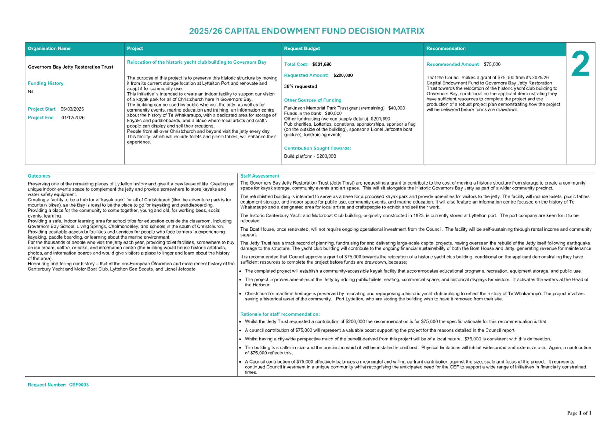
|
16. Discretionary Response Fund March 2026
|
|
Reference Te Tohutoro:
|
26/299691
|
|
Responsible Officer(s) Te Pou Matua:
|
Lynette
Foster, Community Funding Advisor
|
|
Accountable ELT Member Pouwhakarae:
|
Andrew
Rutledge, General Manager Citizens and Community
|
1. Purpose and Origin of the Report Te Pūtake Pūrongo
1.1 The
purpose of this report is for the Council to consider an application for
funding from its 2025/26 Discretionary Response Fund (DRF) from RDU 98.5FM
(RDU).
1.2 The
report is the result of an application to the DRF.
2. Officer Recommendations Ngā
Tūtohu
That the Council:
1. Receives the information in the Discretionary Response Fund
March 2026 Report.
2. Notes that the decision in this report is
assessed as low significance based on the Christchurch City Council’s
Significance and Engagement Policy.
3. Approves a grant of $20,000 from its 2025/26
Citywide Discretionary Response Fund to RDU 98.5FM towards RDU50 - Anniversary
Events Programme.
3. Executive Summary Te Whakarāpopoto Matua
3.1 This
report presents an application from RDU for $88,088 to employ an event manager
to deliver a 50th anniversary series of events and activities.
3.2
A grant of $88,088 was requested. A grant of this magnitude would
substantially impact on the Council’s ability to support other community
organisations with emergency of unforeseen situation over the remainder of the
financial year.
3.3 The
staff recommendation of $20,000 will support RDU to deliver a number of events
and initiatives, aligns with the eligibility criteria of the DRF, takes into
consideration a previous Council directive and ensures there is sufficient
funding available in the DRF to support other community organisations over the
remainder of 2025/26.
4. Background/Context Te Horopaki
Discretionary Response Fund
4.1 The
purpose of the DRF is to assist community groups with emergency or
unforeseen situations. Applications will support community-focused projects
that contribute to the strengthening of community wellbeing in the Christchurch
city area.
The Applicant and Application
4.2 RDU
is a popular citywide radio station. In 2026, RDU 98.5FM marks its 50th
anniversary, and to celebrate this milestone the station is planning a
year-long programme of creative events and community activations. To lead and
deliver this additional activity RDU are seeking $88,088 from the DRF to employ
a Project Manager. The proposed programme includes regular events in
partnership with festivals and creative organisations, pop-ups with their
mobile sound system, as well as a large-scale event.
Summary of the Assessment and Rationale
4.3 The
detailed assessment of the application is summarised in the Decision Matrix
attached to this report in Attachment A.
4.4 RDU
98.5FM presented plans to celebrate their 50th Anniversary to the Council in
August 2025. At this meeting staff were directed to assist with their
programme. An application was received through the Discretionary Response Fund
in mid-December, and while this application does not meet the DRF’s
criteria as an unforeseen or emergency situation, the application is being
assessed as part of the wider directive to support RDU 98.5FM in their 50th
year.
4.5 The
staff recommendation of $20,000 is based on $15,000 towards a programme of
events, and $5000 towards marketing and promotion of the 50th Anniversary. RDU
are encouraged to reapply through the Events and Festivals Fund for their
proposed large scale, free to attend, public event.
4.6 The
staff recommendation aligns with the Council’s direction to assist RDU,
aligns with the eligibility criteria of the DRF and ensures there is sufficient
funding available in the DRF to support other community organisations over the
remainder of 2025/26.
Options Considered Ngā Kōwhiringa Whaiwhakaaro
4.7 The
following reasonably practicable options were considered and are assessed in
this report:
4.7.1 Approve
the recommendation.
4.7.2 Change
the amount recommended.
4.7.3 Decline
the application.
4.7.4 Request
that the application is left on the table or withdrawn and represented.
Options Descriptions Ngā Kōwhiringa
4.8 Preferred
Option: Approve the recommendation.
4.8.1 Option
Advantages
· Recommendations
are carefully considered and peer-reviewed, expert advice is obtained, they are
consistent with DRF eligibility and assessment criteria along with
Council’s strategic goals.
4.8.2 Option
Disadvantages
· The DRF
balance would be reduced with less funding potentially available for other
opportunities.
4.9 Option
2: Change the amount recommended.
4.9.1 Option
Advantages
· Elected
Member scrutiny is an important element of the grant allocation process often
providing a wide-angle community lens over recommendations and a city-wide
perspective.
· Allows
for another layer of evidence-based consideration of the application.
4.9.2 Option
Disadvantages
· Changes
that are not evidence based can compromise a robust assessment process.
4.10 Option
3: Decline the application
4.10.1 Option
Advantages
· DRF
balance would remain unchanged allowing greater scope to support future
opportunities.
4.10.2 Option
Disadvantages
· The
projects will not proceed at his time or potentially at all.
4.11 Option
4: Requesting that an individual application is left on the table or withdrawn
and re-presented.
4.11.1 Option
Advantages
· This
allows Elected Members to request further information and/or staff analysis to
inform their decision making, avoiding the need to reject an application
outright or make insufficiently informed changes.
4.11.2 Option
Disadvantages
· Delaying
the decision will extend the timeframe before the group can plan next steps,
potentially impacting project timelines and costs.
Analysis Criteria Ngā Paearu Wetekina
4.12 Analysis
criteria include but are not limited to an assessment of the application
against the criteria of the DRF, the Council’s strategic goals and the
availability of funds. There is often specialist or expert opinion sought, and
the provisional recommendations are moderated. Analysis criteria are
presented within the assessment of each application in a decision-making matrix
attached to this report as Attachment A.
5. Financial Implications Ngā Hīraunga Rauemi
Capex/Opex Ngā Utu Whakahaere
|
Organisation
|
Project Name
|
Amount Requested
|
Amount Recommended
|
|
RDU 98.5FM
|
RDU50 - Anniversary
events programme - Events Manager
|
$88,088
|
$20,000
|
|
|
Total
|
$88,088
|
$20,000
|
5.1 At the time of writing, the balance of the 2025/26 Discretionary
Response Fund is:
|
Total Budget Current Year
|
Granted To Date
|
Available for allocation
|
Balance If Staff Recommendation adopted
|
|
$226,949
|
$92,269
|
$134,680
|
$114,680
|
5.2 To
date $92,269 has been awarded from the 2025/26 Discretionary Response Fund to
12 organisations.
6. Considerations Ngā Whai Whakaaro
Risks and Mitigations Ngā Mōrearea me
ngā Whakamātautau
6.1 The
main risks are that the decision does not follow the Council’s criteria
for the DRF and that there is insufficient funding to accommodate the
decision. Thes risks can be mitigated by a robust assessment of the
application and a reconciliation of available financial resources prior to each
recommendation.
Legal Considerations Ngā Hīraunga
ā-Ture
6.2 Statutory
and/or delegated authority to undertake proposals in the report:
6.2.1 The
authority to make decisions relating to the allocation of the DRF sits with the
Council.
6.2.2 There
is no legal context, issue, or implication relevant to this decision.
Strategy
and Policy Considerations Te
Whai Kaupapa here
6.3 The
required decision:
6.3.1 Align
with the Christchurch
City Council’s Strategic Framework.
6.3.2 Is
assessed as low significance based on the Christchurch City Council’s
Significance and Engagement Policy. The level of significance was
determined by considering the fact that the DRF is a recently consulted level
of service in the 2024/34 LTP.
6.3.3 Is
consistent with the Council’s Plans and Policies. Specifically, the
Strengthening Communities Together Strategy and the strategic pillar of People.
6.4 This
report supports the Council's Long Term Plan (2024 -
2034):
6.5 Citizens and communities
6.5.1 Activity: Community Development and Facilities
· Level of Service: 2.3.1.1 Provide funding for projects and
initiatives that build partnerships; resilient, engaged and stronger
communities, empowered at a local or community of interest level - 100% of
funding assessments detail rationale and demonstrate benefits aligned to
Council's strategic priorities, and where appropriate, Community Board Plans
Community
Impacts and Views Ngā Mariu ā-Hāpori
6.6 The
DRF is a recently consulted level of service in the 2024/34 LTP. Views
and impacts were sought from the applicants and others during the assessment
process. Wider community views have not been sought.
Impact
on Mana Whenua Ngā
Whai Take Mana Whenua
6.7 The decision in this report does not involve a significant decision
in relation to ancestral land, a body of water or other elements of intrinsic
value, therefore this decision does not specifically impact Mana Whenua, their
culture, and traditions.
6.8 The
decision does not involve a matter of interest to Mana Whenua and will not
impact on our agreed partnership priorities with Ngā Papatipu
Rūnanga. This is because the subject matter of the report and
decision involves the administration of an existing funding scheme provided for
in the 2024/34 LTP.
Climate
Change Impact Considerations Ngā Whai Whakaaro mā te Āhuarangi
6.9 The
decision in this report is unlikely to contribute significantly to adaptation
to the impacts of climate change or emissions reductions.
7. Next Steps Ngā Mahinga ā-muri
7.1 The
applicant will be contacted shortly after the publishing of the minutes of the
decision in this report. With any grant funding distributed thereafter as per
the decision made by the Council.
7.2 If
Council resolve to fund the respective project, the applicant will be required
to complete an accountability report back to the Council on the success of the
projects and how the granted funds were spent.
Attachments Ngā Tāpirihanga
|
No.
|
Title
|
Reference
|
Page
|
|
a ⇩
|
RDU 98.5
Decision Funding Matrix
|
26/180333
|
194
|
In addition to the attached documents, the following background
information is available:
|
Document
Name – Location / File Link
|
|
Not
applicable
|
Signatories Ngā Kaiwaitohu
|
Authors
|
John Filsell -
Head of Community Support and Partnerships
Lynette Foster
- Community Funding Advisor
|
|
Approved By
|
John Filsell -
Head of Community Support and Partnerships
Andrew
Rutledge - General Manager Citizens and Community
|
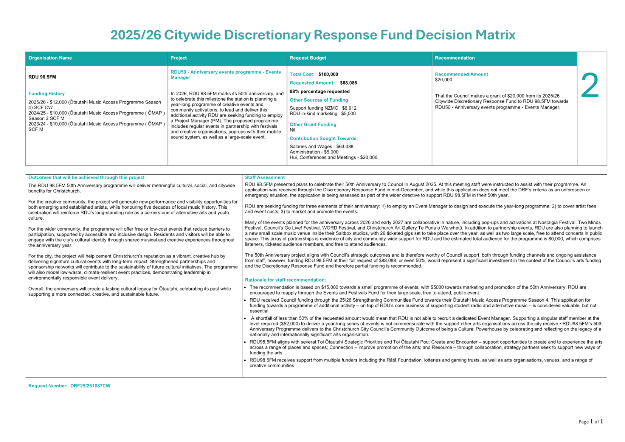
|
17. Ōtākaro Avon River Corridor Regeneration
Committee - draft Terms of Reference
|
|
Reference Te Tohutoro:
|
25/291386
|
|
Responsible Officer(s) Te Pou Matua:
|
Rupert
Bool, Head of Parks
|
|
Accountable ELT Member Pouwhakarae:
|
Andrew
Rutledge, General Manager Citizens and Community
|
1. Purpose and Origin of the Report Te Pūtake Pūrongo
1.1 On
19 February 2025 (item
7, minutes)
the Council agreed to disestablish the Ōtākaro Avon River Corridor
(OARC) Establishment Committee, and replace it with an
interim Committee of Council. The
OARC Regeneration Committee will provide governance for the implementation of
the OARC Regeneration Programme, aligned with the OARC Assessment Framework, Regeneration
Plan, OARC Activity Plan and consenting, policy and legislative requirements.
1.2 At the February 2025 meeting, the Council agreed that membership of
the interim Committee would comprise up to three
representatives appointed by Ngāi Tūāhuriri and the Ihutai Ahu
Whenua Trust (MR900) and up to three Council representatives,
including the Mayor and Deputy Mayor and one of the councillors who
represents the Ōtākaro Avon River Corridor local communities.
1.3 The
purpose of this report is for the Council to:
1.3.1 Establish
the Ōtākaro Avon River Corridor (OARC) Regeneration Committee;
1.3.2 Confirm
the ward councillor to be a member of the OARC Regeneration Committee; and
1.3.3 Adopt
the Terms of the Reference for the OARC Regeneration Committee.
2. Officer Recommendations Ngā
Tūtohu
That the Council:
1. Receives the information in the Ōtākaro Avon River
Corridor Regeneration Committee - draft Terms of Reference Report.
2. Notes that the decision in this report is
assessed as low significance based on the Christchurch City Council’s
Significance and Engagement Policy.
3. Agrees to establish the Ōtākaro Avon
River Corridor Regeneration Committee.
4. Confirms the appointment of the Councillor for [ward]
Ward to the Ōtākaro
Avon River Corridor Committee
5. Notes that Te Ngāi
Tūāhūriri Rūnanga and Te Ihutai Ahu Whenua Trust (MR900) will appoint its representatives.
6. Approves the Terms of Reference (Attachment
A) for the Ōtākaro Avon River Corridor, Governance Committee.
7. Notes that staff will schedule the first OARC
Committee meeting for the second quarter of 2026.
3. Executive Summary Te Whakarāpopoto Matua
3.1 The purpose of the Ōtākaro Avon River Corridor
(OARC) Regeneration Committee is to provide governance for the implementation
of the OARC Regeneration Programme to ensure the ecological, cultural,
social and economic benefits of the OARC, and to protect and secure the environmental integrity and the health of the OARC's mahinga kai
and awa.
3.2 At
its February 2025 meeting, the Council agreed to the OARC Establishment
Committee’s recommendation to establish a Committee of Council as an
interim decision-making body for the governance of the OARC. A
partnership approach for the development of the OARC is key to ensuring Te
Ngāi Tūāhuriri Rūnanga, as mana
whenua, has the ability to exercise its rangatiratanga.
3.3 The
decisions in this report will establish the interim Committee. The Committee
will consist of up to three representatives appointed by Te
Ngāi Tūāhuriri Rūnanga and the
Ihutai MR900 Trust; and up to three Council representatives,
including the Mayor and Deputy Mayor and one of the councillors who represents
the Ōtākaro Avon River Corridor local communities, noting that the
number of appointees from Council and Ngāi Tūāhuriri will
be equal in number.
3.4 This
report also requests the Council to adopt the draft Terms of Reference for the
Committee, which provide the functions and delegations for the Committee. All decisions must align with the OARC Assessment
Framework, Regeneration Plan, OARC Activity Plan and be consistent with the
Council’s obligations under the global stormwater discharge consent, the
Christchurch District Plan, Council policy, national and regional policies and
strategies, and legislation and the guiding documents for the OARC.
3.5 To
achieve the outcomes for the OARC Council staff will continue working with
Whitiora Centre Limited, the authority mandated by the Rūnanga. Specific
science-based advice may also be sought from the University of Canterbury Ngāi Tahu Research Centre, as required
to support living laboratory initiatives in the OARC.
4. Background/Context Te Horopaki
4.1 The
September 2010 and February 2011 earthquakes severely affected the
Ōtākaro Avon River and surrounding area, with the Government
classifying the 602 hectares as a residential red zone. A Regeneration
Plan was developed following extensive community and stakeholder
engagement.
4.2 The Specific Purpose (Otākaro Avon River Corridor) Zone relates
to the area of land covered by the Ōtākaro Avon River Corridor
Regeneration Plan. It is made up of 8 different areas, including the Green
Spine, which provide for different ranges of activities and outcomes. Some
provide for ecological restoration, stormwater management, flood protection,
public open space and outdoor recreation. Others provide for some different
types of activities and scales of built development, including activities
relating to education, recreation, visitor attractions, eco-tourism,
entertainment, retailing, edge and adaptive housing.
4.3 Continuing
to work closely with the community is a high priority for the development of
the OARC to create a legacy asset for both the city and New Zealand. The
Regeneration Plan acknowledged Ngāi Tūāhuriri and the Ihutai Ahu
Whenua Trust collectively represent mana whenua and have property rights and
interests that are established by the Ngāi Tahu Claims Settlement Act
1998.
4.4 The
Global Settlement Agreement, signed by the Crown and the Council in 2019,
outlined a process of transition planning for governance arrangements. The Agreement noted that the Council could establish a permanent
community co-governance entity for the OARC should it choose to do so.
4.5 The
Council set up an Establishment Committee for the OARC programme in 2022 to:
4.5.1 provide
strategic direction, leadership and decision-making to ensure the OARC and the
Ōtākaro Avon River are developed, managed and maintained to provide
the optimal ecological, cultural, social and economic benefits;
4.5.2 provide
advice on the development of the enduring co-governance entity/framework for
the OARC.
4.6 The
Establishment Committee endorsed an Assessment Framework for all projects and
proposals to be evaluated against. The Assessment Framework aligns with the
principles and objectives of the Regeneration Plan. This Council formally
adopted the Framework in February 2025 (item
7). It is included in the draft Terms of Reference as an appendix, as
discussed below.
5. Interim Committee of Council
5.1 The Establishment Committee was
disestablished in February 2025 (item
7), with the Council agreeing to a two-phased
collaborative governance approach:
· Phase
1: establishment of a Committee of Council
as an interim decision-making body, followed by
· Phase
2: establishment of a charitable trust.
5.2 A
partnership approach for the development of the OARC is key to ensuring the
rūnanga has the ability to exercise its rangatiratanga. The agreed outcome
is for appropriate restoration of the wetlands and delta environment.
5.3 Whitiora
Centre Limited is the authority mandated by the Rūnanga to provide
environmental, policy and strategic advice in respect of its cultural
interests, priorities and values on all Council programmes and projects.
Specific scientific advice may also be sought from the University of Canterbury Ngāi Tahu Research Centre, as required
to support ongoing living laboratory activities.
Membership
5.4 At its February 2025 meeting, the Council agreed that the interim
Committee would consist of up to three representatives appointed by Te
Ngāi Tūāhuriri Rūnanga, and
the Ihutai MR900 Trust; and up to three Council
representatives, including the Mayor and Deputy Mayor and one of the
councillors who represents the Ōtākaro Avon River Corridor local
communities, noting that the number of appointees from Council and
Ngāi Tūāhuriri will be equal in number.
5.5 The
Council representatives will be:
5.5.1 The
Mayor
5.5.2 The
Deputy Mayor
5.5.3 One
councillor who represents the OARC communities, i.e. either the councillor for
either Burwood Ward, Coastal Ward, or Central Ward.
5.6 The
majority of the OARC geographical
area is within the Burwood Ward. The Coastal Ward incorporates the majority of
the Ihutai Estuary (with the remainder in Heathcote Ward). The Central Ward
links the Green Spine to the city.
5.7 Mana
whenua will nominate its representatives.
Draft Terms of Reference
5.8 The purpose of the Ōtākaro Avon River Corridor
(OARC) Regeneration Committee is to provide governance for the implementation
of the OARC Regeneration Programme to ensure the ecological, cultural,
social and economic benefits of the OARC, and to protect and secure the environmental integrity and the health of the OARC's mahinga kai
and awa.
5.9 The Terms of Reference provide for:
· Equal membership between
the Council and Rūnanga
· Quarterly meetings
· Secretariat support
provided by the Council
· Strategic direction and
leadership
· Monitoring performance and
reporting requirements
· Decision-making to be made
within existing budget
· Delegating all
responsibilities, duties and powers concerning the use of land within the OARC
Development Plan geographical area, as defined in the District Plan, subject to
exceptions/limitations which cannot be delegated.
5.10 All decisions must align with the OARC Assessment Framework
(Appendix 1), Regeneration Plan, OARC Activity Plan and be consistent with the
Council’s obligations under the global stormwater discharge consent, the
Christchurch District Plan, Council policy, national and regional policies and
strategies, and legislation and the guiding documents for the OARC.
6. Options Considered Ngā Kōwhiringa
Whaiwhakaaro
6.1 The
following reasonably practicable options were considered and are assessed in
this report:
6.1.1 Establish
the OARC Committee and adopt the Terms of Reference.
6.1.2 Establish
the OARC Committee but do not adopt the Terms of Reference.
6.2 The
following options were considered but ruled out:
6.2.1 Do
not establish the OARC Committee – the Council has already resolved
to establish a Committee (February 2025). There is an expectation from mana
whenua and the community that there will be an interim Committee of the Council
to oversee the OARC programme.
Options Descriptions Ngā Kōwhiringa
6.3 Preferred
Option: Establish the OARC Committee and adopt the Terms of Reference.
6.3.1 Option
Description: Under this option the Council would establish the OARC
Committee and adopt the draft Terms of Reference (Attachment A).
6.3.2 Option
Advantages
· The
Committee would be established with confirmed Terms of Reference.
· The
first Committee meeting would not need to reconsider the draft Terms of
Reference and could focus on work programme matters.
6.3.3 Option
Disadvantages
· None.
6.4 Establish
the OARC Committee but do not adopt the Terms of Reference.
6.4.1 Option
Description: Under this option the Council would establish the OARC
Committee. However, it would not adopt the Terms of Reference at this meeting.
Further work would need to be undertaken to update the draft Terms of
Reference, considering any feedback from the Council. Draft Terms of Reference
would then be considered by the OARC Committee and a recommendation made to the
Council for adoption.
6.4.2 Option
Advantages
· The
Committee would be established, and scheduling of the meetings could get
underway.
6.4.3 Option
Disadvantages
· The
Committee would need to reconsider the draft Terms of Reference at its first
meeting.
Analysis Criteria Ngā Paearu Wetekina
6.5 The
Council has already decided to establish a Committee of Council for the OARC
Regeneration programme. The Terms of Reference have been worked through with
Whitiora and the rūnanga input has been incorporated. In providing this
feedback, Whitiora has provided advice to the representatives
7. Financial Implications Ngā Hīraunga Rauemi
Capex/Opex Ngā Utu Whakahaere
|
|
Recommended Option – Establish the
Committee and adopt the ToR
|
Option 2 - Establish the Committee but do not
adopt the ToR
|
|
Cost to Implement
|
Nil
|
Nil
|
|
Maintenance/Ongoing Costs
|
Existing budgets
|
Existing budgets
|
|
Funding Source
|
Legal and Democratic Services
|
Legal and Democratic Services
|
|
Funding Availability
|
Existing budgets
|
Existing budgets
|
|
Impact on Rates
|
Nil
|
Nil
|
8. Considerations Ngā Whai Whakaaro
Risks and Mitigations Ngā Mōrearea me
ngā Whakamātautau
8.1 If
no Committee is established for the OARC, there will be no focused Committee
dedicated to providing strategic leadership for the OARC. Where a governance
decision is required, staff will be able to take reports to the Council. Mana
whenua input would be provided through Whitiora and incorporated in the
programme, however there would not be any mana whenua decision-maker at
governance level.
Legal Considerations Ngā Hīraunga
ā-Ture
8.2 Statutory
and/or delegated authority to undertake proposals in the report:
8.2.1 The
Council determines its committee structure and can establish committees with
appropriate Terms of Reference as it deems necessary. The Council has the
powers to appoint a Committee under Section 30 of Schedule 7 of the Local
Government Act 2002.
8.2.2 The
Council has powers of general competence in section 12 of the Local Government
Act 2002 for the purposes of performing its role. The role of the Council
includes giving effect to the purpose of local government stated in section 10.
The purpose of local government includes promoting the social, economic,
environmental and cultural well-being of communities in the present and for the
future.
8.2.3 Clause
32(1) of Schedule 7 of the Local Government Act 2002 also provides that
“Unless expressly provided
otherwise in this Act, or in any other Act, for the purposes of efficiency and
effectiveness in the conduct of a local authority’s business, a local
authority may delegate to a committee or other subordinate decision-making
body, community board, or member or officer of the local authority any of its
responsibilities, duties, or powers except—
…
(c)
the power to borrow money, or purchase or dispose of assets, other than in
accordance with the long-term plan; or…”
8.3 Other Legal Implications:
8.3.1 Committees
of Council must adhere to the requirements of the Local Government Act; the
Local Government Official Information and Meetings Act and Standing Orders when
conducting meetings.
Strategy
and Policy Considerations Te
Whai Kaupapa here
8.4 The
required decisions:
8.4.1 align
with the Christchurch
City Council’s Strategic Framework. The Strategic Framework
acknowledges Ngāi Tahu rangatiratanga over its takiwā and
emphasises that our work with Ngāi Tahu is intended to bring about
meaningful outcomes benefitting the whole community.
8.4.2 are
assessed as low significance based on the Christchurch City Council’s
Significance and Engagement Policy. There is a high level of interest in the
future of the former residential red zone. However, the Council has already
resolved to establish an interim Committee of Council therefore the decisions
in this report to establish the committee and adopt its Terms of Reference is
of low significance.
8.4.3 Are consistent
with Council’s Plans and Policies, in particular the:
· Regeneration
Plan and Global Settlement Agreement
· Council’s
Ōtākaro Avon River Corridor Activity Plan
· District
Plan - The amendments to the Christchurch District
Plan introduced through the Regeneration Plan require ‘recognition of the
Ōtākaro/Avon River as a taonga and a cultural landscape for which Te
Ngāi Tūāhuriri exercise kaitiakitanga to ensure values of
cultural importance are managed, enhanced and/or protected’; and
‘the restoration of the Ōtākaro Avon River Corridor for mahinga
kai and the improvement of water quality’ (Policy 13.14.2.1.7).
· Te
Whakatau Kaupapa, the Mahaanui Iwi Management Plan 2013
is recognised under the Resource Management Act
1990. The section on Ihutai includes the catchments of the
Ōtākaro/Avon River and Ōpāwaho/Heathcote River and is an
essential resource when making decisions on the ŌARC.
· Agile
policy for the Ōtākaro Avon Corridor and balance of the residential
red zone land use decision making - This policy
outlines how the Council will deal with proposals from third parties to occupy
(including licences and access agreements) and or lease the former RRZ land. It
provides for a collaborative model, which involves the community and mana
whenua at key points in the decision-making process and encourages regeneration
in line with community aspiration and priority.
8.5 This
report supports the Council's
Long Term Plan (2024 - 2034):
8.6 Parks, Heritage and Coastal Environment
8.6.1 Activity: Otakaro Avon River Corridor (OARC)
· Level of Service: 6.8.12.2 Effective permanent
Co-Governance entity for the Otakaro Avon River Corridor - Permanent Co-
Governance entity operational
Community
Impacts and Views Ngā Mariu ā-Hāpori
8.7 The
OARC is of high interest to the people of Christchurch. Projects to implement
the Regeneration Plan will continue to go through usual consultation processes.
8.8 The decision affects the following wards/Community Board areas:
8.8.1 Waitai
Coastal-Burwood-Linwood
8.8.2 Waipapa
Papanui-Innes-Central
Impact
on Mana Whenua Ngā
Whai Take Mana Whenua
8.9 The decisions involve a significant decision in
relation to ancestral land, a body of water or other elements of intrinsic
value, therefore this decision does specifically impact
Mana Whenua, their culture, and traditions.
8.10 The decision involves a matter of
interest to Mana Whenua and could impact on our agreed
partnership priorities with Ngā Papatipu Rūnanga. The Regeneration Plan acknowledged Ngāi Tūāhuriri and
the Ihutai Ahu Whenua Trust collectively represent mana whenua and have property rights and interests that
are established by the Ngāi Tahu Claims Settlement Act 1998.
8.11 The establishment of a collaborative governance entity and a
partnership with Ngāi Tūāhuriri Rūnanga and the
Council, provides for and enables the exercise of rangatiratanga and
kaitiakitanga by mana whenua, and provides for the relationship of mana whenua
and their cultures and traditions with their ancestral lands, mahinga kai, water,
sites, wāhi tapu and other taonga.
Climate
Change Impact Considerations Ngā Whai Whakaaro mā te Āhuarangi
8.12 The decision to establish a Council Committee and adopt the Terms of
Reference does not have any climate change implications.
8.13 The
decisions undertaken by the Committee will relate to projects that will
contribute positively to the impacts of climate change through the regeneration
of the OARC as a lasting legacy.
9. Next Steps Ngā Mahinga ā-muri
9.1 The
Delegations Register will be amended to include the delegated authority for the
Committee.
9.2 Committee
meetings can be scheduled.
Attachments Ngā Tāpirihanga
|
No.
|
Title
|
Reference
|
Page
|
|
a ⇩
|
Draft Terms of
Reference - OARC Regeneration Committee
|
26/296239
|
203
|
In addition to the attached documents, the following background
information is available:
|
Document
Name – Location / File Link
|
|
Not
applicable
|
Signatories Ngā Kaiwaitohu
|
Authors
|
Libby Elvidge
- Principal Advisor Citizens & Community
David Little -
Manager Residential Red Zone
|
|
Approved By
|
Andrew
Rutledge - General Manager Citizens and Community
|
|
18. Three Waters
Quarterly Activities Update (October - December 2025)
|
|
Reference Te Tohutoro:
|
26/373549
|
|
Responsible Officer(s) Te Pou Matua:
|
Gavin
Hutchison, Head of Three Waters
|
|
Accountable ELT Member Pouwhakarae:
|
Brent
Smith, General Manager City Infrastructure
|
1. Purpose and Origin of the Report Te Pūtake Pūrongo
1.1 The
purpose of this report is to update the Council on the Three Waters Operation
activity during the period October to December 2025.
1.2 The
attached report was generated by the Three Waters Unit.
2. Officer Recommendations Ngā Tūtohu
That the Council:
1. Receives the information in the Three Waters
Quarterly Activities Update (October - December 2025) Report.
Attachments Ngā Tāpirihanga
|
No.
|
Title
|
Reference
|
Page
|
|
a ⇩
|
Attachment to
report 26/47654 (Title: Three Waters Quarterly Report - October to December
2025)
|
26/296515
|
210
|
In addition to the attached documents, the following background
information is available:
|
Document
Name – Location / File Link
|
|
Not
applicable
|
Signatories Ngā Kaiwaitohu
|
Author
|
Gavin
Hutchison - Head of Three Waters
|
|
Approved By
|
Brent Smith -
General Manager City Infrastructure
|
|
19. Mayor's Monthly
Report
|
|
Reference Te Tohutoro:
|
26/274934
|
|
Report of Te Pou Matua:
|
Phil
Mauger, Mayor
|
1. Purpose of Report Te Pūtake
Pūrongo
1.1 The
purpose of this report is for the Mayor to report on external activities he
undertakes in his city and community leadership role; and to report on outcomes
and key decisions of the external bodies he attends on behalf of the Council.
1.2 This
report is compiled by the Mayor’s office.
2. Mayors Recommendations Ngā
Tūtohu o Te Koromatua
That the Council:
1. Receives the information in this report.
Attachments Ngā Tāpirihanga
|
No.
|
Title
|
Reference
|
Page
|
|
a ⇩
|
2026 02 18 Mayor's Monthly Report
February 2026
|
26/274904
|
230
|
|
20. Notice of Motion
- Request for staff advice regarding protest free areas
|
|
Reference Te Tohutoro:
|
26/302932
|
|
Elected Member Te Mema Pōti:
|
Councillors
Keown and Cartwright
|
|
Accountable ELT Member Pouwhakarae:
|
Mary
Richardson – Chief Executive
|
1. Purpose and Origin of the Report Te Pūtake Pūrongo
1.1 The
purpose of this report is to provide the Council with a Notice of Motion
submitted by Councillor Keown (Mover) and Councillor Cartwright (Seconder) and
the associated Council Officer advice.
1.2 Pursuant to Standing Order 22 of Christchurch City Council’s Standing
Orders, Councillor Keown (Mover) and Councillor
Cartwright (Seconder) provided a Notice of Motion
outlined in the recommendation section.
2. Recommendations Ngā Tūtohu
Councillor Notice
of Motion:
That the Council:
1. Requests staff to investigate and report back
to the Council with advice on establishing protest-free zones at sensitive
sites in Christchurch, including the Bridge of Remembrance, the Earthquake
Memorial, places of worship and cemeteries.
3. Background/Context Te Horopaki
3.1 The Council has previously received complaints about protests that
have taken place at the Bridge of Remembrance. The
standard response to any complaints is to confirm that protesters have a
statutory right of peaceful protest, and rights of freedom of expression,
peaceful assembly and association.
4. Officer Advice
4.1 The Council can, under clause 13 (Special
Use Areas) of the Public Places Bylaw 2018, by resolution, and on any
conditions the Council thinks fit, including those set
out in any relevant policy or code of conduct, declare that any public place or
any specified part of a public place:
(b)
cannot be used for a particular use or activity.
4.2 Staff can investigate and report back to the
Council on whether the Public Places Bylaw can be used as a mechanism to
establish protest-free zones at sensitive sites in Christchurch. In the first
instance, advice will include whether this can be progressed or whether it
could be in contravention of the Bill of Rights.
4.3 Information
would also include advice on process, any consultation requirements, options
including advantages and disadvantages, resource implications should the
Council wish to proceed and further related legal advice, such as the Bill of
Rights.
4.4 There will be minimal resourcing implications with undertaking the
investigation to provide the initial advice.
5. Legal Advice
5.1 The declaration of specified public places as protest free sites
could be considered an unlawful restriction on peoples’ rights, and
subject to challenge. This matter should be fully considered as part of the
investigation and advice will be included in the report back to the Council.
Signatories Ngā
Kaiwaitohu
|
Officer
Advice Provided by
|
Ron
Lemm – Manager Legal
Service Delivery
John Higgins
– General Manager Strategy, Planning and
Regulatory
|
|
Approved
By
|
Mary
Richardson – Chief Executive
|
Attachments Ngā Tāpirihanga
There are no
attachments to this report.
|
21. Resolution to Exclude the Public
|
Section
48, Local Government Official Information and Meetings Act 1987.
Note: The
grounds for exclusion are summarised in the following table. The full wording from
the Act can be found in section
6 or section
7, depending on the context.
I move that the public be excluded from the
following parts of the proceedings of this meeting, namely the items
listed overleaf.
Reason for passing this resolution: a good
reason to withhold exists under section 7.
Specific grounds under section 48(1) for
the passing of this resolution: Section 48(1)(a)
Note
Section 48(4) of the Local Government
Official Information and Meetings Act 1987 provides as follows:
“(4) Every resolution to exclude
the public shall be put at a time when the meeting is open to the public, and
the text of that resolution (or copies thereof):
(a) Shall
be available to any member of the public who is present; and
(b) Shall
form part of the minutes of the local authority.”
This resolution is made in reliance on
Section 48(1)(a) of the Local Government Official Information and Meetings Act
1987 and the particular interest or interests protected by Section 6 or Section
7 of that Act which would be prejudiced by the holding of the whole or relevant
part of the proceedings of the meeting in public are as follows:
|
ITEM NO.
|
GENERAL SUBJECT OF EACH MATTER TO BE CONSIDERED
|
SECTION
|
SUBCLAUSE AND REASON UNDER THE ACT
|
PUBLIC INTEREST CONSIDERATION
|
Potential Release Review Date and
Conditions
|
|
22.
|
Public Excluded Council Minutes - 4 February 2026
|
|
|
Refer to the previous public excluded reason in the agendas for
these meetings.
|
|
|
23.
|
Chief Executive Recruitment Update Report
|
s7(2)(h), s7(2)(i)
|
Commercial Activities, Conduct Negotiations
|
The commercially sensitive information from the potential supplier
and the Council's ability to negotiate outweigh the public interest.
|
26 February 2027
Once a new Chief Executive has been appointed.
|
Karakia Whakamutunga
Kia whakairia te tapu
Kia wātea ai te ara
Kia turuki whakataha ai
Kia turuki whakataha ai
Haumi e. Hui e. Tāiki e
Actions Register Ngā Mahinga
When decisions are made at meetings, these
are assigned to staff as actions to implement. The following lists
detail any actions from this meeting that were:
·
Open at the time the agenda was generated.
·
Closed since the last ordinary meeting agenda
was generated.
Open Actions Ngā Mahinga Tuwhera
|
REPORT TITLE/AGENDA SECTION
|
MEETING DATE
|
ACTION DUE DATE
|
UNIT
|
TEAM
|
|
Hearings Panel Report to the
Council on the Dog Control Policy and Dog Control Bylaw 2025
|
3 September 2025
|
9 May 2006
|
Parks
|
Parks & Recreation Planning
|
|
Manchester Street Bus Gate
Trial
|
20 August 2025
|
31 January 2026
|
Transport & Waste
|
Management
|
|
Annual Plan 2025/26
|
24 June 2025
|
28 February 2026
|
Facilities & Property Unit
|
Property Consultancy
|
|
Stop Road (airspace) and
Dispose of to Adjoining Landowners
|
5 June 2024
|
1 March 2026
|
Facilities & Property Unit
|
Property Consultancy
|
|
Elected Member Appointments
|
3 December 2025
|
4 March 2026
|
Community Support & Partnerships
|
Governance (Fen-Wai-Har)
|
|
Elected Member Appointments
|
3 December 2025
|
4 March 2026
|
Community Support & Partnerships
|
Governance (Pap-Inn-Cen)
|
|
Elected Member Appointments
|
3 December 2025
|
4 March 2026
|
Executive Office
|
Executive Office
|
|
109 Salisbury Street -
Proposed Parking Restrictions - P5
|
10 December 2025
|
11 March 2026
|
Transport & Waste
|
Traffic Operations
|
|
Antigua Street (Moorhouse to
St Asaph) - Speed Limit Changes
|
10 December 2025
|
11 March 2026
|
Transport & Waste
|
Project Management
|
|
Cashmere / Sutherlands / Hoon
Hay Valley Road - Speed Limit Changes
|
10 December 2025
|
11 March 2026
|
Transport & Waste
|
Traffic Operations
|
|
Discretionary Response Fund
Application - MOVE Ōtautahi
|
10 December 2025
|
11 March 2026
|
Community Support & Partnerships
|
Partnerships & Planning
|
|
MCR Nor'West Arc - Speed
Limit Change
|
10 December 2025
|
11 March 2026
|
Transport & Waste
|
Project Management
|
|
South-East Central
Neighbourhood - Speed Limit Change
|
10 December 2025
|
11 March 2026
|
Transport & Waste
|
Project Management
|
|
Te Kaha Surrounding Streets -
Speed Limit Change
|
10 December 2025
|
11 March 2026
|
Transport & Waste
|
Project Management
|
|
Waimakariri Road and
Whitchurch Place - Speed Limit Change
|
10 December 2025
|
11 March 2026
|
Transport & Waste
|
Traffic Operations
|
|
Grant an Easement for
Utilities Over a Council Reserve
|
10 April 2024
|
20 March 2026
|
Facilities & Property Unit
|
Property Consultancy
|
|
Amendments to the Register of
Delegations
|
17 September 2025
|
27 March 2026
|
Legal & Democratic Services
|
Legal Services
|
|
Heathcote Express Major
Cycleway - Truscotts Road Detailed Traffic Resolutions
|
20 August 2025
|
30 March 2026
|
Transport & Waste
|
Traffic Operations
|
|
Annual Plan 2025/26
|
24 June 2025
|
31 March 2026
|
Planning & Consents
|
Management
|
|
Annual Plan 2025/26
|
24 June 2025
|
31 March 2026
|
Three Waters
|
Asset Planning Water & Wastewater
|
|
Annual Plan 2025/26
|
24 June 2025
|
31 March 2026
|
Transport & Waste
|
Asset Planning
|
|
Annual Plan 2025/26
|
24 June 2025
|
31 March 2026
|
Transport & Waste
|
Management
|
|
Infrastructure Amendments -
Parks
|
25 June 2024
|
31 March 2026
|
Parks
|
Parks & Recreation Planning
|
|
Koukourarata Port Levy - Bach
on Public Land ( Road Reserve)
|
16 April 2025
|
31 March 2026
|
Facilities & Property Unit
|
Property Consultancy
|
|
New Footpaths Programme
|
17 September 2025
|
31 March 2026
|
Transport & Waste
|
Management
|
|
Notice of Motion -
Feasibility of free overnight parking at Parakiore Recreation and Sport
Centre
|
16 July 2025
|
31 March 2026
|
Recreation, Sports & Events
|
Management
|
|
Proposal from the East
Christchurch Housing Trust to Rent Council Land for Community Housing
|
3 September 2025
|
31 March 2026
|
Facilities & Property Unit
|
Management
|
|
Welles Street Temporary
Improvements
|
17 September 2025
|
31 March 2026
|
|
|
|
Councillors' proposed
amendments - Infrastructure and Regulation
|
14 February 2024
|
1 April 2026
|
Three Waters
|
Asset Planning Water & Wastewater
|
|
Elected Member Appointments
|
21 January 2026
|
22 April 2026
|
Executive Office
|
Executive Office
|
|
Climate Change Portfolio Lead
Report
|
3 July 2024
|
30 April 2026
|
Strategic Policy & Resilience
|
Coastal Hazards
|
|
Hearings Panel Report to the
Council on the Dog Control Policy and Dog Control Bylaw 2025
|
3 September 2025
|
30 April 2026
|
Regulatory Compliance
|
Regulatory Compliance
|
|
Burwood & Mairehau
intersection improvements
|
4 February 2026
|
6 May 2026
|
Transport & Waste
|
Project Management
|
|
Dedication of Local Purpose
Reserve (Road) 3 R Tulett Park Drive Casebrook
|
4 February 2026
|
6 May 2026
|
Facilities & Property Unit
|
Property Consultancy
|
|
Environmental Partnership
Fund
|
4 February 2026
|
6 May 2026
|
Parks
|
Management
|
|
Notice of Motion -
Investigation into the viability of a clearway on Memorial Avenue
|
4 February 2026
|
6 May 2026
|
Transport & Waste
|
Asset Planning
|
|
Notice of Motion -
Investigation into the viability of a clearway on Memorial Avenue
|
4 February 2026
|
6 May 2026
|
Transport & Waste
|
Management
|
|
Waipuna Halswell Hornby
Riccarton Community Board: Representation on Committees and External
Organisations, 2025–2028
|
4 February 2026
|
6 May 2026
|
Community Support & Partnerships
|
Governance (Hal-Hor-Ric)
|
|
Hearings Panel Report to the
Council on the Dog Control Policy and Dog Control Bylaw 2025
|
3 September 2025
|
9 May 2026
|
Parks
|
Parks & Recreation Planning
|
|
Hearings Panel report on the
Gloucester Street "Streets for People" Trial
|
2 October 2024
|
15 May 2026
|
Transport & Waste
|
Project Management
|
|
Annual Plan 2025/26
|
24 June 2025
|
18 May 2026
|
Corporate Services Management
|
Corporate Services Management
|
|
Beach Hospitality Limited -
Landlord Consent to Improvements and Request for Further Lease
|
2 April 2025
|
29 May 2026
|
Facilities & Property Unit
|
Property Consultancy
|
|
Ōtākaro-Avon
Stormwater Management Plan
|
19 June 2024
|
29 May 2026
|
Three Waters
|
Asset Planning Water & Wastewater
|
|
Tsunami Alerting System
Review
|
18 June 2025
|
29 May 2026
|
Community Support & Partnerships
|
CDEM
|
|
Acquisition of Land 657 Pages
Road Christchurch, Pages Road Bridge Renewal Project
|
5 March 2025
|
4 June 2026
|
Facilities & Property Unit
|
Property Consultancy
|
|
Spreydon, Somerfield,
Waltham, Beckenham CRAF - Lyttelton Street safety improvements
|
6 August 2025
|
26 June 2026
|
Transport & Waste
|
Project Management
|
|
Spreydon, Somerfield,
Waltham, Beckenham CRAF - Selwyn Street pedestrian and cycle safety
improvements
|
6 August 2025
|
26 June 2026
|
Transport & Waste
|
Project Management
|
|
Spreydon, Somerfield,
Waltham, Beckenham CRAF - Strickland Street/Somerfield Street safety
improvements
|
10 September 2025
|
26 June 2026
|
Transport & Waste
|
Project Management
|
|
66E Hills Rd - Sale of Land
|
16 July 2025
|
30 June 2026
|
Facilities & Property Unit
|
Property Consultancy
|
|
Annual Plan 2025/26
|
24 June 2025
|
30 June 2026
|
Parks
|
Planning & Policy
|
|
Other Amendments - Planning,
Property and Miscellaneous
|
25 June 2024
|
30 June 2026
|
Facilities & Property Unit
|
Management
|
|
Southshore South New Brighton
Earthquake Legacy Project
|
29 August 2019
|
30 June 2026
|
Three Waters
|
Asset Planning Water & Wastewater
|
|
Yaldhurst Memorial Hall
|
25 June 2024
|
30 June 2026
|
Facilities & Property Unit
|
Property Consultancy
|
|
Acquisition of Deeds Land Along with Road Stopping and
Amalgamation - Corner Harmans and Voelas Roads Lyttelton
|
5 February 2025
|
30 September 2026
|
Facilities & Property Unit
|
Property Consultancy
|
|
Report Requests
|
25 June 2024
|
31 October 2026
|
Transport & Waste
|
Asset Planning
|
|
27 Hunters Road & 43 Whero Avenue, Diamond Harbour
– FENZ and Te Pā o Rākaihautū Unsolicited Proposals
|
5 June 2024
|
31 December 2026
|
Facilities & Property Unit
|
Property Consultancy
|
|
Hearings Panel Report on Lincoln Road Peak Hour Bus Lane
Proposal
|
7 July 2022
|
1 June 2027
|
Transport & Waste
|
Project Management
|
Actions Closed Since the Last Meeting Ngā
Mahinga kua Tutuki nō Tērā Hui
|
REPORT TITLE/AGENDA SECTION
|
MEETING DATE
|
DUE DATE
|
ACTION CLOSURE DATE
|
UNIT
|
TEAM
|
|
Ōtākaro Avon River
Corridor Proposed Governance Model
|
19 February 2025
|
31 December 2025
|
12 February 2026
|
Citizens & Community Management
|
Citizens & Community Management
|
|
Ōtākaro Avon River
Corridor Proposed Governance Model
|
19 February 2025
|
27 February 2026
|
12 February 2026
|
Citizens & Community Management
|
Citizens & Community Management
|
|
Canterbury Museum Draft
2025/26 Annual Plan Request
|
16 April 2025
|
10 December 2025
|
12 February 2026
|
Citizens & Community Management
|
Citizens & Community Management
|
|
Annual Plan 2025/26
|
24 June 2025
|
25 February 2026
|
17 February 2026
|
Facilities & Property Unit
|
Management
|
|
Hearings Panel Report to the
Council on the Dog Control Policy and Dog Control Bylaw 2025
|
3 September 2025
|
10 February 2026
|
9 February 2026
|
Parks
|
Management
|
|
Ōtākaro Avon River
Corridor Designation
|
3 December 2025
|
4 March 2026
|
12 February 2026
|
Three Waters
|
Stormwater & Waterways Delivery
|
|
Plan Stop and Exemptions
Amendment
|
3 December 2025
|
4 March 2026
|
12 February 2026
|
Planning & Consents
|
Management
|
|
Plan Change 13 - Final
Approval; and Plan Change 14 - Revoking Alternative Recommendations (in part)
|
10 December 2025
|
11 March 2026
|
12 February 2026
|
Planning & Consents
|
City Planning
|
|
Canterbury Local
Authorities’ Triennial Agreement 2025-2028
|
4 February 2026
|
6 May 2026
|
16 February 2026
|
Strategic Policy & Resilience
|
Policy Team
|
|
Notice of Motion - Endorsing
the Fossil Fuel Non-Proliferation Treaty Initiative
|
4 February 2026
|
6 May 2026
|
10 February 2026
|
Strategic Policy & Resilience
|
Management
|
|
Submission on Proposed Rates
Cap Model
|
4 February 2026
|
6 May 2026
|
9 February 2026
|
Strategic Policy & Resilience
|
Policy Team
|