Christchurch City Council
Agenda
Notice of Meeting:
An ordinary meeting of the Christchurch
City Council will be held on:
Date: Wednesday 4 December 2024
Time: 9.30 am
Venue: Council Chambers, Civic Offices,
53 Hereford Street, Christchurch
Membership
|
Chairperson
Deputy Chairperson
Members
|
Mayor Phil Mauger
Deputy Mayor Pauline Cotter
Councillor Kelly Barber
Councillor Melanie Coker
Councillor Celeste Donovan
Councillor Tyrone Fields
Councillor James Gough
Councillor Tyla Harrison-Hunt
Councillor Victoria Henstock
Councillor Yani Johanson
Councillor Aaron Keown
Councillor Sam MacDonald
Councillor Jake McLellan
Councillor Andrei Moore
Councillor Mark Peters
Councillor Tim Scandrett
Councillor Sara Templeton
|
27 November 2024
Website: www.ccc.govt.nz
TABLE OF CONTENTS NGĀ IHIRANGI
Karakia Tīmatanga................................................................................................... 4
1. Apologies Ngā Whakapāha................................................................................. 4
2. Declarations of Interest Ngā Whakapuaki Aronga.................................................. 4
3. Public
Participation Te Huinga
Tūmatanui............................................................ 4
3.1 Public Forum Te Huinga Whānui.......................................................................................... 4
3.2 Deputations by
Appointment Ngā Huinga Whakaritenga...................................................... 4
4. Presentation
of Petitions Ngā
Pākikitanga............................................................ 4
Council
5. Council
Minutes - 6 November 2024..................................................................... 5
6. Council
Minutes - 20 November 2024.................................................................. 25
Reports
7. Taylors
Mistake Baches - Update on Licensee Status and Requests for Council Services 39
8. Mayor's
Welfare Fund Delegation Amendments................................................... 75
9. Addington
Brook Enhancement: Stage 2............................................................. 81
10. Food
Resilience Network - Community Loan........................................................ 99
11. Discretionary
Response Fund - The Food Resilience Network Inc.......................... 131
12. Appointment
of Recess Committee 2024/2025................................................... 135
13. Six-Monthly
Progress Report - Climate Resilience Strategy Implementation.......... 141
14. Annual
waterbody monitoring update.............................................................. 153
15. Christchurch
Northern Corridor Downstream Effects Management Plan - Cranford Street (Innes
Road - Berwick Street) Improvements..................................................... 175
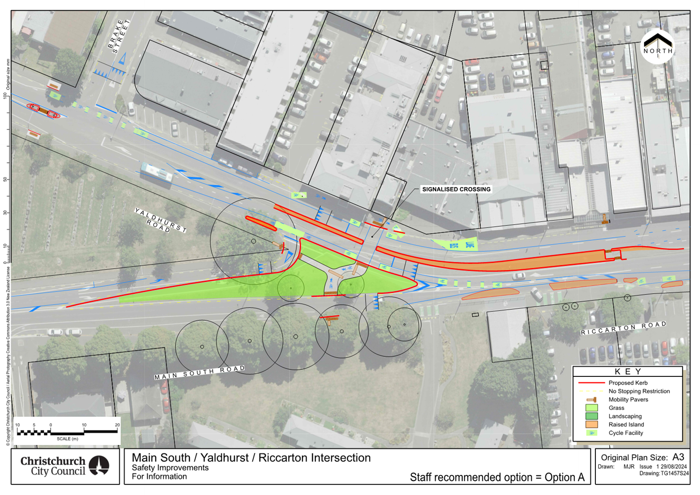
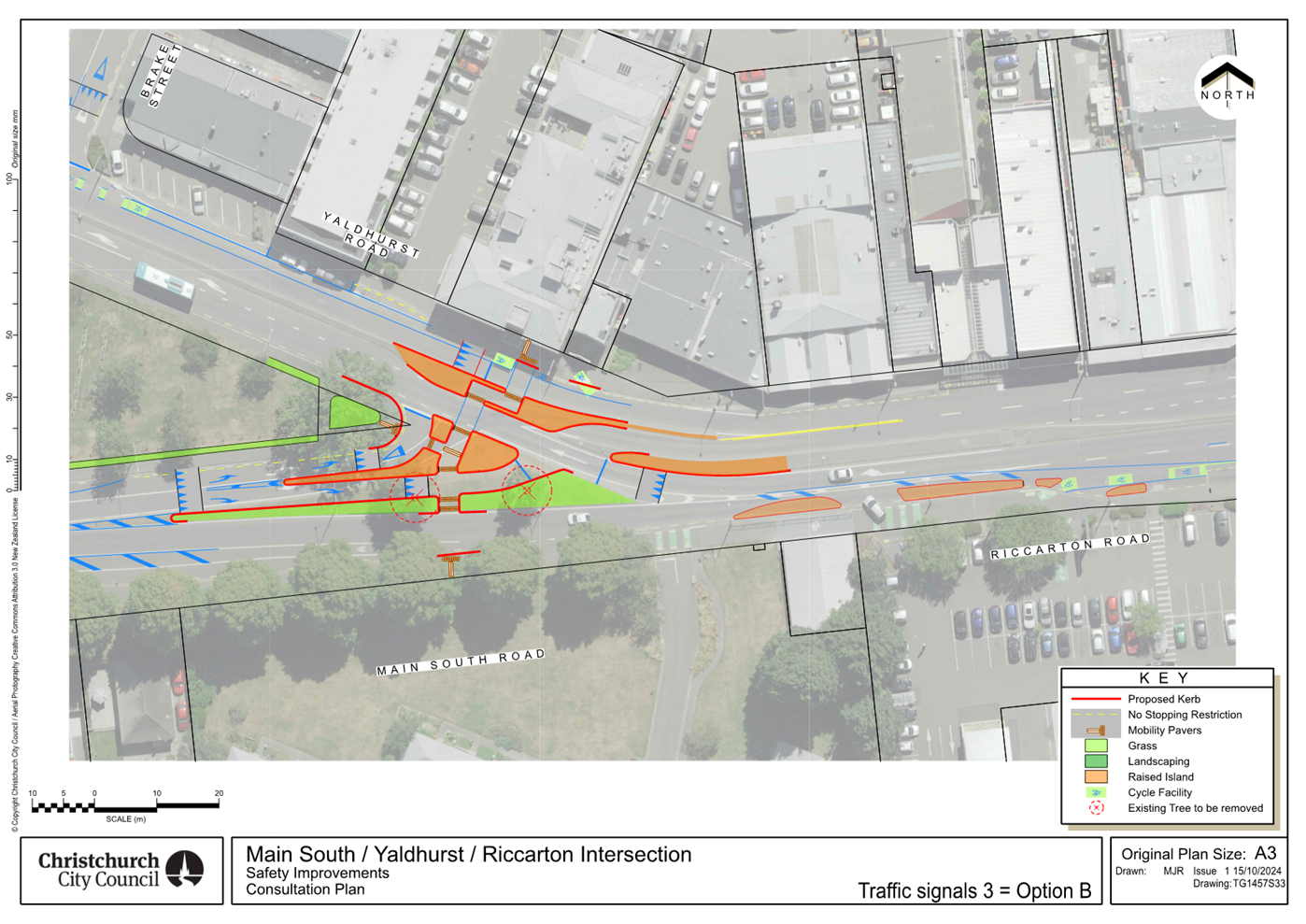
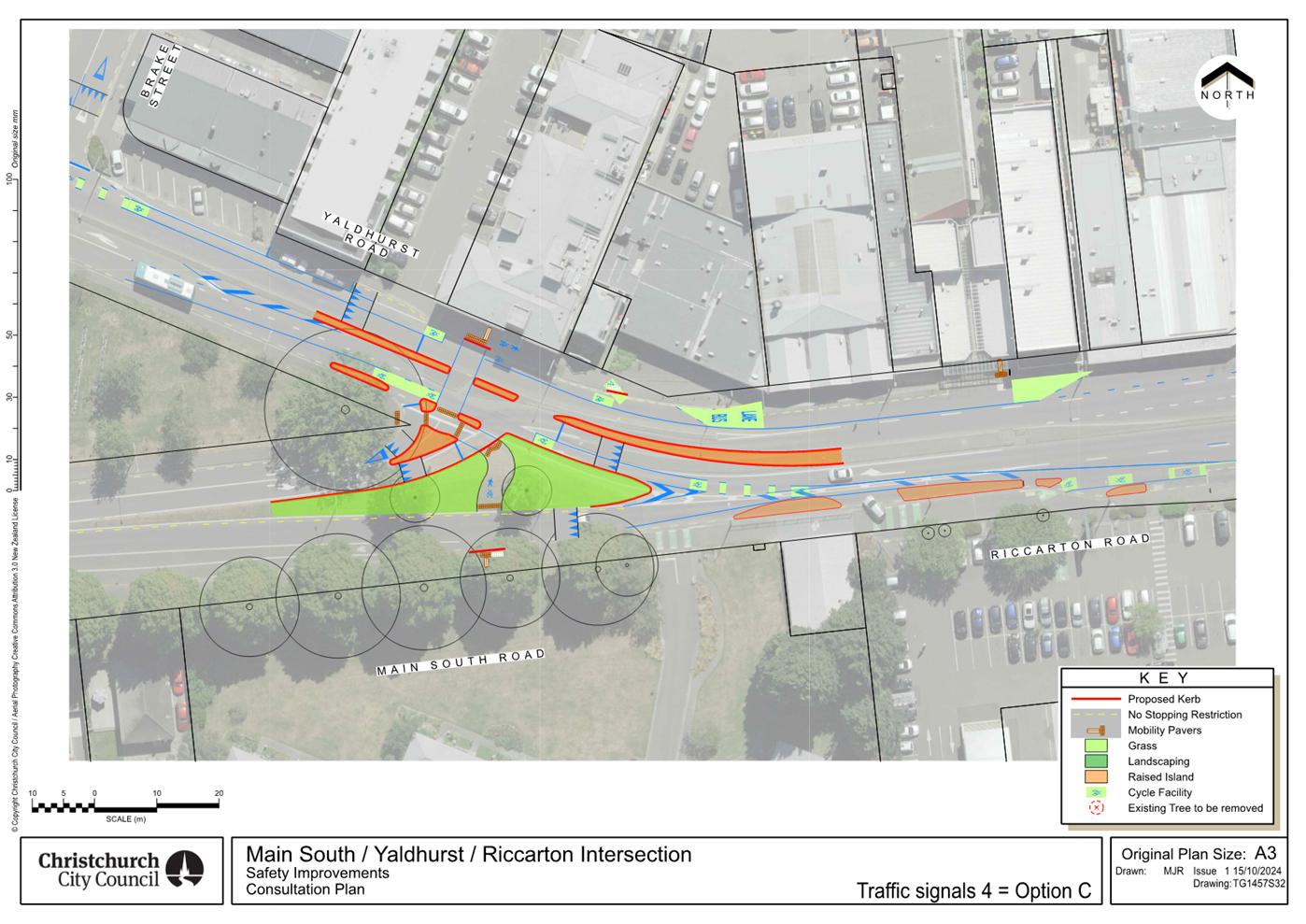
16. Main
South/Yaldhurst/Riccarton Safety Improvements....................................... 211
17. Resolution
to Exclude the Public...................................................................... 236
Karakia Whakamutunga
Karakia Tīmatanga
Whakataka te hau ki te uru
Whakataka te hau ki te tonga
Kia mākinakina ki uta
Kia mātaratara ki tai
E hī ake ana te atakura
He tio, he huka, he hau hū
Tihei mauri ora
1. Apologies Ngā Whakapāha
Apologies will
be recorded at the meeting.
2. Declarations of Interest Ngā
Whakapuaki Aronga
Members are
reminded of the need to be vigilant and to stand aside from decision-making
when a conflict arises between their role as an elected representative and any
private or other external interest they might have.
3. Public Participation Te Huinga
Tūmatanui
Note: If you
would like to make a deputation in relation to Item 16 Main
South/Yaldhurst/Riccarton Road Intersection Safety Improvements, please get
in touch with Samantha Kelly at Samantha.Kelly@ccc.govt.nz or
03 941 6227 no later than midday Tuesday, 3 December 2024. Please note
that speaking time will be limited to accommodate all requests received.
3.1 Public Forum Te Huinga Whānui
A period of up to 30 minutes is available
for people to speak for up to five minutes on any issue that is not the subject
of a separate hearings process.
|
3.1.1
|
Student Volunteer Army
Catherine Robertson will speak on behalf
of the Student Volunteer Army (SVA) to provide an update on the SVA
programmes and how they've grown since their inception and their model for
crisis response.
|
|
3.1.2
|
Speedfreaks Charitable Trust
Kevin Grimwood will speak on behalf of Speedfreaks
Charitable Trust regarding what the organisation does.
|
3.2 Deputations by Appointment Ngā
Huinga Whakaritenga
Deputations may be heard on a matter, or
matters, covered by a report on this agenda and approved by the Chairperson.
Deputations
will be recorded in the meeting minutes.
4. Presentation of Petitions Ngā
Pākikitanga
There were no
Presentations of Petitions at the time the agenda was prepared.
|
5. Council
Minutes - 6 November 2024
|
|
Reference Te Tohutoro:
|
24/2061472
|
|
Responsible Officer(s) Te Pou Matua:
|
Katie
Matheis, Democratic Services Advisor
|
|
Accountable ELT Member Pouwhakarae:
|
Mary
Richardson, Chief Executive
|
1. Purpose of Report Te Pūtake Pūrongo
For the
Council to confirm the minutes from the Council meeting held 6 November 2024.
2. Recommendation Te Tūtohu Council
That the Council confirms the Minutes from the Council
meeting held 6 November 2024.
Attachments
Ngā
Tāpirihanga
|
No.
|
Title
|
Reference
|
Page
|
|
A⇩
|
Minutes Council - 6 November 2024
|
24/1982094
|
6
|
Signatories Ngā Kaiwaitohu
|
Author
|
Katie Matheis
- Democratic Services Advisor
|

Christchurch City Council
Minutes
Date: Wednesday 6 November 2024
Time: 9.30 am
Venue: Council Chambers, Civic Offices,
53 Hereford Street, Christchurch
Present
|
Chairperson
Deputy Chairperson
Members
|
Mayor Phil Mauger
Deputy Mayor Pauline Cotter –
partially via audio/visual link
Councillor Kelly Barber
Councillor Melanie Coker
Councillor Celeste Donovan
Councillor Tyrone Fields
Councillor James Gough –
partially via audio/visual link
Councillor Tyla Harrison-Hunt
Councillor Victoria Henstock
Councillor Yani Johanson
Councillor Aaron Keown
Councillor Sam MacDonald
Councillor Jake McLellan
Councillor Andrei Moore
Councillor Mark Peters
Councillor Tim Scandrett
Councillor Sara Templeton
|

Karakia Tīmatanga
The agenda was dealt with in the following
order.
1. Apologies
Ngā Whakapāha
|
There were no apologies received.
Secretarial Note: The Chair noted that Councillor Johanson was a potential apology
for lateness.
|
|
Withdrawal
of Agenda Items
|
|
Secretarial Note: Consistent with Standing Order 6.8, Item 18.Three Waters
Activities Report – July, August and September 2024, Item 19. Planning
and Consents Unit Update, and Item 20. Building Consenting Unit
Update: July to September 2024 were withdrawn from the agenda.
Secretarial Note: Item 14. Ōtautahi Christchurch
Planning Programme Endorsement, Item 16. Discretionary
Responses Fund and Place Partnership Fund, and Item 17. Miscellaneous
amendments to delegations were considered at the reconvened Council
meeting of 12 November 2024 (refer below).
|
2. Declarations
of Interest Ngā Whakapuaki Aronga
There were no
declarations of interest recorded.
Councillor Johanson joined the meeting at
9.33 am during consideration of Item 3.1.1.
3. Public
Participation Te Huinga Tūmatanui
3.1 Public Forum Te Huinga
Whānui
|
3.1.1
|
Bradley Nicolson
Bradley
Nicolson spoke regarding the Oxford Terrace Baptist Church’s experience
engaging with the Council on rates and remissions issues and processes.
|
Councillor MacDonald left the meeting at
9.40 am during consideration of Item 3.1.2.
|
3.1.2
|
Moana Vā
Lana Shields
and Suli Tuitaupe spoke on behalf of Moana Vā regarding the services and
supports their organisation provides to Pacific Rainbow communities in
Ōtautahi Christchurch.
|
|
Attachments
a Moana
Vā - Impact Report 2023 - Presentation to Council
|
|
3.1.3 Akaroa
Civic Trust
|
|
Mike Norris spoke on behalf of the
Akaroa Civic Trust regarding the Akaroa Wastewater Scheme and the
Council’s resource consent application.
|
|
Attachments
a Akaroa
Civic Trust - Presentation to Council
|
|
3.1.4 Akaroa
Ratepayers & Residents' Association
|
|
Harry Stronach and Cameron Jasper
spoke on behalf of the Akaroa Ratepayers & Residents' Association
regarding the Akaroa Wastewater Scheme and the Council’s resource
consent application.
|
|
Attachments
a Akaroa
Wastewater Disposal Managed Aquifer Recharge Option - Presentation to
Council
|
Councillor MacDonald returned to the
meeting at 9.59 am during consideration of Item 3.1.5.
|
3.1.5 Kim
Annan / David Lynch
|
|
Kim Annan spoke regarding parking
and safety issues related to the redevelopment of the former City Care site
near Sydenham Park and Bradford Park.
|
|
Attachments
a Sydenham
Park Bradford Park Map - Presentation to Council
b Council
Meeting Sydenham Park FINAL - Presentation to Council
|
|
3.1.6 Cody
Cooper
|
|
Cody Cooper spoke regarding Item
22. Notice of Motion – Scruttons Road Rail Crossing Solution.
|
|
3.1.7 Heathcote
School Students
|
|
Amalia Harris and other student
representatives from Heathcote Valley School, Te Aratai College and Hagley
College spoke regarding Item 22. Notice of Motion – Scruttons
Road Rail Crossing Solution.
|
Councillor Barber left the meeting at 10.15
am and returned at 10.18 am during consideration of Item 3.1.8.
|
3.1.8 Heathcote
Commuters
|
|
Steve Harris and Bianca Sullivan
spoke regarding Item 22. Notice of Motion – Scruttons Road
Rail Crossing Solution.
|
|
3.1.9 Spokes
Canterbury
|
|
Fi Bennetts and Anne Scott spoke
on behalf of Spokes Canterbury regarding Item 22. Notice of Motion –
Scruttons Road Rail Crossing Solution.
|
|
3.1.10 Thomas
Healey
|
|
Thomas Healey
spoke regarding Item 22. Notice of Motion – Scruttons Road
Rail Crossing Solution.
|
3.2 Deputations by Appointment Ngā Huinga Whakaritenga
There were no deputations
by appointment.
4. Presentation
of Petitions Ngā Pākikitanga
There
was no presentation of petitions.
|
5. Civic
Awards Committee Minutes - 26 August 2024
|
|
|
The meeting block resolved Minute Items 5
– 9.
|
|
|
Council Resolved CNCL/2024/00168
That the Council receives the Minutes
from the Civic Awards Committee meeting held 26 August 2024.
Mayor/Councillor
Scandrett Carried
|
|
6. Audit
and Risk Management Committee Minutes - 17 October 2024
|
|
|
Council Resolved CNCL/2024/00169
That the Council receives the Minutes
from the Audit and Risk Management Committee meeting held 17 October 2024.
Mayor/Councillor
Scandrett Carried
|
|
7. Council
Minutes - 2 October 2024
|
|
|
Council Resolved CNCL/2024/00170
That the Council confirms the Minutes
from the Council meeting held 2 October 2024.
Mayor/Councillor
Scandrett Carried
|
|
8. Council
Minutes - 16 October 2024
|
|
|
Council Resolved CNCL/2024/00171
That the Council confirms the Minutes
from the Council meeting held 16 October 2024.
Mayor/Councillor
Scandrett Carried
|
|
9. Council
Minutes - 30 October 2024
|
|
|
Council Resolved CNCL/2024/00172
That the Council confirms the Minutes
from the Council meeting held 30 October 2024.
Mayor/Councillor
Scandrett Carried
|
|
28. Resolution
to Include Supplementary Reports
|
|
|
Council Resolved CNCL/2024/00173
Decision
That the
reports be received and considered at the Council meeting on Wednesday, 6
November 2024.
Open Items
12. Te
Kaha Surrounding Streets - Construction Options
21. Notice
of Motion - Brougham Street Upgrade Funding
22. Notice
of Motion - Scruttons Road Rail Crossing Solution
Councillor
Harrison-Hunt/Councillor Peters Carried
|
Councillor Harrison-Hunt left the meeting
at 10.28 am and returned at 10.30 am during consideration of Item 10.
Councillor Peters left the meeting at 10.28
am and returned at 10.30 am during consideration of Item 10.
Councillor Templeton left the meeting at
10.28 am and returned at 10.36 am during consideration of Item 10.
Councillor MacDonald left the meeting at
10.35 am and returned at 10.43 am during consideration of Item 10.
Councillor Keown left the meeting at 10.35
am and returned at 10.37 am during consideration of Item
10.
Councillor Donovan left the meeting at
10.39 am and returned at 10.43 am during consideration of Item 10.
Deputy Mayor Cotter left the meeting via
audio/video link at 10.40 am and returned at 10.51 am during consideration of
Item 10.
|
10. Monthly
Report from the Community Boards - October 2024
|
|
Jason Middlemiss, Chairperson, and
Bridget Williams, Deputy Chair, joined the meeting for presentation of the Waimāero
Fendalton-Waimairi-Harewood Community Board area report.
Emma Norrish,
Chairperson, and Emma Pavey, Community Governance Manager, joined the meeting
for presentation of the Waipapa Papanui-Innes-Central Community Board
area report.
Marie
Pollisco, Chairperson, and Helen Broughton, Deputy Chair, joined the meeting
for presentation of the Waipuna Halswell-Hornby-Riccarton Community Board
area report.
Paul McMahon,
Chairperson, and Jackie Simons, Deputy Chair, joined the meeting for
presentation of the Waitai Coastal-Burwood-Linwood Community Board
area report.
Lyn Leslie,
Chairperson, and Penelope Goldstone, Community Governance Manager, joined the
meeting for presentation of the Te Pātaka o Rākaihautū
Banks Peninsula Community Board area report.
Callum Ward,
Chairperson, and Jess Garrett, Community Board Manager, joined the meeting
for presentation of the Waihoro Spreydon-Cashmere-Heathcote Community
Board area report.
|
|
|
Council Resolved CNCL/2024/00174
Officer Recommendation accepted without
change
That the Council:
1. Receives the information in the Monthly Report from the Community Boards
- October 2024 Report.
Mayor/Councillor
Barber Carried
|
|
|
Attachments
a Waimāero
Fendalton-Waimairi-Harewood Community Board- Presentation to Council
b Waipapa
Papanui-Innes-Central Community Board - Presentation to council
c Waipuna
Halswell-Hornby-Riccarton Community Board - Presentation to
Council
d Waitai
Coastal-Burwood-Linwood Community Board - Presentation to Council
e Te
Pātaka o Rākaihautū Banks Peninsula Community Board PowerPoint
- Presentation to Council
f Waihoro
Spreydon-Cashmere-Heathcote Community Board - Presentation to
Council
|
|
Report from Waihoro Spreydon-Cashmere-Heathcote Community
Board - 10 October 2024
|
|
11. New Deed of Lease-Physiosouth
Limited at Pioneer Recreation and Sport Centre
|
|
|
Council Resolved CNCL/2024/00175
Community Board recommendations accepted without
change
That the Council:
1. Notes that public consultation has been
carried out with no unresolved objections.
2. Agrees to depart from its Lease Policy
for the Creation of New Leases and Extension Requests Prior to
Expiry-Property (Lease Policy) and deal unilaterally with the current
tenant, Physiosouth Limited; and
3. Notes, in accordance with Sections 76-82
of the Local Government Act 2002 that:
a. The granting of a further lease to the
current tenant is inconsistent with the Council’s Lease Policy.
b. The reason for the inconsistency is due
to the proposed unilateral dealing with the current tenant who maintains an
existing level of service, noting there may potentially be a broader market
and public interest.
c. There is no intention that the Lease
Policy be amended to accommodate this decision.
d. Approves the granting of a lease to
Physiosouth Limited, located at the Pioneer Recreation and Sport Centre, more
accurately described as being Part Lot 30-33 Deposited Plan 1968 at
Centennial Park for a term of up to nine (9) years commencing on 1 October
2024.
4. Requests the Manager Property Consultancy
to conclude and administer the terms and conditions of the lease.
Councillor
Coker/Councillor McLellan Carried
|
The meeting adjourned at 11.03 am and
reconvened at 11.29 am. Councillor McLellan was not present at this time.
|
21. Notice of Motion - Brougham Street
Upgrade Funding
|
|
|
Council Resolved CNCL/2024/00176
Councillor Moore’s
recommendation accepted without change
That the Council:
1. Requests that the Mayor meet with the
Minister of Transport, and send a letter to both the Minister of Transport
and the Minister Responsible for RMA Reform regarding the potential
reconsideration of Brougham Street Upgrade funding in light of the
Government’s recent fast-tracking of 4,200 homes in Rolleston.
Councillor
Moore/Mayor Carried
|
Councillor McLellan joined the meeting at
11.40 am during consideration of Item 22.
Councillor Barber left the meeting at 11.47
am and returned at 11.49 am during consideration of Item 22.
|
22. Notice of Motion - Scruttons Road
Rail Crossing Solution
|
|
|
Council Comment
1. Councillor
Templeton, as Mover of the Notice of Motion, and with the agreement of the
meeting, added a further recommendation requesting that staff provide advice
back on options for keeping the Heathcote Expressway open (refer Resolution
4). The updated Notice of Motion was Seconded by Councillor Peters.
2. It
was clarified that the advice requested from staff would be brought back to
the Council on Tuesday, 12 November at which time the meeting would be
reconvened. Refer Item 29 - Access along the Heathcote Expressway MCR
(past Scruttons Road level crossing) below.
3. Council
Officers Lynette Ellis and Jacob Bradbury joined the table to answer
questions from Elected Members. At the conclusion of questions, the meeting
voted on the Notice of Motion, which was declared carried.
|
|
|
Councillor Templeton’s
Recommendations
That the Council:
1. Notes the information provided to the
Mayor and Councillors in the Scruttons Road Level Crossing – Partial
Closure of Heathcote Expressway MCR Memo on 25 October 2024.
2. Expresses its concern at the approach
KiwiRail is taking to crossing upgrades when the Council is working in the
adjacent area.
3. Writes, with urgency, to the KiwiRail
board and shareholding ministers encouraging them to find a solution to the
Scruttons Road rail crossing that enables the completed Heathcote Expressway
Puari ki Kakuhura Major Cycle Route to stay open.
|
|
|
Council Resolved CNCL/2024/00177
That the Council:
1. Notes the information provided to the
Mayor and Councillors in the Scruttons Road Level Crossing – Partial
Closure of Heathcote Expressway MCR Memo on 25 October 2024.
2. Expresses its concern at the approach
KiwiRail is taking to crossing upgrades when the Council is working in the
adjacent area.
3. Writes, with urgency, to the KiwiRail
board and shareholding ministers encouraging them to find a solution to the
Scruttons Road rail crossing that enables the completed Heathcote Expressway
Puari ki Kakuhura Major Cycle Route to stay open.
4. Request that staff provide advice on keeping
the Heathcote Expressway open in time to inform a Council decision
ahead of the proposed closure date on 14 November.
Councillor
Templeton/Councillor Peters Carried
|
Councillor Gough left the meeting at 12.17
pm during consideration of Item 12.
Deputy Mayor Cotter left the meeting via
audio/video link at 12.20 pm during consideration of Item 12.
|
12. Te Kaha Surrounding Streets -
Construction Options
|
|
|
Council Comment
1. The
Mayor Moved and Councillor McLellan Seconded the Officer Recommendations with
an amended Recommendation 4 specifying that the remaining transport works
would come from project(s) deferred beyond the first three years of the
2024-34 Long-Term Plan and have no further impact on rates (refer
Recommendation 4).
2. Council
Officers Jacob Bradbury, Jenny Rankin, and Tony Richardson then joined the
table to provide an update on the project and answer questions from Elected
Members.
3. During
discussion, the meeting had further questions regarding the Public Excluded
Attachment A to the Officer report and the funding update from Waka Kotahi
NZTA. As a result of these questions, the meeting resolved to go into a
Public Excluded session.
|
|
|
Officer Recommendations
That the
Council:
1. Receives the information in the Te Kaha
Surrounding Streets - Construction Options Report.
2. Notes that the decision in this report is assessed as high
significance based on the Christchurch City Council’s Significance and
Engagement Policy.
3. Instructs staff to proceed with the remaining scope of the
transport works associated with the Te Kaha Surrounding Streets Project
(Separable Portion 3 (SP3)). This is specified as:
a. Lichfield Street between Barbadoes Street and Fitzgerald Avenue,
b. Tuam Street between Barbadoes Street and Fitzgerald Avenue,
c. Madras Street between Moorhouse Avenue and Tuam Street; and
d. Remaining works on Lichfield Street between Manchester Street and
Madras Street.
4. Notes that completing the remaining scope of the transport works
associated with the Te Kaha Surrounding Streets Project (Separable Portion 3)
will be an additional 0.06% impact on rates.
5. Notes that the Public Excluded Attachment A can be reviewed for
potential public release after 22 October 2025.
|
|
|
Amended Officer Recommendations Moved
and Seconded
That the
Council:
1. Receives the information in the Te Kaha
Surrounding Streets - Construction Options Report.
2. Notes that the decision in this report is assessed as high
significance based on the Christchurch City Council’s Significance and
Engagement Policy.
3. Instructs staff to proceed with the remaining scope of the
transport works associated with the Te Kaha Surrounding Streets Project
(Separable Portion 3 (SP3)). This is specified as:
a. Lichfield Street between Barbadoes Street and Fitzgerald Avenue,
b. Tuam Street between Barbadoes Street and Fitzgerald Avenue,
c. Madras Street between Moorhouse Avenue and Tuam Street; and
d. Remaining works on Lichfield Street between Manchester Street and
Madras Street.
4. Agrees that the revenue for completing the remaining scope of the
transport works associated with the Te Kaha Surrounding Streets Project
(Separable Portion 3) will come from a transport project or projects that has
been deferred beyond the first 3 years of the Long Term Plan 2024 – 34,
and staff will advise Council of the nominated specific project or projects
through the Annual Plan process, noting that this will have no impact on
rates.
5. Notes that the Public Excluded Attachment A can be reviewed for
potential public release after 22 October 2025.
Mayor/Councillor
McLellan Moved/Seconded
|
|
Resolution to Exclude the Public
|
|
|
Council Resolved CNCL/2024/00178
That at 12.18 pm the resolution to exclude the public
set out on pages 27 to 28 of the Supplementary Agenda be adopted.
Mayor/Councillor
Scandrett Carried
Councillors Coker and Johanson requested their
votes against the resolution be recorded.
|
The public were
re-admitted to the meeting at 12.31 pm.
|
12. Te Kaha Surrounding Streets -
Construction Options - Continued
|
|
|
Council Comment
1. As
a result of discussions with Council Officers during the Public Excluded
session of the meeting, the wording of Recommendation 4 as Moved by the Mayor
and Seconded by Councillor McLellan (refer to Item 12 above) was changed for
clarity (refer Resolution 4 below).
2. The
Motion, including the updated Recommendation 4, was then put, voted on by
division, and declared carried.
|
|
|
Council Resolved CNCL/2024/00179
That the
Council:
1. Receives the information in the Te Kaha
Surrounding Streets - Construction Options Report.
2. Notes that the decision in this report is assessed as high
significance based on the Christchurch City Council’s Significance and
Engagement Policy.
3. Instructs staff to proceed with the remaining scope of the
transport works associated with the Te Kaha Surrounding Streets Project
(Separable Portion 3 (SP3)). This is specified as:
a. Lichfield Street between Barbadoes Street and Fitzgerald Avenue,
b. Tuam Street between Barbadoes Street and Fitzgerald Avenue,
c. Madras Street between Moorhouse Avenue and Tuam Street; and
d. Remaining works on Lichfield Street between Manchester Street and
Madras Street.
4. Agrees that the revenue for completing the remaining scope of the
transport works associated with the Te Kaha Surrounding Streets Project
(Separable Portion 3) will come from within the Transport three-year
programme, noting that this will have no impact on rates.
5. Notes that the Public Excluded Attachment A can be reviewed for
potential public release after 22 October 2025.
The division was declared carried
by 11 votes to 5 votes the voting being as follows:
For: Mayor Mauger, Councillor Barber, Councillor Coker, Councillor
Donovan, Councillor Fields, Councillor Harrison-Hunt, Councillor McLellan,
Councillor Moore, Councillor Peters, Councillor Scandrett and Councillor
Templeton
Against: Councillor Gough, Councillor Henstock, Councillor Johanson,
Councillor Keown and Councillor MacDonald
Mayor/Councillor
McLellan Carried
|
Councillor MacDonald left the meeting at
12.36 pm during consideration of Item 13.
Councillor Harrison-Hunt left the meeting
at 12.40 pm and returned at 12.47 pm during consideration of Item 13.
|
13. Draft
Ōtautahi Christchurch Future Transport Strategy
|
|
|
Council Comment
1. Council
Officers Jane Cameron, Mark Stevenson, and Hannah Ballantyne joined the table
to present Item 13 and answer questions from Elected Members.
2. The
Officer Recommendations were Moved by Councillor Coker and Seconded by
Councillor Templeton. The meeting asked Council Officers for clarification
regarding the hearings process and options available to consider written and
oral submissions.
3. With
the agreement of the Mover and Seconder, Recommendation 3 was then amended to
reflect the advice provided and the Elected Members’ preference to
receive written and oral submissions through the public engagement process
(refer Resolution 3).
4. The
Motion as amended was then voted on and declared carried.
|
|
|
Officer Recommendations
That the
Council:
1. Receives the information in the Draft Ōtautahi
Christchurch Future Transport Strategy Report.
2. Approves that the Draft Ōtautahi
Christchurch Future Transport Strategy (Attachment A to this report) proceed
to public consultation.
3. Agrees to either:
a. Include hearings in the public engagement
process for this draft strategy; or
b. Not include hearings in the public
engagement process for this draft strategy
4. Notes that the decision in this report is
assessed as low significance based on the Christchurch City Council’s
Significance and Engagement Policy.
|
|
|
Council Resolved CNCL/2024/00180
That the
Council:
1. Receives the information in the Draft Ōtautahi
Christchurch Future Transport Strategy Report.
2. Approves that the Draft Ōtautahi
Christchurch Future Transport Strategy (Attachment A to this report) proceed
to public consultation.
3. Agrees to receive written and/or oral
submissions as part of the public engagement and Council decision-making
process.
4. Notes that the decision in this report is
assessed as low significance based on the Christchurch City Council’s
Significance and Engagement Policy.
Councillor
Coker/Councillor Templeton Carried
Councillor Keown
requested his vote against the resolutions be recorded.
|
|
|
Attachments
a Draft
Ōtautahi-Christchurch Future Transport Strategy - Presentation to
Council
|
|
23. Resolution
to Exclude the Public Te whakataunga kaupare hunga tūmatanui
|
|
|
Council Resolved CNCL/2024/00181
That at 12.51 pm the resolution to exclude the public set out on
pages 382 to 383 of the agenda be adopted.
Councillor
Scandrett/Mayor Carried
|
The public were re-admitted to the meeting
at 2.41 pm.
Councillor Gough left the meeting at 2.43
pm during consideration of Item 15.
|
15. Review of
the Trade Waste Bylaw 2015
|
|
|
Council Resolved CNCL/2024/00182
Officer Recommendations accepted without
change
That the
Council:
1. Receives the information in the Review of
the Trade Waste Bylaw 2015 Report and its attachments.
2. Notes that the decision in this report is assessed as medium
significance based on the Christchurch City Council’s Significance and
Engagement Policy.
3. Determines, in accordance with the requirements of section 155 of
the Local Government Act 2002, that the proposed amended bylaw – the
draft Trade Waste Bylaw 2025 (Attachment A to this report), based on the
assessment in the Bylaw Review Report (Attachment B to this report) and the
clause-by-clause analysis (Attachment C to this report):
a. is the most appropriate way of addressing the identified problems;
b. is the most appropriate form of bylaw; and
c. does not give rise to implications under the New Zealand Bill of
Rights Act 1990, and is not inconsistent with that Act, as is the required
test.
4. Adopts the draft Trade Waste Bylaw 2025 (Attachment A to this
report) and agrees to undertake public consultation on the proposed
amendments to the bylaw in accordance with sections 148 and 156(1)(b) of the
Local Government Act 2002.
5. Convenes a hearings panel to hear submissions on the draft bylaw,
deliberate on these submissions, and report the recommendation to the Council
on the final form of bylaw.
Mayor/Councillor
Scandrett Carried
|
|
Adjournment of Meeting
|
|
|
Council Resolved CNCL/2024/00183
That the Council:
1. Adjourn the meeting until 10.00 am Tuesday, 12 November in the Council
Chambers.
Mayor/Councillor
MacDonald Carried
|
Secretarial Note: The meeting adjourned at 2.48 pm on 6 November and reconvened at
10.03 am on 12 November. Deputy Mayor Cotter assumed the Chair at this time.
|
Apologies – Reconvened Council
Meeting 12 November 2024
|
|
|
Council Resolved CNCL/2024/00184
That the apologies from the Mayor and
Councillors MacDonald and Moore for absence, Councillor Donovan for partial
absence and Councillor Harrison-Hunt for lateness be accepted.
Councillor
Peters/Councillor Henstock Carried
|
|
28. Resolution to Include Supplementary
Reports
|
|
|
Council Resolved CNCL/2024/00185
That the
report be received and considered at the Council meeting on Tuesday, 12
November 2024.
Open Item
29. Access
along the Heathcote Expressway MCR (past Scruttons Road level
crossing).
Councillor
Barber/Councillor Scandrett Carried
|
Councillor McLellan left the meeting at
10.08 am and returned at 10.09 am during consideration of Item 29.
|
29 Access along the Heathcote
Expressway MCR (past Scruttons Road level crossing)
|
|
|
Council Comment
1. Council
Officers Lynette Ellis, Jacob Bradbury, and Elizabeth Neazor joined the table
to answer questions from Elected Members. At this time, Officers informed the
meeting that they had received further correspondence from KiwiRail that
morning (refer Attachment A to this Item), specifying that the date of
closure for the Heathcote Expressway MCR would be deferred to a later date to
allow for continued discussions with the Council.
2. In
response to the new information and questions about the legal advice outlined
in Public Excluded Attachment A to the Officer report, including whether the
Officer Recommendations required updating, the meeting resolved to move into
a Public Excluded session.
|
|
|
Officer
Recommendations
That the
Council:
1. Receives the information in the Access
along the Heathcote Expressway MCR (past Scruttons Road level crossing)
Report.
2. Notes that the decision in this report is
assessed as medium significance based on the Christchurch City
Council’s Significance and Engagement Policy.
3. Approves the temporary closure of part of
the Heathcote Expressway:
a. between Vaila Place and Scruttons Road,
and
b. between Scruttons Road and Truscotts
Road.
4. Notes that staff will re-open the
cycleway should KiwiRail rescind its request for immediate closure until
permanent works are completed.
5. Requests further information before the
end of April 2025 to allow the closure to be reviewed.
6. Notes that $2.5M is available in the
current Annual Plan to commence design and pre construction work.
7. Requests that staff instruct KiwiRail to
continue design and pre-construction works to enable confirmation of
construction costs.
8. Agrees that the construction works will
be funded from within the approved Long Term Plan Transport Capital Programme
budget.
|
|
|
Attachments
a Scruttons
Road - moving date
|
Councillor Donovan left the meeting at
10.13 am during consideration of Item 29.
|
Resolution to Exclude the Public
|
|
|
Council Resolved CNCL/2024/00186
That at
10.13 am the resolution to exclude the public set out on pages 16 to 17 of
the second supplementary agenda be adopted.
Deputy
Mayor/Councillor Barber Carried
Councillor
Johanson requested his vote against the resolution be recorded.
|
The public were
re-admitted to the meeting at 11.12 am.
|
29. Access along the Heathcote
Expressway MCR (past Scruttons Road level crossing) - Continued
|
|
|
Council Comment
1. As
a result of discussions with Council Officers during the Public Excluded
session of the meeting, the original Officer Recommendations were updated to
reflect the new information received (i.e., the KiwiRail correspondence) and
the legal advice provided (refer Resolutions 1 to 8).
2. Upon
return to the Public session of the meeting, Council Officers continued to
answer questions from Elected Members.
3. Further
amendments were raised by Councillor Templeton (refer Resolution 10),
Councillor Peters (refer Resolution 9), and Councillor Fields (refer
Resolution 11). With the agreement of the meeting, each of these amendments
were incorporated into the revised Officer Recommendations.
4. The Substantive
Motion was then Moved by the Deputy Mayor and Seconded by Councillor Barber.
At the conclusion of debate, the meeting voted on the Substantive Motion by
division, which was declared carried.
|
|
|
Officer Recommendations
That the
Council:
1. Receives the information in the Access
along the Heathcote Expressway MCR (past Scruttons Road level crossing)
Report.
2. Notes that the decision in this report is
assessed as medium significance based on the Christchurch City
Council’s Significance and Engagement Policy.
3. Approves the temporary closure of part of
the Heathcote Expressway:
a. between Vaila Place and Scruttons Road,
and
b. between Scruttons Road and Truscotts
Road.
4. Notes that staff will re-open the
cycleway should KiwiRail rescind its request for immediate closure until
permanent works are completed.
5. Requests further information before the
end of April 2025 to allow the closure to be reviewed.
6. Notes that $2.5M is available in the
current Annual Plan to commence design and pre construction work.
7. Requests that staff instruct KiwiRail to
continue design and pre-construction works to enable confirmation of
construction costs.
8. Agrees that the construction works will
be funded from within the approved Long Term Plan Transport Capital Programme
budget.
|
|
|
Council Resolved CNCL/2024/00187
That the
Council:
1. Receives
the information in the Access along the Heathcote Expressway MCR (past
Scruttons Road level crossing) Report.
2. Notes
that the decision in this report is assessed as medium significance based on
the Christchurch City Council’s Significance and Engagement Policy.
3.
Notes that staff have the delegations to close the Heathcote Expressway under
temporary traffic management if directed by KiwiRail and would close the
below sections if required:
a. between Vaila Place and Scruttons Road,
and
b. between Scruttons Road and Truscotts
Road.
4. Notes
that staff would re-open the cycleway should KiwiRail rescind its request for
immediate closure until permanent works are completed.
5.
Notes the safety concerns raised by residents about cycling on Port Hills Rd
and Bridlepath Rd should the closure of the Heathcote Expressway go ahead as
requested by KiwiRail, and:
a. Requests staff advice on the comparative risks of
the Scruttons Rd level crossing and Port Hills Rd and Bridlepath Rd as soon
as practicable.
6. Notes
that $2.5M is available in the current Annual Plan to commence design and pre
construction work.
7. Agrees
that the construction works will be funded from within the approved Long Term
Plan Transport Capital Programme budget.
8. Notes
the public excluded Attachment A to the report will be released upon the
review and approval of the Head of Legal and Democratic Services and Chief
Executive.
9.
Seeks to meet as soon as possible with KiwiRail’s Board to discuss this
current impasse at Scruttons Road and the wider ongoing
relationship and expectations whereas organisations we intersect with each
other’s assets.
10.
Writes to the KiwiRail Board and appropriate ministers requesting a change to
policy direction and/or legislation that would enable KiwiRail to take into
account broader transport network safety when making decisions on level
crossings.
11.
Should closure occur, requests that staff ask Environment Canterbury to
consider extending its recently implemented service to mitigate the national
restriction on use of bike racks on buses, to include Martindales Rd and
terminate at The Tannery.
The division was declared carried
by 10 votes to 3 votes the voting being as follows:
For: Deputy Mayor Cotter, Councillor Barber, Councillor Coker,
Councillor Fields, Councillor Harrison-Hunt, Councillor Johanson, Councillor
McLellan, Councillor Peters, Councillor Scandrett and Councillor Templeton
Against: Councillor Gough, Councillor Henstock and Councillor Keown
Deputy
Mayor/Councillor Barber Carried
Councillors
Harrison-Hunt, Johanson, and Templeton requested their votes against
Resolution 3 be recorded.
|
The meeting adjourned at 11.55 am and
reconvened at 1.03 pm. Councillors Keown and Gough were not present at this
time.
Councillor Field left the meeting at 1.06
pm during consideration of Item 16 and did not return.
|
16. Discretionary
Response Fund and Place Partnership Fund
|
|
|
Council Comment
1. Council
Officer Josh Wharton joined the table to answer questions from Elected
Members regarding the Place and Partnership Fund and Officer Recommendation
5.
2. Councillor
Donovan then raised an amendment to provide a grant of $12,000 to Greening
the Rubble Trust (refer Resolution 5). The Motion, including the amendment
was then Moved by Councillor Donovan and Seconded by Councillor Barber.
3. At
the conclusion of debate, the meeting voted on the Motion as amended, which
was declared carried.
|
|
|
Officer Recommendations
That the Council:
1. Receives the information in the
Discretionary Response Fund and Place Partnership Fund Report.
2. Notes that the decisions in this report are assessed as low
significance based on the Christchurch City Council’s Significance and
Engagement Policy.
3. Approves a grant of $15,000 from its 2024/25 Discretionary
Response Fund to Objectspace towards staffing costs.
4. Approves a grant of $20,000 from its 2024/25 Discretionary
Response Fund to Christchurch Resettlement Support Services Inc. towards the
Bilingual Community Work Support programme.
5. Declines the application to the 2024/2025 Place Partnership Fund
from Greening the Rubble Trust toward Community co design landscaping and
workshops.
|
|
|
Council Resolved CNCL/2024/00188
That the Council:
1. Receives the information in the
Discretionary Response Fund and Place Partnership Fund Report.
2. Notes that the decisions in this report are assessed as low
significance based on the Christchurch City Council’s Significance and
Engagement Policy.
3. Approves a grant of $15,000 from its 2024/25 Discretionary
Response Fund to Objectspace towards staffing costs.
4. Approves a grant of $20,000 from its 2024/25 Discretionary
Response Fund to Christchurch Resettlement Support Services Inc. towards the
Bilingual Community Work Support programme.
5. Approves a grant of $12,000 to the 2024/2025 Place Partnership
Fund from Greening the Rubble Trust toward Community co design landscaping
and workshops.
Councillor Donovan/Councillor
Barber Carried
Secretarial
Note: The meeting further requested a Memo
from Council Officers outlining the points of difference and points of
alignment between Greening the Rubble, Gap Filler and Life in Vacant Spaces ,
noting there may be opportunities for administrative alignment between the
groups.
|
|
17. Miscellaneous
amendments to delegations
|
|
|
Council Resolved CNCL/2024/00189
Officer recommendations accepted without
change
That the
Council:
1. Receives the information in the Miscellaneous amendments
to delegations Report.
2. Notes that the decision in this report is
assessed as low significance based on the Christchurch City Council’s
Significance and Engagement Policy.
3. Relying on clause 32 of Schedule 7 of the
Local Government Act 2002 and for the purposes of the efficiency and
effectiveness in the conduct of the Council’s business, and any other
applicable statutory authority:
a. Revokes and amends the delegations set
out in Parts B of the Delegations Register (as shown and highlighted in Attachment
A); and
b. Revokes and amends the delegations set
out in Parts D of the Delegations Register (as shown and highlighted in Attachment
A).
4. Notes that these delegation changes take
effect on the date of this resolution, and that Legal Services will update
the Delegations Register accordingly.
Councillor
Scandrett/Councillor Coker Carried
Secretarial
Note: The meeting further requested that
Attachment A to the report (the Delegations Register), particularly Part B
– Sub Part 3 – Other Matters, reflecting that the Chairperson
of the Mayor’s Welfare Fund Charitable Trust Committee is the Deputy
Mayor be amended to reflect the correct Chairperson (currently Councillor
Johanson).
|
|
14. Ōtautahi
Christchurch Planning Programme Endorsement
|
|
|
Council Resolved CNCL/2024/00190
Officer recommendations accepted without
change
That the
Council:
1. Receives the information in the Ōtautahi
Christchurch Planning Programme Endorsement Report.
2. Notes that the decision in this report is assessed as medium level
significance based on the Christchurch City
Council’s Significance and Engagement Policy.
3. Endorses the Ōtautahi Christchurch Planning Programme set out
as Attachment A to this report, as a foundation for network and local area
planning.
4. Notes that the programme is not being consulted on as it is
essentially an implementation of existing strategic direction and the
resulting local area plans will involve consultation.
5. Notes that the document will form a public and stakeholder
information and planning resource.
6. Notes that the programme will remain responsive to an evolving
city and changing government direction, continuing to be developed and
updated over time.
Councillor
Templeton/Councillor Scandrett Carried
|
|
18. Three Waters
Activities Report - July, August and September 2024
|
|
|
This Item was withdrawn from the agenda
consistent with Standing Order 6.8.
|
|
19. Planning and
Consents Unit Update
|
|
|
This Item was withdrawn from the agenda
consistent with Standing Order 6.8.
|
|
20. Building
Consenting Unit Update: July to September 2024
|
|
|
This Item was withdrawn from the
agenda consistent with Standing Order 6.8.
|
Karakia
Whakamutunga
Meeting concluded
at 1.18pm.
CONFIRMED THIS 4TH DAY
OF DECEMBER 2024
Mayor Phil Mauger
Chairperson
|
6. Council
Minutes - 20 November 2024
|
|
Reference Te Tohutoro:
|
24/2109594
|
|
Responsible Officer(s) Te Pou Matua:
|
Samantha
Kelly, Team Leader Democratic Services Support
|
|
Accountable ELT Member Pouwhakarae:
|
Helen
White, General Counsel / Head of Legal & Democratic Services
|
1. Purpose of Report Te Pūtake Pūrongo
For the
Council to confirm the minutes from the Council meeting held 20 November 2024.
2. Recommendation
Te Tūtohu Council
That the Council confirms the Minutes from the Council
meeting held 20 November 2024.
Attachments Ngā Tāpirihanga
|
No.
|
Title
|
Reference
|
Page
|
|
A⇩
|
Minutes Council - 20 November 2024
|
24/2071740
|
26
|
Signatories Ngā Kaiwaitohu
|
Author
|
Samantha Kelly
- Team Leader Democratic Services Support
|

Christchurch City Council
Minutes
Date: Wednesday 20 November 2024
Time: 9.32 am
Venue: Council Chambers, Civic Offices,
53 Hereford Street, Christchurch
Present
|
Chairperson
Deputy Chairperson
Members
|
Mayor Phil Mauger
Deputy Mayor Pauline Cotter
Councillor Kelly Barber
Councillor Melanie Coker
Councillor Celeste Donovan
Councillor Tyrone Fields
Councillor James Gough
Councillor Victoria Henstock
Councillor Yani Johanson
Councillor Aaron Keown
Councillor Sam MacDonald
Councillor Jake McLellan
Councillor Andrei Moore
Councillor Mark Peters
Councillor Tim Scandrett
Councillor Sara Templeton
|

Karakia Tīmatanga
The agenda was dealt with in the following
order.
1. Apologies Ngā Whakapāha
|
Secretarial Notes:
The Chair noted that Councillor McLellan
was an apology for lateness.
|
2. Declarations of Interest Ngā Whakapuaki Aronga
Councillors Gough and Keown declared an interest in
Item 5 – Local Alcohol Policy Update.
Deputy Mayor Cotter and Councillor McLellan declared an
interest in Item 6 – 2024/25 Sustainability Fund Allocation in relation to application 33 from the
Ōtautahi Community Housing Trust.
Councillor Coker
– Item 6. 2024/25 Sustainability Fund Allocation in relation to
application 3 from the Summit Road Society.
3. Public Participation Te Huinga Tūmatanui
3.1 Public Forum Te Huinga
Whānui
Deputy Mayor Cotter left the meeting at
9.37 am during consideration of Item 3.1.1.
|
3.1.1
|
Multicultural Recreation and Community
Centre Charitable Trust
Jimmy Chen
(Trust Deputy Chair) and Emily Verhoeven (Trust Member) spoke on behalf of
the Multicultural Recreation and Community Centre Charitable Trust regarding
the Multicultural Centre and to provide an update on the first seven months
since its opening on 5 March 2024.
|
|
|
Attachments
a Multicultural
Community Recreation and Community Centre Charitable Trust - Presentation to
Council
|
|
3.1.2
|
Comcare Trust
This public
forum did not proceed.
|
3.2 Deputations by Appointment Ngā Huinga Whakaritenga
Councillor McLellan joined the meeting at
9.48 am during consideration of Item 3.2.1.
|
3.2.1 Community
Action on Youth and Drugs (CAYAD)
|
|
Paul McMahon
spoke on behalf of Community Action on Youth and Drugs regarding Item 5.
Local Alcohol Policy Update.
|
Deputy Mayor Cotter returned to the meeting
at 9.49 am during consideration of Item 3.2.2.
|
3.2.2 Communities
Against Alcohol Harm
|
|
Dr Liz Gordon
spoke on behalf of Communities Against Alcohol Harm regarding Item 5. Local
Alcohol Policy Update.
|
|
Attachments
a Communities
Against Alcohol Harm - Presentation to Council
|
Councillor Gough left the meeting at 10.09
am during consideration of Item 3.2.3.
|
3.2.3 Governors
Bay Jetty Trust
|
|
Prue Miller and
Louisa Eades spoke on behalf of the Governors Bay Jetty Trust regarding Item
7. Governors Bay Jetty Restoration Trust – Community Loan Options.
|
|
Attachments
a Governors
Bay Jetty Trust - Presentation to Council
|
4. Presentation of Petitions Ngā Pākikitanga
There
was no presentation of petitions.
Councillor Gough returned to the meeting at
10.14 am during consideration of Item 5.
The meeting adjourned at 10.29 am and
reconvened at 10.46 am during consideration of Item
5.
|
5. Local Alcohol Policy Update
|
|
|
Council Comment
1. Council
Officer Elizabeth Wilson joined the table to present the report.
2. Officer
Recommendations 1, 2 and 4 and an updated
Recommendation 3 was Moved by Councillor Peters and Seconded by Councillor
Templeton. The updated Recommendation 3 noted that the Council will confirm
the timeframe to adopt a final version of a Local Alcohol Policy when staff
report back on the issues and options.
3. When put to the vote the Motion was declared carried.
|
|
|
Officer Recommendations
That the
Council:
1. Receives the information in the Local
Alcohol Policy Update .
2. Notes that the decisions in this report are assessed as low
significance based on the Christchurch City Council’s Significance and
Engagement Policy.
3. Confirms its intent to consider adoption of a final version of a
Local Alcohol Policy before the local elections in October 2025, and requests
staff to progress work accordingly.
4. Resolves that all decision-making on matters relating to a Local
Alcohol Policy sit with the full Council with the Mayor as Chair.
|
|
|
Council Resolved CNCL/2024/00176
That the
Council:
1. Receives the information in the Local
Alcohol Policy Update .
2. Notes that the decisions in this report are assessed as low
significance based on the Christchurch City Council’s Significance and
Engagement Policy.
3. Notes it will confirm the timeframe to adopt a final version of a
Local Alcohol Policy when staff report back on the issues and options.
4. Resolves that all decision-making on matters relating to a Local
Alcohol Policy sit with the full Council with the Mayor as Chair.
Councillor
Peters/Councillor Templeton Carried
Councillors
Gough and Keown declared a conflict of interest and took no part in the
discussion or voting on this Item.
|
|
7. Governors Bay Jetty Restoration Trust
- Community Loan Options
|
|
|
Council Comment
1. Following
the deputation received from the Governors Bay Jetty Trust the meeting
included an additional Recommendation 4 to pay instalments 2 and 3 of
the existing Jetty Grant in December 2024.
2. Officer
Recommendations 1 to 3 and the additional Recommendation 4 were Moved by
Councillor Fields and Seconded by the Mayor and when put to the vote declared
carried.
|
|
|
Council Resolved CNCL/2024/00177
That the
Council:
1. Receives the information in the Governors
Bay Jetty Restoration Trust - Community Loan Options Report.
2. Notes that the decision in this report is assessed as low
significance based on the Christchurch City Council’s Significance and
Engagement Policy.
3. Retains the existing Governors Bay Jetty Restoration Trust
community loan at a 4% interest rate.
4.
Pays instalments 2 and 3 of the existing Jetty Grant in December 2024.
Councillor
Fields/Mayor Carried
Councillor Keown requested that his vote against
the resolutions be recorded.
|
Deputy Mayor Cotter left the meeting at
11.08 am and returned at 11.10 am during consideration of
Item 9.
|
9. Consideration of Offer Backs for
Residential Red Zone Port Hills Properties
|
|
|
Council Resolved CNCL/2024/00178
Officer Recommendations accepted without
change
That the
Council:
1. Receives the information in the
Consideration of Offer Backs for Residential Red Zone Port Hills Properties
Report.
2. Notes that the decision in this report is assessed as low
significance based on the Christchurch City Council’s Significance and
Engagement Policy.
3. Revokes the following resolutions passed at its meeting of 24
August 2017, Item 43 - Cost Share Agreement Discussion (CNCL/2017/00218):
8. Approves
pursuant to section 12 of the Local Government Act 2002 the sale by the
Council of any of the properties identified in Appendix A (Appendix E in this report) (attached to this report excluding
1/20 and 2/20 Nayland Street) at no less than market value (with a tolerance
of up to 10% on the downside) as determined by a registered valuer appointed
by the Council, and
a. Delegates
to the Property Consultancy Manager the authority to take such steps as he
considers necessary or expedient to maximise value (where practical and
possible including, in conjunction with LINZ removing the ‘red
zone’ classification), to prepare and market those properties for sale,
and to dispose of them (including the power to negotiate, enter into,
implement and enforce agreements for sale and purchase with third party
purchasers), and
b. Authorises
the Property Consultancy Manager, for reasons of practicality, to depart from
the Council’s policy of tendering all properties for sale (subject to
resolution 8.c.) so long as the process adopted is open, transparent and
public. The Council notes that there is no intention to amend the policy to
accommodate this decision.
c. Requires
that the properties referred to in Appendix A (attached to this report) shall
be available as part of the disposal process to the following person(s) or
parties in the following order:
i. person(s)
or parties who sold the particular property to the Crown as a consequence of
the Crown’s Port Hills Residential Red Zoning following the
earthquakes; and
ii. person(s)
or parties generally who sold properties to the Crown as a consequence of the
Crown’s Port Hills Residential Red Zoning following the earthquakes.
iii. current
owner(s) of adjoining properties;
iv. all other
parties.
4. Notes that the future sale of Residential Red Zone Port Hills
properties will follow the Council’s policy and normal practices as
communicated in the two most recent Long-Term Plans:
• Policy – publicly
tendering properties for sale unless there is a clear reason for doing
otherwise.
• Practice – in an open,
transparent, well-advertised and public manner at market value. This may
include methods other than tender, such as auction, deadline sale or general
listing.
Councillor
Peters/Councillor Scandrett Carried
|
Councillor Barber left the meeting at 11.21
am and returned at 11.22 am during consideration of Item 10.
Councillor Gough left the meeting at 11.38
am and returned at 11.31 am during consideration of Item 10.
|
10. Three Waters Activities Report - July, August and
September 2024
|
|
|
Council Resolved CNCL/2024/00179
Officer Recommendation accepted without
change
That the Council:
1. Receives the information in the Three
Waters Activities Report - July, August and September 2024 Report.
Mayor/Councillor
MacDonald Carried
|
|
11. Planning and Consents Unit Update
|
|
|
Council Resolved CNCL/2024/00180
Officer Recommendation accepted without
change
That the Council:
1. Receives the information in the Planning
and Consents Unit Update Report.
Councillor
MacDonald/Mayor Carried
|
Councillor Barber left the meeting at 11.38
am and returned at 11.39 am during consideration of Item 12.
Deputy Mayor Cotter left the meeting at
11.38 am and returned at 11.51 am during consideration of Item 12.
|
12. Building Consenting Unit Update: July to September
2024
|
|
|
Council Resolved CNCL/2024/00181
Officer Recommendation accepted without
change
That the Council:
1. Receives the information in the Building
Consenting Unit Update: July to September 2024.
Councillor
MacDonald/Mayor Carried
|
|
13. Quarterly Governance Report - Q1 2024/2025 (July
to September 2024)
|
|
|
Council Resolved CNCL/2024/00182
Officer Recommendation accepted without
change
That the Council:
1. Receives the information in the Quarterly
Governance Report - Q1 2024/2025 (July to September 2024) Report.
Councillor
MacDonald/Councillor Keown Carried
|
Councillor MacDonald left the meeting at
12.01pm and returned at 12.03pm during consideration of Item 14.
|
14. Resource Recovery Unit Update Q1 FY25
|
|
|
Council Resolved CNCL/2024/00183
Officer Recommendation accepted without
change
That the Council:
1. Receives the information in the Solid
Waste and Resource Recovery Report July to September 2024.
Deputy
Mayor/Councillor Templeton Carried
|
|
16. Resolution to Exclude the Public Te whakataunga
kaupare hunga tūmatanui
|
|
|
Council Resolved CNCL/2024/00184
That Helen Broughton remain after the public have been excluded
for the public excluded attachments of Item 8 to present a deputation
regarding this item.
AND
That at 12.14pm the resolution to exclude the public set out on
pages 160 to 162 of the agenda be adopted.
Mayor/Councillor
Scandrett Carried
Councillor Johanson requested that his
vote against the resolutions be recorded.
|
The public were
re-admitted to the meeting at 12.39pm.
The meeting adjourned at 1.09 pm and reconvened
at 2.18 pm during the consideration of Item 8.
|
8. Carrs Reserve Kart Club Relocation
|
|
|
Council Comment
1. Prior
to considering the open section of the report, the Council resolved to move
to Public Excluded to consider the related deputation and the Public Excluded
Attachments A to D Under Separate Cover (refer to Item 16 above).
2. Upon
returning to the open section of the report, the Officer Recommendations were
Moved by the Mayor and Seconded by Councillor Scandrett (Original Motion).
3. Councillor Moore Moved the following amendment to Officer
Recommendation 3, which was later Seconded by Councillor Johanson:
Requests
staff to undertake public consultation on whether the Council should continue
investigating the feasibility of relocating the Kart Club from the Carrs
Reserve to a private property, including seeking resource consent and
negotiating associated property matters.
4. Councillor
Coker Moved a Foreshadowed Motion to discontinue the Kart Club relocation
project which was Seconded by Deputy Mayor Cotter.
5. Upon
the meeting reconvening, the Mover and Seconder of the Foreshadowed Motion
agreed to incorporate additional wording to the Foreshadowed Motion,
resulting in the amendment from Councillor Moore no longer being required
(refer to Foreshadowed Motions 5 and 6).
6. The
meeting held one debate and when put to the vote the Original Motion was
declared a Tie.
7. The
Chief Executive later clarified the Tied vote resulted in a status quo
position, therefore staff will report back to the Council regarding the
previous related decisions and next steps associated with the project.
|
|
|
Officer Recommendations
That the
Council:
1. Receives the information in the Carrs
Reserve Kart Club Relocation Report.
2. Notes that the decision in this report is assessed as medium
significance based on the Christchurch City Council’s Significance and
Engagement Policy.
3. Requests staff to continue investigating the feasibility of
relocating the Kart Club from Carrs Reserve to a private property, including
seeking resource consent and negotiating associated property matters.
4. Notes that the outcome of the Carrs Reserve Kart Club Relocation
investigations will be reported back to the Council confirming additional
capital funding requirements and sources as may be required to deliver the
project.
5. Approves the release of public excluded information (Attachments A
to D of this report) at the conclusion of investigation work and negotiations
with the private property owner.
|
|
|
Council Decision
That the
Council:
1. Receives the information in the Carrs
Reserve Kart Club Relocation Report.
2. Notes that the decision in this report is assessed as medium
significance based on the Christchurch City Council’s Significance and
Engagement Policy.
3. Requests staff to continue investigating the feasibility of
relocating the Kart Club from Carrs Reserve to a private property, including
seeking resource consent and negotiating associated property matters.
4. Notes that the outcome of the Carrs Reserve Kart Club Relocation
investigations will be reported back to the Council confirming additional
capital funding requirements and sources as may be required to deliver the
project.
5. Approves the release of public excluded information (Attachments A
to D of this report) at the conclusion of investigation work and negotiations
with the private property owner.
The division was declared a
tie the voting being as follows:
For: Mayor Mauger, Councillor Barber, Councillor Gough, Councillor
Henstock, Councillor Keown, Councillor MacDonald, Councillor Peters and
Councillor Scandrett
Against: Deputy Mayor Cotter, Councillor Coker, Councillor Donovan,
Councillor Fields, Councillor Johanson, Councillor McLellan, Councillor Moore
and Councillor Templeton
Mayor/Councillor
Scandrett Tie
|
|
|
Foreshadowed Motion Moved by Councillor Coker and
Seconded by Deputy Mayor Cotter
That the
Council:
1. Receives the information in the Carrs
Reserve Kart Club Relocation Report.
2. Notes that the decision in this report is assessed as medium
significance based on the Christchurch City Council’s Significance and
Engagement Policy.
3. Discontinues the Kart Club relocation project.
4. Approves the release of public excluded information (Attachments A
to D of this report) at the conclusion of investigation work and
negotiations with the private property owner.
5. Requests
staff to provide advice on alternative uses for the funding on budget for
Carrs Reserve Kart Club Relocation as part of the 25/26 Annual Plan process.
6. Engages
on the future use of Carrs Reserve.
Councillor
Coker/Deputy Mayor Moved/Seconded
|
|
6. 2024/25 Sustainability Fund Allocation
|
|
|
Council Resolved CNCL/2024/00185
Officer Recommendations accepted without
change
That the
Council:
1. Receives the information in the 2024/25
Sustainability Fund Allocation Report.
2. Approves the recommended allocations from the 2024/25
Sustainability Fund as outlined in the following table:
|
No.
|
Organisation
|
Project
|
Panel Rec
|
|
1
|
3. Pūharakekenui
Styx Living Laboratory Trust
|
Community
Resilience and Connection: Free Trees Project and Sustainable Transport
|
$10,000
|
|
2
|
Predator
Free Eastside
|
Predator
Free Waimairi Beach Dune Restoration
|
$3,858
|
|
3
|
Summit Road
Society Inc
|
Horotane
Valley Community Reforestation
|
$15,000
|
|
4
|
Conservation
Volunteers NZ
|
CVNZ
Nursery
|
$25,000
|
|
5
|
New
Brighton Community Gardens
|
Funding for
Propagating Young Gardeners school programme and composting
|
$20,000
|
|
6
|
Canterbury
Horticultural Society Inc
|
Orchards in
Schools (OIS)
|
$20,000
|
|
7
|
Garden to
Table Trust
|
Garden to
Table Christchurch
|
$20,000
|
|
8
|
Christchurch Transitional
Architecture Trust
|
Christchurch
Conversations 2025
|
$30,000
|
|
9
|
Sea
Cleaners
|
Sea
Cleaners
|
$21,000
|
|
10
|
Richmond
Community Garden/Riverlution Eco Hub
|
Riverlution
Precious Plastic
|
$15,000
|
|
11
|
4. Clever Green Ltd
|
Recycling
workshops and kits
|
$4,820
|
|
12
|
Sumner Bays
Union Trust
|
Morgans
Valley Bush and Regeneration
|
$2,314
|
|
13
|
Avon
Ōtākaro Network Inc
|
Ōtākaro
Avon River Clean Phase two
|
$20,000
|
|
14
|
Richmond
Residents and Business Association
|
Trial Dog
Poo Bokashi bin in Petrie Park
|
$3,345
|
|
15
|
Orton
Bradley Park Board
|
Te Wharau
stream tributaries restoration project
|
$15,000
|
|
16
|
RAD Bikes
Charitable Trust
|
‘Find
a Bike’ Expansion 2025
|
$17,000
|
|
17
|
The
Wednesday Challenge HQ Ltd
|
The
Wednesday Challenge Schools Programme
|
$35,000
|
|
18
|
The Idea
Consultancy
|
Packaging-Free
Ōtautahi
|
$4,519
|
|
19
|
Sustained
Fun Limited
|
World
Sustainable Toy Day 2024
|
$5,400
|
|
20
|
Wai-ora
Forest Landscapes Ltd
|
Helping
People Grow – Community Sustainability Workshops
|
$4,500
|
|
21
|
Ecobulb
Limited
|
Christchurch
Home Energy Saver Extension
|
$10,000
|
|
22
|
The Idea
Consultancy Limited
|
Regenerative
Business Accelerator
|
$8,000
|
|
23
|
Project Lyttelton
Inc
|
The Lyttel
Sew and Sew’s
|
$10,000
|
|
24
|
Digital
Futures Aotearoa
|
Recycle a
Device
|
$10,000
|
|
25
|
Para Kore
Marae Incorporated
|
Para Kore
ki Ōtautahi
|
$10,000
|
|
26
|
Sustain
Ōtautahi Inc
|
Moana/Marine
Sustainability Workshops
|
$7,900
|
|
27
|
A Rocha Aotearoa
New Zealand
|
Eco Church
Aotearoa
|
$10,000
|
|
28
|
Phillipstown
Community Centre Charitable Trust
|
Circular
Phillipstown
|
$10,000
|
|
29
|
Untouched
World Foundation
|
Rangatahi
Sustainability Leadership Capability Building Programmes
|
$14,100
|
|
30
|
Blue Cradle
Foundation
|
Ocean
Literacy Education for Christchurch
|
$5,000
|
|
31
|
Nōku
Te Ao Charitable Trust
|
Kō
Mahi Ko Ora – ki Te Ōraka
|
$16,244
|
|
32
|
Food
Resilience Network INC
|
Ōtākaro
Orchard Urban Farm Community Composting scheme
|
$1,000
|
|
33
|
Ōtautahi
Community Housing Trust
|
Kaingaki
Māra - Addington Sustainable Food Programme
|
$12,000
|
|
34
|
Ferrymead
Park Ltd
|
Predator
Control Programme
|
$0
|
|
35
|
Eat New
Zealand
|
Local
Procurement Pledge
|
$0
|
|
36
|
Planetary
Accounting Network
|
Planetary
Accounting in Tourism
|
$0
|
|
37
|
Offspring
Directory Ltd
|
Overnight
Success
|
$0
|
|
38
|
Superhome
Movement
|
Superhome
App
|
$0
|
|
39
|
St
Christopher’s Anglican Church - Avonhead
|
Solar
Panels on the roof of St Christopher’s Church and Halls
|
$0
|
|
40
|
Pathway
Trust
|
Pathway
Affordable Housing Solar
|
$0
|
|
41
|
Christchurch
Chinese Church
|
Switch to
LED Lighting
|
$0
|
|
42
|
Greening
the Rubble Trust
|
Living
facades
|
$0
|
|
43
|
Southwest
Baptist Church
|
Solar Panel
Installation
|
$0
|
|
44
|
Natural Extraction
Technologies
|
Energy
reduction extraction process for food products
|
$0
|
|
45
|
Kapa
Limited
|
Chunky Loan
Cup System
|
$0
|
|
46
|
Silver
Boutique
|
Silver
Boutique – Recycle, revamp and reuse
|
$0
|
|
47
|
Cook
Brothers Construction
|
Sustainability
Carpenter
|
$0
|
|
48
|
Renew
Brighton Charitable Trust
|
Preparing
Greater New Brighton community for the climate change impacts
|
$0
|
|
49
|
Narix FSD
Ltd
|
Aerial Fire
Suppression System
|
$0
|
|
50
|
Belfast
Community Network
|
Our Future
– Resilience and sustainability
|
$0
|
|
51
|
Lyttelton
Energy Transition Society Inc
|
Lyttelton
Recreation Centre – A Community Resilience Hub
|
$0
|
|
52
|
Te
Rūnanga o Ngāi Tahu
|
Marae
Preparedness Planning Waitaha
|
$0
|
|
53
|
Seed the
Change/He Kākano Hāpai
|
Drinkable
Rivers
|
$0
|
|
54
|
Big Dreams
Trust
|
Community
Supported Transport
|
$0
|
|
55
|
Food
Resilience Network Inc
|
Edible
Canterbury Charter Workstreams
|
$0
|
|
56
|
Terra Nova
Foundation
|
One Year,
One You, One Planet
|
$0
|
|
57
|
Water
Cremation Aotearoa
|
Christchurch
Water Crematorium
|
$0
|
|
58
|
Ao Tawhiti
Climate Campus
|
Ōtakaro
Climate Action Campus Connections
|
$0
|
|
Total funds allocated
|
$416,000
|
5. Approves the transfer of any unallocated funds from the 2024/25
Sustainability Fund to the 2025/26 Sustainability Fund.
6. Notes that the decision in this report is assessed as low
significance based on the Christchurch City Council’s Significance and
Engagement Policy.
Councillor
Scandrett/Mayor Carried
Deputy Mayor
Cotter and Councillor McLellan declared a conflict of interest in application
33 and took no part in the discussion or voting on this Item.
Councillor Coker
declared a conflict of interest in application 3 and took no part in the
discussion or voting on this Item.
|
|
15. Mayor's Monthly Report
|
|
|
Council Resolved CNCL/2024/00186
Mayor’s Recommendation accepted
without change
That the Council:
1. Receives and notes the information in the Mayor’s Monthly
Report.
Mayor/Deputy
Mayor Carried
|
Karakia Whakamutunga
Meeting
concluded at 2.49pm.
CONFIRMED THIS 4TH DAY
OF DECEMBER 2024
Mayor Phil Mauger
Chairperson
|
7. Taylors
Mistake Baches - Update on Licensee Status and Requests for Council Services
|
|
Reference Te Tohutoro:
|
24/610912
|
|
Responsible Officer(s) Te Pou Matua:
|
Kathy
Jarden, Team Leader Leasing Consultancy
|
|
Accountable ELT Member Pouwhakarae:
|
Lynn
McClelland, General Manager Corporate Services
|
1. Purpose and Origin of the Report Te Pūtake Pūrongo
1.1 The
purpose of this report is to:
1.1.1 Update
the Council on the status of the Licences to Occupy Legal Road for Baches on
Taylors Mistake Road following the recommendation made by the Taylors Mistake
Hearings Panel and subsequent Council resolution of 11 April 2019.
1.1.2 Seek
a resolution on a process to determine matters outstanding and arising from the
process to implement the subsequent Council resolutions. Those matters being:
· Unsigned
licences resulting in unlicenced occupation.
· Clarification
on "museum" status licences and decisions in that regard.
· Treatment for
licenced baches in the moderate/high risk areas that have exceeded the licenced
timeframes and extension for risk mitigation.
· Treatment for
demolition and/or removal of abandoned/unlicenced baches in the moderate/high
risk areas i.e. demolition and/or removal.
· Requests to
connect to the Council's potable water supply and wastewater services.
1.2 This
report has been prepared by staff because some of the decisions being sought
fall outside the delegations and recommendations of the 11 April 2019
resolution. Additionally, while certain decisions fall within staff
delegations, due to their significance and the need for a comprehensive,
consistent approach, these decisions are deemed more appropriately handled
through the process that this report recommends.
2. Officer Recommendations Ngā
Tūtohu
That the Council:
1. Receives the information in the Taylors Mistake Baches - Update on Licensee
Status and Requests for Council Services Report.
2. Notes that the decision in this report is
assessed as low significance based on the Christchurch City Council’s Significance and
Engagement Policy.
3. Resolves that a Taylors Mistake Baches Working
Party be appointed to consider the matters raised in this report and report
back to the Council with recommendations to seek resolutions on the outstanding
matters.
4. Appoint the members of the Taylors Mistake
Baches Working Party when considering this report and passing the resolutions.
5. Adopt the terms of reference to task and
finish the Taylors Mistake Baches Working Party as set out in Attachment A
of this report.
3. Executive Summary Te Whakarāpopoto Matua
3.1 On 11 April 2019, the
Council considered a report from a Hearings Panel regarding the future of the
baches located on public unformed legal road at Taylors Mistake, Boulder Bay,
and Hobsons Bay. The resolutions arising from that are in Attachment B
and summarised below in paragraph 4.3. Staff have been working toward
implementing those resolutions. While doing that several issues have
emerged, and the point has been reached where decisions are required.
3.1.1 Unsigned
licences: Several owners of the baches on legal road at Taylors
Mistake have not entered into occupancy licences. A decision is required
regarding the continued occupation of these structures on legal road.
3.1.2 There
is an abandoned bach that will not be entering into a licence, the
future of this therefore needs to be determined.
3.1.3 There
are two baches to be considered for Museum Status and another two that
are possibilities.
3.1.4 A
request has been made for connection to Council services i.e. the
reticulated water supply and wastewater services; further requests are
anticipated if approval is granted.
3.2 Although
the Chief Executive has some authority on certain matters as per the Council's
resolution from 11 April 2019, this authority does not cover all the issues
mentioned above. Given the importance of these decisions, it is recommended
that a Working Party be formed to review all the issues and present a report to
the Council for a decision.
4. Background/Context Te Horopaki
4.1 Privately
owned baches have been part of the landscape at Taylors Mistake, Hobsons Bay
and Boulder Bay since the early 1900s. In total, there are 45 baches currently
occupying the unformed legal road adjoining the coast: 19 at Taylors Mistake,
17 at Hobsons Bay, and 9 at Boulder Bay. There is an extensive history and
background to the consideration of the baches’ occupation of the publicly
owned legal road, and whether to authorise their continued occupation.
4.2 On
22 November 2018 the Council endorsed public consultation on a proposal for the
future of the baches on publicly-owned unformed legal road at Taylors Mistake,
Boulder Bay and Hobsons Bay and appointed a Hearings Panel comprised of
Councillor Sara Templeton (as Chairperson), former Councillor David East,
Councillor Yani Johanson, former Councillor Anne Galloway and Community Board
Member Jake McLellan, to consider and hear any submissions received and report
the outcome of the consultation and hearings process to the Council for
decision.
4.3 That
Hearings Panel reported back to the Council on 11 April 2019 which resulted in
the resolution in Attachment B. The actions that arise from those
resolutions and relevant to this report are summarised as follows:
4.3.1 The
bachs were categorised into:
· Low Risk from slope
instability hazard - 31 baches
· Moderate to high slope
instability hazard - 14 baches
4.3.2 That
the low risk bach owners enter into a 35-year licence of the land. The
principal terms and conditions of which are set out in the resolution.
4.3.3 That
the moderate to high risk bach owners enter a 2-year licence where they intend
to either seek certification of acceptability or to mitigate the natural
hazards.
4.3.4 That
the moderate to high risk bach owners enter into a 35-year licence of the land
upon the relevant natural hazards being reassessed or mitigated to
councils’ satisfaction.
4.3.5 Delegated
authority to the Chief Executive to:
· Extend the
2-year licence period for the moderate to high risk baches if the bach owner
has made reasonable progress towards completing the mitigation work.
· Issue a
licence for “Museum purposes” where a licence for a moderate to
high risk bach, for either the 2 year or 35-year term, is not granted or
accepted, and the affected bach is of high heritage value.
· Implement the
resolutions and to do all things necessary and take such steps as they shall
consider appropriate in their discretion to give effect to the same. Excluding
approving and signing off on mitigation works on council owned land, which
shall be referred to the Rockfall Protection Structures Committee of Council
for decision.
· Take
enforcement action to require removal of any bach, and to bring an end to
residential use of any bach, that is not authorised by a licence issued
pursuant to the resolutions.
4.3.6 That
the Council discharge the Taylors Mistake Baches Working Party, acknowledging
that its work has been completed.
4.3.7 Note:
The former Chief Executive exercised her delegated authority on 17 March 2021
to extend the timeframe for the moderate/high risk bach owners to mitigate the
risks associated with their baches. The timeframe was extended for three
(3) years to 30 April 2024.
Status of Implementing the Resolutions
4.4 Unsigned
Licences: Licences are in place for the majority of baches, except for the
following:
4.4.1 Low
Risk: Licences have been prepared but not returned for Council execution
for the following Bach numbers:
· 34 and 36 -
staff follow-up on a regular basis.
4.4.2 Moderate/High
Risk (Refer to Summary of Technical Information – Attachment C)
· Licences have
been prepared but not returned for Council execution for the following Bach
numbers: 67 - staff follow-up on a regular basis.
· There has been
no commitment to enter into a Licence for the following Bach numbers: 8, 9, 10,
68.
· Follow-up correspondence
and discussions:
· Bach 8 –
recent conversation with Bach owner has produced documentation from engineers
that is being reviewed by Council engineers to determine what work was
completed or recommendations made for rockfall mitigation.
· Bach 9 -
numerous attempts through written and email correspondence to reach a
resolution; last email 11 June 2024. (See comments Bach 10).
· Bach 10 -
email on 27 August 2021 from owner indicating "it is my intention to
remediate rock fall behind Bach number 10 if possible. Also ... Bach 9
has indicated to me they will be doing the same". Email 23
October 2023 from Bach 2 owner indicated that Bach 10 may be interested in
"museum status"; last email 11 June 2024 - no response from Bach 10
owner. Telephone conversation with Bach 10 owner on 11 November 2024 indicating
the costs to remediate were very high and they would like a museum licence as a
holding measure until money could be secured to fully mitigate the risk of
rockfall collapse.
Note: Bach 10 owners organised, on
behalf of Bach 8 and 9, engineer assessment for the rockfall risk reduction
works. Council’s principal geotechnical advisor followed up with
the engineering firm to understand the scope of the works and/or
recommendations. Bach 10 will liaise with Bach 8 and 9 and report back to
the Council.
· Bach 68 -
numerous attempts through written and email correspondence to reach a
resolution; Email from Brent Gilpin of Taylors Mistake Bach Association on 15
February 2024 indicated that Bach 68 was not going to enter into a licence.
Council emailed the Bach owner on 11 June 2024 for confirmation but has had no
response from owner. On 19 June 2024, Brent Gilpin indicated that the
bach owners would be interested in a Museum licence.
4.5 Abandoned
Baches: The following Bach owners have indicated that they will not enter
into a Licence:
· 63 - advised 5
July 2019 that owner did not wish to seek a licence due to rock fall and wants
to know next steps.
In following up with all the above
mentioned bach owners we have solicited the support of the bach owners’
association who have attempted to follow up with them at their regular
meetings.
4.6 Request
for Museum Status
4.6.1 The
following Bach owners have indicated they would like to consider a Museum
Status licence:
· 1 and 2 -
refer to specific reasons from the Bach owners below (words in italics
are those of the Bach owners):
· The owner of
Bach 1 has indicated that cost to protect both baches with a rock catchment
fence to protect Bach 1 and 2 is prohibitive.
The total cost (December 2023) to
install a barrier was $244,000 including GST.
This doesn't include any CCC fees.
Variations are likely for bad weather
or if bad ground conditions were found.
Helicopter fees were based on five
hours flying time and any excess would be charged at $3600 plus GST per hour.
Both baches would be sharing the costs
50/50.
· The owner of
Bach 2 advised that they cannot afford the costs of making the bach safe to
the standard Annual Individual Fatality Risk (AIFR) - a 1 in 10,000 chance of
an individual dying in a particular year with all the debatable assumptions
that go with that, especially full occupancy and ignoring within the safety
model of the very effective tree protection behind the Bach.
There is also the cost of having a
specialist run a prescriptive and complicated model to assure the owner and
Council of sufficient safety.
Bach 1 (Stone End) and 2 (Rosy Morn)
went a long way down the route of looking to install rockfall fencing, but the
costs quoted to make the baches safe to CCC standards are upwards of $100,000
for that Bach, "money that we just don't have"
4.6.2 Possible
Museum Status:
· Bach 10 - bach
owner would prefer Museum licence as an interim measure due to cost of
remediation.
· Bach 68 - no
direct correspondence from Bach owner(s) supporting request.
4.6.3 Museum
Status – expectation from Bach Owner(s):
· Bach 2 has
indicated that they do not want to demolish their historic bach and would
rather have a licence that allows them to:
· Open it to the
public one or two days per year for events such as Heritage Week; further
access to the public being negotiable.
· Continue to
maintain it so that the Bach is tidy inside and out and buildings are
weatherproof.
· Continue to
have leaflets in the Bach window outlining the history of the Bach.
· No annual
licence fee.
· No overnight
stays, however, would appreciate the ability to stay a few nights each year.
· Ability to
continue to visit the Bach during the day to keep up maintenance and pest
control and ensure security of the Bach.
4.6.4 Heritage
Matters
· Comments from
the Council’s heritage team are contained in Attachment F to this
report. These comments pertain to heritage items in the District Plan and
those scheduled for plan change 13/14.
· A number of
baches are already scheduled in the District Plan. This is to ensure all baches
of value are scheduled (where not subject to high hazard of cliff collapse or
rock fall risk), following Council decisions on leases for the baches in 2019.
Of the baches to be added, 13 adjoin each other at Rotten Row, which is listed
by Heritage New Zealand Pouhere Taonga as an Historic Area.
4.7 Request
to Connect to Council Services – Wastewater and Potable Water Supply.
4.7.1 Bach
48 - The owner of Bach 48 made an inquiry to the Council’s Water &
Wastewater Asset Planning Team for approval to connect to the sewer main. No
new connections will be considered until a decision is made by the Council.
4.7.2 Bach
49
· The owners of
Bach 49 have requested a connection to the existing Taylors Mistake gravity
sewer line which runs behind the western side of the bach.
· The owners
would like to connect to the gravity sewer line and want to install an Ecoflow
E/One low pressure sewer pump station adjacent to the existing dwelling and
discharge the sewer via a standard boundary kit to the manhole in the existing
road formation.
· The owners
have indicated that they want to install and maintain the low-pressure sewer
pump station and lateral at no cost to the Council and wish to discuss options
to revise the area of land covered in the Licence to Occupy agreement to
include these improvements. Additional conditions in the licence could
include that all costs for the sewer system and connection to the gravity main
will be met by the owner.
· The owners
have indicated that Bach 49 is unique in its scale and location and feel the
sewer connection will not set a precedent as very few baches can install a
low-pressure sewer system and connect to the existing CCC gravity network.
· Council
officers considered the request and email correspondence between both parties
is found in Attachment D.
· Council
officers advised that the mandate and authority to licence the land for the
baches does not extend to consenting to sewer line connections for individual
baches and that any application would not be supported by and come with a
positive recommendation from staff.
4.7.3 Refer
to Attachment C for Site Plan and Technical Overview of Baches 48 and
49.
4.7.4 Feedback
from Taylors Mistake Bach Association regarding Provision of Services as
detailed in their email to staff dated 19 June 2024:
· All Baches
have Council supplied drinking water.
· Each Bach has
a water meter except for Boulder Bay which has a single shared water meter for
those Baches. Council has intermittently invoiced for water and staff
have been seen reading the meters over summer periods.
· Baches have a
range of toilet solutions including composting toilets, tanks which a
contractor empties, chemical toilet, use of the public toilets and one Bach
connected to the Council sewer. In Boulder Bay there are some long-drops.
· Bach owners
would enthusiastically connect to the sewer. Their understanding is that
there are limitations on capacity but connecting all the Baches north of the
surf club (Hobsons Bay, Beach area) would technically be achievable, would add
minimal extra load to the sewer network and eliminate any perceived issues with
disposal.
4.8 Refer
to Attachment G for a summary of the bach status.
Options Considered Ngā Kōwhiringa Whaiwhakaaro
4.9 The
following reasonably practicable options were considered and are assessed in
this report:
· Recommended Option: Establish a Working Party.
· Delegate authority to a
senior council officer or Committee. Not recommended.
· Reconvene the Hearings
Panel. Not recommended
· Council Report and
Decision.
4.10 The
following options were considered but ruled out:
· Direct Enforcement Action
for Non-Compliance - There are inadequate resolutions and delegated authority.
Some of the decisions are contentious.
· Expand Consultation with
Affected Stakeholders and Mana Whenua - The initial report and resolutions were
the result of a significant consultation process. Relitigating matters is not
warranted, effective or efficient.
· Status Quo –
Continue Handling Matters within Existing Framework and hope for an outcome.
The point has been reached where further time and effort will reap diminishing
returns. Certainty and decisions are required.
Options Descriptions Ngā Kōwhiringa
4.11 Preferred
Option: Establish a Working Party
4.11.1 Option
Description: A Working Party is established to consider the ongoing and
future issues related to the Taylors Mistake baches with a term of reference
that in summary provides for all outstanding matters to be considered and
reported to the Council with recommendations for resolution. It is
suggested that the Working Party be comprised of 3 – 5 elected members.
4.11.2 Option
Advantages
· Consistent
Oversight: A permanent group could provide consistent and ongoing oversight,
addressing both current and future issues as they arise.
· Efficient
Decision-Making: Ongoing issues could be resolved more efficiently without
needing to reestablish a panel for each new matter.
· Comprehensive
Approach: This group would effectively become subject matter experts with the
support of staff and therefore well place d to put forward resolving
recommendations.
4.11.3 Option
Disadvantages
· Resource
Intensive: Maintaining a working party would require continuous resources,
including staff time and administrative support, until they finish the task.
· Risk of
Bureaucracy: Could create additional layers of decision-making, slowing down
the resolution of simpler issues.
4.12 Delegate
Authority to a Senior Council Officer or Committee
4.12.1 Option
Description: Council could endorse and expand the delegated authority
granted in the subsequent resolutions to a specific senior officer or an
existing more suitable committee to make decisions on the outstanding matters.
4.12.2 Option
Advantages
· Streamlined
Process: Delegating authority could result in faster decision-making, as fewer
approvals would be required.
· Lower Costs:
This option would reduce the need for ongoing meetings and administrative
support for a separate panel.
4.12.3 Option
Disadvantages
· Reduced
Transparency: Delegating authority might reduce the visibility and transparency
of decision-making to the public and affected stakeholders.
· Risk of
Inconsistent Outcomes: Without the focused attention of a dedicated group,
decisions may lack consistency or fail to address broader concerns.
· Public
Pushback: Stakeholders may feel their concerns are not adequately considered if
decisions are made by a smaller group or individual.
· Lack of
political/governance support.
· Some of the
matters may require controversial decisions.
4.13 Reconvene
the Hearings Panel
4.13.1 Option
Description: The Council could reconvene the Hearings Panel to hear
submissions from the public and make informed decisions based on relevant
legislation and policy in a formal and focused setting.
4.13.2 Option
Advantages
· Structured
Decision-Making: The formal process ensures that decisions are made based
on evidence and relevant legislation, promoting transparency and
accountability.
· Expertise:
Panels can include members with specialised knowledge which can enhance the
quality of decision-making. Two members of the original panel are no
longer CCC elected officials and would need to be replaced.
· Public
Participation: The hearings allow for community input, giving residents a
voice in matters that affect them.
4.13.3 Option
Disadvantages
· Time-Consuming:
The formal process can be lengthy, potentially delaying important decisions.
· Limited
Flexibility: The rigid structure may not allow for nuanced discussions or
creative solutions.
· Resource
Intensive: Conducting hearings requires significant resources, including
staff time and facilities.
· Potentially
Adversarial: The formal nature of hearings can lead to situations which
might discourage community engagement.
4.14 Council
Report and Decision
4.14.1 Option
Description: This report could have attempted to deal with all the
outstanding matters and seek decisions on them.
4.14.2 Option
Advantages
· Cost-Effective:
Quick resolutions and fewer meetings with less need for external input for both
the council and the community.
· Efficiency:
The process can be quicker and more streamlined, as it typically relies on
staff reports and established procedures for decision-making.
· Clear
Accountability: Decisions made directly by the Council are often easier
to attribute, enhancing accountability in governance.
4.14.3 Option
Disadvantages
· Limited
Stakeholder Input: The process may provide fewer opportunities for direct
community involvement and feedback, potentially sidelining local concerns.
· Potential lack
of Depth: The matters outstanding are too complex and comprehensive to be
presented in a single report with options identified for each and analysed.
· Unwieldy:
Decisions may be limited by existing policies and regulations, restricting
flexibility in addressing specific issues.
Analysis Criteria Ngā Paearu Wetekina
4.15 Time.
4.16 Complexity.
4.17 Focused
effort.
4.18 Skilled
and appropriate resources.
5. Financial Implications Ngā Hīraunga Rauemi
5.1 The
financial implications for the decision sought in this report, i.e. to convene
a Working Party, are the operational costs within existing budgets involving
staff time, elected member attendance and facility resources.
|
|
Recommended Option
|
|
Cost to Implement
|
Staff time included in operational
budgets
|
|
Maintenance/Ongoing Costs
|
No maintenance/ongoing costs in Working
Party set-up.
|
|
Funding Source
|
Operational budgets
|
|
Funding Availability
|
Operational budgets
|
|
Impact on Rates
|
Nil
|
6. Considerations Ngā Whai Whakaaro
Risks and Mitigations Ngā Mōrearea me
ngā Whakamātautau
6.1 The
risk in not adopting the recommended resolution could result in negative
publicity and dissatisfaction of the Council. To mitigate this risk the
Council would be required to make decisions on matters without full
consideration of the technical matters involved.
Legal Considerations Ngā Hīraunga
ā-Ture
6.2 Statutory and/or
delegated authority to undertake proposals in the report:
6.2.1 Schedule 7 Clause 30 of the Local Government Act provides that a
local authority has the option to establish a formal decision-making structure
including committees, subcommittees and other subordinate decision-making
bodies.
6.2.2 Working Parties can be used to consider a particular issue or
provide complex information to members.
Strategy
and Policy Considerations Te
Whai Kaupapa here
6.3 The required
decision:
6.3.1 Aligns
with the Christchurch
City Council’s Strategic Framework. “Manage
ratepayers’ money wisely” and “Balance the needs of today and
the future”.
6.3.2 Is
assessed as low significance based on the Christchurch City
Council’s Significance and Engagement Policy. The level of
significance was determined by the number of people affected.
6.3.3 Is consistent with Council’s Plans and
Policies. “Infrastructure Strategy”.
Community
Impacts and Views Ngā Mariu ā-Hāpori
6.4 The decision sought
in this report does not have a direct impact on the community.
6.5 The decision
affects the following wards/Community Board areas:
6.5.1 Waihoro
Spreydon-Cashmere-Heathcote.
6.6 The Community Board
view is not sought for this decision as it is a matter for the Council to
consider.
Impact
on Mana Whenua Ngā
Whai Take Mana Whenua
6.7 The decision
is not a significant decision in relation to ancestral land or a body of water
or other elements of intrinsic value, therefore this decision does
not specifically impact Mana Whenua, their culture, and traditions.
6.8 The decision does
not involve a matter of interest to Mana Whenua and will
not impact on our agreed partnership priorities with
Ngā Papatipu Rūnanga.
6.9 The decision
sought, to convene a Working Party, does not have direct impacts on Mana
Whenua. The draft Terms of Reference will consider the agreed partnership
priorities with Ngā Papatipu Rūnanga.
Climate
Change Impact Considerations Ngā Whai Whakaaro mā te Āhuarangi
6.10 The
proposals in this report are unlikely to contribute significantly to adaptation
to the impacts of climate change or emissions reductions.
7. Next Steps Ngā Mahinga ā-muri
7.1 Working
Party members and terms of reference to be confirmed.
7.2 Working
Party to commence and report back to the Council with recommendations.
Attachments Ngā Tāpirihanga
|
No.
|
Title
|
Reference
|
Page
|
|
a ⇩
|
Attachment A -
Draft Terms of Reference Working Party
|
24/1746551
|
50
|
|
b ⇩
|
Attachment B -
Minutes of Council - 11 April 2019 - Taylors Mistake Report
|
24/1752654
|
52
|
|
c ⇩
|
Attachment C-
Technical Site Plans - Unlicenced Moderate/High Risk Baches
|
24/1305187
|
57
|
|
d ⇩
|
Attachment D -
Bach 49 Request for Sewer Connection
|
24/1305189
|
61
|
|
e ⇩
|
Attachment E -
Bach 48 and 49 - Technical Site Plan
|
24/1305191
|
63
|
|
f ⇩
|
Attachment F -
Heritage Comments re Bach Significance and Museum Status
|
24/1752643
|
65
|
|
g ⇩
|
Attachment G -
Taylors Mistake - Summary of Bach Status
|
24/1758183
|
73
|
In addition to the attached documents, the following background
information is available:
|
Document
Name – Location / File Link
|
|
Not
applicable
|
Signatories Ngā Kaiwaitohu
|
Author
|
Kathy Jarden -
Team Leader Leasing Consultancy
|
|
Approved By
|
Angus Smith -
Manager Property Consultancy
Rupert Bool -
Acting Head of Parks
Andrew
Rutledge - Acting General Manager Citizens and Community
Mary
Richardson - Chief Executive
|
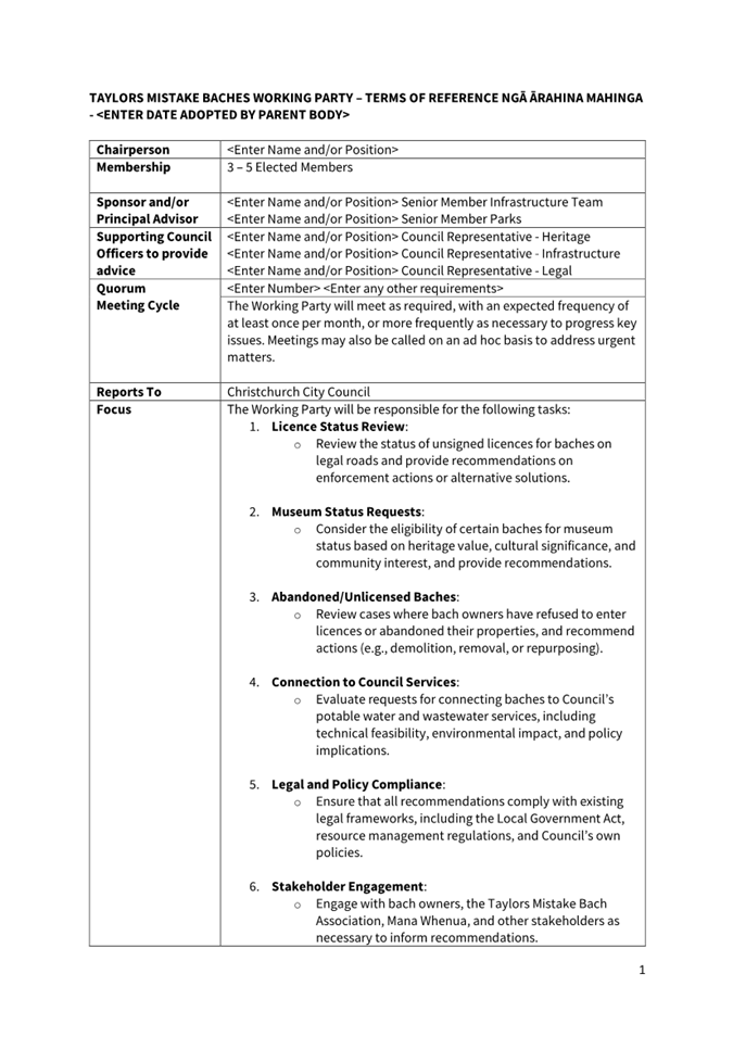
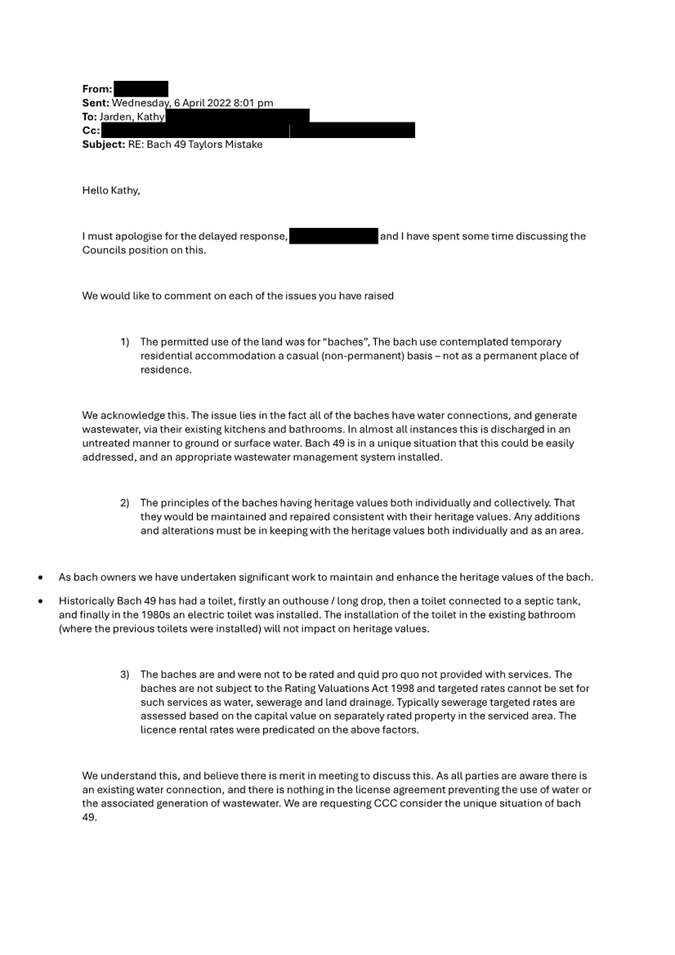
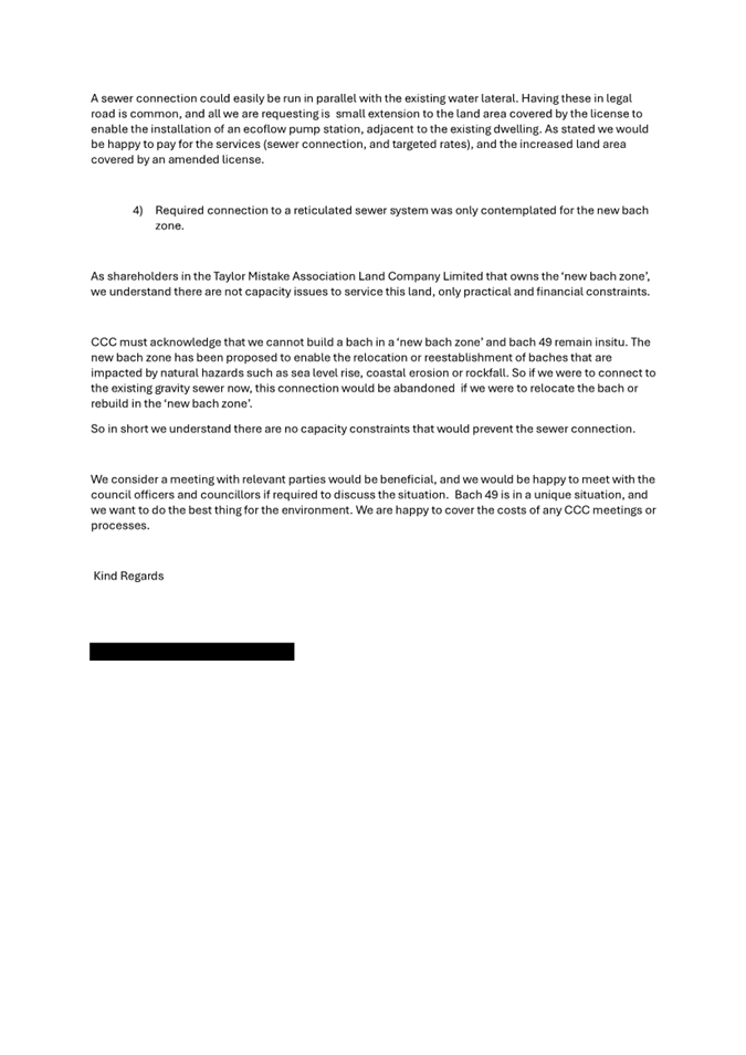
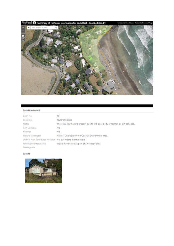
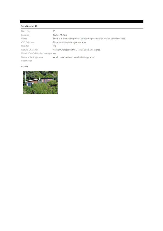
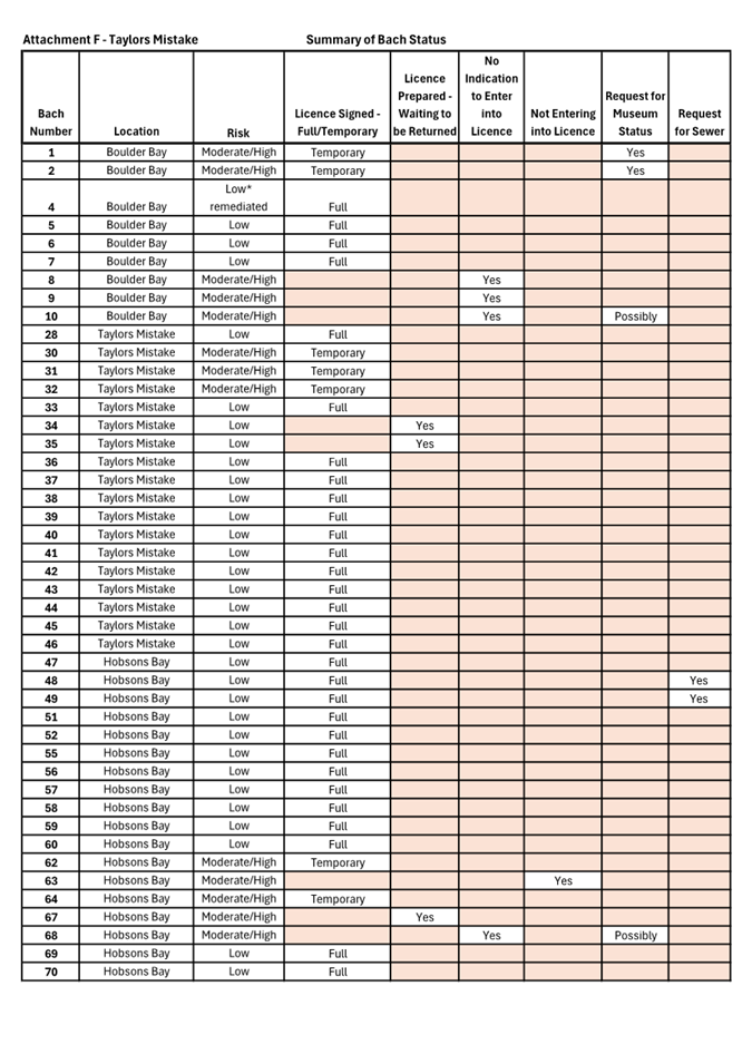
|
8. Mayor's Welfare Fund Delegation
Amendments
|
|
Reference Te Tohutoro:
|
24/2046778
|
|
Responsible Officer(s) Te Pou Matua:
|
Joshua
Wharton, Community Funding Team Leader
|
|
Accountable ELT Member Pouwhakarae:
|
Andrew
Rutledge, Acting General Manager Citizens and Community
|
1. Purpose and Origin of the Report Te Pūtake Pūrongo
1.1 The
purpose of this report is to provide the Council with an update on the
activities of the Mayor’s Welfare Trust over the last 12 months; and to
provide for specific staff delegation changes.
1.2 The
report comes following the Mayor’s Welfare Advisory Committee meeting of
13 November 2024.
2. Officer Recommendations Ngā
Tūtohu
That the Council:
1. Receives the information in the Mayor's Welfare Fund Delegation
Amendments Report.
2. Notes that the decisions in this report are
assessed as low significance based on the Christchurch City Council’s
Significance and Engagement Policy.
3. Relying on clause 32 of Schedule 7 of the
Local Government Act 2002 and for the purposes of the efficiency and
effectiveness in the conduct of the Council’s business, and any other
applicable statutory authority:
a. Revokes and amends the delegations set out in
Part B of the Delegations register (as shown and highlighted in Attachment A
of this report.
b. Notes that these delegation changes take
effect on the date of this resolution, and that Legal Services will update the
Delegations Register accordingly.
3. Executive Summary Te Whakarāpopoto Matua
3.1 The
Mayors Welfare Trust (Trust) exists to provide relief to those residents and
visitors to Christchurch suffering hardship or distress. It achieves
this through providing various grants, advice and referrals.
3.2 The
successful operation of the Trust relies on the Mayor’s Welfare Advisory
Committee (Advisory Committee) who meet quarterly, to provide advice to staff
and elected members on matters relating to the operation and purpose of the
Trust, and on larger grants. The organisations currently represented on
the Advisory Committee are:
Ministry of
Social Development Collective
for the Homeless Methodist
Mission
Petersgate NZ
Police Kainga
Ora
Salvation Army St
Vincent de Paul He
Waka Tapu
City
Mission Birthright Catholic
Social Services
Presbyterian
Support Upper SI Tangata
Atumotu Trust Mayor's
Representative
3.3 This
report recommends changes to staff delegations, which are supported by the
Advisory Committee that will:
· Ensure that the Trust can
respond promptly and effectively to community need, effectively and efficiently
delivering its purpose within Council’s legislative framework.
· Ensure that any larger
grants, between $2,000 and $10,000 are fully informed and recommended by the
Advisory Committee prior to approval.
4. Background/Context Te Horopaki
Activities of the Trust
4.1 From
July 2023 to June 2024 the expenses of the Trust totalled $229,313.00. As with
previous financial years the most frequently granted areas from the Trust
continue to be rent and power arrears. However, unexpected or significant
dental fees have become increasingly common of late.
4.2 The
Trust continues to observe broader challenges in its applicants, wrought by the
misuse of Afterpay and Online Gambling. While outside of the scope of the
Trust’s direct activities, the Advisory Committee and other community
partners continue to look for ways to positively support the damage from these
sources.
4.3 The
complexity of Mayors Welfare applicants also continues to increase. Many have
broader familial or behavioural challenges, learning disabilities, mental
health challenges, obligations or bad debts. As practicable, staff guide these
individuals to seek support from appropriate avenues.
4.4 Staffing
for the Trust and Advisory Committee is provided by Council representatives
from the Community Funding Team, the Financial Accounting Team, and Legal
Services.
4.5 The
Trust maintains its registration of charitable status through the Charities
Services register (CC25434). Annual auditing of the Trust is provided by
Audit NZ.
4.6 The
Council is bringing on a new Community Funds Management Platform
(SmartyGrants), which will allow for a more detailed breakdown of the numbers
of applications, recipients, average size of support to individuals and
high-level demographic information on those being supported by the Trust.
4.7 The
aim is that in partnership with the social service partners on the Advisory
Committee, the Trust can begin to support proactive work on the issues
identified as being particularly prevalent in applicants such as Online
Gambling, misuse of Afterpay/Credit Cards, and the need for quality Budget
Mentoring services.
Delegations
4.8 Part
B of the Council’s Delegations Register contains the Council delegations
in respect of the Trust as well as other matters where the Council delegates
directly to staff because, for the most part, the law does not allow for
sub-delegation of these matters to the Advisory Committee (or similar).
4.9 To
improve the efficiency and effectiveness of the operations of the Trust, the
Advisory Committee has recommended the following changes to the delegations to
clarify the types of applications each staff member can approve. The
recommended changes are:
4.9.1 Community
Funding Advisor to approve a single application of up to $1000.
4.9.2 Team
Leader Community Funding to approve a single application of up to $2000.
4.9.3 Head
of Community Support and Partnerships to approve a single application of up to
$10,000 – following a recommendation from the Advisory Committee.
4.10 The
rationale behind the recommended changes to delegations is:
4.10.1 Council cannot
delegate authority to approve grants to the Advisory Committee (see section
4.11 of this report below).
4.10.2 Represents a
small increase in the existing delegated authority to staff providing for the
larger grants that reflect cost increases over time.
4.10.3 Ensures that
larger grants of between $2,000 and $10,000 are fully informed and recommended
by the Advisory Committee prior to approval.
4.10.4 Grants of over
$10,000 are presented to the Council.
4.10.5 Consistent with
other financial delegations to staff.
4.11 External
legal advice has confirmed that the role of the Advisory Committee, as provided
in clause 7.9 of the Trust, is to provide advice and recommendations on
policies and procedures of the Trust. Its role is strictly advisory with the
ability to make recommendations to Council staff, who can execute the decision
under delegated powers.
5. Financial Implications Ngā Hīraunga Rauemi
5.1 The
Trust has sufficient funds available to accommodate the recommendations in this
report ($918,395.00), without any immediate risk of limiting the BAU of the
Trust in assessing daily/weekly requests for support.
5.2 There
is an additional historic ‘Harry Philpott’ bequest of $723,000.00
made to the Trust in 1996 that is retained in long-term investments, with
interest compounding.
6. Considerations Ngā Whai Whakaaro
Risks and Mitigations Ngā Mōrearea me
ngā Whakamātautau
6.1 There
is a minor risk that the Trust may find itself in a tenuous financial position
in the future.
6.1.1 This
risk is mitigated by the fact that at current spending levels, the Trust has
~3years of expenditure available and easily accessible for distribution. This
is without considering any additional funding that may be sourced over that
time period.
Legal Considerations Ngā Hīraunga
ā-Ture
6.2 Statutory
and/or delegated authority to undertake proposals in the report:
6.2.1 The
Council is the Trustee of the Mayor’s Welfare Trust Deed. The Council has
an obligation as trustee to only use or allocate the trust fund in furtherance
of the purposes of the trust which is confined to providing relief to those
residents and visitors to Christchurch suffering hardship or distress.
6.2.2 Council
as a body corporate per section 12(1) of the Local Government Act 2002 works
through its members, officers and staff. Things done by members, officers and
staff in the name of Council are acts of Council. Therefore, Council can manage
and delegate decision making functions within the Council in the normal way.
6.2.3 Clause
31 of Schedule 7 of the Local Government Act 2002 provides that:
Unless
expressly provided otherwise in this Act, or in any other Act, for the purposes
of efficiency and effectiveness in the conduct of a local authority’s
business, a local authority may delegate to a committee or other subordinate
decision-making body, community board, or member or officer of the local
authority any of its responsibilities, duties, or powers except—
(a) the
power to make a rate; or
(b) the
power to make a bylaw; or
(c) the
power to borrow money, or purchase or dispose of assets, other than in
accordance with the long-term plan; or
(d) the
power to adopt a long-term plan, annual plan, or annual report; or
(e) the
power to appoint a chief executive; or
(f) the
power to adopt policies required to be adopted and consulted on under this Act
in association with the long-term plan or developed for the purpose of the
local governance statement; or
(g) [Repealed]
(h) the power to adopt a
remuneration and employment policy.
6.3 The
proposed changes to the delegations also don’t infringe the restriction
in the Local Government Act 2002.
Strategy
and Policy Considerations Te
Whai Kaupapa here
6.4 The
required decisions:
6.4.1 Align
with the Christchurch
City Council’s Strategic Framework. Specifically, the
strategic priority to “Be an
inclusive and equitable city”.
6.4.2 Are
consistent with Council’s Plans and Policies.
Specifically, the operations of the Trust support those most vulnerable in the
Christchurch and Banks Peninsula Community.
6.5 This
report supports the Council's Long Term Plan (2024 -
2034):
6.6 Communities & Citizens
6.6.1 Activity: Community Development and Facilities
· Level of Service: 2.3.1.1 Provide and manage funding for
initiatives that facilitate resilient and active communities owning their own
future - 100% of funding assessments detail rationale and demonstrate benefits
aligned to Council’s strategic priorities, and where appropriate,
Community Board Plans
· Level of Service: 2.2.1 Community issues, imperatives and
trends are understood, recorded, and made available for stakeholders - 6
community profiles and supporting information at Board level and 1 at a city
– wide level updated annually
· Level of Service: 2.2.2 Locally focussed community
resilience, development and/or recreation initiatives are identified,
prioritised, and delivered - 85% of identified initiatives /projects delivered
Impact
on Mana Whenua Ngā
Whai Take Mana Whenua
6.7 The
decisions do not involve a significant decision in relation to ancestral land,
a body of water or other elements of intrinsic value, therefore this decision
does not specifically impact Mana Whenua, their culture, and traditions.
6.8 The
decisions will not be a matter of significant interest to Mana Whenua and will
not impact on our agreed partnership priorities with Ngā Papatipu
Rūnanga.
Climate
Change Impact Considerations Ngā Whai Whakaaro mā te Āhuarangi
6.9 The
proposals in this report will not contribute to adaptation to the impacts of
climate change or emissions reductions.
Attachments Ngā Tāpirihanga
|
No.
|
Title
|
Reference
|
Page
|
|
a ⇩
|
Attachment A -
Delegations Register
|
24/2084501
|
80
|
In addition to the attached documents, the following background
information is available:
|
Document
Name – Location / File Link
|
|
Not
applicable
|
Signatories Ngā Kaiwaitohu
|
Authors
|
Josh Wharton -
Team Leader Community Funding
Maryem Al
Samer - Legal Counsel
|
|
Approved By
|
John Filsell -
Head of Community Support and Partnerships
|
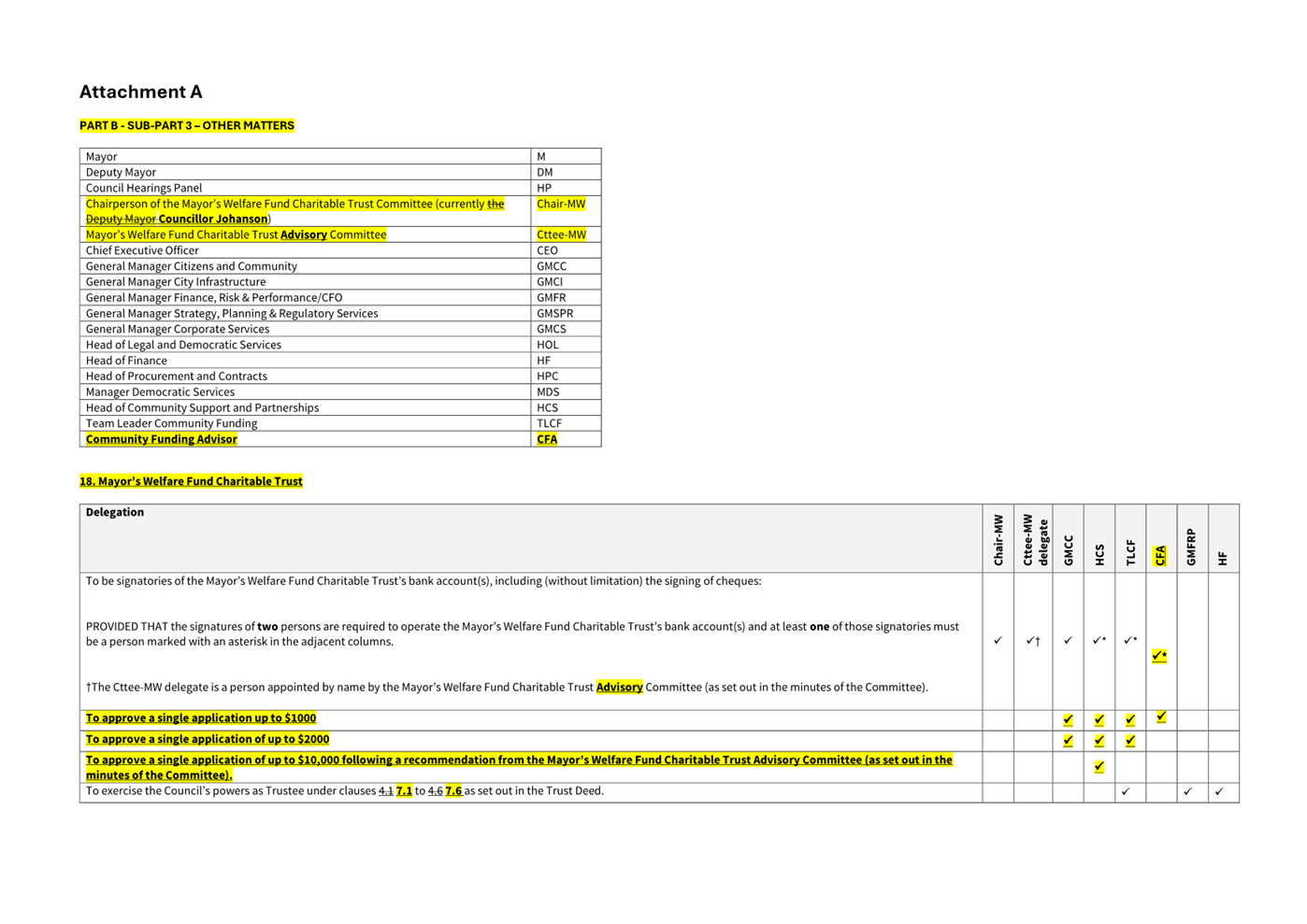
|
9. Addington Brook Enhancement: Stage
2
|
|
Reference Te Tohutoro:
|
24/1934665
|
|
Responsible Officer(s) Te Pou Matua:
|
Mark
Mullaney, Project Manager, Stormwater and Waterways Delivery
|
|
Accountable ELT Member Pouwhakarae:
|
Brent
Smith, Acting General Manager City Infrastructure
|
1. Purpose and Origin of the Report Te Pūtake Pūrongo
1.1 The
purpose of this report is to seek a decision from the Council to remove an
additional 29 trees to enable Stage 2 of the Addington Brook Waterway
Enhancement Renewal project to proceed.
1.2 The
Hagley Park Reference Group is supportive of the project proceeding and the
additional tree removals.
1.3 The
project will plant approximately 500 new trees to allow for a range of tree
species of various ages and heights.
1.4 Stage
1 and 1A of the project has been completed and achieved exceptional outcomes
for the community. Please see Section 4: Background/Context - Te Horopaki
for project stage locations and before and after photos of Stage 1 and 1A.
1.5 The
report is staff generated.
2. Officer Recommendations Ngā
Tūtohu
That
the Council:
1. Receives the information in the Addington Brook Enhancement:
Stage 2 Report.
2. Approves the removal of an additional 29 trees
for stage 2 of the Addington Brook Waterway Enhancement Renewal project to
achieve the following project objectives:
a. Improve health and safety for the public.
b. Improve water quality, biodiversity and
ecology.
c. Improve erosion and provide protection for
Hagley Park assets.
d. Improve drainage reducing peak stormwater
flows.
e. Improve landscaping with plants, trees and
in-stream ecological features.
f. Improve culture by providing opportunities to
connect with nature through safe access at select locations.
3. Notes that the decision in this report is
assessed as medium significance based on the Christchurch City Council’s
Significance and Engagement Policy.
3. Executive Summary Te Whakarāpopoto Matua
3.1 In 2014, ECan’s Christchurch West-Melton Zone Committee
decided to focus on improving the health of Addington Brook because it was one
of the zone’s most polluted waterways and flows directly into the
Ōtākaro-Avon River.
3.2 Addington Brook has erosion issues showing clear signs of slumping
and undercutting following storm events.
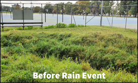
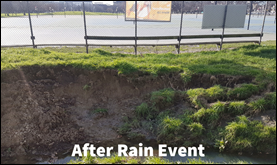
3.3 Several
trees have grown within the waterway edges creating blockages.
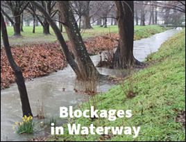
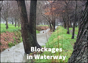
3.4 There
is a health and safety risk as the waterway banks of Addington Brook have a
sharp 3-meter-high drop in several locations, with previous fatalities having
occurred.
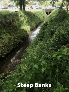
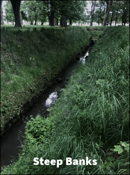
3.5 The
Hagley Park Master Plan 2007 includes Objectives and Projects that relate to
the enhancement of Addington Brook.
3.6 At
its meeting on 30 November 2022 the Finance and Performance Committee (decision
FPCO/2022/00052) approved the Addington Brook Waterway Enhancement Renewal
project and the removal of 45 existing trees (17 existing trees (including 2
groups of poplars) in stage 1 & 1A and 28 existing trees in stage 2). The
project has retained and transplanted as many good candidate trees as possible
(25 trees to date have been accepted by the city arborist, which is 5 more
trees than the 20 trees approved as per Finance and Performance Committee
decision.
3.7 The
project will plant approximately 500 new trees to allow for a range of tree
species of various ages and heights.
3.8 Following
detailed design work for stage 1 & 1A an additional 13 trees were required
to be removed to achieve the project objectives and were approved by the Head
of Parks (stage 1 & 1A works have been completed).
3.9 After
detailed design work for stage 2 an additional 29 trees
will be required to be removed to achieve the following project objectives:
· Improve health and safety
for the public
· Improve water quality,
biodiversity and ecology
· Improve erosion and
provide protection for Hagley Park assets
· Improve drainage reducing
peak stormwater flows
· Improve landscaping with
new plants, trees and in-stream ecological features
· Improve culture by
providing opportunities to connect with nature through safe access at select
locations
3.10 The
Addington Brook Waterway Enhancement Renewal project supports the following
Strategic Priorities and Community Outcomes from the Council’s Strategic
Framework:
· Strategic Priority: Be an
inclusive and equitable city which puts people at the centre of developing our
city and district, prioritising wellbeing, accessibility and connection.
· Strategic Priority:
Champion Ōtautahi-Christchurch and collaborate to build our role as a
leading New Zealand City.
· Strategic Priority: Reduce
emissions as a Council and as a city, and invest in adaptation and resilience,
leading a city-wide response to climate change while protecting our indigenous
biodiversity, water bodies and tree canopy.
· Strategic Priority: Manage
ratepayers’ money wisely, delivering quality core services to the whole
community and addressing the issues that are important to our residents.
· Community Outcome:
Collaborative and Confident. Our residents have the opportunity to
actively participate in community and city life, have a strong sense of
belonging and identity, and feel safe.
· Community Outcome: Green
and Liveable. Our neighbourhoods and communities are accessible and well
connected, supporting our goals to reduce emissions, build climate resilience
and protect and regenerate the environment, especially our biodiversity, water
bodies and tree canopy.
4. Background/Context Te Horopaki
4.1 Stage
1 and 1A of the Addington Brook Waterway Enhancement Renewal project have been
completed with exceptional outcomes for the community. Please see
location of the project stages and before and after photos below.
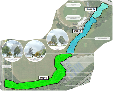
Locations
of Stage 1, 1A & 2
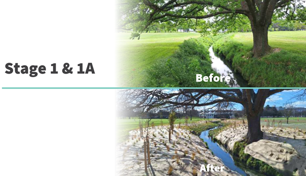
Before and After Stage 1 & 1A
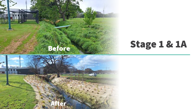
Before and After Stage 1 & 1A (note utilities stretching across
the Brook have been lowered or removed)
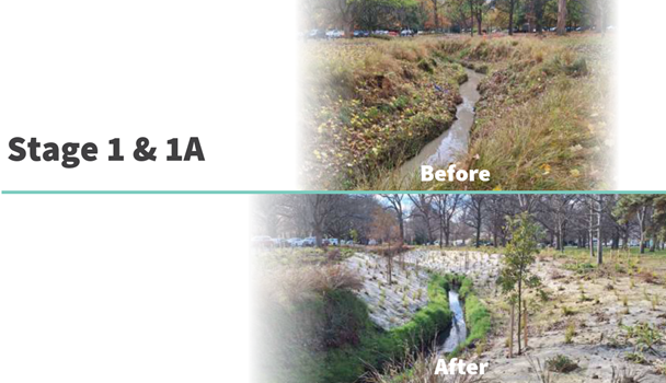
Before and After Stage 1 & 1A
4.2 The Christchurch City Council Tree Policy 1.7 states: For every
tree removed a minimum of 2 new trees will be planted with the projected canopy
cover replacing that which is lost within 20 year (additional planting may be
required). The project will plant approximately 500 new trees
creating new tree canopy in Hagley Park in excess of the requirement under the
Tree Policy.
Options Considered Ngā Kōwhiringa Whaiwhakaaro
4.3 The
following reasonably practicable options were considered and are assessed in
this report:
4.3.1 Do
nothing.
4.3.2 Minimal
enhancement of Addington Brook. Remove the existing trees as approved per
Finance and Performance Committee decision FPCO/2022/00052.
4.3.3 Enhancement
of Addington Brook. Remove an additional 29 trees in stage 2 of the
project to achieve the project objectives.
Options Descriptions Ngā Kōwhiringa
4.4 Preferred
Option: Enhancement of Addington Brook. Remove an additional 29 trees
for stage 2 of the project to achieve the project objectives.
4.4.1 Option
Description: Enhancement of Addington Brook
4.4.2 Option
Advantages
· Improve health
and safety for the public.
· Improve water
quality, biodiversity and ecology.
· Improve
erosion and provide protection for Hagley Park assets.
· Improve
drainage reducing peak stormwater flows.
· Improve
landscaping with plants, trees and in-stream ecological features.
· Approximately,
500 new trees will be planted to allow for a range of
tree species of various ages and heights.
· Improve
culture by providing opportunities to connect with nature through safe access
at select locations.
4.4.3 Option
Disadvantages
· An additional
29 trees for stage 2 of the project will need to be removed.
4.5 Do
Nothing.
4.5.1 Option
Description: Do not continue with The Addington Brook Waterway
Enhancement Renewal project.
4.5.2 Option
Advantages
· No disturbance
of existing trees.
4.5.3 Option
Disadvantages
· Continued
health and safety risks for the public. Therefore, a fence would likely
need to be constructed in Hagley Park to keep the public safe reducing the
interaction, connection and enjoyment of the waterway.
· Addington
Brook, which flows directly into the Ōtākaro-Avon River has potential
to remain one of the most polluted waterways in Christchurch’s
West-Melton Zone as sediment mobilisation would continue.
· Biodiversity
and ecology will remain poor.
· Erosion issues
including damage to Hagley Park assets and risks of undermining trees on top of
the bank will continue.
· Drainage
issues will continue.
· Landscaping
will not meet the outcomes as indicated in the Hagley Park Masterplan for
landscape diversity.
· Stage 2 would
not have the range of tree species of various ages and heights compared to
enhancement.
· There will be
no opportunity to connect with the waterway as access remains unsafe.
4.6 Minimal
enhancement of Addington Brook. Remove the existing trees as approved per
Finance and Performance Committee decision FPCO/2022/00052.
4.6.1 Option
Description: Addington Brook is located in an area with dense trees
on both sides of the steep banks of the waterway. This options criteria
to remove only a relatively small number of trees would prevent enhancement
works beyond plantings at the top of the bank for significant stretches of the
waterway. Stated another way, significant stretches of the
waterway’s banks would have no regrading so the steep banks would remain
in their current condition.
4.6.2 In
addition, since there are areas where regrading could occur next to areas where
regrading could not occur this would result in several trees on the edge of a
steep bank with the upstream bank being removed. Stated another way, the
areas of the waterway that could be regraded would be immediately downstream of
an area that could not be regraded due to existing trees. This would
create a situation with protruding trees in the waterway which would likely
experience erosion and could potentially cause the trees to fall. To
avoid the health and safety issue and potential damage to Hagley Park assets a
more complicated engineered solution in front of trees would likely be
required. However, the engineered solution has potential to exasperate
erosion on the opposite banks or at the transition between banks and hard
structures. The engineered solution would also not look natural in the
waterway. Further, there is potential an engineered solution would not be
feasible due to the bank and tree load which would result in additional areas
not being able to be regraded and even less areas where enhancement could
occur.
4.6.3 Please
see the sketch below which shows the project outcomes of a large area of
Addington Brook if only the existing trees approved per Finance and Performance
Committee decision FPCO/2022/00052 were removed.
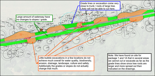
4.6.4 Note
areas highlighted in green would have no regrading and minimal enhancement,
other than plantings next to the waterway. The steep banks would remain,
and the undercutting and sediment mobilisation issues would continue. The
areas highlighted in orange would only have small, localised enhancements which
would not actually change the slopes of the waterway banks very much and
achieve little with regards to water quality, biodiversity, erosion, drainage,
landscape, culture and safety.
4.6.5 In
addition, the project has found on site during the construction of stage 1
& 1A that in several areas the project was unable to cut or excavate as far
as the grade lines show on the drawings since the underground roots of the
trees have been found to be much larger and more spread out than
anticipated. This would further reduce the areas highlighted in orange
which could be enhanced and would likely cause some areas to no longer be
viable for enhancement.
4.6.6 Last,
due to significant sections of the waterway having no regrading, i.e. steep
waterway banks, the health and safety risk for the public would remain.
Therefore, a fence would likely need to be constructed around Addington Brook
in Hagley Park reducing the interaction, connection and enjoyment of the
waterway for the public. This was originally one of the key outcomes of
the project which would not be realised with this option.
4.6.7 Option
Advantages
· Less
disturbance of existing trees.
4.6.8 Option
Disadvantages
· Continued
health and safety risks for the public. Therefore, a fence would likely
need to be constructed in Hagley Park to keep the public safe reducing the
interaction, connection and enjoyment of the waterway.
· Addington
Brook, which flows directly into the Ōtākaro-Avon River has potential
to remain one of the most polluted waterways in Christchurch’s
West-Melton Zone as sediment mobilisation would continue.
· Poor outcome
in comparison to the funding required.
· Biodiversity
and ecology will remain poor.
· Erosion issues
including damage to Hagley Park assets and risks of undermining trees on top of
the bank will continue.
· Drainage and
flooding issues will continue.
· Landscaping
will not meet the outcomes as indicated in the Hagley Park Masterplan for
landscape diversity.
· Stage 2 would
have less of a range of tree species of various ages and heights.
· There will be
no opportunity to connect with the waterway as access remains unsafe.
5. Financial Implications Ngā Hīraunga Rauemi
Capex/Opex Ngā Utu Whakahaere
|
|
Recommended Option
|
Option 2 – Do Nothing
|
|
Cost to Implement
|
CapEx Estimate $50,000
|
$0
|
|
Maintenance/Ongoing Costs
|
$0
|
Estimate $15,000 annually to repair banks
and remove trees with safety issues
|
|
Funding Source
|
LTP
|
LTP
|
|
Funding Availability
|
Currently $4.5 million for project
|
Maintenance Budget
|
|
Impact on Rates
|
Negative due to reduced maintenance costs
|
Positive due to larger annual maintenance
costs
|
6. Considerations Ngā Whai Whakaaro
Risks and Mitigations Ngā Mōrearea me
ngā Whakamātautau
6.1 There
is a moderate reputational risk to approve the removal of an additional 29
trees in South Hagley Park.
6.2 This
risk will be mitigated by a Newsline article, social media, a project website
and project signs which will communicate to the community the rationale for
removing the existing trees and the importance and benefits of the
project.
6.3 The
mitigation strategy would result in the moderate reputational risk to be
shifted to a minor reputational risk.
6.4 If
nothing or only minor enhancements are done to Addington Brook there is an
extreme health, safety and well-being risk as there have already been one or
more fatalities. In this case Addington Brook in Hagley Park will most
likely be fenced off.
6.5 There
is a major environmental risk as Addington Brook would likely remain one of the
most polluted waterways in the Christchurch West-Melton Zone.
Legal Considerations Ngā Hīraunga
ā-Ture
6.6 Statutory
and/or delegated authority to undertake proposals in the report:
6.6.1 Council
has the ability to undertake all the waterway related work recommended in this
brief under a raft of legislation, including the Local Government Act 2002, the
Christchurch District Drainage Act of 1951 and the Land Drainage Act 1908.
6.6.2 The
key concepts of the Addington Brook Naturalisation wholly align with various
publicly notified documents specific to Hagley Park such as Council authored
and endorsed The Hagley Park Management Plan 2007, The Hagley Park and Botanic
Gardens Master Plan 2007, the Ōtākaro/Avon River Catchment Vision and
Values Document, and the Improving the Health of Urban Waterways, Addington
Brook “Living” catchment Management Plan June 2019 prepared by the
Christchurch West-Melton Zone Committee.
6.6.3 Hagley
Park South is a recreation reserve subject to Section 17 of the Reserves Act
1977. The publicly consulted Hagley Park Management Plan 2007 and the Hagley
Park and Botanic Gardens Master Plan 2007 provide the vehicles for the
management of the park to be in alignment with the requirements of the Reserves
Act. Additionally, the Christchurch City Reserves Empowering Act 1971, states
what activities can or cannot occur in the park, but only in relation to new
car parks and public works. With the Addington Brook Naturalisation according
with the Hagley Park Plans and the Reserves, further public consultation is not
required.
6.6.4 The
philosophy of tree removal and replacement accords with the Christchurch City
Council Tree Policy.
6.7 Other Legal Implications:
6.7.1 The
legal consideration is Council has an obligation under the Christchurch
District Drainage Act 1951 to maintain and clear / clean watercourses, drains
and sewers (including the stormwater network) so that they are not a nuisance
or damage to health. The continued erosion and slumping of the banks
during rain events causes damage to public assets and ongoing sediment
mobilisation. Council has a role to provide for watercourses that are
safe and in a suitable condition within the drainage district under the Act.
Strategy
and Policy Considerations Te
Whai Kaupapa here
6.8 The
required decision:
6.8.1 Aligns
with the Christchurch
City Council’s Strategic Framework.
6.8.2 Is
assessed as medium significance based on the
Christchurch City Council’s Significance and Engagement Policy. The
level of significance was determined by the author.
6.8.3 Is
consistent with Council’s Plans and Policies.
6.9 This
report supports the Council's
Long Term Plan (2024 - 2034):
6.9.1 Stormwater Drainage
· Activity:
Stormwater Drainage
· Level of Service: 14.0.4.1 Minimum length of 500m of bank
naturalised per year (based on a single side of the waterway) - >=95%
6.10 Stage
2 of the project will naturalise approximately 1000m of bank.
Community
Impacts and Views Ngā Mariu ā-Hāpori
6.11 The
decision affects the Hagley Park Reference Group
6.12 The
decision affects the following wards/Community Board areas:
6.12.1 The Central
Ward / Waipapa Papanui-Innes-Central Community Board.
6.13 The
Hagley Park Reference Group view is supportive of
Stage 2 of the Addington Brook Waterway Enhancement Renewal project proceeding
and the removal of an additional 29 trees.
Impact
on Mana Whenua Ngā
Whai Take Mana Whenua
6.14 The
decision involves a significant decision in relation to
ancestral land, a body of water or other elements of intrinsic value, therefore
this decision does specifically impact Mana Whenua, their culture, and
traditions.
6.15 The
decision involves a matter of interest to Mana Whenua and could impact on our
agreed partnership priorities with Ngā Papatipu Rūnanga.
6.16 Mana
Whenua have a strong interest in stormwater management. The preferred
approach is consistent with plans and policies that have had Mana Whenua
engagement.
Climate
Change Impact Considerations Ngā Whai Whakaaro mā te Āhuarangi
6.17 The
decisions in this report are likely to:
6.17.1 Contribute
positively to adaptation to the impacts of climate change.
6.17.2 Contribute
positively to emissions reductions.
6.18 This
project will assist with the mitigation of climate change by providing an
increase in flood capacity within Addington Brook due to the battering or
sloping back of the banks.
6.19 The
plantings will increase shading of the water reducing the effects of any
resulting temperature increase on water quality i.e. macrophyte growth.
6.20 The
enhancement of Addington Brook is a nature-based solution instead of a hard
protection structure.
6.21 The
approximate 500 additional trees will remove carbon dioxide from the air and
release oxygen into the atmosphere.
7. Next Steps Ngā Mahinga ā-muri
7.1 Tender
civil drawings will be completed to allow works to start in the beginning of
2025, if a fair price can be negotiated with the contractor that performed the
stage 1 & 1A works. If not, Council reserves the right to tender the
project and in this case the project would start in the later part of 2025.
Attachments Ngā Tāpirihanga
|
No.
|
Title
|
Reference
|
Page
|
|
a ⇩
|
Council
Addington Brook Enhancement Stage 2 - 30% Civil Drawings
|
24/1997224
|
93
|
In addition to the attached documents, the following background
information is available:
|
Document
Name – Location / File Link
|
|
Not
applicable
|
Signatories Ngā Kaiwaitohu
|
Author
|
Mark Mullaney
- Project Manager
|
|
Approved By
|
Grant Stowell
- Team Leader Asset Management
Rupert Bool -
Acting Head of Parks
Gavin
Hutchison - Acting Head of Three Waters
Brent Smith -
Acting General Manager City Infrastructure
|
|
10. Food
Resilience Network - Community Loan
|
|
Reference Te Tohutoro:
|
24/1637013
|
|
Responsible Officer(s) Te Pou Matua:
|
Joshua
Wharton, Community Funding Team Leader
|
|
Accountable ELT Member Pouwhakarae:
|
Andrew
Rutledge, Acting General Manager Citizens and Community
|
1. Purpose and Origin of the Report Te Pūtake Pūrongo
1.1 The
purpose of this report is for the Council to consider a second Community Loan
to the Food Resilience Network Inc (the Network) to;
· complete their
Ōtākaro Orchard Café building project, and
· subsidise their
operational costs until the café is operational and producing a revenue
stream to cover their loan repayment and ongoing operational costs.
1.2 The
report has originated by request of the Food Resilience Network INC (Network),
as the existing Community Loan and subsequent Better off Funding grant have not
been sufficient to bring the café project to completion.
2. Officer Recommendations Ngā
Tūtohu
That the Council:
1. Receives the information in the Food Resilience Network -
Community Loan Report.
2. Notes that the decision in this report is assessed
as low significance based on the Christchurch City Council’s Significance
and Engagement Policy.
3. Declines the request from the Food Resilience
Network Inc. for a secondary Community Loan of $350,000.00.
4. Makes a grant of $34,939 from its 2024/25
Discretionary Response Fund to cover the next 12 months of the existing
Community Loan repayments on behalf of the Food Resilience Network Inc.
5. Notes that the information contained in
Attachment C of this report can be publicly released one year after the
sustainable operation of the Network café.
3. Executive Summary Te Whakarāpopoto Matua
3.1 The Network has an existing community loan of $150,000, at a 2%
interest rate over a 7-year term. It was extended by one year in 2023, so
that the Network could pay interest-only until September 2024, to allow enough
time for the café build project to be completed. The Network are
in arrears and have advised that they cannot met the repayment schedule.
This is now considered an, at-risk, loan.
3.2 A
Better Off Fund grant of $200,000 was made in 2023 to support the Network to
complete the café construction project and secure the sustainable
operation of the enterprise.
3.3 The
Network has approached the Council with a request for a second community loan
of $350,000 to support them in bringing the café project to completion
and cover operational costs until the completed café brings in its own
revenue stream.
3.4 The
Council does not have sufficient funds in the community loans scheme to
accommodate the request for an additional $350,000.
3.5 Staff
believe there are significant risks associated with granting a second, and
larger loan, primarily:
· That the Network cannot
afford the repayments of a total loan of $500,000, even with a completed
café facility.
· $350,000 may be
insufficient to complete the café and keep the organisational
operational until café revenues are sufficient to repay the loans and
cover the costs of running the organisation.
· The financial and project
information supplied by the Network is insufficient to allow staff to recommend
that the Council grant a second loan, particularly in light of the café
projects’ recent history and the current status of the project.
3.6 If
the existing $150,000 loan was not repaid, this would represent a permanent
decrease to the community loans scheme and a cost to the Council.
3.7 The
staff recommendation to decline a second loan and to grant funds from the
Discretionary Response Fund (DRF) reflects a desire to:
· Continue to support the
Network towards the successful completion of a valued community project by a
hardworking and committed group by providing one year’s repayment of the
existing loan and so give them the “room” to focus on fund raising.
· Supporting the Network to
achieve financial independence from the Council.
· Enable the Network to find
the remaining funds to complete the project elsewhere, and to repay the
existing community loan.
4. Background/Context Te Horopaki
4.1 The
Community Loans Scheme has a budget of $3,303,000. $3,094,000 of the
total budget has been allocated to the groups listed below (4.1.3). There
is an available balance of $209,683.69
4.1.1 The
Community Loans Scheme is financed by interest payments covering
Council’s cost of borrowing. As the principal is repaid it becomes
available for future loans. This ensures the sustainability of the
Scheme.
4.1.2 The
current interest rate for community loans is 5.15%. This reflects the
Council’s cost of borrowing over a 5-year term.
4.1.3 The
existing Community Loan holders are:
· Canterbury
Bowls, Cashmere Tennis Club, Kilmarnock Enterprises.
· Mount Pleasant
Community Centre, Halswell Community Centre.
· Piki Te Ora
Clinic, Governors Bay Jetty, Burnside Rugby Football Club.
· Burnside
Squash Club, The Food Resilience Network, Canterbury Softball.
· The
Christchurch Heritage Trust.
4.2 The Network has an existing community loan of $150,000, at a 2%
interest rate over a 7-year term. The purpose of the loan was to complete
cold shell project, to allow the Network to secure substantial third-party
funding and to allow the café facility to generate revenue to repay the
loan. It was agreed that the first two years of this loan would be
interest-only to support the Network to gain financial reserves and enable
future principal payments.
4.2.1 The
repayment of the community loan is contingent on the ability of the Network to
raise sufficient funds to complete the café project, as it is through
the projected income of the café that the Network intends to meet its
quarterly repayments. It is also contingent on the Network raising funds
through donations.
4.2.2 The
Network have historically not met repayment schedules resulting in follow up
action from staff. The loan was extended by one year in 2023, so that the
Network could pay interest-only until September 2024, to allow enough time for
the café build project to be completed. The Network have not
received sufficient third-party funding to repay the loan to date.
4.2.3 From
September 2024, loan repayments have transitioned from interest-only of $750.00
per quarter to a total of $8,734.76 per quarter, accounting for
principal. The September 2024 payment is overdue and the Network have
verbally advised that they will not be able to pay the September 2024 or
December 2024 instalments. This is now considered an, at-risk, loan.
4.3 The
Council’s October 2020 decision to award a loan of $150,000 to the
Network was predicated with an assurance from the Network that the project was
sustainable, albeit with identified risks that could be sufficiently mitigated,
risks included:
· The requirement for the
Network to raise between $81,000 and $212,000 in donation revenue each year.
· The financial viability of
Network and ability to service a loan being made more difficult by the
competition for café and office lease space currently being experienced
and also the effects of COVID-19.
· The ability of the Network
to draw down previously secured third party funding.
· Due to the community-based
nature of the project the security available to the Council in the event of a
failure to repay is low.
4.4 A
Better Off Fund grant of $200,000 was made by the Council in 2023 to support
the Network to complete the café project. The Network advise that
the grant was spent on:
4.4.1 Subsidising
the costs of running the organisation, particularly through the lease and set
up of the Urban Farm.
4.4.2 Improvements
and opportunities including but not immitted to the Green Roof.
4.4.3 Purchase
of building materials.
4.5 The
Network as an organisation contribute positively to building strong
communities, for example:
· Weekly working bees at the
Ōtākaro Orchard. Quarterly school hui.
· Distribution of native
trees. Guided tours to community groups.
· Educational workshops on
various topics (brickmaking, composting, planting, etc.)
· Support of interns &
students from Ara and UC.
4.6 Staff
have visited the site. The cold shell of the café building is
complete as is the green roof. The building interior and immediate
surrounds are substantially incomplete and require considerable work. The
Network advise much of this will be completed by volunteers. Amongst
other areas, the access routes, some interior walls, plumbing and café
fit-out are substantially incomplete.
4.7 Completion
costs are estimated by the Network at $634,284. However, after in kind
contributions, volunteer assistance and materials already procured are taken
into account the Network advise the nett cost to complete, and support the
organisation during this process, is $350,000. This includes some
start-up costs. See publicly excluded Attachment C.
4.8 This
estimate has not been validated or assessed by a Quantity Surveyor. It is
not produced in the context of a wider project and cost plan including
provision for escalation, design, project and general contingency. Given
the above, and the condition of the site, staff are unable to confirm that
$350,000 will be sufficient to complete the café and keep the
organisational operational until café revenues are sufficient to repay
the loans.
4.9 There
are sufficient reserves in the 2024/25 DRF to accommodate the
recommendation. At the time of writing the balance is $348,906,
if the Council approve the grant of $34,939 the
residual balance will be $313,987.
Options Considered Ngā Kōwhiringa Whaiwhakaaro
4.10 The
following reasonably practicable options were considered and are assessed in
this report:
4.10.1 The Council
declines the application for an additional loan of $350,000 and approves a
grant of $34,939 from the DRF to provide a loan holiday of one year.
Preferred option.
4.10.2 The Council
declines the application for an additional loan of $350,000.
4.10.3 The Council
approves a partial loan, at the balance of the Loans Scheme ($209,683).
4.11 The
following options were considered but are not recommended:
4.11.1 The Council
approves a loan of $350,000.00 – there are not sufficient funds available
in the community loans scheme and this would require additional borrowing
outside of the Community Loan Scheme envelope.
4.11.2 The Council
forgives the existing loan – this risks the sustainability of the
Community Loan Scheme as the community loan budget is financed by interest
payments covering Council’s cost of borrowing. As the principal is
repaid it becomes available for future loans.
Options Descriptions Ngā Kōwhiringa
4.12 Preferred
Option: To decline the application for an additional loan of $350,000 and
approve a grant of $34,939 from the DRF to provide the Network a one-year loan
holiday in order to allow them “room” to focus on fundraising.
4.12.1 Option
Advantages:
Loan
· The Council does not have
sufficient funds in the community loan pool to accommodate a new loan of
$350,000. Additional funds would need to be found at a cost to rates.
· There is significant risk
that even with an additional loan of $350,000, that the project will not reach
completion, and the Council is faced with a larger at-risk loan.
· There is limited evidence
of the ability for the proposed café to make enough profit to sustain a
$500,000 community loan. There is a significant risk that the loan will
not be repaid.
· Other funders have
indicated their reservations, due to the remaining cost to complete and lack of
security on lending.
· The Council does not have
the ability to leverage sufficient security against the proposed loan, as the
assets of the Network are limited.
DRF Grant
· The Council will continue
to support the Network towards the successful completion of a valued community
project by a hardworking and committed group by proving a one-year loan
repayment holiday without deferring and increasing the debt.
· Will allow a focus on the
café project rather than the wider aims of the Network.
· The grant will repay the
community loan so the cost will not be sunk.
4.12.2 Option
Disadvantages:
Loan
· There is a risk that the
café will remain in a state of incompletion in a prominent city
location.
· There is also a risk that
if the project remains uncompleted, that the Better off Fund grant, and
$150,000 loan that has already been made to the Food Resilience Network would
be a sunk cost.
· There is potential
negative impact on the sustainable operation of the Network.
DRF Grant
· There is a reputational
risk that the Council will invest a further $34,939 in a project with
substantial risks, primarily that the café will remain incomplete.
4.13 Option
2: To decline the application for an additional loan of $350,000.
4.13.1 Option
Advantages: See section 4.12.1 (Loan) of this report above.
4.13.2 Option
Disadvantages: See section 4.12.1 (Loan) of this report above.
4.14 Option
3: To recommend the Council make partial loan, at the balance of the Loans
Scheme (~$200,000).
4.14.1 Option
Advantages
· There is sufficient
funding available in the Community Loans Scheme for this approach.
4.14.2 Option
Disadvantages
· This option does not
provide sufficient funds to enable to project to progress to completion,
risking not only the current loan, but the additional loan as well.
· The café project
will not be completed.
· The loan will not be
repaid.
· Other funders have
expressed similar concerns about the viability of the project.
· The Council does not have
the ability to leverage sufficient security against the proposed loan, as the
assets of the Trust are limited.
Analysis Criteria Ngā Paearu Wetekina
4.15 Analysis criteria
includes but is not limited to:
· The
inherent viability of the café project given its history and the Council
funding to date.
· The
robustness of the project and financial information supporting the application.
· The
value to the community of the Network and the wider project along with the
continued work of dedicated volunteers in a difficult environment.
· The
balance of the community loan pool.
· The
historic reliability of the Network in repaying the existing community loan.
· This
risk of the Council and others effectively losing their existing investment.
· The
degree to which Council has already invested in the project through a community
loan at a subsidised interest rate and a $200,000 grant.
5. Considerations Ngā Whai Whakaaro
Risks and Mitigations Ngā Mōrearea me
ngā Whakamātautau
5.1 If
an additional loan is not granted, there is a risk of the café remaining
unfinished. If the café is not be open and trading, the Network
will struggle to meet their existing loan repayments.
5.1.1 This
risk is partially mitigated by the potential for other funders to support the
Network to bridge the funding gap.
5.1.2 This
risk is also partially mitigated by the recommended grant from the DRF, which
would allow the Network a further year to raise the required remaining funds
from sources outside of the Council. It will also allow the network to be
much better placed to secure funding elsewhere.
5.2 If
an additional loan were to be granted, there are concerns over the
organisation’s ability to service both loans via the income generated by
the on-site café. This could overleverage
the organisation and risk loss to the Council of up to $500,000, rather than
the existing $150,000. See publicly excluded Attachment C.
The existing loan is in default and considered at risk.
5.2.1 This
risk cannot be mitigated based on the existing information available.
5.3 There
is a risk that a loan of $350,000 will not allow the completion of the
project. There is no robust validated project plan detailing
costs, available budget, consents, programme and key milestones etc. Based on the intermittent nature of the café project
to date, the condition of the site at the time of the staff visit, and the size
of the loan required, this is considered important.
5.3.1 This
risk cannot be mitigated based on the existing information available.
Financial Considerations
5.4 All
the options considered can be accommodated within existing loan and grant
funding budgets and levels of service. However, there will be a cost to
rates if the Network default on their existing loan and any additional loan.
There is no budget to cover the Council forgiving the existing loan.
5.5 There
are insufficient funds available in the community loans scheme to accommodate a
loan of $350,000.00, this would require further borrowing outside the Community
Loans Scheme.
5.6 Council
staff from the Funding, Community Support, Facilities and Finance teams have
reviewed the updated budget for the Café operation supplied by the
Network. Based on the information supplied, staff do not have confidence
that the café operation will be able to fund the repayment of a larger
community loan. For more information see publicly excluded Attachment
C.
Legal Considerations Ngā Hīraunga
ā-Ture
5.7 Statutory
and/or delegated authority to undertake proposals in the report:
5.7.1 The authority
to make decisions relating to the awarding of Community Loans sits with the
Council.
5.8 Other Legal Implications:
5.8.1 The
Council currently has a first registered mortgage, with security over the
assets of the Trust. These assets include the partially completed building, the
garden next to this facility, and the limited cash reserves of the Incorporated
Society.
5.8.2 Rata
has also been approached by the Network with a similarly sized loan request.
However, if another funder were to grant this loan, they would only be eligible
for a second-degree mortgage over the assets of the Network, as the
Council’s agreement would supersede any other agreements made.
5.9 Staff
will not often recommend that the Council approve a grant to repay a
loan. The DRF application process discourages this. This particular
case is considered an exception as there is a desire to alleviate the financial
pressure of a loan repayment for one year whilst the Network fundraise.
There will be no recommendation to change the operation of the DRF as this
particular case is considered relatively unique.
Strategy
and Policy Considerations Te
Whai Kaupapa here
5.10 The
required decisions:
5.10.1 Align with the Christchurch
City Council’s Strategic Framework.
Specifically, the priorities to:
· Be an inclusive and
equitable City,
· Reduce
emissions, and
· Manage
ratepayers’ money wisely.
5.10.2 Is assessed as low
significance based on the Christchurch City Council’s
Significance and Engagement Policy. The level of significance was
determined by evaluating the number of people affected and/or with an
interest.
5.11 This
report supports the Council's
Long Term Plan (2024 - 2034):
5.12 Communities & Citizens
5.12.1 Activity: Community Development and Facilities
· Level of Service: 2.3.1.1 Provide and manage funding for
initiatives that facilitate resilient and active communities owning their own
future - 100% of funding assessments detail rationale and demonstrate benefits
aligned to Council’s strategic priorities, and where appropriate,
Community Board Plans
Community
Impacts and Views Ngā Mariu ā-Hāpori
5.13 Community
views have not been specifically sought as the Community Loan Scheme is a level
of service in the recently consulted 2024/34 LTP. This loan application
has been discussed with the applicant.
Impact
on Mana Whenua Ngā
Whai Take Mana Whenua
5.14 The decision does not involve a significant decision in relation
to ancestral land, a body of water or other elements of intrinsic value,
therefore this decision does not specifically impact Mana Whenua, their
culture, and traditions.
5.15 The decision does not involve a matter of interest to Mana Whenua and will not impact on our agreed partnership priorities
with Ngā Papatipu Rūnanga.
Climate
Change Impact Considerations Ngā Whai Whakaaro mā te Āhuarangi
5.16 The
recommendations in this report are likely to:
5.16.1 Contribute
negatively to adaptation to the impacts of climate change.
5.16.2 Contribute
negatively to emissions reductions.
5.17 Network
is a strong advocate for renewable food production in Christchurch. They lead
the Edible Canterbury Charter project, which contributes significantly to the
Council’s Climate Strategy.
5.18 They
support education around local food initiatives, reducing emissions, and the
benefits of locally produced food. At the Ōtākaro Orchard they
run classes on how individuals can grow, cook and preserve their own fruit and
vegetables, and the importance of understanding seasons.
5.19 The
recommendation to decline this community loan would not stop these positive
climate activities directly, but it would affect the cashflow situation of the
Network as a whole. It would be a stimulus for possible downstream financial
challenges for the society, as they would need to raise the remaining funds to
complete the building through a different source whilst still being required to
repay their existing loan.
Attachments Ngā Tāpirihanga
|
No.
|
Title
|
Reference
|
Page
|
|
a ⇩
|
Food
Resilience Network Strategic Plan
|
24/1668890
|
107
|
|
b ⇩
|
Ōtākaro
Orchard Sponsorship Document
|
24/1668892
|
119
|
|
c
|
Food
Resilience Network Loan Application (Under Separate Cover) - Confidential
|
24/2064553
|
|
In addition to the attached documents, the following background
information is available:
|
Document
Name – Location / File Link
|
|
Not
applicable
|
Signatories Ngā Kaiwaitohu
|
Authors
|
Josh Wharton -
Team Leader Community Funding
Rose Crossland
- Community Development Advisor
|
|
Approved By
|
Gary Watson -
Manager Community Partnerships
John Filsell -
Head of Community Support and Partnerships
|
|
11. Discretionary
Response Fund - The Food Resilience Network Inc.
|
|
Reference Te Tohutoro:
|
24/1943650
|
|
Responsible Officer(s) Te Pou Matua:
|
Joshua
Wharton, Team Leader Community Funding
|
|
Accountable ELT Member Pouwhakarae:
|
Andrew
Rutledge, Acting General Manager Citizens and Community
|
1. Purpose and Origin of the Report Te
Pūtake Pūrongo
1.1 The
purpose of this report is for the Council to consider one application for
funding from its 2024/25 Discretionary Response Fund from
the Food Resilience Network Inc. There is currently a balance of $366,906
remaining in the fund.
|
Funding Request Number
|
Organisation
|
Project Name
|
Amount Requested
|
Amount Recommended
|
|
00068144
|
Food Resilience
Network Inc
|
Otākaro Orchard
and Urban Farm volunteer
co-ordinators
|
$26,500
|
$8,000
|
2. Officer Recommendations Ngā
Tūtohu
That the Council:
1. Receives the information in the Discretionary Response Fund - The Food
Resilience Network Inc. Report.
2. Notes that the decisions in this report are
assessed as low significance based on the Christchurch City Council’s Significance and
Engagement Policy.
3. Approves a grant of $8,000 from its 2024/25
Discretionary Response Fund to The Food Resilience Network Inc. towards the
Otākaro Orchard and Urban Farm Volunteer Co-ordinators.
3. Key Points Ngā Take Matua
Strategic Alignment Te Rautaki Tīaroaro
3.1 The
recommendations are consistent with the Strengthening Communities Together
Strategy. Please see the funding matrix staff assessment for the
application as Attachment A.
Decision Making Authority Te Mana Whakatau
3.2 Council
determines the allocation of the Discretionary Response Fund for each
community. The Metropolitan / Citywide portion of this fund is determined by
the allocation from the 2024/25 Metropolitan Strengthening Communities Fund
decision each year, plus any carry forward from 2023/24.
3.3 Allocations
must be consistent with any policies, standards or criteria adopted by the
Council.
3.4 The
Fund does not cover:
· Legal challenges or the
Environment Court challenges against the Council,
Council Controlled organisations, or Community Board decisions.
· Projects or initiatives
that change the scope of a Council project or that will lead to ongoing
operational costs to the Council.
Assessment of Significance and Engagement Te Aromatawai Whakahirahira
3.5 The decisions in this report are assessed as low significance based
on the Christchurch City Council’s Significance and Engagement Policy.
3.6 The level of significance was determined by the number of people
affected and/or with an interest.
3.7 Due to the assessment of low significance, this has been discussed
with the Applicant and staff, no further community engagement and consultation
is required.
Discussion Kōrerorero
3.8 At the time of writing, the balance of the 2024/25 Discretionary
Response Fund is as below.
|
Total Budget 2024/25
|
Granted To Date
|
Available for allocation
|
Balance If Staff Recommendation adopted
|
|
$449,802
|
$82,896
|
$366,906
|
$358,906
|
3.9 $55,243
has been awarded from the 2024/25 Discretionary Response Fund to 10
organisations under the delegation of the Head of Community Support and
Partnerships.
The Food Resilience Network Inc.
3.10 This request from The Food Resilience Network is to fund their
Otākaro Orchard and Urban Farm volunteer co-ordinators. This is
distinct from another request from The Food Resilience Network for a $350,000
loan to complete the café and support organisational costs whilst this
is being done, also being considered by Council on 4 December 2024.
3.11 The recommendation for this report is made in the context of the
work of the Orchard and Urban Farm continuing independently of the cafe
project.
Attachments Ngā Tāpirihanga
|
No.
|
Title
|
Reference
|
Page
|
|
a ⇩
|
Food
Resilience Network Inc. Decision Matrix
|
24/1943652
|
133
|
Signatories Ngā Kaiwaitohu
|
Authors
|
Josh Wharton -
Team Leader Community Funding
Julie Pearce -
Community Funding Advisor
|
|
Approved By
|
Gary Watson -
Manager Community Partnerships
John Filsell -
Head of Community Support and Partnerships
|
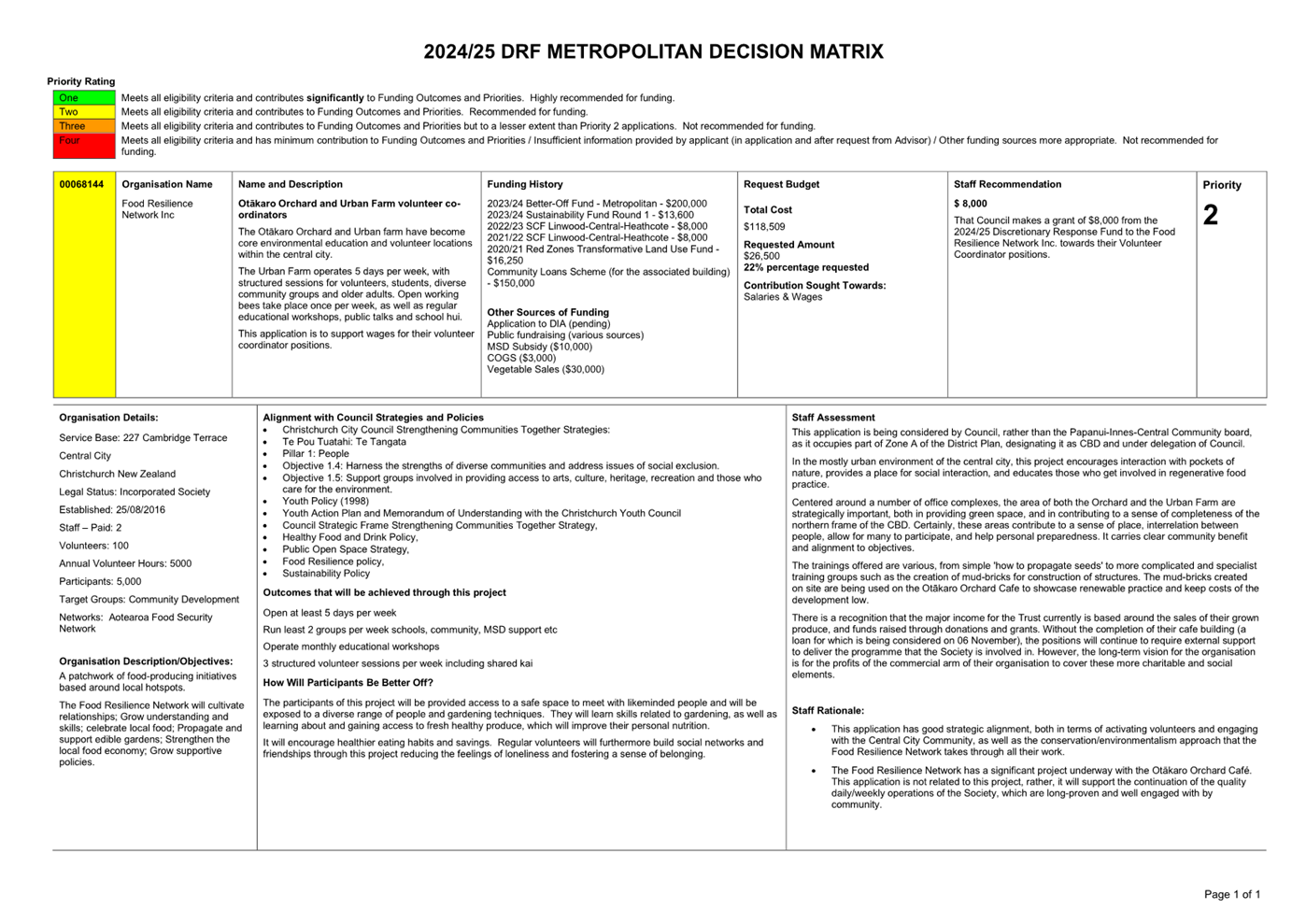
|
12. Appointment of Recess Committee 2024/2025
|
|
Reference Te Tohutoro:
|
24/440592
|
|
Responsible Officer(s) Te Pou Matua:
|
Samantha
Kelly, Team Leader Democratic Services Support
|
|
Accountable ELT Member Pouwhakarae:
|
Helen
White, General Counsel / Head of Legal & Democratic Services
|
1. Purpose and Origin of the Report Te Pūtake Pūrongo
1.1 The
purpose of this report is for the Council to appoint a Recess Committee to
consider any urgent issues that require a Council decision during the recess
period from 20 December 2024 to 19 January 2025.
1.2 The
report is staff generated to ensure any matters that may require urgent
decisions during the recess period can be brought to the attention of the
Council.
2. Officer Recommendations Ngā
Tūtohu
That the Council:
1. Receives the information in the Appointment of Recess Committee 2024/2025 Report.
2. Notes that the decision in this report is
assessed as low significance based on the Christchurch City Council’s Significance and
Engagement Policy.
3. Appoints a Recess Committee comprising of the
following membership and quorum, to be authorised to make any urgent decisions
of the Council required during the period from 20 December 2024 to 19 January
2025 (both days inclusive):
Membership
a. the Mayor or Deputy Mayor; and
b. Councillor [enter name]; and
c. a minimum of three Councillors.
Quorum
d. Notes the quorum of the Recess Committee will
include the Mayor or Deputy Mayor and Councillor [enter name].
4. Notes that any meeting of the Recess Committee
will be publicly notified, and the details forwarded to all Councillors, all of
whom can participate.
5. Notes that any decisions made by the Recess
Committee will be reported to the Council for record purposes.
3. Executive Summary Te Whakarāpopoto Matua
3.1 There
is a recess period between 20 December 2024 and 19 January 2025 (dates inclusive).
It is recommended, as is standard practice, that the Council establish a Recess
Committee to deal with any urgent business during this time.
4. Background/Context Te Horopaki
4.1 The
Council has previously established a Recess Committee, comprising of the Mayor
or Deputy Mayor, another named Councillor and a minimum of any three
Councillors. The Mayor or Deputy Mayor and the named Councillor are required to
make the quorum of the Committee.
4.2 In
accordance with legislation any Recess Committee meeting will be publicly
notified and all Councillors will be advised and are able to participate in the
meeting should they be available.
4.3 Any
decisions made by the Recess Committee will be reported to the Council for
information and record purposes.
Options Considered Ngā Kōwhiringa Whaiwhakaaro
4.4 The
following reasonably practicable options were considered and are assessed in
this report:
· The appointment of a
Recess Committee.
· The calling of an
Extraordinary meeting or Emergency meeting.
Options Descriptions Ngā Kōwhiringa
4.5 Preferred
Option: Appointment of a Recess Committee.
4.5.1 Option
Description: To appoint a Recess Committee to consider and be authorised to
make decisions on any urgent matters that may arise between the recess period
from 20 December 2024 to 19 January 2025.
4.5.2 Option
Advantages
· This option
will ensure that any urgent matters that require a decision can be brought to
the attention of the Council in a timely and efficient manner.
· This option
will mitigate the possibility of not being able to convene a quorum due to
Councillor availability.
· All
Councillors will receive notification of a Recess Committee meeting and will be
able to participate, should they be available.
· Any decisions
made by the Recess Committee will be reported to the next Ordinary Council
meeting for information and record purposes.
4.5.3 Option
Disadvantages
· Due to
availability not all Councillors may be able to participate in the meeting.
4.6 The
calling of an Extraordinary meeting or Emergency meeting.
4.6.1 Option
Description: Alternatives available to the Council under the Local
Government Act 2002 (LGA), the Local Government Official Information and
Meetings Act 1987 (LGOIMA) and the Council’s Standing Orders is the
calling of an Extraordinary or Emergency meeting to consider any urgent
business required.
4.6.2 Option
Advantages
· Any matters
requiring an urgent decision would be made by the Council with a quorum of at
least nine.
4.6.3 Option
Disadvantages
· The inability
to call an Extraordinary or Emergency meeting due to the possibility of not
being able to convene a quorum due to Councillor availability.
· The inability
for the Council to consider any urgent matters that may require a decision due
to not being able to convene a meeting of this type.
· This option
would not promote efficiency and effectiveness in decision-making for urgent
matters.
Analysis Criteria Ngā Paearu Wetekina
4.7 In
assessing the options above, the analysis criteria used relates to the
statutory provisions available under the LGA, LGOIMA and the Council’s
Standing Orders.
5. Financial Implications Ngā Hīraunga Rauemi
Capex/Opex Ngā Utu Whakahaere
|
|
Recommended Option – Appoint a Recess
Committee
|
Option 2 - Call an Extraordinary or Emergency
meeting
|
|
Cost to Implement
|
There are no additional costs associated
with this decision.
|
There are no additional costs associated
with this decision.
|
|
Maintenance/Ongoing Costs
|
Not applicable.
|
Not applicable.
|
|
Funding Source
|
Within existing operational budgets.
|
Within existing operational budgets.
|
|
Funding Availability
|
Within existing operational budgets.
|
Within existing operational budgets.
|
|
Impact on Rates
|
Not applicable.
|
Not applicable.
|
6. Considerations Ngā Whai Whakaaro
Risks and Mitigations Ngā Mōrearea me
ngā Whakamātautau
6.1 There
are no identified risks associated with the decision sought to appoint a Recess
Committee.
Legal Considerations Ngā Hīraunga
ā-Ture
6.2 Statutory
and/or delegated authority to undertake proposals in the report:
6.2.1 The
Council can appoint a Recess Committee and authorise the Committee to consider
any matters that require an urgent decision between ordinary meetings of the
recess period.
6.3 Other Legal Implications:
6.3.1 The provisions
of the LGA, LGOIMA and Council’s Standing Orders are relevant to this
decision.
Strategy
and Policy Considerations Te
Whai Kaupapa here
6.4 The
required decision:
6.4.1 Aligns
with the Christchurch
City Council’s Strategic Framework.
6.4.2 Are
assessed as low significance based on the Christchurch City
Council’s Significance and Engagement Policy. The level of
significance was determined by the fact that this relates to administrative
matters to ensure a continuation of governance meetings during the recess
period.
6.4.3 Is
consistent with the Council’s Plans and Policies.
6.5 This
report supports the Council's
Long Term Plan (2024 - 2034):
6.6 Governance
6.6.1 Activity: Governance and decision-making
· Level of Service: 4.1.28.1 Schedule, support and record
governance meetings. - Between 500 and 650 governance meetings are supported,
unless committee structure provides otherwise
Community
Impacts and Views Ngā Mariu ā-Hāpori
6.7 Any
Recess Committee meeting will be publicly notified, and members of the public
can attend a Council meeting, unless there are grounds to exclude the public.
6.8 Any
Recess Committee meeting will be livestreamed (where possible) or recorded and
published on the Council's website after the meeting.
6.9 The decision affects the following wards/Community Board areas:
6.9.1 All
wards of Christchurch City.
Impact
on Mana Whenua Ngā
Whai Take Mana Whenua
6.10 The decision does not involve a significant decision in relation
to ancestral land or a body of water or other elements of intrinsic value,
therefore this decision does not specifically impact
Mana Whenua, their culture, and traditions.
6.11 The decision does not involve a matter of interest to Mana Whenua and will not impact on our agreed partnership priorities
with Ngā Papatipu Rūnanga.
6.12 The
recommendations of this report relate to the establishment of a Recess
Committee, and not any matters that the Recess Committee could potentially
consider.
Climate
Change Impact Considerations Ngā Whai Whakaaro mā te Āhuarangi
6.13 There
are no climate change impact considerations related to this decision.
7. Next Steps Ngā Mahinga ā-muri
7.1 Should
a Recess Committee be required all usual meeting procedures will be followed
including public notification, notification to all Councillors, all of whom can
participate and the publication of an Agenda and Minutes of the meeting.
Attachments Ngā Tāpirihanga
There are no
attachments to this report.
In addition to the attached documents, the following background
information is available:
|
Document
Name – Location / File Link
|
|
Not
applicable
|
Signatories Ngā Kaiwaitohu
|
Author
|
Samantha Kelly
- Team Leader Democratic Services Support
|
|
Approved By
|
Megan Pearce -
Manager Democratic Services
Helen White -
General Counsel / Head of Legal & Democratic Services
Mary
Richardson - Chief Executive
|
|
13. Six-Monthly Progress Report - Climate
Resilience Strategy Implementation
|
|
Reference Te Tohutoro:
|
24/1188074
|
|
Responsible Officer(s) Te Pou Matua:
|
Jessica
Allison-Batt, Principal Advisor Climate Resilience
|
|
Accountable ELT Member Pouwhakarae:
|
John
Higgins, General Manager Strategy, Planning & Regulatory Services
|
1. Purpose and Origin of the Report Te Pūtake Pūrongo
1.1 On 15 November 2023 Council requested (CNCL/2023/00147) six-monthly
reporting on the implementation of Kia Tūroa te Ao: Ōtautahi
Christchurch Climate Resilience Strategy (the Strategy). This is the
December 2024 report on actions that the Council is taking.
2. Officer Recommendations Ngā Tūtohu
That the Council:
1. Receives the information in the Six-Monthly Progress Report - Climate
Resilience Strategy Implementation.
3. Context Te Horopaki
3.1 This
report includes:
· Key policy and
programme updates on the Council’s work to implement the Strategy.
· The status of
cross Council actions at Attachment A.
4. Considerations Ngā Whai Whakaaro
Overview of
progress against cross Council actions
4.1 Between July 2024 and December 2024 good progress was made against
the Strategy. The Council made significant investments that will reduce Council
emissions, most notably, decisions on the Christchurch Wastewater Treatment
Plant rebuild, which gives the Council an opportunity to significantly reduce
emissions from wastewater processing, which currently accounts for around half
of all Council emissions. The Council also delivered its first draft adaptation
plan (action 81) for Lyttelton Harbour and Port Levy, with final
approval by the Council scheduled for early 2025.
4.2 A summary of the status of cross Council actions (Attachment A) shows:
|
Status of
climate actions
|
Totals
|
|
Recurrent
|
4
|
|
Completed
since last report[1]
|
5
|
|
On track
|
38
|
|
Delayed
|
5
|
|
At risk
|
1
|
|
Total
|
53
|
4.3 A
small number of actions have faced delays or issues, with a key contributor
being changes to Central Government policy. For example:
· Mass Rapid
Transit route protection and business case development (action 105) has
been impacted by Central Government’s changed transport priorities with
alternative funding now required.
· Plan Change 7
to limit indigenous vegetation clearance in coastal environments has faced
uncertainty due to changing Central Government policies on indigenous
biodiversity (action 93).
4.4 Slight delays have also been experienced for actions 116 and
117, which focus on sustainable food systems, while further analysis is
undertaken on the Council’s food resilience policy and engagement is
undertaken with community boards.
4.5 One tracked action is at risk: Work with and advocate to central
government for the building for climate change programme and greenhouse gas
emission standards for buildings in New Zealand (action 107). The
workstream appears dormant at this time with the Government focused on other
projects. This is outside of the Council’s control. Council staff
continue to engage with the Ministry of Business, Innovation and Employment to
maintain our ongoing relationship and keep up to date with developments.
4.6 To achieve our climate goals, significant further work is required.
Key actions ongoing at the Council include:
· District Plan
changes (actions 76, 86, 93, and 122) to support a resilient and
low emissions urban form.
· Endorsement of
a Transport Strategy aligned capital programme and initiatives that can
increase transport choice and help encourage behaviour change (actions 100 through
105).
· Accelerating
the Council’s adaptation planning programme (actions 75,77,79 and
80) to support more timely engagement with communities on climate change
induced risks and local responses.
4.7 The Council’s continued leadership on these matters will be
crucial to our future success.
Key
performance indicators
4.8 Since
the previous implementation report, staff have updated the report format to
include a summary of progress (see above), and detailed progress updates at Attachment
A. The Council’s approach to implement the goals of the Strategy has
been to embed climate action within business-as-usual activities and
investments to achieve most significant impact. Climate actions are taken
across the Council and managed through existing processes, such as the Long
Term Plan 2024-34 and its Activity Plans and Levels of Service. As such, much
of the reporting to the Council is also through existing processes. The intent
here is to provide an overview rather than a duplication of all usual reporting
against targets.
4.9 A
cross-Council working group has looked at the possibility of including
additional key performance indicators for reviewing climate resilience
progress. The identification of suitable indicators that can clearly show
outcomes has proved challenging for measures such as adaptation and will be
added over time. Data on Council emissions will be included in this report as a
key performance indicator. The Council has set a clear emissions reduction
target, and data is available to enable this reporting on an annual basis. The
inventory for FY 2023 set a baseline and showed total gross emissions of 33,727
tCO2-e. The next inventory for FY 2024 has just been independently
verified, showing total gross emissions of 32,854 tCO2-e, and staff will
provide a detailed report in early 2025.
4.10 Future reports will also include relevant Community Outcomes
reporting (when available in early 2025) on delivery of A Green Liveable
City and A Thriving and Prosperous City. Over time there may also be
other opportunities to explore how climate related Levels of Service can be
reported against over time.
Update on
the Climate Resilience team’s work programme
4.11 The
Climate Resilience team continued to build foundations for effective climate
action. Key work in the reporting period included:
· Developing a
Canterbury Climate Partnership Plan with the Mayoral Forum to support
collaborative action with regional partners (action 71). This was
presented to the Council for endorsement on 3 July 2024, was endorsed by other
councils also, and subsequently approved by the Mayoral Forum on 30 August.
· Preparing the
Council’s submission on New Zealand's Emissions Reduction Plan 2026-2030,
presented to the Council on 21 August 2024. The main point made by the
Council’s submission was that Central Government needed to amend the Plan
to include bold, robust and proven actions to reduce emissions.
· Delivering a
Council Greenhouse Gas Emissions Inventory for FY 2023 (with data from teams
across the organisation, presented to the Council on 15 May 2024). This enables
an evidence-based approach for emissions reduction actions for the organisation
(action 69).
· Developing a
carbon removal policy and implementation plan for counting the carbon
sequestered by Council owned and controlled trees (action 92). This was
developed with key implementation teams including Parks, Three Waters, Finance
and others. It was approved by ELT in July 2024 to support the Council’s
net carbon neutral 2030 emissions target. The Emissions Inventory reported
gross emissions; however, the data from counting this sequestered carbon will
allow us to report a net position in future years.
4.12 Looking
to the next reporting period, the team will continue work to implement the
Strategy, including:
· Collaborating
with other councils on delivery of the Canterbury Climate Partnership Plan (action
71). The Council is leading Action 8.1 of the Plan regarding climate
funding.
· Delivering the
next annual Council greenhouse gas emissions inventory (action 69). The
data is currently being independently verified.
· Development of
a Council Emissions Reduction Plan (action 70) to support prioritisation
of further initiatives to reduce emissions.
Update on the Coastal Hazards Adaptation Planning Programme (CHAP)
4.13 A
draft Adaptation Plan for public assets at risk of coastal hazards in the
Whakaraupō Lyttelton Harbour and Koukourarata Port Levy Adaptation Area
has been developed. On 16 October 2024 a report was provided to the Council
with potential pathways identified by a Coastal Panel of community and
rūnanga representatives.
4.14 This
is a significant milestone for the Council and our communities. Since late 2022
work has been underway on this Plan, involving significant engagement with the
community, Council, and technical advisors, and investment in a strong evidence
base and policy framework[2] to inform decision making.
4.15 Following
adoption of the draft Plan, the Council will invite submissions to understand
wider community views and preferences. The Council will hear submissions and
make a decision in early 2025.
4.16 This
work confirms significant financial impacts on the Council from climate change
in the Adaptation Area. It is currently anticipated that over the next ten
years $15.9m will be required to fund the adaptation of public assets in this
Area[3]. This reinforces the importance of Council’s current work to
establish a Climate Resilience Fund.
4.17 Beyond
this draft Plan a number of workstreams remain ongoing. Further updates can be
found at Attachment A.
4.18 Looking
to the next reporting period the team will be:
· Developing
lessons learnt from this pilot adaptation plan, including surveying the Coastal
Panel, Specialist Technical Advisory Group, the Independent Chair and others to
inform what changes are needed to future adaptation planning processes. A
Council decision will then be sought on where next to focus adaptation
planning.
· Scoping
further technical work to better understand hazard risk across the city to
inform future adaptation planning and support related workstreams such as the
Coastal Hazards Plan Change.
· Completing
policy work required to activate the Climate Resilience Fund.
· Establishing a
process for regular cycles of risk screening and reporting.
Update on the Planning Programme
4.19 Land
use planning is a crucial part of our response to the impacts of climate
change, providing both non-statutory and statutory
direction to enable a well-functioning and resilient urban environment. Spatial
planning sets the strategic direction for the city, providing the blueprint for
future growth. Statutory planning, primarily through the mechanism of the District
Plan, provides the framework to manage land-use activities and their effects to
ensure that inappropriate development does not occur.
4.20 Key work over the reporting period included:
· Preparation of
Coastal Hazards Plan Change 12 which will amend the District Plan to account
for the impacts of sea level rise and climate induced hazards in coastal areas.
Pre-notification engagement on this Plan Change is scheduled for the first half
of 2025.
· Pre-engagement
on Plan Change 17, and the extent of Flood Management Areas. Notification is
anticipated in the first half of 2025.
· Advice to the Council on local area planning that can support a
climate resilient urban form.
4.21 The Council is
to receive two papers providing an update on the
Council’s planning activities on 20 November 2024 which can be referred
to for further detailed information.
Update on the enabling environment
4.22 On 19 September NIWA released updated climate projections with
a new tool to support councils and businesses planning for climate change.
Christchurch remains subject to a full range of climate change impacts
including sea level rise, increased frequency and severity of weather events,
flooding, rising groundwater, wildfire, heat and drought. The latest
projections from NIWA also indicate that the Christchurch District will get
hotter and drier, faster than previously expected. This reinforces the
significance of interventions such as the Urban Forest Plan and Port Hills Plan
to reduce heat islands in the central city and mitigate fire risk in the Port
Hills. Detailed information can be accessed online: https://environment.govt.nz/facts-and-science/climate-change/climate-change-projections/climate-projections-summary-dashboard/.
4.23 On 5 November the Auditor General released a report that explored
the climate-related actions of Christchurch City Council, Canterbury Regional
Council, Nelson City Council and Whanganui District Council. The report
indicated that while good progress was being made by each council, more
momentum was needed across central and local government to address the impacts
of climate change and to reduce greenhouse gas emissions. The Council was
pleased to have participated in this review, which provided some useful
insights and helped to share examples of good practice (such as our coastal
hazards adaptation planning, risk explorer tool and cycleway programme) with
other New Zealand councils.
4.24 The Select Committee adaptation inquiry was released in October 2024
and covers known issues such as gaps in legislation that constrain local
government, create moral hazard, and increase risks to public and private
property. The report positions local government as a source of funding for
managed retreat and disaster recovery. This reflects the 50-50 Crown- local
government split of costs for buy-outs following the North Island weather
events in 2023. The report suggests that climate resilience should be a core
component of city deals between the Crown and Local Authorities.
4.25 Central Government’s changing transport priorities mean less
funding is available for enabling infrastructure for district emissions
reductions (such as cycleways and public transport). Additional housing
development is also being enabled in Selwyn and Lincoln (including Central
Government fast-track proposals). This may increase private vehicle use by
commuters into Christchurch City (as a primary employment centre for the
region), adding to our District’s emissions profile and making achieving
our district emissions targets more challenging.
4.26 This highlights that
the successful implementation of the Climate Resilience Strategy depends on the
Council taking action together with other agencies and with our communities.
Next Steps
4.27 The
next progress report on the Climate Resilience Strategy is scheduled for June
2025.
Attachments Ngā Tāpirihanga
|
No.
|
Title
|
Reference
|
Page
|
|
a ⇩
|
Status of
Climate Actions December 2024
|
24/1964480
|
147
|
In addition to the attached documents, the following background
information is available:
Signatories Ngā Kaiwaitohu
|
Author
|
Jessica
Allison-Batt - Principal Advisor Climate Resilience
|
|
Approved By
|
Lisa Early -
Team Leader Climate Resilience
David
Griffiths - Head of Strategic Policy & Resilience
John Higgins -
General Manager Strategy, Planning & Regulatory Services
|
|
14. Annual
waterbody monitoring update
|
|
Reference Te Tohutoro:
|
24/1805948
|
|
Responsible Officer(s) Te Pou Matua:
|
Katie
Noakes, Principal Waterways Ecologist, Three Waters
|
|
Accountable ELT Member Pouwhakarae:
|
Brent
Smith, Acting General Manager City Infrastructure
|
1. Purpose and Origin of the Report Te Pūtake Pūrongo
1.1 The purpose of this report
is to provide an update on the Waterway Ecology Research and Monitoring
Programme undertaken by the Council for the 2023 calendar year.
1.2 This
report is staff generated.
2. Officer
Recommendations Ngā Tūtohu
That the Council:
1. Receives the information in the Annual
waterbody monitoring update Report.
3. Background/Context Te Horopaki
3.1 Christchurch City Council
undertakes a range of environmental monitoring across the city. This is done
for a range of reasons such as compliance with the Comprehensive Stormwater
Network Discharge Consent (CSNDC), to inform Council regulations, policies and
plans, to address national policies and guidance and respond to mana whenua,
community and zone committee requests.
3.2 As part of the CSNDC,
condition 49 requires us to develop and implement an Environmental Monitoring
Programme (EMP) to determine whether receiving environment objectives and
attribute target levels (ATLs) are being met. The monitoring carried out under
this programme includes monitoring of soil quality at infiltration facilities;
groundwater; surface water levels and flows; sea level, and rainfall levels;
surface water quality; instream sediment quality; aquatic ecology; and mana
whenua values. This report covers monitoring under this EMP and other
monitoring done outside of the CSNDC to inform other Council projects.
3.3 For surface water quality
(Chapter 5 of the EMP), the Council monitored fifty one sites across the City
for the 2023 monitoring year. Forty-four within the City and six within Banks
Peninsula. This monitoring is undertaken monthly for a range of parameters
(metals, nutrients etc).
3.4 The priority parameters to
address for freshwater sites include faecal indicator bacteria (as indicated by
Escherichia coli), sediment, dissolved copper, phosphorus (Dissolved
Reactive Phosphorus) and dissolved zinc. The coastal sites generally had issues
with dissolved copper and zinc contamination, as well as high turbidity and
enterococci.
3.5 Based on the Water Quality
Index (WQI), Banks Peninsula recorded ‘poor’ water quality, the
Ōpāwaho-Heathcote River and Huritini-Halswell River catchments
recorded ‘fair’ water quality, and the Ōtākaro-Avon River,
Pūharakekenui-Styx, and Ōtūkaikino River catchments recorded
‘good’ water quality.
3.6 The Ōtūkaikino
River recorded the best overall water quality out of all the catchments. The
best site for water quality was jointly Wairarapa Stream, Waimairi Stream and
Avon at Mona Vale, followed by Ōtūkaikino at Scout Camp, and Avon at
Manchester St. The catchment recording the worst water quality was the Banks
Peninsula waterways. The worst site for water quality was Curletts at Motorway,
followed by Curlett upstream of Heathcote River, and Aylmers Stream.
3.7 Overall, 25 out of the 50
sites were triggered for further investigation due to not meeting the ATLs for
TSS, copper or zinc. These sites are prioritised to three: Nottingham Stream at
Candys Rd in the Huritini-Halswell River catchment; Heathcote River at Tunnel
Rd and Heathcote River at Ferrymead Bridge in the Ōpāwaho-Heathcote
River catchment. These three were prioritised due to exceeding guideline levels
and recording a statistically significant increasing trend.
3.8 For the 2023 monitoring year
instream sediment quality and surface water quality monitoring was undertaken
in accordance with Chapters 6 and 7 of the EMP. Five – yearly aquatic
ecology (habitat, macroinvertebrates and fish) and instream sediment monitoring
was undertaken in the Pūharakekenui – Styx River. Of note from the
monitoring was:
3.8.1 Riparian habitat largely comprised of exotic trees
and grasses, with willow cover increasing since 2018;
3.8.2 Instream habitat quality was variable across sites
in the Styx with sediment depth and cover increasing over time;
3.8.3 Concentrations of common stormwater contaminants
in sediments generally met the guideline levels at most sites, apart from a
marked increase in zinc at Richards Bridge;
3.8.4 The macroinvertebrate community was dominated by
pollution-tolerant taxa at most sites. The presence of sensitive EPT taxa has
reduced over time. Of note is the loss of notable EPT taxa from the upper
catchment;
3.8.5 Quantitative Macroinvertebrate Community Index
(QMCI) scores declined over time at some sites. This was largely attributed to
changes in instream physical habitat from increases in sediment depth and
cover, resulting in a change in macroinvertebrate communities; and
3.8.6 The fish community was dominated by indigenous
species that are commonly found in Christchurch’s waterways. Common
bullies and shortfin eels were the most commonly encountered species, but
longfin eels, inanga, upland bully, giant bully and brown trout were also
found. Of note Kanakaka – lamprey was found at one Pūharakekenui
– Styx River site.
3.9 Other ecology monitoring
that was undertaken includes capital project monitoring effectiveness, estuary
monitoring and range of other monitoring programmes to address waterway issues.
Attachments Ngā Tāpirihanga
|
No.
|
Title
|
Reference
|
Page
|
|
a ⇩
|
2024 Waterbody
monitoring updates
|
24/1959555
|
156
|
In addition to the attached documents, the following background
information is available:
|
Document
Name – Location / File Link
|
|
Not
applicable
|
Signatories Ngā Kaiwaitohu
|
Author
|
Katie Noakes -
Principal Waterways Ecologist
|
|
Approved By
|
Tim Drennan -
Manager Service Excellence
Gavin
Hutchison - Acting Head of Three Waters
|
Report from Waipapa Papanui-Innes-Central Community Board – 14 November
2024
|
15. Christchurch
Northern Corridor Downstream Effects Management Plan - Cranford Street (Innes
Road - Berwick Street) Improvements
|
|
Reference Te Tohutoro:
|
24/2066133
|
|
Responsible Officer(s) Te Pou Matua:
|
David
Sun, Transport Project Manager
Kiran Skelton, Engagement Advisor
|
|
Accountable ELT Member Pouwhakarae:
|
Brent
Smith, Acting General Manager City Infrastructure
|
|
1. Waipapa Papanui-Innes-Central Community Board Consideration
Te Whaiwhakaarotanga
|
|
|
At the Board meeting, Council
Officers spoke to the presentation at Attachment N, and provided the
responses to the pre meeting questions at Attachment O.
The Board considered the submissions, deputations
and staff report on the three options consulted on: Option 1 a bus lane,
Option 2 a clearway and Option 3 a T2 lane.
The Board
voted in favour of recommending Option 1 a bus lane as opposed to the Officer
Recommendation for Option 2 a clearway.
Under the
Board’s delegation it resolved the Part C Officer Recommendations in
respect of the improvements to the road which would be applicable to all
three options. The Board also added the following resolutions:
· Request
staff report back to the Board on safety/pedestrian fencing or other measures
at the Westminster Street/Cranford Street and Berwick Street/Cranford Street
intersections.
· Request
staff to take necessary steps toward prioritising the implementation of the
school speed zone at St Albans School.
· Note that
signage for the bus lane needs improvement and enforcement needs resourcing.
· Note that
the Board will advocate for red light cameras at the Westminster
Street/Cranford Street and English Park pedestrian traffic signals.
|
|
2. Officer Recommendations Ngā Tūtohu
|
|
|
That the Waipapa Papanui-Innes-Central Community Board
recommend that the Council:
1. Receives the information in the
Christchurch Northern Corridor Downstream Effects Management Plan - Cranford
Street (Innes Road - Berwick Street) Improvements Report.
2. Notes that the decision in this report is assessed as medium
significance based on the Christchurch City Council’s Significance and
Engagement Policy.
3. Approves
that any previous resolutions pertaining to Special Vehicle Lanes made
pursuant to any bylaw to the extent that they are in conflict with the
recommendations described in 4 – 7 below be revoked.
4. Approves
that a Special Vehicle Lane for the use of south-east bound cycles only be
installed on the north-eastern side of Cranford Street, commencing at its
intersection with Innes Road and extending in a south-easterly direction for
a distance of 103 metres, as detailed on Plan TP363402, Sheets 1 and 2, dated
30/09/2024, and attached to this report as Attachment B.
5. Approves
that a Special Vehicle Lane for the use of north-west bound cycles only be
installed on the south-western side of Cranford Street, commencing at its
intersection with Innes Road and extending in a south-easterly direction for
a distance of 40 metres, as detailed on Plan TP363402, Sheets 1 and 2, dated
30/09/2024, and attached to this report as Attachment B.
6. Approves
that a Special Vehicle Lane for the use of north-west bound cycles only be
installed on the south-western side of Cranford Street, commencing at a point
123 metres north-west of its intersection with Westminster Street and
extending in a north-westerly direction for a distance of 57 metres, as
detailed on Plan TP363402, Sheet 1, dated 30/09/2024, and attached to this
report as Attachment B.
7. Approves
that, in accordance with Sections 6 and 10.5 of the Land Transport Rule:
Traffic Control Devices 2004:
a. All road user movements at the Cranford Street/Westminster Street
intersection be controlled by Traffic Signals, as detailed on Plan(s)
TP363402, Sheets 1 and 2, dated 30/09/2024, and attached to this report as Attachment
B.
b. All road user movements at the Cranford Street/Berwick Street
intersection be controlled by Traffic Signals, as detailed on Plan(s)
TP363402, Sheets 1 and 2, dated 30/09/2024, and attached to this report as Attachment
B.
8. Approves that these resolutions 4 to 7 take effect when signage and/or
road markings that evidence the restrictions described in the staff report
are in place (or removed in the case of revocations).
That the Waipapa
Papanui-Innes-Central Community Board:
9. Approves
that any previous resolutions pertaining to parking, no-stopping restrictions
and traffic controls made pursuant to any bylaw to the extent that they are
in conflict with the recommendations described in 10 - 15 below be revoked.
10. Approves
all road surface treatments, traffic controls, parking restrictions and road
markings on Cranford Street, commencing at its intersection with Innes Road,
and extending in a south-easterly direction for a distance of 806 metres, as
detailed on Plan(s) TP363402, Sheets 1 and 2, dated 30/09/2024, and attached
to this report as Attachment B.
11. Approves that, in accordance with Clause 7 of the Christchurch City
Council Traffic and Parking Bylaw 2017 and Section
1.6 of the Land Transport (Road User) Rule 2004, the stopping of
vehicles is to be prohibited on the days and times specified for Option 2
Clearway:
a. On the north-eastern side of Cranford Street, commencing at a
point 199 metres south-east of its intersection with Innes Road and extending
in a south-easterly direction for 126 metres. The clearway is to apply 07:00
– 09:00, Monday to Friday as detailed on Plan(s) TP363402, Sheets 1
and2, dated 30/09/2024, and attached to this report as Attachment B.
b. On the north-eastern side of Cranford Street, commencing at a
point 350 metres south-east of its intersection with Innes Road and extending
in a south-easterly direction for a distance of 69 metres. The clearway is to
apply 07:00 – 09:00, Monday to Friday as detailed on Plan(s) TP363402,
Sheets 1 and 2, dated 30/09/2024, and attached to this report as Attachment
B.
c. On the north-eastern side of Cranford Street, commencing at a
point 34 metres south-east of its intersection with Westminster Street and
extending in a south-easterly direction for a distance of 12 metres. The
clearway is to apply 07:00 – 09:00, Monday to Friday. Parking is to be
restricted to a maximum period of 60 minutes at other times as detailed on
Plan(s) TP363402, Sheets 1 and 2, dated 30/09/2024, and attached to this
report as Attachment B.
d. On the north-eastern side of Cranford Street, commencing at a
point 83 metres south-east of its intersection with Westminster Street and
extending in a south-easterly direction for a distance of 90 metres. The
clearway is to apply 07:00 – 09:00, Monday to Friday as detailed on
Plan(s) TP363402, Sheets 1 and 2, dated 30/09/2024, and attached to this
report as Attachment B.
e. On the south-western side of Cranford Street, commencing at a
point 103 metres south-east of its intersection with Innes Road and extending
in a south-easterly direction for 30 metres. The clearway is to apply 16:00
– 18:00, Monday to Friday as detailed on Plan(s) TP363402, Sheets 1 and
2, dated 30/09/2024, and attached to this report as Attachment B.
f. On the south-western side of Cranford Street, commencing at a
point 189 metres south-east of its intersection with Innes Road and extending
in a south-easterly direction for 119 metres. The clearway is to apply 16:00
– 18:00, Monday to Friday as detailed on Plan(s) TP363402, Sheets 1 and
2, dated 30/09/2024, and attached to this report as Attachment B.
g. On the south-western side of Cranford Street, commencing at a
point 378 metres south-east of its intersection with Innes Road and extending
in a south-easterly direction for 45 metres. The clearway is to apply 16:00
– 18:00, Monday to Friday as detailed on Plan(s) TP363402, Sheets 1 and
2, dated 30/09/2024, and attached to this report as Attachment B.
h. On the south-western side of Cranford Street, commencing at a
point 461 metres south-east of its intersection with Innes Road and extending
in a south-easterly direction for 30 metres. The clearway is to apply 16:00
– 18:00, Monday to Friday. Parking is to be restricted to a maximum
period of 60 minutes at other times as detailed on Plan(s) TP363402, Sheets 1
and 2, dated 30/09/2024, and attached to this report as Attachment B.
12. Approves
that, in accordance with Sections 4 and 10.2 of the Land Transport Rule:
Traffic Control Devices 2004:
a. The Malvern Street approach to Cranford Street be controlled by a
‘STOP’ sign, as detailed on Plan(s) TP363402, Sheet 1, dated
30/09/2024, and attached to this report as Attachment B.
b. The Dee Street northern approach to Cranford Street be controlled
by a ‘STOP’ sign, as detailed on Plan(s) TP363402, Sheet 1, dated
30/09/2024, and attached to this report as Attachment B.
c. The Dee Street southern approach to Cranford Street be controlled
by a ‘STOP’ sign, as detailed on Plan(s) TP363402, Sheet 1, dated
30/09/2024, and attached to this report as Attachment B.
13. Approves that, in accordance with Clause 17 of the Christchurch
City Council Traffic and Parking Bylaw 2017:
a. Vehicles in the lane adjacent to the north-eastern kerb on
Cranford Street on the approach to its intersection with Westminster Street
are allowed to travel straight through the intersection from the kerbside
lane between the hours of 07:00 and 09:00 Monday to Friday. This movement is
prohibited at all other times.
b. Vehicles in the lane adjacent to the south-western kerb on
Cranford Street on the approach to its intersection with Westminster Street
are allowed to travel straight through the intersection from the kerbside
lane between the hours of 16:00 and 18:00 Monday to Friday. This movement is
prohibited at all other times, and
c. Vehicles are prohibited from turning right from Cranford Street
north into Westminster Street west between the hours of 07:00 and 09:00,
Monday to Friday.
14. Approves, pursuant to Clause 7 of the Christchurch City Council
Traffic and Parking Bylaw 2017, that bus stops be installed in the
locations described below and as detailed on Plan(s)
TP363402, Sheets 1 and 2, dated 30/09/2024, and attached to this report as Attachment
B
a. On the north-eastern side of Cranford Street, commencing at a
point 287 metres south-east of its intersection with Innes Road and extending
in a south-easterly direction for a distance of 14 metres.
b. On the north-eastern side of Cranford Street, commencing at a
point 56 metres south-east of its intersection with Westminster Street and
extending in a south-easterly direction for a distance of 14 metres.
c. On the north-eastern side of Cranford Street, commencing at a
point 223 metres south-east of its intersection with Westminster Street and
extending in a south-easterly direction for a distance of 14 metres.
d. On the south-western side of Cranford Street, commencing at a
point 139 metres south-east of its intersection with Innes Road and extending
in a south-easterly direction for a distance of 14 metres.
e. On the south-western side of Cranford Street, commencing at a
point 430 metres south-east of its intersection with Innes Road and extending
in a south-easterly direction for a distance of 14 metres, and
f. On the south-western side of Cranford Street, commencing at a
point 182 metres south-east of its intersection with Westminster Street and
extending in a south-easterly direction for a distance of 14 metres.
15. Approves that, in accordance with Clause 7 of the Christchurch
City Council Traffic and Parking Bylaw 2017, that the stopping of motor
vehicles be prohibited at all times:
a. On the north-eastern side of Cranford Street, commencing at its
intersection with Innes Road and extending in a south-easterly direction for
a distance of 157 metres, as detailed on Plan(s) TP363402, Sheets 1 and 2,
dated 30/09/2024, and attached to this report as Attachment B.
b. On the north-eastern side of Cranford Street, commencing at a
point 163 metres south-east of its intersection with Innes Road and extending
in a south-easterly direction for a distance of 21 metres, as detailed on
Plan(s) TP363402, Sheets 1 and 2, dated 30/09/2024, and attached to this
report as Attachment B.
c. On the north-eastern side of Cranford Street, commencing at a
point 325 metres south-east of its intersection with Innes Road and extending
in a south-easterly direction for a distance of 13 metres, as detailed on
Plan(s) TP363402, Sheets 1 and 2, dated 30/09/2024, and attached to this
report as Attachment B.
d. On the north-eastern side of Cranford Street, commencing at a
point 330 metres south-east of its intersection with Innes Road and extending
in a south-easterly direction for a distance of 17 metres, as detailed on
Plan(s) TP363402, Sheets 1 and 2, dated 30/09/2024, and attached to this
report as Attachment B.
e. On the north-eastern side of Cranford Street, commencing at a
point 429 metres south-east of its intersection with Innes Road and extending
in a south-easterly direction for a distance of 73 metres, as detailed on
Plan(s) TP363402, Sheets 1 and 2, dated 30/09/2024, and attached to this
report as Attachment B.
f. On the north-eastern side of Cranford Street, commencing at its
intersection with Westminster Street and extending in a south-easterly
direction for a distance of 34 metres, as detailed on Plan(s) TP363402,
Sheets 1 and 2, dated 30/09/2024, and attached to this report as Attachment
B.
g. On the north-eastern side of Cranford Street, commencing at a
point 46 metres south-east of its intersection with Westminster Street and
extending in a south-easterly direction for a distance of ten metres, as
detailed on Plan(s) TP363402, Sheets 1 and 2, dated 30/09/2024, and attached
to this report as Attachment B.
h. On the north-eastern side of Cranford Street, commencing at a
point 70 metres south-east of its intersection with Westminster Street and
extending in a south-easterly direction for a distance of 13 metres, as
detailed on Plan(s) TP363402, Sheets 1 and 2, dated 30/09/2024, and attached
to this report as Attachment B.
i. On the north-eastern side of Cranford Street, commencing at a
point 173 metres south-east of its intersection with Westminster Street and
extending in a south-easterly direction for a distance of 52 metres, as
detailed on Plan(s) TP363402, Sheets 1 and 2, dated 30/09/2024 and attached
to this report as Attachment B.
j. On the north-eastern side of Cranford Street, commencing at a
point 239 metres south-east of its intersection with Westminster Street and
extending in a south-easterly direction for a distance of 50 metres, as
detailed on Plan(s) TP363402, Sheets 1 and 2, dated 30/09/2024and attached to
this report as Attachment B.
k. On the south-western side of Cranford Street, commencing at its
intersection with Innes Road and extending south-easterly direction for 103
metres, as detailed on Plan(s) TP363402, Sheets 1 and 2, dated 30/09/2024,
and attached to this report as Attachment B.
l. On the south-western side of Cranford Street, commencing at a
point 133 metres south-east of its intersection with Innes Road and extending
in a south-easterly direction for a distance of six metres, as detailed on
Plan(s) TP363402, Sheets 1 and 2, dated 30/09/2024, and attached to this
report as Attachment B.
m. On the south-western side of Cranford Street, commencing at a
point 153 metres south-east of its intersection with Innes Road and extending
in a south-easterly direction for a distance of four metres, as detailed on
Plan(s) TP363402, Sheets 1 and 2, dated 30/09/2024, and attached to this
report as Attachment B.
n. On the south-western side of Cranford Street, commencing at a
point 163 metres south-east of its intersection with Innes Road and extending
in a south-easterly direction for a distance of 26 metres, as detailed on
Plan(s) TP363402, Sheets 1 and 2, dated 30/09/2024, and attached to this
report as Attachment B.
o. On the south-western side of Cranford Street, commencing at a
point 308 metres south-east of its intersection with Innes Road and extending
in a south-easterly direction for a distance of 26 metres, as detailed on
Plan(s) TP363402, Sheets 1 and 2, dated 30/09/2024, and attached to this
report as Attachment B.
p. On the south-western side of Cranford Street, commencing at a
point 343 metres south-east of its intersection with Innes Road and extending
in a south-easterly direction for a distance of 35 metres, as detailed on
Plan(s) TP363402, Sheets 1 and 2, dated 30/09/2024, and attached to this
report as Attachment B.
q. On the south-western side of Cranford Street, commencing at a
point 423 metres south-east of its intersection with Innes Road and extending
in a south-easterly direction for a distance of eight metres, as detailed on
Plan(s) TP363402, Sheets 1 and 2, dated 30/09/2024, and attached to this
report as Attachment B.
r. On the south-western side of Cranford Street commencing at a point
445 metres south-east of its intersection with Innes Road and extending in a
south-easterly direction for a distance of 16 metres, as detailed on Plan(s)
TP363402, Sheets 1 and 2, dated 30/09/2024, and attached to this report as Attachment
B.
s. On the south-western side of Cranford Street, commencing at a
point 491 metres south-east of its intersection with Innes Road and extending
in a south-easterly direction for a distance of ten metres, as detailed on
Plan(s) TP363402, Sheets 1 and 2, dated 30/09/2024, and attached to this
report as Attachment B.
t. On the south-western side of Cranford Street, commencing at its
intersection with Westminster Street and extending in a south-easterly
direction for a distance of 182 metres, as detailed on Plan(s) TP363402,
Sheets 1 and 2, dated 30/09/2024, and attached to this report as Attachment
B.
u. On the south-western side of Cranford Streett, commencing at a
point 196 metres south-east its intersection with Westminster Street and
extending in a south-easterly direction for a distance of 137 metres, as
detailed on Plan(s) TP363402, Sheets 1 and 2, dated 30/09/2024, and attached
to this report as Attachment B.
v. On the north-eastern side of Cranford Street, commencing at its
intersection with Berwick Street, and extending in a south-easterly direction
for a distance of 58 metres, as detailed on Plan(s) TP363402, Sheets 1 and 2,
dated 30/09/2024, and attached to this report as Attachment B.
w. On the north-western side of Westminster Street, commencing at its
intersection with Cranford Street and extending in a south-westerly direction
for a distance of 19 metres, as detailed on Plan(s) TP363402, Sheets 1 and 2,
dated 30/09/2024, and attached to this report as Attachment B.
x. On the south-western side of Westminster Street, commencing at its
intersection with Cranford Street and extending in a south-westerly direction
for a distance of 55 metres, as detailed on Plan(s) TP363402, Sheets 1 and 2,
dated 30/09/2024, and attached to this report as Attachment B.
y. On the north-western side of Malvern Street, commencing at its
intersection with Cranford Street and extending in a north-easterly direction
for a distance of 30 metres, as detailed on Plan(s) TP363402, Sheets 1 and 2,
dated 30/09/2024, and attached to this report as Attachment B.
z. On the south-eastern side of Malvern Street, commencing at its
intersection with Cranford Street and extending in a north-easterly direction
for a distance of 30 metres, as detailed on Plan(s) TP363402, Sheets 1 and 2,
dated 30/09/2024, and attached to this report as Attachment B.
aa. On the north-western side of Malvern Street, commencing at its
intersection with Cranford Street and extending in a south-westerly direction
for a distance of 25 metres, as detailed on Plan(s) TP363402, Sheets 1 and 2,
dated 30/09/2024, and attached to this report as Attachment B.
bb. On the south-easterly side of Malvern Street, commencing at its
intersection with Cranford Street and extending in a south-westerly direction
for a distance of 25 metres, as detailed on Plan(s) TP363402, Sheets 1 and 2,
dated 30/09/2024, and attached to this report as Attachment B.
cc. On the north-western side of Dee Street, commencing at its
intersection with Cranford Street and extending in a north-easterly direction
for a distance of 30 metres, as detailed on Plan(s) TP363402, Sheets 1 and 2,
dated 30/09/2024, and attached to this report as Attachment B.
dd. On the south-eastern side of Dee Street, commencing at its
intersection with Cranford Street and extending in a north-easterly direction
for a distance of 30 metres, as detailed on Plan(s) TP363402, Sheets 1 and 2,
dated 30/09/2024, and attached to this report as Attachment B.
ee. On the north-western side of Dee Street, commencing at its
intersection with Cranford Street and extending in a south-westerly direction
for a distance of 17 metres, as detailed on Plan(s) TP363402, Sheets 1 and 2,
dated 30/09/2024, and attached to this report as Attachment B. and
ff. On the south-eastern side of Dee Street, commencing at its
intersection with Cranford Street and extending in a south-westerly direction
for a distance of 17 metres, as detailed on Plan(s) TP363402, Sheets 1 and 2,
dated 30/09/2024, and attached to this report as Attachment B.
16. Approves that these resolutions 9 -15 take effect when signage
and/or road markings that evidence the restrictions described in the staff report
are in place (or removed in the case of revocations).
|
|
3. Waipapa Papanui-Innes-Central Community Board Decisions
Under Delegation Ngā
Mana kua Tukuna
|
|
|
Part
C
That the Waipapa
Papanui-Innes-Central Community Board:
1. Approves that any previous resolutions pertaining to parking,
no-stopping restrictions and traffic controls made pursuant to any bylaw to
the extent that they are in conflict with resolutions 2 - 7 below be
revoked.Approves all road surface treatments, traffic controls, parking
restrictions and road markings on Cranford Street, commencing at its
intersection with Innes Road, and extending in a southeasterly direction for
a distance of 806 metres, as detailed on plan(s) TP363401, 1 and 2, dated
30/09/2024, and attached to the agenda report as Attachment B.
2. Approves that in accordance with Clause 7 of the Christchurch City
Council Traffic and Parking Bylaw 2017 and Section 1.6 of the Land Transport
(Road User) Rule 2004 that the stopping of vehicles is to be prohibited on
the days and times specified:
a. On the northeastern side of Cranford Street, commencing at a point
34 metres southeast of its intersection with Westminster Street and extending
in a southeasterly direction for a distance of 12 metres. The clearway is to
apply 07:00 – 09:00, Monday to Friday. Parking is to be restricted to a
maximum period of 60 minutes at other times as detailed on plan(s) TP363401,
sheet 1-2, dated 30/09/2024, and attached to the agenda report as Attachment
B.
b. On the southwestern side of Cranford Street, commencing at a point
461 metres southeast of its intersection with Innes Road and extending in a
southeasterly direction for 30 metres. The clearway is to apply 16:00 –
18:00, Monday to Friday. Parking is to be restricted to a maximum period of
60 minutes at other times s detailed on plan(s) TP363401, sheet 1-2, dated
30/09/2024, and attached to the agenda report as Attachment B.
3. Approves that in accordance with Sections 4 and 10.2 of the Land
Trasport Rule: Traffic Control Devices 2004, that:
a. The Malvern Street approach to Cranford Street be controlled by a
‘STOP’ sign, as detailed on plan(s) TP363401, sheet 1, dated
30/09/2024, and attached to the agenda report as Attachment B.
b. The Dee Street northern approach to Cranford Street be controlled
by a ‘STOP’ sign, as detailed on plan(s) TP363401, sheet 1, dated
30/09/2024, and attached to the agenda report as Attachment B.
c. The Dee Street southern approach to Cranford Street be controlled
by a ‘STOP’ sign, as detailed on plan(s) TP363401, sheet 1, dated
30/09/2024, and attached to the agenda report as Attachment B.
4. Approves that in accordance with Clause 17 of the Christchurch
City Council Traffic and Parking Bylaw 2017, that
a. Vehicles in the lane adjacent to the northeastern kerb on Cranford
Street on the approach to its intersection with Westminster Street are
allowed to travel straight through the intersection from the kerbside lane
between the hours of 07:00 and 09:00 Monday to Friday. This movement is
prohibited at all other times,
b. Vehicles in the lane adjacent to the southwestern kerb on Cranford
Street on the approach to its intersection with Westminster Street are
allowed to travel straight through the intersection from the kerbside lane
between the hours of 16:00 and 18:00 Monday to Friday. This movement is
prohibited at all other times, and
c. Vehicles are prohibited from turning right from Cranford Street
into Westminster Street between the hours of 07:00 and 09:00 and 16:00 and
18:00, Monday to Friday.
5. Approves, pursuant to Clause 7 of the Christchurch City Council
Traffic and Parking Bylaw 2017 that bus stops be installed in the locations described below and as detailed on
plan(s) TP363401, sheet 1 and 2, dated 30/09/2024, and attached to the agenda
report as Attachment B
a. On the northeast side of Cranford Street, commencing at a point
287 metres southeast of its intersection with Innes Road and extending in a
southerly direction for a distance of 14 metres,
b. On the northeast side of Cranford Street, commencing at a point 56
metres southeast of its intersection with Westminster Street and extending in
a southerly direction for a distance of 14 metres,
c. On the northeast side of Cranford Street, commencing at a point
223 metres southeast of its intersection with Westminster Street and
extending in a southerly direction for a distance of 14 metres,
d. On the southwest side of Cranford Street, commencing at a point
139 metres southeast of its intersection with Innes Road and extending in a
southerly direction for a distance of 14 metres,
e. On the southwest side of Cranford Street, commencing at a point
430 metres southeast of its intersection with Innes Road and extending in a
southerly direction for a distance of 14 metres, and
f. On the southwest side of Cranford Street, commencing at a point
182 metres southeast of its intersection with Westminster Street and
extending in a southerly direction for a distance of 14 metres.
6. Approves that in accordance with Clause 7 of the Christchurch City
Council Traffic and Parking Bylaw 2017, that the stopping of motor vehicles be prohibited at all times:
a. On the northeastern side of Cranford Street, commencing at its
intersection with Innes Road and extending in a southeasterly direction for a
distance of 157 metres, as detailed on plan(s) TP363401, sheet 1-2, dated
30/09/2024, and attached to the agenda report as Attachment B.
b. On the northeastern side of Cranford Street, commencing at a point
163 metres southeast of its intersection with Innes Road and extending in a
southeasterly direction for a distance of 21 metres, as detailed on plan(s)
TP363401, sheet 1-2, dated 30/09/2024, and attached to the agenda report as Attachment
B.
c. The stopping of vehicles be prohibited at all times adjacent to
the northeastern kerb of Cranford Street, commencing at a point 325 metres
southeast of its intersection with Innes Road and extending in a
southeasterly direction for a distance of 13 metres, as detailed on plan(s)
TP363401, sheet 1-2, dated 30/09/2024, and attached to the agenda report as Attachment
B.
d. On the northeastern side of Cranford Street, commencing at a point
330 metres southeast of its intersection with Innes Road and extending in a
southeasterly direction for a distance of 17 metres, as detailed on plan(s)
TP363401, sheet 1-2, dated 30/09/2024, and attached to the agenda report as Attachment
B.
e. On the northeastern side of Cranford Street, commencing at a point
429 metres southeast of its intersection with Innes Road and extending in a
southeasterly direction for a distance of 73 metres, as detailed on plan(s)
TP363401, sheet 1-2, dated 30/09/2024, and attached to the agenda report as Attachment
B.
f. On the northeastern side of Cranford Street, commencing at its
intersection with Westminster Street and extending in a southeasterly
direction for a distance of 34 metres, as detailed on plan(s) TP363401, sheet
1-2, dated 30/09/2024, and attached to the agenda report as Attachment B.
g. On the northeastern side of Cranford Street, commencing at a point
46 metres southeast of its intersection with Westminster Street and extending
in a southeasterly direction for a distance of 10 metres, as detailed on
plan(s) TP363401, sheet 1-2, dated 30/09/2024, and attached to the agenda
report as Attachment B.
h. On the northeastern side of Cranford Street, commencing at a point
70 metres southeast of its intersection with Westminster Street and extending
in a southeasterly direction for a distance of 13 metres, as detailed on
plan(s) TP363401, sheet 1-2, dated 30/09/2024, and attached to the agenda
report as Attachment B.
i. On the northeastern kerb of Cranford Street, commencing at a point
173 metres southeast of its intersection with Westminster Street and
extending in a southeasterly direction for a distance of 52 metres, as
detailed on plan(s) TP363401, sheet 1-2, dated 30/09/2024, and attached to
the agenda report as Attachment B.
j. On the northeastern kerb of Cranford Street, commencing at a point
239 metres southeast of its intersection with Westminster Street and
extending in a southeasterly direction for a distance of 50 metres, as
detailed on plan(s) TP363401, sheet 1-2, dated 30/09/2024, and attached to
the agenda report as Attachment B.
k. On the southwestern side of Cranford Street, commencing at its
intersection with Inness Road and extending southeasterly for 103 metres, as
detailed on plan(s) TP363401, sheet 1-2, dated 30/09/2024, as detailed on
plan(s) TP363401, sheet 1-2, dated 30/09/2024, and attached to the agenda
report as Attachment B.
l. On the southwestern side of Cranford Street, commencing at a point
133 metres southeast of its intersection with Inness Road and extending in a
southeasterly direction for a distance of 6 metres, as detailed on plan(s)
TP363401, sheet 1-2, dated 30/09/2024, and attached to the agenda report as Attachment
B.
m. On the southwestern side of Cranford Street, commencing at a point
153 metres southeast of its intersection with Inness Road and extending in a
southeasterly direction for a distance of 4 metres, as detailed on plan(s)
TP363401, sheet 1-2, dated 30/09/2024, and attached to the agenda report as Attachment
B.
n. On the southwestern side of Cranford Street, commencing at a point
163 metres southeast of its intersection with Inness Road and extending in a
southeasterly direction for a distance of 26 metres, as detailed on plan(s)
TP363401, sheet 1-2, dated 30/09/2024, and attached to the agenda report as Attachment
B.
o. On the southwestern side of Cranford Street, commencing at a point
308 metres southeast of its intersection with Inness Road and extending in a
southeasterly direction for a distance of 26 metres, as detailed on plan(s)
TP363403, sheet 1-2, dated 30/09/2024, and attached to the agenda report as Attachment
B.
p. On the southwestern side of Cranford Street, commencing at a point
343 metres southeast of its intersection with Inness Road and extending in a
southeasterly direction for a distance of 35 metres, as detailed on plan(s)
TP363403, sheet 1-2, dated 30/09/2024, and attached to the agenda report as Attachment
B.
q. On the southwestern side of Cranford Street, commencing at a point
423 metres southeast of its intersection with Inness Road and extending in a
southeasterly direction for a distance of 8 metres, as detailed on plan(s)
TP363401, sheet 1-2, dated 30/09/2024, and attached to the agenda report as Attachment
B.
r. On the southwestern side of Cranford Street commencing at a point
445 metres southeast of its intersection with Inness Road and extending in a
southeasterly direction for a distance of 16 metres, as detailed on plan(s)
TP363401, sheet 1-2, dated 30/09/2024, and attached to the agenda report as Attachment
B.
s. On the southwestern side of Cranford Street, commencing at a point
491 metres southeast of its intersection with Inness Road and extending in a
southeasterly direction for a distance of 10 metres, as detailed on plan(s)
TP363401, sheet 1-2, dated 30/09/2024, and attached to the agenda report as Attachment
B.
t. On the southwestern side of Cranford Street, commencing at its
intersection with Westminster Street and extending in a southeasterly
direction for a distance of 182 metres, as detailed on plan(s) TP363401,
sheet 1-2, dated 30/09/2024, and attached to the agenda report as Attachment
B.
u. On the southwestern side of Cranford Streett, commencing at a
point 196 metres southeast its intersection with Westminster Street and
extending in a southeasterly direction for a distance of 137 metres, as
detailed on plan(s) TP363403, sheet 1-2, dated 30/09/2024, and attached to
the agenda report as Attachment B.
v. On the northeastern side of Cranford Street, commencing at its
intersection with Berwick Street, and extending in a southeasterly direction
for a distance of 58 metres, as detailed on plan(s) TP363401, sheet 1-2,
dated 30/09/2024, and attached to the agenda report as Attachment B.
w. On the northwestern side of Westminster Street, commencing at its
intersection with Cranford Street and extending in a southwesterly direction
for a distance of 19 metres, as detailed on plan(s) TP363401, sheet 1-2,
dated 30/09/2024, and attached to the agenda report as Attachment B.
x. On the southwestern side of Westminster Street, commencing at its
intersection at its intersection with Cranford Street and extending in a
southwesterly direction for a distance of 55 metres, as detailed on plan(s)
TP363401, sheet 1-2, dated 30/09/2024, and attached to the agenda report as Attachment
B.
y. On the northern side of Malvern Street, commencing at its
intersection with Cranford Street and extending in a northerly direction for
a distance of 30 metres, as detailed on plan(s) TP363401, sheet 1-2, dated
30/09/2024, and attached to the agenda report as Attachment B.
z. On the southern side of Malvern Street, commencing at its
intersection with Cranford Street and extending in a northerly direction for
a distance of 30 metres, as detailed on plan(s) TP363401, sheet 1-2, dated
30/09/2024, and attached to the agenda report as Attachment B.
aa. On the northern side of Malvern Street, commencing at its
intersection with Cranford Street and extending in a southerly direction for
a distance of 25 metres, as detailed on plan(s) TP363401, sheet 1-2, dated
30/09/2024, and attached to the agenda report as Attachment B.
bb. On the southern side of Malvern Street, commencing at its
intersection with Cranford Street and extending in a southerly direction for
a distance of 25 metres, as detailed on plan(s) TP363401, sheet 1-2, dated
30/09/2024, and attached to the agenda report as Attachment B.
cc. On the northern side of Dee Street, commencing at its intersection
with Cranford Street and extending in a northerly direction for a distance of
30 metres, as detailed on plan(s) TP363401, sheet 1-2, dated 30/09/2024, and
attached to the agenda report as Attachment B.
dd. On the southern side of Dee Street, commencing at its intersection
with Cranford Street and extending in a northerly direction for a distance of
30 metres, as detailed on plan(s) TP363401, sheet 1-2, dated 30/09/2024, and
attached to the agenda report as Attachment B.
ee. On the northern side of Dee Street, commencing at its intersection
with Cranford Street and extending in a southerly direction for a distance of
17 metres, as detailed on plan(s) TP363401, sheet 1-2, dated 30/09/2024, and
attached to the agenda report as Attachment B.
ff. On the southern side of Dee Street, commencing at its intersection
with Cranford Street and extending in a southerly direction for a distance of
17 metres, as detailed on plan(s) TP363401, sheet 1-2, dated 30/09/2024, and
attached to the agenda report as Attachment B.
7. Approves that these resolutions 2 - 7 take effect when signage
and/or road markings that evidence the restrictions described in the staff
report are in place (or removed in the case of revocations).
8. Request staff report back to the Board on safety/pedestrian
fencing or other measures at the Westminster Street/Cranford Street and
Berwick Street/Cranford Street intersections.
9. Request staff to take necessary steps toward prioritising the
implementation of the school speed zone at St Albans School.
10. Notes that signage for the bus lane needs improvement and
enforcement needs resourcing.
11. Notes that the Board will advocate for red light cameras at the
Westminster Street/Cranford Street and English Park pedestrian traffic
signals.
|
|
4. Waipapa Papanui-Innes-Central Community Board Recommendation
to Council
|
|
|
That the Council:
1. Receives the information in the Christchurch
Northern Corridor Downstream Effects Management Plan - Cranford Street (Innes
Road - Berwick Street) Improvements Report.
2. Notes that the decision in this report is assessed as medium
significance based on the Christchurch City Council’s Significance and
Engagement Policy.
3. Approves that any previous resolutions pertaining to Special
Vehicle Lanes made pursuant to any bylaw to the extent that they are in
conflict with the recommendations described in 4 - 12 below be revoked.
4. Approves that a Special Vehicle Lane for the use of southeast
bound cycles only be installed on the northeast side of Cranford Street,
commencing at its intersection with Innes Road and extending in a
southeasterly direction for a distance of 103 metres, as detailed on plan
TP363401, sheet 1 and 2, dated 30/09/2024, and attached to the agenda report
as Attachment B.
5. Approves that a Special Vehicle Lane for the use of northeast
bound cycles only be installed on the southwest side of Cranford Street,
commencing at its intersection with Innes Road and extending in a
southeasterly direction for a distance of 40 metres, as detailed on plan
TP363401, sheet 1-2, dated 30/09/2024, and attached to the agenda report as Attachment
B.
6. Approves that a Special Vehicle Lane for the use of northeast
bound cycles only be installed on the southwest side of Cranford Street,
commencing at a point 123 metres northeast of its intersection with
Westminster Street and extending in a northeasterly direction for a distance
of 57 metres, as detailed on plan TP363401, sheet 1, dated 30/09/2024, and
attached to the agenda report as Attachment B.
7. Approves that in accordance with Sections 6 and 10.5 of the Land
Trasport Rule: Traffic Control Devices 2004 that:
a. All road user movements at the Cranford Street/Westminster Street
intersection be controlled by Traffic Signals, as detailed on plan(s)
TP363401, sheet 1 and 2, dated 30/09/2024, and attached to the agenda report
as Attachment B.
b. All road user movements at the Cranford Street/Berwick Street
intersection be controlled by Traffic Signals, as detailed on plan(s)
TP363401, sheet 1 and 2, dated 30/09/2024, and attached to the agenda report
as Attachment B.
8. Approves that a Special Vehicle Lane, in accordance with Clause 18
of the Christchurch City Council Traffic & Parking Bylaw 2017, for the
use of southbound bound road users as defined in Section 1.6 (definition of
Bus lane) of the Land Transport ( Road User) Rule 2004 and also as defined in
Section 11.1A of the Land Transport (Road User) Rule: 2004, excepting
pedestrians and riders of mobility devices, be installed on the northeastern
side of Cranford Street, commencing at a point approximately 199 metres southeast
of its intersection with Innes Road and extending in an southeasterly
direction for a distance of 126 metres as detailed on plan TP363401, sheets
1-2, dated 30/09/2024 and attached to the agenda report as Attachment B.
The Bus Lane is to apply 07:00 – 09:00, Monday to Friday.
9. Approves that a Special Vehicle Lane, in accordance with Clause 18
of the Christchurch City Council Traffic & Parking Bylaw 2017, for the
use of southbound bound road users as defined in Section 1.6 (definition of
Bus lane) of the Land Transport ( Road User) Rule 2004 and also as defined in
Section 11.1A of the Land Transport (Road User) Rule: 2004, excepting
pedestrians and riders of mobility devices, be installed on the northeastern
side of Cranford Street, commencing at a point approximately 83 metres southeast
of its intersection with Westminster Street and extending in an southeasterly
direction for a distance of 90 metres as detailed on plan TP363401, sheets
1-2, dated 30/09/2024 and attached to the agenda report as Attachment B.
The Bus Lane is to apply 07:00 – 09:00, Monday to Friday.
10. Approves that a Special Vehicle Lane, in accordance with Clause 18
of the Christchurch City Council Traffic & Parking Bylaw 2017, for the
use of northbound bound road users as defined in Section 1.6 (definition of
Bus lane) of the Land Transport ( Road User) Rule 2004 and also as defined in
Section 11.1A of the Land Transport (Road User) Rule: 2004, excepting
pedestrians and riders of mobility devices, be installed on the southwestern
side of Cranford Street, commencing at a point approximately 103 metres southeast
of its intersection with Innes Road and extending in a southeasterly
direction for a distance of 30 metres as detailed on plan TP363401, sheets
1-2, dated 30/09/2024 and attached to the agenda report as Attachment B.
The Bus Lane is to apply 16:00 – 18:00, Monday to Friday.
11. Approves that a Special Vehicle Lane, in accordance with Clause 18
of the Christchurch City Council Traffic & Parking Bylaw 2017, for the
use of northbound bound road users as defined in Section 1.6 (definition of
Bus lane) of the Land Transport ( Road User) Rule 2004 and also as defined in
Section 11.1A of the Land Transport (Road User) Rule: 2004, excepting
pedestrians and riders of mobility devices, be installed on the southwestern
side of Cranford Street, commencing at a point approximately 189 metres southeast
of its intersection with Innes Road and extending in a southeasterly
direction for a distance of 119 metres as detailed on plan TP363401, sheets
1-2 , dated 30/09/2024 and attached to the agenda report as Attachment B.
The Bus Lane is to apply 16:00 – 18:00, Monday to Friday.
12. Approves that a Special Vehicle Lane, in accordance with Clause 18
of the Christchurch City Council Traffic & Parking Bylaw 2017, for the
use of northbound bound road users as defined in Section 1.6 (definition of
Bus lane) of the Land Transport ( Road User) Rule 2004 and also as defined in
Section 11.1A of the Land Transport (Road User) Rule: 2004, excepting
pedestrians and riders of mobility devices, be installed on the southwestern
side of Cranford Street, commencing at a point approximately 378 metres southeast
of its intersection with Innes Road and extending in a southeasterly
direction for a distance of 45 metres as detailed on plan TP363401, sheets
1-2 , dated 30/09/2024 and attached to the agenda report as Attachment B.
The Bus Lane is to apply 16:00 – 18:00, Monday to Friday.
13. Approves that these resolutions 4 - 12 take effect when signage
and/or road markings that evidence the restrictions described in the staff
report are in place (or removed in the case of revocations).
|
In addition to the attached documents, the following background
information is available:
Attachments Ngā Tāpirihanga
|
No.
|
Report Title
|
Reference
|
Page
|
|
1
|
Christchurch Northern Corridor
Downstream Effects Management Plan - Cranford Street (Innes Road - Berwick
Street) Improvements
|
24/1535219
|
190
|
|
No.
|
Title
|
Reference
|
Page
|
|
a ⇨
|
CNC Notice of
Requirement Conditions (Under Separate Cover)
|
24/1579963
|
|
|
b ⇨
|
Cranford
Street (Innes Road to Berwick Street) Preferred Option for Approval (Under
Separate Cover)
|
24/1772549
|
|
|
c ⇨
|
Cranford St
Bus Lane Travel Time Survey (Under Separate Cover)
|
24/1313516
|
|
|
d ⇨
|
DEMP_CranfordSt_options_assessment
- Updated - Stantec (Under Separate Cover)
|
24/949148
|
|
|
e ⇨
|
Updated
Cranford Street Options Model Assessment (Under Separate Cover)
|
24/1777904
|
|
|
f ⇨
|
Safe System
Audit - Cranford Street between Innes Road and Berwick Street (Under
Separate Cover)
|
24/1785639
|
|
|
g ⇨
|
Consultation
Report Improvements on Cranford Street (Under Separate Cover)
|
24/1764675
|
|
|
h ⇨
|
Cranford
Street - Submission Table (Public) - Bus lane (Under Separate Cover)
|
24/1743212
|
|
|
i ⇨
|
Cranford
Street - Submission Table (Public) - Clearway (Under Separate Cover)
|
24/1743215
|
|
|
j ⇨
|
Cranford
Street - Submission Table (Public) - T2 lane (Under Separate Cover)
|
24/1743218
|
|
|
k ⇨
|
Cranford
Street - Submission Table (Public) - Additional information (Under
Separate Cover)
|
24/1743210
|
|
|
l ⇨
|
Cranford
Street Options Review - 23 October 2024 Final (Under Separate Cover)
|
24/1912034
|
|
|
m ⇨
|
Background
Information for Cranford Street Between Innes Road and Berwick Street
(Under Separate Cover)
|
24/1917311
|
|
|
n ⇨
|
Staff
Presentation - Cranford Street (Under Separate Cover)
|
24/2066134
|
|
|
o ⇨
|
Pre-Meeting
Board Questions and Officer Responses - Cranford Street (Under Separate
Cover)
|
24/2066135
|
|
|
Christchurch Northern Corridor Downstream Effects Management
Plan - Cranford Street (Innes Road - Berwick Street) Improvements
|
|
Reference Te Tohutoro:
|
24/1535219
|
|
Responsible Officer(s) Te Pou Matua:
|
David
Sun, Transport Project Manager
Kiran Skelton, Engagement Advisor
|
|
Accountable ELT Member Pouwhakarae:
|
Brent
Smith, Acting General Manager City Infrastructure
|
1. Purpose and Origin of the Report Te Pūtake Pūrongo
1.1 The purpose of this report
is to seek approval from the Community Board for the recommended solution for
Cranford Street between Innes Road and Berwick Street.
1.2 The report is prepared by
Council staff.
1.3 It is to fulfill the Notice
of Requirement (NoR) conditions (Attachment A) related to the opening of
the Christchurch Northern Corridor (CNC).
1.3.1 The NoR lays out Council’s legal
obligations, specifically related to the avoidance, remedy or mitigation of any
adverse traffic effects in local streets, resulting from the opening of the
CNC.
1.3.2 The Council is required to monitor traffic on
affected streets. Where traffic increases by more than 30% as a result of the
opening of the CNC, measures to mitigate the impacts by improving the operation
of Cranford / Sherborne Streets, or implementing traffic calming measures must
be considered.
1.3.3 These obligations remain in effect for the
Commissioning Period, nominally ten years from the CNC's opening in December
2020.
2. Officer Recommendations Ngā Tūtohu
That the Waipapa Papanui-Innes-Central Community Board recommend
that the Council:
1. Receives the information in the Christchurch
Northern Corridor Downstream Effects Management Plan - Cranford Street (Innes
Road - Berwick Street) Improvements Report.
2. Notes that the decision in this report is assessed as medium significance
based on the Christchurch City Council’s Significance and Engagement
Policy.
3. Approves
that any previous resolutions pertaining to Special Vehicle Lanes made pursuant
to any bylaw to the extent that they are in conflict with the recommendations
described in 4 – 7 below be revoked.
4. Approves
that a Special Vehicle Lane for the use of south-east bound cycles only be
installed on the north-eastern side of Cranford Street, commencing at its
intersection with Innes Road and extending in a south-easterly direction for a
distance of 103 metres, as detailed on Plan TP363402, Sheets 1 and 2, dated
30/09/2024, and attached to this report as Attachment B.
5. Approves
that a Special Vehicle Lane for the use of north-west bound cycles only be
installed on the south-western side of Cranford Street, commencing at its
intersection with Innes Road and extending in a south-easterly direction for a
distance of 40 metres, as detailed on Plan TP363402, Sheets 1 and 2, dated
30/09/2024, and attached to this report as Attachment B.
6. Approves
that a Special Vehicle Lane for the use of north-west bound cycles only be
installed on the south-western side of Cranford Street, commencing at a point
123 metres north-west of its intersection with Westminster Street and extending
in a north-westerly direction for a distance of 57 metres, as detailed on Plan
TP363402, Sheet 1, dated 30/09/2024, and attached to this report as Attachment
B.
7. Approves
that, in accordance with Sections 6 and 10.5 of the Land Transport Rule:
Traffic Control Devices 2004:
a. All road user movements at the Cranford Street/Westminster Street
intersection be controlled by Traffic Signals, as detailed on Plan(s) TP363402,
Sheets 1 and 2, dated 30/09/2024, and attached to this report as Attachment
B.
b. All road user movements at the Cranford Street/Berwick Street
intersection be controlled by Traffic Signals, as detailed on Plan(s) TP363402,
Sheets 1 and 2, dated 30/09/2024, and attached to this report as Attachment
B.
8. Approves that these resolutions 4 to 7 take effect when signage and/or road
markings that evidence the restrictions described in the staff report are in
place (or removed in the case of revocations).
That
the Waipapa Papanui-Innes-Central Community Board:
9. Approves
that any previous resolutions pertaining to parking, no-stopping restrictions
and traffic controls made pursuant to any bylaw to the extent that they are in
conflict with the recommendations described in 10 - 15 below be revoked.
10. Approves
all road surface treatments, traffic controls, parking restrictions and road
markings on Cranford Street, commencing at its intersection with Innes Road,
and extending in a south-easterly direction for a distance of 806 metres, as
detailed on Plan(s) TP363402, Sheets 1 and 2, dated 30/09/2024, and attached to
this report as Attachment B.
11. Approves that, in accordance with Clause 7 of the Christchurch City Council
Traffic and Parking Bylaw 2017 and Section 1.6 of the
Land Transport (Road User) Rule 2004, the stopping of vehicles is to be
prohibited on the days and times specified for Option 2 Clearway:
a. On the north-eastern side of Cranford Street, commencing at a point
199 metres south-east of its intersection with Innes Road and extending in a
south-easterly direction for 126 metres. The clearway is to apply 07:00 –
09:00, Monday to Friday as detailed on Plan(s) TP363402, Sheets 1 and2, dated
30/09/2024, and attached to this report as Attachment B.
b. On the north-eastern side of Cranford Street, commencing at a point
350 metres south-east of its intersection with Innes Road and extending in a
south-easterly direction for a distance of 69 metres. The clearway is to apply
07:00 – 09:00, Monday to Friday as detailed on Plan(s) TP363402, Sheets 1
and 2, dated 30/09/2024, and attached to this report as Attachment B.
c. On the north-eastern side of Cranford Street, commencing at a point
34 metres south-east of its intersection with Westminster Street and extending
in a south-easterly direction for a distance of 12 metres. The clearway is to
apply 07:00 – 09:00, Monday to Friday. Parking is to be restricted to a
maximum period of 60 minutes at other times as detailed on Plan(s) TP363402,
Sheets 1 and 2, dated 30/09/2024, and attached to this report as Attachment
B.
d. On the north-eastern side of Cranford Street, commencing at a point
83 metres south-east of its intersection with Westminster Street and extending
in a south-easterly direction for a distance of 90 metres. The clearway is to
apply 07:00 – 09:00, Monday to Friday as detailed on Plan(s) TP363402,
Sheets 1 and 2, dated 30/09/2024, and attached to this report as Attachment
B.
e. On the south-western side of Cranford Street, commencing at a point
103 metres south-east of its intersection with Innes Road and extending in a
south-easterly direction for 30 metres. The clearway is to apply 16:00 –
18:00, Monday to Friday as detailed on Plan(s) TP363402, Sheets 1 and 2, dated
30/09/2024, and attached to this report as Attachment B.
f. On the south-western side of Cranford Street, commencing at a point
189 metres south-east of its intersection with Innes Road and extending in a
south-easterly direction for 119 metres. The clearway is to apply 16:00 –
18:00, Monday to Friday as detailed on Plan(s) TP363402, Sheets 1 and 2, dated
30/09/2024, and attached to this report as Attachment B.
g. On the south-western side of Cranford Street, commencing at a point
378 metres south-east of its intersection with Innes Road and extending in a
south-easterly direction for 45 metres. The clearway is to apply 16:00 –
18:00, Monday to Friday as detailed on Plan(s) TP363402, Sheets 1 and 2, dated
30/09/2024, and attached to this report as Attachment B.
h. On the south-western side of Cranford Street, commencing at a point
461 metres south-east of its intersection with Innes Road and extending in a
south-easterly direction for 30 metres. The clearway is to apply 16:00 –
18:00, Monday to Friday. Parking is to be restricted to a maximum period of 60
minutes at other times as detailed on Plan(s) TP363402, Sheets 1 and 2, dated
30/09/2024, and attached to this report as Attachment B.
12. Approves
that, in accordance with Sections 4 and 10.2 of the Land Transport Rule:
Traffic Control Devices 2004:
a. The Malvern Street approach to Cranford Street be controlled by a
‘STOP’ sign, as detailed on Plan(s) TP363402, Sheet 1, dated
30/09/2024, and attached to this report as Attachment B.
b. The Dee Street northern approach to Cranford Street be controlled by
a ‘STOP’ sign, as detailed on Plan(s) TP363402, Sheet 1, dated
30/09/2024, and attached to this report as Attachment B.
c. The Dee Street southern approach to Cranford Street be controlled by
a ‘STOP’ sign, as detailed on Plan(s) TP363402, Sheet 1, dated
30/09/2024, and attached to this report as Attachment B.
13. Approves that, in accordance with Clause 17 of the Christchurch City
Council Traffic and Parking Bylaw 2017:
a. Vehicles in the lane adjacent to the north-eastern kerb on Cranford
Street on the approach to its intersection with Westminster Street are allowed
to travel straight through the intersection from the kerbside lane between the
hours of 07:00 and 09:00 Monday to Friday. This movement is prohibited at all
other times.
b. Vehicles in the lane adjacent to the south-western kerb on Cranford
Street on the approach to its intersection with Westminster Street are allowed
to travel straight through the intersection from the kerbside lane between the
hours of 16:00 and 18:00 Monday to Friday. This movement is prohibited at all
other times, and
c. Vehicles are prohibited from turning right from Cranford Street
north into Westminster Street west between the hours of 07:00 and 09:00, Monday
to Friday.
14. Approves, pursuant to Clause 7 of the Christchurch City Council
Traffic and Parking Bylaw 2017, that bus stops be installed in the
locations described below and as detailed on Plan(s)
TP363402, Sheets 1 and 2, dated 30/09/2024, and attached to this report as Attachment
B
a. On the north-eastern side of Cranford Street, commencing at a point
287 metres south-east of its intersection with Innes Road and extending in a
south-easterly direction for a distance of 14 metres.
b. On the north-eastern side of Cranford Street, commencing at a point
56 metres south-east of its intersection with Westminster Street and extending
in a south-easterly direction for a distance of 14 metres.
c. On the north-eastern side of Cranford Street, commencing at a point
223 metres south-east of its intersection with Westminster Street and extending
in a south-easterly direction for a distance of 14 metres.
d. On the south-western side of Cranford Street, commencing at a point
139 metres south-east of its intersection with Innes Road and extending in a
south-easterly direction for a distance of 14 metres.
e. On the south-western side of Cranford Street, commencing at a point
430 metres south-east of its intersection with Innes Road and extending in a
south-easterly direction for a distance of 14 metres, and
f. On the south-western side of Cranford Street, commencing at a point
182 metres south-east of its intersection with Westminster Street and extending
in a south-easterly direction for a distance of 14 metres.
15. Approves that, in accordance with Clause 7 of the Christchurch City
Council Traffic and Parking Bylaw 2017, that the stopping of motor vehicles be
prohibited at all times:
a. On the north-eastern side of Cranford Street, commencing at its
intersection with Innes Road and extending in a south-easterly direction for a
distance of 157 metres, as detailed on Plan(s) TP363402, Sheets 1 and 2, dated
30/09/2024, and attached to this report as Attachment B.
b. On the north-eastern side of Cranford Street, commencing at a point
163 metres south-east of its intersection with Innes Road and extending in a
south-easterly direction for a distance of 21 metres, as detailed on Plan(s)
TP363402, Sheets 1 and 2, dated 30/09/2024, and attached to this report as Attachment
B.
c. On the north-eastern side of Cranford Street, commencing at a point
325 metres south-east of its intersection with Innes Road and extending in a
south-easterly direction for a distance of 13 metres, as detailed on Plan(s)
TP363402, Sheets 1 and 2, dated 30/09/2024, and attached to this report as Attachment
B.
d. On the north-eastern side of Cranford Street, commencing at a point
330 metres south-east of its intersection with Innes Road and extending in a
south-easterly direction for a distance of 17 metres, as detailed on Plan(s)
TP363402, Sheets 1 and 2, dated 30/09/2024, and attached to this report as Attachment
B.
e. On the north-eastern side of Cranford Street, commencing at a point
429 metres south-east of its intersection with Innes Road and extending in a
south-easterly direction for a distance of 73 metres, as detailed on Plan(s)
TP363402, Sheets 1 and 2, dated 30/09/2024, and attached to this report as Attachment
B.
f. On the north-eastern side of Cranford Street, commencing at its
intersection with Westminster Street and extending in a south-easterly
direction for a distance of 34 metres, as detailed on Plan(s) TP363402, Sheets
1 and 2, dated 30/09/2024, and attached to this report as Attachment B.
g. On the north-eastern side of Cranford Street, commencing at a point
46 metres south-east of its intersection with Westminster Street and extending
in a south-easterly direction for a distance of ten metres, as detailed on
Plan(s) TP363402, Sheets 1 and 2, dated 30/09/2024, and attached to this report
as Attachment B.
h. On the north-eastern side of Cranford Street,, commencing at a point
70 metres south-east of its intersection with Westminster Street and extending
in a south-easterly direction for a distance of 13 metres, as detailed on
Plan(s) TP363402, Sheets 1 and 2, dated 30/09/2024, and attached to this report
as Attachment B.
i. On the north-eastern side of Cranford Street, commencing at a point
173 metres south-east of its intersection with Westminster Street and extending
in a south-easterly direction for a distance of 52 metres, as detailed on
Plan(s) TP363402, Sheets 1 and 2, dated 30/09/2024 and attached to this report
as Attachment B.
j. On the north-eastern side of Cranford Street, commencing at a point
239 metres south-east of its intersection with Westminster Street and extending
in a south-easterly direction for a distance of 50 metres, as detailed on
Plan(s) TP363402, Sheets 1 and 2, dated 30/09/2024and attached to this report
as Attachment B.
k. On the south-western side of Cranford Street, commencing at its
intersection with Innes Road and extending south-easterly direction for 103
metres, as detailed on Plan(s) TP363402, Sheets 1 and 2, dated 30/09/2024, and
attached to this report as Attachment B.
l. On the south-western side of Cranford Street, commencing at a point
133 metres south-east of its intersection with Innes Road and extending in a
south-easterly direction for a distance of six metres, as detailed on Plan(s)
TP363402, Sheets 1 and 2, dated 30/09/2024, and attached to this report as Attachment
B.
m. On the south-western side of Cranford Street, commencing at a point
153 metres south-east of its intersection with Innes Road and extending in a
south-easterly direction for a distance of four metres, as detailed on Plan(s)
TP363402, Sheets 1 and 2, dated 30/09/2024, and attached to this report as Attachment
B.
n. On the south-western side of Cranford Street, commencing at a point
163 metres south-east of its intersection with Innes Road and extending in a
south-easterly direction for a distance of 26 metres, as detailed on Plan(s)
TP363402, Sheets 1 and 2, dated 30/09/2024, and attached to this report as Attachment
B.
o. On the south-western side of Cranford Street, commencing at a point
308 metres south-east of its intersection with Innes Road and extending in a
south-easterly direction for a distance of 26 metres, as detailed on Plan(s)
TP363402, Sheets 1 and 2, dated 30/09/2024, and attached to this report as Attachment
B.
p. On the south-western side of Cranford Street, commencing at a point
343 metres south-east of its intersection with Innes Road and extending in a
south-easterly direction for a distance of 35 metres, as detailed on Plan(s)
TP363402, Sheets 1 and 2, dated 30/09/2024, and attached to this report as Attachment
B.
q. On the south-western side of Cranford Street, commencing at a point
423 metres south-east of its intersection with Innes Road and extending in a
south-easterly direction for a distance of eight metres, as detailed on Plan(s)
TP363402, Sheets 1 and 2, dated 30/09/2024, and attached to this report as Attachment
B.
r. On the south-western side of Cranford Street commencing at a point
445 metres south-east of its intersection with Innes Road and extending in a
south-easterly direction for a distance of 16 metres, as detailed on Plan(s)
TP363402, Sheets 1 and 2, dated 30/09/2024, and attached to this report as Attachment
B.
s. On the south-western side of Cranford Street, commencing at a point
491 metres south-east of its intersection with Innes Road and extending in a
south-easterly direction for a distance of ten metres, as detailed on Plan(s)
TP363402, Sheets 1 and 2, dated 30/09/2024, and attached to this report as Attachment
B.
t. On the south-western side of Cranford Street, commencing at its
intersection with Westminster Street and extending in a south-easterly
direction for a distance of 182 metres, as detailed on Plan(s) TP363402, Sheets
1 and 2, dated 30/09/2024, and attached to this report as Attachment B.
u. On the south-western side of Cranford Streett, commencing at a point
196 metres south-east its intersection with Westminster Street and extending in
a south-easterly direction for a distance of 137 metres, as detailed on Plan(s)
TP363402, Sheets 1 and 2, dated 30/09/2024, and attached to this report as Attachment
B.
v. On the north-eastern side of Cranford Street, commencing at its
intersection with Berwick Street, and extending in a south-easterly direction
for a distance of 58 metres, as detailed on Plan(s) TP363402, Sheets 1 and 2,
dated 30/09/2024, and attached to this report as Attachment B.
w. On the north-western side of Westminster Street, commencing at its
intersection with Cranford Street and extending in a south-westerly direction
for a distance of 19 metres, as detailed on Plan(s) TP363402, Sheets 1 and 2,
dated 30/09/2024, and attached to this report as Attachment B.
x. On the south-western side of Westminster Street, commencing at its
intersection with Cranford Street and extending in a south-westerly direction
for a distance of 55 metres, as detailed on Plan(s) TP363402, Sheets 1 and 2,
dated 30/09/2024, and attached to this report as Attachment B.
y. On the north-western side of Malvern Street, commencing at its
intersection with Cranford Street and extending in a north-easterly direction
for a distance of 30 metres, as detailed on Plan(s) TP363402, Sheets 1 and 2,
dated 30/09/2024, and attached to this report as Attachment B.
z. On the south-eastern side of Malvern Street, commencing at its
intersection with Cranford Street and extending in a north-easterly direction
for a distance of 30 metres, as detailed on Plan(s) TP363402, Sheets 1 and 2,
dated 30/09/2024, and attached to this report as Attachment B.
aa. On the north-western side of Malvern Street, commencing at its
intersection with Cranford Street and extending in a south-westerly direction
for a distance of 25 metres, as detailed on Plan(s) TP363402, Sheets 1 and 2,
dated 30/09/2024, and attached to this report as Attachment B.
bb. On the south-easterly side of Malvern Street, commencing at its
intersection with Cranford Street and extending in a south-westerly direction
for a distance of 25 metres, as detailed on Plan(s) TP363402, Sheets 1 and 2,
dated 30/09/2024, and attached to this report as Attachment B.
cc. On the north-western side of Dee Street, commencing at its
intersection with Cranford Street and extending in a north-easterly direction
for a distance of 30 metres, as detailed on Plan(s) TP363402, Sheets 1 and 2,
dated 30/09/2024, and attached to this report as Attachment B.
dd. On the south-eastern side of Dee Street, commencing at its
intersection with Cranford Street and extending in a north-easterly direction
for a distance of 30 metres, as detailed on Plan(s) TP363402, Sheets 1 and 2,
dated 30/09/2024, and attached to this report as Attachment B.
ee. On the north-western side of Dee Street, commencing at its
intersection with Cranford Street and extending in a south-westerly direction
for a distance of 17 metres, as detailed on Plan(s) TP363402, Sheets 1 and 2,
dated 30/09/2024, and attached to this report as Attachment B. and
ff. On the south-eastern side of Dee Street, commencing at its
intersection with Cranford Street and extending in a south-westerly direction
for a distance of 17 metres, as detailed on Plan(s) TP363402, Sheets 1 and 2,
dated 30/09/2024, and attached to this report as Attachment B.
16. Approves that these resolutions 9 -15 take effect when signage
and/or road markings that evidence the restrictions described in the staff
report are in place (or removed in the case of revocations).
3. Executive Summary Te Whakarāpopoto Matua
3.1 The Notice of Requirement
(See Attachment A) lays out Council’s obligations to address
traffic impacts for the Commissioning Period (nominally ten years following the
CNC’s opening in December 2020).
3.1.1 This includes monitoring traffic in the affected
area, to identify streets where traffic volumes have increased more than 30%
above the traffic level that would have occurred without the operation of the
CNC.
3.1.2 In the event of this, measures must be taken to
mitigate the effects from the increases in traffic. These are specified as
“improv[ing] the operation of Cranford Street and Sherborne Street and/or
calming work” to the affected streets.
3.1.3 The NoR specifically recommended peak-hour
clearways as a possible intervention to improve traffic flow on Cranford and
Sherborne Streets.
3.2 The Downstream Effects
Management Plan (DEMP) was written by the independent traffic engineer, and
defines the affected area and monitoring regime, and proposed ways to reduce
the effects based on traffic modelling.
3.2.1 This document proposed a number of preventative
measures to reduce the effects. Many of these were installed in advance of the
CNC opening: e.g. upgrades to intersections and Cranford Street.
3.2.2 The document also recommended peak-hour clearways
or high-occupancy vehicle (HOV) lanes.
3.3 In the 2018 consultation,
65% (263) of submitters supported the clearway proposal. However, a subsequent
consultation in 2019 revealed opposition from the local community and key
stakeholders.
3.4 In November 2020 the Council
resolved (CNCL/2020/00148) to trial special-purpose bus priority lanes on
Cranford Street for three months starting in February 2021 following the CNC's
opening.
3.4.1 The bus lanes were installed on Cranford Street between
Innes Road and Berwick Street on 26 February 2021, with the trial extended
multiple times, now set to conclude in March 2025.
3.5 A permanent solution needs
to be provided on Cranford Street between Innes Road and Berwick Street as the
bus lane trial is a temporary solution. Following investigations, five
potential long-term solutions were considered, and three options were publicly
consulted between 29 July and 26 August 2024:
3.5.1 Option 1 - Bus Lane
3.5.2 Option 2 – Clearway
3.5.3 Option 3 - T2 Lane
3.6 The public submissions and
organisation and business submissions have been summarised in Attachment G.
3.6.1 The consultation received 629 submissions from the
public, three organisations did not give a preference.
3.6.2 Submissions showed the following preferences:
· 49% (300) of submitters’ first preference is Option 2 -
Clearway
· 43% (262) of submitters’ first preference is Option 1 - Bus
Lane
· 10% (64) of submitters’ first preference is Option 3 - T2 Lane
3.7 The recommended option
for approval is Option 2 – Clearway
3.7.1 This best meets Council’s obligations under
the NoR
3.7.2 This was the recommended option within the DEMP
3.7.3 This aligns best with public feedback through the
consultation
3.8 The Independent Traffic
Engineer, as required by the NoR, has reviewed the recommended option and
provided a positive endorsement (Attachment L).
4. Background/Context Te Horopaki
History
4.1 The Notice of Requirement
lays out Council’s obligations to manage the effects of increased traffic
area. This includes:
4.1.1 Appointing an independent traffic engineer to
identify the affected area, develop a monitoring plan, and recommend measures
to “avoid, remedy or mitigate the effects”.
4.1.2 Monitor traffic within the affected area for the
Commissioning Period (which it defines as at least 10 years from the opening of
the CNC)
4.1.3 Where traffic volumes exceed 30% above that which
would have been expected without the opening of the CNC, “measures to
improve the operation of Cranford Street and Sherborne Street and/or calming
work will be undertaken by the Council as recommended”.
4.2 The independent traffic
engineer produced the Downstream Effects Management Plan (DEMP). This fulfilled
the criteria laid down in 4.1.1, and was consulted on multiple times during
development and approval.
4.2.1 Many of the recommended projects within the DEMP
were also consulted on individually, and were installed ahead of the opening of
the CNC.
4.3 Please refer to Attachment
M for more detailed background information on the decision-making process
and the operation of Cranford Street since the opening of the CNC.
Relevant
Information to Elected Members
4.4 While
staff have provided regular updates to the Community Board throughout DEMP, the
following information session/workshops have focused on the operation of
Cranford Street:
|
Date
|
Subject
|
|
23/11/2023
|
Waipapa Papanui-Innes-Central Community
Board Briefing: Update on CNC Downstream Effects Management Plan (DEMP) -
Cranford Street between Innes Road and Berwick Street
|
|
27/06/2024
|
Waipapa Papanui-Innes-Central Community
Board Information Session/Workshop: Update for the Public Consultation for
Cranford Street between Innes Road and Berwick Street
|
|
23/07/2024
|
Council Information Session/Workshop: Public
Consultation for Cranford Street between Innes Road and Berwick Street
|
Options Considered Ngā
Kōwhiringa Whaiwhakaaro
4.5 The following reasonably
practicable options were considered and are assessed in this report:
4.5.1 Option 1 - Peak-hour Bus Lane.
4.5.2 Option 2 - Peak-hour Clearway.
4.5.3 Option 3 - Peak-hour T2 Lane.
4.6 The following options were
considered but ruled out:
4.6.1 Option 4 - Peak-hour T2 extension from motorway to
Berwick Street. This option was a joint study with NZTA to investigate
extending the existing T2 lane from where it ends north of the Cranford Street
Roundabout to Berwick Street. It was ruled out at this stage due to the
following reasons:
· Significant collaboration is required between the Council and NZTA
for T2 lane management and enforcement, with timing and certainty not yet
established.
· To provide a more consistent journey, the existing T2 lane on the
motorway may need to be shifted from the right-hand side to the left-hand side.
This would avoid the need for vehicles to switch lanes on the Innes-to-Berwick
section.
· There would need to be mitigations developed for potential
merging/diverging issues at the motorway on/off ramps if the T2 lane is shifted.
· Due to the longer modelled delay to single occupancy vehicles (SOVs)
on Cranford Street, it is thought that many SOVs may re-route via QEII Drive,
Innes Road or Westminster Street, increasing local road traffic. This would run
counter to the objectives of the NoR.
4.6.2 Option 5 - Urban arterial. This option involved a
single traffic lane, cycle lanes, and parking on both sides of the road, with a
flush median in the middle. It was ruled out as it does not provide additional
capacity at peak times so does not align well with the NoR and DEMP, and due to
a lack of stakeholder support.
Options Descriptions Ngā
Kōwhiringa
4.7 Preferred Option: Option
2 – Peak-hour Clearway
4.7.1 Option Description: This option creates a
second lane (clearway) for all vehicles during peak hours on Cranford Street
between Innes Road and Berwick Street, with two southbound lanes from 7 AM to 9
AM and two northbound lanes from 4 PM to 6 PM. Outside of these hours, the
clearways will revert to parking with spaces for cyclists.
4.7.2 Option Advantages
· Effectively doubles peak-hour capacity on Cranford Street, reducing
congestion and delays for all traffic.
· Best meets the NoR conditions, which recommend improving the
operation of Cranford Street to mitigate the downstream effects.
4.7.3 Option Disadvantages
· On-road cyclists must share the lane with general traffic during
peak hours.
· The higher capacity provides no incentive for mode change and could
indirectly result in more trips being made in SOVs.
· The reduction in delays may potentially encourage traffic that
currently diverts to other routes or local roads to remain on Cranford Street.
While this aligns with the objectives of the NoR conditions, it may not meet the
concerns of some local residents.
· The option will mean that when buses use the stops on this section
of Cranford Street, it acts as a barrier to traffic. There is an additional
in-lane bus stop near Malvern Street on either side of Cranford Street, in
addition to the two existing in-lane bus stops between Innes Road and Berwick
Street.
4.8 Alternative Option: Option
1 – Peak-hour Bus Lane
4.8.1 Option Description: The option maintains the
current bus lane layout with improvements, including extending the southbound
merge lane south of Innes Road. This option involves a 365m southbound bus lane
from 7 AM to 9 AM and a 320m northbound bus lane from 4 PM to 6 PM. Outside
peak hours, the bus lanes will revert to parking with cycle lanes.
4.8.2 Option Advantages
· Provides travel time benefits for buses during peak hours.
· Offers a safe space for cyclists to share with buses during peak
hours.
· Could encourage mode shift to public transport and reduce SOVS use
in the future.
4.8.3 Option Disadvantages
· Traffic modelling shows it causes longer delays for non-bus
vehicles.
· Restricts Cranford Street south of Innes Road to a single lane for
general traffic, which could lead to increased rat-running on the local road
network if traffic volumes on Cranford Street continue to rise in the future.
4.9 Alternative Option: Option
3 – Peak-hour T2 Lane
4.9.1 Option Description: This option converts
the peak-hour bus lanes into T2 lanes, allowing buses and vehicles with two or
more people, including the driver, to use the lane during peak hours.
4.9.2 Option Advantages
· Provides travel time savings for high-occupancy vehicles (HOVs),
encouraging ridesharing and potentially reducing overall traffic long-term.
· Flexible for travel demand management, with the option to convert to
T3 (vehicles with three or more people) lanes in the future if desired.
4.9.3 Option Disadvantages
· On-road cyclists must share the lane with HOVs and buses during peak
hours.
· The option will mean that when buses use the stops on this section
of Cranford Street, it acts as a barrier to traffic using the T2 lane. The
option will add an additional in-lane bus stop near Malvern Street on either
side of Cranford Street, in addition to the two existing in-lane bus stops
between Innes Road and Berwick Street.
· The enforcement requires specialist technology and processes which
will be new to Council. These are used in Auckland so staff are confident that
the supply chain and regulatory framework can support this approach, but it may
take time to fully implement.
· Confusion may arise due to the CNC motorway's T2 lane being on the
right side, while Cranford Street’s T2 lane would be on the left,
requiring lane shifts that could lead to unintended violations.
Analysis Criteria Ngā Paearu
Wetekina
4.10 A Multi-Criteria Assessment (MCA) was used to
evaluate the options based on four high-level criteria: strategic function,
local function, road safety, and travel time (See Attachment D for the
Options Assessment Report).
4.11 Applying different weightings to the criteria
resulted in varied outcomes. Sensitivity testing shows that if greater emphasis
is placed on travel time, as required by the NoR conditions, the T2 lane would
be the preferred option. However, due to the technical challenges of
implementing the T2 lane, the Clearway option is recommended as the preferred option.
4.12 The performance of the options, including
travel time and traffic volume, has been assessed using the Paramics
microsimulation traffic model (See Attachment E for the traffic model
report).
4.13 Table 1 below shows the average travel
time for different types of vehicles on Cranford Street between the Cranford
Street Roundabout and Berwick Street in 2028. The results indicate:
4.13.1 The Bus Lane option provides a 48-second advantage for buses
over other vehicles. However, bus travel times are similar across the options.
4.13.2 The Clearway option improves travel times for all vehicles,
though bus travel times are 18 seconds longer than for general traffic.
4.13.3 The T2 Lane option offers better travel times for HOVs
compared to SOVs and provides moderate travel times for buses.
|
Cranford Street Travel Times, 2028
|
Average Travel time
(Minutes)
|
|
Options
|
Single Occupancy Vehicles (85% of total
vehicles)
|
High Occupancy Vehicles (15% of total
vehicles)
|
Bus
|
|
Base (Bus lane trial)
|
6.1
|
6.1
|
4.3
|
|
Option 1 – Bus Lane
|
5.1
|
5.1
|
4.3
|
|
Option 2 – Clearway
|
4.3
|
4.3
|
4.6
|
|
Option 3 – T2 Lane
|
4.6
|
4.0
|
4.4
|
Table 1. Vehicle
Travel Times in 2028 (origin from Table 8 of Attachment E)
4.14 The traffic modelling also shows that
different options will lead to changes in traffic volume on Cranford Street.
The travel time savings for the Clearway and T2 Lane options are likely to
encourage traffic that currently diverts to other routes or local roads to
remain on Cranford Street. This aligns with the objectives of the Notice of
Requirement (NoR) conditions.
Table
2. AM Peak Hour Vehicle Southbound on Cranford Street in 2028 (origin from
Table 12 in Attachment E)
4.15 A Safe System Audit
(SSA) was conducted for the existing conditions and proposed design options (Attachment
F). Table 3 below presents the scores (higher scores indicate worse
safety outcomes).
|
Option
|
Score
|
|
Existing layout
|
192
/ 448
|
|
Design Option 1 – Bus Lane
|
200
/ 448
|
|
Design Option 2 – Clearway
|
220
/ 448
|
|
Design Option 3 – T2 Lane
|
232
/ 448
|
Table 3. Safe
System Assessment Score Summary
4.15.1 The SSA indicates that the Bus Lane option has lower kerbside
lane exposure than the Clearway or T2 Lane options, offering a slightly safer
environment for cyclists and motorcyclists. The Clearway option has the highest
exposure, presenting a slightly higher risk for these users compared to the T2
lane. However, given the part-time nature and low overall numbers, the
difference in risk is minimal.
4.15.2 Both the Bus Lane and T2 Lane options include a northbound
merge before the pedestrian crossing at English Park, increasing pedestrian
risk for these options.
Other
Improvements Apply to All Options.
4.16 Six additional parking spaces will be
provided under all options:
4.16.1 Four parking spaces will be added on the west side of
Cranford Street north of the Cranford/Westminster intersection, and four spaces
on the east side south of the intersection, due to the extension of the
priority lanes.
4.16.2 Two P60 parking spaces outside No.145 Cranford Street will be
removed to address safety concerns regarding the northbound merge near the
English Park crossing. This change will create a permanent two-lane northbound
traffic flow from Berwick Street to Westminster Street for all options.
4.16.3 There will be no changes to parking outside businesses on
Cranford Street.
4.17 High-friction coloured road surfacing will be
applied to traffic lanes approaching the Cranford/Westminster intersection and
the English Park crossing to improve pedestrian safety by enhancing driver
alertness and reducing stopping distances in emergencies.
5. Financial Implications Ngā Hīraunga Rauemi
Capex/Opex Ngā Utu Whakahaere
|
|
Recommended Option
Option 2 - Clearway
|
Option 1 – Bus Lane
|
Option 3 – T2 Lane
|
|
Cost to Implement
|
$130,000 – for road marking and
signage changes
|
$250,000 – including $150,000 for
road marking and signage changes and $100,000 for cameras
|
$690,000 - including $190,000 for road
marking and signage changes and $500,000 for cameras (to be confirmed with
contractor)
|
|
Maintenance/Ongoing Costs
|
Operational costs for the following:
• Tow truck vehicle removal
• Staff rates for monitoring and
enforcing
These costs are allowed for in Transport
operational budgets.
|
In addition to the operational costs,
there may be additional costs that need to be confirmed with the contractor
and is likely to be minor.
|
|
Funding Source
|
This project
has been funded in the Council’s LTP as follows:
17088 Cranford Street Intersection Improvement
|
|
Funding Availability
|
Available
|
|
Impact on Rates
|
None
– the costs are accounted for in the Council’s Long Term Plan
|
6. Considerations Ngā Whai Whakaaro
Risks and Mitigations Ngā
Mōrearea me ngā Whakamātautau
6.1 The scope of the DEMP and
associated consultation was in line with the project’s designation and
NoR conditions. It does not further address broader issues such as strategies
to reduce travel demand or increase public transport usage.
6.2 It is acknowledged that the
CNC motorway was not supported by the local community. Therefore, there is a
risk that the preferred option for improving the operation of Cranford Street,
as required by the NoR conditions, may not align with the views of some local
residents.
6.3 There is a risk that the
alternative options may not result in a significant difference in travel times
between modes, which could fail to encourage a mode shift. This may not
sufficiently address traffic volume concerns or improve operations on Cranford
Street and Sherborne Street. As traffic increases on Cranford Street,
congestion or diversion to other routes or local roads could occur, potentially
requiring extensive traffic calming measures, as mandated by the NoR
conditions.
Legal Considerations Ngā
Hīraunga ā-Ture
6.4 Statutory and/or delegated
authority to undertake proposals in the report:
6.4.1 The Community Boards
have delegated authority from the Council to exercise the delegations as set
out in the Register of Delegations. The list of delegations for the Community
Boards includes the resolution of stopping restrictions and traffic control devices.
6.4.2 The installation of any signs and/or markings
associated with traffic control devices must comply with the Land Transport
Rule: Traffic Control Devices 2004.
6.5 Other
Legal Implications:
6.5.1 Breaching the NoR conditions constitutes a breach
of the Resource Management Act.
Strategy and Policy Considerations Te Whai
Kaupapa here
6.6 The required decisions:
6.6.1 Align with the Christchurch
City Council’s Strategic Framework.
6.6.2 Are assessed as medium significance based on the Christchurch City
Council’s Significance and Engagement Policy. The level of
significance was determined by the large amount of community interest in the
project and the number of people affected by the changes.
6.6.3 Are consistent with Council’s Plans and Policies.
6.7 This
report supports the Council's
Long Term Plan (2024 - 2034):
6.7.1 While this project does not
directly contribute towards any Levels of Service, it ensures Council can meet
its legal obligations under the Resource Management Act.
6.7.2 Depending on the options
selected, this project could indirectly contribute towards a number of levels
of service, for example:
· Maintain the perception (resident satisfaction) that Christchurch is a
walking friendly city (16.0.10)
· Reduce the number of death and serious injury crashes on the local road
network (DIA 1) (10.0.6.1)
· Increase the share of non-car modes in daily trips (10.0.2)
· Increase the infrastructure provision for active and public modes
(10.5.42)
· Improve customer satisfaction with public transport facilities (quality
of bus stops and bus priority measures) (10.4.4)
Community Impacts and Views Ngā Mariu
ā-Hāpori
Public Consultation Te Tukanga Kōrerorero
6.8 Early
engagement with key stakeholders started in January 2024.These included:
6.8.1 Environment
Canterbury
6.8.2 Fire
and Emergency New Zealand
6.8.3 New
Zealand Transport Agency Waka Kotahi
6.8.4 St
Albans Residents’ Association
6.8.5 Hato
Hone St Johns
6.8.6 Waimakariri
District Council and,
6.8.7 St
Albans School
6.9 At
early stakeholder meetings, staff shared the draft plans and options for the
Cranford Street peak-hour lanes and answered questions. Staff also asked for
stakeholders to comment on their priority for Cranford Street and their
day-to-day operations.
6.9.1 NZTA
commented that, as an arterial road that connects a state highway to Central Christchurch,
their priority for Cranford Street is to provide safe and efficient access for
people in the community and those traveling through the area and that a T2 lane
would be the most effective way to achieve this outcome.
6.9.2 Environment
Canterbury commented that Cranford Street should operate as a public transport
route, providing facilities to achieve a consistent and efficient route for
buses. They also commented that their priority is to increase the level of
service to meet rising demand for buses.
6.9.3 Waimakariri
District Council commented that the number of Waimakariri residents using the
park and ride facilities in Kaiapoi and Rangiora has increased significantly,
prompting Waimakariri Council to look at expanding capacity. Maintaining and
future proofing public transport and the number of services between
Christchurch and Waimakariri was a priority and while a T2 lane would be an
effective way to achieve this, it would require enforcement.
6.9.4 Fire
and Emergency New Zealand commented that Cranford Street is not high priority
because of Redwood Station. However, they asked that options that create
barriers for emergency vehicles getting to Innes Road or along the CNC,are not
considered.
6.9.5 Hato
Hone St Johns commented that Cranford Street was their main arterial route to
connect Rangiora and Kaikoura to Christchurch’s hospitals. Their priority
was for their vehicles to be able to travel effectively and efficiently. They
requested that we prioritise options that keep traffic flowing.
6.9.6 St
Albans Residents’ Association commented that slow speeds and safety were
their highest priority. Safety of children, specifically at Westminster /
Cranford Street intersection, was a main priority and any option that reduces
safety would not be supported by them. It was asked if a Barnes Dance crossing
could be considered by staff for the intersection. There were also strong views
that any option that would increase the number of vehicles travelling along
Cranford Street would not be supported by them.
6.9.7 St
Albans School commented that the safety of students is their highest priority,
and it would be ideal if, on top of the safety measures proposed, a Barnes
Dance crossing could be considered for Westminster / Cranford intersection.
6.10 Public consultation started
on 29 July and ran until 26 August 2024.
6.10.1 An
email was sent to 98 key stakeholders, including local schools, businesses,
organisations, bus operators, and community advocacy groups.
6.10.2 562
previous submitters on projects in the DEMP area were emailed.
6.10.3 A
leaflet advertising the consultation was distributed to 195 directly affected
residents along Cranford Street from Berwick Street to Innes Road, Mairehau
Library and to community organisations and local schools to distribute to their
communities.
6.10.4 Consultation
documents and feedback forms were available in Papanui Library, Shirley Library
and St Albans Community Centre.
6.10.5 The
consultation was posted on the council Facebook page as well as St Albans and
Mairehau community pages, inviting submissions on the Kōrero
mai / Let’s talk webpage - https://letstalk.ccc.govt.nz/Cranford.
6.10.6 A
public webinar on 7 August 2024, had 11 attendees. The recording
of the webinar was uploaded to YouTube and has been viewed 175 times to date - https://www.youtube.com/watch?v=XHl3MYor2Ow
6.11 Submissions were made by 17 recognised organisations and businesses
and 612 individuals. A full table of submission can be found in Attachment
G, H, I, J and K.
6.12 A quick poll was conducted along side the online survey which showed
50% (420) of people preferred the clearway, 40% (330) of people preferred the
bus lane and 10% (85) of people preferred the T2 lane.
6.13 Of the 629 submissions, the clearway was highest ranked in terms of
first preference. 300 (48%) submitters ranked clearway as their first
preference, bus lane was second in ranking with 262 (42%) submitters, T2 lane
had the lowest ranking with 64 (10%) submitters. Three organisations did not
provide a preference.
6.14 The submitter ranking of options shows the number of submitters who
ranked the options 1st, 2nd and 3rd.
Interestingly, while T2 lane was the lowest ranked in terms of first
preference, the number of submitters ranking it second (423, 69%) was
significantly higher than clearway and bus lane’s 1st and 2nd
ranking combined. A small number of submitters ranked clearway (90, 15%) and
bus lane (93, 15%) second. Submitters were more split between their first and
last preference, with 262 (43%) submitters ranking bus lane last, 222 (36%)
submitters ranking clearway last and 122 (20%) submitters ranking T2 last. This
trend was consistent across submitter profiles.
6.15 To
find out more detail about these results, please refer to Attachment G.
6.16 The decision affects the following wards/Community Board areas:
6.16.1 Waipapa Papanui-Innes-Central Community Board.
Impact on Mana Whenua Ngā Whai Take
Mana Whenua
6.17 The decision does not involve a significant decision in relation to ancestral
land, a body of water or other elements of intrinsic value, therefore this
decision does not specifically impact Mana Whenua, their culture, and
traditions.
6.18 The
decision does not involve a matter of interest to Mana Whenua
and will not impact on our agreed partnership priorities with Ngā Papatipu
Rūnanga.
Climate Change Impact Considerations Ngā
Whai Whakaaro mā te Āhuarangi
6.19 The decisions in this report are likely to:
6.19.1 Contribute neutral to adaptation to the impacts of climate
change.
6.19.2 Contribute neutral to emissions reductions.
6.15 The
proposals in this report are unlikely to contribute significantly to adaptation
to the impacts of climate change or emissions reductions.
6.16 Traffic modelling indicates that due to the
short length of the priority lanes and their limited operating hours, these
options do not result in substantial differences in travel times or traffic
volumes that would lead to significant emissions reductions. As a result, the
differences in emissions between these options are generally negligible.
7. Next Steps Ngā Mahinga ā-muri
7.1 Staff to commence the
detailed design of the approved option.
7.2 The construction is
anticipated to begin in early 2025.
Attachments Ngā Tāpirihanga
|
No.
|
Title
|
Reference
|
Page
|
|
a
|
CNC Notice of
Requirement Conditions (Under Separate Cover)
|
24/1579963
|
|
|
b
|
Cranford
Street (Innes Road to Berwick Street) Preferred Option for Approval (Under
Separate Cover)
|
24/1772549
|
|
|
c
|
Cranford St
Bus Lane Travel Time Survey (Under Separate Cover)
|
24/1313516
|
|
|
d
|
DEMP_CranfordSt_options_assessment
- Updated - Stantec (Under Separate Cover)
|
24/949148
|
|
|
e
|
Updated
Cranford Street Options Model Assessment (Under Separate Cover)
|
24/1777904
|
|
|
f
|
Safe System
Audit - Cranford Street between Innes Road and Berwick Street (Under
Separate Cover)
|
24/1785639
|
|
|
g
|
Consultation
Report Improvements on Cranford Street (Under Separate Cover)
|
24/1764675
|
|
|
h
|
Cranford
Street - Submission Table (Public) - Bus lane (Under Separate Cover)
|
24/1743212
|
|
|
i
|
Cranford
Street - Submission Table (Public) - Clearway (Under Separate Cover)
|
24/1743215
|
|
|
j
|
Cranford
Street - Submission Table (Public) - T2 lane (Under Separate Cover)
|
24/1743218
|
|
|
k
|
Cranford
Street - Submission Table (Public) - Additional information (Under
Separate Cover)
|
24/1743210
|
|
|
l
|
Cranford
Street Options Review - 23 October 2024 Final (Under Separate Cover)
|
24/1912034
|
|
|
m
|
Background
Information for Cranford Street Between Innes Road and Berwick Street
(Under Separate Cover)
|
24/1917311
|
|
In addition to the attached documents, the following background
information is available:
Signatories Ngā Kaiwaitohu
|
Authors
|
David Sun -
Project Manager
Kiran Skelton
- Engagement Advisor
|
|
Approved By
|
Oscar Larson -
Team Leader Project Management
Jacob Bradbury
- Manager Planning & Delivery Transport
Lynette Ellis
- Head of Transport & Waste Management
Brent Smith -
Acting General Manager City Infrastructure
|
|
16. Main South/Yaldhurst/Riccarton Safety
Improvements
|
|
Reference Te Tohutoro:
|
24/1930522
|
|
Responsible Officer(s) Te Pou Matua:
|
Gemma
Dioni, Principal Advisor Transportation - Safety
Krystle Anderson, Engagement Advisor
|
|
Accountable ELT Member Pouwhakarae:
|
Brent
Smith, Acting General Manager City Infrastructure
|
1. Purpose and Origin of the Report Te Pūtake Pūrongo
1.1 The purpose of this report
is for the Council to:
1.1.1 Consider the results of the public engagement on
options for the layout of the Main South Road/Yaldhurst Road/Riccarton Road
intersection at Church Corner, to improve safety for all road users, and
1.1.2 To
make a decision on the preferred option for implementation.
1.2 This
report has been written in response to Council resolution CNCL/2024/00156,
from the Council meeting on 16 October 2024 (Agenda, Item 5). At that meeting, the
Council resolved to (Minutes, Item 5):
1.2.1 Request
staff undertake further engagement on two traffic signal options (as tabled at
the meeting) for the layout of the Main South Road/Yaldhurst Road/Riccarton
Road intersection, and to report back to the Council.
1.2.2 Include
the staff recommended Option A in the further engagement along with a clear
indication of the three options’ costs, timeframes for implementation,
potential traffic delays and relative safety for all users.
2. Officer Recommendations Ngā
Tūtohu
That the Council:
1. Receives the information in the Main South/Yaldhurst/Riccarton
Safety Improvements Report.
2. Notes that consultation was undertaken on the
following options as per the Council’s resolution on 16 October 2024
CNCL/2024/00156:
a. Option
A: Removal of the right-hand turn from Main South Road onto Riccarton Road and
signalised pedestrian crossing;
b. Option
B: Traffic lights with staggered signalised pedestrian crossing; and
c. Option
C: Traffic lights with a signalised pedestrian crossing.
3. Notes that the decision in this report is
assessed as medium significance based on the Christchurch City Council’s
Significance and Engagement Policy.
4. Approves pursuant to Section 331 and 334 of the Local
Government Act 1974 all kerb alignments, traffic calming devices, traffic
islands and road markings on Main South Road, Yaldhurst Road, and Riccarton
Road as detailed as Option A in Attachment A of this report (plan
TG1457S34, dated 20/11/2024),
which includes:
a. In
accordance with Clause 17 of the Christchurch City Council Traffic and Parking
Bylaw 2017, that a No Right Turn control be placed against eastbound vehicles
using the roadway on Main South Road at its intersection with Riccarton Road.
b. In
accordance with Section 8.5 of the Land Transport Rule – Traffic Control
Devices: 2004, that a signalised pedestrian and cycle crossing be installed on Yaldhurst Road, located 65 metres south-east
of its intersection with Brake Street, and as detailed in Attachment A of this report (plan TG1457S24).
c. Subject to the Waipuna
Halswell-Hornby-Riccarton Community Board’s future decision regarding the
Riccarton Road traffic islands and in
accordance with Clause 18 of the Christchurch City Council Traffic and Parking
Bylaw 2017, that a Special Vehicle Lane for the use of westbound road users as
defined in Section 11.1A of the Land Transport (Road User) Rule: 2004,
excepting pedestrians and riders of mobility devices, be installed on the south
side of Riccarton Road, commencing at a point 150 metres east of intersection
with Main South Road and extending in a westerly direction for a distance of
114 metres.
i. Notes as requested, staff will prepare a
report to the Waipuna Halswell-Hornby-Riccarton Community Board on the
Riccarton Road Traffic islands.
d. In
accordance with Clause 18 of the Christchurch City Council Traffic and Parking
Bylaw 2017, that a Special Vehicle Lane for the use of south-westbound road
users as defined in Section 11.1A of the Land Transport (Road User) Rule: 2004,
excepting pedestrians and riders of mobility devices, be installed on the
southeast side of Main South Road, commencing at its intersection with
Riccarton Road and extending in a south westerly direction for a distance of 49
metres.
e. In
accordance with Clause 18 of the Christchurch City Council Traffic and Parking
Bylaw 2017, that a Special Vehicle Lane for the use of westbound road users as
defined in Section 11.1A of the Land Transport (Road User) Rule: 2004,
excepting pedestrians and riders of mobility devices, be installed on the
southwest side of Yaldhurst Road and Riccarton Road, commencing at a point 19
metres east of intersection with Main South Road and extending in a westerly
direction to a point 117 metres west of Main South Road.
f. In accordance with Clause 21 of the
Christchurch City Council Traffic & Parking Bylaw 2017, that the path on
the south side of Yaldhurst Road commencing at its intersection with Main South
Road and extending in a westerly direction for a distance of 86 metres, be
resolved as a bi-directional Shared Path and in accordance with section 11.4 of
the Land Transport Act - Traffic Control Devices Rules: 2004. This Shared Path
is for the use by the classes of road user only as defined in Section 11.1A of
the Land Transport (Road User) Rule: 2004
g. In accordance with Clause 21 of the
Christchurch City Council Traffic & Parking Bylaw 2017, that the path on
the north side of Yaldhurst Road and Riccarton Road, commencing at a point 61
metres east of Brake Street, and extending in a easterly direction for a
distance of 34 metres, be resolved as a bi-directional Shared Path and in
accordance with section 11.4 of the Land Transport Act - Traffic Control
Devices Rules: 2004. This Shared Path is for the use by the classes of road
user only as defined in Section 11.1A of the Land Transport (Road User) Rule:
2004.
h. In accordance with Clause 21 of the
Christchurch City Council Traffic & Parking Bylaw 2017, that the paths in
the traffic island on the south side of Yaldhurst Road and Riccarton Road, be
resolved as a bi-directional Shared Path and in accordance with section 11.4 of
the Land Transport Act - Traffic Control Devices Rules: 2004. This Shared Path
is for the use by the classes of road user only as defined in Section 11.1A of
the Land Transport (Road User) Rule: 2004.
3. Executive Summary Te Whakarāpopoto Matua
3.1 The Main South
Road/Yaldhurst Road/Riccarton Road intersection is part of a wider Church
Corner safety improvement programme. Church Corner is a busy area, particularly
when people are travelling to and from school and work.
3.2 There
have been 83 crashes at the Main South Road/Yaldhurst Road/Riccarton Road
intersection (the intersection) in the 10-year
period from 2013 to 2022. Of the 83 reported crashes, 76 involved people
turning right from Main South Road into Riccarton Road and crashing with
westbound vehicles. Three serious injuries and seven minor injuries have
resulted from this crash type. The recurring crash type is attributed to the
current design of the intersection, particularly with people turning right from
Main South Road into Riccarton Road. Although the visibility of oncoming
traffic travelling west on Riccarton Road is clear to drivers waiting on Main
South Road, the combination of the curve in Riccarton Road and the two
westbound lanes attributes to poor perception of vehicle speed and gap
selection by traffic waiting to exit Main South Road.
3.3 The
Waipuna Halswell-Hornby-Riccarton Community Board has resolved most
recommendations for safety improvements in the wider Church Corner area,
following public consultation, other than Officer Recommendations 6-10
(February 2024, Minutes, item 8). The Board requested
staff to provide information on alternative options at the Main South
Road/Yaldhurst Road/Riccarton Road intersection; and for the decision to be
made by the Council.
3.4 On
16 October 2024, a decision report was presented to the Council regarding the
intersection (Item 5) outlining options for the
intersection improvements. As resolved by the Council, consultation was
undertaken on three options from 18 October until 3 November 2024 (Plans are
provided in Attachment B):
3.4.1 Option
A: Removal of the right-hand turn from Main South Road onto Riccarton Road and
signalised pedestrian crossing;
3.4.2 Option
B: Traffic lights with staggered signalised pedestrian crossing; and
3.4.3 Option
C: Traffic lights with a signalised pedestrian crossing.
3.5 Submitters
were asked to select which of the following options they preferred from the
three options, A, B or C. Council received 595 submissions, with Option A being
the preferred option with 249 submitters (42%) selecting this option. This was
followed by Option C with 219 submitters (37%), Option B with 75 submitters
(12%) and 52 expressed no preference (9%). Additional analysis is
provided in Section 7 of this report.
3.6 Following
this consultation, staff recommend Option A, with some changes. The main
changes relate to the facilities for people travelling by bicycle and removal
of the islands on the south side of Riccarton Road that were approved as
part of the Church Corner programme approved by the Waipuna
Halswell-Hornby-Riccarton Community Board in February 2024 (Agenda, Item 8).
3.7 Staff
recommend Option A, provided in Attachment A, as this presents the
lowest risk option to all road users as it:
3.7.1 Removes
the right turn from Main South Road into Riccarton Road to eliminate the
current crash risk.
3.7.2 Provides
a signalised crossing for people walking and cycling on Riccarton Road. The
signal-controlled crossing would provide a safer and more efficient option.
3.7.3 Includes
improvements for people who cycle to and through the area by providing a cycle
facilities on Riccarton Road, Main South Road and Yaldhurst Road.
4. Background/Context Te Horopaki
4.1 Church
Corner is a busy area, particularly when people are travelling to and from
school and work. Church Corner includes the Bush Inn Centre, Church Corner
Mall, St Peter’s Anglican Church, a medical centre, a pre-school,
supermarkets, other local shops and businesses. The University of Canterbury
and student accommodation is located to the north of Riccarton Road, and there
are large schools close by including Villa Maria, Riccarton High, Middleton
Grange and Kirkwood Intermediate.
4.2 The
existing layout of this intersection is shown below in Figure 1. It is
formed as a “half seagull” arrangement with the main road flow
along Riccarton Road and Yaldhurst Road. Vehicles turning right out of Main
South Road only need to give way to westbound vehicles on Riccarton Road and
can then merge with Riccarton Road eastbound traffic in their own lane
approaching the Hansons Lane intersection.
Figure 1: Existing layout at Main
South/Riccarton/Yaldhurst intersection
4.3 There
have been 83 reported crashes at this intersection, or within 50 metres of it,
between 2013-2022. Of the 83 reported crashes, 76 crashes involved people
turning right from Main South Road into Riccarton Road and crashing with
westbound vehicles. Three serious injuries and seven minor injuries have
resulted from this crash type.
4.4 The
recurring crash type is attributed to the current design of the intersection,
particularly with people turning right from Main South Road into Riccarton
Road. Although the visibility of oncoming traffic travelling west on Riccarton
Road is clear to drivers waiting on Main South Road, the combination of the
curve in Riccarton Road and the two westbound lanes attributes to poor
perception of vehicle speed and gap selection by traffic waiting to exit Main
South Road.
4.5 The
Main South Road/Yaldhurst Road/Riccarton Road intersection is part of the wider
Church Corner area safety improvement programme. Improving safety on local
roads in Christchurch is a priority for the Council. Providing safe
infrastructure is key to ensure people get to where they are going safely,
irrespective of their mode of travel.
4.6 Figure
2 below highlights the main areas of risk that are seeking to be addressed
through this project. In addition to addressing the main crash risk at the
intersection (location 1 below), other areas of risk have been identified
(locations 2-4):
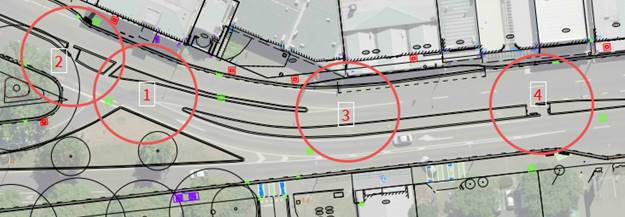
Figure
2: Locations of risk for all road users
4.6.1 At
location 2, it is difficult for people to cross at the existing uncontrolled
crossing due to the volume and speed of traffic. There is a lack of connecting
footpaths also from the south side of Main South Road to access the crossing. A
raised zebra pedestrian crossing was originally consulted on in this location
to replace the existing uncontrolled crossing. Through deputations it was
requested that the crossing also allow for people on bicycles.
4.6.2 At
location 3, traffic must weave from the half seagull arrangement from Main
South Road exit to the far lane to turn left at Waimairi Road, while eastbound
traffic on Yaldhurst Road is attempting to move over to turn right at Hansons
Lane.
4.6.3 At
location 4, people of all ages and abilities cross at this location as it
provides the most direct connection between the supermarket and the Church
Corner Mall, and also the bus stop pair. The proposal approved for the wider
Church Corner programme improved accessibility by removing one westbound
traffic lane to reduce the crossing distance by implementing three traffic
islands on the south side of Riccarton Road. Longer crossing distances increase
the likelihood of a crash and makes finding a gap more challenging for slower
moving pedestrians or those with impairments.
4.7 Information
on the history of this project can be found within the agenda for the 16
October 2024 Council meeting (Item
5). The following paragraphs provide a summary of the key information.
4.8 On
26 October 2023, the Waipuna Halswell-Hornby-Riccarton Community Board was
briefed on a proposal for safety improvements in the wider Church Corner area.
The public were consulted on this proposal. Of the submitters who answered the
question about how safe they feel using the current layout at the Main
South/Yaldhurst/Riccarton intersection, 58.6% perceived it as somewhat or very
unsafe.
4.9 In
February 2024, the Community Board considered the written submissions from
consultation, and heard from submitters, on the staff proposal for the wider
Church Corner project. The consideration of this report was conducted over two
meetings, during which time staff revised the proposal to improve access to a
business and pre-school; and to incorporate a dual crossing on Riccarton Road.
The Community Board resolved most recommendations, other than Officer
Recommendations 6-10 (Minutes,
item 8).
4.10 The
Community Board reconsidered its decision regarding Officer Recommendations
6-10 in March 2024, but the motion was declared lost. This was followed by a
Notice of Motion in April 2024, which revoked the Community Board’s
previous decision for Officer Recommendations 6-10; included a request for
staff to provide information on alternative options at the Main South
Road/Yaldhurst Road/Riccarton Road intersection; and for the decision to be
made by the Council.
4.11 Staff
undertook further investigations to assess options for safety improvements at
this intersection.
4.12 Four
options were developed, which were independently assessed for safety and
network effects. Further refinements were made following the independent
assessments, resulting in two additional options that would be safer and more
efficient than the original four options which were presented to the Council
for a decision on 16 October 2024 (Item
5):
4.12.1 Option A:
Remove the right turn from Main South Road to Riccarton Road and changes the
main road crossing type from a pedestrian crossing to a signalised crossing
(staff recommendation).
4.12.2 Option
B: Retain the right turn from Main South Road to Riccarton Road and changes the
main road crossing type from a pedestrian crossing to a signalised crossing.
4.13 At
the 16 October 2024 meeting, the Council resolved to (Minutes,
Item 5):
4.13.1 Request staff
undertake further engagement on two traffic signal options (as tabled at the
meeting) for the layout of the Main South/Yaldhurst/Riccarton Roads
intersection, and to report back to the Council. The two options were Traffic
Signals 3 and Traffic Signals 4.
4.13.2 Include the
staff recommended Option A in the further engagement along with a clear
indication of the three options’ costs, timeframes for implementation,
potential traffic delays and relative safety for all users.
4.14 The
additional two options for consultation were detailed in a Memo provided in the
16th October 2024 Council Meeting Agenda (Attachment
M). Option B in the 16 October 2024 Council report was not considered an
option to put forward for consultation. The Option B referenced in the
consultation material and this report relates to the Council decision to
include an option on traffic lights with a staggered signalised pedestrian
crossing (Traffic Signal 3).
4.15 At
the Waipuna Halswell-Hornby-Riccarton Community Board Meeting of 14 November
2024 (Item
12), a Notice of Motion was submitted by Councillor Mark Peters requesting
advice from staff as to the process of removing three new traffic islands that
were installed on the south side of Riccarton Road, that were approved as part
of the wider Church Corner Programme, and the implications of revoking the
previous decision. To ensure that any future Community Board decision around
changes to the islands is considered holistically, and to ensure to that safety
risks for all our road users are identified and mitigated, the islands and the
removals have been considered as part of the overall design of the
intersection. However, the decision to remove or retain the islands is a
Community Board decision that must be decided at Community Board level but
should take into account Council’s decision from this report.
5. Public consultation on options for safety improvements at the Main South Road/Yaldhurst Road/Riccarton Road intersection
Public Consultation Te Tukanga Kōrerorero
5.1 Three
options were consulted on following the Council resolution on 16
October 2024:
5.1.1
Option A: Removal of the right-hand turn from Main South Road onto Riccarton
Road and signalised pedestrian crossing;
5.1.2 Option
B: Traffic lights with staggered signalised pedestrian crossing; and
5.1.3 Option
C: Traffic lights with a signalised pedestrian crossing.
5.2 Public
consultation started on 18 October and ran until 3 November 2024. The
consultation material was available on Kōrero mai | Let’s
Talk. An email was also sent to over 500 stakeholders, including
all previous submitters, anyone who made deputations to the Board or to
Council, and our transport and community stakeholders including local
residents’ associations, inviting them to share their
views. Submitters were asked to select which of the three options they
preferred.
Option A: Removal of the right-hand turn from Main
South Road onto Riccarton Road and signalised pedestrian crossing
5.3 Option
A was the option proposed for approval in the 16 October 2024 meeting (Item
5).
5.3.1 This
option:
· Removes the right-hand
turn from Main South Road onto Riccarton Road.
· Retains the left-hand turn
from Main South Road onto Yaldhurst Road.
· Retains the left-hand turn
into Main South Road from Riccarton Road.
· Cycle lanes through the
intersection on both sides of Riccarton Road and Yaldhurst Road.
· A signalised pedestrian
crossing that would operate on demand (when someone pushes the button to
cross).
· A short section of bus
lane on Riccarton Road eastbound.
· Speed humps on all
approaches to the intersection.
|
Advantages
|
Disadvantages
|
|
· Simplifies the road layout for all road users.
· Eliminates the right hand turn crash risk.
· Pedestrians and cyclists can cross Yaldhurst Road safely
with signalised crossing.
· Traffic on Riccarton Road and Yaldhurst Road only need to
stop when someone is there to cross the road.
· Section of bus lane allows easier access into and out of
the bus stop.
· Cycle lanes are included through the intersection on both
sides.
· Retains all trees and adds greenspace to the area.
|
· Eastbound traffic from Main South Road will need to use alternative
routes.
|
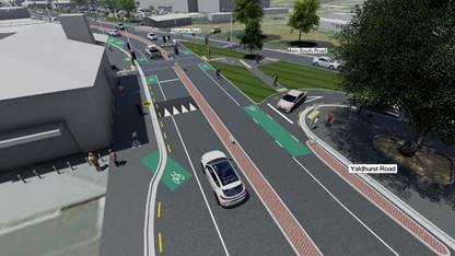
Option B: Traffic lights with staggered signalised
pedestrian crossing
5.4 This
option was proposed by the Council to be consulted on. It was addressed in the
memo attached to the 16 October 2024 report and described as Traffic Signals 3
in the memo.
5.4.1 This
option:
· Retains the right-hand
turn from Main South Road onto Riccarton Road.
· Retains the left-hand turn
from Main South Road onto Yaldhurst Road.
· Retains the left-hand turn
into Main South Road from Riccarton Road.
· Cycle lanes through the
intersection on north side only.
· A staggered signalised
pedestrian crossing that would operate on demand (when someone pushes the
button to cross). Pedestrians would need to cross one lane of traffic and wait
in the centre island to cross the next lane of traffic.
· A bus lane is not included
due to lack of space.
· Speed humps on all
approaches to the intersection.
|
Advantages
|
Disadvantages
|
|
· Eastbound traffic from Yaldhurst Road to Riccarton Road
would not need to stop for the right hand turn as the merge between straight
through and right turning traffic would remain on Riccarton Road.
· Reduces the right hand turn crash risk due to Main South
Road traffic having to stop at the traffic lights.
· The staggered pedestrian crossing would be signalised so
it is safer for pedestrians than the current layout.
|
· A crash risk remains due to the merge between
straight-through and right-turning traffic on Riccarton Road as vehicles will
continue to weave through this section to change lanes before the Riccarton
Road, Hansons Lane, Waimairi Road intersection.
· Pedestrians and cyclists would need to cross Yaldhurst
Road and Main South Road in two stages.
· There is no space for a bus lane through the
intersection.
· There is no space for a cycle lane westbound on the south
side of the intersection.
· Removes two trees on Main South Road.
|
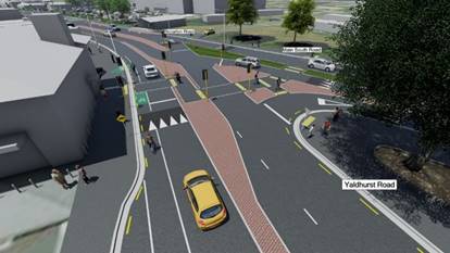
Option C: Traffic lights with a signalised pedestrian
crossing
5.5 This
option was proposed by the Council to be consulted on. It was addressed in the
memo attached to the 16 October 2024 report and described as Traffic Signals 4
in the memo.
5.5.1 This
option:
· Retains the right-hand
turn from Main South Road onto Riccarton Road.
· Retains the left-hand turn
from Main South Road onto Yaldhurst Road.
· Retains the left-hand turn
into Main South Road from Riccarton Road.
· Cycle lanes through the
intersection on both sides of Riccarton Road and Yaldhurst Road.
· A signalised pedestrian
crossing that would operate on demand (when someone pushes the button to
cross).
· A short section of bus
lane on Riccarton Road.
· Speed humps on all
approaches to the intersection.
|
Advantages
|
Disadvantages
|
|
· Reduces the right hand turn crash risk due to Main South
Road traffic having to stop at the traffic lights.
· Eliminates the crash risk for vehicles merging on
Riccarton Road eastbound by all traffic stopping for the right hand turn from
Main South Road.
· Pedestrians and cyclists can cross Yaldhurst Road safely
with signalised crossing.
· Section of bus lane allows easier access into and out of
the bus stop.
· Cycle lanes are included through the intersection on both
sides.
· Retains all trees and adds greenspace to the area.
|
· The
Yaldhurst Road eastbound traffic would experience slightly more delay than
the existing layout and the other two options.
|
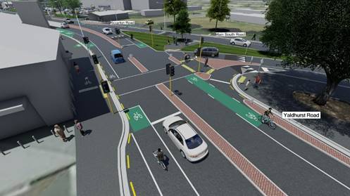
Summary of Submissions Ngā Tāpaetanga
5.6 Submissions
were made by 11 organisations and 584 individuals. All submissions are
available online or in Attachment C.
5.7 Submitters
preferred Option A most often (249, 42%), followed by Option C (219, 37%).
Option B was preferred by the least submitters (75, 12%). An additional 52
submitters (9%) did not select a preference.
5.8 The
table below shows submitters’ preferred option and the ward that they
live in. The most submissions were received from those living in the
Riccarton ward, closely followed by Waimairi and Hornby.
|
Ward
|
Option A
|
Option B
|
Option C
|
No preference
|
Total
|
|
Riccarton
|
49
|
18
|
61
|
7
|
135
|
|
Hornby
|
30
|
21
|
58
|
18
|
127
|
|
Halswell
|
11
|
6
|
18
|
10
|
45
|
|
Fendalton
|
9
|
6
|
6
|
2
|
23
|
|
Waimairi
|
76
|
8
|
36
|
11
|
131
|
|
Harewood
|
3
|
1
|
5
|
|
9
|
|
Papanui
|
9
|
2
|
3
|
|
14
|
|
Innes
|
5
|
|
3
|
|
8
|
|
Central
|
6
|
|
7
|
|
13
|
|
Spreydon
|
14
|
3
|
8
|
2
|
27
|
|
Cashmere
|
5
|
2
|
2
|
1
|
10
|
|
Heathcote
|
5
|
|
2
|
|
7
|
|
Coastal
|
4
|
1
|
|
|
5
|
|
Burwood
|
5
|
1
|
|
|
6
|
|
Linwood
|
|
1
|
1
|
|
2
|
|
Not supplied (organisations)
|
2
|
|
1
|
|
3
|
|
Outside Christchurch
|
16
|
5
|
8
|
1
|
30
|
5.9 Submitters
were also asked how they usually travel through the area and their age. Option
C was selected most often by people whose main method of travel was by car.
Option A was most preferred by submitters whose main method of travel was bike,
bus, or walking/riding a scooter.
5.10 Option
A was selected most often by all age groups except for over 65+ who most often
selected option C.
Key themes
5.11 Submitters
were asked to provide comments about their preferred option and the key themes
are outlined in the table below.
|
|
Theme
|
Number of mentions
|
|
Option A
|
It’s safer / the safest option
|
75
|
|
It removes the right-hand turn / It eliminates the crash
risk
|
68
|
|
It seems the simplest / Less complicated
|
61
|
|
It’s the cheapest option
|
56
|
|
It includes better/safer infrastructure for cyclists
|
45
|
|
It includes better/safer infrastructure for pedestrians
|
37
|
|
It will help traffic flow / Will mean less congestion
|
34
|
|
It includes better bus infrastructure
|
10
|
|
Option B
|
It keeps the right-hand
turn
|
20
|
|
It will help
traffic flow / Will mean less congestion
|
20
|
|
Option C
|
It keeps the right-hand turn
|
94
|
|
It’s safer / the safest option
|
55
|
|
Includes safer/better infrastructure for cyclists
|
34
|
|
Includes
safer/better infrastructure for pedestrians
|
31
|
|
It seems the simplest / Less complicated
|
26
|
|
It includes better bus infrastructure
|
15
|
Analysis Criteria Ngā Paearu Wetekina
5.12 The
options have been developed to address the primary risk of right turn crashes
at the intersection. Comprehensive detail can be found within the agenda for
the 16 October 2024 Council meeting (Item
5). This included independent analysis on options and further refinement
from staff to determine the safest and most effective options. The report also
included a memo that investigated a range of traffic signal control options.
5.13 The
Council proposed consulting on the original staff recommended Option A and two
additional options which are Option B and C in this report.
5.14 The
table below provides a summary of how the options manage risk, and address the
issues raised for this intersection:
|
|
Option A
|
Option B
|
Option C
|
|
Main
South Road right-hand turn
|
This option
removes the right turn from Main South Road into Riccarton Road.
|
This option
retains the right turn from Main South Road into Riccarton Road.
|
This option
retains the right turn from Main South Road into Riccarton Road.
|
|
Mitigates
serious crash incidences
|
Eliminates the risk of a serious crash type
involving right turning vehicles from Main South Road.
|
Manage the risk of a serious crash type
involving right turning vehicles from Main South Road. Risk reduction is
through signalisation and speed management.
|
Manage the risk of a serious crash type
involving right turning vehicles from Main South Road. Risk reduction is
through signalisation and speed management.
|
|
Mitigates
risk of a crash at weave point
|
Eliminates the risk as the half seagull arrangement
is removed.
|
Risk is
maintained as merge
point is retained.
|
Eliminates the risk as the half seagull arrangement
is removed.
|
|
Impact
on network
|
Minimal impact.
Traffic would divert to other routes to access destinations.
Traffic will
only need to stop on Yaldhurst Road if a person activates the crossing.
|
Minimal impact. Eastbound traffic from Yaldhurst Road to Riccarton
Road would not need to stop for the right-hand turn from Main South Road as
the merge between straight through and right turning traffic would remain on
Riccarton Road.
Should traffic
increase on Main South Road due to the ease of being able to exit through the
signalised right turn, delays may increase on this approach.
|
Minimal impact. The Yaldhurst Road eastbound traffic would
experience slightly more delay than the existing layout and the other two
options.
Should traffic
increase on Main South Road due to the ease of being able to exit through the
signalised right turn, delays may increase on this approach.
|
|
Dual
crossing
|
Signalised
crossing provided for people walking and cycling included.
|
Signalised
staggered crossing provided for people walking and cycling included.
|
Signalised
crossing provided for people walking and cycling included.
|
|
Speed
calming
|
To align with
the safe system principles, traffic calming is provided on the approaches to
the signal-controlled crossing.
|
To align with
the safe system principles, traffic calming is provided on the approaches to
the signal-controlled crossing.
|
To align with
the safe system principles, traffic calming is provided on the approaches to
the signal-controlled crossing.
|
|
Cycle
Facilities
|
Through the
original consultation, submitters requested additional cycle facilities. The
Safety Audit also raised concerns around cycle facilities. These were
addressed as part of the process.
|
Through the
original consultation, submitters requested additional cycle facilities. The
Safety Audit also raised concerns around cycle facilities. These were
addressed as part of the process.
|
Through the
original consultation, submitters requested additional cycle facilities. The
Safety Audit also raised concerns around cycle facilities. These were
addressed as part of the process.
|
Preferred Option
5.15 Staff
recommend Option A, with some proposed amendments as the preferred option to
manage the risks at the Main South/Yaldhurst/Riccarton intersection.
5.16 Following
the most recent consultation, staff propose some changes to Option A
including:
· Removal
of the cycle lane between the two westbound lanes on the approach to the
intersection. The on-road cycle lane will guide users along Main South Road for
them to then use the crossing points to access Yaldhurst Road. This cycle lane
will also connect with the existing cycle lane on Main South Road.
· Provision
of a shared path on the south side of Yaldhurst Road from Main South Road to
the island at Brake Street. People can then cycle on the lower traffic streets
of Brake Street and Bowen Street. This will improve access to Villa Maria for
school children and residents north of Yaldhurst Road who use the Puari ki
Niho-toto South Express Cycleway.
5.17 The
Community Board has also requested additional information from staff on the
removal of the islands that were implemented on the south side of Riccarton
Road as part of the Church Corner programme. The removal of the islands will
re-establish two westbound traffic lanes, and therefore could reduce safety of
users travelling outside vehicles. Therefore, it is proposed to maintain safety
for all users by retaining slower speeds through this busy location, through
the provision of a safer speed platform as shown on the plan in Attachment A.
As a result of the new safe speed platform, the two speed humps on the
approaches to the crossing points that were shown on the consultation plan have
been removed. The removal of these islands will require a Community Board
decision.
5.18 Option
A, with the amendments discussed in 5.16 paragraph above:
5.18.1 Removes the
right turn from Main South Road into Riccarton Road to eliminate the current
crash risk.
5.18.2 Provides a
signalised crossing for people walking and cycling on Riccarton Road. The
signal-controlled crossing would provide a safer and more efficient option.
5.18.3 Includes
improvements for people who cycle to and through the area by providing cycle
facilities on Riccarton Road, Main South Road and Yaldhurst Road.
Other options considered
5.19 Other
options were also considered but were not assessed as being reasonably
practicable and these can be found in the previous report to Council (16
October 2024, Item 5).
5.20 Options
that have been considered, but were not assessed as being reasonably
practicable, for the following reasons:
5.20.1 Do Nothing:
There have been a high number of crashes that have occurred at this
intersection resulting in a recurring crash type. If safety improvements are
not made to this intersection, the risk that crashes can continue to occur
would remain. The safety improvements at this intersection are part of a wider
Church Corner project. The Community Board has been working closely with its
community for some time to ensure that this area is safer for all road users.
Therefore, not making any improvements at this intersection is not a
recommended option.
5.20.2 Stop
control: Use of a Stop Control was raised as an option at the 16 October
2024 Council meeting. The Traffic Control Devices manual provides guidance on
the use of Stop Controls. A Stop Control should be provided where, at a point 9
metres from the limit line on a controlled approach to the intersection, there
is a lack of visibility for the exiting driver. The guidance also states that
Stop Controls should not be provided where the sight distance is adequate for
give way control nor as a routine response to an actual or perceived safety
problem. This is because inappropriate use of Stop Controls can reduce the
effectiveness of stop-controlled approaches used correctly in other locations.
The intersection discussed in this report has too much visibility for a Stop
Control to be effective.
5.20.3 Alternative
options for this intersection: Staff have considered numerous options for
this intersection, which were discussed in the report to Council on 16 October
2024 (item 5). These options were independently assessed and refined by staff
to two safer and more efficient options for this intersection. At the 16
October meeting, Option B to retain right hand turn from Main South Road and
install a traffic signal-controlled crossing on Riccarton Road was not
considered a preferred option by the Council therefore it is not recommended
that this option (or the independently assessed options) be revisited. At that
meeting, the Council proposed two options for further engagement in addition to
the staff recommended option, and these have now been consulted on. Staff do
not recommend reconsidering any of these options again as the public engagement
process has now been completed.
6. Financial Implications Ngā Hīraunga Rauemi
Capex/Opex Ngā Utu Whakahaere
|
|
Option A
|
Option B
|
Option C
|
|
Cost to Implement
|
$1.3m
|
$1.56m
|
$1.5m
|
|
Maintenance/Ongoing Costs
|
To be covered under the roading maintenance
contract, the effect will be minimal to the overall asset.
|
|
Funding Source
|
Traffic Operations
Minor Road Safety Budget.
|
|
Funding Availability
|
Funding available in the abovenamed
budget.
|
|
Impact on Rates
|
None
|
6.1 The
cost are high-level estimates and are not tendered prices.
7. Considerations Ngā Whai Whakaaro
Risks and Mitigations Ngā Mōrearea me
ngā Whakamātautau
7.1 There
is a risk that crashes will continue to occur at this intersection.Option A
eliminates the risk of the highest risk crash with the removal of the right
turn. Option A also includes other traffic safety measures that will reduce
risk for all road users at that location.
7.2 Option
C reduces the risk of a collision involving the right turn movement from Main
South Road. It also addresses a large number of the identified risks for other
users.
7.3 In
Option B, risk remains for people exiting Main South Road and weaving through
traffic to access Waimairi Road due to the retention of the half seagull
arrangement.
Legal Considerations Ngā Hīraunga
ā-Ture
7.4 Statutory
and/or delegated authority to undertake proposals in the report:
7.4.1 Clause
18 of the Christchurch City Council Traffic and Parking Bylaw 2017 provides
that the Council may, by resolution, prescribe a road or part of a road as a
special vehicle lane. The Council has not sub-delegated this power.
7.4.2 On 9
April 2024, the Community Board requested that the Council resume the
delegation for the purposes of dealing with the Main South Road/Yaldhurst
Road/Riccarton Road Intersection, and the relevant delegated powers are:
Christchurch City Council Traffic and
Parking Bylaw 2017
7.4.3 Clauses 7 and 8 provides the authority to install parking
restrictions by resolution.
7.4.4 Clause 17 provides for prohibiting or restricting vehicles or
classes of vehicles on any road from turning to the right or to the left or
from proceeding in any other direction.
7.4.5 Clause 21 of the Christchurch City Council Traffic and Parking Bylaw
2017 provides that the Council may, by resolution, determine the length, route
and/or location of a shared path.
Local Government Act 1974
7.4.6 Section
319 provides general powers of councils in respects of roads, including the
authority to:
· divert or alter the
course of any road
· increase or diminish
the width of any road subject to and in accordance with the provisions of the
district plan, if any, and to the Local Government Act 1974 and any other Act
· determine what part
of a road shall be carriageway, and what part a footpath or cycle track only
7.4.7 Section 331 provides authority to approve concept plans for forming
or upgrading footpath, kerbs and channels.
7.4.8 The
installation of any signs and/or markings associated with traffic control
devices must comply with the Land Transport Rule: Traffic Control Devices 2004.
Strategy
and Policy Considerations Te
Whai Kaupapa here
7.5 The
required decision:
7.5.1 Aligns
with the Christchurch
City Council’s Strategic Framework and Community Outcomes. Improving the safety of our roads aligns with
the Strategic Priorities and Community Outcomes, in particular to be an
inclusive and equitable city; build trust and confidence by listening to and
working with our residents; and providing safe crossing points for people who
walk and cycle will contribute to a green, liveable city, where our
neighbourhoods and communities are accessible and well-connected.
7.5.2 Is
assessed as medium significance based on the Christchurch City Council’s
Significance and Engagement Policy. The level of significance was
determined by the assessment for the wider Church Corner safety improvement
project, where it was considered medium due to the high risk of crashes but is
localised to this area. There is increased community interest in this
particular intersection, however the decision does not have any greater impact
on the community than it did originally.
7.5.3 The
recommended option is consistent with the
Council’s Plans and Policies, in particular:
· LTP Activity
Plan - Level of Service target to reduce the number of deaths or serious
injuries (DSI) from all crashes by 40% in 2030.
· The changes
made align with road safety and liveable streets goals in the Christchurch
Transport Strategic Plan 2012–2042, and similarly in the draft Transport
Plan (safe streets).
· The changes
made align with Kia tūroa te Ao - Ōtautahi Christchurch Climate
Resilience Strategy as set out in the Climate Change Impact Considerations
section below.
· Improving
safety on local roads is a priority for the Council.
· Church Corner
is poised to be one of the bigger growth areas in the city in coming years and
is identified as a priority development area in the Greater Christchurch
Spatial Plan (along with the rest of the Riccarton corridor). The area may
likely be upzoned (through Plan Change 14) to allow high density residential
development within a walkable catchment of these shops. This would lead to an
increase in the number of people wanting to walk and cross the road to access
local services.
7.6 This
report supports the Council's
Long Term Plan (2021 - 2031)::
7.7 Transport
7.7.1 Activity: Transport
· Level of Service: 10.0.2 Increase the share of non-car
modes in daily trips - >=37% of trips undertaken by non-car modes
· Level of Service: 10.0.6.1 Reduce the number of death and
serious injury crashes on the local road network (DIA 1) - 4 less than previous
FY
· Level of Service: 10.0.6.2 Reduce the number of death and
serious injury crashes on the local road network - Five year rolling average
<100 crashes per year
· Level of Service: 10.5.1 Limit deaths and serious injury
crashes per capita for cyclists and pedestrians - <=12 crashes per 100,000
residents
· Level of Service: 10.5.41 Increase access within 15 minutes
to key destination types by walking (to at least four of the five basic
services: food shopping, education, employment, health, and open spaces) -
>=49% of residential units with a 15- minute walking access
8. Community Views and Preferences Ngā
mariu ā-Hāpori
8.1 This
information is provided in Section 5 of this report. The options discussed in
this report were consulted on.
8.2 The decision affects the following wards/Community Board areas:
8.2.1 Waipuna
Halswell-Hornby-Riccarton Community Board.
Impact
on Mana Whenua Ngā
Whai Take Mana Whenua
8.3 The decision does not involve a significant decision in relation
to ancestral land or a body of water or other elements of intrinsic value,
therefore this decision does not specifically impact
Mana Whenua, their culture, and traditions.
8.4 The
decision does not involve a matter of interest to Mana
Whenua and will not impact on our agreed partnership priorities with Ngā Papatipu Rūnanga.
8.5 The Ngāi Tahu Cultural Atlas identifies a route way running
through the project footprint. There is an opportunity to recognise the route
mapped in the Cultural Atlas and apply a Te Ao Māori lens to the landscape
design of the space.
Climate
Change Impact Considerations Ngā Whai Whakaaro mā te Āhuarangi
8.6 The
decisions in this report are likely to:
8.6.1 Contribute positively
to adaptation to the impacts of climate change.
8.6.2 Contribute positively
to emissions reductions.
8.7 The
emission reductions associated with this project have not been estimated.
8.8 Improving
the ability for people to walk, cycle, scoot and catch the bus are a key part
of the Council’s emissions reduction efforts by providing a safe, low
emission way for residents to move around the city.
8.9 Improving
safety and making the intersection feel safer would address some of the
barriers to people making sustainable travel choices. Removing these barriers
will lead to reductions in vehicle kilometres travelled and consequently
emissions from transport.
8.10 Options
that increase the area of permeable surface (increasing the amount of green
space) in the area will help contribute more positively to adaptation.
9. Next Steps Ngā Mahinga ā-muri
9.1 If
the Council agrees to the recommendations in this report, the next step will be
to undertake construction.
Attachments Ngā Tāpirihanga
|
No.
|
Title
|
Reference
|
Page
|
|
a ⇩
|
For Approval
Plan - Option A
|
24/2055408
|
230
|
|
b ⇩
|
Consultation
Plans - Option A, B & C
|
24/2055432
|
231
|
|
c ⇨
|
Submission
Table - New options for Church Corner (Public) (Under Separate Cover)
|
24/2062728
|
|
In addition to the attached documents, the following background
information is available:
|
Document
Name – Location / File Link
|
|
Not
applicable
|
Signatories Ngā Kaiwaitohu
|
Authors
|
Gemma Dioni -
Acting Team Leader Traffic Operations
Maryem Al
Samer - Legal Counsel
Krystle Anderson
- Engagement Advisor
Libby Elvidge
- Principal Advisor Citizens & Community
|
|
Approved By
|
Stephen Wright
- Manager Operations (Transport)
Tony
Richardson - Finance Business Partner
Lynette Ellis
- Head of Transport & Waste Management
Brent Smith -
Acting General Manager City Infrastructure
|
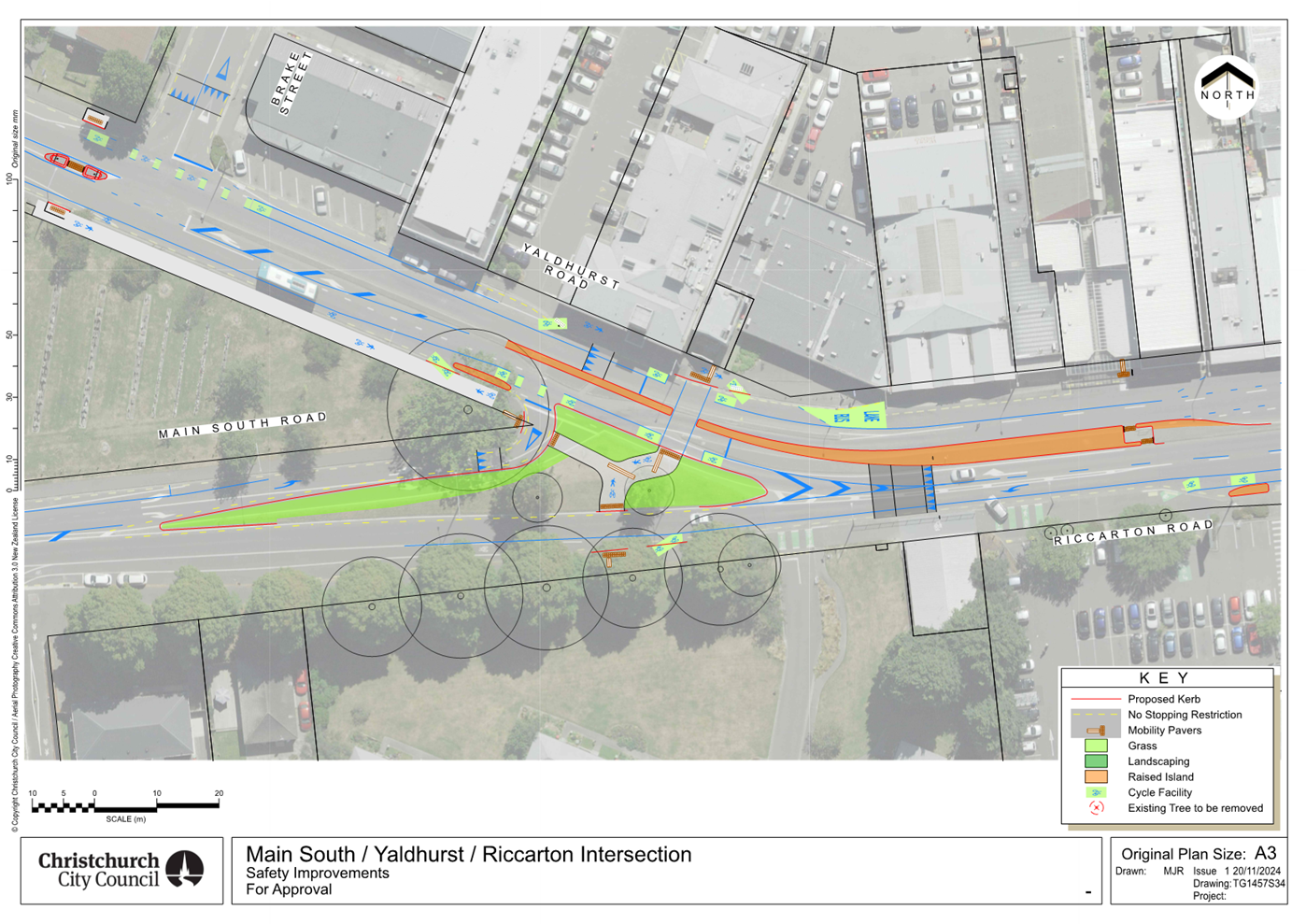
|
17. Resolution to Exclude the Public
|
Section
48, Local Government Official Information and Meetings Act 1987.
Note: The
grounds for exclusion are summarised in the following table. The full wording from
the Act can be found in section
6 or section
7, depending on the context.
I move that the public be excluded from the
following parts of the proceedings of this meeting, namely the items
listed overleaf.
Reason for passing this resolution: a good
reason to withhold exists under section 7.
Specific grounds under section 48(1) for
the passing of this resolution: Section 48(1)(a)
Note
Section 48(4) of the Local Government
Official Information and Meetings Act 1987 provides as follows:
“(4) Every resolution to exclude the
public shall be put at a time when the meeting is open to the public, and the
text of that resolution (or copies thereof):
(a) Shall
be available to any member of the public who is present; and
(b) Shall
form part of the minutes of the local authority.”
This resolution is made in reliance on
Section 48(1)(a) of the Local Government Official Information and Meetings Act
1987 and the particular interest or interests protected by Section 6 or Section
7 of that Act which would be prejudiced by the holding of the whole or relevant
part of the proceedings of the meeting in public are as follows:
|
ITEM NO.
|
GENERAL SUBJECT OF EACH MATTER TO BE CONSIDERED
|
SECTION
|
SUBCLAUSE AND REASON UNDER THE ACT
|
PLAIN ENGLISH REASON
|
Potential Release Review Date and
Conditions
|
|
10.
|
Food Resilience Network - Community Loan
|
|
|
|
|
|
|
Attachment c - Food Resilience Network Loan
Application
|
s7(2)(b)(ii)
|
Prejudice Commercial Position
|
The information contained in the memo is commercially sensitive
and its release may impact the ability of the applicant to deliver the
project.
|
18 November 2029
One years sustainable operation of the Network cafe.
|
|
18.
|
Public Excluded Council Minutes - 6 November
2024
|
|
|
Refer to the previous public excluded reason in the agendas for
these meetings.
|
|
|
19.
|
Public Excluded Council Minutes - 20
November 2024
|
|
|
Refer to the previous public excluded reason in the agendas for these
meetings.
|
|
Karakia Whakamutunga
Kia
whakairia te tapu
Kia
wātea ai te ara
Kia
turuki whakataha ai
Kia
turuki whakataha ai
Haumi
e. Hui e. Tāiki e