Christchurch City Council
Agenda
Notice of Meeting:
An ordinary meeting of the Christchurch
City Council will be held on:
Date: Wednesday 1 November 2023
Time: 9.00 am
Venue: Council Chambers, Civic Offices,
53 Hereford Street, Christchurch
Membership
|
Chairperson
Deputy Chairperson
Members
|
Mayor Phil Mauger
Deputy Mayor Pauline Cotter
Councillor Kelly Barber
Councillor Melanie Coker
Councillor Celeste Donovan
Councillor Tyrone Fields
Councillor James Gough
Councillor Tyla Harrison-Hunt
Councillor Victoria Henstock
Councillor Yani Johanson
Councillor Aaron Keown
Councillor Sam MacDonald
Councillor Jake McLellan
Councillor Andrei Moore
Councillor Mark Peters
Councillor Tim Scandrett
Councillor Sara Templeton
|
26 October 2023
|
|
|
Principal Advisor
Dawn Baxendale
Chief Executive
Tel: 941 8999
|
|
Katie Matheis
Team Leader Hearings & Committee Support
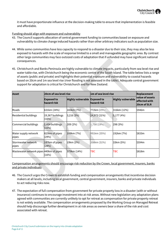
941 5643
katie.matheis@ccc.govt.nz
www.ccc.govt.nz
|
Council
01 November 2023
|

|
|
Council
01 November 2023
|

|
TABLE OF CONTENTS NGĀ IHIRANGI
Karakia Tīmatanga................................................................................................... 4
1. Apologies Ngā Whakapāha................................................................................. 4
2. Declarations of Interest Ngā Whakapuaki Aronga.................................................. 4
3. Public
Participation Te Huinga
Tūmatanui............................................................ 4
3.1 Public Forum Te Huinga Whānui.......................................................................................... 4
3.2 Deputations by
Appointment Ngā Huinga Whakaritenga...................................................... 4
4. Presentation
of Petitions Ngā
Pākikitanga............................................................ 5
Council
5. Council
Minutes - 4 October 2023......................................................................... 7
6. Council
Minutes - 18 October 2023..................................................................... 19
Minutes Reports
7. Audit
and Risk Management Committee Minutes - 3 August 2023........................... 29
Community Board Monthly
Reports
8. Monthly
Report from the Community Boards - October 2023................................. 33
Community Board Part A
Reports
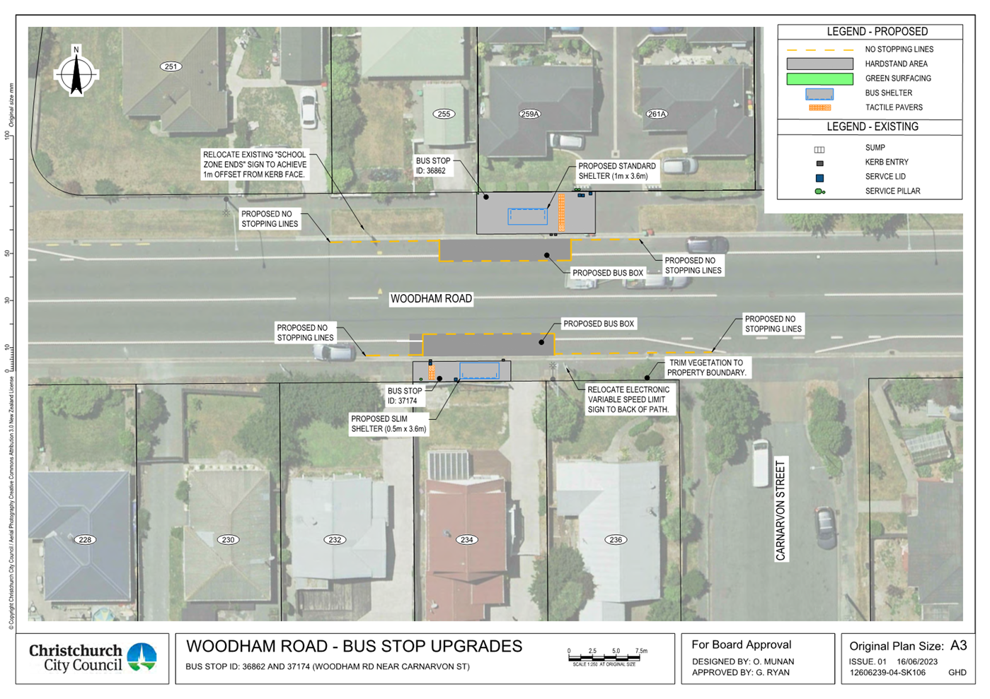
9. Woodham
Road / Gloucester Street - Intersection Improvements........................... 85
10. Wigram/Hayton
Roads Intersection Improvement.............................................. 111
11. Reserve
Revocation 112R Bridle Path Road........................................................ 135
Staff Reports
12. Christchurch
Wastewater Treatment Plant Independent Review.......................... 143
13. Approval
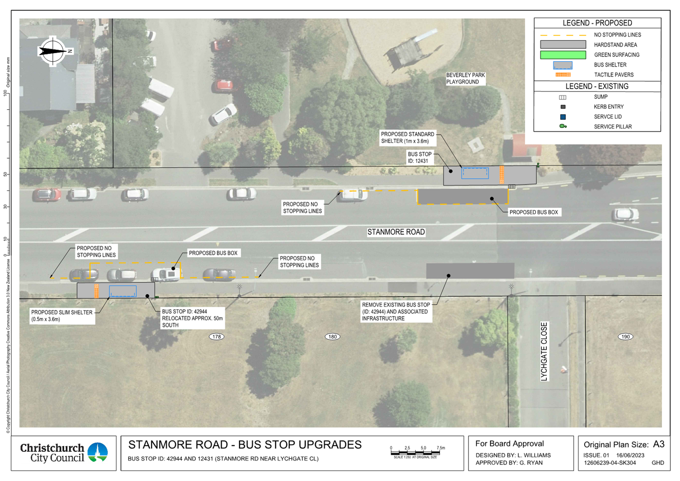
of Transport Choices - Linwood Bus Stop Improvements (CERF).............. 199
14. Plan
Change 4 Short-term accommodation - Final approval................................. 261
15. Draft
submission on the Emergency Management Bill......................................... 271
16. Council
submission on the inquiry into climate adaptation.................................. 279
17. Hearings
Panel report to the Council on the proposed replacement Cruising and Prohibited
Times on Roads Bylaw.................................................................... 295
18. Resolution
to Exclude the Public...................................................................... 321
Karakia Whakamutunga
Whakataka Te
hau ki Te uru
Whakataka Te
hau ki Te tonga
Kia makinakina
ki uta
Kia mataratara
ki Tai
E hi ake ana te
atakura
He tio, he
huka, he hau hu
Tihei Mauri Ora
1. Apologies Ngā Whakapāha
At the close of
the agenda no apologies had been received.
2. Declarations of Interest Ngā
Whakapuaki Aronga
Members are
reminded of the need to be vigilant and to stand aside from decision making
when a conflict arises between their role as an elected representative and any
private or other external interest they might have.
3. Public Participation Te Huinga
Tūmatanui
3.1 Public Forum Te Huinga Whānui
A period of up to 30 minutes is available
for people to speak for up to five minutes on any issue that is not the subject
of a separate hearings process.
|
3.1.1
|
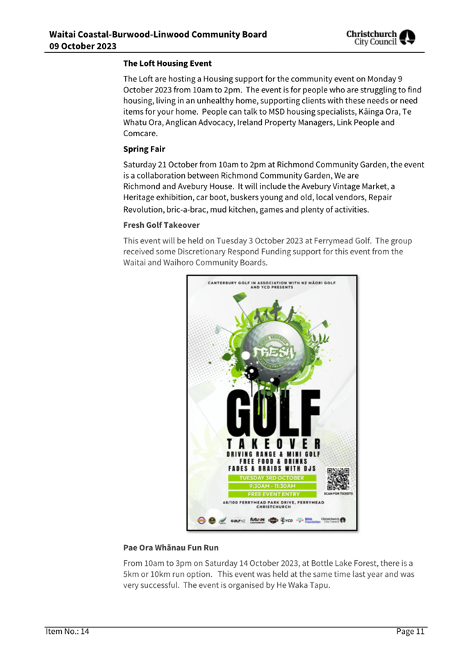
Share Kai and Kōrero
Claire Newman will speak on behalf of Share
Kai and Kōrero regarding
their project that helps by gathering people together over food to
foster connections and support by Weave Foundation to take the programme
nationally.
|
|
3.1.2
|
The Loft
Don Elder, Board Member, will speak on
behalf of The Loft regarding the services the organisation provides for the
community, including the impacts it’s having and the trends it
supports.
|
3.2 Deputations by Appointment Ngā
Huinga Whakaritenga
Deputations may be heard on a matter or
matters covered by a report on this agenda and approved by the Chairperson.
|
3.2.1
|
Matthew Reid
Matthew Reid will speak regarding the
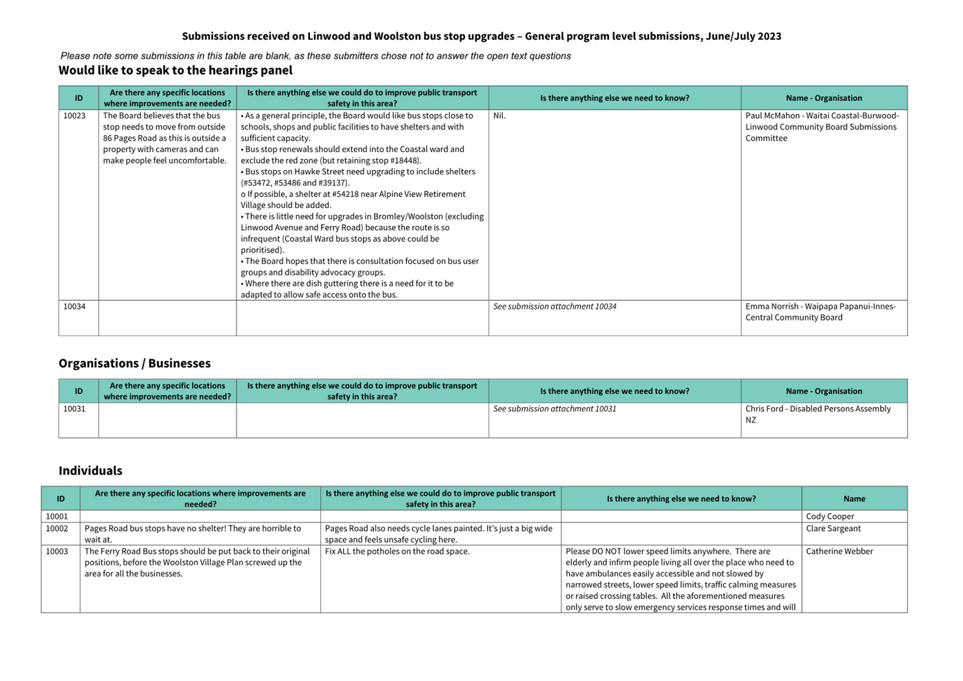
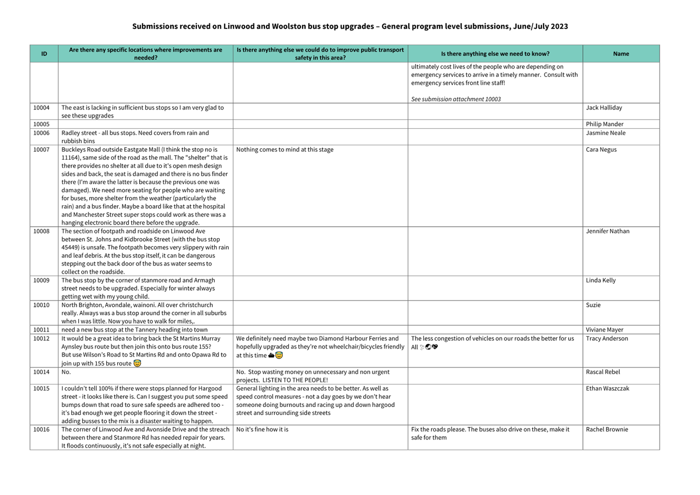
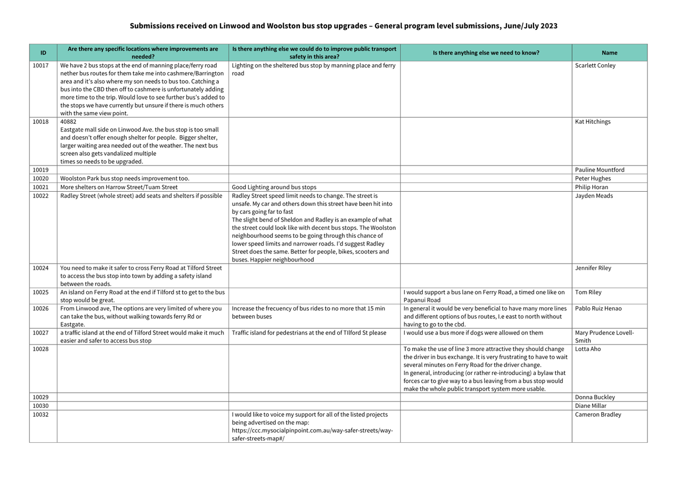
Approval of Transport Choices – Linwood Bus Stop Improvements (CERF)
report.
|
|
3.2.2
|
Nirbhai Singh
Nirbhai Singh will speak regarding the Approval
of Transport Choices – Linwood Bus Stop Improvements (CERF) report.
|
|
3.2.3
|
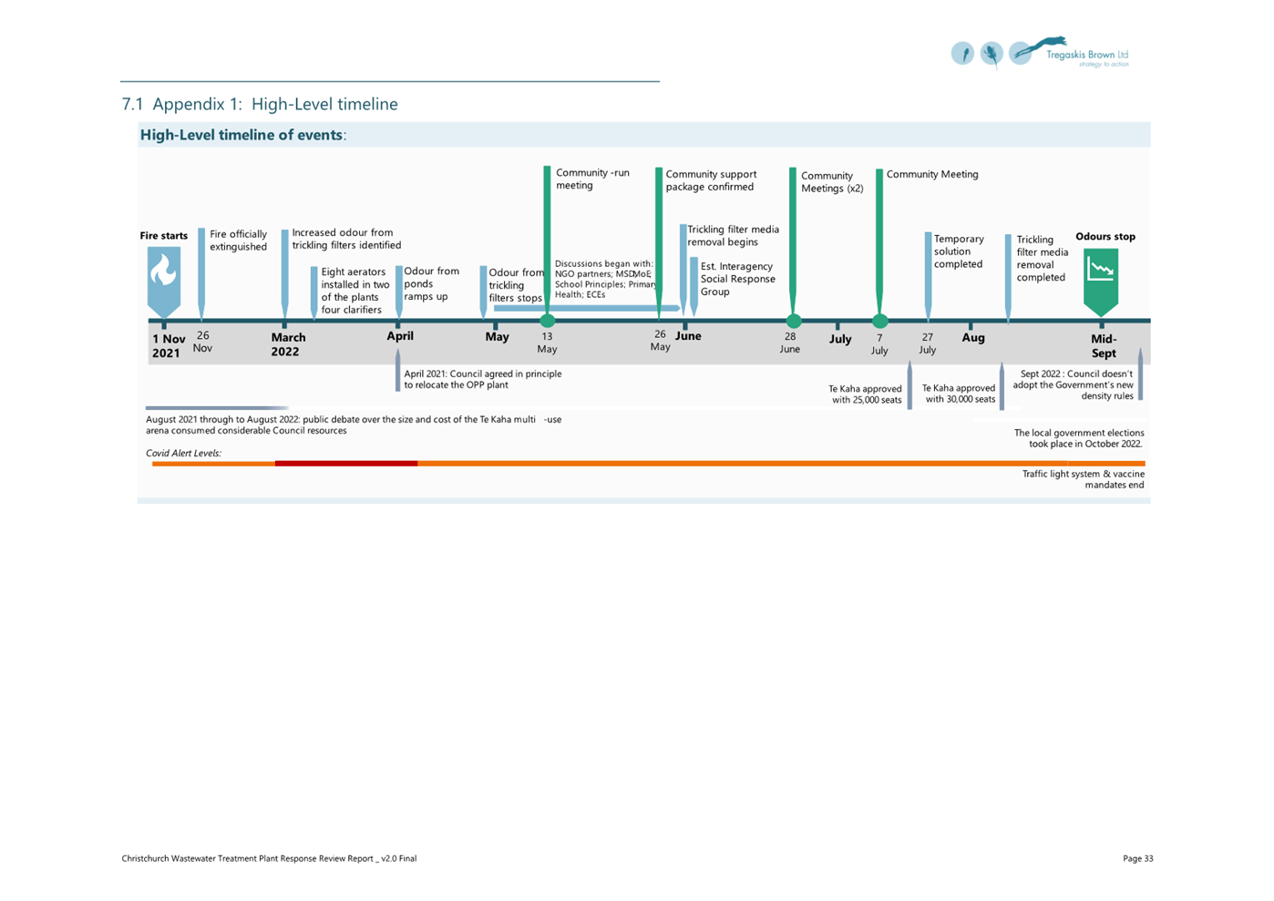
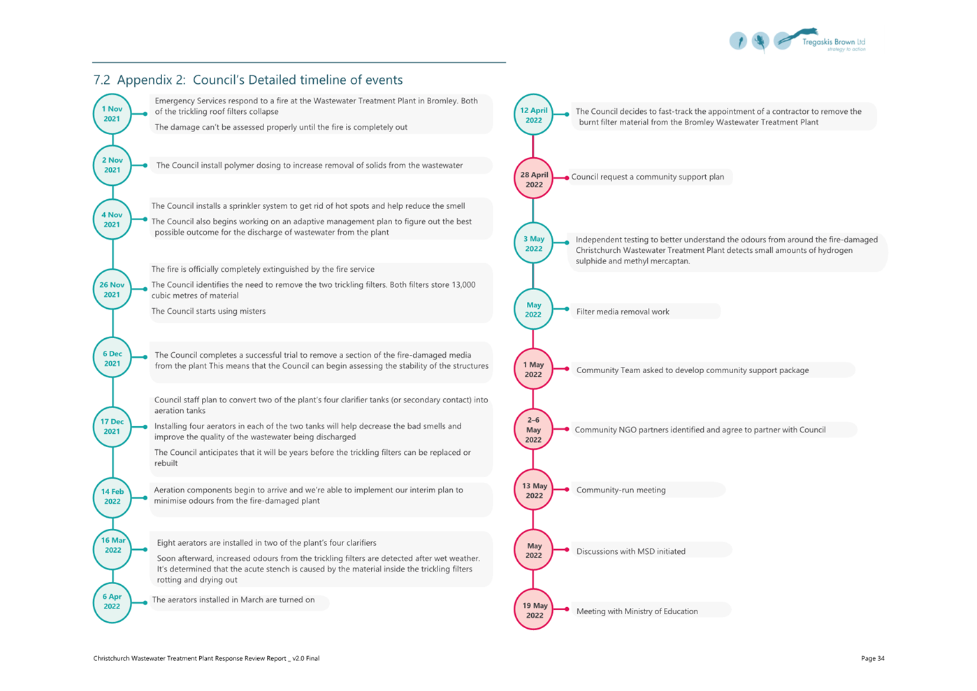
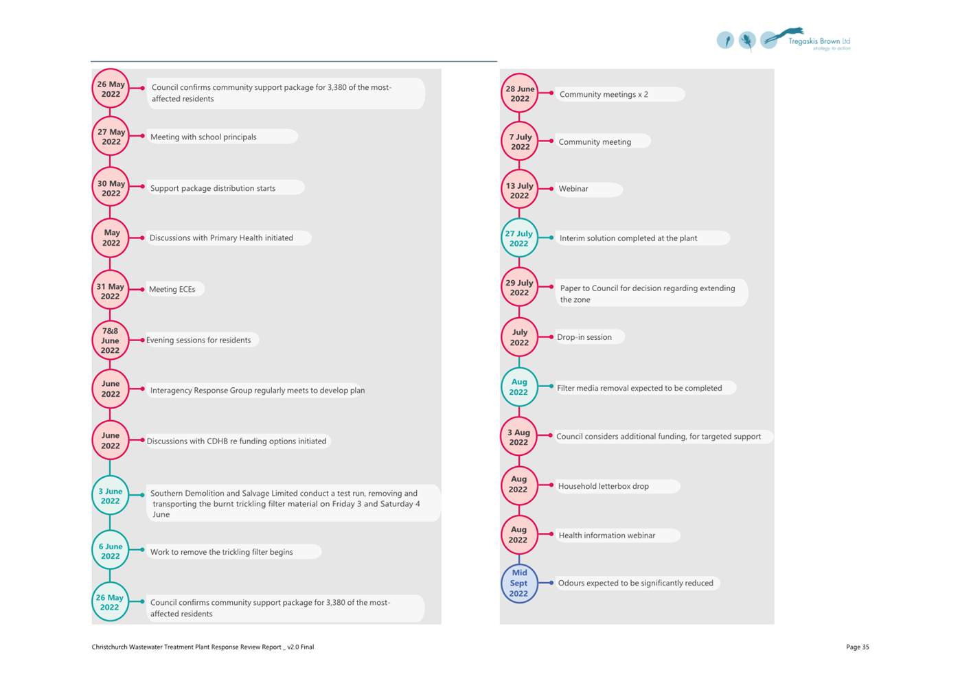
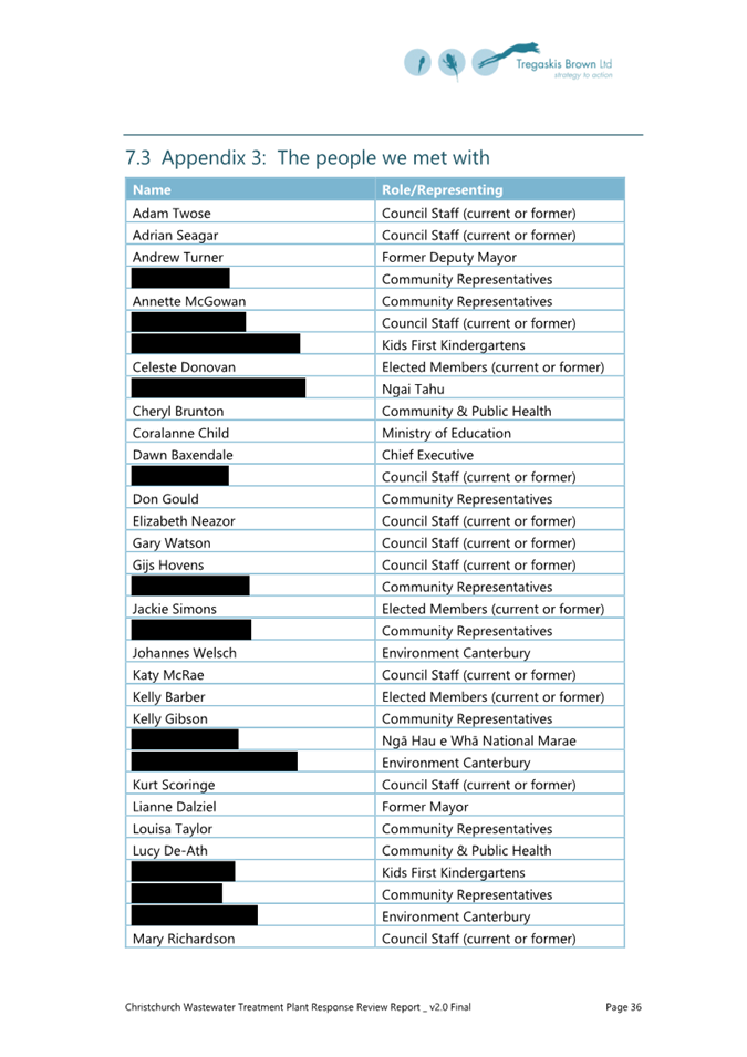
Stephen McPaike
Stephen McPaike will speak regarding Item
12 – Christchurch Wastewater Treatment
Plant Independent Review.
|
4. Presentation of Petitions Ngā
Pākikitanga
There were no
Presentation of Petitions at the time the agenda was prepared.
|
Council
01 November 2023
|

|
|
5. Council
Minutes - 4 October 2023
|
|
Reference / Te Tohutoro:
|
23/1631833
|
|
Report of / Te Pou Matua:
|
Katie
Matheis, Team Leader Hearings & Committee Support
(Katie.Matheis@ccc.govt.nz)
|
|
Senior Manager / Pouwhakarae:
|
Dawn
Baxendale, Chief Executive (Dawn.Baxendale@ccc.govt.nz)
|
1. Purpose of Report Te Pūtake Pūrongo
For the Council
to confirm the minutes from the Council meeting held 4
October 2023.
2. Recommendation
Te Tūtohu Council
That the Council confirm the Minutes from the Council
meeting held 4 October 2023.
Attachments
Ngā
Tāpirihanga
|
No.
|
Title
|
Reference
|
Page
|
|
A⇩ 
|
Minutes Council - 4
October 2023
|
23/1591750
|
8
|
Signatories Ngā Kaiwaitohu
|
Author
|
Katie Matheis
- Team Leader Hearings & Committee Support
|
|
Council
01 November 2023
|

|
|
6. Council Minutes - 18 October 2023
|
|
Reference / Te Tohutoro:
|
23/1715380
|
|
Report of / Te Pou Matua:
|
Katie
Matheis, Team Leader Hearings & Committee Support
(Katie.Matheis@ccc.govt.nz)
|
|
Senior Manager / Pouwhakarae:
|
Dawn
Baxendale, Chief Executive (Dawn.Baxendale@ccc.govt.nz)
|
1. Purpose of Report Te Pūtake Pūrongo
For the Council
to confirm the minutes from the Council meeting held 18
October 2023.
2. Recommendation Te Tūtohu Council
That the Council confirm the Minutes from the Council
meeting held 18 October 2023.
Attachments Ngā Tāpirihanga
|
No.
|
Title
|
Reference
|
Page
|
|
A⇩
|
Minutes Council - 18
October 2023
|
23/1692558
|
20
|
Signatories Ngā Kaiwaitohu
|
Author
|
Katie Matheis
- Team Leader Hearings & Committee Support
|
|
Council
01 November 2023
|

|
|
7. Audit and Risk Management Committee
Minutes - 3 August 2023
|
|
Reference / Te Tohutoro:
|
23/1719593
|
|
Report of / Te Pou Matua:
|
Luke
Smeele, Democratic Services Advisor
(luke.smeele@ccc.govt.nz)
|
|
Senior Manager / Pouwhakarae:
|
Lynn
McClelland, Assistant Chief Executive Strategic Policy and Performance
(lynn.mcclelland@ccc.govt.nz)
|
1. Purpose of Report Te Pūtake Pūrongo
The Audit and
Risk Management Committee held a meeting on 3 August
2023 and is circulating the Minutes recorded to the Council for its information.
2. Recommendation Te Tūtohu Council
That the Council receives the Minutes from the Audit and
Risk Management Committee meeting held 3 August 2023.
Attachments Ngā Tāpirihanga
|
No.
|
Title
|
Reference
|
Page
|
|
A⇩
|
Minutes Audit and Risk Management Committee - 3 August 2023
|
23/1204484
|
30
|
Signatories Ngā Kaiwaitohu
|
Author
|
Luke Smeele -
Democratic Services Advisor
|
|
Council
01 November 2023
|
|
|
8. Monthly
Report from the Community Boards - October 2023
|
|
Reference Te Tohutoro:
|
23/1631392
|
|
Report of Te Pou Matua:
|
The
Chairpersons of all Community Boards
|
|
Senior Leader Pouwhakarae:
|
Mary
Richardson, General Manager, Citizens and Community
mary.richardson@ccc.govt.nz
|
1. Purpose of Report Te Pūtake Pūrongo
The purpose of this report is to provide the Council with an
overview of initiatives and issues recently considered by the Community
Boards. This report attaches the most recent Community Board Area Report
included in each Boards public meeting. Please see the individual agendas for
the attachments to each report.
Each Board will present important matters from their respective
areas during the consideration of this report and these presentations will be
published with the Council minutes after the meeting.
2. Community Board Recommendations Ngā Tūtohu a te Poari
Hapori
That the Council:
1. Receive the Monthly Report from the Community Boards October 2023.
Attachments Ngā Tāpirihanga
|
No.
|
Title
|
Reference
|
Page
|
|
a ⇩ 
|
Waipapa
Papanui-Innes-Central Community Board Area Report October 2023
|
23/1631675
|
34
|
|
b ⇩
|
Waipuna
Halswell-Hornby-Riccarton Community Board Area Report October 2023
|
23/1631678
|
45
|
|
c ⇩
|
Waitai
Coastal-Burwood-Linwood Community Board Area Report October 2023
|
23/1631679
|
53
|
|
d ⇩ 
|
Te Pātaka o
Rākaihautū Banks Peninsula Community Board Area Report October 2023
|
23/1631681
|
67
|
|
e ⇩ 
|
Waihoro
Spreydon-Cashmere-Heathcote Community Board Area Report October 2023
|
23/1631682
|
72
|
|
f ⇩
|
Waimāero
Fendalton-Waimairi-Harewood Community Board Area Report October 2023
|
23/1631683
|
79
|
|
Council
01 November 2023
|

|
Report from Waitai Coastal-Burwood-Linwood
Community Board – 9 October 2023
|
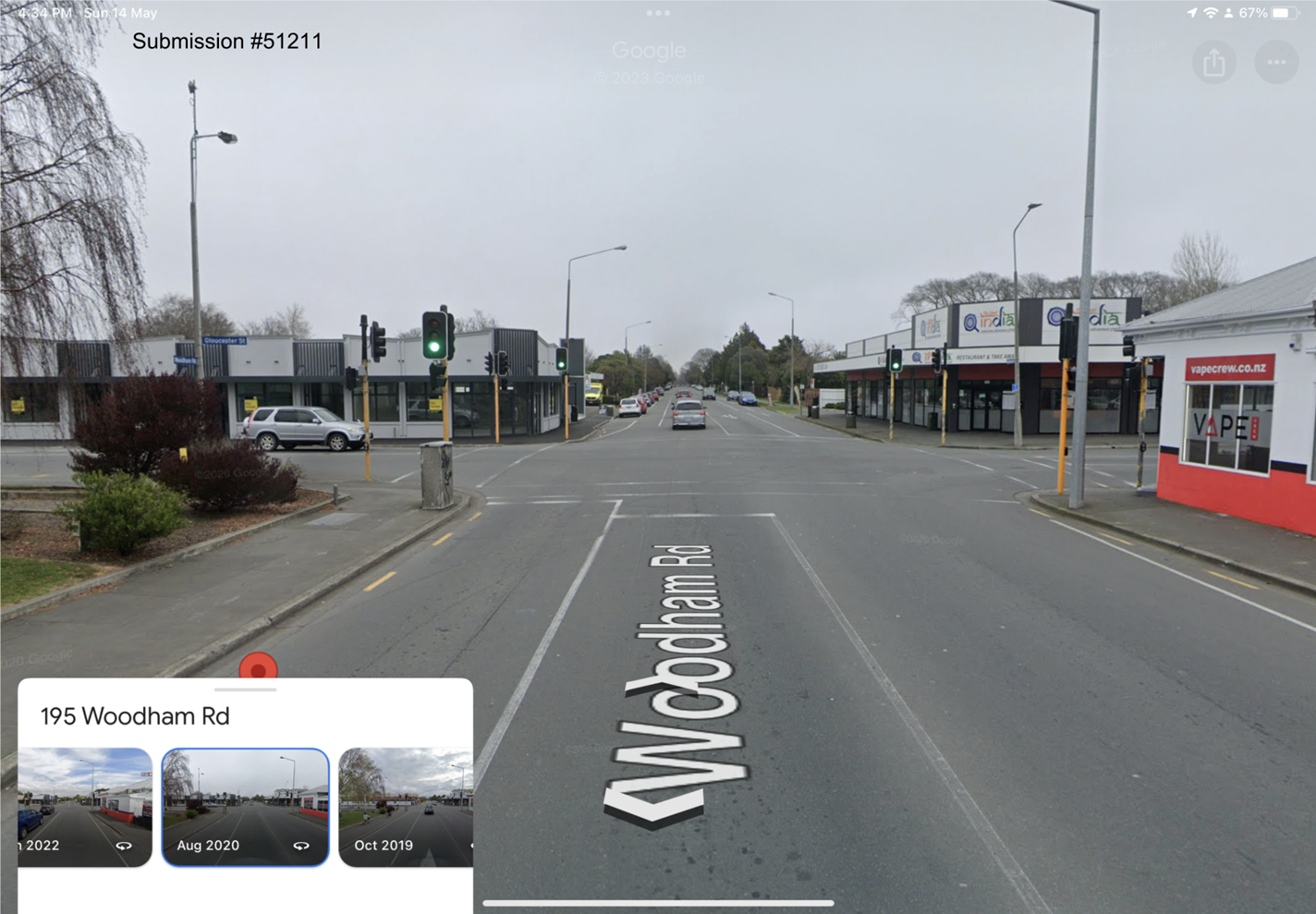
9. Woodham
Road / Gloucester Street - Intersection Improvements
|
|
Reference Te Tohutoro:
|
23/1662651
|
|
Report of Te Pou Matua:
|
Gautham
Praburam, Traffic Engineer, gautham.praburam@ccc.govt.nz
Lachlan Beban, Senior Transportation Engineer, lachlan.beban@ccc.govt.nz
|
|
Senior Leader Pouwhakarae:
|
Mary
Richardson, General Manager Citizens & Community
(Mary.Richardson@ccc.govt.nz)
|
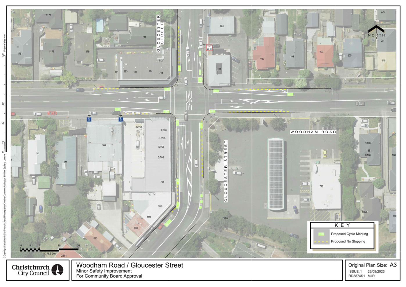
Purpose and Origin of Report Te Pūtake Pūrongo
1.1 The purpose of this report is for the Waitai Coastal
Burwood Linwood Community Board to approve the proposed safety improvements at
the Woodham Road / Gloucester Street intersection.
1.2 This report has been written in response to concerns raised
by road users passing through this intersection and safety risks identified at
this location by Council staff.
|
1. Waitai Coastal-Burwood-Linwood Community Board Consideration
Te Whaiwhakaarotanga
|
|
|
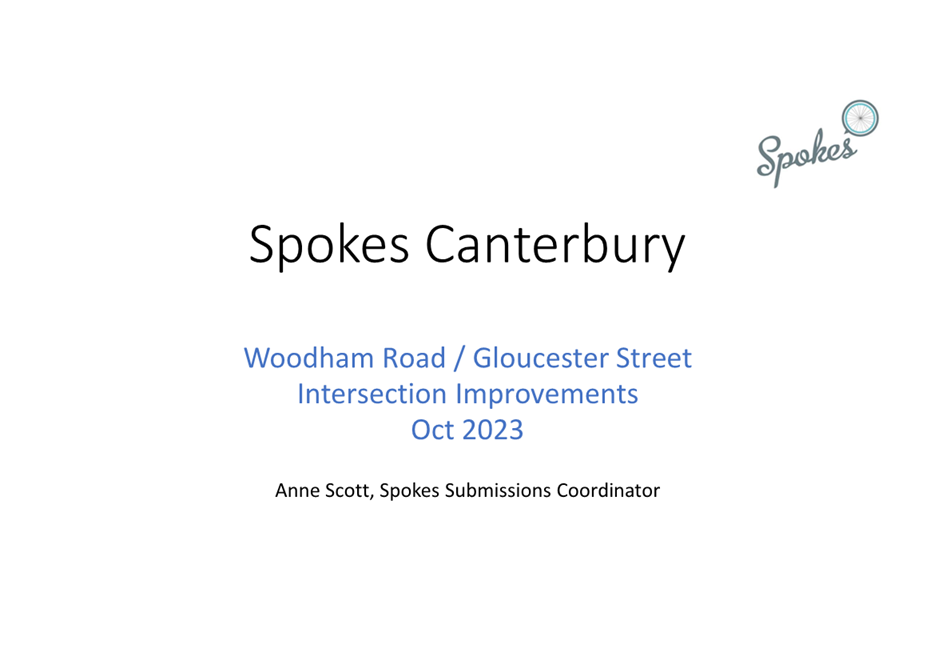
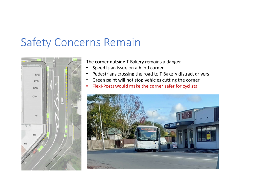
The Board took into consideration a deputation made by Anne Scott
on behalf of Spokes Canterbury whilst making their recommendation to Council
and Part C decision.
|
|
2. Waitai Coastal-Burwood-Linwood Community Board Decisions
Under Delegation Ngā
Mana kua Tukuna
|
|
|
(Original Officer Recommendation accepted without
change)
Part C
That the Waitai Coastal-Burwood-Linwood
Community Board approves:
2. All road surface treatments, lane changes
and road markings as detailed on plan RD3874S1, dated 12/09/2023 and attached
to the Agenda report as Attachment A.
3. That in accordance with Section 2.4 of
the Land Transport Rule: Road User Rule 2004 that cycles be exempt from being
required to turn left, when in the left turn lane on the Gloucester Street
northern approach at its intersection with Woodham Road.
4. Pursuant to Clause 7 of the Christchurch
City Council Traffic and Parking Bylaw 2017, that the stopping of vehicles be
prohibited at all times:
a. Along the western side of Gloucester
Street commencing at its intersection with Woodham Road and extending in a
southerly direction for a distance of approximately 53 metres as detailed on
plan RD3874S1, dated 12/09/2023 and attached to the Agenda report as
Attachment A.
b. Along the eastern side of Gloucester
Street commencing at its intersection with Woodham Road and extending in a
southerly direction for a distance of approximately 42 metres as detailed on
plan RD3874S1, dated 12/09/2023 and attached to the Agenda report as
Attachment A.
c. Along the western side of Gloucester
Street commencing at its intersection with Woodham Road and extending in a
northerly direction for a distance of approximately 31 metres as detailed on
plan RD3874S1, dated 12/09/2023 and attached to the Agenda report as
Attachment A.
d. Along the eastern side of Gloucester
Street commencing at its intersection with Woodham Road and extending in a
northerly direction for a distance of approximately 27 metres as detailed on
plan RD3874S1, dated 12/09/2023 and attached to the Agenda report as
Attachment A.
e. Along the southern side of Woodham Road
commencing at its intersection with Gloucester Street and extending in an
easterly direction for a distance of approximately 46 metres as detailed on
plan RD3874S1, dated 12/09/2023 and attached to the Agenda report as
Attachment A.
f. Along the northern side of Woodham Road
commencing at its intersection with Gloucester Street and extending in an
easterly direction for a distance of approximately 43 metres as detailed on
plan RD3874S1, dated 12/09/2023 and attached to the Agenda report as
Attachment A.
g. Along the southern side of Woodham Road
commencing at its intersection with Gloucester Street and extending in a
westerly direction for a distance of approximately 28 metres as detailed on
plan RD3874S1, dated 12/09/2023 and attached to the Agenda report as
Attachment A.
h. Along the northern side of Woodham Road
commencing at its intersection with Gloucester Street and extending in a
westerly direction for a distance of approximately 44 metres as detailed on
plan RD3874S1, dated 12/09/2023 and attached to the Agenda report as
Attachment A.
5. Pursuant to Clause 7 of the Christchurch
City Council Traffic and Parking Bylaw 2017, revokes any time restricted parking restrictions
along the southern side of Woodham Road between its intersection with Gloucester Street and
Tancred Street.
6. Pursuant to Clause 7 of the Christchurch
City Council Traffic and Parking Bylaw 2017, approves that the parking of
vehicles be restricted to a maximum period of 30 minutes on the southern side
of Woodham Road commencing at a point approximately 28 metres west of its
intersection with Gloucester Street and extending in a westerly direction for
a distance of 16 metres.
7. Revoke any previous resolutions
pertaining to traffic controls made pursuant to any bylaw to the extent that
they are in conflict with the traffic controls described above.
8. Approve that these resolutions take
effect when parking signage and/or road markings that evidence the
restrictions described in the staff report are in place.
Tim Baker/Alex
Hewison
|
|
3. Waitai Coastal-Burwood-Linwood Community Board Recommendation
to Council
|
|
|
(Original Officer Recommendation accepted without change)
Part A
That the Council approves:
1. Pursuant to Clause 18 of the Christchurch City Council Traffic and
Parking Bylaw 2017:
a. That a Special Vehicle Lane (Cycle) be installed along the western
side of Gloucester Street, commencing at its intersection with Woodham Road
and extending in a southerly direction for a distance of approximately 60
metres as detailed on plan RD3874S1, dated 12/09/2023 and attached to the
Agenda report as Attachment A.
b. That a Special Vehicle Lane (Cycle) be installed along the eastern
side of Gloucester Street, commencing at its intersection with Woodham Road
and extending in a southerly direction for a distance of approximately 64
metres as detailed on plan RD3874S1, dated 12/09/2023 and attached to the
Agenda report as Attachment A.
c. That a Special Vehicle Lane (Cycle) be installed along the western
side of Gloucester Street, commencing at its intersection with Woodham Road
and extending in a northerly direction for a distance of approximately 30
metres as detailed on plan RD3874S1, dated 12/09/2023 and attached to the
Agenda report as Attachment A.
d. That a Special Vehicle Lane (Cycle) be installed along the
southern side of Woodham Road, commencing at its intersection with Gloucester
Street and extending in an easterly direction for a distance of approximately
45m as detailed on plan RD3874S1, dated 12/09/2023 and attached to the Agenda
report as Attachment A.
e. That a Special Vehicle Lane (Cycle) be installed along the
northern side of Woodham Road, commencing at its intersection with Gloucester
Street and extending in an easterly direction for a distance of approximately
47 metres as detailed on plan RD3874S1, dated 12/09/2023 and attached to the
Agenda report as Attachment A.
f. That any Special Vehicle Lanes (Cycle) along
the southern side of Woodham Road between its intersection with Gloucester
Street and Tancred Street (located to the west of the intersection) be
revoked.
g. That a Special Vehicle Lane (Cycle) be installed along the
southern side of Woodham Road, commencing at its intersection with Gloucester
Street and extending in a westerly direction up to its intersection with
Tancred Street.
h. That any Special Vehicle Lanes (Cycle) along
the northern side of Woodham Road between its intersection with Gloucester
Street and Patten Street (located to the west of the intersection) be
revoked.
i. That a Special Vehicle Lane (Cycle) be installed along the
northern side of Woodham Road, commencing at its intersection with Patten
Street and extending in an easterly direction up to its intersection with
Gloucester Street.
|
Attachments Ngā Tāpirihanga
|
No.
|
Report Title
|
Reference
|
Page
|
|
1
|
Woodham Road / Gloucester Street -
Intersection Improvements
|
23/1195588
|
89
|
|
No.
|
Title
|
Reference
|
Page
|
|
a ⇩ 
|
Gloucester Street / Woodham Road - Proposed Intersection
Improvements
|
22/1662987
|
97
|
|
b ⇩
|
Gloucester Street Woodham Road intersection - Submission Table
(Public)
|
23/1350420
|
98
|
|
c ⇩ 
|
Spokes Canterbury Presentation to Waitai Community Board 9 October
2023
|
23/1650071
|
107
|
|
Council
01 November 2023
|
|
|
Woodham Road / Gloucester Street - Intersection Improvements
|
|
Reference / Te Tohutoro:
|
23/1195588
|
|
Report of / Te Pou Matua:
|
Gautham
Praburam, Traffic Engineer, gautham.praburam@ccc.govt.nz
Lachlan Beban, Senior Transportation Engineer, lachlan.beban@ccc.govt.nz
|
|
Senior Manager / Pouwhakarae:
|
Mary
Richardson, General Manager Citizens & Community
(Mary.Richardson@ccc.govt.nz)
|
1. Nature of Issue and Report Origin
1.1 The purpose of this report is for the Waitai Coastal
Burwood Linwood Community Board to approve the proposed safety improvements at
the Woodham Road / Gloucester Street intersection.
1.2 This report has been written in response to concerns raised
by road users passing through this intersection and safety risks identified at
this location by Council staff.
1.3 The
decisions in this report are of low significance in relation to the
Christchurch City Council’s Significance and Engagement Policy. The level
of significance was determined through consideration of the various assessment
criteria in the Council’s Significance and Engagement Policy Worksheet.
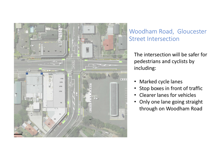
1.4 The recommended option is to reconfigure the intersection approaches
to have separate right turn bays, shared left/through lanes and cycle lanes on
each approach, along with associated cyclist markings, as shown in Attachment
A. Advanced waiting bays within the intersection for right turning
vehicles from the Gloucester Street approaches are also included in this option.
2. Officer Recommendations Ngā Tūtohu
That the Waitai
Coastal-Burwood-Linwood Community Board recommends that the Council approves:
1. Pursuant to Clause 18 of the Christchurch City Council Traffic and
Parking Bylaw 2017:
a. That a Special Vehicle Lane (Cycle) be installed along the western
side of Gloucester Street, commencing at its intersection with Woodham Road and
extending in a southerly direction for a distance of approximately 60 metres as detailed on plan RD3874S1, dated 12/09/2023 and
attached to this Agenda report as Attachment A.
b. That a Special Vehicle Lane (Cycle) be installed along the eastern
side of Gloucester Street, commencing at its intersection with Woodham Road and
extending in a southerly direction for a distance of approximately 64 metres as
detailed on plan RD3874S1, dated 12/09/2023 and attached to this Agenda report
as Attachment A.
c. That a Special Vehicle Lane (Cycle) be installed along the western
side of Gloucester Street, commencing at its intersection with Woodham Road and
extending in a northerly direction for a distance of approximately 30 metres as
detailed on plan RD3874S1, dated 12/09/2023 and attached to this Agenda report
as Attachment A.
d. That a Special Vehicle Lane (Cycle) be installed along the southern
side of Woodham Road, commencing at its intersection with Gloucester Street and
extending in an easterly direction for a distance of approximately 45m as
detailed on plan RD3874S1, dated 12/09/2023 and attached to this Agenda report
as Attachment A.
e. That a Special Vehicle Lane (Cycle) be installed along the northern
side of Woodham Road, commencing at its intersection with Gloucester Street and
extending in an easterly direction for a distance of approximately 47 metres as
detailed on plan RD3874S1, dated 12/09/2023 and attached to this Agenda report
as Attachment A.
f. That any Special Vehicle Lanes (Cycle) along
the southern side of Woodham Road between its intersection with Gloucester
Street and Tancred Street (located to the west of the intersection) be revoked.
g. That a Special Vehicle Lane (Cycle) be installed along the southern
side of Woodham Road, commencing at its intersection with Gloucester Street and
extending in a westerly direction up to its intersection with Tancred Street.
h. That any Special Vehicle Lanes (Cycle) along
the northern side of Woodham Road between its intersection with Gloucester
Street and Patten Street (located to the west of the intersection) be revoked.
i. That a Special Vehicle Lane (Cycle) be installed along the northern
side of Woodham Road, commencing at its intersection with Patten Street and
extending in an easterly direction up to its intersection with Gloucester
Street.
That the Waitai
Coastal-Burwood-Linwood Community Board approves:
2. All road surface treatments, lane changes and road markings as
detailed on plan RD3874S1, dated 12/09/2023 and attached to this Agenda report
as Attachment A.
3. That in accordance with Section 2.4 of the Land Transport Rule: Road
User Rule 2004 that cycles be exempt from being required to turn left, when in
the left turn lane on the Gloucester Street northern approach at its
intersection with Woodham Road.
4. Pursuant to Clause 7 of the Christchurch City Council Traffic and
Parking Bylaw 2017, that the stopping of vehicles be prohibited at all times:
a. Along the western side of Gloucester Street commencing at its
intersection with Woodham Road and extending in a southerly direction for a
distance of approximately 53 metres as detailed on plan RD3874S1, dated
12/09/2023 and attached to this Agenda report as Attachment A.
b. Along the eastern side of Gloucester Street commencing at its
intersection with Woodham Road and extending in a southerly direction for a
distance of approximately 42 metres as detailed on plan RD3874S1, dated
12/09/2023 and attached to this Agenda report as Attachment A.
c. Along the western side of Gloucester Street commencing at its
intersection with Woodham Road and extending in a northerly direction for a
distance of approximately 31 metres as detailed on plan RD3874S1, dated
12/09/2023 and attached to this Agenda report as Attachment A.
d. Along the eastern side of Gloucester Street commencing at its
intersection with Woodham Road and extending in a northerly direction for a
distance of approximately 27 metres as detailed on plan RD3874S1, dated
12/09/2023 and attached to this Agenda report as Attachment A.
e. Along the southern side of Woodham Road commencing at its
intersection with Gloucester Street and extending in an easterly direction for
a distance of approximately 46 metres as detailed on plan RD3874S1, dated
12/09/2023 and attached to this Agenda report as Attachment A.
f. Along the northern side of Woodham Road commencing at its
intersection with Gloucester Street and extending in an easterly direction for
a distance of approximately 43 metres as detailed on plan RD3874S1, dated
12/09/2023 and attached to this Agenda report as Attachment A.
g. Along the southern side of Woodham Road commencing at its
intersection with Gloucester Street and extending in a westerly direction for a
distance of approximately 28 metres as detailed on plan RD3874S1, dated
12/09/2023 and attached to this Agenda report as Attachment A.
h. Along the northern side of Woodham Road commencing at its
intersection with Gloucester Street and extending in a westerly direction for a
distance of approximately 44 metres as detailed on plan RD3874S1, dated
12/09/2023 and attached to this Agenda report as Attachment A.
5. Pursuant to Clause 7 of the Christchurch City Council Traffic and
Parking Bylaw 2017, revokes any time restricted parking
restrictions along the southern side of Woodham Road between
its intersection with Gloucester Street and Tancred Street.
6. Pursuant to Clause 7 of the Christchurch City Council Traffic and
Parking Bylaw 2017, approves that the parking of vehicles be restricted to a
maximum period of 30 minutes on the southern side of Woodham Road commencing at
a point approximately 28 metres west of its intersection with Gloucester Street
and extending in a westerly direction for a distance of 16 metres.
7. Revoke any previous resolutions pertaining to traffic controls made
pursuant to any bylaw to the extent that they are in conflict with the traffic
controls described above.
8. Approve that these resolutions take effect when parking signage
and/or road markings that evidence the restrictions described in the staff
report are in place.
3. Reason for Report Recommendations Ngā Take mō te Whakatau
3.1 The
existing layout of the approaches to the intersection of Gloucester Street /
Woodham Road consists of an unmarked kerbside lane and a shared through / right
turn lane. This layout (without an exclusive right turn lane) is
problematic in operation as any right turning vehicles have to wait to give way
to opposing traffic and therefore block any trailing through vehicles. As
a result, drivers often use the adjacent unmarked lane to undertake the waiting
right turning vehicles thereby creating safety risks.
3.2 Also,
currently there are no dedicated facilities to assist cyclists in safely
navigating the intersection.
3.3 The
proposed intersection improvements include reconfiguring the approaches with
separate right turn bays, shared left/through lanes, and cycle lanes on each
approach, along with cyclist markings and additional no stopping restrictions
to accommodate the revised lane arrangement, as shown in Attachment A. Additionally,
advanced waiting bays will be introduced within the intersection for
right-turning vehicles from Gloucester Street.
3.4 The
recommendations in this report will help to achieve the desired community
outcome of a well-connected and accessible city through improved road safety.
4. Alternative Options Considered Ētahi atu Kōwhiringa
Do Nothing
4.1 The
advantages of this option include:
4.1.1 No cost to Council.
4.2 The
disadvantages of this option include:
4.2.1 Does not address the identified
safety concerns for road users at this location.
5. Detail Te Whakamahuki
5.1 Improving
safety on local roads in Christchurch is a priority for Council. Providing safe
infrastructure is key to ensure people get to where they are going safely
regardless of how they are travelling.
5.2 Woodham
Road is an Arterial Road with an average weekday traffic volume of over 10,000
vehicles. Gloucester Street is a Primary Collector with an average weekday
traffic volume of over 8,000 vehicles. This intersection lies along one of the
primary routes for individuals commuting between the city centre and the
eastern side of the city.
5.3 According
to the latest available traffic survey data (2020), the number of vehicles
making right turns from Gloucester Street is nearly twice the number of
vehicles turning right from Woodham Road.
5.4 Council
staff have received feedback in the past regarding safety concerns for road
users at this intersection.
5.5 The
existing lane alignments have been in place since the pre-earthquake period
when there were a higher number of vehicles travelling towards the present red
zone areas. This type of intersection lane layout was once common in the city,
however over the last few decades these layouts have progressively been
upgraded to provide safety improvements.
5.6 The
current layout presents several issues, primarily related to right-turning
vehicles having to wait and yield to oncoming traffic, subsequently creating
delay and obstructing through vehicles. Consequently, drivers frequently resort
to using the adjacent unmarked lane to bypass the queue of waiting
right-turning vehicles. This behaviour increases the risk of conflicts with
vehicles and cyclists in the kerbside lane. It also raises the likelihood
of collisions with right-turning vehicles from the opposing approach, as the
through vehicles become obscured behind the queue of waiting vehicles.
5.7 Also,
currently the intersection lacks dedicated facilities to assist the safe passage
of cyclists.
5.8 The
Waka Kotahi Crash Analysis System (CAS) was used to gain an understanding of
any underlying safety issues at this location. 16 crashes have been reported within
50m of this intersection since 2013. Ten crashes were non-injury crashes and
six crashes resulted in minor injuries.
5.9 Staff
acknowledge the concerns at this location and feel that safety improvements are
warranted around this intersection.
5.10 The proposed
treatments include:
· Altering the intersection approaches to have separate right turn
bays.
· Shared left/through lanes and cycle lanes on each approach.
· Associated cyclist markings at key locations to highlight the
potential presence of cyclists.
· Advanced waiting bays within the intersection for right turning
vehicles from Gloucester Street.
· No stopping restrictions - to provide road space to accommodate the
revised lane arrangement.
· Moving the existing time restricted parking spaces in Woodham Road
immediately near the intersection to the west to accommodate the revised lane
layout.
5.11 The project is
being funded from the Minor Safety Interventions budget, which is used to fund
low-cost safety improvements in the city’s local road network. This
programme is focussed on delivering smaller scale projects which generally
originate from community requests that might otherwise struggle to get funded
when ranked against other safety initiatives around the city.
5.12 Approval for the
proposed improvements is required by the Waitai Coastal-Burwood-Linwood
Community Board.
5.13 If approved, the
recommendations will be implemented within the current financial year.
6. Community Views and Preferences Ngā mariu ā-Hāpori
Public Consultation Te Tukanga Kōrerorero
6.1 Early
engagement with the affected businesses around the Gloucester Street –
Woodham Road intersection started on 11 April 2023 and ran until 25 April 2023.
Businesses included:
· Vortica Disc Golf
· T Bakery
· Mainland Turkish Food
· Dallington Seafood Centre
· Jo’s Mart and Sushi
· The Great India
· City Express Convenience
· Vape Crew and,
· BP Service Station
6.2 Staff
doorknocked reachable businesses to talk to staff about the proposed plans and
left letters to businesses that couldn’t be reached, inviting them to
give feedback on the proposed plan by a private form.
6.3 Public
consultation started on 1 May 2023 and ran until 19 May 2023. An email was sent
to key stakeholders:
· Spokes
· NZ Police
· Metro
· Automobile Association
· St John
· Fire and Emergency New Zealand (FENZ) and,
· Dallington Residents Association.
6.4 Community
organisations were provided with information to share with their community on
social media. The consultation was posted on the following community pages inviting
submissions on the Have Your Say webpage: https://www.ccc.govt.nz/the-council/haveyoursay/show/590
· Aranui and Wainoni Community
· Woolston Community United
· Inner East Burbs – Linwood, Phillipstown and Woolston Locals
· R.A.D.S – Richmond Avonside Dallington Shirley Locals
· Peoples Independent Republic of New Brighton
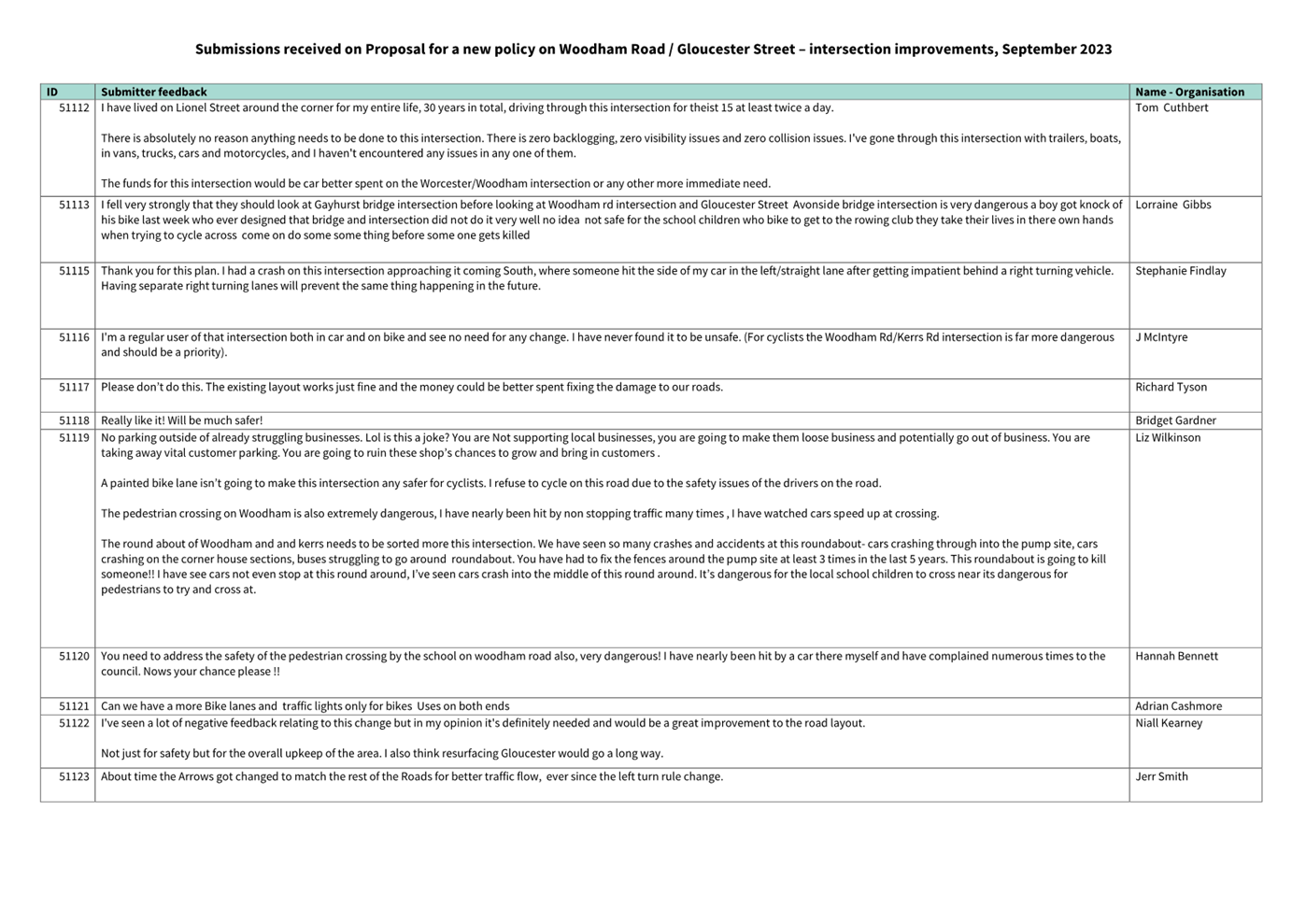
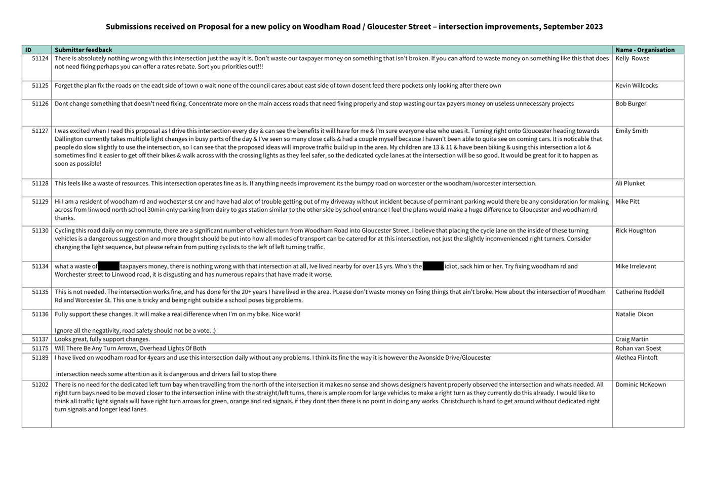
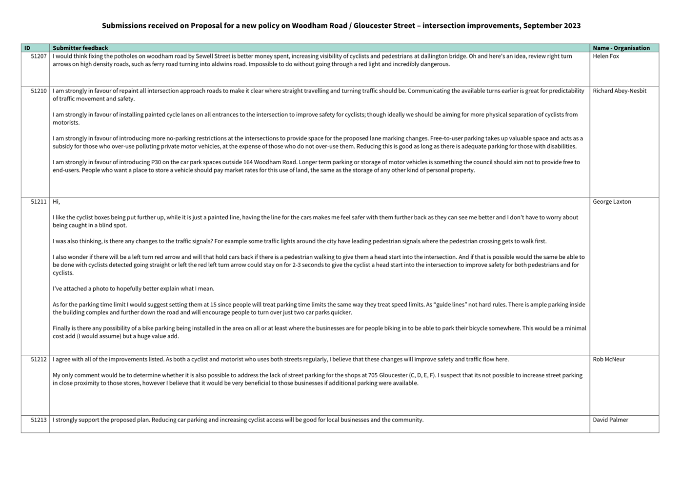
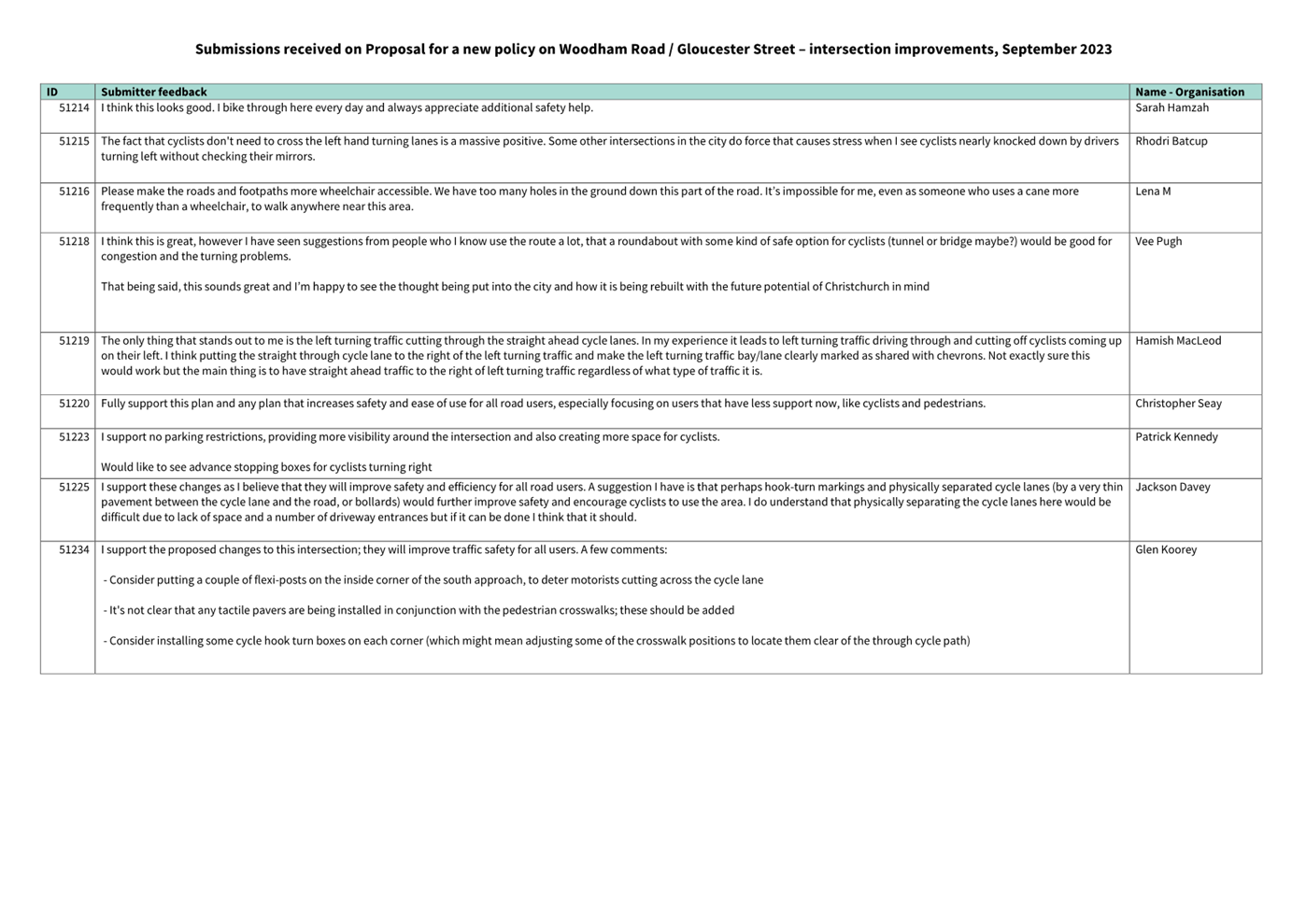
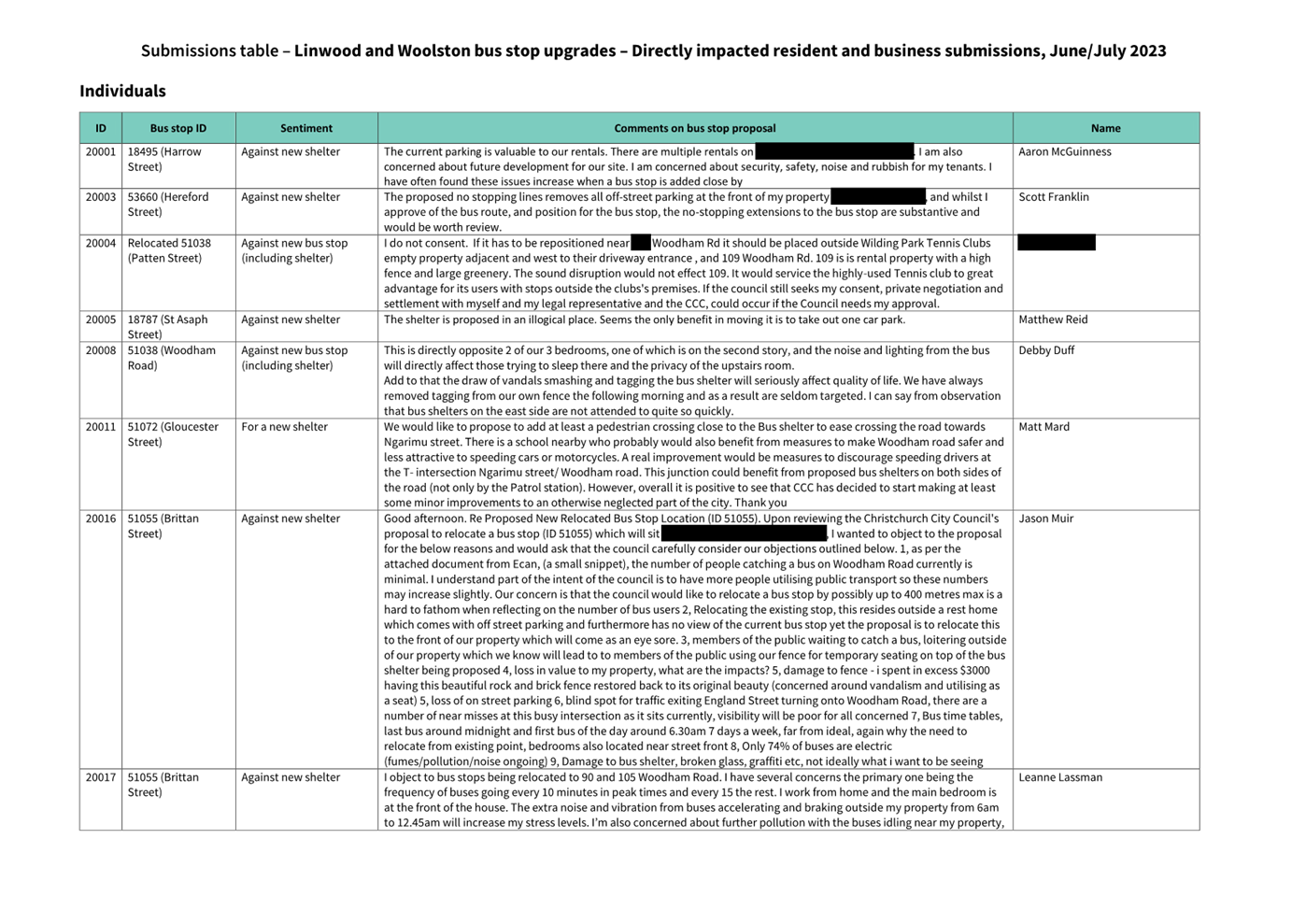
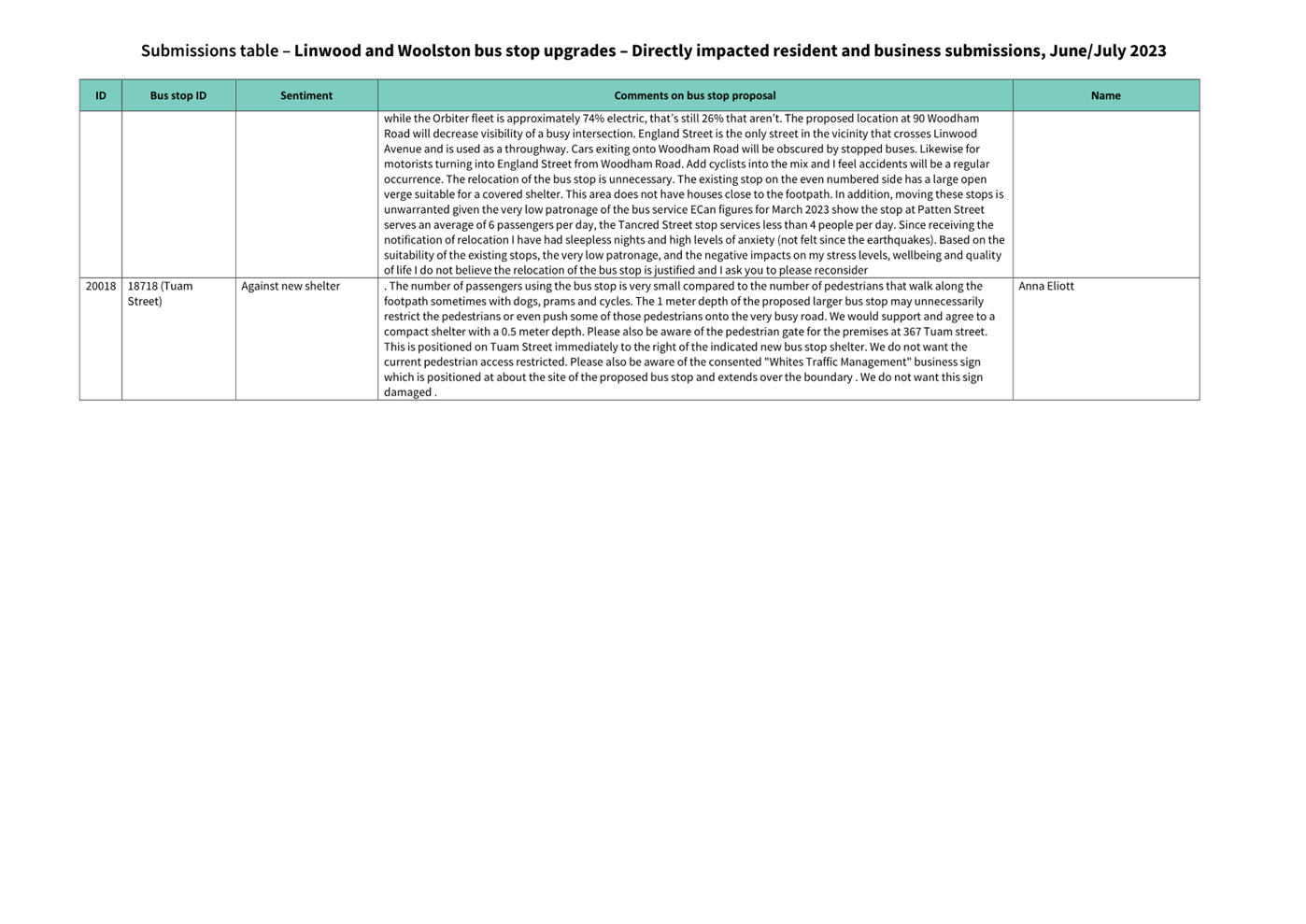
Summary of Submissions Ngā Tāpaetanga
6.5 During
early engagement, Vortica Disc Golf submitted their
concerns regarding the proposal. They expressed worries about its potential
negative impact on both existing and future businesses in the area. The main
concern raised was that these businesses heavily rely on the on-street parking
that currently exists, and any changes could hinder their growth and discourage
new businesses from establishing themselves in the area.
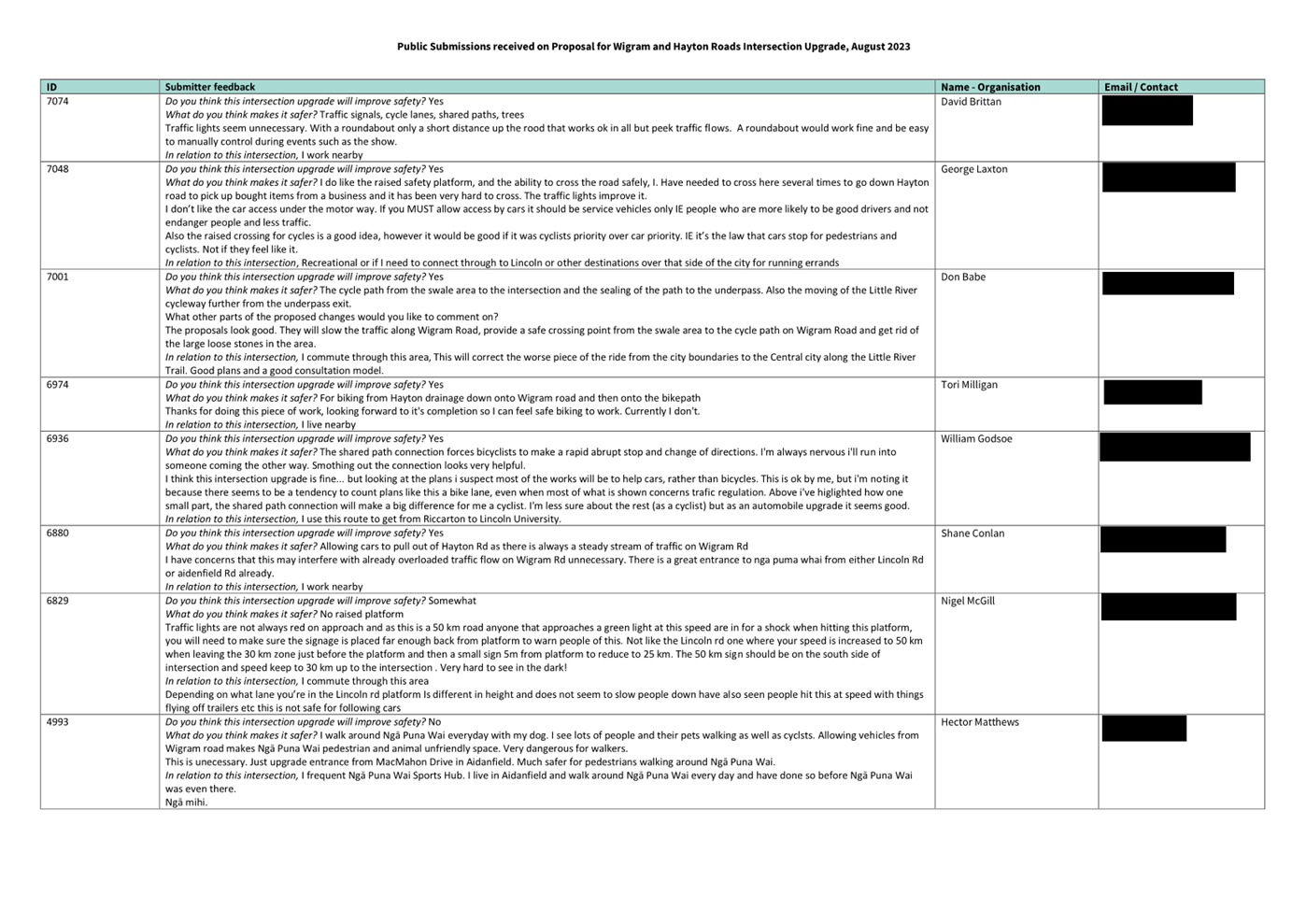
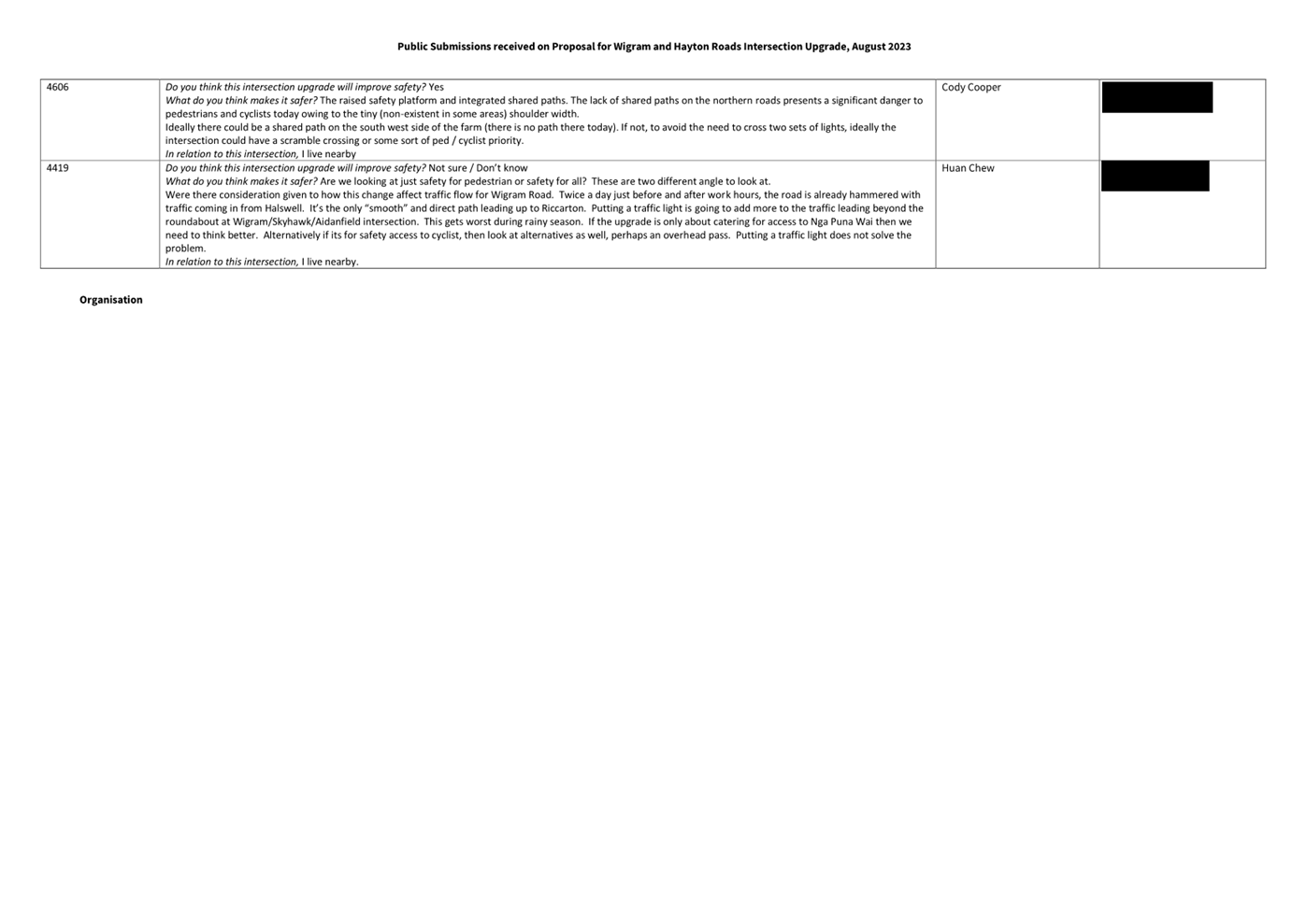
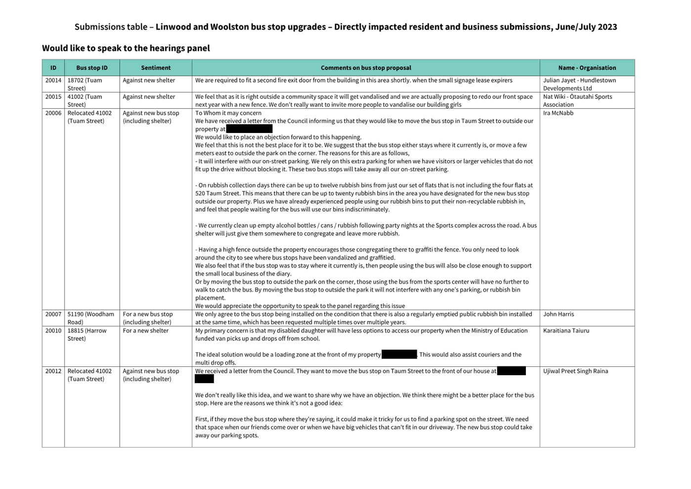
6.6 Submissions
were made by one recognised organisation, three businesses and 48 individuals.
All submissions are available as Attachment B.
6.7 Of
the 22 submitters (43%) who supported the proposal, 17 identified intersection
safety as a problem and these improvements addressed the issues.
6.8 Out
of the 18 submitters (34%) who did not support the proposal for the same
reasons outlined in section 6.5, 14 (27%) suggested that a different
intersection should be prioritized for improvement. These intersections
included:
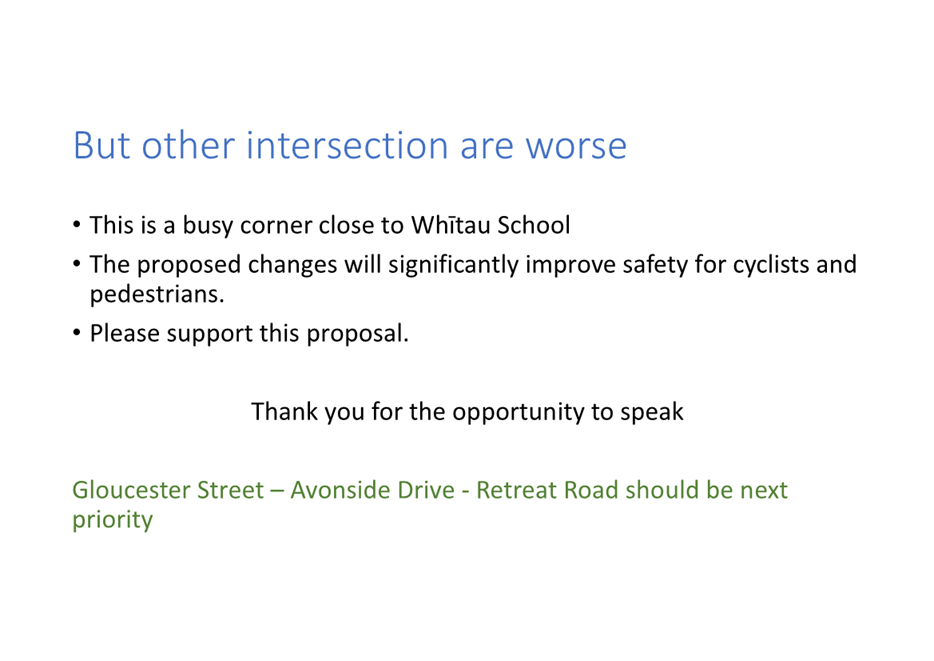
· Gloucester Street – Avonside
Street - Retreat Road
· Worcester Street – Woodham Road
· Woodham Road – Kerrs Road
6.9 A
further 12 (23%) made specific comments on the proposal that neither supported or opposed the overall project.
7. Policy
Framework Implications Ngā Hīraunga ā- Kaupapa
here
Strategic Alignment Te Rautaki
Tīaroaro
7.1 Council’s strategic priorities have been considered in
formulating the recommendations in this report, however this area of work is
not specifically covered by an identified priority.
7.2 This report supports the:
7.3 Transport
7.3.1 Activity:
Transport
· Level of Service: 10.0.6.1 Reduce the number of
death and serious injury crashes on the local road network - <=100
crashes
Policy Consistency Te Whai Kaupapa here
7.4 The recommendations in this report are consistent with
Council’s Policies and Plans.
Impact on Mana Whenua Ngā Whai Take
Mana Whenua
7.5 The decision does not involve a significant decision in relation to
ancestral land or a body of water or other elements of intrinsic value,
therefore this decision does not specifically impact Mana Whenua, their culture
and traditions.
7.6 The decision does not involve a matter of interest to Mana Whenua
and will not impact on our agreed partnership priorities with Ngā Papatipu
Rūnanga.
7.7 The effects of this proposal upon Mana Whenua are expected to be
insignificant.
Climate Change Impact Considerations Ngā
Whai Whakaaro mā te Āhuarangi
7.8 The
proposals in this report are unlikely to contribute significantly to adaptation
to the impacts of climate change or emissions reductions.
Accessibility Considerations Ngā Whai
Whakaaro mā te Hunga Hauā
7.9 This proposal improves safety and accessibility for pedestrians
passing through this intersection.
8. Resource Implications Ngā Hīraunga Rauemi
Capex/Opex Ngā Utu Whakahaere
8.1 Cost
to Implement - Approximately $30,000.
8.2 Maintenance/Ongoing
costs - Approximately $500 per year.
8.3 Funding
Source - Traffic Operations Minor Safety Interventions Budget 2023/24.
Other He mea anō
8.4 None
identified.
9. Legal Implications Ngā Hīraunga ā-Ture
Statutory power to undertake proposals in
the report Te Manatū Whakahaere Kaupapa
9.1 The
Community Boards have delegated authority from the Council to exercise the
delegations as set out in the Register of Delegations. The list of delegations
for the Community Boards includes the resolution of stopping restrictions and
traffic control devices.
9.2 The
installation of any signs and/or markings associated with traffic control
devices must comply with the Land Transport Rule: Traffic Control Devices 2004.
Other Legal Implications Ētahi atu
Hīraunga-ā-Ture
9.3 There
is no other legal context, issue or implication relevant to this decision.
10. Risk Management Implications Ngā Hīraunga Tūraru
10.1 None identified.
Attachments Ngā Tāpirihanga
|
No.
|
Title
|
Reference
|
Page
|
|
a
|
Gloucester
Street / Woodham Road - Proposed Intersection Improvements
|
22/1662987
|
|
|
b
|
Gloucester
Street Woodham Road intersection - Submission Table (Public)
|
23/1350420
|
|
In addition to the attached documents, the following background information
is available:
|
Document
Name – Location / File Link
|
|
Not
applicable
|
Confirmation of Statutory
Compliance Te Whakatūturutanga ā-Ture
|
Compliance with Statutory Decision-making
Requirements (ss 76 - 81 Local Government Act 2002).
(a) This report contains:
(i) sufficient information about all reasonably practicable
options identified and assessed in terms of their advantages and
disadvantages; and
(ii) adequate consideration of the views and preferences of
affected and interested persons bearing in mind any proposed or previous
community engagement.
(b) The information reflects the level of significance of the
matters covered by the report, as determined in accordance with the Council's
significance and engagement policy.
|
Signatories Ngā Kaiwaitohu
|
Authors
|
Gautham
Praburam - Senior Traffic Engineer
Lachlan Beban
- Senior Transportation Engineer
Kiran Skelton
- Engagement Assistant
|
|
Approved By
|
Katie Smith -
Team Leader Traffic Operations
Stephen Wright
- Manager Operations (Transport)
|
|
Council
01 November 2023
|

|
|
Council
01 November 2023
|
|
Report from Waipuna Halswell-Hornby-Riccarton
Community Board – 12 October 2023
|
10. Wigram/Hayton
Roads Intersection Improvement
|
|
Reference Te Tohutoro:
|
23/1692167
|
|
Report of Te Pou Matua:
|
David
Sun, Transport Project Manager
David.Sun@ccc.govt.nz
|
|
Senior Leader Pouwhakarae:
|
Mary
Richardson, General Manager Citizens & Community
(Mary.Richardson@ccc.govt.nz)
|
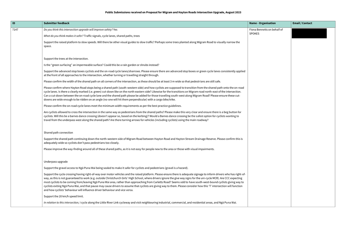
Purpose and Origin of Report Te Pūtake Pūrongo
1.1 The purpose of this report is for the Waipuna
Halswell-Hornby-Riccarton Community Board (Board) to approve intersection
changes at Wigram/Hayton Roads intersection; and to recommend that Council
approve special vehicle lanes for use by cycles.
1.2 The report has been prepared by Council staff. The project
will provide safe pedestrian and cyclist connections from Hayton Reserve to the
Wigram/Hayton Roads intersection, and safe vehicular access from the
intersection to the Ngā Puna Wai Sports Hub.
|
1. Waipuna Halswell-Hornby-Riccarton Community Board Consideration Te Whaiwhakaarotanga
|
|
|
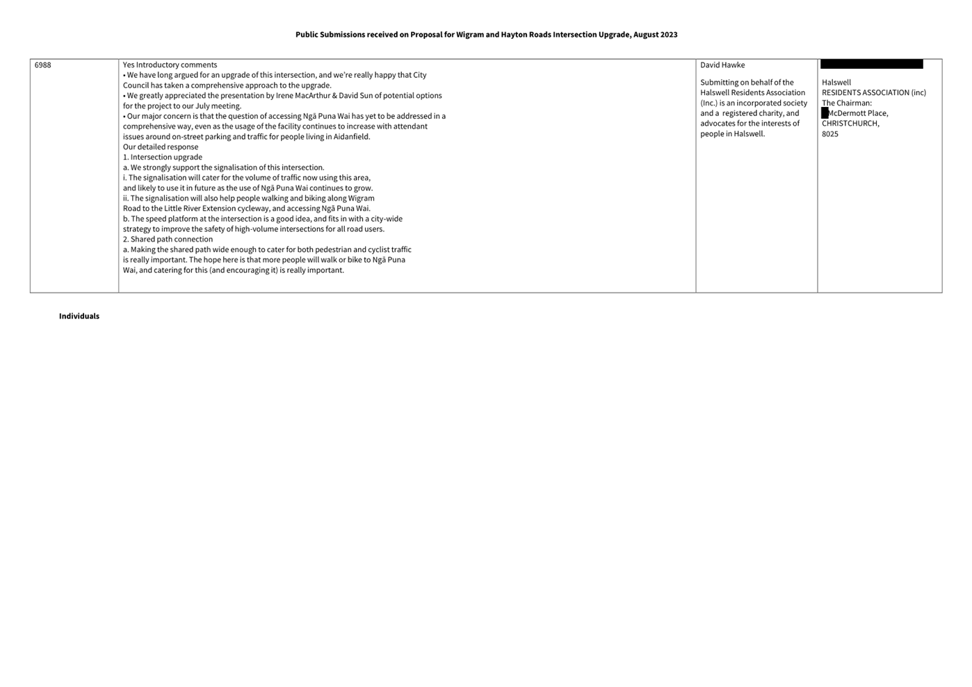
The
Board took into consideration the deputations made from Wayne Keen, Halswell
Residents’ Association and Spokes Canterbury whilst making its recommendation
to Council and Part C decision.
|
|
2. Waipuna Halswell-Hornby-Riccarton Community Board Decisions
Under Delegation Ngā
Mana kua Tukuna
|
|
|
(Officer recommendations accepted)
Part C
That the Waipuna
Halswell-Hornby-Riccarton Community Board approves:
3. All kerb alignments, road surface treatments, lane changes, raised
safety platforms (at the Wigram Road / Hayton Road intersection and across
Nga Puna Wai Access Road adjacent to the proposed pedestrian / cyclist
crossing point), coloured pavement surfacing and road markings as detailed on plan TP359001, dated 21/09/2023 and attached to the report on
the meeting agenda as Attachment A.
4. That in accordance with Section 2.4 of the Land Transport Rule:
Road User Rule 2004 that cycles be exempt from being required to turn left,
when in the left turn lane on the Wigram Road northeastern approach at its
intersection with Nga Puna Wai Access Road as
detailed on plan TP359001, dated 21/09/2023 and
attached to the report on the meeting agenda as Attachment A.
5. That in accordance with Section 8.2 of the Land Transport
Rule: Traffic Control Devices 2004, a Pedestrian / Cyclist Crossing be
established on Nga Puna Wai Access Road at a distance
of 80 metres southeast of its intersection with Wigram Road as detailed on plan TP359001, dated
21/09/2023 and attached to the report on the meeting agenda as Attachment
A.
6. That in accordance with Section 4 of the Land Transport Rule:
Traffic Control Devices 2004, the northwest bound traffic on Nga Puna Wai
Access Road be controlled by a STOP Control at the pedestrian / cyclist
crossing point located at a distance of 80 metres
southeast of its intersection with Wigram Road as
detailed on plan TP359001, dated 21/09/2023 and
attached to the report on the meeting agenda as Attachment A.
7. That in accordance with Section 4 of the Land Transport Rule:
Traffic Control Devices 2004, the southeast bound traffic on Nga Puna Wai
Access Road be controlled by a STOP Control at the pedestrian / cyclist
crossing point located at a distance of 80 metres
southeast of its intersection with Wigram Road as
detailed on plan TP359001, dated 21/09/2023 and
attached to the report on the meeting agenda as Attachment A.
8. That the Give Way control on Hayton Road at its intersection with
Wigram Road be revoked.
9. Pursuant to Clause 7 of the Christchurch City Council Traffic and
Parking Bylaw 2017, that the stopping of vehicles be prohibited at all times:
a. On the northwestern side of Wigram Road, commencing at its
intersection with Hayton Road and extending in south westerly direction for a
distance of 105 metres as detailed on plan TP359001,
dated 21/09/2023 and attached to the report on the meeting agenda as Attachment
A.
b. On the southeastern side of Wigram Road, commencing at its
intersection with Nga Puna Wai Access Road and extending in a south westerly
direction for a distance of 109 metres as detailed on
plan TP359001, dated 21/09/2023 and attached to the report on the meeting
agenda as Attachment A.
c. On the northwestern side of Wigram Road, commencing at its
intersection with Hayton Road and extending in a northeasterly direction for
a distance of 35 metres as detailed on plan TP359001,
dated 21/09/2023 and attached to the report on the meeting agenda as Attachment
A.
d. On the southeastern side of Wigram Road commencing at its
intersection with Nga Puna Wai Access Road and extending in a north easterly
direction for a distance of 50 metres as detailed on
plan TP359001, dated 21/09/2023 and attached to the report on the meeting
agenda as Attachment A.
e. On the southwestern side of Hayton Road, commencing at its
intersection with Wigram Road and extending in a north westerly direction for
a distance of 46 metres as detailed on plan TP359001,
dated 21/09/2023 and attached to the report on the meeting agenda as Attachment
A.
f. On the northeastern side of Hayton Road, commencing at its
intersection with Wigram Road and extending in a north westerly direction for
a distance of 44 metres as detailed on plan TP359001,
dated 21/09/2023 and attached to the report on the meeting agenda as Attachment
A.
10. That the pathway on the southeastern side of Wigram Road
commencing at its intersection with Nga Puna Wai Access Road and extending in
a north easterly direction for a distance of 50 metres, as detailed on plan TP359001, dated 21/09/2023 and attached to the report on
the meeting agenda as Attachment A, be
resolved as a bi-directional shared pedestrian / cycle pathway in accordance
with Clause 21(1)(a) of the Christchurch City Council Traffic and Parking
Bylaw 2017.
11. That the pathway on the southeastern side of Wigram Road
commencing at its intersection with Nga Puna Wai Access Road and extending in
a south-westerly direction for a distance of 11 metres, as detailed on plan TP359001, dated
21/09/2023 and attached to the report on the meeting agenda as Attachment
A, be resolved as a
bi-directional shared pedestrian / cycle pathway in accordance with Clause
21(1)(a) of the Christchurch City Council Traffic and Parking Bylaw 2017.
12. That the pathway on the northwestern side of Wigram Road
commencing at its intersection with Hayton Road and extending in a south
westerly direction for a distance of 238 metres, as
detailed on plan TP359001, dated 21/09/2023 and
attached to the report on the meeting agenda as Attachment A, be resolved as a bi-directional shared
pedestrian / cycle pathway in accordance with Clause 21(1)(a) of the
Christchurch City Council Traffic and Parking Bylaw 2017.
13. That the pathway on the northwestern side of Wigram Road
commencing at its intersection with Hayton Road and extending in a
northeasterly direction for a distance of 35 metres, as
detailed on plan TP359001, dated 21/09/2023 and
attached to the report on the meeting agenda as Attachment A, be resolved as a bi-directional shared
pedestrian / cycle pathway in accordance with Clause 21(1)(a) of the
Christchurch City Council Traffic and Parking Bylaw 2017.
14. That the pathway on the southwestern side of Hayton Road
commencing at its intersection with Wigram Road and extending in a
north-westerly direction for a distance of 46 metres, as detailed on plan TP359001, dated
21/09/2023 and attached to the report on the meeting agenda as Attachment
A, be resolved as a
bi-directional shared pedestrian / cycle pathway in accordance with Clause
21(1)(a) of the Christchurch City Council Traffic and Parking Bylaw 2017.
15. That the pathway on the northeastern side of Hayton Road commencing at its intersection with Wigram Road and extending in a
north westerly direction of for a distance of 27 metres, as detailed on plan TP359001, dated 21/09/2023 and attached to the report on
the meeting agenda as Attachment A, be resolved as a southeast bound bi-directional shared pedestrian
/ cycle pathway in accordance with Clause 21(1)(a) of the Christchurch City
Council Traffic and Parking Bylaw 2017.
16. That right turn movements from the Wigram Road southwest approach
into Nga Puna Wai Access Road be prohibited in accordance with Clause 17(1)
(a) of the Christchurch City Council Traffic and Parking Bylaw 2017. This restriction is to apply every day from 11:00pm to 6:00am.
17. That left turn movements from the Wigram Road northeast approach
into Nga Puna Wai Access Road be prohibited in accordance with Clause 17(1)
(a) of the Christchurch City Council Traffic and Parking Bylaw 2017. This restriction is to apply every day from 11:00pm to 6:00am.
18. That through movements from the Hayton Road northwest approach
into Nga Puna Wai Access Road be prohibited in accordance with Clause 17(1)
(a) of the Christchurch City Council Traffic and Parking Bylaw 2017. This restriction is to apply every day from 11:00pm to 6:00am.
19. That any previous resolutions pertaining to traffic controls made
pursuant to any bylaw to the extent that they are in conflict with the
traffic controls described above be revoked.
20. That these resolutions take effect when parking signage and/or
road markings that evidence the restrictions described in the staff report
are in place.
Mark
Peters/Helen Broughton
|
|
3. Waipuna Halswell-Hornby-Riccarton Community Board Recommendation
to Council
|
|
|
(Officer recommendations
accepted)
Part A
That the Council relying on its powers under the
Christchurch City Council Traffic and Parking Bylaw 2017, the Land Transport
Rule: Traffic Control Devices 2004 and Part 21 of the Local Government Act
1974, approves:
1. That in accordance with Sections 6 and 10.5
of the Land Transport Rule: Traffic Control Devices 2004, all road user
movements at the Wigram Road / Hayton Road / Nga Puna Wai Access Road
intersection be controlled by Traffic Signals.
2. Pursuant to Clause 18 of the Christchurch
City Council Traffic and Parking Bylaw 2017:
a. That a Special Vehicle Lane for use by
northeast bound cycles only be installed on the northwestern side of Wigram
Road, commencing at its intersection with Hayton Road and extending in a
south westerly direction for a distance of 105 metres as detailed on plan TP359001, dated 21/09/2023 and
attached to the report on the meeting agenda as Attachment A.
b. That a Special Vehicle Lane for use by
southwest bound cycles only be installed on the southeastern side of Wigram
Road, commencing at its intersection with Nga Puna Wai Access Road and
extending in a south westerly direction for a distance of 109 metres as
detailed on plan TP359001,
dated 21/09/2023 and attached to the report on the meeting agenda as Attachment
A.
c. That a Special Vehicle Lane for use by
northwest bound cycles only be installed along the southwestern side of
Hayton Road, commencing at its intersection with Wigram Road and extending in
a north westerly direction for a distance of 51 metres as detailed on plan TP359001, dated 21/09/2023 and
attached to the report on the meeting agenda as Attachment A.
d. That a Special Vehicle Lane for use by
southeast bound cycles only be installed along the northeastern side of
Hayton Road, commencing at its intersection with Wigram Road and extending in
a north westerly direction for a distance of 44 metres as detailed on plan TP359001, dated 21/09/2023 and
attached to the report on the meeting agenda as Attachment A.
|
Attachments Ngā Tāpirihanga
|
No.
|
Report Title
|
Reference
|
Page
|
|
1
|
Wigram/Hayton Roads Intersection
Improvement
|
23/1483665
|
115
|
|
No.
|
Title
|
Reference
|
Page
|
|
a ⇩
|
Wigram-Hayton Roads
Intersection Improvement Scheme Plan for Approval
|
23/1561226
|
126
|
|
b ⇩
|
Wigram Hayton Road
Intersection - Submission Table (Public)
|
23/1568090
|
127
|
|
Council
01 November 2023
|
|
|
Wigram/Hayton Roads Intersection Improvement
|
|
Reference / Te Tohutoro:
|
23/1483665
|
|
Report of / Te Pou Matua:
|
David
Sun, Transport Project Manager
David.Sun@ccc.govt.nz
|
|
Senior Manager / Pouwhakarae:
|
Lynette
Ellis, Head of Transport & Waste Management (Lynette.Ellis@ccc.govt.nz)
|
1. Purpose and Origin of Report Te Pūtake Pūrongo
1.1 The purpose of this report is for the Waipuna
Halswell-Hornby-Riccarton Community Board (Board) to approve the parking
changes at Wigram/Hayton Roads intersection; and to recommend that Council
approve the proposal including signalisation.
1.2 The report has been prepared by Council staff. The project
will provide safe pedestrian and cyclist connections from Hayton Reserve to the
Wigram/Hayton Roads intersection, and safe vehicular access from the
intersection to the Ngā Puna Wai Sports Hub.
1.3 The
decisions in this report are of medium significance in relation to the
Christchurch City Council’s Significance and Engagement Policy. The
level of significance was determined by the new pedestrian and cycle connection
to the Major Cycle Route (MCR) Little River Link provided by
the recommended proposal.
2. Officer Recommendations Ngā Tūtohu
That the Waipuna
Halswell-Hornby-Riccarton Community Board recommends that the Council relying
on its powers under the Christchurch City Council Traffic and Parking Bylaw
2017, the Land Transport Rule: Traffic Control Devices 2004 and Part 21 of the
Local Government Act 1974, approves:
1. That in accordance with Sections 6 and 10.5 of the Land Transport
Rule: Traffic Control Devices 2004, all road user movements at the Wigram Road
/ Hayton Road / Nga Puna Wai Access Road intersection be controlled by Traffic
Signals.
2. Pursuant to Clause 18 of the Christchurch City Council Traffic and
Parking Bylaw 2017:
a. That a Special Vehicle Lane for use by northeast bound cycles only
be installed on the northwestern side of Wigram Road, commencing at its
intersection with Hayton Road and extending in a south westerly direction for a
distance of 105 metres as detailed on plan TP359001,
dated 21/09/2023 and attached to this report as Attachment A.
b. That a Special Vehicle Lane for use by southwest bound cycles only
be installed on the southeastern side of Wigram Road, commencing at its
intersection with Nga Puna Wai Access Road and extending in a south westerly
direction for a distance of 109 metres as detailed on
plan TP359001, dated 21/09/2023 and attached to this report as Attachment A.
c. That a Special Vehicle Lane for use by northwest bound cycles only
be installed along the southwestern side of Hayton Road, commencing at its
intersection with Wigram Road and extending in a north westerly direction for a
distance of 51 metres as detailed on plan TP359001,
dated 21/09/2023 and attached to this report as Attachment A.
d. That a Special Vehicle Lane for use by southeast bound cycles only
be installed along the northeastern side of Hayton Road, commencing at its
intersection with Wigram Road and extending in a north westerly direction for a
distance of 44 metres as detailed on plan TP359001,
dated 21/09/2023 and attached to this report as Attachment A.
That the Waipuna
Halswell-Hornby-Riccarton Community Board approves:
3. All kerb alignments, road surface treatments, lane changes, raised
safety platforms (at the Wigram Road / Hayton Road intersection and across Nga
Puna Wai Access Road adjacent to the proposed pedestrian / cyclist crossing
point), coloured pavement surfacing and road markings as detailed on plan TP359001, dated 21/09/2023 and attached to this report as Attachment
A.
4. That in accordance with Section 2.4 of the Land Transport Rule: Road
User Rule 2004 that cycles be exempt from being required to turn left, when in
the left turn lane on the Wigram Road northeastern approach at its intersection
with Nga Puna Wai Access Road as detailed on plan TP359001, dated 21/09/2023 and attached to this report as Attachment
A.
5. That in accordance with Section 8.2 of the Land Transport
Rule: Traffic Control Devices 2004, a Pedestrian / Cyclist Crossing be established
on Nga Puna Wai Access Road at a distance of 80 metres
southeast of its intersection with Wigram Road as
detailed on plan TP359001, dated 21/09/2023 and
attached to this report as Attachment A.
6. That in accordance with Section 4 of the Land Transport Rule:
Traffic Control Devices 2004, the northwest bound traffic on Nga Puna Wai
Access Road be controlled by a STOP Control at the pedestrian / cyclist
crossing point located at a distance of 80 metres
southeast of its intersection with Wigram Road as
detailed on plan TP359001, dated 21/09/2023 and
attached to this report as Attachment A.
7. That in accordance with Section 4 of the Land Transport Rule:
Traffic Control Devices 2004, the southeast bound traffic on Nga Puna Wai
Access Road be controlled by a STOP Control at the pedestrian / cyclist
crossing point located at a distance of 80 metres
southeast of its intersection with Wigram Road as
detailed on plan TP359001, dated 21/09/2023 and
attached to this report as Attachment A.
8. That the Give Way control on Hayton Road at its intersection with
Wigram Road be revoked.
9. Pursuant to Clause 7 of the Christchurch City Council Traffic and
Parking Bylaw 2017, that the stopping of vehicles be prohibited at all times:
a. On the northwestern side of Wigram Road, commencing at its
intersection with Hayton Road and extending in south westerly direction for a
distance of 105 metres as detailed on plan TP359001,
dated 21/09/2023 and attached to this report as Attachment A.
b. On the southeastern side of Wigram Road, commencing at its
intersection with Nga Puna Wai Access Road and extending in a south westerly
direction for a distance of 109 metres as detailed on
plan TP359001, dated 21/09/2023 and attached to this report as Attachment A.
c. On the northwestern side of Wigram Road, commencing at its
intersection with Hayton Road and extending in a northeasterly direction for a
distance of 35 metres as detailed on plan TP359001,
dated 21/09/2023 and attached to this report as Attachment A.
d. On the southeastern side of Wigram Road commencing at its
intersection with Nga Puna Wai Access Road and extending in a north easterly
direction for a distance of 50 metres as detailed on
plan TP359001, dated 21/09/2023 and attached to this report as Attachment A.
e. On the southwestern side of Hayton Road, commencing at its
intersection with Wigram Road and extending in a north westerly direction for a
distance of 46 metres as detailed on plan TP359001,
dated 21/09/2023 and attached to this report as Attachment A.
f. On the northeastern side of Hayton Road, commencing at its
intersection with Wigram Road and extending in a north westerly direction for a
distance of 44 metres as detailed on plan TP359001,
dated 21/09/2023 and attached to this report as Attachment A.
10. That the pathway on the southeastern side of Wigram Road commencing
at its intersection with Nga Puna Wai Access Road and extending in a north
easterly direction for a distance of 50 metres, as detailed on plan TP359001, dated 21/09/2023 and attached to this report as Attachment
A, be resolved as a bi-directional shared
pedestrian / cycle pathway in accordance with Clause 21(1)(a) of the
Christchurch City Council Traffic and Parking Bylaw 2017.
11. That the pathway on the southeastern side of Wigram Road commencing
at its intersection with Nga Puna Wai Access Road and extending in a
south-westerly direction for a distance of 11 metres, as
detailed on plan TP359001, dated 21/09/2023 and
attached to this report as Attachment A, be resolved as a bi-directional shared pedestrian / cycle pathway
in accordance with Clause 21(1)(a) of the Christchurch City Council Traffic and
Parking Bylaw 2017.
12. That the pathway on the northwestern side of Wigram Road commencing
at its intersection with Hayton Road and extending in a south westerly
direction for a distance of 238 metres, as detailed on plan TP359001, dated 21/09/2023 and attached to this report as Attachment
A, be resolved as a bi-directional
shared pedestrian / cycle pathway in accordance with Clause 21(1)(a) of the
Christchurch City Council Traffic and Parking Bylaw 2017.
13. That the pathway on the northwestern side of Wigram Road commencing
at its intersection with Hayton Road and extending in a northeasterly direction
for a distance of 35 metres, as detailed on plan TP359001, dated 21/09/2023 and attached to this report as Attachment
A, be resolved as a bi-directional
shared pedestrian / cycle pathway in accordance with Clause 21(1)(a) of the
Christchurch City Council Traffic and Parking Bylaw 2017.
14. That the pathway on the southwestern side of Hayton Road commencing
at its intersection with Wigram Road and extending in a north-westerly
direction for a distance of 46 metres, as detailed on plan TP359001, dated 21/09/2023 and attached to this report as Attachment
A, be resolved as a bi-directional
shared pedestrian / cycle pathway in accordance with Clause 21(1)(a) of the
Christchurch City Council Traffic and Parking Bylaw 2017.
15. That the pathway on the northeastern side of Hayton Road commencing at its intersection with Wigram Road and extending in a
north westerly direction of for a distance of 27 metres, as detailed on plan TP359001, dated 21/09/2023 and attached to this report as Attachment
A, be resolved as a
southeast bound bi-directional shared pedestrian / cycle pathway in accordance
with Clause 21(1)(a) of the Christchurch City Council Traffic and Parking Bylaw
2017.
16. That right turn movements from the Wigram Road southwest approach into
Nga Puna Wai Access Road be prohibited in accordance with Clause 17(1) (a) of
the Christchurch City Council Traffic and Parking Bylaw 2017. This restriction is to apply every day from 11:00pm to 6:00am.
17. That left turn movements from the Wigram Road northeast approach
into Nga Puna Wai Access Road be prohibited in accordance with Clause 17(1) (a)
of the Christchurch City Council Traffic and Parking Bylaw 2017. This restriction is to apply every day from 11:00pm to 6:00am.
18. That through movements from the Hayton Road northwest approach into Nga
Puna Wai Access Road be prohibited in accordance with Clause 17(1) (a) of the
Christchurch City Council Traffic and Parking Bylaw 2017. This restriction is to apply every day from 11:00pm to 6:00am.
19. Revoke any previous resolutions pertaining to traffic controls made
pursuant to any bylaw to the extent that they are in conflict with the traffic
controls described above.
20. Approve that these resolutions take effect when parking signage
and/or road markings that evidence the restrictions described in the staff
report are in place.
3. Reason for Report Recommendations Ngā Take mō te Whakatau
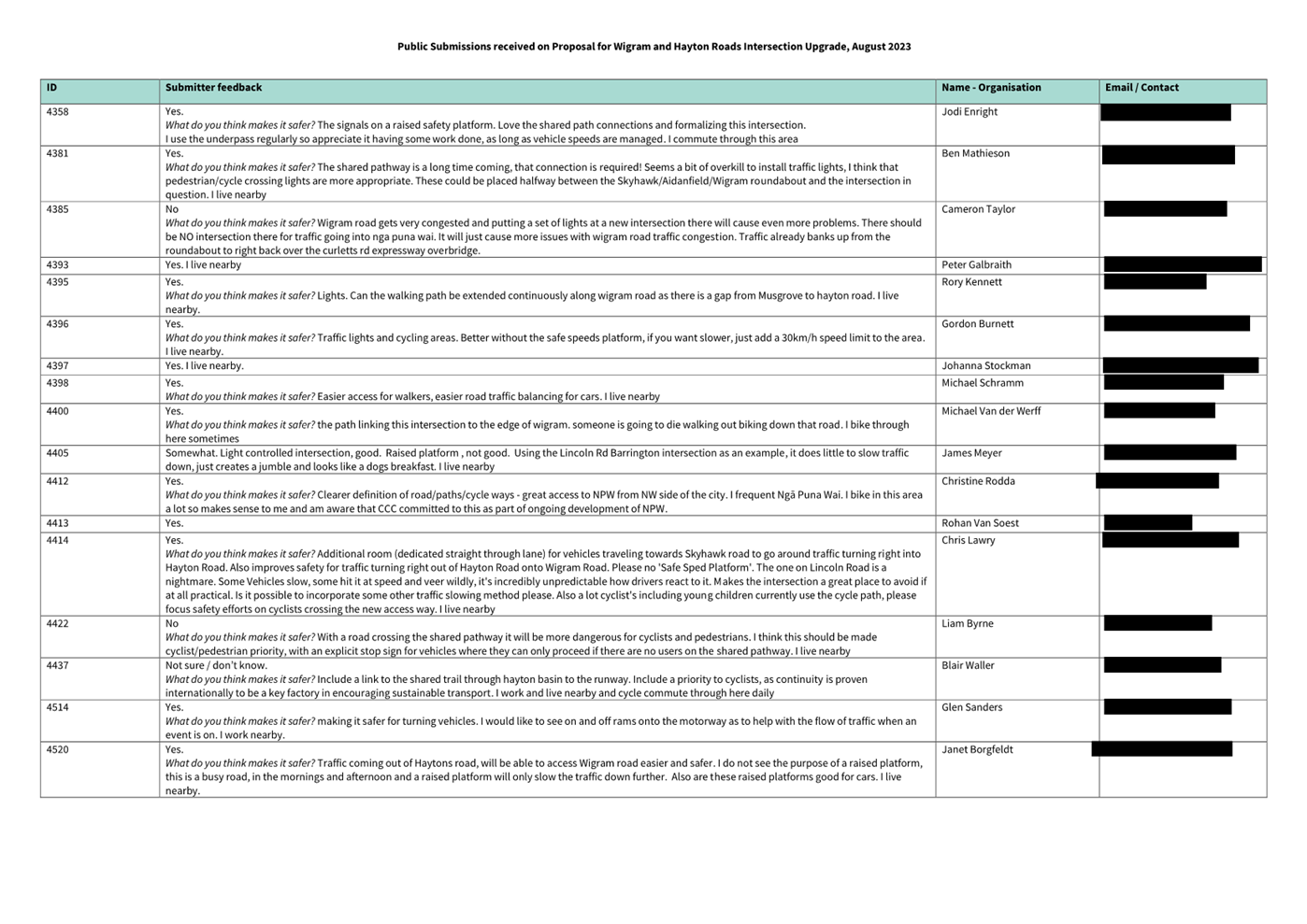
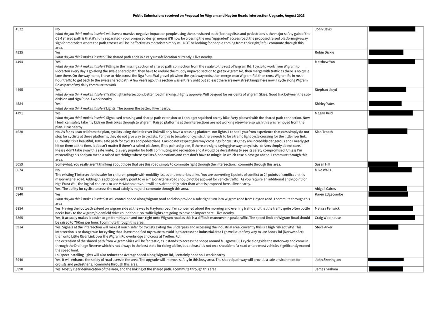
3.1 Wigram
Road is an arterial road with approximately 13,700 vehicles per day and Hayton
Road is a collector road with approximately 2,800 vehicles per day. The
existing shared path on the north side of Wigram Road starts at the
Wigram/Skyhawk Roads roundabout and ends near Hayton Reserve, approximately 250
metres west of the Wigram/Hayton Roads intersection. There are no footpaths or crossing
facilities along this section of Wigram Road to provide safe access for
pedestrians and cyclists to the MCR Little River Link.
3.2 Following
the opening of the Ngā Puna Wai Sports Hub
in 2018, residents in the Aidanfield area have raised concerns about the
traffic and parking issues due to the single entrance to the Ngā Puna Wai Sports Hub from Augustine Drive.
3.3 An
original proposal was developed, which completed the link from the existing
shared path to the intersection, and upgraded the intersection to improve
crossing facilities, but did not address the access to Ngā
Puna Wai. This was brought to the Community Board on 30 November 2021
where the design was approved where delegations applied, with other elements
referred to Council to approval. This was then dropped from the Council agenda
of 10 February 2022.
3.4 The
development of a Netsal facility at Ngā Puna Wai
has resulted in access needing to be provided to the facility through
the existing motorway underpass by the Wigram-Hayton intersection. This has
resulted in the intersection being upgraded from a T-intersection to a 4-way
intersection.
3.5 The
revised recommended option will improve safety and accessibility for the
community by signalising the Wigram/Hayton Roads intersection with a raised
safety platform. This option incorporates the following aspects.
· Replacement of the existing three-way priority-controlled
intersection with a four-way signalised intersection with a raised platform to
reduce operating speeds through the intersection and provide a safer
environment for all road users.
· The existing access to the Ngā Puna Wai Sports Hub (Ngā
Puna Wai Access Road) via the Christchurch Southern Motorway (CSM) underpass will
be sealed, narrowed and connected to the proposed signalised intersection.
· The Ngā Puna Wai Access Road will only be open to light
vehicles between 6am and 11pm. Full time pedestrian and cycle access will not
be affected. The existing 2.4 metres height restriction on the Ngā Puna
Wai Access Road will be maintained.
· Cycle and pedestrian crossing facilities such as signalised
crosswalk, cycle lane, Advanced Stop Boxes and hook-turn boxes will be provided
at the signalised intersection.
· A shared path will be provided on the northern side of Wigram Road
connecting the existing shared paths terminating near Hayton Reserve to the
Wigram/Hayton interchange, from where pedestrians and cyclists can access the
MCR Little River Link.
· The MCR Little River Link cycle crossing on Ngā Puna Wai Access
Road will be moved away from the underpass to improve
visibility between crossing cyclists and vehicles passing through the motorway
underpass culvert and will be upgraded to a crossing with a raised safety platform where vehicles stop for
crossing cyclists.
· Removal of 34 on-street parking spaces due to accommodate turning
lanes and road widening. This includes five on Hayton Road, three on Wigram
Road north-east and 26 on Wigram Road south-west.
· Introducing five new trees and new landscaping in the street
reservation to improve amenity.
3.6 This
option provided the greatest benefit for vulnerable road users safety and
connectivity due to the signalised crossings across all four legs of the
intersection and connectivity between the existing and proposed cycle lanes.
3.7 This
option also allows for direct control and direction of access restriction on
the Ngā Puna Wai Access Road.
4. Alternative Options Considered Ētahi atu Kōwhiringa
Priority controlled intersection option
4.1 This
option proposed a priority-controlled intersection with Ngā Puna Wai
Access Road connected to the intersection.
4.2 The
advantages of this option include:
4.2.1 It has the lowest
capital construction cost and easiest constructability due to the smallest
intervention extent to the existing roads.
4.3 The
disadvantages of this option include:
4.3.1 There is an overall
negative impact on the safety of vulnerable road users, mainly due to the lack
of priority crossing facilities for pedestrians and cyclists at the
intersection.
4.3.2 The safety of
motorists will also be compromised by the additional approach to the intersection
(Ngā Puna Wai Access Road), as this introduces additional conflict points.
4.3.3 Time restricted
access to Ngā Puna Wai would be difficult to implement.
Roundabout with raised safety platform option
4.4 This
option proposed a four-leg roundabout with raised safety platforms on all the
approaches to the intersection.
4.5 This
option provides improvements for safety and connectivity for vulnerable road
users compared to the priority controlled intersection option described in
paragraph 4.1 above.
4.6 The
disadvantages of this option include:
4.6.1 Safety concerns about
pedestrian and cycle crossing facilities will not be addressed.
4.6.2 A roundabout would
require significant road re-alignment, seal widening and land acquisition from
neighbouring park lands which would also increase construction costs and
project timeframes.
4.6.3 Time restricted
access to Ngā Puna Wai would be difficult to implement.
5. Detail Te Whakamahuki
5.1 This
project was initiated in 2019 to complete a safe linkage for pedestrians and
cyclists between the Hayton Reserve and the Wigram/Hayton Roads intersection,
and to provide safety facilities at the intersection. This supported the growth
in subdivisions in the area.
5.2 The Ngā Puna Wai Sports Hub opened in 2018
has an entrance only from Augustine Drive at Aidanfield, which has caused some
challenges with traffic and parking. In 2020, the Council agreed to lease land
in Ngā Puna Wai to the Christchurch Netball Centre to build a new indoor Netsal
Centre, which would attract more traffic to the Ngā Puna Wai.
5.3 There
is a private access road to
Ngā Puna Wai from Wigram Road on Council land. It
is a gravel access road with a wide entrance. It has a 2.4 metre height
restriction as it passes through the State Highway 76 underpass culvert. The
access road is currently closed to vehicular traffic and is only opened for
major events such as the New Zealand Agricultural Show.
5.4 The
scope of this project has therefore been extended to include upgrading the
existing private access road to the Ngā Puna Wai Sports Hub from the
Wigram/Hayton Roads intersection to share the traffic load from the main access
to Ngā Puna Wai from Augustine Drive at Aidanfield.
5.5 This
proposal combines the two main objectives by proposing a signalised
intersection. It provides a shared path link for the long missing section of
shared path on Wigram Road. It also improves safe connections for all road
users at the Wigram/Hayton Roads intersection, including an alternative access
point to the Ngā Puna Wai Sports Hub from Wigram Road.
5.6 The
Ngā Puna Wai Access Road from Wigram Road will be upgraded for vehicle
access between 6:00 am and 11:00 pm. Full time pedestrian and cycle access will
not be affected. The Ngā Puna Wai Access Road will only allow light
vehicles due to the 2.4 metre height restriction of the motorway underpass
culvert.
5.7 The decision affects the following wards/Community Board areas:
5.7.1 Waipuna
Halswell-Hornby-Riccarton Community Board
6. Community Views and Preferences Ngā mariu
ā-Hāpori
Public Consultation Te Tukanga
Kōrerorero
6.1 Businesses
at the Hayton Road/ Avenger Crescent/Ballarat Way intersection were engaged
early in May 2023 to understand the concerns and get feedback on the Wigram
Road and Hayton Road Intersection. Staff advised businesses of public
consultation on Wigram and Hayton Road intersection upgrade occurring later in
the year.
6.2 Staff
attended Halswell Residents Association on 31 July to discuss this project to
get early feedback and understand residents concern around the intersection.
Feedback from this meeting informed the online Frequently Asked Questions of
the consultation.
6.3 Consultation
started on 7 August and ran until 27 August 2023. An email was sent to 45 key
stakeholders, including Police, St Johns, Fire and Emergency, Spokes, and AA inviting
submissions online through Social Pinpoint platform , email or phone call. A printed
submission form for those wanting to make handwritten submissions were
available upon request.
6.4 The
consultation was posted on the Halswell/ Westlake/ Wigram/ Aidanfield/ Kennedys
Bush Community Facebook Group and the Social
Pinpoint platform link was shared by Councillor Andrei Moore Facebook page,
Reddit Christchurch review, and Wigram MP Megan Woods Facebook page. Signage
was also installed around the Nga Puna Wai access and shared path on Wigram
Road.
6.5 During
consultation, 25 businesses in the local area were visited with posters to
inform them and their customers of the consultation.
Summary of Submissions Wigram and Hayton Road Intersection Upgrade
6.6 54
submissions were made on the project via Social Pinpoint platform, with three email submissions
made by the Disabled Persons Assembly and the Halswell Residents Association
and a late submission by an individual ID#7293.
6.7 Submitters
were asked if the Intersection upgrade would improve safety.
|
Do you think this intersection upgrade
will improve safety?
|
Number of submitters
|
|
Agree
|
43 (79.62%)
|
|
Disagree
|
6 (11.11%)
|
|
Somewhat
|
3 (5.55%)
|
|
Not sure / Don’t know
|
2 (3.70%)
|
6.8 Of
those 22 submitters who live in the area, 17 thought the intersection would be
improved, 3 disagreed, 1 submitter said “somewhat” and 1 submitter
said Not sure/ don’t know. 
6.9 Of
those 27 submitters that commute through including those who frequent Ngā
Puna Wai and who selected “other”, 22 agreed that the
upgrade to the intersection would improve safety, 3 disagreed, 1 submitter said
“somewhat,” and 1 submitter said, “not sure / don’t
know.”
6.10 Of those five
submitters who work in the area, all five submissions agree that the
intersection upgrade would improve safety.
6.11 Key themes from
the submissions are summarised below.
|
Key themes on existing intersection
|
Total number of submissions that mention
|
|
Concerns about
safer speeds at existing intersection
· Comments on the current unsafe road user
behaviour through this intersection.
|
15
|
|
Concerns about
traffic flow at existing intersection
· Comments on the increase of traffic during
peak times and at times when events are on at Ngā Puna
Wai.
|
12
|
|
Key themes on outcomes of the proposed upgrade
|
Total number of submissions that mention
|
|
Supportive of
shared path
|
14
|
|
Supportive of
raised safety platforms
· Rationales of encouraging
safer speeds, beneficial traffic calming effects
|
7
|
|
Supportive of cycle
connection.
· Connection from suburbs and places
|
18
|
Changes made to the scheme design as a result of consultation
feedback.
6.12 Cycle on/off
ramps added between the shared path and on-road cycle lane on Wigram Road.
6.13 Additional speed
hump signs added on the Wigram Road approaches to the intersection.
6.14 Cycle hook turn
boxes added at the intersection.
6.15 Priority control
for vehicles on the Ngā Puna Wai Access
Road changed from 'give way' to 'stop' to the raised cycle crossing.
7. Policy
Framework Implications Ngā Hīraunga ā- Kaupapa
here
Strategic AlignmentTe Rautaki
Tīaroaro
7.1 This project is in alignment with the Christchurch Transport
Strategic Plan 2012, the Draft Christchurch Transport Plan 2022 and the
Christchurch District Plan.
7.2 This report supports the Council's
Long Term Plan (2021 - 2031):
7.3 Transport
7.3.1 Activity: Transport
· Level
of Service: 10.0.2 Increase the share of non-car modes in daily trips -
>=36% of trips undertaken by non-car modes
· Level
of Service: 10.0.41 Reduce emissions and greenhouse gases related to transport
- <=1.10 million tonnes of CO2 equivalents
· Level
of Service: 10.5.2 Improve the perception that Christchurch is a cycling
friendly city - >=66% resident satisfaction
· Level
of Service: 16.0.2 Improve roadway condition, to an appropriate national
standard, measured by smooth travel exposure (STE) - >=75% of the sealed
local road network meets the appropriate national standard
· Level
of Service: 16.0.8 Maintain the condition of footpaths - >=81% footpaths
rated 1,2 or 3
· Level
of Service: 16.0.10 Maintain the perception that Christchurch is a walking
friendly city - >=85% resident satisfaction
Policy Consistency Te Whai Kaupapa here
7.4 The decision is consistent with Council’s Plans and Policies.
Impact on Mana Whenua Ngā Whai Take
Mana Whenua
7.5 The decision
does not involve a significant decision in relation to ancestral land or a body
of water or other elements of intrinsic value, therefore this decision does not
specifically impact Mana Whenua, their culture and traditions.
7.6 The decision
does not involve a matter of interest to Mana Whenua and will not impact on our
agreed partnership priorities with Ngā Papatipu
Rūnanga.
Climate Change Impact Considerations Ngā
Whai Whakaaro mā te Āhuarangi
7.7 The decisions in this report are likely to:
7.7.1 Contribute positively
to adaptation to the impacts of climate change.
7.7.2 Contribute positively
to emissions reductions.
7.8 The proposal contributes positively to adaption to the impacts of
climate change and emissions reductions as it includes measures to encourage
walking and cycling, thereby reducing vehicle emissions. It also includes a new
vehicular access point to the Ngā
Puna Wai Sports Hub from Wigram Road, thereby reducing vehicular travel
distances and emissions for those travelling to Ngā Puna Wai from the
northern area. These changes will help to achieve the
desired community outcome of a safe and accessible city through improved road
safety, improved pedestrian and cycle facilities and walking and cycling
networks.
Accessibility Considerations Ngā Whai
Whakaaro mā te Hunga Hauā
7.9 This proposal significantly improves accessibility for pedestrians
and cyclists by providing a shared path link for the long missing section of
shared path on Wigram Road from Hayton Reserve to the Wigram/Hayton Roads
intersection and crossing facilities at the proposed signalised intersection to
facilitate safe access to the MCR Little River Link.
7.10 This proposal also significantly
improves vehicular access to the Ngā Puna Wai Sports Hub by providing an
additional access point from Wigram Road to share the traffic load from the
existing main and only access point from Augustine Drive.
8. Resource Implications Ngā Hīraunga Rauemi
Capex/Opex Ngā Utu Whakahaere
8.1 Cost
to Implement – The total project budget is $2,979,985.
8.2 Maintenance/Ongoing
costs - There will be an increased operational cost of approximately $2,700 per
annum for the maintenance works associated with the proposed traffic signs,
road marking and street cleaning. These works will be covered under the area
maintenance contract.
8.3 Funding
Source - This project has been funded in the Council’s capital programme
as follows:
· 42027 Wigram & Hayton Intersection Improvement
Other He mea anō
8.4 Not
applicable.
9. Legal Implications Ngā Hīraunga ā-Ture
Statutory power to undertake proposals in
the report Te Manatū Whakahaere Kaupapa
9.1 The
Christchurch City Council Traffic and Parking Bylaw 2017, the Land Transport
Rule: Traffic Control Devices 2004 and Part 21 of the Local Government Act 1974
provide the Council with the authority to approve traffic lights, special
vehicle lanes and to declare the Ngā Puna Wai Access Road on the Council
land to be used as public road.
9.2 The
Community Boards have delegated authority from the Council to exercise the
delegations as set out in the Register of Delegations. The list of delegations
for the Community Boards includes the resolution of stopping restrictions and
traffic control devices.
9.3 The
installation of any signs and/or markings associated with traffic control
devices must comply with the Land Transport Rule: Traffic Control Devices 2004.
Other Legal Implications Ētahi atu
Hīraunga-ā-Ture
9.4 There
is no legal context, issue, or implication relevant to this decision.
9.5 This
specific report has not been reviewed and approved by the Legal Services Unit,
however the report has been written using a general approach previously
approved by the Legal Services Unit, and the recommendations are consistent
with the policy and legislative framework outlined above.
10. Risk Management Implications Ngā Hīraunga Tūraru
10.1 There are
currently no departures from any standards or policies.
Attachments Ngā Tāpirihanga
|
No.
|
Title
|
Reference
|
Page
|
|
a
|
Wigram-Hayton
Roads Intersection Improvement Scheme Plan for Approval
|
23/1561226
|
|
|
b
|
Wigram Hayton
Road Intersection - Submission Table (Public)
|
23/1568090
|
|
In addition to the attached documents, the following background
information is available:
Confirmation of Statutory
Compliance Te Whakatūturutanga ā-Ture
|
Compliance with Statutory Decision-making
Requirements (ss 76 - 81 Local Government Act 2002).
(a) This report contains:
(i) sufficient information about all reasonably practicable
options identified and assessed in terms of their advantages and
disadvantages; and
(ii) adequate consideration of the views and preferences of
affected and interested persons bearing in mind any proposed or previous
community engagement.
(b) The information reflects the level of significance of the
matters covered by the report, as determined in accordance with the Council's
significance and engagement policy.
|
Signatories Ngā Kaiwaitohu
|
Author
|
David Sun -
Project Manager
|
|
Approved By
|
Oscar Larson -
Team Leader Transport Project Management
Tony
Richardson - Finance Business Partner
Jacob Bradbury
- Manager Planning & Delivery Transport
Lynette Ellis
- Head of Transport & Waste Management
|
|
Council
01 November 2023
|
|
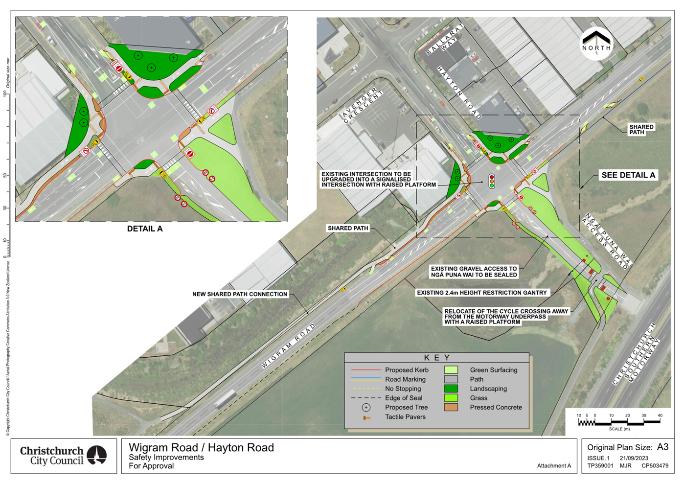
|
Council
01 November 2023
|
|
Report from Waihoro Spreydon-Cashmere-Heathcote
Community Board – 12 October 2023
|
11. Reserve
Revocation 112R Bridle Path Road
|
|
Reference Te Tohutoro:
|
23/1693993
|
|
Report of Te Pou Matua:
|
Stuart
McLeod, Property Consultant, stuart.mcleod@ccc.govt.nz
|
|
Senior Leader Pouwhakarae:
|
Mary
Richardson, General Manager Citizens & Community
(Mary.Richardson@ccc.govt.nz)
|
Purpose and Origin of Report Te Pūtake Pūrongo
1.1 112R Bridle Path Road was declared surplus in the Councils
2021 - 2031 Long Term Plan. To help facilitate the disposal of this property a
Council resolution revoking the reserve status is required.
1.2 Section 24 of the Reserves Act 1977 requires a resolution
from a local authority to enable the Minister of Conservation to publish a
revocation of a reserve in the New Zealand Gazette.
|
1. Waihoro Spreydon-Cashmere-Heathcote Community Board Recommendation
to Council
|
|
|
(Original Officer
recommendations accepted without change)
Part A
That the Council:
1. Notes that the Council as part of its 2021 – 2031 Long Term
considerations declared the property at 112R Bridle Path Road surplus to the
Council’s requirements.
2. Noting the Minister of Conservation does not require public
notification of the proposal to revoke the Local Purpose Drainage Reserve
status of the land at 112R Bridle Path Road by virtue of section 24(7) of the
Reserves Act 1977;
a. Revokes the Local Purpose Drainage Reserve situated at 112R Bridle
Path Road being 3220 square metres described as Lot 3 DP 403583 and
b. Requests the Minister of Conservation to publish the revocation of
the reserve in the New Zealand Gazette under Section 24 of the Reserves Act
1977.
3. Approves that the Property Consultancy Manager be delegated the
authority to manage and conclude all transactions required to finalise the
revocation process.
Callum Ward/Tim Scandrett
|
Attachments Ngā Tāpirihanga
|
No.
|
Report Title
|
Reference
|
Page
|
|
1
|
Reserve Revocation 112R Bridle Path
Road
|
22/1660608
|
137
|
|
No.
|
Title
|
Reference
|
Page
|
|
a ⇩ 
|
Attachment 1 LTP
resolutions
|
22/1728961
|
141
|
|
b
|
304/6434 signed
agreement for sale and purchase dated 17 July 2023 (Under Separate Cover)
- Confidential
|
23/1115835
|
|
|
Council
01 November 2023
|
|
|
Reserve Revocation 112R Bridle Path Road
|
|
Reference / Te Tohutoro:
|
22/1660608
|
|
Report of / Te Pou Matua:
|
Stuart
McLeod, Property Consultant, stuart.mcleod@ccc.govt.nz
|
|
General Manager / Pouwhakarae:
|
Jane
Davis, General Manager Infrastructure, Planning & Regulatory Services
(jane.davis@ccc.govt.nz)
|
1. Nature of Decision or Issue and Report Origin
1.1 112R Bridle Path Road was declared surplus in the Councils
2021 - 2031 Long Term Plan. To help facilitate the disposal of this property a
Council resolution revoking the reserve status is required.
1.2 Section 24 of the Reserves Act 1977 requires a resolution
from a local authority to enable the Minister of Conservation to publish a
revocation of a reserve in the New Zealand Gazette.
1.3 The
decisions in this report are of low significance in relation to the
Christchurch City Council’s Significance and Engagement Policy. The
level of significance was determined by the Councils previous decision to
dispose of this land.
2. Officer Recommendations Ngā Tūtohu
That the Waihoro
Spreydon-Cashmere-Heathcote Community Board recommends to Council that it:
1. Notes that the Council as part of its 2021 – 2031 Long Term
considerations declared this property surplus.
2. Noting the Minister of Conservation does not require public
notification of the proposal to revoke the Local Purpose Drainage Reserve
status of the land at 112R Bridle Path Road by virtue of section 24(7) of the
Reserves Act 1977;
a. Revokes the Local Purpose Drainage Reserve situated at 112R Bridle
Path Road being 3220m² described as Lot 3 DP 403583 and
b. Requests the Minister of Conservation to publish the revocation of
the reserve in the New Zealand Gazette under Section 24 of the Reserves Act
1977.
3. Approves that the Property Consultancy Manager be delegated the
authority to manage and conclude all transactions required to finalise the
revocation process.
3. Reason for Report Recommendations Ngā Take mō te Whakatau
3.1 Without
revoking the reserve status of the land Council are unable to dispose of this
property as resolved in the 2021 – 2031 Long Term Plan (Attachment 1).
The recommendations in this report will enable disposal to the former owner
under section 40 of the Public Works Act 1981 who remains the owner of the
adjoining parcel of land.
4. Alternative Options Considered Ētahi atu Kōwhiringa
4.1 There
are no other alternative options, this report is solely about enabling the 2021
– 2031 Long Term Plan decision to dispose of this property.
5. Detail Te Whakamahuki
5.1 112R
Bridle Path Road is located on the eastern side of the road and is near the
Martindales Road intersection. Council purchased this property in 2008 for a
Local Purpose Drainage Reserve along with three other properties to realign
Matuku Drain across the four properties as shown below.
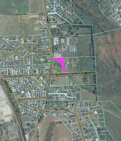
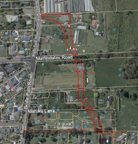
5.2 Subsequent
detailed design identified key concerns with constructing an open waterway
across the natural slope in loess soil, managing overflows for overdesign flood
events and potential downstream impacts.
5.3 As
a result of these concerns on 24 March 2016 Council approved an alternative
pipeline diversion running along Bridle Path Road that collects inflows from
the Heathcote Valley Drain to the east of Bridle Path Road.
5.4 112R
Bridle Path Road was no longer required for drainage and was placed onto a list
of properties for potential disposal that were consulted on as part of
the 2021 – 2031 Long Term Plan. Council subsequently declared it surplus
and it is available for sale, subject to completion of the requirements of
section 24 of the Reserve Act 1977.
5.5 Section
24 sets out the process to revoke a reserve status subject to public
notification (if required), and authorises the Minister of Conservation to
revoke a reserve status.
5.6 The
Minister of Conservation has advised that public notification is not required
by virtue of the provisions of section 24(7). The Minister has however
requested that the local Rununga are consulted directly and any response
forwarded to her including advising if there was no response.
5.7 If the reserve
status is revoked Council then have a statutory obligation under section 40 of
the Public Works Act 1981 to offer the land to the person from whom it was
acquired. In this case those persons remain the adjoining owners and have
agreed to purchase the property a price agreed by valuers acting for the
respective parties.
5.8 The agreement is
conditional upon the Council determining to revoke the reserve status and the
successful completion of the revocation process. A copy of the agreement is
available as a public excluded attachment and can be released once settlement
has occurred.
5.9 The decision affects the following wards/Community Board areas:
5.9.1 Heathcote Ward of the
Waihoro Spreydon-Cashmere-Heathcote Community Board
6. Policy
Framework Implications Ngā Hīraunga ā- Kaupapa
here
Strategic AlignmentTe Rautaki
Tīaroaro
6.1 This report supports the Council's
Long Term Plan (2021 - 2031).
Policy Consistency Te Whai Kaupapa here
6.2 The decision is consistent with Council’s Plans and Policies. This report will
enable Council to dispose of this property in accordance with the decisions
made in the 2021 – 2031 Long Term Plan.
Impact on Mana Whenua Ngā Whai Take
Mana Whenua
6.3 The decision does not involve a significant decision in relation to
ancestral land or a body of water or other elements of intrinsic value,
therefore this decision does specifically impact Mana Whenua, their culture and
traditions.
6.4 The decision does not involve a matter of interest to Mana Whenua and will not impact on our agreed partnership priorities
with Ngā Papatipu Rūnanga
6.5 Mana Whenua were consulted as part of the Councils Long Term Plan
consultation in 2021, and again in relation to the revocation of the reserve
status at the request of the Minister of Conservation, no objections were
raised.
Climate Change Impact Considerations Ngā
Whai Whakaaro mā te Āhuarangi
6.6 The decisions in this report have no impact on climate change, all
they do is put a mechanism in place to revoke the reserve status of the land.
Accessibility Considerations Ngā Whai
Whakaaro mā te Hunga Hauā
6.7 The decisions in this report have no relevant accessibility
considerations. The property will be privately owned and occupied.
7. Resource Implications Ngā Hīraunga Rauemi
Capex/Opex Ngā Utu Whakahaere
7.1 Cost
to Implement - Nil
7.2 Maintenance/Ongoing
costs - Nil
7.3 Funding
Source – n/a
8. Legal Implications Ngā Hīraunga ā-Ture
Statutory power to undertake proposals in
the report Te Manatū Whakahaere Kaupapa
8.1 Section
24 of the Reserves Act 1977 enables the Minister of Conservation to revoke
reserve status, the decisions in this report will enable an application to be
made to the Minister to revoke that reserve.
Other Legal Implications Ētahi atu
Hīraunga-ā-Ture
8.2 This
is a procedural matter and therefore there is no legal context, issue or
implication relevant to this decision.
9. Risk Management Implications Ngā Hīraunga Tūraru
9.1 Having
already declared the land surplus in the 2021 – 2031 Long Term Plan there
is reputational risk if the recommendations in this report are not adopted.
Attachments Ngā Tāpirihanga
|
No.
|
Title
|
Reference
|
Page
|
|
a
|
Attachment 1
LTP resolutions
|
22/1728961
|
|
|
b
|
304/6434
signed agreement for sale and purchase dated 17 July 2023 (Under Separate
Cover) - Confidential
|
23/1115835
|
|
In addition to the attached documents, the following background
information is available:
|
Document
Name – Location / File Link
|
|
Not
applicable
|
Confirmation of Statutory
Compliance Te Whakatūturutanga ā-Ture
|
Compliance with Statutory Decision-making
Requirements (ss 76 - 81 Local Government Act 2002).
(a) This report contains:
(i) sufficient information about all reasonably practicable
options identified and assessed in terms of their advantages and
disadvantages; and
(ii) adequate consideration of the views and preferences of
affected and interested persons bearing in mind any proposed or previous
community engagement.
(b) The information reflects the level of significance of the
matters covered by the report, as determined in accordance with the Council's
significance and engagement policy.
|
Signatories Ngā Kaiwaitohu
|
Author
|
Stuart McLeod
- Property Consultant
|
|
Approved By
|
Angus Smith -
Manager Property Consultancy
Bruce Rendall
- Head of City Growth & Property
|
|
Council
01 November 2023
|

|
|
12. Christchurch Wastewater Treatment Plant
Independent Review
|
|
Reference / Te Tohutoro:
|
23/1542706
|
|
Report of / Te Pou Matua:
|
Nicholas
Hill, Head of Risk & Assurance (Nicholas.Hill@ccc.govt.nz), Pat
Dougherty, Consulting Partner (Pat.Dougherty@tregaskisbrown.co.nz)
|
|
Senior Manager / Pouwhakarae:
|
Mary
Richardson, General Manager Citizens & Community (Mary.Richardson@ccc.govt.nz)
|
1. Purpose and Origin of Report Te Pūtake Pūrongo
1.1 To provide the Council with the final report of the
Christchurch Wastewater Treatment Plant independent review on fire response and
recovery.
1.2 This report has been generated by Risk and Assurance - but
the review was performed by an independent external consultant.
2. Officer Recommendations Ngā Tūtohu
That the Council:
1. Receive the information in the Christchurch Wastewater Treatment
Plant Independent Review Report.
2. Receive the final Christchurch Wastewater Treatment Plant
Independent Report.
3. Receive the Improvement Plan.
3. Brief Summary
3.1 On
1 November 2021, a fire at the Christchurch Wastewater Treatment Plant (CWTP)
destroyed two trickling filters and resulted in a significant recovery
operation spanning the technical response through to the community response.
3.2 Council
specifically requested that an independent review be conducted to consider the
Council’s performance through the recovery and to identify lessons for
Council. The review was commissioned by Risk and Assurance on behalf of the
Chief Executive Officer. Once commenced, the review process was supported /
facilitated by Risk and Assurance.
3.3 A
competitive tender process was initiated via the GETS platform in late December
2022 and was awarded to Wellington based consultancy firm, Tregaskis Brown Ltd,
in early 2023. The lead independent reviewer appointed was Pat Dougherty. Pat
is a highly suitable reviewer with a deep understanding of the context through
past roles as Nelson City Council CEO and wastewater engineer.
3.4 The
review gathered information from publicly available sources, Council documents,
Council meetings, current and former staff / Elected Member interviews.
Importantly there were clear representatives from community members and from
groups affected, including iwi, pre-schools, education, and health.
3.5 The
final report has been attached as Attachment A.
3.6 One
minor redaction has been made in the report due to commercially sensitive
matters under the Local Government Official Information and Meetings Act 1987.
3.7 The
Council has completed the improvement plan which details the recommendations
raised in the report, actions that are currently in place, and proposed further
actions to promote continuous improvement and lessons learnt. The improvement
plan was endorsed by the ELT on 5 October.
3.8 The
improvement plan has been attached as Attachment B.
3.9 A
communications plan has been developed to support the public release of the
report. As part of this plan, those people who were interviewed have been
updated on the report’s findings and the improvement plan prior to the
public release of the report. The Council will also make sure that the report
is widely available, both electronically and in hard copy form from the Linwood
Library and Service Centre, New Brighton Library, Shirley Library and Service
Centre, Bromley Community Centre, Ngā Hau E Whā Marae, and The Loft.
Attachments Ngā Tāpirihanga
|
No.
|
Title
|
Reference
|
Page
|
|
a ⇩ 
|
Christchurch
Wastewater Treatment Plant Independent Report
|
23/1748979
|
145
|
|
b ⇩
|
Improvement
Plan
|
23/1748980
|
190
|
In addition to the attached documents, the following background
information is available:
|
Document
Name – Location / File Link
|
|
Not
applicable
|
Confirmation of Statutory
Compliance Te Whakatūturutanga ā-Ture
|
Compliance with Statutory Decision-making
Requirements (ss 76 - 81 Local Government Act 2002).
(a) This report contains:
(i) sufficient information about all reasonably practicable
options identified and assessed in terms of their advantages and
disadvantages; and
(ii) adequate consideration of the views and preferences of
affected and interested persons bearing in mind any proposed or previous
community engagement.
(b) The information reflects the level of significance of the
matters covered by the report, as determined in accordance with the Council's
significance and engagement policy.
|
Signatories Ngā Kaiwaitohu
|
Authors
|
Nicholas Hill
- Head of Risk & Assurance
Min Jang -
Senior Internal Auditor
|
|
Approved By
|
Mary
Richardson - General Manager Citizens & Community
|
|
Council
01 November 2023
|

|
|
13. Approval of Transport Choices - Linwood Bus Stop
Improvements (CERF)
|
|
Reference / Te Tohutoro:
|
23/1388550
|
|
Report of / Te Pou Matua:
|
Chris
Strydom, Transport Project manager (Chris.Strydom@ccc.govt.nz)
|
|
Senior Manager / Pouwhakarae:
|
Mary
Richardson, General Manager Citizens & Community (Mary.Richardson@ccc.govt.nz)
|
1. Purpose and Origin of Report Te Pūtake Pūrongo
1.1 The purpose of this report is for Christchurch City Council
(Council) to approve bus stop improvements to 14 locations including the
installation of 11 shelters in the Linwood area.
1.2 The origin of this report is the Climate Emergency Response
Fund (CERF) Transport Choices programme.
1.3 Bus
stop infrastructure upgrades are proposed at locations along the following
public transport corridors:
· Woodham Road as shown on Attachment
A
· Tuam Street and St Asaph
Street as shown on Attachment B
· Hereford Street and
Stanmore Road as shown on Attachment C
1.4 The
new / upgraded bus stops include, but are not limited to, line marking, seats,
improved lighting, shelters, footpaths and kerbs.
1.5 The
decisions in this report are of medium significance in relation to the
Christchurch City Council’s Significance and Engagement Policy. The
level of significance was determined by evaluation of the Transport Choices
programme against the criteria set out in the Policy. This evaluation has
considered the Transport Choices projects as a cohesive programme of
work. This is consistent with how community engagement has been
undertaken, with all work packages being presented concurrently on ‘Have
your Say’ under the banner of ‘Way Safer Streets’.
1.6 Council
resolved the Transport Choices programme as Metropolitan Significance when the
programme was included in the draft Annual Plan in February 2023.
1. Officer Recommendations Ngā
Tūtohu
That the Council, in
accordance with Attachments A, B, and C attached to the agenda for this
meeting, approve:
Attachment A -
Woodham Road
Drawing
SK104
Bus stop 51072
– 712 Gloucester Street (Attachment A)
1. Pursuant to Clause 7 of the Christchurch City
Council Traffic and Parking Bylaw 2017:
a. That the stopping of vehicles be prohibited at
all times on the south side of Woodham Road, commencing at a point 56 metres
east of its intersection with Gloucester Street and extending in an
easterly direction for a distance of 7 metres.
b. That a bus stop for scheduled bus services
only (in accordance with the definition of ‘bus service’ in Section
5 of the Land Transport Management Act 2003) be installed on the south side of
Woodham Road, commencing at a point 63 metres east of its intersection with
Gloucester Street and extending in an easterly direction for a distance of 14
metres.
c. That the stopping of vehicles be prohibited at
all times on the south side of Woodham Road, commencing at a point 77 metres
east of its intersection with Gloucester Street and extending in an
easterly direction for a distance of 15 metres.
2. Pursuant to Section 339(1) of the Local
Government Act 1974:
a. The installation of a slim bus passenger
shelter on the south side of Woodham Road immediate to the west of 186 Woodham
Road.
Drawing
SK105
Relocation of Bus
stop 51190 – From 211 Woodham Road to 213 Woodham Road (Attachment A)
3. Pursuant to Clause 7 of the Christchurch City
Council Traffic and Parking Bylaw 2017:
a. That the stopping of vehicles be prohibited at
all times on the north side of Woodham Road, commencing at a point 5 metres
east of its intersection with Ngarimu Street and extending in an easterly
direction for a distance of 19 metres.
b. That a bus stop for scheduled bus services
only (in accordance with the definition of ‘bus service’ in Section
5 of the Land Transport Management Act 2003) be installed on the north side of
Woodham Road, commencing at a point 24 metres east of its intersection with
Ngarimu Street and extending in an easterly direction for a distance of
14 metres.
c. That the stopping of vehicles be prohibited at
all times on the north side of Woodham Road, commencing at a point 38 metres
east of its intersection with Ngarimu Street and extending in an easterly
direction for a distance of 9 metres.
4. Pursuant to Section 339(1) of the Local
Government Act 1974:
a. The installation of a full size bus passenger
shelter on the north side of Woodham Road outside 213 Woodham Road.
Drawing
SK106
Bus stop 36862
– 259A- 259D Woodham Road (Attachment A)
5. Pursuant to Clause 7 of the Christchurch City
Council Traffic and Parking Bylaw 2017:
a. That the stopping of vehicles be prohibited at
all times on the north side of Woodham Road, commencing at a point 36 metres
east of its intersection with Rowcliffe Crescent and extending in an
easterly direction for a distance of 12 metres.
b. That a bus stop for scheduled bus services
only (in accordance with the definition of ‘bus service’ in Section
5 of the Land Transport Management Act 2003) be installed on the north side of
Woodham Road, commencing at a point 48 metres east of its intersection with
Rowcliffe Crescent and extending in an easterly direction for a distance of 14
metres.
c. That the stopping of vehicles be prohibited at
all times on the north side of Woodham Road, commencing at a point 62 metres
east of its intersection with Rowcliffe Crescent and extending in an
easterly direction for a distance of 7 metres.
6. Pursuant to Section 339(1) of the Local
Government Act 1974:
a. The installation of a standard size bus
passenger shelter on the north side of Woodham Road outside 259A Woodham Road.
Bus stop 37174
– 234 Woodham Road (Attachment A)
7. Pursuant to Clause 7 of the Christchurch City
Council Traffic and Parking Bylaw 2017:
a. That the stopping of vehicles be prohibited at
all times on the south side of Woodham Road, commencing at a point 3 metres
west of its intersection with Carnarvon Street and extending in a
westerly direction for a distance of 17 metres.
b. That a bus stop for scheduled bus services
only (in accordance with the definition of ‘bus service’ in Section
5 of the Land Transport Management Act 2003) be installed on the south side of
Woodham Road, commencing at a point 20 metres west of its intersection with
Carnarvon Street and extending in a westerly direction for a distance of 14
metres.
c. That the stopping of vehicles be prohibited at
all times on the south side of Woodham Road, commencing at a point 34 metres
west of its intersection with Carnarvon Street and extending in a westerly
direction for a distance of 6 metres.
8. Pursuant to Section 339(1) of the Local
Government Act 1974:
a. The installation of a slim bus passenger
shelter on the south side of Woodham Road outside 234 Woodham Road.
Attachment B -
Tuam Street and St Asaph Street
Drawing SK201
Bus stop 18718
– 365 and 367 Tuam Street (Attachment B)
9. Pursuant to Clause 7 of the Christchurch City
Council Traffic and Parking Bylaw 2017:
a. That the stopping of vehicles be prohibited at
all times on the north side of Tuam Street, commencing at a point 1 metre west
of its intersection with Livingstone Street and extending in a westerly
direction for a distance of 12 metres.
b. That a bus stop for scheduled bus services
only (in accordance with the definition of ‘bus service’ in Section
5 of the Land Transport Management Act 2003) be installed on the north side of
Tuam Street, commencing at a point 13 metres west of its intersection with
Livingstone Street and extending in a westerly direction for a distance of 14
metres.
c. That the stopping of vehicles be prohibited at
all times on the north side of Tuam Street, commencing at a point 27 metres
west of its intersection with Livingstone Street and extending in a westerly
direction for a distance of 12 metres.
10. Pursuant to Section 339(1) of the Local
Government Act 1974:
a. The installation of a slim bus passenger
shelter on the north side of Tuam Street outside 365 Tuam Street.
Drawing SK202
Relocation of Bus
stop 18787 – From 414 St Asaph Street to 420 St Asaph Street (Attachment
B)
11. Pursuant to Clause 7 of the Christchurch City
Council Traffic and Parking Bylaw 2017:
a. That all existing parking and stopping
restrictions associated with bus stop 18787 on the south side of St Asaph
Street commencing at a point 132 metres west of its intersection with Philips
Street and extending in a westerly direction for a distance of 19 metres, be
revoked.
b. That the stopping of vehicles be prohibited at
all times on the south side of St Asaph Street, commencing at a point 98 metres
west of its intersection with Phillips Street and extending in a westerly
direction for a distance of 14 metres.
c. That a bus stop for scheduled bus services
only (in accordance with the definition of ‘bus service’ in Section
5 of the Land Transport Management Act 2003) be installed on the south side of
St Asaph Street, commencing at a point 112 metres west of its intersection with
Phillips Street and extending in a westerly direction for a distance of 14
metres.
d. That the stopping of vehicles be prohibited at
all times on the south side of St Asaph Street, commencing at a point 126
metres west of its intersection with Phillips Street and extending in a
westerly direction for a distance of 6 metres.
12. Pursuant to Section 339(1) of the Local
Government Act 1974:
a. The installation of a standard size bus
passenger shelter on the south side of St Asaph Street outside 420 St Asaph
Street.
Drawing SK203
Bus stop 18702
– 403 and 407 Tuam Street (Attachment B)
13. Pursuant to Clause 7 of the Christchurch City
Council Traffic and Parking Bylaw 2017:
a. That a bus stop with a seat for scheduled bus
services only (in accordance with the definition of ‘bus service’
in Section 5 of the Land Transport Management Act 2003) be installed on the
north side of Tuam Street, commencing at a point 10 metres east of its
intersection with Gatherer Street and extending in an easterly direction for a
distance of 14 metres.
b. That the stopping of vehicles be prohibited at
all times on the north side of Tuam Street, commencing at a point 24 metres
east of its intersection with Gatherer Street and extending in an easterly
direction for a distance of 6 metres.
Drawing SK204
Bus stop 18938
– 462 Tuam Street (Attachment B)
14. Pursuant to Clause 7 of the Christchurch City
Council Traffic and Parking Bylaw 2017:
a. That the stopping of vehicles be prohibited at
all times on the south side of Tuam Street, commencing at a point 56 metres
east of its intersection with Phillips Street and extending in an easterly
direction for a distance of 6 metres.
b. That a bus stop for scheduled bus services
only (in accordance with the definition of ‘bus service’ in Section
5 of the Land Transport Management Act 2003) be installed on the south side of
Tuam Street, commencing at a point 62 metres east of its intersection with
Phillips Street and extending in an easterly direction for a distance of
14 metres.
c. That the stopping of vehicles be prohibited at
all times on the south side of Tuam Street, commencing at a point 76 metres
east of its intersection with Phillips Street and extending in an easterly
direction for a distance of 12 metres.
15. Pursuant to Section 339(1) of the Local
Government Act 1974:
a. The installation of a standard size bus
passenger shelter on the south side of Tuam Street outside 462 Tuam Street.
Attachment C -
Hereford Street and Stanmore Road
Drawing SK301
Bus stop 53656
– 367 Hereford Street (Attachment B)
16. Pursuant to Clause 7 of the Christchurch City
Council Traffic and Parking Bylaw 2017:
a. That the stopping of vehicles be prohibited at
all times on the north side of Hereford Street, commencing at a point 171
metres east of its intersection with Fitzgerald Avenue and extending in an
easterly direction for a distance of 14 metres.
b. That a bus stop for scheduled bus services
only (in accordance with the definition of ‘bus service’ in Section
5 of the Land Transport Management Act 2003) be installed on the north side of
Hereford Street, commencing at a point 185 metres east of its intersection with
Fitzgerald Avenue and extending in an easterly direction for a distance of 15
metres.
c. That the stopping of vehicles be prohibited at
all times on the north side of Hereford Street, commencing at a point 200
metres east of its intersection with Fitzgerald Avenue and extending in an
easterly direction for a distance of 8 metres.
17. Pursuant to Section 339(1) of the Local
Government Act 1974:
a. The installation of a standard size bus
passenger shelter on the north side of Hereford Street outside 367 Hereford
Street.
Bus stop 53660
– 1/366 - 2/366 Hereford Street (Attachment B)
18. Pursuant to Clause 7 of the Christchurch City
Council Traffic and Parking Bylaw 2017:
a. That the stopping of vehicles be prohibited at
all times on the south side of Hereford Street, commencing at a point 141
metres east of its intersection with Fitzgerald Avenue and extending in an
easterly direction for a distance of 10 metres.
b. That a bus stop for scheduled bus services
only (in accordance with the definition of ‘bus service’ in Section
5 of the Land Transport Management Act 2003) be installed on the south side of
Hereford Street, commencing at a point 151 metres east of its intersection with
Fitzgerald Avenue and extending in an easterly direction for a distance
of 14 metres.
c. That the stopping of vehicles be prohibited at
all times on the south side of Hereford Street, commencing at a point 165
metres east of its intersection with Fitzgerald Avenue and extending in
an easterly direction for a distance of 13 metres.
19. Pursuant to Section 339(1) of the Local
Government Act 1974:
a. The installation of a standard size bus
passenger shelter on the south side of Hereford Street outside 366 Hereford
Street.
Drawing SK302
Bus stop 40323
– 1/138 – 9/138 Stanmore Road (Attachment B)
20. Pursuant to Clause 7 of the Christchurch City
Council Traffic and Parking Bylaw 2017:
a. That a bus stop for scheduled bus services
only (in accordance with the definition of ‘bus service’ in Section
5 of the Land Transport Management Act 2003) be installed on the east side of
Stanmore Road, commencing at a point 27 metres north of its intersection with
Armagh Street and extending in a northerly direction for a distance of 14
metres.
b. That the stopping of vehicles be prohibited at
all times on the east side of Stanmore Road, commencing at a point 41 metres
north of its intersection with Armagh Street and extending in a northerly
direction for a distance of 12 metres.
Drawing SK303
Bus stop 13685
– 1/149 – 5/149 Stanmore Road (Attachment B)
21. Pursuant to Clause 7 of the Christchurch City
Council Traffic and Parking Bylaw 2017:
a. That the stopping of vehicles be prohibited at
all times on the west side of Stanmore Road, commencing at a point 19 metres
north of its intersection with Haast Street and extending in a northerly
direction for a distance of 3 metres.
b. That a bus stop for scheduled bus services
only (in accordance with the definition of ‘bus service’ in Section
5 of the Land Transport Management Act 2003) be installed on the west side of
Stanmore Road, commencing at a point 22 metres north of its intersection with
Haast Street and extending in a northerly direction for a distance of 14
metres.
c. That the stopping of vehicles be prohibited at
all times on the west side of Stanmore Road, commencing at a point 36 metres
north of its intersection with Haast Street and extending in a northerly
direction for a distance of 6 metres.
Drawing SK304
Bus stop 12431
– Beverley Park at 171 Stanmore Road (Attachment B)
22. Pursuant to Clause 7 of the Christchurch City
Council Traffic and Parking Bylaw 2017:
a. That a bus stop for scheduled bus services
only (in accordance with the definition of ‘bus service’ in Section
5 of the Land Transport Management Act 2003) be installed on the west side of
Stanmore Road, commencing at a point 52 metres (measured in a straight line)
south of its intersection with Avonside Drive and extending in a southerly
direction for a distance of 14 metres.
b. That the stopping of vehicles be prohibited at
all times on the west side of Stanmore Road, commencing at a point 66 metres
(measured in a straight line) south of its intersection with Avonside Drive and
extending in a southerly direction for a distance of 12 metres.
23. Pursuant to Section 339(1) of the Local
Government Act 1974:
a. The installation of a standard size bus
passenger shelter on the west side of Stanmore Road outside Beverley Park
Playground.
Relocation of Bus
stop 42944 – From 180 Stanmore Road to 172 Stanmore Road (Attachment B)
24. Pursuant to Clause 7 of the Christchurch City
Council Traffic and Parking Bylaw 2017:
a. That all existing parking and stopping
restrictions associated with bus stop 42944 on the east side of Stanmore Road
commencing at a point 51 metres south of its intersection with Avonside Drive
and extending in a southerly direction for a distance of 13 metres, be revoked.
b. That the stopping of vehicles be prohibited at
all times on the east side of Stanmore Road, commencing at a point 90 metres
south of its intersection with Avonside Drive and extending in a
southerly direction for a distance of 12 metres.
c. That a bus stop for scheduled bus services
only (in accordance with the definition of ‘bus service’ in Section
5 of the Land Transport Management Act 2003) be installed on the east side of
Stanmore Road, commencing at a point 102 metres south of its intersection with
Avonside Drive and extending in a southerly direction for a distance of
14 metres.
d. That the stopping of vehicles be prohibited at
all times on the east side of Stanmore Road, commencing at a point 116 metres
south of its intersection with Avonside Drive and extending in a
southerly direction for a distance of 6 metres.
25. Pursuant to Section 339(1) of the Local
Government Act 1974:
a. The installation of a slim size bus passenger
shelter on the east side of Stanmore Road outside 172 Stanmore Road.
26. That any previous resolutions pertaining to parking and
stopping restrictions made pursuant to any bylaw to the extent that they
conflict with the parking and stopping restrictions described in
recommendations 1 – 29 above are revoked.
27. That, if approved, recommendations 1-29 above
take effect when the parking and stopping restrictions that evidence the
restrictions described in recommendations 1 – 29 above are in place (or
removed, in the case of revocations).
2. Reason for Report Recommendations Ngā Take mō te
Whakatau
2.1 This
project is funded by the Central Government Transport Choices Programme –
a $348 million national programme made available from the Climate Emergency
Response Fund (CERF).
2.2 The
Transport Choices programme is important because transport makes up almost half
of New Zealand’s carbon emissions. In May 2022, government released
its first Emissions Reduction Plan and transport has a significant role to
play, targeting a 20 percent reduction in light vehicle travel by 2035.
Reducing reliance on cars and supporting people to walk, cycle and use public
transport is one of three focus points of the Emissions Reduction Plan.
2.3 The
recommendations in this report meet the below four primary design parameters
for Transport Choices:
· Design for children and mobility impaired.
· Priority to people walking, cycling and using public transport.
· Integration with existing modal networks.
· Designs that
comply with all relevant Waka Kotahi standards and guidelines.
2.4 Measures
that promote the use of public transport help the Council achieve its community
outcomes and strategic framework of providing a well-connected and accessible
city promoting active and public transport, as well as meeting the challenge of
climate change through every means available.
2.5 Figure
1 shows an example of a new generation bus shelter in Christchurch. The bus
shelters will feature solar powered LED lighting to improve the safety and
reinforced toughened glass to provide weather protection.
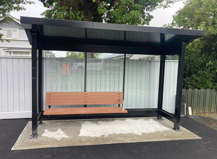
Figure 1: An example of new
generation of bus shelters in Christchurch.
2.6 Bus stops are being reviewed and upgraded within the Linwood area.
Subsequent reports will be presented to Council to approve additional bus stops
within this study area.
2.7 The
benefits of focusing on Linwood as a pilot for future delivery of similar
packages across the city, include:
· This suburb is
located close to the central city with several potential walking and public
transport connections to the central city, eastern suburbs and key activity
centres such as Eastgate shopping mall, Te Pou Toetoe – Linwood Pool, and
the Linwood Library and Service Centre.
· There are several
schools located in and around Linwood creating demand for safe and healthy
school travel and the transport choices programme provides an opportunity for
cluster planning and delivery of benefits to multiple schools at once.
· Linwood is well
placed to enhance connections to significant longer term active transport
programmes such as the Major Cycleways Programme.
· Linwood is
identified as an area where people are more adversely impacted by transport
poverty and access equity so will benefit more from interventions that support
a range of accessible and low-cost transport options. This aligns with
Christchurch’s wider strategic goals of improving transport access and
choice to reduce emissions, while working towards a more equitable transport
system.
2.8 This approach allows the Council to concentrate resources in a
manageable area, maximising delivery under the constrained timeframes, and
supports project integration within a programme of work, which will encourage
multi-modal journeys, reduce vehicle kilometres travelled (VKT) and
emissions. The implementation of these projects aligns with the goals and
outcomes sought by the Emissions Reduction Plan.
2.9 Bus
stops outside the Linwood Area are currently being addressed through the seats
and shelters programme.
Proposed infrastructure improvements
on Woodham Road (Attachment A)
2.10 There
are four bus stops under review for this report, which are serviced by the high
frequency Orbiter, on Woodham Road between Avonside Drive and Kerrs Road. And
two bus stops currently out for consultation that will be covered under a
separate report.
2.11 The
Orbiter operates a 15-minute frequency Monday to Saturday, 10-minute frequency
during peak times, and 30-minute frequency Sunday.
2.12 Environment
Canterbury are currently exploring increasing the frequency of the Orbiter
route as part of the recommendations made in the Greater Christchurch Public
Transport Futures Combined Business Case (PT Futures).
2.13 All
bus stops are proposed to have shelters, road marking, tactile ground surface
indicators and signage in accordance with Council’s
Construction Standard Specification Drawing SD644 (page 35).
2.14 The
existing bus stop spacing is considered adequate along the corridor.
2.15 Figure
2 shows the proposed bus stops along this corridor.
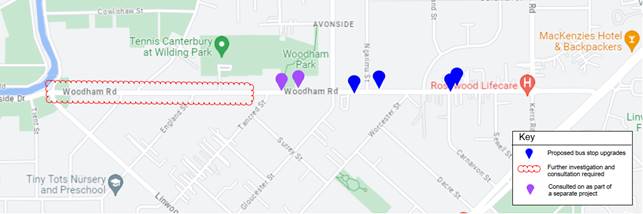
Figure 2: Proposed
locations of bus stops on Woodham Road.
Proposed
infrastructure improvements on Tuam Street and St Asaph Street (Attachment B)
2.16 There
are three bus stops along Tuam Street and one bus stop on St Asaph Street that
are proposed to be upgraded.
2.17 The
corridor is serviced by the city connector Route 80. This route operates to
30-minute frequency every day, and 15-minute frequency during peak times.
2.18 Three
bus shelters and one seat are being proposed along this public transport
corridor. All bus stops are proposed to have road marking, tactile ground
surface indicators and signage in accordance with Council’s Construction
Standard Specification.
2.19 Feedback
was sought on five additional proposed bus stop upgrades along Tuam Street and
Harrow Street. Given the consultation findings, further assessment and
consultation is required before presenting a recommendation to the Council. The
results of this consultation can be found in Attachment E. A detailed report
addressing these bus stops will be submitted to the Council in due course.
2.20 Figure
3 shows the proposed location of the bus stops as described above.
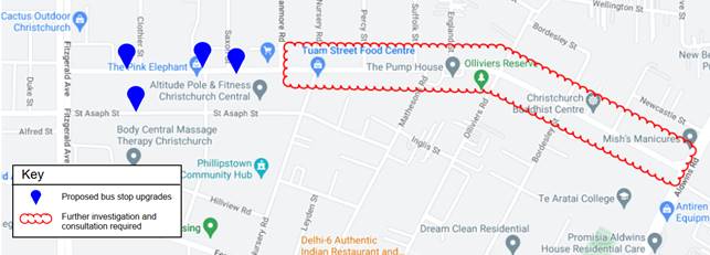 Figure
3: Proposed bus stop upgrades on Tuam Street and St Asaph
Figure
3: Proposed bus stop upgrades on Tuam Street and St Asaph
Proposed infrastructure improvements
on Hereford Street and Stanmore Road (Attachment C)
2.21 There
are two bus stops along Hereford Street and four bus stops on Stanmore Road
between Hereford Street and Avonside Drive proposed to be upgraded.
2.22 This
corridor is serviced by the city connector Route 60. This route predominantly
operates to a 30-minute frequency every day, and 15-minute frequency during
peak times.
2.23 All
bus stops are proposed to have road marking, tactile ground surface indicators
and signage in accordance with Council’s Construction Standard
Specification.
2.24 Four
Bus shelters are being proposed along this public transport corridor.
2.25 The
existing bus stop spacing on Hereford Street and Stanmore Road (between
Hereford Street and Gloucester Street) is considered adequate along the
corridor and no relocations are being proposed.
2.26 Figure
4 shows the proposed location of the bus stops as described above.
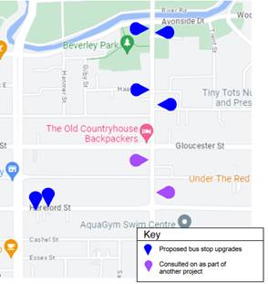
Figure 4:
Proposed locations of bus stops on Tuam Street and Harrow Street.
Proposed infrastructure improvements
(Attachment A, B and C)
2.27 The
advantages of the proposed bus stop upgrades include:
· Bus shelters with lighting
provide a safer environment and provide a protected place to sit and wait.
· The bus stops are
consistently spaced along the corridor, which minimises the delays associated
with stopping / boarding /alighting, and potentially improves the bus journey
time along the corridor.
· Upgrading bus stop road
markings to best practice standards allows a bus to manoeuvre parallel and
close to the existing kerb. This reduces the gap and step between the bus and
the kerb, providing improved accessibility for bus patrons.
· Upgrading bus stop road
markings to best practice standards allows a bus to safely pull out of the stop
to merge into the traffic lane.
· Upgrading the tactile
ground surface indicators will improve access to bus stops for people with a
vision impairment and warn people of the kerb and potential hazards beyond.
2.28 The
disadvantages are:
· At existing bus stops
where road markings have been extended to meet best practice, there may be a
loss of on-street parking. However, nearby on-street parking will be readily
available to accommodate any loss in parking due to bus stop upgrades.
· For relocated bus stops,
there will be a loss in on-street parking at the new location to accommodate
the new stop, however it is expected that some loss of parking will be
re-gained at the old bus stop location.
· The increased spacing
between the relocated bus stops has increased the distance people have to walk
to/from each stop. However, the bus stop spacing is within the Waka Kotahi
guidelines and has generally not reduced the walkable catchment to each bus stop.
· The financial cost of
building and maintaining additional public transport infrastructure.
2.29 The
kerb height impacts the step or ramp up to the bus, while considering the
ground clearance of buses. As per guidance, a standard kerb height of 150
mm is desirable along the length of the passenger hardstand to minimise the
step up or down relative to the bus floor.
2.30 Two
bus stops (ID 18702 and 18938) are being upgraded to a kerb height of 150mm.
Kerb upgrades are based on a kerb
condition assessment. If the existing kerb condition is assessed as poor, then
it is proposed to replace the existing kerb with an improved 150mm high kerb.
Upgrading the remaining bus stops to 150mm kerbs are proposed to be undertaken
with any planned future street renewal works.
3. Alternative Options Considered Ētahi atu Kōwhiringa
3.1 Alternative
options include:
· ‘Do Nothing’
(i.e. to retain existing bus stop locations and infrastructure)
· ‘Do Minimum’
(i.e. to retain existing bus stop locations, and upgrade bus stop road
markings, excluding TGSIs and shelters)
3.2 The
advantages of the Do Nothing option are:
· No additional costs for
bus shelter infrastructure.
· No loss of existing
on-street parking.
3.3 The
disadvantages of the do-nothing option are:
· Where existing bus stops
are not consistently spaced along the corridor, there are higher delays associated
with stopping / boarding /alighting, which increases the bus journey time along
the corridor.
· The existing bus stops
without a bus shelter will have poor safety and legibility, with no protection
for bus patrons to sit and wait.
· Poorly maintained and / or
lack of appropriate bus stop road markings makes it difficult to manoeuvre the
bus parallel and close to the existing kerb. This risks larger gaps between the
bus and the kerb and creates potential accessibility problems for bus patrons.
· With poor road markings,
it may be difficult for buses to pull out of the stop to merge into the traffic
lane.
· With poor, non-standard or
no tactile ground surface indicators, it makes it difficult for people with
vision impairment to access the bus stops.
3.4 The
advantages of the do minimum option are:
· No additional costs for
bus shelter infrastructure.
· Upgrading bus stop road
markings to best practice standards allows a bus to manoeuvre parallel and
close to the existing kerb. This reduces the gap and step between the bus and
the kerb, providing improved accessibility for bus patrons.
· Upgrading bus stop road
markings to best practice standards allows a bus to safely pull out of the stop
to merge into the traffic lane.
3.5 The
disadvantages of the Do Minimum option are:
· Further consultation will
have to be carried out. This will incur additional design fees, staff time and
will delay the upgrade of bus stops in the Linwood Area.
· Where existing bus stops
are not consistently spaced along the corridor, there are higher delays
associated with stopping / boarding /alighting, which increases the bus journey
time along the corridor.
· The existing bus stops
without a bus shelter will have poor safety and legibility, with no protection
for bus patrons to sit and wait.
· At existing bus stops
where road markings have been extended to meet best practice, there may be a
loss of on-street parking. However, it has been assumed that nearby on-street
parking will be readily available to accommodate any loss in parking due to bus
stop upgrades.
· With poor, non-standard or
no tactile ground surface indicators, it makes it difficult for people with
vision impairment to access the bus stops.
4. Detail Te Whakamahuki
Public Consultation Te Tukanga Kōrerorero
4.1 The
decision affects the following wards/Community Board areas:
· Waitai Coastal Burwood – Linwood Community
· Waipapa Papanui-Innes - Central Community
4.2 Two community board briefings were held on Monday 26 June and
Thursday 29 June at the Waitai Coastal Burwood – Linwood Community Board
and Waipapa Papanui-Innes-Central Community Board respectively.
Changes made to the scheme design after consultation feedback
4.3 The following changes have been made to the scheme
design in response to consultation feedback and kerb condition assessments.
· A seat is being proposed outside 407 Tuam Street
instead of a shelter.
· A slim line shelter is being proposed outside 365 Tuam
Street instead of a full-size shelter.
· New bus stop kerbs are being proposed outside 407 Tuam
Street.
· New bus stop kerbs are being proposed outside 402 Tuam
Street.
· Rubbish bin placement will be considered for
installation during detailed design.
Public Consultation Te Tukanga Kōrerorero
4.4 Two
different types of consultation occurred for this project. A general
consultation sharing the overarching goals of reviewing and upgrading bus stops
in the Linwood and Woolston area. The second consultation was a more specific
resident and business focused consultation where immediately affected residents
and businesses received more detail about the proposed bus stop upgrades.
General submissions and comments are available in Attachment D, and
resident and business submissions are available in Attachment E.
General Consultation - ‘Way Safer
Streets’
4.5 Local
residents received warm up flyers in their mailboxes from 29 May, indicating we
would be seeking feedback on Way Safer Streets projects proposed for their area
in June.
4.6 Early
engagement started when staff attended a LinWard collective hui (consisting of
Te Whare Taonga o Ngā Iwi Katoa (Linwood Resource Centre), Bromley
Community Trust, The Loft, CCC Libraries, Christchurch Methodist Mission and St
Chads Church and Linwood Avenue Corner Trust) to brief them on Way Safer
Streets projects in early June 2023. Recommended engagement tactics were taken
on board.
4.7 General
program-level consultation on the Social
Pinpoint Map started on 16 June 2023 and ran until 16 July 2023, as part of
the wider Way Safer Streets consultation.
4.8 An
email was sent to 150 key stakeholders across the entire Way Safer Streets
programme, including emergency services, Mahaanui Kurataiao, ECan, Businesses,
schools and community groups. The consultation was posted on the council
Facebook page, as well as local community groups, inviting submissions on the Social
Pinpoint Map.
4.9 General
information on the project and how the decision to install a bus shelter,
install a bus stop, remove a bus stop and change road markings was posted on
CCC webpage. The link to this webpage is https://ccc.govt.nz/transport/getting-around/bus/
4.10 Two
Newsline stories were published and picked up by local media outlets. Digital
screens advertised the consultation in Civic Offices and Linwood Library, as
well as newspaper advertisements in The Star and The Pegasus Post. Digital
billboards were utilised in Linwood, including outside Eastgate mall. An online
targeted campaign ran for the entire consultation period.
4.11 Consultation
documents (including a submission form) and flyers were available at Bromley
Community Centre, Linwood Union Church, Linwood Library, and Linwood Resource
Centre and Community Gardens. Two Newsline stories were published and picked up
by local media outlets. Digital screens were displaying the consultation in
Civic Offices, as well as newspaper advertisements in The Star and The Pegasus
Post. An online targeted campaign ran for the entire consultation period.
4.12 Key
stakeholder meetings throughout and after consultation, with Spokes, FENZ, St
John, NZ Police and Disabled Persons Assembly, further informed projects in the
Way Safer Streets program.
Specific resident and business focused
consultation
4.1 Project
consultation started on 1 August 2023 and ran until 18 August 2023, when 244
residents and businesses immediately impacted by a new proposed bus shelter,
shifting of bus stops/shelters, proposed extension of no stopping lines, or bus
stop removals outside their house were all door knocked between 1 August
– 4 August, and were provided with the full scheme plans corresponding
with their street address. The letters provided a link to where they could make
a submission about the proposed bus stop upgrades. Within the submission
participants were asked if they were commenting on a proposed bus shelter and
for general comments and supporting documents on a proposed bus stop upgrade.
4.2 As
part of pre-engagement activities staff consulted with Whītau school in
person on 30 June.
Summary of Submissions Ngā Tāpaetanga
Submissions from General Consultation -
‘Way Safer Streets’
4.3 Feedback
on the program-level consultation plan (the wider routes proposed for the whole
area of Linwood and Woolston) could be given by posting a comment on the Social
Pinpoint Map, by making a submission, or sending feedback via email or
post.
4.4 Feedback
on the resident and businesses consultation was specific to the plan proposed
outside their property, and specific to the upgrades proposed on Woodham Road,
Tuam Street, St Asaph Street, Harrow Street, Stanmore Road, and Hereford Road.
Those residents and businesses who were directly impacted could fill out a
specific feedback form after reading through the plans.
4.5 A
total of 52 submissions and four comments were received on the Public Transport
Linwood and Woolston (Phase 1) project. 29 submissions were received in the
interactive Social
Pinpoint Map, five were received via email/PDF/post, and 18 were received
via the resident and business specific feedback form. Submissions were received
by Waipapa Papanui-Innes-Central Community Board, Richmond Residents’ and
Business Association, the Disabled Persons Assembly, Te Aratai College, Valdez
Investments, Hundlestone Developments Ltd, Ōtautahi Sports Association,
and 45 individuals.
Program level social pinpoint feedback
4.6 On
the Social
Pinpoint Map, the project received a total of 51 upvotes, two downvotes,
and four comments. Of the four comments, two were positive and two were
neutral.
4.7 Over
half of the 29 submitters (58.6%) use public transport more than once a month.
4.8 Submitters
were asked which infrastructure improvements they wanted to see out of the
public transport system in Christchurch, and could select multiple. Over half
of the submitters suggested improvements to lighting and visibility (65.5%),
more seats and shelters (58.6%), and bus locators (51.7%):
4.9 Submitters
were asked for specific locations where improvements or changes to bus
infrastructure were needed:
|
Specific location themes
|
Total
mentions
|
|
Ferry
Road
|
4
|
|
Tilford
Street
|
3
|
|
Linwood
Ave
|
3
|
|
Pages
Road
|
2
|
|
Radley
Street
|
2
|
|
Buckleys
Road (outside Eastgate)
|
2
|
|
Stanmore
Road
|
2
|
4.10 Key
themes and requests from both comments and submissions are summarised below.
Note that there could be cross-over between those making comments and making submissions:
|
Key themes on outcomes of the
proposal
|
Number
of comments
|
Number
of submissions
|
Total
mentions
|
|
Support
for bus stop and shelter upgrades
|
2
|
3
|
5
|
|
Requests
|
Number
of comments
|
Number
of submissions
|
Total
mentions
|
|
Improve
lighting at bus stops / in the area
|
0
|
3
|
3
|
|
Improve
speed control measures for the area
|
0
|
2
|
2
|
|
Fix
the roads in the area
|
0
|
2
|
2
|
Submissions
from specific resident and business focused consultation
4.1 Residents
and businesses directly impacted were asked to provide comments on the bus stop
proposal that impacted their address. The following table indicates the
sentiment of feedback received:
|
Sentiment
|
Number of submitters
|
|
For
a new bus shelter
|
3
|
|
Against
a new bus shelter
|
10
|
|
For
a new bus stop (including shelter)
|
1
|
|
Against
a new bus stop (including shelter)
|
4
|
4.2 Key
themes and requests from both comments and submissions are summarised below:
|
Theme
|
Mentions
|
|
Concern
about parking loss
|
8
|
|
Concern
about graffiti or vandalism
|
6
|
|
Concern
about impact on personal safety
|
3
|
|
Concern
about littering
|
3
|
|
Concern
about shelter
|
3
|
|
Concern
about noise and vibrations
|
3
|
|
Concern
about rubbish bin collection
|
3
|
4.3 The feedback above relates to the full 25 bus stops that were
originally consulted on. Staff are only presenting a total of 14 bus stop
improvements and a subsequent report will be taken to council in due course
once further consultation and investigation is carried out as required. Below
is a summary of feedback specific to the bus stops proposed to be upgraded in
this report.
Summary of issues raised on Woodham Road (Attachment A)
4.4 There
was one objection to bus stop 36862 outside 259A Woodham Road. The owners
requested a reduction in the hardstand area being installated. No changes are
being made to the proposed hardstand area as it is essential to have a paved
area for people getting on and off the bus for accessibility reasons. The
hardstand area is in accordance with Council’s
Construction Standard Specification Drawing SD644.
4.5 No
other bus stops received objections. We have had requests to install bins
at bus stops along this corridor. We will consider this in detailed design, but
it will have a direct impact on Council’s operating costs.
Summary of issues raised on Tuam Street and St Asaph Street
(Attachment B)
4.6 We
received one objection to the shelter outside 365 Tuam Street (bus stop 18718)
due to restricting the footpath width. In response to this feedback, we are
proposing to install a slim line shelter.
4.7 We
received one objection to the proposed upgrades for 414 and 420 Tuam Street
(bus stop 18787) due to the removal of parking.
4.8 We
received one objection for the installation of a bus stop shelter outside 403
Tuam Street (bus stop 18702). The property owners have informed staff that the
shelter location conflicts with a planned fire exit door installation. For this
reason, staff are not proposing to install a shelter at this stage but will
install a seat.
4.9 No
objections were received on the bus stops adjacent to 462 Tuam Street (bus stop
18938).
Summary of issues raised on Hereford Street and Stanmore Road
(Attachment C)
4.10 We
received one objection to the line marking outside 366 and 368 Hereford Street
(bus stops 53660) due to loss of parking. No stopping lines are being proposed
for outside 368 Hereford Street. This is to allow the bus to pull in close and
parallel to the kerb without being in conflict with parked cars. No stopping
lines are in accordance with Council’s
Construction Standard Specification Drawing SD644 (page 35).
4.11 No
other objections were received for the other bus stops proposed to be upgrade.
5. Policy Framework Implications Ngā Hīraunga ā- Kaupapa here
Strategic
AlignmentTe Rautaki
Tīaroaro
5.1 Council’s
Strategic Framework is a key consideration in guiding the recommendations in
this report. The recommendations in this report help achieve the:
· Community outcome of a
well-connected and accessible city promoting active and public transport, and
· Strategic priorities of
meeting the challenge of climate change through every means available.
5.2 This report supports the Council's Long Term Plan (2021 -
2031):
5.2.1 Activity:
Transport
· Level of Service: 10.4.4 Improve user
satisfaction of public transport facilities (number and quality of shelters and
quality of bus stop) - >=72% resident satisfaction
· Level
of Service: 10.4.1 More people are choosing to travel by bus
5.3 Level of Service: 10.0.41 Reduce emissions and greenhouse gases
related to transport:
5.4 Transport
5.4.1 Activity: Transport
· Level of Service: 10.4.1 More people are
choosing to travel by bus - >=13.1 million people
· Level of Service: 10.4.4 Improve user
satisfaction of public transport facilities (number and quality of shelters and
quality of bus stop) - >=72% resident satisfaction
Policy
Consistency Te Whai
Kaupapa here
5.5 The decision is consistent with Council’s Plans and Policies.
Impact
on Mana Whenua Ngā
Whai Take Mana Whenua
5.6 The
decision does not involve a significant decision in relation to ancestral land
or a body of water or other elements of intrinsic value, therefore this
decision does not specifically impact Mana Whenua, their culture and
traditions.
5.7 The decision does not involve a matter of interest to Mana Whenua
and will not impact on our agreed partnership priorities with Ngā Papatipu
Rūnanga
Climate
Change Impact Considerations Ngā Whai Whakaaro mā te Āhuarangi
5.8 The
decisions in this report are likely to:
· Contribute positively to adaptation to the impacts of
climate change.
· Contribute
positively to emissions reductions.
5.9 Enhancing our bus service to become more reliable, with more
frequent and efficient trips, will encourage more people to shift modes.
Accessibility
Considerations Ngā
Whai Whakaaro mā te Hunga Hauā
5.10 Extending
bus stops with no-stopping zones ensures buses stop close and parallel to the
kerb, aiding those with limited mobility or prams.
5.11 Tactile
ground indicators guide visually impaired individuals towards the bus's front
door.
5.12 A
150 mm kerb height standard is ideal for easier and safer boarding, as well as
for a more manageable ramp gradient.
5.13 Bus
stops are adjusted so bus doors align with kerbs, not driveways, ensuring a
safe passenger waiting area.
5.14 For
pedestrian safety and adequate bus passenger waiting space, a clear 9 metres of
hardstand at bus stops, free of obstacles, is proposed.
5.15 Proper
lighting in bus shelters enhances safety, visibility, and comfort for
passengers, especially during early mornings and evenings.
6. Resource Implications Ngā Hīraunga Rauemi
Capex/Opex Ngā Utu Whakahaere
6.1 The
table below provides the cost estimates for various bus stop upgrades:
|
Bus stop
upgrades
|
Quantity
|
Rate
|
Construction
estimate
|
|
Bus shelters,
line marking, signs, TGSI’s
|
9
|
$43,000
|
$387,000
|
|
Bus
shelters,150mm kerbs, line marking, signs, TGSI’s
|
2
|
$73,000
|
$146,000
|
|
Line marking,
signs, seat, TGSI’s
|
3
|
$2,500
|
$7,500
|
|
TOTAL
|
14
|
|
$540,500
|
6.2 The
cost estimates are for construction costs only, and do not include contingency,
cost of pre implementation, management supervision and quality assurance.
6.3 The
total construction cost estimate of bus stop improvements is $540,500.
6.4 If
approved, all recommendations will be constructed before July 2024.
6.5 The
works will be funded out of the CERF fund.
6.6 Maintenance/Ongoing
costs - Transport Unit operational expenditure budget, includes maintenance of
bus stop infrastructure, which may cost on average approximately $200 annually
per bus stop, on average.
Other He mea anō
6.7 No
other costs estimated.
7. Legal Implications Ngā Hīraunga ā-Ture
Statutory power to undertake proposals in the report
Te Manatū Whakahaere Kaupapa
7.1 Council
resolved the Transport Choices programme as Metropolitan Significance when the
programme was included in the draft Annual Plan in February 2023.
7.2 Council
retains decision-making responsibilities that might otherwise be delegated in
accordance with the Delegations Register when a project is determined as
Metropolitan Significance.
7.3 Part
1, Clause 7 of the Christchurch City Council Traffic and Parking Bylaw 2017
provides Council with the authority to install stopping, standing and parking
restrictions by resolution.
7.4 The
Council have authority to exercise the delegations as set out in the Register
of Delegations. The list of delegations for the Council includes the resolution
of stopping, standing and parking restrictions.
7.5 The
legal consideration is that the installation of any signs and/or markings
associated with traffic control devices must comply with the Land Transport
Rule: Traffic Control Devices 2004.

7.6 Under
Section 339 of the Local Government Act 1974, the Council may erect on the
footpath of any road, a shelter for use by intending public transport
passengers or small passenger service vehicle passengers provided that no such
shelter may be erected so as to unreasonably prevent access to any land having
a frontage to the road. The Council is required to give notice in writing to
the occupier and owner of property likely to be injuriously affected by the
erection of the shelter and shall not proceed with the erection of the shelter
until after the expiration of the time for objecting against the proposal or,
in the event of an objection, until after the objection has been determined.
7.7 Staff
confirm the shelters will not prevent vehicular or pedestrian access to any
land having a frontage to the road.
7.8 Council
has authority to exercise the delegations as set out in the Register of
Delegations. The list of delegations for Council includes the resolution of bus
passenger shelters under Section 339 (1) of the Local Government Act 1974.
7.9 Where
no objection to the shelter has been presented by the owner or occupier of an
affected property, staff present a decision-making report directly to the
Council.
7.10
Council will determine the outcome of any objection pertaining to a bus shelter
in accordance with Section 339 of the Local
Government Act 1974.
7.11 Under
this legislation the council may erect on the footpath of any road a shelter
for use by intending public-transport passengers or small passenger service
vehicle passengers: provided that no such shelter may be erected so as to
unreasonably prevent access to any land having a frontage to the road.
7.12 For
this decision report objections pertaining to the installation of bus shelters
will not be heard through the bus shelter hearings panel but directly to the
Council due to the time constraints set out by the CERF funding agreement.
7.13 There
are a number of proposed bus stop shelters that are close to power lines. An
ECP34 report is currently being prepared to satisfy New Zealand Electrical Code
of Practice for Electrical Safe Distances 2001 (NZECP 34:2001). If the proposed
shelter location is non-compliant with NZECP 34:2001 the shelter will be
shifted, and an updated resolution will be taken to the Council or
alternatively seat will be installed.
Other Legal Implications Ētahi atu
Hīraunga-ā-Ture
7.14 There
is no legal context, issue or implication relevant to this decision.
7.15 This
specific report has not been reviewed and approved by the Legal Services Unit.
8. Risk Management Implications Ngā Hīraunga Tūraru
8.1 Scope
– Waka Kotahi has governed the scope and design of the project to align
with programme KPI’s and consistency with Transport Choices design
parameters. Departing from the recommendations of this report creates a risk
that Waka Kotahi would not agree to fund the physical works phase of the
project.
8.2 Delivery
– Transport Choices funding is subject to delivery being complete by June
2025. Waka Kotahi has established additional milestones to track
progress. Delays in approval of the projects would impact on the
timeframe for delivery. Due to staff resources, we are still aiming to deliver
this project by June 2024, as per the original funding agreement.
8.3 Funding
security - the Transport Choices funding agreement between Council and Waka
Kotahi presently covers this project for design only, and a further stage gate
approval is required to gain funding approval for construction. The
instruction of physical works will be withheld until an implementation
agreement is in place.
8.4 Implementation
cost uncertainty – the funding agreement with Waka Kotahi places the risk
of cost variations with Council. This risk is being managed by minimising
price uncertainty and building contingency into the funding agreement.
Attachments Ngā Tāpirihanga
|
No.
|
Title
|
Reference
|
Page
|
|
a ⇩ 
|
Woodham Road
Bus Stops
|
23/1561196
|
220
|
|
b ⇩
|
Tuam Street ST
Asaph Street and Harrow Street Bus Stops
|
23/1561199
|
223
|
|
c ⇩
|
Hereford
Street and Stanmore Road Bus Stops
|
23/1561200
|
227
|
|
d ⇩ 
|
Submission
Table General (Public)
|
23/1566741
|
231
|
|
e ⇩
|
Public
Transport Phase 1 - Submission Table Res (Public)
|
23/1569280
|
254
|
In addition to the attached documents, the following background
information is available:
|
Document
Name – Location / File Link
|
|
Not
applicable
|
Confirmation of Statutory
Compliance Te Whakatūturutanga ā-Ture
|
Compliance with Statutory Decision-making
Requirements (ss 76 - 81 Local Government Act 2002).
(a) This report contains:
(i) sufficient information about all reasonably practicable
options identified and assessed in terms of their advantages and
disadvantages; and
(ii) adequate consideration of the views and preferences of
affected and interested persons bearing in mind any proposed or previous
community engagement.
(b) The information reflects the level of significance of the
matters covered by the report, as determined in accordance with the Council's
significance and engagement policy.
|
Signatories Ngā Kaiwaitohu
|
Authors
|
Chris Strydom
- Project Manager
Samantha Smith
- Engagement Advisor
Wayne Gallot -
Senior Transportation Engineer
Sarah Thorne -
Principal Advisor Public Transport Infrastructure
Rushani Bowman
- Public Transport Coordinator
|
|
Approved By
|
Jacob Bradbury
- Manager Planning & Delivery Transport
Lynette Ellis
- Head of Transport & Waste Management
|
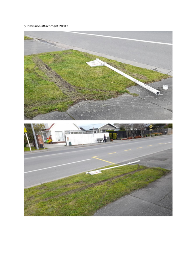
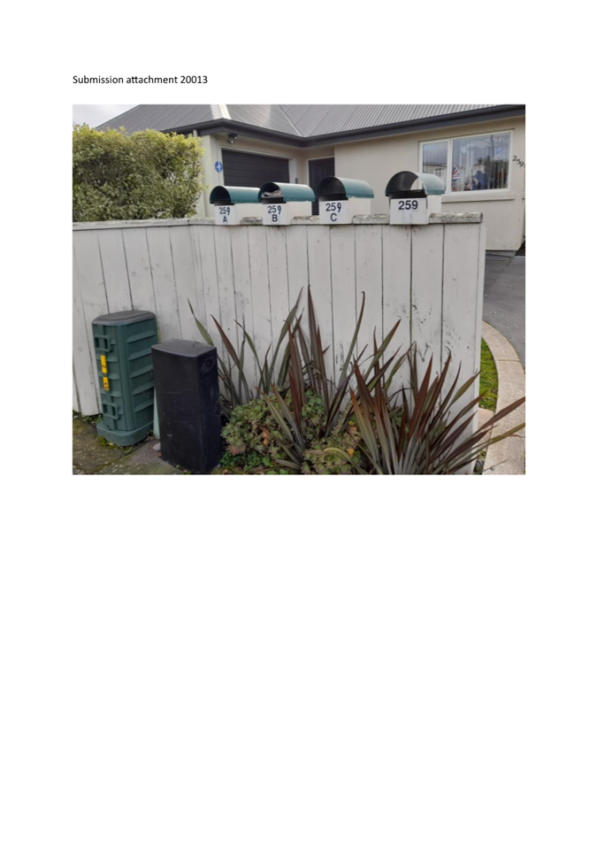
|
Council
01 November 2023
|
|
|
14. Plan Change 4 Short-term accommodation - Final
approval
|
|
Reference / Te Tohutoro:
|
23/1554274
|
|
Report of / Te Pou Matua:
|
Mark
Stevenson, Manager – Planning. Mark.stevenson@ccc.govt.nz
|
|
Senior Manager / Pouwhakarae:
|
John
Higgins, Head of Planning & Consents (John.Higgins@ccc.govt.nz)
|
1. Purpose and Origin of Report Te Pūtake Pūrongo
1.1 The purpose of the report is to seek that Plan Change 4
(PC4) on Short-term accommodation is made operative. This follows an appeal on
Council's decision and a subsequent Consent Order from the Environment Court.
1.2 Plan Change 4 was approved for notification in September
2020. This report to make plan change 4 operative is the last step in the
process and is formal endorsement of the Environment Court's decision.
1.3 The decision in this report is of low significance in
relation to the Christchurch City Council’s Significance and Engagement
Policy. The level of significance has been determined as low on the basis that
it ratifies a decision of the Environment Court that is consistent with
provisions agreed between parties at mediation.
2. Officer Recommendations Ngā
Tūtohu
That the Council:
1. Approve the changes to the District Plan as
set out in the attached Consent Order of the Environment Court dated 24th
July 2023 on Plan Change 4, pursuant to Clause 17(2) of Schedule 1 to the
Resource Management Act, to become operative on 11th November 2023.
3. Reason for Report Recommendations Ngā Take mō te
Whakatau
3.1 The
staff recommendation is to approve that the plan change is made operative in
accordance with the Consent Order issued by the Environment Court dated 24th
July 2023. This has regard to the statutory process that the plan change has
been through including the outcome of the appeal process.
3.2 The
Consent Order is attached.
4. Alternative Options Considered Ētahi atu Kōwhiringa
4.1 The
recommendation in this report is for the Council to take the procedural step to
make Plan Change 4 operative. The Resource Management Act 1991 requires that,
following the end of the appeal period and the resolution of any appeals, a
local authority must formally approve the changes to the plan under clause 17
of Schedule 1 before the plan change becomes operative on a date that is
nominated in a public notice.
4.2 There
are no reasonable alternatives for plan change 4, having regard to the Court
issuing a Consent Order allowing the appeal and the outcome being consistent
with what was agreed at mediation.
5. Detail Te Whakamahuki
5.1 Plan
Change 4 amends the District Plan to better manage the effects associated with
the use of residential units for visitor accommodation in rural and residential
zones.
5.2 In
2019 the Council was approached by BATCH, an association consisting of
backpacker, hostel and motel owners seeking stronger enforcement of the
existing District Plan rules. In response to this, the effects on neighbours
associated with the increase in accommodation advertised on online booking
platforms, and the previous District Plan rules being unnecessarily restrictive
for owners seeking resource consent, Plan Change 4 Short-Term Accommodation was
developed, aimed at managing the impacts of short-term visitor accommodation on
residential, rural and other areas.
5.3 In
March 2020 the Council gathered public feedback on five options for managing
short-term accommodation in residential and rural areas. About 570 responses
were received, which informed the plan change.
5.4 The
plan change was formally notified by the Council in September 2020 with 133
submissions received. A further 18 submissions, supporting or opposing points
made in the original submissions, were then received. Submissions were received
from a range of stakeholders. AirBnB, other online platforms and hosts
generally sought a more permissive approach while the hospitality sector
(including the operators/ owners/ managers of hotels and motels) sought
enforcement of the status quo and in some cases, a more restrictive set of
rules.
5.5 The
hearing was originally scheduled to occur in May 2021 but was rescheduled to
October 2021 to enable Council to prepare additional economic evidence. The
recommendations of the Hearings Panel were presented and adopted by the Council
in March 2022.
5.6 Following
the Council’s approval of the plan change, Airbnb lodged an appeal to the
Environment Court. Mediation was carried out where parties, representing a
broad range of interests, were able to share their views on the proposed rules.
5.7 Following
mediation, the parties filed a joint memorandum with the Environment Court
requesting changes to the proposed rules by consent, which are described
further below. The Environment Court released its consent order,
confirming the changes sought by the parties in July 2023. A summary of the
rules as they apply to residential and rural zones is attached.
5.8 The
Council is now being asked to approve that Plan Change 4 is made operative
under clause 17 of Schedule 1 to the Resource Management Act.
5.9 Once
the resolution is made by the Council, public notice must be given that the
change will become operative on a date specified in the notice. This date must
be at least 5 working days after the notice is published.
5.10 The
decision affects all the community board areas.
Changes from Council decision
5.1 The
changes to the provisions in the Consent Order relative to Council’s
decision of March 2022 are summarised below:
5.2 Policy
14.2.9.1
5.2.1 Changes
in the Consent Order are marked in bold below. The amended policy is intended
to provide greater certainty and clarity on how visitor accommodation is to be
permitted, managed and avoided.
14.2.9.1
Policy
– Visitor Accommodation in Residential Units
a. Permit
visitor accommodation in a residential unit where:
i. at least one permanent resident of the
site is in residence for the duration of the stay; the number of visitors guests, is comparable to use by a
residential household;
ii. disturbance to neighbours is minimal;
iii. information on letting activity is
recorded and provided to the Council on
request;
iv. for unhosted
visitor accommodation, adverse effects are
managed in accordance with b. below.
b. Manage unhosted
visitor accommodation visitor accommodation in a residential unit where
a permanent resident is not in residence to ensure
adverse effects
on the residential character, coherence and amenity of the site and its immediate
surroundings, and on the transport network, are minimised
including through:
i. controlling the scale, duration frequency and extent of
use to ensure that is still predominantly used for residential activity;
ii. management of
operations to minimise disturbance of neighbours and adverse effects on the transport
network;
iii. including providing
contact and site management information to guests and neighbours; and
iv. each residential block retaining a high proportion
of residential
activities, and each residential activity retaining a high proportion of residential neighbours.
c. Avoid
visitor accommodation in a residential
unit at a scale or extent that is inconsistent with any of the
following:
i. retaining
predominantly residential character and coherence in each
residential block; or
ii. each residential
activity retaining a high proportion of residential neighbours; or
iii. minimising
adverse effects on the amenity of the site and its
immediate surroundings, including the disturbance of neighbours; or
iv. protecting
strategic infrastructure from reverse
sensitivity effects.
5.3 Rules
5.3.1 The following table summarises the changes to activity status
between Council’s decision and the Consent Order for residential and
rural zones, noting changes are proposed for the Papakāinga/Kāinga
Nohoanga Zone and Specific Purpose (Flat Land Recovery) zone as well.
|
|
Council
decision
|
Consent
Order
|
|
Hosted
visitor accommodation – Residential, Rural zones
|
Permitted
subject to standards
|
Permitted
subject to standards
In
residential zones, Restricted Discretionary Activity for 9 – 12 guests
and
Discretionary Activity for more than 12 guests
|
|
Unhosted
accommodation – Residential zone
|
Controlled
activity for 1 – 60 nights
Full
Discretionary for 61+ nights
|
Permitted for
1 – 60 nights with standards
Restricted
Discretionary Activity for 61+ nights and up to 12 guests
Discretionary
activity for more than 12 guests
|
|
Unhosted
accommodation – Rural zone
|
Permitted
activity for 1 – 60 nights
Full
Discretionary for 61+ nights
|
Permitted
activity for 1 – 180 nights
Restricted
Discretionary for 180+ nights and exceeding 8 guests
|
The above table is a high-level summary
and does not represent all the changes, nor should be relied on for determining
compliance with the District Plan. Other rules apply to all activities e.g.
noise standards, as well as rules that require resource consent for visitor
accommodation within the airport noise contour, and rules specific to the use
of a heritage building for visitor accommodation.
5.4 Standards
5.5 Other substantive changes in the Consent Order include:
5.5.1 Maximum
permitted number of guests – The number of
guests permitted in different zones has increased from 6 (Council decision) to
8 (Consent order).
5.5.2 Procedures
for managing adverse effects of guests checking in late (Hosted accommodation)– A standard is deleted for hosted accommodation that required
the owner of a unit to have procedures in place for managing adverse effects on
neighbours from guests checking in between the hours of 22.00pm and 06.00am.
A standard for unhosted accommodation in a residential zone (now permitted)
requires that guests are provided with clear instructions including maps/
diagrams/ photos/ signs for check-in procedures.
5.5.3 Notification on commencement of hosted accommodation – A standard for requiring the owner to keep records of the
number of nights the unit is used has been amended such that it is from the
date Council is notified of commencement, rather than commencing on 1 January.
5.5.4 Standards for unhosted accommodation – With the change in activity status for unhosted accommodation,
standards for a permitted activity are introduced that effectively address what
would otherwise be assessed for a controlled activity. These are copied below -
a. A maximum of eight guests shall be accommodated at any one time.
b. The number of nights a site is used
for unhosted visitor accommodation shall not exceed 60 per year calculated from
when Council are notified of commencement.
c. The Council shall be notified in
writing prior to commencement.
d. The owner of the unit shall:
i. keep records of the number of
nights it is used for unhosted visitor accommodation and provide those records
to the Council on request;
ii. provide up-to-date contact
information of a local person and/or organisation responsible for managing the
property and responding to complaints, to all owners and occupiers of adjoining
sites, on commencement, on request, or annually if not requested; and
iii. ensure guests are provided clear
instructions including maps/diagrams/photos/signs for check-in procedures,
building access and parking arrangements, constraints on the use of outdoor
areas, rubbish and recycling procedures, controls on functions and events, any
relevant hazards and safety procedures, prior to arrival, and within the unit.
e. There shall be a maximum of 16
vehicle movements per day associated with unhosted visitor accommodation.
f. Guests shall not hold functions or
events where the number of additional attendees exceed the number of paying
guests between 22.00pm and 07:00am.
g. Guest activities shall meet daytime
and night time noise limits in Rule 6.1.5.2.1 and Rule 6.1.5.2.2.
5.6 The
parties considered the changes as the most appropriate way to achieve the
objectives of the Christchurch District Plan, and give effect to relevant
higher order documents.
Implementation of the plan change
5.7 Under
the new District Plan rules owners of short-term accommodation properties are
required to notify the Council. They are also required to keep records of the
number of nights the property is rented for. These records must be provided to
the Council upon request. To assist parties in achieving compliance, we have created an online notification form for permitted short-term
accommodation providers. This is available https://ccc.tfaforms.net/370.
5.8 We have also sought to improve the information
and processes for anyone renting their house/ unit for visitor accommodation. For activities that require a resource consent we have a new
application form specifically for short-term visitor accommodation, and a
lower deposit of $1,000.
5.9 Previously,
Council staff responded to complaints and if a property was deemed to be
operating in breach of the short-term accommodation District Plan rules, a
resource consent would be required if the owner wished to continue the
activity.
Under the new rules we will be taking an educational
approach in the first instance, reminding short-term accommodation providers
that the rules have changed. The Council’s enforcement
response follows a model of voluntary, assisted, directed, or enforced
compliance (VADE). Our VADE policy allows us to apply a period of voluntary
compliance enabling the property owner to either apply for approval or cease
the activity. However, with any compliance, we assess the risk and nuisance
effects of the activity which forms part of our compliance response.
Council is currently recruiting for an additional staff member to enable
proactive enforcement.
5.10 With short-term
accommodation being permitted in some scenarios e.g. unhosted accommodation of
less than 61 nights per year in a residential zone, we anticipate the level of
compliance will increase. The restrictive policy framework of the previous plan
has been lessened by this plan change for circumstances where effects can be
adequately managed.
Other regulation
5.11 During the course of the plan change process, some
submitters representing the formal accommodation sector have sought a
‘levelling of the playing field’ between informal and formal
accommodation.
5.12 The District Plan can only manage environmental effects arising
from an activity, such as short-term accommodation. A plan change process does
not allow us to influence national legislation (e.g. the Building Act) nor
address the effects of trade competition. A summary of what Council is doing in
the context of other legislation is provided below.
Building Act
5.13 Our webpage ‘Providing visitor accommodation in a
residential unit’ primarily provides guidance on our district plan rules
under the Resource Management Act while referring to a change of use to make
owners aware of any obligations they may have under the Building Act.
5.14 What is a change of use is defined in the Building
(Specified Systems, Change the Use, and Earthquake-prone Buildings) Regulations
2005. The threshold for when a building that was constructed as a dwelling and
starts to be used for short-term visitor accommodation undergoes a change of
use is not straightforward to define. This is why our guidance states;
‘it is best to discuss your situation with the Duty Building Consent
Officer’. We have provided an example when a situation would clearly be a
change of use; ‘where rooms in a dwelling are rented out to different
groups at the same time,’ as there would be more onerous requirements
under the building code for fire safety.
5.15 National Registration
5.16 Despite a remit by LGNZ for investigation of a national
registration system, we do not have any certainty over when, or if, a national
registration system will be introduced. A requirement for properties to
register would make it easier for the Council to monitor compliance of District
Plan rules. For that reason, it is recommended that the Council continues to
advocate for a registration system. Notwithstanding this, a national
registration system would not enable the effects associated with short-term accommodation
to be managed.
5.17 Rating
5.18 Council’s current rating policy is that any land used
for a commercial purpose including “travellers accommodation” is
rated as a business – that is, the business differential on the general
rate is applied. Historically Council has had very little information to
identify which properties are being used for short term visitor accommodation
in a residential unit.
5.19 If Council becomes aware that a property is being used for
unhosted short term visitor accommodation, that property will be rated as a
business unless it remains primarily used for residential purposes. For
properties used part time for that purpose, or for hosted accommodation,
Council is currently considering a range of rating options for the next rating
year.
6. Policy Framework Implications Ngā Hīraunga ā- Kaupapa here
Strategic
AlignmentTe Rautaki
Tīaroaro
6.1 This report supports the Council's
Long Term Plan (2021 - 2031):
6.2 Strategic Planning and Policy
6.2.1 Activity: Strategic Planning, Future Development and
Regeneration
· Level of Service: 9.5.1.1 Guidance on where and
how the city grows through the District Plan. - Maintain operative District
Plan, including monitoring outcomes to inform changes, and giving effect to
national and regional policy statements
6.3 Plan Change 4 enables the District Plan to respond to
issues arising in respect of short-term accommodation. In doing so, the
District Plan provides clear guidance on how short-term accommodation is
managed.
Policy
Consistency Te Whai
Kaupapa here
6.4 The
decision is consistent with Council’s Plans and
Policies.
Impact
on Mana Whenua Ngā
Whai Take Mana Whenua
6.5 The
decision does not involve a significant decision in
relation to ancestral land or a body of water or other elements of intrinsic
value, therefore this decision does not specifically impact Mana Whenua, their
culture and traditions.
6.6 In the provisions for the Papakāinga/Kāinga Nohoanga Zone,
hosted and unhosted visitor accommodation is permitted as per the version
approved by Council, with the number of guests permitted increasing from 6
(Council decision) to 8 (Consent order). Non-compliance with standards for
hosted and unhosted accommodation is changed from Discretionary to Restricted
Discretionary, consistent with residential rules.
6.7 Consultation
was undertaken with Mahaanui Kurataiao in the preparation of the Plan Change.
Climate
Change Impact Considerations Ngā Whai Whakaaro mā te Āhuarangi
6.8 The
proposals in this report are unlikely to contribute significantly to adaptation
to the impacts of climate change or emissions reduction.
6.9 The plan change is principally about managing the effects of
short-term accommodation on surrounding neighbourhoods, rather than affecting
how the city functions or how people travel within the city.
Accessibility
Considerations Ngā
Whai Whakaaro mā te Hunga Hauā
6.10 This
decision has no impact on accessibility.
7. Resource Implications Ngā Hīraunga Rauemi
Capex/Opex Ngā Utu Whakahaere
7.1 Cost
to Implement - The cost of amending the District Plan consistent with the
decision of the Environment Court is a one-off cost.
7.2 Maintenance/Ongoing
costs – There are ongoing costs to monitor the effectiveness of the
District Plan and compliance and enforcement of the provisions.
7.3 Funding
Source – Funding for any resource consent applications is user-pays with
costs on-charged.
8. Legal Implications Ngā Hīraunga ā-Ture
Statutory power to undertake proposals in the report
Te Manatū Whakahaere Kaupapa
8.1 The
recommendation in this report is for the Council to take the procedural step to
make Plan Change 4 operative. The Council has no other option.
8.2 The
Resource Management Act 1991 requires that, following the end of the appeal
period and the resolution of any appeals, a local authority must formally
approve the changes to the plan under clause 17 of Schedule 1 before the plan
change becomes operative on a date that is nominated in a public notice. An
agreement reached at mediation and consented to by the Court qualifies as
resolving the appeal for the purposes of the Act.
8.3 Approving
changes to the District Plan so that they can be made operative is one of the
functions that cannot be delegated to staff under the RMA.
Other Legal Implications Ētahi atu
Hīraunga-ā-Ture
8.4 There
is no other legal context, issue or implication relevant to this
decision. The Legal Services Unit has reviewed this report.
9. Risk Management Implications Ngā Hīraunga Tūraru
9.1 Council
is statutorily required to have an operative District Plan at all times. The
decision to be made is to reflect the Environment Court’s decision to
allow the appeal on Plan Change 4. If this is not approved, the Council is in
breach of its RMA obligations and there is a risk of further legal challenge.
Attachments Ngā Tāpirihanga
|
No.
|
Title
|
Reference
|
Page
|
|
a 
|
Environment
Court Consent Order (Under Separate Cover)
|
23/1657356
|
|
|
b ⇩
|
Plan Change 4
Summary of rules
|
23/1657357
|
269
|
In addition to the attached documents, the following background
information is available:
|
Document
Name – Location / File Link
|
|
Not
applicable
|
Confirmation of Statutory
Compliance Te Whakatūturutanga ā-Ture
|
Compliance with Statutory Decision-making
Requirements (ss 76 - 81 Local Government Act 2002).
(a) This report contains:
(i) sufficient information about all reasonably practicable
options identified and assessed in terms of their advantages and
disadvantages; and
(ii) adequate consideration of the views and preferences of
affected and interested persons bearing in mind any proposed or previous
community engagement.
(b) The information reflects the level of significance of the
matters covered by the report, as determined in accordance with the Council's
significance and engagement policy.
|
Signatories Ngā Kaiwaitohu
|
Authors
|
Mark Stevenson
- Manager Planning
Catherine
Elvidge - Principal Advisor Resource Consents
|
|
Approved By
|
John Higgins -
Head of Planning & Consents
|
|
Council
01 November 2023
|

|
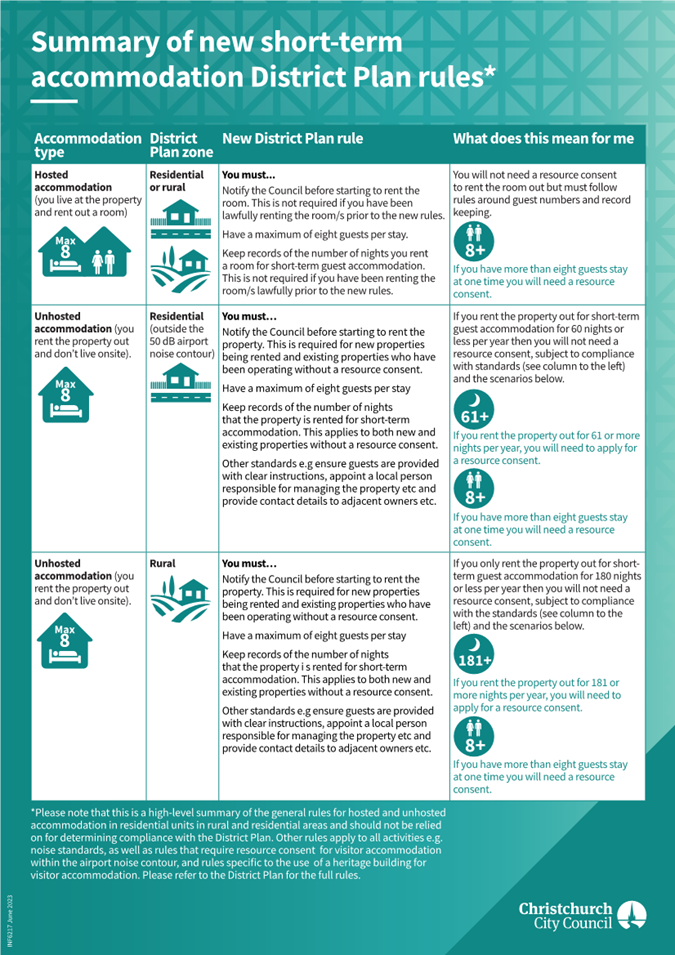
|
Council
01 November 2023
|
|
|
15. Draft submission on the Emergency Management
Bill
|
|
Reference / Te Tohutoro:
|
23/1665084
|
|
Report of / Te Pou Matua:
|
Brenden
Winder, Manager Civil Defence and Emergency Management
|
|
Senior Manager / Pouwhakarae:
|
Mary
Richardson, General Manager Citizens & Community
(Mary.Richardson@ccc.govt.nz)
|
1. Purpose and Origin of Report Te Pūtake Pūrongo
1.1 The purpose of this report is to seek approval of the draft
Council submission on the Emergency Management Bill. Submissions are due with
the Select Committee by 3 November 2023.
1.2 The Government has introduced an Emergency Management Bill
to replace the Civil Defence Emergency Management Act 2002.
1.3 The
decision in this report is of low significance in relation to the Christchurch
City Council’s Significance and Engagement Policy. This recognises that while there may be community interest in how
the Council prepares for and responds to emergencies, the specific decision (to
approve the draft submission) is of a lower level of significance.
2. Officer Recommendations Ngā
Tūtohu
That the Council:
1. Approves the draft submission (Attachment A to
this report) on the Emergency Management Bill.
3. Reason for Report Recommendations Ngā Take mō te
Whakatau
3.1 The
Council regularly makes submissions on proposals which may significantly impact
Christchurch residents or Council business. Submissions are an important
opportunity to influence thinking and decisions through external
agencies’ consultation processes.
4. Alternative Options Considered Ētahi atu Kōwhiringa
4.1 The
alternative option would be to not submit on the Emergency Management Bill.
This is not recommended as making a submission is a valuable opportunity to
influence central government direction on proposals that have significant
implications for Council.
5. Detail Te Whakamahuki
Emergency Management
Bill
5.1 The
Emergency Management Bill will create an updated legal and regulatory framework
within which Aotearoa New Zealand can prepare for, deal with, and recover from
local, regional and national emergencies. The Bill is not a fundamental
transformation of the emergency management system, but instead makes practical
improvements to ensure the system can meet current and future needs –
many of these are technical changes.
5.2 Some
of the key measures in the Emergency Management Bill include:
5.2.1 clarifying
roles and responsibilities across the emergency management system
5.2.2 recognising
and enhancing the role of Māori in emergency management
5.2.3 enhancing
the resilience and accountability of critical infrastructure
5.2.4 enabling
equitable outcomes for communities disproportionately impacted by emergencies
5.2.5 improving
operational effectiveness
5.2.6 updating
the legal and regulatory frameworks for the emergency management system
5.2.7 replacing
the term ‘civil defence emergency management’ with ‘emergency
management’.
5.3 Further
information on the Bill can be found here: https://www.civildefence.govt.nz/cdem-sector/legislation/emergency-management-bill/
Key submission
points
5.4 As
a district, we have experienced numerous emergencies, notably flooding, the
Canterbury earthquake sequence, Port Hills fire and the Mosque attacks. Many of
our communities are vulnerable to flooding and sea level rise and our coastal
areas are also at risk of tsunamis. Being prepared for responding to these
events and looking after our communities is a high priority for our Council.
5.5 The
draft submission supports a review of the current legislation, the updated
legal and regulatory framework needs to go further than just making limited
practical improvements. New Zealand needs to have clear and effective emergency
management legislation in place, especially as the climate is changing and we
will face more frequent and more extreme weather events.
5.6 Māori
participation in emergency management - Mana whenua already contribute significantly to emergency
preparedness and support in emergency responses. We support the inclusion of
iwi in Emergency Management Committees and Executive Groups. Representatives
should have full voting rights and get paid. References to Māori and iwi
in the Bill should be replaced with mana whenua
5.7 Increasing
the resilience of critical infrastructure – the
Bill seems to suggest that infrastructure that is ‘critical’ now
will remain so into the future. In reality, ‘criticality’ will in
part be determined by where populations are located, and over time retreat from
hazards will require communities to move away from marginal and risky locations
meaning that critical infrastructure will also have to move.
5.8 Lack
of adequate provision for regional level of emergency response management - We support the proposed improved recognition and articulation of the
three-layer model of emergency management governance, management, and
operational coordination. But it is unclear why the Bill retains the two-level
approach to declared states of emergency and transition periods as
“local” and “national” respectively. A third tier of
“regional” state of emergency for more than one local authority or
unitary authority would enable controllers to carry out the roles more
effectively.
5.9 Lack
of statutory mandate for the Coordinated Incident Management System (CIMS) - In previous reviews the lack of consistent application of the
Coordinated Incident Management System (CIMS) has been highlighted as a
significant issue. We are concerned that the Bill does not address this, and it
is unclear why the earlier feedback to mandate this has not been incorporated.
5.10 Emergency
Powers not conferred automatically to Controllers -
the Bill (and the 2002 Act) is unique in the New Zealand emergency legislative
context as emergency powers are conferred on Emergency Management Committees
and Recovery Managers, but not to Controllers. Despite this, it is
Controllers who actually exercise the powers and it would be beneficial for
Controller(s) to be empowered by the Bill.
5.11 The
decision affects all wards/Community Board areas.
6. Policy Framework Implications Ngā Hīraunga ā- Kaupapa here
Strategic
AlignmentTe Rautaki
Tīaroaro
6.1 This decision aligns with the Council’s
Strategic Framework.
6.2 This report supports the Council's
Long Term Plan (2021 - 2031):
6.3 Strategic Planning and Policy
6.3.1 Activity: Strategic Planning, Future Development and
Regeneration
· Level of Service: 17.0.1.1 Advice to Council on
high priority policy and planning issues that affect the City. Advice is
aligned with and delivers on the governance expectations as evidenced through
the Council Strategic Framework. - Triennial reconfirmation of the strategic
framework or as required.
Policy
Consistency Te Whai
Kaupapa here
6.4 The
decision is consistent with Council’s Plans and
Policies. It is also consistent with the Canterbury Civil Defence and Emergency
Management Group Plan, which provides strategic direction on how comprehensive,
risk-based emergency management will be implemented across the Canterbury
region.
Impact
on Mana Whenua Ngā
Whai Take Mana Whenua
6.5 Submitting
on the Emergency Management Bill is not a significant decision in relation to
ancestral land or a body of water or other elements of intrinsic value,
therefore this decision does not specifically impact
Mana Whenua, their culture and traditions.
6.6 The
decision involves a matter of interest to Mana Whenua
however the decision to submit on the Bill will not impact on our agreed
partnership priorities with Ngā Papatipu Rūnanga.
6.7 Council staff have shared the draft submission
with Te Rūnanga o Ngāi Tahu staff and provided an opportunity for
feedback. No amendments were suggested. Ngāi Tahu is also making a
submission on the Bill.
Climate
Change Impact Considerations Ngā Whai Whakaaro mā te Āhuarangi
6.8 There are no
direct climate change implications associated with the decision to approve this
submission. However, as the submission itself is on emergency management
legislation, it is important that New Zealand has clear
and effective emergency management legislation in place, especially as the
climate is changing and we will face more frequent and more extreme weather
events.
Accessibility
Considerations Ngā
Whai Whakaaro mā te Hunga Hauā
6.9 There are no direct accessibility implications
associated with the decision to approve this submission.
7. Resource Implications Ngā Hīraunga Rauemi
Capex/Opex Ngā Utu Whakahaere
7.1 The
cost of making this submission will be met from existing operational budgets.
8. Legal Implications Ngā Hīraunga ā-Ture
Statutory power to undertake proposals in the report
Te Manatū Whakahaere Kaupapa
8.1 The
Select Committee’s consultation on the Emergency Management Bill is
public and open to any person or organisation.
Other Legal Implications Ētahi atu
Hīraunga-ā-Ture
8.2 There
is no legal context, issue, or implication relevant to this decision.
9. Risk Management Implications Ngā Hīraunga Tūraru
9.1 There
are no significant risks associated with this decision to lodge submission.
There is some uncertainty about the progress of this Bill with the new
Government as neither National or Act supported it at first reading.
Attachments Ngā Tāpirihanga
|
No.
|
Title
|
Reference
|
Page
|
|
a ⇩
|
Draft
submission on the Emergency Management Bill
|
23/1737333
|
276
|
In addition to the attached documents, the following background
information is available:
|
Document
Name – Location / File Link
|
|
Not
applicable
|
Confirmation of Statutory
Compliance Te Whakatūturutanga ā-Ture
|
Compliance with Statutory Decision-making
Requirements (ss 76 - 81 Local Government Act 2002).
(a) This report contains:
(i) sufficient information about all reasonably practicable
options identified and assessed in terms of their advantages and
disadvantages; and
(ii) adequate consideration of the views and preferences of
affected and interested persons bearing in mind any proposed or previous
community engagement.
(b) The information reflects the level of significance of the
matters covered by the report, as determined in accordance with the Council's
significance and engagement policy.
|
Signatories Ngā Kaiwaitohu
|
Authors
|
Libby Elvidge
- Principal Advisor Citizens & Community
Brenden Winder
- Manager Civil Defence & Emergency Management
John Filsell -
Head of Community Support and Partnerships
|
|
Approved By
|
John Filsell -
Head of Community Support and Partnerships
Mary
Richardson - General Manager Citizens & Community
|
|
Council
01 November 2023
|
|
|
16. Council submission on the inquiry into climate
adaptation
|
|
Reference / Te Tohutoro:
|
23/1381431
|
|
Report of / Te Pou Matua:
|
Jane
Morgan, Team Leader Coastal Hazards Adaptation Planning
|
|
Senior Manager / Pouwhakarae:
|
John
Higgins, Head of Planning & Consents (John.Higgins@ccc.govt.nz)
|
1. Purpose and Origin of Report Te Pūtake Pūrongo
1.1 The purpose of this report is to seek approval of the draft
Council submission on the inquiry into climate adaptation.
1.2 The Environment Committee Komiti Whiriwhiri Take Taiao has
initiated an inquiry into climate adaptation, and is calling for public
submissions. A draft Council submission has been prepared for consideration.
1.3 The
decision in this report is of low significance in relation to the Christchurch
City Council’s Significance and Engagement Policy. This recognises that
while there may be community interest in the inquiry and the subsequent
development of the Climate Adaptation Act, the specific decision (to approve
the draft submission) is of a lower level of significance.
2. Officer Recommendations Ngā
Tūtohu
That the Council:
1. Approves lodging the attached draft submission
(Attachment A) to the Environment Committee on the inquiry into climate
adaptation.
3. Reason for Report Recommendations Ngā Take mō te
Whakatau
3.1 The
Council regularly makes submissions on proposals which may significantly impact
Christchurch residents or Council business. Submissions are an important
opportunity to influence thinking and decisions through external
agencies’ consultation processes.
4. Alternative Options Considered Ētahi atu Kōwhiringa
4.1 The
alternative option would be to not submit on the inquiry into climate
adaptation.
4.2 This
course of action is not recommended as making a submission is a valuable
opportunity to influence central government direction on proposals that have
significant implications for Council.
5. Detail Te Whakamahuki
Overview of inquiry into climate
adaptation
5.1 The
Environment Committee Komiti Whiriwhiri Take Taiao has initiated an inquiry
into climate adaptation and is calling for public submissions.
5.2 For
its inquiry, the committee is particularly interested in:
· The current approach to
community-led retreat and adaptation funding, its strengths, risks and costs
· Lessons learned from
severe weather events and natural disasters in Aotearoa New Zealand for
community-led retreat and funding climate adaptation
· Effective mechanisms for
community-led decision making
· The role of the private
sector in managing climate risk
· Potential institutional
arrangements, including roles and responsibilities of central and local
government agencies, iwi and hapu
· Māori participation,
Crown obligations, and how to best give effect to the principles of te Tiriti o
Waitangi, and integrate matauranga Māori and te ao Māori across the
adaptation system
· Alignment and integration
with existing legislation and regulatory framework, including the reformed
resource management system and any changes needed to regulatory powers and
potential economic or other incentives needed to support adaptation actions (both
before and after extreme events)
· Funding sources, access to
them and principles and criteria for cost sharing
· Targets or indicators for
assessing progress to more resilient communities and infrastructure.
5.3 The
inquiry is expected to report back in 2024, and its findings are expected to
inform development of the Climate Change Adaptation Bill, which is the final
piece of legislation for the Resource Management reforms.
Summary of submission content
5.4 The
submission is focused on key themes emerging from the Report of the Expert
Working Group on Managed Retreat. It draws heavily on Christchurch’s
experience of retreat following the Canterbury Earthquake Sequence, through the
Crown’s red-zoning process, and the hard lessons learned during this
time, as well as our experience delivering our current adaptation planning
programme.
5.5 The
submission welcomes this reform, noting that national policy on climate
adaptation and managed retreat currently represents a large gap.
5.6 The
following details key points outlined in the Council’s draft submission
(Attachment A):
5.6.1 Timing
and the need for urgency: the reform must be progressed
urgently to provide clarity and avoid unnecessary rework.
5.6.2 Need
for national direction: the submission urges the need for
national direction to help set consistent expectations and enable communities
to engage within a generally accepted framework. This is essential to reduce
the existing uncertainty that impacts communities and their well-being and
provide necessary direction to Councils to support long-term planning and
future investment decisions.
5.6.3 Approaches to
adaptation and managed retreat: the submission encourages
a balance between ensuring the efficiency and certainty of adaptation processes
(including managed retreat), and ensuring appropriate community involvement in,
and ownership of, these processes. It reflects the
tensions inherent in taking a purely ‘top down’ or ‘bottom
up’ approach to adaptation and managed retreat and recognises the need
for a nuanced approach.
5.6.4 People focused
framework: the submission seeks that greater
emphasis is placed on creating a framework that is people focused and
prioritises community well-being. It details how more involvement from social
service and health agencies is required to shift from a strict land-use
planning approach to a social policy approach. It also notes how a greater
focus needs to be placed on how we educate and prepare people for change to
ensure community buy-in.
5.6.5 Funding and
finance: the submission seeks that funding and financing must be adequate
to enable adaptation, must create incentives that encourage risk reduction by
the Crown, local government, private individuals, banks and insurers, and must
avoid transfer of risk and cost onto local government. Notably, it seeks that
funding should align with exposure and vulnerability to climate change induced
hazards.
5.6.6 Rates cannot be
relied upon to fund the scale of investment required: For the district,
conservative estimates suggest with sea level rise of only 20cm the replacement
value of our three waters network pipes and road networks is $3.2B. If exposure
of all Council infrastructure was quantified, the costs would be far greater
than this. Our assessments indicate the approximately $14B of private
properties are exposed within the district, which would be unaffordable for
Council to co-fund private property retreat. Our position is that local
government remains responsible for public assets only, with central government
taking responsibility for compensation for private asset owners.
5.6.7 Roles and
responsibilities: the submission recognises the need for a simple and clear
set of roles, responsibilities, and accountabilities to avoid inefficiencies,
unnecessary complexity and fragmentation.
6. Policy Framework Implications Ngā Hīraunga ā- Kaupapa here
Strategic
AlignmentTe Rautaki
Tīaroaro
6.1 This decision aligns with the
Council’s Strategic Framework.
6.2 This report does not supports the Council's
Long Term Plan (2021 - 2031).
6.2.1 Activity: Strategic Planning, Future
Development and Regeneration
· Level
of Service: 17.0.1.1 Advice to Council on high priority policy and planning
issues that affect the City. Advice is aligned with and delivers on the
governance expectations as evidenced through the Council Strategic Framework. -
Triennial reconfirmation of the strategic framework or as required.
Policy
Consistency Te Whai
Kaupapa here
6.3 The
decision is consistent with Council’s Plans and
Policies.
6.4 Staff have also endeavoured to ensure the
content of the draft submission and accompanying feedback to be provided to the
Environment Committee is consistent with previous Council submissions on
related matters.
Impact
on Mana Whenua Ngā
Whai Take Mana Whenua
6.5
The decision to lodge a Council submission on the inquiry into climate
adaptation is not a significant decision in relation to ancestral land or a
body of water or other elements of intrinsic value, therefore this decision
does not specifically impact Mana Whenua, their culture and traditions.
6.6 The
decision involves a matter of interest to Mana Whenua,
however the decision to submit on the inquiry will not impact on our agreed
partnership priorities with Ngā Papatipu Rūnanga.
6.7 The Report of the Expert Working Group details
how recognition of Māori rights could be applied
in any new system and acknowledges the importance of such. In particular, Chapter 2 of the Working Group’s
report explores in greater detail how a new system needs to be developed to be
consistent with te Triti.
Climate
Change Impact Considerations Ngā Whai Whakaaro mā te Āhuarangi
6.8 There are no
direct climate change implications associated with the decision to approve this
submission. However, the submission itself being on the inquiry into climate
adaptation, considers implications regarding climate adaptation and managed
retreat in detail.
Accessibility
Considerations Ngā
Whai Whakaaro mā te Hunga Hauā
6.9 There are no direct accessibility
implications associated with the decision to approve this submission.
7. Resource Implications Ngā Hīraunga Rauemi
Capex/Opex Ngā Utu Whakahaere
7.1 Cost
to Implement - the cost of making this submission will be met from existing
operational budgets.
7.2 Maintenance/Ongoing
costs - as above
7.3 Funding
Source - existing operational budgets
8. Legal Implications Ngā Hīraunga ā-Ture
Statutory power to undertake proposals in the report
Te Manatū Whakahaere Kaupapa
8.1 The
Select Committee’s consultation on the inquiry into climate adaptation is
public and open to any person or organisation.
Other Legal Implications Ētahi atu
Hīraunga-ā-Ture
8.2 There
is no legal context, issue or implication relevant to this decision.
9. Risk Management Implications Ngā Hīraunga Tūraru
9.1 There
are no significant risks associated with this decision to lodge submission.
Attachments Ngā Tāpirihanga
|
No.
|
Title
|
Reference
|
Page
|
|
a ⇩
|
Draft Council
submission on the inquiry into climate adaptation
|
23/1735779
|
284
|
In addition to the attached documents, the following background
information is available:
|
Document
Name – Location / File Link
|
|
Not
applicable
|
Confirmation of Statutory
Compliance Te Whakatūturutanga ā-Ture
|
Compliance with Statutory Decision-making
Requirements (ss 76 - 81 Local Government Act 2002).
(a) This report contains:
(i) sufficient information about all reasonably practicable
options identified and assessed in terms of their advantages and
disadvantages; and
(ii) adequate consideration of the views and preferences of
affected and interested persons bearing in mind any proposed or previous
community engagement.
(b) The information reflects the level of significance of the
matters covered by the report, as determined in accordance with the Council's
significance and engagement policy.
|
Signatories Ngā Kaiwaitohu
|
Authors
|
Helaina Gregg
- Principal Advisor Policy
Katie McFadden
- Senior Policy Analyst
Jessica
Allison-Batt - Principal Advisor Climate Resilience
Jane Morgan -
Team Leader Coastal Hazards Adaptation Planning
|
|
Approved By
|
John Higgins -
Head of Planning & Consents
|
|
Council
01 November 2023
|

|
|
17. Hearings Panel report to the Council on the
proposed replacement Cruising and Prohibited Times on Roads Bylaw
|
|
Reference / Te Tohutoro:
|
23/1512788
|
|
Report of / Te Pou Matua:
|
Councillor
Tyla Harrison-Hunt, Hearings Panel Chairperson
|
|
Senior Manager / Pouwhakarae:
|
Mary
Richardson, General Manager Citizens & Community
(Mary.Richardson@ccc.govt.nz)
|
1. Purpose of Report Te Pūtake
Pūrongo
1.1 The
purpose of this report is to present to the Council the Hearings Panel (the
Panel) recommendations following the consultation and hearings process on the proposed
replacement Cruising and Prohibited Times on Roads Bylaw and associated
documents.
1.2 The
Panel has no decision-making powers but, in accordance with its delegation, has
considered the written and oral submissions received on the proposal and is now
making recommendations to the Council. The Council can then accept or
reject those recommendations as it sees fit bearing in mind that the Local
Government Act 2002 s.82(1)(e) requires that “the views presented to
the local authority should be received by the local authority with an open mind
and should be given by the local authority, in making a decision, due
consideration.”
1.3 The
Council, as the final decision-maker, should put itself in as good a position
as the Panel having heard all the parties. It can do so by considering
this report which includes a summary of the submissions that were presented at
the hearings, additional information received and the Panel’s
considerations and deliberations. For the full set of written submissions
considered by the Hearings Panel, and minutes of the Panel meeting refer to
Section 9: Documents A – C below.
2. Hearings Panel Recommendations / Ngā Tūtohu o Te Tira
Taute
That the Council:
1. Note that public consultation on the following
proposed replacement documents has been completed, and that submissions have
been considered by the Hearings Panel:
a. Cruising and Prohibited Times on Roads Bylaw;
b. Register of Roads on which Cruising is
Prohibited;
c. Prohibited Times on Roads Register; and
d. Prohibited Times on Roads Operational Policy
2. Does not change the proposed Bylaw or
associated documents as a result of the consultation process.
3. Adopt the Christchurch City Council Cruising
and Prohibited Times on Roads Bylaw 2023 in its final form (Attachment A).
4. Note that the Bylaw will revoke and replace
the Christchurch City Council Cruising and Prohibited Times on Roads Bylaw
2014.
5. Agree that, in accordance with section 155 of
the Local Government Act 2002, the Council is satisfied that the Cruising and
Prohibited Times on Roads Bylaw 2023:
a. is the most appropriate way of addressing the
perceived problems
b. is the most appropriate form of bylaw; and
c. gives rise to some implications under the New
Zealand Bill of Rights Act 1990, but none that are inconsistent with that Act
(as is the required test).
6. Approve that the Bylaw comes into force on 15
November 2023, and that signs will be installed or removed to reflect the
changes.
7. Notify the Minister of Transport that the
Bylaw has been made (within one week of the Bylaw being made) to comply with
section 22AB (4) of the Land Transport Act 1998.
8. Agree to revoke and replace the Register of
Roads on which Cruising is Prohibited, effective from 15 November 2023 (Attachment
B).
9. Resolve under clause 7 of the Cruising and
Prohibited Times on Roads Bylaw 2023 that access to the following roads or
parts of roads is prohibited to vehicles weighing less than 3,500kg during the
days and times listed:
a. Establishment Drive, Depot Street,
Headquarters Place, Quadrant Drive, Aruhe Road and Mania Road (Hornby South) -
10pm to 5am, 7 days a week
b. Part of Branston Street (Hornby) - section
from Halswell Junction Road to Boston Avenue - 10pm to 5am, 7 days a week
c. Watts Road (Sockburn) - 10pm to 5am, 7 days a
week
d. Weaver Place (Sockburn) - 10pm to 5am,
Thursday to Monday, and public holidays
e. Part of Pound Road (Yaldhurst) - branch of
Pound Road east of the main alignment - 10pm to 5am, Thursday to Monday, and
public holidays
f. Aviation Drive (Yaldhurst) - 10pm to 5am,
Thursday to Monday, and public holidays
g. Part of Syd Bradley Road (Yaldhurst) - Russley
Road to Ron Guthrey Road - 10pm to 5am, Thursday to Monday, and public holidays
h. Jet Place (Harewood) - 10pm to 5am, 7 days a
week
i. Lakes Way, Outlook Place and Lakeside Place
(Harewood) - 10pm to 5am, Thursday to Monday, and public holidays.
10. Agree to revoke and replace the Prohibited
Times on Roads Register, effective from 15 November 2023 (Attachment C).
11. Agree to revoke and replace the Prohibited
Times on Roads Operational Policy 2023, effective from 15 November 2023 (Attachment
D).
12. Authorise staff to make any typographical
changes or to correct minor errors or omissions as the case may be, before the
bylaw, registers and policy come into force;
13. Delegate to the Chief Executive the authority
to amend any explanatory notes in the Cruising and Prohibited Times on Roads
Bylaw 2023, as the case may be, and that this power may be sub-delegated.
14. Give public notice of the Christchurch City
Council Cruising and Prohibited Times on Roads Bylaw 2023, that it comes into
force on 15 November 2023, and that copies of the Bylaw may be inspected and
obtained at the Council’s offices or on its website, without payment, in
accordance with section 157 of the Local Government Act 2002.
15. Notify the Canterbury Police District
Commander of the adoption of the replacement Cruising and Prohibited Times on
Roads Bylaw 2023, and the changes to the roads regulated by the bylaw.
16. Note that issues outside the scope of the
Bylaw were raised by residents in and around Branston Street (including heavy
vehicle routes, potential use of security camera footage from private
businesses, and other tools to reduce vehicle noise at the residential end of
Branston Street), and that staff will discuss these matters with the Waipuna
Halswell-Hornby-Riccarton Community Board at the next available Traffic
Operations Update.
3. Background / Context Te Horopaki
3.1 A review of the Cruising and Prohibited Times on Roads
Bylaw 2014 was undertaken to comply with legislative requirements.[1]
The results of the review were accepted by the Council on 21 June 2023 (refer
to Section 9: Document E), and a replacement bylaw
was proposed for consultation: the Cruising and Prohibited Times on
Roads Bylaw 2023.
3.2 The
Bylaw sets rules to reduce cruising and to restrict nighttime access to some
roads in rural and industrial areas with a history of antisocial
vehicle-related activities, such as racing and burnouts. It is made using
bylaw-making powers in the following two pieces of legislation, with different
bylaw-making requirements:
· the Land Transport Act
1998 (LTA) for cruising; and
· the Local Government Act
2002 (LGA) for prohibited times on roads.
3.3 The
legislation places some limitations on what can be regulated, particularly in
relation to freedoms protected by the New Zealand Bill of Rights Act 1990.[2]
The Bylaw regulates two very specific and localised matters, and only on
specified roads in the district.
3.4 The
following documents were part of the consultation process, together with the
proposed replacement Bylaw:
· Register
of Roads on which Cruising is Prohibited
· Prohibited
Times on Roads Register
· Prohibited
Times on Roads Operational Policy.
3.5 The
Bylaw provides the legal mechanism for the Council to regulate roads, the
registers list the roads the Bylaw regulates, and the policy sets outs how
roads may be added or removed as new issues arise.
3.6 The
Bylaw can only be enforced by the Police. It complements other powers the
Police have to address associated activities. Transport laws already regulate
antisocial driving behaviours, including excessive speed, street racing and
sustained loss of traction. Modified vehicles (including loud exhausts) are
also already regulated and are not covered by the Bylaw. While the Bylaw is
associated with modified vehicles, it applies to all vehicles.
3.7 The
Antisocial Road User Team at the Christchurch Police provided input into the
review of the Bylaw and the roads it regulates.
3.8 The
review focused on improvements to the Bylaw, and not on how to address wider
antisocial vehicle-related activities. The Council has other tools to address
related issues outside of this bylaw process, such as setting safe and
appropriate speeds, and traffic engineering solutions to improve road safety.
4. Proposed changes to the bylaw, policy, and the roads the bylaw
regulates
4.1 The
Council adopted the proposed replacement Bylaw for consultation on 16 June
2023. The proposed changes included:
4.1.1 Proposed changes to
the Cruising and Prohibited Times on Road Bylaw 2014:
· updating
and modernising the format and language of the Bylaw;
· clarifying
that the Bylaw is a “qualifying bylaw” under the Land Transport Act
1998, which means that warning notices can be issued for a breach of the bylaw,
and that a further breach can result in a vehicle being seized and impounded by
Police; and
· adding
to the list of access exemptions that apply to the prohibited times on roads
clauses to better reflect legitimate access during prohibited times and
societal shifts (e.g., deliveries and the increasing use of ride share
vehicles).
4.1.2 Proposed
changes to the Prohibited Times on Roads Register:
(a) The
addition of the following roads to the Prohibited Times on Roads
Register:
· Establishment
Drive, Depot Street, Headquarters Place, Quadrant Drive, Aruhe Road and Mania
Road (Hornby South)
· part
of Branston Street (Hornby) – section
from Halswell Junction Road to Boston Avenue
· Weaver
Place (Sockburn)
· Watts
Road (Sockburn)
· part
of Pound Road (Yaldhurst) - the branch east
of the main alignment
· Syd
Bradley Road (Yaldhurst) – Russley Road
to Ron Guthrey Road
· Aviation
Drive (Yaldhurst)
· Jet
Place (Harewood)
· Lakes
Way, Outlook Place, Lakeside Place (Harewood)
(b) The removal of part of
Blakes Road (Belfast) from the Prohibited Times on Roads Register.
4.2 No changes were
proposed to the Register of Roads on which Cruising is Prohibited.
4.3 The
Prohibited Times on Roads Operational Policy gives guidance on the
process to add or amend roads, or to remove existing roads from the coverage of
the Bylaw. The policy was reviewed to ensure it is up-to-date
and fit-for-purpose, and a replacement policy was proposed.
5. Consultation Process and Submissions Te Tukanga Kōrerorero
/ Ngā Tāpaetanga
Summary
5.1 Submissions
opened on 27 June and closed on 25 July 2023. Consultation information
was made available on the Council Have Your Say website (refer to
Section 9 Document D). Emails were sent to 132 stakeholders, inviting
submissions. A Newsline story was published on 16 June 2023 (Section 9:
Document D). Posts on Council’s social media pages about the consultation
had good engagement, including posts to neighbourhood groups where changes were
proposed.
5.2 Forty-one
submissions were received. Submitters included five community boards, three
organisations, three businesses located in areas where nighttime restrictions
are proposed, and 30 individuals.
5.3 Some
of the individual submissions were focused only on one proposal. There was a cluster of submitters from Branston Street (eight
submitters) who supported the addition of nighttime restrictions, a cluster
from Blakes Road (seven submitters) who were opposed to removing the nighttime
restrictions, and a number of submitters generally opposed to the Bylaw and all
restrictions (seven submitters). Other submitters wanted the Bylaw to apply
much more broadly than is possible, while others raised out of scope issues.
Submission Analysis
5.4 In
briefing the Panel, staff provided an analysis of the submissions and comment
on the key themes raised, the Panel noted the staff advice that:
5.4.1 The
three submitters with businesses in areas where Council is proposing to add
roads were all supportive, and they set out the negative impacts and damage
they have been experiencing from nighttime antisocial vehicle-related
activities.
5.4.2 The
Community Boards who made a submission were broadly supportive of the changes
to the Bylaw and policy, and supported the proposed additional roads in their
areas, and some in neighbouring areas. Some asked that new roads be added to
the coverage of the Bylaw. Some of these roads were residential or arterial
roads, which are not appropriate for nighttime access restrictions, while
activities on other roads were unlikely to fit the definition of cruising so
would not be appropriate for cruising restrictions.
5.4.3 Of
the organisations that submitted, the Disabled Persons Assembly was supportive
of the changes to the exemptions to allow better access; the local Automobile
Association was supportive of all the proposals; and the Summit Road Society
asked for nighttime access restrictions due to concerns about damage and
safety.
5.4.4 Nighttime
access restrictions on the Summit Road were explored in 2018, and while there
was overwhelming public opposition to restricting access, there was also
widespread concern about antisocial and unsafe vehicle-related activities along
the Summit Road. Many of the 2018 submissions did not want access for
recreational activities to be reduced, or for a minority to ruin it for the
majority.
5.4.5 Many
of the submissions raised legitimate concerns about driver behaviour,
particularly in residential areas. While the Panel acknowledged these concerns,
it also noted that the legislation the Bylaw operates under means that the
Bylaw is not the right tool to address these behaviours, and that the Police
already have tools at their disposal.
5.4.6 Many
of the behaviours that concerned submitters are already regulated by transport
legislation – including modified vehicles (loud exhausts), sustained loss
of traction (burnouts, donuts, and drifting), racing, and speeding. If drivers
are undertaking these activities, they are already breaking the law, and the
Police have powers to address them. The Panel noted that residents should
continue to report incidents to the Police as they are occurring.
6. The Hearing Te Hui
6.1 The
Hearings Panel consisted of Chair Councillor Tyla Harrison-Hunt and members
Councillors Sam MacDonald and Tim Scandrett. The Hearings Panel convened
on 13 September 2023 to consider and deliberate on all submissions received on
the proposal.
6.2 Prior
to hearing oral submissions Council officers presented the Hearings Panel with
further clarification in relation to:
6.2.1 Bylaw
limitations – noting that while many submitters raised legitimate
concerns about noise, disruption, damage, stress, and safety from antisocial
vehicle-related activities, especially at night and in residential areas, in
many cases the Bylaw is not the right tool for regulating this behaviour.
6.2.2 Transport
laws and role of the Police – transport laws apply to all drivers and
roads. If drivers are breaking the law, there is no need for the Bylaw to
apply. The Police have a range of tools they can use, and in some cases, the
Bylaw is one of those tools, but it is only useful in some situations.
6.2.3 Cruising
– noting a common misconception is that cruising involves driving around
in a loud, modified vehicle with no particular purpose, but the legal
definition of cruising is more specific - Driving repeatedly over the
same stretch of road, in the same direction, in a way that draws
attention to the sound or power of the engine, or that creates a convoy (paraphrased).
This means the cruising part of the Bylaw would not address some concerns
raised by submitters about nighttime vehicle noise, as drivers are driving a
long route, not repeatedly driving the same stretch of road in the same
direction, so would not meet the legal definition of cruising.
6.2.4 Prohibited
Times on Roads - noting that this part of the Bylaw
does not regulate antisocial driver behaviour but prohibits vehicle access at
night. This means it should not be applied to
frequently used roads, such as in residential areas or on arterial or collector
roads. The nighttime access restrictions can appropriately be applied to roads
in industrial or rural-city fringe areas where we would not reasonably expect
drivers to be at night and where there is a history of antisocial
vehicle-related activity. It applies to light vehicles[3],
so excludes heavy vehicles, such as trucks and buses.
6.2.5 Bill of Rights implications – because the Prohibited Times on
Roads part of the Bylaw limits people’s freedom
of movement (apart from exceptions for bona fide reasons, such as residents
needing access to a property), this part of the Bylaw has New Zealand Bill of
Rights Act 1990 implications. The LGA requires a council to assess these
implications when making a bylaw, and to only apply reasonable and
proportionate limitations. This is one of the reasons this part of the Bylaw is
only applied to roads not commonly used at night and with a history of
antisocial issues.
6.2.6 Scope of the
consultation - the Panel noted that if it were to recommend the addition
of any roads that were not specifically consulted on, but that were raised
through submissions, the Panel would need to refer the matter back to the
Council. This would be for the Council to explore the matter further, and if
the Council wished to proceed with additional roads, this would require further
consultation with the public.
6.3 The
Hearings Panel heard the following five oral submissions, with submitters
taking the opportunity to emphasise key concerns expressed in their written
submissions. For the original submissions and subsequent document tabled at the
Hearing refer to Section 9: Documents A - C.
· Helen Broughton - Waipuna
Halswell-Hornby-Riccarton Community Board, Chairperson
· Paul McMahon - Waitai Coastal-Burwood-Linwood Community Board
Submissions Committee
· Kieran Brewster
· Marie Gray - Summit Road Society, Secretary
· Marc Duff
7. Consideration and Deliberation of Submissions Ngā
Whaiwhakaaro o Ngā Kōrero me Ngā Taukume
7.1 The
Hearings Panel considered and deliberated on all submissions received on the
proposal as well as information received from Council Officers during the
hearing.
7.2 The
key matters that were discussed by the Hearings Panel were:
7.2.1 Antisocial
driving behaviours on residential streets, including some that are near
industrial properties, were a common concern in submissions. The Panel
noted that the Bylaw is not an appropriate mechanism to use on
residential or collector roads, as it prohibits all light vehicles at night,
not just those causing issues.
7.2.2 Bylaw
limitations - while noting that many of the issues raised by submitters cannot
be addressed under the Bylaw, police resourcing to respond to calls continues
to be a concern. Several submitters commented that by the time police respond
to calls reporting antisocial driving behaviours, the vehicles have often moved
on. The message that calls are logged and provide an indication of locations of
concern needs to be reinforced to the public, by way of the Police.
7.2.3 Summit
Road – the Panel noted that in 2018 the Council decided not to impose
nighttime restrictions on Summit Road. This followed consultation on the
proposal that resulted in overwhelming public opposition. Police enforcement is
considered the most appropriate tool to address anti-social road user activity
in this area, and staff will continue to work with Police on this.
7.2.4 Branston
Street, Hornby – there was strong community support for the proposed
nighttime restrictions at the industrial end of Branston Street. While
accepting that antisocial driving behaviours in the residential area adjacent
to the industrial zone are not able to be addressed under the Bylaw, the Panel
encouraged submitters to work with the community board, local businesses, and
the Police.
7.2.5 The
Panel noted the potential to use security footage from private land in relation
to antisocial driving behaviour at the industrial end of Branston Street. The
Panel also noted the impact that nighttime noise from heavy vehicles in this
area has on residents. The Panel asked that staff discuss these matters with
the Waipuna Halswell-Hornby-Riccarton Community Board at the next available
Traffic Operations Update.
7.2.6 Blakes
Road, Belfast – while accepting that submitters did not want the
restrictions removed, the Panel noted that residential development in the area
meant prohibiting vehicles was no longer appropriate. The Panel also noted that
the Police have other tools they can use to address antisocial driving
behaviour, and residents are encouraged to continue reporting issues to the
Police as they are occurring.
8. Legal Implications Ngā Hīraunga ā-Ture
8.1 The
Panel was advised by staff that there are several legal matters that need to be
included in its recommendations to Council to ensure that the requirements of
legislation are properly reflected and met.
8.2 This
consists of the section 155 determinations required by the Local Government Act
2002 (including the New Zealand Bill of Rights Act 1990 considerations),
notifying the Minister of Transport of the Bylaw (because part of the Bylaw is
made under the Land Transport Act 1998), and giving public notice of the
Bylaw.
8.3 As
the enforcer of the Bylaw, the Panel has included a recommendation to the
Council to notify the Police Canterbury District Commander of the replacement
bylaw and the roads it regulates.
9. Reference Documents
Signatories Ngā Kaiwaitohu
Author Ann
Fitzgerald – Democratic Services Advisor
Approved
By Councillor
Tyla Harrison - Hunt - Chair of Hearings Panel
Attachments Ngā Tāpirihanga
|
No.
|
Title
|
Reference
|
Page
|
|
a ⇩ 
|
Christchurch
City Council Cruising and Prohibited Times on Roads Bylaw 2023
|
23/1612460
|
303
|
|
b ⇩
|
Register of
Roads on which Cruising is Prohibited
|
23/1619360
|
308
|
|
c ⇩
|
Prohibited
Times on Roads Register
|
23/1610943
|
311
|
|
d ⇩ 
|
Prohibited
Times on Roads Operational Policy 2023
|
23/1610736
|
315
|
|
Council
01 November 2023
|
|
|
Council
01 November 2023
|
|
|
18. Resolution to Exclude the Public
|
Section 48, Local Government Official
Information and Meetings Act 1987.
I move that the public be excluded from the
following parts of the proceedings of this meeting, namely items listed
overleaf.
Reason for passing this resolution: good
reason to withhold exists under section 7.
Specific grounds under section 48(1) for
the passing of this resolution: Section 48(1)(a)
Note
Section 48(4) of the Local Government
Official Information and Meetings Act 1987 provides as follows:
“(4) Every resolution to exclude the
public shall be put at a time when the meeting is open to the public, and the
text of that resolution (or copies thereof):
(a) Shall
be available to any member of the public who is present; and
(b) Shall
form part of the minutes of the local authority.”
This resolution is made in reliance on
Section 48(1)(a) of the Local Government Official Information and Meetings Act
1987 and the particular interest or interests protected by Section 6 or Section
7 of that Act which would be prejudiced by the holding of the whole or relevant
part of the proceedings of the meeting in public are as follows:
|
Council
01 November 2023
|
|
|
ITEM NO.
|
GENERAL SUBJECT OF EACH MATTER TO BE CONSIDERED
|
SECTION
|
SUBCLAUSE AND REASON UNDER THE ACT
|
PLAIN ENGLISH REASON
|
WHEN REPORTS CAN BE REVIEWED FOR POTENTIAL RELEASE
|
|
11.
|
Reserve Revocation 112R Bridle Path Road
|
|
|
|
|
|
|
Attachment b - 304/6434 signed agreement for
sale and purchase dated 17 July 2023
|
s7(2)(h)
|
Commercial Activities
|
Contains a purchase price that is confidential to the parties
until after settlement.
|
26 February 2027
|
|
19.
|
Public Excluded Audit and Risk Management
Committee Minutes - 3 August 2023
|
|
|
Refer to the previous public excluded reason in the agendas for
these meetings.
|
|
|
20.
|
Public Excluded Council Minutes - 4 October
2023
|
|
|
Refer to the previous public excluded reason in the agendas for
these meetings.
|
|
|
Council
01 November 2023
|
|
Karakia Whakamutunga
Kia
whakairia te tapu
Kia
wātea ai te ara
Kia
turuki whakataha ai
Kia
turuki whakataha ai
Haumi
e. Hui e. Tāiki e