Waihoro
Spreydon-Cashmere-Heathcote Community Board
Agenda
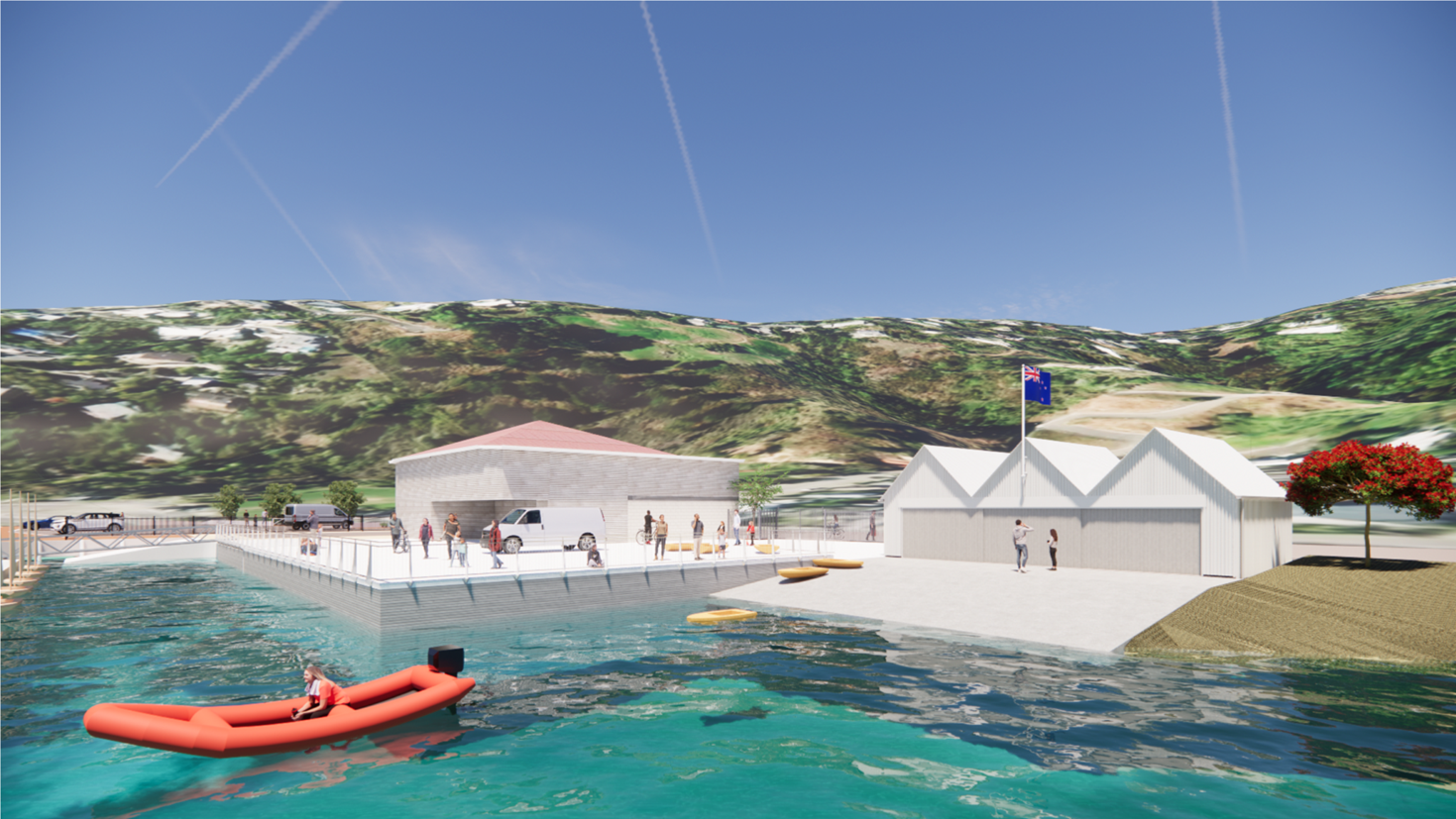
Notice of Meeting Te Pānui o te Hui:
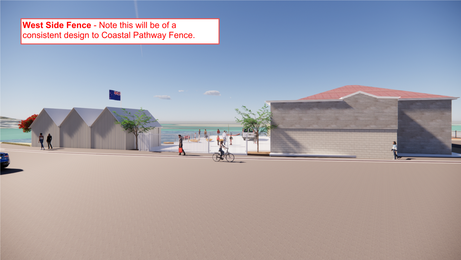
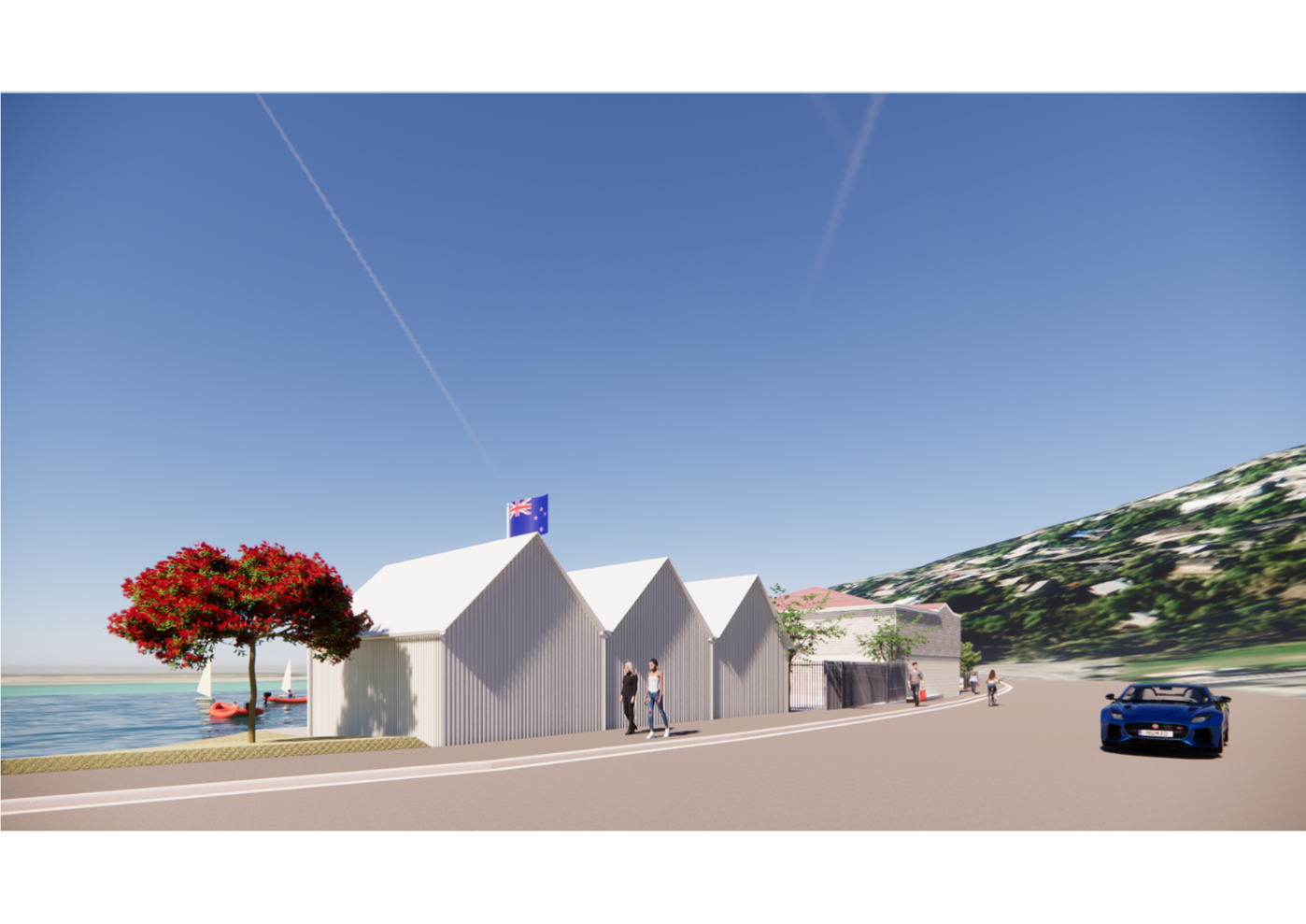
An ordinary meeting of the Waihoro
Spreydon-Cashmere-Heathcote Community Board will be held on:
Date: Thursday 11 September 2025
Time: 4 pm
Venue: Linwood Boardroom,
Gate B, 180 Smith Street,
Woolston
Membership Ngā
Mema
|
Chairperson
Deputy Chairperson
Members
|
Callum Ward
Keir Leslie
Melanie Coker
Will Hall
Roy Kenneally
Tim Lindley
Lee Sampson
Tim Scandrett
Sara Templeton
|
5 September 2025
Website: www.ccc.govt.nz
Part A Matters
Requiring a Council Decision
Part B Reports
for Information
Part C Decisions
Under Delegation
TABLE OF CONTENTS NGĀ IHIRANGI
Karakia Tīmatanga................................................................................................... 5
Waiata ............................................................................................................... 5
C 1. Apologies Ngā Whakapāha.......................................................................... 5
B 2. Declarations of Interest Ngā Whakapuaki Aronga........................................... 5
C 3. Confirmation of Previous Minutes Te Whakaāe o te
hui o mua.......................... 5
B 4. Public Forum Te Huinga Whānui.................................................................. 5
B 5. Deputations by Appointment Ngā Huinga
Whakaritenga................................. 6
B 6. Presentation
of Petitions Ngā
Pākikitanga.................................................... 7
C 7. Correspondence...................................................................................... 15
Staff Reports
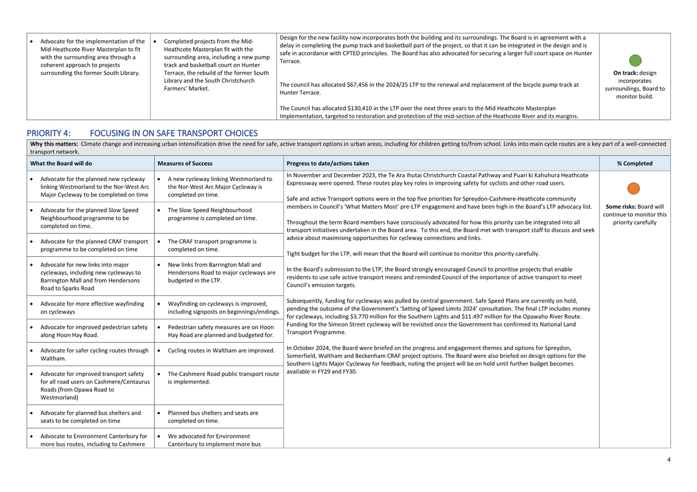
C 8. Hoon
Hay Park - Te Kōmanawa Rowley School - Place Cadet Nature Play Project 25
C 9. Christchurch
Yacht Club - Application for Building and Site Development........ 33
C 10. Richmond
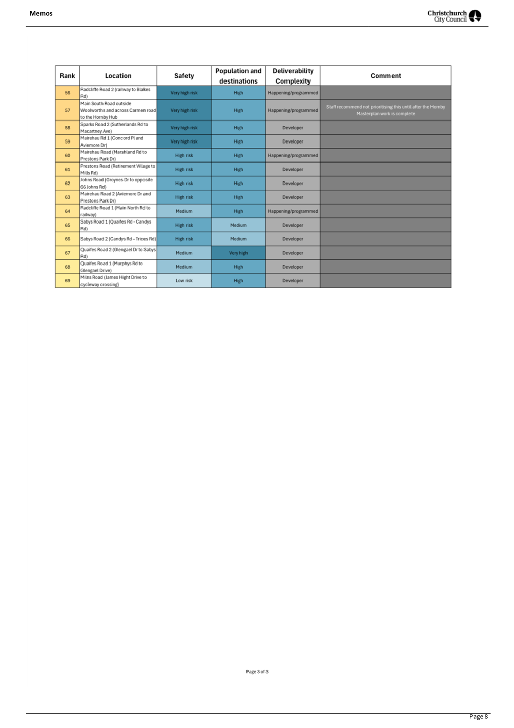
Hill Road - Proposed Parking Changes and Pedestrian Improvements 85
C 11. 429
Selwyn Street - Proposed No Stopping Restrictions................................ 99
C 12. Charlesworth
Street / Olds Place Intersection - Proposed No Stopping Restrictions............................................................................................................ 105
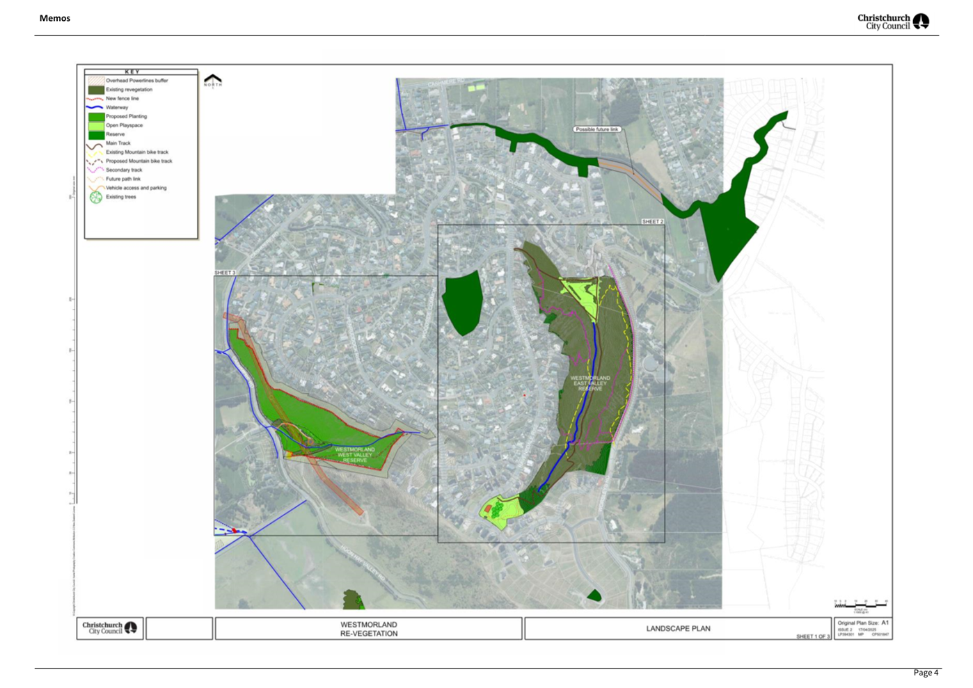
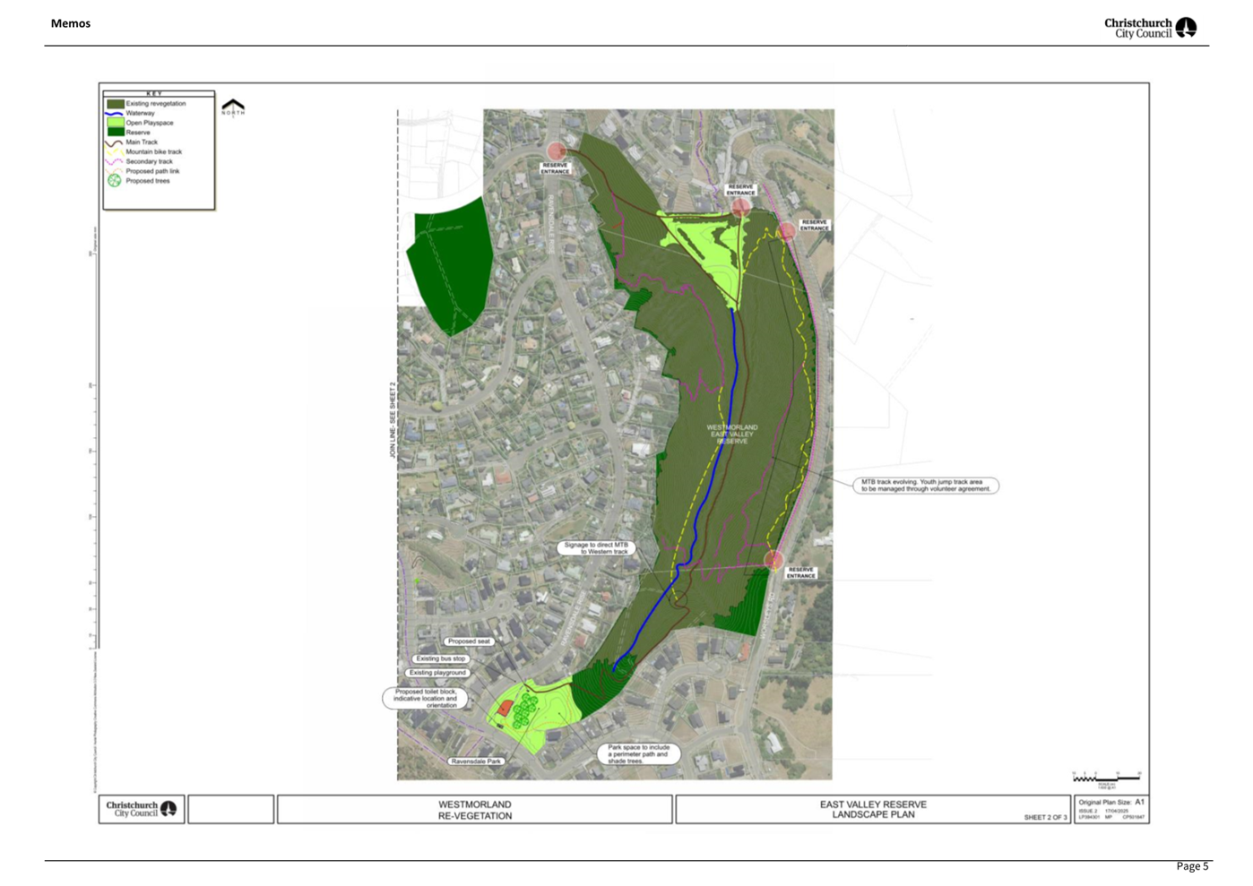
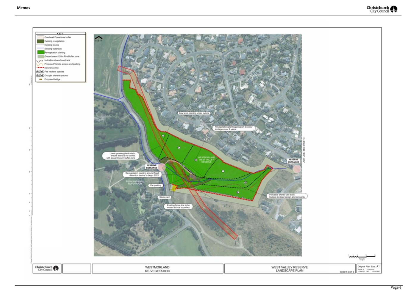
C 13. Westmorland
West Valley Reserve - Landscape Plan.................................... 111
C 14. Kordia
Licence at Sugarloaf and Thomson Scenic Reserves.......................... 125
C 15. Barnett
Park - Regional Park Landscape Plan............................................. 135
C 16. Waihoro
Spreydon-Cashmere-Heathcote Community Board Summer with your Neighbours 2025-26................................................................................ 151
C 17. Waihoro
Spreydon-Cashmere-Heathcote Community Board Area Report - September 2025..................................................................................................... 161
B 18. Valedictory............................................................................................ 207
B 19. Elected Members’
Information Exchange Te Whakawhiti
Whakaaro o Te Kāhui Amorangi............................................................................................................ 208
Karakia Whakakapi
Actions Register Ngā Mahinga Tuwhera
Karakia Tīmatanga
|
Kia tau te mauri o runga
Kia tau te mauri o raro
Paiheretia te ture wairua
Paiheretia te ture tangata
Hei pou arahi i a tātou i
tēnei wā
Kia tika te whakaaro
Kia tika te kupu
Tīhei Mauri Ora!
|
May the essence of above settle here
May the essence of below settle here
Bind together that we can’t see and bind that
we can see
And have them guide us at this time
May the thought be true
May the words be true
|
Waiata
|
Manu tiria manu tiria
Manu werohia ki
te poho o Te Raka
Ka tau
rērere
Ka tau mai i te
Ruhi
E tau e koia a
Koia koia ko Tararauriki
Kī mai i
Māui
Ehara i te whitu
me te waru e
E tau e koia,
koia
|
Te whakamārama
This song tells the story of
Māui changing into a kererū and following his father into the
underworld whereupon he returns with the kūmara.
The kūmara
is seen not only as food for the body but also food for the mind, thus
referring to the importance of mātauranga.
|
1. Apologies Ngā Whakapāha
Apologies will
be recorded at the meeting.
2. Declarations of Interest Ngā
Whakapuaki Aronga
Members are
reminded of the need to be vigilant and to stand aside from decision-making
when a conflict arises between their role as an elected representative and any
private or other external interest they might have.
3. Confirmation of Previous Minutes Te
Whakaāe o te hui o mua
That the
minutes of the Waihoro Spreydon-Cashmere-Heathcote Community Board meeting held
on Thursday, 28 August 2025 be
confirmed (refer page 8).
4. Public Forum Te Huinga Whānui
A period of up
to 30 minutes will be available for people to speak for up to five minutes on
any issue that is not the subject of a separate hearing process.
|
4.1
|
Spreydon Tennis Club tree removal request
Kelly Perazzolo will speak on behalf of Spreydon
Tennis Club regarding a request to remove a tree.
|
|
4.2
|
Traffic management in the Beckenham Loop
Dave Kelly will speak on behalf of the
Beckenham Neighbourhood Association Inc as Chair regarding traffic management
in the Beckenham Loop.
|
|
4.3
|
Old stone tram shelter Sumner
Andrea Davis will speak on behalf of
Sumner Community Residents Association regarding the old stone tram shelter
in Sumner.
|
5. Deputations by Appointment Ngā Huinga
Whakaritenga
Deputations may
be heard on a matter or matters covered by a report on this agenda and approved
by the Chairperson.
|
5.1
|
Gather Foundation - Hoon Hay Park - Te Kōmanawa Rowley School
- Place Cadet Nature Play Project
Dr Wendy Hoddinott and Rosie Murphy will
speak on behalf of the Gather Foundation along with Katrina Morgan teacher
from Te Kōmanawa Rowley School and pupils regarding item 8, Hoon Hay
Park - Te Kōmanawa Rowley School - Place Cadet Nature Play Project -
Gather Foundation and the co-design project with Te Kōmanawa Rowley
School.
|
|
5.2
|
Eileen Whiteside - Christchurch Yacht Club - Application for
Building and Site Development
Eileen Whiteside, local resident will
speak regarding item 9, Christchurch Yacht Club - Application for Building
and Site Development.
|
|
5.3
|
Tony Page - Christchurch Yacht Club - Application for Building and
Site Development
Tony Page, local resident will speak
regarding item 9, Christchurch Yacht Club - Application for Building and Site
Development.
|
|
5.4
|
Kathy Page - Christchurch Yacht Club - Application for Building
and Site Development
Kathy Page, local resident will speak
regarding item 9, Christchurch Yacht Club - Application for Building and Site
Development.
|
|
5.5
|
Abby Moore - Christchurch Yacht Club - Application for Building
and Site Development
Abby Moore, local resident will speak on item
9, Christchurch Yacht Club - Application for Building and Site Development.
|
|
5.6
|
Richmond Hill Residents' Association - Richmond Hill Road Proposed
Parking Changes and Pedestrian Improvements
Alice Shannon will speak on behalf of
Richmond Hill Residents' Association in relation to item 10, Richmond Hill
Road Proposed Parking Changes and Pedestrian Improvements.
|
6. Presentation of Petitions Ngā
Pākikitanga
There were no petitions
received at the time the agenda was prepared.
To present to the Community
Board, refer to the Participating in decision-making webpage or
contact the meeting advisor listed on the front of this agenda.

Waihoro
Spreydon-Cashmere-Heathcote Community Board
Open Minutes
Date: Thursday 28 August 2025
Time: 4.02 pm
Venue: Linwood Boardroom,
Gate B, 180 Smith Street,
Woolston
Present
|
Chairperson
Deputy Chairperson
Members
|
Callum Ward
Keir Leslie
Melanie Coker
Will Hall
Roy Kenneally
Tim Lindley
Lee Sampson
Tim Scandrett
|
Website: www.ccc.govt.nz

Part A Matters
Requiring a Council Decision
Part B Reports
for Information
Part C Decisions
Under Delegation
Karakia Tīmatanga
Waiata: The Board
sang a waiata to open the meeting.
The agenda was dealt with in the following
order.
1. Apologies
Ngā Whakapāha
Part C
|
Community Board Resolved SCBCC/2025/00078
That the apology for absence from Sara Templeton be accepted.
Callum Ward/Tim
Scandrett Carried
|
2. Declarations
of Interest Ngā Whakapuaki Aronga
Part B
There were no
declarations of interest recorded.
3. Confirmation
of Previous Minutes Te Whakaāe o te hui o mua
Part C
|
Community Board Resolved SCBCC/2025/00079
That the
minutes of the Waihoro Spreydon-Cashmere-Heathcote Community Board meeting
held on Thursday, 14 August 2025 be confirmed.
Callum Ward/Tim
Lindley Carried
|
4. Public
Forum Te Huinga Whānui
Part B
There were no public forum presentations.
6. Presentation
of Petitions Ngā Pākikitanga
Part B
There was no presentation of petitions.
5. Deputations
by Appointment Ngā Huinga Whakaritenga
Part B
|
5.2
|
Strickland Street/Somerfield Street
safety improvements
The following
presenters spoke regarding item 8 - Spreydon, Somerfield, Waltham, Beckenham
CRAF - Strickland Street/Somerfield Street safety improvements.
|
Item number
|
Name
|
Organisation
|
|
5.2.1
|
Danny Rood
|
Local resident
|
|
5.2.2
|
Lindsay
Sanford
|
Tillmans Fine Furniture
|
Item 8
records the Board’s decisions on this matter.
|
|
|
Attachments
a Item
5.2.1 - Danny Rood - presentation to the Board
|
|
8. Spreydon,
Somerfield, Waltham, Beckenham CRAF - Strickland Street/Somerfield Street
safety improvements
|
|
|
Community Board Resolved SCBCC/2025/00080
Original Officer Recommendations accepted without change
Part C
That the
Waihoro Spreydon-Cashmere-Heathcote Community Board:
1. Receives the information in the Spreydon,
Somerfield, Waltham, Beckenham CRAF - Strickland Street/Somerfield Street
safety improvements Report.
2. Notes that the decision in this report is assessed as low
significance based on the Christchurch City Council’s Significance and
Engagement Policy. The level of significance was determined by the small
number of affected residents and businesses, the low impact the proposed
changes would have on residents and businesses and that the project is CRAF
funded.
3. Makes the following recommendations required for the
implementation of the project, including any traffic controls and /or
stopping restrictions, relying on its powers under the Christchurch City
Council Traffic and Parking Bylaw 2017 and Part 21 of the Local Government
Act 1974.
4. Revokes any previous resolutions pertaining to traffic controls or
parking and stopping restrictions made pursuant to any bylaw to the extent
that they are in conflict with the traffic controls or parking and stopping
restrictions described in recommendations 5 – 10 below.
5. Approves all kerb alignments, traffic calming devices, road
surface treatments, signage and road markings on Somerfield Street,
commencing at its intersection with Strickland Street and extending in a
south-westerly direction for a distance of 20 metres as detailed on plan
TP365001, dated 07.08.2025, and attached to the agenda report as Attachment
A.
6. Approves all kerb alignments, traffic calming devices, road
surface treatments, signage and road markings on Strickland Street,
commencing at its intersection with Colombo Street and extending in a
north-westerly direction for a distance of 60 metres as detailed on plan
TP365001, dated 07.08.2025, and attached to the agenda report as Attachment
A.
7. Approves that, pursuant to Clause 7 of the Christchurch City
Council Traffic and Parking Bylaw 2017, the stopping of vehicles be
prohibited at all times on the south-western side of Strickland Street
commencing at its intersection with Somerfield Street and extending in a
north-westerly direction for a distance of 26 metres as detailed on plan
TP365001, dated 07.08.2025, and attached to the agenda report as Attachment
A.
8. Approves that, pursuant to Clause 7 of the Christchurch City
Council Traffic and Parking Bylaw 2017, the stopping of vehicles be
prohibited at all times on the south-eastern side of Somerfield Street,
commencing at its intersection with Strickland Street and extending in a
south-westerly direction for a distance of 20 metres as detailed on plan
TP365001, dated 07.08.2025, and attached to the agenda report as Attachment
A.
9. Approves that, pursuant to Clause 7 of the Christchurch City
Council Traffic and Parking Bylaw 2017, the stopping of vehicles be
prohibited at all times on the north-western side of Somerfield Street
commencing at its intersection with Strickland Street and extending in a
south-westerly direction for a distance of 20 metres as detailed on plan
TP365001, dated 07.08.2025, and attached to the agenda report as Attachment
A.
10. Approves that in accordance with Section 4 of the Land Transport
Rule: Traffic Control Devices 2004 that the Somerfield Street approach to its
intersection with Strickland Street be controlled by a Give Way.
11. Approve that these resolutions take effect when parking signage
and/or road marking that evidence the restrictions described in the staff
report are in place (or removed in the case of revocations).
Tim
Scandrett/Melanie Coker Carried
|
|
Community Board Decided SCBCC/2025/00081 Original
Officer Recommendations accepted without change
Part A
That the
Waihoro Spreydon-Cashmere-Heathcote Community Board recommend that Council:
12. Approves that a Special Vehicle Lane, in accordance with Clause 18
of the Christchurch City Council Traffic & Parking Bylaw 2017, for the
use of northwest bound road users as defined in Section 11.1A of the Land
Transport (Road User) Rule: 2004, excepting pedestrians and riders of
mobility devices, be installed on the south west side of Strickland Street,
commencing at its intersection with Colombo Street and extending in a north
westerly direction for a distance of 60 metres as detailed on plan TP TP365001,
dated 07.08.2025, and attached to the agenda report as Attachment A.
13. Approves that a Special Vehicle Lane, in accordance with Clause 18
of the Christchurch City Council Traffic & Parking Bylaw 2017, for the
use of southwest bound road users as defined in Section 11.1A of the Land
Transport (Road User) Rule: 2004, excepting pedestrians and riders of
mobility devices, be installed on the southeast side of Somerfield Street,
commencing at a point 5 metres southwest of its intersection with Strickland
Street, and extending in an south westerly direction for a distance of 15
metres as detailed on plan TP TP365001, dated 07.08.2025, and attached to the
agenda report as Attachment A.
Tim
Scandrett/Melanie Coker Carried
|
Secretarial note: The Board returned to item 5.1
deputations for Cave Rock Lighting.
The meeting adjourned at 5.27 pm after item
5.1.11 and reconvened at 5.34 pm before item 5.1.14.
|
5.1
|
Cave Rock Lighting
Deputation item 5.1.1 Alastair Maitland
was not present and did not present.
Deputation item 5.1.4 Carmen Hammond
withdrew her request.
Deputation item 5.1.6 Andrew Docking
withdrew his request.
The following presenters spoke regarding
item 7 - Cave Rock lighting.
|
Item
number
|
Name
|
Organisation
|
|
5.1.2
|
Brian Johnston
|
Local resident
|
|
5.1.3
|
Lesley Murdoch
|
Local resident
|
|
5.1.12
|
Dave Diggs
|
Local resident
|
|
5.1.13
|
David Lynch
|
Momentus Public Relations Ltd
|
|
5.1.7
|
Paul Corwin
|
Local resident
|
|
5.1.8
|
Alisdair Hutchison
|
Local resident
|
|
5.1.9
|
Sigrid Campbell
|
Local resident
|
|
5.1.10
|
Angela Woodward
|
Local resident
|
|
5.1.5
|
Andrea Davis
|
Sumner Community Residents Association
|
|
5.1.11
|
Toni Pengelly and Monique Bond
|
Local residents
|
|
5.1.14
|
Rev Mike Hawke
|
St John Woolston Church
|
Two written deputations were distributed
to the Board regarding item 7 - Cave Rock lighting.
|
5.1.15
|
Paul Baddeley
|
Local resident
|
|
5.1.16
|
Bruce Whitfield
|
Local resident
|
|
|
|
|
|
|
Attachments
a Item
5.1.9 - Sigrid Campbell - photos presented to the Board
b Item
5.1.9 - Sigrid Campbell - speaking notes presented to the Board
c Item
5.1.11 - Toni Pengelly and Monique Bond - tabled document to the Board
d Item
5.1.15 - Written deputation - Paul Baddeley - distributed to the Board
e Item
5.1.16 - Written deputation - Bruce Whitfield - distributed to the
Board
|
Secretarial note: Due to technical difficulties, the
livestream/recording stopped during item 7. The meeting was adjourned, and the
livestream/recording continued. The video recording is therefore in two
parts.
The meeting adjourned at 5.52 pm and
reconvened at 5.58 pm.
|
7. Cave
Rock Lighting
|
|
|
Community Board Comment
Council officers Maria Adamski,
Senior Parks Asset Planner, Swantje Babritzki, Senior Engagement Advisor, and
Ron Lemm, Manager Legal Service Delivery, presented the information in the
staff report.
After questions from staff, Tim Scandrett moved a motion seconded by
Tim Lindley that aligned with officer recommendations but removed the hours
of operation and added to explore ecologically
friendly types of lights as part of further negotiations with the Deed
Holder; the motion also added a timeframe of six months for the report back
to the Board.
The motion was put to the vote and
carried.
|
|
|
Officer Recommendations Ngā
Tūtohu
That the
Waihoro Spreydon-Cashmere-Heathcote Community Board:
1. Receive the information in the Cave Rock
Lighting Report.
2. Notes that the decision in this report is assessed as medium significance
based on the Christchurch City Council’s Significance and Engagement
Policy 2019. The level of significance was determined by the heritage
significance of the site, the level of local community interest and concern,
and possible costs and risks to Council.
3. Resolves that staff enter into further negotiations with the Deed
Holder to vary the ‘Deed of Accessibility in Respect of LED Lighting
Installation at Tuawera – Cave Rock, Sumner,’ (the Deed) to
include the following:
a. Amending the hours of operation to 5pm to 9pm (June to August) and
8pm to 11pm (September to May) in the following year.
b. Turn the lights off during the week prior to and including the
date of the Matariki public holiday each year.
c. Extend or reduce the lights to emphasise the form of the maritime
mast.
4. Staff to report back to the Community Board with the outcome of
negotiations with the Deed Holder for a final decision on the hours of
operation and configuration of the lights.
|
|
|
Community Board Resolved SCBCC/2025/00082
Part C
That the
Waihoro Spreydon-Cashmere-Heathcote Community Board:
1. Receive the information in the Cave Rock
Lighting Report.
2. Notes that the decision in this report is assessed as medium
significance based on the Christchurch City Council’s Significance and
Engagement Policy 2019. The level of significance was determined by the
heritage significance of the site, the level of local community interest and
concern, and possible costs and risks to Council.
3. Resolves that staff enter into further negotiations with the Deed
Holder to vary the ‘Deed of Accessibility in Respect of LED Lighting
Installation at Tuawera – Cave Rock, Sumner,’ (the Deed) to
include the following:
a. Turn the lights off during the week prior to and including the
date of the Matariki public holiday each year.
b. Explore ecologically friendly types of lights.
c. Extend or reduce the lights to emphasise the form of the maritime
mast.
4. Staff to report back to the Community Board with the outcome of
negotiations with the Deed Holder for a final decision on the hours of
operation and configuration of the lights in six months from 28 August 2025.
Tim
Scandrett/Tim Lindley Carried
|
The meeting adjourned at 6.37 pm and
reconvened at 6.39 pm.
9. Elected
Members’ Information Exchange Te Whakawhiti Whakaaro o Te
Kāhui Amorangi
Part B
|
There was no elected members’
exchange.
|
Karakia Whakakapi
Meeting
concluded at 6.40 pm.
CONFIRMED THIS 11 DAY OF
SEPTEMBER 2025
Callum Ward
Chairperson
|
7. Correspondence
|
|
Reference Te Tohutoro:
|
25/1779471
|
|
Responsible Officer(s) Te Pou Matua:
|
Jonathon
Jones, Community Board Advisor
|
|
Accountable ELT Member Pouwhakarae:
|
Andrew
Rutledge, General Manager Citizens and Community
|
1. Purpose of Report Te Pūtake Pūrongo
Correspondence has been received from:
|
Name
|
Subject
|
|
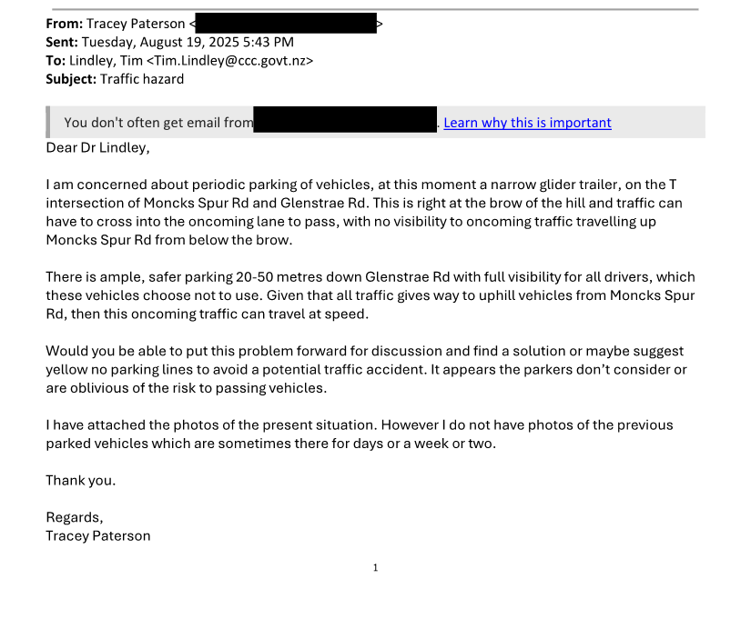
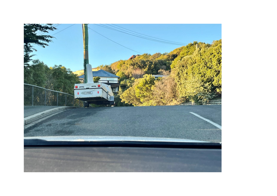
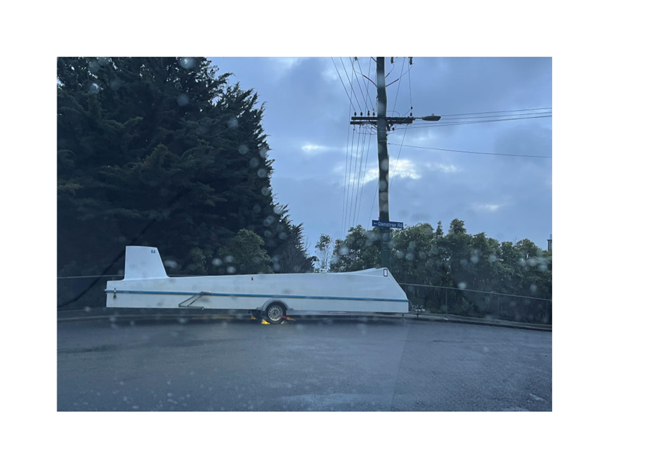
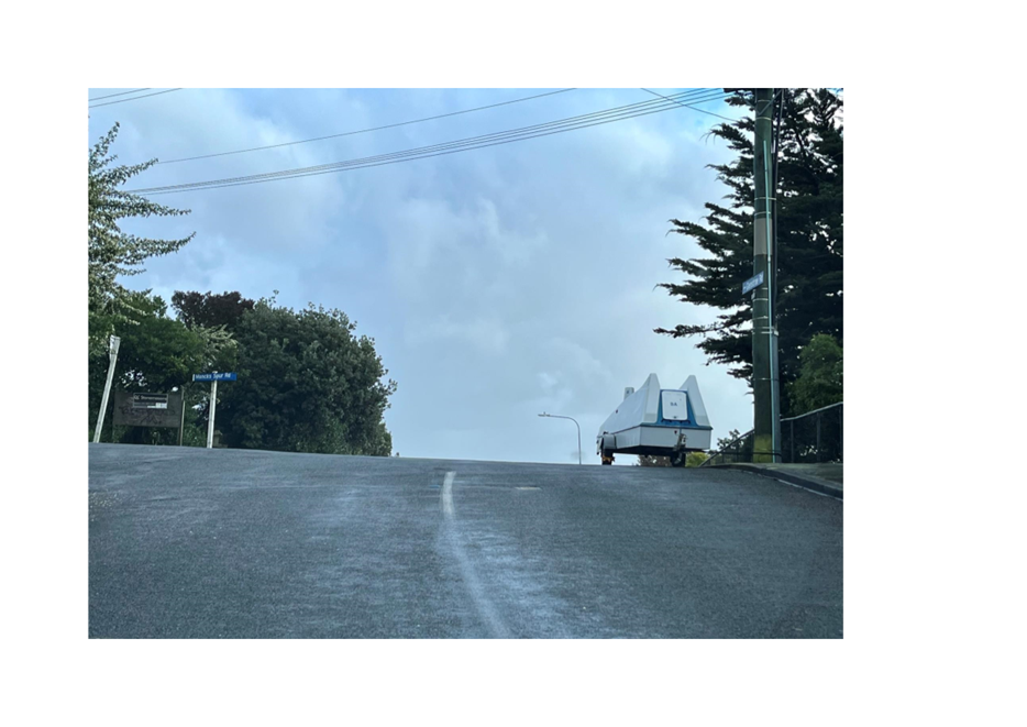
Tracey Paterson
|
Traffic hazard - Moncks Spur Road and
Glenstrae Road
|
|
Prue Parsons
|
Tree hazard on Rose Street
|
|
Sean Eustace
|
Cycleway safety on Collins Street in
Addington
|
|
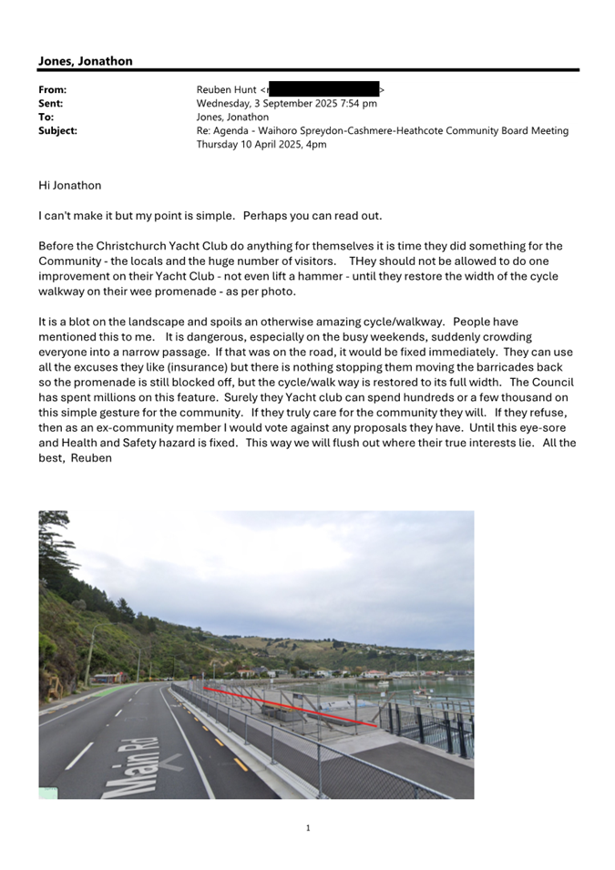
Reuben Hunt
|
Christchurch Yacht Club application for
Building and Site Development
|
2. Officer Recommendations Ngā
Tūtohu
That the Waihoro
Spreydon-Cashmere-Heathcote Community Board:
1. Receives the information in the correspondence
report dated 11 September 2025 from Tracey Paterson via Tim Lindley in relation
to Traffic hazard - Moncks Spur Road and Glenstrae Road and refers the issue to
staff for investigation and report back to the Board.
2. Receives the information in the correspondence
report dated 11 September 2025 from Prue Parsons via Melanie Coker in relation
to a tree hazard on Rose Street and refers the issue to staff for investigation
and report back to the Board.
3. Receives the information in the correspondence
report dated 11 September 2025 from Sean Eustace via Melanie Coker in relation
to cycleway safety on Collins Street in Addington and refers the issue to staff
for investigation and report back to the Board.
4. Receives the information in the correspondence
report dated 11 September 2025 from Reuben Hunt in relation to item 9,
Christchurch Yacht Club - Application for Building and Site Development.
Attachments Ngā Tāpirihanga
|
No.
|
Title
|
Reference
|
Page
|
|
a ⇩
|
Correspondence
- Tracey Paterson - Traffic hazard - Moncks Spur Road and Glenstrae Road
|
25/1779482
|
16
|
|
b ⇩
|
Correspondence
- Prue Parsons - Tree hazard on Rose Street
|
25/1797379
|
20
|
|
c ⇩
|
Correspondence
- Sean Eustace - Cycleway safety on Collins Street
|
25/1800373
|
21
|
|
d ⇩
|
Correspondence
- Reuben Hunt - Christchurch Yacht Club application for Building and Site
Development
|
25/1800453
|
23
|
|
8. Hoon Hay Park - Te Kōmanawa
Rowley School - Place Cadet Nature Play Project
|
|
Reference Te Tohutoro:
|
25/951965
|
|
Responsible Officer(s) Te Pou Matua:
|
Megan
Carpenter, Team Leader Parks Recreation & Planning
|
|
Accountable ELT Member Pouwhakarae:
|
Andrew
Rutledge, General Manager Citizens and Community
|
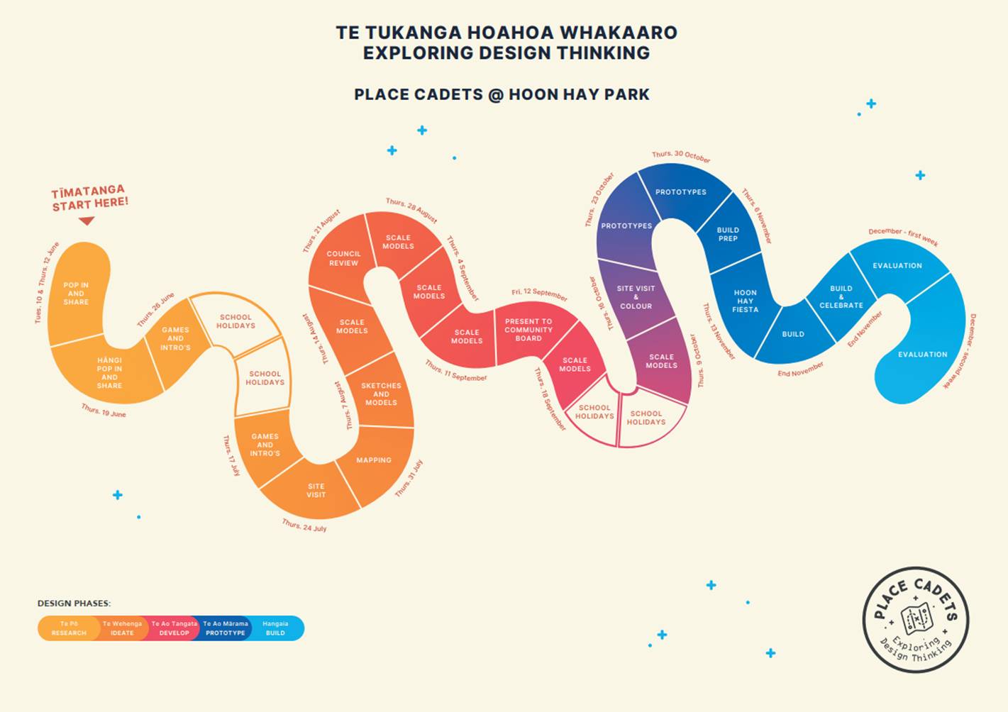
1. Purpose and Origin of the Report Te Pūtake Pūrongo
1.1 The
purpose of this report is for the Waihoro Spreydon-Cashmere-Heathcote Community
Board to approve the concept plan for a nature play space proposed for Hoon Hay
Park by tamariki at Te Kōmanawa Rowley School.
1.2 The
report is in response to a Place Cadet nature play project that a class at Te
Kōmanawa Rowley School have been completing for Terms 2, 3 & 4 at
school in 2025.
2. Officer
Recommendations Ngā Tūtohu
That the Waihoro
Spreydon-Cashmere-Heathcote Community Board:
1. Receives the information in the Hoon Hay
Park - Te Kōmanawa Rowley School - Place Cadet Nature Play Project Report.
2. Notes that the decision in this report is assessed as low significance
based on the Christchurch City Council’s Significance and Engagement
Policy.
3. Approve the concept plan for the construction of nature play at Hoon
Hay Park as per attachment A.
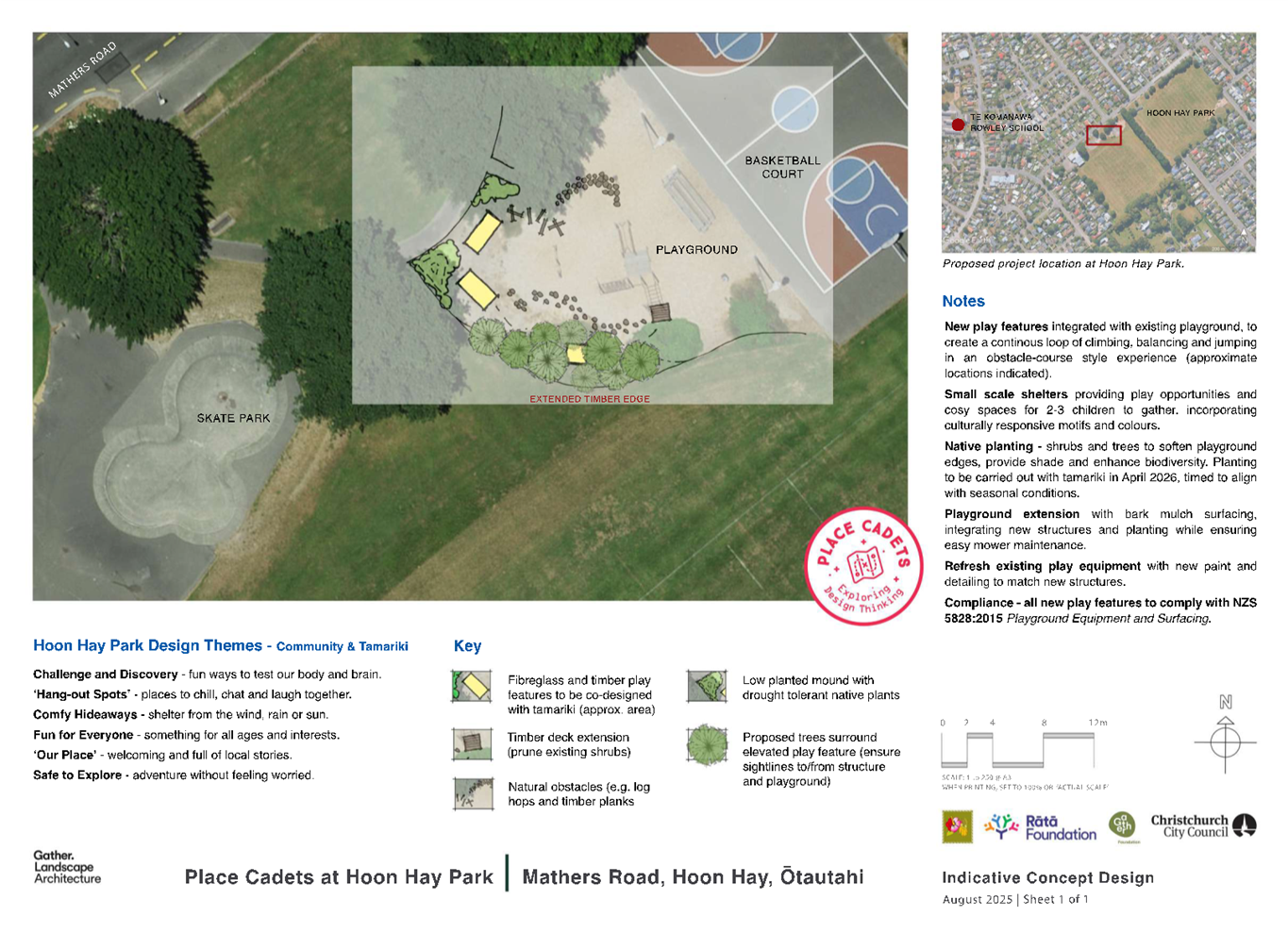
3. Executive Summary Te Whakarāpopoto Matua
3.1 The
report recommends Community Board approval for a nature play space at Hoon Hay
Park.
3.2 A
classroom of 10-year-old tamariki at Te Kōmanawa Rowley School have been
participating in a Place Cadet programme led by the Gather Foundation.
3.3 They
have developed a concept plan for a nature play area adjacent to the existing
playground on Mathers Road at Hoon Hay Park.
4. Background/Context Te Horopaki
4.1 Hoon
Hay Park is located at 75 Mathers Road, Hoon Hay. It is a large sports park
that has a skate park, full basketball court, and two playgrounds.
4.2 A
class of students at Te Kōmanawa Rowley School are participating in a
Place Cadet project led by the Gather Foundation. The Gather Foundation offer
curriculum-aligned, co-design programmes, focused on creating outdoor structure
and environments at no cost for schools. “When children have
opportunities to take part in the design of their outdoor spaces, they feel
valued and develop a sense of belonging, manaakitanga and kaitiakitanga for
their local environments.” (source - (Gather Foundation).
4.3 This
is the first project that the Gather Foundation has completed on a park, the
programme is usually led within the school grounds. However, in this case the
school participated in this programme in 2023 and were keen to move outside the
school grounds to their local park.
4.4 The
programme started in June 2025, and the tamariki have been to a site visit on
the park, been mapping locations, and completing sketches and models. They have
been learning about the local wetlands, ecology, and their place within these
spaces, they have been getting creative and sharing ideas so they can make the
park even better for the whole community.
4.5 Theme
of the tamariki’s brief for the landscape plan;
· Challenge and Discovery – Fun ways
to test your body and brain
· Hang out spot – places to chill,
laugh, and chat together
· Comfy Hideaways – shelter from the
wind, rain, and sun
· Fun for Everyone – something for
all ages and interest
· ‘Our Place’ –
welcoming and full of local stories
· Safe to explore – adventure
without feeling worried

Te Kōmanawa
Rowley School tamariki creating early play models.
Image source:
Photographer - Petra Mingneau
4.6 Parks
staff attended a workshop with the tamariki in August to discuss possible
locations for the nature play area and other design considerations. The
tamariki were discussing landscape features and moulding these out of clay and
paper.
4.7 The
attached concept plan is an indicative design, as the tamariki are still
working through the details of each feature. Staff will share more information
to the Community Board via memo once the details are confirmed, prior to any
works onsite.
4.8 The following related information session/workshops have taken place
for the members of the meeting:
Options Considered Ngā
Kōwhiringa Whaiwhakaaro
4.9 The
following reasonably practicable options were considered and are assessed in
this report:
4.9.1 Approve the
concept plan for the construction of a nature play space at Hoon Hay Park.
4.9.2 Do not approve
the concept plan and request that Gather Foundation consider an alternative
concept plan.
4.10 The following
options were considered but ruled out:
4.10.1 Do nothing (status quo).
This was ruled out due to the process that the tamariki have been involved in
and the amount of time involved.
Options Descriptions Ngā
Kōwhiringa
4.11 Preferred
Option: Approve the concept plan for the construction of a nature play
space at Hoon Hay Park.
4.11.1 Option Description:
Approve the concept plan for the construction of a nature play space at Hoon
Hay Park.
4.11.2 Option Advantages
· Support a project that gives local tamariki an opportunity to develop
manaakitanga (process of showing respect, generosity, and care for others) and
kaitiakitanga (guardianship and protection) for their local park.
· A small portion of the playground at Hoon Hay Park receives an
upgrade and refresh at no substantial cost to the ratepayer.
· The tamariki are developing a stronger connection to their local
park and participating in Council processes e.g. engagement, Community Board
approval, construction and ongoing care of park.
4.11.3 Option Disadvantages
· None noted.
4.12 Do not approve
the concept plan and request that Gather Foundation consider an alternative
concept plan.
4.12.1 Option Description: Do
not approve the concept plan and request that Gather Foundation consider an
alternative concept plan.
4.12.2 Option Advantages
· Can give the Community Board more time to consider a concept plan
that has more information and details.
4.12.3 Option Disadvantages
· The project timeframe is within the school calendar year. This group
of school kids would not be able to develop an alternative plan and gain
Community Board approval prior to the end of the school year.
· Adding additional costs to a project that had limited budget.
Analysis Criteria Ngā Paearu
Wetekina
4.13 The options were
assessed considering the time the tamarki have spent on the project to date and
the wider impact on the park.
5. Financial Implications Ngā Hīraunga Rauemi
Capex/Opex Ngā Utu Whakahaere
|
|
Recommended Option
|
Option 2 – Request alternative
|
|
Cost to Implement
|
n/a – Gather Foundation are funding.
CCC parks may contribute plants and trees to support project out of existing
budgets
|
Additional cost to Gather Foundation to
work with the children and consider an alternative design.
|
|
Maintenance/Ongoing Costs
|
Covered within existing Parks OPEX and
support from volunteers.
|
Covered within existing Parks OPEX and
support from volunteers.
|
|
Funding Source
|
External budgets
|
External budgets
|
|
Funding Availability
|
n/a
|
n/a
|
|
Impact on Rates
|
n/a
|
n/a
|
6. Considerations Ngā Whai Whakaaro
Risks and Mitigations Ngā
Mōrearea me ngā Whakamātautau
6.1 The
risk around the project not being delivered is low, due to the Gather
Foundation having funding to deliver the project and support from the wider
community to build and implement the concept plan.
Legal Considerations Ngā
Hīraunga ā-Ture
6.2 Statutory
and/or delegated authority to undertake proposals in the report:
6.2.1 As per the
Christchurch City Council’s Delegation Register dated 25 March 2025, the
Community Board has the delegation:
· Approve and adopt any new landscape development plans for parks and
reserves provided the design is within the policy and budget set by the Council
(Community Board Delegations Register pg.96 Part D – Sub Part 1 –
Community Boards.)
6.3 Other Legal Implications:
6.3.1 There is no
legal context, issue, or implication relevant to this decision.
Strategy and Policy Considerations Te Whai
Kaupapa here
6.4 The
required decision:
6.4.1 Align with the
Christchurch
City Council’s Strategic Framework.
6.4.2 Is assessed as
low significance based on the Christchurch
City Council’s Significance and Engagement Policy. The level of
significance was determined by the number of people effected by the proposal
and the impacts on the wider reserve.
6.4.3 Is consistent with Council’s Plans and
Policies.
· Physical Recreation and Sports Strategy 2002
· Te Haumako; Te Whitingia Strengthening Communities Together Strategy
2022-2032
6.5 This
report supports the Council's
Long Term Plan (2024 - 2034):
6.6 Parks, Heritage and Coastal Environment
6.6.1 Activity: Parks and Foreshore
· Level of Service: 6.8.5 Resident satisfaction
with the overall availability of recreation facilities within the City's parks
and foreshore network - >= 70%
Community Impacts and Views Ngā Mariu
ā-Hāpori
6.7 The
tamariki at Hoon Hay School and the Gather Foundation have been leading the
consultation for this project. At this stage there has not been any wider
formal engagement led by the Council.
6.8 There have been three community drop-in sessions based on
advice from the school as the best way to connect to the community.
6.8.1 One was at a
community hāngi at the school, attended by several hundred people. Many
tamariki outside the project group came to the project table and shared their
ideas directly with many different ages attending.
6.8.2 Another took
place in Hoon Hay Park during a busy sports evening.
6.8.3 The third was
held at the school during afternoon pickups.
6.9 Other
engagement opportunities include
· Input from preschool and kindergarten – the team have talked
with both groups at the hāngi and met separately because they wanted to
give more detailed feedback.
· Three Year 8 students, who were involved in the previous project,
have offered to be mentors for this one and have been attending sessions where
possible.
· Project updates are posted on the school’s Facebook
page and discussed in classrooms, encouraging tamariki to talk with their
families and peers.
· Home updates - we know children regularly discuss the work at home,
which broadens whānau awareness and involvement.
6.10 All community
input is being mapped and will be compiled for review and shared with the Council
at the end of the project.
6.11 The concept plan
has been shared with the Council’s Sport Liaison Officer to ensure that
the proposal does not impact on sports allocation within Hoon Hay Park.
6.12 The decision
affects the following wards/Community Board areas:
6.12.1 Waihoro
Spreydon-Cashmere-Heathcote
Impact on Mana Whenua Ngā Whai Take
Mana Whenua
6.13 The decision does not involve a
significant decision in relation to ancestral land, a body of water or other
elements of intrinsic value, therefore this decision does not specifically
impact Mana Whenua, their culture, and traditions.
6.14 The decision does not involve a
matter of interest to Mana Whenua and will not impact on our agreed partnership
priorities with Ngā Papatipu Rūnanga.
6.15 There is no
change of any significance to the existing use of the park.
Climate Change Impact Considerations Ngā
Whai Whakaaro mā te Āhuarangi
6.16 The proposals in this report are
unlikely to contribute significantly to adaptation to the impacts of climate
change or emissions reductions.
6.17 The proposal to
approve the concept plan for a nature play space does not have an impact on
climate change. The development will involve the use of additional
resources, but this is not regarded as significant and is reasonable in the
circumstances as the proposal encourages local community involvement generally
and in that sense the carbon associated with travel is low.
7. Next Steps Ngā Mahinga ā-muri
7.1 The
tamariki will continue to develop models as their detailed design if the
concept plan is approved by the Community Board. The detailed design will be
shared with the Community Board via memo.
7.2 A
scaled prototype of the nature play space will be created in October with the
aim to construct the space in November 2025. The construction will be a team
effort by the tamariki with support from their whanau and qualified
tradespeople.
7.3 The
Parks Unit will manage the works onsite via a Temporary Access Permit and will
involve our Parks Partnership Rangers.
Attachments Ngā Tāpirihanga
|
No.
|
Title
|
Reference
|
Page
|
|
a ⇩
|
Hoon Hay Park
- Nature Play Indicative Concept Plan - August 2025
|
25/1706492
|
31
|
|
b ⇩
|
Hoon Hay Park
- 2025 Place Cadets Calendar - Final
|
25/1696084
|
32
|
In addition to the attached documents, the following background
information is available:
|
Document
Name – Location / File Link
|
|
Not
applicable
|
Signatories Ngā Kaiwaitohu
|
Author
|
Megan
Carpenter - Team Leader Parks & Recreation Planning
|
|
Approved By
|
Kelly Hansen -
Manager Parks Planning & Asset Management
Al Hardy -
Manager Community Parks
Rupert Bool -
Head of Parks
|
|
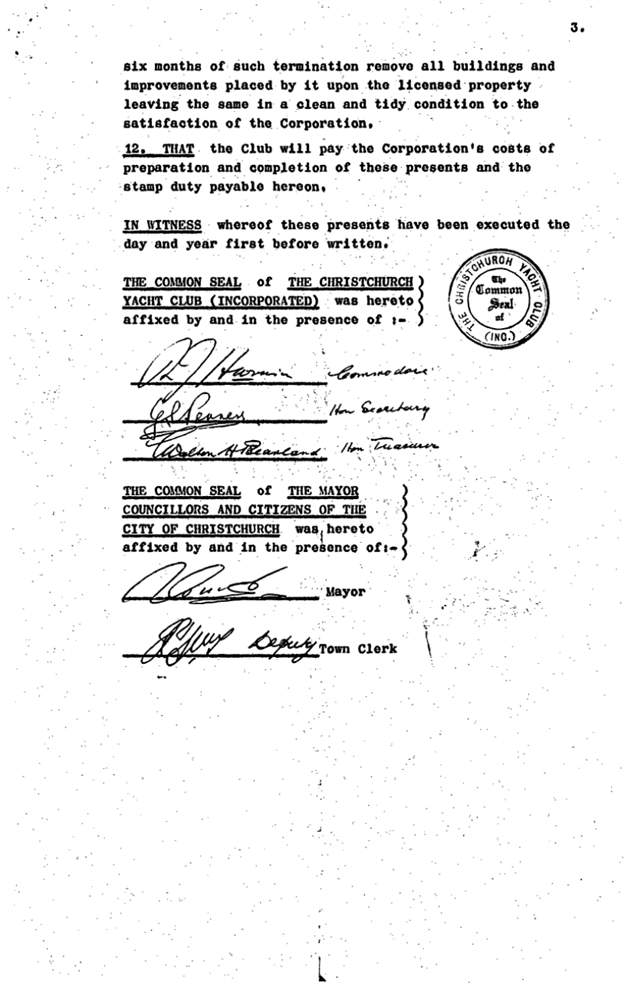
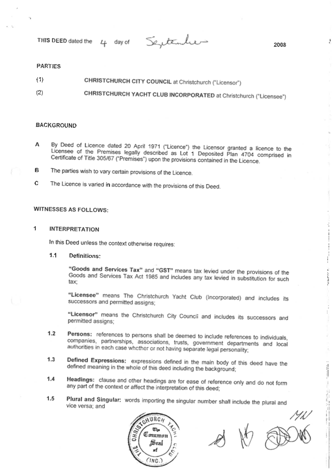
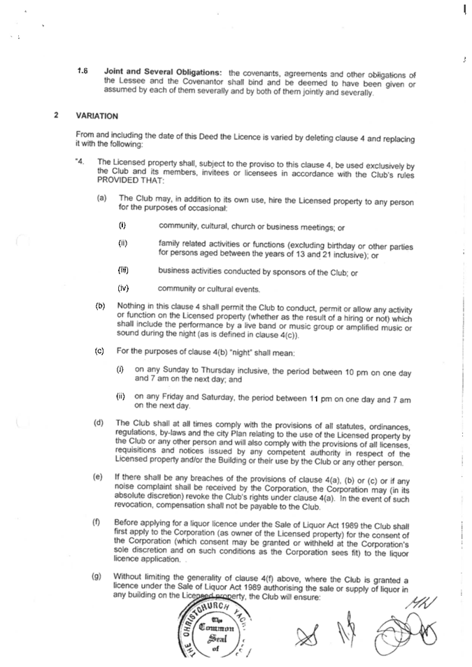
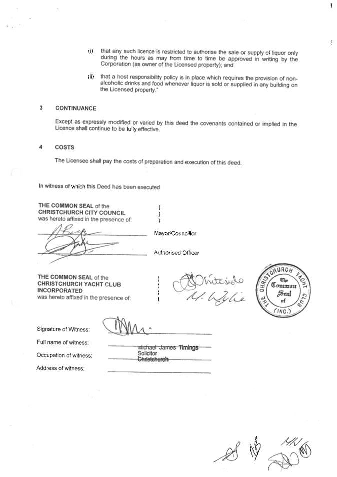
9. Christchurch Yacht Club -
Application for Building and Site Development
|
|
Reference Te Tohutoro:
|
25/1521186
|
|
Responsible Officer(s) Te Pou Matua:
|
Jason
Tickner, Parks and Recreation Planner; Felix Dawson, Leasing Consultant
|
|
Accountable ELT Member Pouwhakarae:
|
Andrew
Rutledge, General Manager Citizens and Community
|
1. Purpose and Origin of the Report Te Pūtake Pūrongo
1.1 The
purpose of this report is to consider the application by the Christchurch Yacht
Club (the Club) for the construction and use of a new storage building,
concourse extension, boat ramp extension, and additional fencing at Yacht Club
Reserve, 239 Main Road, Moncks Bay.
1.2 The
report is staff initiated to address the request from the Club.
2. Officer
Recommendations Ngā Tūtohu
That the Waihoro
Spreydon-Cashmere-Heathcote Community Board:
1. Receives the information in the Christchurch Yacht Club -
Application for Building and Site Development Report.
2. Approve the construction and use of a new
storage building, concourse extension, boat ramp extension, and additional
fencing at the west side of Yacht Club Reserve, 239 Main Road, Moncks
Bay, in accordance with the plans shown in Attachment A
of the agenda report.
3. Notes that:
a. approval is subject to the Christchurch Yacht Club meeting all
regulatory requirements including the Building Act 2004 and the Resource
Management Act 1991. This includes, but is not limited to, gaining resource
consent approval from the Christchurch City Council and the Canterbury Regional
Council.
b. the decision in this report is assessed as low significance based on
the Christchurch City Council’s Significance and Engagement Policy.
c. appropriate consultation has been undertaken.
4. Requests that the Manager Property Consultancy does all things
necessary and make any decisions at his sole discretion that are consistent
with the intent of this report to implement the resolutions above including
approving final design, completing negotiations, and administering the terms
and conditions of the updated licence.
3. Executive Summary Te Whakarāpopoto Matua
3.1 The
Christchurch Yacht Club (the Club) have been in continuous occupation of the
site at 239 Main Road, Moncks Bay for the purpose of a yacht club since 1891
and continue to operate as a functioning club with a proud history of producing
top class sailors.
3.2 The
Club’s facilities are run down and have not been repaired since the
earthquakes. For the Club to continue, repairs and improvements are
required to the building facilities, ramp and concourse wharf areas. The
Club have historically left the licence area open to the public but in recent
years have experienced consistent difficulties managing public swimming from
their pontoon and have looked at fencing options to help manage the issue.
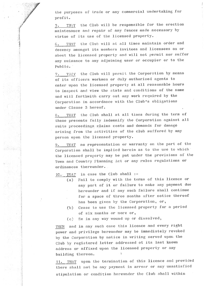
3.3 Under
the terms of the Licence, the Licensee is required to ask for Landlord approval
for any building or fencing improvements. The Landlord is required to
give reasonable consideration to such requests and cannot unreasonably withhold
consent.
3.4 The
Club have been in correspondence with the Council since 2023 regarding their
plans to develop the site to enable the Club to continue to function into the
future with particular emphasis on providing a facility to enable development
of young sailors.
3.5 There
have been several consultations to determine community views, and the Club have
made design changes in response to the submissions. The key changes are
reduction of the rescue boat shed size to a minimum and dropping the proposal
to fence the eastern boundary.
3.6 The
resulting plans proposed for approval include:
· Extending the existing pier/concourse to the northwest of the
existing clubhouse
· Installing new concrete slipway for launching boats on the western
boundary
· Construction of a new rescue boat storage building on the
southwestern boundary
· Fencing the western side of the property at the boundary around the
new development
3.7 The building
work will remain within the footprint of their licensed site. Planning and
building consent will be required separate to this process and will need to be
advanced by the Club.
3.8 Building costs
would be covered by the Club, and not the Council.
3.9 The
Parks Unit supports the new design and rebuild on the basis that:
· the existing wharf/ramp needs replacement to enable the Club to
continue as a functioning yacht club into the future
· the new boatshed is a reasonable proposal and is required to enable
the Club to continue as a functioning yacht club into the future
· the proposed west fence between the club house and proposed storage
shed is a reasonable proposal and necessary to assist the Club in management of
the site
· approval will lower the risk of challenge from the Club to the
exercise of the Council’s obligations under the exclusive licence.
3.10 Staff consider
that the recommended option represents a balance between the needs and rights
of the Club and the impact and effects on neighbours and the community.
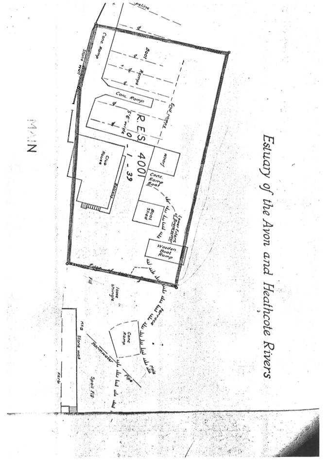
4. Background/Context Te Horopaki
The Property
4.1 The
Club is located at 239 Main Road, Moncks Bay (Lot 1 DP 4704) on the Council
owned ‘Yacht Club Reserve’, which is shown in red below
and is treated as park under the Local Government Act 2002.
4.2 The
Club site adjoins the Avon-Heathcote Estuary / Ihutai to the north, Main Road
and the Coastal Pathway to the south, and the Council owned public car park and
boat ramp to the east.
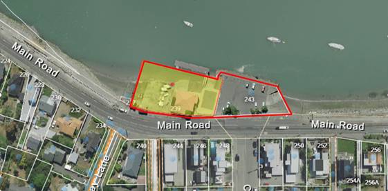
Figure 1 - Yacht Club Reserve
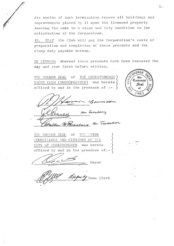
4.3 The
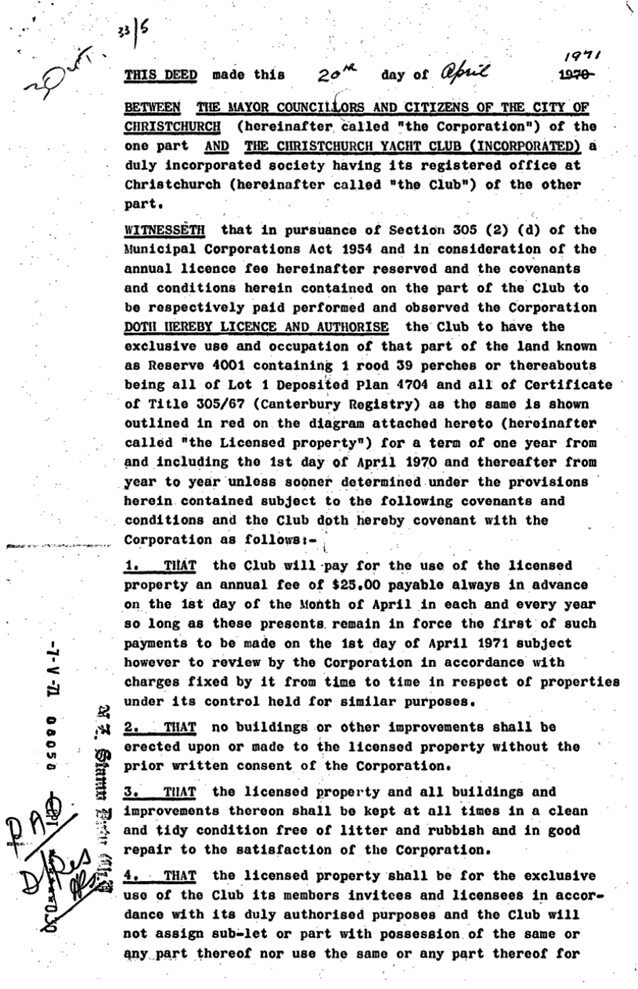
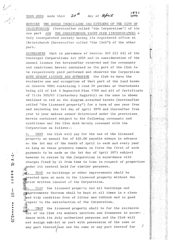
park was originally owned by the Club but in 1971 after subsidence problems
with the carpark area the Club and the Council entered into an agreement
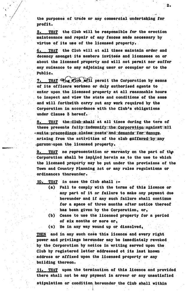
whereby the Council took ownership of the carpark and public access ramp. The
Club received a licence in perpetuity for its improvements: the clubhouse,
ramps and wharf/concourse, shown in yellow above.
4.4 The
area is popular with walkers, cyclists, swimmers, fishermen, kayakers, and
other recreational craft users. The public gain water access through the
carpark and ramp to the east but have also traditionally made use of the Club
wharf facilities which have been left open by the Club for public use.
Rowing Club Site
4.5 It
should also be noted that the Club have rights over the former rowing club site
situated to the east and shown in yellow below. This is not a
Christchurch City Council owned or managed reserve/land holding and not the
subject of this report.
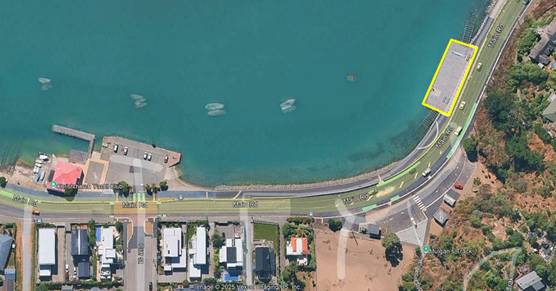
Figure 2 - Former Rowing Club Site
4.6 The
redevelopment of the site has been on-going for a number of years but on hold
until recently with issues around piling construction. The outstanding issues
have since been resolved and the Club are currently progressing the completion
of the jetty, and boatshed which is used purely by adult sailors as the strong
tidal flow makes it unsuitable for juniors and rescue craft.
4.7 The
Council considered and came to the resolution on the 20 June 2017 as part of
the 2017/2018 Annual Report, to grant the Club $239,713 as a contribution to
repairs on the facility in conjunction with work undertaken on the Coastal
Pathway. This money has been ring fenced and will be applied to the
construction of the new ramps and reinstatement of the jetty and boatshed on
that site. The funding was conditional on the following:
· There is enduring public access in perpetuity to the Coastal
Pathway, and adjoining deck area and ramps providing access to the beach area
below.
· The design and specifications of the replacement base are consistent
with the developed design for the Coastal Pathway.
Christchurch Yacht Club
4.8 The Christchurch
Yacht Club was established in 1891 in Monck’s Bay (originally known as
‘Christchurch Sailing Club’) and has been an active sailing club
every year since. The Club has produced several Olympic sailors and
continues as a well-functioning club with a current focus on its junior
programme.
4.9 Membership numbers for the Club have fluctuated over the last seven
years, with a drop in 2021 – 2023 primarily due to Covid 19 although
membership has stabilised at around 95. The Club membership numbers are
listed below:
· 2017-2018 season
100
· 2018-2019 season
125
· 2019-2020
season 123
· 2021-2021 season
99
· 2022-2023 season
94
· 2023-2024 season
95
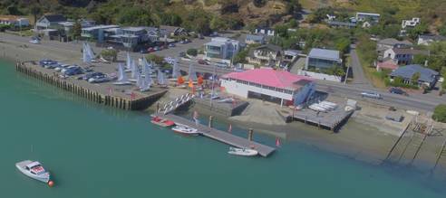
Figure 3 - Christchurch Yacht Club
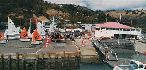
Figure 4 - Club Site and Car Park during a Regatta
4.10 The Club
operates from a central two-storey building consisting of the club house on the
top floor and storage at ground floor. A winch is operated from the
downstairs storage for the purpose of rescue boat haul out. A rigging
area and boat ramp is located to the east of the main building which is fenced
by means of low posts and rope. To the west of the building is an existing
wooden concourse/wharf being used as temporary yacht storage. It is run
down and in need of replacement. There is also an additional boat ramp
and dry dock next to the wharf that is run down and in need of repair. Past use
of the site for antifouling is no longer appropriate.
4.11 The Club has
built and own the floating pontoon in front of the club house. This structure
extends beyond the licence area, into the Estuary/Ihutai.
4.12 The current
facilities are dated and in need of repair or replacement to enable the Club to
maintain existing membership levels and continue to operate long term. The
Club has prepared a staged development plan, with stage one being the subject
of this report for Council consideration and approval.
4.13 Stage one
contains three key elements: a repaired wharf/concourse with small extension
and re-siting of the ramp further west to link with a new patrol boat shed. The
west area will be fenced. This is stage one and will be undertaken in
conjunction with work on the Rowing Club.
4.14 Stage two will
involve either repair or replacement of the existing clubhouse and will require
a further decision of the Council. A staged approach enables the Club to
continue operating during reconstruction work.
Key Operational Issues - Why the Club has
Proposed this Development
4.15 Overcrowding-wharf and concourse
· Existing
flat space for rigging is limited largely to the east side due to the damaged
concourse/wharf on the west. This results in overcrowding in the rigging
area on the east side of the clubhouse with yachts frequently spilling over
into the car park.
· Modern
yacht clubs require the operation of IRB patrol boats with four being a minimum
for a club of this size. These are currently tightly stored under the
clubhouse and launched by way of a power-driven winch from inside the building
down a steep ramp. This splits the use of the two rigging areas and
creates health and safety issues at time of launching with strict safety
protocols required on the ramp and potential conflict with swimmers on the
pontoon. Launching is difficult from this location and not well suited
for emergency access. Moving the main launching ramp away from the
pontoon will help to alleviate the issues. Storage of boat fuel under the
wooden clubhouse is also a significant risk.
A larger
rigging space keeping yachts within the license area is required to free up the
car park for public use. Moving the rescue boats to dedicated storage and
a separate launching facility is also preferred to enable effective use of the
rigging space and launching away from people walking past. It will also
function in a safer/quicker manner for launching rescue boats particularly in
the case of emergencies.
4.16 Public use of the pontoon for swimming
The Club wharf
has always been popular for public swimming. Since the introduction of
the pontoon, popularity has continued to increase, and the Club consistently
experiences problems with launching of yachts and patrol boats on club days.
This has even escalated to threats of violence to club members from swimmers
and is causing increasing health and safety concerns for the club.
Signage and a gate in front of the pontoon have proved unsuccessful to-date in
effectively managing this issue. The Club has reluctantly conceded that
to manage this issue increased fencing to control access may be required.
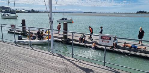
Figure 5 - Conflict between swimmers and powerboats at the club
owned pontoon
Club Development Proposals
4.17 In June 2023, in
response to issues with the public on the pontoon, the Club requested Council
consent to the installation of fencing on both the east and west side of the
licence area. The proposal included lockable boat access gates on the
east side together with a pedestrian gate.
4.18 Consultation
with the neighbours and local community generated a number of objections including
concern about aesthetic impact, restriction of public access and questioning the
need generally. The proposal was parked.
4.19 In November 2023 the Club submitted an initial development proposal
that addressed the storage and ramp issues. A fence on the west side was
included but a fence on the east side was not re-visited at that stage.
4.20 The key elements
of the design included:
· Extending the existing pier/concourse to the northwest of the
existing clubhouse and removing existing ramp
· Installing a new concrete ramp for launching boats on the western
boundary
· Construction of a new rescue boat and junior yachts storage building
on the southwestern boundary
· Fencing the western side of the property at the boundary
4.21 The initial
proposal was intended to provide increased rigging area, storage for rescue
boats and junior dinghies, and a re-located launching ramp for rescue boats and
yachts. The building design was of a low sloping roof with local stone
cladding. It was intended to minimise visual intrusion through being of
the lowest feasible height and clad with the same stone used on the walls along
the Coastal Pathway. The contentious fence and lockable gates on the east
side were not included. The design is shown below:
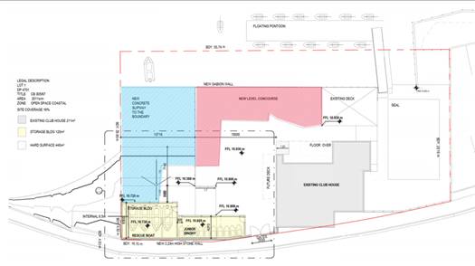
Figure 6 - Original Proposal (Site Plan)
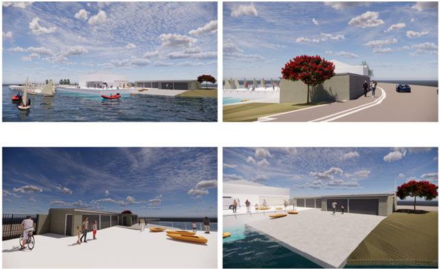
Figure 7 - Original Proposal (Artist Impressions)
Community
Engagement
4.22 Community consultation for the
above proposal was undertaken in December 2024. It included a sign on the
premises, ‘Have Your Say Page’ on the Council website, letter box
drop, and communication with key stakeholders.
4.23 The building design was not
supported by the majority of submitters with objections to the size of the
structure, intrusion into view shafts, and poor design style generally.
The new ramp and increased concourse area was generally supported although
submissions expressing concern over intrusion into the estuary and amenity
overall were received. A summary and schedule of the feedback for the
initial design and earlier fence proposal is contained in the attached link: Kōrero mai
webpage
Revised Design
4.24 Following consultation on the
initial design above, the Club undertook a redesign of the development to
attempt to alleviate some of the concerns raised by submitters. The main
changes included:
· Reduced length of
the storage building by 9.42m or 41.1% to minimise visual intrusion.
· Reduced total area
of building from approximately 128.6m² to 93.1m² being a 27.6%
reduction.
· Modified cladding
· Change in building
style from the flat roof, rock wall style, to a more architectural boat shed
style.
· Fencing on the
east and west side
4.25 The revised design is shown below
and included in Attachment A
Figure 8 - Redesigned Site Plans (Change to Storage Building)
Figure 9 - Redesigned Proposal (Artist Impression)
4.26 Revised design comment
Wharf/concourse
4.27 This configuration has remained consistent
in both designs. It addresses the Club’s issue of limited rigging
space and ramp issues in front of the Club. It has been generally
supported although with some concern over increased intrusion into the estuary,
amenity and effect on ecology. These are discussed in paragraph 6.25.
Boat Shed Building
4.28 The revised design was produced
as a response to criticism around the bland linear nature and size of the first
design. The size has been reduced to the minimum required for rescue boat
storage leaving a view shaft between the club house and proposed boat
shed. Dinghy storage has been removed.
4.29 The design style was modified to
produce a more classical boat club look with traditional cladding and pitched
roof. Staff acknowledge neighbours’ concerns over visual intrusion
but note that the Club has reduced the size to the minimum required to continue
to operate and that the revised design generally received a more favourable
public response than the first option.
Fences
4.30 Fencing on the west side
of the club house is continued and considered necessary to secure the site and
the new developments from the road (see Fig.9).
4.31 Due to the length of the process
for approval and risk that in the future a further fence request would be
required, the Club chose to re-introduce the fencing proposal at the eastern
side of their licence area as part of this redesign.
4.32 Taking on board criticisms of the
first fence consultation the Club made changes including: brand-new fence instead
of second-hand option, open style, relatively low (1.4m) pool style fence to
reduce impact on sightlines, light grey colour to minimise visual impact, and
as per the original design, providing a pedestrian gate to allow public access
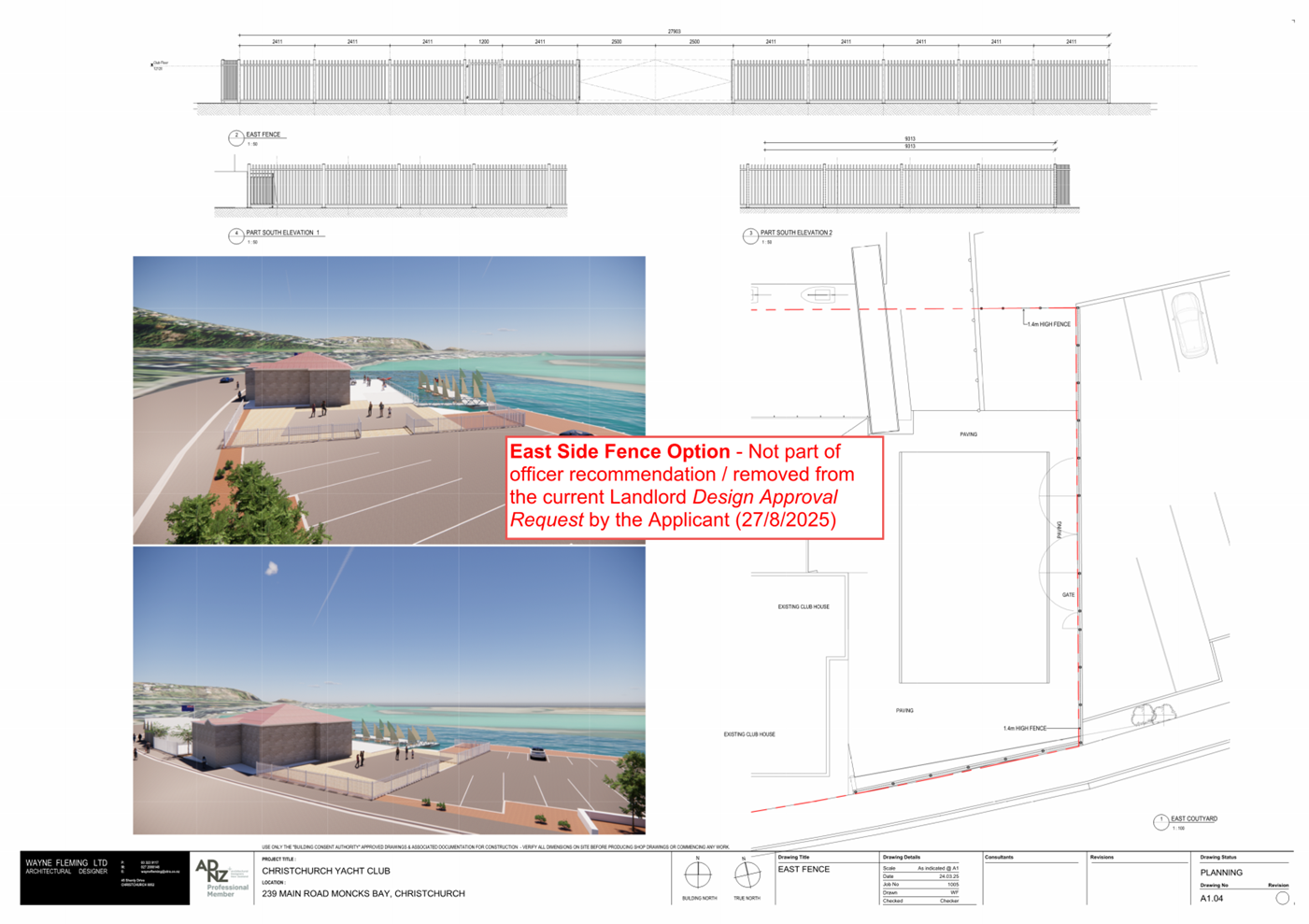
during daytime and non-event days. The proposed fence is shown below.
Figure 10 - East Side Fence Proposed (removed)
4.33 The above revised design was
circulated to original submitters in March 2025 for further comment.
4.34 This feedback was reported to the
Community Board by way of an Information Session on the 29 May 2025.
4.35 A final round of wider community
engagement seeking comment on the final proposed plans was undertaken in July
2025. Refer para 6.25 for detailed discussion summarising issues and staff
comment.
4.36 The Club has made a late change
and agreed to withdraw the proposed east fence from the design in response to
community concerns.
4.37 Council
Process Summary
|
Proposal
|
Process
|
Date
|
Comment
|
|
Request for new fence
|
Local consultation
|
September 2023
|
Objections to style of fence and
perceived loss of public access despite undertaking to leave gate unlocked
|
|
Original Development Proposal -
Information Sharing
|
Initial Information Session with
Community Board
|
26 September 2024
|
Inform the Community Board of the new
development proposal, the process moving forward, and the previous objections
to fencing.
|
|
Initial design- re-build concourse, /jetty,
new build of boat shed- fence only on west side boundary
|
General consultation through ‘have
your say’ page and direct contact with neighbours and key stakeholders
|
1 November – 3 December 2024
|
No major objections to concourse and ramp
proposal other than concerns about ecology
Objections to size/scale, visual
intrusion and style of building
|
|
Revised design- re-build concourse, /jetty,
new build of boat shed (revised), includes fence on east side boundary as
well
|
Targeted consultation to those who
submitted on initial design
|
9 April 2025 - 12 May 2025
|
Similar response to above on
concourse/ramps
Less objections to style and size of
building, still some objections to visual intrusion arising from the building
itself, and objection to fencing proposal
|
|
Revised Development Proposal -Information
Sharing
|
Second Community Board Information Session
|
29 May 2025
|
Presentation of public submissions,
Presentation of revised proposal from the Club, Community Board discussion of
revised design and key issues
|
|
Design without change from above
|
General consultation through ‘have
your say’ page and direct contact with neighbours and key stakeholders
|
18 July - 3 August 2025
|
Similar response to above for revised
design, and additional support received from users/club members.
|
4.38 Additional Matters
Funding
4.39 External funding
will be required for this project. The Club cannot gain public funding until
they have approval and fully consented drawings for the project, followed by
establishing the estimated costs of the project. Only at this stage there will
be a presentable project for a marketing presentation.
Resource
Consents
4.40 The proposal
requires Resource Consent from the Christchurch City Council under the District
Plan and Canterbury Regional Council under the Regional Plan.
4.41 The Resource
Consent under the Christchurch City District Plan will consider the
environmental effects of the proposal in relation to the District Plan Rules,
and amongst other matters, will look at the impact of the club building on
neighbours, any earthworks and impacts on the coastline.
4.42 Resource Consent
is also required from the Regional Council under the Regional Plan for the
proposal, in particular building in a waterbody. The Regional Council will
consider the environmental effects and ecological impacts the development may
have, and if these can be avoided, remedied, and/or mitigated. The Club have
indicated that they are confident in gaining approval on the basis of previous adjoining
consents, including the Club’s Pontoon installation, and the Christchurch
City Council consent approval for the Coastal Pathway Project.
4.43 If the Community
Board are to approve the proposal as the Licensor, the proposal will still need
to gain both resource consents before construction can commence.
Options Considered Ngā
Kōwhiringa Whaiwhakaaro
4.44 The following
reasonably practicable options were considered and are assessed in this report:
4.44.1 Preferred option: Approve
the proposed building, concourse/wharf, slipway extension and fencing on west
side only.
4.44.2 Option 2 Approve
the proposed building, concourse/wharf, slipway extension and fencing on west
and east side.
4.44.3 Option 3: Approve
the concourse/slipway extension. Decline the building development and/or
fencing.
4.44.4 Option 4: Decline the
proposed building, concourse/slipway extension, and fencing.
4.45 The following
options were considered but ruled out:
· Do nothing: The Club requires certainty to enable it to plan future
use. To do nothing would significantly impact the long-term viability of the
Club
· Relocation: not favoured, the Club has historical links to the site,
and it remains a unique location for a yacht club in terms of low tide sailing
opportunity.
· Repair
existing clubhouse and jetty and continue with existing ramp: The Club need to
ensure the site can function effectively and safely and moving the ramp to the
west boundary will achieve that. The jetty is at ‘end of
life’ and not large enough to service the clubs need for rigging space. Therefore,
repairing the jetty and ramp in their current form was not considered as a
suitable option.
· Operate rescue boats from rowing club location: not favoured as site
is not suitable due to high tidal flow in this location.
· Further reduction of boatshed area: not favoured, the Club have
advised that the storage shed is the minimum required to enable this service
and storage of its rescue boats.
· Further consideration of boatshed design not favoured. The Club
responded to criticism of initial design with a revised design that was
generally supported. It is acknowledged that some visual intrusion will
occur. The question as to whether the pitch could be lowered or design is
unsuitable generally will be left to be considered by urban design experts at
resource consent stage.
Fencing
· Lower fence on west side not supported by the Club as it will not
provide a sufficient sense of security. The proposed fence matches
existing fences on Coastal Pathway.
· The use of a temporary fence on club days was suggested by some
submitters. This was not supported by the Club as creating an unnecessary
workload for volunteers with difficulty managing the use.
· A variation in licence to guarantee public pedestrian access has
been considered. This would require agreement by the Club who have been
unwilling to agree to such a change.
Options Descriptions Ngā
Kōwhiringa
4.46 Preferred
Option: Approve the proposed building, concourse/wharf, slipway extension
and fencing on west side.
4.46.1 Option Description: Construction
of boatshed on west side, replace and extend concourse removing existing ramp
and rebuilding the ramp on the west boundary. Fence the west side development
on the road boundary with a design consistent with Coastal Pathway. Public
access retained when not in use by the Club subject to management of health and
safety and other risks.
4.46.2 Option Advantages
· Provides the Club and its members certainty to move forward with the
redevelopment and improvement of their site that will enable maintenance of
membership with proper provision of space for rescue craft and rigging area.
· Positions the Club for potential future redevelopment of the main
clubhouse through the ability to continue to operate when the clubhouse is
redeveloped or refurbished.
· Provides a much safer launching area for rescue boats emergency
access and yachts.
· Proposed roadside fence will secure new development area.
· Proposed roadside fence design will be consistent with the Coastal
Pathway fencing.
· Not fencing the east side maintains the status quo to a large degree
in regard to public access to the site for swimming when not in use by the
Club, (subject to club assessment of reasonable management of Health and Safety
and other risks).
· The area is run down, and this option will see it revitalised
improving public amenity of the area generally.
· Takes account to some degree of the Club’s rights under the
exclusive licence.
· Likely removes the risk of challenge from the Club to the exercise
of the Council’s obligations under the licence.
4.46.3 Option Disadvantages
· Storage shed and proposed fence will create additional intrusion on
the site detracting from its open vista and partially blocking or obscuring
some view shafts from opposite neighbours and public generally.
· The ramp and concourse construction may have an impact on the
ecology of the area. This is likely to be relatively minor given the
construction is predominantly over existing concrete ramps. It will be
considered in detail in the resource consent with the Canterbury Regional
Council.
4.47 Option 2: Approve
the proposed building, concourse/wharf, slipway extension and fencing on both
the west and east side.
4.47.1 Option Description: Construction
of boatshed on west side, replace and extend concourse removing existing ramp
and rebuilding the ramp on the west boundary. Fence the west side development
on the road boundary with a design consistent with Coastal Pathway. Fence the
east side boundary. Public access retained when not in use by the Club subject
to management of health and safety and other risks.
4.47.2 Option Advantages
· Provides the Club and its members certainty to move forward with the
redevelopment and improvement of their site that will enable maintenance of
membership with proper provision of space for rescue craft and rigging area.
· Positions the Club for potential future redevelopment of the main
clubhouse through the ability to continue to operate when the clubhouse is
redeveloped or refurbished.
· Provides a much safer launching area for rescue boats and yachts.
· The fence on the east side will provide a clear and enforceable
boundary during club days to assist in management of public swimming from the
Club’s pontoon. It also provides a sense of club security for
the site generally when not in use despite being open to the public. It
should lead to reduced conflict.
· Proposed roadside fence design will be consistent with the Coastal
Pathway fencing.
· Maintains public access to the site when not in use by the Club,
(subject to club assessment of reasonable management of Health and Safety and
other risks).
· The area is run down, and this option will see it revitalised
improving public amenity of the area generally.
· Takes account of the Club’s rights under the exclusive
licence.
· Likely removes the risk of challenge from the Club to the exercise
of Council’s obligations under the Licence.
4.47.3 Option Disadvantages
· Storage shed and proposed fence will create additional intrusion on
the site detracting from its open vista and partially blocking or obscuring
some view shafts from opposite neighbours and public generally.
· Some members of the public perceive this area as public space, and
the east side fence is seen as a restriction on this.
· The ramp and concourse construction may have an impact on the
ecology of the area. This is likely to be relatively minor given the
construction is predominantly over existing concrete ramps. It will be
considered in detail in the resource consent with the Canterbury Regional
Council.
4.48 Option 3: Approve
the concourse and ramp extension. Decline the building development and/or
fencing.
4.48.1 Option Description: Some
submitters are opposed to the visual impact of the building and fence, as well
as opposing any physical restriction to public access. This option provides an
opportunity to minimise the concerns in part or whole by declining either the
boatshed or the fence or both. As a minimum the Club would have some
extended space for rigging and an improved ramp.
4.48.2 Option Advantages
· Will be supported by some submitters/neighbours.
· Provides the Club and its members some level of certainty to move
forward with part of the redevelopment.
· The expansion of the concourse will improve ability to better
accommodate activities within the licence area.
· Improved ramp enables easier access to water with boats.
· Maintains public access to the Club site and this section of estuary
edge (noting the Club has exclusive rights).
4.48.3 Option Disadvantages
Building
· Does not resolve the issue of insufficient storage area for the
Club’s rescue boats, and associated risks of storing petrol engines and
equipment underneath their wooden club house.
· Makes patrol and rescue boat launching more difficult and time
consuming especially in times of emergency.
· Limits the Club’s ability to provide a proper level of rescue
and patrol services.
· Does not resolve safety issues around existing winch retrieval of
boats in the middle of the club site.
Fence
· Limits the Club’s ability to manage its health and safety
obligations in terms of public swimming from the site.
· Doesn’t address safety concerns raised by the Club in terms of
public use of the pontoon.
General
· Provides uncertainty for the Club’s future if they cannot
develop their site to allow it to function for its licenced purpose,
potentially will fail to maintain existing or attract new membership.
· Doesn’t take account of the Club’s rights under the
exclusive licence.
· Could be challenged as an unreasonable decision by the Landlord
under the terms of the licence.
4.49 Option 4: Decline
the proposed building, concourse and ramp extension, and fencing.
4.49.1 Option Description: Do
not provide approval for any changes or improvements to the site.
4.49.2 Option Advantages
· Will be supported by some submitters/neighbours.
· No loss of current view shafts.
· No change to existing estuary ecology/ environmental effects.
· No physical barrier preventing public access, (noting however that
the Club has exclusive use rights).
4.49.3 Option Disadvantages
· The site and infrastructure will continue to deteriorate impacting
on site usability and amenity.
· Does not enable the Club to effectively and safely operate from a
site to which they have rights in perpetuity.
· Likely to prevent the Club from maintaining members and attracting
new members.
· Doesn’t take account of the Club’s rights under the
exclusive licence.
· Could be challenged as an unreasonable decision by the Landlord
under the terms of the licence.
Analysis Criteria Ngā Paearu Wetekina
4.50 The options in
terms of the design proposal were assessed taking into account the Club needs
to be able to continue to function, as against the impact of a new build on the
amenity values of neighbours and the public generally. Assessment
included consideration of current Licensee investment on site and the need for
certainty for the Club to move forward.
5. Financial Implications Ngā Hīraunga Rauemi
Capex/Opex Ngā Utu Whakahaere
|
|
Recommended Option –
Approval of development with fencing on west
side
|
Option 2 –
Approval of development with fencing of all
boundaries
|
Option 3 –
Partial Approval
|
Option 4–
Decline
|
|
Cost to Implement
|
Development of
the new building, concourse and fencing is a club cost – Council cost
of approximately $4,000 to fence the boundary of Coastal Pathway with
matching fencing
|
Development of
the new building, concourse and fencing is a club cost – Council cost
of approximately $9,000 to fence the boundary of Coastal Pathway with
matching fencing
|
Development of
the new building, concourse is a club cost – no cost to council
|
Nil
|
|
Maintenance/
Ongoing Costs
|
Maintenance
undertaken by tenant – no cost to Council
|
Maintenance
undertaken by tenant – no cost to Council
|
Maintenance
undertaken by tenant – no cost to Council
|
Increased
maintenance cost to the Club as asset degrades further
|
|
Funding Source
|
Club Funded/
Fundraised
|
Club Funded/
Fundraised
|
Club Funded/
Fundraised
|
Nil
|
|
Funding
Availability
|
Club Funded (to
be fundraised), except for the
Coastal Pathway
Fence Portion - Funded through Council existing budgets (CPMS # 61817)
|
Club Funded (to
be fundraised), except for the
Coastal Pathway
Fence Portion - Funded through Council existing budgets (CPMS # 61817)
|
Club Funded (to
be fundraised)
|
N/A
|
|
Impact on Rates
|
Minimal
|
Minimal
|
Nil
|
Nil
|
6. Considerations Ngā Whai Whakaaro
Risks and Mitigations Ngā
Mōrearea me ngā Whakamātautau
Funding Shortfall
6.1 There
is a risk of the licensee failing to raise sufficient funds to complete the
build. The likelihood of this is considered medium given the current
financial climate, although it is noted that the project has the support of the
Canterbury Yachting Association. The consequences are considered medium.
If funding is not gained the project will not progress and the site will
continue to deteriorate.
Resource Consent Uncertainty
6.2 There
is a risk that even if the Club obtains landowner approval to proceed with the
development, resource consent from either the Regional Council or the City
Council may be declined, or substantial changes to the plans may be required.
6.3 This
presents a "chicken and egg" scenario, as the Club requires multiple
approvals under different Acts. In this case, the Club has chosen to seek
landowner approval first, as it incurs lower cost to the applicant. In
contrast, the resource consent process is often expensive and time-consuming,
and could result in wasted expenditure if landowner approval is not granted.
6.4 If
significant changes to the plans arise during the resource consent process, and
Council officers determine these changes to be fundamentally different from the
plans approved under landowner consent, then the plans will need to be
reapproved and potentially re-engaged with stakeholders.
6.5 If
either of the required resource consents is not granted, the application will
not proceed. A standard condition to this effect is included in the decision.
6.6 Legal
Objection
6.7 There
is a risk that not approving the request for development will be challenged by the
Club as unreasonable in terms of the Council’s obligations under the
Licence. The overall risk is considered medium. Without a
reasonable opportunity to develop the Club will struggle to continue its
operations. The consequences of the challenge would be staff costs associated
with defending it in court as well as public exposure.
Legal Considerations Ngā
Hīraunga ā-Ture
6.8 Delegations Parks (Part D-sub Part 1- Community Boards) Authority
delegated from Council to Community Boards.
“Authority to give or decline consent as landlord to any
matter or request made by tenants/licensees under leases or licences of parks
to other parties, and to authorise staff to sign all required
documentation”.
6.9 Other Legal Implications:
6.9.1 Local Government
Act 2002-Licence entered into pursuant to Local Government Act 2002.
6.9.2 Local
Government Act 2002-Decision Making including consideration of community
views. Staff consider that the consultation undertaken meets the
statutory requirement for seeking and considering community views of those
having an interest in the proposal.
The Licence
6.9.3 The Club
occupies the site pursuant to a perpetual year to year Licence to occupy for
exclusive use (refer to Attachments B-C)
6.9.4 Under the
terms of the Licence, the Licensee is required to ask for Landlord approval for
any building or fencing improvements. The Landlord is required to give
reasonable consideration to such requests and cannot unreasonably withhold
consent.
6.9.5 Staff have
received legal advice that it would be legally difficult to refuse a request to
erect a fence.
6.9.6 Equally a
reasonable request to build a boat shed would also be legally difficult to
refuse.
6.9.7 Note that the
licence was entered into by agreement with the Council for part of the land
previously owned by the Club to be transferred to the Council in exchange for
an exclusive Licence to the Club for the remainder. This was a practical
response to the Club difficulties in managing erosion on the carpark
site. The Club would argue it was its clear intention to maintain rights
at least resembling its previous freehold. The perpetual nature of the
Licence reflects this and any consideration of requests for Landlord approval
should take this into account when considering requests for improvements.
Health and Safety
6.9.8 Staff have
received legal advice that Health and Safety obligations around the site use,
(in particular swimming) fall largely on the Club. Given that fact and
the risks associated with some of the behaviours of swimmers it would be
unreasonable to deny the Club the right to attempt to manage the risks. The
withdrawal of the east side fence by the Club due to public opposition will
make management of these issues by the Club more difficult.
Strategy and Policy Considerations Te Whai
Kaupapa here
6.10 The required
decision:
6.10.1 Aligns with the Christchurch
City Council’s Strategic Framework, in particular the strategic
priority of being an inclusive and equitable city that puts people at the
centre. Local sports club enable wellbeing, accessibility, and
connection.
6.10.2 Is
assessed as low significance based on the
Christchurch City Council’s Significance and Engagement Policy. The
level of significance was determined by considering the number of people
affected, the level of impact on those affected, and the low cost to Council
associated with approving the proposal.
6.10.3 Is consistent with Council’s Plans and
Policies:
· Open Space Strategy
· Physical Recreation and Sports Strategy
· Christchurch District Plan – in particular, Open Space Coastal
Zone (the underlying zone) Policy 18.2.2.1(g)iii which states:
This
zone protects the natural environment of the sandy beaches and rocky shorelines
of the Christchurch City coast from Waimakariri River to Taylors
Mistake, while providing for:
(iii) “existing surf lifesaving, yacht club and
coastguard facilities that contribute to the social and cultural wellbeing and
health and safety of the community.”
6.11 This report supports
the Council's
Long Term Plan (2024 - 2034):
6.12 Parks, Heritage and Coastal Environment
6.12.1 Activity:
Parks and Foreshore
· Level of Service: 6.8.10.1 Appropriate use and
occupation of parks is facilitated - Processing of the application is started
within ten working days of receiving application - 95%
· Level of Service: 6.8.5 Resident satisfaction
with the overall availability of recreation facilities within the City's parks
and foreshore network - >= 70%
6.13 Citizens and communities
6.13.1 Activity:
Recreation, Sports, Community Arts and Events
· Level of Service: 7.0.3.1 Support citizen and
partner organisations to develop, promote and deliver recreation and sport in
Christchurch - 4,000 hours of staff support provided per annum
Community Impacts and Views Ngā Mariu
ā-Hāpori
6.14 Consultation on
the initial fencing proposal was undertaken in September 2023 and was not
supported by the surrounding residents.
6.15 Consultation for
the original development proposal started on 11 November 2024 and ran until 15
December 2024. Submissions were received from 52 individuals. All submissions
are available in Kōrero
mai webpage.
6.16 Most submitters
(36, 65%) opposed the proposal or did not express support. 18 of those opposing
submitters reside directly opposite the club.
6.17 Between 9 April
and 12 May 2025, submitters on the previous (2024) plans for Christchurch Yacht
Club (the Club) were offered an opportunity to submit on a revised plan.
6.18 Consultation on
the revised plan re-opened to the wider community on 18 July and ran until 3
August 2025.
6.19 Consultation
details including links to the project information shared on the Kōrero mai | Let’s
Talk webpage were advertised via:
6.19.1 An email sent to 51
previous submitters to notify them the plans were open for further feedback.
6.19.2 Leaflet maildrop
delivered to 45 Moncks Bay residents.
6.19.3 Four A3 laminated signs
established near the Christchurch Yacht Club clubhouse.
6.19.4 Emails to 16 stakeholders
including Redcliffs Residents Association to notify them the consultation was
open.
6.20 The Kōrero mai | Let’s
Talk page had 290 views throughout the consultation period.
Summary of Submissions Ngā Tāpaetanga
6.21 One organisation
and 48 individuals made further submissions. These have been combined
with the April/May feedback received on the revised proposal.
6.22 Over both
rounds, submissions were made by two recognised organisations and 56
individuals. All submissions are available on the Kōrero mai webpage.
· Spokes Canterbury supported the plan,
and that the gap between the buildings improved visibility for pedestrians and
cyclists.
· Redcliffs Residents Association had no
objection to the boat storage shed but opposed the fencing due to aesthetics
and a need to maintain public access. They suggested using temporary fencing
instead during rigging and sailing events.
· The Avon-Heathcote Estuary Ihutai Trust
– who expressed their opposition to the proposal and were concerned about
the development’s impacts on the natural ecosystem of the area. They felt
that the plans lack clarity regarding the specific area of reclamation needed
for the new slipway and gabion, and the extent of estuary likely impacted by
other structures. They would therefore expect the Club to submit a resource
consent application to Environment Canterbury, which will provide an
opportunity for public input and more thorough assessment of the environmental
impact. They were also concerned about the visual disruption which could be
caused by erecting a new boat shed between the Coastal Pathway and the area.
6.23 Overall, 50% of
submitters supported the plans, 38% opposed the plans, and 12% could not be
determined.
6.24 Most (73%) of
those who opposed the proposal were local residents (16). Around half of those
who supported the plans (15) were current or past members of the Club, or
family of members.
6.25 Submitters
supported the plan for the following reasons:
6.25.1 It will improve the
appearance of the area (11).
6.25.2 It will improve safety
for sailors and the public (11).
6.25.3 It will bring benefits
for the community, not just the club (9). Comments included that it represents
growth and will be an asset for the community.
6.26 Submitters
opposed the plan for the following reasons:
6.26.1 It obstructs the views of
the estuary from properties, devaluing homes (14)
6.26.2 The fencing:
· Restricts public access (16).
· Was already strongly opposed during a consultation in 2023 (7).
6.26.3 It will have adverse
ecological/environmental impacts (11).
6.26.4 It will negatively impact
the coastal pathway (7).
6.26.5 It does not fit in with
the natural landscape of the area (8).
6.26.6 It is inconsistent with
the Public Open Space Strategy and Estuary management Plan (5).
6.26.7 It will benefit only a
small number of people (5).
Submitters requested:
6.27 That the Club
progress the ‘old rowing club’ platform (11), and the rebuild or
remediation of the clubhouse building (6) before progressing further work.
6.28 That the Club
use temporary fencing when it is needed, instead of permanent (6).
6.29 Key Issues
and Submissions in Support - Officers’ Assessment:
|
Issue
Raised
|
Staff
Comment
|
|
Rebuild
and extend existing wharf/concourse, rebuild west ramp-Related Issues
|
|
Impacts on the natural habitat – Environmental effects on the estuary have been cited
as a concern by submitters.
|
Based on the landowner approval request, the
applicant has not yet provided expert advice or evidence regarding the
potential environmental effects of the proposal.
However, the proposal cannot proceed without these
effects being properly considered, assessed, and approved through the
Resource Consent process.
Should landowner approval be granted, a condition
will be included to ensure that the development may only proceed if the Club
demonstrates that the environmental effects are minor and obtains the
necessary consents.
It is also noted the development is occurring almost
exclusively over an existing modified area (i.e. over an existing concrete
boat ramp area).
|
|
Building
Related Issues
|
|
Concerns about design and aesthetics
– The revised
building design, featuring three narrow and high-pitched roofs, is criticized
for resembling "cheaply built multi-unit residential units" and
having a "prison fencing look" with the continued vertical bar
fence and gates.
|
The Club has carefully considered the initial
feedback received regarding the first iteration of the building’s
design. One of the key concerns raised was regarding the proposed rock wall,
which initially was intended to screen the boat shed and visually align with
the existing rock wall along the adjacent road and pathway.
In response, the Club engaged their architect to
revise the plans significantly. These changes included reducing the overall
scale of the building and reimagining its form to better reflect the
character of a traditional boat shed, rather than concealing it behind a
wall. Additionally, a large opening was introduced between the new shed and
the existing clubhouse to provide views of the estuary and surrounding
environment.
While aesthetic preferences will always vary, the
Club has made a genuine effort to acknowledge and incorporate the concerns of
submitters. The revised design reflects thoughtful input from a qualified
architect and demonstrates a sincere attempt to address the issues raised.
In addition, the amenity effects of the proposal will
be further evaluated in detail through the Resource Consent process with
Christchurch City Council, should the project proceed to that stage.
|
|
Objection to location and impact of the
building development on views – A primary concern is the placement of the new
building on the coastal pathway, with residents emphasising the obstruction
of scenic estuary and sea views, which they believe will negatively impact
their property values and diminish the public's enjoyment of the area.
|
As previously outlined, the Club responded to initial
feedback regarding the impact on views by reducing the overall length of the
building’s façade by 41%. In addition, the originally proposed
rock wall was removed and replaced with open-style fencing, significantly
improving visual permeability through the site.
It is acknowledged that the building and fencing will
alter the outlook for some residents and pathway users. However, this change
must be considered alongside the Club’s legitimate need to provide
secure storage within the site constraints, such as access to flat land above
the high tide line.
|
|
Noise impact – concerns about potential noise increase
from the construction and reflection of traffic sound from the new
building.
|
It is acknowledged that the proposed building may
alter the way road traffic noise is experienced on surrounding sites.
However, given the location’s proximity to a busy thoroughfare, traffic
noise is an inherent and unavoidable characteristic of the area. As such,
potential changes in noise dynamics are not considered a reasonable reason to
oppose development on this site.
6.30 It is also noted that the Christchurch District Plan
does not treat road traffic noise as a breach of its noise standards, since
those standards apply to noise generated by activities on a site, not ambient
environmental noise like traffic.
|
|
Fencing
Related Issues
|
|
Impact on public access and use – Residents highlight the importance of the
Moncks Bay estuary as a multi-use public space and fear that the new
construction and fencing will restrict access for non-yacht club users,
effectively privatising a public asset. Not happy that the fence was
consulted on in 2023 with community opposition and the updated proposal
contradicts this community feedback.
|
The Club, on selling the site to the Council
in the 1980’s, secured a right in perpetuity to occupy the site in
exclusivity (i.e. essentially privatising the site).
Regardless of the Club’s rights, it
is proposing to maintain public access (via an open gate) subject to their
discretion and conditions of use. The key times public access may be denied
to the public are during events/regattas, after daylight hours, and if there
is ongoing vandalism to the site.
Suggestion received that the fence should be left
open when the club is not operating.
Note: the considerations above are no longer strictly
relevant following the Club’s late decision to withdraw request for
fencing on the east side.
|
|
Visual impact and unsightly – Concerns regarding fencing having a visual impact,
and that the fencing style and colour not in keeping with the area.
|
The Club have changed the fencing proposed
initially, and are proposing a new, open style 1.4m fence of a light grey
appearance to blend in with the environment. Although it is a change from the
existing rope style barrier, it is this officer’s opinion that it is
not overly obstructive or unsightly, and fencing of a similar nature is
common along this stretch of waterfront (namely the fencing along the new
Coastal Pathway).
The Parks Unit have offered to contribute
as neighbour to a share of the costs for fencing to match other fencing on
the Coastal Pathway.
Note: the considerations above are no longer strictly
relevant following the Club’s late decision to withdraw request for
fencing on the east side.
|
|
Suggestion that the fence should be left open when
the club is not operating
|
No longer relevant following the Club’s late decision to
withdraw request for fencing on the east side.
|
|
Temporary fencing and/or lower fencing – Options of lower fencing styles and suggestion of
the Club putting up temporary fencing for event days were proposed by some
submitters.
|
These submissions refer to the east side
fencing and are no longer relevant
following the Club’s decision to withdraw request for fencing on that
boundary.
Note that
the Club may explore further the option of temporary fencing as a management
tool.
|
|
General
Issues
|
|
Safety concerns with
pathway – regarding the building
and fencing design and interface with the coastal pathway.
|
The plans have been revised to include an open-style
fence, significantly improving visibility to the adjacent pathway. This
represents a substantial improvement over the originally proposed high stone
wall, which would have created a more enclosed and obstructive frontage.
To further enhance safety, the gate is now proposed
to swing inward, reducing potential risks to pathway users. The Club has
confirmed that this entrance will be used only for emergency access or
limited entry during events and maintenance. It is not intended to serve as
the primary access point to the site; the main entrance will continue to be
via the car park.
This secondary entrance will be subject to further assessment
as part of the City Council’s resource consent process.
|
|
Addressing
existing issues –
there's a call to address unresolved issues with existing incomplete yacht
club facilities (eg, earthquake repairs) before considering new developments.
I.e. they should prioritise other projects.
|
While the opinion is acknowledged, it is important to
note that this matter falls outside the scope of Council’s discretion.
Decisions regarding investment priorities and development sequencing are the
responsibility of the Club itself.
That said, the Club has provided clear and reasonable
justification for its decision to invest in the wider site prior to
undertaking redevelopment of the existing clubhouse. These considerations
include:
· The current clubroom remains functional and fit for
purpose.
· Budget constraints necessitate a staged approach to
development.
· Operational functionality and safety require the
broader site to be established before focusing on the more complex and costly
clubhouse redevelopment.
· Progress is already underway on the adjacent rowing
club site.
· Improvements have been made to the existing
clubhouse, including a recent re-roofing.
· Establishing the boatshed, infrastructure, and
rigging area first will allow the Club to continue operating effectively
during any future redevelopment or repair of the clubhouse.
In light of this rationale, the Club’s approach
is supported, and it is not considered that this matter is grounds to decline
their request.
|
|
Loss of access to the
estuary and facilities – the
site currently is unfenced and there is free and open access to both the
estuary and the Club infrastructure including the boat ramp and pontoon.
|
It is noted that the Club has held exclusive rights
to the site since the original licence was granted in the 1970s.
The infrastructure on the site is owned, managed, and
maintained by the Club. It is not a public asset, although the Club has
historically allowed public use.
Technically, the proposal does not alter the legal
status of the site, which remains under exclusive licence. However, it is
acknowledged that the perception of ownership may shift as a result of the
proposed changes.
To mitigate this, the Club has proposed to provide
public access via a gated entry.
Given the clear and legally binding licence the Club
holds over the site, it is considered that the Club has the right to control
public access to this small stretch of the estuary in order to carry out its
activities. Notably, the Club has also proposed to maintain a level of public
access that exceeds its legal obligations.
|
|
Impact on property values
– Concerns from residents that
the development will devalue their properties.
|
While the concern about property values is
appreciated, it's worth noting that the impact of development is rarely
one-dimensional. Many factors contribute to property valuation, and
well-executed projects often bring long-term benefits. Improved
infrastructure, new amenities, and increased community engagement could
enhance the appeal of an area.
The Club retains development rights under
its licence to meet the needs of its users, and it is important that these
rights are considered thoughtfully alongside the legitimate concerns of
neighbouring residents.
|
|
Inconsistent with the Council’s Policies
– namely the Public Open Space Strategy 2010-2040 and
the Estuary Management Plan 2020-2030.
|
6.31 Open Space Strategy Comment:
Supporting Recreation:
The Open Space Strategy emphasizes enhancing
recreational opportunities and access to coastal areas. A sailing club
offering better facilities for water-based recreation aligns with this goal.
6.32 Community Use:
6.33 Although the Club holds an exclusive license, it has
historically allowed public access and proposes to maintain a level of access
even after redevelopment.
Design Sensitivity:
The Club has revised its plans to reduce visual
impact and improve sight lines, which supports the Strategy’s emphasis
on preserving open space character.
It is considered, on balance, and given the existing
licence and the nature of the proposal and intended use, the application is
generally consistent with this strategy.
Estuary Management Plan (Not a CCC Document)
It is noted firstly that technically the area of the
proposal is positioned in a separate title that does not fall into the Common
Marine and Coastal Area (CMCA) and the corresponding Act.
Support for Safe Recreation:
The Estuary Management Plan promotes safe and inclusive recreational use of
Te Ihutai. The Club’s role in facilitating sailing and water-based
activities contributes to this goal, especially if public access is
maintained or enhanced.
Stewardship and Infrastructure:
The Club has historically maintained its infrastructure and allowed public
use. Its revised plans—including a reduced building footprint and
improved sight lines—show responsiveness to community feedback and
landscape values.
Environmental Responsibility:
The Plan emphasizes clean water, healthy ecosystems, and reduced
environmental impact. While the Club has not yet provided expert
environmental assessments, these will be required through the Resource
Consent process, ensuring alignment with the Plan’s ecological
standards.
In summary, the Club’s redevelopment
is not inherently inconsistent with the Estuary Management Plan. The formal
assessment of such environmental concerns will be considered in the resource
consent process.
|
|
Questioning the benefit versus impact
– question whether
the benefits for the yacht club outweigh the significant negative impacts on
the wider community's access, amenity, and property values.
|
Environmentel impact and the balance of
effects is a matter that will be considered in detail as part of the Resource
Consent process. The project will not proceed unless it passes this gateway.
|
|
Call for iwi consultation – The need for proper consultation with mana
whenua regarding the cultural significance of the estuary is emphasized.
|
Consultation with Mana Whenua has been
undertaken and described in Section 6.31-6.34 below.
|
|
Impacts on the principal of Te Tiriti o Waitangi
along with the Marine and Coastal Areas Act
|
Engagement has taken place with the relevant Treaty
Settlement entities, and their interests have been acknowledged as part of
the process.
While it is recognised that the site lies partially
within the vicinity of the Mean High-Water Springs (MHWS) and the estuarine
environment, the proposal does not seek to alter the boundaries of the title
or the associated licence. Rather, it involves the installation of
infrastructure within an area of exclusive freehold title, designed to meet
the operational needs of the sailing club.
The proposal does not extend beyond the boundaries of
the title into the Common Marine and Coastal Area (CMCA).
In accordance with the Resource Management Act (RMA),
the principles of Te Tiriti o Waitangi will be considered as part of the
assessment of environmental effects. This ensures that any potential impacts
on tangata whenua values are appropriately addressed.
Section 6.29 of the Marine and Coastal Area (Takutai
Moana) Act 2011 defines the CMCA as the area between the MHWS and the outer
limits of the territorial sea, excluding land held in freehold title or other
specified ownership. As the proposed development is entirely contained within
land held in freehold title by Christchurch City Council, it falls outside
the scope of this Act.
|
|
Submissions
items in Support
|
|
Support for the Yacht Club's Progress
– feedback in
support for the yacht club's updated proposal mention that the club is a
valuable community asset.
|
Noted.
|
|
Support for the improvements to the visual
appearance of the area – feedback was received that the upgrades would improve the outlook for
the area that is generally run down.
|
It is noted that much of the area and
infrastructure is nearing end of life and is starting to look degraded.
|
|
Improved Safety Outcome – comments that the fence will help
mitigate existing safety issues between club users and the public during
events.
|
It has been identified that there have
been witnessed public altercation during events with club users and pontoon.
The luCb has also provided photos of this issue.
It is agreed that a fence and additional
signage will likely improve the management of this issue. It is also noted
the Club’s right to exclusive use of the area and its assets (including
the club built and funded pontoon).
|
|
Submissions in support highlighted the importance of
the Yacht Club in the community
|
Noted.
|
6.34 The decision
affects the following wards/Community Board areas:
6.34.1 Waihoro Spreydon-Cashmere-Heathcote Community Board
Impact on Mana Whenua Ngā Whai Take
Mana Whenua
6.35 The decision
does involve a significant decision in relation to ancestral land, a body of
water or other elements of intrinsic value, therefore this decision does
specifically impact Mana Whenua, their culture, and traditions.
6.36 The decision
does involve a matter of interest to Mana Whenua and will impact on our agreed
partnership priorities with Ngā Papatipu Rūnanga.
6.37 The proposal was
forwarded to the Treaty Partnership Team and considered by Whitiora on behalf
of the Tuahuriri hapu. Issues were identified and have been addressed by staff.
Whitiora have indicated that there are no further issues at this stage, noting
that the proposal will require consideration at resource consent phase which
they will be a party to.
6.38 Whitiora support
was subject to written support from the Ihutai MR900 Trust. This has been
provided verbally at the time of writing this report and will be confirmed in
writing and provided at the meeting.
Climate Change Impact Considerations
Ngā Whai Whakaaro mā te Āhuarangi
6.39 The
proposal in this report is unlikely to contribute significantly to adaption to
the impacts of climate change or emissions reductions.
6.40 The development
proposed will involve use of new resources. The build will involve use of
sustainable materials with re-use and recycling where possible.
6.41 Matters of
adaptation will also be considered in detail as part of the subsequent Resource
Consent process. It is noted that Sailing Clubs require to be adjoining the
coast to operate, and this is recognised in the Policy direction of the
Christchurch City District Plan, specifically Policy 18.2.2.1(g)iii.
7. Next Steps Ngā Mahinga ā-muri
7.1 If
approved, Parks staff to liaise with the Club on final designs and approve
final designs, Property staff to amend licence when work is complete.
7.2 If
approved, the Club will need to undertake the preparation and lodgement of
Resource Consent to both the Christchurch City Council and Canterbury Regional
Council, both of which will need to be granted if the proposal is to proceed.
Attachments Ngā Tāpirihanga
|
No.
|
Title
|
Reference
|
Page
|
|
a ⇩
|
Christchurch
Yacht Club - Updated Plans August 2025
|
25/1741438
|
60
|
|
b ⇩
|
BE1396-LA4817-Christchurch
Yacht Club (Inc)
|
10/535166
|
69
|
|
c ⇩
|
BE1396-LA4817-CYC
Licence variation 2008
|
23/569589
|
75
|
In addition to the attached documents, the following background
information is available:
Signatories Ngā Kaiwaitohu
|
Authors
|
Jason Tickner
- Parks & Recreation Planner
Felix Dawson -
Leasing Consultant
Paris Porter -
Engagement Advisor
|
|
Approved By
|
Kathy Jarden -
Team Leader Leasing Consultancy
Kelly Hansen -
Manager Parks Planning & Asset Management
Al Hardy -
Manager Community Parks
Rupert Bool -
Head of Parks
|
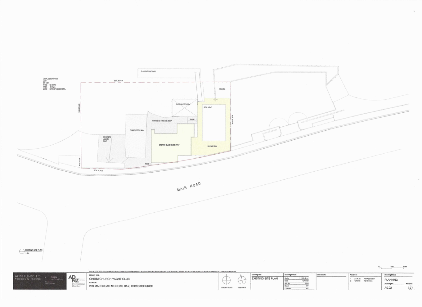
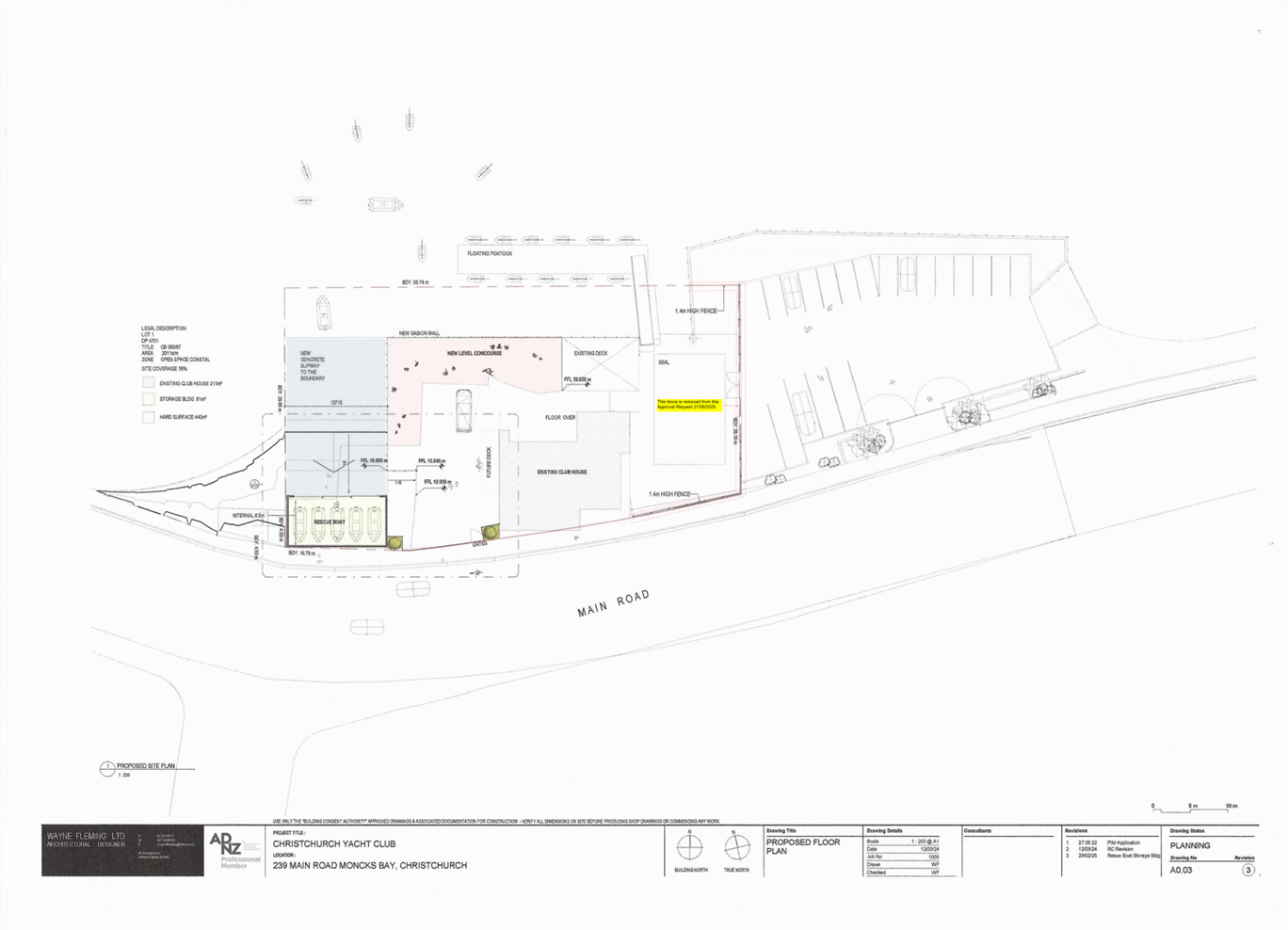
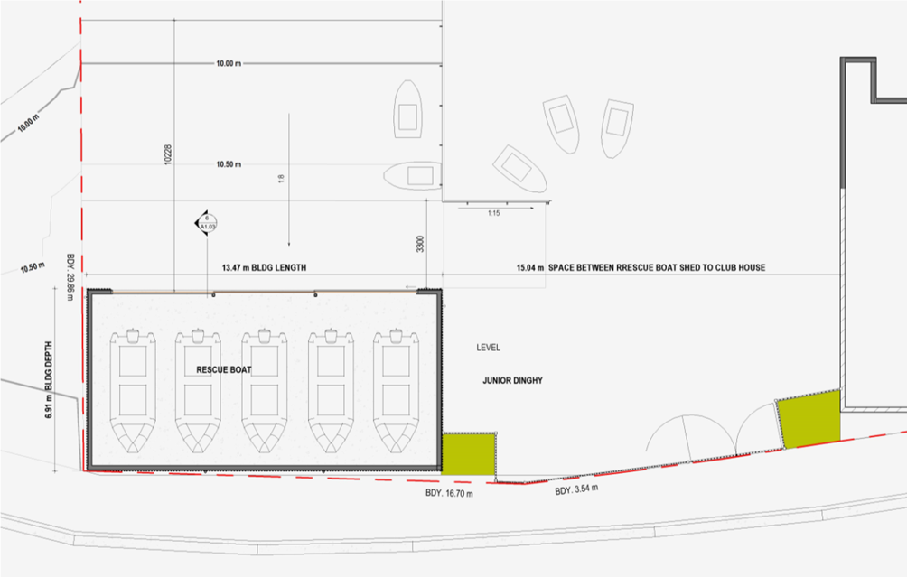
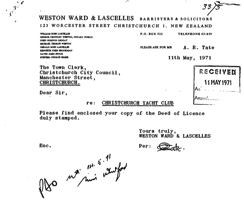
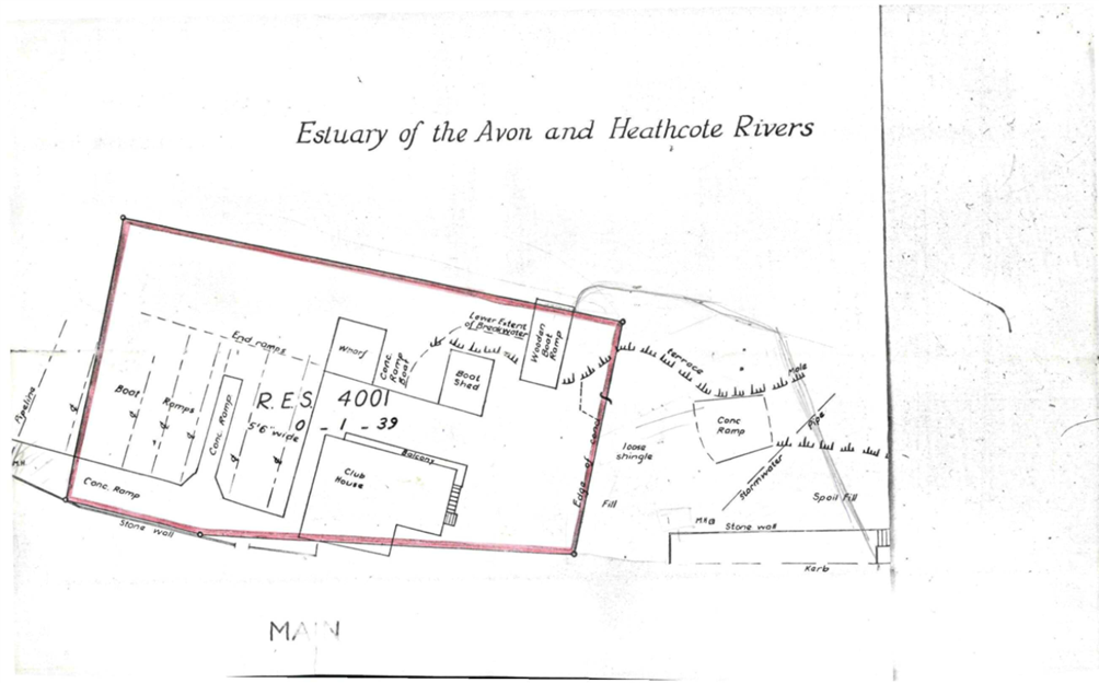
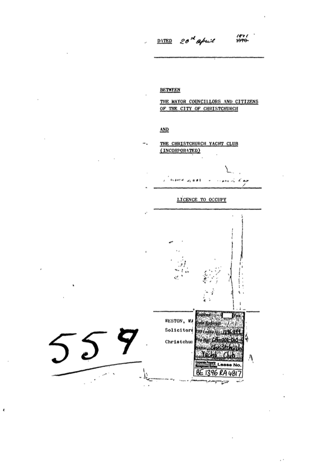
|
10. Richmond
Hill Road - Proposed Parking Changes and Pedestrian Improvements
|
|
Reference Te Tohutoro:
|
25/1455587
|
|
Responsible Officer(s) Te Pou Matua:
|
Toni
Dakers, Traffic Engineer
Krystle Anderson, Engagement Advisor
|
|
Accountable ELT Member Pouwhakarae:
|
Brent
Smith, General Manager City Infrastructure
|
1. Purpose and Origin of the Report Te Pūtake Pūrongo
1.1 The
purpose of this report is for the Waihoro Spreydon-Cashmere-Heathcote Community
Board to make a decision on proposed parking changes on Richmond Hill Road to
improve access and safety for pedestrians.
1.2 This
report has been written in response to a request from a member of the public,
and concerns raised in the past about poor connectivity for pedestrians between
the two hairpin bends adjacent to 54 and 70 Richmond Hill Road.
2. Officer Recommendations Ngā Tūtohu
That the Waihoro
Spreydon-Cashmere-Heathcote Community Board:
1. Receives the information in the Richmond
Hill Road - Proposed Parking Changes and Pedestrian Improvements Report.
2. Notes that the decision in this report are assessed as low
significance based on the Christchurch City
Council’s Significance and Engagement Policy.
3. Revokes any previous resolutions pertaining to traffic controls made
pursuant to any bylaw to the extent that they are in conflict with the traffic
control or parking and stopping restrictions described in resolutions 4-7
below.
4. Approves the road layout, on the section of Richmond Hill Road
between 54 and 70 Richmond Hill Road, as detailed on Attachment A to
this report (Drawings 3338711-CA-202 Rev A and 3338711-CA-201 Rev B, dated
02/09/2025).
5. Approves, pursuant to Clause 7 of the Christchurch City Council
Traffic and Parking Bylaw 2017, that the stopping of vehicles be prohibited at
any time on the northwest side of Richmond Hill Road, as detailed on Attachment
A to this report (Drawings 3338711-CA-202 Rev A and 3338711-CA-201 Rev B,
dated 02/09/2025).
6. Approves, pursuant to Clause 7 of the Christchurch City Council
Traffic and Parking Bylaw 2017, that the stopping of vehicles be prohibited at
any time on the southeast side of Richmond Hill Road, as detailed on Attachment
A to this report (Drawings 3338711-CA-202 Rev A and 3338711-CA-201 Rev B,
dated 02/09/2025).
7. Approves, in accordance with Section 319(1)(f), 331 and 334 of the
Local Government Act 1974, that the path on the northwest side of Richmond Hill
Road, between the two hair pin bends and as identified on Attachment A to this
report (Drawings 3338711-CA-202 Rev A and
3338711-CA-201 Rev B, dated 02/09/2025) be resolved as
a footpath. This path is for the use of pedestrians only, as defined in 1.6 of
the Land Transport (Road User) Rule: 2004.
8. Approves that these resolutions take effect when parking signage
and/or road markings that evidence the restrictions described in this staff
report are in place (or removed in the case of revocations).
3. Executive Summary Te Whakarāpopoto Matua
3.1 Concerns
have been raised about the safety of pedestrians walking on the section of
Richmond Hill Road between the two hair-pin bends. The footpath is poorly
defined along this section of road as the kerb is largely flush with the road.
3.2 Due
to the narrow road width, drivers park across the kerb to leave space for
through traffic. At times these vehicles fully obstruct access for pedestrians
who are then required to walk on the carriageway to manoeuvre around them.
3.3 The
recommended option is to mark dedicated parking bays for up to 13 vehicles, and
no stopping restrictions in accordance with Attachment A. This option was
developed in response to feedback from the Community Board at the decision
meeting in November 2024 (Agenda,
Item 10).
3.4 This
option takes into account the site constraints and seeks to find a balance
between providing for pedestrians and addressing concerns raised through
consultation about the loss of parking and associated risks of increased
speeds.
4. Background/Context Te Horopaki
Background
4.1 Staff
presented a proposal for improvements on Richmond Hill Road to the Waihoro
Spreydon-Cashmere-Heathcote Community Board at their meeting held on 14
November 2024 (Agenda,
Item 10). At this meeting the Board resolved for Staff to explore an
alternate option that provides for a defined footpath and defined car parking
areas (Minutes,
Item 10).
4.2 Following
this, an initial concept plan was presented at a Community Board workshop in
May 2025 (Agenda,
Item 3). This option incorporated various elements (give way controls,
marked bays, signage) for the purpose of discussion, and has since been
developed further to reflect the current operation of the road and ongoing
feedback.
4.3 Richmond
Hill Road has a carriageway width of around five to six metres on the section
between the two hairpin bends. In addition, there is a sealed path over the
majority of this length which is around one metre wide and separated by low
mountable kerb.
4.4 The
path is programmed for a surfacing renewal this financial year as part of
Councils resurfacing programme. Maintenance works are also planned which
includes battening where required to support the path edge and maximise the
usable space for pedestrians.
4.5 Due
to the site constraints, any option that provides for both parking and
pedestrian access will have some compromises between the amount of parking that
can be retained and the clear width that can be allocated for pedestrians.
Traffic Environment
4.6 Richmond
Hill Road is a no-exit local road providing access to residential properties.
It has a 40km/h posted speed limit. Under the current Setting of Speed Limits
Rule 2024, there is no requirement to reverse this speed limit, nor is there an
allowance to reduce this further.
4.7 Tube
count surveys were undertaken in February 2024 outside 62 Richmond Hill Road,
and further uphill on the straight near 102 Richmond Hill Road.
4.8 A
summary of the key speed survey data is included in the table below.
|
Survey
Location
|
Average Speed(km/h)
|
85th percentile Speed (km/h)
|
|
Uphill
|
Downhill
|
Uphill
|
Downhill
|
|
62 Richmond Hill
Rd
|
30.1
|
29.0
|
35.5
|
34.6
|
|
102 Richmond
Hill Rd
|
39.7
|
42.4
|
47.3
|
50.0
|
Table 1: Speed survey summary
4.9 Both
the average speed and 85th percentile speed recorded outside 62
Richmond Hill Road are well below the posted speed limit of 40km/h. The speeds
increase outside 102 Richmond Hill Road on the straight section of road further
uphill around the bend, where the road widens.
4.10 A search of the
NZ Transport Agency Crash Analysis System has been undertaken. There have been no
crashes reported on Richmond Hill Road within the last five years. Richmond
Hill Road is classified as low risk under Council’s risk mapping system.
4.11 A pedestrian
walkway is located between 62 and 64 Richmond Hill Road which connects to the
lower part of Richmond Hill Road. This is steep and narrow in places so is not
suitable for all pedestrians.
4.12 The narrow road
width requires drivers to slow to give way to oncoming traffic before
manoeuvring around parked vehicles. Parking demands on this section of Richmond
Hill Road are variable. Up to 12 vehicles were observed by staff during initial
site visits. During ongoing investigations up to 14 parked vehicles have been
observed on this section of road. However, feedback from residents is that 15
or 16 vehicles are present at times.
4.13 These vehicles
are parked on the northwest side of the road, with the majority parking on the
section of road downhill of the walkway entrance (located between 62 and 64
Richmond Hill Road).
4.14 If approved, the recommendations will be implemented within the
current financial year, following the planned resurfacing of the path.
4.15 The following related briefings/workshops have taken place for the
members of the meeting:
Options Considered Ngā
Kōwhiringa Whaiwhakaaro
4.16 The following
reasonably practicable options were considered and are assessed in this report:
4.16.1 Option 1 - Recommended Option:
Mark no stopping restrictions and defined parking bays in accordance with
Attachment A. This option will retain parking for 13 vehicles. Red surfacing is
proposed in addition to minor signage improvements.
4.16.2 Option 2 – Revised 2024
Report Plan: Mark no stopping restrictions and pedestrian markings between
the pedestrian walkway and footpath to the northeast/uphill. Three parking
spaces will be retained in the section uphill of the walkway; one more compared
to the previous 2024 version of this plan. No change is proposed to the lower
section where most of the parking demand is observed (Attachment B).
4.16.3 Option 3 – Original
Consultation Plan: Mark no stopping restrictions over the full section of
road, retaining five parking spaces only, in accordance with the original
consultation plan (Attachment C).
4.16.4 Option 4 – Do Minimum:
Do minimum. Red surfacing and minor warning signage changes only.
4.17 All options have
focused on low cost signage and line marking changes only. There is no funding
available for any physical works such as road widening, new kerbs or relocating
power poles. However as noted above, in addition to these options, maintenance
works are planned to maximise the usable space for pedestrians.
4.18 Any work to
widen the road/footpath or construct any additional pedestrian walkways or
infrastructure will need to be funded through the Councils Long Term Plan. A
thorough options assessment including geotechnical/structural investigation
would need to be undertaken as part of that process.
Options Descriptions Ngā
Kōwhiringa
4.19 The Advantages of these
options are summarised in Table 2 below:
|
Option 1
Recommended Option
|
Option 2
Revised 2024 Plan
|
Option 3
Original Consultation Plan
|
Option 4
Do Minimum
|
|
Parking
|
|
Retains parking
for up to 13 vehicles.
Specifies exactly
where vehicles are permitted to park, clearly defining the space for both
pedestrians and drivers.
|
No change to the current
parking provision on the section of road downhill of #62 (the walkway
entrance).
Retains three
parks uphill of the walkway.
|
None identified.
|
No changes to
current parking provision.
|
|
Pedestrian
Access
|
|
Maintains a
minimum of 600mm between the fence line and parked vehicles to ensure
vehicles won’t completely block access for pedestrians walking on the
path.
For those
requiring more space, the proposed yellow lines and marked bays will reduce
the length (and time) pedestrians will be required to walk on the road to
manoeuvre around parked vehicles, compared to the existing operation.
Yellow lines marked adjacent to power poles to allow
pedestrians to manoeuvre around them.
Provides a
clearly defined pedestrian space.
|
Provides some
improvement for pedestrians compared to the existing arrangement by providing
a more defined space for pedestrians to connect between the existing walkway
and formed footpath uphill of #70.
|
Ensures the full
section of path will be clear of parked vehicles.
Yellow lines
marked adjacent to power poles to allow pedestrians space to manoeuvre around
them.
|
Red surfacing and
minor changes to pedestrian warning signage will advise drivers of the
presence of pedestrians in this area and the change in road environment.
|
|
Speed
|
|
Road markings and
parked vehicles will visually narrow down the space. This is expected to have
a positive effect on speed management.
Drivers are
required to slow vehicle speeds to manoeuvre around parked vehicles and give
way to oncoming traffic to assist with managing speeds.
|
Since the
majority of parking is being retained, this option is not expected to result
in increased speeds through this section of road.
Drivers will
still be required to slow to manoeuvre around parked vehicles and give way to
oncoming traffic which will assist with managing speeds.
|
None identified.
|
No changes to
current speed patterns. Speed surveys were undertaken in February 2024 with
an average speed of 29.5 km/hr recorded over the 7-day survey period.
However, the
speed of drivers through this section remains a concern for adjacent
properties.
|
|
Through
Traffic
|
|
Space is provided
between the parking bays (by marked yellow lines) to provide space for
conflicting vehicles to give way to approaching traffic.
|
The marking of
yellow lines uphill of #62 will provide some improvement for through traffic
– parking will be permitted in three specific locations on the wider
section of road.
|
This option will
result in fewer obstructions for through traffic with only five parking
spaces retained.
With less parking
on street there will be improved access and visibility for through traffic.
|
None identified.
|
|
General
|
|
This option
provides the best balance by retaining parking to meet most of the observed
parking demand but also allocates specific pedestrian space.
|
This option was
developed in response to the original consultation feedback; it aimed to
provide some improvement for pedestrians but minimise the loss of parking and
associated risks of increased speeds compared to the consultation option.
|
In response to
concerns raised though the original consultation process, this option was not
presented as the recommended option in the November report.
|
Lowest cost to
implement - some road marking improvements such as red surfacing and upgrades
to warning signage would still be undertaken with this option.
|
Table 2: Summary of option advantages
4.20 The disadvantages
of these options are summarised in Table 3 below:
|
Option 1
Recommended Option
|
Option 2
Revised 2024 Plan
|
Option 3
Original Consultation Plan
|
Option 4
Do Minimum
|
|
Parking
|
|
Removes the ability
for drivers to choose to park in other locations that may be more convenient
for them.
While the
proposal retains parking for 13 vehicles, this may not meet the full demand
for parking at times.
|
Three parking
spaces will be retained uphill of the walkway. This won’t fully meet
the observed parking demands during busier periods where up to four vehicles
have been observed on this section. During these times any overflow parking
will move to other parts of Richmond Hill Road.
|
This option
retains around five car parks in locations where the road is wide enough to
accommodate them.
Parking provision
is notably less than the current residential parking demands (staff have
observed between 12-14 vehicles however residents have reported 15-16 at
times)
This would therefore
not be sufficient to meet the current on street parking demands in this
immediate area and will move these vehicles to other locations, either
further uphill or downhill of this location.
|
None identified.
|
|
Pedestrian
Access
|
|
On the narrowest
section of road, a minimum clearance of 600mm will be provided between the
fence line and edge of the marked parking bays.
This will provide
space for pedestrians to walk, but will be insufficient for some, including
those with prams. However as noted above, the proposed yellow lines and
marked bays will provide an improvement on the existing operation by reducing
the length (and time) these pedestrians will be required to walk on the road
to manoeuvre around parked vehicles.
No changes are
proposed to the location of power poles or other physical obstructions.
|
The width
proposed for pedestrians on the upper section is defined by the existing
kerbline. In places this is less than the desirable minimum of 1.5 metres for
a footpath.
The section downhill of the walkway will remain
unchanged. This option does not fully address the original concerns raised
about parked vehicles obstructing access for pedestrians. Therefore, at times
pedestrians will still be required to walk on the carriageway to navigate
around parked vehicles.
No changes are
proposed to the location of power poles or other physical obstructions.
|
The path width is
defined by the existing kerbline, which in places is less than the desirable
minimum of 1.5 metres for a footpath.
Due to the flush
kerb, there were concerns raised through consultation that through traffic
will encroach into the path of pedestrians. The proposed road marking and
other physical constraints such as the power poles will provide clear
delineation for through traffic to reduce this risk.
No changes are
proposed to the location of power poles or other physical obstructions.
|
Parked vehicles
will continue to impede access for pedestrians over the full section of road.
|
|
Speed
|
|
None identified.
|
None identified.
|
Parked vehicles
assist with managing speeds so there is a risk that the speed of through
traffic will increase with this option.
However, it is
noted that this is still a narrow road and opposing drivers will still be
required to slow and give way to approaching traffic.
|
None identified.
|
|
Through
Traffic
|
|
The available
width for through traffic will be more constrained compared to the existing
layout. Providing clearance for pedestrians will result in vehicles being
parked slightly further out. The plan provides a minimum 3.2m wide traffic
lane which is sufficient to accommodate one lane of traffic. This will
operate in the same way as the existing layout where drivers will need to
yield to oncoming traffic.
|
With the
potential for more vehicles to be parked on the lower section of road during
busy times, space for vehicles to stop to give way to oncoming traffic will
be more constrained, this is particularly an issue when larger vehicles are
travelling on the road. There are however existing no stopping restrictions
already marked in critical locations such as on the bends to improve
visibility and clearance for through traffic.
|
None identified.
|
There will be no
change to the current operation of the road. The road will continue to
operate with essentially one way traffic with limited defined space for
opposing vehicles to give way.
|
|
General
|
|
With the very
constrained carriageway width available, drivers will be required to park
accurately to ensure they do not encroach into the pedestrian space or
obstruct through traffic.
|
As above, this
option does not fully address the issues raised about pedestrian safety on
the lower section of road.
It was intended
to provide some improvement compared to the existing but also consider
concerns raised through consultation feedback.
|
The majority of
public submissions during the original consultation process were opposed to
this option (79%).
|
This option does
not address any of the issues raised around pedestrian access and safety.
This option
(along with signage upgrades) was the preferred option through consultation.
|
Table 3: Summary of option disadvantages
5. Financial Implications Ngā Hīraunga Rauemi
Capex/Opex Ngā Utu Whakahaere
|
|
Recommended Option
|
Option 2
|
Option 3
|
Do Minimum*
|
|
Cost to Implement
- Capital
|
$10,250 for new markings and signage
|
$2,200 for new markings and signage
|
$5,050 for new markings and signage
|
$6,400 (red surfacing and signage)
|
|
Maintenance/Ongoing Costs
|
Will
be added to and covered by the area maintenance contract
|
|
Funding Source
|
Traffic
Operations Team Traffic Signs and Markings budget
|
|
Funding Availability
|
Funding
available
|
|
Impact on Rates
|
Negligible
|
Negligible
|
Negligible
|
Negligible
|
*The estimated cost for the Do Minimum is
higher than those for Option 2 and Option 3 as it includes red surfacing.
6. Considerations Ngā Whai Whakaaro
Risks and Mitigations Ngā
Mōrearea me ngā Whakamātautau
6.1 The
constraints of the site will mean that any pedestrian space will be less than
the recommended minimum width of 1.5m for a footpath. The recommended option
will continue to support a slower speed environment by the retention of
on-street parking and associated road marking to manage this risk.
Legal Considerations Ngā
Hīraunga ā-Ture
6.2 Statutory
and/or delegated authority to undertake proposals in the report:
6.2.1 Part 1, Clause 7 of
the Christchurch City Council Traffic and Parking Bylaw 2017 provides Council
with the authority to install parking or stopping restrictions by resolution.
6.2.2 The Community Boards
have delegated authority from the Council to exercise the delegations as set
out in the Delegations Register. The list of delegations for the Community
Boards includes the resolution of stopping and traffic control devices.
6.2.3 The installation of any signs and/or markings associated with
traffic control devices must comply with the Land Transport Rule: Traffic
Control Devices 2004.
6.3 Other
Legal Implications:
6.3.1 There is no other
legal context, issue, or implication relevant to this decision.
6.3.2 This specific report
has not been reviewed and approved by the Legal Services Unit however the
report has been written using a general approach previously approved of by the
Legal Services Unit, and the recommendations are consistent with the policy and
legislative framework outlined in this report.
Strategy and Policy Considerations Te Whai
Kaupapa here
6.4 The
required decision:
6.4.1 Aligns with the Christchurch
City Council’s Strategic Framework.
6.4.2 The
recommendations in this report are consistent with the Christchurch Suburban
Parking Policy.
6.4.3 The decisions in this
report are assessed as low significance based on the Christchurch City
Council’s Significance and Engagement Policy. The level of significance
was determined by the low level of impact and low number of people affected by
the recommended decision.
6.5 The
community engagement and consultation outlined in this report reflect the
assessment.
6.6 This
report supports the Council's
Long Term Plan (2024 - 2034):
6.7 Transport
6.7.1 Activity: Transport
· Level of Service: 10.0.6.2 Reduce the number of
death and serious injury crashes on the local road network - Five year rolling
average <95 crashes per year
Community Impacts and Views Ngā Mariu
ā-Hāpori
6.8 The
original consultation plan for Richmond Hill Road (Option 3) was consulted on
between 2 August and 8 September 2024. Submissions were made by four
organisations and 61 individuals. The majority (49, 79%) did not support this
plan.
6.9 Following
the 14 November 2024 Community Board meeting, staff returned to the Community
Board for a workshop on 29 May 2025 and presented a new option with marked
parking bays (Option 1).
6.10 A site visit was
then organised with staff, Community Board Members and the affected residents.
The residents expressed concerns about ongoing maintenance of the road and
longer-term solutions, but many indicated they were comfortable with Option 1
(shown at the Community Board workshop) as a short-term solution.
6.11 Option 1 was
updated with minor changes and sent to residents on 15 August 2025 inviting
questions or feedback by 28 August 2025.
6.12 Staff received
feedback or questions from five residents:
· One resident on the lower section of affected part of Richmond Hill
Road was disappointed with the removal of parking and felt this would result in
vehicles travelling faster. They felt the walking track should be used for
people to walk to the bottom of the hill.
· One resident provided positive feedback on the plan and said they
felt Council had thought hard about meeting the needs of everyone.
· One resident asked why the speed limit wasn’t being reduced.
Staff responded with information about how we can set speeds under the Setting
of Speed Limits Rule.
· One resident asked whether a power pole could be moved. Staff
responded explaining why it couldn’t be moved as part of this
project.
· Staff had not heard from the Richmond Hill Residents Group at the
close of the feedback period. Staff phoned the main coordinator to ask if they
wanted to provide feedback. They said they would provide written feedback but
outlined that they didn’t like Option 1 and would prefer the Board choose
a ‘do nothing’ option but add signage. They felt a better,
longer-term option needed to be explored. Staff had not received any written
feedback from this group before this report was due.
6.13 The Team Leader
Parking Compliance supports the preferred option.
6.14 The decision
affects the following wards/Community Board areas:
6.14.1 Heathcote Ward.
6.14.2 Waihoro Spreydon-Cashmere-Heathcote Community Board.
Impact on Mana Whenua Ngā Whai Take
Mana Whenua
6.15 The decision does not involve a significant decision concerning
ancestral land or a body of water or other elements of intrinsic value,
therefore this decision does not specifically impact Mana Whenua, their culture
and traditions.
6.16 The decision does
not involve a matter of interest to Mana Whenua and will not impact on our
agreed partnership priorities with Ngā Papatipu Rūnanga.
Climate Change Impact Considerations Ngā
Whai Whakaaro mā te Āhuarangi
6.16 The proposal in this report is unlikely to contribute significantly to
adaptation to the impacts of climate change or emissions reductions.
7. Next Steps Ngā Mahinga ā-muri
7.1 If
approved, staff will arrange for the new markings to be installed. This will be
programmed to align with the planned path renewal.
Attachments Ngā Tāpirihanga
|
No.
|
Title
|
Reference
|
Page
|
|
a ⇩
|
Option 1 -
Recommended Option
|
25/1777328
|
95
|
|
b ⇩
|
Option 2 -
Revised 2024 Option
|
25/1761555
|
97
|
|
c ⇩
|
Option 3 -
Original Consultation Plan (2024)
|
25/1778168
|
98
|
In addition to the attached documents, the following background
information is available:
|
Document
Name – Location / File Link
|
|
Not
applicable
|
Signatories Ngā Kaiwaitohu
|
Authors
|
Toni Dakers -
Traffic Engineer
Krystle
Anderson - Senior Engagement Advisor
|
|
Approved By
|
Kathy Graham -
Acting Team Leader Traffic Operations
Stephen Wright
- Manager Operations (Transport)
|
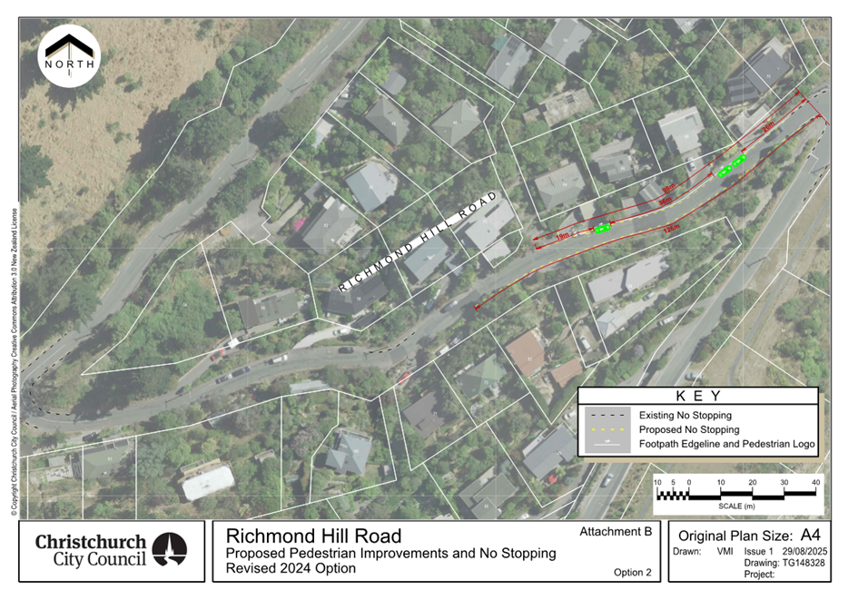
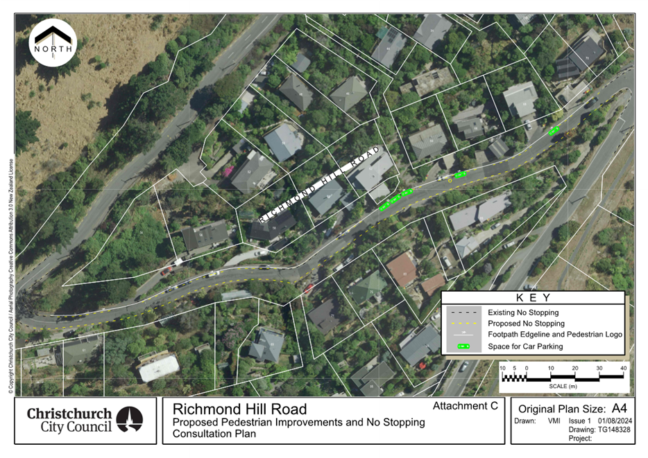
|
11. 429 Selwyn
Street - Proposed No Stopping Restrictions
|
|
Reference Te Tohutoro:
|
25/1648592
|
|
Responsible Officer(s) Te Pou Matua:
|
Toni
Dakers, Traffic Engineer
|
|
Accountable ELT Member Pouwhakarae:
|
Brent
Smith, General Manager City Infrastructure
|
1. Purpose and Origin of the Report Te Pūtake Pūrongo
1.1 The
purpose of this report is for the Waihoro Spreydon-Cashmere-Heathcote Community
Board to approve the installation of no stopping restrictions at the access to
Tunnel Wash on Selwyn Street.
1.2 This
report has been written in response to a request from the Operations Manager of
Tunnel Wash.
1.3 The
recommended option is to install no stopping restrictions in accordance with
Attachment A.
2. Officer Recommendations Ngā Tūtohu
That the Waihoro
Spreydon-Cashmere-Heathcote Community Board:
1. Receives the information in the 429 Selwyn
Street - Proposed No Stopping Restrictions Report.
2. Notes that the decision in this report are assessed as low
significance based on the Christchurch City
Council’s Significance and Engagement Policy.
3. Revokes any previous resolutions pertaining to traffic controls made
pursuant to any bylaw to the extent that they are in conflict with the parking
or stopping restrictions described in resolution 4 below.
4. Approves that in accordance with Clause 7 of the Christchurch City
Council Traffic and Parking Bylaw 2017, that the stopping of vehicles be
prohibited at any time on the west side of Selwyn Street, commencing at a point 61 metres north of
its intersection with Harman Street and extending in a northerly direction for
a distance of 11 metres, as detailed on Attachment A.
5. Approves that these resolutions take effect when parking signage
and/or road markings that evidence the restrictions described in this staff
report are in place (or removed in the case of revocations).
3. Executive Summary Te Whakarāpopoto Matua
3.1 Safety
concerns have been raised about parked vehicles restricting visibility for
drivers exiting the Tunnel Wash business onto Selwyn Street. This is a
high-volume driveway with around 300 vehicles per day visiting this site for
car wash services.
3.2 Implementing
the noted recommendations will lead to a reduction in the risk of a crash by
improving sightlines to oncoming traffic and cyclists in the nearside traffic
lane on Selwyn Street.
3.3 The
recommended option is to install no stopping restrictions in accordance with
Attachment A.
4. Background/Context Te Horopaki
4.1 Selwyn Street (along the site frontage) is classified as a Collector
Road with traffic volumes of approximately 10,000 vehicles/day.
4.2 There
is a high parking demand in the area associated with the surrounding business
activity and commuter parking. A consistent parking demand is observed around
the access, which essentially acts as a permanent obstruction to view
approaching traffic.
4.3 This
is a high-volume driveway with around 300 vehicles per day visiting the site.
4.4 Two
minor injury crashes have been reported within 30 metres of this access within
the last five years. Neither were associated with drivers exiting this
property, however the request for parking restrictions was generated in
response to ongoing reports of near misses, including with northbound cyclists.
4.5 If approved, the recommendations will be implemented within the
current financial year (generally around four weeks after the contractor
receives the request, but this is subject to other factors such as resourcing
and prioritisation beyond Council’s control).
Options Considered Ngā
Kōwhiringa Whaiwhakaaro
4.6 The
following reasonably practicable options were considered and are assessed in
this report:
4.6.1 Mark no stopping
restrictions in accordance with Attachment A.
4.6.2 Do Nothing.
4.7 The
following options were considered but ruled out:
4.7.1 Mark no stopping
restrictions to achieve the Safe Intersection Sight Distance guidance of 90
metres – this would require all parking to be removed on the west side of
the road through to Harman Street (up to eight spaces) to provide an
unobstructed view between an approaching vehicle and one waiting to turn. This
option was not progressed due to the extent of parking that would be removed,
there is no reported crash history associated with drivers exiting this
property, and it is inconsistent with the original request to remove one to two
parking spaces only.
Options Descriptions Ngā
Kōwhiringa
4.8 Preferred
Option: Mark no stopping restrictions in accordance with Attachment A
4.8.1 Option Advantages
· Improves safety by increasing visibility for exiting vehicles
· Addresses the safety concerns raised by the business
4.8.2 Option
Disadvantages
· Removal of up to two on street parking spaces
· Cost to implement
4.9 Alternative
Option – Do Nothing
· The advantages and disadvantages of this option are the opposite to
those described for the preferred options above.
5. Financial Implications Ngā Hīraunga Rauemi
Capex/Opex Ngā Utu Whakahaere
|
|
Recommended Option
|
Do Nothing
|
|
Cost to Implement: Capital:
Operational:
|
- Approximately $70 for line marking
- $750 for staff time (reporting and investigation)
|
n/a
- $750 for staff time (reporting and investigation)
|
|
Maintenance/Ongoing Costs
|
Will be added to and covered by the area maintenance
contract
|
n/a
|
|
Funding Source
|
Traffic Operations Team Operational
budget
|
n/a
|
|
Funding Availability
|
Funding available
|
n/a
|
|
Impact on Rates
|
Negligible
|
n/a
|
6. Considerations Ngā Whai Whakaaro
Risks and Mitigations Ngā
Mōrearea me ngā Whakamātautau
6.1 None
identified.
Legal Considerations Ngā
Hīraunga ā-Ture
6.2 Statutory
and/or delegated authority to undertake proposals in the report:
6.2.1 Part 1, Clause 7 of
the Christchurch City Council Traffic and Parking Bylaw 2017 provides Council
with the authority to install parking or stopping restrictions by resolution.
6.2.2 The Community Boards
have delegated authority from the Council to exercise the delegations as set
out in the Delegations Register. The list of delegations for the Community
Boards includes the resolution of stopping and traffic control devices.
6.2.3 The installation of any signs and/or markings associated with
traffic control devices must comply with the Land Transport Rule: Traffic
Control Devices 2004.
6.3 Other
Legal Implications:
6.3.1 There is no other
legal context, issue, or implication relevant to this decision.
6.3.2 This specific report
has not been reviewed and approved by the Legal Services Unit however the
report has been written using a general approach previously approved of by the
Legal Services Unit, and the recommendations are consistent with the policy and
legislative framework outlined in this report.
Strategy and Policy Considerations Te Whai
Kaupapa here
6.4 The
required decision:
6.4.1 Aligns with the Christchurch
City Council’s Strategic Framework.
6.4.2 The
recommendations in this report are consistent with the Christchurch Suburban
Parking Policy.
6.4.3 The decisions in this
report are assessed as low significance based on the Christchurch City
Council’s Significance and Engagement Policy. The level of significance
was determined by the low level of impact and low number of people affected by
the recommended decision.
6.5 The
community engagement and consultation outlined in this report reflect the
assessment.
6.6 This
report supports the Council's
Long Term Plan (2024 - 2034):
6.7 Transport
6.7.1 Activity: Transport
· Level of Service: 10.0.6.2 Reduce the number of
death and serious injury crashes on the local road network - Five year rolling
average <95 crashes per year
Community Impacts and Views Ngā Mariu
ā-Hāpori
6.8 The
Operations Manager of Tunnel Wash confirmed their support for the proposal.
6.9 No
further consultation was undertaken. The proposal affects the short section of
road immediately adjacent to the Tunnel Wash access and is wholly along their
property frontage.
6.10 The Team Leader
Parking Compliance supports the preferred option.
6.11 The decision
affects the following wards/Community Board areas:
6.11.1 Spreydon Ward
6.11.2 Waihoro
Spreydon-Cashmere-Heathcote Community Board.
Impact on Mana Whenua Ngā Whai Take
Mana Whenua
6.12 The decision does not involve a significant decision concerning
ancestral land or a body of water or other elements of intrinsic value,
therefore this decision does not specifically impact Mana Whenua, their culture
and traditions.
6.13 The decision does
not involve a matter of interest to Mana Whenua and will not impact on our
agreed partnership priorities with Ngā Papatipu Rūnanga.
Climate Change Impact Considerations Ngā
Whai Whakaaro mā te Āhuarangi
6.16 The proposal in this report is unlikely to contribute significantly to
adaptation to the impacts of climate change or emissions reductions.
7. Next Steps Ngā Mahinga ā-muri
7.1 If
approved, staff will arrange for the no stopping restrictions to be installed.
Attachments Ngā Tāpirihanga
|
No.
|
Title
|
Reference
|
Page
|
|
a ⇩
|
Site Plan -
429 Selwyn Street Proposed No Stopping Restrictions
|
25/1665855
|
104
|
In addition to the attached documents, the following background
information is available:
|
Document
Name – Location / File Link
|
|
Not
applicable
|
Signatories Ngā Kaiwaitohu
|
Author
|
Toni Dakers -
Traffic Engineer
|
|
Approved By
|
Gemma Dioni -
Principal Advisor Transportation - Safety
Kathy Graham -
Acting Team Leader Traffic Operations
Stephen Wright
- Manager Operations (Transport)
|
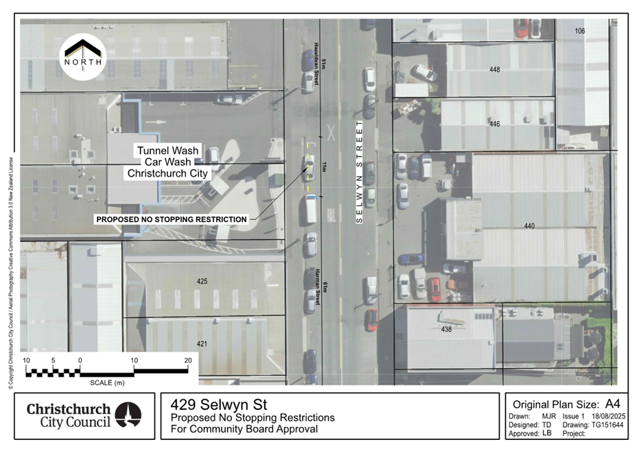
|
12. Charlesworth
Street / Olds Place Intersection - Proposed No Stopping Restrictions
|
|
Reference Te Tohutoro:
|
25/1671083
|
|
Responsible Officer(s) Te Pou Matua:
|
Toni
Dakers, Traffic Engineer
|
|
Accountable ELT Member Pouwhakarae:
|
Brent
Smith, General Manager City Infrastructure
|
1. Purpose and Origin of the Report Te Pūtake Pūrongo
1.1 The
purpose of this report is for the Waihoro Spreydon-Cashmere-Heathcote Community
Board to approve the installation of no stopping restrictions at the
Charlesworth Street / Olds Place intersection.
1.2 This
report has been written in response to concerns raised by a member of the
public about parked vehicles obstructing access and visibility at the
intersection, specifically for emergency service vehicles accessing the
Woolston Fire Station and Woolston Fire Training Centre on Olds Place.
1.3 The
recommended option is to install no stopping restrictions in accordance with
Attachment A.
2. Officer Recommendations Ngā Tūtohu
That the Waihoro
Spreydon-Cashmere-Heathcote Community Board:
1. Receives the information in the Charlesworth
Street / Olds Place Intersection - Proposed No Stopping Restrictions Report.
2. Notes that the decision in this report are assessed as low
significance based on the Christchurch City
Council’s Significance and Engagement Policy.
3. Revokes any previous resolutions pertaining to traffic controls made
pursuant to any bylaw to the extent that they are in conflict with the parking
or stopping restrictions described in resolutions 4-6 below.
4. Approves that in accordance with Clause 7 of the Christchurch City
Council Traffic and Parking Bylaw 2017, that the stopping of vehicles be
prohibited at any time on the northwest side of Charlesworth Street, commencing
at a point 90 metres northeast of its intersection with Ferry Road, and
extending in a northeast direction for a distance of 29 metres, as detailed on
Attachment A (TG150186, dated 20/8/2025).
5. Approves that in accordance with Clause 7 of the Christchurch City
Council Traffic and Parking Bylaw 2017, that the stopping of vehicles be
prohibited at any time on the southwest side of Olds Place, commencing at its intersection with
Charlesworth Street, and extending in a southeast direction for a distance of 13
metres, as detailed on Attachment A (TG150186, dated 20/8/2025).
6. Approves that in accordance with Clause 7 of the Christchurch City
Council Traffic and Parking Bylaw 2017, that the stopping of vehicles be
prohibited at any time on the northeast side of Olds Place, commencing at its
intersection with Charlesworth Street, and extending in a southeast direction
for a distance of 10 metres, as detailed on Attachment A (TG150186, dated
20/8/2025).
7. Approves that these resolutions take effect when parking signage
and/or road markings that evidence the restrictions described in this staff
report are in place (or removed in the case of revocations).
3. Executive Summary Te Whakarāpopoto Matua
3.1 Safety
concerns have been raised by a nearby resident about parked vehicles
restricting visibility and access at the intersection of Charlesworth Street
and Olds Place.
3.2 This
is particularly an issue for fire engines and other large vehicles turning at
the intersection to access the Woolston Fire Station and Woolston Fire Training
Centre, located at the southern end of Olds Place.
3.3 The
recommended option is to install no stopping restrictions in accordance with
Attachment A.
4. Background/Context Te Horopaki
4.1 Charlesworth Street and Olds Place form an
uncontrolled T intersection, with priority given to Charlesworth Street.
4.2 The
Woolston Fire Station and Woolston Fire Training Centre are located at the end
of Olds Place. The main access to the Woolston Fire Station is provided via
Ferry Road, however the rear entrance via Olds Place is also used for emergency
response.
4.3 Charlesworth
Street is on the Russley / Mt Pleasant metro bus route (Route 140).
4.4 There
is a moderate parking demand near the intersection associated with adjacent
residential properties.
4.5 Charlesworth Street narrows at the intersection to 7 metres wide. No
stopping restrictions are already provided on the southeast side, however this
is insufficient to ensure unimpeded access for emergency vehicles. The length
of the proposed no stopping restrictions is based on a tracking assessment for
a fire engine.
4.6 The proposal will result in the removal of up to five on street
parking spaces.
4.7 There have been no crashes reported at the Charlesworth Street / Olds
Place intersection within the last five years. The intersection is classified
as low risk under Council’s risk mapping system.
4.8 If approved, the recommendations will be implemented within the
current financial year (generally around four weeks after the contractor
receives the request, but this is subject to other factors such as resourcing
and prioritisation beyond Council’s control).
Options Considered Ngā
Kōwhiringa Whaiwhakaaro
4.9 The
following reasonably practicable options were considered and are assessed in
this report:
4.9.1 Mark no stopping
restrictions in accordance with Attachment A.
4.9.2 Do nothing.
Options Descriptions Ngā
Kōwhiringa
4.10 Preferred
Option: Mark no stopping restrictions in accordance with Attachment A.
4.10.1 Option Advantages
· Prevents parked vehicles from impeding access for drivers
manoeuvring at the intersection, including emergency service vehicles.
· Reduces the risk of conflict between opposing traffic at the
intersection.
· Ensures the crossing points on Olds Place are kept clear.
· Improves access for through traffic on Charlesworth Street,
including metro buses.
4.10.2 Option Disadvantages
· Removal of up to five on-street parking spaces.
· Cost to implement
4.11 Alternative
Option – Do nothing
4.11.1 Option Advantages and
Disadvantages
· The advantages and disadvantages of this option are the opposite to
those described for the preferred option above.
5. Financial Implications Ngā Hīraunga Rauemi
Capex/Opex Ngā Utu Whakahaere
|
|
Recommended Option
|
Do Nothing
|
|
Cost to Implement: Capital:
Operational:
|
- Approximately $320 for line marking
- $750 for staff time (reporting and investigation)
|
n/a
- $750 for staff time (reporting and investigation)
|
|
Maintenance/Ongoing Costs
|
Will be added to and covered by the area
maintenance contract
|
n/a
|
|
Funding Source
|
Traffic Operations Team Operational
budget
|
n/a
|
|
Funding Availability
|
Funding available
|
n/a
|
|
Impact on Rates
|
Negligible
|
n/a
|
6. Considerations Ngā Whai Whakaaro
Risks and Mitigations Ngā
Mōrearea me ngā Whakamātautau
6.1 None
identified.
Legal Considerations Ngā
Hīraunga ā-Ture
6.2 Statutory
and/or delegated authority to undertake proposals in the report:
6.2.1 Part 1, Clause 7 of
the Christchurch City Council Traffic and Parking Bylaw 2017 provides Council
with the authority to install parking or stopping restrictions by resolution.
6.2.2 The Community Boards
have delegated authority from the Council to exercise the delegations as set
out in the Delegations Register. The list of delegations for the Community
Boards includes the resolution of stopping and traffic control devices.
6.2.3 The installation of any signs and/or markings associated with
traffic control devices must comply with the Land Transport Rule: Traffic
Control Devices 2004.
6.3 Other
Legal Implications:
6.3.1 There is no other
legal context, issue, or implication relevant to this decision.
6.3.2 This specific report
has not been reviewed and approved by the Legal Services Unit however the
report has been written using a general approach previously approved of by the
Legal Services Unit, and the recommendations are consistent with the policy and
legislative framework outlined in this report.
Strategy and Policy Considerations Te Whai
Kaupapa here
6.4 The
required decision:
6.4.1 Aligns with the Christchurch
City Council’s Strategic Framework.
6.4.2 The
recommendations in this report are consistent with the Christchurch Suburban
Parking Policy.
6.4.3 The decisions in this
report are assessed as low significance based on the Christchurch City
Council’s Significance and Engagement Policy. The level of significance
was determined by the low level of impact and low number of people affected by
the recommended decision.
6.5 The
community engagement and consultation outlined in this report reflect the
assessment.
6.6 This
report supports the Council's
Long Term Plan (2024 - 2034):
6.7 Transport
6.7.1 Activity: Transport
· Level of Service: 10.0.6.2 Reduce the number of
death and serious injury crashes on the local road network - Five year rolling
average <95 crashes per year
Community Impacts and Views Ngā Mariu
ā-Hāpori
6.8 Affected
property owners and residents were advised of the recommended option by letter
drop and post. 12 letters were delivered.
6.9 One
submission was received; this was from the resident who raised the original
concern and was supportive of the proposal. They have observed ongoing issues
with parked vehicles impeding access for larger vehicles manoeuvring to/from
Olds Place (including emergency service vehicles, delivery trucks and rubbish
trucks), as well as through traffic on Charlesworth Street.
6.10 As part of the
submission, they also raised concerns with speeds on Charlesworth Street and
suggested speed humps be installed to address this. There are no current plans
to install speed humps on this street however a speed survey has been ordered
to confirm current traffic patterns. Any relevant information will be sent to
Police to assist with enforcement (if they have available resource).
6.11 Staff also
contacted the Woolston Fire Station as part of the investigation. They agree
with the concern raised about access being impeded at times and confirmed their
support for the proposal.
6.12 The Team Leader
Parking Compliance supports the preferred option.
6.13 The decision
affects the following wards/Community Board areas:
6.13.1 Heathcote Ward
6.13.2 Waihoro
Spreydon-Cashmere-Heathcote Community Board
Impact on Mana Whenua Ngā Whai Take
Mana Whenua
6.14 The decision does not involve a significant decision concerning
ancestral land or a body of water or other elements of intrinsic value,
therefore this decision does not specifically impact Mana Whenua, their culture
and traditions.
6.15 The decision does
not involve a matter of interest to Mana Whenua and will not impact on our
agreed partnership priorities with Ngā Papatipu Rūnanga.
Climate Change Impact Considerations Ngā
Whai Whakaaro mā te Āhuarangi
6.16 The proposal in this report is unlikely to contribute significantly to
adaptation to the impacts of climate change or emissions reductions.
7. Next Steps Ngā Mahinga ā-muri
7.1 If
approved, staff will arrange for the markings to be installed.
Attachments Ngā Tāpirihanga
|
No.
|
Title
|
Reference
|
Page
|
|
a ⇩
|
Site Plan -
Charlesworth Street / Olds Place Proposed No Stopping Restrictions
|
25/1673685
|
110
|
In addition to the attached documents, the following background
information is available:
|
Document
Name – Location / File Link
|
|
Not
applicable
|
Signatories Ngā Kaiwaitohu
|
Author
|
Toni Dakers -
Traffic Engineer
|
|
Approved By
|
Gemma Dioni -
Principal Advisor Transportation - Safety
Kathy Graham -
Acting Team Leader Traffic Operations
Stephen Wright
- Manager Operations (Transport)
|
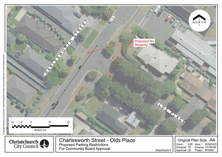
|
13. Westmorland West Valley Reserve - Landscape
Plan
|
|
Reference Te Tohutoro:
|
25/633613
|
|
Responsible Officer(s) Te Pou Matua:
|
Katelyn
Elley, Parks and Recreation Planner and Megan Carpenter - Team Leader Parks
& Recreation Planning
|
|
Accountable ELT Member Pouwhakarae:
|
Andrew
Rutledge, General Manager Citizens and Community
|
1. Purpose and Origin of the Report Te Pūtake Pūrongo
1.1 The
purpose of this report is to seek a decision from the Waihoro
Spreydon-Cashmere-Heathcote Community Board for the approval of the Westmorland
West Valley Reserve landscape plan.
2. Officer
Recommendations Ngā Tūtohu
That the Waihoro
Spreydon-Cashmere-Heathcote Community Board:
1. Receives the information in the Westmorland
West Valley Reserve - Landscape Plan Report.
2. Notes that the decision in this report is assessed as low significance
based on the Christchurch City Council’s Significance and Engagement
Policy.
3. Approve the landscape plan as shown in Attachment A.
3. Executive Summary Te Whakarāpopoto Matua
3.1 This
landscape plan aims to ensure there is a forward plan to inform planting in the
valley, establishment of fire management controls, and location of an
additional recreational link to support broader recreational connectivity to
surrounding areas.
3.2 Regional
Parks staff have worked closely with the South West Baptist Church (SWBC) to
develop a six-year community planting programme and ensure alignment to other
requirements of the reserve.
4. Background/Context Te Horopaki
4.1 Staff
have prepared a landscape plan for Westmorland West Valley Reserve. The purpose
of this plan is to align future planting, fire management controls, and track
development in the reserve.
4.2 West
Valley Reserve is a Regional Park. The terrain of the reserve is steep with
rock fall hazards in some locations.
4.3 The
reserve is currently not open to the public and the area is managed by contract
grazing. The base of the reserve is a stormwater basin managed by Three Waters.
Community planting funded by Three Waters is set to begin in this area this
year.
Planting
4.4 There
has been interest from the Southwest Baptist Church (SWBC) to undertake
planting in the reserve. Regional Park rangers have engaged with this group and
have developed a six-year staged planting programme. Staff have signed a
volunteer agreement with SWBC to undertake this work starting in 2026.
4.5 The planting will include a variety of fire resilient and drought
tolerant species. These will include a mix of trees, shrubs, and groundcover. The
known maximum height of the tallest trees is 25m for kowhai and 25 – 30m
for totara and matai, however, it will take many years for these to reach this
height. The taller tree species will be planted further below residential
boundaries, therefore should not impact on existing residential views. See Attachment A for proposed planting stages and plant
types.
Fire
Management
4.6 Following
fires in recent years in the Port Hills there has been an increasing need for
fire management. The plan includes a proposed 20-meter-wide fire buffer zone
around the edge of the valley to be fenced and grazed. A stock yard is proposed
in the plan to facilitate the grazing of these areas. Fire resilient species
will be planted throughout the valley to further mitigate fire risk.
4.7 Fencing
is planned to be installed once approval is granted.
Track and
Carpark
4.8 The
plan includes a shared used track from Penruddock Rise to Cashmere Road to
provide linkage between adjacent valleys. The establishment of this track will
allow mountain bike and walking access all the way from the Adventure Park,
through Westmorland East and West Valley Reserves to Te Kuru and other areas of
Halswell.
4.9 Given
the harsh terrain and rock hazard areas this is an indicative track, subject to
detailed design and consent. Staff will monitor the area over various seasons
to determine the safest and most practicable alignment.
4.10 A proposed
carpark and accessway off Cashmere Road will allow the public to access the
reserve. It is intended that once developed, the reserve will be opened to the
public.
Funding
4.11 The proposed
planting programme, stock yard, and fencing will be funded by the Three Waters project
ID #69218 SW Port Hills Revegetation and Sediment Control Stage 1 and planted
by volunteers.
4.12 All other
elements are to be covered under the following Regional Parks capital budgets.
4.12.1 Shared use track -If approved,
staff will use Regional Parks Operational budget (staff time) to undertake
further investigations/ detailed design of the track. Funding of $50,000 will
be prioritised within the next five years in project ID 65873 Regional Parks
Development for Port Hills & Banks Peninsula Delivery Package.
4.12.2 Accessway / Carpark – An
expanded gravel carpark with post and cable fencing will be developed for
$10,000 in Project ID 65873 Regional Parks Development for Port Hills &
Banks Peninsula Delivery Package. It is expected that this will be prioritised
within the next two years.
Westmorland East Valley Reserve
4.13 When preparing
the landscape plan for Westmorland West Valley Reserve, a plan was also
developed for the East Valley, including Ravensdale Park. This was shared for
consultation with Westmorland Residents Association (WRA), Westmorland Ecology
Group, and residents surrounding Ravensdale Park. Feedback revealed clear
opposition to the proposed toilet block, perimeter path, and trees in
Ravensdale Park. In response, staff will re-develop the plans considering the
feedback received along with prior community requests, such as shelter from the
wind around the existing playground.
4.14 Once a revised
landscape plan is prepared, staff will undertake broader engagement with the
Westmorland community before seeking Community Board approval. Staff expect
community engagement to occur towards the end of 2025, before seeking Community
Board approval in early 2026.
4.15 The following
related memos/information were circulated to the meeting members.
|
Date
|
Subject
|
|
14
July 2025
|
Westmorland West and East Valley Reserve
– Upcoming Community Engagement on Landscape Plan – refer
attachment B
|
Options Considered Ngā
Kōwhiringa Whaiwhakaaro
4.16 The following
reasonably practicable options were considered and are assessed in this report:
4.16.1 Approve the landscape plan for
Westmorland West Valley Reserve that includes planting, fire management
control, and a shared use track.
4.16.2 Do nothing.
Options Descriptions Ngā
Kōwhiringa
4.17 Preferred
Option: Approve landscape plan for Westmorland West Valley Reserve.
4.17.1 Option Description: Approve
the landscape plan for the reserve that includes planting, fire management
control, and a shared use track.
4.17.2 Option Advantages
· Fire mitigation – The proposed fire buffer zone and planting
low-flammability native species will improve fire resilience and support community
safety.
· Planting – The proposed planting will support biodiversity and
ecological resilience and aligns directly with the goals of
Christchurch’s Biodiversity Strategy.
· A new shared track will connect the reserve into the wider valley
network encouraging active travel, social access, and lifestyle benefits, and
aligning with Christchurch’s Public Open Space Strategy to deliver a
diverse and equitable green infrastructure network.
· Integrating planting, fire-management, access design, and track
location into a single staged plan avoids future conflicting works, streamlines
maintenance and reduces long‑term operational costs.
4.17.3 Option Disadvantages
· Due to the harsh and steep terrain an exact alignment for the shared
use track cannot be determined at this stage and will be subject to further
detailed design and consent.
4.18 Option 2 -Do
nothing – Status Quo
4.18.1 Option Description: Status
Quo.
4.18.2 Option Advantages
· No upfront capital cost.
4.18.3 Option Disadvantages
· Missed opportunity to develop improved fire resilience.
· Missed opportunity for biodiversity and ecological outcomes if
community planting cannot be undertaken.
· A gap in connectivity in the wider track network will remain.
· Without a landscape plan that integrates all elements, there is a
risk of future conflicts between activities, leading to inefficiencies and
potential ecological or operational issues.
5. Financial Implications Ngā Hīraunga Rauemi
Capex/Opex Ngā Utu Whakahaere
|
|
Recommended Option
|
Option 2 -Do nothing
|
|
Cost to Implement
|
· Plants and material – Total cost estimated at $192,000.
Based on an estimated $25,000 per year +10% added each year.
· Track- Estimated at $50,000*
*Subject to increase if resource consent required
· Fencing / Stock Yard - $30,000
· Carpark/ accessway -$10,000
|
N/A
|
|
Maintenance/Ongoing Costs
|
Covered by Regional Parks operational
budgets
|
Covered by Regional Parks operational
budgets – status quo
|
|
Funding Source
|
· Regional Parks Capital Budget ID 65873 Regional
Parks Development for Port Hills & Banks Peninsula Delivery Package
· Three Waters Capital Budget ID 69218 SW Port Hills Revegetation and Sediment Control Stage 1
|
N/A
|
|
Funding Availability
|
Yes
|
N/A
|
|
Impact on Rates
|
N/A
|
N/A
|
6. Considerations Ngā Whai Whakaaro
Risks and Mitigations Ngā
Mōrearea me ngā Whakamātautau
6.1 There
is a risk that during further investigations/ detailed design that the proposed
shared use track is deemed unfeasible. However, relevant staff have been on
site and inspected the proposed location, received preliminary planning advice
and have determined that this outcome is unlikely. However, the final alignment
may slightly differ to what is proposed in this plan.
6.1.1 During consultation
stakeholders and the community were made aware of this risk to manage community
expectations.
6.1.2 Staff support
including the proposed track in the landscape plan. Doing so enables
progression for further investigations and detailed design, while ensuring that
planned activities, such as the planting programme do not conflict and avoid
the need for additional consultation or approvals later.
Legal Considerations Ngā
Hīraunga ā-Ture
6.2 Statutory
and/or delegated authority to undertake proposals in the report:
6.3 As
per the Christchurch City Council’s Delegation Register, 20th
February 2025, the Community Board has the delegation to;
“Approve
and adopt any new landscape development plans for parks and reserves provided
the design is within the policy and budget set by the Council.”
(Part D
– Sub Part 1 - Community Boards, pg. 96)
6.4 Other Legal Implications:
6.4.1 There is no legal
context, issue, or implication relevant to this decision.
Strategy and Policy Considerations Te Whai
Kaupapa here
6.5 The
required decision:
6.5.1 Align with the Christchurch
City Council’s Strategic Framework.
6.5.2 Is assessed as low significance based on the Christchurch City
Council’s Significance and Engagement Policy. The level of
significance was determined by minimal impact on
the community.
6.5.3 Is consistent with Council’s Plans and
Policies.
· Climate Resilience Strategy 2021
· Biodiversity Strategy 2008 - 2035
· Public Open Space Strategy 2010 – 2040
· Ōtautahi Christchurch Future Transport Plan 2024–54
6.6 This
report supports the Council's
Long Term Plan (2024 - 2034):
6.7 Parks, Heritage and Coastal Environment
6.7.1 Activity: Parks and Foreshore
· Level of Service: 6.3.5 Customer satisfaction
with the recreational opportunities and ecological experiences provided by the
City's Regional Parks - >=80%
Community Impacts and Views Ngā Mariu
ā-Hāpori
6.8 Engagement
started on 23 July until 11 August 2025.
6.9 Engagement
involved:
6.9.1 Staff met with SWBC
and WRA.
6.9.2 WRA shared the
landscape plan with the community and held a public meeting on 30 and 31 July.
Staff were present to discuss and receive feedback.
6.9.3 SWBC held a public
meeting on 4 August to discuss the proposed landscape plan and allow the
community to provide feedback.
Summary of Feedback
6.10 SWBC and WRA are overall supportive
of the landscape plan.
6.11 Staff received four email
submissions; all were overall supportive of the landscape plan.
6.12 Key feedback via email submission
and during public/ stakeholder meetings including the following:
·
Support for revegetation planting.
·
Support for the fire buffer zone, many noting that this is
essential given climate change and the risk posed to nearby residents.
·
One individual was opposed to the fire buffer zone noting
that they did not see the need and requested that planting is extended to the
reserve boundary, however, were overall supportive of the plan.
·
Support for the proposed track, many noting it would be a
great addition to the network of tracks in the area.
·
Some feedback noted that future planning should consider a
safe link from the proposed track across Cashmere Road to Te Kuru.
6.13 The decision
affects the following wards/Community Board areas:
6.13.1 Waihoro
Spreydon-Cashmere-Heathcote Community Board.
Impact on Mana Whenua Ngā Whai Take
Mana Whenua
6.14 The decision does not involve a significant decision in relation to
ancestral land, a body of water or other elements of intrinsic value, therefore
this decision does not specifically impact Mana Whenua,
their culture, and traditions.
6.15 The decision does
not involve a matter of interest to Mana Whenua and will not impact on
our agreed partnership priorities with Ngā Papatipu
Rūnanga.
Climate Change Impact Considerations Ngā
Whai Whakaaro mā te Āhuarangi
6.16 The decisions in
this report are likely to:
6.16.1 Contribute positively to
adaptation to the impacts of climate change.
6.16.2 Contribute positively to
emissions reductions.
6.17 The
establishment of a fire buffer zone will help mitigate the heightened fire risk
posed by climate change.
6.18 The proposed
planting programme will reduce emissions by absorbing carbon dioxide in the
atmosphere.
7. Next Steps Ngā Mahinga ā-muri
7.1 If
the proposed landscape plan is approved, the Regional Parks team will order
plants for the 2026 planting season.
7.2 Further
investigation and detailed design of the shared use track will be undertaken.
7.3 All
other elements will be implemented when relevant funding is available.
Attachments Ngā Tāpirihanga
|
No.
|
Title
|
Reference
|
Page
|
|
a ⇩
|
Westmorland
West Valley Reserve Landscape Plan
|
25/1608797
|
118
|
|
b ⇩
|
Memo to
Communtiy Board - Westmorland West and East Valley Reserve - Upcoming
Community Engagement on Landscape Plan
|
25/1685993
|
119
|
In addition to the attached documents, the following background
information is available:
|
Document
Name – Location / File Link
|
|
Not
applicable
|
Signatories Ngā Kaiwaitohu
|
Authors
|
Katelyn Elley
- Parks and Recreation Planner
Megan
Carpenter - Team Leader Parks & Recreation Planning
|
|
Approved By
|
Kelly Hansen -
Manager Parks Planning & Asset Management
Paul Devlin -
Manager Regional Parks
Rupert Bool -
Head of Parks
|
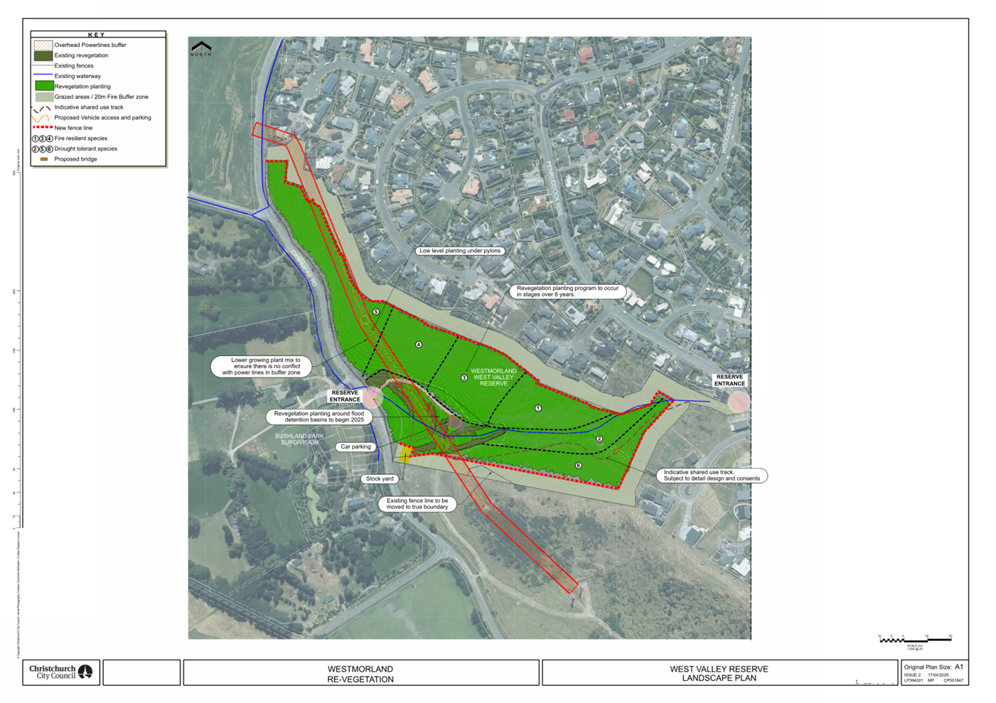
|
14. Kordia
Licence at Sugarloaf and Thomson Scenic Reserves
|
|
Reference Te Tohutoro:
|
25/1265500
|
|
Responsible Officer(s) Te Pou Matua:
|
Kathy
Jarden, Team Leader Leasing Consultancy
|
|
Accountable ELT Member Pouwhakarae:
|
Andrew
Rutledge, General Manager Citizens and Community
|
1. Purpose and Origin of the Report Te Pūtake Pūrongo
1.1 The
purpose of this report is to seek the Community Board’s approval to grant
a new long-term licence to Kordia Limited for the telecommunication site which
straddles Sugarloaf Scenic Reserve and Thomson Scenic Reserve.
1.2 The
licenced area involves land which is situated in two Christchurch City Council
wards. A separate report was considered by Te Pātaka o
Rākaihautū Banks Peninsula Community Board on 8 September 2025.
1.3 Officers
will provide an update of the Banks Peninsula Community Board’s decision,
as the meeting had not taken place prior to the report deadline. Approval
by both Community Boards is required for the new licence to be granted.
1.4 The
report is staff-generated at the request of Kordia, whose current lease expires
on 31 August 2026.
1.5 Kordia Limited has requested a new licence to ensure continuity of
services and ongoing investment in critical national infrastructure.
2. Officer
Recommendations Ngā Tūtohu
That Waihoro
Spreydon-Cashmere-Heathcote Community Board:
1. Receives the information in the Kordia
Licence at Sugarloaf and Thomson Scenic Reserves Report.
2. Notes that the decision in this report is assessed as low significance
based on the Christchurch City Council’s Significance and Engagement
Policy.
3. Notes that the licenced area covers two Christchurch City Council
wards being Banks Peninsula and Cashmere.
4. Notes the decision-making powers requested in this report relate to
the licenced area within the Cashmere Ward. Dual consent is required by Waihoro Spreydon-Cashmere-Heathcote Community Board and Te Pātaka o Rākaihautū Banks
Peninsula Community Board to approve the granting of a
new licence agreement; that report was considered on 8 September 2025.
5. Subject to the approval (8 September 2025) of Te Pātaka o Rākaihautū Banks Peninsula Community
Board, Waihoro
Spreydon-Cashmere-Heathcote Community Board, approves
the granting of a new licence to Kordia Limited for a term of 33 years
commencing 1 September 2026 at an agreed rental of $77,000 per annum plus GST
plus property rates recovery over that part of the land described as Res 4259
Sugarloaf Scenic Reserve and PT Res 4170 Thomson Scenic Reserve and shown in
Attachment A to this report in accordance with Section 48A of the Reserves Act
1977.
6. Requests that the Manager Property Consultancy do all things
necessary and make any decisions at his sole discretion that are consistent
with the intent of this report to implement the resolutions above including
completing negotiations for and administering the terms and conditions of the
new licence.
3. Executive Summary Te Whakarāpopoto Matua
3.1 Kordia
operates a key telecommunications hub from the Sugarloaf and Thomson Scenic
Reserves.
3.2 The
lease, initially established in 1963 and expiring in 2026, supports services
including emergency communications, cellular coverage, digital TV and FM
broadcasting.
3.3 The
new licence is essential for continuity of these services.
4. Background/Context Te Horopaki
The Land
4.1 The
Kordia site is located within the Sugarloaf and Thomson Scenic Reserves which
is managed under the Reserves Act 1977.
4.2 The
land is described as Res 4259 Sugarloaf Scenic Reserve and PT Res 4170 Thomson
Scenic Reserve. The Land is owned by the Crown and the Council has been
appointed to control and manage the land.
4.3 The
licence area, as shown in the Attachment A, consists of buildings,
structures and land (area C) and an access road (area D).
4.4 The
licence area covers two Christchurch City Council wards, namely the Cashmere
Ward and the Banks Peninsula Ward as marked on Attachment A.
4.5 The
current use as a telecommunications facility is longstanding and does not
involve further expansion or intensification.
4.6 Continued
use is deemed consistent with the reserve’s purpose under the current
legislation, provided environmental effects remain managed and contained.
Strategic
Importance and National Significance
4.7 The Sugarloaf
site plays a critical role in the national telecommunications network.
4.8 It supports
digital television, FM radio, cellular services, emergency communications, and
microwave data transmission throughout Christchurch and the wider Canterbury
region.
4.9 The site's
elevation and infrastructure make it uniquely suited for high-frequency
transmission, and there are no practical alternative locations with equivalent
coverage or connectivity.
Continuity
of Essential Services
4.10 The site is used by emergency
services including NZ Police, Fire and Emergency New Zealand, and Civil Defence
for critical communications.
4.11 Disruption or loss of this site
would have immediate and wide-ranging effects on public safety and
communications resilience.
4.12 A long-term licence provides
Kordia with the stability needed to ensure continuous operation and planned
infrastructure maintenance.
Infrastructure
Investment and Maintenance
4.13 Kordia has a long-standing
presence on the site since 1963 and has invested significantly in maintaining
the 120-metre telecommunications tower and associated buildings.
4.14 The company has committed to
ongoing maintenance, including reroofing the facility during the next licence
term.
4.15 Kordia is responsible for
maintenance of the access road and land contained in the licence.
4.16 A secure licence is necessary for
Kordia to justify continued investment in nationally significant
infrastructure.
Licence
Term and Rental
4.17 The proposed licence term is 33
years which is the maximum term permitted under the Reserves Act.
4.18 The annual rental was assessed by
an independent valuer and both parties have agreed to a net rental of $77,000
plus GST and recovery of the proportionate Rates levy.
4.19 Market rent reviews will be
completed every 11 years, with CPI rent adjustments made three-yearly.
Options Considered Ngā
Kōwhiringa Whaiwhakaaro
4.20 The following
reasonably practicable options were considered and are assessed in this report:
4.20.1 Option 1
(Preferred): Grant a new licence to Kordia.
4.20.2 Option 2:
Short-term licence (e.g 10-15 years).
4.20.3 Option 3: Decline
the licence request and decommission site.
4.21 The following
options were considered but ruled out:
4.21.1 Option to relocate
facility – deemed impractical due to infrastructure, terrain, and
national integration requirements.
Options Descriptions Ngā
Kōwhiringa
4.22 Preferred
Option: Grant Long-term Licence.
4.22.1 Option Description: 33-year
licence commencing 1 September 2026.
4.22.2 Option Advantages
· Ensures continuity of emergency and broadcast services
· Supports long-term national infrastructure planning
· Enables Kordia to undertake planned maintenance.
4.22.3 Option Disadvantages
· Long licence term reduces flexibility for future land use changes.
4.23 Option 2 -
Short-Term Licence.
4.23.1 Option Description: 10-
or 15-year term.
4.23.2 Option Advantages
· Retains more flexibility over land use.
4.23.3 Option Disadvantages
· Undermines certainty for infrastructure investment.
· May jeopardise national telecommunications service continuity.
4.24 Option 3 –
Decline the licence request.
4.24.1 Option Description: Terminate
licence at expiry.
4.24.2 Option Advantages
· Future flexibility for land use – Council could explore
alternative uses of the site potentially aligning with updated strategic,
environmental or recreational priorities for the scenic reserve.
4.24.3 Option Disadvantages
· Reputational risk to the Council
· Loss of the site could result in major outages or services
· May jeopardise national telecommunications service continuity.
Analysis Criteria Ngā Paearu
Wetekina
The proposal
to grant a new licence to Kordia was assessed against the following key
criteria:
4.25 Strategic and Operational
Importance
The Sugarloaf site is essential to national and regional telecommunications,
emergency services, and public broadcasting. Maintaining Kordia's long-term
presence ensures continuity of these critical services.
4.26 Environmental and Land Use
Compatibility
The licence involves no new development or intensification, aligns with current
use of the scenic reserve, and does not adversely affect the environment or
recreational values of the site.
4.27 Policy and Legal Alignment
The proposal supports the Council’s Long Term Plan objectives, complies
with the Reserves Act 1977 (subject to public notification), and ensures
responsible stewardship of public land without financial cost to ratepayers.
5. Financial Implications Ngā Hīraunga Rauemi
Capex/Opex Ngā Utu Whakahaere
|
|
Recommended Option
33 year Licence
|
Option 2 - Short Term Licence
|
Option 3 – Decline Licence
|
|
Cost to Implement
|
No capital cost to Council
|
No capital cost to Council
|
No cost to Council
|
|
Maintenance/Ongoing Costs
|
Ongoing maintenance remains with Kordia
|
Ongoing maintenance remains with Kordia
|
Grounds maintenance costs not yet
quantified
|
|
Funding Source
|
N/A (tenant-funded)
|
N/A (tenant-funded)
|
Maintenance to come from Parks opex
budgets
|
|
Funding Availability
|
N/A
|
N/A
|
Unknown
|
|
Impact on Rates
|
Nil
|
Nil
|
Unknown
|
5.1 Operational
Expenses incurred included the rental valuation, preparation of licence plan
and staff administration costs in preparing the licence document. These
costs are recovered through operational budgets. The rental valuation
costs were split between both parties.
6. Considerations Ngā Whai Whakaaro
Risks and Mitigations Ngā
Mōrearea me ngā Whakamātautau
6.1 Risk
of service disruption if the licence is not renewed; mitigated by granting a
long-term licence.
6.2 Risk
that there may be some community concern around leasing part of a scenic
reserve to a corporate entity. Clear communication that this is a
longstanding essential utility use with no change in the footprint or public
access impacts and the fact that the licence supports critical infrastructure
should mitigate that risk.
Legal Considerations Ngā
Hīraunga ā-Ture
6.3 Statutory
and/or delegated authority to undertake proposals in the report:
6.3.1 The land is
owned by the Crown and Council has been appointed to control and manage the
land.
6.3.2 Licences of
Crown owned land must be approved by the Minister of Conservation.
Delegated authority was granted to the Chief Executive in 2013 to make certain
decisions that previously had to be referred to the Department of Conservation
for the approval of the Minister of Conservation or their delegate. Chief
Executive approval will be sought prior to execution of the licence ensuring
that due process has been followed.
6.3.3 The reserves
are subject to the Reserves Act 1977. Council must ensure continued
compliance with permitted use under the Act.
6.3.4 The previous
lease was issued prior to the Reserves Act 1977 and any occupation must now be
by way of a licence.
6.3.5 The Sugarloaf
site is on scenic reserves, and the applicable licencing provision is Section
48A - use of reserve for communication stations. Section 48A licences do
not automatically exempt Council from public notification unless:
· The activity is already detailed in an approved management plan, or
· The reserve is not likely to be materially altered or permanently
damaged; and the rights of the public in respect of the reserve are not likely
to be permanently affected.
6.3.6 In this
instance, the Cashmere Spur and Bowenvale Valley Reserves Management Plan
approved July 1991 contemplates the lease on Thomson Park/Sugarloaf Scenic
Reserves for telecommunication purposes and therefore, public notification is
not required.
6.3.7 Summit Road
(Canterbury) Protection Act 2001 (the “Act”) – The Sugarloaf
and Thomson Scenic Reserves fall within the area protected by the Act.
The proposed licence to Kordia Limited relates to the continued use of an
existing telecommunications facility with no new development or structural
modifications proposed. As such, the proposal does not trigger
notification or referral requirements under the Act. The Summit Road
Protection Authority, including the Summit Road Protection Society, does not
need to be consulted in this instance. The Society has however been
notified by way of an email on 12 August 2025 from the Executive Secretary of
the Authority of the intention to grant a new licence.
6.4 Other Legal Implications:
6.4.1 Relevant
Christchurch City Council policies including the Leasing Council Property
policy.
6.4.2 The granting
of a new licence complies with this policy as there is only one logical tenant
for use of the public property where there are buildings on parks and reserves.
Strategy and Policy Considerations Te Whai
Kaupapa here
6.5 The
required decision:
6.5.1 Aligns with
the Christchurch
City Council’s Strategic Framework.
· Resilient Infrastructure – the Sugarloaf telecommunications
facility is a core component of Christchurch’s critical infrastructure,
supporting emergency response, public broadcasting, and mobile/data services.
· Renewing the licence enables long-term
continuity of these services, which is consistent with the Council’s
commitment to building and maintaining resilient infrastructure networks.
6.5.2 Is assessed as
low significance based on the Christchurch
City Council’s Significance and Engagement Policy. The level of
significance was determined by the following considerations:
· Limited Public Impact – the licence affects a very small
number of people directly and maintains the status quo of an existing
facility. There is minimal potential for widespread community concern or
disruption.
· No impact on strategic assets or Mana Whenua – the decision
does not involve the sale or change in control of any strategic Council assets,
and there is no identified impact on Māori
land, culture, or traditions.
· High reversibility and low risk
– the licence is fully within Council’s statutory powers under the
Reserves Act, poses no financial risk, and can be controlled through standard licence
conditions and review clauses.
6.5.3 Is consistent with Council’s Plans and Policies. The 2024-2034
LTP emphasises resilient infrastructure, continuity of essential services, and
cost-effective stewardship of Council-managed assets.
6.6 This
report supports the Council's
Long Term Plan (2024 - 2034).
6.7 The proposal meets the intent and
direction of Council’s governing documents. It supports
infrastructure continuity, prudent asset management, environmental care, and
long-term planning – making the licence consistent with Council’s
Plans and Policies.
Community Impacts and Views Ngā Mariu
ā-Hāpori
6.8 There
is a positive impact with the continuation of essential communications.
6.9 The
continued operation of the facility directly contributes to the Council’s
community outcomes, particularly:
6.9.1 Strong sense
of community – enabling connection and access to emergency services.
6.9.2 A
well-connected and accessible city – through high-quality
telecommunications.
6.9.3 A safe and
healthy city – through uninterrupted emergency and public service
communications.
6.10 The decision
affects the following wards/Community Board areas:
6.10.1 Cashmere Ward and Banks
Peninsula Ward with benefits to the greater Christchurch area.
6.11 The Waihoro Spreydon-Cashmere-Heathcote Community Board view has not
been canvassed directly; supporting the decision ensures infrastructure
continuity and minimal site changes and supports Council’s long-term
vision as a resilient, well-connected and sustainable city.
Impact on Mana Whenua Ngā Whai Take
Mana Whenua
6.12 The decision does not involve a significant decision in relation to
ancestral land, a body of water or other elements of intrinsic value, therefore
this decision does not specifically impact Mana Whenua, their culture, and
traditions.
6.13 The decision does
not involve a matter of interest to Mana Whenua and will
not impact on our agreed partnership priorities with
Ngā Papatipu Rūnanga.
6.14 The decision
relates to operational continuity of nationally significant infrastructure and
involves no changes to land use, expansion or new development.
6.15 The granting of
a new licence supports the status quo and has no material impact on the
relationship of Mana Whenua to the land, nor on their culture, traditions, or
partnership arrangements with the Council.
6.16 Te Hapū o
Ngāti Wheke have been contacted directly and have no concerns with a
further licence.
Climate Change Impact Considerations Ngā
Whai Whakaaro mā te Āhuarangi
6.15 The
proposals in this report are unlikely to contribute negatively to adaptation to
the impacts of climate change or emissions reductions as there are minimal
emissions or adaptation impact due to the existing infrastructure and no
expansion is planned to the built infrastructure.
6.16 Reusing
existing infrastructure rather than developing a new site reduces emissions and
avoids additional environmental impacts.
6.17 This
is consistent with Council’s climate mitigation and adaptation
principles, especially those encouraging efficient land use and low-impact
infrastructure solutions.
7. Next Steps Ngā Mahinga ā-muri
7.1 Finalise
licence documents and execute agreement effective 1 September 2026.
Attachments Ngā Tāpirihanga
|
No.
|
Title
|
Reference
|
Page
|
|
a ⇩
|
Kordia Limited
- Sugarloaf Areas
|
25/1246264
|
133
|
In addition to the attached documents, the following background
information is available:
|
Document
Name – Location / File Link
|
|
Not
applicable
|
Signatories Ngā Kaiwaitohu
|
Author
|
Kathy Jarden -
Team Leader Leasing Consultancy
|
|
Approved By
|
Angus Smith -
Manager Property Consultancy
Paul Devlin -
Manager Regional Parks
Rupert Bool -
Head of Parks
|
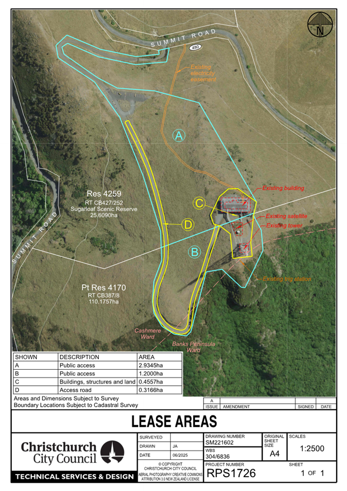
|
15. Barnett Park - Regional Park Landscape Plan
|
|
Reference Te Tohutoro:
|
25/1081568
|
|
Responsible Officer(s) Te Pou Matua:
|
Jason
Tickner – Parks and Recreation Planner
|
|
Accountable ELT Member Pouwhakarae:
|
Andrew
Rutledge, General Manager Citizens and Community
|
1. Purpose and Origin of the Report Te Pūtake Pūrongo
1.1 The
purpose of this report is to seek approval for the Barnett Park Conservation
Landscape Plan.
1.2 The report is staff initiated to address a community request for a
plan and direct community planting efforts in a strategic manner.
2. Officer
Recommendations Ngā Tūtohu
That the Waihoro
Spreydon-Cashmere-Heathcote Community Board:
1. Receives the information in the Barnett Park
- Regional Park Landscape Plan Report.
2. Approves the Barnett Park Conservation Landscape Plan in Attachment
A, and the supporting information in Attachment B.
3. Notes that the decisions in this report are of low significance in
relation to the Christchurch
City Council’s Significance and Engagement Policy 2019. The level of
significance was determined by the low number of people affected, the low level
of impact this plan would have on future social, economic, environmental, and
cultural wellbeing of the area, and the low risks to the Council, ratepayers,
and wider community of carrying out this landscape plan.
3. Executive Summary Te Whakarāpopoto Matua
3.1 The
purpose of this proposed landscape plan is to help outline and implement
prioritised community and council projects in the Barnett Park conservation
area, as well as assisting the Council to direct current funds and allocate
future budgets.
3.2 A
request for a plan for the Barnett Park Valley was received from the Redcliffs
Residents Association (the RRA) who are planting the valley and working
alongside the Council.
3.3 Engagement
was undertaken with specific stakeholders and the wider community in late 2024.
Feedback was generally positive, and a number of suggestions were received and
were included in the plan.
3.4 The
proposed Barnett Park Conservation Landscape Plan and supporting information
have been included in the Attachments for approval.
4. Background/Context Te Horopaki
4.1 Barnett Park Conservation
is a well-used regional park that serves many user groups (walkers, climbers,
etc). Among these are the RRA, who have been working with Council Park Rangers
to regenerate the area.
4.2 The park is
bounded by the Barnett Park Sports Grounds to the north, Greenwood Park to the
south and east, and private farmland to the west, with John Britten Reserve
beyond this property to the west. The reserve is shown below:
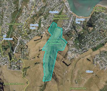
Figure
1 - Barnett Park Conservation
4.3 The RRA
approached the Council to get guidance on the appropriate planting areas and
potential projects in the park. As a result, Council officers, in collaboration
with the RRA, have developed a landscape plan to guide planting efforts and
future improvements.
4.4 The landscape
plan, Attachment A, proposes designated planting zones and recommended
species to guide both the community and the Council with restoration efforts.
It also sets out future improvements which include new track connections,
interpretive signage, waterway improvements, and upgrades to park entrances.
4.5 The plan also
includes projects that extend into adjoining parks, these being:
· A connection pathway is
proposed through the adjoining sports park portion of Barnett Park Sports
Grounds.
· Planting and track
extension further up the valley into Greenwood Park.
· Investigate entrance and
car park improvements at the Summit Road entrance of Greenwood Park.
4.6 In addition to
the Plan is a Supporting Information document, Attachment B, that
outlines the site, purpose of the plan, vision and objectives, as well as
identifying:
· Ecological
Context
· Catchment
Pests
· Catchment
Flora and Forna
· Planting
List (including flammability categories)
4.7 The
plan excludes the Sports Park portion of Barnett Park (with the exception of a
pathway connection). A separate detailed landscape plan will be prepared for
this section of the park in 2025/2026 to address the programmed playground
improvements and urban forest plan projects in this area.
Stream
Naming Request
4.8 A recent request
was received from Martin Ward of the RRA regarding the naming of the Rifle
Range Drain. Substantial efforts have been made by Mr Ward to track down the
historical and/or cultural naming of the waterway at the base of the valley. Mr
Ward has received feedback from from Ngāti Wheke on the matter, with their representative identifying ‘support for the name Te
Awa Kura being applied to the stream’.
4.9 Renaming a watercourse is managed by the New Zealand Geographic
Board Ngā Pou Taunaha o Aotearoa (NZGB) under the New Zealand Geographic
Board Act 2008 and would require consultation with other Hapū including Ngāi Tūāhuriri.
4.10 Council staff will investigate
this further and cannot include the suggested name into the proposed plan at
this point of time given the need to follow the mandated process and
requirement to undertake wider engagement.
Options Considered Ngā
Kōwhiringa Whaiwhakaaro
4.11 The following
reasonably practicable options were considered and are assessed in this report:
4.11.1 Approve the Barnett Park
Conservation Landscape Plan.
4.11.2 Request changes to the
Barnett Park Conservation Landscape Plan.
4.11.3 Decline the Barnett Park
Conservation Landscape Plan.
4.12 The following
options were considered but ruled out:
4.12.1 Detailed Plan Developed
– this valley is of a scale and nature that a detailed landscaping plan
is not necessary nor cost effective. However, future detailed landscaping plans
are intended for some of the specific capital projects identified.
4.12.2 Including the entirety of
Barnett Park in the Plan – The park comprises two distinctly different
areas with separate functions: a Sports Park located on the valley floor, and a
Regional Park conservation area situated further up the valley. To avoid
confusion and ensure clarity of purpose, it was considered that these areas are
planned for separately rather than combining them under a single, multi-purpose
plan.
Options Descriptions Ngā
Kōwhiringa
4.13 Preferred
Option 1: Approve the Barnett Park Conservation Landscape Plan
4.13.1 Option Description: Approve
the landscape plan to allow the community groups and council officers to
continue the restoration of the valley in a strategic manner, and progress with
the project identified.
4.13.2 Option Advantages
· Provides
certainty and direction to the Regional Park Rangers, the RRA, and the wider
community regarding future planting and projects planned for the conservation park.
· The plan
outlines clear mitigation strategies for several known risks and management
challenges, including fire hazards along site boundaries and planting beneath
transmission lines.
· The proposed
restoration will enhance tree cover and create habitat for a diverse range of
native flora and fauna.
· The
initiative will contribute positively to climate change mitigation and help
reduce the impacts of stormwater runoff.
· Improves our
community’s enjoyment of the park through improvement of facilities and
connection with the natural environment.
4.13.3 Option Disadvantages
· As with any restoration and park development, there are costs
associated.
4.14 Other Option
2: Request changes to the Barnett Park Conservation Landscape plan
4.14.1 Option Description: Undertake
another round of engagement and make changes to the plan based on any
additional feedback and community board direction.
4.14.2 Option Advantages
· Gives the community a second chance to provide feedback on the
proposal.
· Opportunity to add additional options or projects for consideration.
4.14.3 Option Disadvantages
· It will delay the plan approval, and the subsequent projects already
indicated and requested.
· Additional costs involved undertaking engagement and plan redesign.
4.15 Other Option3:
Decline the Barnett Park Conservation Landscape Plan
4.15.1 Option Description: Decline
the plan and continue with status quo
4.15.2 Option Advantages
· No further costs to the Council.
4.15.3 Option Disadvantages
· No clear direction and no agreement of projects and priorities.
· May result in planting of inappropriate species in inappropriate
locations (for example the planting of Kahikatea trees under the transmission
lines).
· Would not provide the direction needed to support the RRA in the
mahi they do.
5. Financial Implications Ngā Hīraunga Rauemi
Capex/Opex Ngā Utu Whakahaere
|
|
Recommended Option
|
Option 2 –
Revise Plan
|
Option3 –
Decline
|
|
|
Cost to Implement
|
Volunteer Planting – Donation of time and plants from volunteers. Total costs
unknown.
Council Cost to Implement Projects
Estimated: $633,600
|
Unknown
|
Nil
|
|
|
Maintenance/
Ongoing Costs
|
Planting
Community Lead (no cost to Council)
|
Planting
Community Lead (no cost to Council)
|
Community Lead (no cost to Council)
|
|
|
Funding Source
|
Native Planting
Principle planting efforts beyond
2025/2026 will be RRA lead and funded.
$20,000 estimated
Regional Parks planting budgets provided
for planting in 2025/26. #65873 Regional Parks Development for Port
Hills & Banks Peninsula Delivery Package
$20,000 estimated
Specimen planting of the valley floor
will be funded from the Urban Forest Budget. CPMS Project #73097 Urban
Forest Implementation
Track Improvements
$50,000
Regional Parks Maintenance and Renewal
Budget
Stream Improvements
$400,000 approx.
CPMS Project #69218 Port Hills
Revegetation and Sediment Control
Interpretive signage
$5,000 approx.
#61747 Regional Parks Planned Displays, Visitor information
& Signage Renewals
|
Unknown dependent on what changes/additional projects are
added to the plan
|
NA
|
|
|
|
Parks Planning Opex Budget to undertake
further engagement and redesign.
Funding Source for Projects would have to
be confirmed based on changes made to the plan and new projects introduce.
Pathway Connection via Sportsgrounds
$138,600 approx.
Proposed to be funded from CPMS 61781
Community Parks Access & Carpark Development
|
|
|
|
Funding Availability
|
Yes
|
Unknown
|
NA
|
|
Impact on Rates
|
Nil – within existing budgets
|
Unknown
|
Nil
|
5.1 The
intended lifespan of the Barnett Park Conservation Landscape Plan is 10
to 15 years. Projects such as the stream improvements, interpretive signage,
and pathway connection via the sportsgrounds are budgeted to be undertaken in
the next 1-3 years, while the completion of the planting/revegetation of the
valley is more likely to take the full 10-15 year.
6. Considerations Ngā Whai Whakaaro
Risks and Mitigations Ngā
Mōrearea me ngā Whakamātautau
Fire Risk
6.1 The
fire risk is addressed through a combination of strategies outlined in the plan
and supporting documentation. These include:
· Establishment of
fire breaks to reduce the spread of potential fires.
· Implementation of
a regular maintenance schedule to manage vegetation and fuel loads.
· Careful selection
of plant species with lower flammability and appropriate spacing to reduce fire
hazards.
Impact on
Transmission Lines
6.2 There
is a risk that the Council or community groups may inadvertently plant large
tree species beneath transmission lines, potentially leading to future safety,
access, and compliance issues. To mitigate this:
· The plan
designates specific low-planting zones beneath transmission corridors.
· Only low-growing,
non-invasive species are permitted in these zones.
· Council rangers
will actively monitor planting activities to ensure compliance and prevent the
establishment of inappropriate vegetation.
Impact on
Sites of Significance to Māori
6.3 The
project area includes land of cultural and historical significance to
Māori. Any inappropriate development within this area carries the risk of
impacting sacred sites and damaging the relationship between mana whenua and the
Council. To mitigate this:
· The restoration
plan has been shared with mana whenua, with the intent to restore the mana of
the whenua through the re-introduction of the native flora to the valley.
· As individual
projects progress to detailed design stage, further engagement and input will
be sought from local hapū to ensure alignment with tikanga and values.
· The Council will
adhere to its statutory obligations to consult with iwi and hapū,
particularly for any works involving waterways or areas of known cultural
significance (eg. the cave/s).
Legal Considerations Ngā
Hīraunga ā-Ture
6.4 As
per the Christchurch City Council’s Delegation Register, 21st
July 2025, the Community Board has the delegation to;
“Approve
and adopt any new landscape development plans for parks and reserves provided
the design is within the policy and budget set by the Council.”
(Part D
– Sub Part 1 - Community Boards, pg. 96)
6.5 Other Legal Implications:
6.5.1 There is no
legal context, issue, or implication relevant to this decision.
Strategy and Policy Considerations Te Whai
Kaupapa here
6.6 The
required decision:
6.6.1 Alings with
the Christchurch
City Council’s Strategic Framework.
6.6.2 Is assessed as
low significance based on the Christchurch
City Council’s Significance and Engagement Policy. The level of
significance was determined by the low number of people affected, the low level
of impact this plan would have on future social, economic, environmental, and
cultural wellbeing of the area, and the low risks to the Council, ratepayers,
and wider community of implementing this landscape plan
6.6.3 Is consistent with Council’s Plans and Policies:
· Urban Forest Strategy
· Tree Policy
· Public Open Space Strategy
6.7 This
report supports the Council's
Long Term Plan (2024 - 2034):
6.8 Parks, Heritage and Coastal Environment
6.8.1 Activity: Parks and Foreshore
· Level of Service: 6.3.5 Customer satisfaction
with the recreational opportunities and ecological experiences provided by the
City's Regional Parks - >=80%
· Level of Service: 6.3.7.4 Volunteer
participation at community opportunities across parks network - Volunteer hours
- maintain or grow compared to previous year
· Level of Service: 6.8.2.1 Increasing tree canopy
in Parks - A net increase in total number of trees is achieved (1:2 replacement
policy), with a minimum of 50% of the trees being medium to very large species
Community Impacts and Views Ngā Mariu
ā-Hāpori
6.9 Early
engagement with the RRA took place on 11 August 2024. Staff met with the
association and discussed the draft landscape plan. Several suggestions were
made including revising the pest species on the proposed plant register,
improving public amenity areas, and exploring land gifting opportunities with
neighbouring landowners. These suggestions were taken into consideration.
6.10 Consultation
started on 21 August and ran until 19 September 2024. An email was sent to 29
key stakeholders, including the RRA, local school, local sports clubs, and
environmental advocacy groups.
6.11 The consultation
was hosted on Kōrero
mai | Let’s Talk which had 592 views throughout the consultation
period.
6.12 A range of
marketing tactics was used to promote consultation to the community including
social media, letter drops to residents neighbouring Barnett Park, and physical
signs at the entrances to the park. The consultation was shared to three local
community group pages. The local library was provided with leaflets with
information about the consultation and instructions on how to make a submission.
Summary of Submissions Ngā
Tāpaetanga
6.13 Submissions were
made by one recognised organisation and 31 individuals. All
submissions are available on the Kōrero Mai | Let’s Talk webpage.
6.14 The Disabled
Persons Assembly submitted in support of the draft landscape plan with
suggestions to improve existing tracks and trails and ensure any new tracks are
fully accessible for those living with disabilities.
6.15 Submitters made
the following requests:
· Improve amenities in the area e.g. bins, BBQs, fences, gates (7)
· Improve dog control in the park (5)
· Create new walkways and revise old ones (4)
· Address issues with invasive species e.g. Gorse (2)
6.16 The RRA
submitted a list of suggestions and requests which were responded to by staff.
This response was given to a representative of the residents’ association
to provide to the other members.
6.17 The staff
responses to submitter questions and requests are available on the Kōrero
Mai | Let’s Talk webpage.
Supplementary
information
6.18 A quick poll was
conducted on the Let’s Talk webpage to reduce barriers to participate.
People were asked “How much do you like or dislike the Draft Barnett Park
Landscape Development Plan?”. The following ratings were submitted, out
of 25 responses.
· 18 5-star ratings
· 7 4-star ratings
6.19 The decision
affects the following wards/Community Board areas:
6.19.1 Waihoro
Spreydon-Cashmere-Heathcote Community Board.
Impact on Mana Whenua Ngā Whai Take
Mana Whenua
6.20 The decision involves a site of
interest to Mana Whenua and could impact on our agreed
partnership priorities with Ngā Papatipu Rūnanga.
6.21 Initially we sought direction
from Mahaanui Kurataiao Ltd. The Kaitiaki advice was to pass this through to
Whitiora as agents for Ngāi Tūāhuriri Rūnanga. Whitiora
identified at the time that they did not wish to provide any further comment to
the landscape development plan.
6.22 We also approached Te Hapū o
Ngāti Wheke (Rāpaki) Rūnanga and provided copies on the plan. We
have been working closely with a representative from the Hapū, however
have recently received direction from our Treaty Partnership team to work
unilaterally with Whitiora in this location.
6.23 The Council also commissioned
Mahaanui Kurataio Ltd in 2021 to provide a “Statement of Mana
Whenua cultural values for earthworks to be performed at the Council’s
and community planting project, Barnett Park (Te Awakura)” to inform and
accompany the Archaeological Authority application
6.24 There will be further works and
engagement with Mana Whenua as we progress the second stage of works to
stabilize the Rifle Range Drain, which is one of the projects identified in the
Barnett Park Conservation Landscape Plan.
Climate Change Impact Considerations Ngā
Whai Whakaaro mā te Āhuarangi
6.25 The decisions in
this report are likely to:
6.25.1 Contribute positively to
adaptation to the impacts of climate change
6.25.2 Contribute positively to emissions reductions.
6.26 The large-scale
planting restoration will sequester carbon and have a positive impact on
emissions and reduce the impact of climate change. The proposal will also
provide habitat for native flora and fauna and help reduce stormwater runoff
issues.
7. Next Steps Ngā Mahinga ā-muri
7.1 Council rangers
will continue to collaborate with the RRA to implement the restoration planting
outlined in this plan, and to carry out ongoing pest control and maintenance.
7.2 Council planning
and project staff will advance the current funded projects and prepare detailed
plans for targeted engagement and approval. The next step is to develop a detailed
landscape plan for the Valley Floor area (Regional Park), integrating the
following funded initiatives:
· Second Stage of
the Rifle Range Stream naturalisation and stabilisation
· Improvements to
the Bay View Road entrance to the park
· Specimen planting
on the valley floor under the Urban Forest Plan
Attachments Ngā Tāpirihanga
|
No.
|
Title
|
Reference
|
Page
|
|
a ⇩
|
Barnett Park
Conservation Landscape Plan
|
25/1724196
|
144
|
|
b ⇩
|
Barnett Park
Conservation Landscape Plan Supporting Information
|
25/1724197
|
145
|
In addition to the attached documents, the following background
information is available:
Signatories Ngā Kaiwaitohu
|
Authors
|
Jason Tickner
- Parks & Recreation Planner
Kiran Skelton
- Engagement Advisor
|
|
Approved By
|
Kelly Hansen -
Manager Parks Planning & Asset Management
Paul Devlin -
Manager Regional Parks
Rupert Bool -
Head of Parks
|
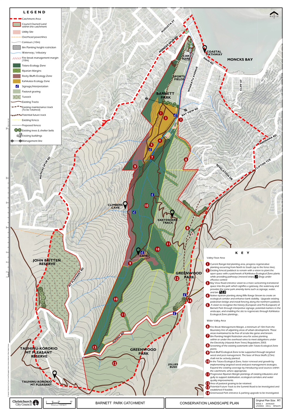
|
16. Waihoro
Spreydon-Cashmere-Heathcote Community Board Summer with your Neighbours
2025-26
|
|
Reference Te Tohutoro:
|
25/1438893
|
|
Responsible Officer(s) Te Pou Matua:
|
Shanelle
Temaru-Ilalio, Community Development Advisor
Heather Davies, Community Development Advisor
Nime Ah Kam-Sherlock, Community Recreation Advisor
|
|
Accountable ELT Member Pouwhakarae:
|
Andrew
Rutledge, General Manager Citizens and Community
|
1. Purpose and Origin of the Report Te Pūtake Pūrongo
1.1 The
purpose of this report is for the Waihoro Spreydon-Cashmere-Heathcote Community
Board to consider the allocation of funding for reimbursement from its 2025-26 Summer with your neighbours fund from the applicants listed below.
1.2 The
Board allocated $4,000 to this fund at its meeting held on Thursday 14 August
2025.
2. Officer Recommendations Ngā Tūtohu
That the Waihoro
Spreydon-Cashmere-Heathcote Community Board:
1. Receives the information in the Waihoro
Spreydon-Cashmere-Heathcote Community Board Summer with your Neighbours 2025-26
Report.
2. Notes that the decisions in this report are assessed as low
significance based on the Christchurch City Council’s Significance and
Engagement Policy.
3. Allocates its 2025-26 Summer with your Neighbours fund as follows:
|
Applicant
|
Activity
|
No. attending
|
Recommendation
|
|
Leonne Watson
(Hillsborough)
|
BBQ
|
20
|
$50
|
|
Louise van Tongeren
(Beckenham)
|
Street BBQ
|
50
|
$75
|
|
Shelley Washington
(St Martins)
|
BBQ
|
20
|
$50
|
|
Evelyn Kenneally
(Rowley Community Centre)
|
'Open Day' for Rowley
Community Centre
|
100
|
$150
|
|
Sonia Pollard
(Somerfield)
|
Halloween Street
Celebration
|
70
|
$105
|
|
Fleur Hart
(Huntsbury)
|
BBQ
|
30
|
$50
|
|
Kathy Duncan
(Richmond Hill)
|
Neighbourhood BBQ
|
50
|
$75
|
|
Sarah A Suckling
(Cashmere)
|
Street BBQ
|
60
|
$90
|
|
Katrina Cowie
(Cashmere)
|
Street BBQ
|
25
|
$50
|
|
Kristy Hogsden
(Castle Way
Residents Assocation)
|
Summer afternoon picnic
|
30
|
$50
|
|
David George Drayton
(Huntsbury)
|
Gathering of
neighbours
|
25
|
$50
|
|
Karen Loveday
(Cashmere)
|
BBQ
|
35
|
$52.50
|
|
Margaret Jenkin
(Heathcote Valley)
|
BBQ
|
30
|
$50
|
|
Iliffe Kirsten
(Redcliffs)
|
Christmas Party
|
40
|
$60
|
|
Jen Saunders
(Heathcote
Valley)
|
Street BBQ
|
45
|
$67.50
|
|
Tejada Stark
(Horotane Valley Road)
|
Neighbourhood picnic
|
50
|
$75
|
|
Timothy Greer
(Heathcote
Valley)
|
BBQ
|
15
|
$50
|
|
Mhairi Flett
(Huntsbury)
|
Summer BBQ
|
20
|
$50
|
|
Dave Mitchell
(Spreydon)
|
Street Party
|
30
|
$50
|
|
Jill & Grant
Borland Ritchie
(Hoon Hay)
|
Mavin Road Street
Party
|
50
|
$75
|
|
Dennis Sloane
(Addington)
|
Morning Tea / BBQ
|
25
|
$50
|
|
Sue Kingham
(Beckenham)
|
BBQ
|
85
|
$127.50
|
|
Kylie Ehrich
(Mokihi
Community Garden)
|
Neighbourhood BBQ
|
40
|
$60
|
|
Tanya Jephson
(Sumner)
|
Bi-annual
neighbourhood gathering
|
30
|
$50
|
|
Lisi Reid
(Huntsbury)
|
Street BBQ
|
40
|
$60
|
|
Aine Elliott
(Cracroft)
|
Street BBQ
|
40
|
$60
|
|
Ange Ritchie
(Opawa)
|
Street BBQ
|
50
|
$75
|
|
Finn Jackson
(Somerfield
Residents Association)
|
Somerfield End of
Year Community Picnic
|
200
|
$200
|
|
Katie Brazil
(Westmorland)
|
BBQ and axe throwing
|
30
|
$50
|
|
Fiona Miller
(Beachville Road
Neighbourhood Support)
|
Afternoon tea and
bowls
|
70
|
$105
|
|
Sirena Blair
(Beckenham
School Parent Teacher Association)
|
School and wider
community planting and working bee morning
|
130
|
$195
|
|
Bridget Kinnersley
(Hilmorton)
|
Summer get-together
|
100
|
$150
|
|
Zella Askew
(Heathcote
Community Sports Club Incorporated)
|
Heathcote Community
Sports Club Open Day
|
60
|
$90
|
|
Grace Le Heux
(Addington)
|
Parlane Street party
|
40
|
$60
|
|
Wendy Dudson
(Beckenham)
|
BBQ
|
60
|
$90
|
|
Emmy Nicol
(Spreydon)
|
Neighbourhood
Gathering
|
40
|
$60
|
|
Kristin Hoskin
(Cashmere)
|
Driveway BBQ and
working bee
|
25
|
$50
|
|
Allison Love
(Cashmere)
|
Neighbours' Night Out
|
350
|
$200
|
|
Helena Parsons
(Sumner)
|
Lower Sumnervale
community picnic
|
60
|
$90
|
|
Catherine Cox
(Cashmere)
|
Community Christmas
BBQ
|
60
|
$90
|
|
Liam Carroll
(Beckenham
Neighbourhood Association)
|
Summer neighbourhood
BBQ
|
200
|
$200
|
|
Michael Graveston
(St Marys the
Virign)
|
Addington Community
Carols
|
80
|
$120
|
|
Matthew Sinclair
(Cracroft
Residents Association)
|
Community Summer BBQ
|
75
|
$112.50
|
|
Ruth Wilkins
(Cracroft)
|
BBQ in Addington Bush
|
40
|
$60
|
|
Derek McCullough
(Mt Pleasant)
|
Neighbours BBQ
|
40
|
$60
|
|
|
|
Total
|
$3,790.00
|
4. Declines the applications received from: Aine
Elliott to paint a four-square court on a private lane and Finn Jackson from
Somerfield Residents Association for a Halloween event.
5. Notes that the granted funds are to be used towards food items,
non-alcoholic drinks, or invitation/advertising costs only.
6. That any unspent 2025-26 Summer with your Neighbours funding is
returned to the 2025-26 Waihoro Spreydon-Cashmere-Heathcote Discretionary
Response Fund.
3. Key Points Ngā Take Matua
Strategic Alignment Te Rautaki
Tīaroaro
3.1 The
recommendations above are aligned with the Council's Strategic Framework and in
particular the strategic priority of Strengthening
Communities. It will
provide a strong sense of community, active participation in civic life, safe
and healthy communities, celebration of our identity through arts, culture,
heritage and sport, valuing the voices of children and young people.
Decision Making Authority Te Mana
Whakatau
3.2 The
Community Board has the delegated authority to determine the allocation of the
Discretionary Response Fund for each community.
3.2.1 Allocations must be
consistent with any Council-adopted policies, standards or criteria.
3.2.2 The Fund does not
cover:
· Legal or environmental court challenges
against the Council, Council Controlled Organisations, or Community Board
decisions.
· Projects or initiatives that change the scope of a Council project
or lead to ongoing operational costs to the Council
(though Community Boards can recommend to the Council that it consider a grant
for this purpose).
Assessment of Significance and Engagement Te
Aromatawai Whakahirahira
3.3 The decisions in this report are assessed as
low significance based on the Christchurch City Council’s Significance
and Engagement Policy.
3.4 The significance level was determined by the number of people
affected and/or with an interest.
3.5 Due to the assessment of low significance, no further community
engagement and consultation is required.
Discussion Kōrerorero
3.6 At
its meeting on 14 August 2025, the Waihoro
Spreydon-Cashmere-Heathcote Community Board resolved to allocate $4,000 from
its 2025-26 Discretionary Response Fund towards Summer with your Neighbours
2025-26.
3.7 Summer
with your Neighbours is about bringing people closer together and celebrating
the unique and diverse mix of each neighbourhood. It invites residents to consider
if they have ever wanted to organise a neighbourhood gathering, or to get to
know the people who live close to them. This popular event has grown from year
to year and is promoted by the Council.
3.8 Posters
were placed in and around the Board area, including libraries. Previous
applicants were sent information inviting them to apply for the Summer with
your Neighbours funding. Staff also promoted the fund through the Board
webpage, social media and other networks.
3.9 Summer with your Neighbours will run from 25 October 2025 to 30 March
2026. Applications for funding opened on 12 July 2025 and closed on 10
August 2025.
3.10 In total 48
applications had been received, with 46 applications to be considered by the
Board due to:
· Two applications have been declined due to applying for funding
twice.
Staff have
assessed the applications to ensure that they meet the Summer with your
Neighbours guidelines and recommended an amount to be allocated to all of the
applications.
3.11 Staff recommendations were based on the following, in order to
maintain consistency over the allocation of recommendations:
· A city-wide formula of $2.50 per person has been applied as a
consistent approach to applications. When the requested amount is less than the
$2.50 per head formula, the requested amount is what has been recommended;
however, due to the increased Summer with Your Neighbours applications in the
Waihoro Spreydon-Cashmere-Heathcote area for 2025/2026, a formula of $1.50 per
person has been applied.
· A maximum of $200 and a minimum of $50 per event have been applied
to all applicants.
· Where two approximate attendee numbers have been noted,
recommendations are based on the lower approximate figure.
3.12 A matrix
outlining the applications and staff recommendations is attached (refer Attachment
A), along with the Summer with your Neighbours Guidelines (refer Attachment
B).
Attachments Ngā Tāpirihanga
|
No.
|
Title
|
Reference
|
Page
|
|
a ⇩
|
Summer with your Neighbours 2025-26 Matrix
|
25/1811318
|
156
|
|
b ⇩
|
Summer with your Neighbours 2025-26 Guidelines
|
25/1438894
|
159
|
Signatories Ngā Kaiwaitohu
|
Authors
|
Jane Walders -
Support Officer
Hannah Martin
- Community Support & Events Coordinator
|
|
Approved By
|
Emma Pavey -
Manager Community Governance, Papanui-Innes-Central
|
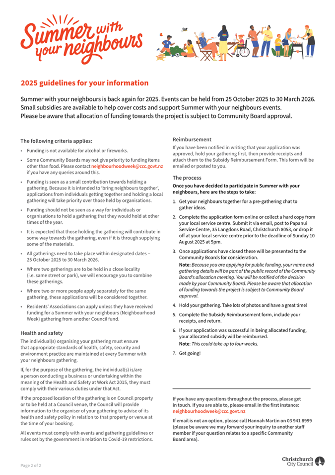
|
17. Waihoro Spreydon-Cashmere-Heathcote Community
Board Area Report - September 2025
|
|
Reference Te Tohutoro:
|
25/1440305
|
|
Responsible Officer(s) Te Pou Matua:
|
Emma
Pavey, Acting Community Governance Manager
|
|
Accountable ELT Member Pouwhakarae:
|
Andrew
Rutledge, General Manager Citizens and Community
|
1. Purpose of Origin of the Report Te Pūtake Pūrongo
1.1 This
report provides the Board with an overview of initiatives and
issues current within the Community Board area.
1.2 This
report is staff-generated monthly.
2. Officer Recommendations Ngā Tūtohu
That the Waihoro
Spreydon-Cashmere-Heathcote Community Board:
1. Receives the information in the Waihoro
Spreydon-Cashmere-Heathcote Community Board Area Report - September 2025.
3. Community Support, Governance and Partnership Activity
3.1 Community Governance Projects
|
Activity
|
Detail
|
Timeline
|
Strategic Alignment
|
|
2025 Community Service Awards
|
The Community Board has resolved to
discontinue the separate Community Service Awards and will instead present
the awards later in the year.
|
Ongoing
|
Strengthening Communities Together
Strategy.
|
|
2025/26 Summer with Your Neighbours
|
Applications to Summer with your
neighbours opened on 12 July at 9 am and closed at 5 pm on 10 August 2025.
The Board will consider the applications at its final meeting on 11 September
2025.
|
25 October 2025 – 30 March 2026
|
Strengthening Communities Together
Strategy.
|
|
Emergency Preparedness
|
Communities have been supported to
undertake preparedness planning for natural disasters. Sumner Residents
Association, Redcliffs Residents Association, Cashmere Residents Emergency
Support Team, and Somerfield Community Emergency Response Team have the capacity
to set up an emergency hub in their neighbourhood when
required.
|
Ongoing
|
Strengthening Communities Together
Strategy.
Community Board Plan Priority
|
|
Heathcote River Raft
|
The event is scheduled for Sunday, 8
March at 1 pm.
Staff are supporting the coordinator and
committee with planning, permit applications, and connections with key stakeholders.
|
Ongoing
|
Strengthening Communities Together
Strategy.
|
|
Ferrymead Pump Track
|
Staff have been assisting the project
team with funding initiatives, with an application currently pending
consideration at the Council decision meeting scheduled for Wednesday, 3
September.

|
Ongoing
|
Strengthening Communities Together
Strategy.
|
3.2 Community
Funding Summary
3.2.1 Community
Board Discretionary Response Fund 2025/26 – as of 22 August 2025:
· Discretionary
Response Fund balance for 2025/26 is $120,339 (including carryforwards).
· Youth Achievement
and Development Fund balance is $10,000.
· The Off the Ground
Fund balance is $3,000.
The 2025/26 Discretionary Response Fund Spreadsheet as of 22 August
2025 is attached for record purposes.
3.2.2 Report
back to the Community Board:
|
Name | Event | Photos
|
|
Rachel Baker, Junior World
Orienteering Championships, Italy
The highlights of the event were having
some success in the forest races and making friends and connections with
people from all over the world! I came 21st in the long distance
and 39th in the Middle distance (out of 150 people), so I was very
happy with my results. The training week prior to the competition week was a
great learning experience to learn which skills work best in the different
terrain, and to get valuable coaching from our NZ team coaches.
Next year, I aim to make the top 10 in a
forest race at the junior world champs. I am also hoping to coach at the NZ
junior orienteering camp in December. I am currently organising an introduction
to Orienteering event for the University club this term on Mount Vernon.
Competing at the junior world champs has inspired me and continues to inspire
me to share my love for the sport and coaching with others.
|
3.3 Participation
in and Contribution to Decision Making
3.3.1 Report
back on other Activities contributing to Community Board Plan [for items not
included in the above table but are included in Community Board Plan]
· The Waihoro Spreydon-Cashmere-Heathcote 2023-25 Community Board Plan
was adopted by the Board at their meeting in May 2023 and can be found online here.
· Progress on the Community Board Plan is attached.
3.3.2 Council
Engagement and Consultation.
· On
29 July 2025, the Board gave feedback to Council officers on options for
Coastal Hazards Adaptation planning. The Board was briefed on the options at
its Information Session/Workshop on 26 June 2025. The Board indicated its
support for the Woolston to Taylors Mistake (Option 3) option as the next area
for adaptation planning, noting that:
o It is an area of high risk (second-highest
level of risk)
o There is a high level of community
engagement and willingness to engage
o There are fire hazards (Port Hills)
in the area, which are impacted by climate change.
· The Sumner
community asked for consultation on the operation of the mast lights on Tuawera
Cave Rock. The consultation was open from 12 May to 28 May 2025. The Board will
consider the feedback and staff recommendation at its meeting on 28 August
2025.
· A proposal for safety
improvements at the Somerfield Street and Strickland Street intersection was
open for consultation from 11 July to 3 August 2025. This followed community
feedback sought in May 2024 on transport issues in this area.
Staff updated the Board on the project at the Board’s Information
Session/Workshop on 26 June 2025, amongst other Christchurch Regeneration
Acceleration Facility (CRAF) projects. The Board is scheduled to receive a
decision report at its meeting on 28 August 2025.
· A proposal to
make it safer for pedestrians on Richmond Hill Road was open for feedback from
2 August to 8 September 2024. At their meeting on 14 November 2024, the Board requested
a workshop to explore an alternate option that provides for a defined footpath
and defined car parking areas. Staff investigated this and presented options to
the Board at their Information Session/Workshop on 29 May 2025. This was
followed by a site meeting on Richmond Hill Road with elected members,
residents, and staff. A decision report is scheduled for the Board’s
meeting on 11 September 2025.
· The Christchurch Yacht Club's
proposed redevelopment of their club facilities was reopened for further
consultation from 18 July to 3 August 2025. This follows earlier consultation
in late 2024, in response, the club updated its plans and in April Council
contacted those who had previously provided feedback. The Club
has requested to proceed for a Community Board decision based on the plans used
in the previous consultation. A decision report is scheduled
at the Board’s meeting on 11 September 2025.
· A proposal to lower the speed
on Cashmere Road, Sutherlands Road, and Hoon Hay Valley Road to make it safer
for people walking was reconsulted, following initial consultation in 2023 and
the new Setting of Speed Limit 2024 Rule that came into effect in September
2024. The roads are in the Waipuna Halswell-Hornby-Riccarton Community Board
area, but they border with Waihoro Community Board area. Feedback opened on 4
July and closed on 18 August 2025, and a decision on this matter is expected to
be made by Council in February 2026.
3.4 Governance
Advice
3.4.1 Public
Forum – The Board received the following public forum presentations
at its 14 August 2025 meeting:
· Local residents spoke regarding parking safety issues on Beechworth
Avenue.
· A local resident spoke regarding parking issues on Opawa Road.
3.4.2 Deputations
– The Board received the following deputations at its 28 August 2025 meeting:
· Local residents, Momentus Public Relations, Sumner Community
Residents Association and the Vicar of St John’s Woolston spoke in
relation to Item 7, Cave Rock Lighting.
· A resident and the Owner of Tillmans Fine Furniture spoke in
relation to Item 8, Spreydon, Somerfield, Waltham, Beckenham CRAF –
Strickland Street/Somerfield Street safety improvements.
3.4.3 Correspondence
– The Board received the following correspondence at its 14 August
meeting:
· State of the paths in Barrington Park.
· Traffic accidents at the intersections of Stanley/ Durham Street
South and The Colombo/ Durham Street South.
· Illegal parking on Sumner Street.
3.4.4 Information
Sessions/Workshops – The Board received the following information
sessions/workshops in August 2025:
· Community Parks Rolling Renewal Programme FY26-FY29
3.5 Community
Development
3.5.1 Kia
ora Addington: Kia Ora Addington continues with the community
connection through skill-sharing nights scheduled monthly at Manuka Cottage.
These nights provide an opportunity for local people to lead and share their
amazing skills with the local community, providing an opportunity for
connection and collaboration.
This month(August) is traditional Ukrainian Borscht making, knife
and gardening tool sharpening, and hair braiding.
3.5.2 What’s
Up Waltham: What’s up Waltham, with
community input are looking at ways to activate Waltham Park with the potential
of a Car Boot Sale in the coming months.
4. Advice Provided to the Community Board Ngā Kupu Tohutohu ka
hoatu ki te Poari Hapori
4.1 Closed Information Requests from Community Open Forums – July 2025.
|
Ticket
|
Involved Business Units
|
Original Request
|
Officer Advice
|
|
Open Forum 29 May 2025 Request - Norfolk
pines on the Coastal Pathway
|
CIPA Parks (CCC Unit/Team)
|
Concerns relating to Norfolk Pines on Coastal Pathway
|
The Christchurch Coastal Pathway Group and Christchurch
City Council signed a Memorandum of Understanding in November 2013 to jointly
deliver the Coastal Pathway project and a developed design plan in October
2014. A Landscape Plan for the Coastal Pathway project, including this
area was completed in 2018 and the plant species aligned with the
recommendations and plant description in the developed design, was agreed
with the Christchurch Coastal Pathway Group. The (former)
Waikura/Linwood-Central Heathcote Community Board approved the Landscape Plan
on 15 August 2018 (refer
to minutes, Item 11), at paragraph 5.12 the planting schedule is set out,
including the Norfolk Pines. The report notes at paragraph 4.4.
“Extensive consultation occurred during the development of the Main
Road Master Plan, which included the Coastal Pathway” (refer
Main Road Masterplan, which summaries Community Workshops held on 28 May
and 4 June 2013. The Landscape Plan proposed the planting of eight Norfolk
Island Pines in the swale area between the car park and shared path. The
Christchurch Coastal Pathway documentation does not outline why Norfolk
Island pines were specifically included in the Landscape Plan, however staff
advise that some likely reasons could be:
1. Coastal Resilience: Tolerant to harsh coastal
conditions: Norfolk Island pines (Araucaria heterophylla) are known
for their strong tolerance to salt spray, wind, and exposed coastal
sites—making them ideal for seaside planting
2. Aesthetic and Historical Appeal: Iconic and ornamental:
With their distinctive symmetrical shape and towering presence, Norfolk pines
have long been favoured for planting along the coastline and promenades
(e.g., Napier’s Marine Parade). They offer both visual appeal and a
sense of place.
Cultural familiarity: New Zealand residents often
associate these trees with the coastal landscape, creating a sense of
continuity and charm.
3. Structural and Shade Qualities: Shade and visibility:
Their horizontal branching canopy structure provides shade without
obstructing views—an ideal combination for shared pathways where
visibility and comfort are both important
Damage to Coastal Pathway
There is currently no visible damage to the Coastal
Pathway because of the newly planted Norfolk Island Pines. The tree pits were
designed to prevent future infrastructure damage by allowing the tree roots
adequate below ground space and installing root barriers to redirect root
growth away from hard surfaces (e.g., footpaths, pipes, foundations). As part
of the Open Forum presentation to the Board on 19 May 2025 a photo was
presented showing existing footpath damage near the Esplanade entrance, which
is likely to be caused by the mature Norfolk Island Pines (which have an
estimated to be 100+ years old). This damage will be passed onto the
Council’s Pavement Maintenance Engineer for further assessment.
|
4.2 Customer
Service Request Report – Report on open and completed tickets
(requests for service) in July 2025 is attached.
4.3 Graffiti
Snapshot Report – The monthly report for July 2025 is attached.
4.4 Attached Memos include:
·
Memo - NZTA Funding - LCLR Targeted Fund (2024-27)
· Memo
- Simeon Street Cycleway - Milton Street Crossing Update
· Memo
New Footpaths Programme
4.5 On
1 August 2025 the Board received advice that Orion have agreed for Council to
utilise their power pole to install a new light on Koromiko street.
4.6 At
the Board’s meeting on 15 May 2025 the Board received correspondence from
Rex and Jan Raistrick in relation to parking issues on Lyttelton Street. The
Board referred the issue to staff for investigation. The Board received staff
advice on 1 August 2025:
We
understand that high parking demands are observed at times which may make
access more challenging. However, no stopping restrictions are typically only
considered for residential driveways when there is a site-specific safety
concern that poses an increased risk to drivers exiting the property, and it is
demonstrably different from others in the immediate area. Factors that are
considered include the location, topography, presence of street furniture, or
whether the driveway serves a high volume of traffic (typically more than 250
vehicles per day).
In this case
the driveway is clearly defined and no different to any other driveway along
this section of road. It is around 5 metres wide which already provides some
increased clearance for exiting vehicles when compared to a standard
residential driveway.
A search of
the NZTA Crash Analysis System has been undertaken to confirm if there is any
history or pattern of reported crashes associated with driveway access or
manoeuvring along this section of road to indicate an inherent safety issue. No
crashes relating to driveway access have been reported on this section of
Lyttelton Street within the five-year search period.
Based on the
above, parking restrictions are not supported at this time however we can
continue to monitor it. If parked vehicles are blocking access or parked within
1 metre of the driveway, we encourage residents to report this to Councils
enforcement team to investigate. They can be contacted via the Council Call
Centre on 941 8999.
4.7 The
Board received two items of correspondence relating to the height of no parking
signs on Beachville road at the Board’s meeting on 15 May 2025. The Board
received advised on 20 August 2025 confirming the signs have been lowered.
4.8 The
Board received correspondence at its meeting on 10 April 2025 from a resident
in relation to traffic concerns on Cheviot Street in Spreydon. The Board
received staff advice on 22 August 2025 that staff have been monitoring Cheviot
Street in response to the parking and access concerns raised by the resident
and have also received several similar concerns from other nearby residents in
recent months. A proposal for no stopping restrictions will be developed for
consultation with affected residents.
4.9 Ōmōkihi
South Library and Customer Service Hub update
Cook Brothers
Construction has completed the first concrete pour on the Ōmōkihi
South Library and Customer Service Hub. The team trucked in more than 300 cubic
metres of concrete, which comes to 52 truckloads. The second half will be
poured in early September. Once the concrete is cured, the next step is for the
structural steel to be erected.
4.10 On 21 August 2025, Board members
were taken on a site visit of the construction and saw first-hand the progress
at the site.
4.11 The recent demolition of the old
building has seen more than 20 tons of material reused and repurposed. The team
working on Ōmōkihi has managed to divert approximately 69% of
material, which puts this project at the upper end of industry performance.
That material includes joinery, furniture, and carpet tiles for use in the
local community.
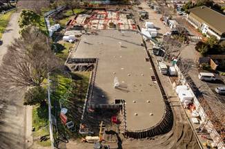
Attachments Ngā Tāpirihanga
|
No.
|
Title
|
Reference
|
Page
|
|
a ⇩
|
Waihoro Spreydon-Cashmere-Heathcote - Discretionary Response Fund
2025/26
|
25/1684555
|
170
|
|
b ⇩
|
Waihoro Community Board Plan Monitoring Report - August 2025
|
25/1748947
|
171
|
|
c ⇩
|
Waihoro Customer Service Request Report - July 2025
|
25/1690859
|
180
|
|
d ⇩
|
Waihoro Graffiti Snapshot Report - July 2025
|
25/1690860
|
183
|
|
e ⇩
|
Memo - NZTA Funding - LCLR Targeted Fund (2024-27)
|
25/1690872
|
185
|
|
f ⇩
|
Memo - Simeon Street Cycleway - Milton Street Crossing Update
|
25/1690873
|
189
|
|
g ⇩
|
Memo New Footpaths Programme
|
25/1690874
|
191
|
Signatories Ngā Kaiwaitohu
|
Authors
|
Nime Ah
Kam-Sherlock - Community Recreation Advisor
Heather Davies
- Community Development Advisor
Jonathon Jones
- Community Board Advisor
Shanelle
Temaru-Ilalio - Community Development Advisor
Jacqui Jeffrey
- Community Funding Advisor
Jane Walders -
Support Officer
Hannah Martin
- Community Support & Events Coordinator
|
|
Approved By
|
Emma Pavey -
Manager Community Governance, Papanui-Innes-Central
Matthew
McLintock - Manager Community Governance Team
John Filsell -
Head of Community Support and Partnerships
|
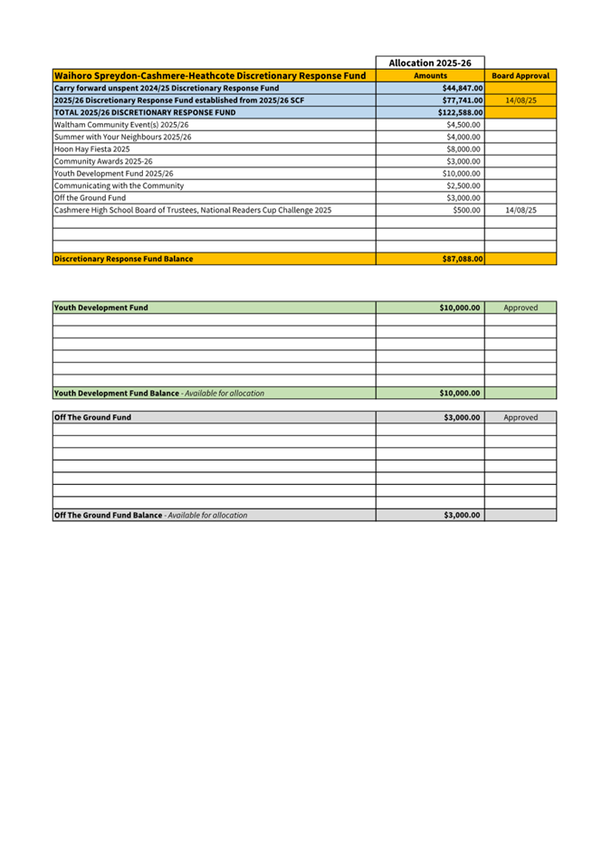
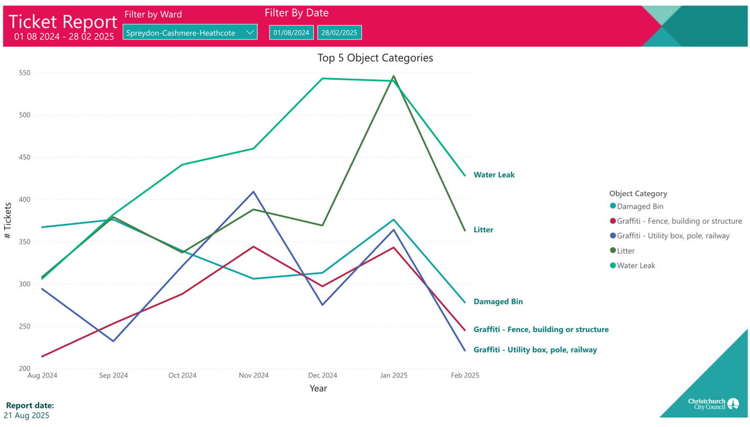
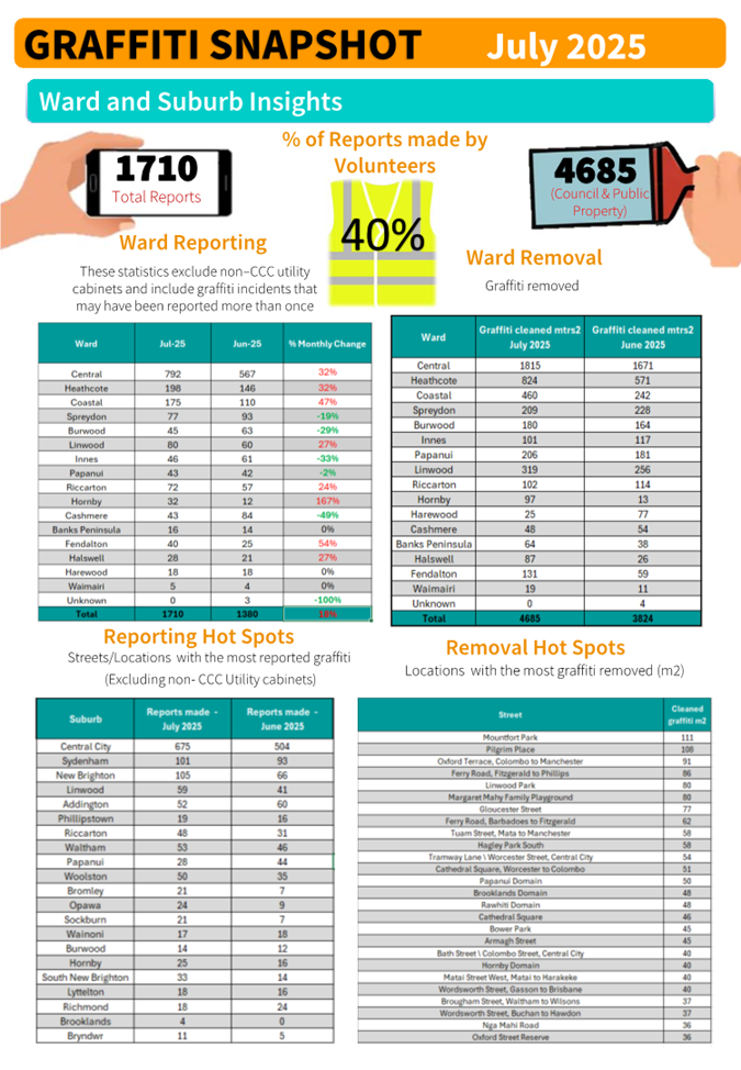
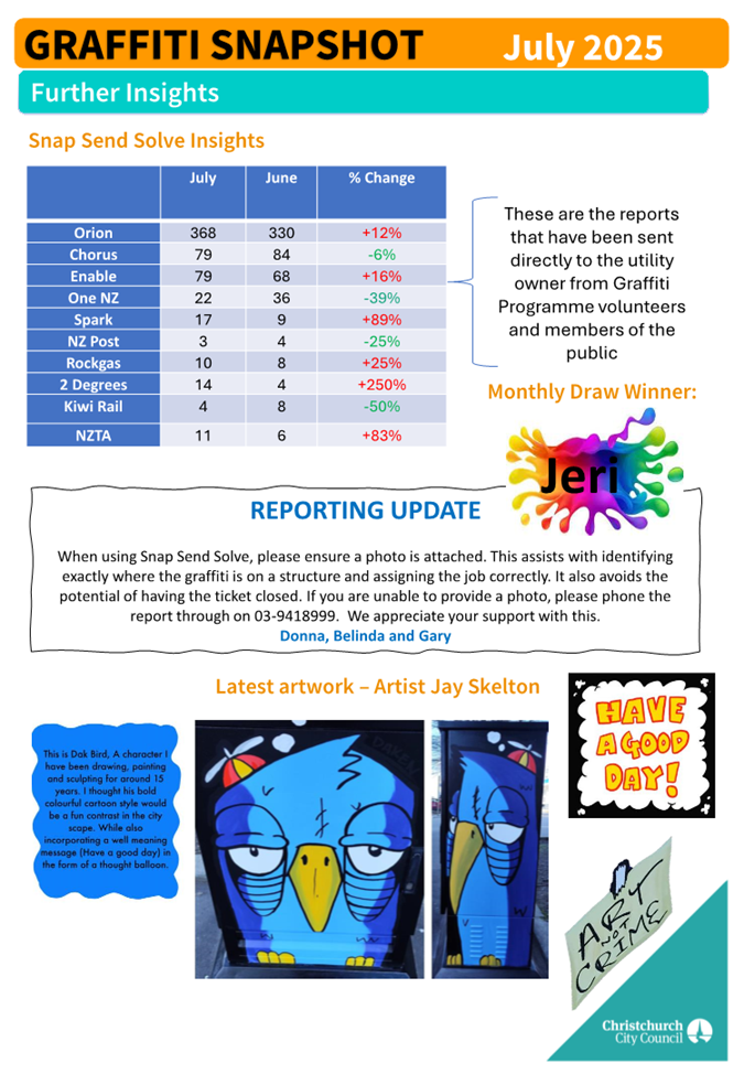
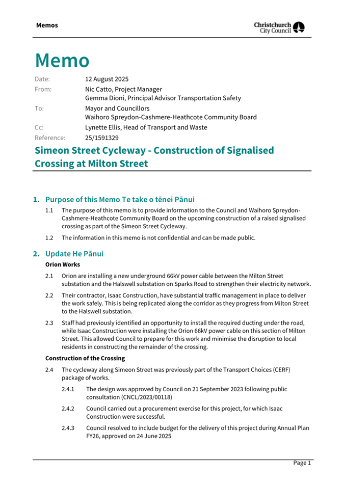
|
18. Valedictory
|
|
Reference Te Tohutoro:
|
25/1755160
|
|
Responsible Officer(s) Te Pou Matua:
|
Jonathon
Jones, Community Board Advisor
|
|
Accountable ELT Member Pouwhakarae:
|
Andrew
Rutledge, General Manager Citizens and Community
|
1. Waihoro Spreydon-Cashmere-Heathcote Community Board Chairperson
valedictory
1.1 Callum
Ward, Chairperson will give a valedictory speech.
Attachments Ngā Tāpirihanga
There are no attachments for this report.
|
19. Elected Members’ Information Exchange Te
Whakawhiti Whakaaro o Te Kāhui Amorangi
|
This item provides an opportunity for Board Members to
update each other on recent events and/or issues of relevance and interest to
the Board.
Karakia Whakakapi
|
Tukuna te wairua kia rere ki te
taumata
Ko te matatika te mātāpono
hei arahi i ngā mahi
Ka arotahi te tira kia eke panuku,
kia eke Tangaroa
Haumi e, hui e, tāiki e
|
May the spirit be released to soar to its zenith.
Ethics is the principle that guides our work.
As we focus on the success for our community
Bring together! Gather together and bind together!
|
Actions Register Ngā Mahinga
When decisions are made at meetings, these
are assigned to staff as actions to implement. The following lists
detail any actions from this meeting that were:
·
Open at the time the agenda was generated.
·
Closed since the last ordinary meeting agenda
was generated.
Open Actions Ngā Mahinga Tuwhera
|
REPORT TITLE/AGENDA SECTION
|
MEETING DATE
|
ACTION DUE DATE
|
UNIT
|
TEAM
|
|
Public Forum - Request for
the recommencement of the Grange Street Renewal
|
15 May 2025
|
14 August 2025
|
Transport & Waste
|
Asset Management
|
|
Correspondence
|
14 September 2023
|
30 August 2025
|
Parks
|
Parks & Recreation Planning
|
|
Correspondence
|
12 June 2025
|
11 September 2025
|
Transport & Waste
|
Traffic Operations
|
|
Correspondence
|
10 April 2025
|
30 September 2025
|
Community Support & Partnerships
|
Governance (Spr-Cas-Hea)
|
|
Public Forum - Cumbria Lane
Lighting, Westmorland
|
12 June 2025
|
30 September 2025
|
Transport & Waste
|
Asset Management
|
|
Public Forum - Development of
New Sections in West Halswell
|
12 June 2025
|
30 September 2025
|
Community Support & Partnerships
|
Governance (Spr-Cas-Hea)
|
|
Public Forum - Replacement
for the Plaque at Ashgrove Reserve
|
13 February 2025
|
30 September 2025
|
Parks
|
Community Parks
|
|
Sumner Valley Riding School
Trust - proposed new lease
|
10 April 2025
|
1 October 2025
|
Facilities & Property Unit
|
Property Consultancy
|
|
The Green Effect Trust (Trees
for Canterbury) - Proposed new lease - Charlesworth Reserve
|
13 March 2025
|
1 October 2025
|
Facilities & Property Unit
|
Property Consultancy
|
|
Public Forum - Basketball
court at Ti Rakau Reserve
|
10 July 2025
|
9 October 2025
|
Parks
|
Parks & Recreation Planning
|
|
Public Forum - Tree removal
Farnley Reserve
|
10 July 2025
|
9 October 2025
|
Parks
|
Botanic and Garden Parks
|
|
Public Forum - Tree shading
property in Hillsborough
|
10 July 2025
|
9 October 2025
|
Parks
|
Botanic and Garden Parks
|
|
Public Forum - Mt Pleasant
Community Centre traffic management issues
|
15 May 2025
|
14 October 2025
|
Transport & Waste
|
Traffic Operations
|
|
Beach Hospitality Limited -
Landlord Consent to Improvements and Request for Further Lease
|
13 March 2025
|
31 October 2025
|
Facilities & Property Unit
|
Property Consultancy
|
|
Grant an Easment over
Waterworks Reserve 109 Scruttons Road Heathcote Christchurch.
|
15 February 2024
|
31 October 2025
|
Facilities & Property Unit
|
Property Consultancy
|
|
2025/26 Waihoro
Spreydon-Cashmere-Heathcote Discretionary Response Fund - Board Projects
|
14 August 2025
|
13 November 2025
|
Community Support & Partnerships
|
Governance (Hal-Hor-Ric)
|
|
Bunyan Street / Domett Street
Intersection - Proposed No Stopping Restrictions
|
14 August 2025
|
13 November 2025
|
Transport & Waste
|
Traffic Operations
|
|
Correspondence
|
14 August 2025
|
13 November 2025
|
Parks
|
Community Parks
|
|
Correspondence
|
14 August 2025
|
13 November 2025
|
Transport & Waste
|
Traffic Operations
|
|
Public Forum - Parking Issues
on Opawa Road
|
14 August 2025
|
13 November 2025
|
Transport & Waste
|
Traffic Operations
|
|
Waihoro
Spreydon-Cashmere-Heathcote 2025/26 Strengthening Communities Fund
Applications for Consideration
|
14 August 2025
|
13 November 2025
|
Community Support & Partnerships
|
Governance (Hal-Hor-Ric)
|
|
Waihoro Spreydon-Cashmere-Heathcote
2025-26 Discretionary Response Fund Cashmere High School Board of Trustees,
National Readers Cup Challenge in Auckland September 2025 Project
|
14 August 2025
|
13 November 2025
|
Community Support & Partnerships
|
Governance (Hal-Hor-Ric)
|
|
Cave Rock Lighting
|
28 August 2025
|
27 November 2025
|
Parks
|
Asset Management
|
|
Spreydon, Somerfield,
Waltham, Beckenham CRAF - Strickland Street/Somerfield Street safety
improvements
|
28 August 2025
|
27 November 2025
|
Transport & Waste
|
Project Management
|
|
Public Forum - Spokes
Canterbury
|
12 June 2025
|
1 December 2025
|
Transport & Waste
|
Asset Planning
|
|
Sumner Tennis and Squash Club
Application to lease 8-14 Heberden Avenue and 140 Nayland Street
|
11 May 2023
|
1 December 2025
|
Facilities & Property Unit
|
Property Consultancy
|
|
Spreydon, Somerfield,
Waltham, Beckenham CRAF - Lyttelton Street safety improvements
|
10 July 2025
|
20 December 2025
|
Transport & Waste
|
Project Management
|
|
Orion Easement at Waltham
Park
|
10 April 2025
|
31 December 2025
|
Facilities & Property Unit
|
Property Consultancy
|
|
Parking changes on Selwyn
Street and Milton Street
|
14 August 2025
|
31 March 2026
|
Transport & Waste
|
Traffic Operations
|
|
Spreydon, Somerfield,
Waltham, Beckenham CRAF - Selwyn Street pedestrian and cycle safety
improvements
|
10 July 2025
|
26 June 2026
|
Transport & Waste
|
Project Management
|
|
Redcliffs Village - Coastal
Pathway safety improvements.
|
15 February 2024
|
30 June 2026
|
Transport & Waste
|
City Streets Maintenance
|
Actions Closed Since the Last Meeting Ngā
Mahinga kua Tutuki nō Tērā Hui
Actions closed from 22 to 31 August 2025
|
REPORT TITLE/AGENDA SECTION
|
MEETING DATE
|
DUE DATE
|
ACTION CLOSURE DATE
|
UNIT
|
TEAM
|
|
Public Forum - Request for
the recommencement of the Grange Street Renewal
|
15 May 2025
|
29 August 2025
|
25 August 2025
|
Three Waters
|
Asset Management
|
|
Proposed Lane Names - 245
Worsleys Road, Cracroft
|
14 August 2025
|
13 November 2025
|
27 August 2025
|
Planning & Consents
|
Resource Consents
|
|
Fifield Terrace - Proposed No
Stopping Restrictions
|
12 June 2025
|
11 September 2025
|
28 August 2025
|
Transport & Waste
|
Traffic Operations
|
|
Willard Street - Proposed No
Stopping Restrictions
|
14 August 2025
|
13 November 2025
|
28 August 2025
|
Transport & Waste
|
Traffic Operations
|