Waimāero
Fendalton-Waimairi-Harewood Community Board
Agenda
Notice of Meeting Te Pānui o te Hui:
An ordinary meeting of the Waimāero
Fendalton-Waimairi-Harewood Community Board will be held on:
Date: Monday 8 September 2025
Time: 4.30 pm
Venue: Boardroom, Fendalton Service Centre,
Corner Jeffreys and Clyde Roads, Fendalton
Membership Ngā
Mema
|
Chairperson
Deputy Chairperson
Members
|
Jason Middlemiss
Bridget Williams
David Cartwright
Linda Chen
James Gough
Aaron Keown
Sam MacDonald
Nicola McCormick
|
3 September 2025
|
|
Principal Advisor
Maryanne Lomax
Manager Community Governance
Tel: 941 6730
[email protected]
|
Meeting Advisor
Aidan Kimberley
Community Board Advisor
Tel: 941 6566
[email protected]
|
Website: www.ccc.govt.nz
Part A Matters
Requiring a Council Decision
Part B Reports
for Information
Part C Decisions
Under Delegation
TABLE OF CONTENTS NGĀ IHIRANGI
Karakia Tīmatanga................................................................................................... 4
C 1. Apologies Ngā Whakapāha.......................................................................... 4
B 2. Declarations of Interest Ngā Whakapuaki Aronga........................................... 4
C 3. Confirmation of Previous Minutes Te Whakaāe o te
hui o mua.......................... 4
B 4. Public Forum Te Huinga Whānui.................................................................. 4
B 5. Deputations by Appointment Ngā Huinga
Whakaritenga................................. 4
B 6. Presentation
of Petitions Ngā
Pākikitanga.................................................... 4
Staff Reports
C 7. Dedication
of Local Purpose Reserve (Road) as Road-Kildare Street Belfast..... 19
C 8. Urban
Forest Planting Plan for Avonhead Park............................................. 27
C 9. Proposed
Lane Names - 40B Johns Road...................................................... 34
C 10. Bryndwr
Road Street Renewal................................................................... 38
C 11. Easement
Over Recreation Reserve - 82 Glenturret Drive............................... 66
C 12. Groynes
Boat Hire- Proposed New Licence- The Groynes............................... 72
C 13. Waimāero
Fendalton-Waimairi-Harewood Summer with your Neighbours 2025-26............................................................................................................. 82
C 14. Memorial
Avenue Intersections.................................................................. 90
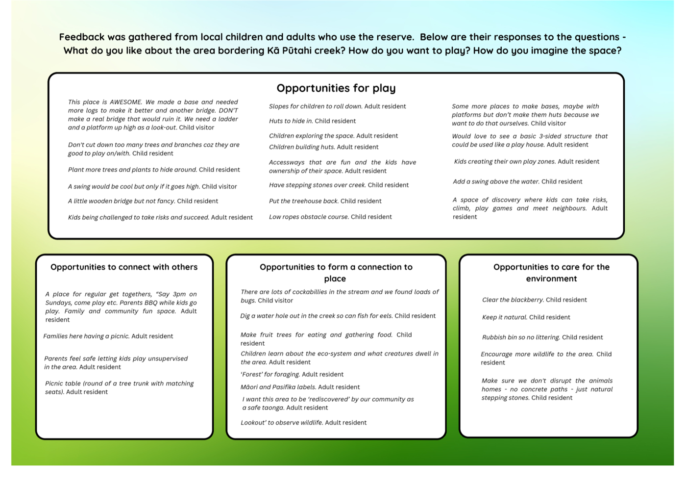
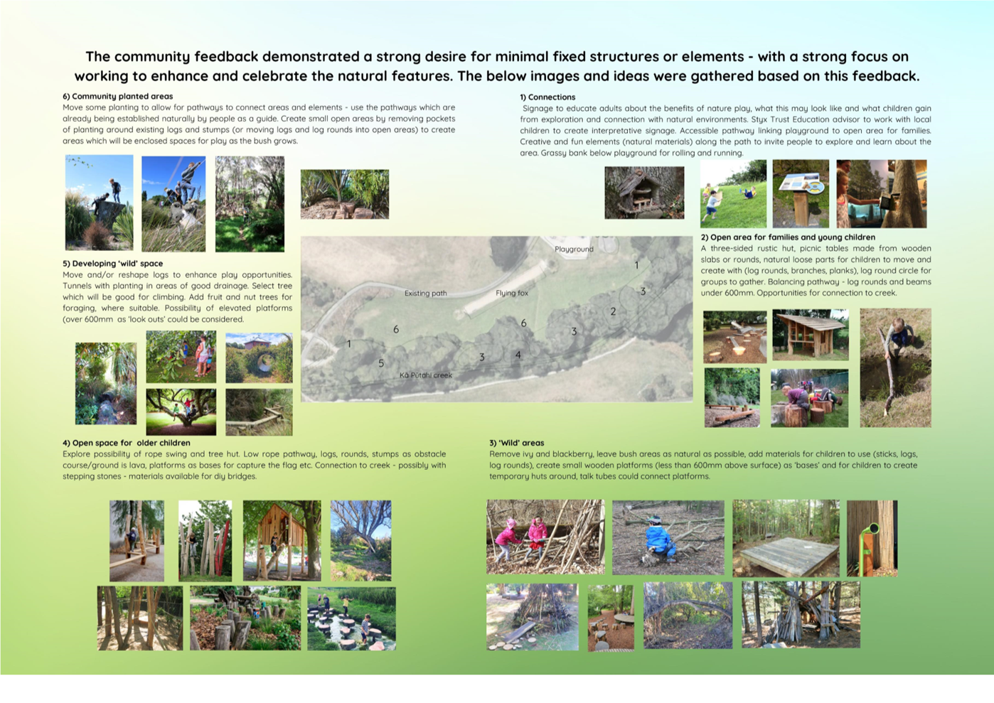
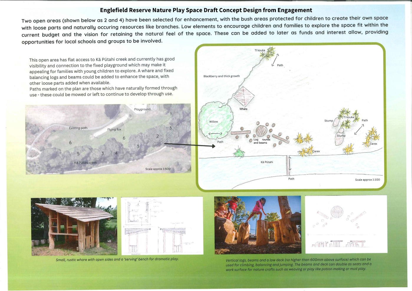
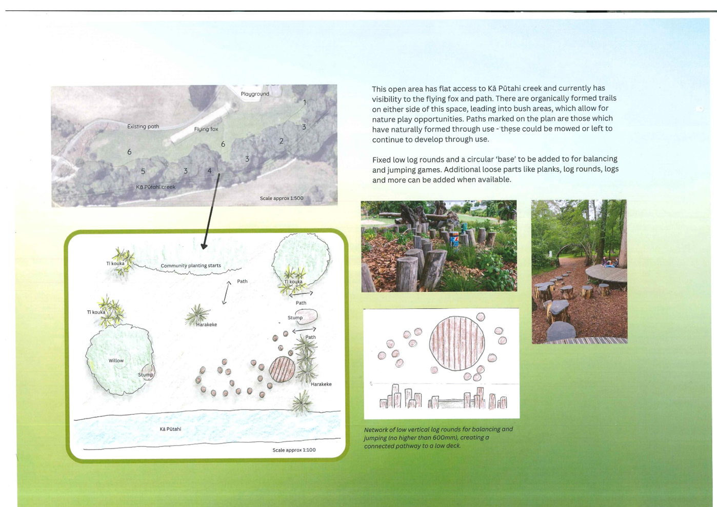
C 15. Englefield
Reserve Nature Play Space Renewal............................................ 95
C 16. Fendalton-Waimairi-Harewood
2025-2026 Discretionary Response Fund Application Avonhead Community Trust.................................................................... 104
C 17. Waimāero
Fendalton-Waimairi-Harewood Community Board Area Report - September 2025..................................................................................... 107
B 18. Elected Members’
Information Exchange Te Whakawhiti
Whakaaro o Te Kāhui Amorangi............................................................................................................ 123
Karakia Whakamutunga
Actions Register Ngā Mahinga Tuwhera
Karakia Tīmatanga
|
Whakataka te hau ki te uru
Whakataka te hau ki te tonga
Kia mākinakina ki uta
Kia mātaratara ki tai
E hī ake ana te atakura
He tio, he huka, he hauhūnga
Tīhei Mauri Ora
|
Cease the winds from the west
Cease the winds from the south
Let the breeze blow over the land
Let the breeze blow over the ocean
Let the red-tipped dawn come with a sharpened air.
A touch of frost, a promise of a glorious day.
|
1. Apologies Ngā Whakapāha
Apologies will
be recorded at the meeting.
2. Declarations of Interest Ngā
Whakapuaki Aronga
Members are
reminded of the need to be vigilant and to stand aside from decision-making
when a conflict arises between their role as an elected representative and any
private or other external interest they might have.
3. Confirmation of Previous Minutes Te
Whakaāe o te hui o mua
That the
minutes of the Waimāero Fendalton-Waimairi-Harewood Community Board
meeting held on Monday, 11 August 2025 be confirmed
(refer page 5).
4. Public Forum Te Huinga Whānui
A period of up
to 30 minutes will be available for people to speak for up to five minutes on
any issue that is not the subject of a separate hearings process.
Public Forum presentations will be recorded in the meeting
minutes
5. Deputations by Appointment Ngā Huinga
Whakaritenga
Deputations may
be heard on a matter or matters covered by a report on this agenda and approved
by the Chairperson.
Deputations will be recorded in the
meeting minutes.
6. Presentation of Petitions Ngā
Pākikitanga
There were no petitions
received at the time the agenda was prepared.
To present to the Community
Board, refer to the Participating in decision-making webpage or
contact the meeting advisor listed on the front of this agenda.

Waimāero
Fendalton-Waimairi-Harewood
Community Board
Open
Minutes
Date: Monday 11 August 2025
Time: 4.35 pm
Venue: Boardroom, Fendalton Service
Centre,
Corner Jeffreys and Clyde Roads, Fendalton
Present
|
Chairperson
Deputy Chairperson
Members
|
Jason Middlemiss
Bridget Williams
David Cartwright (via
audio/visual link)
Linda Chen (via
audio/visual link)
Aaron Keown
Sam MacDonald
Nicola McCormick
|
|
|
Principal Advisor
Maryanne Lomax
Manager Community Governance
Tel: 941 6730
[email protected]
|
Meeting Advisor
Aidan Kimberley
Community Board Advisor
Tel: 941 6566
[email protected]
|
Website: www.ccc.govt.nz

Part A Matters
Requiring a Council Decision
Part B Reports
for Information
Part C Decisions
Under Delegation
Karakia
Tīmatanga
The agenda was dealt
with in the following order.
1. Apologies Ngā Whakapāha
Part C
|
Community Board Resolved FWHB/2025/00032
That the apology from
James Gough for absence be accepted.
Bridget Williams/Nicola McCormick Carried
|
2. Declarations of Interest Ngā Whakapuaki Aronga
Part B
There were no declarations of interest recorded.
3. Confirmation of Previous Minutes Te Whakaāe o te hui o mua
Part C
|
Community Board Resolved FWHB/2025/00033
That the minutes of the Waimāero
Fendalton-Waimairi-Harewood Community Board meeting held on Monday, 7 July
2025 be confirmed.
Jason Middlemiss/Aaron Keown Carried
|
4. Public Forum Te Huinga Whānui
Part B
There were no public forum presentations at this meeting.
5. Deputations by Appointment Ngā Huinga Whakaritenga
Part B
|
5.1
|
Bishopdale Tennis
Club
Gareth Robb and Paul Morris spoke on behalf of the
Bishopdale Tennis Club regarding item 7 – Bishopdale Tennis Club Padel
Court Application.
|
|
|
Attachments
a Presentation
- Community Benefits of Padel
|
6. Presentation of Petitions Ngā Pākikitanga
Part B
There was no presentation of petitions.
|
7. Bishopdale Tennis Club Padel
Court Application
|
|
|
Community Board Resolved
FWHB/2025/00034
Part C
That the Waimāero Fendalton-Waimairi-Harewood
Community Board:
1. Receives the information in the Bishopdale Tennis Club Padel
Court Application Report.
2. Approve the construction of a new padel Court,
including the relocation of an existing coaching shed and storage shed to
accommodate the new court as shown in the plan in Attachment A, Drawing
A1.03.
3. Approve the removal and replacement of four
trees as shown in the plan in Attachment A, Drawing A1.02 and
A1.03.
4. Approve variation to the permitted use in the
existing lease to include padel.
5. Notes that approval is subject to the
Bishopdale Tennis Club meeting all regulatory requirements including the
Building Act 1991 and the Resource Management Act 1991.
6. Notes that the decisions in this report are of
low significance in relation to the Christchurch City Council’s Significance
and Engagement Policy 2019. The level of significance was determined by the small
number of neighbouring properties affected and the minimal cost to the
Council.
7. Requests that the Manager Property Consultancy
do all things necessary and make any decisions at his sole discretion that
are consistent with the intent of this report to implement the resolutions
above including completing negotiations for, and administer, the terms and
conditions of the variation.
Aaron Keown/David Cartwright Carried
|
Sam MacDonald left the
meeting at 4:47 pm.
|
8. 23 Holmwood Rd - Road Stopping
Application
|
|
|
Community Board Resolved
FWHB/2025/00035
Part C
That the Waimāero Fendalton-Waimairi-Harewood
Community Board:
1. Receives the information in the 23 Holmwood Rd - Road Stopping
Application Report.
2. Notes that the decision in this report is
assessed as low significance based on the Christchurch City Council’s
Significance and Engagement Policy.
3. Notes that the proposed Road Stopping details
have been assessed and approved by Transport staff.
4. Resolve pursuant to Sections 116(1), of the
Public Works Act 1981 to stop and sell to the adjoining owners, Annabel and
Glen Crozier, that parcel of land shown as Section 1 in Attachment A to this
report containing 49m2, at market value, and to amalgamate that parcel of
land with the owner’s adjoining land contained in Record of Title
1078200.
5. Authorises the Manager Property Consultancy
under delegated authority to undertake all actions, negotiations and to
conclude the agreements necessary to facilitate the above on terms and
conditions acceptable to him at his sole discretion, and in doing so make any
decisions necessary to give effect to this.
Aaron Keown/Nicola McCormick Carried
|
Sam MacDonald returned
to the meeting at 4:50 pm during consideration of item 9.
|
9. Halifax Reserve play space
renewal and Urban Forest plan
|
|
|
Community Board Comment
1. The
Community Board deferred making a decision on this item to allow more time to
consider alternative play equipment options.
|
|
|
Community Board Resolved
FWHB/2025/00036
Part C
That the Waimāero Fendalton-Waimairi-Harewood
Community Board:
1. Receives the information in the Halifax Reserve play space
renewal and Urban Forest plan Report.
2. Notes that the decisions in this report are of
low significance in relation to the Christchurch City Council’s Significance
and Engagement Policy 2019. The level of significance was determined by the low
number of people affected and the low level of impact on Council’s
functions.
3. Leaves the report to lie on the table and
requests staff to work with the Board on alternative play equipment options,
with the report to come back for decision to the September Board
meeting.
Jason Middlemiss/Sam MacDonald Carried
|
|
10. Hyde Park play space renewal- design
approval
|
|
|
Community Board Resolved
FWHB/2025/00037
Part C
That the Waimāero Fendalton-Waimairi-Harewood
Community Board:
1. Receives the information in the Hyde Park play space renewal-
design approval Report.
2. Notes that the decision in this report is
assessed as low significance based on the Christchurch City Council’s
Significance and Engagement Policy. The level of significance was determined
by the low level of impact on local residents and the like-for-like nature of
the project.
3. Approves the Hyde Park play space renewal plan
set out in attachment A to the report in the agenda.
Nicola McCormick/Sam MacDonald Carried
|
|
11. Waimāero Fendalton-Waimairi-Harewood
2025/26 Strengthening Communities Fund Applications for Consideration
|
|
|
Community Board Resolved
FWHB/2025/00038
Part C
That the Waimāero Fendalton-Waimairi-Harewood
Community Board:
1. Receives the information in the Waimāero Fendalton-Waimairi-Harewood
2025/26 Strengthening Communities Fund Applications for Consideration Report.
2. Notes that the decisions in this report are
assessed at low significance based on the Christchurch City Council’s
Significance and Engagement Policy.
3. Approves the 2025/26 Strengthening Communities
Fund grants outlined in the following schedule:
|
No
|
Organisation Name
|
Project
|
Recommendation
|
|
SCF25/26_046_FWH
|
Asian Community
Transformation Trust (ACTT)
|
ACTT Operating
Costs and Salaries
|
That the
Waimāero Fendalton-Waimairi-Harewood Community Board makes a grant of
$15,000 from its 2025/26 Strengthening Communities Fund to Asian Community
Transformation Trust towards the salaries of the Trust Manager and Family
Support Worker.
|
|
SCF25/26_006_FWH
|
Social Service
Council of the Diocese of Christchurch
|
Burnside/Bryndwr
Community Development Kaimahi
|
That the
Waimāero Fendalton-Waimairi-Harewood Community Board makes a grant of
$6,000 from its 2025/26 Strengthening Communities Fund to Social Service
Council of the Diocese of Christchurch towards the Burnside/Bryndwr
Community Development worker.
|
|
SCF25/26_036_FWH
|
Anglican Parish of
Burnside Harewood
|
Community
Services/programmes
|
That the
Waimāero Fendalton-Waimairi-Harewood Community Board makes a grant of
$8,500 from its 2025/26 Strengthening Communities Fund to Anglican Parish
of Burnside Harewood towards their community services and programmes
operating costs excluding food and prizes.
|
|
SCF25/26_009_FWH
|
Avonhead Community
Trust
|
Whole Village
|
That the Waimāero
Fendalton-Waimairi-Harewood Community Board makes a grant of $11,750 from
its 2025/26 Strengthening Communities Fund to Avonhead Community Trust
towards the costs of their Community Connect initiative.
|
|
SCF25/26_031_FWH
|
Avonhead Tennis
Club Inc
|
Encouraging Tennis
Participation by Youngsters
|
That the
Waimāero Fendalton-Waimairi-Harewood Community Board makes a grant of
$3,500 from its 2025/26 Strengthening Communities Fund to Avonhead Tennis
Club Inc towards their Junior Tennis Programme Expenses.
|
|
SCF25/26_005_FWH
|
Burnside Bowling
Club Incorporated
|
Greenkeeper Wage
Assistance
|
That the
Waimāero Fendalton-Waimairi-Harewood Community Board makes a grant of
$5,000 from its 2025/26 Strengthening Communities Fund to Burnside Bowling
Club Incorporated towards their Greenkeeper's wages.
|
|
SCF25/26_050_FWH
|
Burnside Elim
Church Trust
|
Burnside Elim
Church - Community Programs
|
That the
Waimāero Fendalton-Waimairi-Harewood Community Board makes a grant of
$7,000 from its 2025/26 Strengthening Communities Fund to Burnside Elim
Church Trust towards delivering their community projects excluding
refreshments.
|
|
SCF25/26_063_FWH
|
Burnside Park
Tennis Club Inc
|
Club and
Administrator Wages
|
That the
Waimāero Fendalton-Waimairi-Harewood Community Board makes a grant of
$4,500 from its 2025/26 Strengthening Communities Fund to Burnside Park
Tennis Club Inc towards wages for their Head Coach and Club Administrator.
|
|
SCF25/26_032_FWH
|
Burnside Squash
Rackets Club Incorporated
|
Annual Operational
Expenses
|
That the
Waimāero Fendalton-Waimairi-Harewood Community Board makes a grant of
$5,000 from its 2025/26 Strengthening Communities Fund to Burnside Squash
Rackets Club Incorporated towards their annual operational expenses.
|
|
SCF25/26_034_FWH
|
Burnside West
Christchurch University Cricket Club Incorporated
|
Junior and Youth
Coaching
|
That the
Waimāero Fendalton-Waimairi-Harewood Community Board makes a grant of
$6,000 from its 2025/26 Strengthening Communities Fund to Burnside West
Christchurch University Cricket Club Incorporated towards wages for their
Junior and Youth Programme coaches.
|
|
SCF25/26_038_FWH
|
Christchurch
Chinese Church Trust
|
Christchurch
Chinese Projects
|
That the
Waimāero Fendalton-Waimairi-Harewood Community Board makes a grant of
$9,000 from its 2025/26 Strengthening Communities Fund to Christchurch
Chinese Church Trust towards operational costs, including salaries and
wages, for their community programmes excluding refreshments.
|
|
SCF25/26_048_FWH
|
Christchurch Girls
High School Netball Club Incorporated
|
CGHS Netball Club
|
That the
Waimāero Fendalton-Waimairi-Harewood Community Board makes a grant of
$1,500 from its 2025/26 Strengthening Communities Fund to Christchurch
Girls High School Netball Club Incorporated towards playing bibs and
uniforms.
|
|
SCF25/26_002_FWH
|
Community Toy
Library Waimairi Incorporated
|
Operating costs for
the toy library
|
That the
Waimāero Fendalton-Waimairi-Harewood Community Board makes a grant of
$3,500 from its 2025/26 Strengthening Communities Fund to Community Toy
Library Waimairi Incorporated towards the wages of the Toy Librarian.
|
|
SCF25/26_045_FWH
|
Cotswold Preschool
& Nursery Assoc. Inc.
|
Art and Play
equipment for our Tamariki
|
That the
Waimāero Fendalton-Waimairi-Harewood Community Board makes a grant of
$1,500 from its 2025/26 Strengthening Communities Fund to Cotswold
Preschool & Nursery Assoc. Inc. towards art and play equipment.
|
|
SCF25/26_029_FWH
|
Crockfords Bridge
Club Incorporated
|
Bridge Learner
Lessons
|
That the
Waimāero Fendalton-Waimairi-Harewood Community Board makes a grant of
$4,500 from its 2025/26 Strengthening Communities Fund to Crockfords Bridge
Club Incorporated towards tutor training fees.
|
|
SCF25/26_007_FWH
|
Delta Rhythmic
Gymnastics Club Incorporated
|
Operational Costs
|
That the
Waimāero Fendalton-Waimairi-Harewood Community Board makes a grant of
$9,000 from its 2025/26 Strengthening Communities Fund to Delta Rhythmic
Gymnastics Club Incorporated towards their operational costs.
|
|
SCF25/26_062_FWH
|
FC Twenty 11
Incorporated
|
Football
Development Officer
|
That the
Waimāero Fendalton-Waimairi-Harewood Community Board makes a grant of
$9,000 from its 2025/26 Strengthening Communities Fund to FC Twenty 11
Incorporated towards the salary expenses for their Football Development
Officer.
|
|
SCF25/26_057_FWH
|
Fendalton Bowling
Club Inc
|
Support for
Greenkeeper Contract
|
That the
Waimāero Fendalton-Waimairi-Harewood Community Board makes a grant of
$5,000 from its 2025/26 Strengthening Communities Fund to Fendalton Bowling
Club Inc towards their Greenkeepers wages.
|
|
SCF25/26_003_FWH
|
Fendalton Park
Croquet Club Incorporated
|
Croquet Lawn
Maintenance
|
That the
Waimāero Fendalton-Waimairi-Harewood Community Board makes a grant of
$3,000 from its 2025/26 Strengthening Communities Fund to Fendalton Park
Croquet Club Incorporated towards lawn maintenance costs.
|
|
SCF25/26_054_FWH
|
Harewood Hockey
Club Inc
|
Youth and Junior
Development Program
|
That the
Waimāero Fendalton-Waimairi-Harewood Community Board makes a grant of
$9,000 from its 2025/26 Strengthening Communities Fund to Harewood Hockey
Club Inc towards turf training hire expenses at Nunweek Park and wages for
Coach Developer.
|
|
SCF25/26_064_FWH
|
Marist Albion
Netball Club Incorporated
|
Club Administration
|
That the
Waimāero Fendalton-Waimairi-Harewood Community Board makes a grant of
$2,000 from its 2025/26 Strengthening Communities Fund to Marist Albion
Netball Club Incorporated towards Club Administrators wages.
|
|
SCF25/26_049_FWH
|
Marist Albion Rugby
Club Inc
|
Marist Albion Rugby
Club - Supporting Costs for Members and Volunteers
|
That the
Waimāero Fendalton-Waimairi-Harewood Community Board makes a grant of
$8,000 from its 2025/26 Strengthening Communities Fund to Marist Albion
Rugby Club Inc towards their Club administration and operation expenses.
|
|
SCF25/26_053_FWH
|
Merivale Papanui
Rugby Football Club Incorporated
|
Rugby development
for our Tamariki
|
That the
Waimāero Fendalton-Waimairi-Harewood Community Board makes a grant of
$3,000 from its 2025/26 Strengthening Communities Fund to Merivale Papanui
Rugby Football Club Incorporated towards the Club’s operating
expenses and safety equipment.
|
|
SCF25/26_060_FWH
|
Miyazato Karate
Club Christchurch Incorporated
|
Karate Club Growth
Project 2025
|
That the
Waimāero Fendalton-Waimairi-Harewood Community Board makes a grant of
$1,000 from its 2025/26 Strengthening Communities Fund to Miyazato Karate
Club Christchurch Incorporated towards essential training equipment, venue
hire, volunteer recognition and promotion.
|
|
SCF25/26_041_FWH
|
New Generation
Church
|
Strengthening
Bryndwr community engagement and well-being
|
That the
Waimāero Fendalton-Waimairi-Harewood Community Board makes a grant of
$2,500 from its 2025/26 Strengthening Communities Fund to New Generation
Church towards Community events and programmes excluding food.
|
|
SCF25/26_042_FWH
|
Nomads United
Association Football Club Incorporated
|
Support for
Football Development Officer and Junior Programmes
|
That the
Waimāero Fendalton-Waimairi-Harewood Community Board makes a grant of
$6,000 from its 2025/26 Strengthening Communities Fund to Nomads United
Association Football Club Incorporated towards their Football Development
Officer wages and Junior Programmes.
|
|
SCF25/26_055_FWH
|
Nor'west Brass
Incorporated
|
General Running
Costs
|
That the
Waimāero Fendalton-Waimairi-Harewood Community Board makes a grant of
$7,000 from its 2025/26 Strengthening Communities Fund to Nor'west Brass
Incorporated towards rent and insurance.
|
|
SCF25/26_028_FWH
|
Papanui Community
Toy Library Inc
|
Papanui Toy Library
Supervisor Wages
|
That the
Waimāero Fendalton-Waimairi-Harewood Community Board makes a grant of
$1,500 from its 2025/26 Strengthening Communities Fund to Papanui Community
Toy Library Inc towards toy library supervisor wages.
|
|
SCF25/26_047_FWH
|
St Christopher's
Anglican Church - Avonhead
|
24-7 Youth Workers
Programme and Holiday Programme
|
That the
Waimāero Fendalton-Waimairi-Harewood Community Board makes a grant of
$15,000 from its 2025/26 Strengthening Communities Fund to St Christopher's
Anglican Church - Avonhead towards the operational costs of their 24-7
Youth Work initiatives and Holiday Programme Young Leaders’
Programme.
|
|
SCF25/26_056_FWH
|
St Marks
Presbyterian Church
|
Foot Clinic
|
That the
Waimāero Fendalton-Waimairi-Harewood Community Board makes a grant of
$1,130 from its 2025/26 Strengthening Communities Fund to St Marks
Presbyterian Church towards the community foot clinic.
|
|
SCF25/26_001_FWH
|
St Marks Retired
Peoples Fellowship
|
Monthly Outings
Project
|
That the
Waimāero Fendalton-Waimairi-Harewood Community Board makes a grant of
$1,500 from its 2025/26 Strengthening Communities Fund to St Marks Retired
Peoples Fellowship towards the monthly coach outings.
|
|
SCF25/26_061_FWH
|
The Old Boys' Te
Kura Tennis Club Incorporated
|
Hagley Grass Courts
|
That the
Waimāero Fendalton-Waimairi-Harewood Community Board makes a grant of
$1,600 from its 2025/26 Strengthening Communities Fund to The Old Boys' Te
Kura Tennis Club Incorporated towards the purchase tennis balls and
pickleball supplies and volunteer recognition function (excluding court
maintenance).
|
|
SCF25/26_030_FWH
|
The Village
Presbyterian Church
|
Community Centre
Operations & Programmes
|
That the
Waimāero Fendalton-Waimairi-Harewood Community Board makes a grant of
$10,000 from its 2025/26 Strengthening Communities Fund to The Village
Presbyterian Church towards the Village Community Centre operations and
their community programmes.
|
|
SCF25/26_059_FWH
|
Waimairi Tennis
Club Inc
|
Waimairi Tennis
Club Junior Tennis Programme
|
That the
Waimāero Fendalton-Waimairi-Harewood Community Board makes a grant of
$6,000 from its 2025/26 Strengthening Communities Fund to Waimairi Tennis
Club Inc towards its junior tennis programme expenses.
|
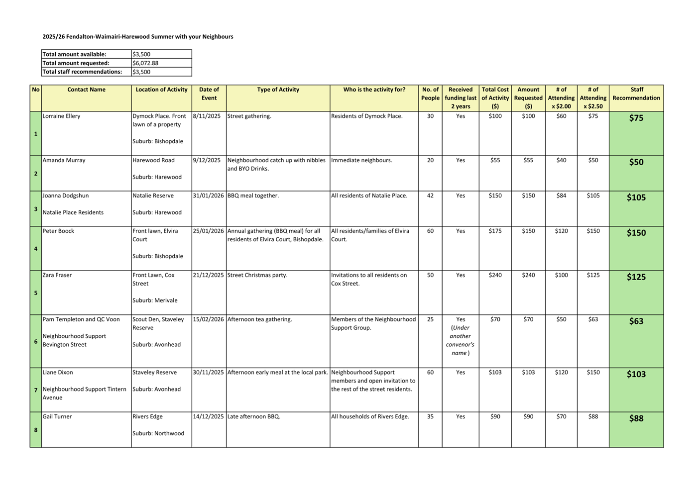
4. Approves the transfer of $112,854 to the 2025/26 Discretionary Response Fund.
Jason Middlemiss/Aaron Keown Carried
|
|
12. 2025/26 Fendalton-Waimairi-Harewood
Discretionary Response Fund - Board Projects
|
|
|
Community Board Resolved
FWHB/2025/00039
Part C
That the Waimāero Fendalton-Waimairi-Harewood
Community Board:
1. Receives the information in the 2025/26 Fendalton-Waimairi-Harewood
Discretionary Response Fund - Board Projects Report.
2. Notes that the decisions in this report are
assessed as low significance based on the Christchurch City Council’s
Significance and Engagement Policy.
3. Allocates $12,000 from its 2025/26
Discretionary Response Fund to establish the 2025/26
Fendalton-Waimairi-Harewood Youth Development Fund.
4. Allocates $8,000 from its 2025/26
Discretionary Response Fund towards the delivery of Celebrate Bishopdale
2025.
5. Allocates $3,500 from its 2025/26
Discretionary Response Fund towards Summer with your Neighbours 2025/26.
6. Allocates $6,000 from its 2025/26
Discretionary Response Fund towards Youth Activities and Events.
7. Allocates $2,000 from its 2025/26
Discretionary Response Fund towards Community Liaison and Events.
8. Allocates $2,500 from its 2025/26
Discretionary Response Fund towards hosting a Youth Achievement Event.
9. Allocates
$3,750 from its 2025/26 Discretionary Response Fund towards the Garden Pride
Awards 2026.
Bridget Williams/David Cartwright Carried
|
|
13. Waimāero Fendalton-Waimairi-Harewood
2025/26 Discretionary Response Fund Applications - St Mark's Presbyterian
Church and St Christopher's Anglican Church
|
|
|
Community Board Comment
1. The
Community Board decided to grant $2,000 towards the security cameras at St
Christopher’s Church, an increase of $500 from the officer
recommendation.
|
|
|
Officer Recommendations
Ngā Tūtohu
That the Waimāero Fendalton-Waimairi-Harewood
Community Board:
1. Receives the information in the Waimāero
Fendalton-Waimairi-Harewood 2025/26 Discretionary Response Fund Applications
- St Mark's Presbyterian Church and St Christopher's Anglican Church Report.
2. Notes that the decisions in this report are
assessed as low significance based on the Christchurch City Council’s
Significance and Engagement Policy.
3. Approves a grant of $4,000
from its 2025/26 Discretionary Response Fund to St Mark's Presbyterian Church
towards new chairs and a handrail.
4. Approves a grant of $1,500 from its 2025/26
Discretionary Response Fund to St Christopher's Anglican Church towards security
cameras.
|
|
|
Community Board Resolved
FWHB/2025/00040
Part C
That the Waimāero Fendalton-Waimairi-Harewood
Community Board:
1. Receives the information in the Waimāero
Fendalton-Waimairi-Harewood 2025/26 Discretionary Response Fund Applications
- St Mark's Presbyterian Church and St Christopher's Anglican Church Report.
2. Notes that the decisions in this report are
assessed as low significance based on the Christchurch City Council’s
Significance and Engagement Policy.
3. Approves a grant of $4,000
from its 2025/26 Discretionary Response Fund to St Mark's Presbyterian Church
towards new chairs and a handrail.
4. Approves a grant of $2,000 from its 2025/26
Discretionary Response Fund to St Christopher's Anglican Church towards security
cameras.
Sam MacDonald/Nicola McCormick Carried
|
|
14. Waimāero Fendalton-Waimairi-Harewood
Community Board Area Report - August 2025
|
|
|
Community Board Resolved
FWHB/2025/00041
Part B
That the Waimāero Fendalton-Waimairi-Harewood
Community Board:
1. Receives the information in the Waimāero Fendalton-Waimairi-Harewood
Community Board Area Report - August 2025.
Jason Middlemiss/David Cartwright Carried
|
15. Elected Members’ Information Exchange Te Whakawhiti Whakaaro o Te Kāhui Amorangi
Part B
|
Members
exchanged information on matters of interest to the Board.
|
Karakia
Whakamutunga
Meeting
concluded at
5.14pm.
CONFIRMED THIS 8TH DAY OF
SEPTEMBER 2025.
Jason Middlemiss
Chairperson
|
7. Dedication
of Local Purpose Reserve (Road) as Road-Kildare Street Belfast
|
|
Reference Te Tohutoro:
|
25/610078
|
|
Responsible Officer(s) Te Pou Matua:
|
Colin
Windleborn Property Consultant
|
|
Accountable ELT Member Pouwhakarae:
|
Brent
Smith, General Manager City Infrastructure
|
1. Purpose and Origin of the Report Te Pūtake Pūrongo
1.1 The
purpose of this report is to seek a resolution under
Section 111 of the Reserves Act 1977 to dedicate the Local Purpose Reserve
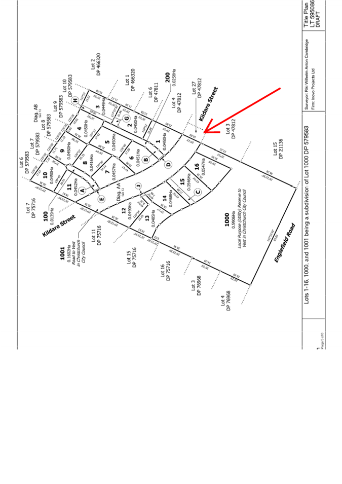
(Road), described as Lot 27 DP 47812, as road.
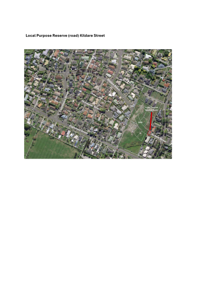
1.2 For many years, Kildare Street in Belfast was separated into two
sections, with an undeveloped lot (Lot 27 DP 47182) in the middle. That lot was
designated as Local Purpose Reserve (Road) to allow for the future completion
of Kildare Street. The surrounding land has now been
subdivided under resource consent RMA/2022/1565 which required Lot 27 DP 47812 to be formed as road
and vested in Council.
1.3 The road is now formed over the Local Purpose
Reserve (Road) and therefore requires dedication as a road.
2. Officer Recommendations Ngā
Tūtohu
That the
Waimāero Fendalton-Waimairi-Harewood Community Board:
1. Receives the information in the Dedication of Local Purpose
Reserve (Road) as Road-Kildare Street Belfast Report.
2. Notes that the decision in this report is
assessed as low significance based on the Christchurch City Council’s
Significance and Engagement Policy.
3. Resolves pursuant to Section 111 of the
Reserves Act 1977 to dedicate the Local Purpose Reserve (Road) containing
157m² described as Lot 27 DP 47812 as road.
4. Authorises the Manager Property Consultancy to
take all steps necessary to complete all necessary documentation to conclude
the dedication of Lot 27 DP 47812 as road.
3. Executive Summary Te Whakarāpopoto Matua
3.1 Kildare Street is not a
legal through road - being separated by undeveloped vacant land along with a
portion of land vested as Local Purpose Reserve (Road).
3.2 Subdivision
of the vacant land has meant that Kildare Street has now been formed into a
through-road, utilising land currently designated as Local Purpose Reserve
(Road), but the Local Purpose Reserve (Road) has not yet been designated as
legal road.
3.3 It
is now necessary to legalise the Local Purpose Reserve (Road) as road.
3.4 The
recommendation in this report, if adopted, will allow for the legalisation of
the Local Purpose Reserve (Road) as road.
4. Background/Context Te Horopaki
4.1 Kildare
Street has progressively been vested as Street initially by way of a cul de sac
off Connemara Drive Belfast as subdivisions have been undertaken. Attachment
A
4.2 In
1985 a subdivision was undertaken off Englefield Road Belfast which created -30
sections (plan shown in Attachment B) – along with
Sefton Street and a cul de sac off this being Kildare Street East.
4.3 At
the end of this cul de sac was lot 27 which vested in Waimairi District Council
as Local Purpose Reserve (Road) to separate Kildare Street East and vacant
land.
4.4 In 2022 resource consent RMA/2022/1565 was granted for the
development of the vacant land to the west of the Local Purpose Reserve (Road),
shown in Attachment C, which required the Local Purpose Reserve (Road)
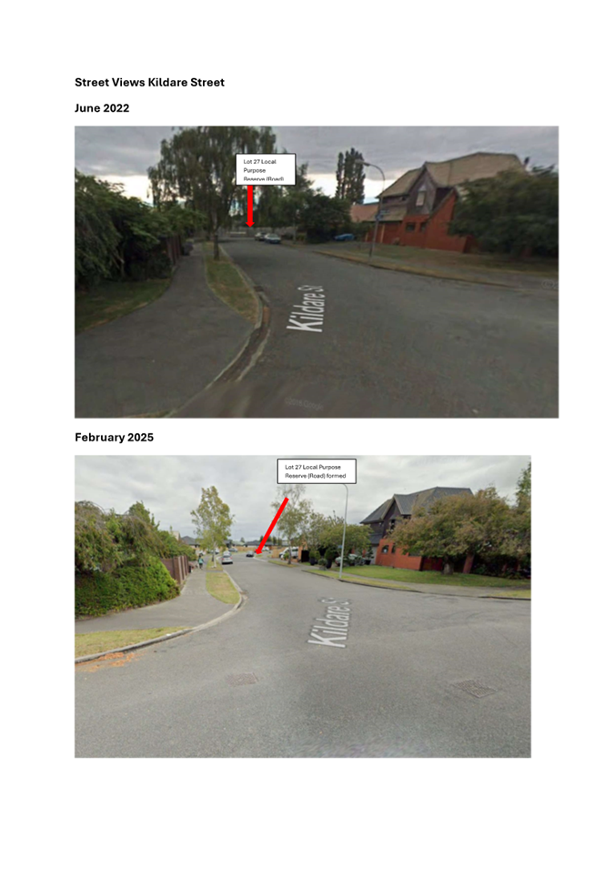
to be formed to enable Kildare Street to be a through Road. Attachment D shows
a photo of the site as it was prior to the road being constructed, and a recent
photo showing the newly formed road.
4.5 The
adoption of the resolution in this report will allow the legalisation of the
Local Purpose Reserve (Road)as road.
Options Considered Ngā Kōwhiringa Whaiwhakaaro
4.6 The
following reasonably practicable options were considered and are assessed in
this report:
4.6.1 Option
1: Recommended. Dedicate the Local Purpose Reserve (Road) as road.
4.7 The
following option was considered but ruled out:
4.7.1 Option
Description Status Quo – Do nothing
4.7.2 Option
Advantage: There is no advantage.
4.7.3 Option
Disadvantage:
· Council is
legally bound to declare the Local Purpose Reserve (Road) as road.
· Would create a
reputational risk as there is a resource consent which states that the land is
to be road
Options Descriptions Ngā Kōwhiringa
4.8 Preferred
Option: Option 1: Dedicate the Land as Road.
4.8.1 Option
Description: Undertake the process to legalise the land as road.
4.8.2 Option
Advantages
· Compliance
with the resource consent.
· Road has been
formed therefore no reputational risk
4.8.3 Option
Disadvantages
· No
disadvantages.
Analysis Criteria Ngā Paearu Wetekina
4.9 Not
required.
5. Financial Implications Ngā Hīraunga Rauemi
Capex/Opex Ngā Utu Whakahaere
|
|
Status Quo
|
Recommended Option
|
|
Cost to Implement
|
$0
|
$1500
|
|
Maintenance/Ongoing
Costs
|
Minimum given
area 157m2
|
Minimum given
area 157m2
|
|
Funding Source
|
Operational
|
Operational
|
|
Funding
Availability
|
Current budget
|
Current budget
|
|
Impact on Rates
|
nil
|
nil
|
5.1 The
area of the Local Purpose Reserve (Road) is 157m2 with minimum if
any impact on overall transport budget.
6. Considerations Ngā Whai Whakaaro
Risks and Mitigations Ngā Mōrearea me
ngā Whakamātautau
6.1 The
decision has no risk or mitigation with more risk if Council does not undertake
the legalisation.
Legal Considerations Ngā Hīraunga
ā-Ture
6.2 Statutory
and/or delegated authority to undertake proposals in the report:
6.2.1 Section 111 of the reserves act gives Council the authority to pass
a resolution and then lodge this with the Registrar-General of Land.
6.3 Other Legal Implications:
6.3.1 Christchurch
City Council is the registered owner of the land by way of successive Local
Authority re-organisations for Waimairi County Council to Waimairi District
Council to Christchurch City Council.
6.3.2 There
is no other legal context, issue, or implication relevant to this decision.
Strategy
and Policy Considerations Te
Whai Kaupapa here
6.4 The
required decision:
6.4.1 Aligns
with the Christchurch
City Council’s Strategic Framework.
6.4.2 Is
assessed as low significance based on the Christchurch
City Council’s Significance and Engagement Policy. The level of
significance was determined by assessing the impact of dedicating the
land as road on the public and budgets.
6.4.3 Is
consistent with Council’s Plans and Policies. Manage
ratepayers’ money wisely by delivering quality core services to the whole
community and addressing the issues that are important to our residents.
6.5 This
report supports the Council's
Long Term Plan (2024 - 2034):
6.6 Transport
6.6.1 Activity: Transport
· Level of Service: 10.5.42 Increase the infrastructure
provision for active and public modes - >= 635 kilometres (total combined
length)
· Level of Service: 16.0.2 Improve roadway condition, to an
appropriate national standard, measured by smooth travel exposure (STE)(DIA 2)
- >=75% of the sealed local road network meets the appropriate national
standard
Community
Impacts and Views Ngā Mariu ā-Hāpori
6.7 The
decision in this report enables a requirement of resource
consent RMA/2022/1565 which would have addressed all community impacts and
views.
6.8 The decision affects the following wards/Community Board areas:
6.8.1 Waimāero
Fendalton-Waimairi-Harewood Community Board.
6.9 The
report is being presented to this board for their consideration.
Impact
on Mana Whenua Ngā
Whai Take Mana Whenua
6.10 The decision does not involve a significant decision in relation
to ancestral land, a body of water or other elements of intrinsic value,
therefore this decision does not specifically impact
Mana Whenua, their culture, and traditions.
6.11 The decision does
not involve a matter of interest to Mana Whenua and will not
impact on our agreed partnership priorities with Ngā
Papatipu Rūnanga.
6.12 The
decision is an enabling one which will legalise land which is currently Local
Purpose Reserve Road which has been formed as road following an adjacent
subdivision.
Climate
Change Impact Considerations Ngā Whai Whakaaro mā te Āhuarangi
6.15 The proposals in
this report are unlikely to contribute significantly to adaptation to the
impacts of climate change or emissions reductions.
6.16 The
road is already formed and will provide a through road rather than two cul de
sacs.
7. Next Steps Ngā Mahinga ā-muri
7.1 Prepare
a gazette notice for publication.
Attachments Ngā Tāpirihanga
|
No.
|
Title
|
Reference
|
Page
|
|
a ⇩
|
Local Purpose
Reserve (road) Kildare Street
|
25/1037553
|
23
|
|
b ⇩
|
Plan of 1985
Subdivision
|
25/627589
|
24
|
|
c ⇩
|
2022
Subdivision Plan
|
25/629889
|
25
|
|
d ⇩
|
Historic
Street Views of Kildare Street from Sefton Street
|
25/651618
|
26
|
In addition to the attached documents, the following background
information is available:
|
Document
Name – Location / File Link
|
|
Not
applicable
|
Signatories Ngā Kaiwaitohu
|
Author
|
Colin
Windleborn - Property Consultant
|
|
Approved By
|
Angus Smith -
Manager Property Consultancy
Andy Milne -
Team Leader Asset Planning
Lynette Ellis
- Head of Transport & Waste Management
|
|
8. Urban Forest Planting Plan for
Avonhead Park
|
|
Reference Te Tohutoro:
|
25/1310521
|
|
Responsible Officer(s) Te Pou Matua:
|
Toby
Chapman (Urban Forest Manager)
|
|
Accountable ELT Member Pouwhakarae:
|
Andrew
Rutledge, General Manager Citizens and Community
|
1. Purpose and Origin of the Report Te Pūtake Pūrongo
1.1 The
purpose of this report is to seek approval for the planting of new trees within
Avonhead Park using the attached tree planting plan.
1.2 The
report is in response to the adoption of the Urban Forest Plan which seeks to
increase canopy cover across the city by 40%.
2. Officer
Recommendations Ngā Tūtohu
That the
Waimāero Fendalton-Waimairi-Harewood Community Board:
1. Receives the information in the Urban Forest
Planting Plan for Avonhead Park Report.
2. Notes that the decision in this report is assessed as low significance
based on the Christchurch City Council’s Significance and Engagement
Policy.
3. Approves the planting of trees within Avonhead Park in alignment
with the updated planting plan (Attachment A to the report), which has
been updated based on community feedback.
3. Executive Summary Te Whakarāpopoto Matua
3.1 The
Urban Forest Plan was adopted in 2023 and includes an objective of increasing
canopy cover within our parks from 23% to 40% by 2070. To meet this
objective, Council has implemented an Urban Forest Tree Planting program which
requires trees to be planted by 2040, so they grow large enough to meet the
canopy cover target by 2070.
3.2 As
part of the Urban Forest Tree Planting program, staff developed a plan to plant
new trees in Avonhead Park.
3.3 The
plan has been updated to reflect and mitigate concerns shared during and after
the consultation period.
3.4 All
plantings will follow our general guidelines for planting including the use of
recession planes to assist in determining the size and location of trees. The
recession plane modelling used to develop the planting plan is the same as used
for building new residential home.
4. Background/Context Te Horopaki
4.1 A
planting plan was developed for Avonhead Park as part of the Urban Forest Tree
Planting program with an emphasis on increasing canopy cover both within the
reserve and within the wider area.
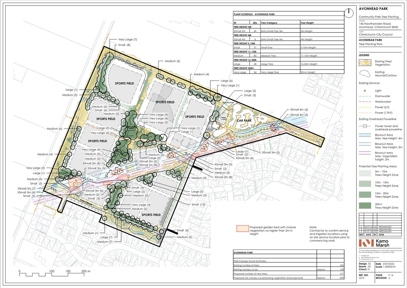
4.2 Avonhead
Park is located in a low canopy area making planting in these areas a priority
for Council and the Urban Forest Plan.
4.3 The
planting plan proposes to plant 277 new trees which will increase the canopy
cover in Avonhead Park from 15% to 29% once they reach maturity, in
approximately 30 years.
4.4 The
attached plan (attachment A) shows the proposal for the planting and what
modelling estimates it to look like once the trees have reached maturity:
4.5 The
feedback received was mixed, while 16 supported or somewhat supported the plan
six did not and three were unsure. Concerns shared by submitters focused on the placement of trees along the eastern edge near residential
properties (near Hatfield Place and Arundel Gate), the impact of debris
(dropping leaves) on those properties, and the impact of some of the proposed
trees on access to and use of sports fields.
4.6 After
the consultation concluded staff met with several community members and the
football club onsite to discuss concerns further. As a result, the plan has
been amended to mitigate those concerns.
4.7 Staff
made the following changes to the plan
4.7.1 Removal of 16
proposed trees along the eastern edge between 26 Hatfield Place and 9 Arundel
Gate.
4.7.2 Removal of 25
proposed trees from the centre of the park to allow space for additional junior
fields.
4.8 Staff
will be maintaining all trees once planted for the first seven years using our
own in-house team. Maintenance will include watering, pruning and
mulching. After seven years the trees will be inputted to our contracted
maintenance program.
4.9 The plan has been developed using a recession plane to help reduce
shading impact. While we cannot avoid shading all together, this model
does assist in ensuring it is managed to the same extent as would occur if a
resident’s neighbour was constructing a new building.
Options Considered Ngā
Kōwhiringa Whaiwhakaaro
4.10 The following
reasonably practicable options were considered and are assessed in this report:
4.10.1 Approve the updated
Avonhead Park Planting Plan and implementation.
4.10.2 Decline the updated
Avonhead Park Planting Plan.
4.10.3 Approve the plan that was
consulted on (with no amendments).
4.11 The following
options were considered but ruled out:
4.11.1 Reconsult on updated plan
– as the plan has been changed to reflect
community concerns and desires, and those changes have little impact on the
overall plan, staff do not feel this is necessary.
Options Descriptions Ngā
Kōwhiringa
4.12 Preferred
Option: Approve the updated Avonhead Park Planting Plan and implementation.
4.12.1 Option Description: Approve
the updated plan attached.
4.12.2 Option Advantages
· Supports the Urban Forest Plan objectives and targets by increasing
canopy cover in Avonhead Park to 29% once trees reach maturity.
· Local community gain some of the many benefits trees provide.
· Community feedback is reflected in the plan showing that Council has
taken on board their views and preferences.
4.12.3 Option Disadvantages
· Some may see the planting of trees presents a loss of open space.
4.13 Decline the
updated Avonhead Park Planting Plan.
4.13.1 Option Description: Decline the plan and require no trees to be planted.
4.13.2 Option Advantages
· Open space within the park would be retained
· Council would save costs that are associated with the planting.
4.13.3 Option Disadvantages
· The local area will be deprived of the benefits that trees provide.
4.14 Approve the
plan that was consulted on (with no amendments).
4.14.1 Option Description: Approve the original plan consulted on.
4.14.2 Option Advantages
· Supports the Urban Forest Plan objectives and targets by planting an
additional 321 and increasing canopy cover in Avonhead Park to 31% once trees
reach maturity.
· Local community gain some of the many benefits trees provide.
4.14.3 Option Disadvantages
· Does not reflect the future playing fields configuration sports
clubs will need.
· Does not reflect community feedback and preferences.
Analysis Criteria Ngā Paearu
Wetekina
4.15 Alignment
with the Urban Forest Plan.
5. Financial Implications Ngā Hīraunga Rauemi
Capex/Opex Ngā Utu Whakahaere
|
|
Recommended Option – Approve updated
plan
|
Option 2 – Decline the updated plan
|
Option 3 – Approve original plan
(consulted on)
|
|
Cost to Implement
|
$140K (this covers the planting and seven
years of maintenance
|
$0
|
$155K (this covers the planting and seven
years of maintenance
|
|
Maintenance/Ongoing Costs
|
Included in implementation costs
|
NA
|
Nil
|
|
Funding Source
|
Better off funding
budget
|
NA
|
Better off funding
budget
|
|
Funding Availability
|
Existing
|
NA
|
Existing
|
|
Impact on Rates
|
Nil
|
NA
|
Nil
|
5.1 Planting
will be funded through the Urban Forest Tree Planting program which is
currently funded through the Better Off Fund.
6. Considerations Ngā Whai Whakaaro
Risks and Mitigations Ngā
Mōrearea me ngā Whakamātautau
6.1 The availability of trees
can be challenging. If not all trees and plants are available, staff will
push planting out to 2026.
Legal Considerations Ngā
Hīraunga ā-Ture
6.2 Statutory
and/or delegated authority to undertake proposals in the report:
6.2.1 Under
the Reserves Act, Community Boards have the delegation to “determine to
plant, maintain and remove trees on reserves within the policy set by the
Council”.
6.3 Other Legal Implications:
6.3.1 There is no
legal context, issue, or implication relevant to this decision.
Strategy and Policy Considerations Te Whai
Kaupapa here
6.4 The
required decision:
6.4.1 Aligns with
the Christchurch
City Council’s Strategic Framework with a particular focus on a green, liveable city.
6.4.2 Is assessed as
low significance based on the Christchurch
City Council’s Significance and Engagement Policy. The level of significance was determined by assessing the impact the
decision will have on the city which is low.
6.4.3 Is consistent with Council’s Plans and Policies. The planting plan forms a key component of the
implementation of the Councils Urban Forest Plan.
6.5 This
report supports the Council's
Long Term Plan (2024 - 2034):
6.6 Parks, Heritage and Coastal Environment
6.6.1 Activity: Parks and Foreshore
· Level of Service: 6.8.2.1 Increasing tree canopy
in Parks - A net increase in total number of trees is achieved (1:2 replacement
policy), with a minimum of 50% of the trees being medium to very large species
Community Impacts and Views Ngā Mariu
ā-Hāpori
6.7 Consultation started on 8 May and ran until 26 May.
6.8 An email was sent to three key stakeholders: Mainland Football,
Canterbury Baseball and Kids First. An automated email
was also sent to 79 subscribers.
6.9 Consultation
details including links to the project information shared on the Kōrero mai | Let’s Talk webpage was advertised via:
6.9.1 Social media
on local community Facebook pages
6.9.2 Letter box
delivery to neighbouring properties
6.9.3 Signage at
park entrances
6.10 The Kōrero
mai | Let’s talk Avonhead Park tree planting page had 367 views
throughout the consultation period.
Summary of Submissions Ngā
Tāpaetanga
6.11 Submissions were
made by two recognised organisations and 23 individuals. A
full table of submission feedback is available on Kōrero mai | Let’s
talk.
6.12 Submitters were
asked how important certain aspects were in the park, what aspects were
concerning going forward with the park and whether they felt we got this tree
planting plan right.
6.13 Seven submitters
felt we had got the tree planting plan right, nine submitters felt we had
somewhat got the plan right, six didn’t feel we got the plan right and
three submitters didn’t know / weren’t sure.
6.14 Submitters
were asked to rate the importance of various aspects when increasing the tree
cover in this park. The top three aspects rated important were: trees attracting birds and insects (21), native trees (17) and
trees with autumn colouring (15).
6.15 Submitters were
asked whether they were concerned about various aspects when increasing the
tree cover in this park. Submitters were able to select more than one
concern. Submitters were concerned about too much shade (13), loss of
open spaces (11) and debris like leaves dropping and hazards like branches
falling (9).
6.16 Submitters were also invited to provide
additional feedback. Feedback shared concern about maintenance of new and existing trees, maintenance of the
riparian planting along the stream, and the footpaths.
6.17 Out of scope
requests included removal of the existing blue gums at the northern end, and
more rubbish bins and formal paths throughout the park.
6.18 A
quick poll that was conducted on the Let’s Talk webpage to reduce
barriers to participate. 15 5-star ratings, one 4-star ratings and six 1-star
ratings were received.
Impact on Mana Whenua Ngā Whai Take
Mana Whenua
6.19 The decision does not involve a significant decision in
relation to ancestral land, a body of water or other elements of intrinsic
value, therefore this decision does not specifically
impact Mana Whenua, their culture, and traditions.
6.20 The
planting is in alignment with the Councils Urban Forest Plan which sought
feedback from Mana Whenua and is in alignment with the Iwi Management Plan.
6.21 The
decision does not involve a matter of interest to
Mana Whenua and will not impact on our agreed
partnership priorities with Ngā Papatipu Rūnanga.
Climate Change Impact Considerations Ngā
Whai Whakaaro mā te Āhuarangi
6.22 The decision in this report is likely to:
6.22.1 Contribute positively to
adaptation to the impacts of climate change.
6.22.2 Contribute positively to emissions reductions.
6.23 Tree planting will assist Council in offsetting its emissions and
coping with the impacts of climate change.
7. Next Steps Ngā Mahinga ā-muri
7.1 If
the updated plan or the original plan is approved, staff will proceed with sourcing trees
and schedule the park for planting.
7.2 If
the Community Board decline the plan no further action will be taken.
Attachments Ngā Tāpirihanga
|
No.
|
Title
|
Reference
|
Page
|
|
a ⇩
|
Urban Forest
updated tree planting plan for Avonhead Park
|
25/1468066
|
33
|
In addition to the attached documents, the following background
information is available:
|
Document
Name – Location / File Link
|
|
Not
applicable
|
Signatories Ngā Kaiwaitohu
|
Author
|
Toby Chapman -
Manager Urban Forest
|
|
Approved By
|
Rupert Bool -
Head of Parks
|
|
9. Proposed Lane Names - 40B Johns
Road
|
|
Reference Te Tohutoro:
|
25/707524
|
|
Responsible Officer(s) Te Pou Matua:
|
Sean
Ward, Team Leader Planning
|
|
Accountable ELT Member Pouwhakarae:
|
John
Higgins, General Manager Strategy, Planning & Regulatory Services
|
1. Purpose and Origin of the Report Te Pūtake Pūrongo
1.1 The
purpose of this report is for the Waimāero Fendalton-Waimairi-Harewood
Community Board to approve the proposed lane names at 40B Johns Road.
1.2 The
report is staff-generated resulting from a naming request received from the
developer.
2. Officer Recommendations Ngā Tūtohu
That the Waimāero
Fendalton-Waimairi-Harewood Community Board:
1. Receives the information in the Proposed
Lane Names - 40B Johns Road Report.
2. Notes that the decision in this report is assessed as low
significance based on the Christchurch City Council’s Significance and
Engagement Policy.
3. Approves the following new road names for 40B Johns Road (RMA/2024/1548)
a. Lane 1 - Devonvale Lane
b. Lane 2 - Golden Lane
3. Detail Te Whakamahuki
Introduction Te Whakatkinga
3.1 A
road naming request has been submitted by the developer. Preferred names and
alternative names have been put forward for the lanes.
3.2 The
recommended road names have been checked against existing road names in
Christchurch and bordering districts, for duplication, alternative spelling, or
other similarities in spelling or pronunciation to avoid the potential for
confusion. The proposed names are considered sufficiently different to existing
road names.
3.3 The
recommended road names have been checked against the Council’s Naming
Policy dated 15 November 2023 and are considered to be consistent with this
policy. The specific criteria for assessing a name from clause 2 is set out
below.
3.3.1 A traditional or
Māori name which is acceptable to the Rūnanga or Iwi; this may be a
name reflecting the physical characteristics of an area, an activity or event
associated with the area or of a notable ancestor.
3.3.2 A feature of
historical, social, cultural, environmental or physical importance in the area
(e.g., Carlton Mill Road or Carlton Mill Reserve*).
3.3.3 The name of a notable
family, person or event associated with the locality or with the wider
Christchurch area.
3.3.4 A name in recognition
of a person’s service. This can be for community service, conservation,
sport, the arts, science and research or other sphere of activity.
3.3.5 Consistency with a
common or established theme for naming in a subdivision or locality.
3.3.6 A name that reflects
the diverse cultures and communities of the locality or of Christchurch
generally.
3.3.7 The name of an event
or activity strongly associated with the immediate location including an
informal name for the area that is (or was historically) in common usage.
3.3.8 A name associated
with a person, event or activity of significance to Christchurch including
names associated with people, events, or places of national and international
significance.
3.4 The
criteria for names that are not suitable for approval from clause 6 are set out
below.
3.4.1 Names of people,
flora, fauna or geographical features not associated with the area, e.g., names
of native trees which are not present in the area or views that cannot be
identified, except where the name continues a current naming theme in the
locality.
3.4.2 Currently trading
commercial organisations except for sponsorship names for facilities and leased
parks.
3.4.3 Anagrams,
amalgamations or derivatives of people's names.
3.4.4 Names of living
persons.
3.4.5 Names related to the
developer of a subdivision.
3.4.6 Name of a person,
club or organisation associated with a privately owned building on Council
land, where the club or organisation does not hold the ground lease for the
building.
3.4.7 Names for roads which
may cause confusion because they are associated with another geographical
location or feature e.g., Parklands Drive which is not located in the Parklands
suburb.
3.5 The
recommended road names have also been checked against the Australia and New
Zealand Standard AS/NZA 4819:2011 Rural and Urban Addressing. The names are
considered to be consistent with the Standard.
3.6 Under
the Roads and Right-of-Way Naming Policy, the names considered must be
requested by the developer. There is no ability to consider alternative names
without first checking whether there are any duplications or similarities with
other road and right-of-way names.
3.7 Consultation
has been undertaken with Land Information New Zealand who have raised no
concerns with the proposed names.
3.8 Rūnanga
are being consulted on the proposed road naming in the context of part of the
land being within a Silent file area, and a verbal update will be provided at
the meeting. Consultation is not otherwise required under clause 3 of the
policy because the roads to be named are not collector roads and/or site(s) of
significance under the District Plan.
3.9 No
addresses of neighbouring properties are affected by the proposed road naming
(clause 12.2 of the Naming Policy).
3.10 The names requested
have been accompanied by an explanation of the background of the names, which
is summarised below.
Assessment of Significance and Engagement Te
Aromatawai Whakahirahira
3.11 The decisions in
this report are assessed as low significance based on the Christchurch City
Council’s Significance and Engagement Policy.
3.12 The level of
significance was determined by the number of people affected and/or with an
interest.
3.13 Due to the
assessment of low significance, no further community engagement and
consultation is required.
Proposed Names
3.14 The proposed
roads are shown in Attachment A.
3.15 The proposed
names are themed for local history and continue the existing theme.
3.16 Lane 1 -
Devonvale Lane
3.17 In 1877 Mr Johns
purchased 50 acres of good, heavy pastoral and agricultural land in Belfast. In
1891 he built his homestead and called it Devonvale after his home county. Mr
Johns and his son James started dairy farming and had their own treating house in
which they produced the first pasteurised milk in Christchurch, if not the
South Island.
3.18 Lane 2 - Golden
Lane
3.19 Golden is in the
name of many apple varieties, (Golden Delicious, Golden Supreme, Golden Russet)
and reflects the previous use of the property as an apple orchard.
Alternative Names
3.20 Divine Lane
- Divine is an apple variety and reflects the previous use of the property as
an apple orchard.
3.21 Russet Lane
- Russet is a family of apple varieties and reflects the previous use of the
property as an apple orchard.
Assessment of Names
3.22 The proposed
names are considered to be consistent with the policy.
3.23 Notwithstanding, the discretion lies with the Community Board to
approve any of the above name options, including the alternative names.
Attachments Ngā Tāpirihanga
|
No.
|
Title
|
Reference
|
Page
|
|
a ⇩
|
RMA/2024/1548 - Road Naming Plan - 40B Johns Road
|
25/503584
|
37
|
Signatories Ngā Kaiwaitohu
|
Authors
|
Leashelle
Miller - Planner Level 2
Sean Ward -
Team Leader Planning
|
|
Approved By
|
Mark Stevenson
- Head of Planning & Consents
|
|
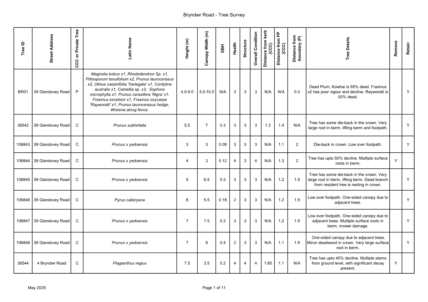
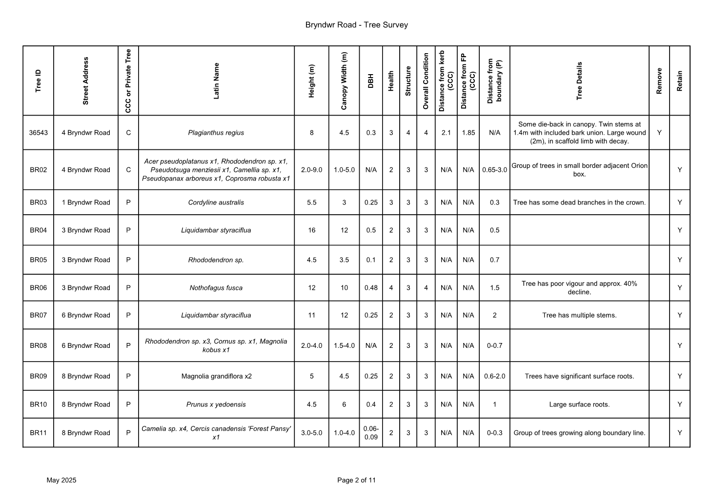
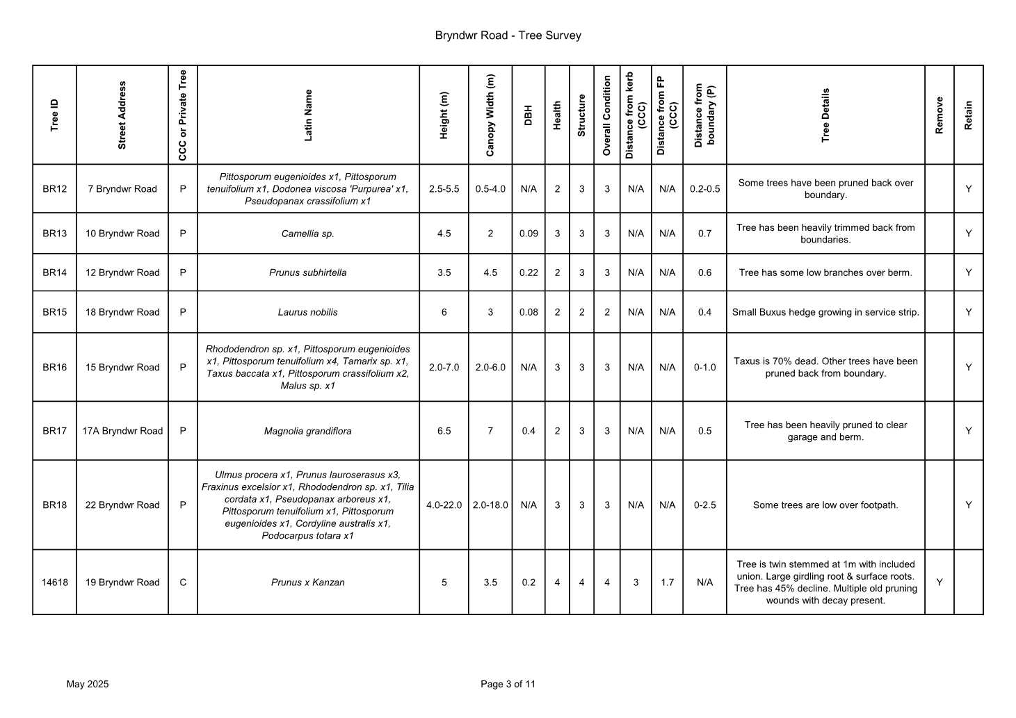
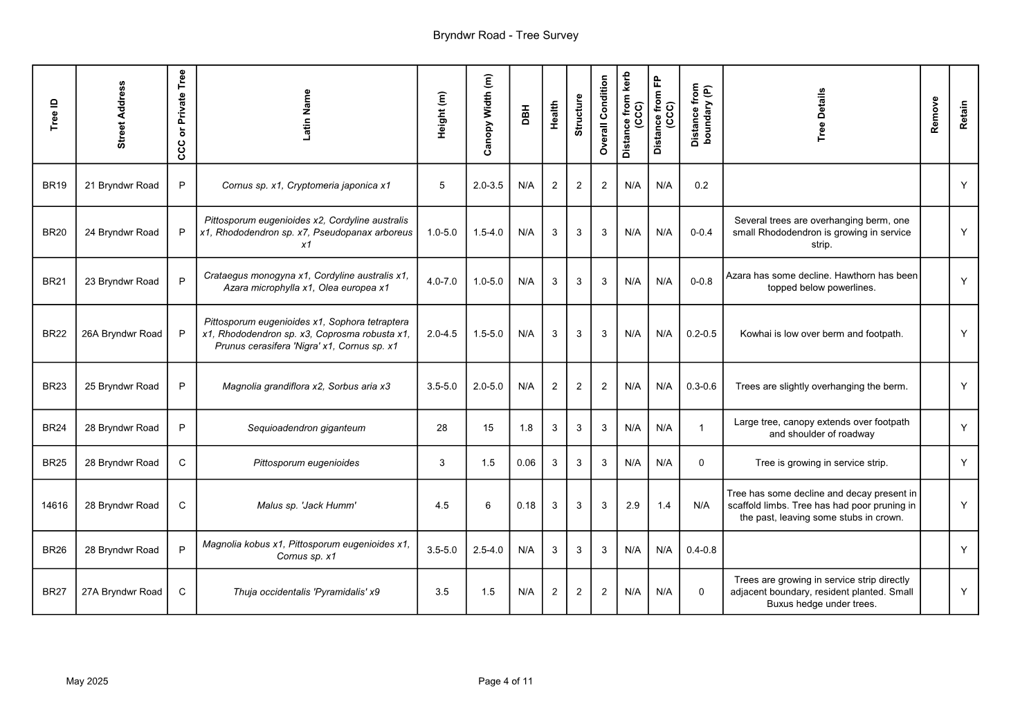
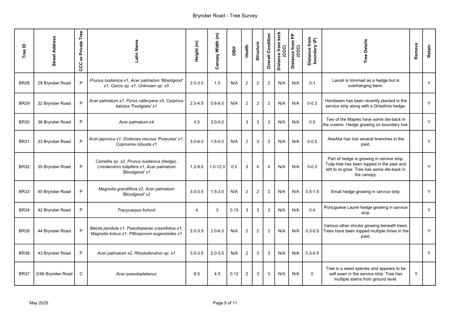
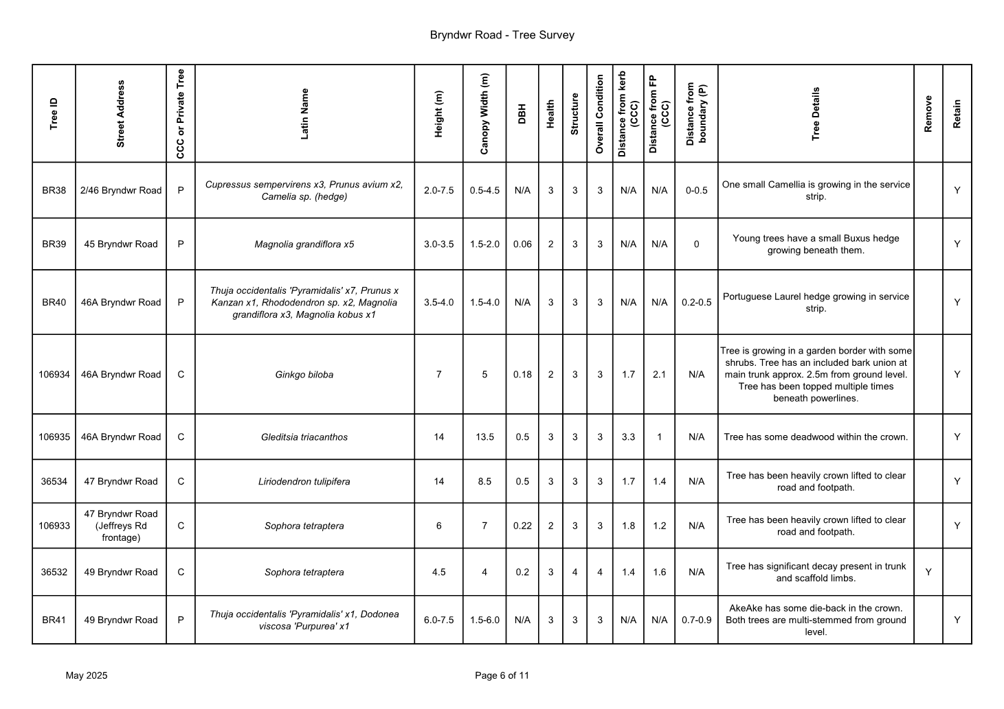
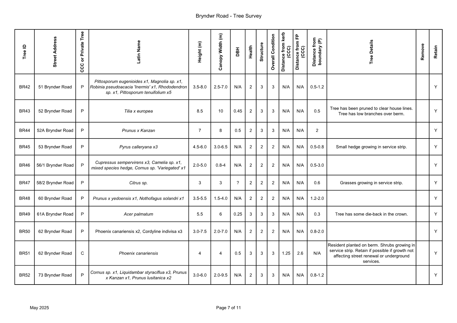
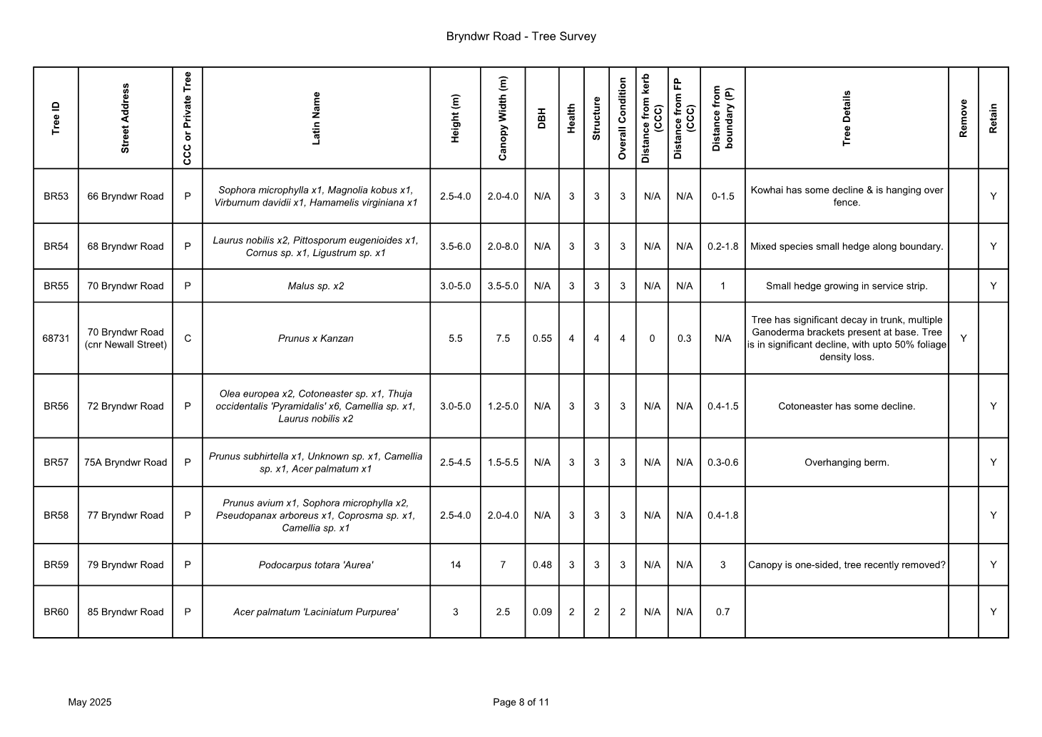
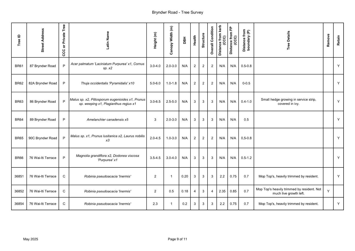
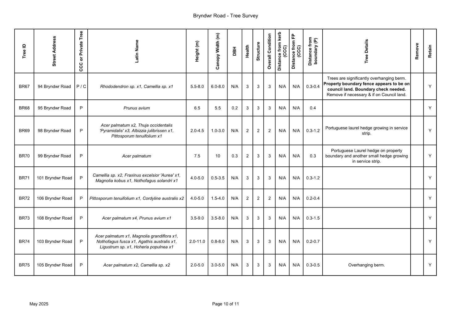
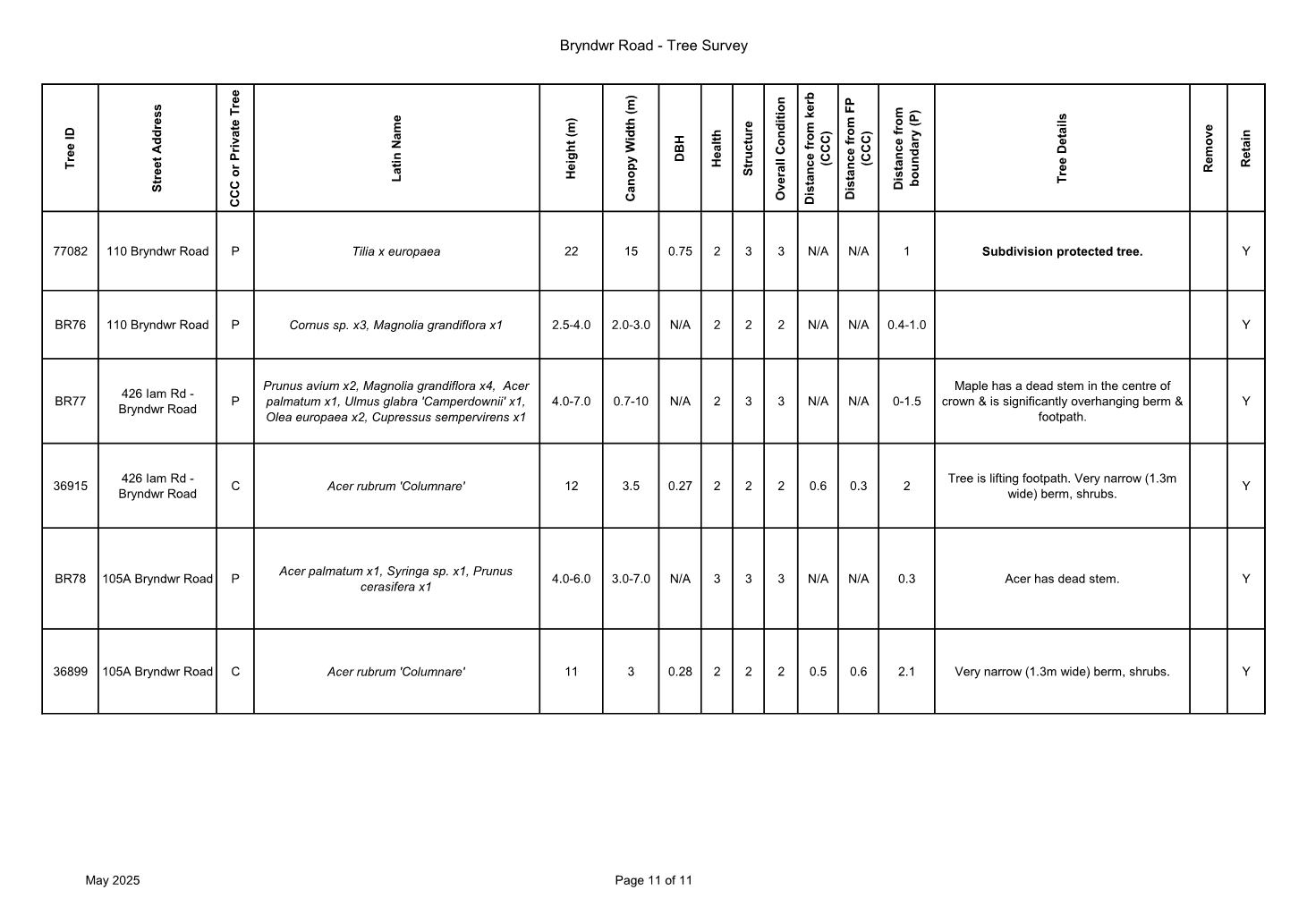
10. Bryndwr Road Street Renewal
|
|
Reference Te Tohutoro:
|
25/1479771
|
|
Responsible Officer(s) Te Pou Matua:
|
Katharine
Jones – Project Manager
|
|
Accountable ELT Member Pouwhakarae:
|
Brent
Smith, General Manager City Infrastructure
|
1. Purpose and Origin of the Report Te Pūtake Pūrongo
1.1 The
purpose of this report is for the Waimāero Fendalton-Waimairi-Harewood
Community Board to approve the Bryndwr Road street renewal scheme design
following community engagement and to proceed to construction.
1.2 The
report has been written to address the poor condition of the transport assets
on Bryndwr Road, including the kerb and channel, deep dish channels,
carriageway and footpaths.
2. Officer
Recommendations Ngā Tūtohu
That the
Waimāero Fendalton-Waimairi-Harewood Community Board:
1. Receives the information in the Bryndwr Road
Street Renewal Report.
2. Notes that the decision in this report is assessed as low
significance based on the Christchurch City Council’s Significance and
Engagement Policy.
3. Revokes any previous resolutions pertaining to kerb lines, traffic
calming devices, traffic controls, parking, and stopping restrictions made
pursuant to any bylaw to the extent that they are in conflict with the traffic
calming, parking and stopping restrictions described in the recommendations
below.
4. Approves pursuant to Christchurch City Council Traffic and Parking
Bylaw 2017 and Part 21 of the Local Government Act 1974 all kerb alignments,
traffic calming devices, road surface treatments, stopping restrictions,
signage and road markings:
a. Along Bryndwr Road, commencing at its intersection with Ilam Road
and extending in a southerly direction until its intersection with Glandovey
Road as detailed on plan TP365901, dated 13.08.2025, and attached to this
report as Attachment A.
b. Along Wai-iti Terrace, commencing at its intersection with Burwood
Road and extending in a westerly direction for a distance of approximately 20
metres as detailed on plan TP365901, dated 13.08.2025, and attached to this
report as Attachment A.
c. Along Newall Avenue, commencing at its intersection with Burwood
Road and extending in an easterly direction for a distance of approximately 21
metres as detailed on plan TP365901, dated 13.08.2025, and attached to this
report as Attachment A.
d. Along Jeffreys Road, commencing at a point approximately 14 metres
east of its intersection with Bryndwr Road and extending in a westerly
direction for a distance of 37 metres as detailed on plan TP365901, dated
13.08.2025, and attached to this report as Attachment A.
Ilam
Road
5. Approves that, pursuant to Clause 7 of the Christchurch City Council
Traffic and Parking Bylaw 2017, the stopping of vehicles be prohibited at all
times:
a. On the south side of Ilam Road commencing at its intersection with
Bryndwr and extending in an easterly direction for a distance of 16 metres as
detailed on plan TP365901, dated 13.08.2025, and attached to this report as Attachment
A.
b. On the south side of Ilam Road commencing at its intersection with
Bryndwr Road and extending in a westerly direction for a distance of 11 metres
as detailed on plan TP365901, dated 13.08.2025, and attached to this report as Attachment
A.
Bryndwr Road
Traffic controls
6. Approves that, in accordance with Section 4 of the Land Transport
Rule: Traffic Control Devices 2004:
a. The northern approach of Bryndwr Road at its intersection with Ilam
Road be controlled by a Give Way control as detailed on plan TP365901, dated
13.08.2025, and attached to this report as Attachment A.
b. The southern approach of Bryndwr Road at its intersection with
Jeffreys Road be controlled by a Stop control as detailed on plan TP365901,
dated 13.08.2025, and attached to this report as Attachment A.
c. The northern approach of Bryndwr Road at its intersection with
Jeffreys Road be controlled by a Stop control as detailed on plan TP365901,
dated 13.08.2025, and attached to this report as Attachment A.
d. The southern approach of Bryndwr Road at its intersection with
Glandovey Road be controlled by a Give Way control as detailed on plan
TP365901, dated 13.08.2025, and attached to this report as Attachment A.
No
stopping
7. Approves that, pursuant to Clause 7 of the Christchurch City Council
Traffic and Parking Bylaw 2017, the stopping of vehicles be prohibited at all
times:
a. On the east side of Bryndwr Road commencing at its intersection with
Ilam Road and extending in a southerly direction for a distance of 14 metres as
detailed on plan TP365901, dated 13.08.2025, and attached to this report as Attachment
A.
b. On the east side of Bryndwr Road commencing at a point approximately
278 metres south of its intersection with Ilam Road and extending in a
southerly direction until its intersection with Newall Avenue as detailed on
plan TP365901, dated 13.08.2025, and attached to this report as Attachment
A.
c. On the east side of Bryndwr Road commencing at its intersection with
Newall Avenue and extending in a southerly direction for approximately 11
metres as detailed on plan TP365901, dated 13.08.2025, and attached to this
report as Attachment A.
d. On the east side of Bryndwr Road commencing at a point approximately
37 metres south of its intersection with Newall Avenue and extending in a
southerly direction for approximately 10 metres as detailed on plan TP365901,
dated 13.08.2025, and attached to this report as Attachment A.
e. On the east side of Bryndwr Road commencing at a point approximately
207 metres south of its intersection with Newall Avenue and extending in a
southerly direction until its intersection with Jeffreys Road as detailed on
plan TP365901, dated 13.08.2025, and attached to this report as Attachment
A.
f. On the east side of Bryndwr Road commencing at its intersection with
Jeffreys Road and extending in a southerly direction for a distance of 23
metres as detailed on plan TP365901, dated 13.08.2025, and attached to this
report as Attachment A.
g. On the east side of Bryndwr Road commencing at a point approximately
109 metres south of its intersection with Jeffreys Road and extending in a
southerly direction for a distance of 33 metres as detailed on plan TP365901,
dated 13.08.2025, and attached to this report as Attachment A.
h. On the east side of Bryndwr Road commencing at a point approximately
388 metres south of its intersection with Jeffreys Road and extending in a
southerly direction until its intersection with Glandovey Road as detailed on
plan TP365901, dated 13.08.2025, and attached to this report as Attachment
A.
i. On the west side of Bryndwr Road commencing at its intersection with
Glandovey Road and extending in a northerly direction for a distance of 28
metres as detailed on plan TP365901, dated 13.08.2025, and attached to this
report as Attachment A.
j. On the west side of Bryndwr Road commencing at a point approximately
283 metres north of its intersection with Glandovey Road and extending in a
northerly direction for a distance of 23 metres as detailed on plan TP365901,
dated 13.08.2025, and attached to this report as Attachment A.
k. On the west side of Bryndwr Road commencing at a point approximately
404 metres north of its intersection with Glandovey Road and extending in a
northerly direction until its intersection with Jeffreys Road as detailed on
plan TP365901, dated 13.08.2025, and attached to this report as Attachment
A.
l. On the west side of Bryndwr Road, commencing at its intersection
with Jeffreys Road and extending in a northerly direction for a distance of 11
metres as detailed on plan TP365901, dated 13.08.2025, and attached to this
report as Attachment A.
m. On the west side of Bryndwr Road, commencing at a point
approximately 170 metres north of its intersection with Jeffreys Road and
extending in a northerly direction for a distance of 15 metres as detailed on
plan TP365901, dated 13.08.2025, and attached to this report as Attachment
A.
n. On the west side of Bryndwr Road, commencing at a point
approximately 354 metres north of its intersection with Jeffreys Road and
extending in a northerly direction until its intersection with Wai-iti Terrace
as detailed on plan TP365901, dated 13.08.2025, and attached to this report as Attachment
A.
o. On the west side of Bryndwr Road, commencing at its intersection
with Wai-iti Terrace and extending in a northerly direction for a distance of
seven metres as detailed on plan TP365901, dated 13.08.2025, and attached to
this report as Attachment A.
p. On the west side of Bryndwr Road, commencing at a point
approximately 131 metres north of its intersection with Wai-iti Terrace and
extending in a northerly direction until its intersection with Ilam Road as
detailed on plan TP365901, dated 13.08.2025, and attached to this report as Attachment
A.
q. On the north side of Glandovey Road, commencing at its intersection
with Bryndwr Road and extending in a north-easterly direction for a distance of
eight metres as detailed on plan TP365901, dated 13.08.2025, and attached to
this report as Attachment A.
r. On the north side of Glandovey Road, commencing at its intersection
with Bryndwr Road and extending in a south westerly direction for a distance of
25 metres as detailed on plan TP365901, dated 13.08.2025, and attached to this
report as Attachment A.
Jeffreys Road
No stopping
8. Approves that, pursuant to Clause 7 of the Christchurch City Council
Traffic and Parking Bylaw 2017, the stopping of vehicles be prohibited at all
times:
a. On the northern side of Jeffreys Road commencing at its intersection
with Bryndwr Road and extending in an easterly direction for a distance of 14
metres as detailed on plan TP365901, dated 13.08.2025, and attached to this
report as Attachment A.
b. On the southern side of Jeffreys Road commencing at a point
approximately 12 metres east of its intersection with Bryndwr Road and
extending in a westerly direction until its intersection with Bryndwr Road as
detailed on plan TP365901, dated 13.08.2025, and attached to this report as Attachment
A.
c. On the southern side of Jeffreys Road commencing at its intersection
with Bryndwr Road and extending in a westerly direction for approximately 12
metres as detailed on plan TP365901, dated 13.08.2025, and attached to this
report as Attachment A.
d. On the northern side of Jeffreys Road commencing at a point
approximately 15 metres west of its intersection with Bryndwr Road and
extending in an easterly direction until its intersection with Bryndwr Road as
detailed on plan TP365901, dated 13.08.2025, and attached to this report as Attachment
A.
Wai-iti Terrace
No stopping
9. Approves that, pursuant to Clause 7 of the Christchurch City Council
Traffic and Parking Bylaw 2017, the stopping of vehicles be prohibited at all
times:
a. On the south side of Wai-iti Terrace commencing at its intersection
with Bryndwr Road and extending in a westerly direction for a distance of 15
metres as detailed on plan TP365901, dated 13.08.2025, and attached to this
report as Attachment A.
b. On the north side of Wai-iti Terrace commencing at a point
approximately 15 metres west of its intersection with Bryndwr Road and
extending in a easterly direction until its intersection with Bryndwr Road as
detailed on plan TP365901, dated 13.08.2025, and attached to this report as Attachment
A.
Newall
Avenue
No
stopping
10. Approves that, pursuant to Clause 7 of the Christchurch City Council
Traffic and Parking Bylaw 2017, the stopping of vehicles be prohibited at all
times:
a. On the north side of Newall Avenue commencing at its intersection
with Bryndwr Road and extending in an easterly direction for a distance of 19
metres as detailed on plan TP365901, dated 13.08.2025, and attached to this
report as Attachment A.
b. On the south side of Newall Avenue commencing at a point
approximately 21 metres east of its intersection with Bryndwr Road and
extending in a westerly direction until its intersection with Bryndwr Road as
detailed on plan TP365901, dated 13.08.2025, and attached to this report as Attachment
A.
General approval
11. Approve that these resolutions take effect when parking signage
and/or road marking that evidence the restrictions described in the staff
report are in place (or removed in the case of revocations).
Tree removal
12. Approves tree removal as detailed in Attachment C of this
report, with the tree numbers listed below, noting that these will be retained
if on-site assessment allows.
a. Tree 106844 (39 Glandovey Road). This is a Yoshino cherry, in poor
condition
b. Tree 36544 (4 Bryndwr Road). This is a Ribbonwood, in poor
condition, and its roots are encroaching on underground services
c. Tree 36543 (4 Bryndwr Road). This is a Ribbonwood, in poor
condition, and its roots are encroaching on underground services
d. Tree 14618 (19 Bryndwr Road). This is a Flowering Cherry, in poor
condition and is within the footpath realignment, and
its roots are encroaching on underground services
e. Tree BR37 (2/46 Bryndwr Road). This is a Sycamore, which is a weed
species.
f. Tree 36532 (49 Bryndwr Road). This is a Kowhai, in poor condition
and is within the footpath realignment, and its roots
are encroaching on underground services
g. Tree 68731 (70 Bryndwr Road). This is a Flowering Cherry, in poor
condition and is within the footpath realignment, and
its roots are encroaching on underground services
h. Tree 36852 (76 Wai-iti Terrance). This is a Black Locust, in poor
condition, and its roots are encroaching on underground services
3. Executive Summary Te Whakarāpopoto Matua
3.1 At
the November 2024 Waimāero Fendalton-Waimairi-Harewood Community Board
Information Session/Workshop to brief the Board on the Transport Programmes,
Bryndwr Road was noted as being absent from the street renewal programme but
was a high priority for the Board.
3.2 Staff
worked with the Board to include the street renewal project in their programme
of works.
3.3 Three
main options have been considered:
· Full Street Renewal, including alternate locations for berms and
footpaths (Attachment A)
· Full Street Renewal, keeping the berms and footpaths in their
current location (Attachment B)
· Do Nothing
3.4 The
recommended option is to install the above improvements in accordance with Attachment
A. Key features of this options are:
· Replace the deep dish channel with kerb and flat channel to improve
drainage
· Reconstruct the carriageway
· Improve walkability through the addition of two mid-block crossings
and reconstruction of footpaths and changes to cutdowns and kerb alignments
· Include the addition of a Give Way at Ilam Road and Glandovey Road
intersection
· Improve amenity through incorporating areas of planting and the
planned planting of up to 37 street trees.
3.4.2 Staff have
recommended this option as will help achieve the desired community outcome of
early engagement of improving the existing infrastructure by upgrading the kerb
and channel, carriageway and footpaths and improving pedestrian connectivity
and amenity. While some residents expressed a preference for retaining the
existing footpath layout, staff are recommended making changes as this provides
opportunities for planting more trees.
4. Background/Context Te Horopaki
4.1 At
the November 2024 Waimāero Fendalton-Waimairi-Harewood Community Board
Information Session/Workshop, Council staff presented the Transport Programmes
to the Board, including a list of projects in each programme and the rationale
behind their inclusion.
4.2 It
was noted that Bryndwr Road was not currently on the programme but was a high
priority for the Board, and staff agreed to work with the Board to include the
project in the street renewals programme.
4.3 The
addition of Bryndwr Road to the capital programme was in response to poor
condition and repeated flooding events and the following objectives were
developed:
4.3.1 Full renewal
of the kerb and channel
4.3.2 Full
carriageway reconstruction
4.3.3 Footpath
reconstruction
4.3.4 Upgraded and
additional pedestrian crossing points
4.3.5 Increased tree
planting and landscaping
4.4 Bryndwr
Road is classified as a Local Road. Traffic volumes are 1,500 vehicles per day
between Ilam Road and Jeffreys Road and 1,100 vehicles per day between Jeffreys
Road and Glandovey Road. The posted speed limit is 50 km/h, with the average
speed being 43 km/h, and the 85th percentile speed being 51 km/h.
4.5 A
tree assessment has been completed during the development of the scheme design
and this identified up to 8 street trees may need to be removed to allow this
project to progress (see Attachment C). Based on the Councils Tree
Policy, 16 trees would need to be planted to compensate for this.
4.6 New
street trees are proposed on the western side of Bryndwr Road due to the
location of overhead lines and underground services on the eastern side.
4.7 Engagement
was undertaken with residents to understand their issues, which has enabled the
project team to proactively adapt the scheme design to reflect the views and
concerns of the residents.
4.8 A
key theme that emerged from engagement was the desire to see the overhead lines
put underground. A representative of Bryndwr Road has been provided contact
details for Orion to initiate and discuss options and costings for
undergrounding lines.
4.9 The following related memos/information were circulated to the
meeting members:
|
Date
|
Subject
|
|
5
Feb 2025
|
Bryndwr Road Street Renewal confirmation
of funding and project initiation
|
|
28
July 2025
|
Bryndwr Road Street Renewal update on
scheme design and timings
|
Options Considered Ngā
Kōwhiringa Whaiwhakaaro
4.10 The following
reasonably practicable options were considered and are assessed in this report:
4.10.1 Option 1 (Preferred
option) – Full street renewal on Bryndwr Road with alternate berm and
footpath locations as shown in Attachment A.
4.10.2 Option 2 –
Full street renewal on Bryndwr Road with berm and footpaths in existing
locations as shown in Attachment B.
4.10.3 Option 3 –
Do nothing.
Options Descriptions Ngā
Kōwhiringa
4.11 Preferred
Option: Full street renewal on Bryndwr Road with alternate berm and
footpath locations
4.11.1 Option Description: Full
street renewal including kerb and channel, carriage way, footpaths, pedestrian
improvements and stormwater upgrade. The locations of the berms and footpaths
have been swapped from the existing layout to maximise tree planting
opportunities and minimise impacts to underground services.
4.11.2 Option Advantages
· Meets the project objectives of delivering a full street renewal,
providing upgrades to the kerb and channel, carriageway, footpaths and
crossings.
· Maximises tree planting opportunities, with a proposed planting of
up to 37 street trees.
· Reduces maintenance costs through the upgrade of the road, kerb and
channel, footpaths and other infrastructure.
4.11.3 Option Disadvantages
· Installation of the upgrades incur initial costs.
· Disruption during construction to residents and businesses through
possible road closures and detours.
· Several residents do not support swapping the footpath and berm.
· Loss of on-street parking due to narrowing of intersections
(approximately 15 spaces) and two pedestrian mid-block crossings (approximately
12 spaces)
4.12 Option 2: Full
street renewal on Bryndwr Road with berm and footpaths in existing locations
4.12.1 Option Description: Full
street renewal including kerb and channel, carriage way, footpaths, pedestrian
improvements and stormwater upgrade. The locations of the berms and footpaths
would remain in their existing locations.
4.12.2 Option Advantages
· Meets the project objectives of delivering a full street renewal,
providing upgrades to the kerb and channel, carriageway, footpaths and
crossings.
· Retains existing layout of berm and footpath, which several of the
residents preferred.
· Reduces maintenance costs through the upgrade of the road, kerb and
channel, footpaths and other infrastructure.
4.12.3 Option Disadvantages
· Installation of the upgrades incur initial costs.
· Disruption during construction to residents and businesses through
possible road closures and detours.
· Does not meet the Tree Policy, as it only allows minimal
opportunities for tree planting due to underground services.
· Footpath widths would be inconsistent with Council’s
Infrastructure Design Standards (IDS), requiring a minimum of 1.5 m for
footpath widths.
· Loss of on-street parking due to narrowing of intersections
(approximately 15 spaces) and two pedestrian mid-block crossings (approximately
12 spaces)
4.13 Option 3
– Do nothing
4.13.1 Option Description: Bryndwr
Road will remain as-is with no safety or condition improvements.
4.13.2 Option Advantages
· Project funding can be spent elsewhere.
4.13.3 Option Disadvantages
· Does not respond to drainage and ponding issues raised by residents.
· Does not provide an upgrade to a street that is in poor condition.
· Does not improve pedestrian safety.
· Incurs ongoing maintenance costs.
5. Financial Implications Ngā Hīraunga Rauemi
Capex/Opex Ngā Utu Whakahaere
|
|
Recommended Option
|
Option 2
|
Option 3 – Do nothing
|
|
Cost to Implement
|
$5.5M
|
$5.4M
|
Nil
|
|
Maintenance/Ongoing Costs
|
Covered by existing maintenance contract
|
Covered by existing maintenance contract
|
Covered by existing maintenance contract
|
|
Funding Source
|
40414 – Bryndwr Road Street Renewal
|
40414 – Bryndwr Road Street Renewal
|
CCC street maintenance contract
|
|
Funding Availability
|
Funds are available
|
Funds are available
|
Funds are available
|
|
Impact on Rates
|
Nil – project is fully funded for
design and construction
|
Nil – project is fully funded for
design and construction
|
Nil
|
5.1 The
Cost to Implement shows the estimated costs to complete the project, with a 25%
contingency on construction items. This is considered appropriate given the
state of design development and investigation.
5.2 The project has also spent around $150k on design development and
consultation to date.
6. Considerations Ngā Whai Whakaaro
Risks and Mitigations Ngā
Mōrearea me ngā Whakamātautau
6.1 None
identified; this is a standard street renewal project.
Legal Considerations Ngā
Hīraunga ā-Ture
6.2 Statutory
and/or delegated authority to undertake proposals in the report:
6.2.1 The Community
Boards have delegated authority from Council to exercise the delegations as set
out in the Register of Delegations. The list of delegations for the Community
Boards includes the resolution of stopping and traffic control devices.
6.2.2 The
installation of any signs and/or markings associated with traffic control
devices must comply with the Land Transport Rule: Traffic Control Devices 2004.
6.2.3 Part 1, Clause
7 of the Christchurch City Council Traffic and Parking Bylaw 2017 provides
Council with the authority to install parking or stopping restrictions by
resolution.
6.3 Other Legal Implications:
6.3.1 There is no
legal context, issue, or implication relevant to this decision.
Strategy and Policy Considerations Te Whai
Kaupapa here
6.4 The
required decisions:
6.4.1 Align with the
Christchurch
City Council’s Strategic Framework.
6.4.2 Are assessed
as low significance based on the
Christchurch City Council’s Significance and Engagement Policy. The
level of significance was determined by the low
level of impact and low number of people affected by the recommended decision.
6.4.3 Are consistent with Council’s Plans and Policies.
6.5 This
report supports the Council's
Long Term Plan (2024 - 2034):
6.6 Transport
6.6.1 Activity: Transport
· Level of Service: 16.0.3 Improve resident
satisfaction with road condition - >=30%
· Level of Service: 16.0.9 Improve resident
satisfaction with footpath condition - >=43%
Community Impacts and Views Ngā Mariu
ā-Hāpori
6.7 To
accelerate timeframes and streamline the scheme design phase, Council staff,
the Engagement Team and the Community Board agreed to undertake engagement at
an early stage with the Bryndwr Road residents to understand their concerns and
any issues they would like addressed. This reflects the new engagement process
for street renewals.
6.8 Engagement
started on 20 March and ran until 7 April 2025. A letter discussing the
upcoming project and opportunities to provide feedback was delivered to all
properties and businesses on Bryndwr Road.
6.9 Feedback
was received by 46 individuals living, working and/or regularly travelling on
Bryndwr Road. The feedback was categorised into key themes:
6.9.1 Road
surface and design: Residents requested road flattening (25), removal of
the deep gutters (10), and road widening (9) in their submissions.
6.9.2 Infrastructure
and utilities: Residents requested flooding and drainage issues to be
addressed (13); several residents (14) requested undergrounding of powerlines,
and many were willing to explore cost-sharing options.
6.9.3 Traffic
calming: Residents were split on their views around traffic calming, with 8
residents asking for traffic calming measures and 4 strongly opposing
this.
6.9.4 Amenity and
aesthetics: Residents requested tree planting to improve the aesthetics of
the street and provide shade (11).
6.10 Consultation on
the draft scheme design was open from 1 August to 17 August 2025.
6.11 Staff visited
business owners and the residents most affected by the draft scheme design on 1
August 2025. Staff spoke with the three businesses and received on-the-spot
feedback from two residents. All of those affected were provided a letter with
contact details, a link to the Kōrero Mai webpage and
a version of the design zoomed in outside their property.
6.12 Consultation
details with the draft scheme design were available on the Kōrero Mai webpage, and
advertised via:
6.12.1 An email sent to 45
previous submitters to notify them the draft scheme design was open for
feedback
6.12.2 An email sent to St John
Moraia Fijian Methodist Church and Fendalton Retirement Village
6.12.3 A leaflet drop to
approximately 120 Bryndwr Road residents.
6.13 The Kōrero mai | Let’s
Talk page had 403 views throughout the consultation period.
6.14 A drop-in
session was held at Fendalton Library on 12 August 2025 and attended by 11
residents. The themes discussed are accurately represented through the
submission feedback, except for opposition to the landscaping areas at the
intersections. All but one attendee made a submission.
Summary of Submissions Ngā Tāpaetanga
6.15 Two
organisations and 44 individuals made submissions. All submissions are
available on the Kōrero mai webpage.
6.16 Of the 45
individual submitters, most (84%) were Bryndwr Road residents. Staff heard from
34 different Bryndwr Road addresses, representing around one-quarter of the
residential homes on the street.
6.17 The remaining
submitters commuted through Bryndwr Road (14%), and one (2%) worked or had a
business on Bryndwr Road.
6.18 Businesses/organisations:
6.18.1 Jeffreys/Bryndwr
businesses (Thai Smile Thai Massage, To Be Continued… and Fendalton
Convenience) had mixed views about the introduction of timed parking outside
their businesses. The convenience store felt all parking should be P10. Thai
Smile and To Be Continued… felt there was no need to introduce timed
parking in the area because they do not see people parking there for long
periods of time, but if it had to be timed P120 would suit them better. Both
felt the timed parking would have adverse effects on their businesses.
6.18.2 Fendalton Retirement
Village felt there was no longer a need for the safe crossing point near
them because they are closing down.
6.18.3 Spokes Canterbury
supported the plan overall and provided a number of suggestions to make the
intersection more pedestrian and cyclist friendly.
6.19 Submitters
supported the following aspects of the design:
6.19.1 The steep camber is
proposed to be addressed (9)
6.19.2 The deep-dish gutters are
proposed to be replaced (7)
6.19.3 Tree-planting (6)
6.19.4 The berm configured on
the roadside, increasing pedestrian safety (5)
6.20 Submitters
opposed the following aspects of the design:
6.20.1 The berm and footpath
configuration (15), for the following reasons:
· Safety – current configuration has better visibility of
pedestrians for cars leaving their driveways
· Preference for car passengers to step onto a footpath, not grass
· Watering – challenges with watering a berm that is not beside
their house
· Perception the proposed configuration would be more costly than
existing configuration
· Bisected lawn creates more maintenance for homeowners e.g., lawn
edging
6.20.2 The tree planting, with
some suggesting Bryndwr Road already has a sufficient number of trees (9)
6.20.3 The safe crossing point
outside Fendalton Retirement Village, with some deeming it unnecessary with the
village closing down (5).
6.21 Submitters
requested:
6.21.1 That the plan ensures
drainage issues are addressed (5).
6.22 Undergrounding
of powerlines remained a key issue for residents. In response to calls for more
detail, staff added further information about Council’s stance on
undergrounding on the Kōrero
mai webpage and in the letter-drop to residents. Staff have provided a
residents group representative the details for a key contact person at Orion to
liaise with in any discussions on behalf of Bryndwr Road residents.
6.23 At
the drop-in session, residents discussed their strong opposition to the
landscaped areas at the intersections, however this was not reflected in the
submissions. Two submissions called for the removal of landscaping areas, and
three submissions requested that any landscaping is kept low to ensure drivers
have good visibility. Landscaping was initially
introduced in alignment with the letter from residents received 28th
March 2025.
6.24 The decision
affects the following wards/Community Board areas:
6.24.1 Waimāero Fendalton-Waimairi-Harewood Community Board.
Impact on Mana Whenua Ngā Whai Take
Mana Whenua
6.25 The decision does not involve a significant
decision in relation to ancestral land, a body of water or other elements of
intrinsic value, therefore this decision does not specifically impact Mana
Whenua, their culture, and traditions.
6.26 The decision does
not involve a matter of interest to Mana Whenua and will
not impact on our agreed partnership priorities with
Ngā Papatipu Rūnanga.
Climate Change Impact Considerations Ngā
Whai Whakaaro mā te Āhuarangi
6.27 The decisions in
this report are likely to:
6.27.1 Contribute positively to
adaptation to the impacts of climate change.
6.27.2 Contribute positively to emissions reductions.
6.15 The
proposals in this report are expected to have a relatively small impact on
climate change considerations, due to the nature and scope of the project.
However, improved drainage will contribute towards adaptation to the impacts of
climate change, and safer footpaths and improved connectivity for residents may
encourage more walking and cycling.
7. Next Steps Ngā Mahinga ā-muri
7.1 If
approved staff will progress the scheme to detailed design and construction.
Attachments Ngā Tāpirihanga
|
No.
|
Title
|
Reference
|
Page
|
|
a ⇩
|
Bryndwr Road
Preferred Option for Approval
|
25/1676061
|
50
|
|
b ⇩
|
Bryndwr Road
Option 2 For Information
|
25/1676073
|
51
|
|
c ⇩
|
Bryndwr Road
Reconstruction - Tree Survey PDF Copy - May 25
|
25/1094714
|
52
|
|
d ⇩
|
Bryndwr Road
Street Renewal confirmation of funding and project initiation
|
25/231430
|
63
|
|
e ⇩
|
Bryndwr Road
Street Renewal update on scheme design and timings
|
25/1479614
|
64
|
In addition to the attached documents, the following background
information is available:
|
Document
Name – Location / File Link
|
|
Not
applicable
|
Signatories Ngā Kaiwaitohu
|
Authors
|
Katharine
Jones - Project Manager
Tom Williams -
Senior Traffic engineer
Paris Porter -
Engagement Advisor
|
|
Approved By
|
Matt Goldring
- Transport Team Leader Project Management
Jacob Bradbury
- Manager Planning & Delivery Transport
Tony
Richardson - Finance Business Partner
Lynette Ellis
- Head of Transport & Waste Management
|
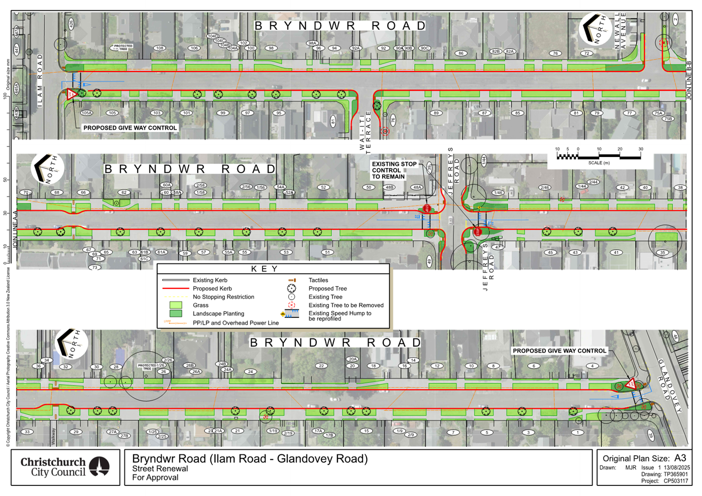
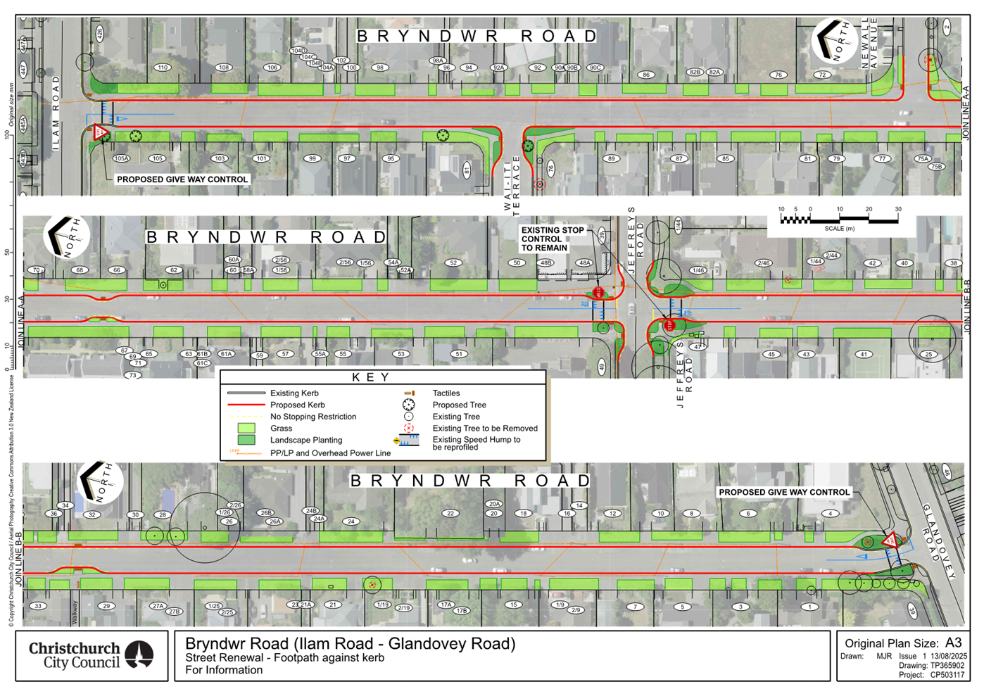
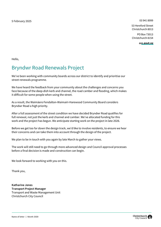
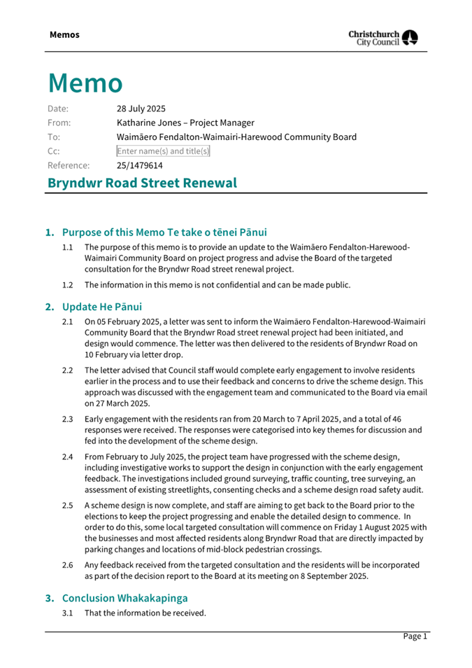
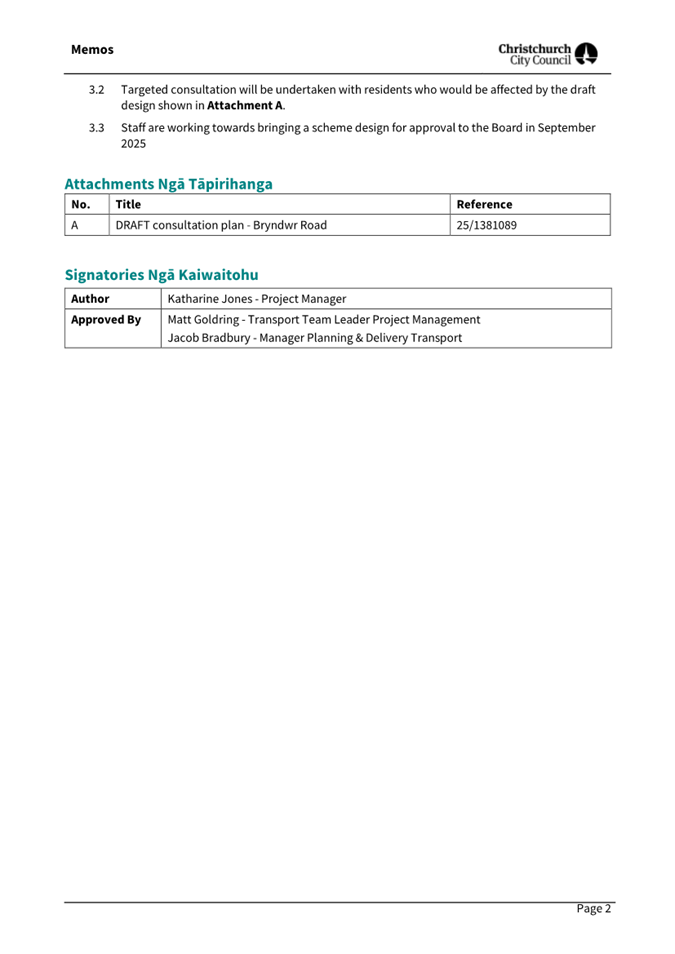
|
11. Easement
Over Recreation Reserve - 82 Glenturret Drive
|
|
Reference Te Tohutoro:
|
25/774986
|
|
Responsible Officer(s) Te Pou Matua:
|
Raymond
Qu, Property Consultant
|
|
Accountable ELT Member Pouwhakarae:
|
Anne
Columbus, General Manager Corporate Services/Chief People Officer
|
1. Purpose and Origin of the Report Te Pūtake Pūrongo
1.1 The
purpose of this report is to obtain the approval of the Waimaero
Fendalton-Waimairi-Harewood Community Board for granting easements over a
Council-owned reserve.
1.2 The
report is staff-generated in response to a private application for the
easement. Community Boards have the delegation to grant easements over
reserves.
2. Officer
Recommendations Ngā Tūtohu
That the Waimāero Fendalton-Waimairi-Harewood Community Board:
1. Receives the information in the Easement
Over Recreation Reserve - 82 Glenturret Drive report.
2. Notes that the decision in this report is assessed as low significance
based on the Christchurch City Council’s Significance and Engagement
Policy.
3. Approve pursuant to Section 48 of the Reserves Act 1977, granting
the right of way, right to drain water marked as ZZ on the plan in attachment A
to the report, Subject to:
a. The consent of the Minister of Conservation or her delegate is
obtained.
4. Recommend that the Chief Executive, using the Council’s
delegated authority from the Minister of Conservation, consent to granting the
right of way, right to drain water in favour of ZZ on the plan in attachment A.
3. Executive Summary Te Whakarāpopoto Matua
3.1 Staff
have received an application to grant an easement shown as ZZ on the plan in
Attachment A, over Council land being Lot 152 DP 499649, which is a Recreation
Reserve.
3.2 Staff
do not have the delegated authority to grant easements over reserves.
Therefore, approval from the Waimāero Fendalton-Waimairi-Harewood
Community Board is required for the easement.
3.3 The
physical works have been completed, and the easement is to legitimise a
misalignment of a stormwater pipe, which will eventually vest in the Council.
4. Background/Context Te Horopaki
4.1 Apohrodite
Limited, the developer of 275 Highsted Road, Casebrook, inadvertently had a
contractor install a water supply pipe slightly on Recreation Reserve land in
January 2025. The pipe was intended to be laid within the adjacent drainage
reserve or road reserve land. This pipe will ultimately become a 3 Waters Unit
asset. 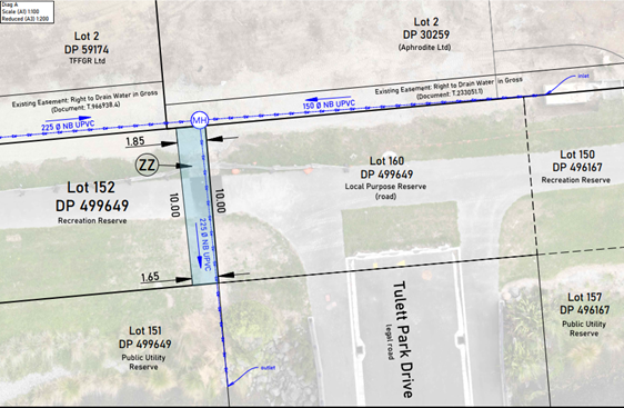
4.2 The
developer has contacted the Parks Unit to discuss how their contractor caused
this error and is requesting an easement to keep the pipe in place. While
relocating the short section of pipe could be done at significant cost, with
land disturbance and inconvenience, the Parks Unit has agreed that the best
solution is to leave the pipe where it is and seek an easement, subject to
Community Board approval.
4.3 The
Parks Unit believes that the size and position of the easement at the boundary
of the recreation reserve are unlikely to pose significant problems or
challenges for its future management and use.
4.4 The
proposed easement varies from 1.85 m to 1.65 m x 10 m (see survey plan below).
Apart from a pedestrian path (which has been reinstated), no trees or
structures on the Recreation Reserve were impacted.
4.5 The following related memos/information were circulated to the
meeting members:
|
Date
|
Subject
|
|
|
Not Applicable
|
4.6 The following related information sessions/workshops have taken
place for the meeting members: (If the information session/workshop was open to
the public, provide a link to either the agenda or the recording of the meeting.
If it was closed,
|
Date
|
Subject
|
|
|
Not Applicable
|
Options Considered Ngā
Kōwhiringa Whaiwhakaaro
4.7 The
following reasonably practicable options were considered and are assessed in
this report:
4.7.1 Grant the
requested easements.
4.7.2 There were no
other practical options.
4.8 The
following options were considered but ruled out:
4.8.1 Do not grant
easements – This would impose unnecessary extra costs on the applicant.
It is unreasonable as the asset will eventually vest in the Council after the
developer completes its project.
Options Descriptions Ngā
Kōwhiringa
4.9 Preferred
Option:
4.9.1 Option
Description: Grant the easements shown as ZZ on the plan in Attachment A.
4.9.2 Option
Advantages
· Permits the applicant to formalise existing access.
· Provides an expedient route for services.
· Maintains the Council’s reputational integrity.
· Is consistent with existing use of the land.
4.9.3 Option
Disadvantages
· None.
Analysis Criteria Ngā Paearu
Wetekina
4.10 The analysis
criteria for this option were evaluated by considering the current private and
public use of the reserve and potential disruptions; this easement imposes
minimal additional burden on the land.
5. Financial Implications Ngā Hīraunga Rauemi
Capex/Opex Ngā Utu Whakahaere
|
|
Recommended Option
|
|
Cost to Implement
|
Nil
|
|
Maintenance/Ongoing Costs
|
Nil
|
|
Funding Source
|
Reimbursed by the applicant
|
|
Funding Availability
|
N/A
|
|
Impact on Rates
|
N/A
|
5.1 The
applicant has agreed to meet all Council costs to implement the decisions in
this report.
6. Considerations Ngā Whai Whakaaro
Risks and Mitigations Ngā
Mōrearea me ngā Whakamātautau
6.1 Having
been through a regulatory consenting process, there is potential for reputation
risk if the request to grant easements is refused.
6.2 The
installation is complete, and the developer reinstated the pedestrian walkway.
Apart from replanting the lawn along the bank of Gardiners Drain, there is
nothing more to be made good.
Legal Considerations Ngā
Hīraunga ā-Ture
6.3 Statutory
and/or delegated authority to undertake proposals in the report:
6.3.1 Sections 10
& 48 of the Reserves Act 1977.
6.3.2 In exercising
the consent of the Minister of Conservation, the Council should be satisfied
that due procedure has been followed. In this respect, the Council should have
regard to the following matters:
· Section 48 of the Reserves Act 1977 gives authority to Councils to
grant rights of way and other easements over reserves.
· The Council has subdelegated this decision to the Community Boards
– Delegations Register Part D – Sub Part 1 – Community Boards
· Section 48(2) of the Reserves Act 1977 mandates that the granting of
easements over reserves must be publicly notified.
· Section 48(3) of the Reserves Act 1977 exempts public notification
if the reserve is not materially altered or permanently damaged. Since there
are existing similar uses and any new services will be underground, this
provision applies, and public notice is not deemed necessary.
6.4 Other Legal Implications:
6.4.1 Under Section
48(1) of the Reserves Act 1977, the Minister of Conservation's consent is also
necessary. The Minister has delegated this authority to the Council, which has
further subdelegated it to the Chief Executive Officer (CEO).
6.4.2 The Community
Board can signal its support for the CEO to exercise this sub-delegation.
Strategy and Policy Considerations Te Whai
Kaupapa here
6.5 The
required decisions:
6.5.1 Align with the
Christchurch
City Council’s Strategic Framework.
6.5.2 Are assessed
as low significance based on the
Christchurch City Council’s Significance and Engagement Policy. The
overall impact on the land of the granting of an easement determined the level
of significance.
6.5.3 Are consistent with Council’s Plans and Policies.
6.6 This
report does not support the Council's
Long Term Plan (2024 - 2034).
Community Impacts and Views Ngā Mariu
ā-Hāpori
6.7 The decision affects the following wards/Community Board areas:
6.7.1 Waimaero
Fendalton-Waimairi-Harewood Community Board.
6.8 The Community Board's view should be requested.
Impact on Mana Whenua Ngā Whai Take
Mana Whenua
6.9 The decision does not
involve a significant decision in relation to ancestral land, a body of
water or other elements of intrinsic value; therefore, this decision does not specifically impact Mana Whenua, their culture, and
traditions.
6.10 The decision does
not involve a matter of interest to Mana Whenua and will
not impact our agreed partnership priorities with
Ngā Papatipu Rūnanga.
6.11 The reserve land
was vested in the Council through private subdivision rather than being
classified as sensitive land owned by the Crown.
Climate Change Impact Considerations Ngā
Whai Whakaaro mā te Āhuarangi
6.15 The
proposals in this report are unlikely to contribute significantly to adaptation
to the impacts of climate change or emissions reductions.
7. Next Steps Ngā Mahinga ā-muri
7.1 Obtain
the Minister of Conservation’s consent that has been delegated to the
Chief Executive Officer for the easements to be granted over the reserve land.
7.2 Obtain
LINZ-approved plan (as-built) for the easement registration.
7.3 Invoice
applicant to recover all staff costs.
7.4 Registration
of easements at Land Information NZ.
Attachments Ngā Tāpirihanga
|
No.
|
Title
|
Reference
|
Page
|
|
a ⇩
|
Easement
Application Plan
|
25/1511023
|
71
|
In addition to the attached documents, the following background
information is available:
|
Document
Name – Location / File Link
|
|
Not
applicable
|
Signatories Ngā Kaiwaitohu
|
Author
|
Raymond Qu -
Property Consultant
|
|
Approved By
|
Angus Smith -
Manager Property Consultancy
Kelly Hansen -
Manager Parks Planning & Asset Management
Rupert Bool -
Head of Parks
|
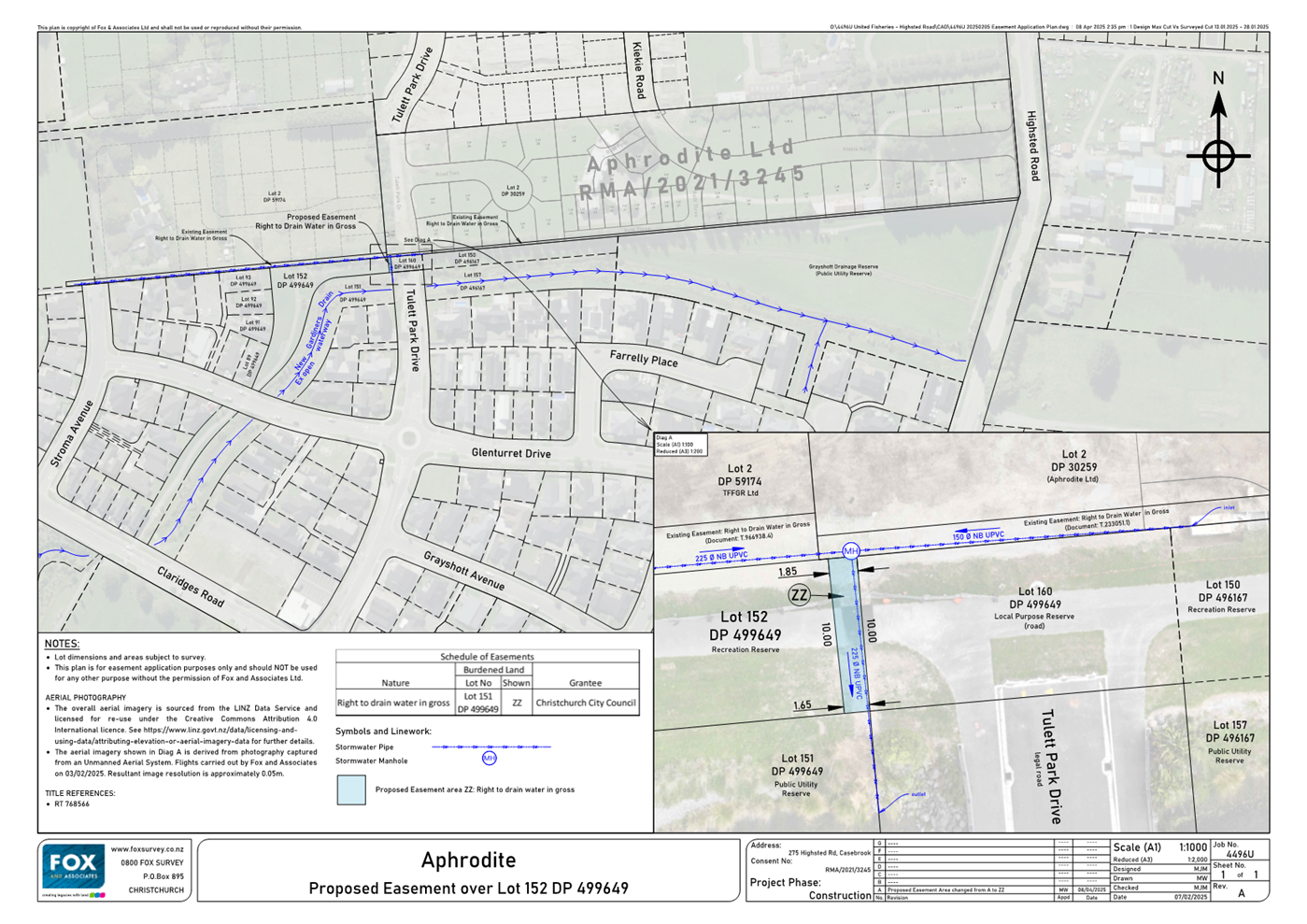
|
12. Groynes
Boat Hire- Proposed New Licence- The Groynes
|
|
Reference Te Tohutoro:
|
25/1517863
|
|
Responsible Officer(s) Te Pou Matua:
|
Felix
Dawson, Leasing Consultant
|
|
Accountable ELT Member Pouwhakarae:
|
Andrew
Rutledge, General Manager Citizens and Community
|
1. Purpose and Origin of the Report Te Pūtake Pūrongo
1.1 The purpose of this report is for the Waimāero Fendalton-Waimairi-Harewood Community Board to consider the
application for a commercial recreation licence by Groynes Boat Hire at the
Groynes Park.
1.2 The report is staff initiated to address a request for a
new licence and follows a Request for Proposal process.
2. Officer
Recommendations Ngā Tūtohu
That the
Waimāero Fendalton-Waimairi-Harewood Community Board:
1. Receives the information in the Groynes Boat
Hire- Proposed New Licence- The Groynes Report.
2. Grant a Licence to Groynes Boat Hire pursuant to the Local
Government Act 2002, for a licence period of 10 years including renewals for an
area of approximately 1.95ha approx. of the Groynes being part of Pt RS 5636 as
shown generally as areas A – D on the plan described as Attachment A of
this report.
3. Notes that the decisions in this report are of low significance in
relation to the Christchurch City Council’s
Significance and Engagement Policy 2019.
4. Requests that the Manager Property Consultancy do all things
necessary and make any decisions at his sole discretion that are consistent
with the intent of this report to implement the resolutions above including
completing negotiations and administering the terms and conditions of the new
lease.
3. Executive Summary Te Whakarāpopoto Matua
3.1 Groynes
Boat Hire is a long-standing boat hire business operating from the main lake at
The Groynes.
3.2 The
business has operated on a month-to-month licence since 2017 and have
approached the Council with a request for a longer term to provide business
security.
3.3 Parks
planning staff have assessed the park which is primarily used for outdoor
activities and support the continued use of the lake for boat hire purposes
noting that it is a popular and a well patronised activity.
3.4 A
Request for Proposal process was undertaken inviting proposals for a commercial
water-based licence. Groynes Boat Hire presented the only proposal.
3.5 Staff
have assessed the proposal which meets all key requirements and support a
licence for continuation of the activity generally at the current level which
has a low impact on the park. The provision of light refreshments is also
supported although only to patrons in an ancillary capacity to the primary
business of boat hire
3.6 There
were no submissions made in response to the public notification process.
3.7 A
licence to Groynes Boat Hire is proposed for the area shown in Attachment A.
4. Background/Context Te Horopaki
The Property
4.1 The
Groynes Park is located at 182 Johns Road as shown in red below. It is
owned by Environment Canterbury (ECan) and leased to the Council for the
purpose of passive and water-based recreation. Regarding Council
management it is considered as Park under the Local Government Act 2002.
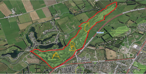
4.2 The
Park has been developed over time as an outdoor recreation facility, is around
69ha in size and can be separated into three general areas of use, A-C
above.
Area
‘A’ includes the main lake, four other smaller lakes and a range of
different picnic areas. The main lake has historically been used for paddle
boats with the four other lakes popular for fishing all year round and is also
used by the ‘Take a Kid Fishing Trust’ for an annual fishing event
where fish are introduced into the lakes prior to the event. Around 5,000
people have been known to attend on the day. The area is set up for
picnicking with barbeques provided on site along with three playgrounds and a
number toilet blocks. The park is popular with the community who hold regular
annual gatherings.
The Otukaikino
Stream which feeds the lakes in area ‘A’ runs through Area
‘B’ which is dominated by mature plantings that follow the
stream. This area is popular for water safety education in the stream and
includes an on-site kayak slalom course. A high ropes course used
generally by school groups under the management of the Horizons Trust on behalf
of the Kahikatea Trust is also contained in this area in association with the
Girl Guides Association who have a base for camping. The area is also popular for
orienteering cross country and fun runs.
There is a
well-used dog park in area ‘C’ providing a space where dogs can run
free. At 17ha it is the largest dog park in Canterbury.
Water Activities on the Main Lake
4.3 For
over 58 years a paddle boat business has been run on the main recreation lake
operating from a small boat shed and wharf as shown below.
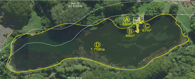
4.4 The
business has become somewhat of an ‘institution’ providing hire of
fibreglass paddleboats and canoes all made in Christchurch in the 1970s.
Some customers have referenced three generations of use. The quality of
the service has varied over time, but the business was purchased by the current
operators in 2017 and since that time the boats have been re-furbished and the
business has operated as a low cost family orientated water activity.
4.5 Following
purchase of the business the new owners were advised by the Council that a
licence was not in place and could not be arranged until execution of a new
head lease with ECan, completion of a Management Plan and public tender
process. A month-to-month licence was approved by the
Fendalton-Waimairi-Harewood Community Board Recess Committee in January 2018
pending the above.
4.6 The
head lease was completed in 2019 and a management plan for Roto Kohatu was
completed in 2023. Originally intended to be a joint management plan for
The Groynes and Roto Kohatu the Groynes element was removed from that plan
process because of the complexity of the issues arising at Roto Kohatu.
4.7 Management
and development of the Groynes has continued since 2017 consistent with the
permitted use under the ECan lease. The key elements of current activity
as outlined above provide a clear framework for use generally with the
popularity of the park providing for community needs. The popularity of
the paddleboat activity suggests that continued activity of this nature is
supported and so Parks planning staff were comfortable with supporting a public
process to invite proposals for a water-based activity on the main lake.
It was also decided to allow for the sale of refreshments from the site in a
limited capacity to support the business.
Request for Proposal Process
4.8 A
Request for Proposal (open tender) process was undertaken in accordance with
Council policy requirements for an open transparent and public process.
It is also consistent with the decision of 2018 regarding the current
licence. It was advertised in the public notices of the Press on 12 May
2025. A sign was erected on site. One proposal was received.
Groynes Boat Hire proposal was complying in key elements and assessed in
accordance with the assessment criteria considering:
· Key
Aspects of the Proposal-Project Plan
· Personnel
and Track Record
· Funding
Plan and Financial Resources
· Health
and Safety/Sustainability
The Proposal
Groynes Boat Hire (the Licensee)
have described their purpose to “provide a low cost, safe service to
Tamariki (children) whanau (family) and hapori whanui (wider community) to
engage in physically active water activities utilising canoes, aqua trikes and
pedal boats.”
Their objectives are to
“contribute to the personal health, wellbeing and quality of life of all
customers regardless of age or diversity… to keep the cost to customers
low to increase accessibility for all.”
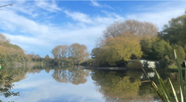
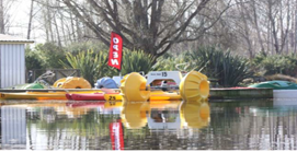
4.9 The
proposal is to continue to offer the same low key, safe and friendly affordable
service “that supports families to be active whilst spending time
together, immersed in nature”
4.10 The boats
have been furbished by the owner (under supervision), are safe and whilst
scruffy have a classic and iconic feel. The aqua trikes are described as
unique and only available at the Groynes. The Licensee considers that
maintaining this operation is a form of community service.
4.11 Over the
last seven years the Licensee has steadily built the business with website,
google, Facebook and TripAdvisor profiles, with solid reviews.
4.12 The
business is run with good health and safety procedures, including restricting
numbers of people on the water at any one time and compliance with maritime law
as required and administered by ECan. The business is run as a sole
operator with volunteer family assistance. It operates at minimal profit
which could be viewed as financially tenuous, although the track record has
shown this to be sustainable.
4.13 Proposed
Business Hours- as per current use:
Saturday-
Sunday 11.00am-4.00pm,
Public holidays and school
holidays 11.00am- 4.00pm
Occassional use outside hours
above
4.14 A request has
been made to offer refreshments: snacks, ice creams coffee/drinks from the
premises which would potentially increase the financial return. This is
supported by Parks as a reasonable element to strengthen the business. A
small space to the side of the boatshed has been included in the licence area
and is shown as ‘C’ above. This provides a set-up area for
customers using boats and a space for provision of low-level
refreshments. It is noted that there are no services of this nature
currently offered in the park and a mobile vendor/or other may be considered in
the future. The right to sell refreshments for the licensee will be
restricted in sales to business patrons only. This would not limit future
mobile vendor/or other options.
Assessment of Proposal
4.15 Staff have reviewed the proposal
which was presented in high quality and consider that Groynes Boat Hire have
sufficient track record and experience to continue operation as is and although
it runs on a tight financial basis, there is a good track record of managing in
this way and commitment to continue. There is minimal risk to Council in
terms of costs if the business should fail financially.
Proposed Licence
4.16 Groynes Boat Hire meets the
Council’s requirements as a suitable lessee
· Sole operator
· Commitment to providing service
· Proven track record
· Financially stable
· Low
impact on park
4.17 Key
lease terms are:
· Non exclusive
licence for lake and jetty. Exclusive use of shed and exclusive use
of jetty and adjoning area when operating .
· Licence area
1.95ha approx
· Permitted use:
pleasure boat hire and provision of refreshments
· Initial licence
term 5 years with one right of renewal
· Base rent
with percentage of income calculated on annual revenue.
Options Considered Ngā
Kōwhiringa Whaiwhakaaro
4.18 The following
reasonably practicable options were considered and are assessed in this report:
4.18.1 Enter into a commercial licence
for pleasure boat hire business with option to sell refreshments
4.18.2 Do not enter into a commercial
licence for pleasure boat hire business with option to sell refreshments
4.19 The following
options were considered but ruled out:
4.19.1 Do nothing: Groynes Boat Hire
requires a decision to enable it to plan future business use with certainty.
4.19.2 Enter into a commercial licence
for pleasure boat hire business without option to sell refreshments. Not
favoured as selling refreshments would strengthen financial viability and
enable Groynes Boat Hire to keep its hire fees low and accessible to all.
Options Descriptions Ngā
Kōwhiringa
4.20 Preferred
Option: Enter into a commercial licence for pleasure boat hire business
with option to sell refreshments.
4.20.1 Option Description: Enter
into a commercial licence for pleasure boat hire business with option to sell
refreshments. Involves non-exclusive use of lake when business is
operating, exclusive use of jetty and surrounding area when business is
operating. Exclusive use of boat shed. Right to sell light
refreshments to business patrons.
4.20.2 Option Advantages
· Provides business certainty for operator
· Continues with popular public service of boat hire
· Consistent with the public use of the reserve and head lease
· Selling refreshments option strengthens business viability and
facilitates keeping hire fees low. Sale only to patrons does not limit
options for further sale options within the park.
4.20.3 Option Disadvantages
· Restricts public use of jetty when business is operating
4.21 Other Option:
Do not enter into a commercial licence for pleasure boat hire business with
option to sell refreshments
4.21.1 Option Description: Do
not enter into a commercial licence for pleasure boat hire business with option
to sell refreshments and retain existing wharf facility for general public use.
4.21.2 Option Advantages
· Area remains available for recreational use at all times.
4.21.3 Option Disadvantages
· A popular activity/service is denied
Analysis Criteria Ngā Paearu
Wetekina
4.22 The options were
assessed taking into account the benefits of maintaining the existing boat hire
activity as against keeping it completely open for public use.
5. Financial Implications Ngā Hīraunga Rauemi
Capex/Opex Ngā Utu Whakahaere
|
|
Recommended Option
|
Option 2 -Do not enter into licence1,00 and
retain for open space
|
|
Cost to Implement
|
Nil
Licence set up costs covered by licensee
|
Nil
Licence set up costs covered by licensee
|
|
Maintenance/Ongoing Costs
|
$1500/annum
|
nil
|
|
Funding Source
|
Operational budget
|
Operational budget
|
|
Funding Availability
|
yes
|
yes
|
6. Considerations Ngā Whai Whakaaro
Risks and Mitigations Ngā
Mōrearea me ngā Whakamātautau
6.1 There
is a risk of the lessee failing to continue operating successfully and maintain
the premises. Financial consequences would be minor and operational
issues could be rectified. The likelihood of these consequences occurring
is considered low based on the organisation’s previous track record.
6.2 There
is also a risk that the operator will sell refreshments to non-patrons and
develop the business in the way of a café. The likelihood is
considered medium and will be mitigated by the terms of the licence that will
be explicit and specify sale to non-patrons as a breach.
Legal Considerations Ngā
Hīraunga ā-Ture
6.3 Statutory
and/or delegated authority to undertake proposals in the report:
6.3.1 Delegations Parks
(Part D-sub Part 1- Community Boards) Authority delegated from Council to
Community Boards.
“To
grant leases or licences for a maximum term of 35 years to any person or body
over parks and to authorise staff to sign all required documentation”
Local Government Act 2002.
6.3.2 Local
Government Act 2002-Lease entered into pursuant to general powers
6.4 Other Legal Implications:
6.4.1 Local Government Act
2002-Decision Making including consideration of community views
6.4.2 Local
Government Act 2002, Public notification in accordance with s138
6.4.3 Approval of lessor
under head lease.
Strategy and Policy Considerations Te Whai
Kaupapa here
6.5 The
required decisions:
6.5.1 Aligns with the Christchurch City Council’s Strategic Framework. in particular the strategic priority of “Be an inclusive and
equitable city…prioritising well being, accessibility and
connection”. These elements
are key objectives for the business as set out in the RFP proposal.
6.5.2 Are of low
significance in relation to the Christchurch City Council’s Significance and Engagement Policy
2019. The level of significance was
determined by considering the number of people affected, the level of impact on
those affected and the low cost to Council associated with entering into the licence.
6.5.3 Is consistent with Council’s Plans and
Policies.
· Lease Policy for the Creation of New leases and Extension Requests
Prior to Expiry-Property:
“..tenant for property sought through an open transparent and
public process..” applies in this case for an
application for a new licence. An RFP process was run inviting proposals
for this use.
· Open Space Strategy
· Physical Recreation and Sports Strategy
6.6 This
report supports the Council's Long Term Plan (2024 - 2034):
6.7 Parks, Heritage and Coastal Environment
6.7.1 Activity: Parks and Foreshore
· Level of Service: 6.8.10.1 Appropriate use and
occupation of parks is facilitated - Processing of the application is started
within ten working days of receiving application - 95%
Community Impacts and Views Ngā Mariu
ā-Hāpori
6.8
6.8.1 Public notices
regarding the proposed licence were put in the Christchurch Press on 25 June
2025, with a notice in the public notices on the Council website running
from 27 June for a month. No responses were received. No
submissions were received.
6.8.2 Staff consider that
this is sufficient consideration of community views taking into account the
significance of the decision proposed and the fact that the proposal does not
change the current level of activity
6.9 The decision affects the following wards/Community Board areas:
6.9.1 Waimāero Fendalton-Waimairi Spreydon
Community Board
Impact on Mana Whenua Ngā Whai Take
Mana Whenua
6.10 The decision
does not involve a significant decision in relation to ancestral land, a
body of water or other elements of intrinsic value, therefore this decision does not impact Mana Whenua, their culture, and traditions.
6.11 The decision does
not involve a matter of interest to Mana Whenua and will
not impact on our agreed partnership priorities with
Ngā Papatipu Rūnanga.
6.12 The proposal was forwarded to Te Aporei Whakawhanaunga a Tiriti,
Treaty Partnerships Team and to Whitiora for comment on 19 May 2025 and they have
not identified any issues.
Climate Change Impact Considerations Ngā
Whai Whakaaro mā te Āhuarangi
6.13 The proposals in this report are
unlikely to contribute to adaptation to the impacts of climate change and
emissions reductions.
6.14 In terms of the
activities associated with the licence, there is a low carbon footprint
associated with the use as it is locally focused. The licensee has a
strong focus on minimal resource use with the decision to re-furbish the
existing boats preferred to replacement with plastic that are difficult to
repair if damaged. The vessels are all pedal or paddle powered, the shed
has a solar panel for electricity. Games that are provided to customers have
been hand made with recycled or natural materials
7. Next Steps Ngā Mahinga ā-muri
7.1 Subject
to Community Board approval, Property staff are to undertake final negotiation
of lease terms, complete documentation and administration of the new
lease.
Attachments Ngā Tāpirihanga
|
No.
|
Title
|
Reference
|
Page
|
|
a ⇩
|
Groynes Boat
Hire Licence Areas
|
25/1578317
|
81
|
In addition to the attached documents, the following background
information is available:
|
Document
Name – Location / File Link
|
|
Not
applicable
|
Signatories Ngā Kaiwaitohu
|
Author
|
Felix Dawson -
Leasing Consultant
|
|
Approved By
|
Kathy Jarden -
Team Leader Leasing Consultancy
Angus Smith -
Manager Property Consultancy
Robbie Hewson
- Head Ranger Coastal & Plains
Rupert Bool -
Head of Parks
|
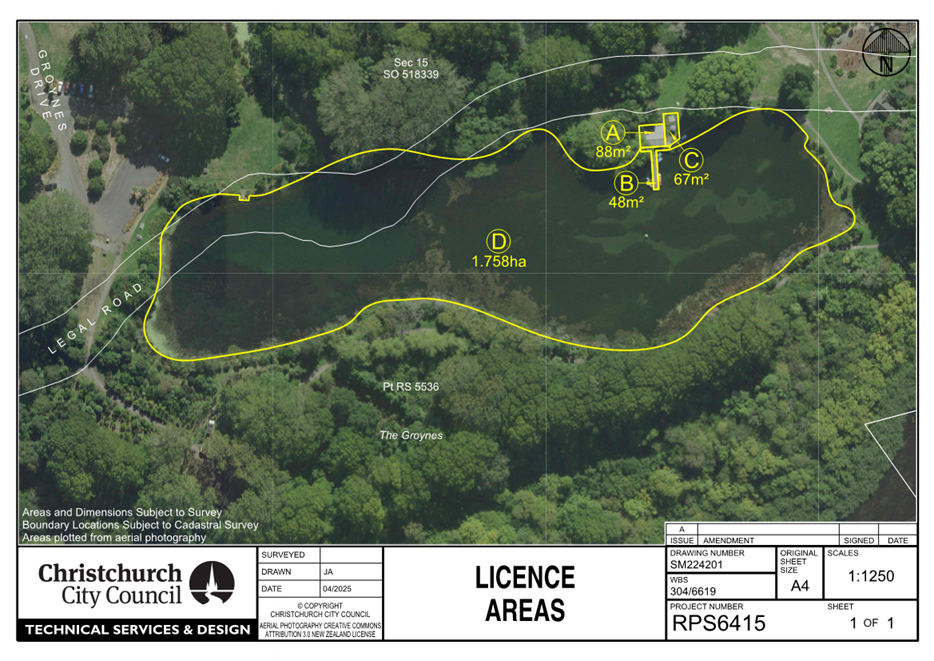
|
13. Waimāero Fendalton-Waimairi-Harewood
Summer with your Neighbours 2025-26
|
|
Reference Te Tohutoro:
|
25/1589598
|
|
Responsible Officer(s) Te Pou Matua:
|
Katie
MacDonald, Support Officer, [email protected]
|
|
Accountable ELT Member Pouwhakarae:
|
Andrew
Rutledge, General Manager Citizens and Community
|
1. Purpose and Origin of the Report Te Pūtake Pūrongo
1.1 The
purpose of this report is for the Waimāero Fendalton-Waimairi-Harewood
Community Board to consider applications received for the 2025-26 Waimāero
Fendalton-Waimairi Harewood Summer with your Neighbours and to allocate funding
as appropriate. There is a balance of $3,500 allocated to the 2025-26
Waimāero Fendalton-Waimairi-Harewood Summer with your Neighbours. The
staff recommendations in this report total $3,500.
2. Officer Recommendations Ngā Tūtohu
That the Waimāero
Fendalton-Waimairi-Harewood Community Board:
1. Receives the information in the Waimāero
Fendalton-Waimairi-Harewood Summer with your Neighbours 2025-26 Report.
2. Notes that the decisions in this report are assessed at low
significance based on the Christchurch City Council’s Significance and
Engagement Policy.
3. Allocate its 2025-26 Summer with your Neighbours as follows:
|
Applicant
|
Activity
|
No. Attending
|
Staff recommendation
|
|
1
|
Lorraine Ellery
|
Street gathering
|
30
|
$75
|
|
2
|
Amanda Murray
|
Neighbourhood catch
up
|
20
|
$50
|
|
3
|
Joanna Dodgshun
|
BBQ meal
|
42
|
$105
|
|
4
|
Peter Boock
|
BBQ meal
|
60
|
$150
|
|
5
|
Zara Fraser
|
Street Christmas
party
|
50
|
$125
|
|
6
|
Pam Templeton and
QC Voon
|
Afternoon tea
gathering
|
25
|
$63
|
|
7
|
Liane Dixon
|
Afternoon early
meal
|
60
|
$103
|
|
8
|
Gail Turner
|
Late afternoon BBQ
|
35
|
$88
|
|
9
|
Vilna Gough-Jones
|
Pizza in the park
|
60
|
$150
|
|
10
|
Marg O'Connell
|
Street party
|
50
|
$70
|
|
11
|
Diane Lattimore
|
Christmas BBQ
|
25
|
$63
|
|
12
|
Kylie
Phaup-Stephens
|
Shared kai and
conversation
|
20
|
$50
|
|
13
|
Lisa Wallace
|
Afternoon BBQ
|
50
|
$125
|
|
14
|
Vicki Smith
|
BBQ
|
120
|
$200
|
|
15
|
Gretchen Bruner
|
Summer BBQ
|
18
|
$45
|
|
16
|
Peter Cameron
|
Afternoon tea
|
35
|
$88
|
|
17
|
Peter Evans
|
Street BBQ
|
32
|
$80
|
|
18
|
Joanna Hopkins
|
Street BBQ
|
70
|
$175
|
|
19
|
Barb Harper
|
Lunch BBQ
|
45
|
$113
|
|
20
|
Anna Woodham
|
BBQ
|
40
|
$60
|
|
21
|
Isabella
Slattery-Shannon
|
BBQ
|
45
|
$113
|
|
22
|
Jacqui and Dave
Ching
|
Private street party
|
100
|
$200
|
|
23
|
Carolyn Coghlan
|
Street BBQ
|
90
|
$200
|
|
24
|
Atu Siwatibau
|
BBQ
|
40
|
$100
|
|
25
|
Peter Floris
|
Pre-Christmas get
together
|
22
|
$55
|
|
26
|
Teresa Barnes
|
BBQ
|
40
|
$100
|
|
27
|
Brian Palliser
|
BBQ
|
24
|
$60
|
|
28
|
Truus Dingemanse
|
Street BBQ
|
40
|
$100
|
|
29
|
Lisa Martin
|
Street BBQ
|
30
|
$75
|
|
30
|
Fendalton Park
Croquet Club Incorporated
|
Twilight Croquet
|
60
|
$257
|
|
31
|
Anglican Parish of
Burnside-Harewood
|
Light party
|
100
|
$262
|
3. Key Points Ngā Take Matua
Strategic Alignment Te Rautaki
Tīaroaro
3.1 The recommendations above are aligned to the Council's Strategic
Framework and in particular the strategic priorities of a Collaborative and
Confident City and A Cultural Powerhouse City. The projects also align
with the Te Haumako Te Whitingia Strengthening Communities Together Strategy.
Decision Making Authority Te Mana
Whakatau
3.2 The
Community Board has the delegated authority to determine the allocation of its
Summer with your Neighbours funding.
3.3 Allocations must be consistent with any
policies, standards or criteria adopted by the Council.
Assessment of Significance and Engagement Te
Aromatawai Whakahirahira
3.4 The
decisions in this report are assessed as low significance based on the
Christchurch City Council’s Significance and Engagement Policy.
3.5 The
level of significance was determined by the number of people affected and/or
with an interest.
3.6 Due to the assessment of low significance, no further community
engagement and consultation is required.
Discussion Kōrerorero
3.7 At
its meeting on 11 August 2025, the Waimāero Fendalton-Waimairi-Harewood
Community Board resolved to allocate $3,500 from its 2025-26 Discretionary
Response Fund towards Summer with your Neighbours 2025-26.
3.8 Summer
with your Neighbours is about bringing people closer together and celebrating
the unique and diverse mix of each neighbourhood. It invites residents to
consider if they have ever wanted to organise a neighbourhood gathering, or to
get to know the people who live close to them. This popular event has grown
from year to year and is promoted by the Council.
3.9 Local
community groups, including Residents' Associations and Neighbourhood Support
groups, have been sent information inviting them to apply for the Summer with
your Neighbours funding. Staff also promoted the fund through social media and
other networks.
3.10 Summer with your
Neighbours will run from 25 October 2025 to 30 March 2026. Applications for
funding opened on 12 July 2025 and closed on 10 August 2025.
3.11 By the closing
date, 31 eligible applications had been received. Staff have assessed the
applications to ensure that they met the Summer with your Neighbours guidelines
and have recommended amounts to be allocated to all of the 31 applications
received.
3.12 To create
consistency in staff recommendations across the city, staff recommendations are
based on the following formula:
- $2.50 per head approx. up to a
maximum of $200 (exceptions may be made for applications from organisations).
- When the requested amount is less
than the $2.50 per head formula, the requested amount is what has been
recommended.
- Where two approximate attendee
numbers have been noted, recommendations are based on the higher approximate
figure.
3.13 A matrix
outlining the applications and staff recommendations is attached (refer Attachment
A), along with the Summer with your Neighbours Guidelines (refer Attachment
B).
Attachments Ngā Tāpirihanga
|
No.
|
Title
|
Reference
|
Page
|
|
a ⇩
|
Matrix - 2025-26 Fendalton-Waimairi-Harewood Summer with your
Neighbours
|
25/1728197
|
85
|
|
b ⇩
|
Guidelines - 2025-26 Summer with your Neighbours
|
25/1438894
|
89
|
Signatories Ngā Kaiwaitohu
|
Author
|
Katie
MacDonald - Support Officer
|
|
Approved By
|
Maryanne Lomax
- Manager Community Governance, Fendalton-Waimairi-Harewood
|

|
14. Memorial Avenue Intersections
|
|
Reference Te Tohutoro:
|
25/1615511
|
|
Responsible Officer(s) Te Pou Matua:
|
Gemma
Dioni - Principal Advisor Transportation Safety
Lachlan Beban - Principal Advisor Transportation Signals
|
|
Accountable ELT Member Pouwhakarae:
|
Brent
Smith, General Manager City Infrastructure
|
1. Purpose and Origin of the Report Te Pūtake Pūrongo
1.1 For
the Waimāero Fendalton-Waimairi-Harewood Community Board to approve right
turn phases from Grahams Road, Greers Road and Ilam Road on to Memorial Avenue
from the southern approaches to each intersection.
1.2 The
report has been written in response to requests to help ease congestion caused
by the nearby Ilam Wastewater renewal project, which is being delivered by
Three Waters.
1.3 Only
minor hardware changes are required to facilitate the phase changes at the
Grahams Road/Memorial Avenue intersection and the Ilam Road/Memorial Avenue
intersection, which includes changing the signal lanterns on the southern
approaches.
1.4 At
the Greers Road/Memorial Avenue intersection, staff are undertaking a full
upgrade of the traffic signals. This includes underground cables, new signal
poles and lanterns, as these critical assets are at the end of their working
life and need to be replaced before a right turn phase can be introduced.
1.5 Staff
will also be making some minor safety improvements at the Greers Road/Memorial
Avenue intersection for people walking and crossing. This will be through the
introduction of pedestrian protection (red arrow displays to hold back turning
traffic while pedestrians are using the crossings), and new kerb cutdowns to
align with new pole locations and road markings. This will provide increased
separation between crossings.
2. Officer
Recommendations Ngā Tūtohu
That the
Waimāero Fendalton-Waimairi-Harewood Community Board:
1. Receives the information in the Memorial
Avenue Intersections Report.
2. Notes that the decision in this report is assessed as low significance
based on the Christchurch City Council’s Significance and Engagement
Policy.
3. Approves, pursuant to Section 331 and 334 of the Local Government
Act 1974:
a. All kerb alignments and road markings changes on Memorial Avenue and
Greers Road as detailed in Attachment A of this
report.
b. The installation of hardware to facilitate traffic signal control of
the right movement from Greers Road (south) into Memorial Avenue.
c. The installation of hardware to facilitate traffic signal control of
the right movement from Grahams Road (south) into Memorial Avenue.
d. The installation of hardware to facilitate traffic signal control of
the right movement from Ilam Road (south) into Memorial Avenue.
4. Notes that staff will review the operation of the intersections
following completion of the Ilam wastewater renewal project to determine whether the right turn phases from the southern
approaches should be retained.
3. Executive Summary Te Whakarāpopoto Matua
3.1 The
Three Waters team at Council has been delivering the Ilam wastewater renewal
project since September last year. While this work is essential to keep the
wastewater network operational, it has put some pressure on the local road
network. The signal upgrades outlined in this report aim to keep traffic
flowing through the wider area while these works are in place.
3.2 At
the Memorial Avenue/Grahams Road intersection and the Memorial Avenue/Ilam Road
intersection, it is proposed to change the signal lanterns to provide a right
turn phase. At the Memorial Avenue/Greers Road intersection, a full upgrade of
the traffic signals is required.
4. Background/Context Te Horopaki
4.1 Traffic
signal lanterns are to be changed at the intersection of Memorial
Avenue/Grahams Road intersection and Memorial Avenue/Ilam Road intersection to
facilitate a right turn phase from the southern approaches.
4.2 A
full upgrade of the traffic signals is required at the Memorial Avenue/Greers
Road intersection as these critical assets are at the end of their working
life. There is therefore an opportunity to include minor improvements as part
of the work to address concerns raised in the Burnside High School and Christ
the King School Travel Plans by students who cross at this intersection. These
improvements include:
4.2.1 Altering the
kerb cut downs to provide separation between the crossing points.
4.2.2 Introducing
pedestrian protection (red arrow displays to hold back turning traffic while
pedestrians are using the crossings).
4.2.3 Implementing
tactile paving.
Options Considered Ngā
Kōwhiringa Whaiwhakaaro
4.3 The
following reasonably practicable options were considered and are assessed in
this report:
4.3.1 Introduce
right turn green arrows on the southern approaches of Grahams Road, Ilam Road
and Greers Road at the intersections with Memorial Avenue.
4.3.2 Do nothing
Options Descriptions Ngā
Kōwhiringa
4.4 Preferred
Option: Introduce right turn green arrows on the southern approaches of
Grahams Road, Ilam Road and Greers Road at the intersections with Memorial
Avenue.
4.4.1 Option advantages
· Improve the ability for drivers to turn right from the southern
approach.
· At the Memorial Avenue/Greers Road intersection:
· Provide separation between the crossing points.
· Introduce pedestrian protection.
· Implement tactile paving.
4.4.2 Option
disadvantages
· Cost to Council
· Potential impact on intersection efficiency, as the phasing changes
are likely to introduce additional delay to movements on other intersection
approaches.
4.5 Option
2: Do nothing
4.5.1 Option description:
Do nothing
4.5.2 Option advantages
· No cost to Council
4.5.3 Option disadvantages
· Does not improve the ability for drivers to turn right from the
southern approaches.
· At the Memorial Avenue/Greers Road intersection:
· Does not provide separation between the crossing points.
· Does not introduce pedestrian protection.
· Does not implement tactile paving.
5. Financial Implications Ngā Hīraunga Rauemi
Capex/Opex Ngā Utu Whakahaere
|
|
Recommended Option
|
Option 2
|
|
Cost to Implement
|
$700k
|
$0
|
|
Maintenance/Ongoing Costs
|
To be covered under the Traffic Signals
Maintenance contract. Would reduce the cost of maintenance in the medium-term
due to new assets being provided.
|
$0
|
|
Funding Source
|
#37293 Delivery Package - Traffic Signals Renewals
|
$0
|
|
Funding Availability
|
Funding available in the above-named
budget.
|
$0
|
|
Impact on Rates
|
None
|
$0
|
5.1 The cost are
high-level estimates and are not tendered prices.
5.2 The traffic
signals require renewal at the Greers Road/Memorial Avenue site, as the cables
are at the end of their working life. As part of the traffic signal renewal, it
is proposed to undertake further improvements.
6. Considerations Ngā Whai Whakaaro
Risks and Mitigations Ngā
Mōrearea me ngā Whakamātautau
6.1 There
is a risk that people may continue to feel unsafe while crossing at the Greers
Road/Memorial Avenue intersection if the proposed changes are not approved.
Completing this work alongside the traffic signal renewal project reduces cost
and risk to Council and impact on the local community.
Legal Considerations Ngā
Hīraunga ā-Ture
6.2 Statutory
and/or delegated authority to undertake proposals in the report:
Local Government Act 1974
6.2.1 Section 331 provides
authority to approve concept plans for forming or upgrading footpath, kerbs and
channels.
6.2.2 The installation of
any signs and/or markings associated with traffic control devices must comply
with the Land Transport Rule: Traffic Control Devices 2004.
6.3 Other Legal Implications:
6.3.1 There is no other
legal context, issue, or implication relevant to this decision.
6.3.2 This specific
report has not been reviewed and approved by the Legal Services Unit however
the report has been written using a general approach previously approved of by
the Legal Services Unit, and the recommendations are consistent with the policy
and legislative framework outlined in this report.
Strategy and Policy Considerations Te Whai
Kaupapa here
6.4 The
required decision:
6.4.1 Aligns with the Christchurch
City Council’s Strategic Framework and Community Outcomes. Improving
the safety of our roads aligns with the Strategic Priorities and Community
Outcomes, in particular to be an inclusive and equitable city; build trust and
confidence by listening to and working with our residents; and providing safe
crossing points for people who walk and improved cycle infrastructure, will
contribute to a green, liveable city, where our neighbourhoods and communities
are accessible and well-connected.
6.4.2 Is assessed as low significance
based on the Christchurch City Council’s Significance and Engagement
Policy. The level of significance was determined by the low level of impact and
low number of people affected by the recommended decision.
6.4.3 The recommended option is consistent with the
Council’s Plans and Policies, in particular:
· LTP Activity Plan - Level of Service target to reduce the number of
deaths or serious injuries (DSI) from all crashes by 40% in 2030.
· The changes made align with the safe and healthy streets for
everyone goal in the draft Ōtautahi Christchurch Future Transport Strategy
2024-2054.
· Improving safety on local roads is a priority for the Council.
6.5 This
report supports the Council's
Long Term Plan (2024 - 2034):
6.6 Transport
6.6.1 Activity: Transport
· Level of Service: 10.0.6.1 Reduce the number of
death and serious injury crashes on the local road network (DIA 1) - 4 less
than previous FY
· Level of Service: 10.0.6.2 Reduce the number of
death and serious injury crashes on the local road network - Five year rolling
average <95 crashes per year
· Level of Service: 10.5.1 Limit deaths and
serious injury crashes per capita for cyclists and pedestrians - <=12
crashes per 100,000 residents
Community Impacts and Views Ngā Mariu
ā-Hāpori
6.7 Due
to the very minor nature of improvements at the intersection, consultation has
not been undertaken.
6.8 The decision affects the following wards/Community Board areas:
6.8.1 Waimāero Fendalton-Waimairi-Harewood Community Board
Impact on Mana Whenua Ngā Whai Take
Mana Whenua
6.9 The
decision does not involve a significant decision concerning ancestral land or a
body of water or other elements of intrinsic value, therefore this decision
does not specifically impact Mana Whenua, their culture and traditions.
6.10 The decision does not involve a
matter of interest to Mana Whenua and will not impact on our agreed partnership
priorities with Ngā Papatipu Rūnanga.
Climate Change Impact Considerations Ngā
Whai Whakaaro mā te Āhuarangi
6.11 The
proposals in this report are unlikely to contribute significantly to adaptation
to the impacts of climate change or emissions reductions.
6.12 This is a
minor proposal that is principally intended to improve accessibility and safety
for people crossing at the intersection.
7. Next Steps Ngā Mahinga ā-muri
7.1 If
approved, staff will proceed with construction.
Attachments Ngā Tāpirihanga
There are no
attachments to this report.
In addition to the attached documents, the following background
information is available:
|
Document
Name – Location / File Link
|
|
Not
applicable
|
Signatories Ngā Kaiwaitohu
|
Authors
|
Gemma Dioni -
Principal Advisor Transportation - Safety
Lachlan Beban
- Principal Advisor Transportation Signals
|
|
Approved By
|
Jann Kuhlmann
- Team Leader Real Time Operations
Stephen Wright
- Manager Operations (Transport)
|
|
15. Englefield Reserve Nature Play Space Renewal
|
|
Reference Te Tohutoro:
|
25/1635129
|
|
Responsible Officer(s) Te Pou Matua:
|
Natalie
Dally, Community Development Advisor
|
|
Accountable ELT Member Pouwhakarae:
|
Andrew
Rutledge, General Manager Citizens and Community
|
1. Purpose and Origin of the Report Te Pūtake Pūrongo
1.1 The
purpose of this report is to inform the Waimāero
Fendalton-Waimairi-Harewood Community Board on the progress of the Englefield
Nature Play Space Renewal project.
1.2 The
Waimāero Fendalton-Waimairi-Harewood Community Board granted $20,000 from
its Better-Off Fund towards a Community Development /Partnership project in
Englefield Reserve. This became the Renewal of the Englefield Nature Play
Space.
2. Officer Recommendations Ngā Tūtohu
That the Waimāero
Fendalton-Waimairi-Harewood Community Board:
1. Receives the information in the Englefield
Reserve Nature Play Space Renewal Report.
3. Background/Context Te Horopaki
3.1 Due to some trees having to
be cut down for safety reasons in Englefield Reserve, the Waimāero
Fendalton-Waimairi-Harewood Community Board wanted to support the community to
rebuild a community space there. The
current area designated as a Nature Play Space needed rejuvenating and
its renewal became this community project.
3.2 The project is being facilitated by the
Council’s Community Development Advisor for the area, and a
Community Advisory Group made up of representatives from Northwood and Belfast
Residents Associations, Belfast Community Network, Pūtahi Belfast School and the Styx Living Laboratory
Trust. Belfast Rugby Club was invited to participate and were kept informed.
3.3 An independent Nature Play Consultant from
Woodland Escape has been engaged along with relevant Council staff. The
Community Advisory Group had an onsite engagement session with the consultant
and came up with some initial ideas. Further engagement sessions included:
· A local afterschool group with an onsite engagement session.
· Pūtahi Belfast School had an engagement
session at school with student leaders.
3.4 An initial draft design concept was then
developed and presented to the Council’s Team Leader of Parks and
Recreation Planning, and the Team Leader of Biodiveristy, for their feedback,
input and approval to proceed.
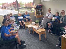
3.5 The draft design was posted on the social media
pages of the groups involved (including the Community Board) and a quick survey
developed for those who wanted to give feedback on the design. A letterbox drop
was delivered to approximately 400 homes in close proximity to the Reserve with
an invitation to provide feedback. From this, nine additional responses were
received. The responses were supportive with only minor suggested changes to
the concept plan. The Council’s Team Leader of Parks and Recreation Planning approved
the project to proceed.
3.6 An
onsite pop-up event is being planned, under the guidance of the consultant and
with support from the Community Advisory Group, for the wider community. This
will help to activate the space and inform the final placement of any fixed
items in the Nature Play design.
3.7 The
Styx Living Laboratory Trust are working on signage for the community to engage
with the area, in consultation with the school and supported by the Council
Play Advocate.
3.8 The
space is expected to be fully operational by the end of November 2025. An
opening event will be organised around this time. Members of the Community and Pūtahi
Belfast School will be invited to become guardians of the space. The school
intend to make the space a place to visit as part of their learnings and
activities.
4. Considerations Ngā Whai Whakaaro
4.1 The
final design is unchanged from the version that went out for consultation but
the community interactive pop-up event will allow for adjustments to the final
placement of any fixed items and additional items may be added as budget
allows.
4.2 Final
Community Design Guide for Englefield Nature Play Space, on site at Englefield
Reserve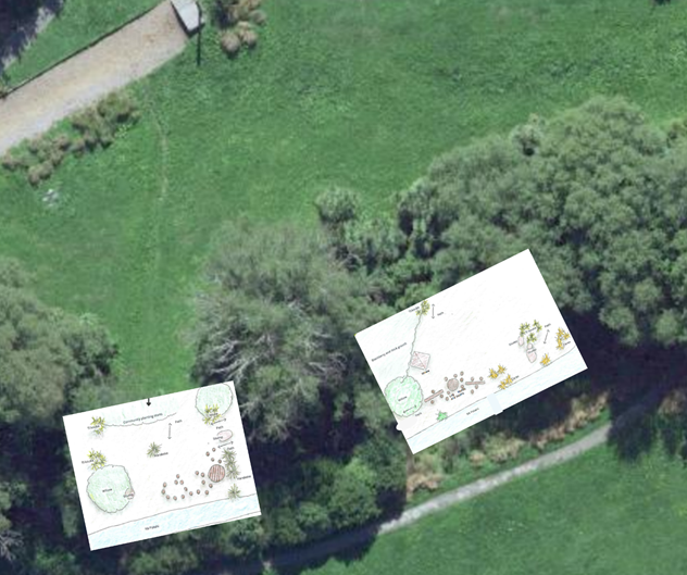
Attachments Ngā Tāpirihanga
|
No.
|
Title
|
Reference
|
Page
|
|
a ⇩
|
Englefield
Reserve Nature Play Space - Consultation draft design and engagement
information.
|
25/1635605
|
99
|
In addition to the attached documents, the following background
information is available:
|
Document
Name – Location / File Link
|
|
Not
applicable
|
Signatories Ngā Kaiwaitohu
|
Author
|
Natalie Dally
- Community Development Advisor
|
|
Approved By
|
Maryanne Lomax
- Manager Community Governance, Fendalton-Waimairi-Harewood
|
|
16. Fendalton-Waimairi-Harewood
2025-2026 Discretionary Response Fund Application Avonhead Community Trust
|
|
Reference Te Tohutoro:
|
25/1635141
|
|
Responsible Officer(s) Te Pou Matua:
|
Karen
Boag, Community Development Advisor
|
|
Accountable ELT Member Pouwhakarae:
|
Andrew
Rutledge, General Manager Citizens and Community
|
1. Purpose and Origin of the Report Te Pūtake Pūrongo
1.1 The
purpose of this report is for the Waimāero Fendalton-Waimairi-Harewood
Community Board to consider an application for funding from its 2025-26 Discretionary Response Fund from the organisation listed below.
|
Funding Request Number
|
Organisation
|
Project Name
|
Amount Requested
|
Amount Recommended
|
|
DRF 25/26_00016
|
Avonhead Community Trust
|
Community Expo
|
$1,748
|
$1,748
|
1.2 There
is currently a balance of $121,758 remaining in the fund.
2. Officer Recommendations Ngā Tūtohu
That the Waimāero
Fendalton-Waimairi-Harewood Community Board:
1. Receives the information in the Fendalton-Waimairi-Harewood
2025-2026 Discretionary Response Fund Application Avonhead Community Trust
Report.
2. Notes that the decision in this report are assessed as low
significance based on the Christchurch City Council’s Significance and
Engagement Policy.
3. Approves a grant of $1,748 from its 2025-26 Discretionary
Response Fund to Avonhead Community Trust towards a Community Expo.
3. Key Points Ngā Take Matua
Strategic Alignment Te Rautaki
Tīaroaro
3.1 The
recommendation above is aligned with the Council's Strategic Framework and in
particular the strategic priority of being an inclusive
and equitable city. The
project also aligns with the Strengthening Communities
Together Strategy.
3.2 The
recommendations are consistent with the Strengthening Communities Together
Strategy.
Decision Making Authority Te Mana
Whakatau
3.3 The
Community Board has the delegated authority to determine the allocation of the Discretionary
Response Fund for each community.
3.3.1 Allocations must be
consistent with any Council-adopted policies, standards or criteria.
3.3.2 The Fund does not
cover:
· Legal or environmental court challenges
against the Council, Council Controlled Organisations, or Community Board
decisions.
· Projects or initiatives that change the scope of a Council project
or lead to ongoing operational costs to the Council
(though Community Boards can recommend to the Council that it consider a grant
for this purpose).
Assessment of Significance and Engagement Te
Aromatawai Whakahirahira
3.4 The decision in this report is assessed as low
significance based on the Christchurch City Council’s Significance and
Engagement Policy.
3.5 The significance level was determined by the number of people
affected and/or with an interest.
3.6 Due to the assessment of low significance, no further community
engagement and consultation is required.
Discussion Kōrerorero
3.7 At the time of writing, the balance of the 2025-26 Discretionary
Response Fund is:
|
Total Budget Current Year
|
Granted To Date
|
Available for allocation
|
Balance If Staff Recommendation adopted
|
|
$165,508
|
$43,750
|
$121,758
|
$120,010
|
3.8 Based
on the current Discretionary Response Fund criteria, the application above is
eligible for funding.
3.9 The
attached Decision Matrix provides detailed information for the
applications. This includes organisational details, project details,
financial information, and a staff assessment.
Attachments Ngā Tāpirihanga
|
No.
|
Title
|
Reference
|
Page
|
|
a ⇩
|
Fendalton-Waimairi-Harewood 2025-26 DRF - Avonhead Community Trust
Decision Matrix
|
25/1695830
|
106
|
Signatories Ngā Kaiwaitohu
|
Author
|
Karen Boag -
Community Development Advisor
|
|
Approved By
|
Maryanne Lomax
- Manager Community Governance, Fendalton-Waimairi-Harewood
|
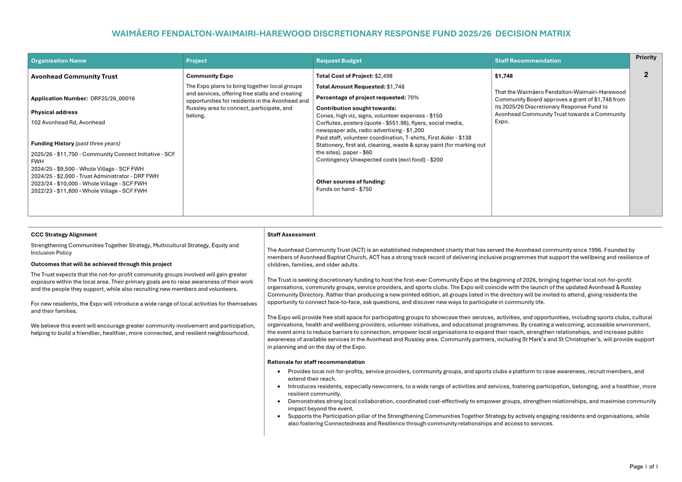
|
17. Waimāero Fendalton-Waimairi-Harewood
Community Board Area Report - September 2025
|
|
Reference Te Tohutoro:
|
25/1679338
|
|
Responsible Officer(s) Te Pou Matua:
|
Maryanne
Lomax, Community Governance Manager, [email protected]
|
|
Accountable ELT Member Pouwhakarae:
|
Andrew
Rutledge, General Manager Citizens and Community
|
1. Purpose of Origin of the Report Te Pūtake Pūrongo
1.1 This
report provides the Board with an overview of initiatives and
issues current within the Community Board area.
1.2 This
report is staff-generated monthly.
2. Officer Recommendations Ngā Tūtohu
That the Waimāero
Fendalton-Waimairi-Harewood Community Board:
1. Receives the information in the Waimāero
Fendalton-Waimairi-Harewood Community Board Area Report - September 2025.
3. Community Support, Governance and Partnership Activity
3.1 Community Governance Projects
3.1.1 Fendalton-Waimairi-Harewood
Community Liaison Meeting - August 2025
There was another great turn-out for our August community networking
meeting with approximately 30 people attending. Our guest speaker was
Wayne Hamilton from Fire and Emergency New Zealand. Wayne is a Senior
Advisor on Community Readiness and Recovery within the Canterbury District
Team. He shared a presentation about planning and the built
environment. He spoke about the four R’s of emergency
management, Risk reduction, Readiness, Response and Relief. He shared a
picture of the water map they use to access water supplies. They need a minimum
standard of 12.5 litres a second which is 750 litres every minute.
When testing fire alarms, groups should ring FENZ to advise them
it’s just a test, this should be a standard procedure. Wheelie bins
were mentioned as a special hazard and FENZ will also come and install smoke
alarms free of charge. Their pamphlet on low flammability plants was also
popular with the group.
Our community highlight was Brooke Agnew from the Papanui Baptist
Freedom Trust sharing their journey with their social supermarket project, Kai
Connect. This was launched in October 2024 after Brooke looked into making
their food bank more efficient and effective. Instead of giving out food
parcels they set up a mini supermarket.
People sign up to the project and get to choose what they like
(within reason). This type of food bank is a really good way to start
relationships with the organisation and between each other. They also have
tables and chairs out for people to have coffee and cake and a chat and people
turn up to socialise even if they are not getting any food.
Twenty-five people who have come through Kai Connect have joined
other Freedom Trust Groups and they have had extremely positive feedback from
participants. It has resulted in many connections being formed, between
neighbours and the team are collaborating on a street party for one of the
streets that some of the participants come from.
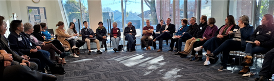
3.1.2 Ilam Stream
Restoration Completed at Avonhead and Crosbie Parks
The plantings along the banks of the Ilam Stream through Avonhead
Park and Crosbie Park have now been completed, marking a significant milestone
in efforts to “bring our stream back to life.”
The Network of Ilam Stream (NOTIS) has long championed the
enhancement of the stream and its surroundings, consulting with neighbours,
local groups, sports clubs, businesses, and Christchurch City Council. Their
advocacy, which began 20-plus years ago and included presentations to the
Community Board in 2019 and a submission to the Long-Term Plan in 2021, led to
the commissioning of a feasibility assessment and the development of a
comprehensive planting programme. NOTIS also notes that maintaining a continual
flow in the stream is vital for native fauna, ensuring the ecological health of
the waterway alongside the completed riparian planting.
Contractors have now planted approximately 500 metres of riparian
margin at Crosbie Park and completed infill planting across 350 metres of
stream bank, completed last year at Avonhead Park. Riparian planting plays a
vital role in stabilising banks, preventing erosion, filtering stormwater,
improving water quality, and supporting native wildlife.
Alongside this work, the Friends of Crosbie Park held their annual
community planting day on 15 July. Around 150 plants were added to the waterway
with the help of local volunteers, including representatives from NOTIS, St
Mark’s Church and Community Centre, and more than thirty students from Te
Pārīto Kōwhai Russley School. It was wonderful to see community
members of different ages and generations working side by side, strengthening
both the park’s natural habitat and the community spirit. Their next event
will be a working bee at 9.30 am on 9 September.
Together, these efforts mark the completion of a major phase of
stream restoration, leaving a lasting legacy of healthier waterways and
stronger community connections.
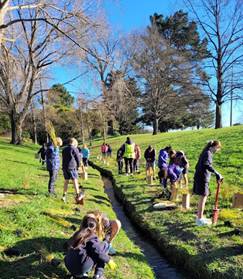
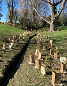
3.2 Community
Funding Summary
3.2.1 A status report on
the Board’s 2025-26 Discretionary Response Fund and Youth Development
Fund as at 20 August 2025 is attached (refer to Attachment A).
3.2.2  Nomads United AFC - Garage Door
Please see
below feedback from the Club regarding the Discretionary Response Fund
allocation for their garage door:
“Thank
you to the Christchurch City Council for supporting our club with funding for a
new garage door on our storage room - a vital space that holds equipment, first
aid supplies, and laundry facilities for our 1,000+ members. The upgrade has
greatly improved access, safety, and efficiency for our volunteers and coaches.
Your support has helped us maintain a high standard of service without adding
financial pressure to our members during a challenging time for community
organisations. We’ll be sharing this project with our members via social
media and other channels to highlight the great work the Council is doing in
supporting grassroots sport.”
3.2.3 Nomads United AFC
– Mini Kickers is Indoors this Winter!
Please see
below feedback from the Club regarding the funding allocation towards their
Mini Kickers programme:
“We are
incredibly grateful to Christchurch City Council for their generous support in
helping us launch our new Mini Kickers indoor programme at the Bishopdale
Recreation Centre during the colder months.
Mini Kickers is
the perfect introduction to the fun world of football for our youngest players,
and thanks to CCC’s funding, we’ve been able to move the programme
indoors - ensuring warm, dry, and safe sessions every week.
The programme
encourages parents to participate alongside their budding footballers, building
connection and confidence through shared play. Each session focuses on a core
football skill—striking the ball, dribbling, goal scoring—while
always keeping the number one priority front and centre: having fun.
There’s
also dedicated time for free play and self-guided discovery, with equipment set
up to let kids (and parents!) explore and enjoy the game in their own way.
We were
committed to making this programme as accessible as possible, and with
CCC’s funding support, we’ve been able to keep the cost down to
just $40 for four sessions. This has made a real difference in allowing more
families to join in and enjoy this positive early football experience.
Thank you again
to CCC for supporting quality, affordable football opportunities for our
community!”
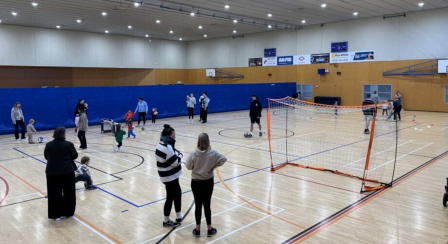
3.3 Participation
in and Contribution to Decision Making
3.3.1 Report back on
other Activities contributing to Community Board Plan
· The final monitoring report for the Board’s 2022-25 Board Plan
was included in the July 2025 Area Report. The Board will begin working
on their new Board Plan following the elections in October.
3.3.2 Council Engagement
and Consultation
· There are currently no consultations open for projects in the Waimāero
Fendalton-Waimairi-Harewood area.
· A full list of open consultations city-wide is available at https://letstalk.ccc.govt.nz/
4. Advice Provided to the Community Board Ngā Kupu Tohutohu ka
hoatu ki te Poari Hapori
4.1 Customer
Service Request Report - Hybris monthly report for July 2025 attached,
providing an overview of the number of Customer Service Requests that have been
received, including the types of requests being received and a breakdown of how
they are being reported (refer to Attachment B).
4.2 SWN
- Wairarapa Stream - Channel enhancement, planning and reinstatement (circulated
12 August 2025)
4.3 SWN
- Glandovey Road - emergency watermain renewal (circulated 14 August 2025)
4.4 SWN
- Harewood/Gardiners/Breens intersection - investigation work (circulated 15
August 2025)
4.5 SWN
- Investigation work for Harewood School - signalised crossing and pedestrian
safety improvements (circulated 18 August 2025)
4.6 SWN
– Greers/Memorial intersection traffic signal upgrade investigations (circulated
21 August 2025)
4.7 Memo
– Radcliffe Road Corridor Improvements – Public Consultation (refer
to Attachment C)
Attachments Ngā Tāpirihanga
|
No.
|
Title
|
Reference
|
Page
|
|
a ⇩
|
Fendalton-Waimairi-Harewood Funding Update - September 2025
|
25/1679875
|
112
|
|
b ⇩
|
Fendalton-Waimairi-Harewood Hybris Ticket Report - July 2025
|
25/1679876
|
113
|
|
c ⇩
|
Memo - Radcliffe Road Corridor Improvements - Public Consultation
|
25/1708751
|
114
|
Signatories Ngā Kaiwaitohu
|
Author
|
Maryanne Lomax
- Manager Community Governance, Fendalton-Waimairi-Harewood
|
|
Approved By
|
Matthew
McLintock - Manager Community Governance Team
John Filsell -
Head of Community Support and Partnerships
|
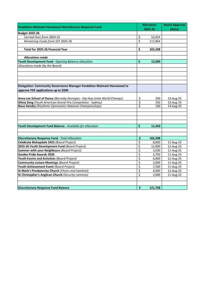
|
18. Elected
Members’ Information Exchange Te Whakawhiti Whakaaro o Te Kāhui
Amorangi
|
This item provides an opportunity for Board Members to
update each other on recent events and/or issues of relevance and interest to
the Board.
Karakia Whakamutunga
|
Unuhia, unuhia
Unuhia ki te uru tapu nui
Kia wātea, kia māmā, te ngākau,
Te tinana te wairua i te ara takatā
Koia rā e Rongo, whakairia ake ki runga
Kia tina! TINA! Hui e! TĀIKI E!
|
Draw on, draw on,
Draw on the supreme sacredness
To clear, to free the heart, the body and the spirit of mankind
Rongo, suspended high above us (i.e. in ‘heaven’)
Draw together! Affirm!
|
Actions Register Ngā Mahinga
When decisions are made at meetings, these
are assigned to staff as actions to implement. The following lists
detail any actions from this meeting that were:
·
Open at the time the agenda was generated.
·
Closed since the last ordinary meeting agenda
was generated.
Open Actions Ngā Mahinga Tuwhera
No open actions were remaining at the time
the agenda was generated.
Actions Closed Since the Last Meeting Ngā
Mahinga kua Tutuki nō Tērā Hui
No actions were closed since the last
ordinary meeting.