
Waipapa
Papanui-Innes-Central Community Board
Agenda
Notice of Meeting Te Pānui o te Hui:
An ordinary meeting of the Waipapa
Papanui-Innes-Central Community Board will be held on:
Date: Thursday 15 May 2025
Time: 4 pm
Venue: Board Room, Papanui Service Centre,
Corner Langdons Road and Restell Street, Papanui
Membership Ngā
Mema
|
Chairperson
Deputy Chairperson
Members
|
Emma Norrish
Simon Britten
Pauline Cotter
Sunita Gautam
Victoria Henstock
Ali Jones
Jake McLellan
John Miller
Emma Twaddell
|
9 May 2025
Website: www.ccc.govt.nz
Part A Matters
Requiring a Council Decision
Part B Reports
for Information
Part C Decisions
Under Delegation
TABLE OF CONTENTS NGĀ IHIRANGI
Karakia Tīmatanga.................................................................. 4
C 1. Apologies Ngā Whakapāha...................................... 4
B 2. Declarations of Interest Ngā Whakapuaki Aronga..... 4
C 3. Confirmation of Previous Minutes Te Whakaāe o te
hui o mua............................................................... 4
B 4. Public Forum Te Huinga Whānui.............................. 4
B 5. Deputations by Appointment Ngā Huinga
Whakaritenga......................................................... 4
B 6. Presentation
of Petitions Ngā
Pākikitanga............... 5
C 7. Correspondence........................................... 27
Staff Reports
C 8. Dunedin
Reserve- Change part of the reserve classification to Local Purpose (Community)
Reserve........................................................ 29
C 9. Langdons
Road at Chapel Street Intersection - Proposed Extension of Parking Restrictions... 37
C 10. Proposed Road
Names - 140 Prestons Road.... 43
C 11. Waipapa
Papanui-Innes-Central Community Board Area Report - May 2025........................ 51
B 12. Elected Members’
Information Exchange Te Whakawhiti
Whakaaro o Te Kāhui Amorangi.......... 74
Karakia Whakamutunga
Karakia Tīmatanga
|
Whakataka te hau ki te uru
Whakataka te hau ki te tonga
Kia mākinakina ki uta
Kia mātaratara ki tai
E hī ake ana te atakura
He tio, he huka, he hauhūnga
Tīhei Mauri Ora
|
Cease the winds from the west
Cease the winds from the south
Let the breeze blow over the land
Let the breeze blow over the ocean
Let the red-tipped dawn come with a sharpened air.
A touch of frost, a promise of a glorious day.
|
1. Apologies Ngā Whakapāha
Apologies will
be recorded at the meeting.
2. Declarations of Interest Ngā
Whakapuaki Aronga
Members are
reminded of the need to be vigilant and to stand aside from decision-making
when a conflict arises between their role as an elected representative and any
private or other external interest they might have.
3. Confirmation of Previous Minutes Te
Whakaāe o te hui o mua
That the
minutes of the Waipapa Papanui-Innes-Central Community Board meeting held on Thursday, 10 April 2025 be confirmed
(refer page 6).
4. Public Forum Te Huinga Whānui
A period of up
to 30 minutes will be available for people to speak for up to five minutes on
any issue that is not the subject of a separate hearings process.
|
4.1
|
Ruby-Grace Miller
Ruby-Grace Miller will speak regarding
pedestrian safety on Fitzgerald Avenue.
|
|
4.2
|
Jennifer Dalziel
Jennifer Dalziel will speak regarding
promoting the Dudley Design Guide.
|
|
4.3
|
Holy Trinity Church
Rev'd Lisa MacInnes, Vicar of Holy
Trinity Church, will speak to familiarise the Board with the Church’s
activities and vision for the homeless in their area.
|
5. Deputations by Appointment Ngā Huinga
Whakaritenga
Deputations may
be heard on a matter or matters covered by a report on this agenda and approved
by the Chairperson.
Deputations will be recorded in the
meeting minutes.
6. Presentation of Petitions Ngā
Pākikitanga
There were no petitions
received at the time the agenda was prepared.
To present to the Community
Board, refer to the Participating in decision-making webpage or
contact the meeting advisor listed on the front of this agenda.

Waipapa
Papanui-Innes-Central Community Board
Open Minutes
Date: Thursday 10 April 2025
Time: 4 pm
Venue: Board Room, Papanui Service Centre,
Corner Langdons Road and Restell Street, Papanui
Present
|
Chairperson
Deputy Chairperson
Members
|
Emma Norrish
Simon Britten
Pauline Cotter
Sunita Gautam
Victoria Henstock
Ali Jones
Jake McLellan
John Miller
Emma Twaddell
|
Website: www.ccc.govt.nz

Part A Matters
Requiring a Council Decision
Part B Reports
for Information
Part C Decisions
Under Delegation
Karakia Tīmatanga
The agenda was dealt with in the following
order.
1. Apologies
Ngā Whakapāha
Part C
|
There were no apologies received
|
2. Declarations
of Interest Ngā Whakapuaki Aronga
Part B
There were no
declarations of interest recorded.
3. Confirmation
of Previous Minutes Te Whakaāe o te hui o mua
Part C
|
Community Board Resolved PCBCC/2025/00012
That the
minutes of the Waipapa Papanui-Innes-Central Community Board meeting held on
Thursday, 13 March 2025 be confirmed.
Pauline
Cotter/Sunita Gautam Carried
|
|
7. Joint
Meeting - Waipuna Halswell-Hornby-Riccarton & Waipapa
Papanui-Innes-Central Community Boards Minutes - 27 March 2025
|
|
|
Community Board Resolved PCBCC/2025/00013
That the Waipapa Papanui-Innes-Central
Community Board confirms the minutes from the meeting of the Waipuna
Halswell-Hornby-Riccarton and Waipapa Papanui-Innes-Central community boards
held 27 March 2025.
Pauline
Cotter/Sunita Gautam Carried
|
4. Public
Forum Te Huinga Whānui
Part B
|
There were no public forum presentations.
|
|
|
|
|
5. Deputations
by Appointment Ngā Huinga Whakaritenga
Part B
|
5.1
|
Lisa Rigby
This deputation did not proceed.
|
|
|
|
5.2
|
Richard Ashton Owen
Richard Ashton Owen provided the attached
statement and plan in lieu of speaking regarding Item 9, specifically in
relation to the proposed bus passenger shelter installation at 47 Hereford
Street.
|
|
|
|
Attachments
a Richard
Ashton Owen - proposed bus passenger shelter at 47 Hereford Street
|
|
5.3
|
Shane Donaldson
Local resident, Shane Donaldson,
addressed the Board regarding Item 9, specifically in relation to the
proposed bus passenger shelter installation and bus stop change at 458
Barbadoes Street.
|
|
|
|
5.4
|
Paul Matthews
This deputation did not proceed.
|
|
|
|
5.5
|
Darren Dean
Local resident, Darren Dean, addressed
the Board with the attached presentation regarding Item 9, specifically in
relation to the proposed bus passenger shelter installation at 33E Rolleston
Avenue.
|
|
|
|
Attachments
a Darren
Dean - Presentation - proposed bus passenger shelter at 33E Rolleston
Avenue
|
|
5.6
|
Zhonghuai Wu
This deputation did not proceed.
|
|
|
|
5.7 John
Mitchell
|
|
Local resident, John Mitchell, addressed the Board with the
attachment diagram regarding Item 9, specifically in relation to the proposed
bus shelter installation and bus stop change at 44 Hills Road.
|
|
|
|
Attachments
a John
Mitchell - Diagram - proposed bus passenger shelter at 44 Hills Road
|
|
5.8 Beauty
with Grace
|
|
Grace Parwinder Kaur addressed
the Board on behalf of Beauty with Grace regarding Item 10, Westminster
Street - Proposed Parking Restrictions Change Report, requesting additional
parking on Cranford Street directly outside her business to replace some of
the broken yellow lines on Cranford Street near its intersection with
Westminster Street.
|
|
|
6. Presentation
of Petitions Ngā Pākikitanga
Part B
There was no presentation of petitions.
|
9. Shelter
installation at well-used bus stops across the Waipapa Papanui-Innes-Central
Community Board area
|
|
|
Board
Consideration
Council Officers joined the table to
address the Board’s questions, and spoke to the attached slides to
answer the questions relating to the bus stops shown.
The Board considered the submissions
and deputations (Items 5.2 - 5.7) on the proposed bus passenger shelters and
bus stop changes before voting on these in separate parts as shown below,
with those proposed within the Central City Plan A area being recommended to
the Council for approval.
The Board accepted the Officer
Recommendations, except that in relation to Bus stop 24441 – 458
Barbadoes Street. The Board requested staff investigate an alternative site
for this bus passenger shelter, signalling a need for a shelter at the BP on
Cranford Street.
In relation to the bus passenger
shelters approved for Bus stop 20632 – 44 Hills
Road, and Bus stop 36219 – 202 Gloucester Street, the Board added a request that staff have
a conversation with the immediately affected resident to mitigate the privacy
issue; this was principally to offer available options to reduce the
visibility through these shelters.
|
|
|
Officer Recommendations Ngā
Tūtohu
That the
Waipapa Papanui-Innes-Central Community Board recommends that the Council:
1. Receives the information in the Shelter
installation at well-used bus stops across the Waipapa Papanui-Innes-Central
Community Board area Report.
2. Notes that the decisions in this report are assessed as low
significance based on the Christchurch City Council’s Significance and
Engagement Policy.
3. Approves that any previous resolutions pertaining to parking and
stopping restrictions made pursuant to any bylaw to the extent that they
conflict with the parking and stopping restrictions described in resolutions
4 – 13 below are revoked.
Bus stop
54260 – 83 Victoria Street (Attachment A)
4. Pursuant to Section 339(1) of the Local Government Act 1974:
a. Approves that a bus passenger shelter be installed on the west
side of Victoria Street commencing at a point 28 metres north of its
intersection with Peterborough Street and extending in a north-westerly
direction for a distance of approximately 3.6 metres.
Bus stop 52915
– 47 Hereford Street (Attachment A)
5. Pursuant to Section 339(1) of the Local Government Act 1974:
a. Approves that a bus passenger shelter be installed on the north
side of Hereford Street commencing at a point 16 metres east of its
intersection with Montreal Street and extending in an easterly direction for
a distance of approximately 3.6 metres.
Bus stop
51616 – 332 Hereford Street (Attachment A)
6. Pursuant to Section 339(1) of the Local Government Act 1974:
a. Approves that a bus passenger shelter be installed on the south
side of Hereford Street commencing at a point 23 metres west of its
intersection with Fitzgerald Avenue and extending in an easterly direction
for a distance of approximately 3.6 metres.
7. Pursuant to Clause 7 of the Christchurch City Council Traffic and
Parking Bylaw 2017:
a. Approves that the stopping of all vehicles be prohibited at any
time, on the south side of Hereford Street commencing at a point 29 metres
west of its intersection with Fitzgerald Avenue and extending in an easterly
direction for a distance of 1 metres.
Bus stop 14263
– 164 St Asaph Street (Attachment A)
8. Pursuant to Section 339(1) of the Local Government Act 1974:
a. Approves that a bus passenger shelter be installed on the south
side of St Asaph Street commencing at a point 99 metres east of its
intersection with Durham Street and extending in a westerly direction for a
distance of approximately 3.6 metres.
Bus stop 36219
– 202 Gloucester Street (Attachment A)
9. Pursuant to Clause 7 of the Christchurch City Council Traffic and
Parking Bylaw 2017:
a. Approves that bus stop be revoked on the south side of Gloucester
Street commencing at a point 24 metres west of its intersection with Latimer
Square (western side) and extending in a westerly direction for a distance of
19 metres.
b. Approves that the stopping of all vehicles be prohibited at any
time, on the south side of Gloucester Street commencing at its intersection
with Latimer Square (western side) and extending in a westerly direction for
a distance of 8 metres.
c. Approves that bus stop be installed on the south side of
Gloucester Street commencing at a point 8 metres west of its intersection
with Latimer Square (western side) and extending in a westerly direction for
a distance of 14 metres.
d. Approves that the stopping of all vehicles be prohibited at any
time, on the south side of Gloucester Street commencing at a point 22 metres
west of its intersection with Latimer Square (western side) and extending in
a westerly direction for a distance of 4 metres.
10. Pursuant to Section 339(1) of the Local Government Act 1974:
a. Approves that a bus passenger shelter be installed on the south
side of Gloucester Street commencing at a point 12 metres west of its
intersection with Latimer Square (west end) and extending in a westerly
direction for a distance of approximately 3.6 metres.
11. Pursuant to Clause 6 of the Christchurch City Council Traffic and
Parking Bylaw 2017:
a. That a Stop control be placed against Latimer Square (western
side) at its intersection with Gloucester Street.
Bus stop
32180 – 106 Ferry Road (Attachment A)
12. Pursuant to Section 339(1) of the Local Government Act 1974:
a. Approves that a bus passenger shelter be installed on the south
side of Ferry Road commencing at a point 102 metres west of its intersection
with Fitzgerald Avenue and extending in a westerly direction for a distance
of approximately 3.6 metres.
13. Approves that directional and warning tactile pavers, hardstand
areas, bus stop signs, and green surface treatments are installed at the
above bus stops, as shown on Attachment A.
14. Approves that these resolutions 3 – 13 above take effect
when parking signage and/or road markings that evidence the restrictions
described in the staff report are in place (or removed in the case of
revocations).
That the
Waipapa Papanui-Innes-Central Community Board:
15. Receives the information in the Shelter
installation at well-used bus stops across the Waipapa Papanui-Innes-Central
Community Board area Report.
16. Notes that the decisions in this report are assessed as low
significance based on the Christchurch City Council’s Significance and
Engagement Policy.
17. Approves that any previous resolutions pertaining to parking and
stopping restrictions made pursuant to any bylaw to the extent that they
conflict with the parking and stopping restrictions described in resolutions
18 – 46 below are revoked.
Bus stop
24231 – 60 Briggs Road (Attachment A)
18. Pursuant to Section 339(1) of the Local Government Act 1974:
a. Approves that a bus passenger shelter be installed on the south
side of Briggs Road commencing at a point 89 metres west of its intersection
with Akaroa Street and extending in a westerly direction for a distance of
approximately 3.6 metres.
Bus stop
20632 – 44 Hills Road (Attachment A)
19. Pursuant to Clause 7 of the Christchurch City Council Traffic and
Parking Bylaw 2017:
a. Approves that a bus stop be revoked on the east side of Hills Road
commencing at a point 102 metres north of its intersection with North Avon
Road and extending in a northerly direction for a distance of 13 metres.
b. Approves that the stopping of all vehicles be prohibited at any
time, on the east side of Hills Road commencing at its intersection with
North Avon Road and extending in a northerly direction for a distance of 115
metres.
c. Approves that a bus stop be installed on the east side of Hills
Road commencing at a point 115 metres north of its intersection with North
Avon Road and extending in a northerly direction for a distance of 14 metres.
20. Pursuant to Section 339(1) of the Local Government Act 1974:
a. Approves that a bus passenger shelter be installed on the east
side of Hills Road commencing at a point 117 metres north of its intersection
with North Avon Road and extending in a northerly direction for a distance of
approximately 3.6 metres.
Bus stop
12010 – 83 North Avon Road (Attachment A)
21. Pursuant to Section 339(1) of the Local Government Act 1974:
a. Approves that a bus passenger shelter be installed on the north
side of North Avon Road commencing at a point 55 metres east of its
intersection with Stapletons Road and extending in an easterly direction for
a distance of approximately 3.6 metres.
Bus stop
40628 – 342 Stanmore Road (Attachment A)
22. Pursuant to Clause 7 of the Christchurch City Council Traffic and
Parking Bylaw 2017:
a. Approves that the stopping of all vehicles be prohibited at any
time, on the east side of Stanmore Road commencing at a point 5 metres south
of its intersection with North Avon Road and extending in a southerly
direction for a distance of 19 metres.
23. Pursuant to Section 339(1) of the Local Government Act 1974:
a. Approves that a bus passenger shelter be installed on the east
side of Stanmore Road commencing at a point 25 metres south of its
intersection with North Avon Road and extending in a southerly direction for
a distance of approximately 3.6 metres.
Bus stop
24441 – 458 Barbadoes Street (Attachment A)
24. Pursuant to Clause 7 of the Christchurch City Council Traffic and
Parking Bylaw 2017:
a. Approves that a bus stop be revoked on the east side of Barbadoes
Street commencing at a point 12 metres south of its intersection with Purchas
Street and extending in a southerly direction for a distance of 15 metres.
b. Approves that the stopping of all vehicles be prohibited at any
time, on the east side of Barbadoes Street commencing at its intersection
with Purchas Street and extending in a southerly direction for a distance of
33 metres.
c. Approves that a bus stop be installed on the east side of
Barbadoes Street commencing at a point 33 metres south of its intersection
with Purchas Street and extending in a southerly direction for a distance of
14 metres.
d. Approves that the stopping of all vehicles be prohibited at any
time, on the east side of Barbadoes Street commencing at a point 47 metres
south of its intersection with Purchas Street and extending in a southerly
direction for a distance of 2 metres.
25. Pursuant to Section 339(1) of the Local Government Act 1974:
a. Approves that a bus passenger shelter be installed on the east
side of Barbadoes Street commencing at a point 37 metres south of its
intersection with Purchas Street and extending in a southerly direction for a
distance of approximately 3.6 metres.
Bus stop
24402 – 516 Barbadoes Street (Attachment A)
26. Pursuant to Section 339(1) of the Local Government Act 1974:
a. Approves that a bus passenger shelter be installed on the east
side of Barbadoes Street commencing at a point 18 metres south of its
intersection with Canon Street and extending in a southerly direction for a
distance of approximately 3.6 metres.
Bus stop
38465 – 656 Barbadoes Street (Attachment A)
27. Pursuant to Section 339(1) of the Local Government Act 1974:
a. Approves that a bus passenger shelter be installed on the east
side of Barbadoes Street commencing at a point 92 metres south of its
intersection with Warrington Street and extending in a southerly direction
for a distance of approximately 3.6 metres.
Bus stop 45184
– 1024 Colombo Street (Attachment A)
28. Pursuant to Clause 7 of the Christchurch City Council Traffic and
Parking Bylaw 2017:
a. Approves that the stopping of all vehicles be prohibited at any
time, on the east side of Colombo Street commencing at its intersection with
Canon Street and extending in a southerly direction for a distance of 7
metres.
29. Pursuant to Section 339(1) of the Local Government Act 1974:
a. Approves that a bus passenger shelter be installed on the east
side of Colombo Street commencing at a point 10 metres south of its
intersection with Canon Street and extending in a southerly direction for a
distance of approximately 3.6 metres.
Bus stop
28797 – 212 Bealey Avenue (Attachment A)
30. Pursuant to Section 339(1) of the Local Government Act 1974:
a. Approves that a bus passenger shelter be installed on the south
side of Bealey Avenue commencing at a point 49 metres west of its
intersection with Madras Street and extending in a westerly direction for a
distance of approximately 3.6 metres.
Bus stop 53185
– 33E Rolleston Avenue (Attachment A)
31. Pursuant to Section 339(1) of the Local Government Act 1974:
a. Approves that a bus passenger shelter be installed on the island
separating the cycle lane and traffic lane on the west side of Rolleston
Avenue commencing at a point 44 metres south of its intersection with Armagh
Street and extending in a southerly direction for a distance of approximately
3.6 metres.
Bus stop 46339
– 249 Gloucester Street (Attachment A)
32. Pursuant to Section 339(1) of the Local Government Act 1974:
a. Approves that a bus passenger shelter be installed on the north
side of Gloucester Street commencing at a point 90 metres west of its
intersection with Barbadoes Street and extending in an easterly direction for
a distance of approximately 3.6 metres.
Bus stop 28637
– 214 Fitzgerald Avenue (Attachment A)
33. Pursuant to Section 339(1) of the Local Government Act 1974:
a. Approves that a bus passenger shelter be installed on the east
side of Fitzgerald Avenue commencing at a point 30 metres north of its
intersection with Elm Grove and extending in a northerly direction for a
distance of approximately 3.6 metres.
Bus stop 28713
– 217 Fitzgerald Avenue (Attachment A)
34. Pursuant to Clause 7 of the Christchurch City Council Traffic and
Parking Bylaw 2017:
a. Approves that bus stop be revoked on the west side of Fitzgerald
Avenue commencing at a point 44 metres north of its intersection with Armagh
Street and extending in a northerly direction for a distance of 13
metres.
b. Approves that the stopping of all vehicles be prohibited at any
time, on the west side of Fitzgerald Avenue commencing at a point 43.5 metres
north of its intersection with Armagh Street and extending in a northerly
direction for a distance of 4 metres.
c. Approves that bus stop be installed on the west side of Fitzgerald
Avenue commencing at a point 47.5 metres north of its intersection with
Armagh Street and extending in a northerly direction for a distance of 14
metres.
d. Approves that the stopping of all vehicles be prohibited at any
time, on the west side of Fitzgerald Avenue commencing at a point 61.5 metres
north of its intersection with Armagh Street and extending in a northerly
direction for a distance of 2 metres.
35. Pursuant to Section 339(1) of the Local Government Act 1974:
a. Approves that a bus passenger shelter be installed on the west
side of Fitzgerald Avenue commencing at a point 55 metres north of its
intersection with Armagh Street and extending in a northerly direction for a
distance of approximately 3.6 metres.
Bus stop
53233 – 168 Ferry Road (Attachment A)
36. Pursuant to Section 339(1) of the Local Government Act 1974:
a. Approves that a bus passenger shelter be installed on the south
side of Ferry Road commencing at a point 49 metres west of its intersection
with Lancaster Street and extending in a westerly direction for a distance of
approximately 3.6 metres.
Bus stop
18938 – 442 Tuam Street (Attachment A)
37. Pursuant to Clause 7 of the Christchurch City Council Traffic and
Parking Bylaw 2017:
a. Approves that a bus stop be revoked on the south side of Tuam
Street commencing at a point 68 metres east of its intersection with Phillips
Street and extending in a westerly direction for a distance of 13 metres.
b. Approves that the stopping of all vehicles be prohibited at any
time, on the south side of Tuam Street commencing at a point 36 metres east
of its intersection with Phillips Street and extending in an westerly
direction for a distance of 3 metres.
c. Approves that a bus stop be installed on the south side of Tuam
Street commencing at a point 33 metres east of its intersection with Phillips
Street and extending in a westerly direction for a distance of 14 metres.
38. Pursuant to Section 339(1) of the Local Government Act 1974:
a. Approves that a bus passenger shelter be installed on the south
side of Tuam Street commencing at a point 26 metres east of its intersection
with Phillips Street and extending in a westerly direction for a distance of
approximately 3.6 metres.
39. Pursuant to Clause 6 of the Christchurch City Council Traffic and
Parking Bylaw 2017:
a. That a Give way control be placed against Phillips Street at its
intersection with Tuam Street.
Bus stop
41002 – 500 Tuam Street (Attachment A)
40. Pursuant to Clause 7 of the Christchurch City Council Traffic and
Parking Bylaw 2017:
a. Approves that a bus stop be revoked on the south side of Tuam
Street commencing at a point 66 metres east of its intersection with Nursery
Road and extending in a westerly direction for a distance of 10 metres.
b. Approves that the stopping of all vehicles be prohibited at any
time, on the south side of Tuam Street commencing at a point 81 metres east
of its intersection with Nursery Road and extending in a westerly direction
for a distance of 7 metres.
c. Approves that a bus stop be installed on the south side of Tuam
Street commencing at a point 70 metres east of its intersection with Nursery
Road and extending in a westerly direction for a distance of 14 metres.
41. Pursuant to Section 339(1) of the Local Government Act 1974:
a. Approves that a bus passenger shelter be installed on the south
side of Tuam Street commencing at a point 64 metres east of its intersection
with Nursery Road and extending in a westerly direction for a distance of
approximately 3.6 metres.
Bus stop
18827 – 18 Harrow Street (Attachment A)
42. Pursuant to Clause 7 of the Christchurch City Council Traffic and
Parking Bylaw 2017:
a. Approves that a bus stop be revoked on the south side of Harrow
Street commencing at a point 18 metres east of its intersection with
Bordesley Street and extending in a westerly direction for a distance of 11
metres.
b. Approves that the stopping of all vehicles be prohibited at any
time, on the south side of Harrow Street commencing at a point 54 metres west
of its intersection with Bordesley Street and extending in a westerly
direction for a distance of 5 metres.
c. Approves that a bus stop be installed on the south side of Harrow
Street commencing at a point 64 metres west of its intersection with
Bordesley Street and extending in a westerly direction for a distance of 14
metres.
d. Approves that the stopping of all vehicles be prohibited at any
time, on the south side of Harrow Street commencing at a point 78 metres west
of its intersection with Bordesley Street and extending in a westerly
direction for a distance of 2 metres.
43. Pursuant to Section 339(1) of the Local Government Act 1974:
a. Approves that a bus passenger shelter be installed on the south
side of Harrow Street commencing at a point 70 metres west of its
intersection with Bordesley Street and extending in a westerly direction for
a distance of approximately 3.6 metres.
Bus stop 13310
– 51 North Parade (Attachment A)
44. Pursuant to Clause 7 of the Christchurch City Council Traffic and
Parking Bylaw 2017:
a. Approves that a bus stop be revoked on the west side of North
Parade commencing at a point 20 metres north of its intersection with Randall
Street and extending in a northerly direction for a distance of 12
metres.
b. Approves that the stopping of all vehicles be prohibited at any
time, on the west side of North Parade commencing at its intersection with
Randall Street and extending in a northerly direction for a distance of 15
metres.
c. Approves that a bus stop be installed on the west side of North
Parade commencing at a point 15 metres north of its intersection with Randall
Street and extending in a northerly direction for a distance of 14
metres.
Bus stop
36901 – 116 Aldwins Road (Attachment A)
45. Pursuant to Clause 7 of the Christchurch City Council Traffic and
Parking Bylaw 2017:
a. Approves that a bus stop be revoked on the east side of Aldwins
Road commencing at a point 365 metres south of its intersection with Linwood
Avenue and extending in a southerly direction for a distance of 16 metres.
46. Approves that directional and warning tactile pavers, hardstand
areas, bus stop signs, and green surface treatments are installed at the
above bus stops, as shown on Attachment A.
47. Approves that these resolutions 17 – 46 above, take effect
when parking signage and/or road markings that evidence the restrictions
described in the staff report are in place (or removed in the case of
revocations).
|
|
|
Community Board Resolved PCBCC/2025/00014 Officer
recommendations accepted without change
Part C
That the
Waipapa Papanui-Innes-Central Community Board:
1. Receives the information in the Shelter
installation at well-used bus stops across the Waipapa Papanui-Innes-Central
Community Board area Report.
2. Notes that the decisions in this report are assessed as low significance
based on the Christchurch City Council’s Significance and Engagement
Policy.
3. Approves that any previous resolutions pertaining to parking and
stopping restrictions made pursuant to any bylaw to the extent that they
conflict with the parking and stopping restrictions described in resolutions
4 – 31 below are revoked.
Bus stop
24231 – 60 Briggs Road (Agenda Report Attachment A)
4. Pursuant to Section 339(1) of the Local Government Act 1974:
a. Approves that a bus passenger shelter be installed on the south
side of Briggs Road commencing at a point 89 metres west of its intersection
with Akaroa Street and extending in a westerly direction for a distance of
approximately 3.6 metres.
Bus stop
12010 – 83 North Avon Road (Agenda Report Attachment A)
7. Pursuant to Section 339(1) of the Local Government Act 1974:
a. Approves that a bus passenger shelter be installed on the north
side of North Avon Road commencing at a point 55 metres east of its
intersection with Stapletons Road and extending in an easterly direction for
a distance of approximately 3.6 metres.
Bus stop
40628 – 342 Stanmore Road (Agenda Report Attachment A)
8. Pursuant to Clause 7 of the Christchurch City Council Traffic and
Parking Bylaw 2017:
a. Approves that the stopping of all vehicles be prohibited at any
time, on the east side of Stanmore Road commencing at a point 5 metres south
of its intersection with North Avon Road and extending in a southerly
direction for a distance of 19 metres.
9. Pursuant to Section 339(1) of the Local Government Act 1974:
a. Approves that a bus passenger shelter be installed on the east
side of Stanmore Road commencing at a point 25 metres south of its
intersection with North Avon Road and extending in a southerly direction for
a distance of approximately 3.6 metres.
Bus stop
24402 – 516 Barbadoes Street (Agenda Report Attachment A)
11. Pursuant to Section 339(1) of the Local Government Act 1974:
a. Approves that a bus passenger shelter be installed on the east
side of Barbadoes Street commencing at a point 18 metres south of its
intersection with Canon Street and extending in a southerly direction for a
distance of approximately 3.6 metres.
Bus stop
38465 – 656 Barbadoes Street (Agenda Report Attachment A)
12. Pursuant to Section 339(1) of the Local Government Act 1974:
a. Approves that a bus passenger shelter be installed on the east
side of Barbadoes Street commencing at a point 92 metres south of its
intersection with Warrington Street and extending in a southerly direction
for a distance of approximately 3.6 metres.
Bus stop 45184
– 1024 Colombo Street (Agenda Report Attachment A)
13. Pursuant to Clause 7 of the Christchurch City Council Traffic and
Parking Bylaw 2017:
a. Approves that the stopping of all vehicles be prohibited at any
time, on the east side of Colombo Street commencing at its intersection with
Canon Street and extending in a southerly direction for a distance of 7
metres.
14. Pursuant to Section 339(1) of the Local Government Act 1974:
a. Approves that a bus passenger shelter be installed on the east
side of Colombo Street commencing at a point 10 metres south of its
intersection with Canon Street and extending in a southerly direction for a
distance of approximately 3.6 metres.
Bus stop
28797 – 212 Bealey Avenue (Agenda Report Attachment A)
15. Pursuant to Section 339(1) of the Local Government Act 1974:
a. Approves that a bus passenger shelter be installed on the south
side of Bealey Avenue commencing at a point 49 metres west of its
intersection with Madras Street and extending in a westerly direction for a
distance of approximately 3.6 metres.
Bus stop 46339
– 249 Gloucester Street (Agenda Report Attachment A)
17. Pursuant to Section 339(1) of the Local Government Act 1974:
a. Approves that a bus passenger shelter be installed on the north
side of Gloucester Street commencing at a point 90 metres west of its
intersection with Barbadoes Street and extending in an easterly direction for
a distance of approximately 3.6 metres.
Bus stop 28637
– 214 Fitzgerald Avenue (Agenda Report Attachment A)
18. Pursuant to Section 339(1) of the Local Government Act 1974:
a. Approves that a bus passenger shelter be installed on the east
side of Fitzgerald Avenue commencing at a point 30 metres north of its
intersection with Elm Grove and extending in a northerly direction for a
distance of approximately 3.6 metres.
Bus stop 28713
– 217 Fitzgerald Avenue (Agenda Report Attachment A)
19. Pursuant to Clause 7 of the Christchurch City Council Traffic and
Parking Bylaw 2017:
a. Approves that bus stop be revoked on the west side of Fitzgerald
Avenue commencing at a point 44 metres north of its intersection with Armagh
Street and extending in a northerly direction for a distance of 13
metres.
b. Approves that the stopping of all vehicles be prohibited at any
time, on the west side of Fitzgerald Avenue commencing at a point 43.5 metres
north of its intersection with Armagh Street and extending in a northerly
direction for a distance of 4 metres.
c. Approves that bus stop be installed on the west side of Fitzgerald
Avenue commencing at a point 47.5 metres north of its intersection with
Armagh Street and extending in a northerly direction for a distance of 14
metres.
d. Approves that the stopping of all vehicles be prohibited at any
time, on the west side of Fitzgerald Avenue commencing at a point 61.5 metres
north of its intersection with Armagh Street and extending in a northerly
direction for a distance of 2 metres.
20. Pursuant to Section 339(1) of the Local Government Act 1974:
a. Approves that a bus passenger shelter be installed on the west
side of Fitzgerald Avenue commencing at a point 55 metres north of its
intersection with Armagh Street and extending in a northerly direction for a
distance of approximately 3.6 metres.
Bus stop
53233 – 168 Ferry Road (Agenda Report Attachment A)
21. Pursuant to Section 339(1) of the Local Government Act 1974:
a. Approves that a bus passenger shelter be installed on the south
side of Ferry Road commencing at a point 49 metres west of its intersection
with Lancaster Street and extending in a westerly direction for a distance of
approximately 3.6 metres.
Bus stop
18938 – 442 Tuam Street (Agenda Report Attachment A)
22. Pursuant to Clause 7 of the Christchurch City Council Traffic and
Parking Bylaw 2017:
a. Approves that a bus stop be revoked on the south side of Tuam
Street commencing at a point 68 metres east of its intersection with Phillips
Street and extending in a westerly direction for a distance of 13 metres.
b. Approves that the stopping of all vehicles be prohibited at any
time, on the south side of Tuam Street commencing at a point 36 metres east
of its intersection with Phillips Street and extending in an westerly
direction for a distance of 3 metres.
c. Approves that a bus stop be installed on the south side of Tuam
Street commencing at a point 33 metres east of its intersection with Phillips
Street and extending in a westerly direction for a distance of 14 metres.
23. Pursuant to Section 339(1) of the Local Government Act 1974:
a. Approves that a bus passenger shelter be installed on the south
side of Tuam Street commencing at a point 26 metres east of its intersection
with Phillips Street and extending in a westerly direction for a distance of
approximately 3.6 metres.
24. Pursuant to Clause 6 of the Christchurch City Council Traffic and
Parking Bylaw 2017:
a. That a Give way control be placed against Phillips Street at its
intersection with Tuam Street.
Bus stop
41002 – 500 Tuam Street (Agenda Report Attachment A)
25. Pursuant to Clause 7 of the Christchurch City Council Traffic and
Parking Bylaw 2017:
a. Approves that a bus stop be revoked on the south side of Tuam
Street commencing at a point 66 metres east of its intersection with Nursery
Road and extending in a westerly direction for a distance of 10 metres.
b. Approves that the stopping of all vehicles be prohibited at any
time, on the south side of Tuam Street commencing at a point 81 metres east
of its intersection with Nursery Road and extending in a westerly direction
for a distance of 7 metres.
c. Approves that a bus stop be installed on the south side of Tuam
Street commencing at a point 70 metres east of its intersection with Nursery
Road and extending in a westerly direction for a distance of 14 metres.
26. Pursuant to Section 339(1) of the Local Government Act 1974:
a. Approves that a bus passenger shelter be installed on the south
side of Tuam Street commencing at a point 64 metres east of its intersection
with Nursery Road and extending in a westerly direction for a distance of
approximately 3.6 metres.
Bus stop
18827 – 18 Harrow Street (Agenda Report Attachment A)
27. Pursuant to Clause 7 of the Christchurch City Council Traffic and
Parking Bylaw 2017:
a. Approves that a bus stop be revoked on the south side of Harrow
Street commencing at a point 18 metres east of its intersection with
Bordesley Street and extending in a westerly direction for a distance of 11
metres.
b. Approves that the stopping of all vehicles be prohibited at any
time, on the south side of Harrow Street commencing at a point 54 metres west
of its intersection with Bordesley Street and extending in a westerly
direction for a distance of 5 metres.
c. Approves that a bus stop be installed on the south side of Harrow
Street commencing at a point 64 metres west of its intersection with
Bordesley Street and extending in a westerly direction for a distance of 14
metres.
d. Approves that the stopping of all vehicles be prohibited at any
time, on the south side of Harrow Street commencing at a point 78 metres west
of its intersection with Bordesley Street and extending in a westerly
direction for a distance of 2 metres.
28. Pursuant to Section 339(1) of the Local Government Act 1974:
a. Approves that a bus passenger shelter be installed on the south
side of Harrow Street commencing at a point 70 metres west of its
intersection with Bordesley Street and extending in a westerly direction for
a distance of approximately 3.6 metres.
Bus stop 13310
– 51 North Parade (Agenda Report Attachment A)
29. Pursuant to Clause 7 of the Christchurch City Council Traffic and
Parking Bylaw 2017:
a. Approves that a bus stop be revoked on the west side of North
Parade commencing at a point 20 metres north of its intersection with Randall
Street and extending in a northerly direction for a distance of 12
metres.
b. Approves that the stopping of all vehicles be prohibited at any
time, on the west side of North Parade commencing at its intersection with
Randall Street and extending in a northerly direction for a distance of 15
metres.
c. Approves that a bus stop be installed on the west side of North
Parade commencing at a point 15 metres north of its intersection with Randall
Street and extending in a northerly direction for a distance of 14
metres.
Bus stop
36901 – 116 Aldwins Road (Agenda Report Attachment A)
30. Pursuant to Clause 7 of the Christchurch City Council Traffic and
Parking Bylaw 2017:
a. Approves that a bus stop be revoked on the east side of Aldwins
Road commencing at a point 365 metres south of its intersection with Linwood
Avenue and extending in a southerly direction for a distance of 16 metres.
31. Approves that directional and warning tactile pavers, hardstand
areas, bus stop signs, and green surface treatments are installed at the
above bus stops, as shown on Attachment A to the agenda report.
32. Approves that these resolutions 3 – 31, take effect when
parking signage and/or road markings that evidence the restrictions described
in the staff report are in place (or removed in the case of revocations).
Jake
McLellan/Emma Twaddell Carried
|
|
|
Community Board Resolved PCBCC/2025/00015 Officer
recommendations accepted without change
That the Waipapa
Papanui-Innes-Central Community Board:
Bus stop 53185
– 33E Rolleston Avenue (Agenda Report Attachment A)
16. Pursuant to Section 339(1) of the Local Government Act 1974:
a. Approves that a bus passenger shelter be
installed on the island separating the cycle lane and traffic lane on the
west side of Rolleston Avenue commencing at a point 44 metres south of its
intersection with Armagh Street and extending in a southerly direction for a
distance of approximately 3.6 metres.
Pauline Cotter/Jake McLellan Carried
|
|
|
Community Board Resolved PCBCC/2025/00016
That the
Waipapa Papanui-Innes-Central Community Board:
Bus stop
20632 – 44 Hills Road (Agenda Report Attachment A)
5. Pursuant to Clause 7 of the Christchurch City Council Traffic and
Parking Bylaw 2017:
a. Approves that a bus stop be revoked on the east side of Hills Road
commencing at a point 102 metres north of its intersection with North Avon
Road and extending in a northerly direction for a distance of 13 metres.
b. Approves that the stopping of all vehicles be prohibited at any
time, on the east side of Hills Road commencing at its intersection with
North Avon Road and extending in a northerly direction for a distance of 115
metres.
c. Approves that a bus stop be installed on the east side of Hills
Road commencing at a point 115 metres north of its intersection with North
Avon Road and extending in a northerly direction for a distance of 14 metres.
6. Pursuant to Section 339(1) of the Local Government Act 1974:
a. Approves that a bus passenger shelter be installed on the east
side of Hills Road commencing at a point 117 metres north of its intersection
with North Avon Road and extending in a northerly direction for a distance of
approximately 3.6 metres.
b. Requests
staff have a conversation with the immediately affected resident to mitigate
the privacy issue.
Pauline
Cotter/Jake McLellan Carried
John Miller requested that his vote
against the above resolutions 5 and 6 be recorded.
Victoria
Henstock requested that her abstention from this vote be recorded.
|
|
|
Community Board Resolved PCBCC/2025/00017
That the
Waipapa Papanui-Innes-Central Community Board:
Bus stop
24441 – 458 Barbadoes Street (Agenda Report Attachment A)
10. Requests staff investigate an alternative site for this bus
passenger shelter, with the Board signalling a need for a shelter at the BP
on Cranford Street.
Pauline
Cotter/Emma Twaddell Carried
Jake McLellan requested that his
abstention from this vote be recorded.
|
|
|
|
|
|
Attachments
a Staff
Slides - Bus Stop Optioneering - 44 Hills Road, 458 Barbadoes Street, and 33E
Rolleston Avenue
|
|
Community
Board Decided PCBCC/2025/00018 Officer recommendations accepted without
change
Part A
That the
Waipapa Papanui-Innes-Central Community Board recommends that the Council:
1. Receives the information in the Shelter
installation at well-used bus stops across the Waipapa Papanui-Innes-Central
Community Board area Report.
2. Notes that the decisions in this report are assessed as low
significance based on the Christchurch City Council’s Significance and
Engagement Policy.
3. Approves that any previous resolutions pertaining to parking and
stopping restrictions made pursuant to any bylaw to the extent that they
conflict with the parking and stopping restrictions described in resolutions
4 – 13 below are revoked.
Bus stop
54260 – 83 Victoria Street (Agenda Report Attachment A)
4. Pursuant to Section 339(1) of the Local Government Act 1974:
a. Approves that a bus passenger shelter be installed on the west
side of Victoria Street commencing at a point 28 metres north of its
intersection with Peterborough Street and extending in a north-westerly
direction for a distance of approximately 3.6 metres.
Bus stop 52915
– 47 Hereford Street (Agenda Report Attachment A)
5. Pursuant to Section 339(1) of the Local Government Act 1974:
a. Approves that a bus passenger shelter be installed on the north
side of Hereford Street commencing at a point 16 metres east of its
intersection with Montreal Street and extending in an easterly direction for
a distance of approximately 3.6 metres.
Bus stop
51616 – 332 Hereford Street (Agenda Report Attachment A)
6. Pursuant to Section 339(1) of the Local Government Act 1974:
a. Approves that a bus passenger shelter be installed on the south
side of Hereford Street commencing at a point 23 metres west of its
intersection with Fitzgerald Avenue and extending in an easterly direction
for a distance of approximately 3.6 metres.
7. Pursuant to Clause 7 of the Christchurch City Council Traffic and
Parking Bylaw 2017:
a. Approves that the stopping of all vehicles be prohibited at any
time, on the south side of Hereford Street commencing at a point 29 metres
west of its intersection with Fitzgerald Avenue and extending in an easterly
direction for a distance of 1 metres.
Bus stop 14263
– 164 St Asaph Street (Agenda Report Attachment A)
8. Pursuant to Section 339(1) of the Local Government Act 1974:
a. Approves that a bus passenger shelter be installed on the south
side of St Asaph Street commencing at a point 99 metres east of its
intersection with Durham Street and extending in a westerly direction for a
distance of approximately 3.6 metres.
Bus stop
32180 – 106 Ferry Road (Agenda Report Attachment A)
12. Pursuant to Section 339(1) of the Local Government Act 1974:
a. Approves that a bus passenger shelter be installed on the south
side of Ferry Road commencing at a point 102 metres west of its intersection
with Fitzgerald Avenue and extending in a westerly direction for a distance
of approximately 3.6 metres.
13. Approves that directional and warning tactile pavers, hardstand
areas, bus stop signs, and green surface treatments are installed at the
above bus stops, as shown on Attachment A to the agenda report.
14. Approves that these resolutions 3 – 13 take effect when
parking signage and/or road markings that evidence the restrictions described
in the staff report are in place (or removed in the case of revocations).
John Miller/Emma
Twaddell Carried
|
|
Community Board Decided PCBCC/2025/00019
That the Waipapa Papanui-Innes-Central
Community Board recommends that the Council:
Bus stop 36219
– 202 Gloucester Street (Agenda Report Attachment A)
9. Pursuant to Clause 7 of the Christchurch City Council Traffic and
Parking Bylaw 2017:
a. Approves that bus stop be revoked on the south side of Gloucester
Street commencing at a point 24 metres west of its intersection with Latimer
Square (western side) and extending in a westerly direction for a distance of
19 metres.
b. Approves that the stopping of all vehicles be prohibited at any
time, on the south side of Gloucester Street commencing at its intersection
with Latimer Square (western side) and extending in a westerly direction for
a distance of 8 metres.
c. Approves that bus stop be installed on the south side of
Gloucester Street commencing at a point 8 metres west of its intersection
with Latimer Square (western side) and extending in a westerly direction for
a distance of 14 metres.
d. Approves that the stopping of all vehicles be prohibited at any
time, on the south side of Gloucester Street commencing at a point 22 metres
west of its intersection with Latimer Square (western side) and extending in
a westerly direction for a distance of 4 metres.
10. Pursuant to Section 339(1) of the Local Government Act 1974:
a. Approves that a bus passenger shelter be installed on the south
side of Gloucester Street commencing at a point 12 metres west of its
intersection with Latimer Square (west end) and extending in a westerly
direction for a distance of approximately 3.6 metres.
b. Request
staff have a conversation with the immediately affected resident to mitigate
the privacy issue.
11. Pursuant to Clause 6 of the Christchurch City Council Traffic and
Parking Bylaw 2017:
a. That a Stop control be placed against Latimer Square (western
side) at its intersection with Gloucester Street.
Pauline
Cotter/Jake McLellan Carried
|
Ali Jones left the meeting at 5.33 pm and
returned at 5.38 pm during consideration of Item 9 above.
|
10. Westminster
Street - Proposed Parking Restrictions Change
|
|
|
Board
Consideration
The Board considered the submissions
and deputation (Item 5.8) on the proposed parking restrictions change before
accepting the Officer Recommendations.
|
|
|
Community Board Resolved PCBCC/2025/00020 Officer Recommendations
accepted without change
Part C
That the
Waipapa Papanui-Innes-Central Community Board:
1. Receives the information in the Westminster Street -
Proposed Parking Restrictions Change Report.
2. Notes that the decision in this report is
assessed as low significance based on the Christchurch City Council’s
Significance and Engagement Policy.
3. Revokes any previous resolutions
pertaining to traffic controls made pursuant to any bylaw to the extent that
they are in conflict with the traffic controls described in resolution 4 below.
4. Approves that, in accordance with Clause
7 of the Christchurch City Council Traffic and Parking Bylaw 2017, the
parking of all vehicles be restricted to a maximum period of 60 minutes on
the north-eastern side of Westminster Street, commencing at a point 12 metres
north-east of its intersection with Cranford Street and extending in a
north-easterly direction for a distance of 45.5 metres as shown on plan
TG150181, Issue 2, dated 21 March 2025 as shown on Attachment A to the
agenda report.
5. Approves that these resolutions take
effect when parking signage and/or road markings that evidence the
restrictions described in this staff report are in place (or removed in the
case of revocations).
Emma
Norrish/Pauline Cotter Carried
Ali Jones requested that her vote against
the resolutions be recorded.
|
Ali Jones left the meeting at 5.38 pm and
returned at 5.51 pm during consideration of Item 10 above.
|
8. Bishop
Street - Proposed P120 Parking Restrictions
|
|
|
Board
Consideration
The Board accepted the Officer
Recommendations, and added a noting provision that it would like to see the
timeline for the review of the parking policy, pertaining particularly to
resident permits.
|
|
|
Officer Recommendations Ngā
Tūtohu
That the Waipapa
Papanui-Innes-Central Community Board:
1. Receives the information in the Bishop
Street - Proposed P120 Parking Restrictions Report.
2. Notes that the decision in this report is assessed as low
significance based on the Christchurch City
Council’s Significance and Engagement Policy.
3. Revokes any previous resolutions pertaining to traffic controls
made pursuant to any bylaw to the extent that they are in conflict with the
parking or stopping restrictions described in resolution 4 below.
4. Approves that, in accordance with Clause 7 of the Christchurch
City Council Traffic and Parking Bylaw 2017, the parking of all vehicles be
restricted to a maximum period of 120 minutes on the eastern side of Bishop
Street, commencing at a point 30.5 metres north of its intersection with
Bealey Avenue and extending in a northerly direction for a distance of 101
metres as shown on Attachment A, plan TG148370, Issue 2, dated
23/10/2024. The restriction is to apply Monday to Friday.
5. Approves that these resolutions take effect when parking signage
and/or road markings that evidence the restrictions described in this staff
report are in place (or removed in the case of revocations).
|
|
|
Community Board Resolved PCBCC/2025/00021
Part C
That the Waipapa
Papanui-Innes-Central Community Board:
1. Receives the information in the Bishop
Street - Proposed P120 Parking Restrictions Report.
2. Notes that the decision in this report is assessed as low
significance based on the Christchurch City
Council’s Significance and Engagement Policy.
3. Revokes any previous resolutions pertaining to traffic controls
made pursuant to any bylaw to the extent that they are in conflict with the
parking or stopping restrictions described in resolution 4 below.
4. Approves that, in accordance with Clause 7 of the Christchurch
City Council Traffic and Parking Bylaw 2017, the parking of all vehicles be
restricted to a maximum period of 120 minutes on the eastern side of Bishop
Street, commencing at a point 30.5 metres north of its intersection with
Bealey Avenue and extending in a northerly direction for a distance of 101
metres as shown on Attachment A to the agenda report, plan TG148370,
Issue 2, dated 23/10/2024. The restriction is to apply Monday to Friday.
5. Approves that these resolutions take effect when parking signage
and/or road markings that evidence the restrictions described in this staff
report are in place (or removed in the case of revocations).
6. Notes
that the Board would like to see the timeline for the review of the parking
policy, pertaining particularly to resident permits.
John
Miller/Sunita Gautam Carried
|
|
11. Waipapa
Papanui-Innes-Central 2024-25 Discretionary Response Fund Application - Avon
Ōtākaro Network INC for Matariki in the Zone
|
|
|
Board Consideration
The Board accepted the Officer
Recommendation, while increasing the grant to $4,300.
|
|
|
Officer Recommendations Ngā
Tūtohu
That the Waipapa
Papanui-Innes-Central Community Board:
1. Receives the information in the Waipapa Papanui-Innes-Central
2024-25 Discretionary Response Fund Application - Avon Ōtākaro
Network INC for Matariki in the Zone. Report.
2. Notes that the decisions in this report
are assessed as low significance based on the Christchurch City
Council’s Significance and Engagement Policy.
3. Approves a grant of $4,250 from its
2024-25 Discretionary Response Fund to Avon Ōtākaro Network INC
towards the Matariki in the Zone.
|
|
|
Community Board Resolved PCBCC/2025/00022
Part C
That the Waipapa
Papanui-Innes-Central Community Board:
1. Receives the information in the Waipapa Papanui-Innes-Central
2024-25 Discretionary Response Fund Application - Avon Ōtākaro
Network INC for Matariki in the Zone. Report.
2. Notes that the decisions in this report
are assessed as low significance based on the Christchurch City
Council’s Significance and Engagement Policy.
3. Approves a grant of $4,300 from its
2024-25 Discretionary Response Fund to Avon Ōtākaro Network INC
towards the Matariki in the Zone.
Sunita
Gautam/Victoria Henstock Carried
|
|
12. Waipapa
Papanui-Innes-Central Community Board Area Report - April 2025
|
|
|
Community Board Resolved PCBCC/2025/00023 Officer Recommendations
accepted without change
Part B
That the Waipapa
Papanui-Innes-Central Community Board:
1. Receives the information in the Waipapa Papanui-Innes-Central Community
Board Area Report - April 2025.
Simon
Britten/John Miller Carried
|
13. Elected
Members’ Information Exchange Te Whakawhiti Whakaaro o Te
Kāhui Amorangi
Part B
|
Board
members updated each other on recent events, and issues of relevance to the
Board arising at Council, including in relation to:
· Edgeware Pool construction commencing
· Submissions open on Woolworths resource consent application for
Madras Street site
· Work with ECan Councillor on temporary bus stop for bus detour
around Condell Avenue
· Shirley planting plan engagement
|
Karakia
Whakamutunga
Meeting concluded
at 6.24 pm.
CONFIRMED THIS 15th DAY
OF MAY 2025
Emma Norrish
Chairperson
|
7. Correspondence
|
|
Reference Te Tohutoro:
|
25/765273
|
|
Responsible Officer(s) Te Pou Matua:
|
Mark
Saunders, Kaitohutohu Hāpori – Community Board Advisor
|
|
Accountable ELT Member Pouwhakarae:
|
Andrew
Rutledge, General Manager Citizens and Community
|
1. Purpose of Report Te Pūtake Pūrongo
Correspondence as attached has been
received from:
|
Name
|
Subject
|
|
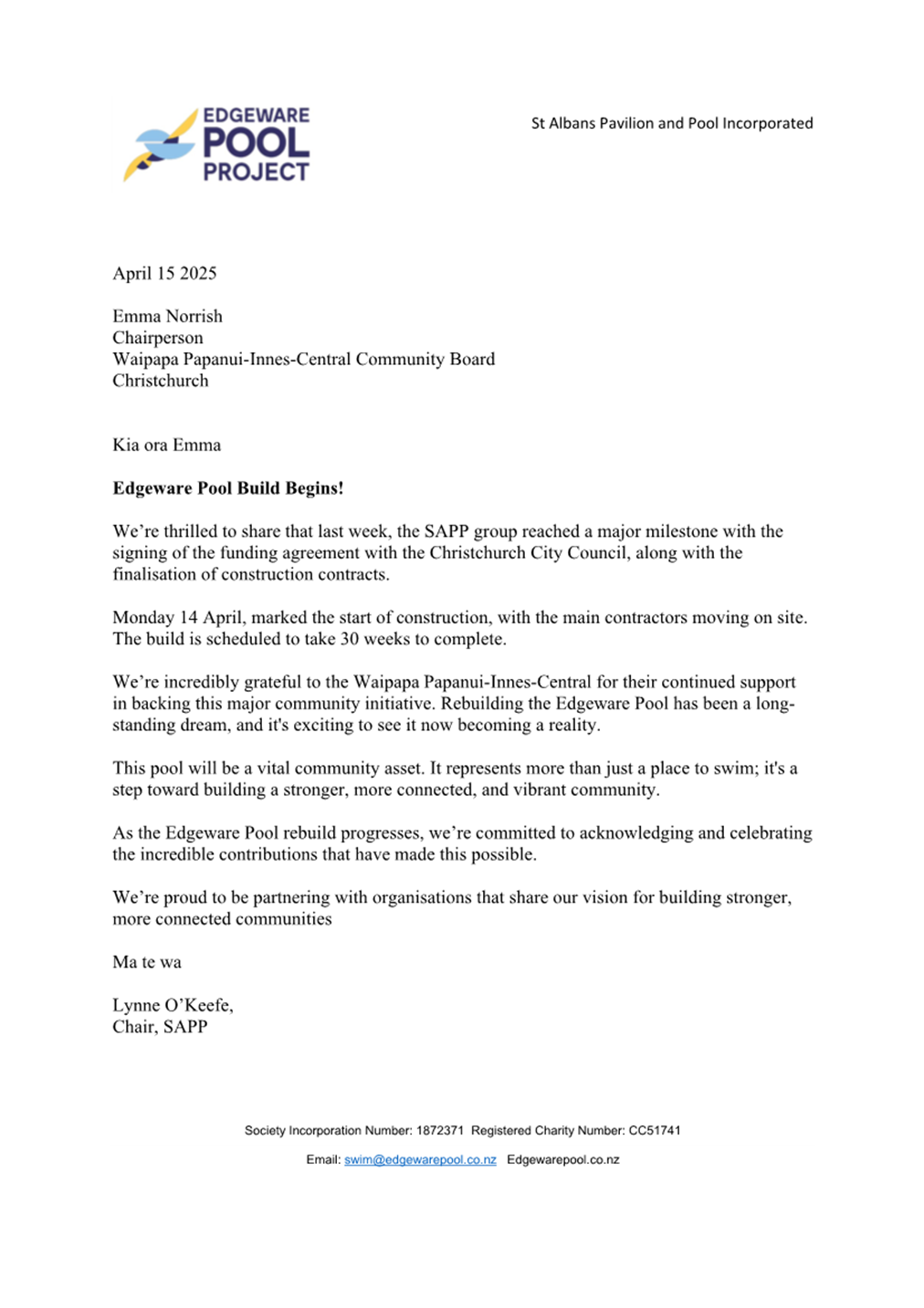
St Albans Pavilion and Pool Incorporated
|
Edgeware Pool Build Begins!
|
2. Officer Recommendations Ngā
Tūtohu
That the Waipapa
Papanui-Innes-Central Community Board:
1. Receives the information in the correspondence
report.
Attachments
Ngā
Tāpirihanga
|
No.
|
Title
|
Reference
|
Page
|
|
a ⇩
|
Corespondence from St Albans Pavilion
and Pool Incorporated
|
25/765280
|
30
|
|
8. Dunedin Reserve- Change part of the
reserve classification to Local Purpose (Community) Reserve
|
|
Reference Te Tohutoro:
|
25/85355
|
|
Responsible Officer(s) Te Pou Matua:
|
Elizabeth
Hoskins, Property Consultant
|
|
Accountable ELT Member Pouwhakarae:
|
Andrew
Rutledge, General Manager Citizens and Community
|
1. Purpose and Origin of the Report Te Pūtake Pūrongo
1.1 The purpose of this report is to request that the Waipapa
Papanui-Innes-Central Community Board approves the implementation of the
Reserves Act 1977 processes to:
a. Reclassify
part of Dunedin Reserve around the existing building occupied by the Redwood
Playcentre, from Recreation Reserve to Local Purpose (Community) Reserve
pursuant to Minister of Conservation approval.
1.2 This will ensure the occupation by Redwood Playcentre is compatible
with the correct reserve classification and will allow a lease to be agreed
with the tenant. Approval of any new lease will be the subject of a later
report to the Board for approval.
1.3 There are restrictions in the Recreation Reserve classification on
leasing outside of recreation and sport. This process will rectify this and
allow a community facility such as a kindergarten to lease the facility.
2. Officer Recommendations Ngā
Tūtohu
That
the Waipapa Papanui-Innes-Central Community Board:
1. Receives the information in the Dunedin Reserve- Change part of
the reserve classification to Local Purpose (Community) Reserve report.
2. Notes that the decision in this report is
assessed as low significance based on the Christchurch City Council’s
Significance and Engagement Policy.
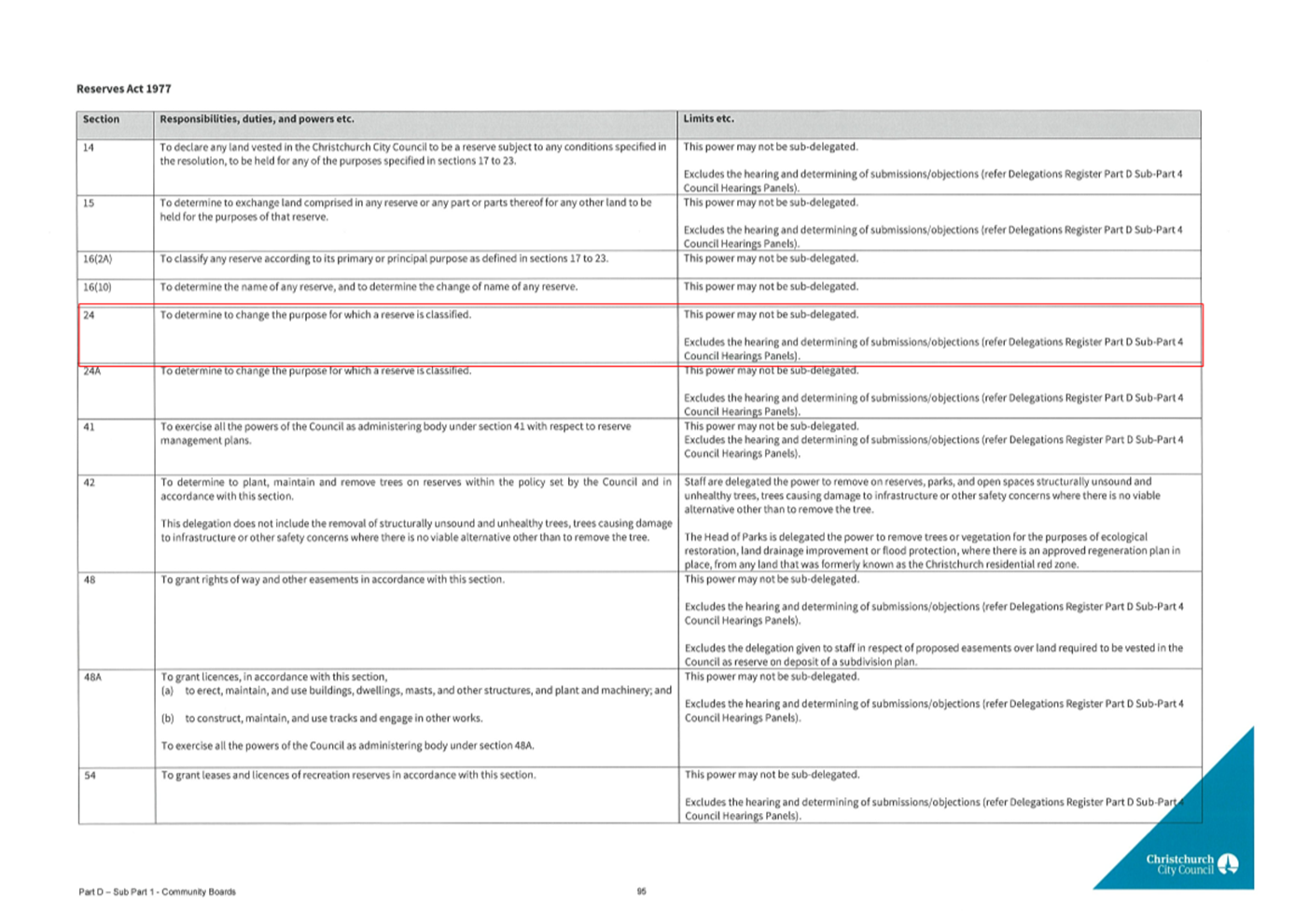
3. Pursuant to Section 24 (1)(b) of the Reserves Act 1977,
under delegated authority from the Christchurch City Council, as administering
body determines that the classification of that area of reserve described in
Schedule A below be changed from Recreation Reserve to Local Purpose
(Community) Reserve.
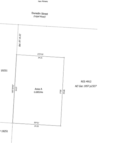
Schedule A
· Area A – 852m2
· Description – Area A SO 615322 being part of
Reserve 4912 comprised in Gazette Notice 1957 p2327 (See plan in section 3 of
the report)
4. Recommends that the Chief Executive exercise
the discretion of the Minister of Conservation under Section 24 of the Reserves
Act 1977 (power delegated to the Council Chief Executive) to change the
classification of Area A SO 615322 being part of Reserve 4912 (Dunedin Reserve)
from Recreation Reserve to Local Purpose (Community) Reserve by notice in the
New Zealand Gazette.
5. Authorises the Manager Property Consultancy to
do all things necessary and make any decisions at his sole discretion related
to implementing the above resolutions including to finalise all processes and
documentation to complete the reclassification.
3. Executive Summary Te Whakarāpopoto Matua
3.1 Dunedin Reserve is classified as Recreation Reserve and the Redwood
Playcentre occupies part of this reserve.
3.2 The Playcentre has been in occupation since 1979 and leased the land
for 30 years which expired in 2009, and they have been on a monthly holdover
basis since then.
3.3 The Playcentre own the building and improvements on the land.
3.4 A new Lease to a Community building cannot be granted until the
reserve classification for the land they occupy is reclassified to Local
Purpose (Community) Reserve.
3.5 Decisions for approval are sought from the Community Board to
proceed and complete the necessary process to achieve this reclassification
under the Reserves Act 1977 pursuant to Minister of Conservation approval which
is delegated to the Christchurch City Council Chief Executive.
3.6 The process under the Reserves Act 1977 to reclassify part of the
Reserve requires approval by the Council (delegated to Community Boards) and
Minister of Conservation (delegated to Council Chief Executive)
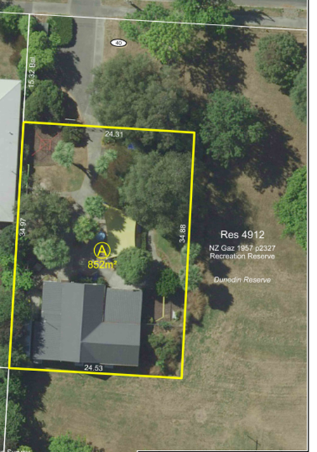
3.7 AREA A shown as land to be classified Local Purpose (Community)
Reserve
4. Background/Context Te Horopaki
4.1 Redwood Playcentre has occupied part of Dunedin Reserve since 1979.
They leased the land for 30 years and this Lease expired in 2009.
4.2 Since 2009 they have been in occupation on a holdover basis as a new
lease cannot be granted until the land they occupy is reclassified from
Recreation Reserve to Local Purpose (Community) Reserve.
4.3 The process under the Reserves Act 1977 to reclassify part of the
Reserve requires approval by the Council (delegated to Community Boards) and
Minister of Conservation (delegated to Council Chief Executive).
4.4 Once the land referred to as Area A has been reclassified a new
Lease can be entered into with the tenant which will be the subject of a later
report.
Options Considered Ngā Kōwhiringa Whaiwhakaaro
4.5 The following reasonably practicable options were considered and are
assessed in this report:
4.5.1 Option
1 Reclassify part of the Reserve around the Playcentre building and
playground to Local Purpose (Community) Reserve.
Option 2
Maintain the Recreation Reserve classification with only recreation and sports
use for the land allowed which is against the current situation.
4.6 The following option was considered but ruled out:
4.6.1 Relocate
the Playcentre to an alternative site which would be impractical and a costly
option and the Playcentre owns the building and other improvements on the site
they occupy.
Options Descriptions Ngā Kōwhiringa
4.7 Preferred Option: Option 1.
4.7.1 Option
Description: Reclassify part of the Reserve around the existing building
and Play area to Local Purpose (Community) Reserve.
4.7.2 Option
Advantages
· This process
reflects and legitimises the current use of the building by a community-based
kindergarten tenant.
· A new
Lease can be granted which provides security of tenure to both the Council and
the tenant
4.7.3 Option
Disadvantages
· There
are no disadvantages with this option.
4.8
Option 2.
4.8.1 Option
Description: Maintain the current Recreation Reserve classification.
4.8.2 Option
Advantages
· There
are no advantages.
4.8.3 Option
Disadvantages
· The land
could not be leased to a community tenant such as a playcentre so they would
continue on holdover with no security of tenure.
Analysis Criteria Ngā Paearu Wetekina
4.9 Not applicable.
5. Financial Implications Ngā Hīraunga Rauemi
Capex/Opex Ngā Utu Whakahaere
|
|
Recommended Option
|
Option 2 - <enter text>
|
Option 3 - <enter text>
|
|
Cost to Implement
|
Internal staff and LINZ costs
|
Nil
|
|
|
Maintenance/Ongoing Costs
|
Not affected
|
Nil
|
|
|
Funding Source
|
Parks unit
|
Parks Unit
|
|
|
Funding Availability
|
Operational funds are available
|
Nil as no action
|
|
|
Impact on Rates
|
Nil
|
Nil
|
|
6. Considerations Ngā Whai Whakaaro
Risks and Mitigations Ngā Mōrearea me
ngā Whakamātautau
6.1 There are no significant risks identified with this process and implementation.
Legal Considerations Ngā Hīraunga
ā-Ture
6.2 Statutory and/or delegated authority to undertake proposals in the
report:
6.2.1 The
Council has delegated its powers to undertake the Reserves Act reclassification
approval to proceed to the Community Boards.
6.2.2 If a
decision is made to proceed, an application to Minister of Conservation
(decision delegated to the Council Chief Executive) will be sought for their
approval of the proposed new classification of part of the Reserve to Local
Purpose (Community) Reserve
6.3 Other Legal Implications:
6.3.1
This proposed reserve classification change are legal processes under Section
24 of the Reserves Act 1977.
Strategy
and Policy Considerations Te
Whai Kaupapa here
6.4 The required decision:
6.4.1 Aligns
with the Christchurch
City Council’s Strategic Framework.The decision will allow a wider
use for the property and legitimise the current use.
6.4.2 Is
assessed as low significance
based on the Christchurch City Council’s Significance and Engagement
Policy. The level of significance was determined as there will be no
change in appearance, access or current use of the Reserve and there will be no
negative impact.
6.4.3 Is
consistent with Council’s Plans and Policies.
6.5 This report supports the Council's
Long Term Plan (2024 - 2034):
6.6 Parks, Heritage and Coastal Environment
6.6.1 Activity: Parks and Foreshore
· Level of Service: 6.8.10.1 Appropriate use and occupation
of parks is facilitated - Processing of the application is started within ten
working days of receiving application – 95%
Community
Impacts and Views Ngā Mariu ā-Hāpori
6.7 A public notice was issued identifying the land and the proposal to
reclassify part of the reserve. No submissions were received at the time of
writing this report.
6.8 The decision affects the following Community Board areas:
6.8.1 Waipapa
Papanui-Innes-Central Community Board.
6.9 The Community Board view will be
confirmed at this meeting.
Impact
on Mana Whenua Ngā
Whai Take Mana Whenua
6.10 The decision does not involve a significant decision in
relation to ancestral land, a body of water or other elements of intrinsic
value, therefore this decision does not specifically impact Mana Whenua, their
culture, and traditions.
6.11 The decision does
not involve a matter of interest to Mana Whenua and will not
impact on our agreed partnership priorities with Ngā
Papatipu Rūnanga.
6.12 The use of the
property will not change however the reclassification of part of the reserve
legitimises the occupation, under the Reserves Act 1977, by a
playcentre/kindergarten.
Climate
Change Impact Considerations Ngā Whai Whakaaro mā te Āhuarangi
6.15 The proposals in
this report are unlikely to contribute significantly to adaptation to the
impacts of climate change or emissions reductions.
6.16 There will be no change in use of the facilities or the reserve.
7. Next Steps Ngā Mahinga ā-muri
7.1 The Property Consultancy team will obtain Minister of Conservation
approval (delegated to the Council Chief Executive) and then complete the process
for reclassification through LINZ.
Attachments Ngā Tāpirihanga
|
No.
|
Title
|
Reference
|
Page
|
|
a ⇩
|
Delegations to
Community Board
|
25/681873
|
38
|
In addition to the attached documents, the following background
information is available:
|
Document
Name – Location / File Link
|
|
Not
applicable
|
Signatories Ngā Kaiwaitohu
|
Author
|
Elizabeth
Hoskins - Property Consultant
|
|
Approved By
|
Angus Smith -
Manager Property Consultancy
Kelly Hansen -
Manager Parks Planning & Asset Management
Rupert Bool -
Head of Parks
|
|
9. Langdons Road at Chapel Street
Intersection - Proposed Extension of Parking Restrictions
|
|
Reference Te Tohutoro:
|
25/592923
|
|
Responsible Officer(s) Te Pou Matua:
|
Sally-Ann
Marshall, Traffic Engineer
|
|
Accountable ELT Member Pouwhakarae:
|
Brent
Smith, General Manager City Infrastructure
|
1. Purpose and Origin of the Report Te Pūtake Pūrongo
1.1 For
the Waipapa Papanui-Innes-Central Community Board to approve the proposed
extension of existing parking restrictions on Langdons Road opposite the Chapel
Street intersection.
1.2 This report has been written in response to a request from a member
of the public who works in the area.
1.3 The decisions in this report are of low significance in relation to
the Christchurch City Council’s Significance and Engagement Policy. The
level of significance was determined by the low level of impact and low number
of people affected by the recommended decision.
1.4 The community engagement and consultation outlined in this report
reflect the assessment.
1.5 The Preferred Option is for the existing No Stopping restriction to
be extended as shown on Attachment A.
2. Officer Recommendations Ngā
Tūtohu
That the Waipapa
Papanui-Innes-Central Community Board:
1. Receives the information in the Langdons Road at Chapel Street
Intersection - Proposed Extension of Parking Restrictions Report.
2. Notes that the decision in this report is
assessed as low significance based on the Christchurch City Council’s
Significance and Engagement Policy.
3. Revokes any previous resolutions pertaining to
traffic controls made pursuant to any bylaw to the extent that they are in conflict with the parking or
stopping restrictions described in resolution 4 below.
4. Approves that, in accordance with Clause 7 of
the Christchurch City Council Traffic and Parking Bylaw 2017, the stopping of
all vehicles be prohibited at all times on the north-eastern side of Langdons
Road commencing at a point five metres north west of the prolongation of the
north-western kerb of Chapel Street and extending in a south-easterly direction
for a distance of 24 metres as shown on plan LANGDON01, Issue 2, dated 31 March
2025, refer Attachment A.
5. Approves that these resolutions take effect
when parking signage and/or road markings that evidence the restrictions
described in this staff report are in place (or removed in the case of
revocations).
3. Executive Summary Te Whakarāpopoto Matua
3.1 Vehicles
which are parked on Langdons Road, adjacent to Bridgestone Reserve, reduce the
eastbound lane width. This is causing queueing traffic when a driver is waiting
to turn right into Chapel Street.
3.2 This
section of Langdons Road is a high-volume connector road in a predominantly
commercial area. Parking demands are high.
3.3 We
received no response to our consultation on the proposal from the neighbouring
business and property owner.
3.4 The
preferred option is to extend the existing No Stopping restriction in this
location to provide space for through traffic, as shown on Attachment A.
4. Background/Context Te Horopaki
4.1 We
have received a request to investigate an issue at and around the intersection
of Langdons Road and Chapel Street, where cars parking on the northwest side of
the road, narrow the carriageway. This means that when a driver is waiting to
turn right into Chapel Street, either tail backs occur, or drivers attempt to
squeeze through the resulting small gap.
4.2 Langdons
Road is classified as a Collector Road in the Councils Road Classification
System. Due to this being a busy commercial centre, there are consistently high
traffic volumes through the area.
4.3 The
speed limits along Langdons Road correspond with the different environments
along the street: 40km/h through the residential areas changing to 30km/h at
the commercial area. The posted speed limit at the Langdons Street / Chapel
Street intersection is 30 km/h.
4.4 Currently,
there are approximately seven unrestricted parking spaces available adjacent to
Bridgestone Reserve. Three of these parking spaces are within the intersection
with Chapel Street as indicated by the red line on the plan below.
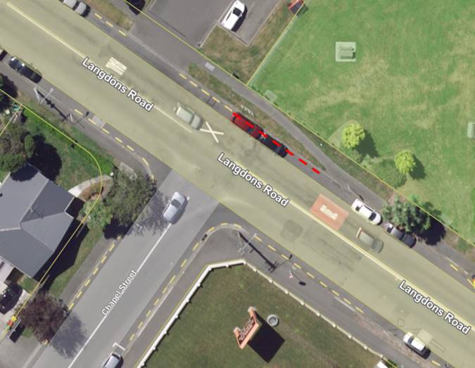
4.5 Council
staff have observed on two site visits that the parking spaces within the
intersection were in use.
4.6 The
recommended option is to extend the existing No Stopping restriction by
approximately 15 metres. This will remove the three parking spaces as noted
above, which will allow space for traffic to move past when there is a vehicle
waiting to turn right into Chapel Street.
4.7 Parking
demands in the area are high, however the road safety aspect of supporting
safer movements for eastbound traffic is higher priority.
4.8 We
have consulted with Council’s parks staff and the neighbouring business
and property owner who are affected by this change, refer Section 6.7.
4.9 If
approved, the parking changes will be implemented in this financial year
(generally around four weeks after the contractor receives the request, but
this is subject to other factors such as resourcing and prioritisation beyond
Council’s control).
Options Considered Ngā Kōwhiringa Whaiwhakaaro
4.10 The
following reasonably practicable options have been considered and are assessed
in this report:
4.10.1 Extend the
existing No Stopping restriction to remove approximately three parking spaces
as shown on Attachment A.
4.10.2 Maintain the
status quo – do nothing.
4.11 The
following option was initially considered but has been ruled out:
· Installing a right-turn
bay or flush median – the geometry is unlikely to work with the railway
crossing and could result in the loss of parking somewhere else.
Options Descriptions Ngā Kōwhiringa
4.12 Preferred
Option: Extend the existing No Stopping restriction to remove approximately
three parking spaces as shown on Attachment A.
4.12.1 Option
Advantages
· Enables
better movement of eastbound through traffic around vehicles waiting to turn
right into Chapel Street.
4.12.2 Option
Disadvantages
· Removes
three parking spaces
4.13 Maintain
the status quo – do nothing:
4.13.1 Option
Advantages
· Retains
three parking spaces.
4.13.2 Option
Disadvantages
· Does not
assist movement of eastbound through traffic around vehicles waiting to turn
right into Chapel Street.
5. Financial Implications Ngā Hīraunga Rauemi Capex/Opex
Ngā Utu Whakahaere
Capex/Opex Ngā Utu Whakahaere
|
|
Preferred Option
|
Option 2 – Do nothing
|
|
Cost to investigate
|
$1,500 to write report including
consultation and two site visits
|
$1,500 to write report including
consultation and two site visits
|
|
Cost to Implement
|
$200 to install No Stopping restriction
|
$0
|
|
Maintenance/Ongoing Costs
|
Will be added to and covered by the area
maintenance contract
|
$0
|
|
Funding Source
|
Traffic Operations Team traffic signs and
markings budget
|
$0
|
6. Considerations Ngā Whai Whakaaro
Risks and Mitigations Ngā Mōrearea me
ngā Whakamātautau
6.1 None
identified.
Legal Considerations Ngā Hīraunga
ā-Ture
6.2 Statutory
and/or delegated authority to undertake proposals in the report:
6.2.1 Part
1, Clause 7 of the Christchurch City Council Traffic and Parking Bylaw 2017
provides Council with the authority to install parking or stopping restrictions
by resolution.
6.2.2 The
installation of any signs and/or markings associated with traffic control
devices must comply with the Land Transport Rule: Traffic Control Devices 2004.
6.3 Other Legal Implications:
6.3.1 There
is no other legal context, issue, or implication relevant to this decision.
6.3.2 This
specific report has not been reviewed and approved by the Legal Services Unit
however the report has been written using a general approach previously
approved of by the Legal Services Unit, and the recommendations are consistent
with the policy and legislative framework outlined in this report.
Strategy
and Policy Considerations Te
Whai Kaupapa here
6.4 The
required decisions:
6.4.1 Alings with the Christchurch
City Council’s Strategic Framework.
6.4.2 The
recommendations in this report are consistent with the Christchurch Suburban
Parking Policy.
6.4.3 The
decisions in this report are assessed as low significance based on the
Christchurch City Council’s Significance and Engagement Policy. The level
of significance was determined by the low level of impact and low number of
people affected by the recommended decision.
6.5 This
report supports the Council's
Long Term Plan (2024 - 2034):
6.6 Transport
6.6.1 Activity: Transport
· Level of Service: 10.0.6.1 Reduce the number of death and
serious injury crashes on the local road network (DIA 1) - 4 less than previous
FY
Community
Impacts and Views Ngā Mariu ā-Hāpori
6.7 The
recommended option removes three parking spaces adjacent to Bridgestone
Reserve. This has been discussed with Councils Parks unit who have confirmed
they have no issues with the proposal.
6.8 Consultation
documentation was posted to the business, Tonys Tyres, next to Greenstone Park
and the property owner. No feedback has been received yet, but
any feedback received before the Community Board meeting will be tabled at the
meeting.
6.9 The
Team Leader Parking Compliance supports the preferred option.
6.10 The
decision affects the following wards/Community Board areas:
6.10.1 Waipapa
Papanui-Innes-Central.
Impact
on Mana Whenua Ngā
Whai Take Mana Whenua
6.11 The decision does not involve a significant decision concerning
ancestral land or a body of water or other elements of intrinsic value,
therefore this decision does not specifically impact Mana Whenua, their culture
and traditions.
6.12 The
decision does not involve a matter of interest to Mana Whenua and will not
impact on our agreed partnership priorities with Ngā Papatipu
Rūnanga.
Climate
Change Impact Considerations Ngā Whai Whakaaro mā te Āhuarangi
6.13 The
proposals in this report do not contribute significantly to
adaptation to the impacts of climate change or emissions reductions.
7. Next Steps Ngā Mahinga ā-muri
7.1 If
approved, staff will arrange for the additional No Stopping restriction to be
installed.
Attachments Ngā Tāpirihanga
|
No.
|
Title
|
Reference
|
Page
|
|
a ⇩
|
Attachment A -
Langdons Road / Chapel Street Intersection, Proposed No Stopping Restrictions
|
25/755378
|
44
|
In addition to the attached documents, the following background
information is available:
|
Document
Name – Location / File Link
|
|
Not
applicable
|
Signatories Ngā Kaiwaitohu
|
Author
|
Sally-Ann
Marshall - Traffic Engineer
|
|
Approved By
|
Gemma Dioni -
Acting Team Leader Traffic Operations/Principal Advisor
Stephen Wright
- Manager Operations (Transport)
|
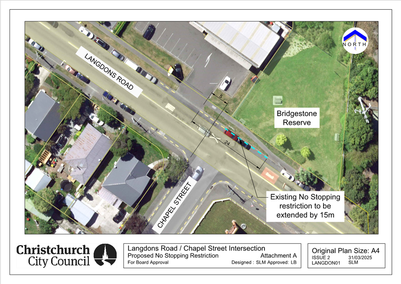
|
10. Proposed Road Names - 140 Prestons Road
|
|
Reference Te Tohutoro:
|
25/836739
|
|
Responsible Officer(s) Te Pou Matua:
|
Sean
Ward, Team Leader Planning
|
|
Accountable ELT Member Pouwhakarae:
|
John
Higgins, General Manager Strategy, Planning & Regulatory Services
|
1. Purpose and Origin of the Report Te Pūtake Pūrongo
1.1 The
purpose of this report is for the Waipapa Papanui-Innes-Central Community Board
to approve the proposed road and lane names at 140 Prestons Road, Redwood.
1.2 The
report is staff-generated resulting from a naming request received from the
developer.
2. Officer Recommendations Ngā Tūtohu
That the Waipapa
Papanui-Innes-Central Community Board:
1. Receives the information in the Proposed
Road Names - 140 Prestons Road Report.
2. Notes that the decision in this report is assessed as low
significance based on the Christchurch City Council’s Significance and
Engagement Policy.
3. Approves the following new road and lane names for 140 Prestons Road
(RMA/2022/2624)
a. Road 1 - Newquay Avenue
b. Road 2 - Padstow Loop
c. Road 3 - Holywell Street
d. Road 4 - Launceston Street
e. Road 5 - Camborne Street
f. Road 6 - Seaton Way
g. Road 7 - Exmouth Drive
h. Lane 1 - Sidmouth Lane
i. Lane 2 - Callington Lane
3. Detail Te Whakamahuki
Introduction Te Whakatkinga
3.1 A
road naming request has been submitted by the developer. A preferred name and
alternative names have been put forward for the roads and lanes.
3.2 The
recommended road names have been checked against existing road names in
Christchurch and bordering districts, for duplication, alternative spelling, or
other similarities in spelling or pronunciation to avoid the potential for
confusion. The proposed names are considered sufficiently different to existing
road names.
3.3 The
recommended road names have been checked against the Council’s Naming
Policy dated 15 November 2023 and are considered to be consistent with this
policy. The specific criteria for assessing a name from clause 2 is set out
below.
3.3.1 A traditional or
Māori name which is acceptable to the Rūnanga or Iwi; this may be a
name reflecting the physical characteristics of an area, an activity or event
associated with the area or of a notable ancestor.
3.3.2 A feature of
historical, social, cultural, environmental or physical importance in the area
(e.g., Carlton Mill Road or Carlton Mill Reserve*).
3.3.3 The name of a notable
family, person or event associated with the locality or with the wider
Christchurch area.
3.3.4 A name in recognition
of a person’s service. This can be for community service, conservation,
sport, the arts, science and research or other sphere of activity.
3.3.5 Consistency with a
common or established theme for naming in a subdivision or locality.
3.3.6 A name that reflects
the diverse cultures and communities of the locality or of Christchurch
generally.
3.3.7 The name of an event
or activity strongly associated with the immediate location including an
informal name for the area that is (or was historically) in common usage.
3.3.8 A name associated
with a person, event or activity of significance to Christchurch including
names associated with people, events, or places of national and international
significance.
3.4 The
criteria for names that are not suitable for approval from clause 6 are set out
below.
3.4.1 Names of people,
flora, fauna or geographical features not associated with the area, e.g., names
of native trees which are not present in the area or views that cannot be
identified, except where the name continues a current naming theme in the
locality.
3.4.2 Currently trading
commercial organisations except for sponsorship names for facilities and leased
parks.
3.4.3 Anagrams,
amalgamations or derivatives of people's names.
3.4.4 Names of living
persons.
3.4.5 Names related to the
developer of a subdivision.
3.4.6 Name of a person,
club or organisation associated with a privately owned building on Council
land, where the club or organisation does not hold the ground lease for the
building.
3.4.7 Names for roads which
may cause confusion because they are associated with another geographical
location or feature e.g., Parklands Drive which is not located in the Parklands
suburb.
3.5 The
recommended road names have also been checked against the Australia and New
Zealand Standard AS/NZA 4819:2011 Rural and Urban Addressing. The names are
considered to be consistent with the Standard.
3.6 Under
the Roads and Right-of-Way Naming Policy, the names considered must be
requested by the developer. There is no ability to consider alternative names
without first checking whether there are any duplications or similarities with
other road and right-of-way names.
3.7 Consultation
has been undertaken with Land Information New Zealand who have raised no concerns
with the proposed names.
3.8 Consultation
under the policy with rūnanga is not required because the roads to be
named are not collector roads and/or site(s) of significance under the District
Plan (clause 3 of the Naming Policy).
3.9 No
addresses of neighbouring properties are affected by the proposed road naming
(clause 12.2 of the Naming Policy).
3.10 The names requested
have been accompanied by an explanation of the background of the names, which
is summarised below.
Assessment of Significance and Engagement Te
Aromatawai Whakahirahira
3.11 The decisions in
this report are assessed as low significance based on the Christchurch City
Council’s Significance and Engagement Policy.
3.12 The level of
significance was determined by the number of people affected and/or with an
interest.
3.13 Due to the
assessment of low significance, no further community engagement and
consultation is required.
Proposed Names
3.14 The proposed
roads are shown in Attachment A.
3.15 The theme of the
proposed names relates back to the name Prestons and where it originates from.
Prestons Road is named after Thomas Herbert Preston (1824–1884) who was a
local resident and chair of the Avon Road Board. The Suburb was renamed Redwood
in 1967 as requested by residents. This name comes from 3 large Redwood Sequoia
trees that were planted in the 1860’s by Thomas Preston for each of his 3
sons.
Thomas Herbert
Preston and his wife Elizabeth arrived aboard the ‘Cornwall’, the
18th Canterbury Association ship. The below proposed names relate to villages
and seaside towns in Southwest England where the ship originated from.
The alternative
name options are place names that originate from Manchester which is where
Thomas Preston and wife Margaret were from and where they were married; and a
mixture of portside towns in Cornwall, place names in Manchester and other
names relating to Thomas Preston’s family.
3.16 Road 1 -
Newquay Avenue
3.17 Newquay is a
town on the north coast of Cornwall, in southwest England. It’s known for
sandy Fistral and Watergate Bay beaches, where waves from the Atlantic Ocean
create strong surf. On the seafront, the Blue Reef Aquarium features an
underwater tunnel going through a coral-reef tank with pufferfish, sharks and
rays.
3.18 Road 2 -
Padstow Loop
3.19 Padstow is a
town, civil parish and fishing port on the north coast of Cornwall, England.
The town is situated on the west bank of the River Camel estuary, approximately
5 miles northwest of Wadebridge, 10 miles northwest of Bodmin and 10 miles
northeast of Newquay.
3.20 Road 3 -
Holywell Street
3.21 Holywell is a
coastal village in the civil parish of Cubert, in north Cornwall, England. It
is at Holywell Bay, about three miles west-southwest of Newquay.
3.22 Road 4 -
Launceston Street
3.23 Launceston is a town,
ancient borough, and civil parish in Cornwall, England. It is 1 mile west of
the middle stage of the River Tamar, which constitutes almost the entire border
between Cornwall and Devon.
3.24 Road 5 -
Camborne Street
3.25 Camborne is a
town in Cornwall, England. The northern edge of the parish includes a section
of the South West Coast Path, Hell's Mouth and Deadman's Cove. Camborne was
formerly one of the richest tin mining areas in the world and home to the
Camborne School of Mines.
3.26 Road 6 -
Seaton Way
3.27 Seaton is a
seaside town, fishing harbour and civil parish in East Devon on the south coast
of England, between Axmouth and Beer. It faces onto Lyme Bay and is on the
Jurassic Coast, a World Heritage Site.
3.28 Road 7 -
Exmouth Drive
3.29 Exmouth is a
port town, civil parish and seaside resort situated on the east bank of the
mouth of the River Exe, 11 miles southeast of Exeter.
3.30 Lane 1 -
Sidmouth Lane
3.31 Sidmouth is a
town on the English Channel in Devon, South West England, 14 miles southeast of
Exeter. With a population of 13,258 in 2021, it is a tourist resort and a
gateway to the Jurassic Coast World Heritage Site. A large part of the town has
been designated a conservation area.
3.32 Lane 2 -
Callington Lane
3.33 Callington is a
civil parish and town in east Cornwall, England about 11 km north of Saltash
and 14 km south of Launceston. Nearby ancient monuments include Castlewitch
Henge, with a diameter of 96 m and Cadsonbury Iron Age hillfort, as well as
Dupath Well built in 1510 on the site of an ancient sacred spring.
Alternative Names
3.34 Swinton Ave/St/Dr/Wy/Ln
- Swinton is a town in the City of Salford in Greater Manchester, England.
southwest of the River Irwell, 4 miles northwest of Manchester, adjoining the
town of Pendlebury and suburb of Clifton.
3.35 Stratton Ave/St/Dr/Wy/Ln
- Stratton is a market town and former civil parish, now in the parish of
Bude-Stratton, in Cornwall, England, United Kingdom. It is situated near the
coastal town of Bude and the market town of Holsworthy. It was also the name of
one of ten ancient administrative hundreds of Cornwall.
3.36 Didsbury Ave/St/Dr/Wy/Ln
- Didsbury is a suburb of Manchester, England, on the north bank of the River
Mersey, 5 miles south of Manchester city centre. The population at the 2011
census was 26,788. Within the boundaries of the historic county of Lancashire,
there are records of Didsbury existing as a small hamlet as early as the 13th
century.
3.37 Hadfield Ave/St/Dr/Wy/Ln
- Hadfield is a town in the High Peak of Derbyshire, England, with a population
at the 2021 Census of 6,763. It lies on the south side of the River Etherow,
near to the border with Greater Manchester, at the western edge of the Peak
District close to Glossop.
3.38 Stockport Ave/St/Dr/Wy/Ln
- Stockport is a town in Greater Manchester, England, 8 miles south-east of
Manchester, 7 miles south-west of Ashton-under-Lyne and 12 miles north of
Macclesfield. The Rivers Goyt and Tame merge to create the River Mersey here.
It is the main settlement of the wider Metropolitan Borough of Stockport.
3.39 Redcliffe Ave/St/Dr/Wy/Ln
- William Redcliffe Preston was the son of Thomas Preston.
3.40 Timperley Ave/St/Dr/Wy/Ln
- Timperley is a suburban village in the borough of Trafford, in Greater
Manchester, England. Within the boundaries of the historic county of Cheshire,
it is approximately six miles southwest of central Manchester.
3.41 Partington
Ave/St/Dr/Wy/Ln - Partington is a town and civil parish in the Metropolitan
Borough of Trafford, Greater Manchester, England, ten miles south-west of
Manchester city centre. Within the boundaries of the historic county of
Cheshire, it lies on the southern bank of the Manchester Ship Canal, opposite
Cadishead on the northern bank.
3.42 Constantine
Ave/St/Dr/Wy/Ln - Constantine is a village and civil parish in Cornwall,
England, United Kingdom. It is situated approximately five miles west-southwest
of Falmouth.
3.43 Mossley Ave/St/Dr/Wy/Ln
- Mossley is a town and civil parish in Tameside, Greater Manchester, England,
in the upper Tame Valley and the foothills of the Pennines, 3 miles south-east
of Oldham and 9 miles east of Manchester. The town grew up straddling the three
historic counties of Lancashire, Cheshire and Yorkshire.
3.44 Sale Ave/St/Dr/Wy/Ln
- Sale is a town in Trafford, Greater Manchester, England. It is on the south
bank of the River Mersey, 2 miles south of Stretford, 3 miles northeast of
Altrincham, and 5 miles southwest of Manchester. Sale lies within the historic
county boundaries of Cheshire, and became part of Greater Manchester in 1974.
3.45 Uppermill Ave/St/Dr/Wy/Ln
- Uppermill is a village in the civil parish of Saddleworth in the Metropolitan
Borough of Oldham, Greater Manchester, England.
3.46 Kingsand Ave/St/Dr/Wy/Ln
- Kingsand is located in southeast Cornwall, United Kingdom. The villages are
situated on the Rame Peninsula and are in the parish of Maker-with-Rame.
3.47 Cheetham Ave/St/Dr/Wy/Ln
- Cheetham is an inner-city area and electoral ward of Manchester, in Greater
Manchester, England.
3.48 Prestwich Ave/St/Dr/Wy/Ln
- Prestwich is a town in the Metropolitan Borough of Bury, Greater Manchester,
England, three miles north of Manchester, three miles north of Salford and five
miles south of Bury.
3.49 Monton Ave/St/Dr/Wy/Ln
- Monton is a village in the City of Salford, Greater Manchester, England. It
is contiguous with nearby Eccles, Salford and Swinton
3.50 Ann Ave/St/Dr/Wy/Ln
- Margaret Ann Preston was Thomas Preston’s wife.
3.51 Officers
Note: The appropriate road type will be used if any of the alternative
names are chosen.
Assessment of Names
3.52 The proposed
names are considered to be consistent with the policy.
3.53 Notwithstanding, the discretion lies with the Community Board to
approve any of the above name options, including the alternative names.
Attachments Ngā Tāpirihanga
|
No.
|
Title
|
Reference
|
Page
|
|
a ⇩
|
RMA/2022/2624 - Road Naming Plan - 140 Prestons Road
|
25/704653
|
51
|
Signatories Ngā Kaiwaitohu
|
Authors
|
Leashelle
Miller - Planner Level 2
Sean Ward -
Team Leader Planning
|
|
Approved By
|
Mark Stevenson
- Head of Planning & Consents
|
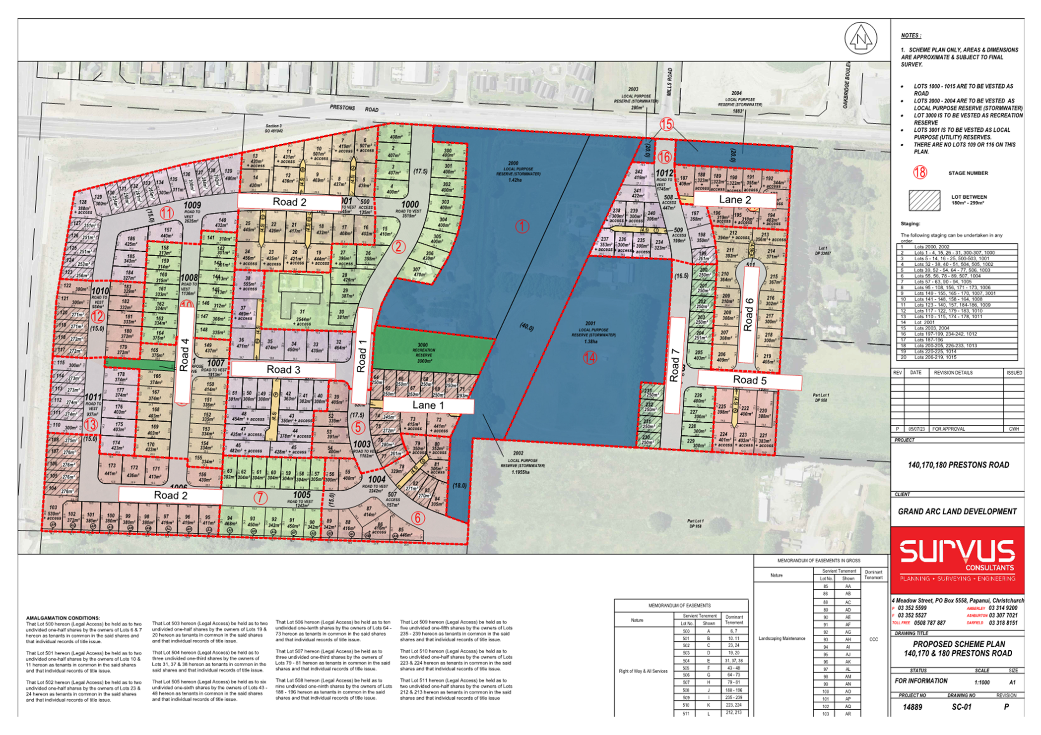
|
11. Waipapa Papanui-Innes-Central Community Board Area
Report - May 2025
|
|
Reference Te Tohutoro:
|
25/656769
|
|
Responsible Officer(s) Te Pou Matua:
|
Emma
Pavey, Community Governance Manager Papanui-Innes-Central
|
|
Accountable ELT Member Pouwhakarae:
|
Andrew
Rutledge, General Manager Citizens and Community
|
1. Purpose of Origin of the Report Te
Pūtake Pūrongo
1.1 This
monthly staff-generated report provides the Board with an
overview of initiatives and issues current within the Community Board area.
2. Officer Recommendations Ngā
Tūtohu
That the Waipapa
Papanui-Innes-Central Community Board:
1. Receives the information in the Waipapa Papanui-Innes-Central Community Board
Area Report - May 2025.
3. Community Support, Governance and Partnership Activity
3.1 Community Governance Projects
|
Activity
|
Detail
|
Timeline
|
Strategic Alignment
|
|
Youth Recreation
|
Staff are
working in collaboration with youth focussed organisations to discuss
potential opportunities in the Papanui, Innes and Central ward areas. These
include:
Initial
conversations have begun with SARA to hold a Skate Jam in the St Albans area
in the coming months. More details will be provided as plans are
confirmed.
Staff are
working in collaboration with Te Ora Hou and Papanui Youth Development Trust
to discuss their upcoming events and the upskilling opportunities and support
available.
|
Ongoing
|
Te Haumako Te
Whitingia
Strengthening
Communities Together Strategy
|
|
Stanmore
Block Party
|
Community
Governance staff supported Youth and Cultural Development, the Stanmore
Corner Project, and Euphoria Dance Studio to host the Stanmore Block Party on
12 April 2025 at 89 Stanmore Road. The event was to activate the corner
of Stanmore Road and Worcester Street with local performances, activities and
food offerings. Photos further down in the report.
|
Completed
|
Te
Haumako Te Whitingia
Strengthening
Communities Together Strategy
|
|
Eid
al-Fitr
|
Community
Governance staff supported the Eid al-Fitr Festival 2025, which was held on 5
April 2025 at the Events Triangle in North Hagley Park. The event is
celebration for both the Muslim community and the wider city with a range of
festive activities, performances and food stalls. Photos further down
in the report.
|
Completed
|
Te
Haumako Te Whitingia
Strengthening
Communities Together Strategy
|
|
Youth Safety
|
A youth
space has opened in Northlands Mall with the support of the Board’s
Better Off Fund, in collaboration with Papanui Youth Development Trust and Te
Ora Hou.
Participation
numbers have been steady with young people using the space after school
hours, often prior to catching buses from the bus exchange.
Further work
is progressing to support the installation of Wi-Fi at the site, and the
possibility of having the bus timetable screens installed.
|
Ongoing
|
Te Haumako Te
Whitingia
Strengthening
Communities Together Strategy
|
|
Shirley Community Reserve
|
The Board
resolved for staff to initiate the process to design an on‑budget
community building on the Reserve that will enable mixed use.
Following its first
meeting, the Working Party has asked for further design work that is being
prepared for consideration.
|
Ongoing
|
Te Haumako Te
Whitingia
Strengthening
Communities Together Strategy
|
|
Revitalisation
of Petrie Park
|
Consultation
on the Petrie Park tree planting plan has closed, and a report is being
prepared for consideration at a future meeting.
|
Ongoing
|
Te Haumako Te
Whitingia
Strengthening
Communities Together Strategy
|
|
Safety
Initiatives
- CPTED
|
The CPTED
report the Board funded with its Better Off Fund for MacFarlane Park has been
completed and presented back to the Board.
Further
discussions underway about the future planning for the MacFarlane Park area.
|
Relevant Council teams
are reviewing the CPTED report
|
Te Haumako Te
Whitingia
Strengthening
Communities Together Strategy
|
|
- Community safety and aggressive begging
|
There has been an
increased Police visibility through the community beat teams. Christchurch
City Mission workers have also been present on the streets offering support
when required. This work has seen a decrease in aggressive begging being
reported.
Phillipstown Hub hosts
a monthly Community Safety Panel attended by the Police, local community,
Kāinga Ora, Property Developers and Council staff.
The Hub in partnership
with Orange Sky New Zealand also provide access to washing machines, dryers
and showers for people who need them, and wrap around support is provided by
Housing First Otautahi.
|
Ongoing
|
|
- Civil Defence Emergency Management (CDEM)
Community Resilience Plans
|
Local staff, with the
assistance of the CDEM team, are working with community organisations within
the Papanui, Innes and
Central wards on their Emergency
Response/Community Resilience Plans that will support their communities
during adverse events.
We Are Richmond,
Avebury House, Eastern Community Sport and Recreation Inc, Delta Trust and
Riverlution have worked together to develop their area specific plan, while
the Phillipstown Hub has also developed a plan.
The groups in Shirley
are also developing a plan with cross-area support enabling ideas and
solutions to be shared. Staff are also working with Te Ora Hou, and
St Albans Residents Association on developing plans.
The collegial work
between organisations has been a highlight of the process with each
organisation contributing together to develop their plans.
|
|
|
Community
Pride Garden Awards
|
These awards
are in partnership with Keep Christchurch Beautiful’s Street and Garden
Awards. Participating Boards award certificates to residents and businesses
who maintain their street-visible gardens to a high standard.
|
Certificates
are in the process of being issued.
|
Te Haumako
Te Whitingia Strengthening Communities Together Strategy
|
3.2 Community
Funding Summary
The balance of the Board’s funding
pools at the time of writing is currently as follows subject to subtraction of
the grants proposed through the reports to this meeting as shown:
|
2024/25 Waipapa Papanui-Innes-Central Youth
Development Fund (YDF)
|
|
YDF grants
approved so far this financial year:
· Grant
to Disharn Noda towards travelling to Tahiti for a cultural exchange
· Grants
to Katia and Elena Ashmore towards the costs of attending the National
Secondary Schools' Brass Band Course 2024
· Grant
to Laura Powley towards participating in the Avonside Girls' High School
French Trip to Angers
· Grant
to Olivia Zeng towards the costs of attending the Aspire (Dance) Programme at
Convergence Dance Studio
· Grant
to Natalia Kay towards competing in the Deaf World 3v3 Basketball
Championships at Gallaudet University, Washington DC
· Grant
to Ollie Dysart towards representing the South Island at the ITKD Taekwondo
National Championships 2024 in Palmerston North
· Grant
to Villa Maria College for Oriana Puhiatau towards playing in the 1st XI
Football Team attending the New Zealand Secondary Schools Tournament in
Blenheim
· Grant to Tiana Olney towards
attending the Outward Bound Classic Course
· Grant
to Jorja Ashley McCaughan towards competing at the NZCAF Aerobics
Nationals in Queenstown
· Grant
to Lauren Dyet towards travelling with the Mixx U19 Korfball Team to the
National Championships in Taiwan
· Grant
to Badminton Canterbury Inc. applicants towards attending the NZ Junior Team
Badminton Championships in Palmerston North
· Elsha
Brocherie towards travelling with her team to the Korfball Club Championships
in Adelaide, Australia (see Attachment A)
· Rhys
Lewis towards competing at The World VEX Robotics
Championships in Dallas, USA (see Attachment B)
· Alisa
Wada towards the costs of representing New Zealand at the FISU Summer World
University Games 2025 for Artistic Gymnastics in Germany (see Attachment C)
|
$300
$300 &
$300
$500
$100
$500
$350
$100
$300
$200
$500
$260
$400
$500
$500
|
|
AVAILABLE
BALANCE (at time of writing):
|
$2,890
|
3.3 The
Mayor’s Welfare Fund
The Mayor’s Welfare Fund provides
financial support to families and individuals in the community who are in
extreme financial distress. It is a last resource when people have exhausted
other appropriate sources such as Work and Income New Zealand (WINZ). The
criteria and instructions on how to apply can be found here: Mayors
Welfare Fund - all you need to know.
3.4 Upcoming
Community Events and Activities
·  Volunteer Events
Visit this
link for the variety of volunteer events held around the city, and this
link to volunteer at a Council-produced event. There is also
information at this
link on becoming a Graffiti Programme volunteer, or register
at this link to join the Parks Volunteers Team.
Some
planting events are eligible for Children's University (CU) credits, and family-friendly. Schools can be
supported by the ‘connect and grow’ planting programme: Manaaki Taiao – Nurture Nature.
Or find other opportunities to volunteer
in your community at this link,
whether it be sharing your passion for art at the Art Gallery, helping the Friends of the Library,
joining the Friends of the
Botanic Gardens, or any of the number of volunteer opportunities listed on
the site for Volunteering Canterbury.
·  FRESH Events 2025
Information on events from Youth & Cultural Development
(YCD) is available at this link.
· Other
upcoming community events and festivals in the city
Visit this
link for the variety of community events and festivals held around the
city. You can also visit the What’s On site,
for one-off and regular events like:
· Spirited Conversation: Understanding Gender Identity
– 14 May, 6-7.30pm at Aldersgate, 309 Durham Street -
This workshop on gender identity and language, inclusion and allyship will
offer valuable insights and tools to foster inclusivity and respect for all.
·  Friends Auction Event 2025 –
16 May, 6-10pm at the Christchurch Art Gallery - The
Auction Event features work by over thirty contemporary New Zealand artists,
including ten special limited-edition artworks produced for the event by Wayne
Youle. This biennial auction is a keenly anticipated occasion and the
biggest fundraising event on the Friends calendar with funds raised going
towards acquisitions that enhance the city's public art collection.
Friends Auction Event 2025 –
16 May, 6-10pm at the Christchurch Art Gallery - The
Auction Event features work by over thirty contemporary New Zealand artists,
including ten special limited-edition artworks produced for the event by Wayne
Youle. This biennial auction is a keenly anticipated occasion and the
biggest fundraising event on the Friends calendar with funds raised going
towards acquisitions that enhance the city's public art collection.
· Tipuria tō reo: Dallington Landing tree planting
– 17 May, 10am to 1pm at Rotary Forest of Peace and
Remembrance - Christchurch City Council, Conservation Volunteers New Zealand
and Kōrero ki Ōtautahi have joined forces to celebrate te reo and te
taiao. Join the planting to help restore part of an important floodplain
ecosystem in the Ōtākaro – Avon River Corridor, and nuture your
reo at the same time - all levels and abilities welcome.
· 
 Project Night – 20 May, 7-9pm at
Photosynthesis, 400 St Asaph Street - Conceptualising your
first project or veteran artist polishing off your magnum opus: photo projects
can be big undertakings. All project stages and levels of experience are
welcome: this night brings together people passionate about art and loads you
full of creativity.
Project Night – 20 May, 7-9pm at
Photosynthesis, 400 St Asaph Street - Conceptualising your
first project or veteran artist polishing off your magnum opus: photo projects
can be big undertakings. All project stages and levels of experience are
welcome: this night brings together people passionate about art and loads you
full of creativity.
· Matariki
Glow Show – 8 June, 10-10.40am and 12-12.40pm
at Isaac Theatre Royal - The Matariki Glow Show is a giant-scale
glow-in-the-dark show for children, families, and educators celebrating
Matariki in a unique and magical way.
·  Winter Solstice Ride 2025 – 21 June,
5.30-6.15pm at North Hagley Park - The purpose is to
brightly support safe cycling in Christchurch, for commuters, kids riding to
school and for all recreational cyclists. And to be cool – very cool.
Bling your bike, helmet and person with as many lights as you can. The ride
follows each other single file on bicycles around the new protected cycleways
and the shared-use paths of North Hagley Park. The route is traffic-free.
Winter Solstice Ride 2025 – 21 June,
5.30-6.15pm at North Hagley Park - The purpose is to
brightly support safe cycling in Christchurch, for commuters, kids riding to
school and for all recreational cyclists. And to be cool – very cool.
Bling your bike, helmet and person with as many lights as you can. The ride
follows each other single file on bicycles around the new protected cycleways
and the shared-use paths of North Hagley Park. The route is traffic-free.
·  AF8
Public Science Talks – The AF8 Roadshow: The
Science Beneath Our Feet shares Alpine Fault hazard science with
communities likely to be impacted by the next Alpine Fault earthquake. It is
designed to enable conversations, activate local knowledge, and support
informed decision-making to increase awareness of, and our preparedness for, a
future event. See here for
dates in May and further information. The AF8
Roadshow leverages the close partnership between science and emergency
management, demonstrating the value of working together to be better prepared
for natural hazard events in New Zealand.
AF8
Public Science Talks – The AF8 Roadshow: The
Science Beneath Our Feet shares Alpine Fault hazard science with
communities likely to be impacted by the next Alpine Fault earthquake. It is
designed to enable conversations, activate local knowledge, and support
informed decision-making to increase awareness of, and our preparedness for, a
future event. See here for
dates in May and further information. The AF8
Roadshow leverages the close partnership between science and emergency
management, demonstrating the value of working together to be better prepared
for natural hazard events in New Zealand.
· Christchurch
Heritage Festival 2025
 The Christchurch Heritage Festival is an opportunity to share the
stories of the past that link us to this place. He tātai muka, he
tātai tangata – weave together the strands, weave together the
people. The 2025 festival, ‘Building Place - evolving communities’
is scheduled for Saturday 11 to Monday 27 October (Labour Day) 2025.
The Christchurch Heritage Festival is an opportunity to share the
stories of the past that link us to this place. He tātai muka, he
tātai tangata – weave together the strands, weave together the
people. The 2025 festival, ‘Building Place - evolving communities’
is scheduled for Saturday 11 to Monday 27 October (Labour Day) 2025.
New and returning event providers
are welcomed to be part of the Christchurch Heritage Festival 2025 programme.
Applications will be open here from mid-May to mid-June 2025.
· Christchurch
City Council Libraries Events
Christchurch City Libraries run a wide
range of classes and programmes both in libraries and through its learning
centres for everyone from babies to seniors, with information at this
link.
 The Libraries’ technology
programmes are designed to help people become more comfortable with
technology, and to make better use of available computer tools. Better
Digital Futures Computer Programmes for ages 65+ is a free
programme (though it does require bookings). There is also technology help
drop-in sessions, and a GenConnect Drop-in to help with questions about your
iPad, Smart Phone or Tablet, and how to use Skype, Facebook, or share your
photos with family or friends.
The Libraries’ technology
programmes are designed to help people become more comfortable with
technology, and to make better use of available computer tools. Better
Digital Futures Computer Programmes for ages 65+ is a free
programme (though it does require bookings). There is also technology help
drop-in sessions, and a GenConnect Drop-in to help with questions about your
iPad, Smart Phone or Tablet, and how to use Skype, Facebook, or share your
photos with family or friends.
JP
Clinics - Justices of the Peace are available at set times at a number of
Christchurch City libraries. JPs can witness signatures, verify copies of
documents, hear oaths, declarations and more. There is no charge for JP
services.
 The Libraries’ Events Calendar can be found here,
and there are dedicated pages for significant events and related topics like:
The Libraries’ Events Calendar can be found here,
and there are dedicated pages for significant events and related topics like:
· NZ Music Month
 Christchurch City Libraries celebrates NZ Music Month during May
every year. Find out more about this month-long celebration, and the
Libraries’ music resources.
Christchurch City Libraries celebrates NZ Music Month during May
every year. Find out more about this month-long celebration, and the
Libraries’ music resources.
· Youth
Week - 19 to 25 May 2025
Stickers, temporary tattoos, clothes
swap, crochet and more! Find out what's happening for Youth Week. The 2025
theme is: Take our place - Whai Wāhitanga.
· Vaiaso o le Gagana Sāmoa - Samoa Language Week
Tālofa lava. Vaiaso o le Gagana
Sāmoa - Samoa Language Week is on from Sunday 1 to Saturday 7 June 2025.
· Gasav Ne Fäeag Rotuạm Ta - Rotuman Language Week
is on from Sunday 11 to Saturday 17 May 2025.
·  Matariki — the Aotearoa / Pacific New Year
3.5 Participation
in and Contribution to Decision Making
3.5.1 Report back on other
Activities contributing to Community Board Plan
·  Te
Ora Hou Night Market
Te
Ora Hou Night Market
On 4 April 2025, Te Ora Hou hosted the
Mangopare Night Market at their Windermere Road premises. It was a beautiful,
sunny evening, perfect for families and the wider community to come together
and enjoy the event. Attendees were treated to delicious kai, fun activities,
and a range of amazing stalls.

 A live auction also took place, featuring fantastic items up for
grabs. The market successfully raised funds to support Te Ora Hou’s
rangatahi in attending the Tautoko Camp in Whanganui later this year.
A live auction also took place, featuring fantastic items up for
grabs. The market successfully raised funds to support Te Ora Hou’s
rangatahi in attending the Tautoko Camp in Whanganui later this year.
· Eid al-Fitr Festival 2025
 Staff supported the Eid al-Fitr Festival 2025 on 5 April 2025, held
at the Events Triangle in North Hagley Park. It was a wonderful celebration for
both the Muslim community and the wider city.
Staff supported the Eid al-Fitr Festival 2025 on 5 April 2025, held
at the Events Triangle in North Hagley Park. It was a wonderful celebration for
both the Muslim community and the wider city.
 Running from 3pm to 9pm, the event featured a live performance by
Inteam Nasheed Vocal Group, who travelled all the way from Malaysia. There were
also plenty of food stalls offering a wide range of delicious cuisine from
local vendors.
Running from 3pm to 9pm, the event featured a live performance by
Inteam Nasheed Vocal Group, who travelled all the way from Malaysia. There were
also plenty of food stalls offering a wide range of delicious cuisine from
local vendors.
Kids enjoyed face painting, farm animals,
bouncy castles, and more. It was a fun and festive event for everyone who
attended.
· Stanmore Block
party
The Stanmore Block Party was held on 12
April 2025 at 89 Stanmore Road. This event was a collaboration between Youth
and Cultural Development, the Stanmore Corner Project, Euphoria Dance Studio,
and Christchurch City Council.
The goal of the event was to bring life
and activate the corner of Stanmore Road and Worcester Street. The event
featured talented dancers, rappers, and singers who had the chance to perform
and share their skills.
Those who attended also got involved by
helping paint a community mural. A free sausage sizzle, fades and braids, and a
variety of food helped make the day even more enjoyable.


· Fall
Market at Phillipstown Hub

 Staff attended the Fall Market held at Phillipstown Hub on Saturday
4 April 2025.
Staff attended the Fall Market held at Phillipstown Hub on Saturday
4 April 2025.
Approximately 250 attendees were
entertained by the Maea Ukelele Group, Morris Dancers, African Drummers, and
Sports Suzie. 18 market stalls, and five food stalls, added to the mix of
offerings, plus activities such as face painting, clay and art workshops, and
Henna painting.

 The Council Engagement team were also in attendance gaining feedback
on the Cross Street Reserve Play Space renewal.
The Council Engagement team were also in attendance gaining feedback
on the Cross Street Reserve Play Space renewal.
·  Parks Update
The Community Partnership Rangers
continue their collaborative work with the community around the greenspaces in
the Board area:
Rutland Reserve - Verizon Connect corporate
volunteers have been helping spread mulch around native plantings put in late
last year. The Ranger reports that it was a great session and they worked hard
even in the rain! There are also plans for a planting with the Vanuatu
Community sometime this year, possibly in July to honour the start of their
language week.

 Shirley
Birdsong Trail - On 17 April there was an infill planting session at the
Shirley Birdsong Trail in Macfarlane Park with Shirley Community Trust. A hardy crew of Trust and Council staff, along with locals and some
board members braved the weather to complete some weeding, planting, and
mulching. The Ranger reports that the crew managed to plant 190 plants,
and thanks Shirley Community Trust for coordinating the people and continuing
to look after the plants.
Shirley
Birdsong Trail - On 17 April there was an infill planting session at the
Shirley Birdsong Trail in Macfarlane Park with Shirley Community Trust. A hardy crew of Trust and Council staff, along with locals and some
board members braved the weather to complete some weeding, planting, and
mulching. The Ranger reports that the crew managed to plant 190 plants,
and thanks Shirley Community Trust for coordinating the people and continuing
to look after the plants.

Papanui Bush - On 1 April, Denis McMurtrie hosted a contingent
of forestry experts from around the country in the Bush as part of a precursory
field trip for those attending the New Zealand Farm Forestry Association 67th
Annual Conference.
Also this month multiple classes from Papanui High have
been in the Bush to assist with plant maintenance, and the Council’s
Urban Forest team planted 8 specimen trees (kahikatea and rimu) in the
front/Langdons Road section of the Bush. The regular volunteers are of course
very thrilled about this. To the left is a photo of a couple of the new trees.
·  Nature Play in MacFarlane Park
 Logs from the local street tree work are being stored in the area of
MacFarlane Park near Jebson Street, beside the Community Garden and Flying Fox,
showing the early outline of where a nature play area will be developed there.
This will put to good local use the lumber for the enjoyment of tamariki and
activation of the greenspace.
Logs from the local street tree work are being stored in the area of
MacFarlane Park near Jebson Street, beside the Community Garden and Flying Fox,
showing the early outline of where a nature play area will be developed there.
This will put to good local use the lumber for the enjoyment of tamariki and
activation of the greenspace.
· Summer
With Your Neighbours
Carrington Street residents got together
for a barbeque on 28 March with the support from the Board Summer With Your
Neighbours project funding, which helps bring neighbours closer together.
·  ANZAC Parade

 A
great turnout from the local community marked the last ever ANZAC Service at
the Papanui RSA on Harewood Rd, with the Board Chair laying a wreath on behalf
of the Board.
A
great turnout from the local community marked the last ever ANZAC Service at
the Papanui RSA on Harewood Rd, with the Board Chair laying a wreath on behalf
of the Board.
The service will be at a different location in Papanui
next ANZAC Day, with the RSA having sold their property.
·  Walking
Festival 2025
Walking
Festival 2025
The Walking Festival returned this with
over 30 organisations across the district partnering with the Council to
deliver more than 40 engaging walks. Despite some wet autumn days during the
school holidays, the Festival was filled with energy, exploration, and
connection.
 Highlights for tamariki included "Going on a Bear
Hunt", delivered by the Shirley Community Trust at Walter Park with
support from local volunteers and libraries. The festival also offered
self-guided, environmental, historical, and expert-led walks, with highlights
including the ANZAC Walk, SCAPE Public Art trail, and GAP Filler’s Stories
of Play, all drawing strong community interest.
Highlights for tamariki included "Going on a Bear
Hunt", delivered by the Shirley Community Trust at Walter Park with
support from local volunteers and libraries. The festival also offered
self-guided, environmental, historical, and expert-led walks, with highlights
including the ANZAC Walk, SCAPE Public Art trail, and GAP Filler’s Stories
of Play, all drawing strong community interest.
3.5.2 Council
Engagement and Consultation
· Draft
Local Alcohol Policy (closes 18 May
2025)
 Any council can develop its own Local Alcohol Policy, in
consultation with the local community. A Local Alcohol Policy can set rules
around the number, location, and opening hours of licensed premises, such as
bars, cafes and restaurants, supermarkets and bottle stores. These rules can
apply across either the whole city and district or only in identified local
areas.
Any council can develop its own Local Alcohol Policy, in
consultation with the local community. A Local Alcohol Policy can set rules
around the number, location, and opening hours of licensed premises, such as
bars, cafes and restaurants, supermarkets and bottle stores. These rules can
apply across either the whole city and district or only in identified local
areas.
Over the last year we have gathered
feedback from our communities and data from a range of sources including the
Police, Health New Zealand Te Whatu Ora, Salvation Army, St Johns and licensing
data, and completed research, to understand what conditions could be included
in a Local Alcohol Policy. You can find out more by reading the Research Report, Issues and Options Paper and Engagement Analysis Report.
· Ferry Road
pedestrian safety improvements (closes
26 May 2025)
 The proposal for making Ferry Road safer for people to cross between
Wilsons Road and Aldwins Road, with devices including, among other things, four
pedestrian refuge islands, and asphalt speed humps on the approaches, has been
developed with the aid of a camera to view the desire lines for how people
cross the road.
The proposal for making Ferry Road safer for people to cross between
Wilsons Road and Aldwins Road, with devices including, among other things, four
pedestrian refuge islands, and asphalt speed humps on the approaches, has been
developed with the aid of a camera to view the desire lines for how people
cross the road.
·  Cross Reserve play
space renewal (closes 12 May 2025)
Cross Reserve play
space renewal (closes 12 May 2025)
The aging play equipment at Cross Reserve
is being upgraded with modern, fit for purpose replacements. This is a mostly
'like-for-like' renewal with options offering similar play value. Philipstown
Community Hub have also expressed interest in growing a small edible garden in
the reserve, with the layout to be determined.
· Tree Planting Plans
Help the shape the tree planting plans
for parks across Ōtautahi Christchurch.
-
 Murchison
Park tree planting plan (closes 26 May
2025)
Murchison
Park tree planting plan (closes 26 May
2025)
-
 Papanui
Domain tree planting plan (closes 26 May
2025)
Papanui
Domain tree planting plan (closes 26 May
2025)
· Consultations in
other parts of the district:
- Te
Pātaka o Rākaihautū Banks Peninsula Stormwater Management Plan (closes 17 June 2025)
- Reimagining
Cypress Gardens Reserve skate ramp (closes 12 May 2025)
- Wycola Skate Park renewal (closes 12 May 2025)
- North Beach
Surf Lifesaving Club rebuild and new lease (closes
12 May 2025)
- Pūrau recreation ground and
foreshore redevelopment plan (closes 18 May
2025)
- South New Brighton Park development
plan (closes 19 May 2025)
- Stourbridge
Street road renewal (closes 18 May 2025)
- Enhancing Lake Kate Sheppard and Bower
Park (closes 2 June 2025)
- Avonhead
Park tree planting plan (closes 26
May 2025)
- Auburn
Reserve tree planting plan (closes 26 May 2025)
- Hansen Park
tree planting plan (closes 26 May 2025)
- Kahuku Park
tree planting plan (closes 26 May 2025)
- Woolston
Park tree planting plan (closes 26 May 2025)
- Yaldhurst
Bush tree planting plan (closes 26 May 2025)
3.6 Governance
Advice
3.6.1 Customer
Service Request (CSR) Report for the Papanui-Innes-Central Wards
Refer to Attachment D for the 1 to
30 April 2025 statistics, providing an overview of the number of CSRs that have
been received, including the types of requests being received and a breakdown
of how they are being reported.
Snap Send Solve is the
smartphone app the Council offers to help make reporting issues easy, and it is
still possible to report issues online, by calling Council on 03
941 8999 or visiting one of the Council’s Service
centres.
 3.6.2 Climate action
The Board’s vision statement
reflects its commitment to supporting the Ōtautahi
Christchurch Climate Resilience Strategy's climate goals and the Ōtautahi-Christchurch
Urban Forest Plan.
A key resource for understanding the
Council’s targets, what it's doing, how emissions are tracking, and
finding relevant community events and activities, is the Council’s Climate
Action webpage.
We’ve got greenhouse gas emission
reduction targets to aim for. Find
out here where our emissions come from and how we’re tracking them
within the Council and across the Christchurch district.
We need everyone to play their part to reach our targets.
These online tools can help you measure and reduce your household or business
greenhouse gas emissions:
· Future
Fit household emissions calculator
· Sustainable Business Network Climate Action Toolbox
Whether you are going to work or school,
choose ways that are better for you and our environment. For more information,
visit getting to
work or getting to
school.
We also recognise that our tamariki and
rangatahi are the leaders of tomorrow. The Learning
Through Action programme encourages students to get creative and find
innovative ideas for meaningful climate action.
· Prepare
for the impacts of climate change
We’re already feeling the effects
of a changing climate in the form of wetter winters, and hotter, drier and
longer summers. Find
out more here, and browse the Christchurch
District Risk Screening Report (2022), which identifies how climate change will affect our natural and
built environments. The document is based on the latest scientific information
and input from key agencies in the region.
· Get
updates on climate action
Sign
up for the Council’s newsletter and get the latest news and
information delivered to your inbox.
3.6.3 Public Notices
· Trade Waste Bylaw 2025
· Proposed temporary road closures -Events at Apollo Projects Stadium
- Winter Fireworks - NZ Brass Band National Championship
 3.6.4 Community Patrols
The Community
Patrols of New Zealand website hosts a wealth of information relevant to
what they do in helping to build safer communities, becoming a patroller, and
setting up a patrol. Patrols in the Board area include the Christchurch North
and City Park community patrols. Their statistical information can be
found on the website.
3.6.5 Planned
road works and closures
Planned road works and closures are
indicated on the map at the Traffic
Updates page at this link. Additionally, a Smartview of nearby road works
and closures is available at the following link: https://smartview.ccc.govt.nz/travel/roads.
There is also a project page for the work
in Bishopdale and Papanui at this
site.
3.6.6  School travel
The Council offers a wealth of resources at
this link relevant to how together we can make it way safer and easier for
more children to walk, bike and scooter to school.
Good-to-go
ways to get to school is an exciting programme designed to support schools
in encouraging safe, active, fun, affordable, low-emission ways to travel to
and from school.
3.6.7 Travel
Planning
The Council also offers free city travel
planning to help organisations, businesses and staff get to know their travel
options, with personalised journey planning sessions, advice, practical
resources, and services such as Metro incentives for taking the bus, and onsite
bike workshops. Information is available at this
link, which notes that over 50 workplaces have been supported since 2016,
assisting thousands of staff across the city.
3.6.8 SmartView
 The Council’s SmartView page gives users access to a range of real-time
information about the city, including data on how to find local mountain bike
tracks and also check that they are open, the number of spaces available in car
park buildings, the nearest bus stop and the time of the next arrival, air
quality, how to get to places, events, where to see street art, weather updates
and the latest airport arrivals and departures. Advice Provided to the
Community Board Ngā Kupu Tohutohu ka hoatu ki te Poari Hapori
The Council’s SmartView page gives users access to a range of real-time
information about the city, including data on how to find local mountain bike
tracks and also check that they are open, the number of spaces available in car
park buildings, the nearest bus stop and the time of the next arrival, air
quality, how to get to places, events, where to see street art, weather updates
and the latest airport arrivals and departures. Advice Provided to the
Community Board Ngā Kupu Tohutohu ka hoatu ki te Poari Hapori
4. Advice Provided to the Community Board Ngā Kupu Tohutohu ka
hoatu ki te Poari Hapori
4.1 Start
Work Notices (SWN)
SWN relating to the Board area are
separately circulated to the Board. SWN are for works being carried out
by the Council can be found at this
link. The traffic
updates page is a more comprehensive map of planned road works and closures
as other agencies also carry out work on the roads. Recent SWN relating to the
Board area are:
· Oxford Terrace - water
supply renewals (Night Works) (circulated 7 May 2025)
· Hills Road night works -
road closure for pavement repairs (circulated 5 May 2025)
· Moorhouse Avenue –
water service upgrades (nightworks) (circulated 2 May 2025)
· Tay Street - drain renewal
(circulated 1 May 2025)
4.2 Memoranda
Memoranda related to matters of relevance
to the Board have been separately circulated for the Board’s information
and are listed below.
· CCC: Madras Street brick
barrel remediation (Te Kaha Surrounding Streets) (circulated
7 May 2025)
· CCC: St Asaph/Fitzgerald
Improvements - Decision Making (circulated 5 May
2025)
· CCC: Antigua Street Cycle
Network and Watermain Renewal - Contract Award (circulated
2 May 2025)
· CCC: Wet weather update (circulated 29 April 2025)
· Orion: 2025 Asset
Management Plan Update (circulated 23 April 2025)
· CCC: Setting of Speed
Limits Rule - Capital Projects (circulated 15 April
2025)
· CCC: Ferry Road Active
Transport Improvements - pre-consultation advisory (circulated
11 April 2025)
· CCC: Paddington Playground
- Volleyball court consultation (circulated 7 April
2025)
· CCC: Christchurch Marathon
- CBD road closures (circulated 7 April 2025)
· CCC: Sport Field Network
Plan Implementation (circulated 1 April 2025)
Attachments Ngā Tāpirihanga
|
No.
|
Title
|
Reference
|
Page
|
|
a ⇩
|
Youth
Development Fund Grant under Delegation for Elsha Brocherie
|
25/721884
|
69
|
|
b ⇩
|
Youth
Development Fund Grant under Delegation for Rhys Lewis
|
25/774267
|
71
|
|
c ⇩
|
Youth
Development Fund Grant under Delegation for Alisa Wada
|
25/821489
|
73
|
|
d ⇩
|
Customer
Service Request Report - April 2025
|
25/858724
|
75
|
Signatories Ngā Kaiwaitohu
|
Authors
|
Mark Saunders
- Community Board Advisor
Lyssa Aves -
Support Officer
Trevor
Cattermole - Community Development Advisor
Stacey
Holbrough - Community Development Advisor
Jason Chee -
Community Recreation Advisor
Hannah Martin
- Community Support & Events Coordinator
Emma Pavey -
Manager Community Governance, Papanui-Innes-Central
|
|
Approved By
|
Emma Pavey -
Manager Community Governance, Papanui-Innes-Central
Matthew
McLintock - Manager Community Governance Team
John Filsell -
Head of Community Support and Partnerships
|
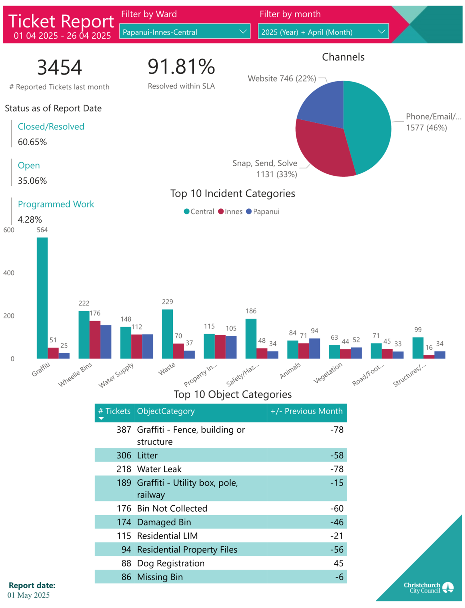
|
12. Elected
Members’ Information Exchange Te Whakawhiti Whakaaro o Te
Kāhui Amorangi
|
This item provides an opportunity for Board Members to
update each other on recent events and/or issues of relevance and interest to
the Board.
Karakia Whakamutunga
|
Unuhia, unuhia
Unuhia ki te uru tapu nui
Kia wātea, kia māmā, te ngākau,
Te tinana te wairua i te ara takatā
Koia rā e Rongo, whakairia ake ki runga
Kia tina! TINA! Hui e! TĀIKI E!
|
Draw on, draw on,
Draw on the supreme sacredness
To clear, to free the heart, the body and the spirit of mankind
Rongo, suspended high above us (i.e. in ‘heaven’)
Draw together! Affirm!
|