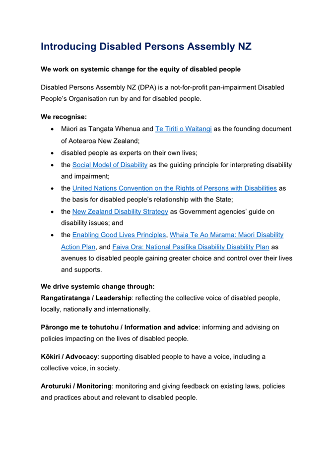
|
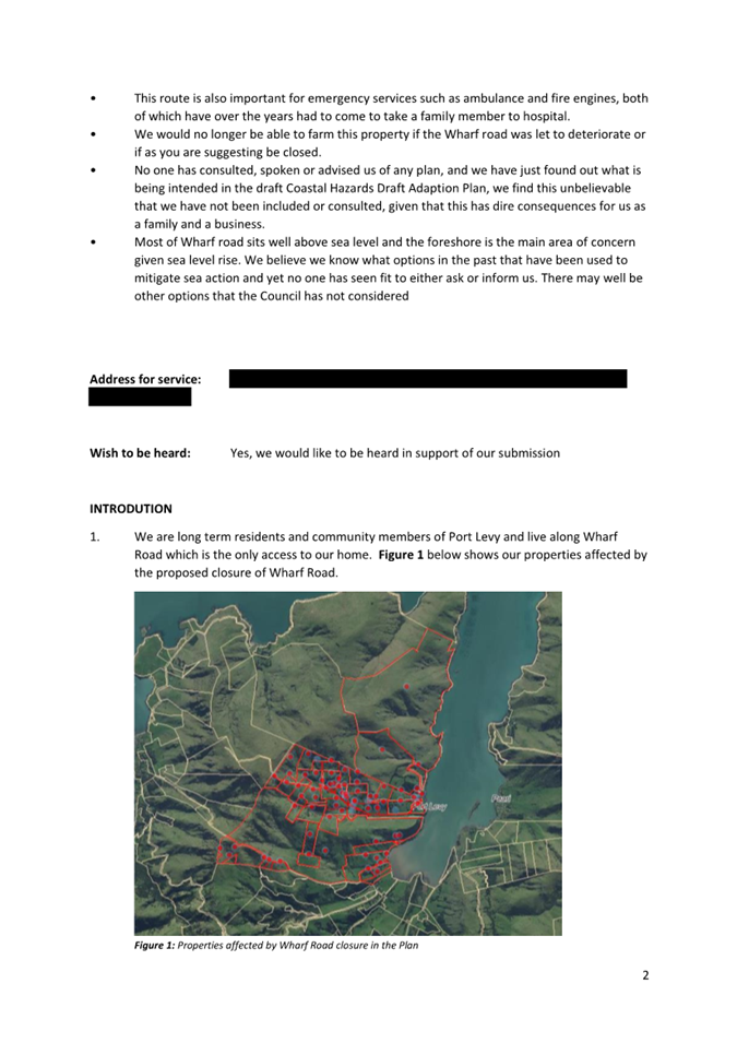
4. Coastal
Hazards Adaptation Plan for Whakaraupō Lyttelton Harbour and
Koukourarata Port Levy
|
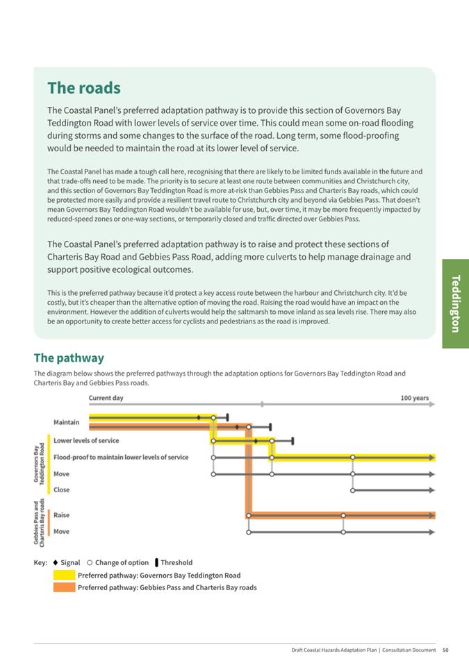
|
Reference
Te Tohutoro:
|
24/2186485
|
|
Responsible Officer(s) Te Pou Matua:
|
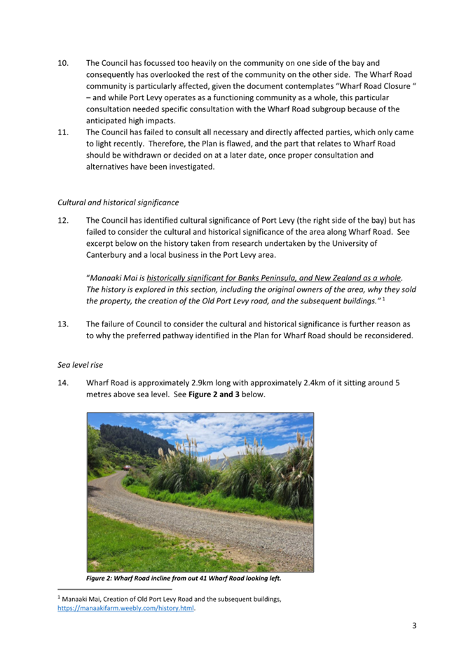
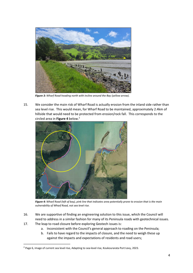
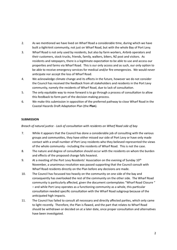
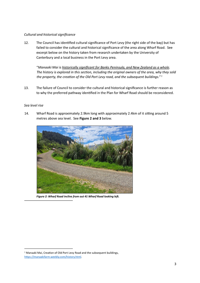
Jane
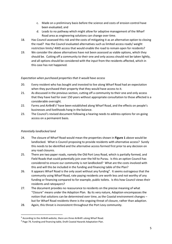
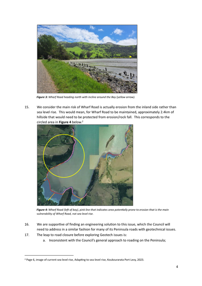
Morgan, Team Leader, Coastal Adaptation
Tom Simons-Smith, Principal Advisor, Coastal Hazards
Ruby Clark, Senior Adaptation Advisor
Krystle Andersen, Senior Engagement Advisor
|
|
Accountable ELT Member Pouwhakarae:
|
John
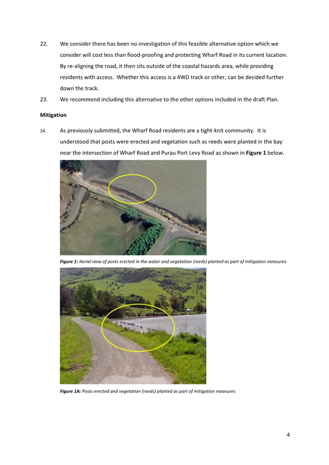
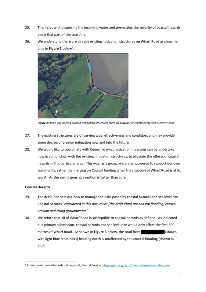
Higgins, General Manager Strategy, Planning & Regulatory Services
|
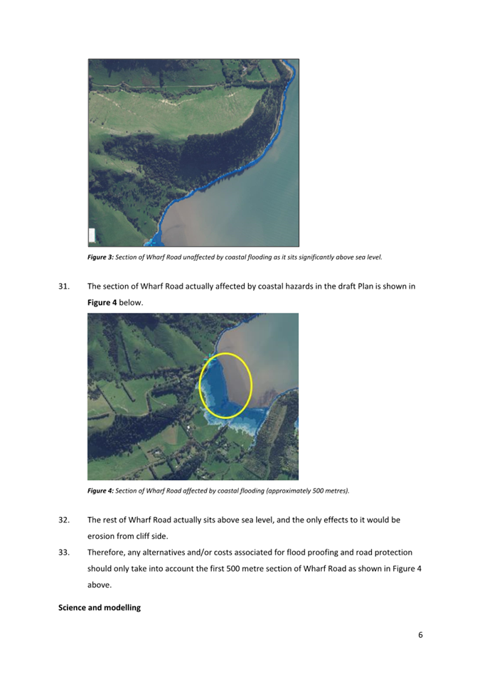
1. Purpose and Origin of the Report Te Pūtake Pūrongo
1.1 The
purpose of this report to the Council is to:
· Receive written and oral submissions on the draft Coastal Hazards
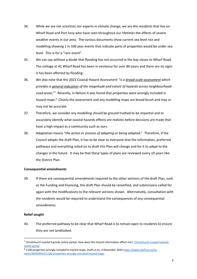
Adaptation Plan for Whakaraupō Lyttelton Harbour and Port Levy
Koukourarata (the draft Plan).
· Consider the amendments proposed by staff.
· Make recommendations to Council to adopt the draft Plan at a later
meeting.
1.2 On
16 October 2024, Council adopted the draft Plan for community consultation. Council
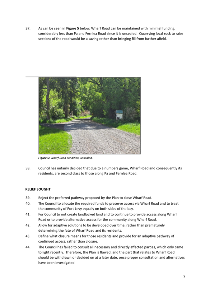
requested that following consultation, a Hearings Panel be appointed,
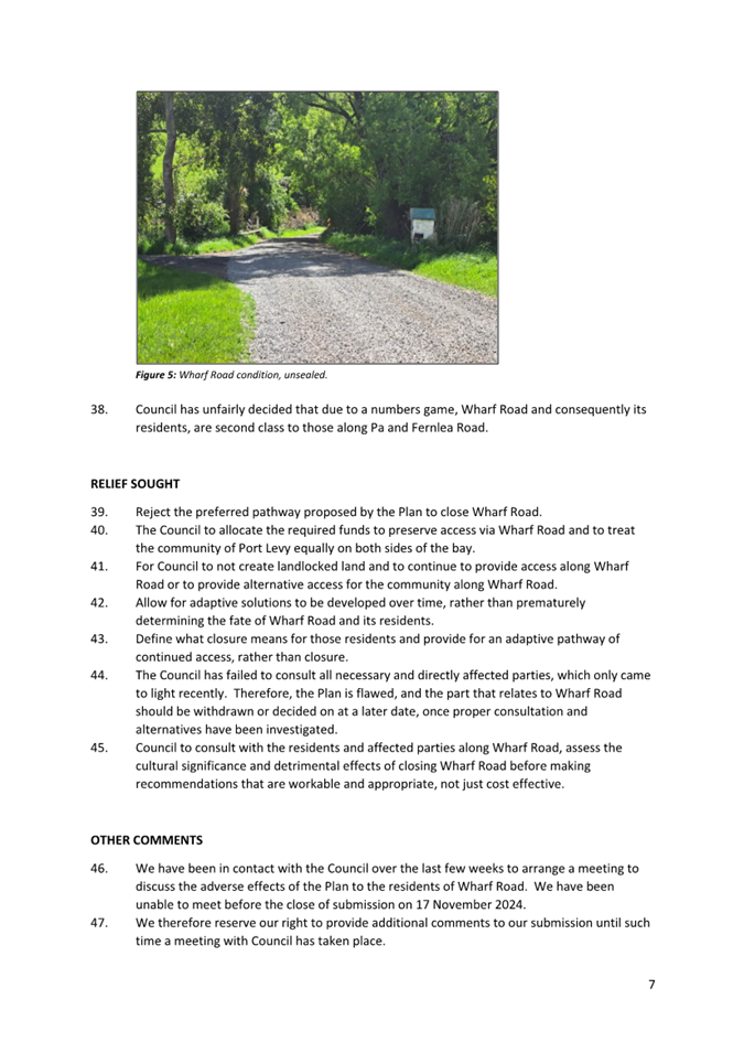
comprising of full Council, to hear submissions and make recommendations for
Council to resolve at a later date.
1.3 The
draft Plan sets out the preferred adaptation pathways identified by a Coastal
Panel of community and Rūnanga representatives to manage risks to public
assets, posed by coastal hazards and rising sea levels.
1.4 Attached
to this report are the following appendices:
· Appendix One: The draft Coastal Hazards Adaptation Plan for
Whakaraupō Lyttelton Harbour and Port Levy Koukourarata (the draft Plan).
· Appendix Two: Analysis of Submissions on the draft Plan.
2. Officer
Recommendations Ngā Tūtohu
That the Council:
1. Receives the information in the Coastal
Hazards Adaptation Plan for Whakaraupō Lyttelton Harbour and Koukourarata
Port Levy report.
2. Notes that the decision in this report is assessed as high significance
based on the Christchurch City Council’s Significance and Engagement
Policy.
3. Recommends the draft Plan be adopted with the following amendments:
a. Amend the preferred pathway for the Governor’s Bay to
Allandale Foreshore Track to include Protection of the stretch of track between
the Governors Bay Jetty and the Council pump station at an additional estimated
cost of $3M.
b. Retain the preferred pathway for Governors Bay – Teddington
Road but add a new alternative option of Road Raising.
c. Retain the preferred pathway for Wharf Road but add a new
alternative option of Moving the section of Wharf Road located at the head of
the harbour inland.
d. Minor edits and amendments as set out in Table One in this report.
3. Executive Summary Te Whakarāpopoto Matua
3.1 In
response to feedback from submitters received during the final consultation on
the draft Plan, Council staff recommend that the Council support the following
amendments:
3.1.1 The
Coastal Panel’s preferred pathway for the Governors Bay to Allandale
Foreshore Track is Maintain → Lower Levels of Service → Close.
Submitters emphasised the value of the track and sought to keep the track open
for as long as possible. Staff recommend an amendment to the preferred pathway
to include protection of a stretch of the track between the Governors Bay Jetty
and the Council pump station to provide ongoing access to the pump station for
operational purposes and to provide amenity to the community. This option comes
at an estimated additional cost of $3M which is not expected to be incurred
within the next decade.
3.1.2 The
Coastal Panel’s preferred pathway for the Governors Bay Teddington Road
is Maintain → Lower Levels of Service → Flood Proof to Maintain at
a Lowered Level of Service. Submitters emphasised the criticality of that
section of road and sought further clarity on the exact nature of lowered
levels of service. Staff recommend no change to the preferred pathway but recommend
that a new alternative option of Road Raising is added to the pathway to allow
for greater flexibility in the future. Further clarifications regarding Lower
Levels of Service have also been proposed as edits to the draft Plan.
3.1.3 The
Coastal Panel’s preferred pathway for Wharf Road is to Maintain → Lower
Levels of Service → Close. Submitters emphasised the criticality of Wharf
Road as the sole access to their properties and to their economic and social
wellbeing and sought ongoing protection or relocation of the road. Staff
recommend no change to the preferred pathway but recommend that a new
alternative option of Moving a section of Wharf Road is added to the pathway to
allow for greater flexibility in the future.
3.2 Specific
wording changes to the draft Plan are set out in Table One, Section 5.72 of
this report.
3.3 Staff
do not recommend further changes to the Coastal Panel’s preferred
pathways in response to submitters feedback.
4. Background/Context Te Horopaki
4.1 The
Coastal Hazards Adaptation Planning (CHAP) programme has been progressing an
adaptation planning process in the Whakaraupō Lyttelton Harbour and
Koukourarata Port Levy Adaptation Area since late 2022. This is the first of a
number of climate adaptation planning processes that are expected to occur
across the district as Council and communities prepare for the impacts of
climate change.
4.2 The
process focuses on developing adaptation pathways for Council-owned assets in
areas at risk of coastal flooding, erosion and/or rising groundwater within the
next 30 years. The specific locations planned for are Rāpaki, Allandale
Teddington, Te Wharau Charteris Bay, Purau and Koukourarata Port Levy. Assets
in other areas such as Lyttelton have been assessed as lower risk during this
30-year timeframe but may be subject to future planning processes.
4.3 In
line with its Coastal Adaptation Framework, the
Council appointed a local Coastal Panel of community and rūnanga
representatives with the responsibility of identifying their preferred
adaptation pathways, with the final decision to be made by Council.
4.4 The
Coastal Panel have been guided through this process by the Specialist and
Technical Advisory Group (STAG) which included Council asset owners and
specialists as well as representatives from Environment Canterbury, the
Department of Conservation, Te Whatu Ora and the University of Canterbury. The
involvement of asset owners from across Council has ensured that the draft Plan
reflects and aligns with existing activity and decision-making approaches in
these areas.
4.5 The
Coastal Panel included representatives from the two rūnanga whose
takiwā is impacted, Te Hapū o Ngāti Wheke and Te Rūnanga o
Koukourarata. Staff have also engaged directly throughout the process with
wider rūnanga representatives.
4.6 There
have also been wider community engagement points during the process, to ensure
that the Coastal Panel has been able to integrate community values and feedback
as planning has progressed.
4.7 The
Coastal Panel identified its preferred adaptation pathways, and these were then
included in the draft Plan which was consulted on between 17 Oct – 17 Nov
2024. The integrated planning process outlined above delivered a high level of
agreement about the preferred pathways across the Coastal Panel, STAG and
rūnanga.
4.8 The
estimated capital costs of implementation of the pathways as set out in the
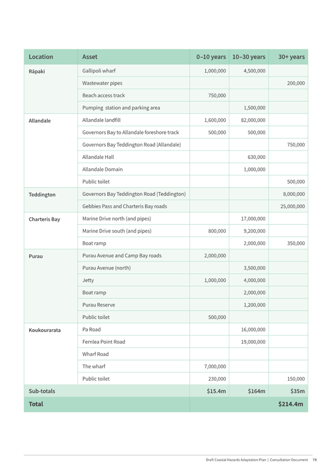
draft Plan are $15.4m over the next decade, $164m between 2035-2065 and $35m
from 2065 onwards totalling $214.4m over the 100-year period. These costs are
estimates, based on present day value and do not account for operational costs
such as maintenance. Any changes to the Coastal Panel’s preferred
pathways may require adjustment to the cost estimates.
4.9 Adaptation
planning uses the Dynamic Adaptive Planning Pathways (DAPP) approach which is
predicated on undertaking long-term planning (over a 100-year period for these
at-risk assets) in the context of deep uncertainty, and includes two key
features that differentiate it from standard planning processes:
· Flexibility in the timing of the action – The timing of
actions is based on signals and triggers, not on concrete timelines, meaning
that we only act when we need to. This responds to the uncertainty around the
rate and timing of sea level rise. Signals and triggers include monitoring the
rate of future sea level rise and the nature of local impacts in different
areas. This allows adaptation investments to be pulled forward to, for example,
respond to the impacts of an extreme storm, or be delayed if impacts on assets
occur later.
· A ‘preferred pathway’ that allows for changes in
direction - There is more certainty about proximate actions, and less about
longer term actions. To address that uncertainty, a range of feasible (but
currently not preferred) ‘alternative options’ are retained in the
Plan. Retaining alternative options responds to the possibility that we may
need to change direction in the future.
4.10 The Council may
choose to endorse existing preferred pathways as proposed by the Coastal Panel,
or they may choose to amend these in response to staff and submitter feedback.
However, even once the draft Plan is finalised, adaptation actions and pathways
are still responsive to future changes and are reliant on future
reprioritisation and/or funding decisions by Council.
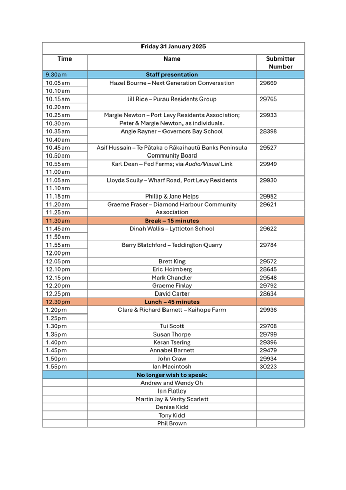
4.11 The following sessions took place before adoption of the draft Plan
for consultation:
|
Date
|
Subject
|
|
22 Jul
|
Te Pātaka o Rākahautū
Banks Peninsula Community Board briefing
|
|
6 Aug
|
Council information session (link to recording)
|
|
26 Sept
|
Coastal Hazards Working Group endorsed
the draft Plan
|
|
16 Oct
|
Council adopted the draft Plan for
consultation and agreed to establish a Hearings Panel (link to the recording)
|
5. Community Feedback and Options Considered Ngā
Kōwhiringa Whaiwhakaaro
Early engagement
5.1 Staff
ran two rounds of early engagement with the wider Whakaraupō Lyttelton
Harbour and Koukourarata Port Levy communities prior to consultation on the
draft Plan.
5.2 The
first engagement started in October 2022 and asked the community to tell us:
· what they valued most about the area.
· what community assets were important to them.
· what they would like and wouldn’t like this area to look like
in 100 years.
5.3 The
full report or summary document on this engagement is
available on the Council webpage. The Coastal Panel used these results to
create Community Objectives which guided the Coastal Panel’s scoring of
adaptation options. These Community Objectives can be found in the draft Plan on
page 15.
5.4 A
second engagement between October 2023 - January 2024 sought feedback on the
shortlisted options for the draft adaptation pathways to see if the Coastal
Panel was on the right track. 58 individuals and groups provided feedback. The analysis of this feedback is available on our webpage.
Consultation
5.5 Consultation
on the draft Plan occurred between 17 October and 17 November 2024. Information
about the consultation was emailed to 178 key stakeholders, including local
community groups and residents’ associations and a newsletter was also
sent to 362 subscribers, including those who had provided feedback previously.
5.6 The
consultation was hosted on Kōrero mai | Let’s Talk and
received 7,799 views. It was posted on the Council Facebook page and shared to
four local community group pages reaching over 12,600 people. A short video was
developed and shared on 7 November 2024 which reached over 2,800 people.
5.7 Online
and newspaper ads, public signage located by affected assets, and posters promoted
the consultation. Flyers and posters were delivered to some local businesses
and community spaces and documents were available in Lyttelton and Diamond
Harbour libraries.
5.8 Flyers
were also sent directly to resident’s letterboxes across the
Whakaraupō Lyttelton Harbour and Koukourarata Port Levy area.
5.9 Staff
attended the following community meetings/events/markets:
· Community meeting hosted by Diamond Harbour Residents Association -
22 October
· Community meeting hosted by Governors Bay Community Association
– 4 November
· Community meeting with Port Levy (Wharf Road) residents – 30
November
· Presentation to Cashmere High School class – 21 October
· Governors Bay Fete – 20 October
· Orton Bradley Fair – 27 October
5.10 Staff hosted a webinar
on 30 October which was attended by approximately 13 people. Targeted
sessions were also run with students from Governors Bay and Lyttelton Schools.
5.11 This final
consultation phase provided the wider community with an opportunity to share
their feedback on the Coastal Panel’s preferred pathways before a final
Council decision.
Community feedback and options
considered
5.12 This section of
the report has four sub-sections, which address submitters feedback.
· General feedback about the draft Plan.
· Feedback on the proposed pathways, where it was either supportive,
neutral, minimal or no comments were made. Therefore, it is recommended that
these pathways progress to Council decision with no recommended changes.
· Feedback on the proposed pathways, where it was substantive and/or
raised new matters for consideration. Therefore, staff commentary and
recommendations are put forward for consideration by the Council.
· Table One captures proposed edits to the draft Plan, to reflect
amendments proposed by staff to address submitters feedback, or for accuracy or
clarity.
General
feedback about the draft Plan
5.13 Submissions were
made by 16 recognised organisations, four businesses and 68 individuals. Of the
88 total submissions, 71 submissions were made online in Let’s Talk, and
17 were made via email. All submissions are available in the associated Volume
of Submissions; and Appendix Two contains the Analysis of Submissions which
sets out submitter comments on each asset.
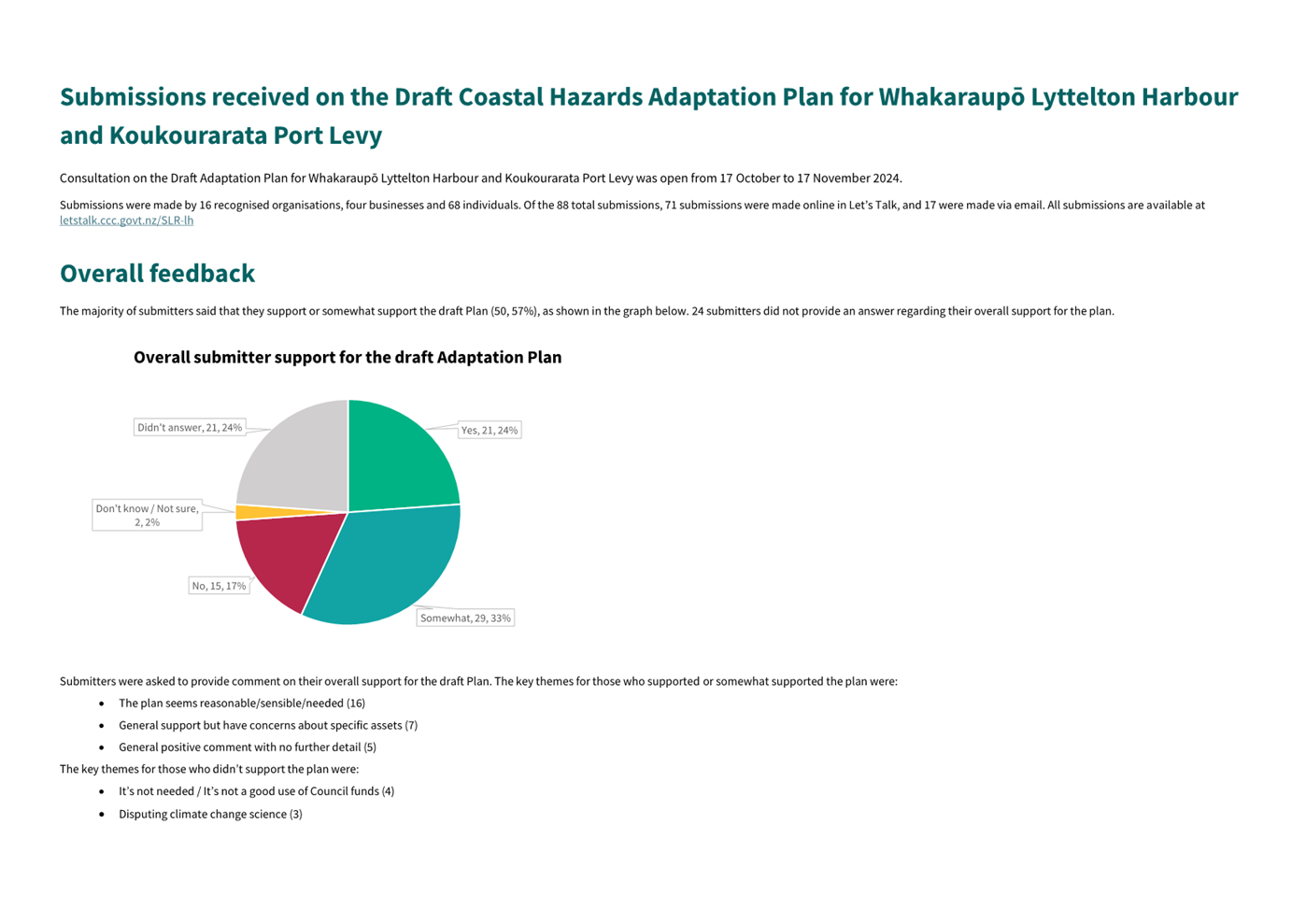
5.14 The majority of
submitters said that they support or somewhat support the draft Plan (50, 57%),
as shown in the graph below. 24 submitters did not provide an answer regarding
their overall support for the plan.

5.15 The key themes
for those who supported or somewhat supported the plan were:
· The plan seems reasonable/sensible/needed (16)
· General support but have concerns about specific assets (7)
· General positive comment with no further detail (5)
5.16 The key themes
for those who didn’t support the plan were:
· It’s not needed / It’s not a good use of Council funds
(4)
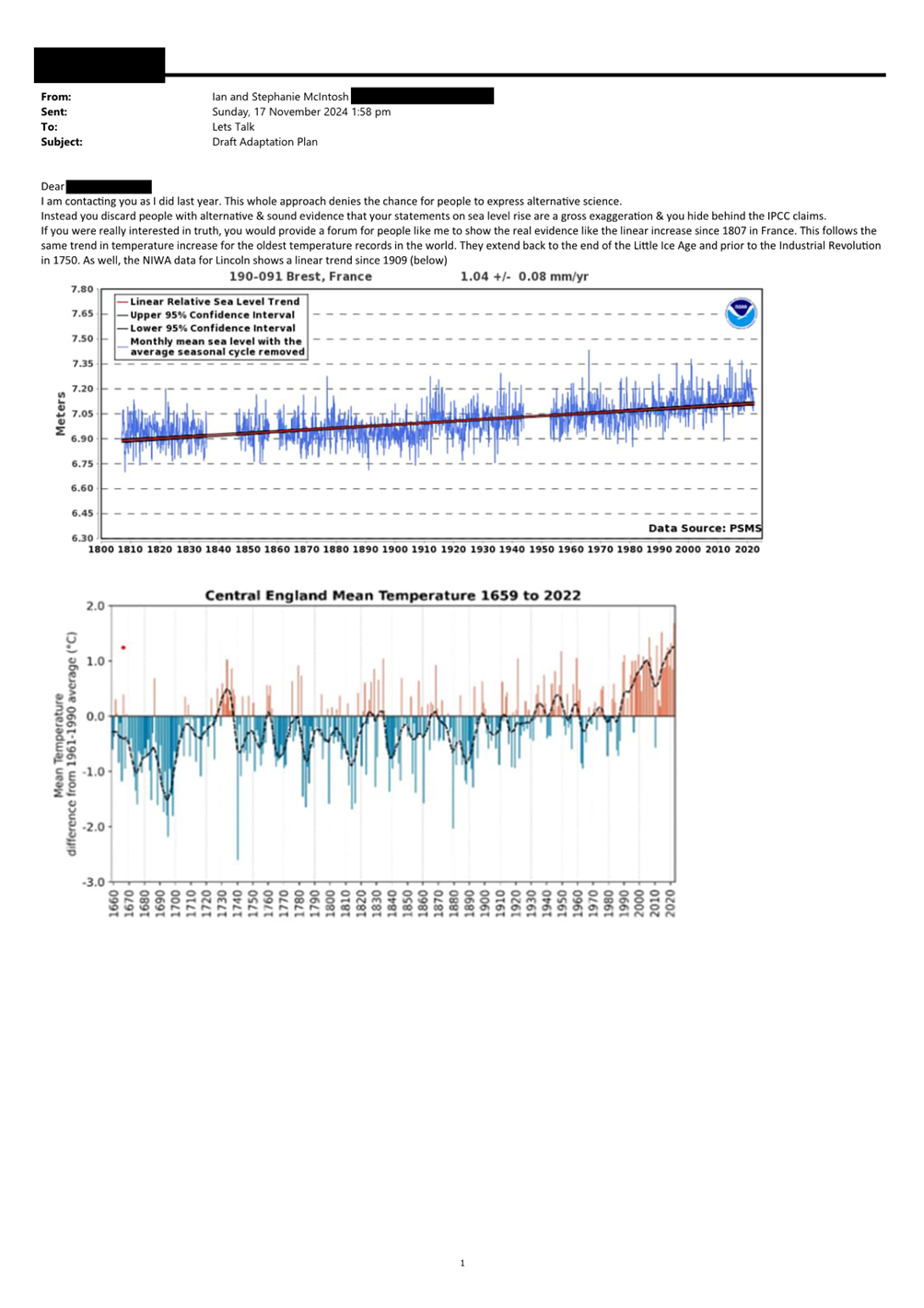
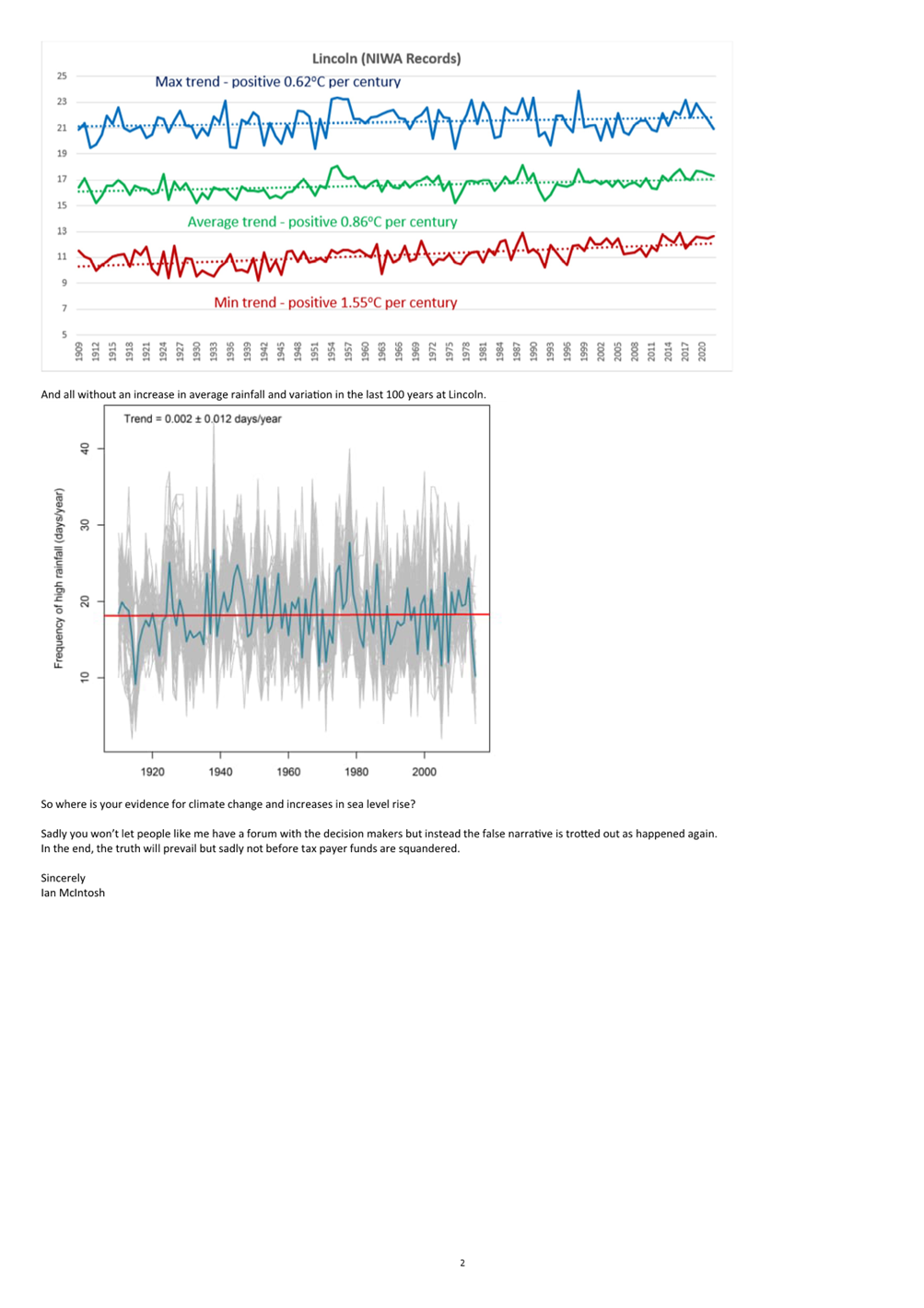
· Disputing climate change science (3)
Feedback
supportive or minimal: No changes are recommended
5.17 Feedback on the proposed pathways for the following assets was
either supportive, neutral, minimal or no comments were made. Therefore, it is
recommended that the Coastal Panel’s preferred pathways for the following
assets progress to Council decision with no changes.
|
Location
|
Asset
|
|
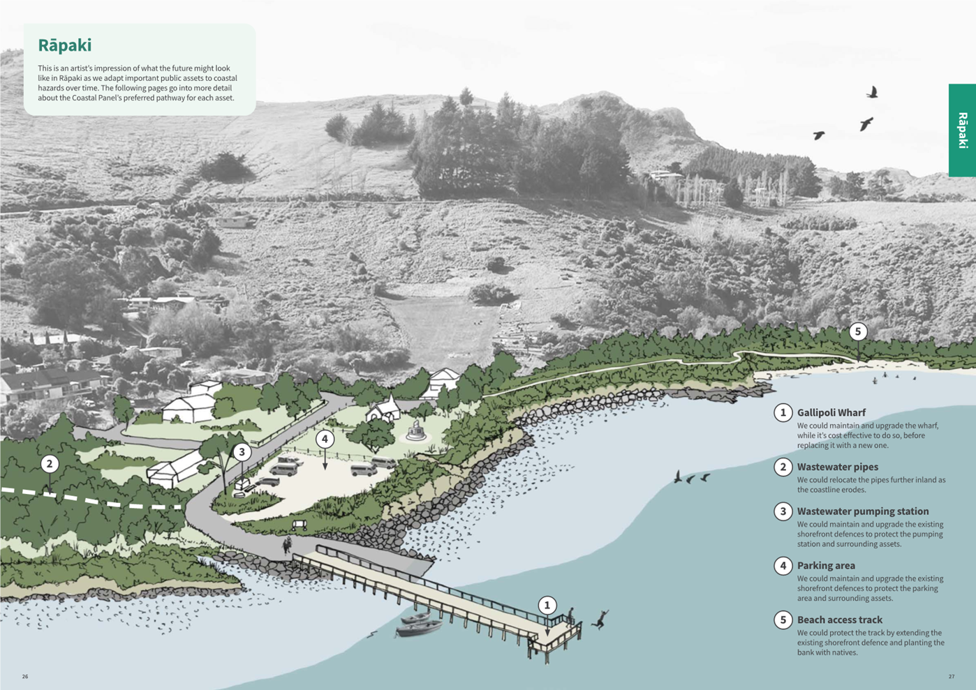
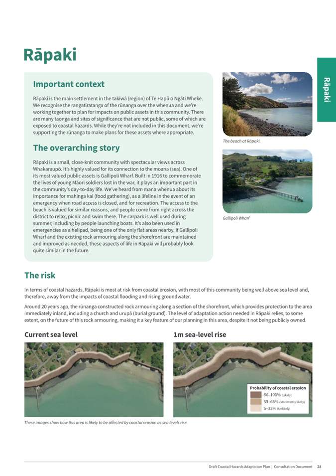
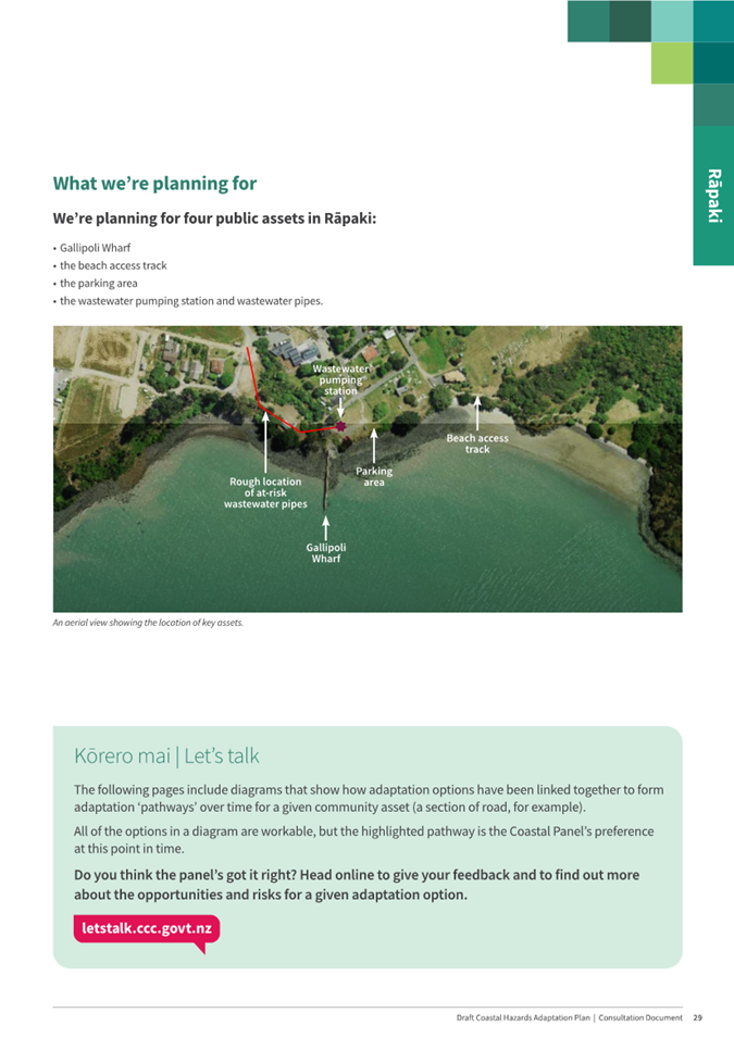
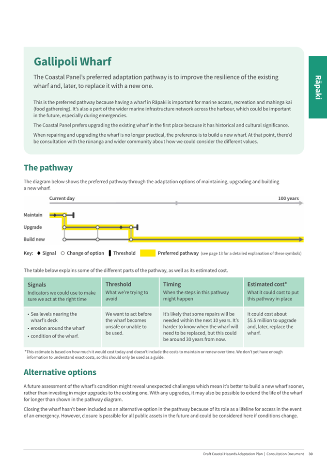
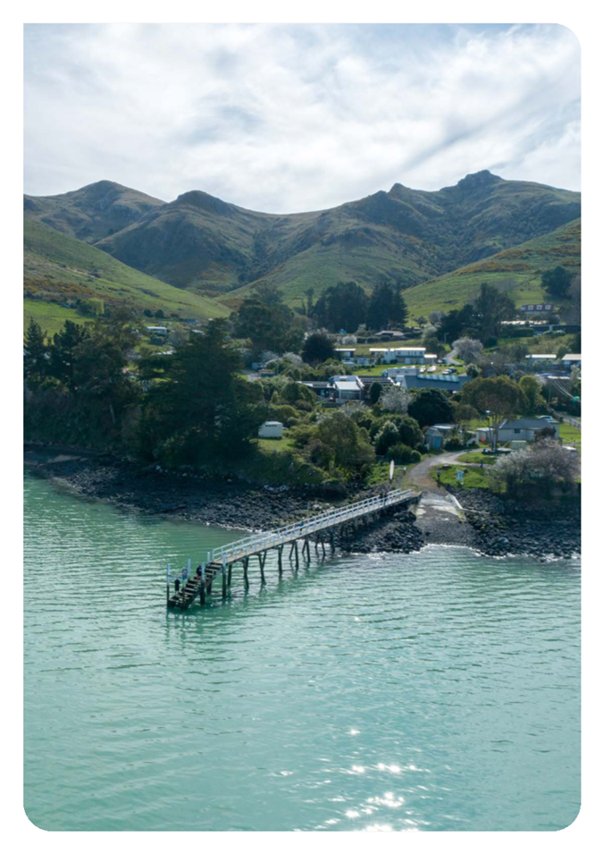
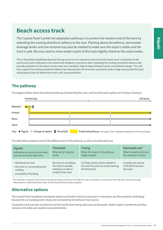
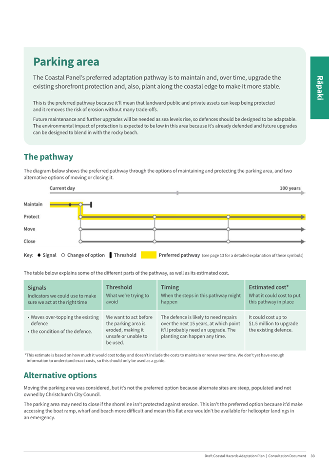
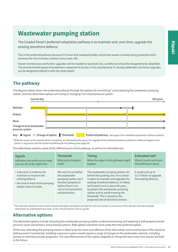
Rāpaki
|
Gallipolli Wharf, the beach access track, parking area, wastewater
pumping station and the wastewater pipes, being all components of the Plan
for Rāpaki.
|
|
Allandale
|
Allandale landfill, Governors Bay Teddington Road (Allandale
section), public toilet
|
|
Teddington
|
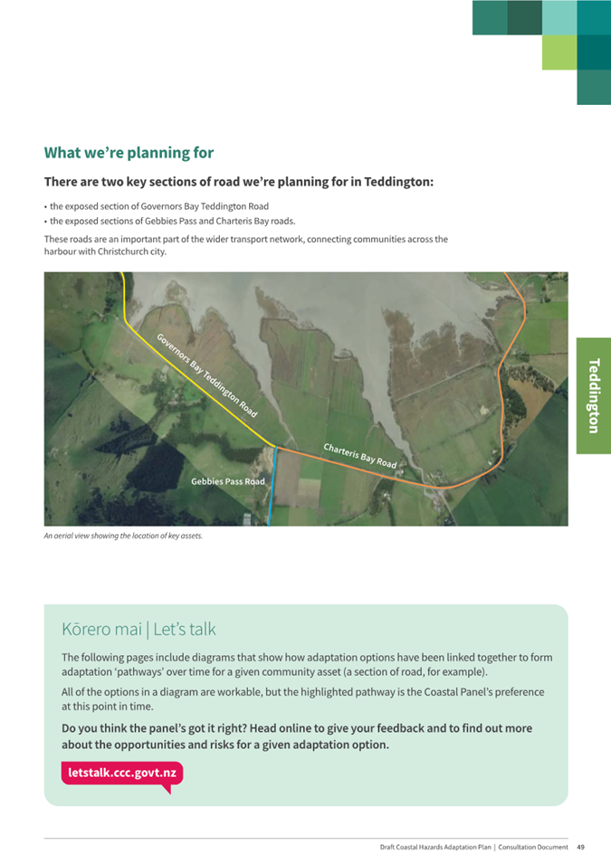
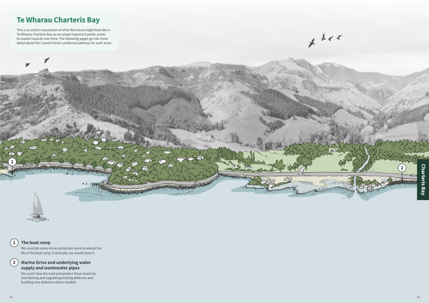
Charteris Bay Road and Gebbies Pass Road
|
|
Charteris Bay
|
Marine Drive and underlying pipes
|
|
Purau
|
Longshore section of Purau Avenue, Purau Jetty, Purau Reserve, and
the public toilet.
|
|
Koukourarata
|
Koukourarata Wharf, Pa and Fernlea Roads, and the public toilet.
|
Marine Drive
5.18 While no changes
are recommended to the Coastal Panel’s preferred pathway for Marine Drive
and its underlying wastewater and water supply pipes of Maintain →
Protect and Raise, staff note that several submitters who made comments about
Marine Drive (6 of 15) sought the inclusion of a footpath alongside the road as
this area is popular for walking. This matter would be investigated at the
stage of detailed design.
Feedback is
substantive or new matters are raised: Staff commentary and recommendations
5.19 Feedback on the
following proposed pathways was substantive and/or raised new matters for
consideration. Therefore, staff commentary and recommendations are put forward
for consideration.
Allandale Hall
5.20 The Coastal
Panel’s preferred pathway in the medium to long term is Closure and
Removal. Allandale Hall has been closed since 2023 due to significant issues
including a decayed floor caused by a lack of ventilation and high groundwater,
and a finding of E.coli in the water supply requiring investment to meet
compliance standards.
5.21 Following
feedback received through the Long-Term Plan consultation, it was agreed that
decisions regarding the immediate operational future of the Hall would be made
outside of, but informed by, the adaptation planning process.
5.22 Repairs to give
the Hall an operating life of another 3 to 10 years are estimated at $80,000
and these funds have since been allocated by the Te Pātaka o
Rākaihautū Banks Peninsula Community Board and from an existing
operational budget.
5.23 The timing of
the Hall’s permanent closure and removal will depend on the extent of any
repairs undertaken.
5.24 Seven of eight
submitters want to see the hall repaired and reopened, mostly citing its value
to the community, its historic value, and the fact that it is a unique venue in
the harbour. Four of these seven submitters want to see the hall operating
indefinitely, while the other three support the Coastal Panel’s preferred
pathway of closing it at some point in the future.
5.25 Staff recommend
no changes to the preferred pathway for the Allandale Hall noting that the short-term
repair of the hall falls outside of the draft Plan process.
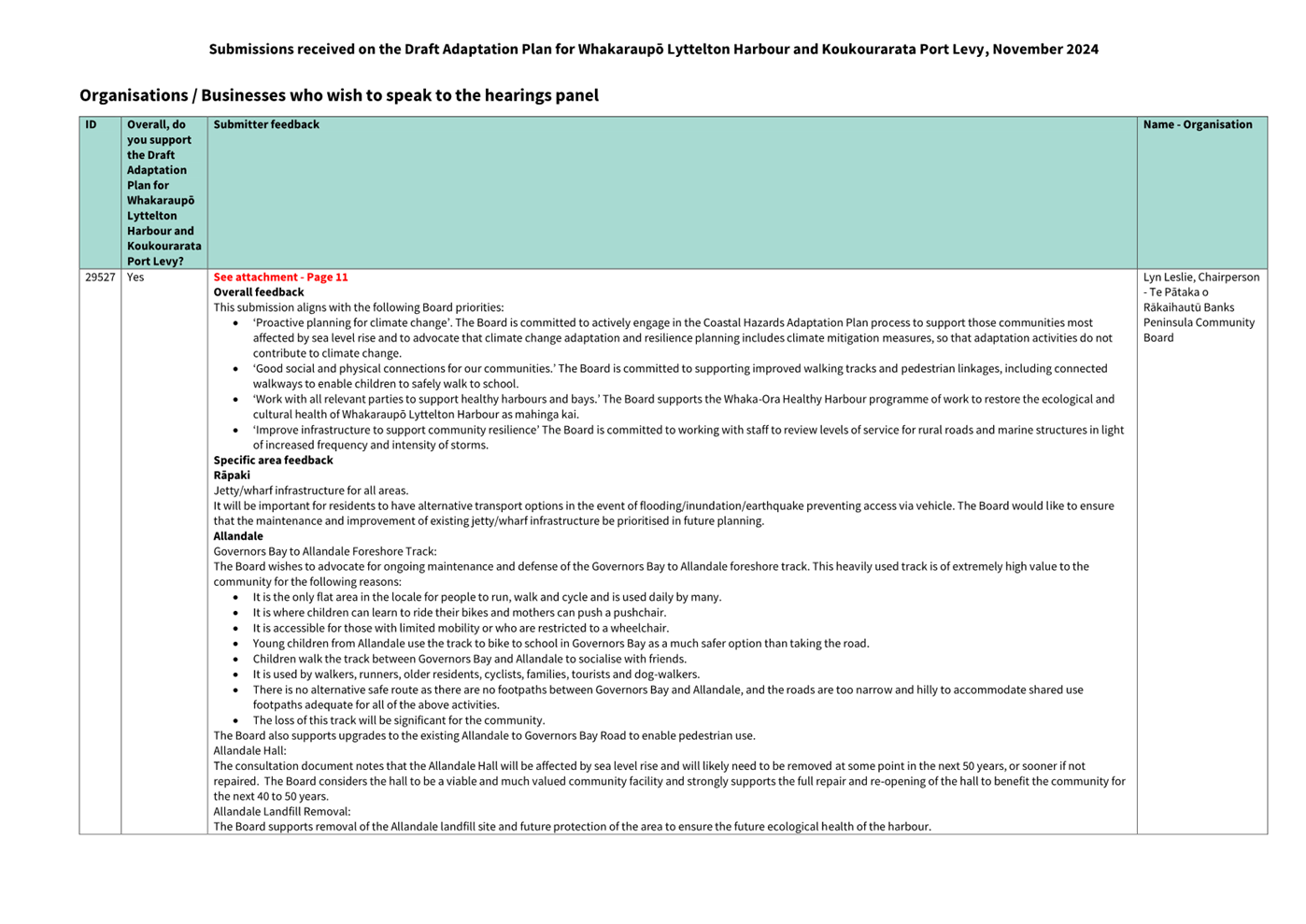
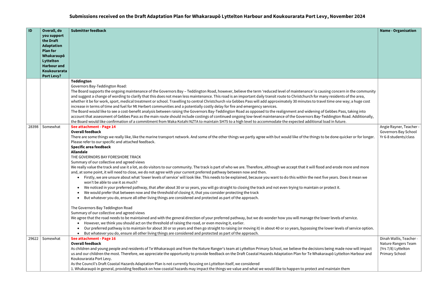
Governors Bay to Allandale Foreshore Track
5.26 The Coastal
Panel’s preferred pathway is Maintain → Lower Levels of Service
→ Close. This pathway recognises that $680,000 of works are already
programmed to repair weakened areas of the existing seawall that protects the
track. It is expected that the track will function at a Lower Level of Service
for around 30 years and will then likely need to be Closed due to the impacts
of erosion and flooding. The alternative option of Protect is included in the
pathway but it is not the Coastal Panel’s preferred pathway.
5.27 Ten of 11
submitters emphasised the significant values that the track provides:
· It is well utilised for running, walking, cycling, dog-walking and
socialising.
· Its flat and wide terrain is highly valued for its safety and
accessibility allowing children to learn to ride bikes, parents to push prams,
people with limited mobility to walk safely, and wheelchair users to navigate
the outdoors.
· It connects Governors Bay and Allandale settlements which have no
other footpath access, allowing safe movement for children attending Governors
Bay School.
5.28 Citing these
values, eight submitters would like to see the track kept open for as long as
possible or indefinitely. Several suggested protection measures to help keep
the track open, including raising, defending, planting, or adapting the track
to include board walks.
5.29 The option of protecting
the full length of the track is not recommended by staff due to the high cost (estimated
at $13.4M excluding maintenance), environmental impacts of physical works on
penguin nesting, and the mudflat environment; and the challenging consenting
pathway involving works in the Coastal Marine Area.
5.30 Staff recommend
that the preferred pathway for the Governors Bay to Foreshore Track is amended
to include protection of a stretch of the track between the Governors Bay Jetty
and the Council pump station to provide a level of ongoing access to the pump
station for operational purposes and amenity to the community. This option
comes at an estimated additional cost of $3M, which is not expected to be
incurred within the next decade.
Allandale Domain
5.31 The Coastal
Panel’s preferred pathway is Maintain → Naturalise the domain. The
option of Do Nothing is included in the pathway but is not preferred by the
Coastal Panel.
5.32 Of the eight submitters that provided feedback on Allandale Domain,
three support the Coastal Panels preferred pathway, three want to see the
recreational value of the domain retained, and one suggested planting occur
while retaining recreational values.
5.33 The option of
maintaining the grounds primarily for sports and recreation is not recommended
by staff. The domain is already impacted by infrequent ponding and is regularly
damp due to high groundwater. Staff anticipate that the costs to address these
impacts would be prohibitive, requiring active ground and surface water
management and possible land raising.
5.34 Staff recommend
no changes to the preferred pathway for the Allandale Domain. The
naturalisation of this area will have ecological benefits allowing the
saltmarsh and other species to survive. However, in recognition of the
recreational value communicated by submitters, the domain could be maintained for
a time before any regeneration occurs, instead of taking proactive action.
Governors Bay Teddington Road
5.35 The
Coastal Panel’s preferred pathway is Maintain → Lower Levels of
Service → Flood Proof to Maintain at a Lowered Level of Service. This
recognises the limited traffic numbers (around 2,100 vehicles a day), the high
costs of any alternatives (moving or substantial raising), and the availability
of an alternative route through Gebbies Pass to the city. Lower Levels of
Service are anticipated to be incremental and relatively minor over
the next few decades – likely involving temporary (hours) and infrequent
(a few times a year) road closures. The alternative options of
Moving or Closing the road are included as alternative options in the pathway
but are not preferred by the Coastal Panel.
5.36 23 submitters
made comments about the Governors Bay Teddington Road. Of these, 19 did not
support the Coastal Panel’s preferred pathway, two did and two
didn’t express a view.
5.37 Unfortunately,
an article published by The Press on 18 October 2024 (the day after the release
of the draft Plan) wrongly reported that this road would be permanently closed
by the end of the century, however the Coastal Panel’s preferred pathway
in the draft Plan is to eventually raise the road (described as Flood Proofing
in the draft Plan)[1]. While this article was corrected on 21 October, at least five of
the 23 submitters on this pathway appear to have submitted based on this
inaccuracy.
5.38 15 of the 23 submitters questioned the practicality of Lowering Levels
of Service on this road for the following reasons:
· It may reduce connectivity between settlements that currently
operate as one harbour-wide community.
· The alternative Gebbies Pass route is longer, adding time, cost, and
emissions.
· It reduces access for emergency vehicle access during a civil
defence emergency.
· It is an oversized vehicle route that is used by the Lyttelton Port
Company (LPC).
· This is currently the Cashmere High School bus route.
· It reduces access to the local quarry.
5.39 Te Pātaka o
Rākaihautū Banks Peninsula Community Board recommended that the draft
Plan clarify that Lower Levels of Service does not always mean reduced
maintenance as could be assumed.
5.40 Lowered Levels
of Service are challenging to communicate and specify in advance as these will
be conditional on the nature and scale of future flooding events and how the
road performs under these conditions; and will differ depending on the usage,
location and importance of the road. The draft Plan outlines the forms that
Lowered Level of Service might take on page 20:
· Temporary road closures.
· Lower-capacity traffic for a time, such as one lane being closed.
· Changes to the road surface, for example seal being replaced with
gravel or bridges being replaced with fords.
· Four-wheel drive access vehicles being recommended at times.
· Less usable road space.
· Temporary or permanent heavy-vehicle restrictions to limit damage to
the road.
· More frequent road maintenance and disruption.
5.41 Many of these
options are temporary and will only require road users to change their route or
adapt their behaviour for limited periods of time. Some options, such as the
use of fords are more likely to be applied to low traffic roads only.
5.42 In the context
of Governors Bay – Teddington Road, Lower Levels of Service are most
likely to involve temporary road disruptions due to flooding. Drivers may be
required to take a temporary detour via Gebbies Pass before tides and flooding
recede and the road can be re-opened. Staff expect these events will often be
foreseeable and short-lived, for example due to spring tides or storm events,
allowing drivers to plan travel routes around these disruptions.
5.43 Council staff
have engaged with LPC throughout this process and LPC have confirmed that they
have no concerns with the proposal to Lower Levels of Service on this road,
noting that it would remain generally available for use.[2]
5.44 Staff note that
while a commute via Gebbies Pass will add time, the detour is only a further
10-20 minutes to the CBD depending on the traffic.
5.45 The option of
raising the road to the same extent as proposed for Gebbies Pass and Charteris
Bay Road is not recommended by staff. The estimated cost of this is $21.5M and
this scale of road raising would likely require road widening, with significant
additional environmental disruption of the highly valued saltmarsh environment.
Relatively low usage rates and the availability of an alternative route through
Gebbies Pass make this less necessary.
5.46 Te Pātaka o
Rākaihautū Banks Peninsula Community Board sought assurances that
Waka Kotahi would commit to the long-term availability of State Highway 75
(south of Gebbies Pass) as an alternate route. Staff engaged with Waka Kotahi
during development of the draft Plan to seek confidence that the preferred pathway
for the roads in Teddington would not be precluded by future plans for SH75.
Waka Kotahi indicated that while long-term planning has not yet occurred for
SH75, there are no current plans to close this route.
5.47 Staff recommend
that the preferred pathway for Governors Bay – Teddington Road is not
amended but that a new alternative option of Road Raising is added to the
pathway. The Council would retain the Coastal Panel’s preferred pathway
of Maintain → Lower Levels of Service → Flood Proof to Maintain at
a Lowered Level of Service as it recognises the cost pressures on future
ratepayers (an estimated cost of $8M compared with $21.5M), which allows for
ongoing access as well as the alternative access via Gebbies Pass.
5.48 However, staff
recommend that inclusion of an alternative option of Road Raising would provide
greater flexibility in the future, if, for example Waka Kotahi’s future
decisions impact on the availability of SH75. Should
SH75 be closed, it may be that raising of Governors Bay – Teddington Road
is necessary.
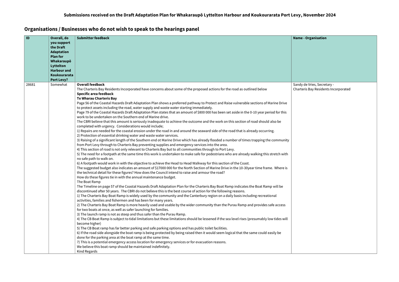
Charteris Bay and Purau Boat Ramps
5.49 The Coastal
Panel’s preferred pathway for the Charteris Bay Boat Ramp is Maintain
→ Protect → Close. Closure is not anticipated for around 40-50
years. While the Charteris Bay Boat Ramp is well used for recreational
purposes, it is not currently a reliable lifeline asset due to only being
available during mid-high tide, as the shallow waters limit the launching of
boats. The preferred pathway therefore recognises that the Purau Boat Ramp
offers a substitute for most recreational needs. The alternative option of
ongoing Protection is included in the pathway but is not preferred by the
Coastal Panel due to the high cost of protecting the parking area to retain a
functioning boat ramp long-term. Costs are estimated at between $350,000 -
$2.35M, depending on the scale of protection and whether land raising is
required.
5.50 The Coastal
Panel’s preferred pathway for the Purau Boat Ramp is Maintain → Upgrade/Protect.
This would see the existing facility retained with larger scale renewals,
likely to involve shoreline protection and upgrades of the ramp itself. The
Coastal Panel recommended this pathway to provide for recreational uses and to
retain access over water on this side of the harbour should the roads be
impacted, with the Purau Boat Ramp being identified as more defendable and
useable during different tidal conditions than the Charteris Bay Boat Ramp. The
alternative option of Closure is included in the pathway but is not preferred
by the Coastal Panel.
5.51 Submissions
reinforced the high value of both boat ramps. 15 of 17 submitters who made
comments about the Charteris Bay Boat Ramp expressed concern over closing it
and/or sought a long-term strategy of raising and protecting it. Nine of 10
submitters on the Purau Boat Ramp supported the Coastal Panel’s preferred
pathway while one did not.
5.52 Feedback
included:
· The Purau Boat Ramp is less safe, due to its steep and slippery ramp
and more choppy launching conditions.
· The Charteris Bay Boat Ramp is preferable to the Purau Boat Ramp as
it is a safer gradient, its wider and allows for launching two boats at once,
and it has more parking, and toilet facilities.
· As sea levels rise it should be easier to launch from the Charteris
Bay Boat Ramp in a range of tidal conditions, allowing for emergency access.
· There are opportunities to align raising the boat ramp with the
proposed pathway of protecting and raising the section of Marine Drive.
· Reliance on the Purau Boat Ramp only may lead to capacity
constraints, particularly for parking during high use periods.
5.53 Staff note that
the Purau Boat Ramp is scheduled for renewal within six months, which is
expected to increase its safety and usability. This renewal is expected to
involve resurfacing of the concrete ramp, the addition of a concrete retaining
wall and possibly an elevated walkway to support with access during different
tides. Details are subject to final costings and approval.
5.54 Throughout the
draft Plan, the Coastal Panel have proposed that the existing marine
infrastructure act as an alternate means of moving around the harbour as the
roading network comes under greater threat. While the Council is responsible
for the marine infrastructure and the related access roads, Environment
Canterbury is responsible for public transport services, including ferry
transport, all of which play a role in a functional combined road and marine
infrastructure network. Staff have identified that further work is needed to
explore how we could provide more opportunities to move around the harbour in
the future.
5.55 Therefore,
Council and Environment Canterbury staff have agreed to work together to
investigate the feasibility and role that ferry services might play in
supporting the long-term resilience of the transport network in the harbour. As
part of this work, agencies would explore the feasibility of maintaining a
critical network of marine infrastructure to support access during emergencies.
Such feasibility work would be considered within the next LTP cycle.
5.56 This work may
conclude that the Charteris Bay Boat Ramp is a critical part of the network,
and the Purau Boat Ramp less so. The existing adaptation pathways allow for the
possibility that future investigations will help to inform the relative
priority of these assets and the type and timing of investments that are
recommended by staff.
5.57 Staff recommend
that the preferred pathways for the Charteris Bay and Purau Boat Ramps are not
amended but that the draft Plan be edited to reference the future
investigation to be undertaken by the Council and Environment Canterbury and
the possibility that this may drive changes to the long-term preferred pathways
for these assets.
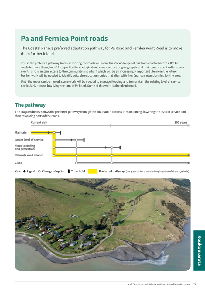
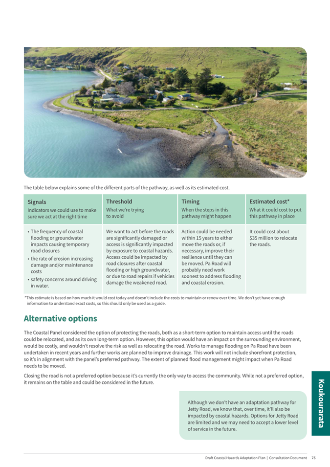
Purau
Avenue, Camp Bay Road and Purau – Port Levy Road
5.58 Over
the short term, the Coastal Panel’s preferred pathway is Maintain →
Lower Levels of Service and Use Interim Protection. The Coastal Panel has not
recommended a preferred pathway over the long term due to several
uncertainties, but has indicated that, either Flood-Proofing and Protecting the
road or moving it inland are likely the best options and should remain on the
table for consideration. Future decisions will
consider factors such as the number of people that depend on the road, the
availability of alternative access such as marine, the impact that interim
protection works have on the beach and their effectiveness in defending the
road, and the relative affordability of options to ratepayers. The alternative option
of Closure is included in the pathway but is not preferred by the Coastal Panel.
5.59 Of the 11
submitters who commented on these roads, six indicated a preference of
protecting and raising the road on its existing alignment. Five stated that it
was necessary to retain access to private properties, and one suggested that
would secure the long-term future of the inland community.
5.60 Staff advise
that protecting and raising the shorefront road would not reduce groundwater
and drainage-related flood risk to adjoining inland properties. To reduce flood
risk to the inland area, a range of other interventions would be necessary to
manage raised groundwater and surface flooding. These issues of raised
groundwater and flooding from tides and rainfall are expected to worsen over
time due to the low-lying nature of the landward area.
5.61 Orion’s
submission stated that their network of above and below ground infrastructure
in both sections of Purau Avenue is likely to be impacted in advance of the
road and that early and close consultation will be key.
5.62 Staff recommend
that the preferred pathway for Purau Avenue, Camp Bay Road and Purau –
Port Levy is not amended. While submitters indicated a preference of Protecting
and Flood-Proofing the existing road alignment, these options would have
significant environmental implications and estimated capital costs of $13M and
$48M respectively. Long-term protection would require the construction of
hundreds of metres of shoreline defences, the raising of the road corridor and
the implementation of stormwater management works, such as swales and culverts.
Staff are confident that this scale of work would result in the lowering and
complete loss of the beach. While not recommended by staff, Flood Proofing and
Protection remains an alternate option that could be implemented in the future.
The preferred pathway of Maintain → Lower Levels of Service and Interim
Protection, provides an interim pathway with low consequences prior to any
commitment to a long-term approach.
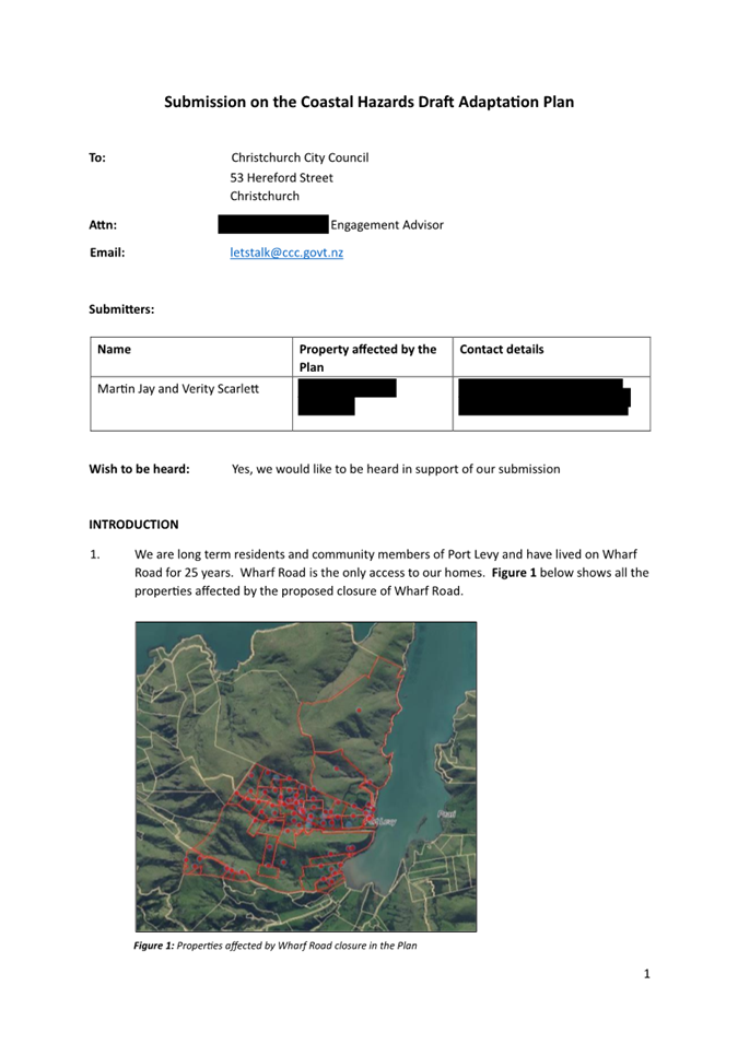
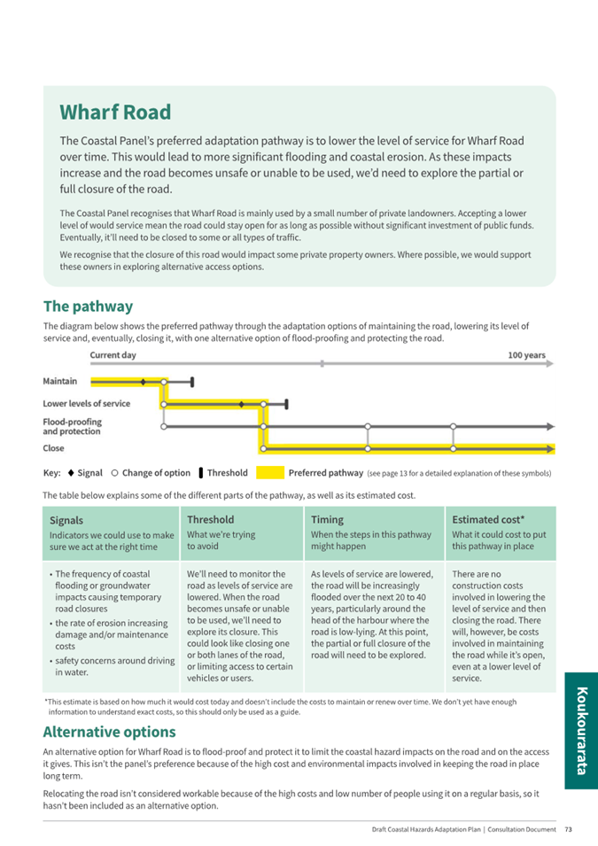
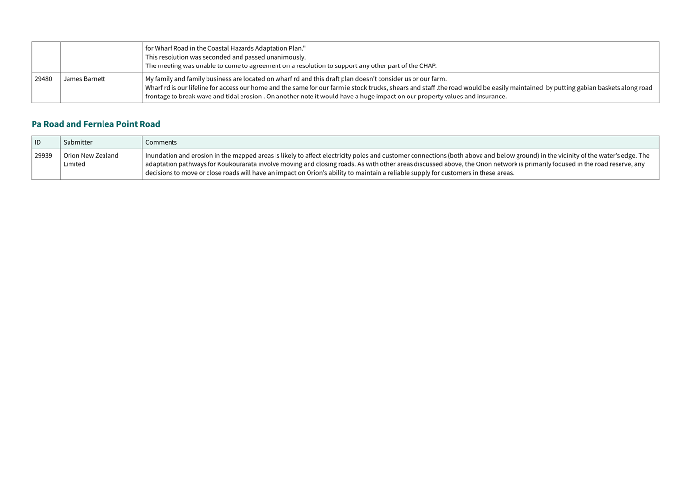
Wharf Road
5.63 The
Coastal Panel’s preferred pathway is to Maintain → Lower Levels of Service
→ Close Wharf Road. An alternate option of Flood Proofing and Protecting
the road is included but is not preferred. The proposed closure of Wharf Road
is signalled as likely in around 35 years’ time. The draft Plan noted
Council’s willingness to support property owners to explore alternative
access options if closure is the ultimate pathway for this public asset.
5.64 16 of the 17
submitters on Wharf Road emphasised the critical nature of road access to their
livelihoods and wellbeing. In addition to the road forming the sole access
route to their properties, submitters emphasised the importance of the road in
providing for their economic wellbeing, citing transport routes for moving farm
stock and access to tourism operations (Airbnb). Submitters also questioned
future access for emergency services.
5.65 Submitters also raised the following points:
· Greater clarity was sought on what Lower Levels of Service might
mean.
· The inclusion of a new road relocation (Move the road) option was
sought for the section of Wharf Road located at the head of the harbour, with submitters
indicating that there is appropriate privately owned land available for this
purpose.
· The majority (16) of submitters who made comments about Wharf Road
did not support the preferred long-term option of Closure, with many requesting
a preferred pathway of flood-proofing and protection.
· It was
requested that the adaptation option of Road Closure be more clearly defined,
including to avoid confusion with Road Stopping.
5.66 The option of
Flood-Proofing (raising) and Protecting the road is not recommended by staff
due to the estimated costs of $15M to provide access for traffic volumes
estimated at less than 20 vehicles a day. Staff acknowledge that the potential
impact on these users is significant given it is currently the sole access
route, however as signalled below, ongoing alternative access options can be
considered. Road Raising and Protection would likely also require road widening
which would encroach on surrounding ecological values with adverse
environmental impacts. However, this remains an alternative option in the
pathway.
5.67 Staff recommend
that the preferred pathway for Wharf Road is not amended, but that a new
alternative option is added of Moving the section of Wharf Road located at the
head of the harbour inland. The Council would retain the Coastal Panel’s
preferred pathway of Maintain → Lower Levels of Service → Closure,
but inclusion of this alternative option of Moving the most vulnerable section
of Wharf Road recognises that with cooperation of local landowners this option may
be more feasible than previously considered.
5.68 Because there is
no recommended change to the Coastal Panel’s preferred pathway, there is
no impact on the costings in the draft Plan, however the alternative option of
Moving a 500m section of Wharf Rd is estimated at $16M, requiring land
purchase, road construction and significant drainage works. This would come
with similar environmental risks to the Road Raising and Protection option.
5.69 Text
edits are proposed to provide greater clarity on the terms Lower Levels of Service,
Road Closure, and Road Stopping. These edits aim to clarify what these complex
terms mean generally, and particularly in the context of the Wharf Road
adaptation pathway. Proposed text edits are captured in Table One below, and
further explanation is provided below.
5.69.1 Lower Levels
of Service involves making changes to the quality or quantity of a service, in
this case roads. As outlined in paragraph 5.40 above and in page 20 of the
draft Plan, this could include a range of actions. The aim is to allow
increasingly vulnerable roads to be maintained for as long as possible in a
more cost-effective way, by delaying or avoiding investment in more expensive
alternatives. In most cases, lowering levels of service will still require
investing more money in maintenance as impacts increase.
5.69.2 Road Closure
means a section of road, or an entire road is either temporarily or permanently
physically closed to certain types of vehicles or activities (such as walking
or cycling). In some ways this might look like lowering levels of service, but
the main difference is that there is no investment in maintaining the road,
just in managing access to the road for as long as it is safe to do so.
5.69.3 Road Stopping
is a legal process to change the status of a road to fee simple or freehold
land. Once a road is legally stopped, the land can be retained, sold or
transferred for an alternative use. This has not been proposed for any
adaptation pathway in the plan. However, it would allow private management and
maintenance of the road which may be an option the community could explore with
Council in the future.
5.70 In summary, the
Coastal Panel’s preferred pathway for Wharf Road is Maintain > Lower Levels
of Service > Close. Wharf Road is going to be increasingly impacted by
coastal hazards and as the costs of maintaining the road increase, it will
become necessary to maintain the road at a lowered level of service. Because
this isn’t likely to be necessary for around 20 years, there are
uncertainties about how exactly this will occur, but it will likely involve the
examples described on page 20 of the plan. When the costs of maintaining the
road, even at a lowered level of service become significant, the road may need
to be closed. At this point, there would be no further public investment in
maintaining the road. Instead, the focus would be on maintaining safe access
for as long as possible by limiting access as necessary. Again, because this
isn’t likely to be necessary for around 35 years, there are uncertainties
about how exactly this would occur.
5.71 Council staff
reiterate that consultation with local landowners would occur in advance of any
road closure (or the implementation of any other alternative option) which
would help to inform the outcomes of this process.
Table One: Staff
proposed edits to the draft Plan
5.72 Table One sets
out proposed changes to the wording within the draft Plan, to ensure it
reflects and explains the amendments proposed by staff in response to
submitters feedback. Minor edits for accuracy are also included. Staff seek
approval to make the following amendments.
|
Page No/Text
deletion
|
Proposed Edit/New
Text
|
|
P.4 “A road closure means that a certain section of road
is temporarily or permanently blocked off, preventing all or certain types of
vehicles and pedestrians from using it.”
|
“A Road Closure means a section of road, or an entire road
is either temporarily or permanently physically closed to certain types of
vehicles or activities. This does not change the legal status of the road
(see the definition for “Road Stopping”).”
|
|
P.4
Add a new definition for “Road Stopping”
|
“Road Stopping is the legal
process to change the status of road to fee simple land. Once a road is
legally stopped the land can be retained, sold or transferred for an
alternative use. The road stopping process is governed by either the Local
Government Act 1974 or the Public Works Act 1981.”
|
|
P.4
Add a new definition for “Levels of Service”
|
“Levels of service is a term used
to describe the quality and/or quantity of a service provided to a community,
such as roads. Any changes to levels of service would usually consider usage,
location, and importance of an asset”.
|
|
P.10 “Locally, they have risen by about 10 centimetres
over the last 15 years.”
|
“Locally they have risen by about 15 centimetres in the last
30 years”
|
|
P.51
“It could cost about $8 million to flood-proof the
road.”
Additional text proposed for clarity
|
“It could cost about $8 million to flood-proof the road, by
raising it by around half a metre, including installing necessary drainage
works.”
|
|
P.57 and p.65
New text proposed.
|
“The Christchurch City Council and Environment Canterbury have
agreed to work together to investigate the feasibility and role that ferry
services might play in supporting the long-term resilience of the transport
network in the harbour. As part of this investigation, agencies will explore
the feasibility of maintaining a critical network of marine infrastructure
and assets to support access during emergencies. Such feasibility work will
be considered within the next LTP cycle.”
|
|
P.57
Amendment to pathway diagram (protect option) proposed.
|
To improve the accuracy of the pathway diagram for the Charteris
Bay Boat Ramp, staff recommend that the ‘protect’ line is
extended to reflect that substantial further investment could retain this
facility for longer than is currently indicated. While long-term protection
is not the preferred pathway, this change reflects an alternative option that
has been considered and could be considered in the future depending on the
outcomes of the joint investigation with Environment Canterbury.
|
|
P.73
“The Coastal Panel recognises
that Wharf Road is mainly used by a small number of private landowners.
Accepting a lower level of service would mean the road could stay open for as
long as possible without significant investment of public funds. Eventually,
it’ll need to be closed to some or all types of traffic.
We recognise that the closure of this
road would impact some private property owners. Where possible, we would
support these owners in exploring alternative access options.”
|
The Coastal Panel recognises that Wharf
Road is mainly used by a small number of private landowners. Lowering the
level of service would mean access along the road could be maintained in a
more cost-effective way for as long as possible. This could look like
temporary road closures and disruptions during king tides or storm events, or
longer-term service changes such as replacing bridges with fords. Eventually,
the road may need to be closed to some or all types of traffic due to the
size and frequency of the impacts. At this point there would be no further
public investment in maintaining the road. Instead, the focus would be on
managing access to the road for as long as it is safe to do so.
We recognise that the closure of this
road will have a wide range of impacts on private property owners.
Consultation with this community will occur in advance of any road closure
(or the implementation of any other alternative option) and would help to inform
the management and outcomes of this process. Where possible, we will support
these property owners to explore alternate access options.”
|
|
P73. “Relocating the road isn’t considered workable
because of the high costs and low number of people using it on a regular
basis, so it hasn’t been included as an alternative option”.
|
“A
second alternate option is to move the road away from the flood-prone
shorefront at the head of the harbour. This would involve establishing a new
road further inland, on land not currently owned by Council. This new road
would then connect back with the existing Wharf Road alignment, perhaps near
Old Port Levy Road. This alternate option would be challenging and costly due
to the lack of available public land and the need to manage drainage in,
around, and below the new road”.
|
|
Consistency of language
|
Change all residual references from ‘Relocate’ to
‘Move’.
|
|
Add the definition of Flood Proofing to the glossary
|
“Flood-Proofing describes work undertaken to
manage surface water and groundwater impacts on roads. In some locations,
flood-proofing involves raising road levels, in other locations it might
involve changing the road material to be more resilient to water impacts, which
would limit road maintenance requirements and disruptions otherwise
associated with post-storm repairs.
|
|
Minor amendments to integrate Council recommendations
|
As needed.
|
Options Descriptions Ngā
Kōwhiringa
5.73 The Council are
receiving written and oral submissions on the draft Coastal Hazards Adaptation
Plan for Whakaraupō Lyttelton Harbour and Port Levy Koukourarata and
considering staff amendments. Recommendations will then be made on the draft
Plan.
5.74 The following reasonably practicable options were considered:
· A recommendation for Council to adopt the draft Plan with staff
amendments set out in this report.
· A recommendation for Council to adopt the draft Plan with no
changes.
5.75 Preferred
Option: A recommendation for Council to adopt the draft Plan
with the following amendments:
5.75.1 Amend
the preferred pathway for the Governor’s Bay to Allandale Foreshore Track
to include protection of the stretch of track between the Governors Bay Jetty
and the Council pump station at an additional estimated cost of $3M.
5.75.2 Retain
the preferred pathway for Governors Bay – Teddington Road but add a new
alternative option of Road Raising.
5.75.3 Retain
the preferred pathway for Wharf Road but add a new alternative option of Moving
the section of Wharf Road located at the head of the harbour inland.
5.75.4 Minor
edits and amendments as set out in Table One (5.72) in this report.
5.76 Option
Advantages
· This option values the Coastal Panel’s expertise while also
recognising the input from the wider community.
· It is in line with the Coastal Adaptation Framework which provides
the wider community with an opportunity to provide feedback on the Coastal
Panel’s preferred options.
5.77 Option
Disadvantages
· This option adds additional costs of $3M.
5.78 Alternative Option:
A recommendation for Council to adopt the draft Plan with no changes.
5.78.1 Option Advantages
· There are no additional costs associated with this recommendation.
5.78.2 Option Disadvantages
· This is less aligned with the Coastal Adaptation Framework which
provides the wider community with an opportunity to provide feedback on the
Coastal Panel’s preferred options.
6. Financial Implications Ngā
Hīraunga Rauemi
Capex/Opex Ngā Utu Whakahaere
6.1 There
are no immediate costs to Council from approving the draft Plan with or without
the recommended staff amendments.
6.2 The
proposed amendment to the content of the Plan regarding the preferred pathway
for the Governor’s Bay to Allandale Foreshore track adds an estimated additional
cost of $3M which would be sought through Council’s budget planning
cycles when required which is in approximately 30 years’ time, noting
that the work might be staged.
7. Considerations Ngā Whai Whakaaro
Legal Considerations Ngā
Hīraunga ā-Ture
7.1 Statutory
and/or delegated authority to undertake proposals in the report:
· A recommendation will be made to the Council on the approval of the
draft Plan. The Council is entitled to, and has, appointed the whole Council
Hearings Panel for that purpose.
· The Council’s decision on the recommendations will be under
the Council’s general planning powers under the Local Government Act
2002.
· Express provision in the LGA 2002 for managing the effects of
natural hazards on infrastructure is in relation to the Infrastructure
Strategy. The Infrastructure Strategy must “provide for the resilience of
infrastructure assets by identifying and managing risks relating to
natural hazards and by making appropriate financial provision for
those risks” .
7.2 Other Legal Implications:
· Detailed assessment of the legislative framework within which
coastal hazards adaptation planning occurs is in Coastal Hazards Management Framework – An overview of the
legislative and policy context for the Coastal Hazard Adaptation Planning
Programme and District Plan Change.
· Some aspects of that summary are now out of date – such as
references to the previous government’s intended new legislation, and
reference to “the avoidance of or mitigation of natural hazards” as
a core service in the LGA 2002 – but the legislative context described
there remains generally correct.
Strategy and Policy Considerations Te Whai
Kaupapa
7.3 The
required decisions:
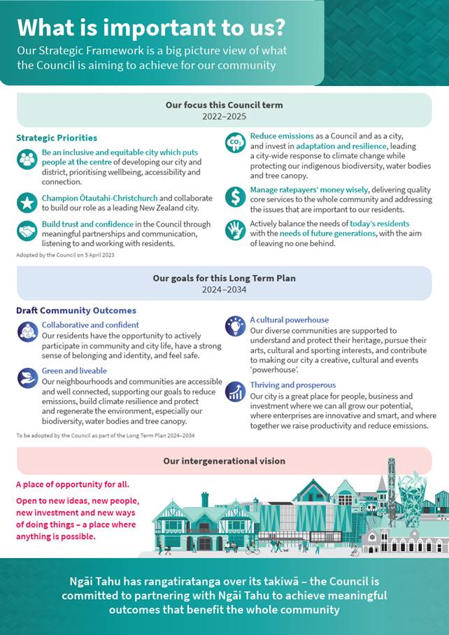
7.3.1 Align with the Christchurch City Council’s Strategic Framework particularly the strategic priorities
· Balance the needs of today and the future.
· Build trust and confidence.
· Manage ratepayers’ money wisely.
7.3.2 Are assessed as high significance based on the Christchurch City
Council’s Significance and Engagement Policy. The level of significance
was determined by the high impacts on
rūnanga wai and whenua, access and assets, the long-term impacts of these
decisions including on future generations, and the significant impacts these
decisions will have on Council assets.
7.3.3 Are consistent with Council’s Plans and
Policies, particularly the Council’s Coastal Adaptation Framework.
7.4 This report supports the Council's Long Term Plan (2024 - 2034):
7.5 Strategic
Planning and Policy
7.5.1 Activity:
Strategic Policy and Resilience
· Level
of Service: 17.2.34 Provide policy and advice for Council on climate resilience
- Council teams receive advice enabling action on climate change
7.6 Regulatory
and Compliance
7.6.1 Activity:
Strategic Planning and Resource Consents
· Level
of Service: 17.0.23.4 Work with communities and Rūnanga in low-lying
coastal and inland communities to develop adaptation plans that respond to the
current and future impacts of coastal hazards caused by climate change -
Undertake adaptation planning in accordance with Council expectations and in alignment
with central government guidance.
Impact on Mana Whenua Ngā Whai Take
Mana Whenua
7.7 The draft Plan has been developed with the benefit of extensive
engagement with Te Hapū o Ngāti Wheke and Te Rūnanga o
Koukourarata as it involves the development of adaptation pathways for public
assets within their takiwā. Decisions related to the papakaianga and
settlements of Rāpaki, Purau and Koukourarata are significant to each
Rūnanga.
7.8 Both
Rūnanga have heavily invested their time and resources in
this process through membership of the Coastal Panel and through hui to input
on adaptation pathways.
7.9 The decision to recommend that Council adopts the draft Plan with
amendments involves a matter of interest to mana whenua and could impact on our
agreed partnership with Ngā Papatipu Rūnanga.
Climate Change Impact Considerations Ngā
Whai Whakaaro mā te Āhuarangi
7.10 The decisions in
this report will contribute positively and directly to adaptation to the
impacts of climate change. This is Council’s first adaptation plan and
signals delivery of a Council commitment to undertake adaptation planning in
conjunction with communities.
8. Next Steps Ngā Mahinga ā-muri
8.1 A
report containing recommendations will be prepared for a Council decision at a
later meeting.
Attachments Ngā Tāpirihanga
|
No.
|
Title
|
Reference
|
Page
|
|
a ⇩
|
Draft Coastal
Hazards Adaptation Plan for Whakaraupo Lyttelton Harbour and Koukourarata
Port Levy
|
25/68200
|
173
|
|
b ⇩
|
Analysis of Submissions
on the draft Plan
|
25/71687
|
245
|
In addition to the attached documents, the following background
information is available:
|
Document
Name – Location / File Link
|
|
Not
applicable
|
Signatories Ngā Kaiwaitohu
|
Authors
|
Jane Morgan -
Team Leader Coastal Hazards Adaptation Planning
Ruby Clark -
Senior Adaptation Advisor
Tom
Simons-Smith - Principal Advisor Coastal Adaptation
Krystle
Anderson - Engagement Advisor
Sarah Pahlen -
Senior Adaptation Advisor
|
|
Approved By
|
David
Griffiths - Head of Strategic Policy & Resilience
John Higgins -
General Manager Strategy, Planning & Regulatory Services
|