A black text on a white background

Description automatically generated


Waipuna Halswell-Hornby-Riccarton Community Board Information Session/Workshop

Agenda


Notice of Information Session/Workshop:

A Waipuna Halswell-Hornby-Riccarton Community Board Information Session/Workshop will be held on:


Date:                                    Thursday 29 August 2024

Time:                                   4 pm

Venue:                                 Rārākau: Riccarton Centre,
199 Clarence Street, Christchurch


Membership

Chairperson

Deputy Chairperson

Members

Marie Pollisco

Helen Broughton

Sarah Brunton

Henk Buunk

Gamal Fouda

Tyla Harrison-Hunt

Andrei Moore

Debbie Mora

Mark Peters


26 August 2024


Bailey Peterson

Acting Manager Community Governance, Halswell, Hornby, Riccarton

Tel: 941 6743


Faye Collins

Community Board Advisor

941 5108

faye.collins@ccc.govt.nz

www.ccc.govt.nz

Note:  This forum has no decision-making powers and is purely for information sharing.
To watch the meeting live, or a recording after the meeting date, go to:
https://www.youtube.com/channel/UCQN_yNuZzfRhDJ2scAEjCvA
To view copies of Agendas and Notes, go to:
https://www.ccc.govt.nz/the-council/meetings-agendas-and-minutes/


TABLE OF CONTENTS NGĀ IHIRANGI

 1.       Apologies Ngā Whakapāha................................................................................. 3

Information Session Items

2.        Parks In-house Maintenance Mobilisation Introduction.......................................... 5

The time allocated is 15 minutes.

3.        Customer Service Hybris Ticket Reports............................................................... 7

The time allocated is 20 minutes.

4.        Good-to-go ways to get to school........................................................................ 9

The time allocated is 45 minutes.

5.        Various Transport / Growth work in the Halswell Hornby Riccarton wards.............. 11

The time allocated is 30 minutes.

6.        Amyes/Springs/Awatea Intersection Update....................................................... 21

The time allocated is 20 minutes.   


1.   Apologies Ngā Whakapāha

An apology for absence was recieved from Henk Buunk.


2.     Parks In-house Maintenance Mobilisation Introduction

Reference Te Tohutoro:

24/1450171

Presenter(s) Te Kaipāhō :

Kim Wood, Community Parks Maintenance Operations Manager


1. Detail Te Whakamahuki


Timing

This information session is expected to last for 15 minutes.

Purpose / Origin of the Information Session

Following the Council Briefing where Andrew Rutledge gave an update on the new Parks In-house Maintenance Mobilisation, it was suggested that teams meet with their respective Community Boards to introduce new staff members. The purpose of this session is for the operations manager, team leaders and supervisors responsible for the different areas of this Community Board to introduce themselves and answer any questions regarding the parks in-house maintenance mobilisation that commenced on 1 July 2024.


Confidentiality

The workshop and any shared information are not confidential.


Background

A decision was taken in 2023 to bring the parks maintenance in-house to reduce the use of contractors and improve the quality of parks maintenance.


Key Issues

·    Not applicable.

Next Steps

·    Introduce new staff.

·    Connect people with places.


Useful Links

·    Not applicable.


Attachments Ngā Tāpirihanga

There are no attachments to this coversheet.


Signatories Ngā Kaiwaitohu

Author

Vita Rowe-Smith - Personal Assistant

Approved By

Rupert Bool - Acting Head of Parks


3.     Customer Service Hybris Ticket Reports

Reference Te Tohutoro:

24/1221635

Presenter(s) Te Kaipāhō :

Bridget Latimer, Manager Operational Process & Insights


1. Detail Te Whakamahuki


Timing

This information session is expected to last for 20 minutes.

Purpose / Origin of the Information Session

The purpose of this information session is for staff to present to the Board on customer service ticket report data, and to explain an expanded Hybris Ticket report which will soon be available to Board members.


Confidentiality

The workshop and any shared information is not confidential.


Background

The Hybris Ticket Report has been a feature of the Community Board Area Report for some time. Staff have developed an expanded report to provide the Community Boards with more accurate information about trends and compliance with service levels.


Key Issues

·    Not applicable.

Next Steps

·    Not applicable.


Useful Links

·    Not applicable.


Attachments Ngā Tāpirihanga

There are no attachments for this report.


Signatories Ngā Kaiwaitohu

Author

Faye Collins - Community Board Advisor

Approved By

Bailey Peterson - Acting Manager Community Governance, Halswell-Hornby-Riccarton


4.     Good-to-go ways to get to school

Reference Te Tohutoro:

24/827032

Presenter(s) Te Kaipāhō :

Ashley Beaton, Community Travel Advisor


1. Detail Te Whakamahuki


Timing

This information session is expected to last for 45 minutes.

Purpose / Origin of the Information Session

The purpose of this report is to provide information through a presentation to the Community Board regarding the updated Good-to-go ways to get to school programme the Council provides to schools.


Confidentiality

The workshop and any shared information are not confidential.


Background

Good-to-go ways to get to school is a programme designed to support schools in encouraging safe, active, fun, affordable, low-emission ways to travel to school and around their community.

The programme requires schools to participate in walk or wheel to school week (primary and intermediate schools only), participate in crash bash (high schools only), promote and participate in our annual school travel survey and receive our termly newsletters. Many of our schools are already meeting these requirements. Council works in partnership with registered schools to focus on transport issues that are prevalent for them. Depending on the type of issue the school is facing we look at the different interventions that could be used.

The Good-to-go ways to get to school programme has been well received with over 53 schools registered.

Key Issues

·    Not applicable.

·   

Next Steps

·    Not applicable.


Useful Links

·    The webpage for Good-to-go ways to get to school can be found here.


Attachments Ngā Tāpirihanga

There are no attachments for this report.


Signatories Ngā Kaiwaitohu

Author

Ashley Beaton – Community Travel Advisor Travel Demand Management

Approved By

Sarah Anderson - Team Leader Travel Demand Management

Stephen Wright - Manager Operations (Transport)


5.     Various Transport / Growth work in the Halswell Hornby Riccarton wards

Reference Te Tohutoro:

23/1561169

Presenter(s) Te Kaipāhō :

Weng-Kei Chen (Asset Engineer Policy) and Peter Rodgers (Transport Network Planner)


1. Detail Te Whakamahuki


Timing

This information session is expected to last for 30 minutes.

Purpose / Origin of the Information Session

The purpose of this information session is to update the Board on various growth-related transport work occurring in the Community Board area.

Confidentiality

The workshop and any shared information is not confidential.

Background

Items of interest include:

1.    Realignment of Wigram Road

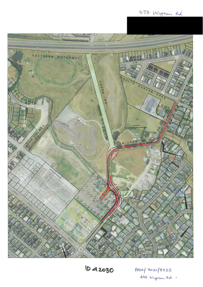
This project is a Resource Consent condition for the development at 448 Wigram Road, which will connect Bill Harvey Drive to Wigram Road. The development creates an opportunity for Council to realign the current sharp bend and create a much-enhanced road environment. The Developer will deliver the project to service its development and at the same time deliver the improvement to the road network.


On completion, the realigned carriageway on Wigram Road will be marked to include on-road cycle lanes from Halswell Junction Road to Carrs Reserve.


Formal approval of regulatory road markings, including the declaring of the special on-road cycle lanes and an accompanying shared path will be required. This will be presented to the Board at a later date.


Attachment A shows the overview of the realignment at 440 Wigram Road and Attachment B shows the high-level plans for the wider area of Wigram Road


2.    Kennedys Bush Road Upgrade


A section of road between Cashmere Road and the Quarry Park entrance is required to be upgraded. The scheme plan is shown on Attachment C. The upgraded road will accommodate 3.2m vehicle lanes in each direction, with on-road cycle lanes. Traffic control measures will also be constructed to manage vehicle speeds and create a safer road environment. These traffic measures include platforms at the intersection of Kennedys Bush Road with the Quarry access, the intersection with the proposed new subdivision road, and at the new pedestrian refuges.


The frontage upgrades alongside Oakvale Farm on the western side of Kennedys Bush Road is a resource consent condition. The extent of the work required provides Council the opportunity to upgrade the remaining section of the road as described above and also includes the forming of on-road, indented car parking spaces. This work also includes the drainage control of road runoff.


Formal approval of regulatory road markings, including the declaration of on road cycle lanes and the shared path from Glovers Road and Quarry Park Entrance will be required. This will be presented to the Board at a later date.


3.    Sparks Road Upgrade between McCartney and Traffic Lights by Milns Drain


This upgrade project will be delivered in partnership with 5 developers, with frontage upgrades forming a condition of each development. The Sparks Road area plan is shown in Attachment D.


There were challenges to develop a scheme that could accommodate all the elements of a minor arterial road, due to the constraints caused by Connal Drain being within the road corridor. Staff were involved in prolonged discussions with stakeholders, and the final design outcome has been agreed with respective developers for the delivery.


The upgrade also includes the relocation of the existing Milns and Sparks intersection, which the Community Board has been briefed on previously. The intersection relocation is a condition for the development at 179 Milns Road.


The road upgrades will consist of cycle lanes, traffic median, shared paths and pedestrian refuges.


An upgrade of Milns Road is also included in this project, including the construction of a footpath on the eastern side to connect Milns Drain to the path outside the retirement village. Milns Road upgrades are shown on Attachment E.


Formal approval of regulatory road markings, including the declaring of the special on-road cycle lanes and shared path will be required. This will be presented to the Board at a later date.

4.    Quaifes Road Upgrade between Murphy Road and Sabys Road

There has been significant work along Quaifes Road over the last 5 years, with developments carried out by various stakeholders. This has included installation underground infrastructure to service these developments.


The developer of 63 Quaifes Road will realign a section of Quaifes Road, connecting to Candys Road in accordance with the Outline Development Plan for the area. A high-level plan of the Quaifes / Sabys / Candys Road changes is shown in Attachment F.


Formal approval of regulatory signs and road markings will be required. This will be presented to the Board at a later date.


Next Steps

·    Reports to formalise regulatory markings including any parking restrictions, on-road cycle lanes, shared paths and traffic restraints will need to be presented to the Community Board at a later date for each project.

Useful Links


Attachments Ngā Tāpirihanga

No.

Title

Reference

Page

a

440 Wigram Road Realignment

24/1464582

14

b

Wigram Road high level area plan

24/1464583

15

c

Kennedys Bush Road scheme plan

24/1464584

16

d

Sparks Road upgrade - McCartney to Milns Drain

24/1464587

17

e

Sparks Road upgrade - Milns Road improvements

24/1464590

18

f

Quaifes Road / Sabys / Candys area

24/678085

19


Signatories Ngā Kaiwaitohu

Author

Peter Rodgers - Transport Network Planner

Approved By

Andy Milne - Team Leader Asset Planning

Jacob Bradbury - Manager Planning & Delivery Transport

Lynette Ellis - Head of Transport & Waste Management


A map of a city

Description automatically generated


A map of a road

Description automatically generated


A map of a city

Description automatically generated


A map of a farm

Description automatically generated


A map of a city

Description automatically generated


6.     Amyes/Springs/Awatea Intersection Update

Reference Te Tohutoro:

24/1246309

Presenter(s) Te Kaipāhō :

Andrew Cameron – Project Manager, Liqi Chen - Network Planner


1. Detail Te Whakamahuki


Timing

This information session is expected to last for 20 minutes.

Purpose / Origin of the Information Session

A project has been initiated to look at safety improvements at the Amyes, Awatea & Springs Intersection. 

This session is an opportunity for Staff to present findings on work carried out around the operational use of the two intersections if signalisation was to be undertaken, based on existing traffic data.

There is the opportunity for the Board to confirm that staff are using the correct criteria, and considering  all the issues prior to the sourcing of up to date traffic counts, to validate the modelling, and starting scheming.

Confidentiality

The workshop and any shared information are not confidential.

Background

Amyes Road / Springs Road has been identified as a medium high-risk intersection in Christchurch which does not currently rank high enough to be supported by NZTA for funding as a safety improvement project. Due to support by the Waipuna Halswell-Hornby-Riccarton Community Board backed up by the Greater Hornby Resident’s Association a project has been initiated to look at addressing the issues being experienced at these two intersections.


Transport modelling has been carried out to assess the operational performance when incorporating traffic signal control at the intersections and considering impacts on the wider road network. Three viable options have been investigated.

Option 1 - signalise both intersections

Option 2 – signals at Amyes Road

An aerial view of a city

Description automatically generated

Option 3 – Signals at Awatea Road

Option 1 (two signals) demonstrates the highest performance based on the results of the modelling exercise. However, it requires a significant increase in funding allocation, which poses challenges in terms of financial feasibility.


Option 2 (one signal at Amyes/Springs intersection) and Option 3 (one signal at Awatea/Springs intersection) achieve comparable results when looking at the overall network impacts.

Option 2 appears to be more adaptable considering the diverse range of land use along Amyes Road but fails to solve the bottleneck of congestion and improving of wait times for right turning vehicles.

Option 3 significantly outperforms Option 2 in reducing queuing congestion and improving overall vehicle movement efficiency.

Key Issues

·    Traffic signal may potentially cause rat-running within wider local transport network.

·    Fund constraint: $1.6m

·    The crash summary records 27 crashes over the past 10 years, this places the project low down the priority list for the NZTA safety funding.


Next Steps

·    Transport model recalibration with the latest traffic counts

·    Scheme Design.

Useful Links


Attachments Ngā Tāpirihanga

There are no attachments to this coversheet.


Signatories Ngā Kaiwaitohu

Author

Liqi Chen - Transport Network Planner

Approved By

Andrew Cameron - Project Manager