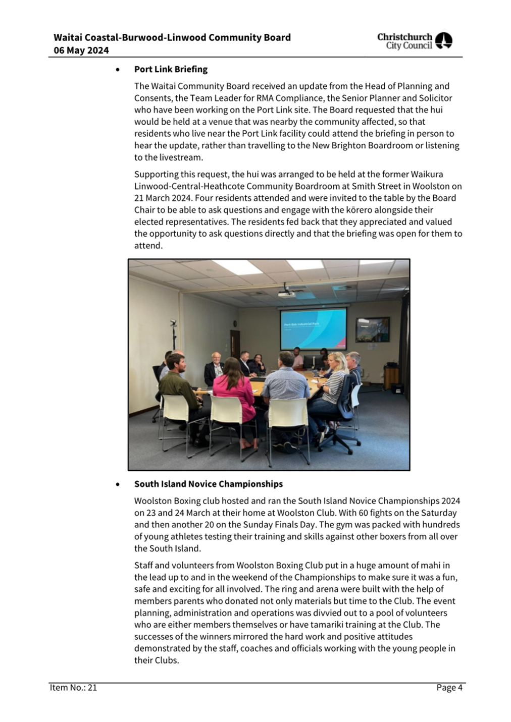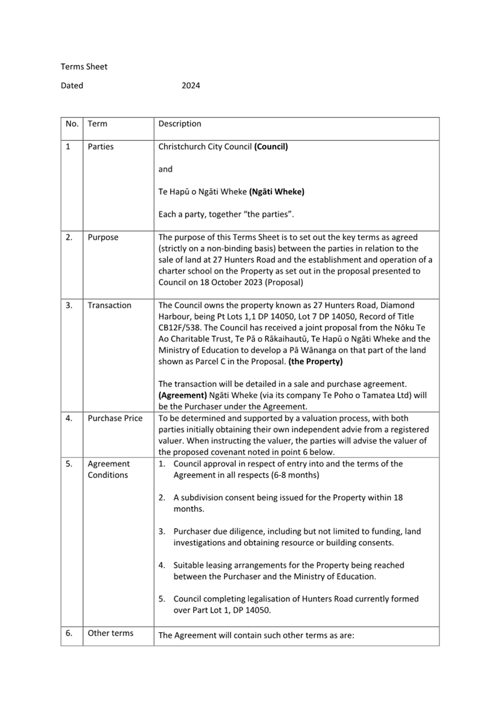
Christchurch City Council
Agenda
Notice of Meeting:
An ordinary meeting of the Christchurch
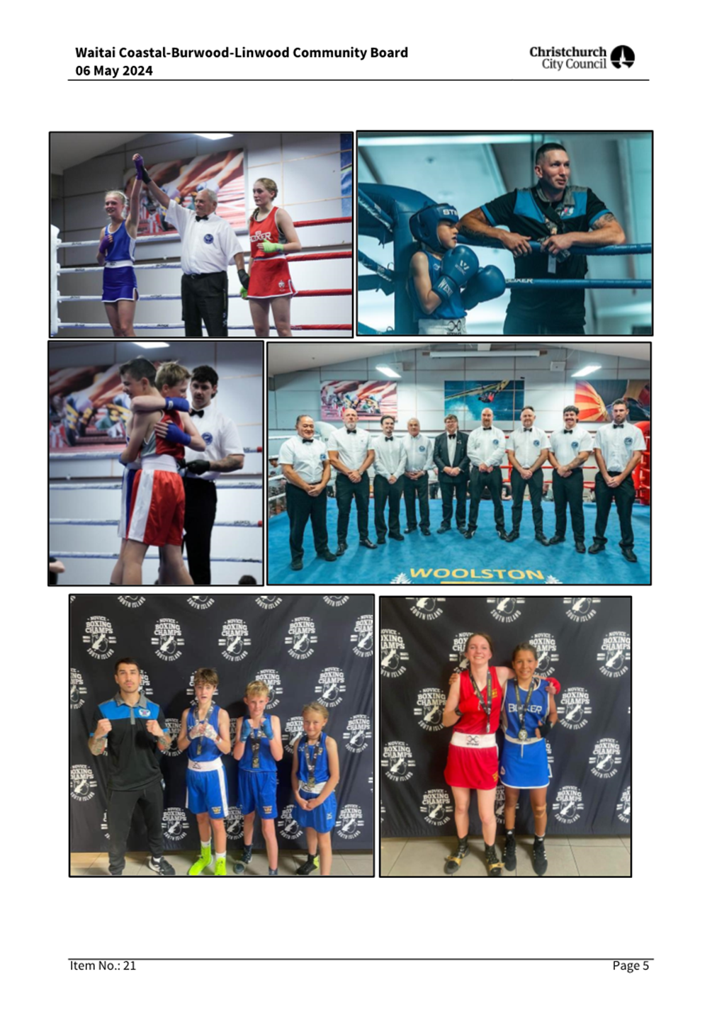
City Council will be held on:
Date: Wednesday 5 June 2024
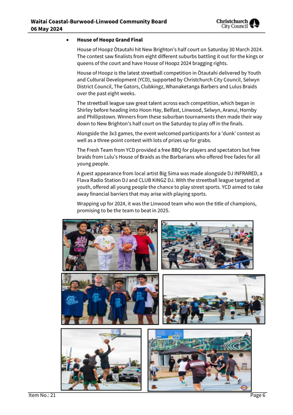
Time: 9.30 am
Venue: Council Chambers, Civic Offices,
53 Hereford Street, Christchurch
Membership
|
Chairperson
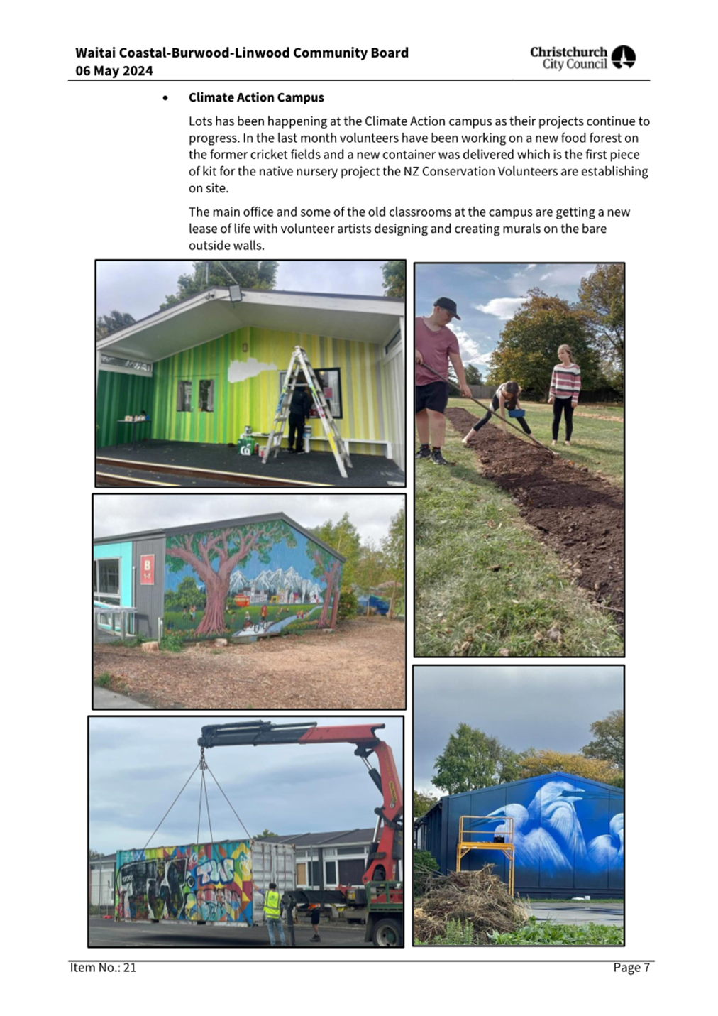
Members
|
Deputy Mayor Pauline Cotter
Councillor Kelly Barber
Councillor Melanie Coker
Councillor Celeste Donovan
Councillor Tyrone Fields
Councillor James Gough
Councillor Tyla Harrison-Hunt
Councillor Victoria Henstock
Councillor Yani Johanson
Councillor Aaron Keown
Councillor Sam MacDonald
Councillor Jake McLellan
Councillor Andrei Moore
Councillor Mark Peters
Councillor Tim Scandrett
Councillor Sara Templeton
|
29 May 2024
|
|
|
Principal Advisor
Mary Richardson
Interim Chief Executive
Tel: 941 8999
|
|
Katie Matheis
Democratic Services Advisor
941 5643
Katie.Matheis@ccc.govt.nz
TABLE OF CONTENTS NGĀ IHIRANGI
Karakia Tīmatanga................................................................. 4
1. Apologies Ngā Whakapāha.............................................. 4
2. Declarations of Interest Ngā Whakapuaki Aronga............. 4
3. Public
Participation Te Huinga
Tūmatanui....................... 4
3.1 Public Forum Te Huinga Whānui................................. 4
3.2 Deputations by
Appointment Ngā Huinga Whakaritenga............................................................. 4
4. Presentation
of Petitions Ngā
Pākikitanga....................... 4
Council
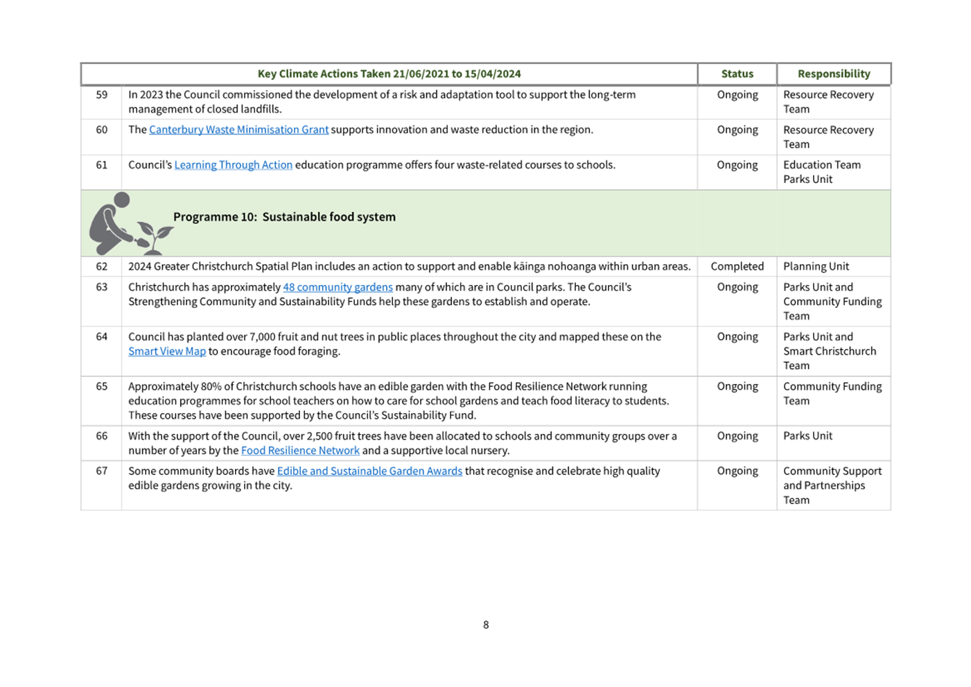
5. Council
Minutes - 1 May 2024................................... 5
Community Board Monthly
Reports
6. Monthly
Report from the Community Boards - May 2024..................................................................... 17
Community Board Part A
Reports
7. 27
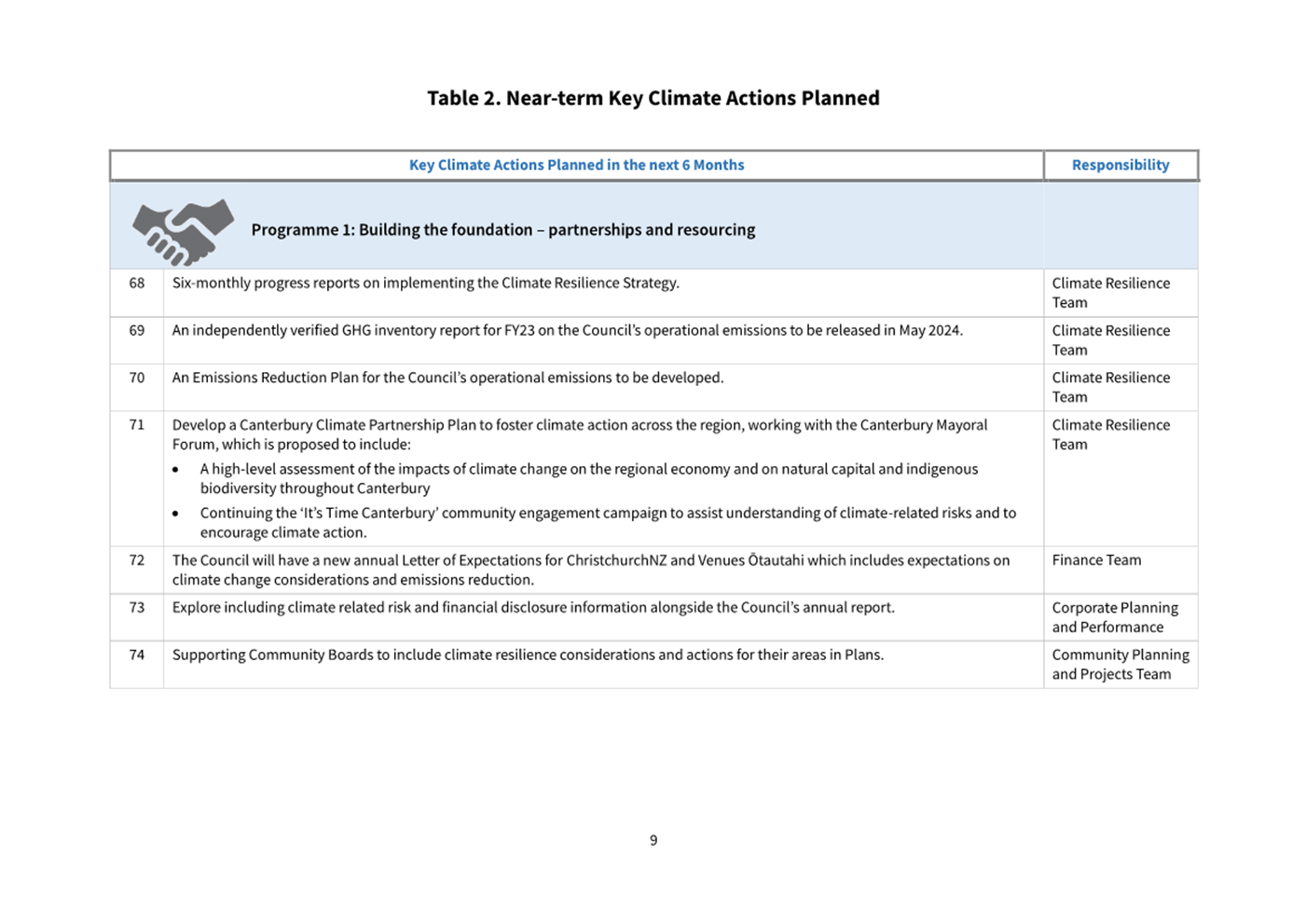
Hunters Road & 43 Whero Avenue, Diamond Harbour – FENZ and Te Pā
o Rākaihautū Unsolicited Proposals............................................................. 69
8. City
to Sea West Safety Improvements - Roading Elements.............................................................. 97
Staff Reports
9. Local
Alcohol Policy............................................ 135
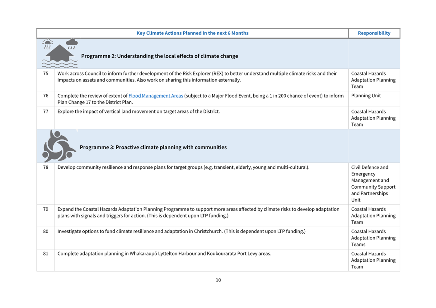
10. Stop Road
(airspace) and Dispose of to Adjoining Landowners........................................................ 225
11. Climate
Resilience Strategy Implementation Progress............................................................. 271
12. Central City
Noise Programme - Progress Update, Acoustic Assessment Advice................................ 289
13. Suburban
Regeneration Biannual Report - October 2023 to March 2024............................................. 303
Karakia Whakamutunga
Karakia Tīmatanga
Whakataka te hau ki te uru
Whakataka te hau ki te tonga
Kia mākinakina ki uta
Kia mātaratara ki tai
E hī ake ana te atakura
He tio, he huka, he hau hū
Tihei mauri ora
1. Apologies Ngā Whakapāha
At the close of
the agenda an apology from the Mayor for absence was received.
2. Declarations of Interest Ngā
Whakapuaki Aronga
Members are
reminded of the need to be vigilant and to stand aside from decision making
when a conflict arises between their role as an elected representative and any
private or other external interest they might have.
3. Public Participation Te Huinga
Tūmatanui
3.1 Public Forum Te Huinga Whānui
A period of up to 30 minutes is available
for people to speak for up to five minutes on any issue that is not the subject
of a separate hearings process.
|
3.1.1
|
Te Whakaoranga Trust
Clare Piper will speak on behalf of Te
Whakaoranga Trust and provide an update on the Kate Sheppard National
Memorial site enhancement project.
|
3.2 Deputations by Appointment Ngā
Huinga Whakaritenga
Deputations may be heard on a matter or
matters covered by a report on this agenda and approved by the Chairperson.
There were no
deputations by appointment at the time the agenda was prepared.
4. Presentation of Petitions Ngā
Pākikitanga
There were no
Presentation of Petitions at the time the agenda was prepared.
|
5. Council
Minutes - 1 May 2024
|
|
Reference Te Tohutoro:
|
24/751332
|
|
Responsible Officer(s) Te Pou Matua:
|
Katie
Matheis, Democratic Services Advisor (Katie.Matheis@ccc.govt.nz)
|
|
Accountable ELT Member Pouwhakarae:
|
Helen
White, General Counsel / Head of Legal & Democratic Services
|
1. Purpose of Report Te Pūtake Pūrongo
For the Council
to confirm the minutes from the Council meeting held 1
May 2024.
2. Recommendation Te Tūtohu Council
That the Council confirms the Minutes from the Council
meeting held 1 May 2024.
Attachments Ngā Tāpirihanga
|
No.
|
Title
|
Reference
|
Page
|
|
A⇩
|
Minutes Council - 1
May 2024
|
24/715827
|
6
|
Signatories Ngā Kaiwaitohu
|
Author
|
Katie Matheis
- Democratic Services Advisor
|

Christchurch City Council
Minutes
Date: Wednesday 1 May 2024
Time: 9.33 am
Venue: Council Chambers, Civic Offices,
53 Hereford Street, Christchurch
Present
|
Chairperson
Deputy Chairperson
Members
|
Mayor Phil Mauger
Deputy Mayor Pauline Cotter
Councillor Kelly Barber
Councillor Melanie Coker
Councillor Celeste Donovan
– via audio / visual link
Councillor Tyrone Fields
Councillor James Gough
Councillor Victoria Henstock
Councillor Yani Johanson
Councillor Aaron Keown
Councillor Sam MacDonald
Councillor Jake McLellan
Councillor Andrei Moore
Councillor Mark Peters
Councillor Tim Scandrett
Councillor Sara Templeton
– via audio / visual link
|
|
|
|
Principal Advisor
Mary Richardson
Interim Chief Executive
Tel: 941 8999
|
Katie Matheis
Democratic Services Advisor
941 5643
Katie.Matheis@ccc.govt.nz
www.ccc.govt.nz

Karakia Tīmatanga: All
Councillors
The agenda was dealt with in the following
order.
1. Apologies
Ngā Whakapāha
|
Council Resolved CNCL/2024/00035
That the apologies from The Mayor and
Councillor Templeton for partial absence be accepted.
That an apology be recorded for
Councillor Harrison-Hunt due to a leave of absence.
Councillor
Scandrett/Councillor Henstock Carried
|
2. Declarations
of Interest Ngā Whakapuaki Aronga
There were no
declarations of interest recorded.
3. Public
Participation Te Huinga Tūmatanui
3.1 Public Forum Te Huinga Whānui
There were no public forum presentations.
3.2 Deputations by Appointment Ngā Huinga Whakaritenga
There were no deputations
by appointment.
4. Presentation
of Petitions Ngā Pākikitanga
|
5. Central
City Parking Restrictions Committee Minutes - 27 November 2023
|
|
|
The meeting blocked resolved Minutes
Items 5 – 8 and PX Minutes Items 20 – 21.
|
|
|
Council Resolved CNCL/2024/00036
That the Council receives the Minutes
from the Central City Parking Restrictions Committee meeting held 27 November
2023.
Councillor
Moore/Deputy Mayor Carried
|
|
6. Council
Minutes - 3 April 2024
|
|
|
Council Resolved CNCL/2024/00037
That the Council confirm the Minutes from
the Council meeting held 3 April 2024.
AND
That the Council confirm the Public
Excluded Minutes from the Council meeting held 3 April 2024.
Councillor
Moore/Deputy Mayor Carried
|
|
7. Council
Minutes - 10 April 2024
|
|
|
Council Resolved CNCL/2024/00038
That the Council confirm the Minutes from
the Council meeting held 10 April 2024.
AND
That the Council confirm the Public
Excluded Minutes from the Council meeting held 10 April 2024.
Councillor
Moore/Deputy Mayor Carried
|
|
8. Council
Minutes - 16 April 2024
|
|
|
Council Resolved CNCL/2024/00039
That the Council confirm the Minutes from
the Council meeting held 16 April 2024.
Councillor
Moore/Deputy Mayor Carried
|
Councillor Donovan joined the meeting via
audio / visual link at 10.26am during consideration of Item 9.
Councillor Johanson left the meeting at 9.57am
and returned at 9.59am during consideration of Item 9.
Councillor McDonald left the meeting at 10.09am
and returned at 10.19am during consideration of Item 9.
Councillor Gough left the meeting at 10.09am
and returned at 10.19am during consideration of Item 9.
Councillor Barber left the meeting at 10.16am
and returned at 10.20am during consideration of Item 9.
Councillor McLellan left the meeting at 10.16am
and returned at 10.23am during consideration of Item 9.
Deputy Mayor Cotter left the meeting at 10.18am
and returned at 10.20am during consideration of Item 9.
|
9. Monthly
Report from the Community Boards - April 2024
|
|
|
The Mayor, on behalf of the Council,
thanked Waimāero Fendalton-Waimairi-Harewood Community Board Chairperson
Bridget Williams and Waipuna Halswell-Hornby-Riccarton Community Board Chairperson
Helen Broughton after each announced they would be stepping down from their
roles as Chairperson though would continue to serve on their respective
Community Boards. Their service, accomplishments, and contributions were
acknowledged by the meeting.
|
|
|
Bridget Williams, Chairperson, and Jason
Middlemiss, Deputy Chairperson, joined the meeting for presentation of the Waimāero
Fendalton-Waimairi-Harewood Community Board area report.
Emma Norrish, Chairperson, and Simon
Britten, Deputy Chair, joined the meeting for presentation of the Waipapa
Papanui-Innes-Central Community Board area report.
Helen Broughton, Chairperson, and Marie
Pollisco, Deputy Chairperson, joined the meeting for presentation of the Waipuna
Halswell-Hornby-Riccarton Community Board area report.
Paul McMahon, Chairperson, and Jackie
Simons, Deputy Chairperson, joined the meeting for presentation of the Waitai
Coastal-Burwood-Linwood Community Board area report.
Lyn Leslie, Chairperson, and Penelope Goldstone, Community
Governance Manager, joined the meeting for presentation of the Te
Pātaka o Rākaihautū Banks Peninsula Community Board area
report.
Callum Ward, Chairperson, and Keir Leslie, Deputy Chairperson,
joined the meeting for presentation of the Waihoro
Spreydon-Cashmere-Heathcote Community Board area report.
|
|
|
Council Resolved CNCL/2024/00040
Officer recommendation accepted without
change
That the Council:
1. Receive the information in the Monthly Report from the Community Boards
- April 2024 Report.
Councillor
Barber/Councillor Peters Carried
|
|
|
Attachments
a Waimāero
Fendalton-Waimairi-Harewood Community Board - Presentation to Council
b Waipapa
Papanui-Innes-Central Community Board - Presentation to Council
c Waipuna
Halswell-Hornby-Riccarton Community Board - Presentation to Council
d Waitai
Coastal-Burwood-Linwood Community Board - Presentation to Council
e Te
Pātaka o Rākaihautū Banks Peninsula Community Board -
Presentation to Council
f Waihoro
Spreydon-Cashmere-Heathcote Community Board - Presentation to Council
|
|
Report from Waihoro Spreydon-Cashmere-Heathcote Community
Board - 11 April 2024
|
|
10. Worsleys
Road Realignment - Legalisation
|
|
|
Council Resolved CNCL/2024/00041
Waihoro Spreydon-Cashmere-Heathcote Community Board
recommendation accepted without change
That the
Council:
1. Pursuant to Sections 116 and 117(7) of the Public Works Act 1981
the Council resolves to make application to the Minister of Lands to stop
that parcel road identified as Section 1 on SO Plan 585685, as detailed on
Attachment A to the report (Worsleys Road Realignment – Legalisation,
Title Plan SO 585685) on the meeting agenda, containing 0.3871ha and to
declare it to be a local purpose (utility) reserve vested in the Christchurch
City Council subject to the Reserves Act 1977.
Councillor
Peters/Mayor Carried
|
Councillor Scandrett left the meeting at 10.26am
and returned at 10.29an during consideration of Item 11.
|
Report from Waihoro Spreydon-Cashmere-Heathcote Community
Board - 11 April 2024
|
|
11. Former Opawa
Children's Library Building - Expression of Interest, Results and
Recommendation
|
|
|
Council Resolved CNCL/2024/00042
Waihoro Spreydon-Cashmere-Heathcote Community Board
recommendations accepted without change
That the
Council:
3. Notes:
a. The
existing Council resolution (CNCL/2022/00076) to approve the removal of the
Building from its current flood prone location if no purchase or relocation
options arise from an Expressions of Interest (EOI) process.
b. That
the proposal from the Smith Street Community Farm Trust to take ownership of
and relocate the Building to the Smith Street community garden was withdrawn
after the report on the Community Board agenda.
4. Requires
staff to further explore relocation options as a preference prior to
demolition.
5. Any
relocation option is conditional upon:
a.
An achievable option being established within three months of this
resolution.
b.
The cost of any relocation being within the $40,000 council budget provision
including remediation of the current site.
6. Delegates
to the Manager Property Consultancy the authority to make all decisions,
enter into such contracts and documents as deemed necessary at their sole
discretion to implement the demolition or relocation of the building and
remediation of the site, without further formal reporting back to the
Community Board or Council.
Mayor/Councillor
Scandrett Carried
|
The meeting adjourned at 10.31am and
reconvened at 10.49am. The Mayor, Councillor Barber and Councillor Gough were
not present at this time.
Deputy Mayor Cotter assumed the Chair for
consideration of Item 12.
Councillor Barber returned the meeting at 10.56am
during consideration of Item 12.
Councillor Gough returned the meeting at 10.56am
during consideration of Item 12.
|
12. Plan Change
14 Staging of Decision
|
|
|
Council Resolved CNCL/2024/00043
Officer recommendations accepted without
change
That the
Council:
1. Receive the information in the Plan Change
14 Staging of Decision Report.
2. Note that the decision in this report is assessed as Medium
significance based on the Christchurch City
Council’s Significance and Engagement Policy.
3. Agree that its decision by 12 September 2024 on the IHP’s
recommendations on PC14 will be confined to (option 1 in this report):
a. Those parts of Plan Change 14 that implement policies 3 and 4 of
the NPS-UD, including the rezoning of land in Sydenham to Mixed-use, and
b. Related provisions, including objectives, policies, rules,
standards, and zones within policy 3 and 4 areas; and
c. Financial contributions for tree canopy cover across all relevant
zones (including beyond NPS-UD areas).
The division was declared carried
by 10 votes to 5 votes the voting being as follows:
For: Deputy Mayor Cotter, Councillor Barber, Councillor Gough,
Councillor Henstock, Councillor Johanson, Councillor Keown, Councillor
MacDonald, Councillor McLellan, Councillor Peters and Councillor Scandrett
Against: Councillor Coker, Councillor Donovan, Councillor Fields,
Councillor Moore and Councillor Templeton
Councillor
MacDonald/Councillor Henstock Carried
|
|
|
Attachments
a Plan
Change 14 Staging of Decision - Presentation to Council
|
Councillor Keown left the meeting at 11.41am
and returned at 11.43am during consideration of Item 13.
The Mayor returned to the meeting at 11.43am
during consideration of Item 13.
Councillor McDonald left the meeting at 11.41am and returned at 11.44am during
consideration of Item 13.
Councillor Gough left the meeting at 11.49am
during consideration of Item 13.
|
13. Gloucester
Street (Manchester to Colombo): Completion of Trial Period
|
|
|
Item 13 was first Moved by Councillor
Scandrett and Seconded by Councillor McLellan. Council Officers Lynette Ellis
and Jacob Bradbury then joined the table to answer questions from elected
members. As further questions were raised regarding the availability of
feedback from the public, Council Officer Ron Lemm also joined the table to
respond to elected member queries.
The meeting then agreed to let the Item
lie on the table and to return to it later in the meeting to allow Council
Officers time to collect advice in response to the elected members’
questions.
Refer to Item 13, as continued, below.
|
|
|
Officer Recommendations Moved
and Seconded
That the
Council:
1. Receive the information in the Gloucester Street (Manchester to
Colombo): Completion of Trial Period Report.
2. Agree to retain the Gloucester Street (Manchester to Colombo)
trial layout until 31 October 2024, to allow time for a Hearings Panel to
review feedback from the trial and make a recommendation to Council regarding
its long-term future.
3. Note that the decision in this report is
assessed as medium significance based on the Christchurch City
Council’s Significance and Engagement Policy.
Councillor
Scandrett/Councillor McLellan Carried/Lost
|
The Mayor returned to the Chair at 11.50am
for consideration of Item 14.
|
14. Transport
Choices - School Safety Linwood - Pedestrian crossing Worcester McLeans
|
|
|
Council Resolved CNCL/2024/00045
Officer recommendations accepted without
change
That the
Council:
1. Receive the information in the Transport
Choices - School Safety Linwood - Pedestrian crossing Worcester McLeans
Report.
2. Note that the decision in this report is of assessed as low-level
significance based on the Christchurch City Council’s Significance and
Engagement Policy.
3. Revoke the road layout, including all traffic islands, road
surface treatments, traffic calming features and road markings on Worcester
Street to the southwest of McLean Street as detailed on plan TG361601 dated
21/08/2023 in Attachment A to this report.
4. Relying on its powers under the Christchurch City Council Traffic
and Parking Bylaw 2017 and Part 21 of the Local Government Act 1974, approve
the road layout, including all traffic islands, road surface treatments,
traffic calming features and road markings on Worcester Street as detailed on
plan TP361601a issue 2 dated 26/02/2024 in Attachment B to this report.
Parking
and stopping restrictions to be revoked
5. Revoke that the:
a. stopping of vehicles be prohibited at any time on the northeast
side of Mclean Street commencing at its intersection with Worcester Street
and extending in a southeasterly direction for a distance of 12 metres.
b. stopping of vehicles be prohibited at any time on the southwest
side of Mclean Street commencing at its intersection with Worcester Street
and extending in a southeasterly direction for a distance of 13 metres.
c. stopping of vehicles be prohibited at any time on the southeast
side of Worcester Street commencing at its intersection with Mclean Street
and extending in a southwest direction for a distance of 63 metres.
d. stopping of vehicles be prohibited at any time on the northwest
side of Worcester Street commencing at a point 153 metres southwest from its
intersection with Surrey Street and extending in a southwest direction for a
distance of 67 metres be revoked.
Parking and stopping restrictions
6. Revoke any previous resolutions pertaining to traffic controls
made pursuant to any bylaw to the extent that they are in conflict with the
traffic controls described in Recommendation 7 below.
7. Approve, pursuant to Clause 7 of the Christchurch City Council
Traffic and Parking Bylaw 2017, that:
a. the stopping of vehicles be prohibited at any time on the
southeast side of Worcester Street commencing at a point 16 metres northeast
from its intersection with Norwich Street and extending in a northeasterly
direction for a distance of 29 metres.
b. the stopping of vehicles be prohibited at any time on the
northwest side of Worcester Street commencing at a point 35 metres northeast
from its intersection with Rochester Street and extending in a northeasterly
direction for a distance of 42 metres.
8. Approve that Recommendations 5 to 7 take effect when parking
signage and/or road markings that evidence the restrictions described in the
report on the meeting agenda are in place (or removed in the case of
revocations).
Councillor
Keown/Councillor MacDonald Carried
|
Councillor Scandrett left the meeting at 11.51am
and returned at 11.52am during consideration of Item 15.
Councillor Keown left the meeting at 12.06pm
and returned at 12.11pm during consideration of Item 15.
|
15. Capital
Endowment Fund Application Eastern Relationship Project
|
|
|
Council Resolved CNCL/2024/00046
Officer recommendations accepted without
change
That the
Council:
1. Approve a grant of $130,000 from the
2023/24 Capital Endowment Fund to the Council’s Community Support and
Partnerships Unit to resource a project with the goal of improving the
Council’s relationship with the Eastern Communities.
2. Note that the decision in this report is
assessed as low significance based on the Christchurch City Council’s Significance and
Engagement Policy.
Mayor/Councillor
Peters Carried
|
|
16. Chief
Executive Recruitment - Approval of the Position Description
|
|
|
The Mayor and Interim Chief Executive
introduced Item 16 and put forward an additional recommendation delegating to
the Mayor and Deputy Mayor the finalisation and approval of the Chief
Executive Position Description to be used during recruitment.
The Motion as amended was then Moved by
Councillor McLellan and Seconded by Councillor Barber, voted on, and declared
carried.
|
|
|
Officer Recommendations
That the
Council:
1. Receive the information in the Chief Executive Recruitment - Approval of
the Position Description Report.
2. Note that the decision in this report is
assessed as low significance based on the Christchurch City Council’s Significance and
Engagement Policy.
3. Approve the Position Description
(Attachment A to this report) be used during the recruitment of a new Chief
Executive.
|
|
|
Council Resolved CNCL/2024/00047
That the
Council:
1. Receive the information in the Chief Executive Recruitment - Approval of
the Position Description Report.
2. Note that the decision in this report is
assessed as low significance based on the Christchurch City Council’s Significance and
Engagement Policy.
3. Approve the Position Description
(Attachment A to this report) be used during the recruitment of a new Chief
Executive.
4. Delegate
to the Mayor and Deputy Mayor the finalisation and approval of the Position
Description to be used during the recruitment of a new Chief Executive.
Councillor
McLellan/Councillor Barber Carried
|
|
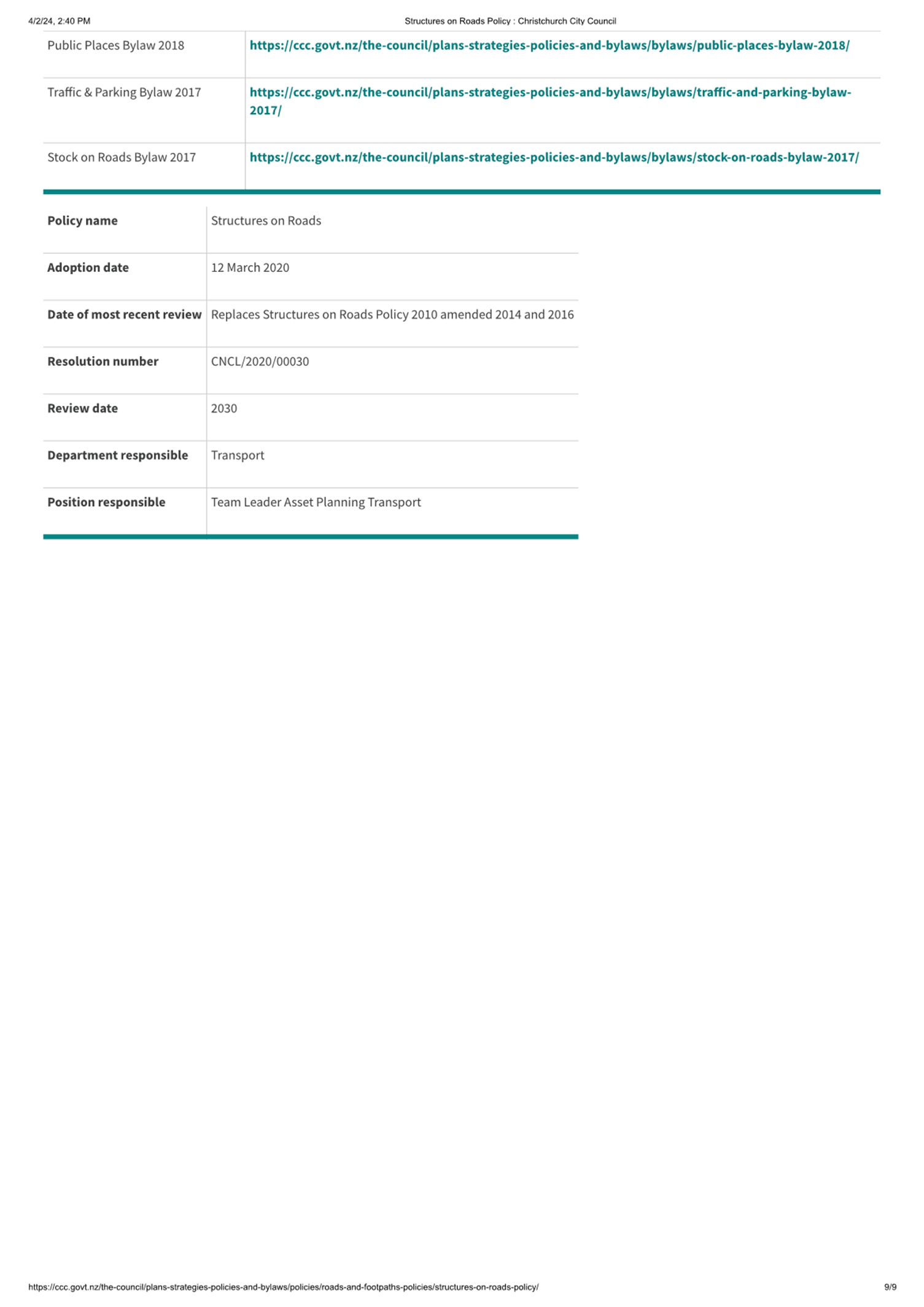
17. Revoking
Superseded External Policies
|
|
|
Council Resolved CNCL/2024/00048
Officer recommendations accepted without
change
That the
Council:
1. Receive the information in the Revoking Superseded External
Policies report.
2. Note that the decision in this report is assessed as low
significance based on the Christchurch City
Council’s Significance and Engagement Policy.
3. Approve the revocation of the following policies as they have been
superseded by other Council documents and are no longer fit-for-purpose as
further detailed in Attachment A to this report:
a. Arts Policy and Strategy 2001 (Attachment B), superseded by
Tōi Ōtautahi – Arts and Creativity Strategy.
b. Footpath Battens Policy 1999 (Attachment C), superseded by
the Christchurch City Council Construction Standard Specifications, Part 6.
c. Footpath Berms Policy 1999 (Attachment D), superseded by
the Christchurch City Council Construction Standard Specifications, Part 6
and Chapter 9.
d. Heritage Conservation Policy 2007 (Attachment E),
superseded by the Heritage Grants Guidelines and the ‘Our Heritage Our
Taonga Heritage Strategy 2019-2029.
Councillor
MacDonald/Deputy Mayor Carried
|
Councillor MacDonald left the meeting at 12.10pm
and returned at 12.11pm during consideration of Item 18.
Councillor Keown left the meeting at 12.14pm
and returned at 12.19pm during consideration of Item 18.
Councillor Donovan left the meeting via
audio / visual link at 12.15pm and returned at 12.34pm via audio / visual link
during consideration of Item 18.
Councillor MacDonald left the meeting at 12.15pm
and returned at 12.22pm during consideration of Item 18.
Councillor Gough returned to the meeting at
12.30pm during consideration of Item 18.
|
18. Wastewater
overflow improvement status
|
|
|
Council Resolved CNCL/2024/00049
Officer recommendation accepted without
change
That the Council:
1. Receive the information in the Wastewater
overflow improvement status Report.
Councillor
Scandrett/Mayor Carried
|
|
|
Attachments
a Wastewater
overflow improvement status - Presentation to Council
|
|
13. Gloucester Street
(Manchester to Colombo): Completion of Trial Period
|
|
|
The meeting returned to Item 13 after it
was left to lie on the table to allow Council Officers time to collect advice
in response to the elected members’ questions. Council Officers Lynette
Ellis, Jacob Bradbury, Ron Lemm, and Lauren Boyce returned to the table to
answer further questions from elected members.
With the agreement of the Mover and
Seconder, the meeting included an additional recommendation requesting a
breakdown of the expected total costs of the Gloucester Street trial (refer
Resolution 4 below).
At the conclusion of debate, the meeting
voted on the Motion as amended which was declared carried.
|
|
|
Officer Recommendations
That the
Council:
1. Receive the information in the Gloucester Street (Manchester to
Colombo): Completion of Trial Period Report.
2. Agree to retain the Gloucester Street (Manchester to Colombo)
trial layout until 31 October 2024, to allow time for a Hearings Panel to
review feedback from the trial and make a recommendation to Council regarding
its long-term future.
3. Note that the decision in this report is
assessed as medium significance based on the Christchurch City
Council’s Significance and Engagement Policy.
|
|
|
Council Resolved CNCL/2024/00050
That the
Council:
1. Receive the information in the Gloucester Street (Manchester to
Colombo): Completion of Trial Period Report.
2. Agree to retain the Gloucester Street (Manchester to Colombo)
trial layout until 31 October 2024, to allow time for a Hearings Panel to
review feedback from the trial and make a recommendation to Council regarding
its long-term future.
3. Note that the decision in this report is
assessed as medium significance based on the Christchurch City
Council’s Significance and Engagement Policy.
4.
Request that staff provide a memo updating the Council on a breakdown of the
expected total costs of the Gloucester Street (Manchester to Colombo) trial.
Councillor
Scandrett/Councillor McLellan Carried
|
|
19. Resolution
to Exclude the Public Te whakataunga kaupare hunga tūmatanui
|
|
|
Secretarial Note: The meeting did not resolve
to go into a Public Excluded session as Items 20 and 21 – the Public
Excluded Council Minutes of 3 April and 10 April were confirmed in the Open
meeting (refer Item 6 and Item 7).
|
Karakia
Whakamutunga: All Councillors
Meeting
concluded at 1.01pm.
CONFIRMED THIS 5th DAY
OF JUNE 2024
Mayor Phil Mauger
Chairperson
|
6. Monthly
Report from the Community Boards - May 2024
|
|
Reference Te Tohutoro:
|
24/822275
|
|
Report of Te Pou Matua:
|
The
Chairpersons of all Community Boards
|
|
Accountable ELT Member Pouwhakarae:
|
Andrew
Rutledge, Acting General Manager Citizens and Community
|
1. Purpose and Origin of the Report Te Pūtake Pūrongo
1.1 The
purpose of this report is to provide the Council with an overview of
initiatives and issues recently considered by the Community Boards. This
report attaches the most recent Community Board Area Report included in each Board's
public meeting. Please see the individual agendas for the attachments to each
report.
1.2 Each Board will present important matters from their respective
areas during the consideration of this report and these presentations will be
published with the Council minutes after the meeting.
2. Community Board Recommendations Ngā Tūtohu a te Poari
Hapori
That the Council:
1. Receives the information in the Monthly
Report from the Community Boards - May 2024 Report.
Attachments Ngā Tāpirihanga
|
No.
|
Title
|
Reference
|
Page
|
|
a ⇩
|
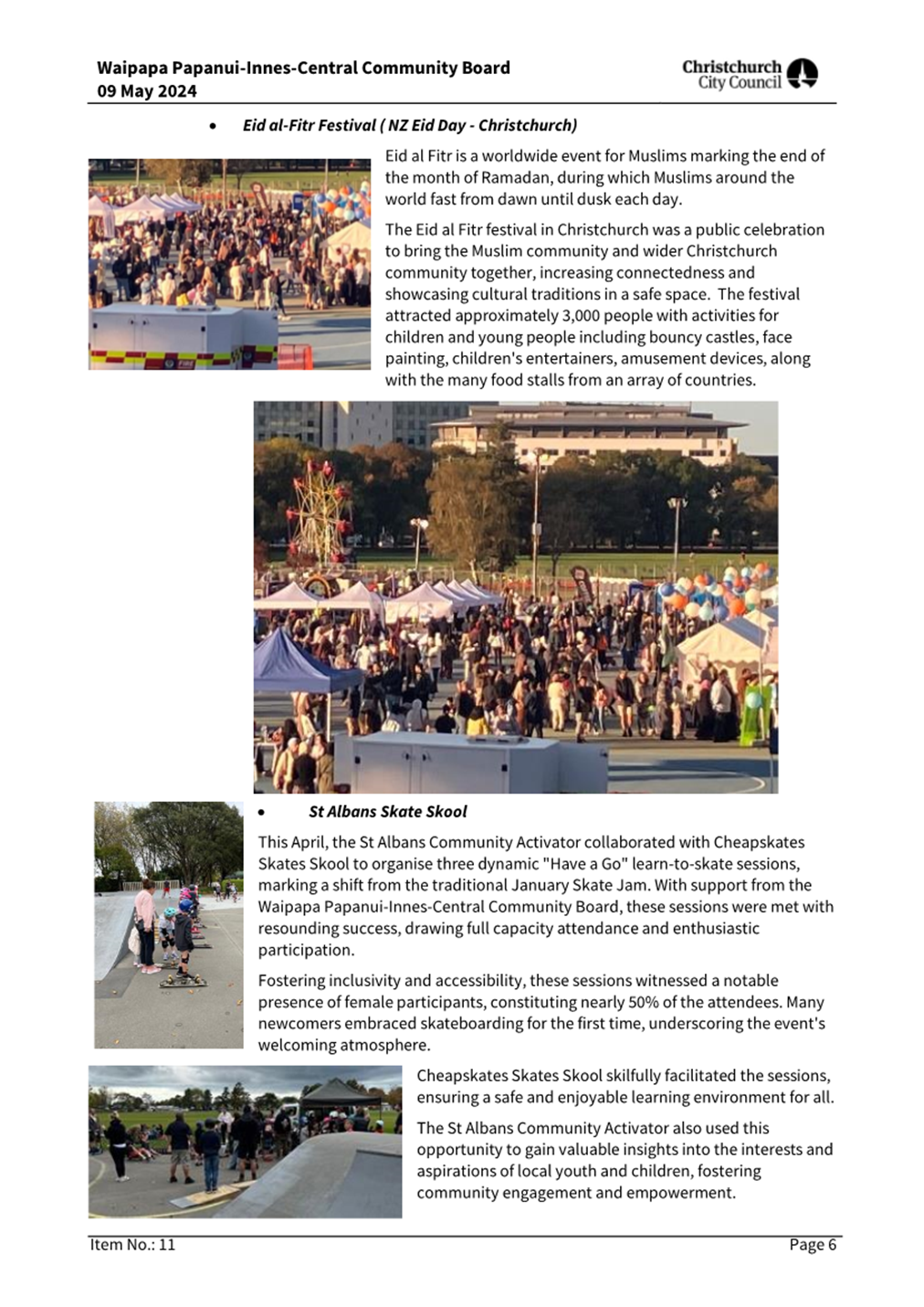
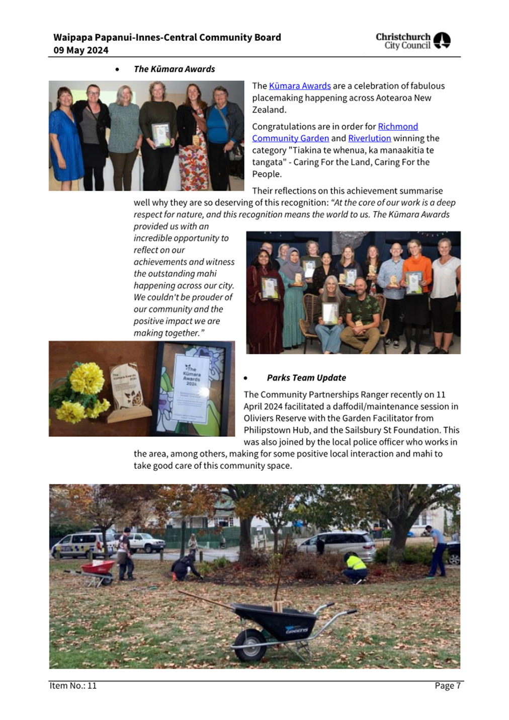
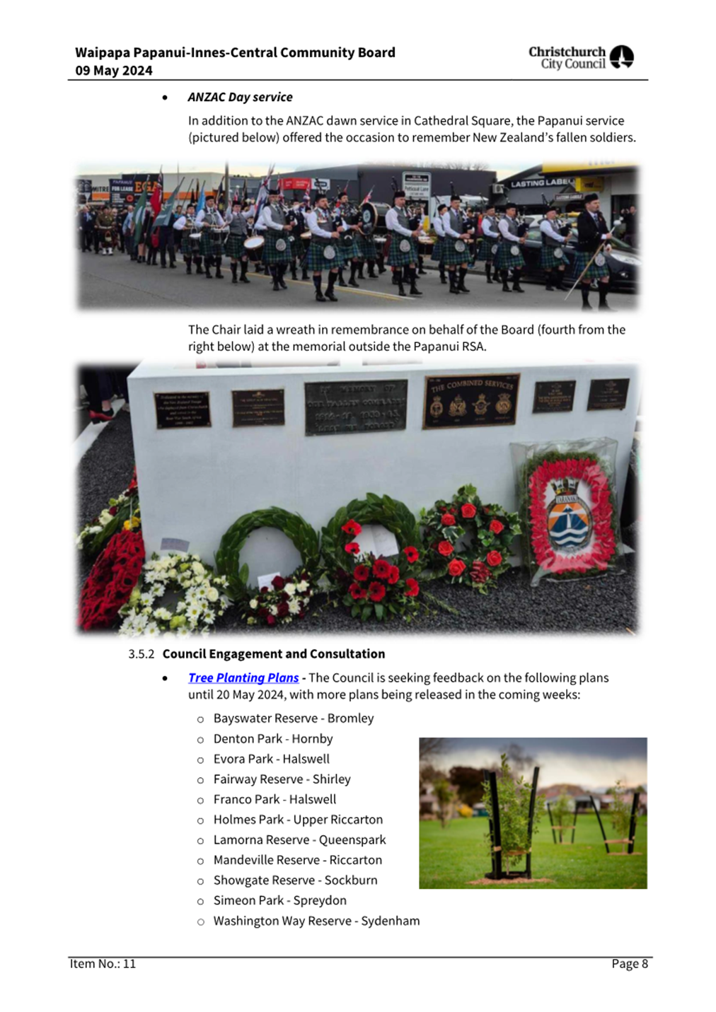
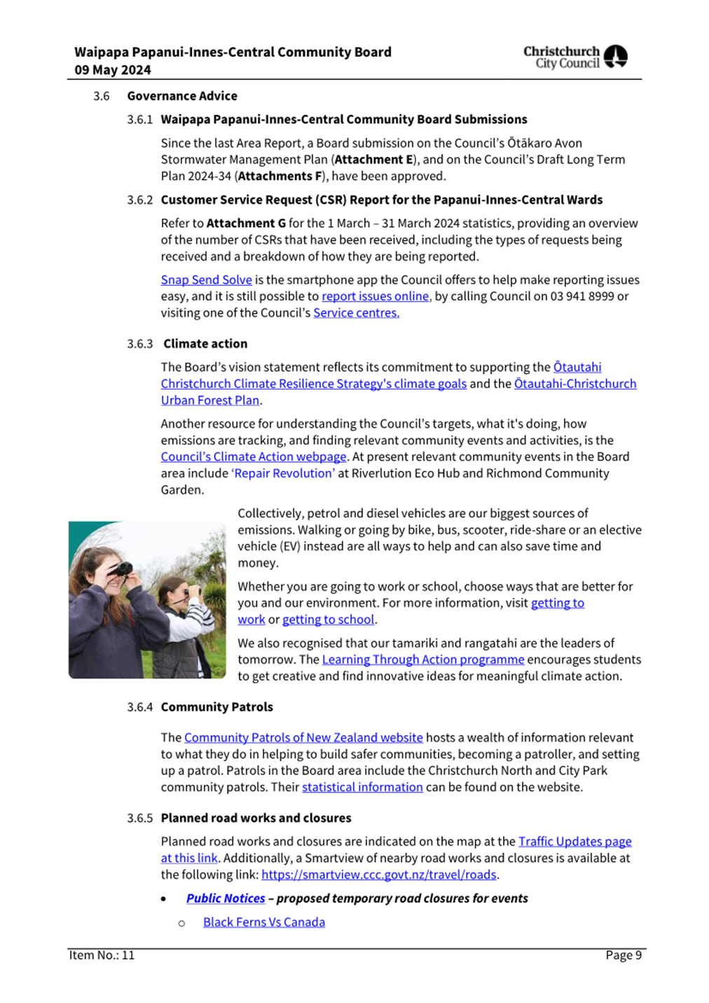
Waipapa Papanui-Innes-Central Community Board Area Report May 2024
|
24/822276
|
18
|
|
b ⇩
|
Waipuna Halswell-Hornby-Riccarton Community Board Area Report May
2024
|
24/822277
|
30
|
|
c ⇩
|
Waitai Coastal-Burwood-Linwood Community Board Area Report May
2024
|
24/822278
|
37
|
|
d ⇩
|
Te Pātaka o Rākaihautū Banks Peninsula Community
Board Area Report May 2024
|
24/822282
|
49
|
|
e ⇩
|
Waihoro Spreydon-Cashmere-Heathcote Community Board Area Report
May 2024
|
24/822283
|
54
|
|
f ⇩
|
Waimāero Fendalton-Waimairi-Harewood Community Board Area
Report May 2024
|
24/822284
|
61
|
Report from Te Pātaka o Rākaihautū Banks Peninsula Community
Board – 22 April 2024
|
7. 27
Hunters Road & 43 Whero Avenue, Diamond Harbour – FENZ and Te
Pā o Rākaihautū Unsolicited Proposals
|
|
Reference Te Tohutoro:
|
24/684938
|
|
Responsible Officer(s) Te Pou Matua:
|
Angus
Smith, Manager
Kristine Bouw, Development Project Manager
|
|
Accountable ELT Member Pouwhakarae:
|
Andrew
Rutledge, Acting General Manager Citizens and Community
|
|
1. Te Pātaka o Rākaihautū Banks
Peninsula Community Board Consideration Te Whaiwhakaarotanga
|
|
|
1. Staff
presented reviewed submission results that included submissions from
Charteris Bay, Church Bay, Purau and Port Levy counted as being local for
paragraph 8.30 of the report.
2. The
Board took into consideration the deputations. (Item 5.1 of these minutes
refers).
3. The
Board acknowledged that it heard from its community through the submissions
and deputations.
4. The Board wishes submitters to 27 Hunters Road and 43 Whero
Avenue, Diamond Harbour – FENZ and Te Pā o Rākaihautū
Unsolicited Proposals be updated on the two projects as they develop.
|
|
2. Te Pātaka o Rākaihautū Banks
Peninsula Community Board Decisions Under Delegation Ngā Mana kua Tukuna
|
|
|
Officer Recommendations Ngā Tūtohu
That Te
Pātaka o Rākaihautū Banks Peninsula Community Board recommend
to the Council that:
1. It depart from its Disposal of Property Policy 2000 and the
requirement to sell by public tender, noting that the Council does not intend
to amend the Policy to accommodate this decision.
2. It deal unilaterally with Fire and Emergency New Zealand and Te
Poho o Tamatea Limited and conditionally sell the part of the land as shown
in Attachment B and C to this report and described as:
a. Part Lot 1 DP 14050 contained in Record of Title CB12F/538 and
marked “FENZ Site” in Attachment B to this report to Fire and
Emergency New Zealand for a Fire Station; and
b. Part Lot 1 DP 14050 marked “Te Pā o
Rākaihautū” in Attachment C to this report to Te Hapū o
Ngāti Wheke investment company Te Poho o Tamatea Limited for a Character
School under section 156 of the Education Act 1989.
3. Authorise the Manager Property Consultancy, to undertake all
actions, negotiate and conclude all the agreements necessary to facilitate
Recommendations 1 and 2 in general accordance with this report on terms and
conditions acceptable to him at his sole discretion, and in doing so make any
decisions necessary to give effect to this.
4. Require the matter to be referred back to the Council should the
Manager Property Consultancy in his sole discretion consider the terms in the
attached Terms Sheets (Attachment A and B) cannot be reasonably met.
|
|
3. Te Pātaka o Rākaihautū
Banks Peninsula Community Board Recommendation to Council
|
|
|
Part A
That Te Pātaka o Rākaihautū Banks
Peninsula Community Board recommends to the Council that:
1. It departs from its Disposal of Property
Policy 2000 and the requirement to sell by public tender, noting that the
Council does not intend to amend the Policy to accommodate this decision.
2. It deals unilaterally with Fire and
Emergency New Zealand and Te Poho o Tamatea Limited and conditionally sell
the parts of the land as shown in Attachment B and C to this report and
described as:
a. Part Lot 1 DP 14050 contained in Record of
Title CB12F/538 and marked “FENZ Site” in Attachment B to this
report to Fire and Emergency New Zealand for a Fire Station; and
b. Part Lot 1 DP 14050 marked “Te Pā
o Rākaihautū” in Attachment C to this report to Te Hapū
o Ngāti Wheke investment company Te Poho o Tamatea Limited for a
Character School under section 156 of the Education Act 1989.
3. Authorises the Manager Property Consultancy,
to undertake all actions, negotiate and conclude all the agreements necessary
to facilitate Recommendations 1 and 2 in general accordance with the report
on the meeting agenda on terms and conditions acceptable to him at his sole
discretion, and in doing so to make any decisions necessary to give effect to
this.
4. Requires the matter be referred back to the
Council should the Manager Property Consultancy in his sole discretion
consider the terms in the attached Terms Sheets (Attachment A and B to the
report on the meeting agenda) cannot be reasonably met.
5.
Requests that access points
to the site do not materially impact the existing street layout or alter
existing streets.
6. Notes
the community concerns, regarding the proposed Te Pā o
Rākaihautū kura, of the potential additional load on roading and
utilities, and requests staff to provide information on these potential
impacts, including the impact on the transport network both on land and sea
and report to Te Pātaka o Rākaihautū Banks Peninsula Community
Board and the Council.
7. It
ensures any decision made in relation to 27 Hunters Road & 43 Whero Avenue, Diamond Harbour
– FENZ and Te Pā o Rākaihautū Unsolicited Proposals aligns with the declared climate emergency.
8.
It notes that any sale of
the land would be at a price that fits with Council policy and at market
value.
|
Attachments Ngā Tāpirihanga
|
No.
|
Report Title
|
Reference
|
Page
|
|
1
|
27 Hunters Road & 43 Whero
Avenue, Diamond Harbour – FENZ and Te Pā o Rākaihautū
Unsolicited Proposals
|
24/440559
|
72
|
|
No.
|
Title
|
Reference
|
Page
|
|
a ⇨
|
Unsolicited Proposal Te Pa o Rākaihautū (Under
Separate Cover)
|
24/497492
|
|
|
b ⇩
|
FENZ Terms Sheet
|
24/511602
|
86
|
|
c ⇩
|
Te Poho o Tamatea Limited
|
24/511610
|
89
|
|
d ⇨
|
Submission file (Under Separate Cover)
|
24/550625
|
|
|
e ⇩
|
Analysis of submissions
|
24/513310
|
92
|
|
27 Hunters Road & 43 Whero Avenue, Diamond Harbour –
FENZ and Te Pā o Rākaihautū Unsolicited Proposals
|
|
Reference Te Tohutoro:
|
24/440559
|
|
Responsible Officer(s) Te Pou Matua:
|
Angus
Smith, Manager
Kristine Bouw, Development Project Manager
|
|
Accountable ELT Member Pouwhakarae:
|
Jane
Parfitt, General Manager City Infrastructure
|
1. Purpose and Origin of the Report Te Pūtake Pūrongo
1.1 The
purpose of this report is to present the outcomes of the consultation and make
recommendations relating to the Unsolicited Proposals received for the
Council-owned land at 27 Hunters Road and 43 Whero Avenue to:
1.1.1 Sell
a portion to Fire and Emergency New Zealand (FENZ) for a new fire station and
1.1.2 Sell
a portion to Te Hapū o Ngāti Wheke investment company Te Poho o
Tamatea Limited for the purposes of Te Pā o Rākaihautū character
school.
1.2 The
report is staff generated in response to proposals from FENZ and Te Pā o
Rākaihautū (Te Pā) character school to purchase parts of the
Hunters Road site for a Fire Station and a character school established under
section 156 of the Education Act 1989 respectively.
2. Officer Recommendations Ngā Tūtohu
That Te Pātaka
o Rākaihautū Banks Peninsula Community Board recommend to the Council
that:
1. It depart from its Disposal of Property Policy 2000 and the
requirement to sell by public tender, noting that the Council does not intend
to amend the Policy to accommodate this decision.
2. It deal unilaterally with Fire and Emergency New Zealand and Te Poho
o Tamatea Limited and conditionally sell the part of the land as shown in
Attachment B and C to this report and described as:
a. Part Lot 1 DP 14050 contained in Record of Title CB12F/538 and
marked “FENZ Site” in Attachment B to this report to Fire and
Emergency New Zealand for a Fire Station; and
b. Part Lot 1 DP 14050 marked “Te Pā o
Rākaihautū” in Attachment C to this report to Te Hapū o
Ngāti Wheke investment company Te Poho o Tamatea Limited for a Character
School under section 156 of the Education Act 1989.
3. Authorises the Manager Property Consultancy, to undertake all
actions, negotiate and conclude all the agreements necessary to facilitate
Recommendations 1 and 2 in general accordance with this report on terms and
conditions acceptable to him at his sole discretion, and in doing so make any
decisions necessary to give effect to this.
4. Requires the matter to be referred back to the Council should the
Manager Property Consultancy in his sole discretion consider the terms in the
attached Terms Sheets (Attachment A and B) cannot be reasonably met.
3. Executive Summary Te Whakarāpopoto Matua
3.1 Council
has been approached by two organisations, FENZ and Te Pā o
Rākaihautū, a designated Character School, to sell to them portions
of the Council owned land situated at 27 Hunters Road and 42 Whero Avenue,
Diamond Harbour, identified as Part Lot 1 DP 14050 contained in Record of Title
CB12F/538.
3.2 The
land is not required for any current or reasonably foreseeable future Council
use and it has no reason to retain the land that is the subject of these
bids.
3.3 The
proposals have benefits to the wider community and help Council achieves its
outcomes and priorities.
3.4 Community
feedback is generally supportive of both proposals, however, there are concerns
from some in Diamond Harbour about the effects of the school on infrastructure,
the environment and other local educational establishments.
3.5 Te
Poho o Tamatea Limited and the Ministry of Education (MoE), have expressed
concerns about expending further time and resources on collating information to
support their proposals when there is uncertainty about whether Council would
depart from policy, support the proposals and deal unilaterally with
them. Until this further information is prepared there remains
uncertainty about the effects of the school proposal.
3.6 To
address these concerns, the report recommends an option that provides increased
certainty for the proponents to proceed to the next stage and commence
substantial property planning and consenting investigations and feasibility
studies. The effects of the proposals on infrastructure and the
environment can then be addressed through the statutory resource consent
process. The effects of the proposed school on other educational
establishments can be addressed through the Ministry of Education decision
making process.
3.7 Community
views are supportive of both proposals as detailed later in this report.
There is little to no financial impact at this stage or reputational risk to
Council in adopting the recommendations in this report.
3.8 The
proposed uses of the land by both FENZ and Te Pā o Rākaihautū
support the Council's Te Haumako Te Whitingia Strengthening Communities
Together and Multicultural Strategies.
4. Background/Context Te Horopaki (4.2 and 4.3
can be deleted if not applicable)
4.1 In
2021 the Christchurch City Council as part of its Long Term Plan (LTP)
consultation proposed to sell the land situated at 27
Hunters Road and 42 Whero Avenue (the land). As a result of that LTP
consultation Council resolved to undertake further targeted consultation.
4.1.1 M19Aii:
That the Council defer making a decision about the properties at 27 Hunters
Road and 42 Whero Avenue Diamond Harbour until a targeted consultation process
can be undertaken to gather additional information to support the material
gathered trough the LTP Consultation process. Council creates a project in the
first year of the LTP and sets aside a budget of $65,000 for this purpose.
Report back to Council for a final decision as part of the FY 2022/23 annual
plan process.
4.2 This
targeted consultation took place in October/November 2021 and resulted in the
following resolutions being passed by Council;
Council
Resolved CNCL/2022/0032
1. Acknowledges the
views of the submitters from the Council’s targeted consultation process
including the Banks Peninsula Community Board’s submission from its
meeting on 14 February 2022.
2. Note there is
community support for the sale of the land for residential and other purposes
subject to the development reflecting community aspirations.
3. Notes that the
recommended paths forward is to:
a. Develop
an Outline Development Plan for the properties collectively known as 27 Hunters
Road and 42 Whero Avenue;
b. Protect
the revegetated gullies and access tracks;
c. Subdivide
the site and place covenants on the property titles that requires development
to be in accordance with the Outline Development Plan; and
d. Dispose
of the balance of the site not required for Council purposes.
4. Refers the matter
to the 2023/24 Annual Plan for prioritisation and funding;
5. Defers any decision
to declare 27 Hunters Road and 42 Whero Avenue surplus to operational
requirement until such time as an Outline Development Plan is completed
6. Request the Outline
Development Plan prioritise climate change adaptation and the ability for local
residents to age in place in the considerations as far as possible.
4.3 Soon
after, Council staff commenced a process to develop an Outline Development Plan
(ODP) to determine possible future uses for the land that reflected community
views and aspirations and the Council resolution in paragraph 4.2.
4.4 Council
staff became aware of a request by FENZ to purchase approximately 5000m²
of the site for a fire station and subsequently in late 2023 received a further
request from Te Pā o Rākaihautū, for a designated Character
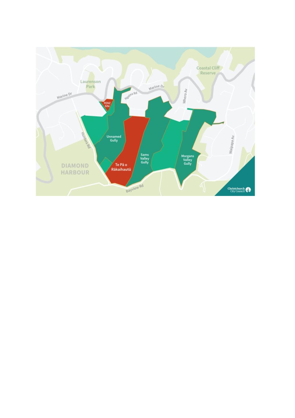
School, to purchase approximately 8 hectares in the middle portion of the site.
These sites are identified below and are both part of Lot 1 DP 14050 contained
in Record of Title CB12F/538.
4.5 The
receipt of the two unsolicited proposals has necessitated that the ODP process
be put on hold until decisions on the unsolicited proposals and outcomes are
known.
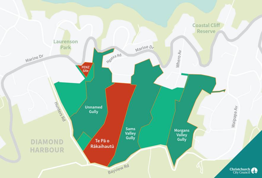
Site Plan of CCC-owned land at 27 Hunters
Road and 42 Whero Avenue with proposed FENZ and Te Pā land purchase areas
highlighted in red
5. FENZ – Diamond Harbour Fire Station
5.1 FENZ
currently occupy an 829m² site at 89 Marine Drive, Diamond Harbour. FENZ
has identified that this site not large enough for their operational
requirements and the building that they occupy has been rated at less than 34%
of the New Building Standard and is an Earthquake Prone Building. As a result,
notice have been served on FENZ to upgrade the building based on current
building standards.
5.2 FENZ
are looking for a larger site to meet their future needs and have investigated
several sites within the Diamond Harbour area. The proposed site has been
selected based on preference in regards to optimal response times, population
movement and estimated growth in the Diamond Harbour area. The result of these
investigations is the selection of the current site for their new build.
5.3 The
selected site of approximately 5000m² will enable FENZ to build a new
station that is a fit for purpose, resilient, and meets statutory, regulatory
and organisational requirements for the future and allows for growth of the
wider community.
5.4 Whilst
the station will be vacant 80 – 90% of the time it will be used for
training purposes approximately one evening per week and be used for community
engagement days, education and Civil Defence if required.
6. Te Pā o Rākaihautū – Character School
6.1 Nōku
Te Ao Charitable Trust in partnership with the Ministry of Education have been
working together to realise a long-term goal to develop a permanent 21st
century pā wānaka (learning village) known as Te Pā o
Rākaihautū and are looking to develop this on the Council-owned land
at 27 Hunters Road / 42 Whero Avenue, Diamond Harbour.
6.2 Te
Pā opened in 2015 on a temporary site at Richmond Primary School, it moved
to the old Linwood Intermediate site in the same year on a temporary basis and
remains there while they look for a permanent home.
6.3 Te
Pā became aware the Council were seeking a use(s) for the Hunters Road
site in Diamond Harbour. The proposed site in Te Pātaka o
Rākaihautū (Banks Peninsula) is strongly aligned with Te
Pā’s kaupapa (special character) and would enable full delivery of
their curriculum with a location based centrally amongst the five key
Rūnanga.
6.4 The
unsolicited proposal from Te Pā o
Rākaihautū to purchase part of the site is appended as Attachment A Unsolicited
Proposal Te Pā o Rākaihautū. The proposal includes input
from multiple parties and can be summarised as follows:
6.4.1 Nōku
Te Ao Charitable Trust was established in 2002 to establish a total immersion
reo Māori early childhood centre. It has since evolved and opened Te Pā
o Rākaihautū as a designated Character School established under
Section 156 of the Education Act 1989.
6.4.2 Te
Pā o Rākaihautū has been operating
from a temporary site at 7 McLean Street in Linwood since 2015.
6.4.3 Te
Hapū o Ngāti Wheke through their charitable investment company Te
Poho o Tamatea Limited propose to purchase the land and lease it to the
Ministry of Education as a school site for Te Pā o Rākaihautū.
6.4.4 The
Ministry of Education (the Ministry) are supportive of Te Pā o
Rākaihautū operating a multi-site school to ultimately provide a
school for up to 700 students across two sites, currently the Linwood site and
part of the land at 27 Hunters Road.
Options Considered Ngā
Kōwhiringa Whaiwhakaaro
6.5 The
following reasonably practicable options were considered and are assessed in
this report:
· Preferred Option 1: To support the conditional sale of part of the
land to FENZ and Te Hapū o Ngāti Wheke through their charitable
investment company Te Poho o Tamatea Limited
· Option 2: Not sell the land to FENZ
· Option 3: Not sell the land to Te Poho o Tamatea Limited
Option
Descriptions Ngā Kōwhiringa
6.6 Preferred
Option: To support the conditional sale of part of the land to FENZ and Te
Hapū o Ngāti Wheke through their charitable investment company Te
Poho o Tamatea Limited
6.6.1 Option Description
Sale of land to
both FENZ and Te Poho o Tamatea Limited subject to FENZ and Te Poho o Tamatea
Limited meeting conditions of sale whereby they are satisfied the land is
suitable for their specific use and being able to obtain all necessary consents
and approvals to construct, operate and manage a Fire and Emergency and
Character School site respectively. The land sale option will be subject to
multiple conditions as outlined in the attached terms sheets (Attachment B
and C) and be subject to any terms and conditions approved from time to
time by the Property Consultancy Manager.
6.6.2 Option Advantages
· Gives certainty to all parties that enables them to commit financial
resources for planning, design and consenting,
· Helps meet Council commitment to community development,
· Provides an economic return to Council i.e., land sale,
· Provides a permanent site for Te Pā o Rākaihautū,
· Provides a fit for purpose site for FENZ,
· Both proposals are low intensity and would retain a degree of open
space and be less demanding on services than could be enabled by the current
zoning for residential activity.
6.6.3 Option
Disadvantages
· Delays the ODP process until outcomes become certain.
· Precludes other alternative uses.
6.7 Option 2 - Not sell the land to FENZ
6.7.1 Option Description
This option
would require FENZ to seek an alternative site for a new fire station. FENZ has
considered other sites within Diamond Harbour many of which have already been
considered and ruled out as being not suitable, and included:
· Laurenson Park – a recreation reserve used by the Diamond
Harbour Community and its use by FENZ is not supported by the Councils Parks
Team due to its current park use and direct proximity to residential
properties. In addition, being a reserve presents reserve act challenges to
revoke the reserve status and sell.
· Alternative sites within the Council-owned Hunters Road land. These
were considered either too steep, have poor access or were not in a suitable
locality.
6.7.2 Option
Advantages
· Council’s Outline Development Plan (ODP) process could
continue as planned.
6.7.3 Option Disadvantages
· FENZ is required to rebuild the Diamond Harbour Fire Station as a
part of their operational and community response requirements. Further delays
to the location of a new facility provide increased risk to the community.
· FENZ is an acquiring authority under the Public Works Act 1981 and
has the ability to compulsory acquire land for a fire station and may choose a
site that from a Council perspective is less desirable. Not selecting this
Hunter Road land may result in a less desirable land selection for a new fire
station.
6.8 Option
3 - Not sell the land to Te Poho o Tamatea
Limited
6.8.1 Option Description
This option would require Te Poho o Tamatea Limited to find an
alternate site within the Banks Peninsula that would accommodate their needs
for a new school.
6.8.2 Option
Advantages
· This option may allow for the location of a new school with
potentially less infrastructural constraints.
· Council’s ODP process could continue as planned.
6.8.3 Option Disadvantages
· An alternative site for a school will need to be found within Banks
Peninsula and which may not provide the opportunities of the land at Hunters
Road.
· Further delays the location of a fit for purpose, permanent site for
Te Pā.
Analysis Criteria Ngā Paearu
Wetekina
6.9 These
proposals were assessed against the Councils Guidelines for Submission and
Assessment of Unsolicited Proposals and Disposal of Property Policy.
6.9.1 The above guidelines
require unsolicited proposals to be unique, align with Council community
outcomes and strategic priorities and demonstrate value for money.
6.9.2 Both proposals
submitted are unique (including community focused and low density outcomes),
are considered to align with desirable community outcomes, align with strategic
priorities, and have potential to demonstrate value for money once valuations
are available.
6.10 The
proposals were also considered against the Council’s Strategic Framework
and policies.
7. Financial Implications Ngā Hīraunga Rauemi
7.1 The
decision of this report does not have a direct financial implication but rather
considers the conditional sale of the land to FENZ and to Te Poho o Tamatea
Limited.
7.2 The
full details of the cost to implement the land sale are not yet known,
including CAPEX / OPEX implications. Should the proposed land sale be supported
by the Council, staff will provide further information and detail on the
financial implications and based on standard Council land transactions.
7.3 Any
option is considered to include costs to Council in the form of operational
costs and staff time to support as an upfront consideration and will be a part
of any future land sale decision making and considered under the appropriate
delegations.
8. Considerations Ngā Whai Whakaaro
Risks and Mitigations Ngā
Mōrearea me ngā Whakamātautau
8.1 There
are limited risks for Council in adopting the recommendations in this report.
The proposed conditional sale to both FENZ and Te Poho o Tamatea Limited have
been widely consulted on and have generally been well received by the community
as detailed in this report.
8.2 There
are risks associated with the consenting of the proposals at a future date,
particularly at this stage without complete information on how the effects will
be mitigated. Notwithstanding this, conditions can be included on the sale of
the land, requiring approvals to be obtained.
Legal Considerations Ngā
Hīraunga ā-Ture
8.3 When
selling land, officers follow the requirements of legislation and the
Council’s “Disposal of Council Property Policy 2000”.
This policy states that:
· the Council's policy of publicly tendering properties for sale
unless there is a clear reason for doing otherwise be confirmed as applying to
all areas of the City.
8.4 Normal practice is to treat
the statement “clear reason for doing otherwise” as a policy
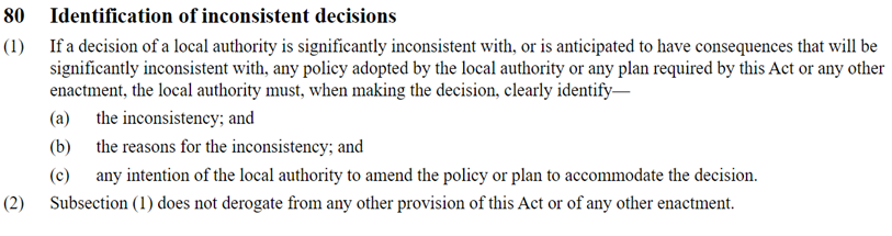
inconsistency under Clause 80 of the Local Government Act 2002. This
clause requires the Local Authority to clearly identify any significant inconsistencies
with policy including the reasons for the inconsistency. The specific clause is:
8.5 In
this case the inconsistency is to not publicly tender the sale of parts of the
site.
8.6 This
is inconsistent with the policy because it is proposed to deal unilaterally
with FENZ and Te Poho o Tamatea Limited.
8.7 Council
do not intend to amend the policy as these are unique, one-off proposals.
8.8 In
the case of the sale to Te Poho o Tamatea Limited, Council intend to enter into
a covenant whereby if the land is not used for the purposes of a character
school as described in the attached proposal then the Council has the ability
to repurchase the property.
8.9 In
the case of FENZ, FENZ is deemed to be an acquiring authority under the Public
Works Act 1981 and if they were to ever consider selling their site then they
are obligated under the provisions of the Public Works Act 1981 to offer the
land back to Council.
Consultation requirements
8.10 Council
has consulted the Community on the proposed sale. Section 138 of the Local
Government Act 2002 requires consultation where Council proposes to sell land
that could be considered to be a park where that land was acquired or is used
principally for community, recreational, environmental, cultural, or spiritual
purposes. Although the proposed sale only relates to land that is grazed other
parts of the land are used by the community e.g. native planting and walking
tracks.
Term and Conditions of Sale
8.11 Both
parties intend to enter into terms and conditions of sale, the principal ones
affecting both parties are,
· Valuation to establish the purchase price.
· Protection of existing Council infrastructure.
· Suitable for proposed use, i.e. geotechnical reports.
8.12 Te
Poho o Tamatea Limited has specific conditions over and above those listed in
paragraph 8.9 to enable Te Pā o Rākaihautū to utilise the site
for a school and requires,
· MoE completing a feasibility study for the suitability of the site
for Te Pā o Rākaihautū to operate a school.
· MoE and Te Pā o Rākaihautū having a suitable business
and financial plan.
· Use of the balance of the site purchased by Te Poho o Tamatea
Limited being used solely for the purposes of Te Pā o Rākaihautū
school.
· Ability for the Council to purchase the site back if it is not used
for a school.
Strategy and Policy Considerations Te Whai
Kaupapa here
8.13 The
required decisions:
8.13.1 Align with the Christchurch
City Council’s Strategic Framework.
· The proposals help to contribute to the Community Outcome: A
collaborative confident city
· The
proposed uses of the land by both FENZ and Te Pā o Rākaihautū is
consistent with the Council's Te Haumako Te Whitingia Strengthening Communities
Together and Multicultural Strategies.
· The proposals help the Council “manage ratepayers' money wisely, delivering quality core
services to the whole community and addressing the issues that are important to
our residents” via releasing capital from land that is not currently
contributing to meeting community outcomes.
8.13.2 Relate to land that on initial assessment
does not meet Council’s criteria for retention as set out in its December
2020 approved retention criteria.
8.13.3 The decisions in this report are assessed
as medium significance based on the Christchurch City Council’s
Significance and Engagement Policy 2019. The level of significance was
determined by the interest from the Banks Peninsula community in the future of
the land, the significance of the decision outcome to Te Pā and FENZ, and
the potential impacts on the local area.
8.13.4 The decisions in this report are
inconsistent with the Council Disposal of Property Policy. This policy
requires Council to “… publicly
tendering properties for sale unless there is a clear reason for doing
otherwise …”. The inconsistency is that the recommended
action is to sell these properties via private treaty. The clear reason
for taking this approach in both cases is that the beneficial outcomes cannot
be guaranteed through a public tender process.
8.13.5 The
decision in this report do not support the Council's
Long Term Plan (2021 - 2031):
8.13.6 Not in Plan
8.13.7 Activity:
Not in Plan
· Level
of Service: Not in Plan
8.13.8 The sale of the sites does not negate the need
for approvals under the Resource Management Act 1991 (i.e. resource consent),
which will require an assessment of the effects of the proposed activities and
mitigation of those effects.
8.13.9 Both Te Poho o Tamatea and FENZ will need to work through the resource consent processes on the
basis that resource consent is required under the zone rules and provisions in
the Christchurch District Plan.
8.13.10 The sale of these sites remains separate to the spatial planning
work for the wider site that the Council has been undertaking, and any ongoing
spatial planning will take into account the outcomes of these recommendations
and decisions. The broader exercise for the balance of the site will be
reported to the community board at a future date including options and a
preferred option.
Community Views and Preferences Ngā Mariu
ā-Hāpori
Public Consultation Te Tukanga
Kōrerorero
8.14 Early community
consultation in November 2021, gathered feedback on potential land uses for the
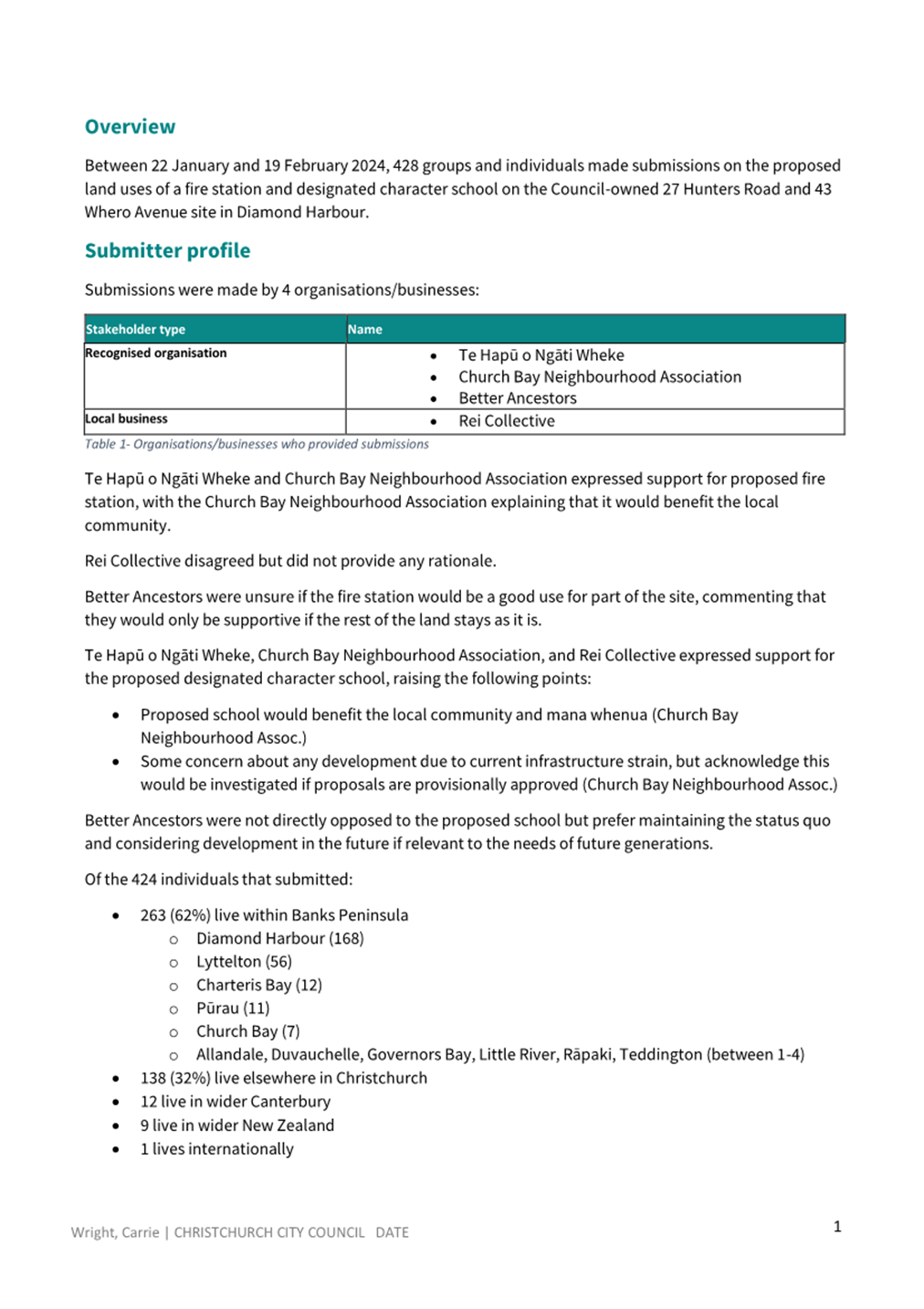
27 Hunters and 43 Whero Avenue site. A total of 234 submissions were received,
which showed strong community interest in preserving the gullies and ongoing
involvement in deciding the future use of the land.
8.15 Following the
unsolicited proposals received from both FENZ at Te Pā, further community
consultation started on 22 January 2024 and ran until 19 February 2024.
8.16 An email was
sent to 76 key stakeholders, including local resident groups, community
organisations, Rūnanga, businesses, schools, and preschools.
8.17 The consultation
was promoted on the Council Newsline (998 views) and Facebook page (9900
impressions). It was also posted to the Diamond Harbour community group
Facebook page, the Diamond Harbour NZ
community page, and the Banks
Peninsula Community Board page. The Community Board also promoted the
consultation in their weekly email updates, inviting submissions on the Kōrero Mai | Let’s
Talk consultation page (2400 views).
8.18 Consultation
documents were delivered to directly affected residents located around the
proposed land parcels for a school and fire station. Documents were available
in the Diamond Harbour library, Lyttelton Service Centre, Diamond Harbour
School, KidsFirst Kindergarten, and local businesses including Four Square,
Diamond Harbour Surgery, and Diamond Harbour Bar & Eatery.
8.19 The consultation
was advertised in the Diamond Harbour Herald newspaper.
8.20 An information session was held on 31 January 2024 and attended by
approximately 60 people. Council staff and representatives from Te Pā and
FENZ provided project information and were available to answer questions.
8.21 Staff attended a
Diamond Harbour School Board meeting to discuss the proposals and gather their
feedback. Feedback from the Board included:
· Interest in meeting with Te Pā to explore mutual benefit.
· Acknowledgement of the site’s cultural significance to Te
Pā.
· Concerns about Te Pā students/staff unfamiliarity with the
Diamond Harbour community if coming from wider Christchurch, and transport
implications including increased traffic and road wear.
· Interest to engage with the MOE to ensure they have assessed any
negative effects on the existing school, ways to support its growth, and the
demand for Te Pā school.
· Recognise the significant role of FENZ in the local community.
Recommend considering and mitigating noise impacts for Diamond Harbour School
where possible.
· Diamond Harbour School Board prioritises maintaining education
quality and community service despite potential impacts of the proposed
facilities.
8.22 Te Pā and FENZ have also undertaken their own community
engagement and communication strategies throughout the project.
Summary of Submissions Ngā
Tāpaetanga
8.23 Submissions were
made by three recognised organisations – Te Hapū o Ngāti Wheke,
Church Bay Neighbourhood Association, Better Ancestors; one business
– Rei Collective; and 424 individuals.
8.24 A full table of submission feedback is available in Attachment D.
8.25 Submitters were
asked if the proposed fire station and designated character school were a good
use for the outlined parts of the 27 Hunters Road and 43 Whero Avenue land.
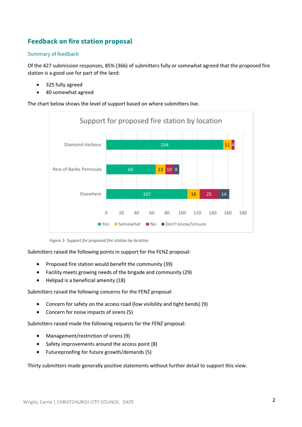
8.26 As shown below,
85% (366) of submitters fully or somewhat agreed that the proposed fire station
is a good use for part of the land, 9% (39) disagreed, and 5% (22) were unsure.
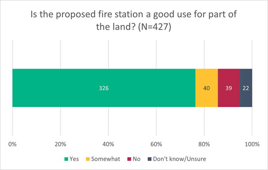
8.27 Submitters who
supported the proposed fire station felt that it would benefit the local
community, is necessary to meet the future needs of both the brigade and the
community and see benefits in the proposed helipad.
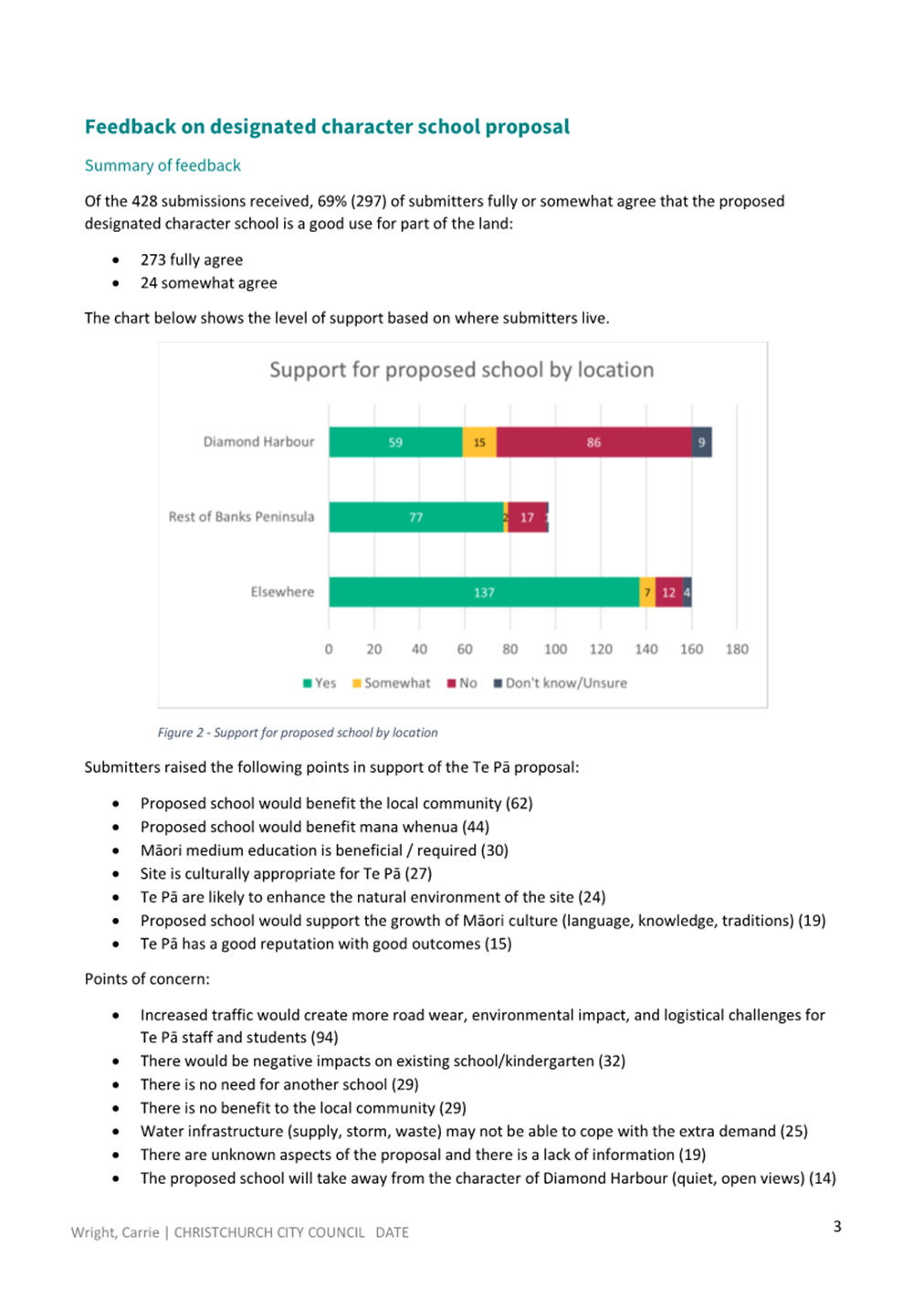
8.28 As shown
below, 69% (298) of submitters fully or somewhat agreed that
the designated character school is a good use for part of the land, 27% (116)
disagreed, and 3% (14) were unsure.
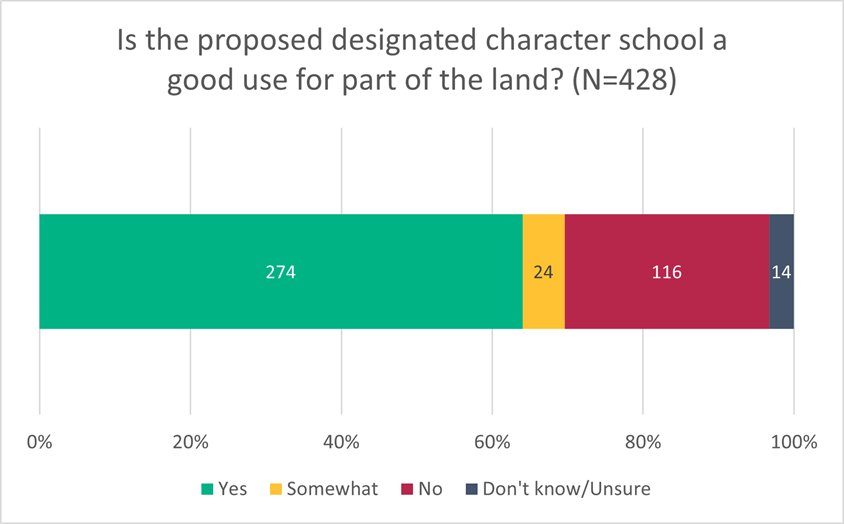
8.29 Submitters who
supported the proposed school felt that it would benefit the local community
and mana whenua, as well as meet the demand for more Māori medium
education. However, there was concern about potential issues from increased
traffic, such as road wear, environmental effects, and logistical challenges
for Te Pā students and staff.
8.30 The detailed
breakdown of the addresses of submitters show different views about the school
proposal between the Diamond Harbour and others (Table 1). Diamond
Harbour submitters were less likely to support the school proposal than other
submitters.
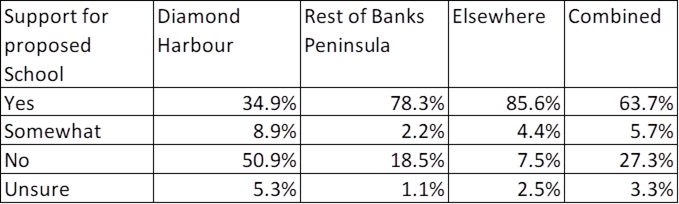
Table 1 Support For Proposed School by
Location
8.31 The community
views likely reflect that the that the “benefits” (e.g. capital
release, achievement of community outcomes, provision of a specialist education
facility) of the sale of the land to the school fall widely, while the real or
perceived costs (e.g. impacts on infrastructure and environment) are perceived
to fall on the local Diamond Harbour community.
8.32 Additionally, a
theme that has emerged from the three consultation processes undertaken
regarding the Hunter Road land is that the Diamond Harbour community may be
open to Council selling the land, but they want to understand the effects of
any development on the land as part of this decision. Council’s
usual decision-making process does not give sufficient certainty to meet the
community desires as Council does not generally
restrict, beyond the requirements of the planning scheme, the use of land it
sells. This means that the effects of any future use are not known at the
time of the decision to dispose of the land.
8.33 Obtaining
information about the effects of a use can be expensive, and in this case the
school proponents do not want to commit to costs with no indication that the
land will be available for use.
8.34 The
recommendation in this report tries to address this matter and balance the
community and proponent’s concerns. A conditional agreement to sell
gives sufficient certainty to the proponent that they can commit to the costs
of further studies and proceed to apply for a resource consent. The
resource consent process allows for the effects of the development to be
assessed, allowing a degree of comfort to the local community that the effects
of a use have been considered. This may or may not be a process that the
community comments on depending on a technical assessment of the information
about the effects against regulatory requirements.
8.35 There are some
points of concern that should receive little weight in the Community Board and
Council’s consideration of these matters. These are “there is
no need for another school” and “there is little or no demand for Māori
medium education in Diamond Harbour”. These matters fall
outside of Council’s responsibility and are best left with the proponent
and the Ministry of Education to determine. The recommended option allows
for this to occur.
8.36 Concerns about
negative impacts on the existing school / kindergarten are matters where the
Community Board / Council has a broad community interest, however, analysis and
decision making on this matter sits with the Ministry of Education. The
recommended option allows the opportunity for this matter to be raised with the
Ministry.
8.37 A full analysis of submissions is available in Attachment E.
8.38 The decision affects the Te Pātaka o Rākaihautū Banks
Peninsula Community Board area, however, they also have city wide implications.
Impact on Mana Whenua Ngā Whai Take
Mana Whenua
8.39 The
recommendations of this report regarding the conditional sale of this land does
not specifically involve a significant decision in relation to ancestral land
or a body of water or other elements of intrinsic value, however, all lands
within the proposed land sale area are of cultural significance and therefore
this decision does impact Mana Whenua, their culture, and traditions for the
purpose of the decision making.
8.40 The decisions do
involve a matter of interest to Mana Whenua and will positively impact on our
agreed partnership priorities with Ngā Papatipu Rūnanga. Ngāti
Wheke, mana whenua for this area, have indicated that this sale is important to
them.
8.41 Setting aside
the proposed sale of part to FENZ, the sale of approximately 8ha of the site to
the investment arm of Ngāti
Wheke, Te Poho o Tamatea
Limited supports Te Pā o Rākaihautū character school to provide
a Māori medium education service.
8.42 Staff have been
working closely and collaboratively with Ngāti Wheke and Ngai Tahu
throughout this process and require a decision from Council to move forward.
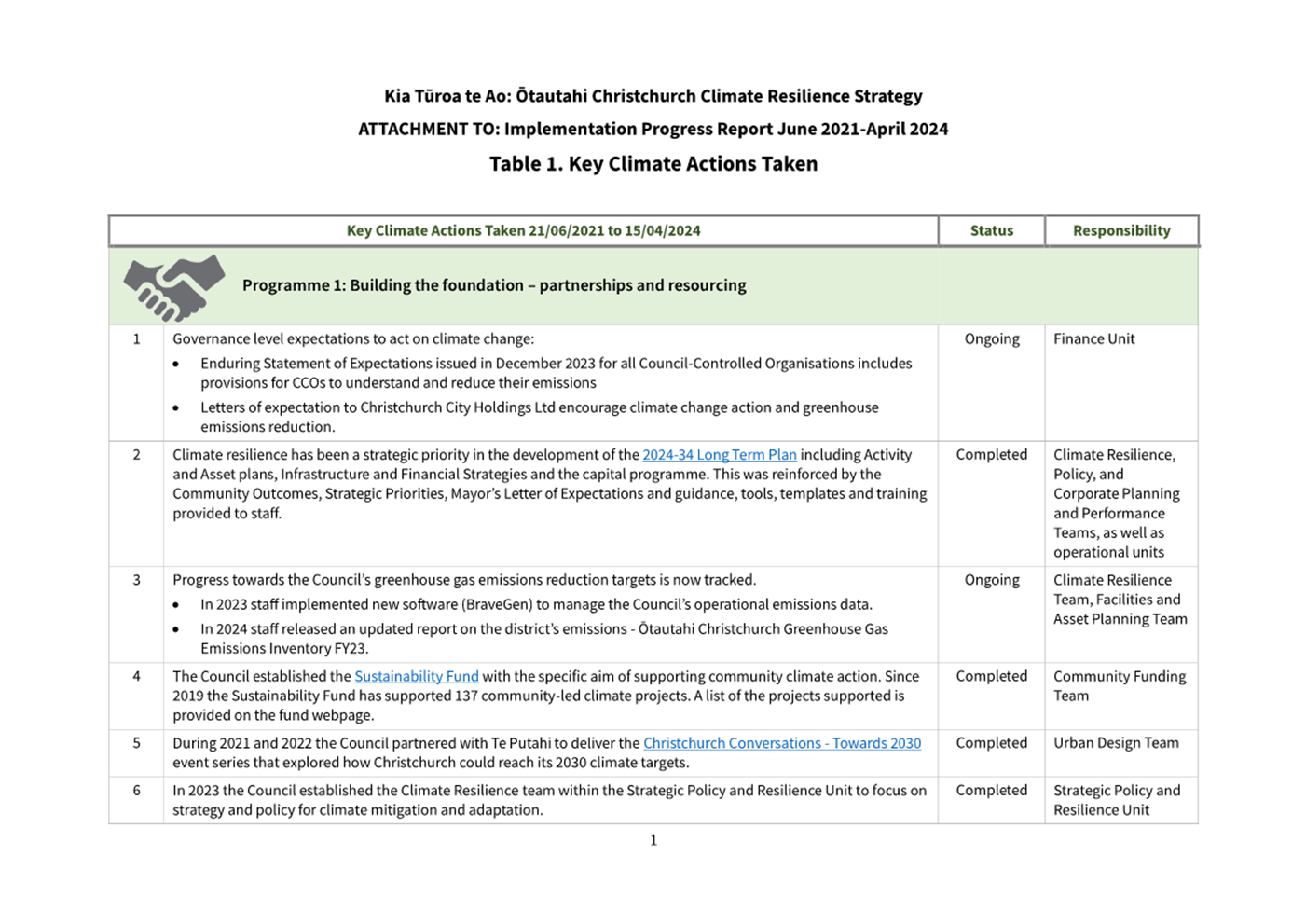
Climate Change Impact Considerations Ngā
Whai Whakaaro mā te Āhuarangi
8.43 The proposals in this report are
unlikely to contribute significantly to adaptation to the impacts of climate
change or emissions reductions.
8.44 Although there
will be some additional bus/boat movements resulting from the sale of the land
to Te Poho o Tamatea Limited to transport pupils from Christchurch City to
Lyttelton and then to Diamond Harbour the school itself strives to build
climate resilience and protect and regenerate the environment, biodiversity and
tree canopy.
8.45 There is
expected to be no significant change to the day to day FENZ activities in
Diamond Harbour and therefore a negligible impact on climate change.
9. Next Steps Ngā Mahinga ā-muri
9.1 If
the recommendations is this report are adopted, conditional agreements for sale
and purchase will be entered into that reflect the draft terms in the attached
terms sheet for both Te Poho o Tamatea Limited and FENZ. These included but are
not limited to purchase price being determined by independent valuations and
being acceptable to the Council delegate in recommendation two (2) at his or
her sole discretion, survey, site investigations, resource and building
consents.
9.2 If
there is any major change from the proposed terms and conditions as assessed by
the Manager Property Consultancy that change may shall be reported back to
Council for a decision.
Attachments Ngā Tāpirihanga
|
No.
|
Title
|
Reference
|
Page
|
|
a
|
Unsolicited
Proposal Te Pa o Rākaihautū
|
24/497492
|
|
|
b
|
FENZ Terms
Sheet
|
24/511602
|
|
|
c
|
Te Poho o
Tamatea Limited
|
24/511610
|
|
|
d
|
Submission
file
|
24/550625
|
|
|
e
|
Analysis of
submissions
|
24/513310
|
|
In addition to the attached documents, the following background
information is available:
|
Document
Name – Location / File Link
|
|
Not
applicable
|
Signatories Ngā Kaiwaitohu
|
Authors
|
Angus Smith -
Manager Property Consultancy
Mark Stevenson
- Acting Head of Planning & Consents
Danielle
Endacott - Engagement Advisor
Stuart McLeod
- Property Consultant
|
|
Approved By
|
Bruce Rendall
- Head of City Growth & Property
Jane Parfitt -
General Manager City Infrastructure
|
Report from Joint Meeting - Waipapa Papanui-Innes-Central and Waitai
Coastal-Burwood-Linwood Community Boards – 14 May 2024
|
8. City
to Sea West Safety Improvements - Roading Elements
|
|
Reference Te Tohutoro:
|
24/833629
|
|
Responsible Officer(s) Te Pou Matua:
|
Sam
Morris, Project Manager
David Little, Residential Red Zone Manager
|
|
Accountable ELT Member Pouwhakarae:
|
Andrew
Rutledge, Acting General Manager Citizens and Community
|
|
2. Joint Meeting - Waipapa Papanui-Innes-Central and
Waitai Coastal-Burwood-Linwood Community Boards Decisions
Under Delegation Ngā
Mana kua Tukuna
|
|
|
Original
Officer Recommendations accepted without change
Part C
1. That the Waipapa Papanui-Innes-Central Community Board approves:
a. A
pedestrian crossing be established on Swanns Road, for the use of pedestrians
and riders of mobility devices only, located at a point 41 metres west of its
intersection with Avonside Drive as detailed in Agenda Attachment B –
Swanns Road Crossing Plan, in accordance with Section 8.2 of the Land
Transport Rule Traffic Control Devices: 2004.
b. A Give
Way control be placed against the westbound Swanns Road traffic, located at a
point 32 metres west of its intersection with Avonside Drive as detailed on
Agenda Attachment B – Swanns Road Crossing Plan. The purpose of this
Give Way control is to create priority for cyclists and riders of wheeled
recreational devices only, crossing Swanns Road.
c. A
Give Way control be placed against the eastbound Swanns Road traffic, located
at a point 50 metres west of its intersection with Avonside Drive as detailed
on Agenda Attachment B – Swanns Road Crossing Plan. The purpose of this
Give Way control is to create
priority for cyclists and riders of wheeled recreational devices only,
crossing Swanns Road.
d. All kerb
alignments, road surface treatments, speed cushions and road markings related
to this crossing, as detailed on Agenda Attachment B – Swanns Road
Crossing Plan.
e. All kerb
alignments, road surface treatments, speed cushions and road markings related
to the Stanmore Road crossing, as detailed on Agenda Attachment A –
Stanmore Road Crossing Plan.
f. All
kerb alignments, road surface treatments, speed cushions and road markings
related to the Flesher Avenue carpark entry, as detailed on Agenda Attachment
D – Flesher Avenue Car Park Plan.
g. All kerb
alignments, road surface treatments, speed cushions and road markings related
to the Evelyn Couzins Avenue carpark entry, as detailed on Agenda Attachment
E – Evelyn Couzins Car Park Plan.
2. That the Waipapa Papanui-Innes-Central
Community Board resolves, pursuant to Clause 7 of the Christchurch City
Council Traffic and Parking Bylaw 2017, that the stopping of vehicles be
prohibited at all times:
a. Swanns Road Dual Pedestrian/Cycle
Crossing
i. On the northern side of Swanns Road,
commencing at its intersection with Avonside Drive and extending in a
westerly direction for a distance of 33 metres.
ii. On the northern side of Swanns Road,
commencing at a point approximately 45 metres west of its intersection with
Avonside Drive and extending in a westerly direction for a distance of 15
metres.
iii. On the southern side of Swanns Road,
commencing at its intersection with Avonside Drive and extending in a
westerly direction for a distance of 36 metres.
iv. On the southern side of Swanns Road,
commencing at a point approximately 44 metres west of its intersection with
Avonside Drive and extending in a westerly direction for a distance of 50
metres.
v. On the northern side of Swanns Road,
commencing at a point approximately 103 metres west of its intersection with
Avonside Drive and extending in a south-westerly direction for a distance of
4 metres.
vi. On the southern side of Swanns Road,
commencing at a point approximately 91 metres west of its intersection with
Avonside Road and extending in a westerly direction for a distance of 4
metres.
vii. On the western side of Avonside Drive,
commencing at its intersection with Swanns Road and extending in a northerly
direction for a distance of eight metres.
viii. On the western side of Avonside Drive,
commencing at its intersection with Swanns Road and extending in a southerly
direction for a distance of 11 metres.
b. Flesher Avenue Carpark (within the red
zone)
i. On the eastern side of Flesher Avenue,
commencing at a point approximately 14 metres north of its intersection with
Kershaw Place and extending in a northerly direction for a distance of six
metres.
ii. On the eastern side of Flesher Avenue,
commencing at a point approximately 32 metres north of its intersection with
Kershaw Place and extending in a northerly direction for a distance of nine
metres.
c. Evelyn Couzins Carpark (within the red
zone)
i. On the eastern side of Evelyn Couzins
Avenue, commencing at a point approximately 173 metres south of its
intersection with Flesher Avenue and extending in a southerly direction for a
distance of 30 metres.
ii. On the western side of Evelyn Couzins
Avenue, commencing at a point approximately 168 metres south of its
intersection with Flesher Avenue and extending in a southerly direction for a
distance of 35 metres.
3. That the Waipapa Papanui-Innes-Central Community Board resolves, pursuant to Clause 7 of the
Christchurch City Council Traffic and Parking Bylaw 2017, that the stopping
of vehicles be prohibited at all times:
a. Stanmore Road Signalised Crossing
i. On the western side of Stanmore Road,
commencing at a point approximately 67 metres north of its intersection with
Avonside Drive and extending in a northerly direction for a distance of eight
metres.
ii. On the western side of Stanmore Road,
commencing at a point approximately 82 metres north of its intersection with
Avonside Drive and extending in a northerly direction for a distance of 37
metres.
iii. On the eastern side of Stanmore Road,
commencing at a point approximately 66 metres north of its intersection with
Avonside Drive and extending in a northerly direction for a distance of ten
metres.
iv. On the eastern side of Stanmore Road,
commencing at a point approximately 83 metres north of its intersection with
Avonside Drive and extending in a northerly direction for a distance of 24
metres.
4. That the Waitai Coastal-Burwood-Linwood Community Board approves:
a. Gayhurst Road Dual Pedestrian/Cycle
Crossing
i. A pedestrian crossing be established on
Gayhurst Road, for the use of pedestrians and riders of mobility devices
only, located at a point 383 metres south of its intersection with McBratneys
Road as detailed on Agenda Attachment C – Gayhurst Road Crossing
Plan, in accordance with Section 8.2 of the Land Transport Rule Traffic
Control Devices: 2004.
ii. A Give Way control be placed against the
southbound Gayhurst Road traffic, located at a point 370 metres south of its
intersection with McBratneys Road as detailed on Agenda Attachment C
– Gayhurst Road Crossing Plan. The purpose of this Give Way control
is to create priority for cyclists and riders of wheeled recreational devices
only, crossing Gayhurst Road.
iii. A Give Way control be placed against the
northbound Gayhurst Road traffic, located at a point 386 metres south of its
intersection with McBratneys Road as detailed on Agenda Attachment C
– Gayhurst Road Crossing Plan. The purpose of this Give Way control
is to create priority for cyclists and riders of wheeled recreational devices
only, crossing Gayhurst Road.
iv. All kerb alignments, road surface
treatments, speed cushions and road markings related to this crossing, as
detailed on Agenda Attachment C – Gayhurst Road Crossing Plan.
5. That the Waitai Coastal-Burwood-Linwood Community Board resolves, pursuant to Clause 7 of the
Christchurch City Council Traffic and Parking Bylaw 2017, that the stopping
of vehicles be prohibited at all times:
a. Gayhurst Road Dual Pedestrian/Cycle
Crossing
i. On the western side of Gayhurst Road,
commencing at a point approximately 365 metres south of its intersection with
McBratneys Road and extending in a southerly direction for a distance of nine
metres.
ii. On the western side of Gayhurst Road,
commencing at a point approximately 382 metres south of its intersection with
McBratneys Road and extending in a southerly direction for a distance of 14
metres.
iii. On the eastern side of Gayhurst Road,
commencing at a point approximately 363 metres south of its intersection with
McBratneys Road and extending in a southerly direction for a distance of 14
metres.
iv. On the eastern side of Gayhurst Road,
commencing at a point approximately 385 metres south of its intersection with
McBratneys Road and extending in a southerly direction for a distance of
eight metres.
v. On the western side of Gayhurst Road,
commencing at a point approximately 327 metres south of its intersection with
McBratneys Road and extending in a southerly direction for a distance of six
metres.
vi. On the western side of Gayhurst Road,
commencing at a point approximately 425 metres south of its intersection with
McBratneys Road and extending in a southerly direction for a distance of six
metres.
vii. On the eastern side of Gayhurst Road,
commencing at a point approximately 327 metres south of its intersection with
McBratneys Road and extending in a southerly direction for a distance of six
metres.
viii. On the eastern side of
Gayhurst Road, commencing at a point approximately 425 metres south of its
intersection with McBratneys Road and extending in a southerly direction for
a distance of six metres.
10. That the Waitai Coastal-Burwood-Linwood Community Board and Waipapa Papanui-Innes-Central Community Board:
i. Revoke any previous restrictions
pertaining to traffic controls made pursuant to any bylaw to the extent that
they are in conflict with the traffic controls described above.
ii. Approves
these resolutions to take effect when parking signage and/or road markings
that evidence the restrictions described in this staff report are in place
(or removed in the case of revocations).
|
|
3. Joint Meeting - Waipapa
Papanui-Innes-Central and Waitai Coastal-Burwood-Linwood Community Boards Recommendation
to Council
|
|
|
Original Officer
Recommendations accepted without change
Part A
6. That the Council approves, pursuant to Clause 18 of the
Christchurch City Council Traffic and Parking Bylaw 2017:
a. Stanmore Road Signalised Crossing
i. A signalised crossing with a raised safety platform for use by
pedestrians and cyclists,
installed on Stanmore Road with its centreline approximately 80 metres north
of the centreline of Avonside Drive, in accordance with the relevant sections
of the Land Transport Rule: Traffic Control Devices 2004.
7. That the Council approves in accordance with Clause 21 of the
Christchurch City Council Traffic & Parking Bylaw 2017
a. Stanmore Road Signalised Crossing
i. On the western side of Stanmore Road, commencing at a point
approximately 67 metres north of its intersection with Avonside Drive and
extending in a northerly direction for a distance of 24 metres be resolved as
a Shared Path for pedestrian and north bound cycle only in accordance with
section 11.4 of the Land Transport Act - Traffic Control Devices Rules: 2004.
This Shared Path is for the use by the classes of road user only as defined
in Section 11.1A of the Land Transport (Road User) Rule: 2004.
ii. On the eastern side of Stanmore Road, commencing at a point
approximately 66 metres north of its intersection with Avonside Drive and
extending in a northerly direction for a distance of 25 metres be resolved as
a Shared Path for pedestrian and south bound cycle only in accordance with
section 11.4 of the Land Transport Act - Traffic Control Devices Rules: 2004.
This Shared Path is for the use by the classes of road user only as defined
in Section 11.1A of the Land Transport (Road User) Rule: 2004.
b. Swanns Road Dual Pedestrian/Cycle
Crossing
i. On the northern side of Swanns Road, commencing at a point
approximately 27 metres west of its intersection with Avonside Drive and
extending in a westerly direction for a distance of 18 metres be resolved as
a Shared Path for pedestrian and east bound cycle only in accordance with
section 11.4 of the Land Transport Act - Traffic Control Devices Rules: 2004.
This Shared Path is for the use by the classes of road user only as defined
in Section 11.1A of the Land Transport (Road User) Rule: 2004.
ii. On the southern side of Swanns Road, commencing at a point
approximately 26 metres north of its intersection with Avonside Drive and
extending in a northerly direction for a distance of 28 metres be resolved as
a Shared Path for pedestrian and west bound cycle only in accordance with
section 11.4 of the Land Transport Act - Traffic Control Devices Rules: 2004.
This Shared Path is for the use by the classes `of road user only as defined
in Section 11.1A of the Land Transport (Road User) Rule: 2004.
8. That the Council approves in accordance with Clause 21 of the
Christchurch City Council Traffic & Parking Bylaw 2017
a. Gayhurst Road Dual Pedestrian/Cycle Crossing
i. On the western side of Gayhurst Road, commencing at a point
approximately 365 metres south of its intersection with McBratneys Road and
extending in a southerly direction for a distance of 30 metres be resolved as
a Shared Path for pedestrian and north bound cycle only and in accordance
with section 11.4 of the Land Transport Act - Traffic Control Devices Rules:
2004. This Shared Path is for the use by the classes of road user only as
defined in Section 11.1A of the Land Transport (Road User) Rule: 2004.
ii. On the eastern side of Gayhurst Road, commencing at a point
approximately 370 metres north of its intersection with Avonside Drive and
extending in a northerly direction for a distance of 30 metres be resolved as
a Shared Path for pedestrian and south bound cycle only in accordance with
section 11.4 of the Land Transport Act - Traffic Control Devices Rules: 2004.
This Shared Path is for the use by the classes of road user only as defined
in Section 11.1A of the Land Transport (Road User) Rule: 2004.
9. That
the Council approves, pursuant to Clause 18 of the Christchurch City Council
Traffic and Parking Bylaw 2017:
a. Gayhurst Road Special Vehicle Lane
(cycle) extension
i. An extension to the existing Special Vehicle Lane (cycle) on
Gayhurst Road, installed along the western side of Gayhurst Road at a point
approximately 290 metres north of its intersection with Avonside Drive
extending in a northerly direction for a distance of 234 metres.
ii.
An extension to the existing
Special Vehicle Lane (cycle) on Gayhurst Road, installed along the eastern
side of Gayhurst Road at a point approximately 260 metres south of its
intersection with McBratneys Road and extending in a southerly direction for
a distance of 281 metres.
|
Attachments Ngā Tāpirihanga
|
No.
|
Report Title
|
Reference
|
Page
|
|
1
|
City to Sea West Safety Improvements
- Roading Elements
|
24/491341
|
104
|
|
No.
|
Title
|
Reference
|
Page
|
|
a ⇩
|
Stanmore Road Crossing Plan
|
24/736670
|
118
|
|
b ⇩
|
Swanns Road Crossing Plan
|
24/722538
|
119
|
|
c ⇩
|
Gayhurst Road Crossing Plan
|
24/722545
|
120
|
|
d ⇩
|
Flesher Avenue Car Park Plan
|
24/797134
|
121
|
|
e ⇩
|
Evelyn Cousinz Avenue Car Park Plan
|
24/797123
|
122
|
|
f ⇩
|
City to Sea Pathway Road Crossings Engagement Report Data
|
24/679600
|
123
|
|
g ⇩
|
Extract from City to Sea Transport Assessment, Stanmore
Road/Avonside Drive intersection modelling.
|
24/685044
|
131
|
|
h ⇨
|
City to Sea Pathway Road Crossings Submission Table (Under
Separate Cover)
|
24/787085
|
|
|
City to Sea West Safety Improvements - Roading Elements
|
|
Reference Te Tohutoro:
|
24/491341
|
|
Responsible Officer(s) Te Pou Matua:
|
Sam
Morris, Project Manager
David Little, Residential Red Zone Manager
|
|
Accountable ELT Member Pouwhakarae:
|
Andrew
Rutledge, General Manager Citizens & Community Group
|
1. Purpose and Origin of the Report Te Pūtake Pūrongo
1.1 The purpose of this report is for the Waipapa Papanui-Innes-Central
and Waitai Coastal-Burwood-Linwood Community Boards to consider proposed safety
improvements associated with the City to Sea Pathway, and to make decisions on
the same. The safety improvements are split across the two boards, and
are primarily road crossings, described below:
· A signalised pedestrian/cycle crossing on Stanmore Road and an
unsignalised pedestrian/cycle crossing on Swanns Road, in the Waipapa
Papanui-Innes-Central Community Board area.
· An unsignalised pedestrian/cycle crossing on Gayhurst Road in the
Waitai Coastal-Burwood-Linwood Community Board area.
· There are also minor line marking changes related to carpark entries
at Flesher Avenue and Evelyn Couzins Avenue, both in the Waipapa
Papanui-Innes-Central Community Board area.
1.2 Due
to the nature of the work, some of the specific decisions are delegated to
Community Boards and some to Council. This is reflected in the officer
recommendations.
1.3 The
decisions in this report are of medium significance in relation to the
Christchurch City Council’s Significance and Engagement Policy. The
level of significance was determined by
the safety impacts of the decisions on the relevant user groups.
2. Officer Recommendations Ngā Tūtohu
1. That the Waipapa
Papanui-Innes-Central Community Board approves:
a. A pedestrian crossing be
established on Swanns Road, for the use of pedestrians and riders of mobility
devices only, located at a point 41 metres west of its intersection with
Avonside Drive as detailed in Agenda Attachment B – Swanns Road Crossing
Plan, in accordance with Section 8.2 of the Land Transport Rule Traffic Control
Devices: 2004.
b. A Give Way control be placed
against the westbound Swanns Road traffic, located at a point 32 metres west of
its intersection with Avonside Drive as detailed on Agenda Attachment B –
Swanns Road Crossing Plan. The purpose of this Give Way control is to create
priority for cyclists and riders of wheeled recreational devices only, crossing
Swanns Road.
c. A Give Way control be placed
against the eastbound Swanns Road traffic, located at a point 50 metres west of
its intersection with Avonside Drive as detailed on Agenda Attachment B –
Swanns Road Crossing Plan. The purpose of this Give Way control is to create priority
for cyclists and riders of wheeled recreational devices only, crossing Swanns
Road.
d. All kerb alignments, road surface
treatments, speed cushions and road markings related to this crossing, as
detailed on Agenda Attachment B – Swanns Road Crossing Plan.
e. All kerb alignments, road surface
treatments, speed cushions and road markings related to the Stanmore Road
crossing, as detailed on Agenda Attachment A – Stanmore Road Crossing
Plan.
f. All kerb alignments,
road surface treatments, speed cushions and road markings related to the
Flesher Avenue carpark entry, as detailed on Agenda Attachment D –
Flesher Avenue Car Park Plan.
g. All kerb alignments, road surface
treatments, speed cushions and road markings related to the Evelyn Couzins
Avenue carpark entry, as detailed on Agenda Attachment E – Evelyn Couzins
Car Park Plan.
2. That the Waipapa
Papanui-Innes-Central Community Board resolves, pursuant to Clause 7 of the
Christchurch City Council Traffic and Parking Bylaw 2017, that the stopping of
vehicles be prohibited at all times:
a. Swanns Road Dual Pedestrian/Cycle Crossing
i. On the northern side of Swanns Road, commencing at its intersection
with Avonside Drive and extending in a westerly direction for a distance of 33
metres.
ii. On the northern side of Swanns Road, commencing at a point
approximately 45 metres west of its intersection with Avonside Drive and
extending in a westerly direction for a distance of 15 metres.
iii. On the southern side of Swanns Road, commencing at its intersection
with Avonside Drive and extending in a westerly direction for a distance of 36
metres.
iv. On the southern side of Swanns Road, commencing at a point
approximately 44 metres west of its intersection with Avonside Drive and
extending in a westerly direction for a distance of 50 metres.
v. On the northern side of Swanns Road, commencing at a point
approximately 103 metres west of its intersection with Avonside Drive and
extending in a south-westerly direction for a distance of 4 metres.
vi. On the southern side of Swanns Road, commencing at a point
approximately 91 metres west of its intersection with Avonside Road and
extending in a westerly direction for a distance of 4 metres.
vii. On the western side of Avonside Drive, commencing at its
intersection with Swanns Road and extending in a northerly direction for a
distance of eight metres.
viii. On the western side of Avonside Drive, commencing at its
intersection with Swanns Road and extending in a southerly direction for a
distance of 11 metres.
b. Flesher Avenue Carpark (within the red zone)
i. On the eastern side of Flesher Avenue, commencing at a point
approximately 14 metres north of its intersection with Kershaw Place and
extending in a northerly direction for a distance of six metres.
ii. On the eastern side of Flesher Avenue, commencing at a point
approximately 32 metres north of its intersection with Kershaw Place and
extending in a northerly direction for a distance of nine metres.
c. Evelyn Couzins Carpark (within the red zone)
i. On the eastern side of Evelyn Couzins Avenue, commencing at a point
approximately 173 metres south of its intersection with Flesher Avenue and
extending in a southerly direction for a distance of 30 metres.
ii. On the western side of Evelyn Couzins Avenue, commencing at a point
approximately 168 metres south of its intersection with Flesher Avenue and
extending in a southerly direction for a distance of 35 metres.
3. That the Waipapa Papanui-Innes-Central
Community Board resolves, pursuant to Clause 7 of
the Christchurch City Council Traffic and Parking Bylaw 2017, that the stopping
of vehicles be prohibited at all times:
a. Stanmore Road Signalised Crossing
i. On the western side of Stanmore Road, commencing at a point
approximately 67 metres north of its intersection with Avonside Drive and
extending in a northerly direction for a distance of eight metres.
ii. On the western side of Stanmore Road, commencing at a point
approximately 82 metres north of its intersection with Avonside Drive and
extending in a northerly direction for a distance of 37 metres.
iii. On the eastern side of Stanmore Road, commencing at a point
approximately 66 metres north of its intersection with Avonside Drive and
extending in a northerly direction for a distance of ten metres.
iv. On the eastern side of Stanmore Road, commencing at a point
approximately 83 metres north of its intersection with Avonside Drive and
extending in a northerly direction for a distance of 24 metres.
4. That the Waitai Coastal-Burwood-Linwood
Community Board approves:
a. Gayhurst Road Dual Pedestrian/Cycle Crossing
i. A pedestrian crossing be established on Gayhurst Road, for the use
of pedestrians and riders of mobility devices only, located at a point 383
metres south of its intersection with McBratneys Road as detailed on Agenda Attachment
C – Gayhurst Road Crossing Plan, in accordance with Section 8.2 of
the Land Transport Rule Traffic Control Devices: 2004.
ii. A Give Way control be placed against the southbound Gayhurst Road
traffic, located at a point 370 metres south of its intersection with
McBratneys Road as detailed on Agenda Attachment C – Gayhurst Road
Crossing Plan. The purpose of this Give Way control is to create priority
for cyclists and riders of wheeled recreational devices only, crossing Gayhurst
Road.
iii. A Give Way control be placed against the northbound Gayhurst Road
traffic, located at a point 386 metres south of its intersection with
McBratneys Road as detailed on Agenda Attachment C – Gayhurst Road
Crossing Plan. The purpose of this Give Way control is to create priority
for cyclists and riders of wheeled recreational devices only, crossing Gayhurst
Road.
iv. All kerb alignments, road surface treatments, speed cushions and
road markings related to this crossing, as detailed on Agenda Attachment C
– Gayhurst Road Crossing Plan.
5. That the Waitai Coastal-Burwood-Linwood
Community Board resolves, pursuant to Clause 7 of
the Christchurch City Council Traffic and Parking Bylaw 2017, that the stopping
of vehicles be prohibited at all times:
a. Gayhurst Road Dual Pedestrian/Cycle Crossing
i. On the western side of Gayhurst Road, commencing at a point
approximately 365 metres south of its intersection with McBratneys Road and
extending in a southerly direction for a distance of nine metres.
ii. On the western side of Gayhurst Road, commencing at a point
approximately 382 metres south of its intersection with McBratneys Road and
extending in a southerly direction for a distance of 14 metres.
iii. On the eastern side of Gayhurst Road, commencing at a point
approximately 363 metres south of its intersection with McBratneys Road and
extending in a southerly direction for a distance of 14 metres.
iv. On the eastern side of Gayhurst Road, commencing at a point
approximately 385 metres south of its intersection with McBratneys Road and
extending in a southerly direction for a distance of eight metres.
v. On the western side of Gayhurst Road, commencing at a point
approximately 327 metres south of its intersection with McBratneys Road and
extending in a southerly direction for a distance of six metres.
vi. On the western side of Gayhurst Road, commencing at a point
approximately 425 metres south of its intersection with McBratneys Road and
extending in a southerly direction for a distance of six metres.
vii. On the eastern side of Gayhurst Road, commencing at a point
approximately 327 metres south of its intersection with McBratneys Road and
extending in a southerly direction for a distance of six metres.
viii. On the eastern side of Gayhurst Road, commencing at a point
approximately 425 metres south of its intersection with McBratneys Road and
extending in a southerly direction for a distance of six metres.
6. That the Waipapa Papanui-Innes-Central
Community Board recommends that the Council
approves, pursuant to Clause 18 of the Christchurch City Council Traffic and
Parking Bylaw 2017:
a. Stanmore Road Signalised Crossing
i. A signalised crossing with a raised safety platform for use by
pedestrians and cyclists,
installed on Stanmore Road with its centreline approximately 80 metres north of
the centreline of Avonside Drive, in accordance with the relevant sections of
the Land Transport Rule: Traffic Control Devices 2004.
7. That the Waipapa Papanui-Innes-Central
Community Board recommends that the Council
approves in accordance with Clause 21 of the Christchurch City Council Traffic
& Parking Bylaw 2017
a. Stanmore Road Signalised Crossing
i. On the western side of Stanmore Road, commencing at a point
approximately 67 metres north of its intersection with Avonside Drive and
extending in a northerly direction for a distance of 24 metres be resolved as a
Shared Path for pedestrian and north bound cycle only in accordance with
section 11.4 of the Land Transport Act - Traffic Control Devices Rules: 2004.
This Shared Path is for the use by the classes of road user only as defined in
Section 11.1A of the Land Transport (Road User) Rule: 2004.
ii. On the eastern side of Stanmore Road, commencing at a point
approximately 66 metres north of its intersection with Avonside Drive and
extending in a northerly direction for a distance of 25 metres be resolved as a
Shared Path for pedestrian and south bound cycle only in accordance with
section 11.4 of the Land Transport Act - Traffic Control Devices Rules: 2004.
This Shared Path is for the use by the classes of road user only as defined in
Section 11.1A of the Land Transport (Road User) Rule: 2004.
b. Swanns Road Dual Pedestrian/Cycle
Crossing
i. On the northern side of Swanns Road, commencing at a point
approximately 27 metres west of its intersection with Avonside Drive and
extending in a westerly direction for a distance of 18 metres be resolved as a
Shared Path for pedestrian and east bound cycle only in accordance with section
11.4 of the Land Transport Act - Traffic Control Devices Rules: 2004. This
Shared Path is for the use by the classes of road user only as defined in
Section 11.1A of the Land Transport (Road User) Rule: 2004.
ii. On the southern side of Swanns Road, commencing at a point
approximately 26 metres north of its intersection with Avonside Drive and
extending in a northerly direction for a distance of 28 metres be resolved as a
Shared Path for pedestrian and west bound cycle only in accordance with section
11.4 of the Land Transport Act - Traffic Control Devices Rules: 2004. This
Shared Path is for the use by the classes `of road user only as defined in
Section 11.1A of the Land Transport (Road User) Rule: 2004.
8. That the Waitai Coastal-Burwood-Linwood
Community Board recommends that the Council
approves in accordance with Clause 21 of the Christchurch City Council Traffic
& Parking Bylaw 2017
a. Gayhurst Road Dual Pedestrian/Cycle Crossing
i. On the western side of Gayhurst Road, commencing at a point
approximately 365 metres south of its intersection with McBratneys Road and
extending in a southerly direction for a distance of 30 metres be resolved as a
Shared Path for pedestrian and north bound cycle only and in accordance with
section 11.4 of the Land Transport Act - Traffic Control Devices Rules: 2004.
This Shared Path is for the use by the classes of road user only as defined in
Section 11.1A of the Land Transport (Road User) Rule: 2004.
ii. On the eastern side of Gayhurst Road, commencing at a point
approximately 370 metres north of its intersection with Avonside Drive and
extending in a northerly direction for a distance of 30 metres be resolved as a
Shared Path for pedestrian and south bound cycle only in accordance with
section 11.4 of the Land Transport Act - Traffic Control Devices Rules: 2004.
This Shared Path is for the use by the classes of road user only as defined in
Section 11.1A of the Land Transport (Road User) Rule: 2004.
9. That the Waitai Coastal-Burwood-Linwood
Community Board recommends that the Council
approves, pursuant to Clause 18 of the Christchurch City Council Traffic and
Parking Bylaw 2017:
a. Gayhurst Road Special Vehicle Lane
(cycle) extension
i. An extension to the existing Special Vehicle Lane (cycle) on
Gayhurst Road, installed along the western side of Gayhurst Road at a point
approximately 290 metres north of its intersection with Avonside Drive
extending in a northerly direction for a distance of 234 metres.
ii. An extension to the existing Special Vehicle Lane (cycle) on
Gayhurst Road, installed along the eastern side of Gayhurst Road at a point
approximately 260 metres south of its intersection with McBratneys Road and
extending in a southerly direction for a distance of 281 metres.
10. That the Waitai Coastal-Burwood-Linwood
Community Board and Waipapa
Papanui-Innes-Central Community Board:
i. Revoke any previous restrictions pertaining to traffic controls made
pursuant to any bylaw to the extent that they are in conflict with the traffic
controls described above.
ii. These resolutions to take effect when parking signage and/or road
markings that evidence the restrictions described in this staff report are in
place (or removed in the case of revocations).
3. Executive Summary Te Whakarāpopoto Matua
3.1 This
portion of the City to Sea Pathway crosses three ‘in service’
roads. There are currently no dedicated crossing facilities in place,
which leads to safety hazards for users – including those currently using
stopped roads in the area. The expected increase in use of the Pathway
following construction will likely exacerbate this issue.
3.2 Designs have been prepared aimed at improving safety at the crossing
points. These have been consulted with the community, receiving generally
favourable feedback as detailed in Section 6 of this report.
3.3 The
proposals are described in Section 4, and scheme plans can be found in Attachment
A to E.
3.4 In
order to enact these proposals, Community Board and Council approval is
required.
4. Background/Context Te Horopaki
4.1 The
City to Sea Pathway is a core element of the Ōtākaro Avon River
Corridor Regeneration Plan and has been funded by central government via the
Christchurch Regeneration Acceleration Facility (CRAF). Its
implementation was approved via Council Resolution CNCL/2021/00160
(Implementing the City to Sea Pathway – Key Decisions 12 October 2021).
4.2 Due
to its length, delivery of the Pathway has been split into three sections. The
decisions in this report relate to the road crossings associated with the
western section, shown in Figure 1 below. This section runs from
Fitzgerald Avenue to Snell Bridge (Avon Park).
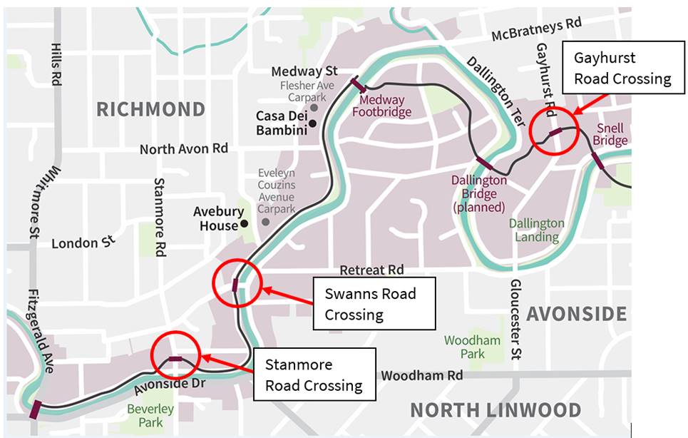
Figure 1. City to Sea
Pathway – Western Portion
4.3 A
Safe System assessment has been completed for the proposed crossings.
4.4 The
proposed safety improvements fall into two different Board areas, as described below:
4.4.1 Waipapa
Papanui-Innes-Central Community Board area:
· A signalised pedestrian/cycle crossing on a safer speed platform on
Stanmore Road between River Road and Glade Avenue.
· A dual pedestrian/cycle crossing on a safer speed platform on Swanns
Road immediately west of the Swanns Road bridge.
· Minor road marking changes at Flesher Avenue and Evelyn Couzins
Avenue, associated with proposed carparks within the grassed red zone area.
4.4.2 Waitai
Coastal-Burwood-Linwood Community Board area:
· A dual pedestrian/cycle crossing on a safer speed platform on
Gayhurst Road.
· Extension of the north and southbound Gayhurst Road cycle lanes, to connect
the existing cycle lanes to the new City to Sea Pathway.
4.5 Traffic Information relating to the Stanmore Road
Signalised Crossing.
4.5.1 Stanmore Road is an
arterial road carrying approximately 14,800 vehicles per day (3.3% heavy
vehicles) with approximately 1,110 vehicles in the morning peak hour and 1,600
vehicles in the evening peak hour. The posted speed is 50km/h, and the
85th percentile speed is 50km/h.
4.5.2 Traffic modelling was
completed to understand the effects of the proposed crossing on the Stanmore
Road and Avonside Drive intersection and was deemed negligible by
Council’s traffic operations team. This report is included as Attachment
G - City to Sea Transport Assessment, Stanmore Road/Avonside Drive.
4.5.3 Between 2012 and 2022
a total of 29 crashes were recorded at the Stanmore Road/Avonside Drive
intersection. Most were minor/non-injury, and involved rear end or
crossing movements. One crash was reported as serious, being a side
collision between a right turning and through moving vehicles on opposite
lanes. There were no crashes related to the section of Stanmore Road
where the crossing is proposed during this period.
4.6 Traffic Information relating to the Swanns Road
dual pedestrian/cycle crossing.
4.6.1 Swanns Road is a
collector road carrying approximately 1,000 vehicles per day (2.9% heavy
vehicles). The posted speed is 50km/h, and the 85th percentile speed is 55km/h.
4.6.2 Between 2012 and 2022
no crashes were recorded on Swanns Road.
4.7 Traffic Information relating to the Gayhurst Road dual pedestrian/cycle
crossing.
4.7.1 Gayhurst Road is an
arterial road carrying approximately 7,500 vehicles per day (3.3% heavy
vehicles). The posted speed
is 50 km/h and the 85th percentile speed is 59km/h northbound (Team
Traffic Survey, 22 and 24 June, 2023).
4.7.2 Between 2012 and 2022
one crash was recorded at the Gayhurst Road and Glenarm Terrace intersection.
This resulted in a minor injury and had cause factors associated with a vehicle
losing control.
4.8 The
Team Leader Parking Compliance supports the preferred option, described below.
Options Considered Ngā
Kōwhiringa Whaiwhakaaro
4.9 The
following reasonably practicable options were considered and are assessed below:
· Preferred: Adopt the road crossings at
Stanmore, Swanns and Gayhurst Roads as per Attachment A.
· Maintain status quo, without crossing facilities.
· Provide the road crossings as proposed, but without raised tables.
· Utilise existing traffic signals at the intersection of Stanmore
Road/Avonside Drive in lieu of the Stanmore Road crossing.
Options Descriptions Ngā Kōwhiringa
4.10 Preferred: Adopt crossings at Stanmore, Swanns and Gayhurst
Roads
4.10.1 Option
Description: Construct a signalised pedestrian/cycle
crossing on Stanmore Road and unsignalised pedestrian/cycle crossings on Swanns
Road and Gayhurst Road.
4.10.2 Option
Advantages
· Provides safe crossing points for users of the City to Sea
Pathway. As part of consultation, we heard from users of the current Te
Ara Ōtākaro Avon River Trail who expressed safety concerns with the
status quo.
4.10.3 Option
Disadvantages
· The cost of the physical works, although the City to Sea Pathway
project was fully funded by the Christchurch Regeneration Acceleration Facility
(CRAF).
4.11 Option 1, maintain the status quo at all road crossings
4.11.1 Option
Description: City to Sea Pathway constructed to the edge of the road
reserve only, existing road corridor remains as is.
4.11.2 Option
Advantages
· Avoids physical works costs.
4.11.3 Option
Disadvantages
· The lack of crossings would be confusing for
users, and we could expect queries as to why they were omitted.
· Safety issues with uncontrolled crossings, resulting in increased
likelihood of injury as usage of the Pathway increases.
· Missing this opportunity to provide the crossings from the CRAF
funding would mean that future crossings would need to be funded out of
Transport budgets.
4.12 Option
2, provide all crossing points as shown, but omit the raised safer speed
platforms
4.12.1 Option Description: Omit
the safer speed platforms on all three crossings. This could take the
form of road markings only, possibly with a central median island.
4.12.2 Option
Advantages
· Reduced physical works
cost (although noting CRAF funding as above).
· Less impact to road users during construction
· Preferred option of public transport providers
4.12.3 Option
Disadvantages
· There are known speeding issues at two of the three crossing points
(Swanns and Gayhurst) and Stanmore is a high-volume road. Safer speed
platforms make motorists more aware of the crossings and reduce speeds to
within safe system thresholds for any potential collisions between vehicles and
pedestrians/cyclists. Not installing the platforms would increase the
likelihood of death or serious injury for users of the Pathway.
· Doing all works in one contract is more economically efficient than
retrofitting, if raised platforms were to be needed in the future.
4.13 Option 3, use
existing traffic signals at Stanmore Road/Avonside Drive intersection to cross
in lieu of the Stanmore Road crossing, which is the most expensive of the three.
4.13.1 Option Description: Provide
Swanns and Gayhurst crossings as presented but use existing traffic signals at the
Stanmore Road/Avonside Drive intersection to cross.
4.13.2 Option Advantages
· Reduced physical works
cost (although noting CRAF funding as above).
4.13.3 Option Disadvantages
· The current traffic light phasing requires users to cross to the
southern side of Avonside Drive in order to move east or west. There is
no direct connection on the northern side, and this means that most users
jaywalk rather than waiting for three crossing phases. As part of a
recent traffic signal ducting and re-cabling project, BECA looked at creation
of a northern crossing phase, but concluded that this was not possible due to
the configuration of the intersection.
· Noting the above, this option would result in continuation of the
current jaywalking behaviour, but in greater numbers - increasing the
likelihood of death or serious injury.
5. Financial Implications Ngā Hīraunga Rauemi
Capex/Opex Ngā Utu Whakahaere
|
|
Recommended Option
|
Option 1 – Status quo retained
|
Option 2 – Delete raised tables
|
Option 3– Delete Stanmore crossing
|
|
Cost to Implement
|
$ 900 000 approx
|
0
|
$ 750 000 approx
|
$ 450 000 approx
|
|
Maintenance/Ongoing Costs
|
$ 8000 approx
|
$ 8000 approx
|
$ 8000 approx
|
Nil, above normal roading costs for the
remaining crossings.
|
|
Funding Source
|
CRAF, fully funded
|
N/A
|
CRAF, fully funded
|
CRAF, fully funded
|
|
Funding Availability
|
On budget in LTP
|
N/A
|
On budget in LTP
|
On budget in LTP
|
|
Impact on Rates
|
Nil
|
Nil
|
Nil
|
Nil
|
5.1 The
works form part of the City to Sea Pathway project, which has been fully funded
by central government, via the Christchurch Recovery Acceleration Facility
(CRAF).
5.2 Around
15% of the above costs relate to traffic management.
6. Considerations Ngā Whai Whakaaro
Risks and Mitigations Ngā
Mōrearea me ngā Whakamātautau
6.1 The
Pathway is intended to provide a route for active users, and the route should
be safe for use. The crossings have been designed to mitigate injury
risk. The Safe System assessment concluded that if the design as proposed
is not accepted, then then the risk to users is increased.
6.2 There
are no further risk and mitigation considerations.
Legal Considerations Ngā
Hīraunga ā-Ture
6.3 Statutory
and/or delegated authority to undertake proposals in the report:
6.3.1 Part 1, Clause 7 of
the Christchurch City Council Traffic and Parking Bylaw 2017 provides Council
with the authority to install parking or stopping restrictions by resolution.
6.3.2 The Community Boards
have delegated authority from the Council to exercise the delegations as set
out in the Register of Delegations. The list of delegations for the Community
Boards includes the resolution of stopping and traffic control devices.
6.3.3 The installation of any signs and/or markings associated with
traffic control devices must comply with the Land Transport Rule: Traffic
Control Devices 2004.
6.4 Other Legal Implications:
6.4.1 There is no other
legal context, issue, or implication relevant to this decision.
6.4.2 This specific report
has not been reviewed and approved by the Legal Services Unit however the
report has been written using a general approach previously approved of by the
Legal Services Unit, and the recommendations are consistent with the policy and
legislative framework outlined in this report.
Strategy and Policy Considerations Te Whai
Kaupapa here
6.5 The
required decisions in this report:
6.5.1 Align with the Christchurch
City Council’s Strategic Framework,
particularly:
A green, liveable city
· Our neighbourhoods and communities are accessible and
well-connected, supporting our goals to reduce emissions, build climate
resilience and protect and regenerate the environment, especially our
biodiversity, waterbodies and tree canopy.
6.5.2 Are
consistent with the Christchurch Suburban Parking Policy.
6.5.3 Are
generally consistent with the Ōtākaro
Avon River Corridor Regeneration Plan, in that they support the City to Sea
Pathway.
6.5.4 Are
assessed as medium significance based on the Christchurch City Council’s
Significance and Engagement Policy. The level of significance was determined by the safety impacts of the
decisions on the relevant user groups.
6.6 This report supports the
Council's
Long Term Plan (2021 - 2031):
6.7 Transport
6.7.1 Activity:
Transport
· Level
of Service: 10.5.1 Limit deaths and serious injury crashes per capita for
cyclists and pedestrians - <= 12 crashes per 100,000 residents
Parks, Heritage and Coastal Environment
Activity: Ōtākaro Avon River
Corridor
Level of Service: 6.8.12.1 Implementation
of the Ōtākaro Avon River
Corridor Regeneration Plan (Green Spine). Council-led capital investment:
Progress integrated Green Spine programme (Parks, Water and Transport) as per
the Implementation Plan. Target: 90 % of approved work programmes delivered in
the year funded.
Community Impacts and Views Ngā Mariu
ā-Hāpori
Public Consultation Te Tukanga
Kōrerorero
6.8 Public
consultation started on 1 March 2024 and ran until 24 March 2024. An email was
sent to 163 key stakeholders including local community groups, recreational
groups (including local flatwater sports clubs), key transport stakeholders,
key disability sector groups, and ECAN as part of the Public Transport Steering
Group.
6.9 The
consultation was posted on the Council Facebook page and on five community
group pages, inviting submissions on the Let’s Talk webpage. The Facebook
post reached 21,592 people, receiving 74 reactions, 34 comments and 12 shares.
6.10 A Newsline story
about the project was published on 1 March 2024 and received 1,759 views. A
video showing the road crossings and encouraging engagement had 488 views.
6.11 Consultation
posters were displayed at Richmond Community Garden/Riverlution Hub, New World
Stanmore Road and Shirley Library. Consultation documents were delivered
to Riverlution Hub and Shirley Library/Service Centre.
6.12 14 signs were
displayed throughout the consultation along the City to Sea Pathway with a QR
code directing people to the Let’s Talk consultation page which was
scanned by 106 people users.
6.13 The project
featured in the Ōtākaro
Avon River Corridor newsletter sent to 488 subscribers on 18 March,
which also promoted a drop-in session at the Richmond Gala.
6.14 Households on
Swanns Road impacted by the proposed speed cushions and crossing received
consultation documents on 1 March 2024.
6.15 The Dallington
Residents Association delivered a flier to the Dallington and Avonside communities
inviting people to a Dallington Landing drop-in event.
6.16 On 9 March a drop-in
session at Dallington Landing was held in partnership with the Dallington
Residents Association and attended by approximately 50 people. A second
drop-in at the Richmond Community Gala on Saturday 23 March and engaged
approximately 70 people. A quick star-rating activity at each of these
events sought feedback for each crossing point.
6.17 The Hohepa Trust
group requested a site visit at the Dallington crossing point and staff met
with the group to discuss the project.
6.18 The Let’s Talk
webpage received 1,995 unique page visits for the project, with 30% of visitors
to the page clicking on at least two features, and 54% of visitors spending at
least one minute on the page. The conversion from page visitors to
submissions was 6%. The Let’s Talk page featured a video
describing the project which had 421 views.
6.19 The Swanns Road
crossing is close to the access of a resident, and early engagement was carried
out directly with him, commencing in December 2023. Verbally, he was
supportive of the raised crossing.
6.20 Environmental Canterbury were
notified of the proposed crossings and feedback sought in March 2024. No
feedback was received.
6.21 Emergency Services were also
notified of the proposed crossings and feedback sought in February 2024. No
specific concerns were raised with the plans. St John sought
clarification regarding who has right of way in the event when an ambulance has
its lights on. Staff confirmed that when a crossing is unsignalised,
emergency vehicles with lights and sirens will always
have right of way over crossing pedestrians.
6.22 Mahaanui
Kurataiao were consulted as part of the wider consenting process for the
Pathway.
Summary of Submissions Ngā
Tāpaetanga
6.23 Submissions were
made by 8 recognised organisations, 2 businesses and 55 individuals. A
full table of submission feedback is available in Attachment H - City to Sea
Pathway Road Crossings Submission Table.
6.24 The majority of
submitters provided feedback on all three crossings and were largely in support:
· Stanmore
Road: 49 in support (80.3%), 7 did not support (11.5%)
· Swanns
Road: 44 in support (74.6%), 7 did not support (11.9%)
· Gayhurst
Road: 47 in support (78.35), 8 did not support (13.3%)
6.25 Key issues
raised by submitters were:
· Safety for pathway users, especially for vulnerable users.
This was particularly of interest to Hohepa Canterbury and Early Childcare
Centres, who were interested in safely crossing the roads with larger groups.
· Measures to slow traffic on the approaches to the crossing were
supported, particularly on Swanns Road and Gayhurst Road.
6.26 A full analysis
of submissions is available in Attachment F City to Sea Pathway Road
Crossings Engagement Report Data.
6.27 As a result of
the submissions, the following changes were made to the designs:
· Evelyn
Couzins Carpark – We heard from the community and Avebury House tenants
how well used the on-street parking is, especially during events. Based
on this feedback, the original plans for increased on-street parking will be
replaced by a larger 20 space (approx.) carpark in the red zone area east of
Evelyn Couzins Avenue. The no stopping lines in the draft recommendations
reflect this change, and the revised design is included as Attachment E.
· Gayhurst Road speed cushions – Detailed minor feedback
was received around the location and configuration of the proposed advance speed
cushions associated with the platforms. Transport staff have reviewed and
suggested a speed hump is included, as per Attachment C.
· Swanns Road speed cushions - Detailed minor feedback was
received around the location of the speed cushions proposed near 45 Swanns
Road. As a result, the speed cushion was relocated slightly to be clear of
turning movements in and out of the driveway, and these changes are included in Attachment B.
· Swanns
Road Crossing – Concerns were raised about speeding vehicles entering
Swanns Road from Avonside Drive and whether these vehicles have sufficient
warning of the crossing. The Transport team reviewed this feedback, and
expect that the bend and intersection will slow traffic sufficiently, in
combination with the new raised platform. There are clear sightlines for
both crossing users and drivers, however No Stopping lines have been added on both
sides of the bridge to ensure this, as shown in Attachment B. Transport
will monitor speeds at the intersection and consider traffic calming treatment
if required. As a further note, in future the speed limit on Swanns Road
is likely to reduce to 30kph as part of Transport’s Safer Speed
Programme.
· Swanns
Road Crossing – The cycle cutdown for eastbound cyclists was removed from
the crossing at approximately 213A Swanns Road due to conflicts with a
driveway. This change is included in Attachment B.
6.28 The decision
affects the following wards/Community Board areas:
6.28.1 Waipapa Papanui-Innes-Central
Community Board
6.28.2 Waitai
Coastal-Burwood-Linwood Community Board
Impact on Mana Whenua Ngā Whai Take
Mana Whenua
6.29 The decisions do not involve a significant decision concerning
ancestral land or a body of water or other elements of intrinsic value,
therefore this decision does not specifically impact Mana Whenua, their culture
and traditions.
6.30 The decision does
not involve a matter of interest to Mana Whenua and will not impact on our
agreed partnership priorities with Ngā Papatipu Rūnanga.
6.31 While the
Corridor overall is of high value and interest to mana whenua (and is the
subject of co-governance arrangements), the primary focus for mana whenua has
consistently been its return to a functioning delta ecosystem where mahinga kai
can once more be gathered and processed. Road crossing points are of
minor interest only in this outcome. The Co-governance committee have
been briefed on the project as it has developed.
Climate Change Impact Considerations Ngā
Whai Whakaaro mā te Āhuarangi
6.32 The decisions in
this report are likely to:
6.32.1 Not affect adaptation to the impacts of
climate change.
6.32.2 Contribute positively to emissions reductions.
6.33 While the
crossings are not likely to have a significant impact on adaptation
planning, they will encourage use of non-motorised transport options, reducing
emissions. Although not strictly a commuting route, the Pathway is likely
to be used for this purpose by residents, as well as for short trips to local
facilities and shops.
7. Next Steps
Ngā Mahinga ā-muri
7.1 If
approved by both Community Boards and Council, this work will proceed as part
of a separable portion to the City to Sea construction contract. This
contract is on programme to be completed by Christmas 2024.
7.2 If
Council decide not to approve the Stanmore Road signalised crossing,
alternative measures will be considered to enable safe crossing and brought
back to the Board.
Attachments Ngā Tāpirihanga
|
No.
|
Title
|
Reference
|
Page
|
|
a
|
Stanmore Road
Crossing Plan
|
24/736670
|
|
|
b
|
Swanns Road
Crossing Plan
|
24/722538
|
|
|
c
|
Gayhurst Road
Crossing Plan
|
24/722545
|
|
|
d
|
Flesher Avenue
Car Park Plan
|
24/797134
|
|
|
e
|
Evelyn Cousinz
Avenue Car Park Plan
|
24/797123
|
|
|
f
|
City to Sea
Pathway Road Crossings Engagement Report Data
|
24/679600
|
|
|
g
|
Extract from
City to Sea Transport Assessment, Stanmore Road/Avonside Drive intersection
modelling.
|
24/685044
|
|
|
h
|
City to Sea
Pathway Road Crossings Submission Table
|
24/787085
|
|
In addition to the attached documents, the following background
information is available:
|
Document
Name – Location / File Link
|
|
Not
applicable
|
Signatories Ngā Kaiwaitohu
|
Authors
|
Sam Morris -
Project Manager
Jacqui Miller
- Engagement Advisor
Swantje
Bubritzki - Senior Engagement Advisor
David Little -
Manager Residential Red Zone
Tessa Zant -
Manager Engagement
Lachlan Beban
- Principal Advisor Transportation Signals
|
|
Approved By
|
Stephen Wright
- Manager Operations (Transport)
Rupert Bool -
Acting Head of Parks
|
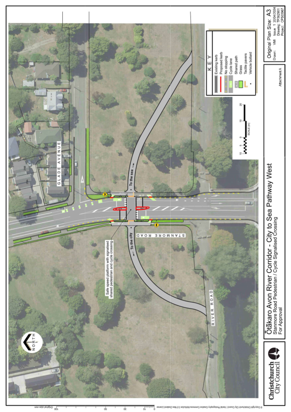
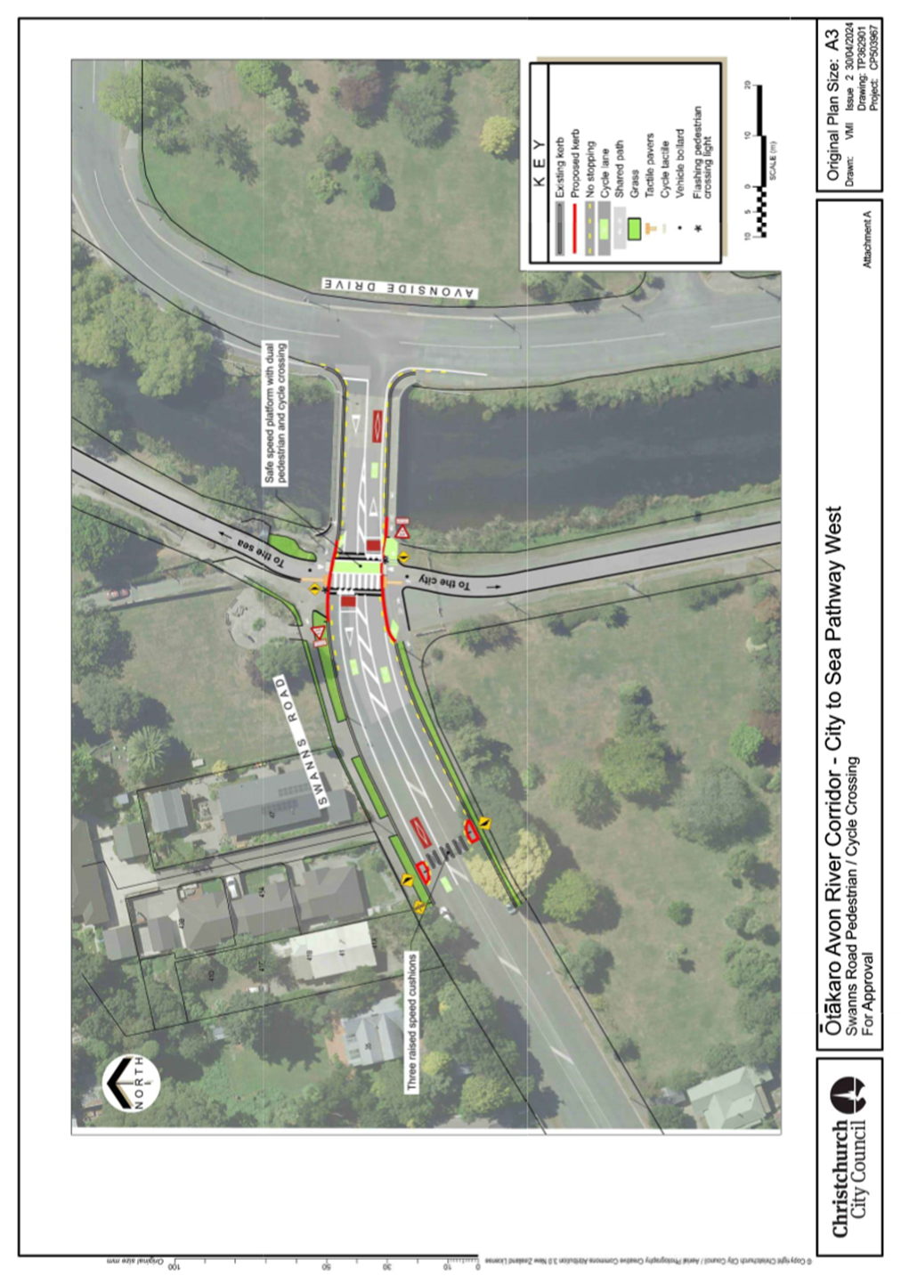
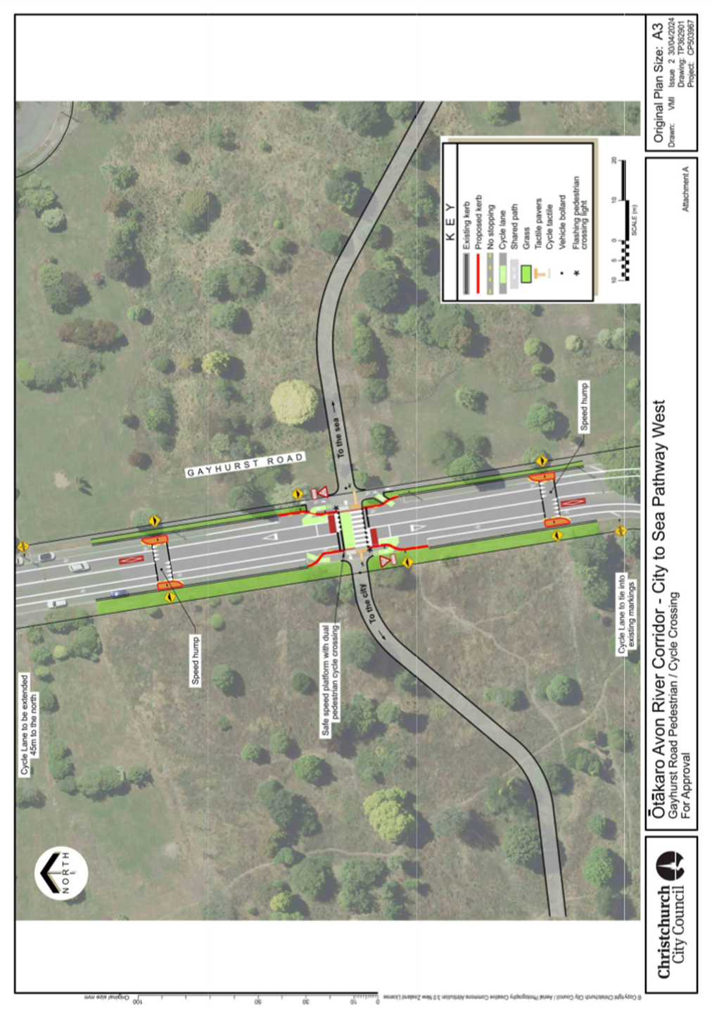
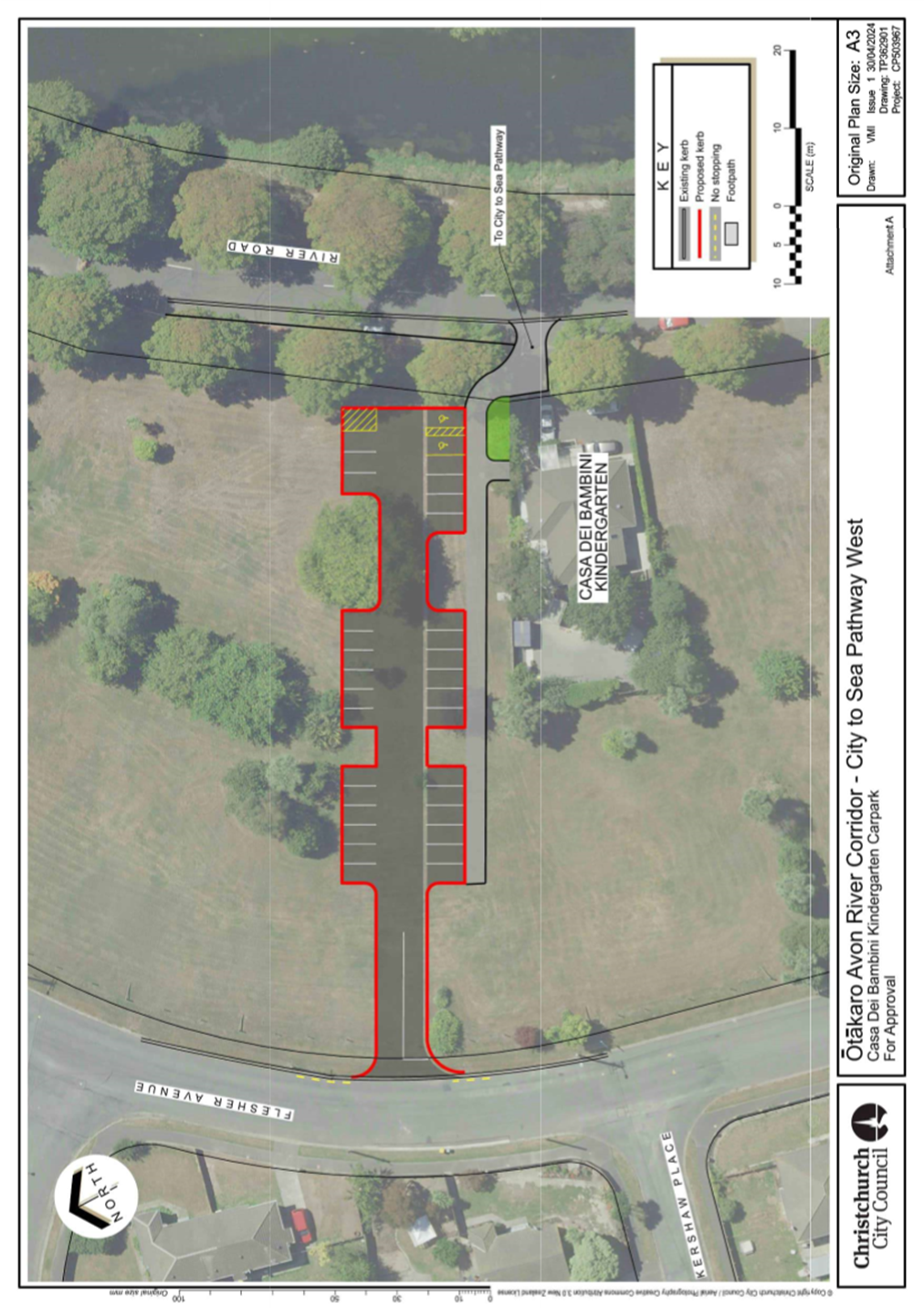
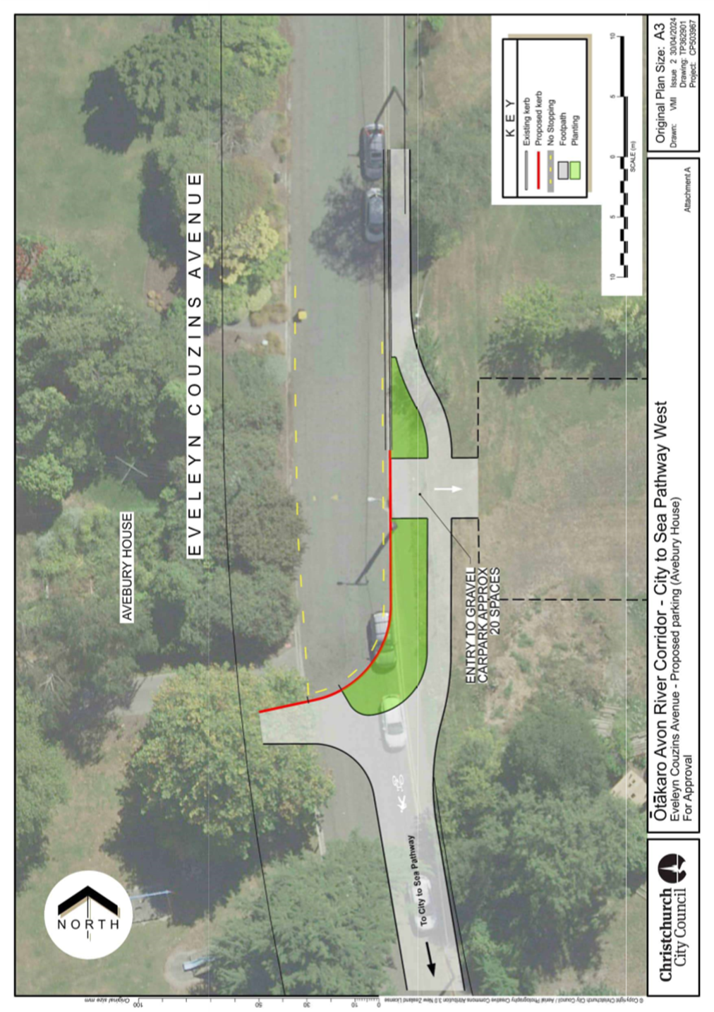
|
9. Local
Alcohol Policy
|
|
Reference Te Tohutoro:
|
24/688918
|
|
Responsible Officer(s) Te Pou Matua:
|
Elizabeth
Wilson – Team Leader Policy
Tracey Weston - Head of Regulatory Compliance
Helen White - General Counsel / Head of Legal & Democratic Services
|
|
Accountable ELT Member Pouwhakarae:
|
John
Higgins, General Manager Strategy, Planning & Regulatory Services
|
1. Purpose and Origin of the Report Te Pūtake Pūrongo
1.1 This
is a staff-generated report seeking a Council Resolution to develop a Local
Alcohol Policy (LAP).
2. Officer
Recommendations Ngā Tūtohu
That the Council:
1. Receives the information in this report.
2. Notes that the decision in this report is assessed as high level
significance based on the Christchurch City Council’s Significance and
Engagement Policy.
3. Directs staff to commence work on development of a Local Alcohol
Policy and report to Council on progress before the end of 2024.
3. Executive Summary Te Whakarāpopoto Matua
3.1 A
LAP is a set of decisions a territorial authority may make in consultation with
its community about the sale and supply of alcohol in its district, giving
local communities more input into licensing decisions, including about trading
hours, location, and density of licensed premisesi.
3.2 The
Sale and Supply of Alcohol Act 2012 (the Act) empowers any territorial
authority to have a LAP and prescribes what a council wishing to have a LAP
must do to adopt one for its district.
3.3 The
Act was amended last year. Amendments included:
3.3.1 removing the
requirement for a council wishing to have a LAP to adopt a provisional version
of the policy before it adopts the final LAP.
3.3.2 removing the right of
other parties to appeal to the Alcohol Regulatory and Licensing Authority
(ARLA) against any element of that territorial authority’s provisional
LAP.
3.4 The
right to appeal was a significant obstacle to territorial authorities,
including the Council, adopting LAPs. Its removal should make adopting a LAP
easier for the Council.
3.5 In
addition, a Supreme Court judgement[2]
last year clarified that policies in a provisional LAP may be justified
on the basis of ‘reasonable likelihood’ (rather than proof) of
reducing alcohol-related harm and that LAPs may be based on, or influenced by,
community preferences, which to that extent do not have to be evidence-basedii.
3.6 In
2017, the Council discontinued over four years of work on a LAP after lengthy
appeals and judicial review (and, the following year, decided to not pursue a
LAP ‘at this time’).
3.7 Following
a Council Resolution made on 7 December 2022, and having regard to the changing
legislative context, staff carried out preparatory work to enable Council to
consider a new LAP.
3.8 This
report presents a summary of issues and options, and seeks Council approval to
commence the production of a LAP.
4. Background/Context Te Horopaki
LAP: in-scope
4.1 The
Act empowers territorial authorities to have a policy relating to the sale,
supply, or consumption of alcohol within its district.
4.2 LAPs
are made for the purpose of achieving the object of the Act, which is that:
· the sale, supply and consumption of alcohol is undertaken safely and
responsibly; and
· alcohol-related harm is minimised.
4.3 The Act provides for a LAP to include policies on any or all of the
following matters
relating to licensing in seeking to reduce alcohol related harm:
(a) location of licensed premises by reference to broad
areas:
(b) location of licensed premises by reference to
proximity to premises of a particular kind or kinds:
(c) location of licensed premises by reference to
proximity to facilities of a particular kind or kinds:
(d) whether further licences (or licences of a
particular kind or kinds) should be issued for premises in the district
concerned, or any stated part of the district:
(e) maximum trading hours
(f) the issue of licences, or licences of a
particular kind or kinds, subject to discretionary conditions:
(g) one-way
door restrictions.
4.4 LAPs
are optional, but where a territorial authority has a LAP the District
Licensing Committee (DLC) and ARLA must consider it when determining licence
applications in the district[5].
LAP: out-of-scope
4.5 The
scope of a LAP is limited by the legislation to alcohol licensing and to no
other matters. It does not, and cannot, fulfil the functions of a general
alcohol strategy or action plan which could aim to address a fuller range of
issues relating to alcohol misuse.
4.6 However, because LAPs must be consistent with the Act, a LAP should
complement policies and programmes at local- and national levels aligning with
the object of the Act.
What is required to develop a LAP?
4.7 Councils
wishing to have a LAP must:
· Produce a draft LAP[6]
· Consult on the draft LAP using the Special Consultative Procedure
(SCP)[7]
· Review the LAP, once adopted, every six years[8].
4.8 The
Act sets out what councils must consider
when producing a draft LAP (for further information see Appendix 1).
4.9 The
cost involved in developing a LAP (excluding staff time) is estimated at
between: $20,000 to $100,000, depending on the level of stakeholder engagement
and research to be carried out (in addition to the mandatory analysis and
consultation required under the Act).
4.10 The estimated
timeframe is around 18 months. Work is still ongoing to refine the timeframe to
less than the current estimated timeframe.
4.11 The outline
project plan attached (Appendix 2) illustrates the main activities and
timeframes involved.
Advantages of having a LAP, for:
Citizens and the community
Health and
wellbeing
4.12 The information
available at this time indicates there may be a reasonable likelihood that
policies made under a LAP reduce the effects of alcohol related harm.
4.13 The Council
recently received correspondence from Health New Zealand, Pegasus Health
Charitable Limited, and Healthy Families Ōtautahi, expressing support for
a LAP (see Appendices 3, 4, and 5), pointing to the role of policies on
availability, affordability, and marketing of alcohol in reducing
alcohol-related harm, and referring to the findings of local research relating
to alcohol-related harm locally and in the region.
Public safety
4.14 The Council also
received a letter from the Police (see Appendix 6), stating that an
appropriately drafted and consulted LAP ‘can greatly assist us both in
reducing alcohol related harm in our city’.
Community input
4.15 LAPs enable
alcohol licensing decisions to take account of local issues and preferences.
4.16 The
Council’s previous work on a LAP (in 2013, see Appendix 7)
identified general support in the community for more restrictive licensing
policies than default settings under the Act.
4.17 The changed
legislative context should strengthen the Council’s ability to develop a
LAP based on, or influenced by, the preferences of our community.
Licensed trade
Clarity of policy direction
4.18 A LAP would give
businesses certainty about the Council’s intentions concerning a LAP.
4.19 It would give
new operators a baseline for how they are expected to operate, providing a
level playing field for the sector.
Council
Greater consistency in licensing decisions
4.20 The Act already
empowers DLCs to impose licence conditions relating to matters for which a LAP
would provide (eg: reduced trading hours) but these are considered on an
individual basis and can be more difficult to apply consistently in the absence
of a LAP.
4.21 The DLC has
expressed a desire to have a LAP to provide a framework for its decisions.
Potential cost savings
4.22 Having a LAP may
lead to a decrease in the number of objections made against individual licence
applications (depending on LAP provisions) and consequently fewer hearings.
4.23 In October 2023,
DLC costs for the 12 months prior totalled $170,289.51. This included both
unopposed and opposed applications (but excludes Council staff time).
4.24 The DLC and Alcohol Licensing staff spend considerable time at
hearings dealing with issues of single sales in deprived areas, remote sales,
one way door provisions for night clubs and off license trading hours.
Since 2021, staff have managed 25 hearings on these matters and have more than
10 applicants awaiting hearings. The cost of and time taken for hearings
could be significantly reduced, depending on policy provisions.
Disadvantages of having a LAP, for:
Citizens and the community
Risk of unintended consequences
4.25 For instance,
consumers shifting spending from on-licensed premises to liquor stores (as
observed in a 2019 NZIER study for the Health Promotion Agencyiii).
Licenced trade
Restrictions
4.26 Businesses in
the hospitality and alcohol retail sectors may be concerned about the impacts
of greater restrictions on trade.
Council
Litigation
4.27 Judicial review
is still possible despite the amendments to the Act. The risk of a successful
claim can be mitigated but defending a judicial review remains costly and time
consuming.
Managing conflicting views
4.28 LAPs in metro
areas are high-profile and contentious. The Council must be prepared to manage
opposing viewpoints from stakeholders with a high interest in the outcome of
this work, and to accept that its decisions and outputs in this area may not
satisfy all parties equally.
Resource commitment
4.29 Developing a LAP
is resource intensive, requiring input from Strategic Policy, Legal, Alcohol
Licensing, Engagement, Communications, Hearings and Council Support.
4.30 The development
and cyclical review of a LAP for Ōtautahi-Christchurch would incur one-off
costs every six years and require significant staff resources from Council
teams.
4.31 Some elements of the development and subsequent reviews may need to
be outsourced.
This is not the first time Council has pursued a LAP
4.32 The Council
commenced development of a LAP in 2013 but discontinued in 2017 and resolved in
2018 to not pursue a LAP ‘at this time’, following two rounds of
appeal, long pauses to await ARLA hearing dates and decisions and judicial
review proceedings.
4.33 The Council
considered it untenable to continue because of the wide grounds for appeal, the
indefinite duration of the appeals process, and the significant costs
associated with defending appeals in court (this was before the legislative
changes made in 2023, summarised below).
What has changed since then?
4.34 Alcohol Healthwatch reported in 2017 that LAPs became
less restrictive as they progressed through stages of development (particularly
the appeals stage), signalling an ‘increasing gap between community
expectations for greater control and the reality of the LAP process as it is
prescribed in legislation’ under the legislative settings at the timeiv.
4.35 New case law and legislative changes, both made last year, should
strengthen the Council’s ability to develop and implement a LAP that
reflects community expectations.
New case law
4.36 On 5 May 2023,
the Supreme Court dismissed judicial review proceedings[11] challenging
a 2017 decision of the High Court that largely upheld Auckland Council’s
Provisional LAP[12].
4.37 The Supreme
Court’s decision clears the way for Auckland’s provisional LAP to
become operative (although it is not yet operative). By making the
evidence base for a LAP less onerous for councils, the case law should make it
easier to develop LAPs reflecting community preferences.
Legislative changes
4.38 The Sale and
Supply of Alcohol (Community Participation) Amendment Act (Amendment Act),
enacted in August 2023, made several changes to the Act.
4.39 The Amendment
Act removed the requirement for territorial authorities to produce a
provisional LAP and the ability of parties to appeal the provisional LAP.
4.40 LAPs can now be
adopted after having undertaken Special Consultative Procedure (SCP), generally
in line with other policy development processes.
4.41 The amended Act
now allows DLCs to consider policies made under a LAP when determining licence
renewals, meaning LAP provisions can be applied not only to prospective new
licence holders but to existing licensed premises at the point of renewal.
4.42 The following related memo (Appendix 8) was circulated to the
Mayor and Councillors following the legislative changes last year:
|
Date
|
Subject
|
|
14/09/2023
|
Alcohol Amendment Act Passed
|
Seeking direction
LAPs return to the Council’s
agenda
4.43 The Council, at
its meeting on 7 December 2022, following consideration of a report by the Chairperson
of the Waitai-Coastal-Burwood-Linwood Community Board, resolved (see Appendices
9 and 10):
‘[That the Council] Requests staff, in anticipation of
legislative change, to start the process of gathering the information and
resources needed to develop an evidence-based Local Alcohol Policy’.
4.44 Staff work to
discharge this resolution covered:
· Preparation of a Council submission on the legislative changes
enacted in August 2023 and engagement with the Ministry of Justice
subsequently.
· Briefing Elected Members on the changes by memo.
· Developing a draft project plan for LAP development.
· Examining our previous LAP process to inform any new LAP process.
· Provisional identification of stakeholders.
· Consulting staff in other metro councils working on LAP matters.
· Researching relevant academic work research (including meetings with
University of Otago Christchurch researchers and Health Promotion Agency
staff).
4.45 The issue was
also raised in Council on 7 February and 3 April this year (see Appendix 11).
4.46 When the Council briefly considered LAP matters on these occasions, it did not have before it advice on options, costs, risks, and
challenges. This is now provided.
Other considerations in developing a LAP
Understanding the impacts of LAPs
4.47 The true impact
of a LAP alone is not entirely clear, and may be difficult to quantify.
4.48 A LAP made under
the previous legislative settings may have been ‘watered down’ to
avoid legal challenge, so the efficacy of LAPs may not become clear until these
new settings bed-in,v.
4.49 In addition, as
a LAP is one tool in a suite of potential options to address alcohol-related
harm, it is difficult to attribute the direct impacts of a LAP. The impact of
LAP provisions can only really be considered in terms of a reasonable
likeliness to contribute to alcohol-related harm.
Further legislative reform cannot be ruled out
4.50 The potential
for further legislative change has not been signalled but cannot be ruled out:
4.50.1 Hospitality NZ’s Briefing
to the Incoming Ministervi (dated November 2023) advocated for the
new government to repeal the legislative changes made last year and consider
‘appropriate amendments or abandonment of the LAP system’.
4.50.2 National and ACT opposed the
previous (Labour) government’s reforms to the Act but the new coalition
government has made no commitment to repeal the Amendment Act.
Anticipated industry position
4.51 Feedback on the previous LAP proposals from industry stakeholders
was generally not in support of further restrictions over and above the
provisions of the Act.
4.52 Points made by businesses in the off-licence sector in
response to the Council’s (2013) consultation (see Appendix 7)vii,
included:
· supermarkets: shorter licensing hours
would have significant negative impacts on business, employment, customer
convenience and are not justified by empirical evidence;
· bottle stores: responsible retailers of
alcohol should not be restricted from opening in particular neighbourhoods or
local centres.
4.53 More recently,
Hospitality New Zealand communicated its opposition to a LAP in its responses
to the Council’s Long-Term Plan 2024-2034 consultation (see Appendix 12)viii,ix.
4.54 Points made included:
‘well run on-licensed environments are the safest place for people to
consume alcohol in New Zealand’; increased access to liquor has not
translated to higher consumption; and other tools are available to Councils to
address alcohol-related harm.
Potential development of joint LAP with other districts
4.55 The Act provides
for territorial authorities to develop joint LAPs for their districts, although
staff are not recommending that the Council pursues this option.
Options Considered Ngā
Kōwhiringa Whaiwhakaaro
4.56 The following
reasonably practicable options were considered and are assessed in this report:
· Option 1: Commence development of a LAP
immediately.
· Option 2: Complete research, report
findings, proceed if Council is satisfied with the benefits.
· Option 3: Do nothing.
4.57 The following
option was considered but ruled out:
· Option 4: Defer decision by six months
whilst monitoring whether central government will reverse/repeal legislative
changes introduced by the previous government.
Options Descriptions Ngā
Kōwhiringa
4.58 Preferred Option: Option
1
4.58.1 Option Description: Staff
to commence production of a LAP immediately and report to Council on progress
before the end of December 2024.
4.59 Option 2
4.59.1 Option Description: Staff
to complete the LAP research component and report to Council before the end of
December 2024 on issues identified and a recommendation on whether a LAP is the
most suitable tool to address these issues.
4.60 Option 3
4.60.1 Option Description: Business
as usual is maintained. Staff to take no further action concerning the
development of a draft LAP.
4.61 Option
advantages and disadvantages:
|
|
Options Analysis
|
|
Implementation
|
Operational
|
Community
|
|
+
|
-
|
+
|
-
|
+
|
-
|
|
Option
1
|
LAP developed at
earliest opportunity.
|
|
LAP benefits achieved
sooner.
|
|
LAP benefits achieved
sooner.
|
|
|
Option
2
|
Provides
opportunity for Council to enhance knowledge of general and local issues
before committing fully to LAP.
|
Carrying out
research but (potentially) deciding to not produce a LAP could be perceived
as wasting time, money, and effort.
|
|
|
|
Does not provide
certainty to stakeholders
|
|
Option
3
|
N/A
|
N/A
|
Staff time
reserved for producing LAP freed up for other work, plus no need to resource
LAP review every six years.
|
LAP benefits
(including cost savings in staff and DLC time) would not be realised.
|
|
LAP benefits
would not be realised.
|
Analysis Criteria Ngā Paearu
Wetekina
4.62 No
comprehensive quantitative (cost-benefit) analysis has been undertaken to
inform the development of this report.
5. Financial Implications Ngā Hīraunga Rauemi
Capex/Opex Ngā Utu Whakahaere
|
|
Recommended Option
Option 1: Develop LAP immediately
|
Option 2
Complete research, report findings,
proceed if Council is satisfied with the benefits.
|
Option 3
Do nothing
|
|
Cost to Implement
Excludes:
· staff time costs
· potential external legal costs
|
Opex estimates:
$20,000 to $100,000
Minimum estimated cost in the region of
$20,000 for mandatory SCP, plus additional (discretionary) research and
engagement costs up to an estimated maximum of $100,000.
|
As Option 1
|
N/A
|
|
Maintenance/Ongoing Costs
Excludes:
· staff time costs
· potential external legal costs
|
Opex estimates:
$20,000 to $100,000 once every six years.
Cost of reviewing LAP estimated as
matching cost of developing LAP.
|
As Option 1
|
DLC costs for the 12 months to October
2023 totalled approximately $170,000[15].
We could expect a reduction to this figure under options 1& 2.
|
|
Funding Source
|
Strategic policy, legal and licensing
operational budgets.
|
Strategic policy, legal and licensing
operational budgets.
|
N/A
|
|
Funding Availability
|
Covered by existing budgets.
|
Covered by existing budgets.
|
N/A
|
|
Impact on Rates
|
Neutral, as within existing budgets.
|
Neutral, as within existing budgets.
|
N/A
|
6. Considerations Ngā Whai Whakaaro
Risks and Mitigations Ngā
Mōrearea me ngā Whakamātautau
Judicial review
6.1 The
right to appeal is no longer part of the process, but the risk of judicial
review remains.
6.2 The
Council cannot mitigate against judicial review proceedings being brought but
can manage the risk of a successful claim by getting the LAP development
process right.
Reputational risk
6.3 Because
the Council’s stakeholders have opposing viewpoints and expectations, the
Council may be unable to satisfy the requirements of everyone with an interest
in the LAP, which may lead to the Council’s work in this area being
criticised.
Legal Considerations Ngā
Hīraunga ā-Ture
6.4 Statutory
and/or delegated authority to undertake proposals in the report:
6.4.1 Section 75 of the Act
provides for territorial authorities to have a LAP to guide local alcohol
licensing decisions and conditions.
6.4.2 Under section 77 of
the Act, a LAP can only deal with specific matters related to licensing. A LAP
cannot include provisions related to any other matter outside of the scope of
what is defined in the Act.
6.5 Other Legal Implications:
6.5.1 There is no legal
context, issue, or implication relevant to this decision.
Strategy and Policy Considerations Te Whai
Kaupapa here
6.6 The
required decision:
6.6.1 Aligns with the Christchurch
City Council’s Strategic Framework in particular the collaborative
and confident (draft) community outcome which aims for all residents to have
the opportunity to participate in community and city life and to feel safe (and
the current community outcomes of Resilient Communities (safe and healthy
communities).
6.6.2 Has been assessed as
high significance based on the Christchurch City Council’s Significance
and Engagement Policy. The level of significance was determined by carrying
out an initial assessment based on the principle of minimising alcohol-related
harm and by the anticipated high level of interest among the community and
other stakeholders. (More detailed assessment of the impact of specific
provisions of a LAP cannot be assessed until those provisions have been
produced.)
6.6.3 Is consistent with
Council’s Plans and Policies.:
6.6.4 Strategic Planning and Policy
6.6.5 Activity: Strategic Planning, Future Development and
Regeneration
· Level of Service: 17.0.1.1 Advice to Council on
high priority policy and planning issues that affect the City. Advice is
aligned with and delivers on the governance expectations as evidenced through
the Council Strategic Framework. - Triennial reconfirmation of the strategic
framework or as required.
Community Impacts and Views Ngā Mariu
ā-Hāpori
6.7 This
decision will affect the district as a whole.
6.8 As noted above, a Community Board (Waitai Coastal-Burwood-Linwood)
has already expressed its view on development of a LAP and other Boards are
expected to engage in the process of developing a LAP, if that is the decision
of Council.
Impact on Mana Whenua Ngā Whai Take
Mana Whenua
6.9 The
decision does not involve a significant decision in relation to ancestral land
or a body of water or other elements of intrinsic value, therefore this
decision does not specifically impact Mana Whenua, their culture, and
traditions.
6.10 The
decision may be a matter of interest to Mana Whenua and could impact on our
agreed partnership priorities with Ngā Papatipu Rūnanga.
6.11 Further
consideration is required and engagement with Mana Whenua will be undertaken
under the recommended option.
6.12 As set out in Appendix 3, the Health Promotion Agency has advised of
the disproportionate impact of hazardous drinking and alcohol related harm on
Māori males (among others).
Climate Change Impact Considerations Ngā
Whai Whakaaro mā te Āhuarangi
6.15 The
proposals in this report are unlikely to contribute significantly to adaptation
to the impacts of climate change or emissions reductions.
7. Next Steps Ngā Mahinga ā-muri
7.1 Operationalisation
of the Council’s decision (see Appendix 2).
Attachments Ngā Tāpirihanga
|
No.
|
Title
|
Reference
|
Page
|
|
a ⇩
|
Appendix 1 -
Subpart 2 of the Sale and Supply of Alcohol Act 2013
|
24/707231
|
146
|
|
b ⇩
|
Appendix 2 -
LAP - Outline Project Plan
|
24/726377
|
153
|
|
c ⇩
|
Appendix 3 -
LAP - Letter of Support from Health New Zealand
|
24/726013
|
155
|
|
d ⇩
|
Appendix 4 -
LAP - Letter of Support from Pegasus Health
|
24/836113
|
157
|
|
e ⇩
|
Appendix 5 -
LAP - Letter of Support - Healthy Families
|
24/836206
|
159
|
|
f ⇩
|
Appendix 6 -
LAP - Letter of Support from Police
|
24/836167
|
161
|
|
g ⇩
|
Appendix 7 -
LAP - Consultation Analysis (2013)
|
24/848136
|
163
|
|
h ⇩
|
Appendix 8 -
LAP - Memo to Mayor and Councillors 'Alcohol Amendment Act Passed' (14
September 2023)
|
23/1511658
|
212
|
|
i ⇩
|
Appendix 9 -
LAP - Chairperson's Report (7 December 2022)
|
22/1522571
|
214
|
|
j ⇩
|
Appendix 10 -
Extract of Council Minutes 7 December 2022
|
24/848335
|
216
|
|
k ⇩
|
Appendix 11 -
References to Council Meetings on 7 February and 3 April 2024
|
24/707247
|
217
|
|
l ⇩
|
Appendix 12 -
Copy of Hospitality New Zealand Submission to LTP 2024-34 Consultation
|
24/848402
|
218
|
|
m ⇩
|
Appendix 13 -
Reference list
|
24/874715
|
224
|
In addition to the attached documents, the following background
information is available:
|
Document
Name – Location / File Link
|
|
Not
applicable
|
Signatories Ngā Kaiwaitohu
|
Authors
|
Philip
Henderson - Senior Policy Analyst
Jenna Marsden
- Senior Policy Analyst
Ron Lemm -
Manager Legal Service Delivery, Regulatory & Litigation
Dave Joker -
Team Leader Alcohol Licensing
Wade Morris -
Legal Counsel
|
|
Approved By
|
Elizabeth
Wilson - Team Leader Policy
Tracey Weston
- Head of Regulatory Compliance
Helen White -
General Counsel / Head of Legal & Democratic Services
John Higgins -
General Manager Strategy, Planning & Regulatory Services
|
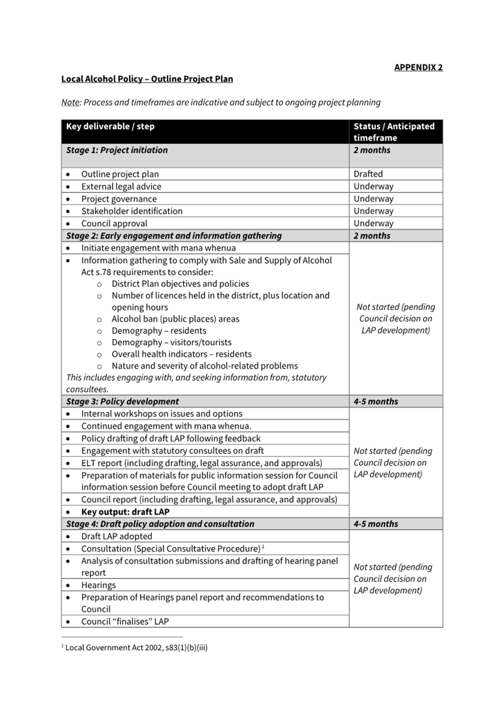
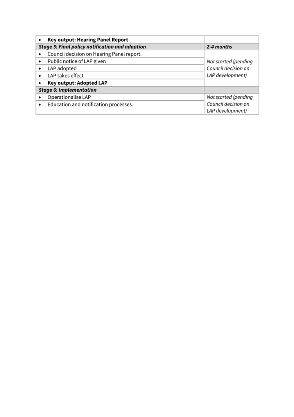
|
10. Stop Road (airspace) and Dispose of to Adjoining
Landowners
|
|
Reference Te Tohutoro:
|
24/494555
|
|
Responsible Officer(s) Te Pou Matua:
|
Colin
Windleborn Property Consultant
|
|
Accountable ELT Member Pouwhakarae:
|
Brent
Smith, Acting General Manager City Infrastructure
|
1. Purpose and Origin of the Report Te Pūtake Pūrongo
1.1 The
purpose of this report is for the Council, as landowner, to consider stopping
the road (airspace) and selling the airspace to the adjoining landowners of
developments at:
1.1.1 5-11 Marriner Street,
Sumner (Devcorp) – Attachment A.
1.1.2 132 Worcester Street,
Central City (Williams Corporation) – Attachment B and I.
1.2 The
developers of both properties have requested permanent use of the airspace
above legal road for the developments, both of which have received building and
resource consents from the Council.
2. Officer
Recommendations Ngā Tūtohu
That the Council:
1. Receives the information in the Stop Road (airspace) and dispose of
to the adjoining landowners report.
2. Notes that the decision in this report is assessed as low
significance based on the Christchurch City
Council’s Significance and Engagement Policy.
3. Pursuant to Section 116(1) of the Public Works Act 1981, agree to
stop the legal road, being a cube of airspace above the formed carriageway, and
amalgamate the parcels of land that arise from that road stopping with the
adjoining properties:
a. 5 – 11 Marriner Street, Sumner contained within Title
Identifier 961489.- The parcels of land containing an area of 76 m2are
shown as Section 1 and 2 on Plan SO 602249.
b. Hereford/Manchester and 132 Worcester Streets contained within Title
Identifier 1158091 and 1158093.- The parcels of
land are shown as Sections 1-10 containing an area of 104 m2 shown
on Plan SO XXXXXX (this being the reference on the plan which is yet to be
numbered).
4. Agrees to a departure from the Disposal of Council Property Policy
2000 by approving the unilateral dealing for disposal of the stopped legal road
parcels (the cubes of airspace above the formed carriage way) as described in
recommendation 3 above to the owners of the adjoining land at a valuation
determined by an independent valuer.
5. Delegates to the Property Consultancy Manager the authority to take
and complete all steps necessary to stop the legal road and dispose of the
stopped parcels (cubes of airspace) as shown as Section 1 and 2 on Plan SO
602249 and Sections 1-10 on Plan SO XXXXXX (this being the reference on the
plan which is yet to be numbered).
3. Executive Summary Te Whakarāpopoto Matua
3.1 The
definition of a road not only includes the land at ground level but also the
subsoil and airspace above the road. For this reason, Council can lease the
subsoil/airspace or lease or sell the subsoil/airspace above the road without
affecting the primary purpose of the road.
3.2 Two
residential/commercial buildings are being constructed at:
i. 5-11 Marriner Street Sumner -Devcorp – Attachment A
ii. 132 Worcester Street Christchurch Central– Williams
Corporation - Attachment B and I
3.3 Both
developments have been granted building and planning consents by Council (as
the Regulatory Authority) to erect part of the buildings over the footpath at a
height that does not hinder pedestrian or vehicular traffic.
3.4 For
use of the airspace (encroachments) above Council Road, the developers also
need to be granted permission from the Council as landowner.
3.5 Initially
it was thought that the encroachments would be dealt with by a licence/lease
through the Council’s Policy on Structures on Road Policy 2020. However,
the encroachments do not fit nicely within the purpose of the Policy which
refers to encroachments for private non- habitable structures.
3.6 The
report therefore deals with the Council’s Road Stopping Policy utilising
the Public Works 1981 for the process of dealing with the encroachments.
3.7 When
this has been completed then the disposal of the stopped road (airspace) will
be completed utilising the Disposal of Council Property Policy 2000 and the
departure of this to deal unilaterally with the adjoining property owners of
the road is sought.
4. Background/Context Te Horopaki
4.1 The
Council has received two applications from developers of multi-level buildings
for use of the airspace above legal road. Both developers have obtained
building and resource consents from the Council, and will also need Council
approval, as landowner, to encroach on the airspace above the road.
4.2 The
adjoining properties are:
4.2.1 5-11 Marriner
Street, Sumner – this is a multi-level development by Devcorp
comprising 50 two and three-bedroom apartments and five “premium”
penthouses over six separate buildings on the corner of Marriner Street and The
Esplanade Sumner. The development will contain 8 residential units, with
balconies that encroach on the airspace over Marriner Street and The Esplanade.
- Attachment D
4.2.2 132 Worcester
Street, Central City – this is a multi-level development by Williams
Corporation on land contained within Huanui Lane, Hereford, Manchester, and
Worcester Streets. This development is a mixture of unit’s, townhouses
and commercial properties. The development will contain 40 residential units,
with balconies that encroach on the airspace on Hereford, Manchester and
Worcester Streets. The property was purchased from Ōtākaro Limited with
the development approved by them. - Attachment C.
4.3 Initially
it was thought that the encroachments could be dealt with by way of a
licence/lease for the airspace, which would be within the parameters of The
Council’s Policy on Structures on Road Policy 2020 which allows for
structures encroaching over, under or on roads. - Attachment H.
4.4 However,
the encroachments do not fit nicely within the purpose of the Policy which
refers to private non-habitable structures.
4.5 The
lease/licence mechanism is not conducive with future strata ownership once
individual titles are available for the units, providing long term
administrative uncertainty for Council and unit owners with insurance and
mortgage lenders.
4.6 Staff
sought legal advice which recommended that road
stopping under the Public Works Act 1981 and sale of the airspace would be the
most appropriate mechanism rather than the lease/licence.
4.7 The
Council has delegated road stopping to the respective Community Boards;
however, road stoppings have been suspended until the review of the policy is
undertaken.
4.8 In
this instance because the road stopping is unique i.e. airspace rather than the
physical road/formed carriageway along with consents given by the Council,
staff thought it prudent to bring this matter to the Council. In addition, the
sale of the airspace (property) is not supported by a delegation and therefore
requires a Council decision.
4.9 The
Councils Road Stopping Policy Attachment E provides guidance on the
Council’s approach to:
4.9.1 Road stopping applications generally.
4.9.2 Identifying which statutory road stopping process will be
used.
4.9.3 The evaluation criteria to be applied when considering
road stopping applications.
4.9.4 Achieving consistency with road stopping applications,
decisions and processes ensuring statutory compliance.
4.9.5 While the policy does
not specifically deal with stopping the airspace over roads it does not prevent
it, therefore what is proposed in this report is not inconsistent as the
Council will be stopping airspace as distinct from the surface of roads.
4.10 Road Stoppings are managed under one of two statutory processes: - Attachment
G
4.10.1 the Public Works Act 1981; or
4.10.2 the Local Government Act 1974
4.11 In this instance
the thresholds of the Public Works Act 1981 are met (section 6.6 below) and
stopping of the road (airspace) will be undertaken utilising the provisions the
Public Works Act 1981.
Options Considered Ngā
Kōwhiringa Whaiwhakaaro
4.12 The following
reasonably practicable options were considered and are assessed in this report:
· Proceed
with the road stopping and dispose of the areas encroached upon to the adjacent
landowners.
· Proceed with the road stopping and lease the area being encroached
upon.
· Lease the area being encroached upon.
4.13 The following
option was considered but ruled out:
· Do not give permission as landowner - this option would mean that
the developers of 5-11 Marriner Street and 132 Worcester Street would need to
redesign the buildings to avoid the encroachments review their consents; the
development at 132 Worcester Street has already commenced construction and is
retrospectively seeking permission. This option is not feasible as it would
mean:
· The Council would be allowing the use of a Council asset with no
compensation.
· There would be a breach of Council’s policy with respect to
Structures on Road Policy
· There would be no Public Liability Insurance for a structure which
is encroaching onto the road.
· Unit owners may experience problems when obtaining funding for the
purchase of their units or insurance as a portion of their unit would be over
an area where there was no legitimate right to occupy.
· There would be the potential that the developers commence litigation
with Council as the landowner.
Options Descriptions Ngā
Kōwhiringa
4.14 Preferred
Option: Proceed with the road (airspace) stopping and dispose of the areas
encroached on to the adjacent landowners.
4.14.1 Option
Description: The road(airspace) would be
stopped using the Public Works Act 1981, valued and then a sale at market
valuation undertaken with the adjoining landowners (developers).
4.14.2 Option Advantages
· The permanent structures within the airspace can occupy the airspace
for an indefinite period.
· The Council would only be dealing with one landowner (i.e. the
developer).
· The Council would receive market value for the sale along with the
additional rates revenue for an increase in value of the units the airspace is
being added to.
· The right to use the airspace is transferable with the title of the
property it is amalgamated with; the Council would not be involved when the
property changes hands.
4.14.3 Option Disadvantages
· Additional costs associated with the road stopping including legal,
survey.
4.15 Proceed with
the road stopping and lease the area being occupied.
4.15.1 Option Description: Under
this option, the Council would proceed with the road stopping of the airspace
but rather than transferring ownership to the developer, the Council would
enter into leases with the owner of each individual apartment.
4.15.2 Option Advantages.
· The Council would retain ownership of the airspace in case it is
needed in the future.
4.15.3 Option Disadvantages
· There would be more administrative work as each time the unit was
transferred with the lease needing to be separately assigned or a new lease
entered.
· Council would not receive a market value for the airspace.
· Council would need to deal with 8 owners with respect to 5-11
Marriner Street and 40 owners in 2 buildings for 132 Worcester Street.
· Leases can only be granted for a finite
period which may be longer than the life of the building.
4.16 Lease
the areas encroached upon.
4.16.1 Option Description: Under
this option, the road (airspace) would remain in Council ownership with a lease
of the area that the building is encroaching into to each apartment owner.
4.16.2 Option Advantages
· The Council would retain ownership of the airspace in case it is
needed in the future.
· There would be less administrative work initially.
4.16.3 Option Disadvantages
· Leases can
only be granted for a finite period which may be longer than the life of the
building.
· The Council would need to deal with eight owners with respect to
5-11 Marriner Street and 40 owners in 2 buildings for 132 Worcester Street.
This would create more administrative work as each time the unit was
transferred with the lease needing to be separately assigned or a new lease
entered.
· If the Council did ever want use of the airspace, it would be
problematic as the building would need to be partially rebuilt to ensure there
was no encroachment.
· Council would not receive a market value for the airspace.
Analysis Criteria Ngā Paearu
Wetekina
4.17 Staff considered
all the options which are discussed in this report to provide a long-term
cost-effective process for the encroachments.
4.18 The recommended
option of stopping the road (airspace) and disposing to the adjoining
landowners will provide this.
4.19 The Council will
receive revenue from the disposal, with additional rate intake from having the
additional space added to the area of the various units and subsequent capital
value.
4.20 The unit owners
will be provided with ownership of the encroachment and therefore funding and
insurance certainty.
4.21 The decision
does not set a precedent as all applications for encroachments will need to
come to the Council on an individual basis.
5. Financial Implications Ngā Hīraunga Rauemi
5.1 This
proposal is funded by the applicants (the developers of each property) with
Council recovering all costs along with receiving the value of the road
(airspace) being sold along with long term increase in rates from the 48
properties which will have an additional area added to the rateable area of
their properties.
6. Considerations Ngā Whai Whakaaro
Risks and Mitigations Ngā
Mōrearea me ngā Whakamātautau
6.1 The
Minister may not give approval for the stopping but given the criteria the
stopping is assessed against this risk is considered minimal.
6.2 As
a Regulatory Authority Council has granted resource and building consents for
the construction of the buildings. There is a reputational risk to Council as
the landowner if Council does not offer an appropriate form of tenure for the
road(airspace).
Legal Considerations Ngā
Hīraunga ā-Ture
6.3 Statutory
and/or delegated authority to undertake proposals in the report:
6.3.1 Councils have powers under Sections 116, 117 and 120 of the PWA 1981
to stop roads. The Christchurch City Council has delegated this authority to
the Property Consultancy Manager, due to the uniqueness of this proposal that
delegation is not being exercised in this instance, hence referral to the
Council by way of this report.
6.3.2 Legal advice was sought with respect to the process to be used and
this was confirmed that a road stopping under the Public Works Act 1981 was the
appropriate procedure.
6.3.3 Approval is being
sought to a departure from the Disposal of Council Property Policy 2000 which
requires the tendering for the sale of properties. This is not appropriate
given that the road(airspace) can only be sold to the property owners
adjoining. Attachment F
6.4 Other Legal Implications:
6.5 Local
Government Act 1974
6.5.1 The Local Government
Act 1974 road-stopping procedure will not be adopted if one or more of the
following circumstances apply:
6.5.2 Where any public
right of access to any public space could be removed or materially limited or
extinguished because of the road being stopped; or
6.5.3 If it is found
through the review process that the road stopping could injuriously affect or
have a negative or adverse impact on any other property; or
6.5.4 The road stopping is,
in the judgment of the Council, likely to be controversial; or
6.5.5 If there is any doubt
or uncertainty as to which procedure should be used to stop the road.
6.6 The
Public Works Act 1981
6.5.6 Public Works Act 1981
process considerations
6.5.7 The Public Works Act
1981 road stopping procedure may be adopted only if all the
following circumstances apply:
6.5.8 Where there are no
more than two properties, other than the applicant’s property, adjoining
the road proposed to be stopped.
6.5.9 Where the written
consent to the proposed road stopping of all adjoining landowners (other than
the applicant) to the proposed road-stopping is obtained.
6.5.10 Where no other persons,
including the public generally, are considered by the Council in its judgment
to be adversely affected by the proposed road stopping.
6.5.11 Where the road(airspace)
proposed to be stopped is to be amalgamated with the adjoining property or
properties (as appropriate); and
6.5.12 Where other reasonable access
exists or will be provided to replace the access previously provided by the
road proposed to be stopped (i.e. by the construction of a new road); and
6.5.13 Where the use of the Public
Works Act 1981 road stopping procedure is approved by the relevant Government
department or Minister.
6.7
If any one of the circumstances referred to in clause 6.6 does not apply, then
the Local
Government Act 1974 process must be used.
Strategy and Policy Considerations Te Whai
Kaupapa here
6.8 The
required decisions:
6.8.1 Align with the Christchurch
City Council’s Strategic Framework.
6.8.2 This
recommendation is strongly aligned to the Strategic
Framework and in particular Councils vision of providing an opportunity for all
open to new ideas and a new way of doing things.
6.8.3 Are assessed as low significance
based on the Christchurch City Council’s Significance and Engagement
Policy in that the stopping of the (road)airspace does not compromise the
primary purpose of the road at street level, doesn’t not set a precedent
for future developments of a similar nature provides a benefit to the community
by providing additional revenue for the sale and additional revenue through
rates in the future.
6.8.4 The decision to be
made is considering whether or not to stop a portion of road (airspace) which
while contemplated by the Public Works Act 1981 and the Local Government Act
1974 there are thresholds which must be met as described in this report and
therefore what methodology should be used.
6.8.5 The developments
which are occurring to which the airspace will be added have both been through
the Council’s Planning consent process which considers the effects of the
development and a decision made to grant a resource consent for the developments
with conditions.
6.8.6 The road stopping
application has been assessed against the criteria in the Council’s Road
Stopping Policy with all criteria being satisfied:
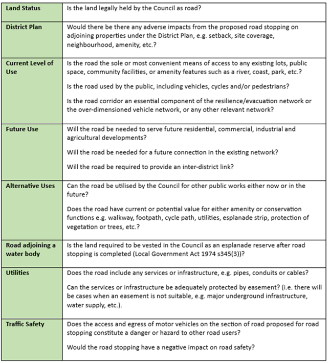
6.8.7 Following this
assessment to progress the application a 3-dimensional road stopping (cube of
airspace) survey plan has been prepared for each property, with upper and lower
reference points shown on the plans. Attachments C and D.
These plans
will be used to assess the value of the road(airspace) to be stopped with a
sale and purchase agreement entered with the adjoining owner. This agreement is
conditional upon Minister of Land’s approval and subject to the stopped
road (airspace) being amalgamated with the applicant’s adjoining title.
6.9 This report supports the Council's
Long Term Plan (2021 - 2031):
6.10 Economic
Development
6.10.1 Activity:
Economic Development
· Level
of Service: 5.1.9.2 Facilitate urban development activities that contribute to
a prosperous local economy - New urban development projects added to the
pipeline in line with the strategy
6.11 Transport
6.11.1 Activity:
Transport
· Level
of Service: 10.5.41 Increase access within 15 minutes to key destination types
by walking - >=49% of residential land holdings with a 15- minute walking
access
6.12 Internal
Services
6.12.1 Activity:
Facilities, Property and Planning
· Level
of Service: 13.4.10 Acquisition of property right projects, e.g. easements,
leases and land assets to meet LTP funded projects and activities. - At least
90% projects delivered to agreed timeframes per annum
Community Impacts and Views Ngā Mariu
ā-Hāpori
6.13 The decision
affects the following wards/Community Board areas:
6.13.1 Waipapa
Papanui-Innes-Central Community Board and Waihoro Spreydon-Cashmere-Heathcote
Community Boards.
6.14 The Community Boards have been notified of the proposal in this report.
Impact on Mana Whenua Ngā Whai Take
Mana Whenua
6.15 The decisions do
not involve a significant decision in relation to ancestral land or a
body of water or other elements of intrinsic value, therefore these decisions do not specifically impact Mana Whenua, their culture, and
traditions.
6.16 The decision does not involve a
matter of interest to Mana Whenua and will not impact
on our agreed partnership priorities with Ngā Papatipu
Rūnanga.
6.17 Specific
consultation is not required as the decision of this report relates to the sale
of encroachments into public airspace. The decision is of low significance and
would not impact on the relationship between council and Mana Whenua.
6.18 In addition, both
are consented with papatipu rūnanga through Mahannui Kurataiao Limited
indicating in respect of the Marriner Street development that “the rūnunga
would not consider themselves adversely affected subject to the recommended
conditions being adopted …” The principles and relationship
issues in respect of the Worcester Street development are the same.
Climate Change Impact Considerations Ngā
Whai Whakaaro mā te Āhuarangi
6.15 The
proposals in this report are unlikely to contribute significantly to adaptation
to the impacts of climate change or emissions reductions.
6.16 The decision is
procedural to do with road stopping (airspace) and disposal.
7. Next Steps Ngā Mahinga ā-muri
7.1 If
the Council agrees to the proposals in this report, staff will continue with
the statutory processes for road stopping.
7.2 Sale
and Purchase Agreement will be prepared by the Council Legal Services Unit and entered
with the respective property owners which will be subject to obtaining
Ministerial approval.
7.3 Application
to Minister to proceed with the road stopping.
7.4 All
road stoppings that fall within the Public Works Act 1981 process are subject
to approval from the Minister of Lands. The Minister’s consent is
obtained by submitting a report to Land Information New Zealand (LINZ) that
contains all information relevant to each individual application.
7.5 The Minister considers the
following critical factors set out in LINZ’s road stopping standard:
7.6 Public
use of the road.
7.7 Is
sufficient road remaining?
7.8 The
reasons for it being stopped.
7.9 Access
to adjoining properties either remains or is provided for.
7.10 All
necessary regulatory authorities have been obtained i.e. The Council approval,
and
7.11 Is
the use of the Public Works Act 1981 warranted?
7.12 If
the Minister’s approval is given, then a road stopping notice is
published in the New Zealand Gazette stopping the road and automatically
amalgamating it with the adjoining title(s). The notice is then lodged with the
District Land Registrar who issues one new title for the stopped road and the
adjoining parcel of land.
Attachments Ngā Tāpirihanga
|
No.
|
Title
|
Reference
|
Page
|
|
a ⇩
|
Attachment A
Street View Proposed Building 5-11 Marriner Street Sumner
|
24/423250
|
235
|
|
b ⇩
|
Attachment B
Street View Building 132 Worcester Street from Worcester Street to Hereford
Street Central Christchurch
|
24/344828
|
236
|
|
c ⇩
|
Attachment C
Road Stopping Plan 132 Worcester Street Christchurch Central
|
24/344842
|
237
|
|
d ⇩
|
Attachment D
Road Stopping Plan 5-11 Marriner Street Sumner
|
24/423265
|
243
|
|
e ⇩
|
Attachment E
Road Stopping Policy 2020
|
24/424160
|
248
|
|
f ⇩
|
Attachment F
Disposal of Council Property Policy 2000
|
24/425955
|
257
|
|
g ⇩
|
Attachment G
Flow Diagram Road Stopping process
|
24/427010
|
258
|
|
h ⇩
|
Attachment H
Structures on Road Policy 2020
|
24/557916
|
260
|
|
i ⇩
|
Attachment I
Street View Building 132 Worcester Street from Hereford Street to Worcester
Street
|
24/606350
|
269
|
In addition to the attached documents, the following background
information is available:
|
Document
Name – Location / File Link
|
|
Not
applicable
|
Signatories Ngā Kaiwaitohu
|
Author
|
Colin
Windleborn - Property Consultant
|
|
Approved By
|
Angus Smith -
Manager Property Consultancy
Lynette Ellis
- Head of Transport & Waste Management
Brent Smith -
Acting General Manager City Infrastructure
|
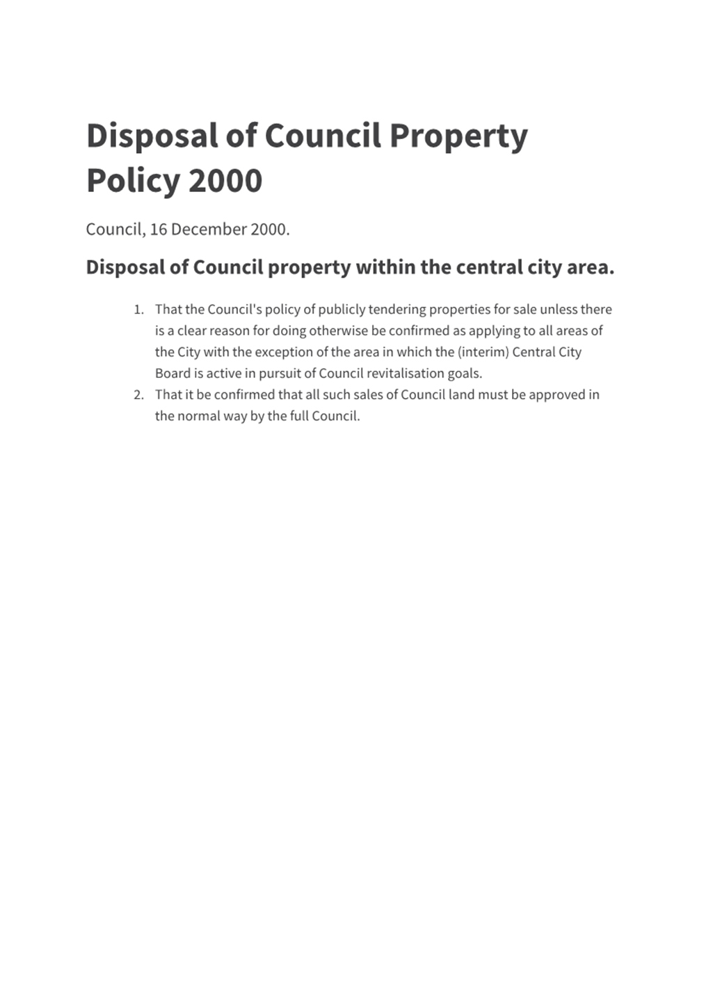
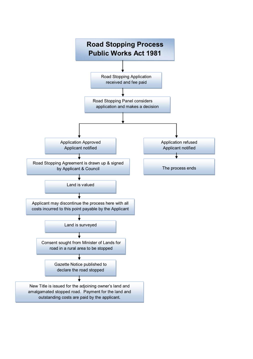
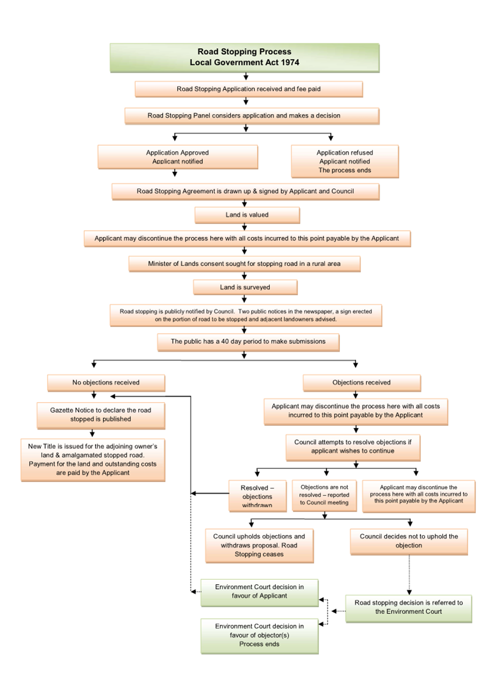
|
11. Climate Resilience Strategy Implementation Progress
|
|
Reference Te Tohutoro:
|
24/440554
|
|
Responsible Officer(s) Te Pou Matua:
|
Joy
Gribben, Principal Advisor Climate Resilience
Tony Moore, Principal Advisor Climate Resilience
Diane Shelander, Senior Advisor Climate Resilience
|
|
Accountable ELT Member Pouwhakarae:
|
John
Higgins, General Manager Strategy, Planning & Regulatory Services
|
1. Purpose and Origin of the Report Te Pūtake Pūrongo
1.1 At
its 15 November 2023 meeting, the Council resolved (CNCL/2023/00147) to request
six monthly reporting to the Council on the implementation of Kia Tūroa te
Ao: Ōtautahi Christchurch Climate Resilience Strategy (the Strategy).
1.2 This
is the first six monthly report.
2. Officer Recommendations Ngā Tūtohu
That the Council:
1. Receives the information in this Climate Resilience Strategy
Implementation Progress Report.
3. Considerations Ngā Whai Whakaaro
Coverage of the first and subsequent
reports
3.1 This
first report covers work done between June 2021, when the Strategy was adopted,
and the present. It also covers actions intended to be done in the next six
months. It does not include international shipping or aviation emissions. As recently requested by the Council at its 15 May 2024
meeting (Council Resolved CNCL/2024/00062), staff will provide advice in a
separate report regarding the Lyttelton Port Company international shipping
emissions and Christchurch International Airport Limited international aviation
emissions.
3.2 Future
reports will cover the preceding six-month period and intended actions in the
upcoming six months. Staff are developing key performance indicators to make
future six-monthly reporting succinct and easily communicated.
Across Council contributions and engagement
3.3 Staff
have worked closely with teams across the Council to document key achievements.
3.4 This
has been guided by a cross-Council Climate Resilience Strategy implementation
working group, set up to develop the reporting and drive further work to
implement the Strategy.
3.5 These
units and teams have contributed: Transport, Parks, Three Waters, Waste
Management, Civil Defence, Asset Management, Climate Resilience, Coastal
Hazards Adaptation, Planning and Consents, Procurement, Community Support,
Smart Christchurch, Corporate Planning, Monitoring and Research, and
ChristchurchNZ.
Actions taken to build climate
resilience
3.6 The
Council has made substantial progress on building climate resilience for
Christchurch. Further planning is also underway, and tools have been developed
to help the Council and communities understand how climate change is affecting
our District.
3.7 An
account of key climate activities undertaken, and planned activities upcoming,
is provided in Attachment A. This is not a full list of all actions, but
a list of significant actions.
Mitigation: emissions reduction and
carbon removal
3.8 The
Council has set targets for Christchurch to have net zero greenhouse gas
emissions by 2045 (excluding methane), and for the Council to be net carbon
neutral by 2030. Tracking our progress is now underway (see Tools and
Information below) and we are developing an Emissions Reduction Plan for the
Council’s operational emissions, due July 2024.
3.9 Transport
is the source of 54 percent of the District’s emissions. Actions to
address this include supporting public transport, expanding the cycleways
network (over 60 percent complete), investigating rapid transit options, and
working on the Greater Christchurch Spatial Plan, which focusses growth around
centres and along strategic transport corridors.
3.10 Large planting
programmes, such as regeneration work (e.g., Ōtākaro Avon and Styx
rivers) and the Urban Forest Plan, play a role in reducing our emissions
through carbon sequestration. They also provide protection for our riverways in
case of flooding and protect hilly areas to reduce slips and erosion thus
protecting soils. As an example of the extent of this work, the Council nursery
now provides around 500,000 eco-sourced plants annually for restoration and
general planting purposes.
3.11 Further actions
to reduce emissions:
· Water conservation (for example, the ‘Water like you oughta’
campaign which reduced peak daily demand by 25 percent from the February 2020
peak to the FY22/23 peak) reduced electricity use for pumping water.
· Work to support over 1000 low-income households to use LED
lightbulbs and efficient showerheads has also given them an average saving of $865
per household per year.
· Landfill remediation work is supporting emissions reductions.
Adaptation: taking action to reduce and respond to climate risk
3.12 Adaptation
planning and action is underway in many areas of the Council. Actions taken so
far have focussed on flood and erosion protection, as well as reduction of fire
risk by using native and fire-retardant planting.
3.13 One of the
biggest risks is sea level rise.
The Christchurch District has 33,985 properties with LIM notations for either
coastal flooding or erosion risk over 100 years, making coastal adaptation
planning essential. The Coastal Hazards Adaptation Planning Programme began in
2021 and continues to make good progress, with the Whakaraupō Lyttelton
Harbour and Koukourārata Port Levy community planning underway.
3.14 It is also
essential for the Council to prepare its infrastructure for climate risk. The
Long Term Plan (LTP) and associated Infrastructure Strategy has a focus on climate
change issues, both adaptation and mitigation.
Tools and information
3.15 While the
potential impacts of climate change are well known, the risks to different
parts of our District vary. We need good information to prepare and plan to
minimise impacts on people, services, assets, and the environment. A range of
tools and information have been developed to support climate action.
3.16 The Risk
Explorer tool is highly useful to map which climate risks affect which areas
and assets, and is being further developed to include additional climate hazard
datasets as these become available. Work has also been done on Christchurch climate change risk screening, published
in 2022.
3.17 The
Council’s operational emissions are tracked with BraveGen software to
produce an annual inventory, while an inventory of District emissions has
recently been published. Further tools include one for long-term management of
closed landfills, and one under development for estimating embodied carbon in
Three Waters targeted capital projects.
Full summary of key actions in Attachment A
3.18 Further details
of specific programmes and projects can be found in Table 1 (which covers
actions since June 2021) and Table 2 (which highlights near term actions planned)
in Attachment A.
3.19 The tables cover
the ten programme areas in the Strategy which are:
|
1.
Building the foundation – partnerships and resourcing
|
6.
Economic transformation and innovation
|
|
2.
Understanding local effects of climate change
|
7.
Low-emission transport system
|
|
3.
Proactive climate planning with communities
|
8.
Energy efficient homes and buildings
|
|
4.
Adapting and greening infrastructure
|
9.
Towards zero waste
|
|
5.
Carbon removal and natural restoration
|
10.
Sustainable food system
|
Next steps
3.20 The Climate
Resilience Strategy implementation staff working group will develop key
performance indicators that can be reported to the Council to demonstrate
progress on the Strategy implementation in future.
3.21 The Climate
Resilience Strategy will continue to guide and drive the Council’s
climate action. As shown in Attachment A, there is a wide range of
activities planned and underway across the Council to address emissions
reduction and to reduce and plan for climate risks.
Attachments Ngā Tāpirihanga
|
No.
|
Title
|
Reference
|
Page
|
|
a ⇩
|
Tables of
Actions by Council on Climate Resilience Strategy Implementation (June
2021-April 2024)
|
24/684194
|
275
|
In addition to the attached documents, the following background
information is available:
Signatories Ngā Kaiwaitohu
|
Authors
|
Joy Gribben -
Principal Advisor Climate Resilience
Tony Moore -
Principal Advisor Climate Resilience
Diane
Shelander - Senior Advisor Climate Resilience
|
|
Approved By
|
Lisa Early -
Team Leader Climate Resilience
Elizabeth
Wilson - Team Leader Policy
John Higgins -
General Manager Strategy, Planning & Regulatory Services
|
|
12. Central City
Noise Programme - Progress Update, Acoustic Assessment Advice
|
|
Reference Te Tohutoro:
|
24/673390
|
|
Responsible Officer(s) Te Pou Matua:
|
Carolyn
Bonis, Urban Regeneration Team Leader;
Mark Stevenson, Head of Planning & Consents
|
|
Accountable ELT Member Pouwhakarae:
|
John
Higgins, General Manager Strategy, Planning & Regulatory Services
|
1. Purpose and Origin of the Report Te Pūtake Pūrongo
1.1 The
purpose of this report is:
1.1.1 To update the Council
on progress with delivering the Central City Noise Programme; and
1.1.2 To provide advice
ahead of a possible future initiative: provision of a funded acoustic
assessment service.
1.2 The
origin of the report reflects:
1.2.1 The range of
initiatives currently forming the Central City Noise Programme as agreed by the
Council on 5 April 2023 (CNCL/2023/00045 - refer item
18 of agenda ); and
1.2.2 The 12 December 2023
request by the Council for staff advice about “funding for live music
acoustic assessments as part of an update report on the ongoing live music
programme” (CNCL/2023/00185); and
1.2.3 The Council’s
decision as part of adopting the Draft Long Term Plan, which notes that:
“staff will table a report in FY24 or FY25 that provides an update to
Council on the District plan change process as it affects live music venues in
the central city which will inform a future discussion around funding acoustic
assessment trials in the 2025/2026 Annual Plan” (CNCL/2024/00003).
2. Officer Recommendations Ngā Tūtohu
That the Council:
1. Receives the information in the Central City
Noise Programme - Progress Update, Acoustic Assessment Advice report.
2. Notes that staff will report back to the Council with a further
update on the Central City Noise Programme. This is likely to be in early
2025.
3. Background/Context Te Horopaki
3.1 New residential activity, including multi-unit development, is
occurring across the Central City residential zones and – increasingly
– the mixed use zones (refer the July – December 2023 Central City
Biannual report and the online progress dashboard). This
helps meet the Council’s 'Project 8011' Central City Residential Programme aspiration for 20,000 people living in the Central City. However,
with tensions arising between existing businesses and newly developed
residential pockets, the Council agreed a Central City Noise Programme in 2023
as a mechanism to reconsider noise standards in the Central City while better
supporting developers, businesses and residents to be good neighbours with one
another. While there are no ‘silver bullets’ or quick fixes
for these tensions, the range of regulatory and non-regulatory initiatives was
agreed as a means of responding to the situation.
3.2 With
the city’s relatively high rate of land use change and evolution, areas
that had been experiencing noise tensions a few years ago (e.g. Victoria
Street) are no longer a focus for enforcement officers as noise-generating
activity has begun to cluster into the more centrally-located commercial zones.
Nevertheless, the ongoing uptake of the Central City’s mixed use
and commercial areas for residential activity is anticipated to result in new
areas of tension.
3.3 This report covers both:
3.3.1 An update on
the Central City Noise Programme, which has several components, both
regulatory and non-regulatory. This update is detailed in Attachment A
and via the link to survey findings in a recent Newsline Article (refer the
table at the end of this report). To summarise Attachment A:
· The non-regulatory elements have progressed well across the various
information gathering and information sharing initiatives. This includes new
advisory notes on Land Information Memoranda (LIMs), advice from the
Council’s Eco Design Advisor and Arts mentoring, and new webpage
information underway to educate residents, businesses and developers on how
they might achieve good acoustic insulation and implement associated measures
to mitigate noise nuisance issues.
· Recent surveys have clearly shown that both residents and businesses
expect a higher noise environment in the Central City and they do not want the
growing residential population to be at the expense of our nighttime
economy. These survey results will help inform the shape of future
changes to the District Plan; an Issues and Options paper is currently in
development. Next steps are working through the technical analysis on the
issues and options identified, with the goal to identify a preferred option that
will inform early engagement. Thereafter, staff will commence work on the
Section 32 Report and will draft provisions over the coming months.
Officers will report back at a future date on the plan change, including for
approval to notify and invite submissions.
3.3.2 Initial advice
regarding scope of any possible future funding for acoustic assessments.
Council resolutions have sought advice on use of acoustic assessments,
particularly in relation to live music venues. This report provides an
initial step towards a future decision.
· It recognises that noise in mixed use environments may come from
several different sources, so the scope of any future service is important to
clarify. Staff are seeking initial views and feedback from elected members on
whether to continue a focus on live music, or extend the scope of advice to
include intrusive noise from a broader range of music and other
businesses.
· Staff advice is that any funded assessments would most usefully
apply to those areas currently undergoing land use transition from industrial
to mixed use (including residential) activities, and with a focus on the noise
emitter rather than the noise receiver.
· This advice is provided in section 4 below and examples of acoustic
assessments used elsewhere nationally and globally is provided at Attachment
B.
· A later report will provide further advice once more information is
available on both the pilot acoustic assessment currently underway and the
likely future changes to noise rules in the district plan. This will
enable all relevant information to be considered ahead of any decisions on
possible funding of acoustic assessments, as part of the FY25/26 Annual Plan,
including a decision on whether or not to progress.
4. Considerations Ngā Whai Whakaaro
4.1 The
advice provided below, regarding potential future acoustic assessments,
canvasses the following topics:
· What is an acoustic assessment
· The current pilot acoustic assessment.
· Interpretation: ‘live music’.
· Achieving freedom from intrusive noise: understanding the range of
noise issues in the Central City and what distinguishes ‘live
music’ from other music, other business-related noise, and other general
noise issues.
· Geographical scope.
· Acoustic assessments at source and/or receiving environments.
· Current numbers of businesses and complaints.
· Community views.
· Next steps: scope of future advice and financial implications.
What is an acoustic assessment
4.2 Acoustic
assessments are often undertaken in advance of construction or operation of a noise-emitting
activity. However, in this context we’re considering assessments of
established buildings to consider how best to mitigate existing noise issues.
4.3 Assessments
are undertaken by qualified acoustic engineers and advice is provided on a
range of possible structural solutions to either address the level of sound
‘leaking’ from the structure, or limit the level of noise being
received inside a sensitive environment (for example, bedrooms or living areas
of nearby dwellings).
4.4 Attachment
B provides examples of acoustic assessments used elsewhere in New Zealand
and globally, together with brief commentary on their benefits and drawbacks.
Current pilot assessment
4.5 In 2023 and with a particular tension arising in St Asaph Street
(where new residential activity was being built near existing live music
venues), budget was allocated to pilot an acoustic assessment of a live music
venue. This sought to better understand the nature of concern regarding
noise and the mitigation options for the music venue.
4.6 The assessment identified a range of initiatives that the building
owner might undertake – for example the addition of Gib Noiseline,
polyester sound absorbers, laminated glass, acoustic door seals, additional
solid core doors, additional walls and ceiling inside the existing structure
and some internal reconstruction. A Council quantity surveyor outlined the
costs associated with the proposed mitigation; this totalled over
$100,000. This information was provided to the venue operator and to Save
Our Venues, a national advocacy group for grassroots
live music venues. The venue operator is
currently considering their options but has noted the significant costs
involved in retrofitting the building, especially in the context of potential
changes to the noise standards.
4.7 Therefore, a drawback of acoustic assessments is that while they
provide clarity in terms of potential steps to take and ballpark costs for the
venue to meet noise standards, the ability to fund mitigation works can remain
challenging. For this reason, and with the knowledge that the District
plan rules in and around noise precincts may be changing, the original pilot
remains ‘live’, with no clear resolution to the original
noise-related concerns at the time of preparing this report.
Interpretation
4.8 The
Council resolutions asked for advice on a potential future acoustic assessment
service relating to “live music”. Having taken advice, this report
uses an interpretation of ‘live music’ which extends the
traditional understanding of live performance to include, for example, a DJ
using a personally curated composition:
4.8.1 Live music
is an event where one or more performers provide music (including vocals,
instrumental or via manipulating pre-existing sound recordings with a creative
or curatorial aim), with or without amplification, to an audience at the same
location.[17]
Achieving freedom from intrusive
noise
4.9 Although
the initiation of the Central City Noise Programme resulted from concerns
regarding “live music”, the success of mixed use living
requires freedom from intrusive noise from a range of sources as shown below. For
example, music from sound systems at hospitality venues or the operation of
restaurant extractor fans can create at least as much concern for residents as
noise from live music venues.
4.10 This is an
important consideration when contemplating the scope of any future acoustic
assessment service. If the intent is to focus purely on the arts, then a
scope that sits to the left of the diagram would be appropriate. If the
intent is to mitigate tensions between residents and existing businesses, a
broader scope may be warranted.
4.11 Individual
music-related venues will not necessarily fit neatly into any one category in
this diagram as they may provide a range of music offerings.
Geographical scope
4.12 The scope of any
future acoustic assessment service also needs to consider whether it would be
focused towards a particular geographical area. The current Central City
Noise Programme has a geographical scope of the whole area within the four
avenues. However, current tensions are focused toward the Central
City’s mixed use neighbourhoods.
4.13 These mixed use
neighbourhoods are where the greatest impact can be achieved in supporting new housing
demand in the Central City, to realise the growth of residents anticipated by
Project 8011. The District Plan’s activity rules for the mixed use
and commercial zones are also more enabling of commercial activities than in
pure residential zones.
4.14 The potential
for future noise concerns in the South-East Central neighbourhoods - resulting
from the mix of light industrial activity and new housing growth - is unable to
be quantified at present but likely provides the greatest potential for tension
between existing/new business activity and new residential neighbours.
4.15 Therefore, the
Central City’s commercial and mixed use zones would potentially be the
most suitable location for focusing any future acoustic assessment service.
Acoustic assessments at source and/or receiving environments
4.16 Acoustic
assessments could theoretically be undertaken for both a business producing
noise and a dwelling receiving the noise – noting that acoustic
insulation can be achieved at both the source and the receiving
end. Examples of each are provided in Attachment B. However,
addressing the noise source in the first instance has potential to
mitigate effects on multiple receiving dwellings, so is likely to be a more
efficient way of addressing any concern related to a particular business.
Many dwellings in the coming decade will also be new-builds rather than
existing or retrofitted buildings; as such, they will likely employ a higher
degree of noise attenuation. It is further anticipated that the action
taken to amend LIMs and to prepare educational webpages for new residents may
provide solutions for the majority of residential situations.
4.17 Similarly, acoustic
assessments for non-business sources – such as residential parties,
traffic, rowdy pedestrians etc – would unlikely be suitable for funded
acoustic assessments as they don’t relate to a building or would be a
poor fit for any Council funded service.
Current numbers of businesses and complaints
4.18 Future decisions
on whether to provide an acoustic assessment service would need to consider the
size of the issue.
4.19 The number of
business venues emitting noise is not a static figure, as the number of Central
City businesses continues to evolve. The following breakdown uses early
2024 numbers from the Council’s enforcement team:
4.19.1 Music venues:
There are up to 30 venues across the Central City and all are located within
the current commercial or mixed use zones. Of these venues, half have generated
a need for noise monitoring in recent years by enforcement officers.
· Of the 110 complaints received and investigated across this
timeframe, 75 (68%) were found not to be generating excessive noise, with no
further action required.
· Although three quarters of monitored venues were, at some
stage, found to be producing excessive noise or exceeding the noise standards,
the vast majority involved three or fewer occasions.
· With ongoing resolution of noise complaints, there is a relatively
small list of venues on an active monitoring list at any given time.
4.19.2 Enforcement colleagues advise
that some of the received complaints are for live music, although the collected
data does not currently distinguish whether or not the music is
‘live’.
4.19.3 Other businesses:
A further three businesses in the Central City have given rise to noise
complaints across the last year, unrelated to matters of music. All are
located in the mixed use zone and relate to restaurant plant and extraction
fans located on the external areas of the building. The businesses are in
close proximity to residential buildings. One of the three businesses
also features in the music venue numbers in 4.8.1 above. This is a relatively
small number of businesses, but looking ahead may be underrepresented relative
to future anticipated growth of residential activity in the Central City,
particularly when considering any existing use rights of established businesses.
4.20 If acoustic
assessments are available in future to the full range of businesses generating
noise complaints, it is unlikely that every establishment would either need or
seek this service as they may be able to readily and immediately mitigate the
issues raised – for example, by reducing speaker volume.
Community views
4.21 The Waipapa
Papanui-Innes-Central Community Board was briefed on 23 November 2023 regarding
progress of the Programme and the findings from the survey. The Board was
interested to ensure that webpage information targeted tenants as well as
landlords; and reflected with staff on the cost of acoustic surveys and the
economics of mitigation for older buildings.
4.22 Staff have
tested the idea of providing further funded acoustic assessments with a
representative of Save Our Venues. Initial feedback from Save Our Venues
is that:
4.22.1 The pilot acoustic assessment
has been a valued contribution from the Council to understand potential
investment to attenuate sound and mitigate possible conflict with nearby
residents. However, the pilot shows significant financial investment may be
needed – noting that in most instances venue operators are not the owner
of the property. Venues are also concerned that making a significant
investment does not necessarily preclude a complainant from continuing to call
the noise control service. The plan change, noise enforcement procedures
and other non-regulatory tools are considered important to work in parallel
with sound attenuation, to give confidence to venues that the investment will
be worthwhile.
4.22.2 Any funding assistance for
acoustic assessments be prioritised to ticketed live music venues in the first
instance (in particular those which have live music performance as their
primary purpose as compared with other hospitality venues), while acknowledging
that there are many other components of the night-time economy that would also
benefit from such support.
4.22.3 A contestable grant be
considered, to support initial, targeted investment in improving sound
mitigation. This may help venues to start work on some of the more
affordable components of the work suggested in an acoustic report. Save
Our Venues has suggested an approach similar to the New South Wales
‘Venues Unlocked’ Programme, outlined in Attachment B. This
supports music venues to achieve best-practice soundproofing and management by
providing grants of up to $100,000 to upgrade premises’ sound management
infrastructure and equipment. To inform the scope of mitigation required, an
acoustic assessment report up to the value of $10,000 is provided by Sound
NSW.
Next steps: Scope of future advice and likely implications that will
need to be considered
4.23 Further advice
on an acoustic assessment service will need to await and take into account the
following matters in order to provide sound options for a Council decision:
· Any feedback from elected members around the scope of the service,
as noted below.
· An updated understanding of any District Plan changes to noise rules
in the Central City. The earliest that the ‘shape’ of new rules
and/or precincts and any associated decision on funding might be possible is
early 2025 (post- plan change notification and receipt of submissions).
· Any further outcomes of the initial pilot acoustic assessment.
4.24 Future decisions
on whether to offer an acoustic assessment service will also need to consider:
· An appropriate level of budget allocation, noting the current pilot
acoustic assessment cost approximately $6000 plus staff time.
· Risks that providing acoustic assessments may not deliver changed
outcomes if the recommended building alterations are not actioned
(acknowledging the high cost of these, and the difficulty for businesses who
may not own the building).
· Locational application (e.g. the Central City’s mixed use and
commercial zones).
· Timing of any new service, noting that any funding would not apply
until new District Plan noise rules for the Central City are operative.
4.25 Meanwhile, staff
are happy to receive feedback from elected members on the scope of any
potential future acoustic assessment service. In this regard, if the
focus for elected members is strongly towards the arts function of live music,
then a more narrow and targeted approach might be taken. However, if the
focus is towards addressing tensions between residents and noisier businesses
(of any type), with a broader aim of growing the number of Central City
residents, then a wider scope would be beneficial. Initial advice is that
there may be little difference in costs between both approaches, if taking a
multi-year, ‘first come first served’ and/or criteria-driven
approach.
Attachments Ngā Tāpirihanga
|
No.
|
Title
|
Reference
|
Page
|
|
a ⇩
|
Central City
Noise Programme Update
|
24/500294
|
297
|
|
b ⇩
|
Acoustic
assessments elsewhere
|
24/833067
|
301
|
In addition to the attached documents, the following background
information is available:
Signatories Ngā Kaiwaitohu
|
Authors
|
Carolyn Bonis
- Team Leader Urban Regeneration
Mark Stevenson
- Acting Head of Planning & Consents
|
|
Approved By
|
Bruce Rendall
- Head of City Growth & Property
John Higgins -
General Manager Strategy, Planning & Regulatory Services
|
|
13. Suburban
Regeneration Biannual Report - October 2023 to March 2024
|
|
Reference Te Tohutoro:
|
24/452960
|
|
Responsible Officer(s) Te Pou Matua:
|
Janine
Sowerby, Senior Planner, Urban Regeneration
|
|
Accountable ELT Member Pouwhakarae:
|
Brent
Smith, Acting General Manager City Infrastructure
|
1. Purpose and Origin of the Report Te Pūtake Pūrongo
1.1 The
purpose of this report is to advise the Council of progress implementing
suburban regeneration projects in the period October 2023 to March 2024.
1.2 Staff have been reporting on suburban regeneration implementation
progress on a biannual basis, as part of delivering on the Urban Place Making
Levels of Service Performance targets.
2. Officer Recommendations Ngā Tūtohu
That the Council:
1. Receives the information in the Suburban Regeneration Biannual Report -
October 2023 to March 2024 Report.
3. Background/Context Te Horopaki
3.1 Attachment
A provides details and images of multiple regeneration projects across
parts of the city. It:
3.1.1 Focusses
on locations and projects which saw activity during the reporting period.
3.1.2 Summarises
information from across the Council and other organisations (including
ChristchurchNZ and the Council’s city-making partners).
3.1.3 Is
structured around the currently agreed prioritisation of suburban regeneration
locations.
3.2 Highlights
are:
3.2.1 Higher
priority suburban regeneration locations
· New Brighton: Demolition
of the former Westpac building (56 Brighton Mall) was completed towards the
future extension of Oram Ave, and a ‘Better for Brighton’ working
group was established to coordinate various public and private projects occurring
within Brighton Mall.
· Linwood Village:
Installation of an interactive artwork in Doris Lusk Reserve was completed and
construction began on the streetscape upgrade through the village.
3.2.2 Other
master plan locations
· Main Road: The final
section of the Coastal Pathway was completed and subsequently received a NZ
Planning Institute award for innovative and creative excellence in respect to a
physical works project.
· Lyttelton: A Lyttelton
Community Emergency Hub was established, following collaborative work between
groups interested in resilience planning, including Project Lyttelton,
the Council’s CDEM Team, other agencies and community groups.
3.2.3 Other
suburban locations/Council-funded community-led projects
· Diamond Harbour: Staff
sought community feedback on two unsolicited proposals for parts of
Council-owned land - from Fire and Emergency NZ for a replacement fire station
and from Te Hapū o Ngāti Wheke for a character school.
· Little River: The Little
River Wairewa Community Trust progressed a review, update and expansion of its
community-led plan Little River, Big Ideas.
· Akaroa: A process was
initiated and approved by Te Pātaka o Rākaihautū Banks Peninsula
Community Board to identify future land use options for the Council-owned site
known as the Banks Peninsula (BP) Meats site.
· Council funded
community-led projects: Community-led projects (including a community street
art jam and building of a sensory nature play area) were supported in multiple
locations across the city. The funding (Enliven Places City-making Partner
funding, Rates Incentive, Place Partnership grants and Shape your Place Toolkit
funding) enabled creativity, site activation and external technical advice for
projects.
3.3 The
Council included a proposal to extend the City Vacant Differential Rating to
New Brighton, Linwood Village, Sydenham and Lyttelton in its Draft Long Term
Plan 2024-2034. This reflects the extent of vacant land in these centres and
public support for encouraging appropriate use and/or improving the appearance
of vacant sites.
4. Considerations Ngā Whai Whakaaro
4.1 In
future the urban regeneration work programme will be driven from the Greater
Christchurch Spatial Plan, which was unanimously endorsed by the Greater
Christchurch Partnership Committee in February and adopted by all Partner
Councils as their future development strategy in March. This change will be
reflected in future biannual information update reports.
Attachments Ngā Tāpirihanga
|
No.
|
Title
|
Reference
|
Page
|
|
a ⇩
|
Council
Suburban Regeneration Biannual Report - October 2023 to March 2024 5 June
2024 - Attachment A
|
24/803574
|
306
|
In addition to the attached documents, the following background
information is available:
|
Document
Name – Location / File Link
|
|
Not
applicable
|
Signatories Ngā Kaiwaitohu
|
Author
|
Janine Sowerby
- Senior Planner
|
|
Approved By
|
Carolyn Bonis
- Team Leader Urban Regeneration
Bruce Rendall
- Head of City Growth & Property
|

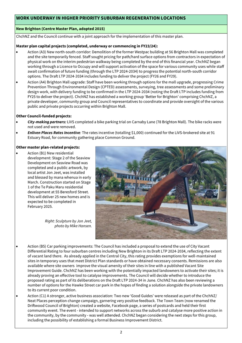
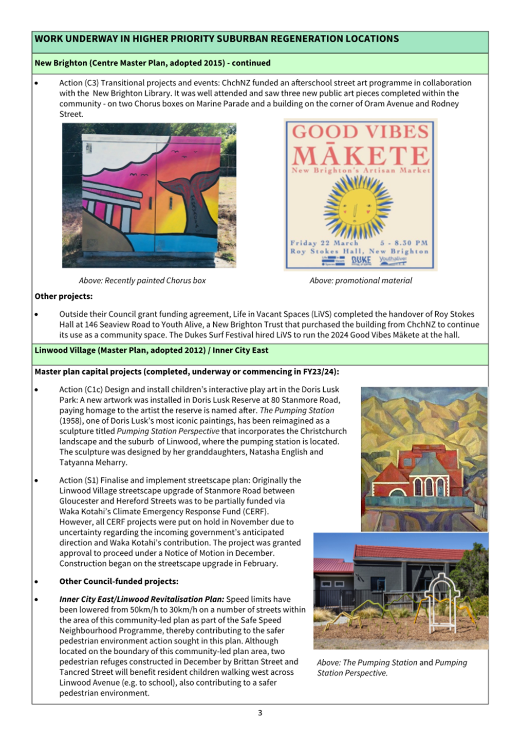
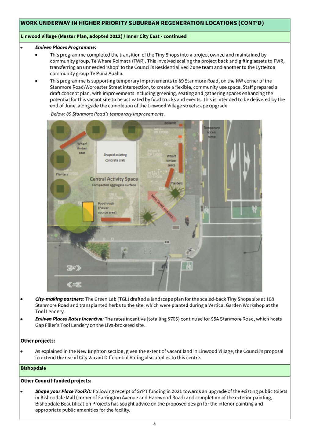
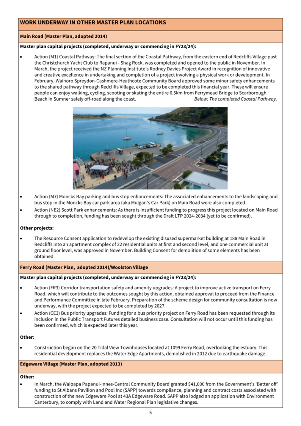
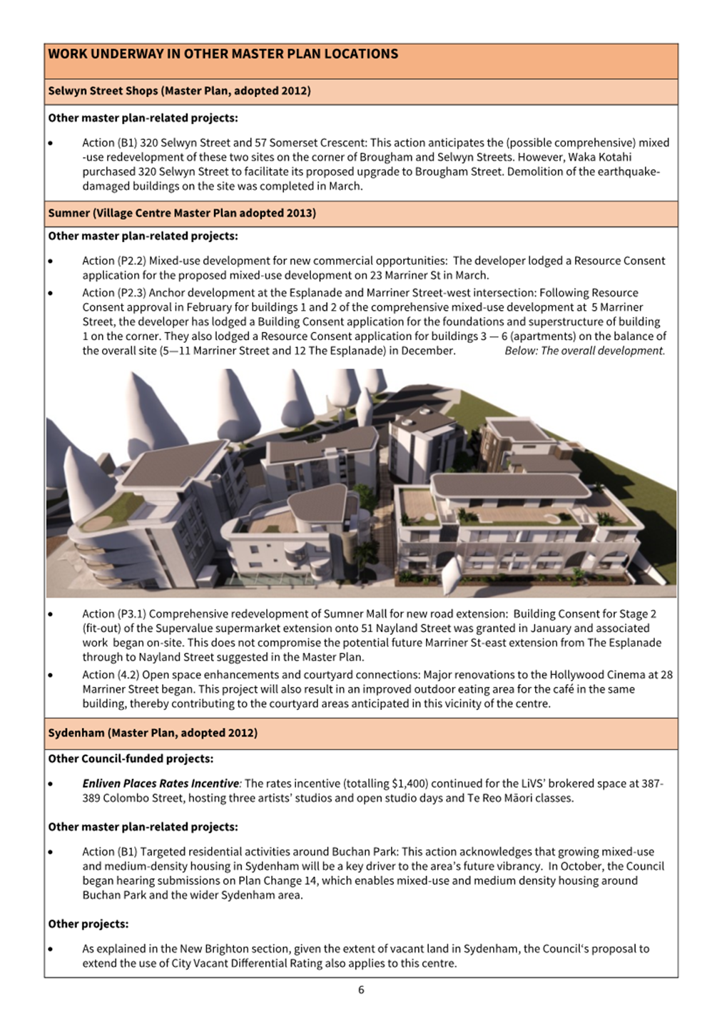
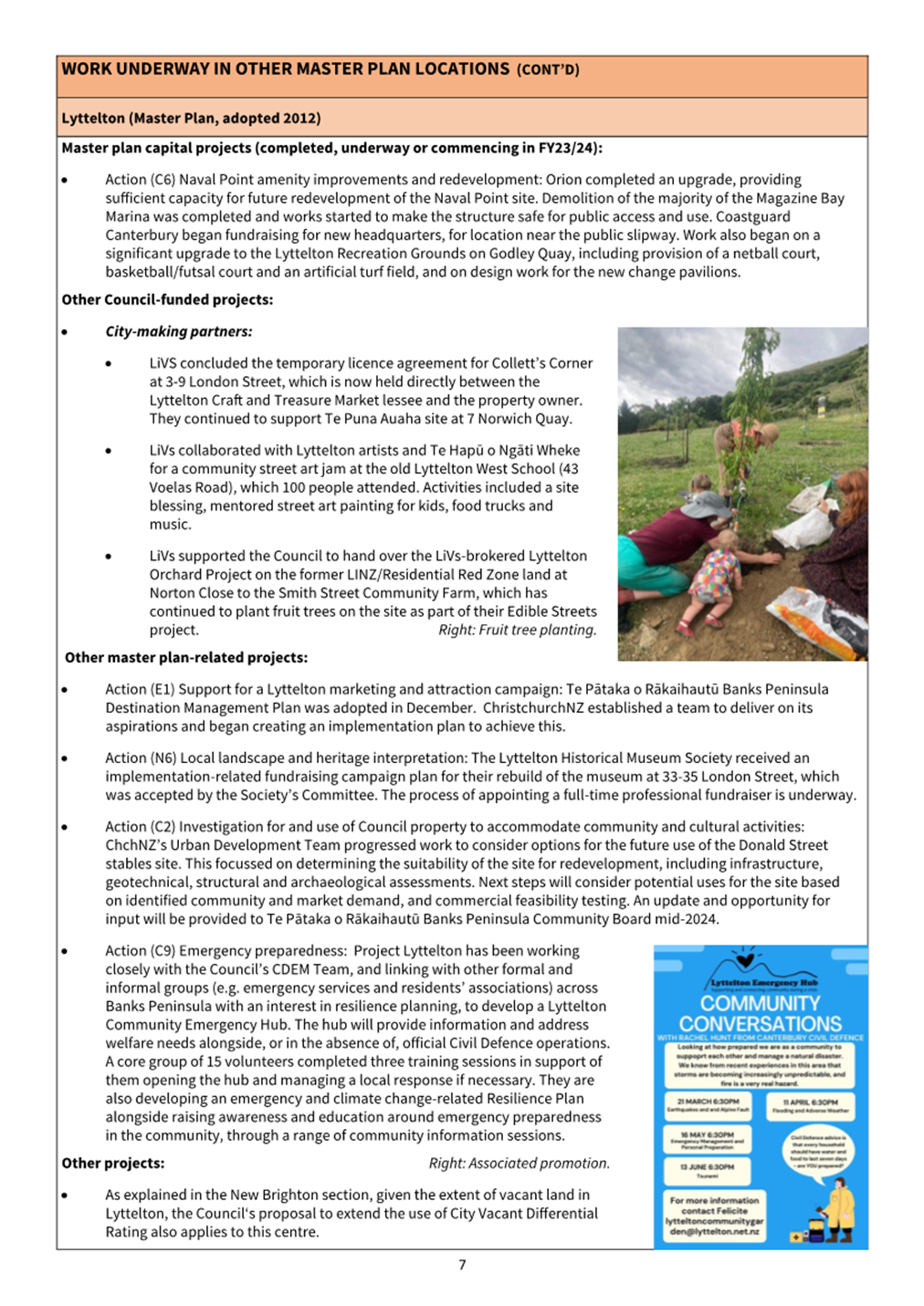
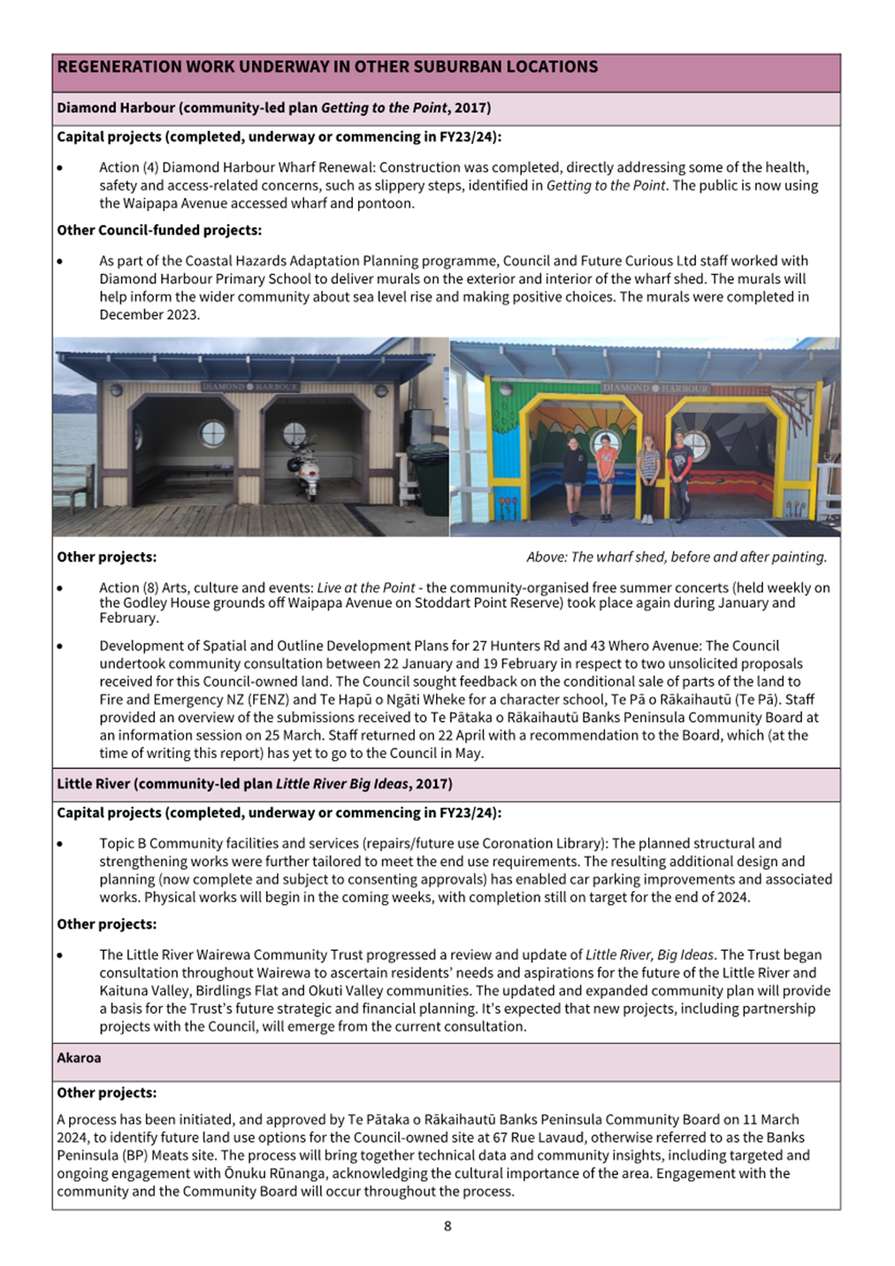
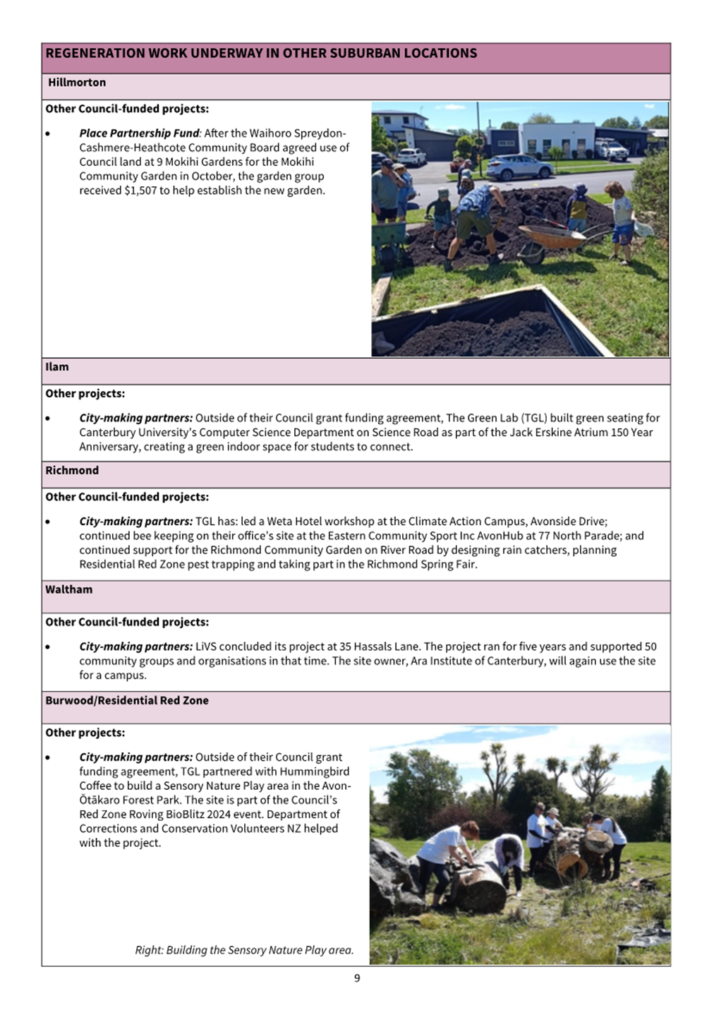
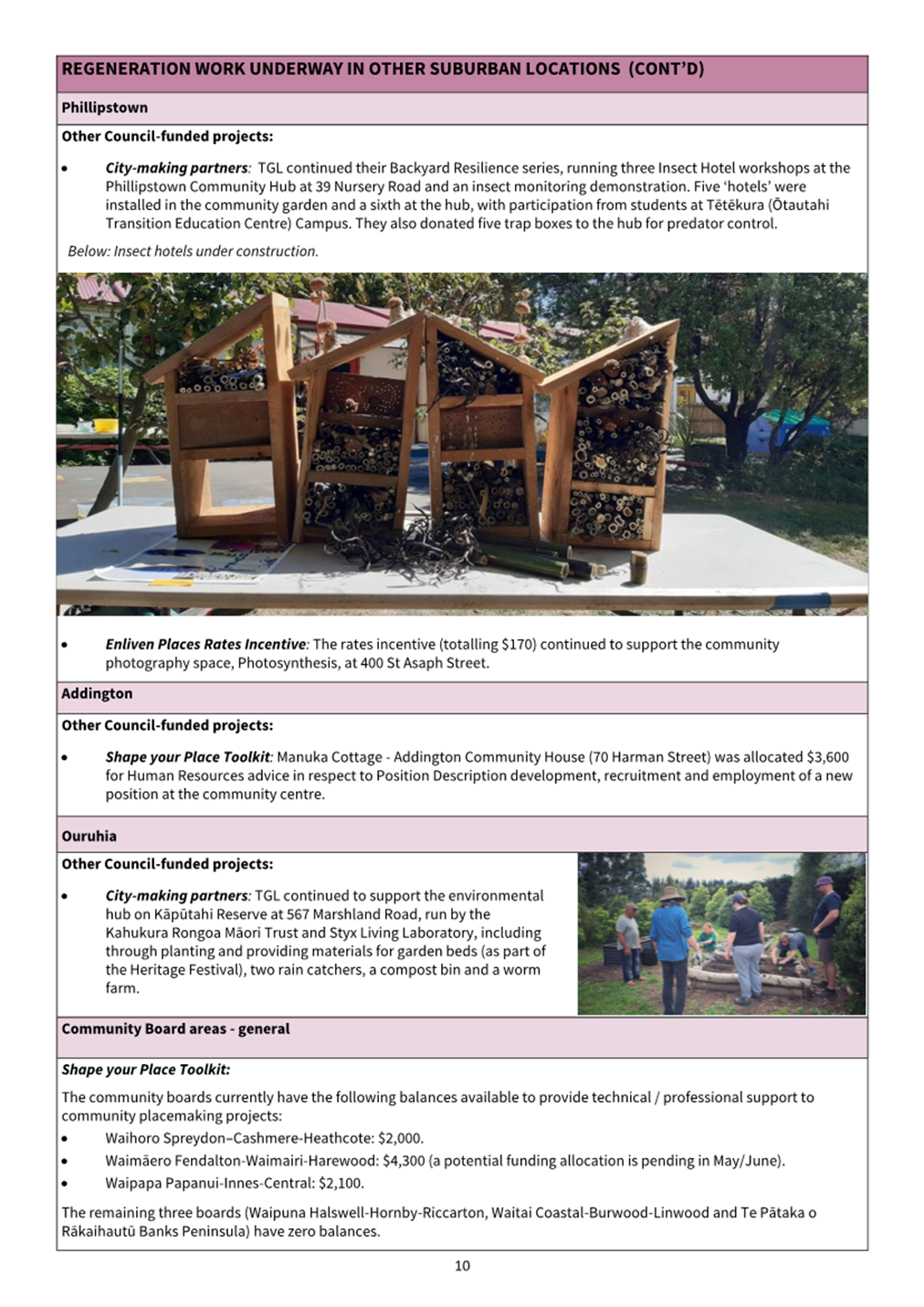
Karakia
Whakamutunga
Kia
whakairia te tapu
Kia
wātea ai te ara
Kia
turuki whakataha ai
Kia
turuki whakataha ai
Haumi
ē, hui ē, tāiki ē