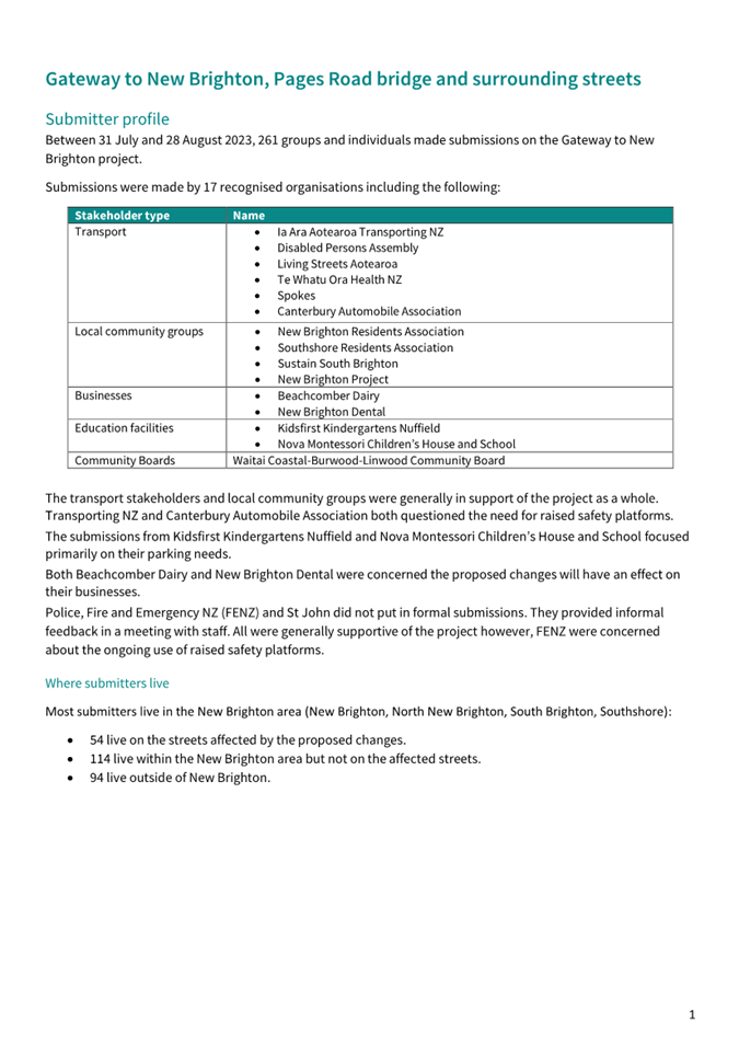
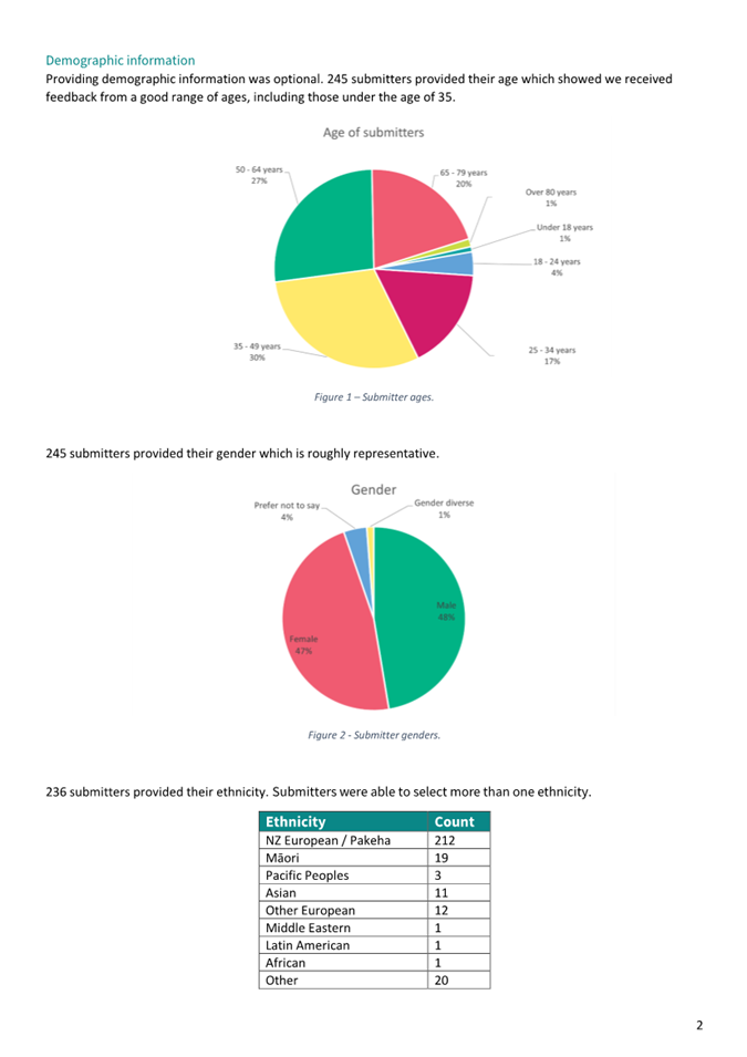
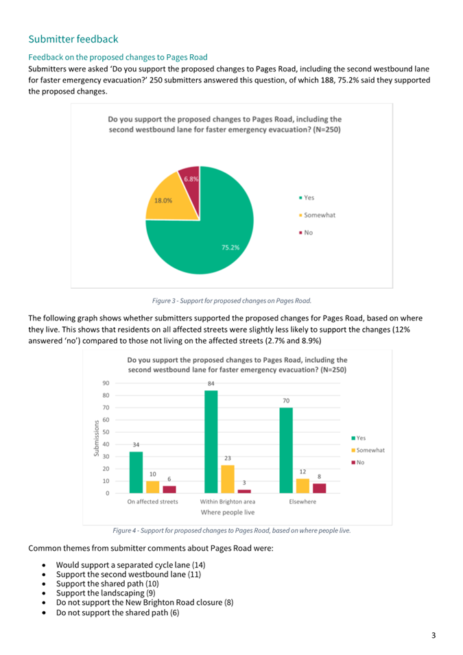
|
Hearings Panel
04 April 2024
|

|
|
4. Pages
Road Bridge Renewal Project
|
|
Reference / Te Tohutoro:
|
23/2120549
|
|
Report of / Te Pou Matua:
|
Nathan
Sidwell, Project Manager (Nathan.Sidwell@ccc.govt.nz)
Krystle Anderson, Engagement Advisor (Krystle.Anderson@ccc.govt.nz)
|
|
Senior Manager / Pouwhakarae:
|
Jane
Parfitt, Interim General Manager Infrastructure, Planning and Regulatory
Services (Jane.Parfitt@ccc.govt.nz)
|
1. Purpose and Origin of Report Te Pūtake Pūrongo
1.1 The purpose of this report is to advise the Hearings Panel
on the outcomes of the consultation and engagement process, and to inform the Hearings
Panel of the staff recommended design before it considers the views of
submitters.
1.2 This report also requests that the Hearings Panel make a
recommendation to the Council to approve the staff recommended scheme design.
1.3 This
is a staff-initiated report.
1.4 The
decisions in this report are of high significance in relation to the
Christchurch City Council’s Significance and Engagement Policy. The
level of significance was determined by undertaking a significance assessment
which indicated that this project would have a significant impact on the
residents of New Brighton due to the very high level of community interest in
the project, the location related environmental and social impacts and the
costs/risks to the Council, ratepayers and wider community of implementing the
decision.
2. Officer Recommendations Ngā
Tūtohu
That
the Hearings Panel:
1. Receive the information contained in this
Pages Road Bridge Renewal project report, and consider the submissions received
as part of the public consultation process.
2. Recommend that the Council approves the staff
recommended scheme design (Attachment A) and tree removal plan (Attachment
B) for the Pages Road Bridge Renewal project, which includes:
a. The installation of a new bridge structure
over the Ōtākaro-Avon River and the removal of the existing Pages
Road bridge;
b. The installation of a new signalised
T-intersection at Pages Road, Hawke Street and Seaview Road intersection;
c. The Pages Road westbound carriageway lane
change from one lane to two lanes;
d. No vehicle access (except maintenance
vehicles) along Owles Terrace from Beresford Street to the Pages Road, Hawke
Street and Seaview Road intersection;
e. No vehicle access (except maintenance
vehicles) along New Brighton Road from Rawson Street to the Pages Road, Hawke
Street and Seaview Road intersection;
f. No vehicle access (except maintenance
vehicles) along Pratt Street from 19 Pratt Street to New Brighton Road;
g. Intersection modifications, including kerb
build outs, as listed below:
i. Rawson Street and New Brighton Road
intersection,
ii. Keyes Road, Rawson Street and Pratt Street
intersection,
iii. Hardy Street and Owles Terrace intersection,
iv. Hardy Street and Collingwood Street
intersection,
v. Hardy Street and Beresford Street
intersection,
vi. Hardy Street and Seaview Road intersection,
vii. Owles Terrace and Beresford Street
intersection;
h. The installation of a cul-de-sac on Pratt
Street and Owles Terrace;
i. The minor relocation of one bus stop on
Seaview Road;
j. Pedestrian refuge crossings on Pages Road and
Keyes Road;
k. The installation of time restricted parking on
Rawson Street, Seaview Road, Hardy Street and Beresford Street;
l. The removal of parking, as detailed in
Attachment A:
m. Other works, as listed below:
i. Midblock renewal works on Rawson Street, Pratt
Street, Seaview Road, and Hardy Street,
ii. Renewal works on Hawke Street from the
proposed new T-intersection to east of Keyes Road,
iii. Renewal works on Pages Road from the proposed new T-intersection to Anzac Drive,
iv. A new pocket park with landscaping and artwork
elements on the site of the existing 5-leg roundabout
3. Recommend that the detailed traffic
resolutions required to implement the Pages Road Bridge Renewal project, are
brought back to Council for approval at the end of the detailed design phase,
prior to construction.
3. Reason for Report Recommendations Ngā Take mō te
Whakatau
3.1 In
2010 and 2011 Christchurch suffered a sequence of devastating earthquakes
resulting in a significant amount of damage to the city’s horizontal
infrastructure, including bridges, roads, three water assets and retaining
walls.
3.1.1 In
2015 short term repairs were completed on the Pages Road bridge extending the
life of the bridge by an estimated 10 years.
3.1.2 The
bridge repairs are now nearing the end of their repair life. While additional
repairs could be carried out to further extend the life of the bridge, this
would not address the many issues with the existing bridge, including low
earthquake resilience, current speed restrictions, inadequacy as a key
emergency evacuation route, and existing flooding issues on the approaches.
3.2 It
is proposed to replace Pages Road bridge with a new resilient bridge, as it is
critical infrastructure for;
· Connecting New Brighton to the city.
· Emergency egress and access after a natural
disaster for the New Brighton area.
· Carrying other lifeline infrastructure to
the New Brighton area.
3.3 The
approach roads are below standard and need replacement.
3.3.1 Pages
Road has an undulating carriageway and kerbs creating drainage issues.
3.3.2 The
5-leg roundabout immediately east of the bridge has vertical and horizontal
geometric deficiencies and is inefficient in an emergency evacuation of the New
Brighton area.
3.4 To
replace the 5-leg roundabout, a signalised T-intersection is proposed at the
Pages Road, Hawke Street and Seaview Road intersection.
3.4.1 To
enable this new intersection to be operational, safe, and provide the most
efficient emergency evacuation route, it is proposed that Owles Terrace and New
Brighton Road have no vehicle connection to the intersection.
3.4.2 In
removing these connections, traffic must have an alternative route that is safe
and with efficient traffic flow.
3.4.3 It
is therefore proposed to carry out intersection upgrades and street renewals
along Hardy Street, Seaview Road, Rawson Street and Pratt Street to provide
connectivity.
Project Objectives
3.5 The
scheme design as shown in Attachment A, is recommended by staff as it
meets the project objectives as detailed below:
3.5.1 Resilient bridge
replacement.
· The
new bridge would provide improved resilience to seismic events, increased
evacuation capacity, and be constructed at a higher level taking into account
sea level rise due to climate change and tying into future stop bank levels.
3.5.2 Restore level of
service for vehicular access to pre-earthquake level.
· Construction
of a new bridge would allow removal of the current heavy vehicle 30km/h speed
restriction, imposed to minimise the exacerbation of earthquake damage to the
existing bridge.
· The
renewal of Pages Road between Anzac Drive and the Ōtākaro-Avon
River would remove the undulating carriageway and kerbs caused by
earthquake damage.
3.5.3 Improve pedestrian
connectivity and cycling access.
· New
cycling and walking facilities along Pages Road and Seaview Road.
· A
raised signalised T-intersection to replace the existing roundabout, providing
safer access and crossing points for cyclists, pedestrians and vulnerable
users.
· New
cycling and walking facilities that would connect to the proposed City to Sea
Pathway and other paths along the river.
3.5.4 Address the
existing vertical and horizontal road profile deficiencies.
· The
signalised T-intersection and associated realignment of Hawke Street and
Seaview Road would replace the existing roundabout and be realigned for
improved visibility.
· Pages
Road between Anzac Drive and the Ōtākaro-Avon River
would be realigned with the new bridge location and be fully reconstructed,
thereby resolving current drainage and earthquake damage issues.
3.5.5 Improve New
Brighton’s emergency evacuation efficiency and capacity across the Pages
Road bridge.
· Removal
of the existing roundabout that is inefficient during emergency evacuations.
· The
signalised T-intersection increases evacuation capacity by adding a second lane
through the intersection and increases efficiency by reducing the signal phases
through design and queue detection loops and radar.
· The
inclusion of a second westbound lane along Pages Road from the signalised
T-intersection to Anzac Drive, designed to increase evacuation capacity.
· No
vehicle connection from Owles Terrace and New Brighton Road to the Pages Road,
Seaview Road and Hawke Street intersection further increases the evacuation
efficiency of the new signalised T-intersection.
· Reprioritisation
of the Give Way and Stop controls at three of the Hardy Street intersections
also increases the evacuation efficiency of the main traffic flow.
4. Detail Te Whakamahuki
4.1 Pages
Road bridge was opened in 1931, connecting the city to the coastal suburb of
New Brighton. The bridge is a key piece of infrastructure for emergency
egress and access after a natural disaster. The bridge also carries lifeline
infrastructure including wastewater, water supply, power, and
telecommunications over the Ōtākaro-Avon River.
4.2 During
the 2011 Christchurch earthquakes, Pages Road bridge suffered significant
earthquake damage. The existing bridge is currently operating at 15% -
20% of the New Building Standard (NBS), it is therefore currently classified as
earthquake prone. Replacement of the bridge would improve resilience to
earthquakes, floods, tsunamis and rising sea levels.
4.3 The
purpose of the (Stronger Christchurch Infrastructure Rebuild Team (SCIRT)
Alliance was to repair and replace earthquake damaged infrastructure. SCIRT
developed a renewal design for the bridge focused on replacing both it and the
damaged Pages Road between Anzac Drive and Ōtākaro-Avon River. The design did not however consider the wider transport network
and need for emergency evacuations, and it did not progress to
construction. ‘Short-term’ repairs were completed by
SCIRT on the earthquake damaged bridge in 2015, extending its life by 10 years.
4.4 There
is currently a 30km/h heavy vehicles speed restriction imposed on the
bridge to prevent exacerbating existing earthquake damage.
4.5 Council
has allocated funding in the 2021-2031 Long Term Plan for the replacement of
the bridge with construction funding in FY26 to FY28. For further details on
funding refer to section 10.
4.6 A
preliminary ‘Present Value End of Life’ (PVEoL) assessment was
undertaken as supporting evidence for the NZ Transport Agency funding subsidy,
Point of Entry process.
4.6.1 The
assessment follows the NZ Transport Agency template at a high level, focusing
on bridge condition, and compares the option of bridge renewal now versus
bridge repairs with bridge renewal in 10 years’ time.
4.6.2 The
preliminary PVEoL assessment shows, from a condition perspective, that the
bridge should be maintained in the short term by undertaking repairs and
renewing in 10 years’ time.
4.6.3 The
bridge replacement need is, however, driven by level of service deficiencies
and the need for other improvements, including access, resilience, flood
capacity, earthquake vulnerability, emergency evacuation, active travel, etc.
4.7 In
2021 and 2022 staff developed the scheme design, investigated various options,
modelled the emergency evacuation needs of the area, and defined the project
scope. In doing so, staff undertook seven briefings and workshops with the
Waitai Coastal-Burwood-Linwood Community Board. These kept the Community Board
informed and involved in developing a scheme design that best suited the
community and addressed emergency evacuation concerns. On 2 May 2023, a project
presentation was given to the Council and the Waitai Coastal-Burwood-Linwood
Community Board prior to public consultation outlining the project objectives,
scheme design, early engagement, project costs and the next steps.
4.8 On
2 May 2023 and prior to public consultation, a project presentation was given
to the Council and the Waitai Coastal-Burwood-Linwood Community Board outlining
the project objectives, scheme design, early engagement, project costs and the
next steps.
4.9 In
June and July 2023, early engagement was undertaken with key community groups,
key transport stakeholders, emergency services, residents and businesses
directly affected.
4.10 Public
consultation was open from 31 July 2023 until 28 August 2023, this included
several presentations to community groups, online webinars, drop-in sessions at
the New Brighton library and market and door knocking affected residents and
businesses.
4.11 A
public hearing is scheduled to commence on 04 April2024, followed by a Council
decision with the date yet to be confirmed.
4.12 Following
Council’s approval of the scheme design, the project team will commence
the detailed design phase. This phase includes design, site investigations,
land purchase and statutory approvals, and is planned for 2024 to 2025.
4.13 It
is anticipated that construction will commence in 2026 to 2028, subject to
Council decision, land purchase, statutory approvals and funding approvals.
4.14 The
decision is of Metropolitan Significance and affects the following
wards/community board areas: Waitai Coastal-Burwood-Linwood Community
board.
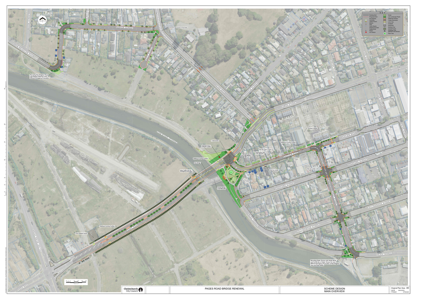
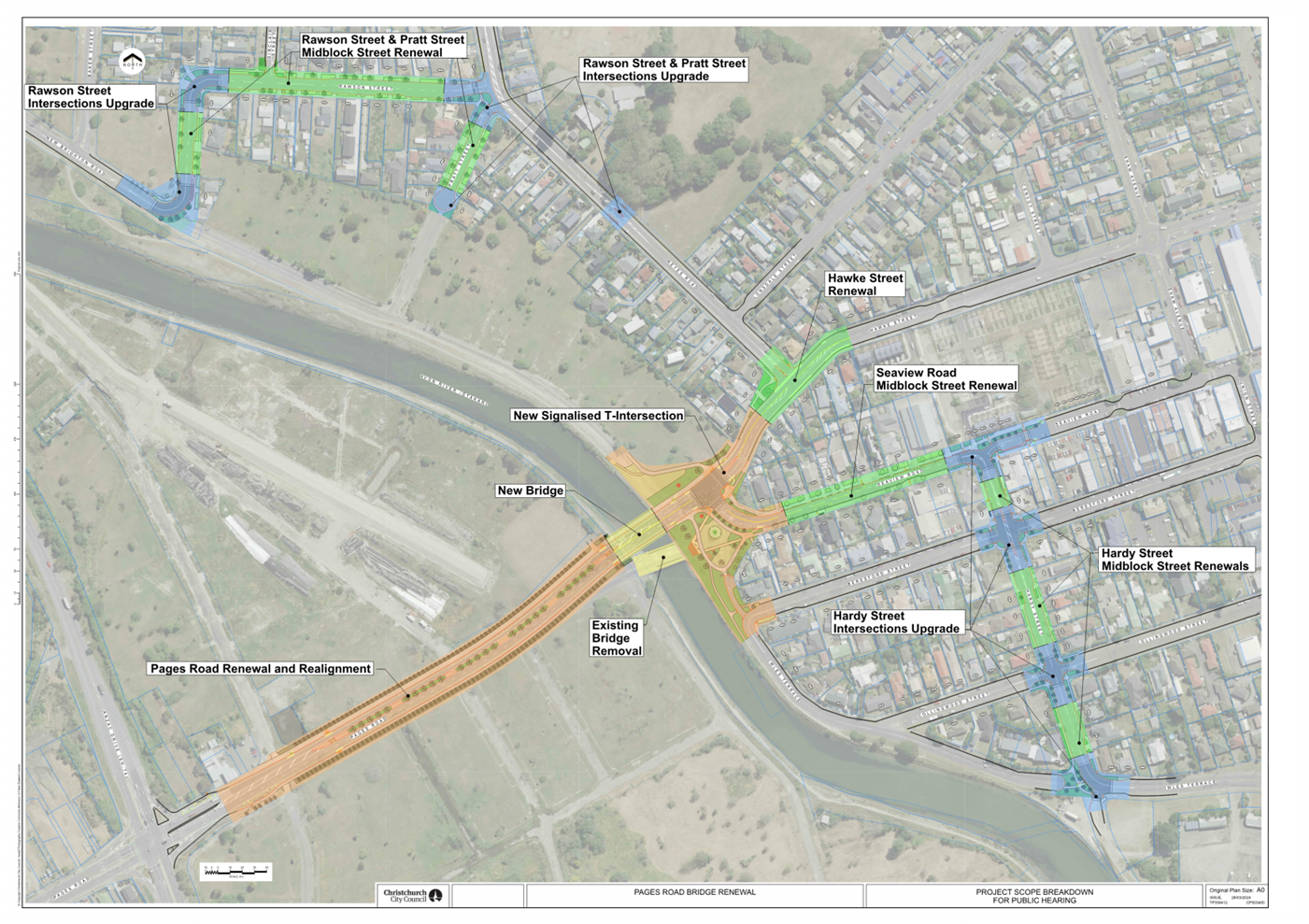
5. Details of the Scheme Design
5.1 The
staff recommended scheme design is for a new bridge over the
Ōtākaro-Avon River immediately north of the existing bridge. The
proposal creates an improved route from Anzac Drive along Pages Road over the
new bridge towards Hawke Street, with the existing roundabout being replaced by
a signalised T-intersection connecting with Seaview Road.
5.2 As
part of the proposed design, Hardy Street, Seaview Road and Rawson Street
require upgrading in order to provide New Brighton Road and Owles Terrace
traffic a safe alternative route and to protect residential amenity.
5.3 The
scheme design that is recommended by staff is shown in Attachment A,
broken down into sections in Attachment C and visually reflected by
artist impressions in Figure 1 to Figure 5 of this report.
New Bridge
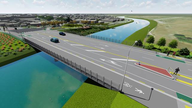
Figure 1 – New Pages Road bridge
(artist impression)
5.4 A
new resilient bridge would improve:
· Transport
connectivity between New Brighton and the city
· Emergency egress and access during a
natural disaster
· The reliability of lifeline
infrastructure for New Brighton
· Walking and cycling access and
connectivity
5.5 The
new bridge would be constructed on a new alignment just north of the existing
bridge. This has the following advantages and disadvantages:
5.5.1 Advantages:
· Allows the
existing bridge to be retained and remain operational during construction of
the new bridge
· Retains
existing emergency egress and access during construction of the new bridge
· Reduces
construction risk, with expected time, cost, safety and quality benefits
· Reduces impact
to residents and road users during construction
· No need for
temporary relocation of existing services on the bridge
5.5.2 Disadvantages:
· Unable to
retain the existing roundabout and road network layout
· Higher
operational cost associated with traffic signals
5.6 Staff
recommend the proposed new bridge design as it offers improved resilience to
seismic events, increased capacity during emergency evacuations, is at a higher
level allowing for sea level rise, and ties into future stop banks.
Existing Bridge Removal
5.7 Following construction of
the new bridge, the existing bridge would be removed for the following reasons:
· It is earthquake damaged
and there is no recommended long-term method of repair to the lateral spreading
that occurred to the abutments during the 2011 earthquakes.
· The existing bridge is
further deteriorating due to the earthquake damage, and would require
significant ongoing maintenance costs to keep it operational.
· With two bridges in close
proximity there would be conflicting requirements in terms of river hydraulics
and additional hazards for river users as the piers may not align.
· The existing bridge is not
compatible with future stop bank levels as it is lower than the future level
intended to protect against predicted sea level rise.
New Signalised T-Intersection


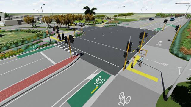
Figure 2 – Proposed
signalised T-intersection (artist impression)
5.8 During the workshops with
the previous Coastal-Burwood Community Board,
issues relating to the roundabout during an emergency evacuation of the area
were raised.
5.8.1 Staff
undertook further research into the evacuation of the New Brighton area
triggered by the 2016 Kaikoura earthquake. It was clear that the location of
the roundabout and bridge is a ‘bottleneck’ for New
Brighton’s evacuation, largely due to inefficiencies in the intersection
layout.
5.8.2 Furthermore,
existing roundabout crash data strongly correlates to road profile
deficiencies, and there is poor pedestrian and cyclist connectivity.
5.9 At
the intersection of Pages Road, Hawke Street and Seaview Road, it is proposed
to remove the existing 5-leg roundabout and construct a new signalised
T-intersection.
5.10 Five
intersection options were analysed, these included:
· Roundabout
· Priority control with one
westbound lane
· Priority control with two
westbound lanes
· Signalised T-intersection
with one westbound lane
· Signalised T-intersection
with two westbound lanes
5.11 A multicriteria analysis was conducted which
determined that the signalised T-intersection with two westbound lanes was the
preferred intersection layout.
5.11.1 The analysis
criteria included safety of all users, emergency evacuation capacity and efficiency,
alignment with neighbouring projects, property access and green space.
5.11.2 In undertaking
traffic modelling, staff carried out research to determine appropriate inputs.
This included literature from the Kaikoura 2016 tsunami evacuation of the New
Brighton area and consultation on the assumptions with subject matter experts
from Civil Defence, University of Canterbury and Oregon State University.
5.11.3 As an input to multicriteria analysis, traffic modelling in
an emergency evacuation scenario was undertaken to test different road layouts
and determine which intersection layout would be the most efficient and have
the greatest capacity in an evacuation.
5.11.4 A signalised
T-intersection with two westbound lanes was the most efficient option, making
it approximately 40 minutes faster for the area to evacuate compared to the
existing road layout.
Pages Road
Renewal and Realignment (between Anzac Drive and Ōtākaro-Avon River)
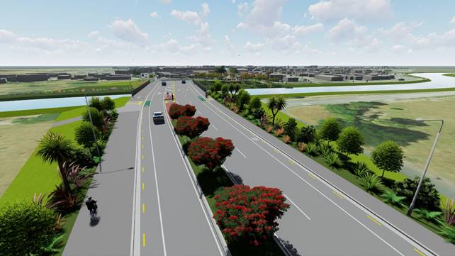
Figure 3 - Pages Road looking
towards New Brighton (artist impression)
5.12 Pages
Road between Anzac Drive and Ōtākaro-Avon
River is a key stretch of road that connects New Brighton to the city and a
primary evacuation route for the coastal suburb of New Brighton. This section
is earthquake damaged with undulating carriageway and kerbs creating regular
drainage issues.
5.13 Pages
Road between Anzac Drive and Ōtākaro-Avon
River is proposed to be renewed and realigned to:
· Meet all five project
objectives
· Accommodate the new bridge
location
· Remove the existing
undulating carriageway and kerbs
5.14 The
existing Pages Road carriageway regularly floods, therefore it is proposed to
raise most of it approximately 0.5m above the existing road level to improve
road drainage. Nearer the river there will be further raising of the road to
meet the new bridge level, and to tie into the proposed stop banks (constructed
by others).
5.15 The
renewal of Pages Road includes the following features:
· One eastbound lane into
New Brighton and two westbound lanes out of New Brighton.
· On-road cycle lanes and no
stopping lines on each side of Pages Road, a new footpath on the south side of
Pages Road, as well as a four-metre-wide shared path for walking and cycling
along the north side of the road.
· Two pedestrian refuges in
the median, one just west of the bridge and one nearer to Anzac Drive, linking
to paths from Bexley to the Waitaki wetland and the City to Sea Pathway.
· At the back of the
footpaths along Pages Road native coastal forest planting will be established
to tie into adjacent future wetlands. Mixed plant heights allows views
through to the wetlands.
· The central median along
Pages Road from Anzac Drive to Ōtākaro-Avon River will be planted
with Pōhutukawa trees. The native coastal forest trees and
Pōhutukawa trees will encourage birds to fly to the wetlands at a safer
height across the road and create a welcoming gateway to New Brighton. Without
the planted median, Pages Road would feel like a wide-open road, potentially
encouraging higher speeds.
Second Westbound Lane
5.16 A proposed second westbound lane along Pages Road meets the project
objective to improve New Brighton’s emergency evacuation efficiency
and capacity across Pages Road bridge.
5.17 The second westbound lane (along with the signalised T-intersection)
reduces the evacuation time by 23 minutes compared to one westbound lane (with
priority control intersection).
5.18 This will also have the additional benefit of significantly
improving traffic flows after large events in New Brighton, such as the winter
fireworks spectacular.
Cycling and Walking Facilities
5.19 A
proposed shared path meets the project objective of improving pedestrian
connectivity and cycling access.
5.20 The
shared path will be 4m wide along the northern edge of Pages Road and across
the bridge, allowing pedestrians and cyclists to cross Hawke Street at a safe
crossing point on the signalised T-intersection, before leading to a 3.5 metre
wide shared path along the northern side of Seaview Road.
5.21 The
shared path will connect the proposed pathways along the river to access points
to the proposed neighbouring wetlands and the proposed City to Sea Pathway
(separate project).
5.22 To
future proof for a potential Major Cycle Route, the shared cycling and walking
facilities would be designed to Major Cycleway Route standards.
Hawke Street Renewal
5.23 The
proposed Hawke Street renewal includes the northern footpath, line marking and
carriageway pavement. This work will allow the road to align with the new
signalised T-intersection, accommodate two westbound lanes through the
intersection, and resolve existing pavement issues.
Integration with
Ōtākaro-Avon River Corridor (OARC) Projects
5.24 The
design has been co-ordinated with neighbouring Ōtākaro-Avon River
Corridor (OARC) projects, allowing for stopbank levels, access to pathways,
maintenance access and integration of landscaping.
5.25 A
stopbank (Three Waters funded) beneath the proposed Pocket Park is proposed to
future proof the tie-in to the future stopbank. This has the benefits of a one
pass approach, limiting disruption to the community, and reducing the cost to
council by not requiring rework of the newly-created Pocket Park at a later
date.
No Vehicle
Connection from Owles Terrace to the Signalised T-Intersection
5.26 To
meet the project objectives a signalised T-intersection is proposed as outlined
in sections 0 to 0 above. In order to implement this design, it is
proposed that Owles Terrace has no vehicle connection to the Pages Road, Hawke
Street and Seaview Road intersection as it has at present. This allows:
· The proposed
alignment and location of the new bridge and new intersection (as a road is
being removed from the 5-leg intersection)
· Simplification of
the above intersection, with associated safety benefits
· Improved emergency
evacuation time of the surrounding area by 10 minutes
· Space along Owles
Terrace for future river flood protection measures
5.27 Owles
Terrace traffic from east of Hardy Street would need to be rerouted via Hardy
Street and Seaview Road.
5.28 Owles
Terrace residents between Hardy Street and Seaview Road would retain access to
their properties via Beresford Street and Collingwood Street. An accessway to
the property at 5 Owles Terrace would be shared with active users connecting to
the pocket park.
5.29 Active
users would retain access from Owles Terrace to the proposed signalised
T-intersection via paths through the pocket park.
Hardy Street Intersections Upgrade
5.30 Traffic
from Owles Terrace must have an alternative route that is safe and efficient,
therefore it is proposed that Hardy Street intersections be upgraded as
follows:
5.30.1 Changing three
of four intersection priority controls (swapping the Give Way or Stop
controls).
5.30.2 Safety
improvements to the intersections including raised platforms and kerb build
outs with no parking restrictions. The design is to cater for a future 30km/h
speed limit that will be implemented by the Speed Management Plan project for
the Nova Montessori School (corner of Owles Terrace and Hardy Street).
5.31 It
is proposed to cul-de-sac Owles Terrace at the intersection of Owles Terrace
and Hardy Street, to make the intersection safer, enable a pedestrian crossing
point at the intersection, and to landscape the intersection to visually
reinforce the proposed new corner to motorists.
5.32 Active
users (pedestrians and cyclists) would retain access to Owles Terrace on paths
through the cul-de-sac.
Hardy Street Midblock Street Renewals
5.33 Between the Hardy Street intersection
upgrades, it is proposed to renew midblock street sections for the following
reasons:
· The poor condition / ride
quality of the existing pavement and the expected increase in traffic
volumes. Midblock sections along the full length of Hardy Street would be
reconstructed. If this work is not carried out, it is likely that the pavement
would need to be reconstructed anyway within five years of the reconfigured
roading network being implemented.
· A pavement upgrade and
heavy-duty asphaltic concrete surface for the midblock between Seaview Road and
Beresford Street to cater for future loading from electric buses.
· Removal of the deep-dish
drainage channels and replacement with kerb and channel for access and safety
reasons.
· Design and construction
efficiency in renewing the street midblock at the same time as the intersection
work is being completed.
5.34 To
improve public transport infrastructure, a new bus shelter is proposed on the
northwest corner of the Hardy Street and Beresford Street intersection; along
with a new bench for the bus stop on the northeast corner beneath the building
canopy.
Seaview Road
Midblock Street Renewal
5.35 Renewal
of the Seaview Road midblock section, between Hardy Street and the new
signalised T-intersection, is proposed for the following reasons:
· To allow continuation of
the shared path from the signalised T-intersection past Hardy Street towards
Brighton Mall.
· To upgrade the pavement to
a heavy-duty asphaltic concrete surface to cater for future loading from
electric buses.
5.36 No
stopping road markings are included on the north side of Seaview Road, to
accommodate the shared path and to retain the existing mature trees.
5.37 Moving
the bus stop on the north side of Seaview Road slightly east to prevent the
road being blocked if there are two buses in either direction at the bus stops.
This is caused by the road narrowing to create space for the shared path.
5.38 A
new bus shelter on the south side of Seaview Road for those heading towards the
city.
No Vehicle Connection from New
Brighton Road to the Signalised T-Intersection
5.39 To
be able to meet the project objectives a signalised T-intersection is proposed
as outlined in 0 to 0 above. In order to implement this design, it is
proposed that New Brighton Road has no vehicle connection to the Pages Road,
Hawke Street and Seaview Road intersection. This allows:
· Improved emergency
evacuation time of the area by 25 minutes.
· Space along New Brighton
Road for future river flood protection measures and more space for stormwater
facilities.
· Improved active
users’ connectivity and safety through simplification of the
intersection.
5.40 New
Brighton Road traffic will need to be rerouted via Rawson Street and Keyes
Road.
5.41 The
neighbouring land along New Brighton Road between Rawson Street and Pages Road
is red zone, thus no residential or business properties will be affected.
5.42 Active
users will still retain access along New Brighton Road to the proposed
signalised T-intersection.
Rawson Street and Pratt Street
Intersections Upgrade
5.43 The
removal of the exit from New Brighton Road to the signalised T-intersection is
expected to cause changes in traffic flows in the local area. To mitigate the
impacts, an upgrade of the Rawson Street intersections is proposed. This
includes:
· Creating a corner at the
intersection of New Brighton Road and Rawson Street outside the Beachcomber
Dairy to direct traffic onto Rawson Street. A raised safety platform will slow
vehicles to an appropriate speed for the tight corner and the nearby corner
slightly north.
· Separating the two
give-way controls at Keyes Road, Pratt Street and Rawson Street intersections
which are situated close together. Pratt Street control will change from a Give
Way to Stop control to improve road safety.
· Changing Pratt Street to a
cul-de-sac, as there will be no need for vehicles to access the closed section
of New Brighton Road via Pratt Street. Maintenance vehicles, cyclists and
pedestrians will still have access through the cul-de-sac.
· Installing a pedestrian
crossing island outside 370 Keyes Road, to assist pedestrians travelling
between the red zone and Rawhiti Domain.
Rawson Street and
Pratt Street Midblock Street Renewals
5.44 It
is proposed to renew midblock sections between the Rawson Street and Pratt
Street intersection upgrades, for the following reasons:
· Reconstruction of
mid-block sections along the full length of Rawson Street, due to the existing
poor pavement condition / ride quality and the expected slight increase in
traffic volumes. If this work is not carried out, it is likely that the
pavement would need to be reconstructed within three to seven years of the
reconfigured roading network being completed.
· The pavement condition and
ride quality of Pratt Street are classified as poor, suggesting a need to renew
the pavement. However, since a cul-de-sac is proposed a decrease in
traffic volumes is expected, there is an opportunity to defer this renewal.
· Removal of the deep-dish
drainage channels and replacement with kerb and channel for access and safety
reasons.
· Design and construction
efficiency and reduced resident disruption, by renewing the street midblock at
the same time as the intersection work is being completed.
Pocket Park, Artwork
and Landscaping
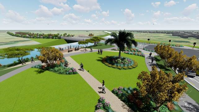
Figure 4 - Pocket Park (artist
impression)
5.1 With
the removal of the existing roundabout there is the opportunity to turn this
area into green space, named on the project as the “Pocket Park.”
This would include a viewing platform over the river, seating, cycle stands,
water fountain, landscaping, path connections along the river, and retain the
iconic existing palm tree which is currently located in the
roundabout.
5.2 To
celebrate this area as the gateway to New Brighton, space has been reserved on
either side of Pages Road, east of the bridge, for artworks. The artwork would
be developed in collaboration with Mana Whenua during the detailed design
phase. There is also an opportunity for artwork to be incorporated in other
built and landscape elements such as bridge handrails and paving patterns.
5.3 Where
there is an opportunity along the streets additional landscape planting, trees
and grass will be provided.
6. Alternative Options Considered Ētahi atu Kōwhiringa
Do Nothing Option
6.1 The
do-nothing option would be to leave the existing Pages Road bridge and road
network in the current condition and layout.
6.2 Advantages
of the Do-Nothing Option:
· Short-term capital cost
saving in not undertaking the work.
6.3 Disadvantages
of the Do-Nothing Option:
· The Pages Road bridge is
earthquake prone (15%-20% of the New Building Standard). It would not
adequately fulfill its function in connecting New Brighton to the city,
for emergency egress and access after a natural disaster, and for carrying
lifeline infrastructure to the New Brighton area.
· By delaying bridge
replacement, the structure would continue to deteriorate and likely
require unplanned maintenance, with associated cost and level of service
implications.
· The bridge would continue
to have a 30km/h speed restriction for heavy vehicles to prevent or minimise
the exacerbation of existing earthquake damage.
· Pages Road would continue
to have flooding issues arising from the undulating carriageway and kerbs.
· The 5-leg roundabout
immediately east of the bridge would continue to be inefficient in an emergency
evacuation, and there would continue to be adverse safety implications relating
to vertical and horizontal road profile deficiencies.
· Poor pedestrian and
cycling access for those using the bridge and the 5-leg roundabout, also
contributing to adverse safety implications.
· Community concerns and
fears relating to emergency evacuation of the area over the Pages Road bridge
and through the 5-leg roundabout.
· The perception of neglect
within the eastern community is likely to persist.
6.4 The
Do Nothing option of not maintaining the assets associated with the earthquake
damaged Pages Road bridge and Pages Road between Anzac Drive and
Ōtākaro-Avon River would present serious risks relating to future
unplanned maintenance costs and/or adverse impacts on levels of service.
Do Minimum Option
6.5 The
do-minimum option would be to undertake another set of short term repairs (10
year life span) to the existing Pages Road bridge, and to only remove the
undulating carriageway and kerbs on Pages Road (between Anzac Drive and
Ōtākaro-Avon River.
6.6 Advantages
of the Do-Minimum Option:
· Short-term capital cost
saving by undertaking lower cost repair work.
· Extends the bridge asset
life by another 10 years.
6.7 Disadvantages
of the Do-Nothing Option:
· The Pages Road bridge is
earthquake prone (15%-20% of the New Building Standard). It would not
adequately fulfill its function in connecting New Brighton to the city,
for emergency egress and access after a natural disaster, and for carrying
lifeline infrastructure to the New Brighton area.
· The repairs would only
maintain the current structural condition of the bridge and would not address
seismic and structural deficiencies.
· The bridge would continue
to have a 30km/h speed restriction for heavy vehicles to prevent or minimise
the exacerbation of existing earthquake damage.
· The 5-leg roundabout
immediately east of the bridge would continue to be inefficient in an emergency
evacuation, and there would continue to be adverse safety implications relating
to vertical and horizontal road profile deficiencies.
· Pages Road wouldn’t
be raised and would therefore continue to flood from the neighbouring low lying
red zone land.
· Poor pedestrian and
cycling access for those using the bridge and the 5-leg roundabout, also
contributing to adverse safety implications.
· Community concerns and
fears of emergency evacuation of the area over Pages Road bridge and through
the 5-leg roundabout.
· The perception of neglect
within the eastern community is likely to persist.
6.8 The do-minimum option of
repairing the existing earthquake damaged bridge and partial renewal of Pages
Road to remove the undulations would not remove the bridge earthquake defects
and the road flooding issue.
Various Alternative Options to the
Preferred Scheme Design
6.9 During
scheme design development prior to public consultation, staff considered
options other than the preferred scheme design.
6.10 The
following options were considered; however, they were discounted from
progressing further as noted in the table below.
|
Option
|
Description
|
Reason Discounted
|
|
Replace the bridge only
|
Replace the bridge on the same alignment
as the existing bridge.
|
· Replacing the bridge “as is” will only achieve one
project objective, Resilient bridge replacement.
· Therefore, the existing intersection or similar layout would
remain which would not meet the following project objectives as in Section 3
and 5:
o Improve pedestrian connectivity and cycling access.
o Address the existing vertical and horizontal road profile
deficiencies.
o Improve New Brighton’s emergency evacuation efficiency and
capacity across Pages Road Bridge.
· Building the bridge on the same alignment also has the following
disadvantages:
o More
time and cost to construct the bridge.
o Limited
egress in an emergency for New Brighton.
o Temporary
relocation of existing services on the bridge.
o Disruptive
to road users and community.
|
|
Retain the existing bridge for
pedestrians and cyclists.
|
Retain the existing bridge for
pedestrians and cyclists with new bridge slightly north of existing bridge.
|
· Existing bridge is earthquake damaged and earthquake prone. There
is no recommended way of bringing it up to current standards.
· Deteriorating earthquake damaged bridge requires significant
annual maintenance budget to keep it operational.
· Close proximity of the two bridges with likely different pier
alignment resulting in issues for river hydraulics and hazards for river
users.
· Interferes with new stopbank levels.
|
|
Alternative intersection options
|
A range of possible options for the Pages
Road, Hawke Street and Seaview Road intersection.
|
· Multi-criteria analysis determined that a signalised
T-intersection with two westbound lanes was the best intersection layout. The
analysis criteria used was safety of all users, emergency evacuation capacity
and efficiency, alignment with neighbouring projects, property access and
green space.
· The signalised T-intersection is the most efficient option for an
emergency evacuation. The intersection with dual lanes out has a
saving of 12 minutes compared to the give way control with dual lanes out.
|
|
Three westbound lanes
|
An additional westbound lane to assist
with evacuation during emergency events.
|
A third lane would increase the project
cost with minimal additional benefit for the following reasons:
· Three lanes out would merge into one lane past Anzac Drive
intersection, which would be the ‘bottle neck,’ discounting the
value of adding the third lane.
· Property purchase would be required east of Pages Road bridge.
· Additional lane likely to require greater bridge cost (i.e.
additional piles to approximately 40 metre depth).
· Anzac Drive / Pages Road intersection would require new layout to
accommodate three lanes including property purchase. This intersection is not
within CCC ownership. NZTA confirmed they have no plans to do significant
works to this intersection, thus CCC would likely have to fund this
intersection upgrade.
|
|
Omit the second westbound lane
(evacuation lane)
|
One westbound lane instead of dual
westbound lanes.
|
· Emergency evacuation of the area would increase by 23 minutes with
a single lane out and give way control compared to the two west bound lanes
option.
|
|
No tree lined median on Pages Road
|
No tree lined median on Pages Road
between Anzac Drive and Ōtākaro-Avon River.
|
· Increase of traffic speed due to the perception of a wide open
road.
· Birds likely to fly lower between future wetlands on either side
of Pages Road, increasing the risk of birds being struck by vehicles.
· Active users could cross at non-designated crossing points with
poor visibility and no refuge median – potential safety concern.
· Loss of gateway and landscape amenity coming into New Brighton.
|
|
Exclusion of shared path on Seaview Road
to allow parking to be retained
|
Retain the existing 1.5 metre footpath
instead of the 3.5 metre shared path on Seaview Road from Pages Road to Hardy
Street.
|
· There would be no off-road cycling facilities on Seaview Road from
signalised T-intersection towards the Brighton Mall which wouldn’t meet
objective, improve pedestrian connectivity and cycling access.
· Probable rework and future disruption to the community if a future
Major Cycle Route is constructed along Seaview Road.
|
|
Exclude midblock street renewals for
Hardy Street, Rawson Street and Seaview Street
|
Retain the existing street midblock
instead of the proposed renewals for Hardy Street, Seaview Road and Rawson
Street.
|
· Hardy Street and Rawson Street pavements are currently in poor
condition and it is anticipated the pavements will require upgrading anyway
within three to seven years of the reconfigured road network being
implemented.
· Seaview Road pavement would not be upgraded to accommodate heavier
electric buses.
· Removal of the deep-dish channels and replacement with kerb and
channel for access and safety reasons would not occur.
· Design and construction efficiencies in renewing the street
midblock at the same time as the neighbouring intersections would not be
achieved.
|
|
Exclude midblock
street renewals for Pratt Street
|
Retain the existing Pratt Street midblock
instead of the proposed midblock street renewals.
|
· Design and construction efficiencies in renewing the street
midblock at the same time as the neighbouring intersections and cul-de-sac
would not be achieved.
· Removal of the deep-dish channels and replacement with kerb and
channel for access and safety reasons would not occur.
· Pavement condition and ride quality are classified as poor,
however this short street would have low vehicle speeds thus less
likely to deteriorate and renewal work could be deferred.
|
|
Removal of
abandoned New Brighton Road
|
Removal of New Brighton Road between
Rawson Street and Pages Road.
|
· When the red zone is developed into a stormwater management area
with stopbanks, it is proposed that the existing road be used as a
construction access road.
· Cyclists, pedestrians and maintenance vehicles can continue to use
the road.
· Additional cost of removing the road, with potential coal tar
issues, and establishing path or road with drainage for cycling, pedestrian
and maintenance vehicle access, which will be removed when the red zone area
is developed in the future (rework).
|
|
Basic Pocket Park
|
Create a pocket park that is more basic
(i.e. just grass with no street furniture).
|
· Loss of amenity value for community and recreational users to
use.
· It would not create the gateway feel when entering the New
Brighton area.
|
Table
1
– Various alternative options to the preferred scheme design
7. Community Views and Preferences
Public Consultation Te Tukanga Kōrerorero
Early
engagement
7.1 Early
engagement with key community groups, key transport stakeholders and directly
affected businesses and residents started in June 2023.
7.2 Staff
contacted key transport stakeholders: Road Transport Association, NZ Trucking
Association, Automobile Association, Heavy Haulage and met with Spokes,
Environment Canterbury public transport and Emergency Services (including the
local Police Station).
7.3 On
29 June 2023 staff met with the owners of Beachcomber Dairy. On 30 June staff
visited the retail unit at 175 Seaview Road who were not available. A letter
was left and after a follow-up phone call, staff met with the owners on 7
August 2023.
7.4 On
30 June 2023 staff visited three directly impacted residential properties; 5
Owles Terrace, 176 Seaview Road, and 177 Seaview Road. Staff spoke with the
resident at 5 Owles Terrace at the time, 177 Seaview Road a week later and left
a letter for 176 Seaview Road. Staff later met with the owners of 176 Seaview
Road during the consultation period.
7.5 In
early July, staff met with the New Brighton Residents Association, Renew
Brighton, New Brighton Project, Sustain South Brighton, Te Waka St Faiths, Nova
Montessori School. Staff also contacted Grace Vineyard Church, who did not
respond to the offer to meet.
7.6 Staff
also met with ChristchurchNZ, Seaview Road Development, and Robbie Harris (New
Brighton mall redevelopment).
7.7 At
early meetings staff shared the proposed plans for the Gateway to New Brighton
project. Stakeholder feedback influenced how we reached the community during
consultation and in informing minor consequential design changes, see section 8.2.
Consultation
7.8 Consultation
started on 31 July 2023 and ran until 28 August 2023. An email was sent to 150
key stakeholders, including transport stakeholders and local community groups.
7.9 The
consultation was posted on Kōrero mai |
Let’s Talk which had 4,857 views throughout the consultation period.
A flythrough video of the proposed changes was created and posted on the
Council’s Youtube
channel which had over 6,500 views.
7.10 The
consultation page and flythrough were shared on the Council’s Facebook
page on 31 July which reached 11.4K people, and by 23 August it had reached
30.5K people.
7.11 A
range of marketing tactics were used to promote consultation to the community
including digital and newspaper ads, bus shelter posters and digital
billboards. Signs were erected on poles on the affected streets and around
Brighton Mall.
7.12 Throughout
the consultation period, the flythrough played in the New Brighton Library
where there were also physical brochures and a large plan of the proposed
changes for people to view.
7.13 Staff
door-knocked 70 properties on affected streets to discuss the consultation. The
consultation brochure was left for those that weren’t home. An additional
120 properties within the project area received a flyer about the consultation
in their mailbox. A letter was also sent to absentee owners of properties
within the project area.
7.14 Staff
attended the following community meetings/events:
· New Brighton Residents
Association AGM.
· Meeting with a group of
New Brighton businesses (hosted by Switch Café)
· New Brighton Market on 12
August 2023.
· Presentation to the
Burwood/Christchurch East Seniors.
· Renew Brighton Connect
meeting.
7.15 Staff
hosted two webinars on 10 August 2023. The afternoon session was attended by 22
people and the evening session was attended by six.
7.16 Drop-in
sessions were held at New Brighton Library on 15 August 2023, attended by five
people and 21 August, attended by seven people.
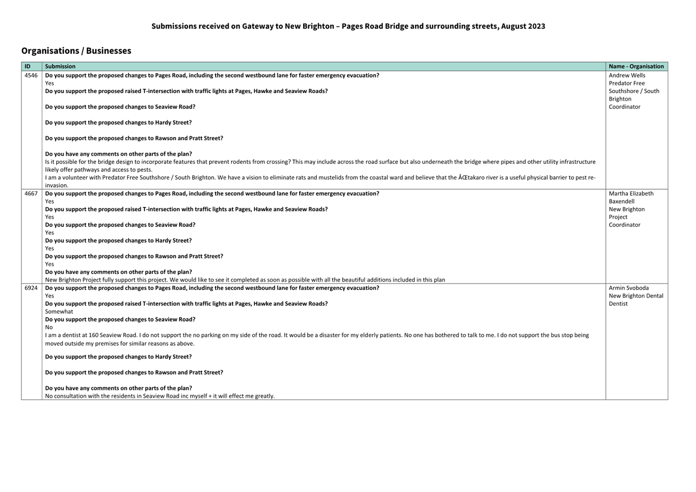
Summary of Submissions Ngā Tāpaetanga
7.17 Submissions
were made by 17 recognised organisations/businesses, and 244 individuals. All
submissions are available online
or in the Hearings Panel agenda. We were unable to count an additional ten
submissions due to incomplete personal details and/or abusive content.
7.18 The
tables of submission feedback are available in the “Volume of
Submissions” section of this agenda.
7.19 Submitters
were asked whether they supported the proposed changes across each section of
the project. The majority of submitters supported all the proposed changes, as
shown in Figure 5.
· 188,
75% of submitters supported the proposed changes to Pages Road, including the
second westbound lane for faster emergency evacuation.
· 170,
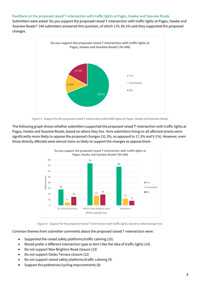
69.1% of submitters supported the proposed raised T-intersection with traffic
lights at Pages, Hawke and Seaview Roads.
· 167,
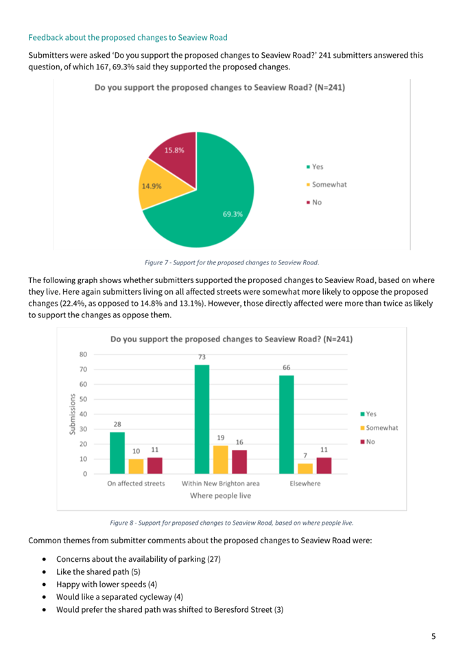
69.3% of submitters supported the proposed changes to Seaview Road.
· 172,
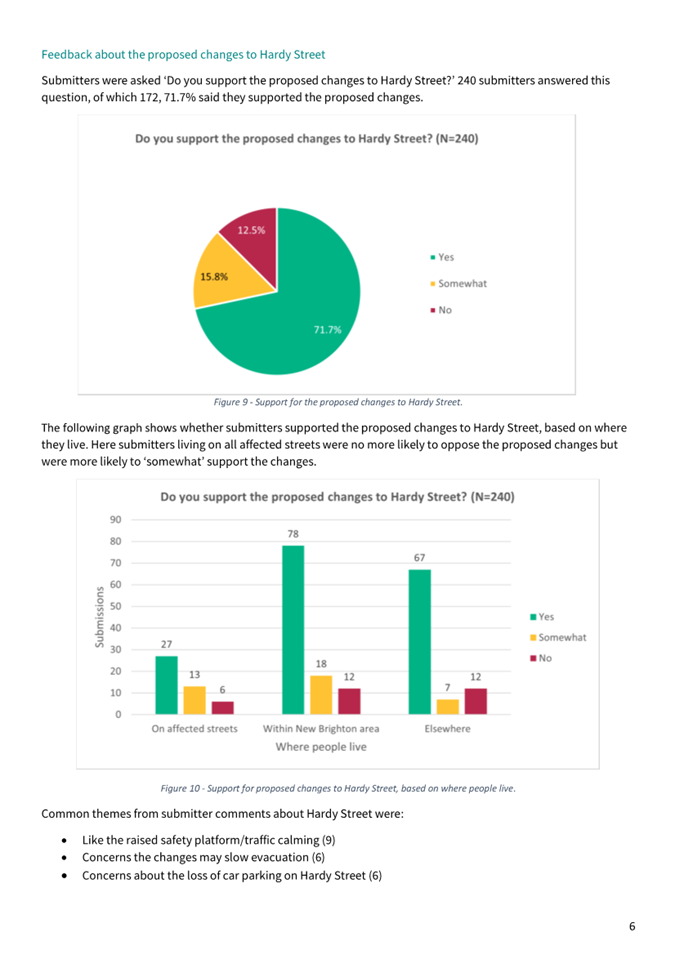
71.7% of submitters supported the proposed changes to Hardy Street.
· 167,
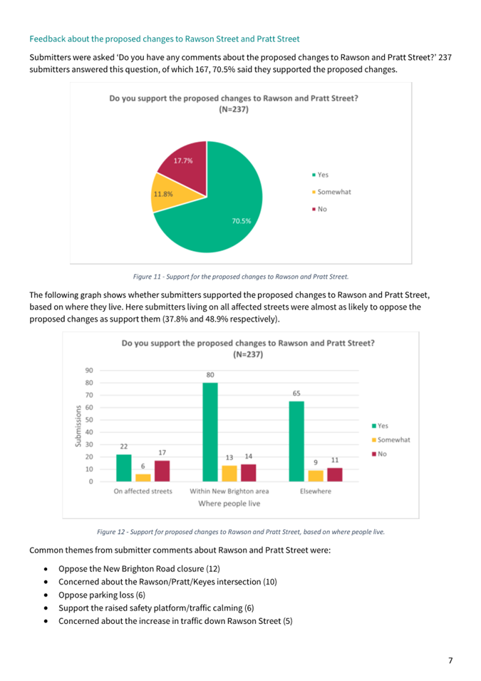
70.5% of submitters supported the proposed changes to Rawson Street and Pratt
Street.
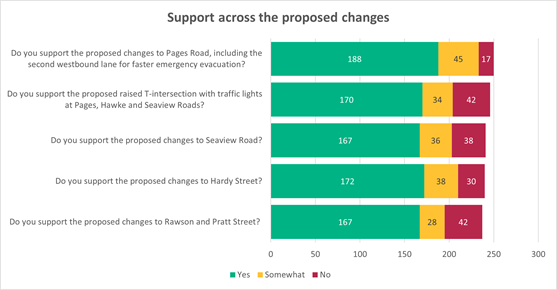
Figure
5
– Graph showing support across all proposed changes.
7.20 A
full analysis of submissions, including a breakdown of common themes is
available in Attachment D.
8. Design Post Consultation
8.1 A
scheme design was issued for both early engagement and public consultation as
outlined in section 7. Post early engagement and post public
consultation, staff read and analysed the submissions to take on board the
feedback and, where appropriate, changes were made to the scheme design. A
large portion of submission suggestions had already been addressed in the
design, or designers had considered the issues raised during scheme design
development, as detailed in Attachment E.
Design Changes Resulting from Early Engagement
8.2 Table 2 summarises the design changes resulting from early engagement and
prior to public consultation:
|
Request From
|
Design Item Changed
|
|
Beachcomber Dairy (corner of Rawson
Street and New Brighton Road)
|
The time restricted car parking on Rawson
Street outside the Beachcomber Dairy was changed from P30 to P10.
|
|
Table area removed from the design
outside Beachcomber Dairy to prevent public congregating (concerns of theft).
|
|
Low landscaping added to design on
footpath outside Beachcomber Dairy to prevent vehicles parking on the
footpath area (theft).
|
|
5 Owles Terrace
|
New gravel path along the top of the
stopbank included in the design to connect the pocket park to the existing
track on the Owles Terrace stopbank to help separate pedestrians/cyclists
following the river from the vehicles using the accessway to 5 Owles
Terrace.
|
|
Spokes
|
Cycling markings and access across the
intersection of New Brighton Road and Rawson Street (by Beachcomber Dairy).
|
|
On road cycling space at Hardy Street
build outs.
|
|
Owner of retail unit at 175 Seaview Road
– design changed post public consultation
|
Time restricted car park outside 175
Seaview Road changed from P30 to P60.
Three carparks outside 171 Seaview Road
(Kidsfirst Kindergarten) currently have P10 (all times). It is proposed to
make this P10 between 8.00am to 9.30am and 2.30pm to 3.30pm and P60 at all
other times to assist the retail unit with parking. To assist the kindergarten
with this change one carpark on Beresford Street is proposed to have time
restricted parking of P10 from 8.00am to 9.30am and 2.30pm to 3.30pm.
|
|
Nova Montessori School (corner of Owles
Terrace and Hardy Street) – design changed post public consultation
|
One more carpark was created opposite the
school, on the east side of Hardy Street between Owles Terrace and
Collingwood Street.
Car park was created from changing the
kerb build outs and associated no stopping lines from outside 37 and 39 Hardy
Street to over the driveways of 39 and 41 Hardy Street.
|
Table
2
– Design Changes Resulting from Early Engagement
Design Changes Resulting from Public Consultation
8.3 Table 3 summarises the design changes resulting from public consultation.
|
Submitters Feedback
|
Design Item Changed
|
|
More bus shelters
|
Added a bus shelter to Seaview Road for
westbound bus (to city).
|
|
Backup power for traffic signals in an
emergency (e.g., earthquake cuts mains power)
|
Added an uninterruptible power supply
(UPS) with batteries to the traffic signals design, to keep them operating
during an evacuation arising from a natural disaster.
|
|
More carparking outside Seaview Road
shops
|
Reintroduced two perpendicular car parks
outside 123 Seaview Road for businesses in the area.
|
|
More cycle stands
|
Added cycle stands in appropriate
locations throughout the project area. Location of cycle stands are Pocket
Park, 131 Seaview Road and outside the Beachcomber Dairy.
|
|
162 Seaview Road driveway adjustment
|
162 Seaview Road is redeveloping the
property including the driveway location. Design now reflects the new
driveway location.
|
Table
3
– Design Changes Resulting from Public Consultation
Design Changes made by Staff Post Public Consultation
8.4 Post
public consultation, staff continued developing the scheme design for
disciplines other than transport and landscaping which were consulted on. The
other design disciplines that were further developed included; pavement,
stormwater, wastewater, water supply, urban design, bridge, utilities,
construction methodology, consent strategy, survey and design interface with
neighbouring projects.
8.5 Table 4 summarises the design changes made by staff post consultation.
8.6 The
changes made to the design as detailed in Table 4 are
minor and do not result in major changes to the public consultation material.
|
Design Item Changed
|
Details
|
|
Improve tie-in to existing driveway
entrances
|
Small amendments to the design layout
were made to improve the tie-in to existing driveway entrances and
accessways, based on the recently completed topographical survey.
|
|
Vehicle tracking check
|
Minor amendments to kerb locations /
radii resulting from the vehicle tracking design check
|
|
Adjustments to the Hardy Street and
Beresford Street intersection
|
Design layout changes to the Hardy Street
and Beresford Street intersection for road safety reasons. The revised layout
includes a flush median through the intersection, realigned kerbs to provide
a better road alignment, additional pedestrian refuge island, landscaping
changes and extension of no stopping lines for pedestrian sight distance (two
carparks removed from outside 14 Hardy Street).
|
|
Adjustments to tree locations
|
Trees have been locally relocated
throughout the project area to avoid clashes with existing underground
utility services.
Tree symbols within the coastal forest
are now shown on the drawing for clarification.
|
|
Added the second driveway 134 Hawke
Street
|
Access to an existing residential
driveway (second driveway) at 134 Hawke Street has been added to the design
layout. This was inadvertently missed on the public consultation plan and
picked up in the topographic survey.
|
|
Further adjustments to landscaping
outside Beachcomber Dairy
|
Further adjustments to landscaping and
hardstand area outside the Beachcomber Dairy to help indicate the new corner
on the road and to address business owner concerns about shop safety (theft).
|
|
Realignment of footpath along Rawson
Street and Pratt Street
|
Rawson Street and Pratt Street footpaths
have been realigned to avoid clashes with existing underground utility
services.
|
|
Priority Control changed to
‘Stop’ at Pratt Street and Keyes Road intersection
|
For road safety reasons the Pratt Street
and Keyes Road intersection priority has been changed from ‘Give
Way’ to ‘Stop’ to avoid a clash with the Rawson Street and
Keyes Road intersection that has a ‘Give Way’ priority.
|
|
Added no stopping lines for Keyes Road
bus stop
|
Standard length of no stopping lines has
been added at the existing bus stop near 383 Keyes Road.
|
Table
4
– Design changes made by staff post public consultation
Public Feedback Considered However Not Implemented
8.7 Post
public consultation all the feedback was considered. Table 5 summarises the submissions that were considered, however not
implemented following staff feedback.
|
Submitters Feedback
|
Staff feedback
|
|
Reduction in the no stopping restrictions
on Hawke Street
|
Between 117 to 129 Hawke Street there is
potential space to be created for six carparks by indenting the kerb into the
footpath, removing the berm and reducing the footpath to two metres against
the property boundary. However, the disbenefits include a narrower footpath,
loss of green space, and a higher cost option requiring undergrounding of
services and relocation of existing services.
|
|
Between 176 Seaview Road and 133 Hawke
Street there is potential space for two carparks along Hawke Street by
indenting the kerb into the footpath, however this would require purchasing
an area of private property with an uncertain chance of sale (disbenefit).
|
|
Reduction in the no stopping restrictions
on the northside of Seaview Road
|
To install the proposed 3.5-metre wide
shared path on the north side of Seaview Road, a no parking restriction has
been proposed. To retain the parking on the north side of Seaview Road would
require either omitting the 3.5-metre shared path or removing eight mature
trees on the southern side of Seaview Road. Other disbenefits include a
narrower footpath, no off-road cycling facilities and additional service
clashes (higher cost).
|
|
Parking space opposite the retail unit at
175 Seaview Road
|
Parking spaces were investigated in the
planted berm outside 176 Seaview Road (opposite 175 Seaview Road). There is
only space for one carpark and the shop visitor would have to walk
approximately 90 metres to get safely from the car to the shop via the signalised
intersection crossing. The close proximity of the intersection to this
potential car parking space is not ideal from a safety perspective due to the
limited available sight distance to traffic travelling through the
intersection onto the Seaview Road.
|
|
Safety concerns from increase in traffic
flow at Keyes Road and Hawke Street intersection
|
Typical traffic flows on Keyes Road are
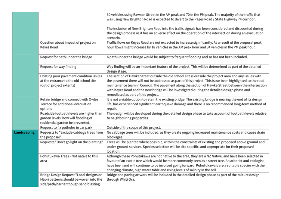
not expected to increase significantly: the traffic modelling shows peak hour
flows might increase by 18 vehicles in the morning peak hour and 34 vehicles
in the afternoon peak hour.
In the last five years, there has been
only one injury crash at or within 50 metres of this intersection which was a
minor injury crash and involved a vehicle failing to give way. This is
unlikely to be worsened by the preferred scheme design.
|
|
Safety concerns from increase in traffic
flow at Keyes Road and Rawson Street intersection
|
Traffic flows on Rawson Street will
increase, however this is not significant as the traffic modelling shows an
additional 30 vehicles using Rawson Street in the morning peak and 70
vehicles in the afternoon peak.
There were two crashes recorded at this
intersection in the last five years. One of those was a serious injury crash
and one a non-injury crash. Both crashes involved vehicles losing control on
the bend in the road while travelling along Keyes Road, they did not involve
vehicles turning into either Rawson Street or Pratt Street.
The existing layout is likely to
contribute to these loss of control crashes. The intersection is located on
the bend and is poorly defined with a wide-open space. The preferred scheme
design is to separate Pratt Street and Rawson Street into two separate
intersections delineated with kerbs, this will improve guidance around the
Keyes Road bend.
|
Table
5 -
Public feedback considered however not implemented.
Public Feedback Items that were Already in the Design
8.8 During
analysis of the submissions, it became evident that a large proportion of the
submissions had already been addressed in the design, or staff had already
considered the issues during development of the scheme design as detailed in Attachment
E.
9. Policy Framework Implications Ngā Hīraunga ā- Kaupapa here
Strategic
AlignmentTe Rautaki
Tīaroaro
9.1 The recommendation is consistent with the current Council desired
community outcomes of achieving a liveable city and healthy environment, with a
prosperous economy and resilient communities.
9.2 The
recommendation is also consistent with the draft Council’s desired
community outcomes of a green liveable city and a thriving prosperous city.
9.3 The
scheme design is consistent with the Council’s strategic priorities; to
be an inclusive and equitable city, champion Otautahi-Christchurch, build trust
and confidence in the Council, reduce emissions as a Council and as a city, and
actively balance the needs to today’s residents.
9.4 The
recommendation is consistent with council policies and has followed best
practice transport associated design guidelines.
9.5 This report supports the Council's
Long Term Plan (2021 - 2031):
9.6 Transport
9.6.1 Activity: Transport
· Level of Service: 16.0.3 Improve resident
satisfaction with road condition - >=30% resident satisfaction
Policy
Consistency Te Whai
Kaupapa here
9.7 The
decision is consistent with Council’s Plans and
Policies.
Impact
on Mana Whenua Ngā
Whai Take Mana Whenua
9.8 The
decision is a significant decision in relation to
ancestral land or a body of water or other elements of intrinsic value,
therefore this decision does specifically impact Mana
Whenua, their culture and traditions.
9.9 The
decision involves a matter of interest to Mana Whenua
and could impact on our agreed partnership priorities with
Ngā Papatipu Rūnanga.
9.10 The
project includes constructing a new bridge over the Ōtākaro
(Avon River - body of water), and removing the existing
Pages Road bridge, with a strong likelihood that some work will need to be
undertaken in the water.
9.11 The
design has been discussed with representatives of Mahaanui Kurataiao (MKT) and Ngā Hau e Whā (National Marae) and staff will
continue these discussions during detailed design and construction phases of
the project.
9.12 The landscape design has been based on the Cultural
Design Intent and Artwork report by Matapopore dated
May 2020.
9.13 Space
has been reserved at the signalised T-intersection for artworks. Mana Whenua consider the site an important place for cultural
artworks next to Ōtākaro (Avon River). Therefore,
the artwork will be developed in collaboration with Mana Whenua.
9.14 During
the detailed design phase, staff will engage Mahaanui Kurataiao (MKT) and
Whiti-Ora for their cultural services and inputs.
Climate
Change Impact Considerations Ngā Whai Whakaaro mā te Āhuarangi
9.15 The
decisions in this report are likely to:
9.15.1 Contribute
positively to adaptation to the impacts of climate
change.
9.15.2 Contribute
positively to emissions reductions.
9.16 The
preferred scheme design supports the Council’s role in encouraging active
travel and public transport.
9.16.1 The design
encourages use of active modes through providing cycling and walking facilities
throughout the project, including connecting the paths along the river and
providing safe crossing points.
9.16.2 The design
future proofs for a section of the Avon-Ōtākaro
Major Cycleway Route. Once constructed this will
support mode shift and therefore help to reduce emissions.
9.16.3 The design is
proposing two new bus shelters on Seaview Road and Hardy Street to encourage
public transport use.
9.17 The
landscape design actively looks to incorporate increasing tree coverage in the
area and additional landscaping.
9.18 The
proposed new bridge will be at a higher level in consideration of predicted sea
level rises.
Accessibility
Considerations Ngā
Whai Whakaaro mā te Hunga Hauā
9.19 The
preferred scheme design outlined in the report has been fully aligned to meet
with the needs of persons of all abilities and accessibility needs. These
design elements include, but are not limited to, crossing widths, kerb heights,
tactile pavers, pedestrian path alignments and grade of paths.
10. Resource Implications Ngā Hīraunga Rauemi
Capex/Opex Ngā Utu Whakahaere
10.1 Cost to Implement - The rough order cost
estimate to complete implementation is in the order of $80 million. This is broken down into:
10.1.1 Estimated $39
million – Bridge structure (including ground improvements and removal of
existing bridge).
10.1.2 Estimated $22
million – Bridge approaches (including Pages Road renewal and signalised
T-intersection.
10.1.3 Estimated $19
million – Surrounding street renewals and intersection upgrades (Hardy
Street, Rawson Street, Pratt Street, Seaview Road, Hawke Street).
10.1.4 Staff are
continuing to refine the costs as more information becomes available on the
requirements of the design.
10.2 Maintenance/Ongoing
costs - The overall maintenance costs of these assets are anticipated to
decrease as this project is proposing to renew the earthquake damaged Pages
Road Bridge, renew the earthquake damaged and flood prone Pages Road (between
Anzac Drive and the Ōtākaro-Avon River), and remove vehicle access to
the earthquake damaged and flood prone New Brighton Road (between Rawson Street
and Pages Road). During the detailed design stage staff will continue to work
with maintenance teams to ensure the future operational costs of the area are
represented in OPEX budgets.
10.3 Funding
Source – CAPEX
· The funding for the
project is listed in the Long Term Plan(s) as ‘27273 -Pages Road Bridge
Renewal (OARC).’
· The project scope required
to meet the project objectives exceeds the current budget. Additional funding
for the project will have to be sought through the 2024 to 2034 Long Term Plan
process.
· The
draft 2024/34 Long Term Plan has a total project budget of $65.7 million.
Other He mea anō
10.4 Spent
to date – The amount spent to date on the project is approximately $2.06
million (March 2024) which was mainly for; defining project scope, project
management, traffic modelling, cost estimation, consenting strategy, risk
analysis and management, property investigation, topographic survey, principal
bridge inspection, co-ordination with neighbouring projects, consultation
material, marketing for consultation, procurement of detailed design services
and scheme design of bridge, geotechnical, transport, stormwater, wastewater,
water supply and utilities.
10.5 Funding Subsidy – The Council is
following the NZTA standard business case processes for this project. This will
continue as the project progresses. The standard 51% National Land Transport
Fund (NLTF) subsidy on eligible items is the potential rate for this project.
10.5.1 Funding subsidy
remains a significant risk, due to constrained budgets (local and central
government), change in central government, change in government policy
statement and the ranking of this project at a regional level (currently ranked
12th in the Regional Land Transport Plan).
10.6 Integrated
Projects – These are other projects within the Pages Road Bridge Renewal
project area, and which can be more efficiently included in the construction
works providing a one pass approach. Integrated projects include; 3W asset
renewals, stopbanks tie-in and major cycle route. The rough order estimated
cost to implement the integrated projects is anticipated to be $14 million.
This is subject to funding being available for the separate projects in the
appropriate Activity Plan as part of the 2024/34 Long Term Plan.
11. Legal Implications Ngā Hīraunga ā-Ture
Statutory power to undertake proposals in the report
Te Manatū Whakahaere Kaupapa
11.1 Council
has the statutory power and is the decision-making authority for Pages Road
Bridge Renewal project as the project is of Metropolitan Significance (Council
Resolved Substantive Motion CNCL/2020/00034). It is the role of the
Hearings Panel to consider and hear submissions from the community and
information provided by Council officers, deliberate on the matters raised, and
make recommendations to the Council as the final decision-maker.
Other Legal Implications Ētahi atu
Hīraunga-ā-Ture
11.2 There
is no other legal context, issue, or implication relevant to this decision.
12. Risk Management Implications Ngā Hīraunga Tūraru
12.1 The
risks associated with this project and the decision-making process are
considered to vary between moderate and high as detailed below.
|
Risk
|
Rating
|
Consequence
|
Mitigation
|
|
Unable to obtain NZTA subsidy
|
High
|
Higher than expected ratepayer contribution
Delay of project delivery.
Reduction in project scope delivered and unable to
achieve all project objectives.
|
Staff at both Christchurch City Council and the NZ
Transport Agency are working together to ensure the point of entry and
associated business case have all the correct information, and that the
assumptions built into the analysis are robust, this will support the
application for funding.
|
|
Proceeding with the detailed design phase before the
business case is drafted and accepted by NZTA for central government subsidy
|
High
|
Business case could conclude that an alternative
option is more economical than the preferred scheme design, causing programme
delays, re-litigation of project scope and redesign (additional cost).
Unable to claim NZTA subsidy for designs done before
business case.
|
Accept the risk and proceed with the detailed design
phase in parallel to drafting the business case and seeking the NZTA subsidy.
|
|
Unable to obtain the additional funding required to
undertake the preferred scheme design in order to meet the project
objectives.
|
High
|
Significant delays, higher than expected ratepayer
contribution, need to re-litigate scope, unable to meet project objective(s)
and/or unable to proceed with project.
|
Local Government Funding: Additional funding is
being sought through the Long Term Plan 2024 – 2034 process.
Central Government Subsidy:
As above for risk “Unable to obtain NZTA
subsidy”.
|
|
Decision not to proceed or partial delivery only.
|
High
|
Bridge would remain earthquake damaged. New Brighton
would not have a resilient lifelines bridge.
Road profile deficiencies, poor pedestrian and
cycling access would remain.
Emergency evacuation time would not be improved.
Detour inefficiencies and safety issues.
Criticism from community and media.
Expectations are set by consultation and community
are seeking investment in the east.
|
Staff to provide comprehensive report to Hearings
Panel in order that Councillors can make an informed decision.
|
|
No space for future stopbanks if Owles Terrace and
New Brighton Road diversions don’t get approved with the preferred
scheme design.
|
High
|
The type and location of future stopbanks would need
to be revised, likely resulting in greater cost for council and a less
resilient stopbank.
|
Staff to provide comprehensive report to Hearings
Panel in order that Councillors can make an informed decision about Owles
Terrace and New Brighton Road diversions.
|
|
Problems with statutory approvals including
obtaining consents to work in/over/adjacent to a tidal river.
|
High
|
Programme delay and additional costs. Unable to
proceed with project or aspects of project.
|
Staff to work closely with CCC planners and ECan
planners.
Take time to ensure a robust consent application.
|
|
Key partner influence on the project including
Ōtākaro-Avon River Corridor (OARC) Co-Governance, Mana Whenua and
Utilities.
|
Medium
|
Programme delay and additional costs.
|
Staff to consult with key partners and keep them
updated.
|
13. Next Steps Ngā Mahinga ā-muri
13.1 Following
the Hearings Panel’s consideration of this report and submissions
received, the Panel may seek further information of the project team, if it
considers it necessary, and then report to the Council for a decision on the
recommended option.
13.2 Upon
Council approval of the preferred scheme design, the project team will commence
detailed design.
13.3 It is anticipated that construction of this project will commence in
2026 – 2028 subject to Council approval, in Q1 of 2024, statutory
approvals and funding approvals.
Attachments Ngā Tāpirihanga
|
No.
|
Title
|
Reference
|
Page
|
|
a ⇩
|
Preferred
Scheme Design Plan for Council Decision (General Overview Drawing)
|
23/2128612
|
34
|
|
b ⇩
|
Tree Removal
Plan for Council Decision (on General Arrangement Drawing)
|
23/2128613
|
35
|
|
c ⇩
|
Project Scope
Breakdown for Hearings Report
|
23/2128614
|
36
|
|
d ⇩
|
Full
Submission Analysis - Gateway to New Brighton
|
23/2091819
|
37
|
|
e ⇩
|
Submitter
Ideas and Issues with Staff Responses
|
23/2111873
|
45
|
In addition to the attached documents, the following background
information is available:
Confirmation of Statutory
Compliance Te Whakatūturutanga ā-Ture
|
Compliance with Statutory Decision-making
Requirements (ss 76 - 81 Local Government Act 2002).
(a) This report contains:
(i) sufficient information about all reasonably practicable
options identified and assessed in terms of their advantages and
disadvantages; and
(ii) adequate consideration of the views and preferences of
affected and interested persons bearing in mind any proposed or previous
community engagement.
(b) The information reflects the level of significance of the
matters covered by the report, as determined in accordance with the Council's
significance and engagement policy.
|
Signatories Ngā Kaiwaitohu
|
Authors
|
Nathan Sidwell
- Project Manager
Krystle
Anderson - Engagement Advisor
|
|
Approved By
|
Jacob Bradbury
- Manager Planning & Delivery Transport
Lynette Ellis
- Head of Transport & Waste Management
Jane Parfitt -
Interim General Manager Infrastructure, Planning and Regulatory Services
|