Christchurch City Council
Agenda
Notice of Meeting:
An ordinary meeting of the Christchurch
City Council will be held on:
Date: Thursday 21 September 2023
Time: 9.00am
Venue: Council Chambers, Civic Offices,
53 Hereford Street, Christchurch
Membership
|
Chairperson
Deputy Chairperson
Members
|
Mayor Phil Mauger
Deputy Mayor Pauline Cotter
Councillor Kelly Barber
Councillor Melanie Coker
Councillor Celeste Donovan
Councillor Tyrone Fields
Councillor James Gough
Councillor Tyla Harrison-Hunt
Councillor Victoria Henstock
Councillor Yani Johanson
Councillor Aaron Keown
Councillor Sam MacDonald
Councillor Jake McLellan
Councillor Andrei Moore
Councillor Mark Peters
Councillor Tim Scandrett
Councillor Sara Templeton
|
13 September 2023
|
|
|
Principal Advisor
Dawn Baxendale
Chief Executive
Tel: 941 8999
|
|
Katie Matheis
Team Leader Hearings & Committee Support
941 5643
katie.matheis@ccc.govt.nz
www.ccc.govt.nz
|
Council
21 September 2023
|

|
|
Council
21 September 2023
|

|
TABLE OF CONTENTS NGĀ IHIRANGI
Karakia Tīmatanga................................................................................................... 4
1. Apologies Ngā Whakapāha................................................................................. 4
2. Declarations of Interest Ngā Whakapuaki Aronga.................................................. 4
3. Public
Participation Te Huinga
Tūmatanui............................................................ 4
3.1 Public Forum Te Huinga Whānui.......................................................................................... 4
3.2 Deputations by
Appointment Ngā Huinga Whakaritenga...................................................... 4
4. Presentation
of Petitions Ngā
Pākikitanga............................................................ 7
Staff Reports
5. Transport
Choices - Westmorland Cycle Connection............................................... 9
6. Transport
Choices - Little River Link Cycle Connections (Simeon Street)................. 81
7. Transport
Choices - Te Aratai College Cycle Connection....................................... 167
8. Transport
Choices - Richmond Neighbourhood Greenway................................... 287
9. Transport
Choices - School Safety Linwood....................................................... 347
10. Transport
Choices - Improving Bromley's Roads................................................ 399
11. Transport
Choices - Little River Link Cycle Connections (Aidanfield)..................... 453
12. Transport
Choices - Linwood and Woolston Improvements (Rhona Street)............ 499
13. Transport
Choices - Linwood and Woolston Improvements (Smith Street)............. 539
14. Transport
Choices - Slow Speed Neighbourhoods Linwood.................................. 577
15. Transport
Choices - Linwood Village Streetscape Scheme Amendments................ 621
16. Transport
Choices - Little River Link Cycle Connections (Nga Puna Wai)................. 629
Karakia Whakamutunga
Whakataka Te
hau ki Te uru
Whakataka Te
hau ki Te tonga
Kia makinakina
ki uta
Kia mataratara
ki Tai
E hi ake ana te
atakura
He tio, he huka,
he hau hu
Tihei Mauri Ora
1. Apologies Ngā Whakapāha
An apology for was
received from Councillor Scandrett.
2. Declarations of Interest Ngā
Whakapuaki Aronga
Members are
reminded of the need to be vigilant and to stand aside from decision making
when a conflict arises between their role as an elected representative and any
private or other external interest they might have.
3. Public Participation Te Huinga
Tūmatanui
3.1 Public Forum Te Huinga Whānui
There were no public forum requests received at the time the agenda
was prepared.
3.2 Deputations by Appointment Ngā
Huinga Whakaritenga
Deputations may be heard on a matter or
matters covered by a report on this agenda and approved by the Chairperson.
|
3.2.1
|
Way Safer Streets – Transport Choices Deputations
The following presenters will speak in
support of their submissions to the Way Safer Streets consultation:
|
Item number
|
Name
|
Organisation
|
Project/s
|
|
3.2.1
|
Paul McMahon
|
Waitai Coastal-Burwood-Linwood
Community Board Submissions Committee
|
|
|
3.2.2
|
Callum Ward
|
Waihoro
Spreydon-Cashmere-Heathcote Community Board
|
|
|
3.2.3
|
Emma Norrish
|
Waipapa Papanui-Innes-Central
Community Board
|
|
|
3.2.4
|
David Hawke
|
Halswell Residents Association
|
Multiple projects
|
|
3.2.5
|
Fiona Bennetts
|
|
Multiple projects
|
|
3.2.6
|
Cody Cooper
|
|
Multiple projects
|
|
3.2.7
|
George Laxton
|
|
Multiple projects
|
|
3.2.8
|
Shane Walls-Harris
|
|
Rhona Street
|
|
3.2.9
|
Robin Hull
|
Rhona Street Residents
|
Rhona Street
|
|
3.2.10
|
Cameron James Bradley
|
|
Multiple projects
|
|
3.2.11
|
Rod Mckay
|
|
Westmorland
|
|
3.2.12
|
John Arkless
|
|
Westmorland
|
|
3.2.13
|
Lindsay Smith
|
|
Westmorland
|
|
3.2.14
|
Karen Whitla
|
|
Westmorland
|
|
3.2.15
|
Alan McKinney
|
|
Westmorland
|
|
3.2.16
|
Richard Hamilton
|
|
Westmorland
|
|
3.2.17
|
Mark Hyde
|
|
Westmorland
|
|
3.2.18
|
David Diggs
|
|
Westmorland
|
|
3.2.19
|
Lindsay Richards
|
Westmorland Residents'
Association
|
Westmorland
|
|
3.2.20
|
Iain Mcdonald
|
|
Westmorland
|
|
3.2.21
|
Dave Lane
|
|
Westmorland
|
|
3.2.22
|
Bryan Noonan
|
|
Westmorland
|
|
3.2.23
|
Alan Clelland
|
|
Westmorland
|
|
3.2.24
|
Lynette Hartley
|
|
Westmorland
|
|
3.2.25
|
Julian Odering
|
Oderings Nurseries Ltd
|
Westmorland
|
|
3.2.26
|
Logan Austin
|
|
Westmorland
|
|
3.2.27
|
Vikki Hart
|
|
Westmorland
|
|
3.2.28
|
J N Morris
|
|
Westmorland
|
|
3.2.29
|
Steve Kennedy
|
Fire and Emergency NZ
|
Simeon Street
|
|
3.2.30
|
Wayne Carey
|
|
Simeon Street
|
|
3.2.31
|
Jackie McKenzie-Doig
|
|
Simeon Street
|
|
3.2.32
|
Teresa Allpress
|
|
Simeon Street
|
|
3.2.33
|
Izaak Wybourne
|
|
Simeon Street
|
|
3.2.34
|
Nathaniel Brown
|
|
Simeon Street
|
|
3.2.35
|
Rico Parkinson
|
|
Simeon Street
|
|
3.2.36
|
Lee Hogsden
|
|
Simeon Street
|
|
3.2.37
|
Jennifer Horsburgh, Barry Mann,
Elise Mann, and Genevieve Mann
|
|
Westmorland
|
|
3.2.38
|
Andrew Reynolds
|
|
Simeon Street
|
|
3.2.39
|
Stephen Judd
|
|
Simeon Street
|
|
3.2.40
|
Ann-Cherie Manawatu-Pearcy
|
|
Simeon Street
|
|
3.2.41
|
Rebecca Finch
|
|
Simeon Street
|
|
3.2.42
|
Nigel Grant Urquhart
|
|
Westmorland
|
|
3.2.43
|
Benny Gilling
|
|
Simeon Street
|
|
3.2.44
|
Raviv Carasuk
|
|
Multiple projects
|
|
3.2.45
|
Melanie Jane and Owen Smith
|
|
Westmorland
|
|
3.2.46
|
Tim Bates
|
|
Rhona Street
|
|
3.2.47
|
Kristin Hoskin
|
|
Te Aratai
|
|
3.2.48
|
Jackson Wright
|
|
Te Aratai
|
|
3.2.49
|
Joanne Easterbrook
|
|
Te Aratai
|
|
3.2.50
|
Verity Halkett
|
|
Smith Street
|
|
3.2.51
|
Paul McGarry
|
McDonald's Linwood
|
Te Aratai
|
|
3.2.52
|
Dermot Coffey's students at Te
Aratai
|
Students from Te Aratai College
|
Te Aratai
|
|
3.2.53
|
Jo-Anne Bethell
|
|
Te Aratai
|
|
3.2.54
|
Robert Carter
|
|
Aidanfield
|
|
3.2.55
|
Stephen Watt
|
|
Aidanfield
|
|
3.2.56
|
Stephen Watt (on behalf of
Danielle Flower)
|
|
Aidanfield
|
|
3.2.57
|
Lecia McCallum
|
|
Improving Bromley's Roads
|
|
3.2.58
|
Andrew Massie
|
|
Improving Bromley's Roads
|
|
3.2.59
|
Jayne Hall
|
|
Improving Bromley's Roads
|
|
3.2.60
|
Hope Gillespie
|
|
Te Aratai
|
|
3.2.61
|
Nick Reid
|
|
Richmond
|
|
3.2.62
|
Craig Given
|
|
Richmond
|
|
3.2.63
|
Tim Blundell
|
|
Richmond
|
|
3.2.64
|
Greg Partridge
|
|
Richmond
|
|
3.2.65
|
Sharon Liu
|
|
Richmond
|
|
3.2.66
|
Gabriel Taite
|
|
School Safety Linwood
|
|
3.2.67
|
Aaron Ghattas
|
|
School Safety Linwood
|
|
3.2.68
|
Graham Coumbe
|
|
School Safety Linwood
|
|
3.2.69
|
Colin Maxwell
|
|
School Safety Linwood
|
|
4. Presentation of Petitions Ngā
Pākikitanga
There were no
Presentation of Petitions at the time the agenda was prepared.
|
Council
21 September 2023
|

|
|
5. Transport
Choices - Westmorland Cycle Connection
|
|
Reference / Te Tohutoro:
|
23/1162768
|
|
Report of / Te Pou Matua:
|
Alanna
Warhurst, Project Manager Transport,
Alanna.warhurst@ccc.govt.nz;
Jacob Bradbury, Manager Planning & Delivery Transport
Jacob.bradbury@ccc.govt.nz
|
|
Senior Manager / Pouwhakarae:
|
Lynette
Ellis, Head of Transport & Waste Management (Lynette.Ellis@ccc.govt.nz)
|
1. Nature of Issue and Report Origin
1.1 The purpose of this report is to inform the Council of
feedback received, and for the Council to approve the design to proceed to
construction for the Transport Choices Westmorland Cycle Connection project.
1.2 The origin of this report is the Climate Emergency Response
Fund (CERF) Transport Choices programme.
1.3 The decisions in
this report are of medium significance in relation to the Christchurch
City Council’s Significance and Engagement Policy 2019. The
level of significance was determined by potential benefits and opportunities to
the Council/community, the number of people affected and/or with an interest,
and that these projects span multiple community board areas, as set out in the
criteria of the policy (Page 2). This evaluation has considered the Transport
Choices projects as a cohesive programme of work. This is consistent with
how community engagement has been undertaken, with all work packages being
presented concurrently on Have your Say under the banner of Way Safer Streets.
2. Officer Recommendations Ngā Tūtohu
That the Council:
Funding
1. Approves that construction of the Westmorland
Cycle Connection project is conditional on implementation costs being agreed
and incorporated into the Transport Choices Funding agreement between Waka
Kotahi and Council.
2. Approves the following recommendations
required for the implementation of the Transport Choices – Westmorland
Cycle Connection project, relying on its powers under the Christchurch City
Council Traffic and Parking Bylaw 2017 and Part 21 of the Local Government Act
1974.
Revocations and
General
3. Approves that any previously approved
resolutions made pursuant to any Bylaw, Local Government Act or any Land
Transport Rule and pertaining to traffic controls, stopping and/or parking
restrictions (but excluding speed limits) on the south side of Cashmere Road
commencing at a point 15 metres west of its intersection with Worsleys Road and
extending in a westerly direction to a point 30 metres west of its intersection
with Penruddock Rise be revoked.
4. Approves that any previously approved resolutions
made pursuant to any Bylaw, Local Government Act or any Land Transport Rule and
pertaining to traffic controls, stopping and/or parking restrictions (but
excluding speed limits) on the north side of Cashmere Road commencing at a
point 161 metres east of its intersection with Mavin Road and extending in a
westerly direction to a point 30 metres west of its intersection with
Penruddock Rise (measured from a prolongation of the western Penruddock Rise
kerb line) be revoked.
5. Approves that any previously approved
resolutions made pursuant to any Bylaw, Local Government Act or any Land
Transport Rule and pertaining to traffic controls, stopping and/or parking
restrictions (but excluding speed limits) within 30 metres of the respective
intersections of Cashmere Road with Mavin Road, Opihi Street, Kaiwara Street,
Leistrella Road and Penruddock Rise be revoked.
6. Notes that the distances referenced in
recommendations 3-5 are measured from existing kerb alignments, whereas
references to distances in the following recommendations hereinafter are
measured from existing kerb alignments where these are retained or new kerb
alignments where these have been modified as shown on plans titled Christchurch
City Council Westmorland Cycleway Connection Cashmere Road (Penruddock Rise to
Hoon Hay Road): General Layout Sheets 1-3 (Sheet Numbers C30–C 32,
Revision A) attached to this report as Attachment A.
7. Notes that recommendations 3-5 above
specifically exclude the intersection of Cashmere Road with Worsleys Road and Hoon
Hay Road, and specifically the traffic signal and slip lane priority controls
at that intersection, which is unaffected by this project.
8. Approves the road layout, including all kerb
alignments, road surface treatments, traffic islands, traffic calming features
and road markings on Cashmere Road, commencing at a point 10 metres west of its
intersection with Worsleys Road (south side) and 153 metres east of its
intersection with Mavin Road (north side), and extending in a westerly
direction to a point 19 metres west of its intersection with Penruddock Rise,
and on intersecting road approaches to Cashmere Road, as detailed on plans
titled Christchurch City Council Westmorland Cycleway Connection Cashmere Road
(Penruddock Rise to Hoon Hay Road): General Layout Sheets 1-3 (Sheet Numbers
C30–C 32, Revision A) attached to this report as Attachment A.
Separated Cycle
Facilities
9. Approves pursuant to Section 334(1)(d) of the
Local Government Act 1974 that a separated uni-directional cycle facility, for
the use of cycles only travelling west, be established on the south side of
Cashmere Road commencing at a point 15 metres west of its intersection with
Worsleys Road and extending in a westerly direction to a point 9 metres east of
its intersection with Opihi Street.
10. Approves pursuant to Section 334(1)(d) of the
Local Government Act 1974 that a separated uni-directional cycle facility, for
the use of cycles only travelling west, be established on the south side of
Cashmere Road commencing at a point 12 metres west of its intersection with
Opihi Street and extending in a westerly direction for a distance of 200
metres.
11. Approves pursuant to Section 334(1)(d) of the
Local Government Act 1974 that a separated uni-directional cycle facility, for
the use of cycles only travelling east, be established on the north side of
Cashmere Road commencing at a point 78 metres west of its intersection with
Leistrella Road and extending in an easterly direction to a point 8 metres west
of its intersection with Leistrella Road.
12. Approves pursuant to Section 334(1)(d) of the
Local Government Act 1974 that a separated uni-directional cycle facility, for
the use of cycles only travelling east, be established on the north side of
Cashmere Road commencing at a point 12 metres east of its intersection with
Leistrella Road and extending in an easterly direction to a point 9 metres west
of its intersection with Kaiwara Street.
13. Approves pursuant to Section 334(1)(d) of the
Local Government Act 1974 that a separated uni-directional cycle facility, for
the use of cycles only travelling east, be established on the north side of
Cashmere Road commencing at a point 12 metres east of its intersection with
Kaiwara Street and extending in an easterly direction to a point 8 metres west
of its intersection with Mavin Road.
14. Approves pursuant to Section 334(1)(d) of the
Local Government Act 1974 that a separated uni-directional cycle facility, for
the use of cycles only travelling east, be established on the north side of
Cashmere Road commencing at a point 9 metres east of its intersection with
Mavin Road and extending in an easterly direction for a distance of 137 metres.
Cycle Lanes
15. Approves, pursuant to Clause 18 of the
Christchurch City Council Traffic and Parking Bylaw 2017, that a special
vehicle lane for the use of cycles travelling west, be established on the south
side of Cashmere Road commencing at a point 9 metres east of its intersection
with Opihi Street and extending in a westerly direction to a point 12 metres
west of its intersection with Opihi Street.
16. Approves, pursuant to Clause 18 of the
Christchurch City Council Traffic and Parking Bylaw 2017, that a special
vehicle lane for the use of cycles travelling west, be established on the south
side of Cashmere Road commencing at a point 212 metres west of its intersection
with Opihi Street and extending in a westerly direction for a distance of 129
metres.
17. Approves, pursuant to Clause 18 of the
Christchurch City Council Traffic and Parking Bylaw 2017, that a special
vehicle lane for the use of cycles travelling west, be established on the south
side of Cashmere Road commencing at a point 13 metres west of its intersection
with Penruddock Rise and extending in a westerly direction for a distance of 17
metres. This replaces (and slightly extends) the existing special vehicle
(cycle) lane on this section of Cashmere Road and ties into the existing
special vehicle (cycle) lane continuing further west that is not affected by
this project.
18. Approves, pursuant to Clause 18 of the
Christchurch City Council Traffic and Parking Bylaw 2017, that a special
vehicle lane for the use of cycles travelling east, be established on the north
side of Cashmere Road commencing at a point 8 metres west of its intersection
with Leistrella Road and extending in an easterly direction to a point 12
metres east of its intersection with Leistrella Road.
19. Approves, pursuant to Clause 18 of the
Christchurch City Council Traffic and Parking Bylaw 2017, that a special
vehicle lane for the use of cycles travelling east, be established on the north
side of Cashmere Road commencing at a point 9 metres west of its intersection
with Kaiwara Street and extending in an easterly direction to a point 12 metres
east of its intersection with Kaiwara Street.
20. Approves, pursuant to Clause 18 of the
Christchurch City Council Traffic and Parking Bylaw 2017, that a special vehicle
lane for the use of cycles travelling east, be established on the north side of
Cashmere Road commencing at a point 8 metres west of its intersection with
Mavin Road and extending in an easterly direction to a point 9 metres east of
its intersection with Mavin Road.
21. Approves, pursuant to Clause 18 of the
Christchurch City Council Traffic and Parking Bylaw 2017, that a special
vehicle lane for the use of cycles travelling east, be established on the north
side of Cashmere Road commencing at a point 146 metres west of its intersection
with Mavin Road and extending in an easterly direction for a distance of 14
metres. This replaces the existing special vehicle (cycle) lane on this section
of Cashmere Road and ties in to the existing special vehicle (cycle) lane
continuing further east through to the intersection that is not affected by
this project.
Shared Paths
22. Approves that a bi-directional Shared Path be
resolved in accordance with Clause 21 of the Christchurch City Council Traffic
& Parking Bylaw 2017, and in accordance with Section 11.4 of the Land
Transport Rule: Traffic Control Devices 2004 on the south side of Cashmere Road
commencing at a point 147 metres west of its intersection with Opihi Street and
extending in a westerly direction to its intersection with Penruddock Rise
(connecting with the east side of Penruddock Rise at a point 7 metres south of
its intersection with Cashmere Road). This Shared Path is for use by the
classes of road user only as defined in Section 11.1A of the Land Transport
(Road User) Rule: 2004.
23. Approves that a bi-directional Shared Path be
resolved in accordance with Clause 21 of the Christchurch City Council Traffic
& Parking Bylaw 2017, and in accordance with Section 11.4 of the Land
Transport Rule: Traffic Control Devices 2004 on the south side of Cashmere Road
commencing at a point 18 metres west of its intersection with Penruddock Rise
and extending in an easterly direction to its intersection with Penruddock Rise
then in a southerly direction on the west side of Penruddock Rise to a point 13
metres south of its intersection with Cashmere Road. This Shared Path is for
use by the classes of road user only as defined in Section 11.1A of the Land
Transport (Road User) Rule: 2004.
Priority
Controlled Crossings
24. Approves pursuant to Section 334(1)(d) of the
Local Government Act 1974, and contingent on approval of recommendation 9
relating to the separated uni-directional cycle facility on the south side of
Cashmere Road, that pedestrian crossings be resolved and established in
accordance with Section 8.2 of Land Transport Rule: Traffic Control Devices
2004 across the separated uni-directional cycle facility on the south side of
Cashmere Road at a point 48 metres west of the intersection of Cashmere Road
with Opihi Street and extending in a westerly direction for a distance of 2
metres and at a point 53 metres west of the intersection of Cashmere Road with
Leistrella Road and extending in a westerly direction for a distance of 2
metres.
25. Approves pursuant to Section 334(1)(d) of the
Local Government Act 1974 that a signalised roadway crossing for the use of
pedestrians and cycles be installed on Cashmere Road, commencing at a point 71
metres east of its intersection with Leistrella Road and extending in an easterly
direction for a distance of 6 metres. The signalised crossing is to be
installed and operated in accordance with relevant sections of Land Transport
Rule: Traffic Control Devices 2004.
26. Approves pursuant to Section 334(1)(d) of the
Local Government Act 1974, and contingent on approval of recommendation 11
relating to the separated uni-directional cycle facility on the north side of
Cashmere Road, that pedestrian crossings be resolved and established in
accordance with Section 8.2 of Land Transport Rule: Traffic Control Devices
2004 across the separated uni-directional cycle facility on the north side of
Cashmere Road at a point 125 metres east of the intersection of Cashmere Road
with Leistrella Road and extending in an easterly direction for a distance of 2
metres and at a point 131 metres east of the intersection of Cashmere Road with
Leistrella Road and extending in an easterly direction for a distance of 2
metres.
Intersection
Controls
27. Approves that the south approach of Opihi
Street at its intersection with Cashmere Road be controlled by a Give Way
control, in accordance with Section 4 and Section 10.3 of the Land Transport
Rule: Traffic Control Devices 2004.
28. Approves that the south approach of Penruddock
Rise at its intersection with Cashmere Road be controlled by a Give Way
control, in accordance with Section 4 and Section 10.3 of the Land Transport
Rule: Traffic Control Devices 2004.
29. Approves that the north approach of Leistrella
Road at its intersection with Cashmere Road be controlled by a Give Way
control, in accordance with Section 4 and Section 10.3 of the Land Transport
Rule: Traffic Control Devices 2004.
30. Approves that the north approach of Kaiwara
Street at its intersection with Cashmere Road be controlled by a Give Way
control, in accordance with Section 4 and Section 10.3 of the Land Transport
Rule: Traffic Control Devices 2004.
31. Approves that the north approach of Mavin Road
at its intersection with Cashmere Road be controlled by a Give Way control, in
accordance with Section 4 and Section 10.3 of the Land Transport Rule: Traffic
Control Devices 2004.
Stopping and
Parking Restrictions –South Side (including side roads)
32. Approves, pursuant to Clause 7 of the
Christchurch City Council Traffic and Parking Bylaw 2017, that the stopping of
all vehicles is prohibited at all times on the south side of Cashmere Road
commencing at a point 15 metres west of its intersection with Worsleys Road,
and extending in a westerly direction to its intersection with Opihi Street.
33. Approves, pursuant to Clause 7 of the
Christchurch City Council Traffic and Parking Bylaw 2017, that the stopping of
all vehicles is prohibited at all times on the east side of Opihi Street
commencing at its intersection with Cashmere Road, and extending in a southerly
direction for a distance of 20 metres.
34. Approves, pursuant to Clause 7 of the
Christchurch City Council Traffic and Parking Bylaw 2017, that the stopping of
all vehicles is prohibited at all times on the west side of Opihi Street
commencing at its intersection with Cashmere Road, and extending in a southerly
direction for a distance of 20 metres.
35. Approves, pursuant to Clause 7 of the
Christchurch City Council Traffic and Parking Bylaw 2017, that the stopping of
all vehicles is prohibited at all times on the south side of Cashmere Road
commencing at its intersection with Opihi Street, and extending in a westerly
direction for a distance of 28 metres.
36. Approves, pursuant to Clause 7 of the
Christchurch City Council Traffic and Parking Bylaw 2017, that a Bus Stop for
scheduled bus services only (per the definition of bus service in Section 5 of
the Land Transport Management Act 2003) be installed on the south side of
Cashmere Road commencing at a point 40 metres west of its intersection with
Opihi Street and extending in a westerly direction for a distance of 15 metres.
37. Approves, pursuant to Clause 7 of the
Christchurch City Council Traffic and Parking Bylaw 2017, that the stopping of
all vehicles is prohibited at all times on the south side of Cashmere Road
commencing at a point 55 metres west of its intersection with Opihi Street, and
extending in a westerly direction to a point 59 metres east of its intersection
with Penruddock Rise.
38. Approves, pursuant to Clause 7 of the
Christchurch City Council Traffic and Parking Bylaw 2017, that a Bus Stop for
scheduled bus services only (per the definition of bus service in Section 5 of
the Land Transport Management Act 2003) be installed on the south side of
Cashmere Road commencing at a point 59 metres east of its intersection with
Penruddock Rise and extending in a westerly direction for a distance of 15
metres.
39. Approves, pursuant to Clause 7 of the
Christchurch City Council Traffic and Parking Bylaw 2017, that the stopping of
all vehicles is prohibited at all times on the south side of Cashmere Road
commencing at its intersection with Penruddock Rise, and extending in an
easterly direction for a distance of 44 metres.
40. Approves, pursuant to Clause 7 of the
Christchurch City Council Traffic and Parking Bylaw 2017, that the stopping of
all vehicles is prohibited at all times on the east side of Penruddock Rise
commencing at its intersection with Cashmere Road, and extending in a southerly
direction for a distance of 23 metres.
41. Approves, pursuant to Clause 7 of the
Christchurch City Council Traffic and Parking Bylaw 2017, that the stopping of
all vehicles is prohibited at all times on the west side of Penruddock Rise commencing
at its intersection with Cashmere Road, and extending in a southerly direction
for a distance of 23 metres.
42. Approves, pursuant to Clause 7 of the
Christchurch City Council Traffic and Parking Bylaw 2017, that the stopping of
all vehicles is prohibited at all times on the south side of Cashmere Road
commencing at its intersection with Penruddock Rise, and extending in a
westerly direction for a distance of 30 metres. This reinstates existing
stopping restrictions on this section of Cashmere Road and ties in to the
existing stopping restrictions continuing further west that are not affected by
this project.
Stopping and
Parking Restrictions –North Side (including side roads)
43. Approves, pursuant to Clause 7 of the
Christchurch City Council Traffic and Parking Bylaw 2017, that the stopping of
all vehicles is prohibited at all times on the north side of Cashmere Road
commencing at a point 455 metres west of its intersection with Leistrella Road,
and extending in an easterly direction for a distance of 142 metres.
44. Approves, pursuant to Clause 7 of the
Christchurch City Council Traffic and Parking Bylaw 2017, that a Bus Stop for
scheduled bus services only (per the definition of bus service in Section 5 of
the Land Transport Management Act 2003) be installed on the north side of
Cashmere Road commencing at a point 313 metres west of its intersection with
Leistrella Road and extending in an easterly direction for a distance of 15
metres.
45. Approves, pursuant to Clause 7 of the
Christchurch City Council Traffic and Parking Bylaw 2017, that the stopping of
all vehicles is prohibited at all times on the north side of Cashmere Road
commencing at its intersection with Leistrella Road, and extending in a
westerly direction for a distance of 298 metres.
46. Approves, pursuant to Clause 7 of the
Christchurch City Council Traffic and Parking Bylaw 2017, that the stopping of
all vehicles is prohibited at all times on the west side of Leistrella Road
west side commencing at its intersection with Cashmere Road, and extending in a
northerly direction for a distance of 15 metres.
47. Approves, pursuant to Clause 7 of the
Christchurch City Council Traffic and Parking Bylaw 2017, that the stopping of
all vehicles is prohibited at all times on the east side of Leistrella Road
east side commencing at its intersection with Cashmere Road, and extending in a
northerly direction for a distance of 15 metres.
48. Approves, pursuant to Clause 7 of the
Christchurch City Council Traffic and Parking Bylaw 2017, that the stopping of
all vehicles is prohibited at all times on the north side of Cashmere Road
commencing at its intersection with Leistrella Road and extending in an
easterly direction for a distance of 121 metres.
49. Approves, pursuant to Clause 7 of the
Christchurch City Council Traffic and Parking Bylaw 2017, that a Bus Stop for
scheduled bus services only (per the definition of bus service in Section 5 of
the Land Transport Management Act 2003) be installed on the north side of
Cashmere Road commencing at a point 121 metres east of its intersection with
Leistrella Road and extending in an easterly direction for a distance of 14
metres.
50. Approves, pursuant to Clause 7 of the
Christchurch City Council Traffic and Parking Bylaw 2017, that the stopping of
all vehicles is prohibited at all times on the north side of Cashmere Road
commencing at a point 135 metres east of its intersection with Leistrella Road
and extending in an easterly direction to its intersection with Kaiwara Street.
51. Approves, pursuant to Clause 7 of the
Christchurch City Council Traffic and Parking Bylaw 2017, that the stopping of
all vehicles is prohibited at all times on the west side of Kaiwara Street
commencing at its intersection with Cashmere Road, and extending in a northerly
direction for a distance of 13 metres.
52. Approves, pursuant to Clause 7 of the
Christchurch City Council Traffic and Parking Bylaw 2017, that the stopping of
all vehicles is prohibited at all times on the east side of Kaiwara Street
commencing at its intersection with Cashmere Road, and extending in a northerly
direction for a distance of 12 metres.
53. Approves, pursuant to Clause 7 of the
Christchurch City Council Traffic and Parking Bylaw 2017, that the stopping of
all vehicles is prohibited at all times on the north side of Cashmere Road
commencing at its intersection with Kaiwara Street, and extending in an
easterly direction to its intersection with Mavin Road.
54. Approves, pursuant to Clause 7 of the
Christchurch City Council Traffic and Parking Bylaw 2017, that the stopping of
all vehicles is prohibited at all times on the west side of Mavin Road commencing
at its intersection with Cashmere Road, and extending in a northerly direction
for a distance of 15 metres.
55. Approves, pursuant to Clause 7 of the
Christchurch City Council Traffic and Parking Bylaw 2017, that the stopping of
all vehicles is prohibited at all times on the east side of Mavin Road
commencing at its intersection with Cashmere Road, and extending in a northerly
direction for a distance of 17 metres.
56. Approves, pursuant to Clause 7 of the
Christchurch City Council Traffic and Parking Bylaw 2017, that the stopping of
all vehicles is prohibited at all times on the north side of Cashmere Road
commencing at its intersection with Mavin Road, and extending in an easterly
direction for a distance of 161 metres. This ties in to the existing stopping
restrictions on this section of Cashmere Road continuing further east that are
not affected by this project.
General
57. Approves that the traffic controls, stopping
and/or parking restrictions described in recommendations 3-56 take effect when
infrastructure, signage and/or road markings that evidence the controls and
restrictions are in place (or removed in the case of revocations) and, in the
case of traffic signal infrastructure, activated.
3. Reason for Report Recommendations Ngā Take mō te
Whakatau
3.1 This
project is funded by the Central Government Transport Choices programme –
a $348 million national programme made available from the Climate Emergency
Response Fund.
3.2 The
Transport Choices programme is important because transport makes up almost half
of New Zealand’s carbon emissions. In May 2022, government released
its first Emissions Reduction Plan and transport has a significant role to
play, targeting a 20 percent reduction in light vehicle travel by 2035.
Reducing reliance on cars and supporting people to walk, cycle and use public
transport is one of three focus points of the Emissions Reduction Plan.
3.3 The
Westmorland Cycle Connection project was
included within the Transport Choices programme due to alignment with the
“deliver strategic cycling/micro mobility networks” investment
category of the programme.
4. Alternative Options Considered Ētahi atu Kōwhiringa
The Transport Choices Programme
4.1 The decision affects the following wards/Community Board areas:
4.1.1 Spreydon
and Cashmere wards
4.1.2 Waihoro
Spreydon-Cashmere-Heathcote Community Board
4.2 Transport
Choices funding was allocated to Local Authorities through an Expression of
Interest process administered by Waka Kotahi. Through that process
Christchurch City Council submitted a package of projects that was developed by
consideration of:
· Project alignment with the
four investment criteria for Transport Choices funding: deliver strategic
cycling/micro mobility networks; create walkable neighbourhoods; support safe,
green, and healthy school travel; make public transport more reliable and
easier to use;
· Achieving diversity across
the four investment categories for Transport Choices funding;
· Focusing investments in
certain suburbs;
· Community requests for
infrastructure improvements aligned with the Transport Choices programme
outcomes;
· Complimenting existing
programmes, such as the Major Cycleway Routes programme;
· Project complexity and
ability to deliver prior to June 2024.
4.3 All
14 projects submitted for Transport Choices funding were accepted by Waka
Kotahi. However, in deciding to include the Transport Choices programme
in the Draft Annual Plan, Council decided to include 11 projects in the
programme and defer a number of business-as-usual projects by 12 months to
enable the Transport Choices programme to be adequately resourced.
Project
Options Considered
4.4 Four
options were shortlisted for consideration during concept design, these options
included:
· Option One –
Separated uni-direction on-road cycle way on both sides.
· Option Two –
Separated bi-directional on-road cycle on one side.
· Option Three –
Off-road bi-directional cycle way on one side.
· Option Four –
Separated uni-directional on-road cycle way on both sides between Hoon Hay Road
and Oderings, with a shared path on one side between Oderings and Penruddock
Rise.
4.5 A
multi-criteria analysis was undertaken on the four shortlisted options to
assess these options against the objectives of the project and Waka
Kotahi’s Transport Choices design parameters. A specific assessment
criteria, looking at overall road safety with regards to the safe systems
approach, was also included within this analysis.
4.5.1 Options
one and two, both meet the requirements of the Transport Choices design
parameters and provide safety and connectivity benefits that align with the
objectives of the project. However, options one and two respectively present
significant affordability and constructability constraints due to the need to
alter existing services and stormwater infrastructure. Both options would
require highly technical engineered interventions with large cost and time
implications, therefore were excluded from further consideration.
4.5.2 During
the analysis it was determined that option three did not present any
significant improvements to the current level of safety provided along the existing route,
nor did it satisfy the requirements of the Transport Choices design parameters
with regards to providing physical separation between cyclists and vehicles.
Option three also presented affordability and constructability constraints, due
to the need to underground power lines on the south side of Cashmere Road. For
this reason, option three was excluded from further consideration.
4.5.3 Option
four combines option one with a shared path facility on the south side of
Cashmere Road, from Oderings Garden Centre to Penruddock Rise. This option
removes the need to alter existing stormwater infrastructure on the north side
of Cashmere Road. Shared paths are generally not supported by the Waka Kotahi
Transport Choices design parameters due to conflicts between pedestrians and
cyclists. A shared path has been included in the preferred option due to
constraints surrounding existing stormwater infrastructure and the rural nature
of this section of the existing road corridor between Oderings Garden Centre
and Penruddock Rise.
4.6 Based
on the options analysed, option four achieved the best weighted score and was
therefore progressed as the preferred design option.
5. Detail Te Whakamahuki
5.1 The
Westmorland Cycle Connection project seeks to deliver a safe cycle connection
between Westmorland and existing Major Cycle Routes, schools and areas of
employment.
5.2 The
Westmorland Cyle Connection will help create a safer, more efficient travel
option for commuters along Cashmere Road from Penruddock Rise to Hoon Hay Road
intersection and further encourage cycling as a travel method of choice.
5.3 The
safe cycle facilities provided as part of this project will be suitable for use
by ‘interested but concerned’ cyclists, whilst maintaining a good
level of service for the many enthused and confident cyclists currently
utilising this popular route.
5.4 The
proposed scheme design includes:
· A separated
uni-directional cycle way on both sides of Cashmere Road, between Hoon Hay Road
intersection and Oderings Garden Centre, with a shared path facility on the
south side of Cashmere Road, from Oderings to Penruddock Rise;
· Alterations to the
existing bus stops along Cashmere Road;
· Crossing facility
improvements;
· Safe speed platforms;
· Traffic calming buildouts;
and
· Removal of all on street
parking.
5.5 The
project does not include:
· Any significant pavement
works or road resurfacing;
· Subsurface three waters
infrastructure upgrades; and
· Any highly technical
engineered interventions with large cost and time implications.
Parking impacts
5.6 There
are approximately 96 on-street parking spaces on Cashmere Road between Hoon Hay
Road and Penruddock Rise, and an additional 66 parks within the first 100m of the
intersecting side roads.
5.7 All
parking on both sides of Cashmere Road between Hoon Hay Road and Penruddock
Rise will be removed to install the cycle lanes.
5.8 A
parking survey, which included a weekday and weekend, was undertaken during the
scheme phase that showed the highest occupancy for Cashmere Road was 11 out of
96 car parks occupied.
5.9 There is significant parking available on all side streets
intersecting with Cashmere Road.
Public Consultation Te Tukanga Kōrerorero
5.10 Local
residents received warm up flyers in their mailboxes from 29 May, indicating we
would be seeking feedback on Way Safer Streets projects proposed for their area
in June.
5.11 Early
engagement with residents and businesses started in early June when residents
and businesses were door knocked with scheme plans. Initial feedback was mixed
from both businesses and residents. Some businesses felt concerned about the
treatments outside their business and that it would impact business negatively,
whilst others welcomed changes. Some residents felt that this cycle connection
would remove too much parking, and others were supportive of a dedicated
cycleway, whilst others wanted to think about it.
5.12 Consultation
started on 16 June 2023 and ran until 16 July 2023, as part of the wider Way
Safer Streets consultation. An email was sent to 150 key stakeholders across
the entire Way Safer Streets programme, including emergency services, Spokes,
AA, Disabled Persons Assembly, Blind Low Vision, ECan, Mahaanui Kurataiao, Westmorland
Residents’ Association, Cashmere High School and Oderings. The
consultation was posted on the council Facebook page, as well as local
community groups, inviting submissions on the Social
Pinpoint Map.
5.13 During
consultation, flyers were delivered to residents in the local area, and emails
were sent to those who expressed interest in being updated on Way Safer Streets.
5.14 Two
Newsline stories were published and picked up by local media outlets. Digital
screens were displaying the consultation in Civic Offices, as well as newspaper
advertisements in The Star and The Southern View. An online targeted campaign
ran for the entire consultation period.
5.15 A
Christchurch wide cycling event, “Christchurch Winter Solstice Matariki
Night Light Bike Ride” was attended, and flyers were distributed to
ensure cyclists had access to the different projects.
5.16 Flyers
were made available in the Christchurch Adventure Park, as well as local
businesses, Oderings Garden Centre, Urban Eatery, and Cashmere Early Learning
Centre.
5.17 A
meeting was held with the owner of Oderings to discuss the project. Oderings
indicated they were unhappy with the proposal, the time to construct,
overspending, loss of parking, and that this cycleway will not cater to
Oderings customers. They asked if a signalised crossing were to be installed,
that sensors ensure the crossing does not go off without a person there, to
avoid congestion.
5.18 Key
stakeholder meetings throughout and after consultation, with Spokes, FENZ, St
John, NZ Police and Disabled Persons Assembly, further informed projects in the
Way Safer Streets program.
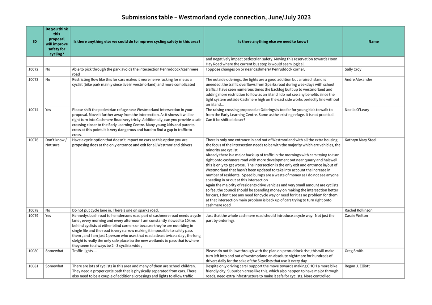
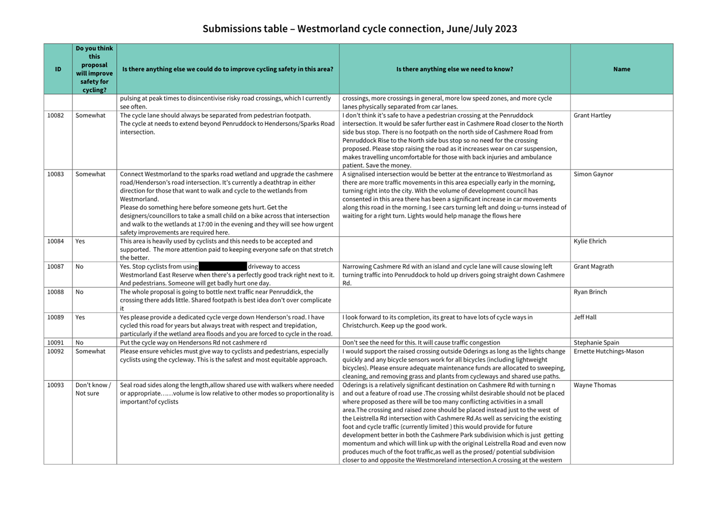
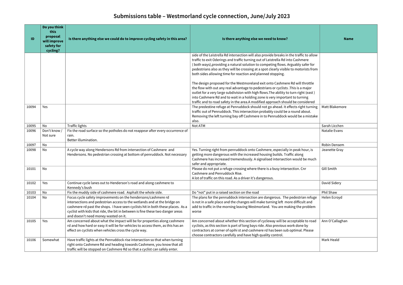
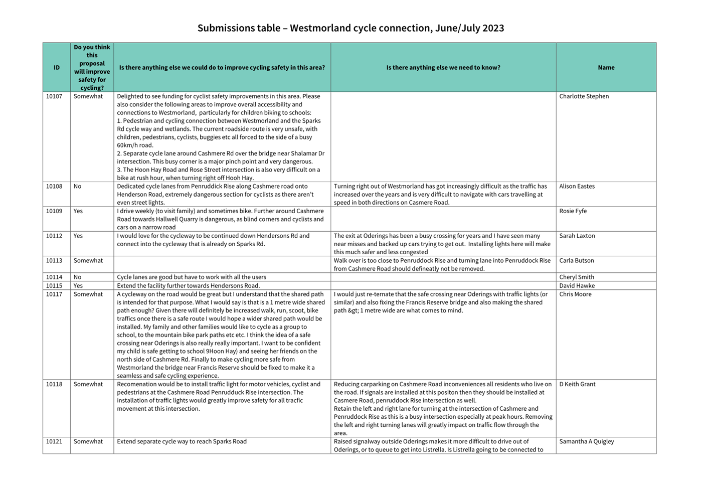
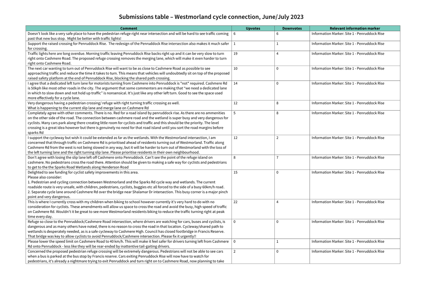
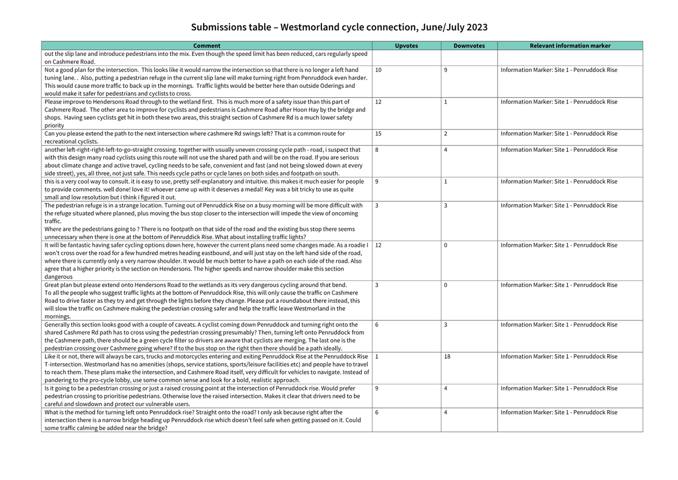
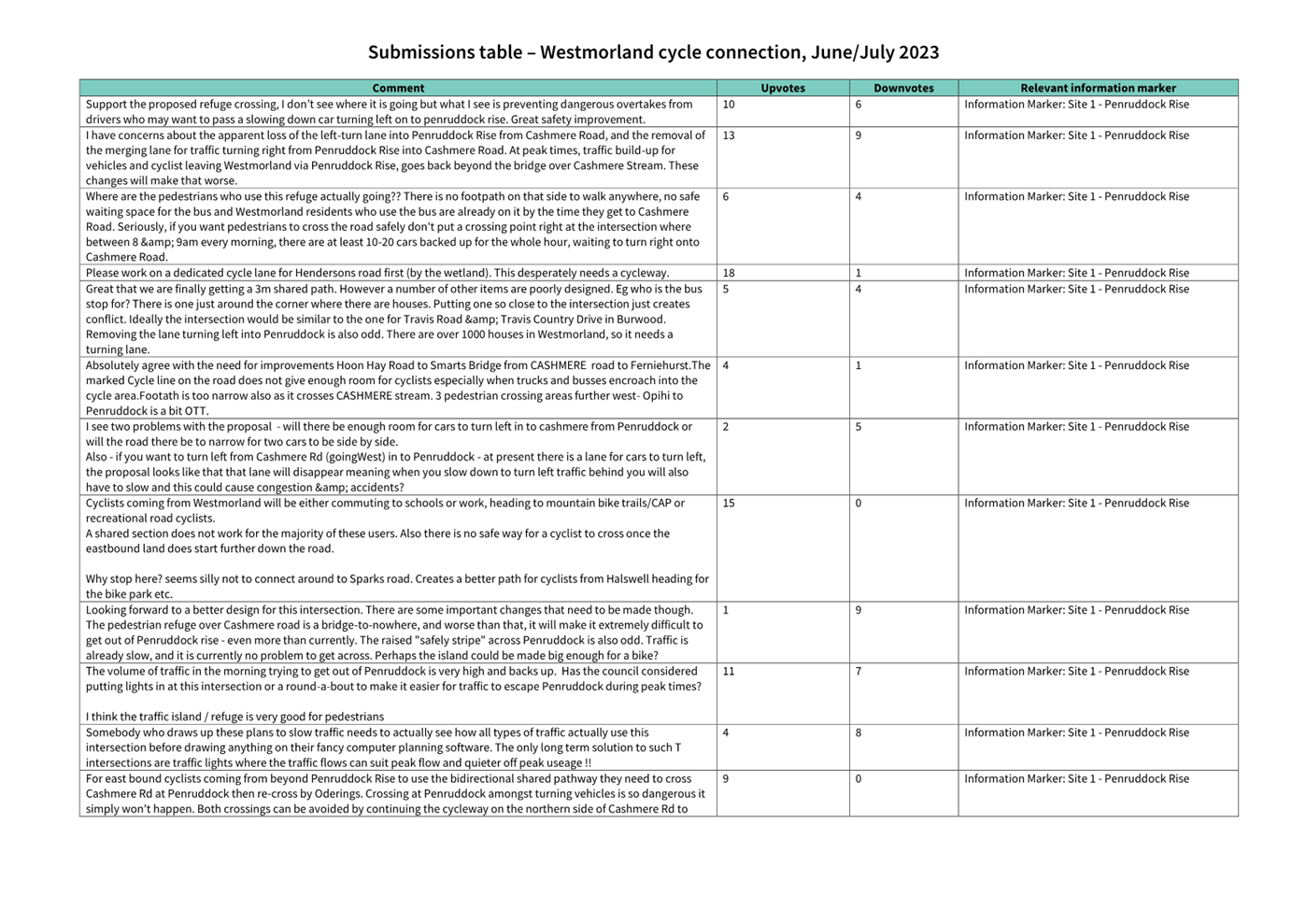
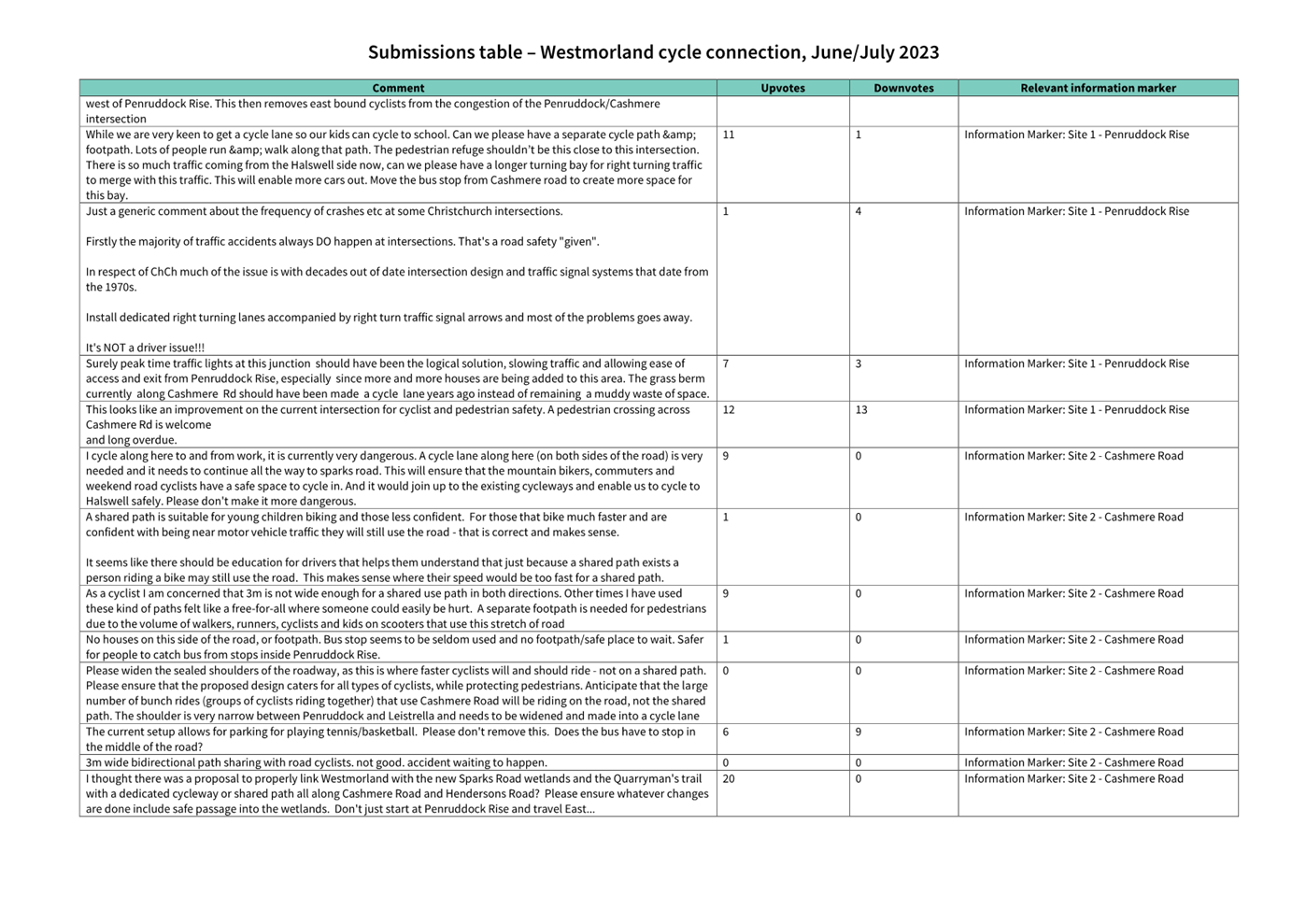
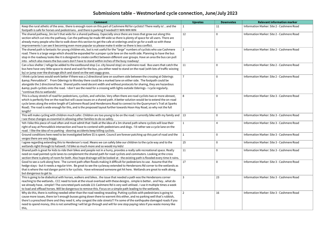
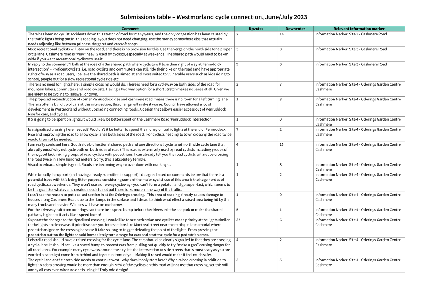
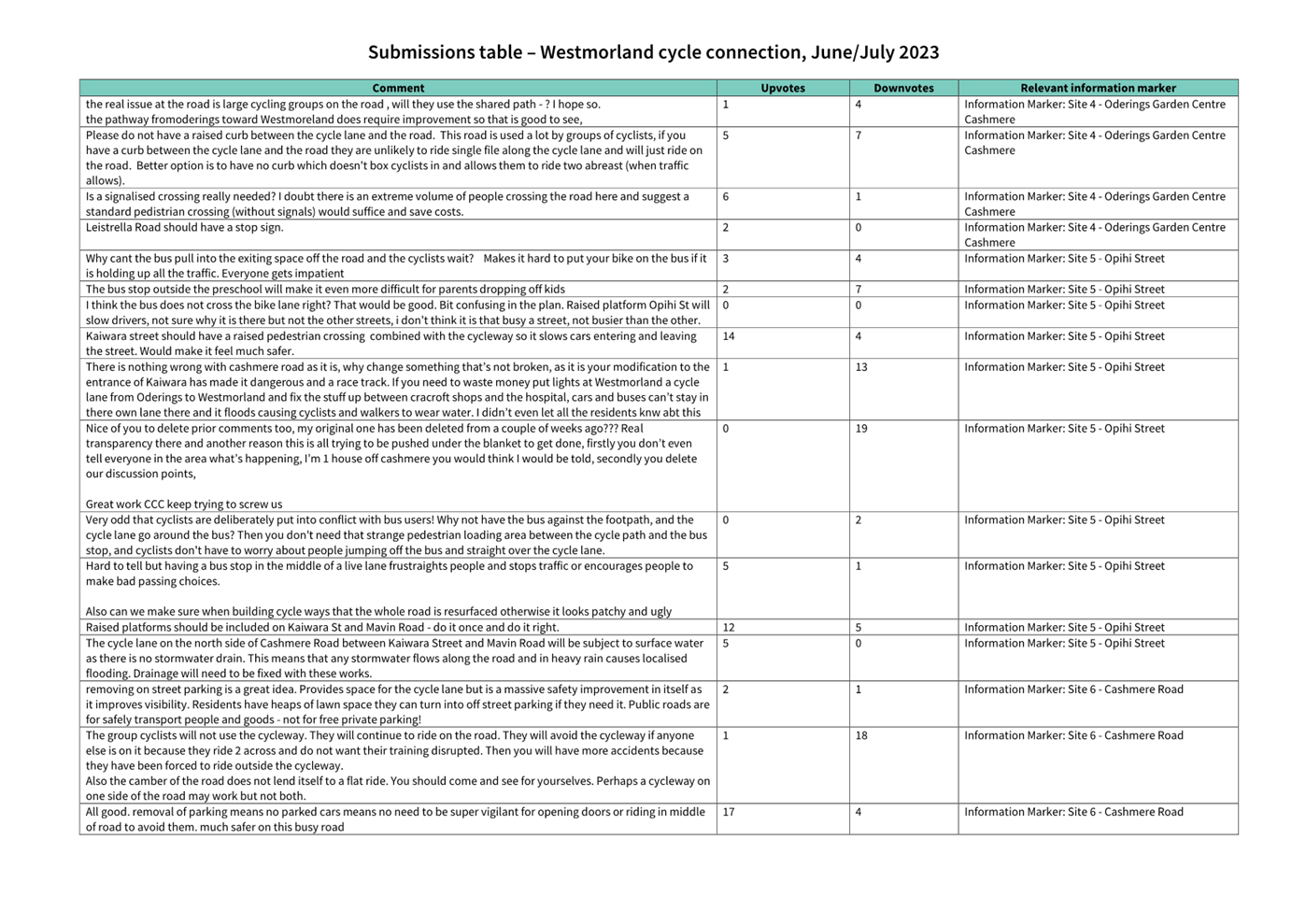
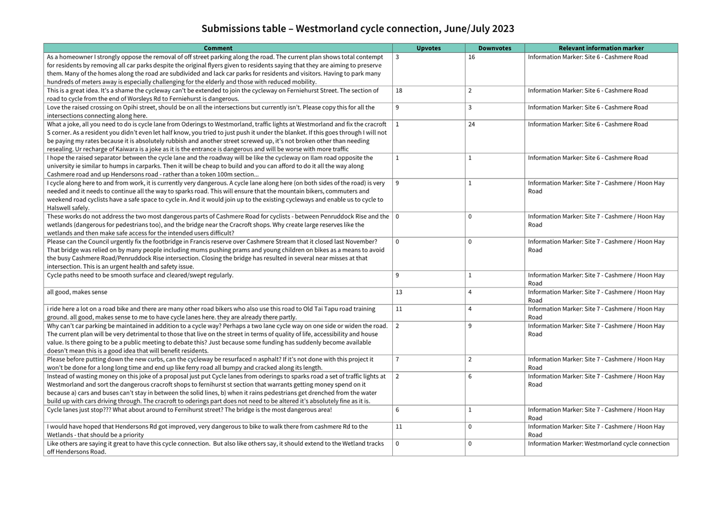
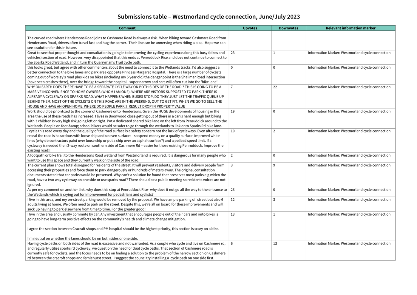
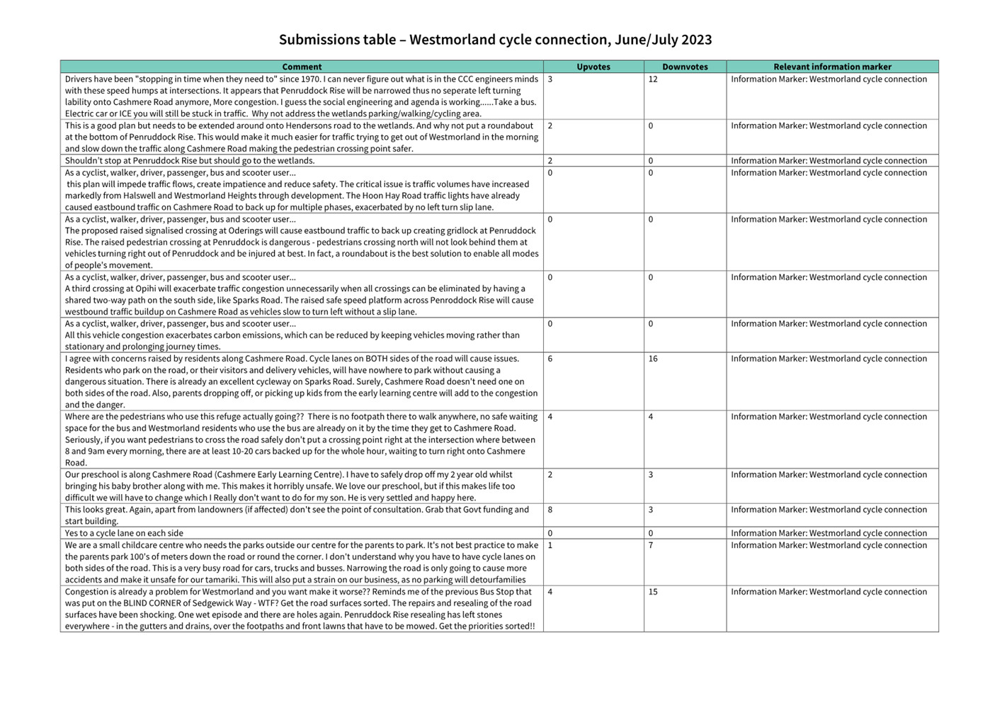
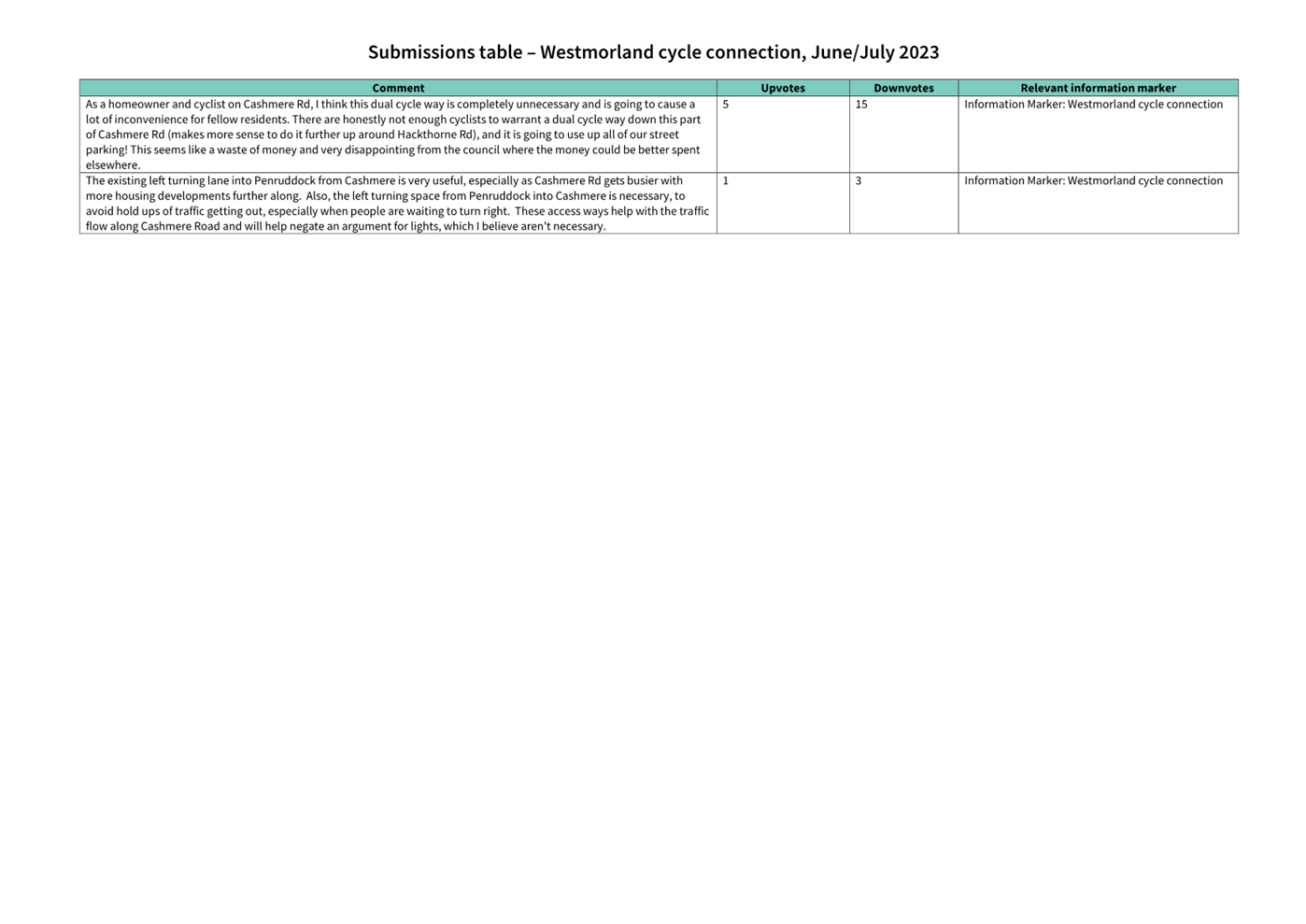
Summary of Submissions Ngā Tāpaetanga
5.19 Feedback
on the plans could be given by posting a comment on the Social
Pinpoint Map, by making a submission, or both.
5.20 A
total of 135 submissions and 143 comments were made on the project. 126
submissions were made in the interactive Social
Pinpoint Map, and 9 submissions were made via email/PDF. Submissions were
made by Waihoro Spreydon-Cashmere-Heathcote Community Board, Cashmere Early
Learning Centre, Oderings Nurseries Ltd, Cumbria Lane Residents Group,
Westmorland Residents’ Association, the Disabled Persons Assembly, and
129 individuals. All submissions and comments are available in Attachment B.
On
the Social
Pinpoint Map, the project received a total of 292 upvotes, 69 downvotes,
and 143 comments. Downvotes were prominent for Site 1 – Penruddock Rise,
with 24 downvotes.
Summary
from social pinpoint interactions
|
Project pin
|
Comments
|
Upvotes
|
Downvotes
|
|
Overall pin
|
28
|
59
|
9
|
|
Site 1 - Penruddock Rise
|
45
|
38
|
24
|
|
Site 2 - Cashmere Road
|
13
|
24
|
7
|
|
Site 3 - Cashmere Road
|
12
|
25
|
4
|
|
Site 4 - Oderings Garden Centre
|
16
|
33
|
8
|
|
Site 5 - Opihi Street
|
10
|
25
|
5
|
|
Site 6 - Cashmere Road
|
8
|
30
|
6
|
|
Site 7 – Cashmere Road/Hoon Hay Road
|
11
|
58
|
6
|
|
Total
|
143
|
292
|
69
|
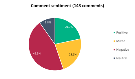
5.21 Comment
sentiment was analysed in addition to submissions, where majority of the
comments were negative (45.5%), 23.1% were mixed, and another 21.7% were
positive.
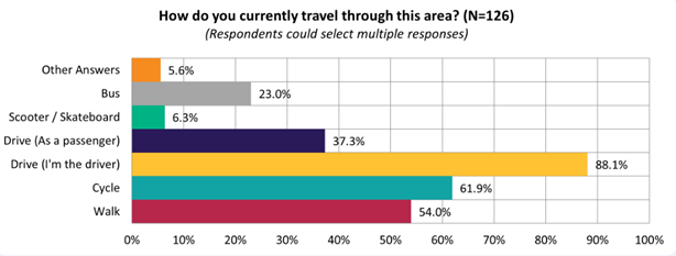
5.22 Submitters
were asked for their methods of travel through this area. The majority (88.1%)
of submitters use this area via car (as the driver):
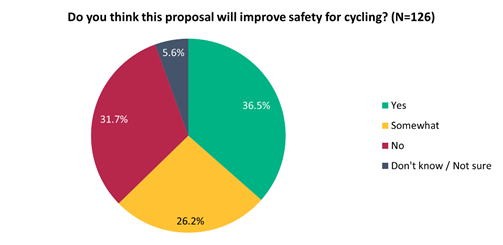
5.23 Submitters
were split on whether they felt this proposal would improve safety for cycling,
with 36.5% agreeing, 26.2% agreeing somewhat, and 31.7% disagreeing:
5.24 This
sentiment differed slightly depending on whether they live on the affected
streets (i.e. Cashmere Road, Penruddock Rise), live in local suburbs (i.e.
Cashmere, Westmorland, Hoon Hay), or live elsewhere:
|
Do you think this proposal
will improve safety for cycling?
|
Live on affected streets
|
Live in local suburbs
|
Live elsewhere
|
|
Yes
|
9
|
25
|
12
|
|
Somewhat
|
10
|
22
|
1
|
|
No
|
11
|
24
|
5
|
|
Don't
know / Not sure
|
0
|
7
|
0
|
5.25 Submitters
were also split on their support to install a raised signalised crossing
outside Oderings Garden Centre, with 45.6% not supporting, 26.2% somewhat
supporting, and 36.5% supporting:
5.26 Key
themes and requests from both comments and submissions are summarised below.
Note that there could be cross-over between those making comments and making
submissions:
|
Key themes on outcomes of
the proposal
|
Number of comments
|
Number of submissions
|
Total mentions
|
|
Support
for the dedicated cycleway
· Discussing how a dedicated
cycleway would address safety concerns cycling in the area
|
29
|
36
|
65
|
|
Concern
at the Penruddock Rise intersection
· Narrowing the intersection
would result in congestion, due to removing the left turning lane, and
reducing the width of the road with two refuge islands
|
26
|
39
|
65
|
|
Concern
around the need for a dedicated cycleway
· Lack of overall need of a
dedicated cycleway, discussed that it would be money wasted, removing width
of the road, restricting flow for cars and resulting in some cyclists still
using the road, and that Sparks Road is already a good enough cycleway
|
8
|
15
|
23
|
|
Concern
about loss of parking
· Concern on the amount of loss
of parking and the impact on residents and their families accessing houses
resulting from a dedicated cycleway
|
10
|
10
|
20
|
|
Concern
about the signalised crossing location
· Suggestions to shift this
crossing either east or west, as current proposed location will not cater to
pedestrians - it would not be used to cross to Oderings
|
5
|
11
|
16
|
|
Concern
about raised safety platforms
· Raised safety platforms will negatively
contribute to congestion, and that it wears on car suspension, and makes
travelling uncomfortable for those in vehicles, as well as the impact on
heavier vehicles
|
3
|
11
|
14
|
|
Concern
on the width of the shared path
· 3m not wide enough for the
shared pathway
· Most agreed with the shared
path, but wanted it to be further pushed out from the road to increase safety
and further delineate shared use
|
6
|
6
|
12
|
|
Concern
that the cycleway will not cater to all cyclists
· Not every cyclist would be
using this dedicated cycleway in this area, due to how many pelotons cycle
two to three abreast, and will likely contribute to further congestion as a
result
|
6
|
6
|
12
|
|
Requests
|
Number
of comments
|
Number
of submissions
|
Total
mentions
|
|
Extend
cycleway / investigate other routes
· Extend the cycle connection to
Sparks Road on Hendersons Road past the wetlands
· Extend the cycle connection
along the river past Princess Margaret Hospital
· Increase cycling safety at the
Hoon Hay intersection and on the bridge over Cashmere Stream
|
29
|
62
|
91
|
|
Request
for traffic lights / roundabout at Penruddock Rise
· Proposed roundabout or traffic
light treatment instead of pedestrian refuge islands to address safety and
congestion
|
11
|
10
|
21
|
|
Request
to reseal road
· Address condition of the road
and cycleway before putting this treatment in, or instead of a dedicated
cycleway altogether
|
4
|
8
|
12
|
|
Request
for more treatments at side streets
· Consistency of crossings
across Leistrella Road, Mavin Road and Kaiwara Street to have raised
intersections, better pedestrian facilities and kerb buildouts
|
6
|
3
|
9
|
|
Address
flooding
· Surface flooding with a lack
of stormwater drain between Kairwara Street and Mavin Road, as well as
outside Oderings
· Investigate ground conditions
generally before installing a cycleway
|
4
|
3
|
7
|
|
Change
the treatment to a bidirectional cycleway
· Several requests came through
to install a bidirectional cycleway to retain some parking
|
4
|
2
|
6
|
|
Fix
the Francis Reserve footbridge
· Address the Francis Reserve
broken footbridge to enhance cycling safety in the project area
|
1
|
3
|
4
|
Changes made to the scheme as a result
of consultation feedback
5.27 Reallocated
space of existing carriageway to increase the width of the separated cycleway
on both sides of Cashmere Road.
5.28 Inclusion
of Give Way controls at the intersections of Leistrella Road, Kaiwara Street,
Opihi Street and Mavin Road.
5.29 Relocate
the raised safety platform crossing outside Oderings Garden Centre further
east.
5.30 Increase
the centre island on Cashmere Road near Penruddock Rise and remove the crossing
facility at this point.
5.31 Provide
allocated space delineation to shared path for cyclists and pedestrians at
Penruddock Rise intersection.
5.32 The
bus stop opposite Francis Reserve will not become an in-lane stop and will
remain within the road shoulder.
Responses to comments and feedback not
included in the final scheme
5.33 Francis
Reserve footbridge – This footbridge is due for renewal and this is
planned to be complete by the end of 2023. This is being delivered by the
Parks Unit as a separate project.
5.34 Retaining
the left turn slip lane on Cashmere Road at Penruddock Rise – The removal
of the left turn lane will assist right turners out of Penruddock Rise.
Currently westbound traffic on Cashmere Road can travel through the
intersection unimpeded. With the removal of the left turn lane, westbound
traffic on Cashmere Road will have to slow down for left turning traffic into
Penruddock giving right turners out of Cashmere Road an opportunity to
go.
5.35 Extend
the cycle lanes further to the west (towards Hendersons Road and wetlands) and
further east – There is a wider cycle plan for the area that is in a
preliminary stage that extends the above project on Cashmere Road in both
directions.
5.36 Request
for signals at Penruddock Rise – Outside the scope of this project and
not aligned with the Transport Choices funding criteria.
6. Policy Framework Implications Ngā Hīraunga ā- Kaupapa here
Strategic Alignment Te
Rautaki Tīaroaro
6.1 This report supports the Council's Long Term Plan (2021 - 2031):
6.2 Transport
6.2.1 Activity: Transport
· Level of Service: 10.0.2 Increase the share of
non-car modes in daily trips - >=36% of trips undertaken by non-car modes
· Level of Service: 10.0.6.1 Reduce the number of
death and serious injury crashes on the local road network - <=100
crashes
· Level of Service: 10.0.41 Reduce emissions and
greenhouse gases related to transport - <=1.10 million tonnes of CO2
equivalents
· Level of Service: 10.5.1 Limit deaths and
serious injury crashes per capita for cyclists and pedestrians - <= 12
crashes per 100,000 residents
· Level of Service: 10.5.2 Improve the perception
that Christchurch is a cycling friendly city - >=66% resident satisfaction
· Level of Service: 10.5.3 More people are
choosing to travel by cycling - >=12,500 average daily cyclist detections
Policy
Consistency Te Whai
Kaupapa here
6.3 The
proposals are consistent with Council’s Plans and
Policies, in particular:
6.3.1 The
changes proposed align with road safety and liveable streets goals in the
Christchurch Transport Strategic Plan 2012–2042, and similarly in the
draft Transport Plan (safe streets).
6.3.2 The
changes proposed align with Kia tūroa te Ao - Ōtautahi Christchurch
Climate Resilience Strategy as set out in the Climate Change Impact
Considerations section below.
Impact
on Mana Whenua Ngā
Whai Take Mana Whenua
6.4 The
decision does not involve a significant decision in relation to ancestral land
or a body of water or other elements of intrinsic value, therefore this
decision does not specifically impact Mana Whenua, their culture and
traditions.
6.5 The
decision does not involve a matter of interest to Mana Whenua and should not
impact on our agreed partnership priorities with Ngā Papatipu
Rūnanga.
6.6 The
projects are based on minor changes to, or re-allocation of, existing road spaces,
so are not anticipated to have a significant impact on Mana Whenua.
Climate
Change Impact Considerations Ngā Whai Whakaaro mā te Āhuarangi
6.7 The
decisions in this report are likely to:
6.7.1 Contribute
neutrally to adaptation to the impacts of climate change.
6.7.2 Contribute
positively to emissions reductions.
6.8 The
emission reductions associated with this project have not been estimated.
6.9 The Government’s Emissions Reduction Plan states we
will have to ‘substantially improve infrastructure for walking and
cycling’ to meet our emissions targets (including a 20% reduction in
light Vehicle Kilometres Travelled by 2035 - required under the Emissions
Reduction Plan). Improving the quality of our streets for walking and cycling
is also a key part of the Ministry of Transport and Waka Kotahi’s efforts
to decarbonise the transport system.
6.10 New
Zealand has the 5th highest transport emissions rate per capita
among the 43 OECD countries. Petrol or diesel car use is typically the
single-biggest contributor to an individual’s carbon footprint in New
Zealand.
6.11 From
the 2022 Life in Christchurch Transport Survey, 96 percent of respondents
travel by car. Respondents find car travel the least difficult means of
travel. Inconsiderate and dangerous behaviour from other road users and
sharing the road with cars were the main reasons respondents found it difficult
to bike.
6.12 The proposed changes make it safer for people walking and cycling, which will have a net positive impact for the climate by
helping to reduce transport emissions. Enabling more people to walk or cycle,
particularly for local journeys, is a key part of council’s emissions
reduction efforts by providing a safe, low emission way for residents to move
around the city.
Accessibility
Considerations Ngā
Whai Whakaaro mā te Hunga Hauā
6.13 This proposal improves accessibility for people walking and
cycling, by providing a safer means of accessing and using our street network.
6.14 Waka
Kotahi developed a set of Project Design Parameters to ensure all projects work
to collectively meet the programme objectives. The Project Design
Parameters require that “the infrastructure should be designed for
children and people with visual, mobility, or cognitive impairments. If the
infrastructure works for them, it will work for a wider spectrum of the
population who are interested in walking and cycling but concerned for their
safety.” Transport Choices projects have been designed in
accordance with these requirements.
7. Resource Implications Ngā Hīraunga Rauemi
Capex/Opex Ngā Utu Whakahaere
7.1 Cost
to Implement - the total project estimate is $3,096,399. This is
inclusive of design and project management.
7.2 Maintenance/Ongoing
costs – $17,566 per year additional costs associated with coloured
surfacing, cycle lane separators, new signalised crossing and sweeping costs.
These costs will be eligible for Waka Kotahi subsidy at Council’s 51%
Funding Assistance Rate. The net maintenance cost for the full Transport Choices
programme will have an ongoing rates impact of approximately 0.01%, which will
be included in the draft Long Term Plan proposed budgets.
7.3 Funding Source –
Councils capital programme:
7.3.1 ID
72759, Transport Choices 2022 – Westmorland Cycle Connection, $1,334,668.
7.4 There
is a budget shortfall of $1,761,731 within ID #727759 to meet the project
funding requirements presently. The additional budget will be sourced by
reallocating budget within the Transport Choices programme. Expenditure
on the Transport Choices programme is forecast to be $25.3 million, which
compares to $26.8 million budget. It is proposed to align individual
project budgets in conjunction with Waka Kotahi physical works funding
approvals.
7.5 Waka
Kotahi through the Transport Choices programme will be funding the project up
to an agreed value which is calculated as 90% of the expected implementation
cost. The remaining 10% is Council’s share.
7.6 Under
the cost share agreement with Waka Kotahi, funding approvals for individual
Transport Choices projects are approved through two stage gates: design and
physical works. All Transport Choices projects have agreed funding schedules
for design. Individual project schedules for physical works are required to be
agreed and approved prior to 20 October 2023. In approving funding for physical
works, Waka Kotahi will consider:
7.6.1 The
project is in accordance with the scope and design approved by Waka
Kotahi.
7.6.2 Project
costs are in accordance with expectations.
7.6.3 Ability
to deliver the project prior to June 2024.
7.7 The
staff recommendations of this report include that Council’s approval of
this project is conditional on a funding agreement with Waka Kotahi being in
place for the physical works.
8. Legal Implications Ngā Hīraunga ā-Ture
Statutory power to undertake proposals in the report
Te Manatū Whakahaere Kaupapa
8.1 Council
resolved the Transport Choices programme as Metropolitan Significance when the
programme was included in the draft Annual Plan in February 2023/24.
8.2 Council
retains decision-making responsibilities that might otherwise be delegated in
accordance with the Delegations Register when a project is determined as
Metropolitan Significance.
8.3 Part
1, Clauses 7 and 8 of the Christchurch City Council Traffic and Parking Bylaw
2017 provides Council with the authority to install parking restrictions by
resolution.
8.4 The
installation of any signs and/or markings associated with traffic control
devices must comply with the Land Transport Rule: Traffic Control Devices 2004.
Other Legal Implications Ētahi atu
Hīraunga-ā-Ture
8.5 There
is no legal context, issue or implication relevant to this decision.
9. Risk Management Implications Ngā Hīraunga Tūraru
9.1 Scope
– Waka Kotahi has governed the scope and design of the project to align
with programme KPI’s and consistency with Transport Choices design
parameters. Departing from the recommendations of this report creates a risk
that Waka Kotahi would not agree to fund the physical works phase of the
project.
9.2 Delivery
– Transport Choices funding is subject to delivery being complete by June
2024. Waka Kotahi has established additional milestones to track
progress. Delays in approval of the projects would impact on the
timeframe for delivery.
9.3 Funding
security - the Transport Choices funding agreement between Council and Waka
Kotahi presently covers this project for design only, and a further stage gate
approval is required to gain funding approval for construction. The
instruction of physical works will be withheld until an implementation
agreement is in place.
9.4 Implementation
cost uncertainty – the funding agreement with Waka Kotahi places the risk
of cost variations with Council. This risk is being managed by minimising
price uncertainty and building contingency into the funding agreement.
Attachments Ngā Tāpirihanga
|
No.
|
Title
|
Reference
|
Page
|
|
a ⇩ 
|
Westmorland
Cycle Connection Scheme Plans
|
23/1386853
|
28
|
|
b ⇩
|
Westmorland -
Submission Table (Public)
|
23/1372181
|
31
|
In addition to the attached documents, the following background
information is available:
|
Document
Name – Location / File Link
|
|
Not
applicable
|
Confirmation of Statutory
Compliance Te Whakatūturutanga ā-Ture
|
Compliance with Statutory Decision-making
Requirements (ss 76 - 81 Local Government Act 2002).
(a) This report contains:
(i) sufficient information about all reasonably practicable
options identified and assessed in terms of their advantages and
disadvantages; and
(ii) adequate consideration of the views and preferences of
affected and interested persons bearing in mind any proposed or previous
community engagement.
(b) The information reflects the level of significance of the
matters covered by the report, as determined in accordance with the Council's
significance and engagement policy.
|
Signatories Ngā Kaiwaitohu
|
Authors
|
Ryan Rolston -
Programme Manager
Chris Strydom
- Project Manager
Wayne Gallot -
Senior Transportation Engineer
Ann Tomlinson
- Project Manager
Samantha Smith
- Engagement Advisor
Alanna
Warhurst - Project Manager
|
|
Approved By
|
Jacob Bradbury
- Manager Planning & Delivery Transport
Tony
Richardson - Finance Business Partner
Lynette Ellis
- Head of Transport & Waste Management
|
|
Council
21 September 2023
|

|
|
Council
21 September 2023
|
|
|
Council
21 September 2023
|

|
|
6. Transport Choices - Little River
Link Cycle Connections (Simeon Street)
|
|
Reference / Te Tohutoro:
|
23/1168779
|
|
Report of / Te Pou Matua:
|
Andrew
Cameron, Project Manager Transport, andrew.cameron@ccc.govt.nz;
Jacob Bradbury, Manager Planning & Delivery Transport,
Jacob.bradbury@ccc.govt.nz
|
|
Senior Manager / Pouwhakarae:
|
Lynette
Ellis, Head of Transport & Waste Management (Lynette.Ellis@ccc.govt.nz)
|
1. Nature of Issue and Report Origin
1.1 The purpose of this report is to inform the Council of
feedback received, and for the Council to approve the design to proceed to construction
for the Transport Choices Little River Link Cycle Connections (Simeon Street)
project.
1.2 The origin of this report is the Climate Emergency Response
Fund (CERF) Transport Choices programme.
1.3 The
decisions in this report are of medium significance in relation to the Christchurch
City Council’s Significance and Engagement Policy 2019. The
level of significance was determined by potential benefits and opportunities to
the council/community, the number of people affected and/or with an interest,
and that these projects span multiple community board areas, as set out in the
criteria of the policy (Page 2). This evaluation has considered the Transport
Choices projects as a cohesive programme of work. This is consistent with
how community engagement has been undertaken, with all work packages being
presented concurrently on Have your Say under the banner of Way Safer Streets.
2. Officer Recommendations Ngā
Tūtohu
That the Council:
1. Approves that construction of the Little River
Link Cycle Connections (Simeon Street) project is conditional on implementation
costs being agreed and incorporated into the Transport Choices Funding
agreement between Waka Kotahi and Council.
2. Approves the following recommendations
required for the implementation of the Little River Link Cycle Connections
(Simeon Street) project, relying on its powers under the Christchurch City
Council Traffic and Parking Bylaw 2017 and Part 21 of the Local Government Act
1974.
3. Approves that the traffic controls, stopping
and/or parking restrictions described in resolutions 4-120 take effect when
infrastructure, signage and/or road markings that evidence the controls and
restrictions are in place (or removed in the case of revocations) and, in the
case of traffic signal infrastructure, activated.
Revocations and
General
4. Approves that any previously approved
resolutions made pursuant to any Bylaw, Local Government Act or any Land
Transport Rule and pertaining to the existing uni-directional (southbound)
off-road cycle path on the east side of Simeon Street commencing at a point 6
metres from its intersection with Brougham Street when measured in a straight
line parallel to the Simeon Street boundary, and extending in a southerly
direction for a distance of 13 metres, be revoked. This includes the existing
Give Way control on the northern off-road cycle path approach to the Simeon
Street cul de sac turning head.
5. Approves that any previously approved
resolutions made pursuant to any Bylaw, Local Government Act or any Land
Transport Rule and pertaining to traffic controls, stopping and/or parking
restrictions (but excluding speed limits) on Simeon Street commencing at a
point 38 metres south of its intersection with Brougham Street when measured in
a straight line parallel to the Simeon Street boundary, and extending in a
southerly then southeasterly direction to its intersection with Milton Street,
be revoked.
6. Notes that recommendation 3 specifically
excludes existing traffic controls, stopping and parking restrictions
around the Simeon Street cul de sac turning head, the left turn slip lane from
the Simeon Street cul de sac to Brougham Street and shared path connection
between the Simeon Street cul de sac and Brougham Street on the west side of
Simeon Street.
7. Approves that any previously approved
resolutions made pursuant to any Bylaw, Local Government Act or any Land
Transport Rule and pertaining to traffic controls, stopping and/or parking
restrictions within 30 metres of the respective intersections of Simeon Street
with Andrews Crescent, Howard Street, Diamond Avenue, Rosewarne Street,
Coronation Street, Sydney Street, Elstow Place, Bletsoe Avenue, Rosebery
Street, Sugden Street, Meadowville Avenue, Althelston Street and Milton Street
be revoked.
8. Notes that recommendation 5 specifically
excludes the intersection of Simeon Street with Brougham Street, for which
Christchurch City Council is not the road controlling authority.
9. Notes that the distance of 30 metres
referenced in recommendation 5 is measured from existing kerb alignments,
whereas references to distances in the following recommendations hereinafter
are measured from existing kerb alignments where these are retained or new kerb
alignments where these have been modified as shown on plan(s) TP362301 sheets
1-4 (Little River Cycle Connections: Simeon Street, Issue 1, dated 08/2023) and
attached to this report as Attachment A.
10. Approves the road layout, including all kerb
alignments, road surface treatments, traffic islands and road markings on
Simeon Street, commencing at a point 38 metres south of its intersection with
Brougham Street, and extending in a southerly then southeasterly direction to
its intersection with Milton Street, and on intersecting road approaches to
Simeon Street (excluding Brougham Street), as detailed on plan(s) TP362301
sheets 1-4 (Little River Cycle Connections: Simeon Street, Issue 1, dated
08/2023) and attached to this report as Attachment A.
Bi-Directional
Cycle Facility
11. Approves pursuant to Section 334(1)(d) of the
Local Government Act 1974 that an off-road bi-directional cycle path, for the
use of cycles only, be established on the east side of Simeon Street commencing
at a point 6 metres south of its intersection with Brougham Street when
measured in a straight line parallel to the Simeon Street road boundary and
extending in a southerly direction for a distance of 13 metres.
12. Approves pursuant to Section 334(1)(d) of the
Local Government Act 1974 that a separated bi-directional cycle facility, for
the use of cycles only, be established on the east side of Simeon Street
commencing at a point 38 metres south of its intersection with Brougham Street
when measured in a straight line parallel to the Simeon Street road boundary
and extending in a southerly direction for a distance of 131 metres.
13. Approves pursuant to Section 334(1)(d) of the
Local Government Act 1974 that a separated bi-directional cycle facility, for
the use of cycles only, be established on the east side of Simeon Street
commencing at a point 197 metres south of its intersection with Brougham Street
when measured in a straight line parallel to the Simeon Street road boundary
and extending in a southerly then southeasterly direction (on the northeast
side of Simeon Street) to a point 5 metres northwest of its intersection with
Rosewarne Street.
14. Approves pursuant to Section 334(1)(d) of the
Local Government Act 1974 that a separated bi-directional cycle facility, for the use of cycles only, be established on the
northeast side of Simeon Street commencing at a point 5 metres southeast of its
intersection with Rosewarne Street and extending in a southeasterly direction
to a point 18 metres northwest of its intersection with Coronation Street.
15. Approves pursuant to Section 334(1)(d) of the
Local Government Act 1974 that a separated bi-directional cycle facility, for
the use of cycles only, be established on the northeast side of Simeon Street
commencing at a point 18 metres southeast of its intersection with Coronation
Street and extending in a southeasterly direction to a point 6 metres northwest
of its intersection with Sydney Street.
16. Approves pursuant to Section 334(1)(d) of the
Local Government Act 1974 that a separated bi-directional cycle facility, for
the use of cycles only, be established on the northeast side of Simeon Street
commencing at a point 6 metres southeast of its intersection with Sydney Street
and extending in a southeasterly direction to a point 5 metres northwest of its
intersection with Elstow Place.
17. Approves pursuant to Section 334(1)(d) of the
Local Government Act 1974 that a separated bi-directional cycle facility, for
the use of cycles only, be established on the northeast side of Simeon Street
commencing at a point 11 metres southeast of its intersection with Elstow Place
and extending in a southeasterly direction to a point 6 metres northwest of its
intersection with Bletsoe Avenue.
18. Approves pursuant to Section 334(1)(d) of the
Local Government Act 1974 that a separated bi-directional cycle facility, for
the use of cycles only, be established on the northeast side of Simeon Street
commencing at a point 7 metres southeast of its intersection with Bletsoe
Avenue and extending in a southeasterly direction to a point 5 metres northwest
of its intersection with Rosebery Street.
19. Approves pursuant to Section 334(1)(d) of the
Local Government Act 1974 that a separated bi-directional cycle facility, for
the use of cycles only, be established on the northeast side of Simeon Street
commencing at a point 5 metres southeast of its intersection with Rosebery
Street and extending in a southeasterly direction to a point 6 metres northwest
of its intersection with Meadowville Avenue.
20. Approves pursuant to Section 334(1)(d) of the
Local Government Act 1974 that a separated bi-directional cycle facility, for
the use of cycles only, be established on the northeast side of Simeon Street
commencing at a point 5 metres southeast of its intersection with Meadowville
Avenue and extending in a southeasterly direction to a point 12 metres
northwest of its intersection with Milton Street.
Cycle Lanes
21. Approves, pursuant to Clause 18 of the
Christchurch City Council Traffic and Parking Bylaw 2017, that a special
vehicle lane for the use of cycles travelling in a northeast direction, be
established on the northwest side of Coronation Street commencing at a point 14
metres southwest of its intersection with Simeon Street and extending in a
northeasterly direction to a point 37 metres northeast of its intersection with
Simeon Street. This reinstates an existing special vehicle (cycle) lane on this
section of Coronation Street and ties in to the existing special vehicle
(cycle) lane continuing further northeast that is not affected by this project.
22. Approves, pursuant to Clause 18 of the
Christchurch City Council Traffic and Parking Bylaw 2017, that a special
vehicle lane for the use of cycles travelling in a southwest direction, be
established on the southeast side of Coronation Street commencing at a point 30
metres northeast of its intersection with Simeon Street and extending in a
southwesterly direction to a point 18 metres southwest of its intersection with
Simeon Street. This reinstates an existing special vehicle (cycle) lane on this
section of Coronation Street and ties in to the existing special vehicle
(cycle) lane connecting from further northeast that is not affected by this
project.
23. Approves, pursuant to Clause 18 of the
Christchurch City Council Traffic and Parking Bylaw 2017, that a special
vehicle lane for the use of cycles travelling in a northeast direction, be
established on the northwest side of Athelstan Street commencing at a point 30
metres southwest of its intersection with Simeon Street and extending in a
northeasterly direction to a point 20 metres southwest of its intersection with
Simeon Street. This reinstates an existing special vehicle (cycle) lane on this
section of Athelstan Street and ties in to the existing special vehicle (cycle)
lane connecting from further southwest that is not affected by this project.
24. Approves, pursuant to Clause 18 of the
Christchurch City Council Traffic and Parking Bylaw 2017, that a special
vehicle lane for the use of cycles travelling in a southwest direction, be
established on the southeast side of Athelstan Street commencing at a point 20
metres southwest of its intersection with Simeon Street and extending in a
southwesterly direction to a point 30 metres southwest of its intersection with
Simeon Street. This reinstates an existing special vehicle (cycle) lane on this
section of Athelstan Street and ties in to the existing special vehicle (cycle)
lane continuing further southwest that is not affected by this project
25. Approves, pursuant to Clause 18 of the
Christchurch City Council Traffic and Parking Bylaw 2017, that a special
vehicle lane for the use of cycles travelling in a northeast direction, be
established on the northwest side of Milton Street commencing at a point 30
metres southwest of its intersection with Simeon Street and extending in a
northeasterly direction to a point 34 metres northeast of its intersection with
Simeon Street. This reinstates an existing special vehicle (cycle) lane on this
section of Milton Street and ties in to the existing special vehicle (cycle)
lane continuing in both the northeast and southwest directions that are not
affected by this project.
26. Approves, pursuant to Clause 18 of the
Christchurch City Council Traffic and Parking Bylaw 2017, that a special vehicle
lane for the use of cycles travelling in a southwest direction, be established
on the southeast side of Milton Street commencing at a point 30 metres
northeast of its intersection with Simeon Street and extending in a
southwesterly direction to a point 30 metres southwest of its intersection with
Simeon Street. This reinstates an existing special vehicle (cycle) lane on this
section of Milton Street and ties in to the existing special vehicle (cycle)
lane continuing in both the northeast and southwest directions that are not
affected by this project.
Shared Paths
27. Approves that a bi-directional Shared Path be
resolved in accordance with Clause 21 of the Christchurch City Council Traffic
& Parking Bylaw 2017, and in accordance with Section 11.4 of the Land
Transport Rule: Traffic Control Devices 2004 on the east side of Simeon Street
commencing at a point 170 metres south of its intersection with Brougham Street
when measured in a straight line parallel with the Simeon Street boundary and
extending in a southerly direction for a distance of 31 metres from its intersection
with Simeon Street. This Shared Path is for use by the classes of road user
only as defined in Section 11.1A of the Land Transport (Road User) Rule: 2004.
28. Approves that a bi-directional Shared Path be
resolved in accordance with Clause 21 of the Christchurch City Council Traffic
& Parking Bylaw 2017, and in accordance with Section 11.4 of the Land
Transport Rule: Traffic Control Devices 2004 on the northeast side of Simeon
Street commencing at a point 19 metres northwest of its intersection with Coronation
Street and extending in a southeast direction to its intersection with
Coronation Street and then in a northeast direction on the northwest side of
Coronation Street commencing at its intersection with Simeon Street and
extending in a northeast direction to a point 13 metres from its intersection
with Simeon Street. This Shared Path is for use by the classes of road user
only as defined in Section 11.1A of the Land Transport (Road User) Rule: 2004.
29. Approves that a bi-directional Shared Path be resolved
in accordance with Clause 21 of the Christchurch City Council Traffic &
Parking Bylaw 2017, and in accordance with Section 11.4 of the Land Transport
Rule: Traffic Control Devices 2004 on the northeast side of Simeon Street
commencing at a point 18 metres southeast of its intersection with Coronation
Street and extending in a northwest direction to its intersection with
Coronation Street and then in a northeast direction on the southeast side of
Coronation Street commencing at its intersection with Simeon Street and
extending in a northeast direction to a point 13 metres from its intersection
with Simeon Street. This Shared Path is for use by the classes of road user
only as defined in Section 11.1A of the Land Transport (Road User) Rule: 2004.
30. Approves that a bi-directional Shared Path be
resolved in accordance with Clause 21 of the Christchurch City Council Traffic
& Parking Bylaw 2017, and in accordance with Section 11.4 of the Land
Transport Rule: Traffic Control Devices 2004 on the northeast side of Simeon
Street commencing at a point 12 metres northwest of its intersection with
Milton Street and extending in a southeast direction to its intersection with
Milton Street and then in a northeast direction on the northwest side of Milton
Street commencing at its intersection with Simeon Street and extending in a
northeast direction to a point 22 metres from its intersection with Simeon
Street. This Shared Path is for use by the classes of road user only as defined
in Section 11.1A of the Land Transport (Road User) Rule: 2004.
31. Approves that a bi-directional Shared Path be
resolved in accordance with Clause 21 of the Christchurch City Council Traffic
& Parking Bylaw 2017, and in accordance with Section 11.4 of the Land
Transport Rule: Traffic Control Devices 2004 on the southeast side of Milton
Street commencing at its intersection with Simeon Street and extending in a
northeast direction to a point 22 metres from its intersection with Simeon
Street. This Shared Path is for use by the classes of road user only as defined
in Section 11.1A of the Land Transport (Road User) Rule: 2004.
Priority
Controlled Crossings
32. Approves pursuant to Section 334(1)(d) of the
Local Government Act 1974 that a pedestrian crossing be resolved and established
on a raised platform in accordance with Section 8.2 of Land Transport Rule:
Traffic Control Devices 2004 on Simeon Street (including across the separated
cycle facility detailed in recommendation 9) commencing at a point 6 metres
north of its intersection with Andrews Crescent and extending in a northerly
direction for a distance of 3 metres.
33. Approves pursuant to Section 334(1)(d) of the
Local Government Act 1974 that a pedestrian crossing be resolved and
established on a raised platform in accordance with Section 8.2 of Land
Transport Rule: Traffic Control Devices 2004 on Simeon Street (including across
the separated cycle facility detailed in recommendation 10) commencing at a
point 9 metres south of its intersection with Howard (being the intersecting
point of the prolongation of the Howard Street and Simeon Street kerb lines)
and extending in a southerly direction for a distance of 3 metres.
34. Approves pursuant to Section 334(1)(d) of the
Local Government Act 1974 that a pedestrian crossing be resolved and
established on a raised platform in accordance with Section 8.2 of Land
Transport Rule: Traffic Control Devices 2004 on Coronation Street commencing at
a point 9.5 metres northeast of its intersection with Simeon Street and
extending in a northeast direction for a distance of 3 metres.
35. Approves pursuant to Section 334(1)(d) of the
Local Government Act 1974 that a priority cycle crossing be established on a
raised platform on Coronation Street commencing at a point 6.5 metres northeast
of its intersection with Simeon Street and extending in a northeast direction
for a distance of 3 metres and further approves that Give Way controls are
placed against traffic travelling northeast and southwest on Coronation Street
on each approach to this cycle crossing requiring that traffic to give way to
users of the cycle crossing facility (in addition to users of the adjacent
pedestrian crossing). These Give Way controls are to be evidenced by signs
and/or markings installed in accordance with Land Transport Rule: Traffic
Control Devices 2004.
36. Approves pursuant to Section 334(1)(d) of the
Local Government Act 1974 that a pedestrian crossing be resolved and
established on a raised platform in accordance with Section 8.2 of Land
Transport Rule: Traffic Control Devices 2004 across the separated cycle
facility on the northeast side of Simeon Street (if approved in accordance with
recommendation 17) commencing at a point 48 metres northwest of the
intersection of Simeon Street with Milton Street and extending in a northwest
direction for a distance of 2 metres.
37. Approves pursuant to Section
334(1)(d) of the Local Government Act 1974 that a signalised roadway
crossing for the use of pedestrians and cycles be installed on Milton Street,
commencing at a point 16 metres northeast of its intersection with Simeon
Street (northwest leg) and extending in a northeast direction for a distance of
5 metres. The signalised crossing is to be installed and operated in accordance
with relevant sections of Land Transport Rule: Traffic Control Devices 2004.
Intersection
Controls
38. Approves that the off-road bi-directional
cycle path described in recommendation 9 at its north approach to the Simeon
Street cul de sac head be controlled by a Give Way control, in accordance with Section
4 and Section 10.3 of the Land Transport Rule: Traffic Control Devices 2004.
39. Approves that the separated bi-directional
cycle facility described in recommendation 10 at its south approach to the
Simeon Street cul de sac head be controlled by a Give Way control, in
accordance with Section 4 and Section 10.3 of the Land Transport Rule: Traffic
Control Devices 2004.
40. Approves that the separated bi-directional
cycle facility described in recommendation 11 at its northwest approach to
Rosewarne Street be controlled by a Give Way control, in accordance with
Section 4 and Section 10.3 of the Land Transport Rule: Traffic Control Devices
2004.
41. Approves that the separated bi-directional
cycle facility described in recommendation 12 at its southeast approach to
Rosewarne Street be controlled by a Give Way control, in accordance with
Section 4 and Section 10.3 of the Land Transport Rule: Traffic Control Devices
2004.
42. Approves that the northeast approach of
Rosewarne Street at its intersection with Simeon Street be controlled by a Stop
control, in accordance with Section 4 and Section 10.2 of the Land Transport
Rule: Traffic Control Devices 2004.
43. Approves that the northwest approach of Simeon
Street at its intersection with Coronation Street be controlled by a Give Way
control, in accordance with Section 4 and Section 10.3 of the Land Transport
Rule: Traffic Control Devices 2004.
44. Approves that the southeast approach of Simeon
Street at its intersection with Coronation Street be controlled by a Give Way
control, in accordance with Section 4 and Section 10.3 of the Land Transport
Rule: Traffic Control Devices 2004.
45. Approves that the separated bi-directional
cycle facility described in recommendation 13 at its northwest approach to
Sydney Street be controlled by a Give Way control, in accordance with Section 4
and Section 10.3 of the Land Transport Rule: Traffic Control Devices 2004.
46. Approves that the northeast approach of Sydney
Street at its intersection with Simeon Street be controlled by a Stop control,
in accordance with Section 4 and Section 10.2 of the Land Transport Rule:
Traffic Control Devices 2004.
47. Approves that the separated bi-directional
cycle facility described in recommendation 14 at its southeast approach to
Sydney Street and at its northwest approach to Elstow Place be controlled by a
Give Way control, in accordance with Section 4 and Section 10.3 of the Land
Transport Rule: Traffic Control Devices 2004.
48. Approves that the northeast approach of Elstow
Place at its intersection with Simeon Street be controlled by a Stop control,
in accordance with Section 4 and Section 10.2 of the Land Transport Rule:
Traffic Control Devices 2004.
49. Approves that the separated bi-directional
cycle facility described in recommendation 15 at its southeast approach to
Elstow Place and at its northwest approach to Bletsoe Avenue be controlled by a
Give Way control, in accordance with Section 4 and Section 10.3 of the Land
Transport Rule: Traffic Control Devices 2004.
50. Approves that the northeast approach of
Bletsoe Avenue at its intersection with Simeon Street be controlled by a Stop
control, in accordance with Section 4 and Section 10.2 of the Land Transport
Rule: Traffic Control Devices 2004.
51. Approves that the separated bi-directional
cycle facility described in recommendation 16 at its southeast approach to
Bletsoe Avenue and at its northwest approach to Rosebery Street be controlled
by a Give Way control, in accordance with Section 4 and Section 10.3 of the
Land Transport Rule: Traffic Control Devices 2004.
52. Approves that the northeast approach of
Rosebery Street at its intersection with Simeon Street be controlled by a Stop
control, in accordance with Section 4 and Section 10.2 of the Land Transport
Rule: Traffic Control Devices 2004.
53. Approves that the separated bi-directional
cycle facility described in recommendation 17 at its southeast approach to
Rosebery Street and at its northwest approach to Meadowville Avenue be
controlled by a Give Way control, in accordance with Section 4 and Section 10.3
of the Land Transport Rule: Traffic Control Devices 2004.
54. Approves that the northeast approach of
Meadowville Avenue at its intersection with Simeon Street be controlled by a
Stop control, in accordance with Section 4 and Section 10.2 of the Land
Transport Rule: Traffic Control Devices 2004.
55. Approves that the separated bi-directional
cycle facility described in recommendation 18 at its southeast approach to
Meadowville Avenue be controlled by a Give Way control, in accordance with
Section 4 and Section 10.3 of the Land Transport Rule: Traffic Control Devices
2004.
56. Approves that the southwest approach of
Athelstan Street at its intersection with Simeon Street be controlled by a Stop
control, in accordance with Section 4 and Section 10.2 of the Land Transport
Rule: Traffic Control Devices 2004.
57. Approves that the northwest approach of Simeon
Street at its intersection with Milton Street be controlled by a Stop control,
in accordance with Section 4 and Section 10.2 of the Land Transport Rule:
Traffic Control Devices 2004.
58. Approves that the southeast approach of Simeon
Street at its intersection with Milton Street be controlled by a Stop control,
in accordance with Section 4 and Section 10.2 of the Land Transport Rule:
Traffic Control Devices 2004.
Stopping and
Parking Restrictions – West / Southwest Side (including side roads)
59. Approves, pursuant to Clause 7 of the
Christchurch City Council Traffic and Parking Bylaw 2017, that the stopping of
all vehicles is prohibited at all times on the west side of Simeon Street
commencing at a point 38 metres south of its intersection with Brougham Street
when measured in a straight line parallel to the Simeon Street road boundary,
and extending in a southerly direction for a distance of 5 metres.
60. Approves, pursuant to Clause 7 of the
Christchurch City Council Traffic and Parking Bylaw 2017, that the stopping of
all vehicles is prohibited at all times on the west side of Simeon Street
commencing at its intersection with Andrews Crescent and extending in a
northerly direction for a distance of 35 metres.
61. Approves, pursuant to Clause 7 of the
Christchurch City Council Traffic and Parking Bylaw 2017, that the stopping of
all vehicles is prohibited at all times on the north side of Andrews Crescent
commencing at its intersection with Simeon Street and extending in a westerly
direction for a distance of 30 metres. This reinstates
existing stopping restrictions on this section of Andrews Crescent and ties in
to the existing stopping restrictions continuing further west that are not
affected by this project.
62. Approves, pursuant to Clause 7 of the
Christchurch City Council Traffic and Parking Bylaw 2017, that the stopping of
all vehicles is prohibited at all times on the south side of Andrews Crescent
commencing at its intersection with Simeon Street and extending in a westerly
direction for a distance of 14 metres.
63. Approves, pursuant to Clause 7 of the
Christchurch City Council Traffic and Parking Bylaw 2017, that the stopping of
all vehicles is prohibited at all times on the west side of Simeon Street
commencing at its intersection with Andrews Crescent and extending in a
southerly direction for a distance of 9 metres.
64. Approves, pursuant to Clause 7 of the
Christchurch City Council Traffic and Parking Bylaw 2017, that the stopping of
all vehicles is prohibited at all times on the west side of Simeon Street
commencing at its intersection with Howard Street and extending in a northerly
direction for a distance of 17 metres.
65. Approves, pursuant to Clause 7 of the
Christchurch City Council Traffic and Parking Bylaw 2017, that the stopping of
all vehicles is prohibited at all times on the north / northwest side of Howard
Street commencing at its intersection with Simeon Street and extending in a
west / southwesterly direction for a distance of 13 metres.
66. Approves, pursuant to Clause 7 of the
Christchurch City Council Traffic and Parking Bylaw 2017, that the stopping of
all vehicles is prohibited at all times on the southeast side of Howard Street
commencing at its intersection with Simeon Street (being the intersecting point
of the prolongation of the Howard Street and Simeon Street kerb lines) and
extending in a southwesterly direction for a distance of 13 metres.
67. Approves, pursuant to Clause 7 of the
Christchurch City Council Traffic and Parking Bylaw 2017, that the stopping of
all vehicles is prohibited at all times on the west side of Simeon Street
commencing at its intersection with Howard Street (being the intersecting point
of the prolongation of the Howard Street and Simeon Street kerb lines) and
extending in a southerly direction for a distance of 23 metres.
68. Approves, pursuant to Clause 7 of the
Christchurch City Council Traffic and Parking Bylaw 2017, that a Bus Stop for
scheduled bus services only (per the definition of bus service in Section 5 of
the Land Transport Management Act 2003) be installed on the west side of Simeon
Street commencing at a point 38 metres south of its intersection with Howard
Street (being the intersecting point of the prolongation of the Howard Street and
Simeon Street kerb lines) and extending in a southerly direction for a distance
of 13 metres. This reinstates existing Metro Bus Stop ID 22810.
69. Approves, pursuant to Clause 7 of the
Christchurch City Council Traffic and Parking Bylaw 2017, that the stopping of
all vehicles is prohibited at all times on the southwest side of Simeon Street
commencing at its intersection with Diamond Avenue and extending in a
northwesterly direction for a distance of 10 metres.
70. Approves, pursuant to Clause 7 of the Christchurch
City Council Traffic and Parking Bylaw 2017, that the stopping of all vehicles
is prohibited at all times on the northwest side of Diamond Avenue commencing
at its intersection with Simeon Street and extending in a southwesterly
direction for a distance of 10 metres.
71. Approves, pursuant to Clause 7 of the
Christchurch City Council Traffic and Parking Bylaw 2017, that the stopping of
all vehicles is prohibited at all times on the southeast side of Diamond Avenue
commencing at its intersection with Simeon Street and extending in a
southwesterly direction for a distance of 10 metres.
72. Approves, pursuant to Clause 7 of the
Christchurch City Council Traffic and Parking Bylaw 2017, that the stopping of
all vehicles is prohibited at all times on the southwest side of Simeon Street
commencing at its intersection with Diamond Avenue and extending in a
southeasterly direction for a distance of 25 metres.
73. Approves, pursuant to Clause 7 of the
Christchurch City Council Traffic and Parking Bylaw 2017, that the stopping of
all vehicles is prohibited at all times on the southwest side of Simeon Street
commencing at its intersection with Coronation Street and extending in a
northwesterly direction for a distance of 23 metres.
74. Approves, pursuant to Clause 7 of the
Christchurch City Council Traffic and Parking Bylaw 2017, that the stopping of
all vehicles is prohibited at all times on the northwest side of Coronation
Street commencing at its intersection with Simeon Street and extending in a
southwesterly direction for a distance of 16 metres.
75. Approves, pursuant to Clause 7 of the
Christchurch City Council Traffic and Parking Bylaw 2017, that the stopping of
all vehicles is prohibited at all times on the southeast side of Coronation
Street commencing at its intersection with Simeon Street and extending in a
southwesterly direction for a distance of 18 metres.
76. Approves, pursuant to Clause 7 of the
Christchurch City Council Traffic and Parking Bylaw 2017, that the stopping of
all vehicles is prohibited at all times on the southwest side of Simeon Street
commencing at its intersection with Coronation Street and extending in a
southeasterly direction for a distance of 28 metres.
77. Approves, pursuant to Clause 7 of the
Christchurch City Council Traffic and Parking Bylaw 2017, that the stopping of
all vehicles is prohibited at all times on the southwest side of Simeon Street
commencing at a point 107 metres northwest of its intersection with Sugden
Street and extending in a northwesterly direction for a distance of 34 metres.
78. Approves, pursuant to Clause 7 of the
Christchurch City Council Traffic and Parking Bylaw 2017, that the stopping of
all vehicles is prohibited at all times on the southwest side of Simeon Street
commencing at its intersection with Sugden Street and extending in a
northwesterly direction for a distance of 12 metres.
79. Approves, pursuant to Clause 7 of the
Christchurch City Council Traffic and Parking Bylaw 2017, that the stopping of
all vehicles is prohibited at all times on the northwest side of Sugden Street
commencing at its intersection with Simeon Street and extending in a
southwesterly direction for a distance of 12 metres.
80. Approves, pursuant to Clause 7 of the
Christchurch City Council Traffic and Parking Bylaw 2017, that the stopping of
all vehicles is prohibited at all times on the southeast side of Sugden Street
commencing at its intersection with Simeon Street and extending in a
southwesterly direction for a distance of 12 metres.
81. Approves, pursuant to Clause 7 of the
Christchurch City Council Traffic and Parking Bylaw 2017, that the stopping of
all vehicles is prohibited at all times on the southwest side of Simeon Street
commencing at its intersection with Sugden Street and extending in a
southeasterly direction for a distance of 7 metres.
82. Approves, pursuant to Clause 7 of the
Christchurch City Council Traffic and Parking Bylaw 2017, that the stopping of
all vehicles is prohibited at all times on the southwest side of Simeon Street
commencing at a point 68 metres southeast of its intersection with Sugden
Street and extending in a southeasterly direction for a distance of 9 metres.
83. Approves, pursuant to Clause 7 of the
Christchurch City Council Traffic and Parking Bylaw 2017, that the stopping of
all vehicles is prohibited at all times on the southwest side of Simeon Street
commencing at its intersection with Athelstan Street and extending in a
northwesterly direction for a distance of 11 metres.
84. Approves, pursuant to Clause 7 of the
Christchurch City Council Traffic and Parking Bylaw 2017, that the stopping of
all vehicles is prohibited at all times on the northwest side of Athelstan
Street commencing at its intersection with Simeon Street and extending in a
southwesterly direction for a distance of 21 metres.
85. Approves, pursuant to Clause 7 of the
Christchurch City Council Traffic and Parking Bylaw 2017, that the stopping of
all vehicles is prohibited at all times on the southeast side of Athelstan
Street commencing at its intersection with Simeon Street and extending in a
southwesterly direction for a distance of 20 metres.
86. Approves, pursuant to Clause 7 of the
Christchurch City Council Traffic and Parking Bylaw 2017, that the stopping of
all vehicles is prohibited at all times on the southwest side of Simeon Street
commencing at its intersection with Athelstan Street and extending in a
southeasterly direction for a distance of 8 metres.
87. Approves, pursuant to Clause 7 of the
Christchurch City Council Traffic and Parking Bylaw 2017, that the stopping of
all vehicles is prohibited at all times on the southwest side of Simeon Street
commencing at its intersection with Milton Street and extending in a northwesterly
direction for a distance of 8 metres.
88. Approves, pursuant to Clause 7 of the
Christchurch City Council Traffic and Parking Bylaw 2017, that the stopping of
all vehicles is prohibited at all times on the northwest side of Milton Street
commencing at its intersection with Simeon Street and extending in a
southwesterly direction for a distance of 30 metres. This reinstates existing
stopping restrictions on this section of Milton Street and ties in to the
existing stopping restrictions continuing further southwest that are not
affected by this project.
89. Approves, pursuant to Clause 7 of the
Christchurch City Council Traffic and Parking Bylaw 2017, that the stopping of
all vehicles is prohibited at all times on the southeast side of Milton Street
commencing at its intersection with Simeon Street and extending in a
southwesterly direction for a distance of 30 metres. This reinstates existing
stopping restrictions on this section of Milton Street and ties in to the
existing stopping restrictions continuing further southwest that are not
affected by this project.
Stopping and
Parking Restrictions – East / Northeast Side (including side roads)
90. Approves, pursuant to Clause 7 of the
Christchurch City Council Traffic and Parking Bylaw 2017, that the stopping of
all vehicles is prohibited at all times on the east side of Simeon Street
commencing at a point 38 metres south of its intersection with Brougham Street
when measured in a straight line parallel to the Simeon Street boundary, and
extending in a southerly direction for a distance of 130 metres.
91. Approves, pursuant to Clause 7 of the
Christchurch City Council Traffic and Parking Bylaw 2017, that the parking of
vehicles on the east side of Simeon Street be restricted to a maximum time
limit of 3 minutes between 8:00 am and 9:30 am and between 2:00 pm and 4:00 pm
on school days only, commencing at a point 168 metres south of its intersection
with Brougham Street when measured in a straight line parallel with the Simeon
Street boundary and extending in a southerly direction for a distance of 29
metres.
92. Approves, pursuant to Clause 7 of the
Christchurch City Council Traffic and Parking Bylaw 2017, that the stopping of
all vehicles is prohibited at all times on the east side of Simeon Street commencing
at a point 197 metres south of its intersection with Brougham Street when
measured in a straight line parallel to the Simeon Street boundary and
extending in a southerly direction for a distance of 41 metres.
93. Approves, pursuant to Clause 7 of the
Christchurch City Council Traffic and Parking Bylaw 2017, that the stopping of
all vehicles is prohibited at all times on the east side of Simeon Street
commencing at a point 288 metres south of its intersection with Brougham Street
when measured in a straight line parallel to the Simeon Street boundary and
extending in a southerly then southeasterly direction for a distance of 25
metres.
94. Approves, pursuant to Clause 7 of the
Christchurch City Council Traffic and Parking Bylaw 2017, that the stopping of
all vehicles is prohibited at all times on the northeast side of Simeon Street
commencing at a point 78 metres northwest of its intersection with Rosewarne
Street and extending in a northwesterly direction for a distance of 5 metres.
95. Approves, pursuant to Clause 7 of the
Christchurch City Council Traffic and Parking Bylaw 2017, that the stopping of
all vehicles is prohibited at all times on the northeast side of Simeon Street
commencing at a point 50 metres northwest of its intersection with Rosewarne
Street and extending in a northwesterly direction for a distance of 6 metres.
96. Approves, pursuant to Clause 7 of the
Christchurch City Council Traffic and Parking Bylaw 2017, that the stopping of
all vehicles is prohibited at all times on the northeast side of Simeon Street
commencing at its intersection with Rosewarne Street and extending in a
northwesterly direction for a distance of 5 metres.
97. Approves, pursuant to Clause 7 of the
Christchurch City Council Traffic and Parking Bylaw 2017, that the stopping of
all vehicles is prohibited at all times on the northwest side of Rosewarne
Street commencing at its intersection with Simeon Street and extending in a
northwesterly direction for a distance of 35 metres. This reinstates existing
stopping restrictions on this section of Rosewarne Street and ties in to the
existing stopping restrictions continuing further northwest that are not affected
by this project.
98. Approves, pursuant to Clause 7 of the
Christchurch City Council Traffic and Parking Bylaw 2017, that the stopping of
all vehicles is prohibited at all times on the southeast side of Rosewarne
Street commencing at its intersection with Simeon Street and extending in a
northeasterly direction for a distance of 12 metres. This reinstates existing
stopping restrictions on this section of Rosewarne Street.
99. Approves, pursuant to Clause 7 of the
Christchurch City Council Traffic and Parking Bylaw 2017, that the stopping of
all vehicles is prohibited at all times on the northeast side of Simeon Street
commencing at its intersection with Rosewarne Street and extending in a
southeasterly direction for a distance of 12 metres.
100. Approves, pursuant to Clause 7 of the
Christchurch City Council Traffic and Parking Bylaw 2017, that the stopping of
all vehicles is prohibited at all times on the northeast side of Simeon Street
commencing at its intersection with Coronation Street and extending in a
northwesterly direction for a distance of 18 metres.
101. Approves, pursuant to Clause 7 of the
Christchurch City Council Traffic and Parking Bylaw 2017, that the stopping of
all vehicles is prohibited at all times on the northwest side of Coronation Street
commencing at its intersection with Simeon Street and extending in a
northeasterly direction for a distance of 29 metres. This reinstates existing
stopping restrictions on this section of Coronation Street.
102. Approves, pursuant to Clause 7 of the Christchurch
City Council Traffic and Parking Bylaw 2017, that the stopping of all vehicles
is prohibited at all times on the southeast side of Coronation Street
commencing at its intersection with Simeon Street and extending in a
northeasterly direction for a distance of 28 metres. This reinstates existing
stopping restrictions on this section of Coronation Street.
103. Approves, pursuant to Clause 7 of the
Christchurch City Council Traffic and Parking Bylaw 2017, that the stopping of
all vehicles is prohibited at all times on the northeast side of Simeon Street
commencing at its intersection with Coronation Street and extending in a
southeasterly direction for a distance of 16 metres.
104. Approves, pursuant to Clause 7 of the
Christchurch City Council Traffic and Parking Bylaw 2017, that the stopping of
all vehicles is prohibited at all times on the northeast side of Simeon Street
commencing at a point 48 metres southeast of its intersection with Coronation
Street and extending in a southeasterly direction for a distance of 7 metres.
105. Approves, pursuant to Clause 7 of the
Christchurch City Council Traffic and Parking Bylaw 2017, that the stopping of
all vehicles is prohibited at all times on the northeast side of Simeon Street
commencing at its intersection with Sydney Street and extending in a
northwesterly direction for a distance of 11 metres.
106. Approves, pursuant to Clause 7 of the
Christchurch City Council Traffic and Parking Bylaw 2017, that the stopping of
all vehicles is prohibited at all times on the northeast side of Simeon Street
commencing at its intersection with Sydney Street and extending in a
southeasterly direction for a distance of 11 metres.
107. Approves, pursuant to Clause 7 of the
Christchurch City Council Traffic and Parking Bylaw 2017, that the stopping of
all vehicles is prohibited at all times on the northeast side of Simeon Street
commencing at a point 21 metres northwest of its intersection with Elstow Place
and extending in a northwesterly direction for a distance of 6 metres.
108. Approves, pursuant to Clause 7 of the
Christchurch City Council Traffic and Parking Bylaw 2017, that the stopping of
all vehicles is prohibited at all times on the northeast side of Simeon Street
commencing at its intersection with Elstow Place and extending in a
northwesterly direction for a distance of 8 metres.
109. Approves, pursuant to Clause 7 of the
Christchurch City Council Traffic and Parking Bylaw 2017, that the stopping of
all vehicles is prohibited at all times on the northeast side of Simeon Street
commencing at its intersection with Elstow Place and extending in a
southeasterly direction for a distance of 11 metres.
110. Approves, pursuant to Clause 7 of the
Christchurch City Council Traffic and Parking Bylaw 2017, that the stopping of
all vehicles is prohibited at all times on the northeast side of Simeon Street
commencing at its intersection with Bletsoe Avenue and extending in a
northwesterly direction for a distance of 52 metres.
111. Approves, pursuant to Clause 7 of the
Christchurch City Council Traffic and Parking Bylaw 2017, that the stopping of
all vehicles is prohibited at all times on the northeast side of Simeon Street
commencing at its intersection with Bletsoe Avenue and extending in a
southeasterly direction for a distance of 17 metres.
112. Approves, pursuant to Clause 7 of the
Christchurch City Council Traffic and Parking Bylaw 2017, that the stopping of
all vehicles is prohibited at all times on the northeast side of Simeon Street
commencing at a point 24 metres southeast of its intersection with Bletsoe Avenue
and extending in a southeasterly direction for a distance of 7 metres.
113. Approves, pursuant to Clause 7 of the
Christchurch City Council Traffic and Parking Bylaw 2017, that the stopping of
all vehicles is prohibited at all times on the northeast side of Simeon Street
commencing at its intersection with Rosebery Street and extending in a
northwesterly direction for a distance of 10 metres.
114. Approves, pursuant to Clause 7 of the
Christchurch City Council Traffic and Parking Bylaw 2017, that the stopping of
all vehicles is prohibited at all times on the northeast side of Simeon Street
commencing at its intersection with Rosebery Street and extending in a
southeasterly direction for a distance of 10 metres.
115. Approves, pursuant to Clause 7 of the
Christchurch City Council Traffic and Parking Bylaw 2017, that the stopping of
all vehicles is prohibited at all times on the northeast side of Simeon Street
commencing at its intersection with Meadowville Avenue and extending in a
northwesterly direction for a distance of 66 metres.
116. Approves, pursuant to Clause 7 of the
Christchurch City Council Traffic and Parking Bylaw 2017, that the stopping of
all vehicles is prohibited at all times on the northeast side of Simeon Street
commencing at its intersection with Meadowville Avenue and extending in a
southeasterly direction for a distance of 113 metres.
117. Approves, pursuant to Clause 7 of the
Christchurch City Council Traffic and Parking Bylaw 2017, that a Bus Stop for
scheduled bus services only (per the definition of bus service in Section 5 of
the Land Transport Management Act 2003) be installed on the northeast side of
Simeon Street commencing at a point 113 metres southeast of its intersection
with Meadowville Avenue and extending in a southerly direction for a distance
of 13 metres. This reinstates existing Metro Bus Stop ID 54021.
118. Approves, pursuant to Clause 7 of the
Christchurch City Council Traffic and Parking Bylaw 2017, that the stopping of
all vehicles is prohibited at all times on the northeast side of Simeon Street
commencing at a point 126 metres southeast of its intersection with Meadowville
Avenue and extending in a southeasterly direction to its intersection with
Milton Street.
119. Approves, pursuant to Clause 7 of the Christchurch
City Council Traffic and Parking Bylaw 2017, that the stopping of all vehicles
is prohibited at all times on the northwest side of Milton Street commencing at
its intersection with Simeon Street and extending in a northeasterly direction
for a distance of 34 metres. This reinstates existing stopping restrictions on
this section of Milton Street and ties in to the existing stopping restrictions
continuing further northeast that are not affected by this project.
120. Approves, pursuant to Clause 7 of the
Christchurch City Council Traffic and Parking Bylaw 2017, that the stopping of
all vehicles is prohibited at all times on the southeast side of Milton Street
commencing at its intersection with Simeon Street and extending in a
northeasterly direction for a distance of 30 metres. This reinstates existing
stopping restrictions on this section of Milton Street and ties in to the
existing stopping restrictions continuing further northeast that are not
affected by this project.
3. Reason for Report Recommendations Ngā Take mō te
Whakatau
3.1 This
project is funded by the Central Government Transport Choices programme –
a $348 million national programme made available from the Climate Emergency
Response Fund.
3.2 The
Transport Choices programme is important because transport makes up almost half
of New Zealand’s carbon emissions. In May 2022, government released
its first Emissions Reduction Plan and transport has a significant role to
play, targeting a 20 percent reduction in light vehicle travel by 2035.
Reducing reliance on cars and supporting people to walk, cycle and use public
transport is one of three focus points of the Emissions Reduction Plan.
3.3 The
Little River Link Cycle Connections Improvements
project was included within the Transport Choices programme due to
alignment with the “deliver strategic cycling/micro mobility
networks” investment category of the programme.
4. Alternative Options Considered Ētahi atu Kōwhiringa
The Transport Choices Programme
4.1 Transport
Choices funding was allocated to Local Authorities through an Expression of
Interest process administered by Waka Kotahi. Through that process
Christchurch City Council submitted a package of projects that was developed by
consideration of:
· Project alignment with the
four investment criteria for Transport Choices funding: deliver strategic
cycling/micro mobility networks; create walkable neighbourhoods; support safe,
green, and healthy school travel; make public transport more reliable and easier
to use;
· Achieving diversity across
the four investment categories for Transport Choices funding;
· Focusing investments in
certain suburbs;
· Community requests for
infrastructure improvements aligned with the Transport Choices programme
outcomes;
· Complimenting existing
programmes, such as the Major Cycleway Routes programme;
· Project complexity and
ability to deliver prior to June 2024.
4.2 All
14 projects submitted for Transport Choices funding were accepted by Waka
Kotahi. However, in deciding to include the Transport Choices programme
in the Draft Annual Plan, Council decided to include 11 projects in the
programme and defer a number of business-as-usual projects by 12 months to
enable the Transport Choices programme to be adequately resourced.
Project Options Considered
4.3 The
following three options were considered with only option 3 being put through
scheme design.
4.3.1 Option 1 - Low impact cycle treatments such as painted markings, low
complexity stick on type physical road improvements and wayfinding. This option
was dropped as it did not meet the latest requirements for Waka Kotahi cycle
facility design which places a greater emphasis on separated cycle facilities
that better cater for at risk and less confident user groups. Therefore this
would be unlikely to gain funding through the Transport Choices programme.
4.3.2 Option
2 - Uni-direction in road cycle lanes. This option was rejected as it did not
provide separation and would require the removal of all on street parking which
would most likely not have been supported by the residents of Simeon Street. The lack of separation means this would be unlikely to gain funding
through the Transport Choices programme.
4.3.3 Option
3 - Bi-directional separated cycle facility on the east side of Simeon Street.
This scheme was retained as it met Waka Kotahi design guidance and maintained
the highest level of on street parking which was considered to attract the
greatest support from the residents of Simeon Street.
5. Detail Te Whakamahuki
5.1 The decision affects the following wards/Community Board areas:
5.1.1 Spreydon
Ward
5.1.2 Waihoro
Spreydon-Cashmere-Heathcote Community Board
5.2 Simeon
Street has been selected for a cycle facility to progress the strategic cycle
network providing connectivity from residential areas to major cycle routes and
key facilities.
5.3 Simeon Street is categorised as a local road with an average daily
traffic count ranging from 2,250 vehicles per day, adjacent to the Barrington
Mall, to 1,774 vehicles per day north of Coronation Street. Pedestrian, cycle,
and scooter counts were taken on Simeon Street between Milton Street and
Athelstan Street in February 2023 between 7:00 am and 6:30 pm providing the
following data.
|
North bound
|
South bound
|
|
Scooter
|
Bicycle
|
Pedestrian
|
Scooter
|
Bicycle
|
Pedestrian
|
|
16
|
177
|
173
|
14
|
176
|
179
|
5.4 The numbers of people currently choosing Simeon Street over other
cycle facilities in the surrounding area highlights the desirability of Simeon
Street to connect into the wider existing cycle network. Currently Simeon
Street does not have a cycle facility so has a poor level of service for less
confident and more at-risk cycle groups such as children.
5.5 Simeon Street currently has the following characteristics:
· One
bus route, the 120 running from Milton to Athelstan and Howard to Coronation
streets.
· Trucking
movements for the Barrington Mall entering Simeon Street from either Milton
Street or Coronation Street.
· Spreydon
Fire Station is situated at 77 Simeon Street with vehicles exiting out of
Simeon Street on to Coronation Street and Milton Street.
· Te Kura Taumata Addington School, with a role of 268 years
1-6, has its entrance adjacent to Simeon Park.
· Approximately
225 residential properties.
· Connects
two major cycle routes, Little River Link and Quarryman’s Trail.
5.6 The proposed design, refer Attachment A, provides for a
bi-directional cycle facility on the east side of Simeon Street between Milton
Street and Brougham Street with the following additional facilities:
· Cycle
and pedestrian crossing facility at Coronation Street.
· Signalised
crossing on Milton Street.
· Pedestrian
crossing facility south of Howard Street.
· Pedestrian crossing
facility north of Andrews Crescent.
· Raised
platform at bus stop located at 14 Simeon Street.
· Timed
parking area adjacent to Simeon Park to cater for school pick up/drop off.
Parking impacts
5.7 There
are currently approximately 204 on-street parking spaces on Simeon Street from
Milton Street intersection to Brougham Street. There are parking
spaces available on the 11 side streets, however these have not been counted,
as they are unaffected by the proposal.
5.8 There
are approximately 115 parking spaces on the east side of Simeon Street, of
which 76 will be removed under the proposed scheme to install the
bi-directional separated cycle facility.
5.9 There
are approximately 89 parking spaces on the west side of Simeon Street, of which
11 will be removed to maintain traffic flow under the proposed scheme.
Responses to Public Consultation Feedback
Loss of parking
5.10 The
preferred option is a compromise between meeting Waka Kotahi’s Transport
Choices design parameters for cycle projects and minimise the loss of parking
to residents on Simeon Street. Since the consultation there have been six
additional parking spaces removed over four locations in response to the Safe
Systems Audit. Six parking spaces have been added adjacent to Simeon Park with
P3 at school drop off and pick up times.
School Safety
5.11 Two
pedestrian crossings have been added to allow for safer crossing of Simeon
Street in the vicinity of the Addington School entrance at Simeon Park.
This will also make Howard Street a safer option for parents to park thus
providing greater numbers of safe parking options to parents.
Sentiment that a cycleway is not needed
5.12 Comments
were received that Simeon Street is sufficiently wide enough for current
demand, the scheme will make property access less safe, and that money could be
better spent elsewhere.
5.13 Physical
separation of the cycleway is a Waka Kotahi design requirement for streets with
the volume carried by Simeon Street. The physical separation caters for those
less confident and at-risk groups, such as children, that these facilities are
aimed to attract. It is noted that some confident cyclists may be more
comfortable with the current situation and that bi-directional cycleways do
have some minor additional risk associated with driveways. This is outweighed
by the additional protection provided by the physical separation, noting that
Simeon Street has regular truck and bus movements.
5.14 Transport
Choices funding is not transferable to projects outside of the current
allocation, and projects allocated funding from Waka Kotahi are required to
meet Waka Kotahi’s design requirements for funding to be approved.
Concern over the width of Simeon
Street for the movement of traffic
5.15 There
is some concern around navigating around parked cars, driveways and
intersections, including concern for fire trucks turning out of the fire
station. The narrowing of streets leads to overall lower vehicle speeds, which
when combined with the approved change to a 30kph limit on Simeon Street, will
result in a safer environment for all road users.
5.16 The
consultation plan included No Stopping lines adjacent to the fire station to
allow for fire trucks to exit. Post-consultation, the separator width has
been reduced further to maximise space for fire trucks to manoeuvre. Parking
restrictions have been proposed strategically to prevent parked vehicles from becoming
an obstruction to the movement of traffic.
Cycleway extension
5.17 A
connection to Quarryman’s Trail at Roker Street was requested. This
section of Simeon Street has very low traffic volumes so the impact to
residents currently outweighs the benefits of continuing the bi-directional
cycle facility at this location.
Wayfinding / road sharing signage
5.18 More
signage for cyclists, such as more road paint markings at intersections, give
way signs, and a wayfinding sign from the cycleway has been requested.
The detailed design stage will include a check that all signage/road
markings/wayfinding is in accordance with best practice.
Reduce speed for this area
5.19 The
speed limit on Simeon Street has been approved as 30kph as part of the Safe
Speed Neighbourhood’s project.
Preference for other routes to be
prioritised and improvements at other locations
5.20 Simeon
Street is considered a priority due to the location of Barrington Mall, the
connection of two major cycleways, location of Te Kura Taumata Addington School
and the number of cyclists currently using this street. Requested cycle
connections to Spreydon Domain and Barrington Park are outside the scope of
this project.
Request for a
fully signalised crossing at Coronation Street
5.21
Current traffic volumes do not promote the use of a signalised crossing at the
Simeon Street / Coronation Street intersection.
Additional traffic calming for the
Howard Street / Simeon Street intersection
5.22 The
kerb buildouts proposed at the Howard Street / Simeon Street intersection
cannot be increased further as this would impede the bus on the 120 route.
Resurfacing Simeon Street
5.23 Reseals
are carried out under the maintenance contract/budget and are programmed a year
in advance, with Simeon Street not programmed for this financial year.
Public Consultation Te Tukanga Kōrerorero
5.24 Local
residents received warm up flyers in their mailboxes from 29 May, indicating we
would be seeking feedback on Way Safer Streets projects proposed for their area
in June.
5.25 In
early June, staff met with Barrington Mall to discuss the upcoming project and
access concerns. Barrington Mall raised concerns with the overall project and
asked a number of questions about their entrance and turning circles for heavy
vehicles. Staff provided a response for these questions on the safety
assessments conducted for trucks accessing the mall.
5.26 Consultation
started on 16 June 2023 and ran until 16 July 2023, as part of the wider Way
Safer Streets consultation. An email was sent to 150 key stakeholders across
the entire Way Safer Streets programme, including emergency services, Spokes,
AA, Disabled Persons Assembly, Blind Low Vision, Environment Canterbury,
Mahaanui Kurataiao, Te Kura Taumata Addington School, The Spreydon
Neighbourhood Network and Barrington Mall. The consultation was posted on the
council Facebook page, as well as local community groups, inviting submissions
on the Social Pinpoint Map.
5.27 During
consultation, flyers were delivered to residents in the local area, and emails
were sent to those who expressed interest in being updated on Way Safer
Streets. Those who live on Simeon and side street intersections received
consultation letters with scheme plans.
5.28 Two
Newsline stories were published and picked up by local media outlets. Digital
screens advertised the consultation in Civic Offices, as well as newspaper
advertising in The Star and The Southern View. An online targeted advertising
campaign ran for the entire consultation period.
5.29 A
Christchurch wide cycling event, “Christchurch Winter Solstice Matariki
Night Light Bike Ride” was attended, and flyers were distributed to
ensure cyclists had access to the different projects.
5.30 Local
residents adjacent to the Milton Street raised signalised crossing were
doorknocked during consultation to ensure they were aware and understood how to
provide feedback. Total responses were limited, but positive about the
crossing.
5.31 During
consultation, staff met with Fire and Emergency NZ to discuss raised platforms
and turning circles, and the impact on response times. Fire and Emergency NZ
recommended the plan be updated with more no stopping lines to improve the
turning circle for fire trucks. They also recommended that CCC and Waka Kotahi
should work with FENZ more closely on raised safety platforms across the city,
especially in areas with fire stations.
5.32 After
consultation, staff met with Te Kura Taumata Addington School to discuss parent
and bus parking and safety issues crossing Coronation and Howard. P3 parking on
Simeon and other entrances to the school was requested, as well as addressing
the lack of pedestrian crossings from Howard Street to the school.
5.33 After
consultation, a public street meeting was also held with staff, the Simeon Park
Community group, local residents and elected members to observe traffic
behaviour after school and discuss additional improvements and safety concerns,
particularly near Harrow Street.
5.34 Key
stakeholder meetings were also hosted throughout and after consultation, with
Spokes, St John, NZ Police and Disabled Persons Assembly, to further inform
projects in the Way Safer Streets program.
Summary of Submissions Ngā Tāpaetanga
5.35 Feedback
on the plans could be given by posting a comment on the Social Pinpoint Map, by making a
submission, or both.
5.36 A
total of 106 submissions and 101 comments were made on the project. 95
submissions were made in the interactive Social Pinpoint Map, and 11 submissions
were made via email/PDF. Submissions were made by Addington Te Kura Taumata,
Fire and Emergency NZ, Disabled Persons Assembly, the Waihoro
Spreydon-Cashmere-Heathcote Community Board and 102 individuals. All
submissions and comments are available in Attachment B.
5.37 On
the Social Pinpoint Map, the project received
a total of 229 upvotes, 58 downvotes, and 101 comments:
Summary
from social pinpoint interactions
|
Project pin
|
Comments
|
Upvotes
|
Downvotes
|
|
Overall project pin
|
34
|
77
|
13
|
|
Site 1 –
Simeon St / Brougham St/ Howard St
|
20
|
36
|
13
|
|
Site 2 - Diamond
Ave, Rosewarne St, Coronation St
|
11
|
39
|
9
|
|
Site 3 - Sydney
St - Rosebery St
|
8
|
28
|
8
|
|
Site 4 -
Barrington Mall / Milton St
|
28
|
49
|
15
|
|
Total
|
101
|
229
|
58
|
5.38 
For comments, sentiment was most positive for the Diamond
Avenue, Rosewarne Street, Coronation Street scheme plan. 45.5% of comments on
this project were positive, followed by 30.7% mixed.
5.39 Submitters
were asked for their methods of travel through this area. The majority (80.4%)
of submitters cycle through this area:
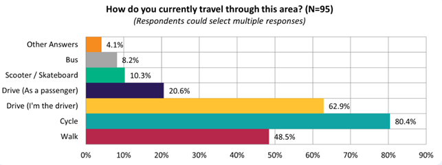
5.40
The majority of submitters felt that this proposal would
improve safety for cycling (66.0%):
5.41 This
sentiment differed slightly depending on whether they live on the affected
streets (i.e. Simeon Street, Coronation Street), live in local suburbs (i.e.
Spreydon, Somerfield), or live elsewhere:
|
Do you think this proposal
will improve safety for cycling?
|
Live on affected streets
|
Live in local suburbs
|
Live elsewhere
|
|
Yes
|
11
|
45
|
7
|
|
Somewhat
|
2
|
8
|
3
|
|
No
|
2
|
13
|
1
|
|
Don't
know/not sure
|
0
|
3
|
0
|
5.42 The
majority of submitters also support the raised signalised crossing on Milton
Street (76.3%):
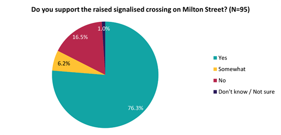
5.43 Key
themes and requests from both comments and submissions are summarised below.
Note that there could be cross-over between those making comments and making
submissions:
|
Key themes on outcomes of the
proposal
|
Number
of comments
|
Number
of submissions
|
Total
mentions
|
|
Support
the bidirectional cycleway
· Focused on the need for
cycleway connections and how useful this link would be
|
39
|
41
|
80
|
|
Support
the Milton Street and Coronation Street crossing treatments
· Most mentioned that a
connection was needed for Milton Street
· Some mentioned enhanced
cyclist safety on Coronation Street given the traffic volumes
|
22
|
13
|
35
|
|
Concern
on loss of parking
· Concerns that this plan takes
away too many car parks to sustain future need with housing intensification
|
14
|
16
|
30
|
|
Feel
that a cycleway is not needed here
· Perception that Simeon Street
is sufficiently wide enough for current cyclist demand
· Safety concern for about
coming out of their driveways
· Dispute cycleway location and
how money could be better spent elsewhere
|
17
|
12
|
29
|
|
Concern
about loss of parking specifically outside the school
· Perceive that it will be more
difficult for parents to safely take their children to school, and that
it’s already difficult enough to navigate
· Suggestions to remove the berm
outside the school to retain some parking
|
8
|
10
|
18
|
|
Concern
on width of road for cars as a result of the cycleway
· Concern around navigating
single lane stretches, driveways and intersections, including concern for
fire trucks turning out of the fire station
|
8
|
9
|
17
|
|
Other
concerns
· Preference for other routes to
be prioritised
· Concern about safety of a
bidirectional cycleway
· Concerned with the
‘dogleg’ at Milton Street and Coronation Street crossings for
cyclists trying to head into town – some may cycle over the grass
|
15
|
14
|
29
|
|
Requests
|
Number
of comments
|
Number
of submissions
|
Total
mentions
|
|
Further
traffic calming / pedestrian crossings
· More pedestrian crossings near
the school
· A fully signalised crossing at
Coronation Street
· A connection to Barrington
Park
|
9
|
16
|
25
|
|
An
extension of the cycleway
· A connection to
Quarryman’s Trail via Roker Street, as well as through Spreydon Domain
and Barrington Park
|
9
|
12
|
21
|
|
A
better connection for cyclists to Barrington Mall
· Lack of a clear crossing point
to Barrington Mall
|
10
|
8
|
18
|
|
Wayfinding
/ road sharing signage
· More signage for cyclists,
such as more road paint markings at intersections, give way signs, and a
wayfinding sign from the cycleway
|
5
|
5
|
10
|
|
Reduce
speed for this area
· On Simeon Street where the
cycleway is proposed, but particularly near the school
|
1
|
9
|
10
|
|
More
traffic calming for the Howard Street intersection
· Kerb buildout not wide enough,
requests for beautification (landscaping and trees) and additional pedestrian
crossings at this intersection and near it on Simeon Street to cater to
Addington Te Kura Taumatua School
|
6
|
3
|
9
|
|
Resealing
road
· Making the cycleway as smooth
as possible
· Focus on resealing the road
instead of doing the project altogether
|
1
|
6
|
7
|
6. Policy Framework Implications Ngā Hīraunga ā- Kaupapa here
Strategic
Alignment Te Rautaki Tīaroaro
6.1 This report supports the Council's
Long Term Plan (2021 - 2031):
6.2 Transport
6.2.1 Activity: Transport
· Level of Service: 10.0.2 Increase the share of
non-car modes in daily trips - >=36% of trips undertaken by non-car modes
· Level of Service: 10.0.6.1 Reduce the number of
death and serious injury crashes on the local road network - <=100 crashes
· Level of Service: 10.0.41 Reduce emissions and
greenhouse gases related to transport - <=1.10 million tonnes of CO2
equivalents
· Level of Service: 10.5.3 More people are
choosing to travel by cycling - >=12,500 average daily cyclist detections
· Level of Service: 10.5.1 Limit deaths and
serious injury crashes per capita for cyclists and pedestrians - <= 12
crashes per 100,000 residents
· Level of Service: 10.5.2 Improve the perception
that Christchurch is a cycling friendly city - >=66% resident satisfaction
Policy
Consistency Te Whai
Kaupapa here
6.3 The
recommendations of this report are consistent with
Council’s Plans and Policies, in particular:
6.3.1 The
changes proposed align with road safety and liveable streets goals in the Christchurch
Transport Strategic Plan 2012–2042, and similarly in the draft Transport
Plan (safe streets).
6.3.2 The
changes proposed align with Kia tūroa te Ao - Ōtautahi Christchurch
Climate Resilience Strategy as set out in the Climate Change Impact Considerations
section below.
Impact
on Mana Whenua Ngā
Whai Take Mana Whenua
6.4 The
decision does not involve a significant decision in relation to ancestral land
or a body of water or other elements of intrinsic value, therefore this
decision does not specifically impact Mana Whenua, their culture and
traditions.
6.5 The
decision does not involve a matter of interest to Mana Whenua and should not
impact on our agreed partnership priorities with Ngā Papatipu
Rūnanga.
6.6 The
projects are based on minor changes to, or re-allocation of, existing road
spaces, so are not anticipated to have a significant impact on Mana Whenua.
Climate
Change Impact Considerations Ngā Whai Whakaaro mā te Āhuarangi
6.7 The
decisions in this report are likely to:
6.7.1 Contribute
neutrally to adaptation to the impacts of climate change.
6.7.2 Contribute
positively to emissions reductions.
6.8 The
emission reductions associated with this project have not been estimated.
6.9 The Government’s Emissions Reduction Plan states we
will have to ‘substantially improve infrastructure for walking and
cycling’ to meet our emissions targets (including a 20% reduction in
light Vehicle Kilometres Travelled by 2035 - required under the Emissions
Reduction Plan). Improving the quality of our streets for walking and cycling
is also a key part of the Ministry of Transport and Waka Kotahi’s efforts
to decarbonise the transport system.
6.10 New
Zealand has the 5th highest transport emissions rate per capita
among the 43 OECD countries. Petrol or diesel car use is typically the
single-biggest contributor to an individual’s carbon footprint in New
Zealand.
6.11 From
the 2022 Life in Christchurch Transport Survey, 96 percent of respondents
travel by car. Respondents find car travel the least difficult means of
travel: "We use car travel as it is easier. Christchurch is very spread
out and to have several buses is not convenient." Inconsiderate and
dangerous behaviour from other road users and sharing the road with cars were the
main reasons respondents found it difficult to bike.
6.12 The
proposed changes make it safer for people walking and cycling, which will have a net positive impact for the climate by
helping to reduce transport emissions. Enabling more people to walk or cycle,
particularly for local journeys, is a key part of council’s emissions
reduction efforts by providing a safe, low emission way for residents to move
around the city.
Accessibility
Considerations Ngā
Whai Whakaaro mā te Hunga Hauā
6.13 This proposal improves accessibility for people walking and
cycling, by providing a safer means of accessing and using our street network.
6.14 Waka
Kotahi developed a set of Project Design Parameters to ensure all projects work
to collectively meet the programme objectives. The Project Design
Parameters require that “the infrastructure should be designed for
children and people with visual, mobility, or cognitive impairments. If the
infrastructure works for them, it will work for a wider spectrum of the
population who are interested in walking and cycling but concerned for their
safety.” Transport Choices projects have been designed in
accordance with these requirements.
7. Resource Implications Ngā Hīraunga Rauemi
Capex/Opex
Ngā Utu Whakahaere
7.1 Cost to Implement - the total
project estimate is $1,400,000. This is inclusive of all project costs.
7.2 Maintenance/Ongoing
costs – $15,750 per year additional costs associated with coloured
surfacing, cycle lane separators, new signalised crossing and sweeping costs.
These costs will be eligible for Waka Kotahi subsidy at Council’s 51%
Funding Assistance Rate. The net maintenance cost for the total Transport
Choices programme will have an ongoing rates impact of approximately 0.01%,
which will be included in the draft Long Term Plan proposed budgets.
7.3 Funding
Source – Councils capital programme:
7.3.1 ID
72760, Transport Choices 2022 – Little River Link Cycle Connections
$4,303,242
7.4 Waka
Kotahi through the Transport Choices programme will be funding the project up
to an agreed value which is calculated as 90% of the expected implementation
cost. The remaining 10% is Council’s share.
7.5 Under
the cost share agreement with Waka Kotahi, funding approvals for individual
Transport Choices projects are approved through two stage gates: design and
physical works. All Transport Choices projects have agreed funding schedules
for design. Individual project schedules for physical works are required to be
agreed and approved prior to 20 October 2023. In approving funding for physical
works, Waka Kotahi will consider:
7.5.1 The
project is in accordance with the scope and design approved by Waka
Kotahi.
7.5.2 Project
costs are in accordance with expectations.
7.5.3 Ability
to deliver the project prior to June 2024.
7.6 The
staff recommendations of this report include that Council’s approval of
this project is conditional on a funding agreement with Waka Kotahi being in
place for the physical works.
8. Legal Implications Ngā Hīraunga ā-Ture
Statutory power to undertake proposals in
the report Te Manatū Whakahaere Kaupapa
8.1 Council
resolved the Transport Choices programme as Metropolitan Significance when the
programme was included in the draft Annual Plan in February 2023/24.
8.2 Council
retains decision-making responsibilities that might otherwise be delegated in
accordance with the Delegations Register when a project is determined as
Metropolitan Significance.
8.3 Part
1, Clauses 7 and 8 of the Christchurch City Council Traffic and Parking Bylaw
2017 provides Council with the authority to install parking restrictions by
resolution.
8.4 The
installation of any signs and/or markings associated with traffic control
devices must comply with the Land Transport Rule: Traffic Control Devices 2004.
Other Legal Implications Ētahi atu
Hīraunga-ā-Ture
8.5 There
is no legal context, issue or implication relevant to this decision.
9. Risk Management Implications Ngā Hīraunga Tūraru
9.1 Scope – Waka Kotahi
has governed the scope and design of the project to align with programme
KPI’s and consistency with Transport Choices design parameters. Departing
from the recommendations of this report creates a risk that Waka Kotahi would
not agree to fund the physical works phase of the project.
9.2 Delivery
– Transport Choices funding is subject to delivery being complete by June
2024. Waka Kotahi has established additional milestones to track
progress. Delays in approval of the projects would impact on the
timeframe for delivery.
9.3 Funding
security - the Transport Choices funding agreement between Council and Waka
Kotahi presently covers this project for design only, and a further stage gate
approval is required to gain funding approval for construction. The
instruction of physical works will be withheld until an implementation
agreement is in place.
9.4 Implementation
cost uncertainty – the funding agreement with Waka Kotahi places the risk
of cost variations with Council. This risk is being managed by minimising
price uncertainty and building contingency into the funding agreement.
Attachments Ngā Tāpirihanga
|
No.
|
Title
|
Reference
|
Page
|
|
a ⇩ 
|
Scheme design
for council approval
|
23/1351970
|
107
|
|
b ⇩
|
Simeon Street
- Submission Table (Public)
|
23/1371338
|
111
|
In addition to the attached documents, the following background
information is available:
|
Document
Name – Location / File Link
|
|
Not
applicable
|
Confirmation of Statutory
Compliance Te Whakatūturutanga ā-Ture
|
Compliance with Statutory Decision-making
Requirements (ss 76 - 81 Local Government Act 2002).
(a) This report contains:
(i) sufficient information about all reasonably practicable
options identified and assessed in terms of their advantages and
disadvantages; and
(ii) adequate consideration of the views and preferences of
affected and interested persons bearing in mind any proposed or previous
community engagement.
(b) The information reflects the level of significance of the
matters covered by the report, as determined in accordance with the Council's
significance and engagement policy.
|
Signatories Ngā Kaiwaitohu
|
Authors
|
Ryan Rolston -
Programme Manager
Andrew Cameron
- Project Manager
Samantha Smith
- Engagement Advisor
Ann Tomlinson
- Project Manager
|
|
Approved By
|
Jacob Bradbury
- Manager Planning & Delivery Transport
Tony
Richardson - Finance Business Partner
Lynette Ellis
- Head of Transport & Waste Management
|
|
Council
21 September 2023
|

|
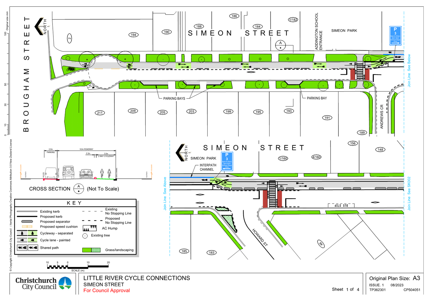
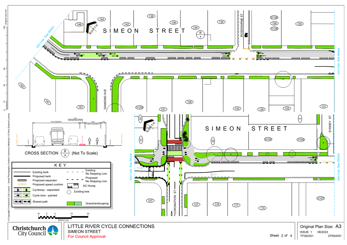
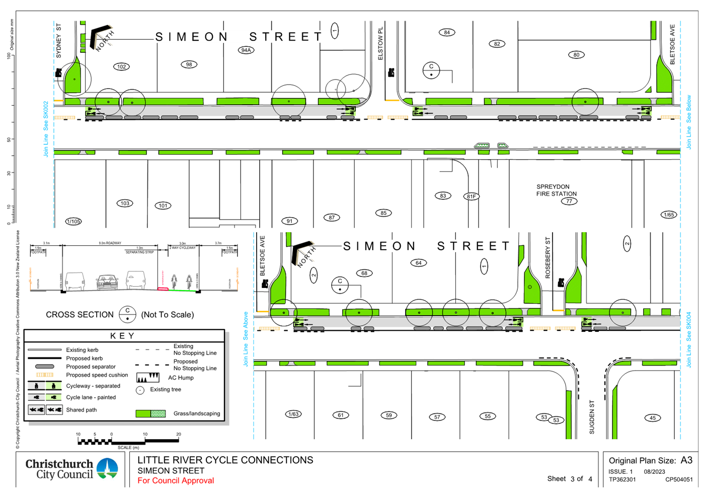
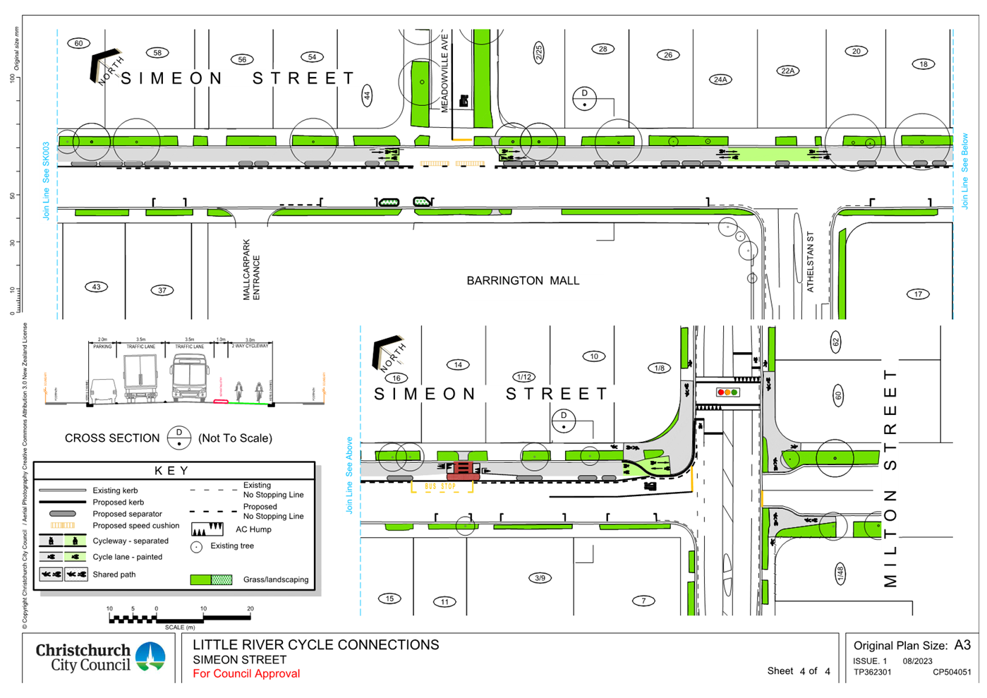
|
Council
21 September 2023
|
|
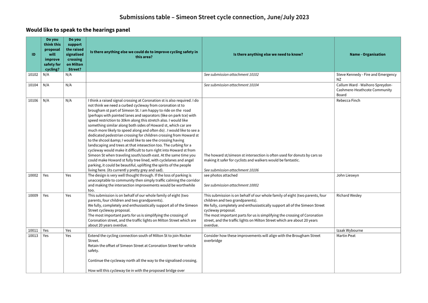
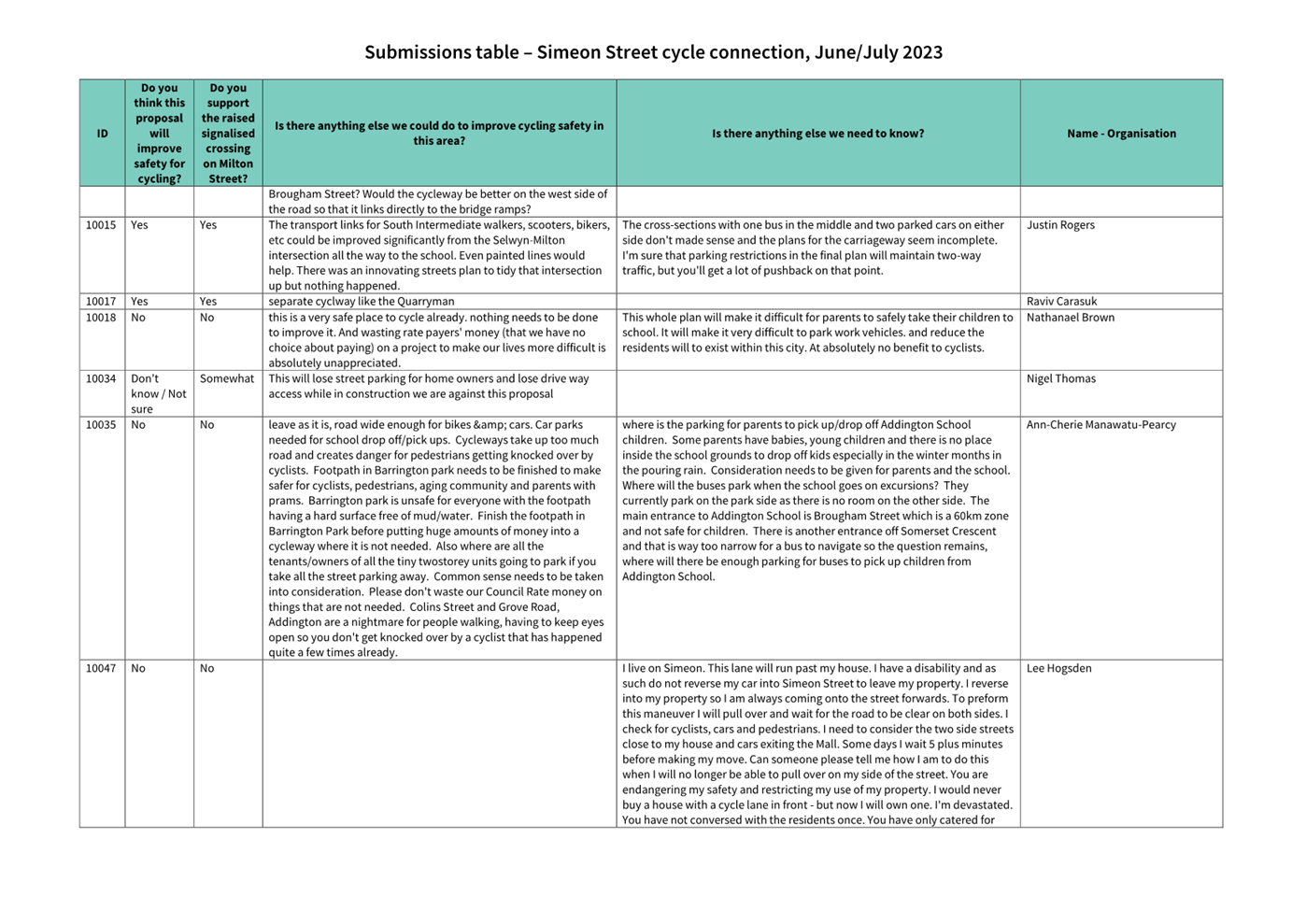
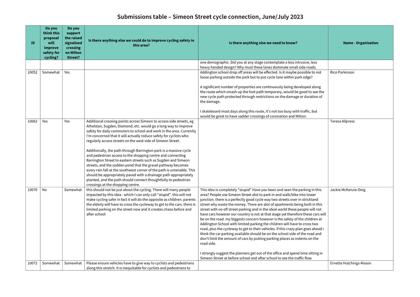
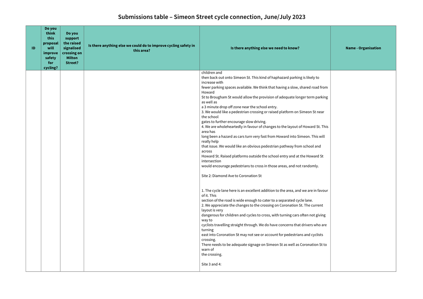
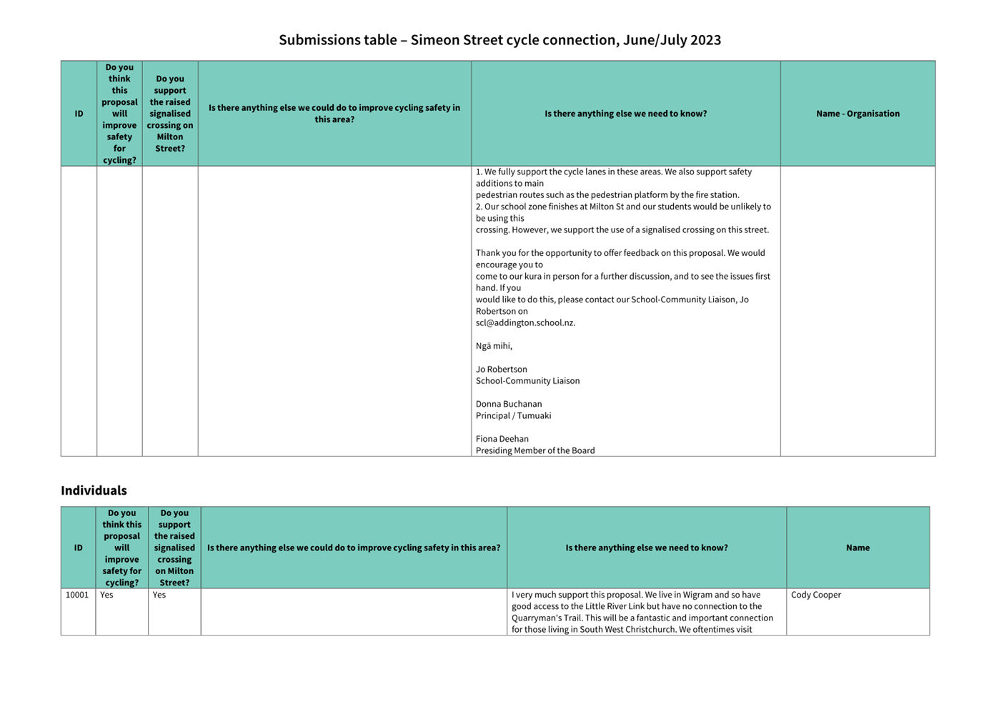
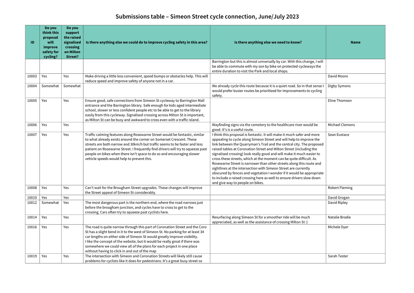
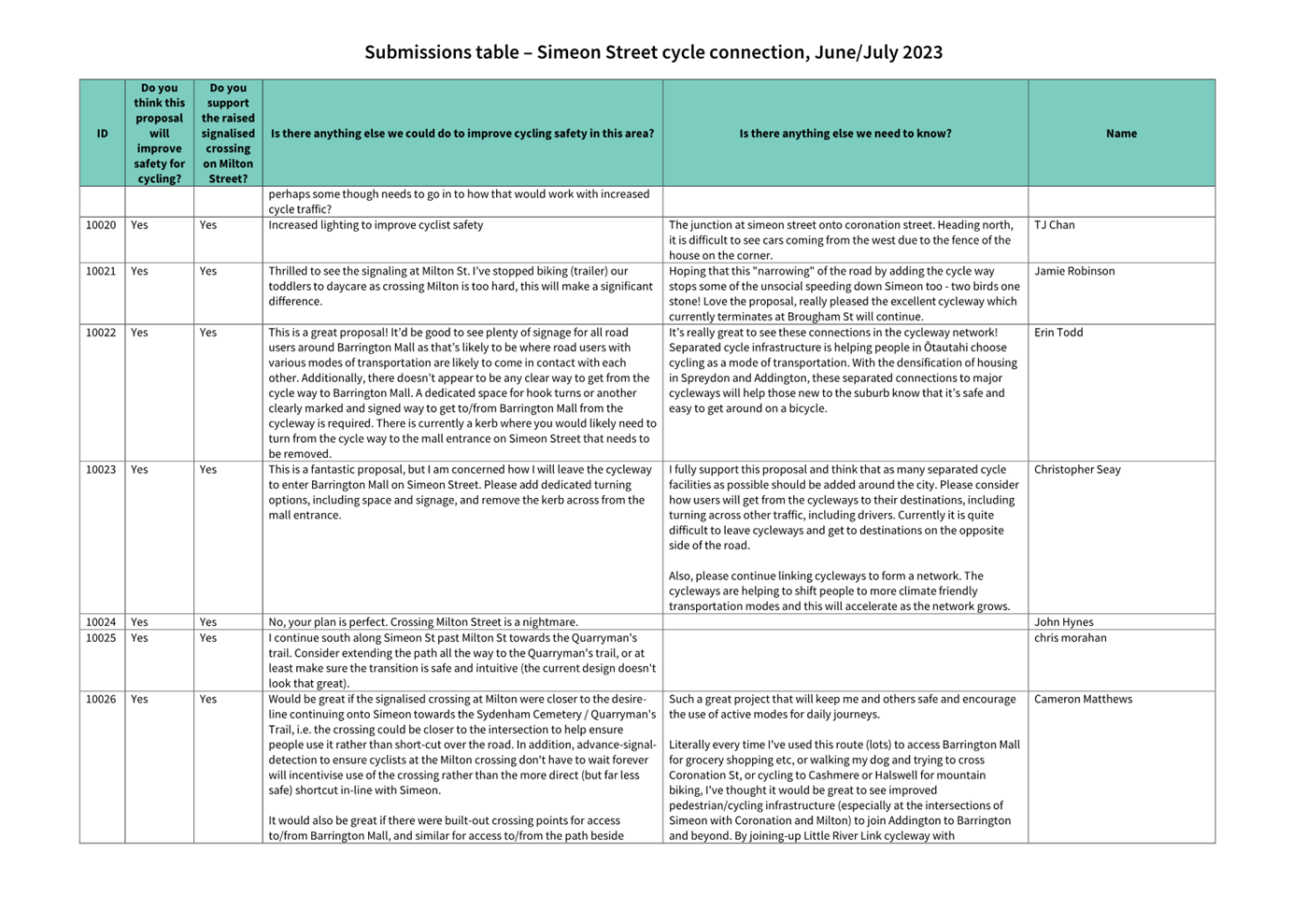
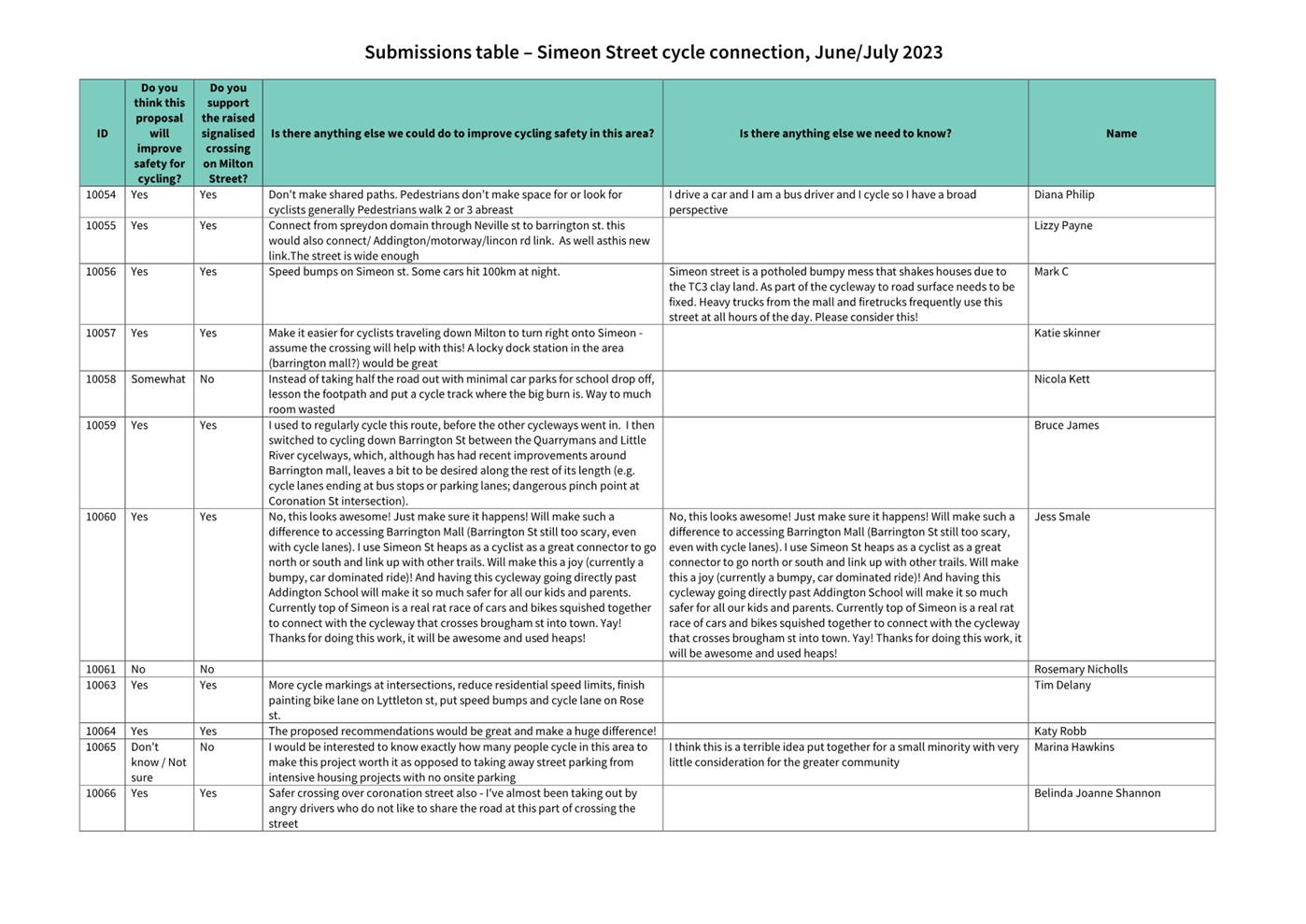
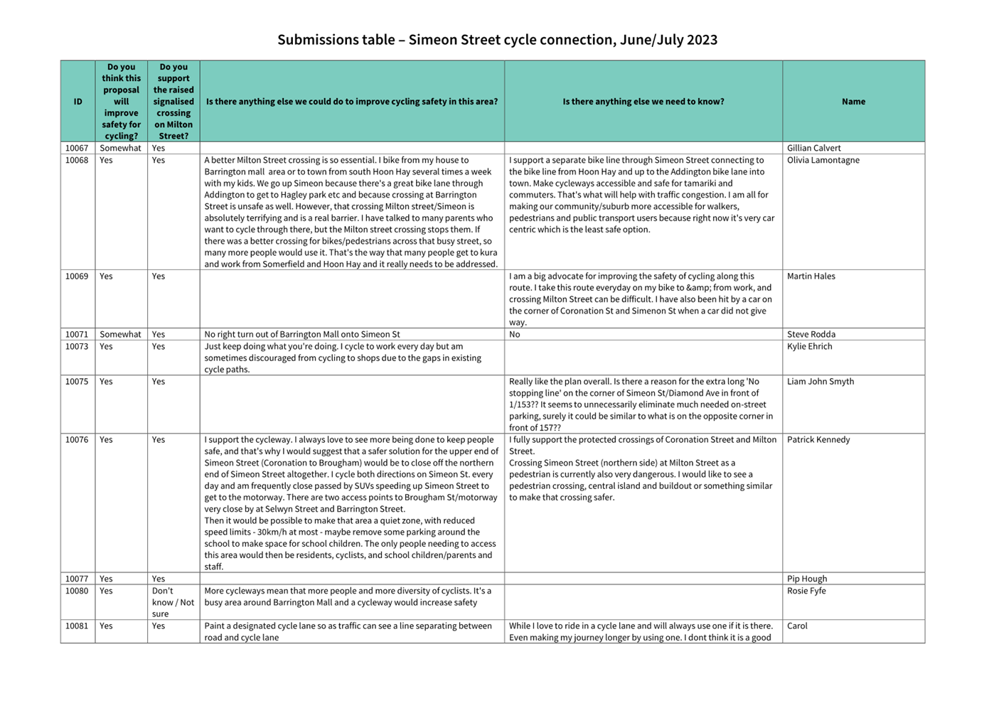
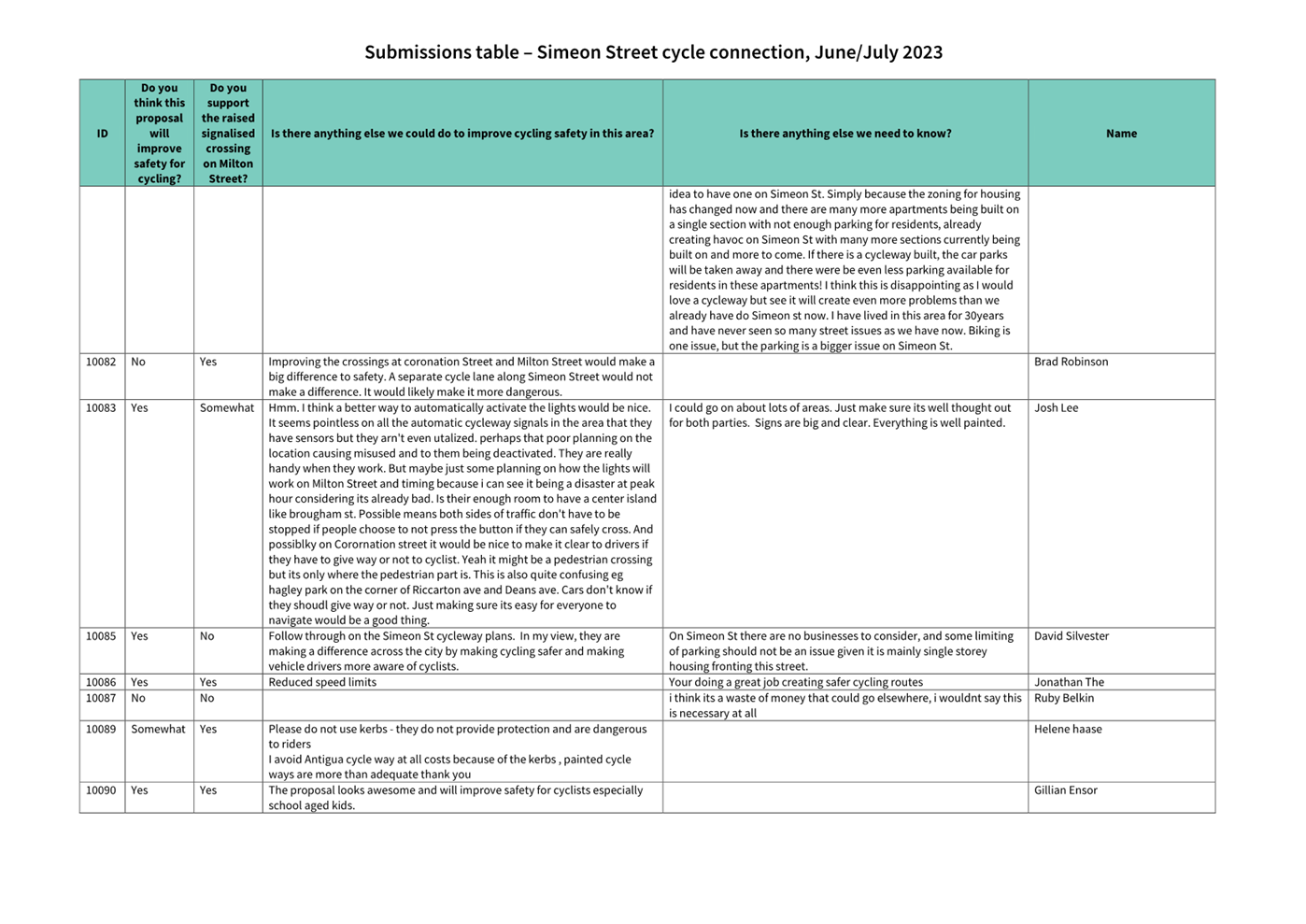
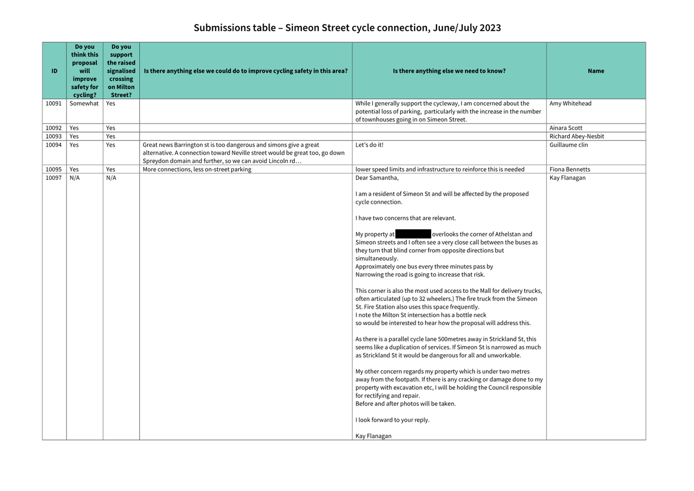
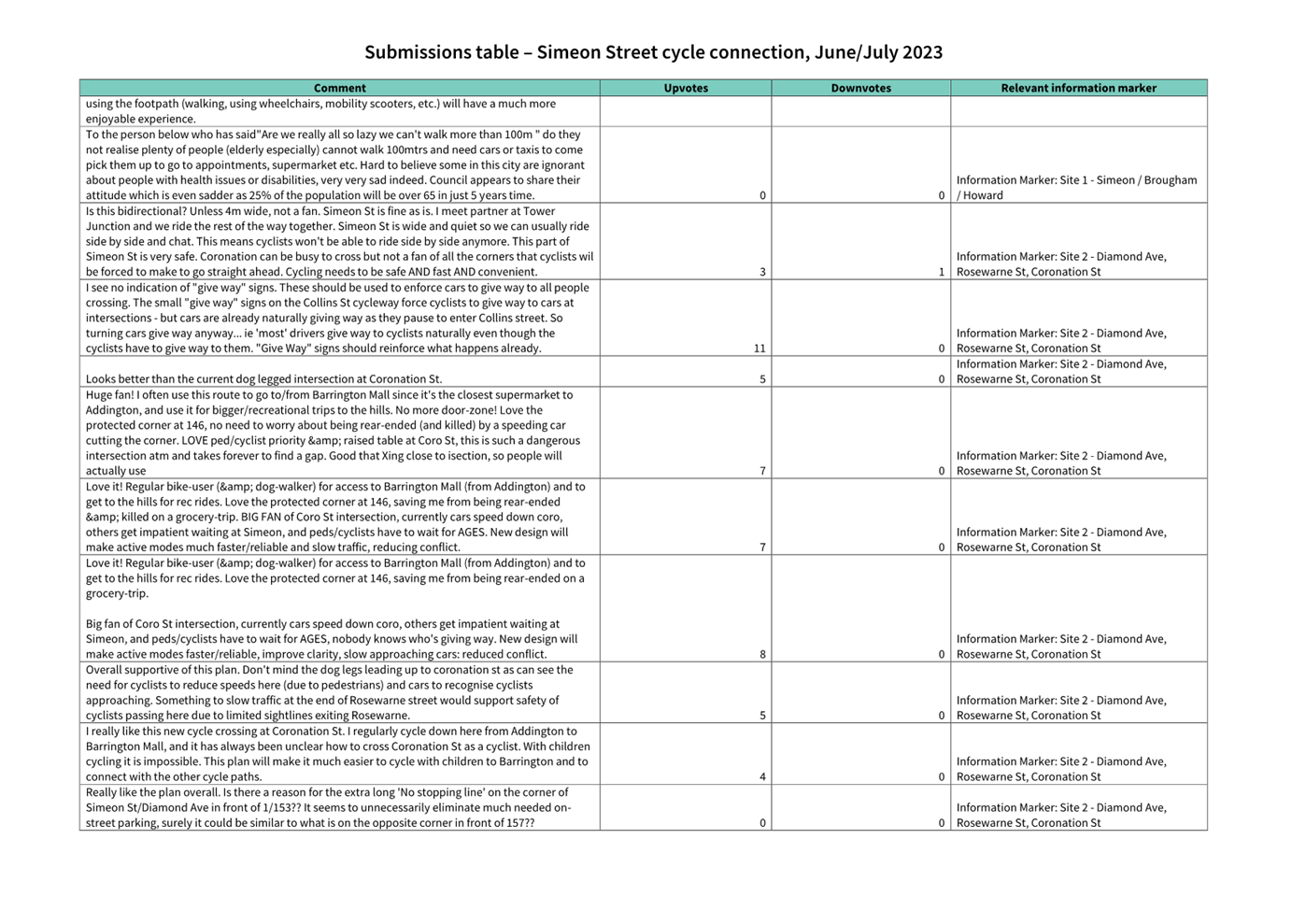
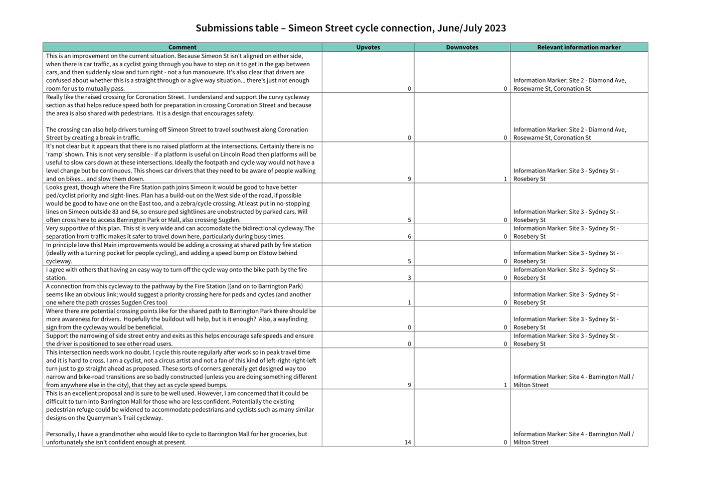
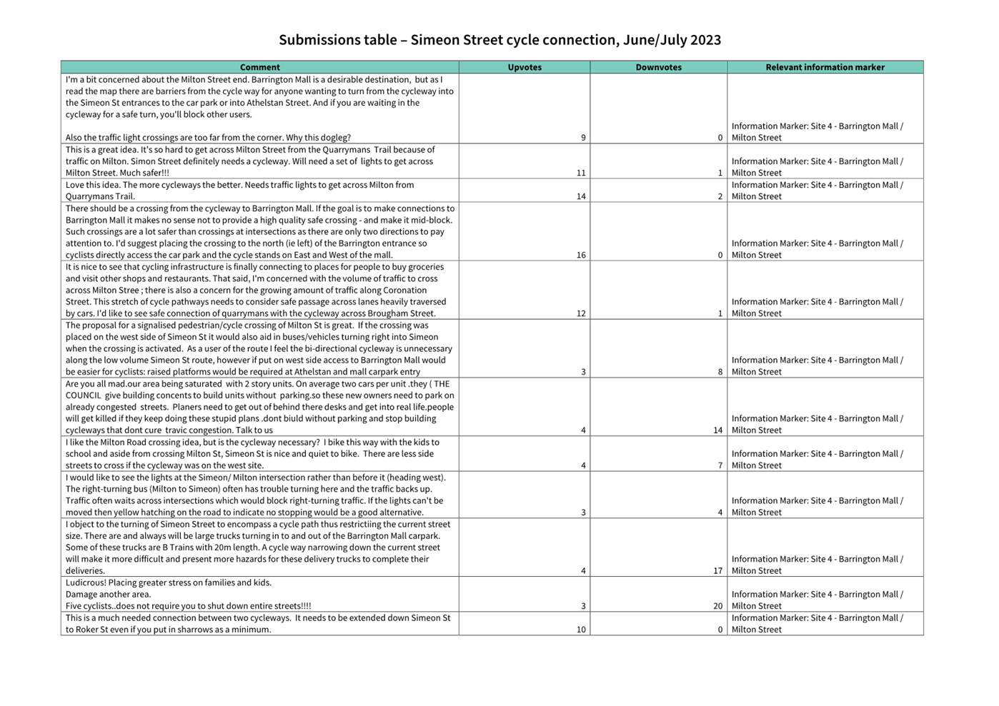
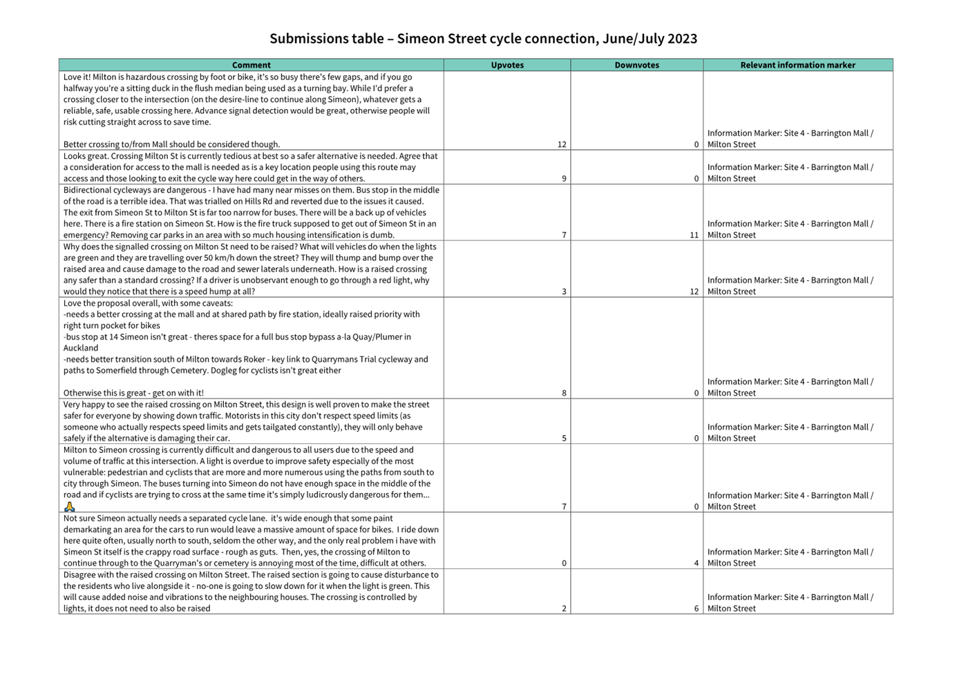
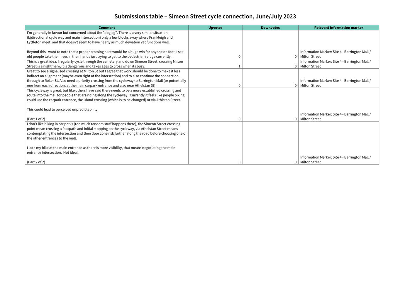
|
Council
21 September 2023
|

|
|
7. Transport Choices - Te Aratai
College Cycle Connection
|
|
Reference / Te Tohutoro:
|
23/1162291
|
|
Report of / Te Pou Matua:
|
Chris
Strydom, Project Manager Transport, chris.strydom@ccc.govt.nz
Jacob Bradbury, Manager Planning & Delivery Transport,
jacob.bradbury@ccc.govt.nz
|
|
Senior Manager / Pouwhakarae:
|
Lynette
Ellis, Head of Transport & Waste Management (Lynette.Ellis@ccc.govt.nz)
|
1. Nature of Issue and Report Origin
1.1 The purpose of this report is to inform the Council of
feedback received, and for the Council to approve the design to proceed to
construction for the Transport Choices Te Aratai College Cycle Connection
project.
1.2 The origin of this report is the Climate Emergency Response
Fund (CERF) Transport Choices programme.
1.3 The
decisions in this report are of medium significance in relation to the Christchurch
City Council’s Significance and Engagement Policy 2019. The level of significance was determined by potential
benefits and opportunities to the council/community, the number of people
affected and/or with an interest, and that these projects span multiple
community board areas, as set out in the criteria of the policy (Page 2). This
evaluation has considered the Transport Choices projects as a cohesive
programme of work. This is consistent with how community engagement has
been undertaken, with all work packages being presented concurrently on Have
your Say under the banner of Way Safer Streets.
2. Officer Recommendations Ngā
Tūtohu
That the Council:
General
1. Approves the following recommendations
required for the implementation of the Transport Choices – Te Aratai
Cycle Connection relying on its powers under the Christchurch City Council
Traffic and Parking Bylaw 2017 and Part 21 of the Local Government Act 1974.
2. Approves that the traffic controls, stopping
and/or parking restrictions described in the recommendations of this report
take effect when infrastructure, signage and/or road markings that evidence the
controls and restrictions are in place (or removed in the case of revocations)
and, in the case of traffic signal infrastructure, activated.
3. Approves that any previously approved
resolutions made pursuant to any Bylaw, Local Government Act or any Land
Transport Rule and pertaining to traffic controls, stopping and/or parking
restrictions (but excluding speed limits) in so far as they conflict with the
recommendations of this report be revoked.
4. Approves that construction of the Te Aratai
College Cycle Connection project is conditional on implementation costs being
agreed and incorporated into the Transport Choices Funding agreement between
Waka Kotahi and Council.
General
Arrangements
5. Approves the road layout, including all kerb
alignments, road surface treatments, traffic islands, traffic calming features
and road markings on Ensors Road, Aldwins Road, and Buckleys Road, including
intersecting road approaches, as detailed on plans titled Te Aratai College
Cycle Connection: Signage and Road Marking Plan (Sheet Numbers R01–R09,
Revision A, dated 18/08/23) attached to this report as Attachment A.
Cycleways, Shared
Paths and Cycle Lanes
6. Approves pursuant to Section 334(1)(d) of the
Local Government Act 1974 that a separated uni-directional cycle facility, for
the use of cycles only travelling north, be established on the western side of
Ensors Road, commencing at its intersection with Grenville Street and extending
in a southerly direction for a distance of 89 metres.
7. Approves pursuant to Section 334(1)(d) of the
Local Government Act 1974 that a separated uni-directional cycle facility, for
the use of cycles only travelling north, be established on the western side of
Ensors Road, commencing at its intersection with Grenville Street and extending
to its intersection with Frederick Place.
8. Approves pursuant to Section 334(1)(d) of the
Local Government Act 1974 that a separated uni-directional cycle facility, for
the use of cycles only travelling north, be established on the western side of
Ensors Road, commencing at its intersection with Frederick Place and extending
in a northerly direction for a distance of 51 metres.
9. Approves that a bi-directional Shared Path in
accordance with Clause 21 of the Christchurch City Council Traffic &
Parking Bylaw 2017, and in accordance with Section 11.4 of the Land Transport
Rule: Traffic Control Devices 2004, be established on the western side of
Ensors Road, commencing at its intersection with Ferry Road and extending in a
southerly direction for a distance of 61 metres. This Shared Path is for use
by the classes of road user only as defined in Section 11.1A of the Land
Transport (Road User) Rule: 2004.
10. Approves that a bi-directional Shared Path, in
accordance with Clause 21 of the Christchurch City Council Traffic &
Parking Bylaw 2017 and in accordance with Section 11.4 of the Land Transport
Rule: Traffic Control Devices 2004, be established on the western side of
Aldwins Road commencing at its intersection with Ferry Road and extending in a
northerly direction for a distance of 89 metres.
11. Approves pursuant to Section 334(1)(d) of the
Local Government Act 1974 that a separated uni-directional cycle facility, for
the use of cycles only travelling north, be established on the western side of
Aldwins Road, commencing at a distance of 89 metres north of its intersection
with Ferry Road and extending in a northerly direction for a distance of 329
metres.
12. Approves that a bi-directional Shared Path, in
accordance with Clause 21 of the Christchurch City Council Traffic &
Parking Bylaw 2017 and in accordance with Section 11.4 of the Land Transport
Rule: Traffic Control Devices 2004, be established on the western side of
Aldwins Road, commencing at its intersection with Harrow Street and extending
in a southerly direction for a distance of 61 metres.
13. Approves that a bi-directional Shared Path, in
accordance with Clause 21 of the Christchurch City Council Traffic &
Parking Bylaw 2017 and in accordance with Section 11.4 of the Land Transport
Rule: Traffic Control Devices 2004, be established on the southern side of
Harrow Street, commencing at its intersection with Aldwins Road and extending
in a westerly direction for a distance of 39 metres.
14. Approves that a bi-directional Shared Path, in
accordance with Clause 21 of the Christchurch City Council Traffic &
Parking Bylaw 2017 and in accordance with Section 11.4 of the Land Transport
Rule: Traffic Control Devices 2004, be established on the northern side of Harrow Street, commencing at its
intersection with Aldwins Road and extending in a westerly direction for a
distance of 53 metres.
15. Approves pursuant to section 11.4 of the Land
Transport Act – Traffic Control Devices Rule: 2004 that an eastbound
uni-directional cycle lane be established on the northern side of Harrow
Street, commencing at its intersection with Aldwins Road and extending in a
westerly direction for a distance of 56 metres.
16. Approves that a bi-directional Shared Path, in
accordance with Clause 21 of the Christchurch City Council Traffic &
Parking Bylaw 2017 and in accordance with Section 11.4 of the Land Transport
Rule: Traffic Control Devices 2004, be established on the western side of
Aldwins Road, commencing at its intersection with Harrow Street and extending
in a northerly direction for a distance of 60 metres.
17. Approves pursuant to Section 334(1)(d) of the
Local Government Act 1974 that a separated uni-directional cycle facility, for
the use of cycles only travelling north, be established on the western side of
Aldwins, commencing at its intersection with Newcastle Street and extending in
a southerly direction for a distance of 34 metres.
18. Approves pursuant to Section 334(1)(d) of the
Local Government Act 1974 that a separated uni-directional cycle facility, for
the use of cycles only travelling north be established on the western side of
Aldwins Road, commencing at its intersection with Newcastle Street and
extending in a northerly direction for a distance of 219 metres.
19. Approves that a bi-directional Shared Path, in
accordance with Clause 21 of the Christchurch City Council Traffic &
Parking Bylaw 2017 and in accordance with Section 11.4 of the Land Transport
Rule: Traffic Control Devices 2004, be established on the western side of
Aldwins, commencing at its intersection with Marlborough Street and extending
in a southerly direction for a distance of 26 metres.
20. Approves that a bi-directional Shared Path, in
accordance with Clause 21 of the Christchurch City Council Traffic &
Parking Bylaw 2017 and in accordance with Section 11.4 of the Land Transport
Rule: Traffic Control Devices 2004, be established on the western side of
Aldwins Road, commencing at its intersection with Marlborough Street and
extending in a northerly direction to its intersection with Linwood
Avenue.
21. Approves pursuant to section 11.4 of the Land
Transport Act – Traffic Control Devices Rule: 2004 that a northbound
uni-directional cycle lane be established on the western side of Aldwins Road,
commencing at its intersection with Linwood Avenue and extending in a southerly
direction for a distance of 79 metres.
22. Approves that a bi-directional Shared Path, in
accordance with Clause 21 of the Christchurch City Council Traffic &
Parking Bylaw 2017 and in accordance with Section 11.4 of the Land Transport
Rule: Traffic Control Devices 2004, be established on the eastern side of
Ensors Road, commencing at its intersection with Sullivan Avenue and extending
in a southerly direction for a distance of 74 metres.
23. Approves that a bi-directional Shared Path, in
accordance with Clause 21 of the Christchurch City Council Traffic &
Parking Bylaw 2017 and in accordance with Section 11.4 of the Land Transport
Rule: Traffic Control Devices 2004, be established on the eastern side of
Ensors, commencing at its intersection with Sullivan Avenue and extending in a
northerly direction to its intersection with Mackenzie Avenue.
24. Approves that a bi-directional Shared Path, in
accordance with Clause 21 of the Christchurch City Council Traffic &
Parking Bylaw 2017 and in accordance with Section 11.4 of the Land Transport
Rule: Traffic Control Devices 2004, be established on the eastern side of
Ensors Road, commencing at its intersection with Mackenzie Avenue and extending
in a northerly direction for a distance of 32 metres.
25. Approves pursuant to Section 334(1)(d) of the
Local Government Act 1974 that a separated uni-directional cycle facility, for
the use of cycles only travelling south be established on the eastern side of
Ensors Road, commencing at a distance 97 metres south of its intersection with
Ferry Road and extending in a southerly direction for a distance of 166 metres.
26. Approves that a bi-directional Shared Path, in
accordance with Clause 21 of the Christchurch City Council Traffic &
Parking Bylaw 2017 and in accordance with Section 11.4 of the Land Transport
Rule: Traffic Control Devices 2004, be established on the eastern side of
Ensors Road, commencing at its intersection with Ferry Road and extending in a
southerly direction for a distance of 97 metres.
27. Approves that a bi-directional Shared Path, in
accordance with Clause 21 of the Christchurch City Council Traffic &
Parking Bylaw 2017 and in accordance with Section 11.4 of the Land Transport
Rule: Traffic Control Devices 2004, be established on the eastern side of
Aldwins Road, commencing at its intersection with Ferry Road and extending in a
northerly direction for a distance of 93 metres.
28. Approves pursuant to Section 334(1)(d) of the
Local Government Act 1974 that a separated uni-directional cycle facility, for
the use of cycles only travelling south be established on the eastern side of
Aldwins Road, commencing at its intersection with Matlock Street and extending
in a northerly direction to its intersection with Edmonds Street.
29. Approves pursuant to Section 334(1)(d) of the
Local Government Act 1974 that a separated uni-directional cycle facility, for
the use of cycles only travelling south be established on the eastern side of
Aldwins Road, commencing at its intersection with Edmonds Street and extending
in a northerly direction to its intersection with Bass Street.
30. Approves that a bi-directional Shared Path, in
accordance with Clause 21 of the Christchurch City Council Traffic &
Parking Bylaw 2017 and in accordance with Section 11.4 of the Land Transport
Rule: Traffic Control Devices 2004, be established on the eastern side of
Aldwins Road, commencing at its intersection with Bass Street and extending in
a northerly direction to its intersection with Marcroft Street.
31. Approves pursuant to Section 334(1)(d) of the
Local Government Act 1974 that a separated uni-directional cycle facility, for
the use of cycles only travelling south be established on the eastern side of
Aldwins Road, commencing at its intersection with Marcroft Street and extending
in a northerly direction for a distance of 165 metres.
32. Approves that a bi-directional Shared Path, in
accordance with Clause 21 of the Christchurch City Council Traffic &
Parking Bylaw 2017 and in accordance with Section 11.4 of the Land Transport
Rule: Traffic Control Devices 2004, be established on the eastern side of
Aldwins Road, commencing at a point 165 metres north of its intersection with
Marcroft Street and extending in a northerly direction for a distance of 35
metres.
33. Approves pursuant to Section 334(1)(d) of the
Local Government Act 1974 that a separated uni-directional cycle facility, for
the use of cycles only travelling south be established on the eastern side of
Aldwins Road, commencing at a point of 200 metres north of its intersection
with Marcroft Street and extending in a northerly direction for a distance of
147 metres.
34. Approves that a bi-directional Shared Path, in
accordance with Clause 21 of the Christchurch City Council Traffic &
Parking Bylaw 2017 and in accordance with Section 11.4 of the Land Transport
Rule: Traffic Control Devices 2004, be established on the eastern side of
Aldwins Road, commencing at its intersection with Linwood Avenue and extending
in a southerly direction for a distance of 222 metres.
Stopping,
Standing and Parking Restrictions
35. Approves pursuant to Clause 7 of the
Christchurch City Council Traffic and Parking Bylaw 2017 that the stopping of
vehicles be prohibited at any time on the western side of Ensors Road
commencing a point 37 metres south of its intersection with Grenville Street
and extending in a southerly direction for a distance of 52 metres.
36. Approves pursuant to Clause 7 of the
Christchurch City Council Traffic and Parking Bylaw 2017 that the stopping of
vehicles be prohibited at any time on the western side of Ensors Road
commencing at its intersection with Grenville Street and extending in a
southerly direction for a distance of 23 metres.
37. Approves pursuant to Clause 7 of the
Christchurch City Council Traffic and Parking Bylaw 2017 that the stopping of
vehicles be prohibited at any time on the western side of Ensors Road
commencing at its intersection with Grenville Street and extending in a
northerly direction to its intersection with Frederick Place.
38. Approves pursuant to Clause 7 of the
Christchurch City Council Traffic and Parking Bylaw 2017 that the stopping of
vehicles be prohibited at any time on the southern side of Frederick Place
commencing at its intersection with Ensors Road and extending in a westerly
direction for a distance of 15 metres.
39. Approves pursuant to Clause 7 of the
Christchurch City Council Traffic and Parking Bylaw 2017 that the stopping of
vehicles be prohibited at any time on the northern side of Frederick Place
commencing at its intersection with Ensors Road and extending in a westerly
direction for a distance of 19 metres.
40. Approves pursuant to Clause 7 of the
Christchurch City Council Traffic and Parking Bylaw 2017 that the stopping of
vehicles be prohibited at any time on the western side of Ensors Road
commencing at its intersection with Frederick Place and extending in a
northerly direction to its intersection with Ferry Road.
41. Approves pursuant to Clause 7 of the
Christchurch City Council Traffic and Parking Bylaw 2017 that the stopping of
vehicles be prohibited at any time on the southern side of Ferry Road
commencing at its intersection with Ensors Road and extending in a westerly
direction for a distance of 21 metres.
42. Approves pursuant to Clause 7 of the
Christchurch City Council Traffic and Parking Bylaw 2017 that the stopping of
vehicles be prohibited at any time on the southern side of Ferry Road
commencing a point 36 metres west of its intersection with Ensors Road and
extending in a westerly direction for a distance of 35.5 metres.
43. Approves pursuant to Clause 7 of the
Christchurch City Council Traffic and Parking Bylaw 2017 that the stopping of
vehicles be prohibited at any time on the western side of Aldwins Road
commencing at its intersection with Ferry Road extending in a northerly
direction for a distance of 20 metres.
44. Approves pursuant to Clause 7 of the
Christchurch City Council Traffic and Parking Bylaw 2017 that the stopping of
vehicles be prohibited at any time on the western side of Aldwins Road
commencing a point 34 metres north of its intersection with Ferry Road and
extending in a northerly direction for a distance of 7 metres.
45. Approves pursuant to Clause 7 of the
Christchurch City Council Traffic and Parking Bylaw 2017 that parking of all
vehicles is restricted to a maximum period of 60 minutes on the western side of
Aldwins Road commencing at a point 41 metres north of its intersection with
Ferry Road and extending in a northerly direction for a distance of 18 metres.
46. Approves pursuant to Clause 7 of the
Christchurch City Council Traffic and Parking Bylaw 2017 that parking of all
vehicles is restricted to a maximum period of 10 minutes on the western side of
Aldwins Road commencing at a point 59 metres north of its intersection with
Ferry Road and extending in a northerly direction for a distance of 12 metres.
47. Approves pursuant to Clause 7 of the
Christchurch City Council Traffic and Parking Bylaw 2017 that parking of all
vehicles is restricted to a maximum period of 60 minutes on the western side of
Aldwins Road commencing at a point 71 metres north of its intersection with
Ferry Road and extending in a northerly direction for a distance of 347 metres.
48. Approves pursuant to Clause 7 of the
Christchurch City Council Traffic and Parking Bylaw 2017 that the stopping of
vehicles be prohibited at any time on the western side of Aldwins Road
commencing at a point173 metres south of its intersection with Harrow Street
and extending in a southerly direction for a distance of 9 metres.
49. Approves pursuant to Clause 7 of the
Christchurch City Council Traffic and Parking Bylaw 2017 that the stopping of
vehicles be prohibited at any time on the western side of Aldwins Road
commencing at a point 125 metres south of its intersection with Harrow Street
and extending in a southerly direction for a distance of 26 metres.
50. Approves pursuant to Clause 7 of the
Christchurch City Council Traffic and Parking Bylaw 2017 that the stopping of
vehicles be prohibited at any time on the western side of Aldwins Road
commencing at a point 93 metres south of its intersection with Harrow Street
and extending in a southerly direction for a distance of 13 metres.
51. Approves pursuant to Clause 7 of the
Christchurch City Council Traffic and Parking Bylaw 2017 that the stopping of
vehicles be prohibited at any time on the western side of Aldwins Road
commencing at its intersection with Harrow Street and extending in a southerly
direction for a distance of 74 metres.
52. Approves pursuant to Clause 7 of the
Christchurch City Council Traffic and Parking Bylaw 2017 that the stopping of
vehicles be prohibited at any time on the southern side of Harrow Street
commencing at its intersection with Aldwins Road and extending in a westerly
direction for a distance of 39 metres.
53. Approves pursuant to Clause 7 of the Christchurch
City Council Traffic and Parking Bylaw 2017 that the stopping of vehicles be
prohibited at any time on the northern side of Harrow Street commencing at its
intersection with Aldwins Road and extending in a westerly direction for a
distance of 55 metres.
54. Approves pursuant to Clause 7 of the
Christchurch City Council Traffic and Parking Bylaw 2017 that the stopping of
vehicles be prohibited at any time on the western side of Aldwins Road
commencing at its intersection with Harrow Street and extending in a northerly
direction for a distance of 30 metres.
55. Approves pursuant to Clause 7 of the
Christchurch City Council Traffic and Parking Bylaw 2017 that the stopping of
vehicles be prohibited at any time on the western side of Aldwins Road commencing
at its intersection with Newcastle Street and extending in a southerly
direction for a distance of 50 metres.
56. Approves pursuant to Clause 7 of the
Christchurch City Council Traffic and Parking Bylaw 2017 that the stopping of
vehicles be prohibited at any time on the western side of Aldwins Road
commencing at its intersection with Newcastle Street and extending in a
northerly direction to its intersection with Marlborough Street.
57. Approves pursuant to Clause 7 of the
Christchurch City Council Traffic and Parking Bylaw 2017 that the stopping of
vehicles be prohibited at any time on the western side of Aldwins Road
commencing at its intersection with Marlborough Street and extending in a
northerly direction for a distance of 13 metres.
58. Approves pursuant to Clause 7 of the
Christchurch City Council Traffic and Parking Bylaw 2017 that the stopping of
vehicles be prohibited at any time on the western side of Aldwins Road
commencing at a point 27 metres north of its intersection with Marlborough Street
and extending in a northerly direction for a distance of 6 metres.
59. Approves pursuant to Clause 7 of the
Christchurch City Council Traffic and Parking Bylaw 2017 that the stopping of
vehicles be prohibited at any time on the western side of Aldwins Road
commencing at a point 45 metres north of its intersection with Marlborough
Street and extending in a northerly direction for a distance of 9 metres.
60. Approves pursuant to Clause 7 of the
Christchurch City Council Traffic and Parking Bylaw 2017 that the stopping of
vehicles be prohibited at any time on the western side of Aldwins Road
commencing at a point 60 metres north of its intersection with Marlborough
Street and extending in a northerly direction for a distance of 22 metres.
61. Approves pursuant to Clause 7 of the
Christchurch City Council Traffic and Parking Bylaw 2017 that the stopping of
vehicles be prohibited at any time on the western side of Aldwins Road
commencing at its intersection with Linwood Avenue and extending in a southerly
direction for a distance of 94 metres.
62. Approves pursuant to Clause 7 of the
Christchurch City Council Traffic and Parking Bylaw 2017 that stopping of
vehicles be prohibited at any time on the eastern side of Ensors Road
commencing at a point 67 metres south of its intersection with Sullivan Avenue
and extending in a southerly direction for a distance of 14 metres.
63. Approves pursuant to Clause 7 of the
Christchurch City Council Traffic and Parking Bylaw 2017 that the stopping of
vehicles be prohibited at any time on the eastern side of Ensors Road
commencing at its intersection with Sullivan Avenue and extending in a
southerly direction for a distance of 20 metres.
64. Approves pursuant to Clause 7 of the
Christchurch City Council Traffic and Parking Bylaw 2017 that the stopping of
vehicles be prohibited at any time on the southern side of Sullivan Avenue
commencing at its intersection with Ensors Road and extending in an easterly
direction for a distance of 15 metres.
65. Approves pursuant to Clause 7 of the
Christchurch City Council Traffic and Parking Bylaw 2017 that the stopping of
vehicles be prohibited at any time on the northern side of Sullivan Avenue
commencing at its intersection with Ensors Road and extending in an easterly
direction for a distance of 15 metres.
66. Approves pursuant to Clause 7 of the
Christchurch City Council Traffic and Parking Bylaw 2017 that the stopping of
vehicles be prohibited at any time on the eastern side of Ensors Road
commencing at its intersection with Sullivan Avenue and extending in a
northerly direction for a distance of 27 metres.
67. Approves pursuant to Clause 7 of the
Christchurch City Council Traffic and Parking Bylaw 2017 that the stopping of
vehicles be prohibited at any time on the eastern side of Ensors Road
commencing at a point 59 metres north of its intersection with Sullivan Avenue
and extending in a northerly direction for a distance of 71 metres.
68. Approves pursuant to Clause 7 of the
Christchurch City Council Traffic and Parking Bylaw 2017 that the stopping of
vehicles be prohibited at any time on the eastern side of Ensors Road
commencing at its intersection with Mackenzie Avenue and extending in a
southerly direction for a distance of 20 metres.
69. Approves pursuant to Clause 7 of the
Christchurch City Council Traffic and Parking Bylaw 2017 that the stopping of
vehicles be prohibited at any time on the eastern side of Ensors Road
commencing at its intersection with Mackenzie Avenue and extending in a
northerly direction for a distance of 61 metres.
70. Approves pursuant to Clause 7 of the
Christchurch City Council Traffic and Parking Bylaw 2017 that the stopping of
vehicles be prohibited at any time on the eastern side of Ensors Road
commencing at a point 75 metres north of its intersection with Mackenzie Avenue
and extending in a northerly direction for a distance of 191 metres.
71. Approves pursuant to Clause 7 of the
Christchurch City Council Traffic and Parking Bylaw 2017 that parking of all
vehicles is restricted to a maximum period of 60 minutes on the eastern side of
Ensors Road commencing at a point 44 metres south of its intersection with
Ferry Road and extending in a southerly direction for a distance of 40 metres.
72. Approves pursuant to Clause 7 of the
Christchurch City Council Traffic and Parking Bylaw 2017 that the stopping of
vehicles be prohibited at any time on the eastern side of Ensors Road
commencing at a point 32 metres south of its intersection with Ferry Road and
extending in a southerly direction for a distance of 13 metres.
73. Approves pursuant to Clause 7 of the
Christchurch City Council Traffic and Parking Bylaw 2017 that the stopping of
vehicles be prohibited at any time on the eastern side of Ensors Road
commencing at its intersection with Ferry Road and extending in a southerly
direction for a distance of 18 metres.
74. Approves pursuant to Clause 7 of the
Christchurch City Council Traffic and Parking Bylaw 2017 that the stopping of
vehicles be prohibited at any time on the northern side of Ferry Road commencing
at its intersection with Aldwins Road and extending in an easterly direction
for a distance of 28 metres.
75. Approves pursuant to Clause 7 of the
Christchurch City Council Traffic and Parking Bylaw 2017 that the stopping of
vehicles be prohibited at any time on the northern side of Ferry Road
commencing at a point 43 metres east of its intersection with Aldwins Road and
extending in an easterly direction for a distance of 22 metres.
76. Approves pursuant to Clause 7 of the
Christchurch City Council Traffic and Parking Bylaw 2017 that the stopping of
vehicles be prohibited at any time on the eastern side of Aldwins Road
commencing at its intersection with Ferry Road and extending in a northerly
direction for a distance of 53 metres.
77. Approves pursuant to Clause 7 of the
Christchurch City Council Traffic and Parking Bylaw 2017 that parking of all
vehicles is restricted to a maximum period of 60 minutes on the eastern side of
Ensors Road commencing at a point 53 metres north of its intersection with Ferry
Road and extending in a northerly direction for a distance of 40 metres.
78. Approves pursuant to Clause 7 of the
Christchurch City Council Traffic and Parking Bylaw 2017 that the stopping of
vehicles be prohibited at any time on the eastern side of Aldwins Road
commencing at its intersection with Matlock Street and extending in a southerly
direction for a distance of 14 metres.
79. Approves pursuant to Clause 7 of the
Christchurch City Council Traffic and Parking Bylaw 2017 that the stopping of
vehicles be prohibited at any time on the eastern side of Aldwins Road
commencing at its intersection with Matlock Street and extending in a northerly
direction to its intersection with Edmonds Street.
80. Approves pursuant to Clause 7 of the
Christchurch City Council Traffic and Parking Bylaw 2017 that the stopping of
vehicles be prohibited at any time on the eastern side of Aldwins Road
commencing at its intersection with Edmonds Street and extending in a northerly
direction to its intersection with Bass Street.
81. Approves pursuant to Clause 7 of the
Christchurch City Council Traffic and Parking Bylaw 2017 that the stopping of
vehicles be prohibited at any time on the eastern side of Aldwins Road
commencing at its intersection with Bass Street and extending in a northerly
direction for a distance of 150 metres.
82. Approves pursuant to Clause 7 of the
Christchurch City Council Traffic and Parking Bylaw 2017 that the stopping of
vehicles be prohibited at any time on the eastern side of Aldwins Road
commencing at its intersection with Marcroft Street and extending in a
southerly direction for a distance of 69 metres.
83. Approves pursuant to Clause 7 of the
Christchurch City Council Traffic and Parking Bylaw 2017 that the stopping of
vehicles be prohibited at any time on the eastern side of Aldwins Road
commencing at a point 74 metres south of its intersection with Marcroft Street
and extending in a southerly direction for a distance of 8 metres.
84. Approves pursuant to Clause 7 of the
Christchurch City Council Traffic and Parking Bylaw 2017 that the stopping of
vehicles be prohibited at any time on the eastern side of Aldwins Road
commencing at a point 87 metres south of its intersection with Marcroft Street
and extending in a southerly direction for a distance of 10 metres.
85. Approves pursuant to Clause 7 of the
Christchurch City Council Traffic and Parking Bylaw 2017 that the stopping of
vehicles be prohibited at any time on the eastern side of Aldwins Road
commencing at its intersection with Marcroft Street and extending in a
northerly direction for a distance of 183 metres.
86. Approves pursuant to Clause 7 of the
Christchurch City Council Traffic and Parking Bylaw 2017 that the stopping of
vehicles be prohibited at any time on the eastern side of Aldwins Road commencing
at a point 172 metres south of its intersection with Linwood Avenue and
extending in a southerly direction for a distance of 196 metres.
87. Approves pursuant to Clause 7 of the
Christchurch City Council Traffic and Parking Bylaw 2017 that the stopping of
vehicles be prohibited at any time on the eastern side of Aldwins Road
commencing at a point 137 metres south of its intersection with Linwood Avenue
and extending in a southerly direction for a distance of 17 metres.
88. Approves pursuant to Clause 7 of the
Christchurch City Council Traffic and Parking Bylaw 2017 that the stopping of
vehicles be prohibited at any time on the eastern side of Aldwins Road
commencing at a point 102 metres south of its intersection with Linwood Avenue
and extending in a southerly direction for a distance of 12 metres.
89. Approves pursuant to Clause 7 of the
Christchurch City Council Traffic and Parking Bylaw 2017 that the stopping of
vehicles be prohibited at any time on the eastern side of Aldwins Road
commencing at a point 54 metres south of its intersection with Linwood Avenue
and extending in a southerly direction for a distance of 14 metres.
90. Approves pursuant to Clause 7 of the
Christchurch City Council Traffic and Parking Bylaw 2017 that the stopping of
vehicles be prohibited at any time on the eastern side of Aldwins Road
commencing at its intersection with Linwood Avenue and extending in a southerly
direction for a distance of 22 metres.
Bus Stops
91. Approves pursuant to Clause 7 of the
Christchurch City Council Traffic and Parking Bylaw 2017 that a bus stop for
scheduled bus services only (in accordance with the definition of ‘bus
service’ in Section 5 of the Land Transport Management Act 2003) be
installed on the western side of Ensors Road commencing at a point 23 metres
south of its intersection with Grenville Street and extending in a southerly
direction for a distance of 14 metres.
92. Approves pursuant to Clause 7 of the
Christchurch City Council Traffic and Parking Bylaw 2017 7 that a bus stop for
scheduled bus services only (in accordance with the definition of ‘bus
service’ in Section 5 of the Land Transport Management Act 2003) be
installed on the southern side of Ferry Road commencing at a point 21 metres
west of its intersection with Ensors Road and extending in a westerly direction
for a distance of 15 metres.
93. Approves pursuant to Clause 7 of the
Christchurch City Council Traffic and Parking Bylaw 2017 that a bus stop for
scheduled bus services only (in accordance with the definition of ‘bus
service’ in Section 5 of the Land Transport Management Act 2003) be
installed on the western side of Aldwins Road commencing at a point 20 metres
north of its intersection with Ferry Road and extending in a northerly
direction for a distance of 14 metres.
94. Approves pursuant to Clause 7 of the
Christchurch City Council Traffic and Parking Bylaw 2017 that a bus stop for
scheduled bus services only (in accordance with the definition of ‘bus
service’ in Section 5 of the Land Transport Management Act 2003) be
installed on the western side of Aldwins Road commencing at a point 181 metres
south of its intersection with Harrow Street and extending in a southerly
direction for a distance of 20 metres.
95. Approves pursuant to Clause 7 of the
Christchurch City Council Traffic and Parking Bylaw 2017 that parking be
restricted to passenger service vehicles only Monday to Friday on the western
side of Aldwins Road commencing at a point 151 metres south of its intersection
with Harrow Street and extending in a southerly direction for a distance of 22
metres.
96. Approves pursuant to Clause 7 of the
Christchurch City Council Traffic and Parking Bylaw 2017 that parking be
restricted to passenger service vehicles only Monday to Friday on the western
side of Aldwins Road commencing at a point 106 metres south of its intersection
with Harrow Street and extending in a southerly direction for a distance of 19
metres.
97. Approves pursuant to Clause 7 of the
Christchurch City Council Traffic and Parking Bylaw 2017 that parking be
restricted to passenger service vehicles only Monday to Friday on the western
side of Aldwins Road commencing at a point 74 metres south of its intersection
with Harrow Street and extending in a southerly direction for a distance of 20
metres.
98. Approves pursuant to Clause 7 of the
Christchurch City Council Traffic and Parking Bylaw 2017 that a bus stop for
scheduled bus services only (in accordance with the definition of ‘bus
service’ in Section 5 of the Land Transport Management Act 2003) be
installed on the western side of Aldwins Road commencing at a point 30 metres
north of its intersection with Harrow Street and extending in a northerly
direction for a distance of 14 metres.
99. Approves pursuant to Clause 7 of the
Christchurch City Council Traffic and Parking Bylaw 2017 that a bus stop for
scheduled bus services only (in accordance with the definition of ‘bus
service’ in Section 5 of the Land Transport Management Act 2003) be
installed on the western side of Aldwins Road commencing at a point 13 metres
north of its intersection with Marlborough Street and extending in a northerly
direction for a distance of 14 metres.
100. Approves pursuant to Clause 7 of the
Christchurch City Council Traffic and Parking Bylaw 2017 that a bus stop for
scheduled bus services only (in accordance with the definition of ‘bus
service’ in Section 5 of the Land Transport Management Act 2003) be
installed on the eastern side of Ensors Road commencing at a point 20 metres
south of its intersection with Sullivan Avenue and extending in a southerly
direction for a distance of 23 metres.
101. Approves pursuant to Clause 7 of the
Christchurch City Council Traffic and Parking Bylaw 2017 that a bus stop for
scheduled bus services only (in accordance with the definition of ‘bus
service’ in Section 5 of the Land Transport Management Act 2003) be
installed on the eastern side of Ensors Road commencing at a point 61 metres
north of its intersection with Mackenzie Avenue and extending in a northerly
direction for a distance of 14 metres.
102. Approves pursuant to Clause 7 of the
Christchurch City Council Traffic and Parking Bylaw 2017 that a bus stop for
scheduled bus services only (in accordance with the definition of ‘bus
service’ in Section 5 of the Land Transport Management Act 2003) be
installed on the eastern side of Ensors Road commencing at a point 18 metres
south of its intersection with Ferry Road and extending in a southerly direction
for a distance of 14 metres.
103. Approves pursuant to Clause 7 of the
Christchurch City Council Traffic and Parking Bylaw 2017 that a bus stop for
scheduled bus services only (in accordance with the definition of ‘bus
service’ in Section 5 of the Land Transport Management Act 2003) be
installed on the northern side of Ferry Road commencing at a point 27 metres
east of its intersection with Aldwins Road and extending in an easterly
direction for a distance of 15 metres.
104. Approves pursuant to Clause 8 of the
Christchurch City Council Traffic and Parking Bylaw 2017 and section 591 of the
Local Government Act 1974 that a bus stop is provided on the eastern side of
Aldwins Road commencing at a point 183 metres north of its intersection with
Marcroft Street and extending in a northerly direction for a distance of 14
metres.
Bus Shelters
105. Approves pursuant to Section 339(1) of the
Local Government Act 1974 the
provision of a bus passenger shelter on the western side of Ensors Road
(outside 189 Ensors Road) generally centred at a point 24 metres south of its
intersection with Grenville Street, as shown on plans titled Te Aratai College
Cycle Connection: Signage and Road Marking Plan (Sheet Numbers R01–R09,
Revision A, dated 18/08/23) attached to this report as Attachment A.
106. Approves pursuant to Section 339(1) of the
Local Government Act 1974 the provision of a bus passenger shelter on the
western side of Aldwins Road (outside 375 Ferry Road) generally centred at a
point 29 metres north of its intersection with Ferry Road, as shown on plans
titled Te Aratai College Cycle Connection: Signage and Road Marking Plan (Sheet
Numbers R01–R09, Revision A, dated 18/08/23) attached to this report as Attachment
A.
107. Approves pursuant to Section 339(1) of the
Local Government Act 1974 the provision of a bus passenger shelter on the
western side of Aldwins Road (outside 85 Aldwins Road) generally centred at a
point 184 metres south of its intersection with Harrow Street, as shown on
plans titled Te Aratai College Cycle Connection: Signage and Road Marking Plan
(Sheet Numbers R01–R09, Revision A, dated 18/08/23) attached to this
report as Attachment A.
108. Approves pursuant to Section 339(1) of the
Local Government Act 1974 the provision of a bus passenger shelter on the
western side of Aldwins Road (outside 139 Aldwins Road) generally centred at a
point 39 metres north of its intersection with Harrow Street, as shown on plans
titled Te Aratai College Cycle Connection: Signage and Road Marking Plan (Sheet
Numbers R01–R09, Revision A, dated 18/08/23) attached to this report as Attachment
A.
109. Approves pursuant to Section 339(1) of the
Local Government Act 1974 the provision of a bus passenger shelter on the
eastern side of Ensors Road (outside 372 Ferry Road) generally centred at a
point 34 metres south of its intersection with Ferry Road, as shown on plans
titled Te Aratai College Cycle Connection: Signage and Road Marking Plan (Sheet
Numbers R01–R09, Revision A, dated 18/08/23) attached to this report as Attachment
A.
110. Approves pursuant to Section 339(1) of the
Local Government Act 1974 the provision of a bus passenger shelter on the
eastern side of Aldwins Road (outside 116 Aldwins Road) generally centred at a
point 188 metres north of its intersection with Marcroft Street, as shown on
plans titled Te Aratai College Cycle Connection: Signage and Road Marking Plan
(Sheet Numbers R01–R09, Revision A, dated 18/08/23) attached to this
report as Attachment A.
3. Reason for Report Recommendations Ngā Take mō te
Whakatau
3.1 This
project is primarily funded by the Central Government Transport Choices
programme – a $348 million national programme made available from the
Climate Emergency Response Fund.
3.2 The
Transport Choices programme is important because transport makes up almost half
of New Zealand’s carbon emissions. In May 2022, government released
its first Emissions Reduction Plan and transport has a significant role to
play, targeting a 20 percent reduction in light vehicle travel by 2035.
Reducing reliance on cars and supporting people to walk, cycle and use public
transport is one of three focus points of the Emissions Reduction Plan.
3.3 The
Te Aratai College Cycle Connection project was
included within the Transport Choices programme due to alignment with the “deliver
strategic cycling/micro mobility networks” investment category of the
programme.
4. Alternative Options Considered Ētahi atu Kōwhiringa
The Transport
Choices Programme
4.1 Transport
Choices funding was allocated to Local Authorities through an Expression of
Interest process administered by Waka Kotahi. Through that process
Christchurch City Council submitted a package of projects that was developed by
consideration of:
4.2 Project
alignment with the four investment criteria for Transport Choices funding:
deliver strategic cycling/micro mobility networks; create walkable
neighbourhoods; support safe, green, and healthy school travel; make public
transport more reliable and easier to use;
· Achieving
diversity across the four investment categories for Transport Choices funding;
· Focusing
investments in certain suburbs;
· Community
requests for infrastructure improvements aligned with the Transport Choices
programme outcomes;
· Complimenting
existing programmes, such as the Major Cycleway Routes programme;
· Project
complexity and ability to deliver prior to June 2024.
4.3 All
14 projects submitted for Transport Choices funding were accepted by Waka
Kotahi. However, in deciding to include the Transport Choices programme
in the Draft Annual Plan, Council decided to include 11 projects in the
programme and defer a number of business-as-usual projects by 12 months to
enable the Transport Choices programme to be adequately resourced.
Project Options
Considered
4.4 The
following options were considered:
· Option 1 –
Uni-directional cycleway
· Option 2 –
Bi-directional cycleway
· Option 3 – Shared
paths
4.5 Option
1 - is the recommended option and provides the best alignment with the project
and Transport Choices objectives and design parameters. It should be
noted that in some locations sections of shared path are proposed where
constraints don’t allow for continuation of the uni-directional cycleway.
4.6 Option
2 - during concept design it was determined that there is insufficient existing
carriageway width to accommodate a bi-directional cycleway without significant
carriageway widening and drainage work. This option has been excluded due to
the costs associated with it and the Transport Choices budget constraints.
4.7 Option
3 - Shared paths are generally not supported by the Waka Kotahi Transport
Choices design parameters due to conflicts between pedestrians and
cyclists. Sections of shared path are included in the recommended option
where cyclists are expected to cross the road at existing signalised crossings,
and to ensure a suitable tie-in to existing infrastructure to cater for less
confident cyclists. Outside Te Aratai College shared paths are proposed due to
restricted carriageway width, to guide cyclists accessing Te Aratai College to
the signalised crossing point. Shared paths in the vicinity of Ferry Road have
been added post consultation to retain parking.
5. Detail Te Whakamahuki
5.1 The
decision affects the following wards/Community Board areas:
5.1.1 Central
and Linwood Wards
5.1.2 Waipapa
Papanui-Innes-Central and Waitai Coastal-Burwood-Linwood Community Boards
5.2 The
recommended option is to install a uni-directional cycleway with some
relatively small sections of shared path. This option provides the best
alignment with the Transport Choices objectives and design parameters. It
should be noted that in some locations sections of shared path are proposed
where constraints do not allow for continuation of the uni-directional
cycleway.
5.3 The
Te Aratai College Cycle Connection project amalgamates scope from four other
projects that contribute to the outcomes of the project and will also offer
efficiencies in delivery, that scope being:
5.3.1 The
raised platform at the Linwood/Buckleys intersection
5.3.2 The
raised platform at the Ferry/Ensors/Aldwins intersection, and signal
infrastructure upgrades
5.3.3 Existing
signalised crossing at Te Aratai College infrastructure renewal
5.3.4 Signals
Cable Renewal at the Ferry/Ensors/Aldwins intersection.
5.4 There
are two Major Cycle Routes in the vicinity of the recently reconstructed Te
Aratai College but there is currently no dedicated connection for students to
use. The Major Cycle Routes are designed to be an integrated network of
cycleways not only with each other but with key community locations.
5.5 The
Te Aratai College cycle connection will complement the Major Cycle Route
programme but also help create a safer, more efficient travel option to and
from the college, and encourage cycling as the school travel method of choice.
5.6 The
Te Aratai College cycle connection project seeks to deliver safe cycle access
to Te Aratai College as well as a continuous cycle connection between the
Rapanui-Shag Rock Major Cycleway Route and the Heathcote Expressway Major
Cycleway Route, and to connect the Sullivan Avenue Ara campus to the Major
Cycleway Route network. The safe cycle facilities provided will be suitable for
use by ‘interested but concerned’ cyclists.
5.7 Proposed
interventions include:
· Cycle paths;
· Signalised intersection
improvements;
· Signage and pavement
markings; and
· Traffic calming buildouts.
5.8 The
project does not include:
· Any significant pavement
works or road resurfacing;
· Subsurface three waters
infrastructure upgrades; or
· Any highly technical
engineered interventions with large cost and time implications.
Parking impacts
5.9 The
proposed separated cycle lanes and bus stops will result in the loss of parking
throughout the project length.
5.10 There
are approximately 250 parking spaces within the project extent currently,
noting that these are not marked as individual car parks. Under the proposed
scheme design, 76 parking spaces will be retained and 174 parking spaces will
be removed.
5.11 The
76 spaces retained includes 19 parking spaces near Ferry Road that were
initially proposed to be removed, but have now been retained in response to
consultation feedback. These parking spaces include time restrictions to
support adjacent businesses.
Public Consultation Te Tukanga Kōrerorero
5.12 Local
residents received warm up flyers in their mailboxes from 29 May, indicating we
would be seeking feedback on Way Safer Streets projects proposed for their area
in June.
5.13 Staff
attended a LinWard collective hui (consisting of Te Whare Taonga o Ngā Iwi
Katoa (Linwood Resource Centre), Bromley Community Trust, The Loft, CCC
Libraries, Christchurch Methodist Mission and St Chads Church and Linwood
Avenue Corner Trust) to brief them on Way Safer Streets projects in early June
2023. Recommended engagement tactics were taken on board.
5.14 Consultation
started on 16 June and ran until 16 July 2023, as part of the wider Way Safer
Streets consultation. An email was sent to 150 key stakeholders across the
entire Way Safer Streets programme, including emergency services, Spokes, AA,
Disabled Persons Assembly, Blind Low Vision, ECan, Mahaanui Kurataiao, Linwood
Ave School, and The Loft at Eastgate. The consultation was posted on the
council Facebook page, as well as local community groups, inviting submissions
on the Social
Pinpoint Map.
5.15 During
consultation, flyers were delivered to residents in the local area about the
wider Way Safer Streets programme, and emails were sent to those who expressed
interest in being updated on Way Safer Streets.
5.16 Two
Newsline stories were published and picked up by local media outlets. Digital
screens advertised the consultation in Civic Offices and Linwood Library, as
well as newspaper advertisements in The Star and The Pegasus Post. Digital
billboards were utilised in Linwood, including outside Eastgate Mall. An online
targeted campaign ran for the entire consultation period. Footpath decals with
QR codes were installed in the project area to direct local pedestrians to the
consultation.
5.17 A
Christchurch wide cycling event, “Christchurch Winter Solstice Matariki
Night Light Bike Ride” was attended, and flyers were distributed to
ensure cyclists had access to the different projects.
5.18 Local
businesses were door knocked with a consultation letter and initial feedback
was collected.
5.19 Residents
in the project area received scheme plans and invitations to discuss the plan
with staff.
5.20 Consultation
documents (including a submission form) and flyers were available at Bromley
Community Centre, Linwood Union Church, Linwood Library, and Linwood Resource
Centre and Community Gardens.
5.21 Two
meetings were held with businesses at the Ferry Rd/Aldwins Rd/Ensors Rd
intersection. Concerns about lack of parking resulted in an updated scheme plan
to reinstate timed parking on both sides of the intersection of Aldwins
Rd/Ensors Rd. Initial feedback on this compromise was positive.
5.22 Key
stakeholder meetings throughout and after consultation, with Spokes, FENZ, St
John, NZ Police and Disabled Persons Assembly, further informed projects in the
Way Safer Streets program.
5.23 Staff
met with McDonalds Linwood who requested the project scope be extended to
address the lack of footpath at Linwood Ave. Although outside of this project,
transport staff agreed to look at plans and see if a mutual solution could be
reached.
Summary of Submissions Ngā Tāpaetanga
5.24 Feedback
on the plans could be given by posting a comment on the Social
Pinpoint Map, by making a submission, or both.
5.25 A
total of 88 submissions and 105 comments were made on the project. 78
submissions were made in the interactive Social
Pinpoint Map, and 10 submissions were made via email/PDF. Submissions were
made by the Disabled Persons Assembly, the School Board of Trustees at Te
Aratai College, the Waitai Coastal-Burwood-Linwood, Waihoro
Spreydon-Cashmere-Heathcote and Waipapa Papanui-Innes-Central Community Boards,
as well as 83 individuals. All submissions and comments are available in Attachment
B.
5.26 On
the Social
Pinpoint Map, the project received a total of 264 upvotes, 81 downvotes,
and 105 comments. Downvotes were more prominent for the two main intersection
plans:
|
Project pin
|
Comments
|
Upvotes
|
Downvotes
|
|
Overall Pin
|
23
|
80
|
6
|
|
Site 1 - Ara
Institute of Canterbury, Sullivan Ave, Mackenzie Ave
|
9
|
23
|
5
|
|
Site 2 -
Grenville St, Frederick St
|
9
|
21
|
4
|
|
Site 3 –
Ferry Rd/Aldwins Rd/Ensors Rd Intersection upgrade and cycleway
|
30
|
28
|
27
|
|
Site 4 - Aldwins
Rd, Edmonds St, Matlock St
|
6
|
20
|
5
|
|
Site 5 - Te
Aratai College
|
4
|
19
|
2
|
|
Site 6 - Harrow
St intersection upgrade
|
5
|
20
|
3
|
|
Site 7 - Harrow
St, Newcastle St
|
3
|
11
|
4
|
|
Site 8 –
Aldwins Rd/Buckleys Rd/Linwood Ave
|
4
|
18
|
5
|
|
Site 9 - Linwood
Ave, Aldwins Rd, Buckleys Rd intersection upgrade
|
12
|
24
|
20
|
|
Total
|
105
|
264
|
81
|
Summary
from social pinpoint interactions
5.27 Comment
sentiment was analysed in addition to submissions, where over half of the
comments were either positive or mixed (27.6% and 26.7% respectively):
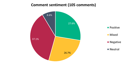
5.28 Submitters
were asked for their methods of travel through this area. The majority (66.7%)
of submitters use this area via car (as the driver):
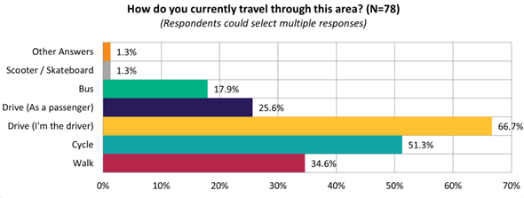
5.29 The
majority of submitters felt this proposal would improve safety for cycling
(66.0%):
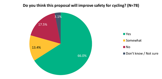
5.30 This
sentiment differed slightly depending on whether they live on the affected
streets (i.e. Aldwins Road, Ensors Road), live in local suburbs (i.e. Linwood,
Woolston), or live elsewhere:
|
Do you think this proposal
will improve safety for cycling?
|
Live on affected streets
|
Live in local suburbs
|
Live elsewhere
|
|
Yes
|
2
|
23
|
20
|
|
Somewhat
|
5
|
4
|
6
|
|
No
|
1
|
8
|
5
|
|
Don't know / Not sure
|
0
|
3
|
1
|
5.31 The
majority of submitters either agreed (48.7%) or somewhat agreed (12.8%) that
installing a raised safety platform would improve safety at the Ferry
Rd/Aldwins Rd/Ensors Rd intersection:
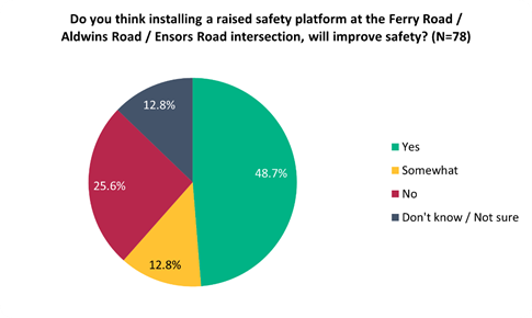
5.32 The
majority of submitters agreed (51.3%) that installing a raised safety platform
would improve safety at the Aldwins Rd/ Buckleys Rd/ Linwood Ave intersection:
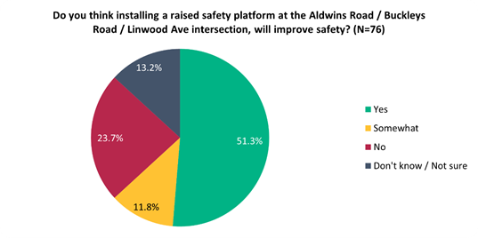
5.33 Key
themes and requests from both comments and submissions are summarised below.
Note that there could be cross-over between those making comments and making
submissions:
|
Key themes on outcomes of
the proposal
|
Number of comments
|
Number of submissions
|
Total mentions
|
|
Support
for the cycleway
|
22
|
27
|
49
|
|
Concern
about raised safety platforms
· Including perception that
raised intersections force people to run through orange lights, increasing
congestion and causing discomfort to drivers
|
11
|
11
|
22
|
|
Concern
around location of bus stops / shelters
· Concern around bus stops
cutting into cycleways, and for the safety for drivers and cyclists if buses
can stop so close next to the Ferry Rd/Aldwins Rd/Ensors Rd intersection.
· Ensuring the school has an
adequate level of bus stops and shelters
|
14
|
8
|
22
|
|
Concerned
about parking loss
· Perceived lack of existing
parking on side streets and how this would create more of an issue on
Flaxwood Lane, leading residents to park on Mackenzie Ave or Ferry Rd
· Concerns around accessing
businesses at the Ferry Rd/Aldwins Rd/Ensors Rd intersection, for both
customers and staff
|
11
|
9
|
20
|
|
Concern
about impact on residents & small businesses
· Businesses near the Ferry
Rd/Aldwins Rd/Ensors Rd intersection, such as Steadfast Books, Book Barn, J
Books, The Emporium, The Mad Butcher and Couplands
· Impact on Aldwins Rd and side
streets residents who do not all have off street parking
|
9
|
8
|
17
|
|
Supportive
of raised safety platforms
· Some felt raised safety
platforms were an appropriate treatment for the intersection given the safety
issues, and slows cars adequately, increasing safety
|
8
|
7
|
15
|
|
Do
not support the cycleway
· Because of parking loss, cost,
compromising driver safety, and that there should be different routes that
are more appropriate
|
4
|
6
|
10
|
|
Requests
|
Number
of comments
|
Number
of submissions
|
Total
mentions
|
|
Further
Ferry/Ensors/Aldwins intersection safety upgrades
· Installing right turning
arrows for traffic from Ferry Rd to Aldwins Rd and vice versa
· Installing a signalised
crossing for cyclists
|
10
|
12
|
22
|
|
Further
traffic calming / side street improvements
· Raising all side streets
(Dutch style intersections), and increase the use of stop signs at side
streets
· Traffic lights at side streets
· Further kerb buildouts at all
side streets
· Further treatments on the
cycleway to warn drivers coming out of long driveways
|
9
|
10
|
19
|
|
Remove
shared path sections and make it fully dedicated
· Use of shared path treatments
for certain sections of the cycleway, citing safety concerns for cyclists and
pedestrians
|
9
|
5
|
14
|
|
Extension
of cycleway
· Cycleway extension to Opawa Rd
and Brougham St
· Request to use a dedicated
cycleway the whole way instead of shared for some sections
|
6
|
7
|
13
|
|
Cycleway
treatment / width requests
· Making the shared pathway was
as wide as possible, concrete cycle lane barriers, and raising the cycleway
at intersections
|
6
|
6
|
12
|
|
Reduce
speeds
· Decrease vehicle speeds
further and install speed cameras at intersections and outside Te Aratai
College
|
1
|
8
|
9
|
Scheme Changes Post-Consultation
5.33.1 Related to
Consultation Response:
· Retention of 19 parking spaces for businesses around the Ferry Rd
intersection with time restrictions.
5.33.2 Related to
Safe System Audit
· Staggered
crossing width at Harrow St increased, and traffic signal design developed.
5.33.3 Related to
Waka Kotahi Scheme design review & approval
· Treatments at
bus stops developed to improve delineation.
· Shared path detail/delineation
opposite Te Aratai College amended/developed.
· On-road cycle transitions
developed from separated path to on-road lane (for confident riders).
· Speed humps proposed at accessways
to slow vehicles.
6. Policy Framework Implications Ngā Hīraunga ā- Kaupapa here
Strategic
Alignment Te Rautaki Tīaroaro
6.1 This report supports the Council's
Long Term Plan (2021 - 2031):
6.2 Transport
6.2.1 Activity: Transport
· Level of Service: 10.0.2 Increase the share of
non-car modes in daily trips - >=36% of trips undertaken by non-car modes
· Level of Service: 10.0.6.1 Reduce the number of
death and serious injury crashes on the local road network - <=100
crashes
· Level of Service: 10.0.41 Reduce emissions and
greenhouse gases related to transport - <=1.10 million tonnes of CO2
equivalents
· Level of Service: 10.5.1 Limit deaths and
serious injury crashes per capita for cyclists and pedestrians - <= 12
crashes per 100,000 residents
· Level of Service: 10.5.2 Improve the perception
that Christchurch is a cycling friendly city - >=66% resident satisfaction
· Level of Service: 10.5.3 More people are
choosing to travel by cycling - >=12,500 average daily cyclist detections
Policy
Consistency Te Whai
Kaupapa here
6.3 The
proposals are consistent with Council’s Plans and
Policies, in particular:
6.3.1 The
changes proposed align with road safety and liveable streets goals in the
Christchurch Transport Strategic Plan 2012–2042, and similarly in the
draft Transport Plan (safe streets).
6.3.2 The
changes proposed align with Kia tūroa te Ao - Ōtautahi Christchurch
Climate Resilience Strategy as set out in the Climate Change Impact
Considerations section below.
Impact
on Mana Whenua Ngā
Whai Take Mana Whenua
6.4 The
decision does not involve a significant decision in relation to ancestral land
or a body of water or other elements of intrinsic value, therefore this
decision does not specifically impact Mana Whenua, their culture and
traditions.
6.5 The
decision does not involve a matter of interest to Mana Whenua and should not
impact on our agreed partnership priorities with Ngā Papatipu Rūnanga
6.6 The
projects are based on minor changes to, or re-allocation of, existing road
spaces, so are not anticipated to have a significant impact on Mana Whenua.
Climate
Change Impact Considerations Ngā Whai Whakaaro mā te Āhuarangi
6.7 The
decisions in this report are likely to:
6.7.1 Contribute
neutrally to adaptation to the impacts of climate change.
6.7.2 Contribute
positively to emissions reductions.
6.8 The
emission reductions associated with this project have not been estimated.
6.9 The Government’s Emissions Reduction Plan states we
will have to ‘substantially improve infrastructure for walking and
cycling’ to meet our emissions targets (including a 20% reduction in
light Vehicle Kilometres Travelled by 2035 - required under the Emissions
Reduction Plan). Improving the quality of our streets for walking and cycling
is also a key part of the Ministry of Transport and Waka Kotahi’s efforts
to decarbonise the transport system.
6.10 New
Zealand has the 5th highest transport emissions rate per capita
among the 43 OECD countries. Petrol or diesel car use is typically the
single-biggest contributor to an individual’s carbon footprint in New
Zealand.
6.11 From
the 2022 Life in Christchurch Transport Survey, 96 percent of respondents
travel by car. Respondents find car travel the least difficult means of
travel. Inconsiderate and dangerous behaviour from other road users and
sharing the road with cars were the main reasons respondents found it difficult
to bike.
6.12 The
proposed changes make it safer for people walking and cycling, which will have a net positive impact for the climate by
helping to reduce transport emissions. Enabling more people to walk or cycle,
particularly for local journeys, is a key part of council’s emissions
reduction efforts by providing a safe, low emission way for residents to move
around the city.
Accessibility
Considerations Ngā
Whai Whakaaro mā te Hunga Hauā
6.13 This proposal improves accessibility for people walking and
cycling, by providing a safer means of accessing and using our street network.
6.14 Waka
Kotahi developed a set of Project Design Parameters to ensure all projects work
to collectively meet the programme objectives. The Project Design
Parameters require that “the infrastructure should be designed for
children and people with visual, mobility, or cognitive impairments. If the
infrastructure works for them, it will work for a wider spectrum of the
population who are interested in walking and cycling but concerned for their
safety.” Transport Choices projects have been designed in
accordance with these requirements.
7. Resource Implications Ngā Hīraunga Rauemi
Capex/Opex Ngā Utu Whakahaere
7.1 Cost
to Implement - the total project estimate is $5,871,367. This is
inclusive of design and project management.
7.2 Maintenance/Ongoing
costs – $37,326 per year additional costs associated with coloured
surfacing, cycle lane separators, new signalised crossing, two new bus shelters
and sweeping costs. These costs will be eligible for Waka Kotahi subsidy at
Council’s 51% Funding Assistance Rate. The net maintenance cost for the
total Transport Choices programme will have an ongoing rates impact of
approximately 0.01%, which will be included in the draft Long Term Plan
proposed budgets.
7.3 Funding
Source – Council’s capital programme:
7.3.1 ID 72755, Transport Choices 2022 – Te Aratai
College Cycle Connection, $3,337,564.
7.3.2 ID
72776, Transport Choices 2022 – Slow Speed Neighbourhoods Linwood
(Linwood/Buckleys Raised platforms), $319,575.
7.3.3 ID
50462, Minor Safety Improvements (Ferry/Ensors Raised platforms Including
signal upgrade) – $494,150
7.3.4 ID
37293, Package – Traffic signals Renewals (Pedestrian/Cycle Signal
upgrade at Te Aratai school), $361,542
7.3.5 ID
67946, Delivery Package – Traffic signal Cabling Renewals ( Ferry /Ensors
signal renewal) $517,000
7.4 There
is a budget shortfall of $841,536 within ID #72755 to meet the project funding
requirements presently. The additional budget will be sourced by
reallocating budget within the Transport Choices programme. Expenditure
on the Transport Choices programme is forecast to be $25.3 million, which
compares to $26.8 million budget. It is proposed to align individual
project budgets in conjunction with Waka Kotahi physical works funding
approvals.
7.5 Waka
Kotahi through the Transport Choices programme is expected to fund the
$5,900,000 project up to an agreed value which is calculated as 90% of the
expected implementation cost. The remaining 10% is Council’s
share.
7.6 Costs
have escalated from the original $3,300,000 budget which was scoped for shared
paths, due to selection of uni-directional separated cycleways being selected
as the preferred option. The design has been developed in collaboration with
Waka Kotahi and they are aware of the cost implication of the preferred option.
7.7 Under
the cost share agreement with Waka Kotahi, funding approvals for individual
Transport Choices projects are approved through two stage gates: design and
physical works. All Transport Choices projects have agreed funding schedules
for design. Individual project schedules for physical works are required to be
agreed and approved prior to 20 October 2023. In approving funding for physical
works, Waka Kotahi will consider:
7.7.1 The
project is in accordance with the scope and design approved by Waka
Kotahi.
7.7.2 Project
costs are in accordance with expectations.
7.7.3 Ability
to deliver the project prior to June 2024.
7.8 The
staff recommendations of this report include that Council’s approval of
this project is conditional on a funding agreement with Waka Kotahi being in
place for the physical works.
8. Legal Implications Ngā Hīraunga ā-Ture
Statutory power to undertake proposals in the report
Te Manatū Whakahaere Kaupapa
8.1 Council
resolved the Transport Choices programme as Metropolitan Significance when the
programme was included in the draft Annual Plan in February 2023/24.
8.2 Council
retains decision-making responsibilities that might otherwise be delegated in
accordance with the Delegations Register when a project is determined as
Metropolitan Significance.
8.3 Part
1, Clauses 7 and 8 of the Christchurch City Council Traffic and Parking Bylaw
2017 provides Council with the authority to install parking restrictions by
resolution.
8.4 The
installation of any signs and/or markings associated with traffic control
devices must comply with the Land Transport Rule: Traffic Control Devices 2004.
Other Legal Implications Ētahi atu
Hīraunga-ā-Ture
8.5 There
is no legal context, issue or implication relevant to this decision.
9. Risk Management Implications Ngā Hīraunga Tūraru
9.1 Scope
– Waka Kotahi has governed the scope and design of the project to align
with programme KPI’s and consistency with Transport Choices design
parameters. Departing from the recommendations of this report creates a risk
that Waka Kotahi would not agree to fund the physical works phase of the
project.
9.2 Delivery
– Transport Choices funding is subject to delivery being complete by June
2024. Waka Kotahi has established additional milestones to track
progress. Delays in approval of the projects would impact on the
timeframe for delivery.
9.3 Funding
security - the Transport Choices funding agreement between Council and Waka
Kotahi presently covers this project for design only, and a further stage gate
approval is required to gain funding approval for construction. The
instruction of physical works will be withheld until an implementation
agreement is in place.
9.4 Implementation
cost uncertainty – the funding agreement with Waka Kotahi places the risk
of cost variations with Council. This risk is being managed by minimising
price uncertainty and building contingency into the funding agreement.
Attachments Ngā Tāpirihanga
|
No.
|
Title
|
Reference
|
Page
|
|
a ⇩ 
|
3814701-C006-Te
Aratai - Scheme Plans
|
23/1362855
|
191
|
|
b ⇩
|
Te Aratai -
Submission Table (Public)
|
23/1372039
|
200
|
In addition to the attached documents, the following background
information is available:
|
Document
Name – Location / File Link
|
|
Not
applicable
|
Confirmation of Statutory
Compliance Te Whakatūturutanga ā-Ture
|
Compliance with Statutory Decision-making
Requirements (ss 76 - 81 Local Government Act 2002).
(a) This report contains:
(i) sufficient information about all reasonably practicable
options identified and assessed in terms of their advantages and
disadvantages; and
(ii) adequate consideration of the views and preferences of
affected and interested persons bearing in mind any proposed or previous
community engagement.
(b) The information reflects the level of significance of the
matters covered by the report, as determined in accordance with the Council's
significance and engagement policy.
|
Signatories Ngā Kaiwaitohu
|
Authors
|
Ryan Rolston -
Programme Manager
Sharon O'Neill
- Programme Manager Transport Capital Programme
Chris Strydom
- Project Manager
Ann Tomlinson
- Project Manager
Miranda Adams
- Procurement Officer
Gemma Dioni -
Senior Transportation Engineer
Samantha Smith
- Engagement Advisor
John Morahan -
Finance Advisor
Wayne Gallot -
Senior Transportation Engineer
|
|
Approved By
|
Jacob Bradbury
- Manager Planning & Delivery Transport
Tony
Richardson - Finance Business Partner
Lynette Ellis
- Head of Transport & Waste Management
|
|
Council
21 September 2023
|

|
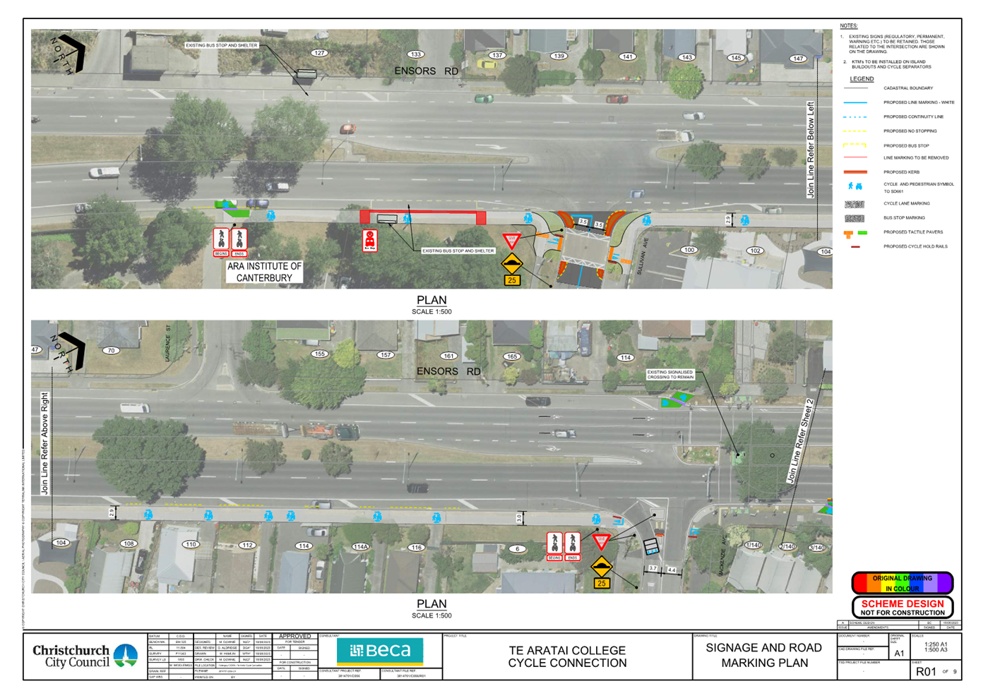
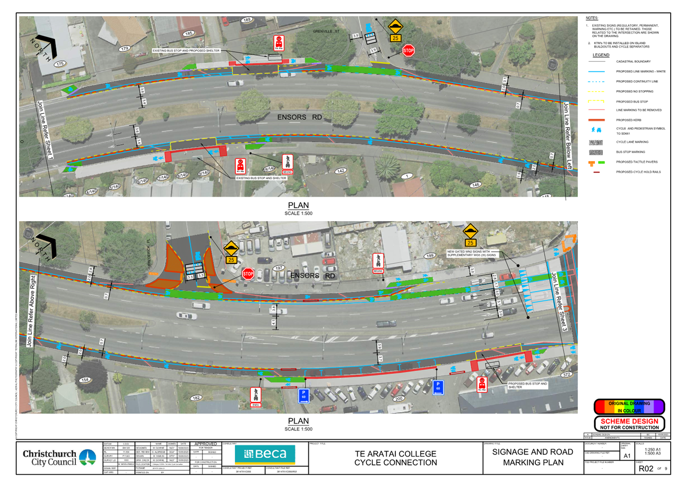
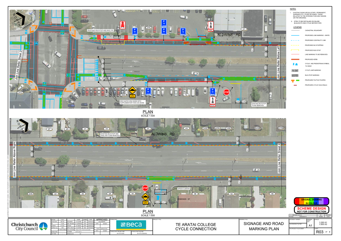
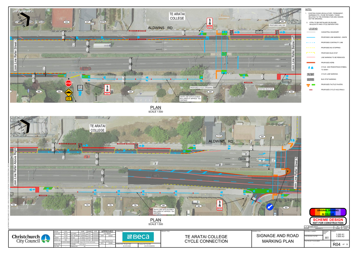
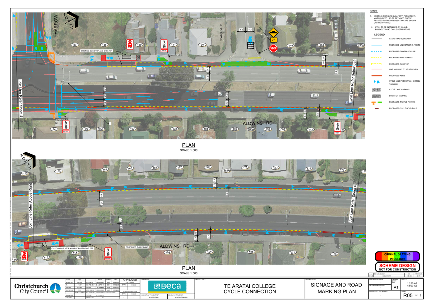
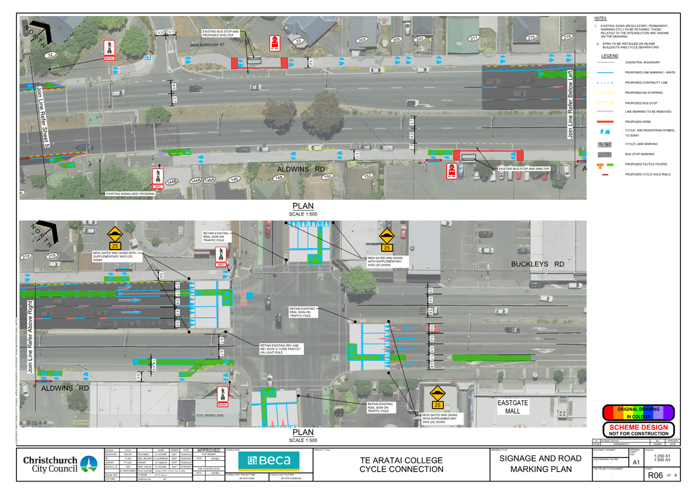
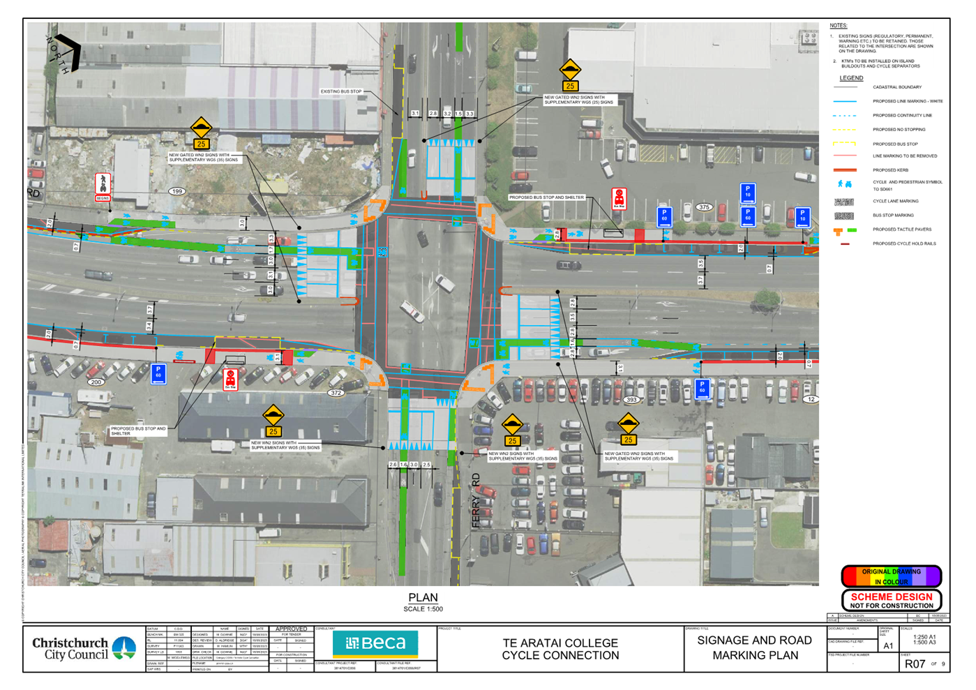
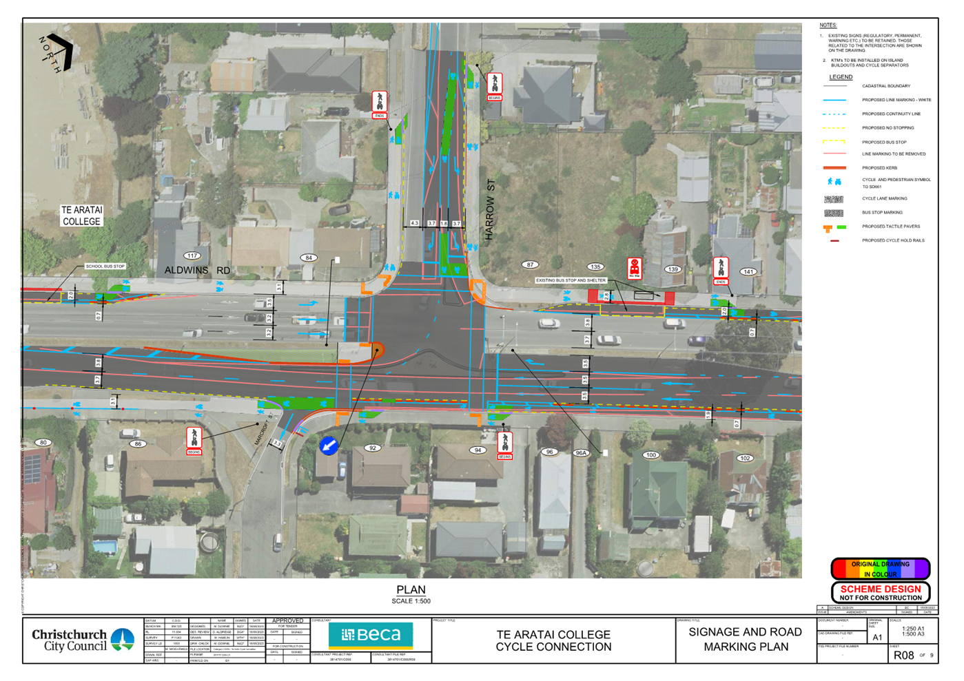
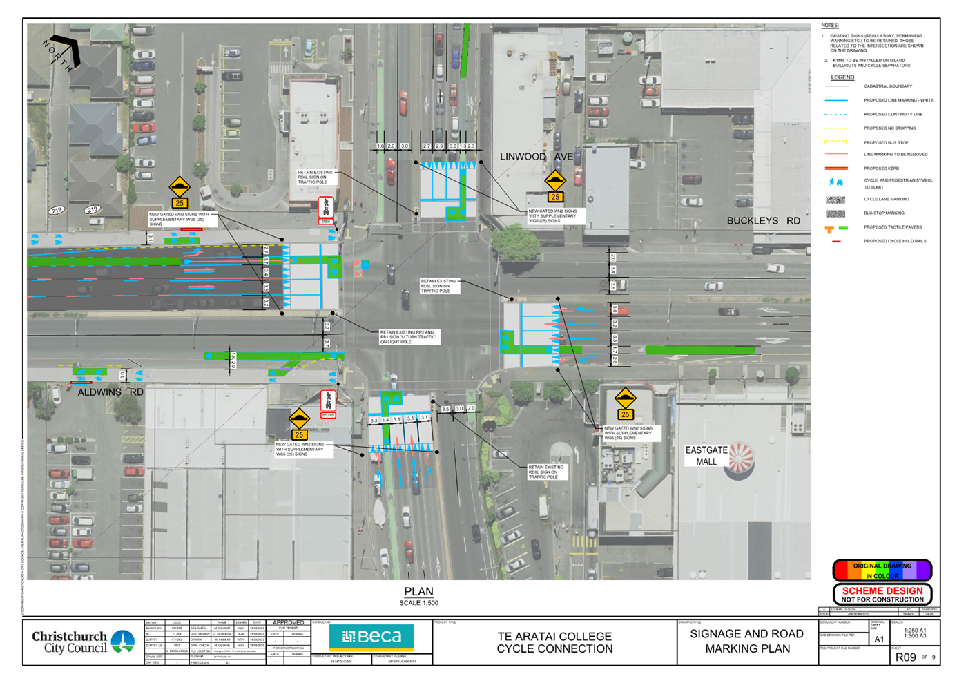
|
Council
21 September 2023
|
|
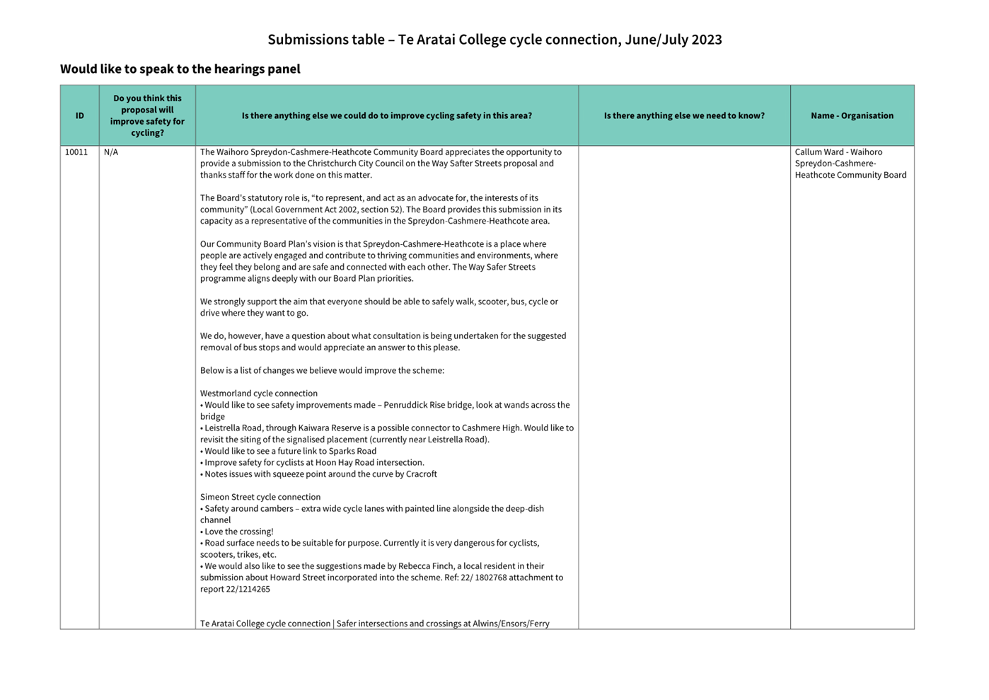
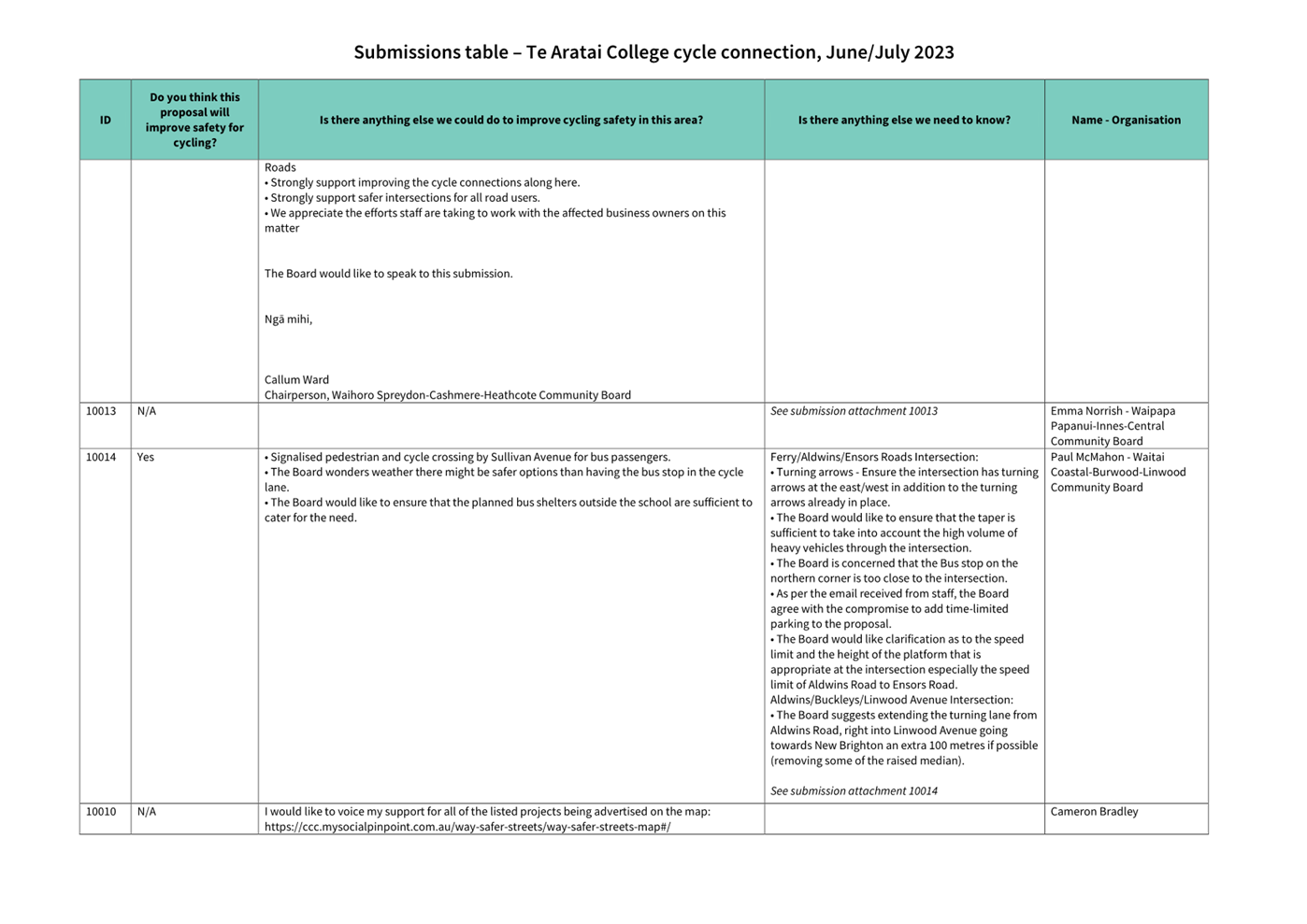
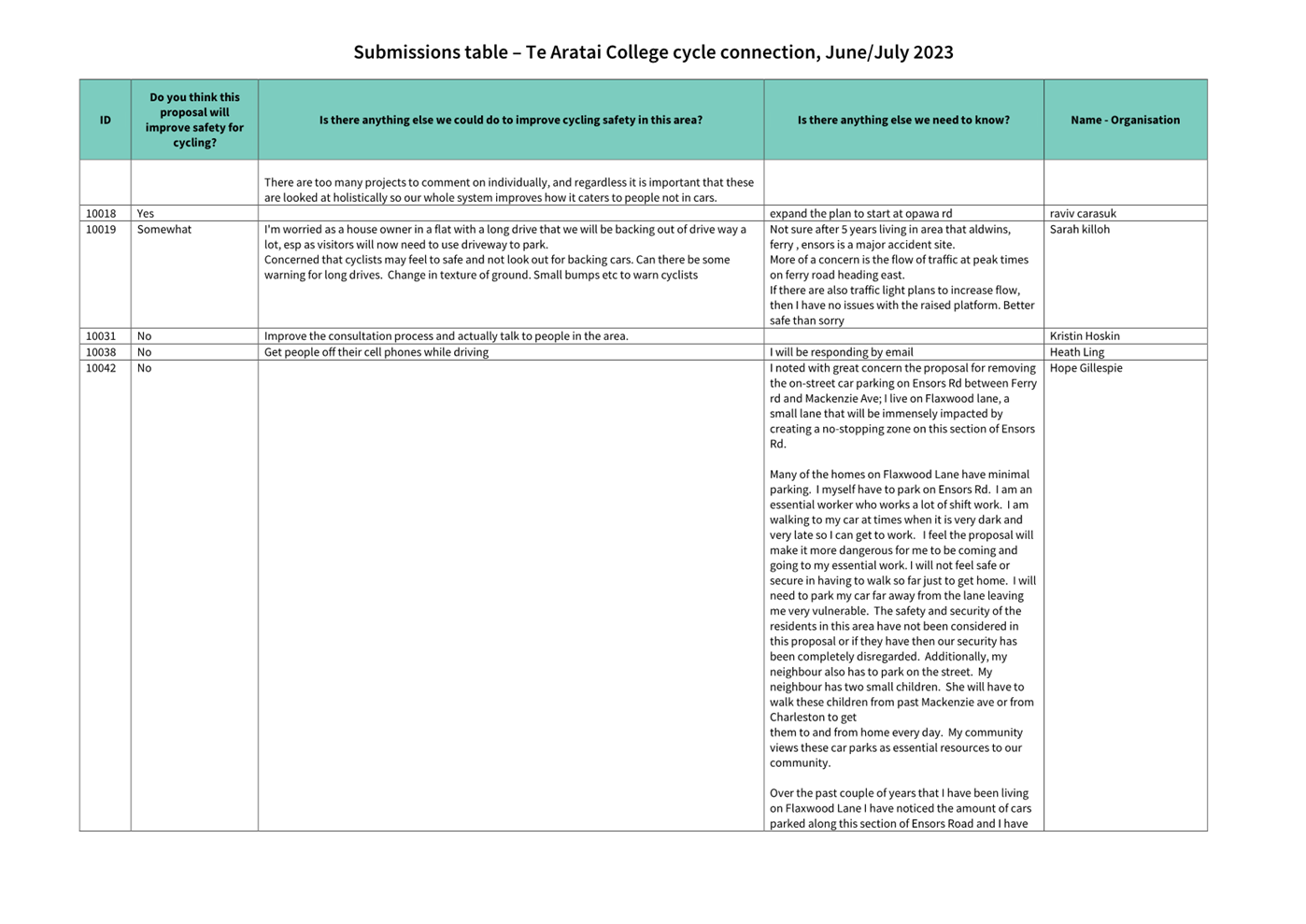
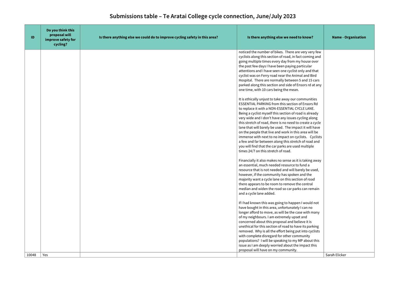
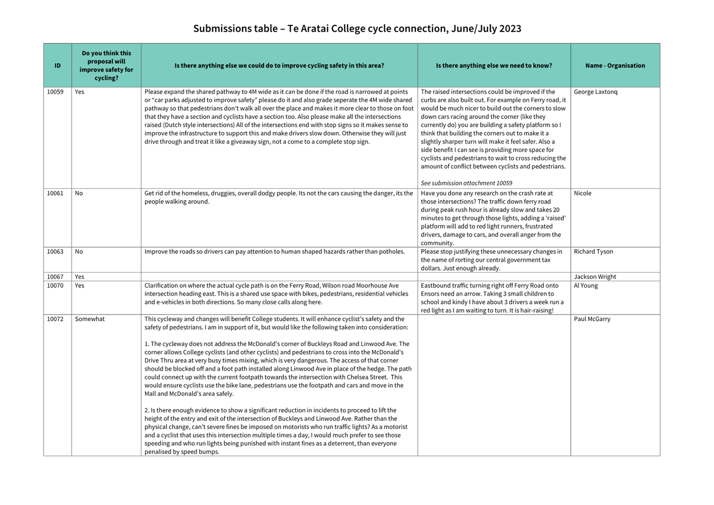
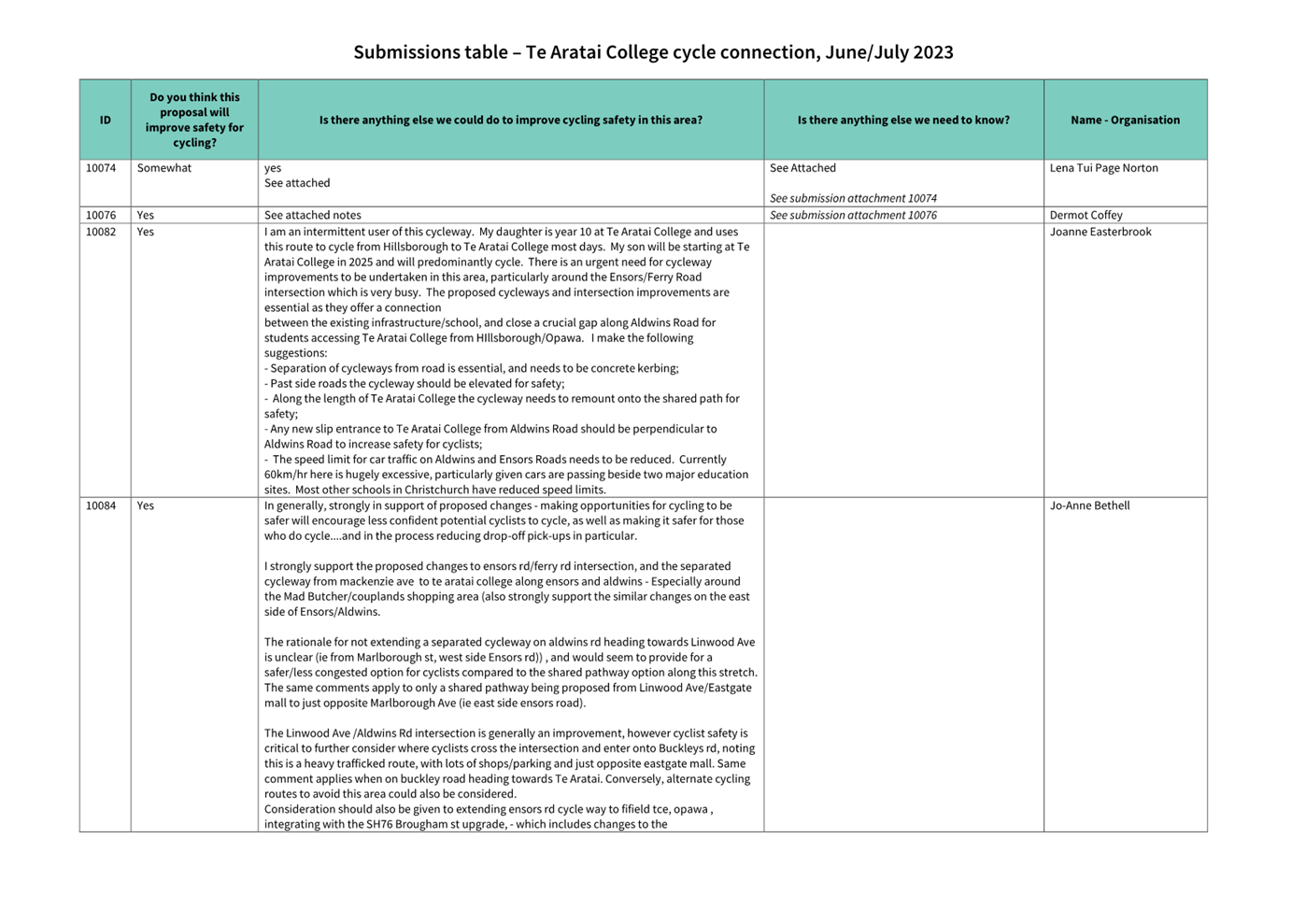
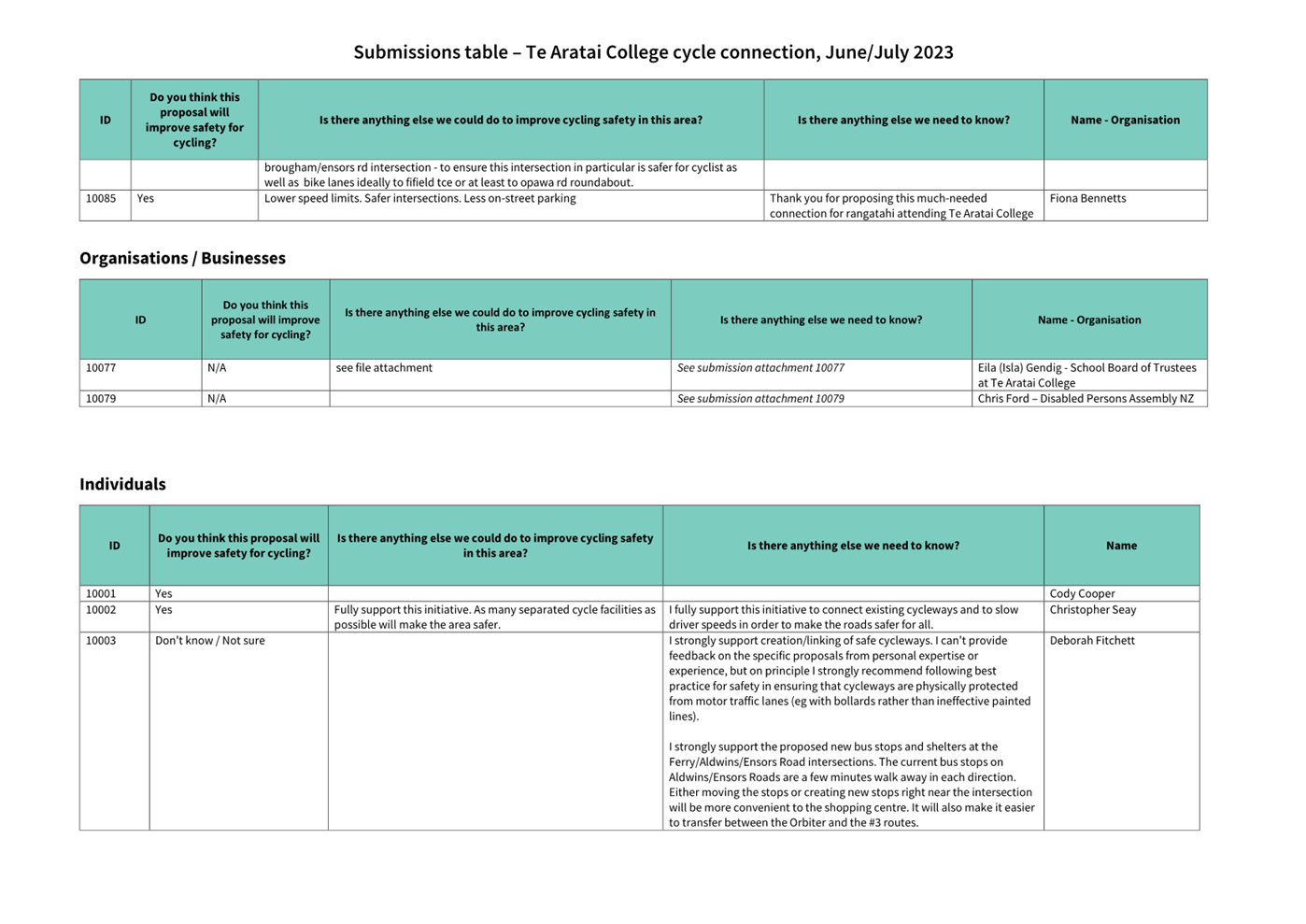
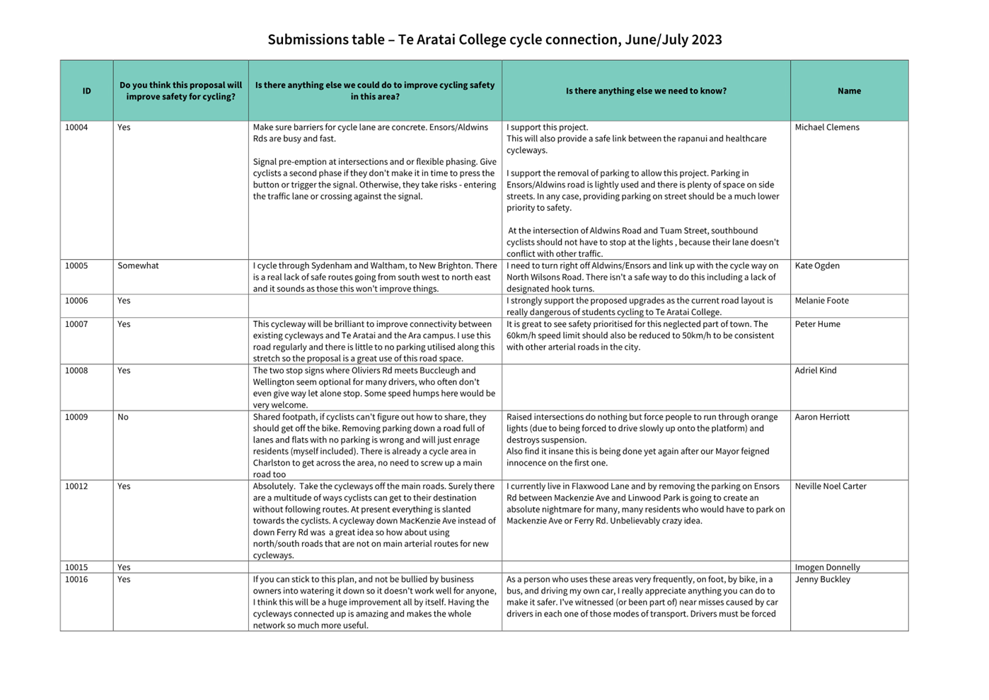
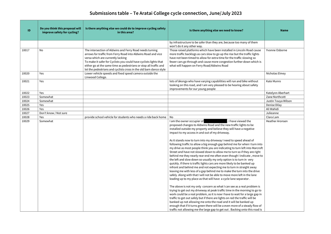
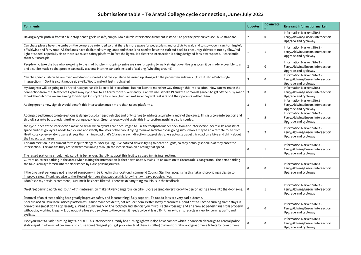
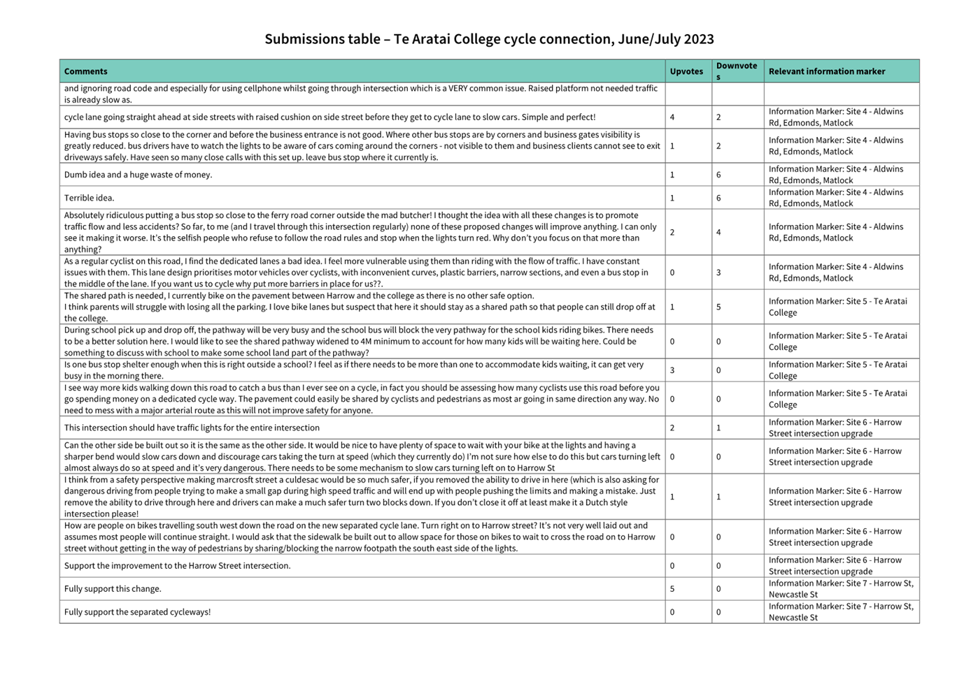
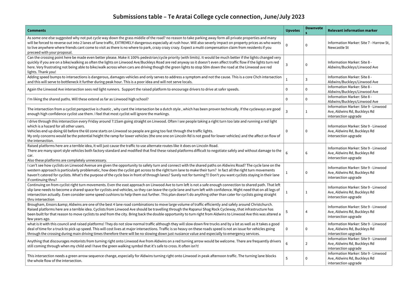
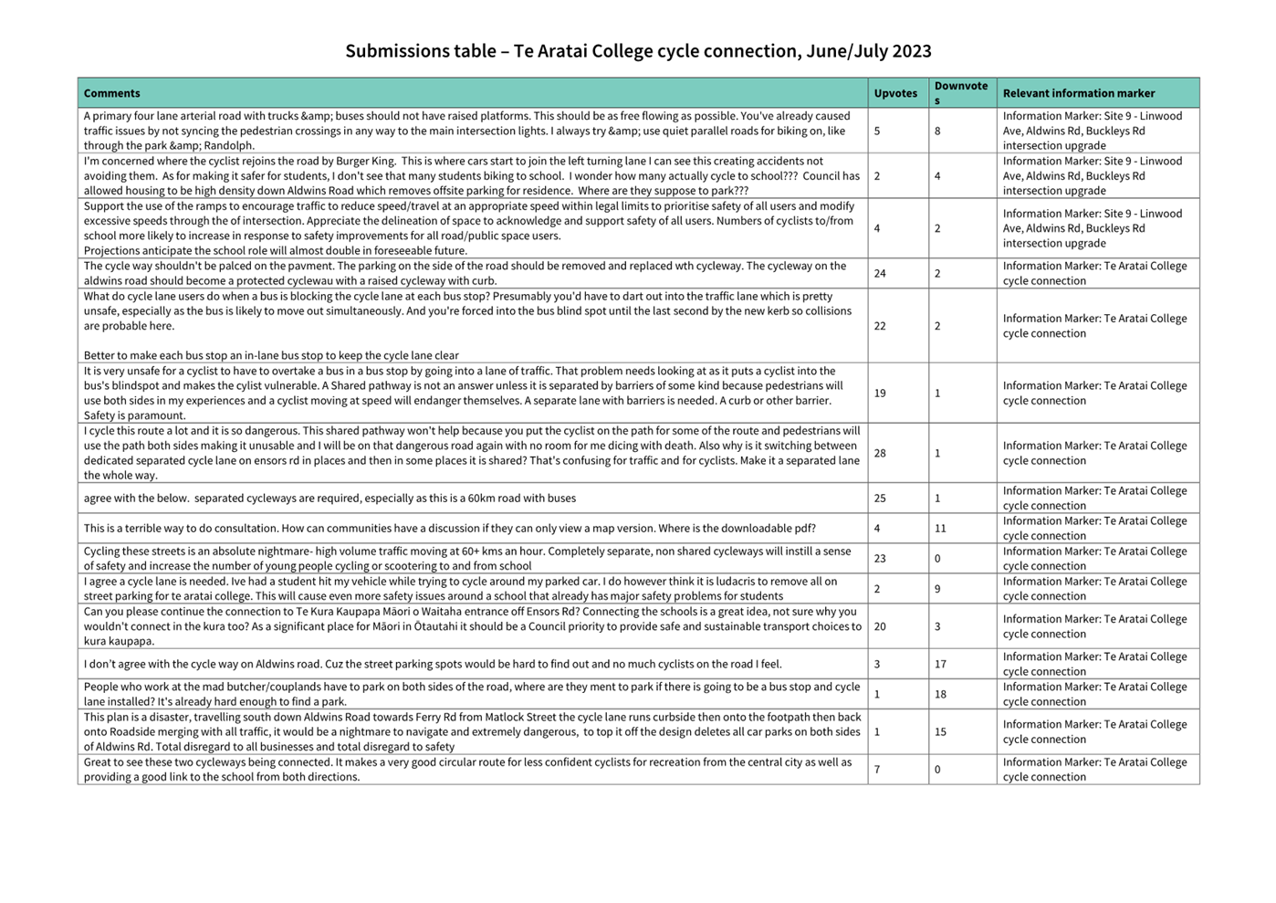
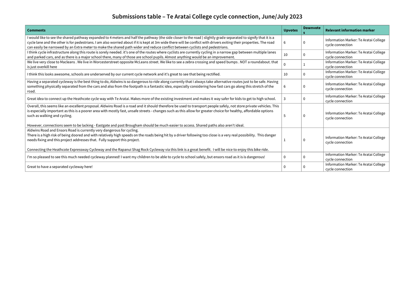
|
Council
21 September 2023
|

|
|
8. Transport Choices - Richmond
Neighbourhood Greenway
|
|
Reference / Te Tohutoro:
|
23/1259448
|
|
Report of / Te Pou Matua:
|
Lisa-Maria
Biggar, Project Manager Transport,
lisa-maria.biggar@ccc.govt.nz;
Jacob Bradbury, Manager Planning and Delivery - Transport,
jacob.bradbury@ccc.govt.nz
|
|
Senior Manager / Pouwhakarae:
|
Lynette
Ellis, Head of Transport & Waste Management (Lynette.Ellis@ccc.govt.nz)
|
1. Nature of Issue and Report Origin
1.1 The purpose of this report is to inform the Council of feedback
received, and to request Council approval of the scheme to proceed to
construction for the Richmond Neighbourhood Greenway project.
1.2 The origin of this report is the Climate Emergency
Response Fund (CERF) Transport Choices programme and the Christchurch
Regeneration Acceleration Facility (CRAF).
1.3 The
decisions in this report are of medium significance in relation to the Christchurch
City Council’s Significance and Engagement Policy 2019. The
level of significance was determined by potential benefits and opportunities to
the council/community, the number of people affected and/or with an interest,
and that these projects span multiple community board areas, as set out in the
criteria of the policy (Page 2). This evaluation has considered the Transport
Choices projects as a cohesive programme of work. This is consistent with
how community engagement has been undertaken, with all work packages being
presented concurrently on Have your Say under the banner of Way Safer Streets.
2. Officer Recommendations Ngā
Tūtohu
That the Council:
General
1. Approves that construction of the Richmond
Neighbourhood Greenway project is conditional on implementation costs being
agreed and incorporated into the Transport Choices Funding agreement between
Waka Kotahi and Council.
2. Approves the following recommendations
required for the implementation of the project, relying on its powers under the
Christchurch City Council Traffic and Parking Bylaw 2017 and Part 21 of the
Local Government Act 1974.
3. Approves that any previous resolutions
pertaining to parking, no-stopping restrictions, Special Vehicle Lanes, and
traffic controls made pursuant to any bylaw to the extent that they are in
conflict with the recommendations described in 4-22 below be revoked.
General
Arrangements
4. Approves all road surface treatments, traffic
controls, traffic calming devices and road markings on London Street,
commencing at its intersection with Perth Street, and extending in a westerly
direction for a distance of 50 metres, as detailed on plan(s) TG139003, sheet
1, dated 09.08.2023, and attached to this report as Attachment A.
5. Approves all road surface treatments, traffic
controls, traffic calming devices and road markings on London Street,
commencing at its intersection with Perth Street, and extending in an easterly
direction for a distance of 30 metres, as detailed on plan(s) TG139003, sheet
1, dated 09.08.2023, and attached to this report as Attachment A.
6. Approves all road surface treatments, traffic
controls, traffic calming devices and road markings on Perth Street, commencing
at its intersection with London Street, and extending in a northerly direction
to its intersection with Avalon Street, as detailed on plan(s) TG139003, sheet
1, dated 09.08.2023, and attached to this report as Attachment A.
7. Approves all road surface treatments, traffic
controls, traffic calming devices and road markings on Avalon Street,
commencing at a point 15 metres west of its intersection with Perth Street, and
extending in an easterly direction to a point 18 metres east of its intersection
with McLeod Street, as detailed on plan(s) TG139003, sheet 1, dated 09.08.2023,
and attached to this report as Attachment A.
8. Approves all road surface treatments, traffic
controls, traffic calming devices and road markings on McLeod Street,
commencing at its intersection with Avalon Street, and extending in a northerly
direction to its intersection with North Avon Road, as detailed on plan(s)
TG139003, sheets 1-2, dated 09.08.2023, and attached to this report as Attachment
A.
9. Approves all kerb alignments, road surface
treatments, traffic islands, traffic calming devices and road markings on North
Avon Road, commencing at its intersection with McLeod Street, and extending in
an easterly direction to the eastern extent of its intersection with Nicholls Street,
as detailed on plan(s) TG139003, sheet 2, dated 09.08.2023, and attached to
this report as Attachment A.
10. Approves all road surface treatments, traffic
controls, traffic calming devices and road markings on Nicholls Street,
commencing at its intersection with North Avon Road, and extending in a
northerly direction to its intersection with Dudley Street, as detailed on
plan(s) TG139003, sheets 2-3, dated 09.08.2023, and attached to this report as Attachment
A.
11. Approves all road surface treatments and road
markings on Dudley Street, commencing at its intersection with Nicholls Street,
and extending in an easterly direction to its intersection with Stapletons
Road, as detailed on plan(s) TG139003, sheet 3, dated 09.08.2023, and attached
to this report as Attachment A.
12. Approves all kerb alignments, road surface
treatments, traffic islands, traffic calming devices and road markings on
Stapletons Road, commencing at its intersection with Dudley Street, and
extending in a north easterly direction to its intersection with Averill
Street, as detailed on plan(s) TG139003, sheets 3-4, and attached to this
report as Attachment A.
13. Approves all road surface treatments, traffic
controls, traffic calming devices and road markings on Averill Street,
commencing at its intersection with Stapletons Road, and extending in a north
easterly direction to its intersection with North Parade, as detailed on
plan(s) TG139003, sheet 4, dated 15.08.2023, and attached to this report as Attachment
A.
14. Approves all kerb alignments, road surface
treatments, traffic calming devices and road markings on Petrie Street,
commencing at a point 25 metres south of its intersection with Averill Street,
and extending in a northerly direction for 60 metres, as detailed on plan(s)
TG139003, sheet 4, dated 15.08.2023, and attached to this report as Attachment
A.
Parking and
Stopping Restrictions
15. Approves pursuant to Clause 7 of the
Christchurch City Council Traffic and Parking Bylaw 2017, that the stopping of
vehicles be prohibited at all times:
a. Along
the south side of London Street commencing at a point 35 meters west of
its intersection with Perth Street and extending in a westerly direction
for a distance of 12 metres.
a. Along
the north side of London Street commencing at a point 35 meters west of its
intersection with Perth Street and extending in a westerly direction for a
distance of 9 metres.
b. Along
the north side of London Street commencing at a point18 meters east of its
intersection with Perth Street and extending in an easterly direction for a
distance of 7 metres.
c. Along
the south side of London Street commencing at a point 18 meters east of its
intersection with Perth Street and extending in an easterly direction for a
distance of 7 metres.
d. Along
the eastern side of Perth Street commencing at a point 10 meters south of its
intersection with Avalon Street and extending in a southerly direction for a
distance of 4 metres.
e. Along
the western side of Perth Street commencing at a point 10 meters south of its
intersection with Avalon Street and extending in a southerly direction for a
distance of 4 metres.
f. Along
the north side of Avalon Street commencing at a point 4 meters west of its
intersection with Perth Street and extending in a westerly direction for a
distance of 6 metres.
g. Along
the south side of Avalon Street commencing at a point 4 meters west of its
intersection with Perth Street and extending in a westerly direction for a
distance of 6 metres.
h. Along
the north side of Avalon Street commencing at a point 5 meters east of its
intersection with McLeod Street and extending in an easterly direction for a
distance of 5 metres.
i. Along
the south side of Avalon Street commencing at a point 5 meters east of its
intersection with McLeod Street and extending in an easterly direction for a
distance of 5 metres.
j. Along the east side of
Stapletons Road, commencing at its intersection with Averill Street and
extending in a north westerly direction for a distance of 14 metres.
k. Along the east side of Stapletons
Road, commencing at its intersection with Averill Street and extending in a
south easterly direction for a distance of 30metres.
l. Along the north side of
Averill Street commencing at its intersection with Stapletons Road and
extending in an easterly direction for a distance of 30 metres.
m. Along the south side of Averill Street
commencing at its intersection with Stapletons Road and extending in an
easterly direction for a distance of 20 metres.
n. Along the north side of Averill
Street commencing at a point 12 metres west of its intersection with Petrie
Street and extending in an easterly direction to the Petrie Street
intersection.
o. Along the south side of Averill
Street commencing at a point 12 metres west of its intersection with Petrie
Street and extending in an easterly direction to the Petrie Street
intersection.
p. Along the north side of Averill Street
commencing at its intersection with Petrie Street and extending in an easterly
direction for 12 metres.
q. Along the south side of Averill
Street commencing at its intersection with Petrie Street and extending in an
easterly direction for 12 metres.
r. Along
the south side of Averill Street commencing at its intersection with Chrystal
Street and extending in an easterly direction for a distance of 40 metres.
s. Along
the north side of Averill Street commencing at its intersection with Chrystal
Street and extending in an easterly direction for a distance of 36 metres.
t. Along
the east side of Petrie Street Commencing at its intersection with Averill
Street and extending in a northerly direction for a distance of 18 metres.
u. Along
the west side of Petrie Street Commencing at its intersection with Averill
Street and extending in a northerly direction for a distance of 18 metres.
v. Along
the east side of Petrie Street Commencing at its intersection with Averill
Street and extending in a southerly direction for a distance of 10 metres.
w. Along
the west side of Petrie Street Commencing at its intersection with Averill
Street and extending in a southerly direction for a distance of 8 metres.
Cycle
Paths
16. Approves that the path on the eastern side of
McLeod Street, commencing at a point 65 meters north of its intersection with
Avalon Street and extending in a northerly direction to its intersection with
North Avon Road be resolved as a bi-directional Shared Path in accordance with
Clause 21 of the Christchurch City Council Traffic & Parking Bylaw 2017,
and in accordance with section 11.4 of the Land Transport Rule: Traffic Control
Devices 2004. This Shared Path is for the use by the classes of road user only
as defined in Section 11.1A of the Land Transport (Road User) Rule 2004.
17. Approves that the path on the south side of
North Avon Road, commencing at its intersection with McLeod Street and
extending in an easterly direction for a distance of 70 meters be resolved as a
bi-directional Shared Path in accordance with Clause 21 of the Christchurch
City Council Traffic & Parking Bylaw 2017, and in accordance with section
11.4 of the Land Transport Rule: Traffic Control Devices 2004. This Shared Path
is for the use by the classes of road user only as defined in Section 11.1A of
the Land Transport (Road User) Rule 2004.
18. Approves that the path on the north side of
North Avon Road, commencing at a point 18 meters west of its intersection with
Nicholls Street and extending in an easterly direction to its intersection with
Nicholls Street be resolved as a bi-directional Shared Path in accordance with
Clause 21 of the Christchurch City Council Traffic & Parking Bylaw 2017,
and in accordance with section 11.4 of the Land Transport Rule: Traffic Control
Devices 2004. This Shared Path is for the use by the classes of road user only
as defined in Section 11.1A of the Land Transport (Road User) Rule 2004.
19. Approves that the path on the western side of
Nicholls Street, commencing at its intersection with North Avon Road extending
in a northerly direction for a distance of 18 meters be resolved as a
bi-directional Shared Path in accordance with Clause 21 of the Christchurch
City Council Traffic & Parking Bylaw 2017, and in accordance with section
11.4 of the Land Transport Rule: Traffic Control Devices 2004. This Shared Path
is for the use by the classes of road user only as defined in Section 11.1A of
the Land Transport (Road User) Rule 2004.
20. Approves that the path on the eastern side of
Nicholls Street, commencing at its intersection with North Avon Road extending
in a northerly direction for a distance of 12 meters be resolved as a
bi-directional Shared Path in accordance with Clause 21 of the Christchurch
City Council Traffic & Parking Bylaw 2017, and in accordance with section
11.4 of the Land Transport Rule: Traffic Control Devices 2004. This Shared Path
is for the use by the classes of road user only as defined in Section 11.1A of
the Land Transport (Road User) Rule 2004.
21. Approves, pursuant to Section 334(1)(d) of the
Local Government Act 1974 that a separated bi-directional cycle facility, for
the use of cycles only be installed along the northern side of Averill Street,
commencing at a point 36 metres east of its intersection with Chrystal Street
and extending in a north easterly direction for a distance of 88 metres.
22. Approves that the path on the northern side of Averill
Street, commencing at a point 20 metres west of its intersection with North
Parade and extending in an easterly direction to its intersection with North
Parade be resolved as a bi-directional Shared Path in accordance with Clause 21
of the Christchurch City Council Traffic & Parking Bylaw 2017, and in
accordance with section 11.4 of the Land Transport Rule: Traffic Control Devices
2004. This Shared Path is for the use by the classes of road user only as
defined in Section 11.1A of the Land Transport (Road User) Rule 2004.
23. Approves that these resolutions 5-22 take
effect when parking signage and/or road markings that evidence the restrictions
described in the staff report are in place (or removed in the case of
revocations).
3. Reason for Report Recommendations Ngā Take mō te
Whakatau
3.1 The
Richmond Neighbourhood Greenway project is
located northeast of the city centre and is expected to provide a continuous
Level of Service through to the central city connections for ‘interested
but concerned’ cyclists.
3.2 This
project is funded by the Central Government Transport Choices programme –
a $348 million national programme made available from the Climate Emergency
Response Fund, as well as the Christchurch Regeneration Acceleration Facility
(CRAF) – a funding package of $40 million from the Treasury for transport
projects in Christchurch.
3.3 The
Transport Choices programme is important because transport makes up almost half
of New Zealand’s carbon emissions. In May 2022, government released
its first Emissions Reduction Plan and transport has a significant role to
play, targeting a 20 percent reduction in light vehicle travel by 2035.
Reducing reliance on cars and supporting people to walk, cycle and use public
transport is one of three focus points of the Emissions Reduction Plan.
3.4 The
Richmond Neighbourhood Greenway project was
included within the Transport Choices programme due to alignment with the
“deliver strategic cycling/micro mobility networks” investment
category of the programme.
4. Alternative Options Considered Ētahi atu Kōwhiringa
The Transport
Choices Programme
4.1 Transport
Choices funding was allocated to Local Authorities through an Expression of
Interest process administered by Waka Kotahi. Through that process
Christchurch City Council submitted a package of projects that was developed by
consideration of:
· Project
alignment with the four investment criteria for Transport Choices funding:
deliver strategic cycling/micro mobility networks; create walkable
neighbourhoods; support safe, green, and healthy school travel; make public
transport more reliable and easier to use;
· Achieving
diversity across the four investment categories for Transport Choices funding;
· Focusing
investments in certain suburbs;
· Community
requests for infrastructure improvements aligned with the Transport Choices
programme outcomes;
· Complimenting
existing programmes, such as the Major Cycleway Routes programme;
· Project
complexity and ability to deliver prior to June 2024.
4.2 All
14 projects submitted for Transport Choices funding were accepted by Waka
Kotahi. However, in deciding to include the Transport Choices programme
in the Draft Annual Plan, Council decided to include 11 projects in the
programme and defer a number of business-as-usual projects by 12 months to
enable the Transport Choices programme to be adequately resourced.
Project Options Considered
4.3 The
options considered in the development of the Richmond
Neighbourhood Greenway relate to route selection and the type of
treatment provided (physical separation or a shared road environment) on the
identified route. Considerations included:
· The identified route
is supported by the Richmond Residents and Business Association and consists of
roads/streets with low traffic volumes and operating speeds. In agreeing this
route, several alternative alignments were considered but discontinued as they
would require more extensive physical works or a greater impact on the
community, such as parking loss.
· On streets that
experience a high traffic volume (above 1,500 vehicles per day) and/or an
operating speed limit of more than 30km/h, it is necessary to provide physical
separation between vehicles and people who cycle.
· Where separation is
required along the route, both shared pathways and physically separated
cycleways were considered. The type of separation selected was determined based
on predicted demand, length of the segment, location of driveways, other users,
existing infrastructure/connections, and potential impact on parking.
· Many roads along the
route (Perth Street, Avalon Street, McLeod Street, Nicholls Street, Dudley
Street, Stapletons Road and Averill Street) have existing low traffic volumes
and operating speed limits. Moreover, the above-mentioned streets are included
in the Safe Speed Neighbourhoods Speed Reduction programme. Therefore, the
project’s intent is to provide a low speed/low traffic volume environment
where it is appropriate for bicycles and general vehicles to share the road.
5. Detail Te Whakamahuki
5.1 The decision affects the following wards/Community Board areas:
5.1.1 Waitai
Coastal-Burwood-Linwood Community Board
5.1.2 Waipapa
Papanui-Innes-Central Community Board
5.2 The
purpose of the project is to provide a local cycle route through the Richmond
neighbourhood providing a safe cycle connection to local community destinations
and onwards and intended to extend to connect to the Central City. This will
provide a local cycle connection for the ‘interested but concerned’
cycle user.
5.3 The
recommended alignment for the project commences at the intersection of Perth
and London Street before travelling on Perth Street, Avalon Street, McLeod
Street, North Avon Road, Nicholls Street, Dudley Street, Stapletons Road and
Averill Street to connect to the existing shared pathway on North Parade.
5.4 The
recommended route is approximately 2 kilometres long and consists of 750m of
shared path (along North Parade and North Avon Road), 150m of separated
bi-directional cycleway (along Averill Street outside of Pareawa Banks Avenue
School) and 1,170m of greenway treatments.
5.5 A
cycle greenway treatment is proposed where it is possible to achieve a road
environment with low traffic speeds and low traffic volumes. This is achieved
through the existing road environment, the installation of speed reduction
devices (road humps and speed cushions) and the planned reduction of the posted
limit (from 50 km/h to 30 km/h) on many streets in the Richmond Area. Sharrow
markings and wayfinding signage is also proposed to help guide cycle users
along the route and reinforce the shared use road environment.
5.6 Speed
humps are proposed at:
· The London Street
approaches to its intersection with Perth Street;
· The Perth Street
approach to its intersection with Avalon Street;
· The Avalon Street
west approach to its intersection with Perth Street;
· The Avalon Street
east approach to its intersection with McLeod Street; and
· On Averill Street
east of its intersection with Chrystal Street.
5.7 A
shared path is proposed on the southern side of North Avon Road (McLeod Street
to Nicholls Street) to provide physical separation between bicycles and motor
vehicles, to assist with crossing North Avon Road - the existing pedestrian refuge
island will be widened. Speed cushions are proposed on approaches to the
crossing point.
5.8 A
section of physically separated bi-directional cycleway is proposed outside of
Pareawa Banks Avenue School.
5.9 The
route utilises the existing shared use path on North Parade, the width of this
shared path will not be modified, however, an allowance has been made to
resurface sections of it.
5.10 The
identified route is dependant of the development of the following projects
which have an interface with this project:
· Richmond Cluster
intersections (CRAF project) – will run simultaneously with the Richmond
Neighbourhood Greenway.
· Nicholls Street
Renewal and Dudley Street Renewal – both projects are presently in the
procurement phase. They are to be combined under a single contract. Specific
construction timeframes are yet to be confirmed, but have projected completion
within this financial year FY24.
· The planned
reduction in the posted limit areas part of the Slow Speed Neighbourhood
project will be complete before construction of this project.
5.11 The project has
been developed to minimise impact on the local community and businesses. The
impact on parking has been kept to a minimum, however is proposed to be removed
in locations where speed control devices are proposed.
Public Consultation Te Tukanga Kōrerorero
5.12 Richmond
Residents’ and Business Association (RRBA) sent a proposal for safer
cycling connections in Richmond to CCC in 2020, proposing a route to be
investigated. Council staff have worked on a scheme plan since and have met
with RRBA to share updates to the plan.
5.13 Local
residents received warm up flyers in their mailboxes from 29 May, indicating we
would be seeking feedback on Way Safer Streets projects proposed for their area
in June.
5.14 Consultation
started on 16 June 2023 and ran until 16 July 2023, as part of the wider Way
Safer Streets consultation. An email was sent to 150 key stakeholders across
the entire Way Safer Streets programme, including emergency services, Spokes,
AA, Disabled Persons Assembly, Blind Low Vision, Environment Canterbury,
Mahaanui Kurataiao, Richmond Residents’ and Business Association, and
Pareawa Banks Avenue School. The consultation was posted on the council
Facebook page, as well as local community groups, inviting submissions on the Social
Pinpoint Map.
5.15 Flyers
and consultation documents were made available at Pareawa Banks Avenue School
and Shirley Library.
5.16 Staff
met with Pareawa Banks Avenue School in late June 2023, who were supportive of
the proposal.
5.17 Two
Newsline stories were published and picked up by local media outlets. Digital
screens were displaying the consultation in Civic Offices, as well as newspaper
advertisements in The Star and The Pegasus Post. An online targeted campaign
ran for the entire consultation period.
5.18 During
consultation, flyers were delivered to residents in the local area, and emails
were sent to those who expressed interest in being updated on Way Safer
Streets.
5.19 Residents
most affected by the intersection improvements and traffic calming features
were door knocked during consultation. They were mostly in support of the
plans, and many residents raised vehicle speed and burnouts being key safety
issues for their streets.
5.20 A
Christchurch wide cycling event, “Christchurch Winter Solstice Matariki
Night Light Bike Ride” was attended, and flyers were distributed to ensure
cyclists had access to the different projects.
5.21 Key
stakeholder meetings throughout and after consultation, with Spokes, FENZ, St
John, NZ Police and Disabled Persons Assembly, further informed projects in the
Way Safer Streets program.
Summary of Submissions Ngā Tāpaetanga
5.22 Feedback
on the plans could be given by posting a comment on the Social Pinpoint map, by
making a submission, or both.
5.23 A
total of 52 submissions and 44 comments were received on the Richmond project.
47 submissions were received in the interactive Social
Pinpoint Map, and five were received via email/PDF. Submissions were
received by Waipapa Papanui-Innes-Central Community Board, Richmond
Residents’ and Business Association, the Disabled Persons Assembly, and
49 individuals. All submissions and comments are available in Attachment B.
5.24 On
the Social
Pinpoint Map, the project received a total of 130 upvotes, 43 downvotes,
and 44 comments:
Summary
from social pinpoint interactions
|
Project pin
|
Comments
|
Upvotes
|
Downvotes
|
|
Overall
pin
|
17
|
43
|
9
|
|
Site 1 -
London Street / Perth Street
|
8
|
17
|
10
|
|
Site 2 -
Perth / Avalon / McLeod
|
1
|
12
|
5
|
|
Site 3 -
McLeod Street / North Avon Road / Nicholls Street
|
3
|
10
|
3
|
|
Site 4 -
Nicholls Street / Dudley Street
|
5
|
12
|
7
|
|
Site 5 -
Stapletons Road / Averill Street
|
5
|
15
|
4
|
|
Site 6 -
Averill Street, Chrystal Street, North Parade
|
5
|
21
|
5
|
|
Total
|
44
|
130
|
43
|
5.25
Comment sentiment was predominantly mixed (50.0%), and
positive (31.8%):
5.26 Submitters
were asked how they travel through this area. The majority (72.9%) of
submitters use this area via car (as the driver), followed closely by cycling
(64.6%) and walking (58.3%):
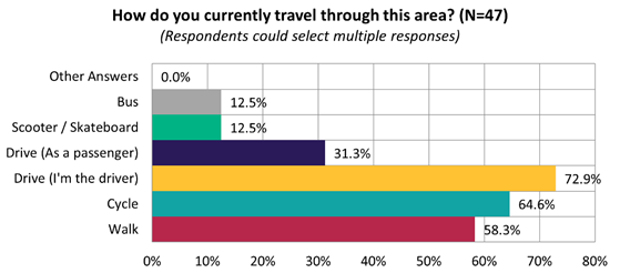
5.27
Submitters were split on whether they felt this proposal would
improve cycling safety, with 39.6% saying they agreed, 22.9% saying they
somewhat agreed, and another 29.2% saying they disagreed:
5.28 This
sentiment differed slightly depending on whether they live on the affected
streets (i.e. Perth Street, London Street, Nicholls Street), live in local
suburbs (i.e. Richmond, St Albans, Mairehau), or live elsewhere:
|
Do you think this proposal
will improve safety for cycling?
|
Live on affected streets
|
Live in local suburbs
|
Live elsewhere
|
|
Yes
|
7
|
5
|
7
|
|
Somewhat
|
4
|
4
|
2
|
|
No
|
9
|
4
|
1
|
|
Don't know / Not sure
|
0
|
2
|
2
|
5.29 Submitters
were asked to comment on specific connections that could be explored if the
route were to be extended into the central city. Several commenters also chose
to mention specific route extension requests into the city, which are
summarised into themes below:
|
Inner city route extension
request themes
|
Number
of comments
|
Number
of submissions
|
Total
mentions
|
|
Fitzgerald
Ave
|
5
|
13
|
18
|
|
Alexandra
Street
|
6
|
10
|
16
|
|
Stanmore
Road
|
1
|
9
|
10
|
|
Hills
Road
|
1
|
5
|
6
|
|
Cambridge
Terrace
|
1
|
4
|
5
|
|
Bealey
Ave
|
1
|
3
|
4
|
|
Stapletons
Road
|
1
|
3
|
4
|
5.30 Key
themes and requests from both comments and submissions are summarised below.
Note that there could be cross-over between those making comments and making
submissions:
|
Key themes on outcomes of the
proposal
|
Number
of comments
|
Number
of submissions
|
Total
mentions
|
|
Supportive
of the project
· General support and agreement
that this project would increase safety
|
15
|
11
|
26
|
|
Concern
about the route proposed
· Perception that cyclists
won’t take this route as it will be inconvenient to cycle in an indirect
way
· Questions about why this
particular route was selected, given that other side streets are wider
· Concern about the sudden end
of the route
|
7
|
14
|
21
|
|
Concern
about width of road and congestion
· Particular concern about Perth
Street being congested already, having insufficient parking, and being too
narrow to direct cyclists
· Particular concern about
Nicholls Street being too narrow and having to share the road with cars
|
5
|
11
|
16
|
|
Lack
of need for a project in this area
· A perception that the area is
already safe enough for cyclists, and that greenways on narrow streets are
unnecessary
|
1
|
7
|
8
|
|
Concern
about parking loss
· A general shortage for parks
in the area, and especially on Perth Street and outside the school, which
this would not help with
|
1
|
3
|
4
|
|
Requests
|
Number of comments
|
Number of submissions
|
Total mentions
|
|
Additional
speed cushions, buildouts, crossings and traffic calming
· For instance more refuge
islands on Hills Road, a refuge island near McLeod and Nicholls streets, more
traffic calming, more raised safety platforms, a physical cycleway barrier,
and a signalised crossing near North Parade
|
8
|
8
|
16
|
|
Route
extension requests
· Make sure this cycleway
connects with the inner city and other cycleways
|
7
|
5
|
12
|
|
Road
maintenance requests
· Improve condition of the road
surface, kerbsides, signs and street markings
|
2
|
4
|
6
|
|
Reduce
speeds
· Requests have come through to
have a 30-40km zone, some suggest for the cycle connection, others suggest
for the whole suburb
|
0
|
4
|
4
|
Changes made to the
scheme design as a result of consultation feedback
5.31 Changes
made include:
· Speed cushions on either
side of the pedestrian crossing on North Avon Road.
· 30km/h safe speed area
signage.
· Loss of one parking space
outside Pareawa Banks Avenue School on Averill Street to accommodate a minor
adjustment to the position of a proposed speed hump.
6. Policy Framework Implications Ngā Hīraunga ā- Kaupapa here
Strategic
AlignmentTe Rautaki Tīaroaro
6.1 This report supports the Council's
Long Term Plan (2021 - 2031):
6.2 Transport
6.2.1 Activity: Transport
· Level of Service: 10.0.2 Increase the share of
non-car modes in daily trips - >=36% of trips undertaken by non-car modes
· Level of Service: 10.0.6.1 Reduce the number of
death and serious injury crashes on the local road network - <=100
crashes
· Level of Service: 10.0.41 Reduce emissions and
greenhouse gases related to transport - <=1.10 million tonnes of CO2
equivalents
· Level of Service: 10.5.2 Improve the perception
that Christchurch is a cycling friendly city - >=66% resident satisfaction
· Level of Service: 10.5.1 Limit deaths and
serious injury crashes per capita for cyclists and pedestrians - <= 12
crashes per 100,000 residents
· Level of Service: 10.5.3 More people are
choosing to travel by cycling - >=12,500 average daily cyclist detections
· Level of Service: 10.5.42 Increase the
infrastructure provision for active and public modes - >= 585 kilometres
(total combined length)
Policy
Consistency Te Whai
Kaupapa here
6.3 The
recommendations of this report are consistent with
Council’s Plans and Policies, in particular:
6.3.1 The
changes proposed align with road safety and liveable streets goals in the
Christchurch Transport Strategic Plan 2012–2042, and similarly in the
draft Transport Plan (safe streets).
6.3.2 The
changes proposed align with Kia tūroa te Ao - Ōtautahi Christchurch
Climate Resilience Strategy as set out in the Climate Change Impact
Considerations section below.
Impact
on Mana Whenua Ngā
Whai Take Mana Whenua
6.4 The
decision does not involve a significant decision in relation to ancestral land
or a body of water or other elements of intrinsic value, therefore this
decision does not specifically impact Mana Whenua, their culture and
traditions.
6.5 The
decision does not involve a matter of interest to Mana Whenua and should not
impact on our agreed partnership priorities with Ngā Papatipu Rūnanga
6.6 The
projects are based on minor changes to, or re-allocation of, existing road
spaces, so are not anticipated to have a significant impact on Mana Whenua.
Climate
Change Impact Considerations Ngā Whai Whakaaro mā te Āhuarangi
6.7 The
decisions in this report are likely to:
6.7.1 Contribute
neutrally to adaptation to the impacts of climate change.
6.7.2 Contribute
positively to emissions reductions.
6.8 The
emission reductions associated with this project have not been estimated.
6.9 The Government’s Emissions Reduction Plan states we
will have to ‘substantially improve infrastructure for walking and
cycling’ to meet our emissions targets (including a 20% reduction in
light Vehicle Kilometres Travelled by 2035 - required under the Emissions
Reduction Plan). Improving the quality of our streets for walking and cycling
is also a key part of the Ministry of Transport and Waka Kotahi’s efforts
to decarbonise the transport system.
6.10 New
Zealand has the 5th highest transport emissions rate per capita
among the 43 OECD countries. Petrol or diesel car use is typically the
single-biggest contributor to an individual’s carbon footprint in New
Zealand.
6.11 From
the 2022 Life in Christchurch Transport Survey, 96 percent of respondents
travel by car. Respondents find car travel the least difficult means of
travel: "We use car travel as it is easier. Christchurch is very spread
out and to have several buses is not convenient." Inconsiderate and
dangerous behaviour from other road users and sharing the road with cars were
the main reasons respondents found it difficult to bike.
6.12 The
proposed changes make it safer for people walking and cycling, which will have a net positive impact for the climate by
helping to reduce transport emissions. Enabling more people to walk or cycle,
particularly for local journeys, is a key part of council’s emissions
reduction efforts by providing a safe, low emission way for residents to move
around the city.
Accessibility
Considerations Ngā
Whai Whakaaro mā te Hunga Hauā
6.13 This proposal improves accessibility for people walking and
cycling, by providing a safer means of accessing and using our street network.
6.14 Waka
Kotahi developed a set of Project Design Parameters to ensure all projects work
to collectively meet the programme objectives. The Project Design
Parameters require that “the infrastructure should be designed for
children and people with visual, mobility, or cognitive impairments. If the
infrastructure works for them, it will work for a wider spectrum of the
population who are interested in walking and cycling but concerned for their
safety.” Transport Choices projects have been designed in accordance
with these requirements.
7. Resource Implications Ngā Hīraunga Rauemi
Capex/Opex Ngā Utu Whakahaere
7.1 Cost
to Implement - the total project estimate is $1,166,513. This is
inclusive of design and project management.
7.2 Maintenance/Ongoing
costs – $15,115 per year additional costs associated with coloured
surfacing, sweeping costs, cycleway separators and speed cushions. These costs
will be eligible for Waka Kotahi subsidy at Council’s 51% Funding
Assistance Rate. The net maintenance cost for the full Transport Choices
programme will have an ongoing rates impact of approximately 0.01%, which will
be included in the draft Long Term Plan proposed budgets.
7.3 Funding
Source – Councils capital programme:
7.3.1 ID
72758, Transport Choices 2022 - Richmond Neighbourhood Greenway, $853,549
7.3.2 ID
71496, Richmond CRAF – Neighbourhood Greenway Cycleway, $100,000
7.4 There
is a budget shortfall of $212,965 within ID #72758 to meet the project funding
requirements presently. The additional budget will be sourced by
reallocating budget within the Transport Choices programme. Expenditure
on the Transport Choices programme is forecast to be $25.3 million, which
compares to $26.8 million budget. It is proposed to align individual
project budgets in conjunction with Waka Kotahi physical works funding
approvals.
7.5 The
CRAF is a funding package of $40 million from the Treasury for transport
projects in Christchurch. The CRAF funding component for this project
sits within ID 71496.
7.6 Waka
Kotahi through the Transport Choices programme funds will be funding the
project up to an agreed value which is calculated as 90% of the expected
implementation cost. The remaining 10% is Council’s share, all
funds sit within ID 72758.
7.7 Under
the cost share agreement with Waka Kotahi, funding approvals for individual
Transport Choices projects are approved through two stage gates: design and
physical works. All Transport Choices projects have agreed funding schedules
for design. Individual project schedules for physical works are required to be
agreed and approved prior to 20 October 2023. In approving funding for physical
works, Waka Kotahi will consider:
7.7.1 The
project is in accordance with the scope and design approved by Waka
Kotahi.
7.7.2 Project
costs are in accordance with expectations.
7.7.3 Ability
to deliver the project prior to June 2024.
7.8 The
staff recommendations of this report include that Council’s approval of
this project is conditional on a funding agreement with Waka Kotahi being in
place for the physical works.
8. Legal Implications Ngā Hīraunga ā-Ture
Statutory
power to undertake proposals in the report Te Manatū Whakahaere Kaupapa
8.1 Council
resolved the Transport Choices programme as Metropolitan Significance when the
programme was included in the draft Annual Plan in February 2023/24.
8.2 Council
retains decision-making responsibilities that might otherwise be delegated in
accordance with the Delegations Register when a project is determined as
Metropolitan Significance.
8.3 Part
1, Clauses 7 and 8 of the Christchurch City Council Traffic and Parking Bylaw
2017 provides Council with the authority to install parking restrictions by
resolution.
8.4 The
installation of any signs and/or markings associated with traffic control
devices must comply with the Land Transport Rule: Traffic Control Devices 2004.
Other Legal Implications Ētahi atu
Hīraunga-ā-Ture
8.5 There
is no legal context, issue or implication relevant to this decision.
9. Risk Management Implications Ngā Hīraunga Tūraru
9.1 Scope
– Waka Kotahi has governed the scope and design of the project to align
with programme KPI’s and consistency with Transport Choices design
parameters. Departing from the recommendations of this report creates a risk
that Waka Kotahi would not agree to fund the physical works phase of the
project.
9.2 Delivery
– Transport Choices funding is subject to delivery being complete by June
2024. Waka Kotahi has established additional milestones to track
progress. Delays in approval of the projects would impact on the
timeframe for delivery.
9.3 Funding
security - the Transport Choices funding agreement between Council and Waka
Kotahi presently covers this project for design only, and a further stage gate
approval is required to gain funding approval for construction. The
instruction of physical works will be withheld until an implementation
agreement is in place.
9.4 Implementation
cost uncertainty – the funding agreement with Waka Kotahi places the risk
of cost variations with Council. This risk is being managed by minimising
price uncertainty and building contingency into the funding agreement.
Attachments Ngā Tāpirihanga
|
No.
|
Title
|
Reference
|
Page
|
|
a ⇩ 
|
Richmond
Neighbourhood Greenway plans for approval
|
23/1305585
|
303
|
|
b ⇩
|
Richmond -
Submission Table (Public)
|
23/1372846
|
308
|
In addition to the attached documents, the following background
information is available:
|
Document
Name – Location / File Link
|
|
Not
applicable
|
Confirmation of Statutory
Compliance Te Whakatūturutanga ā-Ture
|
Compliance with Statutory Decision-making
Requirements (ss 76 - 81 Local Government Act 2002).
(a) This report contains:
(i) sufficient information about all reasonably practicable
options identified and assessed in terms of their advantages and
disadvantages; and
(ii) adequate consideration of the views and preferences of
affected and interested persons bearing in mind any proposed or previous
community engagement.
(b) The information reflects the level of significance of the
matters covered by the report, as determined in accordance with the Council's
significance and engagement policy.
|
Signatories Ngā Kaiwaitohu
|
Authors
|
Ryan Rolston -
Programme Manager
Lisa-Maria
Biggar - Junior Project Manager
Barry Hayes -
Team Leader Transport Design
Samantha Smith
- Engagement Advisor
May Wong -
Engineer - Traffic Investigations
Ann Tomlinson
- Project Manager
Wayne Gallot -
Senior Transportation Engineer
Sharon O'Neill
- Programme Manager Transport Capital Programme
|
|
Approved By
|
Jacob Bradbury
- Manager Planning & Delivery Transport
Tony
Richardson - Finance Business Partner
Lynette Ellis
- Head of Transport & Waste Management
|
|
Council
21 September 2023
|
|
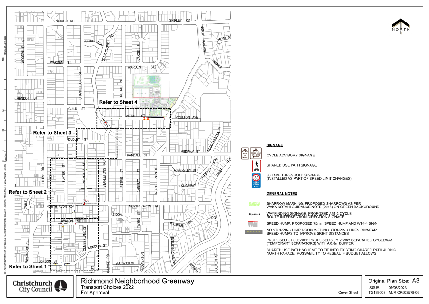

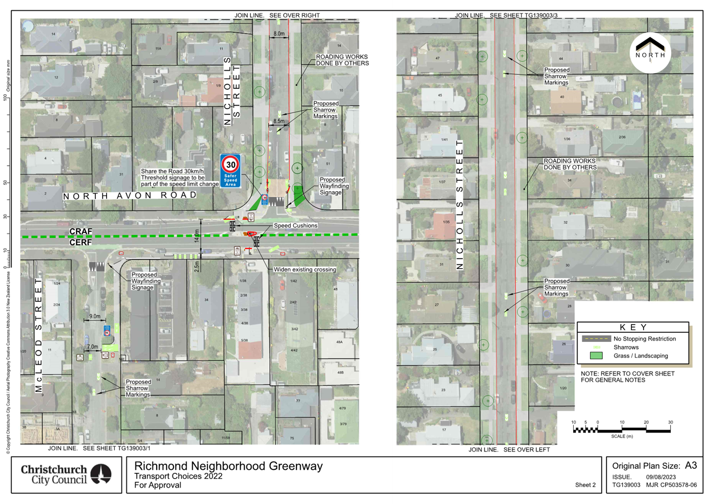
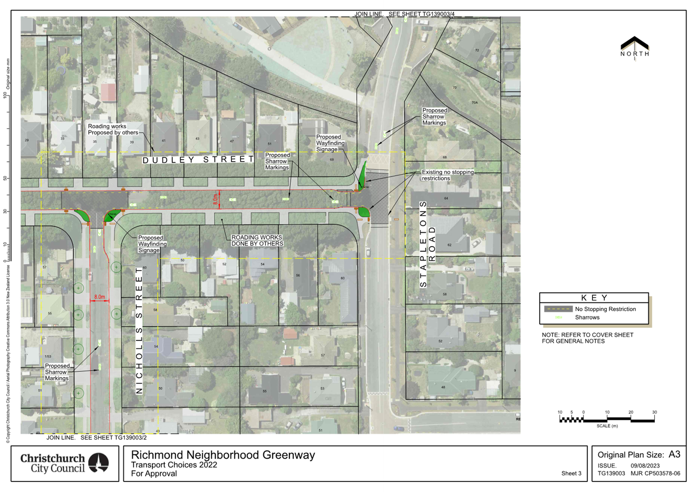
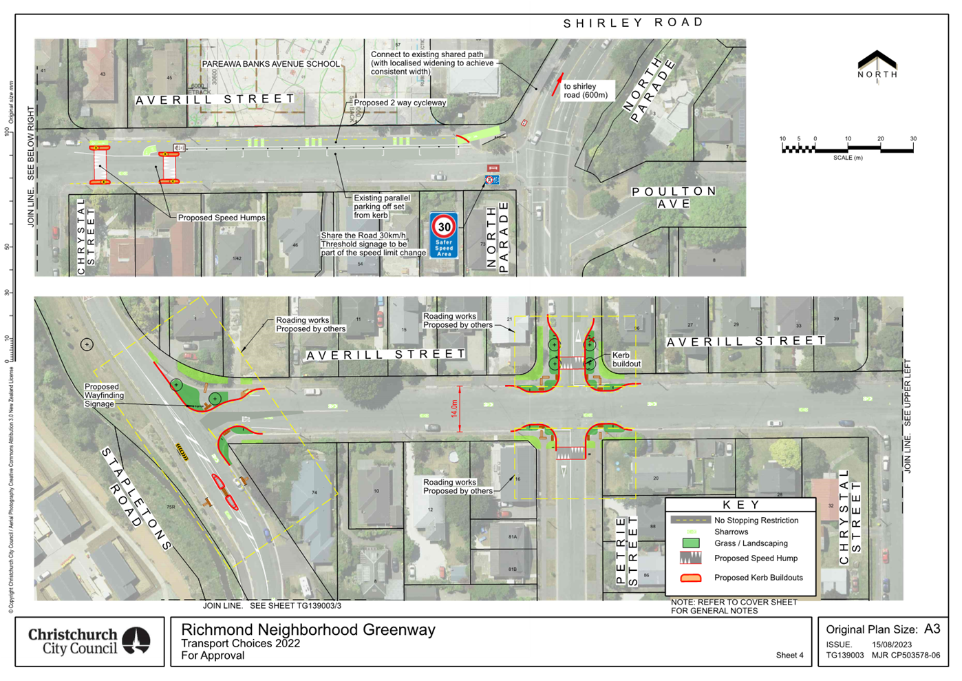
|
Council
21 September 2023
|
|
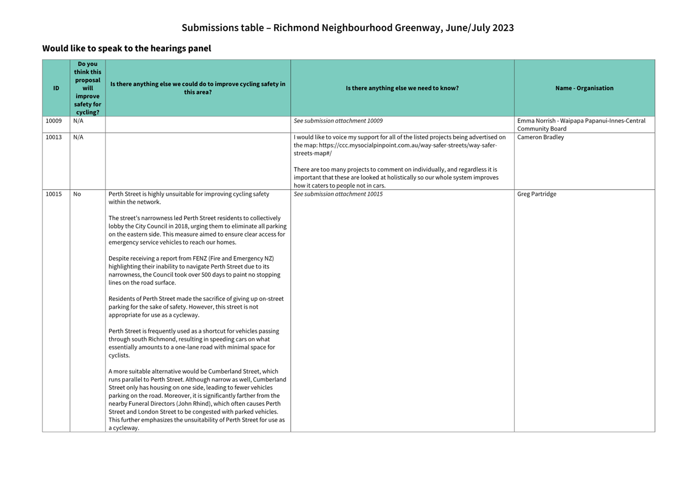
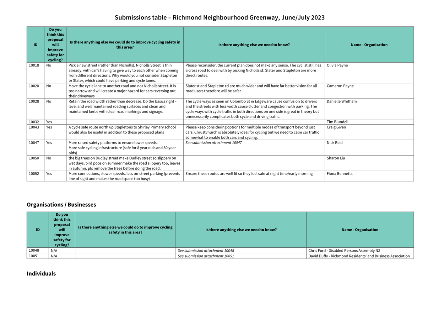
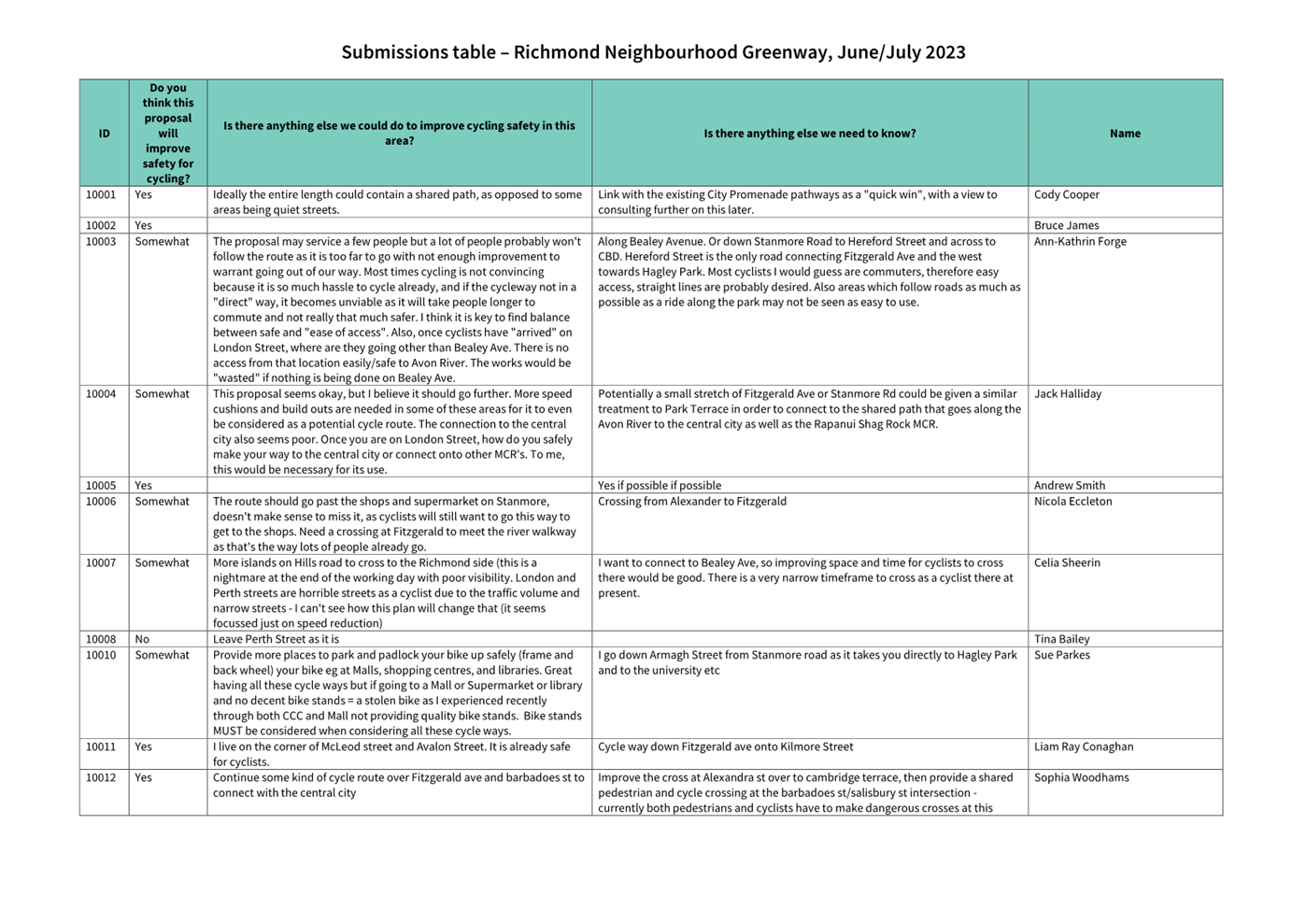
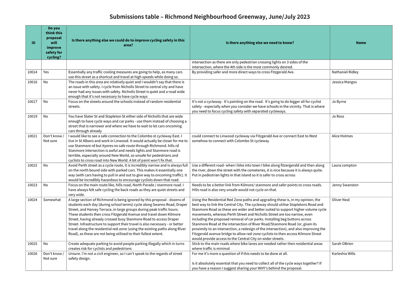
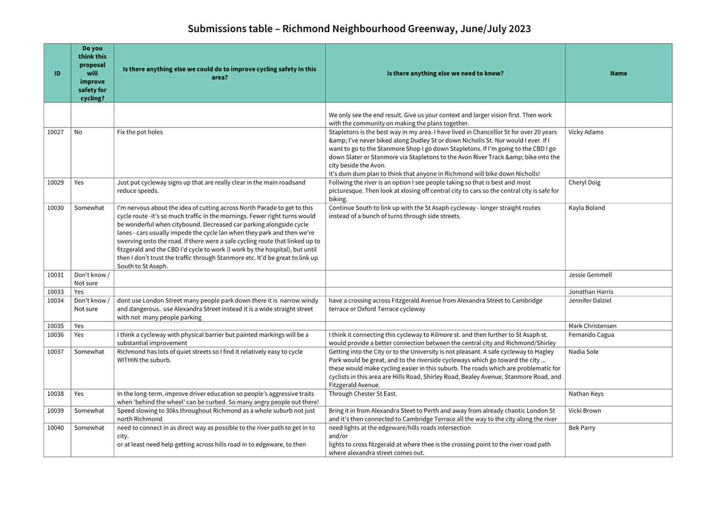
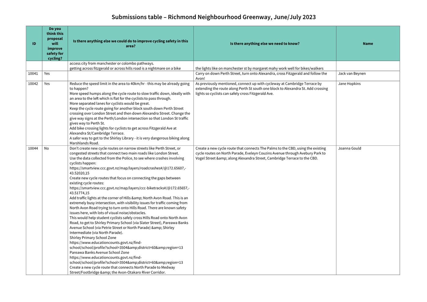
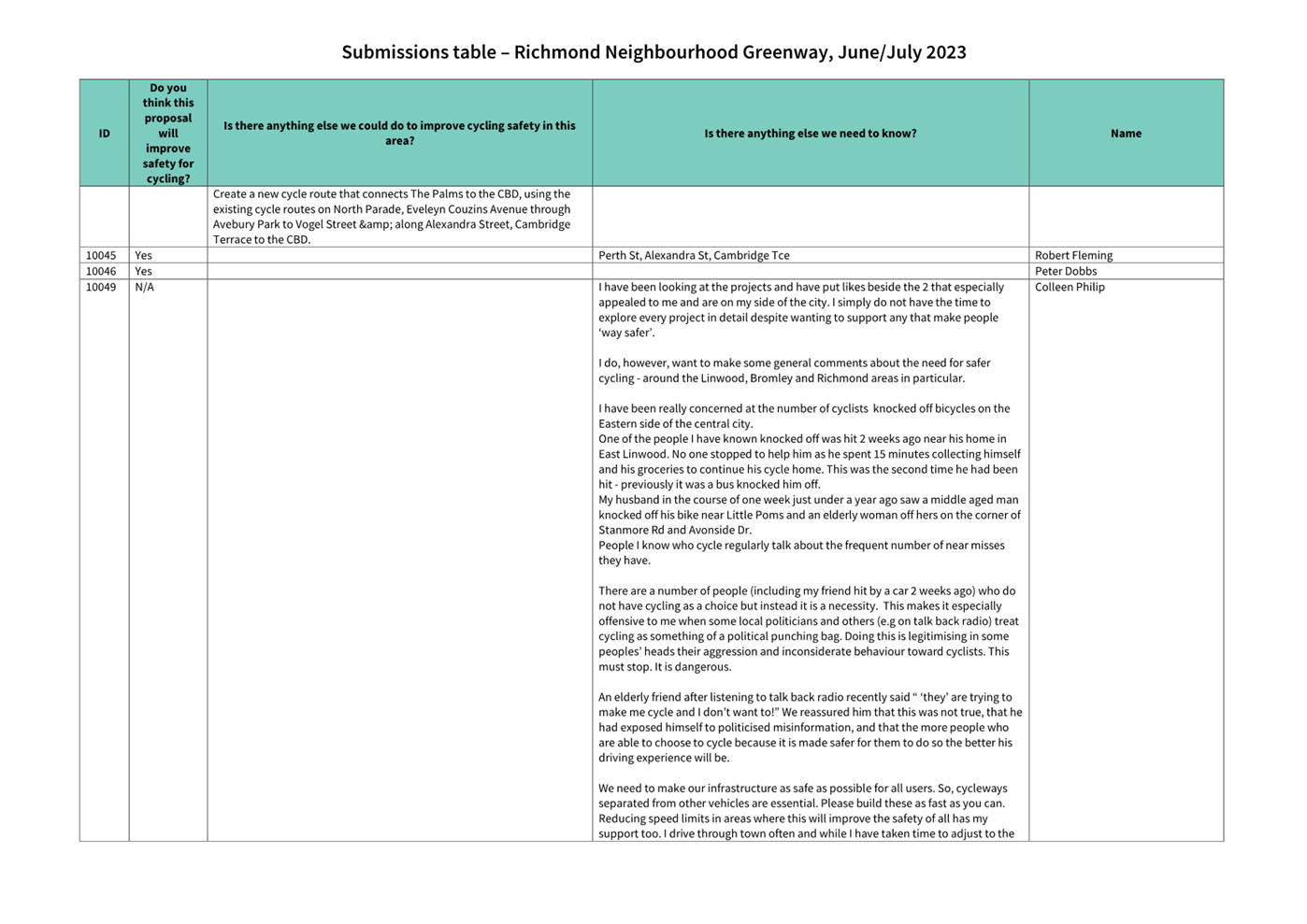
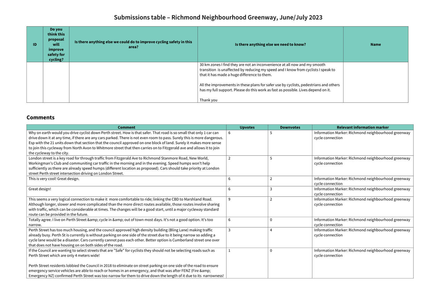
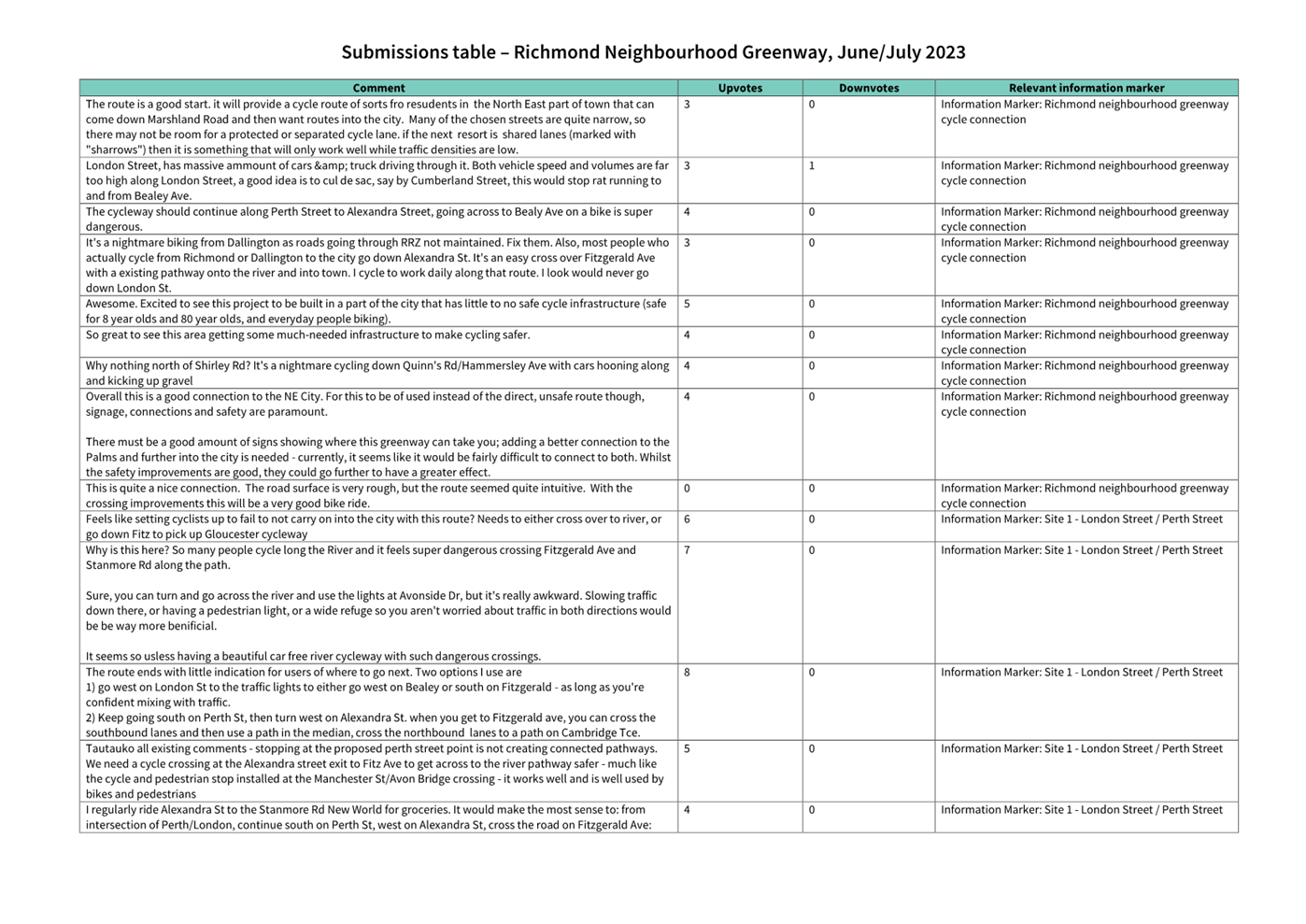
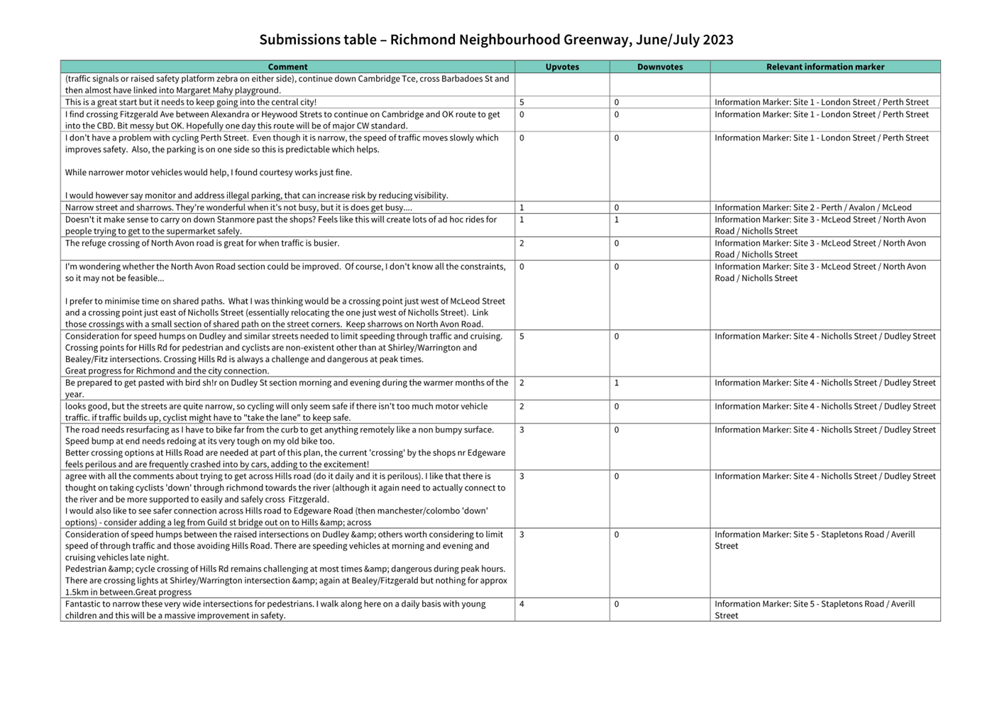
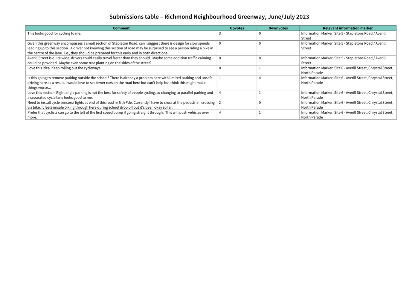
|
Council
21 September 2023
|

|
|
9. Transport Choices - School Safety
Linwood
|
|
Reference / Te Tohutoro:
|
23/1169779
|
|
Report of / Te Pou Matua:
|
Andrew
Cameron, Project Manager Transport,
andrew.cameron@ccc.govt.nz
Jacob Bradbury, Manager Planning & Delivery Transport, jacob.bradbury@ccc.govt.nz
|
|
Senior Manager / Pouwhakarae:
|
Lynette
Ellis, Head of Transport & Waste Management (Lynette.Ellis@ccc.govt.nz)
|
1. Nature of Issue and Report Origin
1.1 The purpose of this report is to inform the Council of
feedback received, and for the Council to approve the design to proceed to
construction for the Linwood and Transport Choices School Safety Linwood
project.
1.2 This project is funded from the Climate Emergency response
Fund (CERF) Transport Choices programme and is identified in the Annual Plan
for construction during the current financial year. The report has been
generated following completion of consultation.
1.3 The
decisions in this report are of medium significance in relation to the Christchurch
City Council’s Significance and Engagement Policy 2019. The
level of significance was determined by potential benefits and opportunities to
the council/community, the number of people affected and/or with an interest,
and that these projects span multiple community board areas, as set out in the
criteria of the policy (Page 2). This evaluation has considered the Transport
Choices projects as a cohesive programme of work. This is consistent with
how community engagement has been undertaken, with all work packages being
presented concurrently on Have your Say under the banner of Way Safer Streets.
2. Officer Recommendations Ngā
Tūtohu
That
the Council:
General
1. Approves the following recommendations,
relying on its powers under the Christchurch City Council Traffic and Parking
Bylaw 2017 and Part 21 of the Local Government Act 1974.
2. Approves that the traffic controls, stopping
and/or parking restrictions described in the recommendations of this report
take effect when infrastructure, signage and/or road markings that evidence the
controls and restrictions are in place (or removed in the case of revocations)
and, in the case of traffic signal infrastructure, activated.
3. Approves that any previously approved
resolutions made pursuant to any Bylaw, Local Government Act or any Land
Transport Rule and pertaining to traffic controls, stopping and/or parking
restrictions (but excluding speed limits) in so far as they conflict with the
recommendations of this report be revoked.
4. Approves that construction of the Linwood
School Safety project is conditional on implementation costs being agreed and
incorporated into the Transport Choices Funding agreement between Waka Kotahi
and Council.
Worcester Street
/ Woodham Road / Rowcliffe Crescent (Attachment A)
General
Arrangements
5. Approves the road layout, including all kerb
alignments, road surface treatments, traffic islands, traffic calming features
and road markings on Worcester Street, Rowcliffe Crescent and Woodham Road, as
detailed on plan TG361601 in Attachment A.
Pedestrian /
Cycle Facilities
6. Approves that a pedestrian crossing be
installed on Woodham Road, located 12 metres west of its intersection with
Worcester Street, in accordance with Section 8.2 of the Land Transport Rule
– Traffic Control Devices: 2004 and as detailed on Attachment A to the
report on the meeting agenda.
7. Approves pursuant to Section 334(1)(d) of the
Local Government Act 1974 that a priority cycle crossing be established on
Woodham Road at a point 16 metres west of its intersection with Worcester
Street and as detailed on Attachment A and further approves that Give Way
controls are placed against traffic approaching the crossing requiring that
traffic to give way to users of the cycle crossing facility (in addition to
users of the adjacent pedestrian crossing). These Give Way controls are to be
evidenced by signs and/or markings installed in accordance with Land Transport
Rule: Traffic Control Devices 2004.
8. Approves that a special vehicle (cycle) lane
be installed on the south side of Woodham Road for westbound cyclists only,
commencing at a point 48 metres east of its intersection of Worcester Street
and extending in a westerly direction for a distance of 104 metres, as detailed
on Attachment A.
9. Approves that a special vehicle (cycle) lane
be installed on the north side of Woodham Road for eastbound cyclists only,
starting from a point 100 metres west of the intersection of Rowcliffe Street
and extending in an easterly direction for a distance of 124 metres, as
detailed on Attachment A.
10. Approves that the pathway on the north side of
Woodham Road, commencing at a point 87 metres west of its intersection with
Rowcliffe Crescent and extending in an easterly direction for a distance of 24
metres be a bi-directional shared pedestrian/cycle pathway in accordance with
section 11.4 of the Land Transport Act – Traffic Control Devices Rule:
2004, as detailed on Attachment A to the report on the meeting agenda.
11. Approves that the pathway on the south side of
Woodham Road, commencing at a point 8 metres west of its intersection with
Worcester Street and extending in a westerly direction for a distance of 14
metres be a bi-directional shared pedestrian/cycle pathway in accordance with
section 11.4 of the Land Transport Act – Traffic Control Devices Rule:
2004, as detailed on Attachment A to the report on the meeting agenda.
Traffic Controls
12. Approves that the northern approach of
Rowcliffe Crescent at its intersection with Woodham Road be controlled by a
Give Way control, in accordance with Section 4 and Section 10.3 of the Land
Transport Rule: Traffic Control Devices 2004.
Parking and
Stopping Restrictions
13. Approves that the stopping of vehicles be
prohibited at any time on the north side of Woodham Road commencing at its
intersection with Rowcliffe Crescent and extending in a westerly direction for
a distance of 87 metres.
14. Approves that the stopping of vehicles be
prohibited at any time on the north side of Woodham Road commencing at its
intersection with Rowcliffe Crescent and extending in an easterly direction for
a distance of 17 metres.
15. Approves that the stopping of vehicles be
prohibited at any time on the south side of Woodham Road commencing at its
intersection with Worcester Street and extending in an easterly direction for a
distance of 60 metres.
16. Approves that the stopping of vehicles be
prohibited at any time on the south side of Woodham Road commencing at its
intersection with Worcester Street and extending in a westerly direction for a
distance of 40 metres.
17. Approves that the parking of all vehicles be
restricted to a maximum period of 10 minutes, on the south side of Woodham Road
commencing at a point 60 metres west of its intersection with Worcester Street
and extending in a westerly direction for a distance of 12 metres.
18. Approves that the parking of all vehicles be
restricted to a maximum period of 10 minutes, on the northwest side of
Worcester Street commencing at a point 15 metres southwest of its intersection
with Woodham Road and extending in a south-westerly direction for a distance of
13 metres.
Ngarimu Street,
Holland Street, Rowcliffe Crescent (Attachment B)
General
Arrangements
19. Approves the road layout, including all road
surface treatments, traffic calming features and road markings on Ngarimu
Street, Rowcliffe Crescent and Holland Street, as detailed on plan TG361601 in Attachment
B.
Parking and
Stopping Restrictions
20. Approves that the stopping of vehicles be
prohibited at any time on the west side of Ngarimu Street commencing at a point
186 metres north of its intersection with Woodham Road and extending in a
northerly direction for a distance of 18 metres.
21. Approves that the stopping of vehicles be
prohibited at any time on the east side of Ngarimu Street commencing at a point
186 metres north of its intersection with Woodham Road and extending in a
northerly direction for a distance of 18 metres.
22. Approves that the stopping of vehicles be
prohibited at any time on the west side of Holland Street commencing at a point
60 metres south of its intersection with Dunarnan Street and extending in a
southerly direction for a distance of 18 metres.
23. Approves that the stopping of vehicles be
prohibited at any time on the east side of Holland Street commencing at a point
60 metres south of its intersection with Dunarnan Street and extending in a
southerly direction for a distance of 18 metres.
24. Approves that the stopping of vehicles be
prohibited at any time on the east side of Rowcliffe Crescent commencing at its
intersection with Woodham Road and extending in a northeasterly direction for a
distance of 80 metres.
Worcester Street
– Mclean Street / Surrey Street / Wyon Street (Attachment C)
General
Arrangements
25. Approves the road layout, including all
traffic islands, road surface treatments, traffic calming features and road
markings on Worcester Street, Mclean Street, Surrey Street and Wyon Street, as
detailed on plan TG361601 in Attachment C.
Parking and
Stopping Restrictions
26. Approves that the stopping of vehicles be
prohibited at any time on the northwest side of Worcester Street commencing at
a point 140 metres northeast of its intersection with Surrey Street and
extending in an easterly direction for a distance of 37 metres.
27. Approves that the stopping of vehicles be
prohibited at any time on the southeast side of Worcester Street commencing at
its intersection with Wyon Street and extending in a northeasterly direction
for a distance of 34 metres.
28. Approves that the stopping of vehicles be
prohibited at any time on the northeast side of Wyon Street commencing at its
intersection with Worcester Street and extending in a southeasterly direction
for a distance of 14 metres.
29. Approves that the stopping of vehicles be
prohibited at any time on the southwest side of Wyon Street commencing at its
intersection with Worcester Street and extending in a southeasterly direction
for a distance of 6 metres.
30. Approves that the stopping of vehicles be
prohibited at any time on the southwest side of Worcester Street commencing at
its intersection with Wyon Street and extending in a southwesterly direction
for a distance of 6 metres.
31. Approves that the stopping of vehicles be
prohibited at any time on the southwest side of Worcester Street commencing at
a point 118 metres northeast of its intersection with McleanStreet and
extending in a southwesterly direction for a distance of 35 metres.
32. Approves that the stopping of vehicles be
prohibited at any time on the northwest side of Worcester Street commencing at
its intersection with Surrey Street and extending in a southwesterly direction
for a distance of 24 metres.
33. Approves that the stopping of vehicles be
prohibited at any time on the southwest side of Surrey Street commencing at its
intersection with Worcester Street and extending in a northwesterly direction
for a distance of 18 metres.
34. Approves that the stopping of vehicles be
prohibited at any time on the northeast side of Surrey Street commencing at its
intersection with Worcester Street and extending in a northwesterly direction
for a distance of 18 metres.
35. Approves that the stopping of vehicles be
prohibited at any time on the northwest side of Worcester Street commencing at
its intersection with Surrey Street and extending in a northeasterly direction
for a distance of 10 metres.
36. Approves that the stopping of vehicles be
prohibited at any time on the southeast side of Worcester Street commencing at
its intersection with Mclean Street and extending in a northeasterly direction
for a distance of 10 metres.
37. Approves that the stopping of vehicles be prohibited
at any time on the northeast side of Mclean Street commencing at its
intersection with Worcester Street and extending in a southeasterly direction
for a distance of 12 metres.
38. Approves that the stopping of vehicles be
prohibited at any time on the southwest side of Mclean Street commencing at its
intersection with Worcester Street and extending in a southeasterly direction
for a distance of 13 metres.
39. Approves that the stopping of vehicles be
prohibited at any time on the southeast side of Worcester Street commencing at
its intersection with Mclean Street and extending in a southwesterly direction
for a distance of 63 metres.
40. Approves that the stopping of vehicles be
prohibited at any time on the northwest side of Worcester Street commencing at
a point 153 metres southwest from its intersection with Surrey Street and
extending in a southwesterly direction for a distance of 67 metres.
Linwood Avenue /
Brittan Street (Attachment D)
General
Arrangements
41. Approves the road layout, including all
traffic islands, road surface treatments, traffic calming features and road
markings on Linwood Avenue and Brittan Street, as detailed on plan TG361601 in Attachment
D.
Parking and
Stopping Restrictions
42. Approves that the stopping of vehicles be prohibited
at any time on the northeast side of Linwood Avenue commencing at its
intersection with Brittan Street and extending in a northwesterly direction for
a distance of 15 metres.
43. Approves that the stopping of vehicles be
prohibited at any time on the northwest side of Brittan Street commencing at
its intersection with Linwood Avenue and extending in a northeasterly direction
for a distance of 16 metres.
44. Approves that the stopping of vehicles be
prohibited at any time on the southeast side of Brittan Street commencing at
its intersection with Linwood Avenue and extending in an northeasterly
direction for a distance of 18 metres.
45. Approves that the stopping of vehicles be
prohibited at any time on the northeast side of Linwood Avenue commencing at
its intersection with Brittan Street and extending in a southeasterly direction
for a distance of 14 metres.
46. Approves that the stopping of vehicles be
prohibited at any time on the southwest side of Linwood Avenue commencing at
its intersection with Brittan Street and extending in a northwesterly direction
for a distance of 15 metres.
47. Approves that the stopping of vehicles be
prohibited at any time on the northwest side of Brittan Street commencing at
its intersection with Linwood Avenue and extending in a southwesterly direction
for a distance of 16 metres.
48. Approves that the stopping of vehicles be
prohibited at any time on the southeast side of Brittan Street commencing at
its intersection with Linwood Avenue and extending in a southesterly direction
for a distance of 15 metres.
49. Approves that the stopping of vehicles be
prohibited at any time on the southwest side of Linwood Avenue commencing at its
intersection with Brittan Street and extending in a southeasterly direction for
a distance of 14 metres.
Linwood Avenue /
Tancred Street (Attachment E)
General
Arrangements
50. Approves the road layout, including all
traffic islands, road surface treatments, traffic calming features and road
markings on Linwood Avenue and Tancred Street, as detailed on plan TG361601 in Attachment
E.
Traffic Controls
51. Approves that the southwest approach of
Tancred Street at its intersection with Linwood Avenue be controlled by a Give
Way control, in accordance with Section 4 and Section 10.3 of the Land
Transport Rule: Traffic Control Devices 2004.
52. Approves that the northeast approach of
Tancred Street at its intersection with Linwood Avenue be controlled by a Give
Way control, in accordance with Section 4 and Section 10.3 of the Land
Transport Rule: Traffic Control Devices 2004.
Parking and
Stopping Restrictions
53. Approves that the stopping of vehicles be
prohibited at any time on the northeast side of Linwood Avenue commencing at
its intersection with Tancred Street and extending in a northwesterly direction
for a distance of 18 metres.
54. Approves that the stopping of vehicles be
prohibited at any time on the northwest side of Tancred Street commencing at
its intersection with Linwood Avenue and extending in a northeasterly direction
for a distance of 15 metres.
55. Approves that the stopping of vehicles be
prohibited at any time on the southeast side of Tancred Street commencing at
its intersection with Linwood Avenue and extending in a northeasterly direction
for a distance of 15 metres.
56. Approves that the stopping of vehicles be
prohibited at any time on the northeast side of Linwood Avenue commencing at
its intersection with Tancred Street and extending in a southeasterly direction
for a distance of 15 metres.
57. Approves that the stopping of vehicles be
prohibited at any time on the southwest side of Linwood Avenue commencing at
its intersection with Tancred Street and extending in a northwesterly direction
for a distance of 15 metres.
58. Approves that the stopping of vehicles be
prohibited at any time on the northwest side of Tancred Street commencing at
its intersection with Linwood Avenue and extending in a southwesterly direction
for a distance of 17 metres.
59. Approves that the stopping of vehicles be
prohibited at any time on the southeast side of Tancred Street commencing at
its intersection with Linwood Avenue and extending in a southeasterly direction
for a distance of 13 metres.
60. Approves that the stopping of vehicles be
prohibited at any time on the southwest side of Linwood Avenue commencing at
its intersection with Tancred Street and extending in a southeasterly direction
for a distance of 16 metres.
Woodham Road
(Attachment F)
General
Arrangements
61. Approves the road layout, including all
traffic islands, road surface treatments, traffic calming features and road
markings on Woodham Road, as detailed on plan TG361601 in Attachment F.
Bus
Passenger Shelter
62. Approves pursuant to Section 339(1) of the
Local Government Act 1974 the installation of a bus passenger shelter on the
south side of Woodham Road at a point 7 metres east of its intersection with
Tancred Street.
Parking and
Stopping Restrictions
63. Approves that the stopping of vehicles be
prohibited at any time on the south side of Woodham Road commencing at its
intersection with Tancred Street and extending in an easterly direction for a
distance of 19 metres.
64. Approves that a bus stop be installed on the
south side of Woodham Road, commencing at a point 19 metres east of its
intersection with Tancred Street and extending in an easterly direction of a
distance of 14 metres.
65. Approves that the stopping of vehicles be
prohibited at any time on the south side of Woodham Road commencing at a point
33 metres east of its intersection with Tancred Street and extending in an
easterly direction for a distance of 12 metres.
66. Approves that the stopping of vehicles be
prohibited at any time on the north side of Woodham Road commencing at a point
483 metres east of its intersection with Patten Street and extending in an
easterly direction for a distance of 68 metres.
67. Approves that a bus stop be installed on the
north side of Woodham Road, commencing at a point 551 metres east of its
intersection with Patten Street and extending in an easterly direction of a
distance of 14 metres.
68. Approves that the stopping of vehicles be
prohibited at any time on the north side of Woodham Road commencing at a point
565 metres east of its intersection with Patten Street and extending in an
easterly direction for a distance of 9 metres.
3. Reason for Report Recommendations Ngā Take mō te
Whakatau
3.1 This
project is funded by the Central Government Transport Choices programme –
a $348 million national programme made available from the Climate Emergency
Response Fund.
3.2 The
Transport Choices programme is important because transport makes up almost half
of New Zealand’s carbon emissions. In May 2022, government released
its first Emissions Reduction Plan and transport has a significant role to
play, targeting a 20percent reduction in light vehicle travel by 2035.
Reducing reliance on cars and supporting people to walk, cycle and use public
transport is one of three focus points of the Emissions Reduction Plan.
3.3 The
School Safety Linwood project was included
within the Transport Choices programme due to alignment with the “support
safe, green and healthy school travel” investment category of the
programme.
3.4 Improving safety on local roads in Christchurch is a
priority for Council and is also a national priority under the principles and
guidance of the Te Ara ki te Ora Road to Zero - New Zealand’s road safety
strategy for 2020-2030. There are several focus areas being looked at
nationally to achieve this, but the most significant difference can be made
through having safe and appropriate speeds on our roads, and safer
infrastructure.
Changes made to the
scheme design as a result of consultation feedback and safe system audit
3.5 The
eastbound bus stop on Woodham Road has been relocated to retain car parking
outside 151 Woodham Road.
3.6 Speed
humps have been included on the following local streets Ngarimu, Holland, and
Rowcliffe, refer Attachment B.
3.7 It
is now proposed to use speed humps rather than speed cushions for ease of
delivery on side roads adjoining Worcester Street. On Worcester Street itself
pre-made speed cushions will be used to reduce any redundant construction, due
to the future cycleway.
3.8 The
pedestrian crossing on Woodham Road will become a dual crossing for people
walking and cycling. This is to be consistent with other crossings in the area
being investigated through the Streets for People programme.
3.9 No
changes are proposed to the schemes at Linwood/Britten or Linwood/Tancred
intersections.
4. Alternative Options Considered Ētahi atu Kōwhiringa
The Transport
Choices Programme
4.1 Transport
Choices funding was allocated to Local Authorities through an Expression of
Interest process administered by Waka Kotahi. Through that process
Christchurch City Council submitted a package of projects that was developed by
consideration of:
· Project alignment with the
four investment criteria for Transport Choices funding: deliver strategic
cycling/micro mobility networks; create walkable neighbourhoods; support safe,
green, and healthy school travel; make public transport more reliable and
easier to use;
· Achieving diversity across
the four investment categories for Transport Choices funding;
· Focusing investments in
certain suburbs;
· Community requests for
infrastructure improvements aligned with the Transport Choices programme
outcomes;
· Complimenting existing
programmes, such as the Major Cycleway Routes programme;
· Project complexity and
ability to deliver prior to June 2024.
4.2 All
14 projects submitted for Transport Choices funding were accepted by Waka
Kotahi. In deciding to include the Transport Choices programme in the
Draft Annual Plan, Council decided to include 11 projects in the programme and
defer a number of business-as-usual projects by 12 months to enable the
Transport Choices programme to be adequately resourced.
Project Options Considered
4.3 For
the Worcester Street scheme an option using roundabouts at the intersections of
Wyon Street and McLean Street was considered to slow traffic. Pre engagement
was undertaken with those residents that would be immediately impacted by the
roundabouts adjacent to their property. The feedback received, in general, did
not support this option so this option was dropped.
5. Detail Te Whakamahuki
5.1 The decision affects the following wards/Community Board areas:
5.1.1 Linwood
Ward
5.1.2 Waitai
Coastal-Burwood-Linwood Community Board
5.2 The
locations for school safety improvements were identified through a review of
the existing network within the school catchments, school travel plan
information, a review of pedestrian crossing opportunities in the area and feedback
received through engagement on the Safe Speed Neighbourhood programme. The
following locations identified were:
· Woodham Road at Whitau
School;
· Worcester Street close to
Te Pā o Rākaihautū:
· Linwood Avenue for
children living to the west of this main road, and:
· Woodham Road at the park
and bus stops.
Woodham Road at Whitau School
5.3 The
Woodham Road scheme at Whitau School was developed through engagement with the
school children and parents. They raised concerns about the existing crossing
on Woodham Road, and to make it safer it is proposed to raise the
crossing. During these conversations additional issues were raised at the
other school entrances at Ngarimu Street, Holland Street and Rowcliffe
Crescent. The project was therefore extended to seek to resolve the
issues at these locations which were speed of vehicles travelling along these
local streets and parking on Rowcliffe Crescent.
5.4 Crash
information was provided in the Safe System Audit undertaken by independent
consultants. Ten crashes were reported at this location in a five-year
period, with multiple crash types identified:
· Motorists
pulling out from Worcester Street and impacting other motorists travelling
along Woodham Road;
· Pedestrian
hit on the zebra crossing due to blocked visibility from traffic backed up on
the opposite side of the road;
· Vehicles
undertaking a U-turn from the shops impacting other motorists travelling along
Woodham Road;
· Vehicles
rear end crashing due to inattention and suddenly breaking for a pedestrian on
the crossing;
· Vehicle
moving to the left of a vehicle waiting to turn right into Worcester Street and
being hit by a motorcycle undertaking on the left, and;
· Motorist
opening the car door into the path of a cyclist.
5.5 Counts
undertaken in June 2023, identified that Woodham Road currently carries
approximately 11,000 vehicles per day. Speeds measured to the west of the
current crossing are:
|
85%ile Speed
|
Mean Speed
|
|
Eastbound
|
Westbound
|
Eastbound
|
Westbound
|
|
50 km/h
|
49.3 km/h
|
43.2 km/h
|
42.5 km/h
|
5.6 The safe system speed for pedestrians is 30 km/h to reduce
the risk of death or serious injury should a crash occur. This means that
vehicles may be exceeding safe system speeds during school peak times. The
raised safety platform will help to control speeds during the times when
free-flow speeds are higher, reducing both the likelihood of a crash occurring
and the severity of the crash should it occur.
Worcester Street
5.7 The Worcester Street scheme provides improved crossing
facilities for children walking to school and reduces vehicle speeds along this
local road. Count data (2019) shows that an average of 2,271 vehicles use this
street per day. The speed data shows that people are travelling over the
posted speed limit along Worcester Street.
|
85%ile Speed
|
Mean Speed
|
|
Eastbound
|
Westbound
|
Eastbound
|
Westbound
|
|
55.3km/h
|
57.5 km/h
|
48 km/h
|
50 km/h
|
5.8 Calming
traffic speeds would make the street safer for people walking and cycling,
particularly for people travelling to the school, the park, and the playcentre.
Linwood Avenue
5.9 There
is currently only one pedestrian crossing between Woodham Road and Gloucester
Street on Linwood Avenue. This is located close to England Street.
Increasing the number of crossing points will improve accessibility for people
walking in the community, and the islands will allow people to cross in two
stages.
5.10 Survey
data (2020) shows that Linwood Avenue carries on average 10,786 vehicles per
day. Speeds measured on this section of Linwood Avenue are:
|
85%ile Speed
|
Mean Speed
|
|
Northbound
|
Southbound
|
Northbound
|
Southbound
|
|
56.6km/h
|
55.6 km/h
|
51.8 km/h
|
50.6 km/h
|
5.11 Crash
information was provided in the Safe System Audit undertaken by independent
consultants. The crash information showed that all crashes (five) along
Linwood Avenue occurred due to inattention leading to rear end vehicle crashes
and or collision with parked vehicles.
Woodham Road at Woodham Park
5.12 The proposed
crossing point at this location will improve accessibility for children and the
community accessing the park and the bus stops on Woodham Road.
5.13 While there is no
volume or count data at the proposed location, a survey (2020) to the west shows
that Woodham Road carries on average 8,632 vehicles per day. Speeds measured on this section of Woodham Road are:
|
85%ile Speed
|
Mean Speed
|
|
Eastbound
|
Westbound
|
Eastbound
|
Westbound
|
|
55.7km/h
|
55.9 km/h
|
50 km/h
|
50.2 km/h
|
Public Consultation Te Tukanga Kōrerorero
5.14 Early
engagement with Whitau School started in late May, where a workshop was hosted
with students and parents to identify issues and situations that made them feel
unsafe travelling to and from school, and ideas for making the area safer when
travelling to and from school. This informed the scheme plans for the area.
5.15 Affected
residents were doorknocked prior to consultation. Feedback was mostly positive,
apart from proposed roundabouts on Worcester Street. Plans were updated for
consultation for Worcester Street.
5.16 Local
residents received warm up flyers in their mailboxes from 29 May, indicating we
would be seeking feedback on Way Safer Streets projects proposed for their area
in June.
5.17 Staff
attended a LinWard collective hui (consisting of Te Whare Taonga o Ngā Iwi
Katoa Linwood Resource Centre, Bromley Community Trust, The Loft, CCC
Libraries, Christchurch Methodist Mission and St Chads Church and Linwood
Avenue Corner Trust) to brief them on Way Safer Streets projects in early June
2023. Recommended engagement tactics were taken on board.
5.18 Consultation
started on 16 June 2023 and ran until 16 July 2023, as part of the wider Way
Safer Streets consultation. An email was sent to 150 key stakeholders across
the entire Way Safer Streets programme, including emergency services, Spokes,
AA, Disabled Persons Assembly, Blind Low Vision, Environment Canterbury,
Mahaanui Kurataiao, Whitau School, and The Loft at Eastgate. The consultation
was posted on the council Facebook page, as well as local community groups,
inviting submissions on the Social
Pinpoint Map.
5.19 Consultation
documents (including a submission form) and flyers were available at Bromley
Community Centre, Linwood Union Church, Linwood Library, and Linwood Resource
Centre and Community Gardens.
5.20 Two
Newsline stories were published and picked up by local media outlets. Digital
screens were displaying the consultation in Civic Offices and Linwood Library,
as well as newspaper advertising in The Star and The Pegasus Post. Digital
billboards were utilised in Linwood, including outside Eastgate mall. An online
targeted advertising campaign ran for the entire consultation period. Footpath
decals with QR codes were installed where intersection upgrades were proposed.
5.21 During
consultation, flyers were delivered to residents in the local area, and emails
were sent to those who expressed interest in being updated on Way Safer
Streets.
5.22 During
consultation, affected residents were door knocked where we had made scheme
plan changes on Worcester Street. Feedback was positive.
5.23 A
follow up session was hosted in late June with Year 6 students from Whitau
school, where staff shared the scheme plans and students used post it notes to
indicate what they liked and disliked about the plans, and what was missing.
Feedback was largely positive, and students requested additional traffic
calming measures, including more speed bumps outside the school, safer ways to
cycle, more pedestrian and zebra crossings in the area, and additional ways of
reducing driver speeds.
5.24 Key
stakeholder meetings throughout and after consultation, with Spokes, FENZ, St
John, NZ Police and Disabled Persons Assembly, further informed projects in the
Way Safer Streets program.
Summary of Submissions Ngā Tāpaetanga
5.25 The
design that was consulted on was developed through early engagement with Whitau
School
5.26 Feedback
on the plans could be given by posting a comment on the Social
Pinpoint Map, by making a submission, or both.
5.27 To
reduce confusion for submitters, consultation for this project was merged on
the Social
Pinpoint Map with ‘Slow Speed Neighbourhoods’ – another
four proposed intersection upgrades for the North Linwood area.
5.28 A
total of 19 submissions and 10 comments were made on these projects. 15
submissions were made via the Social
Pinpoint Map, and four submissions were made via email/PDF. Submissions
were made by Waitai Coastal-Burwood-Linwood Community Board, Waipapa
Papanui-Innes-Central Community Board, Disabled Persons Assembly, and 16
individuals. All submissions and comments are available in Attachment G.
5.29 On
the Social
Pinpoint Map, the projects received a total of 62 upvotes, 7 downvotes, and
27 comments:
Summary from social
pinpoint interactions
|
Project pin
|
Comments
|
Upvotes
|
Downvotes
|
|
Overall
project pin
|
5
|
19
|
3
|
|
Site 1 - Linwood Ave/Brittan St
pedestrian crossing and speed humps
|
2
|
6
|
1
|
|
Site 2 - Linwood Ave / Tancred St
pedestrian crossing
|
3
|
12
|
1
|
|
Site 3 - Woodham Rd / Tancred St
pedestrian refuge island
|
6
|
9
|
0
|
|
Site 4 - Woodham Rd / Worcester St
zebra crossing upgrade
|
2
|
9
|
1
|
|
Site 5 - McLean St, Surrey St
and Wyon St - pedestrian refuge islands and speed cushions
|
8
|
4
|
1
|
|
Site 6 - Ngarimu St, Holland St -
speed cushions and no stopping restrictions
|
1
|
3
|
0
|
|
Total
|
27
|
62
|
7
|
|
Other projects (Slow Speed Neighbourhoods)
|
10
|
49
|
8
|
5.30 Comment
sentiment was predominantly positive (59.3%), or mixed (25.9%):
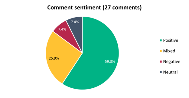
5.31 Submitters
were asked how they travel through this area. The majority (66.7%) of
submitters use this area via car (as the driver), followed by walking (60.0%):
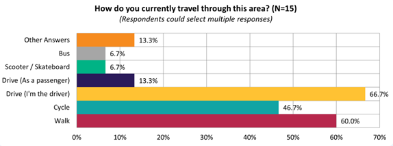
5.32 The
majority of submitters felt this proposal would improve safety for pedestrians
(53.3%):
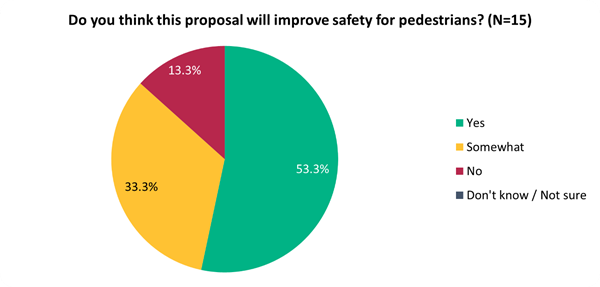
5.33 This
sentiment differed slightly depending on whether they live on the affected
streets (i.e. Worcester Street, Tancred Street), live in local suburbs (i.e.
Linwood, Woolston), or live elsewhere:
|
Do you think this proposal
will improve safety for cycling?
|
Live on affected streets
|
Live in local suburbs
|
Live elsewhere
|
|
No
|
0
|
0
|
2
|
|
Somewhat
|
2
|
3
|
0
|
|
Yes
|
2
|
4
|
2
|
5.34 Key
themes and requests from both comments and submissions are summarised below.
Note that there could be cross-over between those making comments and making
submissions:
|
Key themes on outcomes of the
proposal
|
Number
of comments
|
Number
of submissions
|
Total
mentions
|
|
Supportive
of the proposed intersection upgrades
· This project is valuable in
addressing existing safety concerns and is long overdue
|
20
|
9
|
29
|
|
Raising
existing safety issues
· Discussing near misses that
they have witnessed on Buckleys Rd and McLean St, on Worcester St and Woodham
Rd with regards to speeding, and pedestrian crossings making access a lot
safer to Woodham Park and Whitau School
|
6
|
5
|
11
|
|
Not
supportive of certain treatments proposed
· Concern with roundabouts
proposed on Worcester St and resulting parking loss, which may have been
caused by confusion from the early engagement consultation letter which has
since changed as a result of community feedback
· Concern around visibility and
congestion, access, and wanting to shift certain features
|
3
|
2
|
5
|
|
Requests
|
Number of comments
|
Number of submissions
|
Total mentions
|
|
Requests
outside of existing proposed intersections
· Further traffic calming on
Worcester St, given the speed issues
· A crossing at Gloucester St
bridge
· Pedestrian crossings and
traffic calming at Brittan St/Armagh St and Linwood Ave/England St/Armagh St
intersections
· Maintenance of the shared
path from Hargood St to Smith St
· Traffic calming on streets
around Woodhouse St, Tancred St, Rochester St and Surrey St
|
3
|
4
|
7
|
|
Shifting
a pedestrian crossing
· Specifically requesting a
certain treatment be shifted, for instance, pedestrian refuge islands further
away from intersections
|
3
|
3
|
6
|
|
Resealing
/ tidying the road condition
· Requests have been made to
address Worcester St earthquake damage in the road, incorporating Surrey St
condition, improve footpath condition and tidiness generally in the east, and
increase street trees
|
0
|
4
|
4
|
|
Accessibility
/ mobility requests
· Ensure crossings are smooth
and wide to accommodate a range of mobility devices
· Increasing access for those
with visual and mobility impairments who have less choice is important
· That pedestrian crossings are
safe and visible, with good lighting, tactile strips, mobility kerb cuts, and
sufficient turning space for wheelchairs/mobility aids
|
2
|
2
|
4
|
|
Additional
traffic calming measures in existing plans
· More speed bumps on Worcester
St and Armagh St
· Another speed cushion on
Rowcliffe Cres close to main intersection of Woodham Rd
|
1
|
1
|
2
|
5.35 A late submission
was received after we reconsulted following shifting the bus stop from 171
Woodham Road to 169 Woodham Road, see Attachment H.
6. Policy Framework Implications Ngā Hīraunga ā- Kaupapa here
6.1 This report supports the Council's
Long Term Plan (2021 - 2031):
6.2 Transport
6.2.1 Activity: Transport
· Level of Service: 10.0.2 Increase the share of
non-car modes in daily trips - >=36% of trips undertaken by non-car modes
· Level of Service: 10.0.6.1 Reduce the number of
death and serious injury crashes on the local road network - <=100
crashes
· Level of Service: 10.0.41 Reduce emissions and
greenhouse gases related to transport - <=1.10 million tonnes of CO2
equivalents
· Level of Service: 10.5.1 Limit deaths and
serious injury crashes per capita for cyclists and pedestrians - <= 12
crashes per 100,000 residents
Policy
Consistency Te Whai
Kaupapa here
6.3 The
recommendations of this report are consistent with Council’s Plans and
Policies, in particular:
6.3.1 The changes
proposed align with road safety and liveable streets goals in the Christchurch
Transport Strategic Plan 2012–2042, and similarly in the draft Transport
Plan (safe streets).
6.3.2 The
changes proposed align with Kia tūroa te Ao - Ōtautahi Christchurch
Climate Resilience Strategy as set out in the Climate Change Impact
Considerations section below.
Impact
on Mana Whenua Ngā
Whai Take Mana Whenua
6.4 The
decision does not involve a significant decision in relation to ancestral land
or a body of water or other elements of intrinsic value, therefore this
decision does not specifically impact Mana Whenua, their culture and
traditions.
6.5 The
decision does not involve a matter of interest to Mana Whenua and should not
impact on our agreed partnership priorities with Ngā Papatipu Rūnanga
6.6 The
projects are based on minor changes to, or re-allocation of, existing road
spaces, so are not anticipated to have a significant impact on Mana Whenua.
Climate
Change Impact Considerations Ngā Whai Whakaaro mā te Āhuarangi
6.7 The
decisions in this report are likely to:
6.7.1 Contribute
neutrally to adaptation to the impacts of climate change.
6.7.2 Contribute
positively to emissions reductions.
6.8 The
emission reductions associated with this project have not been estimated.
6.9 New
Zealand has the 5th highest transport emissions rate per capita
among the 43 OECD countries. Petrol or diesel car use is typically the
single-biggest contributor to an individual’s carbon footprint within New
Zealand.
6.10 From
the 2022 Life in Christchurch Transport Survey, 96 percent of respondents
travel by car. Respondents find car travel the least difficult means of
travel: "We use car travel as it is easier. Christchurch is very spread
out and to have several buses is not convenient." Inconsiderate and
dangerous behaviour from other road users and sharing the road with cars were
the main reasons respondents found it difficult to bike.
6.11 The
Transport Choices programme addresses barriers to people making sustainable
travel choices. Removing these barriers will lead to reductions in
vehicle kilometres travelled and consequently emissions from transport.
Accessibility
Considerations Ngā
Whai Whakaaro mā te Hunga Hauā
6.12 Waka
Kotahi developed a set of Project Design Parameters to ensure all projects work
to collectively meet the programme objectives. The Project Design
Parameters require that “the infrastructure should be designed for
children and people with visual, mobility, or cognitive impairments. If the
infrastructure works for them, it will work for a wider spectrum of the
population who are interested in walking and cycling but concerned for their
safety.” Transport Choices projects have been designed in
accordance with these requirements.
7. Resource Implications Ngā Hīraunga Rauemi
Capex/Opex Ngā Utu Whakahaere
7.1 Cost
to Implement - the total project estimate is $631,813. This is inclusive
of design and project management.
7.2 Maintenance/Ongoing
costs – $3,445 per year additional costs associated with coloured
surfacing and linework. These costs will be eligible for Waka Kotahi subsidy at
Council’s 51% Funding Assistance Rate. The net maintenance cost for the
total Transport Choices programme will have an ongoing rates impact of
approximately 0.01%, which will be included in the draft Long Term Plan
proposed budgets.
7.3 Funding
Source – Councils capital programme:
7.3.1 CPMS
ID 72777, Transport Choices 2022 – School Safety Linwood, $531,813
7.3.2 CPMS
ID 65923, School Safety, $100,000
7.4 Waka
Kotahi through the Transport Choices programme will be funding the project up
to an agreed value which is calculated as 90% of the expected implementation
cost. The remaining 10% is Council’s share.
7.5 Under
the cost share agreement with Waka Kotahi, funding approvals for individual
Transport Choices projects are approved through two stage gates: design and
physical works. All Transport Choices projects have agreed funding schedules
for design. Individual project schedules for physical works are required to be
agreed and approved prior to 20 October 2023. In approving funding for physical
works, Waka Kotahi will consider:
7.5.1 The
project is in accordance with the scope and design approved by Waka
Kotahi.
7.5.2 Project
costs are in accordance with expectations.
7.5.3 Ability
to deliver the project prior to June 2024.
7.6 The
staff recommendations of this report include that Council’s approval of
this project is conditional on a funding agreement with Waka Kotahi being in
place for the physical works.
8. Legal Implications Ngā Hīraunga ā-Ture
Statutory power to undertake proposals in the report
Te Manatū Whakahaere Kaupapa
8.1 Council
resolved the Transport Choices programme as Metropolitan Significance when the
programme was included in the draft Annual Plan in February 2023.
8.2 Council
retains decision-making responsibilities that might otherwise be delegated in
accordance with the Delegations Register when a project is determined as
Metropolitan Significance.
8.3 Part
1, Clauses 7 and 8 of the Christchurch City Council Traffic and Parking Bylaw
2017 provides Council with the authority to install parking restrictions by resolution.
8.4 The
installation of any signs and/or markings associated with traffic control
devices must comply with the Land Transport Rule: Traffic Control Devices 2004.
Other Legal Implications Ētahi atu
Hīraunga-ā-Ture
8.5 There
is no legal context, issue or implication relevant to this decision.
9. Risk Management Implications Ngā Hīraunga Tūraru
9.1 Scope
– Waka Kotahi has governed the scope and design of the project to align
with programme KPI’s and consistency with Transport Choices design
parameters. Departing from the recommendations of this report creates a risk
that Waka Kotahi would not agree to fund the physical works phase of the
project.
9.2 Delivery
– Transport Choices funding is subject to delivery being complete by June
2024. Waka Kotahi has established additional milestones to track
progress. This project is presently on track in compliance with all
milestones.
9.3 Funding
Security - the Transport Choices funding agreement between Council and Waka
Kotahi presently covers this project for design only, and a further stage gate
approval is required to gain funding approval for construction. The
instruction of physical works will be withheld until an implementation
agreement is in place.
9.4 Implementation
Cost Uncertainty – the funding agreement with Waka Kotahi places the risk
of cost variations with Council. This risk is being managed by minimising
price uncertainty and building contingency into the funding agreement.
Attachments Ngā Tāpirihanga
|
No.
|
Title
|
Reference
|
Page
|
|
a ⇩
|
School Safety
Linwood - Woodham Road Crossing
|
23/1251047
|
365
|
|
b ⇩
|
School Safety
Linwood - Ngarimu, Holland & Rowcliffe
|
23/1251045
|
366
|
|
c ⇩
|
School Safety
Linwood - Worcester Street
|
23/1251061
|
367
|
|
d ⇩ 
|
School Safety
Linwood - Linwood Ave/Brittan St
|
23/1251049
|
368
|
|
e ⇩ 
|
School Safety
Linwood - Linwood Ave/Tancred St
|
23/1251051
|
369
|
|
f ⇩
|
School Safety
Linwood - Woodham Road at Tancred Street
|
23/1251055
|
370
|
|
g ⇩
|
School Safety
Linwood and Slow Speed Neighbourhoods - Submission Table (Public)
|
23/1366493
|
371
|
|
h ⇩
|
School Safety
Linwood - 169 Woodham Road Submission
|
23/1410238
|
398
|
In addition to the attached documents, the following background
information is available:
|
Document
Name – Location / File Link
|
|
Not
applicable
|
Confirmation of Statutory
Compliance Te Whakatūturutanga ā-Ture
|
Compliance with Statutory Decision-making
Requirements (ss 76 - 81 Local Government Act 2002).
(a) This report contains:
(i) sufficient information about all reasonably practicable
options identified and assessed in terms of their advantages and
disadvantages; and
(ii) adequate consideration of the views and preferences of
affected and interested persons bearing in mind any proposed or previous
community engagement.
(b) The information reflects the level of significance of the
matters covered by the report, as determined in accordance with the Council's
significance and engagement policy.
|
Signatories Ngā Kaiwaitohu
|
Authors
|
Ryan Rolston -
Programme Manager
Andrew Cameron
- Project Manager
Gemma Dioni -
Senior Transportation Engineer
Samantha Smith
- Engagement Advisor
Kelly
Griffiths - Senior Project Manager
Wayne Gallot -
Senior Transportation Engineer
|
|
Approved By
|
Jacob Bradbury
- Manager Planning & Delivery Transport
Tony
Richardson - Finance Business Partner
Lynette Ellis
- Head of Transport & Waste Management
|
|
Council
21 September 2023
|

|
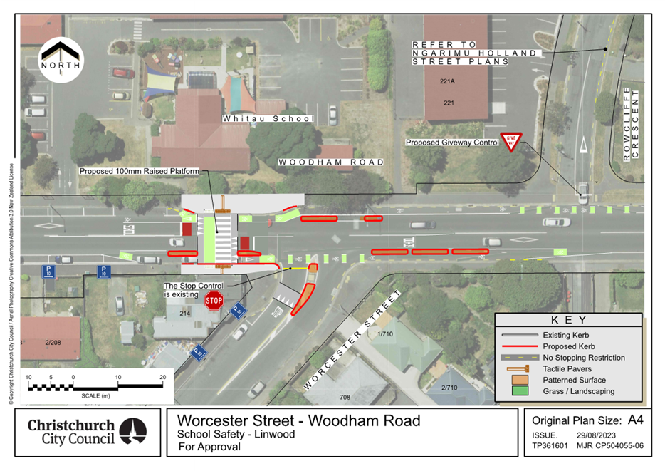
|
Council
21 September 2023
|
|
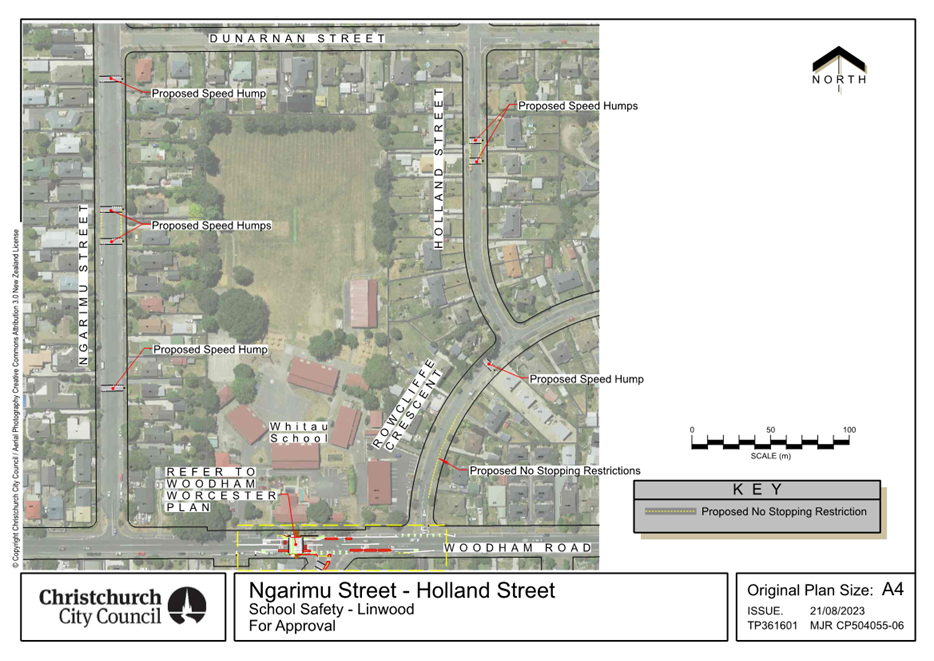
|
Council
21 September 2023
|
|
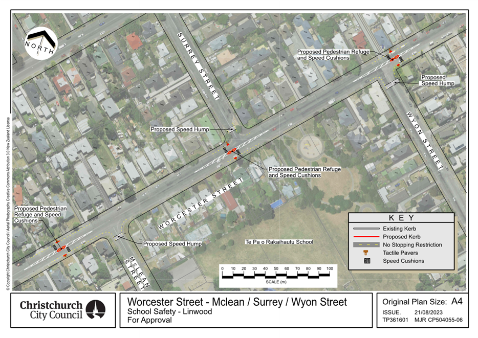
|
Council
21 September 2023
|
|
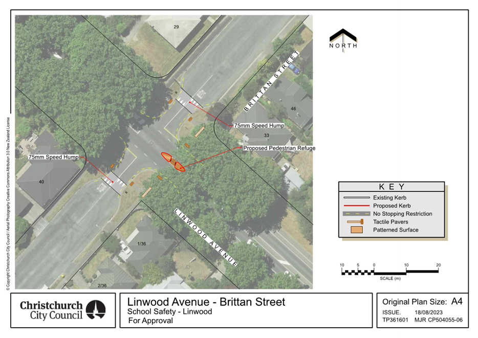
|
Council
21 September 2023
|
|
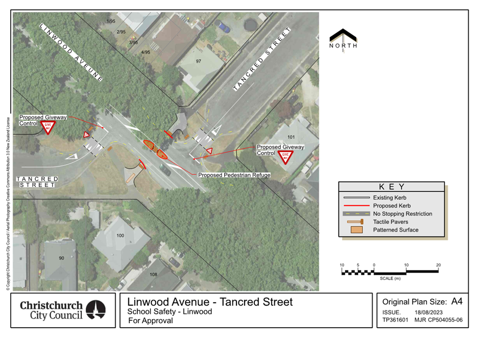
|
Council
21 September 2023
|
|
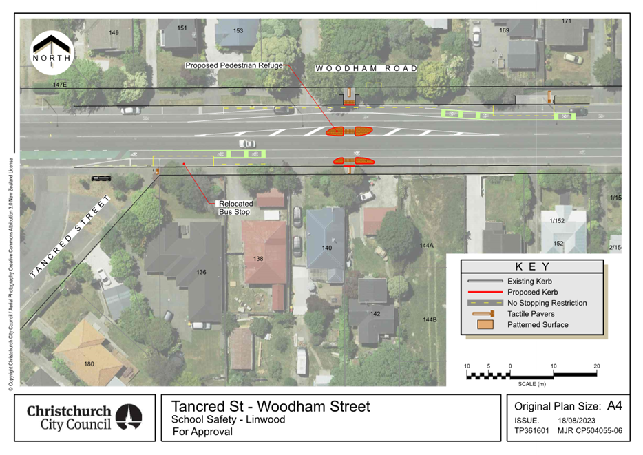
|
Council
21 September 2023
|
|


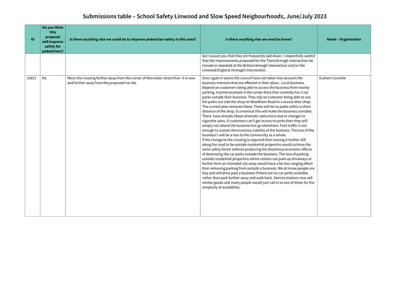
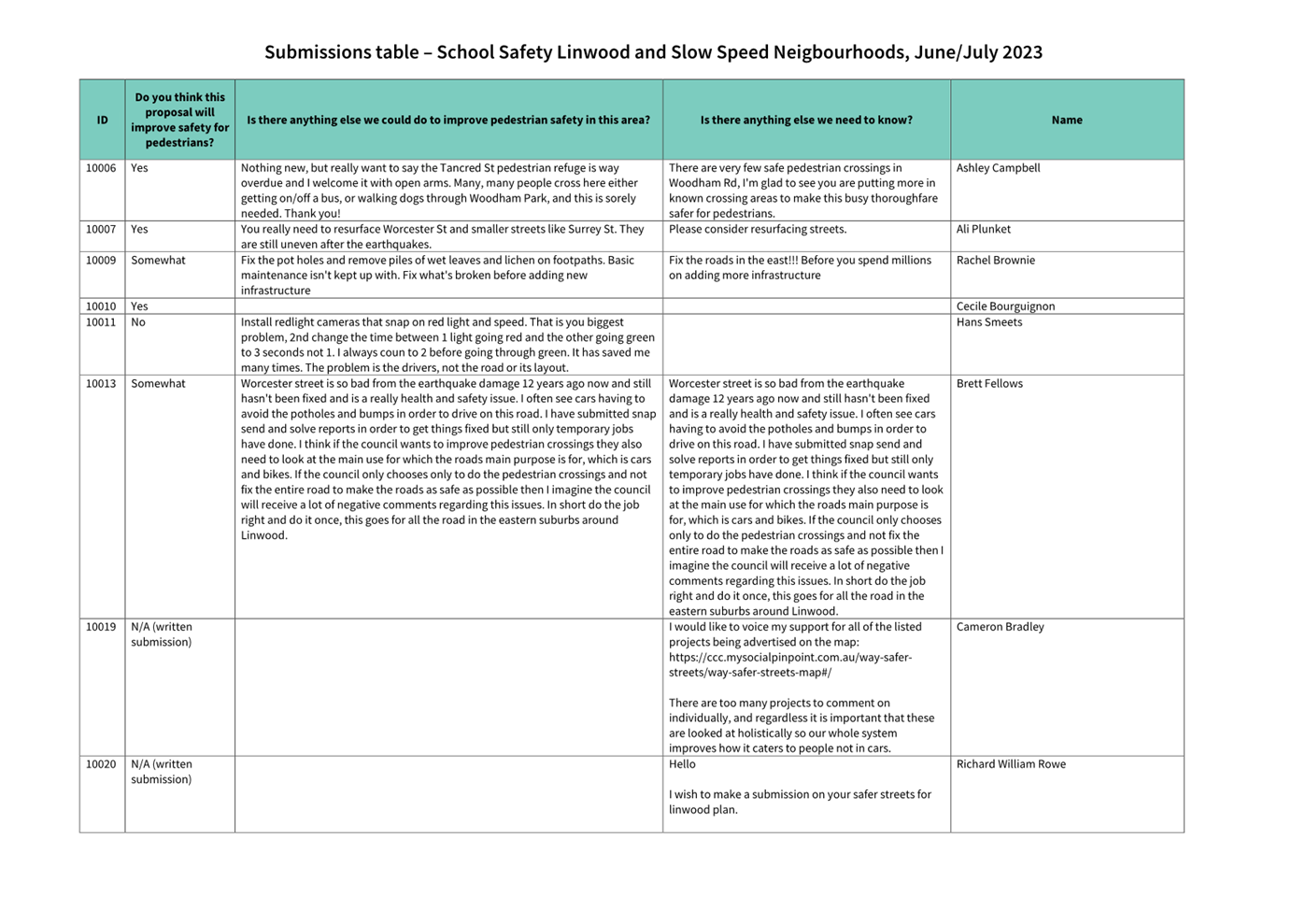

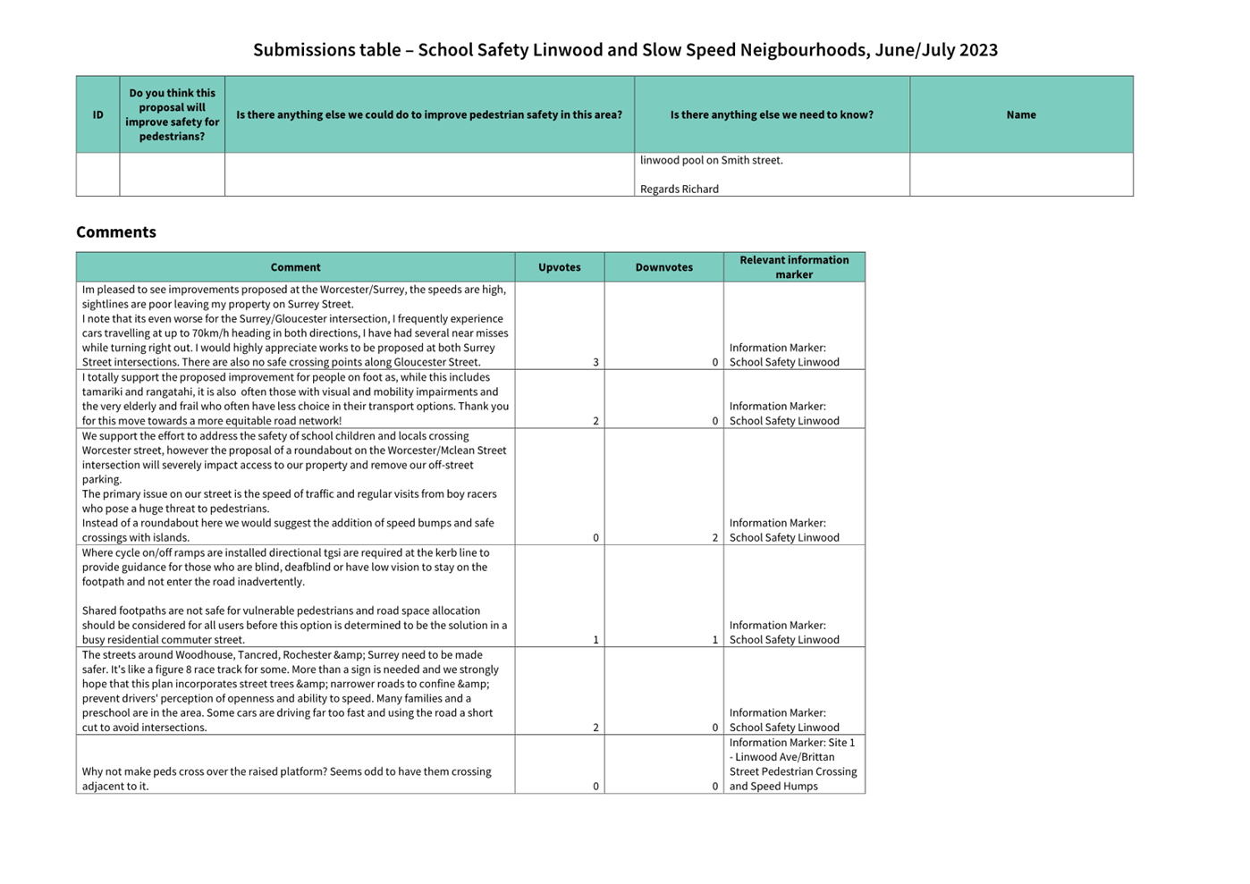
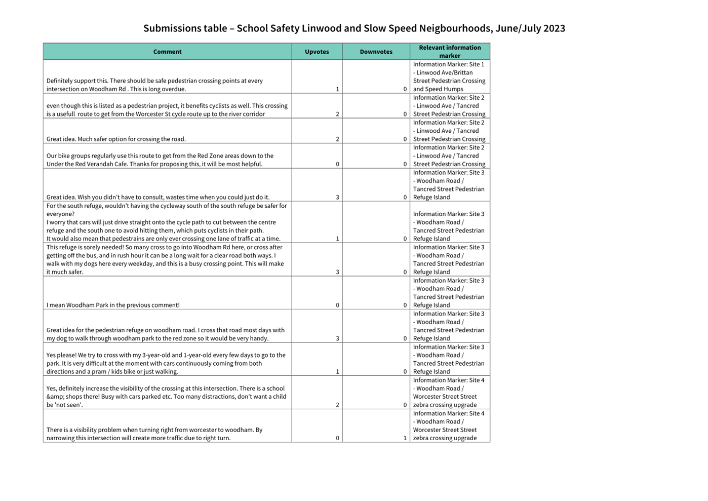
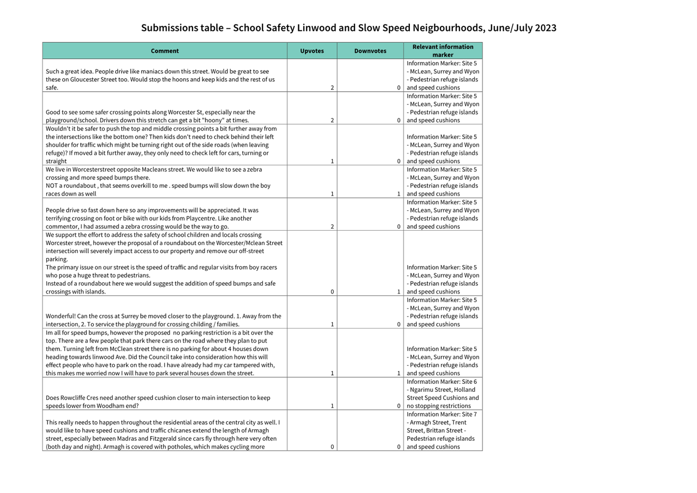
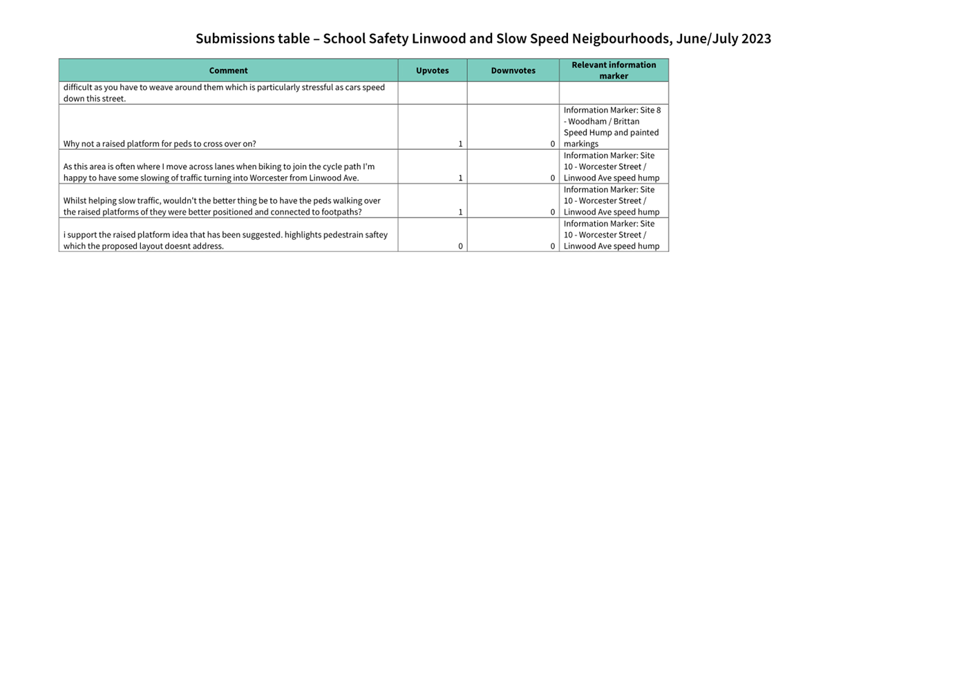
|
Council
21 September 2023
|
|
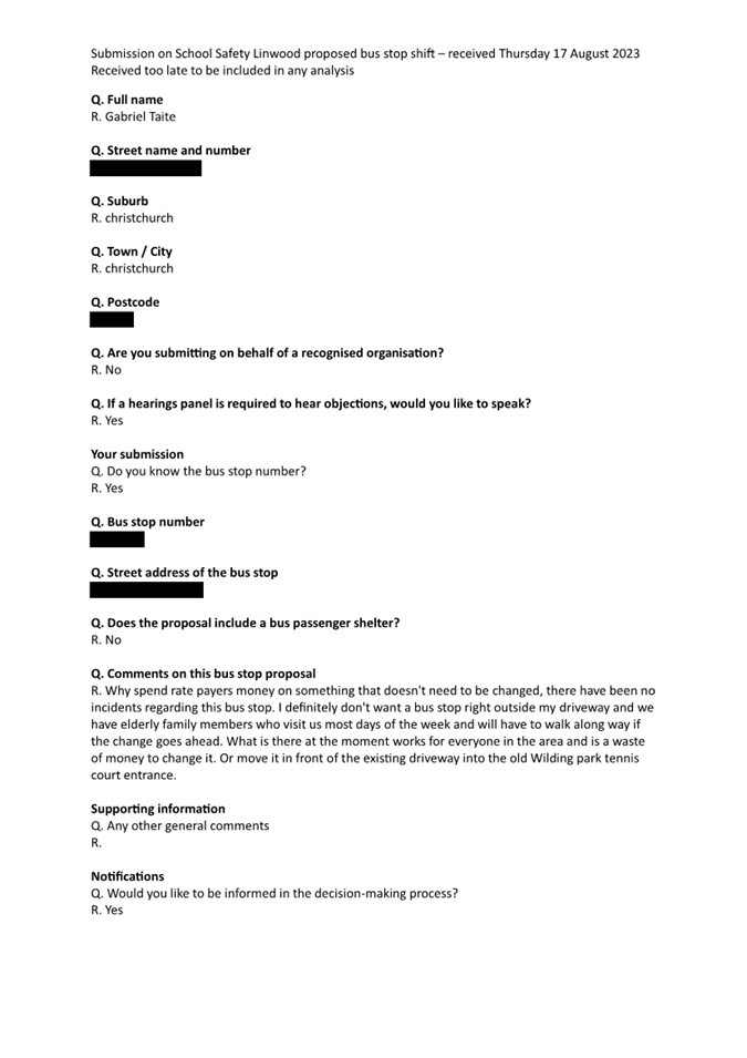
|
Council
21 September 2023
|
|
|
10. Transport Choices - Improving Bromley's Roads
|
|
Reference / Te Tohutoro:
|
23/1168897
|
|
Report of / Te Pou Matua:
|
Peter
Bawden, Senior Project Manager Transport, peter.bawden@ccc.govt.nz;
Jacob Bradbury, Manager Planning & Delivery Transport, Jacob.bradbury@ccc.govt.nz
|
|
Senior Manager / Pouwhakarae:
|
Lynette
Ellis, Head of Transport & Waste Management (Lynette.Ellis@ccc.govt.nz)
|
1. Nature of Issue and Report Origin
1.1 The purpose of this report is to inform the Council of
feedback received, and for the Council to approve the design to proceed to
construction for the Transport Choices - Improving Bromley's Roads project.
1.2 The origin of this report is the Climate Emergency Response
Fund (CERF) Transport Choices programme.
1.3 The
decisions in this report are of medium significance in relation to the Christchurch
City Council’s Significance and Engagement Policy 2019. The level of significance was determined by potential
benefits and opportunities to the council/community, the number of people
affected and/or with an interest, and that these projects span multiple
community board areas, as set out in the criteria of the policy (Page 2). This
evaluation has considered the Transport Choices projects as a cohesive
programme of work. This is consistent with how community engagement has
been undertaken, with all work packages being presented concurrently on Have
your Say under the banner of Way Safer Streets.
2. Officer Recommendations Ngā
Tūtohu
That the Council:
General
1. Approves the following recommendations
required for the implementation of the project, relying on its powers under the
Christchurch City Council Traffic and Parking Bylaw 2017 and Part 21 of the
Local Government Act 1974.
2. Approves that any previous resolutions made
pursuant to any Bylaw, Local Government Act or any Land Transport Rule and
pertaining to traffic controls, stopping and/or parking restrictions (but excluding
speed limits) to the extent that they are in conflict with resolutions 5 to 60
be revoked.
3. Approve that these resolutions take effect
when parking signage and/or road markings that evidence the restrictions
described in the staff report are in place (or removed in the case of
revocations).
4. Approves that construction of the Transport
Choices – Improving Bromley’s Roads project is conditional on
implementation costs being agreed and incorporated into the Transport Choices
Funding agreement between Waka Kotahi and Council.
McGregors
Road/Hay Street/Butterfield Avenue
General
Arrangements
5. Approves all kerb alignments, road surface
treatments, traffic islands and road markings on Hay Street, McGregors Road and
Butterfield Avenue, as detailed on plan 310203418-TP74469-01-001-C101, and
attached to this report as Attachment A.
Shared Paths
6. Approves that the path on the southern side of
Hay Street, commencing at a point 23 metres west of its intersection with
McGregors Road, and extending in an easterly direction to a point 58 metres
east of its intersection with McGregors Road, as detailed on plan
310203418-TP74469-01-001-C101, dated 29/08/23 and attached to this report as
Attachment A, be resolved as a bi-directional Shared Path in accordance with
Clause 21 of the Christchurch City Council Traffic & Parking Bylaw 2017,
and in accordance with section 11.4 of the Land Transport Act - Traffic Control
Devices Rules: 2004. This Shared Path is for the use by
the classes of road user only as defined in Section 11.1A of the Land Transport
(Road User) Rule: 2004.
7. Approves that the path on the northern side of
the Hay Street, commencing at a point 14 metres west of its intersection with
Butterfield Avenue, and extending in an easterly direction to appoint 39 metres
east of its intersection with McGregors Road, as detailed on plan
310203418-TP74469-01-001-C101, dated 29/08/23 and attached to this report as
Attachment A, be resolved as a bi-directional Shared Path in accordance with
Clause 21 of the Christchurch City Council Traffic & Parking Bylaw 2017,
and in accordance with section 11.4 of the Land Transport Act - Traffic Control
Devices Rules: 2004. This Shared Path is for the use by the classes of road
user only as defined in Section 11.1A of the Land Transport (Road User) Rule:
2004.
Traffic Controls
8. Approves that a roundabout be installed in
accordance with Section 10.4 of the Land Transport Rule-Traffic Control
Devices: 2004, including all kerb alignments, road surface treatments and road
markings at the Hay Street and McGregors Road intersection, and also including
all approaches to this intersection, as detailed on plan
310203418-TP74469-01-001-C101, and attached to this report as Attachment A.
9. Approves pursuant to Section 334(1)(d) of the
Local Government Act 1974 that a pedestrian crossing be resolved and
established on a raised platform in accordance with Section 8.2 of Land
Transport Rule: Traffic Control Devices 2004 on Hay Street at a point 20 metres
west of its eastern intersection with McGregors Road and as detailed on plan
310203418-TP74469-01-001-C101, dated 29/08/23 and attached to this report as
Attachment A.
10. Approves pursuant to Section 334(1)(d) of the
Local Government Act 1974 that a priority cycle crossing be established on a
raised platform on Hay Street at a point 20 metres west of its eastern
intersection with McGregors Road and as detailed on plan
310203418-TP74469-01-001-C101, dated 29/08/23 and attached to this report as
Attachment A and further approves that Give Way controls are placed against
traffic approaching the crossing requiring that traffic to give way to users of
the cycle crossing facility (in addition to users of the adjacent pedestrian
crossing). These Give Way controls are to be evidenced by signs and/or markings
installed in accordance with Land Transport Rule: Traffic Control Devices 2004.
11. Approves pursuant to Section 334(1)(d) of the
Local Government Act 1974 that a pedestrian crossing be resolved and
established on a raised platform in accordance with Section 8.2 of Land
Transport Rule: Traffic Control Devices 2004 on McGregors Road at a point 12
metres south of its intersection with Hay Street and as detailed on plan
310203418-TP74469-01-001-C101, dated 29/08/23 and attached to this report as
Attachment A.
12. Approves pursuant to Section 334(1)(d) of the
Local Government Act 1974 that a priority cycle crossing be established on a
raised platform on McGregors Road at a point 12 metres south of its
intersection with Hay Street and as detailed on plan
310203418-TP74469-01-001-C101, dated 29/08/23 and attached to this report as
Attachment A and further approves that Give Way controls are placed against
traffic approaching the crossing requiring that traffic to give way to users of
the cycle crossing facility (in addition to users of the adjacent pedestrian
crossing). These Give Way controls are to be evidenced by signs and/or markings
installed in accordance with Land Transport Rule: Traffic Control Devices 2004.
Stopping and
Parking Restrictions
13. Approves that the stopping of all vehicles be
prohibited at any time, in accordance with Clause 7 of the Christchurch City
Council Traffic & Parking Bylaw 2017, on the north side of Hay Street
commencing 41 metres southwest of its intersection with Butterfield Avenue, and
extending in a northeasterly, then easterly direction for a distance of 157
metres to tie into existing no stopping restrictions west of the intersection
of Hay Street and Kuaka Crescent.
14. Approves that the stopping of all vehicles be
prohibited at any time, in accordance with Clause 7 of the Christchurch City
Council Traffic & Parking Bylaw 2017, on the western side of Butterfield
Avenue commencing at its intersection with Hay Street and extending in a
northerly direction for a distance of 9 metres.
15. Approves that the stopping of all vehicles be prohibited
at any time, in accordance with Clause 7 of the Christchurch City Council
Traffic & Parking Bylaw 2017, on the eastern side of Butterfield Avenue
commencing at its intersection with Hay Street and extending in a northerly
direction for a distance of 9 metres.
16. Approves that the stopping of all vehicles be
prohibited at any time, in accordance with Clause 7 of the Christchurch City
Council Traffic & Parking Bylaw 2017, on the western side of McGregors Road
(north of Hay Street), commencing at its intersection with Hay Street and
extending in a northerly direction for a distance of 15 metres.
17. Approves that the stopping of all vehicles be
prohibited at any time, in accordance with Clause 7 of the Christchurch City
Council Traffic & Parking Bylaw 2017, on the eastern side of McGregors Road
(north of Hay Street), commencing at its intersection with Hay Street and
extending in a northerly direction for a distance of 15 metres.
18. Approves that the stopping of all vehicles be
prohibited at any time, in accordance with Clause 7 of the Christchurch City
Council Traffic & Parking Bylaw 2017, on the southern side of Hay Street,
commencing at a point 40 metres west of its intersection with McGregors Road
(south of Hay Street) and extending in an easterly direction to a point 107
metres west of Korora Street.
19. Approves that the stopping of all vehicles be
prohibited at any time, in accordance with Clause 7 of the Christchurch City
Council Traffic & Parking Bylaw 2017, on the west side of McGregors Road
(south of Hay Street), commencing at its intersection with Hay Street, and
extending in a southerly direction for a distance of 40 metres.
20. Approves that the stopping of all vehicles be
prohibited at any time, in accordance with Clause 7 of the Christchurch City
Council Traffic & Parking Bylaw 2017, on the southern side of Hay Street,
commencing at its intersection with McGregors Road (south side of Hay Street),
and extending in a south easterly direction for a distance of 21 metres.
21. Approves that the stopping of all vehicles be
prohibited at any time, in accordance with Clause 7 of the Christchurch City
Council Traffic & Parking Bylaw 2017, on the island south of Hay Street,
beginning at a point parallel to the west edge of the property accessway of 86
Hay Street and following the island’s kerb in a complete loop.
22. Approves that the stopping of all vehicles be
prohibited at any time, in accordance with Clause 7 of the Christchurch City
Council Traffic & Parking Bylaw 2017, beginning at a point 2 metres east of
the property access to 86 Hay Street, and following the island’s kerb in
a complete loop.
23. Approves that the stopping of all vehicles be
prohibited at any time, in accordance with Clause 7 of the Christchurch City
Council Traffic & Parking Bylaw 2017, on the western side of McGregors Road
commencing at its intersection with Hay Street and extending in a southerly
direction for a distance of 18 metres.
24. Approves, pursuant to Clause 7 of the
Christchurch City Council Traffic and Parking Bylaw 2017, that the stopping of
vehicles be prohibited at all times on the southeast side of the service lane
providing access to 72 McGregors Road and 82-82 Hay Street commencing at
its intersection with McGregors Road and extending generally in a northeast
direction to a point 9 metres northeast of the property boundary between 70 and
72 McGregors Road when measured in a straight line parallel to the road
boundary.
Hay Street/Ruru
Road
General
Arrangements
25. Approves all kerb alignments, road surface
treatments, traffic islands and road markings on Ruru Road and Hay Street, as
detailed on plan 310203418-TP74469-01-002-C101, and attached to this report as Attachment
A.
Traffic Controls
26. Approves that a roundabout be installed in
accordance with Section 10.4 of the Land Transport Rule-Traffic Control
Devices: 2004, including all kerb alignments, road surface treatments and road
markings at the Hay Street and Ruru Road intersection, and also including all
approaches to this intersection, as detailed on plan
310203418-TP74469-01-001-C102, dated 29/08/23 and attached to this report as
Attachment A.
27. Approves pursuant to Section 334(1)(d) of the
Local Government Act 1974 that a pedestrian crossing be resolved and
established on a raised platform in accordance with Section 8.2 of Land
Transport Rule: Traffic Control Devices 2004 on Hay Street at a point 7 metres
south of its intersection with Ruru Road and as detailed on plan 310203418-TP74469-01-001-C102,
dated 29/08/23 and attached to this report as Attachment A.
28. Approves pursuant to Section 334(1)(d) of the
Local Government Act 1974 that a pedestrian crossing be resolved and
established on a raised platform in accordance with Section 8.2 of Land
Transport Rule: Traffic Control Devices 2004 on Ruru Road at a point 20 metres
east of its intersection with Hay Street and as detailed on plan
310203418-TP74469-01-001-C102, dated 29/08/23 and attached to this report as
Attachment A.
Stopping and
Parking Restrictions
29. Approves that the stopping of all vehicles be
prohibited at any time, in accordance with Clause 7 of the Christchurch City
Council Traffic & Parking Bylaw 2017, on the northeast side of Ruru Road
commencing at a point on the road boundary parallel to the property boundary
between 45 Ruru Road and Memorial Park Cemetery and extending in a
southeasterly direction for a distance of 44 metres following the road
boundary.
30. Approves that the stopping of all vehicles be
prohibited at any time, in accordance with Clause 7 of the Christchurch City
Council Traffic & Parking Bylaw 2017, on the northeast side of Ruru Road
commencing at a point 3 meters southeast of the property boundary between 45
and 47 Ruru Road when measured in a straight line parallel to the road
boundary, and extending in a southeasterly direction for a distance of 47
metres.
31. Approves that the stopping of all vehicles be
prohibited at any time, in accordance with Clause 7 of the Christchurch City
Council Traffic & Parking Bylaw 2017, on the southwest side of Ruru Road
commencing at its intersection with Hay Street, and extending in a
northwesterly direction for a distance of 48 metres.
32. Approves that the stopping of all vehicles be
prohibited at any time, in accordance with Clause 7 of the Christchurch City
Council Traffic & Parking Bylaw 2017, on the southwest side of Ruru Road
commencing at its intersection with Hay Street, and extending in a
southeasterly direction for a distance of 30 metres.
33. Approves that the stopping of all vehicles be
prohibited at any time, in accordance with Clause 7 of the Christchurch City
Council Traffic & Parking Bylaw 2017, on the northeast side of Hay Street,
commencing at its intersection with Ruru Road and extending in a southwesterly
direction for a distance of 32 metres.
34. Approves that the stopping of all vehicles be
prohibited at any time, in accordance with Clause 7 of the Christchurch City
Council Traffic & Parking Bylaw 2017, on the southwest side of Hay Street,
commencing at its intersection with Ruru Road and extending in a southwesterly
direction for a distance of 38 metres.
Keighleys
Road/Bromley Road
General
Arrangements
35. Approves all kerb alignments, road surface
treatments, traffic islands and road markings on Bromley Road and Keighleys
Road, as detailed on plan 310203418-TP74469-01-003-C101 and attached to this
report as Attachment A.
McGregors
Road/Walcot Street
General
Arrangements
36. Approves all kerb alignments, road surface
treatments, traffic islands and road markings on McGregors Road and Walcot
Street, as detailed on plan 310203418-TP74469-01-004-C101 and attached to this
report as Attachment A.
Traffic Controls
37. Approves that a roundabout be installed in
accordance with Section 10.4 of the Land Transport Rule-Traffic Control
Devices: 2004, including all kerb alignments, road surface treatments and road
markings at the McGregors Road and Walcot Street intersection, as detailed on
plan 310203418-TP74469-01-001-C104, dated 29/08/23 and attached to this report
as Attachment A.
Stopping and
Parking Restrictions
38. Approves that the stopping of all vehicles be
prohibited at any time, in accordance with Clause 7 of the Christchurch City
Council Traffic & Parking Bylaw 2017, on the northeast side of Walcot
Street, commencing at its intersection with McGregors Road and extending in a
northwesterly direction for a distance of 20 metres.
39. Approves that the stopping of all vehicles be
prohibited at any time, in accordance with Clause 7 of the Christchurch City
Council Traffic & Parking Bylaw 2017, on the northwest side of McGregors
Road, commencing at its intersection with Walcot Street and extending in a northeasterly
direction for a distance of 23 metres.
40. Approves that the stopping of all vehicles be
prohibited at any time, in accordance with Clause 7 of the Christchurch City
Council Traffic & Parking Bylaw 2017, on the southeast side of McGregors
Road, commencing at its intersection with Walcot Street and extending in a
northeasterly direction for a distance of 22 metres.
41. Approves that the stopping of all vehicles be
prohibited at any time, in accordance with Clause 7 of the Christchurch City
Council Traffic & Parking Bylaw 2017, on the northeast side of Walcot
Street commencing at its intersection with McGregors Road Street and extending
in a southeasterly direction for a distance of 18 metres.
42. Approves that the stopping of all vehicles be
prohibited at any time, in accordance with Clause 7 of the Christchurch City
Council Traffic & Parking Bylaw 2017, on the southwest side of Walcot
Street, commencing at its intersection with McGregors Road and extending in a
southeasterly direction for a distance of 13 metres.
43. Approves that the stopping of all vehicles be
prohibited at any time, in accordance with Clause 7 of the Christchurch City
Council Traffic & Parking Bylaw 2017, on the southeast side of McGregors
Road commencing at its intersection with Walcot Street and extending in a
southwesterly direction for a distance of 16 metres.
44. Approves that the stopping of all vehicles be
prohibited at any time, in accordance with Clause 7 of the Christchurch City
Council Traffic & Parking Bylaw 2017, on the northwest side of McGregors
Road, commencing at its intersection with Walcot Street and extending in a
southwesterly direction for a distance of 19 metres.
45. Approves that the stopping of all vehicles be
prohibited at any time, in accordance with Clause 7 of the Christchurch City
Council Traffic & Parking Bylaw 2017, on the southwest side of Walcot
Street commencing at its intersection with McGregors Road and extending in a
northwesterly direction for a distance of 20 metres.
Hay
Street/Korora Street
General
Arrangements
46. Approves all kerb alignments, road surface
treatments, traffic islands and road markings on Hay Street and Korora Street,
as detailed on plan 310203418-TP74469-01-005-C101, and attached to this report
as Attachment A.
Stopping and
Parking Restrictions
47. Approves that the stopping of all vehicles be
prohibited at any time, in accordance with Clause 7 of the Christchurch City
Council Traffic & Parking Bylaw 2017, on the north side of Hay Street
commencing 12 metres west of its intersection with Korora Street, and extending
in an easterly direction for a distance of 40 metres.
48. Approves that the stopping of all vehicles be
prohibited at any time, in accordance with Clause 7 of the Christchurch City
Council Traffic & Parking Bylaw 2017, on the south side of Hay Street,
commencing at its intersection with Korora Street and extending in a westerly
direction for a distance of 12 metres.
49. Approves that the stopping of all vehicles be
prohibited at any time, in accordance with Clause 7 of the Christchurch City
Council Traffic & Parking Bylaw 2017, on the south side of Hay Street,
commencing at its intersection with Korora Street and extending in an easterly
direction for a distance of 17 metres.
50. Approves that the stopping of all vehicles be
prohibited at any time, in accordance with Clause 7 of the Christchurch City
Council Traffic & Parking Bylaw 2017, on the west side of Korora Street
commencing at its intersection with Hay Street, extending in a southerly
direction for a distance of 14 metres.
51. Approves that the stopping of all vehicles be
prohibited at any time, in accordance with Clause 7 of the Christchurch City
Council Traffic & Parking Bylaw 2017, on the east side of Korora Street
commencing at its intersection with Hay Street, extending in a southerly
direction for a distance of 14 metres.
Korora
Street/Kawau Crescent
General
Arrangements
52. Approves all kerb alignments, road surface
treatments, traffic islands and road markings on Korora Street and Kawau
Crescent, as detailed on plan 310203418-TP74469-01-006-C101, and attached to
this report as Attachment A.
Stopping and
Parking Restrictions
53. Approves that the stopping of all vehicles be
prohibited at any time, in accordance with Clause 7 of the Christchurch City
Council Traffic & Parking Bylaw 2017, on the west side of Korora Street
commencing 21 metres northeast of its intersection with Keighleys Road and
extending in a northeasterly direction for a distance of 42 metres.
54. Approves that the stopping of all vehicles be
prohibited at any time, in accordance with Clause 7 of the Christchurch City
Council Traffic & Parking Bylaw 2017, on the east side of Korora Street
commencing at its intersection with Kawau Crescent, and extending in a
northerly direction for a distance of 20 metres.
55. Approves that the stopping of all vehicles be
prohibited at any time, in accordance with Clause 7 of the Christchurch City
Council Traffic & Parking Bylaw 2017, on the east side of Korora Street
commencing at its intersection with Kawau Crescent, and extending in a
southerly direction for a distance of 24 metres.
56. Approves that the stopping of all vehicles be
prohibited at any time, in accordance with Clause 7 of the Christchurch City
Council Traffic & Parking Bylaw 2017, on the north side of Kawau Crescent
commencing at its intersection with Korora Street and extending in an easterly
direction for a distance of 15 metres.
57. Approves that the stopping of all vehicles be
prohibited at any time, in accordance with Clause 7 of the Christchurch City Council
Traffic & Parking Bylaw 2017, on the south side of Kawau Crescent
commencing at its intersection with Korora Street and extending in an easterly
direction for a distance of 15 metres.
Road/Raymond
Road
General
Arrangements
58. Approves all kerb alignments, road surface
treatments, traffic islands and road markings on Korora, commencing at its
intersection with Kawau Crescent, and extending in a northerly, easterly, and
southerly direction as detailed on plan 310203418-TP74469-01-007-C101, dated
29/08/23 and attached to this report as Attachment A.
Shared Paths
59. Approves that a bi-directional Shared Path be
resolved in accordance with Clause 21 of the Christchurch City Council Traffic
& Parking Bylaw 2017, and in accordance with Section 11.4 of the Land
Transport Rule: Traffic Control Devices 2004 on the west side of Raymond Road
commencing at its intersection with Bromley Road and extending in a northerly
direction for a distance of 57 metres. This Shared Path is for use by the
classes of road user only as defined in Section 11.1A of the Land Transport
(Road User) Rule: 2004.
Bromley School,
Keighleys Road
General
Arrangements
60. Approves all kerb alignments, road surface
treatments, traffic islands and road markings on Keighleys Road, as detailed on
plan 310203418-TP74469-01-008-C101, and attached to this report as Attachment
A.
3. Reason for Report Recommendations Ngā Take mō te
Whakatau
3.1 This
project is funded by the Central Government Transport Choices programme –
a $348 million national programme made available from the Climate Emergency
Response Fund.
3.2 The
Transport Choices programme is important because transport makes up almost half
of New Zealand’s carbon emissions. In May 2022, government released
its first Emissions Reduction Plan and transport has a significant role to
play, targeting a 20 percent reduction in light vehicle travel by 2035.
Reducing reliance on cars and supporting people to walk, cycle and use public
transport is one of three focus points of the Emissions Reduction Plan.
3.3 The
Improving Bromley’s Roads project #74469
was included within the Transport Choices programme due to alignment with the
“creating walkable networks” investment category of the programme.
4. Alternative Options Considered Ētahi atu Kōwhiringa
The Transport
Choices Programme
4.1 Transport
Choices funding was allocated to Local Authorities through an Expression of
Interest process administered by Waka Kotahi. Through that process
Christchurch City Council submitted a package of projects that was developed by
consideration of:
· Project alignment with the
four investment criteria for Transport Choices funding: deliver strategic
cycling/micro mobility networks; create walkable neighbourhoods; support safe,
green, and healthy school travel; make public transport more reliable and
easier to use;
· Achieving diversity across
the four investment categories for Transport Choices funding;
· Focusing investments in
certain suburbs;
· Community requests for
infrastructure improvements aligned with the Transport Choices programme
outcomes;
· Complimenting existing
programmes, such as the Major Cycleway Routes programme;
· Project complexity and
ability to deliver prior to June 2024.
4.2 All
14 projects submitted for Transport Choices funding were accepted by Waka
Kotahi. However, in deciding to include the Transport Choices programme
in the Draft Annual Plan, Council decided to include 11 projects in the
programme and defer a number of business-as-usual projects by 12 months to
enable the Transport Choices programme to be adequately resourced.
Project Options Considered
4.3 Selection
of Bromley sites for inclusion in the Central Government Transport Choices
programme considered alignment with funding criteria. The criteria constrained
scope, and limited works to those amenable to a fast-track design and
construction process to meet programme timeframes.
4.4 Initial
work and community engagement started under Improving
Bromley’s Roads project #67989 in FY23 and was used to inform
selection of six key intersections plus two other possible sites, depending on
budget availability.
4.5 The
eight selected sites were accepted into the Transport Choices programme and a new project, Improving Bromley’s Roads project
#74469, was set up for the Transport Choices funded work in Bromley.
4.6 Work on the wider Improving Bromley’s Roads project
#67989 area transport action plan continues in parallel with the Transport
Choices works. Opportunities to maximise efficiency and leverage off the
Transport Choices works by bringing forward installation of additional
complementary traffic calming measures under project #67989 and are also being
prioritised.
5. Detail Te Whakamahuki
5.1 The decision affects the following wards/Community Board areas:
5.1.1 Linwood
Ward
5.1.2 Waitai
Coastal-Burwood-Linwood Community Board
Scheme
Description
5.2 The
proposed scheme consulted on comprised a range of raised platform, mini
roundabout, traffic lane narrowing and geometric tightening traffic calming
elements, raised pedestrian crossings and cycling improvements across six
intersections two additional opportunity sites in Bromley shown in Figure 1.
5.3 Identified
intersections mostly have a residential land use. There are several cemeteries
in the area, and Bromley Primary School lies on Keighleys Road. There is a
small group of shops at the McGregors Road-Walcot Street intersection.
The list of sites within the scope of the project is as follows and as
indicated on the map below:
Site 1: McGregors Road/Hay
Street/Butterfield Avenue
Site 2: Hay Street/Ruru Road
Site 3: Keighleys Road/Bromley Road
Site 4: McGregors Road/Walcot Street
Site 5: Hay Street/Korora Street
Site 6: Korora Street/Kawau Crescent
Site 7: Bromley Road/Raymond Street
Site 8: Bromley School
Figure 1: Proposed Scheme - Site
Locations
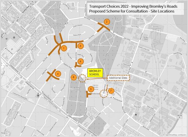
5.4 Scheme
Descriptions
5.4.1 McGregors
Road/Hay Street/Butterfield Avenue Intersections works
The site includes two adjacent
intersections and two routes traversing the Bromley neighbourhood that are used
by light and heavy vehicles featuring in community consultation feedback.
The 155 bus route travels through these intersections along Hay Street east and
McGregors Road north. The scheme includes:
· Raised safety
platform and median island on Hay Street southern approach;
· Pedestrian and
cycle crossings on Hay Street (between McGregors intersctions) and on McGregors
Road at the Hay Street intersection;
· A mini
roundabout at the intersection of McGregors (north) and Hay Street;
· Speed cushions
on McGregors Road (north), Buttterfield Avenue and Hay Street (east);
· Widened shared
pedestrian-cycle path treatments on Hay Street and extending into McGregors
South with narrowed traffic lanes throughout; and
· No stopping
treatments applied where lane widths or safety would by obstructed by parked
vehicles.
5.4.2 Hay
Street / Ruru Road Intersection works
The site includes the intersection of Hay
Street and Ruru Road. Memorial Park Cemetery is immediately north of the site,
and Ruru Lawn Cemetery lies to the southeast.
The 155 bus route travels through this intersection along Hay Street and Ruru
Road east. The scheme includes:
· A mini
roundabout at the intersection with kerb buildouts to direct vehicle
approaches; and
· Raised
platform zebra crossings on Ruru (east) and Hay Street, and raised table
platform on Ruru (west).
5.4.3 Keighleys / Bromley Intersection works
The site includes the intersection of
Keighleys Road and Bromley Road. Bromley Cemetery lies west of Keighley’s
Road, and Cypress Garden Reserve lies to the east. Bromley School lies north of
the site, on the east side of Keighley’s Road. The 155 bus route travels
along Keighleys Road south and Bromley Road in the east. The scheme
includes:
· A platform on all approaches to
the intersection, replacing the current lower height speed platform on
Keighleys (north). Existing pedestrian island to remain.
5.4.4 McGregors / Walcot works
The site includes the intersection of
McGregors Road and Walcot Street - intersection features a set of local shops,
namely, a dairy, barber, tattoo shop, and a fish n’ chip shop. There
are dedicated parks outside the local shops, which are not time-restricted.
On-street parking is also available throughout the site. The scheme
includes:
· Roundabout control at the
intersection, with a raised kerb on the south west side to ensure all
approaches are a consistent size and shape. Raised platforms on each
approach for crossing opportunities (not formal zebra crossings).
5.4.5 Hay/Korora
works
The site includes the intersection of Hay
Street and Korora Street. The 155 bus route travels along Hay Street from
McGregors Road in the west to Ruru Road in the east. The scheme includes:
· Raised
buildouts on all approaches to the intersections to narrow the lanes on the
approaches;
· Raised platform across all
approaches to reduce vehicle speed; and
· Speed cushions on Korora Street
at approximately 90m intervals extending down to Site 6 the Korora/Kawau
intersection.
5.4.6 Korora/Kawau
works
The site includes the intersection of
Korora Street and Kawau Crescent.
The Bromley school Kawau Crescent pedestrian entrance is most commonly by
residents from the northern catchment area. The scheme includes:
· Raised
buildouts on all approaches to the intersections to narrow the lanes on the
approaches; and
· Speed
cushion across all approaches to reduce vehicle speed.
5.4.7 Bromley/Raymond
works
The site covers pedestrian access to the
northwest of the Bromley/Raymond intersection adjacent to Cypress Garden
Reserve. The scheme includes:
· Adding
a length of footpath, on the western side of Raymond Road, from the
intersection to the entrance to Cypress Gardens.
5.4.8 Keighleys
Road by Bromley School works
The site covers the roadway outside the
main entrance to Bromley School and the existing kea crossing. The scheme
includes:
· Adding
two speed humps either side of the existing kea crossing location;
· Adding
speed cushions west of the informal build out opposite the school car park
entrance, and adding some surfacing to allow this to be used for an informal
crossing point to parking used for pick-ups/drop-offs across Keighleys Road
from the school.
Public Consultation Te Tukanga Kōrerorero
5.5 Local
residents received warm up flyers in their mailboxes from 29 May, indicating we
would be seeking feedback on Way Safer Streets projects proposed for their area
in June.
5.6 Staff
attended a LinWard collective hui (consisting of Te Whare Taonga o Ngā Iwi
Katoa Linwood Resource Centre, Bromley Community Trust, The Loft, CCC
Libraries, Christchurch Methodist Mission and St Chads Church and Linwood
Avenue Corner Trust) to brief them on Way Safer Streets projects in early June
2023. Recommended engagement tactics were taken on board.
5.7 Consultation
started on 16 June and ran until 16 July 2023, as part of the wider Way Safer
Streets consultation. An email was sent to 150 key stakeholders across the
entire Way Safer Streets programme, including emergency services, Spokes, AA,
Disabled Persons Assembly, Blind Low Vision, ECan, Mahaanui Kurataiao, Bromley
School, and The Loft at Eastgate. The consultation was posted on the council
Facebook page, as well as local community groups, inviting submissions on the Social
Pinpoint Map.
5.8 Consultation
documents (including a submission form) and flyers were available at Bromley
Community Centre, Linwood Union Church, Linwood Library, and Linwood Resource
Centre and Community Gardens.
5.9 Two
Newsline stories were published and picked up by local media outlets. Digital
screens advertised the consultation in Civic Offices and Linwood Library, as
well as newspaper advertisements in The Star and The Pegasus Post. Digital
billboards were utilised in Linwood, including outside Eastgate Mall. An online
targeted campaign ran for the entire consultation period. Footpath decals with
QR codes were installed in the project area to direct local pedestrians to the
consultation.
5.10 During
consultation, flyers were delivered to residents in the local area, and emails
were sent to those who expressed interest in being updated on Way Safer
Streets.
5.11 Bromley
School were engaged during consultation. They shared feedback on the plans and
indicated how parents are currently parking near the school. They were
supportive of the plans and recommended additional locations near the school
for traffic calming and pedestrian crossings.
5.12 Local
businesses were door knocked and given consultation letters and an explanation
of the plans. They were supportive of the plans and discussed issues with
speeding in the area.
5.13 Residents
most affected by the intersection improvements were door knocked during
consultation. They were mostly in support of the plans as a good initial step
to address major existing safety concerns related to speeding and vehicle
crashes.
5.14 Key
stakeholder meetings throughout and after consultation, with Spokes, FENZ, St
John, NZ Police and Disabled Persons Assembly, further informed projects in the
Way Safer Streets program.
Summary of Submissions Ngā Tāpaetanga
5.15 Feedback
on the plans could be given by posting a comment on the Social
Pinpoint Map, by making a submission, or both.
5.16 A
total of 35 submissions and 35 comments were received on Improving
Bromley’s Roads. 26 submissions were made via the Social
Pinpoint Map, and nine submissions were made via email/PDF/letter.
Submissions were received from Linwood Resource Centre, Waitai
Coastal-Burwood-Linwood Community Board, the Bromley Art Group, the Disabled
Persons Assembly, and 31 individuals. All submissions and comments are
available in Attachment B.
5.17 On
the Social
Pinpoint Map, the project received a total of 90 upvotes, 13 downvotes, and
35 comments:
|
Project pin
|
Comments
|
Upvotes
|
Downvotes
|
|
Overall project pin
|
20
|
25
|
3
|
|
Site 1 - McGregors / Hay / Butterfield
|
6
|
9
|
1
|
|
Site 2 - Hay / Ruru
|
0
|
9
|
2
|
|
Site 3 - Keighleys / Bromley Rd
|
1
|
9
|
1
|
|
Site 4 - McGregors / Walcot
|
5
|
10
|
3
|
|
Site 5 - Hay St / Korora St
|
1
|
7
|
1
|
|
Site 6 - Korora St / Kawau Cr
|
0
|
5
|
0
|
|
Additional Opportunity - Bromley
School
|
1
|
7
|
1
|
|
Additional Opportunity - Bromley Rd /
Raymond Rd
|
1
|
9
|
1
|
|
Total
|
35
|
90
|
13
|
5.18 
Comment sentiment was predominantly mixed (54.3%), and
positive (28.6%):
5.19 Submitters
were asked how they travel through this area. The majority (88.5%) of
submitters travel in a car as the driver, however over half (57.8%) also walk
in the area:
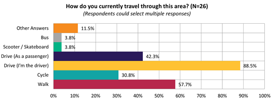
5.20 The
majority of submitters felt the proposed changes would improve safety at
intersections (69.2%):
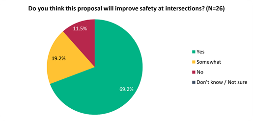
5.21 This
sentiment differed slightly depending on whether they live on the affected
streets (i.e. Hay Street, Ruru Road, McGregors Road), live in the suburb but
not on affected streets (i.e. Bromley), or live elsewhere:
|
Do you think this proposal will improve safety
at intersections?
|
Live on affected streets
|
Live in suburb elsewhere
|
Live elsewhere
|
|
Yes
|
7
|
7
|
4
|
|
Somewhat
|
3
|
2
|
0
|
|
No
|
3
|
0
|
0
|
5.22 The
majority of submitters supported the additional proposed safety features
outside Bromley School (80.8%):
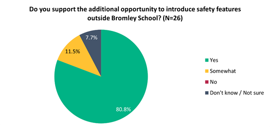
5.23 Key
themes and requests from both comments and submissions are summarised below.
Note that there could be cross-over between those
making comments and making submissions:
|
Key themes on outcomes of the
proposal
|
Number
of comments
|
Number
of submissions
|
Total
mentions
|
|
Highlighting
current safety issues / speeding
· Cars regularly speed on these
streets, especially Hay Street and Cypress Street, and around corners
· Concern about crashes into
houses, into people, and cars overtaking dangerously
· Currently an unsafe
environment for tamariki
|
9
|
16
|
25
|
|
Support
of the intersection upgrades
· Specific support around how
these intersection upgrades would start to address these issues with safety
|
12
|
12
|
24
|
|
Concern
about burnouts / cruising
· Concern around burnouts and
boy racers speeding happening at all hours, on Maces Road, Ruru Road, Cypress
Street, Keighleys, Raupo, and the McGegors/Walcot intersection
|
4
|
5
|
9
|
|
Concern
about heavy vehicles
· Concern about heavy vehicles
and buses using Korora Street and Ruru Road, often speeding
· Concern about heavy vehicles
cutting through on Hay Street and Bromley Road outside the school
|
2
|
4
|
6
|
|
Requests
|
Number of comments
|
Number of submissions
|
Total mentions
|
|
More
speed bumps and traffic calming within the project area
· More speed bumps are
installed, the better
· Intersections should be raised
· More treatments on Hay Street,
McGregors Road, Cypress Street, Ruru Road, Korora/Hay intersection,
McGregors/Hay intersection, McGregors/Walcot intersection,
Bromley/Keighley’s Road intersection, Raymond Road
|
14
|
16
|
30
|
|
Out
of project area requests
· Calls for a project to focus
on Cypress Street traffic calming
· Improve the Linwood Ave / Hay
Street intersection, by introducing traffic calming for drivers, and
increasing pedestrian accessibility
|
10
|
10
|
20
|
|
School
pedestrian improvements
· More pedestrian crossings to
cater to the school on Kawau Crescent, Bromley/Keighley’s intersection,
and Korora Street
|
1
|
6
|
7
|
|
Reduce
speeds
· Reduce speeds particularly
outside the school
· Concern that Bromley
hasn’t been treated equally with regard to speed restrictions
|
2
|
4
|
6
|
|
Other
requests
· Make it safer for those with
mobility issues
· Have teachers monitor the
school gates
· Have police patrolling
· Landscaping
|
5
|
6
|
11
|
Changes made to the
scheme design as a result of consultation and other feedback
5.24 The
basic scheme proposed and consulted on across the eight selected sites had
responded well to early community feedback drawn from the wider Bromley project
#67989. Design changes were generally minor changes in response to community,
road safety audit and Waka Kotahi feedback.
5.25 For
McGregors Road/Hay Street/Butterfield Avenue (Site 1), Hay Street/Ruru Road
(Site 2), Keighleys Road/Bromley Road (Site 3) and McGregors Road/Walcot Street
(Site 5), the response themes of current safety and speeding issues as well as
pedestrian safety at were well catered for in the proposed scheme.
However, design responses to feedback on heavy vehicles cutting through the
area were limited by the need to provide for transit of buses as these sites
are on bus route 155. Geometric adjustments have been made where possible
at the intersections to slow vehicles and help dissuade use by heavy vehicles
other than scheduled busses.
5.26 At
the McGregors Road/Walcot Street intersection (Site 4), no specific
modifications were made as a result of consultation. The general themes of
speeding, need for traffic calming and pedestrian safety improvements were well
covered. Slight changes to tighten geometrics and slow vehicles and
optimise pedestrian routes around the intersection were made.
5.27
At the Korora Street / Kawau Crescent intersection (Site 6), no specific
modifications were made as a result of consultation. The general themes of
speeding, need for traffic calming and pedestrian safety improvements well
covered. Slight adjustments to line marking and to optimise delineation of
pedestrian routes around the intersection were made.
5.28 At
the Bromley Road / Raymond Street intersection (Site 7) and Bromley Road (Site
8) no specific modifications were made as consultation was generally in support
of the proposed design. The general themes of speeding, need for traffic
calming and pedestrian safety improvements well covered. At site 8 the location
of the speed cushions and build-outs were moved eastward to avoid conflict with
cemetery access.
6. Policy Framework Implications Ngā Hīraunga ā- Kaupapa here
Strategic
AlignmentTe Rautaki Tīaroaro
6.1 This report supports the Council's
Long Term Plan (2021 - 2031):
6.2 Transport
6.2.1 Activity: Transport
· Level of Service: 10.0.2 Increase the share of
non-car modes in daily trips - >=36% of trips undertaken by non-car modes
· Level of Service: 10.0.6.1 Reduce the number of
death and serious injury crashes on the local road network - <=100
crashes
· Level of Service: 10.0.41 Reduce emissions and
greenhouse gases related to transport - <=1.10 million tonnes of CO2
equivalents
· Level of Service: 10.5.1 Limit deaths and
serious injury crashes per capita for cyclists and pedestrians - <= 12
crashes per 100,000 residents
Policy
Consistency Te Whai
Kaupapa here
6.3 The
recommendations of this report are consistent with
Council’s Plans and Policies, in particular:
6.3.1 The
changes proposed align with road safety and liveable streets goals in the
Christchurch Transport Strategic Plan 2012–2042, and similarly in the
draft Transport Plan (safe streets).
6.3.2 The
changes proposed align with Kia tūroa te Ao - Ōtautahi Christchurch
Climate Resilience Strategy as set out in the Climate Change Impact
Considerations section below.
Impact
on Mana Whenua Ngā
Whai Take Mana Whenua
6.4 The
decision does not involve a significant decision in relation to ancestral land
or a body of water or other elements of intrinsic value, therefore this
decision does not specifically impact Mana Whenua, their culture and
traditions.
6.5 The
decision does not involve a matter of interest to Mana Whenua and should not
impact on our agreed partnership priorities with Ngā Papatipu Rūnanga
6.6 The
projects are based on minor changes to, or re-allocation of, existing road
spaces, so are not anticipated to have a significant impact on Mana Whenua.
Climate
Change Impact Considerations Ngā Whai Whakaaro mā te Āhuarangi
6.7 The
decisions in this report are likely to:
6.7.1 Contribute
neutrally to adaptation to the impacts of climate change.
6.7.2 Contribute
positively to emissions reductions.
6.8 The
emission reductions associated with this project have not been estimated.
6.9 The Government’s Emissions Reduction Plan states we
will have to ‘substantially improve infrastructure for walking and
cycling’ to meet our emissions targets (including a 20% reduction in
light Vehicle Kilometres Travelled by 2035 - required under the Emissions
Reduction Plan). Improving the quality of our streets for walking and cycling
is also a key part of the Ministry of Transport and Waka Kotahi’s efforts
to decarbonise the transport system.
6.10 New
Zealander has the 5th highest transport emissions rate per capita
among the 43 OECD countries. Petrol or diesel car use is typically the
single-biggest contributor to an individual’s carbon footprint in New
Zealand.
6.11 From
the 2022 Life in Christchurch Transport Survey, 96 percent of respondents
travel by car. Respondents find car travel the least difficult means of
travel: "We use car travel as it is easier. Christchurch is very spread
out and to have several buses is not convenient." Inconsiderate and
dangerous behaviour from other road users and sharing the road with cars were
the main reasons respondents found it difficult to bike.
6.12 The
proposed changes make it safer for people walking and cycling, which will have a net positive impact for the climate by
helping to reduce transport emissions. Enabling more people to walk or cycle,
particularly for local journeys, is a key part of council’s emissions
reduction efforts by providing a safe, low emission way for residents to move around
the city.
Accessibility
Considerations Ngā
Whai Whakaaro mā te Hunga Hauā
6.13 This proposal improves accessibility for people walking and
cycling, by providing a safer means of accessing and using our street network.
6.14 Waka
Kotahi developed a set of Project Design Parameters to ensure all projects work
to collectively meet the programme objectives. The Project Design
Parameters require that “the infrastructure should be designed for
children and people with visual, mobility, or cognitive impairments. If the
infrastructure works for them, it will work for a wider spectrum of the
population who are interested in walking and cycling but concerned for their
safety.” Transport Choices projects have been designed in
accordance with these requirements.
7. Resource Implications Ngā Hīraunga Rauemi
Capex/Opex Ngā Utu Whakahaere
7.1 Cost
to Implement - the total project estimate is $3,029,899. This is
inclusive of design and project management.
7.2 Maintenance/Ongoing
costs – $19,200 per year additional costs associated with coloured
surfacing, linework and speed cushions and manual sweeping of channels
associated with raised platforms and speed cushions. These costs will be
eligible for Waka Kotahi subsidy at Council’s 51% Funding Assistance Rate.
The net maintenance cost for the full Transport Choices programme will have an
ongoing rates impact of approximately 0.01%, which will be included in the
draft Long Term Plan proposed budgets.
7.3 Funding
Source – Council’s capital programme:
7.3.1 ID
74469, Transport Choices 2022 – Improving Bromley’s Roads,
$3,038,054
7.4 All
funds sit within project ID 74469. Project ID 67989 Improving Bromley’s
Road is a separate Council funded project, budget $1M. It is not
proposed to utilise ID 67989 to fund improvements as set out in this
report. However, the community engagement undertaken for Transport
Choices is anticipated to help inform community priorities for the Council
funded project.
7.5 Waka
Kotahi through the Transport Choices programme will be funding the project up
to an agreed value which is calculated as 90% of the expected implementation
cost. The remaining 10% is Council’s share.
7.6 Under
the cost share agreement with Waka Kotahi, funding approvals for individual
Transport Choices projects are approved through two stage gates: design and
physical works. All Transport Choices projects have agreed funding schedules
for design. Individual project schedules for physical works are required to be
agreed and approved prior to 20 October 2023. In approving funding for physical
works, Waka Kotahi will consider:
7.6.1 The
project is in accordance with the scope and design approved by Waka
Kotahi.
7.6.2 Project
costs are in accordance with expectations.
7.6.3 Ability
to deliver the project prior to June 2024.
7.7 The
staff recommendations of this report include that Council’s approval of
this project is conditional on a funding agreement with Waka Kotahi being in
place for the physical works.
8. Legal Implications Ngā Hīraunga ā-Ture
Statutory power to undertake proposals in the report
Te Manatū Whakahaere Kaupapa
8.1 Council
resolved the Transport Choices programme as Metropolitan Significance when the
programme was included in the draft Annual Plan in February 2023.
8.2 Council
retains decision-making responsibilities that might otherwise be delegated in
accordance with the Delegations Register when a project is determined as
Metropolitan Significance.
8.3 Part
1, Clauses 7 and 8 of the Christchurch City Council Traffic and Parking Bylaw
2017 provides Council with the authority to install parking restrictions by
resolution.
8.4 The
installation of any signs and/or markings associated with traffic control
devices must comply with the Land Transport Rule: Traffic Control Devices 2004.
Other Legal Implications Ētahi atu
Hīraunga-ā-Ture
8.5 There
is no legal context, issue or implication relevant to this decision.
9. Risk Management Implications Ngā Hīraunga Tūraru
9.1 Scope
– Waka Kotahi has governed the scope and design of the project to align with
programme KPI’s and consistency with Transport Choices design parameters.
Departing from the recommendations of this report creates a risk that Waka
Kotahi would not agree to fund the physical works phase of the project.
9.2 Delivery
– Transport Choices funding is subject to delivery being complete by June
2024. Waka Kotahi has established additional milestones to track
progress. Delays in approval of the projects would impact on the
timeframe for delivery.
9.3 Funding
security - the Transport Choices funding agreement between Council and Waka
Kotahi presently covers this project for design only, and a further stage gate
approval is required to gain funding approval for construction. The
instruction of physical works will be withheld until an implementation
agreement is in place.
9.4 Implementation
Cost Uncertainty – the funding agreement with Waka Kotahi places the risk
of cost variations with Council. This risk is being managed by minimising
price uncertainty and building contingency into the funding agreement.
Attachments Ngā Tāpirihanga
|
No.
|
Title
|
Reference
|
Page
|
|
a ⇩
|
Improving
Bromley's Roads Scheme Plans
|
23/1388436
|
419
|
|
b ⇩
|
Improving
Bromley's Roads - Submission Table (Public)
|
23/1372480
|
428
|
In addition to the attached documents, the following background
information is available:
|
Document
Name – Location / File Link
|
|
Not
applicable
|
Confirmation of Statutory
Compliance Te Whakatūturutanga ā-Ture
|
Compliance with Statutory Decision-making
Requirements (ss 76 - 81 Local Government Act 2002).
(a) This report contains:
(i) sufficient information about all reasonably practicable
options identified and assessed in terms of their advantages and
disadvantages; and
(ii) adequate consideration of the views and preferences of
affected and interested persons bearing in mind any proposed or previous
community engagement.
(b) The information reflects the level of significance of the
matters covered by the report, as determined in accordance with the Council's
significance and engagement policy.
|
Signatories Ngā Kaiwaitohu
|
Authors
|
Ryan Rolston -
Programme Manager
Peter Bawden -
Senior Project Manager
Samantha Smith
- Engagement Advisor
|
|
Approved By
|
Jacob Bradbury
- Manager Planning & Delivery Transport
Tony
Richardson - Finance Business Partner
Lynette Ellis
- Head of Transport & Waste Management
|
|
Council
21 September 2023
|
|
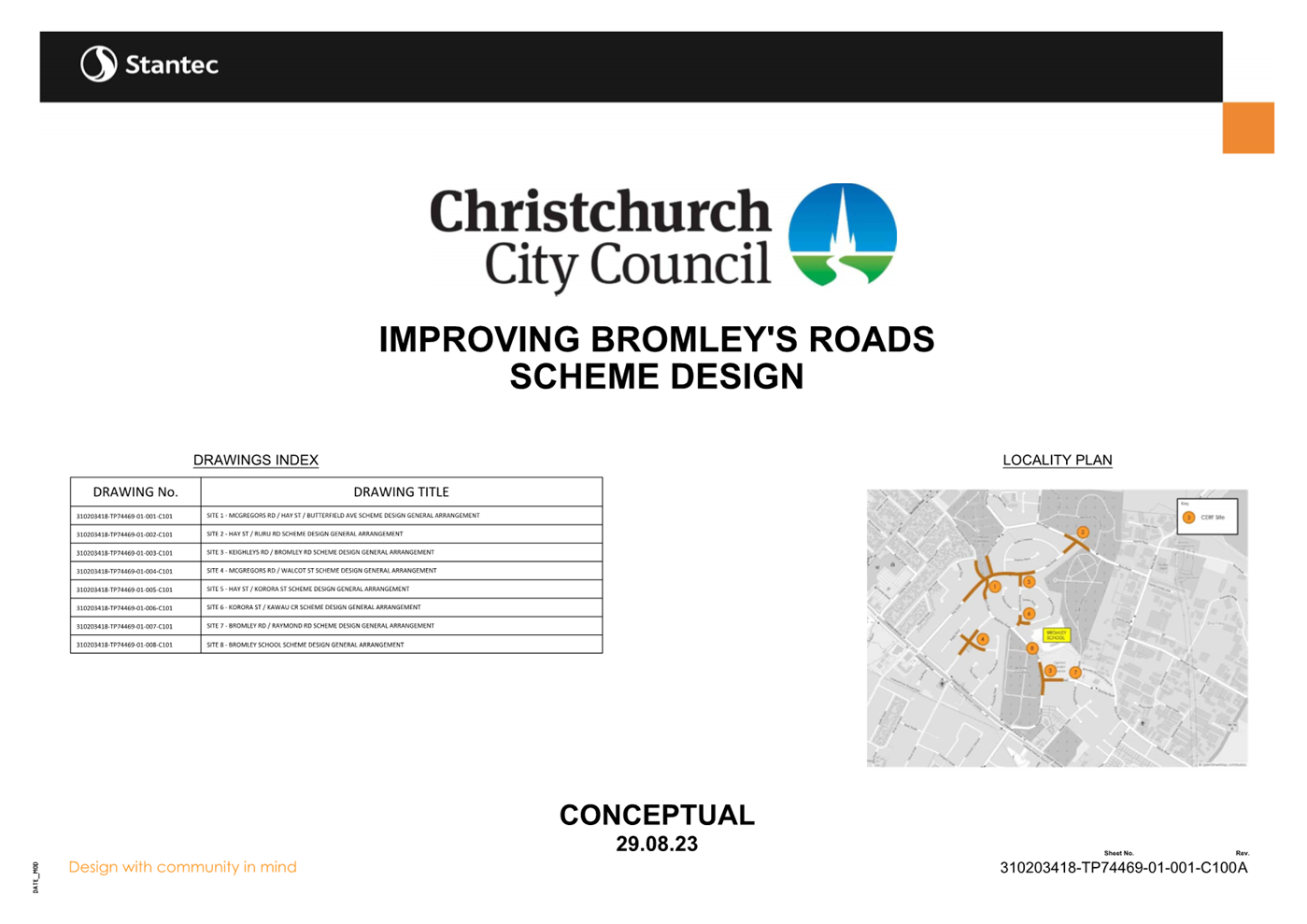
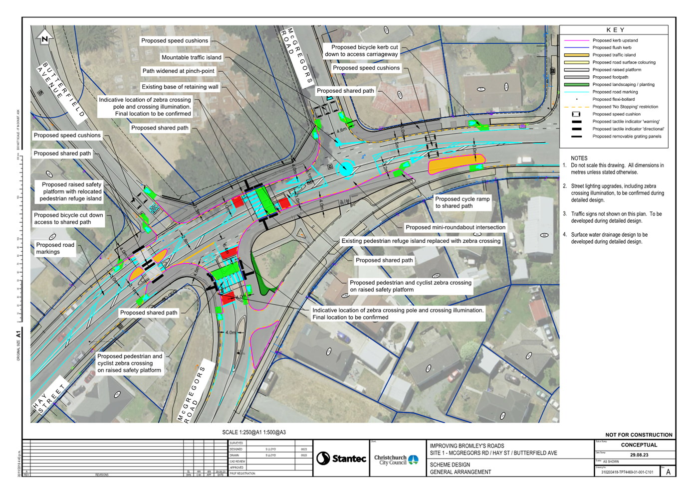

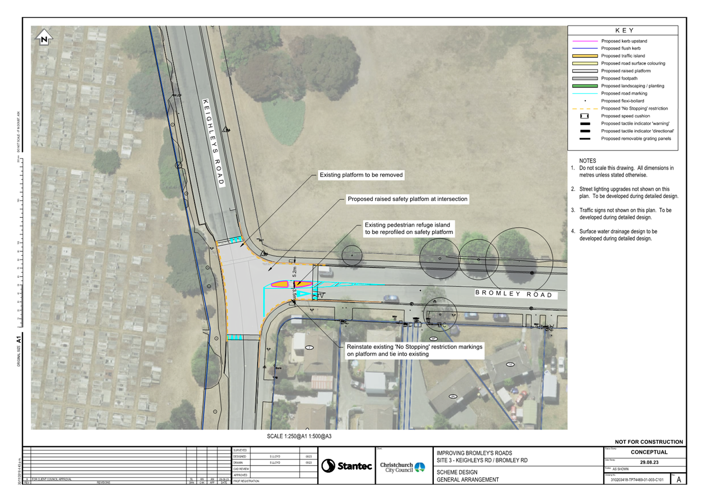
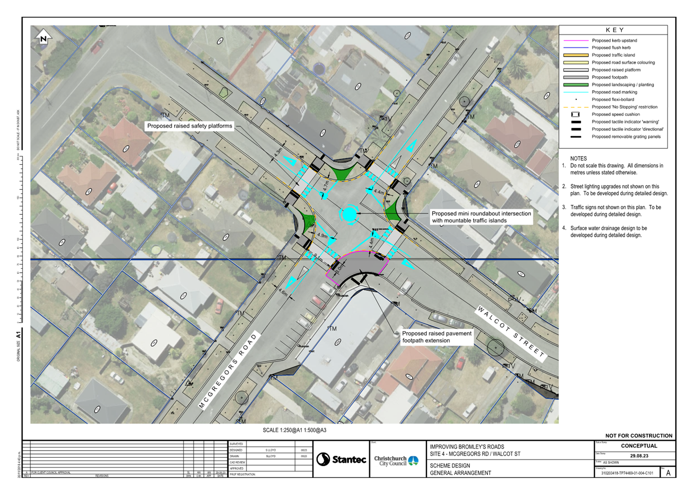
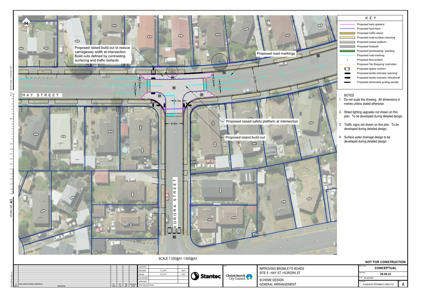
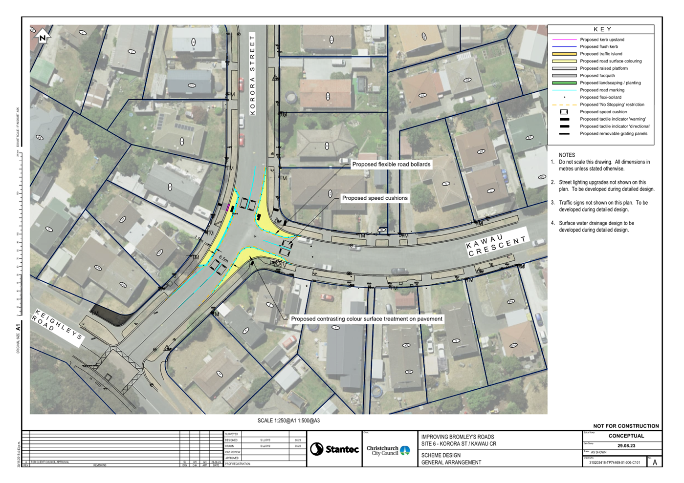
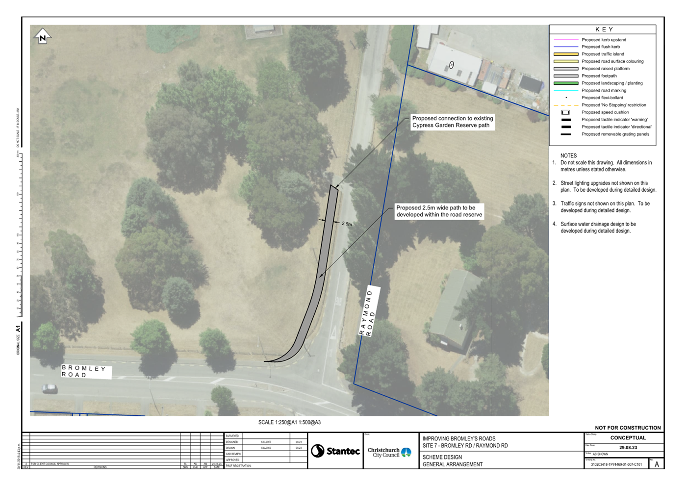
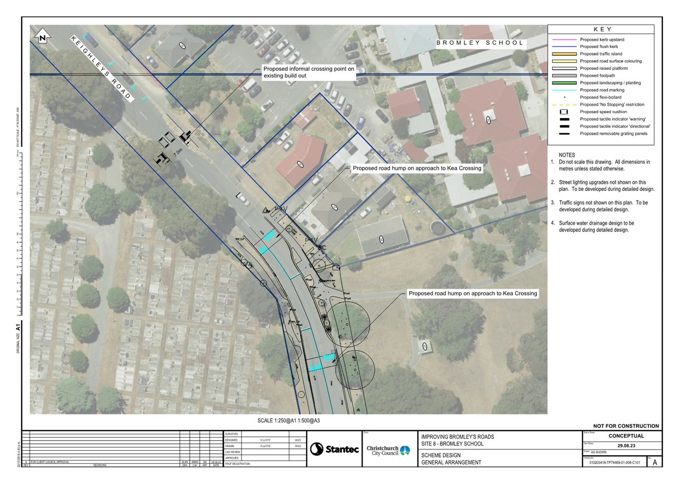
|
Council
21 September 2023
|
|
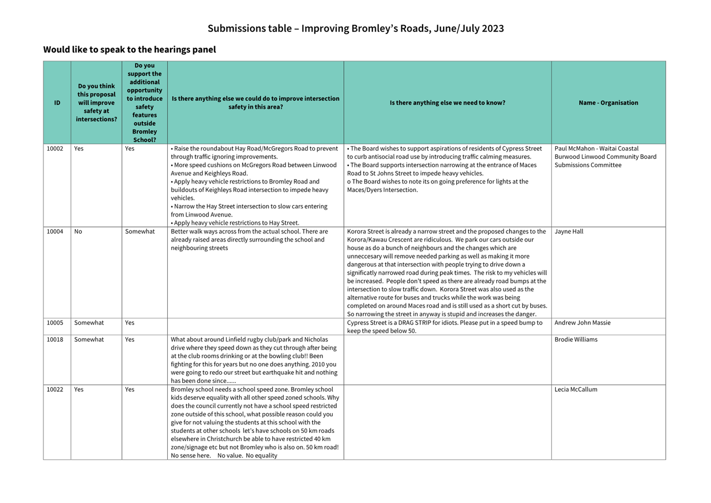
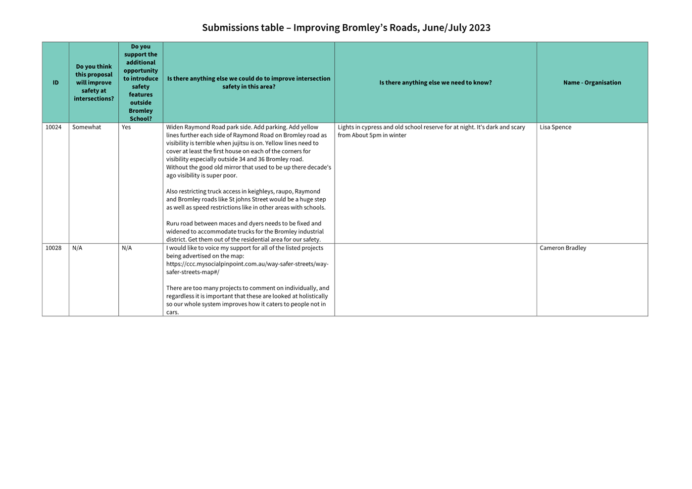
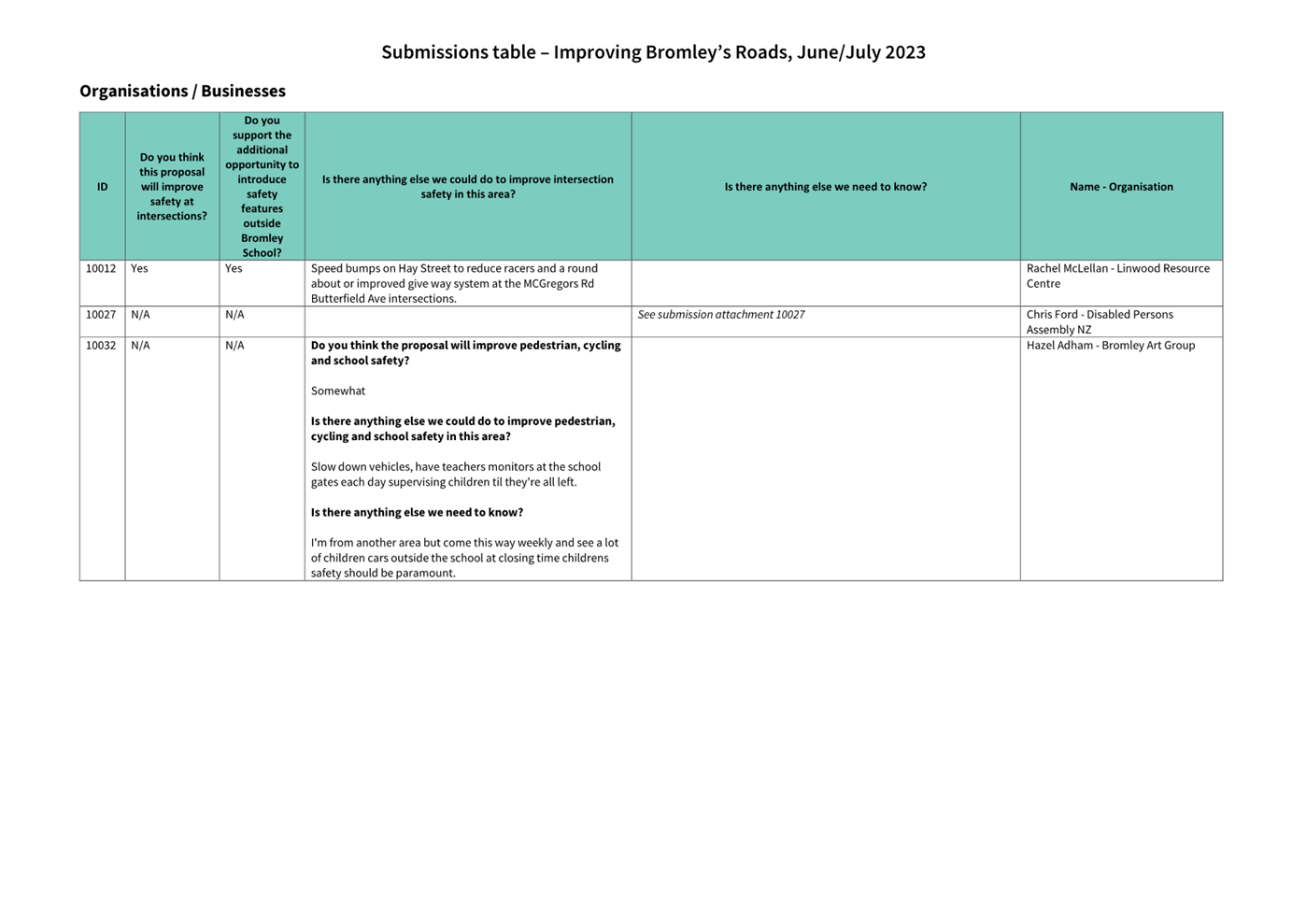
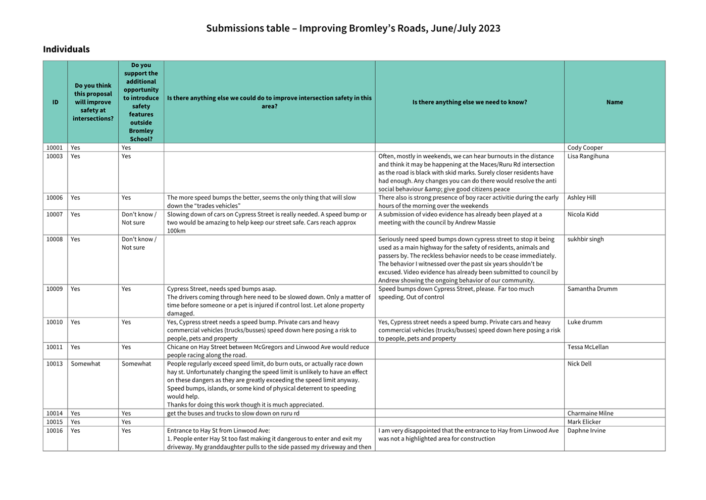
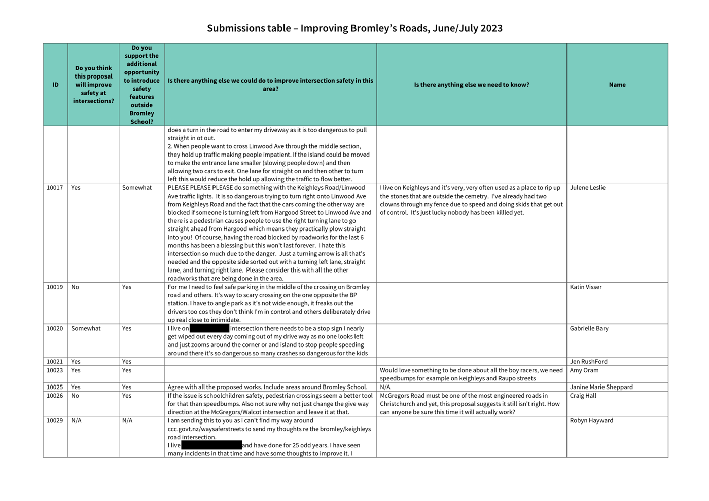
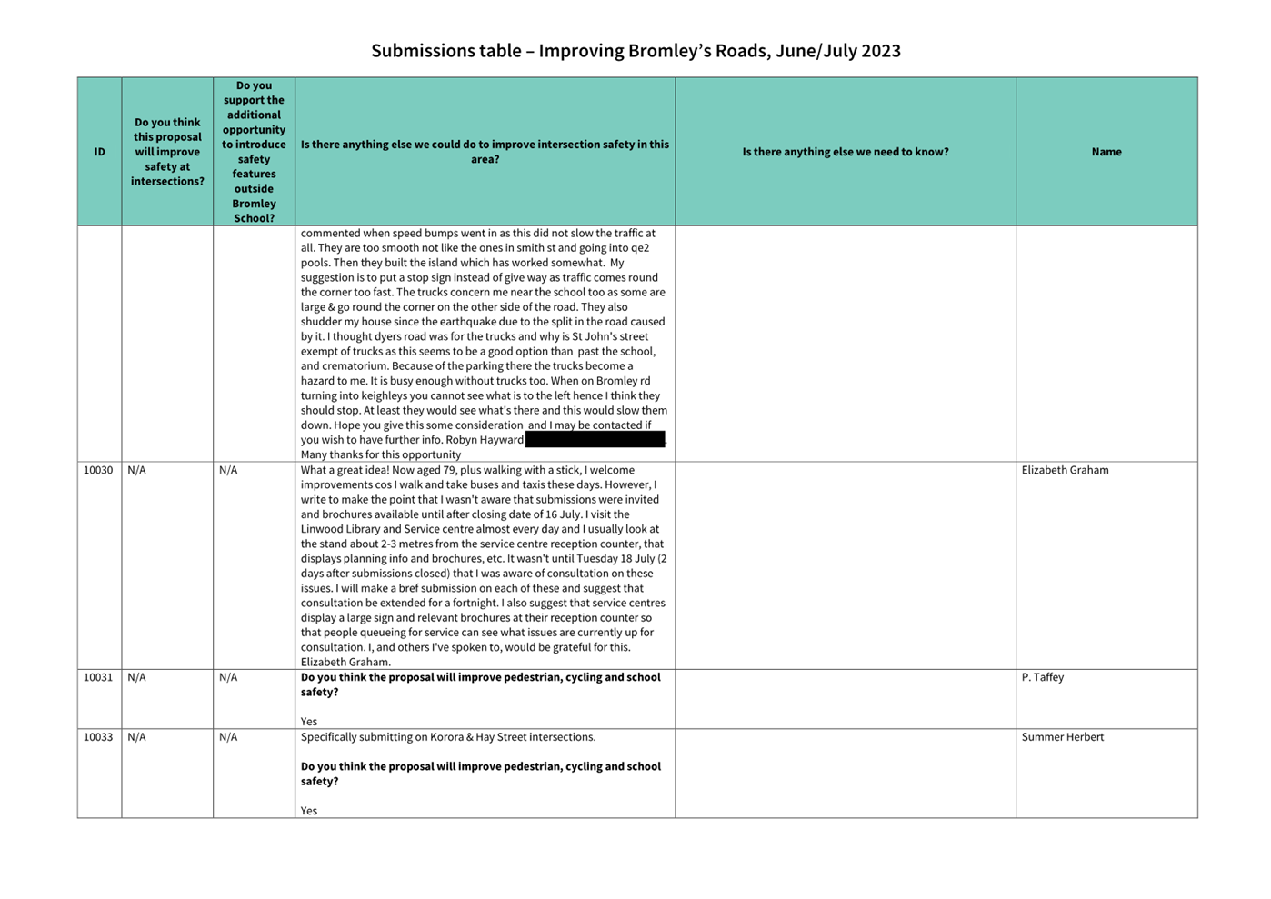
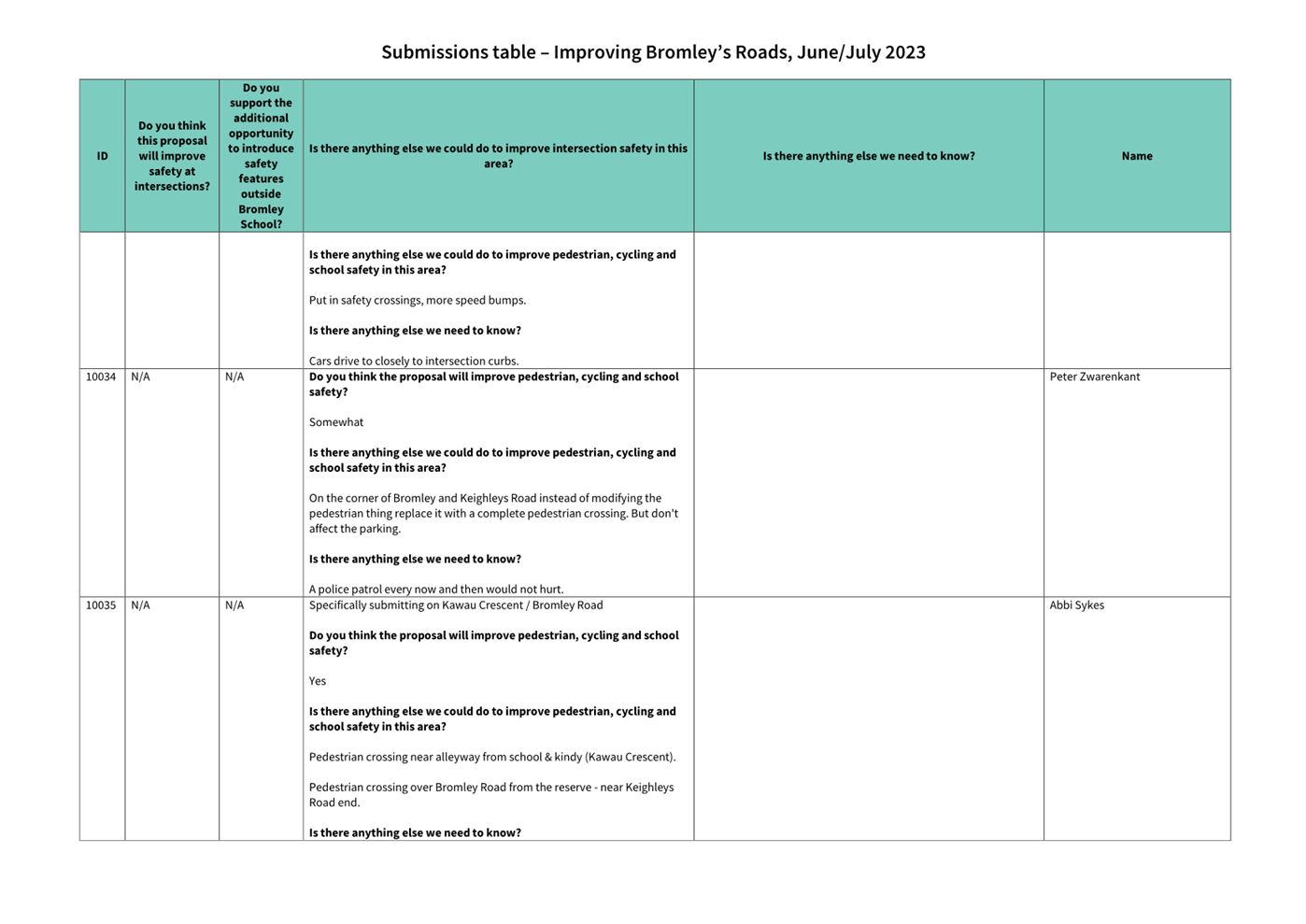
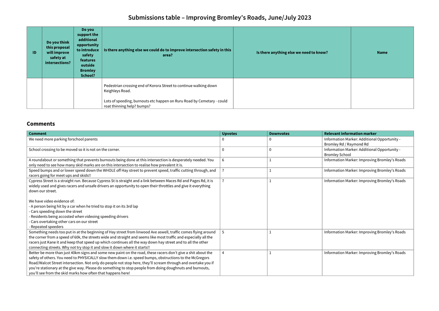
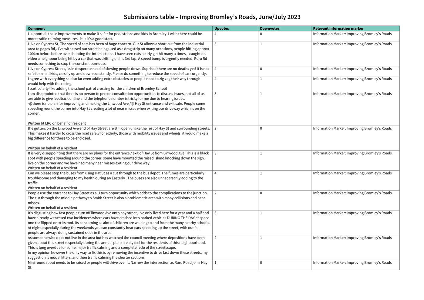
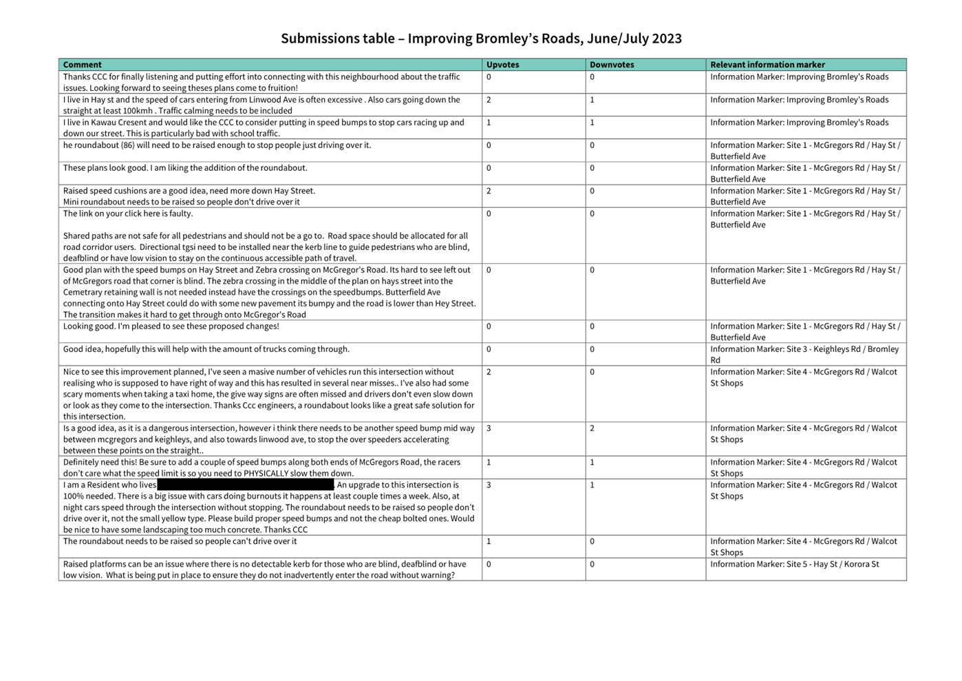
|
Council
21 September 2023
|
|
|
11. Transport Choices - Little River Link Cycle
Connections (Aidanfield)
|
|
Reference / Te Tohutoro:
|
23/1168838
|
|
Report of / Te Pou Matua:
|
Andrew
Cameron, Project Manager Transport, andrew.cameron@ccc.govt.nz;
Jacob Bradbury, Manager Planning & Delivery Transport,
Jacob.bradbury@ccc.govt.nz
|
|
Senior Manager / Pouwhakarae:
|
Lynette
Ellis, Head of Transport & Waste Management (Lynette.Ellis@ccc.govt.nz)
|
1. Nature of Issue and Report Origin
1.1 The purpose of this report is to inform the Council of
feedback received, and for the Council to approve the design to proceed to
construction for the Transport Choices Little River Link Cycle Connections
(Aidanfield) project.
1.2 The origin of this report is the Climate Emergency Response
Fund (CERF) Transport Choices programme.
1.3 The
decisions in this report are of medium significance in relation to the Christchurch
City Council’s Significance and Engagement Policy 2019. The
level of significance was determined by potential benefits and opportunities to
the council/community, the number of people affected and/or with an interest,
and that these projects span multiple community board areas, as set out in the
criteria of the policy (Page 2). This evaluation has considered the Transport
Choices projects as a cohesive programme of work. This is consistent with
how community engagement has been undertaken, with all work packages being
presented concurrently on Have your Say under the banner of Way Safer Streets.
2. Officer Recommendations Ngā
Tūtohu
That the Council:
1. Approves that construction of the Aidanfield
component of the Little River Link Cycle Connections project is conditional on
implementation costs being agreed and incorporated into the Transport Choices
Funding agreement between Waka Kotahi and Council.
2. Approves the changes to the layout of Nash
reserve including, planting, bridge, additional and widening of paths, as
generally shown on the plan TP362101 Issue 1, included within this report as Attachment
A.
3. Approves the removal of three trees and the
planting of six replacement trees as detailed in the tree assessment included
in this report as Attachment B .
3. Reason for Report Recommendations Ngā Take mō te
Whakatau
3.1 This
project is funded by the Central Government Transport Choices programme –
a $348 million national programme made available from the Climate Emergency
Response Fund.
3.2 The
Transport Choices programme is important because transport makes up almost half
of New Zealand’s carbon emissions. In May 2022, government released
its first Emissions Reduction Plan and transport has a significant role to
play, targeting a 20 percent reduction in light vehicle travel by 2035.
Reducing reliance on cars and supporting people to walk, cycle and use public
transport is one of three focus points of the Emissions Reduction Plan.
3.3 The Little River Link Cycle Connections project was
included within the Transport Choices programme due to alignment with the
“deliver strategic cycling/micro mobility networks” investment
category of the programme.
4. Alternative Options Considered Ētahi atu Kōwhiringa
The Transport
Choices Programme
4.1 Transport
Choices funding was allocated to Local Authorities through an Expression of
Interest process administered by Waka Kotahi. Through that process
Christchurch City Council submitted a package of projects that was developed by
consideration of:
· Project alignment with the
four investment criteria for Transport Choices funding: deliver strategic
cycling/micro mobility networks; create walkable neighbourhoods; support safe,
green, and healthy school travel; make public transport more reliable and
easier to use;
· Achieving diversity across
the four investment categories for Transport Choices funding;
· Focusing investments in
certain suburbs;
· Community requests for
infrastructure improvements aligned with the Transport Choices programme
outcomes;
· Complimenting existing
programmes, such as the Major Cycleway Routes programme;
· Project complexity and
ability to deliver prior to June 2024.
4.2 All
14 projects submitted for Transport Choices funding were accepted by Waka
Kotahi. However, in deciding to include the Transport Choices programme
in the Draft Annual Plan, Council decided to include 11 projects in the
programme and defer a number of business-as-usual projects by 12 months to
enable the Transport Choices programme to be adequately resourced.
Project Options Considered
4.3 As
this project aims to formalising a currently informal connection that has
significant use no further option was considered.
5. Detail Te Whakamahuki
5.1 The decision affects the following wards/Community Board areas:
5.1.1 Halswell
Ward
5.1.2 Waipuna
Halswell-Hornby-Riccarton Community Board
5.2 Formal
access for cyclists from the Aidanfield area to the Little River Major Cycle
Route is currently over one of the two Waka Kotahi bridges located on Awatea
Road and on Aidanfield Drive. Both bridges provide a 2m shared path which do
not connect into a dedicated cycle facility/shared path into the Aidanfield
area. Situated between these two bridges is an underpass that directly connects
to the Little River Major Cycle Route to the north of the motorway, and to the
south of the motorway connects into Nash Reserve via a grit path that runs for
approximately 100m south-east into the reserve. From the termination of this
path tracks have been worn across the grass to both Bronco Drive and towards
Date Crescent. A count of scooters, cyclists and pedestrians was taken on 30
March 2023 at the exit of the underpass on the Nash Reserve side of the
motorway. The data below shows the total count between 7am and 6:30pm. 70% of
the cyclists recorded north bound were between 7am and 8:30am with 70% of the
south bound cyclists between 3:30pm and 6:30 pm. This data would suggest that
this connection is currently a desired commuter link to the Little River Major
Cycle Route.
|
North Bound
|
South Bound
|
|
Scooter
|
Bicycle
|
Pedestrian
|
Scooter
|
Bicycle
|
Pedestrian
|
|
1
|
29
|
30
|
1
|
26
|
20
|
5.3 This
project proposes to provide the following.
· Work with Waka
Kotahi (as the Christchurch Southern Motorway Road Controlling Authority) to
remove flaxes on the exit of the underpass to address current CPTED concerns.
· Create a 3m wide
shared facility that exits onto Date Crescent and Bronco Drive.
· Replace the existing
bridge with a 3m wide bridge that sits above the 50-year high water level.
· Remove three
self-seeded willows that clash with the new bridge and create a CPTED concern.
· Plant six trees to
replace those removed.
· Realign the
connection of the existing grit path that heads east from the underpass to
create a safer alignment to the new shared path.
Responses to
consultation feedback
Opposition to the plan / location
5.4 There
was some negative sentiment around impact on green space, privacy, and view of
the reserve. Six replacement trees are proposed for the
playground area that will provide an increase to the tree diversity in the area,
shade within the playground and for the adjacent parking.
Address flooding and raise the path
as high as possible
5.5 Those
who raised this theme mentioned the bridge area in particular needing to be as
high as possible above flood levels. The bridge level will be raised
above the current 50-year high water level.
Connect to Bronco Drive path
5.6 There
is a well-trodden dirt path connection into Bronco
Drive near the playground that was not proposed to be upgraded
pre-consultation. Upgrading this connection has been included in the
proposed design as requested by the community.
Address visibility at corners
5.7 Addressing
visibility where paths connect with the Little River Major
Cycle Route, under the motorway. Vegetation removal is requested but those
who raised this theme requested if anything else can be done, such as mirrors,
and conducting safety audits on this point. Staff will work with Waka Kotahi to
address the issue of visibility created by planting on each side of the subway.
Install lighting
5.8 Both
general lighting and lighting under the bridge have been requested.
Council’s maintenance have been made aware that the underpass lights are
not operational. No additional lighting is proposed however the existing light
that currently lights the area to the south of the underpass will be optimised
to light this area including the new bridge.
Additional route extension requests
5.9 A
summary of other requests made is as follows:
· Improve
the overpass on Dunbars Road going to Halswell/Westlake
· Improve
connection with Somerville Crescent
· Create
a connection from Aidanfield to Ngā Puna Wai
· Connect
to McMahon Drive
· Improve
connectivity in Halswell to public transport and Quarryman’s trail
· Create
a mountain bike track amongst trees off of new path
5.10 These improvements are outside of the scope of this project.
Public Consultation Te Tukanga Kōrerorero
5.11 Local
residents received warm up flyers in their mailboxes from 29 May, indicating we
would be seeking feedback on Way Safer Streets projects proposed for their area
in June.
5.12 Early
engagement started in early June 2023, when all surrounding residents were
doorknocked with a letter and scheme plan, letting them know of the upcoming consultation
details. Early feedback was mixed, some residents welcomed the changes while
others were concerned about privacy and noise.
5.13 Consultation
started on 16 June 2023 and ran until 16 July 2023, as part of the wider Way
Safer Streets consultation. An email was sent to 150 key stakeholders across
the entire Way Safer Streets programme, including emergency services, Spokes,
AA, Disabled Persons Assembly, Blind Low Vision, Environment Canterbury,
Mahaanui Kurataiao, Halswell Residents Association, and Aidanfield Christian
School. The consultation was posted on the council Facebook page, as well as
local community groups, inviting submissions on the Social
Pinpoint Map.
5.14 During
consultation, emails were sent to those who expressed interest online in being
updated on Way Safer Streets. Two Newsline stories were published and picked up
by local media outlets. Digital screens were advertising the consultation in
Civic Offices, as well as newspaper advertising in The Star and The Southern
View. An online targeted advertising campaign ran for the
entire consultation period.
5.15 An
A3 sign was installed in Nash Reserve with a QR code which directed local
cyclists and pedestrians to the online consultation.
5.16 A
Christchurch-wide cycling event, “Christchurch Winter Solstice Matariki
Night Light Bike Ride” was attended, and flyers were distributed to
ensure cyclists were aware of the wider Way Safer Streets programme.
5.17 Key
stakeholder meetings throughout and after consultation, with Spokes, FENZ, St
John, NZ Police and Disabled Persons Assembly, further informed projects in the
Way Safer Streets program.
Summary of Submissions Ngā Tāpaetanga
5.18 Feedback
on the plans could be given by posting a comment on the Social
Pinpoint Map, by making a submission, or both.
5.19 A
total of 27 submissions and 22 comments were made on the project. 21
submissions were made in the interactive Social
Pinpoint Map, and six submissions were made via email/PDF. Submissions were
made by The Halswell Residents Association, the Disabled Persons Assembly, the
Waipuna Halswell-Hornby-Riccarton Community Board, and 24 individuals. All
submissions and comments are available in attachment B.
5.20 On
the Social
Pinpoint Map, the project received a total of 63 upvotes, 2 downvotes, and
22 comments.
5.21 Comment
sentiment was analysed in addition to submissions, where the majority of
comments were positive (68.2%):

5.22 Submitters
were asked how they travel through this area. The majority either walk (76.2%)
or cycle (76.2%):
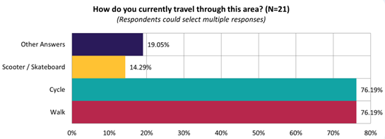
5.23 The
majority of submitters (85.7%) felt this proposal would improve safety for
cycling:
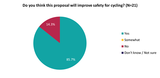
5.24 This
sentiment differed slightly depending on whether they live on the affected
streets (i.e. Bronco Drive, Annies Lane, Date Crescent), live in local suburbs
(e.g. Aidanfield, Wigram, Halswell, Hillmorton), or live elsewhere:
|
Do you think this proposal
will improve safety for cycling?
|
Live on affected streets
|
Live in local suburbs
|
Live elsewhere
|
|
No
|
3
|
0
|
0
|
|
Yes
|
5
|
11
|
2
|
5.25 Key
themes and requests from both comments and submissions are summarised below:
|
Key themes on outcomes of the
proposal
|
Number of comments
|
Number of submissions
|
Total mentions
|
|
Support
for the shared path
· Support for the project
adequately addressing existing safety concerns
|
16
|
8
|
24
|
|
Opposition
to the plan / location
· Negative sentiment around
impact on green space, privacy, and view of the reserve
· Potential to increase noise,
e-scooters, and antisocial behaviour
|
1
|
3
|
4
|
|
Requests
|
Number of comments
|
Number of submissions
|
Total mentions
|
|
Address
flooding and raise the path as high as possible
· Those who raised this theme
mentioned the bridge area in particular needing to be as high as possible
above flood levels
|
4
|
4
|
8
|
|
Connect
to Bronco Drive path
· Those who raised this theme
mentioned an existing muddy path connection into Bronco Drive near the
playground, which may as well be formalised as it becomes muddy and unsafe
during winter
|
4
|
3
|
7
|
|
Additional
route extension requests
· Improve the overpass on
Dunbars Road going to Halswell/Westlake (2)
· Improve connection with
Somerville Crescent (2)
· From Aidanfield to Ngā
Puna Wai (1)
· Connect to McMahon Drive (1)
· Improve connectivity in
Halswell to public transport and Quarryman’s trail (1)
· A mountain bike track amongst
trees off of new path (1)
|
4
|
3
|
7
|
|
Address
visibility at corners
· In particular addressing
visibility where paths connect with the MCR, under the motorway. Vegetation
removal is requested but those who raised this theme requested if anything
else can be done, such as mirrors, and conducting safety audits on this point
|
2
|
5
|
7
|
|
Make
the path as wide as possible
· Sharing the path with dogs,
cyclists and pedestrians requires a wide path
· Those who mentioned this theme
requested a 3.5-4m wide path, and a wider bridge
|
4
|
3
|
7
|
|
Install
lighting
· Both general lighting and
lighting under the bridge have been requested
|
3
|
3
|
6
|
6. Policy Framework Implications Ngā Hīraunga ā- Kaupapa here
Strategic
AlignmentTe Rautaki Tīaroaro
6.1 This report supports the Council's
Long Term Plan (2021 - 2031):
6.2 Transport
6.2.1 Activity: Transport
· Level of Service: 10.0.2 Increase the share of
non-car modes in daily trips - >=36% of trips undertaken by non-car modes
· Level of Service: 10.0.6.1 Reduce the number of
death and serious injury crashes on the local road network - <=100
crashes
· Level of Service: 10.0.41 Reduce emissions and
greenhouse gases related to transport - <=1.10 million tonnes of CO2
equivalents
· Level of Service: 10.5.1 Limit deaths and
serious injury crashes per capita for cyclists and pedestrians - <= 12
crashes per 100,000 residents
· Level of Service: 10.5.3 More people are
choosing to travel by cycling - >=12,500 average daily cyclist detections
· Level of Service: 10.5.2 Improve the perception
that Christchurch is a cycling friendly city - >=66% resident satisfaction
Policy
Consistency Te Whai
Kaupapa here
6.3 The
recommendations of this report are consistent with Council’s Plans and Policies, in particular:
6.3.1 The
changes proposed align with road safety and liveable streets goals in the
Christchurch Transport Strategic Plan 2012–2042, and similarly in the
draft Transport Plan (safe streets).
6.3.2 The
changes proposed align with Kia tūroa te Ao - Ōtautahi Christchurch
Climate Resilience Strategy as set out in the Climate Change Impact
Considerations section below.
Impact
on Mana Whenua Ngā
Whai Take Mana Whenua
6.4 Having
requested advice from the Treaty Relationships Team with regards to the project
constructing a bridge over the Heathcote river the below advice was provided:
6.4.1 The decision does not
involve a significant decision in relation to ancestral land or a body of water
or other elements of intrinsic value, therefore this decision does not
specifically impact Mana Whenua, their culture and traditions.
6.4.2 The decision does not
involve a matter of interest to Mana Whenua and will not impact on our agreed
partnership priorities with Ngā Papatipu Rūnanga.
6.4.3 The
completion of this project, replacing a small footbridge and enhancing access
to connected cycle paths in this area of the city and district, will bring
positive outcomes for the whole community and can contribute to people’s
wellbeing and safety.
Climate
Change Impact Considerations Ngā Whai Whakaaro mā te Āhuarangi
6.5 The
decisions in this report are likely to:
6.5.1 Contribute
neutrally to adaptation to the impacts of climate change.
6.5.2 Contribute
positively to emissions reductions.
6.6 The
emission reductions associated with this project have not been estimated.
6.7 The Government’s Emissions Reduction Plan states we
will have to ‘substantially improve infrastructure for walking and
cycling’ to meet our emissions targets (including a 20% reduction in
light Vehicle Kilometres Travelled by 2035 - required under the Emissions
Reduction Plan). Improving the quality of our streets for walking and cycling
is also a key part of the Ministry of Transport and Waka Kotahi’s efforts
to decarbonise the transport system.
6.8 New
Zealander has the 5th highest transport emissions rate per capita
among the 43 OECD countries. Petrol or diesel car use is typically the
single-biggest contributor to an individual’s carbon footprint in New
Zealand.
6.9 From
the 2022 Life in Christchurch Transport Survey, 96 percent of respondents
travel by car. Respondents find car travel the least difficult means of
travel. Inconsiderate and dangerous behaviour from other road users and
sharing the road with cars were the main reasons respondents found it difficult
to bike.
6.10 The
proposed changes make it safer for people walking and cycling, which will have a net positive impact for the climate by
helping to reduce transport emissions. Enabling more people to walk or cycle,
particularly for local journeys, is a key part of council’s emissions
reduction efforts by providing a safe, low emission way for residents to move
around the city.
Accessibility
Considerations Ngā
Whai Whakaaro mā te Hunga Hauā
6.11 This proposal improves accessibility for people walking and
cycling, by providing a safer means of accessing and using our street network.
6.12 Waka
Kotahi developed a set of Project Design Parameters to ensure all projects work
to collectively meet the programme objectives. The Project Design
Parameters require that “the infrastructure should be designed for
children and people with visual, mobility, or cognitive impairments. If the
infrastructure works for them, it will work for a wider spectrum of the
population who are interested in walking and cycling but concerned for their
safety.” Transport Choices projects have been designed in
accordance with these requirements.
7. Resource Implications Ngā Hīraunga Rauemi
Capex/Opex Ngā Utu Whakahaere
7.1 Cost
to Implement - the estimate to implement the project is $550,000 This is
inclusive of all project costs.
7.2 Maintenance/Ongoing
costs – generally consistent with existing maintenance costs. The net
maintenance cost for the full Transport Choices programme will have an ongoing
rates impact of approximately 0.01%, which will be included in the draft Long
Term Plan proposed budgets.
7.3 Funding
Source – Councils capital programme:
7.3.1 ID
72760, Transport Choices 2022 – Little River Cycle Connections $4,303,242
7.4 Waka
Kotahi through the Transport Choices programme will be funding the project up
to an agreed value which is calculated as 90% of the expected implementation
cost. The remaining 10% is Council’s share.
7.5 Under
the cost share agreement with Waka Kotahi, funding approvals for individual
Transport Choices projects are approved through two stage gates: design and
physical works. All Transport Choices projects have agreed funding schedules
for design. Individual project schedules for physical works are required to be
agreed and approved prior to 20 October 2023. In approving funding for physical
works, Waka Kotahi will consider:
7.5.1 The
project is in accordance with the scope and design approved by Waka
Kotahi.
7.5.2 Project
costs are in accordance with expectations.
7.5.3 Ability
to deliver the project prior to June 2024.
7.6 The
staff recommendations of this report include that Council’s approval of
this project is conditional on a funding agreement with Waka Kotahi being in
place for the physical works.
8. Legal Implications Ngā Hīraunga ā-Ture
Statutory power to undertake proposals in the report
Te Manatū Whakahaere Kaupapa
8.1 Council
resolved the Transport Choices programme as Metropolitan Significance when the
programme was included in the draft Annual Plan in February 2023.
8.2 Council
retains decision-making responsibilities that might otherwise be delegated in
accordance with the Delegations Register when a project is determined as
Metropolitan Significance.
8.3 Part
1, Clauses 7 and 8 of the Christchurch City Council Traffic and Parking Bylaw
2017 provides Council with the authority to install parking restrictions by resolution.
8.4 The
installation of any signs and/or markings associated with traffic control
devices must comply with the Land Transport Rule: Traffic Control Devices 2004.
Other Legal Implications Ētahi atu
Hīraunga-ā-Ture
8.5 There
is no legal context, issue or implication relevant to this decision.
9. Risk Management Implications Ngā Hīraunga Tūraru
9.1 Scope
– Waka Kotahi has governed the scope and design of the project to align
with programme KPI’s and consistency with Transport Choices design
parameters. Departing from the recommendations of this report creates a risk
that Waka Kotahi would not agree to fund the physical works phase of the
project.
9.2 Delivery
– Transport Choices funding is subject to delivery being complete by June
2024. Waka Kotahi has established additional milestones to track
progress. Delays in approval of the projects would impact on the
timeframe for delivery.
9.3 Funding
security - the Transport Choices funding agreement between Council and Waka
Kotahi presently covers this project for design only, and a further stage gate
approval is required to gain funding approval for construction. The
instruction of physical works will be withheld until an implementation
agreement is in place.
9.4 Implementation
cost uncertainty – the funding agreement with Waka Kotahi places the risk
of cost variations with Council. This risk is being managed by minimising
price uncertainty and building contingency into the funding agreement.
Attachments Ngā Tāpirihanga
|
No.
|
Title
|
Reference
|
Page
|
|
a ⇩ 
|
Scheme plan
|
23/1387786
|
464
|
|
b ⇩
|
Tree
Assessment
|
23/1360929
|
465
|
|
c ⇩ 
|
Aidanfield -
Submission Table (Public)
|
23/1365921
|
468
|
In addition to the attached documents, the following background
information is available:
|
Document
Name – Location / File Link
|
|
Not
applicable
|
Confirmation of Statutory
Compliance Te Whakatūturutanga ā-Ture
|
Compliance with Statutory Decision-making
Requirements (ss 76 - 81 Local Government Act 2002).
(a) This report contains:
(i) sufficient information about all reasonably practicable
options identified and assessed in terms of their advantages and
disadvantages; and
(ii) adequate consideration of the views and preferences of
affected and interested persons bearing in mind any proposed or previous
community engagement.
(b) The information reflects the level of significance of the
matters covered by the report, as determined in accordance with the Council's
significance and engagement policy.
|
Signatories Ngā Kaiwaitohu
|
Authors
|
Ryan Rolston -
Programme Manager
Andrew Cameron
- Project Manager
Wayne Gallot -
Senior Transportation Engineer
Samantha Smith
- Engagement Advisor
Ann Tomlinson
- Project Manager
|
|
Approved By
|
Jacob Bradbury
- Manager Planning & Delivery Transport
Tony
Richardson - Finance Business Partner
Lynette Ellis
- Head of Transport & Waste Management
|
|
Council
21 September 2023
|
|
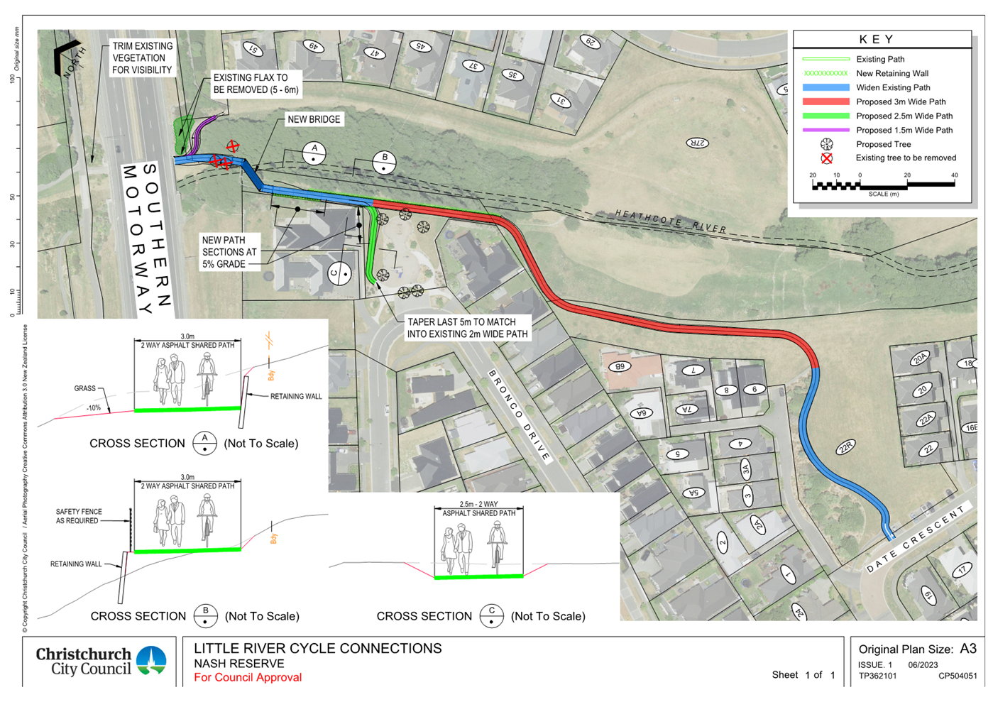
|
Council
21 September 2023
|
|
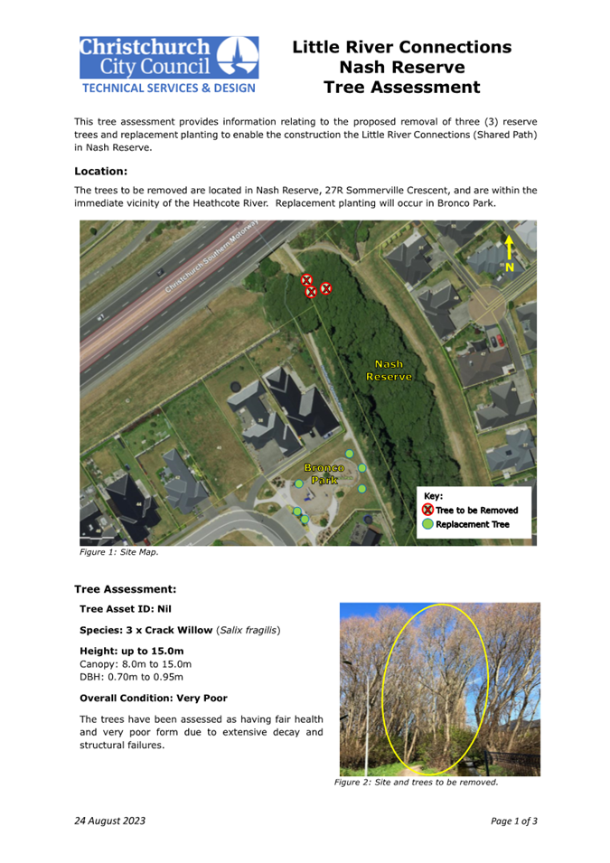
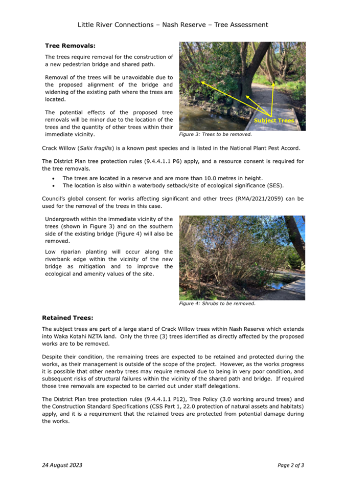
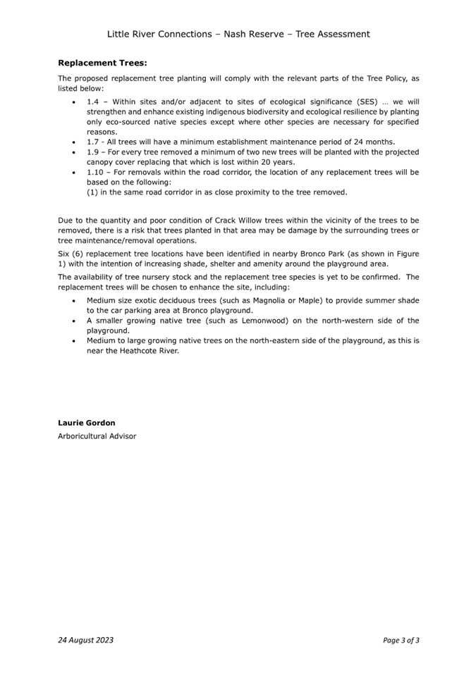
|
Council
21 September 2023
|
|
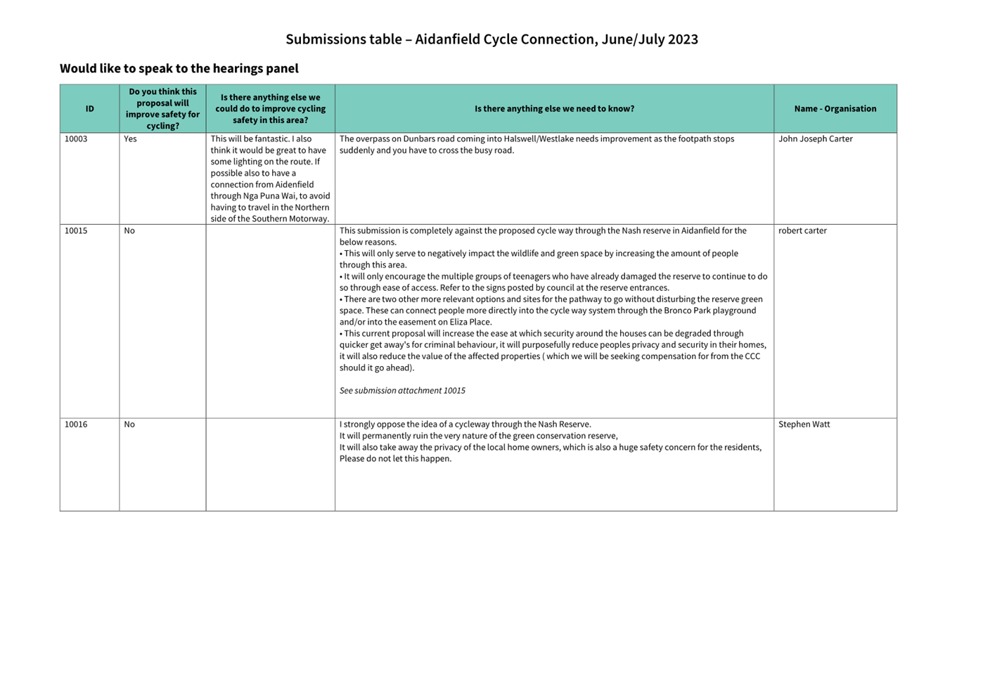
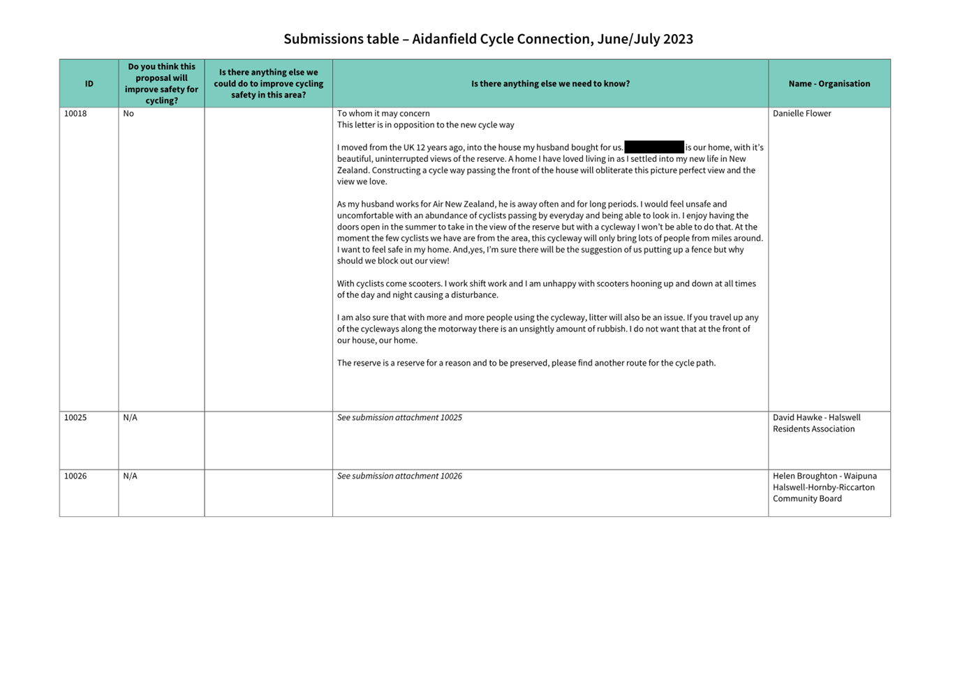
|
Council
21 September 2023
|
|
|
12. Transport Choices - Linwood and Woolston
Improvements (Rhona Street)
|
|
Reference / Te Tohutoro:
|
23/1168984
|
|
Report of / Te Pou Matua:
|
Lisa-Maria
Biggar, Project Manager Transport,
lisa-maria.biggar@ccc.govt.nz
Jacob Bradbury, Manager Planning & Delivery Transport,
jacob.bradbury@ccc.govt.nz
|
|
Senior Manager / Pouwhakarae:
|
Lynette
Ellis, Head of Transport & Waste Management (Lynette.Ellis@ccc.govt.nz)
|
1. Nature of Issue and Report Origin
1.1 The purpose of this report is to inform the Council of
feedback received, and for the Council to approve the design to proceed to
construction for the Linwood and Woolston Improvements (Rhona Street) project.
1.2 The origin of this report is the Climate Emergency Response
Fund (CERF) Transport Choices programme.
1.3 The
decisions in this report are of medium significance in relation to the Christchurch
City Council’s Significance and Engagement Policy 2019. The
level of significance was determined by potential benefits and opportunities to
the council/community, the number of people affected and/or with an interest,
and that these projects span multiple community board areas, as set out in the
criteria of the policy (Page 2). This evaluation has considered the Transport
Choices projects as a cohesive programme of work. This is consistent with
how community engagement has been undertaken, with all work packages being
presented concurrently on Have your Say under the banner of Way Safer Streets.
2. Officer Recommendations Ngā
Tūtohu
That the Council:
1. Approves construction of the Linwood and
Woolston Improvements (Rhona Street) project subject to implementation costs
being agreed and incorporated into the Transport Choices Funding agreement
between Waka Kotahi and Council.
2. Approves the following recommendations
required for the implementation of the project, relying on its powers under the
Christchurch City Council Traffic and Parking Bylaw 2017 and Part 21 of the
Local Government Act 1974.
3. Approves all road surface treatments, traffic
islands, kerb alignments, traffic calming devices and road markings on Rhona
Street, commencing at its intersection with Buckleys Road, and extending in
north-westerly direction to the end (school boundary), as detailed on plan
TG361702, sheet 1, dated 18/08/2023 and attached to this report as Attachment
A.
4. Approves that in accordance with Section 4 and
Section 10.3 of the Land Transport Rule: Traffic Control Devices 2004 that the
northwest approach of Rhona Street at its intersection with Buckleys Road be
controlled by a Give Way.
5. Approves that the stopping of all vehicles be
prohibited at all times, in accordance with Clause 7 of the Christchurch City
Council Traffic & Parking Bylaw 2017, on the north-eastern side of Rhona
Street commencing at its intersection with Buckleys Road and extending in a
north westerly direction for a distance of 22 metres.
6. Approves that the stopping of all vehicles be
prohibited at all times, in accordance with Clause 7 of the Christchurch City
Council Traffic & Parking Bylaw 2017, on the north-eastern side of Rhona
Street commencing at a point 62 metres northeast of its intersection with
Buckleys Road and extending in a north westerly direction for a distance of
nine metres.
7. Approves that the stopping of all vehicles be
prohibited at all times, in accordance with Clause 7 of the Christchurch City
Council Traffic & Parking Bylaw 2017, on the north-eastern side of Rhona
Street commencing at a point 127 metres northeast of its intersection with
Buckleys Road and extending in a north westerly direction for a distance of
nine metres.
8. Approves that the stopping of all vehicles be
prohibited at all times, in accordance with Clause 7 of the Christchurch City
Council Traffic & Parking Bylaw 2017, on the north western end of
Rhona Street adjoining the property boundary of No.15 / 15A McLean Street (Te
Pā o Rākaihautū School), and extending across the vehicle
entrance and along the kerb build out in front of No.46 Rhona Street, as detailed on plan TG361702, sheet 1, dated 18/08/2023
and attached to this report as Attachment A.
9. Approves that the stopping of all vehicles be
prohibited at all times, in accordance with Clause 7 of the Christchurch City
Council Traffic & Parking Bylaw 2017, on the south-western side of Rhona Street
commencing at its intersection with Buckleys Road and extending in a north
westerly direction for a distance of 17 metres.
10. Approves that the stopping of all vehicles be
prohibited at all times, in accordance with Clause 7 of the Christchurch City
Council Traffic & Parking Bylaw 2017, on the south-western side of Rhona
Street commencing at a point 62 metres northeast of its intersection with
Buckleys Road and extending in a north westerly direction for a distance of
nine metres.
11. Approves that the stopping of all vehicles be
prohibited at all times, in accordance with Clause 7 of the Christchurch City
Council Traffic & Parking Bylaw 2017, on the south-western side of Rhona
Street commencing at a point 128 metres northeast of its intersection with
Buckleys Road and extending in a north westerly direction for a distance of
nine metres.
12. Approves that the stopping of all vehicles be
prohibited at all times, in accordance with Clause 7 of the Christchurch City
Council Traffic & Parking Bylaw 2017, on the north-western side of Buckleys
Road commencing at its intersection with Rhona Street and extending in a north
easterly direction for a distance of seven metres.
13. Approves that the stopping of all vehicles be
prohibited at all times, in accordance with Clause 7 of the Christchurch City
Council Traffic & Parking Bylaw 2017, on the north-western side of Buckleys
Road commencing at its intersection with Rhona Street and extending in a south
westerly direction for a distance nine metres.
14. Revokes any previous resolutions pertaining to
traffic controls made pursuant to any bylaw to the extent that they are in
conflict with the traffic controls described in 4 to 13.
15. Approves that these resolutions take effect
when parking signage and/or road marking that evidence the restrictions
described in 4 to 14 are in place (or removed in the case of revocations).
3. Reason for Report Recommendations Ngā Take mō te
Whakatau
3.1 This
project is funded by the Central Government Transport Choices programme –
a $348 million national programme made available from the Climate
Emergency Response Fund.
3.2 The
Transport Choices programme is important because transport makes up almost half
of New Zealand’s carbon emissions. In May 2022, government released
its first Emissions Reduction Plan and transport has a significant role to
play, targeting a 20 percent reduction in light vehicle travel by 2035.
Reducing reliance on cars and supporting people to walk, cycle and use public
transport is one of three focus points of the Emissions Reduction Plan.
3.3 The
Linwood and Woolston Improvements project was
included within the Transport Choices programme due to alignment with the
“creating walkable networks” investment category of the
programme.
4. Alternative Options Considered Ētahi atu Kōwhiringa
The Transport
Choices Programme
4.1 Transport
Choices funding was allocated to Local Authorities through an Expression of
Interest process administered by Waka Kotahi. Through that process
Christchurch City Council submitted a package of projects that was developed by
consideration of:
· Project alignment with the
four investment criteria for Transport Choices funding: deliver strategic
cycling/micro mobility networks; create walkable neighbourhoods; support safe,
green, and healthy school travel; make public transport more reliable and
easier to use.
· Achieving diversity across
the four investment categories for Transport Choices funding.
· Focusing investments in
certain suburbs.
· Community requests for
infrastructure improvements aligned with the Transport Choices programme
outcomes.
· Complimenting existing
programmes, such as the Major Cycleway Routes programme.
· Project complexity and
ability to deliver prior to June 2024.
4.2 All
14 projects submitted for Transport Choices funding were accepted by Waka
Kotahi. However, in deciding to include the Transport Choices programme
in the Draft Annual Plan, Council decided to include 11 projects in the
programme and defer several business-as-usual projects by 12 months to enable
the Transport Choices programme to be adequately resourced.
Project Options
4.3 The
options considered for the whole scheme included:
· Do nothing.
Footpath improvement element
· Improve pedestrian access
to Te Pā o Rākaihautū School through either widening the
footpath on both sides of Rhona Street or;
· Only on the footpath on
south-western side.
Traffic calming element
· Speed humps only, with
on-street parking retained.
· Speed humps combined with
road narrowing achieved by kerb buildouts and loss of on-street parking at the
kerb buildouts.
At the school end of the street
· Provide a new curved
turning head.
· Provide a short footpath
connection to Te Pā o Rākaihautū School without a new turnaround
area.
At the Buckleys Road intersection
· Provide a Give Way
Control, with pedestrian refuge island and speed hump.
· Provide a narrow
intersection threshold, with kerb buildouts and speed hump.
Project
Options Selection
4.4 The
preferred option was chosen for the following reasons:
· Widening the footpath on
the south-western side will provide the best improvements for the school,
particularly for students walking to and from the Linwood pool for swimming
lessons. It encourages students to stay on the south-western side of
Rhona Street to use the existing traffic signals with the signalised pedestrian
crossing on Buckleys Road to the southwest side of Rhona Street.
· Traffic calming using
speed humps combined with road narrowing is more effective in speed reduction
since many vehicles are not discouraged by speed humps alone, yet all drivers
tend to slow down whilst approaching a road narrowing. The associated
kerb buildouts have been located between driveways to minimise the loss of
on-street parking and to provide opportunities for streetscapes.
· At the end of the street,
while a full turning head would assist some vehicles, this has been considered
by the local residents as being of negligible benefit that would not justify
the removal of several parking spaces. Instead, the short footpath connection
at the school end of the street minimises the loss of on-street parking with a
turning head while providing connection for pedestrians between the school and
the footpath.
· The pedestrian refuge
island and speed hump treatment at the Buckleys Road intersection will be
consistent with the proposal for the Buckleys Road/McLean Street intersection
to the south. The pedestrian refuge island reduces the crossing distance
for pedestrians and enables them to cross Rhona Street in two stages.
· The option meets the project objectives and is able to be delivered
within the constrained Transport Choices programme timeframe.
5. Detail Te Whakamahuki
5.1 The decision affects the following wards/Community Board areas:
5.1.1 Linwood
Ward
5.1.2 Waitai
Coastal-Burwood-Linwood Community Board
5.2 The
purpose of the project is to improve walking connections to Te Pā o Rākaihautū School and
provide traffic calming along Rhona Street by means of:
· Providing a kerb buildout
and path on Rhona Street at the school access connecting to the south-western
footpath on Rhona Street.
· Footpath widening on the
south-western side of Rhona Street. The footpath will be 2.2 metres wide
along the kerb, which is an improvement on the existing footpath that is
under-width and obstructed by poles.
· Traffic calming with speed
humps and kerb buildouts along Rhona Street. The road width at the buildouts is
6 metres, which compares to the current 14 metres wide.
· Lighting upgrades.
· Street trees and
landscaping at the kerb buildouts.
· A pedestrian refuge island
with speed hump and Give Way control on Rhona Street at its intersection with
Buckleys Road.
· Tactile pavers on Rhona
Street at the intersection with Buckleys Road.
· No stopping restrictions
at various locations.
· Drainage
improvements.
5.3 To implement this scheme, there will be a loss of eight on-street
parking spaces on Rhona Street - four parking spaces at the kerb buildouts with
speed humps and four parking spaces at the Rhona Street/Buckleys Road
intersection.
Public Consultation Te Tukanga Kōrerorero
5.4 Early
engagement started in late May 2023 when staff met with Te Pā o
Rākaihautū School to brief them on the project.
5.5 Local
residents received warm up flyers in their mailboxes from 29 May, indicating we
would be seeking feedback on Way Safer Streets projects proposed for their area
in June.
5.6 Staff
attended a LinWard collective hui (consisting of Te Whare Taonga o Ngā Iwi
Katoa - Linwood Resource Centre, Bromley Community Trust, The Loft, CCC
Libraries, Christchurch Methodist Mission and St Chads Church and Linwood
Avenue Corner Trust) to brief them on Way Safer Streets projects in early June
2023. Recommended engagement tactics were taken on board.
5.7 Consultation
started on 16 June and ran until 16 July 2023, as part of the wider Way Safer
Streets consultation. An email was sent to 150 key stakeholders across the
entire Way Safer Streets programme, including emergency services, Spokes, The
New Zealand Automobile Association, Disabled Persons Assembly, Blind Low Vision
group, ECan, Mahaanui Kurataiao, Te Pā o Rākaihautū School, and
The Loft at Eastgate.
5.8 The
consultation was posted on the Council Facebook page, as well as local
community group pages, inviting submissions on the Social
Pinpoint Map. The consultation plan is provided as Attachment B.
5.9 Residents
in the project area were doorknocked and provided with scheme plans in June
2023, where feedback was mostly positive, and residents spoke of existing
safety issues, speeding, and drainage concerns.
5.10 Two
Newsline stories were published and picked up by local media outlets. There
were digital screens advertised the consultation in Civic Offices and Linwood
Library, as well as newspaper advertisements in The Star and The Pegasus Post.
Digital billboards were used in Linwood, including at the Aldwins Road/Buckleys
Road/Linwood Ave intersection, at bus shelters, and outside Eastgate mall.
Footpath decals with QR codes to the consultation were used in the Linwood and
Bromley project areas. An online targeted campaign ran for the entire
consultation period.
5.11 During
consultation, flyers were delivered to residents in the local area, and emails
were sent to those who expressed interest in being updated on Way Safer
Streets.
5.12 Consultation
documents and flyers were delivered to Bromley Community Centre, Linwood Union
Church, Linwood Library, and Linwood Resource Centre and Community Gardens.
These included opportunities to make physical and written submissions.
5.13 A
street meeting was hosted after consultation closed on 21 June 2023, with
residents of Rhona Street, McLean Street and staff from Te Pā o
Rākaihautū School. Residents raised concerns with drainage, the
proposed loss of parking, the location proposed, the turning head and footpath
design, and tree loss. They asked where the rationale for the project had come
from, and asked staff to investigate a project on McLean Street. Staff from Te
Pa o Rakaihautu School agreed with community suggestions made, and staff
committed to updating the plan to accommodate the requests where possible, and
advised that others (such as drainage) would be addressed through detailed
design.
5.14 There
were key stakeholder meetings throughout and after consultation, with Spokes,
FENZ, St John, NZ Police and Disabled Persons Assembly. The information
gathered also informed other projects in the Way Safer Streets program.
Summary of Submissions Ngā Tāpaetanga
5.15 Feedback
on the scheme could be given by posting a comment on the Social
Pinpoint Map, or by making a written or verbal submission.
5.16 A
total of nine submissions and 12 comments were made on the project. Four
submissions were made in the interactive Social
Pinpoint Map, and five submissions were made via email/PDF. Submissions
were made by the Disabled Persons Assembly, the Waitai Coastal-Burwood-Linwood
Community Board and seven individuals. All submissions and comments are
available in Attachment C.
5.17 On
the Social
Pinpoint Map, the project received a total of 19 upvotes, 11 downvotes, and
12 comments.
5.18 Comment
sentiment was analysed in addition to submissions, where half of the comments
were negative (50.0%), and another third (33.3%) were mixed.
5.19 Submitters
were asked for their methods of travel through this area. Half of the
submitters use it to walk (50.0%):
5.20 The
majority of submitters felt this proposal would improve safety for tamariki
travelling to school (75.0%):

5.21 Key
themes and requests from both comments and submissions are summarised below.
Note that there could be cross-over between those making comments and making
submissions:
|
Key themes on outcomes of
the proposal
|
Number of comments
|
Number of submissions
|
Total mentions
|
|
Existing
pedestrian safety concerns
· Speeding, flooding and
footpath condition
|
4
|
5
|
9
|
|
Support
for the overall project
· This theme covers how changes
would be beneficial to residents, and would address existing safety concerns
|
4
|
4
|
8
|
|
Concern
this project would make safety worse
· There was general concern
that it does not fully address pedestrian safety, as well as driver safety
when coming out of driveways, and encouraging more traffic to use the school
entrance
|
5
|
2
|
7
|
|
Concern
toward the turning head at the school end
· Concern on parking removal,
and the idea that this would encouraging more cars to use this entrance to
the school, and leading to increased antisocial behaviour at the end of the
street
|
4
|
3
|
7
|
|
Concern
on loss of parking
· Parking already a premium,
due to school vehicles and increased housing intensification
|
2
|
2
|
4
|
|
Requests
|
Number
of comments
|
Number
of submissions
|
Total
mentions
|
|
Prioritise
speed bumps
· The addition of speed humps
was welcomed, and requested to be the focus, instead of a turning head at the
school entrance
|
6
|
2
|
8
|
|
Investigate
a project at McLean Street
· Instead of Rhona Street, as
McLean is the main school entrance
|
4
|
2
|
6
|
|
Fix
drainage/flooding
· Requests came through to
address drainage and flooding as a priority before doing any work
|
2
|
1
|
3
|
Changes made to the
scheme design as a result of consultation feedback:
5.22 The
proposed turning head at the end of Rhona Street was removed.
5.23 Additional
kerb buildouts at the end of Rhona Street were added, connecting pedestrians
from the school to the existing footpath on the southwestern side and no
stopping.
5.24 The
road width at kerb buildouts was reduced, providing opportunities for two
street trees and landscaping.
5.25 Intersection
control with Give way at Buckleys Road intersection incorporated to the scheme.
5.26 Drainage
improvements with additional sumps to mitigate the flooding concerns (not shown
on the plan).
6. Policy Framework Implications Ngā Hīraunga ā- Kaupapa here
Strategic
AlignmentTe Rautaki
Tīaroaro
6.1 This report supports the Council's
Long Term Plan (2021 - 2031):
6.2 Transport
6.2.1 Activity: Transport
· Level of Service: 10.0.2 Increase the share of
non-car modes in daily trips - >=36% of trips undertaken by non-car modes
· Level of Service: 10.0.6.1 Reduce the number of
death and serious injury crashes on the local road network - <=100
crashes
· Level of Service: 10.0.41 Reduce emissions and
greenhouse gases related to transport - <=1.10 million tonnes of CO2
equivalents
· Level of Service: 10.5.1 Limit deaths and
serious injury crashes per capita for cyclists and pedestrians - <= 12
crashes per 100,000 residents
Policy
Consistency Te Whai
Kaupapa here
6.1 The
recommendations of this report are consistent with Council’s Plans and
Policies, in particular:
6.1.1 The
changes proposed align with road safety and liveable streets goals in the
Christchurch Transport Strategic Plan 2012–2042, and similarly in the
draft Transport Plan (safe streets).
6.2 The changes proposed align with Kia tūroa te Ao - Ōtautahi
Christchurch Climate Resilience Strategy as set out in the Climate Change
Impact Considerations section below.
Impact
on Mana Whenua Ngā
Whai Take Mana Whenua
6.3 The
decision does not involve a significant decision in relation to ancestral land
or a body of water or other elements of intrinsic value, therefore this
decision does not specifically impact Mana Whenua, their culture and
traditions.
6.4 The
decision does not involve a matter of interest to Mana Whenua and should not
impact on our agreed partnership priorities with Ngā Papatipu
Rūnanga.
6.5 The
projects are based on minor changes to, or re-allocation of, existing road
spaces, so are not anticipated to have a significant impact on Mana Whenua.
Climate
Change Impact Considerations Ngā Whai Whakaaro mā te Āhuarangi
6.6 The
decisions in this report are likely to:
6.6.1 Contribute
neutrally to adaptation to the impacts of climate change.
6.6.2 Contribute
positively to emissions reductions.
6.7 The
emission reductions associated with this project have not been estimated.
6.8 New
Zealand has the 5th highest transport emissions rate per capita
among the 43 OECD countries. Petrol or diesel car use is typically the
single-biggest contributor to an individual’s carbon footprint within New
Zealand.
6.9 From
the 2022 Life in Christchurch Transport Survey, 96 percent of respondents
travel by car. Respondents find car travel the least difficult means of
travel: "We use car travel as it is easier. Christchurch is very spread
out and to have several buses is not convenient." Inconsiderate and
dangerous behaviour from other road users and sharing the road with cars were
the main reasons respondents found it difficult to bike.
6.10 The
Transport Choices programme addresses barriers to people making sustainable
travel choices. Removing these barriers will lead to reductions in
vehicle kilometres travelled and consequently emissions from Transport.
Accessibility
Considerations Ngā
Whai Whakaaro mā te Hunga Hauā
6.11 Waka
Kotahi developed a set of Project Design Parameters to ensure all projects work
to collectively meet the programme objectives. The Project Design
Parameters require that “the infrastructure should be designed for
children and people with visual, mobility, or cognitive impairments. If the
infrastructure works for them, it will work for a wider spectrum of the
population who are interested in walking and cycling but concerned for their
safety.” Transport Choices projects have been designed in
accordance with these requirements.
7. Resource Implications Ngā Hīraunga Rauemi
Capex/Opex Ngā Utu Whakahaere
7.1 Cost
to Implement - the total project estimate is $494,472. This is inclusive
of all project costs.
7.2 Maintenance/Ongoing
costs – maintenance costs for this project will
be comparable to existing costs. The net maintenance cost for the wider
$26M Transport Choices programme will have an ongoing rates impact of
approximately 0.01%, which will be included in the draft Long Term Plan
proposed budgets.
7.3 Funding
Source – Councils capital programme:
7.3.1 ID
72764, Transport Choices 2022 – Linwood and Woolston Roading and
Transport Improvements - $1,480,684
7.4 Waka
Kotahi through the Transport Choices programme will be funding the project up
to an agreed value which is calculated as 90% of the expected implementation
cost. The remaining 10% is Council’s share.
7.5 Under
the cost share agreement with Waka Kotahi, funding approvals for individual
Transport Choices projects are approved through two stage gates: design and
physical works. All Transport Choices projects have agreed funding schedules
for design. Individual project schedules for physical works are required to be
agreed and approved prior to 20 October 2023. In approving funding for physical
works, Waka Kotahi will consider:
7.5.1 The
project is in accordance with the scope and design approved by Waka
Kotahi.
7.5.2 Project
costs are in accordance with expectations.
7.5.3 Ability
to deliver the project prior to June 2024.
7.6 The
staff recommendations of this report include that Council’s approval of
this project is conditional on a funding agreement with Waka Kotahi being in
place for the physical works.
8. Legal Implications Ngā Hīraunga ā-Ture
Statutory power to undertake proposals in the report
Te Manatū Whakahaere Kaupapa
8.1 Council
resolved the Transport Choices programme as Metropolitan Significance when the
programme was included in the draft Annual Plan in February 2023.
8.2 Council
retains decision-making responsibilities that might otherwise be delegated in
accordance with the Delegations Register when a project is determined as
Metropolitan Significance.
8.3 Part
1, Clauses 7 and 8 of the Christchurch City Council Traffic and Parking Bylaw
2017 provides Council with the authority to install parking restrictions by
resolution.
8.4 The
installation of any signs and/or markings associated with traffic control
devices must comply with the Land Transport Rule: Traffic Control Devices 2004.
Other Legal Implications Ētahi atu
Hīraunga-ā-Ture
8.5 There
is no legal context, issue or implication relevant to this decision.
9. Risk Management Implications Ngā Hīraunga Tūraru
9.1 Scope
– Waka Kotahi has governed the scope and design of the project to align
with programme KPI’s and consistency with Transport Choices design
parameters. Departing from the recommendations of this report creates a risk
that Waka Kotahi would not agree to fund the physical works phase of the
project.
9.2 Delivery
– Transport Choices funding is subject to delivery being complete by June
2024. Waka Kotahi has established additional milestones to track
progress. Delays in approval of the projects would impact on the
timeframe for delivery.
9.3 Funding
security - the Transport Choices funding agreement between Council and Waka
Kotahi presently covers this project for design only, and a further stage gate
approval is required to gain funding approval for construction. The
instruction of physical works will be withheld until an implementation
agreement is in place.
9.4 Implementation
cost uncertainty – the funding agreement with Waka Kotahi places the risk
of cost variations with Council. This risk is being managed by minimising
price uncertainty and building contingency into the funding agreement.
Attachments Ngā Tāpirihanga
|
No.
|
Title
|
Reference
|
Page
|
|
a ⇩
|
Scheme - Plan
- CERF - Rhona Street - Buckleys to End - For Approval Plan - TP361702 -
2023_0818
|
23/1279169
|
511
|
|
b ⇩
|
Scheme - Plan
- CERF - Rhona Street - Buckleys to End - Consultation Plan - TP361701
|
23/897510
|
512
|
|
c ⇩
|
Rhona Street -
Submission Table (Public)
|
23/1371667
|
513
|
In addition to the attached documents, the following background
information is available:
|
Document
Name – Location / File Link
|
|
Not
applicable
|
Confirmation of Statutory
Compliance Te Whakatūturutanga ā-Ture
|
Compliance with Statutory Decision-making
Requirements (ss 76 - 81 Local Government Act 2002).
(a) This report contains:
(i) sufficient information about all reasonably practicable
options identified and assessed in terms of their advantages and
disadvantages; and
(ii) adequate consideration of the views and preferences of
affected and interested persons bearing in mind any proposed or previous
community engagement.
(b) The information reflects the level of significance of the
matters covered by the report, as determined in accordance with the Council's
significance and engagement policy.
|
Signatories Ngā Kaiwaitohu
|
Authors
|
Ryan Rolston -
Programme Manager
Lisa-Maria
Biggar - Junior Project Manager
Barry Hayes -
Team Leader Transport Design
Samantha Smith
- Engagement Advisor
May Wong -
Engineer - Traffic Investigations
Kelly
Griffiths - Senior Project Manager
Wayne Gallot -
Senior Transportation Engineer
|
|
Approved By
|
Jacob Bradbury
- Manager Planning & Delivery Transport
Tony
Richardson - Finance Business Partner
Lynette Ellis
- Head of Transport & Waste Management
|
|
Council
21 September 2023
|
|
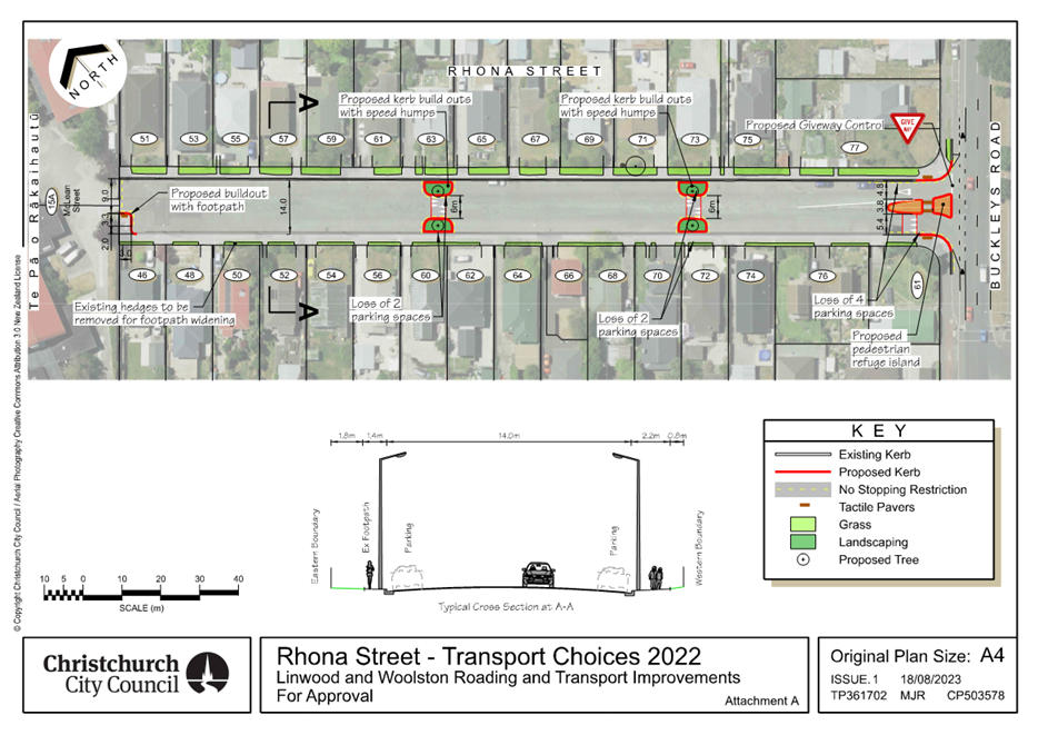
|
Council
21 September 2023
|
|
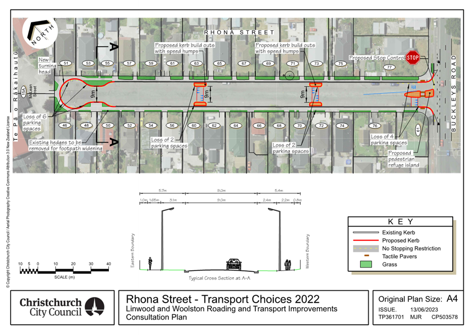
|
Council
21 September 2023
|
|
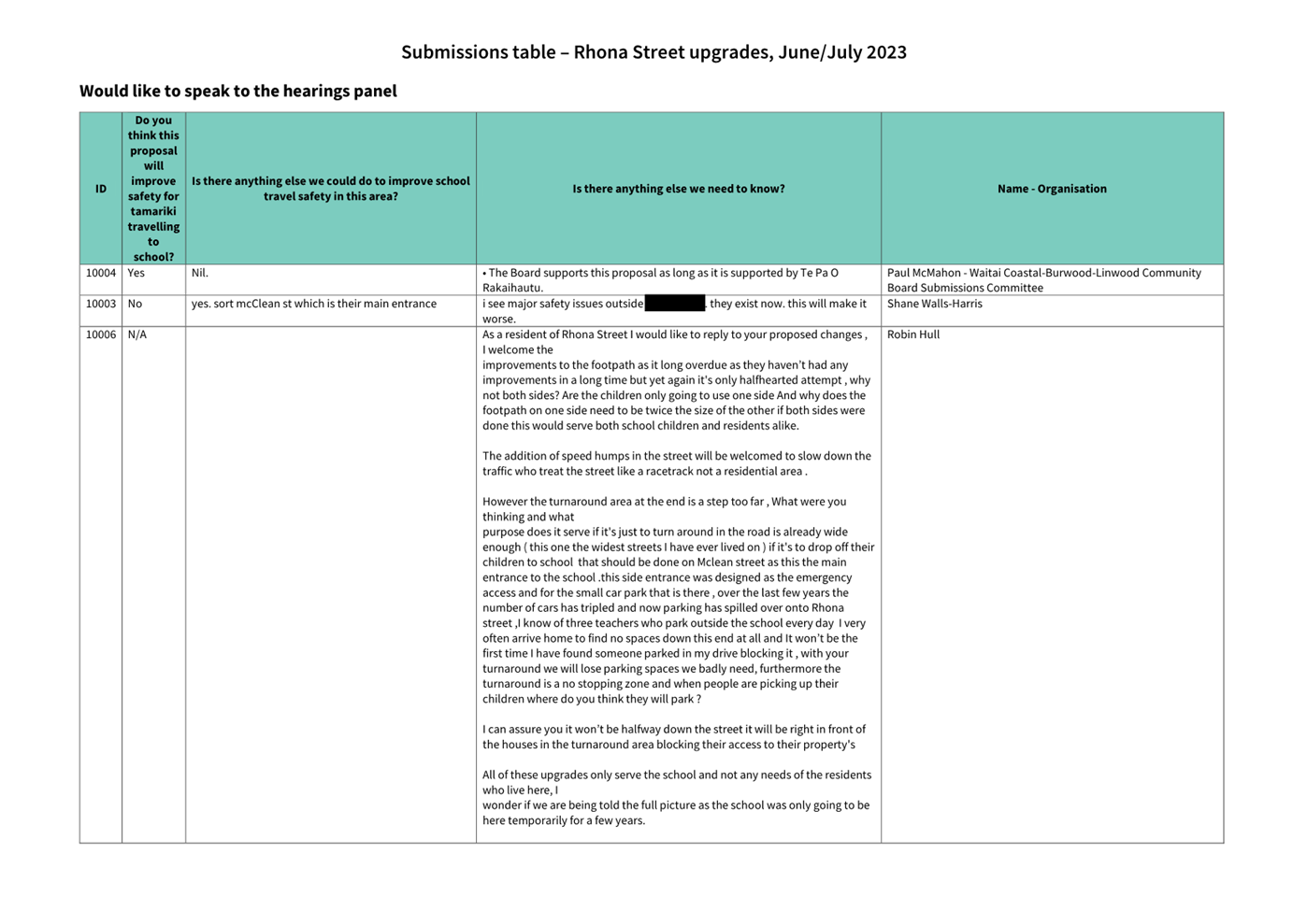
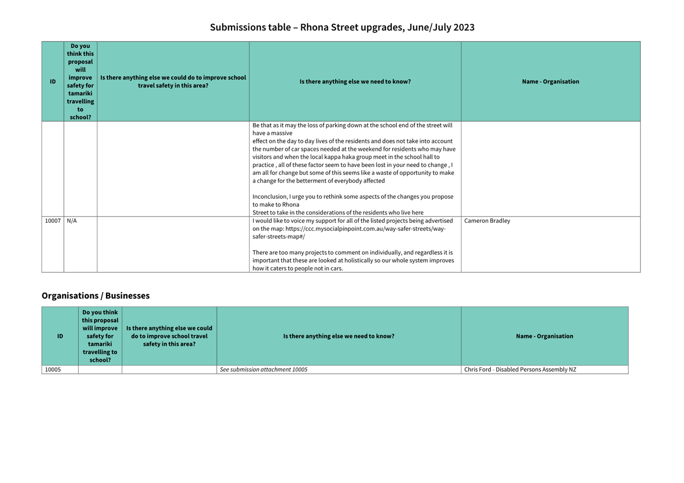
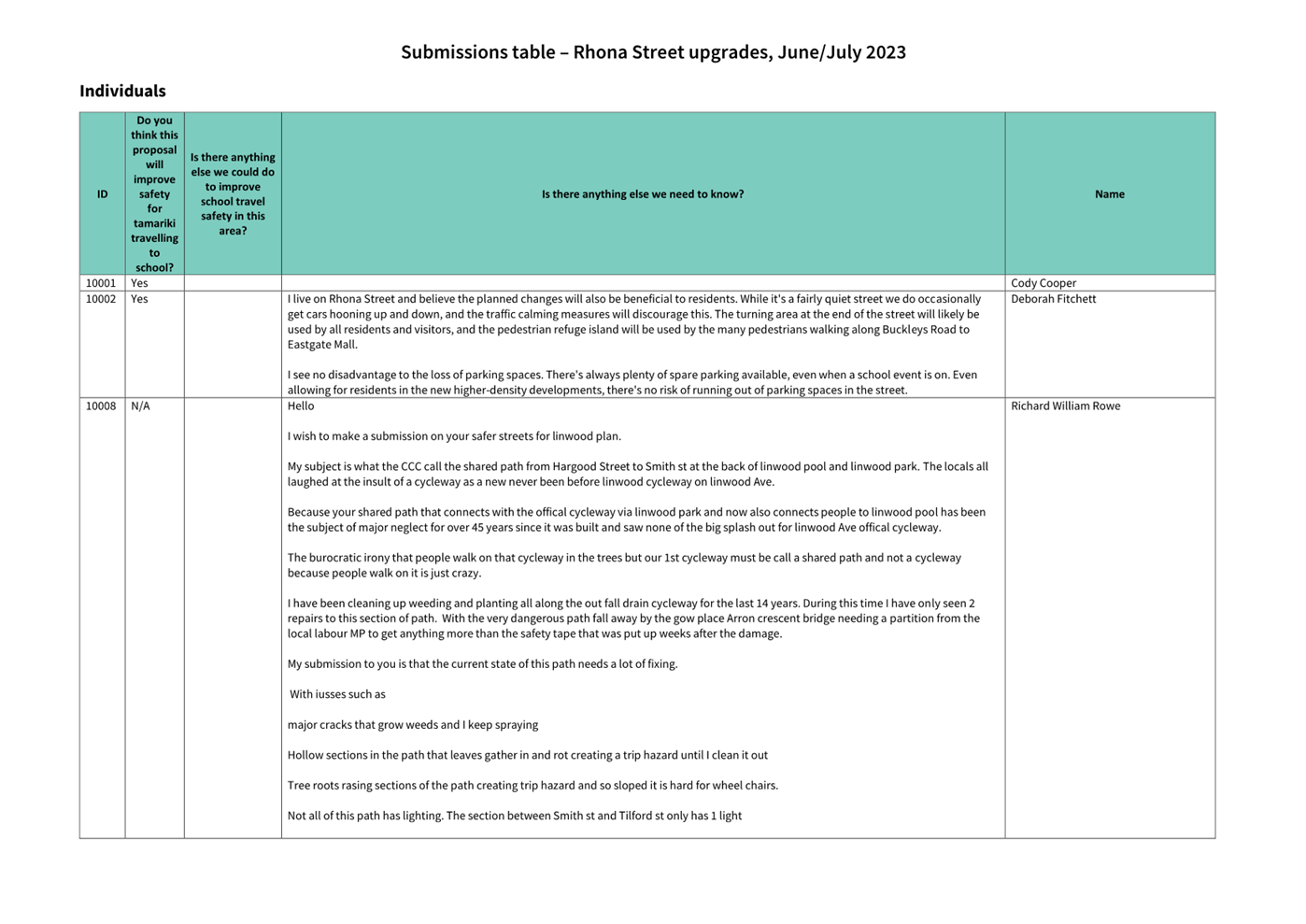
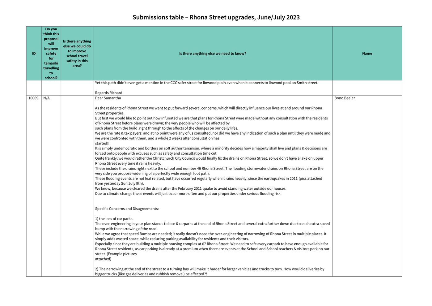
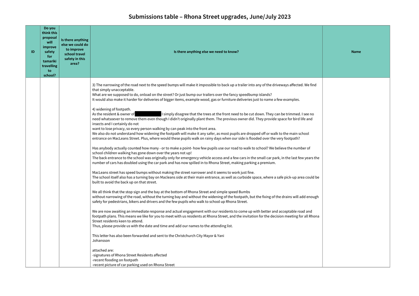
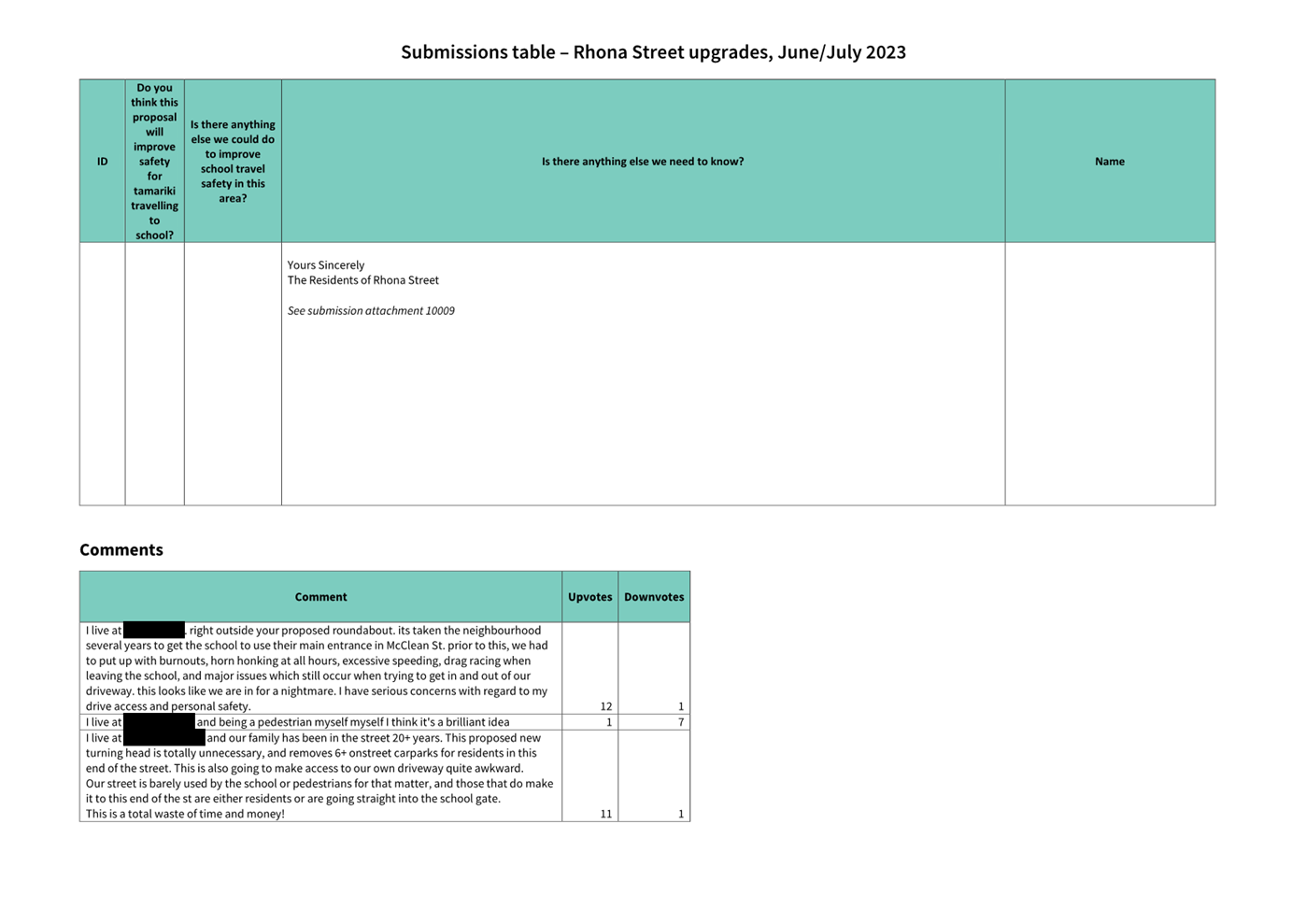
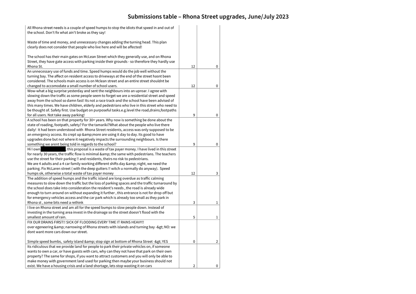

|
Council
21 September 2023
|
|
|
13. Transport Choices - Linwood and Woolston
Improvements (Smith Street)
|
|
Reference / Te Tohutoro:
|
23/1169099
|
|
Report of / Te Pou Matua:
|
Lisa-Maria
Biggar, Project Manager Transport,
lisa-maria.biggar@ccc.govt.nz
Jacob Bradbury, Manager Planning & Delivery Transport,
jacob.bradbury@ccc.govt.nz
|
|
Senior Manager / Pouwhakarae:
|
Lynette
Ellis, Head of Transport & Waste Management (Lynette.Ellis@ccc.govt.nz)
|
1. Nature of Issue and Report Origin
1.1 The purpose of this report is to inform the Council of
feedback received, and for the Council to approve the design to proceed to
construction for the Linwood and Woolston Improvements (Smith Street) project.
1.2 The origin of this report is the Climate Emergency Response
Fund (CERF) Transport Choices programme.
1.3 The
decisions in this report are of medium significance in relation to the Christchurch
City Council’s Significance and Engagement Policy 2019. The
level of significance was determined by potential benefits and opportunities to
the council/community, the number of people affected and/or with an interest,
and that these projects span multiple community board areas, as set out in the
criteria of the policy (Page 2). This evaluation has considered the Transport
Choices projects as a cohesive programme of work. This is consistent with
how community engagement has been undertaken, with all work packages being
presented concurrently on Have your Say under the banner of Way Safer Streets.
2. Officer Recommendations Ngā
Tūtohu
That the Council:
General
1. Approves that construction of the Linwood and
Woolston Improvements (Smith Street) project is conditional on implementation
costs being agreed and incorporated into the Transport Choices Funding
agreement between Waka Kotahi and Council.
2. Approves the following recommendations
required for the implementation of the project, relying on its powers under the
Christchurch City Council Traffic and Parking Bylaw 2017 and Part 21 of the
Local Government Act 1974.
3. Approves that the traffic controls, stopping
and/or parking restrictions described in the recommendations of this report
take effect when infrastructure, signage and/or road markings that evidence the
controls and restrictions are in place (or removed in the case of revocations).
4. Approves that any previously approved
resolutions made pursuant to any Bylaw, Local Government Act or any Land
Transport Rule and pertaining to traffic controls, stopping and/or parking
restrictions (but excluding speed limits) in so far as they conflict with the
recommendations of this report be revoked.
Smith
Street
5. Approves all road surface treatments, traffic
islands, kerb alignments, traffic calming devices and road markings on Smith
Street, commencing at its intersection with Ferry Road, and extending in
north-easterly direction to its intersection with Linwood Avenue, as detailed
on plan TG361801, sheet 1 and 2, dated 22/08/2023 and attached to this report
as Attachment A.
6. Approves that in accordance with Clause 21 of
the Christchurch City Council Traffic & Parking Bylaw 2017 and section 11.4
of the Land Transport Act: Traffic Control Devices Rule 2004, that the path on
the north-western side of Smith Street, commencing at its intersection with
Linwood Avenue, and extending in a south westerly direction for a distance of
73 metres be resolved as a bi-directional Shared Path. This Shared Path is for
the use by the classes of road user only as defined in Section 11.1A of the
Land Transport (Road User) Rule: 2004.
7. Approves pursuant to Section 334(1)(d) of the
Local Government Act 1974 that a pedestrian crossing be resolved and
established on a raised platform in accordance with Section 8.2 of the Land
Transport Rule: Traffic Control Devices 2004, on Smith Street, commencing at a
point 45 metres southwest of its intersection with Linwood Avenue and extending
in a southwest direction for a distance of 3 metres as detailed on plan
TG361801, sheet 1 and 2, dated 22/08/2023 and attached to this report as
Attachment A.
8. Approves that in accordance with Clause 21 of
the Christchurch City Council Traffic & Parking Bylaw 2017 and section 11.4
of the Land Transport Act: Traffic Control Devices Rule 2004, that the path on
the north-western side of Smith Street, commencing at a point 215 metres
southwest of its intersection with Linwood Avenue, and extending in a south
westerly direction for a distance of ten metres be resolved as a bi-directional
Shared Path. This Shared Path is for the use by the classes of road user only
as defined in Section 11.1A of the Land Transport (Road User) Rule: 2004.
9. Approves that in accordance with Clause 21 of
the Christchurch City Council Traffic & Parking Bylaw 2017 and section 11.4
of the Land Transport Act: Traffic Control Devices Rule 2004, that the path on
the south-eastern side of Smith Street, commencing at a point 219 metres
southwest of its intersection with Linwood Avenue, and extending in a south
westerly direction for a distance of eight metres be resolved as a
bi-directional Shared Path. This Shared Path is for the use by the classes of
road user only as defined in Section 11.1A of the Land Transport (Road User)
Rule: 2004.
10. Approves that in accordance with Clause 21 of
the Christchurch City Council Traffic & Parking Bylaw 2017 and section 11.4
of the Land Transport Act: Traffic Control Devices Rule 2004, that the path on
the south-eastern side of Smith Street, commencing at a point 96 metres
southwest of its intersection with Bray Street, and extending in a south
westerly direction for a distance of five metres be resolved as a
bi-directional Shared Path. This Shared Path is for the use by the classes of
road user only as defined in Section 11.1A of the Land Transport (Road User)
Rule: 2004.
11. Approves that the stopping of all vehicles be
prohibited at all times, in accordance with Clause 7 of the Christchurch City
Council Traffic & Parking Bylaw 2017, on the north-western side of Smith
Street commencing at its intersection with Linwood Avenue and extending in a
south westerly direction for a distance of 75 metres.
12. Approves that the stopping of all vehicles be
prohibited at all times, in accordance with Clause 7 of the Christchurch City
Council Traffic & Parking Bylaw 2017, on the north-western side of Smith
Street commencing at a point 131 metres southwest of its intersection with
Linwood Avenue and extending in a south westerly direction for a distance of 28
metres.
13. Approves that the stopping of all vehicles be
prohibited at all times, in accordance with Clause 7 of the Christchurch City
Council Traffic & Parking Bylaw 2017, on the south-eastern side of Smith
Street commencing at its intersection with Linwood Avenue, and extending in a
south westerly direction for a distance of 76 metres.
14. Approves that the stopping of all vehicles be
prohibited at all times, in accordance with Clause 7 of the Christchurch City
Council Traffic & Parking Bylaw 2017, on the south-eastern side of Smith
Street commencing at a point 210 metres southwest of its intersection with
Linwood Avenue, and extending in a south westerly direction for a distance of
25 metres.
15. Approves that the stopping of all vehicles be
prohibited at all times, in accordance with Clause 7 of the Christchurch City
Council Traffic & Parking Bylaw 2017, on the south-eastern side of Smith
Street commencing at a point 43 metres southwest of intersection with Bray
Street and extending in a south westerly direction for a distance of 37 metres.
16. Approves that the stopping of all vehicles be
prohibited at all times, in accordance with Clause 7 of the Christchurch City
Council Traffic & Parking Bylaw 2017, on the south-eastern side of Smith
Street commencing at a point 88 metres southwest of intersection with Bray
Street and extending in a south westerly direction for a distance of 17 metres.
17. Approves that the parking of all vehicles be
restricted to a maximum period of 30 minutes, in accordance with Clause 7 of
the Christchurch City Council Traffic & Parking Bylaw 2017, on the
south-eastern side of Smith Street commencing at a point 149 metres southwest
of its intersection with Bray Street and extending in a south westerly
direction for a distance of 10 metres.
18. Approves that the stopping of all vehicles be
prohibited at all times, in accordance with Clause 7 of the Christchurch City
Council Traffic & Parking Bylaw 2017, on the south-eastern side of Smith
Street commencing at a point 158 metres southwest of intersection with Bray
Street, and extending in a south westerly direction to its intersection with
Ferry Road.
19. Approves that the stopping of all vehicles be
prohibited at all times, in accordance with Clause 7 of the Christchurch City
Council Traffic & Parking Bylaw 2017, on the north-western side of Smith
Street commencing at its intersection with Ferry Road and extending in a north
easterly direction for a distance of 24 metres.
20. Approves that the stopping of all vehicles be
prohibited at all times, in accordance with Clause 7 of the Christchurch City
Council Traffic & Parking Bylaw 2017, on the north-western side of Smith
Street commencing at a point 97 metres northeast of its intersection with Ferry
Road and extending in a north easterly direction to its intersection with
Matlock Street.
21. Approves that the stopping of all vehicles be
prohibited at all times, in accordance with Clause 7 of the Christchurch City
Council Traffic & Parking Bylaw 2017, on the north-western side of Smith
Street commencing at its intersection with Matlock Street, and extending in a
north easterly direction for a distance of 13 metres.
22. Approves that the parking of all vehicles be
restricted to a maximum period of 30 minutes, in accordance with Clause 7 of
the Christchurch City Council Traffic & Parking Bylaw 2017, on the
north-western side of Smith Street commencing at a point 29 metres northeast of
its intersection with Matlock Street and extending in a north easterly westerly
direction for a distance of 27 metres. This restriction is to apply
8:00am to 9:30am and 2:00pm to 3:00pm, Monday to Friday.
Linwood Avenue
23. Approves all kerb alignments, road surface
treatments and road markings on Linwood Avenue, commencing at its intersection
with Smith Street, and extending in a north westerly direction for a distance
of 76 meters, as detailed on plan TG361801, sheet 1 and 2, dated 22/08/2023 and
attached to this report as Attachment A.
24. Approves that in accordance with Clause 21 of
the Christchurch City Council Traffic & Parking Bylaw 2017 and section 11.4
of the Land Transport Act: Traffic Control Devices Rule 2004, that the path on
the north western side of Linwood Avenue, commencing at its intersection with
Smith Street, and extending in a north westerly direction for a distance of 76
metres be resolved as a bi-directional Shared Path. This Shared Path is for the
use by the classes of road user only as defined in Section 11.1A of the Land
Transport (Road User) Rule: 2004.
25. Approves that the stopping of all vehicles be
prohibited at all times, in accordance with Clause 7 of the Christchurch City
Council Traffic & Parking Bylaw 2017, on the south-western side of Linwood
Avenue commencing at its intersection with Smith Street and extending in a
north westerly direction for a distance of 18 metres.
26. Approves that the stopping of all vehicles be
prohibited at all times, in accordance with Clause 7 of the Christchurch City
Council Traffic & Parking Bylaw 2017, on the south-western side of Linwood
Avenue commencing at a point 60 metres northwest of its intersection with Smith
Street and extending in a north westerly direction for a distance of 18 metres.
27. Approves that the stopping of all vehicles be
prohibited at all times, in accordance with Clause 7 of the Christchurch City
Council Traffic & Parking Bylaw 2017, on the south-western side of the
Linwood Avenue central median commencing at a point 59 metres northwest of its
intersection with the U-turn facility at Smith Street, and extending in a north
westerly direction for a distance of 20 metres.
Matlock
Street
28. Approves all kerb alignments, road surface
treatments and road markings on Matlock Street, commencing at its intersection
with Smith Street, and extending in a north westerly direction for a distance
of 17 meters, as detailed on plan TG361801, sheet 1 and 2, dated 22/08/2023 and
attached to this report as Attachment A.
29. Approves that the stopping of all vehicles be
prohibited at all times, in accordance with Clause 7 of the Christchurch City
Council Traffic & Parking Bylaw 2017, on the south-western side of Matlock
Street commencing at its intersection with Smith Street and extending in a
north westerly direction for a distance of 12 metres.
30. Approves that the stopping of all vehicles be
prohibited at all times, in accordance with Clause 7 of the Christchurch City
Council Traffic & Parking Bylaw 2017, on the north-eastern side of Matlock
Street commencing at its intersection with Smith Street and extending in a
north westerly direction for a distance of 13 metres.
3. Reason for Report Recommendations Ngā Take mō te
Whakatau
3.1 This
project is funded by the Central Government Transport Choices programme –
a $348 million national programme made available from the Climate
Emergency Response Fund.
3.2 The
Transport Choices programme is important because transport makes up almost half
of New Zealand’s carbon emissions. In May 2022, government released
its first Emissions Reduction Plan and transport has a significant role to
play, targeting a 20 percent reduction in light vehicle travel by 2035.
Reducing reliance on cars and supporting people to walk, cycle and use public
transport is one of three focus points of the Emissions Reduction Plan.
3.3 The
Linwood and Woolston Improvements project was
included within the Transport Choices programme due to alignment with the
“creating walkable networks” investment category of the
programme.
4. Alternative Options Considered Ētahi atu Kōwhiringa
The Transport
Choices Programme
4.1 Transport
Choices funding was allocated to Local Authorities through an Expression of
Interest process administered by Waka Kotahi. Through that process
Christchurch City Council submitted a package of projects that was developed by
consideration of:
· Project alignment with the
four investment criteria for Transport Choices funding: deliver strategic
cycling/micro mobility networks; create walkable neighbourhoods; support safe,
green, and healthy school travel; make public transport more reliable and
easier to use;
· Achieving diversity across
the four investment categories for Transport Choices funding;
· Focusing investments on
certain suburbs;
· Community requests for
infrastructure improvements aligned with the Transport Choices programme
outcomes;
· Complimenting existing
programmes, such as the Major Cycleway Routes programme, and;
· Project complexity and
ability to deliver prior to June 2024.
4.2 All
14 projects submitted for Transport Choices funding were accepted by Waka
Kotahi. However, in deciding to include the Transport Choices programme
in the Draft Annual Plan, Council decided to include 11 projects in the programme
and defer several business-as-usual projects by 12 months to enable the
Transport Choices programme to be adequately resourced.
Project Options
4.3 Options
considered for the project included:
For all of Smith Street
· Do nothing;
· Provide additional traffic
calming with speed cushions and cycle sharrows on Smith Street, combined with
kerb cutdowns and tactile paving at side streets, and;
· Provide additional traffic
calming with kerb buildouts, speed humps and cycle sharrows on Smith Street, combined
with kerb cutdowns and tactile paving at side streets.
Near Te Pou Toetoe/Linwood Pool
· A raised zebra crossing,
and;
· Kerb buildouts and a
raised table to form an un-signalled crossing.
Near Ferry Road
· Provide a refuge island
and kerb buildout on one side and retaining a two-lane approach on Smith
Street, and;
· Provide a narrow
intersection threshold comprising kerb buildouts and speed hump with single
exit/ entry lane on Smith Street at the intersection.
On Linwood Avenue
· Establish a shared path
outside Te Pou Toetoe/Linwood Pool on the Smith Street and Linwood Avenue
frontages.
Project Options Selection
4.4 The
preferred option was chosen for the following reasons:
· Traffic calming with
speed cushions. Retain existing on-street parking, while traffic calming
with kerb buildouts and speed humps require the removal of on-street
parking. The spacing between the speed cushions enable cyclists to bypass
the speed cushions.
· Provide a
cycle-friendly environment along Smith Street with the additional traffic
calming with speed cushions, in conjunction with the existing traffic calming
treatments.
· Raised zebra
crossing provides the safest form of pedestrian crossing facility near Te Pou
Toetoe/Linwood Pool and most aligned with the safe system. It gives
priority to pedestrians over vehicles on Smith Street. The raised
crossing provides safe and comfortable crossing for pedestrians where the
crossing is flush with the footpath, where vehicles approaching the zebra
crossing at safe system speed (30kph).
· The refuge
pedestrian island and build-out treatment near Ferry Road provides improvements
for pedestrians at the intersection while retaining a two-lane approach on
Smith Street. The refuge island enables pedestrians to cross Smith Street
in two stages. A single lane approach with kerb buildout would impact on
the turning movements on Smith Street. i.e., right turning out of Smith
Street blocking the left turning traffic etc.
· The shared path
along Te Pou Toetoe/Linwood Pool frontage would provide connection for cyclists
from the Rapanui-Shag Rock Major Cycleway to the pool with existing mid-block
crossing on Linwood Avenue.
· Meet the project
objectives and delivery within the constraint project timeframe.
5. Detail Te Whakamahuki
5.1 The
decision affects the following wards/Community Board areas:
5.1.1 Linwood
Ward
5.1.2 Waitai
Coastal-Burwood-Linwood Community Board
5.2 The
Smith Street improvements project aims to strengthen walking and cycling
connections between Ferry Road, Linwood Avenue and Te Pou Toetoe/Linwood Pool.
The project consists of the installation
of speed reduction measures (road humps and speed cushions), and cycle sharrow
markings along Smith Street and the construction of a shared use path along
Linwood Ave (between Smith Street and the existing midblock pedestrian/cycle
crossing point).
Specific details include:
· Pedestrian refuge
island with speed humps and kerb alteration on Smith Street at the intersection
with Ferry Road.
· Informal two lane
exit on Smith Street at the intersection with Ferry Road.
· Traffic calming
treatments with speed cushions along Smith Street. The speed cushions will be
located between existing traffic calming treatments.
· Raised zebra
crossing on Smith Street between the northern pool vehicle access and Linwood
Avenue. The raised zebra crossing is located near the pool main entrance.
There will be a loss of eight on-street parking spaces for the raised zebra
crossing.
· Speed cushions on
the entry lane at the Linwood Avenue/Smith Street intersection.
· New shared path on
Smith Street between Linwood Avenue and the pool northern vehicle access and on
Linwood Avenue between Smith Street and existing crossing at Linwood
Park. The shared path will be three metres in width.
· Sharrow markings
along Smith Street at the existing and proposed traffic calming treatments and
intersections.
· Lighting upgrade at
existing and proposed traffic calming treatments and at the raised zebra
crossing.
· Repaint existing
raised platform ramps and speed humps on Smith Street with new ramp marking.
· New kerb cutdown
with no stopping at the Mary Dixon Park. There will be a loss of two
on-street parking spaces.
· Green surfacing and
signage on Smith Street at Mary Dixon Park. Shared path at Mary Dixon Park.
· Tactile pavers and
new cutdowns to assist vision impaired pedestrians at the existing crossing
points.
· Edge line buffer
along the shared path on Linwood Avenue for door opening zone.
· Cycle cutdown on
Smith Street to shared path on Linwood Avenue.
· One existing street
tree to be removed to accommodate the new shared path. The street tree is
located on Smith Street at the intersection with Linwood Avenue.
· Three new street
trees on Smith Street located at existing traffic calming at No.37 Smith Street
and the intersection with Matlock Street and Linwood Avenue.
· Landscaping planting
along Smith Street at the existing intersections (Ferry Road/Matlock Street/
Linwood Avenue), speed humps, crossing at concrete drain and new zebra
crossing.
· There will be no
change to the existing time restricted parking at Ferry Road/Smith Street
intersection and at the Kidsfirst Kindergarten (21 Smith Street).
· Loss of eleven on-street parking spaces on Smith Steet. One
parking space at the intersection with Ferry Road, two parking spaces at Mary
Dixon Park and eight parking spaces for the raised zebra crossing.
Public Consultation Te Tukanga Kōrerorero
5.3 Local
residents received warm up flyers in their mailboxes from 29 May, indicating we
would be seeking feedback on Way Safer Streets projects proposed for their area
in June.
5.4 Staff
attended a LinWard collective hui (consisting of Te Whare Taonga o Ngā Iwi
Katoa Linwood Resource Centre, Bromley Community Trust, The Loft, CCC
Libraries, Christchurch Methodist Mission and St Chads Church and Linwood
Avenue Corner Trust) to brief them on Way Safer Streets projects in early June
2023. Recommended engagement tactics were taken on board.
5.5 Consultation
started on 16 June 2023 and ran until 16 July 2023, as part of the wider Way
Safer Streets consultation. An email was sent to 150 key stakeholders across
the entire Way Safer Streets programme, including emergency services, Spokes,
AA, Disabled Persons Assembly, Blind Low Vision, ECan, Mahaanui Kurataiao,
Whitau School, and The Loft at Eastgate. The consultation was posted on the
council Facebook page, as well as local community groups, inviting submissions
on the Social
Pinpoint Map.
5.6 Consultation
documents (including a submission form) and flyers were available at Bromley
Community Centre, Linwood Union Church, Linwood Library, and Linwood Resource
Centre and Community Gardens.
5.7 Two
Newsline stories were published and picked up by local media outlets. Digital
screens were displaying the consultation in Civic Offices and Linwood Library,
as well as newspaper advertising in The Star and The Pegasus Post. Digital
billboards were utilised in Linwood, including outside Eastgate Mall. An online
targeted advertising campaign ran for the entire consultation period. Footpath
decals with QR codes were installed where intersection upgrades were proposed.
5.8 During
consultation, flyers were delivered to residents in the local area, and emails
were sent to those who expressed interest in being updated on Way Safer
Streets.
5.9 Key
stakeholder meetings throughout and after consultation, with Spokes, FENZ, St
John, NZ Police and Disabled Persons Assembly, further informed projects in the
Way Safer Streets program.
Summary of Submissions Ngā Tāpaetanga
5.10 Feedback
on the plans could be given by posting a comment on the Social
Pinpoint Map, by making a submission, or both.
5.11 A
total of 27 submissions and 15 comments were received on Smith Street. 22
submissions were made via the Social
Pinpoint Map, and five submissions were made via email/PDF. Submissions
were received from Waitai Coastal-Burwood-Linwood Community Board, Waipapa
Papanui-Innes-Central Community Board, Disabled Persons Assembly, and 19
individuals. All submissions and comments are available in Attachment B.
5.12 On
the Social
Pinpoint Map, the projects received a total of 96 upvotes, 17 downvotes,
and 15 comments:
Summary
from social pinpoint interactions:
|
Project pin
|
Comments
|
Upvotes
|
Downvotes
|
|
Overall project pin
|
11
|
59
|
6
|
|
Site 1 - Ferry Road to 110 Smith
Street
|
3
|
20
|
6
|
|
Site 2 - Smith Street pedestrian
crossing
|
1
|
17
|
5
|
|
Total
|
15
|
96
|
17
|
5.13 Comment
sentiment was predominantly positive (46.7%), or mixed (20.0%):
5.14 Submitters
were asked how they travel through this area. The majority (63.6%) of
submitters use this area to cycle, followed closely by travelling in the car as
a driver (59.1%):
5.15 The
majority of submitters felt the proposed changes would improve safety for
cyclists (63.6%):
5.16 The
majority of submitters (77.3%) agreed this proposal would improve safety for
pedestrians crossing the road:
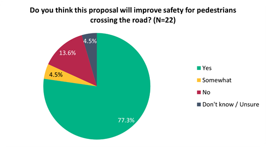
5.17 This
sentiment differed slightly depending on whether they live on the affected
streets (i.e. Smith Street), live in local suburbs (i.e. Linwood, Woolston), or
live elsewhere:
|
Do you think this proposal
will improve safety for pedestrians crossing the road?
|
Live on affected streets
|
Live in local suburbs
|
Live elsewhere
|
|
Yes
|
1
|
10
|
6
|
|
Somewhat
|
0
|
1
|
0
|
|
No
|
1
|
2
|
0
|
|
Don't
know / Unsure
|
0
|
1
|
0
|
5.18 Key
themes and requests from both comments and submissions are summarised below.
Note that there could be cross-over between those making comments and making
submissions:
|
Key themes on outcomes of the
proposal
|
Number
of comments
|
Number
of submissions
|
Total
mentions
|
|
Supportive
of the proposal
· Agreement that this proposal
would address existing safety concerns
|
6
|
7
|
13
|
|
Lack
of need for project
· Concern on whether cycling
infrastructure is even necessary here, due to low cycling numbers
|
4
|
4
|
8
|
|
Concern
on narrowing Ferry Road intersection
· Concern that exiting Smith
Street onto Ferry Road is currently difficult, especially for a right turn,
and this would lead to a lot of congestion
|
1
|
3
|
4
|
|
Requests
|
Number
of comments
|
Number
of submissions
|
Total
mentions
|
|
Investigate
a different route
· Calls to investigate
Mackworth Street, and encourage the pathway through Mary Dixon Park
|
3
|
1
|
4
|
|
Request
for additional crossings
· At Matlock Street, and at
Linwood Drain
|
1
|
2
|
3
|
|
Further
traffic calming
· A raised intersection at
Arran Crescent, speed bumps and cushions down the street, dedicated cycle
facilities
|
0
|
2
|
2
|
|
Other
requests
· Improved lighting, trees,
address street condition and flooding, make the space simple and not cluttered,
increase road width
|
0
|
4
|
4
|
Changes made to the
scheme design as a result of consultation feedback
5.19 Alternative
layout at Ferry Road/Smith Street intersection with space for two informal exit
lanes similar to existing situation. Pedestrian refuge island and road
widening with kerb alignment change on the western side.
5.20 Additional
sharrow markings at intersection and busy vehicle accesses.
5.21 Shared
path, green surfacing, and wayfinding signage at Mary Dixon Park.
5.22 One
additional speed cushion at new traffic calming treatment, i.e., four speed
cushions instead of three.
5.23 Three
new street trees to replace the one removed for the shared path. One
street tree is located at Matlock Street intersection, one at Linwood Avenue
intersection and the third at the existing traffic calming at 37 Smith Street.
5.24 Landscaping
at existing traffic calming, Mary Dixon Park and at the intersection with Ferry
Road, Matlock Street and Linwood Avenue.
6. Policy Framework Implications Ngā Hīraunga ā- Kaupapa here
Strategic
AlignmentTe Rautaki Tīaroaro
6.1 This report supports the Council's
Long Term Plan (2021 - 2031):
6.2 Transport
6.2.1 Activity: Transport
· Level of Service: 10.0.2 Increase the share of
non-car modes in daily trips - >=36% of trips undertaken by non-car modes
· Level of Service: 10.0.6.1 Reduce the number of
death and serious injury crashes on the local road network - <=100
crashes
· Level of Service: 10.0.41 Reduce emissions and
greenhouse gases related to transport - <=1.10 million tonnes of CO2
equivalents
· Level of Service: 10.5.42 Increase the infrastructure
provision for active and public modes - >= 585 kilometres (total combined
length)
Policy
Consistency Te Whai
Kaupapa here
6.3 The
recommendations of this report are consistent with
Council’s Plans and Policies, in particular:
6.3.1 The changes
proposed align with road safety and liveable streets goals in the Christchurch
Transport Strategic Plan 2012–2042, and similarly in the draft Transport
Plan (safe streets).
6.3.2 The
changes proposed align with Kia tūroa te Ao - Ōtautahi Christchurch
Climate Resilience Strategy as set out in the Climate Change Impact
Considerations section below.
Impact
on Mana Whenua Ngā
Whai Take Mana Whenua
6.4 The
decision does not involve a significant decision in relation to ancestral land
or a body of water or other elements of intrinsic value, therefore this
decision does specifically impact Mana Whenua, their culture and traditions.
6.5 The
decision does not involve a matter of interest to Mana Whenua and should not
impact on our agreed partnership priorities with Ngā Papatipu
Rūnanga.
6.6 The
projects are based on minor changes to, or re-allocation of, existing road
spaces, so are not anticipated to have a significant impact on Mana Whenua.
Climate
Change Impact Considerations Ngā Whai Whakaaro mā te Āhuarangi
6.7 The
decisions in this report are likely to:
6.7.1 Contribute
neutrally to adaptation to the impacts of climate change.
6.7.2 Contribute
positively to emissions reductions.
6.8 The
emission reductions associated with this project have not been estimated.
6.9 The Government’s Emissions Reduction Plan states we
will have to ‘substantially improve infrastructure for walking and
cycling’ to meet our emissions targets (including a 20% reduction in
light Vehicle Kilometres Travelled by 2035 - required under the Emissions
Reduction Plan). Improving the quality of our streets for walking and cycling
is also a key part of the Ministry of Transport and Waka Kotahi’s efforts
to decarbonise the transport system.
6.10 New
Zealand has the 5th highest transport emissions rate per capita
among the 43 OECD countries. Petrol or diesel car use is typically the
single-biggest contributor to an individual’s carbon footprint in New
Zealand.
6.11 From
the 2022 Life in Christchurch Transport Survey, 96 percent of respondents
travel by car. Respondents find car travel the least difficult means of
travel: "We use car travel as it is easier. Christchurch is very spread
out and to have several buses is not convenient." Inconsiderate and
dangerous behaviour from other road users and sharing the road with cars were
the main reasons respondents found it difficult to bike.
6.12 The
proposed changes make it safer for people walking and cycling, which will have a net positive impact for the climate by
helping to reduce transport emissions. Enabling more people to walk or cycle,
particularly for local journeys, is a key part of council’s emissions
reduction efforts by providing a safe, low emission way for residents to move
around the city.
Accessibility
Considerations Ngā
Whai Whakaaro mā te Hunga Hauā
6.13 This proposal improves accessibility for people walking and
cycling, by providing a safer means of accessing and using our street network.
6.14 Waka
Kotahi developed a set of Project Design Parameters to ensure all projects work
to collectively meet the programme objectives. The Project Design
Parameters require that “the infrastructure should be designed for
children and people with visual, mobility, or cognitive impairments. If the
infrastructure works for them, it will work for a wider spectrum of the
population who are interested in walking and cycling but concerned for their
safety.” Transport Choices projects have been designed in
accordance with these requirements.
7. Resource Implications Ngā Hīraunga Rauemi
Capex/Opex Ngā Utu Whakahaere
7.1 Cost
to Implement – the total project estimate is $741,709. This is
inclusive of design and project management.
7.2 Maintenance/Ongoing costs
– $7,915 per year additional costs associated with coloured surfacing and
speed cushions. These costs will be eligible for Waka Kotahi subsidy at
Council’s 51% Funding Assistance Rate. The net maintenance cost for the
full Transport Choices programme will have an ongoing rates impact of
approximately 0.01%, which will be included in the draft Long Term Plan proposed
budgets.
7.3 Funding
Source – Councils capital programme:
7.3.1 ID
72764, Transport Choices 2022 – Linwood and Woolston Roading and
Transport Improvements, $1,480,684.
7.4 Waka
Kotahi through the Transport Choices programme will be funding the project up
to an agreed value which is calculated as 90% of the expected implementation
cost. The remaining 10% is Council’s share.
7.5 Under
the cost share agreement with Waka Kotahi, funding approvals for individual
Transport Choices projects are approved through two stage gates: design and
physical works. All Transport Choices projects have agreed funding schedules
for design. Individual project schedules for physical works are required to be
agreed and approved prior to 20 October 2023. In approving funding for physical
works, Waka Kotahi will consider:
7.5.1 The
project is in accordance with the scope and design approved by Waka
Kotahi.
7.5.2 Project
costs are in accordance with expectations.
7.5.3 Ability
to deliver the project prior to June 2024.
7.6 The
staff recommendations of this report include that Council’s approval of
this project is conditional on a funding agreement with Waka Kotahi being in
place for the physical works.
8. Legal Implications Ngā Hīraunga ā-Ture
Statutory power to undertake proposals in the report
Te Manatū Whakahaere Kaupapa
8.1 Council
resolved the Transport Choices programme as Metropolitan Significance when the
programme was included in the draft Annual Plan in February 2023.
8.2 Council
retains decision-making responsibilities that might otherwise be delegated in
accordance with the Delegations Register when a project is determined as
Metropolitan Significance.
8.3 Part
1, Clauses 7 and 8 of the Christchurch City Council Traffic and Parking Bylaw
2017 provides Council with the authority to install parking restrictions by
resolution.
8.4 The
installation of any signs and/or markings associated with traffic control
devices must comply with the Land Transport Rule: Traffic Control Devices 2004.
Other Legal Implications Ētahi atu
Hīraunga-ā-Ture
8.5 There
is no legal context, issue or implication relevant to this decision.
9. Risk Management Implications Ngā Hīraunga Tūraru
9.1 Scope
– Waka Kotahi has governed the scope and design of the project to align
with programme KPI’s and consistency with Transport Choices design
parameters. Departing from the recommendations of this report creates a risk
that Waka Kotahi would not agree to fund the physical works phase of the
project.
9.2 Delivery
– Transport Choices funding is subject to delivery being complete by June
2024. Waka Kotahi has established additional milestones to track
progress. Delays in approval of the projects would impact on the timeframe
for delivery.
9.3 Funding
security - the Transport Choices funding agreement between Council and Waka
Kotahi presently covers this project for design only, and a further stage gate
approval is required to gain funding approval for construction. The
instruction of physical works will be withheld until an implementation
agreement is in place.
9.4 Implementation
cost uncertainty – the funding agreement with Waka Kotahi places the risk
of cost variations with Council. This risk is being managed by minimising
price uncertainty and building contingency into the funding agreement.
Attachments Ngā Tāpirihanga
|
No.
|
Title
|
Reference
|
Page
|
|
a ⇩
|
Scheme - Plan
- CERF - Smith Street - Ferry to Linwood - For Approval Plan - TP361801 -
2023_0822
|
23/1317202
|
554
|
|
b ⇩
|
Smith Street -
Submission Table (Public)
|
23/1373854
|
556
|
In addition to the attached documents, the following background
information is available:
|
Document
Name – Location / File Link
|
|
Not
applicable
|
Confirmation of Statutory
Compliance Te Whakatūturutanga ā-Ture
|
Compliance with Statutory Decision-making
Requirements (ss 76 - 81 Local Government Act 2002).
(a) This report contains:
(i) sufficient information about all reasonably practicable
options identified and assessed in terms of their advantages and
disadvantages; and
(ii) adequate consideration of the views and preferences of
affected and interested persons bearing in mind any proposed or previous
community engagement.
(b) The information reflects the level of significance of the
matters covered by the report, as determined in accordance with the Council's
significance and engagement policy.
|
Signatories Ngā Kaiwaitohu
|
Authors
|
Ryan Rolston -
Programme Manager
Lisa-Maria
Biggar - Junior Project Manager
Barry Hayes -
Team Leader Transport Design
Samantha Smith
- Engagement Advisor
May Wong -
Engineer - Traffic Investigations
Wayne Gallot -
Senior Transportation Engineer
Kelly
Griffiths - Senior Project Manager
|
|
Approved By
|
Jacob Bradbury
- Manager Planning & Delivery Transport
Tony
Richardson - Finance Business Partner
Lynette Ellis
- Head of Transport & Waste Management
|
|
Council
21 September 2023
|
|
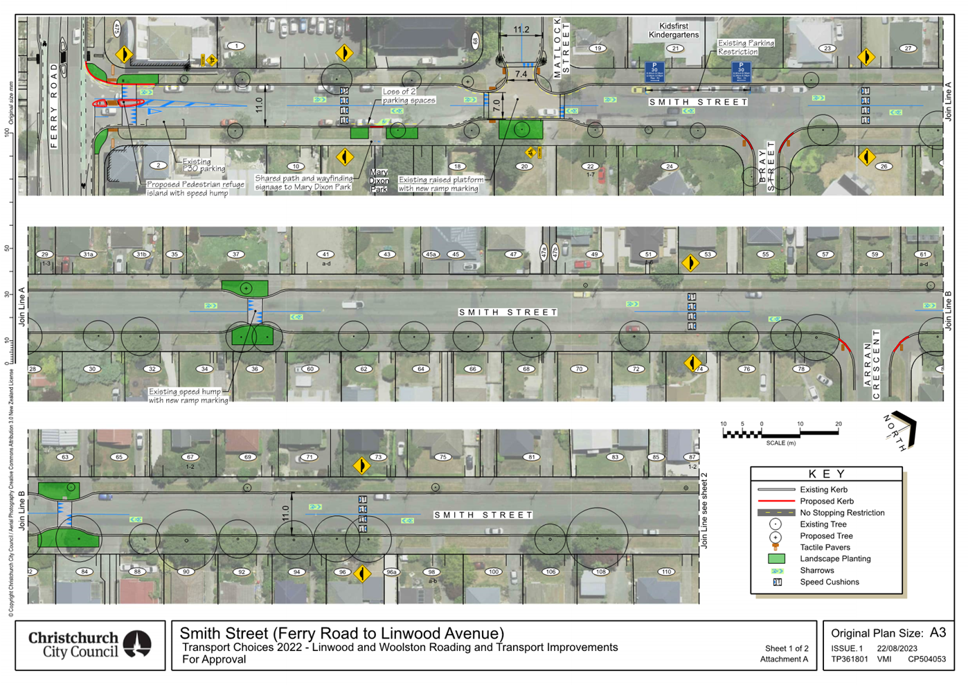
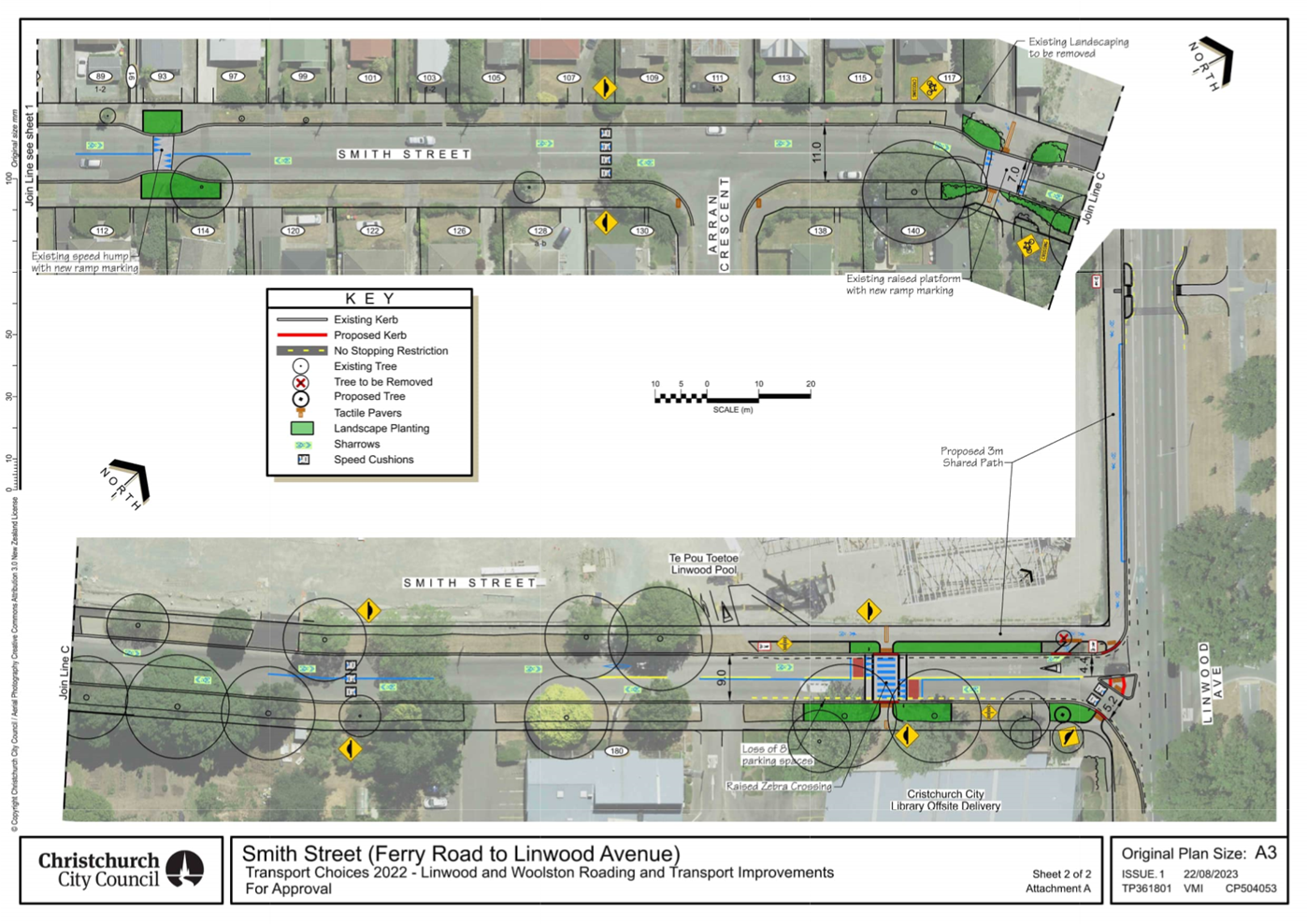
|
Council
21 September 2023
|
|
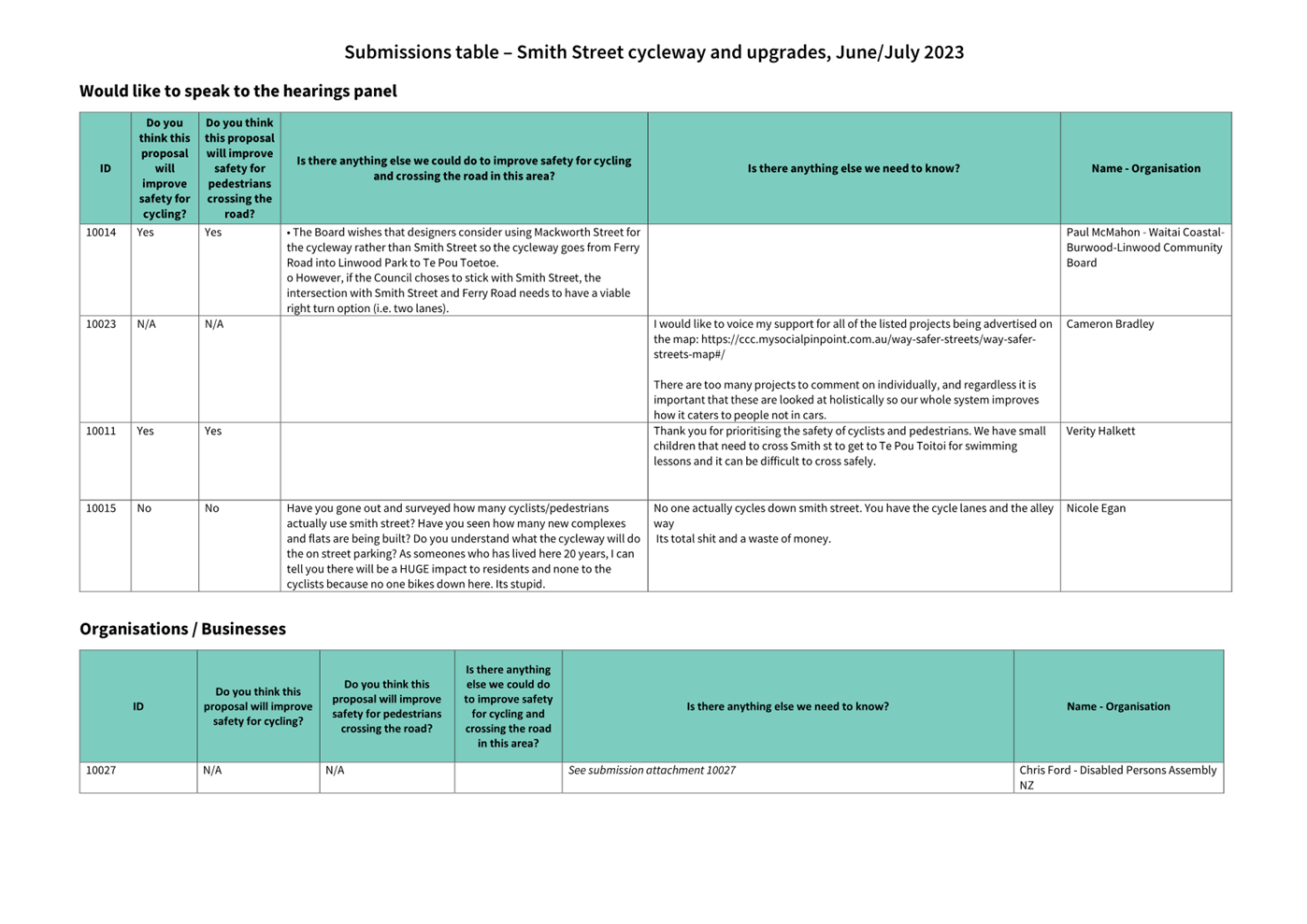
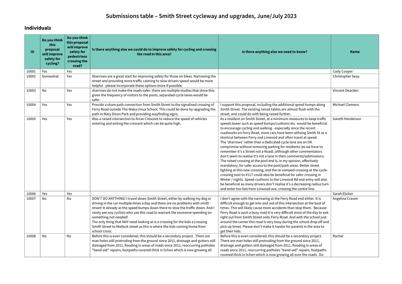
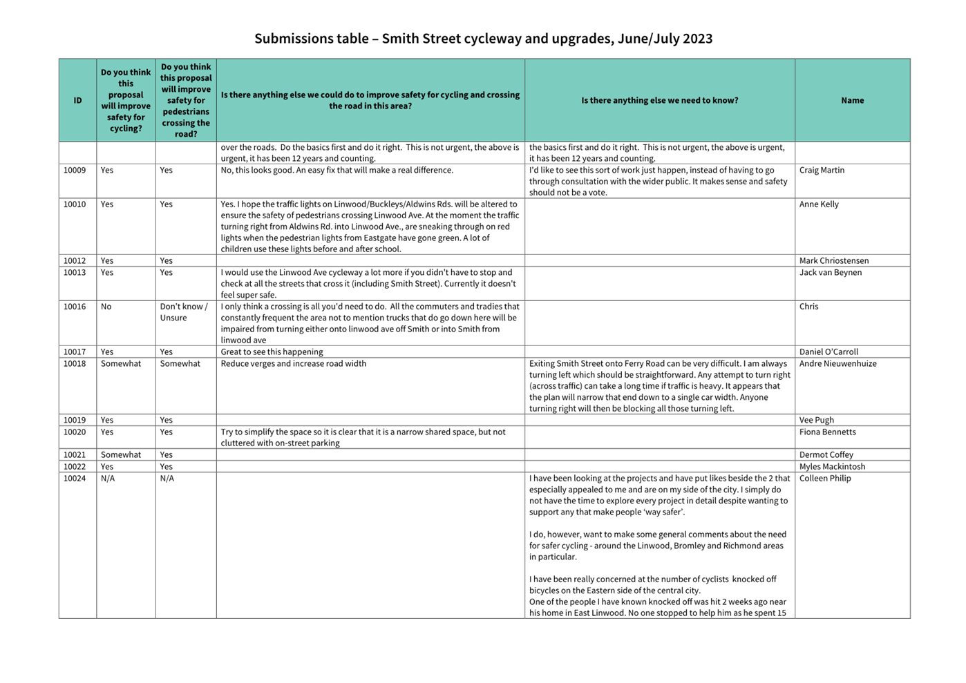
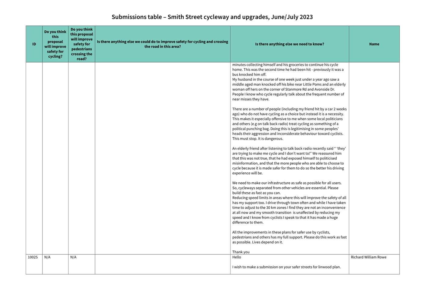
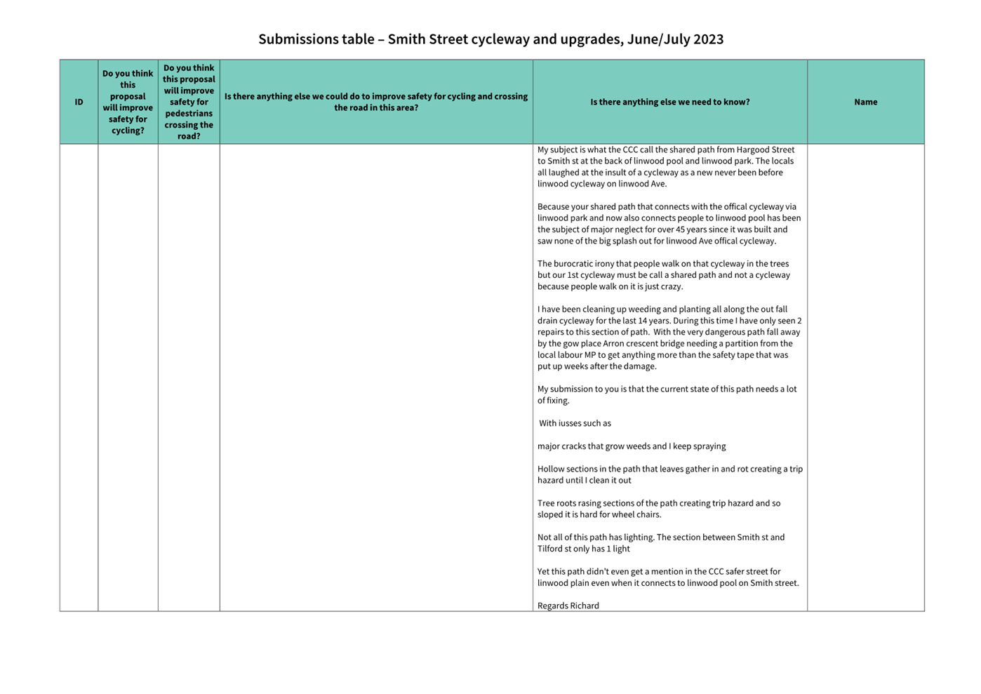
|
Council
21 September 2023
|

|
|
14. Transport Choices - Slow Speed Neighbourhoods
Linwood
|
|
Reference / Te Tohutoro:
|
23/1169856
|
|
Report of / Te Pou Matua:
|
Chris
Strydom, Project Manager Transport,
chris.strydom@ccc.govt.nz
Jacob Bradbury, Manager Planning & Delivery Transport,
jacob.bradbury@ccc.govt.nz
|
|
Senior Manager / Pouwhakarae:
|
Lynette
Ellis, Head of Transport & Waste Management (Lynette.Ellis@ccc.govt.nz)
|
1. Nature of Issue and Report Origin
1.1 The purpose of this report is to inform the Council of
feedback received, and to request Council to approve the design to proceed to
construction for the Transport Choices Slow Speed Neighbourhoods Linwood
project.
1.2 The origin of this report is the Climate Emergency Response
Fund (CERF) Transport Choices programme.
1.3 The
decisions in this report are of medium significance in relation to the Christchurch
City Council’s Significance and Engagement Policy 2019. The
level of significance was determined by potential benefits and opportunities to
the council/community, the number of people affected and/or with an interest,
and that these projects span multiple community board areas, as set out in the criteria
of the policy (Page 2). This evaluation has considered the Transport Choices
projects as a cohesive programme of work. This is consistent with how
community engagement has been undertaken, with all work packages being
presented concurrently on Have your Say under the banner of Way Safer Streets.
1.4 The speed limit changes referred to in the report were
approved by Council as part of the Interim Speed Management Plan process on 7
July 2023.
2. Officer Recommendations Ngā
Tūtohu
That the Council:
General
1. Approves that the traffic controls, stopping
and/or parking restrictions described in the recommendations of this report
take effect when infrastructure, signage and/or road markings that evidence the
controls and restrictions are in place (or removed in the case of
revocations).
2. Approves that any previously approved
resolutions made pursuant to any Bylaw, Local Government Act or any Land
Transport Rule and pertaining to traffic controls, stopping and/or parking
restrictions (but excluding speed limits) in so far as they conflict with the
recommendations of this report be revoked.
3. Approves that construction of the Linwood Slow
Speeds Neighbourhood project is conditional on implementation costs being
agreed and incorporated into the Transport Choices Funding agreement between
Waka Kotahi and Council.
Road Layout
Changes:
4. Approves the scheme design as detailed on plan
TP361601 Armagh Street – Trent Street – Brittan Street), and
attached to this report as Attachment A.
5. Approves the scheme design as detailed on plan
TG361601 Woodham Street – Brittan Street, and attached to this report as Attachment
B.
6. Approves the scheme design as detailed on plan
TG361601 Buckleys Road – Mclean Street, and attached to this report as Attachment
C.
7. Approves the scheme design as detailed on plan
TG361601 Linwood Avenue – Worcester Street, and attached to this report
as Attachment D.
Traffic
Controls - Attachment A: Armagh/Trent Intersection
8. Approves pursuant to the Christchurch City
Council Traffic and Parking Bylaw 2017 and Part 21 of the Local Government Act
1974:
a. That the stopping of vehicles be prohibited at
any time on the north side of Armagh Street commencing at its intersection with
Trent Street and extending in a westerly direction for a distance of 38 metres.
b. That the stopping of vehicles be prohibited at
any time on the west side of Trent Street commencing at its intersection with
Armagh Street and extending in a northerly direction for a distance of 13
metres.
c. That the stopping of vehicles be prohibited at
any time on the east side of Trent Street commencing at its intersection with
Armagh Street and extending in a northerly direction for a distance of 13
metres.
d. That the stopping of vehicles be prohibited at
any time on the north side of Armagh Street commencing at its intersection with
Trent Street and extending in an easterly direction for a distance of 39
metres.
e. That the stopping of vehicles be prohibited at
any time on the south side of Armagh Street commencing at a point 205 metres
east of its intersection with Stanmore Road and extending in an easterly
direction for a distance of 40 metres.
f. That the stopping of vehicles be prohibited at
any time on the south side of Armagh Street commencing at a point 173 metres
west of its intersection with England Street and extending in a westerly direction
for a distance of 37 metres.
g. That the stopping of vehicles be prohibited at
any time on the north side of Armagh Street commencing at its intersection with
Brittan Street and extending in a westerly direction for a distance of 7
metres.
h. That the stopping of vehicles be prohibited at
any time on the west side of Brittan Street commencing at its intersection with
Armagh Street and extending in a northerly direction for a distance of 14
metres.
i. That the stopping of vehicles be prohibited at
any time on the east side of Brittan Street commencing at its intersection with
Armagh Street and extending in a northerly direction for a distance of 14
metres.
j. That the stopping of vehicles be prohibited at
any time on the north side of Armagh Street commencing at its intersection with
Brittan Street and extending in an easterly direction for a distance of 11
metres.
Traffic
Controls - Attachment B: Woodham/Brittan Intersection
9. Approves that the Brittan Street approach at
its intersection with Woodham Road be controlled by a Give Way control, in
accordance with Section 4 and Section 10.2 of the Land Transport Rule: Traffic
Control Devices 2004.
Traffic
Controls - Attachment C: Buckleys/Mclean Intersection
10. Approves pursuant to the Christchurch City Council
Traffic and Parking Bylaw 2017 and Part 21 of the Local Government Act 1974:
a. That the stopping of vehicles be prohibited at
any time on the northwest side of Buckleys Road commencing at its intersection
with Mclean Street and extending in a southwesterly direction for a distance of
19 metres.
b. That the stopping of vehicles be prohibited at
any time on the southwest side of McLean Street commencing at its intersection
with Buckleys Road and extending in a northwesterly direction for a distance of
16 metres.
c. That the stopping of vehicles be prohibited at
any time on the northwest side of McLean Street commencing at its intersection
with Buckleys Road and extending in a northwesterly direction for a distance of
16 metres.
11. Approves that the Mclean Street approach at
its intersection with Buckleys Road be controlled by a Give Way control, in
accordance with Section 4 and Section 10.2 of the Land Transport Rule: Traffic
Control Devices 2004.
3. Reason for Report Recommendations Ngā Take mō te
Whakatau
3.1 This project is funded by
the Central Government Transport Choices programme – a $348million
national programme made available from the Climate Emergency Response
Fund.
3.2 The
Transport Choices programme is important because transport makes up almost half
of New Zealand’s carbon emissions. In May 2022, government released
its first Emissions Reduction Plan and transport has a significant role to
play, targeting a 20 percent reduction in light vehicle travel by 2035.
Reducing reliance on cars and supporting people to walk, cycle and use public
transport is one of three focus points of the Emissions Reduction Plan.
3.3 The
Slow Speed Neighbourhoods Linwood project was
included within the Transport Choices programme due to alignment with the
“creating walkable networks” investment category of the
programme.
3.4 Improving safety on local roads in Christchurch is a
priority for Council and is also a national priority under the principles and
guidance of the Te Ara ki te Ora Road to Zero - New Zealand’s road safety
strategy for 2020-2030. There are several focus areas being looked at
nationally to achieve this, but the most significant difference can be made
through having safe and appropriate speeds on our roads, and safer
infrastructure.
3.5 The speed limits that Council have approved for Linwood
through the Safe Speed Neighbourhood programme, Council’s Interim Speed
Management Plan, align with the safe and appropriate speed limit.
The supporting
infrastructure being proposed in this report are to support the safe and
appropriate speed limits being implemented, and support walking and cycling
journeys in the community.
4. Alternative Options Considered Ētahi atu Kōwhiringa
The Transport
Choices Programme
4.1 Transport
Choices funding was allocated to Local Authorities through an Expression of
Interest process administered by Waka Kotahi. Through that process
Christchurch City Council submitted a package of projects that was developed by
consideration of:
· Project alignment with the
four investment criteria for Transport Choices funding: deliver strategic
cycling/micro mobility networks; create walkable neighbourhoods; support safe,
green, and healthy school travel; make public transport more reliable and
easier to use;
· Achieving diversity across
the four investment categories for Transport Choices funding;
· Focusing investments in
certain suburbs;
· Community requests for
infrastructure improvements aligned with the Transport Choices programme
outcomes;
· Complimenting existing
programmes, such as the Major Cycleway Routes programme;
· Project complexity and
ability to deliver prior to June 2024.
4.2 All
14 projects submitted for Transport Choices funding were accepted by Waka
Kotahi. However, in deciding to include the Transport Choices programme
in the Draft Annual Plan, Council decided to include 11 projects in the
programme and defer a number of business-as-usual projects by 12 months to
enable the Transport Choices programme to be adequately resourced.
Project Options Considered
Maintain the status
quo
4.3 The
advantages of this option include:
4.3.1 Retains
on-street parking spaces that would be removed to implement safety
improvements.
4.4 The
disadvantages of the option include:
4.4.1 Does
not address the objective of supporting the safe and appropriate speeds or
improving facilities for walking and cycling.
4.4.2 Does
not implement gateway features into side roads so drivers entering the local
street are more aware of the change in the speed environment.
5. Detail Te Whakamahuki
5.1 The decision affects the following wards/Community Board areas:
5.1.1 Linwood
Ward
5.1.2 Waitai
Coastal-Burwood-Linwood Community Board
5.2 The
locations for the traffic calming were identified through a review of existing
gateway treatments onto local roads, customer requests from the hybris system
and a review of pedestrian crossing opportunities in the area. The following
locations were identified:
5.2.1 Trent
St/Armagh St
5.2.2 McLean
St/Buckleys Rd
5.2.3 Worcester
St/Linwood Ave
5.2.4 Brittan
St/Woodham Rd
5.3 The
scheme proposed for the Trent St/Armagh St intersection aims to reduce the
ongoing anti-social behaviour activity at this location. Reducing the
speed of vehicles using speed cushions and reducing the road width seeks to
discourage the anti-social behaviour raised by the residents.
5.4 The
crossing distance on McLean Street at Buckleys Road is just over 14 metres.
This location is just to the southwest of Te Pa O Rakaihautu School and would
is a crossing desire line for journeys to school. It is proposed to
provide a build out on the southwest side of McLean Street to improve the
visibility back towards Buckleys Road for people walking towards the east, and
a refuge island to allow people to take the crossing in two stages.
5.5 The
proposed traffic calming on the side streets at the Worcester Street / Linwood
Avenue and Brittan Street /Woodham Road intersections are included to
standardise the approaches for people exiting busier and faster roads onto
local residential streets. The proposed treatments are consistent with
other gateway treatments in the neighbourhood.
Public Consultation Te Tukanga Kōrerorero
5.6 Local
residents received warm up flyers in their mailboxes from 29 May, indicating we
would be seeking feedback on Way Safer Streets projects proposed for their area
in June.
5.7 Staff
attended a Linward collective hui (consisting of Te Whare Taonga o Ngā Iwi
Katoa Linwood Resource Centre, Bromley Community Trust, The Loft, CCC
Libraries, Christchurch Methodist Mission and St Chads Church and Linwood
Avenue Corner Trust) to brief them on Way Safer Streets projects in early June
2023. Recommended engagement tactics were taken on board.
5.8 Consultation
started on 16 June 2023 and ran until 16 July 2023, as part of the wider Way
Safer Streets consultation. An email was sent to 150 key stakeholders across
the entire Way Safer Streets programme, including emergency services, Spokes,
AA, Disabled Persons Assembly, Blind Low Vision, ECan, Mahaanui Kurataiao,
Whitau School, and The Loft at Eastgate. The consultation was posted on the
Council Facebook page, as well as local community groups, inviting submissions
on the Social
Pinpoint Map.
5.9 Consultation
documents (including a submission form) and flyers were available at Bromley
Community Centre, Linwood Union Church, Linwood Library, and Linwood Resource
Centre and Community Gardens.
5.10 Two
Newsline stories were published and picked up by local media outlets. Digital
screens were displaying the consultation in Civic Offices and Linwood Library,
as well as newspaper advertising in The Star and The Pegasus Post. Digital
billboards were utilised in Linwood, including outside Eastgate Mall. An online
targeted advertising campaign ran for the entire consultation period. Footpath
decals with QR codes were installed where intersection upgrades were proposed.
5.11 During
consultation, flyers were delivered to residents in the local area, and emails
were sent to those who expressed interest in being updated on Way Safer
Streets.
5.12 Key
stakeholder meetings throughout and after consultation, with Spokes, FENZ, St
John, NZ Police and Disabled Persons Assembly, further informed projects in the
Way Safer Streets program.
Summary of Submissions Ngā Tāpaetanga
5.13 Feedback
on the plans could be given by posting a comment on the Social
Pinpoint Map, by making a submission, or both.
5.14 To
reduce confusion for submitters, consultation for this project was merged on
the Social
Pinpoint Map with ‘School Safety Linwood’ – another six
proposed intersection upgrades for the North Linwood area.
5.15 A
total of 19 submissions and 10 comments were made on these projects. 15
submissions were made via the Social
Pinpoint Map, and four submissions were made via email/PDF. Submissions
were made by Waitai Coastal-Burwood-Linwood Community Board, Waipapa
Papanui-Innes-Central Community Board, Disabled Persons Assembly, and 16
individuals. All submissions and comments are available in Attachment E.
5.16 On
the Social
Pinpoint Map, these projects received a total of 49 upvotes, 8 downvotes,
and 10 comments:
Summary
from social pinpoint interactions
|
Project pin
|
Comments
|
Upvotes
|
Downvotes
|
|
Overall project pin
|
5
|
19
|
3
|
|
Site 7 - Armagh Street, Trent Street,
Brittan Street - pedestrian refuge islands and speed cushions
|
1
|
6
|
0
|
|
Site 8 – Woodham Road / Brittan
Street - speed hump and painted markings
|
1
|
8
|
3
|
|
Site 9 – Buckleys Road/Mclean
Street - pedestrian crossing & traffic calming
|
0
|
10
|
1
|
|
Site 10 - Worcester Street / Linwood
Avenue - speed hump
|
3
|
6
|
1
|
|
Total
|
10
|
49
|
8
|
|
Other projects (School Safety Linwood)
|
22
|
43
|
4
|
5.17 Comment
sentiment was predominantly positive (50.0%), or mixed (40.0%):
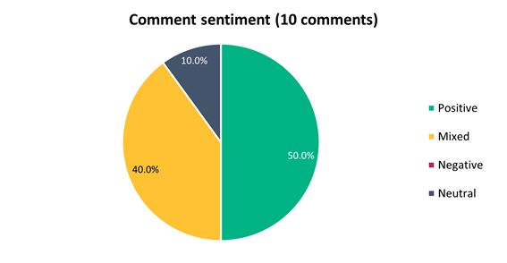
5.18 Submitters
were asked how they travel through this area. The majority (66.7%) of
submitters use this area via car (as the driver), followed by walking (60.0%):
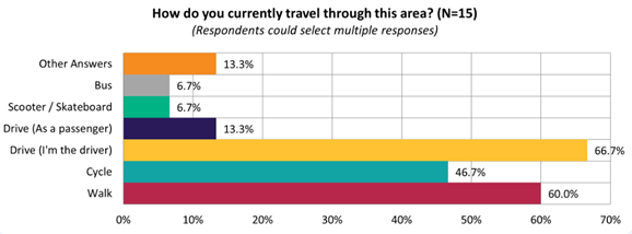
5.19
The majority of submitters felt this proposal would improve
safety for pedestrians (53.3%):
5.20 This
sentiment differed slightly depending on whether they live on the affected
streets (i.e. Worcester Street, Tancred Street), live in local suburbs (i.e.
Linwood, Woolston), or live elsewhere:
|
Do you think this proposal
will improve safety for cycling?
|
Live on affected streets
|
Live in local suburbs
|
Live elsewhere
|
|
No
|
0
|
0
|
2
|
|
Somewhat
|
2
|
3
|
0
|
|
Yes
|
2
|
4
|
2
|
5.21 Key
themes and requests from both comments and submissions are summarised below.
Note that there could be cross-over between those making comments and making
submissions:
|
Key themes on outcomes of the
proposal
|
Number
of comments
|
Number
of submissions
|
Total
mentions
|
|
Supportive
of the proposed intersection upgrades
· This project is valuable in
addressing existing safety concerns and is long overdue
|
20
|
9
|
29
|
|
Raising
existing safety issues
· Discussing near misses that
they have witnessed on Buckleys Rd and McLean St, on Worcester St and Woodham
Rd with regards to speeding, and pedestrian crossings making access a lot
safer to Woodham Park and Whitau School
|
6
|
5
|
11
|
|
Not
supportive of certain treatments proposed
· Concern with roundabouts
proposed on Worcester St and resulting parking loss, which may have been
caused by confusion from the early engagement consultation letter which has
since changed as a result of community feedback
· Concern around visibility and
congestion, access, and wanting to shift certain features
|
3
|
2
|
5
|
|
Requests
|
Number of comments
|
Number of submissions
|
Total mentions
|
|
Requests
outside of existing proposed intersections
· Further traffic calming on
Worcester St, given the speed issues
· A crossing at Gloucester St
bridge
· Pedestrian crossings and
traffic calming at Brittan St/Armagh St and Linwood St/England St/Armagh St
intersections
· Maintenance of the shared
path from Hargood St to Smith St
· Traffic calming on streets
around Woodhouse St, Tancred St, Rochester St and Surrey St
|
3
|
4
|
7
|
|
Shifting
a pedestrian crossing
· Specifically requesting a
certain treatment be shifted, for instance, pedestrian refuge islands further
away from intersections
|
3
|
3
|
6
|
|
Resealing
/ tidying the road condition
· Requests have been made to
address Worcester St earthquake damage in the road, incorporating Surrey St
condition, improve footpath condition and tidiness generally in the east, and
increase street trees
|
0
|
4
|
4
|
|
Accessibility
/ mobility requests
· Ensure crossings are smooth
and wide to accommodate a range of mobility devices
· Increasing access for those
with visual and mobility impairments who have less choice is important
· That pedestrian crossings are
safe and visible, with good lighting, tactile strips, mobility kerb cuts, and
sufficient turning space for wheelchairs/mobility aids
|
2
|
2
|
4
|
|
Additional
traffic calming measures in existing plans
· More speed bumps on Worcester
St and Armagh St
· Another speed cushion on
Rowcliffe Cres close to main intersection of Woodham Rd
|
1
|
1
|
2
|
5.22 Changes
made to the scheme design as a result of consultation feedback, the Safe System
Audit and Waka Kotahi feedback
5.22.1 It is proposed
to use speed humps rather than speed cushions. Speed cushions are not as
effective as speed humps when considered on their own, and if the gaps are too
big between the two cushions, vehicles may pass over a cushion without being
affected by the cushion.
5.22.2 It is proposed
to change the shape of the pedestrian island on Mclean Street to re-enforce the
left-in/left-out movement.
6. Policy Framework Implications Ngā Hīraunga ā- Kaupapa here
Strategic
AlignmentTe Rautaki
Tīaroaro
6.1 Council’s strategic priorities have
been considered in formulating the recommendations in this report, including,
enabling active and connected communities, and meeting the challenge of climate
change through every means available.
6.2 This report supports the Council's
Long Term Plan (2021 - 2031):
6.3 Transport
6.3.1 Activity: Transport
· Level of Service: 10.0.2 Increase the share of
non-car modes in daily trips - >=36% of trips undertaken by non-car modes
· Level of Service: 10.0.6.1 Reduce the number of
death and serious injury crashes on the local road network - <=100
crashes
· Level of Service: 10.0.41 Reduce emissions and
greenhouse gases related to transport - <=1.10 million tonnes of CO2
equivalents
· Level of Service: 10.5.1 Limit deaths and
serious injury crashes per capita for cyclists and pedestrians - <= 12
crashes per 100,000 residents
Policy
Consistency Te Whai
Kaupapa here
6.4 The proposals are
consistent with Council’s Plans and Policies, in
particular:
6.4.1 The
changes made align with road safety and liveable streets goals in the
Christchurch Transport Strategic Plan 2012–2042, and similarly in the
draft Transport Plan (safe streets).
6.4.2 The
changes made align with Kia tūroa te Ao - Ōtautahi Christchurch
Climate Resilience Strategy as set out in the Climate Change Impact
Considerations section below.
Impact
on Mana Whenua Ngā
Whai Take Mana Whenua
6.5 The
decision does not involve a significant decision in relation to ancestral land
or a body of water or other elements of intrinsic value, therefore this
decision does not specifically impact Mana Whenua,
their culture and traditions.
6.6 The
decision does not involve a matter of interest to Mana
Whenua and will not impact on our agreed partnership priorities with Ngā Papatipu Rūnanga.
Climate Change Impact Considerations Ngā Whai Whakaaro mā te
Āhuarangi
6.7 The decisions in this report are likely to:
6.7.1 Contribute
neutrally to adaptation to the impacts of climate change.
6.7.2 Contribute
positively to emissions reductions.
6.8 The
emission reductions associated with this project have not been estimated.
6.9 The Government’s Emissions Reduction Plan states we
will have to ‘substantially improve infrastructure for walking and
cycling’ to meet our emissions targets (including a 20% reduction in
light Vehicle Kilometres Travelled by 2035 - required under the Emissions
Reduction Plan). Improving the quality of our streets for walking and cycling
is also a key part of the Ministry of Transport and Waka Kotahi’s efforts
to decarbonise the transport system.
6.10 New
Zealand has the 5th highest transport emissions rate per capita
among the 43 OECD countries. Petrol or diesel car use is typically the
single-biggest contributor to an individual’s carbon footprint within New
Zealand.
6.11 From
the 2022 Life in Christchurch Transport Survey, 96 percent of respondents
travel by car. Respondents find car travel the least difficult means of
travel: "We use car travel as it is easier. Christchurch is very spread
out and to have several buses is not convenient." Inconsiderate and
dangerous behaviour from other road users and sharing the road with cars were
the main reasons respondents found it difficult to bike.
6.12 The
proposed changes make it safer for people walking and cycling, which will have a net positive impact for the climate by
helping to reduce transport emissions. Enabling more people to walk or cycle,
particularly for local journeys, is a key part of council’s emissions
reduction efforts by providing a safe, low emission way for residents to move
around the city.
Accessibility
Considerations Ngā
Whai Whakaaro mā te Hunga Hauā
6.13 This proposal improves accessibility for people walking and
cycling, by providing a safer means of accessing and using our street network.
6.14 Waka
Kotahi developed a set of Project Design Parameters to ensure all projects work
to collectively meet the programme objectives. The Project Design
Parameters require that “the infrastructure should be designed for
children and people with visual, mobility, or cognitive impairments. If the
infrastructure works for them, it will work for a wider spectrum of the
population who are interested in walking and cycling but concerned for their safety.”
Transport Choices projects have been designed in accordance with these
requirements.
7. Resource Implications Ngā Hīraunga Rauemi
Capex/Opex Ngā Utu Whakahaere
7.1 Cost
to Implement – The estimated costs for the improvements are as follows:
· Brittan St/Woodham Rd -
Speed hump $15,000
· Trent St/Armagh St -
Crossings and speed humps $100,000
· Worcester St/Linwood Ave -
Speed hump $20,000
· McLean St/Buckleys Rd -
Build out/refuge island and speed humps $65,000.
7.2 Maintenance/Ongoing
costs - generally consistent with existing
maintenance costs. These costs will be eligible for Waka Kotahi subsidy
at Council’s 51% Funding Assistance Rate. The net maintenance cost for
the full Transport Choices programme will have an ongoing rates impact of approximately
0.01%, which will be included in the draft Long Term Plan proposed budgets.
7.3 Funding
Source – Councils capital programme:
7.3.1 ID
72776, Transport Choices 2022 – Slow Speed Neighbourhoods Linwood,
$1,453,562
7.4 Waka
Kotahi through the Transport Choices programme will be funding the project up
to an agreed value which is calculated as 90% of the expected implementation
cost. The remaining 10% is Council’s share.
7.5 Under
the cost share agreement with Waka Kotahi, funding approvals for individual
Transport Choices projects are approved through two stage gates: design and
physical works. All Transport Choices projects have agreed funding schedules
for design. Individual project schedules for physical works are required to be
agreed and approved prior to 20 October 2023. In approving funding for physical
works, Waka Kotahi will consider:
7.5.1 The
project is in accordance with the scope and design approved by Waka
Kotahi.
7.5.2 Project
costs are in accordance with expectations.
7.5.3 Ability
to deliver the project prior to June 2024.
7.6 The
staff recommendations of this report include that Council’s approval of
this project is conditional on a funding agreement with Waka Kotahi being in
place for the physical works.
8. Legal Implications Ngā Hīraunga ā-Ture
Statutory power to undertake proposals in the report
Te Manatū Whakahaere Kaupapa
8.1 Council resolved the
Transport Choices programme as Metropolitan Significance when the programme was
included in the draft Annual Plan in February 2023/24.
8.2 Council
retains decision-making responsibilities that might otherwise be delegated in
accordance with the Delegations Register when a project is determined as
Metropolitan Significance.
8.3 Part
1, Clauses 7 and 8 of the Christchurch City Council Traffic and Parking Bylaw
2017 provides Council with the authority to install parking restrictions by resolution.
8.4 The
installation of any signs and/or markings associated with traffic control
devices must comply with the Land Transport Rule: Traffic Control Devices 2004.
Other Legal Implications Ētahi atu
Hīraunga-ā-Ture
8.5 There is no other legal context, issue or implication
relevant to this decision.
9. Risk Management Implications Ngā Hīraunga Tūraru
9.1 Scope – Waka Kotahi
has governed the scope and design of the project to align with programme
KPI’s and consistency with Transport Choices design parameters. Departing
from the recommendations of this report creates a risk that Waka Kotahi would
not agree to fund the physical works phase of the project.
9.2 Delivery
– Transport Choices funding is subject to delivery being complete by June
2024. Waka Kotahi has established additional milestones to track
progress. Delays in approval of the projects would impact on the
timeframe for delivery.
9.3 Funding
security - the Transport Choices funding agreement between Council and Waka
Kotahi presently covers this project for design only, and a further stage gate
approval is required to gain funding approval for construction. The
instruction of physical works will be withheld until an implementation
agreement is in place.
9.4 Implementation
cost uncertainty – the funding agreement with Waka Kotahi places the risk
of cost variations with Council. This risk is being managed by minimising
price uncertainty and building contingency into the funding agreement.
Attachments Ngā Tāpirihanga
|
No.
|
Title
|
Reference
|
Page
|
|
a ⇩ 
|
Slow Speed
Neighbourhood Linwood - Armagh/Trent
|
23/1248055
|
590
|
|
b ⇩
|
Slow Speed
Neighbourhood Linwood - Woodham/Brittan
|
23/1248063
|
591
|
|
c ⇩
|
Slow Speed
Neighbourhood Linwood - Buckleys/McLean
|
23/1248074
|
592
|
|
d ⇩ 
|
Slow Speed
Neighbourhood Linwood - Linwood/Worcester
|
23/1248087
|
593
|
|
e ⇩
|
School Safety
Linwood and Slow Speed Neighbourhoods - Submission Table (Public)
|
23/1374183
|
594
|
In addition to the attached documents, the following background
information is available:
|
Document
Name – Location / File Link
|
|
Not
applicable
|
Confirmation of Statutory
Compliance Te Whakatūturutanga ā-Ture
|
Compliance with Statutory Decision-making
Requirements (ss 76 - 81 Local Government Act 2002).
(a) This report contains:
(i) sufficient information about all reasonably practicable
options identified and assessed in terms of their advantages and
disadvantages; and
(ii) adequate consideration of the views and preferences of
affected and interested persons bearing in mind any proposed or previous
community engagement.
(b) The information reflects the level of significance of the
matters covered by the report, as determined in accordance with the Council's
significance and engagement policy.
|
Signatories Ngā Kaiwaitohu
|
Authors
|
Ryan Rolston -
Programme Manager
Chris Strydom
- Project Manager
Gemma Dioni -
Senior Transportation Engineer
Samantha Smith
- Engagement Advisor
Ann Tomlinson
- Project Manager
Wayne Gallot -
Senior Transportation Engineer
Sharon O'Neill
- Programme Manager Transport Capital Programme
|
|
Approved By
|
Jacob Bradbury
- Manager Planning & Delivery Transport
Tony
Richardson - Finance Business Partner
Lynette Ellis
- Head of Transport & Waste Management
|
|
Council
21 September 2023
|

|
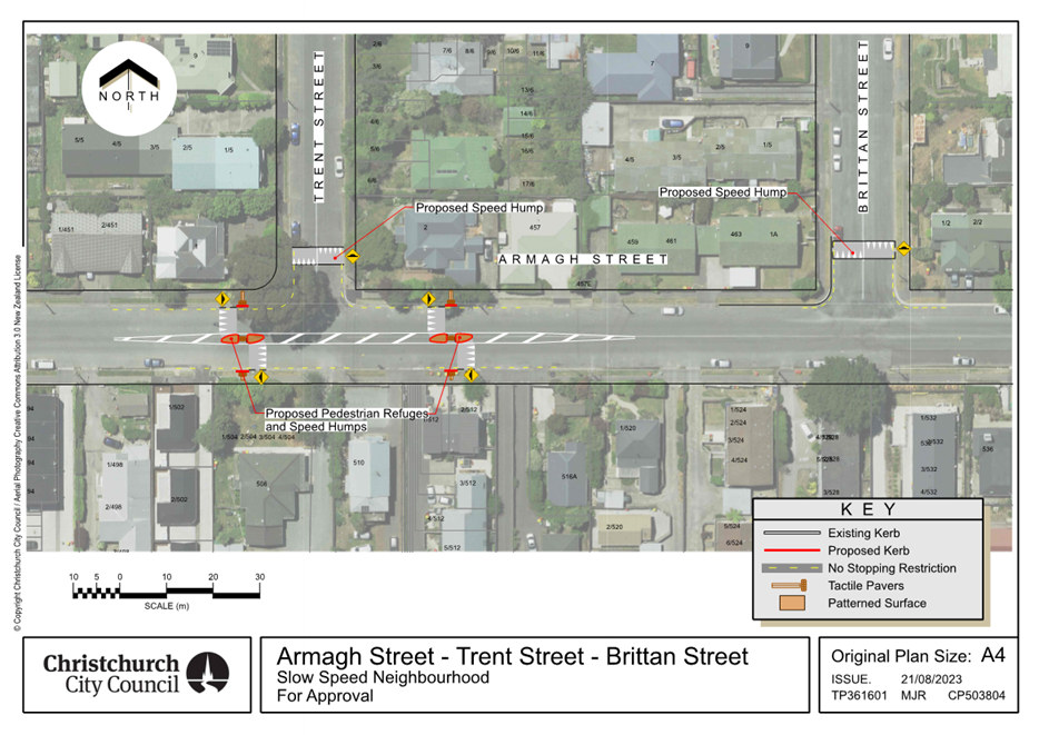
|
Council
21 September 2023
|
|
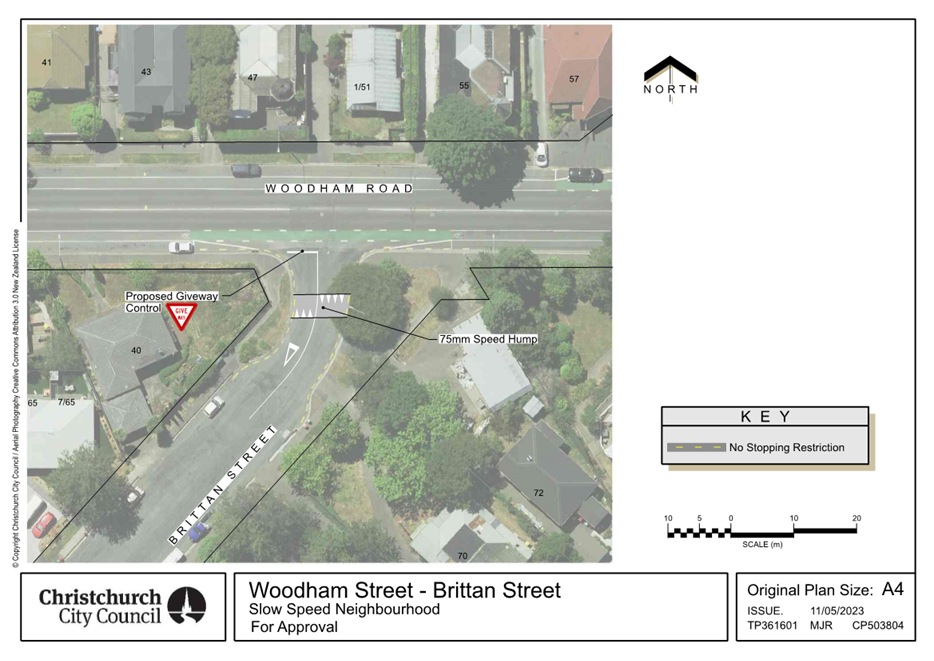
|
Council
21 September 2023
|
|
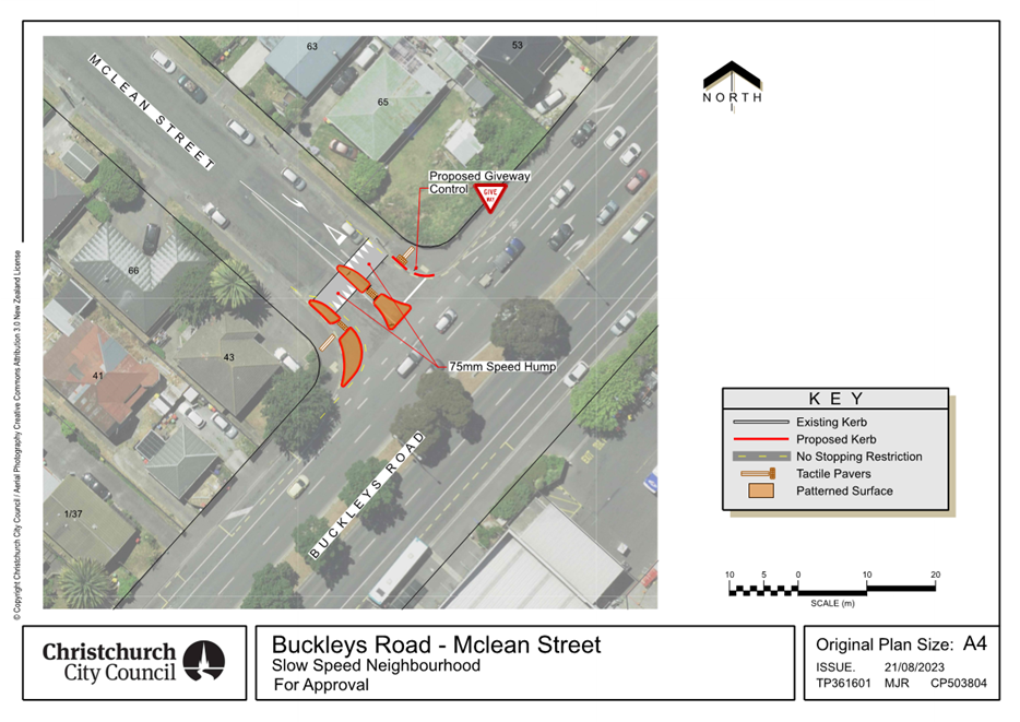
|
Council
21 September 2023
|
|
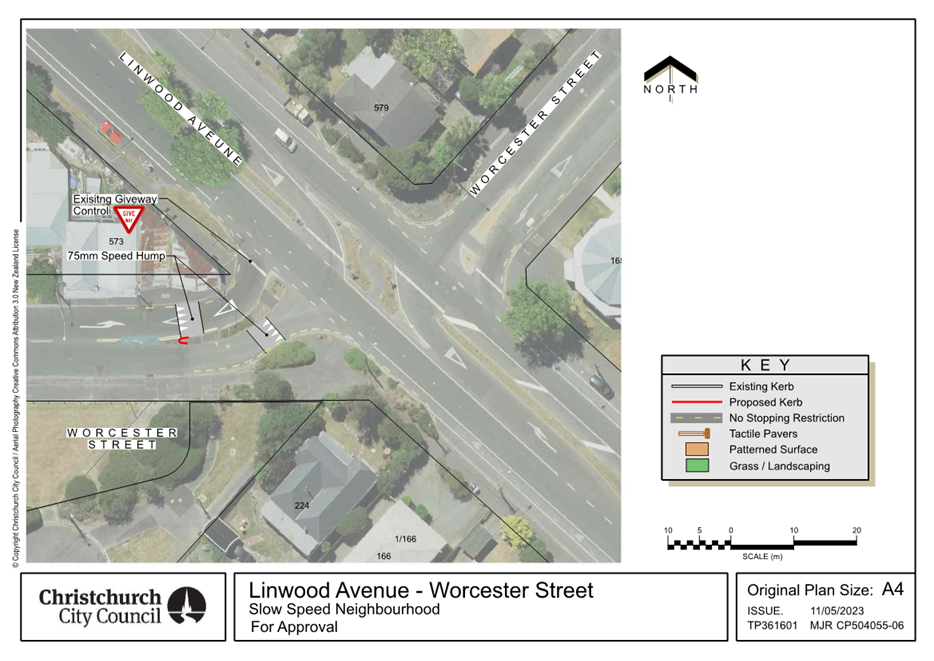
|
Council
21 September 2023
|
|
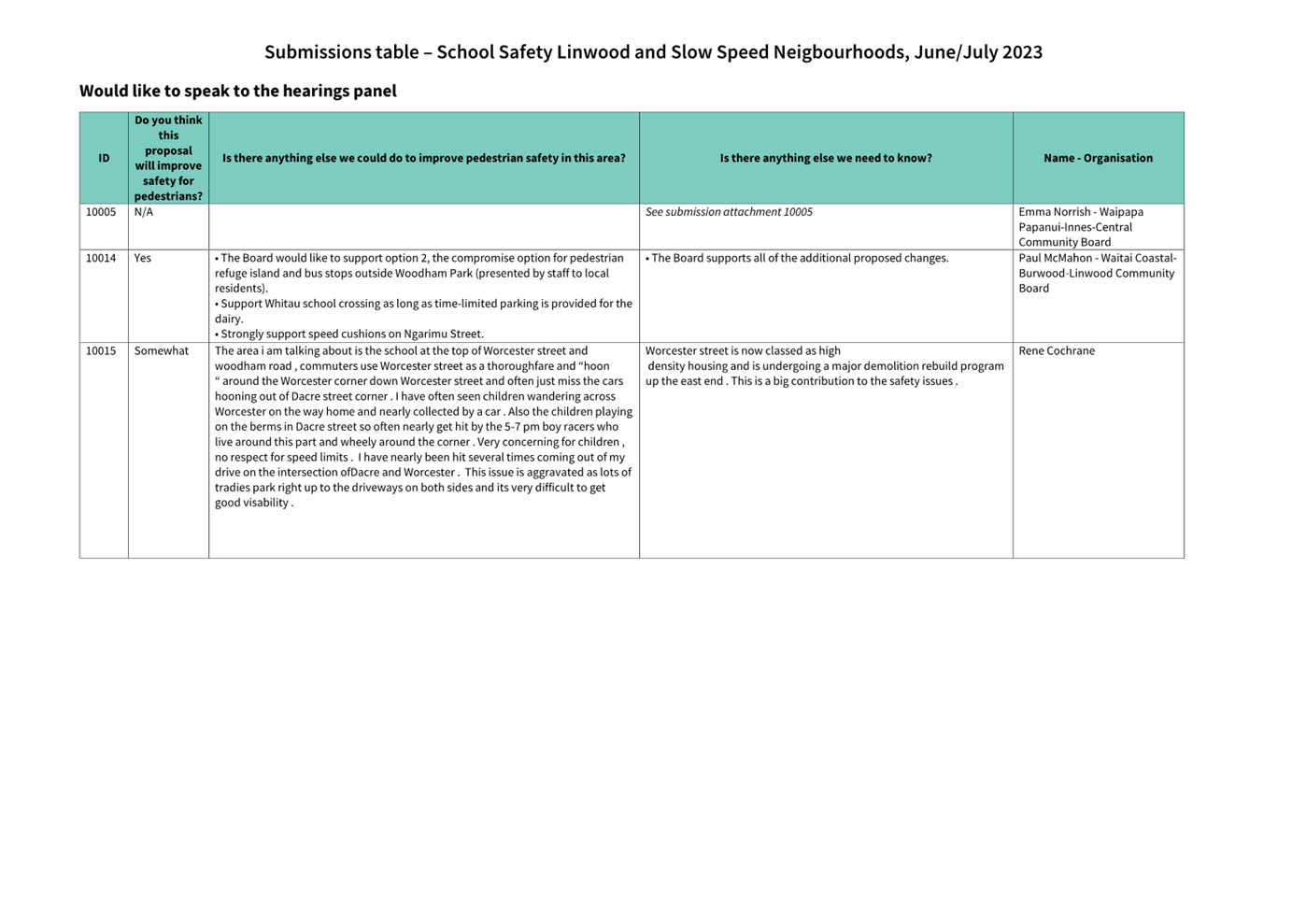
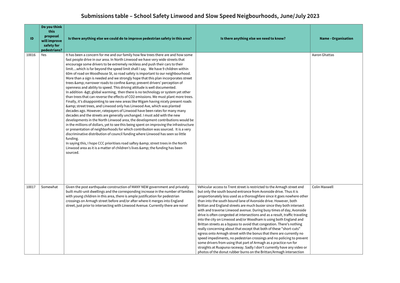


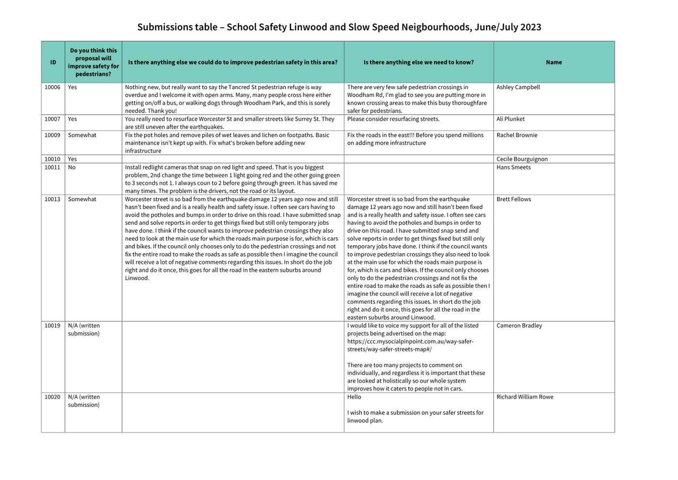
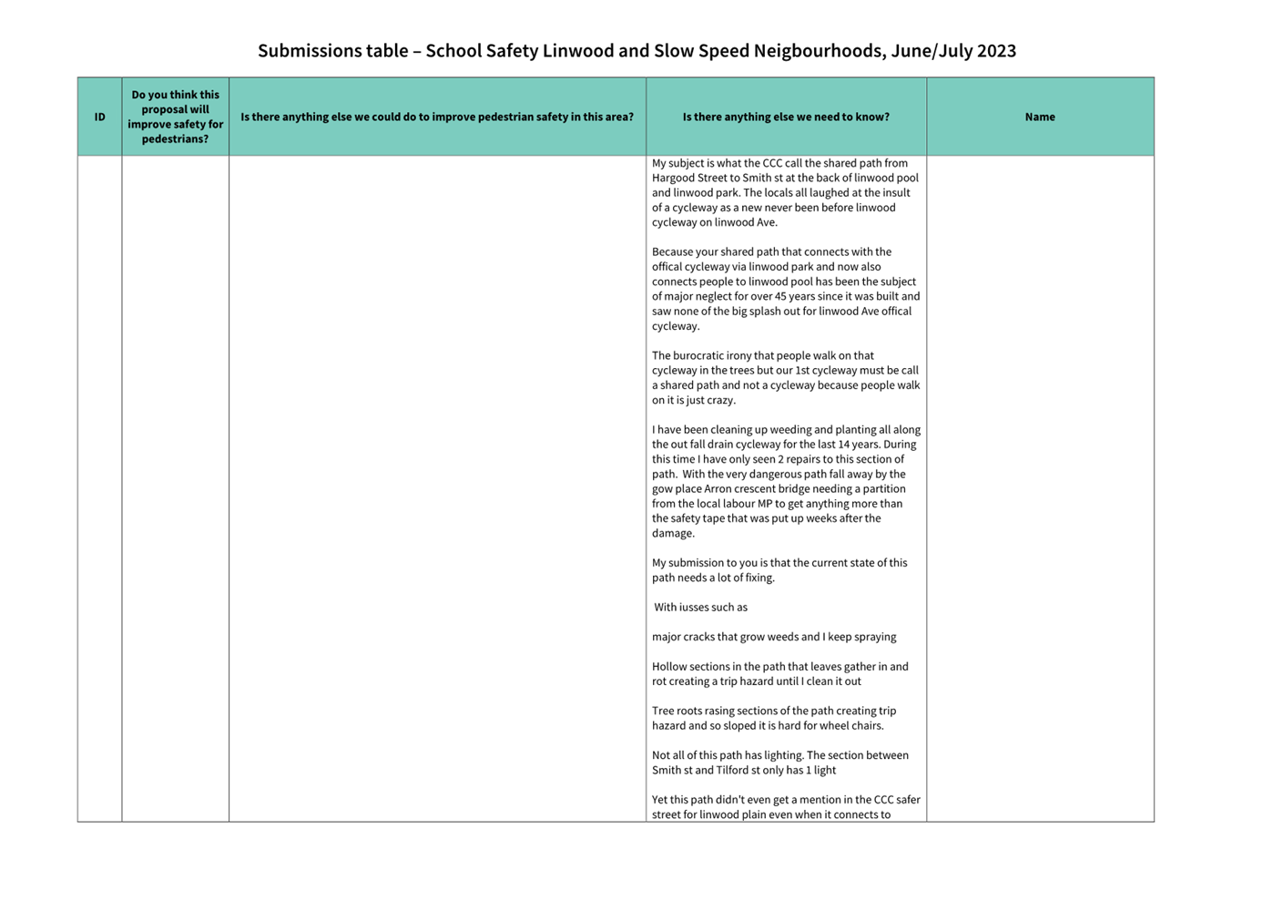
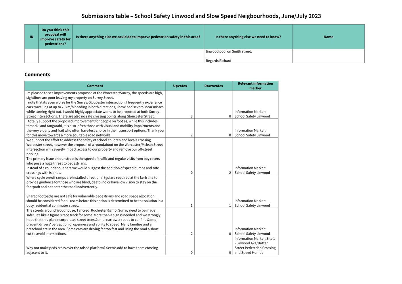


|
Council
21 September 2023
|
|
|
15. Transport Choices - Linwood Village Streetscape
Scheme Amendments
|
|
Reference / Te Tohutoro:
|
23/1213005
|
|
Report of / Te Pou Matua:
|
Alanna
Warhurst, Project Manager Transport,
Alanna.warhurst@ccc.govt.nz;
Jacob Bradbury, Manager Planning & Delivery Transport Jacob.bradbury@ccc.govt.nz
|
|
Senior Manager / Pouwhakarae:
|
Lynette
Ellis, Head of Transport & Waste Management (Lynette.Ellis@ccc.govt.nz)
|
1. Nature of Issue and Report Origin
1.1 The purpose of this report it to seek approval for minor
changes to the Linwood Village Streetscape Enhancements scheme.
1.2 Council approved the Linwood Village Streetscapes
Enhancements project on 8 September 2022 (CNCL/2022/00111), refer Attachment
A. During the detailed design phase several minor design issues were identified
that this report seeks to address.
1.3 The
decision in this report is of low significance in relation to the Christchurch
City Council’s Significance and Engagement Policy. The level of
significance was determined on the basis of the low number of people affected
by the minor amendments to the scheme.
2. Officer Recommendations Ngā
Tūtohu
That the Council:
General
1. Approves that construction of the Transport
Choices - Linwood Village Streetscape Scheme project is conditional on
implementation costs being agreed and incorporated into the Transport Choices
Funding agreement between Waka Kotahi and Council.
2. Approves that the traffic controls, stopping
and/or parking restrictions described in resolutions 4 to 8 take effect when
infrastructure, signage and/or road markings that evidence the controls and
restrictions are in place.
Revocations
3. Approves that any previously approved
resolutions, pertaining to traffic controls, made pursuant to any bylaw to the
extent that they are in conflict with the traffic controls described in
recommendations 4 to 8 below, are revoked.
Stanmore
Road/ Hereford Street Intersection
4. Approves all kerb alignments, islands, road
surface treatments and road markings at the intersection of Stanmore Road and
Hereford Street, as detailed on plan TP359201, sheet 1, and attached to this
report as Attachment B.
Gloucester
Street Bus Stops
5. Approves that the stopping of all vehicles be
prohibited at any time, in accordance with Clause 7 of the Christchurch City
Council Traffic & Parking Bylaw 2017, on the south side of Gloucester
Street, commencing at its intersection with Stanmore Road, and extending in a
westerly direction for a distance of 10 metres.
6. Approves that a Bus Stop be installed, in
accordance with Clause 7 of the Christchurch City Council Traffic & Parking
Bylaw 2017, on the south side of Gloucester Street, commencing at a point 10
metres west of its intersection with Stanmore Road, and extending in a westerly
direction for a distance of 14 metres.
7. Approves that the stopping of all vehicles be
prohibited at any time, in accordance with Clause 7 of the Christchurch City
Council Traffic & Parking Bylaw 2017, on the north side of Gloucester
Street, commencing at its intersection with Stanmore Road, and extending in an
easterly direction for a distance of 11 metres.
8. Approves that a Bus Stop be installed, in
accordance with Clause 7 of the Christchurch City Council Traffic & Parking
Bylaw 2017, on the north side of Stanmore Road commencing at a point 11 metres
east of its intersection with Stanmore Road, and extending in an easterly
direction for a distance of 14 metres.
Tree Removal
9. Approves the removal of one street tree as
detailed on plan TP359201, sheet 1, dated 23/08/2022 and attached to this
report as Attachment B.
3. Reason for Report Recommendations Ngā Take mō te
Whakatau
3.1 To address several minor design issues identified during
detailed design.
4. Alternative Options
Considered Ētahi atu Kōwhiringa
4.1 Council
approved the Linwood Village Streetscapes Enhancements project on 8 September
2022 (CNCL/2022/00111). The approved scheme is provided for reference as
Attachment A. The amendments recommended in this report reduces
implementation costs and improves functionality of the design.
5. Detail Te Whakamahuki
Bus Stops
5.1 It
is proposed to make refinements to the position of Gloucester Street bus stops
each side of Stanmore Road. The reason is to locate the bus stops for
better kerb height at boarding / alighting areas which improves
accessibility. There are presently bus stops at these locations.
5.1.1 The
proposed location differs by approximately 5m from the existing bus stop
location and differs by approximately 10 metres from the approved location from
the original Linwood Village Streetscape Enhancements scheme.
5.1.2 The
proposed amendment has not been consulted on as the change in position of the
bus stop is insignificant.
Tree Removal
5.2 An
existing cabbage tree on the south-western side of the Gloucester Street /
Stanmore Road intersection is proposed to be removed. The reason is the
tree obstructs visibility of pedestrians and the traffic signals.
5.2.1 The approved scheme
removes five trees and introduces 23 new trees.
5.2.2 The proposed revision
means that six street trees will be removed and 23 trees introduced.
Hereford Street / Stanmore Road Raised Safety Platforms
5.3 A
modification to the approved raised safety platforms at the Hereford Street /
Stanmore Road intersection is proposed. The modification has less of an
impact on drainage and reduces associated implementation costs, whilst
providing the same outcomes and intent of the original design.
5.3.1 The proposed revision
shifts the raised platform to the approach side of the crossing points and
removes the platform for vehicles exiting the roundabout.
6. Policy Framework Implications Ngā Hīraunga ā-
Kaupapa here
Strategic
AlignmentTe Rautaki
Tīaroaro
6.1 This report supports the Council's
Long Term Plan (2021 - 2031):
6.2 Transport
6.2.1 Activity: Transport
· Level of Service: 10.5.42 Increase the
infrastructure provision for active and public modes - >= 585 kilometres
(total combined length)
Policy
Consistency Te Whai
Kaupapa here
6.3 The
decision is consistent with Council’s Plans and
Policies.
Impact
on Mana Whenua Ngā
Whai Take Mana Whenua
6.4 The
decision does not involve a significant decision in
relation to ancestral land or a body of water or other elements of intrinsic
value, therefore this decision does not specifically impact Mana Whenua, their
culture and traditions.
6.5 The
decision does not involve a matter of interest to Mana Whenua and should not
impact on our agreed partnership priorities with Ngā
Papatipu Rūnanga
6.6 The projects are based on minor changes to, or re-allocation of,
existing road spaces, so are not anticipated to have a significant impact on
Mana Whenua.
Climate
Change Impact Considerations Ngā Whai Whakaaro mā te Āhuarangi
6.7 The decisions in this report relating to minor scheme design changes
are likely to:
6.7.1 Contribute
neutrally to adaptation to the impacts of climate change.
6.7.2 Contribute
neutrally to emissions reductions.
Accessibility
Considerations Ngā
Whai Whakaaro mā te Hunga Hauā
6.8 Proposed amendments to bus stop locations support Councils Equity
and Access for People with Disabilities Policy.
7. Resource Implications Ngā Hīraunga Rauemi
Capex/Opex Ngā Utu Whakahaere
7.1 Cost
to Implement – revisions to the raised safety platforms at the Hereford
Street / Stanmore Road intersection reduce the implementation cost by
approximately $110,000 in comparison to the approved scheme.
7.2 Maintenance/Ongoing
costs – not affected by proposed amendments to the scheme.
7.3 Funding
Source – Councils capital programme:
7.3.1 ID
34094, Transport Choices 2022 – Linwood Village Streetscape Enhancements
(S1), $6,363,286.
7.4 Waka
Kotahi through the Transport Choices programme will be funding the project up
to an agreed value which is calculated as 90% of the expected implementation
cost. The remaining 10% is Council’s share.
8. Legal Implications Ngā Hīraunga ā-Ture
Statutory power to undertake proposals in the report
Te Manatū Whakahaere Kaupapa
8.1 Council
resolved the Transport Choices programme as Metropolitan Significance when the
programme was included in the draft Annual Plan in February 2023.
8.2 Council
retains decision-making responsibilities that might otherwise be delegated in
accordance with the Delegations Register when a project is determined as
Metropolitan Significance.
8.3 Part
1, Clauses 7 and 8 of the Christchurch City Council Traffic and Parking Bylaw
2017 provides Council with the authority to install parking restrictions by
resolution.
8.4 The
installation of any signs and/or markings associated with traffic control
devices must comply with the Land Transport Rule: Traffic Control Devices 2004.
Other Legal Implications Ētahi atu
Hīraunga-ā-Ture
8.5 There
is no legal context, issue or implication relevant to this decision.
9. Risk Management Implications Ngā Hīraunga Tūraru
9.1 Not
removing the cabbage tree as recommended creates the risk of a crash resulting
from lack of visibility of the traffic signals.
9.2 Not
amending the Hereford Street / Stanmore Road raised safety platforms as
recommended will either incur costs, or pose increased flooding risk to
adjacent properties.
Attachments Ngā Tāpirihanga
|
No.
|
Title
|
Reference
|
Page
|
|
a ⇩
|
Approved
Linwood Village Streetscape Scheme Design
|
22/547572
|
626
|
|
b ⇩
|
Amended
Linwood Village Streetscape Scheme Design (for approval)
|
23/1354146
|
627
|
In addition to the attached documents, the following background
information is available:
|
Document
Name – Location / File Link
|
|
Not
applicable
|
Confirmation of Statutory
Compliance Te Whakatūturutanga ā-Ture
|
Compliance with Statutory Decision-making
Requirements (ss 76 - 81 Local Government Act 2002).
(a) This report contains:
(i) sufficient information about all reasonably practicable
options identified and assessed in terms of their advantages and
disadvantages; and
(ii) adequate consideration of the views and preferences of
affected and interested persons bearing in mind any proposed or previous
community engagement.
(b) The information reflects the level of significance of the
matters covered by the report, as determined in accordance with the Council's
significance and engagement policy.
|
Signatories Ngā Kaiwaitohu
|
Authors
|
Samantha Smith
- Engagement Advisor
Ryan Rolston -
Programme Manager
Wayne Gallot -
Senior Transportation Engineer
Sharon O'Neill
- Programme Manager Transport Capital Programme
Barry Hayes -
Team Leader Transport Design
Alanna
Warhurst - Project Manager
Ann Tomlinson
- Project Manager
|
|
Approved By
|
Jacob Bradbury
- Manager Planning & Delivery Transport
Tony
Richardson - Finance Business Partner
Lynette Ellis
- Head of Transport & Waste Management
|
|
Council
21 September 2023
|
|
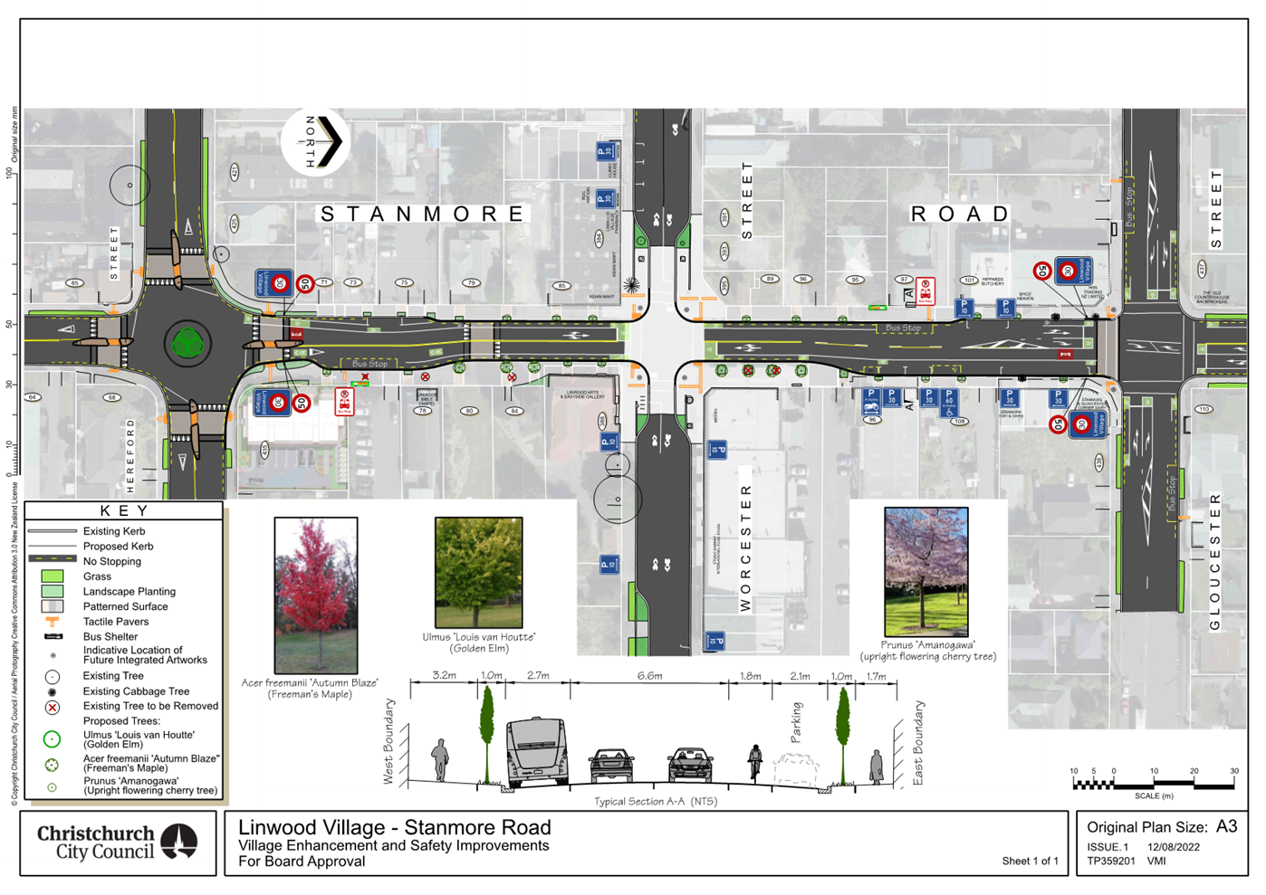
|
Council
21 September 2023
|
|
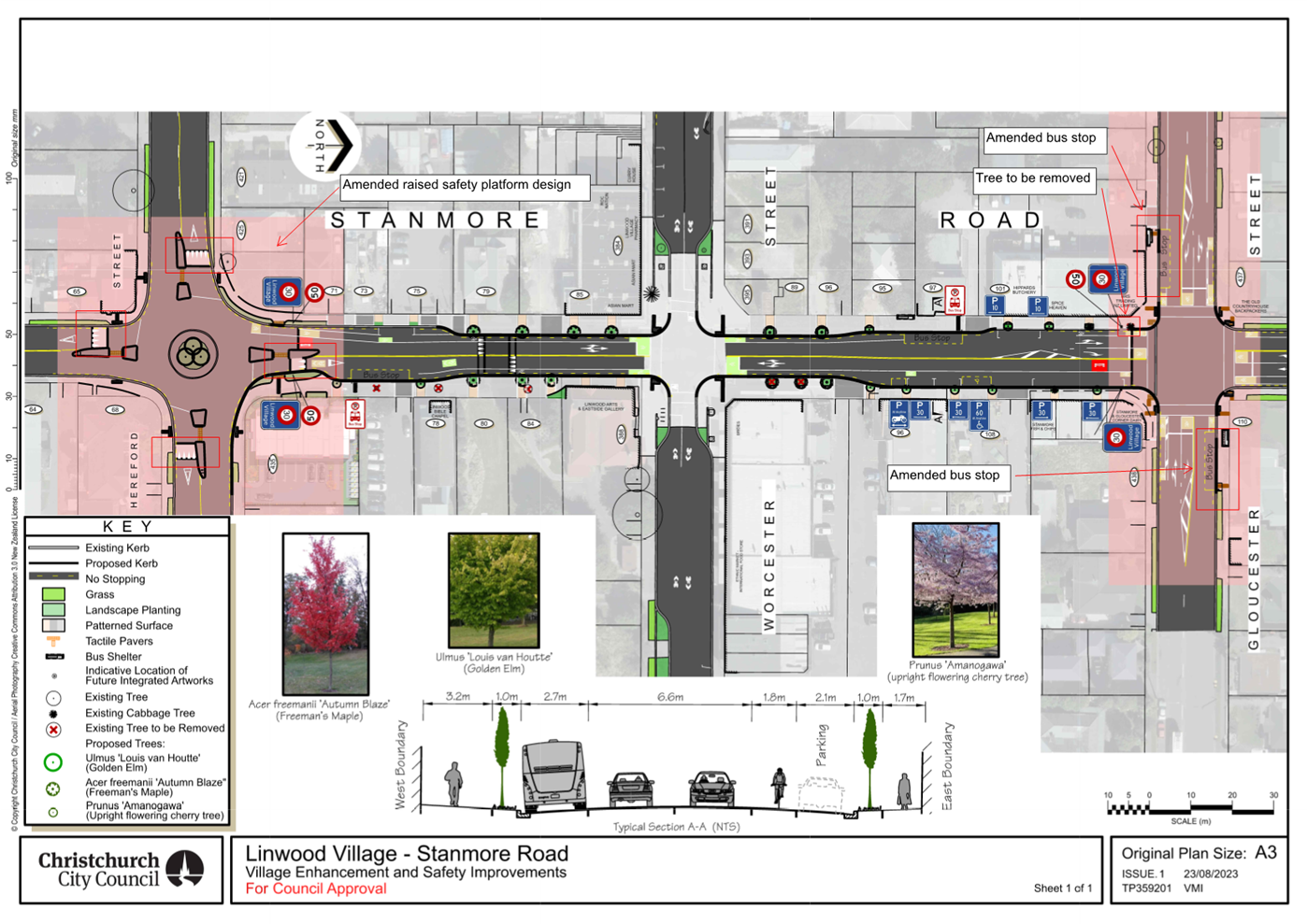
|
Council
21 September 2023
|
|
|
16. Transport Choices - Little River Link Cycle Connections
(Nga Puna Wai)
|
|
Reference / Te Tohutoro:
|
23/1192836
|
|
Report of / Te Pou Matua:
|
Andrew
Cameron, Project Manager Transport, andrew.cameron@ccc.govt.nz
Jacob Bradbury, Manager Planning & Delivery Transport, jacob.bradbury@ccc.govt.nz
|
|
Senior Manager / Pouwhakarae:
|
Lynette
Ellis, Head of Transport & Waste Management (Lynette.Ellis@ccc.govt.nz)
|
1. Nature of Issue and Report Origin
1.1 The purpose of this report is to inform the Council of
feedback received, and for the Council to approve the street lighting design to
proceed to construction for the Transport Choices - Little River Link Cycle
Connections (Nga Puna Wai) project.
1.2 The origin of this report is the Climate Emergency Response
Fund (CERF) Transport Choices programme.
1.3 The
decisions in this report are of medium significance in relation to the Christchurch
City Council’s Significance and Engagement Policy 2019. The
level of significance was determined by potential benefits and opportunities to
the council/community, the number of people affected and/or with an interest,
and that these projects span multiple community board areas, as set out in the criteria
of the policy (Page 2). This evaluation has considered the Transport Choices
projects as a cohesive programme of work. This is consistent with how
community engagement has been undertaken, with all work packages being
presented concurrently on Have your Say under the banner of Way Safer Streets.
2. Officer Recommendations Ngā
Tūtohu
That the Council:
1. Approves that construction of the Transport
Choices – Little River Link Cycle Connections (Nga Puna Wai) project is
conditional on implementation costs being agreed and incorporated into the
Transport Choices Funding agreement between Waka Kotahi and Council.
2. Approves the changes, including widening and
surfacing plus associated signage and markings, to paths and internal roadways within
Nga Puna Wai Sports Hub as generally shown on the plan TP362201 (‘Little
River Cycle Connections: Nga Puna Wai Sports Hub’, Sheets 1 and 2, Issue
1, dated 08/2023) included within this report as Attachments A.
3. Approves the installation of roadway and path
lighting within the Nga Puna Wai Sports Hub as detailed on plans prepared by
Connetics (‘Road Lighting Upgrade: Nga Puna Wai Cycle Connection’,
Sheets 2 and 3, Issue A, dated 12-06-23) included within this report as Attachment
B.
3. Reason for Report Recommendations Ngā Take mō te
Whakatau
3.1 This
project is funded by the Central Government Transport Choices programme –
a $348 million national programme made available from the Climate Emergency
Response Fund.
3.2 The
Transport Choices programme is important because transport makes up almost half
of New Zealand’s carbon emissions. In May 2022, government released
its first Emissions Reduction Plan and transport has a significant role to
play, targeting a 20 percent reduction in light vehicle travel by 2035.
Reducing reliance on cars and supporting people to walk, cycle and use public
transport is one of three focus points of the Emissions Reduction Plan.
3.3 The
Little River Link Cycle Connections project
was included within the Transport Choices programme due to alignment with the
“deliver strategic cycling/micro mobility networks” investment
category of the programme.
4. Alternative Options Considered Ētahi atu Kōwhiringa
The Transport
Choices Programme
4.1 Transport
Choices funding was allocated to Local Authorities through an Expression of
Interest process administered by Waka Kotahi. Through that process
Christchurch City Council submitted a package of projects that was developed by
consideration of:
4.1.1 Project
alignment with the four investment criteria for Transport Choices funding:
deliver strategic cycling/micro mobility networks; create walkable
neighbourhoods; support safe, green, and healthy school travel; make public
transport more reliable and easier to use;
4.1.2 Achieving
diversity across the four investment categories for Transport Choices funding;
4.1.3 Focusing
investments in certain suburbs;
4.1.4 Community
requests for infrastructure improvements aligned with the Transport Choices
programme outcomes;
4.1.5 Complimenting
existing programmes, such as the Major Cycleway Routes programme;
4.1.6 Project
complexity and ability to deliver prior to June 2024.
4.2 All
14 projects submitted for Transport Choices funding were accepted by Waka
Kotahi. However, in deciding to include the Transport Choices programme
in the Draft Annual Plan, Council decided to include 11 projects in the
programme and defer a number of business-as-usual projects by 12 months to
enable the Transport Choices programme to be adequately resourced.
Project Options Considered
4.3 Alternative
routes through the wetland area were considered however were dismissed due to
the propensity for flooding in this area, with the paths being under water
during heavy rain events. Raising the level of these paths was considered cost
prohibitive.
5. Detail Te Whakamahuki
5.1 The decision affects the following wards/Community Board areas:
5.1.1 Halswell
Ward
5.1.2 Waipuna
Halswell-Hornby-Riccarton Community Board
5.2 The
Nga Puna Wai sports Hub currently has a sealed shared path cycle connection
extending southeast to Haswell Road. To the north of the complex is the Little
River Major Cycleway Route link which is currently connected by unsealed paths
through the wetland area and on the main access road that leads from the Wigram
Road underpass. The underpass is currently only open to motorised vehicles
during large events such as show day. Pedestrian, cycle, and scooter
counts were taken just south of the underpass in February 2023 between 7:00 am
and 6:30 pm providing the following data.
|
Northbound
|
Southbound
|
|
Scooter
|
Bicycle
|
Pedestrian
|
Scooter
|
Bicycle
|
Pedestrian
|
|
|
0
|
49
|
27
|
1
|
48
|
29
|
|
|
|
|
|
|
|
|
|
5.3 Of
the 49 north bound cyclists 47% occurred between 7am and 8:30am with 56% of the
south bound cyclist between 3:30pm and 6:30pm. This suggests that this route is
currently being used as a commuter route.
5.4 This
project will be delivered as an addition to a separate parks project
reconstructing the unsealed access road from the Wigram Road under pass through
to the Hub.
5.5 The scope of the Transport Choices - Little River Link Cycle
Connections (Nga Puna Wai) following additional elements (refer Attachment A):
· Seal
the stretch of road from the Wigram Road underpass to the first intersection in
the Hub.
· Formalise
a 3m sealed cycle path from the access road linking to the shared path in the
Hub.
· Provide
wayfinding and road markings for cyclists.
· Provide
street lighting from the Wigram Road underpass to the Hub which then completes
a lit cycle route from the Little River MCR through to Halswell Road
5.6 The cycle way project does not add additional roading infrastructure
within the Hub instead it is raising the level of service for cyclists on
existing routes by providing a sealed finish. The street lighting that is being
included lights a section of road previously not lit and can be seen in Attachment
B.
Response to consultation feedback
Current safety
concerns
5.7 Submitters discussed not letting their children cycle through
Ngā Puna Wai alone, and visibility issues, as well as the safety issues
with the Wigram/Hayton junction for cyclists. Street lighting will
resolve visibility issues currently experienced at night. A project is
currently underway to upgrade the Wigram Hayton intersection. This is expected
to be constructed early 2024.
Extension to
the route / investigate other routes
5.8 It was requested that the Council investigates further connections
for both cyclists and pedestrians, including safer crossing over Wigram Road, a
connection to the Templetons Road shared path, McMahon Drive, and Hansons
Lane/Blenheim Road/Annex Road. This project will connect to the
Templetons Road shared path via the Hub shared path. The crossing of Wigram
Road will be signalised as part of another project. The Nga Puna Wai roadway
that connects to McMahon Drive will be sealed by Parks. Hansons Lane/Blenheim
Road/Annex Road are all out of scope for this project.
Lighting and
visibility
5.9 Suggestions were received about needing adequate lighting and
addressing visibility issues as part of this plan. Lighting is included
in the scheme.
Signage and
wayfinding
5.10 Requests
were received to investigate clear cycle marking and signage, that could
continue through to Halswell Road, as it is not currently clear where to cycle
and people are getting lost. This is included in the scheme design.
Request to
widen path
5.11 Requests
were made to further separate pedestrians and cyclists by creating a wider
path. The path widths proposed are in line with current best practice and
will not be widened.
Public Consultation Te Tukanga Kōrerorero
5.12 Local
residents received warm up flyers in their mailboxes from 29 May, indicating we
would be seeking feedback on Way Safer Streets projects proposed for their area
in June.
5.13 Consultation
started on 16 June 2023 and ran until 16 July 2023, as part of the wider Way
Safer Streets consultation. An email was sent to 150 key stakeholders across
the entire Way Safer Streets programme, including emergency services, Spokes,
AA, Disabled Persons Assembly, Blind Low Vision, Environment Canterbury,
Mahaanui Kurataiao, Halswell Residents Association and local sports groups
including Athletics Canterbury and Canterbury Hockey. The consultation was
posted on the council Facebook page, as well as local community groups,
inviting submissions on the Social
Pinpoint Map.
5.14 During
consultation, flyers were delivered to residents in the local area about the
wider Way Safer Streets programme, and emails were sent to those who expressed
interest in being updated on Way Safer Streets. Two Newsline stories were
published and picked up by local media outlets. Digital screens advertised the
consultation in Civic Offices, as well as newspaper advertising in The Star and
The
Southern View. An online targeted advertising campaign
ran for the entire consultation period.
5.15 An
A3 sign was installed in Ngā Puna Wai near the Templetons Road entrance to
capture current pedestrians and cyclists using existing connections, with a QR
code which directed local cyclists and pedestrians to the online consultation.
5.16 A
Christchurch-wide cycling event, “Christchurch Winter Solstice Matariki
Night Light Bike Ride” was attended and flyers were distributed to ensure
cyclists were aware of the wider Way Safer Streets programme.
5.17 Key
stakeholder meetings throughout and after consultation, with Spokes, FENZ, St
John, NZ Police and Disabled Persons Assembly, further informed projects in the
Way Safer Streets program.
Summary of Submissions Ngā Tāpaetanga
5.18 Feedback
on the plans could be given by posting a comment on the Social
Pinpoint Map, by making a submission, or both.
5.19 A
total of 24 submissions and 17 comments were made on the project. 18 submissions
were made in the interactive Social
Pinpoint Map, and six submissions were made via email/PDF. Submissions were
made by Halswell Residents Association, Disabled Persons Assembly, Waipuna
Halswell-Hornby-Riccarton Community Board, and 21 individuals. All submissions
and comments are available in Attachment C.
5.20 On
the Social
Pinpoint Map, the project received a total of 63 upvotes, 2 downvotes, and
17 comments.
5.21 Comment
sentiment was analysed in addition to submissions, where the majority of
comments were positive (76.5%):
5.22 Submitters
were asked for their reason for visiting Ngā Puna Wai. The majority
(88.9%) of submitters cycle through this area, and the ‘other
answer’ was running:
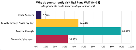
5.23 The
majority of submitters (61.1%) felt this proposal will improve safety for
cycling:
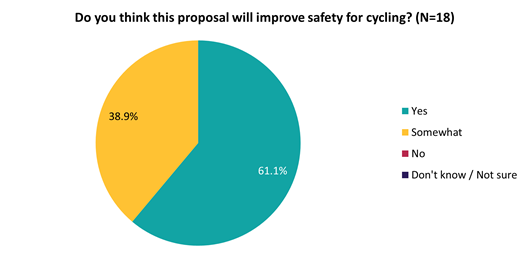
5.24 Key
themes and requests from both comments and submissions are summarised below.
Note that there could be cross-over between those making comments and making
submissions:
|
Key themes on outcomes of the
proposal
|
Number
of comments
|
Number
of submissions
|
Total
mentions
|
|
Support for the cycle connection
· General support for the idea,
and how it will address existing safety hazards
|
13
|
8
|
21
|
|
Current
safety concerns
· Discussed not letting their
children cycle through Ngā Puna Wai alone, and visibility issues, as
well as the safety issues with the Wigram/Hayton junction for cyclists
|
1
|
2
|
3
|
|
Current
access issues
· These submitters spoke of a
lack of a safe cycling connection to link existing cycleways and
intersections to Ngā Puna Wai generally, as well as through Hayton Basin
and Aidanfield Drive.
|
0
|
2
|
2
|
|
Requests
|
Number of comments
|
Number of submissions
|
Total mentions
|
|
Extension
to the route / investigate other routes
· Requests to investigate
further connections for both cyclists and pedestrians, including safer
crossing over Wigram Road, a connection to the Templetons Road shared path,
McMahon Drive, and Hansons Lane/Blenheim Road/Annex Road
|
5
|
8
|
13
|
|
Lighting
and visibility
· Suggestions about needing
adequate lighting and addressing visibility issues as part of this plan
|
0
|
4
|
4
|
|
Signage
and wayfinding
· Requests to investigate clear
cycle marking and signage, that could continue through to Halswell Road, as
it is not currently clear where to cycle and people are getting lost
|
1
|
3
|
4
|
|
Request
to widen path
· Requests to further separate
pedestrians and cyclists by creating a wider path
|
2
|
0
|
2
|
6. Policy Framework Implications Ngā Hīraunga ā- Kaupapa here
Strategic
Alignment Te Rautaki Tīaroaro
6.1 This report supports the Council's
Long Term Plan (2021 - 2031):
6.2 Transport
6.2.1 Activity: Transport
· Level of Service: 10.0.2 Increase the share of
non-car modes in daily trips - >=36% of trips undertaken by non-car modes
· Level of Service: 10.0.6.1 Reduce the number of
death and serious injury crashes on the local road network - <=100
crashes
· Level of Service: 10.0.41 Reduce emissions and
greenhouse gases related to transport - <=1.10 million tonnes of CO2
equivalents
· Level of Service: 10.5.1 Limit deaths and
serious injury crashes per capita for cyclists and pedestrians - <= 12
crashes per 100,000 residents
· Level of Service: 10.5.2 Improve the perception
that Christchurch is a cycling friendly city - >=66% resident satisfaction
· Level of Service: 10.5.3 More people are
choosing to travel by cycling - >=12,500 average daily cyclist detections
Policy
Consistency Te Whai
Kaupapa here
6.1 The
recommendations of this report are consistent with Council’s Plans and
Policies, in particular:
6.1.1 The
changes proposed align with road safety and liveable streets goals in the
Christchurch Transport Strategic Plan 2012–2042, and similarly in the
draft Transport Plan (safe streets).
6.2 The changes proposed align with Kia tūroa te Ao - Ōtautahi
Christchurch Climate Resilience Strategy as set out in the Climate Change
Impact Considerations section below.
Impact
on Mana Whenua Ngā
Whai Take Mana Whenua
6.3 The
decision does not involve a significant decision in relation to ancestral land
or a body of water or other elements of intrinsic value, therefore this
decision does not specifically impact Mana Whenua, their culture and
traditions.
6.4 The
decision does not involve a matter of interest to Mana Whenua and should not
impact on our agreed partnership priorities with Ngā Papatipu Rūnanga
6.5 The
projects are based on minor changes to, or re-allocation of, existing road
spaces, so are not anticipated to have a significant impact on Mana Whenua.
Climate
Change Impact Considerations Ngā Whai Whakaaro mā te Āhuarangi
6.6 The
decisions in this report are likely to:
6.6.1 Contribute
neutrally to adaptation to the impacts of climate change.
6.6.2 Contribute
positively to emissions reductions.
6.7 The
emission reductions associated with this project have not been estimated.
6.8 New
Zealander has the 5th highest transport emissions rate per capita
among the 43 OECD countries. Petrol or diesel car use is typically the
single-biggest contributor to an individual’s carbon footprint within New
Zealand.
6.9 From
the 2022 Life in Christchurch Transport Survey, 96 percent of respondents
travel by car. Respondents find car travel the least difficult means of
travel: "We use car travel as it is easier. Christchurch is very spread
out and to have several buses is not convenient." Inconsiderate and
dangerous behaviour from other road users and sharing the road with cars were
the main reasons respondents found it difficult to bike.
6.10 The
Transport Choices programme addresses barriers to people making sustainable
travel choices. Removing these barriers will lead to reductions in
vehicle kilometres travelled and consequently emissions from Transport.
Accessibility
Considerations Ngā
Whai Whakaaro mā te Hunga Hauā
6.11 Waka
Kotahi developed a set of Project Design Parameters to ensure all projects work
to collectively meet the programme objectives. The Project Design Parameters
require that “the infrastructure should be designed for children
and people with visual, mobility, or cognitive impairments. If the
infrastructure works for them, it will work for a wider spectrum of the
population who are interested in walking and cycling but concerned for their
safety.” Transport Choices projects have been designed in
accordance with these requirements.
7. Resource Implications Ngā Hīraunga Rauemi
Capex/Opex Ngā Utu Whakahaere
7.1 Cost
to Implement - the estimate to implement the project inclusive of all elements
is $450,000.
7.2 Maintenance/Ongoing
costs – The additional ongoing maintenance cost for street lighting has
been calculated at $286 per annum. The net maintenance cost for the total
Transport Choices programme will have an ongoing rates impact of approximately
0.01%, which will be included in the draft Long Term Plan proposed budgets.
7.3 Funding
Source – Councils capital programme:
7.3.1 ID
72760, Transport Choices 2022 – Little River Link Cycle Connections
$4,303,242
7.4 Waka
Kotahi through the Transport Choices programme will be funding the project up
to an agreed value which is calculated as 90% of the expected implementation
cost. The remaining 10% is Council’s share.
7.5 Under
the cost share agreement with Waka Kotahi, funding approvals for individual
Transport Choices projects are approved through two stage gates: design and
physical works. Funding approvals for this project are in place for both design
and physical works.
8. Legal Implications Ngā Hīraunga ā-Ture
Statutory power to undertake proposals in the report
Te Manatū Whakahaere Kaupapa
8.1 Council
resolved the Transport Choices programme as Metropolitan Significance when the
programme was included in the draft Annual Plan in February 2023/24.
8.2 Council
retains decision-making responsibilities that might otherwise be delegated in
accordance with the Delegations Register when a project is determined as
Metropolitan Significance.
Other Legal Implications Ētahi atu
Hīraunga-ā-Ture
8.3 There
is no legal context, issue or implication relevant to this decision.
9. Risk Management Implications Ngā Hīraunga Tūraru
9.1 Scope
– Waka Kotahi has governed the scope and design of the project to align
with programme KPI’s and consistency with Transport Choices design
parameters. Departing from the recommendations of this report creates a risk
that Waka Kotahi would not agree to fund the physical works phase of the
project.
9.2 Delivery
– Transport Choices funding is subject to delivery being complete by June
2024. Waka Kotahi has established additional milestones to track
progress. This project is presently on track in compliance with all
milestones.
9.3 Implementation
cost uncertainty – the funding agreement with Waka Kotahi places the risk
of cost variations with Council. This risk is being managed by minimising
price uncertainty and building contingency into the funding agreement.
Attachments Ngā Tāpirihanga
|
No.
|
Title
|
Reference
|
Page
|
|
a ⇩
|
Scheme plan
|
23/1382836
|
639
|
|
b ⇩
|
Lighting
design
|
23/1382839
|
641
|
|
c ⇩
|
Ngā Puna
Wai - Submission Table (Public)
|
23/1371039
|
643
|
In addition to the attached documents, the following background
information is available:
|
Document
Name – Location / File Link
|
|
Not
applicable
|
Confirmation of Statutory
Compliance Te Whakatūturutanga ā-Ture
|
Compliance with Statutory Decision-making
Requirements (ss 76 - 81 Local Government Act 2002).
(a) This report contains:
(i) sufficient information about all reasonably practicable
options identified and assessed in terms of their advantages and
disadvantages; and
(ii) adequate consideration of the views and preferences of
affected and interested persons bearing in mind any proposed or previous
community engagement.
(b) The information reflects the level of significance of the
matters covered by the report, as determined in accordance with the Council's
significance and engagement policy.
|
Signatories Ngā Kaiwaitohu
|
Authors
|
Ryan Rolston -
Programme Manager
Andrew Cameron
- Project Manager
Samantha Smith
- Engagement Advisor
Ann Tomlinson
- Project Manager
|
|
Approved By
|
Jacob Bradbury
- Manager Planning & Delivery Transport
Tony
Richardson - Finance Business Partner
Lynette Ellis
- Head of Transport & Waste Management
|
|
Council
21 September 2023
|
|
|
Council
21 September 2023
|
|
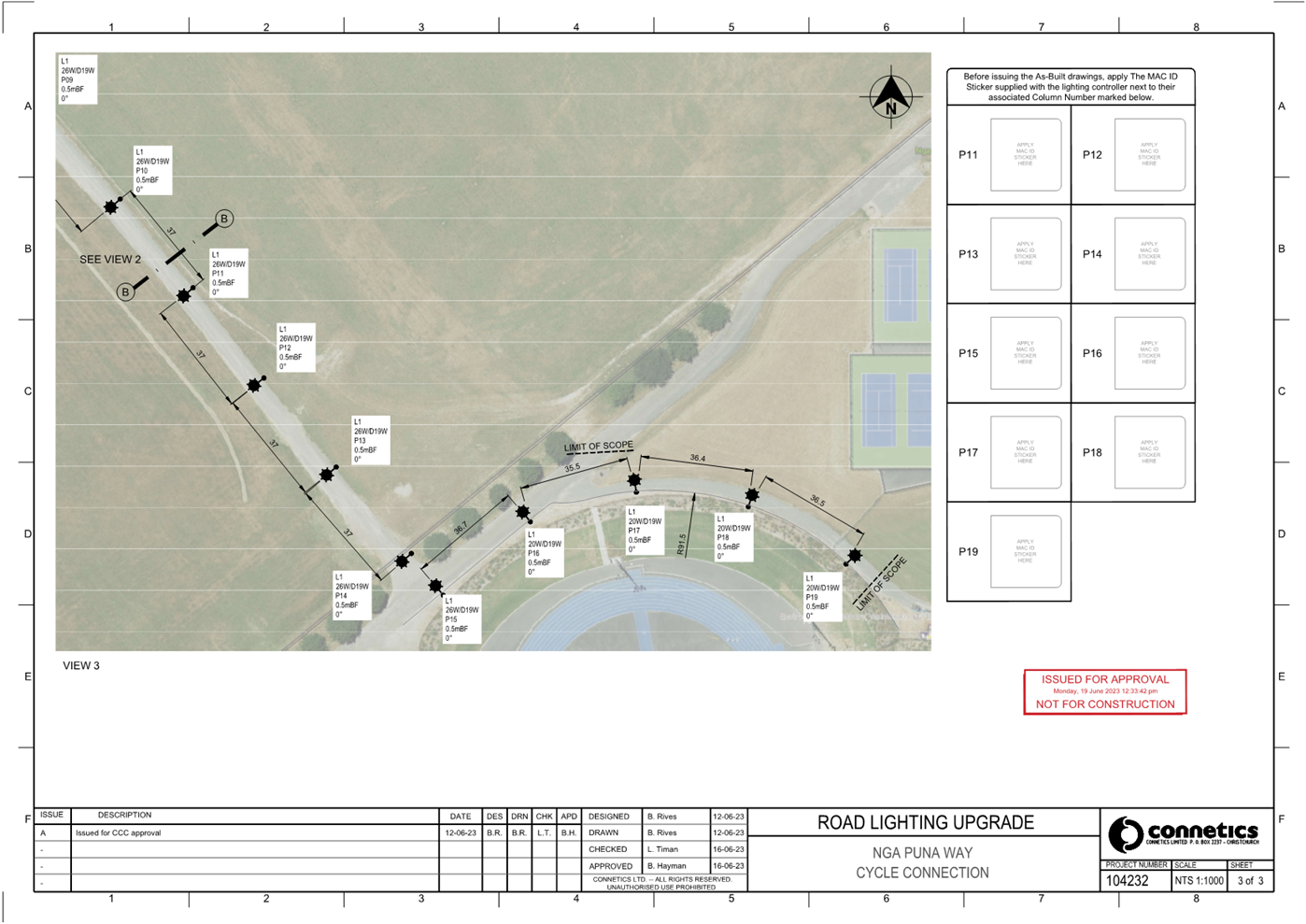
|
Council
21 September 2023
|
|

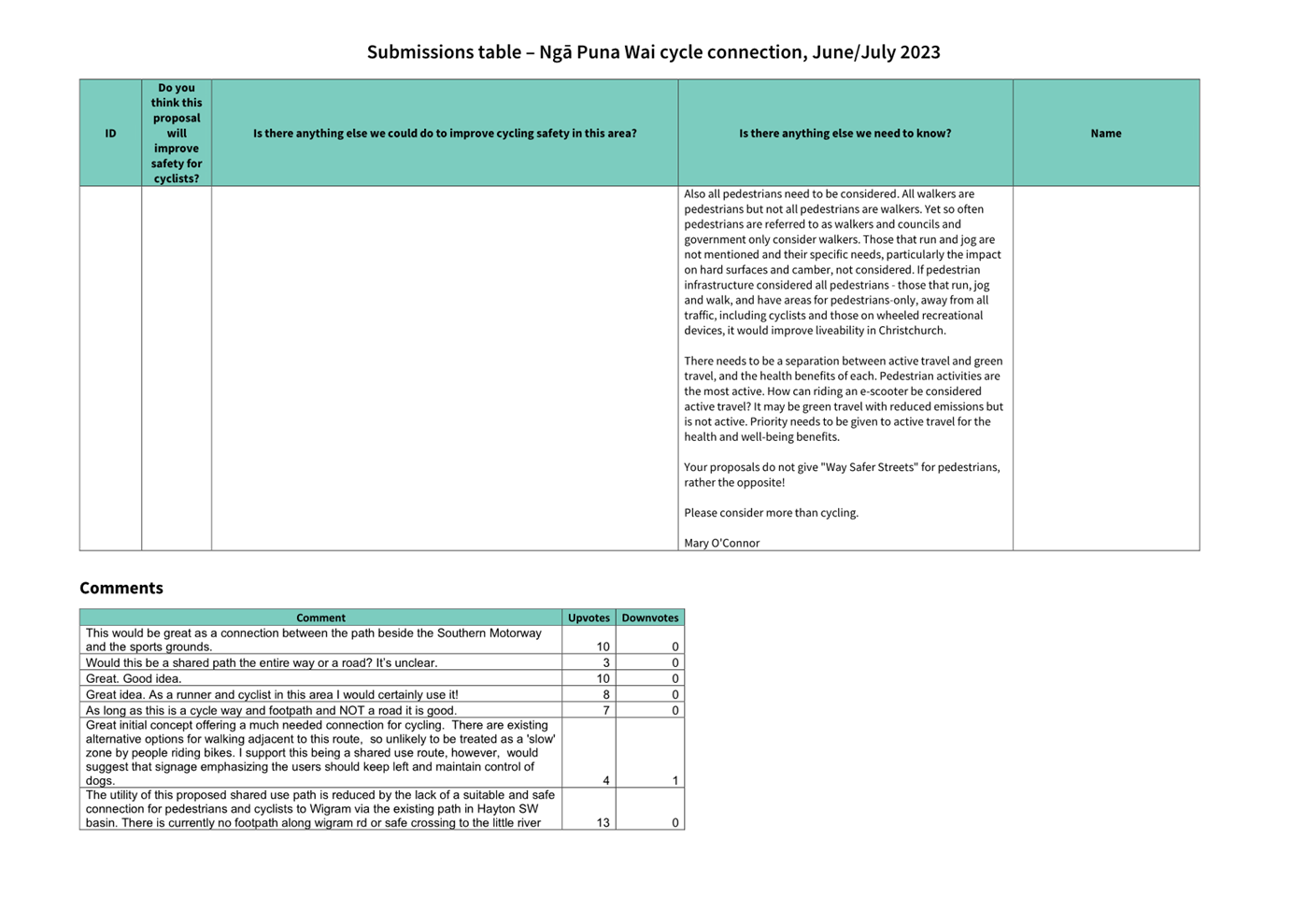
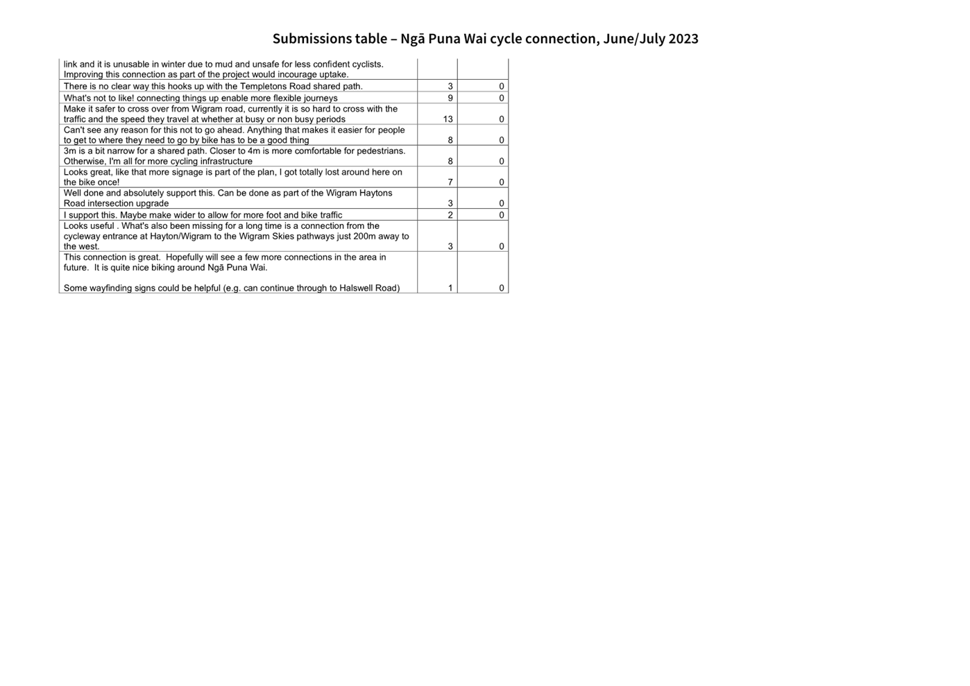
|
Council
21 September 2023
|
|
Karakia Whakamutunga
Kia
whakairia te tapu
Kia
wātea ai te ara
Kia
turuki whakataha ai
Kia
turuki whakataha ai
Haumi e. Hui e. Tāiki e