|
Council
17 May 2023
|

|
|
17. MCR
Northern Line - Detailed Traffic Resolutions Report
|
|
Reference / Te Tohutoro:
|
23/421851
|
|
Report of / Te Pou Matua:
|
Matt
Goldring, Project Manager Transport, matthew.goldring@ccc.govt.nz
|
|
General Manager / Pouwhakarae:
|
Mary
Richardson, General Manager Citizens & Community
(Mary.Richardson@ccc.govt.nz)
|
1. Nature of Decision or Issue and Report Origin
1.1 The purpose of this report is for the Council to approve
the detailed traffic resolutions for the Major Cycleway Route - Northern Line
project. This includes railway crossing upgrades at Barnes Road, Tuckers Road,
Sturrocks Road, Sawyers Arms Road, Harewood Road, Langdons Road, Kilmarnock
Street, Riccarton Road and Old Blenheim Road. This also includes the new
cycleway in the KiwiRail corridor between Barnes and Main North Road, Tuckers
Road and Sturoocks Road, Kilmarnock Street to Riccarton Road and Riccarton Road
to Old Blenheim Road.
1.2 The project was approved by the Major Cycleway Routes
Committee on 14th December 2016, with the recommendation that detailed traffic
resolutions to be brought back to the appropriate Committee for approval once
detailed design was completed.
1.3 The
decisions in this report are of low significance in relation to the
Christchurch City Council’s Significance and Engagement Policy. The
level of significance was determined on the basis that all the delivery
decisions have been previously made and this report seeks to set in place the
traffic by-laws for enforcement.
1.4 There
are no fundamental changes between the approved scheme design and the layout as
detailed in the 14th December 2016 Major Cycleway Routes Committee
Agenda and the final design.
2. Officer
Recommendations Ngā Tūtohu
That the Council:
a. Makes the following resolutions relying on its
powers under Christchurch City Council Traffic and Parking Bylaw 2017 and Part
21 of the Local Government Act 1974.
Note: For the
purposes of the following recommendations, any changes associated with the Railway
line are covered under the Railways Act: 2005.
1. Old Blenheim Road alignment to Riccarton
Road - Traffic Controls
a. Approves that any previously approved
resolutions along the rail corridor adjacent to the Main North Line (MNL)
railway from its intersection with Old Blenheim Road alignment and extending in
a northerly direction to its intersection with Riccarton Road, pertaining to
traffic controls, made pursuant to any Bylaw or any Land Transport Rule, to the
extent that they are in conflict with the traffic controls described in
recommendations b-d below, be revoked.
b. Approves that the path on the west side of the
MNL railway tracks, commencing at its intersection with Old Blenheim Road, and
extending in a northerly direction to its intersection with Riccarton Road be
resolved as a bi-directional Shared Path in accordance with Clause 21 of the
Christchurch City Council Traffic & Parking Bylaw 2017, and in accordance
with section 11.4 of the Land Transport Act - Traffic Control Devices Rules:
2004. This Shared Path is for the use by the classes of road user as defined in
Section 11.1A of the Land Transport (Road User) Rule: 2004.
c. Approves that a Give Way control be placed
against the bi-directional Shared Path on the south approach at its intersection
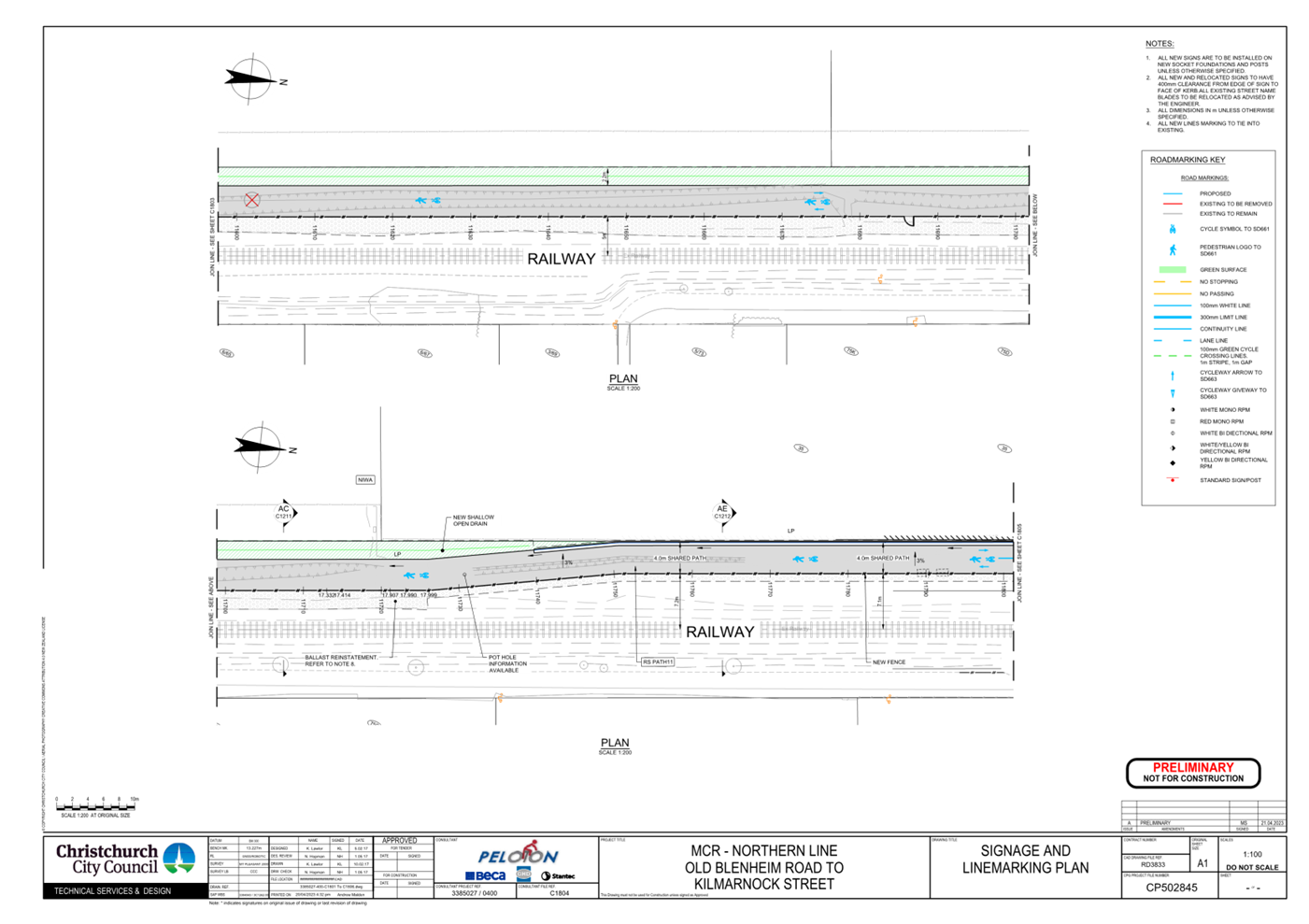
with Riccarton Road as detailed on plan CP502845, sheet 5 of 23, dated 21 April
2023 and attached to this report as Attachment A.
d. Approves all kerb alignments, road surface
treatments and road markings on MNL railway shared path from its intersection
with Old Blenheim Road alignment to its intersection with Riccarton Road, as
detailed on plans CP502845, sheets 1 to 5 of 23, dated 21 April 2023, and
attached to this report as Attachment A.
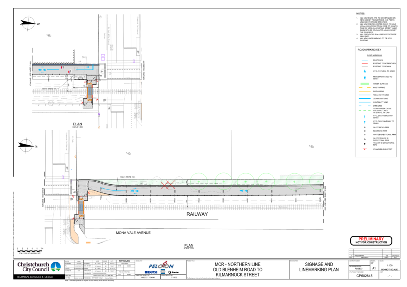
2. Riccarton Road to Kilmarnock Street -
Traffic Controls
a. Approves that any previously approved
resolutions along the rail corridor adjacent to the Main North Line (MNL)
railway from its intersection with Riccarton Road, and extending in a northerly
direction to its intersection with Kilmarnock Street, pertaining to traffic
controls, made pursuant to any Bylaw or any Land Transport Rule, to the extent
that they are in conflict with the traffic controls described in
recommendations b-d below, be revoked.
b. Approves that the path on the west side of the
MNL railway tracks, commencing at its intersection with Riccarton Road, and
extending in a northerly direction to its intersection with Kilmarnock Street
be resolved as a bi-directional Shared Path in accordance with Clause 21 of the
Christchurch City Council Traffic & Parking Bylaw 2017, and in accordance
with section 11.4 of the Land Transport Act - Traffic Control Devices Rules:
2004. This Shared Path is for the use by the classes of road user as defined in
Section 11.1A of the Land Transport (Road User) Rule: 2004.
c. Approves that a Give Way control be placed
against the bi-directional Shared Path on the south approach at its
intersection with Kilmarnock Street as detailed on plan CP502845, sheet 7 of
23, dated 21 April 2023 and attached to this report as Attachment A.
d. Approves all kerb alignments, road surface
treatments and road markings on MNL railway shared path from its intersection
with Riccarton Road to its intersection with Kilmarnock Street, as detailed on
plans CP502845, sheets 5 to 7 of 23, dated 21 April 2023, and attached to this
report as Attachment A.
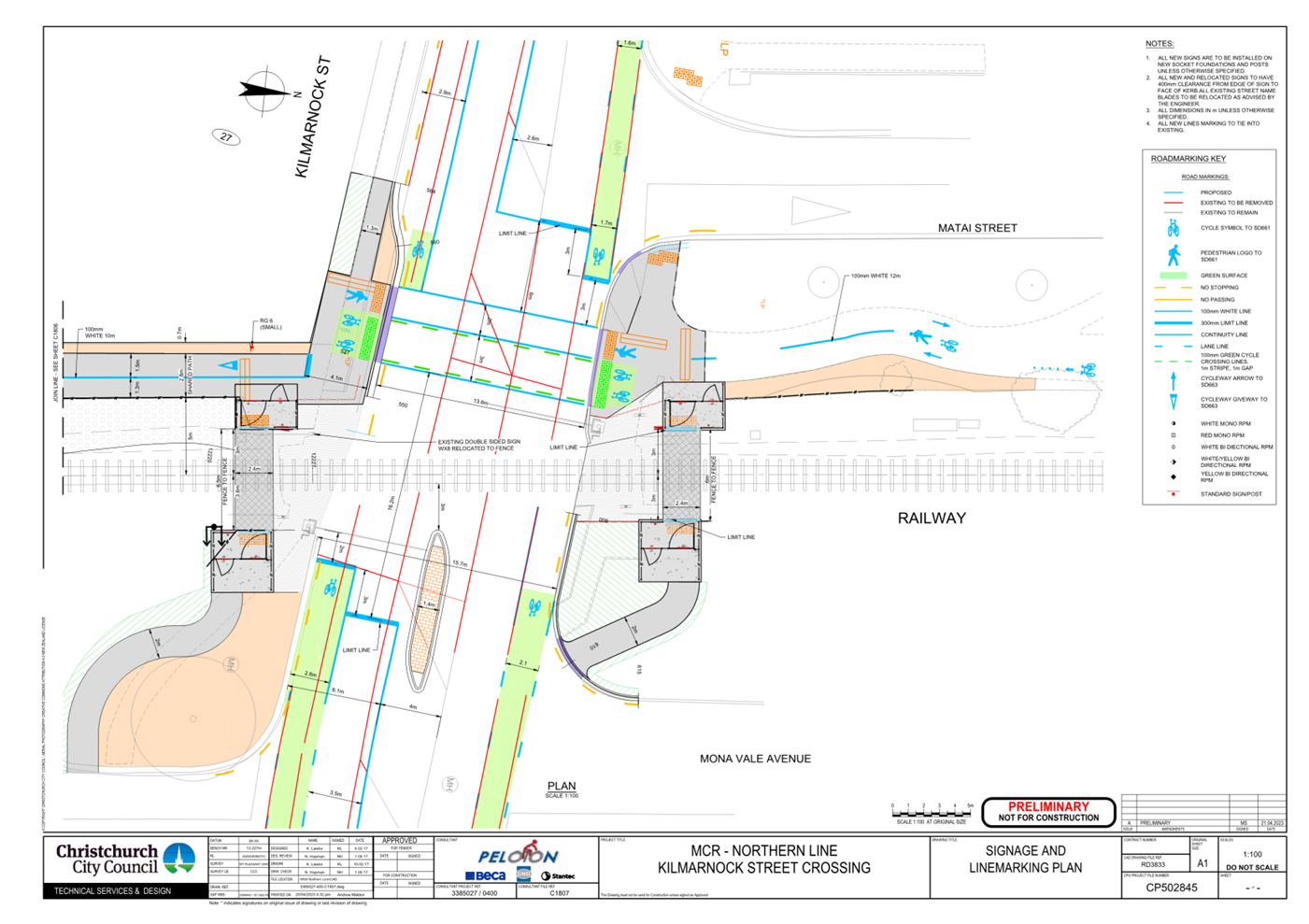
3. Kilmarnock Street Crossing – Traffic
Controls
a. Approves that any previously approved
resolutions on Kilmarnock Street from a point 44 metres west of its
intersection with the centre of the MNL railway, and extending in an easterly
direction a point 46 metres east to its intersection with the centre of the MNL
railway, pertaining to traffic controls, made pursuant to any Bylaw or any Land
Transport Rule, to the extent that they are in conflict with the traffic
controls described in recommendations b-g below, be revoked.
b. Approves all kerb alignments, road surface
treatments and road markings on Kilmarnock Street, commencing from a point 44
metres west from the centre of the MNL railway to a point 46 metres east from
the centre of the MNL railway, as detailed on plan CP502845, sheet 7 of 23,
dated 21 April 2023 and attached to this report as Attachment A.
c. Approves that a signalised roadway crossing on
Kilmarnock Street be installed, at a point nine metres west of its intersection
with the centre of the MNL railway, in accordance with the relevant sections of
the Land Transport Rule: Traffic Control Devices 2004. This signalised road
crossing is for the use by the classes of road user as defined in Section 11.1A
of the Land Transport (Road User) Rule: 2004.
d. Approves that a Special Vehicle Lane, in
accordance with Clause 18 of the Christchurch City Council Traffic &
Parking Bylaw 2017, for the use of east bound cyclists be installed on the
north side of Kilmarnock Street, commencing at a point 44 metres west of its
intersection with the centre of the MNL railway and extending in an easterly
direction for a distance of 30 metres, as detailed on plan CP502845, sheet 7 of
23, dated 21 April 2023 and attached to this report as Attachment A.
e. Approves that a Special Vehicle Lane, in
accordance with Clause 18 of the Christchurch City Council Traffic &
Parking Bylaw 2017, for the use of east bound cyclists be installed on the
north side of Kilmarnock Street, commencing at a point two metres east of
its intersection with the centre of the MNL railway and extending in an
easterly direction for a distance of 45 metres as detailed on plan CP502845,
sheet 7 of 23, dated 21 April 2023 and attached to this report as Attachment A.
f. Approves that a Special Vehicle Lane, in
accordance with Clause 18 of the Christchurch City Council Traffic &
Parking Bylaw 2017, for the use of west bound cyclists be installed on the
south side of Kilmarnock Street commencing at a point 46 metres east of its
intersection with the centre of the MNL railway and extending in a westerly
direction for a distance of 40 metres, as detailed on plan CP502845, sheet 7 of
23, dated 21 April 2023 and attached to this report as Attachment A.
g. Approves that a Special Vehicle Lane, in
accordance with Clause 18 of the Christchurch City Council Traffic &
Parking Bylaw 2017, for the use of west bound cyclists be installed on the
south side of Kilmarnock Street commencing at a point 12 metres west of its
intersection with the centre of the MNL railway and extending in a westerly
direction for a distance of 32 metres, as detailed on plan CP502845, sheet 7 of
23, dated 21 April 2023 and attached to this report as Attachment A.
4. Kilmarnock Street Crossing – Parking and
Stopping
a. Approves that any previously approved
resolutions on Kilmarnock Street from its intersection with Mona Vale Avenue,
and extending in a westerly direction for a distance of 64 metres, pertaining
to parking and /or stopping restrictions, made pursuant to any bylaw or any
Land Transport Rule, to the extent that they are in conflict with the parking
and /or stopping restrictions described in recommendations b-c below, be
revoked.
b. Approves that under clause 7 of the
Christchurch City Council Traffic and Parking Bylaw 2017, that the stopping of
vehicles be prohibited at any time on the north side of Kilmarnock Street
commencing at its intersection with Mona Vale Avenue, and extending to its
intersection with Matai Street.
c. Approves that under clause 7 of the
Christchurch City Council Traffic and Parking Bylaw 2017, that the stopping of
vehicles be prohibited on the south side of Kilmarnock Street commencing at its
intersection with Mona Vale Avenue and extending in a westerly direction for a
distance of 64 metres.
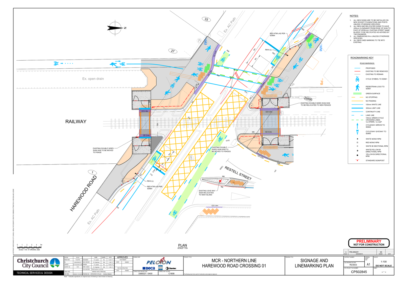
5. Harewood Road Crossing - Traffic Controls
a. Approves that any previously approved
resolutions on Harewood Road from a point 22 metres south east of its
intersection with the centre of the MNL railway, and extending in an north
easterly direction a point 31 metres north east to its intersection with the
centre of the MNL railway, pertaining to traffic controls, made pursuant to any
Bylaw or any Land Transport Rule, to the extent that they are in conflict with
the traffic controls described in recommendations b-i below, be revoked.
b. Approves all kerb alignments, islands, road
surface treatments and road markings on Harewood Road, from a point 31 metres
north west from the centre of the MNL railway to a point 22 metres south-east
from the centre of the MNL railway, as detailed on plan CP502845, sheet 8 of
23, dated 21 April 2023 and attached to this report as Attachment A.
c. Approves that the path on the north east side
of Harewood Road , commencing at its intersection with the MNL railway
extending in a north westerly direction for a distance of 19 metres, be
resolved as a bi-directional Shared Path in accordance with Clause 21 of the
Christchurch City Council Traffic & Parking Bylaw 2017, and in accordance
with section 11.4 of the Land Transport Act - Traffic Control Devices Rules: 2004.
This Shared Path is for the use by the classes of road user as defined in
Section 11.1A of the Land Transport Road User) Rule: 2004.
d. Approves that the path on the south west side
of Harewood Road, commencing at its intersection with the MNL railway extending
in a north westerly direction for a distance of 14 metres, be resolved as a
bi-directional Shared Path in accordance with Clause 21 of the Christchurch
City Council Traffic & Parking Bylaw 2017, and in accordance with section
11.4 of the Land Transport Act - Traffic Control Devices Rules: 2004. This
Shared Path is for the use by the classes of road user as defined in Section
11.1A of the Land Transport (Road User) Rule:2004.
e. Approves that a Special Vehicle Lane, in
accordance with Clause 18 of the Christchurch City Council Traffic &
Parking Bylaw 2017, for the use of south east bound cyclists be installed on
the north east side of Harewood Road, commencing at a point 31 metres north
west of its intersection with the centre of the MNL railway and extending in a
south easterly direction for a distance of 17 metres, as detailed on plan
CP502845, sheet 8 of 23, dated 21 April 2023 and attached to this report as
Attachment A.
f. Approves that a Special Vehicle Lane, in
accordance with Clause 18 of the Christchurch City Council Traffic &
Parking Bylaw 2017, for the use of south east bound cyclists be installed on
the north east side of Harewood Road, commencing at a point three metres
south east of its intersection with the centre of the MNL railway and extending
in a south easterly direction for a distance of 21 metres, as detailed on plan
CP502845, sheet 8 of 23, dated 21 April 2023 and attached to this report as
Attachment A.
g. Approves that a Special Vehicle Lane, in
accordance with Clause 18 of the Christchurch City Council Traffic &
Parking Bylaw 2017, for the use of north west bound cyclists be installed on
the south west side of Harewood Road, commencing at a point 22 metres south
east of its intersection with the centre of the MNL railway and extending in a
north westerly direction for a distance of 14 metres, as detailed on plan
CP502845, sheet 8 of 23, dated 21 April 2023 and attached to this report as
Attachment A.
h. Approves that a Special Vehicle Lane, in
accordance with Clause 18 of the Christchurch City Council Traffic &
Parking Bylaw 2017, for the use of north west bound cyclists be installed on
the south west side of Harewood Road, commencing at a point 14 metres north
west of its intersection with the centre of the MNL railway and extending in a
north westerly direction for a distance of 3 metres, as detailed on plan
CP502845, sheet 8 of 23, dated 21 April 2023 and attached to this report as
Attachment A.
i. Approves that a signalised roadway crossing on
Harewood Road be installed, at a point 11 metres north west of its intersection
with the centre of the MNL railway, in accordance with the relevant sections of
the Land Transport Rule: Traffic Control Devices 2004. This signalised road
crossing is for the use by the classes of road user as defined in Section 11.1A
of the Land Transport (Road User) Rule: 2004.
6. Harewood Road Crossing – Parking and
Stopping
a. Approves that any previously approved
resolutions on Harewood Road from a point 27 metres north west of its intersection
with the MNL railway intersection, and extending to a point 20 metres south
east of its intersection with the MNL railway, pertaining to parking and /or
stopping restrictions, made pursuant to any bylaw or any Land Transport Rule,
to the extent that they are in conflict with the parking and /or stopping
restrictions described in recommendations b-c below, be revoked.
b. Approves that under clause 7 of the
Christchurch City Council Traffic and Parking Bylaw 2017, that the stopping of
vehicles be prohibited on the north east side of Harewood Road commencing at a
distance 27 metres north west of its intersection with the MNL railway, and
extending in a south easterly direction for a distance of 16 metres.
c. Approves that under clause 7 of the Christchurch
City Council Traffic and Parking Bylaw 2017, that the stopping of vehicles be
prohibited on the south west side of Harewood Road commencing at a distance 20
metres north west of its intersection with the MNL railway, and extending in a
south easterly direction for a distance 40 metres.
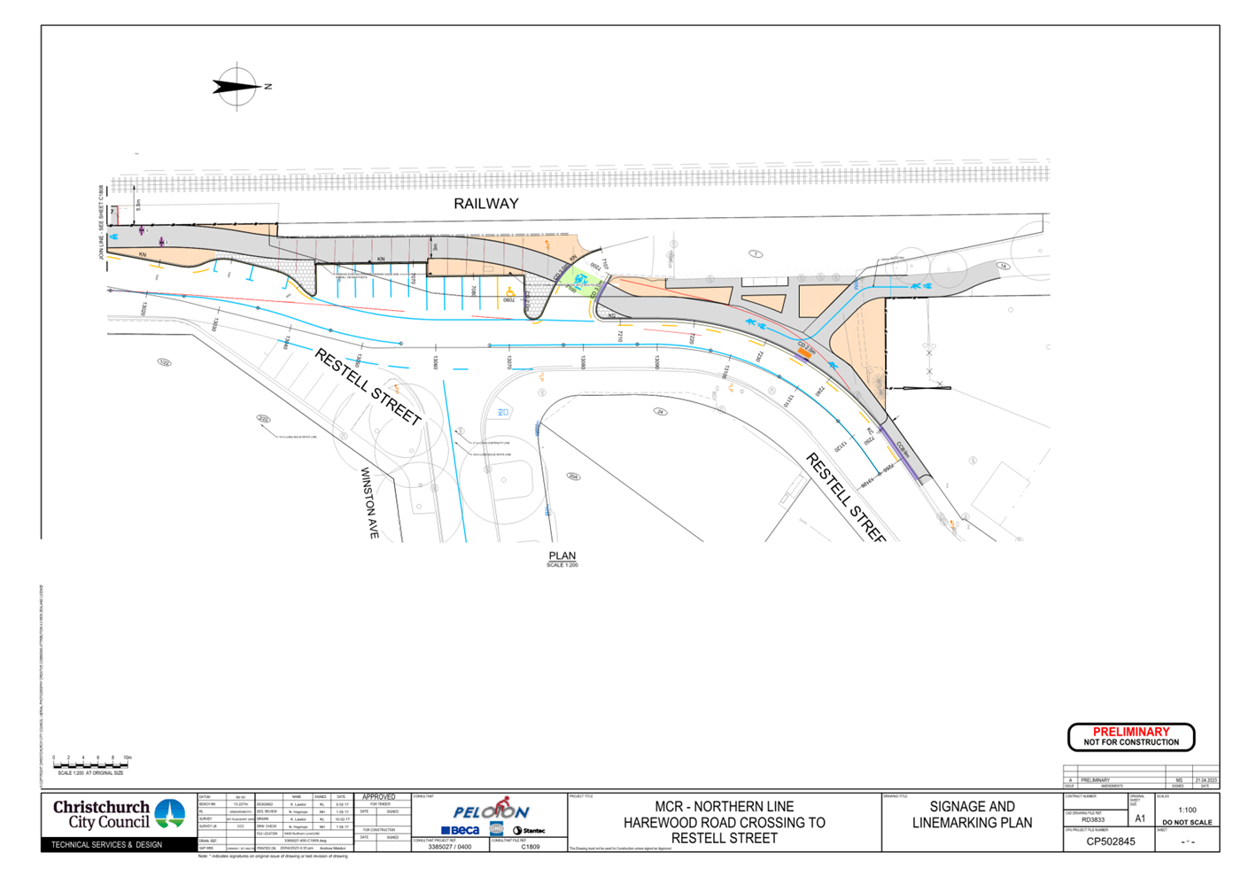
7. Restell Street - Traffic Controls
a. Approves that any previously approved
resolutions on Restell Street from intersection with Harewood Road, and
extending in a northerly direction to a point 128 metres north of its
intersection with Harewood Road, pertaining to traffic controls, made pursuant
to any Bylaw or any Land Transport Rule, to the extent that they are in
conflict with the traffic controls described in recommendations b-c below, be
revoked.
b. Approves all kerb alignments, islands, road
surface treatments and road markings on Restell Street, commencing at its
intersection with Harewood Road, and extending in a northerly direction a point
128 metres north of its intersection with Harewood Road, as detailed on plans
CP502845, sheets 8 and 9 of 23, dated 21 April 2023 and attached to this report
as Attachment A.
c. Approves that the path on the west side of
Restell street, commencing at its intersection with Harewood Road, and
extending in a northerly direction along the MNL railway, to its intersection
with Langdons Road, be resolved as a bi-directional Shared Path in accordance
with Clause 21 of the Christchurch City Council Traffic & Parking Bylaw
2017, and in accordance with section 11.4 of the Land Transport Act - Traffic
Control Devices Rules: 2004. This Shared Path is for the use by the classes of
road user as defined in Section 11.1A of the Land Transport (Road User)
Rule:2004.
8. Restell Street – Parking and Stopping
a. Approves that any previously approved
resolutions on Restell Street from its intersection with Harewood Road, and
extending to a point 128 metres north of its intersection with Harewood Road,
pertaining to parking and /or stopping restrictions, made pursuant to any bylaw
or any Land Transport Rule, to the extent that they are in conflict with the
parking and /or stopping restrictions described in recommendations b-e below,
be revoked.
b. Approves that under clause 7 of the
Christchurch City Council Traffic and Parking Bylaw 2017, that the stopping of
vehicles be prohibited on the west side of Restell Street commencing at its
intersection with Harewood Road and extending in a northerly direction for a
distance of 26 metres.
c. Approves that under clause 7 of the
Christchurch City Council Traffic and Parking Bylaw 2017, that the stopping of
vehicles be prohibited on the west side of Restell Street commencing at a
distance 37 metres north of its intersection with Harewood Road, and extending
in a northerly direction for a distance of four metres.
d. Approves that under clause 7 of the
Christchurch City Council Traffic and Parking Bylaw 2017, that the stopping of
vehicles be prohibited on the west side of Restell Street commencing at a
distance 72 metres north of its intersection with Harewood Road , and extending
in a north westerly direction for a distance of seven metres.
e. Approves that under clause 7 of the
Christchurch City Council Traffic and Parking Bylaw 2017, that the stopping of
vehicles be prohibited on the west side of Restell Street commencing at a
distance 80 metres north of its intersection with Harewood Road , and extending
in a northerly direction for a distance of 48 metres.
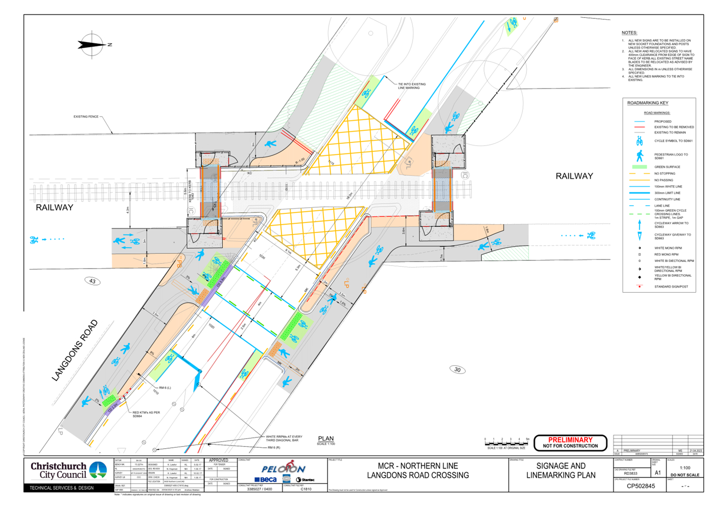
9. Langdons Road Crossing - Traffic Controls
a. Approves that any previously approved resolutions
on Kilmarnock Street from a point 24 metres north west of its intersection with
the centre of the MNL railway, and extending in an easterly direction a point
46 metres south east to its intersection with the centre of the MNL railway,
pertaining to traffic controls, made pursuant to any Bylaw or any Land
Transport Rule, to the extent that they are in conflict with the traffic
controls described in recommendations b-j below, be revoked.
b. Approves all kerb alignments, road surface
treatments and road markings on Langdons Road from a point 24 metres north west
from the centre of the MNL railway to point 46 metres south east from the
centre of the MNL railway, as detailed on plan CP502845, sheet 10 of 23, dated
21 April 2023 and attached to this report as Attachment A.
c. Approves that the path on the south west side
of Langdons Road, commencing at its intersection with the MNL railway extending
in a south easterly direction for a distance of 29 metres be resolved as a
bi-directional Shared Path in accordance with Clause 21 of the Christchurch
City Council Traffic & Parking Bylaw 2017, and in accordance with section
11.4 of the Land Transport Act - Traffic Control Devices Rules: 2004. This
Shared Path is for the use by the classes of road user as defined in Section
11.1A of the Land Transport (Road User) Rule:2004.
d. Approves that the path on the north east side
of Langdons Road, commencing at its intersection with the MNL railway extending
in a south easterly direction for a distance of 24 metres be resolved as a
bi-directional Shared Path in accordance with Clause 21 of the Christchurch
City Council Traffic & Parking Bylaw 2017, and in accordance with section
11.4 of the Land Transport Act - Traffic Control Devices Rules: 2004. This
Shared Path is for the use by the classes of road user as defined in Section
11.1A of the Land Transport (Road User) Rule: 2004.
e. Approves that the path on the north east side
of Langdons Road, commencing at its intersection with the MNL railway extending
in a north westerly direction for a distance of 24 metres be resolved as a
bi-directional Shared Path in accordance with Clause 21 of the Christchurch
City Council Traffic & Parking Bylaw 2017, and in accordance with section
11.4 of the Land Transport Act - Traffic Control Devices Rules: 2004. This
Shared Path is for the use by the classes of road user as defined in Section
11.1A of the Land Transport (Road User) Rule:2004.
f. Approves that a Special Vehicle Lane, in
accordance with Clause 18 of the Christchurch City Council Traffic &
Parking Bylaw 2017, for the use of south east bound cyclists be installed on
the north east side of Langdons Road, commencing at a point 24 metres north
west of its intersection with the centre of the MNL railway and extending in a
south easterly direction for a distance of 16 metres, as detailed on plan
CP502845, sheet 10 of 23, dated 21 April 2023 and attached to this report as
Attachment A.
g. Approves that a Special Vehicle Lane, in
accordance with Clause 18 of the Christchurch City Council Traffic &
Parking Bylaw 2017, for the use of south east bound cyclists be installed on
the north east side of Langdons Road, commencing at a point 23 metres south east
of its intersection with the centre of the MNL railway and extending in a south
easterly direction for a distance of 23 metres, as detailed on plan CP502845,
sheet 10 of 23, dated 21 April 2023 and attached to this report as Attachment
A.
h. Approves that a Special Vehicle Lane, in
accordance with Clause 18 of the Christchurch City Council Traffic &
Parking Bylaw 2017, for the use of north west bound cyclists only be installed
on the south west side of Langdons Road, commencing at a point 26 metres south
east of its intersection with the centre of the MNL railway and extending in a
north westerly direction for a distance of four metres, as detailed on plan
CP502845, sheet 10 of 23, dated 21 April 2023 and attached to this report as
Attachment A.
i. Approves that a Special Vehicle Lane, in
accordance with Clause 18 of the Christchurch City Council Traffic &
Parking Bylaw 2017, for the use of north west bound cyclists be installed on
the south west side of Langdons Road, commencing at a point 12 metres north
west of its intersection with the centre of the MNL railway and extending in a
north westerly direction for a distance of five metres, as detailed on plan
CP502845, sheet 10 of 22 dated 21 April 2023 and attached to this report as
Attachment A.
j. Approves that a signalised roadway crossing on
Langdons Road be installed, at a point 18 metres south east of its intersection
with the centre of the MNL railway, in accordance with the relevant sections of
the Land Transport Rule: Traffic Control Devices 2004. This signalised road
crossing is for the use by the classes of road user as defined in Section 11.1A
of the Land Transport (Road User) Rule: 2004.
10. Langdons Road Crossing – Parking and
Stopping
a. Approves that any previously approved
resolutions on Langdons Road from a point 13 metres north west of its
intersection with the MNL railway intersection, and extending to a point 46
metres south east of its intersection with the MNL railway, pertaining to
parking and /or stopping restrictions, made pursuant to any bylaw or any Land
Transport Rule, to the extent that they are in conflict with the parking and
/or stopping restrictions described in recommendations b-c below, be revoked.
b. Approves that under clause 7 of the
Christchurch City Council Traffic and Parking Bylaw 2017, that the stopping of
vehicles be prohibited on the north side of Langdons Road commencing at a
distance seven metres north west of its intersection with the MNL railway, and
extending in a south easterly direction for a distance of 44 metres.
c. Approves that under clause 7 of the
Christchurch City Council Traffic and Parking Bylaw 2017, that the stopping of
vehicles be prohibited on the south side of Harewood Road commencing at a distance
13 metres north west of its intersection with the MNL railway, and extending in
a south easterly direction for a distance of 51 metres.
11. Langdons Road to Sawyers Arms Road- Traffic
Controls
a. Approves that any previously approved
resolutions along the rail corridor adjacent to the Main North Line (MNL)
railway from its intersection with Langdons Road, and extending in a northerly
direction to its intersection with Sawyers Arms Road, pertaining to traffic
controls, made pursuant to any Bylaw or any Land Transport Rule, to the extent
that they are in conflict with the traffic controls described in
recommendations b below, be revoked.
b. Approves that the path on the east side of the
MNL railway tracks, commencing at its intersection with Langdons Road, and
extending in a northerly direction to its intersection with Sawyers Arms Road
be resolved as a bi-directional Shared Path in accordance with Clause 21 of the
Christchurch City Council Traffic & Parking Bylaw 2017, and in accordance
with section 11.4 of the Land Transport Act - Traffic Control Devices Rules:
2004. This Shared Path is for the use by the classes of road user as defined in
Section 11.1A of the Land Transport (Road User) Rule: 2004.
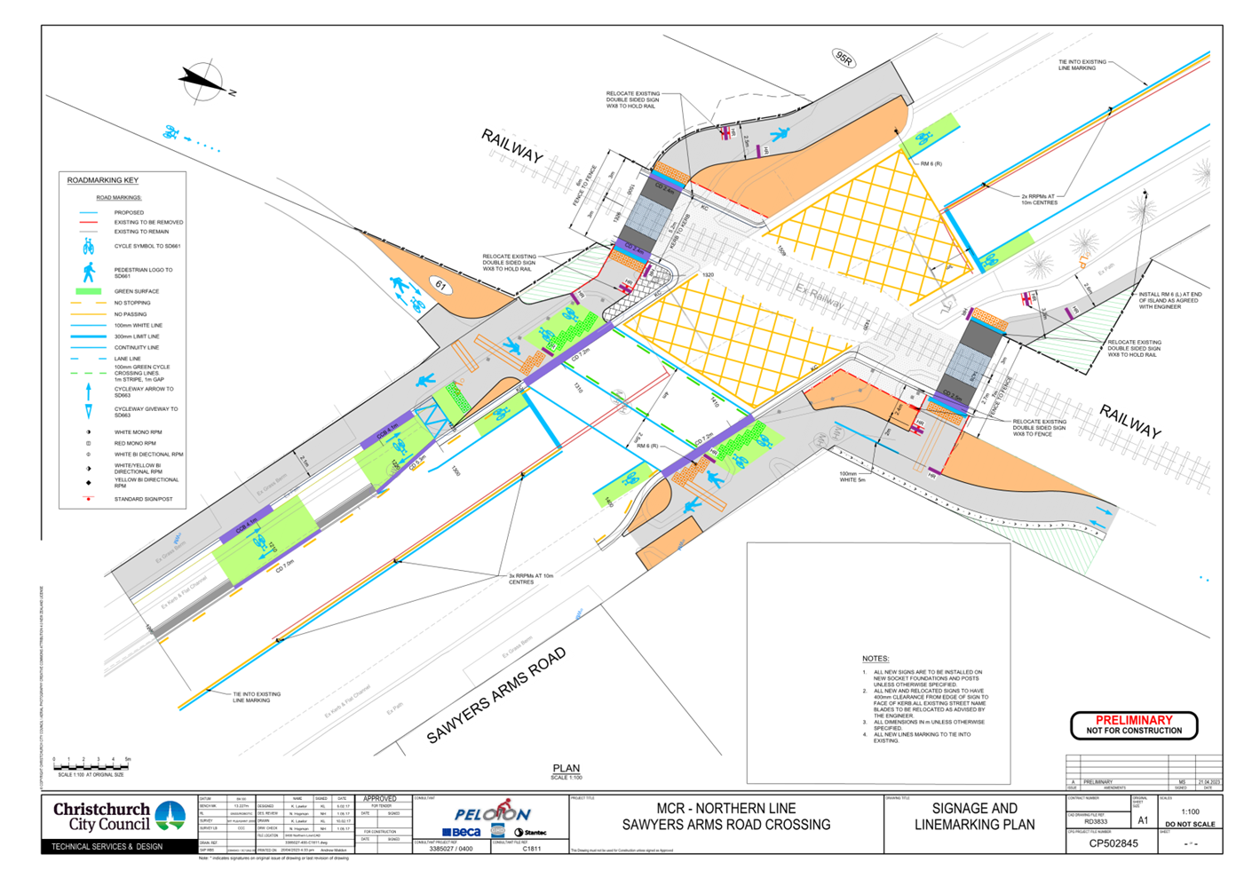
12. Sawyers Arms Road Crossing - Traffic Controls
a. Approves that any previously approved
resolutions on Sawyers Arms Road from a point 39 metres north west of its
intersection with the MNL railway intersection, and extending to a point 51
metres south east of its intersection with the MNL railway pertaining to
traffic controls, made pursuant to any Bylaw or any Land Transport Rule, to the
extent that they are in conflict with the traffic controls described in
recommendations b-i below, be revoked.
b. Approves all kerb alignments, road surface treatments
and road markings on Sawyers Arms Road, from a point 51 metres south east from
the centre of the MNL railway to a point 41 metres north west from the centre
of the MNL railway, as detailed on plan CP502845, sheet 11 of 23, dated 21
April 2023 and attached to this report as Attachment A.
c. Approves that a Special Vehicle Lane, in
accordance with Clause 18 of the Christchurch City Council Traffic &
Parking Bylaw 2017, for the use of south east bound cyclists be installed on
the north east side of Sawyers Arms Road commencing at a point 36 metres north
west of its intersection with the centre of the MNL railway and extending in a
south easterly direction for a distance of 28 metres, as detailed on plan
CP502845, sheet 11 of 23, dated 21 April 2023 and attached to this report as
Attachment A.
d. Approves that a Special Vehicle Lane, in
accordance with Clause 18 of the Christchurch City Council Traffic &
Parking Bylaw 2017, for the use of south east bound cyclists be installed on
the north east side of Sawyers Arms Road commencing at a point 18 metres south
east of its intersection with the centre of the MNL railway and extending in a
south easterly direction for a distance of 4 metres, as detailed on plan
CP502845, sheet 11 of 23, dated 21 April 2023 and attached to this report as
Attachment A.
e. Approves that a Special Vehicle Lane, in
accordance with Clause 18 of the Christchurch City Council Traffic &
Parking Bylaw 2017, for the use of north west bound cyclists be installed on
the south west side of Sawyers Arms Road commencing at a point 26 metres south
east of its intersection with the centre of the MNL railway and extending in a
north westerly direction for a distance of eight metres, as detailed on plan
CP502845, sheet 11 of 23, dated 21 April 2023 and attached to this report as
Attachment A.
f. Approves that a Special Vehicle Lane, in
accordance with Clause 18 of the Christchurch City Council Traffic &
Parking Bylaw 2017, for the use of north west bound cyclists be installed on
the south west side of Sawyers Arms Road commencing at a point 13 metres north
westerly of its intersection with the centre of the MNL railway and extending
in a north westerly direction for a distance of four metres, as detailed on
plan CP502845, sheets 11 of 23, dated 21 April 2023 and attached to this report
as Attachment A.
g. Approves that the path on the north east side
of Sawyers Arms Road, commencing at a point five metres south east of its
intersection with the centre of the MNL railway and extending in a south easterly
direction for a distance of 10 metres, be resolved as a bi-directional Shared
Path in accordance with Clause 21 of the Christchurch City Council Traffic
& Parking Bylaw 2017, and in accordance with section 11.4 of the Land
Transport Act - Traffic Control Devices Rules: 2004. This Shared Path is for
the use by the classes of road user as defined in Section 11.1A of the Land
Transport (Road User) Rule: 2004.
h. Approves that the path on the south west side
of Sawyers Arms Road, commencing at a point nine metres south east of its
intersection with the centre of the MNL railway and extending in a south
easterly direction for a distance of 30 metres, be resolved as a bi-directional
Shared Path in accordance with Clause 21 of the Christchurch City Council Traffic
& Parking Bylaw 2017, and in accordance with section 11.4 of the Land
Transport Act - Traffic Control Devices Rules: 2004. This Shared Path is for
the use by the classes of road user as defined in Section 11.1A of the Land
Transport (Road User) Rule: 2004.
i. Approves that a signalised roadway crossing on
Sawyers Arms Road be installed, at a point 14 metres south east of its
intersection with the centre of the MNL railway, in accordance with the
relevant sections of the Land Transport Rule: Traffic Control Devices 2004.
This signalised road crossing is for the use by the classes of road user as
defined in Section 11.1A of the Land Transport (Road User) Rule: 2004.
13. Sawyers Arms Road Crossing – Parking and
Stopping
a. Approves that any previously approved
resolutions on Sawyers Arms Road from a point 14 metres north west of its
intersection with the MNL railway intersection, and extending to a point 47
metres south east of its intersection with the MNL railway, pertaining to
parking and /or stopping restrictions, made pursuant to any bylaw or any Land
Transport Rule, to the extent that they are in conflict with the parking and
/or stopping restrictions described in recommendations b-c below, be revoked.
b. Approves that under clause 7 of the
Christchurch City Council Traffic and Parking Bylaw 2017, that the stopping of
vehicles be prohibited on the north east side of Sawyers Arms Road commencing
at a point seven metres northwest of its intersection with the MNL
railway, and extending in a south easterly direction for a distance of 31
metres.
c. Approves that under clause 7 of the
Christchurch City Council Traffic and Parking Bylaw 2017, that the stopping of
vehicles be prohibited on the south west side of Sawyers Arms Road commencing
at a point 14 metres northwest of its intersection with the MNL railway, and
extending in a south easterly direction for a distance of 61 metres.
14. Northcote Road to Tuckers Road – Traffic
Controls
a. Approves that any previously approved
resolutions along the rail corridor adjacent to the Main North Line (MNL) railway
from its intersection with Northcote Road, and extending in a northerly
direction to its intersection with Tuckers Road, pertaining to traffic
controls, made pursuant to any Bylaw or any Land Transport Rule, to the extent
that they are in conflict with the traffic controls described in
recommendations b-d below, be revoked.
b. Approves that the path on the west side of the
MNL railway tracks, commencing at its intersection with Northcote Road, and
extending in a northerly direction to its intersection with Tuckers Road be
resolved as a bi-directional Shared Path in accordance with Clause 21 of the
Christchurch City Council Traffic & Parking Bylaw 2017, and in accordance
with section 11.4 of the Land Transport Act - Traffic Control Devices Rules: 2004.
This Shared Path is for the use by the classes of road user as defined in
Section 11.1A of the Land Transport (Road User) Rule:2004.
c. Approves that a Give Way control be placed
against the bi-directional Shared Path on the south approach at its intersection
with Tuckers Road as detailed on plan CP502845, sheet 12 of 23, dated 21 April
2023 and attached to this report as Attachment A.
d. Approves the lane markings, kerb alignment,
islands, and road surface on MNL railway shared path from its intersection with
Northcote Road to its intersection with Tuckers Road, as detailed on plans
CP502845, sheet 12 of 23, dated 21 April 2023 and attached to this report as
Attachment A.
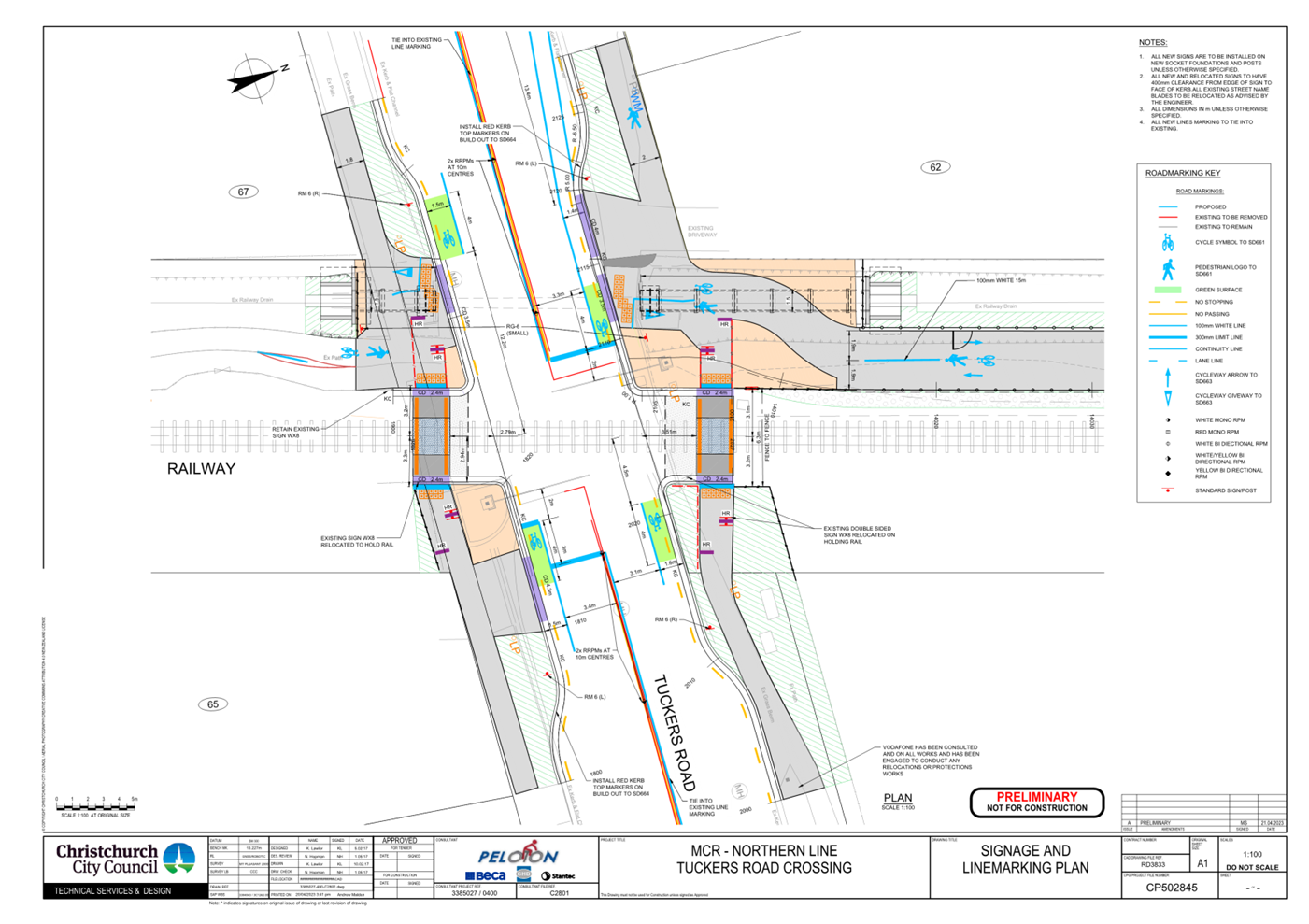
15. Tuckers Road Crossing - Traffic Controls
a. Approves that any previously approved
resolutions on Sawyers Arms Road from a point 30 metres west of its
intersection with the MNL railway intersection, and extending to a point 29
metres east of its intersection with the MNL railway pertaining to traffic
controls, made pursuant to any Bylaw or any Land Transport Rule, to the extent
that they are in conflict with the traffic controls described in
recommendations b-f below, be revoked.
b. Approves all kerb alignments, road surface
treatments and road markings on Tuckers Road, from a point 30 metres west from
the centre of the MNL railway to a point 29 metres east from the centre of the
MNL railway, as detailed on plan CP502845, sheet 12 of 23, dated 21 April 2023,
and attached to this report as Attachment A.
c. Approves that a Special Vehicle Lane, in
accordance with Clause 18 of the Christchurch City Council Traffic &
Parking Bylaw 2017, for the use of east bound cyclists be installed on the
north side of Tuckers Road commencing at a point 31 metres west of its
intersection with the centre of the MNL railway and extending in an easterly
direction for a distance of 24 metres, as detailed on plan CP502845, sheet 12
of 23, dated 21 April 2023, and attached to this report as Attachment A.
d. Approves that a Special Vehicle Lane, in
accordance with Clause 18 of the Christchurch City Council Traffic &
Parking Bylaw 2017, for the use of east bound cyclists be installed on the north
side of Tuckers Road commencing at a point four metres east of its intersection
with the centre of the MNL railway and extending in an easterly direction for a
distance of five metres, as detailed on plan CP502845, sheet 12 of 23, dated 21
April 2023, and attached to this report as Attachment A.
e. Approves that a Special Vehicle Lane, in
accordance with Clause 18 of the Christchurch City Council Traffic &
Parking Bylaw 2017, for the use of west bound cyclists be installed on the
south side of Tuckers Road commencing at a point 14 metres east of its
intersection with the centre of the MNL railway and extending in a westerly
direction for a distance of nine metres, as detailed on plan CP502845, sheet 12
of 23, dated 21 April 2023, and attached to this report as Attachment A.
f. Approves that a Special Vehicle Lane, in
accordance with Clause 18 of the Christchurch City Council Traffic &
Parking Bylaw 2017, for the use of west bound cyclists be installed on the
south side of Tuckers Road commencing at a point 12 metres west of its
intersection with the centre of the MNL railway and extending in a westerly
direction for a distance of five metres, as detailed on plan CP502845, sheet 12
of 23, dated 21 April 2023, and attached to this report as Attachment A.
16. Tuckers Road Crossing- Parking and Stopping
a. Approves that any previously approved
resolutions on Tuckers Road from a point 25 metres west of its intersection
with the MNL railway intersection, and extending to a point 24 metres east of
its intersection with the MNL railway pertaining to parking and /or stopping
restrictions, made pursuant to any bylaw or any Land Transport Rule, to the
extent that they are in conflict with the parking and /or stopping restrictions
described in recommendations b-c below, be revoked.
b. Approves that under clause 7 of the
Christchurch City Council Traffic and Parking Bylaw 2017, that the stopping of
vehicles be prohibited on the south side of Tuckers Road commencing at a
distance 25 metres west of its intersection with the MNL railway, and extending
in an easterly direction for a distance of 49 metres.
c. Approves that under clause 7 of the
Christchurch City Council Traffic and Parking Bylaw 2017, that the stopping of
vehicles be prohibited on the north side of Tuckers Road commencing at a
distance 19 metres west of its intersection with the MNL Railway and extending
in an easterly direction for a distance of 45 metres.
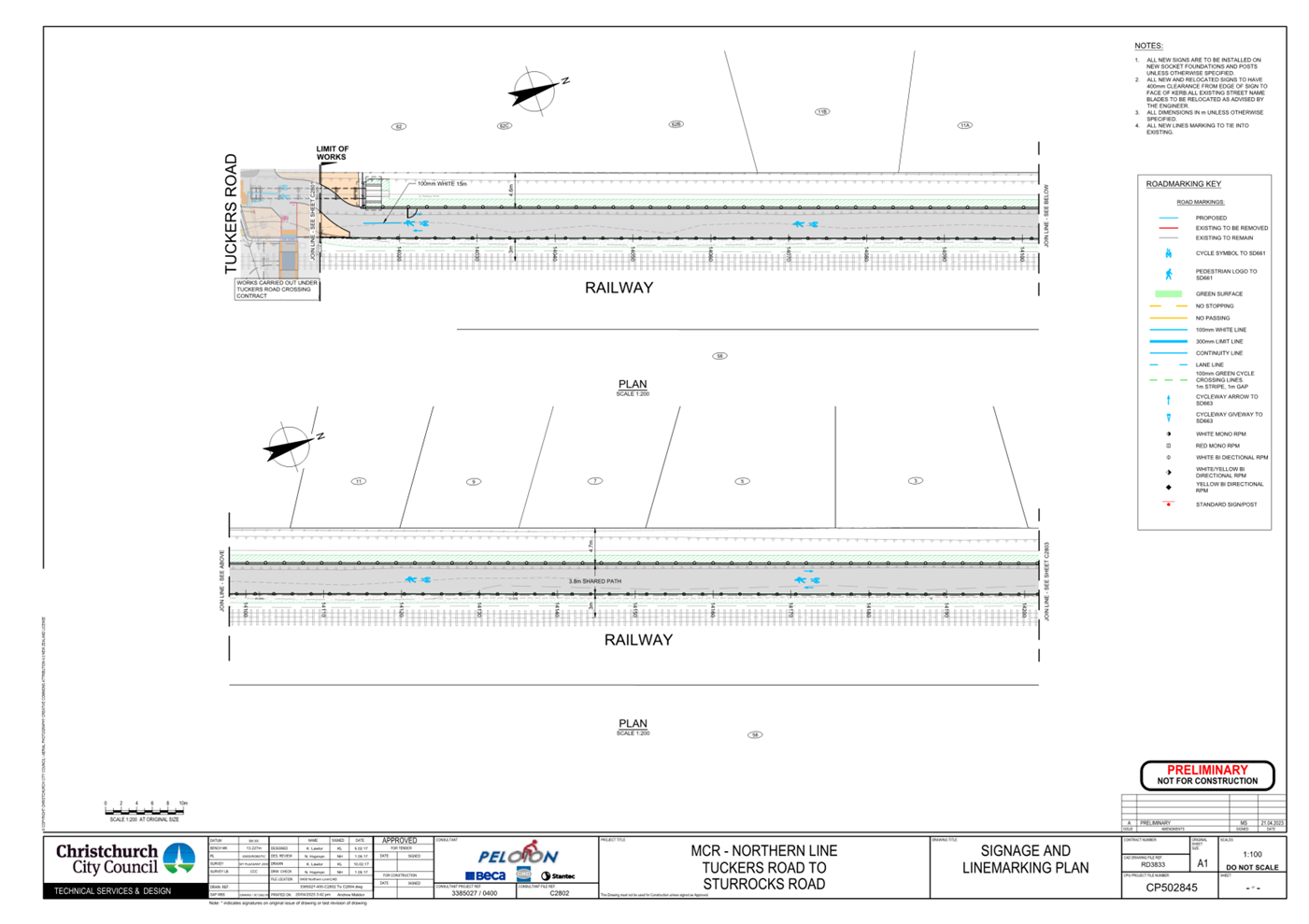
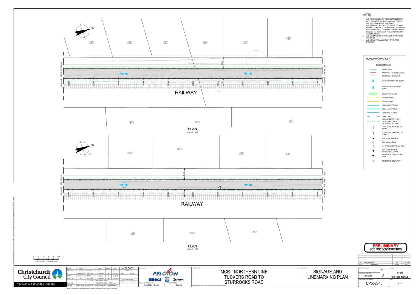
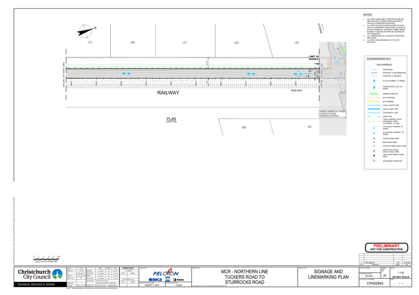
17. Tuckers Road to Sturrocks Road -Traffic
Controls
a. Approves that any previously approved
resolutions along the rail corridor adjacent to the Main North Line (MNL)
railway from its intersection with Tuckers Road, and extending in a northerly
direction to its intersection with Sturrocks Road, pertaining to traffic
controls, made pursuant to any Bylaw or any Land Transport Rule, to the extent
that they are in conflict with the traffic controls described in
recommendations b-e below, be revoked.
b. Approves that the path on the west side of the
MNL railway tracks, commencing at its intersection with Tuckers Road, and
extending in a northerly direction to its intersection with Sturrocks Road be
resolved as a bi-directional Shared Path in accordance with Clause 21 of the
Christchurch City Council Traffic & Parking Bylaw 2017, and in accordance with
section 11.4 of the Land Transport Act - Traffic Control Devices Rules: 2004.
This Shared Path is for the use by the classes of road user as defined in
Section 11.1A of the Land Transport (Road User) Rule: 2004.
c. Approves that a Give Way control be placed
against the bi-directional Shared Path north approach at its intersection with
Tuckers Road as detailed on plan CP502845, sheet 12 of 23, dated 21 April 2023,
and attached to this report as Attachment A.
d. Approves the lane markings, kerb alignment, islands,
and road surface on MNL railway shared path from its intersection with Tuckers
Road to its intersection with Sturrocks Road, as detailed on plan CP502845,
sheet 13 to 15 of 23, dated 21 April 2023, and attached to this report as
Attachment A.
e. Approves that a Give Way control be placed
against the bi-directional Shared Path on the southern approach at its
intersection with Sturrocks Road as detailed on plan CP502845, sheet 16 of 23,
dated 21 April 2023, and attached to this report as Attachment A.
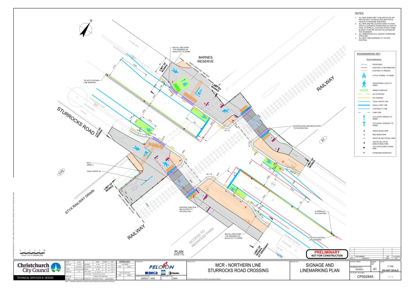
18. Sturrocks Road Crossing- Traffic Controls.
a. Approves that any previously approved
resolutions on Sturrocks Road from a point 28 metres west of its intersection
with the MNL railway intersection, and extending to a point 31 metres east of
its intersection with the MNL railway pertaining to traffic controls, made
pursuant to any Bylaw or any Land Transport Rule, to the extent that they are
in conflict with the traffic controls described in recommendations b-f below,
be revoked.
b. Approves all kerb alignments, road surface
treatments and road markings on Sturrocks Road, from a point 28 metres west
from the centre of the MNL railway to a point 31 metres east from the centre of
the MNL railway, as detailed on plan CP502845, sheet 16 of 23, dated 21 April
2023, and attached to this report as Attachment A.
c. Approves that a Special Vehicle Lane, in
accordance with Clause 18 of the Christchurch City Council Traffic &
Parking Bylaw 2017, for the use of east bound cyclists be installed on the
north side of Sturrocks Road commencing at a point 29 metres west of its
intersection with the centre of the MNL railway and extending in an easterly
direction for a distance of 22 metres, as detailed on plan CP502845, sheet 16
of 23, dated 21 April 2023, and attached to this report as Attachment A.
d. Approves that a Special Vehicle Lane, in
accordance with Clause 18 of the Christchurch City Council Traffic &
Parking Bylaw 2017, for the use of east bound cyclists be installed on the
north side of Sturrocks Road commencing at a point seven metres east of its
intersection with the centre of the MNL railway and extending in an easterly
direction for a distance of 13 metres, as detailed on plan CP502845, sheet 16
of 23, dated 21 April 2023, and attached to this report as Attachment A.
e. Approves that a Special Vehicle Lane, in
accordance with Clause 18 of the Christchurch City Council Traffic &
Parking Bylaw 2017, for the use of west bound cyclists be installed on the
south side of Sturrocks Road commencing at a point 31 metres east of its
intersection with the centre of the MNL railway and extending in a westerly
direction for a distance of 24 metres, as detailed on plan CP502845, sheet 16
of 23, dated 21 April 2023, and attached to this report as Attachment A.
f. Approves that a Special Vehicle Lane, in
accordance with Clause 18 of the Christchurch City Council Traffic &
Parking Bylaw 2017, for the use of west bound cyclists be installed on the
south side of Sturrocks Road commencing at a point 12 metres west of its
intersection with the centre of the MNL railway and extending in a westerly
direction for a distance of 15 metres, as detailed on plan CP502845, sheet 16
of 23, dated 21 April 2023, and attached to this report as Attachment A.
19. Sturrocks Road Crossing - Parking and Stopping
a. Approves that any previously approved
resolutions on Sturrocks Road from a point 20 metres west of its intersection
with the MNL railway intersection, and extending to a point 19 metres east of
its intersection with the MNL railway pertaining to parking and /or stopping
restrictions, made pursuant to any bylaw or any Land Transport Rule, to the
extent that they are in conflict with the parking and /or stopping restrictions
described in recommendations b-c below, be revoked.
b. Approves that under clause 7 of the
Christchurch City Council Traffic and Parking Bylaw 2017, that the stopping of
vehicles be prohibited on the north side of Sturrocks Road commencing at a
point 20 metres west of its intersection with the MNL Railway and extending in
an easterly direction for a distance of 35 metres.
c. Approves that under clause 7 of the
Christchurch City Council Traffic and Parking Bylaw 2017, that the stopping of
vehicles be prohibited on the south side of Sturrocks Road commencing at a
point 16 metres west of its intersection with the MNL Railway and extending in
an easterly direction for a distance of 35 metres.
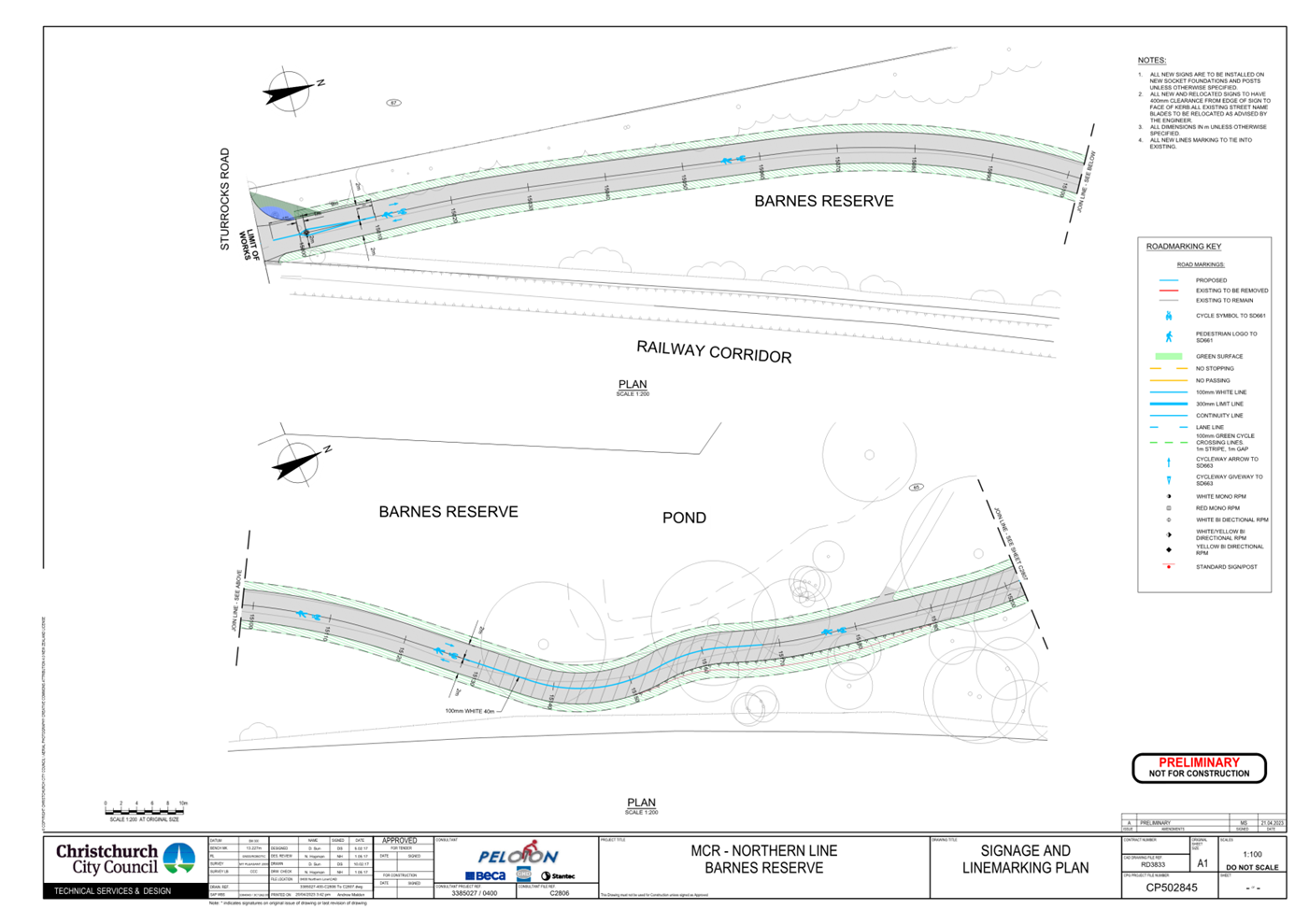
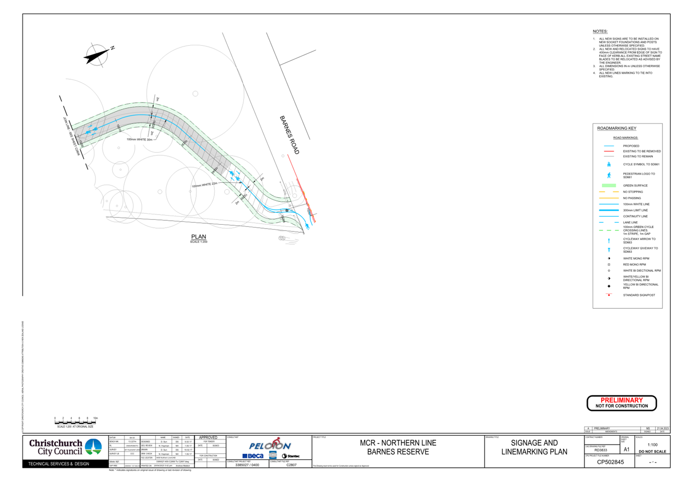
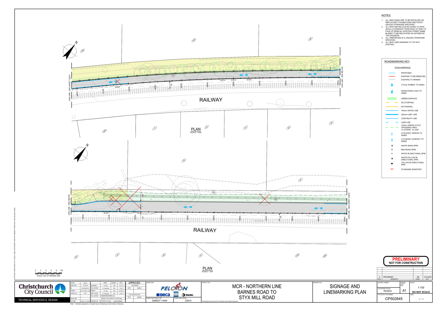
20. Sturrocks Road to Barnes Road – Traffic
Controls
a. Approves that any previously approved
resolutions through Barnes Reserve from its intersection with Sturrocks Road,
and extending in a northerly direction to its intersection with Barnes Road,
pertaining to traffic controls, made pursuant to any Bylaw or any Land
Transport Rule, to the extent that they are in conflict with the traffic
controls described in recommendations b-e below, be revoked.
b. Approves that the path on the west side of the
MNL railway tracks, commencing at its intersection with Sturrocks Road, and
extending in a northerly direction through Barnes Reserve to its intersection
with Barnes Road be resolved as a bi-directional Shared Path in accordance with
Clause 21 of the Christchurch City Council Traffic & Parking Bylaw 2017,
and in accordance with section 11.4 of the Land Transport Act - Traffic Control
Devices Rules: 2004. This Shared Path is for the use by the classes of road
user as defined in Section 11.1A of the Land Transport (Road User) Rule:2004.
c. Approves that a Give Way control be placed
against the bi-directional Shared Path on the north approach at its
intersection with Sturrocks Road as detailed on plans CP502845, sheet 16 of 23,
dated 21 April 2023, and attached to this report as Attachment A.
d. Approves that a Give Way control be placed
against the bi-directional Shared Path on the south approach at its
intersection with Barnes Road as detailed on plans CP502845, sheets 19 of 23,
dated 21 April 2023, and attached to this report as Attachment A.
e. Approves all kerb alignments, road surface
treatments and road markings on MNL railway shared path from its intersection
with Sturrocks Road to its intersection with Barnes Road, through Barnes
Reserve, as detailed on plan CP502845, sheets 17 and 18 of 23, dated 21 April
2023, and attached to this report as Attachment A.
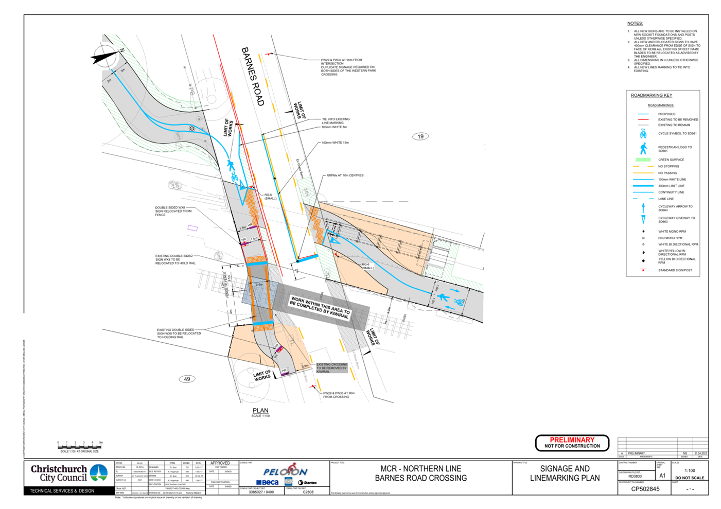
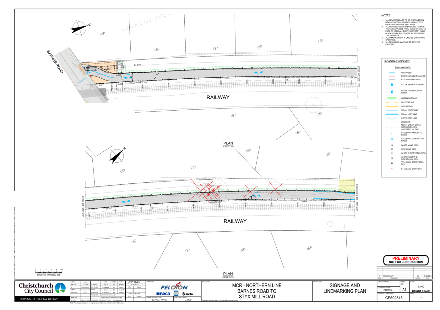
21. Barnes Road Crossing - Traffic Controls.
a. Approves that
any previously approved resolutions on Barnes Road from its intersection with
the MNL railway intersection, and extending to a point 21 metres west of its
intersection with the MNL railway pertaining to traffic controls, made pursuant
to any Bylaw or any Land Transport Rule, to the extent that they are in
conflict with the traffic controls described in recommendations b-c below, be
revoked.
b. Approves all
kerb alignments, road surface treatments and road markings on Barnes Road, from
the centre of the MNL railway to a point 21 metres west of its intersection
with the centre of the MNL railway, as detailed on CP502845, sheet 19 of 23,
dated 21 April 2023, and attached to this report as Attachment A.
c. Approves that
the path on the south side of Barnes Road, commencing at a point 21 metres west
of its intersection with the MNL railway and extending in an easterly direction
for a distance of 16 metres be resolved as a Shared Path in accordance with
Clause 21 of the Christchurch City Council Traffic & Parking Bylaw 2017,
and in accordance with section 11.4 of the Land Transport Act - Traffic Control
Devices Rules: 2004. This Shared Path is for the use by the classes of road
user as defined in Section 11.1A of the Land Transport (Road User) Rule:2004.
22. Barnes Road Crossing – Parking and
Stopping
a. Approves that any previously approved
resolutions on Barnes Road from a point 31 metres west of its intersection with
the MNL railway intersection, and extending to a point 11 metres east of its
intersection with the MNL railway pertaining to parking and /or stopping
restrictions, made pursuant to any bylaw or any Land Transport Rule, to the
extent that they are in conflict with the parking and /or stopping restrictions
described in recommendations b-c below, be revoked.
b. Approves that under clause 7 of the
Christchurch City Council Traffic and Parking Bylaw 2017, that the stopping of
vehicles be prohibited on the north side of Barnes Road commencing at a point
31 metres west of its intersection with the MNL Railway and extending in an
easterly direction for a distance of 40 metres.
c. Approves that under clause 7 of the Christchurch
City Council Traffic and Parking Bylaw 2017, that the stopping of vehicles be
prohibited on the north side of Barnes Road commencing at a point 25 metres
west of its intersection with the MNL Railway and extending in an easterly
direction for a distance of 36 metres.
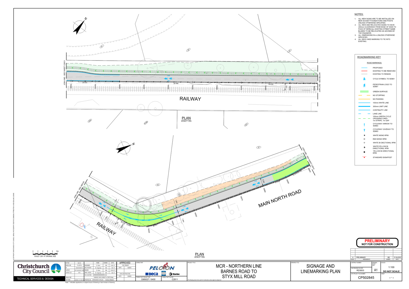
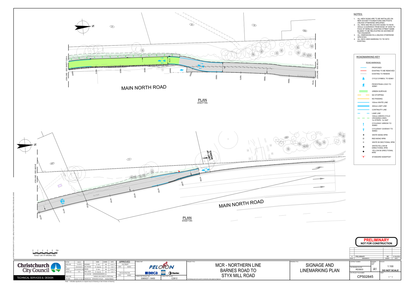
23. Barnes Road to Main North Road – Traffic
Controls
a. Approves that any previously approved
resolutions along the rail corridor adjacent to the Main North Line (MNL)
railway from its intersection with Barnes Road, and extending in a northerly
direction to its intersection with Main North Road, pertaining to traffic
controls, made pursuant to any Bylaw or any Land Transport Rule, to the extent
that they are in conflict with the traffic controls described in recommendations
b-d below, be revoked.
b. Approves that the path on the west side of the
MNL railway tracks, commencing at its intersection with Barnes Road, and
extending in a northerly direction to its intersection with Barnes Road be
resolved as a bi-directional Shared Path in accordance with Clause 21 of the
Christchurch City Council Traffic & Parking Bylaw 2017, and in accordance
with section 11.4 of the Land Transport Act - Traffic Control Devices Rules:
2004. This Shared Path is for the use by the classes of road user as defined in
Section 11.1A of the Land Transport (Road User) Rule: 2004.
c. Approves that a Give Way control be placed
against the bi-directional Shared Path on the north approach at its
intersection with Barnes Road as detailed on plan CP502845, sheets 20 of 23,
dated 21 April 2023, and attached to this report as Attachment A.
d. Approves the lane markings, kerb alignment,
islands, and road surface on MNL railway shared path from its intersection with
Barnes Road to its intersection with Main North Road, as detailed on plans
CP502845, sheets 20 to 23 of 23, dated 21 April 2023, and attached to this
report as Attachment A.
24. Approves that these recommendations, if
approved and become resolutions, take effect when parking signage and/or road
markings that evidence the restrictions described in the staff report are in
place (or removed in the case of revocations).
3. Reason for Report Recommendations Ngā Take mō te
Whakatau
3.1 On
14 December 2016 the scheme design for Major Cycle Route Northern Line project
was approved for detailed design and construction by the Major Cycleway Routes
Committee. It recommended that the detailed design traffic resolutions be
brought back to the appropriate Committee at the end of detailed design prior to
beginning of construction. This delegation now lies with the Council.
4. Alternative Options Considered Ētahi atu Kōwhiringa
4.1 There
are no alternative options considered for this report as the scheme design has
been approved previously. The option of not passing the resolutions would mean
the changes could not be enforced after construction of the cycle route
creating a safety risk for users.
5. Detail Te Whakamahuki
5.1 Traffic
Resolutions
5.1.1 The
Major Cycleway Route Northern Line scheme was approved on the 16 December 2016.
The report presented at that meeting detailed the community views and
preferences of the engagement process that took place in 2016.
5.1.2
As the detailed design has had no fundamental changes to the approved scheme
design, the community views and preferences remain the same and no further
consultation was carried out. This project has a significant interface with
KiwiRail infrastructure and there has been a prolonged period from Scheme
approval to commencement of construction as a result of this.
KiwiRail’s industry wide shortage of skilled resources has resulted in
significant delays to both signal and civil works designs and reviews.
Since the beginning of 2022, progress has improved and has resulted in approved
drawings, approved licenses, successful implementation of CCC works in KiwiRail
land and the implementation of an Over-arching Funding Agreement between CCC
and KiwiRail.
6. Policy Framework Implications Ngā Hīraunga ā- Kaupapa here
Strategic
AlignmentTe Rautaki
Tīaroaro
6.1 This project supports Council’s Strategic Priority
Increasing active, public and shared transport opportunities by providing a
safe option for cyclists particularly those who would not normally feel
comfortable biking among the main stream of traffic.
6.2 This report supports the Council's
Long Term Plan (2021 - 2031):
6.2.1 Activity: Transport
· Level of Service: 10.5.3 More people are
choosing to travel by cycling - >=12,500 average daily cyclist detections .
Policy
Consistency Te Whai
Kaupapa here
6.3 The
decision is consistent with Council’s Plans and Policies
Impact
on Mana Whenua Ngā
Whai Take Mana Whenua
6.4 The
decision does not involve a significant decision in relation to ancestral land
or a body of water or other elements of intrinsic value, therefore this
decision does not specifically impact Mana Whenua, their culture and
traditions.
6.5 The
report is for approval of traffic resolutions only.
Climate
Change Impact Considerations Ngā Whai Whakaaro mā te Āhuarangi
6.6 This
option helps reduce vehicle emissions by encouraging more residents to cycle or
walk for local trips and longer trips.
6.7 For each tree removed, two replacement trees will be planted within
a local reserve as per CCC Tree Policy.
Accessibility
Considerations Ngā
Whai Whakaaro mā te Hunga Hauā
6.8 Accessibility has been prioritised in the design for the route
through the inclusion of tactile pavers and audible pedestrian crossings.
7. Resource Implications Ngā Hīraunga Rauemi
Capex/Opex Ngā Utu Whakahaere
7.1 The
decisions in this report have no financial implications as they are not enacted
until construction is complete.
7.2 The
project has been approved and the costs have been included in the Long Term
Plan and Annual Plan processes.
Other He mea anō
7.3 N/A
8. Legal Implications Ngā Hīraunga ā-Ture
Statutory power to undertake proposals in the report
Te Manatū Whakahaere Kaupapa
8.1 The
statutory power used to undertake proposals as contained in this report is
under the Local Government Act 2002.
8.2 Part
1, Clauses 7 and 8 of the Christchurch City Council Traffic and Parking Bylaw
2017 provides Council with the authority to install parking restrictions by
resolution.
8.3 The
installation of any signs and/or markings associated with traffic control
devices must comply with the Land Transport Rule: Traffic Control Devices 2004.
8.4 The
decisions within this report falls within the Councils delegation.
Other Legal Implications Ētahi atu
Hīraunga-ā-Ture
8.5 There
is no legal context, issue or implication relevant to this decision.
8.6 This
report has not been reviewed and approved by the Legal Services Unit.
9. Risk Management Implications Ngā Hīraunga Tūraru
9.1 If
these resolutions are not approved the legalities relating to the uses of the
road space including parking and cycle lanes will not be able to be enforced
which is expected to have a significant impact on the safety of users.
Attachments Ngā Tāpirihanga
|
No.
|
Title
|
Reference
|
Page
|
|
a ⇩ 
|
Attachment A -
MCR Northern Line Detailed Traffic Resolutions
|
23/527305
|
22
|
In addition to the attached documents, the following background
information is available:
Confirmation of Statutory
Compliance Te Whakatūturutanga ā-Ture
|
Compliance with Statutory Decision-making
Requirements (ss 76 - 81 Local Government Act 2002).
(a) This report contains:
(i) sufficient information about all reasonably practicable
options identified and assessed in terms of their advantages and
disadvantages; and
(ii) adequate consideration of the views and preferences of
affected and interested persons bearing in mind any proposed or previous
community engagement.
(b) The information reflects the level of significance of the
matters covered by the report, as determined in accordance with the Council's
significance and engagement policy.
|
Signatories Ngā Kaiwaitohu
|
Authors
|
Matt Goldring
- Project Manager
Sharon O'Neill
- Programme Manager
|
|
Approved By
|
Mary
Richardson - General Manager Citizens & Community
|