Christchurch City Council
Agenda
Notice of Meeting:
An ordinary meeting of the Christchurch
City Council will be held on:
Date: Wednesday 3 May 2023
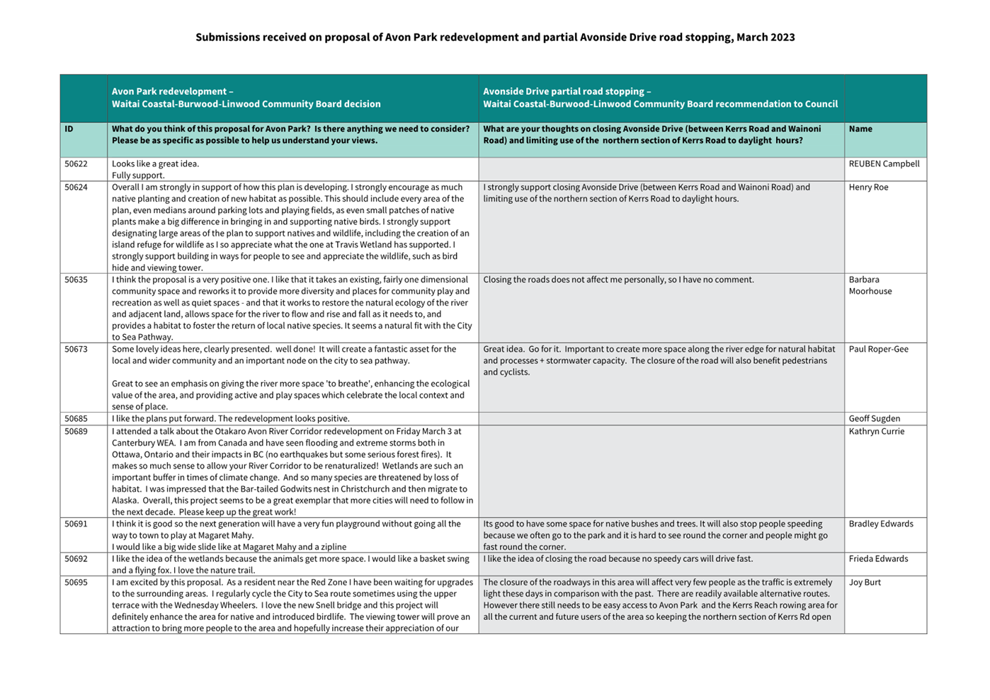
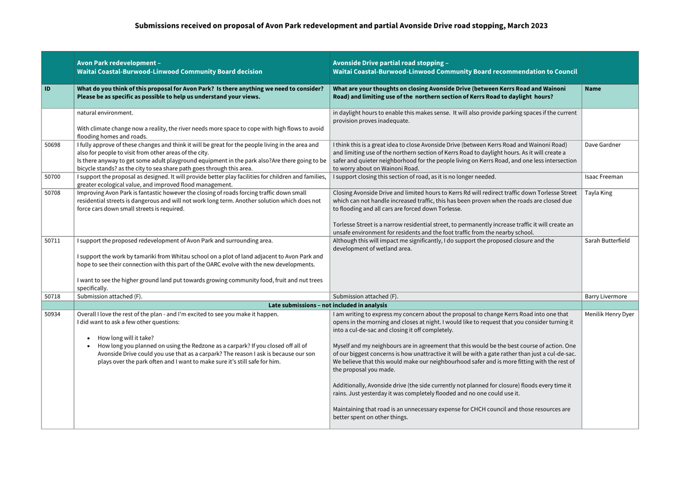
Time: 9.30 am
Venue: Council Chambers, Civic Offices,
53 Hereford Street, Christchurch
Membership
|
Chairperson
Deputy Chairperson
Members
|
Mayor Phil Mauger
Deputy Mayor Pauline Cotter
Councillor Kelly Barber
Councillor Melanie Coker
Councillor Celeste Donovan
Councillor Tyrone Fields
Councillor James Gough
Councillor Tyla Harrison-Hunt
Councillor Victoria Henstock
Councillor Yani Johanson
Councillor Aaron Keown
Councillor Sam MacDonald
Councillor Jake McLellan
Councillor Andrei Moore
Councillor Mark Peters
Councillor Tim Scandrett
Councillor Sara Templeton
|
27 April 2023
|
|
|
Principal Advisor
Dawn Baxendale
Chief Executive
Tel: 941 8999
|
|
Katie Matheis
Team Leader Hearings & Committee Support
941 5643
katie.matheis@ccc.govt.nz
www.ccc.govt.nz
|
Council
03 May 2023
|

|
|
Council
03 May 2023
|

|
TABLE OF CONTENTS
Karakia Tīmatanga................................................................................................... 4
1. Apologies Ngā Whakapāha................................................................................. 4
2. Declarations of Interest Ngā Whakapuaki Aronga.................................................. 4
3. Public
Participation Te Huinga
Tūmatanui............................................................ 4
3.1 Public Forum Te Huinga Whānui.......................................................................................... 4
3.2 Deputations by
Appointment Ngā Huinga Whakaritenga...................................................... 4
4. Presentation
of Petitions Ngā
Pākikitanga............................................................ 4
Council
5. Council
Minutes - 5 April 2023............................................................................. 5
6. Council
Minutes - 19 April 2023.......................................................................... 27
Community Board Monthly
Reports
7. Monthly
Report from the Community Boards - April 2023...................................... 33
Community Board Part A
Reports
8. Proposed
Unsolicited Property Acquisition by the Crown - Part 502 Ferry Road....... 91
9. Legal
stopping of Avonside Drive between Kerrs Road and Wainoni Road, as well as
Kerrs Road north of #144......................................................................................... 105
10. Waltham
Road Marking of Cycle Lanes Between Moorhouse Avenue and Brougham Street................................................................................................................... 171
Staff Reports
11. Plan
Change 5E Noise sensitive activities near roads and rail corridors - Decision... 181
12. Plan
Change 6 Homebase Extension - Final approval........................................... 231
13. Resolution
to Exclude the Public...................................................................... 252
Karakia Whakamutunga
Whakataka Te
hau ki Te uru
Whakataka Te
hau ki Te tonga
Kia makinakina
ki uta
Kia mataratara
ki Tai
E hi ake ana te
atakura
He tio, he
huka, he hau hu
Tihei Mauri Ora
1. Apologies Ngā Whakapāha
At the close of
the agenda no apologies had been received.
2. Declarations of Interest Ngā
Whakapuaki Aronga
Members are
reminded of the need to be vigilant and to stand aside from decision making
when a conflict arises between their role as an elected representative and any
private or other external interest they might have.
3. Public Participation Te Huinga
Tūmatanui
3.1 Public Forum Te Huinga Whānui
A period of up to 30 minutes is available
for people to speak for up to five minutes on any issue that is not the subject
of a separate hearings process.
|
3.1.1
|
Friendship Force
Jan Harrison will speak on behalf of
Friendship Force to share information about what the club does and to present
two letters of greeting from the Mayors of Brisbane and North Moreton,
Queensland, Australia, which were brought by the Friendship Force clubs in
those areas.
|
|
3.1.2
|
Anna Mulvenna
Anna Mulvenna will speak regarding the
dangers pedestrians are encountering from cyclists and scooters.
|
3.2 Deputations by Appointment Ngā
Huinga Whakaritenga
Deputations may be heard on a matter or
matters covered by a report on this agenda and approved by the Chairperson.
There were no
deputations by appointment at the time the agenda was prepared.
4. Presentation of Petitions Ngā
Pākikitanga
There were no
Presentation of Petitions at the time the agenda was prepared.
|
Council
03 May 2023
|

|
|
5. Council
Minutes - 5 April 2023
|
|
Reference / Te Tohutoro:
|
23/517147
|
|
Report of / Te Pou Matua:
|
Katie
Matheis, Team Leader Hearings & Committee Support (Katie.Matheis@ccc.govt.nz)
|
|
General Manager / Pouwhakarae:
|
Dawn
Baxendale, Chief Executive (Dawn.Baxendale@ccc.govt.nz)
|
1. Purpose of Report Te Pūtake Pūrongo
For the Council
to confirm the minutes from the Council meeting held 5
April 2023.
2. Recommendation
to Council
That the Council confirm the Minutes from the Council
meeting held 5 April 2023.
Attachments
Ngā
Tāpirihanga
|
No.
|
Title
|
Reference
|
Page
|
|
A⇩ 
|
Minutes Council - 5 April 2023
|
23/467333
|
6
|
Signatories Ngā Kaiwaitohu
|
Author
|
Katie Matheis
- Team Leader Hearings & Committee Support
|
|
Council
03 May 2023
|

|
|
6. Council Minutes - 19 April 2023
|
|
Reference / Te Tohutoro:
|
23/574174
|
|
Report of / Te Pou Matua:
|
Katie
Matheis, Team Leader Hearings & Committee Support
(Katie.Matheis@ccc.govt.nz)
|
|
General Manager / Pouwhakarae:
|
Dawn
Baxendale, Chief Executive (Dawn.Baxendale@ccc.govt.nz)
|
1. Purpose of Report Te Pūtake Pūrongo
For the Council
to confirm the minutes from the Council meeting held 19
April 2023.
2. Recommendation to Council
That the Council confirm the Minutes from the Council
meeting held 19 April 2023.
Attachments Ngā Tāpirihanga
|
No.
|
Title
|
Reference
|
Page
|
|
A⇩
|
Minutes Council - 19
April 2023
|
23/558189
|
28
|
Signatories Ngā Kaiwaitohu
|
Author
|
Katie Matheis
- Team Leader Hearings & Committee Support
|
|
Council
03 May 2023
|
|
|
7. Monthly
Report from the Community Boards - April 2023
|
|
Reference Te Tohutoro:
|
23/492168
|
|
Report of Te Pou Matua:
|
The
Chairpersons of all Community Boards
|
|
General Manager Pouwhakarae:
|
Mary
Richardson, General Manager Citizens & Community
(Mary.Richardson@ccc.govt.nz)
|
1. Purpose of Report Te Pūtake Pūrongo
The purpose of this report is to provide the Council with an
overview of initiatives and issues recently considered by the Community
Boards. This report attaches the most recent Community Board Area Report
included in each Boards public meeting. Please see the individual agendas for
the attachments to each report.
Each Board will present important matters from their respective
areas during the consideration of this report and these presentations will be
published with the Council minutes after the meeting.
2. Community Board Recommendations
That the Council:
1. Receive the Monthly Report from the Community Boards April 2023.
Attachments Ngā Tāpirihanga
|
No.
|
Title
|
Reference
|
Page
|
|
a ⇩ 
|
Waipapa
Papanui-Innes-Central Community Board Area Report April 2023
|
23/492310
|
34
|
|
b ⇩
|
Waipuna
Halswell-Hornby-Riccarton Community Board Area Report April 2023
|
23/492311
|
46
|
|
c ⇩
|
Waitai
Coastal-Burwood-Linwood Community Board Area Report April 2023
|
23/492312
|
56
|
|
d ⇩ 
|
Te Pātaka o
Rākaihautū Banks Peninsula Community Board Area Report April 2023
|
23/492313
|
70
|
|
e ⇩ 
|
Waihoro
Spreydon-Cashmere-Heathcote Community Board Area Report April 2023
|
23/492314
|
76
|
|
f ⇩
|
Waimāero
Fendalton-Waimairi-Harewood Community Board Area Report April 2023
|
23/492315
|
82
|
|
Council
03 May 2023
|

|
Report from Waitai Coastal-Burwood-Linwood
Community Board – 13 April 2023
|
8. Proposed
Unsolicited Property Acquisition by the Crown - Part 502 Ferry Road
|
|
Reference Te Tohutoro:
|
23/541187
|
|
Report of Te Pou Matua:
|
Barry
Woodland, Property Consultant, Sustainable City Growth & Development
(barry.woodland@ccc.govt.nz)
|
|
General Manager Pouwhakarae:
|
Mary
Richardson, General Manager Citizens & Community
(Mary.Richardson@ccc.govt.nz)
|
Nature of Decision or Issue and Report Origin
1.1 The purpose of this report is to consider the potential
acquisition of land at 502 Ferry Road from the Council by the Crown/ Ministry
of Education (the Crown). The land (Part 502 Ferry Road) has been leased to the
Te Waka Unua School (formerly Woolston School) for school grounds purposes
since 2010. The Crown now wish to purchase the land for the Te Waka Unua School
(the School) to future proof its ability to respond to future roll growth
predictions and to ensure the provision of quality educational services and
activities to the local school community. This report has been written to seek
a recommendation from the Waitai Coastal-Burwood- Linwood Community Board to
the Council that it agrees to deal unilaterally with the Crown, and agrees to
the sale of the land to the Crown at market value subject to public
consultation.
1.2 This report arose from a Decision Report to the Waitai
Coastal-Burwood-Linwood Community Board 13 April 2023 meeting.
|
1. Waitai Coastal-Burwood-Linwood Community Board Recommendation
to Council
|
|
|
Original Officer Recommendation accepted without change
Part A
That the Council:
1. Approves the acquisition by the Crown of
approximately 950m2 of land at 502 Ferry Road (described as Pt RS
32 and held in Record of Title CB204/99 and shown as Section 1 on the plan at
paragraph 5.3) for educational purposes, subject to;
a. Public consultation in accordance with Section
138 Local Government Act 2002,
b. The sale to be at market value as determined
by an independent registered valuer,
c. The Crown being responsible for securing any
and all required resource, building or other statutory consents required to
operate from the Land.
2. Resolves to depart from policy and deal
unilaterally with the Crown.
3. Authorises the Manager Property Consultancy to
negotiate, conclude and administer all the agreements necessary to facilitate
the recommendations above on terms and conditions acceptable to him, and in
doing so make any decisions necessary to give effect to this.
|
Attachments Ngā Tāpirihanga
|
No.
|
Report Title
|
Reference
|
Page
|
|
1
|
Proposed Unsolicited Property
Acquisition by the Crown - Part 502 Ferry Road
|
|
93
|
|
No.
|
Title
|
Reference
|
Page
|
|
a ⇩ 
|
Council Resolution
CNCL/2022/00049
|
23/213804
|
101
|
|
b ⇩
|
Crown's Unsolicited
Request to Acquire Land
|
23/213806
|
102
|
|
c ⇩ 
|
Factors to Consider
When Dealing Unilaterally
|
23/315699
|
103
|
|
Council
03 May 2023
|
|
|
Proposed Unsolicited Property Acquisition by the Crown - Part
502 Ferry Road
|
|
Reference / Te Tohutoro:
|
23/200272
|
|
Report of / Te Pou Matua:
|
Barry
Woodland, Property Consultant, Sustainable City Growth & Development
(barry.woodland@ccc.govt.nz)
|
|
General Manager / Pouwhakarae:
|
Mary
Richardson, General Manager Citizens & Community
(Mary.Richardson@ccc.govt.nz)
|
1. Nature of Decision or Issue and Report Origin
1.1 The purpose of this report is to consider the potential
acquisition of land at 502 Ferry Road from the Council by the Crown/ Ministry
of Education (the Crown). The land (Part 502 Ferry Road) has been leased to the
Te Waka Unua School (formerly Woolston School) for school grounds purposes
since 2010. The Crown now wish to purchase the land for the Te Waka Unua School
(the School) to future proof its ability to respond to future roll growth
predictions and to ensure the provision of quality educational services and
activities to the local school community. This report has been written to seek
a recommendation from the Waitai Coastal-Burwood- Linwood Community Board to
the Council that it agrees to deal unilaterally with the Crown, and agrees to
the sale of the land to the Crown at market value subject to public
consultation.
1.2 The report is staff generated and originates from a formal
unsolicited request from the Crown to the Council to purchase the land for
educational purposes for Te Waka Unua School.
1.3 The
decisions in this report are of low significance in relation to the
Christchurch City Council’s Significance and Engagement Policy. The
level of significance was determined by an assessment determining that the
matter is of a local nature, the land has been leased to the School for school
grounds use for over 10 years and supports the School contributing to the
continued educational empowerment and strengthening of the local Woolston
community. The land is not categorised as a strategic asset. Its disposal will
not affect current levels of service.
2. Officer Recommendations Ngā Tūtohu
That the Waitai
Coastal-Burwood-Linwood Community Board recommends that the Council:
1. Approves the acquisition by the Crown of approximately 950m2
of land at 502 Ferry Road (described as Pt RS 32 and held in Record of Title
CB204/99 and shown as Section 1 on the plan at paragraph 5.3) for educational
purposes, subject to;
a. Public consultation in accordance with Section 138 Local Government
Act 2002,
b. The sale to be at market value as determined by an independent
registered valuer,
c. The Crown being responsible for securing any and all required
resource, building or other statutory consents required to operate from the
Land.
2. Resolves to depart from policy and deal unilaterally with the
Crown.
3. Authorises the Manager Property Consultancy to negotiate, conclude
and administer all the agreements necessary to facilitate the recommendations
above on terms and conditions acceptable to him, and in doing so make any
decisions necessary to give effect to this.
3. Reason for Report Recommendations Ngā Take mō te Whakatau
3.1 The
parcel of land has been leased to, and developed by, the School since 2010.
Acquisition of the land by the Crown will transfer full responsibility and cost
liability for maintenance, rates and other outgoings to the Crown.
3.2 Given
the land’s extended and established use for school ground purposes and
its landlocked nature, its acquisition by the Crown, as incumbent occupier,
represents an appropriate, effective and efficient use of a Council asset which
is no longer required for operational purposes.
3.3 Advantages:
· Transfers ownership of an under-utilised (by Council) asset to the
Crown where it will be valued.
· Enables and contributes to the ongoing educational empowerment and
strengthening of the local Woolston community.
· Enhances the partnership relationship between the Council and the
Crown.
· Builds on the Council’s recent initiative to transfer
ownership of the adjacent former Woolston community building to the School.
· Provides greater certainty and autonomy for the School.
· Provides greater flexibility for the School to develop appropriate
facilities in response to roll-growth projections.
· Ownership of the land provides improved access for programme
delivery and funding sources.
3.4 Disadvantages:
· Loss of potential public open space.
4. Alternative Options Considered Ētahi atu Kōwhiringa
4.1 Retain
the Status Quo: The land will continue to be leased to and occupied by the
School for school grounds purposes. The Council would retain ownership of the
land asset. The Parks Unit do not have an operational use for the land as the
balance of Woolston Park and other nearby parks adequately service public parks
provision in the immediate area.
As there is
no Council operational use for the land the option to dispose of the land for a
valuable educational/community purpose is considered a more effective and
efficient use of an under-utilised Council asset.
4.2 Council
declares the land surplus for sale: In the unlikely event of the existing
ground lease to the School being terminated (either by default or at the
request of the School) the Council could declare the land surplus for sale
(subject to public consultation and offer-back to the Crown). Potential uses
for the site (aside from Council / open space park / school use) would be
limited given its proximity to the park and the former Woolston Community
Centre building and restricted access to Ferry Road.
Not
considered a practical option.
5. Detail Te Whakamahuki
The Land
5.1 502
Ferry Road comprises ten separate parcels which collectively form Woolston
Park, outlined in red below.
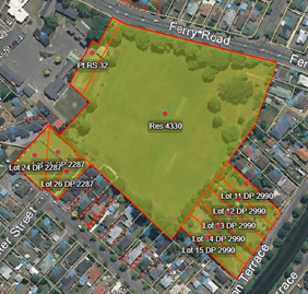
5.2 The
parcel which is the subject of this report is referred to as Pt RS 32 in the
plan above. It is held in Record of Title CB204/99, extends to some 1392m2, is
administered as a park pursuant to Section 138 Local Government Act (LGA) 2002,
and is currently leased to the School.
5.3 That
part of Pt RS 32 which is subject to the proposed acquisition by the Crown is
referred to as Section 1 in the plan below and has an area of around 950m2
(“the Land”).
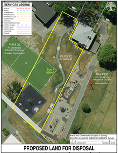
5.4 Section
1 is essentially landlocked by the school to the west and south and Woolston
Park to the east and north. The existing pedestrian access (for the school)
from the northern end of the Land across Woolston Park to Ferry Road is
preserved as is access around the perimeter of the former Woolston Community
Centre building (located to the north-east of Section 1 in the plan above).
5.5 The
Land has been occupied and developed by the School for ‘school
grounds’ since 2010 on a lease which expires in 2045.
5.6 There
are no encumbrances registered against the title and the Land is not subject to
the Ngāi Tahu Claims Settlement Act 1998.
5.7 The
Land is currently zoned Open Space Community Parks which provides for formal
and informal recreation activities.
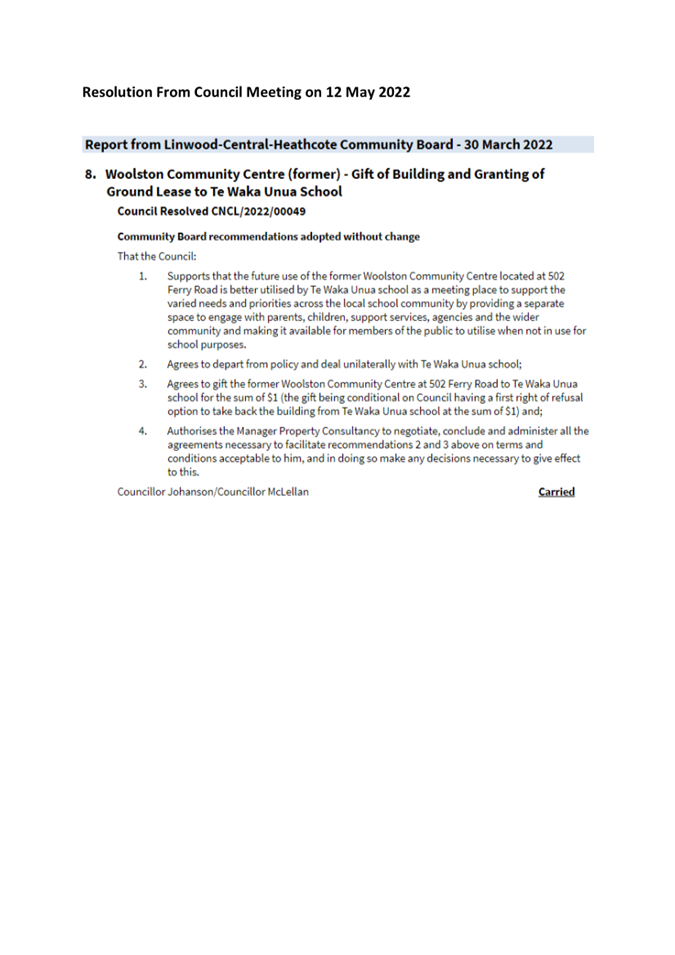
5.8 With
regard to the former Woolston Community Centre building, the Council recently
resolved to deal unilaterally with the School in gifting them the ownership of
this building on the basis that it:
“is
better utilised by Te Waka Unua School as a meeting place to support the varied
needs and priorities across the local school community by providing a separate
space to engage with parents, children, support services, agencies and the
wider community and making it available for members of the public to utilise
when not in use for school purposes”. A
copy of the Council resolution (CNCL/2022/00049) is appended as Attachment
A.
5.9 The
School’s ownership and use of this building is subject to a ground lease
from the Council which expires in 2055. The Council has a first right of
refusal to take the building back should the School no longer require it for
their services.
Asset
– Value and Current Cost to the Council
5.10 The market value
of, and purchase price for, the Land will be assessed by an independent
registered valuer.
5.11 The current
costs to the Council of retaining the Land are nominal as the ground lease
provisions require the School to be responsible for the maintenance of the
school grounds.
5.12 There are no Council
assets or utilities in or on the Land.
The Proposal
5.13 The Council has
received an unsolicited proposal from the Crown to acquire that part of the
Council owned property referred to above for education purposes associated with
Te Waka Unua School (refer Attachment B).
5.14 In support of
the proposal the Crown has commented that:
“it is
considered that there will be significant roll growth at the school as a result
of both anticipated infill / intensification of housing within the local area,
along with increases in the share of local students attending the school. There
is also a need to expand Bilingual education provision across the network, of
which the school is a provider. The additional land is currently already being
used by the school as play space and could enable future expansion of
classrooms for both English and Maori Medium education at the school”.
5.15 The proposed
land acquisition by the Crown does not affect the Council’s level of
service in terms of park provision. Woolston Park will still extend to
some 3.3 hectares and continue to provide the current recreation opportunities.
The proposal promotes the effective and efficient use of Council assets and
enhances its relationship with the Crown.
5.16 Dealing
unilaterally with the Crown recognises that the Land has been leased and
utilised by the School since 2010 and that there are no other practical users
of the Land (internal or external) as the Land is effectively landlocked.
Provision exists for the Land to be taken back by the Council if the School no
longer require it (refer paragraph 8.3).
Disposal of Council Owned Property – Criteria
5.17 Any disposal is
to be in a manner as set out in the Council’s policies and normal
practices, i.e.:
· Policy: to publicly tender properties for sale unless there is a
clear reason for doing otherwise.
· Practice: in an open, transparent, well-advertised and public manner
at market value.
Assessed
against:
· Is the property still required for the purpose for which it was
originally acquired? No
· Does the property have special cultural, heritage or environmental
values that can only be protected through public ownership? No
· Is there an immediate alternative public use / work / activity in a
policy, plan or strategy? No
· Are there any strategic, non-service delivery needs that the
property meets and that can only be met through public ownership? No
· Are there any identified unmet needs, which the Council might
normally address, that the property could be used to solve? And is there a
reasonable pathway to funding the unmet need? No
Dealing Unilaterally
5.18 The
Crown’s proposal is in effect an unsolicited proposal requesting the
purchase of a Parks asset.
5.19 Where there is
only one logical purchaser of a property the Council may deal unilaterally with
that purchaser, subject to undertaking public consultation in accordance with
the requirements of Sections 78 and 138 LGA 2002.
5.20 There are a
number of factors which need to be considered when contemplating a unilateral
dealing. Refer Attachment C.
5.21 The acquisition
of the land by the Crown does not affect the Council’s current levels of
service given that the Land has been leased to the School since 2010. The Parks
Unit, as current internal steward of the Land, fully support the acquisition by
the Crown.
5.22 In context, the
proposed Crown acquisition is also consistent with, and complements, the
previous Council decision to gift ownership of the adjacent former Woolston
Community Centre building to the School for education and community purposes.
5.23 This proposal
does not depart from the considerations outlined in Attachment C. As such,
staff consider it is appropriate for the Community Board to recommend the
acquisition of the Land by the Crown from Council.
Community Views and Preferences
5.24 Assuming the
Council resolve to accept the Board’s recommendation a subsequent section
138 LGA consultation process will be undertaken to establish the views and
preferences of the community. If any sustainable objections to the acquisition
by the Crown are received these will be reported back to the Council for
consideration and, if necessary, a Hearings process may be convened to consider
those objections.
5.25 The decision
affects the following wards/Community Board areas:
Waitai-Coastal-Burwood-Linwood.
6. Policy
Framework Implications Ngā Hīraunga ā- Kaupapa
here
Strategic AlignmentTe Rautaki
Tīaroaro
6.1 This decisions aligns with the Council’s vision to enable
active and connected communities to own their future.
6.2 This report supports the Council's
Long Term Plan (2021 - 2031):
6.2.1 Activity: Facilities,
Property and Planning
· Level
of Service: 13.4.10 Acquisition of property right projects, e.g. easements,
leases and land assets to meet LTP funded projects and activities. - At least
90% projects delivered to agreed timeframes per annum
Policy
Consistency Te Whai Kaupapa here
6.3 The decision is consistent with Council’s Plans and Policies.
· Promotes
effective and efficient use of Council assets.
· Through
the School’s activities, supports active citizenship and connected
communities by providing venues to support community engagement with the
Council, Community Boards and community organisations in order to grow
community participation in civic life.
· Builds
community resilience, social capital and community capacity to support a
response to major stressors such as climate change, terror attacks and the
effects of Covid-19.
· Enables
the celebration of local identity and diversity by providing venues for
education, arts, culture, heritage, sport and recreation.
Impact on Mana Whenua Ngā Whai Take
Mana Whenua
6.4 The decision does not involve a significant decision in relation to
ancestral land or a body of water or other elements of intrinsic value,
therefore this decision does not specifically impact Mana Whenua, their culture
and traditions.
6.5 The decision does not involve a matter of interest to Mana Whenua and will not impact on our agreed partnership priorities
with Ngā Papatipu Rūnanga.
6.6 Following consultation with the Council’s Principal Advisor
Treaty Relationships and Strategic Advisor Te Tiriti Partnership we have been
advised that “Ngai Tuahuriri has no interest in this
property”.
6.7 As an aside, the Crown has expressed their desire to develop an
enduring relationship with local iwi, with particular reference to increasing
bilingual development at Te Waka Unua School. With the assistance of the
Council’s advisors we have provided the Crown with a contact at Ngāi Tūāhuriri who is keen to facilitate this process.
Climate Change Impact Considerations Ngā
Whai Whakaaro mā te Āhuarangi
6.8 Disposal of the land will not require additional resources. The
intended use of the Land by the School may involve the development of
additional classrooms in the future.
Accessibility Considerations Ngā Whai
Whakaaro mā te Hunga Hauā
6.9 The Crown will be responsible for ensuring the Land meets all
regulatory requirements for its particular use including any Ministry of
Education requirements for use as a school facility. Any subsequent
improvements will need to comply with current Resource Management and Building
Act regulations and any other relevant statutory / consenting requirements.
6.10 The Crown will
also be required, at its cost, to establish an easement over the power line
which traverses the north-east corner of the site (providing power to the
former Woolston Community Centre building).
7. Resource Implications Ngā Hīraunga Rauemi
Capex/Opex Ngā Utu Whakahaere
7.1 Cost
to Implement – nil. Purchase price, legal, valuation, survey, subdivision
and any other costs related to the disposal will be the responsibility of the
Crown.
7.2 Maintenance/Ongoing
costs – nil. Ownership and responsibility transfers to the Crown.
7.3 Funding
Source – operational budgets for any nominal incidental Council costs.
Other He mea anō
7.4 The
sale of this asset is not contemplated in the current LTP.
8. Legal Implications Ngā Hīraunga ā-Ture
Statutory power to undertake proposals in
the report Te Manatū Whakahaere Kaupapa
8.1 The
general powers of competence set out in section 12(2) “Status and Powers”
of the LGA 2002.
Other Legal Implications Ētahi atu
Hīraunga-ā-Ture
8.2 The
legal considerations are the Local Government Act 2002 and the Council’s
Disposal of Council Property’ policy, referred to in paragraph 5.17 above.
8.3 The
Council’s Legal Services Unit have been consulted and have confirmed that
the acquisition of the land by the Crown from Council should be actioned
pursuant to section 50 of the Public Works Act 1981 (PWA) which provides for
the disposal of land held for a public work. On this basis the Crown will take
on any section 40 PWA obligations and, if they no longer require the land for
educational purposes at some stage in the future, will be required to address
section 40 PWA offer-back requirements should the Council or the Crown not
require the land for any other further public work.
9. Risk Management Implications Ngā Hīraunga Tūraru
9.1 If
the School ceases to operate from this neighbourhood or no longer has a need
for the Land, the Council would have an option to resume ownership of the Land.
If the Council did resume ownership of the Land, the School would be required
to remove any of its improvements from the Land.
9.2 There
may be some residual community feedback regarding the Council’s decision
to deal unilaterally with the Crown.
Attachments Ngā Tāpirihanga
|
No.
|
Title
|
Reference
|
Page
|
|
a
|
Council
Resolution CNCL/2022/00049
|
23/213804
|
|
|
b
|
Crown's
Unsolicited Request to Acquire Land
|
23/213806
|
|
|
c
|
Factors to
Consider When Dealing Unilaterally
|
23/315699
|
|
In addition to the attached documents, the following background
information is available:
|
Document
Name – Location / File Link
|
|
Not
applicable
|
Confirmation of Statutory
Compliance Te Whakatūturutanga ā-Ture
|
Compliance with Statutory Decision-making
Requirements (ss 76 - 81 Local Government Act 2002).
(a) This report contains:
(i) sufficient information about all reasonably practicable
options identified and assessed in terms of their advantages and
disadvantages; and
(ii) adequate consideration of the views and preferences of
affected and interested persons bearing in mind any proposed or previous
community engagement.
(b) The information reflects the level of significance of the
matters covered by the report, as determined in accordance with the Council's
significance and engagement policy.
|
Signatories Ngā Kaiwaitohu
|
Author
|
Barry Woodland
- Property Consultant
|
|
Approved By
|
Angus Smith -
Manager Property Consultancy
Kelly Hansen -
Manager Parks Planning & Asset Management
Andrew
Rutledge - Head of Parks
Mary
Richardson - General Manager Citizens & Community
|
|
Council
03 May 2023
|

|
|
Council
03 May 2023
|
|
|
Council
03 May 2023
|
|
Report from Waitai Coastal-Burwood-Linwood
Community Board – 13 April 2023
|
9. Legal
stopping of Avonside Drive between Kerrs Road and Wainoni Road, as well as
Kerrs Road north of #144
|
|
Reference Te Tohutoro:
|
23/541132
|
|
Report of Te Pou Matua:
|
Rob
Shelton, Project Manager Residential Red Zone
Angus Smith, Manager Property Consultancy
Swantje Bubritzki, Senior Engagement Advisor
|
|
General Manager Pouwhakarae:
|
Mary
Richardson, General Manager Citizens & Community
(Mary.Richardson@ccc.govt.nz)
|
Nature of Decision or Issue and Report Origin
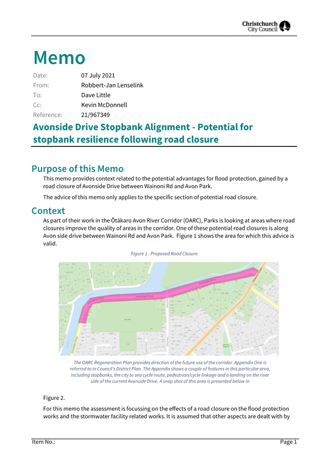
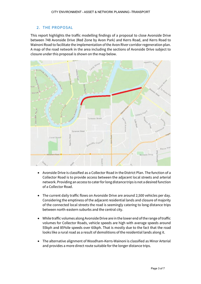
1.1 For the Council to consider the legal stopping of Avonside
Drive between Kerrs Road and Wainoni Road, as well as Kerrs Road north of #144.
1.2 This report arose from a decision report to the Waitai
Coastal-Burwood-Linwood Community Board 13 April 2023 meeting.
|
1. Waitai Coastal-Burwood-Linwood Community
Board Recommendation to Council
|
|
|
Original Officer
Recommendation accepted without change
Part A
That the Council:
1. Commence the road stopping process under the
Local Government Act 1974 procedure for:
a. Avonside Drive between Kerrs Road and Wainoni
Road, and
b. Kerrs Road north of #144
2. In the event that there are no objections
received through the road stopping procedure authorise staff to complete the
road stopping.
3. In the event there are objections, authorise
staff to manage those in accordance with the Local Government Act procedures.
4. Delegate authority to the Property Consultancy
Manager to do all things necessary at his sole discretion to manage and
conclude any of the actions required from resolutions 1 to 3 above.
5. Reduce the speed limit to 30km/h along
Torlesse Street, Braemar Place and Kerrs Road north of Wainoni Road at the
same time (or before) the closure.
6. Install traffic counters on Torlesse Street
following the closure.
7. Request that officers re-engage with residents
around suitable mitigation measures if traffic counts on Torlesse Street are
found to be higher than reasonable for a local road, and report back to the
Waitai Coastal-Burwood-Linwood Community Board.
|
Attachments Ngā Tāpirihanga
|
No.
|
Report Title
|
Reference
|
Page
|
|
1
|
Legal stopping of Avonside Drive
between Kerrs Road and Wainoni Road, as well as Kerrs Road north of #144
|
|
107
|
|
No.
|
Title
|
Reference
|
Page
|
|
a ⇩
|
Avonside Drive
Partial Closure Stopbank Impacts
|
23/451667
|
116
|
|
b ⇩
|
Avonside Drive
Partial Closure Traffic Modelling
|
23/451668
|
119
|
|
c ⇩
|
Avonside Drive
Partial Closure Consultation Summary
|
23/452576
|
126
|
|
d ⇩ 
|
Avonside Drive
Partial Closure Full Submissions Table
|
23/483798
|
130
|
|
Council
03 May 2023
|
|
|
Legal stopping of Avonside Drive between Kerrs Road and
Wainoni Road, as well as Kerrs Road north of #144
|
|
Reference / Te Tohutoro:
|
23/428080
|
|
Report of / Te Pou Matua:
|
Rob
Shelton, Project Manager Residential Red Zone
Angus Smith, Manager Property Consultancy
Swantje Bubritzki, Senior Engagement Advisor
|
|
General Manager / Pouwhakarae:
|
Mary
Richardson, General Manager Citizens & Community
(Mary.Richardson@ccc.govt.nz)
|
1. Nature of Decision or Issue and Report Origin
1.1 The purpose of this report is to update the Waitai
Coastal-Burwood-Linwood Community Board on the results of consultation
regarding the partial stopping of Avonside Drive and Kerrs Road, in order to
allow the Board to formulate their recommendation to Council on this matter.
1.2 This report has been staff generated.
1.3 The
decision in this report is of medium significance in relation to the
Christchurch City Council’s Significance and Engagement Policy. The
level of significance was determined based on the likely high public interest,
but moderated by low actual impacts (based on modelling) and broader economic,
ecological and cultural benefits.
2. Officer Recommendations Ngā Tūtohu
That the Council:
1. Commence the road stopping process under the Local Government Act
1974 procedure for:
a. Avonside Drive between Kerrs Road and Wainoni Road, and
b. Kerrs Road north of #144
2. In the event that there are no objections received through the road
stopping procedure authorise staff to complete the road stopping.
3. In the event there are objections, authorise staff to manage those
in accordance with the Local Government Act procedures.
4. Delegate authority to the Property Consultancy Manager to do all
things necessary at his sole discretion to manage and conclude any of the
actions required from resolutions 1 to 3 above.
5. Reduce the speed limit to 30km/h along Torlesse Street, Braemar
Place and Kerrs Road north of Wainoni Road at the same time (or before) the
closure.
6. Install traffic counters on Torlesse Street following the closure.
7. Request that officers re-engage with residents around suitable
mitigation measures if traffic counts on Torlesse Street are found to be higher
than reasonable for a local road, and report back to the Waitai
Coastal-Burwood-Linwood Community Board.
3. Reason for Report Recommendations Ngā Take mō te Whakatau
3.1 This
report forms part of the process to implement Council’s resolution below,
from the meeting held on 12 October 2021.
Council
Resolved CNCL/2021/00160
That the
Council:
4. Requests that, as part of the land titles
reconfiguration process being undertaken in the Otakaro Avon River Corridor
pursuant to the Global Settlement Agreement, Land Information New Zealand use
the powers of the Greater Christchurch Regeneration Act 2016 to legally stop
the following portions of the road (thereby revoking the public legal road status)
for the following:
a. from 748 Avonside Drive to 836 Avonside Drive (Kerrs
Road intersection) as detailed in the Ōtākaro Avon River Corridor
Regeneration Plan.
b. from 842 Avonside Drive to Bickerton Reserve (Wainoni
Road intersection), following appropriate public notice.
c. from 144 Kerrs Road to the intersection Avonside
Drive, following appropriate public notice.
5. Request staff report back to Council the outcome of
the consultation process for recommendations 4b & 4c before making any requests
to Land Information New Zealand seeking the legal stopping of those roads.
3.2 We
have now completed consultation on 4b and 4c as above, and are reporting
results and recommendations.
4. Alternative Options Considered Ētahi atu Kōwhiringa
4.1 Status
quo. Due to earthquake subsidence, the portion of Avonside Drive
between Kerrs Road and Wainoni cannot drain for portions of the day. This
means that flooding is common after rain, presenting a safety hazard and
increasing operating costs due to reactive traffic management. Flooding
also increases maintenance costs as the surface deteriorates more quickly due
to the regular standing water. The road surface is in poor condition,
meaning that resurfacing will likely be required soon under the status quo
option.
4.2 Lift
road to fix drainage issues. To fix the current issues and
futureproof for sea level rise, another option would be to lift the road.
This would be in the order of one metre if separated from the stopbank, or over
two metres if the stopbank were built into the road. High level estimates
put the cost of these works (over and above baseline stopbank costs) at
around $8-9 million, with more detail in Section 5.
5. Detail Te Whakamahuki
5.1 The
current status of these roads is shown in Figure 1 overleaf.

Figure 1: Current status of roads affected by this
proposal.
5.2 The
section of Avonside Drive that runs from 748 Avonside Drive to the Kerrs Road
intersection (noted as 4a in the Council Resolution) has been legally
stopped.
5.3 This
stopping formed part of the Regeneration Plan, and was subsequently reflected
in the District Plan, however our experience with its temporary closure for the
Snell Bridge construction was that it resulted in detouring traffic from the
eastern portion of Avonside Drive along Torlesse Street (a local road).
5.4 This
report deals with the proposed stopping of the eastern portion of Avonside
Drive out to Wainoni for financial, ecological and cultural reasons, as well as
reducing the traffic impacts of a partial closure on Torlesse. It also
proposes a stopping of the northern portion of Kerrs Road (beyond the last
house) to allow for overnight gating to reduce illegal activity.
Avonside Drive (Kerrs to Wainoni)
5.5 This
section of Avonside Drive runs adjacent to the Avon Ōtākaro River,
and its stormwater system discharges directly into the waterway, with the
outlet pipes below the high tide level.
5.6 When
rainfall coincides with mid to high tide levels in the river, the road floods
as it cannot drain. This situation will worsen over time as the sea level
rises. Due to the regular flooding, the road surface is in poor condition and
requires ongoing maintenance.

Figure 2: Avonside Drive. Looking West towards
Kerrs Road
5.7 Maintenance
and replacement of the road and stopbank are costs that could be either avoided
or reduced by removing the road.
5.8 The
value of stopbank cost avoidance has been estimated at $5.8 million should this
road be stopped and eventually closed, as it is cheaper to build stopbanks
further from the river’s edge.
5.9 There
would be a further $2-3 million involved in rebuilding the road, although this
sum is indicative as work has not been done to accurately determine the
required level that this road would need to be build up to and what engineering
would be required to achieve this.
5.10 Additionally,
removal of the road would allow the stopbanks to be pushed back which would
increase space available for the future Stormwater Management Area immediately
to the south. The Three Waters team have assessed the broader engineering
benefits of this, which is attached as Attachment A.
5.11 Ecological and
cultural benefits associated with removing the road and pushing the stopbank
back have also been assessed, and they include:
5.11.1 A reduction of road runoff pollutants (oil,
heavy metals, brake pad material and the like), improving local water quality.
5.11.2 Ability for the riverbank to be naturalised
and planted. As saltwater moves into this reach over time, this would
allow inanga habitat along the margin, which would be impossible if the
stopbanks were to run along the river’s edge.
5.11.3 Ability for tree planting along the river
margin, which would shade the water, lowering its temperature and subsequently
increasing ecological habitat.
5.11.4 Resultant improved mahinga kai
opportunities, which is the primary cultural driver for the River
Corridor. Further detail on this aspect is included in Section 6.
5.12 The Transport
team have reviewed the proposal and their advice (including modelling) forms Attachment
B. A summary is:
5.12.1 Traffic speeds are high on this portion of
the road, but volumes are relatively low.
5.12.2 If this road were to be stopped, traffic
would divert down Wainoni Road, which is an arterial and designed to handle
high flows. The increase in traffic would not result in significant
impacts on travel times.
5.12.3 Changes to traffic on other parts of the
road network are not expected to be significant.
5.13 While modelling does not indicate
significant increases, staff recommend the following mitigations be implemented
to reduce concerns noted by some residents of Torlesse Street:
5.13.1 Reduce speed limit to 30km/h along Torlesse Street, Braemar Place
and Kerrs Road north of Wainoni Road. This is already proposed as part of
the Safe Speed Neighbourhoods project, but would be brought forward to
align with the closure.
5.13.2 Install traffic counters on Torlesse Street following the closure.
5.13.3 If counts are found to be higher than reasonable for a local road,
re-engage with residents around further mitigation measures. These could
include exploring options for traffic calming or full or partial cul-de-sacs.
Kerrs Road (north of #144)
5.14 Stopping of this portion of road
is linked to the Avonside Drive decision, as this would effectively become a
long cul-de-sac at night. Our experience is that cul-de-sacs in the red
zone attract a range of undesirable activities, many of which incur costs of
clean-up to Council.
5.15 Stopping the road would allow a
gate to be installed past access to the last house (#144), which would be
locked at night to prevent this behaviour. At other times, the road would
remain open to service Porritt Park and the flatwater clubs domiciled there.
6. Community
Views and Preferences Ngā mariu ā-Hāpori
Public Consultation
Te
Tukanga Kōrerorero
6.1 Public consultation on this proposal was completed
in conjunction with the consultation on the redevelopment of Avon Park. A detailed summary of
submissions and staff responses to the issues raised is available in Attachment
C, with an overview provided below.
Summary of Submissions
Ngā Tāpaetanga
6.2 Regarding
the legal road stopping, 111 groups and individuals made submissions. The majority of submitters – both
local and from the wider community – supported the proposed road stopping
(64, 58%). Submitters thought closing the road, would have the following
positive outcomes:
· Improved safety and limited
speeding/racing (19)
· Protection/restoration of nature and
recreational space (17)
6.3 Submitters also felt that there were
satisfactory alternative routes (10), that the current use of the road did not
warrant it’s staying open (7), and that the road is prone to flooding
(6).
6.4 A
smaller proportion of submitters expressed neither support nor opposition (24,
21%), but raised issues and concerns.
6.5 The remainder of submitters – again
local and from the wider community – did not support the proposed road
closure, (23, 21%), for varying reasons. The issues raised were shared among
supporters and non-supporters of the road stopping, so the following table
outlines issues raised across all submitters, grouped by preference:
|
Raised
issues and concerns
|
Supportive
|
Neutral
|
Opposed
|
Total
|
|
Reducing access/parking for the water sports clubs
/ Kerrs Reach to daylight hours
|
6
|
11
|
6
|
23
|
|
Increasing traffic on surrounding
streets, particularly
Torlesse St / Kerrs
Rd
|
3
|
5
|
6
|
15
|
|
Losing direct route/thoroughfare for
cars and cyclists
|
1
|
2
|
7
|
10
|
|
Management of the gate at Kerrs Rd to prevent access
at night
|
1
|
1
|
4
|
6
|
|
Increased risk at intersections, such as
Kerrs Rd/Wainoni Rd or Avonside
Drive/Gloucester St/Retreat Rd
|
1
|
0
|
4
|
5
|
6.6 We
have reviewed the issues and concerns with the Transport team.
6.7 The
access/gate issues can be dealt with operationally, and previous modelling has
checked the intersection safety. While this is a direct route to some
locations, there are suitable alternatives available.
6.8 The
most salient point identified is the risk of increased traffic on Torlesse
Street. Our modelling is not showing significant increases, however to
alleviate the concerns raised by respondents, we are recommending the mitigation
measures described in 2.5 to 2.7 above.
6.9 A
table of all submissions received is available in the second column of Attachment
D.
7. Policy
Framework Implications Ngā Hīraunga ā- Kaupapa
here
Strategic Alignment Te Rautaki
Tīaroaro
7.1 :
7.1.1 Activity:
Otakaro Avon River Corridor
· Level of Service: 6.8.12.1 Implementation of the Otakaro
Avon River Corridor Regeneration Plan (Green Spine). Council-led capital
investment - Progress integrated Green Spine programme (Parks, Water and
Transport) as per the Implementation Plan.
· Target: 90 % of approved work programmes delivered in the
year funded Policy Consistency Te Whai Kaupapa here
7.1 The
decision is consistent with Council’s Plans and
Policies, and any stopping process would follow the requirements of the
Council’s Road Stopping Policy (The Policy).
7.2 The
Policy provides for the stopping of a road initiated by a Council business unit
to meet Council policies or strategies.
7.3 Road
Stopping is the legal process to change the status of road to fee simple land.
Once a road is legally stopped the land can be retained, sold or transferred
for an alternative use. The road stopping process is governed by either the
Local Government Act 1974 or the Public Works Act 1981. The statutory process
used in relation to a particular application is governed by the Policy.
7.4 The
Policy provides that The Local
Government Act 1974 road-stopping procedure will be adopted if one or more of
the following circumstances apply:
7.4.1 Where any public right of access to
any public space could be removed or materially limited or extinguished as a
result of the road being stopped; or
7.4.2 If it is found through the review
process that the road stopping could injuriously affect or have a negative or
adverse impact on any other property; or
7.4.3 The road stopping is, in the judgment
of the Council, likely to be controversial; or
7.4.4 If there is any doubt or uncertainty
as to which procedure should be used to stop the road; or
7.4.5 The Public Works Act 1981 process is
not able to be used, or is not used.
7.5 It
is considered given the circumstances this road stopping should be undertaken
using the Local Government Act 1974 procedure rather than the Public Works Act
1981.
7.6 Section 342 of The Local Government Act 1974 provides the power for
councils to stop roads and sets out in schedule 10 of the Act the manner in
which that is to be undertaken.
7.7 The process in
schedule 10 is prescriptive. In summary that sets out a notification period of
40 days with specific associated undertakings. If no objections are received the
council may by public notice declare that the road is stopped. If
objections are received those together with the plans and description of the
proposed alterations will be referred to the Environment Court for
determination.
Impact on Mana Whenua Ngā Whai Take
Mana Whenua
7.8 The decision involves a significant decision in relation to ancestral land
or a body of water or other elements of intrinsic value, therefore this
decision does specifically impact Mana Whenua, their culture and traditions.
7.9 The decision involves a matter of interest to Mana Whenua and could impact on our agreed partnership priorities
with Ngā Papatipu Rūnanga.
7.10 Mana Whenua have
made it clear that their primary outcome sought for the Ōtākaro Avon
River Corridor is its return to a viable mahinga kai gathering space. To
achieve this, significant ecological improvements to the river margins and waterbody
itself are required.
7.11 Removal of this
portion of road would reduce pollutants and allow the riverbank to be
naturalised, with habitat benefits as noted earlier.
7.12 Accordingly, the
Ngāi Tahu rūnanga kaitiaki committee are supportive of removing the
road.
7.13 Road stopping in
this area was also presented to the Ōtākaro Avon River Corridor
Co-governance Establishment Committee at workshops in February and March 2023,
receiving favourable feedback for the reasons noted above.
Climate Change Impact Considerations Ngā
Whai Whakaaro mā te Āhuarangi
7.14 Water levels in
this portion of the river are influenced by the tide, meaning that over time
the drainage issues will become worse. It also means that any lifting of
the road will need to be futureproofed for further rises and will require
significant fill and engineering.
7.15 With flood
events predicted to become more common, the general approach in the corridor is
to push the stopbanks away from the river, allowing the greatest possible
floodplain. Rebuilding the road and stopbank at the river’s edge
here would limit the area’s ability to ‘soak up’ flooding.
7.16 The engineering
required to rebuild this road and add a river edge stopbank would have a
significant carbon footprint, which could be avoided.
Accessibility Considerations Ngā Whai
Whakaaro mā te Hunga Hauā
7.17 This portion of
Avonside Drive is not particularly accessible – with no functional
footpaths, and the only ‘non-car’ access being a narrow gravel
track at the top of the temporary stopbank.
7.18 Removal of the
road would allow space for a walking/cycling connection here out to Wainoni
Road.
8. Resource Implications Ngā Hīraunga Rauemi
Capex/Opex Ngā Utu Whakahaere
8.1 Cost
to Implement. As this report seeks a legal stopping only, there is no
specific cost for Council to implement the physical works. There would be
relatively minor survey and legal costs.
8.2 Maintenance/Ongoing
costs. There are no specific ongoing costs associated with the legal
stopping. Closure and removal of the road would save ongoing OPEX, as
noted earlier.
8.3 Funding
Source. Surveying costs associated with stopping the road would be
covered out of Parks Red Zone CAPEX budgets, following the Council resolution to
progress this aspect. Future removal costs (and any Environment Court
process) would likely be included in the future stopbank and Stormwater
Management Area project, as closure of this road benefits that project.
Other He mea anō
8.4 There
are no other aspects to consider.
9. Legal Implications Ngā Hīraunga ā-Ture
Statutory power to undertake proposals in
the report Te Manatū Whakahaere Kaupapa
9.1 In
respect of the road stopping the powers and procedures set out Section 342 and
schedule 10 of the Local Government Act 1974 will be used.
Other Legal Implications Ētahi atu
Hīraunga-ā-Ture
9.2 The
legal consideration is referred to above and as set out above in sections 7.1
to 7.7.
10. Risk Management Implications Ngā Hīraunga Tūraru
10.1 As this decision
relates to the legal road stopping process, there is a risk that if there are
objections, thereby having the determination referred to the Environment Court,
that the final determination will be out of Council’s control.
Attachments Ngā Tāpirihanga
|
No.
|
Title
|
Reference
|
Page
|
|
a
|
Avonside Drive
Partial Closure Stopbank Impacts
|
23/451667
|
|
|
b
|
Avonside Drive
Partial Closure Traffic Modelling
|
23/451668
|
|
|
c
|
Avonside Drive
Partial Closure Consultation Summary
|
23/452576
|
|
|
d
|
Avonside Drive
Partial Closure Full Submissions Table
|
23/483798
|
|
In addition to the attached documents, the following background
information is available:
|
Document
Name – Location / File Link
|
|
Not
applicable
|
Confirmation of Statutory Compliance
Te Whakatūturutanga ā-Ture
|
Compliance with Statutory Decision-making
Requirements (ss 76 - 81 Local Government Act 2002).
(a) This report contains:
(i) sufficient information about all reasonably practicable
options identified and assessed in terms of their advantages and
disadvantages; and
(ii) adequate consideration of the views and preferences of
affected and interested persons bearing in mind any proposed or previous
community engagement.
(b) The information reflects the level of significance of the
matters covered by the report, as determined in accordance with the Council's
significance and engagement policy.
|
Signatories Ngā Kaiwaitohu
|
Authors
|
Rob Shelton -
Project Manager, Residential Red Zone
Swantje
Bubritzki - Senior Engagement Advisor
Angus Smith -
Manager Property Consultancy
|
|
Approved By
|
David Little -
Manager Residential Red Zone
Andrew
Rutledge - Head of Parks
Mary Richardson
- General Manager Citizens & Community
|
|
Council
03 May 2023
|

|
Report from Waihoro
Spreydon-Cashmere-Heathcote Community Board – 13 April 2023
|
10. Waltham
Road Marking of Cycle Lanes Between Moorhouse Avenue and Brougham Street
|
|
Reference Te Tohutoro:
|
23/561634
|
|
Report of Te Pou Matua:
|
Michael
Ferigo, Transport Planner - Sustainable Transport (michael.ferigo@ccc.govt.nz)
Kiran Skelton, Engagement Advisor (kiran.skelton@ccc.govt.nz)
|
|
General Manager Pouwhakarae:
|
Mary
Richardson, General Manager Citizens & Community (Mary.Richardson@ccc.govt.nz)
|
Nature of Decision or Issue and Report Origin
1.1 The purpose of this report is for the Waihoro
Spreydon-Cashmere-Heathcote Community Board to consider the consulted proposal
for cycle improvements, and make recommendations to Council to adopt the
supporting lane marking changes.
1.2 The Christchurch Transport Strategic Plan recognises and
supports measures to improve cycling within Christchurch. This project is
identified as a local cycleway within the Plan and within the Long Term Plan
capital programme.
This report arose from a Decision Report to the Waihoro
Spreydon-Cashmere-Heathcote Community Board 13 April 2023 meeting.
|
1. Officer Recommendations Ngā Tūtohu
|
|
|
That the Waihoro Spreydon-Cashmere-Heathcote Community Board
recommends to Council that it approves, pursuant to Clause 18 of the
Christchurch City Council Traffic and Parking Bylaw 2017:
1. That Special Vehicle Lanes (Cycle Lane) be installed on the west
side of Waltham Road from the intersection of Brougham Street and extending
in a northerly direction for a distance of 261 metres to the intersection of
Wordsworth Street.
2. That Special Vehicle Lanes (Cycle Lane) be installed on the west
side of Waltham Road from the intersection of Wordsworth Street and extending
in a northerly direction for a distance of 542 metres to the intersection at
Moorhouse Avenue.
3. That Special Vehicle Lanes (Cycle Lane) be installed on the east
side of Waltham Road from the intersection of Moorhouse Avenue and extending
in a southerly direction for a distance of 30 metres.
4. That Special Vehicle Lanes (Cycle Lane) be installed on the east
side of Waltham Road from the intersection of Shakespeare Road and extending
in a northerly direction for a distance of 275 metres.
5. That Special Vehicle Lanes (Cycle Lane) be installed on the east
side of Waltham Road from the intersection of Shakespeare Road and extending
in a southerly direction for a distance of 235 metres to the intersection of
Brougham Street.
That the Waihoro
Spreydon-Cashmere-Heathcote Community Board:
6. Approves,
pursuant to Section 334 of the Local Government Act 1974, the lane marking
changes and road marking changes on Waltham Road as detailed on plan, For
Approval - tp356901 in attachment A.
7. Approves that the stopping of all vehicles be prohibited at any
time, in accordance with Clause 7 of the Christchurch City Council Traffic
& Parking Bylaw 2017, on the west side of Waltham Road commencing at its
intersection with Brougham Street, and extending in a northerly direction for
a distance of 18 metres.
8. Approves that the stopping of all vehicles be prohibited at any
time, in accordance with Clause 7 of the Christchurch City Council Traffic
& Parking Bylaw 2017, on the west side of Waltham Road commencing at its
intersection with Kingsley Street, and extending in a northerly direction for
a distance of 655 metres.
9. Approves that the stopping of all vehicles be prohibited at any
time, in accordance with Clause 7 of the Christchurch City Council Traffic
& Parking Bylaw 2017, on the east side of Waltham Road commencing at its
intersection with Mowbray Street, and extending in a southerly direction for
a distance of 427 metres.
10. Approves
that the stopping of all vehicles be prohibited at any time, in accordance
with Clause 7 of the Christchurch City Council Traffic & Parking Bylaw
2017, on the east side of Waltham Road commencing at its intersection with
Brougham Street, and extending in a southerly direction for a distance of 118
metres.
11. Approves
that any previously approved resolutions on Waltham Road, from its
intersection with Brougham Street to its intersection with Moorhouse Avenue,
pertaining to parking and /or stopping restrictions, made pursuant to any
bylaw or any Land Transport Rule, to the extent that they are in conflict
with the parking and /or stopping restrictions described in recommendations 6
to 10 above, be revoked.
|
|
2. Waihoro Spreydon-Cashmere-Heathcote Community Board Decisions
Under Delegation Ngā
Mana kua Tukuna
|
|
|
Part
C
That the Waihoro
Spreydon-Cashmere-Heathcote Community Board:
6. Approves,
pursuant to Section 334 of the Local Government Act 1974, the lane marking
changes and road marking changes on Waltham Road as detailed on plan, For
Approval - tp356901 in attachment A.
7. Approves that the stopping of all vehicles be prohibited at any
time, in accordance with Clause 7 of the Christchurch City Council Traffic
& Parking Bylaw 2017, on the west side of Waltham Road commencing at its
intersection with Brougham Street, and extending in a northerly direction for
a distance of 18 metres.
8. Approves that the stopping of all vehicles be prohibited at any
time, in accordance with Clause 7 of the Christchurch City Council Traffic
& Parking Bylaw 2017, on the west side of Waltham Road commencing at its
intersection with Kingsley Street, and extending in a northerly direction for
a distance of 655 metres.
9. Approves that the stopping of all vehicles be prohibited at any
time, in accordance with Clause 7 of the Christchurch City Council Traffic
& Parking Bylaw 2017, on the east side of Waltham Road commencing at its
intersection with Mowbray Street, and extending in a southerly direction for
a distance of 427 metres.
10. Approves
that the stopping of all vehicles be prohibited at any time, in accordance
with Clause 7 of the Christchurch City Council Traffic & Parking Bylaw
2017, on the east side of Waltham Road commencing at its intersection with
Brougham Street, and extending in a southerly direction for a distance of 118
metres.
11. Approves
that any previously approved resolutions on Waltham Road, from its
intersection with Brougham Street to its intersection with Moorhouse Avenue,
pertaining to parking and /or stopping restrictions, made pursuant to any
bylaw or any Land Transport Rule, to the extent that they are in conflict
with the parking and /or stopping restrictions described in recommendations 6
to 10 above, be revoked.
12. Request
that maintenance staff carry-out work at the same
time; to paint the old red cycleway markings on Waltham Road in the new
green-style, while the Waltham Road Marking of Cycle Lanes between Moorhouse
Avenue and Brougham Street project is carried out.
|
|
3. Waihoro Spreydon-Cashmere-Heathcote Community Board Recommendation
to Council
|
|
|
Part A
That the Council approve, pursuant to Clause 18 of the
Christchurch City Council Traffic and Parking Bylaw 2017:
1. That
Special Vehicle Lanes (Cycle Lane) be installed on the west side of Waltham
Road from the intersection of Brougham Street and extending in a northerly
direction for a distance of 261 metres to the intersection of Wordsworth
Street.
2. That Special Vehicle Lanes (Cycle Lane) be
installed on the west side of Waltham Road from the intersection of
Wordsworth Street and extending in a northerly direction for a distance of
542 metres to the intersection at Moorhouse Avenue.
3. That Special Vehicle Lanes (Cycle Lane) be
installed on the east side of Waltham Road from the intersection of Moorhouse
Avenue and extending in a southerly direction for a distance of 30 metres.
4. That Special Vehicle Lanes (Cycle Lane) be
installed on the east side of Waltham Road from the intersection of
Shakespeare Road and extending in a northerly direction for a distance of 275
metres.
5. That Special Vehicle Lanes (Cycle Lane) be
installed on the east side of Waltham Road from the intersection of
Shakespeare Road and extending in a southerly direction for a distance of 235
metres to the intersection of Brougham Street.
|
Attachments Ngā Tāpirihanga
|
No.
|
Report Title
|
Reference
|
Page
|
|
1
|
Waltham Road Marking of Cycle Lanes
Between Moorhouse Avenue and Brougham Street
|
|
174
|
|
No.
|
Title
|
Reference
|
Page
|
|
a ⇩ 
|
For Approval -
Waltham Road cycle lanes, Brougham Street to Moorhouse Avenue
|
23/231142
|
180
|
|
Council
03 May 2023
|
|
|
Waltham Road Marking of Cycle Lanes Between Moorhouse Avenue
and Brougham Street
|
|
Reference / Te Tohutoro:
|
23/184718
|
|
Report of / Te Pou Matua:
|
Michael
Ferigo, Transport Planner - Sustainable
Transport,(michael.ferigo@ccc.govt.nz)
Kiran Skelton, Engagement Advisor (kiran.skelton@ccc.govt.nz)
|
|
General Manager / Pouwhakarae:
|
Mary
Richardson, General Manager Citizens & Community
(Mary.Richardson@ccc.govt.nz)
|
1. Nature of Decision or Issue and Report Origin
1.1 The purpose of this report is for the Waihoro
Spreydon-Cashmere-Heathcote Community Board to consider the consulted proposal
for cycle improvements, and make recommendations to Council to adopt the supporting
lane marking changes.
1.2 The Christchurch Transport Strategic Plan recognises and
supports measures to improve cycling within Christchurch. This project is
identified as a local cycleway within the Plan and within the Long Term Plan
capital programme.
1.3 The
decision in this report is of low significance in relation to the Christchurch
City Council’s Significance and Engagement Policy. The level of
significance was determined by the low level of impact and low number of people
affected by the recommended decision.
2. Officer Recommendations Ngā Tūtohu
That the Waihoro
Spreydon-Cashmere-Heathcote Community Board recommend to Council that it
approves, pursuant to Clause 18 of the Christchurch City Council Traffic and
Parking Bylaw 2017:
1. That Special Vehicle Lanes (Cycle Lane) be
installed on the west side of Waltham Road from the intersection of Brougham
Street and extending in a northerly direction for a distance of 261 metres to
the intersection of Wordsworth Street.
2. That Special Vehicle Lanes (Cycle Lane) be installed on the west
side of Waltham Road from the intersection of Wordsworth Street and extending
in a northerly direction for a distance of 542 metres to the intersection at
Moorhouse Avenue.
3. That Special Vehicle Lanes (Cycle Lane) be installed on the east
side of Waltham Road from the intersection of Moorhouse Avenue and extending in
a southerly direction for a distance of 30 metres.
4. That Special Vehicle Lanes (Cycle Lane) be installed on the east
side of Waltham Road from the intersection of Shakespeare Road and extending in
a northerly direction for a distance of 275 metres.
5. That Special Vehicle Lanes (Cycle Lane) be installed on the east
side of Waltham Road from the intersection of Shakespeare Road and extending in
a southerly direction for a distance of 235 metres to the intersection of
Brougham Street.
That the Waihoro Spreydon-Cashmere-Heathcote
Community Board:
6. Approves, pursuant to Section 334 of the Local Government Act 1974,
the lane marking changes and road marking changes on Waltham Road as detailed
on plan, For Approval - tp356901 in attachment A.
7. Approves that the stopping of all vehicles be prohibited at any
time, in accordance with Clause 7 of the Christchurch City Council Traffic
& Parking Bylaw 2017, on the west side of Waltham Road commencing at its
intersection with Brougham Street, and extending in a northerly direction for a
distance of 18 metres.
8. Approves that the stopping of all vehicles be prohibited at any
time, in accordance with Clause 7 of the Christchurch City Council Traffic
& Parking Bylaw 2017, on the west side of Waltham Road commencing at its
intersection with Kingsley Street, and extending in a northerly direction for a
distance of 655 metres.
9. Approves that the stopping of all vehicles be prohibited at any
time, in accordance with Clause 7 of the Christchurch City Council Traffic
& Parking Bylaw 2017, on the east side of Waltham Road commencing at its intersection
with Mowbray Street, and extending in a southerly direction for a distance of 427
metres.
10. Approves that the stopping of all vehicles be prohibited at any
time, in accordance with Clause 7 of the Christchurch City Council Traffic
& Parking Bylaw 2017, on the east side of Waltham Road commencing at its
intersection with Brougham Street, and extending in a southerly direction for a
distance of 118 metres.
11. Approves that any previously approved resolutions on Waltham Road,
from its intersection with Brougham Street to its intersection with Moorhouse
Avenue, pertaining to parking and /or stopping restrictions, made pursuant to
any bylaw or any Land Transport Rule, to the extent that they are in conflict
with the parking and /or stopping restrictions described in recommendations 6
to 10 above, be revoked.
3. Reason for Report Recommendations Ngā Take mō te Whakatau
3.1 Currently
there is a gap in the provision of cycle lanes along Waltham Road. This project
proposes to address this gap by providing continuous cycle lanes between the
main intersections. The proposal will result in providing a more consistent
level of comfort and safety for people when travelling along Waltham Road.
3.2 Better
utilisation of the existing road carriageway layout and supporting sustainable
transport modes.
3.3 Minimal
parking removal that the community has accepted in the interest of improved
prioritisation to safe sustainable movement use on the road carriageway.
4. Alternative Options Considered Ētahi atu Kōwhiringa
4.1 Maintain
the status quo
4.1.1 The advantages of
this option include:
· There is no cost to Council.
4.1.2 The disadvantage of
this option include:
· Does not support safer outcomes for people using this section of
Waltham Road.
· Is inconsistent with the Councils Strategic Framework Priorities of
‘Meeting the challenge of climate change through every means
possible’ and its strategies - Christchurch Transport Strategic Plan and
the Road to Zero safety targets.
5. Detail Te Whakamahuki
5.1 Waltham
Road and Wilsons Road South provide a radial commuting route connecting the
inner city with the south eastern residential suburbs, schools and recreational
port hills cycle trails, the Waltham outdoor pool and the St Martins shopping
centre. Throughout the majority of the three kilometres of Waltham Road and
Wilsons Road South’s length cycle lanes are provided, however within the
800 metre section of Waltham Road, closest to the inner city, there are
sections with no cycle lanes. In these sections there are pinch points and
narrow widths that make for uncomfortable and less safe riding conditions
within the edge of a shared traffic lane environment.
5.2 This
project is part of a programme of funding for works within the 2022/23 year
under Local Cycleway Connections, Signs and Markings and also with additional
resourcing from the wider traffic markings programme listed in the Long Term
Plan.
5.3 The
project involves only paint and pavement markings, with no construction, and if
approved is scheduled to be implemented within this financial year.
5.4 Waltham
Road is identified within the Councils Christchurch Strategic Transport Plan as
a local cycleway route. This proposal looks to complete the cycle lane
provision within the section from Brougham Street to Moorhouse Avenue. The new
cycle lanes will remove pinch points and visually highlight areas where there
are higher interactions and potential conflict with other road users,
particularly in the approaches and departures at intersections through
strategically limited localised use of colour surfacing.
5.5 A
significant issue reported from cyclists on this route is of drivers
encroaching into the existing cycle lane on the western side of Waltham Road in
the approach down the bridge to the Moorhouse Avenue intersection. Whilst the
left turn traffic lane adjacent to the kerb side cycle lane is wide enough for
motorist to queue within, drivers regularly ‘drift’ into, queue and
stop within the existing narrow cycle lane. The main concern - other than the
legal issue or convenience - is the lack of safety for cyclists. The bridge,
with a built high kerb offers cyclists little option for evasive actions from
encroaching motorists. This project applies a series of short blocks of colour
surfacing to highlight the existing cycle lane, and where possible slightly
widens the narrow cycle lane. The road carriageway width on the bridge is very
constrained and this is evidenced in the widths of all the marked lanes,
however some marginal gains have been identified by reducing the traffic lane
widths to target a cycle lane width of around 1.6 meters. It is expected that
these proposed actions will significantly improve this issue.
5.6 To
fully address this issue of encroachment a future option could be to widen the
footpath along the whole of the bridges western side to create a physically
separated shared path. This would be similar to the bridges eastern side
constructed layout where cyclists use a shared pathway when southbound. This
would result in a physically separated cycle facility but as a current option
it is outside the budget scope of this project. The option, if still needed
after this projects mitigation, can be put forward for Council consideration
within the cycle network future budget improvement programme.
5.7 Improved
connections between intersecting cycle route, through the introduction of hook
turn markings at the intersection with Wordsworth and Shakespeare Roads.
5.8 The
removal of a section of existing unrestricted on-road parking space, on the
western side of the departure leg of Waltham Road with Brougham Street. This
will provide an improved merge and alignment length at the start of the new
cycle lane once crossed from Brougham Street.
5.9 The
removal of an 18-metre, five minute on-road loading zone marked on the western
side of Waltham Road, immediately in front of the property at number 233, to
provide enough width for the new cycle lane. The immediate businesses have
expressed that they have adequate parking, customer parking and loading options
within their properties. It is evident that the loading zone which dates back
twenty years is no longer needed and superfluous to the businesses current
needs. It repurpose to support improved provision for cycling is proposed
freeing up the complete block to provide a kerb Side cycle lane.
5.10 Reduction of the
width of adjacent traffic lanes where needed. This will provide enough width
for the cycle lanes, and is required alongside the new cycle lanes, and on the
western side of the bridge section, to widen the existing narrow cycle lane.
5.11 The existing bus
stop is scheduled to be reviewed as part of a route wide assessment in the near
future. As such this project is not proposing any variations to the existing
bus stop position and layout.
5.12 The decision
affects the following wards/Community Board areas:
5.12.1 The Whaihoro
Spreydon-Cashmere-Heathcote Community Board area
6. Community
Views and Preferences Ngā mariu ā-Hāpori
6.1 Consultation started on 18 October 2022 and ran until 9 November
2022. During this time 62 businesses along Waltham Road were door knocked by
staff with a Project Information leaflet explaining the project and inviting
them to give feedback.
6.2 All businesses
that staff engaged with along the road expressed support, were happy with the
overall plan and what was proposed on the road adjacent to their property and
with the removal of parking on the corner of Brougham Street and Waltham Road.
6.3 The business
(235 Waltham Road) directly adjacent to the P5 parking, that is proposed to be
repurposed into a cycle lane, expressed they were happy with this change as
delivery vehicles use their on-site loading bay.
6.4 Businesses that were absent were left with a Project Information
Leaflet in their mailbox. Staff did not hear from any businesses who were left
a letter.
6.5 One Project
Information Leaflet from a member of the public was received – suggesting
several alternative cycle improvements that are outside the scope and budget of
this project. They were responded to and are to be considered for future
planning or were notified to maintenance or forwarded to Public Transport
operations.
7. Policy
Framework Implications Ngā Hīraunga ā- Kaupapa
here
Strategic AlignmentTe Rautaki
Tīaroaro
7.1 The project is consistent with the Councils Strategic
Priorities.
7.2 This report supports the Council's
Long Term Plan (2021 - 2031):
7.2.1 Activity: Transport
· Level
of Service: 10.0.2 Increase the share of non-car modes in daily trips -
>=36% of trips undertaken by non-car modes Level of Service: 10.5.1 Limit deaths and serious injuries per
capita for cyclists and pedestrians.
Policy Consistency Te Whai Kaupapa here
7.3 The decision is
consistent with Council’s Plans and Policies.
Impact on Mana Whenua Ngā Whai Take
Mana Whenua
The effect of
this proposal upon Mana Whenua are expected to be insignificant.
Climate Change Impact Considerations Ngā
Whai Whakaaro mā te Āhuarangi
7.4 The proposal aims to encourage more trips by cycle resulting in an
outcome of minor positive effects when using cycling as an alternative to less
polluting forms of transport. This is consistent with the Councils declaration
of a Climate and Ecological Emergency and adoption of greenhouse gas emission
targets for the district.
Accessibility Considerations Ngā Whai
Whakaaro mā te Hunga Hauā
7.5 The proposal improves accessibility for cyclists, drivers and
pedestrians by providing safer means of travel for all users along this section
of road corridor.
8. Resource Implications Ngā Hīraunga Rauemi
Capex/Opex Ngā Utu Whakahaere
8.1 Cost
to Implement - $ 95,000
8.2 The
Councils maintenance programme for the city is forecast to cover standard and
minor additions to Maintenance/Ongoing costs. Hence the costs are to be covered
under the area of maintenance contract and markings programme, the effects of
this magnitude and paint will be minimal.
8.3 Funding
Source - Local Cycleway Connections, Signs and Markings CPMS # 58545 and the
Traffic Road Markings and Signs programme CPMS # 50461.
Other He mea anō
8.4 None
identified
9. Legal Implications Ngā Hīraunga ā-Ture
Statutory power to undertake proposals in
the report Te Manatū Whakahaere Kaupapa
9.1 Part
1, Clauses 7 and 8 of the Christchurch City Council Traffic and Parking Bylaw
2017 provides Council with the authority to install parking restrictions by
resolution.
9.2 The
Community Boards have delegated authority from the Council to exercise the
delegations as set out in the Register of Delegations. The list of delegations
for the Community Boards includes the resolution of stopping restrictions and
traffic control devices.
9.3 The
installation of any signs and or markings associated with traffic control
devices must comply with the Land Transport Rule: Traffic Control Devices 2004.
Other Legal Implications Ētahi atu
Hīraunga-ā-Ture
9.4 There
is no legal, issue or implication relevant to this decision.
10. Risk Management Implications Ngā Hīraunga Tūraru
10.1 None identified.
Attachments Ngā Tāpirihanga
|
No.
|
Title
|
Reference
|
Page
|
|
a
|
For Approval -
Waltham Road cycle lanes, Brougham Street to Moorhouse Avenue
|
23/231142
|
|
In addition to the attached documents, the following background
information is available:
|
Document
Name – Location / File Link
|
|
Not
applicable
|
Confirmation of Statutory
Compliance Te Whakatūturutanga ā-Ture
|
Compliance with Statutory Decision-making
Requirements (ss 76 - 81 Local Government Act 2002).
(a) This report contains:
(i) sufficient information about all reasonably practicable
options identified and assessed in terms of their advantages and
disadvantages; and
(ii) adequate consideration of the views and preferences of
affected and interested persons bearing in mind any proposed or previous
community engagement.
(b) The information reflects the level of significance of the
matters covered by the report, as determined in accordance with the Council's
significance and engagement policy.
|
Signatories Ngā Kaiwaitohu
|
Authors
|
Michael Ferigo
- Transport Planner Sustainable Transport
Kiran Skelton
- Engagement Assistant
|
|
Approved By
|
Lynette Ellis
- Head of Transport & Waste Management
Mary
Richardson - General Manager Citizens & Community
|
|
Council
03 May 2023
|

|
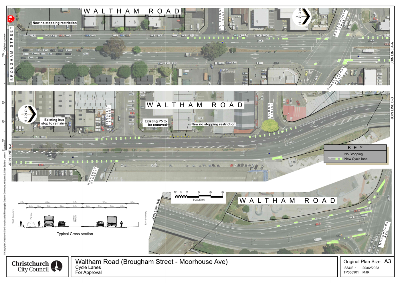
|
Council
03 May 2023
|
|
|
11. Plan Change 5E Noise sensitive activities near
roads and rail corridors - Decision
|
|
Reference / Te Tohutoro:
|
23/406927
|
|
Report of / Te Pou Matua:
|
Abby
Stowell, Policy Planner, abby.stowell@ccc.govt.nz
|
|
General Manager / Pouwhakarae:
|
Mary
Richardson, General Manager Citizens & Community (Mary.Richardson@ccc.govt.nz)
|
Nature of Decision or Issue
and Report Origin
1.1 The purpose of the report is for Council to consider the
recommendations of the Hearing Panel delegated to hear submissions on Plan
Change 5E (Noise sensitive activities near roads and rail corridors) and to
make a decision on those recommendations.
1.2 Council notified Plan Change 5E in October 2020 which has
subsequently been subject to submissions and a hearing.This report details the
recommendations on the plan change following consideration by a Hearings Panel.
1.3 The
decisions in this report are of low significance in relation to the
Christchurch City Council’s Significance and Engagement Policy. The
level of significance was determined by considering: that there is a limited
number of people affected; the impact on those affected is a moderate increase
in construction costs; the level of interest from the wider community was very
limited; and the impact on the current and future social, economic,
environmental or cultural wellbeing of the District will be low, albeit
positive.
Officer Recommendations Ngā Tūtohu
That the Council:
1. Receive the report and recommendations of the
Hearings Panel on Plan Change 5E attached as Attachment A.
2. Accept, accept in part or reject the
submissions on Plan Change 5E as recommended by the Hearings Panel for the
reasons set out in Attachment A.
3. Adopt, as the decision of the Council, the
recommendations of the Hearings Panel that Plan Change 5E be approved as per
the Hearing Panel’s report as Attachment A, under clause 10 of Schedule 1
of the Resource Management Act 1991.
Reason for Report
Recommendations Ngā Take mō te Whakatau
3.1 Plan
Change 5E addresses issues arising in respect of the interpretation and
application of Rule 6.1.7.2.1 – sensitive activities near roads and
railways of the District Plan, which requires the insulation of sensitive
activities including residential buildings within defined distances of roads
and rail corridors.
3.2 The
Hearings Panel has considered the evidence presented by Council staff and
consultants, alongside submissions from interested parties and has provided its
recommendations.
3.3 The
staff recommendation is to adopt the recommendations of Commissioners Paul
Thomas, Andrew Henderson and Alan Matheson (Referred to hereafter as
‘Hearings Panel’ or ‘Panel’) on proposed Plan Change
5E. This has regard to the statutory process that the plan change has been
through to this point and the consideration of the submissions and evidence
received by the Hearings Panel.
3.4 The
Hearings Panel have determined that the proposed plan change is appropriate
with amendments as outlined in their report (Attachment A). A clean version of
the plan change is also included (Attachment B).
Alternative
Options Considered Ētahi atu Kōwhiringa
4.1 The
Council can adopt the Panel’s recommendation as its own decision, but the
adoption must be of the recommendations in their entirety.
4.2 The
Council cannot reject a recommendation outright or substitute its own decision
as it has not heard the submissions and evidence. Legal advice is that natural
justice principles would be infringed if the Council were to make a decision on
the plan change that differs from the recommendation given by the Panel unless
the Council gave the submitter the right to be heard when the Council
reconsiders the proposed plan change.
4.3 Accordingly,
the options available to the Council, if it does not wish to adopt the
Panel’s recommendation as its decision, are to:
4.3.1 Refer
the plan change back to the Panel with a direction that they reconsider their
recommendation, and then adopt the subsequent recommendation of the Panel
– which may be unchanged from the current recommendation. If the Council
wishes to refer the matter back to the Panel, it must be satisfied that there
are sufficient grounds for doing so. For example, if an issue the plan change
is seeking to address has been overlooked. Those grounds do not exist here.
4.3.2 Appoint
different commissioners or for Council to consider the plan change and
supporting reports itself, ensuring that the new decision makers hear from the
submitters.
4.3.3 Withdraw
the plan change.
4.4 When
considering these options Council should take into account that the plan change
has already exceeded the two year limit set under the RMA for issuing a
decision. This has been formally extended, through application to the
Minister for the Environment, to 31st March 2023. A further
application seeking extension until 21st June has been sent to the
Minister.
Detail Te Whakamahuki
5.1 The
proposed plan change, PC5E was publicly notified on 22nd October 2020, as part
of a group of plan changes (PC5), following pre-notification consultation in
July – August 2020. A summary of submissions was notified for further
submissions on 28 January 2020, closing on 12 February 2020.
5.2 The
plan change attracted 12 submissions and 3 further submissions. Of the
submitters 3 were government agencies, 2 were consultancies which offer
acoustic engineering services (Acting for themselves), 1 was a community board
and the remaining 6 were other companies generally involved in property
management or development. There were no submissions from individuals.
5.3 Kāinga
Ora were the only submitter to completely oppose the plan change. Of the other
submitters, 8 supported the plan change, 2 supported it with amendments and 1
requested amendments with no indication of overall support or opposition.
5.4 A
hearing was conducted and those wishing to speak were heard on 13th February
2023. Those speaking on behalf of council noted that the
Kāinga Ora submission proposed a completely new requirement (mitigating
road and railway noise at source) and this would not be efficient at protecting
people, is not supported by acoustic evidence and would actually raise costs
for the wider community instead of reducing them. Kāinga Ora did not
attend the hearing.
5.5 The
issues addressed at the hearing are summarised as follows:
a. Removal
of the current façade reduction method (when the noise level is to
be reduced by a set level, irrespective of the resulting internal noise level)
which experts representing Council and submitters agreed can lead to over or
under engineering. The Council’s planning officer recommended it be
removed and the Hearings Panel concur with the evidence supporting this.
b. Scope
of rule application. The Hearings Panel concur with the reporting
officer’s recommendation that the rule should apply to the conversion of
existing buildings and that the other submissions on scope be rejected.
The other submissions on scope proposed
that:
i. the
rule should not include collector roads with traffic levels under a set average
annual daily traffic volume (this was superseded by a meeting between noise
experts from the council and submitters where it was determined that exempting
low noise environments was more effective);
ii. the
rule should include a minimum acoustic standard for heritage buildings (this
was deemed to be unworkable);
iii. the
list of excluded spaces should be more encompassing (With the agreement of the
Hearings Panel, the list was adjusted and clarified in consultation with the
submitter);
iv. the
increase in distance should be rejected;
v. land
owners should not have to insulate for future effects; and
vi. proposed
noise levels should not apply in bedrooms during the day time.
c. The
location of the noise assessment. Submitters and Council agreed on
minor word changes to clarify where measurements of distance between houses and
noise sources are to start and end. The Hearings Panel agreed with these
changes.
d. Ventilation.
Submitters and Council met while the hearing was adjourned to discuss how to
require adequate ventilation and thermal control in a building where windows
must be closed to meet prescribed noise levels. The agreed outcome was to
rely on the standards in the building code and word the rule accordingly.
The Hearings Panel concurs with this.
e. Financial
burden on landowners to mitigate effects generated by others. The
Panel stated that the policy direction of the District Plan is that
infrastructure is required to manage effects and land use activities are
required to avoid reverse sensitivity effects. The proposal is
consistent with this direction and the Panel concurs that this submission be
rejected.
f. Consistency
with the National Policy Statement on Urban Development (NPS-UD).
Kāinga Ora suggested that the proposed plan change was inconsistent with
the NPS-UD. The Hearings Panel agrees with the planning analysis in the Council
officer’s S42A report that the plan change is consistent with the
NPS-UD. They noted that no evidence was given to the contrary.
g. Upper
External Noise Limit. A submission seeking an upper external noise
limit for application of the rule was given little weight by the Panel, with no
evidence given at the hearing. They concluded that this issue does have some
merit but raises wider issues than those considered in the plan change and
should therefore be considered later as part of a wider review on the Noise
Chapter.
5.6 The decision applies across the Christchurch District, excluding the
central city. It affects all those intending to develop buildings in
which a sensitive activity is to be carried out within 100m of railways and
state highways, 40m from the edge of major or minor arterial roads or 20m from
the edge of a collector road.
Policy
Framework Implications Ngā
Hīraunga ā- Kaupapa here
6.1 The
decision supports the current policies and objectives of the District Plan and does
not depart from them.
Strategic
AlignmentTe Rautaki
Tīaroaro
6.2 This report supports the Council's Long Term Plan (2021 - 2031):
6.2.1 Activity: Strategic Planning, Future Development
and Regeneration
· Level of Service: 9.5.1.1 Guidance on where and
how the city grows through the District Plan. - Maintain operative District
Plan, including monitoring outcomes to inform changes, and giving effect to
national and regional policy statements
Policy
Consistency Te Whai
Kaupapa here
6.3 The
decision is consistent with Council’s Plans and
Policies.
Impact
on Mana Whenua Ngā
Whai Take Mana Whenua
6.4 The
decision does not involve a significant decision in
relation to ancestral land or a body of water or other elements of intrinsic
value, therefore this decision does not specifically impact Tāngata
Whenua, their culture and traditions.
6.5 The
decision does not involve a matter of interest to
Tāngata Whenua and will not impact on our agreed
partnership priorities with Ngā Papatipu Rūnanga
Climate
Change Impact Considerations Ngā Whai Whakaaro mā te Āhuarangi
6.6 This decision has no significant impact on climate change
considerations.
6.7 Enabling
sensitive activities to occur near roads and railways supports a more dense
urban form, which in turn supports a reduction in greenhouse gas emissions
as people do not have to travel so far to access shops, places of employment
etc.
Accessibility
Considerations Ngā
Whai Whakaaro mā te Hunga Hauā
6.8 This decision does not have a significant impact on accessibility
beyond what is described above.
Resource Implications Ngā
Hīraunga Rauemi
Capex/Opex Ngā Utu Whakahaere
7.1 Adopting
the proposed plan change will not result in additional costs to Council beyond
what has been budgeted for except for additional costs associated with
monitoring and enforcement.
7.2 The
costs of staff time on proposed Plan Change 5E have been assumed in the budgets
of the Planning and Strategic Transport unit as part of the Annual Plan and
Long Term Plan.
Legal Implications Ngā
Hīraunga ā-Ture
Statutory power to undertake proposals in the report
Te Manatū Whakahaere Kaupapa
8.1 Sections
74 and 75 of the RMA set out the Council's obligations when preparing a change
to its District Plan. The Panel’s report has applied the appropriate
considerations under the RMA.
8.2 The
legal framework for the Council’s decision on the Panel’s
recommendations is set out in Part 4 above.
8.3 Submitters
have the right to appeal to the Environment Court against the Council’s
decision on PC5E.
Other Legal Implications Ētahi atu
Hīraunga-ā-Ture
8.4 This
report has been reviewed and approved by the Legal Services Unit.
Risk Management
Implications Ngā Hīraunga Tūraru
9.1 Council
is statutorily required to have an operative District Plan at all times. Issues
have been identified with the District Plan which will be addressed through
this Plan Change. Therefore, the risk of not acting is considered greater than
the risk of acting.
9.2 Council
is required to issue a decision on matters raised in submissions no longer than
2 years after notifying the plan change (RMA Schedule 1, Part 1, clause
10(4(a)). The Minister for Environment extended the timeframe for this
plan change from October 2023 to March 31st 2023. A request
for a second extension until 21st June 2023 has been put to the
Minister. With this in mind, and as part of its duty under the RMA,
Council is required to avoid unreasonable delay in issuing a decision.
Attachments Ngā Tāpirihanga
|
No.
|
Title
|
Reference
|
Page
|
|
a ⇩ 
|
Attachment A
|
23/503919
|
187
|
|
b ⇩
|
Plan Change 5E
clean version of rules
|
23/553946
|
227
|
In addition to the attached documents, the following background
information is available:
|
Document
Name – Location / File Link
|
|
Nil
|
Confirmation of Statutory
Compliance Te Whakatūturutanga ā-Ture
|
Compliance with Statutory Decision-making
Requirements (ss 76 - 81 Local Government Act 2002).
(a) This report contains:
(i) sufficient information about all reasonably practicable
options identified and assessed in terms of their advantages and
disadvantages; and
(ii) adequate consideration of the views and preferences of
affected and interested persons bearing in mind any proposed or previous
community engagement.
(b) The information reflects the level of significance of the
matters covered by the report, as determined in accordance with the Council's
significance and engagement policy.
|
Signatories Ngā Kaiwaitohu
|
Authors
|
Abby Stowell -
Policy Planner
Mark Stevenson
- Manager Planning
|
|
Approved By
|
Brent Pizzey -
Senior Legal Counsel
Mary
Richardson - General Manager Citizens & Community
|
|
Council
03 May 2023
|
|
|
12. Plan Change 6 Homebase Extension - Final
approval
|
|
Reference / Te Tohutoro:
|
23/416650
|
|
Report of / Te Pou Matua:
|
Mark
Stevenson, Manager Planning, mark.stevenson@ccc.govt.nz
|
|
General Manager / Pouwhakarae:
|
Mary
Richardson, General Manager Citizens & Community
(Mary.Richardson@ccc.govt.nz)
|
1. Nature of Decision or Issue and Report Origin
1.1 The Council is being asked to approve that plan change 6
(Homebase extension) is made operative under clause 17 of Schedule 1 to the
Resource Management Act. The Environment Court issued a Consent Order on 21st
February 2023 following an appeal by Reefville Properties, which is now
resolved.
1.2 The Council's decision of 30 June 2022 to approve Plan
Change 6 to the Christchurch District Plan was appealed to the Environment
Court by Reefville Properties. Mediation occured in November at which agreement
was reached to a revised set of provisions.
1.3 The
decision in this report is of low significance in relation to the Christchurch
City Council’s Significance and Engagement Policy. The level of
significance was determined by the low number of affected parties and low costs
or risks to the Council, ratepayers and wider community of carrying out the
decision.
2. Officer Recommendations Ngā
Tūtohu
That the Council:
1. Approve the changes to the District Plan as
set out in the attached Consent Order of the Environment Court dated 21st
February 2023 on Private Plan Change 6 (Homebase Extension), pursuant to Clause
17(2) of Schedule 1 to the Resource Management Act, to become operative on 13th
May 2023.
3. Reason for Report Recommendations Ngā Take mō te
Whakatau
3.1 Plan
Change 6 (Homebase extension) is a private plan change request to rezone the
adjoining land to the north of the existing Homebase retail centre on Marshland
Road from Residential Suburban zone to Commercial Retail Park.
3.2 The
staff recommendation is to approve the changes to the District Plan in
accordance with the Consent Order issued by the Environment Court dated 21st
February 2023. This has regard to the statutory process that the plan change
has been through including the outcome of the appeal process.
3.3 The
Consent Order is attached, which orders that “the appeal (on the
plan change) is allowed to the extent that the Christchurch City Council is
directed to amend Private Plan Change 6 to the Christchurch District Plan by
making changes shown in Appendix 1 (forming part of the consent
order)”. The order is consistent with what was agreed between
Council and Reefville Properties at mediation.
4. Alternative Options Considered Ētahi atu Kōwhiringa
4.1 The
recommendation in this report is for the Council to take the procedural step to
make Plan Change 6 operative. The Resource Management Act 1991 requires that,
following the end of the appeal period and the resolution of any appeals, a
local authority must formally approve the changes to the plan under clause 17
of Schedule 1 before the plan change becomes operative on a date that is nominated
in a public notice.
4.2 There
are no reasonable alternatives, having regard to the Court issuing a Consent
Order allowing the appeal and it being consistent with what Council and
Reefville Properties agreed at mediation.
5. Detail Te Whakamahuki
5.1 The
plan change was publicly notified on the 15 October 2020 with the submissions
period closing on 16 November 2020. Sixty-eight (68) submissions were received
on PC6, comprising 119 submission points. Of these, 11 submission points
supported or supported in part PC6, 26 sought amendments to PC6, 3 were
neutral, and 79 opposed or opposed in part PC6.
5.2 The
main issues raised by the submitters were:
5.2.1 Traffic
effects including access from the site to Clearbrook Palms subdivision.
5.2.2 Economic
effects on the centres based framework for Christchurch.
5.2.3 Urban
Design effects and possible mitigations.
5.2.4 Environmental
Health concerns regarding noise and light spill.
5.2.5 The
loss of residential zoned land.
5.2.6 Concerns
regarding sufficiency of infrastructure.
5.3 Further
submissions were sought on 18 January 2021 and closed 1 February 2021.
5.4 Council
appointed a Hearings Panel to hear the submissions. The hearing was held in
July 2021 and resumed in November 2021 following a request from the Panel for
additional planning and economic evidence.
5.5 The
Panel’s recommendation was to adopt PC6 and to accept, accept in part or
reject the submissions on PC6, which was approved by Council on 30th
June 2022.
5.6 On
Wednesday 3 August 2022, Reefville Properties filed an appeal in the
Environment Court on Proposed Plan Change 6, seeking to delete policies and
rules in the Council’s decision on PC6 that:
5.6.1 restrict
store types (i.e. no supermarket, department store, clothing or footwear stores)
until 2031; and
5.6.2 require
a minimum building setback from road boundaries of 12m. The appeal seeks that
this be changed to 6m.
5.7 Submitters
on the plan change were provided the opportunity to join the appeal but none
chose to join as s274 parties.
5.8 Mediation
was held on 2-3 and 24 November 2022 on the appeal, involving the two parties
to the appeal, being Council and Reefville Properties. Agreement was reached at
mediation on a revised set of provisions, which are included in the Consent
Order.
5.9 A
key issue that was worked through at mediation was the effects of the rezoning
on the Shirley/ Palms Key Activity Centre. As a consequence of mediation,
amendments were agreed to the provisions relating to the Northern Homebase
Centre, subject to the private plan change request, and the existing Homebase
centre to the immediate south.
5.10 It was agreed by
economic experts for both parties that it is appropriate to treat the Northern
and Southern Homebase centres as a cohesive whole centre when considering
potential adverse retail distributional effects on other centres.
Further, the experts were satisfied that applying limitations on retail
activities across the whole centre, as agreed by the parties, would not
increase adverse retail distributional impacts on other retail centres,
compared to the status quo as represented by:
5.10.1 the retail and staging
limitations imposed on the Northern Homebase centre in the decisions version of
PC6; and
5.10.2 the retail activity provisions
applying to the area zoned Commercial Retail Park before the decision on PC6,
being the Southern Homebase centre.
5.11 As there will be
no increase in adverse retail distributional impacts on other retail centres
compared to the status quo, there will be no change in terms of the District
Plan provisions relating to retail distributional impacts and the centres-based
framework for commercial activities.
5.12 Once
the resolution is made by the Council, public notice must be given that the
change will become operative on a date specified in the notice. This date must
be at least 5 working days after the notice is published.
5.13 The
decision affects the Waitai Coastal-Burwood-Linwood Community Board, noting
that the the boundary between this Community Board and Waipapa
Papanui-Innes-Central Community Board is Marshland Road. Both Community Boards
made submissions on the plan change request, while noting that neither board
joined the appeal.
6. Policy Framework Implications Ngā Hīraunga ā- Kaupapa here
Strategic
AlignmentTe Rautaki
Tīaroaro
6.1 This report supports the Council's
Long Term Plan (2021 - 2031):
6.1.1 Activity: Strategic Planning, Future Development and
Regeneration
· Level of Service: 9.5.4 Process private plan
change requests. - 100% of any proposed private plan changes comply with
statutory processes and timeframes
Policy
Consistency Te Whai
Kaupapa here
6.2 The
decision is consistent with Council’s Plans and
Policies.
Impact
on Mana Whenua Ngā
Whai Take Mana Whenua
6.3 The
decision does not involve a significant decision in relation to ancestral land
or a body of water or other elements of intrinsic value, therefore this
decision does not specifically impact on Mana Whenua, their culture and
traditions.
6.4 The
decision does not involve a matter of interest to Mana
Whenua and will not impact on our agreed partnership priorities with Ngā Papatipu Rūnanga.
Climate
Change Impact Considerations Ngā Whai Whakaaro mā te Āhuarangi
6.5 This decision does not have a significant impact on climate change.
Accessibility
Considerations Ngā
Whai Whakaaro mā te Hunga Hauā
6.6 This decision has no impact on accessibility.
7. Resource Implications Ngā Hīraunga Rauemi
Capex/Opex Ngā Utu Whakahaere
7.1 Cost
to Implement - The cost of amending the District Plan consistent with the
decision of the Environment Court is a one-off cost.
7.2 Maintenance/Ongoing
costs – There are ongoing costs to monitor the effectiveness of the
District Plan, reflecting our statutory requirement under section 35 of the
Resource Management Act.
8. Legal Implications Ngā Hīraunga ā-Ture
Statutory power to undertake proposals in the report
Te Manatū Whakahaere Kaupapa
8.1 The
recommendation in this report is for the Council to take the procedural step to
make Plan Change 6 operative. The Council has no other option. The Resource
Management Act 1991 requires that, following the end of the appeal period and
the resolution of any appeals, a local authority must formally approve the
changes to the plan under clause 17 of Schedule 1 before the plan change
becomes operative on a date that is nominated in a public notice. Approving
changes to the District Plan so that they can be made operative is one of the
functions that cannot be delegated to staff under the RMA.
Other Legal Implications Ētahi atu
Hīraunga-ā-Ture
8.2 There
is no other legal context, issue or implication relevant to this decision. The
Legal Services Unit has reviewed this report.
9. Risk Management Implications Ngā Hīraunga Tūraru
9.1 Council
is statutorily required to have an operative District Plan at all times. The
decision to be made is to reflect the Environment Court’s decision to
allow the appeal on Plan Change 6. If this is not approved, the Council is in
breach of its RMA obligations and there is a risk of further legal challenge.
Attachments Ngā Tāpirihanga
|
No.
|
Title
|
Reference
|
Page
|
|
a ⇩ 
|
Environment
Court Consent Order
|
23/480288
|
236
|
In addition to the attached documents, the following background
information is available:
|
Document
Name – Location / File Link
|
|
Not
applicable
|
Confirmation of Statutory
Compliance Te Whakatūturutanga ā-Ture
|
Compliance with Statutory Decision-making
Requirements (ss 76 - 81 Local Government Act 2002).
(a) This report contains:
(i) sufficient information about all reasonably practicable
options identified and assessed in terms of their advantages and
disadvantages; and
(ii) adequate consideration of the views and preferences of
affected and interested persons bearing in mind any proposed or previous
community engagement.
(b) The information reflects the level of significance of the
matters covered by the report, as determined in accordance with the Council's
significance and engagement policy.
|
Signatories Ngā Kaiwaitohu
|
Author
|
Mark Stevenson
- Manager Planning
|
|
Approved By
|
Brent Pizzey -
Senior Legal Counsel
John Higgins -
Head of Planning & Consents
Mary
Richardson - General Manager Citizens & Community
|
|
Council
03 May 2023
|
|
|
Council
03 May 2023
|
|
|
13. Resolution to Exclude the Public
|
Section 48, Local Government Official
Information and Meetings Act 1987.
I move that the public be excluded from the
following parts of the proceedings of this meeting, namely items listed
overleaf.
Reason for passing this resolution: good
reason to withhold exists under section 7.
Specific grounds under section 48(1) for
the passing of this resolution: Section 48(1)(a)
Note
Section 48(4) of the Local Government
Official Information and Meetings Act 1987 provides as follows:
“(4) Every resolution to exclude the
public shall be put at a time when the meeting is open to the public, and the
text of that resolution (or copies thereof):
(a) Shall
be available to any member of the public who is present; and
(b) Shall
form part of the minutes of the local authority.”
This resolution is made in reliance on
Section 48(1)(a) of the Local Government Official Information and Meetings Act
1987 and the particular interest or interests protected by Section 6 or Section
7 of that Act which would be prejudiced by the holding of the whole or relevant
part of the proceedings of the meeting in public are as follows:
|
Council
03 May 2023
|
|
|
ITEM NO.
|
GENERAL SUBJECT OF EACH MATTER TO BE CONSIDERED
|
SECTION
|
SUBCLAUSE AND REASON UNDER THE ACT
|
PLAIN ENGLISH REASON
|
WHEN REPORTS CAN BE RELEASED
|
|
14.
|
Public Excluded Council Minutes - 19 April 2023
|
|
|
Refer to the previous public excluded reason in the agendas for
these meetings.
|
|
|
15.
|
Property Negotiations
|
s7(2)(a), s7(2)(b)(ii), s7(2)(g), s7(2)(i)
|
Protection of Privacy of Natural Persons, Prejudice Commercial
Position, Maintain Legal Professional Privilege, Conduct Negotiations
|
This report includes options that could adversley affect property
negotiations and/or prejudice councils position in future negotiations.
|
30 September 2023
Upon settlement of any property transaction or definitive
resolution of these considerations.
|
|
Council
03 May 2023
|
|
Karakia Whakamutunga
Kia
whakairia te tapu
Kia
wātea ai te ara
Kia
turuki whakataha ai
Kia
turuki whakataha ai
Haumi
e. Hui e. Tāiki e