Waimāero
Fendalton-Waimairi-Harewood Community Board
Agenda
Notice of Meeting:
An ordinary meeting of the Waimāero
Fendalton-Waimairi-Harewood Community Board will be held on:
Date: Monday 6 March 2023
Time: 4.30 pm
Venue: Boardroom, Fendalton Service Centre,
Corner Jeffreys and Clyde Roads, Fendalton
Membership
|
Chairperson
Deputy Chairperson
Members
|
Bridget Williams
Jason Middlemiss
David Cartwright
Linda Chen
James Gough
Aaron Keown
Sam MacDonald
Nicola McCormick
Shirish Paranjape
|
28 February 2023
Maryanne Lomax
Manager Community Governance,
Fendalton-Waimairi-Harewood
941 6730
maryanne.lomax@ccc.govt.nz
www.ccc.govt.nz
|
Waimāero Fendalton-Waimairi-Harewood
Community Board
06 March 2023
|

|
|
Waimāero Fendalton-Waimairi-Harewood
Community Board
06 March 2023
|
|
Part A Matters
Requiring a Council Decision
Part B Reports
for Information
Part C Decisions
Under Delegation
TABLE OF CONTENTS
Karakia Tīmatanga................................................................................................... 4
C 1. Apologies Ngā Whakapāha.......................................................................... 4
B 2. Declarations of Interest Ngā Whakapuaki Aronga........................................... 4
C 3. Confirmation of Previous Minutes Te Whakaāe o te
hui o mua.......................... 4
B 4. Public Forum Te Huinga Whānui.................................................................. 4
B 5. Deputations by Appointment Ngā Huinga
Whakaritenga................................. 4
B 6. Presentation
of Petitions Ngā
Pākikitanga.................................................... 5
Fendalton-Waimairi-Harewood
Community Board Submissions Committee
C 7. Waimāero
Fendalton-Waimairi-Harewood Community Board Submissions Committee Minutes - 20
February 2023....................................................... 17
Staff Reports
C 8. Public
Transport Infrastructure Improvements along route 17....................... 23
C 9. Merrin
Street/Avonhead Road/Grahams Road intersection safety improvements 83
C 10. Grahams
Road/Waimairi Road - Safety Improvements.................................. 89
C 11. Memorial
Aveue at Burnside High Safety Improvements & Greers Road Parking
Improvements......................................................................................... 95
C 12. Merrin
Street/Withells Road intersection safety improvements.................... 103
C 13. Fendalton-Waimairi-Harewood
2022-23 Youth Development Fund Application - Addison Jones....................................................................................... 109
C 14. Appointments
to External Organisations................................................... 113
C 15. Waimāero
Fendalton-Waimairi-Harewood Community Board Area Report - March 2023..................................................................................................... 115
B 16. Elected Members’
Information Exchange Te Whakawhiti
Whakaaro o Te Kāhui Amorangi............................................................................................................ 154
Karakia Whakamutunga
|
Waimāero Fendalton-Waimairi-Harewood
Community Board
06 March 2023
|

|
Karakia Tīmatanga
|
Whakataka te hau ki te
uru
Whakataka te hau ki te
tonga
Kia mākinakina ki
uta
Kia mātaratara ki
tai
E hī ake ana te
atakura
He tio, he huka, he
hauhūnga
Tīhei Mauri Ora
|
Cease the winds from
the west
Cease the winds from the south
Let the breeze blow over the land
Let the breeze blow over the ocean
Let the red-tipped dawn come with a sharpened air.
A touch of frost, a promise of a glorious day.
|
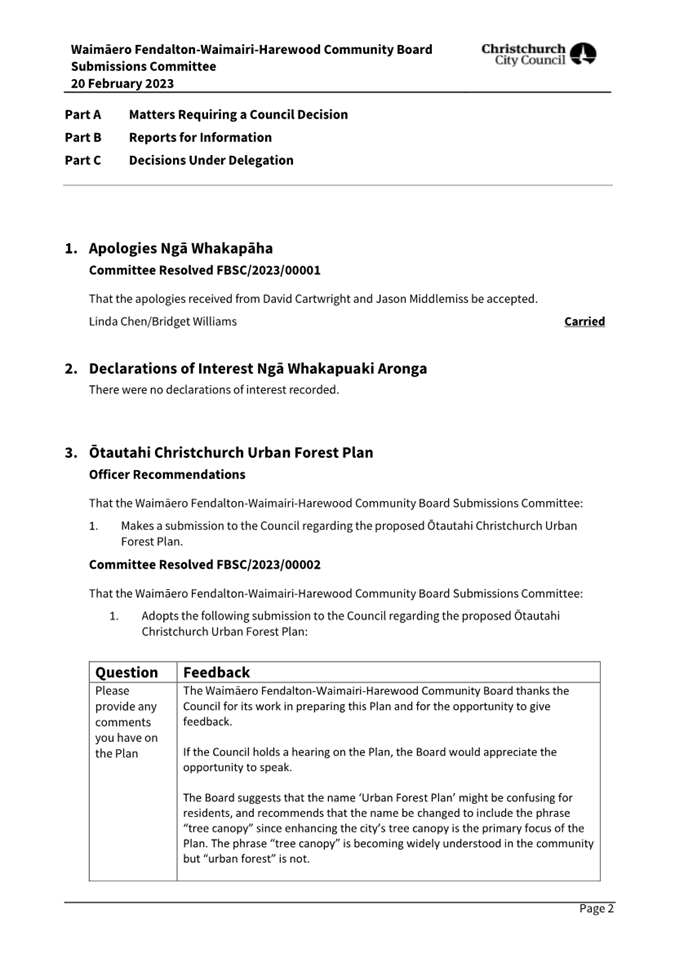
1. Apologies Ngā Whakapāha
At the close of
the agenda no apologies had been received.
2. Declarations of Interest Ngā
Whakapuaki Aronga
Members are
reminded of the need to be vigilant and to stand aside from decision making when
a conflict arises between their role as an elected representative and any
private or other external interest they might have.
3. Confirmation of Previous Minutes Te
Whakaāe o te hui o mua
That the
minutes of the Waimāero Fendalton-Waimairi-Harewood Community Board
meeting held on Tuesday, 7 February 2023 be
confirmed (refer page 6).
4. Public Forum Te Huinga Whānui
A period of up
to 30 minutes will be available for people to speak for up to five minutes on
any issue that is not the subject of a separate hearings process.
There were no public forum requests
received at the time the agenda was prepared
5. Deputations by Appointment Ngā Huinga
Whakaritenga
Deputations may
be heard on a matter or matters covered by a report on this agenda and approved
by the Chairperson.
|
5.1
|
Kevin and Jane Bennett
Kevin and Jane Bennett, local residents,
will speak regarding the proposed pedestrian crossing point on Memorial
Avenue.
|
|
5.2
|
Jacqui Lewis
Jacqui Lewis, local resident, will speak
regarding the proposed bus stop improvements on Carlton Mill Road.
|
6. Presentation of Petitions Ngā
Pākikitanga
There were no petitions
received at the time the agenda was prepared.
|
Waimāero Fendalton-Waimairi-Harewood
Community Board
06 March 2023
|
|


Waimāero
Fendalton-Waimairi-Harewood
Community Board
Open
Minutes
Date: Tuesday 7 February 2023
Time: 4.33 pm
Venue: Boardroom, Fendalton Service
Centre,
Corner Jeffreys and Clyde Roads, Fendalton
Present
|
Chairperson
Deputy Chairperson
Members
|
Bridget Williams
Jason Middlemiss
David Cartwright
Linda Chen
James Gough (via
Audio-Visual Link)
Aaron Keown
Sam MacDonald
Nicola McCormick
Shirish Paranjape
|
Maryanne Lomax
Manager Community Governance,
Fendalton-Waimairi-Harewood
941 6730
maryanne.lomax@ccc.govt.nz
www.ccc.govt.nz

Part A Matters
Requiring a Council Decision
Part B Reports
for Information
Part C Decisions
Under Delegation
Karakia
Tīmatanga
The agenda was dealt
with in the following order.
1. Apologies Ngā Whakapāha
Part C
|
Community Board Resolved FWHB/2023/00001
That the apology
received from Sam MacDonald for early departure be accepted.
Shirish Paranjape/David Cartwright Carried
|
2. Declarations of Interest Ngā Whakapuaki Aronga
Part B
James Gough and David Cartwright declared an interest in
the portions of item 8. relating to Normans Road.
3. Confirmation of Previous Minutes Te Whakaāe o te hui o mua
Part C
|
Community Board Resolved FWHB/2023/00002
That the minutes of the Waimāero
Fendalton-Waimairi-Harewood Community Board meeting held on Monday, 12
December 2022 be confirmed.
David Cartwright/Aaron Keown Carried
|
4. Public Forum Te Huinga Whānui
Part B
|
4.1 Jeanette Christensen
|
|
Jeanette Christensen
addressed the Board regarding the upcoming Edwardian Garden Party at Mona
Vale on Sunday 12 March from 3-6pm, which is a fundraising event to help
restore the historic Bathhouse.
|
5. Deputations by Appointment Ngā Huinga Whakaritenga
Part B
|
5.1
|
Mark Tutton
Mark Tutton, local resident, addressed the Board
regarding item 8, Merivale Traffic and Parking Issues.
|
|
5.2
|
Peel Street
The Chairperson read a statement on behalf of Dale
O’Connor, local resident, regarding Item 8, Merivale Traffic and
Parking Issues. Dale also presented a petition on behalf of the residents of
Peel Street.
|
|
Attachments
a Petition
- Parking Restrictions on Peel Street
|
|
5.3
|
Andrew Dickie
Andrew Dickie, local resident, addressed the Board
regarding item 8, Merivale Traffic and Parking Issues.
|
|
5.4
|
Norm Withers
Norm Withers, local resident, addressed the Board
regarding item 10, Waimairi Road – Tree Removal.
|
6. Presentation of Petitions Ngā Pākikitanga
Part B
The Chairperson noted that a petition was received during
the deputation from Peel Street residents.
|
7. Waimāero
Fendalton-Waimairi-Harewood Community Board Submissions Committee Minutes -
28 November 2022
|
|
|
Community Board Resolved FWHB/2023/00003
That the
Waimāero Fendalton-Waimairi-Harewood Community Board receives and
confirms the Minutes from the Waimāero Fendalton-Waimairi-Harewood
Community Board Submissions Committee meeting held 28 November 2022.
David Cartwright/Jason Middlemiss Carried
|
|
9. Swanleigh Place - Tree Removal
|
|
|
Officer Recommendations Ngā
Tūtohu
That the Waimāero Fendalton-Waimairi-Harewood
Community Board:
1. Receive the report.
2. Decline the application to remove the oak
(street) tree outside 20 Swanleigh Place (ID 141756).
|
|
|
Community Board Resolved FWHB/2023/00004
Part C
That the Waimāero Fendalton-Waimairi-Harewood
Community Board:
1. Receive the report.
2. Approve the application to remove the oak
(street) tree outside 20 Swanleigh Place (ID 141756).
3. Resolve
pursuant to section 4.24 of the Christchurch City Council Tree Policy that
the applicant will not be required to pay any costs associated with the
removal.
Sam MacDonald/David Cartwright Carried
|
|
10. Waimairi Road - Tree Removal
|
|
|
Officer Recommendations Ngā
Tūtohu
That the Waimāero Fendalton-Waimairi-Harewood
Community Board:
1. Receive the report.
2. Decline the application to remove the oak
(street) tree outside 326 Waimairi Road (ID 13366).
|
|
|
Community Board Resolved FWHB/2023/00005
Part C
That the Waimāero Fendalton-Waimairi-Harewood
Community Board:
1. Receive the report.
2. Approve the application to remove the oak
(street) tree outside 326 Waimairi Road (ID 13366).
3. Resolve
pursuant to section 4.24 of the Christchurch City Council Tree Policy that
the applicant will not be required to pay any costs associated with the
removal.
Sam MacDonald/David Cartwright Carried
|
Sam MacDonald left the
meeting at 5:16 p.m. at the conclusion consideration of item 10.
|
8. Merivale Traffic and Parking
Issues
|
|
|
Board Comment
The Board
discussed the feedback received from residents during the consultation period
and the verbal deputations received at the meeting.
The Board made
the following changes to the Officer Recommendations:
· Added a request for a report back in six
months to review the effectiveness of the new parking restrictions.
· Added a request for an urgent report to allow
the Board to consider installing parking restrictions on Peel Street.
· Added a request for the Chairperson to contact
St Andrew’s College regarding residents’ reports of intimidating
behaviour involving school traffic.
· A resolution to defer making a decision on
Akela Street, pending a report with further options including making the
street one-way.
|
|
|
Officer Recommendations Ngā
Tūtohu
That the Waimāero Fendalton-Waimairi-Harewood
Community Board:
1. Approves, pursuant to Clause 7 of the
Christchurch City Council Traffic and Parking Bylaw 2017, that the stopping
of vehicles be prohibited at all times on;
a. The southwest side of St Andrews Square commencing at its
intersection with Peel Street and extending in a north westerly direction for
a distance of eight metres.
b. The southwest side of St Andrews Square commencing at its
intersection with Peel Street and extending in a south easterly direction for
a distance of eight metres.
c. The northwest side of Peel Street commencing at its
intersection with St Andrews Square and extending in a south westerly
direction for a distance of six metres.
d. The southeast side of Peel Street commencing at its
intersection with St Andrews Square and extending in a south westerly
direction for a distance of six metres.
e. The southwest side of Akela Street commencing at its
intersection with Aikmans Road and extending in a south easterly direction to
its intersection with Cox Street
f. The south west side of Akela Street commencing at its
intersection with Cox Street and extending in a south easterly direction to
its intersection with Office Road.
2. Approves, pursuant to Clause 7 of the
Christchurch City Council Traffic and Parking Bylaw 2017, that the parking of
vehicles be restricted to a maximum period of 120 minutes between the times
of 8am and 6pm, School Days only on;
a. The northeast side of Winchester
Street commencing at a point 31 metres southeast of its intersection with
Merivale Lane and extending in a south easterly direction for a distance of
132 metres.
b. The northeast side of Hewitts Road
commencing at a point eight metres southeast of its intersection with
Merivale Lane and extending in a south easterly direction for a distance of
161 metres.
3. Approves, pursuant to Clause 7 of the
Christchurch City Council Traffic and Parking Bylaw 2017, that the parking of
vehicles be restricted to a maximum period of 120 minutes between the times
of 9am and 4pm, School Days only on;
a. The northeast side of Urunga Avenue
commencing at a point 23 meters southeast of its intersection with Halton
Street and extending in a south easterly direction for a distance of 85
metres.
b. The northwest side of Normans Road
commencing at a point 27 metres northeast of its intersection with Alpha
Avenue and extending in a north easterly direction for a distance of 67
metres.
c. The northwest side of Normans Road
commencing at a point 11 northeast of its intersection with Searells Road and
extending in a north easterly direction for a distance of 54 metres.
d. The northwest side of Normans Road
commencing at a point 20 metres northeast of its intersection with Hartley
Avenue and extending in a north easterly direction for a distance of 37
metres.
e. The northwest side of Normans Road
commencing at a point 22 metres northeast of its intersection with Urunga
Avenue and extending in a north easterly direction for a distance of 72
metres.
f. The northwest side of Normans
Road commencing at a point 23 metres northeast of its intersection with
College Avenue and extending in a north easterly direction for a distance of
62 metres.
g. The northwest side of Normans Road
commencing at a point 16 metres northeast of its intersection with Watford
Street and extending in a north easterly direction for a distance of 162
metres.
h. The southwest side of St Andrews
Square commencing at a point 23 metres southeast of its intersection with
Normans Road and extending in a south easterly direction for a distance of 56
metres.
i. The southwest side of St
Andrews Square commencing at a point 8 metres southeast of its intersection
with Peel Street and extending in a south easterly direction for a distance
of 64 metres.
4. Approves, pursuant to Clause 7 of the
Christchurch City Council Traffic and Parking Bylaw 2017, that the parking of
vehicles be restricted to a maximum period of 3 minutes between the times of
8am and 9am, and between 2:30pm and 4pm, School Days only on;
a. The northeast side of Winchester
Street commencing at a point 166 metres southeast of its intersection with
Merivale Lane and extending in a south easterly direction for a distance of
123 metres.
5. Approves, pursuant to Clause 7 of the
Christchurch City Council Traffic and Parking Bylaw 2017, that the parking of
vehicles be restricted to a maximum period of 3 minutes between the times of
8am and 9am, and between 2:30pm and 4pm, School Days only on;
a. The southwest side of Papanui Road
commencing at a distance 11 metres southeast of its intersection with
Merivale Lane and extending in a south easterly direction for a distance of
33 metres.
6. Revoke any previous resolutions pertaining to
traffic controls made pursuant to any bylaw to the extent that they are in
conflict with the traffic controls described in resolutions 1-5 above.
7. Approve that these resolutions take effect
when parking signage and/or road markings that evidence the restrictions
described in the staff report are in place (or removed in the case of
revocations).
|
|
|
Community Board Resolved FWHB/2023/00006
Part C
That the Waimāero Fendalton-Waimairi-Harewood
Community Board:
1. Approves, pursuant to Clause 7 of the
Christchurch City Council Traffic and Parking Bylaw 2017, that the stopping
of vehicles be prohibited at all times on;
a. The southwest side of St Andrews Square (the section that
aligns with Hartley Avenue) commencing at its intersection with Peel
Street and extending in a north westerly direction for a distance of
eight metres.
b. The southwest side of St Andrews Square (the section that
aligns with Hartley Avenue) commencing at its intersection with Peel Street
and extending in a south easterly direction for a distance of eight metres.
c. The northwest side of Peel Street commencing at its
intersection with St Andrews Square and extending in a south westerly
direction for a distance of six metres.
d. The southeast side of Peel Street commencing at its
intersection with St Andrews Square and extending in a south westerly
direction for a distance of six metres.
2. Approves, pursuant to Clause 7 of the
Christchurch City Council Traffic and Parking Bylaw 2017, that the parking of
vehicles be restricted to a maximum period of 120 minutes between the times
of 8am and 6pm, School Days only on;
a. The northeast side of Winchester
Street commencing at a point 31 metres southeast of its intersection with
Merivale Lane and extending in a south easterly direction for a distance of
132 metres.
b. The northeast side of Hewitts Road
commencing at a point eight metres southeast of its intersection with
Merivale Lane and extending in a south easterly direction for a distance of
161 metres.
3. Approves, pursuant to Clause 7 of the
Christchurch City Council Traffic and Parking Bylaw 2017, that the parking of
vehicles be restricted to a maximum period of 120 minutes between the times
of 9am and 4pm, School Days only on;
a. The northeast side of Urunga Avenue
commencing at a point 23 meters southeast of its intersection with Halton Street
and extending in a south easterly direction for a distance of 85 metres.
b. The northwest side of Normans Road
commencing at a point 27 metres northeast of its intersection with Alpha
Avenue and extending in a north easterly direction for a distance of 67
metres.
c. The northwest side of Normans Road
commencing at a point 11 northeast of its intersection with Searells Road and
extending in a north easterly direction for a distance of 54 metres.
d. The northwest side of Normans Road
commencing at a point 20 metres northeast of its intersection with Hartley
Avenue and extending in a north easterly direction for a distance of 37
metres.
e. The northwest side of Normans Road
commencing at a point 22 metres northeast of its intersection with Urunga
Avenue and extending in a north easterly direction for a distance of 72
metres.
f. The northwest side of Normans
Road commencing at a point 23 metres northeast of its intersection with
College Avenue and extending in a north easterly direction for a distance of 62
metres.
g. The northwest side of Normans Road
commencing at a point 16 metres northeast of its intersection with Watford
Street and extending in a north easterly direction for a distance of 162
metres.
h. The southwest side of St Andrews
Square (the section that aligns
with Hartley Avenue) commencing
at a point 23 metres southeast of its intersection with Normans Road and
extending in a south easterly direction for a distance of 56 metres.
i. The southwest side of St
Andrews Square (the section that
aligns with Hartley Avenue)
commencing at a point 8 metres southeast of its intersection with Peel Street
and extending in a south easterly direction for a distance of 64 metres.
4. Approves, pursuant to Clause 7 of the
Christchurch City Council Traffic and Parking Bylaw 2017, that the parking of
vehicles be restricted to a maximum period of 3 minutes between the times of
8am and 9am, and between 2:30pm and 4pm, School Days only on;
a. The northeast side of Winchester
Street commencing at a point 166 metres southeast of its intersection with
Merivale Lane and extending in a south easterly direction for a distance of
123 metres.
5. Approves, pursuant to Clause 7 of the
Christchurch City Council Traffic and Parking Bylaw 2017, that the parking of
vehicles be restricted to a maximum period of 3 minutes between the times of
8am and 9am, and between 2:30pm and 4pm, School Days only on;
a. The southwest side of Papanui Road
commencing at a distance 11 metres southeast of its intersection with
Merivale Lane and extending in a south easterly direction for a distance of
33 metres.
6. Revoke any previous resolutions pertaining to
traffic controls made pursuant to any bylaw to the extent that they are in
conflict with the traffic controls described in resolutions 1-5 above.
7. Approve that these resolutions take effect
when parking signage and/or road markings that evidence the restrictions
described in the staff report are in place (or removed in the case of
revocations).
8. Request staff to urgently prepare a
report with advice to enable the Board to consider installing parking
restrictions on Peel Street, in response to the matters raised in the
residents’ petition.
9. Request staff to report back to the
Board six months after the new restrictions are installed to provide an
update on their effectiveness.
10. Request the Chairperson to write to St
Andrew’s College on behalf of the Board regarding reports of
intimidating behaviour involving school traffic and inviting them to meet
with the Board.
11. Defer making a decision on the no-stopping
restrictions on Akela Street, and request staff to report back to the Board
as soon as feasible with advice on alternative options for Akela Street
including making the street one-way (in the direction from Office Road
towards Aikmans Road) to allow for the retention of more on-street
parking.
Aaron Keown/Shirish Paranjape Carried
James Gough and David Cartwright declared an interest in
clauses 3b.-3g. (relating to Normans Road) and took no part in the debate or
voting on those items.
|
|
11. Fendalton Waimairi Harewood Community Board
2022-23 Discretionary Response Fund Application - Marist Albion Rugby Club
Inc
|
|
|
Community Board Resolved FWHB/2023/00007
Officer recommendations accepted without
change.
Part C
That the Waimāero Fendalton-Waimairi-Harewood
Community Board:
1. Approves a grant of $5,000 from its 2022-23
Discretionary Response Fund to the Marist Albion Rugby Club Inc towards the
repairs to the roof of the changing sheds at South Hagley Park.
Aaron Keown/Linda Chen Carried
|
|
12. New Zealand Community Boards' Executive
Committee- Voting for Zone 5 Representative
|
|
|
Officer Recommendations Ngā
Tūtohu
That the Waimāero Fendalton-Waimairi-Harewood
Community Board:
1. Vote for one of the following candidates to
represent Zone 5 at the Community Board Executive Committee.
a. Sharn Nu’u – Malvern Community
Board OR
b. Simon Britten – Waipapa
Papanui-Innes-Central board OR
c. Ross Munro – Pleasant Point Community
Board
|
|
|
Community Board Resolved FWHB/2023/00008
Part C
That the Waimāero Fendalton-Waimairi-Harewood
Community Board:
1. Vote for Sharn Nu’u to represent Zone 5
at the Community Board Executive Committee.
Aaron Keown/Shirish Paranjape Carried
|
|
13. Waimāero Fendalton-Waimairi-Harewood
Community Board Area Report - February 2023
|
|
|
Community Board Resolved FWHB/2023/00009
Officer recommendations accepted without
change.
Part B
That the Waimāero Fendalton-Waimairi-Harewood
Community Board:
1. Receive the Waimāero
Fendalton-Waimairi-Harewood Community Board Area Report for February 2023.
2. Note the Council's delegation to the Community
Board regarding the appointment of representatives to the Riccarton Bush
Trust and confirm the appointment of Shirish Paranjape as the Board's
representative.
Jason Middlemiss/Shirish Paranjape Carried
|
14. Elected Members’ Information Exchange Te Whakawhiti Whakaaro o Te Kāhui Amorangi
Part B
|
Board members exchanged information on matters of
interest to the Board including:
· The recent installation of a raised platform at an
intersection on Blakes Road.
· Maintenance issues at Nunweek Park
· A discussion around whether a grass berm on Gardiners
Road is a formal swale
· Positive feedback received about the recent meeting with
local businesses in Burnside to discuss safety issues.
· Maintenance issues in the Northwood area.
|
|
14.1 Dunmurry Place - Street Tree
|
|
The Board noted a
letter sent from a resident of Dunmurry Place to the Chief Executive
requesting that a street tree be removed, and requested a decision report to
consider the matter under the Council Tree Policy.
|
Karakia
Whakamutunga
Meeting
concluded at
6.25pm.
CONFIRMED THIS 6TH DAY OF MARCH
2023
Bridget Williams
Chairperson
|
Waimāero Fendalton-Waimairi-Harewood
Community Board
06 March 2023
|

|
|
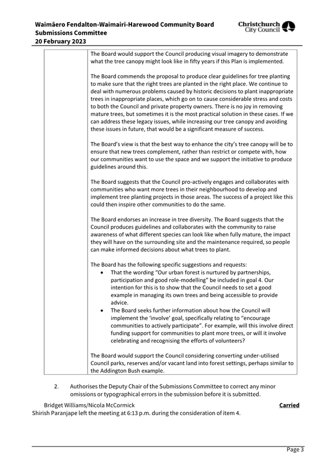
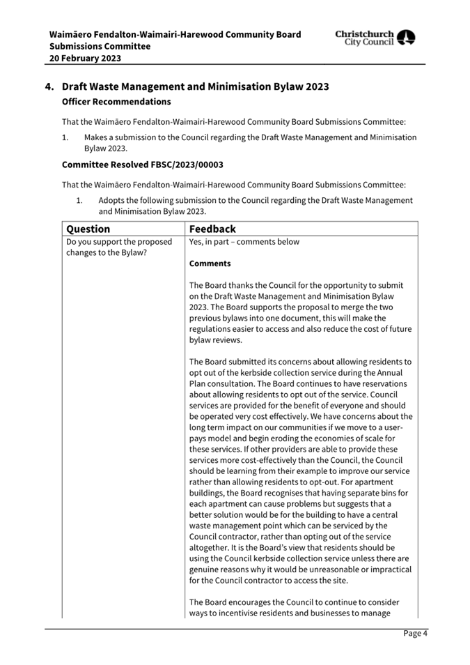
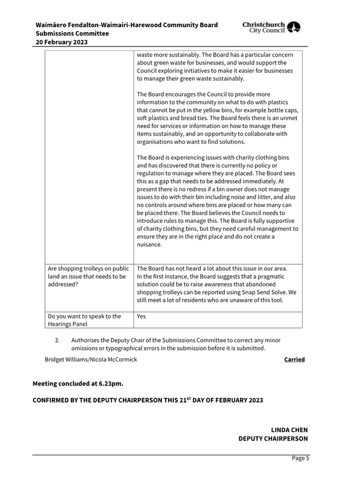
7. Waimāero
Fendalton-Waimairi-Harewood Community Board Submissions Committee Minutes -
20 February 2023
|
|
Reference / Te Tohutoro:
|
23/244936
|
|
Report of / Te Pou Matua:
|
Aidan
Kimberley, Community Board Advisor, Aidan.Kimberley@ccc.govt.nz
|
|
General Manager / Pouwhakarae:
|
Mary
Richardson, General Manager Citizens & Community
(Mary.Richardson@ccc.govt.nz)
|
1. Purpose of Report Te Pūtake
Pūrongo
The
Waimāero Fendalton-Waimairi-Harewood Community Board Submissions Committee
held a meeting on 20 February 2023 and is circulating the Minutes recorded to the Waimāero Fendalton-Waimairi-Harewood Community
Board for its information.
2. Recommendation to Waimāero Fendalton-Waimairi-Harewood
Community Board
That the Waimāero Fendalton-Waimairi-Harewood
Community Board receives the Minutes from the Waimāero
Fendalton-Waimairi-Harewood Community Board Submissions Committee meeting held
20 February 2023.
Attachments Ngā Tāpirihanga
|
No.
|
Title
|
Reference
|
Page
|
|
A⇩ 
|
Minutes Waimāero
Fendalton-Waimairi-Harewood Community Board Submissions Committee - 20 February
2023
|
23/233667
|
18
|
Signatories Ngā Kaiwaitohu
|
Author
|
Aidan
Kimberley - Community Board Advisor
|
|
Waimāero Fendalton-Waimairi-Harewood
Community Board
06 March 2023
|
|
|
Waimāero Fendalton-Waimairi-Harewood
Community Board
06 March 2023
|

|
|
8. Public Transport Infrastructure
Improvements along route 17
|
|
Reference / Te Tohutoro:
|
22/1514729
|
|
Report of / Te Pou Matua:
|
Sarah
Thorne, Principal Advisor Public Transport Infrastructure
(Sarah.Thorne@ccc.govt.nz)
|
|
General Manager / Pouwhakarae:
|
Jane
Davis, General Manager Infrastructure, Planning & Regulatory Services
(jane.davis@ccc.govt.nz)
|
1. Nature of Decision or Issue and Report Origin
1.1 The purpose of this report is to seek approval from the
Waimaero Fendalton-Waimairi-Harewood Community Board for the proposed
infrastructure improvements for Route 17 and infrastructure improvements for
it's extension out to the Christchurch International Airport (CIAL).
This report has been written to meet the outcomes agreed through the Greater
Christchurch Public Transport Futures Combined Business Case (PT Futures),
endorsed by Council on 10 December 2020.
1.2 On 12 September 2022 a similar report was presented to the
Community Board with a proposal to upgrade the bus stop infrastructure along
route 17. The following resolution was made:
Waimāero Fendalton-Waimairi-Harewood Community Board: Resolves to leave
this report to lie on the table for consideration by the Board , to allow time
for the Board to receive a briefing before the final decision.
A briefing was provided to the Community Board on 12 December 2022.
In addition to the bus stops discussed in the 12 September 2022 report, Council
staff would also like the community board to consider changes to bus stops on
Sheffield Crescent and Orchard Road (Attachment K).
1.3 The
bus stops assessed for upgrades have been grouped into the following subsets;
· Attachment K –
Orchard Road and Sheffield Crescent
· Attachment A - Wooldridge
Road
· Attachment B - Wairakei
Road between Wooldridge Road and Greers Road
· Attachment C - Wairakei
Road (south west side) between Greers Road and Blighs Road
· Attachment D - Wairakei
Road and Strowan Road between Blighs Road and Heaton Street
· Attachment E - Rossall
Street
· Attachment F - Carlton
Mill Road
1.4 The
upgrades include, but are not limited to; line marking, seats, shelters,
footpaths, accessible kerbs and pedestrian crossing facilities in accordance
with Attachments G and H.
1.5 Public
transport is a key provision to support mode shift, reduce greenhouse gas
emissions, traffic congestion and traffic crashes. Measures that promote the
use of public transport help the Council achieve its strategic framework of
providing a well-connected and accessible city promoting active public
transport, as well as meeting the challenge of climate change through every
means available.
1.6 The
decisions in this report are of low significance in relation to the
Christchurch City Council’s Significance and Engagement Policy. The
level of significance was determined by considering the criteria set out in the
Council’s Significance and Engagement Policy.
2. Officer Recommendations / Ngā
Tūtohu
That the
Waimāero Fendalton-Waimairi-Harewood Community Board, as per Attachments
K, A,B, C, D, E and F attached to the agenda for this meeting,
approve:
Bus stop 44169
– Opposite 38 Sheffield Crescent (Attachment K),
1. Pursuant to Clause 7 of the Christchurch City
Council Traffic and Parking Bylaw 2017:
a. That the stopping of vehicles be prohibited at
all times on the west side of Sheffield Crescent commencing at its intersection
with Wairakei Road and extending in a southerly direction for a distance of
19.5 metres.
b. That the parking of vehicles be restricted to
a maximum period of ten minutes on the west side of Sheffield Crescent
commencing at a point 19 metres south of its intersection with Wairakei Road
and extending in a southerly direction for a distance of 11.5 metres.
c. That the stopping of vehicles be prohibited at
all times on the west side of Sheffield Crescent commencing at a point 58
metres south of its intersection with Wairakei Road and extending in a
southerly direction for a distance of 5metres.
d. That a bus stop be installed on the west side
of Sheffield Crescent, commencing at a point 63 metres south of its
intersection with Wairakei Road and extending in a southwest direction of a
distance of 50 metres.
e. That any previously approved resolutions on
Sheffield Crescent from its intersection with Wairakei Road, and extending in a
southerly direction for a distance of 113 metres, pertaining to parking and /or
stopping restrictions, made pursuant to any bylaw or any Land Transport Rule,
to the extent that they are in conflict with the parking and /or stopping
restrictions described in recommendations 1a to 1d above, and the attached plan
(TG135647, Issue 1, dated 07/02/2023), be revoked.
Bus stop 19714
– 31 Orchard Road (Attachment K)
2. Pursuant to Clause 7 of the Christchurch City
Council Traffic and Parking Bylaw 2017:
a. That the stopping of vehicles be prohibited at
all times on the north west side of Orchard Road, commencing at a point 142
metres north east of its intersection with Memorial Avenue and extending in a
north easterly direction for a distance of 12 metres;
b. That a bus stop be installed on the north west
side of Orchard Road, commencing at a point 154 metres north east of its
intersection with Memorial Avenue and extending in a north easterly direction
for a distance of 33 metres;
Bus stop 19722
– 38 Orchard Road (Attachment K)
3. Pursuant to Clause 7 of the Christchurch City
Council Traffic and Parking Bylaw 2017:
a. That a bus stop be installed on the south east
side of Orchard Road, commencing at a point 160 metres north east of its
intersection with Memorial Avenue and extending in a north east direction for a
distance of 33 metres;
b. That the stopping of vehicles be prohibited at
all times on the south east side of Orchard Road, commencing at a point 193
metres north east of its intersection with Memorial Avenue and extending in a
north easterly direction for a distance of 10 metres;
New
bus stop – 45 Orchard Road (Attachment K)
4. Pursuant to Clause 7 of the Christchurch City
Council Traffic and Parking Bylaw 2017:
a. That a bus stop be installed on the north west
side of Orchard Road, commencing at a point 44.5 metres south west of its
intersection with Wairakei Road and extending in a south westerly direction for
a distance of 14 metres.
5. Pursuant to Section 339(1) of the Local
Government Act 1974 (subject to approval of 4 above):
a. The installation of a bus passenger shelter on
the north west side of Orchard Road commencing at a point 44.5 metres south
west of its intersection with Wairakei Road and extending in a south westerly
direction for a distance of approximately 3.6 metres.
New bus stop
– Opposite 45 Orchard
Road (Attachment K)
6. Pursuant to Clause 7 of the Christchurch City
Council Traffic and Parking Bylaw 2017:
a. A bus stop be installed on the south side of
Orchard Road, commencing at a point 129 metres south west of its intersection
with Wairakei Road and extending in a south westerly direction for a distance
of 14 metres.
New bus stop -
281 Wooldridge Road (Attachment A)
7. Pursuant to Clause 7 of the Christchurch City
Council Traffic and Parking Bylaw 2017:
a. A bus stop be installed on the west side of
Wooldridge Road, commencing at a point 272 metres north of its intersection
with Sir Angus Tait Drive and extending in a northerly direction for a distance
of 14 metres;
New bus stop -
280 Wooldridge Road (Attachment
A)
8. Pursuant to Clause 7 of the Christchurch City
Council Traffic and Parking Bylaw 2017:
a. That the stopping of vehicles be prohibited at
all times on the east side of Wooldridge Road, commencing at a point 310 metres
south of its intersection with Harewood Road and extending in a southerly
direction for a distance of 76 metres;
b. A bus stop be installed on the east side of
Wooldridge Road, commencing at a point 386 metres south of its intersection
with Harewood Road and extending in a southerly direction for a distance of 14
metres;
c. That the stopping of vehicles be prohibited at
all times on the east side of Wooldridge Road, commencing at a point 400 metres
south of its intersection with Harewood Road and extending in a southerly
direction for a distance of five metres;
New bus stop -
215 Wooldridge Road (Attachment
A)
9. Pursuant to Clause 7 of the Christchurch City
Council Traffic and Parking Bylaw 2017:
a. A bus stop be installed on the west side of
Wooldridge Road, commencing at a point 56 metres north of its intersection with
Wairakei Road and extending in a northerly direction for a distance of 14
metres;
Bus stop 16499 -
501 Wairakei Road (Attachment
B)
10. Pursuant to Clause 7 of the Christchurch City
Council Traffic and Parking Bylaw 2017:
a. That the stopping of vehicles be prohibited at
all times on the south side of Wairakei Road, commencing at its intersection
with Abros Place and extending in a westerly direction for a distance of 14
metres;
b. A bus stop be installed on the south side of
Wairakei Road, commencing at a point 14 metres west of its intersection with
Abros Place and extending in a westerly direction for a distance of 15 metres;
c. That the stopping of vehicles be prohibited at
all times on the south side of Wairakei Road, commencing at a point 29 metres
west of its intersection with Abros Place and extending in a westerly direction
for a distance of five metres;
Bus stop 16481,
pedestrian refuge and shelter– 490 Wairakei Road (Attachment B)
11. Pursuant to Clause 7 of the Christchurch City
Council Traffic and Parking Bylaw 2017:
a. That the stopping of vehicles be prohibited at
all times on the north side of Wairakei Road, commencing at a point five metres
east of its intersection with Abros Place and extending in an easterly
direction for a distance of 31 metres;
b. A bus stop be installed on the north side of
Wairakei Road, commencing at a point 36 metres east of its intersection with
Abros Place and extending in an easterly direction for a distance of 15 metres;
c. That the stopping of vehicles be prohibited at
all times on the north side of Wairakei Road, commencing at a point 51 metres
east of its intersection with Abros Place and extending in an easterly
direction for a distance of five metres;
d. That the stopping of vehicles be prohibited at
all times on the south side of Wairakei Road, commencing its intersection with
Abros Place and extending in an easterly direction for a distance of 75 metres;
12. The road markings, signage and pedestrian
refuge on Wairakei Road from its intersection with Abros Place to about 70
metres east of Abros place as detailed on the plan TG 141801, issue 1, dated
10/03/22, Waimairi Ward – Wairakei Road Near Abros Place (Bus stop #16481
& #16499) attached to this report as Attachment B.
13. Pursuant to Section 339(1) of the Local
Government Act 1974 (subject to approval of 0 above):
a. The installation of a bus passenger shelter on
the north side of Wairakei Road commencing at a point 44.5 metres east of its
intersection with Abros Place and extending in an easterly direction for a
distance of approximately 3.6 metres.
Bus stop 16633
– 469 Wairakei Road (Attachment
B)
14. Pursuant to Clause 7 of the Christchurch City
Council Traffic and Parking Bylaw 2017:
a. That the stopping of vehicles be prohibited at
all times on the south side of Wairakei Road, commencing at its intersection
with Todd Avenue and extending in a westerly direction for a distance of 35
metres;
b. A bus stop be installed on the south west side
of Wairakei Road, commencing at a point 35 metres west of its intersection with
Todd Avenue and extending in a westerly direction for a distance of 15 metres;
c. That the stopping of vehicles be prohibited at
all times on the south side of Wairakei Road, commencing at a point 50 metres
west of its intersection with Todd Avenue and extending in a westerly direction
for a distance of five metres;
Bus stop 16468
– 452 Wairakei Road (Attachment
B)
15. Pursuant to Clause 7 of the Christchurch City
Council Traffic and Parking Bylaw 2017:
a. That the existing parking and stopping
restriction on the north side of Wairakei Road, commencing at a point 30 metres
east of its intersection with Todd Avenue and extending in an easterly
direction for a distance of 15 metres be revoked;
b. A bus stop be installed on the east side of
Wairakei Road, commencing at a point 36 metres north of its intersection with
Breens Road and extending in a northerly direction for a distance of 15 metres;
c. That the stopping of vehicles be prohibited at
all times on the east side of Wairakei Road, commencing at a point 51 metres
north of its intersection with Breens Road and extending in a northerly
direction for a distance of 12 metres;
16. Pursuant to Section 339(1) of the Local
Government Act 1974 (subject to approval of 0 above):
a. The installation of a bus passenger shelter on
the east side of Wairakei Road (beside 450 Wairakei Road) commencing at a point
36 metres north of its intersection with Breens Road and extending in a
northerly direction for a distance of approximately 3.6 metres.
Bus stop 16554
– 442 Wairakei Road (Attachment
B)
17. Pursuant to Clause 7 of the Christchurch City
Council Traffic and Parking Bylaw 2017:
a. That a bus stop on the north side of Wairakei
Road, commencing at a point 40 metres south of its intersection with Breens
Road and extending in a southerly direction for a distance of 14 metres be
revoked;
Bus stop 16596 -
417 Wairakei Road (Attachment
B)
18. Pursuant to Clause 7 of the Christchurch City
Council Traffic and Parking Bylaw 2017:
a. That the stopping of vehicles be prohibited at
all times on the south-west side of Wairakei Road, commencing at its
intersection with Westpark Drive and extending in a north-westerly direction
for a distance of 16 metres;
b. A bus stop be installed on the south-west side
of Wairakei Road, commencing at a point 16 metres north-west of its
intersection with Westpark Drive and extending in a north-westerly direction
for a distance of 15 metres;
c. That the stopping of vehicles be prohibited at
all times on the south-west side of Wairakei Road, commencing at a point 31
metres north-west of its intersection with Westpark Drive and extending in a
north-westerly direction for a distance of 12 metres;
Bus stop #16622
and pedestrian refuge – 416 Wairakei Road (Attachment B)
19. Pursuant to Clause 7 of the Christchurch City
Council Traffic and Parking Bylaw 2017:
a. That the stopping of vehicles be prohibited at
all times on the north-east side of Wairakei Road, commencing at a point 13
metres north-west of its intersection with Charlcott Street and extending in a
south-easterly direction for a distance of 49 metres;
b. A bus stop be installed on the north-east side
of Wairakei Road, commencing at a point 28 metres south-east of its
intersection with Charlcott Street and extending in a south-easterly direction
for a distance of 15 metres;
c. That the stopping of vehicles be prohibited at
all times on the north-east side of Wairakei Road, commencing at a point 43
metres south-east of its intersection with Charlcott Street and extending in a
south-easterly direction for a distance of five metres;
d. That the stopping of vehicles be prohibited at
all times on the south-west side of Wairakei Road, commencing at its
intersection with Charlcott Street and extending in a south-easterly direction
for a distance of 66 metres;
20. The road markings, signage and pedestrian
refuge on Wairakei Road from 18 metres north-west of its intersection with
Charlcott Street to about 48 metres south-east of Charlcott Street as detailed
on the plan TG 141801, issue 1, dated 10/03/22, Waimairi Ward – Wairakei
Road Near Charlcott Street (Bus stop #16370 & #16622) attached to this
report as Attachment B.
Bus stop 16370 -
405 Wairakei Road (Attachment
B)
21. Pursuant to Clause 7 of the Christchurch City
Council Traffic and Parking Bylaw 2017:
a. That the stopping of vehicles be prohibited at
all times on the south-west side of Wairakei Road, commencing at its
intersection with Charlcott Street and extending in a north-westerly direction
for a distance of four metres;
b. A bus stop be installed on the south-west side
of Wairakei Road, commencing at a point four metres north-west of its
intersection with Charlcott Street and extending in a north-westerly direction
for a distance of 15 metres;
c. That the stopping of vehicles be prohibited at
all times on the south-west side of Wairakei Road, commencing at a point 19
metres north-west of its intersection with Charlcott Street and extending in a
north-westerly direction for a distance of five metres;
Bus stop 40212
– 367 Wairakei Road (Attachment
B)
22. Pursuant to Clause 7 of the Christchurch City
Council Traffic and Parking Bylaw 2017:
a. That the stopping of vehicles be prohibited at
all times on the south-west side of Wairakei Road, commencing at its
intersection with Kendal Avenue and extending in a north-westerly direction for
a distance of 77 metres;
b. A bus stop be installed on the south-west side
of Wairakei Road, commencing at a point 77 metres north-west of its
intersection with Kendal Avenue and extending in a north-westerly direction for
a distance of 14 metres;
c. That the stopping of vehicles be prohibited at
all times on the south-west side of Wairakei Road, commencing at a point 91
metres north-west of its intersection with Kendal Avenue and extending in a
north-westerly direction for a distance of three metres;
Bus stop 40980
– 372 Wairakei Road (Attachment
B)
23. Pursuant to Clause 7 of the Christchurch City
Council Traffic and Parking Bylaw 2017:
a. That the stopping of vehicles be prohibited at
all times on the north-east side of Wairakei Road, commencing at a point 81
metres south-east of its intersection with Farrington Avenue and extending in a
south-easterly direction for a distance of six metres;
b. A bus stop be installed on the north-east side
of Wairakei Road, commencing at a point 87 metres south-east of its
intersection with Farrington Avenue and extending in a south-easterly
direction for a distance of 14 metres;
c. That the stopping of vehicles be prohibited at
all times on the north-east side of Wairakei Road, commencing at a point 95
metres south-east of its intersection with Farrington Avenue and
extending in a south-easterly direction for a distance of five metres;
24. Pursuant to Section 339(1) of the Local
Government Act 1974:
a. The installation of a bus passenger shelter on
the north-east side of Wairakei Road (beside 374 Wairakei Road) commencing at a
point approximately 94 metres south-east of its intersection with Farrington
Avenue and extending in a south-easterly direction for a distance of
approximately 3.6 metres.
Bus stop 16045 -
341 Wairakei Road (Attachment
B)
25. Pursuant to Clause 7 of the Christchurch City
Council Traffic and Parking Bylaw 2017:
a. That the stopping of vehicles be prohibited at
all times on the south side of Wairakei Road, commencing at a point 69 metres
east of its intersection with Spalding Street and extending in a westerly
direction for a distance of 84 metres;
b. A bus stop be installed on the south side of
Wairakei Road, commencing at a point 8 metres west of its intersection with
Spalding Street and extending in a westerly direction for a distance of 15
metres;
c. That the stopping of vehicles be prohibited at
all times on the south side of Wairakei Road, commencing at a point 23 metres
west of its intersection with Spalding Street and extending in a westerly
direction for a distance of five metres;
Bus stop #16531 – 346 Wairakei Road (Attachment B)
26. Pursuant to Clause 7 of the Christchurch City
Council Traffic and Parking Bylaw 2017:
a. That the stopping of vehicles be prohibited at
all times on the east side of Spalding Street, commencing at its intersection
with Wairakei Road and extending in a northerly direction for a distance of ten
metres;
b. That the stopping of vehicles be prohibited at
all times on the north side of Wairakei Road, commencing at its intersection
with Spalding Street and extending in an easterly direction for a distance of
26 metres;
c. A bus stop be installed on the north side of
Wairakei Road, commencing at a point 26 metres east of its intersection with
Spalding Street and extending in an easterly direction for a distance of 15
metres;
d. That the stopping of vehicles be prohibited at
all times on the north side of Wairakei Road, commencing at a point 41 metres
east of its intersection with Spalding Street and extending in an easterly
direction for a distance of five metres;
27. The road markings, signage and pedestrian
refuge on Wairakei Road from 7 metres west of its intersection with Spalding
Street to about 52 metres east of Spalding Street as detailed on the plan TG
141801, issue 1, dated 10/03/22, Waimairi Ward –Wairakei Road near
Spalding Street (Bus stop #16531 & #16045) attached to this report as
Attachment B.
Bus stop #16614
– 275 Wairakei Road (Attachment
C)
28. Pursuant to Clause 7 of the Christchurch City
Council Traffic and Parking Bylaw 2017:
a. That the stopping of vehicles be prohibited at
all times on the south-west side of Wairakei Road, commencing at its
intersection with Greers Road and extending in a south-easterly direction for a
distance of 57 metres;
b. A bus stop be installed on the south-west side
of Wairakei Road, commencing at a point 57 metres south-east of its
intersection with Greers Road and extending in a south-easterly direction for a
distance of 15 metres;
c. That the stopping of vehicles be prohibited at
all times on the south-west side of Wairakei Road, commencing at a point 72
metres south-east of its intersection with Greers Road and extending in a
south-easterly direction for a distance of 20 metres;
Bus stop 43164 -
215 Wairakei Road (Attachment
C)
29. Pursuant to Clause 7 of the Christchurch City
Council Traffic and Parking Bylaw 2017:
a. That the stopping of vehicles be prohibited at
all times on the south-west side of Wairakei Road, commencing at a point 13
metres north-west of its intersection with Jennifer Street and extending in a
north-westerly direction for a distance of 10 metres;
b. A bus stop be installed on the south-west side
of Wairakei Road, commencing at a point 23 metres north-west of its
intersection with Jennifer Street and extending in a north-westerly direction
for a distance of 13 metres;
c. That the stopping of vehicles be prohibited at
all times on the south-west side of Wairakei Road, commencing at a point 36
metres north-west of its intersection with Jennifer Street and extending in a
north-westerly direction for a distance of five metres;
Bus stop 43155 -
131 Wairakei Road (Attachment
C)
30. Pursuant to Clause 7 of the Christchurch City
Council Traffic and Parking Bylaw 2017:
a. A bus stop be installed on the south-west side
of Wairakei Road, commencing at a point 18 metres south-east of its
intersection with Pitcairn Crescent and extending in a south-easterly direction
for a distance of 15 metres;
b. That the stopping of vehicles be prohibited at
all times on the south-west side of Wairakei Road, commencing at a point 33
metres south-east of its intersection with Pitcairn Crescent and extending in a
south-easterly direction for a distance of 12 metres;
Bus stop #16124
– 91 Wairakei Road (Attachment
D)
31. Pursuant to Clause 7 of the Christchurch City
Council Traffic and Parking Bylaw 2017:
a. A bus stop be installed on the west side of
Wairakei Road, commencing at a point 23 metres south of its intersection with
Blighs Road and extending in a southerly direction for a distance of 15 metres;
b. That the stopping of vehicles be prohibited at
all times on the west side of Wairakei Road, commencing at a point 38 metres
south of its intersection with Blighs Road and extending in a southerly
direction for a distance of nine metres;
Bus stop #16107
– 55 Wairakei Road (Attachment
D)
32. Pursuant to Clause 7 of the Christchurch City
Council Traffic and Parking Bylaw 2017:
a. A bus stop be installed on the south side of
Wairakei Road, commencing at a point 20 metres west of its intersection with
Chislehurst Place and extending in a westerly direction for a distance of 14
metres;
b. That the stopping of vehicles be prohibited at
all times on the south side of Wairakei Road, commencing at a point 34 metres
west of its intersection with Chislehurst Place and extending in a
westerly direction for a distance of 15 metres;
Bus stop 16260
– 30 Wairakei Road (Attachment
D)
33. Pursuant to Clause 7 of the Christchurch City
Council Traffic and Parking Bylaw 2017:
a. That the stopping of vehicles be prohibited at
all times on the north side of Wairakei Road, commencing at a point 102 metres
west of its intersection with Westholme Street and extending in a westerly
direction for a distance of five metres;
b. A bus stop be installed on the north side of
Wairakei Road, commencing at a point 107 metres west of its intersection with
Westholme Street and extending in a westerly direction for a distance of 15
metres;
c. That the stopping of vehicles be prohibited at
all times on the north side of Wairakei Road, commencing at a point 122 metres
west of its intersection with Westholme Street and extending in a
westerly direction for a distance of 22 metres;
Bus stop #16605
– 52 Strowan Road (Attachment
D)
34. Pursuant to Clause 7 of the Christchurch City
Council Traffic and Parking Bylaw 2017:
a. That the stopping of vehicles be prohibited at
all times on the east side of Strowan Road, commencing at a point 23 metres
south of its intersection with Normans Road and extending in a southerly
direction for a distance of 17 metres;
b. A bus stop be installed on the west side of
Strowan Road, commencing at a point 40 metres south of its intersection with
Normans Road and extending in a southerly direction for a distance of 15
metres;
c. That the stopping of vehicles be prohibited at
all times on the east side of Strowan Road, commencing at a point 55 metres
south of its intersection with Normans Road and extending in a southerly
direction for a distance of ten metres;
Bus
stop 16084 – 41 Strowan Road (Attachment D)
35. Pursuant to Clause 7 of the Christchurch City
Council Traffic and Parking Bylaw 2017:
a. That the stopping of vehicles be prohibited at
all times on the west side of Strowan Road, commencing at a point 51 metres
north of its intersection with Lloyd Street and extending in a northerly
direction for a distance of 15 metres;
b. A bus stop be installed on the west side of
Strowan Road, commencing at a point 66 metres north of its intersection with
Lloyd Street and extending in a northerly direction for a distance of 15
metres;
c. That the stopping of vehicles be prohibited at
all times on the west side of Strowan Road, commencing at a point 81 metres
north of its intersection with Lloyd Street and extending in a northerly
direction for a distance of five metres;
Bus stop #16577
– 192 Rossall Street (Attachment
E)
36. Pursuant to Clause 7 of the Christchurch City
Council Traffic and Parking Bylaw 2017:
a. That the stopping of vehicles be prohibited at
all times on the north-east side of Rossall Street, commencing at a point 58
metres south-east of its intersection with Heaton Street and extending in a
south-easterly direction for a distance of 11 metres;
b. A bus stop be installed on the north-east side
of Rossall Street, commencing at a point 69 metres south-east of its
intersection with Heaton Street and extending in a south-easterly direction for
a distance of 15 metres;
c. That the stopping of vehicles be prohibited at
all times on the north-east side of Rossall Street, commencing at a point 84
metres south-east of its intersection with Heaton Street and extending in a
south-easterly direction for a distance of five metres;
Bus stop 16078 -
131 Rossall Street (Attachment
E)
37. Pursuant to Clause 7 of the Christchurch City
Council Traffic and Parking Bylaw 2017:
a. That the stopping of vehicles be prohibited at
all times on the south-west side of Rossall Street, commencing at a point 53
metres south-east of its intersection with Heaton Street and extending in a south-easterly
direction for a distance of five metres;
b. A bus stop be installed on the south-west side
of Rossall Street, commencing at a point 58 metres south-east of its
intersection with Heaton Street and extending in a south-easterly direction for
a distance of 15 metres;
c. That the stopping of vehicles be prohibited at
all times on the south-west side of Rossall Street, commencing at a point 73
metres south-east of its intersection with Heaton Street and extending in a
south-easterly direction for a distance of 12 metres;
Bus stop #16583
– 176 Rossall Street (Attachment
E)
38. Pursuant to Clause 7 of the Christchurch City
Council Traffic and Parking Bylaw 2017:
a. That the stopping of vehicles be prohibited at
all times on the north-east side of Rossall Street, commencing at a point 15
metres north of its intersection with Aikmans Road and extending in a northerly
direction for a distance of six metres;
b. A bus stop be installed on the north-east side
of Rossall Street, commencing at a point 21 metres north of its intersection
with Aikmans Road and extending in a northerly direction for a distance of 15
metres;
c. That the stopping of vehicles be prohibited at
all times on the north-east side of Rossall Street, commencing at a point 36
metres north of its intersection with Aikmans Road and extending in a northerly
direction for a distance of 12 metres;
Bus stop #16050
– 91 Rossall Street (Attachment
E)
39. Pursuant to Clause 7 of the Christchurch City
Council Traffic and Parking Bylaw 2017:
a. That the stopping of vehicles be prohibited at
all times on the west side of Rossall Street, commencing at a point 20 metres
south of its intersection with Fulton Avenue and extending in a southerly
direction for a distance of five metres;
b. A bus stop be installed on the west side of
Rossall Street, commencing at a point 25 metres south of its intersection with
Fulton Avenue and extending in a southerly direction for a distance of 15
metres;
c. That the stopping of vehicles be prohibited at
all times on the west side of Rossall Street, commencing at a point 40 metres
south of its intersection with Fulton Avenue and extending in a southerly
direction for a distance of 12 metres;
Bus stop #16273
– 132 Rossall Street (Attachment
E)
40. Pursuant to Clause 7 of the Christchurch City
Council Traffic and Parking Bylaw 2017:
a. That the stopping of vehicles be prohibited at
all times on the east side of Rossall Street, commencing at its intersection
with Office Road and extending in a southerly direction for a distance of 24
metres;
b. A bus stop be installed on the east side of
Rossall Street, commencing at a point 24 metres south of its intersection with
Office Road and extending in a southerly direction for a distance of 15 metres;
c. That the stopping of vehicles be prohibited at
all times on the east side of Rossall Street, commencing at a point 39 metres
south of its intersection with Office Road and extending in a southerly
direction for a distance of five metres;
Bus stop
#10687– 37 Rossall Street (Attachment
E)
41. Pursuant to Clause 7 of the Christchurch City
Council Traffic and Parking Bylaw 2017:
a. That the stopping of vehicles be prohibited at
all times on the west side of Rossall Street, commencing at a point 30 metres
south of its intersection with Holmwood Road and extending in a southerly
direction for a distance of five metres;
b. A bus stop be installed on the west side of
Rossall Street, commencing at a point 35 metres south of its intersection with
Holmwood Road and extending in a southerly direction for a distance of 15
metres;
c. That the stopping of vehicles be prohibited at
all times on the west side of Rossall Street, commencing at a point 50 metres
south of its intersection with Holmwood Road and extending in a southerly
direction for a distance of 13 metres;
Bus stop #11516
- 17 Rossall Street (Attachment
E)
42. Pursuant to Clause 7 of the Christchurch City
Council Traffic and Parking Bylaw 2017:
a. That the stopping of vehicles be prohibited at
all times on the west side of Rossall Street, commencing at its intersection
with Rhodes Street and extending in a southerly direction for a distance of 40
metres;
b. A bus stop be installed on the west side of
Rossall Street, commencing at a point 40 metres south of its intersection with
Rhodes Street and extending in a southerly direction for a distance of 15
metres;
c. That the stopping of vehicles be prohibited at
all times on the west side of Rossall Street, commencing at a point 55 metres
south of its intersection with Rhodes Street and extending in a southerly
direction for a distance of 12 metres;
Bus stop
#16362– 20 Rossall Street (Attachment
E)
43. Pursuant to Clause 7 of the Christchurch City
Council Traffic and Parking Bylaw 2017:
a. A bus stop be installed on the east side of
Rossall Street, commencing at a point 20 metres south of its intersection with
Rhodes Street and extending in a southerly direction for a distance of 15
metres;
b. That the stopping of vehicles be prohibited at
all times on the east side of Rossall Street, commencing at a point 35 metres
south of its intersection with Rhodes Street and extending in a southerly
direction for a distance of five metres;
Bus stop #10948
– 18 Carlton Mill Road (Attachment
F)
44. Pursuant to Clause 7 of the Christchurch City
Council Traffic and Parking Bylaw 2017:
a. That the stopping of vehicles be prohibited at
all times on the south side of Carlton Mill Road, commencing at a point 25.5
metres west of its intersection with Cheltenham Street and extending in a
westerly direction for a distance of 12 metres;
b. A bus stop be installed on the south side of
Carlton Mill Road, commencing at a point 37.5 metres west of its intersection
with Cheltenham Street and extending in a westerly direction for a distance of
15 metres;
c. That the stopping of vehicles be prohibited at
all times on the south side of Carlton Mill Road, commencing at a point 52.5
metres west of its intersection with Cheltenham Street and extending in a
westerly direction for a distance of five metres;
d. That the existing parking and stopping restriction
on the south side of Carlton Mill Road, commencing at a point 57.5 metres west
of its intersection with Cheltenham Street and extending in a westerly
direction for a distance of 22 metres be revoked;
Bus stop 16358 -
55 Carlton Mill Road (Attachment
F)
45. Pursuant to Clause 7 of the Christchurch City
Council Traffic and Parking Bylaw 2017:
a. That the stopping of vehicles be prohibited at
all times on the north side of Carlton Mill Road, commencing at a point 20
metres west of its intersection with Cheltenham Street and extending in a
westerly direction for a distance of five metres;
b. A bus stop be installed on the north side of
Carlton Mill Road, commencing at a point 25 metres west of its intersection
with Cheltenham Street and extending in a westerly direction for a distance of
15 metres;
c. That the stopping of vehicles be prohibited at
all times on the north side of Carlton Mill Road, commencing at a point 40
metres west of its intersection with Cheltenham Street and extending in a
westerly direction for a distance of 12 metres;
Bus stop 10660 -
66 Carlton Mill Road (Attachment
F)
46. Pursuant to Clause 7 of the Christchurch City
Council Traffic and Parking Bylaw 2017:
a. That the stopping of vehicles be prohibited at
all times on the south side of Carlton Mill Road, commencing at a point 86
metres east of its intersection with Exeter Street and extending in an easterly
direction for a distance of seven metres;
b. A bus stop be installed on the south side of
Carlton Mill Road, commencing at a point 93 metres east of its intersection
with Exeter Street and extending in an easterly direction for a distance of 15
metres;
c. That the stopping of vehicles be prohibited at
all times on the south side of Carlton Mill Road, commencing at a point 108 metres
east of its intersection with Exeter Street and extending in an easterly
direction for a distance of six metres;
Bus stop 16343 -
73 Carlton Mill Road (Attachment
F)
47. Pursuant to Clause 7 of the Christchurch City
Council Traffic and Parking Bylaw 2017:
a. That the stopping of vehicles be prohibited at
all times on the north side of Carlton Mill Road, commencing at a point 33
metres east of its intersection with Exeter Street and extending in an easterly
direction for a distance of 11 metres;
b. A bus stop be installed on the north side of
Carlton Mill Road, commencing at a point 44 metres east of its intersection
with Exeter Street and extending in an easterly direction for a distance of 14
metres;
c. That the stopping of vehicles be prohibited at
all times on the north side of Carlton Mill Road, commencing at a point 58
metres east of its intersection with Exeter Street and extending in an easterly
direction for a distance of 13 metres;
48. That any previous resolutions pertaining to
traffic controls made pursuant to any bylaw to the extent that they are in
conflict with the traffic controls described in clauses 1 – 0 above are
revoked.
49. That these resolutions take effect when the
traffic control devices that evidence the restrictions described in clauses 1
– 0 above are in place.
3. Reason for Report Recommendations / Ngā Take mō te
Whakatau
Background
3.1 In
December 2020 Elected Members formally endorsed the Greater Christchurch Public
Transport Combined Business Case (PT Futures) as a strategy for public
transport in Greater Christchurch. This includes supporting increased bus
frequency on routes 17 and 28 by providing bus stop, bus shelter and real time
information (RTI) infrastructure.
3.2 The
recommendations in this report, combined with increased bus frequencies,
recently approved by ECan, meet the PT Futures Business Case objectives which
are to:
· Improve journey time and
reliability of Public Transport services relative to private vehicles by 2028
· Improve Public Transport
services to and from highly populated/growth areas and key destinations across
Greater Christchurch by 2028
· Remove barriers to the
uptake of Public Transport by 2028
3.3 Meeting
these objectives are expected to deliver the following key benefits:
· More people using the bus
network
· More households can access
the city centre within 30 minutes by bus
· More people living within
a five-minute walk of a high frequency bus route
· Reduction in car travel,
resulting in CO2 emissions reduction
3.4 Measures
that promote the use of public transport help the Council achieve its community
outcomes and strategic framework of providing a well-connected and accessible
city promoting active and public transport, as well as meeting the challenge of
climate change through every means available.
3.5 Environment
Canterbury has approved the network changes to bus routes 17 and 28 to create a
new high frequency ‘Port-to-Port’ route and a ‘Northwood to
Huntsbury’ route at its 542nd meeting of the Canterbury Regional Council
held on Wednesday, 13 April 2022.
3.6 The
new Port-to-Port route will start at Lyttelton Port, and will continue through
Heathcote, Opawa and Waltham to the Bus Interchange. The northern end will
travel up Wairakei Road with an extension to Orchard Road, finishing at
Christchurch Airport.
3.7 ECan
will also be increasing the bus frequency along the Port-to-Port’ route.
Increasing bus frequency improves usability and accessibility because the
waiting times between services is reduced. A fifteen-minute frequency has four
buses passing each stop every hour, compared with two buses an hour at a
30-minute frequency. This improves the attractiveness of the service.
3.8 The
existing 17 and 28 services predominantly operate to 30-minute frequency
weekdays and up to hourly over the weekends which means customers currently
need to pre-plan their journeys.
3.9 The
new Port-to-Port service will have increased frequencies of 15 minutes during
weekdays until 6pm, 20 minutes on Saturdays and 30 minutes on Sundays. This
increase will make this service a high frequency, core route. The service will
be more direct and will connect major trip generators such as the Airport and
Lyttelton Port (with its connection to the outer bays of Lyttelton Harbour). A
two-year trial was also approved to changes to the Port-to-Port route providing
improved access on weekdays to Ara Institute of Canterbury.
Proposed infrastructure improvements on Orchard Road
and Sheffield Crescent (Attachment K)
3.10 The
new Port-to-Port route will no longer terminate at Sheffield Crescent. The bus
will now travel onto Wooldridge Road and continue along Harewood Road and
Orchard Road and terminate at the airport.
3.11 Therefore
the terminus at Sheffield Crescent is proposed to be reduced in length so that
it only accommodates three terminated buses. Currently it accommodates four
buses, one being for route 17. If the terminus is reduced, there will be
a gain of two unrestricted parking spaces along the west side of Sheffield
Crescent between the bus box and the P10 parking spaces. The line marking
will be updated when the new Port to Port route is implemented.
3.12 It
is also proposed to extend the bus boxes at both bus stops outside the
International Antarctic Centre on Orchard Road so that they can accommodate two
buses at once. This will make it possible for Route 125 to use the stop as a
timing point, while also leaving enough room for the new Port to Port bus stop
to pick up and drop off passengers.
3.13 The
implementation of the Port to Port route later this year will result in Route
125 no longer serving the airport. This decision has been made by ECan due to
space constraints at the airport, which will prevent Route 125 from using the
airport stops in conjunction with the addition of the Port to Port route.
3.14 The
following new bus stops have been recommended for Orchard Road to service the
route extension:
· 45 Orchard Road –
International Antarctic Centre
· Opposite 45 Orchard Road
– International Antarctic Centre
3.15 Council
staff are also working with CIAL staff on the design, approval and implementation
of other bus stops on Orchard Road. However, no report will need to be
presented to the Community Board as the proposed bus stops are within the
on-campus roading network of CIAL.
Proposed infrastructure improvements on Wooldridge
Road (Attachment A)
3.16 The
following new bus stops have been recommended for Wooldridge Road to service
the route extension:
· 281 Wooldridge Road
· 280 Wooldridge Road
· 215 Wooldridge Road
3.17 Staff
are also investigating bus stop locations at the intersection of Wooldridge
Road and Harewood Road in conjunction with the Wheels to Wings – Papanui
ki Waiwhetū cycleway. A separate report will be presented to the Community
Board once this has been finalised.
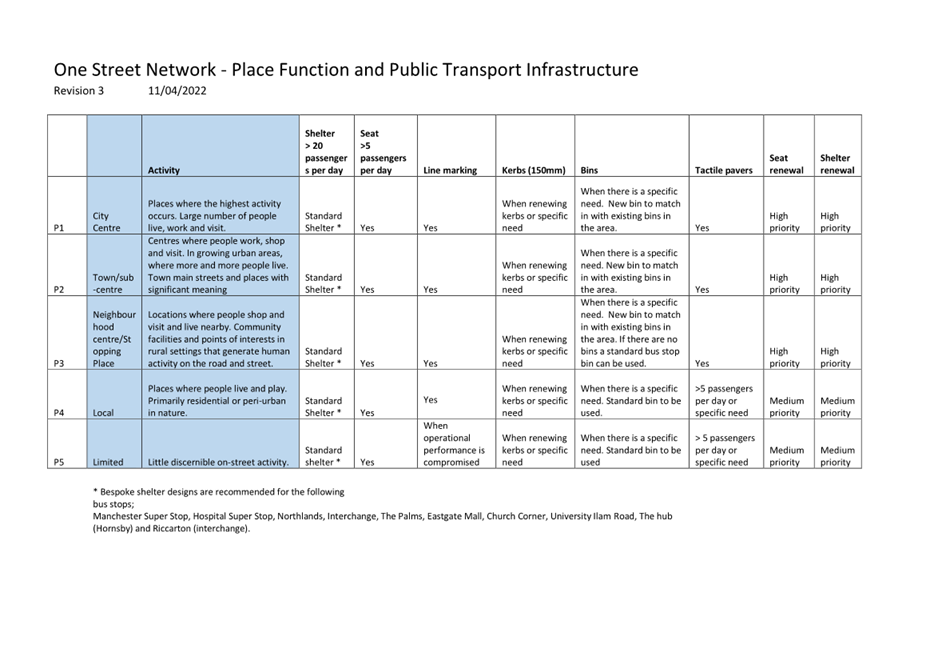
Proposed infrastructure improvements on Wairakei Road
between Wooldridge Road and Greers Road (Attachment B)
3.18 The
infrastructure improvements on Wairakei Road between Wooldridge Road and Greers
Road (Attachment B) are proposed in accordance with Attachments G and H.
3.19 The
following pedestrian refuges have been proposed on Wairakei Road between
Wooldridge Road and Greers Road to improve pedestrian accessibility at bus
stops.
· Wairakei Road, south-east
of Abros Place
· Wairakei Road, south-east
of Charlcott Street
· Bus stop 16370 is
currently outside 401 Wairakei Road and is unmarked. The new bus stop is
proposed to be relocated to outside 405 Wairakei Road due to the design of the
pedestrian refuge.
· Wairakei Road, east of
Spalding Street, bus stop 16045 is currently outside 339 Wairakei Road and is
unmarked. The new bus stop is proposed to be relocated to outside 341 Wairakei
Road due to the design of the pedestrian refuge and be marked.
3.20 Bus
stop 16554 (currently beside 442 Wairakei Road) is proposed to be removed for
the following reasons;
· The bus stop is situated
after a bend in the road making it difficult for bus passengers to see an
approaching bus.
· The driveway of 442
Wairakei Road is within 9 metres of the top of the bus box. This means that bus
passengers may be getting on and off the bus on a driveway.
· Consultation to relocate
the bus stop to 436 Wairakei Road was undertaken as part of the Port-to-Port
consultation. However due to consultation responses, staff decided not to
proceed with this option.
· There was no suitable
location for a shelter at 442 Wairakei Road which provided good sight lines for
approaching buses.
· There are bus stops 190
metres north and 175 metres south, so the removal of the bus stop will
consolidate the number of bus stops in the area.
· A reduction of the number
of stops along this section of Wairakei Road means that the buses will be more
reliable as it has to stop less.
3.21 Bus
stop 16468 (currently beside 460 Wairakei Road) is proposed to be relocated to
beside 450 Wairakei Road so that passengers accessing public transport from
Breens Road do not have longer to walk due to the removal of bus stop
16554. A shelter is also proposed at this relocated bus stop as per the
criteria in Attachment G.
Proposed infrastructure improvements on Wairakei Road
(south-west side) between Greers Road and Blighs Road (Attachment C)
3.22 The
infrastructure improvements on Wairakei Road (south-west side) between Greers
Road and Blighs Road are proposed in accordance with Attachments G and H.
Proposed infrastructure improvements on Wairakei Road
and Strowan Road between Blighs Road and Heaton Street (Attachment D)
3.23 The
infrastructure improvements on Wairakei Road and Strowan Road between Blighs
Road and Heaton Street are proposed in accordance with Attachments G and H.
3.24 Bus
stop 16260 (currently beside 15/126 Idris Road on Wairakei Road) is proposed to
be relocated to 30 Wairakei Road. This will provide a lead-in area for
buses to pull into the bus stop close and parallel to the kerb.
Proposed infrastructure improvements on Rossall Street
(Attachment E)
3.25 The
infrastructure improvements on Rossall Street are proposed in accordance with
Attachments G and H.
Proposed infrastructure improvements on Carlton Mill
Road (Attachment F)
3.26 The
infrastructure improvements on Carlton Mill Road are proposed in accordance
with Attachments G and H.
3.27 Bus
stop 10948 (currently beside 16 Carlton Mill Road) is proposed to be relocated
to 18 Carlton Mill Road. This was due to a request made by the residents at 18
Carlton Mill Road to improve the sight lines of vehicles exiting their
driveway. Currently, parked cars to the east of their driveway obstruct
visibility of westbound traffic on Carlton Mill Road. In addition, the front
door section of the current bus stop box coincide with a redundant vehicle
crossing which makes it difficult for people with limited mobility or with
prams/strollers to board the bus.
Proposed infrastructure improvements – general
comments
3.28 The
advantages vary between each bus stop and are discussed above. Attachment G
also provides a general overview of the advantages of public transport
infrastructure.
3.29 The
disadvantages also vary between each of the bus stops but generally are:
· The loss of parking
spaces.
· The financial cost of
shifting bus stops, installing new bus stops and all the associated
improvements.
4. Alternative Options Considered / Ētahi atu Kōwhiringa
4.1 Option
2 – Do nothing and no bus stop improvements will be undertaken and the
existing bus stop infrastructure remain as is. This means that:
· There will be no new bus
stops on the new route extension to the Christchurch Airport.
· The majority of the bus
stops are not line marked to Council’s standard (Attachment H). Some have
no line marking whilst others have a bus box (sometimes undersized) and with no
‘no stopping’ restrictions before and after the bus box. This means
buses are unable to pull up close and parallel to the kerb, which creates a
barrier for people to catch the bus.
4.2 No
improvements to pedestrian accessibility to public transport.
5. Detail / Te Whakamahuki
Public Consultation Te Tukanga Kōrerorero
5.1 Consultation
started on 22 March and ran until 12 April 2022. An email was sent to 67 key
stakeholders, including Resident Associations, Christchurch International
Airport Limited, Metro Bus, Waka Kotahi, Lyttelton Port Company and 31 schools.
We also emailed submitters from Environment Canterbury’s (ECan) initial
consultation on the route review, who indicated they would like to be contacted
when we opened our consultation.
5.2 Consultation
documents were delivered to 1049 affected properties on 22 March. Documents
were also available in local service centres.
5.3 The
consultation was posted on the Council Facebook page as well as ten community
pages inviting submissions on the Have Your Say webpage.
5.4 Corflute
signs were installed at each of the 110 bus stops along the route.
5.5 A
Newsline article was posted on 22 March 2022 which shared the consultation.
Summary of Submissions Ngā Tāpaetanga
5.6 In
total, one recognised organisation, four businesses and 126 residents made
submissions. All submissions are available on Council’s
Have Your Say Page.
Note: not all submitters
commented on each question
5.7 Please
see Attachment I for the full consultation analysis.
5.8 Some
seats have been included in the proposal based on the submissions. A seat has
been added to the following bus stop:
· Bus stop 16066 (88 Rossall
Street)
Further Public Consultation
5.9 Further
consultation was undertaken following ECan’s decision to extend route 17
out to the airport and to respond to the community consultation carried out in
March 2022. Consultation started on the 15 June and was open until 29
June 2022. We sent letters out to residents and owners in the vicinity of the
bus stops and sent emails to ECan and GoBus for their feedback.
5.10 The following bus stops were consulted on:
· New bus stop - 281
Wooldridge Road
· New bus stop - 280
Wooldridge Road
· New bus stop - 215
Wooldridge Road
· Relocation of bus stop
16468 to 450-452 Wairakei Road, shelter at 450 Wairakei Road
· Removal of bus stop 16554
at 442 Wairakei Road
5.11 Please
see Attachment J for the full consultation comments and staff responses from
the further consultation that was undertaken in June 2022.
5.12 Bus
stop 16343 outside 73 Carlton Mill Road was consulted on separately as part of
a proposed parking restrictions scheme. Consultation started on 23 November
2021 until 21 December 2021. Letters were sent out to affected residents and
owners along Carlton Mill Road. Four responses were received and they were all
in favour of the proposed parking restrictions. Staff are still in discussions with
residents pertaining to the proposed parking restrictions however, it is
proposed that the line marking for bus stop 16343 be included as part of this
public transport infrastructure improvements along route 17 project.
5.13 For
the proposed changes to the bus stop terminus on Sheffield Crescent, staff
carried out consultation with ECan on the 5 January 2023. Staff also considered
the results of the community consultation that was carried out during the
original extension of the bus stop terminus. These considerations ensure that
the proposed changes align with the needs and expectations of the community.
5.14 Consultation
for the Orchard Road bus stops outside the International Antarctic Centre
started on the 16 January 2023 and ran for two weeks. An email was sent to
CIAL, International Antarctic Centre, US Antarctic Program Clothing and
Antarctica New Zealand. An email was also sent to our stakeholder groups; the
Accessibility reference group (ARG) and the Public Transport stakeholder
reference group (PTSRG).
5.15 Consultation
for the Orchard Road bus stops near Wairakei Road occurred with CIAL and ECan
in late 2022 through ongoing discussions.
Summary of issues raised on Sheffield Crescent and
Orchard Road (Attachment K)
5.16 CIAL
has expressed satisfaction with the proposed changes along Orchard Road near
the Antarctic Centre and Wairakei Road. However, they have raised a concern
regarding the unrestricted parking on Orchard Road outside the Antarctic
Centre. Given the high volume of vehicles passing through the Memorial
Ave/Orchard Rd roundabout, particularly at high speeds, CIAL believes that
buses may stop traffic flow to manoeuvre into the bus stop which could pose a
dangerous situation and exacerbate existing traffic issues in the area.
5.17 Council
staff believe that there is sufficient space for buses to turn into the bus
stop safely. However the issue of removing parking along Orchard Road has been
referred to an area engineer for further investigation.
5.18 Environment
Canterbury have approved the proposed changes to Sheffield Crescent.
Summary of issues raised on Wooldridge Road
(Attachment A)
5.19 We
received no objections for the proposed bus stop at 215 Wooldridge Road.
5.20 Staff
received one support and two objections from residents for the proposed bus
stops beside 280 and 281 Wooldridge Road. The objections for the proposed bus
stops are due to increased difficulty in backing into their property,
unnecessary cost due to lack of residents who would utilise the bus, loss of
parking, narrow width of the road and the current traffic volume especially
during sporting events and at peak periods.
Summary of issues raised on Wairakei Road between
Wooldridge Road and Greers Road (Attachment B)
5.21 Staff
originally consulted on relocating bus stop 16554 to 436 Wairakei Road and
installing a shelter. Staff received an objection to the bus passenger shelter
and bus stop due to increased difficulty in exiting their property, loss of
parking and the shelter blocking visibility.
5.22 Due
to this objection, staff re-consulted on the consolidation of bus stop 16468
and 16554 to 450-452 Wairakei Road and a proposed shelter at 450 Wairakei Road.
We received one objection for the proposed relocation of bus stop due to loss
of parking.
5.23 Summary
of issues raised on Wairakei Road (south west side) between Greers Road and
Blighs Road (Attachment C)
5.24 There
were no issues raised by residents along Wairakei Road (south west side)
between Greers Road and Blighs Road. Further investigation is required
for requests for additional pedestrian refuges and shelters.
Summary of issues raised on Wairakei Road and Strowan
Road between Blighs Road and Heaton Street (Attachment D)
5.25 Staff
received support from one resident to the relocation of bus stop 16260 as they
believe it will reduce the conflict between motorists and cyclists on Wairakei
Road.
5.26 Staff
received a request for a shelter at bus stop 16764. This bus stop does
not meet the criteria for a shelter set out in Attachment G. However we will
monitor this bus stop and if passenger numbers increase we will add it to the
shelter installation program.
5.27 A
pedestrian crossing was requested for bus stop 16084 and 16605 near 38 Strowan
Road. Improved pedestrian crossing facilities are under investigation.
Summary of issues raised on Rossall Street (Attachment
E)
5.28 There
were no issues raised by residents along Rossall Street.
5.29 A
pedestrian refuge was requested between 37B Rosall Street and 20 Rossall
Street. At the moment, no pedestrian refuge is being considered as there is a
pedestrian refuge nearby at 33 Rossall Street.
5.30 A
pedestrian refuge and shelter was requested for bus stop 16583 on Rossall
Street near Leinster Road. It does not meet the criteria for a shelter
and there is an existing pedestrian refuge just west of the Leinster Road. A
pedestrian refuge is under further investigation south of the bus stop.
5.31 A
shelter was requested for bus stop 10687. This bus stop does not meet the
criteria for a shelter and a seat is being installed at this location.
5.32 Bus
stop 16362 received support for the addition of the hardstand area.
Summary of issues raised on Carlton Mill Road
(Attachment F)
5.33 There
were no issues raised by residents along Carlton Mill Road. Further
investigation is required for a potential pedestrian crossing facility near 37
Carlton Mill Road.
5.34 The
decision affects the following wards/Community Board areas:
· Waimaero Fendalton-Waimairi-Harewood Community Board
6. Policy Framework Implications Ngā Hīraunga ā- Kaupapa here
Strategic
Alignment /Te Rautaki
Tīaroaro
6.1 Council’s
Strategic Framework is a key consideration in guiding the recommendations in
this report. The recommendations in this report help achieve the:
· Community outcome of a
well-connected and accessible city promoting active and public transport, and
· Strategic priorities of meeting the challenge of climate change
through every means available.
6.2 This report supports the Council's
Long Term Plan (2021 - 2031):
6.2.1 Activity: Transport
· Level of Service: 10.4.4 Improve user
satisfaction of public transport facilities (number and quality of shelters and
quality of bus stop) - >=72% resident satisfaction
Policy
Consistency / Te Whai
Kaupapa here
6.3 The
decision is consistent with Council’s Plans and
Policies.
Impact
on Mana Whenua Ngā
Whai Take Mana Whenua
6.4 The
decision does not involve a significant decision in relation to ancestral land
or a body of water or other elements of intrinsic value, therefore this
decision does specifically impact Mana Whenua, their culture and traditions.
6.5 The
decision does not involve a matter of interest to Mana
Whenua and will not impact on our agreed partnership priorities with Ngā Papatipu Rūnanga.
Climate
Change Impact Considerations / Ngā Whai Whakaaro mā te Āhuarangi
6.6 Greater
investment in public transport provides a more attractive mode choice that
reduces reliance on high-emission, single occupant vehicles.
6.7 Enhancing
our bus service to become more reliable, with more frequent and efficient
trips, will encourage more people to shift modes.
Accessibility
Considerations / Ngā
Whai Whakaaro mā te Hunga Hauā
6.8 Improvements to the overall length of the bus stop, including the no
stopping restrictions leading into and out of the bus box will provide buses
the necessary space to pull into the stop, stopping parallel and close to the
kerb, and to safely pull out of the stop to merge into the traffic lane. Buses
stopping parallel to the kerb provides inclusive access as it decreases the
step height or ramp gradient for people boarding or alighting the bus. This is
particularly important for people with limited mobility or with
prams/strollers.
6.9 Tactile ground surface indicators provide visual and sensory
information about the road environment. They assist people with vision
impairment to access the bus from the adjoining footpath by directing people to
where the front door of the bus will be and warning people of the kerb and
potential hazard beyond. We are intending to install tactile pavers at all bus
stops which have 5 or more passenger boarding per day or in areas with lots of
pedestrian activity. This criteria was determined after consultation with
Blind Low Vision NZ.
6.10 The
kerb forms a critical interface between the bus and the passenger. Many bus
stops have been shifted to ensure that the front or back door of the bus aligns
with a kerb as opposed to a driveway, providing a clear and safe delineation
between the road surface and the waiting area for bus passengers. Kerbs also
reduce the step height which facilitates quicker, safer and more comfortable
boarding and alighting times. Kerbs also reduce the gradient of a
deployed ramp.
6.11 To
allow for both the safe and convenient movement of pedestrians along the
footpath and for an adequate waiting area for bus passengers, a minimum 9
metres of hardstand area where possible (measured from the front of the bus box
which is also free of fixed obstacles) is proposed to be provided at the bus
stops.
7. Resource Implications Ngā Hīraunga Rauemi
7.1 The
figures below provide the construction estimates for each type of bus stop
upgrade;
|
Bus stop
upgrades
|
Construction
estimate
|
|
Bus stops
with shelters
|
$25,000 to
$35,000
|
|
Bus stops
with seats
|
$6,000 to
$10,000
|
|
Bus stops
with line marking
|
$2,000 to
$6,000
|
|
Pedestrian
refuges
|
$40,000 to
$75,000
|
7.2 The
total cost of bus stop improvements is $444,500. The cost estimates includes
construction cost and all associated design, consultation and supervision cost.
The cost estimates also allow for a 10% contingency.
7.3 For
each subset of bus stops, the following construction estimates are provided:
K. Sheffield Crescent and Orchard Road – $60
000
A. Wooldridge Road - $9,500
B. Wairakei Road between Wooldridge Road and Greers Road -
$240,000
C. Wairakei Road (south west side) between Greers Road and
Blighs Road - $25,000
D. Wairakei Road and Strowan Road between Blighs Road and
Heaton Street - $35,000
E. Rossall Street - $65,000
F. Carlton Mill Road - $10,000
7.4 If
approved, all recommendations will be constructed within 12 months, dependant
on the contractor’s availability. The works will be funded out of the
Traffic Operations, Capital Expenditure budgets for bus stops; seating and
shelter installations as well as the bus stop renewals budget.
7.5 Maintenance/Ongoing
costs - Transport Unit Operational Expenditure budget, includes maintenance of
bus stop infrastructure, which may cost on average approximately $200 annually
per bus stop.
8. Legal Implications Ngā Hīraunga ā-Ture
Statutory power to undertake proposals in the report
Te Manatū Whakahaere Kaupapa
8.1 Part
1, Clause 7 of the Christchurch City Council Traffic and Parking Bylaw 2017
provides Council with the authority to install stopping, standing and parking
restrictions by resolution.
8.2 The
Community Board have delegated authority from the Council to exercise the
delegations as set out in the Register of Delegations. The list of delegations
for the Community Boards includes the resolution of stopping, standing and
parking restrictions, traffic islands and traffic restraints, and traffic
control devices.
8.3 The
legal consideration is that the installation of any signs and/or markings
associated with traffic control devices must comply with the Land Transport
Rule: Traffic Control Devices 2004.
Legal implications relating to bus
passenger shelters
8.4 Under
Section 339 of the Local Government Act 1974, the Council may erect on the
footpath of any road, a shelter for use by intending public transport
passengers or small passenger service vehicle passengers provided that no such
shelter may be erected so as to unreasonably prevent access to any land having
a frontage to the road. The Council is required to give notice in writing to
the occupier and owner of property likely to be injuriously affected by the
erection of the shelter, and shall not proceed with the erection of the shelter
until after the expiration of the time for objecting against the proposal or,
in the event of an objection, until after the objection has been determined.
8.5 Staff
confirm the shelters will not prevent vehicular or pedestrian access to any
land having a frontage to the road.
8.6 The
relevant Community Boards have delegated authority from the Council to exercise
the delegations as set out in the Register of Delegations. The list of
delegations for the Community Boards includes the resolution of bus passenger
shelters under Section 339 (1) of the Local Government Act 1974.
8.7 Where
no objection to the shelter has been presented by the owner or occupier of an
affected property, staff present a decision making report directly to the
relevant Community Board.
8.8
Where an objection has been presented by the owner or occupier of an affected
property, staff present a decision making report to a Hearings Panel. The
Hearings Panel then assess the objection against the criterion as outlined in
Section 339 of the Act and make recommendations to the relevant Community
Board. The Community Board will then determine the outcome of the objections in
accordance with criterion outlined in Section 339 of the Local Government Act 1974.
8.9 Section
339 of the Local Government Act requires that resolution of the proposed
shelter will require a separate decision of a Council Hearings Panel that will
hear the objections of the immediate owner (s) and occupier (s) of bordering
properties.
Other Legal Implications Ētahi atu
Hīraunga-ā-Ture
8.10 There
is no legal context, issue or implication relevant to this decision.
8.11 This
specific report has not been reviewed and approved by the Legal Services Unit
however the report has been written using a general approach previously
approved of by the Legal Services Unit, and the recommendations are consistent
with the policy and legislative framework outlined in sections 8.1 – 8.9.
9. Risk Management Implications Ngā Hīraunga Tūraru
9.1 Should
the Community Board proceed with the ‘Do Nothing’ option (Option 2
of this report), many of the existing bus stops will not be marked to
Council’s standard which will affect the operation of the Port-to-Port
service as there may be vehicles impeding access into the bus stops. In
addition, there will be no new bus stops on the new route extension. With no
investment in improving the public transport facilities to the community, it
will be difficult to increase public transport patronage.
Attachments / Ngā Tāpirihanga
|
No.
|
Title
|
Reference
|
Page
|
|
a ⇩ 
|
Attachment A -
Bus stops on Wooldridge Road
|
23/195343
|
46
|
|
b ⇩ 
|
Attachment B -
Bus stops on Wairakei Road between Wooldridge Road and Greers Road
|
23/195345
|
48
|
|
c ⇩ 
|
Attachment C -
Bus stops on Wairakei Road (south-west side) between Greers Road and Blighs
Road
|
23/195347
|
55
|
|
d ⇩
|
Attachment D -
Bus stops on Wairakei Road and Strowan Road between Blighs Road and Heaton
Street
|
23/195348
|
58
|
|
e ⇩ 
|
Attachment E -
Bus stops on Rossall Street
|
23/195349
|
62
|
|
f ⇩
|
Attachment F -
Bus stops on Carlton Mill Road
|
23/195350
|
67
|
|
g ⇩
|
Attachment G -
Public Transport Infrastructure Explained
|
22/841792
|
70
|
|
h ⇩
|
Attachment H -
Bus stop standard detailed design
|
22/841793
|
73
|
|
i ⇩
|
Attachment I -
Consultation Analysis
|
22/1122348
|
74
|
|
j ⇩
|
Attachment J -
Feedback from further consultation in June 2022
|
22/1071159
|
78
|
|
k ⇩
|
Attachment K -
Bus stops on Sheffield Crescent and Orchard Road
|
23/195339
|
80
|
In addition to the attached documents, the following background
information is available:
|
Document
Name – Location / File Link
|
|
Not
applicable
|
Confirmation of Statutory
Compliance / Te Whakatūturutanga ā-Ture
|
Compliance with Statutory Decision-making
Requirements (ss 76 - 81 Local Government Act 2002).
(a) This report contains:
(i) sufficient information about all reasonably practicable
options identified and assessed in terms of their advantages and
disadvantages; and
(ii) adequate consideration of the views and preferences of
affected and interested persons bearing in mind any proposed or previous
community engagement.
(b) The information reflects the level of significance of the
matters covered by the report, as determined in accordance with the Council's
significance and engagement policy.
|
Signatories / Ngā Kaiwaitohu
|
Author
|
Sarah Thorne -
Principal Advisor Public Transport Infrastructure
|
|
Approved By
|
Katie Smith -
Team Leader Traffic Operations
Stephen Wright
- Manager Operations (Transport)
Lynette Ellis
- Head of Transport & Waste Management
|
|
Waimāero Fendalton-Waimairi-Harewood
Community Board
06 March 2023
|

|
|
Waimāero Fendalton-Waimairi-Harewood
Community Board
06 March 2023
|
|
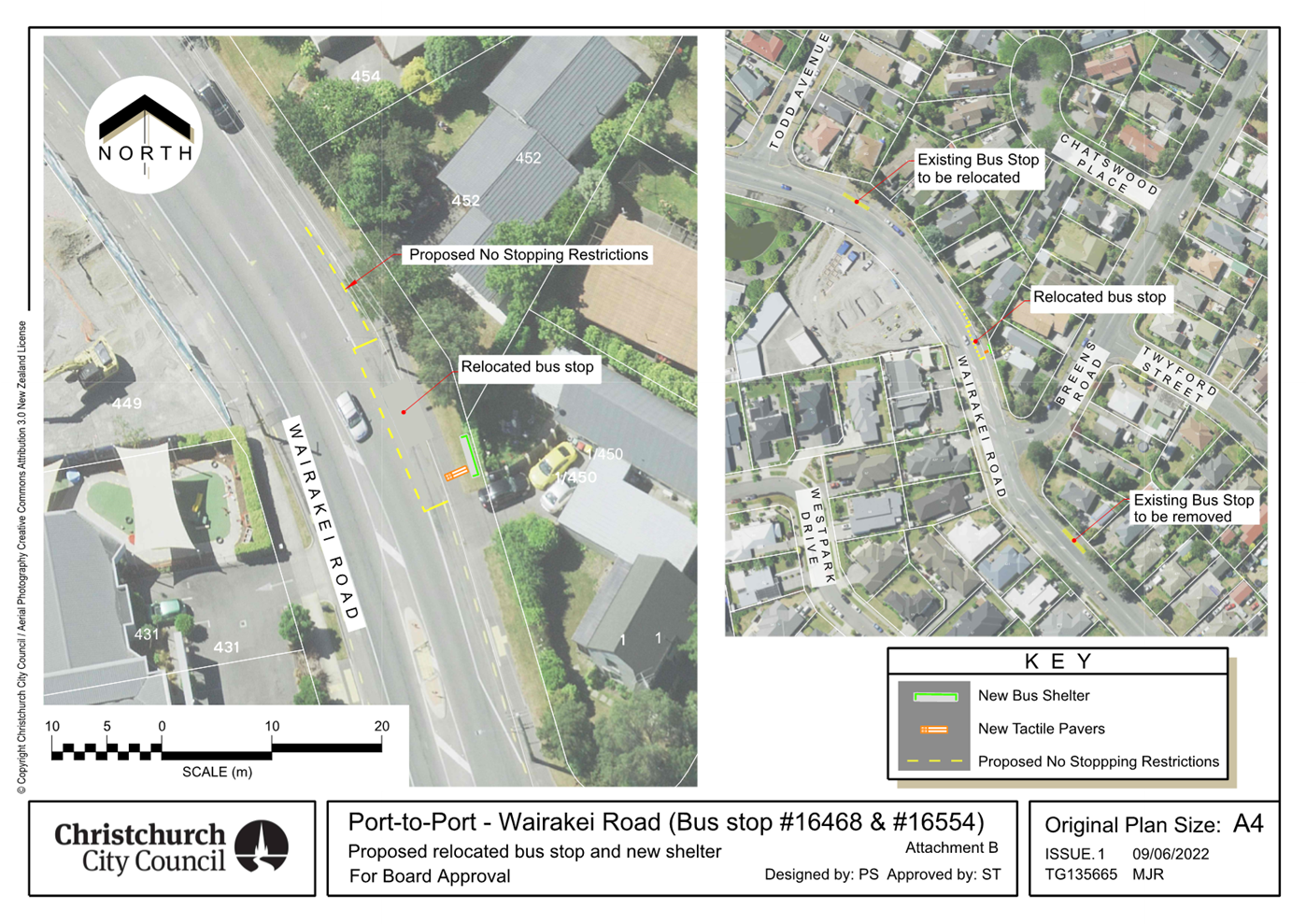
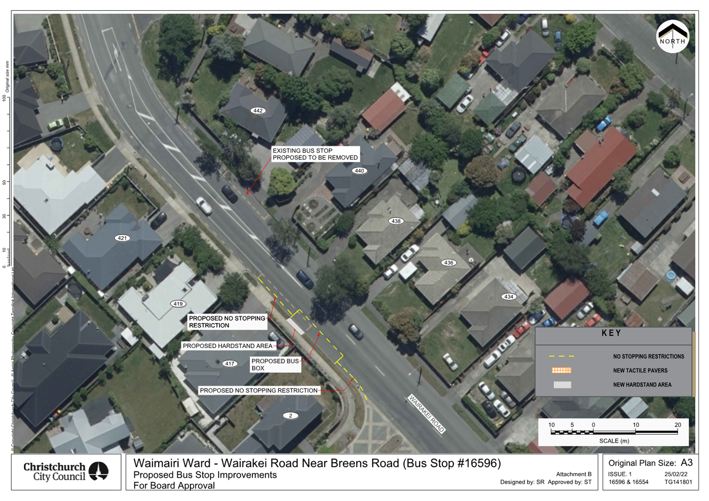
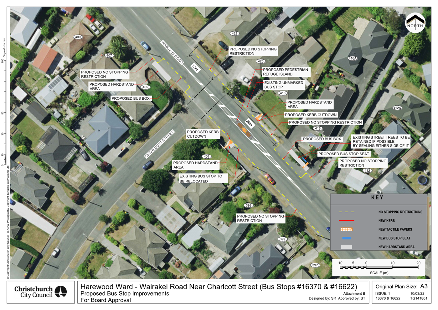
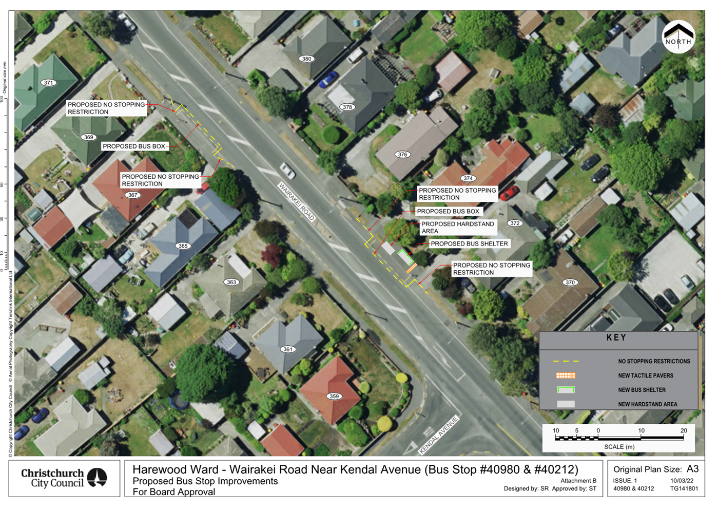

|
Waimāero Fendalton-Waimairi-Harewood
Community Board
06 March 2023
|
|
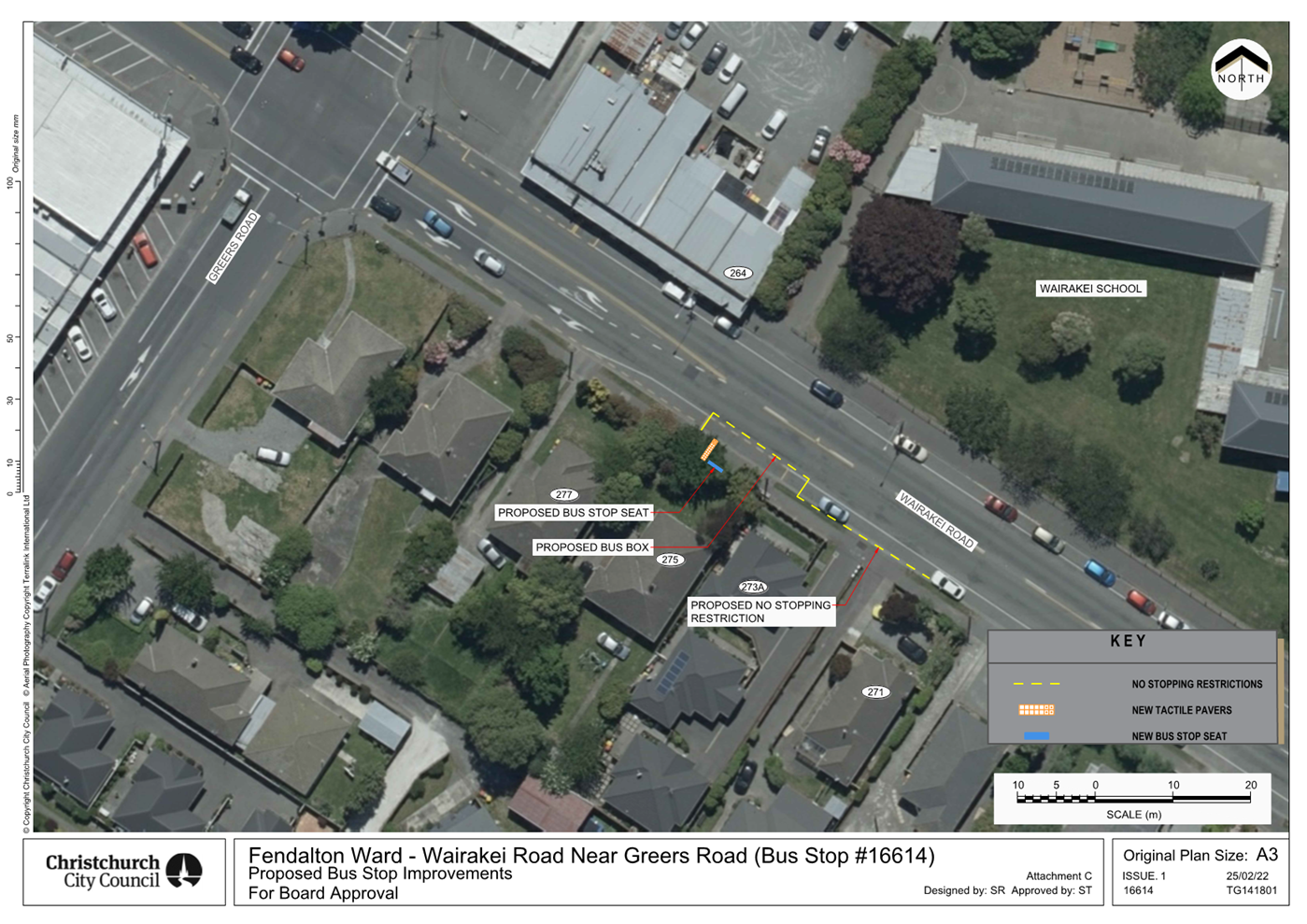
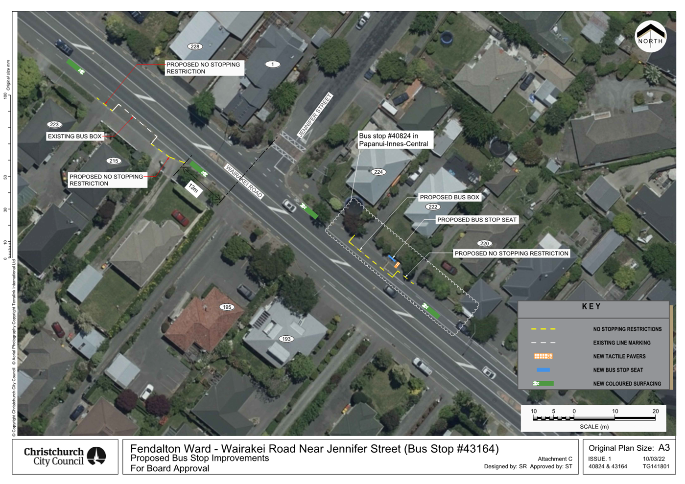
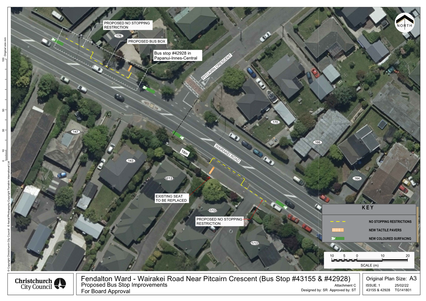
|
Waimāero Fendalton-Waimairi-Harewood
Community Board
06 March 2023
|
|
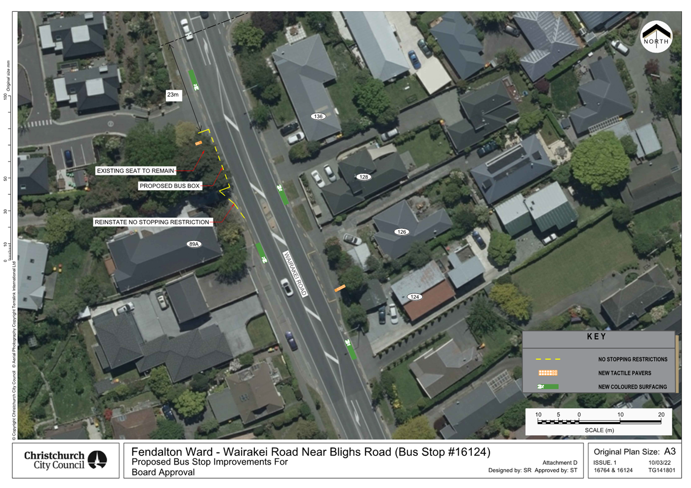
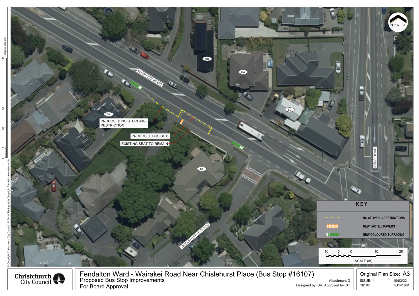
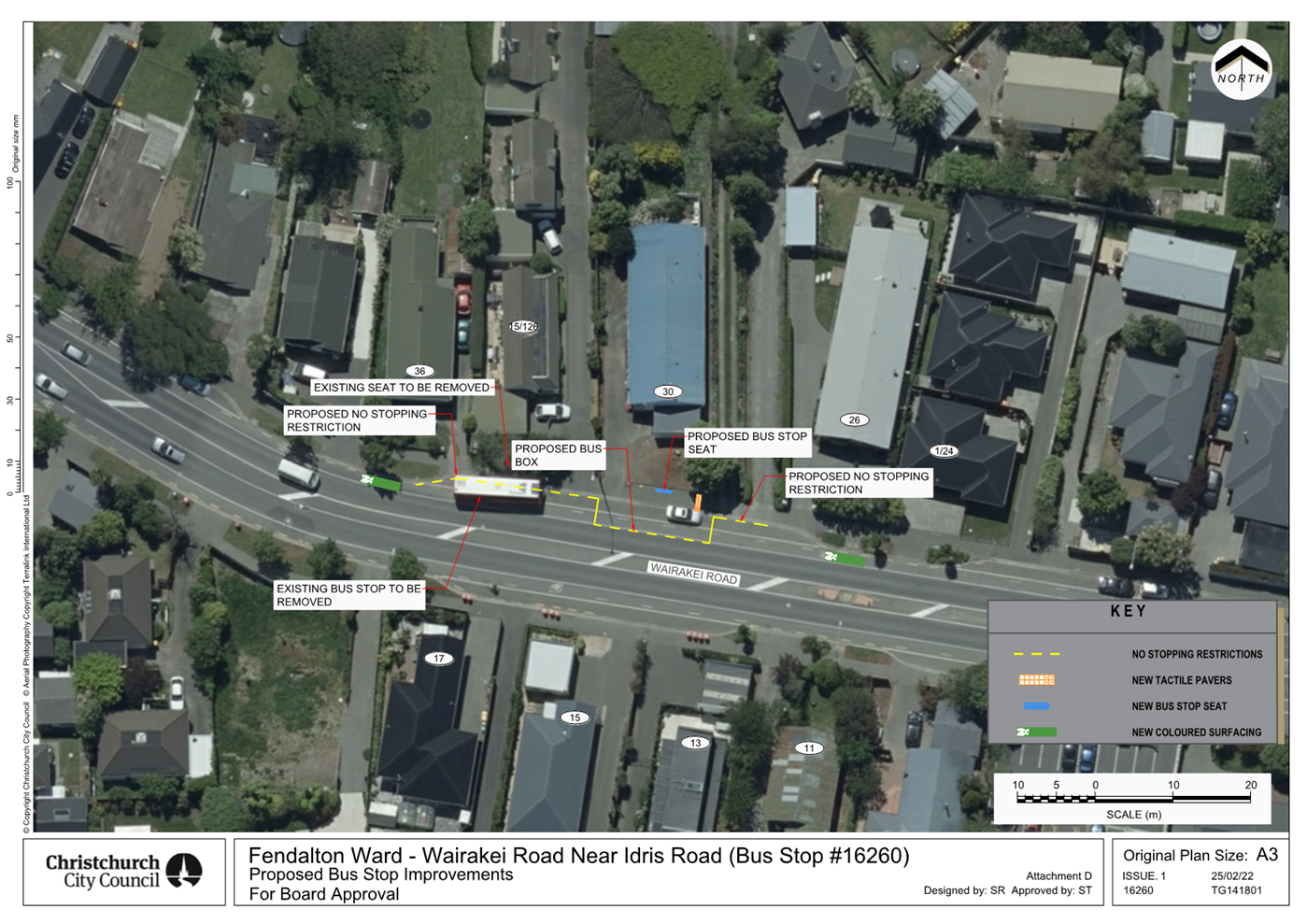
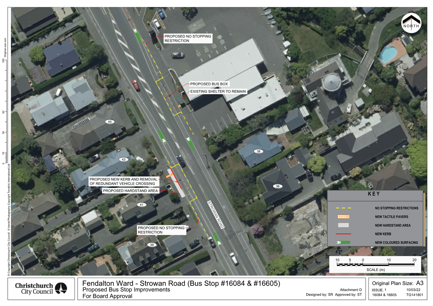
|
Waimāero Fendalton-Waimairi-Harewood
Community Board
06 March 2023
|
|
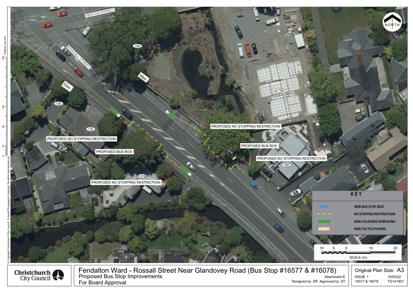
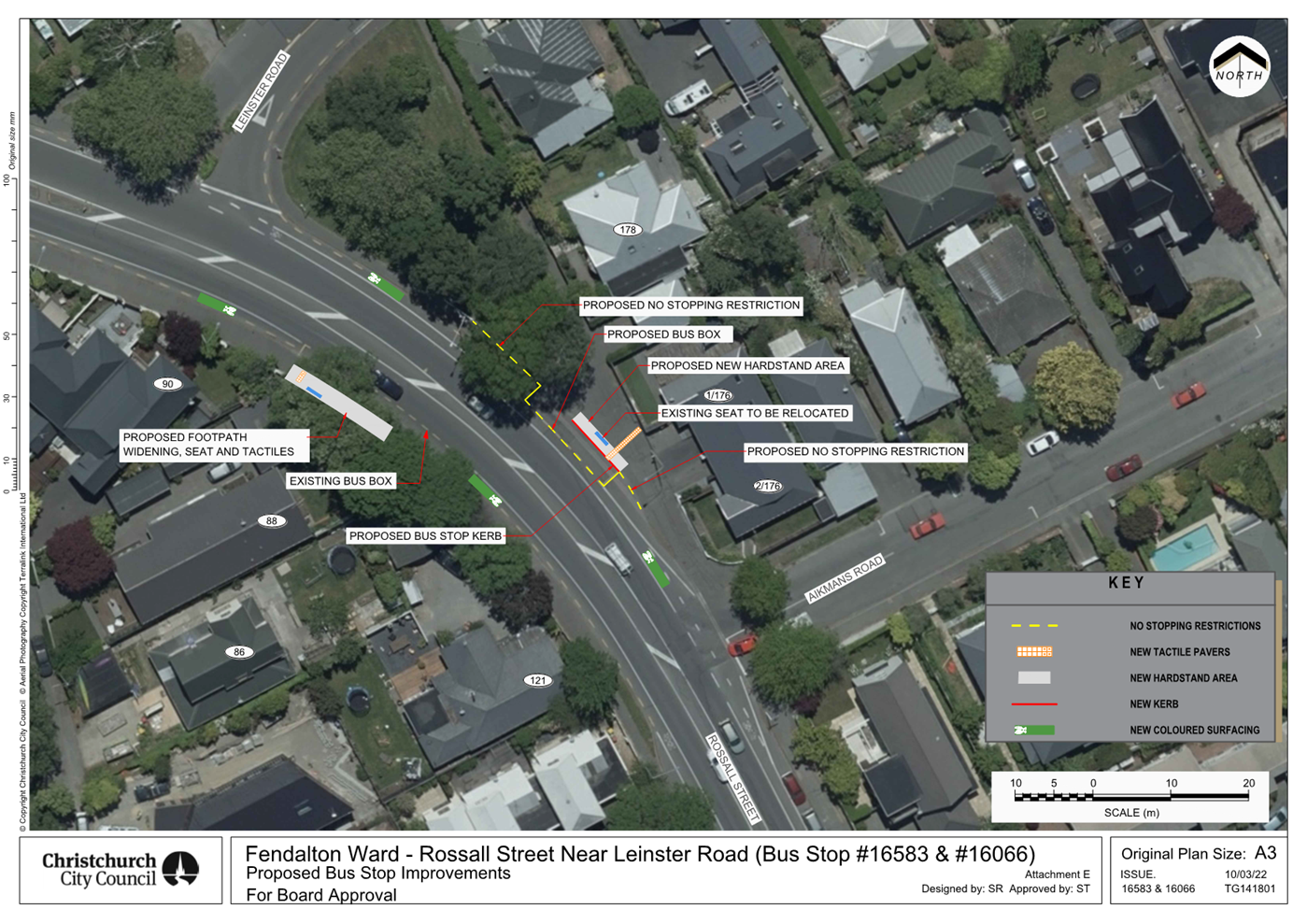
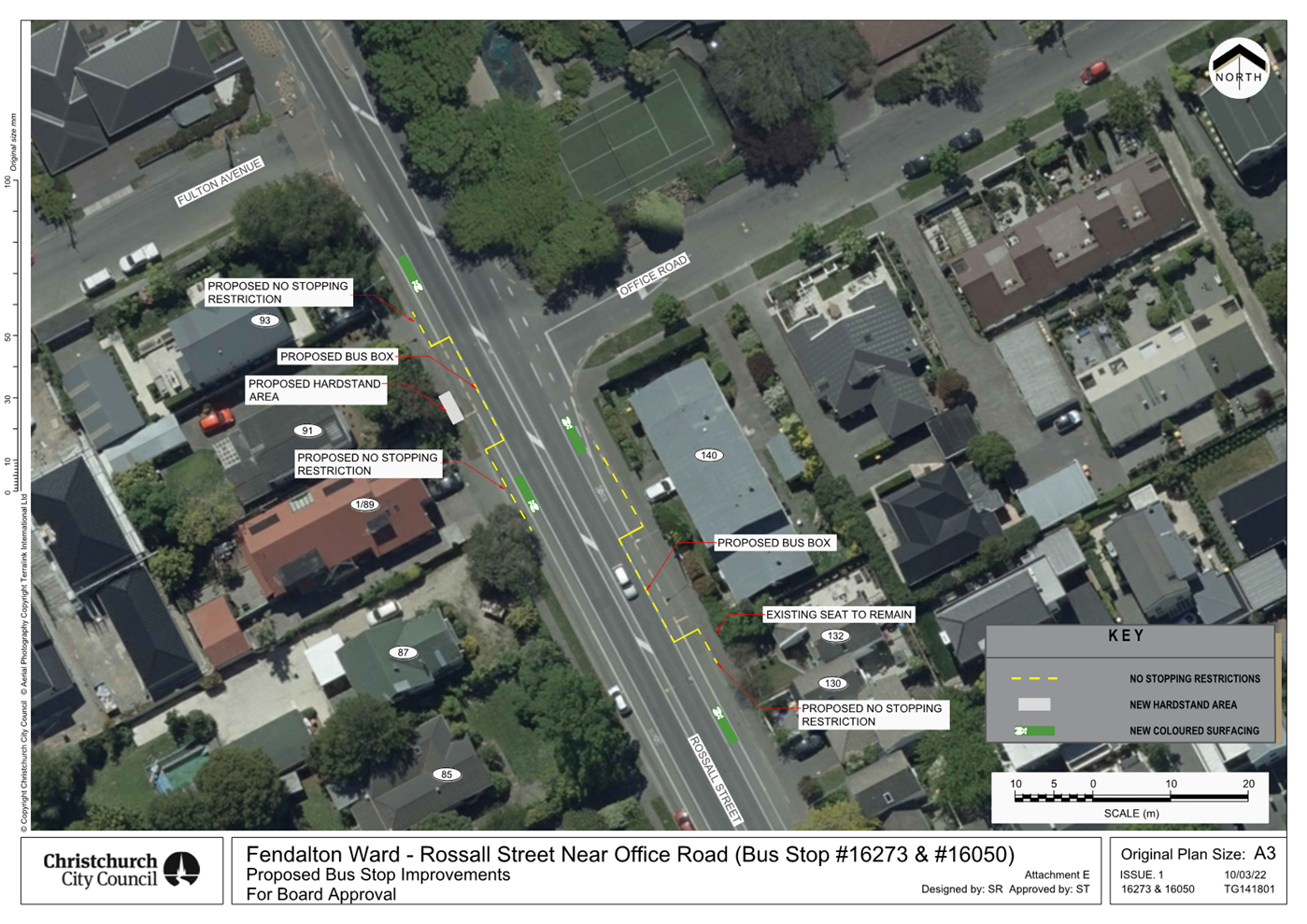
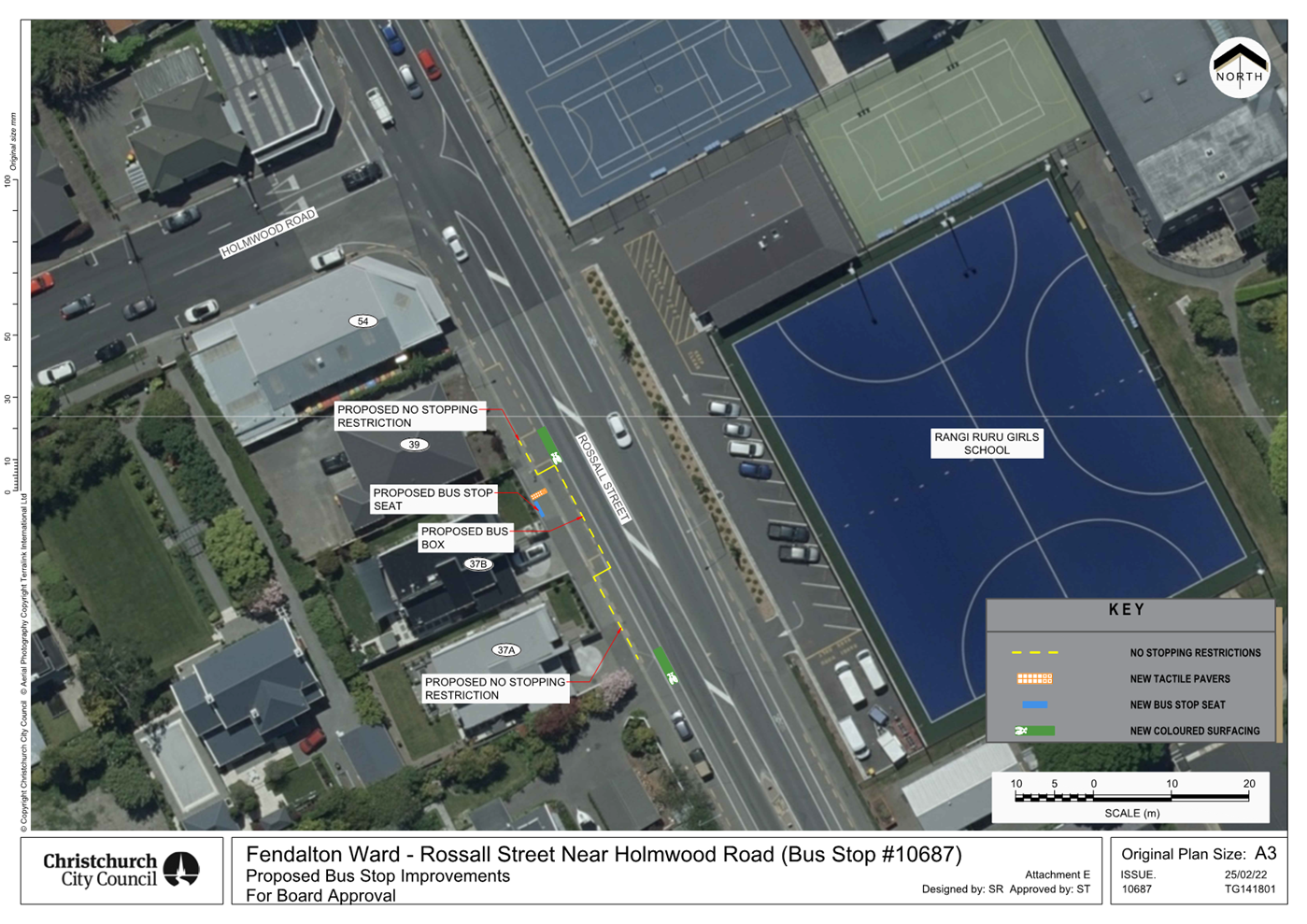

|
Waimāero Fendalton-Waimairi-Harewood
Community Board
06 March 2023
|
|
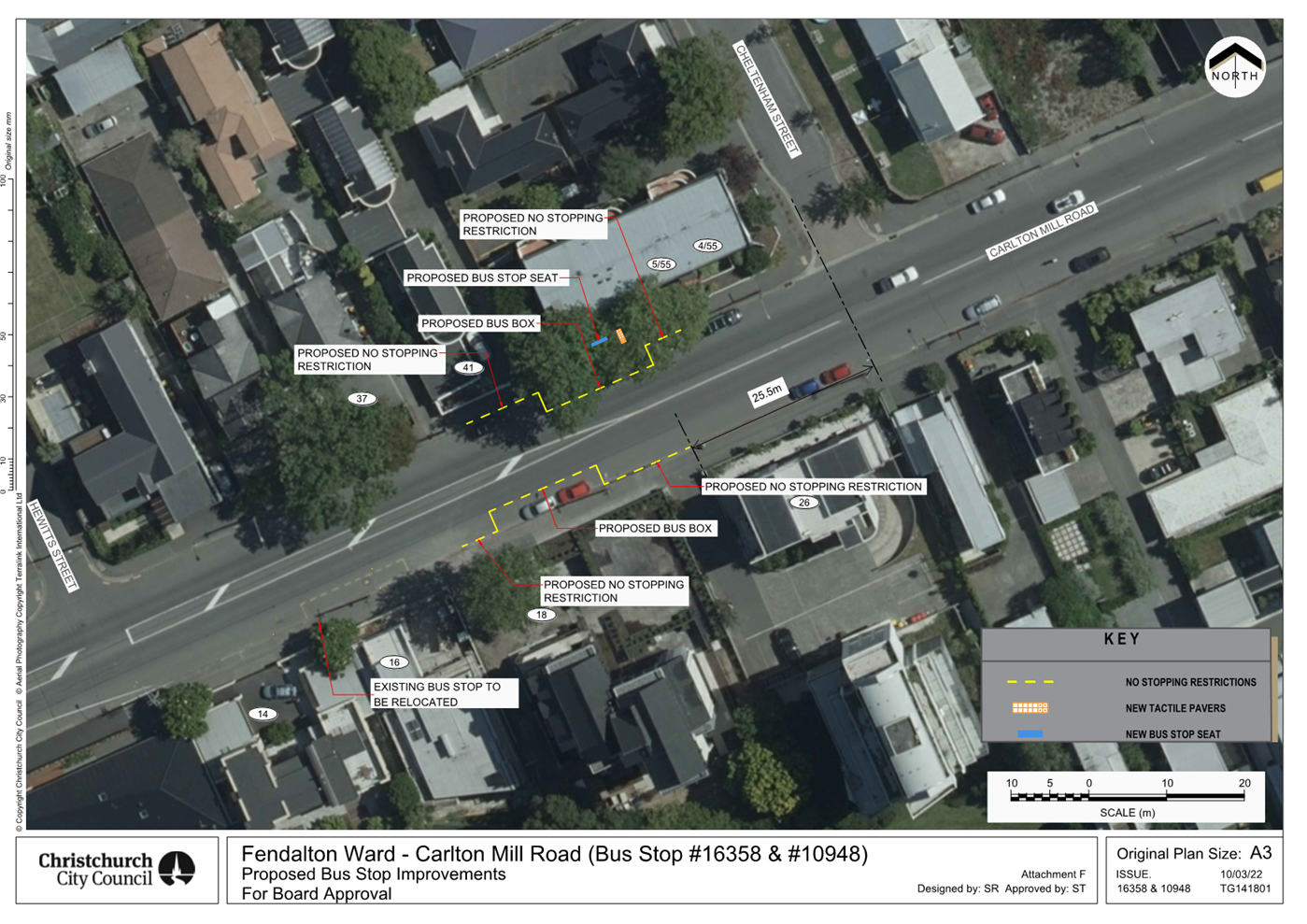
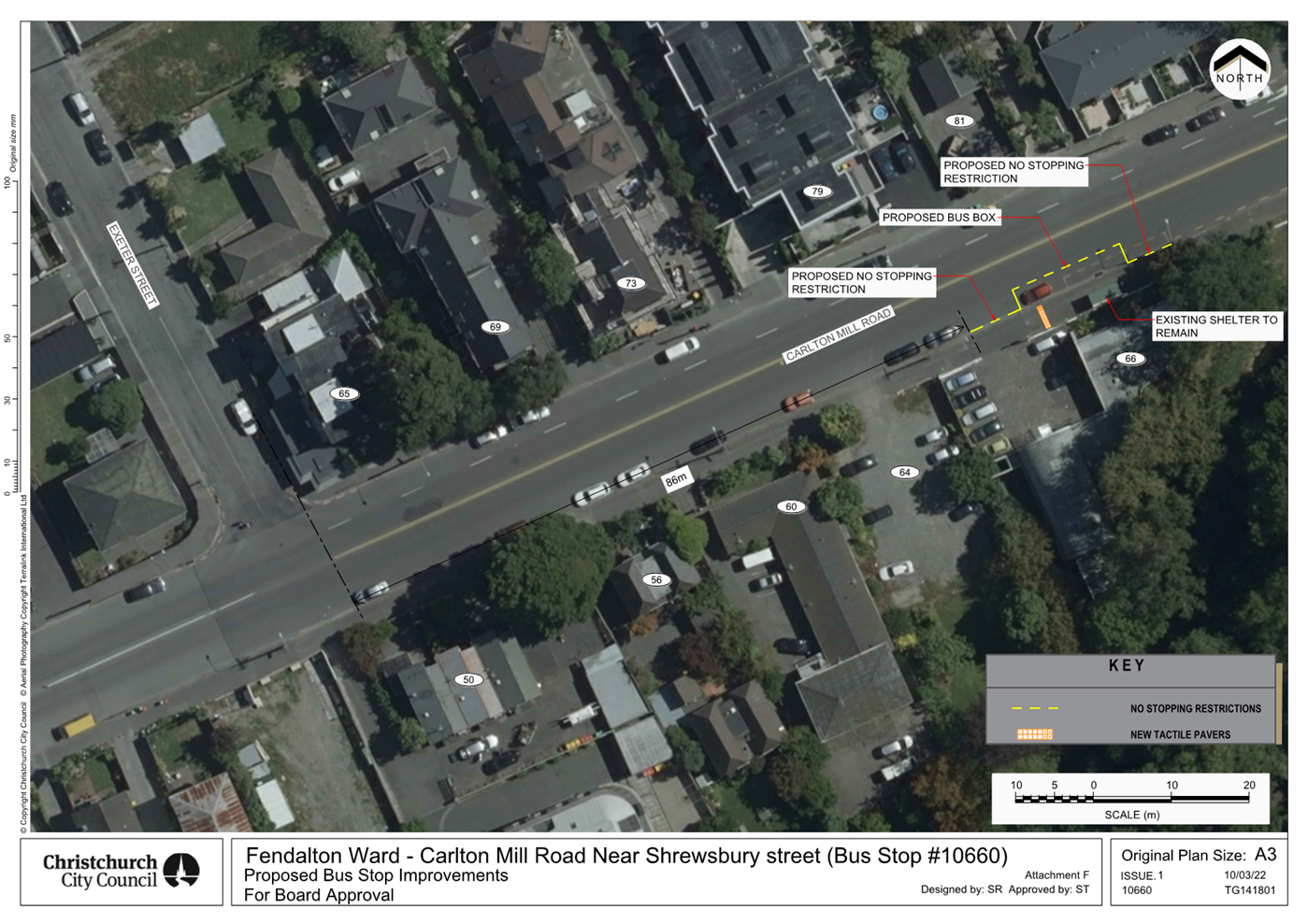
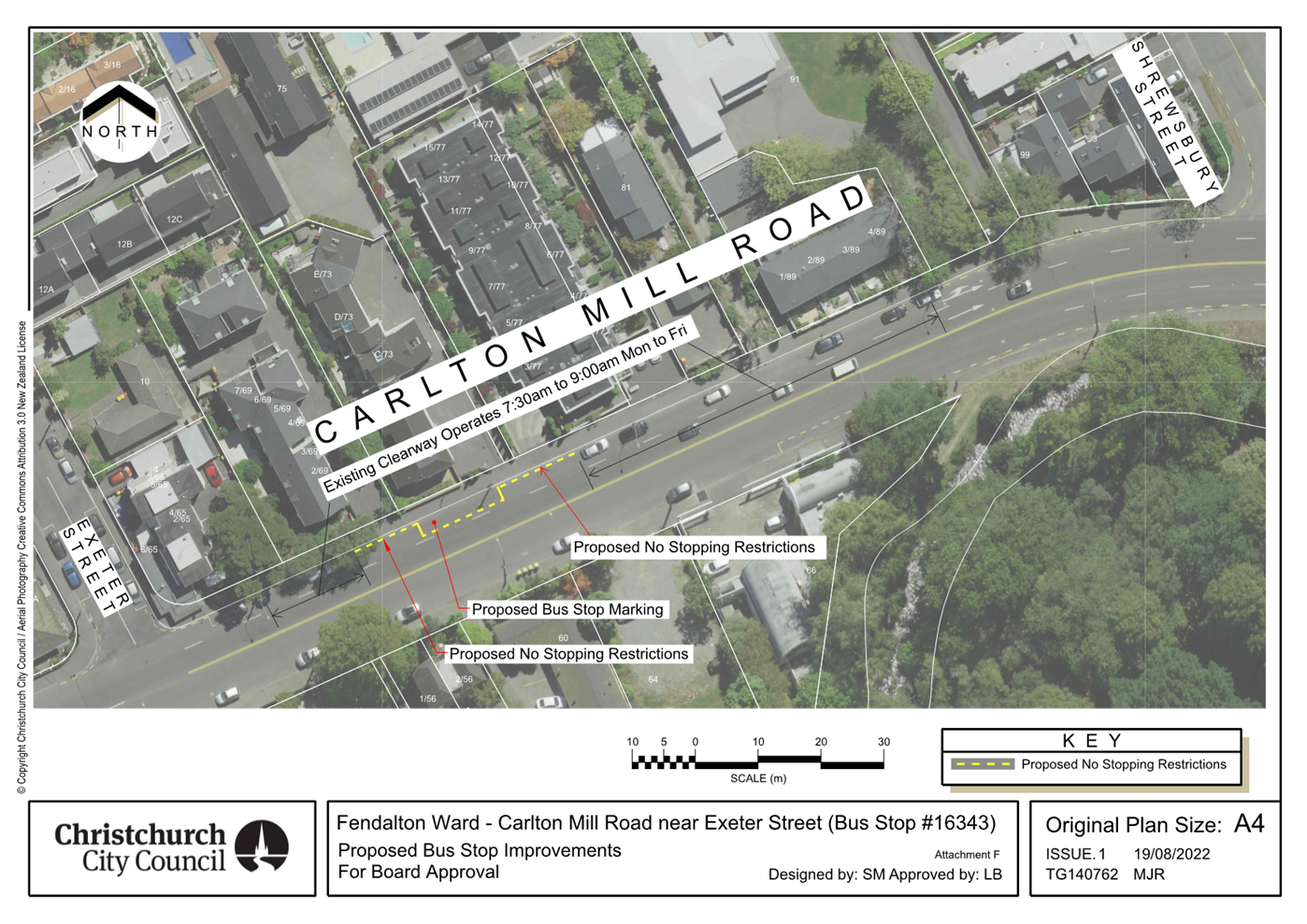
|
Waimāero Fendalton-Waimairi-Harewood
Community Board
06 March 2023
|
|
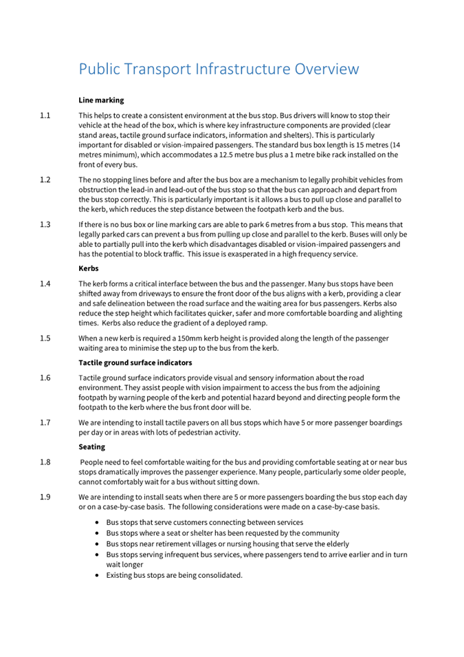
|
Waimāero Fendalton-Waimairi-Harewood
Community Board
06 March 2023
|

|
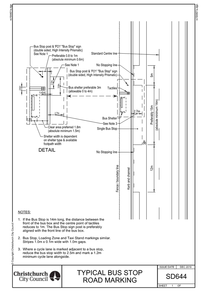
|
Waimāero Fendalton-Waimairi-Harewood
Community Board
06 March 2023
|
|
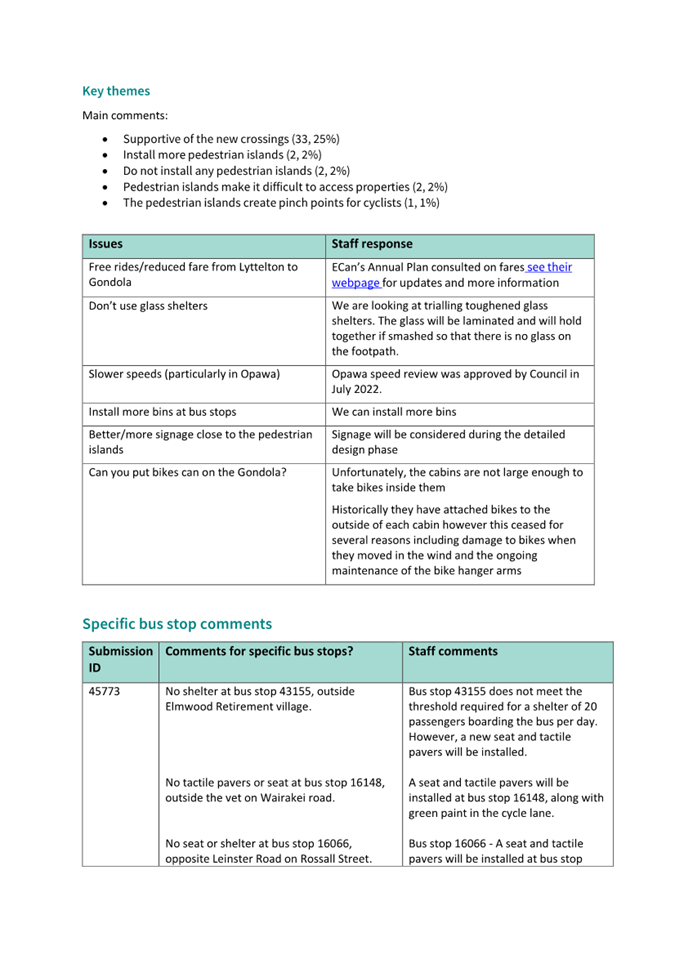
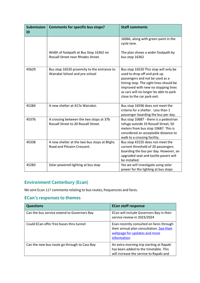
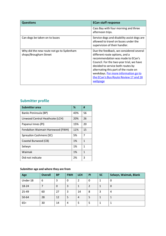
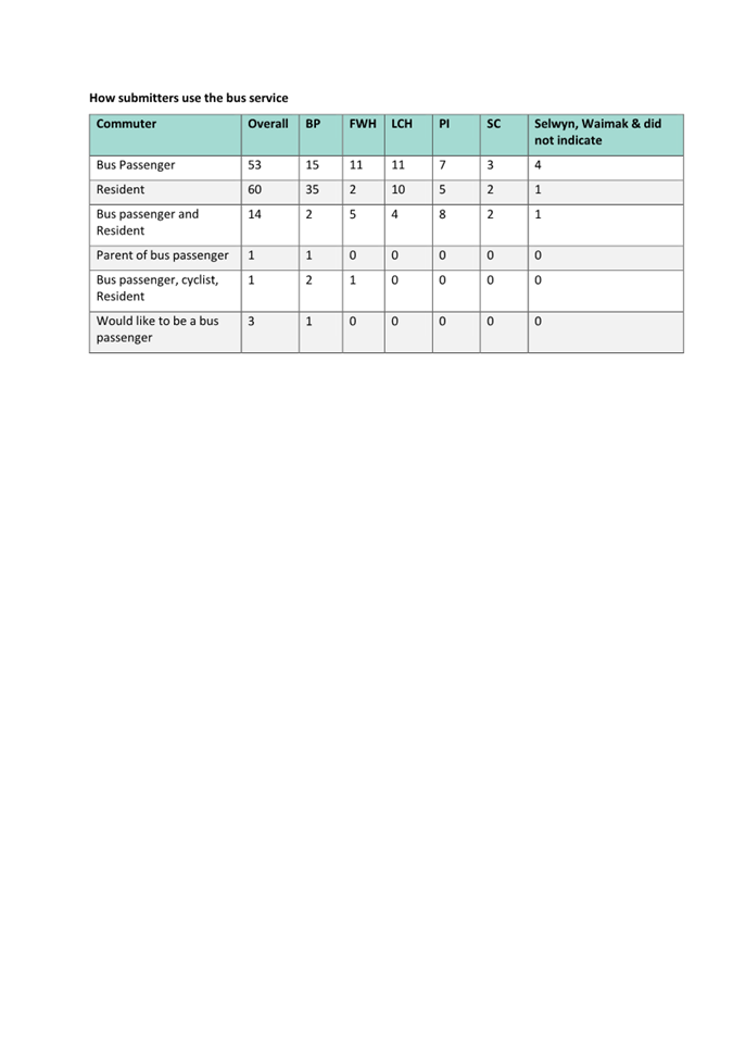
|
Waimāero Fendalton-Waimairi-Harewood
Community Board
06 March 2023
|
|
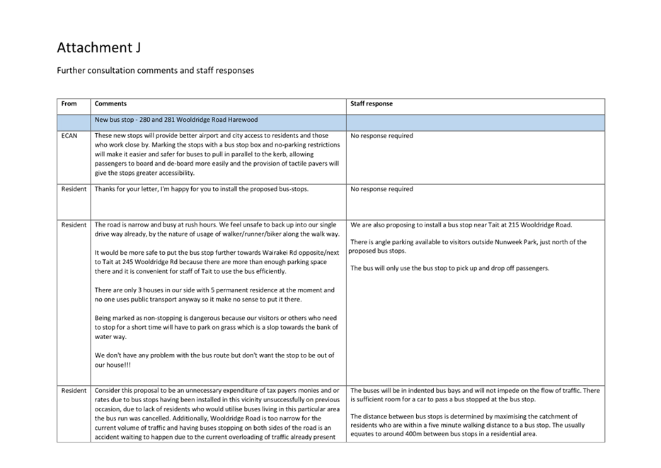
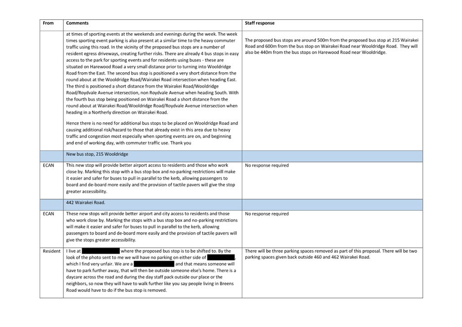
|
Waimāero Fendalton-Waimairi-Harewood
Community Board
06 March 2023
|
|
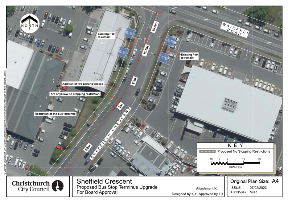
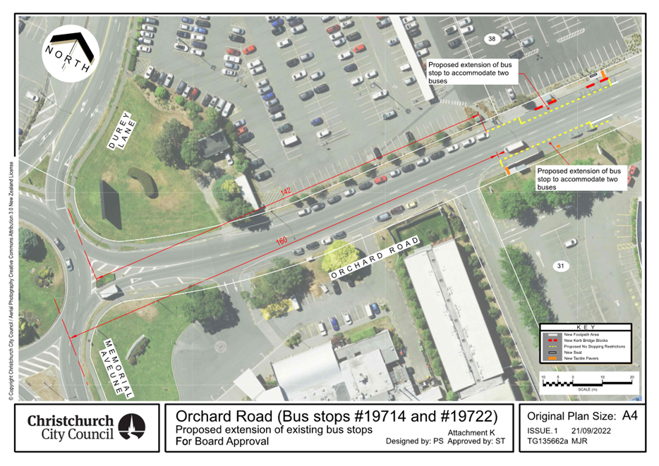
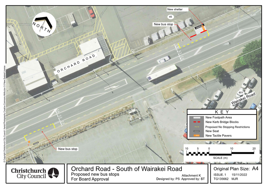
|
Waimāero Fendalton-Waimairi-Harewood
Community Board
06 March 2023
|
|
|
9. Merrin Street/Avonhead Road/Grahams
Road intersection safety improvements
|
|
Reference / Te Tohutoro:
|
23/130181
|
|
Report of / Te Pou Matua:
|
Georgia
Greene, Traffic Engineer, Georgia.Greene@ccc.govt.nz
Gautham Praburam, Traffic Engineer, Gautham.Praburam@ccc.govt.nz
|
|
General Manager / Pouwhakarae:
|
Jane
Davis, General Manager Infrastructure, Planning & Regulatory Services
(jane.davis@ccc.govt.nz)
|
1. Nature of Decision or Issue and Report Origin
1.1 The purpose of this report is for the Waimāero
Fendalton-Waimairi-Harewood Community Board to approve a proposal for safety
improvements at the Merrin Street, Avonhead Road, and Grahams Road roundabout.
1.2 This report has been written in response to concerns raised
by students at Merrin School Ngā Whetū Kohara, and from community
requests to address safety issues at this location.
1.3 The
decisions in this report are of low significance in relation to the
Christchurch City Council’s Significance and Engagement Policy. The level of significance was determined by the low level of impact
and low number of people affected by the recommended decision.
1.4 The community engagement and consultation outlined in this
report reflect the assessment.
1.5 The
recommended option is to implement the proposed changes in accordance with
Attachment A.
2. Officer Recommendations Ngā
Tūtohu
That the Waimāero
Fendalton-Waimairi-Harewood Community Board:
1. Approves all kerb alignments, road surface
treatments, traffic calming and road markings at the intersection of Avonhead
Road, Merrin Street, and Grahams Road, as detailed on plan TG140710 and Attachment
A of the report.
2. Approves, pursuant to Clause 7 of the
Christchurch City Council Traffic and Parking Bylaw 2017, that the stopping of
vehicles be prohibited at all times on;
a. The north side of Merrin Street, commencing at
its intersection with Avonhead Road and extending in a westerly direction for a
distance of 38 metres.
b. The south side of Merrin Street, commencing at
its intersection with Avonhead Road and extending in a westerly direction for a
distance of 41 metres.
c. The west side of Avonhead Road, commencing at
its intersection with Merrin Street and extending in a northerly direction for
a distance of 35 metres.
d. The east side of Avonhead Road, commencing at
its intersection with Grahams Road and extending in a northerly direction for a
distance of 42 metres.
e. The north side of Grahams Road, commencing at
its intersection with Avonhead Road and extending in an easterly direction for
a distance of 44 metres.
f. The south side of Grahams Road, commencing at
its intersection with Avonhead Road and extending in an easterly direction for
a distance of 44 metres.
g. The east side of Avonhead Road, commencing at
its intersection with Grahams Road and extending in a southerly direction for a
distance of 43 metres.
h. The west side of Avonhead Road, commencing at
its intersection with Merrin Street and extending in a southerly direction for
a distance of 37 metres.
3. Revoke any previous resolutions pertaining to
parking restrictions made pursuant to any bylaw to the extent that they are in
conflict with the parking restrictions described in resolutions 1 and 2 above.
4. Approve that these resolutions take effect
when parking signage and/or road markings that evidence the restrictions
described in the staff report are in place (or removed in the case of
revocations).
3. Reason for Report Recommendations Ngā Take mō te
Whakatau
3.1 Recommendations
outlined in this report will help improve the safety issues raised by Merrin
School and the surrounding community. Many of the issues identified by
the school children are regarding the intersection being difficult to navigate
for children walking, cycling, and scooting to school.
3.2 It
is proposed to install kerb build outs to narrow the crossing width for
pedestrians and wider islands to accommodate pedestrian crossing demands.
It is also proposed to install raised speed humps to reduce vehicle speeds as
they approach the roundabout and pedestrian crossing points.
3.3 The recommendations will help to achieve the desired
community outcome of a well-connected and accessible city through improved road
safety.
3.4 This
project supports the forthcoming School Speed Zone changes to be consulted on
later this year.
4. Alternative Options Considered Ētahi atu Kōwhiringa
Do nothing
4.1 The
advantages of this option include:
4.1.1 No
cost to Council
4.2 The
disadvantages of this option include:
4.2.1 Does
not address the identified safety issues at this location.
4.2.2 Does not address the concerns raised by the school
children.
4.2.3 Does
not support safer outcomes for all users at this intersection.
5. Detail Te Whakamahuki
5.1 Improving safety on local roads in Christchurch is a
priority for Council. Providing safe infrastructure is key to ensure
people get to where they are going safely regardless of how they are
travelling.
5.2 The Avonhead Road/Merrin Road/ Grahams Road intersection is
a busy intersection used by many people travelling to school or work, to the
surrounding parks and also visiting the Avonhead Mall. There are also bus
stops close to the intersection.
5.3 Safety
concerns at the Merrin Street/Avonhead Road/Grahams Road roundabout were raised
by the public through the Community Board and by Merrin Primary School through
their school travel plan.
5.4 The
Waka Kotahi Crash Analysis System (CAS) was used to gain an understanding of
any underlying safety issues at this location. There have been 12 recorded
crashes within 50 metres of this intersection since 2013, these included seven
involving a person riding a bicycle. Five of these resulted in minor injury to
the person on the bicycle.
5.5 People
riding bicycles through the intersection along with people walking and scooting
are more vulnerable to serious injury. The installation of raised speed humps
and the improvements to the roundabout geometry are designed to result in
slower speeds at the roundabout. Slower speeds will provide more time for all
users to observe each other and avoid conflicts resulting in a significant
reduction to the likelihood of crashes and also, in the unfortunate event
crashes do occur, less severe injuries. The combination of the traffic calming
and the sharrow (cycles share the lane) markings are designed to provide
conditions for people riding to take the lane and be much more visible to
traffic.
Community Views and Preferences Ngā mariu ā-Hāpori
5.6 Staff
visited 19 directly affected properties and spoke with nine residents on Monday
13 February 2023. Letters outlining the proposed changes and how to provide
feedback by Friday 17 February were left in the letterbox of residents who were
not home. Staff also contacted Merrin School.
5.7 At
the time of writing this report, staff received feedback from six residents in
person and one by email. All seven stated
that they were happy with the proposed changes and made comments about the
issues they had seen at the roundabout.
5.8 Merrin
School were unable to provide comment at the time of writing this report. Their
feedback will be presented at the Community Board meeting along with any
further feedback from the community.
6. Policy Framework Implications Ngā Hīraunga ā- Kaupapa here
Strategic
AlignmentTe Rautaki
Tīaroaro
6.1 Council’s strategic priorities have been
considered in formulating the recommendations in this report, however this area
of work is not specifically covered by an identified priority.
6.2 This report supports the Council's
Long Term Plan (2021 - 2031):
6.2.1 Activity: Transport
· Level of Service: 10.5.1 Limit deaths and
serious injury crashes per capita for cyclists and pedestrians - <= 12
crashes per 100,000 residents
Policy
Consistency Te Whai
Kaupapa here
6.3 The
decision is consistent with Council’s Plans and
Policies.
Impact
on Mana Whenua Ngā
Whai Take Mana Whenua
6.4 The
decision does not involve a significant decision in
relation to ancestral land or a body of water or other elements of intrinsic
value, therefore this decision does specifically impact Mana Whenua, their
culture and traditions.
6.5 The
decision does not involve a matter of interest to Mana
Whenua and will not impact on our agreed partnership priorities with Ngā Papatipu Rūnanga
6.6 The effects of this proposal upon Mana Whenua
are expected to be insignificant.
Climate
Change Impact Considerations Ngā Whai Whakaaro mā te Āhuarangi
6.7 This proposal includes measures to encourage
walking and cycling and therefore will result in positive changes to reduce
carbon emissions and the effects of Climate Change.
Accessibility
Considerations Ngā
Whai Whakaaro mā te Hunga Hauā
6.8 This proposal improves accessibility for
pedestrians and cyclists, by providing a safer means of accessing and using the
crossings at this intersection.
7. Resource Implications Ngā Hīraunga Rauemi
Capex/Opex Ngā Utu Whakahaere
7.1 Cost
to Implement – Approximately $190,000
7.2 Maintenance/Ongoing
costs - To be covered under the area maintenance
contract, the effects will be minimal to the overall asset.
7.3 Funding
Source - Traffic Operations School Safety Budget 2022/23.
Other He mea anō
7.4 None
identified.
8. Legal Implications Ngā Hīraunga ā-Ture
Statutory power to undertake proposals in the report
Te Manatū Whakahaere Kaupapa
8.1 Part 1, Clauses 7 of the Christchurch City Council Traffic
and Parking Bylaw 2017 provides Council with the authority to install parking
restrictions by resolution.
8.2 The Community Boards have delegated authority from the
Council to exercise the delegations as set out in the Register of
Delegations. The list of delegations for the Community Boards includes
the resolution of stopping restrictions and traffic control devices.
8.3 The installation of any signs and/or markings associated
with traffic control devices must comply with the Land Transport Rule: Traffic
Control Devices 2004.
Other Legal Implications Ētahi atu Hīraunga-ā-Ture
8.4 There
is no other legal context, issue or implication relevant to this decision.
8.5 This specific report has not been reviewed and approved by
the Legal Services Unit however the report has been written using a general
approach previously approved of by the Legal Services Unit, and the
recommendations are consistent with the policy and legislative framework
outlined in sections 8.1 – 8.3.
9. Risk Management Implications Ngā Hīraunga Tūraru
9.1 None
identified.
Attachments Ngā Tāpirihanga
|
No.
|
Title
|
Reference
|
Page
|
|
a ⇩ 
|
Merrin
Street/Avonhead Road/Grahams Road roundabout improvements - TG140710
|
23/175952
|
88
|
In addition to the attached documents, the following background
information is available:
|
Document
Name – Location / File Link
|
|
Not
applicable
|
Confirmation of Statutory
Compliance Te Whakatūturutanga ā-Ture
|
Compliance with Statutory Decision-making
Requirements (ss 76 - 81 Local Government Act 2002).
(a) This report contains:
(i) sufficient information about all reasonably practicable
options identified and assessed in terms of their advantages and
disadvantages; and
(ii) adequate consideration of the views and preferences of
affected and interested persons bearing in mind any proposed or previous
community engagement.
(b) The information reflects the level of significance of the
matters covered by the report, as determined in accordance with the Council's
significance and engagement policy.
|
Signatories Ngā Kaiwaitohu
|
Authors
|
Georgia Greene
- Traffic Engineer
Gautham
Praburam - Traffic Engineer
Krystle
Anderson - Engagement Advisor
Gemma Dioni -
Senior Transportation Engineer
|
|
Approved By
|
Katie Smith -
Team Leader Traffic Operations
Stephen Wright
- Manager Operations (Transport)
Lynette Ellis
- Head of Transport & Waste Management
|
|
Waimāero Fendalton-Waimairi-Harewood
Community Board
06 March 2023
|
|
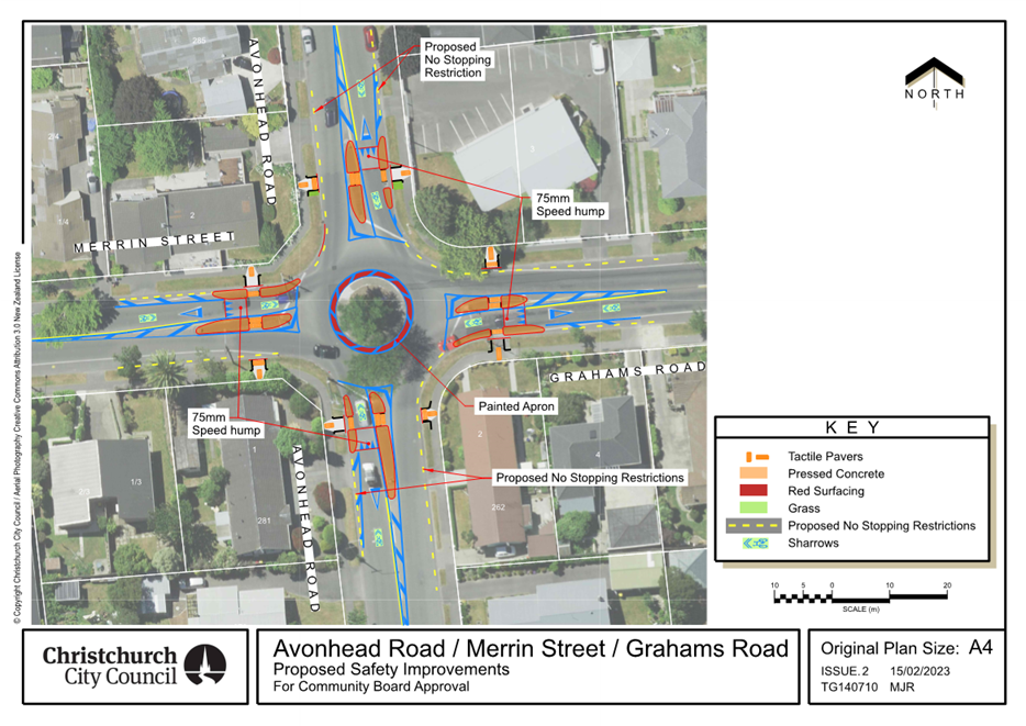
|
Waimāero Fendalton-Waimairi-Harewood
Community Board
06 March 2023
|
|
|
10. Grahams Road/Waimairi Road - Safety
Improvements
|
|
Reference / Te Tohutoro:
|
23/130525
|
|
Report of / Te Pou Matua:
|
Georgia
Greene, Traffic Engineer, Georgia.Greene@ccc.govt.nz
Gautham Praburam, Traffic Engineer, Gautham.Praburam@ccc.govt.nz
|
|
General Manager / Pouwhakarae:
|
Jane
Davis, General Manager Infrastructure, Planning & Regulatory Services
(jane.davis@ccc.govt.nz)
|
1. Nature of Decision or Issue and Report Origin
1.1 The purpose of this report is for the Waimāero
Fendalton-Waimairi-Harewood Community Board to approve a proposal for safety
improvements at the Grahams Road / Waimairi Road roundabout.
1.2 This report has been written in response to concerns raised
by the students and staff of Westburn School Te Kura O Hereora to address
ongoing concerns around safety at this intersection for journeys to school.
1.3 The
decisions in this report are of low significance in relation to the
Christchurch City Council’s Significance and Engagement Policy. The
level of significance was determined by the low level of impact and low number
of people affected by the recommended decision.
1.4 The community engagement and consultation outlined in this
report reflect the assessment.
1.5 The
recommended option is to implement the proposed changes in accordance with Attachment
A.
2. Officer Recommendations Ngā
Tūtohu
That the
Waimāero Fendalton-Waimairi-Harewood Community Board approves:
1. Speed cushions in all the approach lanes of
the Grahams Road / Waimairi Road intersection, as shown in Attachment A.
2. Road markings in all legs of the Grahams Road
/ Waimairi Road intersection, as shown in Attachment A.
3. Hand rails in the median refuge islands, as
shown in Attachment A.
3. Reason for Report Recommendations Ngā Take mō te
Whakatau
3.1 Recommendations
outlined in this report will help improve the safety concerns raised by
Westburn School. Safety concerns at the Grahams Road / Waimairi Road
roundabout were raised by the school many times in the past and also through
the Westburn School Te Kura O Hereora travel plan. Many of the issues
identified by the school children are about travelling through the intersection
when walking, cycling, and scooting to school due to the volume of traffic and
the speed of traffic. One of the main concerns is crossing the Grahams Road
north approach due to the presence of two approach lanes, and vehicles turning
left at speed.
3.2 It
is proposed to install speed cushions on all the approach lanes to reduce
vehicle speeds as they approach the roundabout and pedestrian crossing points.
3.3 The
recommendations in this report will help to achieve the desired community
outcome of a well-connected and accessible city through improved road safety.
3.4 This
project supports the forthcoming School Speed Zone changes to be consulted on
later this year.
4. Alternative Options Considered Ētahi atu Kōwhiringa
Temporary closure of
the existing left turn lane on Grahams Road (east)
4.1 Staff
discussed trialling the closure of the left turn lane from Grahams Road to
reduce the arm to a single lane entry as per the other approaches with the
Community Board. The Community Board members were not happy to progress
with this option to public consultation on this option as it could potentially
lead to delays for vehicle drivers.
4.2 The
advantages of this option include:
4.2.1 Improved
safety for people riding on two-wheels through the roundabout as they would be
more visible to users from a single lane approach, and people walking and scooting
would only have one lane to cross rather than two. Speed cushions were also
proposed as a part of this option to support lower vehicle speeds as drivers
approach the intersection, thereby further improving safety.
4.3 The
disadvantages of this option include:
4.3.1 Combining
the traffic that uses the left turn lane with the existing through and right
turning traffic could increase queue lengths and minor delay for motor
vehicles. However, traffic modelling of the intersection based on current
traffic volumes indicate these increases would be very minor.
Do nothing
4.4 The
advantages of this option include:
4.4.1 There
is no cost to Council
4.5 The
disadvantages of this option include:
4.5.1 Does
not address the identified safety issues at this location.
4.5.2 Does not address the concerns raised by the school
children.
4.5.3 Does
not support safer outcomes for all users at this intersection.
5. Detail Te Whakamahuki
5.1 Improving safety on local roads in Christchurch is a
priority for Council. Providing safe infrastructure is key to ensure
people get to where they are going safely regardless of how they are
travelling.
5.2 The Grahams Road / Waimairi Road intersection is a busy
intersection used by many people travelling to school or work, to the
surrounding parks and also visiting the Avonhead Mall. There are also bus
stops close to the intersection.
5.3 The
Waka Kotahi Crash Analysis System (CAS) was used to gain an understanding of
any underlying safety issues at this location. There have been 13
recorded crashes at the Grahams Road / Waimairi Road
intersection since 2013. Six of the 13 crashes resulted in minor injuries. Four
of the six injury crashes involved people walking and cycling (two each).
5.4 People
riding bicycles through the intersection along with people walking and scooting
are more vulnerable to serious injury. The installation of speed cushions are
expected to result in slower speeds at the roundabout. Slower speeds will
provide more time for all users to observe each other and avoid conflicts
resulting in a significant reduction to the likelihood of crashes and also, in
the unfortunate event crashes do occur, less severe injuries. The combination
of the traffic calming and the sharrow (cycles share the lane) markings are
designed to provide conditions for people riding to take the lane and be much
more visible to traffic.
5.5 These
treatments will be monitored for six months to understand their impact on road
safety and traffic flow.
Community Views and Preferences Ngā mariu ā-Hāpori
5.6 Staff
visited 14 directly affected properties spoke with seven residents and one
business on Friday 10 February 2023. Letters outlining the proposed changes and
how to provide feedback by Friday 17 February were left in the letterbox of
residents who were not home. Staff also contacted Westburn School.
5.7 At
the time of writing this report, staff received feedback from five residents
and the staff at the business. All six stated they were happy with the proposed
changes and made comments about the issues they had seen at the
roundabout.
5.8 Westburn School were unable to provide comment at the time of
writing this report. Their feedback will be presented at the Community Board
meeting along with any further feedback from the community.
6. Policy Framework Implications Ngā Hīraunga ā- Kaupapa here
Strategic
AlignmentTe Rautaki
Tīaroaro
6.1 Council’s strategic priorities have been
considered in formulating the recommendations in this report, however this area
of work is not specifically covered by an identified priority.
6.2 This report supports the Council's
Long Term Plan (2021 - 2031):
6.2.1 Activity: Transport
· Level of Service: 10.5.1 Limit deaths and
serious injury crashes per capita for cyclists and pedestrians - <= 12
crashes per 100,000 residents
Policy
Consistency Te Whai
Kaupapa here
6.3 The
decision is consistent with Council’s Plans and
Policies.
Impact
on Mana Whenua Ngā
Whai Take Mana Whenua
6.4 The
decision does not involve a significant decision in
relation to ancestral land or a body of water or other elements of intrinsic
value, therefore this decision does specifically impact Mana Whenua, their
culture and traditions.
6.5 The
decision does not involve a matter of interest to Mana
Whenua and will not impact on our agreed partnership priorities with Ngā Papatipu Rūnanga
6.6 The effects of this proposal upon Mana Whenua
are expected to be insignificant.
Climate
Change Impact Considerations Ngā Whai Whakaaro mā te Āhuarangi
6.7 This proposal includes measures to encourage
walking and cycling and therefore will result in positive changes to reduce
carbon emissions and the effects of Climate Change.
Accessibility
Considerations Ngā
Whai Whakaaro mā te Hunga Hauā
6.8 This proposal improves accessibility for
pedestrians and cyclists, by providing a safer means of accessing and using the
crossings at this intersection.
7. Resource Implications Ngā Hīraunga Rauemi
Capex/Opex Ngā Utu Whakahaere
7.1 Cost
to Implement – Approximately $25,000.
7.2 Maintenance/Ongoing
costs - To be covered under the area maintenance
contract, the effects will be minimal to the overall asset.
7.3 Funding
Source - Traffic Operations Minor Road Safety Budget 2022/23.
Other He mea anō
7.4 None
identified.
8. Legal Implications Ngā Hīraunga ā-Ture
Statutory power to undertake proposals in the report
Te Manatū Whakahaere Kaupapa
8.1 The Community Boards have delegated authority from the
Council to exercise the delegations as set out in the Register of
Delegations. The list of delegations for the Community Boards includes
the resolution of stopping restrictions and traffic control devices.
8.2 The installation of any signs and/or markings associated
with traffic control devices must comply with the Land Transport Rule: Traffic
Control Devices 2004.
Other Legal Implications Ētahi atu
Hīraunga-ā-Ture
8.3 There
is no other legal context, issue or implication relevant to this decision.
8.4 This specific report has not been reviewed and approved by
the Legal Services Unit however the report has been written using a general
approach previously approved of by the Legal Services Unit, and the
recommendations are consistent with the policy and legislative framework
outlined in sections 8.1 – 8.3.
9. Risk Management Implications Ngā Hīraunga Tūraru
9.1 None
identified.
Attachments Ngā Tāpirihanga
|
No.
|
Title
|
Reference
|
Page
|
|
a ⇩
|
Grahamas Road
/ Waimairi Road intersection improvements
|
23/215301
|
94
|
In addition to the attached documents, the following background
information is available:
|
Document
Name – Location / File Link
|
|
Not
applicable
|
Confirmation of Statutory
Compliance Te Whakatūturutanga ā-Ture
|
Compliance with Statutory Decision-making
Requirements (ss 76 - 81 Local Government Act 2002).
(a) This report contains:
(i) sufficient information about all reasonably practicable
options identified and assessed in terms of their advantages and
disadvantages; and
(ii) adequate consideration of the views and preferences of
affected and interested persons bearing in mind any proposed or previous
community engagement.
(b) The information reflects the level of significance of the
matters covered by the report, as determined in accordance with the Council's
significance and engagement policy.
|
Signatories Ngā Kaiwaitohu
|
Authors
|
Georgia Greene
- Traffic Engineer
Gautham
Praburam - Traffic Engineer
Krystle
Anderson - Engagement Advisor
Gemma Dioni -
Senior Transportation Engineer
|
|
Approved By
|
Katie Smith -
Team Leader Traffic Operations
Stephen Wright
- Manager Operations (Transport)
Lynette Ellis
- Head of Transport & Waste Management
|
|
Waimāero Fendalton-Waimairi-Harewood
Community Board
06 March 2023
|
|
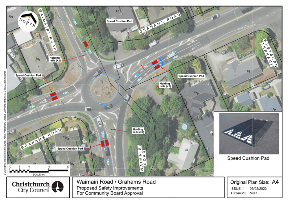
|
Waimāero Fendalton-Waimairi-Harewood
Community Board
06 March 2023
|
|
|
11. Memorial Aveue at Burnside High Safety
Improvements & Greers Road Parking Improvements
|
|
Reference / Te Tohutoro:
|
23/130225
|
|
Report of / Te Pou Matua:
|
Georgia
Greene, Traffic Engineer, Georgia.Greene@ccc.govt.nz
Gautham Praburam, Traffic Engineer, Gautham.Praburam@ccc.govt.nz
|
|
General Manager / Pouwhakarae:
|
Jane
Davis, General Manager Infrastructure, Planning & Regulatory Services
(jane.davis@ccc.govt.nz)
|
1. Nature of Decision or Issue and Report Origin
1.1 The purpose of this report is for the Waimāero
Fendalton-Waimairi-Harewood Community Board to consider approval of the
proposed safety and parking improvements around Burnside High School Te Kura o
Waimairi-iri and Christ The King School. This includes a pedestrian crossing on
Memorial Avenue and parking changes on Greers Road.
1.2 This report has been written in response to concerns raised
by the schools, and from community requests to address safety issues at this
location.
1.3 The
decisions in this report are of low significance in relation to the
Christchurch City Council’s Significance and Engagement Policy. The level of significance was determined by the low level of impact
and low number of people affected by the recommended decision.
1.4 The community engagement and consultation outlined in this
report reflect the assessment.
1.5 The
recommended option is to implement the proposed changes in accordance with
Attachments A, B, C and D.
2. Officer Recommendations Ngā
Tūtohu
That the
Waimāero Fendalton-Waimairi-Harewood Community Board pursuant to Section
334 of the Local Government Act 1974, approves:
1. A pedestrian crossing facility on Memorial
Avenue approximately 225 metres northwest of its intersection with Greers Road
along with all associated kerb extensions, road surface treatments, road
markings, tactile pavers and changes to the existing median island, as shown in
Attachment A.
2. Pursuant to Clause 7 of the Christchurch City
Council Traffic and Parking Bylaw 2017, that the stopping of vehicles be
prohibited at all times along;
a. The southwest side of Memorial Avenue,
commencing at a point approximately 201 metres northwest of its intersection
with Greers Road and extending in a north westerly direction for a distance of
37 metres, as shown in Attachment A.
b. The northeast side of Memorial Avenue,
commencing at a point approximately 223 metres northwest of its intersection
with Greers Road and extending in a north westerly direction for a distance of
21 metres, as shown in Attachment A.
c. The northwest side of Greers Road, commencing
at a point approximately 168 metres northeast of its intersection with Memorial
Avenue and extending in a north easterly direction for a distance of 19 metres,
as shown in Attachment B.
3. Pursuant to Clause 7 of the Christchurch City
Council Traffic & Parking Bylaw 2017, that the parking of all vehicles be
restricted to a maximum period of three minutes between the times of 8am and
9am, and between 2:15pm and 3:30pm, on School Days along the southeast side of
Greers Road, commencing at a point 70 metres northeast of its intersection with
Memorial Avenue and extending in a north easterly direction for a distance of
17 metres, as shown in Attachment C.
4. Revoke any previous resolutions made pursuant
to any bylaw to the extent that they are in conflict with the ones described in
resolutions 1-5 above.
5. Approve that these resolutions take effect
when parking signage and/or road markings that evidence the restrictions
described in the staff report are in place (or removed in the case of
revocations).
3. Reason for Report Recommendations Ngā Take mō te
Whakatau
3.1 Recommendations
outlined in this report will help to address the concerns relating to road
safety on Memorial Avenue that have been raised by Burnside High School Te Kura
o Waimairi-iri, and parking improvements to address concerns raised by Christ
the King School and the local community.
3.2 The
proposed crossing facility will improve safety for Burnside High School
students who use the pedestrian exit on the western corner of the school to
cross Memorial Avenue.
3.3 Changing
parking restrictions to allow for short-term parking on Greers Road will
encourage a higher turnover of vehicles for parents to drop off and pick up
children at school times.
3.4 No
stopping restrictions on Greers Road will provide increased visibility for
motorists exiting Burnside High School.
4. Alternative Options Considered Ētahi atu Kōwhiringa
Do nothing
4.1 The
advantages of this option include:
4.1.1 No
cost to Council.
4.1.2 Retains
two parking spaces outside of Burnside High School.
4.2 The
disadvantages of this option include:
4.2.1 Does
not address the parking issues at this location raised by the schools and the
nearby community.
5. Detail Te Whakamahuki
5.1 Burnside
High School have been advocating for a crossing facility on Memorial Avenue for
many years. This was raised again more recently through the school travel
planning process.
5.2 Students
currently cross Memorial Avenue near the existing side gate at the western end
of the school site. The development of a drop off and pick up bay on the
western corner and a footpath leading to this corner will further create a
desire line for students to use this exit and cross at this location, rather
than using the traffic signals at the Greers Road/Memorial Avenue intersection.
5.3 There
have been no recorded crashes involving pedestrians around this location since
2013. While there have been no crashes, the high traffic volumes on Memorial
Avenue and the high number of school children crossing at this location means
that the risk of a collision remains. Improving the crossing point would help
children cross more safely.
5.4 Burnside
High School also raised issues with exiting their carpark onto Greers Road. No
stopping restrictions are proposed at this location to improve visibility for
vehicles departing the school car park. This is consistent with the no stopping
restrictions near the school’s other exits.
5.5 A
request for parking restrictions on Greers Road was raised through the Christ
the King School travel plan. The school currently has a drop off/pick up area
on site. However, the school found the drop off/pick up area to be frequently
used by the parents of Burnside High School students, thereby limiting it for
their own parents.
5.6 There
are limited opportunities for parents to stop on the southeast side of Greers
Road, due to no stopping restrictions running from the Greers Road/Memorial
Avenue intersection up to Jellie Park. Providing short term parking outside the
school during school time will provide more parking opportunities for parents
wanting to pick up / drop their children.
Community Views and Preferences Ngā mariu ā-Hāpori
5.7 Staff
visited 10 directly affected properties and spoke with five residents on Friday
10 February 2023. Letters outlining the proposed changes and how to provide
feedback by Friday 17 February were left in the letterbox of residents who were
not home. Staff have also been in contact with Burnside High School.
5.8 At
the time of writing this report, staff received feedback from four residents in
person and one by phone.
5.9 Four
were happy with the proposed pedestrian crossing, with one resident raising
concerns about the space to turn into their driveway. Changes were made to the
kerb design on the southwest side to address these concerns.
5.10 One
resident did not support the proposal.
5.11 Burnside
High School indicated they were happy with the proposed plan.
5.12 The
decision affects the following Community Board areas:
5.12.1 Fendalton-Waimairi-Harewood
Community Board
6. Policy Framework Implications Ngā Hīraunga ā- Kaupapa here
Strategic
AlignmentTe Rautaki
Tīaroaro
6.1 Council’s strategic priorities have been
considered in formulating the recommendations in this report, however this area
of work is not specifically covered by an identified priority.
6.2 This report supports the Council's
Long Term Plan (2021 - 2031):
6.2.1 Activity: Transport
· Level of Service: 10.5.1 Limit deaths and
serious injury crashes per capita for cyclists and pedestrians - <= 12
crashes per 100,000 residents
Policy
Consistency Te Whai Kaupapa
here
6.3 The
decision is consistent with the Christchurch
Suburban Parking Policy.
Impact
on Mana Whenua Ngā
Whai Take Mana Whenua
6.4 The
decision does not involve a significant decision in
relation to ancestral land or a body of water or other elements of intrinsic
value, therefore this decision does specifically impact Mana Whenua, their
culture and traditions.
6.5 The
decision does not involve a matter of interest to Mana
Whenua and will not impact on our agreed partnership priorities with Ngā Papatipu Rūnanga.
6.6 The effects of this proposal upon Mana Whenua
are expected to be insignificant.
Climate
Change Impact Considerations Ngā Whai Whakaaro mā te Āhuarangi
6.7 This proposal includes measures to encourage
walking and therefore will result in positive changes to reduce carbon
emissions and the effects of Climate Change.
Accessibility
Considerations Ngā
Whai Whakaaro mā te Hunga Hauā
6.8 This proposal improves accessibility for
pedestrians, by providing a safer means of crossing Memorial Avenue.
7. Resource Implications Ngā Hīraunga Rauemi
Capex/Opex Ngā Utu Whakahaere
7.1 Cost
to Implement – Approximately $50,000 for the installation of the
pedestrian crossing on Memorial Avenue, approximately $800 for the installation
of signs and markings on Greers Road.
7.2 Maintenance/Ongoing
costs - To be covered under the area maintenance
contract, the effects will be minimal to the overall asset.
7.3 Funding
Source – Traffic Operations School Safety Budget 2022/23.
Other He mea anō
7.4 None
identified
8. Legal Implications Ngā Hīraunga ā-Ture
Statutory power to undertake proposals in the report
Te Manatū Whakahaere Kaupapa
8.1 Clause 7 of the Christchurch City Council Traffic and
Parking Bylaw 2017 provides Council with the authority to install parking and
stopping restrictions by resolution.
8.2 The Community Boards have delegated authority from the
Council to exercise the delegations as set out in the Register of
Delegations. The list of delegations for the Community Boards includes
the resolution of stopping restrictions and traffic control devices.
8.3 The installation of any signs and/or markings associated
with traffic control devices must comply with the Land Transport Rule: Traffic
Control Devices 2004.
Other Legal Implications Ētahi atu
Hīraunga-ā-Ture
8.4 There
is no other legal context, issue or implication relevant to this decision.
8.5 This specific report has not been reviewed and approved by
the Legal Services Unit however the report has been written using a general
approach previously approved of by the Legal Services Unit, and the
recommendations are consistent with the policy and legislative framework
outlined in sections 8.1 – 8.3.
9. Risk Management Implications Ngā Hīraunga Tūraru
9.1 None
identified.
Attachments Ngā Tāpirihanga
|
No.
|
Title
|
Reference
|
Page
|
|
a ⇩
|
Memorial
Avenue crossing - TG142502
|
23/175797
|
100
|
|
b ⇩ 
|
Greers Road -
Proposed No Stopping Restrictions - TG144359
|
23/210270
|
101
|
|
c ⇩ 
|
Greers Road P3
parking restrictions - TG142034
|
23/175917
|
102
|
In addition to the attached documents, the following background
information is available:
|
Document
Name – Location / File Link
|
|
Not
applicable
|
Confirmation of Statutory
Compliance Te Whakatūturutanga ā-Ture
|
Compliance with Statutory Decision-making
Requirements (ss 76 - 81 Local Government Act 2002).
(a) This report contains:
(i) sufficient information about all reasonably practicable
options identified and assessed in terms of their advantages and
disadvantages; and
(ii) adequate consideration of the views and preferences of
affected and interested persons bearing in mind any proposed or previous
community engagement.
(b) The information reflects the level of significance of the
matters covered by the report, as determined in accordance with the Council's
significance and engagement policy.
|
Signatories Ngā Kaiwaitohu
|
Authors
|
Georgia Greene
- Traffic Engineer
Gautham
Praburam - Traffic Engineer
Krystle
Anderson - Engagement Advisor
Gemma Dioni -
Senior Transportation Engineer
|
|
Approved By
|
Katie Smith -
Team Leader Traffic Operations
Stephen Wright
- Manager Operations (Transport)
Lynette Ellis
- Head of Transport & Waste Management
|
|
Waimāero Fendalton-Waimairi-Harewood
Community Board
06 March 2023
|
|
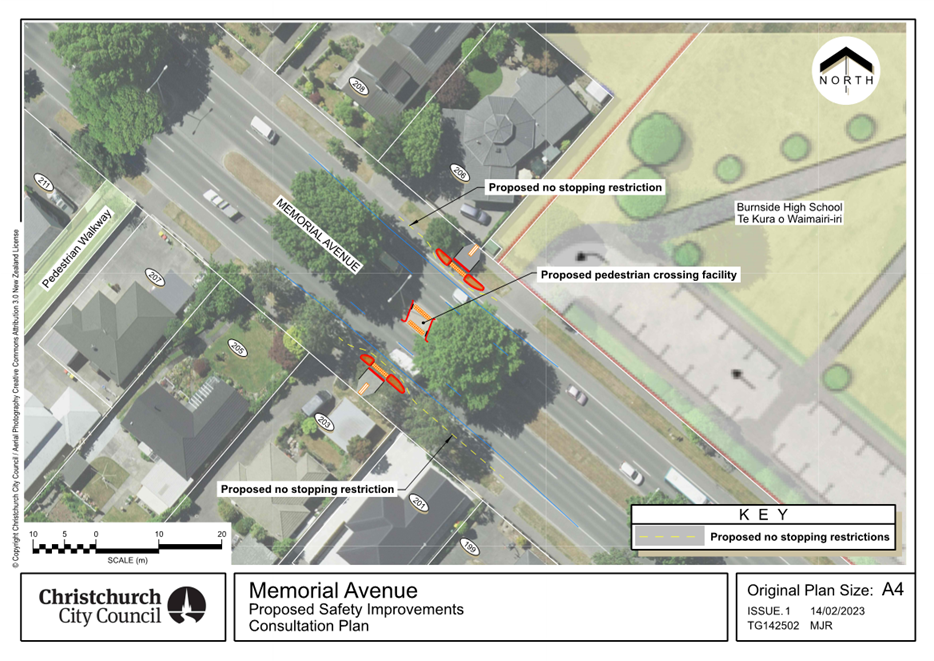
|
Waimāero Fendalton-Waimairi-Harewood
Community Board
06 March 2023
|
|
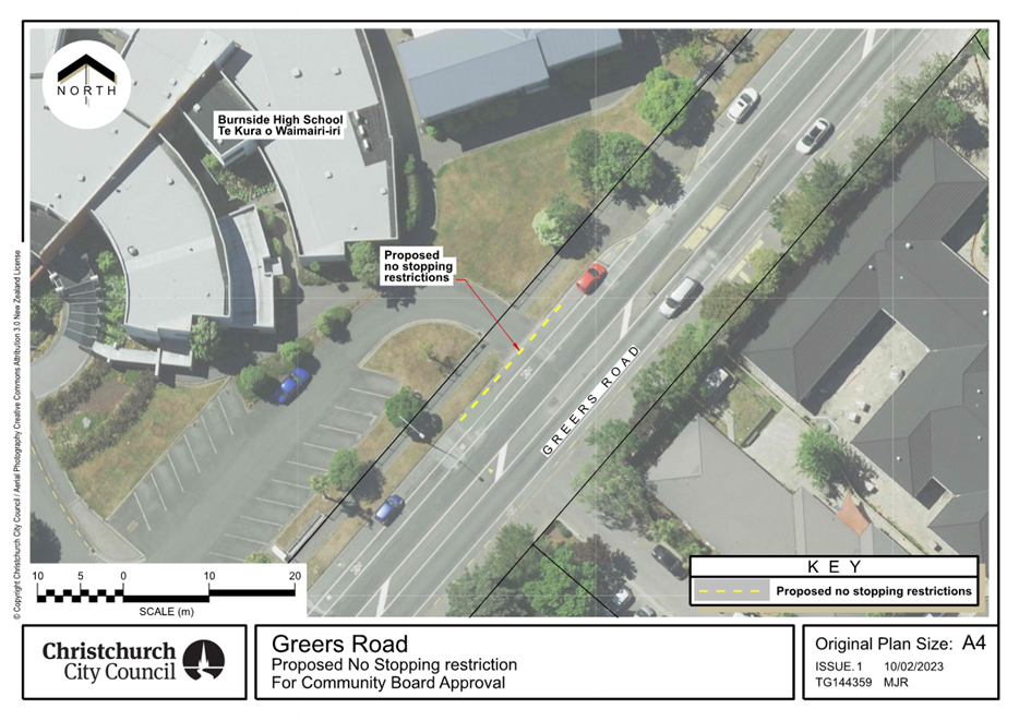
|
Waimāero Fendalton-Waimairi-Harewood
Community Board
06 March 2023
|
|
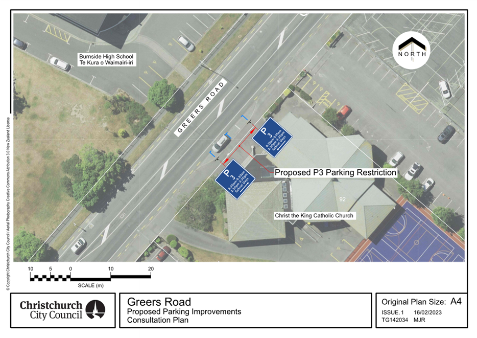
|
Waimāero Fendalton-Waimairi-Harewood
Community Board
06 March 2023
|
|
|
12. Merrin Street/Withells Road intersection
safety improvements
|
|
Reference / Te Tohutoro:
|
23/130137
|
|
Report of / Te Pou Matua:
|
Georgia
Greene, Traffic Engineer,
Georgia.Greene@ccc.govt.nz
Gautham Praburam, Traffic Engineer, Gautham.Praburam@ccc.govt.nz
|
|
General Manager / Pouwhakarae:
|
Jane
Davis, General Manager Infrastructure, Planning & Regulatory Services
(jane.davis@ccc.govt.nz)
|
1. Nature of Decision or Issue and Report Origin
1.1 The purpose of this report is for the Waimāero
Fendalton-Waimairi-Harewood Community Board to approve a proposal for safety
improvements at the Merrin Street and Withells Road roundabout.
1.2 This report has been written in response to concerns raised
by the students at Merrin School Ngā Whetū Kohara, and from community
requests to address safety issues at this location.
1.3 The
decisions in this report are of low significance in relation to the Christchurch
City Council’s Significance and Engagement Policy. The level of
significance was determined by the low level of impact and low number of people
affected by the recommended decision.
1.4 The community engagement and consultation outlined in this
report reflect the assessment.
1.5 The
recommended option is to implement the proposed changes in accordance with
Attachment A.
2. Officer Recommendations Ngā
Tūtohu
That the
Waimāero Fendalton-Waimairi-Harewood Community Board:
1. Approves all kerb alignments, road surface
treatments, traffic calming and road markings at the intersection of Merrin
Street and Withells Road, as detailed on plan TP360701 in Attachment A of the
report.
2. Approves, pursuant to Clause 7 of the
Christchurch City Council Traffic and Parking Bylaw 2017, that the stopping of
vehicles be prohibited at all times on the south side of Merrin Street,
commencing at its intersection with Withells Road and extending in an easterly
direction for a distance of 20 metres.
3. Revoke any previous resolutions pertaining to
parking restrictions made pursuant to any bylaw to the extent that they are in
conflict with the parking restrictions described in resolutions 1 and 2 above.
4. Approve that these resolutions take effect
when parking signage and/or road markings that evidence the restrictions
described in the staff report are in place (or removed in the case of
revocations).
3. Reason for Report Recommendations Ngā Take mō te
Whakatau
3.1 Recommendations
outlined in this report will help improve the safety concerns raised by Merrin
School. Safety concerns at the Merrin Street/Withells Road roundabout
were raised through the Merrin School travel plan. Many of the issues
identified by the school children are regarding the intersection being
difficult to navigate for when walking, cycling, and scooting to school.
3.2 It
is proposed to build larger islands to provide safer waiting areas for
pedestrians, add a larger apron in the roundabout to increase deflection
through the roundabout and to install raised speed humps to reduce vehicle
speeds as they approach the roundabout and pedestrian crossing points. The new
kerb build out will allow for the speed hump to be installed.
3.3 The
recommendations in this report will help to achieve the desired community
outcome of a well-connected and accessible city through improved road safety.
3.4 This
project supports the forthcoming School Speed Zone changes to be consulted on
later this year.
4. Alternative Options Considered Ētahi atu Kōwhiringa
Do nothing
4.1 The
advantages of this option include:
4.1.1 There
is no cost to Council
4.2 The
disadvantages of this option include:
4.2.1 Does
not address the identified safety issues at this location.
4.2.2 Does not address the concerns raised by the school
children.
4.2.3 Does
not support safer outcomes for all users at this intersection.
5. Detail Te Whakamahuki
5.1 Improving safety on local roads in Christchurch is a
priority for Council. Providing safe infrastructure is key to ensure
people get to where they are going safely regardless of how they are
travelling.
5.2 The Withells Road/Merrin Road intersection is a busy
intersection used by many people travelling to school or work, to the
surrounding parks and also visiting the Avonhead Mall. There are also bus
stops close to the intersection.
5.3 The
Waka Kotahi Crash Analysis System (CAS) was used to gain an understanding of
any underlying safety issues at this location. There have been nine
recorded crashes at the Merrin Street/Withells Road intersection since 2013.
Six of the nine crashes involved people riding a bicycle through the roundabout
and being hit by drivers entering the circulatory carriageway. Two of the six
crashes involving people riding bicycles resulted in serious injury and four
resulting in minor injury.
5.4 People
riding bicycles through the intersection along with people walking and scooting
are more vulnerable to serious injury. The installation of raised speed humps
and the improvements to the roundabout geometry are designed to result in
slower speeds at the roundabout. Slower speeds will provide more time for all
users to observe each other and avoid conflicts resulting in a significant
reduction to the likelihood of crashes and also, in the unfortunate event
crashes do occur, less severe injuries. The combination of the traffic calming
and the sharrow (cycles share the lane) markings are designed to provide
conditions for people riding to take the lane and be much more visible to
traffic.
Community Views and Preferences Ngā mariu ā-Hāpori
5.5 Staff
visited 11 directly affected properties and spoke with four residents on Friday
10 February 2023. Letters outlining the proposed changes and how to provide
feedback by Friday 17 February were left in the letterbox of residents who were
not home. Staff also contacted Avonhead Shopping Centre and Merrin School.
5.6 At
the time of writing this report, staff received feedback from three residents
in person and one by phone. Three stated they were happy with the proposed
changes and made comments about the issues they had seen at the roundabout. One
was generally neutral about the proposed changes
but did not want there to be speed bumps.
5.7 Merrin
School were unable to provide comment at the time of writing this report. Their
feedback will be presented at the Community Board meeting along with any
further feedback from the community.
6. Policy Framework Implications Ngā Hīraunga ā- Kaupapa here
Strategic
AlignmentTe Rautaki
Tīaroaro
6.1 Council’s strategic priorities have been
considered in formulating the recommendations in this report, however this area
of work is not specifically covered by an identified priority.
6.2 This report supports the Council's
Long Term Plan (2021 - 2031):
6.2.1 Activity: Transport
· Level of Service: 10.5.1 Limit deaths and
serious injury crashes per capita for cyclists and pedestrians - <= 12
crashes per 100,000 residents
Policy
Consistency Te Whai
Kaupapa here
6.3 The
decision is consistent with Council’s Plans and
Policies.
Impact
on Mana Whenua Ngā
Whai Take Mana Whenua
6.4 The
decision does not involve a significant decision in
relation to ancestral land or a body of water or other elements of intrinsic
value, therefore this decision does specifically impact Mana Whenua, their
culture and traditions.
6.5 The
decision does not involve a matter of interest to Mana
Whenua and will not impact on our agreed partnership priorities with Ngā Papatipu Rūnanga
6.6 The effects of this proposal upon Mana Whenua
are expected to be insignificant.
Climate
Change Impact Considerations Ngā Whai Whakaaro mā te Āhuarangi
6.7 This proposal includes measures to encourage
walking and cycling and therefore will result in positive changes to reduce
carbon emissions and the effects of Climate Change.
Accessibility
Considerations Ngā
Whai Whakaaro mā te Hunga Hauā
6.8 This proposal improves accessibility for pedestrians
and cyclists, by providing a safer means of accessing and using the crossings
at this intersection.
7. Resource Implications Ngā Hīraunga Rauemi
Capex/Opex Ngā Utu Whakahaere
7.1 Cost
to Implement – Approximately $180,000
7.2 Maintenance/Ongoing
costs - To be covered under the area maintenance
contract, the effects will be minimal to the overall asset.
7.3 Funding
Source - Traffic Operations Minor Road Safety Budget 2022/23.
Other He mea anō
7.4 None
identified.
8. Legal Implications Ngā Hīraunga ā-Ture
Statutory power to undertake proposals in the report
Te Manatū Whakahaere Kaupapa
8.1 Part 1, Clauses 7 of the Christchurch City Council Traffic
and Parking Bylaw 2017 provides Council with the authority to install parking
restrictions by resolution.
8.2 The Community Boards have delegated authority from the
Council to exercise the delegations as set out in the Register of
Delegations. The list of delegations for the Community Boards includes
the resolution of stopping restrictions and traffic control devices.
8.3 The installation of any signs and/or markings associated
with traffic control devices must comply with the Land Transport Rule: Traffic
Control Devices 2004.
Other Legal Implications Ētahi atu
Hīraunga-ā-Ture
8.4 There
is no other legal context, issue or implication relevant to this decision.
8.5 This specific report has not been reviewed and approved by
the Legal Services Unit however the report has been written using a general
approach previously approved of by the Legal Services Unit, and the
recommendations are consistent with the policy and legislative framework
outlined in sections 8.1 – 8.3.
9. Risk Management Implications Ngā Hīraunga Tūraru
9.1 None
identified.
Attachments Ngā Tāpirihanga
|
No.
|
Title
|
Reference
|
Page
|
|
a ⇩
|
Merrin
Street/Withells Road roundabout - TP360701
|
23/175701
|
108
|
In addition to the attached documents, the following background
information is available:
|
Document
Name – Location / File Link
|
|
Not
applicable
|
Confirmation of Statutory
Compliance Te Whakatūturutanga ā-Ture
|
Compliance with Statutory Decision-making
Requirements (ss 76 - 81 Local Government Act 2002).
(a) This report contains:
(i) sufficient information about all reasonably practicable
options identified and assessed in terms of their advantages and
disadvantages; and
(ii) adequate consideration of the views and preferences of
affected and interested persons bearing in mind any proposed or previous
community engagement.
(b) The information reflects the level of significance of the
matters covered by the report, as determined in accordance with the Council's
significance and engagement policy.
|
Signatories Ngā Kaiwaitohu
|
Authors
|
Georgia Greene
- Traffic Engineer
Gautham
Praburam - Traffic Engineer
Krystle
Anderson - Engagement Advisor
Gemma Dioni -
Senior Transportation Engineer
|
|
Approved By
|
Katie Smith -
Team Leader Traffic Operations
Stephen Wright
- Manager Operations (Transport)
Lynette Ellis
- Head of Transport & Waste Management
|
|
Waimāero Fendalton-Waimairi-Harewood
Community Board
06 March 2023
|
|
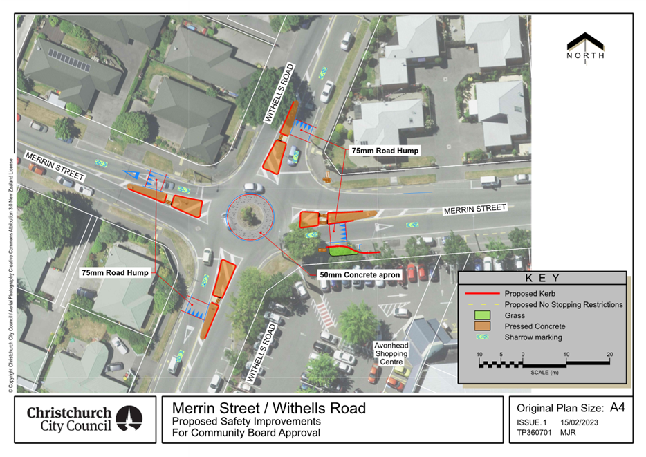
|
Waimāero Fendalton-Waimairi-Harewood
Community Board
06 March 2023
|
|
|
13. Fendalton-Waimairi-Harewood 2022-23 Youth
Development Fund Application - Addison Jones
|
|
Reference / Te Tohutoro:
|
23/128302
|
|
Report of / Te Pou Matua:
|
Lisa
Gregory, Community Recreation Advisor, lisa.gregory@ccc.govt.nz
|
|
General Manager / Pouwhakarae:
|
Mary
Richardson, General Manager Citizens & Community
(Mary.Richardson@ccc.govt.nz)
|
1. Purpose of Report / Te
Pūtake Pūrongo
1.1 The
purpose of this report is for the Waimāero Fendalton-Waimairi-Harewood
Community Board to consider an application
received for funding from its 2022-23 Youth Development Fund.
1.2 The
report is staff generated as a result of applications being received.
1.3 The current balance of the fund is $1,825.
2. Officer Recommendations / Ngā Tūtohu
That the Waimāero
Fendalton-Waimairi-Harewood Community Board resolve to:
1. Approve a grant of $500 from its 2022-23 Youth
Development Fund to Addison Jones towards performing at the Highland Dancing
Virginia Tattoo in Virginia, USA, from 13 to 28 April 2023.
3. Key Points / Ngā Take Matua
Issue or Opportunity / Ngā take, Ngā Whaihua rānei
3.1 To
consider applications received to support the development and achievements of
young people living in the Fendalton-Waimairi-Harewood area.
Strategic Alignment / Te Rautaki Tīaroaro
3.2 The
recommendations in this report align to the Council's Community Outcome of
Resilient Communities including:
· Celebration of our identity through arts, culture, heritage and
sport and recreation
· Valuing the voices of all cultures and ages (including children).
Decision Making Authority / Te Mana Whakatau
3.3 Determine
the allocation of the discretionary Response Fund for each community (including
any allocation towards a Youth Development Fund).
3.4 Allocations
must be consistent with any policies, standards or criteria adopted by the
Council.
3.5 The
Fund does not cover:
· Legal challenges or
Environment Court challenges against the Council, Council Controlled
organisations or Community Board decisions
· Projects or initiatives
that change the scope of a Council project or that will lead to ongoing
operational costs to the Council (though Community Boards can recommend to the
Council that it consider a grant for this purpose).
Assessment of Significance and Engagement / Te Mana Whakatau
3.6 The
decision(s) in this report is of low significance in relation to the
Christchurch City Council’s Significance and Engagement Policy.
3.7 The
level of significance was determined by the number of people affected and/or
with an interest.
3.8 Due
to the assessment of low significance, no further community engagement and
consultation is required.
4. Applicant/ Te Kaitono 1 – Addison Jones
4.1 Age:
16
4.2 Suburb:
Russley
4.3 Event
seeking support for: Highland Dancing Virginia Tattoo in Virginia, USA,
from 13 to 28 April 2023.
4.4 Addison
has been learning highland dancing since the age of 4. She is currently a
pupil of the Julie Hawke School of Highland Dancing, and attends lessons three
times a week. Addison also competes both locally, regionally and
nationally. In July 2022 she gained four top 10 placings at the National
Championships held in Palmerston North.
4.5 The
selection process for the tattoo involved a written application, and submitting
a performance video. Addison's achievements at local and national
competitions were also taken in to consideration. Only 33 dancers
nationwide have been selected to attend.
4.6 Outside
of dancing, Addison plays hockey, both for a local club and for her school
first 11. This year she have been selected for the leadership/prefect
role of Manukura (House captain), and is also a peer support leader for
Riccarton High School year nine students.
4.7 The
following table provides a breakdown of costs for the trip:
|
EXPENSES
|
Cost ($)
|
|
Travel/Insurance/Accommodation/Food
|
$6,639
|
|
Uniform
|
$300
|
|
Incidental costs
|
$320
|
|
Total per participant
|
$7,259
|
Attachments / Ngā Tāpirihanga
There are no
attachments for this report.
Confirmation of Statutory
Compliance / Te
Whakatūturutanga ā-Ture
|
Compliance with Statutory Decision-making
Requirements (ss 76 - 81 Local Government Act 2002).
(a) This report contains:
(i) sufficient information about all reasonably practicable
options identified and assessed in terms of their advantages and
disadvantages; and
(ii) adequate consideration of the views and preferences of
affected and interested persons bearing in mind any proposed or previous
community engagement.
(b) The information reflects the level of significance of the
matters covered by the report, as determined in accordance with the Council's
significance and engagement policy.
|
Signatories / Ngā Kaiwaitohu
|
Author
|
Lisa Gregory -
Community Recreation Advisor
|
|
Approved By
|
Maryanne Lomax
- Manager Community Governance, Fendalton-Waimairi-Harewood
|
|
Waimāero Fendalton-Waimairi-Harewood
Community Board
06 March 2023
|
|
|
14. Appointments to External Organisations
|
|
Reference / Te Tohutoro:
|
23/193455
|
|
Report of / Te Pou Matua:
|
Aidan
Kimberley, Community Board Advisor, Aidan.Kimberley@ccc.govt.nz
|
|
General Manager / Pouwhakarae:
|
Mary
Richardson, General Manager Citizens & Community
(Mary.Richardson@ccc.govt.nz)
|
1. Purpose of the Report Te Pūtake Pūrongo
1.1 The
purpose of this report is for the Waimāero Fendalton-Waimairi-Harewood
Community Board to consider further appointments of Board representatives on
local outside organisations for the 2022-2025 term.
2. Officer Recommendations Ngā
Tūtohu
That the Waimāero
Fendalton-Waimairi-Harewood Community Board:
1. Appoint a Board member(s) as its
representative on each of the following organisations for the 2022-25 term:
a. The McLean Institute
b. The Waimakariri-Eyre-Cust River Rating
District Liaison Committee
3. Reason for Report Recommendations Ngā Take mō te
Whakatau
McLean
Institute
3.1 The McLean Institute is a Trust which manages the estate of Allan
McLean, who died in 1907. Mr McLean also built the McLean’s Mansion in
the Central City, and left instructions in his will that the house and estate
would be used to provide support and accommodation for retired women who
through ‘reduced or straitened circumstances’ could not afford a
home of their own. The Mansion was originally called ‘Holly Lea’.
3.2 An Act of Parliament was passed in 1909 which established the McLean
Institute to manage the estate.
3.3 Subsequently, the trustees of the McLean Institute purchased land on
Fendalton Road. Over time this site was developed into a retirement village,
and the ‘Holly Lea’ name was officially transferred from the
Mansion to the retirement village in 1957 (The McLean’s Mansion is now
owned and managed by a separate charitable trust).
3.4 The Act includes a provision for the Mayor of Christchurch to be a
member of the Institute, but further allows the Council to appoint a person to
be a member of the Institute in place of the Mayor.
3.5 Because
of the historical connection to the Fendalton area, the Council has delegated
the authority to this Community Board to appoint a member to the McLean
Institute.
Waimakariri-Eyre-Cust River Rating
District Liaison Committee
3.6 The
River Rating District Liaison Committees are run by Environment Canterbury.
They are an opportunity for local community members to provide feedback on
local river flood protection, erosion protection and drainage works.
3.7 The
Committees meet once or twice a year to comment on the state of the river and
the proposed works and budget for the coming year. The have influence on the
targeted rates set for each river and the timing of significant works, but the
final decision still rests with the Environment Canterbury Council.
Attachments Ngā Tāpirihanga
There are no
attachments to this report.
In addition to the attached documents, the following background
information is available:
Confirmation of Statutory
Compliance Te Whakatūturutanga ā-Ture
|
Compliance with Statutory Decision-making
Requirements (ss 76 - 81 Local Government Act 2002).
(a) This report contains:
(i) sufficient information about all reasonably practicable
options identified and assessed in terms of their advantages and
disadvantages; and
(ii) adequate consideration of the views and preferences of
affected and interested persons bearing in mind any proposed or previous
community engagement.
(b) The information reflects the level of significance of the
matters covered by the report, as determined in accordance with the Council's
significance and engagement policy.
|
Signatories Ngā Kaiwaitohu
|
Author
|
Aidan
Kimberley - Community Board Advisor
|
|
Approved By
|
Maryanne Lomax
- Manager Community Governance, Fendalton-Waimairi-Harewood
|
|
Waimāero Fendalton-Waimairi-Harewood
Community Board
06 March 2023
|
|
|
15. Waimāero Fendalton-Waimairi-Harewood
Community Board Area Report - March 2023
|
|
Reference / Te Tohutoro:
|
23/192124
|
|
Report of / Te Pou Matua:
|
Maryanne
Lomax, Community Governance Manager
(Maryanne.lomax@ccc.govt.nz)
|
|
General Manager / Pouwhakarae:
|
Mary
Richardson, General Manager Citizens & Community
(Mary.Richardson@ccc.govt.nz)
|
1. Purpose of Report Te
Pūtake Pūrongo
This report provides the Board with an overview on
initiatives and issues current within the Community Board area.
2. Officer Recommendations Ngā
Tūtohu
That the Waimāero
Fendalton-Waimairi-Harewood Community Board:
1. Receive the Waimāero
Fendalton-Waimairi-Harewood Community Board Area Report for March 2023.
3. Community Support, Governance and Partnership Activity
3.1 Community Governance Projects
|
Activity
|
Detail
|
Timeline
|
Strategic Alignment
|
|
Edible and Sustainable Garden Awards
|
Award function to be held at Mona Vale on 17 March 2023 at
4.30pm.
|
17 March 2023
|
· Liveable City
· Resilient
Communities
|
|
Culture Galore 2023
|
This event will be held on 18 February 2023 at Ray Blank
Park on Maidstone Road.
|
18 February 2023
|
· Liveable City
· Resilient
Communities
|
|
Community Board Profiles
|
Local staff are currently updating the Ward
Profiles. These will be available on the Council’s website in
April 2023.
|
April 2023
|
· Resilient
Communities
|
3.2 Burnside
Businesses Crime Prevention Meeting
Further to concerns raised to the Community
Board regarding the increase in crime affecting businesses in the Burnside
area, staff organised a crime prevention meeting for businesses in the Burnside
area.
The meeting was on Tuesday, 31 January, at
Terra Viva Café & Deli and just over fifty people attended, with a
great representation from the local businesses, staff and elected members.
The purpose of the meeting was to provide
the businesses with the opportunity to have an open discussion with a panel of
experts and look at working together on crime prevention initiatives for the
area. Councillor Sam MacDonald was the MC. The panel included MP Sarah Pallett,
Lane Todd, NZ Police, and representatives from Christchurch North Community
Patrol, Canterbury Neighbourhood Support and Christchurch City Council.
The group agreed they would like to meet
again in a couple of months, with a working group created, to pull together the
agenda and dates for future meetings.
Tangible outcomes from the meeting include
creating a closed Facebook group for the Burnside Businesses as a forum to
provide support and share messages about safety. A local marketing business has
set up and administers the group, which currently has forty-one members. Other
tangible outcomes include following up with MSD regarding several questions
that arose and working with local businesses to help promote and recruit
additional volunteers for the local community patrol.
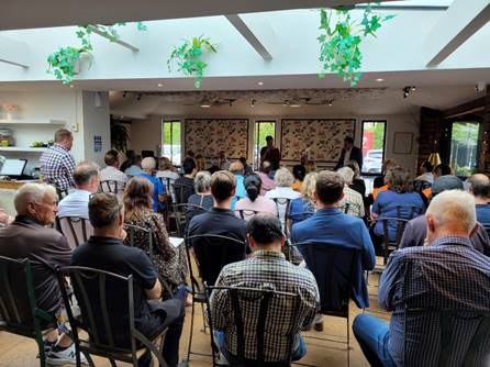
Crime prevention meeting at Terra Viva
Café & Deli
3.3 Bishopdale
Regeneration/Beautification Group - Update
The artwork for the toilet block in the
Bishopdale mall is still in progress, having to go back to the design phase
based on overwhelming feedback from Celebrate Bishopdale that the community
would like a nature theme for it.
We have a final draft concept/mural design
for the long wall on the outside of the toilet, leading towards the Library,
often called the alleyway. This has been developed and approved by the
Bishopdale group after onsite meetings and reviews by the artist. This is now
with the owner for their feedback and approval. Once the owners sign off has
been received, work on the wall will begin reasonably quickly. The artist has
indicated he expects to get it done within two weeks (subject to the weather).
The concept design is representative of a
natural Bishopdale of the recent past. It continues the sunflowers and
sky from the mural around the corner on the Village Green wall, with a path,
water, vines, the plains and a hut that will go over the window of the building
and become the window of the hut.
While visiting the wall site, the group
thought that wildflowers on the two grass areas by the wall would fit into the
theme well, so a request for this has gone into Parks as part of their
wildflower project. The group will look at other options for flowers/planting
with Parks just in case this area does not get the go ahead for wildflowers.
3.4 Bishopdale
Safety Initiative – Village Mall Businesses Survey
Our local Community Development Adviser,
Natalie Dally, has recently visited approximately 90 businesses in the
Bishopdale Village Mall, chatting and dropping in 140 Bishopdale Business
Safety Survey’s for owners and staff. This is part of the Bishopdale Safety
Initiative in conjunction with the Business Centre Association.
Surveys should be completed and returned
by the end of February (28th) to the drop box in the foyer of Ōrauwhata
Bishopdale Library and Community Centre. It is hoped that from the feedback we
will be able to identify any areas of concern or specific issues in the Mall.
The Mall and Bishopdale Park were
identified as an area of concern in the Residents Safety survey that went out
last year.
The next follow up from the Bishopdale
Safety Initiative project will be meetings with local schools to try and
identify any children and youth needs from their perspective. Again this was
identified by the resident’s survey and follow up meeting of stakeholders
as an area of concern both for the safety of the youth themselves and as
potential creators of some issues. The group wanted to consider
opportunities to better support youth.
Once the school visits have been completed
the Bishopdale Safety Initiative stakeholders will have a meeting to determine
the next steps. A safety expo has been indicated at this stage but just what
that might look like has yet to be designed by the group and will be informed
further by the Business survey and school visits, as will any other responses.
3.5 Community
Funding Summary
3.5.1 A
status report on the Board's 2022-23 Discretionary Response Fund and Youth
Development Fund as at 13 February 2023 is attached (refer to Attachment A).
3.5.2 A summary of End of Project accountability reports from
recipients of the Board's 2021-22 Strengthening Communities Fund is attached
(refer Attachment B).
3.6 Participation
in and Contribution to Decision Making
3.6.1 Report
back on other Activities contributing to Community Board Plan
· A workshop was
held on 21 November 2022 where the Board began discussions on content of the
2023-25 Community Board Plan. A second workshop was held on 30 January to
confirm the draft priorities which will then go out for community engagement in
early March 2023.
3.6.2 Council
Engagement and Consultation
· Draft Waste
Management and Minimisation Bylaw 2023
The Christchurch City Council currently
has two bylaws to manage waste:
- The
Waste Management Bylaw 2009 sets the rules for Council’s kerbside collection
services and rural waste collection points.
- The
Cleanfill and Waste Handling Operations Bylaw 2015 sets the rules on commercial
waste handling operations, including cleanfills.
The Council is proposing to replace these
two bylaws with a single Draft Waste Management and Minimisation Bylaw 2023.
This bylaw will allow regulation of all waste collection services and
operations, including landfills.
Consultation on the Bylaw opened on 30
January 2023 and closed on 26 February 2023.
The Waimāero Fendalton-Waimairi-Harewood
Submissions Committee met on 20 February 2023 to compile a submission.
· Ōtautahi
Christchurch Urban Forest Plan
Urban trees are a key tool to help us
meet the challenge of our climate and ecological emergency. They are central to
enhancing our wellbeing and the pleasantness of our urban environment as well
as providing a network of habitat for other wildlife.
Our Urban Forest Plan sets out how
– over 50 years – we will grow our tree canopy and sustain a
thriving urban forest of healthy, diverse and resilient trees. Achieving this
will require strong action across Council activities and by the whole community
– working together to nurture the forest, harnessing community
participation and strengthening partnerships.
This Plan sets our direction and
priority for planting, nurturing and protecting our city’s trees for now
and the future. It forms a key component of the city’s response to
climate change challenges and integrates with other Council plans directing the
future intensification of urban form and a well-functioning city.
Consultation on the Plan opened on 2
February 2023 and closes on 6 March 2023. You can make a submission on
the Council’s Have Your Say page here.
The Waimāero
Fendalton-Waimairi-Harewood Submissions Committee met on 20 February 2023 to
compile a submission.
4. Advice Provided to the Community Board
4.1 Customer
Service Request Report - Hybris monthly report for January 2023 attached, providing
an overview of the number of Customer Service Requests that have been received,
including the types of requests being received and a breakdown of how they are
being reported (refer to Attachment C).
4.2 SWN
- Blighs Road - Well renewal (circulated 27 January 2023)
4.3 SWN
- Braco Place - Water mains and sub-mains renewal (circulated 13 February
2023)
4.4 SWN
- Kyeburn Place – Water mains and sub-mains renewal (circulated 13
February 2023)
Attachments Ngā Tāpirihanga
|
No.
|
Title
|
Reference
|
Page
|
|
a ⇩
|
Fendalton-Waimairi-Harewood
Board Funding Update - February 2023
|
23/192427
|
120
|
|
b ⇩
|
Fendalton-Waimairi-Harewood
2021-22 SCF End of Project Report
|
23/215890
|
122
|
|
c ⇩
|
Fendalton-Waimairi-Harewood
Hybris Report - January 2023
|
23/192795
|
153
|
Signatories Ngā Kaiwaitohu
|
Author
|
Maryanne Lomax
- Manager Community Governance, Fendalton-Waimairi-Harewood
|
|
Approved By
|
Matthew
McLintock - Manager Community Governance Team
John Filsell -
Head of Community Support and Partnerships
|
|
Waimāero Fendalton-Waimairi-Harewood
Community Board
06 March 2023
|
|
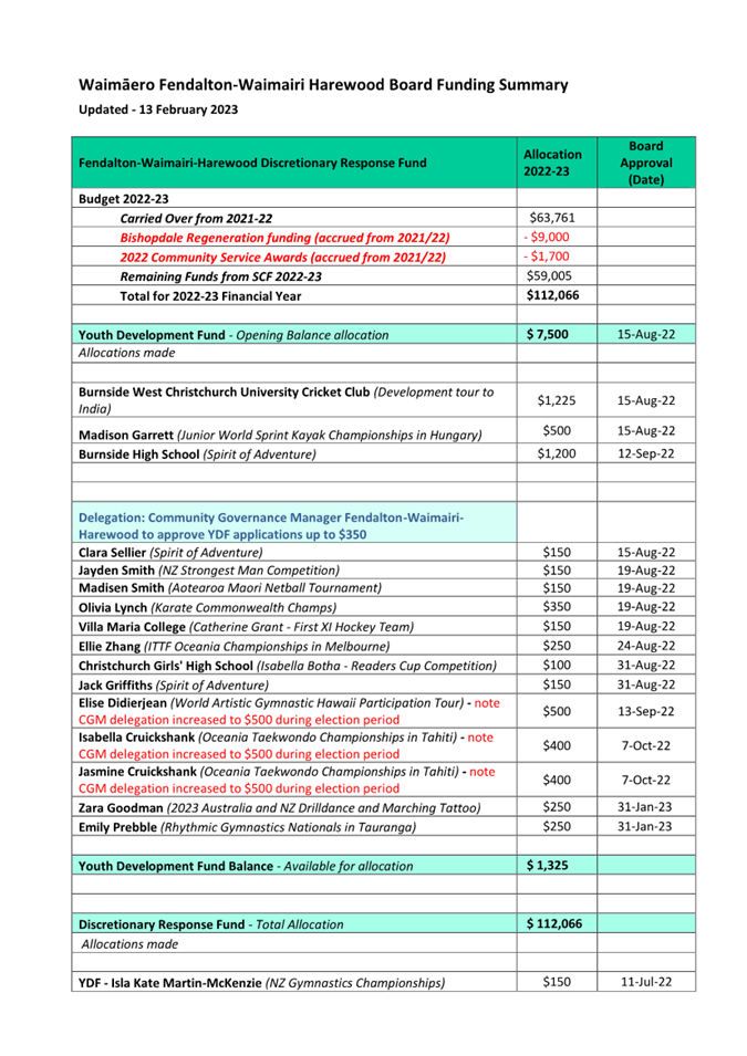
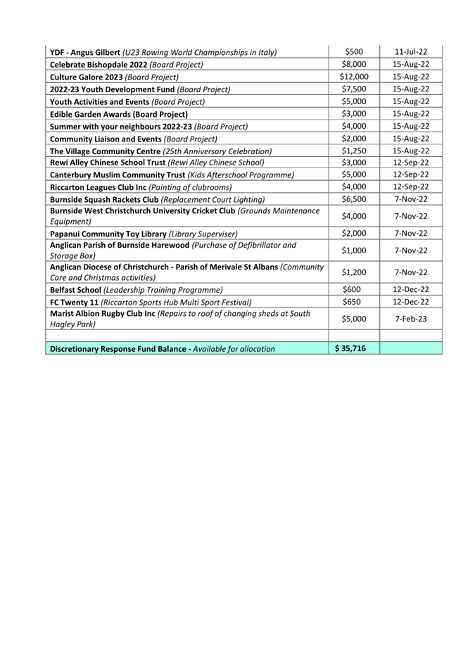
|
Waimāero Fendalton-Waimairi-Harewood
Community Board
06 March 2023
|
|
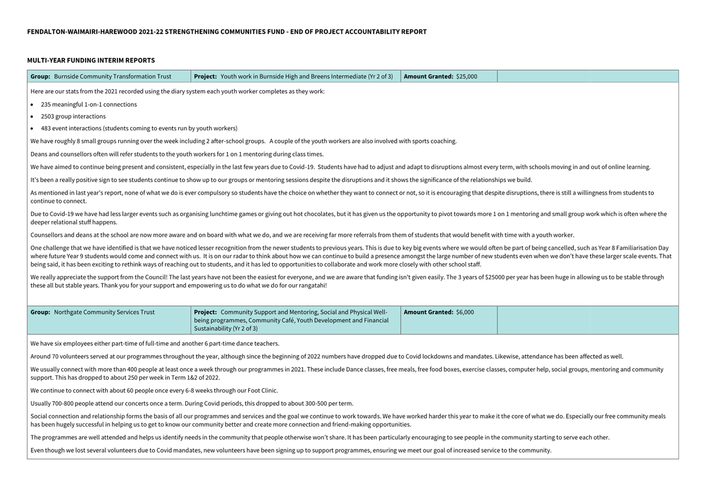
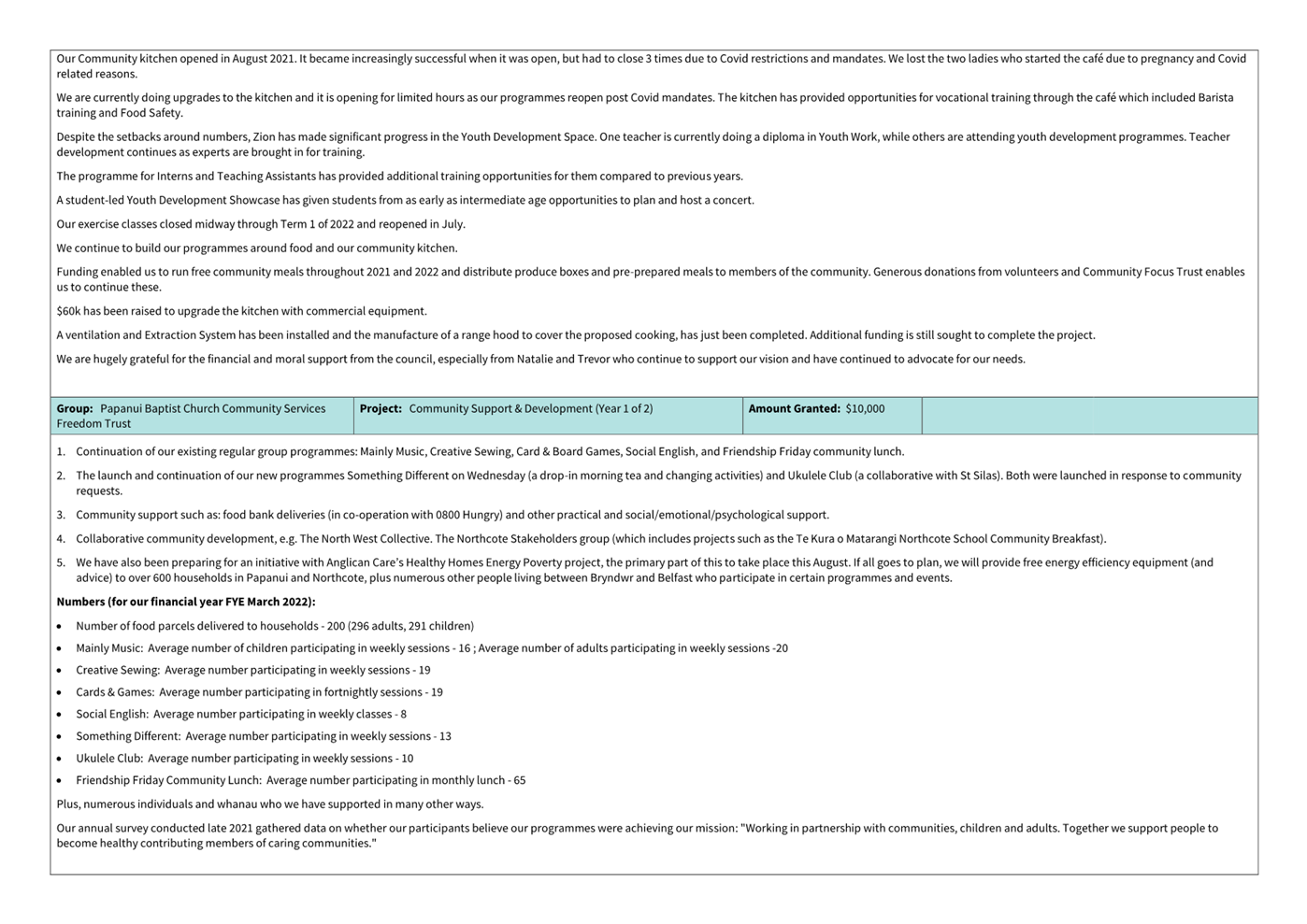
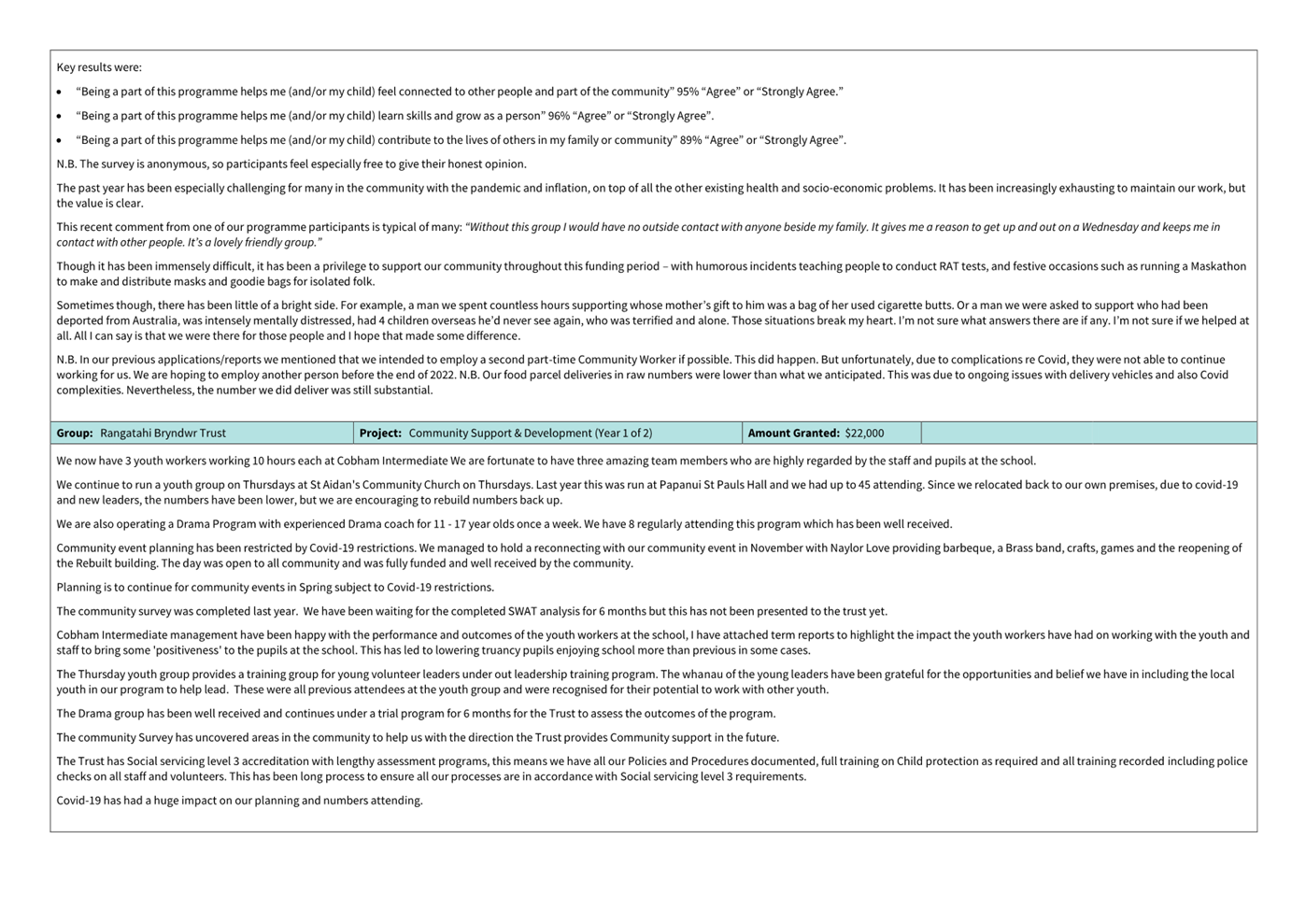
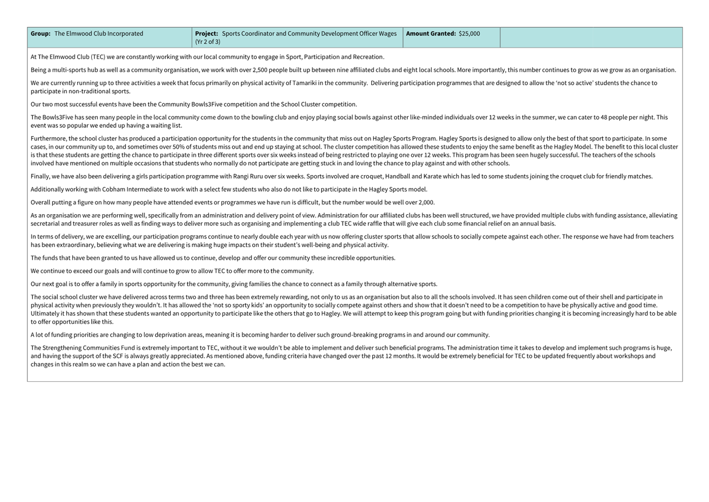
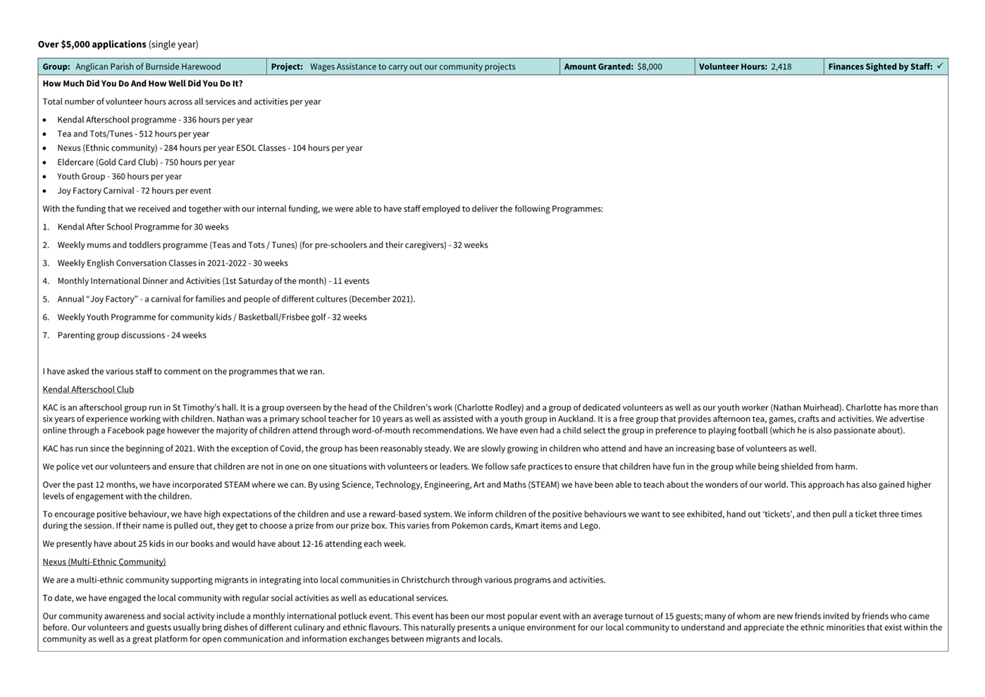
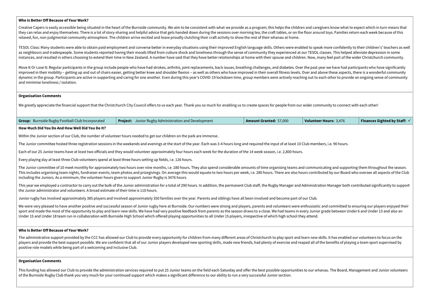
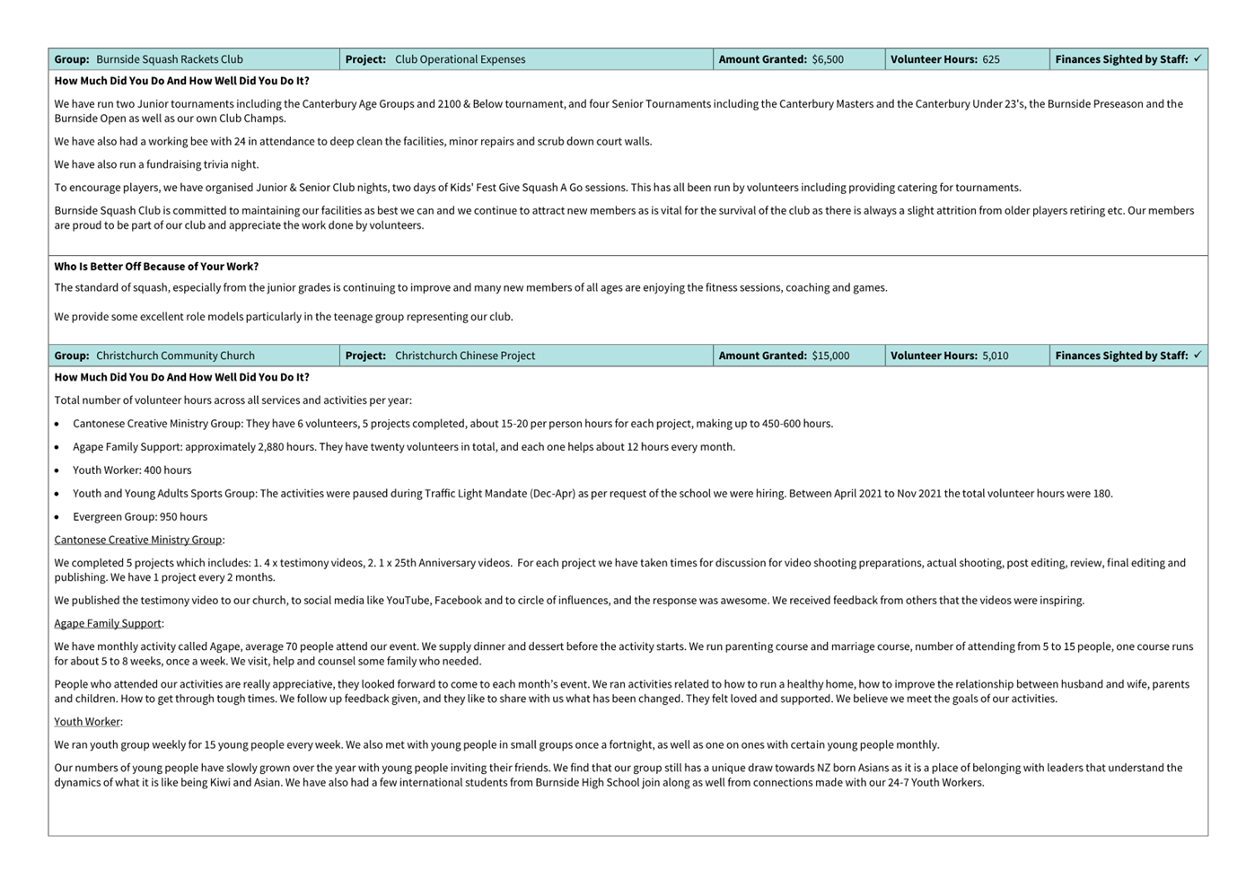
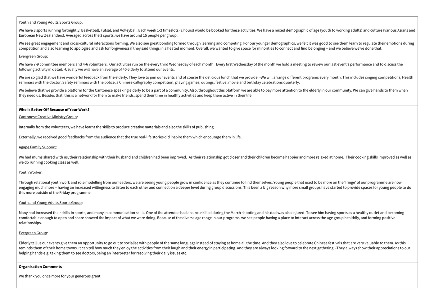
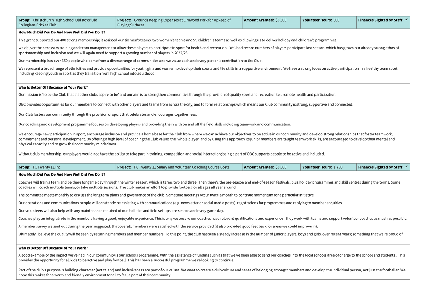
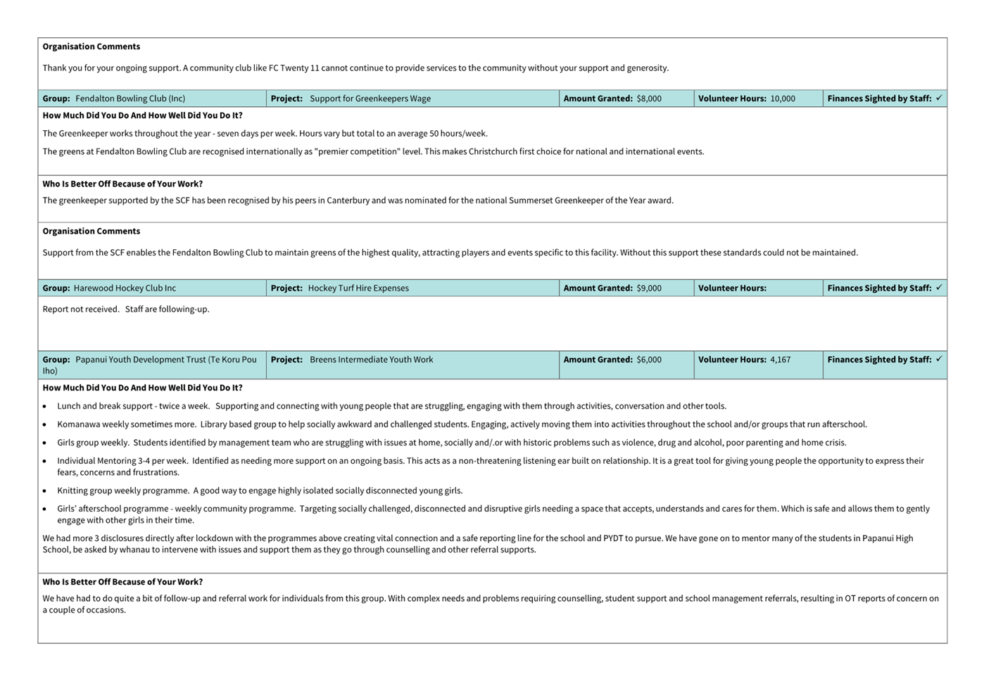
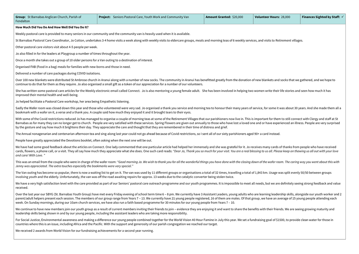
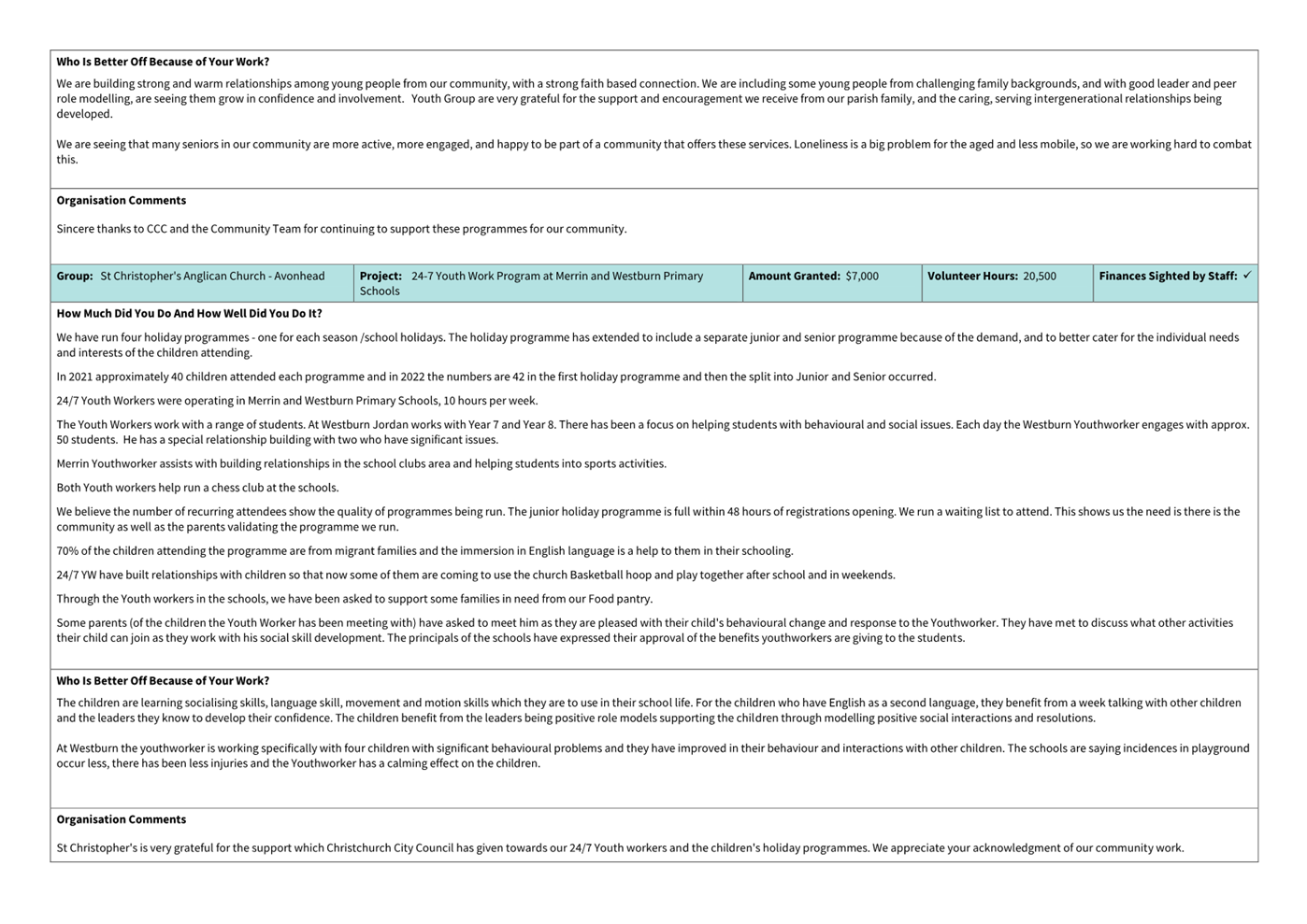
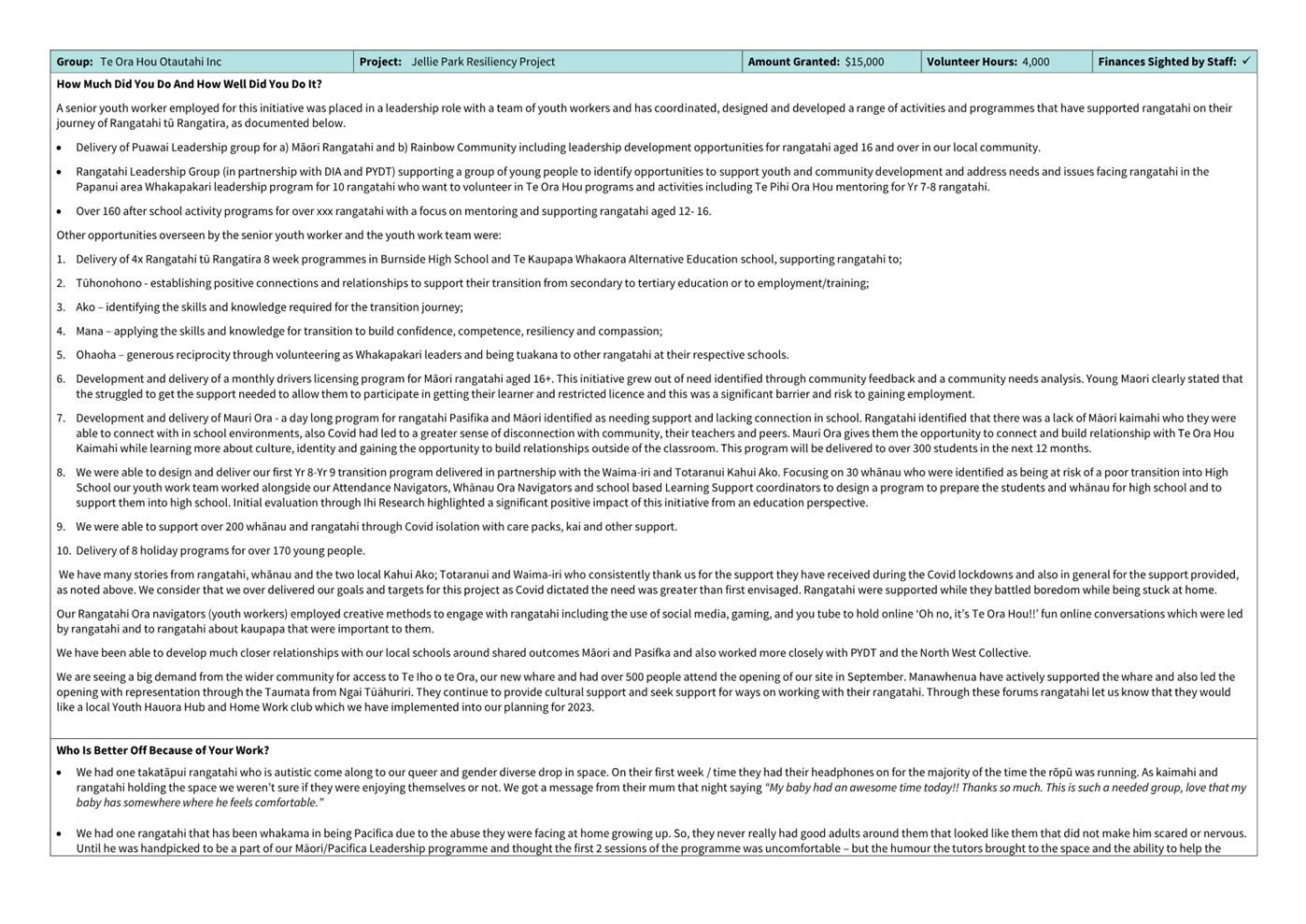
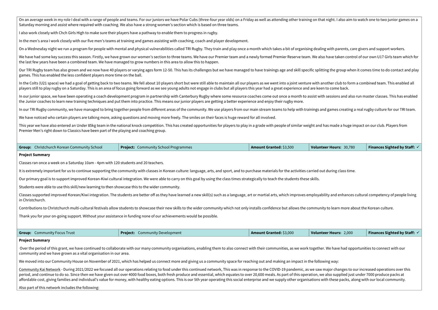
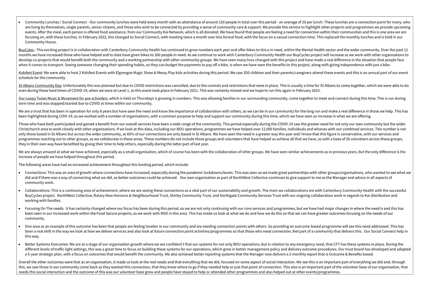
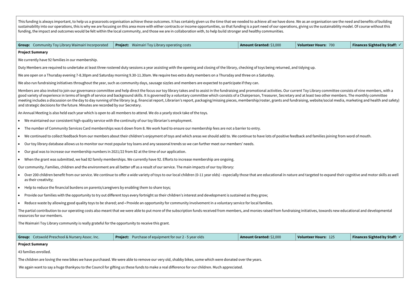
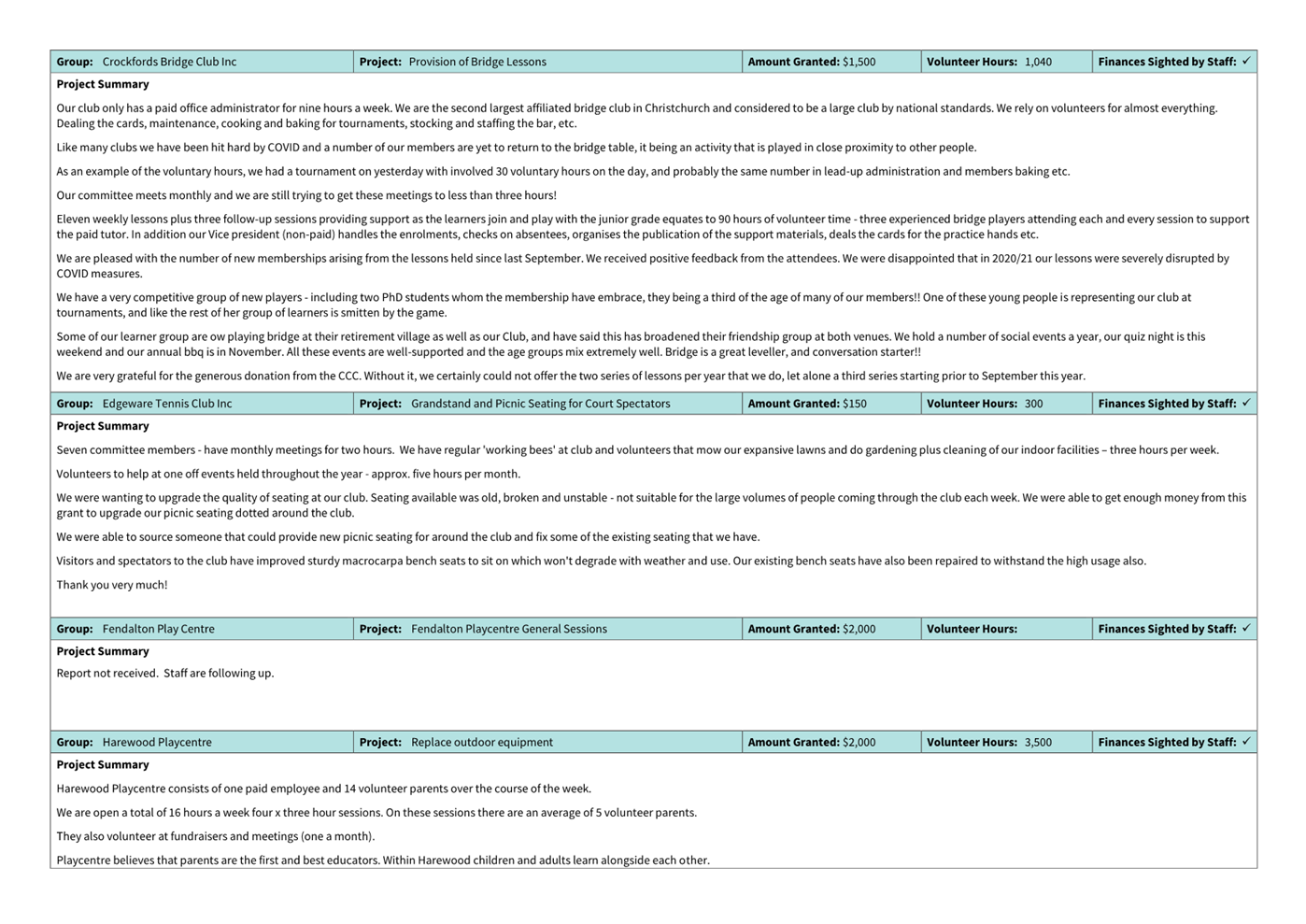
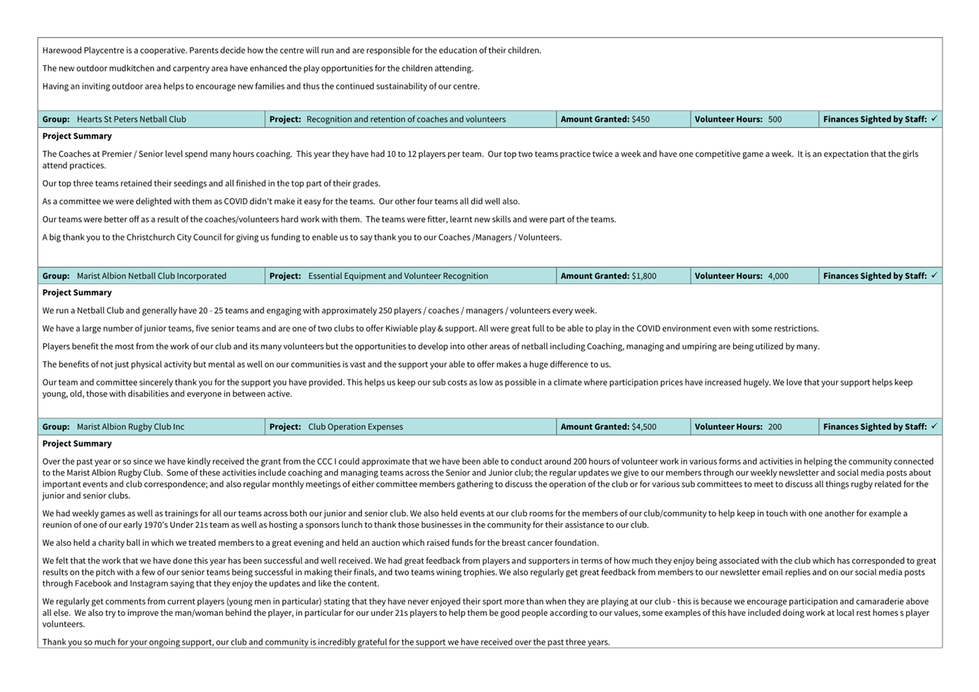
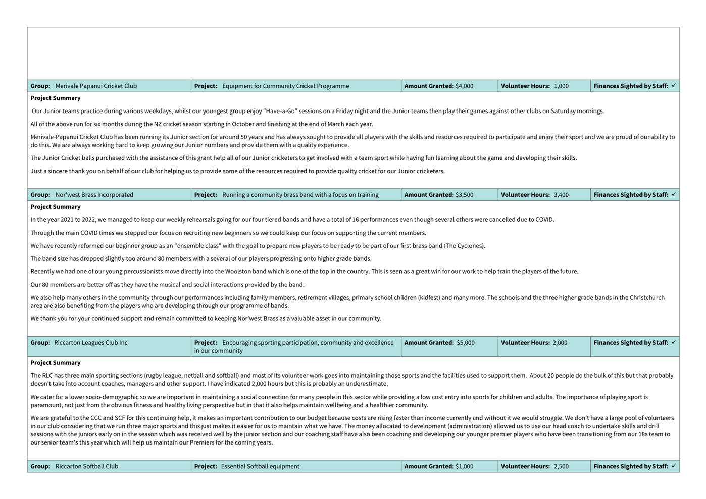
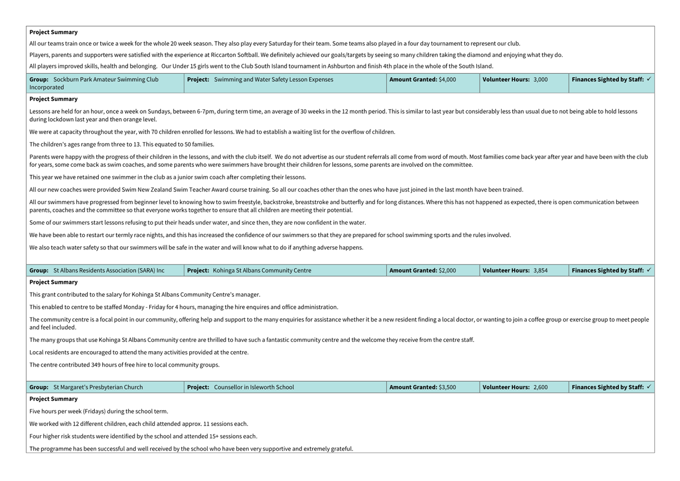
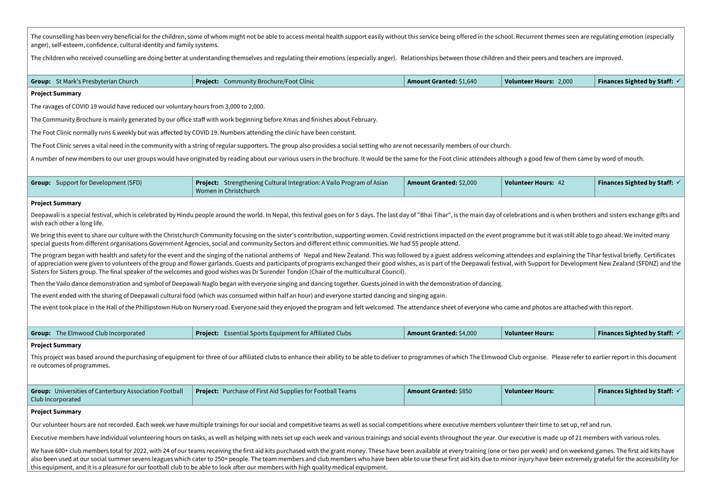
|
Waimāero Fendalton-Waimairi-Harewood
Community Board
06 March 2023
|

|
|
Waimāero Fendalton-Waimairi-Harewood
Community Board
06 March 2023
|
|
|
16. Elected
Members’ Information Exchange Te
Whakawhiti Whakaaro o Te Kāhui Amorangi
|
This item provides an opportunity for Board Members to
update each other on recent events and/or issues of relevance and interest to
the Board.
Karakia Whakamutunga
|
Unuhia, unuhia
Unuhia ki te uru tapu
nui
Kia wātea, kia māmā,
te ngākau,
Te tinana te wairua i
te ara takatā
Koia rā e Rongo,
whakairia ake ki runga
Kia tina! TINA! Hui e!
TĀIKI E!
|
Draw on, draw on,
Draw on the supreme sacredness
To clear, to free the heart, the body and the spirit of mankind
Rongo, suspended high above us (i.e. in ‘heaven’)
Draw together! Affirm!
|