Waimāero
Fendalton-Waimairi-Harewood Community Board
Agenda
Notice of Meeting:
An ordinary meeting of the Waimāero
Fendalton-Waimairi-Harewood Community Board will be held on:
Date: Monday 12 September 2022
Time: 4.30pm
Venue: Boardroom, Fendalton Service Centre,
Corner Jeffreys and Clyde Roads, Fendalton
Membership
|
Chairperson
Deputy Chairperson
Members
|
Bridget Williams
David Cartwright
Linda Chen
James Gough
Aaron Keown
Sam MacDonald
Jason Middlemiss
Shirish Paranjape
Mike Wall
|
7 September 2022
Maryanne Lomax
Manager Community Governance,
Fendalton-Waimairi-Harewood
941 6730
maryanne.lomax@ccc.govt.nz
www.ccc.govt.nz
|
Waimāero
Fendalton-Waimairi-Harewood Community Board
12 September
2022
|

|
|
Waimāero
Fendalton-Waimairi-Harewood Community Board
12 September
2022
|
|
Part A Matters
Requiring a Council Decision
Part B Reports
for Information
Part C Decisions
Under Delegation
TABLE OF CONTENTS
C 1. Apologies Ngā Whakapāha.......................................................................... 4
B 2. Declarations of Interest Ngā Whakapuaki Aronga........................................... 4
C 3. Confirmation of Previous Minutes Te Whakaāe o te
hui o mua.......................... 4
B 4. Public Forum Te Huinga Whānui.................................................................. 4
B 5. Deputations by Appointment Ngā Huinga
Whakaritenga................................. 4
B 6. Presentation
of Petitions Ngā
Pākikitanga.................................................... 4
C 7. Correspondence...................................................................................... 23
Staff Reports
C 8. Proposed
Road Names - Various Subdivisions.............................................. 27
C 9. Withells
Road - Proposed No Stopping Restrictions....................................... 35
C 10. Farrington
Avenue - P60 Parking Restrictions.............................................. 49
C 11. Public
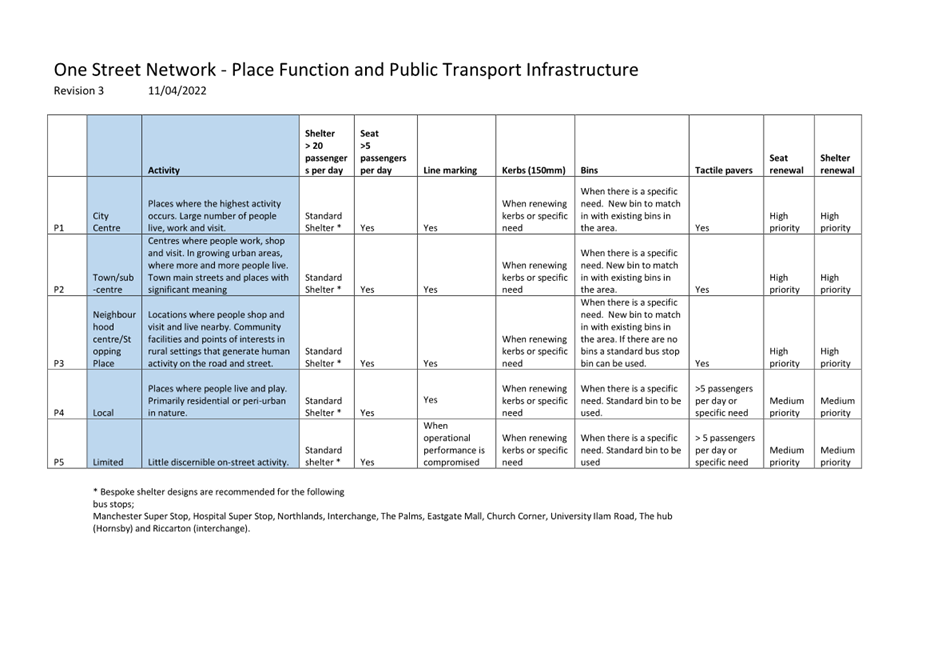
transport infrastructure improvements along Route 17....................... 55
C 12. Hearing
Panel Report to the Fendalton-Waimairi-Harewood Community Board - Roto Kotahu
Reserve Management Plan.................................................... 109
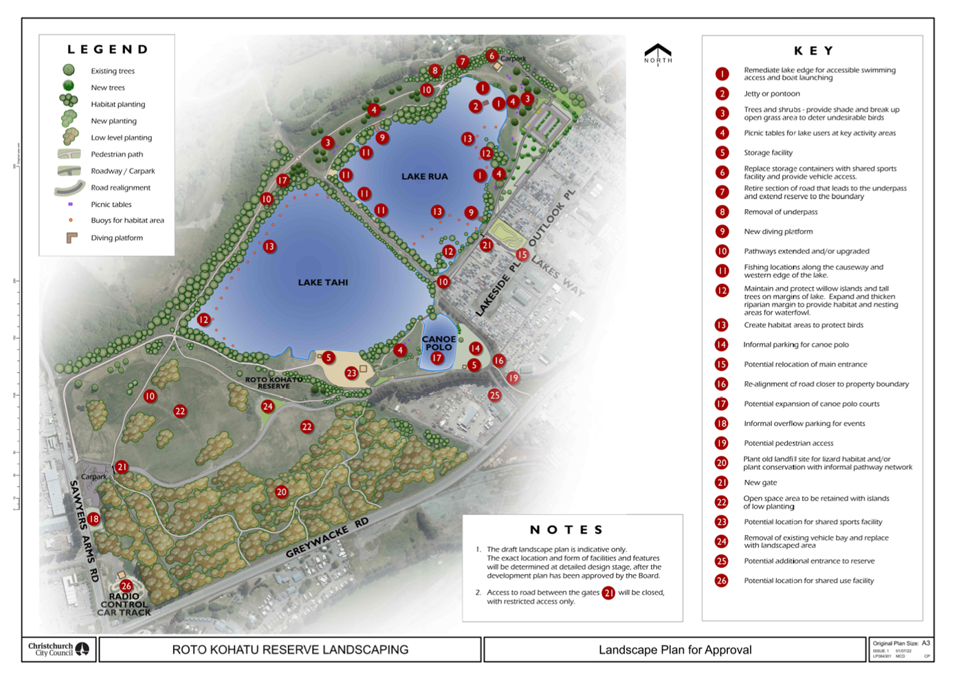
C 13. Roto
Kohatu Reserve Development Plan.................................................... 115
A 14. 52
Westholme Street, Strowan - Control and Manage Reserve...................... 143
C 15. Fendalton-Waimairi-Harewood
Community Board 2022-2023 Discretionary Response Fund Applications - Rewi Alley
Chinese School, Canterbury Muslim Community Trust, Riccarton Leagues Club Inc............................................ 161
C 16. Waimāero
Fendalton-Waimairi-Harewood Summer with your Neighbours 2022-23............................................................................................................ 167
C 17. Fendalton-Waimairi-Harewood
2022-23 Youth Development Fund Application - Burnside High School.............................................................................. 175
C 18. Waimāero
Fendalton-Waimairi-Harewood Community Board Area Report - September 2022..................................................................................... 179
B 19. Elected Members’
Information Exchange Te Whakawhiti
Whakaaro o Te Kāhui Amorangi............................................................................................................ 190
|
Waimāero
Fendalton-Waimairi-Harewood Community Board
12 September
2022
|

|
1. Apologies Ngā Whakapāha
At the close of
the agenda no apologies had been received.
2. Declarations of Interest Ngā
Whakapuaki Aronga
Members are
reminded of the need to be vigilant and to stand aside from decision making
when a conflict arises between their role as an elected representative and any
private or other external interest they might have.
3. Confirmation of Previous Minutes Te
Whakaāe o te hui o mua
That the
minutes of the Waimāero Fendalton-Waimairi-Harewood Community Board
meeting held on Monday, 15 August 2022 be confirmed
(refer page 5).
4. Public Forum / Te Huinga Whānui
A period of up
to 30 minutes will be available for people to speak for up to five minutes on
any issue that is not the subject of a separate hearings process.
|
4.1
|
Academe Tutoring Group
Members of the Academe Tutoring Group
will attend to introduce themselves to the Board and discuss the work of
their group.
|
5. Deputations by Appointment Ngā Huinga
Whakaritenga
Deputations may
be heard on a matter or matters covered by a report on this agenda and approved
by the Chairperson.
There were no
deputations by appointment at the time the agenda was prepared.
6. Presentation of Petitions Ngā
Pākikitanga
There were no petitions
received at the time the agenda was prepared.
|
Waimāero
Fendalton-Waimairi-Harewood Community Board
12 September
2022
|
|


Waimāero
Fendalton-Waimairi-Harewood
Community Board
Open
Minutes
Date: Monday 15 August 2022
Time: 4.31pm
Venue: Boardroom, Fendalton Service
Centre,
Corner Jeffreys and Clyde Roads, Fendalton
Present
|
Chairperson
Deputy Chairperson
Members
|
Bridget Williams
David Cartwright
Linda Chen
James Gough (via
audio/visual link)
Aaron Keown
Sam MacDonald (via
audio/visual link)
Jason Middlemiss
Shirish Paranjape
Mike Wall
|
Maryanne Lomax
Manager Community Governance,
Fendalton-Waimairi-Harewood
941 6730
maryanne.lomax@ccc.govt.nz
www.ccc.govt.nz

Part A Matters
Requiring a Council Decision
Part B Reports
for Information
Part C Decisions
Under Delegation
The agenda was dealt
with in the following order.
1. Apologies / Ngā Whakapāha
Part C
|
Community Board Resolved FWHB/2022/00040
That the apologies
received from David Cartwright for lateness be accepted.
Mike Wall/Shirish Paranjape Carried
|
2. Declarations of Interest / Ngā Whakapuaki Aronga
Part B
There were no declarations of interest recorded.
3. Confirmation of Previous Minutes /
Te Whakaāe o te hui o mua
Part C
|
Community Board Resolved FWHB/2022/00041
That the open and public excluded minutes of the
Waimāero Fendalton-Waimairi-Harewood Community Board meeting held on
Monday, 11 July 2022 be confirmed.
Linda Chen/Aaron Keown Carried
|
4. Public Forum / Te Huinga
Whānui
Part B
David
Cartwright joined the meeting at 4:42 p.m. during the public forum presentation
from Graeme Pollock.
|
4.1
|
New Generation
Church
Graeme Pollock spoke on behalf of the New Generation
Church regarding parking and safety issues in the area surrounding the
Church. Mr Pollock expressed frustration at the consultation process and
design of the Nor’West Arc Cycleway. Mr Pollock asked for the
Board’s support to seek changes to provide additional parking and the
removal of several Silver Birch trees. .
Following the presentation the Chair thanked Mr Pollock
for his presentation, and explained that the Board was unable to alter the
cycleway decision but may be able to find other ways to help address the
Church’s concerns. .
|
|
Attachments
a New
Generation Church - Presentation
|
|
4.2
|
Northwood
Residents’ Association
Clive Smith spoke on behalf of the Northwood
Residents’ Association to update the Board on matters of interest in
the Northwood area. Mr Smith
focused on concerns about the Main North Road/Radcliffe Road/Northwood
Boulevard Intersection layout, surface flooding at the roundabout adjacent to
the Northwood New World, and maintenance of the sculptures, berms and drains
in the Northwood subdivision.
Following the presentation, the Chair thanked Mr Smith
for his presentation and undertook to follow up on the matters raised.
|
|
Attachments
a Northwood
Residents' Association - Presentation
|
5. Deputations by Appointment / Ngā Huinga Whakaritenga
Part B
|
5.1
|
Brenchley Avenue
James Glubb, attending via audio/visual link, spoke on
behalf of the residents of Brenchley Avenue regarding recent flooding events
on the street. Mr Glubb provided information about recent flood events on
Brenchley Avenue and encouraged the Board to support James Gough’s
Notice of Motion (refer to item 7 of these minutes).
The Chair thanked Mr Glubb for his deputation.
|
|
Attachments
a James
Glubb - Presentation
|
6. Presentation of Petitions / Ngā Pākikitanga
Part B
There was no presentation of petitions.
|
7. Notice of Motion - Brenchley
Avenue
|
|
|
Community Board Resolved FWHB/2022/00042
Part C
That the Waimāero
Fendalton-Waimairi-Harewood Community Board:
1. Notes that Brenchley Avenue is sensitive to
flooding due to the local topography.
2. Notes that Council Officers have advised that
a significant capital project would be needed to remediate the flood risk on
Brenchley Avenue.
3. Requests a report with advice on the resources
required to assess (including scope, design and costings) a capital project
to remediate the flood risk on Brenchley Avenue. The intention of this
request is to enable the Board to:
a. Consider making a bid to the 2023-24 Annual
Plan for funding to complete the assessment.
b. Consider making a bid to the 2024-34 Long Term
Plan for funding for the physical works.
James Gough/David Cartwright Carried
|
|
8. Proposed Road Names - 46
Englefield Road
|
|
|
Community Board Resolved FWHB/2022/00043
Original officer recommendation accepted
without change.
Part C
That the Waimāero
Fendalton-Waimairi-Harewood Community Board:
1. Approves the following new lane name for 46
Englefield Road (RMA/2021/4063):
a. Rusbatch Lane
David Cartwright/Linda Chen Carried
|
|
9. Merrin School - Parking and No
Stopping Restrictions
|
|
|
Community Board Resolved FWHB/2022/00044
Original officer recommendation accepted
without change.
Part C
That the
Waimāero Fendalton-Waimairi-Harewood Community Board:
1. Approves, pursuant to Clause 7 of the
Christchurch City Council Traffic and Parking Bylaw 2017, that the parking of
motor vehicles be restricted to a maximum period of three minutes between the
times of 8:15am and 9:15am, and between 2:30pm and 3:30pm, Monday to Friday
on;
a. The north side of Merrin Street, commencing at
a point 171 metres east of its intersection with Withells Road and extending
in an easterly direction for a distance of 7 metres.
b. The north side of Merrin Street, commencing at
a point 200 metres east of its intersection with Withells Road and extending
in a easterly direction for a distance of 18 metres.
c. The south side of Merrin Street, commencing at
a point 137 metres east of its intersection with Withells Road and extending
in an easterly direction for a distance of 50 metres.
d. The south side of Merrin Street, commencing at
a point 220 metres east of its intersection with Withells Road and extending
in an easterly direction for a distance of 35 metres.
e. The east side of Brookby Crescent, commencing
at a point 73 metres north of its intersection with Greendale Avenue and
extending in a northerly direction for a distance of 43 metres.
2. Approves, pursuant to Clause 7 of the
Christchurch City Council Traffic and Parking Bylaw 2017, that the parking of
motor vehicles be restricted to a maximum period of 120 minutes on;
a. The north east side of Brookby Crescent,
commencing at a point 12 metres south east of its intersection with Withells
Road and extending in a south easterly direction for a distance of 17 metres.
b. The north east side of Brookby Crescent,
commencing at a point 39 metres south east of its intersection with Withells
Road and extending in a south easterly direction for a distance of 19 metres.
3. Approves, pursuant to Clause 7 of the
Christchurch City Council Traffic and Parking Bylaw 2017, that the stopping
of vehicles be prohibited at all times on;
a. The north east then east side of Brookby
Crescent, commencing at a point 58 metres south east of its intersection with
Withells Road and extending in a south easterly then southerly direction for
a distance of 39 metres.
b. The west side of Brookby Crescent, commencing
at a point 70 metres south east of its intersection with Withells Road and extending
in a south easterly then southerly direction for a distance of 26 metres.
c. The north side of Merrin Street, commencing at
its intersection with Withells Road and extending in an easterly direction
for a distance of 34 metres.
d. The south side of Merrin Street, commencing at
a point 116 metres east of its intersection with Withells Road and extending
in an easterly direction for a distance of 21 metres.
4. Approves, pursuant to Clause 7 of the
Christchurch City Council Traffic and Parking Bylaw 2017, that the parking of
vehicles is restricted to authorised vehicles only between the hours of
2:30pm to 3:30pm on Mondays on the south side of Merrin Street commencing at
a point 95 metres east of its intersection with Withells Road and extending in
an easterly direction for a distance of 15 metres.
5. Revoke any previous resolutions pertaining to
parking restrictions made pursuant to any bylaw to the extent that they are
in conflict with the parking restrictions described in resolutions 1, 2, 3,
and 4 above.
6. Approve that these resolutions take effect
when parking signage and/or road markings that evidence the restrictions
described in the staff report are in place (or removed in the case of
revocations).
Sam MacDonald/David Cartwright Carried
Mike Wall and Shirish Paranjape requested that their
votes against the P120 parking restrictions on Brookby Crescent be recorded.
|
|
10. 330 Avonhead Road - No Stopping Restrictions
|
|
|
Community Board Resolved FWHB/2022/00045
Original officer recommendation accepted
without change.
Part C
That the
Waimāero Fendalton-Waimairi-Harewood Community Board:
1. Approves, pursuant to Clause 7 of the
Christchurch City Council Traffic and Parking Bylaw 2017, that the stopping
of vehicles be prohibited at all times on;
a. The east side of Avonhead Road, commencing at
a point 50 metres south of its intersection with Kyeburn Place (measured from
the prolongation of the southern kerb line) and extending in a southerly
direction for a distance of 24 metres.
2. Revoke any previous resolutions pertaining to
parking restrictions made pursuant to any bylaw to the extent that they are
in conflict with the parking restrictions described in resolution 1 above.
3. Approve that these resolutions take effect
when parking signage and/or road markings that evidence the restrictions
described in the staff report are in place (or removed in the case of
revocations).
Sam MacDonald/Shirish Paranjape Carried
|
|
11. Burnside Park - Proposed New Lease - Lions
District 202E
|
|
|
Community Board Resolved FWHB/2022/00046
Original officer recommendation accepted
without change.
Part C
That the
Waimāero Fendalton-Waimairi-Harewood Community Board:
1. Approve the surrender of the lease between
Riccarton Waimairi Lions Club Inc. and the Council dated 20 December 2002 for
the land and building being part of Sec 1 SO316071-Lot 232 DP17066,
CB12A/979.
2. Grant a building and ground lease to Lions
District 202E pursuant to s61 of the Reserves Act 1977, for a period of
twenty years including renewals and for an area of land of approximately
170sqm being part of Sec 1 SO316071-Lot 232 DP17066 CB12A/979 as shown A on
the plan described as Attachment A to this report.
3. Authorise the Manager Property Consultancy to
conclude negotiation and administer the terms and conditions of the lease
described above.
Sam MacDonald/David Cartwright Carried
|
|
12. Morley Reserve-Proposed new lease- Bryndwr
Community Garden
|
|
|
Community Board Resolved FWHB/2022/00047
Original officer recommendation accepted
without change.
Part C
That the
Waimāero Fendalton-Waimairi-Harewood Community Board:
1. Grant a ground lease to Bryndwr Community
Garden Incorporated pursuant to s73 & s53 (1) of the Reserves Act 1977,
for a lease period of five years with one right of renewal and for an area of
approximately 177sqm being part of Res 4969, Lot 247 DP19548-CB6B/899, Res
5099 and Res 5098 as shown on the plan described as Attachment A of the
agenda for this meeting.
2. Authorises the Manager Property Consultancy to
conclude and administer all necessary lease negotiations and documentation.
David Cartwright/Linda Chen Carried
|
13. Burnside Park - Proposed new lease- Burnside
Tennis Club
|
|
|
Community Board Resolved FWHB/2022/00048
Original officer recommendation accepted
without change.
Part C
That the
Waimāero Fendalton-Waimairi-Harewood Community Board:
1. Grant a ground lease to Burnside Park Tennis
Club pursuant to s54 of the Reserves Act 1977, for a lease period of 33 years
including renewals for an area of approximately 6320sqm being part of Sec 6
SO316071-Lot 232 DP17066-CB12A/979 and RS40045-CB12A/978 as shown on the plan
described as Attachment A in this report.
2. Authorises the Manager Property Consultancy to
conclude negotiation and administer the terms and conditions of the lease.
David Cartwright/Mike Wall Carried
|
|
14. Fendalton-Waimairi-Harewood 2022-23
Strengthening Communities Fund Report
|
|
|
Community Board Resolved FWHB/2022/00049
Original officer recommendation accepted
without change.
Part C
That the Waimāero
Fendalton-Waimairi-Harewood Community Board:
1. Approve the 2022-23 Strengthening Communities
Fund grants outlined in the following schedule:
|
No
|
Organisation Name
|
Project
|
Recommendation
|
|
00064083
|
Anglican Diocese
of Christchurch - Parish of Merivale St Albans
|
The Corner
Community Hub
|
That the
Waimāero Fendalton-Waimairi-Harewood Community Board approve a grant
of $16,000 from its 2022-23 Strengthening Communities Fund to St Mary's
Anglican Diocese of Christchurch (Parish of Merivale St Albans) towards
their Community Development Workers' wages.
|
|
00064028
|
Belfast Community
Network Inc
|
Belfast
Connectivity
|
That the
Waimāero Fendalton-Waimairi-Harewood Community Board approve a grant
of $10,000 from its 2022-23 Strengthening Communities Fund to the Belfast
Community Network as a contribution towards Belfast Connectivity and other
support programmes and services.
|
|
00064069
|
Bishopdale
Community Trust
|
Sundbye
Community House activities
|
That the
Waimāero Fendalton-Waimairi-Harewood Community Board approve a grant
of $21,000 from its 2022-23 Strengthening Communities Fund to the
Bishopdale Community Trust towards operational costs of Sundbye House.
|
|
00064312
|
Christchurch
Chinese Church
|
Christchurch
Chinese Projects
|
That the
Waimāero Fendalton-Waimairi-Harewood Community Board approve a grant
of $11,500 from its 2022-23 Strengthening Communities Fund to the
Christchurch Chinese Church towards Christchurch Chinese Projects,
excluding food.
|
|
00064267
|
St Barnabas
Anglican Church, Parish of Fendalton
|
Seniors
Pastoral Care, Youth Work and Community Van
|
That the
Waimāero Fendalton-Waimairi-Harewood Community Board approve a grant
of $20,000 from its 2022-23 Strengthening Communities Fund to St Barnabas
towards Seniors Pastoral Care, Youth Work and the Community Van operating
costs.
|
|
00064321
|
Te Ora Hou
Otautahi Inc
|
Whānau Resiliency Project
|
That the
Waimāero Fendalton-Waimairi-Harewood Community Board approve a grant
of $15,000 from its 2022-23 Strengthening Communities Fund to Te Ora Hou
towards their Whānau
Resiliency Project in Fendalton-Waimairi-Harewood.
|
|
00064072
|
Anglican Parish of
Burnside Harewood
|
Community
Programmes Operational Costs
|
That the
Waimāero Fendalton-Waimairi-Harewood Community Board approve a grant
of $9,000 from its 2022-23 Strengthening Communities Fund to the Anglican
Parish of Burnside Harewood towards their community programmes and
equipment.
|
|
00064007
|
Asian Community
Transformation Trust
|
Support
and Enhance Asian Community Wellbeing
|
That the
Waimāero Fendalton-Waimairi-Harewood Community Board approve a grant
of $8,000 from its 2022-23 Strengthening Communities Fund to the Asian
Community Transformation Trust towards the development of their community
led support and connection programmes (excluding the retrospective
contract for wages).
|
|
00064052
|
Avonhead Community
Trust
|
Whole
Village
|
That the
Waimāero Fendalton-Waimairi-Harewood Community Board approve a grant
of $11,800 from its 2022-23 Strengthening Communities Fund to the Avonhead
Community Trust for their community programmes and the Carols event.
|
|
00064086
|
Burnside Bowling
Club Inc
|
Assistance
with cost of Greenkeepers salary
|
That the
Waimāero Fendalton-Waimairi-Harewood Community Board approve a grant
of $7,500 from its 2022-23 Strengthening Communities Fund to the Burnside
Bowling Club towards their Greenkeeper's salary.
|
|
00064359
|
Burnside Elim
Church Trust
|
Burnside
Elim Church - Community Services
|
That the
Waimāero Fendalton-Waimairi-Harewood Community Board approve a grant
of $6,000 from its 2022-23 Strengthening Communities Fund to Burnside Elim
Church Trust towards the costs of delivering their community projects
excluding refreshments.
|
|
00064059
|
Burnside Rugby
Football Club Incorporated
|
Junior
Rugby Administration and Development
|
That the
Waimāero Fendalton-Waimairi-Harewood Community Board approve a grant
of $7,500 from its 2022-23 Strengthening Communities Fund to the Burnside
Rugby Football Club towards its junior rugby administration and
development.
|
|
00064032
|
Burnside Squash
Rackets Club
|
Club
Operational Expenses
|
That the
Waimāero Fendalton-Waimairi-Harewood Community Board approve a grant
of $6,500 from its 2022-23 Strengthening Communities Fund to the Burnside
Squash Rackets Club towards operational expenses.
|
|
00064231
|
Burnside West Christchurch
University Cricket Club Inc
|
Operating
Costs for Annual Insurance
|
That the
Waimāero Fendalton-Waimairi-Harewood Community Board approve a grant
of $2,000 from its 2022-23 Strengthening Communities Fund to the Burnside
West Christchurch University Cricket Club towards the cost of their annual
insurance.
|
|
00064225
|
Christchurch
High School Old Boys' Old Collegians Cricket Club
|
Coaching
and Development
|
That the
Waimāero Fendalton-Waimairi-Harewood Community Board approve a grant
of $7,500 from its 2022-23 Strengthening Communities Fund to the
Christchurch High School Old Boys' Old Collegians Cricket Club towards its
Coaching and Development Programme.
|
|
00064131
|
Christchurch
High School Old Boys Rugby Football Club Inc
|
Rugby
Development Officer
|
That the
Waimāero Fendalton-Waimairi-Harewood Community Board approve a grant
of $4,000 from its 2022-23 Strengthening Communities Fund to the
Christchurch High School Old Boys Rugby Football Club towards the wages
for their Rugby Development Officer.
|
|
00063941
|
Christchurch
Korean Community School
|
Celebrating,
supporting and advocating bicultural communities: Enhancing Korean/Kiwi
cultural awareness
|
That the
Waimāero Fendalton-Waimairi-Harewood Community Board approve a grant
of $2,500 from its 2022-23 Strengthening Communities Fund to the
Christchurch Korean Community Society towards operating and volunteer
related costs associated with their Community School and Cultural
performance delivery.
|
|
00064393
|
Delta
Rhythmic Gymnastic Club Inc
|
Equipment,
Venue Hire and Administration Expenses to Support Participation in
Rhythmic Gymnastics
|
That the
Waimāero Fendalton-Waimairi-Harewood Community Board approve a grant
of $9,000 from its 2022-23 Strengthening Communities Fund to the Delta
Rhythmic Gymnastic Club Inc towards essential equipment, venue hire and
administration expenses for their rhythmic gymnastics programme.
|
|
00064356
|
FC
Twenty 11 Inc
|
FC
Twenty 11 Salary Expenses
|
That the
Waimāero Fendalton-Waimairi-Harewood Community Board approve a grant
of $8,000 from its 2022-23 Strengthening Communities Fund to the FC Twenty
11 Club towards the salary expenses for their part time coaches and
operations manager.
|
|
00063965
|
Fendalton
Bowling Club (Inc)
|
Support
for Greenkeepers Wage
|
That the
Waimāero Fendalton-Waimairi-Harewood Community Board approve a grant
of $7,500 from its 2022-23 Strengthening Communities Fund to the Fendalton
Bowling Club towards Greenkeepers wage.
|
|
00064130
|
Fendalton
Park Croquet Club Inc.
|
Lawn
Maintenance
|
The Waimāero
Fendalton-Waimairi-Harewood Community Board approve a grant of $3,000 from
its 2022-23 Strengthening Communities Fund to the Fendalton Park Croquet
Club towards Lawn Maintenance costs.
|
|
00064343
|
Harewood
Hockey Club Inc
|
Hockey
Turf Hire Expenses - keeping hockey affordable
|
That the
Waimāero Fendalton-Waimairi-Harewood Community Board approve a grant
of $9,000 from its 2022-23 Strengthening Communities Fund to the Harewood
Hockey Club Inc towards its Hockey Turf Hire Expenses.
|
|
00064512
|
Marist
Albion Rugby Club Inc
|
Club
Operation Costs and Wages
|
That the
Waimāero Fendalton-Waimairi-Harewood Community Board approve a grant
of $5,500 from its 2022-23 Strengthening Communities Fund to the Marist
Albion Rugby Club towards Club Operation Expenses.
|
|
00064368
|
Merivale
Papanui Cricket Club
|
Cricket
Balls for Upcoming 2022/2023 Season
|
That the
Waimāero Fendalton-Waimairi-Harewood Community Board approve a grant
of $3,500 from its 2022-23 Strengthening Communities Fund to the Merivale
Papanui Cricket Club towards the purchase of Cricket Balls.
|
|
00064437
|
Nepal
New Zealand Friendship Society of Canterbury Incorporated
|
Community
integrated activities and Volunteer recognition (community radio program)
|
That the
Waimāero Fendalton-Waimairi-Harewood Community Board approve a grant
of $2,000 from its 2022-23 Strengthening Communities Fund to Nepal New
Zealand Friendship Society of Canterbury towards the costs of Community
Integrated activities and volunteer recognition.
|
|
00064281
|
Nor'west
Brass Incorporated
|
Running
a Community Brass Band
|
That the
Waimāero Fendalton-Waimairi-Harewood Community Board approve a grant
of $3,000 from its 2022-23 Strengthening Communities Fund to Nor'west
Brass Incorporated, towards the costs of Running a Community Brass Band,
excluding administration.
|
|
00064276
|
Papanui
Youth Development Trust (Te Koru Pou Iho)
|
Breens
Intermediate Youth Work
|
That the
Waimāero Fendalton-Waimairi-Harewood Community Board approve a grant
of $5,000 from its 2022-23 Strengthening Communities Fund to the Papanui
Youth Development Trust towards Breens Intermediate Youth work.
|
|
00064221
|
Riccarton
Leagues Club Inc
|
Riccarton
Leagues Club Operation Expenses
|
That the
Waimāero Fendalton-Waimairi-Harewood Community Board approve a grant
of $5,000 from its 2022-23 Strengthening Communities Fund to the Riccarton
Leagues Club Inc towards their Operation Expenses.
|
|
00064472
|
Sockburn
Park Amateur Swimming Club Incorporated
|
Swimming
and Water Safety Lessons
|
That the
Waimāero Fendalton-Waimairi-Harewood Community Board approve a grant
of $3,000 from its 2022-23 Strengthening Communities Fund to the Sockburn
Park Amateur Swimming Club towards Swimming and Water Safety Lesson
Expenses.
|
|
00064249
|
St
Christopher's Anglican Church - Avonhead
|
24-7
Program at Merrin and Westburn Primary Schools; Holiday Program for
Primary School children
|
That the
Waimāero Fendalton-Waimairi-Harewood Community Board approve a grant
of $14,000 from its 2022-2023 Strengthening Communities Fund to St
Christopher's Anglican Church towards their Youth work programmes in
Merrin and Westburn Schools wages, holiday and young leaders programmes.
|
|
00064419
|
Styx
Living Laboratory Trust
|
Pūharakekenui
Education Project
|
That the
Waimāero Fendalton-Waimairi-Harewood Community Board approve a grant
of $5,000 from its 2022-23 Strengthening Communities Fund to the Styx
Living Laboratory Trust towards the costs of their Pūharakekenui
Education Project.
|
|
00064195
|
The
Village Community Centre - Bryndwr
|
Village
Community Centre - Bryndwr operations and salaries/wages
|
That the Waimāero
Fendalton-Waimairi-Harewood Community Board approve a grant of $12,500
from its 2022-23 Strengthening Communities Fund to towards The Village
Community Centre Operations.
|
|
00064050
|
The
Young Men's Christian Association of Christchurch Inc.
|
YMCA
Bishopdale Recreation Centre and Early Learning Centre Programme Expenses
|
That the
Waimāero Fendalton-Waimairi-Harewood Community Board approve a grant
of $10,000 from its 2022-23 Strengthening Communities Fund to the YMCA
Bishopdale Recreation Centre towards their Life Fit Programme, Early
Learning Centre Resources and Basketball Programme.
|
|
00064172
|
University
of Canterbury Rugby Football Club Incorporated
|
Director
of Club Operations and Administration
|
That the
Waimāero Fendalton-Waimairi-Harewood Community Board approve a grant
of $3,500 from its 2022-23 Strengthening Communities Fund to the
University of Canterbury Rugby Football Club towards the Director of Club
Operations salary.
|
|
00064382
|
Waimairi
Tennis Club
|
Junior
Administrator Salary
|
That the
Waimāero Fendalton-Waimairi-Harewood Community Board approve a grant
of $5,000 from its 2022-23 Strengthening Communities Fund to the Waimairi
Tennis Club towards its junior administrator's salary.
|
|
00064470
|
Papanui
Youth Development Trust (Te Koru Pou Iho)
|
Operational
Support - Admin Staff
|
That the
Waimāero Fendalton-Waimairi-Harewood Community Board declines to
approve a grant from its 2022-23 Strengthening Communities Fund to the
Papanui Youth Development Trust towards an administrator.
|
|
00063975
|
Avonhead
Tennis Club Inc
|
Junior
Tennis Development Programme
|
That the
Waimāero Fendalton-Waimairi-Harewood Community Board approve a grant
of $2,300 from its 2022-23 Strengthening Communities Fund to the Avonhead
Tennis Club towards their Junior Tennis Development programme.
|
|
00064257
|
Burnside
Park Tennis Club Inc.
|
Junior
Administrator Expenses
|
That the
Waimāero Fendalton-Waimairi-Harewood Community Board approve a grant
of $1,300 from its 2022-23 Strengthening Communities Fund to the Burnside
Park Tennis Club Inc. towards Junior Administrator Expenses.
|
|
00064260
|
Community
Toy Library Waimairi Incorporated
|
Waimairi
Toy Library operating costs
|
That the
Waimāero Fendalton-Waimairi-Harewood Community Board approve a grant
of $2,500 from its 2022-23 Strengthening Communities Fund to the Waimairi
Toy Library towards operating costs.
|
|
00064381
|
Cotswold
Preschool & Nursery Assoc. Inc.
|
Equipment
and Materials
|
That the
Waimāero Fendalton-Waimairi-Harewood Community Board approve a grant
of $1,500 from its 2022-23 Strengthening Communities Fund to Cotswold
Preschool and Nursery towards equipment and resources.
|
|
00064136
|
Crockfords
Bridge Club Inc.
|
Tutor
payment for beginners lessons
|
That the
Waimāero Fendalton-Waimairi-Harewood Community Board approve a grant
of $1,500 from its 2022-23 Strengthening Communities Fund to the
Crockfords Bridge Club Inc. towards Tutor payment for their beginner
lessons.
|
|
00064135
|
Hearts
St Peters Netball Club
|
Recognition
and Retention of Coaches, Managers and Committee members
|
That the Waimāero
Fendalton-Waimairi-Harewood Community Board approve a grant of $500 from
its 2022-23 Strengthening Communities Fund to the Hearts St Peters Netball
Club towards Recognition and Retention of Coaches, Managers and Committee
Members.
|
|
00064331
|
Marist
Albion Netball Club Incorporated
|
Essential
Equipment and Volunteer Recognition and Retention.
|
That the
Waimāero Fendalton-Waimairi-Harewood Community Board approve a grant
of $1,800 from its 2022-23 Strengthening Communities Fund to the Marist
Albion Netball Club Incorporated towards Essential Equipment and Volunteer
Recognition and Retention.
|
|
00064095
|
Miyazato
Karate Club Christchurch Incorporated
|
Training
equipment, venue hire and advertising
|
That the
Waimāero Fendalton-Waimairi-Harewood Community Board approve a grant
of $1,500 from its 2022-23 Strengthening Communities Fund to the Miyazato
Karate Club Christchurch towards their programme expenses.
|
|
00064250
|
St
Mark's Presbyterian Church
|
Community
Brochure/Foot Clinic
|
That the Waimāero/Fendalton-Waimairi-Harewood
Community Board approve a grant of $1,500 from its 2022-23 Strengthening
Communities Fund to St Mark's Presbyterian Church towards the costs of
their Community Brochure and Foot Clinic.
|
|
00064247
|
Yaldhurst
Tennis Club Incorporated
|
Ground
Rent, Grounds Upkeep and Equipment
|
That the
Waimāero Fendalton-Waimairi-Harewood Community Board approve a grant
of $1,200 from its 2022-23 Strengthening Communities Fund to the Yaldhurst
Tennis Club towards ground rent, grounds upkeep and equipment.
|
2. Approve the transfer of $59,005 to the
Fendalton-Waimairi-Harewood 2022-23 Discretionary Response Fund.
Mike Wall/Shirish Paranjape Carried
|
|
15. Fendalton-Waimairi-Harewood 2022-23
Discretionary Response Fund - Board Projects
|
|
|
Community Board Resolved FWHB/2022/00050
Original officer recommendation accepted
without change.
Part C
That the Waimāero
Fendalton-Waimairi-Harewood Community Board:
1. Allocate $12,000 from its 2022-23
Discretionary Response Fund towards the costs of staging Culture Galore 2023.
2. Allocate $8,000 from its 2022-23 Discretionary
Response Fund towards the costs of staging Celebrate Bishopdale 2022.
3. Allocate $7,500 from its 2022-23 Discretionary
Response Fund to establish the Fendalton-Waimairi-Harewood 2022-23 Youth
Development Fund.
4. Allocate $4,000 from its 2022-23 Discretionary
Response Fund towards Summer with your Neighbours 2022-23.
5. Allocate $5,000 from its 2022-23 Discretionary
Response Fund towards costs of staging various youth activities and events.
6. Allocate $2,000 from its 2022-23 Discretionary
Response Fund towards the cost of Community Liaison meetings and community
events.
7. Allocate $3,000 from its 2022-23 Discretionary
Response Fund towards the hosting of the 2023 Edible Garden Awards.
Bridget Williams/Jason Middlemiss Carried
|
|
16. Fendalton-Waimairi-Harewood Community Board
2022-2023 Discretionary Response Fund Application - The Village Community
Centre 25th Anniversary Celebration
|
|
|
Community Board Resolved FWHB/2022/00051
Original officer recommendation accepted
without change.
Part C
That the Waimāero
Fendalton-Waimairi-Harewood Community Board:
1. Approves a grant of $1,250 from its 2022-23
Discretionary Response Fund to The Village Community Centre - Bryndwr towards
their 25th Anniversary Celebration.
Shirish Paranjape/Linda Chen Carried
|
|
17. Fendalton-Waimairi-Harewood 2022-23 Youth
Development Fund Applications - Burnside West Christchurch University Cricket
Club Inc, Madison Garrett
|
|
|
Community Board Resolved FWHB/2022/00052
Original officer recommendation accepted
without change.
Part C
That the Waimāero
Fendalton-Waimairi-Harewood Community Board resolve to:
1. Approve a grant of $1,225 to Burnside West
Christchurch University Cricket Club Inc being $175 each for, Alfie Bell,
Archie Ovens, Bosilu Chenith Liyana Waduge, Harrison Dick, Isaac Milne, Lucas
Roan, Samuel Carrell towards expenses for their North West Youth Cricket
teams to travel on the cricket development tour to India, from 27 September
to 14 October 2022.
2. Approve a grant of $500 to Madison Garrett
towards competing at the Junior World Sprint Kayak Championships in Hungary,
from 1 to 4 September 2022.
David Cartwright/James Gough Carried
|
|
18. Waimāero Fendalton-Waimairi-Harewood
Community Board Area Report - August 2022
|
|
|
Community Board Resolved FWHB/2022/00053
Original officer recommendation accepted
without change.
Part B
That the Waimāero
Fendalton-Waimairi-Harewood Community Board:
1. Receive the Waimāero
Fendalton-Waimairi-Harewood Community Board Area Report for August 2022.
Aaron Keown/Jason Middlemiss Carried
|
19. Elected Members’ Information Exchange
Part B
|
Members exchanged information on matters of interest.
|
Meeting
concluded at
5.53pm.
CONFIRMED THIS 12TH DAY OF
SEPTEMBER 2022
Bridget Williams
Chairperson
|
Waimāero
Fendalton-Waimairi-Harewood Community Board
12 September
2022
|

|
|
7. Correspondence
|
|
Reference / Te Tohutoro:
|
22/1133956
|
|
Report of / Te Pou Matua:
|
Aidan
Kimberley, Community Board Advisor, Aidan.Kimberley@ccc.govt.nz
|
|
General Manager / Pouwhakarae:
|
Mary
Richardson, General Manager Citizens and Community,
Mary.Richardson@ccc.govt.nz
|
1. Purpose of Report Te Pūtake Pūrongo
Correspondence has been received from:
|
Name
|
Subject
|
|
Matt Duffy
|
Road safety around Westburn School
|
2. Officer Recommendations Ngā Tūtohu
That the Fendalton-Waimairi-Harewood
Community Board:
1. Receive the correspondence from Matt Dafety in
relation to road safety around Westburn school.
Attachments Ngā Tāpirihanga
|
No.
|
Title
|
Page
|
|
a ⇩
|
Correspondence - Matt Duffy
|
24
|
|
Waimāero
Fendalton-Waimairi-Harewood Community Board
12 September
2022
|
|
|
Waimāero Fendalton-Waimairi-Harewood
Community Board
12 September
2022
|
|
|
8. Proposed Road Names - Various
Subdivisions
|
|
Reference / Te Tohutoro:
|
22/1020144
|
|
Report of / Te Pou Matua:
|
Paul
Lowe, Manager Resource Consents,
Paul.Lowe@ccc.govt.nz
|
|
General Manager / Pouwhakarae:
|
Jane
Davis, General Manager Infrastructure Planning & Regulatory Services,
Jane.Davis@ccc.govt.nz
|
1. Purpose of Report Te Pūtake
Pūrongo
1.1 The
purpose of this report is for the Waimāero Fendalton-Waimairi-Harewood
Community Board to approve the proposed road names at 302 Highsted Road, Styx
(Millstead Oaks), 195 Styx Mill Road, Styx (Millhaven), and 122 Gardiners Road,
Harewood.
1.2 The report is staff generated resulting from a naming request
received from the subdivision developers.
2. Officer Recommendations Ngā
Tūtohu
That the Waimāero
Fendalton-Waimairi-Harewood Community Board:
1. Approves the following new road and lane names
for 302 Highsted Road (Millstead Oaks, RMA/2021/1747).
a. Road 1 - Oakmill Drive
b. Lane 1 - Millstead Lane
c. Lane 2 - Newbury Lane
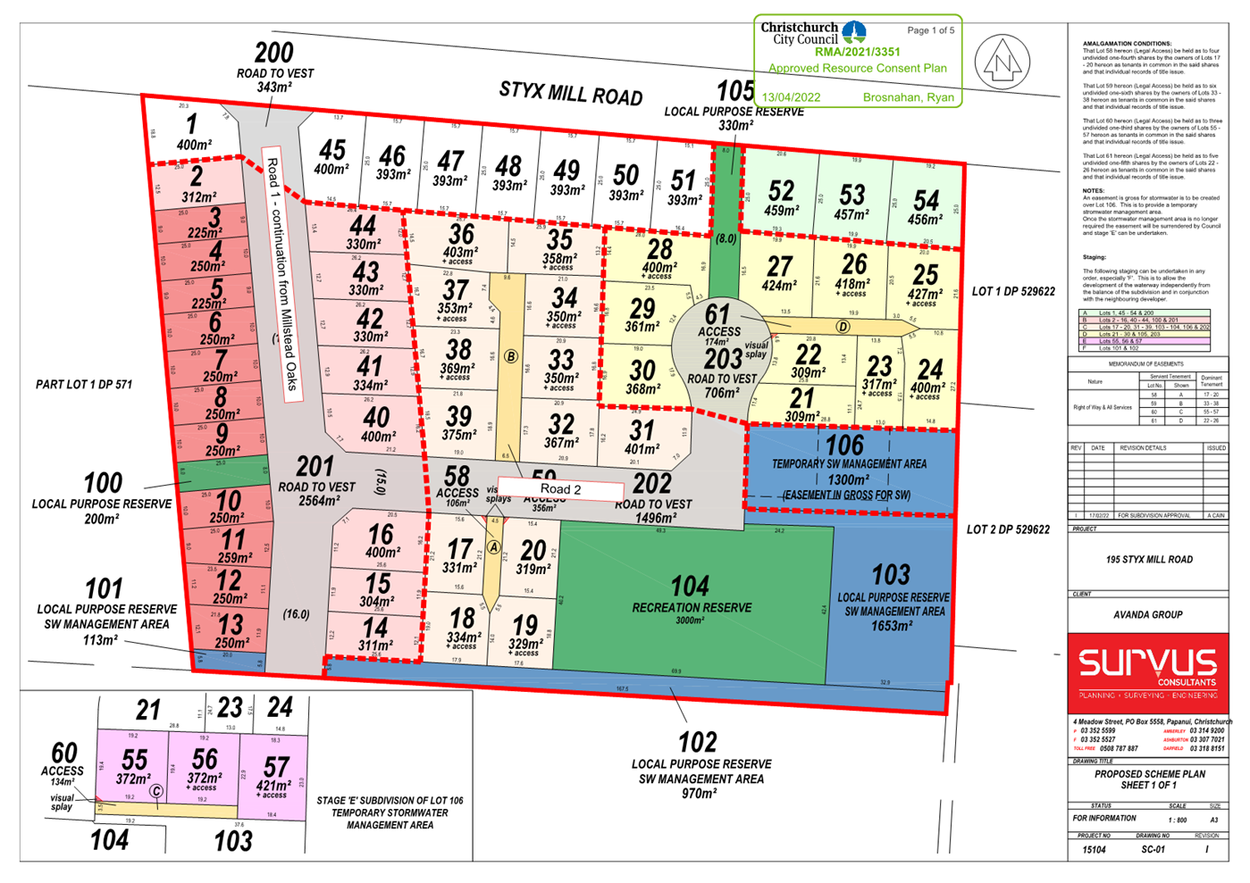
2. Approves the following new road name for 195
Styx Mill Road (Millhaven, RMA/2021/3351).
a. Road 2 - Millhaven Place
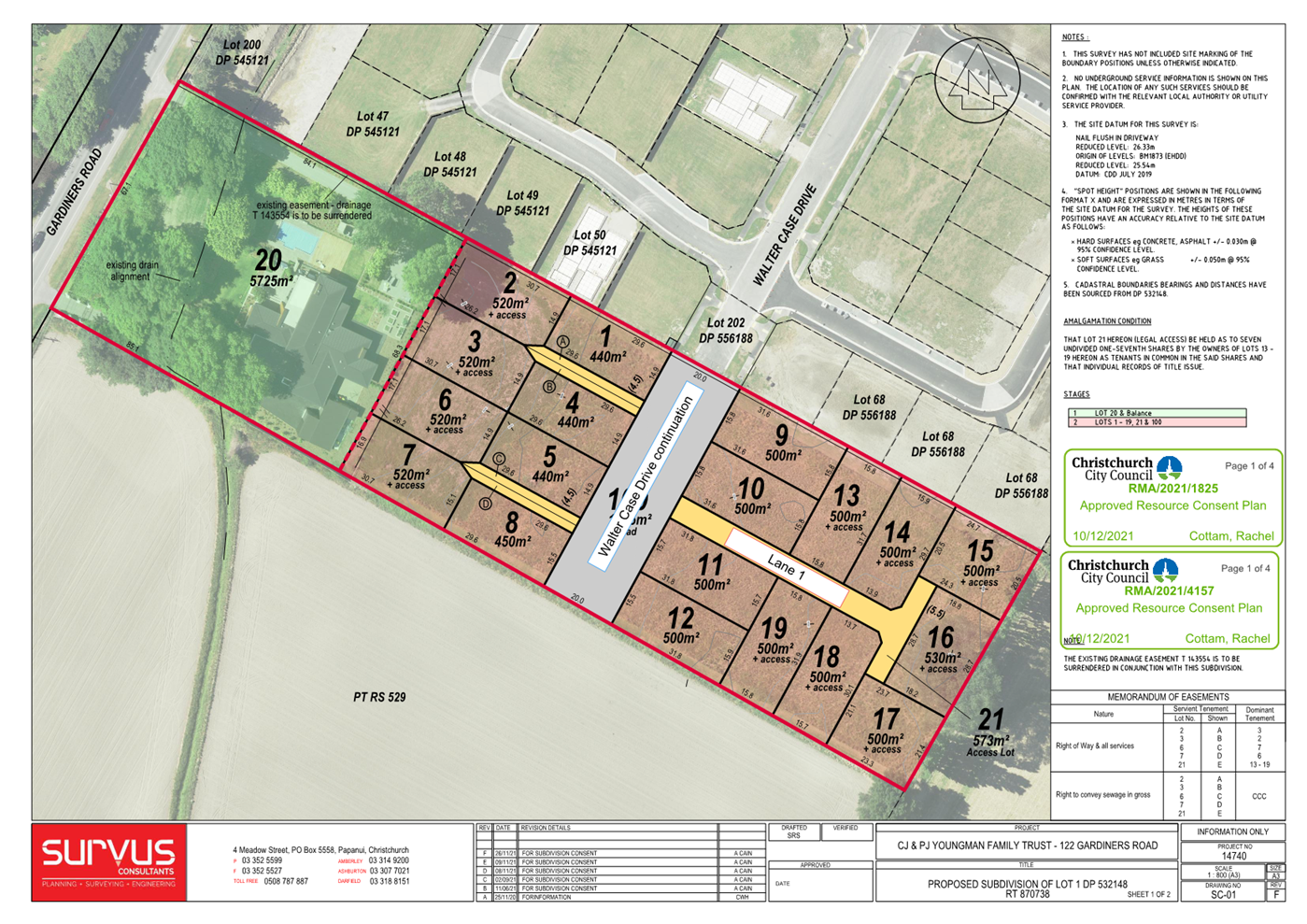
3. Approves the following new land name for 122
Gardiners Road (RMA/2021/4157).
a. Lane 1 - Hobbs Lane
3. Detail Te Whakamahuki
Introduction Te
Whakatkinga
3.1 Road
naming requests have been submitted by the developer for each subdivision: 302
Highsted Road (Millstead Oaks, RMA/2021/1747), 195 Styx Mill Road (Millhaven,
RMA/2021/3351), and 122 Gardiners Road (RMA/2021/4157). A preferred name and
alternative names, have been put forward by the developer for each road.
3.2 The
recommended road names have been checked against existing road names in
Christchurch and bordering districts, for duplication, alternative spelling, or
other similarities in spelling or pronunciation to avoid the potential for
confusion. The proposed names are considered sufficiently different to existing
road names.
3.3 The
recommended road names have been checked against the Council’s Roads and
Right-of-Way Naming Policy dated 2 November 1993 and are considered to be
consistent with this policy except as outlined below.
3.4 The
recommended road names have also been checked against the Australia and New
Zealand Standard AS/NZA 4819:2011 Rural and Urban Addressing. The names are
considered to be consistent with the Standard unless otherwise stated below.
3.5 Under
the Roads and Right-of-Way Naming Policy, the names considered must be
requested by the developer. There is not an ability to consider alternative
names without first checking whether there are any duplications or similarities
with other road and right-of-way names.
3.6 Consultation
has been undertaken with Land Information New Zealand who have raised no
concerns with the proposed road names.
3.7 The
names requested have been accompanied by an explanation of the background to
the names, which is summarised below, along with correspondence with the
applicant.
Assessment of Significance and
Engagement Te Aromatawai Whakahirahira
3.8 The
decisions in this report is of low significance in relation to the Christchurch
City Council’s Significance and Engagement Policy.
3.9 The
level of significance was determined by the number of people affected and/or
with an interest.
3.10 Due
to the assessment of low significance, no further community engagement and
consultation is required.
Proposed Names - 302 Highsted Road
(Millstead Oaks, RMA/2021/1747)
3.11 The
proposed roads are shown in Attachment A
3.12 The
proposed road names are themed for the local environment, and local history.
3.13 The
other road on the plan is a continuation of Redbrooke Road.
3.14 Road
1 - Preferred name: Oakmill Drive
3.15 Oak
trees are part of natural habitat of the area. The Styx River was used to drive
waterwheels and provided an important source of power for mills.
3.16 Lane
1 - Preferred name: Millstead Lane
3.17 Millstead
is named for the development, Millstead Oaks. Millstead means the site of a
mill, reflecting the historical use of the area.
3.18 Lane
2 - Preferred name: Newbury Lane
3.19 Newbury
is a small hamlet in the English county of Kent. It is near the town of
Sittingbourne, and approximately 2km from the village of Highsted.
Alternative Names
3.20 Oakhaven
Drive/Lane - Oak trees are part of natural habitat of the area.
3.21 Sawmill
Drive/Lane - During European settlement the area was used for a number of
purposes including sheep farming and milling. The river provided an important
source of power for sawmills. By the time the First World War came along,
milling had ceased on the site.
Note: The appropriate road type will be
used for any alternative name.
Proposed Names - 195 Styx Mill Road
(Millhaven, RMA/2021/3351).
3.22 The
proposed roads are shown in Attachment B
3.23 The
proposed road names are themed for local environment, and local history.
3.24 Road
1 on the plan is a continuation of Road 1 from the development mentioned above.
3.25 Road
2 - Preferred name: Millhaven Place
3.26 Millhaven
is the developer’s name for the subdivision. The “Mill”
reference in the name refers to the Styx River that was used to drive
waterwheels and provided an important source of power for mills. The word
“Haven” refers to “a place of safety” or haven for the
wildlife around the Styx River.
Alternative Names
3.27 Silver
Fern Place - Ferns were the sources of kai gathering in Styx Mill’s
history.
3.28 Waterwheel
Place - During European settlement, the area was used for a number of
purposes including sheep farming and milling. The river was used to drive
waterwheels and provided an important source of power for sawmills and
flaxmills. By the time the First World War came along, milling had ceased on
the site.
Proposed Names - 122 Gardiners Road
(RMA/2021/4157)
3.29 The
proposed roads are shown in Attachment C
3.30 The
proposed lane name is themed for the historical mayors of Christchurch.
3.31 Lane
1 - Preferred name: Hobbs Lane
3.32 Frederick
Hobbs (1841 - 1920), was Mayor of Christchurch from 1874 until 1876. He is
credited with having made significant improvements to the drainage system, and
thus improving health in the wider Christchurch area. Upon his lobbying, The
Christchurch District Drainage Act 1875 was passed, and Hobbs became the first
chairman of the Christchurch Drainage Board.
Alternative Names
3.33 Gapes
Lane - James Gapes (1822 - 1899), was Mayor of Christchurch on two
occasions, in 1876-1877 and 1880-1881. He was the first mayor who was elected
by the voting public; previously city councillors chose one from their rank as
mayor. His son Thomas Gapes was the 20th Mayor of Christchurch.
3.34 Michael
Hart Lane - Michael Hart (1814 - 1878), was Mayor of Christchurch
1873-1874. Hart was one of the early settlers of Canterbury, having arrived in
1850 by one of the first four ships, he also established the first hotel in
Christchurch, the White Hart, which opened in 1851.
Attachments Ngā Tāpirihanga
|
No.
|
Title
|
Page
|
|
a ⇩
|
RMA/2021/1747
- Proposed Plan - 302 Highsted Road, Millstead Oaks
|
31
|
|
b ⇩
|
RMA/2021/3351
- Proposed Plan - 195 Styx Mill Road, Millhaven
|
32
|
|
c ⇩
|
RMA/2021/4157
- Proposed Plan - 122 Gardiners Road
|
33
|
Confirmation of Statutory
Compliance / Te
Whakatūturutanga ā-Ture
|
Compliance with Statutory Decision-making
Requirements (ss 76 - 81 Local Government Act 2002).
(a) This report contains:
(i) sufficient information about all reasonably practicable
options identified and assessed in terms of their advantages and
disadvantages; and
(ii) adequate consideration of the views and preferences of
affected and interested persons bearing in mind any proposed or previous
community engagement.
(b) The information reflects the level of significance of the
matters covered by the report, as determined in accordance with the Council's
significance and engagement policy.
|
Signatories / Ngā Kaiwaitohu
|
Authors
|
Leashelle
Miller - Planning Technician
Paul Lowe -
Manager Resource Consents
|
|
Approved By
|
John Higgins -
Head of Planning & Consents
Jane Davis -
General Manager Infrastructure, Planning & Regulatory Services
|
|
Waimāero
Fendalton-Waimairi-Harewood Community Board
12 September
2022
|
|
|
Waimāero
Fendalton-Waimairi-Harewood Community Board
12 September
2022
|
|
|
Waimāero
Fendalton-Waimairi-Harewood Community Board
12 September
2022
|
|
|
Waimāero
Fendalton-Waimairi-Harewood Community Board
12 September
2022
|
|
|
9. Withells Road - Proposed No
Stopping Restrictions
|
|
Reference / Te Tohutoro:
|
22/322038
|
|
Report of / Te Pou Matua:
|
Sally-Ann
Marshall, Traffic Engineer, sallyann.marshall@ccc.govt.nz
|
|
General Manager / Pouwhakarae:
|
Jane
Davis, General Manager Infrastructure, Planning & Regulatory Services, jane.davis@ccc.govt.nz
|
1. Purpose of the Report Te Pūtake
Pūrongo
1.1 The
purpose of this report is for the Waimāero
Fendalton-Waimairi-Harewood Community Board to consider options to improve
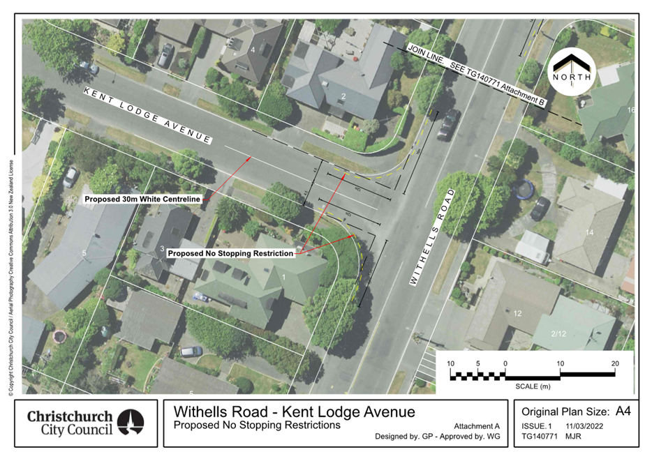
visibility at the intersection of the following streets with Withells Road:
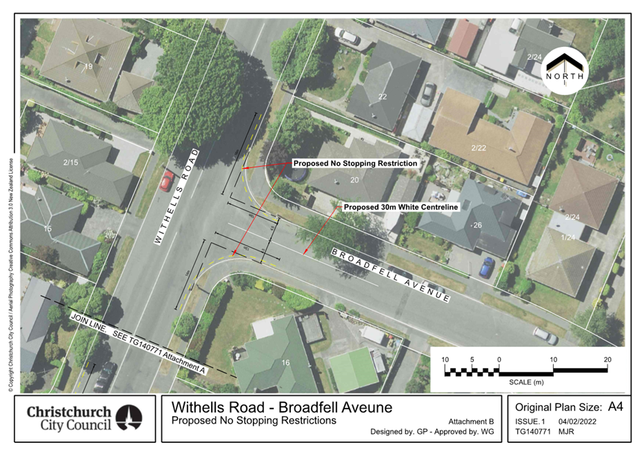
· Kent Lodge Avenue
· Broadfell Avenue
· Harkness Place
· Harrowdale Drive
· Talltree Avenue
1.2 This
report has been written following a request from a local resident to address
visibility issues caused by vehicles parking too close to the intersection of
Harkness Place with Withells Road. The decision was taken to include the other
streets off this section of Withells Road as the same situation also exists
here.
1.3 The
decisions in this report are of low significance in relation to the Christchurch
City Council’s Significance and Engagement Policy. The level of
significance was determined by the low level of impact and low number of people
affected by the recommended decision.
1.4 The
community engagement and consultation outlined in this report reflect the
assessment.
1.5 The
recommended option is to install No Stopping restrictions in accordance with Attachments
A to E.
2. Officer Recommendations Ngā
Tūtohu
That the
Waimāero Fendalton-Waimairi-Harewood Community Board:
1. Approves that in accordance with Clause 7 of
the Christchurch City Council Traffic and Parking Bylaw 2017, that the stopping
of vehicles be prohibited at any time at the
intersection of Withells Road and Kent Lodge Avenue as indicated in the drawing
TG140771 Issue 1, dated 11/03/2022 (refer Attachment A) and detailed in recommendations 1a-1e below:
a. That the stopping of vehicles is prohibited at
all times on the west side of Withells Road commencing at its intersection with
Kent Lodge Avenue, and extending in a northerly direction for a distance of 16
metres.
b. That the stopping of vehicles is prohibited at
all times on the west side of Withells Road commencing at its intersection with
Kent Lodge Avenue, and extending in a southerly direction for a distance of 13
metres.
c. That the stopping of vehicles is prohibited at
all times on the north side of Kent Lodge Avenue commencing at its intersection
with Withells Road, and extending in a westerly direction for a distance of 12
metres.
d. That the stopping of vehicles is prohibited at
all times on the south side of Kent Lodge Avenue commencing at its intersection
with Withells Road, and extending in a westerly direction for a distance of 12
metres.
e. Revoke any previous resolutions pertaining to
traffic controls made pursuant to any bylaw to the extent that they are in
conflict with the traffic controls described
in resolutions 1a – 1d above.
2. Approves that in accordance with Clause 7 of
the Christchurch City Council Traffic and Parking Bylaw 2017, that the stopping
of vehicles be prohibited at any time at the
intersection of Withells Road and Broadfell Avenue as indicated in the drawing
TG140771 Issue 1, dated 04/02/2022 (refer Attachment B) and detailed in recommendations 2a-2e below:
a. That the stopping of vehicles is prohibited at
all times on the east side of Withells Road commencing at its intersection with
Broadfell Avenue, and extending in a northerly direction for a distance of 16
metres.
b. That the stopping of vehicles is prohibited at
all times on the east side of Withells Road commencing at its intersection with
Broadfell Avenue, and extending in a southerly direction for a distance of 14
metres.
c. That the stopping of vehicles is prohibited at
all times on the north side of Broadfell Avenue commencing at its intersection
with Withells Road, and extending in an easterly direction for a distance of 10
metres.
d. That the stopping of vehicles is prohibited at
all times on the south side of Broadfell Avenue commencing at its intersection
with Withells Road, and extending in an easterly direction for a distance of 13
metres.
e. Revoke any previous resolutions pertaining to
traffic controls made pursuant to any bylaw to the extent that they are in
conflict with the traffic controls described
in resolutions 2a – 2d above.
3. Approves that in accordance with Clause 7 of
the Christchurch City Council Traffic and Parking Bylaw 2017, that the stopping
of vehicles be prohibited at any time at the
intersection of Withells Road and Harkness Place as indicated in the drawing
TG140771 Issue 1, dated 04/02/2022 (refer Attachment C) and detailed in recommendations 3a-3e below:
a. That the stopping of vehicles is prohibited at
all times on the west side of Withells Road commencing at its intersection with
Harkness Place, and extending in a northerly direction for a distance of 19
metres.
b. That the stopping of vehicles is prohibited at
all times on the west side of Withells Road commencing at its intersection with
Harkness Place, and extending in a southerly direction for a distance of 22
metres.
c. That the stopping of vehicles is prohibited at
all times on the north side of Harkness Place commencing at its intersection
with Withells Road, and extending in a westerly direction for a distance of 13
metres.
d. That the stopping of vehicles is prohibited at
all times on the south side of Harkness Place commencing at its intersection
with Withells Road, and extending in a westerly direction for a distance of 11
metres.
e. Revoke any previous resolutions pertaining to
traffic controls made pursuant to any bylaw to the extent that they are in
conflict with the traffic controls described
in resolutions 3a – 3d above.
4. Approves that in accordance with Clause 7 of
the Christchurch City Council Traffic and Parking Bylaw 2017, that the stopping
of vehicles be prohibited at any time at the
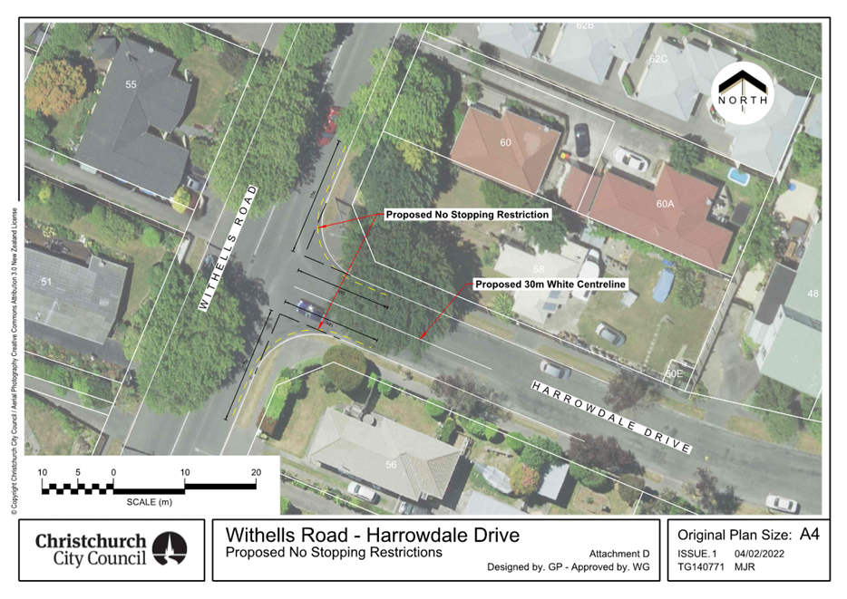
intersection of Withells Road and Harrowdale Drive as indicated in the drawing
TG140771 Issue 1, dated 04/02/2022 (refer Attachment D) and detailed in recommendations 4a-4e below:
a. That the stopping of vehicles is prohibited at
all times on the east side of Withells Road commencing at its intersection with
Harrowdale Drive, and extending in a northerly direction for a distance of 17
metres.
b. That the stopping of vehicles is prohibited at
all times on the east side of Withells Road commencing at its intersection with
Harrowdale Drive, and extending in a southerly direction for a distance of 17
metres.
c. That the stopping of vehicles is prohibited at
all times on the north side of Harrowdale Drive commencing at its intersection
with Withells Road, and extending in an easterly direction for a distance of 14
metres.
d. That the stopping of vehicles is prohibited at
all times on the south side of Harrowdale Drive commencing at its intersection
with Withells Road, and extending in an easterly direction for a distance of 14
metres.
e. Revoke any previous resolutions pertaining to
traffic controls made pursuant to any bylaw to the extent that they are in
conflict with the traffic controls described
in resolutions 4a – 4d above.
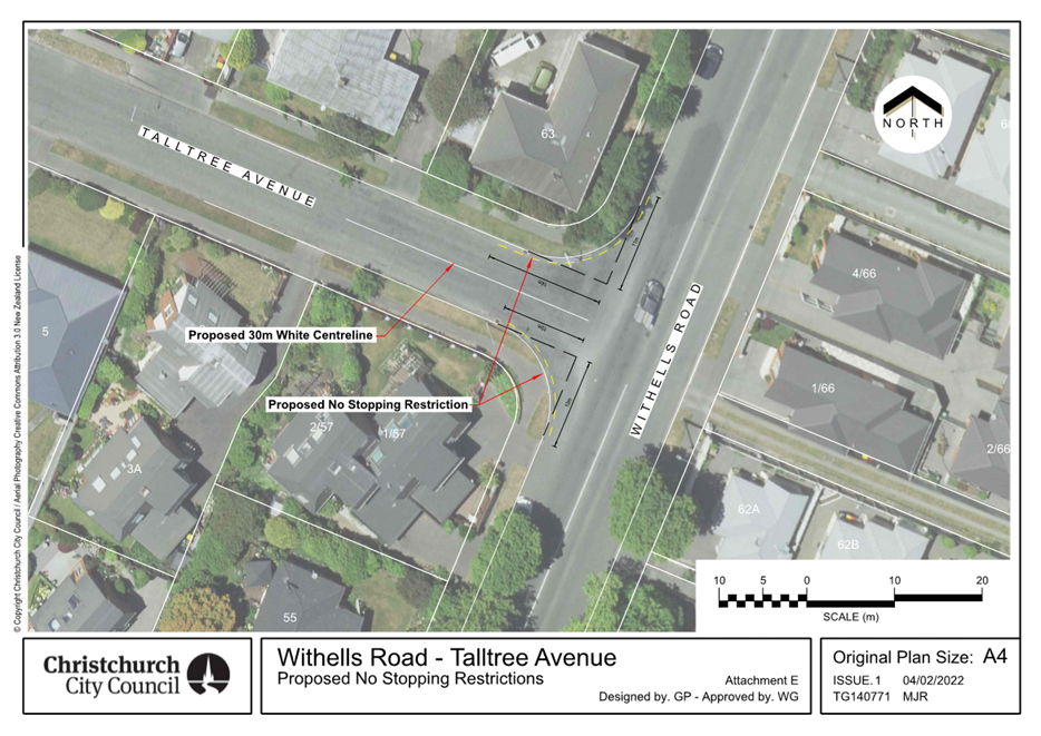
5. Approves that in accordance with Clause 7 of
the Christchurch City Council Traffic and Parking Bylaw 2017, that the stopping
of vehicles be prohibited at any time at the
intersection of Withells Road and Talltree Avenue as indicated in the drawing
TG140771 Issue 1, dated 04/02/2022 (refer Attachment E) and detailed in recommendations 5a-5e below:
a. That the stopping of vehicles is prohibited at
all times on the west side of Withells Road commencing at its intersection with
Talltree Avenue, and extending in a northerly direction for a distance of 11
metres.
b. That the stopping of vehicles is prohibited at
all times on the west side of Withells Road commencing at its intersection with
Talltree Avenue, and extending in a southerly direction for a distance of 10
metres.
c. That the stopping of vehicles is prohibited at
all times on the north side of Talltree Avenue commencing at its intersection
with Withells Road, and extending in a westerly direction for a distance of 14
metres.
d. That the stopping of vehicles is prohibited at
all times on the south side of Talltree Avenue commencing at its intersection
with Withells Road, and extending in a westerly direction for a distance of 10
metres.
e. Revoke any previous resolutions pertaining to
traffic controls made pursuant to any bylaw to the extent that they are in
conflict with the traffic controls described
in resolutions 5a – 5d above.
3. Reason for Report Recommendations Ngā Take mō te
Whakatau
3.1 A local resident has raised concerns that currently there
is poor visibility exiting Harkness Place at the intersection with Withells
Road. This is due to vehicles being parked too close to the intersection.
3.2 The
decision was taken to include the other, following streets off this section of
Withells Road as the same situation also exists here:
· Kent Lodge Avenue
· Broadfell Avenue
· Harrowdale Drive
· Talltree Avenue
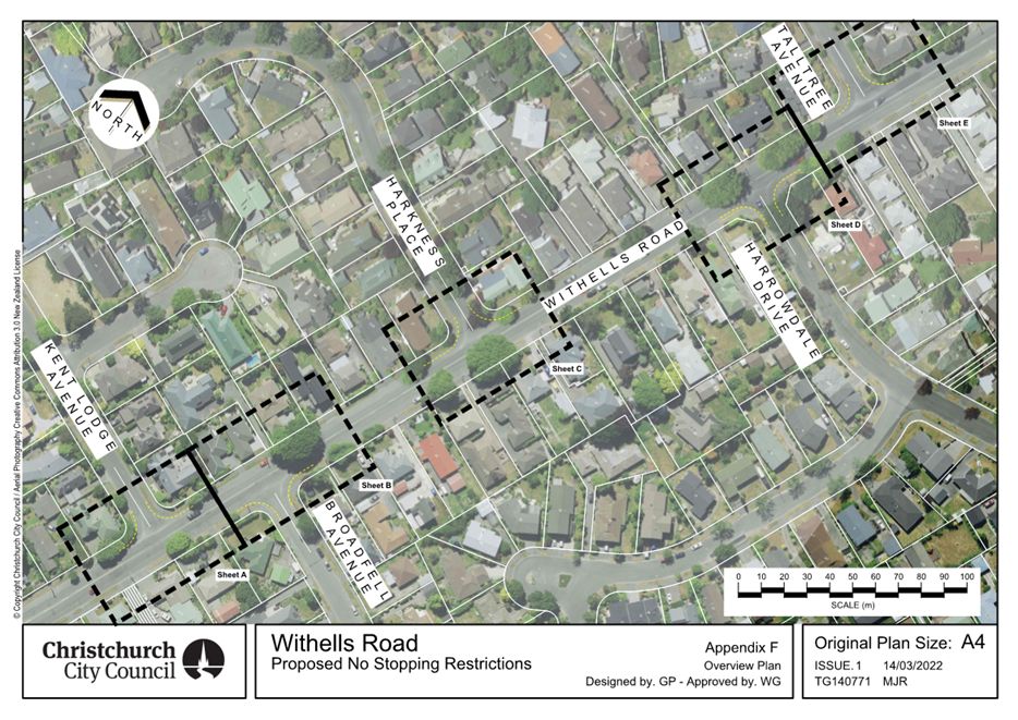
An overview of the
street layout is show in Appendix F.
3.3 It is recommended to install No Stopping restrictions and
30 metre long centrelines on the side roads in accordance with
Attachments A to E. The length of No Stopping along Withells Road in
these options is the minimum length needed to provide Minimum Gap Sight
Distance, allowing a driver exiting the side street sufficient visibility of
approaching traffic to make the desired turn safety. The parking
restrictions for a short distance on the side streets will provide more room
for vehicles waiting to turn into Withells Road, and also for vehicles turning
into the side streets. It also prevents vehicles having to manoeuvre around
parked cars near the intersection that could lead to conflicts.
3.4 Options
within this report have been assessed against relevant industry-standard design
guidance including the sight distance requirements of Council’s
Infrastructure Design Standard.
4. Alternative Options Considered Ētahi atu Kōwhiringa
4.1 The
recommendations in this report are consistent with the anticipated outcomes of
the Traffic Safety and Efficiency Service Plan in the Council's
Long Term Plan (2021 - 2031).
4.2 The
following feasible options have been considered:
· Option 1 - Install No
Stopping Restrictions and centre line (preferred option)
· Option 2 - Do Nothing
4.3 Option
Summary - Advantages and Disadvantages (preferred option)
4.3.1 The
advantages of this option include:
· Addresses
community concerns over the lack of visibility at the Harkness Avenue
intersection with Withells Road.
· Also
improves the visibility at intersection of Kent Lodge Avenue, Broadfell Avenue,
Harrowdale Drive and Talltree Avenue with Withells Road where the same poor
visibility situation exists.
· Reduces
the risk of a crash by improving sightlines Kent Lodge Avenue, Broadfell
Avenue, Harkness Avenue, Harrowdale Drive and Talltree Avenue with Withells
Road.
· Provides
a consistent approach to visibility management at the intersections along
Withells Road between Yaldhurst Road and Staveley Street.
· Legalises
the no stopping of on-street parking near this intersection.
4.3.2 The
disadvantages of this option include:
· Displaces
parking to another location.
5. Detail Te Whakamahuki
5.1 Under
the Christchurch City Council Road Classification Map, Withells Road is a
collector Road. Kent Lodge Avenue, Broadfell Avenue, Harkess Place, Harrowdale
Drive and Talltree Avenue are classified as Local Roads.
5.2 Visibility
can be limited by parked vehicles along Withells Road at the intersection of
Kent Lodge Avenue, Broadfell Avenue, Harkess Place, Harrowdale Drive and
Talltree Avenue
5.3 There
are moderate residential parking demands in the area.
5.4 There
have been no reported crashes at the Withells Road intersection with Kent Lodge
Avenue, Broadfell Avenue, Harkess Place, Harrowdale Drive and Talltree Avenue
in the last five years. These intersections have no risk classification
under Council’s high risk junction mapping system.
5.5 Approval
is required by the Waimāero/Fendalton-Waimairi-Harewood Community Board.
5.6 If
approved, the recommendations will be implemented within the current financial
year.
Community Views and Preferences
5.7 Eight
affected residents and three property owners were advised of the recommended
option by letter.
5.8 We
received two responses; one in support of the proposal at Harkness Place and
another who supported the proposals in general but did not think they would
have any effect on the issues they have pulling out of Broadfell Avenue.
5.9 The
Team Leader Parking Compliance supports the preferred option.
5.10 The
do nothing option is inconsistent with community requests to improve visibility
at the Withells Road intersection with Harkness Place.
6. Policy Framework Implications Ngā Hīraunga ā- Kaupapa here
Strategic
Alignment Te Rautaki
Tīaroaro
6.1 :
6.1.1 Activity: Transport
· Level of Service: 10.3.3 Maintain customer
perception of the ease of use of Council on- street parking facilities -
≥50% resident satisfaction
Policy
Consistency Te Whai
Kaupapa here
6.2 The recommendations in this report are consistent with the Christchurch
Suburban Parking Policy.
Impact
on Mana Whenua Ngā
Whai Take Mana Whenua
6.3 The effects of this proposal upon Mana Whenua are expected to be
insignificant.
Climate
Change Impact Considerations Ngā Whai Whakaaro mā te Āhuarangi
6.4 This proposal does not have any significant effect upon carbon
emissions and Climate Change.
Accessibility
Considerations Ngā
Whai Whakaaro mā te Hunga Hauā
6.5 This proposal improves accessibility for
pedestrians/drivers/cyclists, by providing a safer means of exiting the noted
streets onto Withells Road.
7. Resource Implications Ngā Hīraunga Rauemi
Capex/Opex / Ngā Utu Whakahaere
7.1 Cost
to Implement – approximately $1,250 for the new road markings and $750
for producing the report,
7.2 Maintenance/Ongoing
costs – approximately $1,000 a year.
7.3 Funding
Source - Traffic Operations Signs and Markings budget (installation)/existing
Transport maintenance budgets for ongoing maintenance.
Other / He mea anō
7.4 <enter
text>
8. Legal Implications Ngā Hīraunga ā-Ture
Statutory power to undertake proposals in the report /
Te Manatū Whakahaere Kaupapa
8.1 Part
1, Clause 7 of the Christchurch City Council Traffic and Parking Bylaw 2017
provides Council with the authority to install parking restrictions by
resolution.
8.2 The
Community Boards have delegated authority from the Council to exercise the
delegations as set out in the Register of Delegations. The list of
delegations for the Community Boards includes the resolution of stopping
restrictions and traffic control devices.
8.3 The
installation of any signs and/or markings associated with traffic control
devices must comply with the Land Transport Rule: Traffic Control Devices 2004.
Other Legal Implications / Ētahi atu
Hīraunga-ā-Ture
8.4 There
is a legal context, issue or implication relevant to this decision
8.5 This
specific report has not been reviewed and approved by the Legal Services Unit
however the report has been written using a general approach previously
approved of by the Legal Services Unit, and the recommendations are consistent
with the policy and legislative framework outlined in sections 8.1 – 8.3.
9. Risk Management Implications Ngā Hīraunga Tūraru
9.1 Not
applicable.
Attachments / Ngā Tāpirihanga
|
No.
|
Title
|
Page
|
|
a ⇩
|
Appendix A,
Kent Lodge Avenue intersection with Withells Road - Proposed No Stopping
Restrictions
|
42
|
|
b ⇩
|
Appendix B,
Broadfell Avenue intersection with Withells Road - Proposed No Stopping
Restrictions
|
43
|
|
c ⇩
|
Appendix C,
Harkness Place intersection with Withells Road - Proposed No Stopping
Restrictions
|
44
|
|
d ⇩
|
Appendix D,
Harrowdale Drive intersection with Withells Road - Proposed No Stopping
Restrictions
|
45
|
|
e ⇩
|
Appendix E,
Talltree Avenue intersection with Withells Road - Proposed No Stopping
Restrictions
|
46
|
|
f ⇩
|
Appendix F,
Overview Plan Withells Road - Proposed No Stopping Restriction
|
47
|
In addition to the attached documents, the following background
information is available:
|
Document
Name
|
Location
/ File Link
|
|
Not
applicable
|
Not
applicable
|
Confirmation of Statutory
Compliance / Te
Whakatūturutanga ā-Ture
|
Compliance with Statutory Decision-making
Requirements (ss 76 - 81 Local Government Act 2002).
(a) This report contains:
(i) sufficient information about all reasonably practicable
options identified and assessed in terms of their advantages and
disadvantages; and
(ii) adequate consideration of the views and preferences of
affected and interested persons bearing in mind any proposed or previous
community engagement.
(b) The information reflects the level of significance of the
matters covered by the report, as determined in accordance with the Council's
significance and engagement policy.
|
Signatories / Ngā Kaiwaitohu
|
Author
|
Sally-Ann
Marshall - Traffic Engineer
|
|
Approved By
|
Stephen Wright
- Manager Operations (Transport)
Lynette Ellis
- Head of Transport & Waste Management
|
|
Waimāero
Fendalton-Waimairi-Harewood Community Board
12 September
2022
|

|
|
Waimāero
Fendalton-Waimairi-Harewood Community Board
12 September
2022
|
|
|
Waimāero
Fendalton-Waimairi-Harewood Community Board
12 September
2022
|
|

|
Waimāero
Fendalton-Waimairi-Harewood Community Board
12 September
2022
|
|
|
Waimāero
Fendalton-Waimairi-Harewood Community Board
12 September
2022
|
|
|
Waimāero
Fendalton-Waimairi-Harewood Community Board
12 September
2022
|
|
|
Waimāero
Fendalton-Waimairi-Harewood Community Board
12 September
2022
|
|
|
10. Farrington Avenue - P60 Parking Restrictions
|
|
Reference / Te Tohutoro:
|
22/1003060
|
|
Report of / Te Pou Matua:
|
Georgia
Greene, Traffic Engineer, Georgia.Greene@ccc.govt.nz
|
|
General Manager / Pouwhakarae:
|
Jane
Davis, General Manager Infrastructure, Planning & Regulatory Services,
jane.davis@ccc.govt.nz
|
1. Purpose of the Report Te Pūtake
Pūrongo
1.1 The
purpose of this report is for the Waimāero Fendalton-Waimairi-Harewood
Community Board to consider approval of P60 parking restrictions outside
121-131 Farrington Avenue.
1.2 This
report has been written in response to a petition raised by the businesses at
this location requesting for the current P30 parking restrictions to be
extended to P60.
1.3 The decisions in this report are of low significance in
relation to the Christchurch City Council’s Significance and Engagement
Policy. The level of significance was determined by the low level of impact and
low number of people affected by the recommended decision.
1.4 The
community engagement and consultation outlined in this report reflect the
assessment.
1.5 The
recommended option is to install P60 parking restrictions in accordance with
Attachment A.
2. Officer Recommendations Ngā
Tūtohu
That the
Waimāero Fendalton-Waimairi-Harewood Community Board:
1. Approves, pursuant to Clause 7 of the
Christchurch City Council Traffic and Parking Bylaw 2017, that the parking of
vehicles be restricted to a maximum period of 60 minutes on the northwest side
of Farrington Avenue, commencing at a point 15 metres southwest of its
intersection with Eastling Street and extending in a south easterly direction
for a distance of 36 metres. This parking is further restricted to 60 degree
angle parking.
2. Revoke any previous restrictions pertaining to
parking restrictions made pursuant to any bylaw to the extent that they are in
conflict with the parking restrictions described in resolutions 1 above.
3. Approve that these resolutions take effect
when parking signage and/or road markings that evidence the restrictions
described in the staff report are in place (or removed in the case of
revocations).
3. Reason for Report Recommendations Ngā Take mō te
Whakatau
3.1 Businesses
along Farrington Avenue submitted a petition in regards to extending the
current P30 parking restrictions to P60. Extending the time restrictions will
allow for customers of these businesses to park here for longer.
4. Alternative Options Considered Ētahi atu Kōwhiringa
Do Nothing
4.1 The
advantages of this option include:
4.1.1 The
existing 30 minute parking encourages a higher turnover of vehicles.
4.2 The
disadvantages of this option include:
4.2.1 Does
not accommodate for the customers of the businesses at this location.
4.2.2 Does
not address the request from the businesses at this location.
5. Detail Te Whakamahuki
5.1 Businesses
from 121 to 131 Farrington Avenue requested changes to the P30 parking
restrictions outside their stores. All affected business, apart from the fish
and chip shop would benefit from extending the timed parking restrictions as
their customers/clients have appointments that are longer than 30 minutes.
5.2 When
onsite, the parking spaces were not at capacity.
5.3 Shorter
parking restrictions are available nearby along Farrington Avenue, including
P10 and P30 parking.
Community views and preferences
5.4 Ten
consultation letters were delivered to affected owners and tenants.
5.5 The
fish and chip shop signed the petition in support of the changes but did not
respond to the consultation.
5.6 Two
submissions were received. Both in support of the proposal, one with a request
for a small number of P120 parking spaces to be included.
5.7 A
mixture of P60 and P120 restrictions is not recommended in this section as it
may cause confusion for motorists and makes enforcement of the restrictions
difficult.
5.8 The
Parking Enforcement Team is in support of the proposed restrictions.
5.9 The decision affects the following wards/Community Board areas:
5.9.1 Waimāero
Fendalton-Waimairi-Harewood Community Board.
5.9.2 Harewood Ward.
6. Policy Framework Implications Ngā Hīraunga ā- Kaupapa here
Strategic
Alignment Te Rautaki
Tīaroaro
6.1 Council’s strategic priorities have been considered in
formulating the recommendations in this report, however this area of work is
not specifically covered by an identified priority.
6.2 This report supports the Council's
Long Term Plan (2021 - 2031):
6.2.1 Activity: Transport
· Level of Service: 10.3.3 Maintain customer
perception of the ease of use of Council on- street parking facilities -
>=50% resident satisfaction
Policy
Consistency Te Whai
Kaupapa here
6.3 The
recommendations in this report are
consistent with the Christchurch
Suburban Parking Policy.
Impact
on Mana Whenua Ngā
Whai Take Mana Whenua
6.4 The
decision does not involve a significant decision in relation to ancestral land
or a body of water or other elements of intrinsic value, therefore this
decision does not specifically impact Mana Whenua, their culture and
traditions.
Climate
Change Impact Considerations Ngā Whai Whakaaro mā te Āhuarangi
6.5 This proposal does not have any significant
effect upon carbon emissions and Climate Change.
Accessibility
Considerations Ngā
Whai Whakaaro mā te Hunga Hauā
6.6 This proposal improves accessibility for customers of the affected
businesses by enabling them to park for longer at this location.
7. Resource Implications Ngā Hīraunga Rauemi
Capex/Opex / Ngā Utu Whakahaere
7.1 Cost
to Implement – approximately $500 for the installation of new signs and
$750 for producing the report.
7.2 Maintenance/Ongoing
costs - Will be covered under the area maintenance contract and effect will be
minimal to the overall asset and no additional cost to maintaining the previous
P30 signs.
7.3 Funding
Source – Traffic Operations Signs and Markings budget 2022/23
Other / He mea anō
7.4 None
identified.
8. Legal Implications Ngā Hīraunga ā-Ture
Statutory power to undertake proposals in the report /
Te Manatū Whakahaere Kaupapa
8.1 Clause
7 of the Christchurch City Council Traffic and Parking Bylaw 2018 provides
Council with the authority to install stopping, standing and parking
restrictions by resolution.
8.2 The
Community Boards have delegated authority from the Council to exercise the
delegations as set out in the Register Delegations. The list of delegations for
the Community Boards includes the resolution of stopping restrictions and
traffic control devices.
8.3 The
legal consideration is that the installation of any signs and/or markings
associated with traffic control devices must comply with the Land Transport
Rule: Traffic Control Devices 2004.
Other Legal Implications / Ētahi atu
Hīraunga-ā-Ture
8.4 There
is a legal context, issue or implication relevant to this decision.
8.5 This
specific report has not been reviewed and approved by the Legal Services Unit
however the report has been written using a general approach previously
approved of by the Legal Services Unit, and the recommendations are consistent
with the policy and legislative framework outlined in sections 8.1 – 8.3.
9. Risk Management Implications Ngā Hīraunga Tūraru
9.1 There are no identified risks associated with the
recommendations in this report.
Attachments / Ngā Tāpirihanga
|
No.
|
Title
|
Page
|
|
a ⇩
|
Farrington
Avenue P60 Parking Restrictions
|
53
|
In addition to the attached documents, the following background
information is available:
|
Document
Name
|
Location
/ File Link
|
|
Not
applicable
|
Not
applicable
|
Confirmation of Statutory
Compliance / Te
Whakatūturutanga ā-Ture
|
Compliance with Statutory Decision-making
Requirements (ss 76 - 81 Local Government Act 2002).
(a) This report contains:
(i) sufficient information about all reasonably practicable
options identified and assessed in terms of their advantages and
disadvantages; and
(ii) adequate consideration of the views and preferences of
affected and interested persons bearing in mind any proposed or previous
community engagement.
(b) The information reflects the level of significance of the
matters covered by the report, as determined in accordance with the Council's
significance and engagement policy.
|
Signatories / Ngā Kaiwaitohu
|
Author
|
Georgia Greene
- Traffic Engineer
|
|
Approved By
|
Katie Smith -
Team Leader Traffic Operations
Stephen Wright
- Manager Operations (Transport)
Lynette Ellis
- Head of Transport & Waste Management
|
|
Waimāero
Fendalton-Waimairi-Harewood Community Board
12 September
2022
|

|
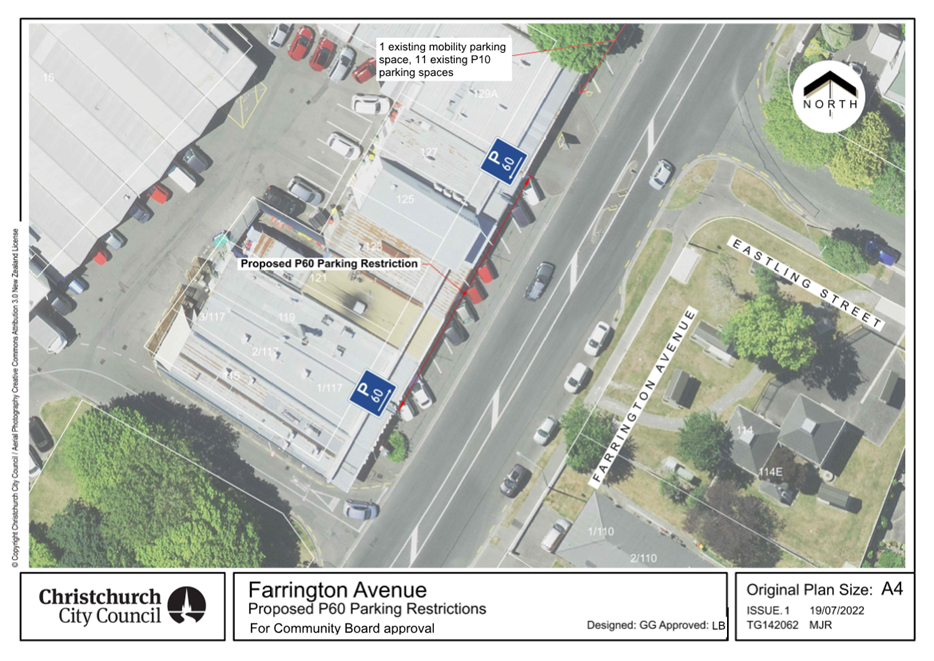
|
Waimāero
Fendalton-Waimairi-Harewood Community Board
12 September
2022
|
|
|
11. Public transport infrastructure improvements
along Route 17
|
|
Reference Te Tohutoro:
|
22/210809
|
|
Report of Te Pou Matua:
|
Sarah
Thorne, Passenger Transport Engineer, Sarah.Thorne@ccc.govt.nz
|
|
General Manager Pouwhakarae:
|
Jane
Davis, GM Infrastructure, Planning and Regulatory Services,
Jane.Davis@ccc.govt.nz
|
1. Purpose of the Report Te Pūtake
Pūrongo
1.1 The
purpose of this report is for the Waimaero Fendalton-Waimairi-Harewood
Community Board to approve the bus stop infrastructure improvements along route
17 as well as along the route extension to the Christchurch Airport as part of
the new Port-to-Port route.
1.2 This
report has been written to meet the outcomes agreed through the Greater
Christchurch Public Transport Futures Combined Business Case (PT Futures),
endorsed by Council on the 10 December 2020.
1.3 The
bus stops assessed for upgrades have been grouped into the following subsets;
· Attachment A - Wooldridge Road
· Attachment B - Wairakei Road between Wooldridge Road and Greers Road
· Attachment C - Wairakei Road (south west side) between Greers Road
and Blighs Road
· Attachment D - Wairakei Road and Strowan Road between Blighs Road
and Heaton Street
· Attachment E - Rossall Street
· Attachment F - Carlton Mill Road
1.4 The
upgrades include, but are not limited to; line marking, seats, shelters,
footpaths, accessible kerbs and pedestrian crossing facilities in accordance
with Attachments G and H.
1.5 Public
transport is a key provision to support mode shift, reduce greenhouse gas
emissions, traffic congestion and traffic crashes. Measures that promote the
use of public transport help the Council achieve its strategic framework of
providing a well-connected and accessible city promoting active public
transport, as well as meeting the challenge of climate change through every
means available.
1.6 The decisions in this report are of low significance in relation to
the Christchurch City Council’s Significance and Engagement Policy.
The level of significance was determined by considering the criteria set out in
the Council’s Significance and Engagement Policy.
2. Officer Recommendations Ngā Tūtohu
That the
Waimāero Fendalton-Waimairi-Harewood Community Board, as per Attachments
A, B, C, D, E and F attached to the agenda for this meeting, approve:
New bus stop -
281 Wooldridge Road (Attachment
A)
1. Pursuant to Clause 7 of the Christchurch City
Council Traffic and Parking Bylaw 2017:
a. A bus stop be installed on the west side of
Wooldridge Road, commencing at a point 272 metres north of its intersection
with Sir Angus Tait Drive and extending in a northerly direction for a distance
of 14 metres;
New bus stop -
280 Wooldridge Road (Attachment
A)
2. Pursuant to Clause 7 of the Christchurch City
Council Traffic and Parking Bylaw 2017:
a. That the stopping of vehicles be prohibited at
all times on the east side of Wooldridge Road, commencing at a point 310 metres
south of its intersection with Harewood Road and extending in a southerly
direction for a distance of 76 metres;
b. A bus stop be installed on the east side of
Wooldridge Road, commencing at a point 386 metres south of its intersection
with Harewood Road and extending in a southerly direction for a distance of 14
metres;
c. That the stopping of vehicles be prohibited at
all times on the east side of Wooldridge Road, commencing at a point 400 metres
south of its intersection with Harewood Road and extending in a southerly
direction for a distance of five metres;
New bus stop -
215 Wooldridge Road (Attachment
A)
3. Pursuant to Clause 7 of the Christchurch City
Council Traffic and Parking Bylaw 2017:
a. A bus stop be installed on the west side of
Wooldridge Road, commencing at a point 56 metres north of its intersection with
Wairakei Road and extending in a northerly direction for a distance of 14
metres;
Bus stop 16499 -
501 Wairakei Road (Attachment
B)
4. Pursuant to Clause 7 of the Christchurch City
Council Traffic and Parking Bylaw 2017:
a. That the stopping of vehicles be prohibited at
all times on the south side of Wairakei Road, commencing at its intersection
with Abros Place and extending in a westerly direction for a distance of 14
metres;
b. A bus stop be installed on the south side of
Wairakei Road, commencing at a point 14 metres west of its intersection with
Abros Place and extending in a westerly direction for a distance of 15 metres;
c. That the stopping of vehicles be prohibited at
all times on the south side of Wairakei Road, commencing at a point 29 metres
west of its intersection with Abros Place and extending in a westerly direction
for a distance of five metres;
Bus stop 16481,
pedestrian refuge and shelter– 490 Wairakei Road (Attachment B)
5. Pursuant to Clause 7 of the Christchurch City
Council Traffic and Parking Bylaw 2017:
a. That the stopping of vehicles be prohibited at
all times on the north side of Wairakei Road, commencing at a point five metres
east of its intersection with Abros Place and extending in an easterly
direction for a distance of 31 metres;
b. A bus stop be installed on the north side of
Wairakei Road, commencing at a point 36 metres east of its intersection with
Abros Place and extending in an easterly direction for a distance of 15 metres;
c. That the stopping of vehicles be prohibited at
all times on the north side of Wairakei Road, commencing at a point 51 metres
east of its intersection with Abros Place and extending in an easterly
direction for a distance of five metres;
d. That the stopping of vehicles be prohibited at
all times on the south side of Wairakei Road, commencing its intersection with
Abros Place and extending in an easterly direction for a distance of 75 metres;
6. The road markings, signage and pedestrian
refuge on Wairakei Road from its intersection with Abros Place to about 70
metres east of Abros place as detailed on the plan TG 141801, issue 1, dated
10/03/22, Waimairi Ward – Wairakei Road Near Abros Place (Bus stop #16481
& #16499) attached to this report as Attachment B.
7. Pursuant to Section 339(1) of the Local Government
Act 1974 (subject to approval of 0 above):
a. The installation of a bus passenger shelter on
the north side of Wairakei Road commencing at a point 44.5 metres east of its
intersection with Abros Place and extending in an easterly direction for a
distance of approximately 3.6 metres.
Bus stop 16633
– 469 Wairakei Road (Attachment
B)
8. Pursuant to Clause 7 of the Christchurch City
Council Traffic and Parking Bylaw 2017:
a. That the stopping of vehicles be prohibited at
all times on the south side of Wairakei Road, commencing at its intersection
with Todd Avenue and extending in a westerly direction for a distance of 35
metres;
b. A bus stop be installed on the south west side
of Wairakei Road, commencing at a point 35 metres west of its intersection with
Todd Avenue and extending in a westerly direction for a distance of 15 metres;
c. That the stopping of vehicles be prohibited at
all times on the south side of Wairakei Road, commencing at a point 50 metres
west of its intersection with Todd Avenue and extending in a westerly direction
for a distance of five metres;
Bus stop 16468
– 452 Wairakei Road (Attachment
B)
9. Pursuant to Clause 7 of the Christchurch City
Council Traffic and Parking Bylaw 2017:
a. That the existing parking and stopping
restriction on the north side of Wairakei Road, commencing at a point 30 metres
east of its intersection with Todd Avenue and extending in an easterly
direction for a distance of 15 metres be revoked;
b. A bus stop be installed on the east side of
Wairakei Road, commencing at a point 36 metres north of its intersection with
Breens Road and extending in a northerly direction for a distance of 15 metres;
c. That the stopping of vehicles be prohibited at
all times on the east side of Wairakei Road, commencing at a point 51 metres
north of its intersection with Breens Road and extending in a northerly
direction for a distance of 12 metres;
10. Pursuant to Section 339(1) of the Local
Government Act 1974 (subject to approval of 0 above):
a. The installation of a bus passenger shelter on
the east side of Wairakei Road (beside 450 Wairakei Road) commencing at a point
36 metres north of its intersection with Breens Road and extending in a
northerly direction for a distance of approximately 3.6 metres.
Bus stop 16554
– 442 Wairakei Road (Attachment
B)
11. Pursuant to Clause 7 of the Christchurch City
Council Traffic and Parking Bylaw 2017:
a. That a bus stop on the north side of Wairakei
Road, commencing at a point 40 metres south of its intersection with Breens
Road and extending in a southerly direction for a distance of 14 metres be
revoked;
Bus stop 16596 -
417 Wairakei Road (Attachment
B)
12. Pursuant to Clause 7 of the Christchurch City
Council Traffic and Parking Bylaw 2017:
a. That the stopping of vehicles be prohibited at
all times on the south-west side of Wairakei Road, commencing at its
intersection with Westpark Drive and extending in a north-westerly direction
for a distance of 16 metres;
b. A bus stop be installed on the south-west side
of Wairakei Road, commencing at a point 16 metres north-west of its
intersection with Westpark Drive and extending in a north-westerly direction
for a distance of 15 metres;
c. That the stopping of vehicles be prohibited at
all times on the south-west side of Wairakei Road, commencing at a point 31
metres north-west of its intersection with Westpark Drive and extending in a
north-westerly direction for a distance of 12 metres;
Bus stop #16622
and pedestrian refuge – 416 Wairakei Road (Attachment B)
13. Pursuant to Clause 7 of the Christchurch City
Council Traffic and Parking Bylaw 2017:
a. That the stopping of vehicles be prohibited at
all times on the north-east side of Wairakei Road, commencing at a point 13
metres north-west of its intersection with Charlcott Street and extending in a
south-easterly direction for a distance of 49 metres;
b. A bus stop be installed on the north-east side
of Wairakei Road, commencing at a point 28 metres south-east of its
intersection with Charlcott Street and extending in a south-easterly direction
for a distance of 15 metres;
c. That the stopping of vehicles be prohibited at
all times on the north-east side of Wairakei Road, commencing at a point 43
metres south-east of its intersection with Charlcott Street and extending in a
south-easterly direction for a distance of five metres;
d. That the stopping of vehicles be prohibited at
all times on the south-west side of Wairakei Road, commencing at its
intersection with Charlcott Street and extending in a south-easterly direction
for a distance of 66 metres;
14. The road markings, signage and pedestrian
refuge on Wairakei Road from 18 metres north-west of its intersection with
Charlcott Street to about 48 metres south-east of Charlcott Street as detailed
on the plan TG 141801, issue 1, dated 10/03/22, Waimairi Ward – Wairakei
Road Near Charlcott Street (Bus stop #16370 & #16622) attached to this
report as Attachment B.
Bus stop 16370 -
405 Wairakei Road (Attachment
B)
15. Pursuant to Clause 7 of the Christchurch City
Council Traffic and Parking Bylaw 2017:
a. That the stopping of vehicles be prohibited at
all times on the south-west side of Wairakei Road, commencing at its
intersection with Charlcott Street and extending in a north-westerly direction
for a distance of four metres;
b. A bus stop be installed on the south-west side
of Wairakei Road, commencing at a point four metres north-west of its
intersection with Charlcott Street and extending in a north-westerly direction
for a distance of 15 metres;
c. That the stopping of vehicles be prohibited at
all times on the south-west side of Wairakei Road, commencing at a point 19
metres north-west of its intersection with Charlcott Street and extending in a
north-westerly direction for a distance of five metres;
Bus stop 40212
– 367 Wairakei Road (Attachment
B)
16. Pursuant to Clause 7 of the Christchurch City
Council Traffic and Parking Bylaw 2017:
a. That the stopping of vehicles be prohibited at
all times on the south-west side of Wairakei Road, commencing at its
intersection with Kendal Avenue and extending in a north-westerly direction for
a distance of 77 metres;
b. A bus stop be installed on the south-west side
of Wairakei Road, commencing at a point 77 metres north-west of its
intersection with Kendal Avenue and extending in a north-westerly direction for
a distance of 14 metres;
c. That the stopping of vehicles be prohibited at
all times on the south-west side of Wairakei Road, commencing at a point 91
metres north-west of its intersection with Kendal Avenue and extending in a north-westerly
direction for a distance of three metres;
Bus stop 40980
– 372 Wairakei Road (Attachment
B)
17. Pursuant to Clause 7 of the Christchurch City
Council Traffic and Parking Bylaw 2017:
a. That the stopping of vehicles be prohibited at
all times on the north-east side of Wairakei Road, commencing at a point 81
metres south-east of its intersection with Farrington Avenue and extending in a
south-easterly direction for a distance of six metres;
b. A bus stop be installed on the north-east side
of Wairakei Road, commencing at a point 87 metres south-east of its
intersection with Farrington Avenue and extending in a south-easterly
direction for a distance of 14 metres;
c. That the stopping of vehicles be prohibited at
all times on the north-east side of Wairakei Road, commencing at a point 95
metres south-east of its intersection with Farrington Avenue and
extending in a south-easterly direction for a distance of five metres;
18. Pursuant to Section 339(1) of the Local
Government Act 1974:
a. The installation of a bus passenger shelter on
the north-east side of Wairakei Road (beside 374 Wairakei Road) commencing at a
point approximately 94 metres south-east of its intersection with Farrington
Avenue and extending in a south-easterly direction for a distance of
approximately 3.6 metres.
Bus stop 16045 -
341 Wairakei Road (Attachment
B)
19. Pursuant to Clause 7 of the Christchurch City
Council Traffic and Parking Bylaw 2017:
a. That the stopping of vehicles be prohibited at
all times on the south side of Wairakei Road, commencing at a point 69 metres
east of its intersection with Spalding Street and extending in a westerly
direction for a distance of 84 metres;
b. A bus stop be installed on the south side of
Wairakei Road, commencing at a point 8 metres west of its intersection with
Spalding Street and extending in a westerly direction for a distance of 15
metres;
c. That the stopping of vehicles be prohibited at
all times on the south side of Wairakei Road, commencing at a point 23 metres
west of its intersection with Spalding Street and extending in a westerly
direction for a distance of five metres;
Bus stop #16531 – 346 Wairakei Road (Attachment B)
20. Pursuant to Clause 7 of the Christchurch City
Council Traffic and Parking Bylaw 2017:
a. That the stopping of vehicles be prohibited at
all times on the east side of Spalding Street, commencing at its intersection
with Wairakei Road and extending in a northerly direction for a distance of ten
metres;
b. That the stopping of vehicles be prohibited at
all times on the north side of Wairakei Road, commencing at its intersection
with Spalding Street and extending in an easterly direction for a distance of
26 metres;
c. A bus stop be installed on the north side of
Wairakei Road, commencing at a point 26 metres east of its intersection with
Spalding Street and extending in an easterly direction for a distance of 15
metres;
d. That the stopping of vehicles be prohibited at
all times on the north side of Wairakei Road, commencing at a point 41 metres
east of its intersection with Spalding Street and extending in an easterly
direction for a distance of five metres;
21. The road markings, signage and pedestrian
refuge on Wairakei Road from 7 metres west of its intersection with Spalding
Street to about 52 metres east of Spalding Street as detailed on the plan TG
141801, issue 1, dated 10/03/22, Waimairi Ward –Wairakei Road near
Spalding Street (Bus stop #16531 & #16045) attached to this report as
Attachment B.
Bus stop #16614
– 275 Wairakei Road (Attachment
C)
22. Pursuant to Clause 7 of the Christchurch City
Council Traffic and Parking Bylaw 2017:
a. That the stopping of vehicles be prohibited at
all times on the south-west side of Wairakei Road, commencing at its
intersection with Greers Road and extending in a south-easterly direction for a
distance of 57 metres;
b. A bus stop be installed on the south-west side
of Wairakei Road, commencing at a point 57 metres south-east of its
intersection with Greers Road and extending in a south-easterly direction for a
distance of 15 metres;
c. That the stopping of vehicles be prohibited at
all times on the south-west side of Wairakei Road, commencing at a point 72
metres south-east of its intersection with Greers Road and extending in a
south-easterly direction for a distance of 20 metres;
Bus stop 43164 -
215 Wairakei Road (Attachment
C)
23. Pursuant to Clause 7 of the Christchurch City
Council Traffic and Parking Bylaw 2017:
a. That the stopping of vehicles be prohibited at
all times on the south-west side of Wairakei Road, commencing at a point 13
metres north-west of its intersection with Jennifer Street and extending in a
north-westerly direction for a distance of 10 metres;
b. A bus stop be installed on the south-west side
of Wairakei Road, commencing at a point 23 metres north-west of its
intersection with Jennifer Street and extending in a north-westerly direction
for a distance of 13 metres;
c. That the stopping of vehicles be prohibited at
all times on the south-west side of Wairakei Road, commencing at a point 36
metres north-west of its intersection with Jennifer Street and extending in a
north-westerly direction for a distance of five metres;
Bus stop 43155 -
131 Wairakei Road (Attachment
C)
24. Pursuant to Clause 7 of the Christchurch City
Council Traffic and Parking Bylaw 2017:
a. A bus stop be installed on the south-west side
of Wairakei Road, commencing at a point 18 metres south-east of its
intersection with Pitcairn Crescent and extending in a south-easterly direction
for a distance of 15 metres;
b. That the stopping of vehicles be prohibited at
all times on the south-west side of Wairakei Road, commencing at a point 33
metres south-east of its intersection with Pitcairn Crescent and extending in a
south-easterly direction for a distance of 12 metres;
Bus stop #16124
– 91 Wairakei Road (Attachment
D)
25. Pursuant to Clause 7 of the Christchurch City
Council Traffic and Parking Bylaw 2017:
a. A bus stop be installed on the west side of
Wairakei Road, commencing at a point 23 metres south of its intersection with
Blighs Road and extending in a southerly direction for a distance of 15 metres;
b. That the stopping of vehicles be prohibited at
all times on the west side of Wairakei Road, commencing at a point 38 metres
south of its intersection with Blighs Road and extending in a southerly
direction for a distance of nine metres;
Bus stop #16107
– 55 Wairakei Road (Attachment
D)
26. Pursuant to Clause 7 of the Christchurch City
Council Traffic and Parking Bylaw 2017:
a. A bus stop be installed on the south side of
Wairakei Road, commencing at a point 20 metres west of its intersection with
Chislehurst Place and extending in a westerly direction for a distance of 14
metres;
b. That the stopping of vehicles be prohibited at
all times on the south side of Wairakei Road, commencing at a point 34 metres
west of its intersection with Chislehurst Place and extending in a
westerly direction for a distance of 15 metres;
Bus stop 16260
– 30 Wairakei Road (Attachment
D)
27. Pursuant to Clause 7 of the Christchurch City
Council Traffic and Parking Bylaw 2017:
a. That the stopping of vehicles be prohibited at
all times on the north side of Wairakei Road, commencing at a point 102 metres
west of its intersection with Westholme Street and extending in a westerly
direction for a distance of five metres;
b. A bus stop be installed on the north side of
Wairakei Road, commencing at a point 107 metres west of its intersection with
Westholme Street and extending in a westerly direction for a distance of 15
metres;
c. That the stopping of vehicles be prohibited at
all times on the north side of Wairakei Road, commencing at a point 122 metres
west of its intersection with Westholme Street and extending in a
westerly direction for a distance of 22 metres;
Bus stop #16605
– 52 Strowan Road (Attachment
D)
28. Pursuant to Clause 7 of the Christchurch City
Council Traffic and Parking Bylaw 2017:
a. That the stopping of vehicles be prohibited at
all times on the east side of Strowan Road, commencing at a point 23 metres
south of its intersection with Normans Road and extending in a southerly
direction for a distance of 17 metres;
b. A bus stop be installed on the west side of
Strowan Road, commencing at a point 40 metres south of its intersection with
Normans Road and extending in a southerly direction for a distance of 15 metres;
c. That the stopping of vehicles be prohibited at
all times on the east side of Strowan Road, commencing at a point 55 metres
south of its intersection with Normans Road and extending in a southerly
direction for a distance of ten metres;
Bus
stop 16084 – 41 Strowan Road (Attachment D)
29. Pursuant to Clause 7 of the Christchurch City
Council Traffic and Parking Bylaw 2017:
a. That the stopping of vehicles be prohibited at
all times on the west side of Strowan Road, commencing at a point 51 metres
north of its intersection with Lloyd Street and extending in a northerly
direction for a distance of 15 metres;
b. A bus stop be installed on the west side of
Strowan Road, commencing at a point 66 metres north of its intersection with
Lloyd Street and extending in a northerly direction for a distance of 15
metres;
c. That the stopping of vehicles be prohibited at
all times on the west side of Strowan Road, commencing at a point 81 metres
north of its intersection with Lloyd Street and extending in a northerly
direction for a distance of five metres;
Bus stop #16577
– 192 Rossall Street (Attachment
E)
30. Pursuant to Clause 7 of the Christchurch City
Council Traffic and Parking Bylaw 2017:
a. That the stopping of vehicles be prohibited at
all times on the north-east side of Rossall Street, commencing at a point 58
metres south-east of its intersection with Heaton Street and extending in a
south-easterly direction for a distance of 11 metres;
b. A bus stop be installed on the north-east side
of Rossall Street, commencing at a point 69 metres south-east of its
intersection with Heaton Street and extending in a south-easterly direction for
a distance of 15 metres;
c. That the stopping of vehicles be prohibited at
all times on the north-east side of Rossall Street, commencing at a point 84
metres south-east of its intersection with Heaton Street and extending in a
south-easterly direction for a distance of five metres;
Bus stop 16078 -
131 Rossall Street (Attachment
E)
31. Pursuant to Clause 7 of the Christchurch City
Council Traffic and Parking Bylaw 2017:
a. That the stopping of vehicles be prohibited at
all times on the south-west side of Rossall Street, commencing at a point 53
metres south-east of its intersection with Heaton Street and extending in a
south-easterly direction for a distance of five metres;
b. A bus stop be installed on the south-west side
of Rossall Street, commencing at a point 58 metres south-east of its
intersection with Heaton Street and extending in a south-easterly direction for
a distance of 15 metres;
c. That the stopping of vehicles be prohibited at
all times on the south-west side of Rossall Street, commencing at a point 73
metres south-east of its intersection with Heaton Street and extending in a
south-easterly direction for a distance of 12 metres;
Bus stop #16583
– 176 Rossall Street (Attachment
E)
32. Pursuant to Clause 7 of the Christchurch City
Council Traffic and Parking Bylaw 2017:
a. That the stopping of vehicles be prohibited at
all times on the north-east side of Rossall Street, commencing at a point 15
metres north of its intersection with Aikmans Road and extending in a northerly
direction for a distance of six metres;
b. A bus stop be installed on the north-east side
of Rossall Street, commencing at a point 21 metres north of its intersection
with Aikmans Road and extending in a northerly direction for a distance of 15
metres;
c. That the stopping of vehicles be prohibited at
all times on the north-east side of Rossall Street, commencing at a point 36
metres north of its intersection with Aikmans Road and extending in a northerly
direction for a distance of 12 metres;
Bus stop #16050
– 91 Rossall Street (Attachment
E)
33. Pursuant to Clause 7 of the Christchurch City
Council Traffic and Parking Bylaw 2017:
a. That the stopping of vehicles be prohibited at
all times on the west side of Rossall Street, commencing at a point 20 metres
south of its intersection with Fulton Avenue and extending in a southerly
direction for a distance of five metres;
b. A bus stop be installed on the west side of
Rossall Street, commencing at a point 25 metres south of its intersection with
Fulton Avenue and extending in a southerly direction for a distance of 15
metres;
c. That the stopping of vehicles be prohibited at
all times on the west side of Rossall Street, commencing at a point 40 metres
south of its intersection with Fulton Avenue and extending in a southerly
direction for a distance of 12 metres;
Bus stop #16273
– 132 Rossall Street (Attachment
E)
34. Pursuant to Clause 7 of the Christchurch City
Council Traffic and Parking Bylaw 2017:
a. That the stopping of vehicles be prohibited at
all times on the east side of Rossall Street, commencing at its intersection
with Office Road and extending in a southerly direction for a distance of 24
metres;
b. A bus stop be installed on the east side of
Rossall Street, commencing at a point 24 metres south of its intersection with
Office Road and extending in a southerly direction for a distance of 15 metres;
c. That the stopping of vehicles be prohibited at
all times on the east side of Rossall Street, commencing at a point 39 metres
south of its intersection with Office Road and extending in a southerly
direction for a distance of five metres;
Bus stop
#10687– 37 Rossall Street (Attachment
E)
35. Pursuant to Clause 7 of the Christchurch City
Council Traffic and Parking Bylaw 2017:
a. That the stopping of vehicles be prohibited at
all times on the west side of Rossall Street, commencing at a point 30 metres
south of its intersection with Holmwood Road and extending in a southerly
direction for a distance of five metres;
b. A bus stop be installed on the west side of
Rossall Street, commencing at a point 35 metres south of its intersection with
Holmwood Road and extending in a southerly direction for a distance of 15
metres;
c. That the stopping of vehicles be prohibited at
all times on the west side of Rossall Street, commencing at a point 50 metres
south of its intersection with Holmwood Road and extending in a southerly
direction for a distance of 13 metres;
Bus stop #11516
- 17 Rossall Street (Attachment
E)
36. Pursuant to Clause 7 of the Christchurch City
Council Traffic and Parking Bylaw 2017:
a. That the stopping of vehicles be prohibited at
all times on the west side of Rossall Street, commencing at its intersection
with Rhodes Street and extending in a southerly direction for a distance of 40
metres;
b. A bus stop be installed on the west side of
Rossall Street, commencing at a point 40 metres south of its intersection with
Rhodes Street and extending in a southerly direction for a distance of 15
metres;
c. That the stopping of vehicles be prohibited at
all times on the west side of Rossall Street, commencing at a point 55 metres
south of its intersection with Rhodes Street and extending in a southerly direction
for a distance of 12 metres;
Bus stop
#16362– 20 Rossall Street (Attachment
E)
37. Pursuant to Clause 7 of the Christchurch City
Council Traffic and Parking Bylaw 2017:
a. A bus stop be installed on the east side of
Rossall Street, commencing at a point 20 metres south of its intersection with
Rhodes Street and extending in a southerly direction for a distance of 15
metres;
b. That the stopping of vehicles be prohibited at
all times on the east side of Rossall Street, commencing at a point 35 metres
south of its intersection with Rhodes Street and extending in a southerly
direction for a distance of five metres;
Bus stop #10948
– 18 Carlton Mill Road (Attachment
F)
38. Pursuant to Clause 7 of the Christchurch City
Council Traffic and Parking Bylaw 2017:
a. That the stopping of vehicles be prohibited at
all times on the south side of Carlton Mill Road, commencing at a point 25.5
metres west of its intersection with Cheltenham Street and extending in a
westerly direction for a distance of 12 metres;
b. A bus stop be installed on the south side of
Carlton Mill Road, commencing at a point 37.5 metres west of its intersection
with Cheltenham Street and extending in a westerly direction for a distance of
15 metres;
c. That the stopping of vehicles be prohibited at
all times on the south side of Carlton Mill Road, commencing at a point 52.5
metres west of its intersection with Cheltenham Street and extending in a
westerly direction for a distance of five metres;
d. That the existing parking and stopping restriction
on the south side of Carlton Mill Road, commencing at a point 57.5 metres west
of its intersection with Cheltenham Street and extending in a westerly
direction for a distance of 22 metres be revoked;
Bus stop 16358 -
55 Carlton Mill Road (Attachment
F)
39. Pursuant to Clause 7 of the Christchurch City
Council Traffic and Parking Bylaw 2017:
a. That the stopping of vehicles be prohibited at
all times on the north side of Carlton Mill Road, commencing at a point 20
metres west of its intersection with Cheltenham Street and extending in a
westerly direction for a distance of five metres;
b. A bus stop be installed on the north side of
Carlton Mill Road, commencing at a point 25 metres west of its intersection
with Cheltenham Street and extending in a westerly direction for a distance of
15 metres;
c. That the stopping of vehicles be prohibited at
all times on the north side of Carlton Mill Road, commencing at a point 40
metres west of its intersection with Cheltenham Street and extending in a
westerly direction for a distance of 12 metres;
Bus stop 10660 -
66 Carlton Mill Road (Attachment
F)
40. Pursuant to Clause 7 of the Christchurch City
Council Traffic and Parking Bylaw 2017:
a. That the stopping of vehicles be prohibited at
all times on the south side of Carlton Mill Road, commencing at a point 86
metres east of its intersection with Exeter Street and extending in an easterly
direction for a distance of seven metres;
b. A bus stop be installed on the south side of
Carlton Mill Road, commencing at a point 93 metres east of its intersection
with Exeter Street and extending in an easterly direction for a distance of 15
metres;
c. That the stopping of vehicles be prohibited at
all times on the south side of Carlton Mill Road, commencing at a point 108
metres east of its intersection with Exeter Street and extending in an easterly
direction for a distance of six metres;
Bus stop 16343 -
73 Carlton Mill Road (Attachment
F)
41. Pursuant to Clause 7 of the Christchurch City
Council Traffic and Parking Bylaw 2017:
a. That the stopping of vehicles be prohibited at
all times on the north side of Carlton Mill Road, commencing at a point 33
metres east of its intersection with Exeter Street and extending in an easterly
direction for a distance of 11 metres;
b. A bus stop be installed on the north side of
Carlton Mill Road, commencing at a point 44 metres east of its intersection
with Exeter Street and extending in an easterly direction for a distance of 14
metres;
c. That the stopping of vehicles be prohibited at
all times on the north side of Carlton Mill Road, commencing at a point 58
metres east of its intersection with Exeter Street and extending in an easterly
direction for a distance of 13 metres;
42. That any previous resolutions pertaining to
traffic controls made pursuant to any bylaw to the extent that they are in
conflict with the traffic controls described in clauses 1 – 0 above are
revoked.
43. That these resolutions take effect when the
traffic control devices that evidence the restrictions described in clauses 1
– 0 above are in place.
3. Reason for Report Recommendations Ngā Take mō te
Whakatau
Background
3.1 In December 2020 Elected Members formally endorsed the Greater
Christchurch Public Transport Combined Business Case (PT Futures) as a strategy
for public transport in Greater Christchurch. This includes supporting
increased bus frequency on routes 17 and 28 by providing bus stop, bus shelter
and real time information (RTI) infrastructure.
3.2 The recommendations in this report, combined with increased bus
frequencies, recently approved by ECan, meet the PT Futures Business Case
objectives which are to:
· Improve journey time and reliability of Public Transport services
relative to private vehicles by 2028
· Improve Public Transport services to and from highly
populated/growth areas and key destinations across Greater Christchurch by 2028
· Remove barriers to the uptake of Public Transport by 2028
3.3 Meeting these objectives are expected to deliver the following key
benefits:
· More people using the bus network
· More households can access the city centre within 30 minutes by bus
· More people living within a five minute walk of a high frequency bus
route
· Reduction in car travel, resulting in CO2 emissions reduction
3.4 Measures that promote the use of public transport help the Council
achieve its community outcomes and strategic framework of providing a
well-connected and accessible city promoting active and public transport, as
well as meeting the challenge of climate change through every means available.
3.5 Environment Canterbury has approved the network changes to bus
routes 17 and 28 to create a new high frequency ‘Port-to-Port’
route and a ‘Northwood to Huntsbury’ route at its 542nd
meeting of the Canterbury Regional Council held on Wednesday, 13 April 2022.
3.6 The new Port-to-Port route will start at Lyttelton Port, and will
continue through Heathcote, Opawa and Waltham to the Bus Interchange. The
northern end will travel up Wairakei Road with an extension to Orchard Road,
finishing at Christchurch Airport.
3.7 ECan will also be increasing the bus frequency along the
Port-to-Port’ route. Increasing bus frequency improves usability and accessibility
because the waiting times between services is reduced. A fifteen-minute
frequency has four buses passing each stop every hour, compared with two buses
an hour at a 30-minute frequency. This improves the attractiveness of the
service.
3.8 The existing 17 and 28 services predominantly operate to 30-minute
frequency weekdays and up to hourly over the weekends which means customers
currently need to pre-plan their journeys.
3.9 The new Port-to-Port service will have increased frequencies of 15
minutes during weekdays until 6pm, 20 minutes on Saturdays and 30 minutes on
Sundays. This increase will make this service a high frequency, core route. The
service will be more direct and will connect major trip generators such as the
Airport and Lyttelton Port (with its connection to the outer bays of Lyttelton
Harbour). A two-year trial was also approved to changes to the Port-to-Port
route providing improved access on weekdays to Ara Institute of Canterbury.
Proposed infrastructure improvements on
Wooldridge Road (Attachment A)
3.10 The new Port-to-Port route will no longer terminate at Sheffield
Crescent. The bus will now travel onto Wooldridge Road and continue along
Harewood Road and Orchard Road and terminate at the airport.
3.11 The following new bus stops have been recommended for Wooldridge
Road to service the route extension:
· 281 Wooldridge Road
· 280 Wooldridge Road
· 215 Wooldridge Road
3.12 In addition, Council staff are carrying out further consultation
with Christchurch International Airport Limited (CIAL) on the design of two
additional bus stops on Orchard Road (south of Wairakei Road). A separate
report will be presented to the Community Board once the bus stop details have
been finalised.
3.13 Council staff are also working with CIAL staff on the design,
approval and implementation of four other bus stops on Orchard Road. However,
no report will need to be presented to the Community Board as the proposed bus
stops are within the on-campus roading network of CIAL.
3.14 Staff are also investigating bus stop locations at the intersection
of Wooldridge Road and Harewood Road in conjunction with the Wheels to Wings
– Papanui ki Waiwhetū cycleway. A separate report will be presented
to the Community Board once this has been finalised.
Proposed infrastructure improvements on
Wairakei Road between Wooldridge Road and Greers Road (Attachment B)
3.15 The infrastructure improvements on Wairakei Road between Wooldridge
Road and Greers Road (Attachment B) are proposed in accordance with Attachments
G and H.
3.16 The following pedestrian refuges have been proposed on Wairakei Road
between Wooldridge Road and Greers Road to improve pedestrian accessibility at
bus stops.
· Wairakei Road, south-east
of Abros Place
· Wairakei Road, south-east
of Charlcott Street
· Bus stop 16370
is currently outside 401 Wairakei Road and is unmarked. The new bus stop is
proposed to be relocated to outside 405 Wairakei Road due to the design of the
pedestrian refuge.
· Wairakei Road, east of
Spalding Street
· Bus stop 16045
is currently outside 339 Wairakei Road and is unmarked. The new bus stop is
proposed to be relocated to outside 341 Wairakei Road due to the design of the
pedestrian refuge and be marked.
3.17 Bus stop 16554 (currently beside 442 Wairakei Road) is proposed to
be removed for the following reasons;
· The bus stop is situated
after a bend in the road making it difficult for bus passengers to see an
approaching bus.
· The driveway of 442
Wairakei Road is within 9 metres of the top of the bus box. This means that bus
passengers may be getting on and off the bus on a driveway.
· Consultation to relocate
the bus stop to 436 Wairakei Road was undertaken as part of the Port-to-Port
consultation. However due to consultation responses, staff decided not to
proceed with this option.
· There was no suitable
location for a shelter at 442 Wairakei Road which provided good sight lines for
approaching buses.
· There are bus stops 190
metres north and 175 metres south, so the removal of the bus stop will
consolidate the number of bus stops in the area.
· A reduction of the number
of stops along this section of Wairakei Road means that the buses will be more
reliable as it has to stop less.
3.18 Bus stop 16468 (currently beside 460 Wairakei Road) is proposed to
be relocated to beside 450 Wairakei Road so that passengers accessing public
transport from Breens Road do not have longer to walk due to the removal of bus
stop 16554. A shelter is also proposed at this relocated bus stop as per
the criteria in Attachment G.
Proposed infrastructure improvements on
Wairakei Road (south-west side) between Greers Road and Blighs Road (Attachment
C)
3.19 The infrastructure improvements on Wairakei Road (south-west side)
between Greers Road and Blighs Road are proposed in accordance with Attachments
G and H.
Proposed infrastructure improvements on
Wairakei Road and Strowan Road between Blighs Road and Heaton Street
(Attachment D)
3.20 The infrastructure improvements on Wairakei Road and Strowan Road
between Blighs Road and Heaton Street are proposed in accordance with
Attachments G and H.
3.21 Bus stop 16260 (currently beside 15/126 Idris Road on Wairakei Road)
is proposed to be relocated to 30 Wairakei Road. This will provide a
lead-in area for buses to pull into the bus stop close and parallel to the
kerb.
Proposed infrastructure improvements on
Rossall Street (Attachment E)
3.22 The infrastructure improvements on Rossall Street are proposed in
accordance with Attachments G and H.
Proposed infrastructure improvements on
Carlton Mill Road (Attachment F)
3.23 The infrastructure improvements on Carlton Mill Road are proposed in
accordance with Attachments G and H.
3.24 Bus stop 10948 (currently beside 16 Carlton Mill Road) is proposed
to be relocated to 18 Carlton Mill Road. This was due to a request made by the
residents at 18 Carlton Mill Road to improve the sight lines of vehicles
exiting their driveway. Currently, parked cars to the east of their driveway obstruct
visibility of westbound traffic on Carlton Mill Road. In addition, the front
door section of the current bus stop box coincide with a redundant vehicle
crossing which makes it difficult for people with limited mobility or with
prams/strollers to board the bus.
Proposed infrastructure improvements
– general comments
3.25 The advantages vary between each bus stop and are discussed above.
Attachment G also provides a general overview of the advantages of public
transport infrastructure.
3.26 The disadvantages also vary between each of the bus stops but
generally are:
· The loss of parking
spaces.
· The financial cost of
shifting bus stops, installing new bus stops and all the associated
improvements.
4. Alternative Options Considered Ētahi atu Kōwhiringa
4.1 Option 2 – Do nothing and no bus stop improvements will be
undertaken and the existing bus stop infrastructure remain as is. This means
that:
· There will be no new bus
stops on the new route extension to the Christchurch Airport.
· The majority of the bus
stops are not line marked to Council’s standard (Attachment H). Some have
no line marking whilst others have a bus box (sometimes undersized) and with no
‘no stopping’ restrictions before and after the bus box. This means
buses are unable to pull up close and parallel to the kerb, which creates a
barrier for people to catch the bus.
· No improvements to
pedestrian accessibility to public transport.
5. Detail Te Whakamahuki
Public Consultation Te Tukanga Kōrerorero
5.1 Consultation started on 22 March and ran until 12 April 2022. An
email was sent to 67 key stakeholders, including Resident Associations,
Christchurch International Airport Limited, Metro Bus, Waka Kotahi, Lyttelton
Port Company and 31 schools. We also emailed submitters from Environment
Canterbury’s (ECan) initial consultation on the route review, who
indicated they would like to be contacted when we opened our consultation.
5.2 Consultation documents were delivered to 1049 affected properties on
22 March. Documents were also available in local service centres.
5.3 The consultation was posted on the Council Facebook page as well as
ten community pages inviting submissions on the Have Your Say webpage.
5.4 Corflute signs were installed at each of the 110 bus stops along the
route.
5.5 A Newsline article was posted on 22 March 2022 which shared the
consultation.
Summary of Submissions Ngā Tāpaetanga
5.6 In
total, one recognised organisation, four businesses and 126 residents made
submissions. All submissions are available on Council’s
Have Your Say Page.
Note: not all submitters
commented on each question
5.7 Please see Attachment I for the full consultation
analysis.
5.8 Some seats have been included in the proposal based on the
submissions. A seat has been added to the following bus stop:
· Bus stop 16066 (88 Rossall Street)
Further Public Consultation
5.9 Further consultation was undertaken following ECan’s decision
to extend route 17 out to the airport and to respond to the community
consultation carried out in March 2022. Consultation started on the 15
June and was open until 29 June 2022. We sent letters out to residents and
owners in the vicinity of the bus stops and sent emails to ECan and GoBus for
their feedback.
5.10 The following bus
stops were consulted on:
· New bus stop - 281 Wooldridge Road
· New bus stop - 280 Wooldridge Road
· New bus stop - 215 Wooldridge Road
· Relocation of bus stop 16468 to 450-452 Wairakei Road, shelter at
450 Wairakei Road
· Removal of bus stop 16554 at 442 Wairakei Road
5.11 Please see Attachment J for the full consultation comments and staff
responses from the further consultation that was undertaken in June 2022.
5.12 Bus stop 16343 outside 73 Carlton Mill Road was consulted on
separately as part of a proposed parking restrictions scheme. Consultation
started on 23 November 2021 until 21 December 2021. Letters were sent out to
affected residents and owners along Carlton Mill Road. Four responses were
received and they were all in favour of the proposed parking restrictions.
Staff are still in discussions with residents pertaining to the proposed
parking restrictions however, it is proposed that the line marking for bus stop
16343 be included as part of this public transport infrastructure improvements
along route 17 project.
Summary of issues raised on Wooldridge
Road (Attachment A)
5.13 We received no objections for the proposed bus stop at 215
Wooldridge Road.
5.14 Staff received one support and two objections from residents for the
proposed bus stops beside 280 and 281 Wooldridge Road. The objections for the
proposed bus stops are due to increased difficulty in backing into their property,
unnecessary cost due to lack of residents who would utilise the bus, loss of
parking, narrow width of the road and the current traffic volume especially
during sporting events and at peak periods.
Summary of issues raised on Wairakei
Road between Wooldridge Road and Greers Road (Attachment B)
5.15 Staff originally consulted on relocating bus stop 16554 to 436
Wairakei Road and installing a shelter. Staff received an objection to the bus
passenger shelter and bus stop due to increased difficulty in exiting their
property, loss of parking and the shelter blocking visibility.
5.16 Due to this objection, staff re-consulted on the consolidation of
bus stop 16468 and 16554 to 450-452 Wairakei Road and a proposed shelter at 450
Wairakei Road. We received one objection for the proposed relocation of bus
stop due to loss of parking.
5.17 Summary of issues raised on Wairakei Road (south west side) between
Greers Road and Blighs Road (Attachment C)
5.18 There were no issues raised by residents along Wairakei Road (south
west side) between Greers Road and Blighs Road. Further investigation is
required for requests for additional pedestrian refuges and shelters.
Summary of issues raised on Wairakei
Road and Strowan Road between Blighs Road and Heaton Street (Attachment D)
5.19 Staff received support from one resident to the relocation of bus
stop 16260 as they believe it will reduce the conflict between motorists and
cyclists on Wairakei Road.
5.20 Staff received a request for a shelter at bus stop 16764. This
bus stop does not meet the criteria for a shelter set out in Attachment G.
However we will monitor this bus stop and if passenger numbers increase we will
add it to the shelter installation program.
5.21 A pedestrian crossing was requested for bus stop 16084 and 16605
near 38 Strowan Road. Improved pedestrian crossing facilities are under
investigation.
Summary of issues raised on Rossall
Street (Attachment E)
5.22 There were no issues raised by residents along Rossall Street.
5.23 A pedestrian refuge was requested between 37B Rosall Street and 20
Rossall Street. At the moment, no pedestrian refuge is being considered as
there is a pedestrian refuge nearby at 33 Rossall Street.
5.24 A pedestrian refuge and shelter was requested for bus stop 16583 on
Rossall Street near Leinster Road. It does not meet the criteria for a
shelter and there is an existing pedestrian refuge just west of the Leinster
Road. A pedestrian refuge is under further investigation south of the bus stop.
5.25 A shelter was requested for bus stop 10687. This bus stop does not
meet the criteria for a shelter and a seat is being installed at this location.
5.26 Bus stop 16362 received support for the addition of the hardstand
area.
Summary of issues raised on Carlton
Mill Road (Attachment F)
5.27 There were no issues raised by residents along Carlton Mill
Road. Further investigation is required for a potential pedestrian
crossing facility near 37 Carlton Mill Road.
6. ThePolicy Framework Implications Ngā Hīraunga ā- Kaupapa here
Strategic
Alignment Te Rautaki
Tīaroaro
6.1 Council’s Strategic Framework is a key consideration in
guiding the recommendations in this report. The recommendations in this report
help achieve the:
· Community outcome of a
well-connected and accessible city promoting active and public transport, and
· Strategic priorities of meeting the challenge of climate change
through every means available.
6.2 This report supports the Council's
Long Term Plan (2021 - 2031):
6.2.1 Activity: Transport
· Level of Service: 10.4.4 Improve user satisfaction of
public transport facilities (number and quality of shelters and quality of bus
stop) - ≥71% resident satisfaction
· Level of Service: 10.0.41 Reduce emissions and greenhouse gases
related to transport
Policy
Consistency Te Whai
Kaupapa here
6.3 The
decision is consistent with Council’s Plans and
Policies.
Impact
on Mana Whenua Ngā
Whai Take Mana Whenua
6.4 The
decision does not involve a significant decision in relation to ancestral land
or a body of water or other elements of intrinsic value, therefore this decision
does specifically impact Mana Whenua, their culture and traditions.
Climate Change Impact Considerations Ngā Whai
Whakaaro mā te Āhuarangi
6.5 Greater
investment in public transport provides a more attractive mode choice that
reduces reliance on high-emission, single occupant vehicles.
6.6 Enhancing
our bus service to become more reliable, with more frequent and efficient
trips, will encourage more people to shift modes.
Accessibility Considerations Ngā Whai Whakaaro
mā te Hunga Hauā
6.7 Improvements to the overall length of the bus stop, including the no
stopping restrictions leading into and out of the bus box will provide buses
the necessary space to pull into the stop, stopping parallel and close to the
kerb, and to safely pull out of the stop to merge into the traffic lane. Buses
stopping parallel to the kerb provides inclusive access as it decreases the
step height or ramp gradient for people boarding or alighting the bus. This is
particularly important for people with limited mobility or with
prams/strollers.
6.8 Tactile ground surface indicators provide visual and sensory
information about the road environment. They assist people with vision
impairment to access the bus from the adjoining footpath by directing people to
where the front door of the bus will be and warning people of the kerb and
potential hazard beyond. We are intending to install tactile pavers at all bus
stops which have 5 or more passenger boarding per day or in areas with lots of
pedestrian activity. This criteria was determined after consultation with
Blind Low Vision NZ.
6.9 The
kerb forms a critical interface between the bus and the passenger. Many bus
stops have been shifted to ensure that the front or back door of the bus aligns
with a kerb as opposed to a driveway, providing a clear and safe delineation
between the road surface and the waiting area for bus passengers. Kerbs also
reduce the step height which facilitates quicker, safer and more comfortable
boarding and alighting times. Kerbs also reduce the gradient of a
deployed ramp.
6.10 To
allow for both the safe and convenient movement of pedestrians along the
footpath and for an adequate waiting area for bus passengers, a minimum 9
metres of hardstand area where possible (measured from the front of the bus box
which is also free of fixed obstacles) is proposed to be provided at the bus
stops.
7. Resource Implications Ngā Hīraunga Rauemi
7.1 The
figures below provide the construction estimates for each type of bus stop
upgrade;
|
Bus stop
upgrades
|
Construction
estimate
|
|
Bus stops
with shelters
|
$25,000 to
$35,000
|
|
Bus stops
with seats
|
$6,000 to
$10,000
|
|
Bus stops
with line marking
|
$2,000 to
$6,000
|
|
Pedestrian
refuges
|
$40,000 to
$75,000
|
7.2 The
total cost of bus stop improvements is $384,500. The cost estimates includes
construction cost and all associated design, consultation and supervision cost.
The cost estimates also allow for a 10% contingency.
7.3 For
each subset of bus stops, the following construction estimates are provided.
A. Wooldridge Road - $9,500
B. Wairakei Road between Wooldridge Road and Greers Road -
$240,000
C. Wairakei Road (south west side) between Greers Road and
Blighs Road - $25,000
D. Wairakei Road and Strowan Road between Blighs Road and
Heaton Street - $35,000
E. Rossall Street - $65,000
F. Carlton Mill Road - $10,000
7.4 If
approved, all recommendations will be constructed within 12 months, dependant
on the contractor’s availability. The works will be funded out of the
Traffic Operations, Capital Expenditure budgets for bus stops; seating and
shelter installations as well as the bus stop renewals budget.
7.5 Maintenance/Ongoing
costs - Transport Unit Operational Expenditure budget, includes maintenance of
bus stop infrastructure, which may cost on average approximately $200 annually
per bus stop.
8. Legal Implications Ngā Hīraunga ā-Ture
Statutory power to undertake proposals in the report
Te Manatū Whakahaere Kaupapa
8.1 Part 1, Clause 7 of the Christchurch City Council Traffic and
Parking Bylaw 2017 provides Council with the authority to install stopping,
standing and parking restrictions by resolution.
8.2 The Community Board have delegated authority from the Council to
exercise the delegations as set out in the Register of Delegations. The list of
delegations for the Community Boards includes the resolution of stopping,
standing and parking restrictions, traffic islands and traffic restraints, and
traffic control devices.
8.3 The legal consideration is that the installation of any signs and/or
markings associated with traffic control devices must comply with the Land
Transport Rule: Traffic Control Devices 2004.
Legal implications relating to bus
passenger shelters
8.4 Under Section 339 of the Local Government Act 1974, the Council may
erect on the footpath of any road, a shelter for use by intending public
transport passengers or small passenger service vehicle passengers provided
that no such shelter may be erected so as to unreasonably prevent access to any
land having a frontage to the road. The Council is required to give notice in
writing to the occupier and owner of property likely to be injuriously affected
by the erection of the shelter, and shall not proceed with the erection of the
shelter until after the expiration of the time for objecting against the
proposal or, in the event of an objection, until after the objection has been
determined.
8.5 Staff confirm the shelters will not prevent vehicular or pedestrian
access to any land having a frontage to the road.
8.6 The relevant Community Boards have delegated authority from the
Council to exercise the delegations as set out in the Register of Delegations.
The list of delegations for the Community Boards includes the resolution of bus
passenger shelters under Section 339 (1) of the Local Government Act 1974.
8.7 Where no objection to the shelter has been presented by the owner or
occupier of an affected property, staff present a decision making report
directly to the relevant Community Board.
8.8 Where an objection has been presented by the owner or occupier of
an affected property, staff present a decision making report to a Hearings
Panel. The Hearings Panel then assess the objection against the criterion as
outlined in Section 339 of the Act and make recommendations to the relevant
Community Board. The Community Board will then determine the outcome of the
objections in accordance with criterion outlined in Section 339 of the Local
Government Act 1974.
8.9 Section 339 of the Local Government Act requires that resolution of
the proposed shelter will require a separate decision of a Council Hearings
Panel that will hear the objections of the immediate owner (s) and occupier (s)
of bordering properties.
Other Legal Implications Ētahi atu
Hīraunga-ā-Ture
8.10 There is no legal context, issue or implication relevant to this
decision.
8.11 This specific report has not been reviewed and approved by the Legal
Services Unit however the report has been written using a general approach
previously approved of by the Legal Services Unit, and the recommendations are
consistent with the policy and legislative framework outlined in sections 8.1
– 8.9.
9. Risk Management Implications Ngā Hīraunga Tūraru
9.1 Should the Community Board proceed with the ‘Do Nothing’
option (Option 2 of this report), many of the existing bus stops will not be
marked to Council’s standard which will affect the operation of the
Port-to-Port service as there may be vehicles impeding access into the bus
stops. In addition, there will be no new bus stops on the new route extension.
With no investment in improving the public transport facilities to the
community, it will be difficult to increase public transport patronage.
Attachments Ngā Tāpirihanga
|
No.
|
Title
|
Page
|
|
a ⇩
|
Attachment A -
Bus stops on Wooldridge Road
|
75
|
|
b ⇩
|
Attachment B -
Bus stops on Wairakei Road between Wooldridge Road and Greers Road
|
77
|
|
c ⇩
|
Attachment C -
Bus stops on Wairakei Road (south-west side) between Greers Road and Blighs
Road
|
84
|
|
d ⇩
|
Attachment D -
Bus stops on Wairakei Road and Strowan Road between Blighs Road and Heaton
Street
|
87
|
|
e ⇩
|
Attachment E -
Bus stops on Rossall Street
|
91
|
|
f ⇩
|
Attachment F -
Bus stops on Carlton Mill Road
|
96
|
|
g ⇩
|
Attachment G -
Public Transport Infrastructure Explained
|
99
|
|
h ⇩
|
Attachment H -
Bus stop standard detailed design
|
102
|
|
i ⇩
|
Attachment I -
Consultation Analysis
|
103
|
|
j ⇩
|
Attachment J -
Feedback from further consultation in June 2022
|
107
|
Additional background information may be noted in the below table:
|
Document
Name
|
Location
/ File Link
|
|
Not
applicable
|
Not
applicable
|
Confirmation of Statutory
Compliance Te
Whakatūturutanga ā-Ture
|
Compliance with Statutory Decision-making
Requirements (ss 76 - 81 Local Government Act 2002).
(a) This report contains:
(i) sufficient information about all reasonably practicable
options identified and assessed in terms of their advantages and
disadvantages; and
(ii) adequate consideration of the views and preferences of
affected and interested persons bearing in mind any proposed or previous
community engagement.
(b) The information reflects the level of significance of the
matters covered by the report, as determined in accordance with the Council's
significance and engagement policy.
|
Signatories Ngā Kaiwaitohu
|
Authors
|
Sarah Thorne -
Passenger Transport Engineer
John Dore -
Principal Advisor Public Transport
Patricia Su -
Passenger Transport Engineer
Samantha
Sharland - Engagement Advisor
|
|
Approved By
|
Katie Smith -
Team Leader Traffic Operations
Stephen Wright
- Manager Operations (Transport)
Lynette Ellis
- Head of Transport & Waste Management
|
|
Waimāero
Fendalton-Waimairi-Harewood Community Board
12 September
2022
|
|
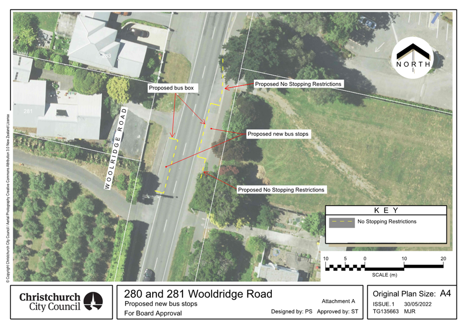

|
Waimāero Fendalton-Waimairi-Harewood
Community Board
12 September
2022
|
|
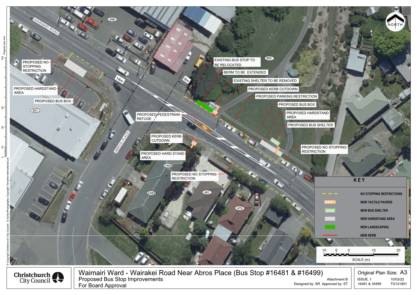
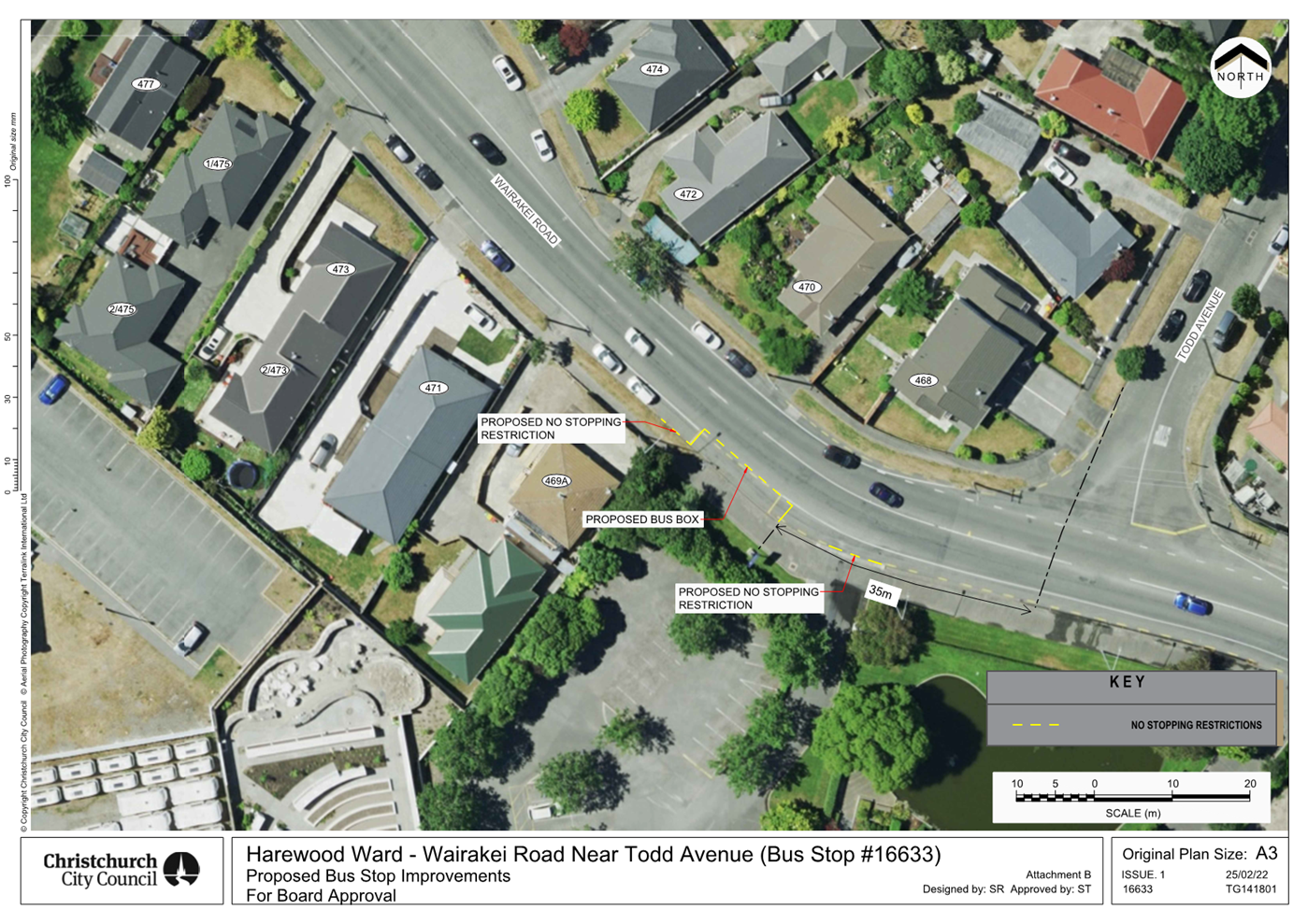
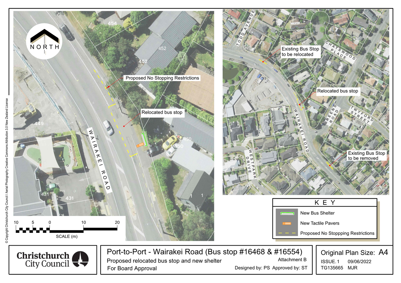
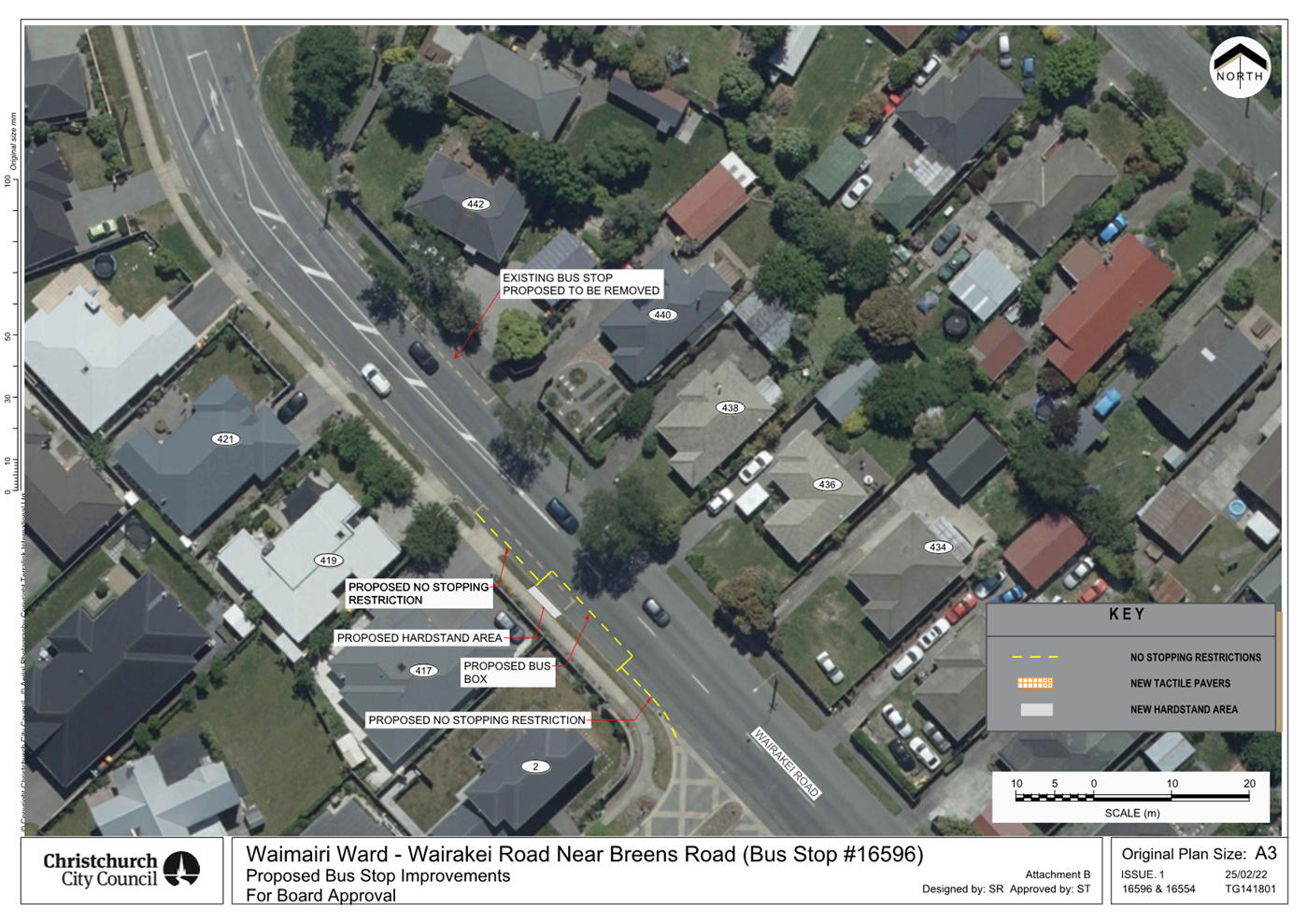
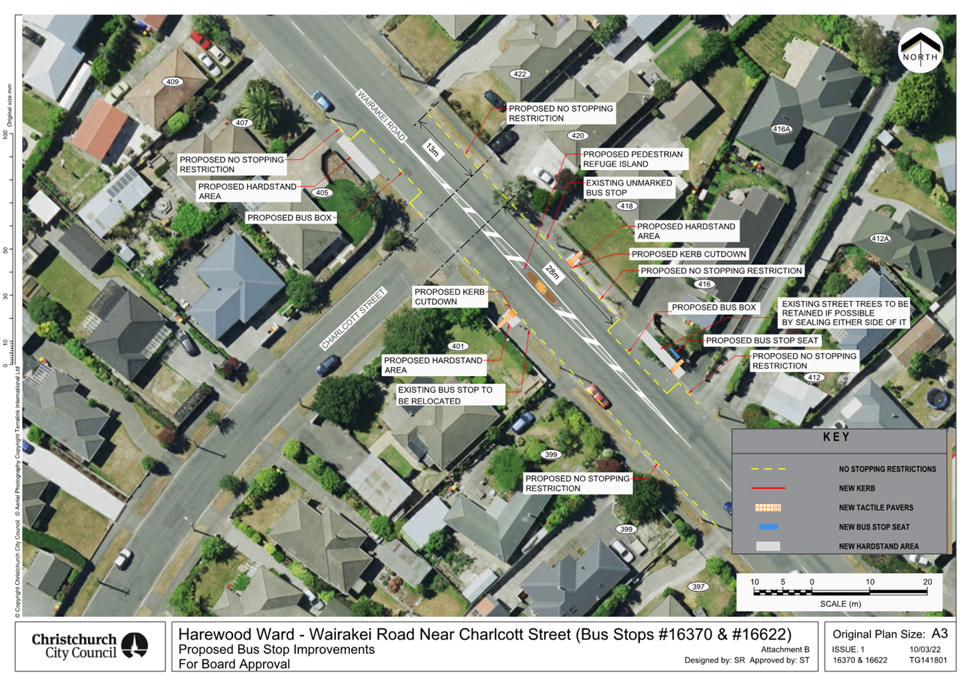
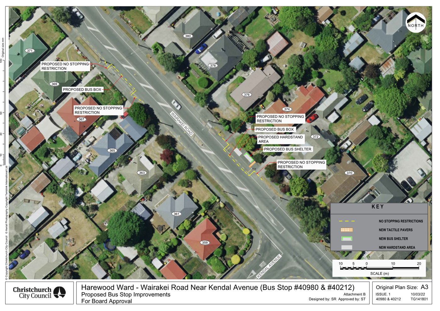
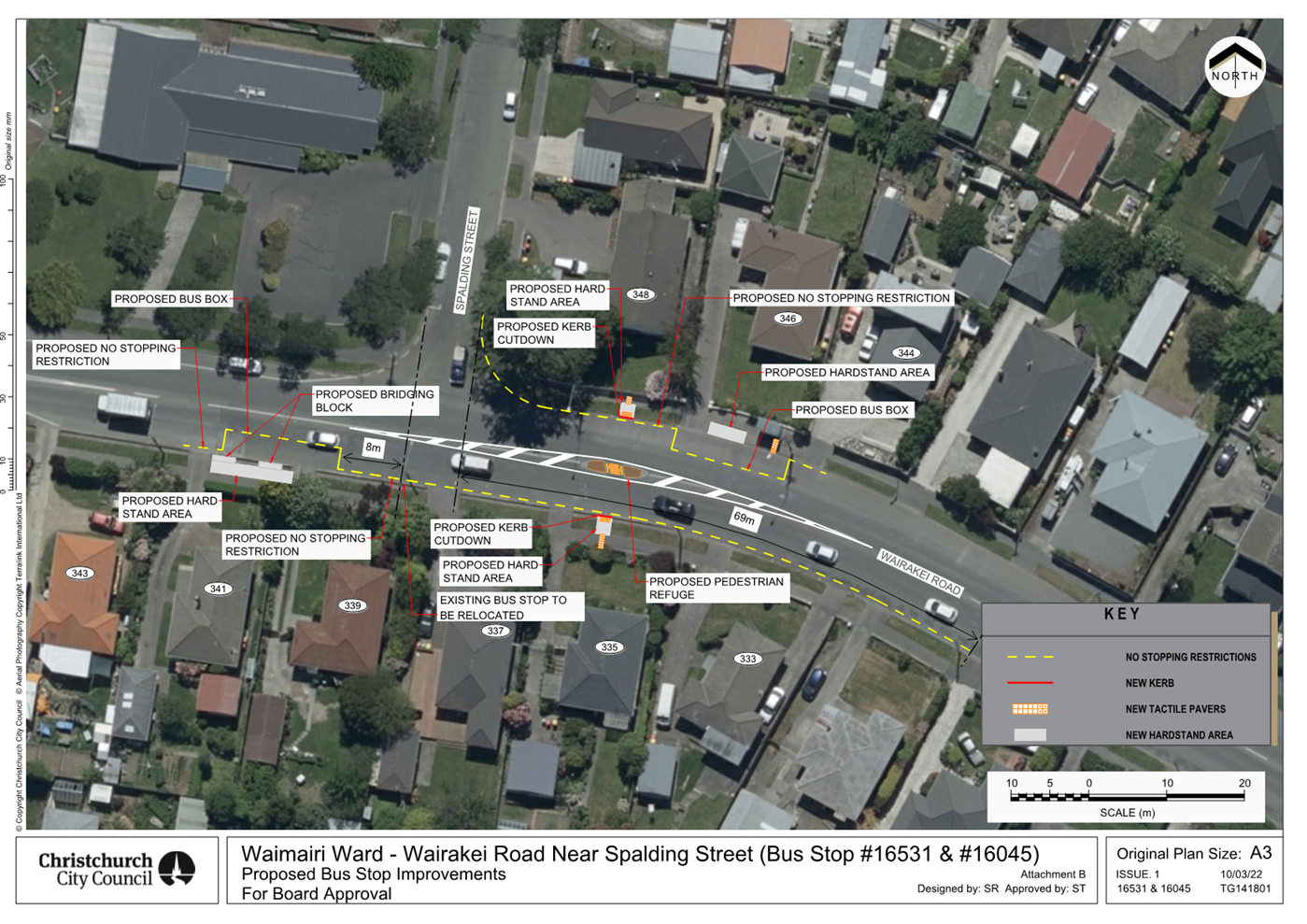
|
Waimāero Fendalton-Waimairi-Harewood
Community Board
12 September
2022
|

|
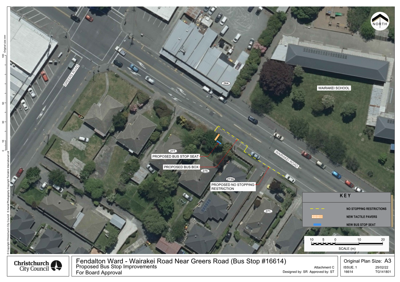
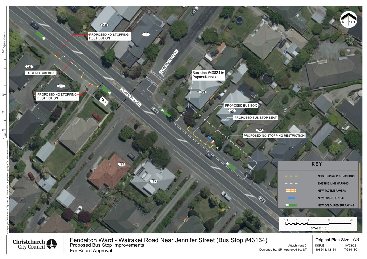
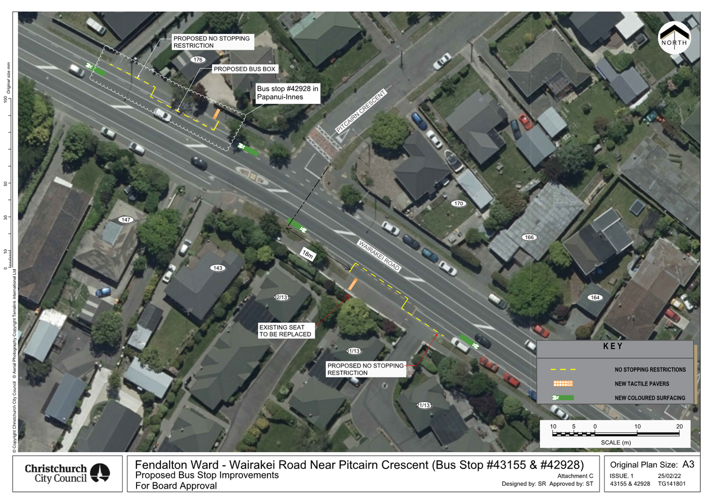
|
Waimāero Fendalton-Waimairi-Harewood
Community Board
12 September
2022
|
|
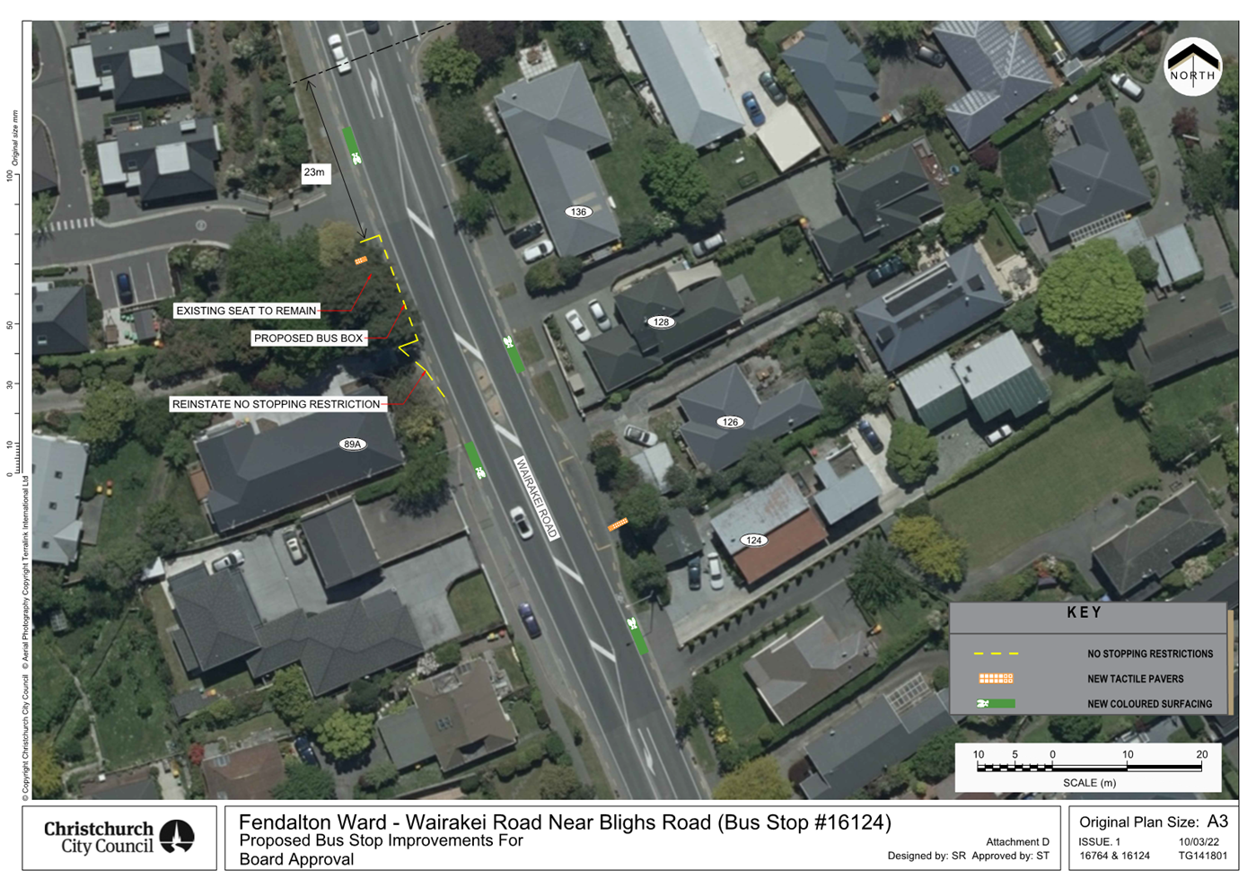
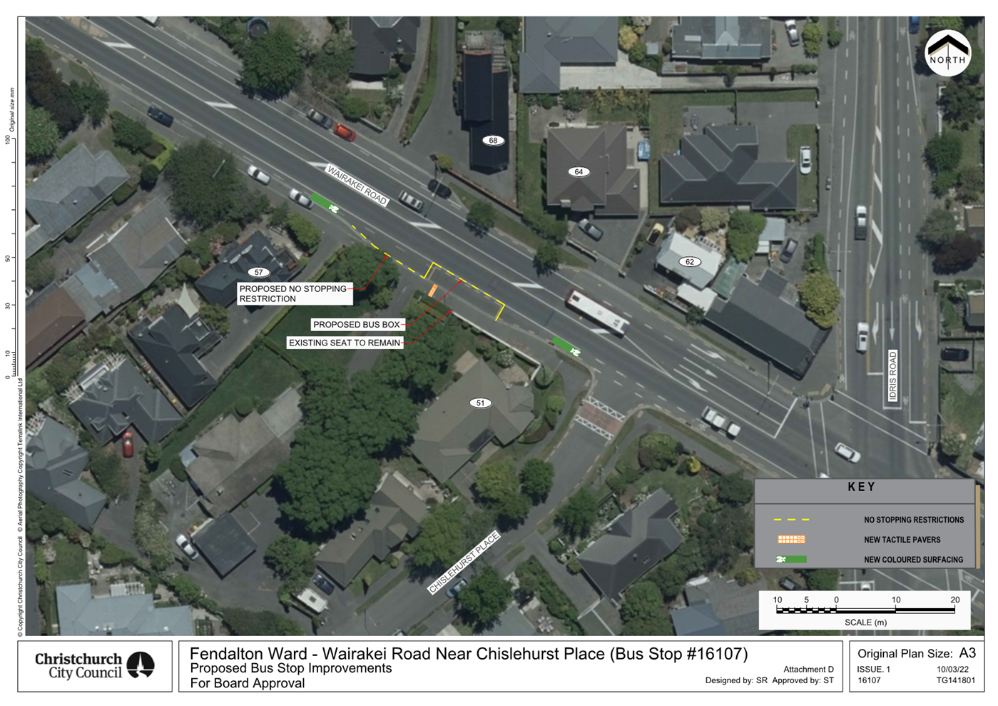
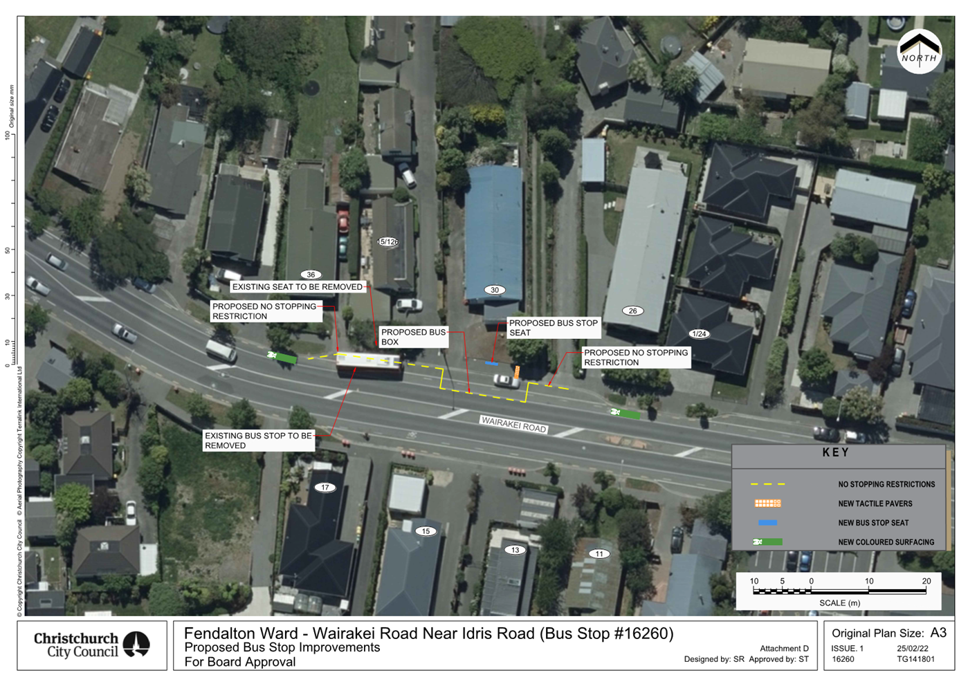
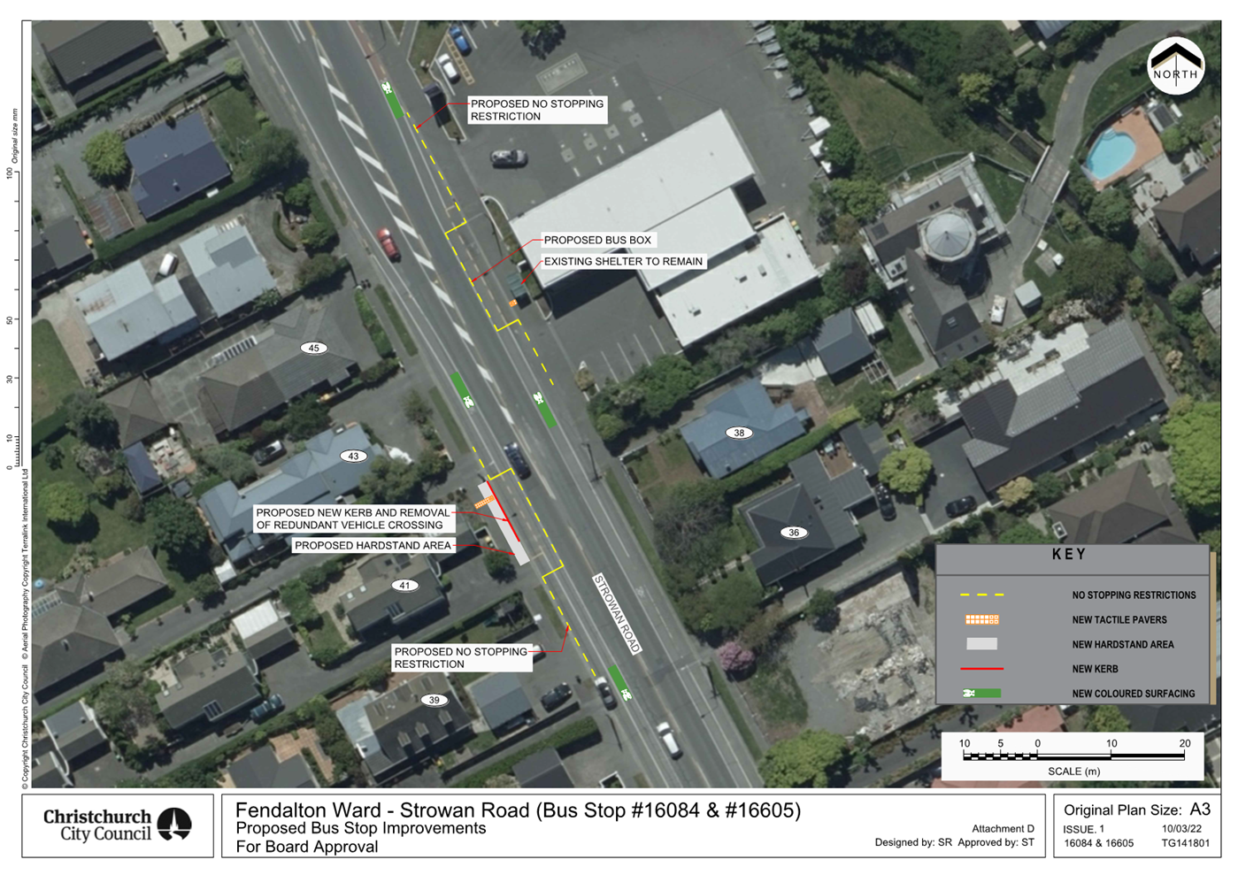
|
Waimāero Fendalton-Waimairi-Harewood
Community Board
12 September
2022
|
|
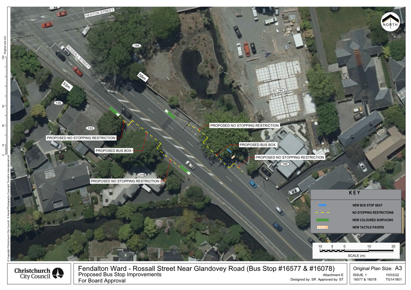
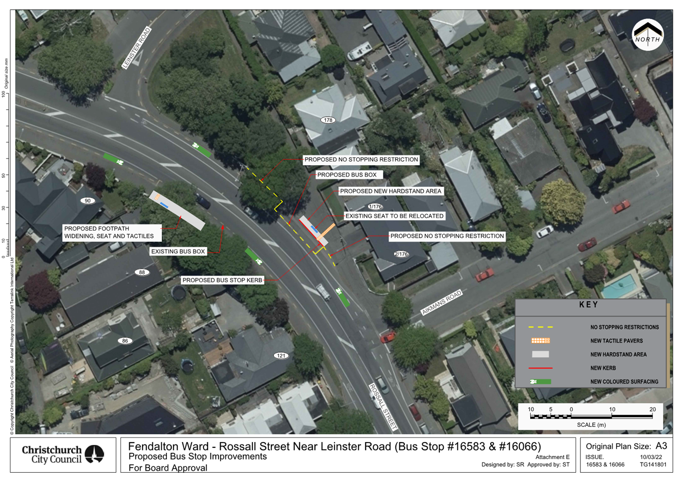
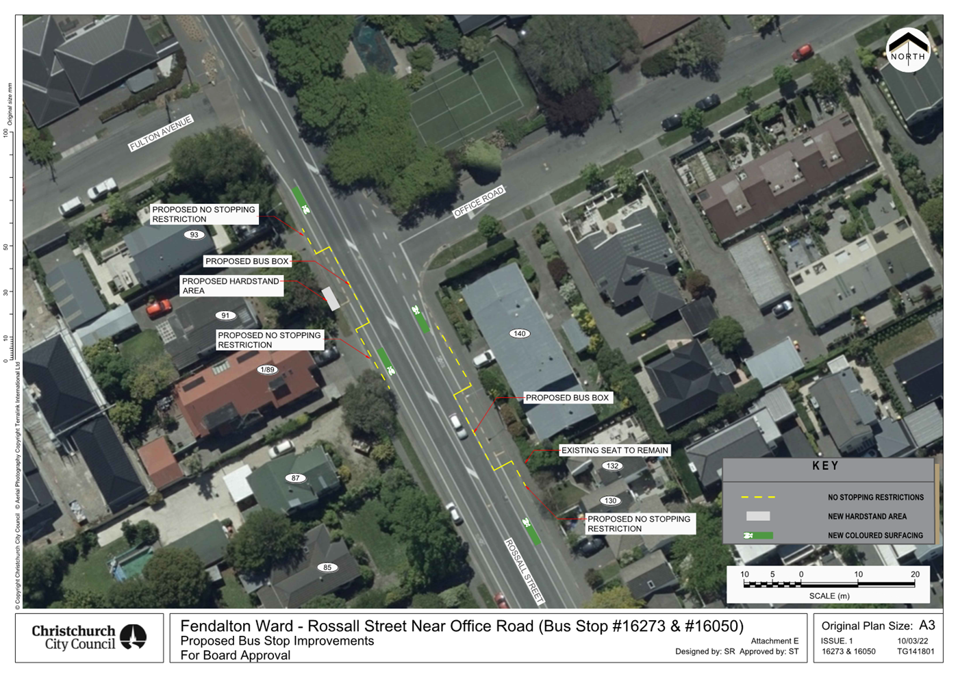
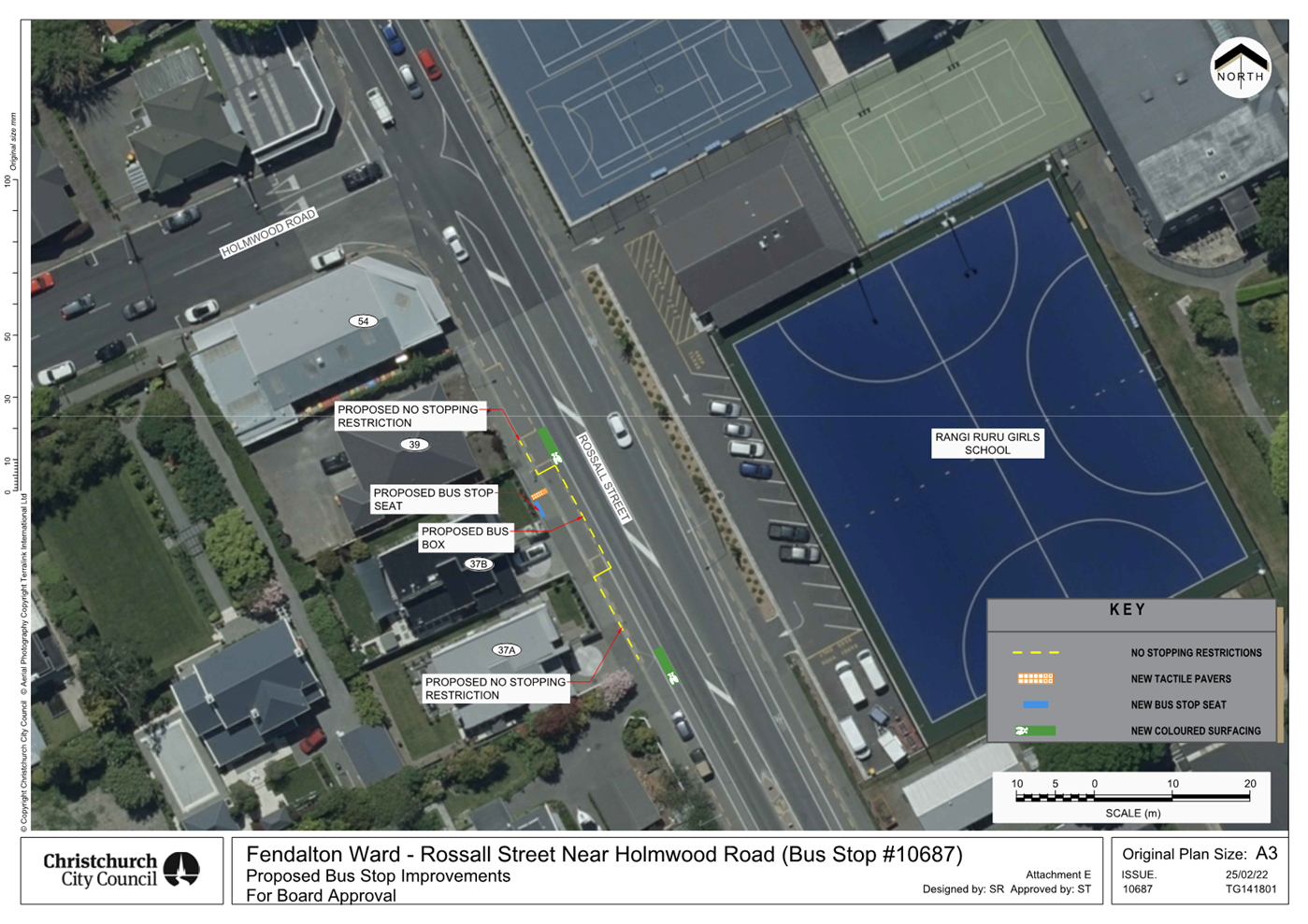

|
Waimāero Fendalton-Waimairi-Harewood
Community Board
12 September
2022
|
|
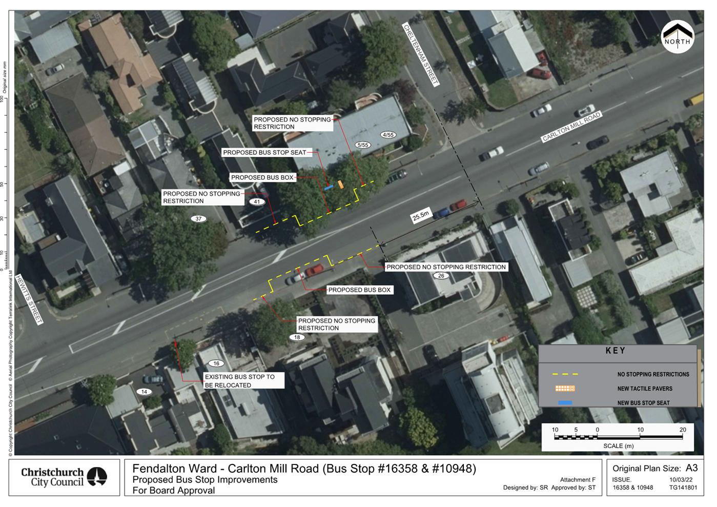

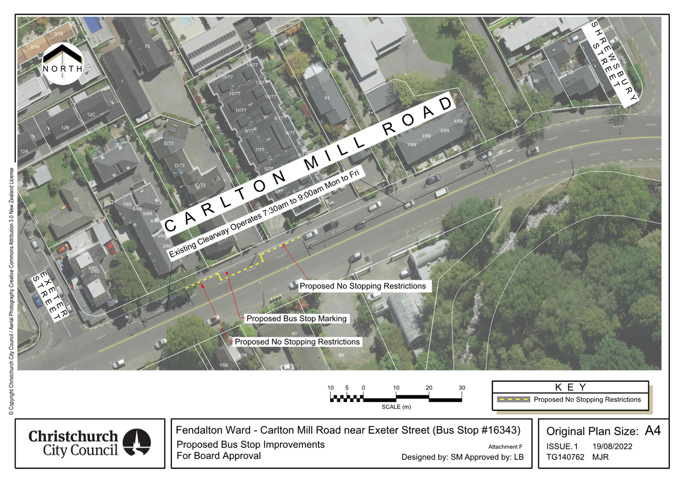
|
Waimāero Fendalton-Waimairi-Harewood
Community Board
12 September
2022
|
|
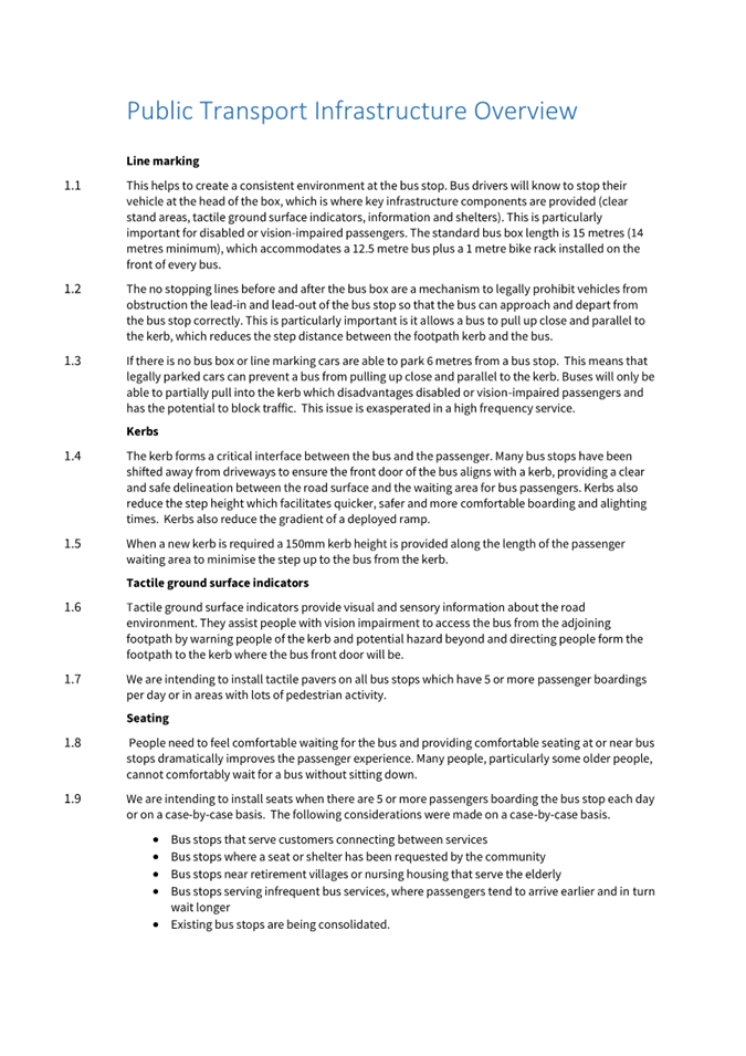
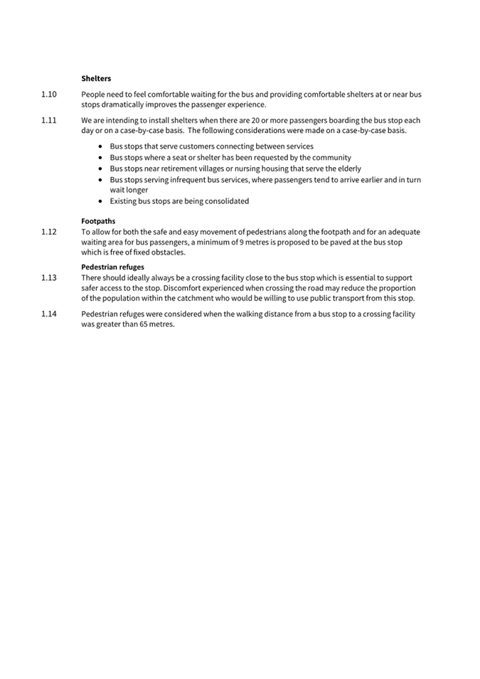
|
Waimāero
Fendalton-Waimairi-Harewood Community Board
12 September
2022
|
|
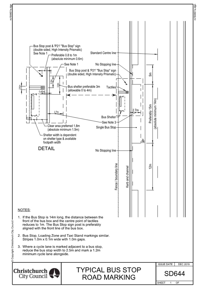
|
Waimāero
Fendalton-Waimairi-Harewood Community Board
12 September
2022
|
|
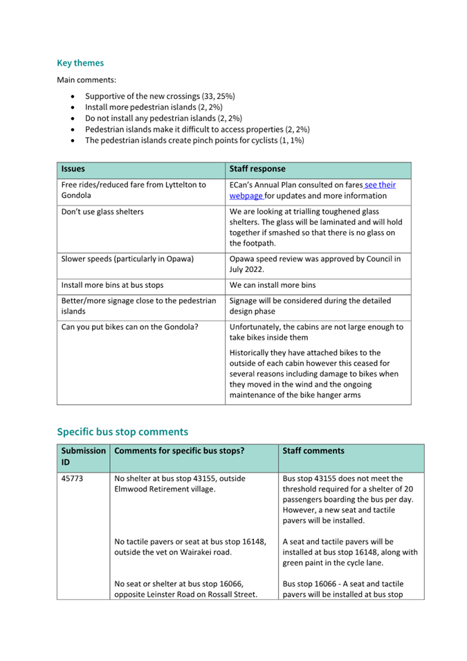
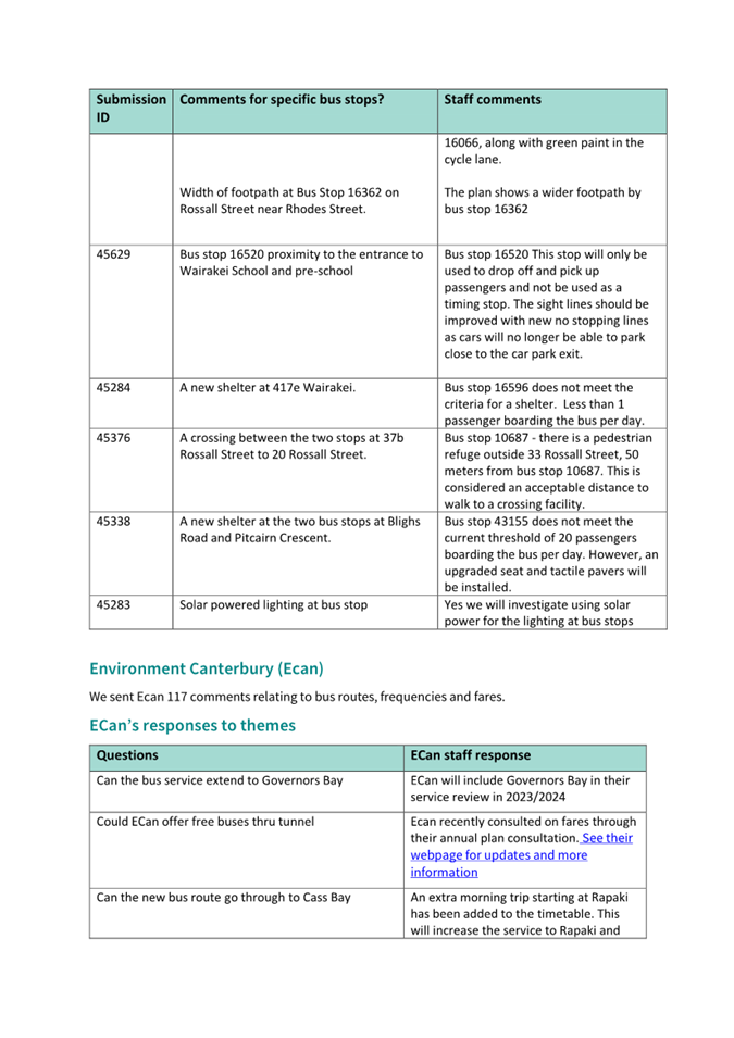
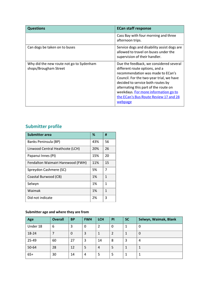
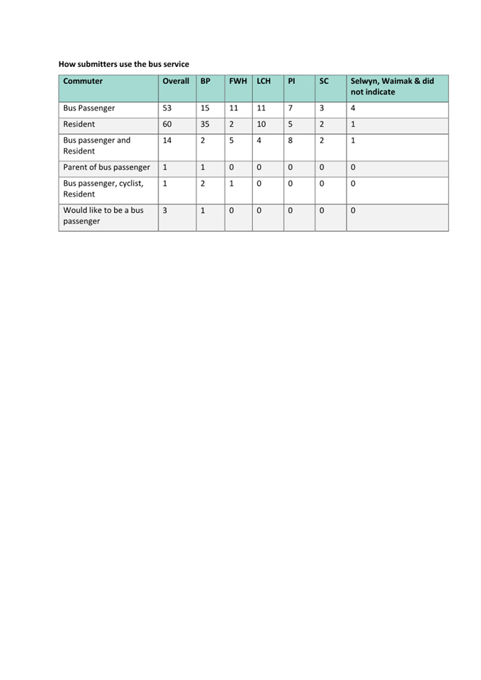
|
Waimāero Fendalton-Waimairi-Harewood
Community Board
12 September
2022
|
|
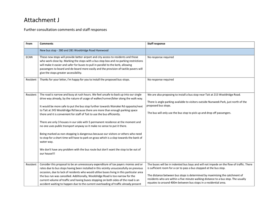
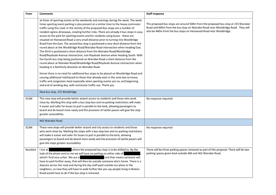
|
Waimāero Fendalton-Waimairi-Harewood
Community Board
12 September
2022
|
|
|
12. Hearing Panel Report to the
Fendalton-Waimairi-Harewood Community Board - Roto Kotahu Reserve Management
Plan
|
|
Reference / Te Tohutoro:
|
22/1020706
|
|
Report of / Te Pou Matua:
|
Community
Board Chairperson, Bridget Williams, bridget.williams@ccc.govt.nz
|
|
General Manager / Pouwhakarae:
|
Mary
Richardson, General Manager Citizens and Community,
mary.richardson@ccc.govt.nz
|
1. Purpose of Report Te Pūtake
Pūrongo
1.1 The
purpose of this report is to present to the Waimāero Fendalton Waimairi
Harewood Community Board the Hearings Panel recommendations following the
consultation and hearings process on the Roto Kotahu Reserve Management Plan.
1.2 The
Reserves Act Hearings Panel has no decision-making powers but, in accordance
with its delegation, has considered the written and oral submissions received
on the proposal and is now making recommendations to the Community Board.
The Community Board can then accept or reject those recommendations as it sees
fit bearing in mind that the Local Government Act 2002 s.82(1)(e) requires that
“the views presented to the local authority should be received by the
local authority with an open mind and should be given by the local authority,
in making a decision, due consideration.”
1.3 The Community Board, as the final decision-maker, should put itself
in as good a position as the Hearings Panel having heard all the parties.
It can do so by considering this report which includes a summary of the
written and verbal submissions that were presented at the hearings, any
additional information received and the Hearings Panel’s considerations
and deliberations. A link to the written submissions is also available
should you want to review them, you can access those submissions by clicking on
this link: https://christchurch.infocouncil.biz/Open/2022/07/RAHPC_20220727_AGN_8120_AT.PDF
2. Hearings Panel Recommendations Ngā Tūtohu o Te Tira
Taute
That the Waimāero
Fendalton-Waimairi-Harewood Community Board:
1. Receive and consider the information in the
report, the recommendation of the hearings panel, the submissions, and all other
relevant information received on the proposed Roto Kohatu Reserve Management
Plan.
2. Adopt the Roto Kohatu Reserve Management Plan
containing revisions agreed to by the hearings panel at its meeting on 27th
July 2022.
3. Background / Context Te Horopaki
3.1 Located at the north-west edge of urban Christchurch, Roto Kohatu
Reserve is part of a network of parks connected by walkways and greenways. The
park has varied landform and character that includes the lakes, open grass
areas and a rounded hill.

Ariel view of Roto
Kohatu Reserve.
3.2 Roto Kohatu Reserve is highly valued for the leisure and sport
opportunities provided by the two lakes: Lake Tahi and Lake Rua, and these
lakes have become increasingly popular for both organised and informal
activities. The lake margins are bordered by trees and other vegetation, and
the park is a green haven for people and a wide range of water birds.
3.3 With the exception of a small area fronting Outlook Place, all areas
of Roto Kohatu Reserve are classified as ‘Recreation Reserve’ under
the Reserves Act 1977. The reserve at the Outlook Place entry is a Local
Purpose (utility) Reserve.
3.4 This reserve management plan provides direction for the management
and development of Roto Kohatu Reserve. Reserve management plans provide the
community with greater certainty about the function and management of a reserve
and ensure that management decisions are consistent with the Reserves Act 1977.
The management plan recognises the values of the reserve, establishes a vision
for its future, and sets management objectives and policies to achieve the
desired outcomes.
3.5 Staff
are confident that the Management Plan reflects the needs of the community, the
natural environment, and the Council. The draft management plan (and an
associated Development Plan for the reserve) was prepared with extensive input
from staff, user groups, and the wider public through a series of meetings,
surveys, and workshops between August 2020 and February 2021, and ongoing
communication with those groups via Council’s Have Your Say website.
4. Consultation Process and Submissions Te Tukanga Kōrerorero
/ Ngā Tāpaetanga
Public
Consultation Te Tukanga Kōrerorero
4.1 An
early engagement information-gathering process resulted in feedback from more
than 30 stakeholders, organisations, user groups, or individuals through a Have
Your Say consultation process and direct contact with user groups and key
stakeholders including local iwi representatives.
4.2 Feedback
from this process and earlier informal consultation informed development of the
draft plan in key areas relating to layout and facilities, vegetation and
birds, water, and reserve use.
4.3 A
parallel consultation process confirmed a change of land classification of two
land parcels to confirm all the park as Recreation Reserve.
4.4 Te
Ngāi Tūāhuriri Rūnanga gave early feedback followed by
comment on the draft plan, responding particularly in relation to biodiversity,
ecology including pest fish concerns, and suitable native plantings.
4.5 To
meet Reserves Act requirements, consultation on the draft Reserve Management
Plan ran on the Council Have Your Say
website over a period of two months from 24 January until 28 March 2022. An
email was sent to approximately 100 stakeholders, including community
organisations and user groups.
4.6 A
Newsline article on 22 January was picked up by the Christchurch Press.
Consultation was posted on the CCC Facebook page, also inviting a range of
likes and comments on five local and wider area Facebook pages.
4.7 Copies
of the draft Reserve Management Plan and Development Plan were available in
central and local service centres, and letters were sent to approximately 30
adjacent property owners and occupiers letting them know of the draft plan, and
how to submit.
4.8 A
drop-in session held on site on Tuesday 15 February was attended by
approximately 30 members of the public and user groups.
4.9 Additional
meetings and phone calls were held with user groups and stakeholders, including
adjacent property owners, during the consultation period.
Summary of Submissions
4.10 We
received 86 submissions from ten recognised organisations, including six user
groups and one business. This included feedback from the Department of
Conservation, Environment Canterbury, North Canterbury Fish and Game,
Christchurch International Airport Ltd, The Cancer Society, Disabled Persons
Assembly, and six user groups.
4.11 The
remainder were residents from across the city and wider area, with 36
submitters giving addresses from adjacent or nearby suburbs. All
submissions are provided in the Hearings Panel Agenda.
4.12 We
asked for comments on both the draft Reserve Management Plan and the
Development Plan. Although most people provided suggestions only, there were a
number of positive comments about the proposed future management and
development of the reserve, indicating how strongly they valued the lakes and
surrounding reserve area.
4.13 Key
comments supported:
· A new entrance at
Outlook Place
· Improvements such as
grading of beach to access and use Lake Rua, e.g. swimming, boat/model
yacht launch
· Development and building
of facilities to support aquatic recreation for groups
· Retaining natural
environment and the general approach to keep built structures to a minimum
· Additional activities put
forward in the plan including more canoe polo courts.
4.14 Key
suggestions included requests for:
· More parking, that is also
better defined and managed
· Facilities that provide
sun safety and adequate shading
· More facilities such as
picnic tables and barbecues
· Improved access including
wayfinding, paths, and cycle facilities.
4.15 Key
concerns related to the need to manage anti–social behaviour, and there
were a range of suggestions about how to manage dog behaviour and access. There
were also several requests relating to jet-ski use on Lake Tahi including
allocation of space and protection of birdlife. Christchurch Airport raised
concerns about managing the risk of bird strike. These have been addressed in
the management plan.
4.16 There
was a range of feedback about ways to manage timing and allocation of space,
including detailed responses and suggestions from user groups. There were also
a number of ideas provided about specific activities for the public including
families and children.
4.17 In
total, 16 amendments were made to the draft Management Plan in preparation to
be heard before a Reserves Act Hearings Panel.
5. The Hearing Te Hui
5.1 The
Hearings Panel consisted of Councillor Jimmy Chen, Councillor Aaron Keown and
Community Board Member Mike Wall. The Hearings Panel convened on 27 July
2022 to consider and deliberate on all submissions received on the proposal.
5.2 Prior
to hearing oral submissions Council officers presented a brief overview of the
proposed amendments and presented the Hearings Panel with further information
in relation to the management plan and scope of consultation.
5.3 Prior
to the hearing six submitters withdrew their request to be heard.
5.4 The
Reserve Act Hearing Panel received verbal submissions from:
5.4.1 Amanda
Dodd on behalf of Cancer Society
5.4.2 Chris
Ford on behalf of Disabled Persons Assembly
5.4.3 Simon
Rutherford on behalf of KORE limited
5.4.4 Lyndon
Slater on behalf of North Canterbury Fish and Game
6. Consideration and Deliberation of Submissions Ngā
Whaiwhakaaro o Ngā Kōrero me Ngā Taukume
6.1 The
Hearings Panel considered and deliberated on all submissions received on the
proposal as well as information received from Council Officers during the
hearing. Some of the key issues that were addressed by the Hearings Panel
are as follows:
6.2 The
Panel had concerns about the management of the wide range of recreational and
active users; anti-social behaviour; road access and parking; toilet and shower
areas; flocking birds; water quality and shade sails.
6.3 The
Hearings Panel accepted advice by Council Officers that the concerns had been
address in the following way:
6.3.1 Security
Cameras have been installed in the area as well as building a working
relationship with Community Patrol in the area.
6.3.2 No
Further parking is required as the current parking is adequate and such
management would put more pressure on the environment.
6.3.3 The
gravel road across the top of the Reserve will be closing allowing for a new
access road with a new entry point which will be able to be used by a wide
range of users and vehicle types.
6.3.4 Toilet
and shower facilities have been installed and are currently open and operating.
6.3.5 The
planting of tall trees and vegetation will have an impact on dissuading
flocking birds from the area.
6.3.6 Water
quality in the Reserve is monitored annually.
6.3.7 There
are ongoing discussions with an organisation which is interested in funding
shade sails to be used in the Reserve.
6.4 Council
Officers referenced the consultation process for the Roto Kotahu Reserve draft
development plan which was done congruently with the consultation process for
the management plan but was not directly considered at the Reserve Panel
Hearing, noting that it would be for the Community Board to consider and make a
decision on.
6.5 Following
consideration and deliberation of submissions, the Hearings Panel unanimously
agreed to recommend the Community Board approve the Roto Kohatu Reserve
Management Plan.
7. Reference Documents
Signatories Ngā Kaiwaitohu
Author Luke
Smeele - Hearings Advisor
Approved
By Aaron Keown
- Chair of Hearings Panel
Attachments Ngā Tāpirihanga
There are no attachments to this report.
|
Waimāero
Fendalton-Waimairi-Harewood Community Board
12 September
2022
|
|
|
13. Roto Kohatu Reserve Development Plan
|
|
Reference / Te Tohutoro:
|
22/979109
|
|
Report of / Te Pou Matua:
|
Antony
Shadbolt
Team Leader: Biodiversity
antony.shadbolt@ccc.govt.nz
|
|
General Manager / Pouwhakarae:
|
Mary
Richardson
GM Citizens and Community
Mary.Richardson@ccc.govt.nz
|
1. Purpose of the Report Te Pūtake
Pūrongo
1.1 The
purpose of this report is to seek Community Board approval of the Roto Kohatu
Reserve Development Plan.
1.2 This
report has been written following community consultation on the draft
Development Plan.
1.3 The
decisions in this report are of medium significance in relation to the
Christchurch City Council’s Significance and Engagement Policy. The level
of significance was determined by such factors as Roto Kohatu Reserve not being
a strategic asset but still providing a strong contribution towards the
City’s health and wellbeing, strong interest from a range of user groups,
the proposal is unlikely to have cost risks to the Council, and any decisions
are capable of being reversed.
2. Officer Recommendations Ngā
Tūtohu
That the
Waimāero Fendalton-Waimairi-Harewood Community Board:
1. Receive and consider the information in the
report, the submissions, and all other relevant information received on the
draft Roto Kohatu Reserve Development Plan.
2. Adopt the Roto Kohatu Reserve Development
Plan.
3. Reason for Report Recommendations Ngā Take mō te
Whakatau
3.1 Staff
are confident that the Roto Kohatu Reserve Development Plan reflects the needs
of the community, the natural environment, and the Council. The draft
Development Plan (and an associated Reserve Management Plan for the reserve)
was prepared with extensive input from staff, user groups, and the wider public
through a series of meetings, surveys, and workshops between August 2020 and
February 2021, and ongoing communication with those groups via the
Council’s Have Your Say website.
4. Alternative Options Considered Ētahi atu Kōwhiringa
4.1 An
alternative option is to not approve the Development Plan in its current form,
but instead request changes prior to approval.
5. Detail Te Whakamahuki
Public
Consultation Te
Tukanga Kōrerorero
5.1 An
early engagement information-gathering process resulted in feedback from more
than 30 stakeholders, organisations, user groups, or individuals through a Have
Your Say consultation process and direct contact with user groups and key
stakeholders including local iwi representatives.
5.2 Feedback
from this process and earlier informal consultation informed development of the
draft plan in key areas relating to layout and facilities, vegetation and
birds, water, and reserve use.
5.3 A
parallel consultation process confirmed a change of land classification of two
land parcels to confirm all the park as Recreation Reserve.
5.4 Te
Ngāi Tūāhuriri Rūnanga gave early feedback followed by
comment on the draft plan, responding particularly in relation to biodiversity,
ecology, including pest fish concerns, and suitable native plantings.
5.5 Consultation
on both the draft Reserve Development Plan and Reserve Management Plan ran on
the Council Have
Your Say website over a period of two months from 24 January until 28 March
2022. An email was sent to approximately 100 stakeholders, including community
organisations and user groups.
5.6 A
Newsline article on 22 January was picked up by the Christchurch Press.
Consultation was posted on the Council Facebook page, also inviting a range of
likes and comments on five local and wider area public Facebook pages.
5.7 Copies
of the draft Development Plan and Management Plan were available in central and
local service centres, and letters were sent to approximately 30 adjacent property
owners and occupiers letting them know of the draft plans, and how to submit.
5.8 A
drop-in session held on site on Tuesday 15 February was attended by
approximately 30 members of the public and user groups.
5.9 Additional
meetings and phone calls were held with user groups and stakeholders, including
adjacent property owners, during the consultation period.
Summary
of Submissions Ngā
Tāpaetanga
5.10 We
received 86
submissions from ten recognised organisations, including
six user groups and one business. This included feedback from the Department of
Conservation, Environment Canterbury, North Canterbury Fish and Game,
Christchurch International Airport Ltd, The Cancer Society, Disabled Persons
Assembly, and six user groups.
5.11 The
remainder were residents from across the city and wider area, with 36
submitters giving addresses from adjacent or nearby suburbs. All
submissions are provided in the Hearings Panel Agenda.
5.12 We
asked for comments on both the draft Reserve Development Plan and the
Management Plan. Although most people provided suggestions only, there were a
number of positive comments about the proposed future management and
development of the reserve, indicating how strongly they valued the lakes and
surrounding reserve area.
5.13 One
submitter requested we don’t change anything in the reserve.
5.14 Key
comments supported:
· A new entrance at Outlook
Place
· Improvements such as
grading of beach to access and use Lake Rua, e.g. swimming, boat/model
yacht launch
· Development and building
of facilities to support aquatic recreation for groups
· Retaining natural
environment and the general approach to keep built structures to a minimum
· Additional activities proposed
in the plan including more canoe polo courts.
5.15 Key
suggestions included requests for:
· More parking, that is also
better defined and managed
· Facilities that provide
sun safety and adequate shading
· More facilities such as
picnic tables and barbecues
· Improved access including
wayfinding, paths, and cycle facilities.
5.16 Key
concerns related to the need to manage anti–social behaviour, and there
were a range of suggestions about how to manage dog behaviour and access. There
were also several requests relating to jet-ski use on Lake Tahi including
allocation of space and protection of birdlife. Christchurch Airport raised
concerns about managing the risk of bird strike. These have been addressed in
both the Development Plan and the Management Plan.
5.17 There
was a range of feedback about ways to manage timing and allocation of space,
including detailed responses and suggestions from user groups. There were also
a number of ideas provided about specific activities for the public including
families and children.
5.18 These
points and further detail are included in the consultation analysis table (Attachment
B) and project team response tables (Attachment C).
5.19 In
total, just seven amendments have been made to the draft Development Plan and
are discussed in the project team response table (Attachment C). These
changes include:
· Change wording in Item 1
on landscape plan to ‘Remediate lake edge for accessible swimming access
and boat launching’
· Change wording in Item 10
on landscape plan to ‘Pathways extended and/or upgraded’
· Change wording in Item 11
on landscape plan to ‘Fishing locations along the causeway and western
edge of the lake’
· Change wording in Item 13
on landscape plan from ‘sanctuary’ to ‘habitat’
· Delete Item 23 on landscape
plan as this integrated with Item 10
· Revised western Lake Tahi
habitat area extent on both Figure 1 and landscape plan
· In Table 2, ‘walking
tracks’ is changed to ‘pathways’
5.20 The decision affects the following wards/Community Board areas:
5.20.1
Fendalton-Waimairi-Harewood
6. Policy Framework Implications Ngā Hīraunga ā- Kaupapa here
Strategic
Alignment Te Rautaki
Tīaroaro
6.1 This report supports the Council's
Long Term Plan (2021 - 2031):
6.1.1 Activity: Parks and Foreshore
· Level of Service: 6.3.5 Overall customer
satisfaction with the recreational opportunities and ecological experiences
provided by the City's Regional Parks. - Regional Parks resident
satisfaction >=80%.
Policy
Consistency Te Whai
Kaupapa here
6.2 The
decision is consistent with Council’s Plans and
Policies.
Impact
on Mana Whenua Ngā
Whai Take Mana Whenua
6.3 Staff
engaged with Tangata Whenua as project partners via Mahaanui Kurataiao Ltd
during pre-engagement. Feedback was that the matter does not involve a
significant decision in relation to ancestral land or a body of water or other
elements of intrinsic value, therefore this decision does not specifically
impact Mana Whenua, their culture and traditions.
6.4 Mahaanui Kurataiao Ltd submitted feedback on the draft Development
Plan and associated Management Plan on behalf of Te Ngāi
Tūāhuriri Rūnanga. Their feedback was focussed on four elements:
1) inclusion of Māori design elements in interpretation signage, 2)
eco-sourcing of native plant species, 3) accidental discovery protocols, and 4)
potential contamination from the closed landfill. Subsequent communication with
Mahaanui Kurataiao Ltd also highlighted pest management requirements of the
Mahaanui Iwi Management Plan. Staff responses and recommendations related to
these points are included in Attachment C (Project Team Response
Tables).
Climate
Change Impact Considerations Ngā Whai Whakaaro mā te Āhuarangi
6.5 The Development Plan (and associated Management Plan) encourages
tree and shrub-land planting which will support an increase in city-wide canopy
coverage and reduction in mowing to help mitigate climate change.
Accessibility
Considerations Ngā
Whai Whakaaro mā te Hunga Hauā
6.6 The Development Plan (and associated Management Plan) supports
improved access to Roto Kohatu Reserve for people of all abilities, with the
inclusion of specific policies to guide this in the Management Plan.
7. Resource Implications Ngā Hīraunga Rauemi
Capex/Opex / Ngā Utu Whakahaere
7.1 The
approved Development Plan will guide the ongoing development and management of
the reserve. Capital development will need to be consistent with this plan.
7.2 The
total cost to implement the Roto Kohatu Development Plan has been provided by
Council’s Quantity Surveyor team and is estimated to be approximately
$6,670,000 +/- 25% Rough Order Magnitude spread over multiple years. This
excludes the lake edge and new main entrance which are already underway and
funded as follows:
7.2.1 Currently
there is $692,422 allocated in the LTP for capital developments at Roto Kohatu
Reserve spread across the next three financial years (FY 23, 24 & 25).
7.3 Funding
in excess of the current Long Term Plan allocation will need to be sought
through via the 2024- 2034 long term plan once the Management Plan and
Development Plan are approved.
7.4 Funding
Source – Parks & Foreshore Capital programme
Other / He mea anō
7.5 N/A
8. Legal Implications Ngā Hīraunga ā-Ture
Statutory power to undertake proposals in the report /
Te Manatū Whakahaere Kaupapa
8.1 The
Community Board has the delegation to approve and adopt any new landscape
development plans for parks and reserves provided the design is within the
policy and budget set by the Council.
Other Legal Implications / Ētahi atu
Hīraunga-ā-Ture
8.2 There
is no legal context, issue or implication relevant to this decision.
9. Risk Management Implications Ngā Hīraunga Tūraru
9.1 Not
applicable
Attachments / Ngā Tāpirihanga
|
No.
|
Title
|
Page
|
|
a ⇩
|
Attachment A -
Roto Kohatu Reserve Development Plan for Community Board approval
|
120
|
|
b ⇩
|
Attachment B -
Roto Kohatu Developmnet Plan Analysis of Submissions
|
132
|
|
c ⇩
|
Attachment C -
Roto Kohatu Development Plan Submitter Feedback and Staff Team Response
|
133
|
In addition to the attached documents, the following background
information is available:
|
Document
Name
|
Location
/ File Link
|
|
Not
applicable
|
Not
applicable
|
Confirmation of Statutory
Compliance / Te
Whakatūturutanga ā-Ture
|
Compliance with Statutory Decision-making
Requirements (ss 76 - 81 Local Government Act 2002).
(a) This report contains:
(i) sufficient information about all reasonably practicable
options identified and assessed in terms of their advantages and
disadvantages; and
(ii) adequate consideration of the views and preferences of
affected and interested persons bearing in mind any proposed or previous
community engagement.
(b) The information reflects the level of significance of the
matters covered by the report, as determined in accordance with the Council's
significance and engagement policy.
|
Signatories / Ngā Kaiwaitohu
|
Author
|
Antony
Shadbolt - Team Leader Biodiversity
|
|
Approved By
|
Kelly Hansen -
Manager Parks Planning & Asset Management
Andrew
Rutledge - Head of Parks
Mary Richardson
- General Manager Citizens & Community
|
|
Waimāero
Fendalton-Waimairi-Harewood Community Board
12 September
2022
|
|


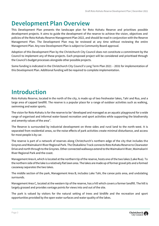
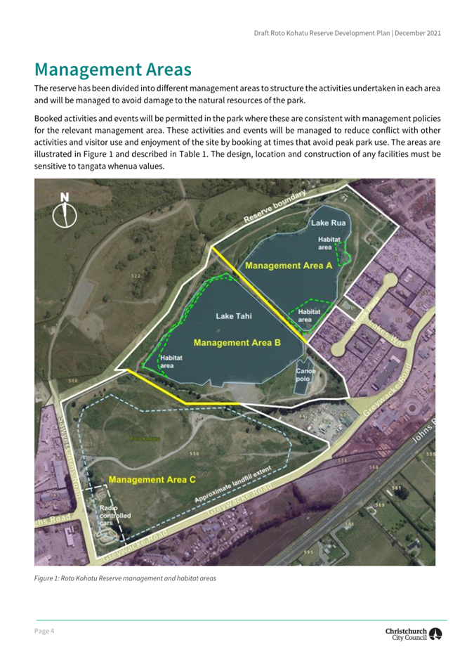
|
Waimāero Fendalton-Waimairi-Harewood
Community Board
12 September
2022
|
|
|
Waimāero
Fendalton-Waimairi-Harewood Community Board
12 September
2022
|
|
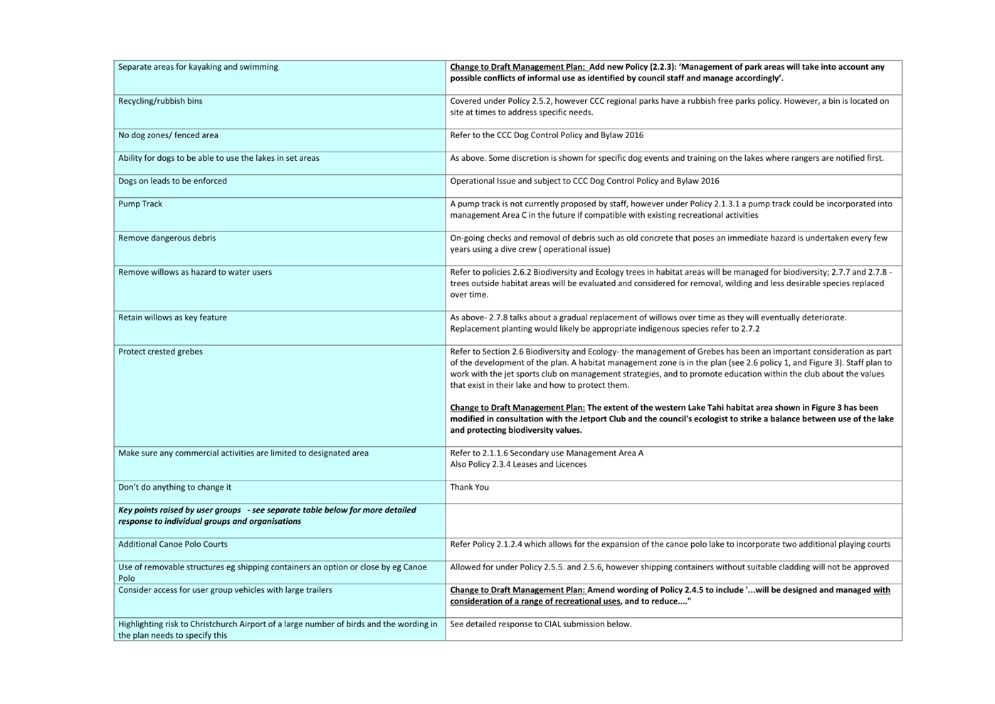
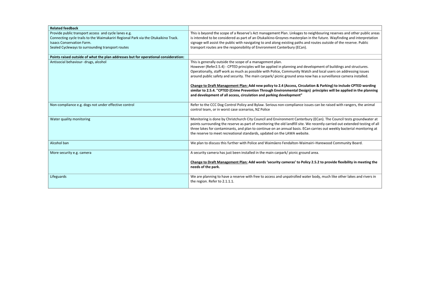
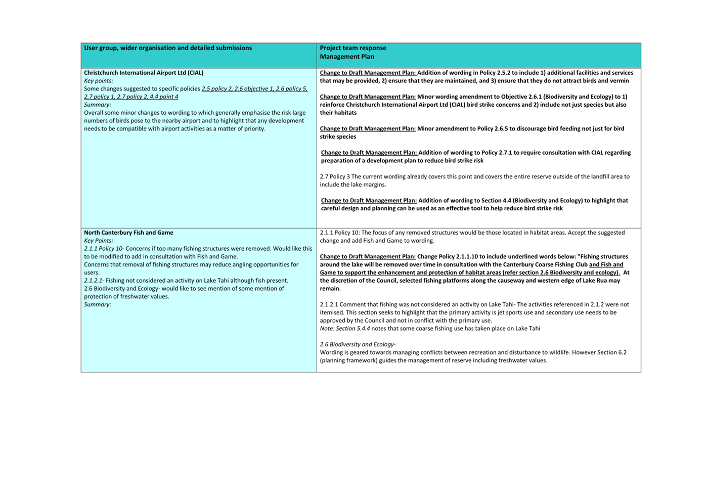
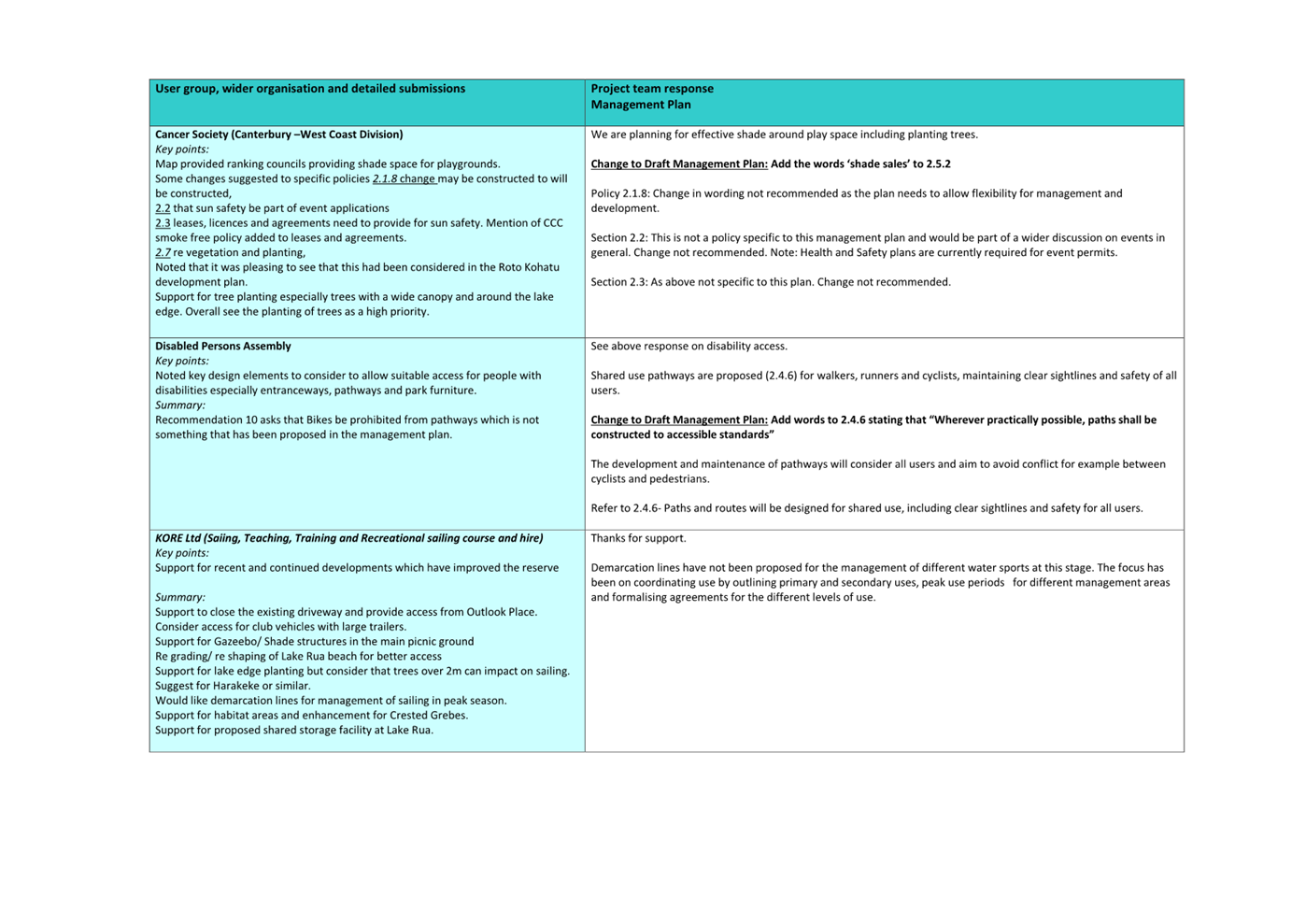
|
Waimāero Fendalton-Waimairi-Harewood
Community Board
12 September
2022
|
|
|
14. 52 Westholme Street, Strowan - Control and
Manage Reserve
|
|
Reference / Te Tohutoro:
|
22/1040113
|
|
Report of / Te Pou Matua:
|
Barry
Woodland, Property Consultant, barry.woodland@ccc.govt.nz; Derek Roozen,
Senior Network Planner Parks, derek.roozen@ccc.govt.nz
|
|
General Manager / Pouwhakarae:
|
Mary
Richardson, General Manager Citizens and Community,
mary.richardson@ccc.govt.nz
|
1. Purpose of the Report Te Pūtake
Pūrongo
1.1 The
purpose of this report is for the Fendalton-Waimairi-Harewood Community Board
to recommend to the Council to accept the offer from the Department of
Conservation (DOC) to control and manage the reserve at 52 Westholme Street.
This report has been written in order for Council approval to be provided to
DOC.
1.2 The
decision in this report is of low significance in relation to the Christchurch
City Council’s Significance and Engagement Policy. The decision is
of a local nature, it affects a limited number of citizens, the social and
environmental effects will be positive, the cost to the Council is relatively
minimal and the decision is capable of being reversed if and when required.
2. Officer Recommendations Ngā
Tūtohu
That the
Waimāero Fendalton-Waimairi-Harewood Community Board recommend that the
Council:
1. Approve the appointment of the Council to
control and manage 52 Westholme Road (Reserve 5137) as a Recreation Reserve in
accordance with Section 17 of the Reserves Act 1977 subject to:
a. The Department of Conservation: (1) securing
the approval of Iwi; (2) cancelling the Scouts appointment to control and
manage the site by Gazette Notice, and; (3) by a separate Gazette Notice,
changing the current classification of the reserve under Section 24 of the Act
from Local Purpose to Recreation Reserve and appointing Council to control and
manage the reserve.
b. ENGEO’s pending site assessment report
confirming that any contamination of the site is at an acceptable level, or is
able to be remediated, for recreational use at a reasonable cost.
2. Authorise the Manager Property Consultancy to
negotiate, conclude and administer all and any agreements necessary to
facilitate recommendation 1 above on terms and conditions acceptable to him,
and in doing so make any decisions necessary to give effect to this.
3. Reason for Report Recommendations Ngā Take mō te
Whakatau
3.1 DOC
approached the Council to see if it would take control and management of 52
Westholme Street which is a Gazetted reserve for a Scout Hall. The Scouts no
longer operate from the site and the Scout Hall has been demolished.
3.2 The
reserve offers the Council the opportunity to address an acute deficiency of
open space within this community area.
3.3 The
reserve, and its proposed use by the Council as a local park, is compatible
with the residential area and being adjacent to Waimairi Primary School.
3.4 Council
control will ensure that the land is tidied, and its continued use as open
space will help to ameliorate the local effects of climate change.
4. Alternative Options Considered Ētahi atu Kōwhiringa
4.1 The
Council could choose not to take over the control and management of the
reserve. In that context:
· The opportunity to
address an acute deficiency of open space within this community area would be
lost.
· The site, which is
currently in a relatively wild state, would likely deteriorate further.
· The Crown may elect
to revoke the land’s reserve status and sell the property for development
purposes, exacerbating the local effects of climate change.
5. Detail Te Whakamahuki
DOC Offer for
Council to Control and Manage the Reserve
5.1 DOC
administers 52 Westholme Street, a Crown held local purpose reserve (Reserve
5132), situated adjacent to Waimairi School, Strowan (a Year 0-6 Primary
School).
5.2 The
reserve was set aside for a Scout Hall in September 1961 with the Scouts being
appointed to control and manage the site in 1961 pursuant to the Reserves and Domains
Act 1953 (now the Reserves Act 1977 – the ‘Act’). The
relevant Gazette Notice is appended as Attachment A.
5.3 The
Scouts ceased operating and removed the Scout Hall and outbuildings from the
site in 2020/21. Other outbuildings and structures had been removed earlier
from the now vacant site.
5.4 DOC
approached Council staff in the Parks Unit in April 2022 to see if the Council
would like to take over control and management of the reserve, shown shaded red
below.
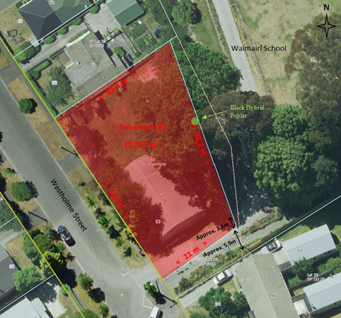
5.5 The
reserve is situated in a residential suburban zone with access from Westholme
Street.
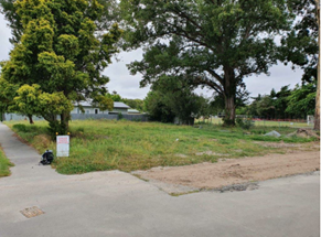
5.6 There
is some residual debris scattered around the site, presumably emanating from
the demolition of the Scout Hall and outbuildings. Asbestos Clearance and
Completion Certificates associated with the demolition of the Scout Hall
(appended as Attachment B) confirm that the area can be reoccupied.
However, some soil testing was considered prudent as no corresponding
certificates were available with regard to clearance of the various other
outbuildings and structures.
5.7 The
Parks team engaged ENGEO to undertake an initial Detailed Site Investigation
(DSI) which has indicated the existence of some contamination on the site. At
the time of writing this report the outcome of further testing by ENGEO to
determine the extent of any contamination (and the likely remediation costs)
was pending. It is anticipated that this information will be available for
discussion at the Board meeting.
5.8 At
the southern end of the reserve an informal access-way across the reserve from
Westholme Street leads to (black) gates providing a secondary access into
Waimairi School (refer photograph below). There is currently no formal right of
way (ROW) in favour of the school over this access-way.
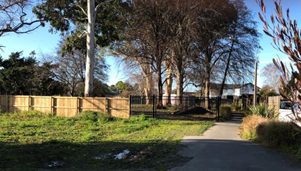
5.9 Similarly,
and as a secondary consideration, the sealed path over School owned land from
Westholme Street (shown to the east of the black gates in the photograph above)
provides pedestrian access to the school and also to the public walkway
adjacent to the railway line to the east (shown highlighted pink in the plan
below). There is, however, no formal public ROW over school land to this public
walkway.

Assessment by the Parks Unit
5.10 In
context, the park (1,204m2) does not meet the minimum size required for a new
park to meet the level of service of 80% of residences in the surrounding area
being within 500 metres of a park of at least 3,000m2 in size.
5.11 However,
the acute deficiency of open space within this community area, together with
its proximity to Council housing and the difficulty of acquiring land for open
space in the immediate area, is such that the Parks unit strongly support the
‘acquisition’ of the reserve as a way of reducing this deficiency.
5.12 The
reserve would be utilised as a local park potentially incorporating play
equipment and landscaping, subject to community consultation.
Process
5.13 For
DOC to transfer the control and management of the reserve to the Council they
require a resolution from the Council to that effect.
5.14 The
Parks Unit are agreeable to taking on this responsibility subject to:
5.14.1 ENGEO’s
pending site investigation confirming that any contamination on the site is
able to be remediated to an acceptable level for recreational use at a
reasonable cost.
5.14.2 DOC undertaking
the necessary consultation with, and securing the approval of, Iwi; cancelling
the Scouts appointment to control and manage the site by Gazette, and; by a
separate Gazette, changing the current classification of the reserve under
Section 24 of the Act from Local Purpose to Recreation Reserve and appointing
the Council to control and manage the reserve. (DOC has confirmed its agreement
to address these requirements).
5.15 Council
staff will inquire of the school if it wishes to retain the secondary vehicle
access across the reserve to the gates on the school boundary and, if it does
require this, investigate the process for the grant of a ROW easement in favour
of the school for this access over the reserve.
5.16 Once
control and management of the reserve has been transferred to the Council, and
prior to its development as a local park, the Parks team are proposing to
initiate a lizard survey (given the current semi-wild state of the site) and an
arborist’s assessment of the trees to ensure that the site is safe for
recreational use.
5.17 Enquiries
will also be made to the school and the Ministry of Education (MOE) as to the
prospect of the grant of a ROW easement in favour of the Council over the
school owned land linking Westholme Street to the public walkway adjacent to
the railway line.
Community Views and Preferences
5.18 Public
notification and consultation on the proposed appointment of the Council to
control and manage the reserve should not be necessary as the use of the land
is not changing significantly. However, as a courtesy, prior notice to
immediate neighbours (School, DOC, MOE, Scouts and MKT) will be appropriate.
5.19 Public
notification will however be required prior to any reporting for approval of
the proposed development of the land in the future.
5.20 Statutory
process requires that consultation with Mana Whenua is undertaken by DOC -
refer 6.4 / 6.5 below.
5.21 The
decision affects the Fendalton-Waimairi- Harewood Community Board.
6. Policy Framework Implications Ngā Hīraunga ā- Kaupapa here
Strategic
Alignment Te Rautaki
Tīaroaro
6.1 The decision is consistent with Council’s Community Outcomes
and Strategic Alignment: Liveable city: a 21st century garden city
we are proud to live in; having good access to nature and green spaces; people
have equitable access to open and green spaces.
6.2 This report supports the Council's
Long Term Plan (2021 - 2031):
6.2.1 Activity: Parks and Foreshore
· Level of Service: 6.8.1.3 Parks are provided
(people have access to parks within walking distance of home) - 80% of urban
residential properties are <500m from a park (any type of park except a
utility park) at least 3000m2 in size
Policy
Consistency Te Whai
Kaupapa here
6.3 The
decision is consistent with the Council’s Plans and
Policies.
Impact
on Mana Whenua Ngā
Whai Take Mana Whenua
6.4 Consultation
with Mahaanui Kurataiao Ltd (MKT), on behalf of Mana Whenua, has not yet been
undertaken. It is noted however that the statutory process requires DOC to
initiate consultation with MKT once the Council has resolved to accept
DOC’s offer to control and manage the reserve. If MKT have no issues with
the proposal then the appointment of the Council to control and manage the
reserve can proceed.
6.5 Subject
to that consultation process it is assumed that the retention and enhancement
of green open space on the site will be a matter of positive interest to Mana
Whenua and that it is not a significant decision in relation to land or water
or other elements of intrinsic value and, as such, this decision does not
specifically impact Mana Whenua, their culture and traditions.
Climate
Change Impact Considerations Ngā Whai Whakaaro mā te Āhuarangi
6.6 The continuation and enhancement of existing green open space will
contribute to the amelioration of the local effects of climate change.
Accessibility
Considerations Ngā
Whai Whakaaro mā te Hunga Hauā
6.7 None. Public access to the reserve will be maintained.
7. Resource Implications Ngā Hīraunga Rauemi
Capex/Opex / Ngā Utu Whakahaere
7.1 Cost
to Implement:
7.1.1 ENGEO
DSI Reports, Lizard and Arborists reports, Stakeholder / partner notification,
Board / Council reports, remediation of land (if required) – Parks
operational budgets.
7.1.2 Gazette
actions – at DOC’s cost.
7.1.3 ROW
Easement across the reserve to the gate – at the School’s /
MOE’s cost.
7.1.4 Reserve
‘Acquisition’ costs – Nil.
7.2 Maintenance/Ongoing
costs – an estimated annual cost of maintenance for the reserve upon
acquisition in its current state is approximately $3100.
7.3 Funding
Source – application to the next LTP for funds to develop and maintain
the site.
Other / He mea anō
7.4 N/A
8. Legal Implications Ngā Hīraunga ā-Ture
Statutory power to undertake proposals in the report /
Te Manatū Whakahaere Kaupapa
8.1 The
general powers of competence set out in section 12(2) “Status and powers”
of the Local Government Act.
8.2 The
provisions of the Reserves Act 1977.
Other Legal Implications / Ētahi atu
Hīraunga-ā-Ture
8.3 The
legal consideration is that reclassification and the control and management of
the reserve needs to be gazetted. The required gazette action is to be
completed by DOC pursuant to section 17 of the Reserves Act 1977.
8.4 This
report has not been reviewed by the Legal Services Unit.
9. Risk Management Implications Ngā Hīraunga Tūraru
9.1 Site
to be administered in a safe condition.
Attachments / Ngā Tāpirihanga
|
No.
|
Title
|
Page
|
|
a ⇩
|
Gazette Notice
|
150
|
|
b ⇩
|
Asbestos
Clearance and Completion Certificates
|
151
|
In addition to the attached documents, the following background
information is available:
|
Document
Name
|
Location
/ File Link
|
|
Not
applicable
|
Not
applicable
|
Confirmation of Statutory
Compliance / Te
Whakatūturutanga ā-Ture
|
Compliance with Statutory Decision-making
Requirements (ss 76 - 81 Local Government Act 2002).
(a) This report contains:
(i) sufficient information about all reasonably practicable
options identified and assessed in terms of their advantages and
disadvantages; and
(ii) adequate consideration of the views and preferences of
affected and interested persons bearing in mind any proposed or previous
community engagement.
(b) The information reflects the level of significance of the
matters covered by the report, as determined in accordance with the Council's
significance and engagement policy.
|
Signatories / Ngā Kaiwaitohu
|
Authors
|
Barry Woodland
- Property Consultant
Derek Roozen -
Senior Network Planner Parks
|
|
Approved By
|
Angus Smith -
Manager Property Consultancy
Kelly Hansen -
Manager Parks Planning & Asset Management
Al Hardy -
Manager Community Parks
Andrew
Rutledge - Head of Parks
Mary
Richardson - General Manager Citizens & Community
|
|
Waimāero
Fendalton-Waimairi-Harewood Community Board
12 September
2022
|

|
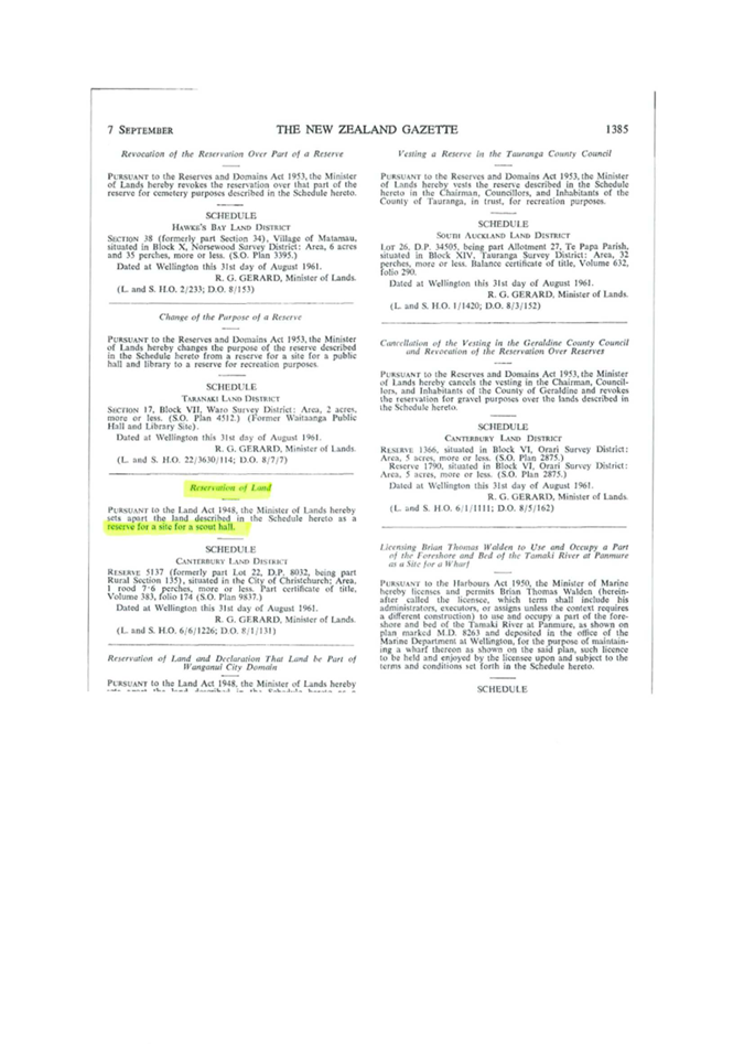
|
Waimāero
Fendalton-Waimairi-Harewood Community Board
12 September
2022
|

|

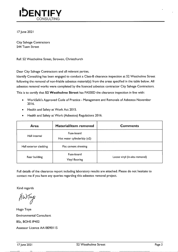
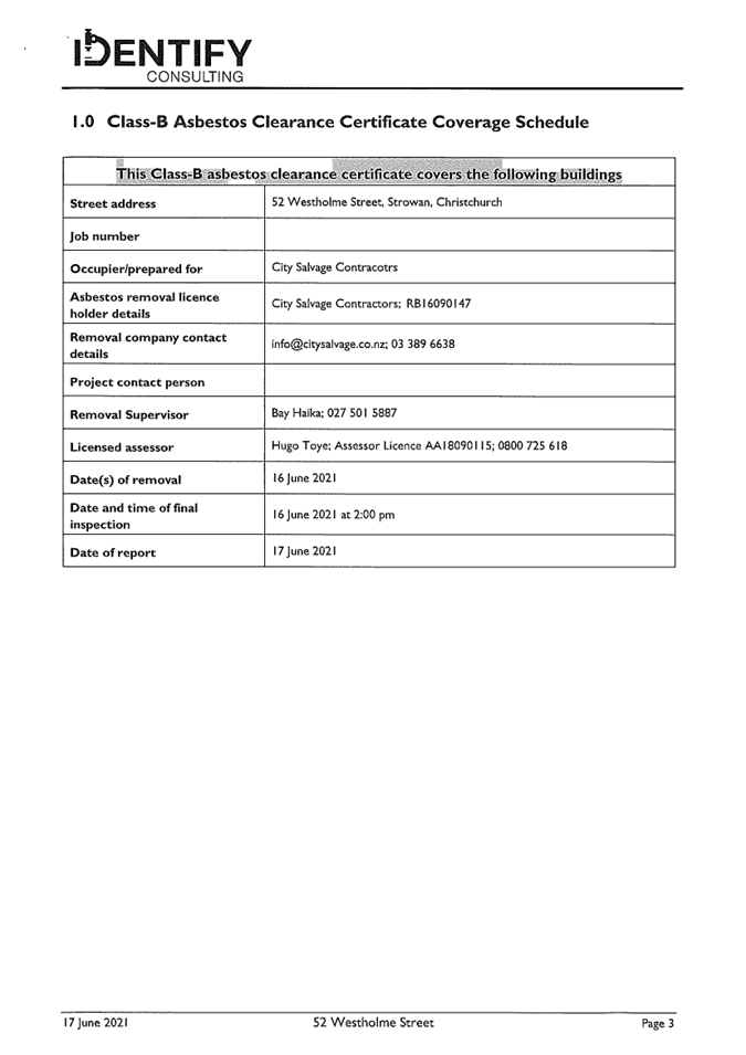
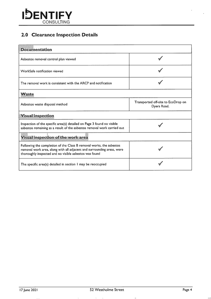
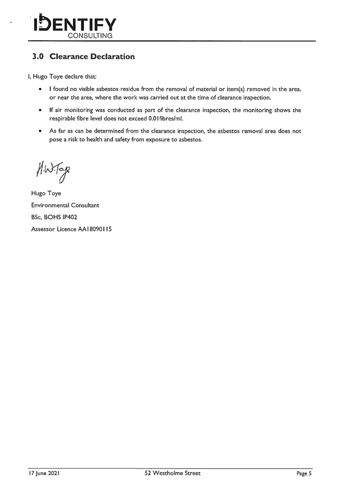
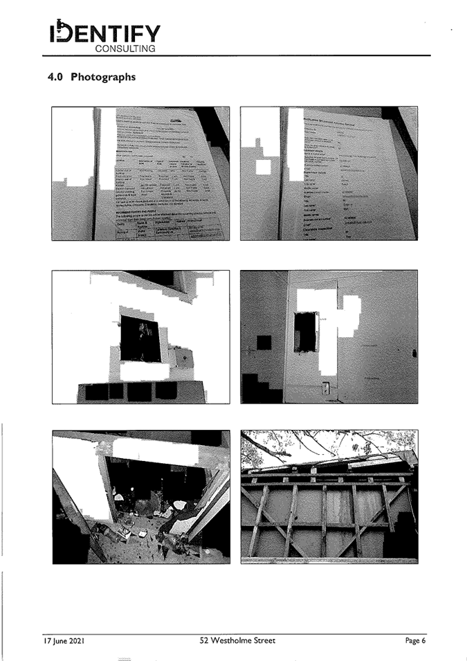


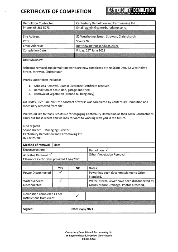

|
Waimāero Fendalton-Waimairi-Harewood
Community Board
12 September
2022
|
|
|
15. Fendalton-Waimairi-Harewood Community Board
2022-2023 Discretionary Response Fund Applications - Rewi Alley Chinese
School, Canterbury Muslim Community Trust, Riccarton Leagues Club Inc
|
|
Reference / Te Tohutoro:
|
22/1136656
|
|
Report of / Te Pou Matua:
|
Karen
Boag, Community Development Advisor, karen.boag@ccc.govt.nz
Natalie Dally, Community Development Advisor, natalie.dally@ccc.govt nz
Lisa Gregory, Community Recreation Advisor, lisa.gregory@ccc.govt.nz
|
|
General Manager / Pouwhakarae:
|
Mary
Richardson, General Manager Citizens and Community,
mary.richardson@ccc.govt.nz
|
1. Purpose of Report Te Pūtake
Pūrongo
1.1 The
purpose of this report is for the Waimāero Fendalton-Waimairi-Harewood
Community Board to consider applications for funding from its 2022-223
Discretionary Response Fund from the organisations listed below.
|
Funding Request Number
|
Organisation
|
Project Name
|
Amount Requested
|
Amount Recommended
|
|
00064812
|
Rewi Alley Chinese School Trust
|
Rewi Alley Chinese School
|
$20,000
|
$3,000
|
|
00064403
|
Canterbury Muslim Community Trust
|
Kids Afterschool Programme (KASP) Project
|
$83,200
|
$5,000
|
|
00064821
|
Riccarton Leagues Club Inc
|
Repainting of Clubrooms
|
$25,000
|
$4,000
|
1.2 There is currently a balance of $68,666 remaining in the fund.
2. Officer Recommendations Ngā
Tūtohu
That the Waimāero
Fendalton-Waimairi-Harewood Community Board:
1. Approves a grant of $3,000 from its 2022-23
Discretionary Response Fund to Rewi Alley Chinese School Trust towards the Rewi
Alley Chinese School.
2. Approves a grant of $5,000 from its 2022-23
Discretionary Response Fund to the Canterbury Muslim Community Trust towards
the Kids Afterschool Programme project.
3. Approves a grant of $4,000 from its 2022-23
Discretionary Response Fund to the Riccarton Leagues Club Inc towards the
painting of their clubrooms.
3. Key Points Ngā Take Matua
Strategic Alignment Te Rautaki Tīaroaro
3.1 The
recommendations are strongly aligned to the Strategic Framework and in
particular the strategic priority of Resilient Communities. The projects recommended above also align with the four pillars of
the Te Haumako Te Whitingia Strengthening Communities Together Strategy –
People, Place, Participation and Preparedness.
Decision Making Authority Te Mana Whakatau
3.2 The
Community Board has the delegated authority to determine the allocation of the
Discretionary Response Fund for each community
3.2.1 Allocations
must be consistent with any policies, standards or criteria adopted by the
Council
3.2.2 The
Fund does not cover:
· Legal
challenges or Environment Court challenges against the Council, Council
Controlled organisations or Community Board decisions
· Projects or
initiatives that change the scope of a Council project or that will lead to
ongoing operational costs to the Council (though Community Boards can recommend
to the Council that it consider a grant for this purpose).
Assessment of Significance and Engagement Te Aromatawai Whakahirahira
3.3 The decisions in this report are of low significance in relation to
the Christchurch City Council’s Significance and Engagement Policy.
3.4 The level of significance was determined by the number of people
affected and/or with an interest.
3.5 Due to the assessment of low significance, no further community
engagement and consultation is required.
Discussion Kōrerorero
3.6 At the time of writing, the balance of the 2022-23 Discretionary
Response Fund is as below.
|
Total Budget 2022/23
|
Granted To Date
|
Available for allocation
|
Balance If Staff Recommendations adopted
|
|
$112,066
|
$43,400
|
$68,666
|
$56,666
|
3.7 Based
on the current Discretionary Response Fund criteria, the applications listed
above are eligible for funding.
3.8 The
attached Decision Matrix provides detailed information for the
applications. This includes organisational details, project details,
financial information and a staff assessment.
Attachments Ngā Tāpirihanga
|
No.
|
Title
|
Page
|
|
a ⇩
|
Fendalton-Waimairi-Harewood
DRF Decision Matrix - Rewi Alley Chinese School Trust - 12 September 2022
|
164
|
|
b ⇩
|
Fendalton-Waimairi-Harewood
DRF Decision Matrix - Canterbury Muslim Community Trust - 12 September 2022
|
165
|
|
c ⇩
|
Fendalton-Waimairi-Harewood
DRF Decision Matrix - Riccarton Leagues Club - 12 September 2022
|
166
|
Confirmation of Statutory
Compliance / Te
Whakatūturutanga ā-Ture
|
Compliance with Statutory Decision-making
Requirements (ss 76 - 81 Local Government Act 2002).
(a) This report contains:
(i) sufficient information about all reasonably practicable
options identified and assessed in terms of their advantages and
disadvantages; and
(ii) adequate consideration of the views and preferences of
affected and interested persons bearing in mind any proposed or previous
community engagement.
(b) The information reflects the level of significance of the
matters covered by the report, as determined in accordance with the Council's
significance and engagement policy.
|
Signatories / Ngā Kaiwaitohu
|
Authors
|
Karen Boag -
Community Development Advisor
Natalie Dally
- Community Development Advisor
Lisa Gregory -
Community Recreation Advisor
|
|
Approved By
|
Maryanne Lomax
- Manager Community Governance, Fendalton-Waimairi-Harewood
|
|
Waimāero
Fendalton-Waimairi-Harewood Community Board
12 September
2022
|
|
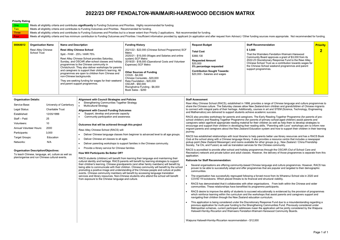
|
Waimāero
Fendalton-Waimairi-Harewood Community Board
12 September
2022
|
|
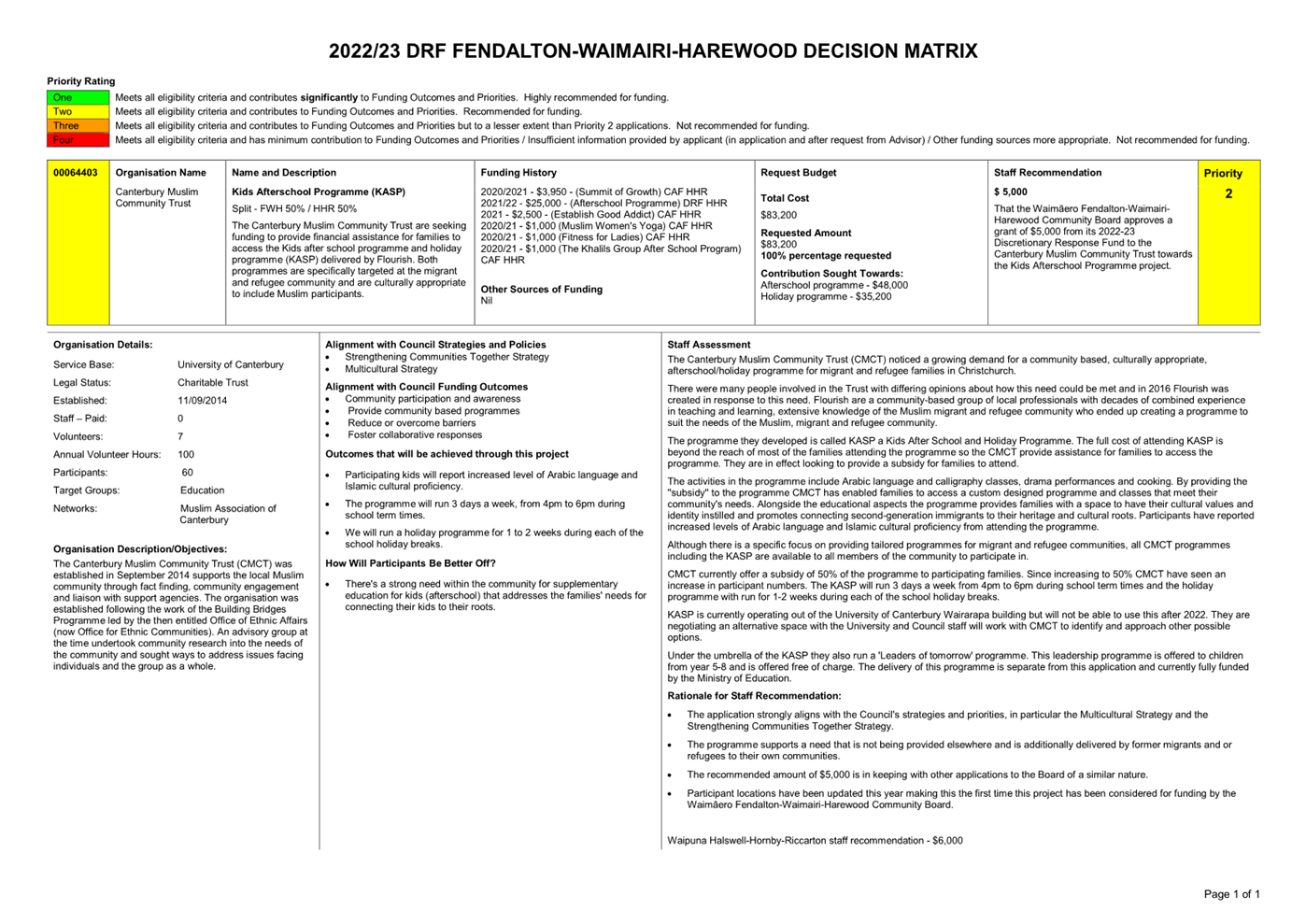
|
Waimāero
Fendalton-Waimairi-Harewood Community Board
12 September
2022
|
|
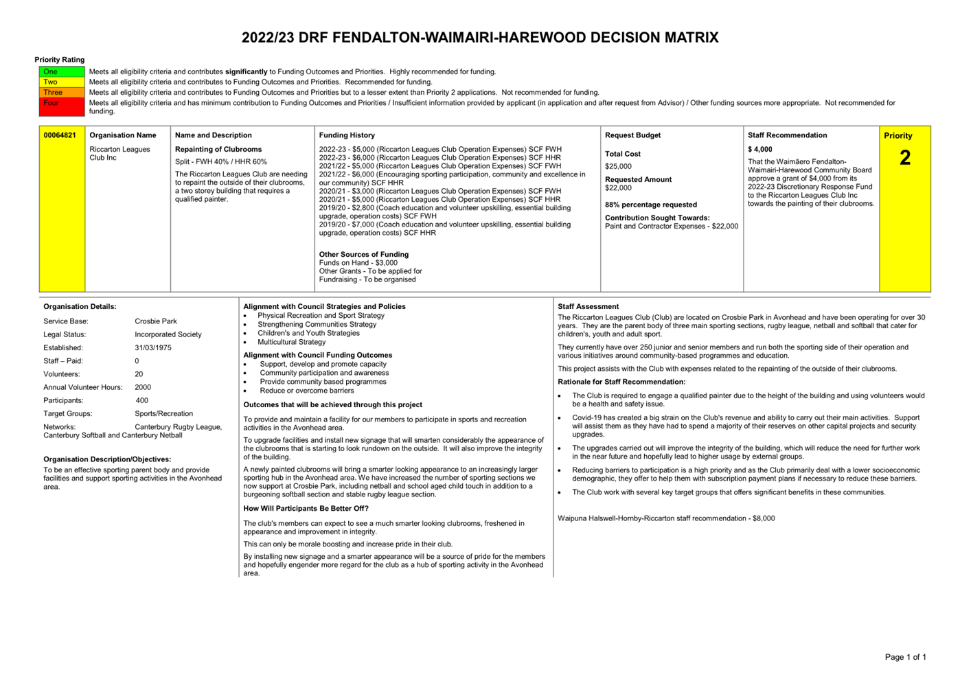
|
Waimāero
Fendalton-Waimairi-Harewood Community Board
12 September
2022
|
|
|
16. Waimāero Fendalton-Waimairi-Harewood
Summer with your Neighbours 2022-23
|
|
Reference Te Tohutoro:
|
22/1082954
|
|
Report of Te Pou Matua:
|
Karen
Boag, Community Development Adviser, karen.boag@ccc.govt.nz
|
|
General Manager Pouwhakarae:
|
Mary
Richardson – General Manager Citizens and Community,
mary.richardson@ccc.govt.nz
|
1. Purpose of Report Te Pūtake
Pūrongo
1.1 The purpose of this report is for the Waimāero
Fendalton-Waimairi-Harewood Community Board to consider applications received
for the 2022-23 Waimāero Fendalton-Waimairi-Harewood Summer with your
Neighbours and to allocate funding as appropriate.
There is a balance of $4,000 allocated to
the 2022-23 Waimāero Fendalton-Waimairi-Harewood Summer with your
Neighbours. The staff recommendations in this report total $3,587.
2. Officer Recommendations Ngā
Tūtohu
That the Waimāero
Fendalton-Waimairi-Harewood Community Board:
1. Allocate its 2022-23 Summer with your
Neighbours as follows:
|
Applicant
|
Activity
|
No. attending
|
Staff recommendation
|
|
1
|
Zara Fraser
|
Street party
|
50
|
$125
|
|
2
|
Jeffry Ross
|
Chedworth/Kingrgrove/Dymock/Wendover combined BBQ
|
40-60
|
$140
|
|
3
|
Lisa Wallace
|
Street BBQ
|
40
|
$100
|
|
4
|
Vicki Smith
|
Christmas Street BBQ
|
190
|
$200
|
|
5
|
Matthew Vannoort
|
Street BBQ
|
25
|
$63
|
|
6
|
Lana McLeod
|
Block party
|
20-30
|
$75
|
|
7
|
Margaret Johns
|
Gathering for neighbours
|
50
|
$69
|
|
8
|
St Christopher's
Church
|
Family BBQ
|
150
|
$200
|
|
9
|
Vilna Gough-Jones
|
Pizza in the Park
|
60
|
$150
|
|
10
|
Fendalton Park
Croquet Club
|
Twilight Croquet event
|
50
|
$125
|
|
11
|
Andrea Champion
|
Street party
|
20
|
$50
|
|
12
|
Joanna Dodgshun
|
Street BBQ
|
37
|
$93
|
|
13
|
Michelle Tracey
|
Street BBQ and games day
|
50-60
|
$150
|
|
14
|
Sarah Johnstone
|
Street BBQ
|
35
|
$88
|
|
15
|
Sophie Robb
|
BBQ lunch
|
50
|
$125
|
|
16
|
Clyde-Penhelig
Residents Assn
|
Street BBQ
|
40-50
|
$100
|
|
17
|
Kylie
Phaup-Stephens
|
BBQ for residents
|
30-40
|
$100
|
|
18
|
Carolyn Coghlan
|
Street BBQ
|
100
|
$200
|
|
19
|
Bernard Tan
|
Neighbourhood get-together
|
30
|
$75
|
|
20
|
Yaldhurst Model
School
|
BBQ lunch on annual Pet Day
|
200
|
$200
|
|
21
|
Cheri Riley
|
Christmas street party
|
20-30
|
$75
|
|
22
|
Barb Harper
|
Pre-Xmas luncheon
|
50-60
|
$150
|
|
23
|
Amanda Murray
|
Street BBQ
|
20
|
$50
|
|
24
|
John Hamilton
|
Christchurch BBQ
|
20-25
|
$63
|
|
25
|
Linda Milne
|
Street get-together
|
17
|
$43
|
|
26
|
Lee Bennetts
|
BBQ at local park
|
50
|
$125
|
|
27
|
Amanda Douglas
|
Pre-Xmas BBQ
|
40-50
|
$125
|
|
28
|
Peter Boock
|
Street BBQ
|
60
|
$150
|
|
29
|
Philippa McMeekan
|
Street BBQ/picnic
|
32
|
$80
|
|
30
|
Denise Donaldson
|
Street BBQ
|
50
|
$125
|
|
31
|
Robyn Thomas
|
Street BBQ
|
50-70
|
$173
|
2. That any unspent 2022-23 Summer with your
Neighbours funding is returned to the 2022-23 Fendalton-Waimairi-Harewood
Discretionary Response Fund.
3. Key Points Ngā Take Matua
Strategic Alignment Te Rautaki Tīaroaro
3.1 The
recommendation is strongly aligned to the Strategic Framework and in particular
the strategic priority of Strengthening Communities. It
will provide a strong sense of community, active participation in civic life,
safe and healthy communities, celebration of our identity through arts,
culture, heritage and sport, valuing the voices of children and young people.
Decision Making Authority Te Mana Whakatau
3.2 The
Community Board has the delegated authority to determine the allocation of its
Summer with your Neighbours funding.
Assessment of Significance and Engagement Te Aromatawai Whakahirahira
3.3 The decisions in this report are of low significance in relation to
the Christchurch City Council’s Significance and Engagement Policy.
3.4 The level of significance was determined by the number of people
affected and/or with an interest.
3.5 Due to the assessment of low significance, no further community
engagement and consultation is required.
Discussion Kōrerorero
3.6 At
its meeting on 15 August 2022, the Waimāero
Fendalton-Waimairi-Harewood Community Board resolved to allocate $4,000 from
its 2022-23 Discretionary Response Fund towards Summer with your Neighbours
2022-23.
3.7 Summer
with your Neighbours is about bringing people closer together and celebrating
the unique and diverse mix of each neighbourhood. It invites residents to
consider if they have ever wanted to organise a neighbourhood gathering, or to
get to know the people who live close to them. This popular event has grown
from year to year and is promoted by the Council.
3.8 Local
community groups, including Residents' Associations and Neighbourhood Support
groups, have been sent information inviting them to apply for the Summer with
your Neighbours funding. Staff also promoted the fund through social
media and other networks.
3.9 Summer with your Neighbours will run from 22 October 2022 to 31
March 2022. Applications for funding opened on 15 July 2022 and closed on
12 August 2022.
3.10 By
the closing date, 31 eligible applications had been received. Staff
have assessed the applications to ensure that they met the Summer with your
Neighbours guidelines, and recommended an amount to be allocated to each
application.
3.11 To
create consistency in staff recommendations across the city, staff
recommendations are based on the following formula:
· $2.50 per head up to
a maximum of $200
· When the requested
amount is less than the $2.50 per head formula, the requested amount is what
has been recommended.
· Where two
approximate attendee numbers have been noted, recommendations are based on the
higher approximate figure.
3.12 A matrix outlining the applications
and staff recommendations is attached (refer Attachment
A), along with the Summer with your Neighbours Guidelines (refer Attachment
B).
Attachments Ngā Tāpirihanga
|
No.
|
Title
|
Page
|
|
a ⇩
|
Fendalton-Waimairi-Harewood
2022-23 Summer with your Neighbours Matrix
|
171
|
|
b ⇩
|
Summer with your
Neighbours 2022-23 Guidelines
|
173
|
Confirmation of Statutory
Compliance Te
Whakatūturutanga ā-Ture
|
Compliance with Statutory Decision-making
Requirements (ss 76 - 81 Local Government Act 2002).
(a) This report contains:
(i) sufficient information about all reasonably practicable
options identified and assessed in terms of their advantages and
disadvantages; and
(ii) adequate consideration of the views and preferences of
affected and interested persons bearing in mind any proposed or previous
community engagement.
(b) The information reflects the level of significance of the
matters covered by the report, as determined in accordance with the Council's
significance and engagement policy.
|
Signatories Ngā Kaiwaitohu
|
Author
|
Karen Boag -
Community Development Advisor
|
|
Approved By
|
Maryanne Lomax
- Manager Community Governance, Fendalton-Waimairi-Harewood
|
|
Waimāero
Fendalton-Waimairi-Harewood Community Board
12 September
2022
|
|

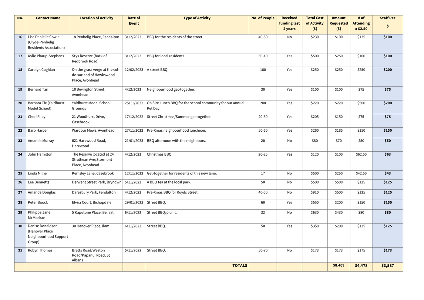
|
Waimāero Fendalton-Waimairi-Harewood
Community Board
12 September
2022
|
|
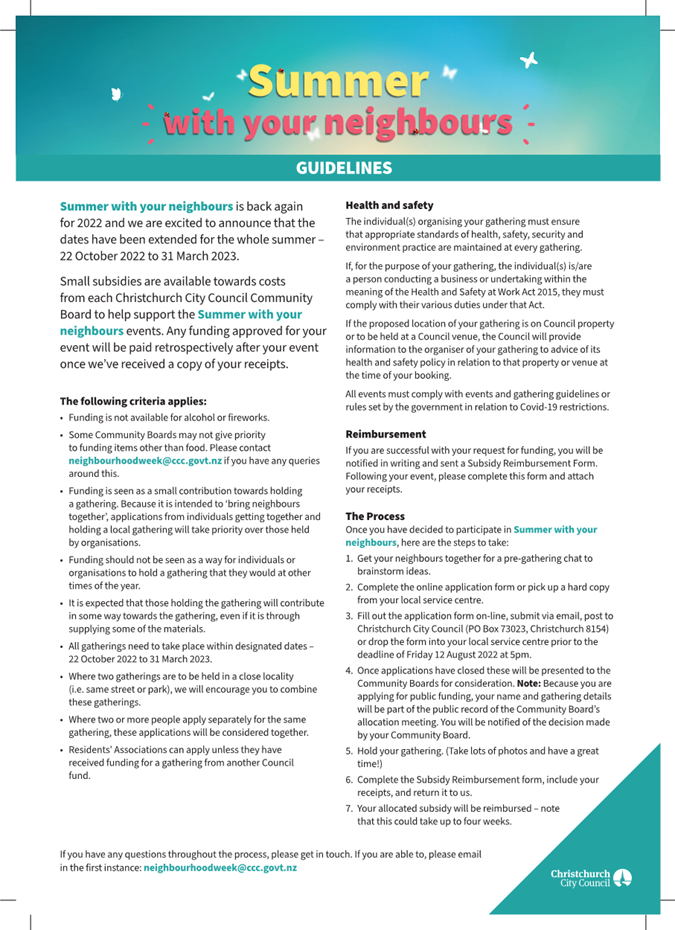
|
Waimāero
Fendalton-Waimairi-Harewood Community Board
12 September
2022
|
|
|
17. Fendalton-Waimairi-Harewood 2022-23 Youth
Development Fund Application - Burnside High School
|
|
Reference / Te Tohutoro:
|
22/1128616
|
|
Report of / Te Pou Matua:
|
Lisa
Gregory, Community Recreation Advisor, lisa.gregory@ccc.govt.nz
Natalie Dally, Community Development Advisor
Natalie.dally@ccc.govt.nz
|
|
General Manager / Pouwhakarae:
|
Mary
Richardson, General Manager Citizens and Community
mary.richardson@ccc.govt.nz
|
1. Purpose of Report / Te
Pūtake Pūrongo
1.1 The
purpose of this report is for the Waimāero Fendalton-Waimairi-Harewood
Community Board to consider an application
received for funding from its 2022-23 Youth Development Fund.
1.2 This
report also includes a recommendation to increase the Community Governance
Manager’s delegation for Youth Development Fund applications during the
upcoming election period.
1.3 The
report is staff generated as a result of applications being received.
1.4 The current balance of the fund is $4,825.
2. Officer Recommendations / Ngā Tūtohu
That the Waimāero
Fendalton-Waimairi-Harewood Community Board resolve to:
1. Approve a grant of $1,200 ($150 each) from its
2022-23 Youth Development Fund to fund Burnside High School towards the costs
of Sophia Alexander, Oscar Evans, Jordyn Mair-Burke, Laura Marshall, Curtis
Shanks, Romy Smith, Evangeline Tiong and Ayla Unstead to participate in the
Spirit of Adventure Trophy Voyage in Auckland, from 19 to 24 September 2022.
2. Increase the Community Governance Manager's
staff delegation for Youth Development Fund applications from $350 to $500
during the period of 13 September 2022 to 1 November 2022 to cover the election
period when the Community Board will not be meeting.
3. Key Points / Ngā Take Matua
Issue or Opportunity / Ngā take, Ngā Whaihua rānei
3.1 To
consider applications received to support the development and achievements of
young people living in the Fendalton-Waimairi-Harewood area.
Strategic Alignment / Te Rautaki Tīaroaro
3.2 The
recommendations in this report align to the Council's Community Outcome of
Resilient Communities including:
· Celebration of our identity through arts, culture, heritage and
sport and recreation
· Valuing the voices of all cultures and ages (including children).
Decision Making Authority / Te Mana Whakatau
3.3 Determine
the allocation of the discretionary Response Fund for each community (including
any allocation towards a Youth Development Fund).
3.4 Allocations
must be consistent with any policies, standards or criteria adopted by the
Council.
3.5 The
Fund does not cover:
· Legal challenges or
Environment Court challenges against the Council, Council Controlled
organisations or Community Board decisions
· Projects or initiatives
that change the scope of a Council project or that will lead to ongoing
operational costs to the Council (though Community Boards can recommend to the
Council that it consider a grant for this purpose).
Assessment of Significance and Engagement / Te Mana Whakatau
3.6 The
decision(s) in this report is of low significance in relation to the
Christchurch City Council’s Significance and Engagement Policy.
3.7 The
level of significance was determined by the number of people affected and/or
with an interest.
3.8 Due
to the assessment of low significance, no further community engagement and
consultation is required.
4. Applicant/ Te Kaitono 1 – Burnside High School
4.1 Event
seeking support for: Spirit of Adventure – Trophy Voyage, in
Auckland from 19 to 24 September 2022.
4.2 Eight
of the ten participants attending the event reside in the
Fendalton-Waimairi-Harewood area. They are:
Sophia Alexander
aged 14 who lives in Burnside
Oscar Evans aged
14 who lives in Ilam
Jordyn
Mair-Burke aged 15 who lives in Avonhead
Laura Marshall
aged 14 who lives in Burnside
Curtis Shanks
aged 15 who lives in Ilam
Romy Smith aged
14 who lives in Ilam
Evangeline Tiong
aged 15 who lives in Avonhead
Ayla Unstead
aged 15 who lives in Ilam
4.3 The
Spirit of Adventure Trophy Voyages are for Year 10 students. Teams of ten
students from various schools, with one teacher per school, compete against
each other over a period of five days.
4.4 All
events include teamwork, problem solving, ship-handling and aquatic sports in
and on the water. Teams will go ashore for a day and complete a task
against others that will involve ingenuity, leadership and reward. The
ship environment will help build self-confidence and ability to work in a team.
4.5 Through
the programme, students will learn the fundamentals of seamanship, water
safety, sailing and marine sciences including navigation, meteorology and conservation.
4.6 The
total cost of the voyage is $16,311 and school has received $6,250 funding from
the Joyce Fisher Charitable trust towards their expenses.
4.7 The
following table provides a breakdown of costs for the voyage for eight of the
ten participants that reside in Fendalton-Waimairi-Harewood:
|
EXPENSES
|
Cost ($)
|
|
Air Fares, Shuttle Costs and Voyage Fees
|
$8,048.88
|
|
|
|
|
Total per participant
|
$1006.10
|
Attachments / Ngā Tāpirihanga
There are no
attachments for this report.
Confirmation of Statutory
Compliance / Te
Whakatūturutanga ā-Ture
|
Compliance with Statutory Decision-making
Requirements (ss 76 - 81 Local Government Act 2002).
(a) This report contains:
(i) sufficient information about all reasonably practicable
options identified and assessed in terms of their advantages and
disadvantages; and
(ii) adequate consideration of the views and preferences of
affected and interested persons bearing in mind any proposed or previous
community engagement.
(b) The information reflects the level of significance of the
matters covered by the report, as determined in accordance with the Council's
significance and engagement policy.
|
Signatories / Ngā Kaiwaitohu
|
Authors
|
Lisa Gregory -
Community Recreation Advisor
Natalie Dally
- Community Development Advisor
|
|
Approved By
|
Maryanne Lomax
- Manager Community Governance, Fendalton-Waimairi-Harewood
|
|
Waimāero
Fendalton-Waimairi-Harewood Community Board
12 September
2022
|
|
|
18. Waimāero Fendalton-Waimairi-Harewood
Community Board Area Report - September 2022
|
|
Reference / Te Tohutoro:
|
22/1083427
|
|
Report of / Te Pou Matua:
|
Maryanne
Lomax, Community Governance Manager, maryanne.lomax@ccc.govt.nz
|
|
General Manager / Pouwhakarae:
|
Mary
Richardson, General Manager, Citizens and Community,
mary.richardson@ccc.govt.nz
|
1. Purpose of Report Te
Pūtake Pūrongo
This report provides the Board with an overview on
initiatives and issues current within the Community Board area.
2. Officer Recommendations Ngā
Tūtohu
That the Waimāero
Fendalton-Waimairi-Harewood Community Board:
1. Receive the Waimāero
Fendalton-Waimairi-Harewood Community Board Area Report for September 2022.
3. Community Support, Governance and Partnership Activity
3.1 Community Governance Projects
|
Activity
|
Detail
|
Timeline
|
Strategic Alignment
|
|
Bishopdale Community Safety Initiative
|
The residents' safety survey for
Bishopdale is now out in paper form with drop boxes for returns at Bishopdale
New World, the Bishopdale Library and Sundbye House. The survey can also be
completed online at https://forms.gle/JUeDxXWiwUKD8ZYg7
The responses are starting to come in
with 28 completed forms already received. The working group, made up of local
community representatives, will be meeting in September for an update of the
feedback. A separate process will be hold with businesses in the
Bishopdale area to get their views on safety issues.
|
Ongoing
|
· Resilient
Communities
· Strengthening
Communities Together Strategy
· Board
Plan Priority
|
|
The Village Community Centre
|
Formerly St Stephen's Community Centre, The Village
Community Centre is celebrating 25 years of providing support to the local
Bryndwr/Burnside community with a community event at their site at 365 Ilam
Road.
|
8 September 2022
|
· Resilient
Communities
· Strengthening
Communities Together Strategy
|
|
Bryndwr connections
|
Staff are looking to get groups supporting the Bryndwr
area together to look at connections, collaborations and complimentary
projects and activities. What’s available to support the community or
what might be needed or are they looking to get up and running. With a major
Kāinga Ora (Housing) redevelopment going on in the area, new residents
will be arriving in 2024 so it’s a good time for the groups to review
and look at future developments and community supports and their roles in
this.
|
Ongoing
|
· Resilient
Communities
· Strengthening
Communities Together Strategy
|
3.2 Russley
Playcentre
Russley Playcentre officially opened its
new equipment storage shed on 25 August
2022. The Playcentre's previous equipment
storage shed leaked and had recurrent rat infestations. There is a lack of
storage inside the main building and the shed has become a storage area for
many items, which were stacked to the roof.
With funding support from the Board's
Discretionary Response Fund, the Playcentre have been able to purchase a much
larger shed/garage which will provide a much safer and more organised storage
facility.

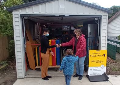
3.3 Fendalton-Waimairi-Harewood
Community Liaison Meeting - 17 August 2022
Approximately 25 representatives from
local community organisations and local elected members attended the last
Community Liaison Meeting. Erin Koller from the Fendalton Library gave a
run down on what they do with a focus on the preschool programmes Pepi/Baby
time and Story time. Sometimes they can have up to 50 babies active in the one
space.
The library is also hosting a drop off
point for “Give Gear Get Great”. This initiative provides an
opportunity for people to drop-off sport and recreation equipment they no
longer need and this can then be redistributed to those who want to get
involved in an activity but don’t have the gear.
A large portion of the meeting was taken
up with a discussion around the mental health system and questions the group
may have around this. This feedback would inform the development of a follow up
session in September that will look to answer these questions and more. Some
shared their personal experiences which further reinforced the reality of the
need. Everyone is looking forward to the session in September to find out how
to navigate the Mental Health System and where else you can go in the community
and what you can do, when it doesn’t work for someone you connect with.
3.4 Avonhead/Russley
Safety Expo
On Sunday, 7 August, a Community Safety
Expo took place at Russley Primary School. Attendees had the opportunity to
meet services and support agencies through information stalls, look at
Community Safety and Emergency Response Vehicles, have their number plates made
safer with tamper-resistant screws and get their questions answered by a panel
of experts.
Police, FENZ, Christchurch North
Community Patrol (CNCP), Canterbury Neighbourhood Support, St John's, Sarah
Pallet's Office and Graffiti were in attendance. Avonhead Community Trust
provided volunteers to help on the day the school PTA ran a sausage.
Approximately 80 people attended the
event. It was well received by those that attended. And would like to see a
similar event happen annually.

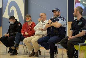
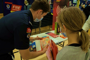
3.5 Asian
Community Transformation Trust (new group update)
The Asian Community Transformation Trust
are developing and growing organically within the community. The group came
about when a few people across different sectors were seeing the same issues in
their Asian communities.
One need identified was for Mental Health
support in the community. The idea of the programme they are developing is to
build and support a network of trained community leaders so they can be
approached in times of need. The current focus is Mental Health and getting
people connected with support as needed. The Manager of the Trust is currently
paid for ten hours a week to help get things up and running in the
organisation. They already have a supervision group of around 20 'leaders' who
have undertaken some training and are getting together to share experiences and
support each other.
They have found through word of mouth they
are also being approached by individuals who are trained health professionals
working in organisations who want to connect because of the specific focus on
the needs in the Asian community. They may not have this in their organisations
and it’s a real bonus to have an ongoing support in the community as well
as a first point of contact, it all works towards building the resilience of
the community as well as supporting individuals.
3.6 Community
Funding Summary
3.6.1 A
status report on the Board's 2022-23 Discretionary Response Fund and Youth
Development Fund as at 22 August 2022 is attached (refer Attachment A).
3.6.2 Youth
Development Fund report backs
· Nicholas Book
The Board provided funding to Nicholas
Book in May 2022 to travel to Qatar for the FIBA Asia Cup and then to Spain for
the FIBA World Cup.
The team ended up winning the Bronze
medal at the Asia Cup, beating Lebanon 89 to 62 in the play-off for 3rd and
4th, resulting in the team qualifying for the World Cup in Spain. Nic was also
named in the All Star 5.
The FIBA.basketball website has listed Nic as one of the
top 20 players to watch from around the world and made the comment below:
"New Zealand are back at the U17 World Cup for a
second straight appearance and Book was a major reason for that - averaging a
double-double at the FIBA U16 Asian Championship 2022. He is a good-sized wing
at 6-foot-8 who can pass and shoot and do a bit of playmaking. He is a good
rebounder with an excellent motor."

· Angus (Will) Gilbert
The Board provided funding to Angus
Gilbert in July 2022 to participate in the U23 Rowing World Championships in
Italy. He has reported back that it was a very successful competition and
he came away with a silver medal in the U23 coxless fours. Will has said
that he will be continuing with the sport and that he is very grateful for the
grant from the Community Board.

Will first on the left
3.7 Participation
in and Contribution to Decision Making
3.7.1 Report
back on other Activities contributing to Community Board Plan
A final monitoring report for the Board's
2020-22 Community Board Plan was included in the August 2022 Area Report.
The new Board will begin developing the 2023-25 Board Plan
3.7.2 Council
Engagement and Consultation
· No current
consultations impacting on the Fendalton-Waimairi-Harewood area.
4. Advice Provided to the Community Board
4.1 Customer
Service Request Report - Hybris monthly report for July 2022 attached,
providing an overview of the number of Customer Service Requests that have been
received, including the types of requests being received and a breakdown of how
they are being reported (refer to Attachment B).
4.2 Fendalton-Waimairi-Harewood
Graffiti Report - July 2022 (refer to Attachment C).
4.3 SWN
- Avice Hill Reserve Pathway and Driveway renewal (circulated 5 August 2022)
4.4 Memo
- Merivale Traffic and Parking Assessment (circulated 15 August 2022)
4.5 Alcohol
Licence requests - 18 July to 25 August 2022 (circulated 25 August 2022)
Attachments Ngā Tāpirihanga
|
No.
|
Title
|
Page
|
|
a ⇩
|
Fendalton-Waimairi-Harewood
Board Funding Update - September 2022
|
185
|
|
b ⇩
|
Fendalton-Wainairi-Harewood
Hybris Ticket report - July 2022
|
186
|
|
c ⇩
|
Fendalton-Waimairi-Harewood
Graffiti Report - July 2022
|
187
|
Signatories / Ngā Kaiwaitohu
|
Authors
|
Maryanne Lomax
- Manager Community Governance, Fendalton-Waimairi-Harewood
Karen Boag -
Community Development Advisor
Natalie Dally
- Community Development Advisor
Lisa Gregory -
Community Recreation Advisor
Aidan
Kimberley - Community Board Advisor
|
|
Approved By
|
Matthew
McLintock - Manager Community Governance Team
John Filsell -
Head of Community Support and Partnerships
|
|
Waimāero
Fendalton-Waimairi-Harewood Community Board
12 September
2022
|
|
|
Waimāero
Fendalton-Waimairi-Harewood Community Board
12 September
2022
|
|
|
Waimāero
Fendalton-Waimairi-Harewood Community Board
12 September
2022
|
|
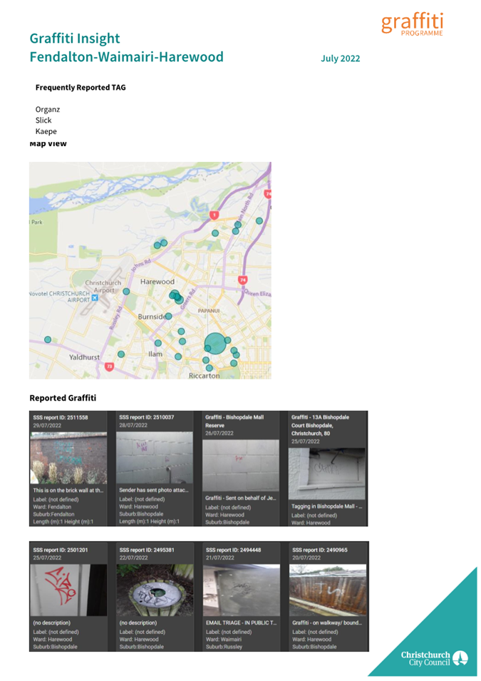
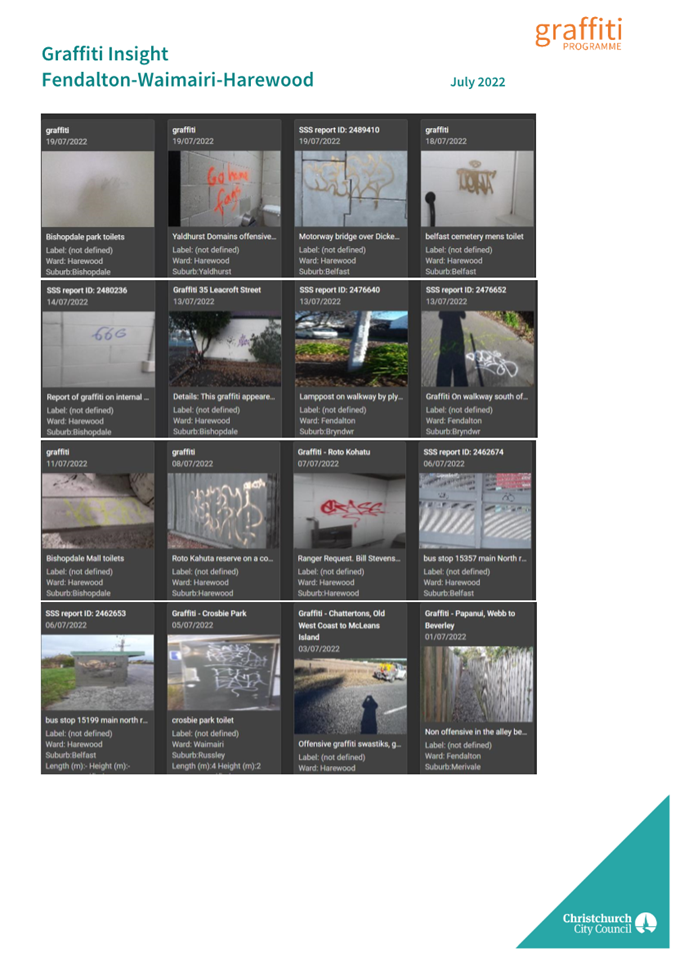
|
Waimāero Fendalton-Waimairi-Harewood
Community Board
12 September
2022
|
|
|
19. Elected
Members’ Information Exchange Te
Whakawhiti Whakaaro o Te Kāhui Amorangi
|
This item provides
an opportunity for Board Members to update each other on recent events and/or
issues of relevance and interest to the Board.
Karakia Whakamutunga