|
Council
08 September
2022
|

|
|
Northcote Road - Signalised Pedestrian Crossing to support the
new Marian College
|
|
Reference / Te Tohutoro:
|
22/824958
|
|
Report of / Te Pou Matua:
|
Kirsty
Mahoney, Team Leader, Asset Planning Transport
Lachlan Beban, Senior Transportation Engineer, Traffic Operations
|
|
General Manager / Pouwhakarae:
|
Jane
Davis, General Manager Infrastructure, Planning and Regulatory Services
|
1. Purpose of the Report Te Pūtake Pūrongo
1.1 The
purpose of this report is to seek the approval of the Papanui-Innes Community
Board (Board) and the Council for the installation of a signalised crossing on
Northcote Road to the east of Lydia Street, and associated infrastructure
improvements for safe and sustainable transport of students and staff attending
the new Marian College site.
1.2 This
report has been written by Council staff to support the implementation of the
designation conditions associated with the construction of the new Marian
College, as outlined in RMA/2021/1122.
1.3 The
decisions in this report are of medium significance in relation to the
Christchurch City Council’s Significance and Engagement Policy. The
level of significance was determined by an assessment of the project against
the criteria outlined in the Council’s Significance and Engagement
Policy.
2. Officer Recommendations Ngā Tūtohu
That the Waipapa
Papanui-Innes Community Board:
Northcote Road
1. Approves that in accordance with Clause 7 of the Christchurch City
Council Traffic and Parking Bylaw 2017, the stopping of vehicles be prohibited
at any time on:
a. The south side of Northcote Road commencing at its intersection with
Lydia Street and extending in a easterly direction for a distance of 67 metres.
b. The south side of Northcote Road commencing at its intersection with
Lydia Street and extending in a westerly direction for a distance of 21 metres.
c. The north side of Northcote Road, commencing at its intersection
with Fenchurch Street, and extending in a westerly direction for a distance of
130 metres.
2. Approves that under clause 8 of the Christchurch City Council
Traffic and Parking Bylaw 2017, a marked bus stop be installed on the southern
side of Northcote Road, commencing at a point 21 metres west of its
intersection with Lydia Street and extending in a westerly direction for a
distance of 14 metres.
3. Approves that the pathway on the south side of Northcote Road
commencing at its intersection with Lydia Street and extending in an easterly
direction for a distance of 21 metres be resolved as a shared pedestrian/cycle
pathway in accordance with Clause 21(1) (a) of the Christchurch City Council
Traffic and Parking Bylaw 2017.
4. Approves that in accordance with Part 2, Clause 17 of the
Christchurch City Council Traffic and Parking Bylaw 2017, the left turn
movement from Northcote Road into Lydia Street be prohibited for goods and
service delivery vehicles over 3,500kg.
Lydia Street
5. Approves that in accordance with Clause 7 of the Christchurch City
Council Traffic and Parking Bylaw 2017, the stopping of vehicles be prohibited
at any time on:
a. The east side of Lydia Street commencing at its intersection with Northcote
Road and extending in a southerly direction for a distance of 50 metres.
b. The west side of Lydia Street commencing at its intersection with Northcote
Road and extending in a southerly direction for a distance of 60 metres.
6. Approves that in accordance with Part 2, Clause 17 of the
Christchurch City Council Traffic and Parking Bylaw 2017, the right turn
movement from Lydia Street onto Northcote Road be prohibited, this turn
restriction is to apply for any class vehicles.
7. Approves that the pathway on the east side of Lydia Street from its
intersection with Northcote Road to the end of the legal road be resolved as a
shared pedestrian/cycle pathway in accordance with Clause 21(1) (a) of the
Christchurch City Council Traffic and Parking Bylaw 2017.
8. Approves that a Give Way control be placed against Lydia Street
at its intersection with Northcote Road, in accordance with Section 10.3 of the
Land Transport rule- Traffic Control Devices: 2004.
9. Revokes any previous resolutions pertaining to traffic controls made
pursuant to any bylaw to the extent that they are in conflict with the traffic
controls described in resolutions 1-8 above.
10. Approves that these resolutions take effect when there is evidence
that the road marking restrictions described in the staff report are in place
(or removed in the case of revocations).
That the Waipapa Papanui-Innes Community Board Recommends that the Council:
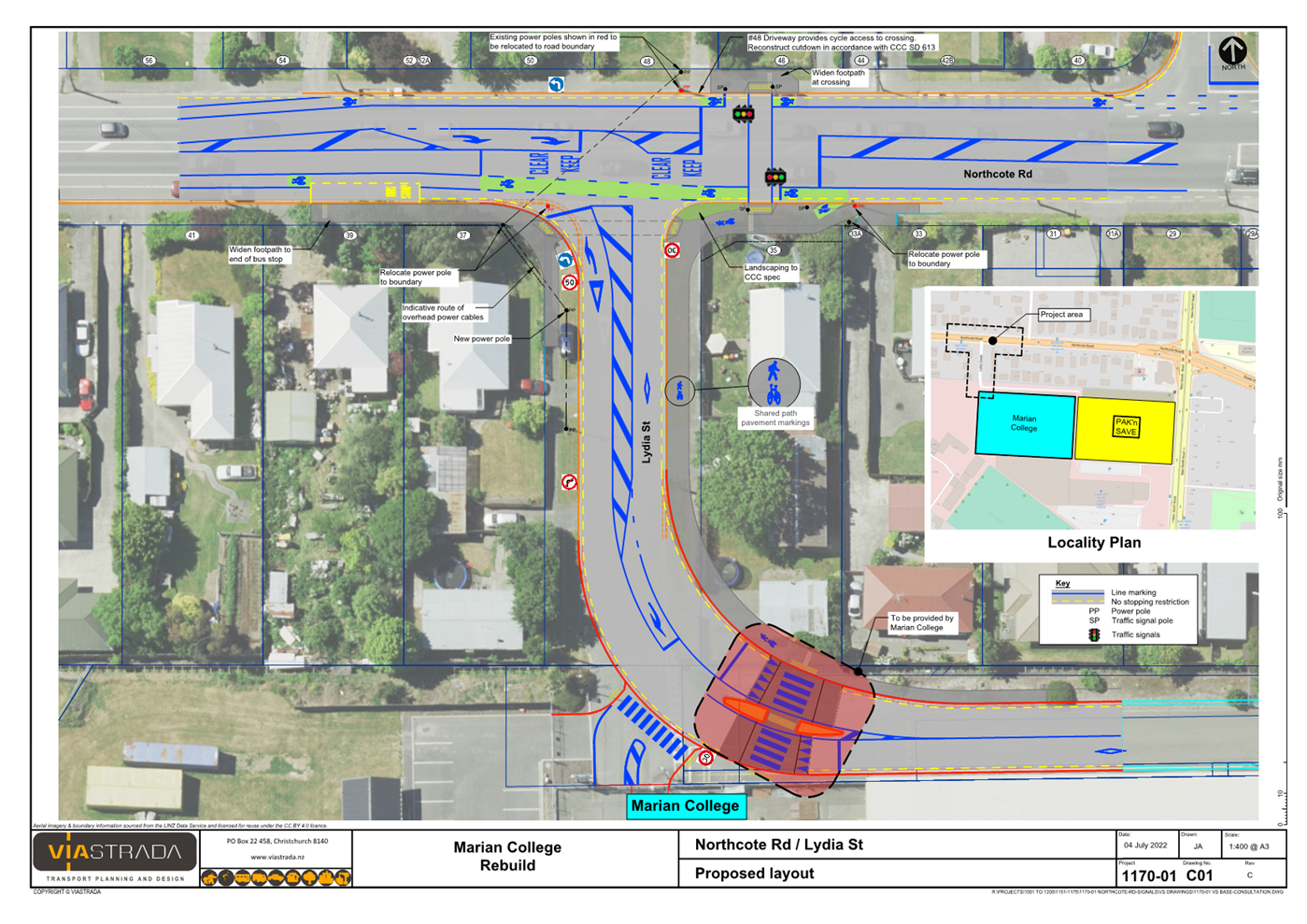
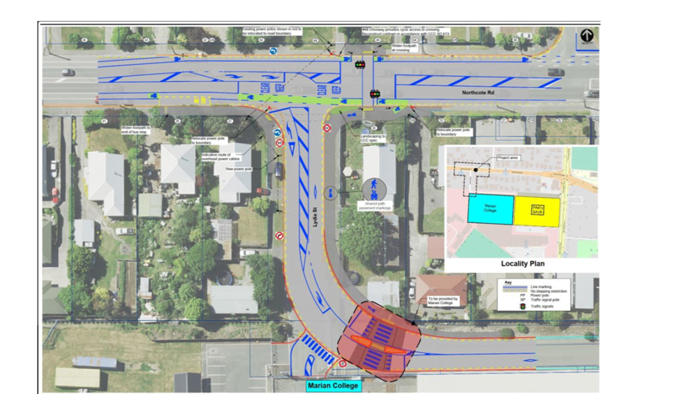
11. Approve the installation of traffic signals (to facilitate
pedestrians and cyclists crossing Northcote Road), including all associated
road markings on Northcote Road to the east of its intersection with Lydia
Street as detailed in Attachment A.
12. Revoke the existing permanent speed limit of 40 kilometres per hour
on Lydia Street (entire length).
13. Approve pursuant to Part 4 Clause 27 of the Christchurch City
Council Traffic and Parking Bylaw 2017 and Land Transport Rule, Setting of
Speed Limits 2022: that the permanent speed limit on Lydia Street be set at 30
kilometres per hour (entire length).
3. Reason for Report Recommendations Ngā Take mō te Whakatau
3.1 These
recommendations support the installation of the signalised crossing on
Northcote Road and associated infrastructure improvements for safe and
sustainable transport of students and staff attending the new Marian College
site, and as required by the designation conditions associated with the
construction of the new Marian College under RMA/2021/1122.
4. Alternative Options Considered Ētahi atu Kōwhiringa
4.1 The
conditions associated with the Foodstuffs resource consent and the Marian
College designation require particular elements to be included in the scheme
design. However, the project team has also considered the following alternative
elements:
4.1.1 Full signalisation of
the Lydia St / Northcote Road intersection – Network modelling has been
undertaken using Paramics for the Pak N Save development, and this model was
used to evaluate the additional impacts caused by Marian College for both a
signalised mid-block crossing option, and a full signalisation option.
The mid-block crossing option provides better overall network
performance. The Foodstuffs resource consent for the Pak N Save
development requires that the right turn out of Lydia Street be banned.
Therefore there is no reason for a fully signalised intersection as all the
remaining movements for all user groups can be safely carried out with a
signalised mid-block crossing.
4.1.2 A signalised
mid-block crossing to the west of Lydia Street has been considered but not
developed fully as the Foodstuffs resource consent for the Pak N Save
development requires that the right turn out of Lydia Street be banned.
The left turn only exit from Lydia Street would then put crossing users
directly in the path of vehicles exiting Lydia Street.
4.1.3 A splitter island on
Lydia Street as an alternative to the flush median marking has been considered
to shorten the crossing distance across Lydia Street for pedestrians. It
is noted that under this option heavy vehicles would not be able to track
easily through this intersection, and therefore carriageway widening would be
required. There would likely be ongoing maintenance issues and costs with
damage to both the splitter island and the adjacent footpath / shared path on
each side of the road from heavy vehicles.
5. Detail Te Whakamahuki
5.1 The
Catholic Diocese of Christchurch has purchased land off Lydia Street and
Northcote Road to construct a new site for Marian College, previously located
in Shirley and post-earthquake co-located in the central city with the Catholic
Cathedral College. The new site is currently under construction.
5.2 The
school’s development is linked with the adjacent development of the
Foodstuffs South Island Limited site. The South Island head office is
located on the site facing Main North Road and a Pak N Save supermarket is
currently under construction. Foodstuffs has resource consent with
conditions that impact on the school and how the intersection of Lydia Street
and Northcote Road can function.
5.3 Lydia
Street provides access to both Marian College and the Foodstuffs site including
the proposed Pak N Save. The Foodstuffs resource consent stipulates
several relevant access parameters at the Lydia Street / Northcote Road
intersection, which include:
5.3.1 Delivery trucks
travelling to Pak N Save shall only turn right into Lydia Street.
5.3.2 Left turns into Lydia
Street by heavy vehicles will not be permitted.
5.3.3 Right turns out of
Lydia Street will not be permitted for any class of vehicle.
5.4 Foodstuffs
staff have confirmed that they will be operating High Performance Motor
Vehicles (HPMVs, i.e. B-trains) that are 23 metres long instead of the usual 20
metres to and from this site. These trucks will be turning right from
Northcote Road into Lydia Street and left out of Lydia Street.
5.5 Marian
College will also sometimes be visited by tour coaches, and these may turn left
from Northcote Road into Lydia Street. Tour coaches have lower tracking
requirements than HPMVs, and therefore the infrastructure changes have been
designed using HPMVs.
5.6 Marian
College, through the Minister of Education, holds a designation with conditions
RMA/2021/1122 for the construction of the school at 35 Northcote Road. The
transport infrastructure and operation conditions associated with this
designation require the following:
5.6.1 School Travel
Plan – Prior to the opening of the school, the Requiring
Authority shall, either directly or through the school management, develop a
Travel Plan which provides specifically for measures to reduce vehicle
dependence, including walking school buses, car-pooling, the encouragement of
the use of public transport, the use of remote pick up/ drop off locations, if
appropriate, and the encouragement of walking and cycling.
5.6.2 Transport
Network Changes – Prior to the opening of the school, the
Minister of Education will ensure that appropriate steps are taken to manage
transport effects. This includes:
The following package of measures:
(i) A signalised
pedestrian crossing across Northcote Road located within 50 metres east of the
intersection of Lydia Street and Northcote Road shall be installed and
operational;
(ii) A footpath that can
accommodate pedestrians, cyclists and scooters of at least 2.5 metres in width
shall be installed in accordance with the Christchurch City Council’s
infrastructure design standards adjacent to the eastern side of the vehicles
carriageway on Lydia Street; and adjacent to the western side of the vehicle
carriageway on Lydia Street south of the raised zebra crossing;
(iii) “No parking”
restrictions shall be placed on the eastern side of the vehicle carriageway on
Lydia Street; and
(iv) A raised zebra crossing
across the vehicle carriageway on Lydia Street shall be installed; or
Any other
method or combination of methods determined to be appropriate to manage
transport effects in consultation with the Head of Resource Consents.
5.7 A
scheme plan has been prepared that provides the required traffic engineering
elements needed for the school development that meets the conditions of both
the Foodstuffs resource consent conditions, and the Marian College designation
conditions. The key features of the scheme plan include:
5.7.1 A signalised
mid-block crossing just to the east of Lydia Street on Northcote Road that will
be operated with signals for people walking or cycling.
5.7.2 Flush median in Lydia
Street to allow use of the intersection and streets by HPMVs.
5.7.3 Relocation of the
westbound bus stop on Northcote Road a few metres further from the intersection
to accommodate the HPMVs.
5.7.4 Right turn lane on
Northcote Road to allow drivers waiting to turn into Lydia Street a space to
wait for a safe gap clear of the eastbound through lane. This requires
the removal of parking along the north side of Northcote Road between 54
Northcote Road and Fenchurch Street.
5.7.5 Keep Clear markings
along Northcote Road to ensure a safe gap is maintained at peak times for
drivers to enter and exit Lydia Street. The spacing of these markings has
been designed to ensure drivers turning right into Lydia Street can observe and
give way to cyclists in the westbound cycle lane.
5.7.6 A No Left Turn for
vehicles over 3,500kg sign will be installed on Northcote Road to meet the
Foodstuff’s consent requirement to ban left turns onto Lydia Street from
Northcote Road for heavy vehicles.
5.7.7 Shared path along the
east side of Lydia Street to provide access to a raised pedestrian crossing
outside the school.
5.7.8 Extension of a short
section of footpath along the western side of Lydia Street from Northcote Road
to the flush pedestrian crossing on Lydia Street to achieve a walking
connection to the Marian College access point.
5.7.9 Introduction of a
30km/h speed limit along Lydia Street in line with the new Setting of Speed
Limits Rule 2022, which came into effect on 19 May 2022. Wider speed
limit changes associated with Marian College will need to be completed as part
of a school cluster with St Bede's College, Casebrook Intermediate and
Northcote Primary School as it will form one zone on Northcote Road/QEII/Main
North Road. These changes are likely to be effected at the start of
FY23/24, as part of the Council’s Interim Speed Management Plan.
6. Community Views and Preferences Ngā mariu
ā-Hāpori
Public Consultation Te Tukanga
Kōrerorero
6.1 Consultation
started on 18 July and ran until 8 August 2022. An email was sent to 19 key
stakeholders, including Foodstuffs, Marian College and the Catholic Diocese.
6.2 Consultation
documents were delivered to 132 properties and sent to 51 absentee owners of
properties in the immediate area on 18 July 2022.
Summary of Submissions Ngā
Tāpaetanga
6.3 In
total, four recognised organisations, one business and 16 residents made
submissions, including one that was late and was not included in the analysis.
All submissions are available on our Have Your Say webpage.
6.4 Half
(10) of the submitters indicated they
supported the signalised crossing for the following reasons:
· To
create a safer environment for all road users.
· Essential for when the new school opens, increasing pedestrian
numbers.
· Improved
accessibility for the wider community.
6.5 Other
issues raised were:
· The short distance between the traffic lights on Main North Road and
the new lights.
· The new lights will increase congestion.
· The new lights should be phased with the Main North Road signals.
6.6 The majority of
submitters supported the speed reduction on Lydia Street (13, 65%) for the
following reasons:
· The
road looks and feels like a slow speed environment.
· The
speed reduction will make it safer for all road users.
· The
speed reduction will improve traffic flow.
6.7 Other
issues raised were:
· A variable speed limit would be more effective.
· The speed reduction area should be extended.
· Pick-ups and drop offs of students should be kept away from Lydia
Street.
· Support for turning restrictions at Lydia Street.
6.8 The decision affects the following wards/Community Board areas:
6.8.1 Papanui-Innes
Community Board
|
Issue raised by
submitter(s)
|
Staff response
|
|
· Turning restrictions on Lydia Street increasing traffic
on Vagues Road outside St Joseph’s School.
· Using a variable speed limit on Northcote Road.
|
We have a Speed Management Plan
for all schools in 2023. This will include 30km/h outside St Joseph’s
School.
|
|
Phase traffic lights with the
lights on Main North Road.
|
We will link the new signals
with the current traffic signals network - this way they can work together
and help the traffic flow.
|
|
Increased congestion on Lydia
Street from the new school traffic.
|
Marian College are working with
Foodstuffs on a traffic plan for when the school opens.
|
|
· Separate pedestrians and cyclists from the traffic with
flexi-posts.
· Extended no stopping past 41 Northcote Road to Increase
pedestrian safety.
· Surveys on how many girls will use a bicycle, public
transport or drive their own car to & from the new school.
|
Monitoring and evaluation will
be undertaken to measure the use and operation of the crossing. This aligns
to the Emissions Reduction Plan outcomes to provide options for all modes of
transport.
|
|
Increased congestion from the
new signalised crossing.
|
We have other projects planned
to improve the traffic flows in the area;
· Greers Road/Northcote Road/Sawyers Arms Road intersection
improvement: 2025
· Greers Road/Langdons Road traffic lights: 2025
· Northcote Road corridor improvements: 2028
· Northern Line cycleway improvements: 2025
|
|
Widen shared path on Lydia
street and remove painted median to slow traffic.
|
Catholic Diocese has designated
land for a standard 2.5 metre shared path. We also have a Speed Management
Plan for all schools in 2023.
|
|
Install a shelter at the bus
stop on Northcote Road.
|
Once the school opens, we will
monitor the whole area and if the stop becomes busier we will request one to
be installed as part of the public transport infrastructure programme.
|
|
· Widen the cycle lane on Northcote Road.
· Upgrades to the corner of Northcote and Vagues Rd, and
the lights by the railway crossing for those turning left on to Northcote Road.
|
There is a project in the Long
Term Plan for Greers Road/Northcote Road/Sawyers Arms Road intersection
improvements in 2025. Also a Northcote Road corridor improvements project is
scheduled for 2028.
|
7. Policy
Framework Implications Ngā Hīraunga ā- Kaupapa
here
Strategic Alignment Te Rautaki
Tīaroaro
7.1 The signalised crossing and associated changes align with
Council’s strategic direction for safety improvements, speed management
and providing transport options for all users.
7.2 This report supports the Council's
Long Term Plan (2021 - 2031):
7.2.1 Activity: Transport
· Level
of Service: 10.5.42 Increase the infrastructure provision for active and public
modes - ≥ 570 kilometres (total combined length)
Policy Consistency Te Whai Kaupapa here
7.3 The decision is consistent with Council’s Plans and Policies.
Impact on Mana Whenua Ngā Whai Take
Mana Whenua
7.4 The decision
does not involve a significant decision in relation to ancestral land or a body
of water or other elements of intrinsic value, therefore this decision does not
specifically impact Mana Whenua, their culture and traditions.
7.5 The signalised crossing and associated infrastructure changes are
not located near to ancestral land or a body of water that impacts the
relationship of Maori and their culture and traditions.
Climate Change Impact Considerations Ngā
Whai Whakaaro mā te Āhuarangi
7.6 This project seeks to promote safe and sustainable transport modes
to and from the new Marian College site, which is consistent with the outcomes
sought by the Emissions Reduction Plan 2022.
Accessibility Considerations Ngā Whai
Whakaaro mā te Hunga Hauā
7.7 This project provides options for safe access by all transport users
to and from the new Marian College site.
8. Resource Implications Ngā Hīraunga Rauemi
Capex/Opex / Ngā Utu Whakahaere
8.1 Cost
to Implement – The cost to implement this project is being funded by the
Catholic Diocese of Christchurch.
8.2 Maintenance/Ongoing
costs – $5,500 per annum in operational costs for the signalised
crossing.
8.3 Funding
Source – The capital cost of this project is funded by the Catholic
Diocese of Christchurch, and the ongoing maintenance and operational costs will
be borne by the Council.
9. Legal Implications Ngā Hīraunga ā-Ture
Statutory power to undertake proposals in
the report / Te Manatū Whakahaere Kaupapa
9.1 The
Community Board has the delegated authority to approve the resolutions outlined
in the recommendation, while the Council has the authority to approve the
installation of the traffic signals and the speed limit reduction along Lydia
Street under the Local Government Act.
Other Legal Implications / Ētahi atu
Hīraunga-ā-Ture
9.2 There
is no legal context, issue or implication relevant to this decision.
10. Risk Management Implications Ngā Hīraunga Tūraru
10.1 The top three
risks associated with the installation of the signalised crossing and
associated infrastructure improvements to support the construction of the new
Marian College include:
10.1.1 Vehicle conflicts – the
Traffic Impact Assessment prepared for the Marian College development lists two
rear-end crashes at the Lydia Street / Northcote Road intersection. This
section of Northcote Road is listed as having a Medium High collective risk,
and Low Medium personal risk.
10.1.2 Vehicle / pedestrian and vehicle
/ cyclist conflicts – the independent Road Safety Audit of the scheme
design has highlighted the potential for these conflicts at the Lydia Street /
Northcote Road intersection.
10.1.3 Non-approval of the
infrastructure required under the designation conditions would lead to the
Marian College site being unable to open and operate.
Attachments / Ngā Tāpirihanga
|
No.
|
Title
|
Page
|
|
a
|
Attachment A -
Northcote Road Signalised Crossing - Plan for Approval
|
|
In addition to the attached documents, the following background
information is available:
|
Document
Name
|
Location
/ File Link
|
|
Not
applicable
|
Not
applicable
|
Confirmation
of Statutory Compliance / Te
Whakatūturutanga ā-Ture
|
Compliance with Statutory Decision-making
Requirements (ss 76 - 81 Local Government Act 2002).
(a) This report contains:
(i) sufficient information about all reasonably practicable
options identified and assessed in terms of their advantages and
disadvantages; and
(ii) adequate consideration of the views and preferences of
affected and interested persons bearing in mind any proposed or previous
community engagement.
(b) The information reflects the level of significance of the
matters covered by the report, as determined in accordance with the Council's
significance and engagement policy.
|
Signatories / Ngā Kaiwaitohu
|
Authors
|
Kirsty Mahoney
- Team Leader Asset Planning
Lachlan Beban
- Senior Transportation Engineer
Samantha
Sharland - Engagement Advisor
Wayne Anisy -
Traffic Engineer
|
|
Approved By
|
Jacob Bradbury
- Manager Planning & Delivery Transport
Lynette Ellis
- Head of Transport & Waste Management
Jane Davis - General
Manager Infrastructure, Planning & Regulatory Services
|
|
Council
08 September
2022
|

|
|
Linwood Village Streetscapes Enhancements (S1)
|
|
Reference / Te Tohutoro:
|
22/359462
|
|
Report of / Te Pou Matua:
|
Adrian
Thein, Project Manager Adrian.thein@ccc.govt.nz
Hannah Ballantyne, Engagement Advisor, Hannah.Ballantyne@ccc.govt.nz
|
|
General Manager / Pouwhakarae:
|
Jane
Davis, Jane.Davis@ccc.govt.nz
|
1. Purpose of the Report Te Pūtake Pūrongo
1.1 The
purpose of this report is to request the Waikura Linwood – Central
– Heathcote Community Board approval of the scheme plan and to proceed to
detail design and construction for the Linwood Village Streetscape
Enhancements.
1.2 This
report has been written in response to the local community’ aspirations
for a safe, attractive and pedestrian -friendly environment, which creates a
good balance between different transport users (e.g. pedestrians, cyclists,
buses and cars) and improves the 'look and feel' of the Village. The area's
amenity and character are to be improved whilst the function and role of the
transport network is maintained. The thoughtful use of space, creativity in
design, safety, new infrastructure, slower vehicle speeds and sensible parking
management (for steady vehicle turnover).
1.3 The
decisions in this report are low significance in relation to the Christchurch
City Council’s Significance and Engagement Policy. The level of
significance was determined through considering the scale of improvement
proposed and the fact that it will provide benefits to the local community.
1.4 The
community engagement and consultation outlined in this report reflect the
assessment.
1.5 The
recommended option is to control and reduce vehicles speed by a change in speed
restrictions, create an improved environment for pedestrians with widened
footpaths and tree planting, and having clear marking, cycle lanes, raised
platforms at each of the approaches to Hereford and Stanmore Road and also
providing a courtesy crossing in front of Doris Lusk Park as outlined in Attachment
B.
1.6 These measures have been requested to:
· Control vehicle speeds.
· Provide greater vehicle turnover along village centre.
· Improve service level for bus users.
· Improve pedestrian safety and enhance the village atmosphere of
Linwood.
2. Officer
Recommendations Ngā Tūtohu
That the Waikura
Linwood-Central-Heathcote Community Board recommends that Council:
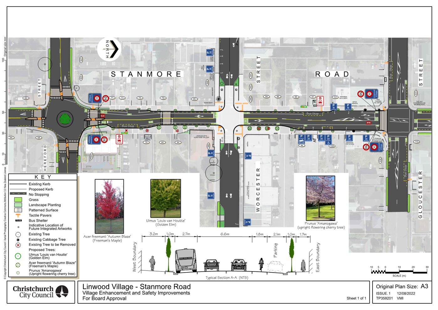
1. Revokes any previously approved resolutions on Stanmore Road from
its intersection with Hereford Street, and extending in a northerly direction to
its intersection with Gloucester Street, pertaining to traffic controls, made
pursuant to any bylaw, to the extent that they are in conflict with the traffic
controls described in recommendations 2-12 below.
2. Approves that the speed limit be set at 30 km /h, in accordance with
Clause 27 of the Christchurch City Council Traffic & Parking Bylaw 2017 on
Stanmore Road, commencing at its intersection with Hereford Street and
extending in a northerly direction to its intersection with Worcester Street.
3. Approves that the speed limit be set at 30 km /h within the
intersection of Stanmore Road and Worcester Street, in accordance with Clause 27
of the Christchurch City Council Traffic & Parking Bylaw 2017.
4. Approves that the speed limit be set at 30 km /h, in accordance with
Clause 27 of the Christchurch City Council Traffic & Parking Bylaw 2017 on
Stanmore Road, commencing at its intersection with Worcester Street and
extending in a northerly direction to its intersection with Gloucester Street.
5. Approves that a Special Vehicle Lane, in accordance with Clause 18 of
the Christchurch City Council Traffic & Parking Bylaw 2017, for the use of
northbound cycles only be installed on the west side of Stanmore Road, commencing
at its intersection with Hereford Street, and extending in a northerly
direction to its intersection with Worcester Street, as detailed on plan
TP359201, sheet 1, dated 12/08/2022 and attached to this report as Attachment
B.
6. Approves that a Special Vehicle Lane, in accordance with Clause 18
of the Christchurch City Council Traffic & Parking Bylaw 2017, for the use
of southbound cycles only be installed on the east side of Stanmore Road,
commencing at its intersection with Worcester Street, and extending in a
southerly direction for a distance of 63 metres, as detailed on plan TP359201,
sheet 1, dated 12/08/2022 and attached to this report as Attachment B.
7. Approves that a Special Vehicle Lane, in accordance with Clause 18
of the Christchurch City Council Traffic & Parking Bylaw 2017, for the use
of northbound cycles only be installed on the west side of Stanmore Road,
commencing at its intersection with Worcester Street, and extending in a
northerly direction for a distance of 50 metres, as detailed on plan TP359201,
sheet 1, dated 26/04/2022 and attached to this report as Attachment B.
8. Approves that a Special Vehicle Lane, in accordance with Clause 18
of the Christchurch City Council Traffic & Parking Bylaw 2017, for the use
of northbound cycles only be installed on the west side of Stanmore Road,
commencing at a point 92 metres north of its intersection with Worcester Street,
and extending in a northerly direction to its intersection with Gloucester
Street, as detailed on plan TP359201, sheet 1, dated 26/04/2022 and attached to
this report as Attachment B.
9. Approves that a Special Vehicle Lane, in accordance with Clause 18
of the Christchurch City Council Traffic & Parking Bylaw 2017, for the use
of southbound cycles only be installed on the east side of Stanmore Road,
commencing at its intersection with Gloucester Street, and extending in a
southerly direction to its intersection with Worcester Street, as detailed on
plan TP359201, sheet 1, dated 26/04/2022 and attached to this report as
Attachment B.
10. Approves that a Special Vehicle Lane, in accordance with Clause 18
of the Christchurch City Council Traffic & Parking Bylaw 2017, for the use
of westbound cycles only be installed on the south side of Gloucester Street,
commencing at its intersection with Stanmore Road, and extending in a westerly
direction for a distance of 21 metres, as detailed on plan TP359201, sheet 1,
dated 12/08/2022 and attached to this report as Attachment B.
11. Approves that a Special Vehicle Lane, in accordance with Clause 18
of the Christchurch City Council Traffic & Parking Bylaw 2017, for the use
of eastbound cycles only be installed on the north side of Gloucester Street,
commencing at its intersection with Stanmore Road, and extending in a westerly
direction for a distance of 21 metres, as detailed on plan TP359201, sheet 1,
dated 12/08/2022 and attached to this report as Attachment B.
12. Approves that all traffic movements at the Stanmore Road and
Gloucester Street intersection be controlled by Traffic Signals, in accordance
with Sections 6 and 10.5 of the Land Transport Rule: Traffic Control Devices 2004.
That the Waikura Linwood-Central-Heathcote
Community Board:
Existing Stanmore Road- Hereford Street to southern Extent of Project–
Traffic Controls
13. Approves that any previously approved resolutions on Stanmore Road from
its intersection with Hereford Street, and extending in a southerly direction for
a distance of 28 metres, pertaining to traffic controls, made pursuant to any
bylaw, to the extent that they are in conflict with the traffic controls described
in recommendation 14 below, are revoked.
New Stanmore Road- Hereford Street to southern Extent of Project–
Traffic Controls
14. Approves all kerb alignments, islands, road surface treatments and
road markings on Stanmore Road, commencing at its intersection with
Hereford Street, and extending in a southerly direction for a distance of 28
metres, as detailed on plan TP359201, sheet 1, dated 12/08/2022 and attached to
this report as Attachment B.
Existing Stanmore Road- Hereford Street to southern Extent of
Project– Parking & Stopping Restrictions
15. Approves that any previously approved resolutions on Stanmore Road from
its intersection with Hereford Street, extending in a southerly direction for a
distance of 28 metres, pertaining to parking and stopping restrictions made
pursuant to any bylaw, to the extent that they are in conflict with the parking
and stopping restrictions described in recommendations 16-17 below, are revoked.
New Stanmore Road- Hereford Street to southern Extent of
Project– Parking & Stopping Restrictions
16. Approves that the stopping of all vehicles be prohibited at any
time, in accordance with Clause 7 of the Christchurch City Council Traffic
& Parking Bylaw 2017, on the west side of Stanmore Road commencing at its
intersection with Hereford Street, and extending in a southerly direction for a
distance of 28 metres.
17. Approves that the stopping of all vehicles be prohibited at any
time, in accordance with Clause 7 of the Christchurch City Council Traffic
& Parking Bylaw 2017, on the east side of Stanmore Road commencing at its
intersection with Hereford Street, and extending in a southerly direction for a
distance of 28 metres.
Existing Stanmore Road/ Hereford Street Intersection- Traffic
Controls
18. Approves that any previously approved resolutions at the Stanmore
Road / Hereford Street intersection, pertaining to traffic controls, made
pursuant to any bylaw to the extent that they are in conflict with the traffic
controls described in recommendations 19-24 below, are revoked.
New Stanmore Road/ Hereford Street Intersection- Traffic Controls
19. Approves all kerb alignments, islands, road surface treatments and
road markings at the intersection of Stanmore Road and Hereford Street, as
detailed on plan TP359201, sheet 1, dated 12/08/2022 and attached to this
report as Attachment B.
20. Approves that the intersection of Stanmore Road and Hereford Street
be controlled by a Roundabout, in accordance with Section 10 of the Land
Transport Rule- Traffic Control Devices: 2004.
21. Approves that the Stanmore Road southern approach to its
intersection with Hereford Street be controlled by a Give Way, in accordance
with Section 10.3 of the Land Transport rule- Traffic Control Devices: 2004.
22. Approves that the Stanmore Road northern approach to its
intersection with Hereford Street be controlled by a Give Way, in accordance
with Section 10.3 of the Land Transport Rule- Traffic Control Devices: 2004.
23. Approves that the Hereford Street western approach to its
intersection with Stanmore Road be controlled by a Give Way, in accordance with
Section 10.3 of the Land Transport Rule- Traffic Control Devices: 2004.
24. Approves that the Hereford Street eastern approach to its
intersection with Stanmore Road be controlled by a Give Way, in accordance with
Section 10.3 of the Land Transport Rule- Traffic Control Devices: 2004.
Existing Stanmore Road- Hereford Street to Worcester Street–
Traffic Controls
25. Approves that any previously approved resolutions on Stanmore Road from
its intersection with Hereford Street, and extending in a northerly direction
to its intersection with Worcester Street, pertaining to traffic controls, and
the speed limit made pursuant to any bylaw, to the extent that they are in
conflict with the traffic controls and speed limit described in recommendation
26 below, is revoked.
New Stanmore Road- Hereford Street to Worcester Street–
Traffic Controls
26. Approves all kerb alignments, islands, road surface treatments and
road markings on Stanmore Road, commencing at its intersection with Hereford
Street, and extending in a northerly direction to its intersection with
Worcester Street, as detailed on plan TP359201, sheet 1, dated 12/08/2022 and
attached to this report as Attachment B.
Existing Stanmore Road- Hereford Street to Worcester Street–
Parking and stopping Restrictions
27. Approves that any previously approved resolutions on the west side
and east side of Stanmore Road from its intersection with Hereford Street, extending
in a northerly direction to its intersection with Worcester Street, pertaining
to parking and stopping restrictions made pursuant to any bylaw, to the extent
that they are in conflict with the parking and stopping restrictions described
in recommendations 28-32 below, are revoked.
New Stanmore Road- Hereford Street to Worcester Street–
Parking and stopping Restrictions
28. Approves that the stopping of all vehicles be prohibited at any
time, in accordance with Clause 7 of the Christchurch City Council Traffic
& Parking Bylaw 2017, on the west side of Stanmore Road commencing at its
intersection with Hereford Street, and extending in a northerly direction for a
distance of 41 metres.
29. Approves that the stopping of all vehicles be prohibited at any
time, in accordance with Clause 7 of the Christchurch City Council Traffic
& Parking Bylaw 2017, on the west side of Stanmore Road commencing at a
point 50 metres north of its intersection with Hereford Street, and extending
in a northerly direction to its intersection with Worcester Street.
30. Approves that the stopping of all vehicles be prohibited at any
time, in accordance with Clause 7 of the Christchurch City Council Traffic
& Parking Bylaw 2017, on the east side of Stanmore Road commencing at its
intersection with Worcester Street, and extending in a southerly direction for
a distance of 63 metres.
31. Approves that a Bus Stop be installed, in accordance with Clause 7
of the Christchurch City Council Traffic & Parking Bylaw 2017, on the east
side of Stanmore Road commencing at a point 63 metres south of its intersection
with Worcester Street, and extending in a southerly direction for a distance of
14 metres.
32. Approves that the stopping of all vehicles be prohibited at any
time, in accordance with Clause 7 of the Christchurch City Council Traffic
& Parking Bylaw 2017, on the east side of Stanmore Road commencing at a
point 77 metres south of its intersection with Worcester Street, and extending
in a southerly direction to its intersection with Hereford Street.
New Stanmore Road/ Worcester Street Intersection- Traffic Controls
33. Approves all kerb alignments at the intersection of Stanmore Road
and Worcester Street, as detailed on plan TP359201, sheet 1, dated 12/08/2022
and attached to this report as Attachment B.
Existing Stanmore Road- Worcester Street to Gloucester Street–
Traffic Controls
34. Approves that any previously approved resolutions on Stanmore Road from
its intersection with Worcester Street, to its intersection with Gloucester
Street, pertaining to traffic controls, and the speed limit made pursuant to
any bylaw, to the extent that they are in conflict with the traffic controls and
speed limit described in recommendation 35 below, is revoked.
New Stanmore Road- Worcester Street to Gloucester Street–
Traffic Controls
35. Approves all kerb alignments, road surface treatments and road
markings on Stanmore Road, commencing at its intersection with Worcester
Street, and extending in a northerly direction to its intersection with
Gloucester Street, as detailed on plan TP359201, sheet 1, dated 12/08/2022 and
attached to this report as Attachment B.
Existing Stanmore Road- Worcester Street to Gloucester Street–
Parking and stopping Restrictions
36. Approves that any previously approved resolutions on the west side
and east side of Stanmore Road from its intersection with Worcester Street, extending
in a northerly direction to its intersection with Gloucester Street, pertaining
to parking and stopping restrictions made pursuant to any bylaw, to the extent
that they are in conflict with the parking and stopping restrictions described
in recommendations 37-48 below, are revoked.
New Stanmore Road- Worcester Street to Gloucester Street–
Parking and Stopping Restrictions
37. Approves that the stopping of all vehicles be prohibited at any
time, in accordance with Clause 7 of the Christchurch City Council Traffic
& Parking Bylaw 2017, on the west side of Stanmore Road commencing at its
intersection with Worcester Street, and extending in a northerly direction for
a distance of 50 metres.
38. Approves that a Bus Stop be installed, in accordance with Clause 7
of the Christchurch City Council Traffic & Parking Bylaw 2017, on the west
side of Stanmore Road commencing at a point 50 metres north of its intersection
with Worcester Street, and extending in a northerly direction for a distance of
14 metres.
39. Approves that the stopping of all vehicles be prohibited at any
time, in accordance with Clause 7 of the Christchurch City Council Traffic
& Parking Bylaw 2017, on the west side of Stanmore Road commencing at a
point 64 metres north of its intersection with Worcester Street, and extending
in a northerly direction for a distance of eight metres.
40. Approves that the parking of all vehicles be restricted to a maximum
period of 10 minutes, in accordance with Clause 7 of the Christchurch City
Council Traffic & Parking Bylaw 2017, on the west side of Stanmore Road
commencing at a point 72 metres north of its intersection with Worcester
Street, and extending in a northerly direction for a distance of 10 metres.
41. Approves that the stopping of all vehicles be prohibited at any
time, in accordance with Clause 7 of the Christchurch City Council Traffic
& Parking Bylaw 2017, on the west side of Stanmore Road commencing at a point
82 metres north of its intersection with Worcester Street, and extending in a
northerly direction to its intersection with Gloucester Street.
42. Approves that the stopping of all vehicles be prohibited at any
time, in accordance with Clause 7 of the Christchurch City Council Traffic
& Parking Bylaw 2017, on the east side of Stanmore Road commencing at its
intersection with Gloucester Street, and extending in a southerly direction for
a distance of eight metres.
43. Approves that the parking of all vehicles be restricted to a maximum
period of 30 minutes, in accordance with Clause 7 of the Christchurch City
Council Traffic & Parking Bylaw 2017, on the east side of Stanmore Road
commencing at a point eight metres south of its intersection with Gloucester
Street, and extending in a southerly direction for a distance of 22 metres.
44. Approves that the stopping of all vehicles be prohibited at any
time, in accordance with Clause 7 of the Christchurch City Council Traffic
& Parking Bylaw 2017, on the east side of Stanmore Road commencing at a
point 30 metres south of its intersection with Gloucester Street, and extending
in a southerly direction for a distance of 10 metres.
45. Approves that the parking of vehicles be reserved for vehicles with
an approved disabled person’s parking permit, prominently displayed in
the vehicle, installed in accordance with Section 12.4(7) of the Land Transport
Rule: Traffic Control Devices 2004 on the east side of Stanmore Road commencing
at a point 40 metres south of its intersection with Gloucester Street, and
extending in a southerly direction for a distance of seven metres. This parking
is further restricted to a maximum period of parking of 60 minutes. This parking
restriction is to apply at any time.
46. Approves that the parking of all vehicles be restricted to a maximum
period of 30 minutes, in accordance with Clause 7 of the Christchurch City
Council Traffic & Parking Bylaw 2017, on the east side of Stanmore Road
commencing at a point 47 metres south of its intersection with Gloucester
Street, and extending in a southerly direction for a distance of 13 metres.
47. Approves that a Motorcycle Stand be installed, in accordance with
Clause 7 of the Christchurch City Council Traffic & Parking Bylaw 2017, on
the east side of Stanmore Road, commencing at a point 60 metres south of its
intersection with Gloucester Street and extending in a southerly direction for
a distance of four metres. This parking restriction is to apply at any
time.
48. Approves that the stopping of all vehicles be prohibited at any
time, in accordance with Clause 7 of the Christchurch City Council Traffic
& Parking Bylaw 2017, on the east side of Stanmore Road commencing at a point
64 metres south of its intersection with Gloucester Street, and extending in a
southerly direction to its intersection with Worcester Street.
Existing Stanmore Road/ Gloucester Street Intersection- Traffic
Controls
49. Approves that any previously approved resolutions at the Stanmore
Road / Gloucester Street intersection, pertaining to traffic controls, made
pursuant to any bylaw, to the extent that they are in conflict with the traffic
controls described in recommendation 50 below, is revoked.
New Stanmore Road/ Gloucester Street Intersection- Traffic Controls
50. Approves all kerb alignments, road surface treatments and road
markings at the intersection of Stanmore Road and Gloucester Street as detailed
on plan TP359201, sheet 1, dated 12/08/2022 and attached to this report as
Attachment B.
Existing Stanmore Road- Gloucester Street to northern Extent of
Project– Traffic Controls
51. Approves that any previously approved resolutions on Stanmore Road from
its intersection with Gloucester Street, and extending in a northerly direction
for a distance of 34 metres, pertaining to traffic controls, made pursuant to
any bylaw, to the extent that they are in conflict with the traffic controls
described in recommendation 52 below, is revoked.
New Stanmore Road- Gloucester Street to northern Extent of Project–
Traffic Controls
52. Approves all kerb alignments, road surface treatments and road
markings on Stanmore Road, commencing at its intersection with Gloucester Street,
and extending in a northerly direction for a distance of 34 metres, as detailed
on plan TP359201, sheet 1, dated 12/08/2022 and attached to this report as
Attachment B.
Existing Stanmore Road- Gloucester Street to northern Extent of
Project– Parking and Stopping Restrictions
53. Approves that any previously approved resolutions on Stanmore Road from
its intersection with Gloucester Street, extending in a northerly direction for
a distance of 34 metres, pertaining to parking and stopping restrictions made
pursuant to any bylaw, to the extent that they are in conflict with the parking
and stopping restrictions described in recommendations 54-55 below, are
revoked.
New Stanmore Road- Gloucester Street to northern Extent of
Project– Parking and Stopping Restrictions
54. Approves that the stopping of all vehicles be prohibited at any
time, in accordance with Clause 7 of the Christchurch City Council Traffic
& Parking Bylaw 2017, on the west side of Stanmore Road commencing at its
intersection with Gloucester Street, and extending in a northerly direction for
a distance of 34 metres.
55. Approves that the stopping of all vehicles be prohibited at any
time, in accordance with Clause 7 of the Christchurch City Council Traffic
& Parking Bylaw 2017, on the east side of Stanmore Road commencing at its
intersection with Gloucester Street, and extending in a northerly direction for
a distance of 34 metres.
Existing Hereford Street- Stanmore Road to western Extent of Project–
Traffic Controls
56. Approves that any previously approved resolutions on Hereford Street
from its intersection with Stanmore Road, and extending in a westerly direction
for a distance of 30 metres, pertaining to traffic controls, made pursuant to
any bylaw, to the extent that they are in conflict with the traffic controls
described in recommendation 57 below, is revoked.
New Hereford Street- Stanmore Road to western Extent of Project–
Traffic Controls
57. Approves all kerb alignments, islands, road surface treatments and
road markings on Hereford Street, commencing at its intersection with Stanmore
Road, and extending in a westerly direction for a distance of 30 metres, as
detailed on plan TP359201, sheet 1, dated 12/08/2022 and attached to this
report as Attachment B.
Existing Hereford Street- Stanmore Road to western Extent of
Project– Parking and Stopping Restrictions
58. Approves that any previously approved resolutions on Hereford Street
from its intersection with Stanmore Road, extending in a westerly direction for
a distance of 30 metres, pertaining to parking and stopping restrictions made
pursuant to any bylaw, to the extent that they are in conflict with the parking
and stopping restrictions described in recommendations 59-60 below, are
revoked.
New Hereford Street- Stanmore Road to western Extent of Project–
Parking and Stopping Restrictions
59. Approves that the stopping of all vehicles be prohibited at any
time, in accordance with Clause 7 of the Christchurch City Council Traffic
& Parking Bylaw 2017, on the north side of Hereford Street, commencing at
its intersection with Stanmore Road, and extending in a westerly direction for
a distance of 30 metres.
60. Approves that the stopping of all vehicles be prohibited at any
time, in accordance with Clause 7 of the Christchurch City Council Traffic
& Parking Bylaw 2017, on the south side of Hereford Street, commencing at
its intersection with Stanmore Road, and extending in a westerly direction for
a distance of 24 metres.
Existing Hereford Street- Stanmore Road to eastern Extent of Project–
Traffic Controls
61. Approves that any previously approved resolutions on Hereford Street
from its intersection with Stanmore Road, and extending in an easterly
direction for a distance of 37 metres, pertaining to traffic controls, made
pursuant to any bylaw, to the extent that they are in conflict with the traffic
controls described in recommendation 62 below, is revoked.
New Hereford Street- Stanmore Road to eastern Extent of Project–
Traffic Controls
62. Approves all kerb alignments, islands, road surface treatments and road
markings on Hereford Street, commencing at its intersection with Stanmore Road,
and extending in an easterly direction for a distance of 37 metres, as detailed
on plan TP359201, sheet 1, dated 12/08/2022 and attached to this report as
Attachment B.
Existing Hereford Street- Stanmore Road to eastern Extent of
Project– Parking and Stopping Restrictions
63. Approves that any previously approved resolutions on Hereford Street
from its intersection with Stanmore Road, extending in an easterly direction for
a distance of 37 metres, pertaining to parking and stopping restrictions made
pursuant to any bylaw, to the extent that they are in conflict with the parking
and stopping restrictions described in recommendations 64-65 below, are
revoked.
New Hereford Street- Stanmore Road to eastern Extent of
Project– Parking and Stopping Restrictions
64. Approves that the stopping of all vehicles be prohibited at any
time, in accordance with Clause 7 of the Christchurch City Council Traffic
& Parking Bylaw 2017, on the north side of Hereford Street, commencing at
its intersection with Stanmore Road, and extending in an easterly direction for
a distance of 37 metres.
65. Approves that the stopping of all vehicles be prohibited at any
time, in accordance with Clause 7 of the Christchurch City Council Traffic
& Parking Bylaw 2017, on the south side of Hereford Street, commencing at
its intersection with Stanmore Road, and extending in an easterly direction for
a distance of 30 metres.
Existing Worcester Street- Stanmore Road to western Extent of
Project– Traffic Controls
66. Approves that any previously approved resolutions on Worcester
Street from its intersection with Stanmore Road, and extending in a
westerly direction for a distance of 27 metres, pertaining to traffic controls,
made pursuant to any bylaw, to the extent that they are in conflict with the
traffic controls described in recommendation 67 below, is revoked.
New Worcester Street- Stanmore Road to western Extent of Project–
Traffic Controls
67. Approves all kerb alignments, road surface treatments and road
markings on Worcester Street, commencing at its intersection with Stanmore Road,
and extending in a westerly direction for a distance of 27 metres, as detailed
on plan TP359201, sheet 1, dated 12/08/2022 and attached to this report as
Attachment B.
Existing Worcester Street- Stanmore Road to western Extent of
Project– Parking and Stopping Restrictions
68. Approves that any previously approved resolutions on Worcester
Street from its intersection with Stanmore Road, extending in a westerly
direction for a distance of 27 metres, pertaining to parking and stopping
restrictions made pursuant to any bylaw, to the extent that they are in conflict
with the parking and stopping restrictions described in recommendations 69-70 below,
are revoked.
New Worcester Street- Stanmore Road to western Extent of
Project– Parking and Stopping Restrictions
69. Approves that the stopping of all vehicles be prohibited at any
time, in accordance with Clause 7 of the Christchurch City Council Traffic
& Parking Bylaw 2017, on the north side of Worcester Street, commencing at
its intersection with Stanmore Road, and extending in a westerly direction for
a distance of 27 metres.
70. Approves that the stopping of all vehicles be prohibited at any
time, in accordance with Clause 7 of the Christchurch City Council Traffic
& Parking Bylaw 2017, on the south side of Worcester Street, commencing at
its intersection with Stanmore Road, and extending in a westerly direction for
a distance of 27 metres.
Existing Worcester Street- Stanmore Road to eastern Extent of
Project– Traffic Controls
71. Approves that any previously approved resolutions on Worcester
Street from its intersection with Stanmore Road, and extending in an
easterly direction for a distance of 111 metres, pertaining to traffic controls,
made pursuant to any bylaw, to the extent that they are in conflict with the
traffic controls described in recommendation 72 below, is revoked.
New Worcester Street- Stanmore Road to eastern Extent of
Project– Traffic Controls
72. Approves all kerb alignments, road surface treatments and road
markings on Worcester Street, commencing at its intersection with Stanmore Road,
and extending in an easterly direction for a distance of 111 metres, as
detailed on plan TP359201, sheet 1, dated 12/08/2022 and attached to this
report as Attachment B.
Existing Worcester Street- Stanmore Road to eastern Extent of
Project– Parking and Stopping Restrictions
73. Approves that any previously approved resolutions on Worcester
Street from its intersection with Stanmore Road, and extending in an easterly
direction for a distance of 111 metres, pertaining to parking and stopping
restrictions, made pursuant to any bylaw, to the extent that they are in
conflict with the parking and stopping restrictions described in recommendations
74-79 below, are revoked.
New Worcester Street- Stanmore Road to eastern Extent of
Project– Parking and Stopping Restrictions
74. Approves that the stopping of all vehicles be prohibited at any
time, in accordance with Clause 7 of the Christchurch City Council Traffic
& Parking Bylaw 2017, on the north side of Worcester Street, commencing at
its intersection with Stanmore Road, and extending in an easterly direction for
a distance of 19 metres.
75. Approves that the parking of vehicles be restricted to a maximum
period of 10 minutes, in accordance with Clause 7 of the Christchurch City
Council Traffic & Parking Bylaw 2017, on the north side of Worcester
Street, commencing at a point 19 metres east of its intersection with Stanmore
Road, and extending in an easterly direction for a distance of 50 metres.
76. Approves that the stopping of all vehicles be prohibited at any
time, in accordance with Clause 7 of the Christchurch City Council Traffic
& Parking Bylaw 2017, on the north side of Worcester Street, commencing at
a point 69 metres east of its intersection with Stanmore Road, and extending in
an easterly direction for a distance of 42 metres.
77. Approves that the stopping of all vehicles be prohibited at any
time, in accordance with Clause 7 of the Christchurch City Council Traffic
& Parking Bylaw 2017, on the south side of Worcester Street, commencing at
its intersection with Stanmore Road, and extending in an easterly direction for
a distance of 20 metres.
78. Approves that the parking of vehicles be restricted to a maximum
period of 10 minutes, in accordance with Clause 7 of the Christchurch City
Council Traffic & Parking Bylaw 2017, on the south side of Worcester
Street, commencing at a point 20 metres east of its intersection with Stanmore
Road, and extending in an easterly direction for a distance of 30 metres.
79. Approves that the stopping of all vehicles be prohibited at any time,
in accordance with Clause 7 of the Christchurch City Council Traffic &
Parking Bylaw 2017, on the south side of Worcester Street, commencing at a point
50 metres east of its intersection with Stanmore Road, and extending in an
easterly direction for a distance of 61 metres.
Existing Gloucester Street- Stanmore Road to western Extent of
Project– Traffic Controls
80. Approves that any previously approved resolutions on Gloucester
Street from its intersection with Stanmore Road, and extending in a
westerly direction for a distance of 40 metres, pertaining to traffic controls,
made pursuant to any bylaw, to the extent that they are in conflict with the
traffic controls described in recommendation 81 below, is revoked.
New Gloucester Street- Stanmore Road to western Extent of Project–
Traffic Controls
81. Approves all kerb alignments, road surface treatments and road
markings on Gloucester Street, commencing at its intersection with Stanmore
Road, and extending in a westerly direction for a distance of 40 metres, as
detailed on plan TP359201, sheet 1, dated 26/04/2022 and attached to this
report as Attachment B.
Existing Gloucester Street- Stanmore Road to western Extent of
Project– Parking and Stopping Restrictions
82. Approves that any previously approved resolutions on Gloucester
Street from its intersection with Stanmore Road, extending in a westerly
direction for a distance of 40 metres, pertaining to parking and stopping
restrictions made pursuant to any bylaw, to the extent that they are in conflict
with the parking and stopping restrictions described in recommendations 83-86
below, are revoked.
New Gloucester Street- Stanmore Road to western Extent of
Project– Parking and Stopping Restrictions
83. Approves that the stopping of all vehicles be prohibited at any
time, in accordance with Clause 7 of the Christchurch City Council Traffic
& Parking Bylaw 2017, on the north side of Gloucester Street, commencing at
its intersection with Stanmore Road, and extending in a westerly direction for
a distance of 21 metres.
84. Approves that the stopping of all vehicles be prohibited at any
time, in accordance with Clause 7 of the Christchurch City Council Traffic
& Parking Bylaw 2017, on the south side of Gloucester Street, commencing at
its intersection with Stanmore Road, and extending in a westerly direction for
a distance of 21 metres.
85. Approves that a Bus Stop be installed, in accordance with Clause 7
of the Christchurch City Council Traffic & Parking Bylaw 2017, on the south
side of Stanmore Road commencing at a point 21 metres west of its intersection
with Stanmore Road, and extending in a westerly direction for a distance of 14
metres.
86. Approves that the stopping of all vehicles be prohibited at any
time, in accordance with Clause 7 of the Christchurch City Council Traffic
& Parking Bylaw 2017, on the south side of Gloucester Street, commencing at
a point 35 metres west of its intersection with Stanmore Road, and extending in
a westerly direction for a distance of five metres.
Existing Gloucester Street- Stanmore Road to eastern Extent of
Project– Traffic Controls
87. Approves that any previously approved resolutions on Gloucester
Street from its intersection with Stanmore Road, and extending in an easterly
direction for a distance of 41 metres, pertaining to traffic controls, made
pursuant to any bylaw, to the extent that they are in conflict with the traffic
controls described in recommendations 88-90 below, are revoked.
New Gloucester Street- Stanmore Road to eastern Extent of Project–
Traffic Controls
88. Approves all kerb alignments, road surface treatments and road
markings on Gloucester Street, commencing at its intersection with Stanmore
Road, and extending in an easterly direction for a distance of 41 metres, as
detailed on plan TP359201, sheet 1, dated 12/08/2022 and attached to this
report as Attachment B.
89. Approves that a Special Vehicle Lane, in accordance with Clause 18
of the Christchurch City Council Traffic & Parking Bylaw 2017, for the use
of westbound cycles only be installed on the south side of Gloucester Street,
commencing at its intersection with Stanmore Road, and extending in an easterly
direction for a distance of 22 metres, as detailed on plan TP359201, sheet 1,
dated 12/08/2022 and attached to this report as Attachment B.
90. Approves that a Special Vehicle Lane, in accordance with Clause 18
of the Christchurch City Council Traffic & Parking Bylaw 2017, for the use
of eastbound cycles only be installed on the north side of Gloucester Street,
commencing at its intersection with Stanmore Road, and extending in an easterly
direction for a distance of 22 metres, as detailed on plan TP359201, sheet 1,
dated 12/08/2022 and attached to this report as Attachment B.
Existing Gloucester Street- Stanmore Road to eastern Extent of
Project– Parking and Stopping Restrictions
91. Approves that any previously approved resolutions on Gloucester
Street from its intersection with Stanmore Road, extending in an easterly
direction for a distance of 41 metres, pertaining to parking and stopping
restrictions made pursuant to any bylaw, to the extent that they are in conflict
with the parking and stopping restrictions described in recommendations 92-95 below, are revoked.
New Gloucester Street- Stanmore Road to eastern Extent of Project–
Parking and Stopping Restrictions
92. Approves that the stopping of all vehicles be prohibited at any
time, in accordance with Clause 7 of the Christchurch City Council Traffic
& Parking Bylaw 2017, on the north side of Gloucester Street, commencing at
its intersection with Stanmore Road, and extending in an easterly direction for
a distance of 22 metres.
93. Approves that a Bus Stop be installed, in accordance with Clause 7
of the Christchurch City Council Traffic & Parking Bylaw 2017, on the north
side of Gloucester Street, commencing at a point 22 metres east of its
intersection with Stanmore Road, and extending in an easterly direction for a
distance of 14 metres.
94. Approves that the stopping of all vehicles be prohibited at any
time, in accordance with Clause 7 of the Christchurch City Council Traffic
& Parking Bylaw 2017, on the north side of Gloucester Street, commencing at
a point 36 metres east of its intersection with Stanmore Road, and extending in
an easterly direction for a distance of five metres.
95. Approves that the stopping of all vehicles be prohibited at any
time, in accordance with Clause 7 of the Christchurch City Council Traffic
& Parking Bylaw 2017, on the south side of Gloucester Street, commencing at
its intersection with Stanmore Road, and extending in an easterly direction for
a distance of 22 metres.
Streetscape Layout Scheme
Design
96. Approves all streetscape layout which includes, but not limited to,
footpath treatments, landscaping and new street trees as detailed on plan
TP359201, sheet 1, dated 12/08/2022 and attached to this report as Attachment
B.
97. The removal of five trees as detailed on plan TP359201, sheet 1,
dated 12/08/2022 and attached to this report as Attachment B.
That the Waikura Linwood-Central-Heathcote Community Board and
Council:
Linwood Village Enhancement and Safety Improvements – Project
to proceed
98. Approves that the project shall proceed to detailed design, as
detailed on Attachment B.
99. Approves that the project shall proceed to construction subject to
adequate budget being available to meet the contract commitments for
construction.
3. Reason for Report Recommendations Ngā Take mō te Whakatau
3.1 The
primary objective of the project is for the Linwood Village to be a safer and
more accessible place to be.
3.2 The
proposed scheme plan addresses the concerns raised by the local community and
the project aspirations of respecting one of the oldest villages in
Christchurch, and improves social outcomes for the community.
3.3 It
provides safety features by reducing vehicle speeds, both along Stanmore Road
and also at the roundabout of Hereford Street and Stanmore Road.
3.4 The
preferred option is consistent with the approved Master Plan for Linwood
Village.
3.5 The
project is currently forecasting a shortfall of approximately $951,818.
It is proposed that the project proceed to detailed design which will allow a
more accurate cost estimate to be completed and contingency items refined.
3.6 The
project scope has been reviewed, however, a reduction is scope is not
recommended. It is considered that the removal of items that could provide a
suitably significant cost reduction would be detrimental to the overall
objectives of the project.
3.7 There
are several options available for consideration to meet the current forecast
budget shortfall.
3.7.1 Consideration of
elements within the design that would meet the criteria for funding from the
Minor Safety Programme or from the Asset Renewals budgets. This is the
preferred option in the first instance.
3.7.2 Deferring of other
projects within the Masterplan programme. Currently the only projects in
the foreseeable future that could be deferred are Selwyn Street Masterplan (S1)
which has finding in FY23, and Edgeware Village Masterplan which has funding in
FY28.
3.7.3 Submitting the
project shortfall for consideration for additional funding as part of the
Annual Plan process.
3.8 Waka
Kotahi funding for this project is likely to be limited to subsidy for the
safety improvements throughout the project, such as, the changes at the
Hereford Street roundabout.
3.9 Given
the current challenges and volatility in the construction market it is expected
that improved estimates will be able to be achieved following the completion of
detailed design. This will take into account material cost changes and
resource availability.
3.10 No contract will
be awarded for construction without sufficient funding being available to meet
the contract commitments.
4. Alternative Options Considered Ētahi atu Kōwhiringa
4.1 Status
quo option was investigated, however by leaving the Linwood Village as is,
without any changes it does not meet the project objectives of increasing
participation of bus patronage, walking and providing a safer cycling
infrastructure. Nor does it align with the objectives of the Linwood Village
Master Plan. The advantage of this option would be the funding allocated to the
project can be released back into the Capital Work programme.
4.2 Reduced
scope version this option was also investigated with a reduced scope such
as removing the raised platforms at five locations (each approach of the
roundabout at Hereford Street / Stanmore Street) and outside 79 Stanmore Road.
The disadvantage of this option is that without the raised platforms, vehicle
speeds are likely to remain high and the ability to achieve a 30km/h speed
limit through this section of Stanmore Road will be unrealised. Therefore the
project objective of a safer speed zone is unlikely to be achieved.
5. Detail Te Whakamahuki
Community views and preferences
Public Consultation Te
Tukanga Kōrerorero
5.1 Consultation
started on 9 February 2022 and ran until 2 March 2022. An email was sent to 66
key stakeholders. Signage advertising the consultation was erected at two
points on the road.
5.2 Consultation
documents were delivered to approximately 1,000 residents within the area.
These and posters advertising the consultation were hand delivered to all
businesses in the project area, and the plans explained with questions answered
where applicable.
5.3 Community
organisations were reached through our Governance Team staff.
5.4 A Newsline
story was picked up by The Press and The Star newspapers and shared on both
Christchurch City Council’s Facebook page and local community group
pages. These invited submissions on the Have your say webpage.
5.5 A drop in
session was held on Thursday 17 February 2022 at Linwood Arts and Eastside
Gallery that 27 residents attended. We approached people on Stanmore Road
between 11:30am-1:00pm on Tuesday 15 February 2022. Staff gathered feedback
from 11 individuals and advised another approximately10 people of the
consultation.
Summary of Submissions
Ngā Tāpaetanga
5.6 Staff received
62 submissions from four businesses, three organisations and 55 individuals.
All submissions are provided on the Have your say webpage.
5.7 Overall 48% (30)
of submissions are clearly in support of the plan, 11% (7) are clearly opposed,
and the remaining 40% (23) are neither in support or opposed.
5.7.1 While data has been collated, many of
the submissions raise unique issues such as suggestions of alternative designs
for certain sections (these have been worked through and responded to by
staff). As such, it is recommend that submissions are read in their entirety.
5.8 A full analysis
of submissions is available in Attachment A.
Revisions to
the Scheme Plan following Public Consultation
5.9 As a result of consultation feedback we have:
· Made
refinements to tree locations and type of trees specified.
· Altered
the originally proposed P10 parking on Stanmore Road east side to remain at
P30.
· Replaced the taxi stand on Worcester Street with additional P10
parking.
6. Policy
Framework Implications Ngā Hīraunga ā- Kaupapa
here
Strategic Alignment Te Rautaki
Tīaroaro
6.1 This report supports the Council's
Long Term Plan (2021 - 2031):
6.1.1 Activity: Transport
· Level
of Service: 10.0.2 Increase the share of non-car modes in daily trips -
≥17% of trips undertaken by non-car modes
· Level of Service:10.3.1 Provide an optimised balance of Council Operated
parking spaces
· Level of Service 10.4.4: Improved user satisfaction of public transport
facilities
Policy Consistency Te Whai Kaupapa here
6.2 The decision is consistent with Council’s Plans and Policies.
Impact on Mana Whenua Ngā Whai Take
Mana Whenua
6.3 The decision
does not involve a significant decision in relation to ancestral land or a body
of water or other elements of intrinsic value, therefore this decision does not
specifically impact Mana Whenua, their culture and traditions.
Climate Change Impact Considerations Ngā
Whai Whakaaro mā te Āhuarangi
6.4 The improvements proposed has mitigating climate change impacts by
making it easier to use low carbon travel options by encouraging walking,
cycling and greater access to the bus service.
Accessibility Considerations Ngā Whai
Whakaaro mā te Hunga Hauā
6.5 Improved and widened footpaths including new tactile pavers will
assist with the ease of use for the vulnerable.
7. Resource Implications Ngā Hīraunga Rauemi
Capex/Opex / Ngā Utu Whakahaere
7.1 Cost
to implement - the total cost estimate for this project is $3,071,789, this was
estimated at the end of scheme design stage as of 28 July 2022.
7.2 The
remaining forecast project costs is $2,668,111 this consists of detail
design, procurement, physical construction costs, professional fees for
contract management, landscaping and consents.
7.3 $403,678
has been spent to date on scheme design, consultation and site investigation
works.
7.4 There
is currently a forecast shortfall of approximately $951,818. Options to
deliver the project within budget will be considered during the detailed design
process. No contract will be awarded for construction without sufficient
funding being available to meet the contract commitments.
7.5 Maintenance/Ongoing
costs – is estimated at $1,180 per annum.
7.6 Funding
Source – via the approved LTP, CPMS 34094, Linwood Village Streetscape
Enhancements (S1) $2,122,498, funding for construction is allocated in FY23 and
FY24.
8. Legal Implications Ngā Hīraunga ā-Ture
Statutory power to undertake proposals in
the report / Te Manatū Whakahaere Kaupapa
8.1 The
Council has the decision making authority regarding the installation of traffic
signals, speed limits and special vehicle lanes (cycle lanes).
8.2 Under
the delegation register the community board has the decision making power over
parking restrictions and other traffic control devices.
8.3 The
installation of any signs and/or markings associated with traffic control
devices must comply with the Land Transport Rule: Traffic Control Devices 2004.
Other Legal Implications / Ētahi atu
Hīraunga-ā-Ture
8.4 There
is no legal context, issue or implication relevant to this decision.
9. Risk Management Implications Ngā Hīraunga Tūraru
9.1 Accounting
for cost inflation pressures from both construction resources and materials
will be difficult. This can be mitigated by reassessing estimates
following detailed design.
9.2 Availability
of specialised contractors and general contractor staff, given the resource
constraints that are currently being experienced nationwide.
Attachments / Ngā Tāpirihanga
|
No.
|
Title
|
Page
|
|
a
|
Attachment A -
Linwood Village Submission Analysis
|
|
|
b
|
Attachment B -
Linwood Village Streetscape Plan
|
|
In addition to the attached documents, the following background information
is available:
|
Document
Name
|
Location
/ File Link
|
|
<enter
document name>
|
<enter
location/hyperlink>
|
|
<enter
document name>
|
<enter
location/hyperlink>
|
Confirmation
of Statutory Compliance / Te
Whakatūturutanga ā-Ture
|
Compliance with Statutory Decision-making
Requirements (ss 76 - 81 Local Government Act 2002).
(a) This report contains:
(i) sufficient information about all reasonably practicable
options identified and assessed in terms of their advantages and
disadvantages; and
(ii) adequate consideration of the views and preferences of
affected and interested persons bearing in mind any proposed or previous
community engagement.
(b) The information reflects the level of significance of the
matters covered by the report, as determined in accordance with the Council's
significance and engagement policy.
|
Signatories / Ngā Kaiwaitohu
|
Authors
|
Adrian Thein -
Project Manager
Hannah
Ballantyne - Engagement Advisor
Alanna
Warhurst - Project Manager
Oscar Larson -
Team Leader Project Management
|
|
Approved By
|
Jacob Bradbury
- Manager Planning & Delivery Transport
Lynette Ellis
- Head of Transport & Waste Management
Peter Langbein
- Finance Business Partner
Jane Davis -
General Manager Infrastructure, Planning & Regulatory Services
|