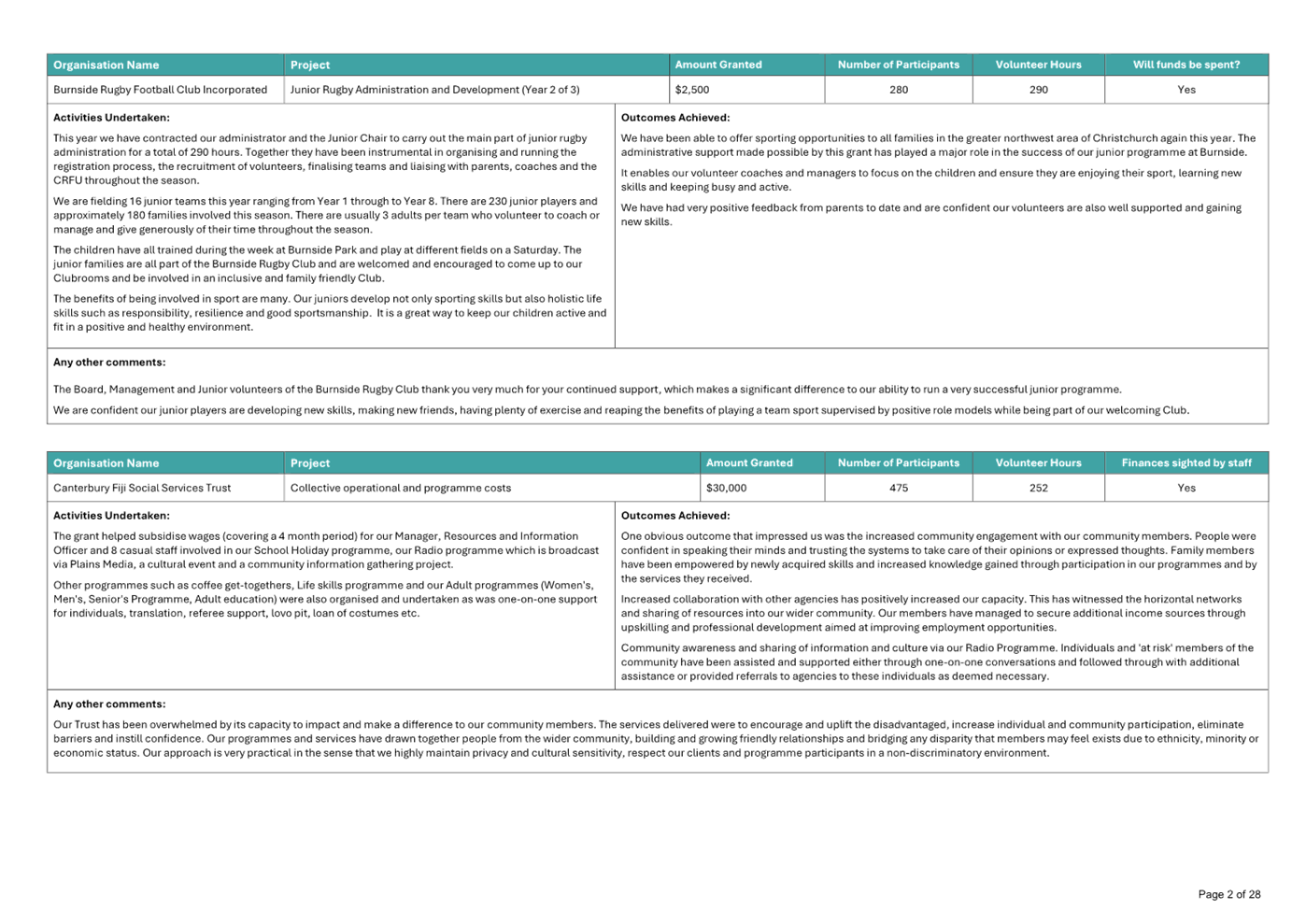
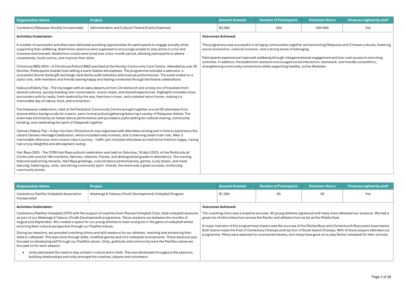
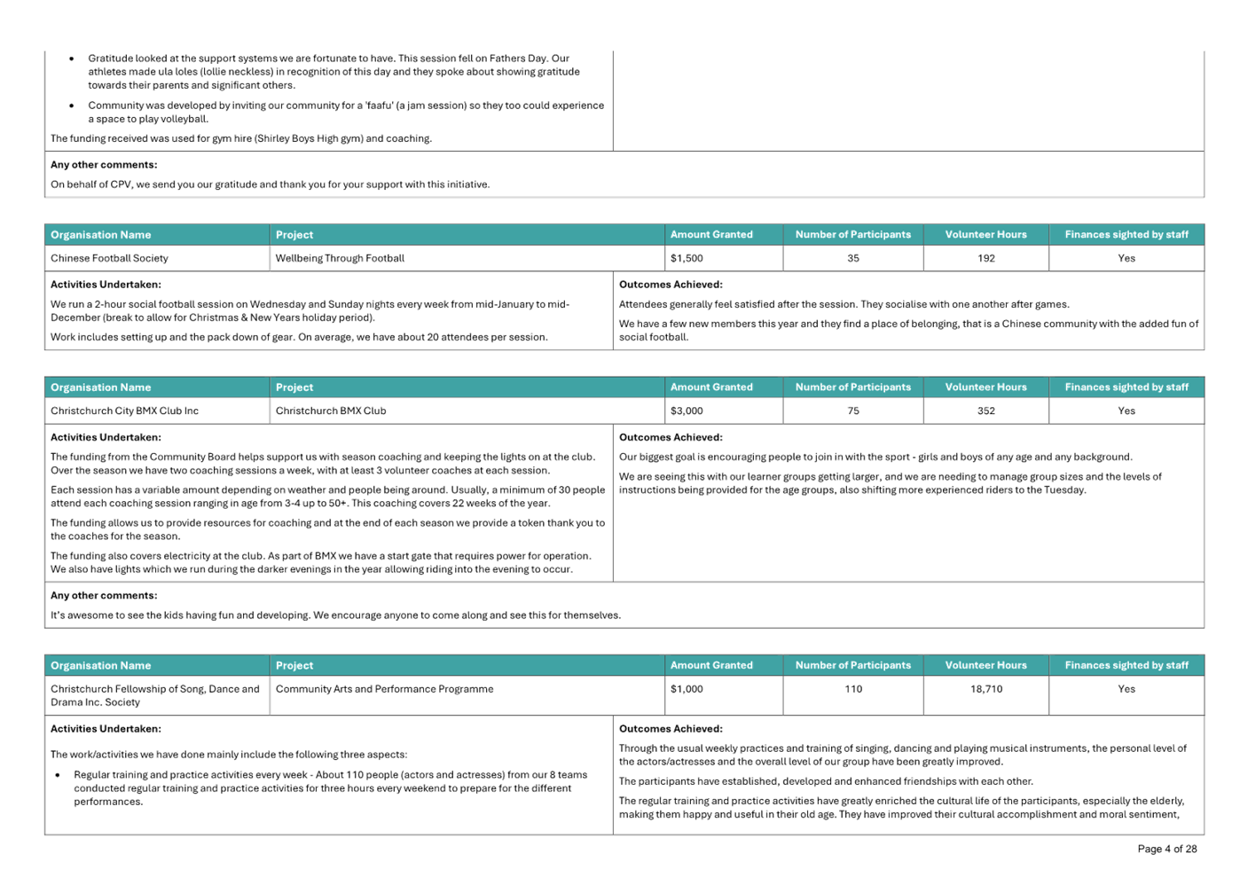
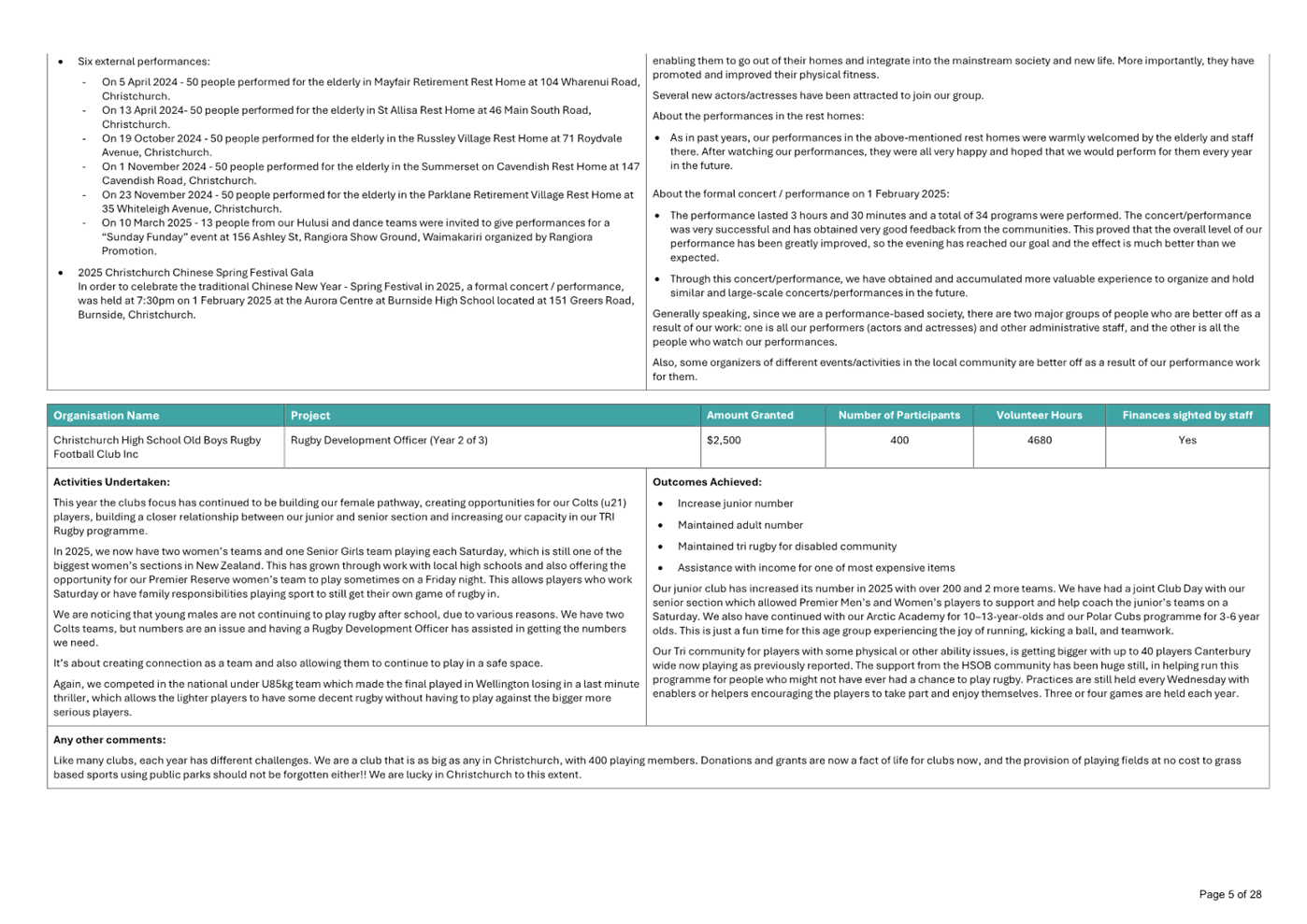
Waipuna
Halswell-Hornby-Riccarton Community Board
Agenda
Notice of Meeting Te Pānui o te Hui:
An ordinary meeting of the Waipuna
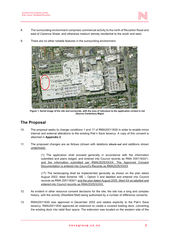
Halswell-Hornby-Riccarton Community Board will be held on:
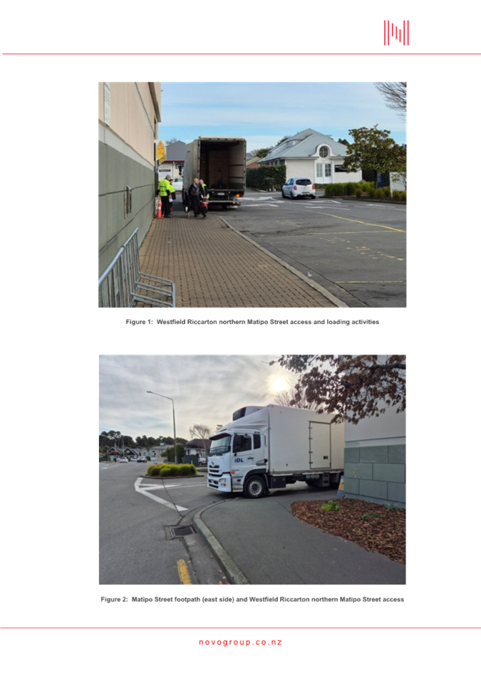
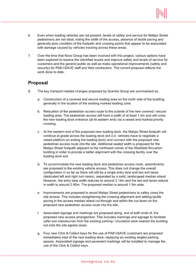
Date: Tuesday 14 April 2026
Time: 4.30 pm
Venue: Horoeka Room, Rārākau: Riccarton
Centre,
199 Clarence Street, Riccarton
Membership Ngā
Mema
|
Chairperson
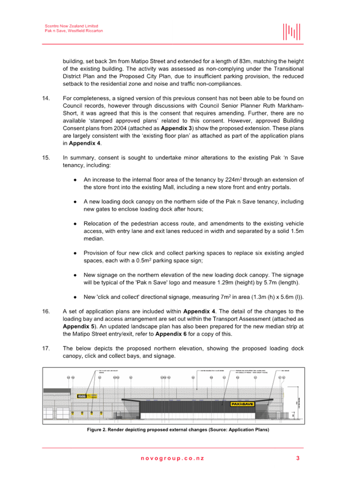
Deputy Chairperson
Members
|
Marie Pollisco
Sarah Brunton
Helen Broughton
Cody Cooper
Joseph Fullerton
Tyla Harrison-Hunt
Andrei Moore
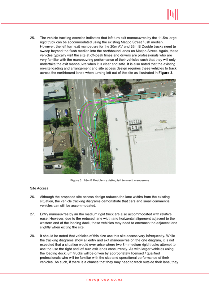
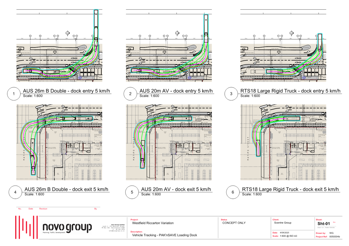
Debbie Mora
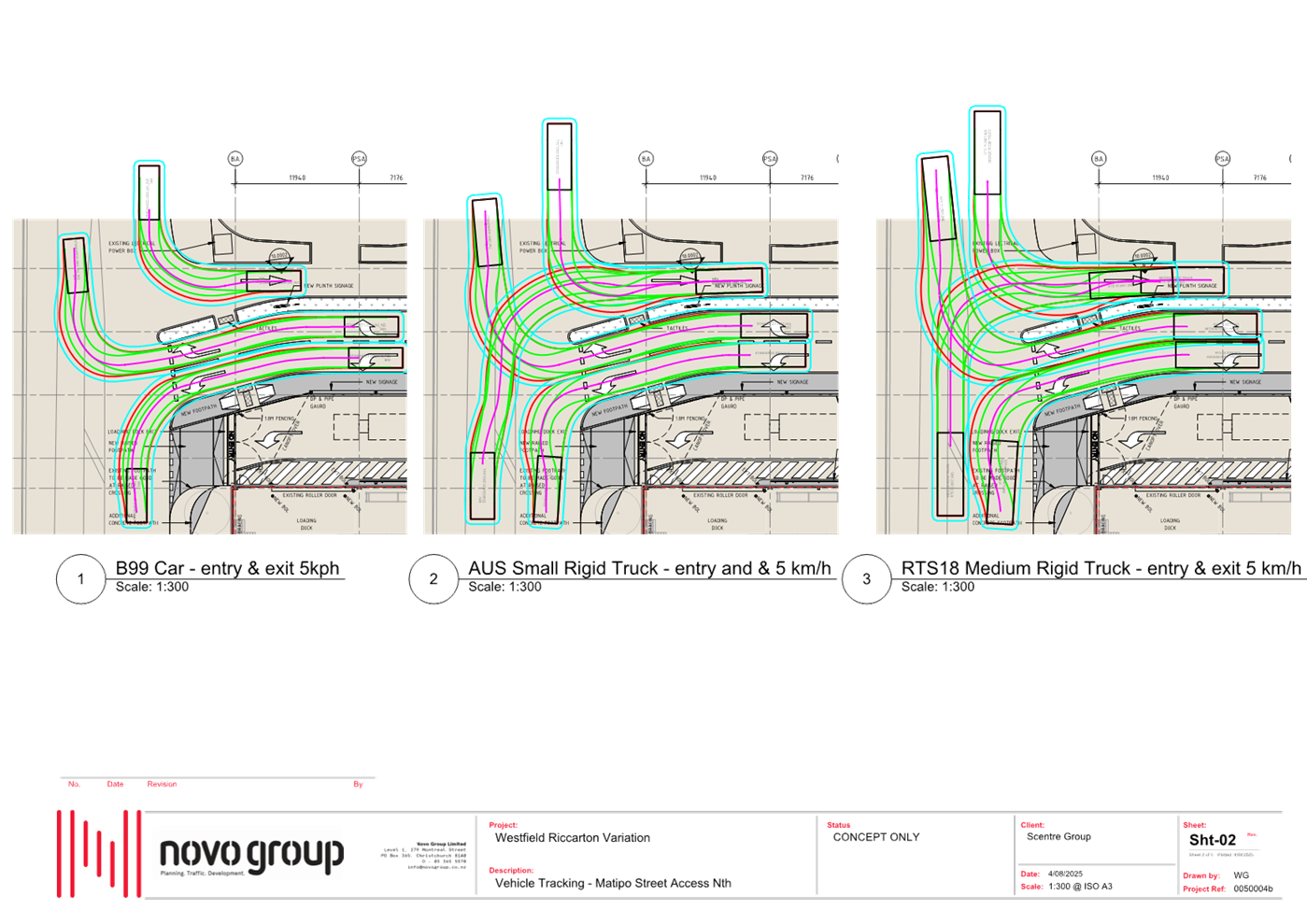
Mark Peters
|
9 April 2026
Website: www.ccc.govt.nz
Part A Matters
Requiring a Council Decision
Part B Reports
for Information
Part C Decisions
Under Delegation
TABLE OF CONTENTS NGĀ IHIRANGI
Karakia Tīmatanga................................................................................................... 5
C 1. Apologies Ngā Whakapāha.......................................................................... 5
B 2. Declarations of Interest Ngā Whakapuaki Aronga........................................... 5
C 3. Confirmation of Previous Minutes Te Whakaāe o te
hui o mua.......................... 5
B 4. Public Forum Te Huinga Whānui.................................................................. 5
B 5. Deputations by Appointment Ngā Huinga
Whakaritenga................................. 5
B 6. Presentation
of Petitions Ngā
Pākikitanga.................................................... 6
Staff Reports
C 7. Proposed
Road Names - 42 Roberts Road, Islington...................................... 17
C 8. Proposed
Road Names - 80 George Noble Road, Yaldhurst............................. 23
C 9. Bus
Stop Upgrades - Waipuna Halswell-Hornby-Riccarton Community Board Area............................................................................................................. 29
C 10. PAK’nSAVE
- Upgraded Vehicle Loading Access on Matipo Street.................... 43
C 11. Waterloo
Road Kea School Patrol Crossing................................................. 221
C 12. Waipuna
Halswell-Hornby-Riccarton Community Board Discretionary Response Fund 2025-26
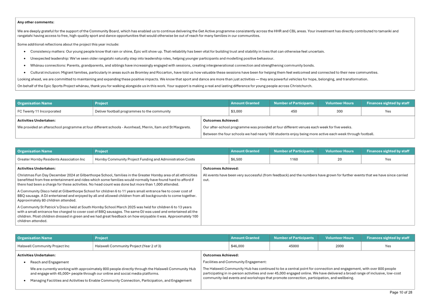
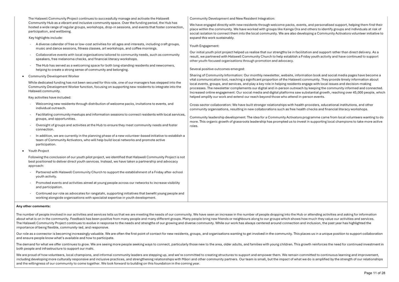
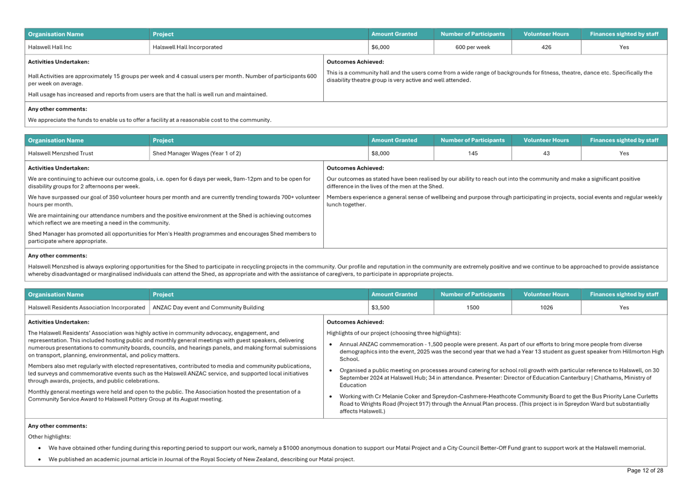
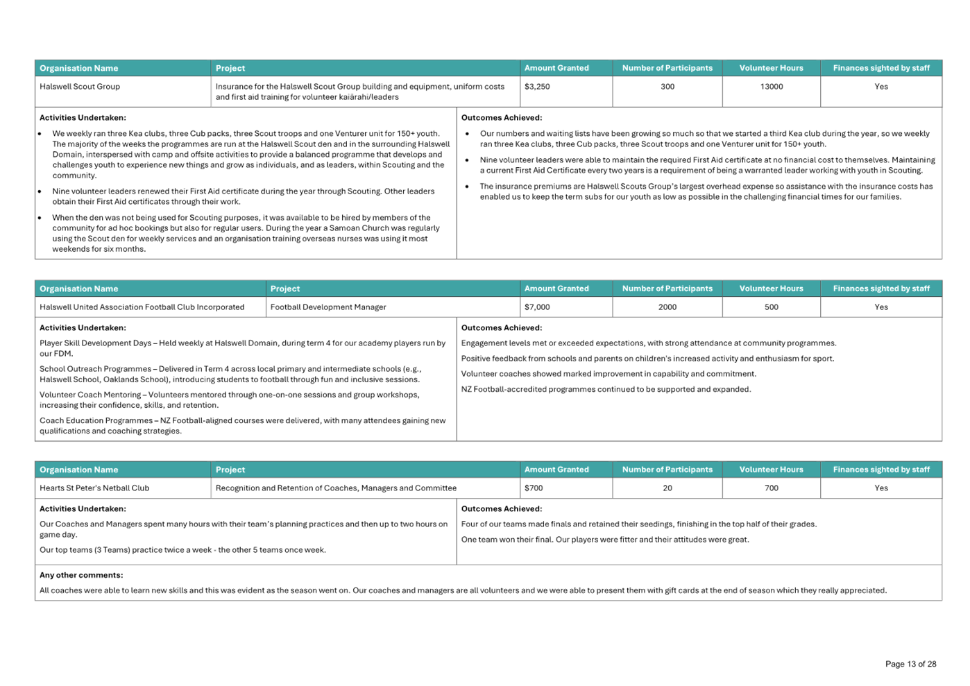
Halswell United Association Football Club Incorporated.......... 235
B 13. Waipuna
Halswell-Hornby-Riccarton Community Board Area Report - April 2026 239
B 14. Elected Members’
Information Exchange Te Whakawhiti
Whakaaro o Te Kāhui Amorangi............................................................................................................ 286
Karakia Whakamutunga
Actions Register Ngā Mahinga Tuwhera
Karakia Tīmatanga
|
Whakataka te hau ki te uru
Whakataka te hau ki te tonga
Kia mākinakina ki uta
Kia mātaratara ki tai
E hī ake ana te atakura
He tio, he huka, he hau hū
Tīhei Mauri Ora
|
Cease the winds from the west
Cease the winds from the south
Let the breeze blow over the land
Let the breeze blow over the ocean
Let the red-tipped dawn come with a sharpened air.
A touch of frost, a promise of a glorious day.
|
1. Apologies Ngā Whakapāha
Apologies will
be recorded at the meeting.
2. Declarations of Interest Ngā
Whakapuaki Aronga
Members are
reminded of the need to be vigilant and to stand aside from decision-making
when a conflict arises between their role as an elected representative and any
private or other external interest they might have.
3. Confirmation of Previous Minutes Te
Whakaāe o te hui o mua
That the
minutes of the Waipuna Halswell-Hornby-Riccarton Community Board meeting held
on Tuesday, 10 March 2026 be confirmed
(refer page 7).
4. Public Forum Te Huinga Whānui
A period of up
to 30 minutes will be available for people to speak for up to five minutes on
any issue that is not the subject of a separate hearing process.
|
4.1
|
Future development at Ngā Puna Wai
Ngā Puna Wai Sports Hub Trust
representatives will address the Board regarding future development at
Ngā Puna Wai.
|
|
4.2
|
Food Security
Drucilla Kingi-Patterson will address the
Board regarding Food Security.
|
|
4.3
|
Te Whare
Awhero
Carey Ewing, Director, will provide the Board with an update regarding the services and
support Te Whare Awhero provides to the community.
|
5. Deputations by Appointment Ngā Huinga
Whakaritenga
Deputations may
be heard on a matter or matters covered by a report on this agenda and approved
by the Chairperson.
Deputations will be recorded in the
meeting minutes.
6. Presentation of Petitions Ngā
Pākikitanga
There were no petitions
received at the time the agenda was prepared.
To present to the Community
Board, refer to the Participating in decision-making webpage or
contact the meeting advisor listed on the front of this agenda.

Waipuna
Halswell-Hornby-Riccarton Community Board
Open Minutes
Date: Tuesday 10 March 2026
Time: 4.30 pm
Venue: Horoeka Room, Rārākau: Riccarton
Centre,
199 Clarence Street, Riccarton
Present
|
Deputy Chairperson
Members
|
Sarah Brunton
Helen Broughton
Cody Cooper
Joseph Fullerton
Tyla Harrison-Hunt
Andrei Moore
Mark Peters
|
Website: www.ccc.govt.nz

Part A Matters
Requiring a Council Decision
Part B Reports
for Information
Part C Decisions
Under Delegation
Karakia Tīmatanga
The agenda was dealt with in the following
order. Where no voting record is shown, the item was carried unanimously by
those present.
1. Apologies
Ngā Whakapāha
Part C
|
Community Board Resolved HHRB/2026/00013
That the apologies from Marie Pollisco
and Debbie Mora for absence, Tyla Harrison-Hunt for an early departure and
Joseph Fullerton for lateness, be accepted.
Tyla
Harrison-Hunt/Cody Cooper Carried
|
2. Declarations
of Interest Ngā Whakapuaki Aronga
Part B
There were no
declarations of interest recorded.
3. Confirmation
of Previous Minutes Te Whakaāe o te hui o mua
Part C
|
Community Board Resolved HHRB/2026/00014
That the
minutes of the Waipuna Halswell-Hornby-Riccarton Community Board meeting held
on Tuesday, 10 February 2026 be confirmed.
Andrei
Moore/Mark Peters Carried
|
4. Public
Forum Te Huinga Whānui
Part B
|
4.1
|
Halswell Community Project
Kate
Cleverly, Keri Glassenbury and Anne Gibling spoke on behalf of Halswell
Community Project and provided an update regarding the services and support
it provides to the community.
Following
questions from members, the Meeting Chairperson thanked Kate Cleverly, Keri
Glassenbury and Anne Gibling for their presentation.
|
|
|
Attachments
a Presentation
- Halswell Community Project
|
|
4.2 Steadman Road
Traffic
|
|
Norm James and
Howard Harvey, residents of Kevin Hickman Retirement Village, addressed the
Board regarding concerns about the increased volume and speed of traffic
along Steadman Road.
They consider
that Steadman Road is being used as a bypass and would like to see traffic
management, traffic calming measures and other measures to address this.
They would
also like to see construction of a footpath on the eastern side of Steadman
Road from Kevin Hickman Retirement Village towards Masham Road.
Following
questions from members, the Meeting Chairperson thanked Mr James and Mr
Harvey for their presentation.
|
|
Part B
That the
Waipuna Halswell-Hornby-Riccarton Community Board refers the following matters
raised in the presentation, to staff for investigation and advice:
1. Traffic
management on Steadman Road.
2. The
need for a footpath on the eastern side of Steadman Road from Kevin Hickman
Retirement Village towards Masham Road.
|
Joseph Fullerton joined the meeting at 4.47pm
during Item 4.2.
5. Deputations
by Appointment Ngā Huinga Whakaritenga
Part B
|
5.1 Te Kāhu
Park, Awatea Athletics New build Application Report
|
|
Rochelle Ellery, local resident, addressed
the Board in relation to the Te Kāhu Park, Awatea Athletics New build
Application Report (Item 8 refers).
Ms Ellery expressed concern regarding
the installation of storage containers on Te Kāhu Park, particularly
related to the aesthetic of the facility and the possibility of its presence
leading to antisocial behaviour on the park. She would prefer that any
approval be for a temporary facility only.
Following questions from members, the
Meeting Chairperson thanked Ms Ellery for her presentation.
|
|
5.2 Te Kāhu
Park, Awatea Athletics New build Application Report
|
|
Helena and Adrian Dinnissen spoke on
behalf of Awatea Athletics Incorporated in support of the staff
recommendations in the Te Kāhu Park, Awatea Athletics New build
Application Report (Item 8 refers).
They advised that the containers will
provide a currently affordable solution for much needed storage for athletics
equipment, including high jump mats and hurdles.
Following questions from members, the
Meeting Chairperson thanked Helena and Adrian Dinnissen for their
presentation.
|
6. Presentation
of Petitions Ngā Pākikitanga
Part B
There was no presentation of petitions.
|
7. Correspondence
|
|
|
Community Board Resolved HHRB/2026/00015 Officer
recommendation accepted without change
Part B
That the Waipuna
Halswell-Hornby-Riccarton Community Board:
1. Receives the correspondence from Megan Woods, Member of Parliament
for Wigram, in relation to the Waterloo Road, Gilberthorpes Road, Parker
Street, and Moffett Street intersection.
Mark Peters/Cody
Cooper Carried
|
|
8. Te
Kāhu Park, Awatea Athletics New build Application
|
|
|
Community Board Consideration
Staff in attendance spoke to the
accompanying report.
The Board took into consideration the
deputations from Rochelle Ellery (Item 5.1 refers) and Helena and Adrian
Dinnissen (Item 5.2 refers).
|
|
|
Community Board Resolved HHRB/2026/00016 Officer
recommendations accepted without change
Part C
That the
Waipuna Halswell-Hornby-Riccarton Community Board:
1. Receives the information in the Te
Kāhu Park, Awatea Athletics New build Application Report.
2. Approves the placement of the storage containers and construction
of athletics facilities generally as shown in Attachment B-C of the report on
the meeting agenda.
3. Approves a ground lease to Awatea Athletics Club for an area of
approximately 1600 square metres of Te Kāhu Park being Lot 15023 DP
461231, as shown on the plan described as Attachment A of the report on the
meeting agenda.
4. Notes that the decision in this report is assessed as low
significance based on the Christchurch City Council’s Significance and
Engagement Policy.
5. Requests that the Manager Property Consultancy does all things
necessary and makes any decisions at his sole discretion to implement the
resolutions above including completing negotiations and administering the
terms and conditions of the new lease.
Andrei
Moore/Mark Peters Carried
|
|
9. Tree
Removals - 22 Milns Road (new school site)
|
|
|
Community Board Consideration
Staff in attendance spoke to the
accompanying report and advised that the trees to be planted within the
proposed primary school site, are to be planted in accordance with the
Council approved landscape plan for the site.
|
|
|
Officer Recommendations Ngā
Tūtohu
That the
Waipuna Halswell-Hornby-Riccarton Community Board:
1. Receives the information in the Tree
Removals - 22 Milns Road (new school site) Report.
2. Approves the removal of 83 black poplar trees at 22 Milns Road, to
facilitate the building of a new primary school in the Halswell area and for
the pathway to a new road layout to support the school.
3. Notes that the decision in this report is assessed as low
significance based on the Christchurch City Council’s Significance and
Engagement Policy.
4. Notes that there will be a further report seeking reconfiguration
of the road layout and footpaths at a future Board meeting, that will
complement this tree removal report.
5. Notes that there are a number of trees proposed for planting
within the bounds of the primary school which will meet the requirements of
the Tree Policy of 1:2 replacement planting for any trees removed.
|
|
|
Community Board Resolved HHRB/2026/00017
Part C
That the
Waipuna Halswell-Hornby-Riccarton Community Board:
1. Receives the information in the Tree
Removals - 22 Milns Road (new school site) Report.
2. Approves the removal of 83 black poplar trees at 22 Milns Road, to
facilitate the building of a new primary school in the Halswell area and for
the pathway to a new road layout to support the school.
3. Notes that the decision in this report is assessed as low
significance based on the Christchurch City Council’s Significance and
Engagement Policy.
4. Notes that there will be a further report seeking reconfiguration
of the road layout and footpaths at a future Board meeting, that will
complement this tree removal report.
5. Notes that there are a number of trees proposed for planting
within the bounds of the primary school with trees planted in accordance with
the Council approved landscape plan for the site.
Andrei
Moore/Tyla Harrison-Hunt Carried
|
|
10. Tiora Place
- Proposed No Stopping Restrictions
|
|
|
Community Board Resolved HHRB/2026/00018
Officer recommendations accepted without change
Part C
That the Waipuna
Halswell-Hornby-Riccarton Community Board:
1. Receives the information in the Tiora
Place - Proposed No Stopping Restrictions Report.
2. Notes that the decision in this report are assessed as low
significance based on the Christchurch City
Council’s Significance and Engagement Policy.
3. Under Clause 6(2) of the Christchurch City Council Traffic and
Parking Bylaw 2017 revokes any previous resolutions
pertaining to traffic controls made pursuant to any bylaw to the extent that
they are in conflict with the parking or stopping restrictions described in
resolutions 4a – 4c below.
4. Approves pursuant to Clause 7 of the Christchurch City Council
Traffic and Parking Bylaw 2017 that:
a. the stopping of all vehicles be prohibited at any time, on the
south-eastern side of Tiora Place commencing at its intersection with Auburn
Avenue, and extending in a south-westerly direction for a distance of 39.5
metres as shown on Plan TG151652, dated 22/12/2025 as shown on Attachment
A to the report on the meeting agenda.
b. the stopping of all vehicles be prohibited at any time, on the
south-eastern side of Tiora Place commencing at a point 44.5 metres from the
intersection with Auburn Avenue, extending first in a south-westerly
direction, then following the kerb in a clockwise direction, around the
cul-de-sac head, then extending in a north-easterly direction for a distance
of 46 metres as shown on Plan TG151652, dated 22/12/2025 as shown on Attachment
A to the report on the meeting agenda.
c. the stopping of all vehicles be prohibited at any time, on the
south-eastern side of Tiora Place commencing at a point 95.5 metres from the
intersection with Auburn Avenue, extending first in a south-westerly
direction, then following the kerb in a clockwise direction, around the
cul-de-sac head, then extending in a north-easterly direction for a distance
of four metres as shown on Plan TG151652, dated 22/12/2025 as shown on Attachment
A to the report on the meeting agenda.
5. Approves that these resolutions take effect when parking signage
and/or road markings that evidence the restrictions described in 3 and 4 are
in place (or removed in the case of revocations).
Tyla
Harrison-Hunt/Cody Cooper Carried
|
Tyla Harrison-Hunt left the meeting at 5.35pm
following consideration of Item 10.
|
11. Bus stop
changes in response to bus route 60 detour
|
|
|
Community Board Resolved HHRB/2026/00019
Officer recommendations accepted without change
Part C
That the
Waipuna Halswell-Hornby-Riccarton Community Board:
1. Receives the information in the Bus stop
changes in response to bus route 60 detour Report.
2. Notes that the decision in this report is assessed as low
significance based on the Christchurch City Council’s Significance and
Engagement Policy.
3. Under
Clause 6(2) of the Christchurch City Council Traffic and Parking Bylaw 2017 revokes any previous resolutions pertaining to parking or stopping
restrictions and traffic controls made pursuant to any bylaw to the extent
that they conflict with the parking or stopping restrictions and traffic
controls described in resolutions 4 to 7 below.
New bus stop– 10 Seelster Lane
on Monsaraz Boulevard
4. Pursuant to Clause 7 of the Christchurch City Council Traffic and
Parking Bylaw 2017:
a. Approves that the stopping of all vehicles be prohibited at any
time, on the east side of Monsaraz Boulevard commencing at a point 26 metres
south of its intersection with Brancion Street and extending in a southerly
direction for a distance of 10 metres, as detailed on
Attachment A to the report on the meeting agenda (Plan TG149105 dated 02/26).
b. Approves that a bus stop be installed on east side of Monsaraz
Boulevard commencing at a point 36 metres south of its intersection with
Brancion Street and extending in a southerly direction for a distance of 14
metres, as detailed on Attachment A to the report on
the meeting agenda (Plan TG149105 dated 02/26).
c. Approves that the stopping of all vehicles be prohibited at any
time, on the east side of Monsaraz Boulevard commencing at a point 50 metres
south of its intersection with Brancion Street and extending in a southerly
direction for a distance of 6 metres, as detailed on
Attachment A to the report on the meeting agenda (Plan TG149105 dated 02/26).
New bus stop– Evora Park on
Manarola Road
5. Pursuant to Clause 7 of the Christchurch City Council Traffic and
Parking Bylaw 2017:
a. Approves that the stopping of all vehicles be prohibited at any
time, on the north side of Manarola Road commencing at a point 70 metres east
of its intersection with Monsaraz Boulevard and extending in an easterly
direction for a distance of 11 metres, as detailed on
Attachment A to the report on the meeting agenda (Plan TG149105 dated 02/26).
b. Approves that a bus stop be installed on the north side of
Manarola Road commencing at a point 81 metres east of its intersection with
Monsaraz Boulevard and extending in an easterly direction for a distance of
14 metres, as detailed on Attachment A to the report
on the meeting agenda (Plan TG149105 dated 02/26).
c. Approves that the stopping of all vehicles be prohibited at any
time, on the north side of Manarola Road commencing at a point 95 metres east
of its intersection with Monsaraz Boulevard and extending in an easterly
direction for a distance of 5 metres, as detailed on
Attachment A to the report on the meeting agenda (Plan TG149105 dated 02/26).
New bus stop– 1E Manarola Road
(Attachment A)
6. Pursuant to Clause 7 of the Christchurch City Council Traffic and
Parking Bylaw 2017:
a. Approves that the stopping of all vehicles be prohibited at any
time, on the south side of Manarola Road commencing at a point 32 metres west
of its intersection with Hendersons Road and extending in a westerly
direction for a distance of 10 metres, as detailed on
Attachment A to the report on the meeting agenda (Plan TG149105 dated 02/26).
b. Approves that a bus stop be installed on the south side of
Manarola Road commencing at a point 42 metres west of its intersection with
Hendersons Road and extending in a westerly direction for a distance of 14
metres, as detailed on Attachment A to the report on
the meeting agenda (Plan TG149105 dated 02/26).
c. Approves that the stopping of all vehicles be prohibited at any
time, on the south side of Manarola Road commencing at a point 56 metres west
of its intersection with Hendersons Road and extending in a westerly
direction for a distance of 6 metres, as detailed on
Attachment A to the report on the meeting agenda (Plan TG149105 dated 02/26).
7. Approves that signage and directional and warning tactile pavers
be installed at bus stops installed pursuant to 4, 5, and 6 above, as detailed on Attachment A to the report on the meeting agenda
(Plans TG149105 dated 02/26).
8. Approves that the resolutions in clauses 4 to 7 above, take effect
when traffic controls or parking signage and/or road markings that evidence
the restrictions described are in place (or removed in the case of
revocations).
Redundant bus stop– 321
Hendersons Road (Attachment A, Plan TG152729 dated 02/2026)
9. Pursuant to Clause 6(2) of the Christchurch City Council Traffic
and Parking Bylaw 2017:
a. Approves that a bus stop on the west side of Hendersons Road
commencing at a point 56 metres south of its intersection with Franco Road
and extending in a northerly direction for a distance of 12 metres be
revoked.
Redundant bus stop– 285
Hendersons Road (Attachment A, Plan TG152729 dated 02/2026)
10. Pursuant to Clause 6(2) of the Christchurch City Council Traffic
and Parking Bylaw 2017:
a. Approves that the stopping restrictions on the west side of
Hendersons Road commencing at a point 62 metres north of its intersection
with Manarola Road and extending in a northerly direction for a distance of 4
metres be revoked.
b. Approves that a bus stop on the west side of Hendersons Road
commencing at a point 70 metres north of its intersection with Manarola Road
and extending in a northerly direction for a distance of 14 metres be
revoked.
c. Approves that the stopping restrictions on the west side of
Hendersons Road commencing at a point 84 metres north of its intersection
with Manarola Road and extending in a northerly direction for a distance of 4
metres be revoked.
Mark Peters/Cody
Cooper Carried
|
|
12. Waipuna
Halswell-Hornby-Riccarton Community Board Area Report - March 2026
|
|
|
Community Board Resolved HHRB/2026/00020 Officer
recommendation accepted without change
Part B
That the Waipuna
Halswell-Hornby-Riccarton Community Board:
1. Receives the information in the Waipuna
Halswell-Hornby-Riccarton Community Board Area Report - March 2026.
Mark
Peters/Andrei Moore Carried
|
13. Elected
Members’ Information Exchange Te Whakawhiti Whakaaro o Te
Kāhui Amorangi
Part B
|
Members exchanged information
on the following matters of interest to the Board:
· Feedback
has been received from some members of the public, noting that the
consultation webpage on the Community Board Plan, is difficult to navigate.
· A
member has met with the New Zealand Transport Agency and KiwiRail to discuss
matters of mutual interest in the Hornby area.
· A
Notice of Motion is proposed to go to the Council regarding the improvement
of the Parker Street, Gilberthorpes and Waterloo Roads intersection.
· A
member is working with residents of Kirkwood Avenue regarding the impacts of
construction work at the University of Canterbury.
· A
letter from The Hub Hornby regarding concerns with internet reception has
been received by members. Communication with the internet provider has
produced a positive response.
|
Karakia
Whakamutunga
Meeting
concluded at 5.56pm.
CONFIRMED THIS 14TH DAY OF
APRIL 2026
Marie Pollisco
Chairperson
|
7. Proposed
Road Names - 42 Roberts Road, Islington
|
|
Reference Te Tohutoro:
|
26/348461
|
|
Responsible Officer(s) Te Pou Matua:
|
Sean
Ward, Team Leader Planning
|
|
Accountable ELT Member Pouwhakarae:
|
John
Higgins, General Manager Strategy, Planning & Regulatory Services
|
1. Purpose and Origin of the Report Te Pūtake Pūrongo
1.1 The
purpose of this report is for the Waipuna Halswell-Hornby-Riccarton Community
Board to approve the proposed road names at 42 Roberts Road, Islington.
1.2 The
report is staff-generated resulting from a naming request received from the
developer.
2. Officer Recommendations Ngā Tūtohu
That the Waipuna
Halswell-Hornby-Riccarton Community Board:
1. Receives the information in the Proposed
Road Names - 42 Roberts Road, Islington Report.
2. Notes that the decision in this report is assessed as low
significance based on the Christchurch City Council’s Significance and
Engagement Policy.
3. Approves the following new road names for 42 Roberts Road (RMA/2024/2945)
a. Road 2 - Elmsly Street
b. Road 3 - Beardsly Street
c. Road 4 - Grant Street
d. Road 5 - Kellahan Street
e. Road 6 - Moylan Street
f. Road 7 - Stone Street
g. Road 8 - Paterson Street
h. Road 9 - Duffell Street
i. Road 10 - Atkinson Street
j. Road 11 - Crowe Street
k. Road 12 - Laurie Street
3. Detail Te Whakamahuki
Introduction Te Whakatkinga
3.1 A
road naming request has been submitted by the agent on behalf of each developer.
A preferred name and alternative names have been put forward for the roads.
3.2 The
recommended road names have been checked against existing road names in
Christchurch and bordering districts, for duplication, alternative spelling, or
other similarities in spelling or pronunciation to avoid the potential for
confusion. The proposed names are considered sufficiently different to existing
road names.
3.3 The
recommended road names have been checked against the Council’s Naming
Policy dated 15 November 2023 and are considered to be consistent with this
policy. The specific criteria for assessing a name from clause 2 is set out
below.
3.3.1 A traditional or
Māori name which is acceptable to the Rūnanga or Iwi; this may be a
name reflecting the physical characteristics of an area, an activity or event
associated with the area or of a notable ancestor.
3.3.2 A feature of
historical, social, cultural, environmental or physical importance in the area
(e.g., Carlton Mill Road or Carlton Mill Reserve*).
3.3.3 The name of a notable
family, person or event associated with the locality or with the wider
Christchurch area.
3.3.4 A name in recognition
of a person’s service. This can be for community service, conservation,
sport, the arts, science and research or other sphere of activity.
3.3.5 Consistency with a
common or established theme for naming in a subdivision or locality.
3.3.6 A name that reflects
the diverse cultures and communities of the locality or of Christchurch
generally.
3.3.7 The name of an event
or activity strongly associated with the immediate location including an
informal name for the area that is (or was historically) in common usage.
3.3.8 A name associated
with a person, event or activity of significance to Christchurch including
names associated with people, events, or places of national and international
significance.
3.4 The
criteria for names that are not suitable for approval from clause 6 are set out
below.
3.4.1 Names of people,
flora, fauna or geographical features not associated with the area, e.g., names
of native trees which are not present in the area or views that cannot be
identified, except where the name continues a current naming theme in the
locality.
3.4.2 Currently trading
commercial organisations except for sponsorship names for facilities and leased
parks.
3.4.3 Anagrams,
amalgamations or derivatives of people's names.
3.4.4 Names of living
persons.
3.4.5 Names related to the
developer of a subdivision.
3.4.6 Name of a person,
club or organisation associated with a privately owned building on Council
land, where the club or organisation does not hold the ground lease for the
building.
3.4.7 Names for roads which
may cause confusion because they are associated with another geographical
location or feature e.g., Parklands Drive which is not located in the Parklands
suburb.
3.5 The
recommended road names have also been checked against the Australia and New
Zealand Standard AS/NZA 4819:2011 Rural and Urban Addressing. The names are considered
to be consistent with the Standard.
3.6 Under
the Roads and Right-of-Way Naming Policy, the names considered must be
requested by the developer. There is no ability to consider alternative names
without first checking whether there are any duplications or similarities with
other road and right-of-way names.
3.7 Consultation
has been undertaken with Land Information New Zealand who have raised no
concerns with the proposed names.
3.8 Consultation
under the policy with rūnanga is not required because the roads to be
named are not collector roads and/or site(s) of significance under the District
Plan (clause 3 of the Naming Policy).
3.9 No
addresses of neighbouring properties are affected by the proposed road naming
(clause 12.2 of the Naming Policy).
3.10 The names requested
have been accompanied by an explanation of the background of the names, which
is summarised below.
Assessment of Significance and Engagement Te
Aromatawai Whakahirahira
3.11 The decisions in
this report are assessed as low significance based on the Christchurch City
Council’s Significance and Engagement Policy.
3.12 The level of
significance was determined by the number of people affected and/or with an
interest.
3.13 Due to the
assessment of low significance, no further community engagement and
consultation is required.
Proposed Names
3.14 The proposed
roads are shown in Attachment A.
3.15 The proposed
name and alternative names are themed for local history and the settlement of
Hei Hei.
3.16 Road 1 - Mary
Carpenter Avenue - continuation of existing road.
3.17 Road 2 - Elmsly
Street
3.18 Noel Victor
Elmsly (1887-1966): WWI serviceman gassed in France and diagnosed with TB.
Original Hei Hei settler (1921) who persevered despite serious health
challenges and received vocational training.
3.19 Road 3 - Beardsley
Street
3.20 Martha Jane
Beardsley: Applied to take over Section 2 in 1928 following Samuel Bray's
departure due to economic hardship forced forfeiture in 1927. Withdrew citing
financial difficulties; exemplifies post-war economic challenges facing
potential settlers.
3.21 Road 4 - Grant
Street
3.22 Thomas Brodie
Grant (1888-1980): Irish-born WWI serviceman with TB. One of only three
original settlers to remain 10+ years; became one of the settlement's most
successful farmers.
3.23 Road 5 - Kellahan
Street
3.24 Thomas Kellahan
(1895-1970): WWI serviceman, Section 15 occupant recorded in Paparua County
rates 1927-28. Demonstrates continuity and stability as properties changed
hands between successive settlers.
3.25 Road 6 - Moylan
Street
3.26 John Joseph
Moylan (1886-1927): WWI serviceman with two war wounds and TB. Built
high-quality dwelling in 1923; established permanent family homestead before
early death from TB complications.
3.27 Road 7 - Stone
Street
3.28 George Stone
(1888-1960): Original 1921 settler on section 14; TB survivor who persevered
through 1924 economic crisis with rent/interest remissions. Remained on
property until early 1930s when transferred to later operators.
3.29 Road 8 - Paterson
Street
3.30 John Alexander
Paterson (1873-1943): WWI veteran with chest conditions. Original 1921 settler
who established small agricultural operations and persisted through the
difficult 1920s.
3.31 Road 9 - Duffell
Street
3.32 Albert William
Duffell (1892-1931): Later settler (1928) who purchased an abandoned section
despite suffering a serious accident. Wife Lily persevered with farming
operations after his death.
3.33 Road 10 - Atkinson
Street
3.34 Frederick
Atkinson (1893-1970): Mechanical engineer, WWI serviceman discharged with TB;
applied for Hei Hei section in 1926 and established successful long-term
poultry and market gardening operation.
3.35 Road 11 - Crowe
Street
3.36 William Harry
Crowe (1879-1935): Isle of Man-born tunneller who served WWI on Western Front.
Wounded and discharged with rheumatism; applied for market gardening section 10
in 1925.
3.37 Road 12 - Laurie
Street
3.38 Alfred Laurie
(1894-1977): Twice-wounded WWI veteran with TB. Applied for settlement 1921
from sanatorium; received rent/interest remission but forfeited lease 1926 due
to farming difficulties.
Alternative Names
3.39 Vance Street
- John Vance (1889-1945): WWI Field Artillery driver. TB survivor; farmed
section 7 in partnership with John Lunn; signed 1924 pension petition alongside
other settlers.
3.40 Easton Street
- Harold Easton (1888-1965): Engine driver and mechanic, WWI serviceman with
bronchial TB; applied for settlement in 1928 and established viable
smallholding with equipment maintenance and farm work.
3.41 Bearpark
Street - James Bearpark: Civilian who obtained option on section 3 (1925)
but withdrew within weeks due to obtaining alternative employment; illustrates
settlement challenges.
3.42 McGlinchy
Street - John Wood McGlinchy (1898-1952): Later successful settler who
combined sections 2&3 in 1933. Ex-serviceman and experienced poultry
farmer; expanded operations through late 1930s-1940s.
3.43 Prior Street
- Edward Prior (1894-1968): Farmer and agricultural worker; WWI serviceman with
TB diagnosis; applied for Hei Hei section in 1927 and established modest but
stable smallholding with consistent property maintenance and livestock farming
through Depression and post-war periods.
3.44 Spriggs
Street - Leslie Charles Spriggs was a notable Hei Hei Settlement settler
recorded in the Archives New Zealand files relating to the Hei Hei soldier
settlement. Spriggs was part of the cohort of WWI returnees who received land
allotments under the Discharged Soldiers Settlement Act 1915 to establish their
livelihoods in the Hei Hei area.
3.45 Bryant Street
- Joseph Bryant was one of the WWI returned servicemen who participated in the
Discharged Soldiers Settlement scheme at Hei Hei. Although archival records
relating to Bryant are sparse, his documentation in the Paparua County Council
rates books and the Lands Department files confirms his status as a soldier
settler who took up residence in the Hei Hei community during the 1930s. He
represents the broader cohort of discharged servicemen who were allocated land
under the government's post-war rehabilitation and resettlement initiative,
contributing to the development of the Hei Hei Settlement.
3.46 The proposed and
alternative names are considered to be consistent with the policy.
3.47 Notwithstanding, the discretion lies with the Community Board to
approve any of the above name options, including the alternative names.
Attachments Ngā Tāpirihanga
|
No.
|
Title
|
Reference
|
Page
|
|
a ⇩ 
|
RMA/2024/2945 - Proposed Road Names Plan - 42 Roberts Road
|
26/126800
|
22
|
Signatories Ngā Kaiwaitohu
|
Authors
|
Leashelle
Miller - Planner Level 2
Sean Ward -
Team Leader Planning
|
|
Approved By
|
Mark Stevenson
- Head of Planning & Consents
|
|
8. Proposed Road Names - 80 George
Noble Road, Yaldhurst
|
|
Reference Te Tohutoro:
|
26/514368
|
|
Responsible Officer(s) Te Pou Matua:
|
Sean
Ward, Team Leader Planning
|
|
Accountable ELT Member Pouwhakarae:
|
John
Higgins, General Manager Strategy, Planning & Regulatory Services
|
1. Purpose and Origin of the Report Te Pūtake Pūrongo
1.1 The
purpose of this report is for the Waipuna Halswell-Hornby-Riccarton Community
Board to approve the proposed road/lane names at 80 George Noble Road,
Yaldhurst.
1.2 The
report is staff-generated resulting from a naming request received from the
developer.
2. Officer Recommendations Ngā Tūtohu
That the Waipuna
Halswell-Hornby-Riccarton Community Board:
1. Receives the information in the Proposed
Road Names - 80 George Noble Road, Yaldhurst Report.
2. Notes that the decision in this report is assessed as low
significance based on the Christchurch City Council’s Significance and
Engagement Policy.
3. Approves the following new road names for 80 George Noble Road (RMA/2007/1846)
a. Road 1 - Poplar View Way
b. Lane 1 - Luna Lane
c. Lane 2 - Apple Tree Lane
3. Detail Te Whakamahuki
Introduction Te Whakatkinga
3.1 A
road naming request has been submitted by the agent on behalf of the developers.
A preferred name and alternative names have been put forward for the roads.
3.2 The
recommended road names have been checked against existing road names in
Christchurch and bordering districts, for duplication, alternative spelling, or
other similarities in spelling or pronunciation to avoid the potential for
confusion. The proposed names are considered sufficiently different to existing
road names.
3.3 The
recommended road names have been checked against the Council’s Naming
Policy dated 15 November 2023 and are considered to be consistent with this
policy. The specific criteria for assessing a name from clause 2 is set out
below.
3.3.1 A traditional or
Māori name which is acceptable to the Rūnanga or Iwi; this may be a
name reflecting the physical characteristics of an area, an activity or event
associated with the area or of a notable ancestor.
3.3.2 A feature of
historical, social, cultural, environmental or physical importance in the area
(e.g., Carlton Mill Road or Carlton Mill Reserve*).
3.3.3 The name of a notable
family, person or event associated with the locality or with the wider
Christchurch area.
3.3.4 A name in recognition
of a person’s service. This can be for community service, conservation,
sport, the arts, science and research or other sphere of activity.
3.3.5 Consistency with a
common or established theme for naming in a subdivision or locality.
3.3.6 A name that reflects
the diverse cultures and communities of the locality or of Christchurch
generally.
3.3.7 The name of an event
or activity strongly associated with the immediate location including an
informal name for the area that is (or was historically) in common usage.
3.3.8 A name associated
with a person, event or activity of significance to Christchurch including
names associated with people, events, or places of national and international
significance.
3.4 The
criteria for names that are not suitable for approval from clause 6 are set out
below.
3.4.1 Names of people,
flora, fauna or geographical features not associated with the area, e.g., names
of native trees which are not present in the area or views that cannot be
identified, except where the name continues a current naming theme in the
locality.
3.4.2 Currently trading
commercial organisations except for sponsorship names for facilities and leased
parks.
3.4.3 Anagrams,
amalgamations or derivatives of people's names.
3.4.4 Names of living
persons.
3.4.5 Names related to the
developer of a subdivision.
3.4.6 Name of a person,
club or organisation associated with a privately owned building on Council
land, where the club or organisation does not hold the ground lease for the
building.
3.4.7 Names for roads which
may cause confusion because they are associated with another geographical
location or feature e.g., Parklands Drive which is not located in the Parklands
suburb.
3.5 The
recommended road names have also been checked against the Australia and New
Zealand Standard AS/NZA 4819:2011 Rural and Urban Addressing. The names are considered
to be consistent with the Standard.
3.6 Under
the Roads and Right-of-Way Naming Policy, the names considered must be
requested by the developer. There is no ability to consider alternative names
without first checking whether there are any duplications or similarities with
other road and right-of-way names.
3.7 Consultation
has been undertaken with Land Information New Zealand who have raised no
concerns with the proposed names.
3.8 Consultation
under the policy with rūnanga is not required because the roads to be
named are not collector roads and/or site(s) of significance under the District
Plan (clause 3 of the Naming Policy).
3.9 No
addresses of neighbouring properties are affected by the proposed road naming
(clause 12.2 of the Naming Policy).
3.10 The names requested
have been accompanied by an explanation of the background of the names, which
is summarised below.
Assessment of Significance and Engagement Te
Aromatawai Whakahirahira
3.11 The decisions in
this report are assessed as low significance based on the Christchurch City
Council’s Significance and Engagement Policy.
3.12 The level of
significance was determined by the number of people affected and/or with an
interest.
3.13 Due to the
assessment of low significance, no further community engagement and
consultation is required.
Proposed Names
3.14 The proposed
roads are shown in Attachment A.
3.15 The proposed
name and alternative names are themed for the local environment.
3.16 Road 1 -
Poplar View Way
3.17 Acknowledges the
presence of Poplar trees traditionally planted in the Canterbury landscape as
shelter belts and boundary plantings. The name reflects the established rural
character of the area.
3.18 Lane 1 - Luna
Lane
3.19 References the
Latin word for "moon" reflecting the open skies and expansive
landscape character of the area.
3.20 Lane 2 -
Apple Tree Lane
3.21 Acknowledges the
historic presence of apple trees within the area and reflects the sites
horticultural heritage. The name recognises the productive character of the
land while providing a clear and appropriate street name for a quiet
residential lane.
Alternative Names
3.22 Bramley Dr/Ln
- References a traditional apple variety, acknowledging the horticultural
history of the area. The name reflects the productive character of the land.
3.23 Russet Dr/Ln
- References a traditional apple variety, acknowledging the horticultural
history of the area. The name recognises the productive character of the land.
3.24 Lindmond
Dr/Ln - Is a heritage style name reflecting traditional rural naming
conventions common within Canterbury.
3.25 Richlind Dr/Ln
- Is a heritage style name reflecting traditional rural naming conventions
common within Canterbury.
3.26 Sunset Dr/Ln
- Reflects the open landscape and western outlook of the area, referencing
evening light and sunset views characteristic of the Canterbury Plains.
3.27 Officers
Note: If any of the alternative names are chosen, the appropriate road type for
the road/lane will be used.
3.28 Officers
Note: This road naming request will change the addresses of existing property
owners on Road 1 that are currently addressed off George Noble Road. The
application included consultation and acceptance from the majority of the
affected property owners.
3.29 The proposed
names are considered to be consistent with the policy and the alternative names
are mostly considered to be consistent with the policy, except for
“Lindmond” and “Richlind” as these names are amalgams
and related to the name of a developer (Section 3.4.3 and 3.4.5 above).
3.30 Notwithstanding, the discretion lies with the Community Board to
approve any of the above name options, including the alternative names.
Attachments Ngā Tāpirihanga
|
No.
|
Title
|
Reference
|
Page
|
|
a ⇩
|
RMA/2007/1846 - Proposed Road Names Plan - 80 George Noble Road
|
26/476174
|
27
|
Signatories Ngā Kaiwaitohu
|
Authors
|
Leashelle
Miller - Planner Level 2
Sean Ward -
Team Leader Planning
|
|
Approved By
|
Mark Stevenson
- Head of Planning & Consents
|
|
9. Bus Stop Upgrades - Waipuna
Halswell-Hornby-Riccarton Community Board Area
|
|
Reference Te Tohutoro:
|
26/178892
|
|
Responsible Officer(s) Te Pou Matua:
|
Mansour
Johari, Passenger Transport Engineer
|
|
Accountable ELT Member Pouwhakarae:
|
Brent
Smith, General Manager City Infrastructure
|
1. Purpose and Origin of the Report Te Pūtake Pūrongo
1.1 To approve the proposed bus stop improvements across the Waipuna
Halswell-Hornby-Riccarton Community Board area.
1.2 This report has been prepared by staff in response to community
requests.
1.3 The proposed bus stop upgrades were consulted on together and are
presented in a single report to streamline timeframes and costs. However, the
decisions concerning each bus stop are independent, and they can be pursued
separately if necessary.
2. Officer Recommendations Ngā
Tūtohu
That the Waipuna
Halswell-Hornby-Riccarton Community Board:
1. Receives the information in the Bus Stop Upgrades - Waipuna
Halswell-Hornby-Riccarton Community Board Area Report.
2. Notes that the decision in this report is
assessed as low significance based on the Christchurch City Council’s
Significance and Engagement Policy.
3. Under Clause 6(2) of the Christchurch City
Council Traffic and Parking Bylaw 2017 revokes any previous resolutions
pertaining to parking or stopping restrictions and traffic controls made
pursuant to any bylaw to the extent that they conflict with the parking or
stopping restrictions and traffic controls described in resolutions 4 to 11
below.
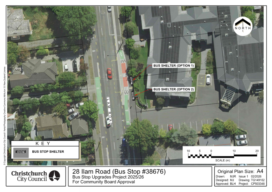
Bus stop 38676
– 28 Ilam Road (Option 1 in Attachment A)
4. Pursuant to Section 339(1) of the Local
Government Act 1974:
a. Approves that a bus passenger shelter be
installed on the east side of Ilam Road commencing at a point 212 metres south
of its intersection with Kirkwood
Avenue and extending in a
southerly direction for a distance of approximately 3.6 metres.
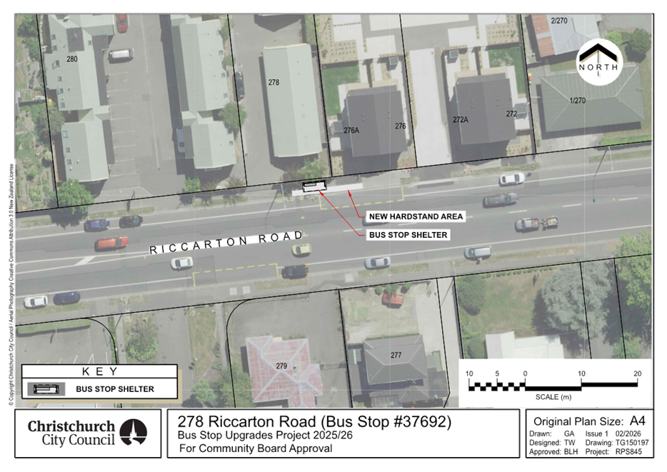
Bus stop 37692
– 278 Riccarton Road (Attachment A)
5. Pursuant to Section 339(1) of the Local
Government Act 1974:
a. Approves that a bus passenger shelter be
installed on the north side of Riccarton Road commencing at a point 74 metres
east of its intersection with Balgay Street and extending in an easterly
direction for a distance of approximately 3.6 metres.
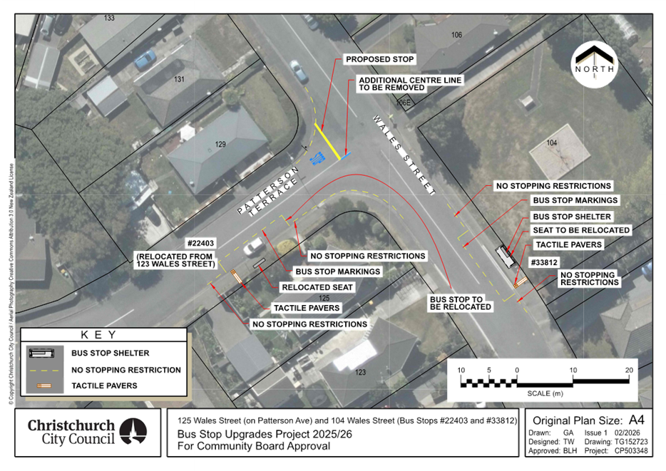
Bus stop 33812
– 104 Wales Street (Attachment A)
6. Pursuant to Clause 7 of the Christchurch City
Council Traffic and Parking Bylaw 2017:
a. Approves that the stopping of all vehicles be
prohibited at any time, on the northeastern side of Wales Street commencing at
a point 13 metres southeast of its intersection with Patterson Terrace and
extending in a south-easterly direction for a distance of 6 metres.
b. Approves that a bus stop be installed on the
northeastern side of Wales Street commencing at a point 19 metres southeast of
its intersection with Patterson Terrace and extending in a south-easterly
direction for a distance of 14 metres.
c. Approves that the stopping of all vehicles be
prohibited at any time, on the northeastern side of Wales Street commencing at
a point 33 metres southeast of its intersection with Patterson Terrace and
extending in a south-easterly direction for a distance of 4 metres.
7. Pursuant to Section 339(1) of the Local
Government Act 1974:
a. Approves that a bus passenger shelter be
installed on the northeastern side of Wales Street commencing at a point 26
metres southeast of its intersection with Patterson Terrace and extending in a
south-easterly direction for a distance of approximately 3.6 metres.
Bus stop 22403
– 125 Wales Street on Patterson Terrace (Attachment A)
8. Pursuant to Clause 6(2) of the Christchurch City Council Traffic and
Parking Bylaw 2017:
a. Approves that a bus stop be revoked on the
southwestern side of Wales Street commencing at a point 31 metres southeast of
its intersection with Patterson Terrace and extending in a south-easterly
direction for a distance of 12 metres.
9. Pursuant to Clause 7 of the Christchurch City
Council Traffic and Parking Bylaw 2017:
a. Approves that the stopping of all vehicles be
prohibited at any time, on the southwestern side of Wales Street commencing at
its intersection with Patterson Terrace and extending in a south-easterly
direction for a distance of 11 metres.
b. Approves that the stopping of all vehicles be
prohibited at any time, on the southeastern side of Patterson Terrace
commencing at its intersection with Wales Street and extending in a
south-westerly direction for a distance of 17 metres.
c. Approves that a bus stop be installed on the
southeastern side of Patterson Terrace commencing at a point 18 metres
southwest of its intersection with Wales Street and extending in a
south-westerly direction for a distance of 14 metres.
d. Approves that the stopping of all vehicles be
prohibited at any time, on the southeastern side of Patterson Terrace
commencing at a point 31 metres southwest of its intersection with Wales Street
and extending in a south-westerly direction for a distance of 4 metres.
e. Approves that the stopping of all vehicles be
prohibited at any time, on the northwestern side of Patterson Terrace
commencing at its intersection with Wales Street and extending in a
south-westerly direction for a distance of 9 metres.
f. Approves that the stopping of all vehicles be
prohibited at any time, on the southwestern side of Wales Street commencing at
its intersection with Patterson Terrace and extending in a north-westerly
direction for a distance of 10 metres.
10. Pursuant to Clause 6 of the Christchurch City
Council Traffic and Parking Bylaw 2017:
a. That a Stop control be placed against
Patterson Terrace at its intersection with Wales Street, as shown on Attachment
A to the report on the meeting agenda, Plan TG152723 dated
02/2026.
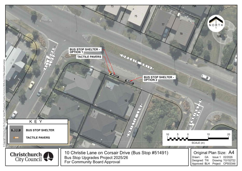
Bus stop 51491
– 10 Christie Lane on Corsair Drive (Option 1 in Attachment A)
11. Pursuant to Section 339(1) of the Local
Government Act 1974:
a. Approves that a bus passenger shelter be
installed on the south side of Corsair Drive commencing at a point 41 metres
northwest of its intersection with Bennington Way and extending in a
north-westerly direction for a distance of approximately 3.6 metres.
12. Approves that hard stand areas, seating, and
directional and warning tactile pavers be installed at the above bus stops, as
shown on Attachment A.
13. Approves that the resolutions, described in
clauses 3 to 11 above, take effect when traffic controls or parking signage
and/or road markings that evidence the restrictions described in the staff
report are in place (or removed in the case of revocations).
3. Executive Summary Te Whakarāpopoto Matua
3.1 Based
on community requests and two requests from the Community Board, staff are
proposing several bus stop upgrades, which are listed in Table 1.
Table 1: Proposed bus stop upgrades.
|
Adress and ID
|
Origin
|
Upgrades
|
|
28 Ilam Road - 38676
|
Community
|
Shelter installation
|
|
278 Riccarton Road - 37692
|
Community and Community Board
|
Shelter installation
|
|
Wales Street / Patterson Terrace Intersection –
22403 and 33812
|
Community and Community Board
|
Shelter installation, Line marking, Relocation, Stop
control
|
|
10 Christie Lane on Corsair Drive - 51491
|
Community
|
Shelter installation
|
3.2 The proposed plans also incorporate tactile pavers and a hardstand
area (where required) to improve accessibility and passenger waiting areas.
3.3 A bus stop is deemed
well-used if, on average, it serves around 20 or more passengers daily. This is
the traditional CCC threshold for bus shelter installation.
3.4 These
upgrades have been prioritised based on patronage, surrounding land use,
community and Community requests.
3.5 A
plan has been developed by staff for the provision of standard line marking at
bus stops 33820 and 22419 on Nicholls Road near Halswell Road. However,
following feedback from affected residents, staff have deferred this plan for
further investigation.
4. Background/Context Te Horopaki
28 Ilam Road - 38676
4.1 The bus stop serves bus routes 3 and 100. On average, 25 passengers
use this bus stop each day.
4.2 Ilam Arvida Retirement & Care, located adjacent to this bus
stop, has requested the installation of a shelter to provide weather protection
for all bus users, including a high proportion of elderly passengers.
4.3 In
addition to the patronage threshold, staff also consider requests from elderly
individuals, schools, hospitals, and people with disabilities, who are often
highly reliant on public transport.
4.4 The
current bus stop includes standard line marking, signage, and tactile pavers.
278 Riccarton Road -
37692
4.5 The bus stop serves bus routes 3, 5, Orbiter, and 130. On average,
36 passengers use this bus stop each day.
4.6 The
current bus stop includes a standard bus box marking, lead-in no-stopping
restrictions, tactile pavers, and signage. Also, the driveway after the bus box
functions as a lead-out no‑ stopping restrictions for buses.
4.7 The
bus stop previously included a seat until early 2023. It was removed because it
obstructed access to the adjacent housing development.
Wales Street /
Patterson Terrace Intersection – 22403 and 33812
4.8 These bus stops serve bus routes 7 and 125. On average, 32
passengers use the bus stop 33812 and 5 passengers use the bus stop 22403 each
day.
4.9 The
existing bus stop 33812 includes a seat and signage, while bus stop 22403
includes signage only.
4.10 A
concern was raised by a bus driver that some drivers on Patterson Terrace, when
approaching the intersection with Wales Street to turn, do not stop and check
for other vehicles before proceeding. The intersection is currently
uncontrolled and give way rules apply. Given the limited visibility at this
intersection a formal control is recommended. In this case, based on the
visibility, a stop control is warranted.
10 Christie Lane on
Corsair Drive - 51491
4.11 The bus stop serves bus route 100. On average, 21 passengers use
this bus stop each day.
4.12 The
current bus stop includes a standard bus box marking and signage.
Options Considered Ngā Kōwhiringa Whaiwhakaaro
28 Ilam Road –
38676, 278 Riccarton Road – 37692, and 10 Christie Lane on Corsair Drive
- 51491
4.13 The
following reasonably practicable options were considered and are assessed in
this report:
4.13.1 Shelter
installation.
4.13.2 Do
nothing.
Wales Street /
Patterson Terrace Intersection– 22403 and 33812
4.14 The
following reasonably practicable options were considered and are assessed in
this report:
4.14.1 Shelter
installation, standard line marking, relocation, install stop control at
intersection.
4.14.2 Do
nothing.
Options Descriptions Ngā Kōwhiringa
28 Ilam Road –
38676, 278 Riccarton Road – 37692, and 10 Christie Lane on Corsair Drive
- 51491
4.15 Preferred
Option: Shelter installation.
4.15.1 Option
Advantages
· Provides weather protection for
bus users.
4.15.2 Option
Disadvantages
· Costs associated with shelter
cleaning and maintenance.
4.16 Do
nothing Option:
4.16.1 Option
Advantages
· Council will
not incur any costs.
4.16.2 Option Disadvantages
· No improvement in weather
protection.
Wales Street /
Patterson Terrace Intersection – 22403 and 33812
4.17 Preferred
Option: Shelter installation, standard line marking, relocation, install
stop control at intersection.
4.17.1 Option
Advantages
· Provides weather protection for
bus users.
· Improved access to the bus stop
for buses.
· Improved
access to and from the bus for passengers.
· Buses would no longer block the traffic lane as the bus stops are not opposite each other.
· Improves
safety by requiring vehicles on Patterson Terrace to stop at its intersection
with Wales Street which has limited visibility.
4.17.2 Option
Disadvantages
· Costs associated with shelter
cleaning and maintenance.
· On-street
parking loss (4 spaces)
4.18 Do
nothing Option:
4.18.1 Option
Advantages
· Council will
not incur any costs.
4.18.2 Option
Disadvantages
· None of the
identified advantages associated with the preferred option would be realised.
5. Financial Implications Ngā Hīraunga Rauemi
Capex/Opex Ngā Utu Whakahaere
5.1 The
estimated costs for the recommended option and the do-nothing option are
provided in the table below.
5.2 The implementation costs in the table below include the expenses for
investigation, design, and construction of bus stop upgrades.
5.3 Maintenance/Ongoing costs - The Transport Unit Operational
Expenditure budgets include maintenance of bus stop infrastructure.
5.4 Funding Source – Traffic Operations budget for public
transport infrastructure upgrades.
28 Ilam Road – 38676
|
|
Recommended Option
|
Option 2 – Do nothing
|
|
Cost
to Implement
|
$30,000
|
$0
|
|
Funding
Source
|
CPMS
50465
|
NA
|
|
Maintenance/Ongoing
Costs
|
Bus
stop maintenance contract - minimal effects to the overall asset
|
NA
|
|
Funding
Availability
|
Available
|
NA
|
|
Impact
on Rates
|
NA
|
NA
|
278 Riccarton Road
– 37692
|
|
Recommended Option
|
Option 2 – Do nothing
|
|
Cost
to Implement
|
$31,000
|
$0
|
|
Funding
Source
|
CPMS
50465
|
NA
|
|
Maintenance/Ongoing
Costs
|
Bus
stop maintenance contract - minimal effects to the overall asset
|
NA
|
|
Funding
Availability
|
Available
|
NA
|
|
Impact
on Rates
|
NA
|
NA
|
10 Christie Lane on
Corsair Drive - 51491
|
|
Recommended Option
|
Option 2 – Do nothing
|
|
Cost
to Implement
|
$31,000
|
$0
|
|
Funding
Source
|
CPMS
50465
|
NA
|
|
Maintenance/Ongoing
Costs
|
Bus
stop maintenance contract - minimal effects to the overall asset
|
NA
|
|
Funding
Availability
|
Available
|
NA
|
|
Impact
on Rates
|
NA
|
NA
|
Wales Street / Patterson
Terrace Intersection – 22403 and 33812
|
|
Recommended Option
|
Option 2 – Do nothing
|
|
Cost
to Implement
|
$35,000
|
$0
|
|
Funding
Source
|
CPMS
50465
|
NA
|
|
Maintenance/Ongoing
Costs
|
Bus
stop maintenance contract and area maintenance contract- minimal effects to
the overall asset
|
NA
|
|
Funding
Availability
|
Available
|
NA
|
|
Impact
on Rates
|
NA
|
NA
|
6. Considerations Ngā Whai Whakaaro
Risks and Mitigations Ngā Mōrearea me
ngā Whakamātautau
6.1 Should the Community Board
proceed with Option 2, the do-nothing option, there will be:
28 Ilam Road –
38676, 278 Riccarton Road – 37692, and 10 Christie Lane on Corsair Drive
- 51491
· No improvement in weather
protection.
Wales Street /
Patterson Terrace Intersection – 22403 and 33812
· No improvement in weather
protection.
· No
improvements in access to the bus stop for buses.
· No
improvements in access to and from the bus for bus passengers.
· Buses would
continue to block the traffic lane when stopping at this bus stop (22403).
· No
improvements to safety at the Patterson Terrace/ Wales Street intersection.
Legal Considerations Ngā Hīraunga
ā-Ture
6.2 Statutory
and/or delegated authority to undertake proposals in the report:
6.2.1 The Community
Board has delegated authority from the Council to exercise the delegations as
set out in the Register of Delegations. The list of delegations for the
Community Boards includes the resolutions of:
· Stopping, standing,
and parking restrictions (including bus stops) under Clause 7 of the Traffic
and Parking Bylaw 2017.
· Bus passenger
shelters under Section 339 (1) of the Local Government Act 1974.
· To hear and
determine objections to bus stop shelters.
· Traffic control
devices under Clause 6 of the Christchurch City Council Traffic and Parking
Bylaw 2017.
6.3 Other Legal Implications:
6.3.1 This report
has not been reviewed and approved by the Legal Services Unit.
Strategy
and Policy Considerations Te
Whai Kaupapa here
6.4 The
required decisions:
6.4.1 Align
with the Christchurch
City Council’s Strategic Framework.
6.4.2 Are
assessed as low significance based on the Christchurch City Council’s
Significance and Engagement Policy. The level of significance was
determined by the number of
people impacted by each individual plan, the low risk and cost associated with
the decision.
6.4.3 Are
consistent with Council’s Plans and Policies.
6.5 This
report supports the Council's
Long Term Plan (2024 - 2034):
6.6 Transport
6.6.1 Activity: Transport
· Level of Service: 10.4.1 More people are choosing to travel
by public transport - >=14 million trips per year
· Level of Service: 10.4.4 Improve customer satisfaction with
public transport facilities (quality of bus stops and bus priority measures) -
>=73%
Community
Impacts and Views Ngā Mariu ā-Hāpori
6.7 Consultation
has been carried out with affected property owners and tenants.
6.8 The
consultation period ran from 27 January to 10 February 2026. Letters were
delivered to the property owners and tenants affected.
6.9 Environment
Canterbury support the proposed bus stop upgrades.
6.10 The
affected resident at bus stop 38676 outside 28 Ilam Road (Ilam Arvida
Retirement & Care) supported staff’s preferred option (Option 1) on
the proposed plan.
6.11 The
affected resident at bus stop 37692 outside 278 Riccarton Road (ASURE
Christchurch Classic Motel & Apartments) supported the proposed plan.
6.12 Staff
received two objections for bus stop 51491 outside 10 Christie Lane on Corsair
Drive, highlighting following concerns:
· Privacy issues.
· Blocking sunshine.
· Blocking the sight
line for vehicles entering and exiting the driveway.
· Reducing the view
from windows.
· Concern on the
potential risks associated with installing a bin at the shelter.
6.13 Staff
has responded that:
· Privacy concerns can occasionally
arise at some bus stops but are not widespread across Christchurch. Should any
unacceptable behaviour occur, the police can be contacted. We also note that
the shelter will be installed at an existing, well-used bus stop. Therefore,
the raised issues may already exist at this location, and adding a shelter is
unlikely to significantly increase these risks.
· In relation to
sunlight, sightlines, views, and rubbish bin, staff confirmed that the shelter
will include glass walls and that no rubbish bin will be installed alongside
it.
· Regarding the suggestion from one
resident to relocate the bus stop outside Chinatown onto the existing shared
path, staff advised that the current location meets standard bus stop spacing
requirements. Relocation would reduce the spacing between stops and would not
align with best practice, particularly given that this is already a heavily
used stop. In addition, the concrete path adjacent to the
shared path is within a heritage setting, which presents further constraints.
There is also no kerb between the concrete path and the shared path. Relocating
the stop there would therefore require construction of a new kerb. As a result,
the cost of this option would be beyond the scope of Traffic Operations’
limited budget for public transport infrastructure.
6.14 Staff
received two submissions for bus stop 22403 outside 125 Wales
Street on Patterson Terrace, highlighting the following concerns:
· Pedestrians crossing,
safe sightline, and safety concerns associated with proximity
of bus stop to the intersection.
· Noise and vibration.
6.15 Staff
has responded that:
· The proposed new location
for bus stop 22403 provides a safe and operationally suitable space for the bus
stop. The plan has been reviewed by a CCC Principal Safety Engineer and
consulted with Environment Canterbury specialists, and no safety or operational
concerns were raised.
· In relation to noise and vibration,
staff advised that buses are expected to stop at this location only a few times
per day and for a short period each time (around 30 seconds). In addition, as
Christchurch transitions to more electric buses in the future, we anticipate
further reductions in noise and vibration at bus stops.
· Regarding the suggestion from one
resident to relocate the bus stop, staff advised that the proposed options (somewhere between 101 and 113 Wales Street) were considered
but were not assessed reasonably practicable due to driveway spacing, road
curvature, and required bus stop spacing.
· In addition, following the
consultation process, additional community feedback was received regarding the
possibility of a Stop control being installed on the Patterson Terrace approach
to Wales Street. Staff have investigated this request and have recommended this
be implemented.
6.16 The decision affects the following
wards/Community Board areas:
6.16.1 Waipuna
Halswell-Hornby-Riccarton Community Board.
6.16.2 Halswell
Ward.
6.16.3 Hornby
Ward.
6.16.4 Riccarton
Ward.
Impact
on Mana Whenua Ngā
Whai Take Mana Whenua
6.17 The decisions do not involve a
significant decision in relation to ancestral land, a body of water or other
elements of intrinsic value, therefore these decisions do not
specifically impact Mana Whenua, their culture, and traditions.
6.18 The decisions do not involve a matter of interest to Mana Whenua and will not impact on our agreed partnership priorities
with Ngā Papatipu Rūnanga.
Climate
Change Impact Considerations Ngā Whai Whakaaro mā te Āhuarangi
6.19 The
proposals in this report are unlikely to contribute significantly to adaptation
to the impacts of climate change or emissions reductions. However, providing
shelters along with other bus stop upgrades will enhance public transport user
satisfaction and encourage more people to use public transport.
7. Next Steps Ngā Mahinga ā-muri
7.1 Once recommendation
approved, staff will engage with contractors to proceed with construction.
Attachments Ngā Tāpirihanga
|
No.
|
Title
|
Reference
|
Page
|
|
a ⇩ 
|
Attachment A:
Proposed bus stop upgrades
|
26/272281
|
39
|
In addition to the attached documents, the following background
information is available:
|
Document
Name – Location / File Link
|
|
Not
applicable
|
Signatories Ngā Kaiwaitohu
|
Authors
|
Mansour Johari
- Passenger Transport Engineer
Andrew Hensley
- Traffic Engineer
|
|
Approved By
|
Kathy Graham -
Team Leader Traffic Operations
Tony
Richardson - Finance Business Partner
Stephen Wright
- Head of Transport & Waste Management
|
|
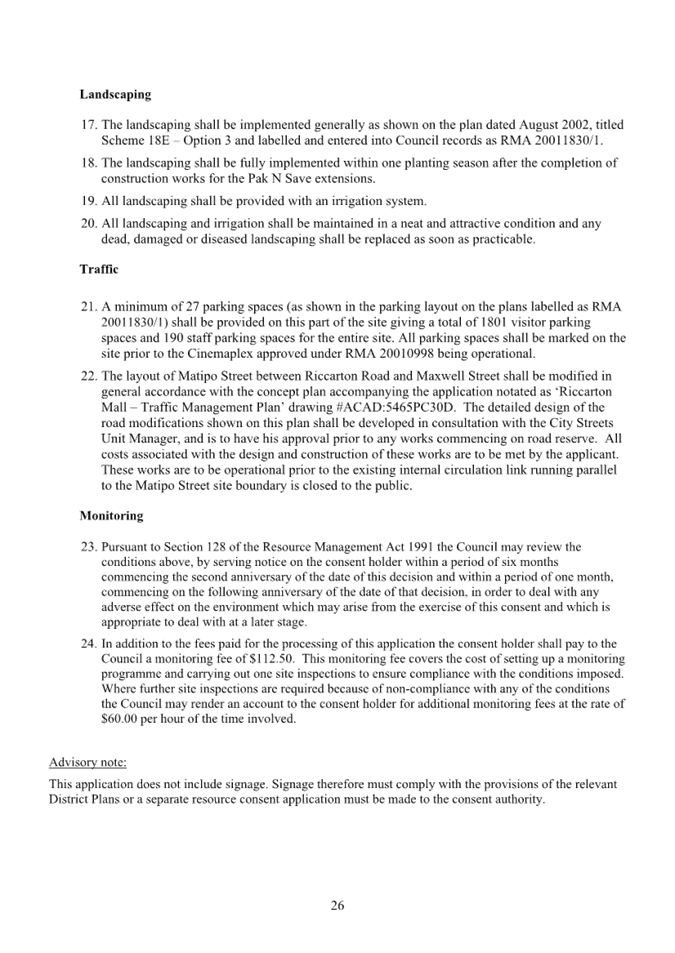
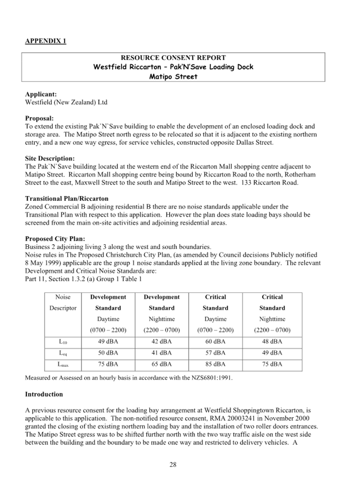
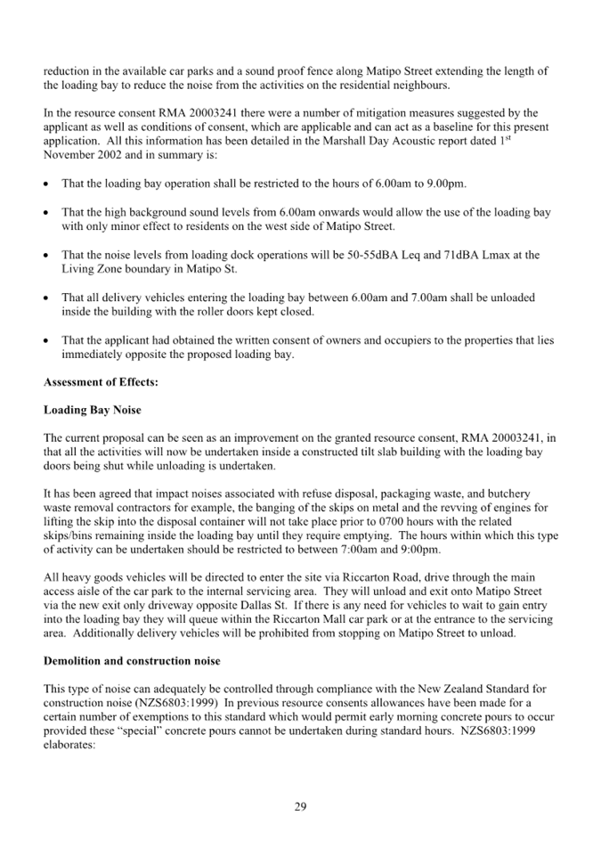
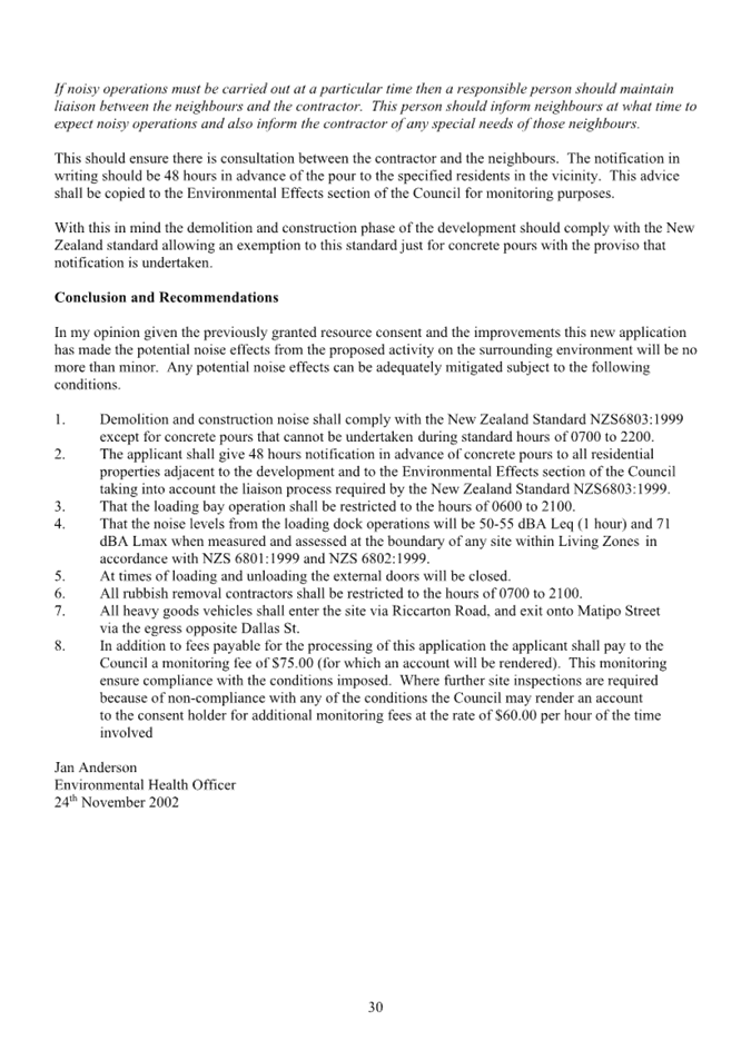
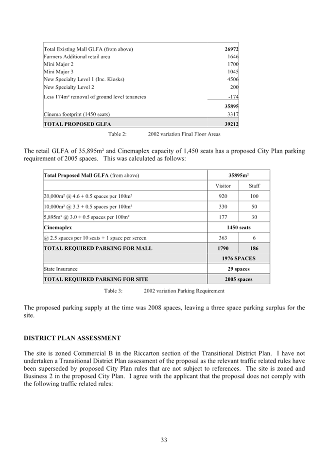
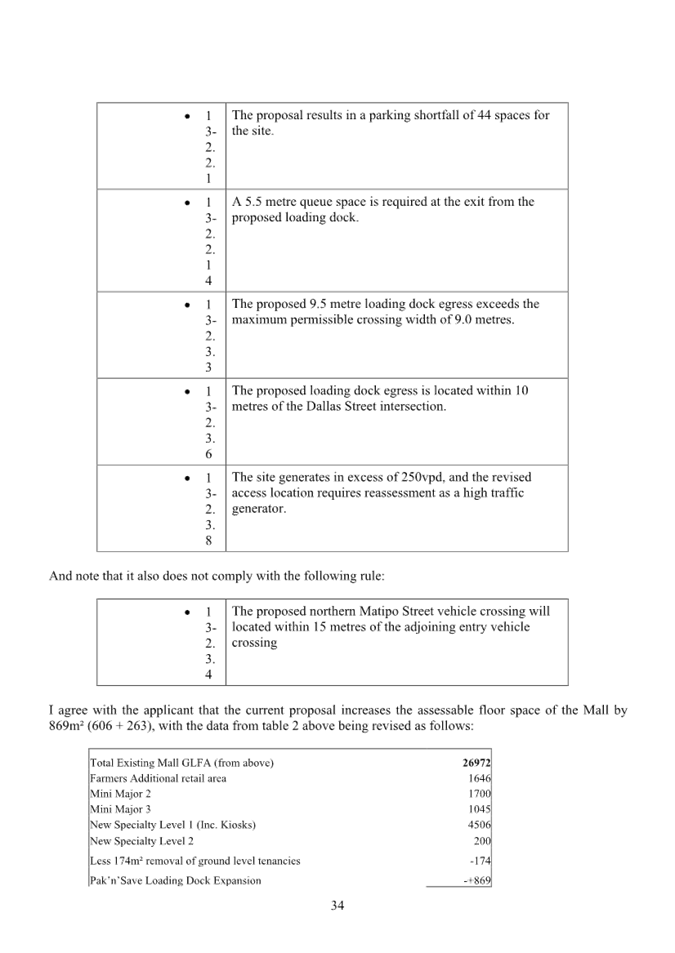
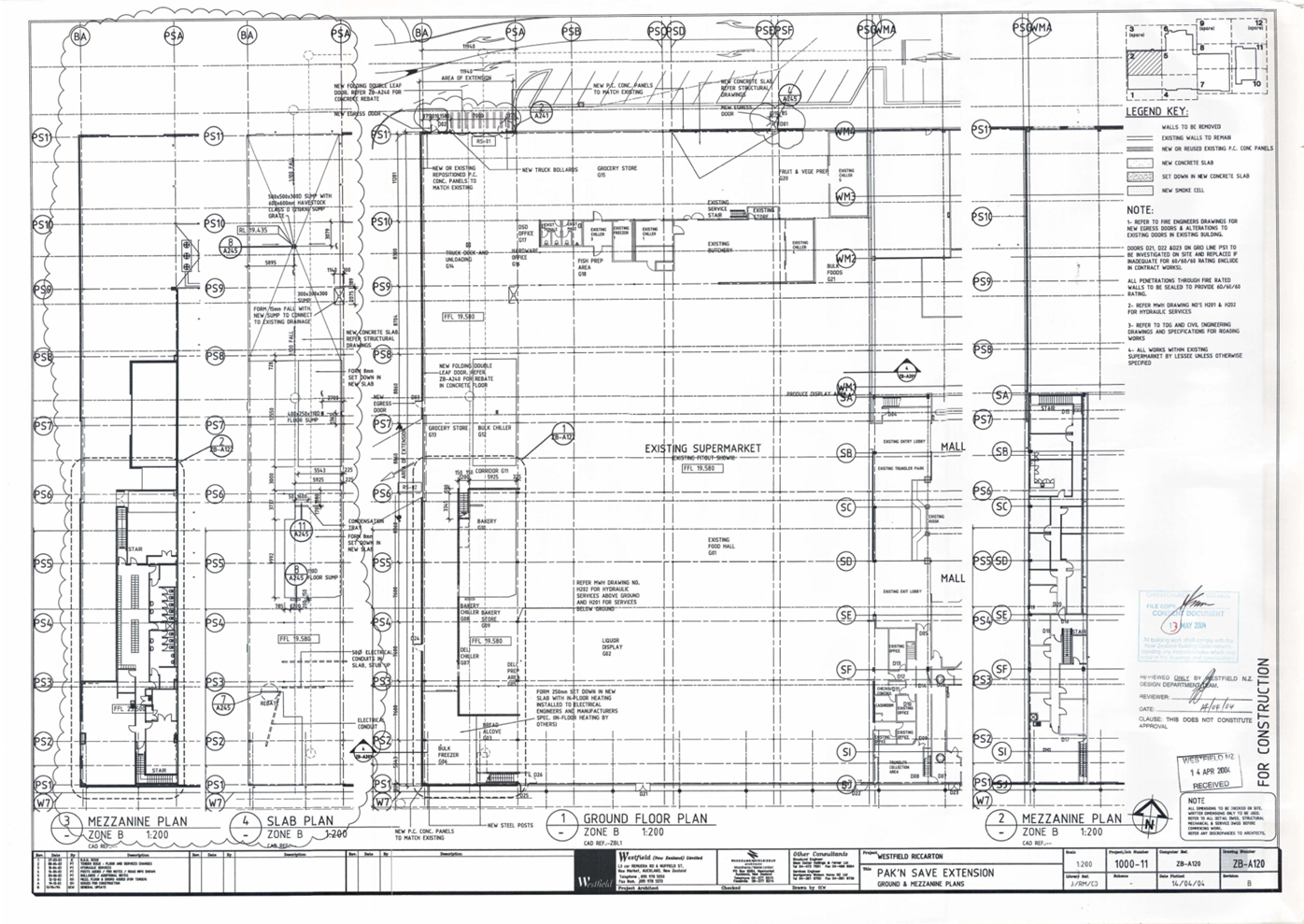
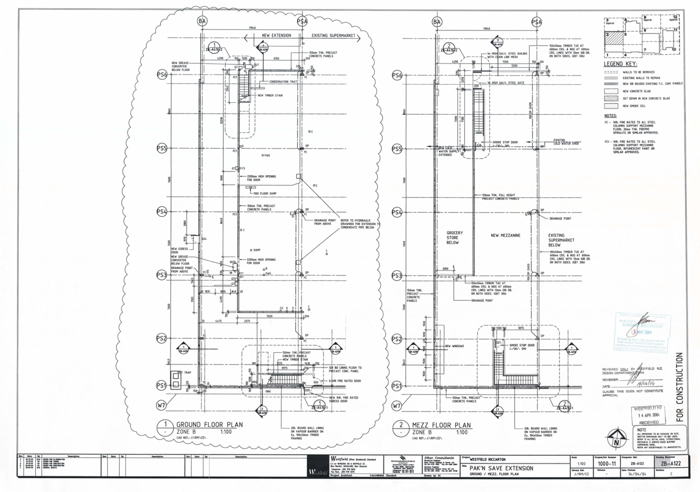
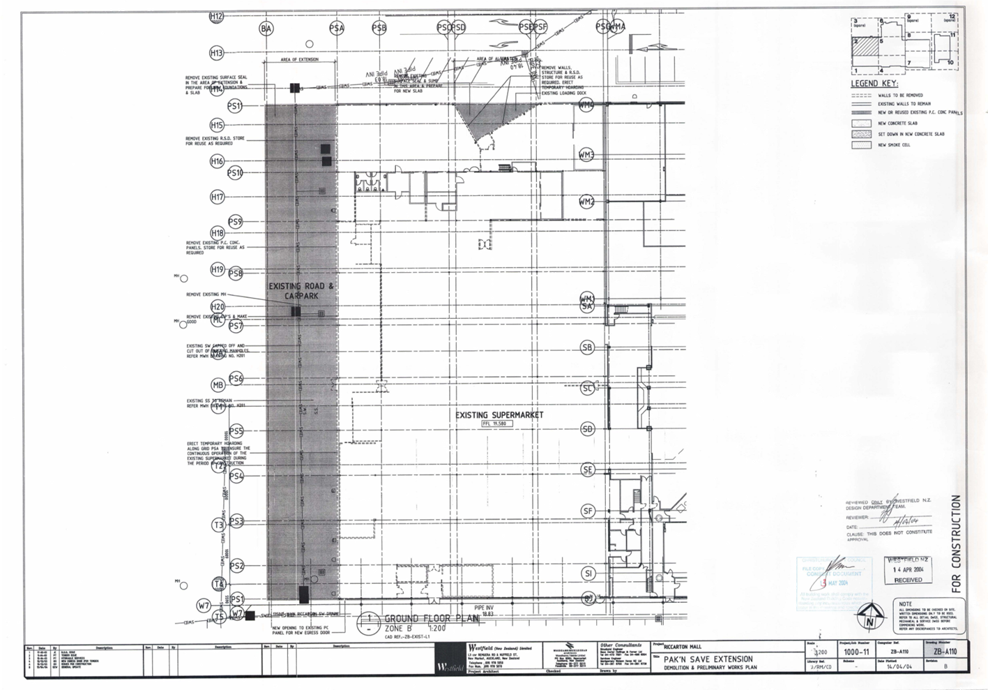
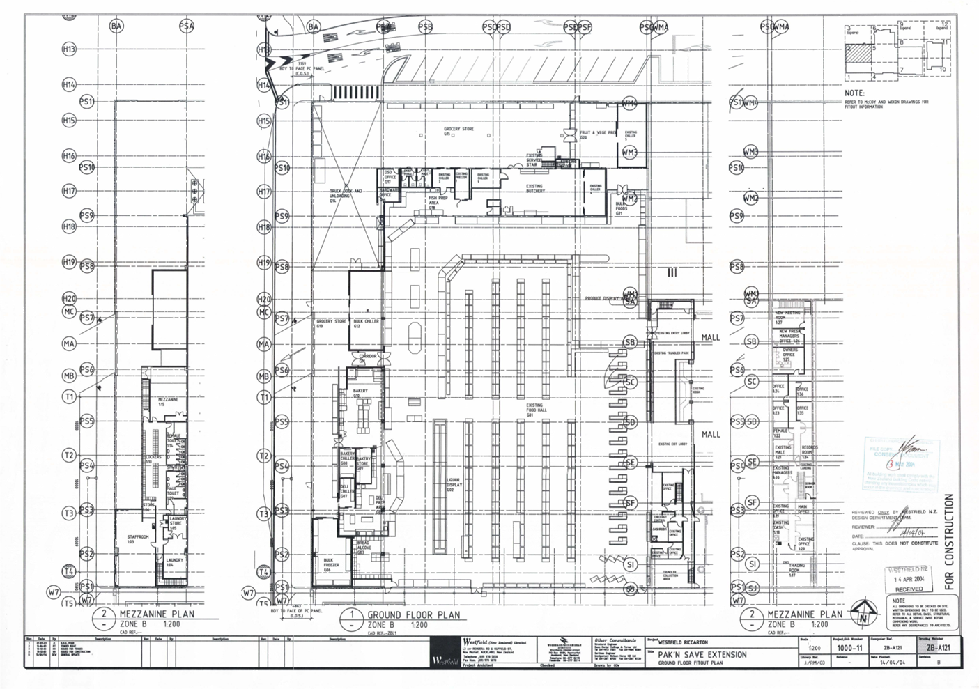
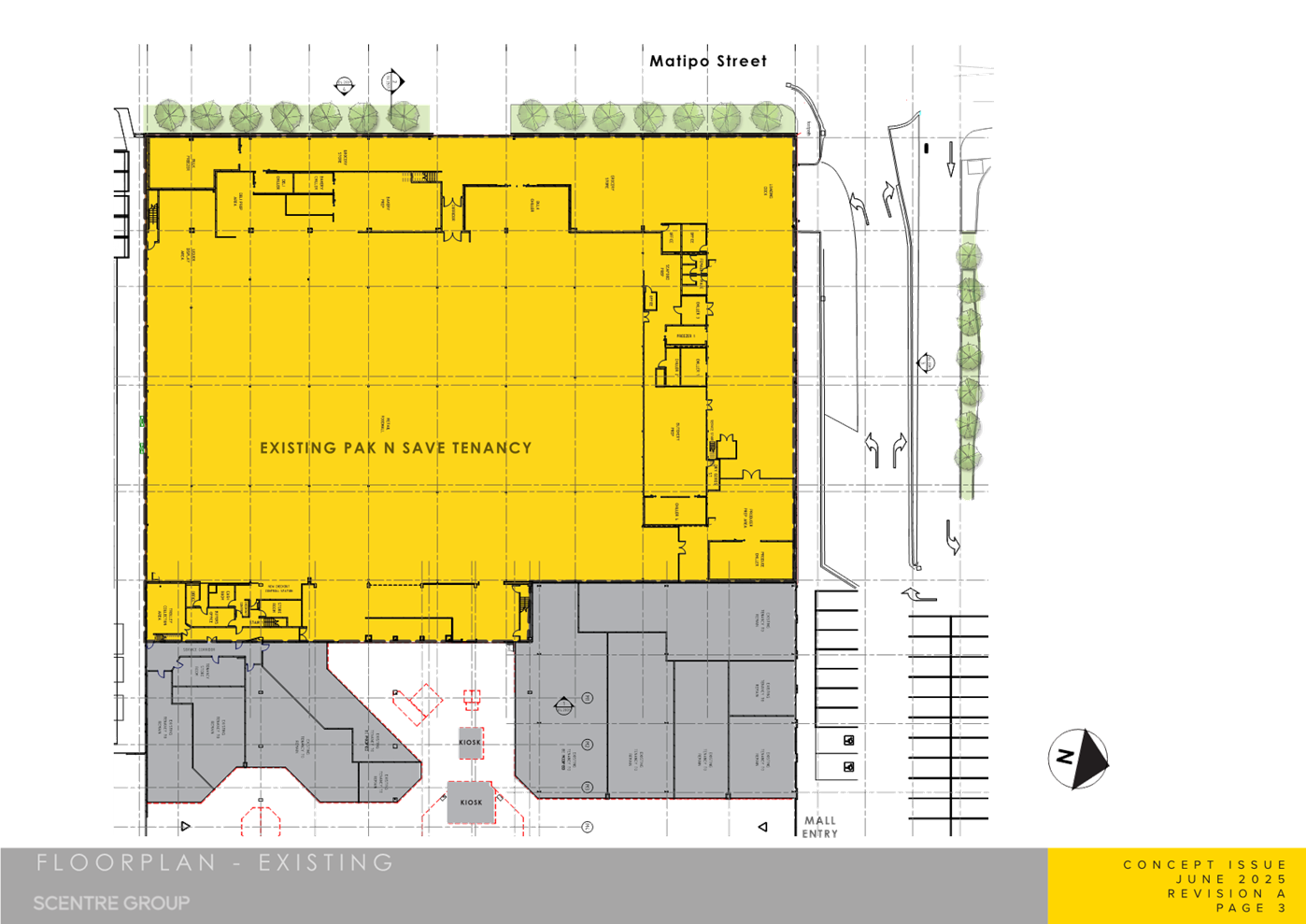
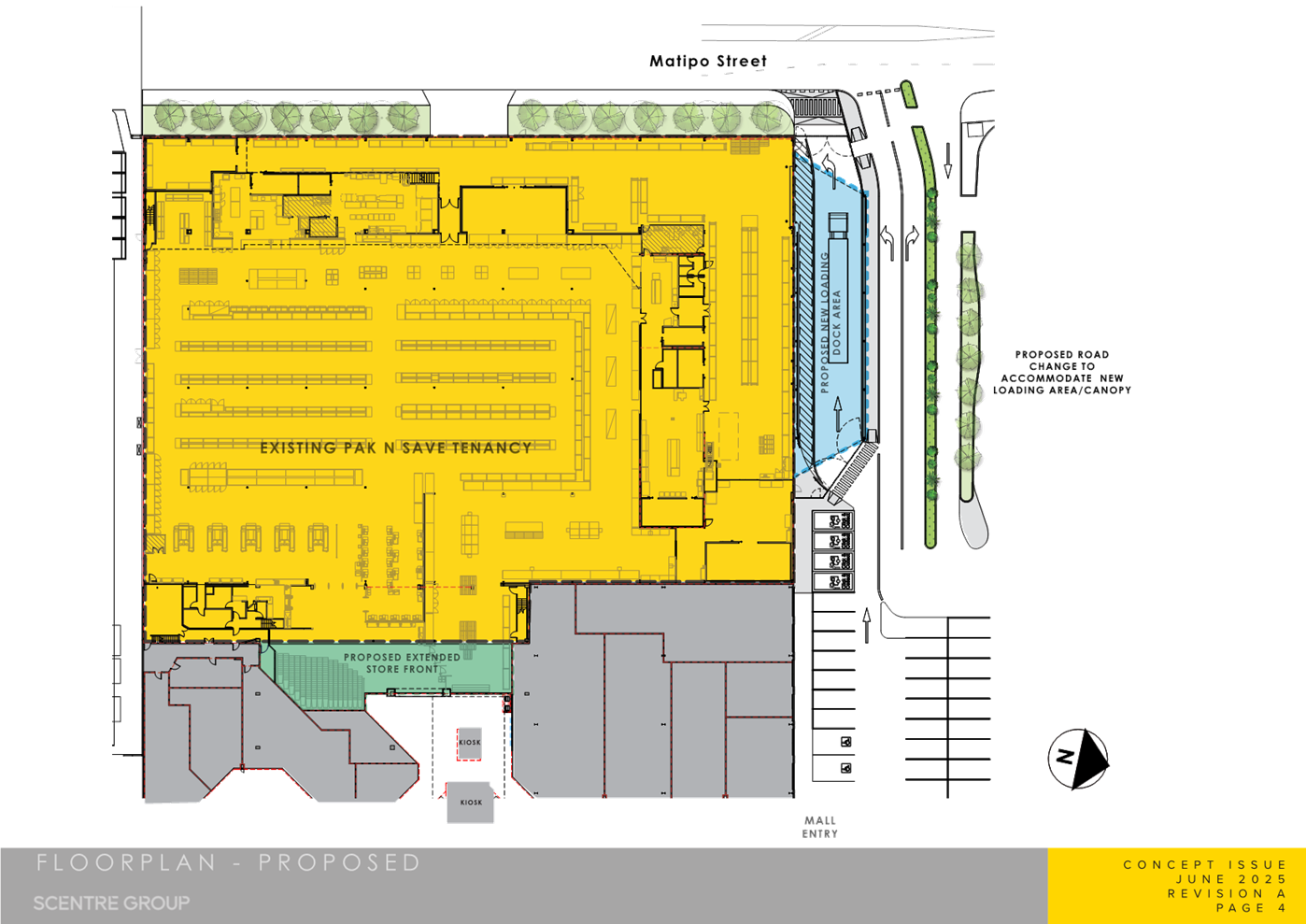
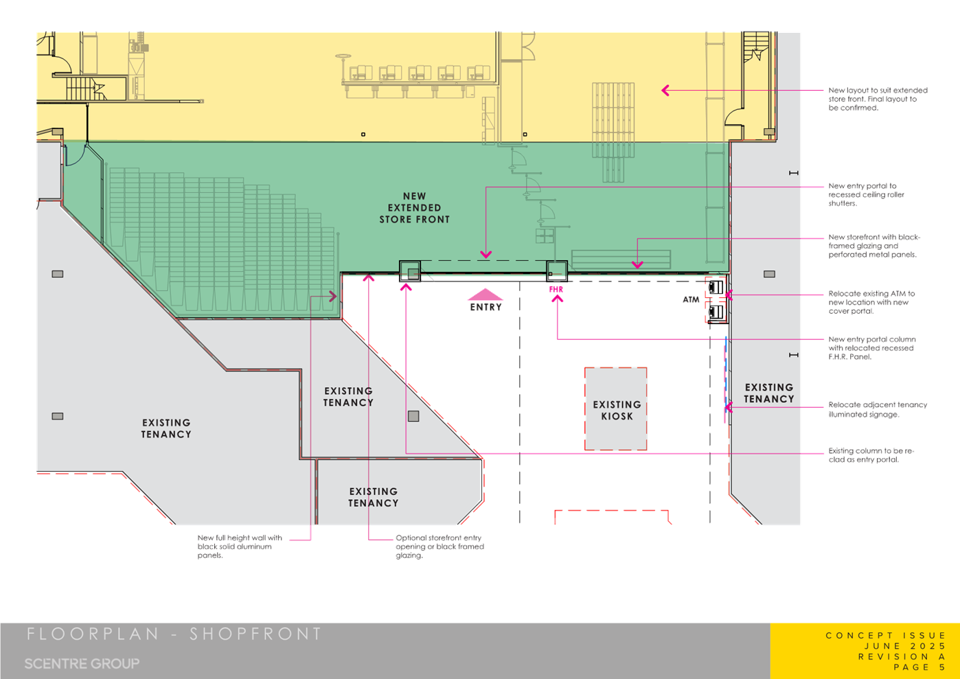
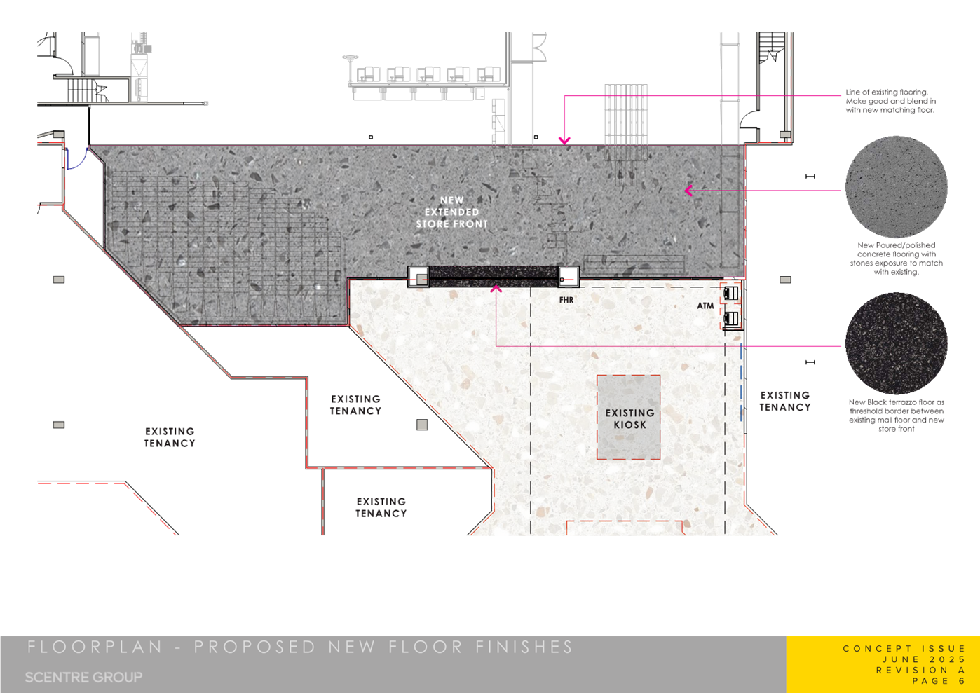
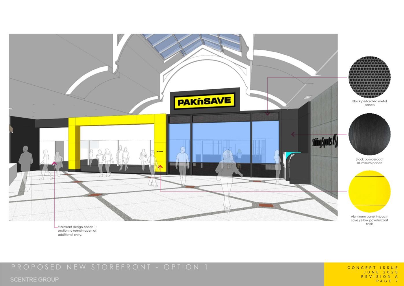
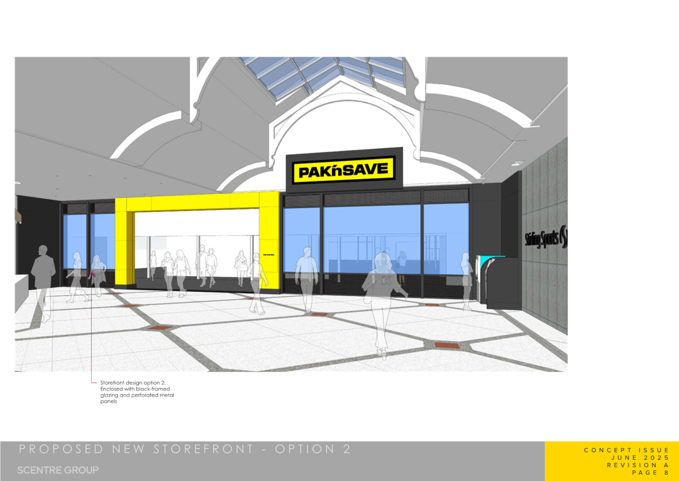
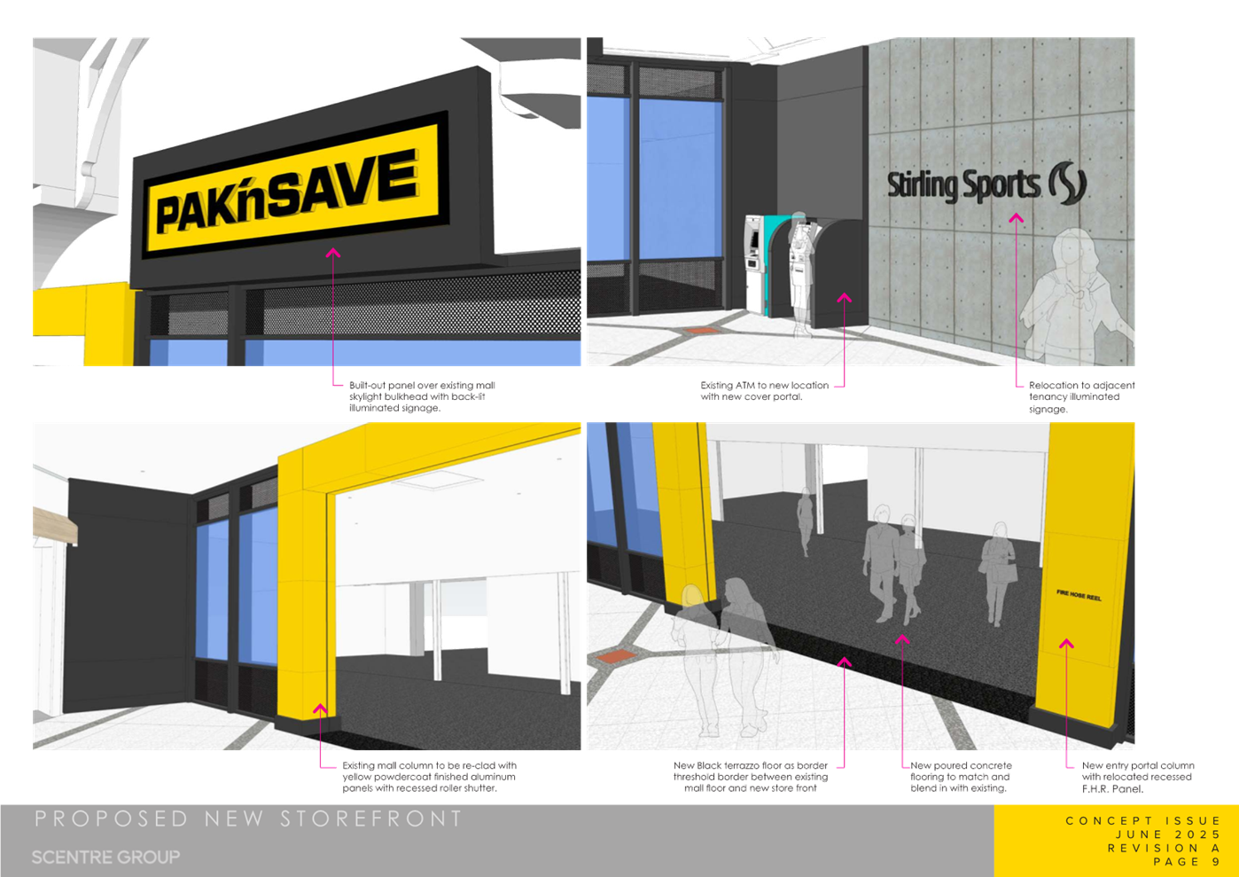
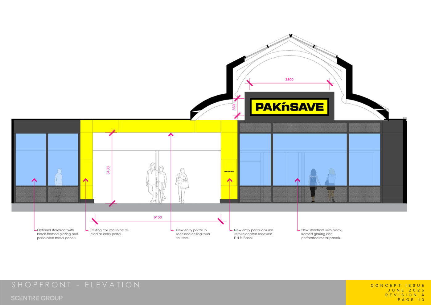
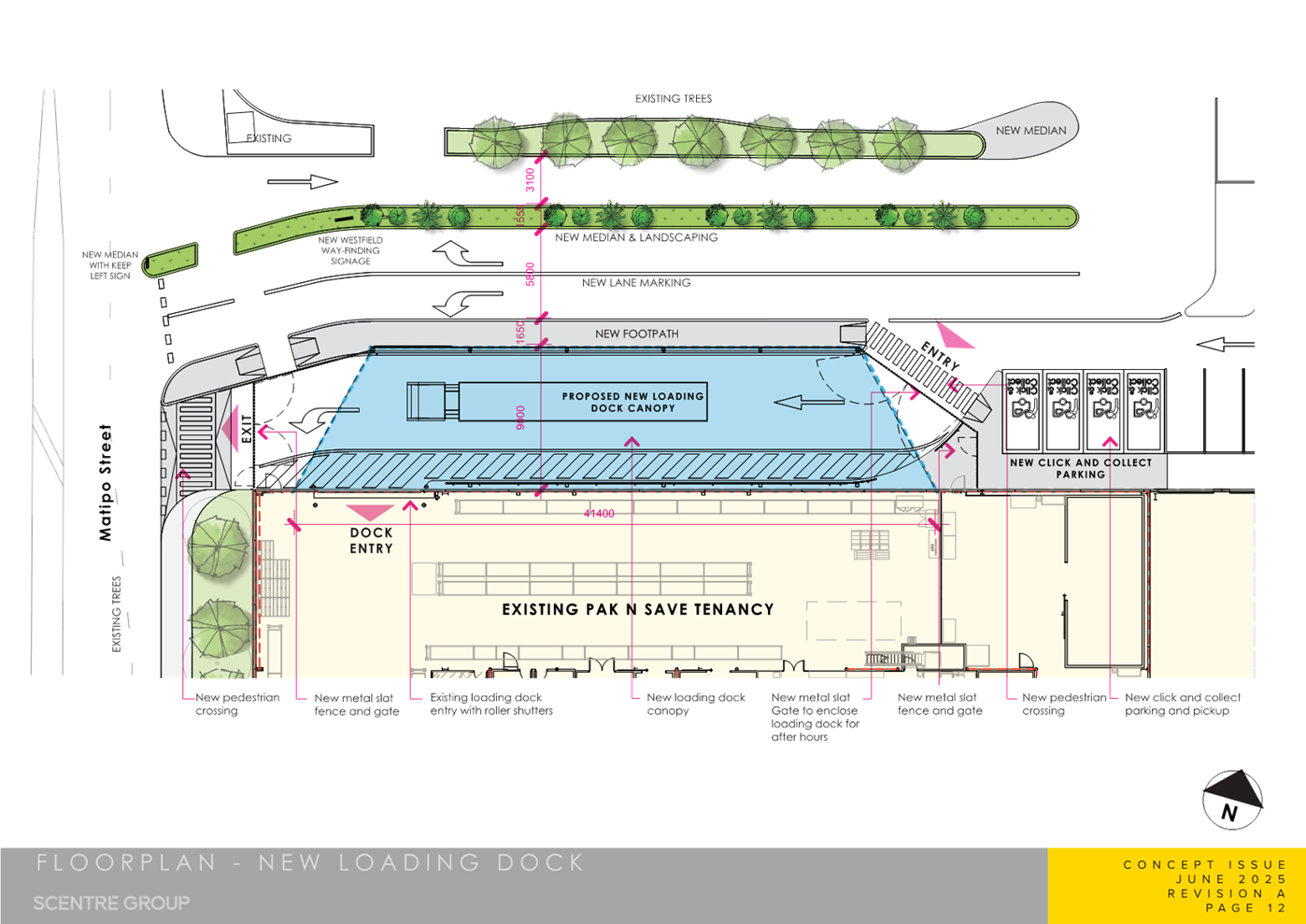
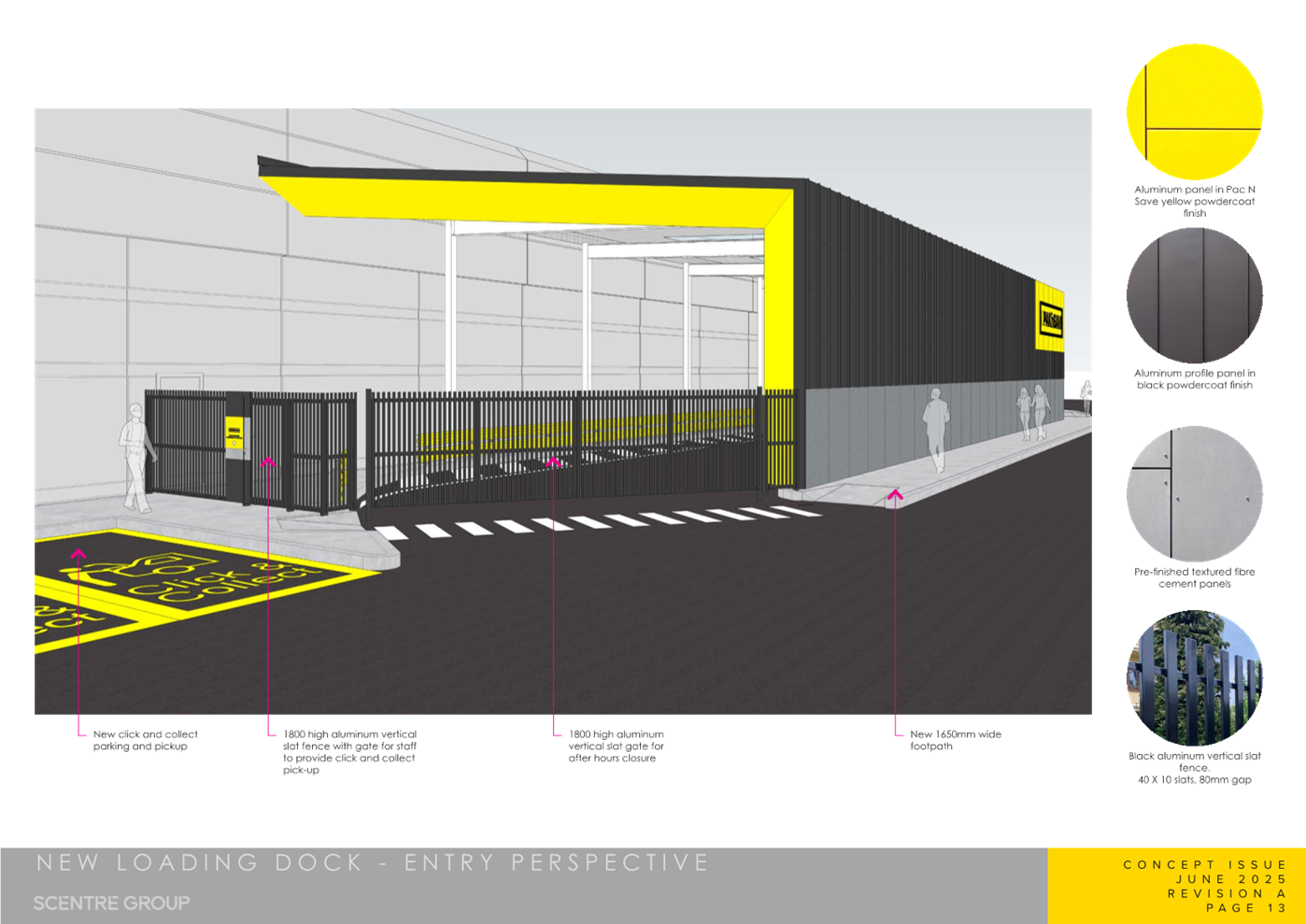
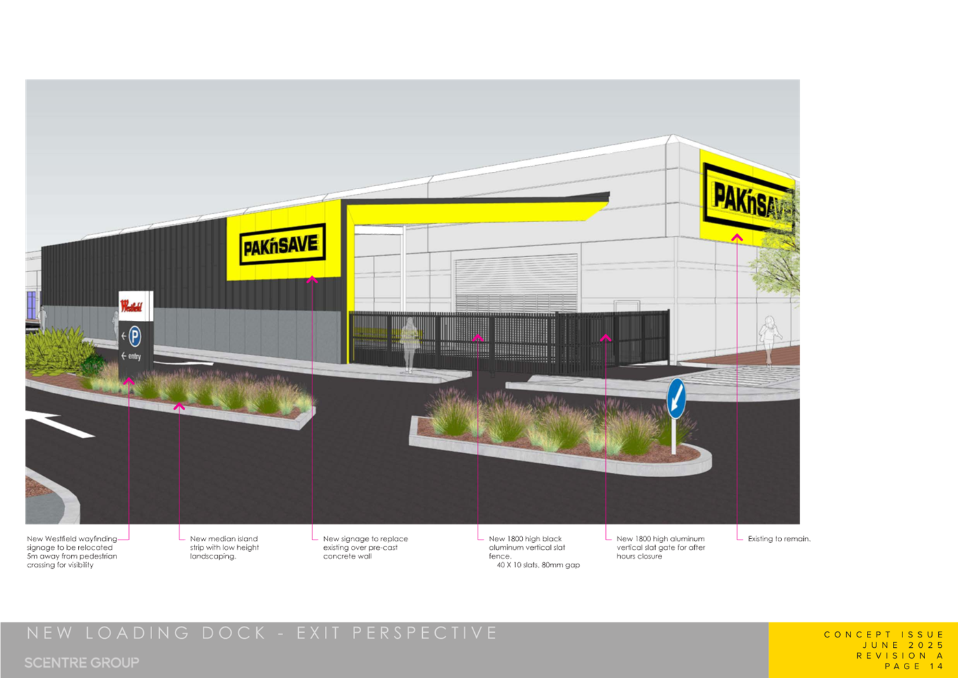
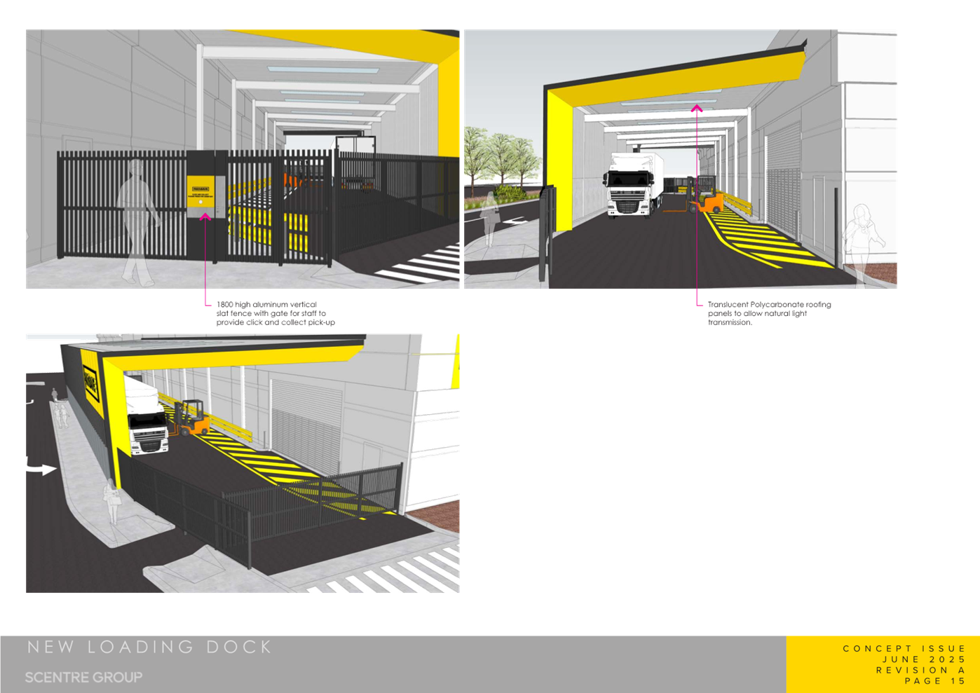
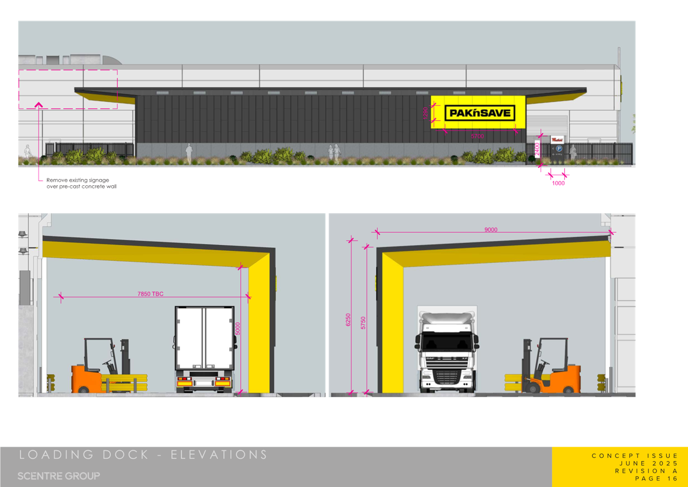
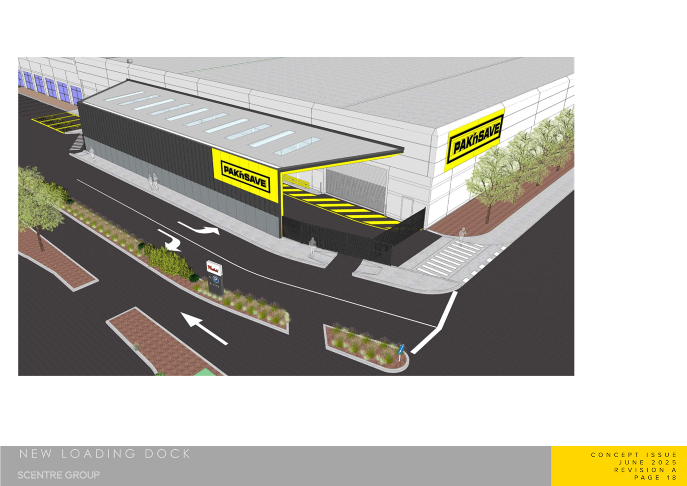
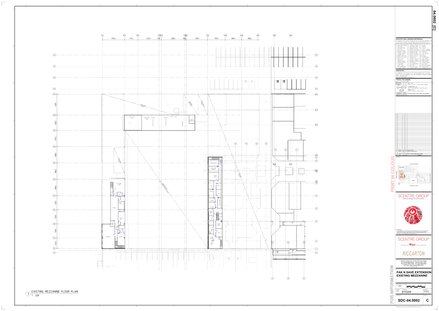
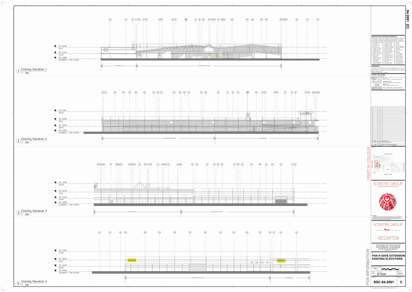
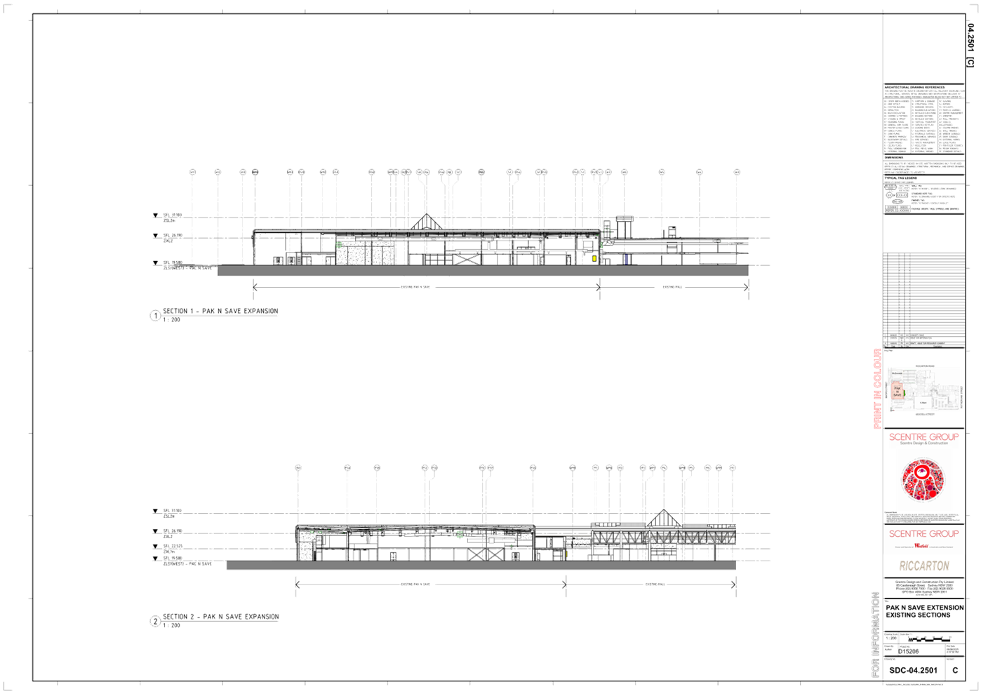
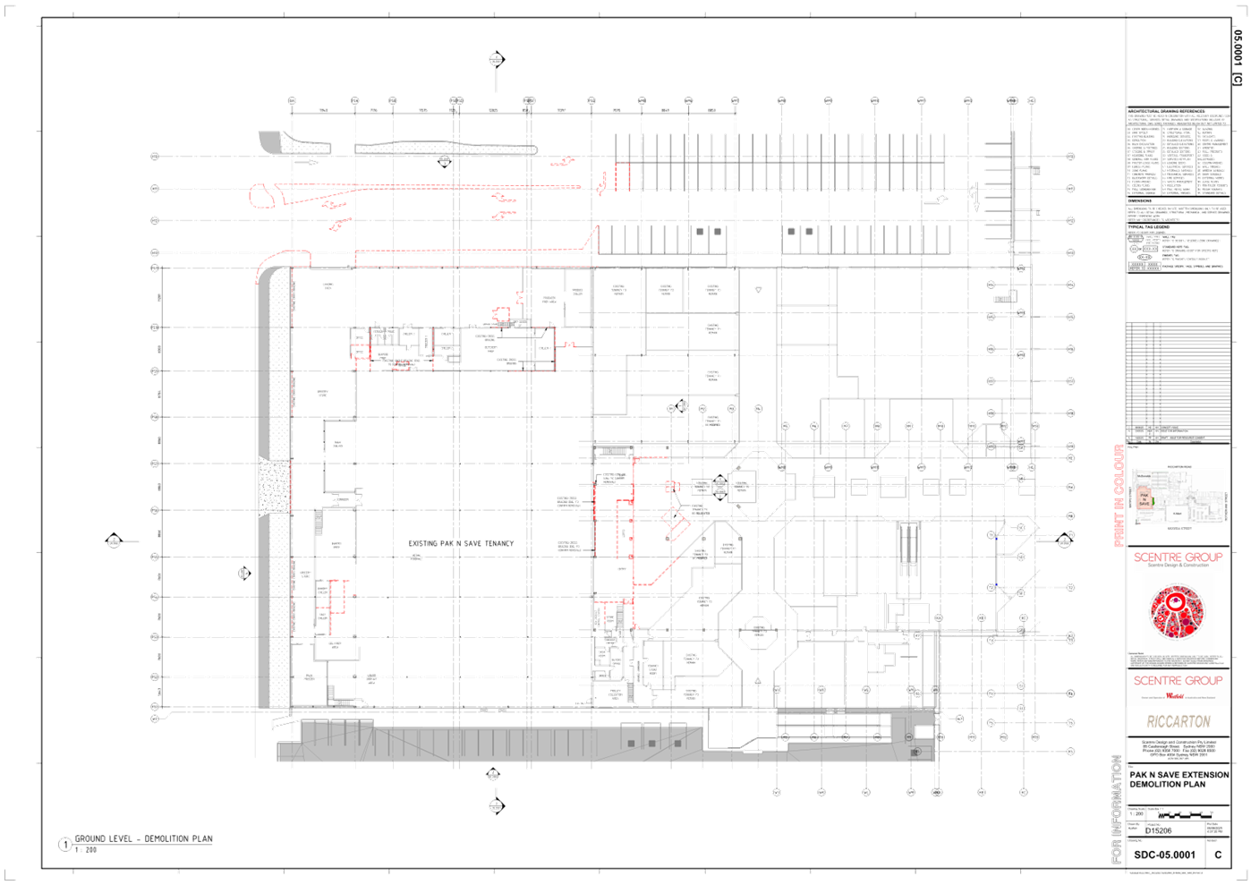
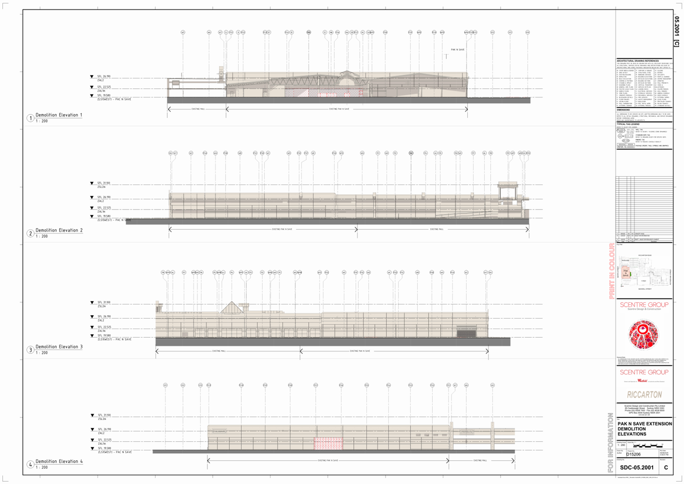
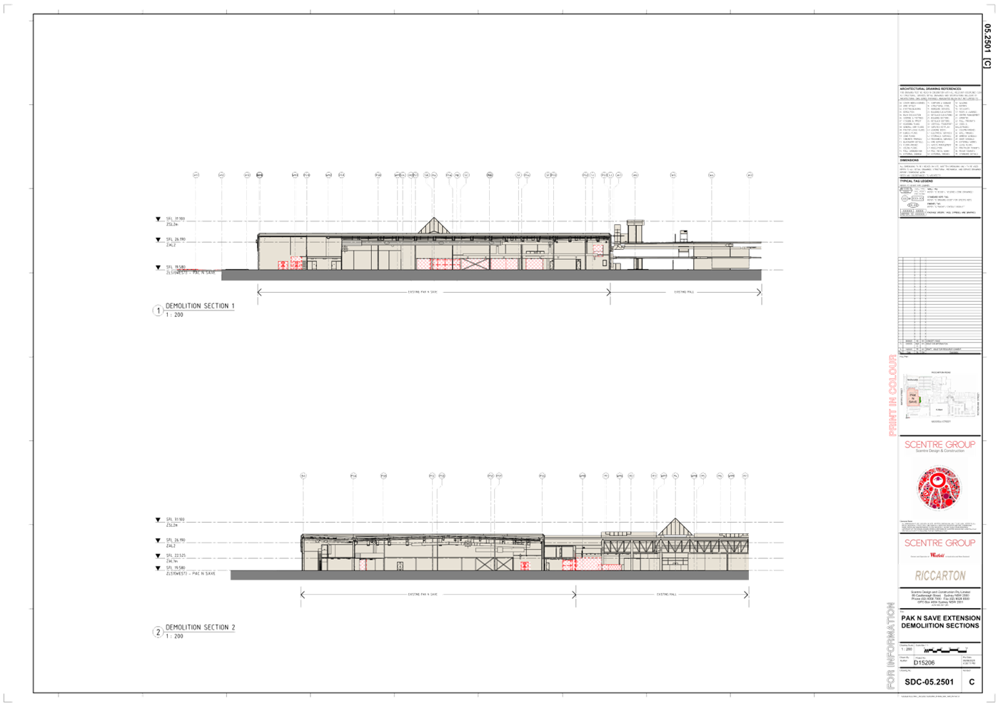
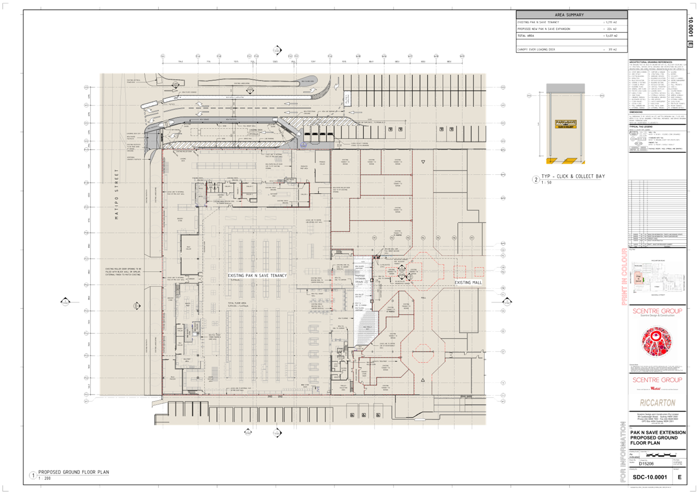
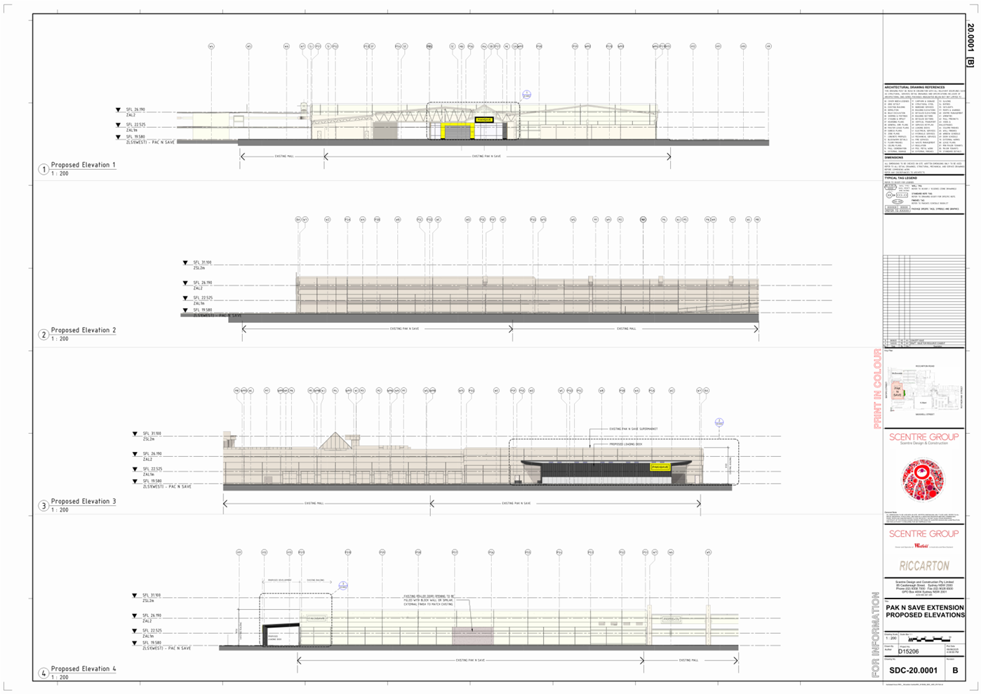
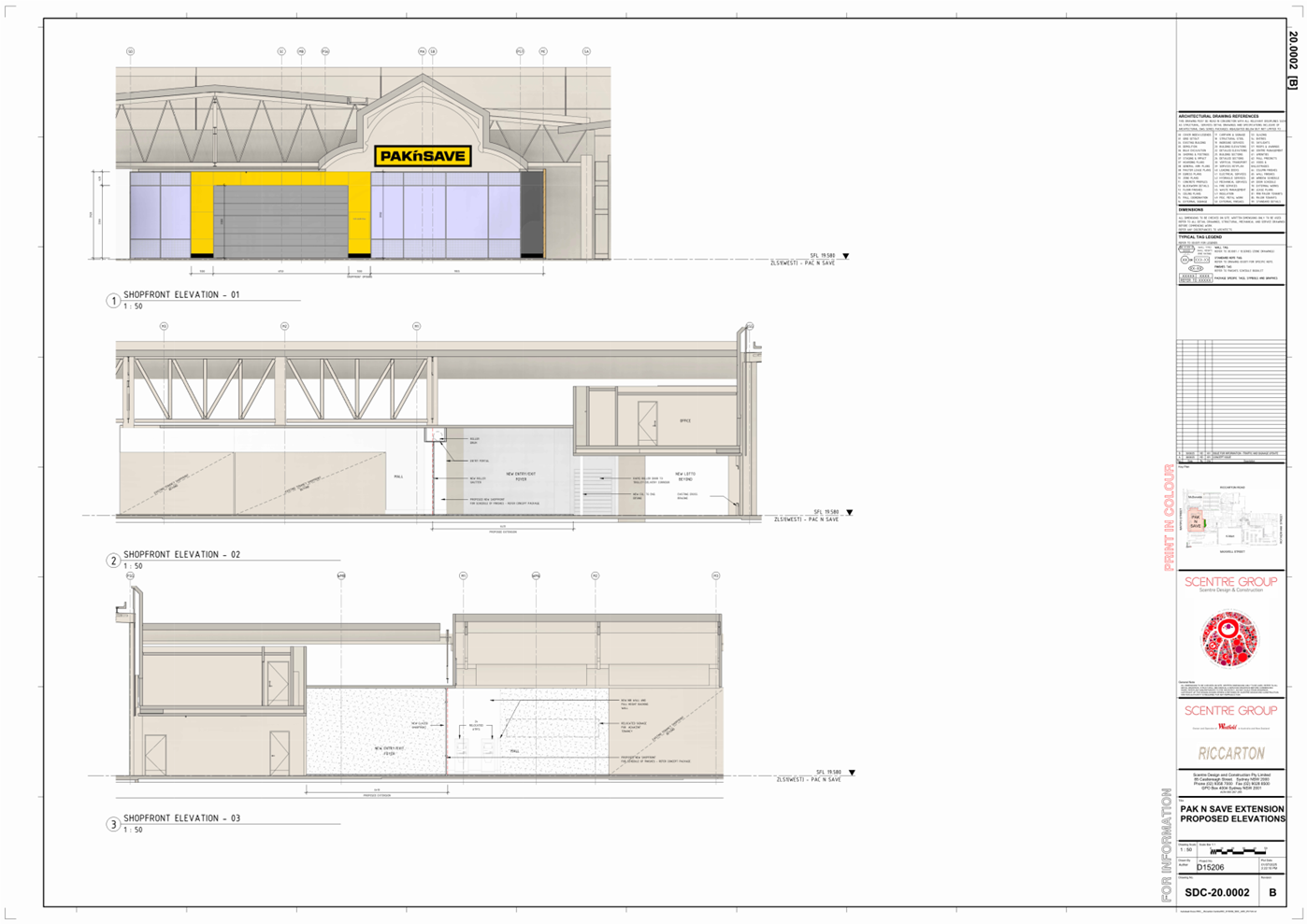
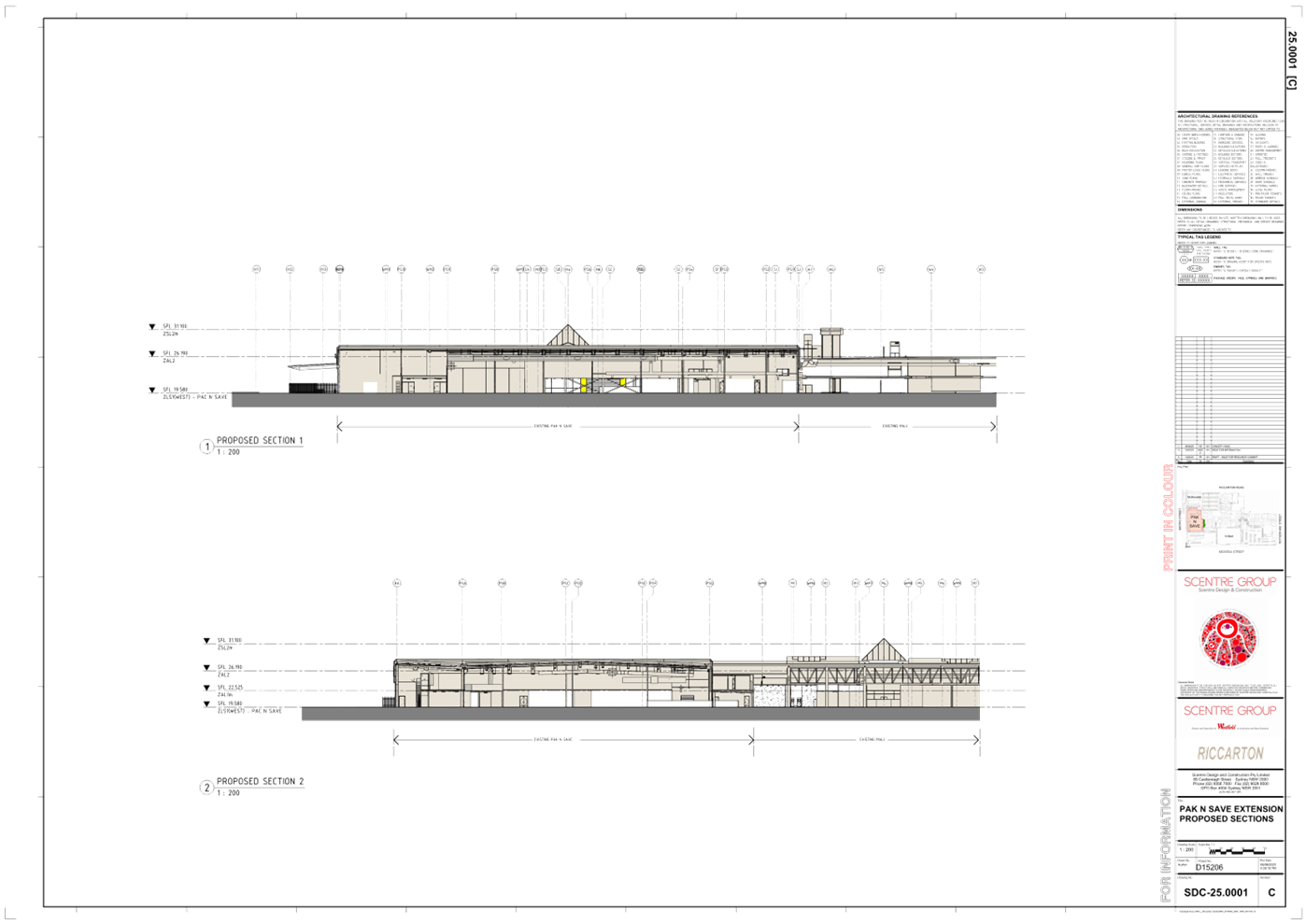
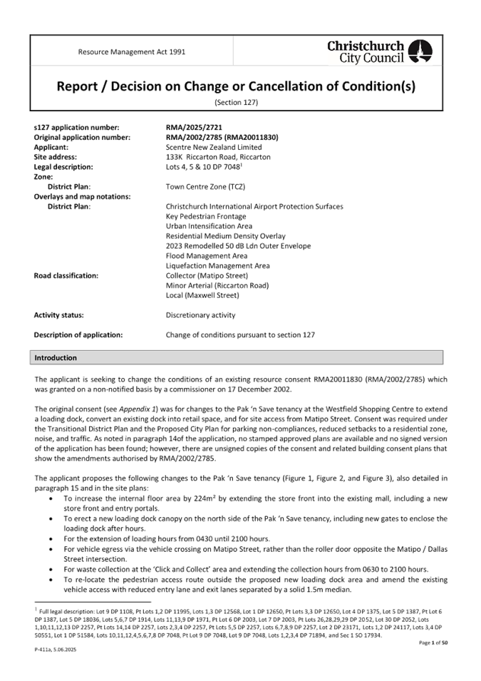
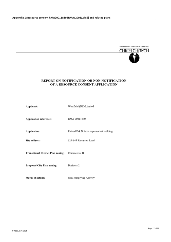
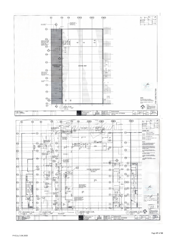
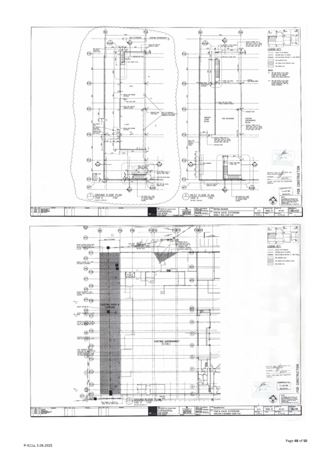
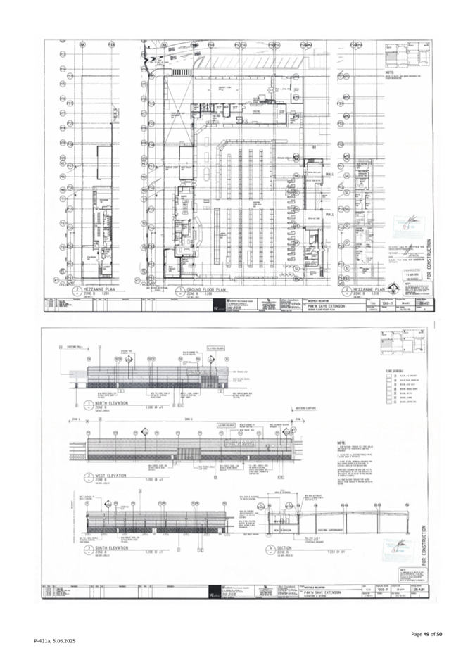
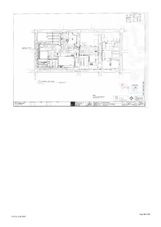
10. PAK’nSAVE
- Upgraded Vehicle Loading Access on Matipo Street
|
|
Reference Te Tohutoro:
|
26/350165
|
|
Responsible Officer(s) Te Pou Matua:
|
Liqi
Chen–Transport Network Planner (Asset Planning Team)
|
|
Accountable ELT Member Pouwhakarae:
|
Brent
Smith, General Manager City Infrastructure
|
1. Purpose and Origin of the Report Te Pūtake Pūrongo
1.1 To obtain approval from the
Waipuna Halswell-Hornby-Riccarton Community Board for the proposed upgrade of
the vehicle crossing at the Westfield Shopping Centre.
1.1.1 This is
located at the existing Matipo Street access, and includes associated road
changes in accordance with Attachment A.
1.2 This report has been
prepared by Council staff in support of the proposed vehicle crossing upgrade
at the consented PAK’nSAVE supermarket to improve road safety and network
efficiency at the Matipo Street access to the Westfield Shopping Centre.
1.3 The decision in this report
is to give effect to the resource consent conditions of RMA/2025/2721.
2. Officer
Recommendations Ngā Tūtohu
That the Waipuna
Halswell Hornby Riccarton Community Board:
1. Receives the information submitted in relation
to the PAK’nSAVE - Upgraded Vehicle Loading Access on Matipo Street
Report.
2. Notes that the decision in this report is assessed as low
significance based on the Christchurch City Council’s Significance and
Engagement Policy.
3. Approves that any previously approved resolutions be revoked , in
accordance with Clause 6 (2) of the Christchurch City Council Traffic &
Parking Bylaw 2017, on the eastern side of Matipo Street from its intersection
with Riccarton Road, and extending in a southerly direction for a distance of
65 metres, pertaining to Traffic Controls, including road markings, made
pursuant to any Bylaw, Local Government Act, or any Land Transport Rule, to the
extent that they are in conflict with, or recommended to be removed in regard
to the Traffic Controls ( including road markings) described in 4-6 below.
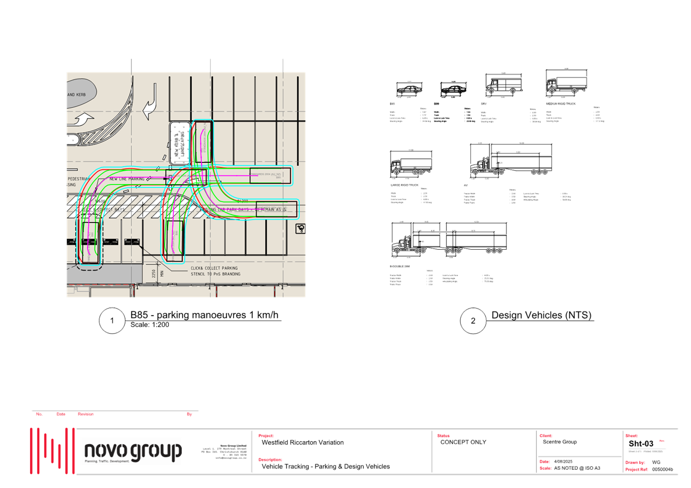
4. Approves the road changes as shown as shown highlighted in light
blue on the plan at Attachment A to the report on the meeting agenda, including
all road marking, signage, kerb alignment, central islands, road surface treatments, and proposed vehicle access on Matipo Street.
5. Approves that in accordance with Section 4 of the Land Transport
Rule: Traffic Control Devices: 2004, that traffic exiting the PAK’n SAVE
at Westfield, car park onto Matipo Street be controlled by a Give Way as shown
and highlighted in light blue on the plan at Attachment A to the report
on the meeting agenda.
6. Approves that the right turn movement from the proposed
PAK’nSave loading access into Matipo Street be prohibited, as detailed in
Attachment A in accordance with Clause 17 of the Christchurch City
Council Traffic and Parking Bylaw 2017.
7. Approves that these resolutions take effect when there is evidence
that the road changes described in 3, 4, 5 and 6 are in place.
3. Executive Summary Te Whakarāpopoto Matua
3.1 Riccarton Shopping Centre
(1997) Limited has applied for resource consent (RMA/2025/2721) seeking
approval for variation on the existing conditions outlined in the original
resource consent RMA20011830, to enable changes to the PAK’nSAVE tenancy,
loading zone layout and access, and northern Matipo Street site access at the
existing Westfield Shopping Centre.
3.1.1 As part of
resource consent application RMA/2025/2721, the applicant proposes to
upgrade the existing PAK’nSAVE loading area through the provision of a
new loading dock with canopy, installation of electric security gates, and
amendments to the existing Matipo Street access, including realignment of the
pedestrian footpath, crossing island, and vehicle approach lanes.
3.2 Approval is sought for the
associated changes within the legal road: shown within the blue shading on Attachment
A.
3.2.1 A set of plans
for more details of the design are included in the Attachment B – RMA/2025/2721
Resource Consent Application Report, from Page 71 onward.
3.3 Staff
have identified two options for approval:
· Approve the changes to road layout as shown in Attachment A
· Reject the changes
3.4 Staff
are recommending that the proposed changes are approved.
3.4.1 This allows
the developer to meet the previously approved Resource Consent. The consent
approval identifies that there are safety benefits for pedestrians and general
traffic within the mall car park, and the general traffic impacts on the road
has been assessed as being no worse than the current situation, and manageable
through conditions on use.
4. Background/Context Te Horopaki
Resource Consent
4.1 The original consent
(RMA20011830) was granted on a non-notified basis by a commissioner on
17/12/2002. The consent was for changes to the PAK’nSAVE tenancy at the
Westfield Shopping Centre to extend the loading dock and for site access from
Matipo Street.
4.2 The applicant, Riccarton
Shopping Centre (1997) Limited, has submitted a resource consent application to
vary existing consent conditions to enable further upgrades to the
PAK’nSAVE loading area and associated changes to the site vehicle access
from Matipo Street.
4.3 The consent application has
been processed by Council staff, and the associated transport effects on road
safety and network efficiency have been assessed. The proposal is expected to
generate following positive effects, including:
4.3.1 The
current PAK’nSAVE’s loading activities operating outside the roller
doors raise significant concerns due to their proximity to the footpath users and
general traffic lanes.
4.3.2 The
proposed variation is anticipated to improve the existing
PAK’nSAVE’s loading zone operation by providing a dedicated
at-grade separation between vehicular and pedestrian movements.
4.3.3 A
continued internal footpath link will be provided and connected to the existing
footpath at the site access, where the existing pedestrian crossing island will
be upgraded to enable safe crossing.
4.4 However, the primary
concerns have been raised regarding the operation of the proposed new loading
vehicle access and its potential impacts on general traffic and other road
users on Matipo Street. These include:
4.4.1 The
proposal includes a reduction in the width of the existing turning lanes at the
site vehicle access to accommodate the new loading dock design. While the
submitted tracking diagrams demonstrate that most private vehicles can operate
within the proposed 2.9 m lane width, the manoeuvring by larger service
vehicles is expected to create noticeable effects on general traffic along
Matipo Street.
4.4.2 The
proposed new loading area, measuring approximately 40 m in length and 8.6 m in
width, is sufficient to accommodate up to three medium rigid trucks for parking
and loading. However, accommodating a 20m+ semi-trailer would experience
operational challenges, as it would occupy a significant space of the loading
area and is likely to require longer dwell times, which result in potential internal
queuing effects.
4.4.3 Matipo
Street has been experiencing relatively high traffic volumes, particularly
during peak hours. However, as identified in the traffic assessment report,
large rigid trucks are likely to encroach into the central flush median and the
opposing traffic lane when exiting to Matipo Street.
4.4.4 Therefore,
the turning movements associated with vehicles of 20 m or longer are expected
to result in noticeable disruption to traffic on Matipo Street.
4.4.5 To
address this, a condition has been imposed requiring the applicant to develop a
service vehicle operational procedure, with servicing by trucks of 23m or
longer restricted to the period between 0600 and 0800, Monday to Sunday
when traffic flows on Matipo Street are lower.
4.4.6 The
applicant will be responsible for ensuring that potential conflicts and queuing
impacts at the site access are minimised and that effects on the surrounding
road network are effectively managed.
4.4.7 A
section 128 review condition has also been included in the consent to enable
Council to monitor operational effects and, if necessary, review the consent
conditions to manage safety and efficiency of service vehicle movements on
Matipo Street should unanticipated effects arise.
4.4.8 Above
conditions can be found at Attachment C – RMA/2025/2721 s127 Decision.
Traffic assessment within the legal road
4.5 As part of seeking Community
Board approval and the vehicle crossing permit, the road changes have been
confirmed acceptable with the following amendments, as illustrated in the
Attachment A – RMA/2025/2721 Proposed Vehicle Crossing Layout
Design:
4.5.1 Increasing the
width of the median strips to 1.8m.
4.5.2 Providing
diamond markings at the exit points to indicate the Give Way enforcement.
4.5.3 A 2.5m
cut-through crossing island to be provided in the median strip.
4.5.4 Tactile
surface pavement to be provided for vision-impaired users.
4.5.5 Two Give Way
Signs to be provided at the access exit.
4.5.6 All
signages and road markings to be compliant with the Traffic Control/Devices
Manual.
4.6 The proposed works within
the public road corridor, including median island modifications, road markings,
pedestrian crossing cut downs, and kerb realignment, will be undertaken within
the existing road boundary and will not introduce any additional encroachment
into Matipo Street beyond the current context.
4.7 Based on the above
assessments, the associated effects of this resource consent application are
considered to be manageable, and an exemption for the site access safety audit
process has therefore been granted and included in Attachment D – RMA/2025/2721
Site Access Safe System Audit Exemption Form.
4.8 The
following related memos/information were circulated to the meeting members:
4.9 The
following related information session/workshops have taken place for the
members of the meeting:
Options Considered Ngā
Kōwhiringa Whaiwhakaaro
4.10 The following reasonably practicable options
were considered and are assessed in this report:
4.10.1 Option
1 (Recommended): Approve the proposed PAK’nSAVE loading zone design
and the associated upgrade to the existing site vehicle access onto Matipo
Street.
4.10.2 Option
2: Decline the proposed vehicle crossing works within the road reserve
Options Descriptions Ngā
Kōwhiringa
4.11 Preferred Option: Option 1
(Recommended): Approve the proposed PAK’nSAVE loading zone design and
the associated upgrade to the existing site vehicle access onto Matipo Street.
4.11.1 Option
Description:
Approval of the proposed PAK’nSAVE
loading zone and site access upgrade as illustrated in Attachment A - RMA20252721
Proposed Vehicle Crossing Layout Design.
4.11.2 Option Advantages:
· Supports the previously approved Resource Consent
· Improves pedestrian safety through provision of tactile paving and
reduced crossing distance
· Improves loading zone operation safety, security and efficiency
· Provides continuous footpath links
· Upgrades the existing pedestrian crossing provision at the site
access
4.11.3 Option Disadvantages:
· Turning manoeuvres by larger service vehicles at the Matipo Street
access may affect road network operations as they require to turn across the
existing centre line – (note this is the current situation, and is to be
managed through a condition of consent to limit the times of loading).
4.12 Option
2: Decline the proposed vehicle crossing works within the road reserve.
4.12.1 Option
Description:
The applicant would need to consider
alternative access arrangements or submit a revised proposal for further
consideration.
4.12.2 Option Advantages:
· Would provide a further opportunity to re-consider vehicle movements
onto Matipo Street (noting the proposed scheme does not worsen the existing
situation)
4.12.3 Option Disadvantages:
· Does not support the previously approved Resource Consent
· Does not support economic development and growth within the city
· Potential that any alternative proposal may reduce the existing
pedestrian and traffic safety improvements both within the mall site and the
legal road
Analysis Criteria Ngā Paearu
Wetekina
4.13 Staff recommend Option 1 as it is in line
with the approved Resource Consent, which has been evaluated with regard to the
relevant District Plan rules and in accordance with the Council Infrastructure
Design Standards and associated road design guidelines.
5. Financial Implications Ngā Hīraunga Rauemi
Capex/Opex Ngā Utu Whakahaere
|
|
Recommended Option
|
Option 2 - Not to Approve
|
|
Cost to Implement
|
$0 Staff Time
|
$0 Staff Time
|
|
Maintenance/Ongoing Costs
|
Will be added to and covered by the area
maintenance contract
|
Will be added to and covered by the area
maintenance contract
|
|
Funding Source
|
External
|
External
|
|
Funding Availability
|
N/A
|
N/A
|
|
Impact on Rates
|
N/A
|
N/A
|
5.1 All associated staff time
will be charged to the current resource consent application RMA/2025/2721
and will be borne by the consent holder.
6. Considerations Ngā Whai Whakaaro
Risks and Mitigations Ngā
Mōrearea me ngā Whakamātautau
6.1 Non-approval of the road
works required under the resource consent conditions would lead to the
applicant applying for a variation to the resource consent. There is likely to
be a significant reputational risk for Council.
Legal Considerations Ngā
Hīraunga ā-Ture
6.2 Statutory and/or delegated
authority to undertake proposals in the report:
6.2.1 The
Community Board has the delegated authority to approve the recommendations
outlined in section 2 of this report.
6.3 Other
Legal Implications:
6.3.1 The
installation of any signs and/or marking associated with traffic control
devices must comply with the Land Transport Rule: Traffic Control Devices 2004.
6.3.2 The
construction of roading work shall comply with the requirements outlined in the
Christchurch City Council Infrastructure Design Standards and Construction
Standard Specification.
6.3.3 There
is no legal context, issue, or implication relevant to this decision.
Strategy and Policy Considerations Te Whai
Kaupapa here
6.4 The required decision:
6.4.1 Align with the
Christchurch
City Council’s Strategic Framework.
6.4.2 The
decisions in this report are assessed as low significance
based on the Christchurch City Council’s Significance and Engagement
Policy. The level of significance was determined by the lower of impact and low number of people affected
by the recommended decision.
6.5 This report supports the Council's Long Term Plan (2024 -
2034):
6.6 Transport
6.6.1 Activity: Transport
· Level of Service: 10.0.6.1 Reduce the number of
death and serious injury crashes on the local road network (DIA 1) - 4 less
than previous FY
Community Impacts and Views Ngā Mariu
ā-Hāpori
6.7 No specific community
consultation has been undertaken as the proposed changes are immediately
adjacent to the land owned by the applicant and associated works will not
extend beyond the existing island and kerb lines.
6.8 The decision affects the following wards/Community Board areas:
6.8.1 The Waipuna Halswell Hornby Riccarton Community Board.
Impact on Mana Whenua Ngā Whai Take
Mana Whenua
6.9 The decision does not involve a significant decision in relation to
ancestral land or a body of water or other elements of intrinsic value. Therefore,
this decision does specifically impact Mana Whenua, their culture and
traditions.
6.10 The
decision does not involve a matter of interest to Mana
Whenua and will not impact on our agreed partnership priorities with Ngā Papatipu Rūnanga.
Climate Change Impact Considerations Ngā
Whai Whakaaro mā te Āhuarangi
6.11 The
proposal in this report is unlikely to contribute significantly to adaptation
to the impacts of climate change or mission reductions.
6.12 The proposal
involves of providing a safe means of access to the site and includes upgraded
pedestrian crossings and footpath as part of proposed scheme layout.
7. Next Steps Ngā Mahinga ā-muri
7.1 If this proposal is
approved, staff will liaise with the applicant for the proposed works to be
constructed in accordance with the approved plan.
Attachments Ngā Tāpirihanga
|
No.
|
Title
|
Reference
|
Page
|
|
a ⇩
|
Attachment A -
RMA20252721 Proposed Vehicle Crossing Layout Design
|
26/708244
|
50
|
|
b ⇩
|
Attachment B -
RMA20252721_Resource Consent Application Report
|
26/708253
|
51
|
|
c ⇩
|
Attachment C -
RMA20252721_Resource Consent s127 Decision Report
|
26/708264
|
170
|
|
d ⇩ 
|
Attachment D -
RMA20252721 Site Access Safety System Audit Exemption Form
|
26/708266
|
220
|
In addition to the attached documents, the following background
information is available:
|
Document
Name – Location / File Link
|
|
Not
applicable
|
Signatories Ngā Kaiwaitohu
|
Author
|
Liqi Chen -
Transport Network Planner
|
|
Approved By
|
Andy Milne -
Team Leader Asset Planning
Jacob Bradbury
- Manager Planning & Delivery Transport
|


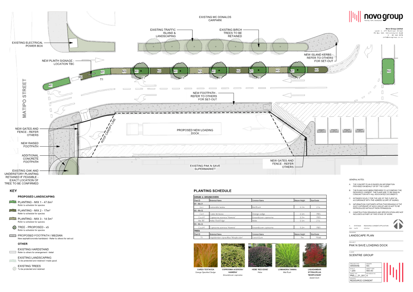
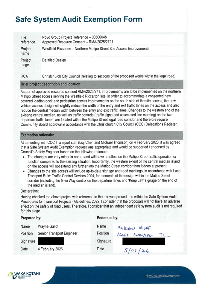
|
11. Waterloo Road Kea School Patrol Crossing
|
|
Reference Te Tohutoro:
|
26/541277
|
|
Responsible Officer(s) Te Pou Matua:
|
Nick
Reid, Traffic Engineer
Ashley Beaton, Community Travel Advisor
|
|
Accountable ELT Member Pouwhakarae:
|
Brent
Smith, General Manager City Infrastructure
|
1. Purpose and Origin of the Report Te Pūtake Pūrongo
1.1 The
purpose of this report is to recommend that the Waipuna
Halswell-Hornby-Riccarton Community Board approve a Kea School Patrol Crossing
on Waterloo Road outside the entrance to Hornby High School.
1.2 Staff
prepared this report in response to concerns raised by Hornby High School to
improve the safety of students crossing Waterloo Road before and after school.
1.3 The recommended option is to install a Kea School Patrol Crossing in
accordance with Attachment A.
2. Officer
Recommendations Ngā Tūtohu
That the Waipuna
Halswell-Hornby-Riccarton Community Board:
1. Receives the information in the Waterloo
Road Kea School Patrol Crossing Report.
2. Notes that the decision in this report is assessed as low significance
based on the Christchurch City Council’s Significance and Engagement
Policy.
3. Approves that a school crossing point is established on
Waterloo Road, located 50 metres west from the intersection of Waterloo Road
and Smarts Road, in accordance with Section 8.4 of the Land Transport Rule:
Traffic Control Devices 2004, and as shown in Attachment A.
4. Approves that pursuant to Section 8.3 of the Land Transport Rule:
Traffic Control Devices 2004, and the Local Government Act 1974, the
Christchurch City Council hereby authorises the Board of Trustees of Hornby
High School, to appoint the appropriately trained persons to act as school
patrols at the school crossing point on Waterloo Road, located 50 metres west
from its intersection with Smarts Road.
5. Approves that any previously approved resolutions be revoked, in
accordance with Section 2 of the Land Transport-Traffic Control Devices
Rule: 2004, pertaining to traffic controls, made pursuant to any Bylaw, Local
Government Act or any Land Transport Rule, to the extent that they are in
conflict with, or recommended to be removed, in regard to the traffic controls
described in recommendations 3 and 4 above.
6. Approves that these resolutions take effect when parking signage
and/or road marking that evidence the restrictions described in 3, 4, or 5 are
in place (or removed in the case of revocations).
3. Executive Summary Te Whakarāpopoto Matua
3.1 The
Council received a request from Hornby High School for safety improvements on
Waterloo Road before and after school hours. The key concern raised was the
large groups of children crossing the road after school and the high number of
heavy vehicles using the road.
3.2 The
recommendation is to install a Kea School Patrol Crossing as shown in Attachment
A. This will reduce the risk of crashes by providing students a supervised crossing
point so they can safely cross.
4. Background/Context Te Horopaki
4.1 Students
currently use the three refuge island crossings on Waterloo Road to cross the
road. A school staff member is generally present to supervise them while they
cross as pedestrians at this location do not have the right of way.
4.2 A
Kea School Patrol Crossing at this location will provide a safe and controlled
crossing facility for students before and after school hours, thereby improving
safety around this location.
4.3 Waterloo
Road has a posted speed limit of 50 km/h except between before and after school
Monday to Friday when a school speed limit of 30 km/h operates.
4.4 Safety
improvements were made in 2022 to Waterloo Road in response to concerns raised
by the students at Hornby High School. Pedestrian islands, traffic calming, and
new road markings were approved and added to Waterloo Road at this time, as
shown in Attachment B.
4.5 Since
the installation of the Waterloo Road safety improvements in 2022, there have
been two reported crashes to the New Zealand Transport Agency’s Crash
Analysis System on Waterloo Road (between the intersection of Hei Hei Road and
Carmen Road). Both crashes were side-swipe collisions with parked vehicles, one
resulting in a minor injury and the other resulting in no-injury.
4.6 A
crash involving a student and a motorist was reported to Christchurch City
Council by the school in February 2026. This crash has not been reported in the
New Zealand Transport Agency’s Crash Analysis System.
4.7 The
average operating speed of motorists on Waterloo Road is 32 km/h, and the
average weekday traffic is 6,800 vehicles per day.
4.8 On
Waterloo Road near Hei Hei Road there is a signalised pedestrian/cycle crossing
and at the signalised intersection with Carmen Road (State Highway 1) there is
a pedestrian crossing.
Options Considered Ngā
Kōwhiringa Whaiwhakaaro
4.9 The
following reasonably practicable options were considered and are assessed in
this report:
4.9.1 Install a Kea
School Patrol Crossing on Waterloo Road.
4.9.2 Do nothing.
4.10 The following
options were considered but ruled out:
4.10.1 Pedestrian crossing
signalisation – ruled out because of substantial cost.
Options Descriptions Ngā
Kōwhiringa
4.11 Preferred
Option: Install a Kea School Patrol Crossing on Waterloo Road
4.11.1 Option Description: Install
a Kea School Patrol Crossing on Waterloo Road and add supporting line markings
and signage as shown in Attachment A.
4.11.2 Option Advantages
· Provides a safe crossing facility for students before and after
school hours.
4.11.3 Option Disadvantages
· None.
4.12 Alternative
option: Do Nothing
4.12.1 Option Description: Retain
status quo
4.12.2 Option Advantages
· None.
4.12.3 Option Disadvantages
· Does not address the concerns raised about the safety of students at
this location.
5. Financial Implications Ngā Hīraunga Rauemi
Capex/Opex Ngā Utu Whakahaere
|
|
Recommended Option
|
Option 2 – Do nothing
|
|
Cost to Implement
|
$6,000
|
$0
|
|
Maintenance/Ongoing Costs
|
Covered by the existing maintenance
contract
|
N/A
|
|
Funding Source
|
Traffic Operations Team traffic signs and
markings budget
|
N/A
|
|
Funding Availability
|
Available
|
N/A
|
6. Considerations Ngā Whai Whakaaro
Risks and Mitigations Ngā
Mōrearea me ngā Whakamātautau
6.1 None
identified.
Legal Considerations Ngā
Hīraunga ā-Ture
6.2 Statutory
and/or delegated authority to undertake proposals in the report:
6.2.1 The Community
Boards have authority from the Council to exercise the delegations as set out
in the Register of Delegations. The list of delegations for the Community
Boards includes the resolution of stopping and traffic control devices.
6.2.2 The installation of
any signs and/or markings associated with traffic control devices must comply
with the Land Transport Rule: Traffic Control Devices 2004.
6.3 Other Legal Implications:
6.3.1 There is no
other legal context, issue, or implication relevant to this decision.
6.3.2 This specific
report has not been reviewed and approved by the Legal Services Unit however
the report has been written using a general approach previously approved of by
the Legal Services Unit, and the recommendations are consistent with the policy
and legislative framework outlined in this report.
Strategy and Policy Considerations Te Whai
Kaupapa here
6.4 The
required decision:
6.4.1 Aligns with
the Christchurch
City Council’s Strategic Framework.
6.4.2 Is assessed as
low significance based on the Christchurch
City Council’s Significance and Engagement Policy. The level of
significance was determined by <enter text>.
6.4.3 Is consistent with
Council’s Plans and Policies.
6.5 This
report supports the Council's
Long Term Plan (2024 - 2034):
6.6 Transport
6.6.1 Activity: Transport
· Level of Service: 10.0.6.1 Reduce the number of
death and serious injury crashes on the local road network (DIA 1) - 4 less
than previous FY
· Level of Service: 10.0.6.2 Reduce the number of
death and serious injury crashes on the local road network - Five year rolling
average <95 crashes per year
· Level of Service: 10.5.1 Limit deaths and
serious injury crashes per capita for cyclists and pedestrians - <=12
crashes per 100,000 residents
Community Impacts and Views Ngā Mariu
ā-Hāpori
6.7 Hornby
High School and CCC (Matatiki Pools and Library) were the only directly
affected stakeholders identified for this Kea School Patrol Crossing proposal.
6.8 The
Board of Trustees of Hornby High School endorses the proposal for a Kea School
Patrol Crossing on Waterloo Road.
6.9 The
New Zealand Police Education Team have agreed to train the students at this Kea
School Patrol Crossing site.
6.10 The decision
affects the following wards/Community Board areas:
6.10.1 Waipuna
Halswell-Hornby-Riccarton Community Board.
Impact on Mana Whenua Ngā Whai Take
Mana Whenua
6.11 The decision
does not involve a significant decision concerning ancestral land or a body of
water or other elements of intrinsic value, therefore this decision does not
specifically impact Mana Whenua, their culture and traditions.
6.12 The decision
does not involve a matter of interest to Mana Whenua and will not impact on our
agreed partnership priorities with Ngā Papatipu Rūnanga.
Climate Change Impact Considerations Ngā
Whai Whakaaro mā te Āhuarangi
6.15 The proposal in this report is unlikely to contribute significantly
to adaptation to the impacts of climate change or emissions reductions.
6.16 This is a minor
proposal that is principally intended to address safety concerns at this
location.
7. Next Steps Ngā Mahinga ā-muri
7.1 If
approved, the recommendations will be implemented this financial year
(generally around four weeks after the contractor receives the request, but
this is subject to other factors such as resourcing and prioritisation beyond
Council’s control).
Attachments Ngā Tāpirihanga
|
No.
|
Title
|
Reference
|
Page
|
|
a ⇩
|
TG153047-HornbyHighSchool-KeaSchoolPatrolCrossing
|
26/541843
|
226
|
|
b ⇩
|
Halswell-Hornby-Riccarton
Community Board Waterloo Road Improvements 20 September 2022 Report
|
22/1024134
|
227
|
In addition to the attached documents, the following background
information is available:
|
Document
Name – Location / File Link
|
|
Not
applicable
|
Signatories Ngā Kaiwaitohu
|
Authors
|
Nick Reid -
Traffic Engineer
Ashley Beaton
- Team Leader Travel Demand Management
|
|
Approved By
|
Kathy Graham -
Team Leader Traffic Operations
Stephen Wright
- Head of Transport & Waste Management
|
|
12. Waipuna
Halswell-Hornby-Riccarton Community Board Discretionary Response Fund 2025-26
Halswell United Association Football Club Incorporated
|
|
Reference Te Tohutoro:
|
26/480442
|
|
Responsible Officer(s) Te Pou Matua:
|
Helen
Miles, Community Recreation Advisor
|
|
Accountable ELT Member Pouwhakarae:
|
Andrew
Rutledge, General Manager Citizens and Community
|
1. Purpose and Origin of the Report Te Pūtake Pūrongo
1.1 The
purpose of this report is for the Waipuna Halswell-Hornby-Riccarton Community
Board to consider an application for funding from its 2025-26
Discretionary Response Fund from the organisation listed below.
|
Funding Request Number
|
Organisation
|
Project Name
|
Amount Requested
|
Amount Recommended
|
|
DRF25/26_00023_HHR
|
Halswell United Association Football Club Incorporated
|
Lights at Ngā Puna Wai
|
$1507.20
|
$1400.00
|
1.2 There
is currently a balance of $65,541 remaining in the fund.
2. Officer Recommendations Ngā Tūtohu
That the Waipuna
Halswell-Hornby-Riccarton Community Board:
1. Receives the information in the Waipuna
Halswell-Hornby-Riccarton Community Board Discretionary Response Fund 2025-26
Halswell United Association Football Club Incorporated Report.
2. Notes that the decisions in this report are assessed as low
significance based on the Christchurch City Council’s Significance and
Engagement Policy.
3. Approves a grant of $1,400 from its 2025/26 Discretionary Response
Fund to the Halswell United Association Football Club Incorporated towards Ngā
Puna Wai venue lighting hire costs.
3. Key Points Ngā Take Matua
Strategic Alignment Te Rautaki
Tīaroaro
3.1 The
recommendations above are aligned with the Council's Strategic Framework and in
particular the strategic priority of be an inclusive
and equitable city and balancing the needs of today and the future. The project also aligns with the Physical
Recreation & Sport Strategy.
3.2 The
recommendations are consistent with the Strengthening Communities Together
Strategy.
Decision Making Authority Te Mana
Whakatau
3.3 The
Community Board has the delegated authority to determine the allocation of the
Discretionary Response Fund for each community.
3.3.1 Allocations must be
consistent with any Council-adopted policies, standards or criteria.
3.3.2 The Fund does not
cover:
· Legal or environmental court challenges
against the Council, Council Controlled Organisations, or Community Board
decisions.
· Projects or initiatives that change the scope of a Council project
or lead to ongoing operational costs to the Council
(though Community Boards can recommend to the Council that it consider a grant
for this purpose).
Assessment of Significance and Engagement Te
Aromatawai Whakahirahira
3.4 The decisions in this report are assessed as
low significance based on the Christchurch City Council’s Significance
and Engagement Policy.
3.5 The significance level was determined by the number of people
affected and/or with an interest.
3.6 Due to the assessment of low significance, no further community
engagement and consultation is required.
Discussion Kōrerorero
3.7 At the time of writing, the balance of the 2025/26 Discretionary
Response Fund is:
|
Total Budget Current Year
|
Granted To Date
|
Available for allocation
|
Balance If Staff Recommendation adopted
|
|
$108,820
|
$46,778
|
$65,541
|
$64,141
|
3.8 Based
on the current Discretionary Response Fund criteria, the application above is
eligible for funding.
3.9 The
attached Decision Matrix provides detailed information for the
application. This includes organisational details, project details,
financial information, and a staff assessment.
Attachments Ngā Tāpirihanga
|
No.
|
Title
|
Reference
|
Page
|
|
a ⇩ 
|
Waipuna Halswell
Hornby Riccarton Discretionary Response Fund Decision Matrix Halswell United
Association Football Club Incorporated
|
26/486571
|
237
|
Signatories Ngā Kaiwaitohu
|
Author
|
Helen Miles -
Community Recreation Advisor
|
|
Approved By
|
Bailey
Peterson - Manager Community Governance, Halswell-Hornby-Riccarton
|
|
13. Waipuna Halswell-Hornby-Riccarton Community
Board Area Report - April 2026
|
|
Reference Te Tohutoro:
|
26/80377
|
|
Responsible Officer(s) Te Pou Matua:
|
Bailey
Peterson, Manager Community Governance
|
|
Accountable ELT Member Pouwhakarae:
|
Andrew
Rutledge, General Manager Citizens and Community
|
1. Purpose of Origin of the Report Te Pūtake Pūrongo
1.1 This
report provides the Board with an overview of initiatives and
issues current within the Community Board area.
1.2 This
report is staff-generated monthly.
2. Officer Recommendations Ngā Tūtohu
That the Waipuna
Halswell-Hornby-Riccarton Community Board:
1. Receives the information in the Waipuna
Halswell-Hornby-Riccarton Community Board Area Report - April 2026.
3. Community Support, Governance and Partnership Activity
3.1 Community Governance Projects
· Community Service and Youth Service Awards 2026
Nominations
for the Community Service and Youth Service Awards 2026 were open from Friday 6
March until Sunday 5 April 2026.
Award
nominations have been received and will be considered at the Board’s 12 May
2026 meeting.
The Community
Board will be presenting Halswell-Hornby-Riccarton Community Service and Youth
Service Awards 2026 to recipients out in the community.
· Community Pride Garden Awards 2026
A drop-in day
for Halswell-Hornby-Riccarton Community Pride Garden Award recipients to
collect their certificates, was held on 2 April 2026, at Rārākau:
Riccarton Centre.
The awards
are a Council initiative started in 1991, and have been a joint venture between
the Community Boards and the Christchurch Beautifying Association since 1997.
Attendees
were able to connect with other award recipients over a cup of tea or coffee,
learn about local community gardens and events and meet with Christchurch
Beautifying Association and Community Board members, who were also in
attendance over the course of the day.
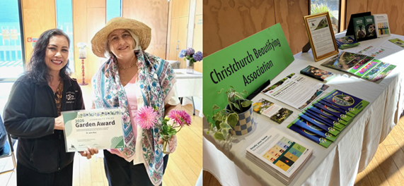
· Reregistering
under the Incorporated Societies Act 2022
The
Incorporated Societies Act 2022 requires organisations to re-register by 5
April 2026.
Staff have
been supporting and advising organisations to meet this deadline. This has
included contacting groups yet to re-register and facilitating a workshop with
the Central Riccarton community to refresh their constitution and gain new
members.
· Upper
Riccarton Community Connections Showcase Series

A series of
vibrant community events took place at Upper Riccarton Memorial Park at 372
Riccarton Road including children’s performances and sausage sizzles.
Additional
dates remain available in this pilot programme for groups interested in taking
part throughout April.
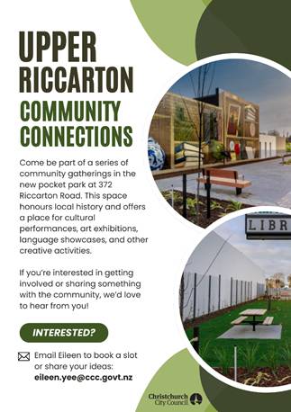
· Culture Galore
Culture Galore was successfully delivered on Saturday, 21 March,
with excellent weather conditions and a strong turnout from a wide cross
section of Ōtautahi’s diverse communities. This year marked the
first time the event was held at the new venue, and early observations indicate
that the site functioned effectively for both attendees and participants.
Feedback from stallholders was highly positive. Many fundraising
stalls reported higher revenue compared with previous years, and information
stalls noted strong engagement from the public throughout the day.
The event included representation from approximately 39 cultural
communities, offering a wide range of performances, cuisine, and cultural
activities. Following a blessing from Mana Whenua, the Mayor and Councillor
Jimmy Chen formally opened the event. Their remarks acknowledged the two
community boards that have historically led the event and highlighted the
strengthened partnerships with the Christchurch Multicultural Centre and
community representatives.
The Bike Valet service experienced steady use, with many attendees
opting to cycle. Several visitors also commented that car parking was easier to
access than anticipated in the new location.
The event attracted attendance from numerous key community
dignitaries, including local government representatives, national government
representatives and community leaders reinforcing Culture Galore’s
significance as a key celebration of the city’s cultural diversity and
community connections.
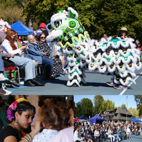
3.2 Community
Events
· Hello Hornby – Our Community Party in the Park
The Hello Hornby event was successfully held on 7 March at Wycola
Park, attracting hundreds of attendees.
Organised by a dedicated committee of community volunteers with the
support of Hornby Community Care Trust, the event offered a vibrant programme, including
on‑stage entertainment, displays from local groups, a baking
competition, craft stalls, and a wide range of free activities that were
enjoyed by people of all ages.
A bus service was also provided to and from Hello Hornby, connecting
various parts of the wider Hornby area to improve accessibility for attendees.
· Canterbury Malaysian Society Chinese New Year Banquet
The Canterbury Malaysian Society celebrated the arrival of the 2026
Year of the Horse with its annual Chinese New Year Banquet at Madam
Kwong’s on Blenheim Road.
The evening featured the auspicious “Lao Sheng” tossing tradition—where
guests mix a shared salad and salmon dish for good fortune—alongside a
vibrant lion dance performance and a calligraphy writing competition.
· Riccarton High School Culture Fest
Culture Fest is a celebration of cultural diversity in the Riccarton
community. It is held annually at Riccarton High School, attracting
approximately 1,000 attendees.
Highlights included diverse food, activity and information stalls
– including stalls from Christchurch City Council’s waste, travel
and Civil Defence and Emergency Management teams.

· ANZAC Day Services 2026
Local services being held on Saturday 25 April include:
- 20th
Battalion Association Commemoration ANZAC Service,
Jane Deans Close, Riccarton, 9am
- Halswell
ANZAC Service, Halswell Domain, Halswell Road, 9am
- Hornby
ANZAC Service, Hornby Primary School, 190 Waterloo
Road, 9am
- UCSA
hosted ANZAC Service, Matariki Quad, University of
Canterbury, 20 Kirkwood Avenue, 10am
- Templeton
ANZAC Service, 38 Kirk Road, Templeton, 10.45am
- Wigram
ANZAC Service, Air Force Museum of New Zealand, 45
Harvard Avenue, 12noon
3.3 Community
Funding Summary
3.3.1 For information, a
summary is provided on the status of the Board's 2025-26 funding as at 26 March
2026 (see Attachment A).
3.3.2 Funding
Accountability Report
The
Halswell-Hornby-Riccarton funding accountability report for the 2024-2025
Strengthening Communities Fund is attached (see Attachment B).
3.3.3 Youth Development Fund
Under authority
delegated to the Community Governance Manager, the following allocation was
made in March 2026:
· $540 to Jox Blue Blades Rowing Society Inc towards supporting Toby
Greer, Tyson Arps, Sam McGuigan, Lukas Dowling, Harry Gallagher and Jack Dunn
representing St Thomas of Canterbury College at the New Zealand Secondary
Schools Rowing Regatta (Maadi Cup) in Twizel.
3.3.4 Summer with your
Neighbours
Under authority
delegated to the Community Governance Manager, the following allocations were
made in March 2026:
· $90 to Libby Doran towards a Neighbourhood BBQ for Dumfries Drive
residents.
· $75 to Brooke Jamieson towards a Neighbourhood BBQ for Muirhill
Street residents.
It was advised
that two events with a combined allocated amount of $275, were cancelled,
allowing this amount to be available for reallocation from the Summer with your
Neighbours fund.
A Summer with your neighbours community gathering on
Longspur Avenue.
A total of 36
applications were received and allocated funding, between October 2025 and 23
March 2026. Highlights noted by participants include the following:
· Engaging and socialising with old and new neighbours. Welcoming new
people.
· The kids had a great time having face paint, the sun was shining and
getting to chat to everyone about their Christmas/summer plans.
· Just catching up with everyone. Apart from the barbeque some people
we don't see to talk to very often, however we know we can rely on each other
if need be.
· It was a really great time to reconnect and celebrate the year
that’s been. We had people come along we hadn’t seen in a few
months.
3.4 Participation
in and Contribution to Decision Making
3.4.1 Report back on
other Activities contributing to Community Board Plan [for items not
included in the above table but are included in Community Board Plan]
· The Community Board Plan 2026-28 is currently being developed, see
3.4.2
3.4.2 Council Engagement
and Consultation.
· Waipuna Halswell-Hornby-Riccarton Community Board Plan 2026-28
A Community
Board Plan is a three-year plan that sets out the Community Board’s
vision and priorities for the local community. It guides decisions on local
activities, projects, and facilities, and helps the board understand what their
communities would like them to advocate for.
Feedback on the
Board’s Draft Community Board Plan was open from 4 March to 22 March
2026.
The Board will
consider feedback and is scheduled to adopt its Board Plan on 12 May 2026.
· Planning for Hornby
Christchurch
City Council, New Zealand Transport Agency and Canterbury Regional Council are all
in the early stages of developing local plans for Hornby.
For the first
phase of engagement, feedback is being sought on the Draft priorities identified
for Hornby’s Local Area Plan. There will be further opportunities to
provide feedback on the plans.
· Tree Planting Plans
Consultation on
a number of planting plans in the Waipuna Halswell-Hornby-Riccarton Community
Board area closed on 22 March 2026.
A report on
these will be presented to the Community Board on 28 April 2026.
· Private Plan Change 18
The Board
recently lodged a submission on Private Plan Change 18 asking that approval of
the plan change only be given where adequate provision is made to address the
existing and future deficiencies in the transport system and infrastructure
together with flooding issues in the local area. See Attachment C.
· Draft
Annual Plan 2026/27
Consultation on the Draft Annual
Plan was open between 27 February and 27 March 2026.
4. Advice Provided to the Community Board Ngā Kupu Tohutohu ka
hoatu ki te Poari Hapori
4.1 Public
Forum - Kahu Road and Titoki Street Bus Activity Memorandum
Following a Public Forum presentation to the Board meeting on 10
February 2026 the Board requested that staff provide detailed advice, including
traffic counts, vehicle types and movements, and potential traffic management
or restrictions, on the Kahu Road rehabilitation programme, with particular
regard to vibrations on Kahu Road. Staff have now responded to the request
advising that the following proposed interventions are appropriate and aligned
with asset condition data and site observations and are expected to mitigate
existing defects and help address vibration concerns ahead of final works:
· Resurfacing of sections of Kahu Road.
· Rehabilitation at the Kahu Road/Straven Road intersection.
· Resurfacing in Titoki Street.
See
memorandum, Attachment D.
4.2 Visibility
of Traffic Island on Sparks Road
At its meeting on 10 August 2023 NZTA the Board requested staff
advice on possible measures that can be taken to improve visibility of the
traffic island on Sparks Road, between Collier Drive and Hendersons Road.
Staff have now provided advice that investigation has shown that
delineation for island meets requirements. Crash records at the site show that
visibility of the island was not identified as contributing to the crashes.
4.3 Community
Patrols
Community Patrols of New Zealand is dedicated to helping build safer
communities in partnership with NZ Police and other organisations. Patrols in
the Board area include the Halswell, Hornby and Riccarton Community Patrols.
Their Monthly Patrol Statistics can be found on the Community Patrols of New
Zealand website:
Halswell
Community Patrol Inc statistical information
Hornby
Community Patrol Inc statistical information
Riccarton
Community Patrol Inc statistical information
4.4 Graffiti
Snapshot
For the Board’s information, attached is a copy of the
February 2026 Graffiti Snapshot (see Attachment E).
4.5 Customer
Service Requests/Hybris Report
For the Board’s information, attached is a copy of the
February 2026 Hybris Report (see Attachment F).
The report provides an overview of the number of Customer Service
Requests that have been received, including the types of requests being
received and a breakdown of how they are being reported.
Attachments Ngā Tāpirihanga
|
No.
|
Title
|
Reference
|
Page
|
|
a ⇩
|
Halswell-Hornby-Riccarton 2024-25 SCF End of Project Report
|
26/619801
|
249
|
|
b ⇩
|
Waipuna Halswell-Hornby-Riccarton Community Board Funding Update -
26 March 2026
|
26/618222
|
277
|
|
c ⇩
|
Submission - Plan Change 18
|
26/601448
|
279
|
|
d ⇩ 
|
Staff Memorandum - Kahu Road and Titoki Street Bus Activity
|
26/601642
|
281
|
|
e ⇩ 
|
Graffiti Snapshot - February 2026
|
26/558474
|
283
|
|
f ⇩
|
Community Board Hybris Ticket Report - Halswell-Hornby-Riccarton -
February 2026
|
26/558465
|
285
|
Signatories Ngā Kaiwaitohu
|
Authors
|
Noela Letufuga
- Support Officer
Marie Byrne -
Community Development Advisor
Eileen Yee -
Community Development Advisor
Helen Miles -
Community Recreation Advisor
Faye Collins -
Community Board Advisor
|
|
Approved By
|
Bailey
Peterson - Manager Community Governance, Halswell-Hornby-Riccarton
Matthew
McLintock - Manager Community Governance Team
John Filsell -
Head of Community Support and Partnerships
|
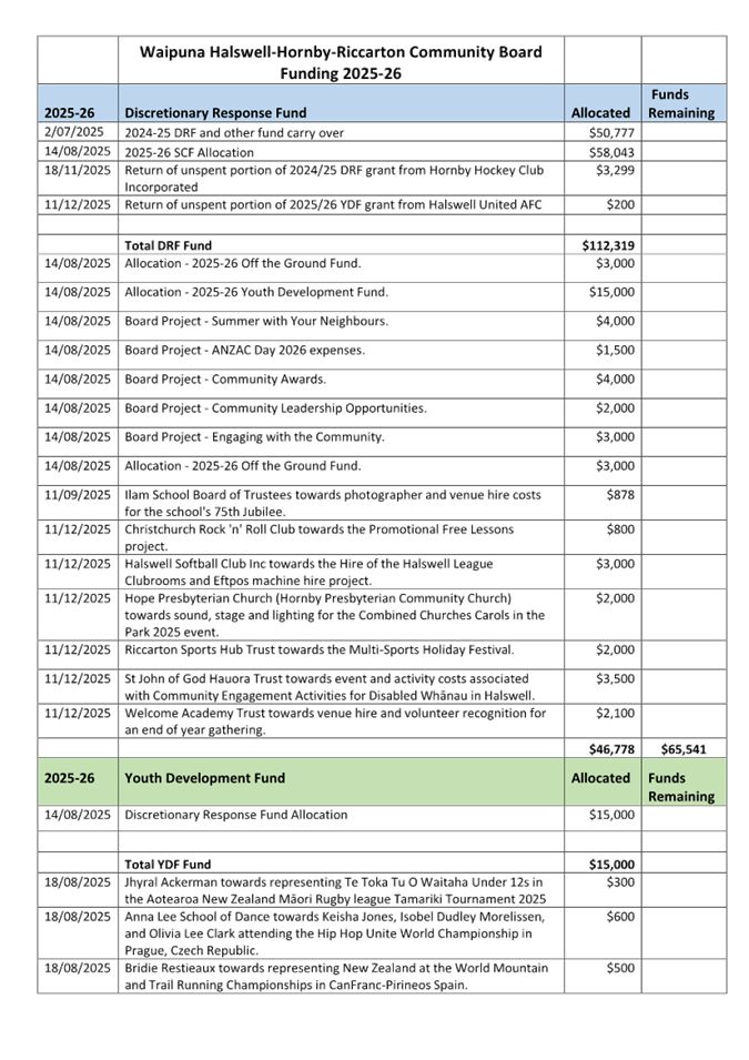
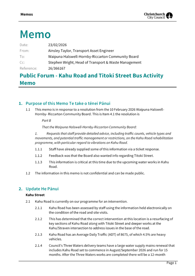
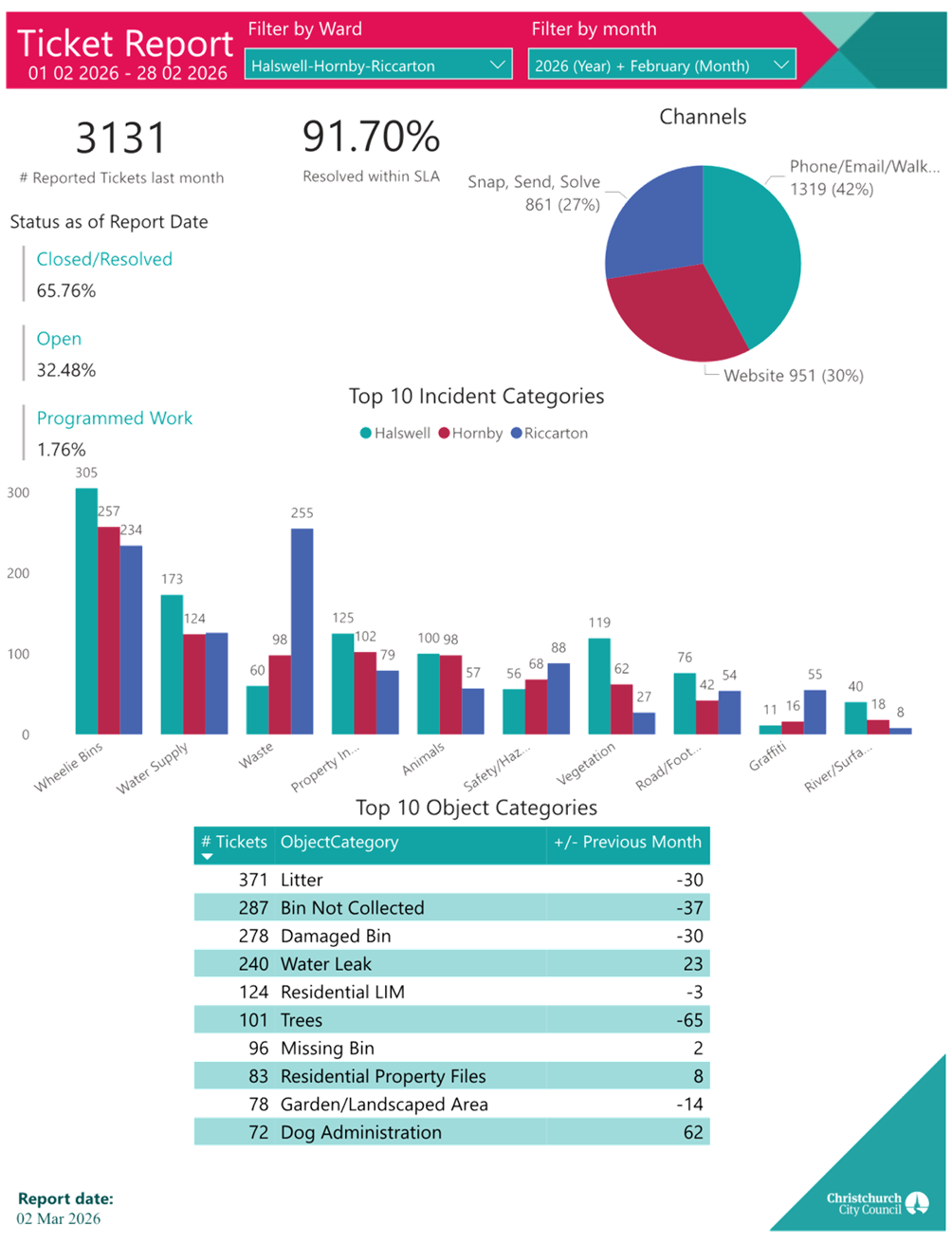
|
14. Elected
Members’ Information Exchange Te Whakawhiti Whakaaro o Te
Kāhui Amorangi
|
This item provides an opportunity for Board Members to
update each other on recent events and/or issues of relevance and interest to
the Board.
Karakia Whakamutunga
|
Unuhia, unuhia
Unuhia ki te uru tapu nui
Kia wātea, kia māmā, te ngākau,
Te tinana te wairua i te ara takatā
Koia rā e Rongo, whakairia ake ki runga
Kia tina! TINA! Hui e! TĀIKI E!
|
Draw on, draw on,
Draw on the supreme sacredness
To clear, to free the heart, the body and the spirit of mankind
Rongo, suspended high above us (i.e. in ‘heaven’)
Draw together! Affirm!
|
Actions Register Ngā Mahinga
When decisions are made at meetings, these
are assigned to staff as actions to implement. The following lists
detail any actions from this meeting that were:
- Open at the time the agenda was
generated.
- Closed since the last ordinary meeting
agenda was generated.
Open Actions Ngā Mahinga Tuwhera
|
REPORT TITLE/AGENDA SECTION
|
MEETING DATE
|
ACTION DUE DATE
|
UNIT
|
TEAM
|
|
Public Forum - Cycling
priorities in the Community Board area
|
14 August 2025
|
30 April 2026
|
Transport & Waste
|
Asset Planning
|
|
William Brittan / Milns /
Kearns intersection
|
15 May 2025
|
30 April 2026
|
Transport & Waste
|
Asset Planning
|
|
Halswell Quarry Dog Exercise
Area
|
14 August 2025
|
1 May 2026
|
Parks
|
Parks & Recreation Planning
|
|
Correspondence
|
10 February 2026
|
12 May 2026
|
Transport & Waste
|
Traffic Operations
|
|
English St/Main South Rd -
Pedestrian Safety Improvements
|
10 February 2026
|
12 May 2026
|
Transport & Waste
|
Traffic Operations
|
|
Nicholls Road/Oakridge Street
- Pedestrian Safety Improvements
|
10 February 2026
|
12 May 2026
|
Transport & Waste
|
Traffic Operations
|
|
Petition - Traffic Calming
Measures on Awatea Gardens, Wigram
|
11 December 2025
|
12 May 2026
|
Transport & Waste
|
Traffic Operations
|
|
Whakatā Christchurch
Cemetery Concept Plan
|
10 February 2026
|
12 May 2026
|
Parks
|
Planning & Policy
|
|
Bus stop changes in response
to bus route 60 detour
|
10 March 2026
|
9 June 2026
|
Transport & Waste
|
Traffic Operations
|
|
Steadman Road Traffic
|
10 March 2026
|
9 June 2026
|
Transport & Waste
|
Asset Planning
|
|
Steadman Road Traffic
|
10 March 2026
|
9 June 2026
|
Transport & Waste
|
Traffic Operations
|
|
Te Kāhu Park, Awatea
Athletics New build Application
|
10 March 2026
|
9 June 2026
|
F&P Unit
|
Property Consultancy
|
|
Public Forum - Hornby
Menzshed
|
10 April 2025
|
30 June 2026
|
CS&P
|
CS&P - Governance Process
|
|
Public Forum - Te Kuru
Wetlands Interpretive Centre Project
|
10 July 2025
|
30 June 2026
|
Parks
|
Parks & Recreation Planning
|
|
Public Forum - Kyle Park Pump
Track
|
11 December 2025
|
12 August 2026
|
Parks
|
Parks & Recreation Planning
|
Actions Closed Since the Last Meeting
Ngā Mahinga kua Tutuki nō Tērā Hui
|
REPORT TITLE/AGENDA SECTION
|
MEETING DATE
|
DUE DATE
|
ACTION CLOSURE DATE
|
UNIT
|
TEAM
|
|
Public Forum - Kahu Road and
Titoki Street Bus Activity
|
10 February 2026
|
12 May 2026
|
7 April 2026
|
Transport & Waste
|
Asset Management
|
|
Tiora Place - Proposed No
Stopping Restrictions
|
10 March 2026
|
9 June 2026
|
17 March 2026
|
Transport & Waste
|
Traffic Operations
|
|
Tree Removals - 22 Milns Road
(new school site)
|
10 March 2026
|
9 June 2026
|
8 April 2026
|
Planning & Consents
|
Case Managers
|