Waimāero
Fendalton-Waimairi-Harewood Community Board
Agenda
Notice of Meeting Te Pānui o te Hui:
The ordinary meeting of the Waimāero
Fendalton-Waimairi-Harewood Community Board will be held on:
Date: Monday 20 April 2026
Time: 4.30 pm
Venue: Boardroom, Fendalton Service Centre,
Corner Jeffreys and Clyde Roads, Fendalton
Membership Ngā
Mema
|
Chairperson
Deputy Chairperson
Members
|
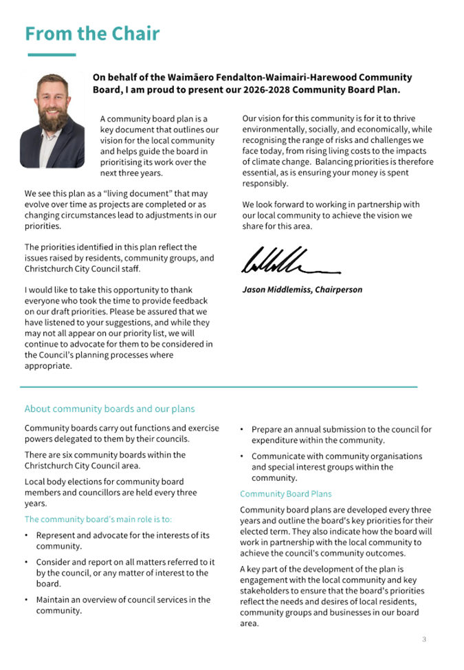
Jason Middlemiss
Nicola McCormick
David Cartwright
James Gough
Aaron Keown
Lucy Keown
Sam MacDonald
Ben Spittle
Bridget Williams
|
14 April 2026
Website: www.ccc.govt.nz
Part A Matters
Requiring a Council Decision
Part B Reports
for Information
Part C Decisions
Under Delegation
TABLE OF CONTENTS NGĀ IHIRANGI
Karakia Tīmatanga................................................................................................... 5
C 1. Apologies Ngā Whakapāha.......................................................................... 5
B 2. Declarations of Interest Ngā Whakapuaki Aronga........................................... 5
C 3. Confirmation of Previous Minutes Te Whakaāe o te
hui o mua.......................... 5
B 4. Public Forum Te Huinga Whānui.................................................................. 5
B 5. Deputations by Appointment Ngā Huinga
Whakaritenga................................. 5
B 6. Presentation
of Petitions Ngā
Pākikitanga.................................................... 5
Staff Reports
C 7. Proposed
Road Names - 232 Highsted Road, Casebrook................................ 11
C 8. Proposed
Road Names - 65 Grampian Street, Casebrook............................... 17
C 9. Radcliffe
Road Corridor Improvement........................................................ 23
C 10. Marshland
Road / Main North Road / Spencerville Road Intersection Improvements Report.................................................................................................... 43
C 11. Glandovey/Heaton/Rossall/Strowan
- Right turn arrows............................... 51
C 12. Grant an
Easement for Fibre Installation to Enable, at Tulett Park, Casebrook. 57
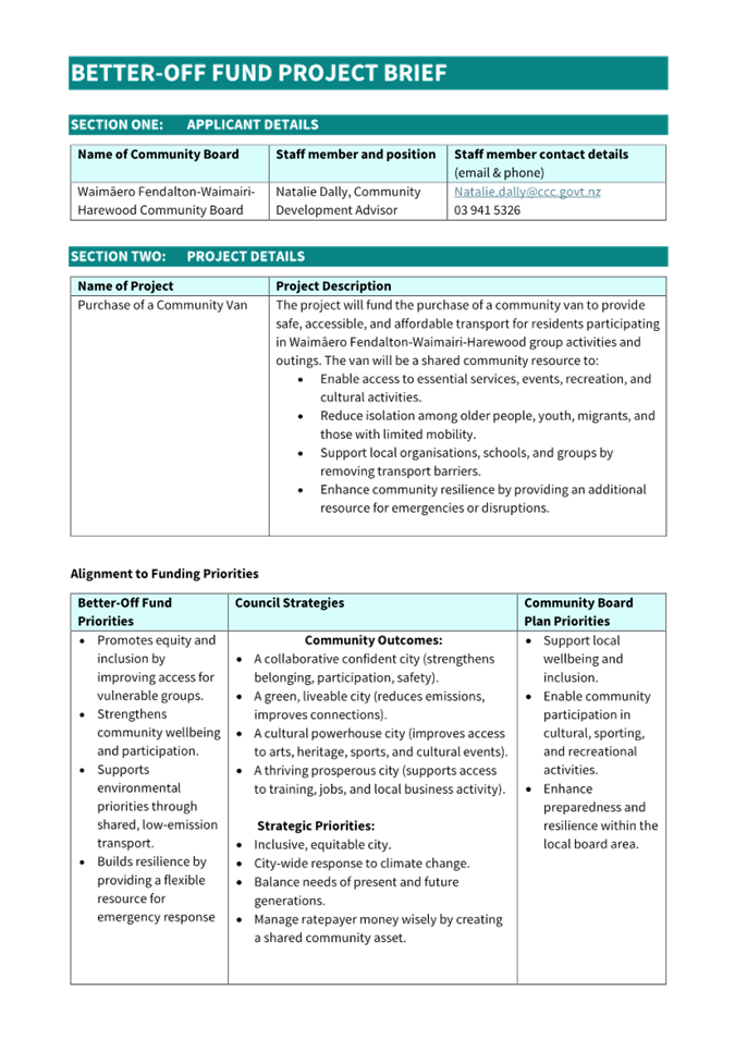
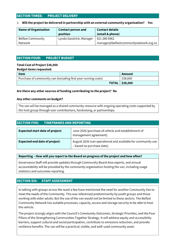
C 13. Waimāero
Fendalton-Waimairi-Harewood - Better-Off Fund Application for Consideration -
Belfast Community Network............................................... 79
C 14. Waimāero
Fendalton-Waimairi-Harewood 2025/26 Youth Development Fund Applications -
Kaitlyn Adams and Burnside High School................................ 85
C 15. Fendalton-Waimairi-Harewood
Youth Development Fund - Approval Process.. 89
C 16. Waimāero
Fendalton-Waimairi-Harewood 2026-28 Community Board Plan..... 91
C 17. Waimāero
Fendalton-Waimairi-Harewood Community Board Area Report - April 2026..................................................................................................... 137
B 18. Elected Members’
Information Exchange Te Whakawhiti
Whakaaro o Te Kāhui Amorangi............................................................................................................ 150
C 19. Resolution
to Exclude the Public.............................................................. 151
Karakia Whakamutunga
Actions Register Ngā Mahinga Tuwhera
Karakia Tīmatanga
|
Whakataka te hau ki te uru
Whakataka te hau ki te tonga
Kia mākinakina ki uta
Kia mātaratara ki tai
E hī ake ana te atakura
He tio, he huka, he hau hū
Tīhei Mauri Ora
|
Cease the winds from the west
Cease the winds from the south
Let the breeze blow over the land
Let the breeze blow over the ocean
Let the red-tipped dawn come with a sharpened air.
A touch of frost, a promise of a glorious day.
|
1. Apologies Ngā Whakapāha
Apologies will
be recorded at the meeting.
2. Declarations of Interest Ngā
Whakapuaki Aronga
Members are
reminded of the need to be vigilant and to stand aside from decision-making
when a conflict arises between their role as an elected representative and any
private or other external interest they might have.
3. Confirmation of Previous Minutes Te
Whakaāe o te hui o mua
That the
minutes of the Waimāero Fendalton-Waimairi-Harewood Community Board
meeting held on Monday, 16 March 2026 be confirmed
(refer page 6).
4. Public Forum Te Huinga Whānui
A period of up
to 30 minutes will be available for people to speak for up to five minutes on
any issue that is not the subject of a separate hearing process.
Public Forum presentations will be
recorded in the meeting minutes.
5. Deputations by Appointment Ngā Huinga
Whakaritenga
Deputations may
be heard on a matter or matters covered by a report on this agenda and approved
by the Chairperson.
Deputations will be recorded in the
meeting minutes.
6. Presentation of Petitions Ngā
Pākikitanga
There were no petitions
received at the time the agenda was prepared.
To present to the Community
Board, refer to the Participating in decision-making webpage or
contact the meeting advisor listed on the front of this agenda.

Waimāero
Fendalton-Waimairi-Harewood
Community Board
Open
Minutes
Date: Monday 16 March 2026
Time: 4.31 pm
Venue: Boardroom, Fendalton Service
Centre,
Corner Jeffreys and Clyde Roads, Fendalton
Present
|
Chairperson
Deputy Chairperson
Members
|
Jason Middlemiss
Nicola McCormick
David Cartwright
James Gough
Aaron Keown
Lucy Keown
Sam MacDonald
Ben Spittle
Bridget Williams
|
Website: www.ccc.govt.nz

Part A Matters
Requiring a Council Decision
Part B Reports
for Information
Part C Decisions
Under Delegation
Karakia
Tīmatanga
|
Whakataka te hau ki te uru
Whakataka te hau ki te tonga
Kia mākinakina ki uta
Kia mātaratara ki tai
E hī ake ana te atakura
He tio, he huka, he
hauhūnga
Tīhei mauri ora
|
Cease the winds from the
west
Cease the winds from the south
Let the breeze blow over the land
Let the breeze blow over the ocean
Let the red-tipped dawn come with a sharpened air.
A touch of frost, a promise of a glorious day.
|
The agenda was dealt
with in the following order. Where no voting record is shown, the item was
carried unanimously by those present.
1. Apologies Ngā Whakapāha
Part C
2. Declarations of Interest Ngā Whakapuaki Aronga
Part B
There were no declarations of interest recorded.
3. Confirmation of Previous Minutes Te Whakaāe o te hui o mua
Part C
|
Community Board Resolved FWHB/2026/00012
That the minutes of the Waimāero
Fendalton-Waimairi-Harewood Community Board meeting held on Monday, 16
February 2026 be confirmed.
David Cartwright/Ben Spittle Carried
|
4. Public Forum Te Huinga Whānui
Part B
|
4.1 Staveley
Street Shops
|
|
Mark
Smith, local business owner, addressed the Board to provide feedback on the
recent parking changes outside the Staveley Street Shops, and to discuss
disability parking arrangements.
|
5. Deputations by Appointment Ngā Huinga Whakaritenga
Part B
There were no deputations by appointment.
6. Presentation of Petitions Ngā Pākikitanga
Part B
There was no presentation of petitions.
|
7. Correspondence
|
|
|
Community Board Resolved
FWHB/2026/00013
Officer recommendations
accepted without change.
Part B
That the Waimāero Fendalton-Waimairi-Harewood
Community Board:
1. Receives the information in the correspondence
report dated 16 March 2026
Nicola McCormick/Aaron Keown Carried
|
|
8. Jellie Park Recreation &
Sport Centre Storeroom
|
|
|
Community Board Resolved
FWHB/2026/00014
Officer recommendations
accepted without change.
Part C
That the Waimāero Fendalton-Waimairi-Harewood
Community Board:
1. Receives the information in the Jellie Park Recreation &
Sport Centre Storeroom Report.
2. Approves construction of a new storeroom
addition to the Jellie Park Recreation & Sport Centre building adjacent
to the indoor pool plantroom.
3. Notes that the decision in this report is
assessed as low significance based on the Christchurch City Council’s
Significance and Engagement Policy.
Aaron Keown/David Cartwright Carried
|
|
9. Fendalton-Waimairi-Harewood
2025-26 Discretionary Response Fund Applications - Belfast Residents
Association, Burnside Bowling Club Inc, Heartfelt NZ Trust and Wildlife
Veterinary Trust
|
|
|
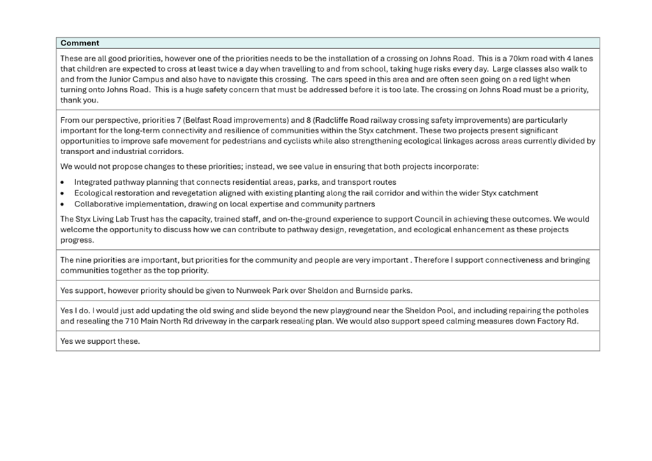
Community Board Comment
The Community
Board decided to the grant the Burnside Bowling Club $4,000, an increase of
$2,000 compared to the staff recommendation. The remainder of the staff
recommendations were accepted without change.
|
|
|
Officer Recommendations
Ngā Tūtohu
That the Waimāero Fendalton-Waimairi-Harewood
Community Board:
1. Receives the information in the report:
Fendalton-Waimairi-Harewood 2025-26 Discretionary Response Fund Applications
- Belfast Residents Association, Burnside Bowling Club Inc, Heartfelt NZ
Trust and Wildlife Veterinary Trust.
2. Notes that the decisions in this report are
assessed as low significance based on the Christchurch City Council’s
Significance and Engagement Policy.
3. Approves a grant of $466 from its 2025-26
Discretionary Response Fund to the Belfast Area Residents Association towards
website hosting, domain name and email address annual subscription fees.
4. Approves a grant of $2,000 from its 2025-26
Discretionary Response Fund to Burnside Bowling Club Inc towards re-sealing
and improvement of the Club's car park.
5. Approves a grant of $3,550 from its 2025-26
Discretionary Response Fund to Heartfelt New Zealand Harvest Trust towards
operational and volunteer costs for the Heartfelt Community Drop-in Centre.
6. Approves a grant of $10,000 from its 2025-26
Discretionary Response Fund to Wildlife Veterinary Trust (known as South
Island Wildlife Hospital) towards the purchase of a sump and up to six months
wages for a volunteer coordinator.
|
|
|
Community Board Resolved
FWHB/2026/00015
Part C
That the Waimāero Fendalton-Waimairi-Harewood
Community Board:
1. Receives the information in the report:
Fendalton-Waimairi-Harewood 2025-26 Discretionary Response Fund Applications
- Belfast Residents Association, Burnside Bowling Club Inc, Heartfelt NZ
Trust and Wildlife Veterinary Trust.
2. Notes that the decisions in this report are
assessed as low significance based on the Christchurch City Council’s
Significance and Engagement Policy.
3. Approves a grant of $466 from its 2025-26
Discretionary Response Fund to the Belfast Area Residents Association towards
website hosting, domain name and email address annual subscription fees.
4. Approves a grant of $4,000 from its 2025-26
Discretionary Response Fund to Burnside Bowling Club Inc towards re-sealing
and improvement of the Club's car park.
5. Approves a grant of $3,550 from its 2025-26
Discretionary Response Fund to Heartfelt New Zealand Harvest Trust towards
operational and volunteer costs for the Heartfelt Community Drop-in Centre.
6. Approves a grant of $10,000 from its 2025-26
Discretionary Response Fund to Wildlife Veterinary Trust (known as South
Island Wildlife Hospital) towards the purchase of a sump and up to six months
wages for a volunteer coordinator.
Sam MacDonald/Ben Spittle Carried
|
|
10. Waimāero Fendalton-Waimairi-Harewood
Community Board Area Report - March 2026
|
|
|
Community Board Resolved
FWHB/2026/00016
Officer recommendations
accepted without change.
Part B
That the Waimāero Fendalton-Waimairi-Harewood
Community Board:
1. Receives the information in the Waimāero Fendalton-Waimairi-Harewood
Community Board Area Report - March 2026.
Sam MacDonald/Bridget Williams Carried
|
11. Elected Members’ Information Exchange Te Whakawhiti Whakaaro o Te Kāhui Amorangi
Part B
|
Members exchanged information on matters of interest to
the Community Board.
|
Karakia
Whakamutunga
Meeting
concluded at
4.58pm.
CONFIRMED THIS 20TH DAY OF APRIL
2026.
Jason Middlemiss
Chairperson
|
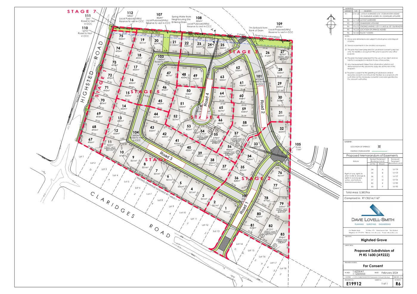
7. Proposed
Road Names - 232 Highsted Road, Casebrook
|
|
Reference Te Tohutoro:
|
26/485541
|
|
Responsible Officer(s) Te Pou Matua:
|
Sean
Ward, Team Leader Planning
|
|
Accountable ELT Member Pouwhakarae:
|
John
Higgins, General Manager Strategy, Planning & Regulatory Services
|
1. Purpose and Origin of the Report Te Pūtake Pūrongo
1.1 The
purpose of this report is for the Waimāero Fendalton-Waimairi-Harewood
Community Board to approve the proposed road names at 232 Highsted Road,
Casebrook.
1.2 The
report is staff-generated resulting from a naming request received from the
developer.
2. Officer Recommendations Ngā Tūtohu
That the Waimāero
Fendalton-Waimairi-Harewood Community Board:
1. Receives the information in the Proposed
Road Names - 232 Highsted Road, Casebrook Report.
2. Notes that the decision in this report is assessed as low
significance based on the Christchurch City Council’s Significance and
Engagement Policy.
3. Approves the following new road names for 232 Highsted Road (RMA/2023/2775)
a. Road 1 - MacKillop Avenue
b. Road 2 - Mother Teresa Drive
c. Road 3 - John Paul Crescent
d. Road 4 - Mooney Close
3. Detail Te Whakamahuki
Introduction Te Whakatkinga
3.1 A
road naming request has been submitted by the agent on behalf of the developer.
A preferred name and alternative names have been put forward for the roads.
3.2 The
recommended road names have been checked against existing road names in
Christchurch and bordering districts, for duplication, alternative spelling, or
other similarities in spelling or pronunciation to avoid the potential for
confusion. The proposed names are considered sufficiently different to existing
road names.
3.3 The
recommended road names have been checked against the Council’s Naming
Policy dated 15 November 2023 and are considered to be consistent with this
policy. The specific criteria for assessing a name from clause 2 is set out
below.
3.3.1 A traditional or
Māori name which is acceptable to the Rūnanga or Iwi; this may be a
name reflecting the physical characteristics of an area, an activity or event
associated with the area or of a notable ancestor.
3.3.2 A feature of
historical, social, cultural, environmental or physical importance in the area
(e.g., Carlton Mill Road or Carlton Mill Reserve*).
3.3.3 The name of a notable
family, person or event associated with the locality or with the wider
Christchurch area.
3.3.4 A name in recognition
of a person’s service. This can be for community service, conservation,
sport, the arts, science and research or other sphere of activity.
3.3.5 Consistency with a
common or established theme for naming in a subdivision or locality.
3.3.6 A name that reflects
the diverse cultures and communities of the locality or of Christchurch
generally.
3.3.7 The name of an event
or activity strongly associated with the immediate location including an
informal name for the area that is (or was historically) in common usage.
3.3.8 A name associated
with a person, event or activity of significance to Christchurch including
names associated with people, events, or places of national and international
significance.
3.4 The
criteria for names that are not suitable for approval from clause 6 are set out
below.
3.4.1 Names of people,
flora, fauna or geographical features not associated with the area, e.g., names
of native trees which are not present in the area or views that cannot be
identified, except where the name continues a current naming theme in the
locality.
3.4.2 Currently trading
commercial organisations except for sponsorship names for facilities and leased
parks.
3.4.3 Anagrams,
amalgamations or derivatives of people's names.
3.4.4 Names of living
persons.
3.4.5 Names related to the
developer of a subdivision.
3.4.6 Name of a person,
club or organisation associated with a privately owned building on Council
land, where the club or organisation does not hold the ground lease for the
building.
3.4.7 Names for roads which
may cause confusion because they are associated with another geographical
location or feature e.g., Parklands Drive which is not located in the Parklands
suburb.
3.5 The
recommended road names have also been checked against the Australia and New
Zealand Standard AS/NZA 4819:2011 Rural and Urban Addressing. The names are considered
to be consistent with the Standard.
3.6 Under
the Roads and Right-of-Way Naming Policy, the name considered must be requested
by the developer. There is no ability to consider alternative names without
first checking whether there are any duplications or similarities with other
road and right-of-way names.
3.7 Consultation
has been undertaken with Land Information New Zealand who have raised no
concerns with the proposed names.
3.8 Consultation
under the policy with rūnanga is not required because the roads to be
named are not collector roads and/or site(s) of significance under the District
Plan (clause 3 of the Naming Policy).
3.9 No
addresses of neighbouring properties are affected by the proposed road naming
(clause 12.2 of the Naming Policy).
3.10 The names requested
have been accompanied by an explanation of the background of the names, which
is summarised below.
Assessment of Significance and Engagement Te
Aromatawai Whakahirahira
3.11 The decisions in
this report are assessed as low significance based on the Christchurch City
Council’s Significance and Engagement Policy.
3.12 The level of
significance was determined by the number of people affected and/or with an
interest.
3.13 Due to the
assessment of low significance, no further community engagement and
consultation is required.
Proposed Names
3.14 The proposed
roads are shown in Attachment A.
3.15 The proposed
name and alternative names are themed for the locality’s Catholic
connections.
3.16 Road 1 - MacKillop
Avenue
3.17 Mary MacKillop
(1842–1909), also known as Saint Mary of the Cross, was an Australian
Roman Catholic nun and educator. Born in Fitzroy, Melbourne, she founded
the Sisters of St Joseph in Penola, South Australia. The order established
schools across Australia and New Zealand, focusing on accessible education for
the poor.
Her
congregation expanded to New Zealand in the late 19th century, including
foundations in Christchurch. St Mary Mackillop visited Christchurch in 1894 and
1895. The Sisters of St Joseph established schools here, contributing to
Catholic education in the region. The sisters taught in at least 9 schools
through the Christchurch Diocese. The Sisters of St Joseph were part of the
original St Gregory’s parish in Bishopdale, which has now merged to
become Christchurch North. This is the parish within which Claridges Estate is
located.
MacKillop
College (Shirley) – Founded in 1949 by the Sisters of St Joseph of the
Sacred Heart as a Catholic girls’ secondary school with day and boarding
facilities. It merged with St Mary’s College to become Marian College in
1982. The new Marian College is now nearby in Papanui.
3.18 Road 2 -
Mother Teresa Drive
3.19 Mary Teresa
Bojaxhiu (1910–1997), better known as Mother Teresa was an
Albanian-Indian Catholic nun, founder of the Missionaries of Charity and a
Catholic saint.
Mother Teresa
visited the Bishopdale parish of St Gregory’s in February 1973.
3.20 Road 3 - John
Paul Crescent
3.21 Pope John Paul
II (1920–2005), born Karol Józef Wojtyła, was head of the
Catholic Church and sovereign of Vatican City from 16 October 1978 until his
death in 2005.
St John Paul II
visited Christchurch in 1983 and led Mass at Lancaster Park. He was the
first pope to visit New Zealand.
3.22 Road 4 -
Mooney Crecent
3.23 Ronald Walter
Mooney (1920–2004) was a historic owner of the underlying land. The farm
was purchased by Ronald Mooney prior to his deployment with the NZ Army.
Mr Mooney served in North Africa and Italy between 1941 – 1945. The
farm was sold in 1975.
Mr Mooney was
also a founding member of the Papanui Working Mens Club. It is understood that
the family were involved in the local parish and Mr Mooney attended the local
Catholic high school – St Bedes College.
3.24 Officers
Note: Written approval from the Mooney family for the above proposed name was
provided with the naming request application.
Alternative Names
Grimes
Ave/Dr/Crs/Cl - Bishop John Grimes (1842-1915) was
the first Catholic Bishop of Christchurch, from 1887 – 1915.
He was born in
the East London slums in 1842 and was ordained as a priest in 1867. Following a
stint teaching in Louisiana, USA, he was ordained Bishop in London in 1887 and
then sailed for New Zealand arriving in Christchurch in early 1888.
Bishop Grimes
was the instigator and driving force behind the building of the Cathedral of
Blessed Sacrament in Barbadoes Street. Upon his death in 1915, Bishop
Grimes was interred in ‘his’ cathedral.
3.25 Lyons
Ave/Dr/Crs/Cl - Bishop Patrick Lyons (1903-1967) was the third Bishop of
Christchurch from 1944 – 1950. Bishop Lyons was born in Melbourne,
Australia in 1903 and was ordained a priest in 1927.
Bishop Lyons
was responsible for the establishment of the Holy Name Seminary in Riccarton
Christchurch, which trained secular clergy from 1947 to 1978. Similarly, he was
instrumental in securing the site in Sockburn where St Thomas of Canterbury
College was established.
It is
understood that Bishop Lyons was well spoken and initiated what is now known as
the Bishop Lyons Shield, a debating and public speaking competition for
students from the Catholic secondary schools within Canterbury.
3.26 The proposed and
alternative names are considered to be consistent with the policy.
3.27 Notwithstanding, the discretion lies with the Community Board to
approve any of the above name options, including the alternative names.
Attachments Ngā Tāpirihanga
|
No.
|
Title
|
Reference
|
Page
|
|
a ⇩ 
|
RMA/2023/2775 - Proposed Road Naming Plan - 232 Highsted Road
|
26/433264
|
15
|
Signatories Ngā Kaiwaitohu
|
Authors
|
Leashelle
Miller - Planner Level 2
Sean Ward -
Team Leader Planning
|
|
Approved By
|
Mark Stevenson
- Head of Planning & Consents
|
|
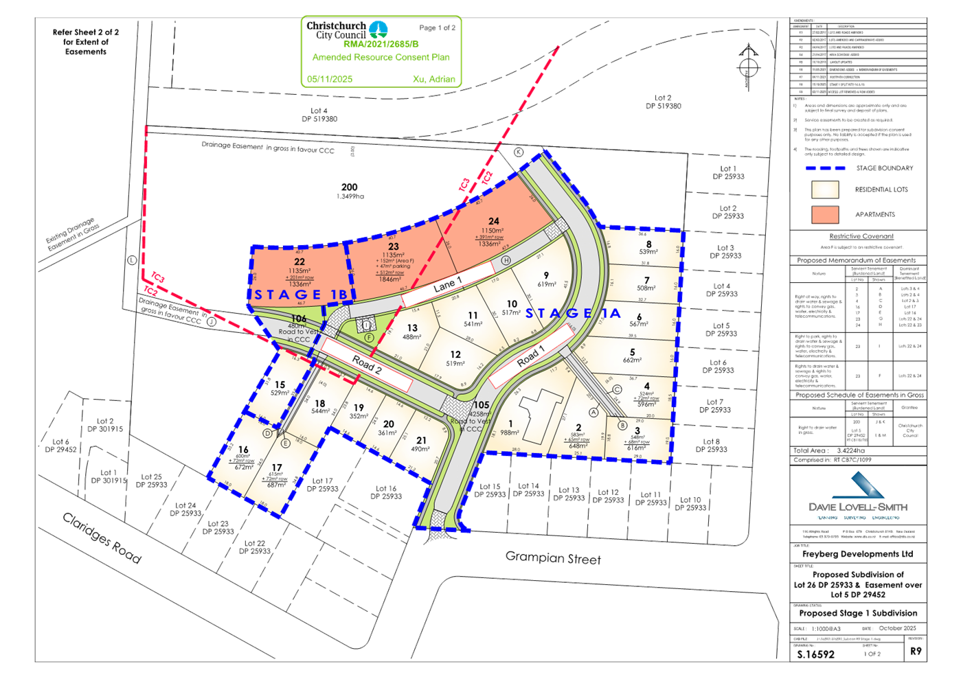
8. Proposed Road Names - 65 Grampian
Street, Casebrook
|
|
Reference Te Tohutoro:
|
26/586764
|
|
Responsible Officer(s) Te Pou Matua:
|
Sean
Ward, Team Leader Planning
|
|
Accountable ELT Member Pouwhakarae:
|
John
Higgins, General Manager Strategy, Planning & Regulatory Services
|
1. Purpose and Origin of the Report Te Pūtake Pūrongo
1.1 The
purpose of this report is for the Waimāero Fendalton-Waimairi-Harewood
Community Board to approve the proposed road names at 65 Grampian Street,
Casebrook.
1.2 The
report is staff-generated resulting from a naming request received from the
developer.
2. Officer Recommendations Ngā Tūtohu
That the Waimāero
Fendalton-Waimairi-Harewood Community Board:
1. Receives the information in the Proposed
Road Names - 65 Grampian Street, Casebrook Report.
2. Notes that the decision in this report is assessed as low
significance based on the Christchurch City Council’s Significance and
Engagement Policy.
3. Approves the following new road names for 65 Grampian Street (RMA/2021/2685)
a. Road 1 - Cairnie Street
b. Road 2 - Cowie Place
c. Lane 1 - Spey Lane
3. Detail Te Whakamahuki
Introduction Te Whakatkinga
3.1 A
road naming request has been submitted by the agent on behalf of the developer.
Preferred names and alternative names have been put forward for the roads.
3.2 The
recommended road names have been checked against existing road names in
Christchurch and bordering districts, for duplication, alternative spelling, or
other similarities in spelling or pronunciation to avoid the potential for
confusion. The proposed names are considered sufficiently different to existing
road names.
3.3 The
recommended road names have been checked against the Council’s Naming
Policy dated 15 November 2023 and are considered to be consistent with this
policy. The specific criteria for assessing a name from clause 2 is set out
below.
3.3.1 A traditional or
Māori name which is acceptable to the Rūnanga or Iwi; this may be a
name reflecting the physical characteristics of an area, an activity or event
associated with the area or of a notable ancestor.
3.3.2 A feature of
historical, social, cultural, environmental or physical importance in the area
(e.g., Carlton Mill Road or Carlton Mill Reserve*).
3.3.3 The name of a notable
family, person or event associated with the locality or with the wider
Christchurch area.
3.3.4 A name in recognition
of a person’s service. This can be for community service, conservation,
sport, the arts, science and research or other sphere of activity.
3.3.5 Consistency with a
common or established theme for naming in a subdivision or locality.
3.3.6 A name that reflects
the diverse cultures and communities of the locality or of Christchurch
generally.
3.3.7 The name of an event
or activity strongly associated with the immediate location including an
informal name for the area that is (or was historically) in common usage.
3.3.8 A name associated
with a person, event or activity of significance to Christchurch including
names associated with people, events, or places of national and international
significance.
3.4 The
criteria for names that are not suitable for approval from clause 6 are set out
below.
3.4.1 Names of people,
flora, fauna or geographical features not associated with the area, e.g., names
of native trees which are not present in the area or views that cannot be
identified, except where the name continues a current naming theme in the
locality.
3.4.2 Currently trading
commercial organisations except for sponsorship names for facilities and leased
parks.
3.4.3 Anagrams,
amalgamations or derivatives of people's names.
3.4.4 Names of living
persons.
3.4.5 Names related to the
developer of a subdivision.
3.4.6 Name of a person,
club or organisation associated with a privately owned building on Council
land, where the club or organisation does not hold the ground lease for the
building.
3.4.7 Names for roads which
may cause confusion because they are associated with another geographical
location or feature e.g., Parklands Drive which is not located in the Parklands
suburb.
3.5 The
recommended road names have also been checked against the Australia and New
Zealand Standard AS/NZA 4819:2011 Rural and Urban Addressing. The names are considered
to be consistent with the Standard.
3.6 Under
the Roads and Right-of-Way Naming Policy, the names considered must be
requested by the developer. There is no ability to consider alternative names
without first checking whether there are any duplications or similarities with
other road and right-of-way names.
3.7 Consultation
has been undertaken with Land Information New Zealand who have raised no
concerns with the proposed names.
3.8 Consultation
under the policy with rūnanga is not required because the roads to be
named are not collector roads and/or site(s) of significance under the District
Plan (clause 3 of the Naming Policy).
3.9 No
addresses of neighbouring properties are affected by the proposed road naming
(clause 12.2 of the Naming Policy).
3.10 The names requested
have been accompanied by an explanation of the background of the names, which
is summarised below.
Assessment of Significance and Engagement Te
Aromatawai Whakahirahira
3.11 The decisions in
this report are assessed as low significance based on the Christchurch City
Council’s Significance and Engagement Policy.
3.12 The level of
significance was determined by the number of people affected and/or with an
interest.
3.13 Due to the
assessment of low significance, no further community engagement and
consultation is required.
Proposed Names
3.14 The proposed
roads are shown in Attachment A.
3.15 The proposed
names and alternative names are themed for rivers that are located in the
Grampian Mountains of Scotland. This is as the site is on Grampian Street which
was named for the Scottish mountain range.
3.16 Road 1 - Cairnie
Street
Cairnie Burn is
a stream that rises in the Mounth, or eastern range of the Grampian Mountains,
north of Netherley, Aberdeenshire, Scotland.
3.17 Road 2 -
Cowie Place
The Cowie Water
is a river of Scotland that rises in the Grampian Mountains in Kincardineshire,
and discharges to the North Sea in the northern part of Stonehaven, south of
the ruined Cowie Castle.
3.18 Lane 1 - Spey
Lane
The River Spey
is a river in the northeast of Scotland. It is the ninth longest river in the
United Kingdom and the third longest and fastest-flowing river in Scotland. It is
172 km long. It rises at over 300 m at Loch Spey in Corrieyairack Forest in the
Scottish Highlands and discharges into Moray Firth.
Alternative Names
3.19 Isla St/Pl/Ln
- The River Isla is a tributary of the River Deveron in the northeast of Scotland.
3.20 Findhorn St/Pl/Ln
- The River Findhorn is one of the longest rivers in Scotland. Located in the
northeast, it flows into the Moray Firth on the north coast.
3.21 Tummel St/Pl/Ln
- The River Tummel is a river in Perth and Kinross, Scotland.
3.22 Livet St/Pl/Ln
- The River Livet is the lowermost tributary of the River Avon which is itself a
tributary of the River Spey.
3.23 Deveron St/Pl/Ln
- The River Deveron is a river in the northeast of Scotland. It has its source
in the Ladder Hills between Glenbuchat and the Cabrach, part of the Grampian
range.
3.24 The proposed and
alternative names are considered to be consistent with the policy.
3.25 Notwithstanding, the discretion lies with the Community Board to
approve any of the above name options, including the alternative names.
Attachments Ngā Tāpirihanga
|
No.
|
Title
|
Reference
|
Page
|
|
a ⇩ 
|
RMA/2021/2685 - Proposed Road Naming Plan - 65 Grampian Street
|
26/547880
|
21
|
Signatories Ngā Kaiwaitohu
|
Authors
|
Leashelle
Miller - Planner Level 2
Sean Ward -
Team Leader Planning
|
|
Approved By
|
Mark Stevenson
- Head of Planning & Consents
|
|
9. Radcliffe Road Corridor Improvement
|
|
Reference Te Tohutoro:
|
26/259335
|
|
Responsible Officer(s) Te Pou Matua:
|
Natasha
Wells, Project Manager
|
|
Accountable ELT Member Pouwhakarae:
|
Brent
Smith, General Manager City Infrastructure
|
1. Purpose and Origin of the Report Te Pūtake Pūrongo
1.1 The
purpose of this report is to seek approval from the Waimāero Fendalton-Waimari-Harewood
Community Board for the Radcliffe Road Corridor Improvement scheme design
following public consultation.
1.2 The
report is staff generated.
2. Officer Recommendations Ngā
Tūtohu
That the
Waimāero Fendalton-Waimairi-Harewood Community Board:
1. Receives the information in the Radcliffe Road Corridor
Improvement Report.
2. Notes that the decision in this report is
assessed as medium significance based on the Christchurch City
Council’s Significance and Engagement Policy.
3. Revokes any previous resolutions pertaining to
parking and stopping restrictions and traffic controls made pursuant to any
Bylaw to the extent that they are in conflict with parking or stopping
restrictions described in resolutions 0 to 0 and 0 to 0 below.
4. Approves the following resolutions required
for the implementation of the project, relying on its powers under the
Christchurch City Council Traffic and Parking Bylaw 2017 and Part 21 of the
Local Government Act 1974.
Radcliffe
Road
5. Approves all kerb alignments, traffic islands,
road surface treatments, and road markings on Radcliffe Road commencing at a
point 172 metres east of its intersection with Main North Road, and extending
in an easterly direction for a distance of 245 metres, as detailed on plan
TP362601, Issue 1, dated 12/03/2026 and attached to this report as Attachment
A.
6. Approves, in accordance with Clause 7 of the
Christchurch City Council Traffic and Parking Bylaw 2017, that the stopping of
vehicles be prohibited at all times as detailed on plan TP362601, Issue 1,
dated 12/03/2026 and attached to this report as Attachment A:
a. On the northern side of Radcliffe Road,
commencing at a point 172 metres east of its intersection with Main North Road
and extending in an easterly direction for a distance of 245 metres.
b. On the southern side of Radcliffe Road,
commencing at a point 172 metres east of its intersection with Main North Road
and extending in a westerly direction for a distance of 225 metres.
7. Approves all kerb alignments, traffic islands,
road surface treatment, and road markings on Radcliffe Road commencing at a
point 96 metres east of its intersection with Blakes Road, and extending in a
westerly direction for a distance of 257 metres, as detailed on plan TP362601,
Issue 1, dated 12/03/2026 and attached to this report as Attachment A.
8. Approves, in accordance with Clause 7 of the
Christchurch City Council Traffic and Parking Bylaw 2017, that the stopping of
vehicles be prohibited at all times as detailed on plan TP362601, Issue 1,
dated 12/03/2026 and attached to this report as Attachment A.
a. On the northern side of Radcliffe Road,
commencing at its intersection with Blakes Road and extending in a westerly
direction for a distance of 96 metres.
b. On the northern side of Radcliffe Road,
commencing at its intersection with Blakes Road and extending in an easterly
direction for a distance of 94 metres.
c. On the southern side of Radcliffe Road,
commencing at a point 96 metres east of its intersection with Blakes Road and
extending in a westerly direction for a distance of 257 metres.
9. Approves that in accordance with Clause 21 of
the Christchurch City Council Traffic & Parking Bylaw 2017, that the path
on the northern side of Radcliffe
Road, commencing at a point 291 metres east of its intersection with Main
North Road and extending in an easterly direction for a distance of 15 metres, as detailed on plan TP362601, dated 12/03/2026, and attached to this report
as Attachment A, be
resolved as an eastbound Shared Path, in accordance with section 11.4 of the
Land Transport Act - Traffic Control Devices Rules: 2004. This Shared Path is
for the use by the classes of road users only as defined in Section 11.1A of
the Land Transport (Road User) Rule: 2004.
10. Approves that in accordance with Clause 21 of
the Christchurch City Council Traffic & Parking Bylaw 2017, that the path
on the southern side of Radcliffe
Road, commencing at a point 397 metres east of its intersection with Main
North Road and extending in a westerly direction for a distance of 55 metres, as detailed on plan TP362601, dated
12/03/2026, and attached to this report as Attachment A, be resolved as
a bi-directional Shared Path, in accordance with section 11.4 of the Land
Transport Act - Traffic Control Devices Rules: 2004. This Shared Path is for
the use by the classes of road users only as defined in Section 11.1A of the
Land Transport (Road User) Rule: 2004.
11. Approves that in accordance with Clause 21 of
the Christchurch City Council Traffic & Parking Bylaw 2017, that the path
on the southern side of Radcliffe
Road, commencing at a point 302 metres east of its intersection with Main
North Road and extending in a westerly direction for a distance of 40 metres, as detailed on plan TP362601, dated
12/03/2026, and attached to this report as Attachment A, be resolved as
an eastbound Shared Path, in accordance with section 11.4 of the Land Transport
Act - Traffic Control Devices Rules: 2004. This Shared Path is for the use by
the classes of road users only as defined in Section 11.1A of the Land
Transport (Road User) Rule: 2004.
12. Approves that in accordance with Clause 21 of
the Christchurch City Council Traffic & Parking Bylaw 2017, that the path on the northern side of Radcliffe Road, commencing at a point
23 metres east of its intersection with Blakes Road and extending in an
easterly direction for a distance of 13 metres, as detailed on plan TP362601, dated 12/03/2026, and
attached to this report as Attachment A, be resolved as an eastbound
Shared Path, in accordance with section 11.4 of the Land Transport Act -
Traffic Control Devices Rules: 2004. This Shared Path is for the use by the
classes of road users only as defined in Section 11.1A of the Land Transport
(Road User) Rule: 2004.
13. Approves that in accordance with Clause 21 of
the Christchurch City Council Traffic & Parking Bylaw 2017, that the path
on the northern side of Radcliffe
Road, commencing at a point 36 metres east of its intersection with
Blakes Road and extending in an easterly direction for a distance of 58 metres, as detailed on plan TP362601, dated
12/03/2026, and attached to this report as Attachment A, be
resolved as a bi-directional Shared Path, in accordance with section 11.4 of
the Land Transport Act - Traffic Control Devices Rules: 2004. This Shared Path
is for the use by the classes of road users only as defined in Section 11.1A of
the Land Transport (Road User) Rule: 2004.
14. Approves that in accordance with Clause 21 of
the Christchurch City Council Traffic & Parking Bylaw 2017, that the path
on the southern side of Radcliffe
Road, commencing at a point 96 metres
east of its intersection with Blakes Road and extending in a westerly direction
for a distance of 588 metres, as
detailed on plan TP362601, dated
12/03/2026, and attached to this report as Attachment A, be resolved as a bi-directional Shared Path,
in accordance with section 11.4 of the Land Transport Act - Traffic Control
Devices Rules: 2004. This Shared Path is for the use by the classes of road
users only as defined in Section 11.1A of the Land Transport (Road User) Rule:
2004.
Blakes
Road
15. Approves all kerb alignments, traffic islands,
and road markings on Blakes Road commencing at its intersection with Radcliffe
Road, and extending in a northerly direction for a distance of 183 metres, as
detailed on plan TP362601, Issue 1, dated 12/03/2026 and attached to this
report as Attachment A.
16. Approves that in accordance with Section 4 of
the Land Transport Rule: Traffic Control Devices 2004 that the southbound
approach of Blakes Road at its intersection with Radcliffe Road be controlled
by a Stop Control, as detailed on plan TP362601, Issue 1, dated 12/03/2026 and
attached to this report as Attachment A.
17. Approves, in accordance with Clause 7 of the
Christchurch City Council Traffic and Parking Bylaw 2017, that the stopping of
vehicles be prohibited at all times as detailed on plan TP362601, Issue 1,
dated 12/03/2026 and attached to this report as Attachment A.
a. On the western side of Blakes Road, commencing
at its intersection with Radcliffe Road and extending in a northerly direction
for a distance of 183 metres.
b. On the easterly side of Blakes Road,
commencing at its intersection with Radcliffe Road and extending in a northerly
direction for a distance of 183 metres.
18. Approves that these resolutions take effect
when parking signage and/or road marking that evidence the restrictions
described in 5 to 17 above are in place (or removed in the case of
revocations).
19. Endorses staff’s recommended delivery
staging approach to construct the full intended design for Radcliffe Road and
Blakes Road, other than the upgrades to the level crossing, as one phase as
soon as possible. The railway level crossing will be delivered when ready to do
so.
That the
Waimāero Fendalton-Waimairi-Harewood Community Board recommend that
Council:
20. Approves that a Special Vehicle Lane, in
accordance with Clause 18 of the Christchurch City Council Traffic &
Parking Bylaw 2017, for the use of eastbound road users as defined in
Section 11.1A of the Land Transport (Road User) Rule: 2004, excepting
pedestrians and riders of mobility devices, be established on the northern side
of Radcliffe Road, commencing at a point 172 metres east of its intersection
with Main North Road and extending in an easterly direction for a distance of
100 metres as detailed on plan TP362601, dated 12/03/2026, and attached to this
report as Attachment A.
21. Approves that a Special Vehicle Lane, in
accordance with Clause 18 of the Christchurch City Council Traffic &
Parking Bylaw 2017, for the use of eastbound road users as defined in
Section 11.1A of the Land Transport (Road User) Rule: 2004, excepting
pedestrians and riders of mobility devices, be established on the northern side
of Radcliffe Road, commencing at a point 280 metres east of its intersection
with Main North Road and extending in an easterly direction for a distance of
11 metres as detailed on plan TP362601, dated 12/03/2026, and attached to this
report as Attachment A.
22. Approves that a Special Vehicle Lane, in
accordance with Clause 18 of the Christchurch City Council Traffic &
Parking Bylaw 2017, for the use of westbound road users as defined in
Section 11.1A of the Land Transport (Road User) Rule: 2004, excepting
pedestrians and riders of mobility devices, be established on the southern side
of Radcliffe Road, commencing at a point 382 metres east of its intersection
with Main North Road and extending in a westerly direction for a distance of 97
metres as detailed on plan TP362601, dated 12/03/2026, and attached to this
report as Attachment A.
23. Approves that a Special Vehicle Lane, in
accordance with Clause 18 of the Christchurch City Council Traffic &
Parking Bylaw 2017, for the use of westbound road users as defined in
Section 11.1A of the Land Transport (Road User) Rule: 2004, excepting
pedestrians and riders of mobility devices, be established on the southern side
of Radcliffe Road, commencing at a point 269 metres east of its intersection
with Main North Road and extending in a westerly direction for a distance of 63
metres as detailed on plan TP362601, dated 12/03/2026, and attached to this
report as Attachment A.
24. Approves that these resolutions take effect
when parking signage and/or road marking that evidence the restrictions
described in 20 to 23 above are in place (or removed in the case of
revocations).
25. Approves that for any traffic controls or
parking restrictions on land not yet vested with Council as Road Reserve, these
resolutions take effect when parking signage and/or road markings that evidence
the restrictions described in this staff report are in place and when the land
has been vested with Council.
3. Executive Summary Te Whakarāpopoto Matua
3.1 The
Radcliffe Corridor Improvement project has come about from the need to provide
a safe pedestrian and cycling connection between Main North Road and the Spring
Grove subdivision.
3.2 The
route means there will be impacts on the existing railway level crossing on
Radcliffe Road due to the expected increased numbers of pedestrians and
cyclists.
3.2.1 Council
therefore has an obligation to upgrade this level crossing to manage the
increased risk.
3.2.2 The
design for the level crossing requires KiwiRail approval which has not yet been
granted, so is not included in this report
3.3 Staff
have considered the works and provided options for approval in two categories:
the permanent design; and staging options:
3.3.1 The
permanent design options:
· Approve the
recommended design, found in Attachment A
· Do not approve
the design
3.3.2 The
staging options are:
· Construct all
scope as soon as possible, noting that the level crossing upgrade will likely
be completed much later than the path
· Construct
scope east of Blakes Road as soon as possible, and all scope west of Blakes
Road once the level crossing upgrade is ready
· Delay the
construction of all scope until the level crossing is ready
3.4 The
staff recommendation is to construct the intended design up to the rail
crossing, then upgrade the level crossing once the design is approved.
3.4.1 Staff
have recommended these as they address community concerns, and provide the
connections as soon as possible.
3.4.2 However,
staff expect that this will temporarily encourage more users towards a level
crossing that has not been upgraded. While this will raise the level of risk at
the level crossing itself, the overall impact on users of the corridor has been
assessed as lower risk (due to the current risk to users walking on the edge of
a narrow, fast and unlit road).
4. Background/Context Te Horopaki
4.1 In
the past decade there has been significant growth in residential properties to
the east of the railway between Radcliffe Road and Belfast Road, within the
Spring Grove subdivision.
4.1.1 This
has created an increasing demand for residents to access amenities and services
to the west of the railway: schools, shops, cafes, bus services, major cycleway
network, etc. However, there is poor pedestrian and cycle access from the
subdivision to Main North Road due to a lack of footpaths, and level crossings
that do not cater for non-vehicular traffic. Staff are aware of reports of
people using the live railway corridor as an access route between Thompsons
Road (east) and Sheldon Park.
4.1.2 In
the 2015 Long Term Plan a project was initiated that sought to cater for this
movement, by crossing the railway line at Thompsons Road. Despite ongoing
discussions with KiwiRail over a number of years it was not possible to get
agreement for a pedestrian level crossing in this location. A grade separated
crossing (under or over-pass) was ruled out for a number of reasons, including
high cost, property purchase requirements, and CPTED and privacy concerns. This
project was removed from Council’s capital programme as part of the 2024
Long Term Plan.
4.1.3 In
the 2021 Long Term Plan a project was initiated for the Radcliffe Corridor
Improvement project. As the Radcliffe Road level crossing needed to be linked
to any new works at Thompsons Road, little progress was able to be made on this
project until the Thompsons Road level crossing was removed from the programme.
4.2 Some
of this project is on land which NZTA acquired for the northern motorway, and
NZTA is in the process of handing over the land to CCC and vesting it as road
reserve, in accordance with the signed memorandum of understanding between CCC
and NZTA associated with the Northern Arterial Extension.
4.3 As
part of the South-East Belfast Outline Development Plan there are significant
further areas of land proposed to be developed for housing in this location.
Therefore, it is anticipated that traffic and pedestrian/cycle volumes along
Radcliffe Road will increase.
4.4 There
have been high-profile campaigns over a number of years by residents,
Council/Community Board elected members, and the Members of Parliament to
highlight and address the lack of pedestrian and cycle access to these
subdivisions.
Network Context
4.5 Both
Radcliffe Road and Blakes Road are designated at Collector Roads within the
District Plan.
4.5.1 Traffic
counted was last carried out on Radcliffe Road in August 2022. Average daily
traffic is around 4,600 vpd, with an average speed of 62km/h, and an 85%ile of
68.5km/h. 8.6% of the traffic were heavy vehicles. The area under consideration
is not on a bus route.
4.5.2 Posted
speed limit is mostly 60km/h along Radcliffe Road, although this reduces to
50km/h at the western end (including over the level crossing), and on Blakes
Road.
4.5.3 The
road is narrow (around 6m), has minimal shoulder, and is rural in nature. Grass
and other vegetation grows up to the seal edge, making it difficult for
pedestrians to walk outside the road.
4.6 For
cyclists, improved facilities along Radcliffe Road would provide an important
link between the major cycleway (Northern Line MCR on Main North Road) and the
Northern Corridor Shared Path (parallel to the motorway). This would provide a
significant legibility benefit to the overall network.
Scope of the
Projects
4.7 A
condition of subdivisions is that they construct footpaths along their
frontages. However, as developments are not necessarily constructed
concurrently or in a sequential way, it can leave gaps in the footpath network
between the new and existing facilities.
4.7.1 In
this area there are a number of footpaths that do not link to the wider
footpath network. While it is anticipated that eventually further developments
will fill in many of these gaps, it is not clear how long this will take
– some appear to be many years from being constructed.
4.8 To
address the poor access, this project is seeking to provide the following:
· a footpath on
the eastern side of Blakes Road; from the existing path at approx. 2 Blakes
Road, to the intersection with Radcliffe Road
· upgrade the
Blakes Road/Radcliffe Road intersection
· crossing
facilities near the intersection
· a shared path
on the southern side of Radcliffe Road. This will go from the existing path
adjacent to the motorway in the east, to the footpath (yet to be installed)
outside the recently-constructed retirement development in the west.
· upgrade the
Radcliffe Road level crossing, to improve provision for pedestrians
4.8.2 Full
path provision will be provided by developers at a later date as the
subdivisions are constructed, and therefore has not been included as part of
the scope of this project.
Level Crossing
4.9 Council
and KiwiRail are working closely on the level crossing upgrade. Staff of the
two organisations have agreed to a priority of level crossing upgrades to
ensure that attention remains focused on the next priority. The upgrade to
Radcliffe Road level crossing is the second highest priority in the
Christchurch District (after Scruttons Road).
4.9.1 Level
crossings are a known source of risk, as they are a point of conflict between
road users and trains. As a “rail participant” under the
Railways Act 2005, Council has an obligation to “ensure, so far as is
reasonably practicable, that none of the rail activities for which it is
responsible causes, or is likely to cause, the death of, or serious injury to,
individuals”.
4.9.2 The
level crossing at Radcliffe Road was constructed as a single track crossing in
a rural area. However, due to growth in the area over recent decades it is
missing some of the features that would normally be expected in a urban
environment.
4.9.3 There
have been 2 incidents at this crossing between 2016 and 2025, one of which was
a Serious Injury crash between a train and a car in mid-2024.
4.10 Council’s
layout design for the level crossing upgrade was submitted to KiwiRail for
approval and staff are currently working with them to finalise the layout
design. Note that this is only seeking to manage the additional risk that
Council’s path project puts on the level crossing, so will not address
all the existing issues at the level crossing.
4.10.1 Once
the layout has been approved as compliant with the standards, KiwiRail will
review how this integrates with their own systems, and provide Council with an
estimate for the rail works.
4.10.2 Due
to the time frames for rail work, and the complexity required in integrating
these with the existing rail network system, it is likely that the level
crossing upgrade will not be constructed for at least 18 months, and possibly
longer.
4.11 As
the level crossing design requires technical approval from KiwiRail, it has not
been included in this report.
4.11.1 A
further report will be brought to the Community Board for approval of the
layout around the level crossing.
4.11.2 However,
feedback was specifically sought from the public on the concept for this
facility, so further public engagement will be limited.
Phasing of the
Works
4.12 The
path along Radcliffe Road is likely to be ready for construction significantly
before the level crossing upgrade. This could create a safety and liability
risk if pedestrians are encouraged towards a level crossing with no safe,
dedicated facility for non-vehicular traffic to cross the railway.
4.12.1 It
is likely that the path will induce more pedestrians and cyclists to use the
level crossing, and therefore raise the risk exposure at the crossing.
4.12.2 However,
there are already users of the level crossing who are currently placed at risk
while travelling along Radcliffe Road due to the high speeds of traffic (85%ile
speeds ~70km/h), lack of shoulder, and narrow lanes. The provision of a path
between Blakes Road and the level crossing would reduce the safety risk for
these users.
4.12.3 Staff
commissioned a safety analysis to determine if an option to construct the path
ahead of the level crossing upgrade would put users in unreasonable danger.
This compared the increased risk at the existing level crossing due to more
users, vs the reduced risk to current users along the existing road.
4.12.4 While
close, the analysis shows that, on balance, constructing the path ahead of the
level crossing upgrade is the lower risk option overall.
4.13 The
risk at the existing level crossing would need to be mitigated until the full
level crossing upgrade is complete.
4.13.1 Therefore,
if the board were to select the option to construct the path first, ahead of
the level crossing upgrade, staff will investigate low-cost temporary
interventions that can reduce the level crossing risk and/or adequately warn
users of the risk.
4.14 However,
it should be noted that this will, in isolation, raise the level of risk at the
level crossing due to the expected increase in users. Therefore, KiwiRail are
unlikely to support this approach.
4.15 The following related memos/information were circulated to the
meeting members:
|
Date
|
Subject
|
|
15
Nov 2021
|
Belfast Park Cycle & Pedestrian Rail
Crossing - Project Update
|
|
13
Oct 2023
|
Radcliffe Road Corridor Upgrade project
|
|
18
Apr 2024
|
Thompsons Rd Pedestrian and Cycle
Crossing – Overbridge Costings
|
|
20
Aug 2025
|
Radcliffe Road Corridor Improvement
– Public Consultation
|
|
16
Jan 2026
|
Radcliffe Road Corridor Improvement
– Public Consultation
|
5. Options Considered Ngā
Kōwhiringa Whaiwhakaaro
5.1 In
the options section below, there are two sets of options provided, in two
different criteria:
· Permanent
Design
· Delivery
Staging
5.1.2 The
staging options make a minimal impact on overall price (see Financial
Implications section below), but do impact on the level and type of risk that
Council takes on.
Permanent Design - Options Considered Ngā Kōwhiringa Whaiwhakaaro
5.2 The
following reasonably practicable design options were considered and are
assessed in this report:
5.2.1 Option
1 (Preferred option) - Installation of pedestrian and cycle infrastructure
5.2.2 Option
2 - Do nothing
5.3 The
following design options were considered but ruled out:
5.3.1 Installing
the refuge island on Radcliffe Road closer to the Northern Corridor cycleway
crossing - This has been moved 15m further west to align with the natural
desire lines of pedestrians travelling west, while avoiding a significant cost
increase through increased stormwater infrastructure by installing the crossing
west of the intersection.
5.3.2 Installing
the shared path along the northern side of Radcliffe Road – This has not
been considered further due to the limited road space available to accommodate
the shared path. There is also an existing drain along the northern side
of Radcliffe Road that would increase the cost of constructing over. The
southern side of the road has sufficient space to accommodate the shared path.
5.3.3 Approval
of the level crossing layout – until the design has been approved by
KiwiRail staff cannot provide a level crossing design for approval by the
Community Board. A separate report will be brought once more certainty is
gained around the layout.
5.3.4 Reduced
speed limit – An option to reduce the speed limit on Radcliffe Road to
50km/h (from 60km/h) was considered. However, as developments fronting directly
onto Radcliffe Road have not yet been started, the road retains a semi-rural
nature. In this context a 50km/h was not felt to be appropriate, and likely to
be poorly observed (current 85%ile speeds are around 68km/h), so the
consultation process was not started. This would be better considered once
developments fronting onto Radcliffe Road are under construction.
Options Descriptions Ngā Kōwhiringa
5.3.5 Preferred
Option: Installation of pedestrian and cycle infrastructure
5.3.6 Option
Description: The scope included includes:
· Improvements
at Radcliffe Road and Blakes Road intersection
· A shared path
along the southern side of Radcliffe Road
· Pedestrian
refuge island on Radcliffe Road
· Extension of
the footpath on Blakes Road
All areas will receive lighting and
drainage upgrades
5.3.7 Option
Advantages
· Improve safety
for vulnerable road users along Radcliffe Road.
· Provide better
pedestrian crossing facilities with the refuge island as pedestrians will be
crossing Radcliffe Road in two stages.
· Reduced
approaching speeds on Blakes Road with traffic island.
· No stopping to
provide visibility at the refuge island and intersection.
· The
operational speed of vehicles is anticipated to decrease and be more in line
with the posted 60km limit as a result of the proposed design.
· The
intersection improvements help to delineate and raise awareness of the
intersection to traffic on Radcliffe Road.
· Provides a
link in the cycle network between the Northern Corridor (adjacent to the
motorway) and the Northern Line Major Cycle Route (along Main North Road)
5.3.8 Option
Disadvantages
· High cost for
works
· As it provides
a slightly circuitous route from Spring Grove to amenities such as Belfast
School, it may not fully meet community desires, and may not resolve the issue
of illegal access to the railway at Thompsons Road.
· Design may
clash with, or restrict design options for, future developments on the southern
side of Radcliffe Road.
5.3.9 Option
2: Do nothing
5.3.10 Option
Description: Leave existing layout
5.3.11 Option
Advantages
· Does not cause
clashes with future developments along Radcliffe Road – reduced chance of
rework or damage by developers
· Allows funding
to be re-allocated to other projects
5.3.12 Option
Disadvantages
· Does not
address community concerns about pedestrian and cycle access
· Retains
existing safety risk for users along Radcliffe Road
· Does not
provide an important link in the city-wide cycle network.
Delivery Staging
- Options Considered Ngā
Kōwhiringa Whaiwhakaaro
5.4 The
following reasonably practicable construction phasing options were considered
and are assessed in this report in relation to the construction of the project:
5.4.1 Option
A (Preferred option) - Construct the full intended design, other than the
upgrades to the level crossing, as one phase as soon as possible. Complete the
level crossing when ready.
5.4.2 Option
B - Stage the improvements: Phase 1 - Construct improvements east of the
intersection of Radcliffe and Blakes Roads; Phase 2 – Construct the
shared path west of Blakes Road and level crossing.
5.4.3 Option
C - Delay construction of the full intended design until the upgrade of the
level crossing can be constructed.
5.5 Preferred
Option A: Construct the full intended design, other than the upgrades to
the level crossing, as one phase as soon as possible. Complete the level
crossing when ready.
Option Description: This option would involve constructing as soon as they are ready. It
is likely that the roading works will be ready before the level crossing
upgrade so the works would be split into two phases:
Phase 1 (to progress normally): All works
apart from level crossing
Phase 2 (to progress only once ready):
Level crossing upgrade
There is currently no certainty around
the length of time between phases 1 & 2, but 12-18 months is a likely
minimum.
5.5.1 Option
Advantages
· The preferred
option more quickly provides a safe access for residents of Spring Grove to the
Northern Corridor shared path, and therefore to the wider footpath/cycleway
networks.
· Building the
shared path along the southern side of Radcliffe Road up to the level crossing
creates a safe travel route for existing pedestrians and cyclists along the
road.
· Building as
much of the infrastructure as soon as possible would reduce the risk against
inflation.
5.5.2 Option
Disadvantages
· Does not meet
the full project objectives of the Radcliffe Road corridor improvements and
level crossing upgrade at once.
· As the path
would likely induce more pedestrian and cycle traffic to use this route, the
exposure risk at the level crossing would increase.
· Current users
would experience more disruption as the works would be carried out in two
phases
· Completing the
works in two phases is likely to be more expensive than a single pass, due to
remobilisation costs and loss of productivity.
5.6 Option
B: Stage the improvements: Phase 1 - Construct improvements east of the
intersection of Radcliffe and Blakes Roads; Phase 2 – Construct the
shared path west of Blakes Road and level crossing.
5.6.1 Option
Description: This option would split the works into two phases:
Phase 1 (to progress normally): Footpath
connection along Blakes Road; intersection upgrade, crossing point, and
connection to Northern Corridor path
Phase 2 (to progress only once level
crossing works are ready): Level crossing upgrade, path along Radcliffe Road
(from Blakes Road to the level crossing) is not constructed until the level
crossing is upgraded.
There is currently no certainty around
the length of time between phases 1 & 2, but 12-18 months is a likely
minimum.
5.6.2 Option
Advantages
· This option
more quickly provides a safe access for residents of Spring Grove to the
Northern Corridor shared path, and therefore to the wider footpath/cycleway
networks.
· Does not
encourage more pedestrian and cycle traffic to the existing level crossing
ahead of upgrades
5.6.3 Option
Disadvantages
· Does not meet
the full project objectives of the Radcliffe Road corridor improvements and
level crossing upgrade at once.
· Delays
improvements to safety for current pedestrian and cycle users of Radcliffe
Road.
· Does not
immediately address the key concern of residents wanting improved access to the
amenities and services along Main North Road
· Completing the
works in two phases is likely to be more expensive than a single pass, due to
remobilisation costs and loss of productivity.
5.7 Option
C: Delay construction of the full intended design until the upgrade of the
level crossing can be constructed.
Option Description: Under this option no works would be constructed until all parts are
ready. The likely longest path would be to the level crossing upgrade, which
may be 18 months away from completion.
5.7.1 Option
Advantages
· Disruption to
users would only happen once
· Completing the
works in a single phase is likely to be the cheapest, as there is no
requirement for remobilisation costs, and productivity can be increased.
· Does not
encourage more pedestrian and cycle traffic to the existing level crossing
ahead of upgrades
5.7.2 Option
Disadvantages
· This option
would delay the construction of a connection to the Northern Corridor shared
path, and therefore to the wider footpath/cycleway networks.
· Delays
improvements to safety for current pedestrian and cycle users of Radcliffe
Road.
· Does not
immediately address the key concern of residents wanting improved access to the
amenities and services along Main North Road
Analysis Criteria Ngā Paearu Wetekina
Permanent Design
5.8 Staff
have arrived at the recommended design option as it addresses safety concerns
raised by residents for several years, and has been well supported during
consultation.
5.8.1 While
the primary intent of the project is improving local access, this recommended
design would also provide a key link within the city’s cycle network, so
has wider benefits.
5.8.2 The
installation of this footpath may impact on future developments on the southern
side of Radcliffe Road, however, there are no immediate plans to develop this
area, and the impacts are likely to be small.
Delivery Staging
5.9 Staff
are recommending that the footpath and other roading works are constructed in
full as soon as ready, with the level crossing upgrade to follow once ready.
However, staff believe this is marginal - there are clear benefits and
disbenefits of each staging option.
5.10 The
primary reason for selecting this option is overall safety for users:
5.10.1 Staff
acknowledge that this will likely encourage more pedestrians and cyclists
towards the level crossing ahead of the upgrade, which will increase the
exposure risk at the level crossing.
5.10.2 However,
by constructing a shared path along Radcliffe Road between Blakes Road and the
level crossing, it will also decrease the risk for existing users navigating a
busy, narrow and fast road.
5.10.3 Analysis
shows that the overall risk to pedestrian and cycle users of Radcliffe Road
will be slightly lower than the existing situation.
5.11 Based
on feedback on other level crossings (eg Scruttons Road and Annex Road), staff
expect that KiwiRail will have concerns with this option, as the expected
increased numbers of users is likely to temporarily increase risk at the level
crossing until the upgrade is complete.
6. Financial Implications Ngā Hīraunga Rauemi
Capex/Opex Ngā Utu Whakahaere
|
|
Recommended Option
|
Option 2 - Do nothing
|
|
Cost to Implement
|
$2.59m
|
$0
|
|
Maintenance/Ongoing Costs
|
$4,234/year
|
No change
|
|
Funding Source
|
CPMS: 60115
|
CPMS: 60115
|
|
Funding Availability
|
$3.66m
|
$3.66m
|
|
Impact on Rates
|
Nil – costs covered by project
funding
|
Nil
|
6.1 The
cost to implement shows the estimated costs to complete the project, with a 20%
contingency on construction items. This is considered appropriate given the
stage of design.
6.2 The
phasing will have a small impact on cost: for options A & B that require
the work to be completed in two phases, staff believe there would be an
increased cost in the region of $30-50k for remobilisation, additional traffic
management, and lower productivity. This remains within the available budget.
7. Considerations Ngā Whai Whakaaro
Non-Legal Risks and Mitigations Ngā Mōrearea
me ngā Whakamātautau
7.1 There
is a risk the construction will cause disruption to the surrounding
businesses, schools and residents, and those travelling through or around the
construction area.
The mitigation will be to highlight
in the contractor tender information the importance of stakeholder engagement,
communication and minimising traffic management disruption while balancing this
with keeping all road users and contractor staff safe. The importance of minimising
disruption will be enforced through the tender evaluation
7.2 There
is a risk that this will not address community concerns, as it does not
provide the more direct link wanted at Thompsons Road.
The mitigation is to explain the
reasons why this is not feasible (see section 4.1).
7.3 There
is a risk that KiwiRail will not support the proposed phasing option.
The mitigation is that Council
demonstrates that the overall risk to users of Radcliffe Road is lower, despite
the increased exposure risk at the level crossing due to increased numbers of
people.
7.4 There
is a risk that the assumptions of user numbers in the safety analysis
are incorrect.
7.5 The
mitigation is that Council will carry out before and after monitoring of
user numbers.
Legal Considerations Ngā Hīraunga
ā-Ture
7.6 Statutory
and/or delegated authority to undertake proposals in the report:
7.6.1 The
Waimāero Fendalton-Waimairi-Harewood Community Board has the delegated
authority to approve the scheme design in Attachment A of this report.
7.7 Other Legal Implications:
7.7.1 Legal
advice is contained in an attachment to this report.
Strategy
and Policy Considerations Te
Whai Kaupapa here
7.8 The
required decisions:
7.8.1 Align
with the Christchurch
City Council’s Strategic Framework. Improving the safety of all road
users aligns with the Strategic Priorities and Community Outcomes, in
particular:
· Be an inclusive and
equitable city
· Build trust and confidence
in the council – this was achieved through the public consultation
process and will continue through engagement with local groups and through the
contractor’s communication.
· Reduce emissions – a
safe shared path encourages more people to walk and ride around the city.
· Balance the needs of today
and the future
7.8.2 Is
assessed as medium significance based on the Christchurch City Council’s
Significance and Engagement Policy. The level of significance was
determined by the high amount of community interest in the project and the
risks to Council associated with its delivery.
7.8.3 Are
consistent with Council’s Plans and Policies.
7.9 This
report supports the Council's
Long Term Plan (2024 - 2034):
7.10 Transport
7.10.1 Activity: Transport
· Level of Service: 10.0.2 Increase the share of non-car
modes in daily trips - >=37% of trips undertaken by non-car modes
· Level of Service: 16.0.10 Maintain the perception (resident
satisfaction) that Christchurch is a walking friendly city - >=85% resident
satisfaction
· Level of Service: 16.0.9 Improve resident satisfaction with
footpath condition - >=43%
· Level of Service: 10.5.42 Increase the infrastructure
provision for active and public modes - >= 635 kilometres (total combined
length)
· Level of Service: 10.5.41 Increase access within 15 minutes
to key destination types by walking (to at least four of the five basic
services: food shopping, education, employment, health, and open spaces) -
>=50% of residential addresses with a 15- minute walking access
· Level of Service: 10.5.1 Limit deaths and serious injury
crashes per capita for cyclists and pedestrians - <=12 crashes per 100,000
residents
Community
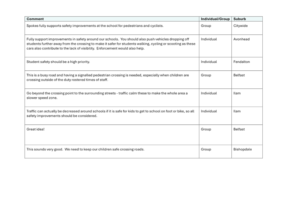
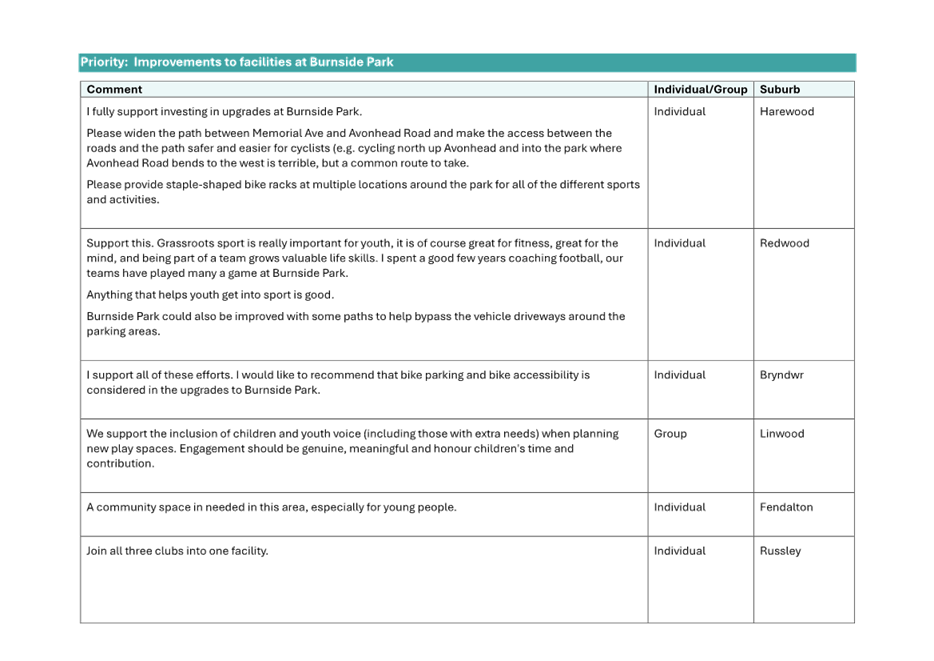
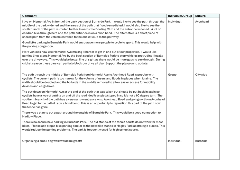
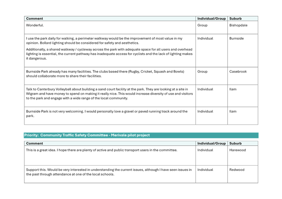
Impacts and Views Ngā Mariu ā-Hāpori
7.11 Consultation
started on 27 January 2026 and ran until 17 February.
7.12 Project
details including links to the Kōrero mai |
Let’s Talk webpage were advertised via:
7.12.1 An
email sent to 25 key stakeholders, including local residents’
associations, emergency services, Northwood Supa Centa, and Ryman Healthcare.
Local groups were asked to circulate the project details within their networks
and received an open invite to meet with project staff.
7.13 The
Kōrero mai |
Let’s Talk webpage had 948 views throughout the consultation period.
Summary of Submissions Ngā
Tāpaetanga
7.14 Submissions
were made by three recognised organisations/businesses and 61 individuals. All
submissions are available on our Kōrero mai |
Let’s Talk webpage.
7.15 Spokes
Canterbury and the AA Canterbury/West Coast District Council support the plans,
with Spokes also requesting further improvements to enhance cyclist safety. The
managers of Northwood Supa Centa would like to ensure a safe crossing area for
pedestrians and cyclists into the shopping centre.
7.16 The
majority of submitters made comments expressing support or excitement for the
project. In addition, comments were made about:
· Wanting to see
the plans implemented as quickly as possible / before something bad happens
(17)
· The need for
safety improvements for the section of Radcliffe Road to the west of the
railway (12)
· Speeding
vehicles being an issue on Radcliffe Road (8) / that the speed limit should be
lowered (6)
· The location
of the pedestrian refuge island being unsuitable (4).
7.17 There was also a range of other requests made by submitters. These
have been collated, along with staff responses, in Attachment B.
7.18 The decision affects the following wards/Community Board areas:
7.18.1 Harewood
Ward
7.18.2 Waimāero
Fendalton-Waimairi-Harewood Community Board.
Impact
on Mana Whenua Ngā
Whai Take Mana Whenua
7.19 The decisions do not involve a significant decision in relation
to ancestral land, a body of water or other elements of intrinsic value,
therefore this decision does not specifically impact
Mana Whenua, their culture, and traditions.
7.20 The decision does not involve a matter of interest to Mana Whenua and will
not impact on our agreed partnership priorities with Ngā
Papatipu Rūnanga.
Climate
Change Impact Considerations Ngā Whai Whakaaro mā te Āhuarangi
7.21 The decisions in this report are likely to:
7.21.1 Contribute
positively to adaptation to the impacts of climate change.
7.21.2 Contribute positively to emissions reductions.
7.22 The proposed design allows for the safe travel of pedestrians and
cyclists, thereby encouraging walking and cycling as transport options. This,
in turn, decreases traffic volumes.
7.23 Provision to
address ponding near the intersection of Radcliffe and Blakes Roads will
improve drainage facilities. This will likely reduce flooding during larger
rain events.
8. Next Steps Ngā Mahinga ā-muri
8.1 If
approved, staff will progress the scheme to detailed design, followed by tender
and construction.
8.2 Construction
of the proposed design is currently scheduled for Summer 2026/27.
Attachments Ngā Tāpirihanga
|
No.
|
Title
|
Reference
|
Page
|
|
a ⇩
|
Radcliffe Road
Corridor Improvements - TP362601- Issue 1 12-03-2026 For Approval
|
26/555602
|
39
|
|
b ⇩
|
Consultation
submission and staff responses
|
26/639479
|
41
|
|
c
|
Legal Advice -
Radcliffes Road (Under Separate Cover) - Confidential
|
26/640226
|
|
In addition to the attached documents, the following background
information is available:
|
Document
Name – Location / File Link
|
|
Not
applicable
|
Signatories Ngā Kaiwaitohu
|
Authors
|
Natasha Wells
- Project Manager
Jacob Bradbury
- Manager Planning & Delivery Transport
Amy Rice -
Engagement Advisor
May Wong -
Engineer - Traffic Investigations
Elizabeth
Neazor - Manager Legal Service Delivery
|
|
Approved By
|
Matt Goldring
- Transport Team Leader Project Management
Stephen Wright
- Head of Transport & Waste Management
|
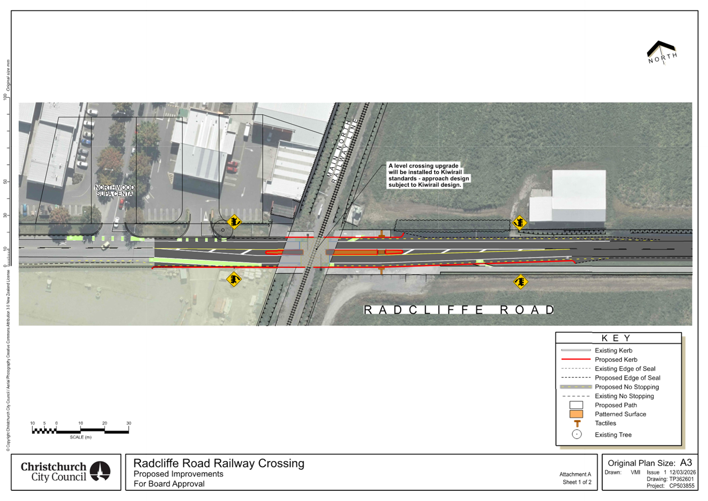
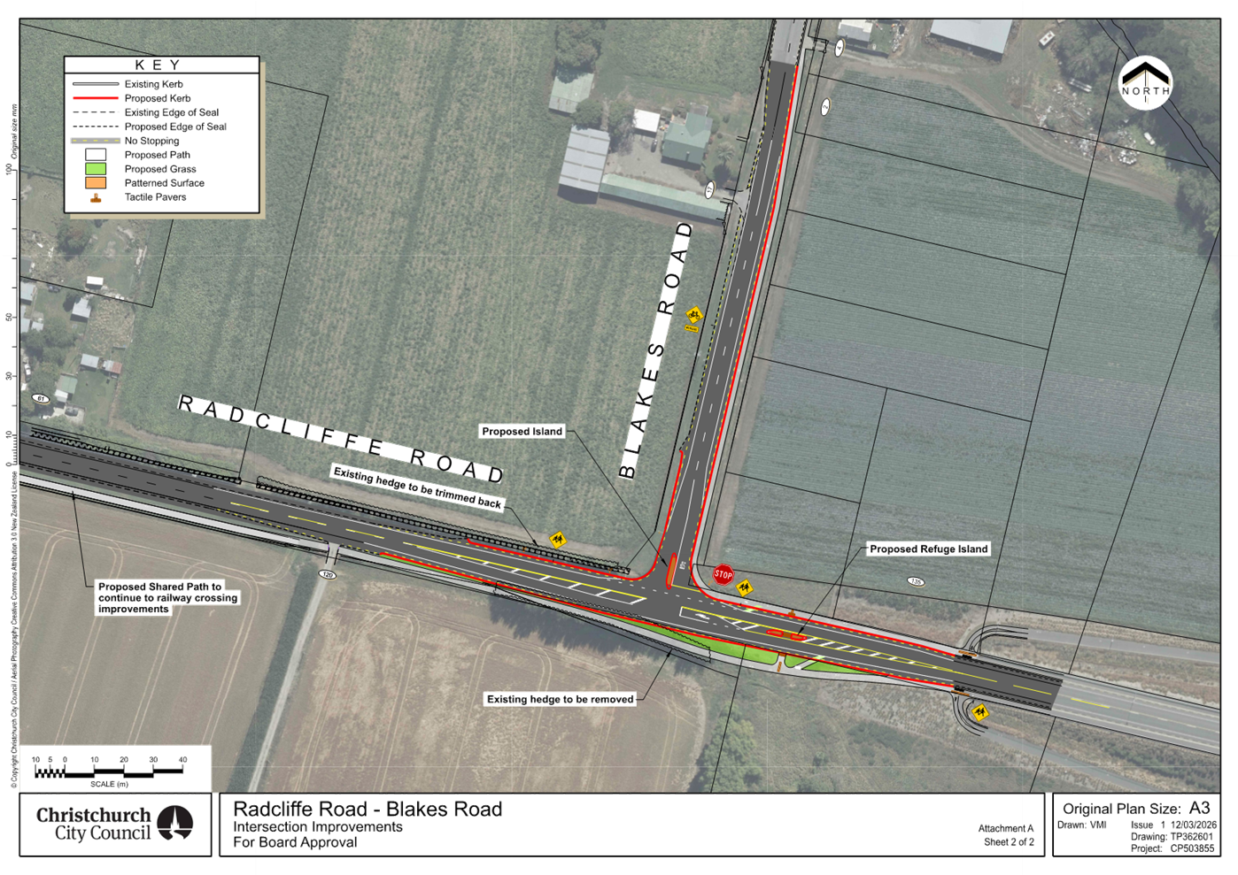
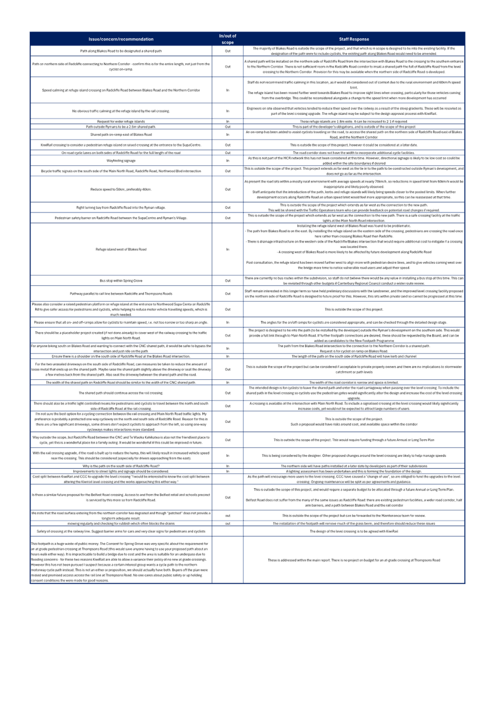
|
10. Marshland Road / Main North Road /
Spencerville Road Intersection Improvements Report
|
|
Reference Te Tohutoro:
|
26/95758
|
|
Responsible Officer(s) Te Pou Matua:
|
Nick
Reid, Traffic Engineer
Daisy-Bea Scrase, Engagement Advisor
|
|
Accountable ELT Member Pouwhakarae:
|
Brent
Smith, General Manager City Infrastructure
|
1. Purpose and Origin of the Report Te Pūtake Pūrongo
1.1 For
the Waimāero Fendalton-Waimairi-Harewood Community
Board to approve a stop control and redesigned slip-lane road markings on Main
North Road at its intersection with Marshland Road and Spencerville Road.
1.2 This
report has been written following a safety review of the Main North Road
– Marshland Road corridor (Old Waimakariri Bridge to Prestons Road) and the identification of a safety issue at this
intersection.
1.3 The
stop control, and changes to the approach layout on Spencerville Road, will be
considered by the Waitai Coastal-Burwood-Linwood Community Board.
1.4 The recommended option is to install a stop control and new
slip-lane markings in accordance with Attachment A.
2. Officer Recommendations Ngā
Tūtohu
That the
Waimāero Fendalton-Waimairi-Harewood Community Board:
1. Receives the information in the Marshland Road / Main North
Road / Spencerville Road Intersection Improvements Report.
2. Notes that the decision in this report is
assessed as low significance based on the Christchurch City Council’s
Significance and Engagement Policy.
3. Approves that in accordance with Section 4 of
the Land Transport Rule: Traffic Control Devices 2004, that a stop control be
placed against Main North Road at its intersection with Marshland Road and
Spencerville Road, as detailed on plan TG1509S3 dated 20/01/2026 and attached
to this report as Attachment A.
4. Approves that any previously approved
resolutions be revoked, in accordance with Section 2 of the Land
Transport-Traffic Control Devices Rule:2004, pertaining to traffic controls,
made pursuant to any Bylaw, Local Government Act or any Land Transport Rule, to
the extent that they are in conflict with, or recommended to be removed, in
regard to the traffic controls described in recommendation 3 above.
5. Approves that these resolutions take effect
when parking signage and/or road marking that evidence the restrictions
described in 3 are in place (or removed in the case of revocations).
3. Executive Summary Te Whakarāpopoto Matua
3.1 A
safety issue of drivers failing to give way on the Spencerville Road approach
to the intersection of Marshland Road, Main North Road and Spencerville Road
was identified by staff as part of a safety review of this section of Marshland
Road.
3.2 A nearby issue of
insufficient space at the south west corner of the intersection for people
walking to access the bus stop on Main North Road was identified by the
public.
3.3 The
recommended option is to install a stop control on Main North Road in
accordance with Attachment A. This will match the proposed stop control on
Spencerville Road. The recommended option also includes changes to the slip
lane line-markings.
3.4 The
intersection is located on a Community Board boundary with the Waitai
Coastal-Burwood-Linwood Community Board. The proposed changes on the east side
of Marshland Road, which include a median island and stop control, are being
taken to their decision meeting on 9 March 2026. The minor nature of this
proposal led to the decision to complete dual Community Board reports, rather
than a metro level report to the Council.
4. Background/Context Te Horopaki
4.1 The
Marshland Road corridor, from Prestons Road to Old Waimakariri Bridge, was
previously identified as a high-risk corridor, however a recent review of the
corridor has identified that since the opening of the Christchurch
Northern Corridor (CNC), and a reduction in the speed limit, the number and
severity of crashes has reduced.
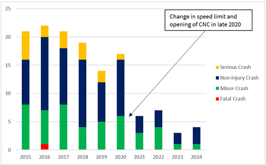
Figure
1: Change in crashes over a ten-year period
4.2 There
is one location where crashes have continued to occur. This is at the Main
North Road/Marshland Road/Spencerville Road intersection. Therefore,
the project seeks to address the ongoing safety concern at this location.
4.3 The
intersection of Marshland Road, Main North Road and Spencerville Road is
controlled by a Give Way sign on the east and west approaches. The Spencerville
approach currently has a straight/right-turning lane as well as a left-turning
lane.
4.4 There were three crashes in the period from 2021 to 2025 at
the Main North Road/Marshland Road/Spencerville Road intersection. One minor
injury crash and two non-injury crashes, all of which occurred due to drivers
failing to give-way when leaving Spencerville Road. In all three crashes the driver was leaving from the Spencerville
Road straight/right-turning lane and heading in a straight direction towards
Main North Road.
4.5 The Christchurch Northern Corridor (CNC) project
opened on Thursday 17 December 2020, providing a 4-lane motorway between the
Waimakariri Bridge and Cranford Street. Prior to this opening, a traffic count
undertaken in 2019 showed that there were approximately 18,000 vehicles per day
(vpd) using Marshland Road (south of Spencerville Road). A count undertaken in
2021, shows that there are now approximately 8000vpd using this section of
Marshland Road, a reduction of 10,000vpd.
4.6 A turning count undertaken in June 2022, showed
that there were 41 vehicles exiting Spencerville Road in the morning peak hour
(29 straight ahead, 6 turning left and 6 turning right), and 27 exiting in the
evening peak hour (15 straight ahead, 8 turning left and 4 turning right).
4.7 A concern was also raised through a Hybris ticket regarding
people walking on the road from Marshland Road around the corner onto Main
North Road to access the bus stop. Traffic Operations observed the intersection
for two morning periods (6-8am), one school pm period (230-330), and then one
pm peak period (4.30-7pm).
4.8 The proposed design is based
on current New Zealand Transport Agency Waka Kotahi (NZTA) standards and best
practice guidance, visibility requirements, and vehicle tracking analysis,
rather than crash history alone.
4.9 Proposed design
The proposed
intersection improvements in accordance with Attachment A are to:
4.9.1 Change
the priority control on Main North Road and Spencerville Road at the Marshland
Road / Main North Road / Spencerville Road intersection from Give-Way Control
to Stop Control. The slip-lanes will be retained as Give-Way Controls.
· A stop sign is required due to
restricted visibility and to comply with NZTA standards. It is also necessary
to match the proposed opposing stop control on Main North Road and ensure
consistent driver expectation. Retaining the give-way control is therefore not
appropriate.
4.9.2 Install
a median island on Spencerville Road approach, allowing for gated Stop signs to
be installed in view of approaching drivers.
4.9.3 Reduce
Spencerville Road approach to a single lane to further improve the visibility
and reduce masking by adjacent vehicles. All three crashes were related to
motorists on the Spencerville westbound approach failing to give way to
motorists approaching from their left (northbound motorists coming from the
direction of the railway level crossing).
· The exit width will be
approximately 5 metres at its narrowest point on the approach to the
intersection. While the minimum lane width under NZTA standards is 2.5 metres,
marking two formal lanes (for a left- and right- turning vehicle) would result
in a constrained outcome.
· The turning
count demonstrates that there is no requirement for two exit lanes based on the
number of vehicles exiting and the reduced amount of traffic on the main road
(Marshland Road).
· Relocating the traffic island
further north was investigated to maintain two lanes. However, this would
adversely affect the turning paths of larger vehicles, including coaches and
semi-trailers entering Spencerville Road from the north.
4.9.4 Provide additional space for pedestrians on the south-west corner
for access to the bus stop on Main North Road, (issue sourced from tickets) by
changing road marking in the slip lane.
Options Considered Ngā Kōwhiringa Whaiwhakaaro
4.10 The
following reasonably practicable options were considered and are assessed in
this report:
4.10.1 Intersection
improvements, as shown in Attachment A.
4.10.2 Do
nothing. The recommended option is
considered to be the minimum solution for the corridor.
Options Descriptions Ngā Kōwhiringa
4.11 Preferred
Option: Intersection improvements
4.11.1 Option Description: Install Stop Controls, median island and
redesigned lane marking.
4.11.2 Option
Advantages
· Reduces the likelihood (risk) of crashes at the intersection by
changing the control of the Spencerville approach from a give way control to a
Stop Control.
· Resolves the
issue of motorists at the Spencerville Road approach failing to notice the
control of the intersection with a gated stop sign located in the island.
· Resolves the issue of insufficient space being provided for people
walking on the south corner for access to the bus stop on Main North
Road.
4.11.3 Option
Disadvantages
· Cost to implement
4.12 Do nothing
4.12.1 Option Description: Existing
layout remains with no improvements.
4.12.2 Option
Advantages
· No cost.
4.12.3 Option
Disadvantages
· Does not resolve the issue of motorists at the Spencerville Road
approach failing to give way.
· Does not
resolve the issue of insufficient space being provided for people walking on
the south corner for access to the bus stop on Main North Road.
5. Financial Implications Ngā Hīraunga Rauemi
Capex/Opex Ngā Utu Whakahaere
|
|
Recommended Option
|
Option 2 – Do Nothing
|
|
Cost to Implement
|
$45,000
|
$0
|
|
Maintenance/Ongoing Costs
|
Covered by existing maintenance
contract
|
N/A
|
|
Funding Source
|
60097 Marshlands Road Corridor Improvement
(Prestons Road to Old Waimakariri Bridge)
|
N/A
|
|
Funding Availability
|
Funding available in the above-named
budget
|
N/A
|
|
Impact on Rates
|
None
|
N/A
|
6. Considerations Ngā Whai Whakaaro
Risks and Mitigations Ngā Mōrearea me
ngā Whakamātautau
6.1 None
identified.
Legal Considerations Ngā Hīraunga
ā-Ture
6.2 Statutory
and/or delegated authority to undertake proposals in the report:
6.2.1 Under Section
2 of the Land Transport Rule: Traffic Control Devices 2004, a road
controlling authority may authorise and, as appropriate, install, operate or
remove traffic control devices: (a) if desirable for the guidance of traffic or
to draw attention to a requirement that controls traffic; or (b) to provide
information to road users.
6.2.2 The
Community Boards have delegated authority from the Council to exercise the
delegations as set out in the Delegations Register. The list of delegations for
the Community Boards includes the resolution of stopping and traffic control
devices.
6.2.3 The
installation of any signs and/or markings associated with traffic control
devices must comply with the Land Transport Rule: Traffic Control Devices 2004.
6.3 Other Legal Implications:
6.3.1 There
is no legal context, issue, or implication relevant to this decision.
6.3.2 This
specific report has not been reviewed and approved by the Legal Services Unit
however the report has been written using a general approach previously
approved of by the Legal Services Unit, and the recommendations are consistent
with the policy and legislative framework outlined in this report.
Strategy
and Policy Considerations Te
Whai Kaupapa here
6.4 The
required decision:
6.4.1 Aligns
with the Christchurch
City Council’s Strategic Framework.
6.4.2 Is
assessed as low significance based on the Christchurch City Council’s
Significance and Engagement Policy. The level of significance was
determined by the low number of people affected and/or with an interest.
6.4.3 Is consistent with Council’s Plans and
Policies.
6.5 This
report supports the Council's
Long Term Plan (2024 - 2034):
6.6 Transport
6.6.1 Activity: Transport
· Level of Service: 10.0.6.1 Reduce the number of death and
serious injury crashes on the local road network (DIA 1) - 4 less than previous
FY
· Level of Service: 10.0.6.2 Reduce the number of death and
serious injury crashes on the local road network - Five year rolling average
<95 crashes per year
Community
Impacts and Views Ngā Mariu ā-Hāpori
6.7 Consultation
started on 28 November and ran until 18 December 2025.
6.8 Project
details including a flyer were advertised via:
· A
flyer drop to 13 properties, including businesses on Spencerville Road.
· An
email to businesses and organisations on Spencerville Road.
6.9 Summary
of Submissions Ngā Tāpaetanga
6.9.1 One
resident from Spencerville Road provided feedback. They were not in support of
reducing the Spencerville Road approach to one lane or the installation of stop
signs.
6.10 The
decision affects the following wards/Community Board areas:
6.10.1 Waimāero
Fendalton-Waimairi-Harewood Community Board
6.10.2 Waitai
Coastal-Burwood-Linwood Community Board
Impact
on Mana Whenua Ngā
Whai Take Mana Whenua
6.11 The decision does not involve a significant decision in
relation to ancestral land, a body of water or other elements of intrinsic
value, therefore this decision does not specifically impact Mana
Whenua, their culture, and traditions.
Climate
Change Impact Considerations Ngā Whai Whakaaro mā te Āhuarangi
6.12 The
proposals in this report are unlikely to contribute significantly to adaptation
to the impacts of climate change or emissions reductions.
7. Next Steps Ngā Mahinga ā-muri
7.1 If approved, staff will
arrange for new road marking, island and signage to be installed in the current
financial year.
Attachments Ngā Tāpirihanga
|
No.
|
Title
|
Reference
|
Page
|
|
a ⇩
|
Marshland Rd -
Main North Rd - Spencerville Rd - Plan
|
26/106180
|
50
|
In addition to the attached documents, the following background
information is available:
|
Document
Name – Location / File Link
|
|
Not
applicable
|
Signatories Ngā Kaiwaitohu
|
Authors
|
Nick Reid -
Traffic Engineer
Daisy-Bea
Scrase - Engagement Advisor
Gemma Dioni -
Principal Advisor Transportation Safety
|
|
Approved By
|
Kathy Graham -
Team Leader Traffic Operations
Stephen Wright
- Head of Transport & Waste Management
|
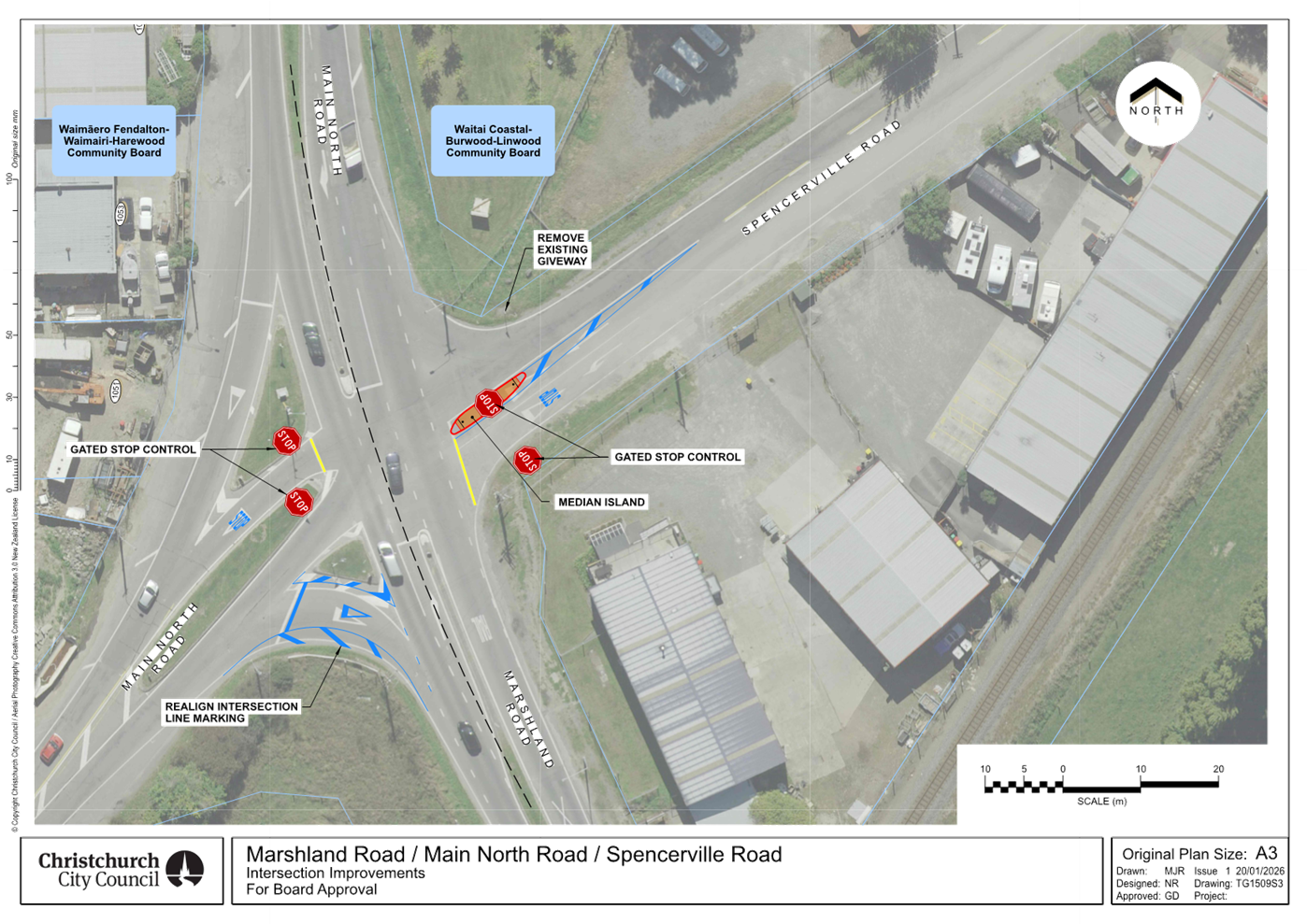
|
11. Glandovey/Heaton/Rossall/Strowan - Right turn
arrows
|
|
Reference Te Tohutoro:
|
26/677721
|
|
Responsible Officer(s) Te Pou Matua:
|
Gemma
Dioni, Principal Advisor - Transport
|
|
Accountable ELT Member Pouwhakarae:
|
Brent
Smith, General Manager City Infrastructure
|
1. Purpose and Origin of the Report Te Pūtake Pūrongo
1.1 This
report is for the Waimāero Fendalton-Waimairi-Harewood Community Board to
approve right turn phases on Rossall Street and Strowan Road at the Glandovey
Road, Heaton Street, Rossall Street, Strowan Road intersection.
1.2 The
report has been written in response to requests to support the nearby three
waters and roading projects in the northwest of the city.
1.3 Staff
are undertaking a full upgrade of the traffic signals. This includes
underground cables, new signal poles and lanterns, as these critical assets are
at the end of their working life and need to be replaced before additional
right turn phases can be introduced. Currently the approaches form Rossall
Street and Strowan Road into Glandovey Road and Heaton Street have pedestrian
protection arrows (single red right turn display), which require upgrading to
fully controlled right turn movements (green, amber & red displays) to
enable effective management of traffic during the future three waters and
roading projects.
1.4 The
upgrade will also include minor safety improvements for people walking and
crossing. This will be through the new kerb cutdowns to align with new pole
locations and road markings. This will provide increased separation between
pedestrian crossings. Cycle marking changes are also proposed, which include a
new advanced cycle stop box and coloured surfacing.
2. Officer Recommendations Ngā
Tūtohu
That the
Waimāero Fendalton-Waimairi-Harewood Community Board:
1. Receives the information in the
Glandovey/Heaton/Rossall/Strowan - Right turn arrows Report.
2. Notes that the decision in this report is
assessed as low significance based on the Christchurch City Council’s
Significance and Engagement Policy.
3. Approves, pursuant to Section 331 and 334 of
the Local Government Act 1974:
a. All kerb alignments and road markings changes
on Glandovey Road, Heaton Street, Rossall Street and Strowan Road as detailed in Attachment
A of this report.
b. The installation of hardware to facilitate
traffic signal control of the right turn movement from Rossall Street (south)
and Strowan Road (north).
4. Notes that staff will review the operation of
the intersection following completion of the three
waters and roading projects to
determine whether the right turn phases should be retained.
3. Executive Summary Te Whakarāpopoto Matua
3.1 The
Council’s Three Waters and Transport teams are delivering a number of
renewals and capital projects in the northwest of the city. While this work is
essential to keep the three waters network operational and to deliver the
transport improvements and maintenance work, it is likely to affect how people
drive around the local road network. The signal upgrade outlined in this report
aim to keep traffic flowing through the wider area while these works are in
place.
4. Background/Context Te Horopaki
4.1 A
full upgrade of the traffic signals is required at the Glandovey Road/Heaton
Street/Rossall Street/Strowan Road intersection as these critical assets are at
the end of their working life and to support the additional traffic signal
displays required to support effective traffic management. There is therefore
an opportunity to include minor improvements as part of the work to improve
safety for people walking and crossing at this intersection. These improvements
include:
4.1.1 Altering
the kerb cut downs to provide separation between the crossing points and to
align with the new pole locations and road marking (similar to the existing
arrangement on the South-west corner of the intersection). Tactile paving will
be adjusted to suit the new crossing alignments.
4.1.2 Addition
of a new advanced stop boxes and additional coloured surfacing for people
cycling.
Options Considered Ngā Kōwhiringa Whaiwhakaaro
4.2 The
following reasonably practicable options were considered and are assessed in
this report:
4.2.1 Introduce
right turn green arrows from Rossall Street and Strowan Road.
4.2.2 Do
nothing.
Options Descriptions Ngā Kōwhiringa
4.3 Preferred
Option: Introduce right turn green arrows from Rossall Street and Strowan
Road.
4.3.1 Option
Advantages
· Improve the
ability for drivers to turn right from the north and south approaches.
· Provide
separation between the crossing points.
· Introduce an
advanced stop box and coloured surfacing for people cycling.
4.3.2 Option
Disadvantages
· Cost to
Council
· Potential
impact on intersection efficiency, as the right turn phasing changes are likely
to introduce additional delay to movements on other intersection approaches.
4.4 Do
Nothing
4.4.1 Option
Advantages
· No cost to
Council
4.4.2 Option
Disadvantages
· Does not
improve the ability for drivers to turn right from Rossall Street and Strowan
Road and Grahams Road when traffic management is in place at worksites, which
could affect people’s driving routes.
5. Financial Implications Ngā Hīraunga Rauemi
Capex/Opex Ngā Utu Whakahaere
|
|
Recommended Option
|
Option 2 – Do nothing
|
|
Cost to Implement
|
$750k approx
|
$0
|
|
Maintenance/Ongoing Costs
|
To be covered under the Traffic Signals
Maintenance contract. Would reduce the cost of maintenance in the medium-term
due to new assets being provided.
|
$0
|
|
Funding Source
|
#37293 Delivery Package - Traffic Signals Renewals
|
$0
|
|
Funding Availability
|
Funding available in the above-named
budget.
|
$0
|
|
Impact on Rates
|
None
|
$0
|
5.1 The
cost are high-level estimates and are not tendered prices.
5.2 The
traffic signals require renewal at the intersection, as the cables are at the
end of their working life. As part of the traffic signal renewal, it is
proposed to undertake further improvements.
6. Considerations Ngā Whai Whakaaro
Risks and Mitigations Ngā Mōrearea me
ngā Whakamātautau
6.1 There
is a risk that not completing the work now and having to undertake it at a more
reactive time during the delivery of the northwest three waters and roading
programme, would compound the impacts on people driving around the network when
there are other road closures and traffic management in place. Completing this
work now, ahead of major works, should lessen the impact on the local
community. Completing this work ahead of the scheduled resurfacing will also
minimise any redundant works through trenching to lay cables and ducts.
Legal Considerations Ngā Hīraunga
ā-Ture
6.2 Statutory
and/or delegated authority to undertake proposals in the report:
Local Government
Act 1974
6.2.1 Section
331 provides authority to approve concept plans for forming or upgrading
footpath, kerbs and channels.
6.2.2 The
installation of any signs and/or markings associated with traffic control
devices must comply with the Land Transport Rule: Traffic Control Devices 2004.
6.3 Other Legal Implications:
6.3.1 There
is no other legal context, issue, or implication relevant to this decision.
6.3.2 This
specific report has not been reviewed and approved by the Legal Services Unit
however the report has been written using a general approach previously
approved of by the Legal Services Unit, and the recommendations are consistent
with the policy and legislative framework outlined in this report.
Strategy
and Policy Considerations Te
Whai Kaupapa here
6.4 The
required decision:
6.4.1 Is assessed as
low significance based on the Christchurch City Council’s Significance
and Engagement Policy. The level of significance was determined by the low
level of impact and low number of people affected by the recommended decision.
6.4.2 The
recommended option is consistent with the Council’s Plans and Policies,
in particular:
· LTP Activity
Plan - Level of Service target to reduce the number of deaths or serious
injuries (DSI) from all crashes by 40% in 2030.
· The changes
made align with the safe and healthy streets for everyone goal in the
Ōtautahi Christchurch Future Transport Strategy 2024-2054.
6.4.3 Improving
safety on local roads is a priority for the Council.
6.5 This
report supports the Council's
Long Term Plan (2024 - 2034):
6.6 Transport
6.6.1 Activity: Transport
· Level of Service: 10.0.6.1 Reduce the number of death and
serious injury crashes on the local road network (DIA 1) - 4 less than previous
FY
· Level of Service: 10.0.6.2 Reduce the number of death and
serious injury crashes on the local road network - Five year rolling average
<95 crashes per year
Community
Impacts and Views Ngā Mariu ā-Hāpori
6.7 Due
to the very minor nature of improvements at the intersection consultation has
not been undertaken.
6.8 The decision affects the following Community Board areas:
6.8.1 Waimāero
Fendalton-Waimairi-Harewood Community Board.
Impact
on Mana Whenua Ngā
Whai Take Mana Whenua
6.9 The
decision does not involve a significant decision concerning ancestral land or a
body of water or other elements of intrinsic value, therefore this decision
does not specifically impact Mana Whenua, their culture and traditions.
6.10 The decision does
not involve a matter of interest to Mana Whenua and will not impact on our
agreed partnership priorities with Ngā Papatipu Rūnanga.
Climate
Change Impact Considerations Ngā Whai Whakaaro mā te Āhuarangi
6.11 The
proposals in this report are unlikely to contribute significantly to adaptation
to the impacts of climate change or emissions reductions.
6.12 This is a minor
proposal that is principally intended to improve accessibility and safety for
people crossing at the intersection.
7. Next Steps Ngā Mahinga ā-muri
7.1 If
approved, staff will proceed with construction.
Attachments Ngā Tāpirihanga
|
No.
|
Title
|
Reference
|
Page
|
|
a ⇩
|
Glandovey/Heaton/Rossall/Strowan
- Intersection Improvements
|
26/718437
|
56
|
In addition to the attached documents, the following background
information is available:
|
Document
Name – Location / File Link
|
|
Not
applicable
|
Signatories Ngā Kaiwaitohu
|
Author
|
Gemma Dioni -
Principal Advisor Transportation Safety
|
|
Approved By
|
Jann-Philipp
Phoenix - Team Leader Real Time Operations
Kathy Graham -
Acting Operations Manager
|
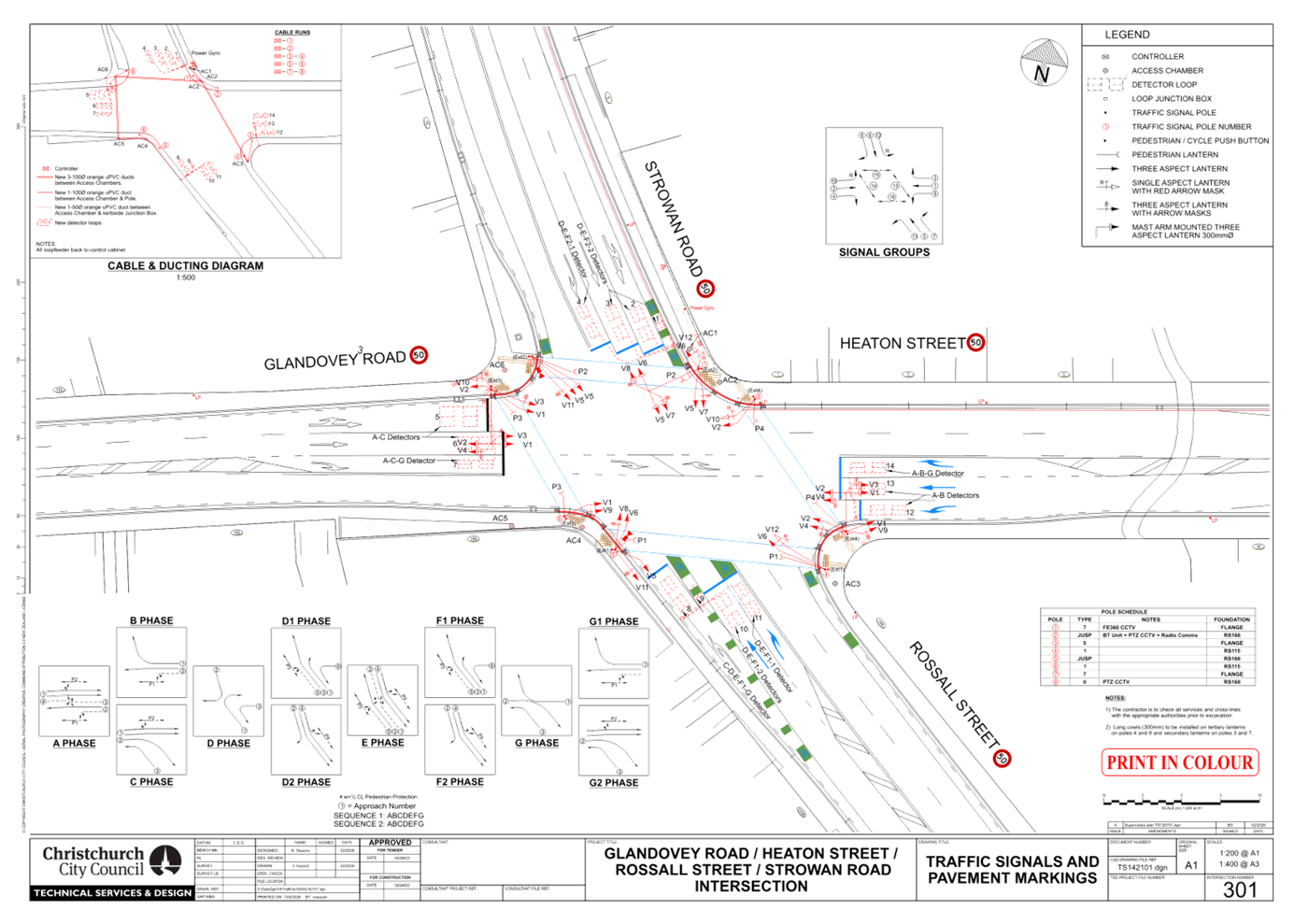
|
12. Grant an Easement for Fibre Installation to
Enable, at Tulett Park, Casebrook
|
|
Reference Te Tohutoro:
|
26/478074
|
|
Responsible Officer(s) Te Pou Matua:
|
Elizabeth
Hoskins, Property Consultant
|
|
Accountable ELT Member Pouwhakarae:
|
Andrew
Rutledge, General Manager Citizens and Community
|
1. Purpose and Origin of the Report Te Pūtake Pūrongo
1.1 The
purpose of this report is to request the Community Board to exercise its
delegation to approve an easement over land governed under Section 48(1) of the
Reserves Act 1977.
1.2 The
easement will be for Enable Networks Limited, to provide fibre across Tulett
Park to the Nomads United AFC clubrooms (as Lessee), located next to the
carpark with entry from Claridges Road.
1.3 The
decision in this report is of low significance in relation to the Christchurch
City Council’s Significance and Engagement Policy. The level of
significance was determined by considering the easement over the reserve will
allow robust and reliable internet connectivity to the Lessee and is below
ground.
1.4 The
Community Board holds the delegation to grant easements over reserve land
pursuant to the Reserves Act 1977, subject to consent from the Minister of
Conservation (delegated to the Council Chief Executive)
2. Officer Recommendations Ngā
Tūtohu
That the
Waimāero Fendalton-Waimairi-Harewood Community Board:
1. Receives the information in the Grant an Easement for Fibre
Installation to Enable, at Tulett Park, Casebrook Report.
2. Notes that the decision in this report is
assessed as low significance based on the Christchurch City Council’s
Significance and Engagement Policy.
3. Approves the installation of a fibre cable and
subsequent granting of an easement in favour of Enable Networks Limited to
convey underground utilities within the land described as Reserve 5136
comprising 6.0930 ha (Recreation Reserve) and Lot 126 Deposited Plan 82299
(Recreation Reserve) comprising 6179 m2, known as Tulett Park.
4. Notes that approval is subject to Section
48(1) of the Reserves Act 1977 and is subject to the Minister of Conservation
consent to the easement, as delegated to the Council Chief Executive under the
Instrument of Delegation for Territorial Authorities dated 12 June 2013. The
Community Board recommends the Chief Executive exercise their delegation in
this regard.
3. Executive Summary Te Whakarāpopoto Matua
3.1 Staff
recommend granting the easement for fibre (underground cables) across Tulett
Park which is a recreation reserve, to the Lessee, Nomads United AFC under
Section 48(1) of the Reserves Act 1977.
3.2 This
sports club is a not-for -profit entity for sporting and community benefit and
has occupied the land since 1989 with an initial lease with the Waimairi
District Council. The club owns the building.
3.3 Fibre
is the preferred option for the provision of internet services, as this is a
reliable service with the capacity to allow the club and its operations to
operate efficiently and effectively.
3.4 This
includes streaming games on a large screen, operating an electronic scoreboard,
operating security cameras, and general business in running the club.
3.5 The
underground cables and installation will have minimal impact on the public and
access to the reserve will not be affected. An aerial and plan of the route is
shown below.
3.6 The
city arborist has confirmed there will be no impact to existing trees as the
route bypasses most of these and, where close, the cable trench will be hand
dug.
3.7 Attachment
A has the route and description of installation from Enable Networks Ltd.
4. Plans and Photos
1) Aerial
showing location of the Nomads Football Club building

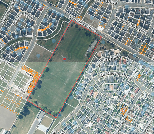
2) View
from Claridges Rd entry to Tulett Park


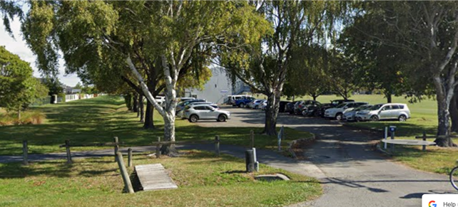
Lot 126 No
93 No
99 Reserve 5136
3) Approved
Enable Plan showing the route over No 93 and 99 Claridges road
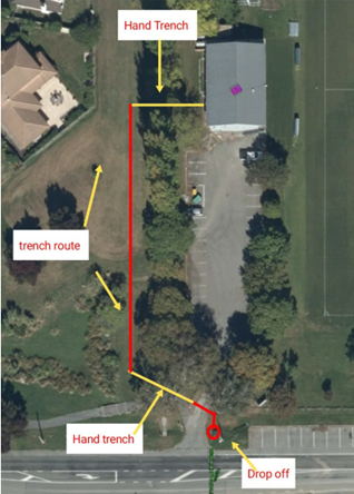
5. Background/Context Te Horopaki
5.1 Tulett Park is a recreation
reserve being described as Reserve 5136 comprising 6.0930ha on Record of Title
CB 10F/1014 and adjoining Lot 126 Deposited Plan 82299 comprising 6179m2
On Record of
Title CB47C/710.
5.2 The
Nomads Football Club have occupied the land since 1989 as Lessee, and they
built and own the existing building.
5.3 The
sports club is a not-for-profit entity and they also offer the clubrooms for
community use.
5.4 The
club require fibre to operate their business effectively with a robust and
reliable internet service. They require fibre to allow efficient business use
including but not limited to streaming games for members, an electronic
scoreboard, and to operate security systems etc.
5.5 Access
for the underground cable will be from the street to the building and through a
recreation reserve. Therefore the process under Section 48(1) of the Reserves
Act 1977 is required to allow the installation by way of an easement.
5.6 There
is an expectation that Lessees on a reserve, which are sports clubs and
community groups, will have the ability to be provided with utilities that
support the functionality of that entity.
5.7 The following related memos/information were circulated to the
meeting members:
5.8 The following related information session/workshops have taken place
for the members of the meeting:
Options Considered Ngā Kōwhiringa Whaiwhakaaro
5.9 The
following reasonably practicable options were considered and are assessed in
this report:
§ Grant an Easement to allow a fibre
connection to the clubrooms.
5.10 The
following options were considered but ruled out:
§ Do not Grant an Easement for fibre
and request the Sports Club use other wireless options for internet
connectivity. These other options, however, would not provide sufficient
capability for the efficient use of the internet for their business and community
events.
Options Descriptions Ngā Kōwhiringa
5.11 Preferred
Option: - Grant an Easement to allow a fibre connection to the
clubrooms.
5.11.1 Option
Description: Grant an Easement to allow a fibre connection to the
clubrooms.
5.11.2 Option
Advantages
· This will
allow a robust and reliable internet connection needed for the club to use for
their business and any events.
5.11.3 Option
Disadvantages
· There are no
disadvantages with this option. The installation will have the Parks unit
oversight and approval regarding location, scope of work, tree protection
access and any remediation.
5.12 Do
not Grant an Easement for fibre.
5.12.1 Option
Description: Do not Grant an Easement for fibre.
5.12.2 Option
Advantages
· There are no
advantages with this option and any other options for internet connectivity
would provide an inferior service and are not practical in this
situation.
5.12.3 Option
Disadvantages
§ Enable would be unlikely to install
fibre through the reserve without some protection for their infrastructure.
Analysis Criteria Ngā Paearu Wetekina
5.13 Installation
of fibre to the building through the reserve is the most practical, reasonable
and cost-effective option for the club and providing an easement to protect
Enable’s infrastructure ensures the fibre installation is protected.
6. Financial Implications Ngā Hīraunga Rauemi
Capex/Opex Ngā Utu Whakahaere
|
|
Recommended Option
|
|
Cost to Implement
|
Costs to be met by Enable other than
staff time
|
|
Maintenance/Ongoing Costs
|
Nil
|
|
Funding Source
|
N/A
|
|
Funding Availability
|
N/A
|
|
Impact on Rates
|
Nil
|
6.1 Costs
will be met by Enable.
7. Considerations Ngā Whai Whakaaro
Risks and Mitigations Ngā Mōrearea me
ngā Whakamātautau
7.1 There
are no risks in granting this easement to Enable Networks Limited. The utility
will be managed under a business-as-usual approach by the operators and access
to install or maintain by Enable Networks will require notification to and
approval from the Council.
7.2 The
Council will be indemnified for any damage to the cable or conduit.
7.3 Should
the Council need the cable to be relocated in the future for any development,
this will be at the cost of Enable Networks limited.
Legal Considerations Ngā Hīraunga
ā-Ture
7.4 Statutory
and/or delegated authority to undertake proposals in the report:
7.4.1 Section
48(1) of the Reserves Act 1977 states that the administering body of a reserve
may grant an easement over any part of the reserve.
7.4.2 A
public notice for this easement and works was not required under Section 48(3)
of the Reserves Act 1977 as the reserve is not likely to be materially amended
and the rights of the public are not permanently affected.
7.4.3 The
Minister of Conservation’s Instrument of Delegation for Territorial
Authorities dated 12 June 2013, delegating to Council and sub delegated to the
Chief Executive to exercise the power to consent to the granting of the
easement pursuant to Section 48(1) of the Reserves Act 1977 as recommended by
the Community Board.
7.5 Other Legal Implications:
7.5.1 There
is no legal context, issue, or implication relevant to this decision. Council
legal services will view and approve all legal documentation associated with
the easement.
7.6 Other Legal Implications:
7.6.1 There
is no legal context, issue, or implication relevant to this decision
Strategy and Policy
Considerations Te Whai Kaupapa here
7.7 The
required decision:
§ Aligns with the Christchurch
City Council’s Strategic Framework.The decision to grant this
easement to Enable Network Limited is consistent with Council’s Plans and
Policies.
§ Is assessed as low significance based
on the Christchurch City Council’s Significance and Engagement
Policy. The level of significance was determined by there being no impact
to Park users or access to the Park, and the cable is underground.
§ Is consistent
with Council’s Plans and Policies.
7.8 This
report supports the Council's
Long Term Plan (2024 - 2034):
7.9 Parks, Heritage and Coastal Environment
7.9.1 Activity: Parks and Foreshore
· Level of Service: 6.8.10.1 Appropriate use and occupation
of parks is facilitated - Processing of the application is started within ten
working days of receiving application - 95%
Community
Impacts and Views Ngā Mariu ā-Hāpori
7.10 The
cables are underground and there is no impact to park users or access to the
park.
7.11 The
park will also not be materially altered or damaged.
7.12 For
these reasons a public notice was not required under Section 48(3) of the
Reserves Act.
7.13 The
decision affects the Community Board areas:
§ Waimaero Fendalton-Waimairi-Harewood.
7.14 The
Community Board view has not been tabled prior to
this report.
Impact
on Mana Whenua Ngā
Whai Take Mana Whenua
7.15 The decision does not
involve a significant decision in relation to ancestral land, a body of
water or other elements of intrinsic value, therefore this decision to grant
this easement does not specifically impact Mana Whenua, their culture, and
traditions.
7.16 The decision does
not involve a matter of interest to Mana Whenua and will not impact on our
agreed partnership priorities with Ngā Papatipu
Rūnanga.
7.17 The decision does
not impact on Mana Whenua as the location is not a site of significance nor
does the granting of an easement impact on any culture or values.
Climate
Change Impact Considerations Ngā Whai Whakaaro mā te Āhuarangi
7.15 The proposals in
this report are unlikely to contribute significantly to adaptation to the
impacts of climate change or emissions reductions.
7.16 The
granting of an easement is for an underground utility on Council land.
8. Next Steps Ngā Mahinga ā-muri
8.1 Following
the recommendation to grant this easement, we will seek Minister of
Conservation approval, delegated to the Chief Executive, then complete all
documentation and processes required before any works commence on the reserve.
Attachments Ngā Tāpirihanga
|
No.
|
Title
|
Reference
|
Page
|
|
a ⇩
|
304/7090
Approved Enable Plan Enable Connect Plan__20260128_233348
|
26/612754
|
65
|
In addition to the attached documents, the following background
information is available:
|
Document
Name – Location / File Link
|
|
Not
applicable
|
Signatories Ngā Kaiwaitohu
|
Author
|
Elizabeth
Hoskins - Property Consultant
|
|
Approved By
|
Angus Smith -
Manager Property Consultancy
Kelly Hansen -
Manager Parks Planning & Asset Management
Rupert Bool -
Head of Parks
|
|
13. Waimāero
Fendalton-Waimairi-Harewood - Better-Off Fund Application for Consideration -
Belfast Community Network
|
|
Reference Te Tohutoro:
|
26/586312
|
|
Responsible Officer(s) Te Pou Matua:
|
Natalie
Dally, Community Development Advisor
|
|
Accountable ELT Member Pouwhakarae:
|
Andrew
Rutledge, General Manager Citizens and Community
|
1. Purpose and Origin of the Report Te
Pūtake Pūrongo
1.1 The
purpose of this report is for the Waimāero Fendalton-Waimairi-Harewood
Community Board to consider changing the recipient of a Better-Off Fund
allocation originally approved on 8 December 2025.
1.2 At
the Waimāero Fendalton-Waimairi-Harewood Community Board meeting of 8
December 2025 the Board approved a grant of $38,000 from its Better-Off Fund to
the Anglican Diocese of Christchurch - Parish of
Merivale St Albans towards the
purchase of a community van for use by groups in the Waimāero
Fendalton-Waimairi-Harewood Community Board area.
1.3 Due
to logistics around hosting the van, the Anglican
Diocese of Christchurch - Parish of Merivale St Albans are now unable to accept
the grant.
1.4 The
Belfast Community Network have confirmed that they are able to host the van.
1.5 The Belfast Community Network currently have a van that is borrowed
by the community and will be needing a new one soon due to user demand. They
have the capacity to purchase and manage the van with the Better-Off Funding.
Basing the van in Belfast will enhance access for organisations on the eastern
side of the Board area as St Barnabas currently operate a community van in
Fendalton on the western side.
|
1. Funding Request Number
|
2. Organisation
|
3. Project Name
|
4. Amount Requested
|
5. Amount Recommended
|
|
FWH_0003_BOF
|
Belfast Community Network
|
Community Van
|
$38,000
|
$38,000
|
1.6 This
report recommends reallocating $38,000 of previously committed funds to an
alternative organisation to deliver an equivalent project. This will result in the Board’s Better-Off Fund being
fully allocated.
2. Officer Recommendations Ngā
Tūtohu
That the Waimāero
Fendalton-Waimairi-Harewood Community Board:
1. Receives the information in the Waimāero Fendalton-Waimairi-Harewood -
Better-Off Fund Application for Consideration - Belfast Community Network Report.
2. Notes that the decisions in this report are
assessed as low significance based on the Christchurch City Council’s
Significance and Engagement Policy.
3. Revokes clause 3. of resolution
FWHB/2025/00071 passed on 8 December 2025 which read as follows:
Approves a grant
of $38,000 from its Better-Off Fund to the Anglican Diocese of Christchurch -
Parish of Merivale St Albans towards the purchase of a community van for use by
groups in the Waimāero Fendalton-Waimairi-Harewood Community Board area.
4. Approves a grant of $38,000 from its Better-Off Fund to the Belfast
Community Network towards the purchase of a community van for use by groups in
the Waimāero Fendalton-Waimairi-Harewood Community Board area.
3. Key Points Ngā Take Matua
Strategic Alignment Te
Rautaki Tīaroaro
3.1 The recommendations above are aligned to the Council's Strategic
Framework and in particular the strategic priorities of a Collaborative and
Confident City and A Cultural Powerhouse City. The
projects also align with the Te Haumako Te Whitingia Strengthening Communities
Together Strategy.
3.2 The
purpose of the fund is to partner with organisations and groups to support
local initiatives, projects, and activities through additional Community Board
funding, including a focus on supporting local action to increase climate
resilience.
3.3 Projects
will improve well-being by building social capital, encouraging participation,
increase accessibility and connectedness – generating opportunities for
youth, and diverse communities and increasing local pride.
3.4 When considering allocation of funds, priority will be given to
projects/initiatives that contribute towards the
following outcomes:
· Increasing the tree canopy
across the city and our regional parks
· Enhancing biodiversity
· Safer neighbourhoods
· Repairing infrastructure
and facilities
· Responding to climate
change through adaptation planning
· Encouraging active travel
3.5 Projects should also show a strong alignment to the Council's Te
Haumako Te Whitingia Strengthening Communities Together
Strategy.
3.6 Priority will also be given to projects that
directly contribute towards achieving Community Board Plan priorities.
Decision Making Authority Te Mana Whakatau
3.7 The
Community Board has the delegated authority to determine the allocation of the Better-Off
Fund for each community.
3.7.1 Allocations must be consistent with any
policies, standards or criteria adopted by the Council.
3.7.2 The Fund does not cover:
· Legal
challenges or Environment Court challenges against the
Council, Council Controlled Organisations, or Community Board decisions.
· Projects or
initiatives that change the scope of a Council project
or that will lead to ongoing operational costs to the Council (though Community
Boards can recommend to the Council that it consider a grant for this purpose).
Assessment of Significance and Engagement Te Aromatawai Whakahirahira
3.8 The
decisions in this report are assessed as low significance based on the
Christchurch City Council’s Significance and Engagement Policy.
3.9 The
level of significance was determined by the number of people affected and/or
with an interest.
3.10 Due to the assessment of low significance, no further community
engagement and consultation is required.
Discussion Kōrerorero
3.11 At the time of writing, the balance of the Better-Off Fund is
as below.
|
Total Budget 2023/25
|
Granted To Date
|
Available for allocation
|
Balance If Staff Recommendation adopted
|
|
$500,000
|
$462,000
|
$38,000
|
$0
|
3.12 Based
on the current Better-Off Fund criteria, the above application is
eligible for funding.
3.13 The
attached Project Brief provides detailed information for the application.
This includes organisational details, project details, financial information,
and a staff assessment.
Attachments Ngā Tāpirihanga
|
No.
|
Title
|
Reference
|
Page
|
|
a ⇩
|
Better off project brief - Community
Van - Belfast Community Network - March 2026
|
26/587424
|
82
|
Signatories Ngā Kaiwaitohu
|
Author
|
Natalie Dally
- Community Development Advisor
|
|
Approved By
|
Maryanne Lomax
- Manager Community Governance, Fendalton-Waimairi-Harewood
Matthew
McLintock - Manager Community Governance Team
John Filsell -
Head of Community Support and Partnerships
|
|
14. Waimāero
Fendalton-Waimairi-Harewood 2025/26 Youth Development Fund Applications -
Kaitlyn Adams and Burnside High School
|
|
Reference Te Tohutoro:
|
26/622738
|
|
Responsible Officer(s) Te Pou Matua:
|
Lisa
Gregory – Community Recreation Advisor
lisa.gregory@ccc.govt.nz
Karen Boag, Community Development Advisor, karen.boag@ccc.govt.nz
|
|
Accountable ELT Member Pouwhakarae:
|
Andrew
Rutledge, General Manager Citizens and Community
|
1. Purpose and Origin of the Report Te
Pūtake Pūrongo
1.1 The
purpose of this report is for the Waimāero Fendalton-Waimairi-Harewood
Community Board to consider applications received for funding from its 2025/26
Youth Development Fund.
1.2 There
is currently a balance of $8,250 remaining in
this fund.
2. Officer Recommendations Ngā
Tūtohu
That the Waimāero
Fendalton-Waimairi-Harewood Community Board resolve to:
1. Receives the information in the Waimāero Fendalton-Waimairi-Harewood
2025/26 Youth Development Fund Applications - Kaitlyn Adams and Burnside High
School Report.
2. Notes that the decisions in this report are
assessed as low significance based on the Christchurch City Council’s Significance and
Engagement Policy.
3. Approves a grant of $750 from its 2025/26
Youth Development Fund to Kaitlyn
Adams towards expenses to compete
at the Canoe Polo World
Championships in Germany from 15 to 19 September 2026.
4. Approves a grant of $800 from its 2025/26
Youth Development Fund to Burnside High School towards the costs of eight
ward-based students participating in the Spirit of Adventure Discovery Voyage
from 9 to 14 June 2026.
3. Key Points Ngā Take Matua
Strategic Alignment Te Rautaki Tīaroaro
3.1 The
recommendations in this report align to the Council's Community Outcome of A
Cultural Powerhouse City - Our diverse communities are supported to understand
and protect their heritage, pursue their arts, cultural and sporting interests,
and contribute to making our city a creative, cultural and events
‘powerhouse’.
Decision Making Authority Te Mana Whakatau
3.2 Determine
the allocation of the Discretionary Response Fund for each community (including
any allocation towards a Youth Development Fund).
3.3 Allocations must be consistent with any
policies, standards or criteria adopted by the Council.
3.4 The Fund does not cover:
· Legal challenges or
Environment Court challenges against the Council, Council Controlled
organisations or Community Board decisions.
· Projects or initiatives
that change the scope of a Council project or that will lead to ongoing
operational costs to the Council (though Community Boards can recommend to the
Council that it consider a grant for this purpose).
Assessment of Significance and Engagement Te Mana Whakatau
3.5 The
decisions in this report are assessed as low significance based on the
Christchurch City Council’s Significance and Engagement Policy.
3.6 The
level of significance was determined by the number of people affected and/or
with an interest.
3.7 Due
to the assessment of low significance, no further community engagement and
consultation is required.
4. Applicant Te Kaitono 1 –
Kaitlyn Adams
4.1 Age:
20
4.2 Suburb:
Burnside.
4.3 Event
seeking support for: Canoe Polo World Championships in Germany from 15 to
19 September 2026.
4.4 Kaitlyn
has been playing Canoe Polo for about six years and began her journey at
Middleton Grange School where she competed at Secondary Schools Nationals twice
and was the captain of the senior girls’ team for two years.
4.5 In
2022 Kaitlyn chose to trial for her first New Zealand campaign where she was
selected as the U18B Captain but was unfortunately cancelled due to
Covid. After high school her passion for the sport only grew stronger and
she trialled for New Zealand and in 2023 and made the U21A team which was a
great achievement.
4.6 As
her confidence grew Kaitlyn was selected for the 2024 World Championships team
and the team won a bronze medal in China. This year Kaitlyn has been
selected as Vice-Captain for the U21 Worlds team, which again is a huge
achievement for her.
4.7 Unfortunately
canoe polo does not receive any funding from the governing body, so players are
responsible for raising the funds for all their trips and competitions.
4.8 The
following table provides a breakdown of the costs for Kaitlyn’s trip:
|
EXPENSES
|
Cost ($)
|
|
Flights
|
$6,000
|
|
Accommodation
|
$2,000
|
|
Entry Fees
|
$1,000
|
|
Food
|
$1,000
|
|
Vehicle Hire
|
$1,000
|
|
Boat Transport
|
$1,500
|
|
Coach Fees
|
$1,500
|
|
Total
|
$14,000
|
5. Applicant Te Kaitono 2 –
Burnside High School
5.1 Event
seeking support for: Spirit of Adventure Five Day Discovery Voyage,
which departs from and returns to Auckland, from 9 to 14 June 2026.
5.2 Eight
of the ten participants reside in the Fendalton-Waimairi-Harewood area and are
Year 10 and 11 students:
· Isak Blommart, who
lives in Avonhead
· Gracie Byrne, who
lives in Harewood
· Katie Churchill, who
lives in Ilam
· Grace Guan, who
lives in Avonhead
· Tremain Laid, who
lives in Burnside
· Hannah Lin, who
lives in Ilam
· Alec McGeorge, who
lives in Bryndwr
· Guy Robinson, who
lives in Burnside
5.3 The
Spirit of Adventure Discovery Voyage is a five-day programme for Year 10 and 11
students. A group of up to ten students from each school joins peers from other
schools on board the tall ship, with approximately 40 young people in total on
each voyage.
5.4 Now
known as the ‘Discovery Voyage’ (previously the Trophy Voyage), the
programme offers a unique learning experience that combines challenge,
adventure, creativity, and reward.
5.5 Throughout
the voyage, students participate in a range of activities including
ship-handling, teamwork, problem-solving, debating, and water-based activities.
They also go ashore to complete challenges and take part in competitive games
that encourage ingenuity, leadership, and fun.
5.6 These
experiences provide opportunities for personal growth, confidence building, and
leadership development in an unforgettable setting at sea.
5.7 The
total cost of the voyage for the eight students is $14,086. To help meet the
shortfall, they have held a bake sale, with three more planned, as well as a
sausage sizzle at Mitre 10 on 9 May.
5.8 The
following table provides a breakdown of the costs for eight of the ten
participants who reside in the Fendalton-Waimairi-Harewood area:
|
EXPENSES
|
Cost ($)
|
|
Air Fares
|
1,830
|
|
Suttle Costs
|
256
|
|
Voyage Fees
|
12,000
|
|
Total
|
$14,086
|
Attachments Ngā Tāpirihanga
There are no
attachments to this report.
Signatories Ngā Kaiwaitohu
|
Authors
|
Lisa Gregory -
Community Recreation Advisor
Karen Boag -
Community Development Advisor
|
|
Approved By
|
Maryanne Lomax
- Manager Community Governance, Fendalton-Waimairi-Harewood
|
|
15. Fendalton-Waimairi-Harewood Youth Development
Fund - Approval Process
|
|
Reference Te Tohutoro:
|
26/669950
|
|
Responsible Officer(s) Te Pou Matua:
|
Maryanne
Lomax, Community Governance Manager, maryanne.lomax@ccc.govt.nz
|
|
Accountable ELT Member Pouwhakarae:
|
Andrew
Rutledge, General Manager Citizens and Community
|
1.1 Purpose
and Origin of the Report Te Pūtake Pūrongo The
purpose of this report is for the Waimāero Fendalton-Waimairi-Harewood
Community Board to consider the process for approving applications received to
their Youth Development Fund.
2. This report is staff generated.
3. Officer Recommendations Ngā
Tūtohu
That the Waimāero
Fendalton-Waimairi-Harewood Community Board:
1. Receives the information in the Fendalton-Waimairi-Harewood Youth Development
Fund - Approval Process Report.
2. Considers the options below with regards to
the approval process for Youth Development Fund applications:
a. Option A - Increase the Community Governance Manager’s
delegation to approve applications up to $1,000.
b. Option B - Implement a process for Youth Development Fund
applications to be approved by the Board via email.
c. Option C - Staff to
complete a full options report to come to a Board meeting for consideration of
applications being recommended for over $500.
4. Background/Context Te Horopaki
4.1 Each year the Board establishes a Youth Development Fund from their
Discretionary Response Fund.
4.2 The purpose of the Youth Development Fund is to celebrate and
support young people living in the Fendalton-Waimairi-Harewood area by
providing financial assistance for their development. The Community Board also
seeks to acknowledge young people’s effort, achievement and potential
excellence in the community.
4.3 In
the past three years, the Board has received an average of 25 applications each
year to this fund. The median grant amount has been $250.
4.4 Currently,
the Community Governance Manager has delegation from the Board to approve
applications up to $500. The fund recipients are reported back to the
Board via the monthly Area Report.
4.5 The
majority of applications fit within this delegation, however, on occasion we
receive applications from groups which include a number of young people from
the Board area. These applications could result in the staff
recommendation being over $500. Under the current process, this would
require a full options report to the Board for consideration. This can
often be an issue in terms of timeframes for the event they are seeking funding
for and the staff time involved in writing an options report for the Board
agenda.
4.6 To
streamline the process and make it easier for applicants, staff are asking the
Board to consider alternative options to approve these applications.
4.7 Option
A would increase the Community Governance Manager’s delegation to
$1,000 which would be the maximum amount we would recommend for an
application.
4.8 Option
B is implementing a process for the Board to approve Youth Development Fund
Applications by email. This would allow a quicker turnaround for decisions and
is the process currently used by most of the other Community Boards across the
city.
4.9 Option
C is the status quo, noting that a full options report is now required
rather than the short cover report used previously.
Attachments Ngā Tāpirihanga
There are no
attachments to this report.
In addition to the attached documents, the following background
information is available:
|
Document
Name – Location / File Link
|
|
Not
applicable
|
Signatories Ngā Kaiwaitohu
|
Author
|
Maryanne Lomax
- Manager Community Governance, Fendalton-Waimairi-Harewood
|
|
Approved By
|
Matthew
McLintock - Manager Community Governance Team
John Filsell -
Head of Community Support and Partnerships
|
|
16. Waimāero Fendalton-Waimairi-Harewood
2026-28 Community Board Plan
|
|
Reference Te Tohutoro:
|
26/614253
|
|
Responsible Officer(s) Te Pou Matua:
|
Maryanne
Lomax, Community Governance Manager, maryanne.lomax@ccc.govt.nz
|
|
Accountable ELT Member Pouwhakarae:
|
Andrew
Rutledge, General Manager Citizens and Community
|
1. Purpose and Origin of the Report Te Pūtake Pūrongo
1.1 The
purpose of this report is for the Waimāero Fendalton-Waimairi-Harewood
Community Board to adopt its 2026-28 Community Board Plan.
1.2 This
report is staff generated.
2. Officer Recommendations Ngā
Tūtohu
That the Waimāero
Fendalton-Waimairi-Harewood Community Board:
1. Receives the information in the Waimāero Fendalton-Waimairi-Harewood
2026-28 Community Board Plan Report.
2. Notes
that the decision in this report is
assessed as low significance based on the Christchurch City Council’s
Significance and Engagement Policy.
3. Adopts the Waimāero Fendalton-Waimairi-Harewood 2026-28
Community Board Plan.
3. Context / Background / Te Horopaki
3.1 The
purpose of the Waimāero Fendalton-Waimairi-Harewood Community Board Plan
(refer to Attachment A) is to identify the Board’s vision and
strategic priorities for the 2023-2025 term.
3.2 The
plan identifies nine priorities, which the board will focus on during their
term. For each priority, the plan includes:
· Why the project
matters
· What actions the
Board will take
· How the Board will
measure its success
3.3 The
nine Waimāero Fendalton-Waimairi-Harewood priorities are:
· Safety improvements
at the Withells Road/Yaldhurst Road intersection
· Safety improvements
for the pedestrian crossing at Avonhead School - Rakipaoa on Avonhead Road
· Improvements to
facilities at Burnside Park
· Community Traffic
Safety Committee - Merivale pilot project
· Elmwood Park
playground renewal
· Strengthening
Community Connections in Bryndwr
· Belfast Road
improvements (Blakes to Main North Road)
· Sheldon and Nunweek
Park improvements
· Radcliffe Road
railway crossing safety improvements
3.4 The
draft Waimāero Fendalton-Waimairi-Harewood 2026-28 Board Plan priorities
opened for community feedback via the Council's Kōrero mai/Let’s
talk website on 24 February 2026 and closed on 15 March 2026.
3.5 A
total of 28 submissions were received on the Board's draft priorities (refer to
Attachment B).
3.6 There
was overwhelming support for the nine priorities in the draft plan.
3.7 General
themes from the feedback included:
· The development of
safe cycling infrastructure across the Board area.
· The need to ensure
young people’s voices are heard in the development and upgrades of play
spaces, parks and community facilities.
· Traffic safety
improvements across the Board, particularly for cyclists and pedestrians.
3.8 Other
suggestions provided by submitters included:
· Completion of the
Wheels to Wings Major Cycle Route
· Extension of the
Uni-Cycle MCR through Avonhead, Russley, and Masham, connecting to the South
Express MCR.
· Traffic safety
improvements on Blighs Road for Waimairi School students.
· Improvements to
timing of roadworks to reduce disruption.
· A number of
suggestions for cycling infrastructure improvements (refer to attached
submissions for more details).
· Planting of fruit
and nut trees in parks.
· Safety improvements
at Brodie Street/Yaldhurst Road intersection.
· Installation of a
pedestrian crossing on Johns Road to improve safety for students at Pūtahi
Belfast School campus.
· A small dog walk in
Burnside Park, Nunweek Park and Sheldon Park.
· Netball court
lighting upgrade at Sheldon Park.
· Speed calming
measures down Factory Road.
3.9 Although
these suggestions do not form part of the Community Board Plan, they will be
forwarded to relevant staff for investigation.
3.10 Priorities
that involve other Council Units were sent to relevant staff for them to have
the opportunity to provide feedback. This feedback was sent to the Board
for their consideration.
Attachments Ngā Tāpirihanga
|
No.
|
Title
|
Reference
|
Page
|
|
a ⇩
|
Waimāero
Fendalton-Waimairi-Harewood 2026-28 Board Plan
|
26/620272
|
94
|
|
b ⇩
|
Waimāero
Draft Community Board Plan 2026-2028 Submissions
|
26/620802
|
110
|
In addition to the attached documents, the following background
information is available:
|
Document
Name – Location / File Link
|
|
Not
applicable
|
Signatories Ngā Kaiwaitohu
|
Author
|
Maryanne Lomax
- Manager Community Governance, Fendalton-Waimairi-Harewood
|
|
Approved By
|
Matthew
McLintock - Manager Community Governance Team
John Filsell -
Head of Community Support and Partnerships
|
|
17. Waimāero
Fendalton-Waimairi-Harewood Community Board Area Report - April 2026
|
|
Reference Te Tohutoro:
|
26/622100
|
|
Responsible Officer(s) Te Pou Matua:
|
Maryanne
Lomax, Community Governance Manager, maryanne.lomax@ccc.govt.nz
|
|
Accountable ELT Member Pouwhakarae:
|
Andrew
Rutledge, General Manager Citizens and Community
|
1. Purpose of Origin of the Report Te
Pūtake Pūrongo
1.1 This
report provides the Board with an overview of initiatives and
issues current within the Community Board area.
1.2 This
report is staff-generated monthly.
2. Officer Recommendations Ngā
Tūtohu
That the Waimāero
Fendalton-Waimairi-Harewood Community Board:
1. Receives the information in the Waimāero Fendalton-Waimairi-Harewood
Community Board Area Report - April 2026.
3. Community Support, Governance and Partnership Activity
3.1 Community Governance Projects
3.1.1 Kia
Ora Burnside - Connect@Kendal Event
Kia Ora Burnside - Connect@Kendal,
Burnside’s first community event, was a great success. The event took
place on the planned rain date of Tuesday, 10 March, with an estimated
400–500 attendees. It was encouraging to see strong local participation,
with around half of the attendees walking to the event, highlighting its
accessibility and local reach.
The event provided a welcoming,
family-friendly space for residents to connect, enjoy activities, and learn
more about local groups and services. A wide range of activities, alongside
free kai, including burgers and dumplings provided by community groups with
support from Kāinga Ora, were well received.
Feedback from stallholders and activity
providers was overwhelmingly positive. Many felt the event achieved its goal of
strengthening community connections, noting the variety of groups involved,
strong engagement with attendees, and the friendly atmosphere. Organisers were
also acknowledged for clear communication and support, and most indicated they
would be keen to participate again. As one of the participants shared: “Thank
you so much for the opportunity to be part of this event, it was amazing, and
we hope to be there next year!!” Sheldon Ogilvie, Piwakawaka Fencing.
Participant feedback was similarly
positive. Attendees highlighted the variety of activities, the opportunity for
children to be active and engaged, and the chance to connect with neighbours
and local organisations. Comments such as “All of the activities
– such a cool event” and “the friendly community
vibe” were common themes.
Overall, the event demonstrated a strong
appetite for community connection in Burnside and provided a solid foundation
for future events.
Thank you to the planning group, who have
been working since May last year to bring this event to life:
· Karen Boag - Community Development Advisor, Christchurch City
Council
· Phil Godsif - Christchurch Elim Church (Burnside Campus)
· Joe Keighley – Burnside/Harewood Anglican Parish
· Kate Cobb - Community Development Worker (Burnside/Bryndwr), City
Mission
· Bruce Irvine - Resident/FENZ
· Lisa Gregory - Community Recreation Advisor, Christchurch City
Council
· Nicola McCormick and Bridget Williams - Waimāero
Fendalton-Waimairi-Harewood Community Board
· James Hadlee - Kāinga Ora
A special thank you also to local
supporters Keith de Dulin, who volunteered his time as MC and did a fantastic
job, and Richard Rendle, who stepped in at short notice to provide music.
We also acknowledge the 13 Riccarton High School students who generously gave
their time to support the event on the day.
A planning group meeting was held on 25
March to review feedback and discuss future planning. Overall, the group was
very happy with how the event went and has plans to build on it, with a few new
ideas and minor tweaks to further enhance the experience. They also confirmed
the dates for the 2027 event.
A short event video is available to view here.

3.1.2 School
Principals’ Meeting
It was great to have such a good turn-out
at our first Principals’ meeting for the year on 18 March 2026.
Fifteen of our local schools were represented.
Ashley Beaton, Council’s Community
Travel Advisor, presented to the group on the School Travel Safety Education
Programmes that the Council offers and also talked about how the Council
prioritises safety projects around schools.
The principals then had the opportunity
to talk to the Board about issues they are currently having, with the majority
of these related to road safety matters.
There was good feedback from Breens
Intermediate School on how great the new lights are at
Harewood/Breens/Gardiners. Harewood School also talked about the positive
safety improvements outside their school on Harewood Road.
Both schools expressed their thanks to
the Council and the contractors for the awesome job they did.
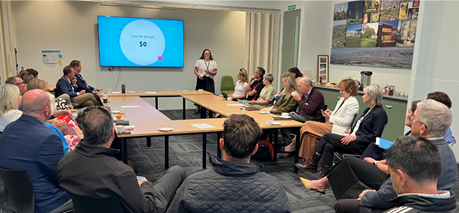
3.1.3 Belfast
Pool
Council staff and the community have been
working together to upgrade the Belfast Community Pool and surround.
The pool is leased by Pūtahi Belfast
School and used by community members over the summer. In winter it also
provides the second changeroom for visiting rugby teams.
With the concrete replaced and picnic
tables installed previously, the inside of the changing rooms have now been
given a coat of paint, fixtures replaced and bird holes repaired so no more
nests and droppings will appear!
The internal mural has been freshened up
as well proudly announcing the area and giving it a facelift. This space
is expected to be part of an ongoing project and Community Board Plan
priority. Some small external repairs and refreshing the external mural
are next on the list.
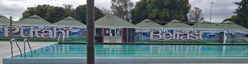
3.1.4 Northwood
Partnership Update
Our local Community Development Adviser,
Natalie Dally, has connected the Northwood Residents’ association with
Community Parks staff to look at greenspaces and how they can work in
partnership with them. A first meeting was held with the Team
Leader for the Northwood area community parks. A walk-around was had
discussing the issues and aspirations, plans in the pipeline, how the
Residents’ Association can input into the process and where the parks
team can support the Residents projects that go beyond basic maintenance.
The timing of this connection
couldn’t have been better with our Parks Unit undertaking the
replanting/renewal of Mounter Avenue Reserve in April. The Residents’
Association have been able to input into decisions being made around plantings
and the greenspace renewal.
The Northwood Residents’
Association Beautification Subcommittee have made whirlwind progress on the
concrete features, tidying, water blasting and painting eight to twelve in the
last month or so. On the last weekend in March, they had 18 volunteers
working on the last four and got them completed before lunchtime. They
are motivated to keep the teamwork and energy going and looking at the next
projects in the community they can work on.
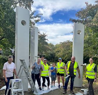
3.1.5 Successful
Culture Galore Transition
After 25 years of being held at Ray Blank
Park in Ilam, the popular Culture Galore event has now transitioned to a
citywide event which was held at the Multicultural Recreation and Community
Centre in South Hagley Park on 21 March 2026.
Feedback from stallholders was
overwhelmingly positive: many fundraising stalls reported raising more than in
previous years, and information stalls were delighted with the high level of
engagement throughout the day.
The event featured representation from
approximately 39 different communities, showcasing a vibrant mix of
performances, food, and cultural traditions. After the blessing from Mana
Whenua, the Mayor and Councillor Jimmy Chen inaugurated the event, acknowledging
the two community boards that historically led the event and celebrating the
new partnerships with the Christchurch Multicultural Centre and community
representatives.
The Bike Valet was busy with many taking
advantage of cycling options, and several attendees commented that finding a
carpark was easier than expected at the new location.
The day also attracted many elected
members and MPs, highlighting Culture Galore as a significant celebration of
our city’s diversity and community connections.
A huge thanks goes to our local Community
Recreation Adviser, Lisa Gregory, for her work to successfully transition
Culture Galore from a local Board funded project to a citywide event.
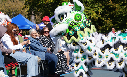
3.2 Community
Funding Summary
3.2.1 A
status report on the Board’s 2025-26 Discretionary Response Fund and
Youth Development Fund as at 25 March 2026 is attached (refer to Attachment
A).
3.2.2 Youth
Development Funds approved under delegation of Community Governance
Manager:
· Jox Blue Blades
Rowing Society Inc - Funding for three St Thomas of Canterbury students to
compete in the Maadi Cup in Twizel - $300
· Lara Streletsky - NZ
Swimming Championships in Napier - $300
3.3 Participation
in and Contribution to Decision Making
3.3.1 Report
back on other Activities contributing to Community Board Plan
· The
Board’s 2026-28 Community Board Plan opened for public consultation on 25
February 2026 and closed on 15 March 2026. A report to adopt the plan is
included in the agenda for this meeting.
3.3.2 Council
Engagement and Consultation
· There are
currently no open consultations in the Fendalton-Waimairi-Harewood area.
· The
Council’s Draft Annual Plan opened for consultation on 27 February and
closed on 27 March 2026.
· A full list of
open consultations city-wide is available at https://letstalk.ccc.govt.nz/
4. Advice Provided to the Community Board Ngā Kupu Tohutohu ka
hoatu ki te Poari Hapori
4.1 Customer
Service Request Report - Hybris monthly report for February 2026 attached,
providing an overview of the number of Customer Service Requests that have been
received, including the types of requests being received and a breakdown of how
they are being reported (refer to Attachment B).
4.2 Fendalton-Waimairi-Harewood
Graffiti Snapshot - February 2026 (refer to Attachment C).
4.3 SWN - Wairakei Road resurfacing (nightworks) (circulated 5 March
2026)
4.4 SWN - Hawthorne, Walnut, Lansbury - wastewater main renewals update (circulated
13 March 2026)
4.5 SWN - Hamilton Avenue - Waimairi Stream bank renewal (circulated
16 March 2026)
4.6 SWN - Tui Street and Roa Road - water service upgrades (circulated
16 March 2026)
4.7 Road maintenance letters (circulated 23 March 2026)
- Fendalton Road - road resurfacing
- Tonbridge Street - road resurfacing
- Joyce Crescent - road resurfacing
- Grahams Road - road resurfacing
- Richill Street - road resurfacing
4.8 Road
maintenance letters (circulated 31 March 2026)
- Hidcote Place - footpath resurfacing
- Glenmore Avenue - essential road repairs (one way system)
- Mayo Place - road resurfacing
- Gregan Crescent - road resurfacing
- Normans Road – road resurfacing update
Attachments Ngā Tāpirihanga
|
No.
|
Title
|
Reference
|
Page
|
|
a ⇩
|
Fendalton-Waimairi-Harewood
Board Funding Update - April 2026
|
26/622832
|
144
|
|
b ⇩
|
Fendalton-Waimairi-Harewood
Hybris Ticket Report - February 2026
|
26/623173
|
145
|
|
c ⇩ 
|
Fendalton-Waimairi-Harewood
Graffiti Snapshot - February 2026
|
26/623930
|
148
|
Signatories Ngā Kaiwaitohu
|
Author
|
Maryanne Lomax
- Manager Community Governance, Fendalton-Waimairi-Harewood
|
|
Approved By
|
Matthew
McLintock - Manager Community Governance Team
John Filsell -
Head of Community Support and Partnerships
|
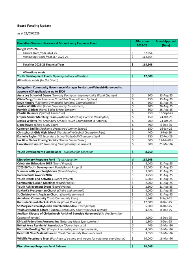
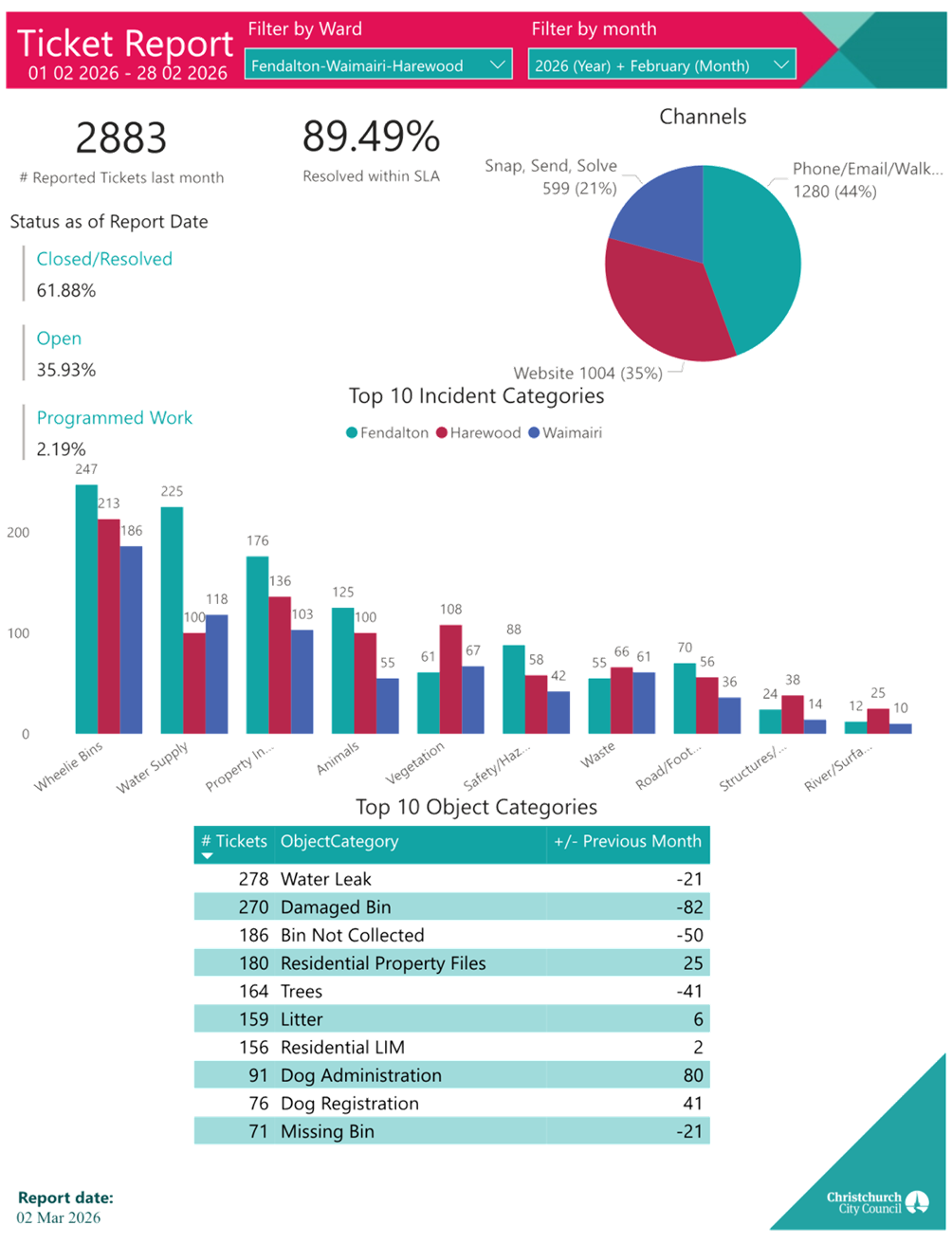
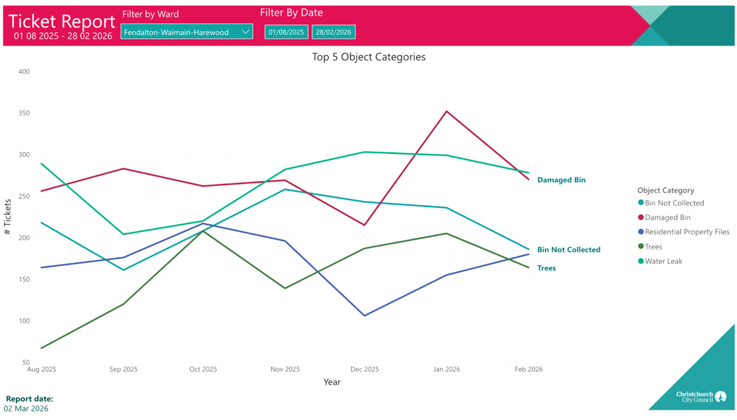
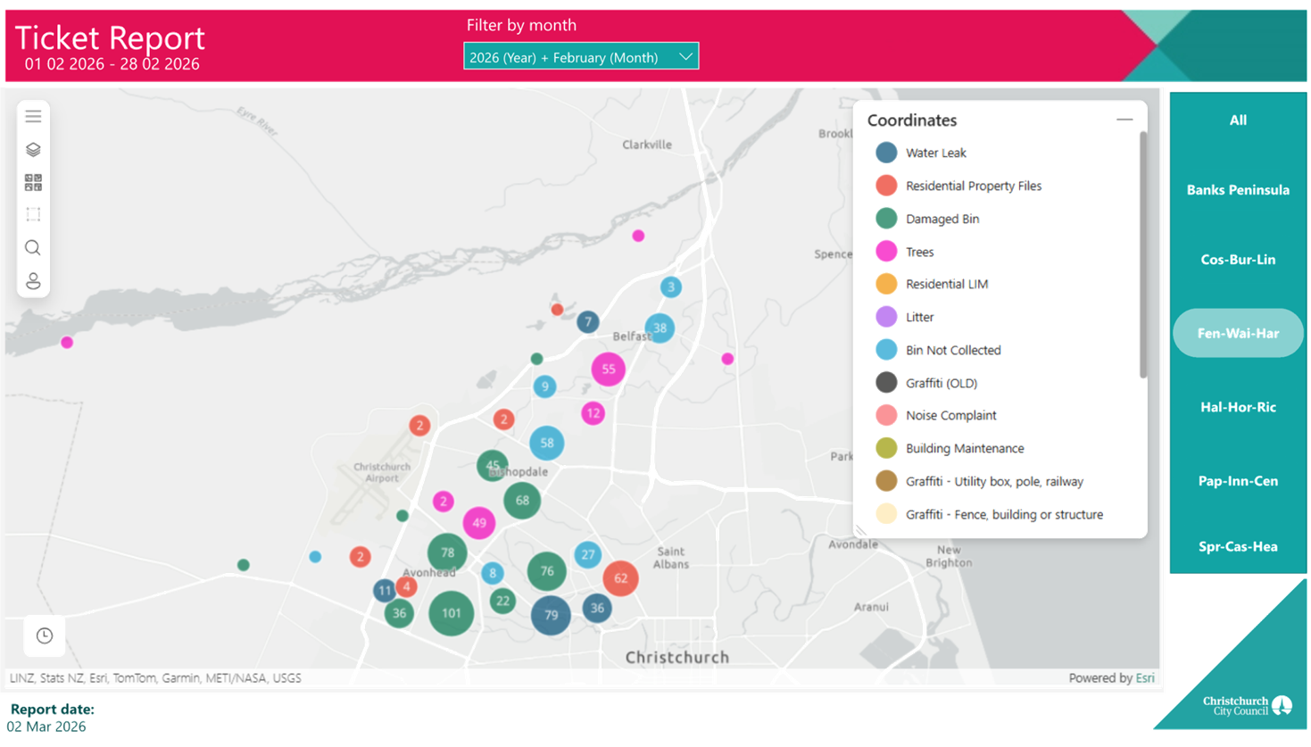
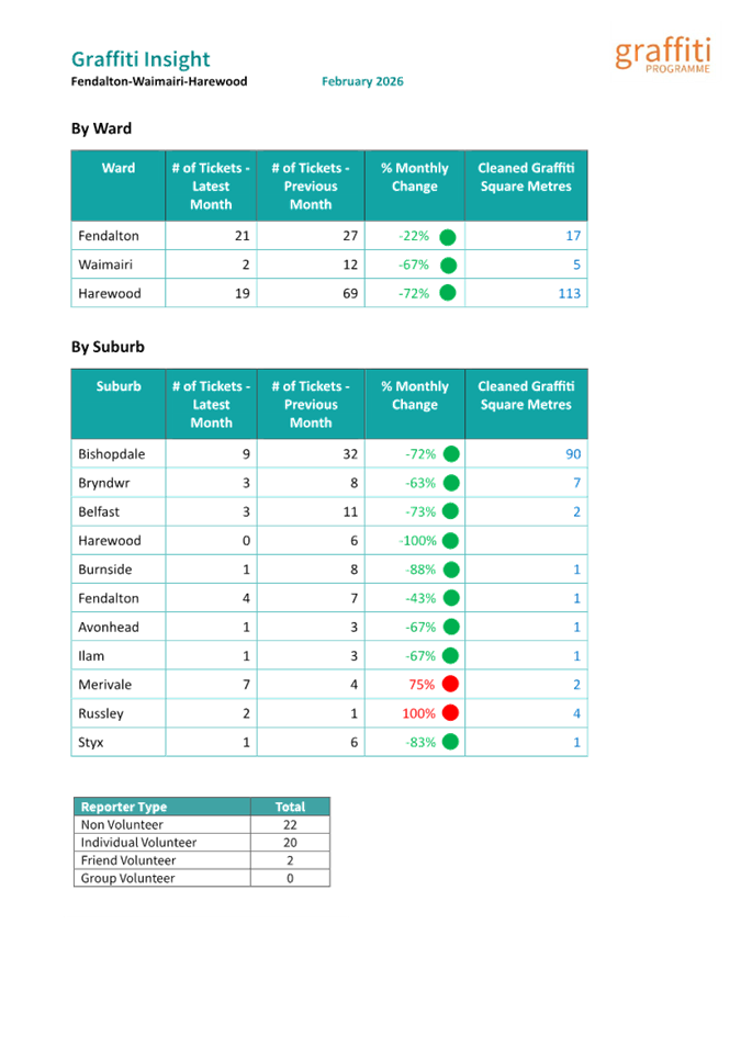
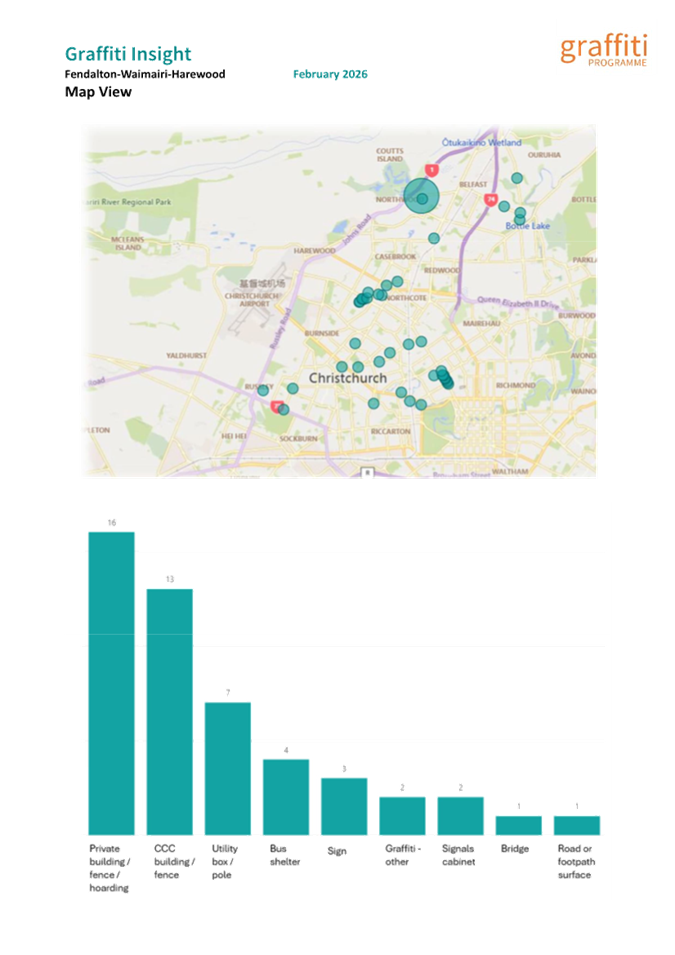
|
18. Elected
Members’ Information Exchange Te Whakawhiti Whakaaro o Te
Kāhui Amorangi
|
This item provides an opportunity for Board Members to
update each other on recent events and/or issues of relevance and interest to
the Board.
Karakia Whakamutunga
|
Unuhia, unuhia
Unuhia ki te uru tapu nui
Kia wātea, kia māmā, te ngākau,
Te tinana te wairua i te ara takatā
Koia rā e Rongo, whakairia ake ki runga
Kia tina! TINA! Hui e! TĀIKI E!
|
Draw on, draw on,
Draw on the supreme sacredness
To clear, to free the heart, the body and the spirit of mankind
Rongo, suspended high above us (i.e. in ‘heaven’)
Draw together! Affirm!
|
|
19. Resolution to Exclude the Public
|
Section
48, Local Government Official Information and Meetings Act 1987.
Note: The
grounds for exclusion are summarised in the following table. The full wording from
the Act can be found in section
6 or section
7, depending on the context.
I move that the public be excluded from the
following parts of the proceedings of this meeting, namely the items
listed overleaf.
Reason for passing this resolution: a good
reason to withhold exists under section 7.
Specific grounds under section 48(1) for
the passing of this resolution: Section 48(1)(a)
Note
Section 48(4) of the Local Government
Official Information and Meetings Act 1987 provides as follows:
“(4) Every resolution to exclude the
public shall be put at a time when the meeting is open to the public, and the
text of that resolution (or copies thereof):
(a) Shall
be available to any member of the public who is present; and
(b) Shall
form part of the minutes of the local authority.”
This resolution is made in reliance on
Section 48(1)(a) of the Local Government Official Information and Meetings Act
1987 and the particular interest or interests protected by Section 6 or Section
7 of that Act which would be prejudiced by the holding of the whole or relevant
part of the proceedings of the meeting in public are as follows:
|
ITEM NO.
|
GENERAL SUBJECT OF EACH MATTER TO BE CONSIDERED
|
SECTION
|
SUBCLAUSE AND REASON UNDER THE ACT
|
PUBLIC INTEREST CONSIDERATION
|
Potential Release Review Date and
Conditions
|
|
9.
|
Radcliffe Road Corridor Improvement
|
|
|
|
|
|
|
Attachment c - Legal Advice - Radcliffes
Road
|
s7(2)(g)
|
Maintain Legal Professional Privilege
|
It is necessary to withhold this information from the public in
order to maintain legal privilege.
|
31 March 2028
When the permanent level crossing update is under construction.
|
Actions Register Ngā Mahinga
When decisions are made at meetings, these
are assigned to staff as actions to implement. The following lists
detail any actions from this meeting that were:
- Open at the time the agenda was
generated.
- Closed since the last ordinary meeting
agenda was generated.
Open Actions Ngā Mahinga Tuwhera
|
REPORT TITLE/AGENDA SECTION
|
MEETING DATE
|
ACTION DUE DATE
|
UNIT
|
TEAM
|
|
Public Forum - Nicholas Tyler
|
9 June 2025
|
1 May 2026
|
Transport & Waste
|
Traffic Operations
|
|
Poynder Avenue and Garden
Road bridges - No Stopping Restrictions and Footpaths
|
16 February 2026
|
18 May 2026
|
Transport & Waste
|
Project Management
|
|
Wairakei Road Intersections
|
16 February 2026
|
18 May 2026
|
Transport & Waste
|
Traffic Operations
|
|
Jellie Park Recreation &
Sport Centre Storeroom
|
16 March 2026
|
15 June 2026
|
RS&E
|
Operations
|
|
Proposed P120 Parking
Restrictions - Staveley Street
|
8 December 2025
|
14 December 2026
|
Transport & Waste
|
Traffic Operations
|
|
Bryndwr Road Street Renewal
|
8 September 2025
|
30 June 2027
|
Transport & Waste
|
Project Management
|
Actions Closed Since the Last Meeting
Ngā Mahinga kua Tutuki nō Tērā Hui
|
REPORT TITLE/AGENDA SECTION
|
MEETING DATE
|
DUE DATE
|
ACTION CLOSURE DATE
|
UNIT
|
TEAM
|
|
Easement Over Recreation
Reserve - 82 Glenturret Drive
|
8 September 2025
|
15 April 2026
|
9 April 2026
|
F&P Unit
|
Property Consultancy
|
|
Fendalton-Waimairi-Harewood
2025-26 Discretionary Response Fund Applications - Belfast Residents
Association, Burnside Bowling Club Inc, Heartfelt NZ Trust and Wildlife
Veterinary Trust
|
16 March 2026
|
15 June 2026
|
17 March 2026
|
CS&P
|
CS&P - Governance (Fen-Wai-Har)
|