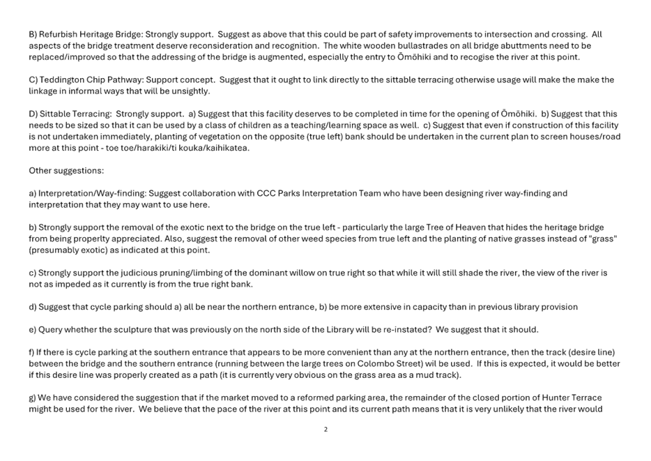
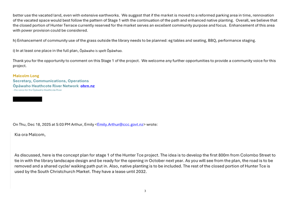
Waihoro
Spreydon-Cashmere-Heathcote Community Board
Agenda
Notice of Meeting Te Pānui o te Hui:
The ordinary meeting of the Waihoro
Spreydon-Cashmere-Heathcote Community Board will be held on:
Date: Thursday 12 March 2026
Time: 4 pm
Venue: Linwood Boardroom, Gate B,
180 Smith Street, Woolston
Membership Ngā
Mema
|
Chairperson
Deputy Chairperson
Members
|
Keir Leslie
Sophie Bond
Melanie Coker
Will Hall
Nathaniel Herz Jardine
Kate Hodgins
Roy Kenneally
Tim Lindley
Tim Scandrett
|
5 March 2026
Website: www.ccc.govt.nz
Part A Matters
Requiring a Council Decision
Part B Reports
for Information
Part C Decisions
Under Delegation
TABLE OF CONTENTS NGĀ IHIRANGI
Karakia Tīmatanga................................................................................................... 4
Waiata ............................................................................................................... 4
C 1. Apologies Ngā Whakapāha.......................................................................... 4
B 2. Declarations of Interest Ngā Whakapuaki Aronga........................................... 4
C 3. Confirmation of Previous Minutes Te Whakaāe o te
hui o mua.......................... 4
B 4. Public Forum Te Huinga Whānui.................................................................. 4
B 5. Deputations by Appointment Ngā Huinga
Whakaritenga................................. 5
B 6. Presentation
of Petitions Ngā
Pākikitanga.................................................... 5
C 7. Correspondence...................................................................................... 25
Staff Reports
C 8. Mowbray
Street - P5 Loading Zone............................................................. 29
C 9. Bus
stop upgrades on Mathers, Sparks, and Main Roads................................ 35
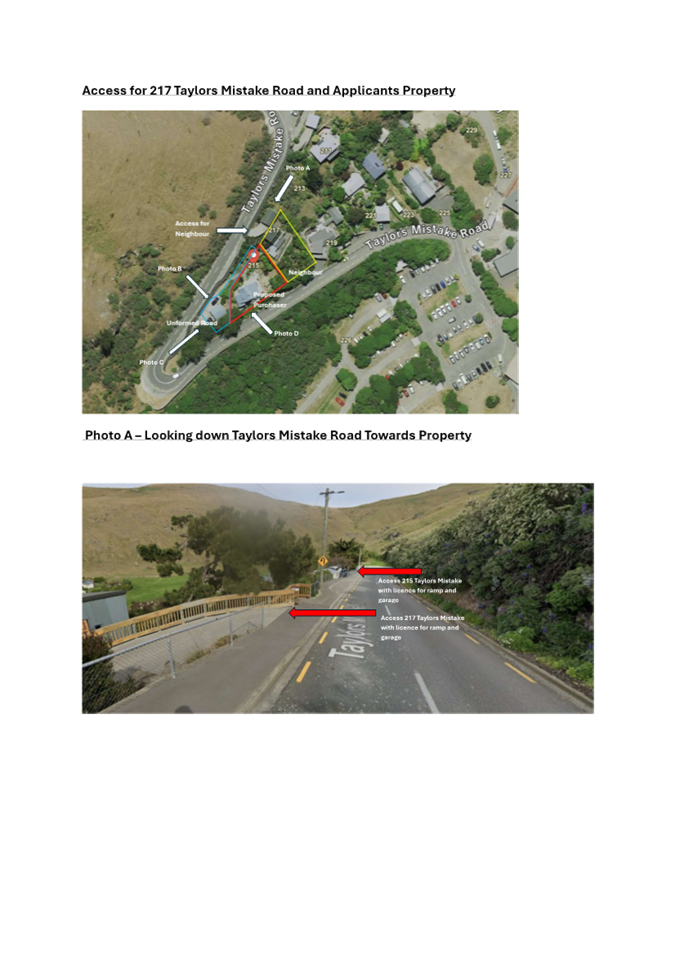
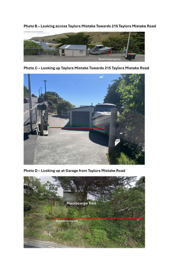
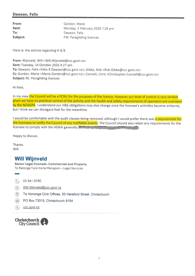
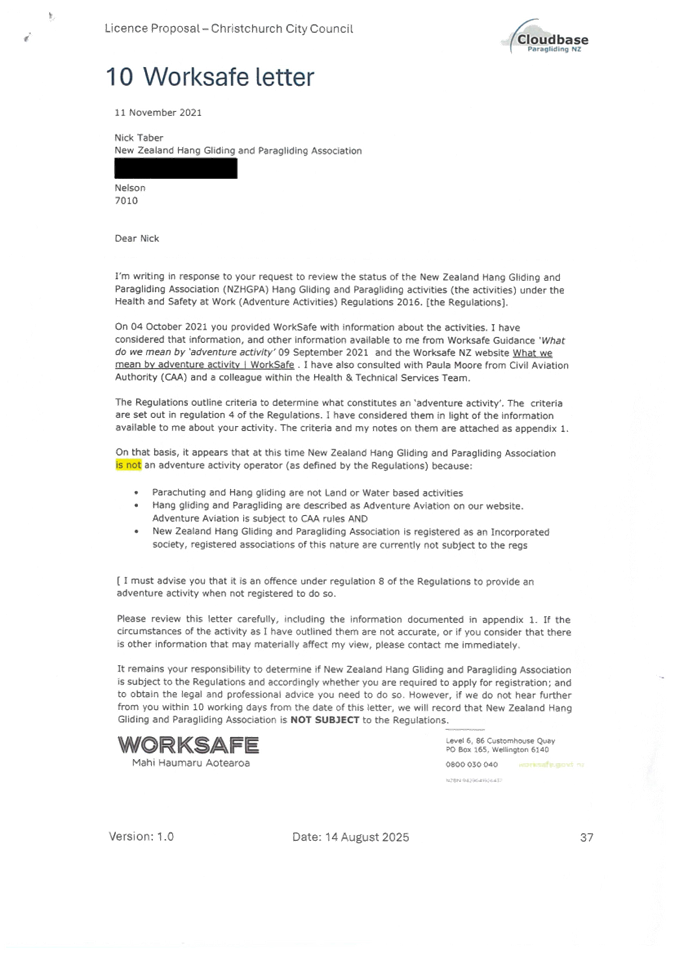
C 10. 215
Taylors Mistake Road - Road Stopping Application.................................. 45
C 11. Port
Hills Paragliding Schools - proposed new licences................................. 57
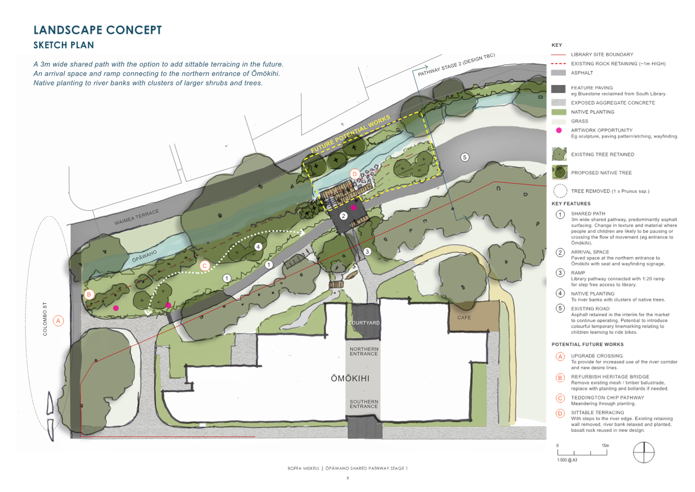
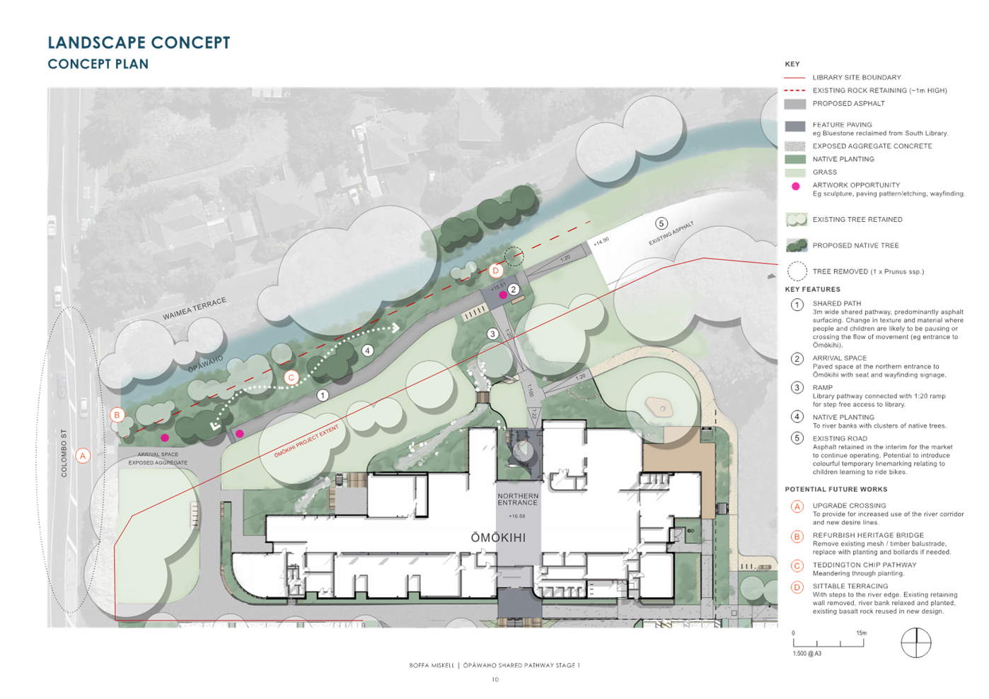
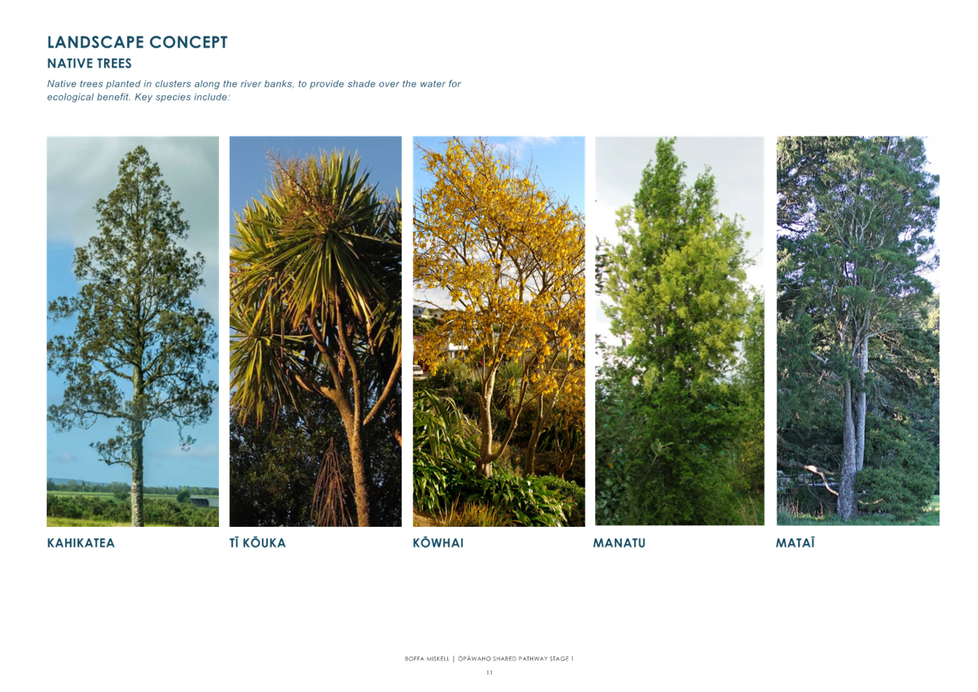
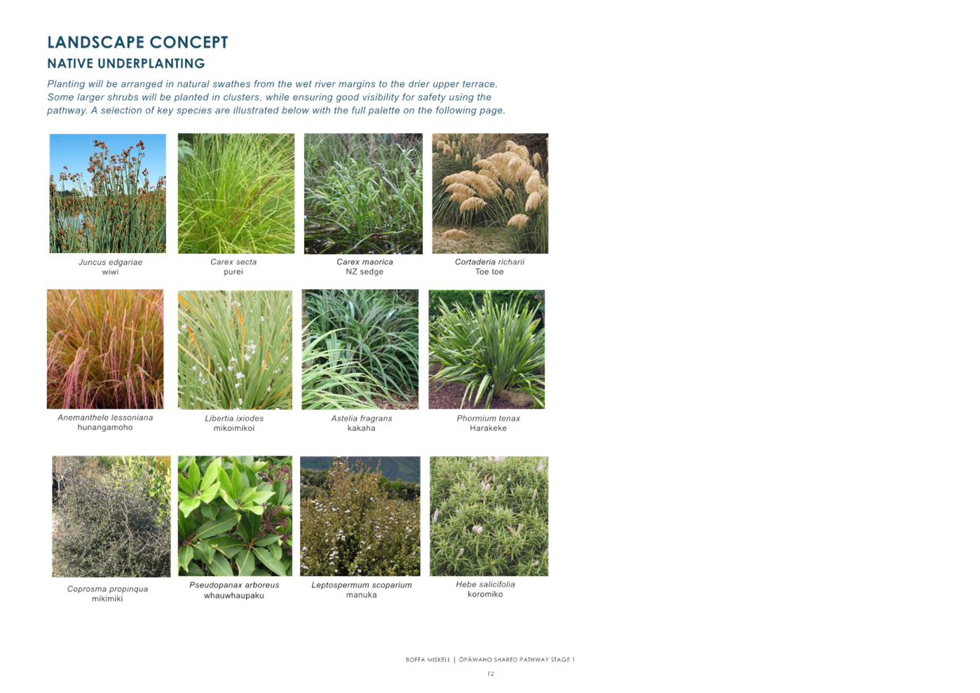
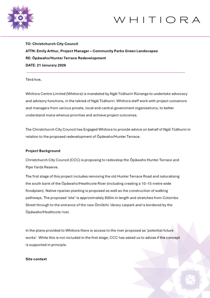
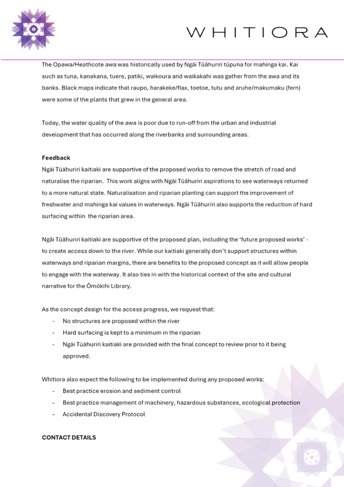
C 12. Ōpāwaho
Pathway Hunter Terrace Stage 1.................................................. 73
C 13. Waihoro
Spreydon-Cashmere-Heathcote Community Board Area Report - March 2026..................................................................................................... 103
B 14. Elected Members’
Information Exchange Te Whakawhiti
Whakaaro o Te Kāhui Amorangi............................................................................................................ 133
Karakia Whakakapi
Actions Register Ngā Mahinga Tuwhera
Karakia Tīmatanga
|
Kia tau te mauri o runga
Kia tau te mauri o raro
Paiheretia te ture wairua
Paiheretia te ture tangata
Hei pou arahi i a tātou i
tēnei wā
Kia tika te whakaaro
Kia tika te kupu
Tīhei Mauri Ora!
|
May the essence of above settle here
May the essence of below settle here
Bind together that we can’t see and bind that
we can see
And have them guide us at this time
May the thought be true
May the words be true
|
Waiata
|
Nei rā te tai ō mihi
Ki a tatou e ngā iwi
Kua tae mai mātou
Hei tautoko
Ki te kaupapa o te rā
He waka eke noa
Nā te Kaunihera o
Ōtautahi e
|
Heartfelt greetings and best
wishes
To all of us who have gathered
here
We have arrived here today
To show our collective support
For the purpose of the
occasion
We are all in this together
On behalf of the Christchurch
City Council
|
1. Apologies Ngā Whakapāha
Apologies will
be recorded at the meeting.
2. Declarations of Interest Ngā
Whakapuaki Aronga
Members are
reminded of the need to be vigilant and to stand aside from decision-making
when a conflict arises between their role as an elected representative and any
private or other external interest they might have.
3. Confirmation of Previous Minutes Te
Whakaāe o te hui o mua
That the
minutes of the Waihoro Spreydon-Cashmere-Heathcote Community Board meeting held
on Thursday, 12 February 2026 be
confirmed (refer page 6).
4. Public Forum Te Huinga Whānui
A period of up
to 30 minutes will be available for people to speak for up to five minutes on
any issue that is not the subject of a separate hearing process.
|
4.1
|
Hoon Hay Community Association Update
Jenny Goodman and Daniel Hay will speak
on behalf of the Hoon Hay Community Association and provide an update on the
Association.
|
|
4.2
|
Acknowledging and Celebrating the Cultural Heritage of Te Rae
Kura/Redcliffs
Martin Ward and Alex Green will speak on
behalf of the Redcliffs Residents’ Association, joined by Sam Duggan
from the Moa Kids Early Childhood Centre Committee regarding acknowledging
and celebrating the cultural heritage of Te Rae Kura/Redcliffs.
|
5. Deputations by Appointment Ngā Huinga
Whakaritenga
Deputations may
be heard on a matter or matters covered by a report on this agenda and approved
by the Chairperson.
Deputations will be recorded in the
meeting minutes.
6. Presentation of Petitions Ngā
Pākikitanga
There were no petitions
received at the time the agenda was prepared.
To present to the Community
Board, refer to the Participating in decision-making webpage or
contact the meeting advisor listed on the front of this agenda.

Waihoro
Spreydon-Cashmere-Heathcote Community Board
Open Minutes
Date: Thursday 12 February 2026
Time: 4.03 pm
Venue: Linwood Boardroom, Gate B,
180 Smith Street, Woolston
Present
|
Chairperson
Deputy Chairperson
Members
|
Keir Leslie
Sophie Bond
Melanie Coker
Will Hall
Nathaniel Herz Jardine
Kate Hodgins
Roy Kenneally
Tim Lindley
|
Website: www.ccc.govt.nz

Part A Matters
Requiring a Council Decision
Part B Reports
for Information
Part C Decisions
Under Delegation
Karakia Tīmatanga
The agenda was dealt with in the following
order. Where no voting record is shown, the item was carried unanimously by
those present.
1. Apologies
Ngā Whakapāha
Part C
|
Community Board Resolved SCBCC/2026/00001
That the apology from Tim Scandrett for
absence be accepted.
Keir
Leslie/Nathaniel Herz Jardine Carried
|
2. Declarations
by Member Te Ki Taurangi
Part B
Will Hall completed
his oral and written declaration in the presence of John
Filsell, Head of Community Support & Partnerships (acting on behalf of the
Chief Executive) in accordance with Clause 14, Schedule
7 of the Local Government Act 2002.
3. Declarations
of Interest Ngā Whakapuaki Aronga
Part B
There were no
declarations of interest recorded.
4. Confirmation
of Previous Minutes Te Whakaāe o te hui o mua
Part C
|
Community Board Resolved SCBCC/2026/00002
That the
minutes of the Waihoro Spreydon-Cashmere-Heathcote Community Board meeting
held on Thursday, 11 December 2025 be confirmed.
Kate Hodgins/Tim
Lindley Carried
|
5. Public
Forum Te Huinga Whānui
Part B
There were no public forum presentations.
6. Deputations
by Appointment Ngā Huinga Whakaritenga
Part B
|
6.2
|
Kate Woods - Cashmere - Penruddock
Roundabout
Kate Woods,
local resident spoke regarding Item 9 – Cashmere-Penruddock Roundabout.
|
|
6.3 Wendy Parlane
- Rose Street Intersection - No Stopping Restrictions
|
|
Wendy Parlane, local
resident spoke regarding Item 11 Rose Street Intersections - Proposed No
Stopping Restrictions Report.
|
|
Attachments
a Wendy
Parlane - Presentation to the Board - Photos
|
Secretarial note: for privacy concerns the individual requested their name in
relation to Item 6.4 be protected.
|
6.4 Hoon Hay
Road/Lewis Street - Pedestrian Improvements
|
|
Submitter 100, local resident could not
attend the Board meeting and their written deputation regarding Item 16
– Hoon Hay Road/Lewis Street - Pedestrian Improvements was read aloud
to the Board.
|
|
Attachments
a Hoon
Hay/Lewis Street - Pedestrian Improvement - Submitter 100 notes
|
7. Presentation
of Petitions Ngā Pākikitanga
Part B
There was no presentation of petitions.
|
8. Correspondence
|
|
|
Community Board Resolved SCBCC/2026/00003
Officer Recommendations accepted without
change
Part B
That the Waihoro
Spreydon-Cashmere-Heathcote Community Board:
1. Receives the information in the correspondence report dated 12
February 2026 from Ian Anderson in relation to Purau Reserve.
2. Receives the information in the correspondence report 12 February
2026 from Honourable Casey Costello, Minister for Seniors in relation to the
Age Friendly Aotearoa Programme.
3. Receives the information in the correspondence report dated 12
February 2026 from Spokes Canterbury in relation to the Cashmere-Penruddock
Roundabout.
4. Receives the information in the correspondence report dated 12
February 2026 from Kate Woods in relation to the cycle connection on Cashmere
Road.
Nathaniel Herz
Jardine/Kate Hodgins Carried
|
The meeting adjourned at 5.05 pm and
reconvened at 5.10 pm.
|
9. Cashmere - Penruddock Roundabout
|
|
|
Community Board Comment
1. The
Board took into consideration the deputations at Items 6.1 and 6.2 and
relevant correspondence in Item 8.
2. Council
Officers Jacob Bradbury, Peter Rodgers and Weng-Kei Chen joined the table to
speak to this Item and answered questions from elected members.
3. Council
Officers presented the image in Attachment A (tabled) to explain safe driving
speeds of the proposed roading layout.
4. Melanie Coker then Moved Option 2 from the
agenda report, to approve the proposed roundabout layout and traffic control
devices with speed humps on the approaches and exits from the roundabout
(Attachment B to the report on the meeting agenda). This was seconded by Kate
Hodgins.
5. Will
Hall then Moved a foreshadowed Motion to approve a variation of Option 1 from
the agenda report with one speed hump on the northbound entry lane for the
new subdivision road. This was seconded by Nathaniel Herz Jardine.
6. At
conclusion of debate, the Board voted on the Motion as Moved by Melanie Coker and was declared carried.
|
|
|
Officer
Recommendations Ngā Tūtohu
That the Waihoro
Spreydon-Cashmere-Heathcote Community Board recommends that the Council:
1. Receives the information in the Cashmere -
Penruddock Roundabout Report.
2. Notes that the decision in this report is assessed as low
significance based on the Christchurch City
Council’s Significance and Engagement Policy.
3. Approves that a special vehicle lane in accordance with Clause 18
of the Christchurch City Council Traffic & Parking Bylaw 2017, for the
use of westbound road users as defined in Section 11.1A of the Land Transport
(Road User) Rule: 2004, excepting pedestrians and riders of mobility devices,
be installed on the south side of Cashmere Road, commencing at a point
approximately 166 metres east of its intersection
with Penruddock Rise and extending in a westerly
direction for 126 metres, as detailed on Attachment A to the report on the meeting agenda.
4. Approves that a special vehicle lane in accordance with Clause 18
of the Christchurch City Council Traffic & Parking Bylaw 2017, for the
use of southbound road users as defined in Section 11.1A of the Land
Transport (Road User) Rule: 2004, excepting pedestrians and riders of
mobility devices, be installed on the east side of Penruddock
Rise, commencing at a point approximately 21 metres
south of its intersection with Cashmere Road and extending in an southerly
direction for a distance of 10 metres, as detailed on Attachment A to the report on the meeting agenda.
5. Approves that a special vehicle lane in accordance with Clause 18
of the Christchurch City Council Traffic & Parking Bylaw 2017, for the
use of northbound road users as defined in Section 11.1A of the Land
Transport (Road User) Rule: 2004, excepting pedestrians and riders of
mobility devices, be installed on the west side of Penruddock
Rise, commencing at a point approximately 33 metres
south of its intersection with Cashmere Road and extending in a northerly
direction for a distance of 10 metres, as detailed on Attachment A to the report on the meeting agenda.
6. Approves that a special vehicle lane in accordance with Clause 18
of the Christchurch City Council Traffic & Parking Bylaw 2017, for the
use of westbound road users as defined in Section 11.1A of the Land Transport
(Road User) Rule: 2004, excepting pedestrians and riders of mobility devices,
be installed on the south side of Cashmere Road, commencing at a point approximately 31
metres west of its intersection with Brookford Place
and extending in an easterly direction for a distance of 74 metres, as
detailed on Attachment A to the report on the
meeting agenda.
7. Approves that a special vehicle lane in accordance with Clause 18
of the Christchurch City Council Traffic & Parking Bylaw 2017, for the
use of eastbound road users as defined in Section 11.1A of the Land Transport
(Road User) Rule: 2004, excepting pedestrians and riders of mobility devices,
be installed on the north side of Cashmere Road, commencing at a point approximately 31
metres west of the prolongation of the western kerb
line of its intersection with Brookford Place and extending in an easterly direction for a distance of 76
metres, as detailed on Attachment A to the
report on the meeting agenda.
8. Approves that a special vehicle lane in accordance with Clause 18
of the Christchurch City Council Traffic & Parking Bylaw 2017, for the
use of eastbound road users as defined in Section 11.1A of the Land Transport
(Road User) Rule: 2004, excepting pedestrians and riders of mobility devices,
be installed on the north side of Cashmere Road, commencing at a point approximately 39 metres east of the
prolongation of the eastern kerb line of Penruddock Rise and extending in an
easterly direction for a distance of 127 metres, as detailed on Attachment
A to the report on the meeting agenda.
That the Waihoro
Spreydon-Cashmere-Heathcote Community Board:
9. Receives the information in the Cashmere -
Penruddock Roundabout Report.
10. Notes that the decision in this report is assessed as low
significance based on the Christchurch City
Council’s Significance and Engagement Policy.
11. Under Clause 6(2) of the Christchurch City Council Traffic and
Parking Bylaw 2017 revokes any previous resolutions pertaining to traffic
controls made pursuant to any bylaw to the extent that they are in conflict
with the parking or stopping restrictions described in resolutions 12 –
17 below.
Cashmere Road frontage –
250-258 Cashmere Road
12. Approves the roundabout, new paths, kerb alignments, traffic
calming, road surface treatments and road markings, on Cashmere Road
commencing at a point 166 metres east of its intersection with Penruddock
Rise and extending in a westerly direction to a point 31 metres west of its
intersection with Brookford Place as detailed on Attachment A to the
report on the meeting agenda.
13. Approves the roundabout, new paths, kerb alignments, traffic
calming, road surface treatments and road markings, on Penruddock Rise
commencing at its intersection with Cashmere Road and extending in a
southerly direction for a distance of 36 metres as detailed on Attachment
A to the report on the meeting agenda.
No
Stopping and Bus Stops - Cashmere Road
14. Approves that in accordance with Clause 7 of the Christchurch City
Council Traffic and Parking Bylaw 2017, that the stopping of vehicles be
prohibited at any time:
a. On the southern side of Cashmere Road, commencing at a point 161
metres east of its intersection with Penruddock Rise and extending in a
westerly direction for a distance of 82 metres as detailed on Attachment A
to the report on the meeting agenda.
b. On the southern side of Cashmere Road, commencing at a point 65
metres east of its intersection with Penruddock Rise and extending in a
westerly direction to its intersection with Penruddock Rise as detailed on Attachment
A to the report on the meeting agenda.
c. On the southern side of Cashmere Road, commencing at its
intersection with Penruddock Rise and extending in a westerly direction to
its intersection with a point 65 metres east of its intersection with
Penruddock Rise and extending in a westerly direction to its intersection
with Brookford Place as detailed on Attachment A to the report on the meeting agenda.
d. On the southern side of Cashmere Road, commencing at its
intersection with Brookford Place and extending in a westerly direction for a
distance of 31 metres as detailed on Attachment A to the report on the meeting agenda.
e. On the northern side of Cashmere Road, commencing at a point 31
metres west of the prolongation of the western kerb line of Brookford Place
and extending in an easterly direction to its intersection with Penruddock
Rise and the new subdivision road as detailed on Attachment A to the report on the meeting agenda.
f. On the northern side of Cashmere Road, commencing at its
intersection with Penruddock Rise and the new subdivision road and extending
in an easterly direction for a distance of 87 metres as detailed on Attachment
A to the report on the meeting agenda.
g. On the northern side of Cashmere Road, commencing at a point 101
metres east of the prolongation of the eastern kerb line of Penruddock Rise
and extending in a easterly direction for a distance of 23 metres as detailed
on Attachment A to the report on the meeting
agenda.
15. Approves that a bus stop in accordance with Clause 7 of the
Christchurch City Council Traffic & Parking Bylaw 2017, be reserved for
large passenger service vehicles only, for the purposes of setting down or
picking up passengers only, as part of a bus service as defined in the Land
Transport Management Act 2003.
a. This restriction will apply on the
southern side of Cashmere Road commencing at a distance 79 metres east of its
intersection with Penruddock Rise and extending in a westerly direction for a
distance of 14 metres as detailed on Attachment A to the report on the
meeting agenda.
b. This restriction will apply on the northern side of Cashmere Road
commencing at a distance 87 metres east of the prolongation of the eastern
kerb line of Penruddock Rise and extending in a easterly direction for a
distance of 14 metres as detailed on Attachment A to the report on the
meeting agenda.
No Stopping
restrictions – Penruddock Rise
16. Approves that in accordance with Clause 7 of the Christchurch City
Council Traffic and Parking Bylaw 2017, that the stopping of vehicles be
prohibited at any time:
a. On the western side of Penruddock Rise, commencing at the new
intersection with Cashmere Road detailed on Attachment A and extending
in a southerly direction for a distance of 38 metres as detailed on
Attachment A to the report on the meeting agenda.
b. On the eastern side of Penruddock Rise, commencing at the new
intersection with Cashmere Road detailed on Attachment A and extending
in a southerly direction for a distance of 38 metres as detailed on
Attachment A to the report on the meeting agenda.
17. Approves that in accordance with Clause 21
of the Christchurch City Council Traffic & Parking Bylaw 2017, a bi-directional shared path, reserved for road users as defined
in Section 11.1A of the Land Transport (Road User) Rule: 2004 be established:
a. On the southern side of Cashmere Road commencing at its
intersection with Penruddock Rise and extending in an easterly direction for
a distance of 161 metres as detailed on Attachment A.
b. On the southern side of Cashmere Road commencing at its
intersection with Penruddock Rise and extending in a westerly direction for a
distance of 45 metres as detailed on Attachment A.
c. On the northern side of Cashmere Road commencing at a point 22
metres west of the prolongation of the western kerb line of Brookford Place
and extending in an easterly direction to its intersection with Penruddock
Rise and the new subdivision road as detailed on Attachment A.
d. On the northern side of Cashmere Road commencing at its
intersection with Penruddock Rise and the new subdivision road and extending
in an easterly direction for a distance of 116 metres as detailed on Attachment
A.
18. Approves that for any parking restrictions on land currently
vested with Council as Road Reserve, these resolutions take effect when
parking signage and/or road markings that evidence the restrictions described
in this staff report are in place.
19. Approves that for any parking restrictions on land not yet vested
with Council as Road Reserve, these resolutions take effect when parking
signage and/or road markings that evidence the restrictions described in this
staff report are in place and when the land has been vested with Council.
|
|
|
Community Board Resolved SCBCC/2026/00004
Part C
That the Waihoro
Spreydon-Cashmere-Heathcote Community Board:
9. Receives the information in the Cashmere -
Penruddock Roundabout Report.
10. Notes that the decision in this report is assessed as low
significance based on the Christchurch City
Council’s Significance and Engagement Policy.
11. Under Clause 6(2) of the Christchurch City Council Traffic and
Parking Bylaw 2017 revokes any previous resolutions pertaining to traffic
controls made pursuant to any bylaw to the extent that they are in conflict
with the parking or stopping restrictions described in resolutions 12 –
17 below.
Cashmere Road frontage –
250-258 Cashmere Road
12. Approves the roundabout, new paths, kerb alignments, traffic
calming, road surface treatments and road markings, on Cashmere Road
commencing at a point 166 metres east of its intersection with Penruddock
Rise and extending in a westerly direction to a point 31 metres west of its
intersection with Brookford Place as detailed on Attachment B to the
report on the meeting agenda.
13. Approves the roundabout, new paths, kerb alignments, traffic
calming, road surface treatments and road markings, on Penruddock Rise
commencing at its intersection with Cashmere Road and extending in a
southerly direction for a distance of 36 metres as detailed on Attachment
B to the report on the meeting agenda.
No
Stopping and Bus Stops - Cashmere Road
14. Approves that in accordance with Clause 7 of the Christchurch City
Council Traffic and Parking Bylaw 2017, that the stopping of vehicles be
prohibited at any time:
a. On the southern side of Cashmere Road, commencing at a point 161
metres east of its intersection with Penruddock Rise and extending in a
westerly direction for a distance of 82 metres as detailed on Attachment B
to the report on the meeting agenda.
b. On the southern side of Cashmere Road, commencing at a point 65
metres east of its intersection with Penruddock Rise and extending in a
westerly direction to its intersection with Penruddock Rise as detailed on Attachment
B to the report on the meeting agenda.
c. On the southern side of Cashmere Road, commencing at its
intersection with Penruddock Rise and extending in a westerly direction to
its intersection with a point 65 metres east of its intersection with
Penruddock Rise and extending in a westerly direction to its intersection
with Brookford Place as detailed on Attachment B to the report on the meeting agenda.
d. On the southern side of Cashmere Road, commencing at its
intersection with Brookford Place and extending in a westerly direction for a
distance of 31 metres as detailed on Attachment B to the report on the meeting agenda.
e. On the northern side of Cashmere Road, commencing at a point 31
metres west of the prolongation of the western kerb line of Brookford Place
and extending in an easterly direction to its intersection with Penruddock
Rise and the new subdivision road as detailed on Attachment B to the report on the meeting agenda.
f. On the northern side of Cashmere Road, commencing at its
intersection with Penruddock Rise and the new subdivision road and extending
in an easterly direction for a distance of 87 metres as detailed on Attachment
B to the report on the meeting agenda.
g. On the northern side of Cashmere Road, commencing at a point 101
metres east of the prolongation of the eastern kerb line of Penruddock Rise
and extending in a easterly direction for a distance of 23 metres as detailed
on Attachment B to the report on the meeting
agenda.
15. Approves that a bus stop in accordance with Clause 7 of the
Christchurch City Council Traffic & Parking Bylaw 2017, be reserved for
large passenger service vehicles only, for the purposes of setting down or
picking up passengers only, as part of a bus service as defined in the Land
Transport Management Act 2003.
a. This restriction will apply on the
southern side of Cashmere Road commencing at a distance 79 metres east of its
intersection with Penruddock Rise and extending in a westerly direction for a
distance of 14 metres as detailed on Attachment B to the report on the
meeting agenda.
b. This restriction will apply on the northern side of Cashmere Road
commencing at a distance 87 metres east of the prolongation of the eastern
kerb line of Penruddock Rise and extending in a easterly direction for a
distance of 14 metres as detailed on Attachment B to the report on the
meeting agenda.
No Stopping
restrictions – Penruddock Rise
16. Approves that in accordance with Clause 7 of the Christchurch City
Council Traffic and Parking Bylaw 2017, that the stopping of vehicles be
prohibited at any time:
a. On the western side of Penruddock Rise, commencing at the new
intersection with Cashmere Road detailed on Attachment B to the report on the meeting agenda and extending in a southerly direction for a distance of 38 metres
as detailed on Attachment B to the report on the meeting agenda.
b. On the eastern side of Penruddock Rise, commencing at the new
intersection with Cashmere Road detailed on Attachment B to the report on the meeting agenda and extending in a southerly direction for a distance of 38 metres
as detailed on Attachment B to the report on the meeting agenda.
17. Approves that in accordance with Clause 21
of the Christchurch City Council Traffic & Parking Bylaw 2017, a bi-directional shared path, reserved for road users as defined
in Section 11.1A of the Land Transport (Road User) Rule: 2004 be established:
a. On the southern side of Cashmere Road commencing at its
intersection with Penruddock Rise and extending in an easterly direction for
a distance of 161 metres as detailed on Attachment B to the report on the meeting agenda.
b. On the southern side of Cashmere Road commencing at its
intersection with Penruddock Rise and extending in a westerly direction for a
distance of 45 metres as detailed on Attachment B to the report on the meeting agenda.
c. On the northern side of Cashmere Road commencing at a point 22
metres west of the prolongation of the western kerb line of Brookford Place
and extending in an easterly direction to its intersection with Penruddock
Rise and the new subdivision road as detailed on Attachment B to the report on the meeting agenda.
d. On the northern side of Cashmere Road commencing at its
intersection with Penruddock Rise and the new subdivision road and extending
in an easterly direction for a distance of 116 metres as detailed on Attachment
B to the report on the meeting agenda.
18. Approves that for any parking restrictions on land currently
vested with Council as Road Reserve, these resolutions take effect when
parking signage and/or road markings that evidence the restrictions described
in this staff report are in place.
19. Approves that for any parking restrictions on land not yet vested
with Council as Road Reserve, these resolutions take effect when parking
signage and/or road markings that evidence the restrictions described in this
staff report are in place and when the land has been vested with Council.
Melanie
Coker/Kate Hodgins Carried
Will Hall, Nathaniel Herz Jardine and
Keir Leslie requested that their votes against the resolutions be recorded.
|
|
Community Board Decided SCBCC/2026/00005
Part A
That the Waihoro
Spreydon-Cashmere-Heathcote Community Board recommends that the Council:
1. Receives the information in the Cashmere -
Penruddock Roundabout Report.
2. Notes that the decision in this report is assessed as low
significance based on the Christchurch City
Council’s Significance and Engagement Policy.
3. Approves that a special vehicle lane in accordance with Clause 18
of the Christchurch City Council Traffic & Parking Bylaw 2017, for the
use of westbound road users as defined in Section 11.1A of the Land Transport
(Road User) Rule: 2004, excepting pedestrians and riders of mobility devices,
be installed on the south side of Cashmere Road, commencing at a point
approximately 166 metres east of its intersection
with Penruddock Rise and extending in a westerly
direction for 126 metres, as detailed on Attachment B to the report on the meeting agenda.
4. Approves that a special vehicle lane in accordance with Clause 18
of the Christchurch City Council Traffic & Parking Bylaw 2017, for the
use of southbound road users as defined in Section 11.1A of the Land
Transport (Road User) Rule: 2004, excepting pedestrians and riders of
mobility devices, be installed on the east side of Penruddock
Rise, commencing at a point approximately 21 metres
south of its intersection with Cashmere Road and extending in an southerly
direction for a distance of 10 metres, as detailed on Attachment B to the report on the meeting agenda.
5. Approves that a special vehicle lane in accordance with Clause 18
of the Christchurch City Council Traffic & Parking Bylaw 2017, for the
use of northbound road users as defined in Section 11.1A of the Land
Transport (Road User) Rule: 2004, excepting pedestrians and riders of
mobility devices, be installed on the west side of Penruddock
Rise, commencing at a point approximately 33 metres
south of its intersection with Cashmere Road and extending in a northerly
direction for a distance of 10 metres, as detailed on Attachment B to the report on the meeting agenda.
6. Approves that a special vehicle lane in accordance with Clause 18
of the Christchurch City Council Traffic & Parking Bylaw 2017, for the
use of westbound road users as defined in Section 11.1A of the Land Transport
(Road User) Rule: 2004, excepting pedestrians and riders of mobility devices,
be installed on the south side of Cashmere Road, commencing at a point approximately 31
metres west of its intersection with Brookford Place
and extending in an easterly direction for a distance of 74 metres, as
detailed on Attachment B to the report on the
meeting agenda.
7. Approves that a special vehicle lane in accordance with Clause 18
of the Christchurch City Council Traffic & Parking Bylaw 2017, for the
use of eastbound road users as defined in Section 11.1A of the Land Transport
(Road User) Rule: 2004, excepting pedestrians and riders of mobility devices,
be installed on the north side of Cashmere Road, commencing at a point approximately 31
metres west of the prolongation of the western kerb
line of its intersection with Brookford Place and extending in an easterly direction for a distance of 76
metres, as detailed on Attachment B to the
report on the meeting agenda.
8. Approves that a special vehicle lane in accordance with Clause 18
of the Christchurch City Council Traffic & Parking Bylaw 2017, for the
use of eastbound road users as defined in Section 11.1A of the Land Transport
(Road User) Rule: 2004, excepting pedestrians and riders of mobility devices,
be installed on the north side of Cashmere Road, commencing at a point approximately 39 metres east of the
prolongation of the eastern kerb line of Penruddock Rise and extending in an
easterly direction for a distance of 127 metres, as detailed on Attachment
B to the report on the meeting agenda.
Melanie
Coker/Kate Hodgins Carried
Will Hall,
Nathaniel Herz Jardine and Keir Leslie requested that their votes against the
resolutions be recorded.
|
|
Attachments
a Cashmere-Penruddock
vehicle tracking speeds for 85th percentile car - Image
|
|
10. Huntsbury
Avenue - Proposed No Stopping Restrictions
|
|
|
Community Board Resolved SCBCC/2026/00006
Officer Recommendations accepted without
change
Part C
That the Waihoro
Spreydon-Cashmere-Heathcote Community Board:
1. Receives the information in the Huntsbury
Avenue - Proposed No Stopping Restrictions Report.
2. Notes that the decision in this report are assessed as low
significance based on the Christchurch City
Council’s Significance and Engagement Policy.
3. Under Clause 6(2) of the Christchurch City Council Traffic and
Parking Bylaw 2017 revokes any previous resolutions pertaining to traffic
controls made pursuant to any bylaw to the extent that they are in conflict
with the parking or stopping restrictions described in resolution 4 below.
4. Approves that in accordance with Clause 7 of the Christchurch City
Council Traffic and Parking Bylaw 2017, the stopping of vehicles be
prohibited at any time on the east side of Huntsbury Avenue, commencing at a point 326 metres south of its intersection with Aotea Terrace and extending in a southerly
direction for a distance of 23 metres, as detailed on Attachment A (TG148397, dated 20/01/26) to
the report on the meeting agenda.
5. Approves that these resolutions take effect when parking signage
and/or road markings that evidence the restrictions described in this staff
report are in place (or removed in the case of revocations).
Tim Lindley/Kate
Hodgins Carried
|
|
11. Rose Street
Intersections - Proposed No Stopping Restrictions
|
|
|
Community
Board Comment
1. The
Board took into consideration the deputation from Wendy Parlane at Item 6.3.
|
|
|
Community Board Resolved SCBCC/2026/00007
Officer Recommendations accepted without
change
Part C
That the Waihoro
Spreydon-Cashmere-Heathcote Community Board:
1. Receives the information in the Rose
Street Intersections - Proposed No Stopping Restrictions Report.
2. Notes that the decisions in this report are assessed as low
significance based on the Christchurch City
Council’s Significance and Engagement Policy.
3. Under Clause 6(2) of the Christchurch City Council Traffic and
Parking Bylaw 2017 revokes any previous resolutions pertaining to traffic
controls made pursuant to any bylaw to the extent that they are in conflict
with the parking or stopping restrictions described in resolutions 4-5 below.
Fairview Street / Rose Street
4. Approves that in accordance with Clause 7 of the Christchurch City
Council Traffic and Parking Bylaw 2017, and as detailed on Attachment A
(TG151677, dated 15/01/2026) to the report on the meeting agenda, that the
stopping of vehicles be prohibited at any time:
a. on the southeast side of Rose Street,
commencing at its intersection with Fairview Street and extending in a
southwest direction for a distance of 10 metres;
b. on the southeast side of Rose Street,
commencing at its intersection with Fairview Street and extending in a
northeast direction for a distance of 22 metres; and
c. on the southwest side of Fairview Street,
commencing at its intersection with Rose Street and extending in a southeast
direction for a distance of 23 metres.
Palmside Street / Rose Street
5. Approves that in accordance with Clause 7 of the Christchurch City
Council Traffic and Parking Bylaw 2017, and as detailed on Attachment B
(TG151681, dated 21/01/2026) to the report on the meeting agenda, that the
stopping of vehicles be prohibited at any time on the southeast side of Rose Street, commencing at its intersection with
Palmside Street and extending in a northeast direction for a distance of 26
metres.
6. Approves that these resolutions take effect when parking signage
and/or road markings that evidence the restrictions described in this staff
report are in place (or removed in the case of revocations).
Melanie
Coker/Nathaniel Herz Jardine Carried
|
|
12. Studholme
Street - Proposed No Stopping Restrictions
|
|
|
Community Board Resolved SCBCC/2026/00008
Officer Recommendations accepted without
change
Part C
That the Waihoro
Spreydon-Cashmere-Heathcote Community Board:
1. Receives the information in the Studholme
Street - Proposed No Stopping Restrictions Report.
2. Notes that the decision in this report are assessed as low
significance based on the Christchurch City
Council’s Significance and Engagement Policy.
3. In accordance with Clause 6(2) of the Christchurch City Council
Traffic & Parking Bylaw 2017, revokes any previous resolutions pertaining
to traffic controls made pursuant to any bylaw to the extent that they are in
conflict with the removal of parking or stopping restrictions described in
resolutions 4 and 5 below.
4. Approves the installation of no stopping restrictions, in
accordance with Clause 7 of the Christchurch City Council Traffic &
Parking Bylaw 2017, on the north-west side of Studholme Street commencing at
a point 267 meters north-east of its intersection with Barrington Street and
extending in a nor’easterly direction for a distance of 17 meters as
detailed in Attachment A (TG151695, Issue 1, dated
04/11/2025) to the report on the meeting agenda.
5. Approves the installation of no stopping restrictions, in
accordance with Clause 7 of the Christchurch City Council Traffic &
Parking Bylaw 2017, on the south-east side of Studholme Street commencing at
a point 267 meters north-east of its intersection with Barrington Street and
extending in a nor’easterly direction for a distance of 16 metres as
detailed in Attachment A (TG151695, Issue 1, dated
04/11/2025) to the report on the meeting agenda.
6. Approves that these resolutions take effect when road markings
that evidence the restrictions described in this staff report are installed.
Keir
Leslie/Sophie Bond Carried
|
|
13. Cashmere
Technical Football Club Lighting Application - Addington Park
|
|
|
Community Board Resolved SCBCC/2026/00009
Officer Recommendations accepted without
change
Part C
That the
Waihoro Spreydon-Cashmere-Heathcote Community Board:
1. Receives the information in the Cashmere
Technical Football Club Lighting Application - Addington Park Report.
2. Notes that the decision in this report is assessed as low
significance based on the Christchurch City Council’s Significance and
Engagement Policy.
3. Grant a ground lease to Cashmere Technical Football Club pursuant
to the Reserves Act 1977 for a lease period of 20 years including renewals
for four floodlights on Addington Park, being Part
Rural Section 72, RoT: CB82/184, as shown generally on Attachment A to the report on the meeting agenda.
4. Approves construction of four (4) new flood lights at Addington
Park Part Rural Section 72,
RoT: CB82/184) as shown in Attachment
A to the report on the meeting agenda.
5. Authorise the Manager Property Consultancy to conclude negotiation
and administer the terms and conditions of the lease.
Will Hall/Roy
Kenneally Carried
|
|
14. Canterbury
Adventure Park - Parking Overflow Lease
|
|
|
Community Board Resolved SCBCC/2026/00010
Officer Recommendations accepted without
change
Part C
That the
Waihoro Spreydon-Cashmere-Heathcote Community Board:
1. Receives the information in the Canterbury
Adventure Park - Parking Overflow Lease Report.
2. Notes that the decision in this report is assessed as low
significance based on the Christchurch City Council’s Significance and
Engagement Policy.
3. Grant a lease pursuant to Section 61(2) of the Reserves Act 1977,
of land located at 55R Worsleys Road, being an area of 2,695m2 as detailed in
Attachment A to the report on the meeting
agenda, for a period of 15 years total, to Leisure
Investments NZ Limited Partnership, on the terms as detailed within this
report.
4. Delegates authority to the Manager Property Consultancy to carry
out any actions necessary to complete the lease documentation.
Roy
Kenneally/Tim Lindley Carried
Melanie Coker declared an interest in
this Item and took no part in any discussion or voting.
|
|
15. Centaurus
Road/St Martins Road - Pedestrian Safety Improvements
|
|
|
Community Board Resolved SCBCC/2026/00011
Officer Recommendations accepted without
change
Part C
That the
Waihoro Spreydon-Cashmere-Heathcote Community Board:
1. Receives the information in the Centaurus
Road/St Martins Road - Pedestrian Safety Improvements Report.
2. Notes that the decision in this report is assessed as low
significance based on the Christchurch City Council’s Significance and
Engagement Policy.
3. Approves, pursuant to Section 331 and 334
of the Local Government Act 1974, the road layout,
including all road surface treatments, pedestrian facilities and road
markings on Centaurus Road and St Martins Road as detailed on plan TG151658 dated 09/01/26 in Attachment A to the
report on the meeting agenda.
Kate
Hodgins/Sophie Bond Carried
|
|
16. Hoon Hay
Road/Lewis Street - Pedestrian Improvements
|
|
|
Community
Board Comment
1. The
Board took into consideration the deputation at Item 6.4.
|
|
|
Community Board Resolved SCBCC/2026/00012
Officer Recommendations accepted without
change
Part C
That the
Waihoro Spreydon-Cashmere-Heathcote Community Board:
1. Receives the information in the Hoon Hay
Road/Lewis Street - Pedestrian Improvements Report.
2. Notes that the decision in this report is assessed as low
significance based on the Christchurch City Council’s Significance and
Engagement Policy.
3. Under Clause 6(2) of the Christchurch City Council Traffic and
Parking Bylaw 2017 revokes
any previous resolutions pertaining to traffic controls made pursuant to any
bylaw to the extent that they are in conflict with the parking or stopping
restrictions described in resolutions 4 to 17 below.
4. Approves, pursuant to Section 331 and 334
of the Local Government Act 1974, the road layout,
including all road surface treatments, traffic islands, pedestrian facilities
and road markings on Hoon Hay Road as detailed in Attachment A to the report
on the meeting agenda (Plan TG150187 dated 12/01/26).
5. Approves that in accordance with Section 4 of the Land Transport
Rule: Traffic Control Devices 2004 that the northeast bound approach of Lewis
Street at its intersection with Hoon Hay Road be controlled by a Stop Control
as detailed in Attachment A to the report on the meeting agenda (Plan
TG150187 dated 12/01/26).
6. Approves that in accordance with Clause 7 of the Christchurch City
Council Traffic and Parking Bylaw 2017, that the stopping of vehicles be
prohibited at any time on the northwestern side of Lewis Street, commencing
at its intersection with Hoon Hay Road and extending in a south‑westerly
direction for a distance of 12 metres, as detailed on Attachment A to the
report on the meeting agenda (Plan TG150187 dated 12/01/26).
7. Approves that in accordance with Clause 7 of the Christchurch City
Council Traffic and Parking Bylaw 2017 that the parking of vehicles on
northwestern side of Lewis Street be restricted to a maximum period of 10
minutes commencing at a point 12 metres southwest of its intersection with
Hoon Hay Road and extending in a south-westerly direction for a distance of
24 metres, as detailed on Attachment A to the report on the meeting agenda
(Plan TG150187 dated 12/01/26). This restriction is to apply from 8am- 6pm
Monday- Sunday, excluding public holidays.
8. Approves that in accordance with Clause 7 of the Christchurch City
Council Traffic and Parking Bylaw 2017, that the stopping of vehicles be
prohibited at any time on the southwestern side of Hoon Hay Road, commencing
at its intersection with Lewis Street and extending in a north‑westerly
direction for a distance of 56 metres, as detailed on Attachment A to the
report on the meeting agenda (Plan TG150187 dated 12/01/26).
9. Approves that in accordance with Clause 7 of the Christchurch City
Council Traffic and Parking Bylaw 2017, that the stopping of vehicles be
prohibited at any time on the northeastern side of Hoon Hay Road, commencing
at a point 86 metres northwest of its intersection with Smartlea Street and
extending in a north-westerly direction for a distance of 38 metres, as
detailed on Attachment A to the report on the meeting agenda (Plan TG150187
dated 12/01/26).
10. Approves that in accordance with Clause 7 of the Christchurch City
Council Traffic and Parking Bylaw 2017, a bus stop be installed on the
northeastern side of Hoon Hay Road, commencing at a point 72 metres northwest
of its intersection with Smartlea Street and extending in a north‑westerly
direction for a distance of 14 metres, as detailed on Attachment A to the
report on the meeting agenda (Plan TG150187 dated 12/01/26).
11. Approves that in accordance with Clause 7 of the Christchurch City
Council Traffic and Parking Bylaw 2017, that the stopping of vehicles be
prohibited at any time on the northeastern side of Hoon Hay Road, commencing
its intersection with Smartlea Street and extending in a north‑westerly
direction for a distance of 72 metres, as detailed on Attachment A to the
report on the meeting agenda (Plan TG150187 dated 12/01/26).
12. Approves that in accordance with Clause 7 of the Christchurch City
Council Traffic and Parking Bylaw 2017, that the stopping of vehicles be
prohibited at any time on the northwestern side of Smartlea Street,
commencing its intersection with Hoon Hay Road and extending in a north‑easterly
direction for a distance of 16.5 metres, as detailed on Attachment A to the
report on the meeting agenda (Plan TG150187 dated 12/01/26).
13. Approves that in accordance with Clause 7 of the Christchurch City
Council Traffic and Parking Bylaw 2017, that the stopping of vehicles be
prohibited at any time on the southeastern side of Smartlea Street,
commencing its intersection with Hoon Hay Road and extending in a north‑easterly
direction for a distance of 15.5 metres, as detailed on Attachment A to the
report on the meeting agenda (Plan TG150187 dated 12/01/26).
14. Approves that in accordance with Section 4 of the Land Transport
Rule: Traffic Control Devices 2004 that the southwest bound approach of
Smartlea Street at its intersection with Hoon Hay Road be controlled by a
Give Way Control.
15. Approves that in accordance with Clause 7 of the Christchurch City
Council Traffic and Parking Bylaw 2017, that the stopping of vehicles be
prohibited at any time on the northeastern side of Hoon Hay Road, commencing
its intersection with Smartlea Street and extending in a south‑easterly
direction for a distance of 22.5 metres, as detailed on Attachment A to the
report on the meeting agenda (Plan TG150187 dated 12/01/26).
16. Approves that in accordance with Clause 7 of the Christchurch City
Council Traffic and Parking Bylaw 2017, that the stopping of vehicles be
prohibited at any time on the southwestern side of Hoon Hay Road, commencing
its intersection with Lewis Street and extending in a south‑easterly
direction for a distance of 95.5 metres, as detailed on Attachment A to the
report on the meeting agenda (Plan TG150187 dated 12/01/26).
17. Approves that in accordance with Clause 7 of the Christchurch City
Council Traffic and Parking Bylaw 2017, that the stopping of vehicles be
prohibited at any time on the southeastern side of Lewis Street, commencing
at its intersection with Hoon Hay Road and extending in a south‑westerly
direction for a distance of 16 metres, as detailed on Attachment A to the
report on the meeting agenda (Plan TG150187 dated 12/01/26).
18. Approves that these resolutions take effect when parking signage
and/or road markings that evidence the restrictions described in 4 to 17 are
in place or removed in the case of revocations.
Melanie
Coker/Nathaniel Herz Jardine Carried
|
|
17. Waihoro
Spreydon-Cashmere-Heathcote 2025-26 Discretionary Response Fund - Sumner Bays
Union Trust, Westland Free Kindergarden, Youth and Cultural Development
|
|
|
Community Board Resolved SCBCC/2026/00013
Officer Recommendations accepted without
change
Part C
That the Waihoro
Spreydon-Cashmere-Heathcote Community Board:
1. Receives the information in the Waihoro
Spreydon-Cashmere-Heathcote 2025-26 Discretionary Response Fund - Sumner Bays
Union Trust, Westland Free Kindergarden, Youth and Cultural Development
Report.
2. Approves a grant of $1,397.00 from its
2025/26 Discretionary Response Fund to Sumner Bays Union Trust towards
entertainment costs for the Sumner Community Christmas Carols.
3. Approves a grant of $3,000 from its
2025/26 Discretionary Response Fund to Canterbury Westland Free Kindergarten
Association Incorporated towards Sustainable Refresh of Outdoor Climbing
Equipment.
4. Approves a grant of $12,000 from its
2025/26 Discretionary Response Fund to The Youth and Cultural Development
Society Incorporated towards FRESH Pool Parties at Pioneer Pool.
Tim Lindley/Roy
Kenneally Carried
|
|
18. Waihoro
Spreydon-Cashmere-Heathcote Community Board Area Report - February 2026
|
|
|
Community Board Resolved SCBCC/2026/00014
Officer Recommendation accepted without
change
Part B
That the Waihoro
Spreydon-Cashmere-Heathcote Community Board:
1. Receives the information in the Waihoro
Spreydon-Cashmere-Heathcote Community Board Area Report - February 2026.
Kate
Hodgins/Sophie Bond Carried
|
19. Elected
Members’ Information Exchange Te Whakawhiti Whakaaro o Te
Kāhui Amorangi
Part B
|
Members
exchanged information on the following matters of interest to the Board:
· Providing feedback
on Council’s Draft Annual Plan.
· Age-friendly Group
advocating for a metro-level resource.
· A member met with
organisers of the Sumner Sports Pavillion rebuild group to discuss upcoming
events.
· Chair received
correspondence, sought staff advice and responded regarding concerns about
the Board’s decision in September 2025 on the Christchurch Yacht Club -
Application for Building and Site Development.
· Attendance at
Sommerfield Residents’ Association meeting noting new Chairperson and
Association’s concerns about intensification in the Sommerfield area.
· Concerns raised
about trucks use of Bridle Path Road and road-users’ speed.
· A member met with
Spokes Canterbury.
· A member reported
on a meeting at Highcrest Reserve regarding planting plan.
|
Karakia Whakakapi
Meeting
concluded at 5.54 pm.
CONFIRMED THIS 12th DAY
OF MARCH 2026
Keir Leslie
Chairperson
|
7. Correspondence
|
|
Reference Te Tohutoro:
|
26/446620
|
|
Responsible Officer(s) Te Pou Matua:
|
Jonathon
Jones, Community Board Advisor
|
|
Accountable ELT Member Pouwhakarae:
|
Andrew
Rutledge, General Manager Citizens and Community
|
1. Purpose of Report Te Pūtake Pūrongo
Correspondence has been received from:
|
Name
|
Subject
|
|
Patrick Kennedy
|
Thank you - Selwyn Street pedestrian
safety improvements
|
2. Officer Recommendations Ngā
Tūtohu
That the Waihoro
Spreydon-Cashmere-Heathcote Community Board:
1. Receives the information in the correspondence
report dated 12 March 2026 from Patrick Kennedy thanking the Board in relation
to Selwyn Street pedestrian safety improvements.
Attachments
Ngā
Tāpirihanga
|
No.
|
Title
|
Reference
|
Page
|
|
a ⇩ 
|
Correspondence
- Patrick Kennedy
|
26/446623
|
26
|
|
8. Mowbray
Street - P5 Loading Zone
|
|
Reference Te Tohutoro:
|
26/372314
|
|
Responsible Officer(s) Te Pou Matua:
|
Toni
Dakers, Traffic Engineer
|
|
Accountable ELT Member Pouwhakarae:
|
Brent
Smith, General Manager City Infrastructure
|
1. Purpose and Origin of the Report Te Pūtake Pūrongo
1.1 The
purpose of this report is for the Waihoro-Spreydon-Cashmere-Heathcote Community
Board to approve changes to the P5 Loading Zone outside 94 Mowbray Street.
1.2 This
report has been written in response to requests from the adjacent business for
this Loading Zone to be removed from the current location and unrestricted
parking reinstated.
1.3 The
recommended option is to relocate the Loading Zone to outside the neighbouring
property (100 Mowbray Street), in accordance with Attachment A.
2. Officer Recommendations Ngā
Tūtohu
That the Waihoro
Spreydon-Cashmere-Heathcote Community Board:
1. Receives the information in the Mowbray Street - P5 Loading Zone Report.
2. Notes that the decision in this report are
assessed as low significance based on the Christchurch City Council’s Significance and
Engagement Policy.
3. Under Clause 6(2) of the Christchurch City
Council Traffic and Parking Bylaw 2017 revokes any previous resolutions
pertaining to traffic controls made pursuant to any bylaw to the extent that
they are in conflict with the parking or stopping restrictions described in
resolutions 4-5 below.
4. Approves, in accordance with Clause 6(2) of
the Christchurch City Council Traffic and Parking Bylaw 2017, that the Loading
Zone located on the southwest side of Mowbray Street, commencing at a point 112
metres west of its intersection with Wilsons Road, and extending in a westerly
direction for a distance of six metres, be revoked.
5. Approves, in accordance with Clause 7 of the
Christchurch City Council Traffic and Parking Bylaw 2017, that a Loading Zone
be installed on the southwest side of Mowbray Street, commencing at a point 96
metres west of its intersection with Wilsons Road, and extending in a westerly
direction for a distance of nine metres. This loading zone is to be restricted
to a maximum loading period of five minutes between 8am and 6pm Monday to
Sunday.
6. Approves that these resolutions take effect
when parking signage and/or road markings that evidence the restrictions
described in this staff report are in place (or removed in the case of
revocations).
3. Executive Summary Te Whakarāpopoto Matua
3.1 A
Loading Zone was originally approved outside 94 Mowbray Street in 2005 to
provide short term parking for a food outlet that was operating at that time.
3.2 To
better service existing businesses in the area, it is proposed to relocate the
Loading Zone to 100 Mowbray Street and extend the length to 9 metres to
accommodate standard delivery trucks.
3.3 The
recommended option is shown in Attachment A.
4. Background/Context Te Horopaki
4.1 Mowbray Steet provides access to industrial / commercial activity. A
high parking demand is observed during weekdays which is associated with the
surrounding business activity. On-street parking is unrestricted except for a
P5 Loading Zone outside 94 Mowbray Street.
4.2 The six-metre-long Loading Zone was approved in 2005 to provide
short term parking for a food outlet. The food outlet has not been operating at
this site for many years. Over time the Loading Zone signs were removed but the
markings remained. During this period, the space no longer functioned as a
Loading Zone but it was never formally revoked.
4.3 Staff
received a request to reinstate the signs to provide a usable Loading Zone for
nearby businesses. In response to this, the signage was reinstated by
Council’s Maintenance Team in August 2025.
4.4 In response to a separate request to consider changes to the Loading
Zone and acknowledging the time since it was last in operation, staff agreed to
consult with the affected businesses to work toward a suitable solution.
4.5 If approved, the recommendations will be implemented within the
current financial year (generally around four weeks after the contractor
receives the request, but this is subject to other factors such as resourcing
and prioritisation beyond Council’s control).
Options Considered Ngā Kōwhiringa Whaiwhakaaro
4.6 The
following reasonably practicable options were considered and are assessed in
this report:
4.6.1 Relocate
the Loading Zone further west (outside the neighbouring property - 100 Mowbray
Street)
4.6.2 Do
Nothing, retain the Loading Zone outside 94 Mowbray Street
4.6.3 Remove
the Loading Zone
Options Descriptions Ngā Kōwhiringa
4.7 Preferred
Option: Relocate the Loading Zone to outside 100 Mowbray Street in
accordance with Attachment A.
4.7.1 Option
Advantages
· This option is
supported by both affected businesses.
· Allows the
Loading Zone to be extended to 9 metres to accommodate standard delivery
trucks.
· Retains a
short-term loading space to service properties in the immediate vicinity.
4.7.2 Option
Disadvantages
· Cost to
implement, although this is minimal (line marking and sign relocation).
4.8 Option
2: Do Nothing, retain the Loading Zone outside 94 Mowbray Street.
4.8.1 Option
Advantages
· Provides a
short-term loading and unloading option for nearby businesses.
4.8.2 Option
Disadvantages
· The Loading
Zone is only six metres long which is not sufficient to accommodate larger
vehicles, including many delivery trucks.
4.9 Option
3: Remove the Loading Zone
4.9.1 Option
Advantages
· Reinstates a
further unrestricted parking space.
4.9.2 Option
Disadvantages
· Cost to
implement, although this is minimal (removal of signs only).
· No loading
space for business deliveries.
5. Financial Implications Ngā Hīraunga Rauemi
Capex/Opex Ngā Utu Whakahaere
|
|
Recommended Option
|
Option 2 – Do Nothing
|
Option 3 - Remove
|
|
Cost to Implement
|
Approximately $200 for new line marking
and sign relocation
|
Nil
|
Approximately $80 for sign removal
|
|
Maintenance/Ongoing Costs
|
No change to existing
|
No change to existing
|
N/A
|
|
Funding Source
|
Traffic Operations Team Operational
budget
|
N/A
|
Traffic Operations Team Operational
budget
|
|
Funding Availability
|
Funding available
|
N/A
|
Funding available
|
|
Impact on Rates
|
Negligible
|
N/A
|
Negligible
|
6. Considerations Ngā Whai Whakaaro
Risks and Mitigations Ngā Mōrearea me
ngā Whakamātautau
6.1 None
identified
Legal Considerations Ngā Hīraunga
ā-Ture
6.2 Statutory
and/or delegated authority to undertake proposals in the report:
6.2.1 Part
1, Clause 7 of the Christchurch City Council Traffic and Parking Bylaw 2017
provides Council with the authority to install parking or stopping restrictions
by resolution.
6.2.2 Clause 6(2) of the Christchurch City Council Traffic and Parking
Bylaw 2017 provides Council with the authority to subsequently amend or revoke
any resolution made under this bylaw at any time.
6.2.3 The
Community Boards have delegated authority from the Council to exercise the
delegations as set out in the Delegations Register. The list of delegations for
the Community Boards includes the resolution of stopping and traffic control
devices.
6.2.4 The installation of any signs and/or markings associated with
traffic control devices must comply with the Land Transport Rule: Traffic
Control Devices 2004.
6.3 Other Legal Implications:
6.3.1 There
is no other legal context, issue, or implication relevant to this decision.
6.3.2 This
specific report has not been reviewed and approved by the Legal Services Unit
however the report has been written using a general approach previously
approved of by the Legal Services Unit, and the recommendations are consistent
with the policy and legislative framework outlined in this report.
Strategy
and Policy Considerations Te
Whai Kaupapa here
6.4 The
required decision:
6.4.1 Aligns
with the Christchurch
City Council’s Strategic Framework.
6.4.2 The
recommendations in this report are consistent with the Christchurch Suburban
Parking Policy.
6.4.3 The
decisions in this report are assessed as low significance based on the
Christchurch City Council’s Significance and Engagement Policy. The level
of significance was determined by the low level of impact and low number of
people affected by the recommended decision.
6.5 The
community engagement and consultation outlined in this report reflect the
assessment.
6.6 This
report supports the Council's
Long Term Plan (2024 - 2034):
6.7 Transport
6.7.1 Activity: Transport
· Level
of Service: 10.3.3 Maintain customer satisfaction with the ease of use of
Council on-street parking facilities - >=50%
Community
Impacts and Views Ngā Mariu ā-Hāpori
6.8 The
two affected businesses were contacted by letter drop, and the proposal was
also discussed on site. Written feedback was received from representatives of
both businesses.
6.9 Both
submissions were supportive of the option to relocate the Loading Zone to
outside 100 Mowbray Street.
6.10 The
business operating from 100 Mowbray Street receives and redistributes food to
community organisations across Canterbury. The Loading Zone allows community
groups to load food into their vans safely and efficiently as well as
accommodate larger deliveries that are received on a weekly basis. They
consider the Loading Zone to be critical for their operations and note it is
also utilised by other businesses in the area.
6.11 They
were opposed to the removal of the Loading Zone and support either retaining it
in its current location or relocating it in accordance with Attachment A.
6.12 The
business adjacent to the existing Loading Zone are supportive of the
recommended option to relocate the Loading Zone to outside 100 Mowbray Street
but opposed to it being retained in its current position. Reasons for opposing
it being retained include the loss of unrestricted parking outside the property
which was previously utilised prior to the recent reinstatement.
6.13 The
Team Leader Parking Compliance supports the preferred option.
6.14 The
decision affects the following wards/Community Board areas:
6.14.1 Heathcote Ward
Impact
on Mana Whenua Ngā
Whai Take Mana Whenua
6.15 The decision does not involve a significant decision concerning
ancestral land or a body of water or other elements of intrinsic value,
therefore this decision does not specifically impact Mana Whenua, their culture
and traditions.
6.16 The
decision does not involve a matter of interest to Mana Whenua and will not
impact on our agreed partnership priorities with Ngā Papatipu Rūnanga.
Climate
Change Impact Considerations Ngā Whai Whakaaro mā te Āhuarangi
6.17 The
proposals in this report are unlikely to contribute
significantly to adaptation to the impacts of climate change or emissions
reductions.
7. Next Steps Ngā Mahinga ā-muri
7.1 If
approved, staff will arrange for the signage and line marking changes to be
undertaken.
Attachments Ngā Tāpirihanga
|
No.
|
Title
|
Reference
|
Page
|
|
a ⇩
|
Site Plan -
Mowbray Street P5 Loading Zone
|
26/423459
|
34
|
In addition to the attached documents, the following background
information is available:
|
Document
Name – Location / File Link
|
|
Not
applicable
|
Signatories Ngā Kaiwaitohu
|
Author
|
Toni Dakers -
Traffic Engineer
|
|
Approved By
|
Kathy Graham -
Team Leader Traffic Operations
Stephen Wright
- Head of Transport & Waste Management
|
|
9. Bus stop upgrades on Mathers,
Sparks, and Main Roads
|
|
Reference Te Tohutoro:
|
26/173580
|
|
Responsible Officer(s) Te Pou Matua:
|
Mansour
Johari, Passenger Transport Engineer
|
|
Accountable ELT Member Pouwhakarae:
|
Brent
Smith, General Manager City Infrastructure
|
1. Purpose and Origin of the Report Te Pūtake Pūrongo
1.1 To approve the proposed bus stop improvements on Mathers, Sparks,
and Main Roads.
1.2 This report has been prepared by staff in response to community
requests.
1.3 The proposed bus stop upgrades were consulted on together and are
presented in a single report to streamline time and costs. However, the
decisions concerning each bus stop are independent, and they can be pursued
separately if necessary.
2. Officer Recommendations Ngā
Tūtohu
That the Waihoro
Spreydon-Cashmere-Heathcote Community Board:
1. Receives the information in the Bus stop upgrades on Mathers,
Sparks, and Main Roads Report.
2. Notes that the decision in this report is
assessed as low significance based on the Christchurch City Council’s
Significance and Engagement Policy.
3. Under Clause 6(2) of the Christchurch City
Council Traffic and Parking Bylaw 2017 revokes any previous resolutions
pertaining to parking or stopping restrictions and traffic controls made
pursuant to any bylaw to the extent that they conflict with the parking or
stopping restrictions and traffic controls described in resolutions 4 to 7
below.
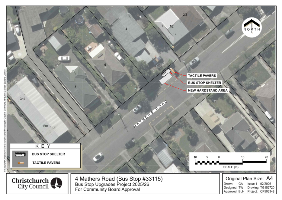
Bus stop 33115
– 4 Mathers Road (Attachment A)
4. Pursuant to Section 339(1) of the Local
Government Act 1974:
a. Approves that a bus passenger shelter be
installed on the north side of Mathers Road commencing at a point 73 metres
west of its intersection with Hoon Hay Road and extending in an easterly
direction for a distance of approximately 3.6 metres.
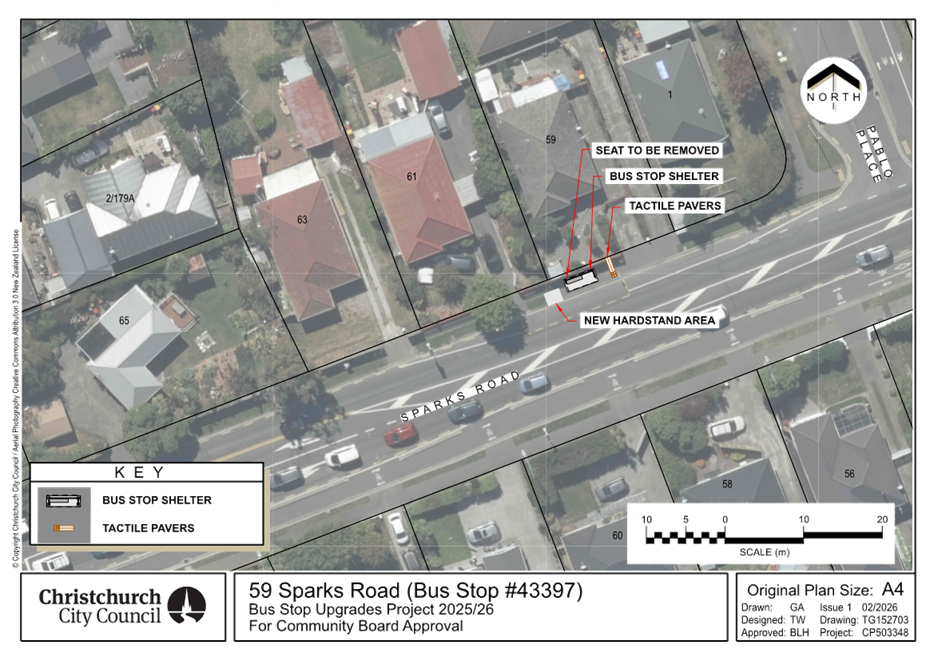
Bus stop
43397– 59 Sparks Road (Attachment A)
5. Pursuant to Section 339(1) of the Local
Government Act 1974:
a. Approves that a bus passenger shelter be
installed on the north side of Sparks Road commencing at a point 40 metres west
of its intersection with Pablo Place and extending in an easterly direction for
a distance of approximately 3.6 metres.
Bus stop
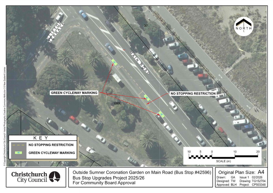
42596– Outside Sumner Coronation Garden on Main Road (Attachment A)
6. Pursuant to Clause 7 of the Christchurch City
Council Traffic and Parking Bylaw 2017:
a. Approves that the stopping of all vehicles be
prohibited at any time, on the west side of Main Road commencing at a point 53
metres south of its intersection with Clifton Terrace and extending in a
northerly direction for a distance of 12 metres.
7. Approves that a hardstand area and tactile
pavers be installed at the bus stops in clauses 4 and 5 above, and that a green
surfacing treatment be implemented at the bus stop in Clause 6 above, as shown
on Attachment A.
8. Approves that these resolutions, described in
clauses 4 to 7 above, take effect when traffic controls or parking signage
and/or road markings that evidence the restrictions described in the staff
report are in place (or removed in the case of revocations).
3. Executive Summary Te Whakarāpopoto Matua
3.1 Based
on community requests, staff are proposing several bus stop upgrades, as listed
in Table 1.
Table
1: Proposed bus stop upgrades.
|
Adress and ID
|
Origin
|
Upgrades
|
|
4
Mathers Road - 33115
|
Community
|
Shelter
installation
|
|
59
Sparks Road - 43397
|
Community
|
Shelter
installation
|
|
Outside
Sumner Coronation Garden on Main Road - 42596
|
Community
|
Lead-in
no stopping restrictions
|
3.2 The proposed plans also incorporate tactile pavers and a hardstand
area to improve accessibility in the waiting area, including for people getting
on and off the bus. Green surfacing is proposed at the bus stop on Main Road to
increase the awareness and potential presence of people riding bicycles.
3.3 A bus stop is deemed
well-used if, on average, it serves around 20 or more passengers daily. This is
the traditional CCC threshold for bus shelter installation.
3.4 These upgrades have been prioritised based on patronage and
community requests.
4. Background/Context Te Horopaki
4 Mathers Road -
33115
4.1 The bus stop serves bus route 60. On average, 20 passengers use this
bus stop each day.
4.2 The
existing bus stop includes standard bus box marking and signage. Also, the
driveways before and after the bus box function as lead-in/out no stopping
restrictions for buses.
59 Sparks Road -
43397
4.3 The bus stop serves bus route 60. On average, 22 passengers use this
bus stop each day.
4.4 The
existing bus stop includes standard bus box marking, lead-in no stopping
restrictions, and signage. Also, the driveway after the bus box functions as
lead-out no stopping restrictions for buses.
Outside Sumner
Coronation Garden on Main Road - 42596
4.5 The bus stop serves bus route 3. On average, 31 passengers use this
bus stop each day.
4.6 The
existing bus stop includes standard bus box marking, lead-out no stopping
restrictions, signage, and a shelter.
Options Considered Ngā Kōwhiringa Whaiwhakaaro
4 Mathers Road
– 33115 and 59 Sparks Road - 43397
4.7 The
following reasonably practicable options were considered and are assessed in
this report:
4.7.1 Shelter
installation.
4.7.2 Do
nothing.
Outside Sumner
Coronation Garden on Main Road - 42596
4.8 The
following reasonably practicable options were considered and are assessed in
this report:
4.8.1 Provision
of standard lead-in no stopping restrictions.
4.8.2 Do
nothing.
Options Descriptions Ngā Kōwhiringa
4 Mathers Road
– 33115 and 59 Sparks Road - 43397
4.9 Preferred
Option: Shelter installation.
4.9.1 Option
Advantages
· Provides weather protection for
bus users.
4.9.2 Option
Disadvantages
· Costs associated with shelter
cleaning and maintenance.
4.10 Do
nothing Option:
4.10.1 Option
Advantages
· The Council
will not incur any costs.
4.10.2 Option
Disadvantages
· No improvement in weather
protection for people waiting for the bus.
Outside Sumner
Coronation Garden on Main Road - 42596
4.11 Preferred
Option: Provision of standard lead-in no stopping restrictions.
4.11.1 Option
Advantages
· Improved access to bus stop for
buses.
· Buses would no
longer block the traffic lane.
4.11.2 Option
Disadvantages
· On-street parking loss (2
spaces)
4.12 Do
nothing Option:
4.12.1 Option
Advantages
· The Council
will not incur any costs.
4.12.2 Option
Disadvantages
· None of the
identified advantages associated with the preferred option would be realised.
5. Financial Implications Ngā Hīraunga Rauemi
Capex/Opex Ngā Utu Whakahaere
5.1 The
estimated costs for the recommended option and the do-nothing option are
provided in the table below.
5.2 The implementation costs in the table below include the expenses for
investigation, design, and construction of bus stop upgrades.
5.3 Maintenance/Ongoing costs - The Transport Unit Operational
Expenditure budgets include maintenance of bus stop infrastructure.
5.4 Funding
Source – Traffic Operations budget for public transport infrastructure
upgrades.
4 Mathers Road – 33115
|
|
Recommended Option
|
Option 2 – Do nothing
|
|
Cost
to Implement
|
$33,000
|
$0
|
|
Funding
Source
|
CPMS
50465
|
N/A
|
|
Maintenance/Ongoing
Costs
|
Bus
stop maintenance contract - minimal effects to the overall asset
|
N/A
|
|
Funding
Availability
|
Available
|
N/A
|
|
Impact
on Rates
|
N/A
|
N/A
|
59 Sparks Road -
43397
|
|
Recommended Option
|
Option 2 – Do nothing
|
|
Cost
to Implement
|
$33,000
|
$0
|
|
Funding
Source
|
CPMS
50465
|
N/A
|
|
Maintenance/Ongoing
Costs
|
Bus
stop maintenance contract - minimal effects to the overall asset
|
N/A
|
|
Funding
Availability
|
Available
|
N/A
|
|
Impact
on Rates
|
N/A
|
N/A
|
Outside Sumner
Coronation Garden on Main Road - 42596
|
|
Recommended Option
|
Option 2 – Do nothing
|
|
Cost
to Implement
|
$7,500
|
$0
|
|
Funding
Source
|
CPMS
50465
|
N/A
|
|
Maintenance/Ongoing
Costs
|
General
maintenance contract - minimal effects to the overall asset
|
N/A
|
|
Funding
Availability
|
Available
|
N/A
|
|
Impact
on Rates
|
N/A
|
N/A
|
6. Considerations Ngā Whai Whakaaro
Risks and Mitigations Ngā Mōrearea me
ngā Whakamātautau
6.1 Should
the Community Board proceed with Option 2, the do-nothing option, there will be
4 Mathers Road – 33115 and 59
Sparks Road – 43397
· No improvements in weather protection for people waiting for the
bus.
Outside Sumner Coronation Garden on Main Road - 42596
· No improvements in access to the bus stop.
· Buses would continue to block the traffic lane when stopping at this
bus stop.
Legal Considerations Ngā Hīraunga
ā-Ture
6.2 Statutory and/or delegated authority to
undertake proposals in the report:
6.2.1 The
relevant Community Board or Committee have delegated authority from the Council
to exercise the delegations as set out in the Register of Delegations. The list
of delegations for the Community Boards includes the resolutions of:
· Stopping, standing,
and parking restrictions (including bus stops) under Clause 7 of the Traffic
and Parking Bylaw 2017.
· Bus passenger
shelters under Section 339 (1) of the Local Government Act 1974.
· To hear and
determine objections to bus stop shelters.
6.3 Other Legal Implications:
6.3.1 This
report has not been reviewed and approved by the Legal Services Unit.
Strategy
and Policy Considerations Te
Whai Kaupapa here
6.4 The
required decisions:
6.4.1 Align
with the Christchurch
City Council’s Strategic Framework.
6.4.2 Are
assessed as low significance based on the Christchurch City Council’s
Significance and Engagement Policy. The level of significance was
determined by the number of people impacted by each individual plan, the low
risk and cost associated with the decision.
6.4.3 Are consistent with Council’s Plans and
Policies.
6.5 This
report supports the Council's
Long Term Plan (2024 - 2034):
6.6 Transport
6.6.1 Activity: Transport
· Level of Service: 10.4.1 More people are choosing to travel
by public transport - >=14 million trips per year
· Level of Service: 10.4.4 Improve customer satisfaction with
public transport facilities (quality of bus stops and bus priority measures) -
>=73%
Community
Impacts and Views Ngā Mariu ā-Hāpori
6.7 Consultation
has been carried out with affected property owners and tenants.
6.8 The
consultation period ran from 27 January to 10 February 2026. Letters were
delivered to the property owners and tenants affected.
6.9 Environment
Canterbury support the proposed upgrades.
6.10 The
Parks Unit has indicated that it has no issues with the proposed plan for bus
stop 42596 outside Sumner Coronation Garden on Main Road.
6.11 Staff
did not receive any submissions regarding the proposed plan for bus stop 33115
outside 4 Mathers Road.
6.12 Staff
received three submissions regarding the plan proposed for bus stop 43397
outside 59 Sparks Road.
6.12.1 Two
affected residents supported the proposed plan.
6.12.2 One
resident objected to the proposed plan and raised the following concerns:
· Buses block the
driveway for longer than a typical pick-up and drop-off stop.
· Increased risk of
graffiti, damage to fencing, fence break-ins, and litter.
· Safety risks
associated with the narrow road width.
6.12.3 Staff
followed up the issue of longer dwell time with Environment Canterbury (ECan).
ECan confirmed that this bus stop is used only for normal for pick-up and
drop-off of passengers and has no other operational function (i.e. timing point
or driver changeover). Staff informed the resident accordingly and advised them
to contact ECan directly if the issue occurs again. In addition, the
installation of a shelter is unlikely to affect this issue.
6.12.4 In
terms of the second concern, staff have responded to the resident that
vandalism, privacy issues, and graffiti may occasionally occur at some bus
stops, but they are not widespread issues across Christchurch. Should such an
incident arise, the police can be contacted, as this behaviour is unacceptable.
In the case of graffiti, the relevant Council team will address the issue.
Furthermore, the shelter is being installed at an existing, well-used bus stop.
This means the concerns mentioned may already exist at this location, and the
addition of a shelter will not significantly increase the likelihood of such
incidents.
6.12.5 Staff
will refer the concern about litter to the relevant Council team to consider
installing a rubbish bin.
6.12.6 Staff
have not proposed any changes to the current bus stop layout and have not
identified any safety issues with the existing arrangement.
6.13 The decision affects the following wards/Community Board
areas:
6.13.1 Waihoro
Spreydon-Cashmere-Heathcote Community Board.
Impact
on Mana Whenua Ngā
Whai Take Mana Whenua
6.14 The decisions do not involve a significant decision in relation
to ancestral land, a body of water or other elements of intrinsic value,
therefore these decisions do not specifically impact
Mana Whenua, their culture, and traditions.
6.15 The decisions do
not involve a matter of interest to Mana Whenua and will not
impact on our agreed partnership priorities with Ngā
Papatipu Rūnanga.
Climate
Change Impact Considerations Ngā Whai Whakaaro mā te Āhuarangi
6.16 The proposals in
this report are unlikely to contribute significantly to adaptation to the
impacts of climate change or emissions reductions. However, providing shelters
along with other bus stop upgrades will enhance public transport user
satisfaction and encourage more people to use public transport.
7. Next Steps Ngā Mahinga ā-muri
7.1 Once
the recommendation is approved, staff will engage with contractors to proceed
with construction.
Attachments Ngā Tāpirihanga
|
No.
|
Title
|
Reference
|
Page
|
|
a ⇩ 
|
Attachment A:
Proposed bus stop improvements
|
26/261043
|
42
|
In addition to the attached documents, the following background
information is available:
|
Document
Name – Location / File Link
|
|
Not
applicable
|
Signatories Ngā Kaiwaitohu
|
Authors
|
Mansour Johari
- Passenger Transport Engineer
Gemma Dioni -
Principal Advisor Transportation Safety
|
|
Approved By
|
Kathy Graham -
Team Leader Traffic Operations
Stephen Wright
- Head of Transport & Waste Management
|
|
10. 215 Taylors
Mistake Road - Road Stopping Application
|
|
Reference Te Tohutoro:
|
25/2271106
|
|
Responsible Officer(s) Te Pou Matua:
|
Colin
Windleborn, Property Consultant
|
|
Accountable ELT Member Pouwhakarae:
|
Anne
Columbus, General Manager Corporate Services/Chief People Officer
|
1. Purpose and Origin of the Report Te Pūtake Pūrongo
1.1 The
purpose of this report is to seek a decision by the Community Board under
delegated authority from the Council to a Road Stopping application under the
Road Stopping Policy 2020 and pursuant to the Public Works Act 1981.
1.2 The
Council’s Transport team has accepted the Road Stopping application,
subject to Community Board approval.
1.3 This report has originated from an application lodged by the owner
of 215 Taylors Mistake Road, Taylors Mistake, to stop and purchase an area of
road (being approx. 305m2) located adjacent to their property. Attachment
A
1.4 The decisions proposed in this report will enable staff to process a
stopping of the road and transfer of this land to the applicant. These actions
will allow the applicant to develop a new dwelling and yard area on their land.
2. Officer Recommendations Ngā
Tūtohu
That the Waihoro Spreydon-Cashmere-Heathcote Community Board:
1. Receives the information in the 215 Taylors Mistake Road - Road
Stopping Application Report.
2. Notes that the decision in this report is
assessed as low significance based on the Christchurch City Council’s
Significance and Engagement Policy.
3. Notes that the proposed Road Stopping details
have been assessed and approved by Transport staff.
4. Resolve pursuant to Sections 116(1), of the
Public Works Act 1981 to stop and sell to the adjoining owners, that parcel of
land shown as Concept Attachment A to this report containing 305m2,
at market value, and to amalgamate that parcel of land with the owner’s
adjoining land contained in Record of Title CB374/135.
5. Authorises the Manager Property Consultancy
under delegated authority to undertake all actions, negotiations and to
conclude the agreements necessary to facilitate the above on terms and
conditions acceptable to him at his sole discretion, and in doing so make any
decisions necessary to give effect to this.
3. Executive Summary Te Whakarāpopoto Matua
3.1 The
owners of 215 Taylors Mistake Road have lodged an application for the Council
to stop a 305m2 section of legal road, adjacent to their land,
located on a bend on Taylors Mistake Road, Taylors Mistake. The applicant
wishes to purchase this land and amalgamate with their existing title, to
enable redevelopment of their site.
3.2 The
legal road area is currently being used by way of a Licence with Christchurch
City Council for the applicants’ garages, access ramp and currently forms
a part of their garden space. The land has been maintained by the private
owners since consent from Council was granted for the construction of the
garage in 1988.
3.3 The
land is not held by the Council for any current or future planned public work.
3.4 The
existing footpath and public street accessibility will not be altered, and
staff view the application as non-controversial. In consideration of the
factors involved, staff are hereby recommending for the Public Works Act Road
Stopping process to be utilised.
3.5 Once
the road area is stopped, the land will be transferred to the applicant at
market value and all costs involved in this process are being met by the
applicant.
4. Background/Context Te Horopaki
4.1 The
current owners of 215 Taylors Mistake have applied for Council to
‘stop’ a portion of legal road located adjacent to their property
on a hairpin bend on Taylors Mistake Road. The owners intend to purchase this
area of land and amalgamate with their existing title, enabling them to
redevelop and landscape their property.
4.2 The
road to be stopped totals an area of 305m2 aligns with the
applicant’s existing boundary fence. Please refer to Attachment A,
showing the area of road proposed to be stopped.
4.3 The
applicant’s existing garage landscaping and ramp have been in place for
at least 38 years The historical presence of the landscaping ramp and garage
has provided a common local assumption that this land has always formed part of
the adjoining private property. Until this time, the land has been managed by
the property owner. Please refer to Attachment B for additional street
view and aerial imagery.
4.4 The
road stopping will not affect the public sealed roading or pedestrian footpath.
Nor will this road stopping cause any accessibility or safety issues for users
of the road or footpath.
4.5 There
is no Council or external party infrastructure located under the area of road
proposed to be stopped. However, there is a portion of the retaining wall
immediately adjacent to the roading stopping and an easement will be put in
place to ensure access is maintained to this.
4.6 Once
the road area has been stopped, the land shall be transferred to the applicant
at full market value and amalgamated with their existing land title. Staff have
sourced a property valuation report which has been agreed with the applicant
and supports the proposed transfer value.
4.7 The
applicant’s land is zoned ‘Residential Hills Zone’, and the
addition of the stopped road area could result in an additional potential for
subdivision. The minimum lot size permitted under the RH zone is 650m2.
Including the 305m2 addition of the stopped road, the applicant’s
landholding will total 955m2. A net site area of 650m2 excluding driveways is
required. A resource consent application for undersized lots can be made.
4.8 There
is a rule within the Residential Hills zone that allows for conversion of an
existing residential unit from one into two it is not reliant on the lot size,
and the owner of the property could then subdivide.
4.9 Views
of the community have not been sought on this occasion as there will be no
effect on pedestrian or vehicular access. Nor will there be any impact on
adjoining neighbours as mentioned above.
4.10 All
costs in relation to this application, including staff time, legal review,
survey and LINZ processing fees are being met by the applicant. A conditional
agreement has been signed by the Council and applicant to record this
obligation.
4.11 In
summary, specifics of this Road Stopping application have been considered by
Transport staff with reference to the Council’s Road Stopping Policy
2020, and a recommendation is hereby presented for the process to proceed,
subject to Community Board approval, pursuant to the Public Works Act 1981.
4.12 The following related memos/information were circulated to the
meeting members:
4.13 The following related information session/workshops have taken place
for the members of the meeting:
Options Considered Ngā Kōwhiringa Whaiwhakaaro
4.14 The
following reasonably practicable options were considered and are assessed in
this report:
4.14.1 Approve the
road stopping process and transfer of land to the applicant.
4.14.2 Decline the
road stopping process and transfer of land to the applicant.
4.15 The
following options were considered but ruled out:
4.15.1 Nil
Options Descriptions Ngā Kōwhiringa
4.16 Preferred
Option: Approve the road stopping process and transfer of land to the
applicant.
4.16.1 Option
Description: Approve the road stopping pursuant to Section 116(1) of the
Public Works Act 1981, as outlined in the Council’s Road Stopping Policy
2020 and the transfer of the stopped land to the applicant at a market value
sum.
4.16.2 Option
Advantages
· Is consistent
with Council’s Strategic framework as it transfers rights to enable
further development.
· Will tidy up
the ownership of this section of land, which has long been located behind the
applicant’s boundary fence, with little involvement from Council.
· Will remove
the Council from any future maintenance of this section of land.
· Will enable
the applicant to complete their intended property development.
· The Council
will be remunerated appropriately for the transfer of land to the private
owner.
4.16.3 Option
Disadvantages
· There are no
disadvantages as the land is not required for a current or future public work.
4.17 Alternative
Option: Decline the road stopping process and
transfer of land to the applicant.
4.17.1 Option
Description: Do not approve the road stopping.
4.17.2 Option
Advantages
· The Council
would retain this section of road, albeit for no likely public purpose.
4.17.3 Option
Disadvantages
· This
alternative would be inconsistent with previous decisions made by Community
Boards and previous applications for road stopping under the Council’s
Road Stopping Policy 2020.
· The applicant
will need to fund the Road Stopping application fee and staff costs incurred to
date, with no positive outcome being achieved.
· The Council
will need to contribute to maintenance costs of the land, when there is no
projected need for the land.
· No transfer
remuneration will be received by Council.
Analysis Criteria Ngā Paearu Wetekina
4.18 In
making its decision, the Community Board needs to consider the impact of
stopping and selling this land to the applicant. As outlined in the report, the
impacts are low, given the location and historical use of the land. There are
no impacts on the public’s ability to access the footpath or street.
5. Financial Implications Ngā Hīraunga Rauemi
Capex/Opex Ngā Utu Whakahaere
|
|
Recommended Option – Approve Road
Stopping and transfer
|
Option 2 – Decline Road Stopping and
transfer
|
|
Cost to Implement
|
Survey, staff, legal, LINZ processing
fees
|
Staff time
|
|
Maintenance/Ongoing Costs
|
Borne by the Applicant
|
Borne by the Applicant
|
|
Funding Source
|
Borne by the Applicant
|
Borne by the Applicant
|
|
Funding Availability
|
Borne by the Applicant
|
Borne by the Applicant
|
|
Impact on Rates
|
Nil
|
Nil
|
5.1 All
costs are recoverable from the applicant, including but not limited to,
valuation, staff time, legal costs and LINZ processing costs.
6. Considerations Ngā Whai Whakaaro
Risks and Mitigations Ngā Mōrearea me
ngā Whakamātautau
6.1 There
are no significant risks identified with this process and implementation. The
Transport unit have considered any risks and concluded there is no operational
reason not to stop and transfer this portion of road.
Legal Considerations Ngā Hīraunga
ā-Ture
6.2 Statutory
and/or delegated authority to undertake proposals in the report:
6.2.1 The
Council’s decision-making is in accordance with the general powers of
competence set out in Section 12(2) “Status and Powers” of the
Local Government Act.
6.2.2 This
proposed Road Stopping has been determined by staff to meet the Public Works
Act 1981 criteria, alongside Council’s Road Stopping Policy 2020, and the
reasons and decision-making process is set out below.
6.2.3 The
Community Board holds delegation to authorise the Road Stopping process, along
with a transfer of the subsequent fee simple land to the adjoining property
owner.
6.3 Other Legal Implications:
There are two statutory processes under
which Road Stoppings can be enacted. The authority to determine which statutory
procedure should be employed to undertake a particular road stopping (either
under the Local Government Act 1974 or under the Public Works Act 1981) is
delegated to staff. The Policy establishes:
4.5 The following criteria have been established to ensure that the
appropriate statutory procedure is consistently adopted by the Council, and to
avoid, as much as is practicable, such decisions being successfully contested
by any party.
Local Government Act 1974 process
4.6 The Local Government Act 1974 road-stopping procedure will be
adopted if one or more of the following circumstances apply:
a. Where any
public right of access to any public space could be removed or materially
limited or extinguished as a result of the road being stopped; or
b. If it is
found through the review process that the road stopping could injuriously
affect or have a negative or adverse impact on any other property; or
c. The road
stopping is, in the judgment of the Council, likely to be controversial; or
d. If there
is any doubt or uncertainty as to which procedure should be used to stop the
road; or
e. The Public Works Act 1981
process is not able to be used or is not used.
Public Works Act 1981 process
4.7 The Public Works Act 1981 road stopping procedure may be adopted
only if all of the following circumstances apply:
a. Where
there are no more than two properties, other than the applicant’s
property, adjoining the road proposed to be stopped.
b. Where the
written consent to the proposed road stopping of all adjoining landowners
(other than the applicant) to the proposed road-stopping is obtained.
c. Where no
other persons, including the public generally, are considered by the Council in
its judgment to be adversely affected by the proposed road stopping.
d. Where the
road proposed to be stopped is to be amalgamated with the adjoining property or
properties (as appropriate); and
e. Where
other reasonable access exists or will be provided to replace the access
previously provided by the road proposed to be stopped (i.e. by the
construction of a new road); and
f. Where
the use of the Public Works Act 1981 road stopping procedure is approved by the
relevant Government department or Minister.
4.8 If any one of the circumstances referred to in clause 4.7 does
not apply, then the Local Government Act 1974 process must be used.
6.3.1 The
appropriate process is this instance is the Public Works Act 1981.
Strategy
and Policy Considerations Te
Whai Kaupapa here
6.4 The
required decision:
6.4.1 Aligns
with the Christchurch
City Council’s Strategic Framework.
6.4.2 Is
assessed as low significance based on the Christchurch City Council’s
Significance and Engagement Policy. The low level of significance was
determined due to there being no change in use or appearance of the land which
already appears to form part of the adjoining site. There is no change
to access or use of the road or footpath for the public.
6.4.3 Is
consistent with Council’s Plans and Policies.
6.5 This
report does not support the Council's
Long Term Plan (2024 - 2034).
Community
Impacts and Views Ngā Mariu ā-Hāpori
6.6 There
is no impact on the public use of the sealed road and footpath, should the road
stopping proceed. The area of land to be stopped has long been incorporated
into the adjoining site by fencing and landscaping, therefore the appearance
from the street will not change.
6.7 The decision affects the following wards/Community Board areas:
6.7.1 Waihoro
Spreydon-Cashmere-Heathcote Community Board
Impact
on Mana Whenua Ngā
Whai Take Mana Whenua
6.8 The
decision does not involve a significant decision in
relation to ancestral land, a body of water or other elements of intrinsic
value, therefore this decision does not specifically
impact Mana Whenua, their culture, and traditions.
6.9 The
decision does not involve a matter of interest to Mana Whenua and will not impact on our agreed partnership priorities
with Ngā Papatipu Rūnanga.
6.10 The
decision does not alter the appearance or use of the land as it has always been
incorporated by fencing with the adjoining land.
Climate
Change Impact Considerations Ngā Whai Whakaaro mā te Āhuarangi
6.11 The proposals in
this report are unlikely to contribute significantly to adaptation to the
impacts of climate change or emissions reductions.
6.12 The
use of the land will not change as it has long been used as part of the
adjoining site and can only be used in the future by the adjoining site for
landscaping.
7. Next Steps Ngā Mahinga ā-muri
7.1 Complete
the process of application to Minister of Lands to approve the Road Stopping
and amalgamation of the land with the adjoining site.
7.2 The
Manager Property Consultancy will complete all documentation to implement this
process.
Attachments Ngā Tāpirihanga
|
No.
|
Title
|
Reference
|
Page
|
|
a ⇩
|
Attachment A
Concept
|
25/2567917
|
52
|
|
b ⇩
|
Attachment B
Aerial Location and Street Views
|
25/2569310
|
53
|
In addition to the attached documents, the following background
information is available:
|
Document
Name – Location / File Link
|
|
Not
applicable
|
Signatories Ngā Kaiwaitohu
|
Author
|
Colin
Windleborn - Property Consultant
|
|
Approved By
|
Angus Smith -
Manager Property Consultancy
Andy Milne -
Team Leader Asset Planning
Stephen Wright
- Head of Transport & Waste Management
|
|
11. Port Hills Paragliding Schools - proposed new
licences
|
|
Reference Te Tohutoro:
|
26/73043
|
|
Responsible Officer(s) Te Pou Matua:
|
Felix
Dawson, Leasing Consultant, Marie Gordon, Team Leader Parks Planning and
Policy
|
|
Accountable ELT Member Pouwhakarae:
|
Andrew
Rutledge, General Manager Citizens and Community
|
1. Purpose and Origin of the Report Te Pūtake Pūrongo
1.1 The
purpose of this report is to consider the proposals for new licences from three
paragliding schools for new licences to operate generally from the Port Hills.
1.2 The
report has been prepared in response to the expiry of the existing licences in
March 2026 and follows a Request for Proposals process inviting new operators.
2. Officer Recommendations Ngā
Tūtohu
That the Waihoro
Spreydon-Cashmere-Heathcote Community Board:
1. Receives the information in the Port Hills Paragliding Schools
- proposed new licences Report.
2. Approve licences for a period of five years
with two rights of renewal, to Christchurch Paragliding Ltd; Cloudbase Ventures
Ltd; Progress Paragliding Ltd for access to the sites listed in the schedule
shown in Attachment A and generally as per the plan shown in Attachment
B of the agenda report.
3. Notes that the decisions in this report are
assessed as low significance based on the Christchurch City Council’s
Significance and Engagement Policy.
4. Requests that the Manager Property Consultancy
do all things necessary and make any decisions at his sole discretion that are
consistent with the intent of this report to implement the resolutions above
including completing negotiations and administering the terms and conditions of
the new licences.
3. Executive Summary Te Whakarāpopoto Matua
3.1 Paragliding
is a popular recreational activity practiced from a range of sites on the Port
Hills but also on some Banks Peninsula sites. It is regulated by the Civil
Aviation Authority, and all paragliders must be trained and registered with the
New Zealand Hang Gliding and Paragliding Association before being able to free
fly.
3.2 Training
is undertaken by registered paragliding schools who have used key sites on the
Port Hills for this purpose. Existing Council licences to use
park/reserve land for current operators expire this year and new licences have
been requested.
3.3 Staff
have considered the popularity of this activity and impact on other users to
determine whether any or how many licences should be issued. There have
not been any significant issues raised in consultation and staff support
continuing with three licences for paragliding schools.
3.4 This
report recommends the granting of licences to the three successful respondents
to a Request for Proposal process.
3.5 Note
that three take off and two landing sites as shown below fall into the Te
Pātaka o Rāikaihautū Banks Peninsula
Community Board ward and will require approval from that Community Board.
The sites are not fundamental to the operation of the schools but if approved
by that Board will be included in the licences.
4. Background/Context Te Horopaki
Port Hills Paragliding- the sites
4.1 Paragliding
has been practiced in the Port Hills for over thirty years and remains
popular. The Canterbury Hang Gliding and Paragliding Club (CHGPC/the
Club) is the second biggest club in the country with around 300 members.
This is due to the quality of the wind conditions and take off sites with
Taylors Mistake being a premium learner’s site and the gondola being a
top-quality intermediate/advanced site. Other sites are used periodically
dependent on the wind conditions
4.2 Take
off sites are 1-14 with landing sites 15-23 as shown on the map below. All take
off sites are currently grazed with sheep for management purposes; the
landing sites are generally sports grounds. The sites are a mix of Reserves Act
recreation reserve/ scenic reserve together with Local Government Act park.
4.3
Note that take off sites 7 (Allendale), 11 (Te Oka) and 14 (Mt Pleasant Towers)
together with landing sites 15 (Naval Point) and 22 (Allendale) are in the
Banks Peninsula ward and are not subject to the decisions in this report.
The sites are not fundamental to the operation of the schools but if approved
by that Board will be included in the licences.
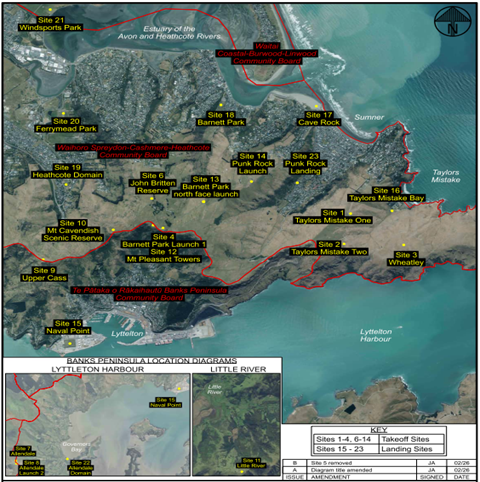
Paragliding Regulation and Training
4.4 Paragliding
is regulated by the Civil Aviation Authority (CAA) who have delegated
management of recreational paragliding by way of a Part 149 Aviation Recreation
Certificate to the New Zealand Hang Gliding and Paragliding Association
(NZHGPA) issued pursuant to the Civil Aviation Act 1990. Under this
regulation all pilots are required to be members of the New Zealand Paragliding
Association and to be trained to a minimum standard (PG1-2) with a
qualification issued by the NZHGPA who set training qualifications and quality
assurance standards. Local clubs such as CHGPC assist NZHGPA in a local
liaison role.
4.5 Training
schools are regulated with requirements to maintain the NZHGPA Operations and
Procedures Manual which is audited together with the Business Safety Management
System and Emergency Response Plan every three years by NZHGPA.
Commercial Tandem Paragliding remains managed by the CAA with three yearly
audits.
Paragliding Schools Licencing and use
4.6 Paragliding
businesses offering flying instruction and/or tandem flights have operated
informally from Council sites on the Port Hills for a number of years. In
2020 following a request from an operator wishing to undertake tandem flights,
the Council undertook a trial of operating licences with a term of five
years. Three licences were issued and have functioned successfully since
that time. All operators offer instruction and one offers tandem flights
as well. The licences expire on 31 March 2026.
4.7 Staff
reviewed the operation of the schools in 2024 with a view to determining
whether licences should be continued for this use. This involved interview of
existing operators and CHGPC Board members to:
· identify level of overall
and school use;
· potential conflict with
other users/stock management;
· capacity of sites.
4.8 Staff
noted that use of sites for all use either instruction or recreation is weather
dependent and so determining average level of use is difficult. In terms
of business use: two of the businesses would average around fifteen - twenty
people per week in peak season which is September to March with April to August
generally off season with low level use. One business runs at around half
that level as it splits its business with paramotoring which is not permitted
for instruction from Council land under the terms of the proposed licence.
4.9 The
Taylors Mistake take off site near the Summit Road with landing behind the
beach is by far the most popular as this is the best site for beginner level
training and entry level recreational flying. At times this site can be
congested with both types of use. The CHGPC have established protocols
for sharing of the site in high use circumstances and the businesses have
established informal communication to avoid unmanageable overlap. The
other high use site is the gondola on Mt Cavendish. This is predominantly
used by recreation users with a small amount of instruction undertaken.
4.10 In
terms of conflict of paragliding with other use/users staff note that keeping
sites clear for take-off on the hills can conflict with regeneration of native
vegetation and use of sites for passive recreation. This is a particular issue
on Mt Cavendish which is a scenic reserve with high native plant values.
Staff have worked with the Club to establish a compromise that meets the needs
of all parties. Dialogue with the Club over site issues has been
undertaken with discussion of the potential for an Memorandum of Understanding
style user agreement. Generally given the relatively short periods that
paragliders use the site all park users can be accommodated.
4.11 The
take-off sites do not significantly restrict stock management.
4.12 Both
the existing businesses and the CHGPA have advised that three schools are the
optimum number. Given the popularity of the sport and the integral part
that schools play in enabling participation, staff have proceeded on that basis
with licences for three schools proposed to continue.
Request for Proposal Process
4.13 Given
the commercial nature of the licences, an open transparent tender process (RFP)
was undertaken in accordance with Council property policy.
4.14 The
current licensees submitted proposals with two making them in the alternative
to other proposals provided by their operating managers who have made offers to
purchase the business. The proposed new operators have been in training
with existing owners since early 2025. They have entered into an
agreement to purchase the business together with all the existing operating
systems which have been proven and are certified. All operators offer the
fundamental beginners training service with each offering a slightly different
emphasis in terms of training options.
4.15 Staff
are confident in the one existing and two new operators who have demonstrated
capacity and sufficient skill either through the current licence or through
their employment with the existing licensees.
4.16 The
three operators have been recommended by both the Club President and the CE of
NZHGPA and all three businesses have recently (December 2025) been audited and
received accreditation from NZHGPA.
4.17 Staff
have given conditional approval for licences to: Christchurch
Paragliding Ltd (Ryan Scarlett); Cloudbase Base Ventures Ltd (Bevan Small) and
Progress Paragliding Ltd (Ondrej Wieden). This report recommends approval
to enter into licences with them
4.18 Key
Licence terms:
· Five year term with two
rights of renewal;
· Requirement to be
certified by NZHGPA;
· Rental: Base rate $650
(plus GST) plus cost/flight. Method is a fair method of payment in
proportion to use. Flight rate is comparable to CAA charges. At
this rate for 2025, two existing schools would pay flat rate only and one would
pay an additional $137.00.
Options Considered Ngā Kōwhiringa Whaiwhakaaro
4.19 The
following reasonably practicable options were considered and are assessed in
this report:
4.19.1 Enter
into three licences.
4.19.2 Enter
into less than three licences
4.19.3 Do
not enter into any licences.
4.20 The
following options were considered but ruled out:
4.20.1 Reduce/increase
the number of sites: The previous sites available to licence were reviewed by
staff prior to the RFP process and considered in terms of ongoing suitability
for use in terms of capacity and impact. Some additional sites were
requested through the RFP process and assessed in the same way. Staff
consider the proposed sites meet the balance between competing demand for use.
4.20.2 Rental:
f two alternative options were considered but not favoured: a flat rate would
either punish businesses in low years or favour them disproportionately in a
high year; base rate plus % of revenue- a percentage of revenue required high
administrative costs for business to separate Council site revenue from
other elements of the service, the charge per flight achieves the same end of
paying in proportion to the level of use.
4.20.3 Additional
licences: Existing licensees and the Club advised that the optimum number is
three schools.
Options Descriptions Ngā Kōwhiringa
4.21 Preferred
Option: Enter into three licences:
4.21.1 Option
Description: Accept all three proposals submitted as part of the RFP, to
run paragliding schools from the sites as shown and enter into operating
licences with them.
4.21.2 Option
Advantages
· Supports
existing business
· Enables and
supports paragliding recreation
· Is at a
capacity that balances the competing needs of different users
4.21.3 Option
Disadvantages
· Restricts
other users
· Relatively
high level of use for paragliding raising risk
4.22 Option
2: Enter into less than three licences.
4.22.1 Option
Description: Enter into less than three licences.
4.22.2 Option
Advantages
· Less pressure
on sites and congestion at peak times
· Less risk from
congestion
· Less impact on
other users
4.22.3 Option
Disadvantages
· One existing
business will be for forced to close.
· Paragliding
users will have less choice of trainers
· There is no
indication from the Club or NZHGPA that the current level is unmanageable from
a safety perspective
· The impact on
other users with current level is not considered unreasonable
4.23 Option
3: Do not enter into any licences.
4.23.1 Option
Description: prioritise other users at the expense of paragliding schools
4.23.2 Option
Advantages
· Less pressure
on sites and congestion at peak times
· Less risk from
congestion
· Less impact on
other users
4.23.3 Option
Disadvantages
· Three
successful existing business will be forced to close.
· There will be
no local trainers for new pilots
· Paragliding as
a recreational activity will not be supported
Analysis Criteria Ngā Paearu Wetekina
4.24 Balance
competing users: the popularity of recreational paragliding as against the
values and use of the reserves/park for other uses.
5. Financial Implications Ngā Hīraunga Rauemi
Capex/Opex Ngā Utu Whakahaere
|
|
Recommended Option:
Enter into three licences
|
Option 2: Enter into less than three licences
|
Option 3 Do not enter into any licences
|
|
Cost to Implement
|
Preparation of licence and running of RFP
$1,500, part to be recovered from licensee
|
Preparation of licence and running of RFP
$1,500, part to be recovered from licensee
|
nil
|
|
Maintenance/Ongoing Costs
|
minimal
|
minimal
|
nil
|
|
Funding Source
|
Operational funds
|
Operational funds
|
X
|
|
Funding Availability
|
yes
|
yes
|
X
|
|
Impact on Rates
|
minimal
|
minimal
|
x
|
6. Considerations Ngā Whai Whakaaro
Risks and Mitigations Ngā Mōrearea me
ngā Whakamātautau
6.1 Operation
of schools will increase the number of paragliders and lead to unmanageable
congestion with accidents occurring leading to bad publicity. The risk is
considered medium in that operation of the schools in recent years has not led
to an explosion of users. There is a natural attrition of students with
relatively low numbers of pilots going on to take up the sport. NZHGPA has
advised that the current level of schools is manageable from a congestion and
safety management perspective. Existing site risks have been mitigated by
Club operational guidelines.
Legal Considerations Ngā Hīraunga
ā-Ture
6.2 Statutory
and/or delegated authority to undertake proposals in the report:
6.2.1 Delegations
Parks (Part D-sub Part 1- Community Boards) Authority delegated from Council to
Community Boards.
“To grant leases of recreation
reserves in accordance with this section”- section 54 Reserves Act 1977.
“To grant leases of recreation
reserves in accordance with this section”- section 56 Reserves Act 1977.
“To grant leases or licences for a
maximum term of 35 years to any person or body over parks and to authorise
staff to sign all required documentation” Local Government Act
2002.”
6.2.2 Note
licence covers land held as recreation reserve, scenic reserve and Park, so
licence entered into pursuant to sections 54, 56, 59A Reserves Act 1977 and
general provisions for ‘Park’- Local Government Act
6.3 Other Legal Implications:
6.3.1 Local
Government Act 2002-Decision Making including consideration of community views.
6.3.2 Reserves
Act 1977, use consistent with recreation use classification, public notice
pursuant to sections 54(1)(d), s56(1)(b).
6.3.3 Local
Government Act 2002, use consistent with park, public notice pursuant to
section s138.
6.3.4 Department
of Conservation approval required pursuant to Reserves Act, authority delegated
to CEO.
6.3.5 Legal
advice is that the Council will be considered a ‘Person Conducting a
Business or Undertaking’ in regard to the Health and Safety at Work Act
2015. Compliance requirements in regard to this act are overseen by the
NZHGPA and legal advice is that the Council has limited practical control of
the activity. Note also that the NZHGPA is not considered an adventure
activity in terms of the Health and Safety at Work Act 2015 and so not subject
to the regulations in that act applying to adventure activities, Refer
Attachment C.
Strategy
and Policy Considerations Te
Whai Kaupapa here
6.4 The
required decisions
6.4.1 Align
with the Christchurch City
Council’s Strategic Framework, in particular
the strategic priority of being an inclusive and equitable city that puts
people at the centre. Paragliding is a popular recreation activity enabling
wellbeing, accessibility and connection.
6.4.2 Are
assessed as low significance based on the Christchurch City Council’s
Significance and Engagement Policy. The level of significance was
determined by considering the number of people affected, the level of impact on
those affected and the low cost to Council associated with entering into the
licences.
6.4.3 Are
consistent with Council’s Plans and Policies.
· Physical
Recreation and Sports Strategy 2002
· Port Hills
Recreation Strategy 2004
· Lease Policy
December 2015
“When seeking to lease premises for
which there is a broader market or public interest, the Council will seek
tenants through an open and transparent public process, such as by tender, by
request for proposals or by advertising to attract potential tenants.”
For the purpose of this policy lease is
interpreted to include licence
6.5 This
report supports the Council's Long Term Plan (2024 - 2034):
6.6 Parks, Heritage and Coastal Environment
6.6.1 Activity: Parks and Foreshore
· Level of Service: 6.8.10.1 Appropriate use and occupation
of parks is facilitated - Processing of the application is started within ten
working days of receiving application - 95%
Community
Impacts and Views Ngā Mariu ā-Hāpori
6.7 Consultation
started 17 November ran until 17 December 2025.
6.8 Consultation
details including links to the project information shared on the Kōrero mai | Let’s Talk webpage were advertised via:
6.8.1 An
email sent to 32 identified stakeholders, including residents associations,
sports clubs, environmental groups and paragliding bodies.
6.8.2 Public
Notice – Christchurch Press 17 November 2025
6.8.3 Four
signs up at the main commercial take-off and land sites.
6.9 The Kōrero mai | Let’s Talk page had 144 views throughout the consultation period.
Summary of Submissions Ngā Tāpaetanga
6.10 Submissions
were made by two organisations and 10 individuals. All submissions are
available to read on the Kōrero mai webpage.
6.10.1 Canterbury
Hang Gliding and Paragliding Club submitted in support of the proposal,
noting safety and operational procedures are well understood and that there was
minimal environmental impact on the sites.
6.10.2 Beach
Bar Sumner submitted in support of the proposal, noting it was a great
activity that brought people out to the area.
6.11 Overall,
75% (9) submissions were in support and the remainder (3) were somewhat in
support of the licences.
6.12 Eight
submitters made additional comments, relating to safety/emergencies (4),
tourism (2), and general comments in support for paragliding as an activity
(4).
6.13 The
table below sets out issues raised in feedback and staff comment in response.
|
Issue
|
Staff
Comment
|
|
Is there an emergency plan in place for each site?
|
Safety management is handled by NZHGPA with all
safety and emergency management systems audited on a three yearly basis
|
|
It seems like every time there is a major rescue
that puts volunteer rescuers at risk its involving a paraglider down. I
support this activity but it does pose a higher risk for technical rescue. Do
the groups that are involved in this activity contribute in any way to the
organisations that rescue them? If not they should be required to pay a
levy and not put that burden solely on the taxpayers
|
The question of tax payer costs for recreation
activity is not a matter for Council decision
|
|
My feedback might be out of date - my wife paid for
a tandem flight in port hills around 30 years ago. The operator at time
didn't have a second person to assist him, and tried to land same place
he took off. Top landings are difficult and problematic and in our case
landed us in hospital. The safest and usual landing is a playground, beach,
etc.
|
All operational systems including staff levels and
safety issues are subject to management oversite and audit by NZHGPA.
All three businesses have recently received audit certification.
|
|
Having more available landing sites could allow for
easier landings in an emergency situation.
|
The proposed landing sites have been reviewed by the
Club and business and are considered suitable and adequate.
|
|
The one near Little River may bother local
residents.
|
The take off site is on Te Oka Reserve with a
landing site on private land. It is only used periodically and staff
consider that it will have low impact
|
|
Whether money from commercial operations would be
passed on to the local communities for the inconvenience.
|
Rental as a matter of practice is contributed to the
general income pool and is received by the community in that sense.
Inconvenience to local communities is considered low overall and distribution
would be problematic.
|
6.14 The
decision affects the following wards/Community Board areas:
6.14.1 Waihoro
Spreydon-Cashmere- Heathcote Community Board.
Impact
on Mana Whenua Ngā
Whai Take Mana Whenua
6.15 The decisions do not involve a significant decision in relation
to ancestral land, a body of water or other elements of intrinsic value,
therefore this decision does not specifically impact
Mana Whenua, their culture, and traditions.
6.16 The decision does involve a matter of interest to Mana Whenua and could impact on our agreed partnership priorities
with Ngā Papatipu Rūnanga.
6.17 Background
material for the consideration of licences was forwarded to Whitiora and
Ngāti Wheke on 8 August 2025 prior to the RFP process in an early notice
of the matter. No issues were identified at that point. The
operators requested additional sites in their proposals and these additional
sites were forwarded to both Whitiora and Ngāti
Wheke in a further notice on 13 November 2025. No issues were identified.
Climate
Change Impact Considerations Ngā Whai Whakaaro mā te Āhuarangi
6.18 The
proposals in this report are unlikely to contribute significantly to adaption
to the impacts of climate change or emissions reductions. The proposal to enter
new licences does not have an impact on climate change as there is limited
carbon footprint associated with licencing itself and there is no change to
current emissions. In terms of the activities associated with the licence
there is some travel involved getting to take off and pick up sites. The
sites are generally local and this is considered reasonable in the
circumstances.
7. Next Steps Ngā Mahinga ā-muri
7.1 Subject
to approval of recommendations, Property staff to complete negotiation of
licence terms and complete documentation.
Attachments Ngā Tāpirihanga
|
No.
|
Title
|
Reference
|
Page
|
|
a ⇩
|
Schedule- Take
off and Landing sites
|
26/220406
|
67
|
|
b ⇩
|
Paragliding
Sites
|
26/231533
|
68
|
|
c ⇩
|
Health and
Safety obligations legal advice
|
26/262408
|
69
|
In addition to the attached documents, the following background
information is available:
|
Document
Name – Location / File Link
|
|
Not
applicable
|
Signatories Ngā Kaiwaitohu
|
Authors
|
Felix Dawson -
Leasing Consultant
Paris Porter -
Engagement Advisor
|
|
Approved By
|
Kathy Jarden -
Team Leader Leasing Consultancy
Angus Smith -
Manager Property Consultancy
Paul Devlin -
Manager Regional Parks
Al Hardy -
Manager Community Parks
Rupert Bool -
Head of Parks
|
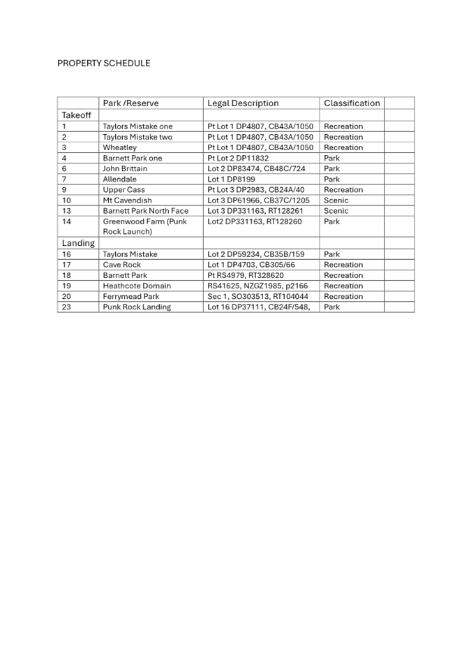
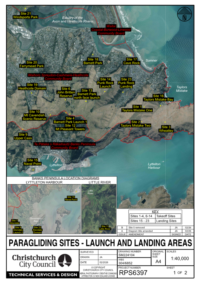
|
12. Ōpāwaho
Pathway Hunter Terrace Stage 1
|
|
Reference Te Tohutoro:
|
26/248204
|
|
Responsible Officer(s) Te Pou Matua:
|
Emily
Arthur, Project Manager, Community Parks
|
|
Accountable ELT Member Pouwhakarae:
|
Andrew
Rutledge, General Manager Citizens and Community
|
1. Purpose and Origin of the Report Te Pūtake Pūrongo
1.1 The
purpose of this report is to seek approval for the Landscape Concept Plan for
Ōpāwaho Pathway Hunter Terrace Stage 1 as shown in Attachment A.
1.2 This
is a staff generated report.
2. Officer Recommendations Ngā
Tūtohu
That the Waihoro
Spreydon-Cashmere-Heathcote Community Board (the Board):
1. Receives the information in the Ōpāwaho Pathway
Hunter Terrace Stage 1 Report.
2. Notes that the decision in this report is
assessed as low significance under the Christchurch City Council’s
Significance and Engagement Policy.
3. Approves the Landscape Concept Plan for
Ōpāwaho Pathway Hunter Terrace Stage 1, as shown in Attachment A the
area marked Indicative Stage 1 Extent, excluding the area marked on Attachment
A as Future Potential Stages.
3. Executive Summary Te Whakarāpopoto Matua
3.1 This
report seeks approval of the Landscape Concept Plan for Stage 1 of the
Ōpāwaho Pathway. Stage 1 involves removal of the former sealed
carriageway outside Christchurch South Library, Ōmōkihi, and its
replacement with new pathways and native planting, consistent with the Mid
Heathcote Ōpāwaho Master Plan (2009).
3.2 The
project is being delivered alongside the library rebuild to provide a
coordinated outcome and improve access, amenity, and ecological values along
the Ōpāwaho Heathcote River corridor.
3.3 Targeted
engagement with Ngāi Tūāhuriri and key community groups has
shown broad support for Stage 1. The preferred option is to approve the
Landscape Concept Plan, excluding future potential stages, to enable timely
delivery aligned with the library opening and efficient coordination of works.
4. Background/Context Te Horopaki
4.1 The
Mid Heathcote Ōpāwaho Masterplan (2009) provides guidance for the
long-term management of the Ōpāwaho Heathcote River corridor between
Colombo Street and Opawa Road. The Masterplan includes the removal of the
existing sealed carriageway along the section of Hunter Terrace outside the
library and for this to be replaced with plantings and new pathways.
4.2 The
rebuild of Christchurch South Library, Ōmōkihi, is currently underway
and is expected to be completed by October 2026.
4.3 The
development of an approximately 800 metre section of the former Hunter Terrace,
consistent with the Mid Heathcote Ōpāwaho Masterplan, is being
planned to align with the library rebuild and to open at the same time.
4.4 The
area being developed as part of stage 1 starts at Colombo Street and continues
for 800 metres. It is outside of the Christchurch South Market lease area.
4.5 The following related memos/information were circulated to the
meeting members:
|
Date
|
Subject
|
|
13
January 2026
|
Memo - Hunter Terrace Draft Landscape
Concept Plan Stage 1
|
4.6 The
memo was included in the Board’s agenda for its meeting on 12 February
2026, attached to Item 18 - Waihoro Spreydon-Cashmere-Heathcote Community Board
Area Report - February 2026, and staff answered questions from the Board in
relation to the memo at that meeting.
4.7 The following related information session/workshops have taken place
for the members of the meeting:
Options Considered Ngā Kōwhiringa Whaiwhakaaro
4.8 The
following reasonably practicable options were considered and are assessed in
this report:
4.8.1 Approve
the Landscape Concept Plan.
4.8.2 Decline
the Landscape Concept Plan.
4.9 The
following options were considered but ruled out:
4.9.1 Leaving
the sealed carriageway in place. This was ruled out due to the provisions in
the Mid Heathcote Master Plan and a general desire to reduce the area of hard
surface adjacent to the river and increase ecological values.
4.9.2 Developing
the entire closed road portion. This was ruled out as there is currently a
lease held by the Christchurch South Market on the remaining area, and their
preference is to retain the extent of the current hard surface for
practicality.
Options Descriptions Ngā Kōwhiringa
4.10 Preferred
Option: Approve the Landscape Concept Plan.
4.10.1 Option
Description: Approve the Landscape Concept plan, excluding the potential
future stages shown in the plan.
4.10.2 Option
Advantages
· Supported by
Ngāi Tūāhuriri, and key community groups.
4.10.3 Option
Disadvantages
· No further
amendments to plans can be made.
4.11 Decline
the Landscape Concept Plan.
4.11.1 Option
Description: Decline the current Landscape Concept Plan and request that
staff develop an alternative design that remains consistent with the Mid
Heathcote Ōpāwaho Master Plan (2009). This option would include
undertaking further engagement with Ngāi Tūāhuriri and key
community stakeholders prior to presenting a revised concept for consideration.
4.11.2 Option
Advantages
· The community
have a further opportunity to offer alternative suggestions to the proposed
plan.
4.11.3 Option
Disadvantages
· The library
may open before the surrounding area is finished, which could affect how the
area looks and feels at opening and reduce opportunities to save costs by
coordinating stormwater works.
Analysis Criteria Ngā Paearu Wetekina
4.12 The
staff recommended option has been selected for the following reasons:
· It enables delivery
of the landscape works in alignment with the library opening, providing a
coordinated and complete outcome for the community.
· It supports timely
implementation of the Mid Heathcote Ōpāwaho Master Plan objectives.
· It allows stormwater
and related infrastructure works to be coordinated efficiently, helping to
manage costs.
· It reflects the
feedback received through engagement while balancing time, cost, and delivery
risks.
5. Financial Implications Ngā Hīraunga Rauemi
5.1 Capex/Opex
Ngā Utu Whakahaere
|
|
Recommended Option
|
Option 2
|
|
Cost to Implement
|
$228,000
|
$238,000 (Allows for further design work
, staff costs and further consultation with Whitiora)
|
|
Maintenance/Ongoing Costs
|
· To be covered under the Parks and Garden Maintenance operations
programme. The effect will be minimal on the overall operation.
· There is potential reduced maintenance costs compared with repairs
and maintenance required for the existing 13m wide closed road.
|
· To be covered under the Parks and Garden Maintenance operations
programme. The effect will be minimal on the overall operation.
· There is potential reduced maintenance costs compared with repairs
and maintenance required for the existing 13m wide closed road.
|
|
Funding Source
|
Funded through the Mid-Heathcote Master
Plan Implementation Project (CPMS: Project Number 1410)
|
Funded through the Mid-Heathcote Master
Plan Implementation Project (CPMS: Project Number 1410)
|
|
Funding Availability
|
Yes
|
Yes
|
|
Impact on Rates
|
Minimal
|
Minimal
|
6. Considerations Ngā Whai Whakaaro
Risks and Mitigations Ngā Mōrearea me
ngā Whakamātautau
6.1 Implementation
costs are based on quantity surveying estimates. More accurate costs will be
confirmed at the tender stage. If costs exceed the approved budget, minor
shortfalls will be managed through small design adjustments. Any significant
impacts on the level of service will be discussed with the Community Board
before the project proceeds.
6.2 Asbestos
contamination has been identified in one area of the project footprint. This
contamination is currently below the depth of the proposed works. A survey will
be undertaken to confirm the extent of contamination, and construction methods
will be adjusted if required. A Contaminated Site Management Plan will guide
works in this area.
6.3 Flooding
or ground saturation during construction could delay works or cause damage. A
buffer will be included in the construction programme to allow for potential
delays.
Legal Considerations Ngā Hīraunga
ā-Ture
6.4 Statutory
and/or delegated authority to undertake proposals in the report:
6.4.1 As
per the Christchurch City Council’s Delegation Register 9 August 2024,
the Community Board has the delegation to approve the location of, and
construction of, or alteration and addition to, any structure or area on parks
and reserves provided the matter is within the policy and budget set by the
Council (Part D – Sub Part 1- Community Boards – Pg 96).
6.5 Other Legal Implications:
6.5.1 There
is no legal context, issue, or implication relevant to this decision.
Strategy
and Policy Considerations Te
Whai Kaupapa here
6.6 The
required decision:
6.6.1 Align
with the Christchurch City Council’s Strategic Framework Christchurch
City Council’s Strategic Framework.
6.6.2 Is
assessed as low significance based on the Christchurch City Council’s
Significance and Engagement Policy.
6.6.3 Is
consistent with the Council’s Plans and Policies.
6.7 This
report supports the Council's
Long Term Plan (2024 - 2034):
6.8 Parks, Heritage and Coastal Environment
6.8.1 Activity: Parks and Foreshore
· Level of Service: 6.0.3 - Customer satisfaction with the
presentation of Community Parks - >=60%
Community
Impacts and Views Ngā Mariu ā-Hāpori
6.9 In
December 2025, staff shared the draft Landscape Concept Plan with the Beckenham
Neighbourhood Association (BNA), the Ōpāwaho Heathcote River Network
Trust (OHRN) and Whitiora. Whitiora, went on to seek feedback from the
Ngāi Tūāhuriri kaitiaki committee.
6.10 Summary of feedback and staff response to issues raised. (Refer
to Attachments B, C and D for the full feedback from the three groups,
including feedback on the remaining closed portion of Hunter Tce).
· There is broad support for Stage 1 of the project
· None of the groups engaged with opposed the removal of the
former Hunter Terrace
· Naturalisation of the riverbank and riparian
planting were widely supported.
· Ecological restoration and improvement of
freshwater values were strong shared priorities.
Staff response to Issues raised:
|
Feedback theme
|
Feedback received
|
Staff response
|
|
River access and structures
|
Ngāi Tūāhuriri see some
benefit in access to the river but requested that no structures be placed
within the river.
|
Further engagement with Ngāi
Tūāhuriri will occur during planning of future stages to ensure
alignment with their values.
|
|
Path surfaces
|
Ngāi Tūāhuriri and OHRN
requested minimising hard surfacing within the riparian margin, with OHRN
preferring a gritted surface rather than asphalt. BNA supported sufficient
hard surfacing to accommodate a functional shared walking and cycling path.
OHRN recommended the gravel pathway
connects directly connects to the sittable terracing to avoid informal,
unsightly desire lines forming through use.
|
A three-metre-wide sealed shared path
with an additional gravel walking path is considered an appropriate
compromise.
If the sittable terracing is created in a
future stage this will be considered.
|
|
Arrival space and public art
|
OHRN suggested whāriki/mat paving
for the arrival space and reinstatement of the removed sculpture.
BNA supported relocation of the sculpture
on or near the site in consultation with the artist.
Ngāi Tūāhuriri requested
separate engagement on public art.
|
A staff meeting is planned to discuss
public art. Further engagement is required before finalising art for the
space.
|
|
Vegetation – exotic species
|
OHRN and BNA supported removal of certain
weedy exotic species on the riverbank.
|
Self-seeded flowering cherries and other
woody weeds will be removed.
|
|
Vegetation – planting location
|
Ngāi Tūāhuriri requested
new native trees be planted only above the basalt wall.
|
Only low-growing species will be planted
between the basalt wall and the river edge.
|
|
Willow management
|
OHRN supported selective pruning of the
dominant willow on the true right bank to maintain shading while improving
views of the river.
|
This will be discussed with a CCC
arborist.
|
|
Cycle parking
|
OHRN and BNA raised concerns about
adequate cycle parking provision.
|
Cycle parking is planned on both the
northern and southern sides of the new library.
|
6.11 None of these
community suggestions described above required changes to the Landscape Concept
Plan for Stage 1.
6.12 The
decision affects the following wards/Community Board areas:
6.12.1 Waihoro
Spreydon-Cashmere-Heathcote Community Board
Impact
on Mana Whenua Ngā
Whai Take Mana Whenua
6.13 The decision does not involve a significant decision in
relation to ancestral land, a body of water or other elements of intrinsic
value, therefore this decision does not specifically impact Mana Whenua, their
culture, and traditions.
6.14 The decision does not involve a matter of interest to Mana Whenua and will
not impact on our agreed partnership priorities with Ngā
Papatipu Rūnanga.
6.15 While
the decision does not involve a significant statutory impact on Mana Whenua
interests, engagement has confirmed that the proposal aligns with Ngāi
Tūāhuriri aspirations to see waterways returned to a more natural
state.
Climate
Change Impact Considerations Ngā Whai Whakaaro mā te Āhuarangi
6.16 The
decisions in this report are likely to:
6.16.1 Contribute
positively to adaptation to the impacts of climate change by reducing hard
surface and increasing the area vegetated.
6.16.2 Contribute positively to emissions reductions by facilitating
improved passive transport.
7. Next Steps Ngā Mahinga ā-muri
7.1 The
next steps include detailed design, consenting, tendering and then
construction.
Attachments Ngā Tāpirihanga
|
No.
|
Title
|
Reference
|
Page
|
|
a ⇩
|
Landscape
Concept Plan for Ōpāwaho Pathway Hunter Terrace Stage 1
|
26/328414
|
80
|
|
b ⇩
|
BNA feedback
on draft Landscape Concept Plan Ōpāwaho-Hunter Terrace Stage 1
|
26/328763
|
95
|
|
c ⇩
|
OHRN feedback
on draft Landscape Concept Plan Ōpāwaho-Hunter Terrace Stage 1
|
26/328790
|
97
|
|
d ⇩ 
|
Ngāi
Tūāhuriri feedback on draft Landscape Concept Plan
Ōpāwaho-Hunter Terrace Stage 1
|
26/328719
|
100
|
In addition to the attached documents, the following background
information is available:
|
Document
Name – Location / File Link
|
|
Not
applicable
|
Signatories Ngā Kaiwaitohu
|
Author
|
Emily Arthur -
Project Manager - Community Parks
|
|
Approved By
|
Bridie
Gibbings - Manager Operations - Parks Development
Rupert Bool -
Head of Parks
|
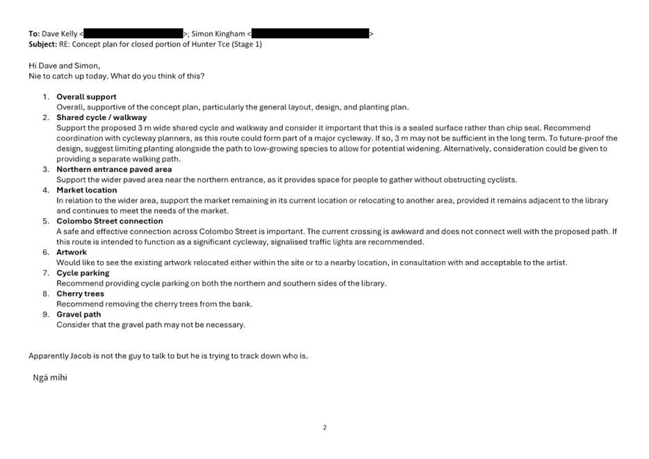
|
13. Waihoro
Spreydon-Cashmere-Heathcote Community Board Area Report - March 2026
|
|
Reference Te Tohutoro:
|
26/158817
|
|
Responsible Officer(s) Te Pou Matua:
|
Josh
Wharton, Community Governance Manager
|
|
Accountable ELT Member Pouwhakarae:
|
Andrew
Rutledge, General Manager Citizens and Community
|
1. Purpose of Origin of the Report Te
Pūtake Pūrongo
1.1 This
report provides the Board with an overview of initiatives and
issues current within the Community Board area.
2. Officer Recommendations Ngā
Tūtohu
That the Waihoro
Spreydon-Cashmere-Heathcote Community Board:
1. Receives the information in the Waihoro Spreydon-Cashmere-Heathcote Community
Board Area Report - March 2026.
3. Community Support, Governance and Partnership Activity
3.1 Community Governance Projects
|
Activity
|
Detail
|
Timeline
|
Strategic Alignment
|
|
Walk n Talk Programme - Beckenham
|
The Beckenham Walk ‘n’ Talk group is now in
its second month, with participants enjoying an away walk to Historic
Addington on 5 February.
Council staff joined the group for a meet-and-greet walk
around Beckenham on 12 February, connecting with participants and supporting
the programme.
 Online
programme: Walk
'n' Talk : Christchurch City Council Online
programme: Walk
'n' Talk : Christchurch City Council
|
January – July 2026
|
Strengthening Communities Together
Strategy
Objective
2.3: Support community activation and kaitiakitanga of public places
and spaces.
Objective
1.4: promoting lifelong learning through active participation.
|
|
House of Hoopz - Addington
|
 The
Addington House of Hoopz event at Cornelius O’Connor Reserve Basketball
Court drew a great crowd and created a positive, energetic atmosphere. It was
rewarding to see rangatahi who had originally advocated for the development
of the basketball court progress through to the finals round, ultimately
placing second against the rangatahi from Rowley. Rowley will progress to the
finals on 15 March at New Brighton. The
Addington House of Hoopz event at Cornelius O’Connor Reserve Basketball
Court drew a great crowd and created a positive, energetic atmosphere. It was
rewarding to see rangatahi who had originally advocated for the development
of the basketball court progress through to the finals round, ultimately
placing second against the rangatahi from Rowley. Rowley will progress to the
finals on 15 March at New Brighton.
The House of Hoopz events are presented by Youth and
Cultural Developement in partnership with Christchurch City Council,
celebrating local talent while strengthening connections within the
community.

|
27 January 2026
|
Strengthening Communities Together
Strategy
Objective
1.5: Support groups involved in arts, culture, heritage, recreation and
environmental care.
Objective
1.7: Work with others to reduce loneliness and social isolation with an
intergenerational focus.
Objective
2.3: Support community activation and kaitiakitanga of public places
and spaces.
|
|
T20 Sumner Smash
|
The T20 Sumner Smash was a fantastic day, bringing
together players and spectators for an afternoon of friendly competition and
community spirit.
Team Rugby came away with the win over Team Cricket,
playing for the trophy that honours Des Lyons, a true Sumner icon and
much-loved figure across the local sports clubs. His legacy of community
spirit and sportsmanship was celebrated throughout the day.
The event also had a strong fundraising focus, with
proceeds supporting the rebuild of the Sumner Pavilion. Organisers raised an
estimated $20,000–$25,000, and Council staff are working closely with
the volunteer project committee to provide guidance and support  for funding. for funding.
Sumner Sports Pavilion Facebook page link:
  https://www.facebook.com/profile.php?id=61578244375842 https://www.facebook.com/profile.php?id=61578244375842
 Website link: Sumner Sports Pavilion Website link: Sumner Sports Pavilion
|
5 February 2026
|
Strengthening Communities Together
Strategy
Objective
1.5: Support groups involved in arts, culture, heritage, recreation and
environmental care.
Objective
2.1: Encourage communities to create and sustain a sense of local, identity
and ownership.
Objective
2.3: Support community activation and kaitiakitanga of public places
and spaces.
|
|
Ferrymead Pump Track Launch Party
|
The Ferrymead Pump Track Launch took
place on Saturday 31 January at the Heathcote Valley Mountain Bike Jump Park.
The day was enjoyed by families and
riders of all ages who took to the track and jumps. Skills were demonstrated
and younger participants were encouraged to give it a go.
   The Heathcote Valley Community Association set up a tent
with information about the project and how people can support the pump
track build. The Heathcote Valley Community Association set up a tent
with information about the project and how people can support the pump
track build.
A sausage sizzle and newly launched Give-a-little page
raised approximately $1,000.
|
31 January 2026
|
Strengthening Communities Together
Strategy
Objective
1.5: Support groups involved in arts, culture, heritage, recreation and
environmental care.
Objective
2.1: Encourage communities to create and sustain a sense of local, identity
and ownership.
Objective
2.3: Support community activation and kaitiakitanga of public places
and spaces.
|
|
FUSE Shoreline Youth Trust
|
FUSE Youth Group have relaunched,
following a successful community promotion and fundraising campaign.
The After School Youth Group for Year 6-9
started on 12th February at Matuku Takotako.
Serving young people in the Sumner,
Redcliffs and Mount Pleasant area and providing a safe, welcoming and
inspiring environment for youth to connect grow and thrive.

|
12 February then ongoing
|
Strengthening Communities Together
Strategy
Te Pou
Tuatahi: Te Tāngata
Pillar 1:
People
Objective
1.5: Support groups involved in providing access to arts, culture, heritage,
recreation, and those who care for the environment.
Te Pou
Tuarua: Te Whenua
Pillar 2:
Place
Objective
2.3: Support the community activation and kaitiakitanga of public places and
spaces.
Board Priority
7. Community Facilities
|
|
Richmond Berry Garden Raspberry Pruning
Workshop
|
Situated in Red Zone land at the bottom
of Richmond Hill. The garden provides a food source for local people and a
place to connect people and families. It has a picnic area and small
playground.
This free workshop will help people learn
how to prune raspberries. Giving them the confidence to prune their own
raspberries and boost their berry harvest.


|
21 February
|
Strengthening Communities Together
Strategy
Objective
2.3: Support community activation and kaitiakitanga of public places
and spaces.
Objective
2.1: Encourage communities to create and sustain a sense of local identity
and ownership.
Objective
1.5: Support groups involved in arts, culture, heritage, recreation and
environmental care.
|
|
House of Hoopz – Hoon Hay
|
 House
of Hoopz series, presented by Youth and Cultural Development in partnership
with Christchurch City Council, will host the next 3x3 Street Ball League at
Hoon Hay Park on 22 February from 12pm – 3pm.Registrations
will be open on the day, with the winning team advancing to the finals round
in New Brighton on 15 March. House
of Hoopz series, presented by Youth and Cultural Development in partnership
with Christchurch City Council, will host the next 3x3 Street Ball League at
Hoon Hay Park on 22 February from 12pm – 3pm.Registrations
will be open on the day, with the winning team advancing to the finals round
in New Brighton on 15 March.
|
22 February 2026
|
Strengthening Communities Together
Strategy
Objective
1.5: Support groups involved in arts, culture, heritage, recreation and
environmental care.
Objective
2.3: Support community activation and kaitiakitanga of public places
and spaces.
|
|
Ferrymead Heritage Park
|
Ferrymead Park Trust continue their
transformative programme of works, with a February update included in the
attachments.
By way of a few highlights:
· December
financial results show an operating profit with no Grant income or reserves
used. This is the first time in two years this has been achieved.
· Ferrymead
have secured corporate sponsorship with Isaac Construction for pavements and
road infrastructure to be upgraded.
· A
record school holiday visitor result saw income grow 60% on the same period
last year. This is on a wage bill 50% lower than in that period.
|
February update
|
Strengthening Communities Together
Strategy
Objective
2.1: Encourage communities to create and sustain a sense of local identity
and ownership
Objective
2.3: Support the community activation and kaitiakitanga of public places and
spaces.
|
|
Ōpāwaho Heathcote River Day
|
Plans are well underway for the
Ōpāwaho Heathcote River Day that is set to take place on Sunday 8
March 2026 at 12pm. The event will start on the Ōpāwaho Heathcote
River, beginning at the Beckford Road bridge and following the river around
Hansen Park to Aynsley Terrace, before finishing back at Hansen Park where
there will feature entertainment, community stalls, hot drinks, and a BBQ.
Entries are limited to 75 rafts and
pre-registration is required.
Council staff are working alongside the
volunteer organising committee to support planning and delivery of the day,
including providing resources, funding support, and assistance with
post-event follow-up.
 Website link: Ōpāwaho
Heathcote River Day – Ōpāwaho Heathcote River day in Hansen
Park, Christchurch NZ including a raft race. Website link: Ōpāwaho
Heathcote River Day – Ōpāwaho Heathcote River day in Hansen
Park, Christchurch NZ including a raft race.
 3.6m x 2m Pontoon 3.6m x 2m Pontoon
|
8 March 2026
|
Strengthening Communities Together
Strategy
Objective
2.3: Support community activation and kaitiakitanga of public places
and spaces.
Objective
2.1: Encourage communities to create and sustain a sense of local identity
and ownership.
Objective
1.5: Support groups involved in arts, culture, heritage, recreation and
environmental care.
|
|
Para/Blind Low Vision Lawn Bowls
Tournament
|
With the two-day tournament fast approaching on Saturday
14 and Sunday 15 March 2026 at the Barrington United Bowling Club,
preparations are well underway. Since registrations opened, participation has
steadily increased, attracting entrants from across Ōtautahi.
 Council
staff have provided funding support and continue to work closely with the
organising committee, offering guidance and advice to assist with planning,
delivery, and post-event follow-up. Council
staff have provided funding support and continue to work closely with the
organising committee, offering guidance and advice to assist with planning,
delivery, and post-event follow-up.
Information and registration: PARA
& BLIND BOWLS TOURNAMENT - Bowls New Zealand Aotearoa
|
14-15 March 2026
|
Strengthening Communities Together
Strategy
Objective
1.4: Harness the strengths of diverse communities and address issues of
social exclusion.
Objective
1.5: Support groups involved in arts, culture, heritage, recreation and
environmental care.
|
|
Neighbourhood Building Project
|
We have the following update on the Neighbourhood building
project from Neighbours Aotearoa (shortened for brevity):
“In Addington, Wilby has finished up his contract.
The Addington work that Willby has been involved in will be picked up by
Manuka Cottage going forward.
In Waltham, Neighbours Aotearoa are pleased to confirm the
appointment of Leeza Green, who has been doing similar work in Hoon Hay.
Leeza will be delivering a Participation Culture
Community of Practice. This will focus on creating opportunities for
communities to connect, swap stories, and learn alongside one another. The
focus is on practical tools, shared reflection, and building confidence to
work in more participatory ways.”
|
Ongoing
|
Strengthening Communities Together
Strategy
Objective
4.2: Support the capacity of the community and voluntary sector to plan,
adapt and respond to risk, disruption and change.
Community Board Plan 2023-25
Support
community development in Waltham and Addington.
|
3.2 Community Funding Summary
3.2.1 Community
Board Discretionary Response Fund 2025/26 –
As of 13 February 2026. Available
balance of the Discretionary Response Fund at the time of writing this report
is $60,416.00
The 2025/26 Discretionary Response Fund
Spreadsheet as of 13 February 2026 is attached for record purposes.
3.2.2 Youth
Development Fund Applications
The following Youth Development Fund
applications have been approved by the Board since the last Area Report:
|
Name
|
Event
|
Amount
|
|
Kieran Alexander Funcke
|
Fiji Service Project held in Fiji, June
29 – July, 2026
|
$500
|
|
Grace Bradley
|
CKTA National Korfball Association Cup
held in New Taipei City, Taiwan, April 20 – April 30, 2026
|
$500
|
|
Brooke Charlotte Goldsmith
|
Surf Life Saving Championships 2026 held
iin Eastern Bay of Plenty, March 5 – March 8, 2026
|
$300
|
|
AVAILABLE BALANCE (at time of writing):
|
$7,150.00
|
The Youth Development
Fund Matrixes are attached for record purposes.
3.2.3 Off
the Ground Fund Applications
There have been no Off the Ground Fund
applications since the last Area Report.
Available balance of the Off the Ground
Fund at the time of writing this report is $2,700.00
3.3 Waihoro
Community Events and Activities
3.3.1  Edible and Sustainable Garden Awards
2026 - entries for this year’s awards closed
on Monday 12 January 2026. We have had 13 nominations. Assessment of the
nominated gardens are currently being organised and will be undertaken by the
Canterbury Horticultural Society. The awards ceremony will be held in
conjunction with the Community Garden Pride Awards 2026, date to be
confirmed.
Edible and Sustainable Garden Awards
2026 - entries for this year’s awards closed
on Monday 12 January 2026. We have had 13 nominations. Assessment of the
nominated gardens are currently being organised and will be undertaken by the
Canterbury Horticultural Society. The awards ceremony will be held in
conjunction with the Community Garden Pride Awards 2026, date to be
confirmed.
3.3.2 Bike
Bridge – sessions will run from 28 January to
1 April 2026 at Addington School on Wednesdays from 5–7pm (10 sessions
planned). This women-only programme welcomes all abilities, provides bikes and
helmets, requires no booking, allows drop-ins at any time, and shares updates
via the Bike Bridge Christchurch Facebook page: Bike Bridge
Christchurch | Facebook
3.3.3 Tsunami
Talk – held on 25 February
2026 - organised by Sumner Community Residents Association & Hub.
Information evening was held at Matuku Takotako led by Dr Rachel Hunt
CDEM, the session covered:

3.3.4  Earthquake and the Alpine Fault – to be held on 10 March
2026 - an information evening to be held at Cashmere Presbyterian Church,
2 MacMillan Avenue, the session will cover:
Earthquake and the Alpine Fault – to be held on 10 March
2026 - an information evening to be held at Cashmere Presbyterian Church,
2 MacMillan Avenue, the session will cover:
3.3.5  Port Hills restoration newsletter for Autumn 2026
– was circulated on 21 January 2026. The newsletter
provides an update from the Concil’s Parks team about planting and
activities in the Waihoro Spreydon-Cashmere-Heathcote area. The newsletter
includes the upcoming volunteer plant care days – see the newsletter attached.
Port Hills restoration newsletter for Autumn 2026
– was circulated on 21 January 2026. The newsletter
provides an update from the Concil’s Parks team about planting and
activities in the Waihoro Spreydon-Cashmere-Heathcote area. The newsletter
includes the upcoming volunteer plant care days – see the newsletter attached.
3.4 Council
Engagement and Consultations
3.4.1 Percival
Street renewal was open
for feedback from 27 January to 22 February 2026. The renewal will include
replacing the current deep-dish gutters with a standard kerb and channel,
resurfacing the road and footpath and upgrading the streetlights. The renewal
will also consider: street trees and landscaping, traffic calming and other
safety features such as pedestrian crossings, signs and road markings and
changes to the footpath.
3.5 Governance
Advice
3.5.1 Public
Participation - The Board received the following deputation presentations
at its 12 February 2026 meeting:
· Anne Scott spoke on behalf of Spokes Canterbury regarding
the Cashmere-Penruddock Roundabout.
· Kate Woods, local resident spoke regarding the
Cashmere-Penruddock Roundabout.
· Wendy Parlane, local resident spoke regarding the Rose
Street Intersections - Proposed No Stopping Restrictions.
· Submitter
100, local resident could not attend the Board meeting and their written
deputation regarding the Hoon Hay Road/Lewis Street - Pedestrian Improvements
was read aloud to the Board.
3.5.2  Customer Service Request
(CSR) Report the Spreydon-Cashmere-Heathcote Wards – a report on open and completed tickets (requests for service)
in January 2026 can be found attached to this report. The report
provides an overview of the number of CSRs that have been received, including
the types of requests being received and a breakdown of how they are being
reported.
Customer Service Request
(CSR) Report the Spreydon-Cashmere-Heathcote Wards – a report on open and completed tickets (requests for service)
in January 2026 can be found attached to this report. The report
provides an overview of the number of CSRs that have been received, including
the types of requests being received and a breakdown of how they are being
reported.
Snap Send Solve is
the smartphone app the Council offers to help make reporting issues easy, and
it is still possible to report
issues online, by calling Council on 03 941 8999 or visiting one
of the Council’s Service centres.
4. Advice Provided to the Community Board Ngā Kupu Tohutohu ka
hoatu ki te Poari Hapori
4.1 Closed
Information Requests from Community Open Forums
– January 2026 to February 2025 – none to report.
4.2 Graffiti
Snapshot Report – The monthly report for December 2025 and January
2026 can be found as attached to this report. The Council also provides
information on graffiti, including tips to prevent it, and about becoming a
Graffiti Programme volunteer, at this link.
4.3 Memoranda - memoranda related to matters
of relevance to the Board have been separately circulated for the Board’s
information and are listed below.
· Memo - Draft Plan Change 20 -
Memo to Councillors and the Mayor – cc’d to Community Boards (circulated
26 January 2026)
· Memo
- Lincoln Road transport and three waters upgrade (circulated 5 February 2026) – refer: https://www.newsline.ccc.govt.nz/news/story/transport-and-water-upgrades-planned-for-lincoln-road.
4.4 Staff
advice to the Board – the following staff advice has been received by
the Board since the last Area Report in response to referrals for information
from public forums and correspondence to the Board:
· On 27 January 2026 the Board received staff advice in response to a
request for staff to investigate the issues raised in a public forum
presentation about road safety issues with cyclists on Sumner Hills presented
to the Board on 11 December 2025. Staff advised that they passed on the video
footage to Police and they have since been liaising with Police who put
in a tasking to their motorcycle enforcement team to focus on Evans Pass and
Wakefield Ave for cyclists and cars. As a result of the tasking, the enforcement
team got a couple of offenders. A separate action remains with staff to respond
to the Board with advice on the roading layout and any options to improve road
safety.
·  On 29 January 2026 the Board received
staff advice following a site visit at the Opawa Road easement on 8 December
2025 that was an action from a public forum to the Board on 14 August 2025.
Staff advised about Parking Ticks that the vehicle crossings along this
section of road are a lot wider than the driveway itself. Based on the Land
Transport (Road user) Rule, drivers are not permitted to park within one metre
of a driveway - this is measured from the prolongation of the driveway, not the
kerb cutdown. It is standard practise for parking ticks to be marked in line
with this rule, as a guide to drivers. Marking parking ticks in the correct way
therefore has the potential to encourage drivers to park closer than they may
be already. For this reason (based on site measurements), staff are not
supportive of marking any further parking ticks. How ever further markings can
be considered as part of the future proposal - for example yellow lines may be
considered in locations with a history of driveway compliance issues. Staff are
preparing a plan for consultation based on resident’s feedback.
On 29 January 2026 the Board received
staff advice following a site visit at the Opawa Road easement on 8 December
2025 that was an action from a public forum to the Board on 14 August 2025.
Staff advised about Parking Ticks that the vehicle crossings along this
section of road are a lot wider than the driveway itself. Based on the Land
Transport (Road user) Rule, drivers are not permitted to park within one metre
of a driveway - this is measured from the prolongation of the driveway, not the
kerb cutdown. It is standard practise for parking ticks to be marked in line
with this rule, as a guide to drivers. Marking parking ticks in the correct way
therefore has the potential to encourage drivers to park closer than they may
be already. For this reason (based on site measurements), staff are not
supportive of marking any further parking ticks. How ever further markings can
be considered as part of the future proposal - for example yellow lines may be
considered in locations with a history of driveway compliance issues. Staff are
preparing a plan for consultation based on resident’s feedback.
Attachments Ngā Tāpirihanga
|
No.
|
Title
|
Reference
|
Page
|
|
a ⇩
|
Ferrymead
Heritage Park - February Update
|
26/206256
|
116
|
|
b ⇩
|
Waihoro
Discretionary Response Fund Spreadsheet - 13 February 2026
|
26/296495
|
121
|
|
c ⇩
|
Kieran
Alexander Funcke - YDF Matrix
|
26/325598
|
122
|
|
d ⇩
|
Grace Bradley
- YDF Matrix
|
26/325631
|
123
|
|
e ⇩ 
|
Brooke
Charlotte Goldsmith - YDF Matrix
|
26/325666
|
124
|
|
f ⇩
|
Port Hills
Newsletter - Autumn 2026
|
26/333953
|
125
|
|
g ⇩
|
Hybris Ticket
Report - Waihoro - January 2026
|
26/366524
|
130
|
|
h ⇩
|
Graffiti
Snapshot - January 2026
|
26/333285
|
131
|
Signatories Ngā Kaiwaitohu
|
Authors
|
Jonathon Jones
- Community Board Advisor
Nime Ah
Kam-Sherlock - Community Recreation Advisor
Heather Davies
- Community Development Advisor
Abbey McMillan
- Support Officer
|
|
Approved By
|
Josh Wharton -
Manager Community Governance, Spreydon-Cashmere-Heathcote
Matthew
McLintock - Manager Community Governance Team
John Filsell -
Head of Community Support and Partnerships
|
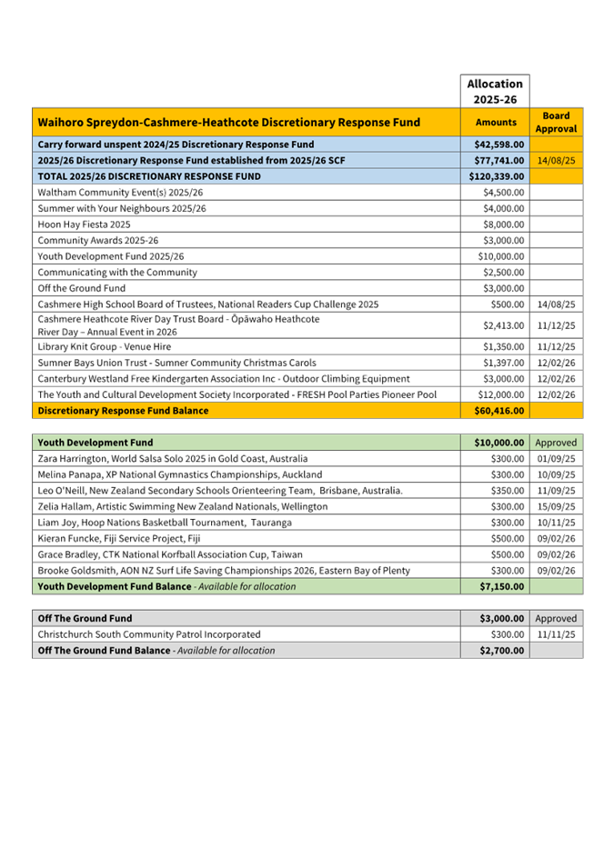
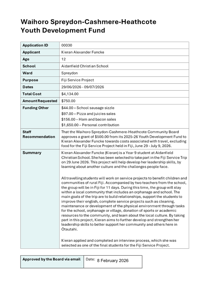
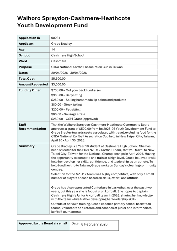
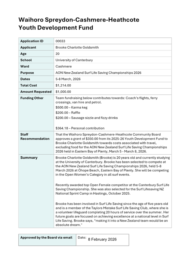
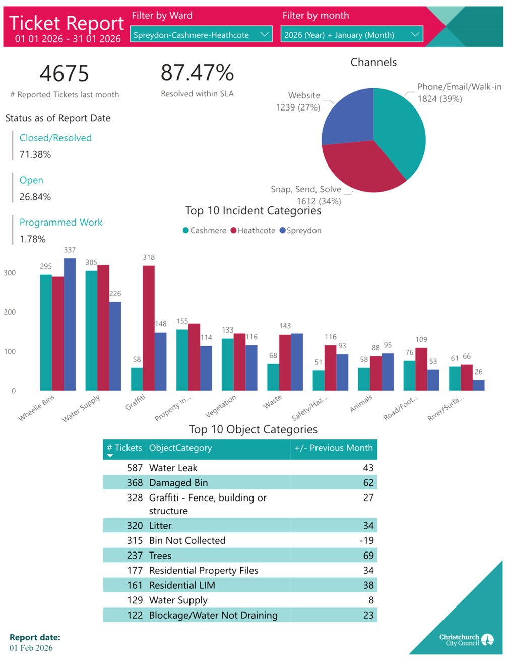
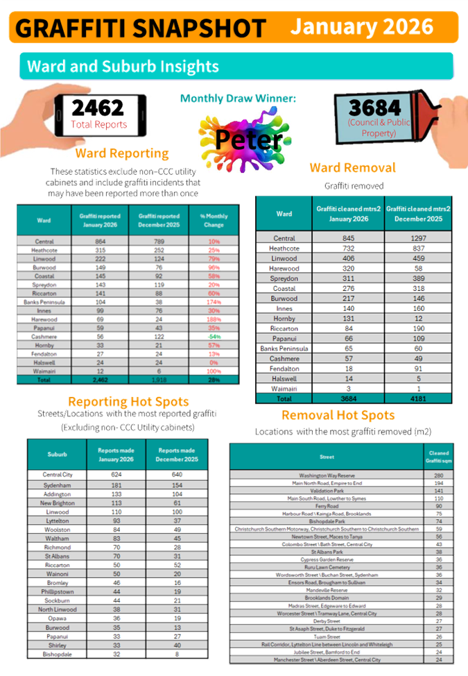
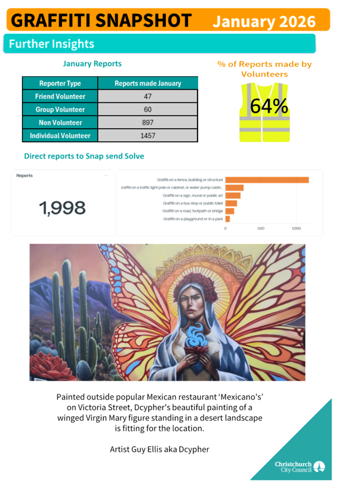
|
14. Elected Members’ Information Exchange Te
Whakawhiti Whakaaro o Te Kāhui Amorangi
|
This item provides an opportunity for Board Members to
update each other on recent events and/or issues of relevance and interest to
the Board.
Karakia Whakakapi
|
Tukuna te wairua kia rere ki te
taumata
Ko te matatika te mātāpono
hei arahi i ngā mahi
Ka arotahi te tira kia eke panuku,
kia eke Tangaroa
Haumi e, hui e, tāiki e
|
May the spirit be released to soar to its zenith.
Ethics is the principle that guides our work.
As we focus on the success for our community
Bring together! Gather together and bind together!
|
Actions Register Ngā Mahinga
When decisions are made at meetings, these
are assigned to staff as actions to implement. The following lists
detail any actions from this meeting that were:
- Open at the time the agenda was
generated.
- Closed since the last ordinary meeting
agenda was generated.
Open Actions Ngā Mahinga Tuwhera
|
REPORT TITLE/AGENDA SECTION
|
MEETING DATE
|
ACTION DUE DATE
|
UNIT
|
TEAM
|
|
14-15 Mary Muller Drive -
Proposed No Stopping Restrictions
|
11 December 2025
|
12 March 2026
|
Transport & Waste
|
Traffic Operations
|
|
Public Forum - Noise from
basketball court at Spreydon School
|
11 December 2025
|
12 March 2026
|
Regulatory Compliance
|
Regulatory Compliance
|
|
Public Forum - Road safety
issues with cyclists on Sumner Hills
|
11 December 2025
|
12 March 2026
|
Transport & Waste
|
Traffic Operations
|
|
Taylors Mistake Road
Wastewater Pump Station - Proposed No Stopping Restrictions
|
11 December 2025
|
12 March 2026
|
Transport & Waste
|
Traffic Operations
|
|
Correspondence
|
11 September 2025
|
19 March 2026
|
Transport & Waste
|
Traffic Operations
|
|
Public Forum - Traffic
management in the Beckenham Loop
|
11 September 2025
|
19 March 2026
|
Transport & Waste
|
Traffic Operations
|
|
Sumner Valley Riding School
Trust - proposed new lease
|
10 April 2025
|
20 March 2026
|
F&P Unit
|
Property Consultancy
|
|
The Green Effect Trust (Trees
for Canterbury) - Proposed new lease - Charlesworth Reserve
|
13 March 2025
|
25 March 2026
|
F&P Unit
|
Property Consultancy
|
|
Public Forum - Spokes
Canterbury
|
12 June 2025
|
27 March 2026
|
Transport & Waste
|
Asset Planning
|
|
Cave Rock Lighting
|
28 August 2025
|
28 March 2026
|
Parks
|
Asset Management
|
|
Correspondence
|
11 September 2025
|
31 March 2026
|
Transport & Waste
|
Traffic Operations
|
|
Orion Easement at Waltham
Park
|
10 April 2025
|
31 March 2026
|
F&P Unit
|
Property Consultancy
|
|
Public Forum - Old stone tram
shelter Sumner
|
11 September 2025
|
31 March 2026
|
Transport & Waste
|
Asset Management
|
|
Grant an Easment over
Waterworks Reserve 109 Scruttons Road Heathcote Christchurch.
|
15 February 2024
|
1 May 2026
|
F&P Unit
|
Property Consultancy
|
|
Canterbury Adventure Park -
Parking Overflow Lease
|
12 February 2026
|
14 May 2026
|
F&P Unit
|
Property Consultancy
|
|
Cashmere Technical Football
Club Lighting Application - Addington Park
|
12 February 2026
|
14 May 2026
|
Parks
|
Parks & Recreation Planning
|
|
Centaurus Road/St Martins
Road - Pedestrian Safety Improvements
|
12 February 2026
|
14 May 2026
|
Transport & Waste
|
Traffic Operations
|
|
Hoon Hay Road/Lewis Street -
Pedestrian Improvements
|
12 February 2026
|
14 May 2026
|
Transport & Waste
|
Traffic Operations
|
|
Huntsbury Avenue - Proposed
No Stopping Restrictions
|
12 February 2026
|
14 May 2026
|
Transport & Waste
|
Traffic Operations
|
|
Rose Street Intersections -
Proposed No Stopping Restrictions
|
12 February 2026
|
14 May 2026
|
Transport & Waste
|
Traffic Operations
|
|
Waihoro
Spreydon-Cashmere-Heathcote 2025-26 Discretionary Response Fund - Sumner Bays
Union Trust, Westland Free Kindergarden, Youth and Cultural Development
|
12 February 2026
|
14 May 2026
|
CS&P
|
CS&P - Governance (Spr-Cas-Hea)
|
|
Beach Hospitality Limited -
Landlord Consent to Improvements and Request for Further Lease
|
13 March 2025
|
29 May 2026
|
F&P Unit
|
Property Consultancy
|
|
Spreydon, Somerfield,
Waltham, Beckenham CRAF - Lyttelton Street safety improvements
|
10 July 2025
|
26 June 2026
|
Transport & Waste
|
Project Management
|
|
Spreydon, Somerfield,
Waltham, Beckenham CRAF - Selwyn Street pedestrian and cycle safety
improvements
|
10 July 2025
|
26 June 2026
|
Transport & Waste
|
Project Management
|
|
Spreydon, Somerfield,
Waltham, Beckenham CRAF - Strickland Street/Somerfield Street safety
improvements
|
28 August 2025
|
26 June 2026
|
Transport & Waste
|
Project Management
|
|
Kordia Licence at Sugarloaf
and Thomson Scenic Reserves
|
11 September 2025
|
30 June 2026
|
F&P Unit
|
Property Consultancy
|
|
Public Forum - Basketball
court at Ti Rakau Reserve
|
10 July 2025
|
30 June 2026
|
Parks
|
Parks & Recreation Planning
|
|
Public Forum - Parking Issues
on Opawa Road
|
14 August 2025
|
30 June 2026
|
Transport & Waste
|
Traffic Operations
|
|
Redcliffs Village - Coastal
Pathway safety improvements.
|
15 February 2024
|
30 June 2026
|
Transport & Waste
|
City Streets Maintenance
|
|
Richmond Hill Road - Proposed
Parking Changes and Pedestrian Improvements
|
11 September 2025
|
30 June 2026
|
Transport & Waste
|
Traffic Operations
|
|
Sumner Tennis and Squash Club
Application to lease 8-14 Heberden Avenue and 140 Nayland Street
|
11 May 2023
|
1 July 2026
|
F&P Unit
|
Property Consultancy
|
|
Cashmere - Penruddock
Roundabout
|
12 February 2026
|
31 August 2026
|
Transport & Waste
|
Asset Planning
|
Actions Closed Since the Last Meeting
Ngā Mahinga kua Tutuki nō Tērā Hui
Actions closed from 4 February 2026 to 5
March 2026.
|
REPORT TITLE/AGENDA SECTION
|
MEETING DATE
|
DUE DATE
|
ACTION CLOSURE DATE
|
UNIT
|
TEAM
|
|
Studholme Street - Proposed
No Stopping Restrictions
|
12 February 2026
|
14 May 2026
|
16 February 2026
|
Transport & Waste
|
Travel Demand Management
|