|
14. Koukourarata
Port Levy - Bach on Public Land ( Road Reserve)
|
|
Reference Te Tohutoro:
|
24/1117842
|
|
Responsible Officer(s) Te Pou Matua:
|
Michael
Thomson, Transport Network Planner, Asset Planning
|
|
Accountable ELT Member Pouwhakarae:
|
Brent
Smith, Acting General Manager City Infrastructure
|
1. Purpose and Origin of the Report Te Pūtake Pūrongo
1.1 The
purpose of this report is to:
1.1.1 provide
information to Te Pātaka o Rākaihautū Banks Peninsula Community
Board on the status of a bach that is located on the foreshore adjoining 23 and
3B Puari Road at the Koukourarata Port Levy settlement area since the 1940s,
and
1.1.2 make
a recommendation to the Council regarding its future.
1.2 This
report is in response to ongoing concerns from neighbouring property owners
about the legality of the bach, access to the foreshore and the condition of
the building and a request from this Board for a staff update.
2. Officer Recommendations Ngā
Tūtohu
That
Te Pātaka o Rākaihautū Banks Peninsula Community Board
recommends that the Council:
1. Approves the granting of a licence over
unformed legal road adjoining 23 and 3B Puari Road, Port Levy to legitimise the
legacy encroachment of the dwelling (the bach) as shown in Attachment A.
2. Delegates authority to the Property
Consultancy Manager to negotiate and enter into the Deed of Licence on
Council’s standard terms and conditions, including but not limited to:
a. A term of 25 years less one day.
b. A negotiated licence fee.
c. The requirement for the licensee to hold
public liability insurance of at least $2m.
d. The public’s right of access must not be
obstructed, and the macrocarpa hedge must be trimmed to the Council’s
satisfaction or removed and the retaining wall must be removed and the
foreshore returned to its natural form.
e. Reassessment of the licence if the structure
is reconstructed or altered.
f. Council will not be responsible to repair or
retain the structure in the event of coastal sea level rise or other natural
hazard.
That
Te Pātaka o Rākaihautū Banks Peninsula Community Board:
3. Receives the information contained within this report for the
Koukourarata /Port Levy Bach, located on the foreshore, adjacent to properties
on Puari Road.
4. Notes that the decision in this report is
assessed as low significance based on the Christchurch City Council’s
Significance and Engagement Policy.
3. Executive Summary Te Whakarāpopoto Matua
3.1 A
bach has existed on the foreshore of Koukourarata Port Levy within an unformed
paper road for the last 80 years. The bach is still
owned within the original family. The paper road was
vested in the Crown until 1974 when it became vested in the Council.
3.2 The bach has been subject to numerous concerns from neighbouring
property owners, particularly around the condition of the bach, public access
along the foreshore, rocks being moved on the foreshore, and the possibility of
wastewater being discharged into the bay. In May 2017 the Council wrote to the
property owners advising that access along the road reserve should be
unhindered, and requested the issues discussed below be addressed before the
Council would consider discussing occupation of the legal road.
3.3 Council
staff have assessed the condition of the bach. Council engineers have
determined that the bach at Koukourarata Port Levy does not meet the
threshold for dangerous under 121(1)(a)(i) of the Building Act 2004.
3.4 If
the Council were to formalise the encroachment of legal road, it needs to
consider doing so purely on the basis as the owner of the land. Granting a
licence will legitimise this legacy encroachment on to unformed legal road
providing certainty for both the property owner and public. Conditions will
need to apply to the licence, including reinstating public access along the
foreshore that does not affect its natural form. If the conditions are not able
to be met, then the owner will need to remove the bach.
4. Background/Context Te Horopaki
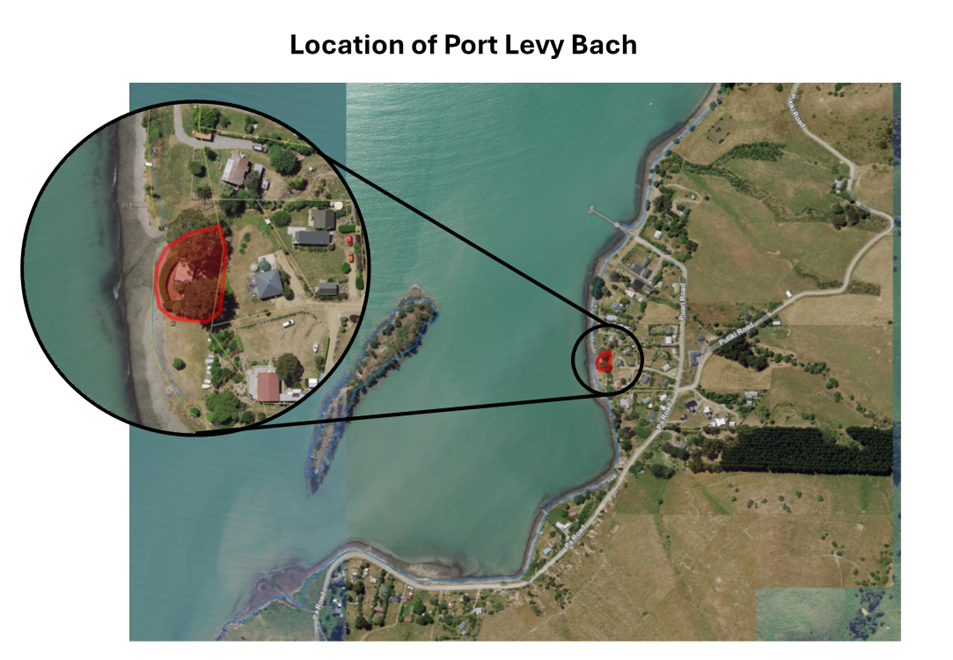
4.1 This report relates to a bach adjacent to 23
and 3b Puari Road, Koukourarata Port Levy. The bach is specifically located on
“paper road” (unformed but legal road status) between the Puari
Road properties and the high tide line. There is no formed road access to the
dwelling.
4.2 Historical
research undertaken by staff indicates that the bach has been in existence from
or prior to the mid-1940’s and is still owned within the original family. The bach owners have advised that the land was a gift from local
iwi approximately 80-90 years ago and that they believe the land was Māori
Reserve at the time.
4.3 Staff
have found no records of any Crown or Council authorisation for the bach on the
paper road. A 1921 survey plan (SO 5728) of the area shows a paper road running
along the shore of Port Levy where the bach is currently located. Therefore,
the land was paper road over 90 years ago, not Māori Reserve. The paper
road was vested in the Crown until 1974 when it became vested in the Council
(section 316 LGA 1974).
4.4 The relevant town planning statute at the time the bach was built
was the Town Planning Act 1926. Section 34(1) of that Act provided local
authorities with an interim power during the course of preparing a district
scheme to refuse consent or prohibit the erection of a building if satisfied
that the building would contravene the draft district scheme, contravene
town-planning principles, or interfere with neighbourhood amenities. The Mount
Herbert County Council did not propose a district scheme until 1963.
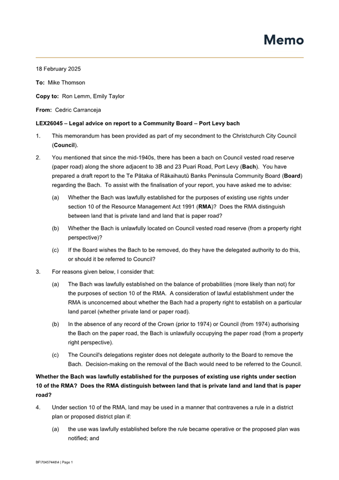
4.5 Further detail on the lawfulness and legality of the bach is
attached in the legal advice in Attachment B. The legal advice considers
that the bach was lawfully established under the planning laws, however this
does not authorise permission to occupy the public place.
4.6 The
bach has been subject to numerous concerns from neighbouring property owners.
In 2017 the Council wrote to the property owners advising that access along the
road reserve should be unhindered (Attachment C), and requested the
issues discussed below be addressed before the Council would consider
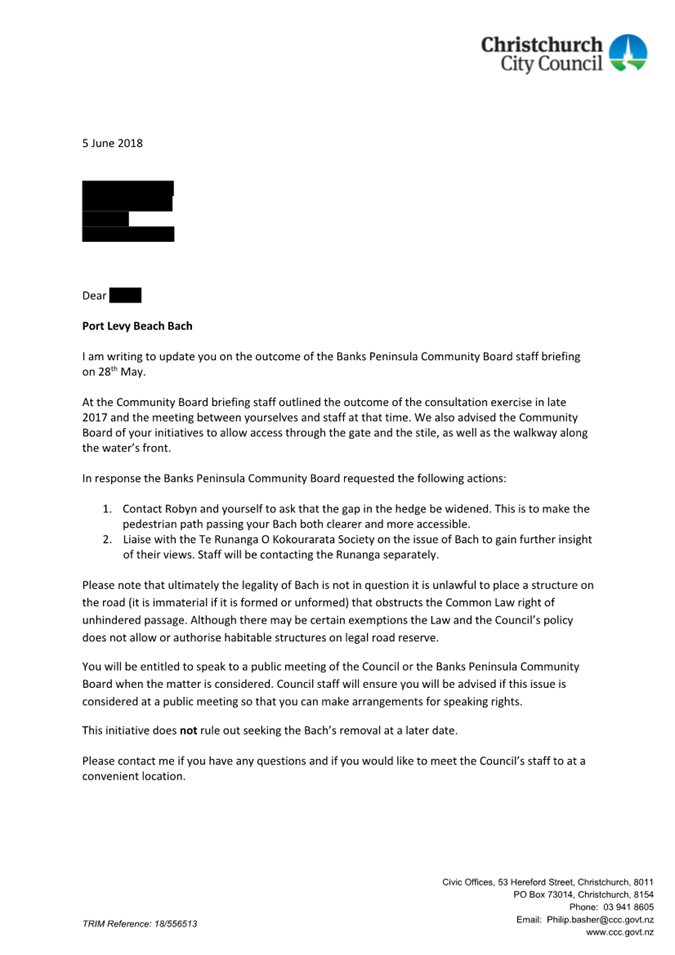
discussing occupation of the legal road. Subsequent to the issue of the 2017
letter, a further letter dated 5 June 2018 (Attachment D) was issued
following a staff briefing to the Board in May 2018. Staff have undertaken site
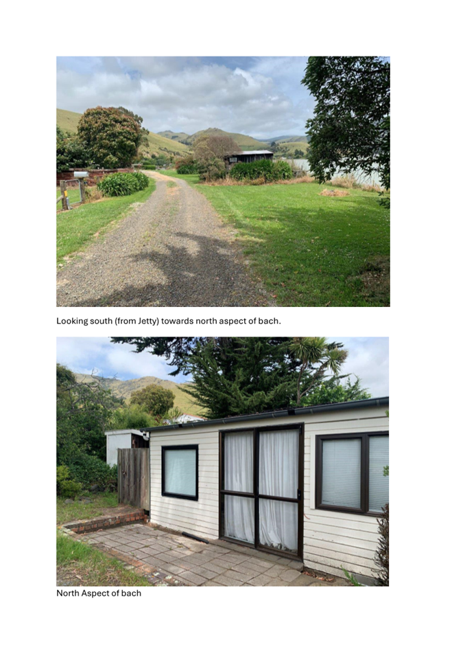
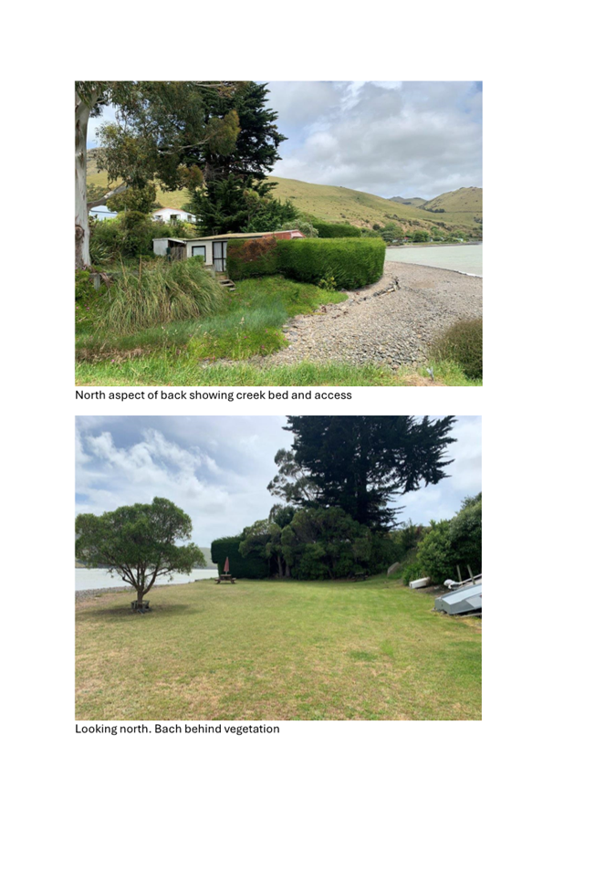
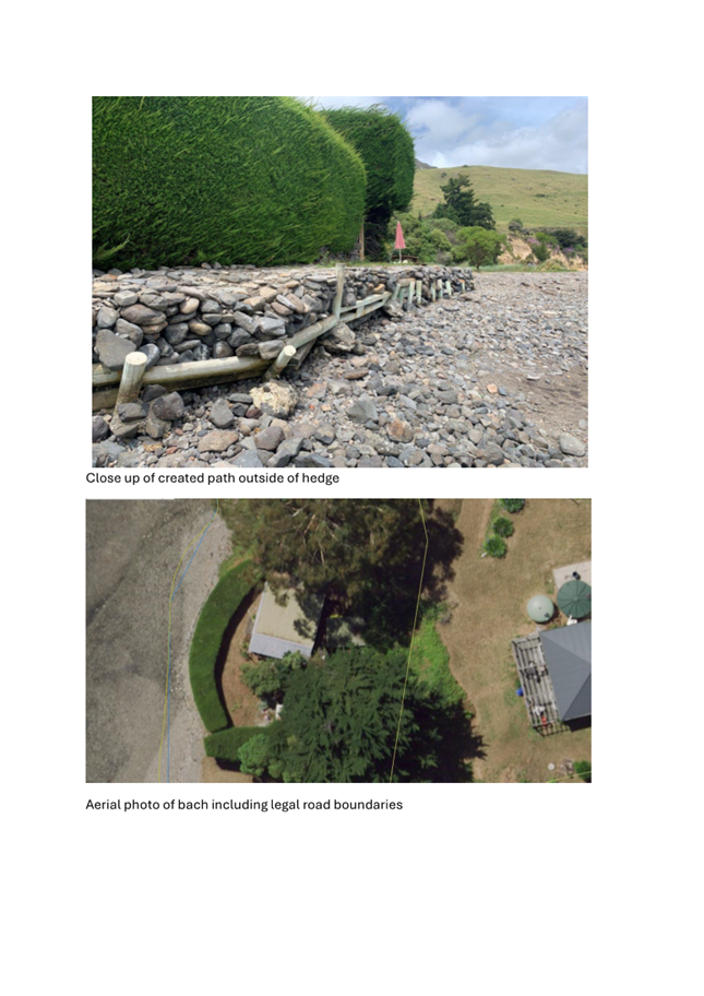
visits in 2017, 2022 and February 2025 (photos and aerial location plan in Attachment
E).
4.7 The
complaints from neighbours mainly relate to the bach’s location, public
access, removal/relocation of foreshore rocks, vegetation issues, and
wastewater disposal:
· Public
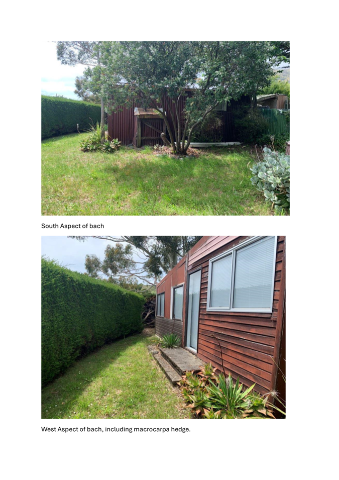
access along the foreshore: the bach is located on road reserve. A large
macrocarpa hedge has been established between the dwelling and the foreshore,
as well as other planting, fences and a gate, which at times has been locked.
This gives the owners of the bach exclusive use of the area around the dwelling
to the foreshore. At high tide, in particular, there is inadequate access
around the bach.
· Condition
of the bach: the bach was constructed approximately 80 years ago and has
had some alterations done, including the construction of a shed. Neighbours are
concerned that the bach has become derelict and the amount of vegetation could
present a fire hazard. On 27 February 2025, staff did a site visit to check the
condition of the bach. Council engineers have determined that
the bach does not meet the threshold for dangerous under 121(1)(a)(i) of
the Building Act 2004. In
addition to this, the bach was built pre-Building Act legislation. Therefore,
it would have no building code standards to achieve, and there is no
requirement that a building must maintain building code standards.
· Rocks
being moved on the foreshore: rocks have been rearranged on the foreshore
to create an informal elevated path in front of where the bach is located. A discrete rock wall that is not consented (or appropriately
designed) is likely to result in enhanced erosion of the beach and could
accelerate erosion of neighbouring sections of shoreline. Some local residents
have commented on the impact the rock wall is having on the beach. This
work has not been consented by the Council. Staff are not aware of any consent
by Environment Canterbury. The rock wall would need to get resource
consent to remain in place.
· Untreated
human waste being discharged into the bay: Port Levy is not connected to
Council wastewater reticulation. Neighbours have raised concerns about how
wastewater is being discharged from the bach and whether it may be
contaminating the bay. If it is being discharged into the ocean or requires
consenting for a septic tank, Environment Canterbury would need to be engaged
for those processes. The owner has indicated that they use chemical toilets at
the bach.
4.8 The
bach owners would like to retain ownership of the bach as it has meaningful
history for their family. The owners dispute some of the complaints raised by
others.
4.9 If
the Council were to formalise the encroachment of legal road, it needs to
consider doing so purely on the basis as the owner of the land, albeit legal
road. In doing so, the following should be considered:
4.9.1 Current
and future use of the land – the land is currently more or less in its
natural state and reasonably isolated from public use. The Port Levy shorefront
is expected to experience accelerated coastal erosion as sea levels rise, as
discussed in the Climate Change Impacts section of this report. The location,
topography, and nature of the land does not lend itself to any other use in the
short to medium term. The access issues mainly relate to the hedge and gates
blocking access along the foreshore. This will need to be addressed in any
licence conditions. See the photos and aerial map in Attachment E.
4.9.2 Status
of the land and how it is held - the land is unformed legal road. Owing to the
location, nature and topography this is extremely unlikely to ever be formed.
Conversion to another status would likely only ever result in the land becoming
esplanade reserve. This action is not considered warranted or necessary.
4.9.3 Public
rights – access along the foreshore has been raised by neighbouring
property owners as being an issue. Any licence would need to address these
concerns.
4.9.4 Effects
on any utilities or infrastructure – there are no utilities or
infrastructure.
4.9.5 Health
and safety – Council staff have undertaken a site visit and deemed that
the building does not meet the dangerous building criteria of the Building Act.
Concerns about the retaining wall and wastewater disposal would need to be
addressed in any licence conditions.
4.9.6 Health
and safety of the public passing the bach – it is Council staff view
based on site visits that the formed rock wall does not offer a suitably safe
or convenient access facility to the foreshore.
4.9.7 Community
views and preferences -This is set out above in this section and in the
Community Views section below.
4.10 The
licence terms and conditions - these would be on the Council standard terms and
conditions for a private / commercial licence of legal road as developed by the
Council’s legal services team. It is proposed that this be a term of 25
years less one day with 5 year rent reviews. Proposed conditions could also
include:
a) Appropriate
fees to be negotiated.
b) The
licence will not be transferable to any other person(s) including other family
members.
c) Public
access past the bach will be provided to the satisfaction of staff. This
includes the removal of that section of the macrocarpa hedge that prevents a
suitable walking path.
d) Maintaining
any overgrown vegetation that can be a fire hazard, appropriate wastewater
management, removal of foreshore rocks /boulders, no dumping of rubbish on the
road reserve.
e) The
conditions to be completed within a 12-month period and monitored by
Councils’ compliance team.
Other examples of baches on Council land in Banks Peninsula
4.11 There
are other examples of baches that have been built on Council land in
Christchurch district, however each of these has its own circumstances specific
to the location, Examples in Banks Peninsula include:
4.11.1 Angel’s
Rest at Koukourarata Port Levy
- the Angel’s Rest bach was located on unformed road and also traversed
private land owned by rūnanga. A request was made by the rūnanga to
the Community Board to have the bach removed. A report was considered at the 20
August 2014 Board meeting. The bach was subsequently demolished and removed.
4.11.2 Archdalls Road
– in 2021, the Council granted a licence to the owner of a property that
partly encroached over unformed legal road in Robinsons Bay. That property had
been there since the 1980s with that part of the
building in the encroachment on to unformed legal road part of an overall
building consent granted by the former Akaroa County Council. The use of the legal road had not been
explicitly dealt with or formalised prior to the 2021 Council decision.
Community Views
4.12 This
bach has been subject to complaints by neighbouring property owners. The
concerns are described in the Background section of this report. Some of the
neighbouring properties wrote to the Council in 2017 requesting that the bach
be removed.
Options Considered Ngā Kōwhiringa Whaiwhakaaro
4.13 The
following reasonably practicable options were considered and are assessed in
this report:
· Grant a
licence to occupy legal road, with conditions (staff recommended option)
· Remove the
bach
· Do nothing
Options Descriptions Ngā Kōwhiringa
4.14 Preferred
Option: Grant a licence to occupy legal road, with conditions
4.14.1 Option
Description: granting a licence for the encroachment would legitimise
a situation that has existed since the 1940s, thereby providing certainty for
all parties. This could be done simply by the Council making a property owner
decision, of the legal road, and documented on standard licence terms and
conditions as drafted by the Legal Services Unit. The reasons for recommending
this option are set out in detail within this report.
4.14.2 Option
Advantages
· Allows the
current owners to continue using the bach for a limited period (including
having regard to sea-level rise).
· Formalises the
legacy use of the road.
· Conditions
imposed will mitigate local community concerns.
· Costs
associated with complying with licence conditions will be met by the owners.
4.14.3 Option
Disadvantages
· Does not meet
the needs of the people within the local community, who request the bach be
removed.
· Cost
implications to Council in developing and enforcing any conditions
4.15 Option
2 - Remove the bach
4.15.1 Option
Description: The bach would be removed from the legal road.
4.15.2 Option
Advantages
· Meets
the needs of the people within the local community, who request the bach be
removed.
· Access
along the foreshore would be unhindered
· Costs
for this would be expected to be borne by the owner of the structure
4.15.3 Option
Disadvantages
· The
current bach owners wish to retain the bach
· While
possible, this option is often - and in this instance could be - fraught and
difficult to resolve for all parties
· Cost
implications to Council in enforcing the removal of the bach
4.16 Option
3 – Do nothing
4.16.1 Option
Description: No action is taken by Council.
4.16.2 Option Advantages
· Allows retention of
the bach by the current owners
4.16.3 Option
Disadvantages
· Does not resolve any
Community concerns regarding the bach, the hedge and gates/fences.
· Does not take into
account the use of council land for private use.
· The rock wall will
cause implications for neighbouring properties as the sea level rises.
Analysis Criteria Ngā
Paearu Wetekina
4.17 The
bach has been occupying legal road since the 1940s.
4.18 Concerns
about the state of the bach have been assessed against criteria for dangerous
buildings under the Building Act. It has been deemed not dangerous under the
legislation, therefore, the bach does not meet the threshold for action
regarding its condition.
4.19 Public
access along the foreshore is hindered when the tide is high. Adding conditions
to a licence would address the issues about public access along the foreshore,
namely trimming or removing the macrocarpa hedge and not having locked gates.
5. Financial Implications Ngā Hīraunga Rauemi
5.1 The
bach owners would need to meet the costs for the options discussed in this
report. If a licence is granted the conditions will be clear regarding this
expectation, for both the requirements for unhindered access along the
foreshore and the expectations for ongoing maintenance of the bach.
6. Considerations Ngā Whai Whakaaro
Risks and Mitigations Ngā Mōrearea me
ngā Whakamātautau
6.1 If
the Council was to issue a licence to occupy to the current bach owners, there
may be ongoing concerns from the Koukourarata Port Levy community. Licence
conditions, as discussed in this report, will help to mitigate the concerns
that have been raised.
6.2 There
will be very little, if any, legal risk for the Council in approving the deed
of licence as that document will clearly set out the rights and
responsibilities of each party.
6.3 It
is the Council’s standard practice to include a clause in the deed of
licence for the licensee to hold $2 million insurance to indemnify the Council.
This will be included in the deed of licence for the bach. This type of
insurance is also typically covered in a house owner’s standard insurance
package.
6.4 The Council will reassess the licence if the structure is
reconstructed for any reason, and if the site is affected by sea level rise
will not be responsible to retain the legal road from erosion or retain or
repair the structure on the legal road.
Legal Considerations Ngā Hīraunga
ā-Ture
6.2 Statutory and/or delegated authority to undertake proposals in the
report:
6.2.1 If
the Community Board agrees to progress with a conditional licence, the decision
will need to be referred to that Council as it is not aligned with the scope of
the Structures on Roads Policy. Decisions outside of this policy have not been
delegated to Community Boards.
6.2.2 The
general powers of competence set out in section 12(2) “Status and
Powers” of the Local Government Act apply. In addition section 357(1)(a)
empowers the granting of a licence.
6.3 Other Legal Implications:
6.3.1 Due to the complexity of legal considerations around the history of
the bach being constructed on this site, Council staff have sought legal
advice, with a summary provided below. This advice is discussed in the
background section of this report and in Appendix B.
6.3.2 Any alterations to the foreshore will be subject to consenting by
Environment Canterbury.
Strategy
and Policy Considerations Te
Whai Kaupapa here
6.4 The required decisions:
6.4.1 Aligns
with the Christchurch City Council’s Strategic Framework. In particular the Strategic Priority to actively balance the needs
of today’s residents with the needs of future generations.
6.4.2 Are
assessed as low significance based on the Christchurch City Council’s
Significance and Engagement Policy. The level of significance was
determined by the report affecting one bach on legal road. The impacts of the
impeded access along the foreshore impacts more widely on the Port Levy
community, however the decisions in this report aim to address the access
concerns. Climate impacts with sea level rise will be addressed by an
appropriate expiry date on any licence that is issued, and the consenting or
removal of the rocks on the foreshore in front of the bach.
6.4.3 Are
consistent with
(i) Public
Places Bylaw 2018 - enables the management of public places in order
to balance the various different, and sometimes competing, lawful uses for
which public places may be used. It seeks to provide for reasonable
controls to protect health and safety, and to protect the public from nuisance.
The bylaw requires anyone wanting to create an obstruction in a public place to
get permission from the Council, which may be subject to such reasonable terms
and conditions as the Council determines.
(ii) Dangerous
and Insanitary Buildings Policy 2018 – Council staff have
assessed the bach under this policy and the relevant provisions of the Building
Act. This is referred to in in the Background section of this report.
6.4.4 Are not consistent with the
(iii) Structures
on Roads Policy 2020 – which enables the
Council to control the private use of public roads, including the airspace and
subsoil of the roads:
· Protecting
the public from nuisance and inconvenience that may arise from permitting
structures for residential and commercial activities.
· Minimising
the extent and impact of permitted encroachments to limit inconvenience to
other road users and/or negative impacts on the streetscape
Habitable structures, boat sheds and
other storage structures (other than garages) are excluded from this policy.
Impact
on Mana Whenua Ngā
Whai Take Mana Whenua
6.5 The
decisions do
not involve a significant decision in relation to ancestral land, a body
of water or other elements of intrinsic value, therefore this decision does not specifically impact Mana Whenua, their culture, and
traditions.
6.6 The
decision involves a matter of interest to Mana Whenua
but will not impact on our agreed partnership priorities with ngā Papatipu Rūnanga. Staff contacted Te
Rūnanga o Koukourarata Projects Manager to determine if there was any
interest or concerns regarding the bach. There was some concern about the
wastewater disposal, particularly if it is being discharged into the ocean.
Mana whenua have requested to be informed of the outcome from this report.
Climate
Change Impact Considerations Ngā Whai Whakaaro mā te Āhuarangi
6.7 Like many parts of the district, the Port Levy shorefront is
expected to experience accelerated coastal erosion as sea levels rise, along
with more frequent and severe coastal flooding and groundwater impacts. In
particular, we understand that as much as 10m of coastal erosion could occur
within the next few decades (and as much as 15m within the next 50 years),
based on the publicly available 2021 coastal hazard assessment. Erosion of this
scale would directly impact the bach.
6.8 The 2021 Coastal Hazard Assessment indicates that the bach is likely
to be increasingly impacted by coastal flooding also, either as direct
overtopping of the rock wall or as flooding coming from north or south of the
site.
6.9 It is difficult to gauge how the bach is currently being accessed.
However, if access is from the north, then this access (road) is likely to be
at similar, if not greater risk than the bach itself, further compromising the
utility of the bach (given there might be no reliable way to access it in the
future).
7. Next Steps Ngā Mahinga ā-muri
7.1 If
the staff recommendation in this report is agreed to by the Community Board,
the report will be referred to the Council to make a decision.
7.2 If
the Council agrees to issue a licence to occupy the legal road, staff will
draft a licence agreement with the conditions as discussed in this report and
work with the bach owner to ensure compliance.
Attachments Ngā Tāpirihanga
|
No.
|
Title
|
Reference
|
Page
|
|
a ⇩
|
Attachment A -
Location of Bach within Port Levy
|
25/437216
|
14
|
|
b ⇩
|
Attachment B -
Legal advice on report to a Community Board (Lex26045)(70457448.5)
|
25/315928
|
15
|
|
c ⇩
|
Attachment C -
2017 Board outcome letter
|
25/439712
|
19
|
|
d ⇩
|
Attachment D -
2018 Board outcome letter
|
25/439710
|
22
|
|
e ⇩
|
Attachment E -
Photos taken in 2022 Port Levy Batch Te Pātaka o Rākaihautū
Banks Peninsula Community Board 10 March 2025
|
25/286821
|
24
|
In addition to the attached documents, the following background
information is available:
|
Document
Name – Location / File Link
|
|
Not
applicable
|
Signatories Ngā Kaiwaitohu
|
Authors
|
Michael
Thomson - Transport Network Planner
Libby Elvidge
- Principal Advisor Citizens & Community
|
|
Approved By
|
Andy Milne -
Team Leader Asset Planning
Jacob Bradbury
- Manager Planning & Delivery Transport
Lynette Ellis
- Head of Transport & Waste Management
|