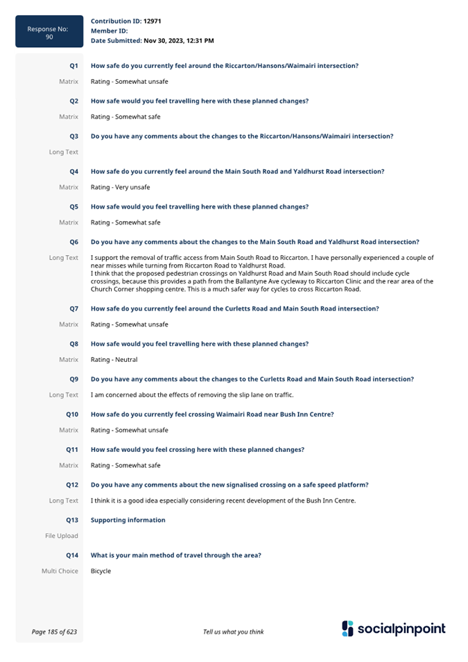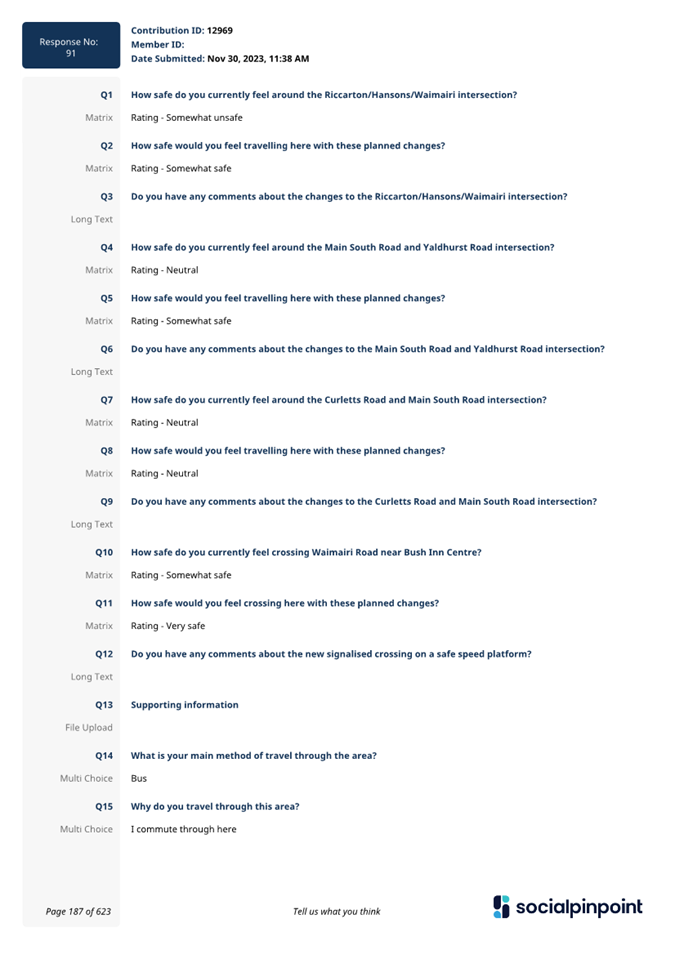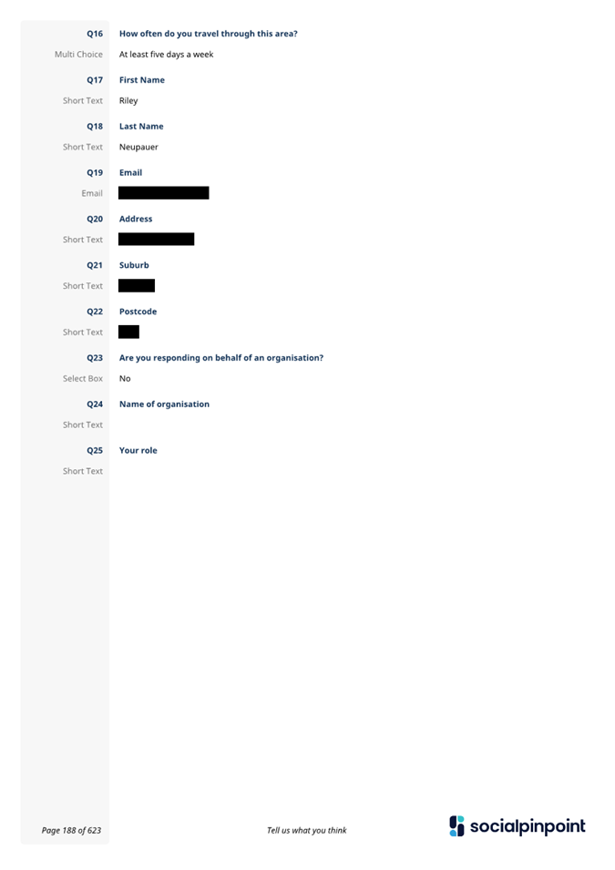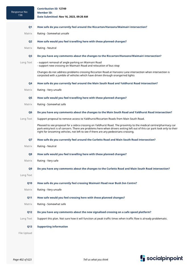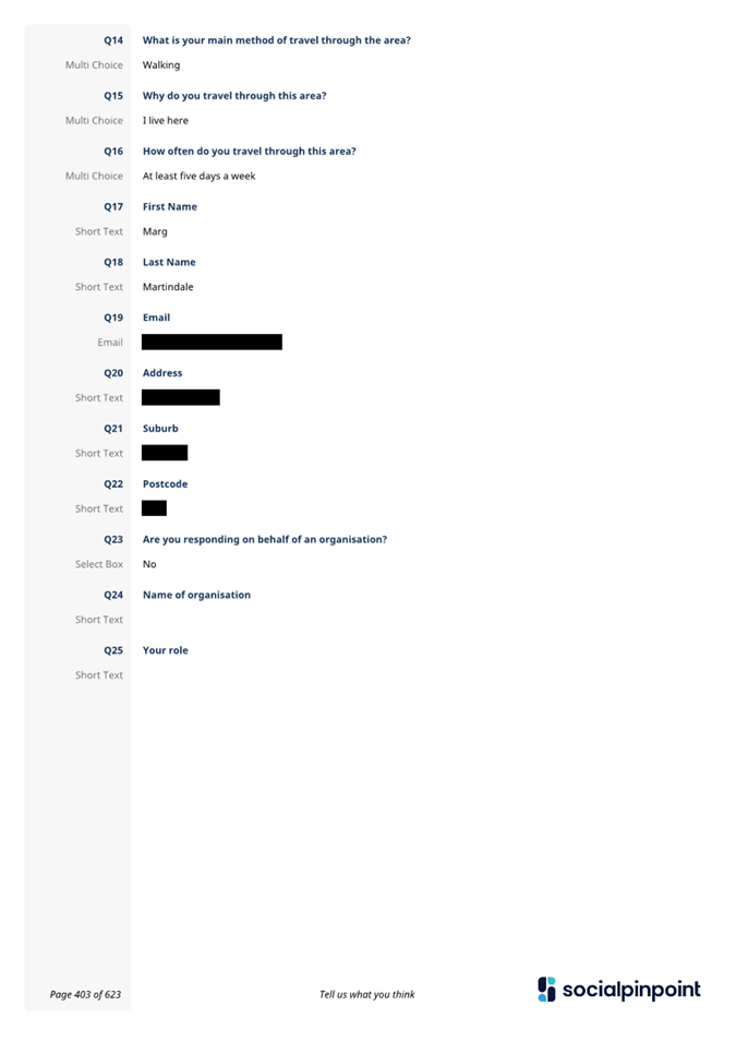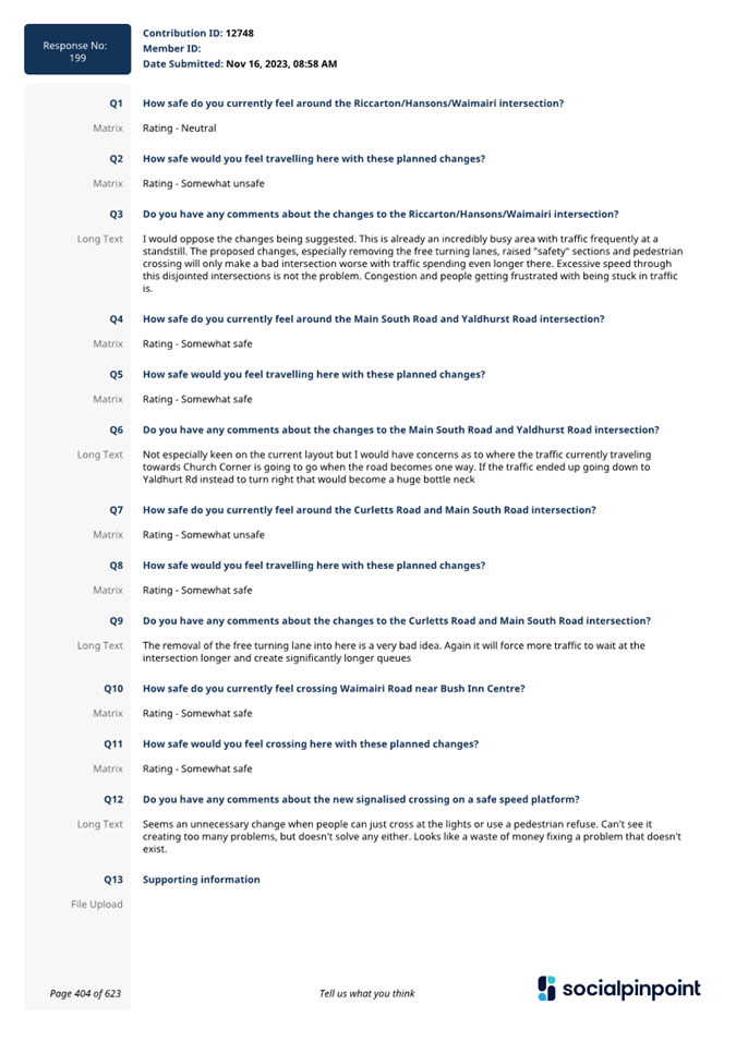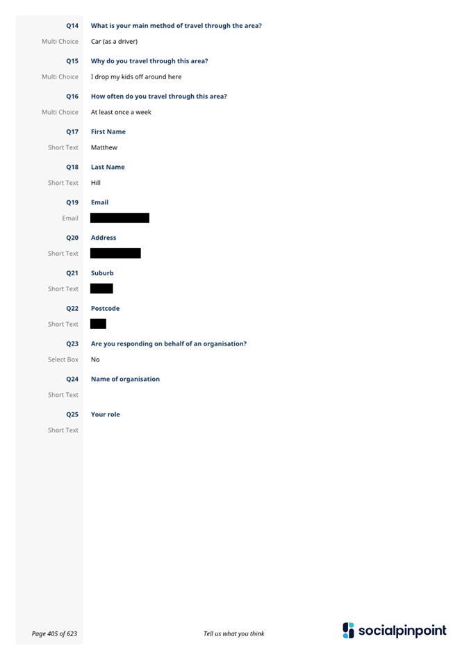
Waipuna
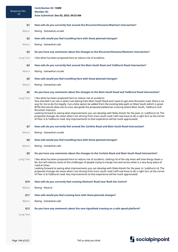
Halswell-Hornby-Riccarton Community Board
Agenda
Notice of Meeting:
An ordinary meeting of the Waipuna
Halswell-Hornby-Riccarton Community Board will be held on:
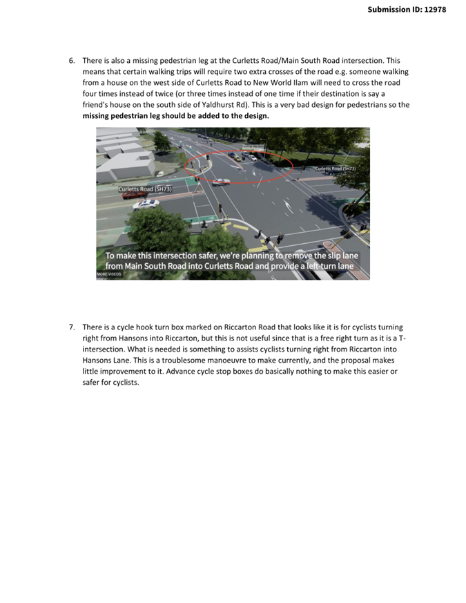
Date: Thursday 15 February 2024
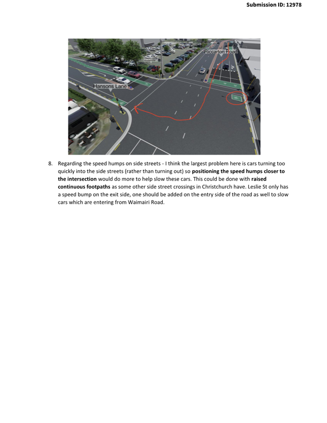
Time: 4.30 pm
Venue: Rārākau: Riccarton Centre,
199 Clarence Street, Christchurch
Membership
|
Chairperson
Deputy Chairperson
Members
|
Helen Broughton
Marie Pollisco
Sarah Brunton
Henk Buunk
Gamal Fouda
Tyla Harrison-Hunt
Andrei Moore
Debbie Mora
Mark Peters
|
12 February 2024
Jess Garrett
Manager Community Governance, Halswell Hornby
Riccarton
941 6289
Jessica.Garrett@ccc.govt.nz
www.ccc.govt.nz
|
Waipuna Halswell-Hornby-Riccarton
Community Board
15 February 2024
|

|
|
Waipuna Halswell-Hornby-Riccarton
Community Board
15 February 2024
|

|
Part A Matters
Requiring a Council Decision
Part B Reports
for Information
Part C Decisions
Under Delegation
TABLE OF CONTENTS NGĀ IHIRANGI
Karakia Tīmatanga................................................................................................... 5
C 1. Apologies Ngā Whakapāha.......................................................................... 5
B 2. Declarations of Interest Ngā Whakapuaki Aronga........................................... 5
C 3. Confirmation of Previous Minutes Te Whakaāe o te
hui o mua.......................... 5
B 4. Public Forum Te Huinga Whānui.................................................................. 5
B 5. Deputations by Appointment Ngā Huinga
Whakaritenga................................. 5
B 6. Presentation
of Petitions Ngā
Pākikitanga.................................................... 6
C 7. Notice
of Motion - Installation of crossing points on Sabys Road, Halswell....... 19
Staff Reports
CA 8. Church
Corner and Waimairi Road Safety Improvements............................... 21
C 9. Proposed
Road Names - 47 Redmund Spur Road......................................... 739
CA 10. Waka
Kotahi Roading Improvements 206R Halswell Road (SH75) - Temporary Licence to
Occupy and Purchase of Land.................................................... 745
C 11. Keri
Place - Proposed No Stopping Restrictions.......................................... 773
C 12. Halswell
Hornby Riccarton Discretionary Response Fund Application - Halswell Community
Project Inc and Youth Development Fund Transfer.................... 781
B 13. Waipuna
Halswell-Hornby-Riccarton Community Board Area Report - February 2024............................................................................................................ 787
B 14. Elected Members’
Information Exchange Te Whakawhiti
Whakaaro o Te Kāhui Amorangi............................................................................................................ 834
Karakia Whakamutunga
|
Waipuna Halswell-Hornby-Riccarton
Community Board
15 February 2024
|
|
Karakia Tīmatanga
|
Whakataka te hau ki te
uru
Whakataka te hau ki te
tonga
Kia mākinakina ki
uta
Kia mātaratara ki
tai
E hī ake ana te atakura
He tio, he huka, he
hauhūnga
Tīhei Mauri Ora
|
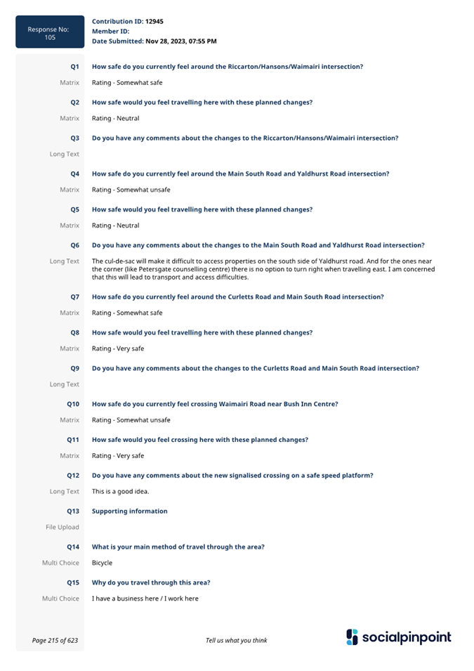
Cease the winds from
the west
Cease the winds from the south
Let the breeze blow over the land
Let the breeze blow over the ocean
Let the red-tipped dawn come with a sharpened air.
A touch of frost, a promise of a glorious day.
|
1. Apologies Ngā Whakapāha
At the close of
the agenda no apologies had been received.
2. Declarations of Interest Ngā
Whakapuaki Aronga
Members are
reminded of the need to be vigilant and to stand aside from decision making
when a conflict arises between their role as an elected representative and any
private or other external interest they might have.
3. Confirmation of Previous Minutes Te
Whakaāe o te hui o mua
That the
minutes of the Waipuna Halswell-Hornby-Riccarton Community Board meeting held
on Thursday, 14 December 2023 be
confirmed (refer page 7).
4. Public Forum Te Huinga Whānui
A period of up
to 30 minutes will be available for people to speak for up to five minutes on
any issue that is not the subject of a separate hearings process.
|
4.1
|
Wigram Aquatic Centre
Morgan Du will address the Board
regarding a Wigram Aquatic Centre.
|
5. Deputations by Appointment Ngā Huinga
Whakaritenga
Deputations may
be heard on a matter or matters covered by a report on this agenda and approved
by the Chairperson.
|
5.1
|
Church Corner and Waimairi Road Safety Improvements
Josiah Tualamali'i will address the Board
regarding the Church Corner and Waimairi Road Safety Improvements Report
(Item 8 of the Agenda refers).
|
|
5.2
|
Church Corner and Waimairi Road Safety Improvements
Gray Crawford, Business Manager, and
Corin Murfitt, Chair of Petersgate Trust, will speak on behalf of Petersgate
Counselling Centre regarding the Church Corner and Waimairi Road Safety
Improvements Report (Item 8 of the Agenda refers).
|
|
5.3
|
Church Corner and Waimairi Road Safety Improvements
Liz Orr, Teacher, will speak on behalf of
St Peter’s Anglican Preschool regarding the Church Corner and Waimairi
Road Safety Improvements Report (Item 8 of the Agenda refers).
|
6. Presentation of Petitions Ngā
Pākikitanga
There were no petitions
received at the time the agenda was prepared.
|
Waipuna Halswell-Hornby-Riccarton
Community Board
15 February 2024
|

|


Waipuna
Halswell-Hornby-Riccarton Community Board
Open Minutes
Date: Thursday 14 December 2023
Time: 4.30 pm
Venue: Horoeka Room, Rārākau: Riccarton
Centre,
199 Clarence Street, Christchurch
Present
|
Chairperson
Deputy Chairperson
Members
|
Helen Broughton
Marie Pollisco
Sarah Brunton
Henk Buunk
Tyla Harrison-Hunt
Andrei Moore
Debbie Mora (via audio/visual link)
Mark Peters
|
Jess Garrett
Manager Community Governance, Halswell Hornby
Riccarton
941 6289
Jessica.Garrett@ccc.govt.nz
www.ccc.govt.nz

Part A Matters
Requiring a Council Decision
Part B Reports
for Information
Part C Decisions
Under Delegation
Karakia Tīmatanga
The agenda was dealt with in the following
order.
1. Apologies
Ngā Whakapāha
Part C
|
Community Board Resolved HHRB/2023/00117
That the apologies received from Gamal
Fouda for absence and Mark Peters for an early departure, be accepted.
Mark
Peters/Marie Pollisco Carried
|
2. Declarations
of Interest Ngā Whakapuaki Aronga
Part B
There were no
declarations of interest recorded.
3. Confirmation
of Previous Minutes Te Whakaāe o te hui o mua
Part C
|
Community Board Resolved HHRB/2023/00118
That the
minutes of the Waipuna Halswell-Hornby-Riccarton Community Board meeting held
on Thursday, 9 November 2023 be confirmed.
Andrei
Moore/Henk Buunk Carried
|
4. Public
Forum Te Huinga Whānui
Part B
|
4.1
|
Tertiary discount for Christchurch
City Council Swimming Pools and Recreation Centres
Pierce
Crowley, President, and Angeline Moneda, Member, spoke on behalf of the
University of Canterbury Students’ Association regarding the pricing
structure for entry to Christchurch City Council swimming pools and
recreation centres.
The
Association has been approached by student members regarding the
affordability of entry charges for tertiary students. It is noted that there
is discount available for secondary students and the Association would like
an investigation into whether these discounts could also be extended to
tertiary students who frequently have higher living costs and less support.
The Association considers that discounted entry would allow for greater use
of the pools and recreation centres by students with health benefits for them
and increased participation in Council facilities, in line with
Council’s objective to have more people, more active, more often.
Following
questions from members, the Chairperson thanked Mr Crowley and Ms Moneda for
their presentation.
|
|
Part B
That the
Waipuna Halswell-Hornby-Riccarton Community Board:
1. Requests
that staff investigate the possibility of extending the discounted entry
charges to pools and recreation centres currently available to secondary
students, to tertiary students also and provide advice to the Board.
|
|
4.2
|
Hornby Menzshed
Brian Dixon,
Chairman Hornby Menzshed, spoke to the Board regarding the group’s
activities and current projects including running programmes for school
students and community groups.
Mr Dixon
thanked the Board for its funding support and noted that the Menzshed is
currently looking at options for premises in the Hornby area.
Following
questions from members, the Chairperson thanked Mr Dixon for his
presentation.
|
|
|
Attachments
a Presentation
- Hornby Menzshed
|
|
4.3
|
South Express Cycleway light phasing
George Laxton
spoke to the Board regarding the South Express Cycleway light phasing at the
Mandeville and Lowe Streets intersection.
Mr Laxton
noted that phasing of the lights means that cyclists and pedestrians are
frequently waiting to cross for long periods when there is no motor vehicles
coming from the other direction. Mr Laxton is concerned that this leads to
frustration and cyclists and pedestrians crossing against the lights which
creates a significant safety issue. He would like to see a change to the
light phasings to address this.
He advised
that this matter has already been raised with Council staff but no change has
resulted.
Following
questions from members, the Chairperson thanked Mr Laxton for his
presentation.
|
|
Part B
That the
Waipuna Halswell-Hornby-Riccarton Community Board:
1. Refers
the issues raised in the presentation to staff for advice on any improvements
that can be made to the South Express Cycleway light phasing at the
Mandeville and Lowe Streets intersection to improve the travel experience and
safety of pedestrians and cyclists.
|
|
Attachments
a Presentation
- George Laxton
|
|
4.4
|
Long Term Plan 2024 - 2034
The scheduled
public forum did not go ahead.
|
|
4.5
|
Emergency management centre
Drucilla
Kingi-Patterson addressed the Board regarding the need for an emergency
management centre for film and theatre work in Christchurch.
Ms
Kingi-Patterson advised that a facility is needed that is accessible to the
community and well equipped. She is currently exploring options for a centre
in various locations across the city, including in the south-west area.
Following
questions from members, the Chairperson thanked Ms Kingi-Patterson for her
presentation.
|
|
|
Attachments
a Appendix
to Presentation - Drucilla Kingi-Patterson
|
5. Deputations
by Appointment Ngā Huinga Whakaritenga
Part B
|
5.1 Halswell
Junction Road Extension - New road name for Halswell Junction Road cul-de-sac
and Proposed Lane Names - 24 Amyes Road and 48 Quaifes Road
|
|
David Hawke,
Secretary and Ross McFarlane, Committee Member, Halswell Residents’
Association, spoke to the Board regarding the proposals for a new road name for
Halswell Junction Road cul-de-sac and names for new lanes at 24 Amyes Road
and 48 Quaifes Road.
The
Association noted that the reports on both proposals refer to the
Council’s former road naming policy but not the newnaming policy
recently adopted. It considers that the proposed names should be assessed
against new policy.
The
Association is concerned that the proposed names and in particular Silberhorn
Drive, recommended for 48 Quaifes Road does not relate well to the location.
It was acknowledged the name fits the development naming theme of mountains,
however, the name has no particular relevance to Halswell and the Association
would like to see a more appropriate name.
Following
questions from members, the Chairperson thanked Mr Hawke and Mr McFarlane for
their presentation.
Items 8 and 9
of these minutes refer to this matter.
|
|
5.2 Riccarton
CRAF - Bradshaw Terrace street renewal
|
|
Tony Dale,
local resident, spoke in support of the proposed Bradshaw Terrace street
renewal that has been a long time coming and thanked the Board for its
support.
Following
questions from members, the Chairperson thanked Mr Dale for his presentation.
Item 10 of
these minutes refer to this matter.
|
6. Presentation
of Petitions Ngā Pākikitanga
Part B
There was no presentation of petitions.
|
7. Correspondence
- Dog park and agility centre
|
|
|
Community Board Resolved
HHRB/2023/00119 (Officer recommendation accepted without change)
Part B
That the Waipuna
Halswell-Hornby-Riccarton Community Board:
1. Receives the correspondence from Amber
Hicks, local resident, suggesting a location for a new dog park and agility
centre on FW Delamain Park, Yaldhurst.
Mark Peters/Henk
Buunk Carried
|
|
8. Halswell
Junction Road Extension - New road name for Halswell Junction Road cul-de-sac
|
|
|
Board Consideration
Staff in attendance spoke to the report.
The Board took into consideration the deputation from the Halswell
Residents’ Association (refer item 5.1 of these minutes).
A number of members indicated that following local discussions,
Panther Place is a preferred name for the new cul-de-sac formed following the
extension of Halswell Junction Road.
|
|
|
Officer Recommendations Ngā
Tūtohu
That the
Waipuna Halswell-Hornby-Riccarton Community Board:
1. Approves Buffalo Place as the new road
name for the cul-de-sac section of Halswell Junction Road.
|
|
|
Community Board Resolved HHRB/2023/00120
Part C
That the
Waipuna Halswell-Hornby-Riccarton Community Board:
1. Approves Panther Place as the new road
name for the cul-de-sac section of Halswell Junction Road.
Mark Peters/Henk
Buunk Carried
|
Marie Pollisco
requested that her vote against the resolution be recorded.
|
9. Proposed
Lane Names - 24 Amyes Road and 48 Quaifes Road
|
|
|
Board Consideration
Staff in attendance spoke to the report.
The Board took into consideration the
deputation from the Halswell Residents’ Association (refer item 5.1 of
these minutes).
The Board discussed the possibility
of confusion of the pronunciation of the recommended names for Lane 1 and
Lane 4 for 24 Amyes Road.
The Board noted that the name
Silberhorn Drive proposed for 48 Quaifes Road appears to have no direct
relevance to the subdivision or the Halswell area.
|
|
|
Officer Recommendations Ngā
Tūtohu
That the Waipuna
Halswell-Hornby-Riccarton Community Board:
1. Approves the following new lane names for
24 Amyes Road (RMA/2022/2972)
a. Lane 1 - Ao Lane
b. Lane 2 - Kohekohe Lane
c. Lane 3 - King Fern Lane
d. Lane 4 - Hou Lane
e. Lane 5 - Daisy Court
f. Lane 6 - Wiri Court
g. Lane 7 - Malva Court
2. Approves the following new road names for
48 Quaifes Road (RMA/2022/2524)
a. Road 1 - Silberhorn Drive
|
|
|
Community Board Resolved HHRB/2023/00121
Part C
That the Waipuna
Halswell-Hornby-Riccarton Community Board:
1. Approves the following new lane names for
24 Amyes Road (RMA/2022/2972)
a. Lane 1 - Puaki Lane
b. Lane 2 - Kohekohe Lane
c. Lane 3 - King Fern Lane
d. Lane 4 - Hou Lane
e. Lane 5 - Daisy Court
f. Lane 6 - Wiri Court
g. Lane 7 - Malva Court
Mark
Peters/Marie Pollisco Carried
|
|
|
Community Board Recommendation
2. Approves the following new road names for
48 Quaifes Road (RMA/2022/2524)
a. Road 1 - Silberhorn Drive
Debbie Mora/Mark
Peters Lost
|
|
10. Riccarton
CRAF - Bradshaw Terrace street renewal
|
|
|
Community Board Resolved HHRB/2023/00122
(Officer recommendations accepted without change)
Part C
That the
Waipuna Halswell-Hornby-Riccarton Community Board:
1. Approves the scheme plan for the Bradshaw Terrace street renewal
as detailed in Attachment A of the report on the meeting agenda, (Plan
TP320701, Issue 3, dated 21/11/2023).
2. Approves all kerb alignments, road surface treatment and road
markings on Bradshaw Terrace, commencing at its intersection with Straven
Road, and extending in an easterly direction, then southerly direction to its
end (cul-de-sac), as shown in Attachment A to the report on the meeting
agenda (Plan TP320701, Issue 3, dated 21/11/2023).
3. Approves, pursuant to Clause 7 of the Christchurch City Council
Traffic and Parking Bylaw 2017, as shown in Attachment A to the report on the
meeting agenda (Plan TP320701, Issue 3, dated 21/11/2023) that the stopping
of vehicles be prohibited at any time on the northern side of Bradshaw
Terrace commencing at its intersection with Straven Road, and extending in an
easterly direction for a distance of 14 metres.
4. Approves, pursuant to Clause 7 of the Christchurch City Council
Traffic and Parking Bylaw 2017, as shown in Attachment A to the report on the
meeting agenda (Plan TP320701, Issue 3, dated 21/11/2023) that the parking of
all vehicles be restricted to a maximum period of 120 minutes on the northern
side of Bradshaw Terrace commencing at a point 14 metres east of its
intersection with Straven Road, and extending in an easterly direction for a
distance of 44 metres. This restriction is to apply 8:00am to
6pm, Monday to Sunday excluding public holidays.
5. Approves, pursuant to Clause 7 of the Christchurch City Council
Traffic and Parking Bylaw 2017, as shown in Attachment A to the report on the
meeting agenda (Plan TP320701, Issue 3, dated 21/11/2023) that the parking of
all vehicles be restricted to a maximum period of 120 minutes on the northern
side of Bradshaw Terrace commencing at a point 113 metres east of its
intersection with Straven Road, and extending in an easterly direction for a
distance of 30 metres. This restriction is to apply 8:00am to 6pm,
Monday to Sunday excluding public holidays.
6. Approves, pursuant to Clause 7 of the Christchurch City Council
Traffic and Parking Bylaw 2017, as shown in Attachment A to the report on the
meeting agenda (Plan TP320701, Issue 3, dated 21/11/2023) that the stopping
of all vehicles be prohibited at all times on the eastern side of Bradshaw
Terrace commencing at a point 156 metres east of its intersection with
Straven Road, and extending in a southerly direction then northerly direction
around the cul-de-sac for a distance of 63 metres.
7. Approves, pursuant to Clause 7 of the Christchurch City Council
Traffic and Parking Bylaw 2017, as shown in Attachment A to the report on the
meeting agenda (Plan TP320701, Issue 3, dated 21/11/2023) that the stopping
of vehicles be prohibited at any time on the southern side of Bradshaw
Terrace commencing at its intersection with Straven Road, and extending in an
easterly direction for a distance of 17 metres.
8. Approves, pursuant to Clause 7 of the Christchurch City Council
Traffic and Parking Bylaw 2017, as shown in Attachment A to the report on the
meeting agenda (Plan TP320701, Issue 3, dated 21/11/2023) that the parking of
all vehicles be restricted to a maximum period of 120 minutes on the southern
side of Bradshaw Terrace commencing at a point 72 metres east of its
intersection with Straven Road, and extending in an easterly direction for a
distance of 24 metres. This restriction is to apply 8:00am to 6pm, Monday
to Sunday excluding public holidays.
9. Revokes any previous resolutions pertaining to traffic controls
made pursuant to any bylaw to the extent that they are in conflict with the
traffic controls described in 2 to 8.
10. Approves that these resolutions take effect when parking signage
and/or road marking that evidence the restrictions described in 3 to 9 are in
place (or removed in the case of revocations).
Helen
Broughton/Tyla Harrison-Hunt Carried
|
|
11. Kinsella
Crescent Proposed No Stopping Restrictions
|
|
|
Community Board Resolved
HHRB/2023/00123 (Officer recommendations accepted without change)
Part C
That the Waipuna
Halswell-Hornby-Riccarton Community Board:
1. Approves that the stopping of vehicles be
prohibited at any time on the northern side of Kinsella Crescent commencing
at a point 100m metres north east of its intersection with Bibiana Street and
extending in a north easterly direction for a distance of 41 metres, as shown
in Attachment 1 to the report on the meeting agenda - Plan TG146846.
2. Revokes any previous resolutions
pertaining to traffic controls made pursuant to any bylaw to the extent that
they are in conflict with the traffic controls described in1.
3. Approves that these resolutions take
effect when parking signage and/or road marking that evidence the
restrictions described in 1. and 2.are in place (or removed in the case of
revocations).
Andrei
Moore/Marie Pollisco Carried
|
|
12. Sir James
Wattie Drive Proposed No Stopping Restrictions
|
|
|
Community Board Resolved HHRB/2023/00124
(Officer recommendations accepted without change)
Part C
That the Waipuna
Halswell-Hornby-Riccarton Community Board:
1. Approves that the stopping of vehicles be
prohibited at any time on the south eastern side of Sir James Wattie Drive
commencing at a point 107 metres north east of its intersection with
Gallagher Drive and extending in a north easterly direction for a distance of
28 metres, as shown on Attachment A- to the report on the meeting agenda Plan
TG146868 dated 27/11/2023.
2. Approves that the stopping of vehicles be
prohibited at any time on the north western side of Sir James Wattie Drive
commencing at a point 107 metres north east of its intersection with
Gallagher Drive and extending in a north easterly direction for a distance of
28 metres, as shown on Attachment A to the report on the meeting agenda -
Plan TG146868 dated 27/11/23.
3. Revokes any previous resolutions
pertaining to traffic controls made pursuant to any bylaw to the extent that
they are in conflict with the traffic controls described in 1. and 2.
4. Approves that these resolutions take
effect when parking signage and/or road marking that evidence the
restrictions described in1.,2. and 3. are in place (or removed in the case of
revocations).
Mark
Peters/Sarah Brunton Carried
|
|
13. Waipuna
Halswell-Hornby-Riccarton Recess Committee 2023/24
|
|
|
Community Board Resolved
HHRB/2023/00125 (Officer recommendations accepted without change)
Part C
That the Waipuna
Halswell-Hornby-Riccarton Community Board:
1. Appoints a Recess Committee comprising
the Board Chairperson or Deputy
Chairperson (or their nominees from amongst the remaining Board members) plus
a minimum of any other two Board members, and authorises the Committee to exercise the
delegated powers of the Waipuna Halswell-Hornby-Riccarton Community Board for
the period following its ordinary meeting on 14 December 2023 up until the
Board resumes its normal business from 15 February 2024.
2. Notes that any delegation exercised by
the Board’s Recess Committee will be reported to the Board for record
purposes.
3. Notes that any meeting convened of the
Recess Committee will be publicly notified and the details forwarded to all
Board members.
Tyla
Harrison-Hunt/Mark Peters Carried
|
|
14. Waipuna
Halswell-Hornby-Riccarton Better-Off Fund Application for Consideration -
URWML Pocket Park Development
|
|
|
Community Board Resolved HHRB/2023/00126
(Officer recommendation accepted without change)
Part C
That the Waipuna
Halswell-Hornby-Riccarton Community Board:
1. Approves a grant of up to $75,000 from
its Better-Off Fund to Christchurch City Council towards the development of a
pocket park at the Upper Riccarton War Memorial Library site.
Tyla
Harrison-Hunt/Helen Broughton Carried
|
Mark Peters left the meeting at 6.23pm.
|
15. Waipuna
Halswell-Hornby-Riccarton 2023-24 Discretionary Response Fund Applications
|
|
|
Community Board Resolved HHRB/2023/00127
(Officer recommendations accepted without change)
Part C
That the Waipuna
Halswell-Hornby-Riccarton Community Board:
1. Approves a grant of $1,025 from its
2023-24 Discretionary Response Fund to Canterbury Westland Kindergarten Assn
(Kidsfirst) – Avonhead towards the Entrance way and sandpit project.
2. Approves a grant of $1,000 from its
2023-24 Discretionary Response Fund to Sockburn Residents Association towards
the Connecting Sockburn project.
Andrei
Moore/Sarah Brunton Carried
|
|
16. Waipuna
Halswell-Hornby-Riccarton Community Board Area Report - December 2023
|
|
|
Community Board Resolved HHRB/2023/00128
(Officer recommendation accepted without change)
Part B
That the Waipuna
Halswell-Hornby-Riccarton Community Board:
1. Receives the Waipuna Halswell-Hornby-Riccarton Community Board Area
Report for December 2023.
Sarah
Brunton/Marie Pollisco Carried
|
17. Elected
Members’ Information Exchange Te Whakawhiti Whakaaro o Te
Kāhui Amorangi
Part B
|
Members
exchanged information on the following topics:
· It was noted that
the Westlake Wild Flowers Trial has been very successful, however, there have
been recent cases of people picking bunches of flowers so appropriate signage
may need to be considered.
· It was noted that
it is proposed to be put charges in place for use of the tennis courts at
Ngā Puna Wai.
· It was noted that
the new Government proposes to make changes to the speed limit regime that
may have implications for Council signage.
· A Local Government
New Zealand Association Conference for Young Elected Members was recently
held and attended by two Board members.
· Long Term Plan
development is underway and members are contributing to the process.
· It was noted that
the Council has decided to seek a pause in its Plan Change 14 consideration
as a result of proposed Government changes regarding minimum density
residential development requirements.
· It was noted that
a sale of a surplus property at Hasketts Road is currently being negotiated.
· The Board
Chairperson attended the opening of the new Christchurch Netball Centre at
Ngā Puna Wai.
· It was noted that
Canterbury Kia Ora Academy is running a programme to provide opportunities
for ethnic women to “have a go” at various sports.
|
Karakia
Whakamutunga
Meeting
concluded at 6.56pm.
CONFIRMED THIS 15TH DAY OF
FEBRUARY 2024.
Helen Broughton
Chairperson
|
Waipuna Halswell-Hornby-Riccarton
Community Board
15 February 2024
|

|
|
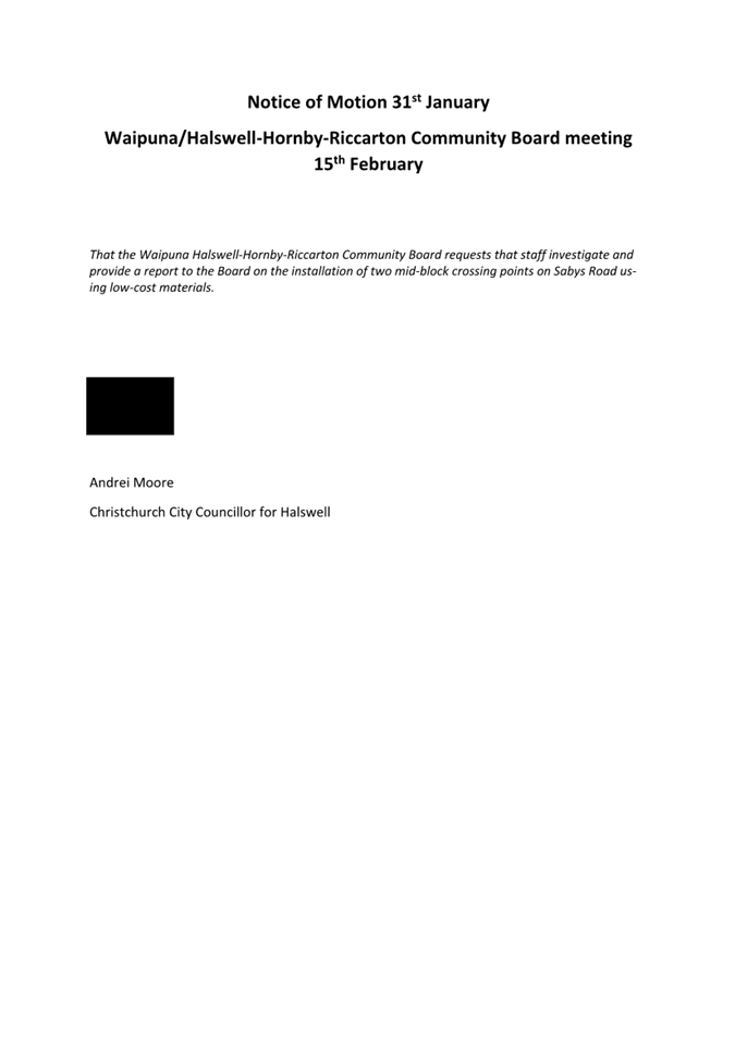
7. Notice
of Motion - Installation of crossing points on Sabys Road, Halswell
|
|
Reference / Te Tohutoro:
|
24/157011
|
|
Report of / Te Pou Matua:
|
Andrei
Moore, Councillor – Halswell Ward,
andrei.moore@ccc.govt.nz
|
|
Senior Manager / Pouwhakarae:
|
Andrew
Rutledge, Acting General Manager Citizens and Community
(Andrew.Rutledge@ccc.govt.nz)
|
Pursuant to Standing Order 22 of
Christchurch City Council’s Standing Orders, the following Notice of
Motion was submitted by Andrei Moore.
1. Notice of Motion to the Waipuna Halswell-Hornby-Riccarton
Community Board He Pānui Mōtini
That the Waipuna
Halswell-Hornby-Riccarton Community Board:
1. Requests that staff investigate and provide a report
to the Board on the installation of two mid-block crossing points on Sabys Road
using low-cost materials.
Attachments Ngā Tāpirihanga
|
No.
|
Title
|
Reference
|
Page
|
|
a ⇩
|
Notice of
Motion - Installation of crossing points on Sabys Road, Halswell
|
24/190777
|
20
|
|
Waipuna Halswell-Hornby-Riccarton
Community Board
15 February 2024
|
|
|
Waipuna Halswell-Hornby-Riccarton
Community Board
15 February 2024
|

|
|
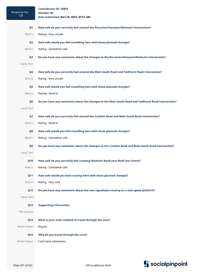
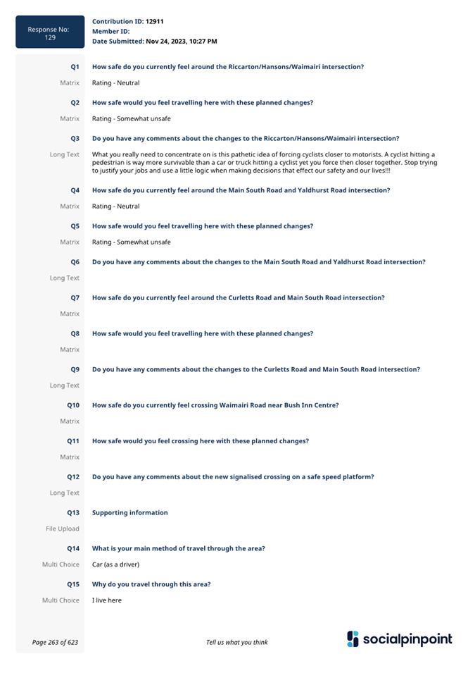
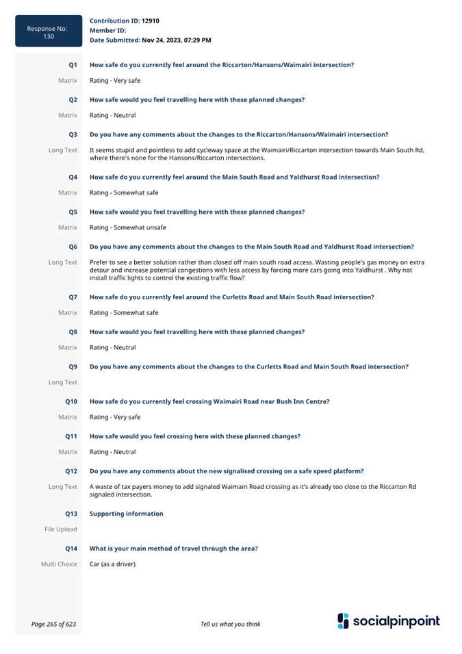
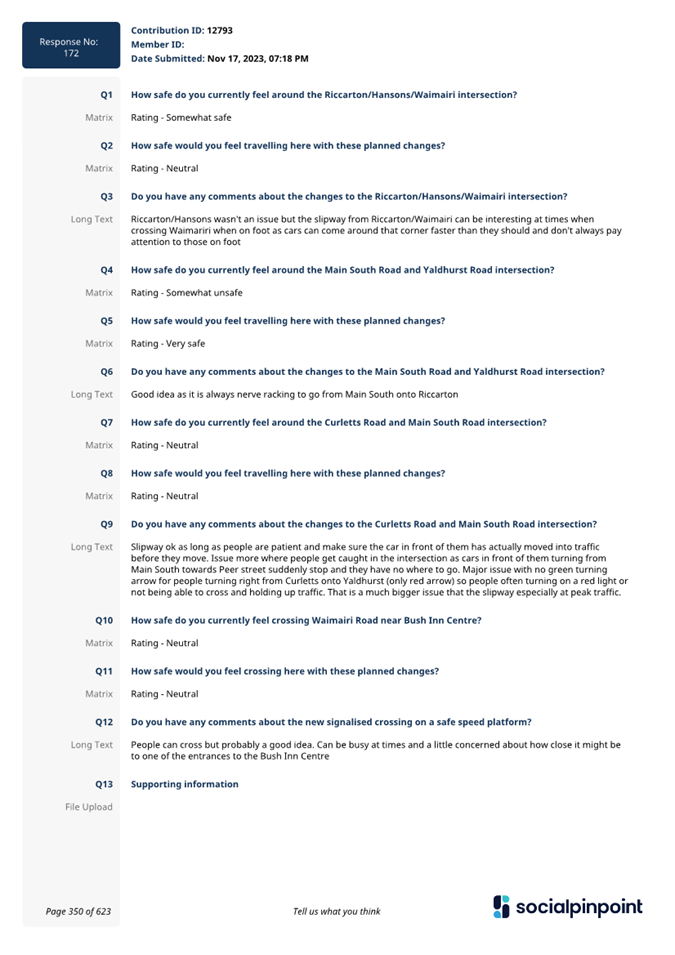
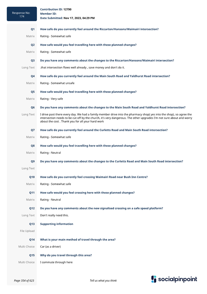
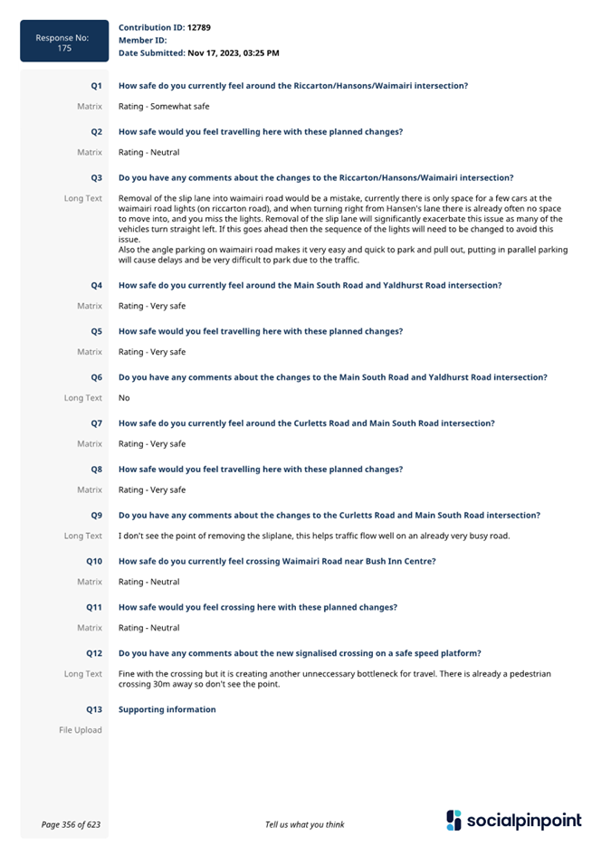
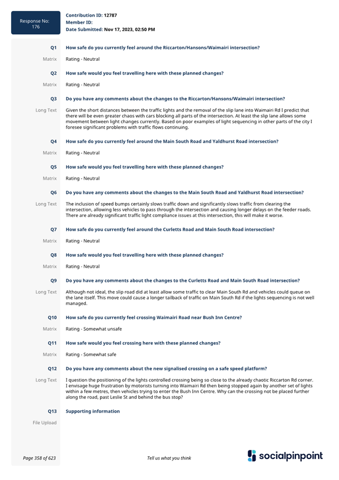
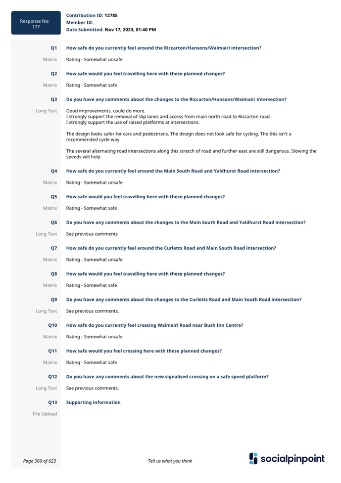
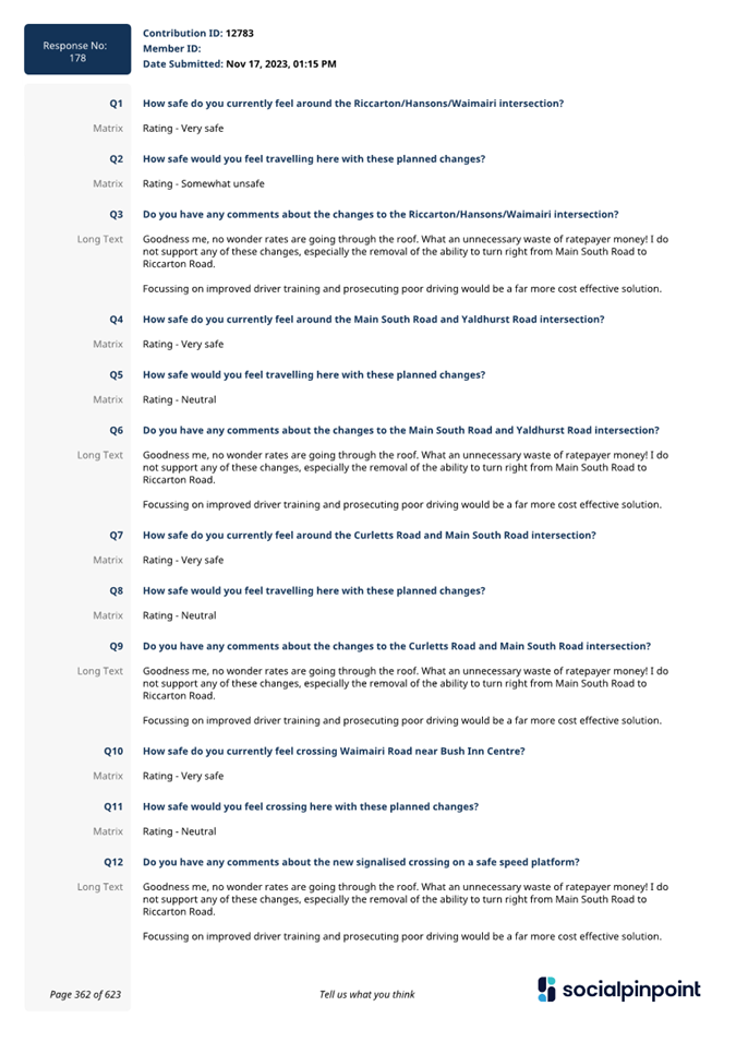
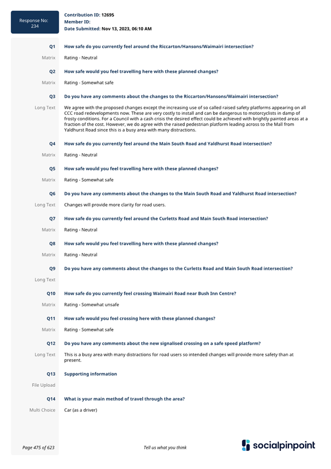
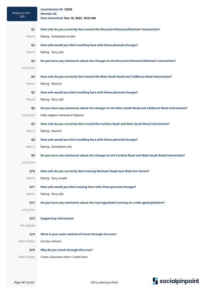
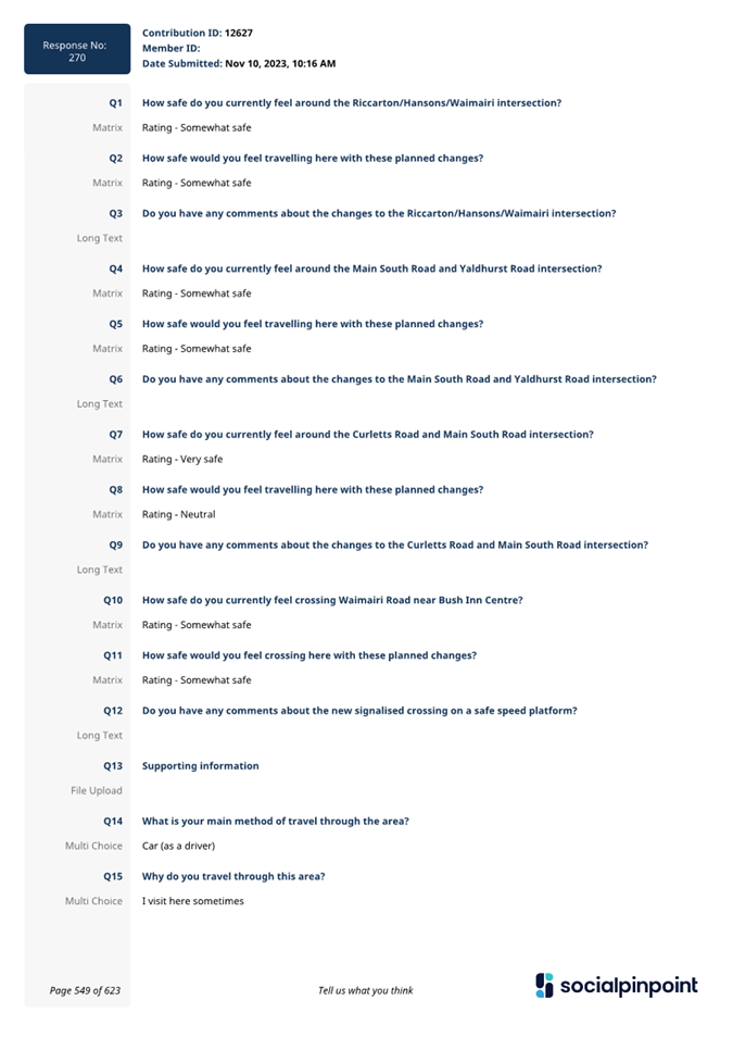
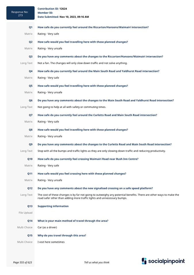
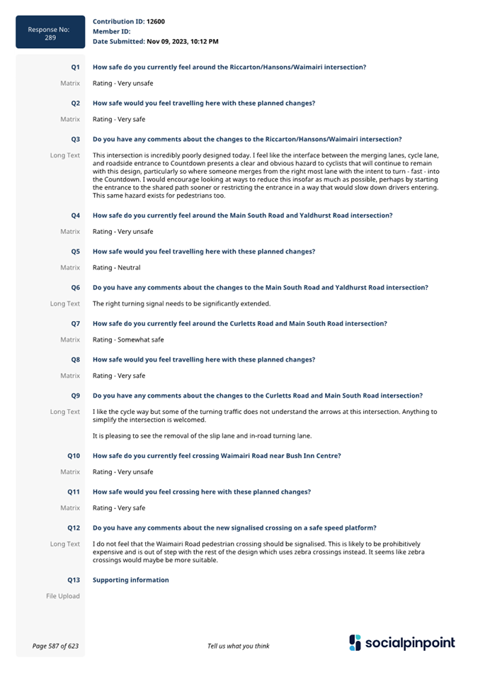
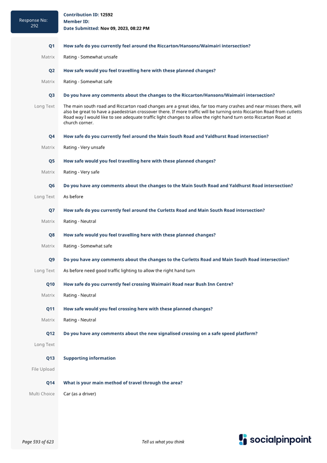
8. Church Corner and Waimairi Road
Safety Improvements
|
|
Reference / Te Tohutoro:
|
23/1883677
|
|
Report of / Te Pou Matua:
|
Gemma
Dioni, Principal Advisor Transportation - Safety
Ann Tomlinson, Project Manager
Krystle Anderson, Engagement Advisor
Georgia Greene, Traffic Engineer
|
|
Senior Manager / Pouwhakarae:
|
Lynette
Ellis, Head of Transport & Waste Management (Lynette.Ellis@ccc.govt.nz)
|
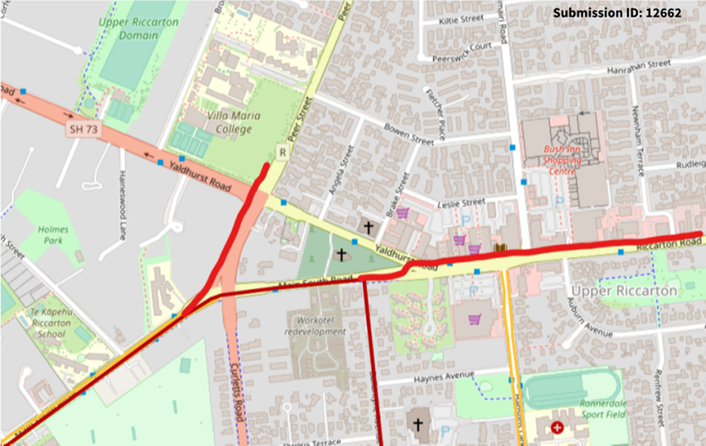
1. Purpose and Origin of Report Te Pūtake Pūrongo
1.1 For the Waipuna Halswell-Hornby-Riccarton Community Board
to approve safety improvements to intersections around Church Corner and to
make recommendations to Council for the items within the proposed design that
rest with Council for decision making.
1.2 This report has been written in response to ongoing safety
concerns in the area particularly for people travelling across the community by
all different modes.
1.3 This
intersections of Riccarton/Hansons/Waimairi and Curletts/Main South are both
within the top 1% of intersections within the Christchurch District in terms of
risk of being in a crash, compared to over 5700 Council controlled
intersections citywide (Main South/Yaldhurst is in the top 3%). The
intersection safety improvements were identified through a co-design process
with Waka Kotahi NZ Transport Agency for the 2021-2024 National Land Transport
Programme Funding Cycle. The Pipeline Development Tool (PDT) used in this
process helps road controlling authorities and their funding partners plan road
safety interventions, understand their benefits, including the expected
reduction in death and serious injury, and identify the most effective
interventions at a local, regional, and national level.
1.4 Church
Corner and Waimairi Road are busy locations used by many people travelling to
school, University or work, accessing the local shops and Bush Inn Centre, or
moving across the community. Whether people are travelling through this
intersection on foot, by bicycle, by bus or driving, they should be able to do
so safely.
1.5 The
decisions in this report are of medium significance in relation to the
Christchurch City Council’s Significance and Engagement Policy. The
level of significance was determined by this being a busy area used daily by
people travelling to the local amenities, travelling to school and commuting to
work. There is some community interest in the project due to existing safety
concerns.
1.6 The
recommended option is to construct a package of safety improvements in the
vicinity of Church Corner, as show in Attachment A, and summarised
below:
· Safe speed platforms on
all approaches to the Riccarton Road, Hansons Lane, and Waimairi Road
intersection.
· Removing the slip lane
from Riccarton Road onto Waimairi Road.
· Reconfiguration of angle
parking to parallel parking on Waimairi Road.
· Speed humps on Angela
Street and Brake Street at their intersection with Yaldhurst Road, Leslie
Street at its intersection with Waimairi Road and Bowen Street at its
intersection with Peer Street.
· Making Main South Road
(from Riccarton Road) entry only and removing vehicle access out of Main South
Road onto Riccarton Road and Yaldhurst Road.
· Installation of pedestrian
zebra crossings on Yaldhurst Road and Main South Road.
· Removing the left turn
slip lane from Main South Road into Curletts Road and providing a left turn
lane at the signals.
· Raised signalised crossing
on Waimairi Road (outside Bush Inn Centre).
· Cycle improvements and bus
stop improvements.
2. Officer Recommendations Ngā
Tūtohu
That the Waipuna
Halswell-Hornby-Riccarton Community Board recommends that the Council:
1. Approves, pursuant to Clause 18 of the
Christchurch City Council Traffic and Parking Bylaw 2017:
a. That a Special Vehicle Lane for the use of
northbound road users as defined in Section 11.1A of the Land Transport (Road
User) Rule: 2004, excepting pedestrians and riders of mobility devices, be
installed on the west side of Waimairi Road, commencing at its intersection
with Riccarton Road and extending in a northerly direction to its intersection
with Bowen Street.
b. That a Special Vehicle Lane for the use of
southbound road users as defined in Section 11.1A of the Land Transport (Road
User) Rule: 2004, excepting pedestrians and riders of mobility devices, be
installed on the east side of Waimairi Road, commencing at a point 149 metres
south of its intersection with Hanrahan Street and extending in a southerly
distance to its intersection with Riccarton Road.
c. That a Special Vehicle Lane for the use of
south eastbound road users as defined in Section 11.1A of the Land Transport
(Road User) Rule: 2004, excepting pedestrians and riders of mobility devices,
be installed on the north-east side of Yaldhurst Road, commencing at a point 94
metres south-east of its intersection with Angela Street and extending in a
south easterly direction to its intersection with Riccarton Road.
d. That a Special Vehicle Lane, in accordance
with Clause 18 of the Christchurch City Council Traffic & Parking Bylaw
2017, for the use of eastbound road users as defined in Section 1.6 (definition
of Bus lane) of the Land Transport ( Road User) Rule 2004 and also as
defined in Section 11.1A of the Land Transport (Road User) Rule: 2004,
excepting pedestrians and riders of mobility devices, be installed on the
north side of Riccarton Road, commencing at its intersection with Yaldhurst
Road and extending in an easterly direction to a point located 105 metres west
of its intersection with Waimairi Road, as detailed on plan TG145701, dated
23/01/2024 and attached to the report on the meeting agenda as Attachment A.
2. Approves that in accordance with Section 8.5
of the Land Transport Rule – Traffic Control Devices: 2004 that a
signalised roadway crossing be installed on Waimairi Road, located 23 metres
north from its intersection with Leslie Street, and as detailed on plan
TG145701, dated 23/01/2024 and attached to the report on the meeting agenda as
Attachment A. This signalised crossing is for the use by the classes of road
user as defined in Section 11.1A of the Land Transport (Road User) Rule: 2004.
3. Approves that in accordance with Clause 21 of the
Christchurch City Council Traffic & Parking Bylaw 2017, that the path on
the west side of Waimairi Road, commencing at a point 20 metres north of its
intersection with Leslie Street, and extending in a northerly direction for a
distance of 11 metres be resolved as a Shared Path and in accordance with
section 11.4 of the Land Transport Act - Traffic Control Devices Rules: 2004.
This Shared Path is for the use by the classes of road user only as defined in
Section 11.1A of the Land Transport (Road User) Rule: 2004.
4. Approves that in accordance with Clause 21 of the
Christchurch City Council Traffic & Parking Bylaw 2017, that the path on
the east side of Waimairi Road, commencing at a point 165 metres south of its
intersection with Hanrahan Street, and extending in a southerly direction for a
distance of 13 metres be resolved as a Shared Path and in accordance with
section 11.4 of the Land Transport Act - Traffic Control Devices Rules: 2004.
This Shared Path is for the use by the classes of road user only as defined in Section
11.1A of the Land Transport (Road User) Rule: 2004.
That
the Waipuna Halswell-Hornby-Riccarton Community Board:
General
5. Approves pursuant to Christchurch City Council Traffic
and Parking Bylaw 2017 and Part 21 of the Local Government Act 1974 all kerb
alignments, road surface treatments, traffic calming devices, traffic islands
and road markings on Main South Road, Curletts Road, Yaldhurst Road, Riccarton
Road, Angela Street, Brake Street, Leslie Street, Waimairi Road, and Hansons
Lane, as detailed on plan TG145701, dated 23/01/2024 and
attached to the report on the meeting agenda as Attachment A.
Traffic
Controls
6. Approves that in accordance with Section 8.2 of the Land
Transport Rule – Traffic Control Devices: 2004, that a Pedestrian
Crossing be installed on Yaldhurst Road, located 65 metres south-east of its
intersection with Brake Street, and as detailed on plan TG145701, dated 23/01/2024
and attached to the report on the meeting agenda as Attachment A.
7. Approves that in accordance with Section 8.2 of the Land
Transport Rule – Traffic Control Devices: 2004, that a Pedestrian
Crossing be installed on Main South Road, located 313 metres east of its
intersection with Curletts Road, and as detailed on plan TG145701, dated 23/01/2024
and attached to the report on the meeting agenda as Attachment A.
8. Approves, in accordance with Clause 16 (1) of the
Christchurch City Council Traffic and Parking Bylaw 2017, that Main South Road,
from its intersection with Riccarton Road and extending in a westerly direction
for a distance of 75 metres, be a one-way street, where vehicles must travel in
a westerly direction only.
9. Approves that in accordance with Section 4 of the Land
Transport Rule: Traffic Control Devices 2004 that the west bound traffic on
Main South Road at a point 295 metres east of its intersection with Curletts
Road be controlled by a Give Way.
10. Approves that in accordance with Clause 17(3) of the
Christchurch City Council Traffic and Parking Bylaw 2017 that a No Entry
control be placed against eastbound vehicles using the roadway on Main South
Road at a point 295 metres east of its intersection with Curletts Road.
Bus Stops
11. Approves that, in accordance with Clause 7 of the
Christchurch City Council Traffic & Parking Bylaw 2017 the north side of
Riccarton Road, commencing at a point 158 metres west of its intersection with
Waimairi Road, and extending in an easterly direction for a distance of 30
metres, be reserved for Large Passenger Service Vehicles only, for the purposes
of setting down or picking up passengers only, as part of a Bus Service as
defined in the Land Transport Management Act 2003, Section 5, - Bus Service,
(a) (i), only.
12. Approves that, in accordance with Clause 7 of the
Christchurch City Council Traffic & Parking Bylaw 2017 the west side of
Waimairi Road, commencing at a point 72 metres north of its intersection with
Leslie Street, and extending in a northerly direction for a distance of 12
metres, be reserved for Large Passenger Service Vehicles only, for the purposes
of setting down or picking up passengers only, as part of a Bus Service as
defined in the Land Transport Management Act 2003, Section 5, - Bus Service,
(a) (i), only.
13. Approves that, in accordance with Clause 7 of the
Christchurch City Council Traffic & Parking Bylaw 2017 the east side of
Waimairi Road, commencing at a point 119 metres south of its intersection with
Hanrahan Street, and extending in a southerly direction for a distance of 30
metres, be reserved for Large Passenger Service Vehicles only, for the purposes
of setting down or picking up passengers only, as part of a Bus Service as
defined in the Land Transport Management Act 2003, Section 5, - Bus Service, (a)
(i), only.
14. Approves that pursuant to Section 339(1) of the local
Government Act:1974, that a bus shelter be installed on the east side of
Waimairi Road, as detailed on plan TG145701, dated 23/01/2024, and attached to
the report on the meeting agenda as Attachment A.
Stopping and Parking
restrictions
15. Approves that the stopping of all vehicles be prohibited
at any time, in accordance with Clause 7 of the Christchurch City Council
Traffic & Parking Bylaw 2017, on the east side of Waimairi Road commencing
at its intersection with Riccarton Road and extending in a northerly direction
for a distance of 168 metres.
16. Approves that the stopping of all vehicles be prohibited
at any time, in accordance with Clause 7 of the Christchurch City Council
Traffic & Parking Bylaw 2017, on the north-east side of Yaldhurst Road
commencing at a point 48 metres south-east of its intersection with Brake
Street and extending in a south easterly direction to its intersection with
Riccarton Road.
17. Approves that the stopping of all vehicles be prohibited
at any time, in accordance with Clause 7 of the Christchurch City Council
Traffic & Parking Bylaw 2017, on the south-west side of Yaldhurst Road
commencing at its intersection with Riccarton Road and extending in a north
westerly direction to a point 200 metres south-east of its intersection with
Curletts Road.
18. Approves that the stopping of all vehicles be prohibited
at any time, in accordance with Clause 7 of the Christchurch City Council
Traffic & Parking Bylaw 2017, on the north-west side of Main South Road
commencing at its intersection with Curletts Road and extending in a south
westerly direction for a distance of 52 metres.
19. Approves that the stopping of all vehicles be prohibited
at any time, in accordance with Clause 7 of the Christchurch City Council
Traffic & Parking Bylaw 2017, on the north side of Main South Road
commencing at a point 262 metres east of its intersection with Curletts Road,
and extending in a easterly direction to its intersection with Riccarton Road,
as detailed on plan TG145701,
dated 23/01/2024, and attached to the report on the meeting agenda as
Attachment A.
20. Approves that the stopping of all vehicles be prohibited
at any time, in accordance with Clause 7 of the Christchurch City Council
Traffic & Parking Bylaw 2017, on the south side of Main South Road
commencing at a point 286 metres east of its intersection with Curletts Road,
and extending in a easterly direction to its intersection with Riccarton Road,
as detailed on plan TG145701,
dated 23/01/2024, and attached to the report on the meeting agenda as
Attachment A.
21. Approves that any previously approved resolutions be
revoked , in accordance with Clause 6 (2) of the Christchurch City Council
Traffic & Parking Bylaw 2017, made pursuant to any Bylaw, Local Government
Act, or any Land Transport Rule, to the extent that they are in conflict with,
or recommended to be removed in regard to the parking and /or stopping
restrictions described in 1-21 above.
22. Approves that these resolutions take effect
when parking signage and/or road markings that described in 1 to 21 are in
place (or removed in the case of revocations).
3. Reason for Report Recommendations Ngā Take mō te
Whakatau
3.1 The
Church Corner area is busy with many people walking, cycling, accessing public
transport and driving through, particularly at school times and when people are
travelling to work. Whether people are travelling through this area on foot, by
bicycle, bus or driving, they should be able to do so safely. If Council are to
achieve its goal in reducing death and serios injuries on our roads, we need to
create a safe transport system; one that recognises humans make mistakes and
that these mistakes do not need to cost us our lives.
3.2 Options within this report
have been assessed against relevant industry-standard guidance including the
Standard Safety Intervention Toolkit Handbook produced by NZTA Waka Kotahi and
Austroads design guides. Traffic signals are not typically identified and
promoted as a Safe System solution, primarily due to the angle and impact speed
of crashes at signalised intersections. Safe Speed Platforms (Raised Safety
Platforms) are a vertical deflection device increasingly used to reduce the
maximum comfortable operating speed for vehicles to Safe System collision
speeds. The tolerable limit (survivable speed) for pedestrians and cyclists is
30 km/h.
3.3 Since
the installation of the platform at the Lincoln/Barrington/Whiteleigh
intersection, safer speeds by drivers entering the intersection have been
achieved as shown in the chart below. In the
preceding five-year period (2018-2022) there were 21 reported crashes at the
Lincoln/Barrington/Whiteleigh intersection including two crashes resulting in
serious injury. There have been no reported crashes at this intersection in
2023 (as of 16/01/2024).
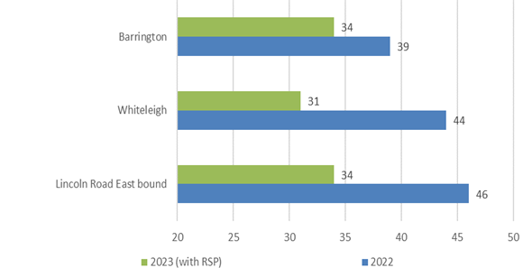
Approach 85th percentile operating speeds
at the Lincoln/Barrington/Whiteleigh intersection (vehicle speeds are at the
bottom of the graph)
3.4 During
consultation for Christchurch Regeneration Acceleration Facility (CRAF)
projects, a request was received from a local blind resident for improvements
to the section of Waimairi Road from Riccarton Road to Peer Street to help
improve safety and accessibility for vision-impaired, disabled and elderly
people. This included a project to investigate the need for a signalised
pedestrian crossing at the Bush Inn Centre.
3.5 The
recommendations in this report will help to achieve the desired community
outcome of having well-connected communities and neighbourhoods, so people can
take fewer and shorter trips to access goods and services and have access to
safe and reliable low-emission travel choices.
4. Alternative Options Considered Ētahi atu Kōwhiringa
Main
South Road/Yaldhurst/Riccarton
4.1 Three options were proposed by the design team for the Main
South Road/Yaldhurst Road/Riccarton Road intersection:
|
Option 1
|
Option 2
|
Option 3
|
|
Speed humps on Riccarton Rd on approach
to intersection (both east and west bound directions).
|
Cul de sac on Main South Road (9m radius) to remove
entry from MSR onto Riccarton/Yaldhurst. Provide westbound entrance to Main
South Rd with give way priority at the cul de sac to allow for bus route
access.
|
Create left in left out T-intersection at Main South
Rd/Yaldhurst.
|
|
Build out southern footpath at bus stop outside
countdown by approx. 0.8m, west of Hansons Ln.
|
Build out southern footpath at bus stop outside countdown
by approx. 0.8m, west of Hansons Ln.
|
Build out southern footpath at bus stop outside
countdown by approx. 0.8m, west of Hansons Ln.
|
|
Keep existing left turn lane from Main South Road
onto Yaldhurst and leave existing crossing point to medical centre.
|
Install raised ped and cyclist (dual) crossing
opposite medical centre, with shared path connection towards southern shared
path on Main South Road.
|
Install raised pedestrian crossing opposite medical
centre.
|
|
Retain crossing point opposite countdown.
|
Build out northern footpath along shops by approx.
1.0m.
|
Build out northern footpath along shops by approx.
1.0m.
|
|
Provide eastbound 1.8m cycle lane on
Yaldhurst/Riccarton Rd which ends just after the bus stop (cycle sharrow
markings to be provided after this point).
|
Provide eastbound 1.8m cycle lane on Yaldhurst
/Riccarton Rd which ends just after the bus stop.
|
Provide eastbound 1.8m cycle lane on Yaldhurst
/Riccarton Rd which ends just after the bus stop.
|
|
Reduce right turn bay for Brake St.
|
Reduce right turn bay for Brake St.
|
Retain existing length of right turn bay to Brake
St.
|
|
Reduce westbound lane on Riccarton Road to one lane.
Provide cycle ramp to enter existing shared path on southern side.
|
Reduce westbound lane on Riccarton Road to one lane.
Provide cycle ramp to enter existing shared path on southern side.
|
Reduce westbound lane on Riccarton Road to one lane.
Provide cycle ramp to enter existing shared path on southern side.
|
4.2 The
advantages and disadvantages for each option are presented below.
|
|
Option 1
|
Option 2
|
Option 3
|
|
Advantages
|
Slows traffic on the approach to the intersection to
give people more time to react should a crash occur.
|
Simplifies layout by removing the turning movements
from Main South/Yaldhurst/ Riccarton
|
Removes right turn from Main South/Yaldhurst/
Riccarton
|
|
Increases footpath width outside Countdown
|
Increases footpath width outside Countdown
|
Increases footpath width outside Countdown
|
|
Slight improvement at the crossing point outside the
Medical Centre
|
Improves crossing opportunities outside the medical
centre.
|
Improves crossing opportunities outside the medical
centre.
|
|
|
Increases footpath width on the northern side of
Riccarton Road
|
Increases footpath width on the northern side of
Riccarton Road
|
|
|
Increases accessibility for people walking/cycling
on Main South Road to access shops and services on the north side of
Riccarton Road.
|
Increases accessibility for people walking/cycling
on Main South Road to access shops and services on the north side of
Riccarton Road.
|
|
Improves westbound cycle access to the Major
Cycleway on Ballantyne Ave.
|
Improves westbound cycle access to the Major
Cycleway on Ballantyne Ave.
|
Improves westbound cycle access to the Major
Cycleway on Ballantyne Ave.
|
|
Disadvantages
|
Right turn from Main South Road to
Yaldhurst is retained. While the consequence of a crash may be reduced with
the traffic calming, the likelihood of a crash remains.
|
Re-assignment of traffic on the network. Modelling
would need to be undertaken to understand the effects on the network.
|
Re-assignment of traffic on the network. Modelling
would need to be undertaken to understand the effects on the network.
|
|
Cost to change kerblines on south side,
which may need altering again in future for MRT.
|
Cost to change kerblines on north and
south side, which may need altering again in future for MRT.
|
Cost to change kerblines on north and
south side, which may need altering again in future for MRT.
|
|
No safer crossing points for people
wanting to access shops and services on the north side of Riccarton Road.
|
|
|
Riccarton/Hansons/Waimairi
4.3 Three
options were proposed by the design team for the Hanson/Waimairi/Riccarton
intersection:
|
Option 1
|
Option 2
|
Option 3
|
|
Westbound cycle lane on Riccarton Rd – 1.5m
|
Raised intersection
o Tapered down to kerblines so platforms do
not affect existing stormwater.
o New median islands on Waimairi Rd and
Hansons Lane installed to allow for different length intersection ramps for
the approach and departure side.
o Unable to fit a median island on
Riccarton Rd east so used a uniform 2m ramp across approach and departure
lanes
|
Create a signalised Left-In-Left-Out
intersection at Waimairi Road
o Provide ‘reverse-seagull’ island on Riccarton Rd to
allow busses only to turn right onto Waimairi and restrict right turn
movement out of Waimairi.
o Install median island on Riccarton Rd to physically remove right
turn to/from Waimairi Rd
o Green surfacing and bus only markings at right turn
· Provide traffic island on
Waimairi to reduce southbound traffic to 1 lane at the intersection.
· Waimairi approach to stay signalised.
· Staggered dual ped & cyclist signal
crossing on Riccarton Rd between Waimairi and Hansons, linked with signals.
|
|
Build out southern kerb and footpath (Between
Hansons Lane and Auburn Avenue). This removes one westbound through
lane at the signalised intersection.
|
Build out southern kerb and footpath (Between
Hansons Lane and Auburn Avenue). This removes one westbound through
lane at the signalised intersection.
|
Build out southern kerb and footpath (Between
Hansons Lane and Auburn Avenue). This removes one westbound through
lane at the signalised intersection.
|
|
Provide parallel parking markings on Waimairi Rd
(northbound lane) to remove angle parking.
|
Provide parallel parking markings on Waimairi Rd
(northbound lane) to remove angle parking.
|
Provide parallel parking markings on Waimairi Rd
(northbound lane) to remove angle parking.
|
|
Remove LT slip and slip island on Waimairi Road -
build out kerb to combine LT/TH movement into signalised intersection.
|
Remove LT slip and slip island on Waimairi Road -
build out kerb to combine LT/TH movement into signalised intersection.
|
Remove LT slip and slip island - build out kerb to
combine LT/TH movement.
|
|
Cyclist advanced
stop boxes on all approaches.
|
Cyclist advanced stop boxes on all approaches.
|
Cyclist advanced stop boxes on all approaches.
|
|
Remove filter
right turns.
|
Remove filter right turns.
|
Remove filter right turns.
|
4.4 The
advantages and disadvantages for each option are presented below.
|
|
Option 1
|
Option 2
|
Option 3
|
|
Advantages
|
Wider footpath on southern side.
|
Includes primary safe system treatment that
physically controls speeds into the intersection. Likely to achieve safe
system speeds for vulnerable users.
|
Restricts turn movements into and from Waimairi
Road, prioritising bus movements only. New crossing installed between Hansons
Lane and Waimairi Road to reduce the need for people to cross multiple
approaches.
|
|
|
Protected right turn from Riccarton Road to Hansons
Lane.
|
Protected right turn from Riccarton Road to Hansons
Lane.
|
|
|
|
Slip lane removed at Riccarton/Waimairi, improving
journeys for people walking.
|
Slip lane removed at Riccarton/Waimairi, improving
journeys for people walking.
|
Slip lane removed at Riccarton/Waimairi, improving
journeys for people walking.
|
|
|
Advanced boxes provided for people riding.
On-road cycle lane provided on Riccarton Road for westbound users.
|
Advanced boxes provided for people riding.
On-road cycle lane provided on Riccarton Road for westbound users.
|
Advanced boxes provided for people riding.
|
|
Disadvantages
|
Cost to change kerblines on south side,
which may need altering again in future for MRT.
|
Cost to change kerblines on north and
south side, which may need altering again in future for MRT.
|
Cost to change kerblines on north and
south side, which may need altering again in future for MRT.
|
|
|
|
Small benefits to walking and cycling on
Riccarton Road. Slowing of vehicles through the use of the safer speed
platform.
|
Re-assignment of traffic on the network. Modelling
undertaken to understand the effects on the network.
|
|
|
|
|
Block back effects from right turn
queuing overflowing onto adjacent through lanes.
|
Waimairi
Road crossing
4.5 An
independent assessment was undertaken to determine the most suitable and safest
crossing type. This is provided in Attachment B.
Safe System
Assessment
4.6 A Safe System Assessment was
completed as part of the optioneering for the improvements. The Safe
System Assessment is a formal examination of a road related program, project or
initiative that assesses the safety of the existing intersection and the
proposals. The process assesses if, and how, existing or future changes
aligns with safe system principles with a focus on safer roads and safer
speeds. The assessment provides a score for the existing arrangement and
a score for the options from a total score of 448 (the lower score the safer
the outcomes). A summary of the scores from the Safe System Assessment can be
found below. Note that the lower the score, the safer the option.
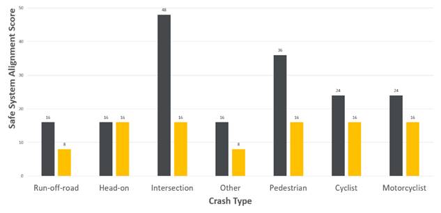
Chart 1: Summary safe system assessment
collision type at Main South, Yaldhurst and Riccarton/Waimairi/Hansons (black
is existing and orange is proposed)
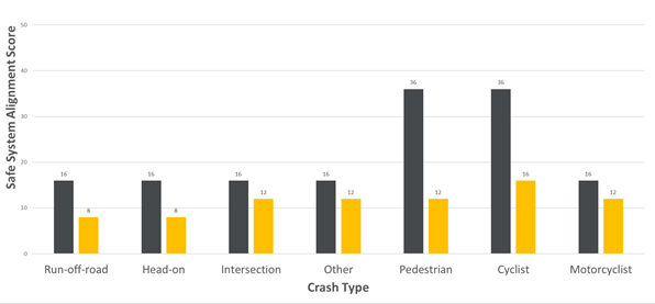
Chart 2: Summary safe system assessment
collision type at Waimairi Road (black is existing and orange is proposed)
4.7 Chart
1 summarises the assessment of the Riccarton Road changes, which demonstrates
that the closure of Main South Road at Yaldhurst and the Safe Speed Platforms
at Riccarton/Hansons/Waimairi reduces the likelihood and severity of crashes
for the intersections making them more safe system aligned. The Standard Safety
Intervention Toolkit assumes a death and serious injury reduction of 40% by
implementing raised safety platforms at existing signalised intersection.
4.8 The
signalised crossing on a raised platform on Waimairi Road has benefits for all
road users as shown in Chart 2.
5. Detail Te Whakamahuki
5.1 Improving safety on local roads in Christchurch is a
priority for the Christchurch City Council. Providing safe infrastructure
is key to ensure people get to where they are going safely irrespective of
their mode of travel. Council has a Level of Service to reduce the
number of deaths or serious injuries from all crashes by 40% in 2030. That is a
reduction of five or more per year, and for this to be under 71 crashes per
year within the 10-year period. This is also a goal in the Road Safety Action
Plan, which is a collaborative plan between Christchurch City Council, NZTA
Waka Kotahi, ACC, FENZ and New Zealand Police.
5.2 Information
was extracted from the Life in Christchurch Survey to understand how people,
who selected Bush Inn-Church Corner as their mall of choice, travel to the
centre:
5.2.1 The
majority visit once a week (53.33%), with the next highest frequency being two
to four times a week (26.67%).
5.2.2 Most
travel by car (66.67%), with the next highest mode being walking (16.67%).
5.2.3 Of
those travelling by car, 45% find it very easy, and 35% find it easy.
5.2.4 Of
those walking, 21.43% find it easy, 19.64% find it very easy, and 17.86% find
it very difficult. There is a fairly even spread of difficulty for walkers.
5.3 The Church Corner area includes the Bush Inn Centre, Church
Corner Mall, St Peters Anglican Church, a medical centre, supermarkets, other
local shops and businesses. The University of Canterbury and student
accommodation is located to the north of Riccarton Road, and there are two
large schools close by including Villa Maria and Kirkwood Intermediate. These
all generate foot traffic, so it needs to be safer for people wanting to cross
the road. Further information on pedestrian counts and ward data is provided in
Attachment C.
5.4 There are signalised crossing facilities at the Riccarton/Hansons/Waimairi
intersection and designated crossing points in the median island close to the
Main South Road/Yaldhurst Road intersection for people to cross.
5.5 It
is proposed to provide improvements for people walking by providing additional
crossing points and removing the slip lane from Riccarton Road into Waimairi
Road. The primary reason for the removal of the slip lane is that it can make
crossing a road feel unsafe for people walking, particularly children or
vulnerable pedestrians. Drivers are focussing on what traffic may be coming
from the right to see if they can pass through without stopping, which can
sometimes lead to people speeding up to take the gap.
5.6 Many
pedestrians have been observed crossing Riccarton Road using the median islands
between the Hansons Lane intersection and the Main South Road intersection, but
not at the designated crossing. This is an attractive place to cross given the
location of bus stops, however pedestrians are required to cross two lanes of
traffic in each direction in faster traffic.
5.7 There
are no facilities for people riding bicycles through the
Riccarton/Hansons/Waimairi intersection on Main South/Yaldhurst intersection.
The South Express Cycleway provides a short local connection to Countdown
entrance on the south side of Riccarton Road. The 2023 counts identified that
there were 43 people riding bicycles through the intersection of
Riccarton/Hansons in the morning peak hour, 72 in the afternoon peak hour and
17 during the off-peak lunchtime period. Some people were observed riding on
the footpaths.
5.8 There
are five bus routes that use the stops on Riccarton Road to the west of Hansons
Lane including the numbers 5, 86, 100, 130 and 140. The Orbiter bus route turns
right into Waimairi Road from Riccarton Road (and left out for return journey).
The 5, 100 and 130 bus routes turn left into Main South Road for the outbound
journey and use Curletts Road and the Peer/Yaldhurst intersection to travel
east through Church Corner. There are bus stops located through the project
area. There are no changes to bus routes, however there is a change to the stop
outside Bush Inn on Waimairi Road to accommodate the signalised crossing.
5.9 There
are approximately 2100 vehicles passing through the Riccarton/Hansons
intersection in the morning peak and 2400 in the evening peak. There are
approximately 1900 vehicles passing through at lunchtime.
5.10 There
is little guidance given to drivers on the westbound approach to the Riccarton
Road/Yaldhurst Road/Main South Road intersection, which can lead to late lane
change decisions. There is nothing to prevent late lane changing, and this
increases potential for vehicles giving way on Main South Road to be confused
as to whether they need to give way to westbound traffic. Although the
visibility of oncoming traffic on Main South Road is clear, it is possible that
the combination of the curve of Riccarton Road and the two westbound lanes
attributes to poor perception of vehicle speed and gap selection by traffic
waiting to exit Main South Road.
Crash information for Main
South/Yaldhurst/Riccarton
5.11 In
the full ten-year period between 2013 and 2022, and the partial year of 2023
(not all crashes are recorded straight away), there were 83 reported crashes at
or within 50 metres of this intersection. Of the 83 crashes:
· 76 were a result of
crossing/turning movements
· Four were a result of loss
of control/head on
· Two crashes were a result
of rear-end/obstruction
· One crash involved a
person walking.
5.12 Of
the 76 crossing/turning crashes, two resulted in a serious injury, and six
resulted in a minor injury. There was no pattern in the two serious injury
crashes:
5.12.1 One driver
failed to stop at the give-way when turning right from Main South Road onto
Riccarton Road and has driven into the corner of a bus that was about to turn
into Yaldhurst Road from Riccarton Road.
5.12.2 One driver
failed to stop at the give-way when turning right from Main South Road onto
Riccarton Road and has driven into a cyclist travelling west on Yaldhurst Road
from Riccarton Road.
5.12.3 The six minor
crashes were also similar to the serious crashes in that all drivers exiting
Main South Road have hit a vehicle travelling westbound on Riccarton Road to
Yaldhurst Road. In four crashes, the driver on Main South Road had failed to
give-way, and in two instances the driver on Main South Road failed to see the
vehicles approaching and have exited into the path of the oncoming traffic.
5.12.4 The remaining
68 crashes were non-injury crashes, however on several occasions FENZ have
attended due to the significant damage to vehicles. Ambulances have also been
dispatched to many of the crashes alongside Police. This crash type varies from
two to 12 per year. Drivers exiting Main South Road have stated that they have
failed to see a vehicle, failed to give-way and have mis-judged the speed of
the vehicle approaching from the east. In several crashes, the driver
travelling westbound has been unable to stop in time when seeing a driver
exiting from Main South Road. Two crashes involved buses travelling along
Riccarton Road to Yaldhurst Road.
5.13 Two
of the four loss of control/head on crashes occurred in 2021, the remaining two
occurred in previous years. There are no trends in the data, with the following
crashes occurring:
· Vehicle travelling
westbound, has swerved hit the central island and then the driver has
overcorrected ending up half on the footpath outside the church.
· Vehicle approached
intersection on giveway sign failed to see motorcycle and failed to give way,
motorcycle swerved to avoid head on collision crossed centreline and was hit by
a car driving the other way.
· A driver turning right
from Main South Road has entered the intersection, has panicked on seeing an
eastbound driver approaching from Yaldhurst Road, and hit the accelerator
ending in the front of a building.
· A driver turning right
from Main South Road has lost control turning right. Was travelling over the
temporary 30km/h limit used for the roadworks.
5.14 The
two rear end crashes happened in two different years, one has involved a
vehicle turning right into a side road away from the intersection and has hit a
vehicle where the driver has made a last minute change to turn into the same
entrance, the second crash involved a vehicle giving way to a rubbish truck
collecting rubbish travelling eastbound on Riccarton Road and has been hit at
the rear.
5.15 The
crash involving the pedestrian resulted in minor injury only. The pedestrian
had walked out into the road when walking with friends.
Crash information for
Riccarton/Waimari/Hansons
5.16 In
the full ten-year period between 2013 and 2022, and the partial year of 2023
(not all crashes are recorded straight away), there were 41 reported number of
crashes at and within 50 metres of this intersection. During this time, there
was one fatal crash, two crashes that resulted in serious injury, 11 crashes
resulting in minor injury, and 27 that resulted in non-injury but mainly
vehicle damage.
5.17 One
crash resulted in a person losing a life. The crash involved a vehicle
performing a filtered right turn onto Hansons Lane, who hit a westbound
motorcyclist on Riccarton Road during early morning hours in 2021.
5.18 Two
crashes resulted in serious injury to people travelling outside a
vehicle:
5.18.1 One crash
involved a vehicle performing a filtered right turn onto Hansons Lane, who hit
a westbound motorcyclist on Riccarton Road during the evening hours in 2022.
5.18.2 One involved a
person riding a bicycle south on Waimairi Road towards Riccarton Road and has
collided with the rear of a vehicle. This crash occurred in 2021.
5.19 Of
the remaining 38 crashes, 11 resulted in minor injury, this included three
pedestrians being hit when crossing the road. These crashes occurred in two
different locations:
· Waimairi Road, north of
the entrance to Bush Inn.
· Riccarton Road to the west
of Hansons Lane (two crashes).
5.20 A
further collision occurred involving a pedestrian being hit when crossing the
slip lane on Waimairi Road at the intersection with Riccarton Road.
5.21 19
of the 38 crashes involved drivers turning at the intersection and being hit,
six of which have resulted in a minor injury.
5.21.1 Seven of the
crashes occurred at the Hansons/Riccarton intersection. Five vehicles turning
right from Hansons Lane were hit by vehicles travelling westbound on Riccarton
Road that had failed to stop at a red. A vehicle turning left from Hansons Lane
was also hit by a westbound vehicle that had failed to stop at a red. Two
crashes involved a vehicle turning right from Riccarton Road into Hansons Lane,
which had failed to give way to a westbound vehicle.
5.21.2 Ten of the
crashes occurred at the Riccarton/Waimairi Road intersection:
· Four crashes involved
people turning right from Riccarton Road and crashing with vehicles travelling
eastbound that had proceeded through a very late orange/start of red.
· Two crashes involved a
vehicle turning right into Waimairi Road that had failed to give-way, on one
occasion this was failing to see the motorcycle travelling east.
· One crash involved a
vehicle waiting in the intersection to turn right and was hit by an oncoming
vehicle travelling east on Riccarton Road. One crash involved a vehicle waiting
to turn right into Waimairi Road when the signals were not operating, and one
vehicle has indicated to the driver to turn but the driver has failed to see
the car approaching in the other lane.
· Two vehicles exiting
Waimairi Road were hit by people travelling on Riccarton Road (one in each
direction) that had passed through a red signal. One vehicle that was hit was a
bus.
5.21.3 Two of the
crashes occurred on Waimairi Road at the Bush Inn entrance. One involved a
vehicle turning in to the Bush Inn Centre and failing to see a vehicle
travelling in the left turn lane accessing the centre, and the other involved a
vehicle exiting that had failed to see a vehicle had exited Leslie Street.
5.22 Eight
of the 38 crashes resulted in the rear end of a vehicle being hit (one was a
cycle travelling on the footpath). These were all non-injury crashes, with
vehicle only damage being reported. Four occurred on the approach to signals,
two of which occurred on the Waimairi Road approach. In each instance a vehicle
was following too closely with little time to react.
5.23 Five
of the 38 crashes involved loss of control by the driver. Three drivers were
attempting to turn right into Waimairi Road from Riccarton Road, one turning
left from Riccaton Road into Waimairi Road, and one turning right from
Riccarton Road to Hansons Lane. On each occasion, the vehicle hit the traffic
signals. Four of the five crashes occurred at night after 10pm.
5.24 Two
of the 38 crashes involved vehicles overtaking and hitting other vehicles. One
was a result of a late lane change to exit onto Main South Road, one was an
inexperienced and impatient driver.
Crash information for Waimairi Road
crossing
5.25 In
the full ten-year period between 2013 and 2022, and the partial year of 2023
(not all crashes are recorded straight away), there have been no reported
crashes at the location of the existing island.
Changes following engagement
5.26 Following
consultation, changes been made to the proposal, which include:
5.26.1 Adding a speed hump on Bowen
Street at the intersection with Peer Street to slow vehicle traffic entering
this local street.
5.26.2 Add sharrow markings in the
shared through/left lanes between Hansons Lane and Waimairi Road to remind
drivers that people riding bicycles are present.
5.26.3 Add additional coloured
surfacing road marking alongside the bus stop on Riccarton Road.
5.26.4 Futureproof the zebra crossing
on Riccarton Road/Yaldhurst Road to change to a dual crossing in future if
people on bicycles are observed crossing at this location.
5.27 The
decision affects the following wards/Community Board areas:
5.27.1 Riccarton Ward.
5.27.2 Waipuna
Halswell-Hornby-Riccarton
6. Community Views and Preferences Ngā mariu
ā-Hāpori
Public Consultation Te Tukanga Kōrerorero
6.1 Early
engagement with key stakeholders started in late October 2023. An email was
sent to key transport stakeholders, local organisations and schools to advise
them of the proposed changes and offer to meet with staff.
6.2 Staff
met with Bush Inn Centre on 2 November and St Peter’s Anglican Church, St
Peter’s Anglican Pre-School, and Petersgate Trust on 10 November 2023 to
discuss the proposed changes.
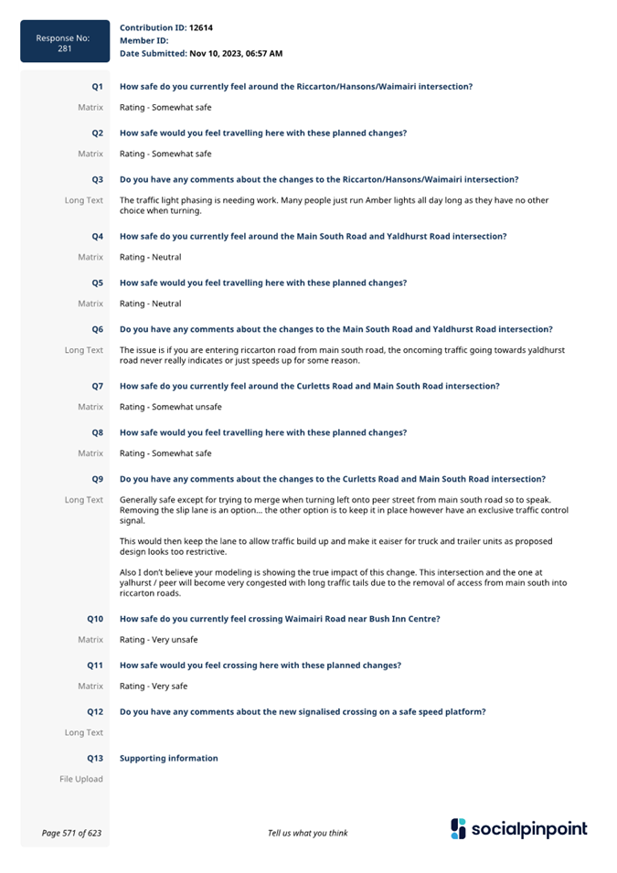
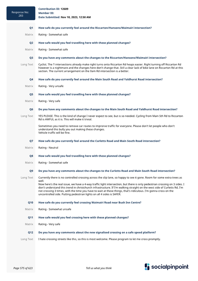
6.3 Staff
visited 66 local businesses around Church Corner on 6 and 8 November 2023.
Staff also door knocked eight residential properties around the proposed
Waimairi Road crossing. Flyers were left for anyone that was unavailable to
speak with staff.
6.4 Consultation
started on 9 November and ran until 7 December 2023. An email was sent to 173
key stakeholders.
6.5 The
consultation was hosted on Kōrero
mai | Let’s Talk which had over 8,500 views throughout the
consultation period. A flythrough video of the proposed changes was created and
posted on the Council’s
YouTube Channel which had over 5,000 views. A Chinese voiceover version of
the flythrough video was sent directly to Chinese groups in Christchurch which
had over 100 views.
6.6 The
consultation was posted on the council Facebook page and was shared to eight
local community group pages which reached over 8,800 people.
6.7 A
flyer was distributed, and a letter was sent to absentee owners of 300
residential properties around Church Corner on 13 November 2023. 100 copies of
the flyer were also dropped to St Peter’s Anglican Church and St
Peter’s Anglican Pre-School.
6.8 Paid
advertising promoted the consultation to the community, including digital and
newspaper ads, bus shelter and washroom posters, digital screens utilised in
Upper Riccarton Library, Riccarton Library and Jellie Park and signs put up
near pedestrian crossing points around Church Corner and Waimairi Road.
Summary of Submissions Ngā Tāpaetanga
6.9 Submissions
were made by 12 recognised organisations and 292 individuals.
6.10 A
full table of submission feedback is available online or in Attachment D.
6.11 Submitters
were asked questions about the following sections of the proposal:
· The Riccarton Road,
Hansons Road and Waimairi Road intersection.
· The Main South Road
and Yaldhurst Road intersection.
· The Curletts Road
and Main South Road intersection.
· The raised
signalised pedestrian crossing on Waimairi Road.
6.12 For
each section of the proposal, submitters were asked how safe they feel using
these intersections and crossing points now, compared to how safe they think
they would feel if the proposed changes were made.
6.13 The
existing Riccarton Road, Hansons Lane and Waimairi Road intersection is
perceived as somewhat or very safe by 93 submitters. If the proposed changes
were implemented, 171 submitters said they would feel somewhat or very safe.
6.14 The
existing Main South Road and Yaldhurst Road intersection is perceived as
somewhat or very safe by 71 submitters. If the proposed changes were
implemented, 173 submitters said they would feel somewhat or very safe.
6.15 The
existing Curletts Road and Main South Road intersection is perceived as
somewhat or very safe by 98 submitters. If the proposed changes were
implemented, 151 submitters said they would feel somewhat or very safe.
6.16 Crossing
Waimairi Road near Bush Inn Centre currently is perceived as somewhat or very
safe by 66 submitters. If the proposed changes were implemented, 179 submitters
said they would feel somewhat or very safe.
6.17 The
overall shift in safety perception across all the proposed changes is shown
below in Table 1. A full breakdown analysis, key themes from submitters and a
‘how to’ on reading these tables is available in Attachment E.
This also includes detailed feedback from key stakeholders including
Environment Canterbury and staff response.
6.18 Overall,
submitters indicated that they would feel safer if the proposed changes were
made to each of the intersections or crossing points. There is a general
increase in submitters saying they would feel somewhat safe (at least 11%) or
very safe (at least 5%).
 Table 1 - Overall shift in safety
perceptions across all proposed changes
Table 1 - Overall shift in safety
perceptions across all proposed changes
7. Policy Framework Implications Ngā Hīraunga ā- Kaupapa here
Strategic
AlignmentTe Rautaki
Tīaroaro
7.1 Council’s strategic priorities have
been considered in formulating the recommendations in this report, including,
residents having equitable access to a range of transport options that make it
easy and safe to get around the city, and reduce emissions as a Council and as
a City.
7.2 This report supports the Council's
Long Term Plan (2021 - 2031):
7.3 Transport
7.3.1 Activity: Transport
· Level of Service: 10.0.6.1 Reduce the number of
death and serious injury crashes on the local road network - <=96 crashes
· Level of Service: 10.5.1 Limit deaths and
serious injury crashes per capita for cyclists and pedestrians - <= 12
crashes per 100,000 residents
Policy
Consistency Te Whai
Kaupapa here
7.4 The decision is consistent with
Council’s Plans and Policies.
Impact
on Mana Whenua Ngā
Whai Take Mana Whenua
7.5 The
decision does not involve a significant decision in relation to ancestral land
or a body of water or other elements of intrinsic value, therefore this
decision does specifically impact Mana Whenua, their culture and traditions.
7.6 The
decision does not involve a matter of interest to Mana Whenua and will not
impact on our agreed partnership priorities with Ngā Papatipu
Rūnanga.
7.7 The
effects of this proposal upon Mana Whenua are expected to be insignificant as
the proposal involves minor work within the existing carriageway.
Climate
Change Impact Considerations Ngā Whai Whakaaro mā te Āhuarangi
7.8 The
decisions in this report are likely to:
7.8.1 Contribute neutrally
to adaptation to the impacts of climate change.
7.8.2 Contribute positively
to emissions reductions.
7.9 The
emission reductions associated with this project have not been estimated.
7.10 Improving the ability for people to walk and cycle are a
key part of council’s emissions reduction efforts by providing a safe,
low emission way for residents to move around the city.
7.11 From the 2022
Life in Christchurch Transport Survey, 96 percent of respondents travel by
car. Inconsiderate and dangerous behaviour from other road users and
sharing the road with cars were the main reasons respondents found it difficult
to bike.
7.12 Improving safety
and making the intersection feel safer would address some of the barriers to
people making sustainable travel choices. Removing these barriers will lead to
reductions in vehicle kilometres travelled and consequently emissions from
transport.
7.13 The National Emissions Reduction Plan (ERP) states we will
have to ‘substantially improve infrastructure for walking and
cycling’ to meet our emissions targets (including a 20% reduction in
light Vehicle Kilometres Travelled by 2035 - required under the ERP). Improving
the quality of walking and cycling infrastructure is also a key part of the
Ministry of Transport and Waka Kotahi’s efforts to decarbonise the
transport system, so improving safety for these users would be consistent with
national direction.
Accessibility
Considerations Ngā
Whai Whakaaro mā te Hunga Hauā
7.14 This proposal improves accessibility for
pedestrians/cyclists, by providing a safer means of crossing at the
intersection and on Waimairi Road.
8. Resource Implications Ngā Hīraunga Rauemi
Capex/Opex Ngā Utu Whakahaere
8.1 Cost
to Implement - $810k for the works on Riccarton Road and on Waimairi Road to
Leslie Street. The Waimairi Road signalised crossing is estimated to cost
$500k. These are estimates and not tendered prices.
8.2 Maintenance/Ongoing
costs - To be covered under the area maintenance
contract, the effects will be minimal to the overall asset.
8.3 Funding
Source –
8.3.1 Traffic
Operations Minor Road Safety Budget for Riccarton Road and Main South Road
projects.
8.3.2 Waimairi
Road signalised pedestrian crossing (CPMS 73676) is funded through the
Christchurch Regeneration Acceleration Facility (CRAF) in the Long-Term Plan.
8.4 Funding support - Waka
Kotahi have confirmed that funding support at 51% is approved for the
intersection works on Riccarton Road and Main South Road through the low-cost
low-risk programme. Activities funded through the Low-Cost Low-Risk investment
pathway do not need to calculate a benefit-cost ratio. Funding support is only
guaranteed for this financial year.
Other He mea anō
8.5 None
identified.
9. Legal Implications Ngā Hīraunga ā-Ture
Statutory power to undertake proposals in the report
Te Manatū Whakahaere Kaupapa
9.1 Part
1, Clauses 7 and 8 of the Christchurch City Council Traffic and Parking Bylaw
2017 provides Council with the authority to install parking restrictions by
resolution.
9.2 The
Community Boards have delegated authority from the Council to exercise the
delegations as set out in the Register of Delegations. The list of
delegations for the Community Boards includes the resolution of stopping
restrictions and traffic control devices.
9.3 The
installation of any signs and/or markings associated with traffic control
devices must comply with the Land Transport Rule: Traffic Control Devices 2004.
Other Legal Implications Ētahi atu
Hīraunga-ā-Ture
9.4 There
is no other legal context, issue or implication relevant to this decision.
9.5 This
specific report has not been reviewed and approved by the Legal Services Unit
however the report has been written using a general approach previously
approved of by the Legal Services Unit, and the recommendations are consistent
with the policy and legislative framework outlined in sections 9.1 - 9.3.
10. Risk Management Implications Ngā Hīraunga Tūraru
10.1 None
identified.
11. Next Steps Ngā Mahinga ā-muri
11.1 Should
the intersection and pedestrian safety improvements be approved, construction
will follow this financial year.
Attachments Ngā Tāpirihanga
|
No.
|
Title
|
Reference
|
Page
|
|
a ⇩
|
Church Corner
Safety Improvements
|
24/95888
|
40
|
|
b ⇩
|
Waimairi Road
Crossing Background Information
|
24/79397
|
41
|
|
c ⇩
|
Church Corner
Ward and Pedestrian Information
|
24/79383
|
48
|
|
d ⇩
|
Church Corner
safety improvements - all submissions (public)
|
24/94712
|
56
|
|
e ⇩
|
Church Corner
safety improvements - submission analysis
|
24/95777
|
728
|
In addition to the attached documents, the following background
information is available:
|
Document
Name – Location / File Link
|
|
Not
applicable
|
Confirmation of Statutory
Compliance Te Whakatūturutanga ā-Ture
|
Compliance with Statutory Decision-making
Requirements (ss 76 - 81 Local Government Act 2002).
(a) This report contains:
(i) sufficient information about all reasonably practicable
options identified and assessed in terms of their advantages and
disadvantages; and
(ii) adequate consideration of the views and preferences of
affected and interested persons bearing in mind any proposed or previous
community engagement.
(b) The information reflects the level of significance of the
matters covered by the report, as determined in accordance with the Council's
significance and engagement policy.
|
Signatories Ngā Kaiwaitohu
|
Authors
|
Gemma Dioni -
Principal Advisor Transportation - Safety
Ann Tomlinson
- Project Manager
Krystle
Anderson - Engagement Advisor
Georgia Greene
- Traffic Engineer
|
|
Approved By
|
Katie Smith -
Team Leader Traffic Operations
Stephen Wright
- Manager Operations (Transport)
Lynette Ellis
- Head of Transport & Waste Management
|
|
Waipuna Halswell-Hornby-Riccarton
Community Board
15 February 2024
|

|
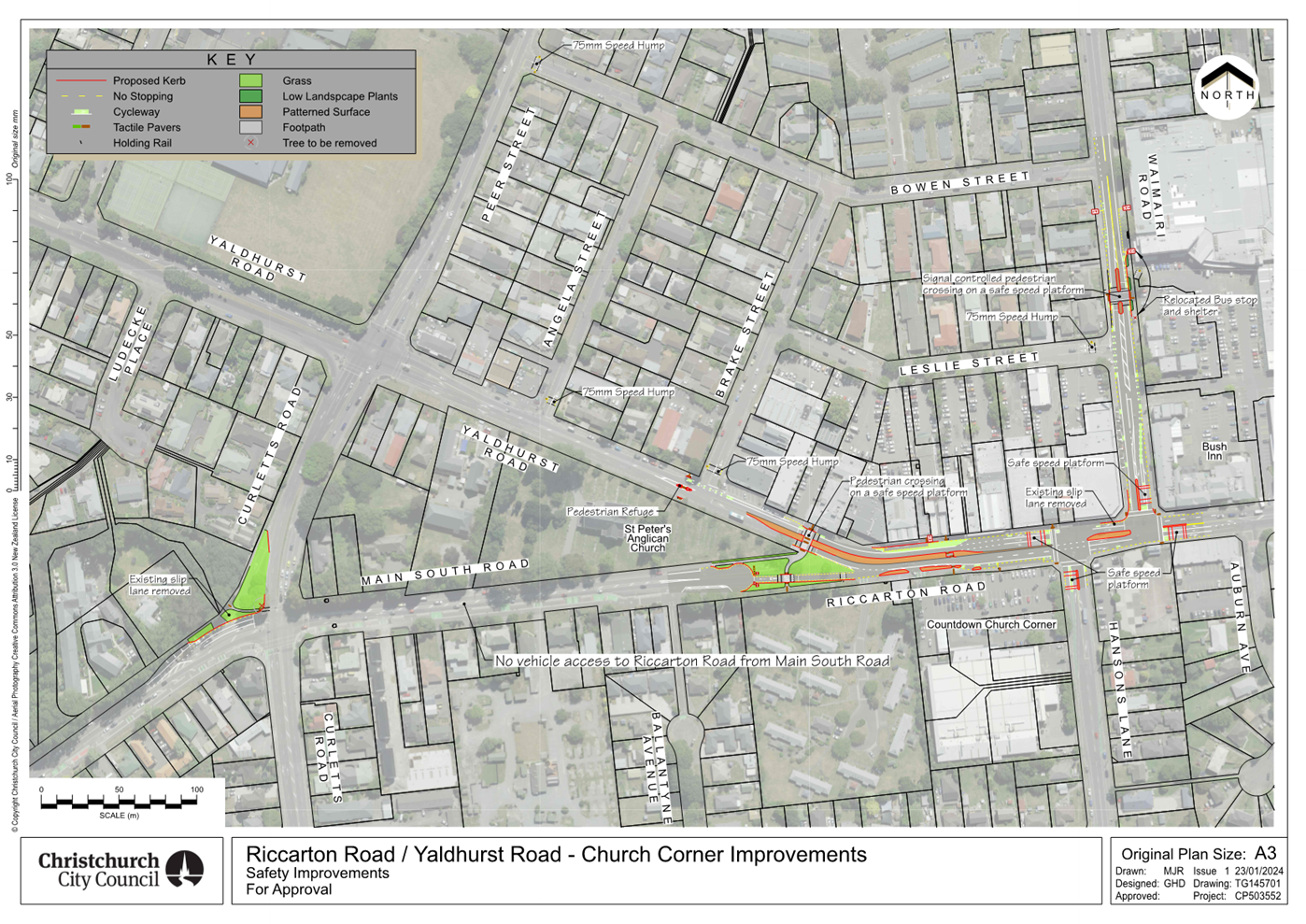
|
Waipuna Halswell-Hornby-Riccarton
Community Board
15 February 2024
|
|
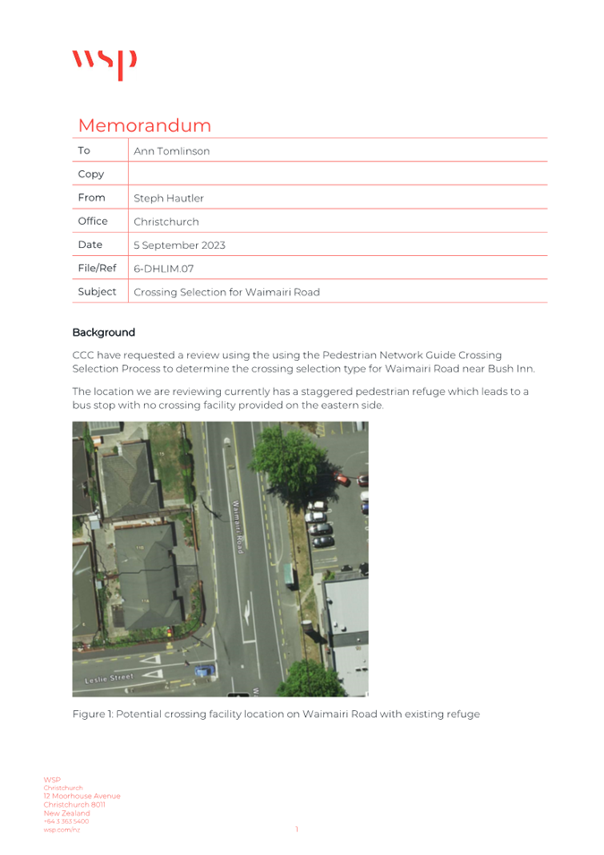
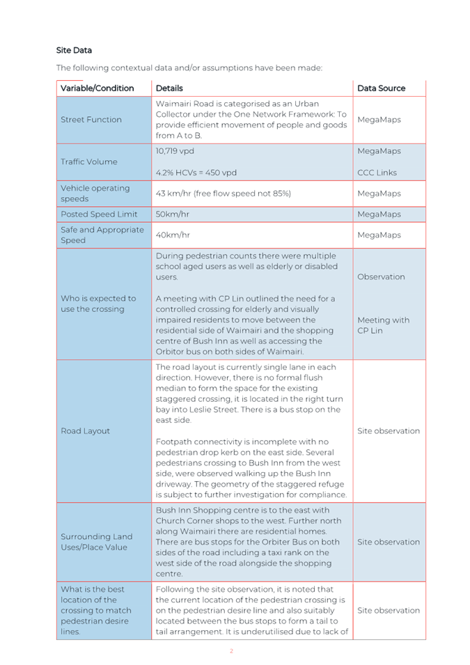
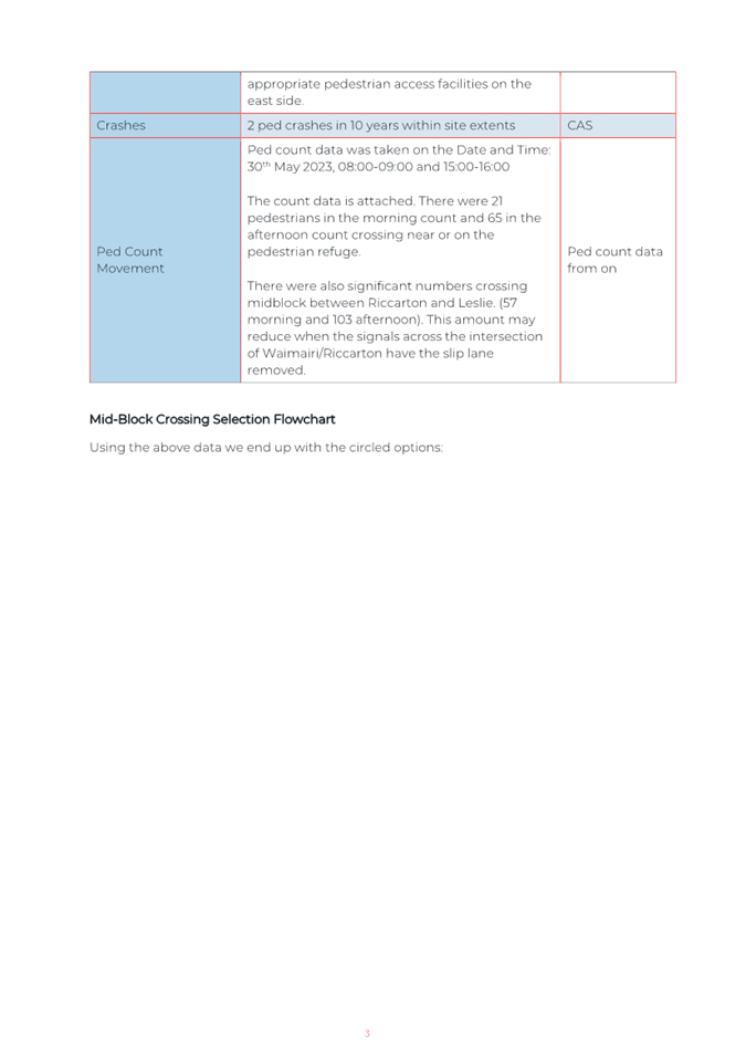
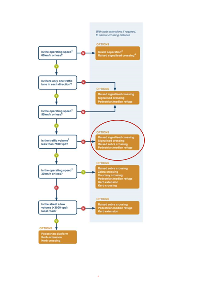
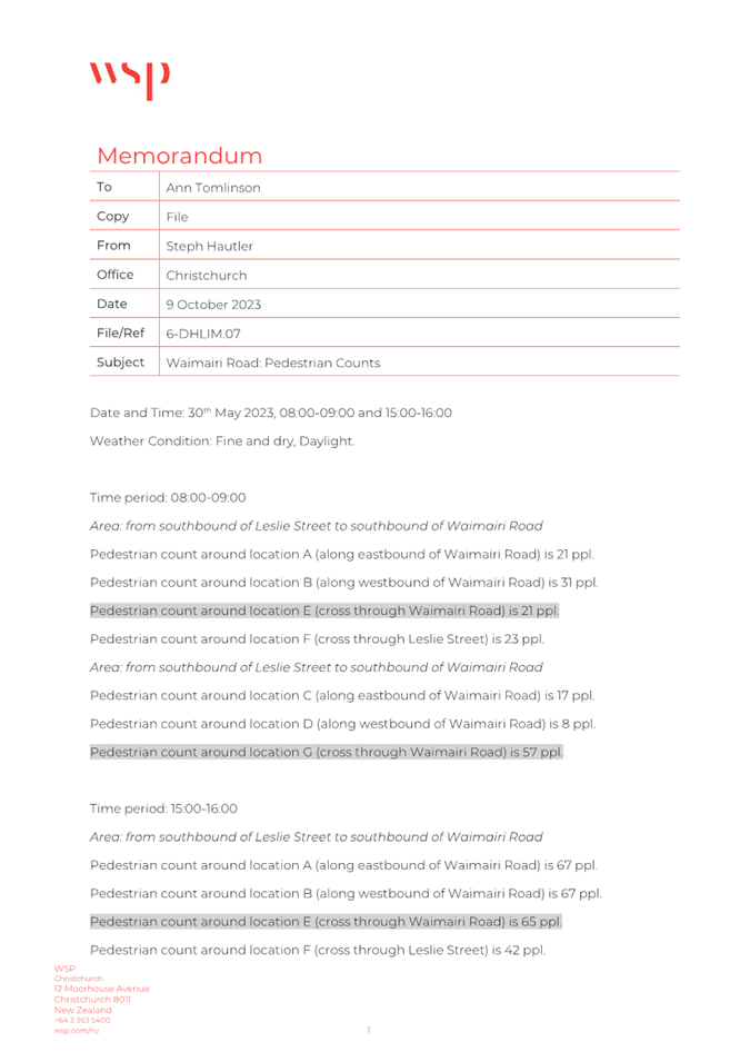
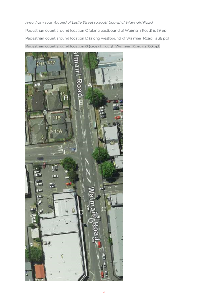
|
Waipuna Halswell-Hornby-Riccarton
Community Board
15 February 2024
|

|
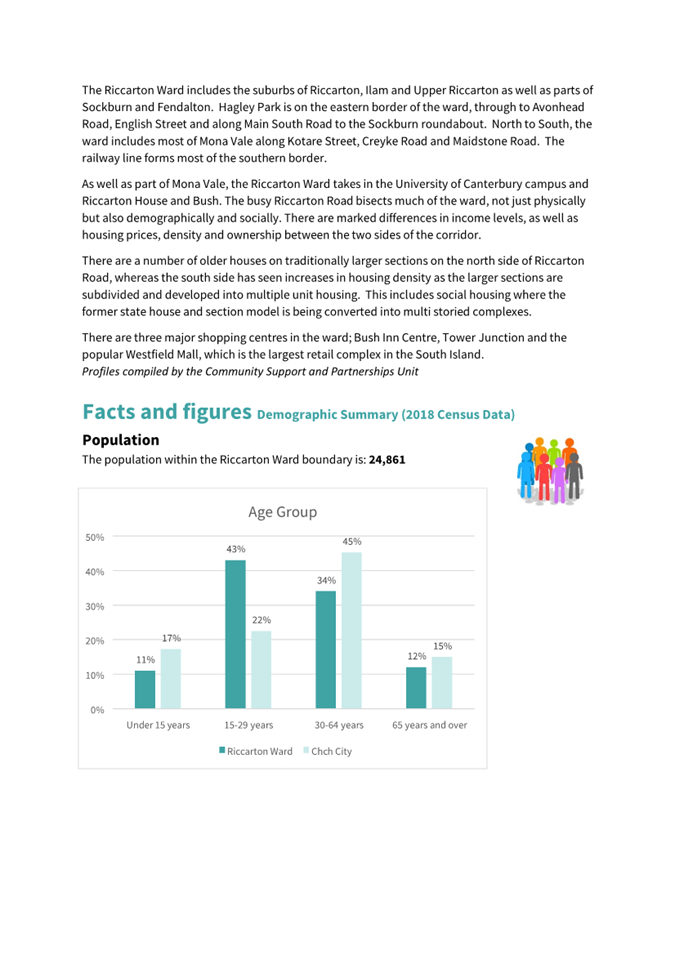
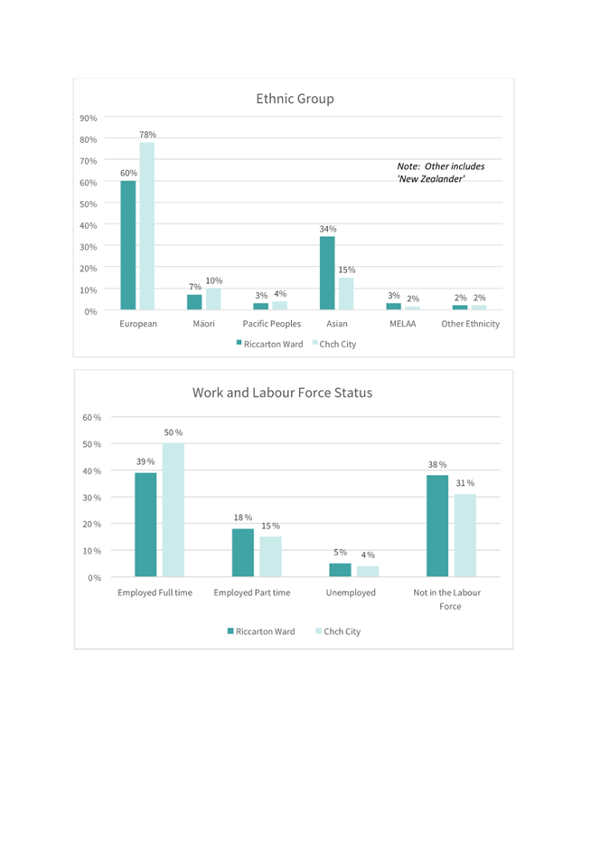
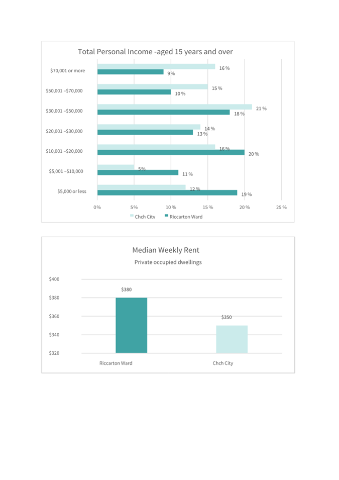
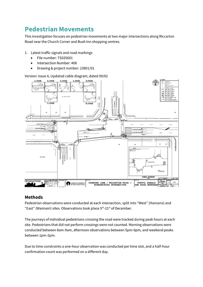
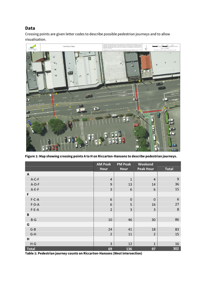
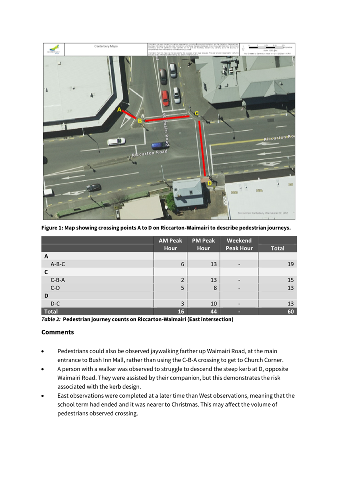
|
Waipuna Halswell-Hornby-Riccarton
Community Board
15 February 2024
|
|

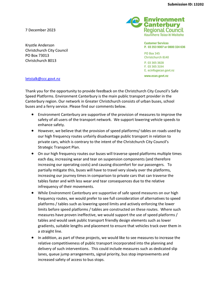
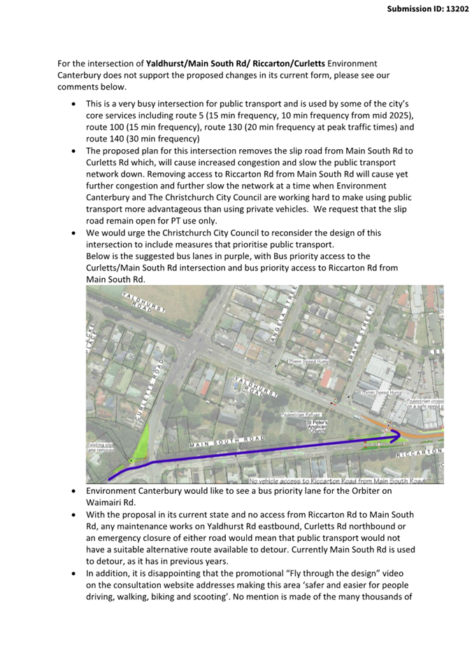
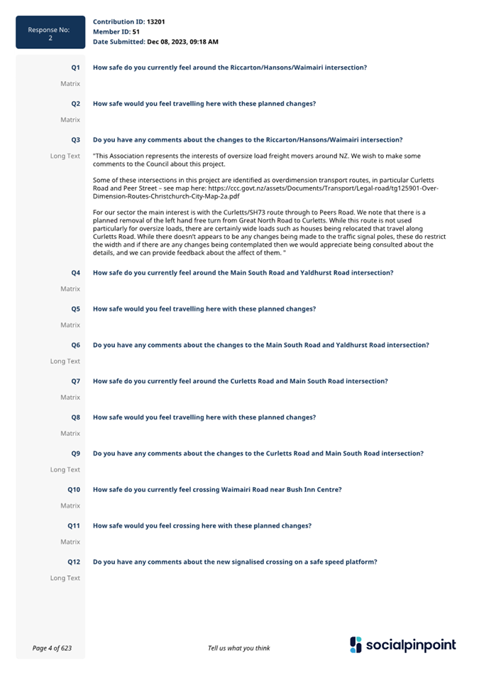

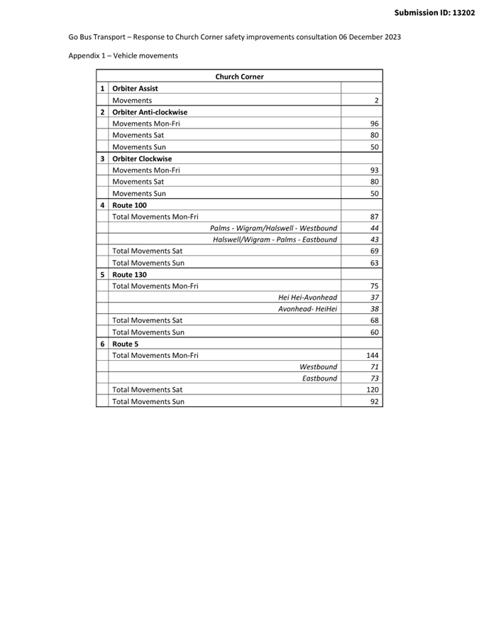
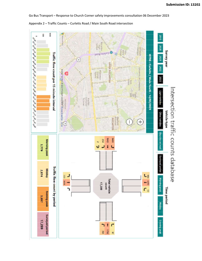


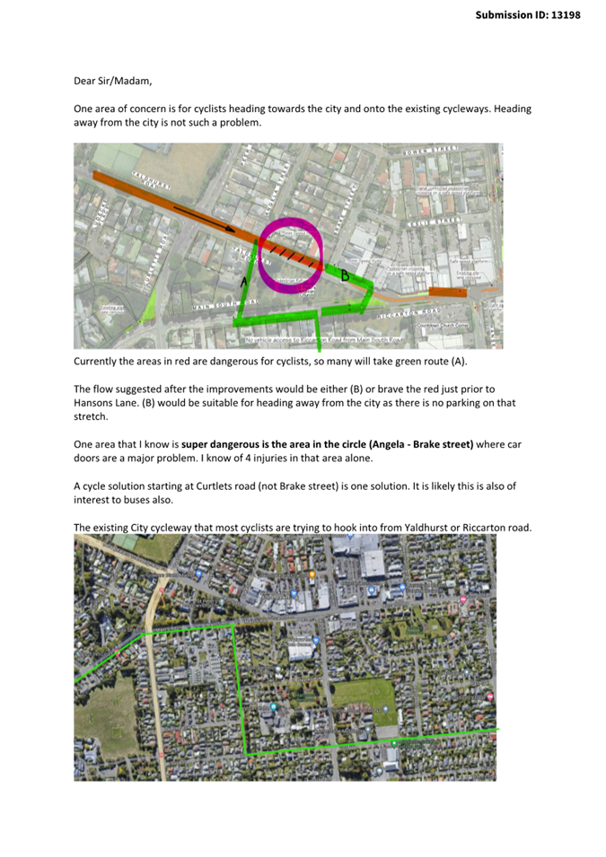


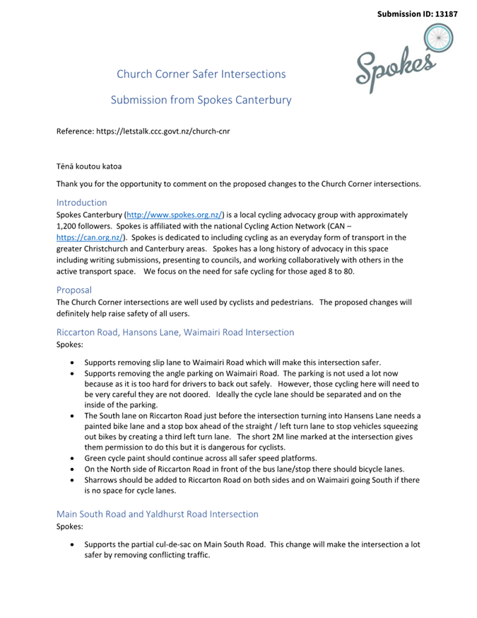
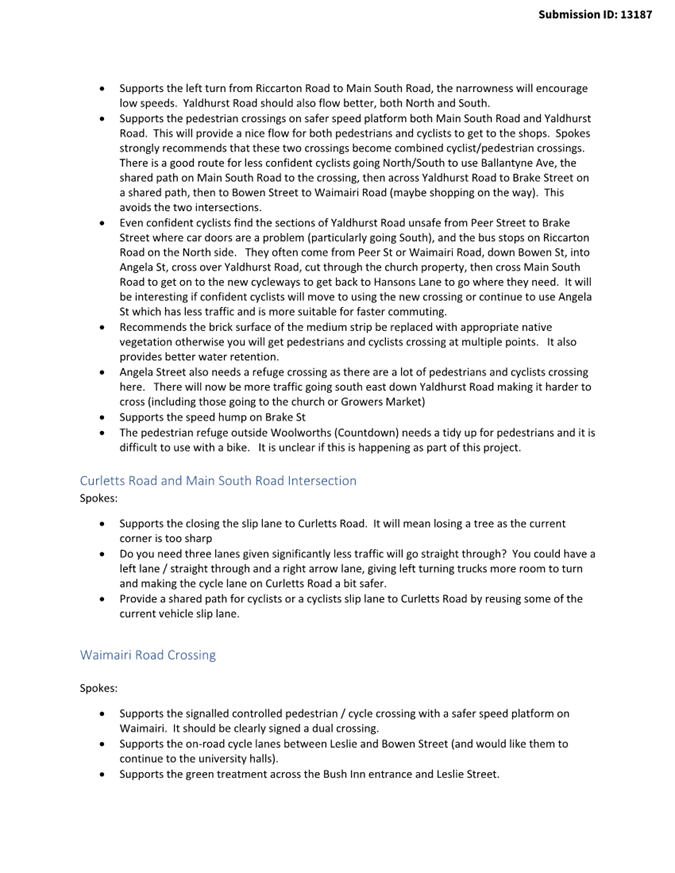


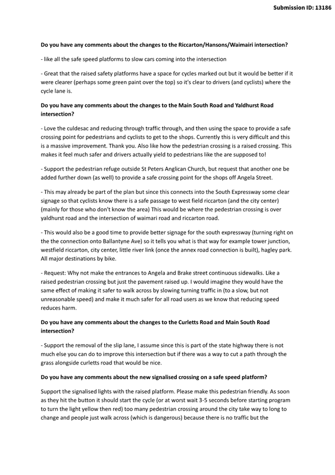


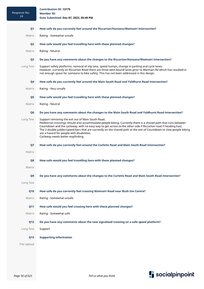

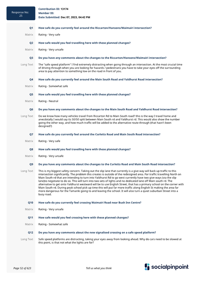


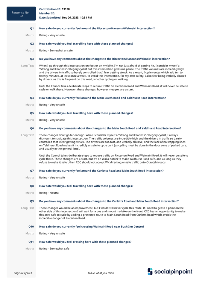
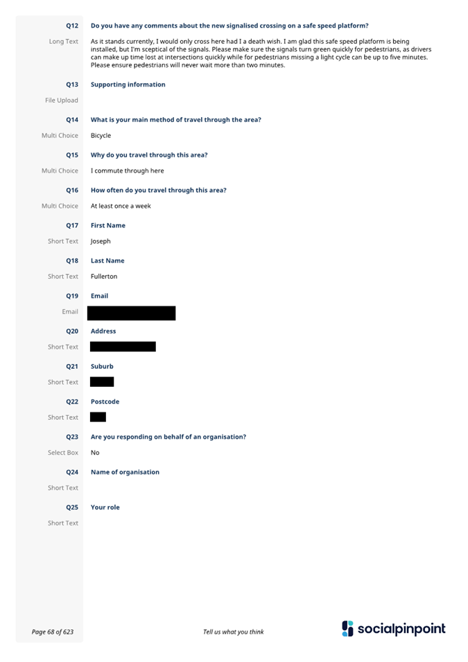
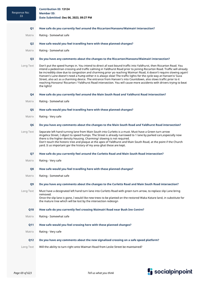
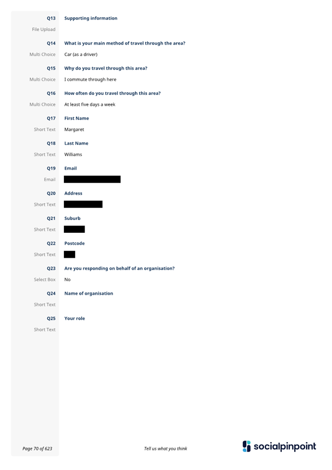
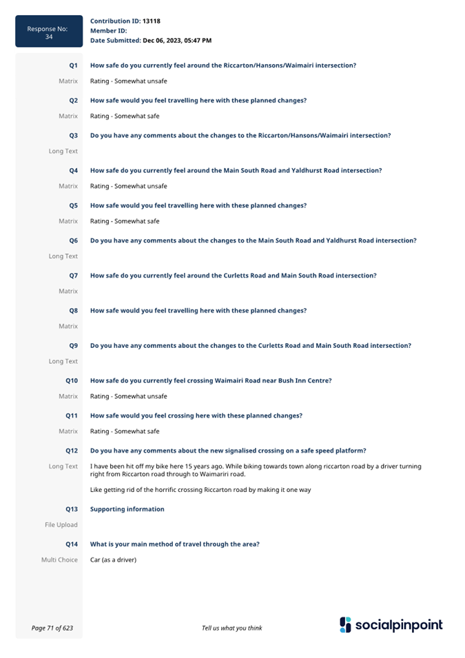

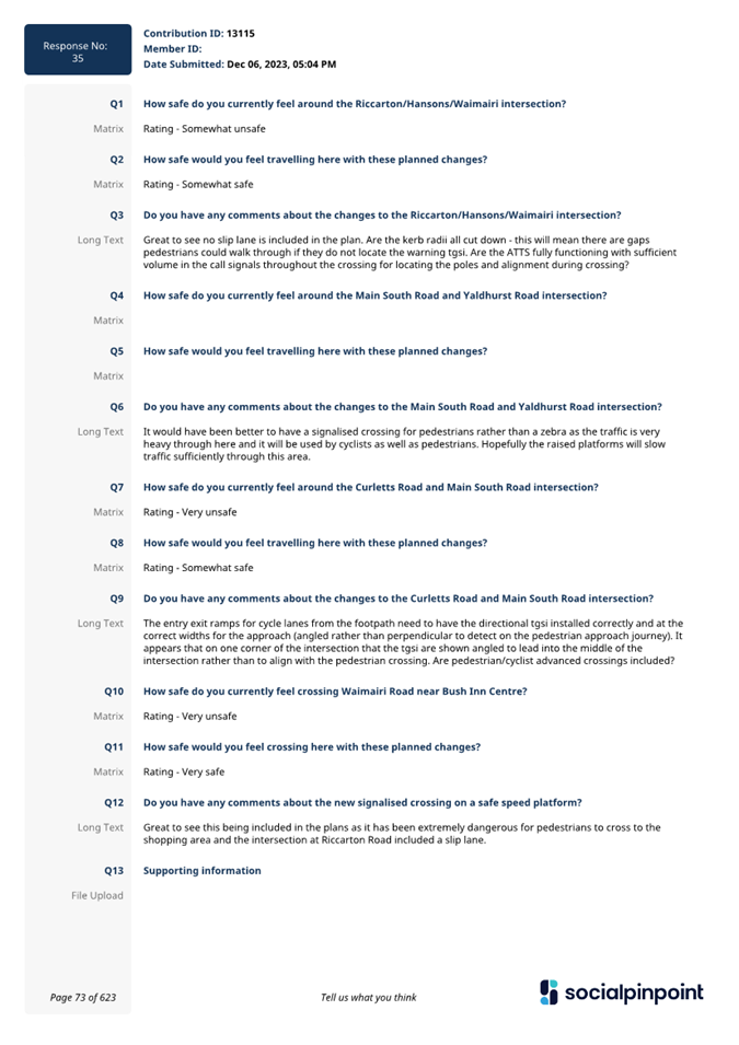


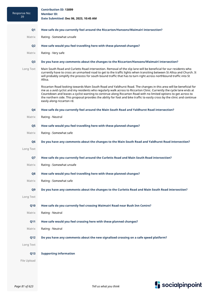
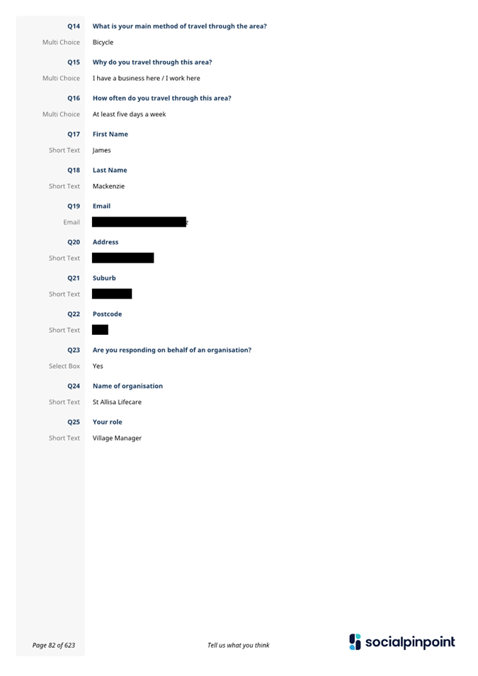
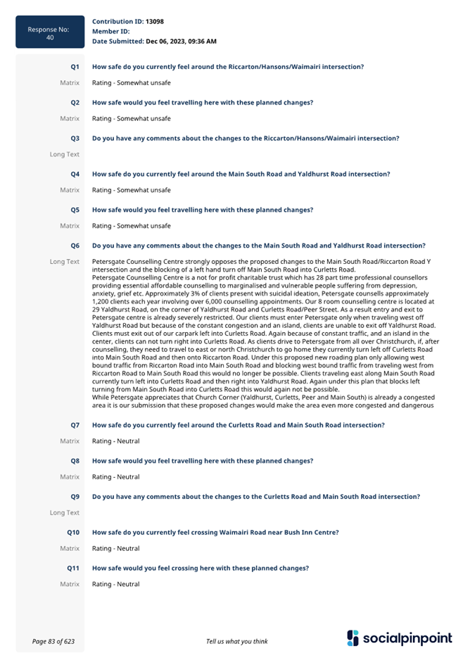
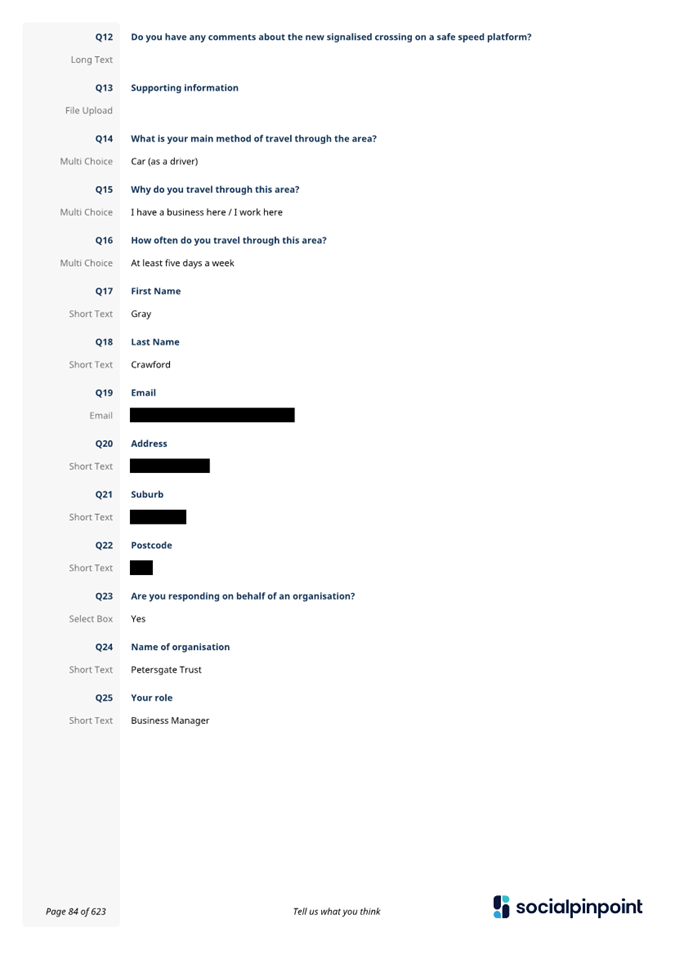


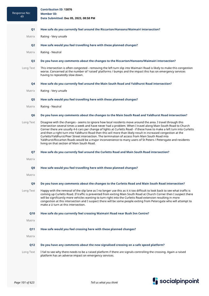

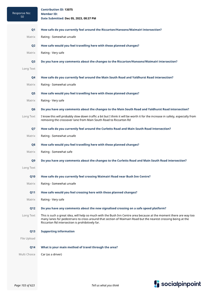


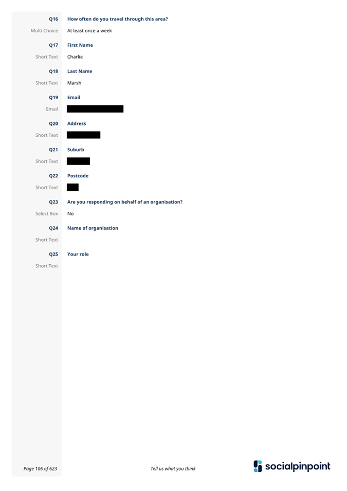


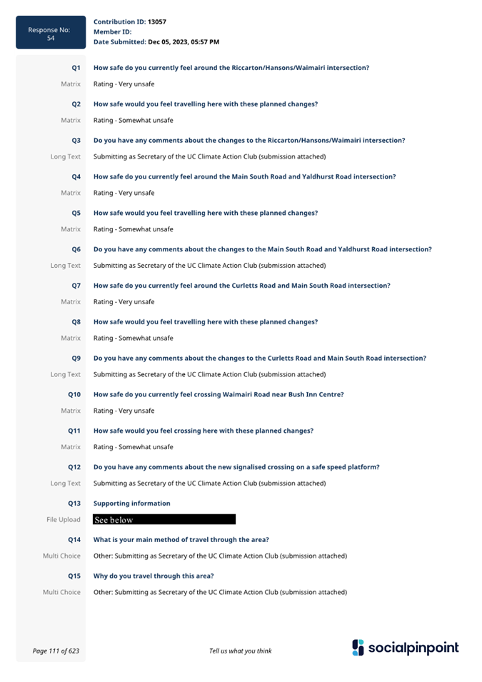
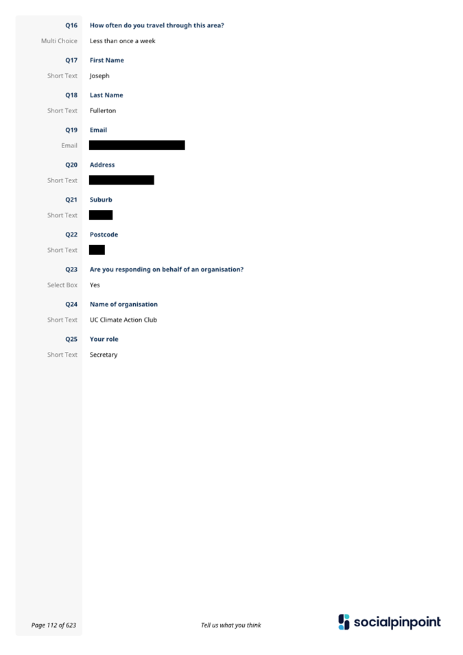
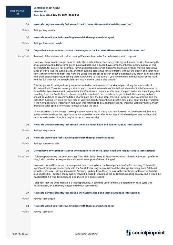
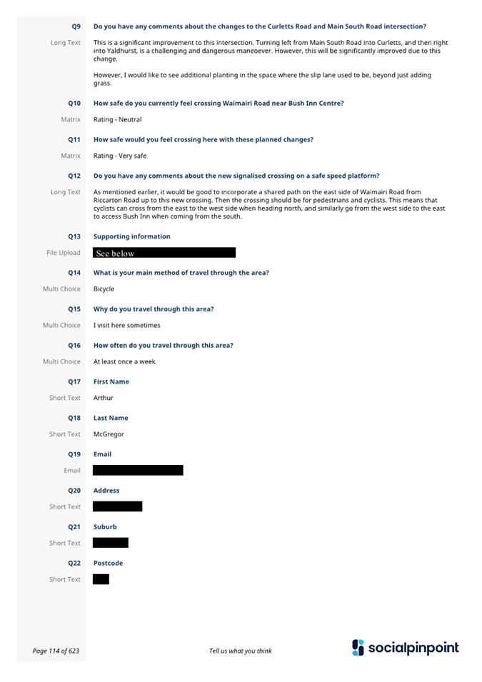
|
Waipuna Halswell-Hornby-Riccarton
Community Board
15 February 2024
|

|
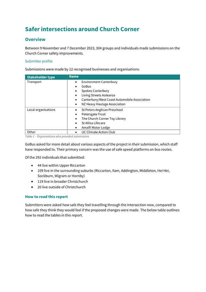
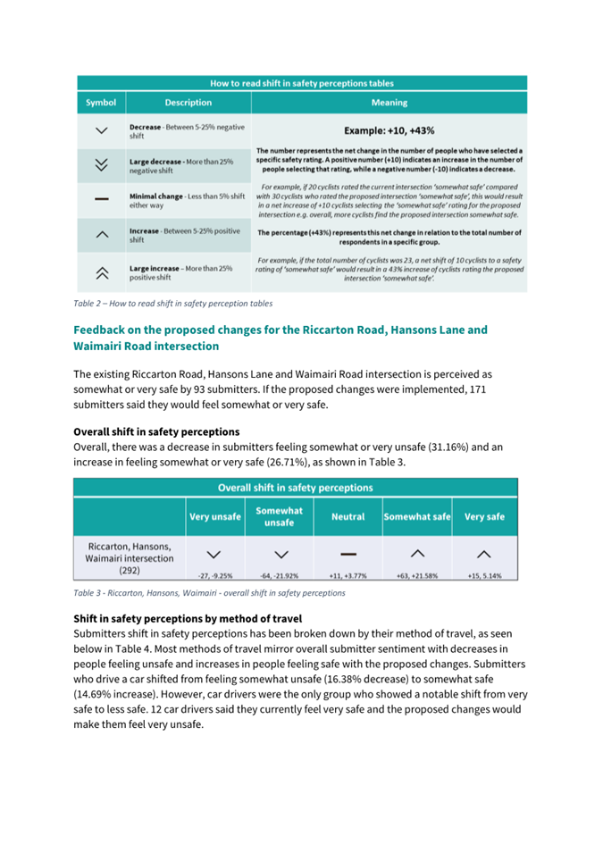
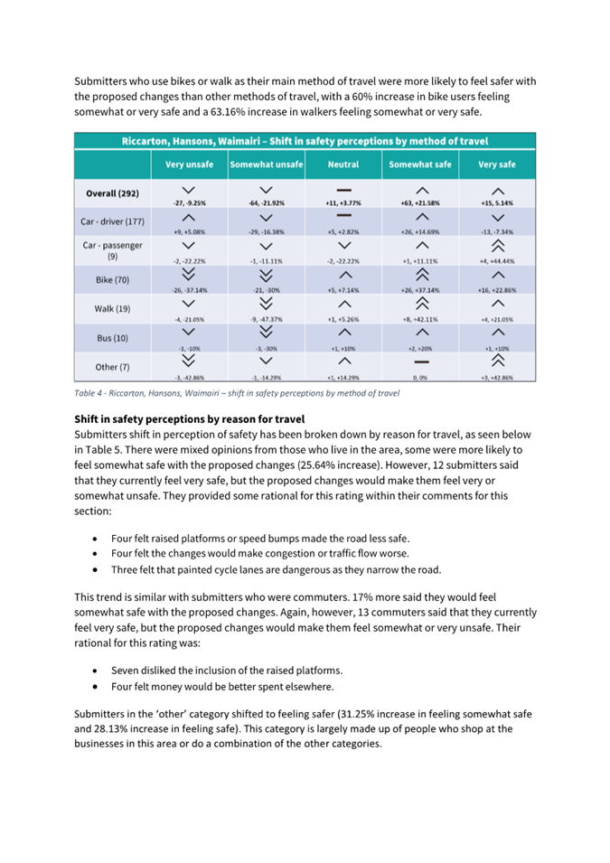
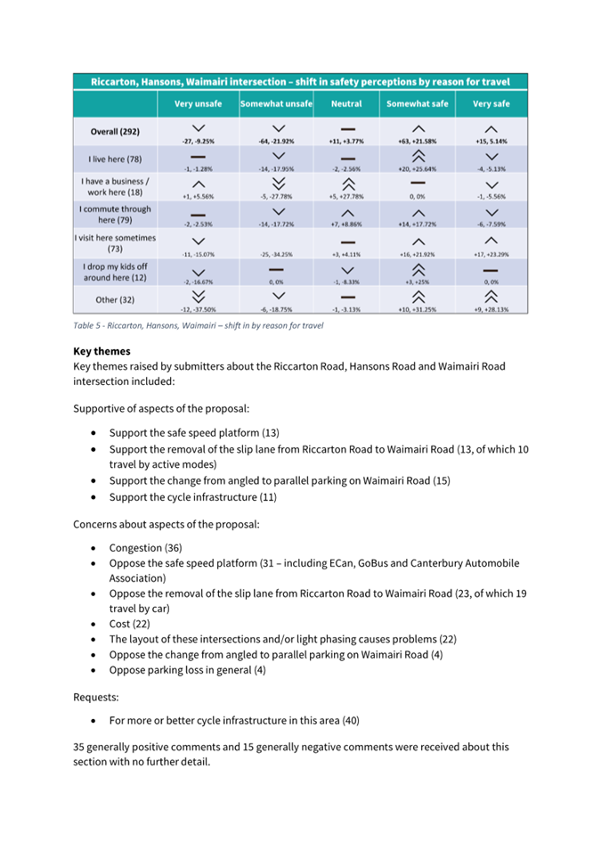
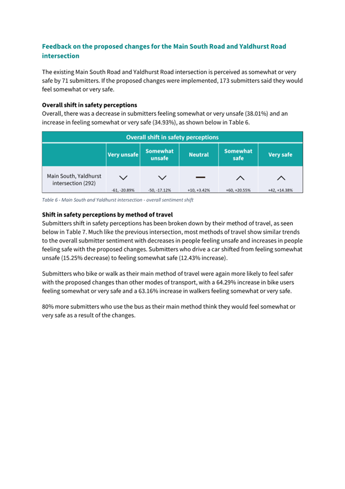
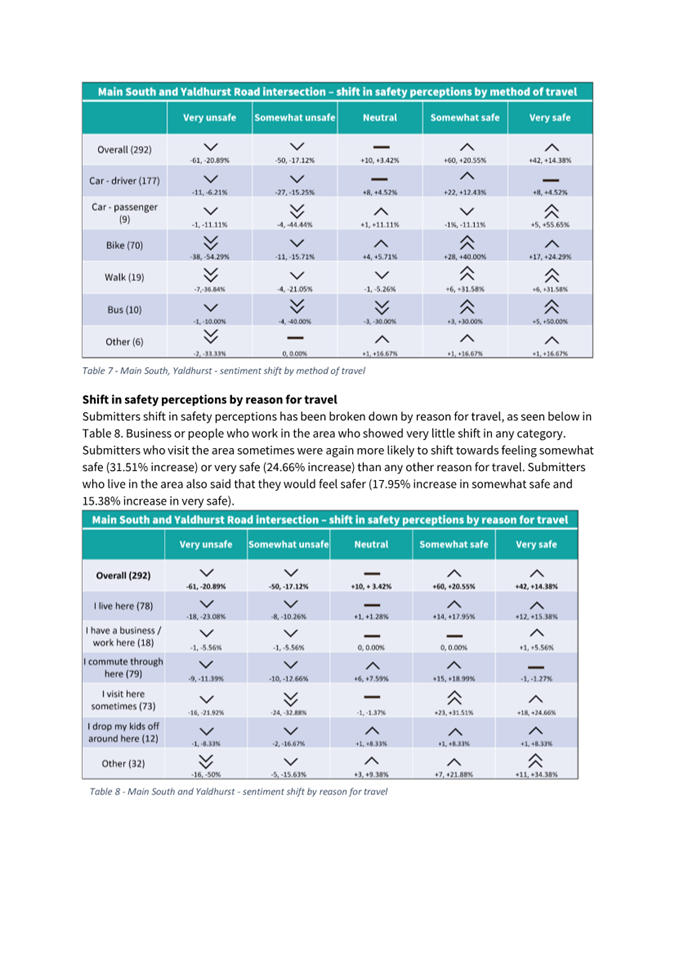
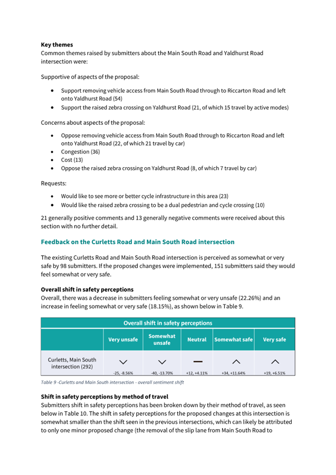
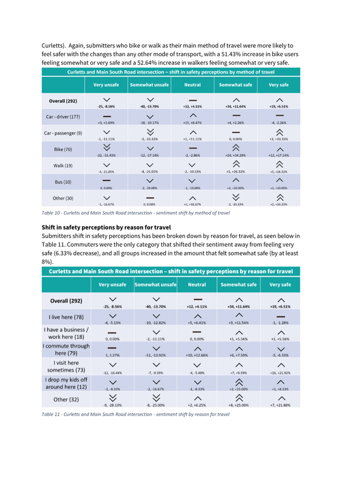
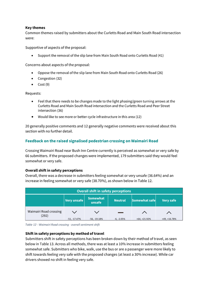
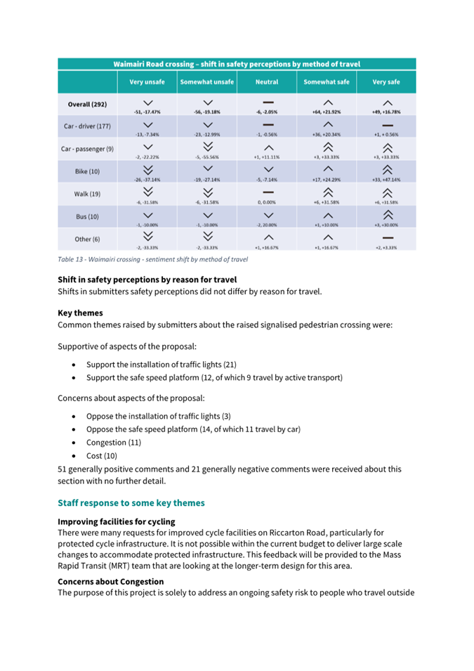
|
Waipuna Halswell-Hornby-Riccarton
Community Board
15 February 2024
|
|
|
9. Proposed Road Names - 47 Redmund
Spur Road
|
|
Reference / Te Tohutoro:
|
23/2017320
|
|
Report of / Te Pou Matua:
|
Sean
Ward, Team Leader Planning (Sean.Ward@ccc.govt.nz)
|
|
Senior Manager / Pouwhakarae:
|
John
Higgins, Head of Planning & Consents (John.Higgins@ccc.govt.nz)
|
1. Purpose of Report Te Pūtake
Pūrongo
1.1 The
purpose of this report is for the Waipuna Halswell-Hornby-Riccarton Community
Board to approve the proposed road names at 47 Redmund Spur Road, Hoon Hay Valley.
1.2 The report is staff generated resulting from a naming request
received from the developer.
2. Staff Recommendations / Ngā
Tūtohu
That the Waipuna
Halswell-Hornby-Riccarton Community Board:
1. Approves the following new road names for 47
Redmund Spur Road (RMA/2022/2804).
a. Road 1 - Aschwell Road
b. Lane 1 - Mokomoko Lane
3. Detail Te Whakamahuki
Introduction Te
Whakatkinga
3.1 A
road naming request has been submitted by the developer. A preferred name and
alternative names have been put forward for the road.
3.2 The
recommended road names have been checked against existing road names in
Christchurch and bordering districts, for duplication, alternative spelling, or
other similarities in spelling or pronunciation to avoid the potential for
confusion. The proposed names are considered sufficiently different to existing
road names.
3.3 The
recommended road names have been checked against the Council’s Naming
Policy dated 15 November 2023 and are considered to be consistent with this
policy except as outlined below. The specific criteria for assessing a name
from clause 2 is set out below.
3.3.1 A
traditional or Māori name which is acceptable to the Rūnanga or Iwi;
this may be a name reflecting the physical characteristics of an area, an
activity or event associated with the area or of a notable ancestor.
3.3.2 A
feature of historical, social, cultural, environmental or physical importance
in the area (e.g., Carlton Mill Road or Carlton Mill Reserve*).
3.3.3 The
name of a notable family, person or event associated with the locality or with
the wider Christchurch area.
3.3.4 A
name in recognition of a person’s service. This can be for community
service, conservation, sport, the arts, science and research or other sphere of
activity.
3.3.5 Consistency
with a common or established theme for naming in a subdivision or locality.
3.3.6 A
name that reflects the diverse cultures and communities of the locality or of
Christchurch generally.
3.3.7 The
name of an event or activity strongly associated with the immediate location
including an informal name for the area that is (or was historically) in common
usage.
3.3.8 A
name associated with a person, event or activity of significance to
Christchurch including names associated with people, events, or places of
national and international significance.
3.4 The
criteria for names that are not suitable for approval from clause 6 is set out
below.
3.4.1 Names
of people, flora, fauna or geographical features not associated with the area,
e.g., names of native trees which are not present in the area or views that
cannot be identified, except where the name continues a current naming theme in
the locality.
3.4.2 Currently
trading commercial organisations except for sponsorship names for facilities
and leased parks.
3.4.3 Anagrams,
amalgamations or derivatives of people's names.
3.4.4 Names
of living persons.
3.4.5 Names
related to the developer of a subdivision.
3.4.6 Name
of a person, club or organisation associated with a privately owned building on
Council land, where the club or organisation does not hold the ground lease for
the building.
3.4.7 Names
for roads which may cause confusion because they are associated with another
geographical location or feature e.g., Parklands Drive which is not located in
the Parklands suburb.
3.5 The
recommended road names have also been checked against the Australia and New
Zealand Standard AS/NZA 4819:2011 Rural and Urban Addressing. The names are
considered to be consistent with the Standard unless otherwise stated below.
3.6 Under
the Naming Policy, the names considered must be requested by the developer.
There is not an ability to consider alternative names without first checking
whether there are any duplications or similarities with other road and
right-of-way names.
3.7 Consultation
has been undertaken with Land Information New Zealand who have raised no
concerns with the proposed road names.
3.8 Consultation
under the policy with rūnanga is not required because none of the roads to
be named are collector roads and/or sites of significance under the District
Plan (clause 3 of the Naming Policy).
3.9 No
addresses of neighbouring properties are affected by the proposed road naming
(clause 12.2 of the Naming Policy).
1.1 The
names requested have been accompanied by an explanation of the background to
the names, which is summarised below, along with correspondence with the
applicant.
Assessment of Significance and
Engagement Te Aromatawai Whakahirahira
3.10 The
decision in this report is of low significance in relation to the Christchurch
City Council’s Significance and Enagement Policy.
1.2 The
level of significance was determined by the number of people affected and/or
with an interest.
3.11 Council’s
Principal Advisor Treaty Relationships has been consulted and has raised no
concerns with the suitability of the proposed Te Reo Māori names set out
below.
3.12 Due
to the assessment of low significance, no further community engagement and
consultation is required.
Proposed Names
3.13 The
proposed roads are shown in Attachment A.
3.14 The
names are themed for historical owners and the natural environment.
3.15 Road
1 - Aschwell Road
3.16 For
Gerrit van Asch and Inez van Asch nee McDowell. The property has been under the
management and/or ownership of the van Asch family since 1926. Gerrit van Asch
took up a farm lease in that year. Gerrit’s wife’s maiden name was
McDowell.
3.17 Lane
1 - Mokomoko Lane
3.18 Mokomoko
is a te reo Māori general word for lizard, skink, gecko. Lizard habitat
has been identified near to the property and in many areas of the Port Hills.
Alternative Names
3.19 Korihi
Road/Lane - Korihi is a te reo Māori word for bird song.
3.20 Turikōkā
Road/Lane - New Zealand wind grass, Lachnagrostis filiformis, is
present on the farmland adjacent to the site.
3.21 Quail
Road/Lane - Quail are present on the farmland adjacent to the site. The New
Zealand quail was the only quail endemic to New Zealand and was extinct by
around 1875. New Zealand now has three species of quail; california, brown and
bobwhite, all introduced into New Zealand in the late 1800’s primarily
for game hunting.
3.22 Officers
Note: If any alternative names are chosen, the appropriate road type will be
used.
Assessment of Names
3.23 The
above names are considered to be consistent with the policy, except for
“Aschwell” is in relation to the developer’s family (clause
3.4.5 above).
3.24 Notwithstanding,
the discretion lies with the Community Board to approve any of the above name
options, including the alternative names.
Attachments Ngā Tāpirihanga
|
No.
|
Title
|
Reference
|
Page
|
|
a ⇩
|
RMA/2022/2804 - Proposed Road Names
Plan - 47 Redmund Spur Road
|
23/1272939
|
743
|
Confirmation of Statutory
Compliance Te Whakatūturutanga ā-Ture
|
Compliance with Statutory Decision-making
Requirements (ss 76 - 81 Local Government Act 2002).
(a) This report contains:
(i) sufficient information about all reasonably practicable
options identified and assessed in terms of their advantages and
disadvantages; and
(ii) adequate consideration of the views and preferences of
affected and interested persons bearing in mind any proposed or previous
community engagement.
(b) The information reflects the level of significance of the
matters covered by the report, as determined in accordance with the Council's
significance and engagement policy.
|
Signatories Ngā Kaiwaitohu
|
Authors
|
Leashelle
Miller - Planning Technician
Sean Ward -
Team Leader Planning
|
|
Approved By
|
John Higgins -
Head of Planning & Consents
|
|
Waipuna Halswell-Hornby-Riccarton
Community Board
15 February 2024
|
|
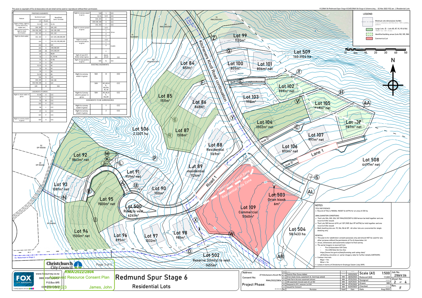
|
Waipuna Halswell-Hornby-Riccarton
Community Board
15 February 2024
|
|
|
10. Waka Kotahi Roading Improvements 206R Halswell
Road (SH75) - Temporary Licence to Occupy and Purchase of Land
|
|
Reference / Te Tohutoro:
|
23/1340173
|
|
Report of / Te Pou Matua:
|
Colin
Windleborn, Property Consultant colin.windleborn@ccc.govt.nz
|
|
Senior Manager / Pouwhakarae:
|
Bruce
Rendall, Head of City Growth & Property (bruce.rendall@ccc.govt.nz)
|
1. Purpose and Origin of Report Te Pūtake Pūrongo
1.1 This report seeks consent for temporary occupation of
council land in order to construct a footpath and cycleway and a recommendation
to the Council for the sale of approximately 956m2 of Council land.
1.2 This report is staff initiated in response to a request
from Waka Kotahi who are undertaking improvements to Halswell Road(SH25) which
require temporary occupancy of council land and minor land purchases.
1.3 The
decision in this report of low significance in relation to the Christchurch
City Council’s Significance and Engagement Policy. The level of
significance was determined by considering the licence is temporary with the
land required minor, with a greater public benefit being achieved with the
improvement in the transport corridor for cyclists, motorists and bus movement.
1.4 Officers
recognise that the recommendations for this report are complicated due to the
two different naming conventions used in the Crown’s request. The
Board can be assured that the cross referencing has been undertaken and the
parcels match.
2. Officer Recommendations Ngā
Tūtohu
That the Waipuna
Halswell-Hornby-Riccarton Community Board:
1. Supports the Crown – Waka Kotahi’s
project for improvements to Halswell Road between Dunbars Road and Augustine
Drive, which provides for construction of a footpath and cycleway along with
any required lighting to Councils standard as indicated on the plan shown in
the agreement, through resolving the following:
2. Resolves to grant temporary occupation of that
part of the Land B and Land D (shown labelled “F” &
“K” on the Plan contained in the Draft Memorandum of Agreement
attached to the report on the meeting agenda), being an area of approximately
511 square metres to allow the formation of a footpath to be vested in the
Council upon completion.
3. Notes that:
a. Due to the mutual benefit, there is no
consideration for the temporary occupation.
b. The Head of Transport has signed off the
report on the meeting agenda indicating that they will accept the new footpath.
4. Grants delegated authority to the Property
Consultancy Manager to do all things necessary and make all decisions at his
sole discretion to conclude negotiations to finalise the terms of a temporary
licence agreement with Waka Kotahi, including the signing of any associated
documentation to implement the temporary licence agreement and to protect the
Council’s interests.
5. Recommends to the Council that it resolves to:
a. Transfer to the Crown the “Required
Land” under section 50 of the Public Works Act. The Required Land being
that part of the Land A, Land C and Land E (shown labelled
“E”,”H”, “I” & “J” on the
Plan contained in the Draft Memorandum of Agreement attached to the report on
the meeting agenda), being an area of approximately 956 square metres, subject
to final survey and for the consideration of $83,130.43 plus Good and Services
Tax (if any) with any adjustments made on a pro rata per metre rate if the area
of land is increased.
b. Note that this Required Land will be declared
road and vested in the Crown pursuant to section 114 of the Public Works Act
1981.
c. Grant delegated authority to the Property
Consultancy Manager, to do all things necessary and make all decisions at his
sole discretion to conclude negotiations to finalise the terms of a sale
agreement with Waka Kotahi including the signing of any associated documentation
to implement the sale of land and to protect the Council’s interests.
3. Reason for Report Recommendations Ngā Take mō te
Whakatau
3.1 Waka
Kotahi have approached Council for the purchase of land and temporary
occupation of land for the construction of a footpath and cycleway as part of
their improvement programme on Halswell Road (SH75) located between Dunbars
Road and Augustine Drive.
4. Alternative Options Considered Ētahi atu Kōwhiringa
4.1 Decline
the sale of the land and Temporary Licence – Not recommended.
4.2 Advantage
of the discounted option: There will no change to land ownership in the short
term or possibly at all. The agreement is voluntary and Waka Kotahi has
the ability to compulsorily acquire the land if they wished.
4.3 Disadvantage
of the discounted option: The community will miss out on the new infrastructure
(footpath and cycleway). Council will not receive the agreed compensation
estimated at $83,130.43 plus GST (if any).
5. Detail Te Whakamahuki
5.1 Waka
Kotahi is undertaking improvements to Halswell Road (SH 75) between Dunbars Road and Augustine Drive to improve their
roading network. This work is to commence in the first quarter of 2024 and be
completed by the fourth quarter of 2024.
5.2 The
Council land which is the subject of this report is only a part of the project
between Dunbars Road and Augustine Drive, and other aspects of the project will
also involve private land. There are a number of small portions of council land
required to facilitate the project. These are either required to be transferred
to the Crown or occupied temporarily.
5.3 Temporary
Occupation Land: This work will involve the construction of a footpath and
cycleway on Council land shown as ‘F’ 342m2 and ‘K’ 170
m2 on Plan SKT-UC-0010 Schedule C of agreement with F being Fee
simple land and K being Local Purpose (Drainage) Reserve held under the
Reserves Act 1977.With these assets being vested in Council at the conclusion
of the project.
5.4 Required
Land: The purchase of land shown in Schedule C and D of the agreement being.
a. 57m2
of land shown as ‘J’ for roading which is fee simple land,
b. 812 m2 of
land shown as ‘E’ and ‘H’ for roading which is Local
Purpose (Drainage)
Reserve
held under the Reserves Act 1977,
c. 87 m2 of
land shown as ‘I’ for roading which is Local Purpose (Drainage)
Reserve held under the Reserves Act 1977.
5.5 The
compensation valuation in the agreement was undertaken by an independent valuer
agreed to by both Waka Kotahi and Christchurch City Council.
5.6 If
the Community Board and Council agree to the request for temporary occupation,
and sale of approximately 956m2 of land Waka Kotahi will be required
to meet the requirements of the Reserves Act 1977.
5.7 The
proposed footpath and cycleway, and the change of ownership, will not have any
long-term negative impacts on the community or the function of the land.
There may be short term disruptions during construction, however, these will be
managed. Detailed designed plans will be reviewed prior to
construction to confirm this.
5.8 The decision affects the following wards/Community Board areas:
5.8.1 Waipuna
Halswell-Hornby-Riccarton Community Board.
6. Policy Framework Implications Ngā Hīraunga ā- Kaupapa here
Strategic
AlignmentTe Rautaki Tīaroaro
6.1 This report supports the Council's
Long Term Plan (2021 - 2031):
6.2 Transport
6.2.1 Activity: Transport
· Level of Service: 16.0.2 Improve roadway
condition, to an appropriate national standard, measured by smooth travel
exposure (STE) - >=75% of the sealed local road network meets the
appropriate national standard
· Level of Service: 16.0.9 Improve resident
satisfaction with footpath condition - >=41% resident satisfaction
Policy
Consistency Te Whai
Kaupapa here
6.3 The
decision is consistent with Council’s Plans and
Policies.
Impact
on Mana Whenua Ngā
Whai Take Mana Whenua
6.4 The
decision does not involve a significant decision in
relation to ancestral land or a body of water or other elements of intrinsic
value, therefore this decision does not specifically
impact Mana Whenua, their culture, and traditions.
6.5 The
decision does not involve a matter of interest to Mana
Whenua and will not impact on our agreed partnership priorities with Ngā Papatipu Rūnanga.
6.6 Waka Kotahi have consulted with all parities with respect to the
project and the requirement to vary the designation which has been approved by
Council.
Climate
Change Impact Considerations Ngā Whai Whakaaro mā te Āhuarangi
6.7 The decisions in this report are likely to:
6.7.1 Contribute
positively to adaptation to the impacts of climate
change.
6.7.2 Contribute
positively to emissions reductions.
6.8 Provision
of an improved cycleway/walkway at no cost to Council along with roading
improvements will impact emissions reductions and adaptation
to the impacts of climate through improved transport utilisation of the roading
network.
Accessibility
Considerations Ngā
Whai Whakaaro mā te Hunga Hauā
6.9 A new footpath and cycleway will improve an all-weather connection
between Dunbars Road Meeking Place and Halswell Road (SH 75).
7. Resource Implications Ngā Hīraunga Rauemi
Capex/Opex Ngā Utu Whakahaere
7.1 Cost
to Implement – Waka Kotahi will be covering all the costs to implement
the project.
7.2 Maintenance/Ongoing
costs – Eventually there will be maintenance costs for the
footpath/cycleway which will be met from operational budgets. Given the
footpath, cycle way is only 512m2, it is considered a minor
maintenance cost given the overall length of paths in Christchurch City. The
increase will be able to be planned for in future financial planning rounds.
Other He mea anō
7.3 N/A
8. Legal Implications Ngā Hīraunga ā-Ture
Statutory power to undertake proposals in the report
Te Manatū Whakahaere Kaupapa
8.1 Waka
Kotahi is undertaking all the statutory obligations under the Public Works Act
1981, Reserves Act 1977, Resource Management Act 1991 and Local Government Act
2002. Including the consultation requirements of those statutes as they relate
to the various land parcels.
8.2 As
Council is the owner/territorial authority in which the land is situated Waka
Kotahi needs Christchurch City Council’s consent to proceed with any land
dealings.
8.3 The
report and agreement with Waka Kotahi have been reviewed by Council’s
Legal Team.
Other Legal Implications Ētahi atu
Hīraunga-ā-Ture
8.4 There
is no legal context, issue, or implication relevant to this decision for
Council apart from the project has required Waka Kotahi to obtain an alteration
to the existing designation which has been granted with a copy of the decision
attached.
9. Risk Management Implications Ngā Hīraunga Tūraru
9.1 There
is minimal risk to Council as this report is authorising sale of land and
occupation of Council land on a temporary basis.
Attachments Ngā Tāpirihanga
|
No.
|
Title
|
Reference
|
Page
|
|
a ⇩
|
Draft
Agreement with Waka kotahi
|
23/1405881
|
750
|
|
b ⇩
|
Halswell Road
Land
|
23/1356061
|
767
|
|
c ⇩
|
Decision
Letter Alteration to designation
|
23/1355823
|
769
|
In addition to the attached documents, the following background
information is available:
|
Document
Name – Location / File Link
|
|
Not
applicable
|
Confirmation of Statutory
Compliance Te Whakatūturutanga ā-Ture
|
Compliance with Statutory Decision-making
Requirements (ss 76 - 81 Local Government Act 2002).
(a) This report contains:
(i) sufficient information about all reasonably practicable
options identified and assessed in terms of their advantages and
disadvantages; and
(ii) adequate consideration of the views and preferences of
affected and interested persons bearing in mind any proposed or previous
community engagement.
(b) The information reflects the level of significance of the
matters covered by the report, as determined in accordance with the Council's
significance and engagement policy.
|
Signatories Ngā Kaiwaitohu
|
Author
|
Colin
Windleborn - Property Consultant
|
|
Approved By
|
Angus Smith - Manager
Property Consultancy
Lynette Ellis
- Head of Transport & Waste Management
Bruce Rendall
- Head of City Growth & Property
|
|
Waipuna Halswell-Hornby-Riccarton
Community Board
15 February 2024
|
|
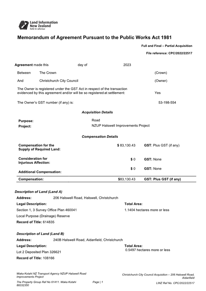
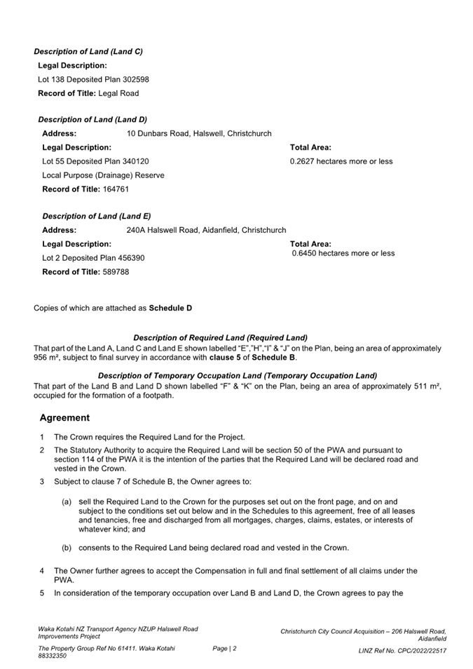
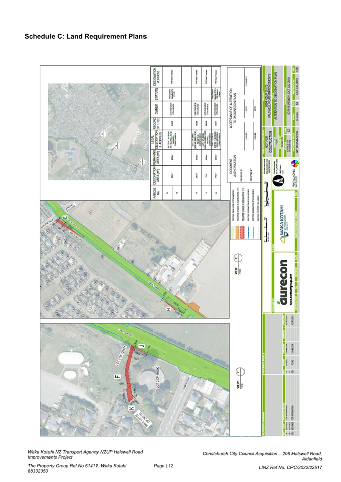
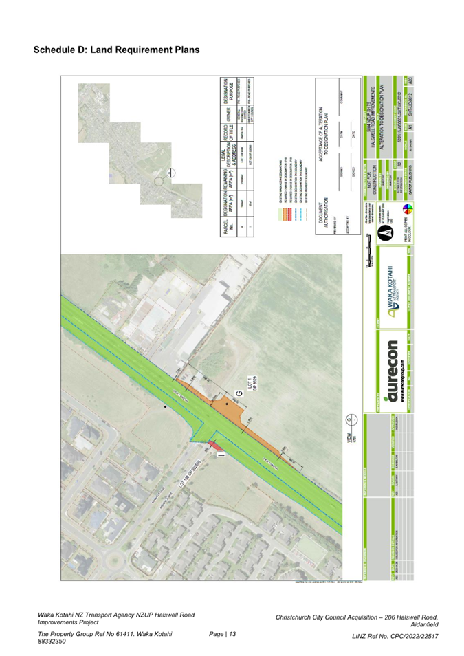
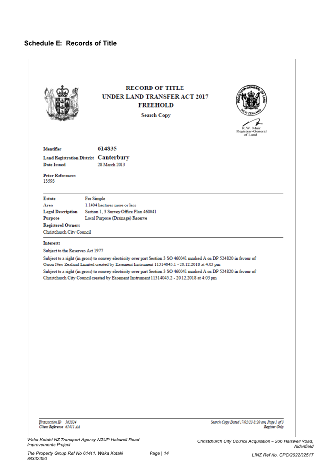
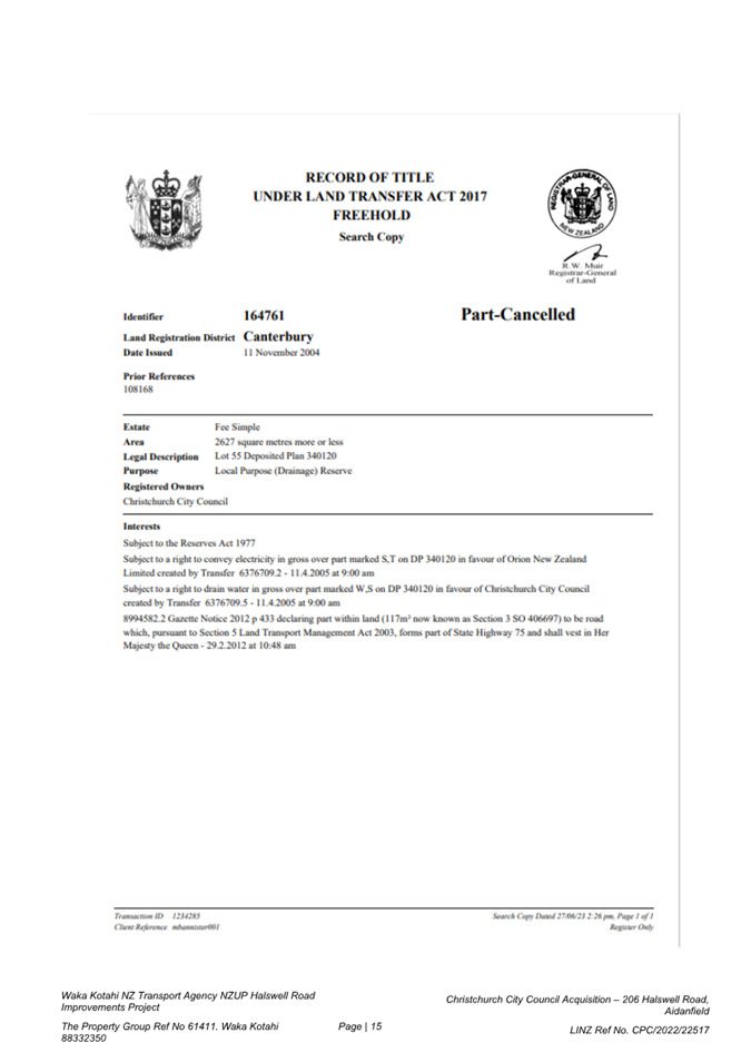
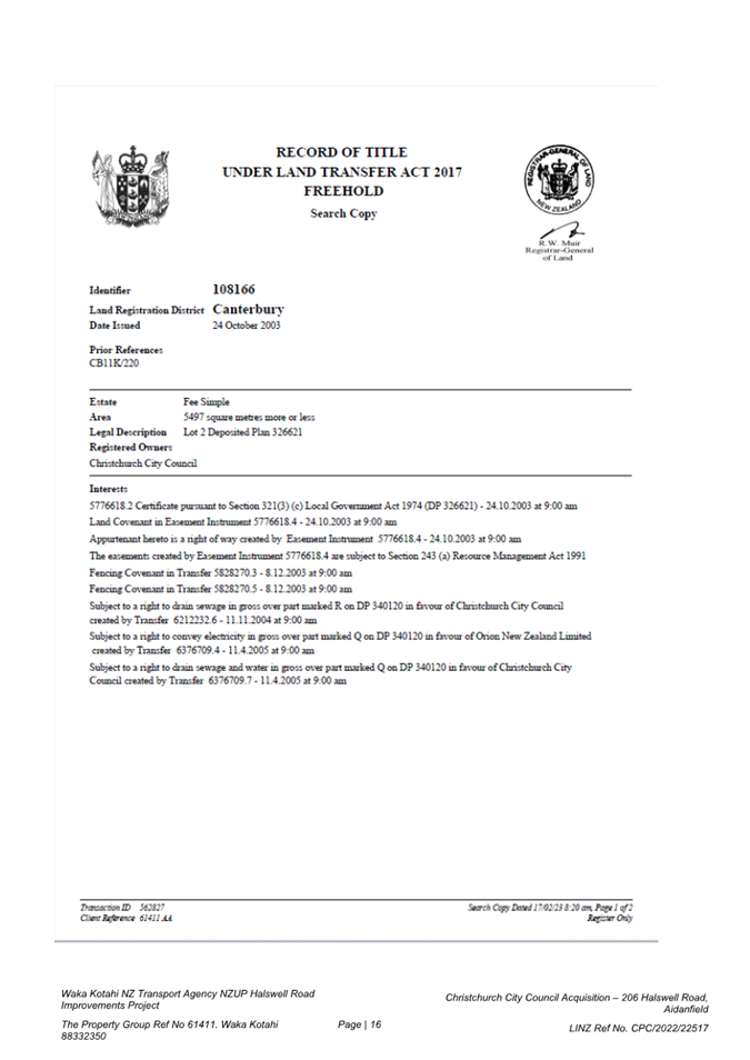
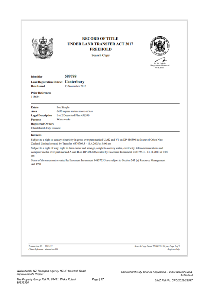
|
Waipuna Halswell-Hornby-Riccarton
Community Board
15 February 2024
|
|
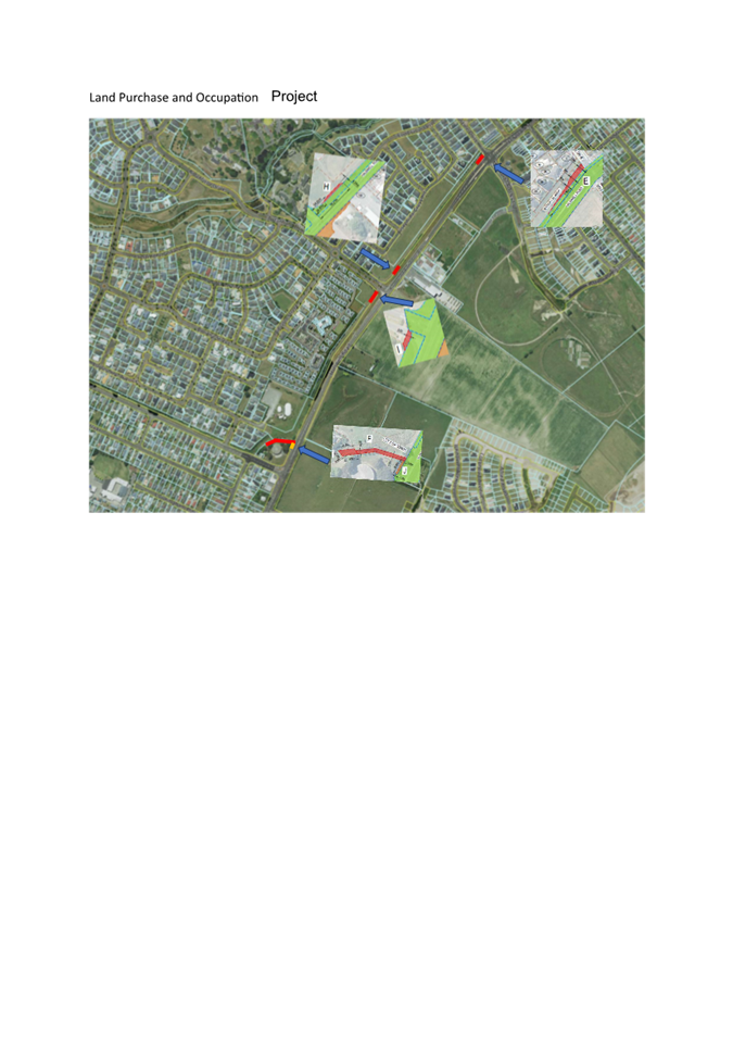
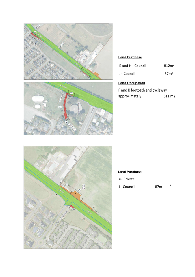
|
Waipuna Halswell-Hornby-Riccarton
Community Board
15 February 2024
|
|
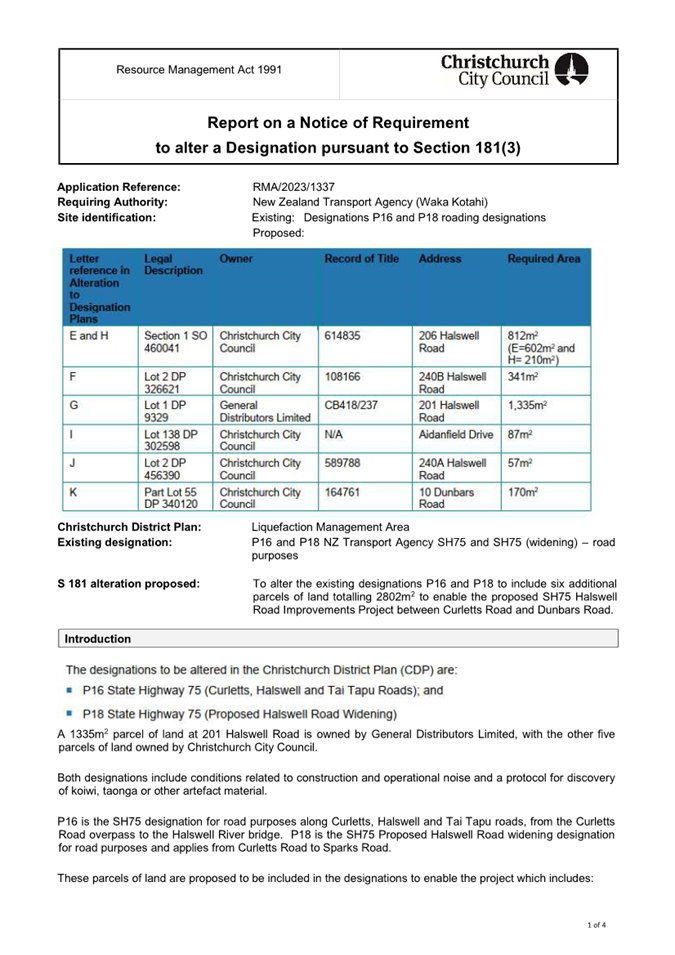
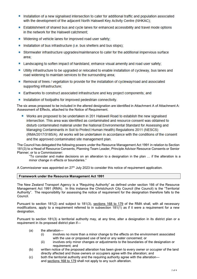
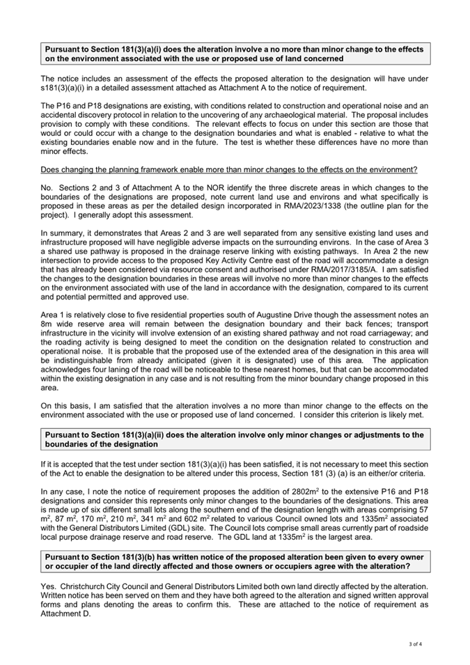
|
Waipuna Halswell-Hornby-Riccarton
Community Board
15 February 2024
|
|
|
11. Keri Place
- Proposed No Stopping Restrictions
|
|
Reference Te Tohutoro:
|
23/2002846
|
|
Report of Te Pou Matua:
|
Edwin
Tiong, Traffic Engineer
edwin.tiong@ccc.govt.nz
|
|
Senior Leader Pouwhakarae:
|
Jane
Parfitt, Interim General Manager Infrastructure, Planning & Regulatory
Services, (Jane.Parfitt@ccc.govt.nz)
|
1. Purpose of the Report Te Pūtake Pūrongo
1.1 For
the Waipuna Halswell-Hornby-Riccarton Community Board to consider options to
improve access along Keri Place. This report has been written following
concerns raised about the function of the street by residents, due to its very
narrow width.
1.2 The
decisions in this report are of low significance in relation to the
Christchurch City Council’s Significance and Engagement Policy. The level
of significance was determined by the low level of impact and low number of
people affected by the recommended decision.
1.3 The
community engagement and consultation outlined in this report reflect the
assessment.
1.4 The
recommended option is to Install No Stopping restrictions in accordance with
Attachment A.
2. Staff Recommendations / Ngā Tūtohu
That the Waipuna
Halswell-Hornby-Riccarton Community Board:
1. Approves that in accordance with Clause 7 of the Christchurch City
Council Traffic and Parking Bylaw 2017, the stopping of vehicles be prohibited
at any time on:
a. the north side of Keri Place commencing at its intersection with Hei
Hei Road and extending in an easterly direction for a distance of 63.5 metres.
b. the east side of Keri Place commencing at a point 103.5 metres south
of its intersection with Hei Hei Road and extending along the kerb line in a
southerly and then northerly direction for a distance of 24.0 metres.
2. Revokes any previous resolutions pertaining to traffic controls made
pursuant to any bylaw to the extent that they are in conflict with the traffic
controls described in 1.
3. Approves that these resolutions take effect when parking signage
and/or road marking that evidence the restrictions described in 1. And 2. are
in place (or removed in the case of revocations).
3. Reason for Report Recommendations Ngā Take mō te Whakatau
3.1 Keri Place is a narrow, two-way, cul-de-sac local street,
approximately 6 metre wide. One local resident has identified/raised that
access to the street and/or driveways can be compromised when vehicles are
parked on both sides of the street, particularly when they park close to each
other. This is particularly relevant to access for larger vehicles, such as
emergency vehicles and refuge trucks.
3.2 Implementing
the No Stopping restrictions in accordance with Attachment A will improve
safety by allowing improved access for larger vehicles (i.e. emergency
vehicles) and will improve the driveway access for residents.
4. Alternative Options Considered Ētahi atu Kōwhiringa
4.1 Maintain
the status quo – do nothing
4.2 The
advantages of this option include:
4.2.1 Retaining current
on-street parking spaces arrangement. It is likely to be approximately 10
parking spaces available within the street.
4.2.2 Does not displace
parking to other locations.
4.3 The
disadvantages of the option include:
4.3.1 Potentially
restricting through access of large vehicles, including emergency vehicles,
when vehicles are parked on both sides of Keri Place.
4.3.2 Does not address the
issues residents are having with access to and from their driveways caused by
the current parking provisions and demand.
5. Detail Te Whakamahuki
5.1 Keri
Place is classified as a Local Road in the Councils Road Classification System.
These roads function almost entirely for access purposes and are not intended
to act as through routes.
5.2 With
the current on-street parking arrangement, vehicles are not able to park
opposite side of the road as they need space for traffic to pass through.
Therefore, the no stopping restrictions provide better parking arrangement
without compromising the parking spaces within the street.
5.3 The street is within walking proximity to Wycola Park and
St Bernadette’s School. Parking demands in the street are
generally low, and mainly for visitors. Most residents do have long driveways
so that they can park within their properties.
5.4 Construction
of South Express cycleway major cycle route on Hei Hei Road has recently been
complete, removing most of the parking on the east side of Hei Hei Road and is
shown as an overlay on Attachment A
5.5 The
current speed limit on Hei Hei Road and Keri Place is 50 km/h. A 30 kilometre
speed limit for both streets has been approved by Council through the Interim
Speed Management Plan.
5.6 The
Christchurch Suburban Parking Policy (2019) Policy 10
provides guidance for reviewing the allocation of parking in circumstances
where the street is less than seven metres wide and there are recognised
parking issues “If the carriageway of a street is less than 7 metres
in width and there are known access problems (i.e. there are limited places for
vehicles to pass and/or emergency access may be compromised), Council will
propose to remove parking on one side of the street.” There is a link
to the Suburban Parking Policy in Section 6.4 of this report.
5.7 Narrow
streets can also lead to issues with people parking on the footpath and berms
to make room on the carriageway. This can degrade pedestrian accessibility,
safety and amenity of the street.
5.8 When removing parking on one side of a street, engineering best
practice is to alternate the parking from one side to another. This has a
traffic calming effect on speed which is especially desirable along our
neighbourhood streets. However, due to the short length of this street, the
alternate parking arrangement was not proposed.
5.9 There
have been no reported crashes on Keri Place in the last five years. This street
has no risk classification under Council’s high risk intersection mapping
system.
5.10 Approval is
required by the Waipuna Halswell-Hornby-Riccarton Community Board.
5.11 If approved, the
recommendations will be implemented within the current financial year
(generally around four weeks after the contractor receives the request, but
this is subject to other factors such as resourcing and prioritisation beyond
Council’s control).
Community Views and Preferences
5.12 A consultation
letter and plan showing the proposal was sent to 15 affected property owners
and residents. The first consultation plan is shown in Attachment B. The
original proposal was to install No Stopping restrictions on the north side of
Keri Place up to the driveway of property No.9.
5.13 One property
owner objected the proposal because there is not enough on-street parking in
the street. She stated that the new cycle lane has halved the parking on Hei
Hei Road. When St Bernadettes church services are on, they get multiple
cars in the street. Residents usually place rubbish bins in a row outside
property No.11, car parks outside No.7 and 9 would not impede the rubbish truck
being able to manoeuvre the cul-de-sac.
5.14 Taking into
account residents’ comments, staff amended the proposal to that shown in
Attachment A. This included removing the section of No Stopping restrictions previously
proposed outside property No.7 and 9. Residents were informed by letter of the
subsequent changes to our initial consultation, which included a plan of the
updated proposals. We received one response from the previous submitter who
expressed her gratitude for considering her opinions and supported the new
proposal.
5.15 The Team Leader
Parking Compliance supports the recommended option (Attachment A).
6. Policy
Framework Implications Ngā Hīraunga ā- Kaupapa
here
Strategic Alignment Te Rautaki
Tīaroaro
6.1 Council’s
strategic priorities have been considered in formulating the recommendations in
this report, however this area of work is not specifically covered by an
identified priority.
6.2 This report supports the Council's
Long Term Plan (2021 - 2031):
6.3 Transport
6.3.1 Activity:
Transport
· Level
of Service: 10.3.3 Maintain customer perception of the ease of use of Council
on- street parking facilities - >=50% resident satisfaction
Policy Consistency Te Whai Kaupapa here
6.4 The
recommendations in this report are consistent with the Christchurch
Suburban Parking Policy.
Impact on Mana Whenua Ngā Whai Take Mana Whenua
6.5 The
effects of this proposal upon Mana Whenua are expected to be insignificant.
Climate Change Impact Considerations Ngā Whai Whakaaro mā te
Āhuarangi
6.6 This
proposal does not have any significant effect upon carbon emissions and Climate
Change.
Accessibility Considerations Ngā Whai Whakaaro mā te Hunga
Hauā
6.7 This
proposal improves accessibility for pedestrians/drivers/cyclists, by providing
a safer means of accessing Keri Place and residents properties.
7. Resource Implications Ngā Hīraunga Rauemi
Capex/Opex Ngā Utu Whakahaere
7.1 Cost
to Implement - approximately $800 for the new road markings and $750 for
producing the report.
7.2 Maintenance/Ongoing
costs - approximately $200 a year.
7.3 Funding
Source - Traffic Operations Signs and Markings budget (installation)/existing
Transport maintenance budgets for ongoing maintenance.
Other
7.4 None
identified.
8. Legal Implications Ngā Hīraunga ā-Ture
Statutory power to undertake proposals in
the report Te Manatū Whakahaere Kaupapa
8.1 Part
1, Clauses 7 of the Christchurch City Council Traffic and Parking Bylaw 2017
provides Council with the authority to install parking restrictions by
resolution.
8.2 The
Community Boards have delegated authority from the Council to exercise the
delegations as set out in the Register of Delegations. The list of
delegations for the Community Boards includes the resolution of stopping
restrictions and traffic control devices.
8.3 The installation of any signs and/or markings associated with
traffic control devices must comply with the Land Transport Rule: Traffic
Control Devices 2004.
Other Legal Implications Ētahi atu
Hīraunga-ā-Ture
8.4 There
is no other legal context, issue or implication relevant to this decision.
8.5 This
specific report has not been reviewed and approved by the Legal Services Unit
however the report has been written using a general approach previously
approved of by the Legal Services Unit, and the recommendations are consistent
with the policy and legislative framework outlined in sections 8.1 – 8.3.
9. Risk Management Implications Ngā Hīraunga Tūraru
9.1 Not
applicable.
Attachments Ngā Tāpirihanga
|
No.
|
Title
|
Reference
|
Page
|
|
a ⇩
|
Keri Place
Proposed No Stopping Restrictions drawing tg146831 For Board Approval
|
23/2002753
|
778
|
|
b ⇩
|
Keri Place
Proposed No Stopping Restrictions drawing tg146831 Original Proposal
|
23/2002795
|
779
|
In addition to the attached documents, the following background
information is available:
|
Document
Name – Location / File Link
|
|
Not
applicable
|
Confirmation of Statutory
Compliance Te Whakatūturutanga ā-Ture
|
Compliance with Statutory Decision-making
Requirements (ss 76 - 81 Local Government Act 2002).
(a) This report contains:
(i) sufficient information about all reasonably practicable
options identified and assessed in terms of their advantages and
disadvantages; and
(ii) adequate consideration of the views and preferences of
affected and interested persons bearing in mind any proposed or previous
community engagement.
(b) The information reflects the level of significance of the
matters covered by the report, as determined in accordance with the Council's
significance and engagement policy.
|
Signatories Ngā Kaiwaitohu
|
Author
|
Edwin Tiong -
Traffic Engineer
|
|
Approved By
|
Katie Smith -
Team Leader Traffic Operations
Stephen Wright
- Manager Operations (Transport)
|
|
Waipuna Halswell-Hornby-Riccarton
Community Board
15 February 2024
|
|
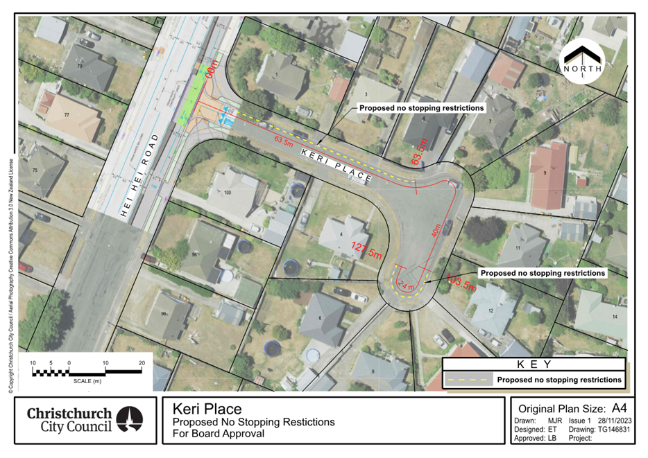
|
Waipuna Halswell-Hornby-Riccarton
Community Board
15 February 2024
|
|
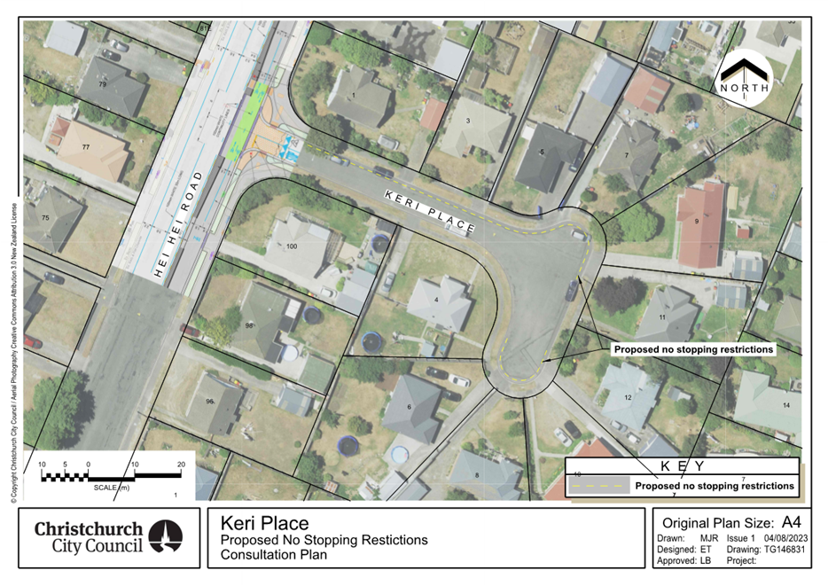
|
Waipuna Halswell-Hornby-Riccarton
Community Board
15 February 2024
|
|
|
12. Halswell Hornby Riccarton Discretionary
Response Fund Application - Halswell Community Project Inc and Youth
Development Fund Transfer
|
|
Reference / Te Tohutoro:
|
24/122546
|
|
Report of / Te Pou Matua:
|
Bailey
Peterson, Community Development Advisor (bailey.peterson@ccc.govt.nz)
|
|
Senior Manager / Pouwhakarae:
|
Andrew
Rutledge, Acting General Manager Citizens and Community
(Andrew.Rutledge@ccc.govt.nz)
|
1. Purpose of Report Te Pūtake
Pūrongo
1.1 The
purpose of this report is for the Waipuna Halswell-Hornby-Riccarton Community
Board to consider an application for funding from its 2023-24 Discretionary Response Fund from the organisation listed below.
1.2 Approval is also sought to transfer $1,500 from the 2023-24
Discretionary Response Fund to the 2023-24 Youth Development Fund.
|
Funding Request Number
|
Organisation
|
Project Name
|
Amount Requested
|
Amount Recommended
|
|
00066930
|
Halswell Community
Project Inc
|
Halswell Hub
Dishwasher
|
$853
|
$853
|
1.3 There is currently a balance of $27,372 remaining in the fund.
2. Staff Recommendations / Ngā
Tūtohu
That the Waipuna
Halswell-Hornby-Riccarton Community Board:
1. Approves a grant of $853 from its 2023-24
Discretionary Response Fund to Halswell Community Project Inc towards the
Halswell Hub Dishwasher.
2. Approves the transfer of $1,500 from the
Halswell-Hornby-Riccarton 2023-24 Discretionary Response Fund to the
Halswell-Hornby-Riccarton 2023-24 Youth Development Fund.
3. Key Points Ngā Take Matua
Strategic Alignment Te Rautaki Tīaroaro
3.1 The
recommendations above are aligned to the Council's Strategic Framework and in
particular the strategic priorities of a Collaborative and Confident City and A
Cultural Powerhouse City. The projects also align with the Te Haumako Te
Whitingia Strengthening Communities Together Strategy.
Decision Making Authority Te Mana Whakatau
3.2 The
Community Board has the delegated authority to determine the allocation of the
Discretionary Response Fund for each community.
3.2.1 Allocations
must be consistent with any policies, standards or criteria adopted by the
Council.
3.2.2 The
Fund does not cover:
· Legal
challenges or Environment Court challenges against the Council, Council
Controlled organisations or Community Board decisions
· Projects or
initiatives that change the scope of a Council project or that will lead to
ongoing operational costs to the Council (though Community Boards can recommend
to the Council that it consider a grant for this purpose).
Assessment of Significance and Engagement Te Aromatawai Whakahirahira
3.3 The decisions in this report are of low significance in relation to
the Christchurch City Council’s Significance and Engagement Policy.
3.4 The level of significance was determined by the number of people
affected and/or with an interest.
3.5 Due to the assessment of low significance, no further community
engagement and consultation is required.
Discussion Kōrerorero
3.6 At the time of writing, the balance of the 2023-24 Discretionary
Response Fund is as below.
|
Total Budget 2023/24
|
Granted To Date
|
Available for allocation
|
Balance If Staff Recommendation adopted
|
|
$136,030
|
$108,658
|
$27,372
|
$25,019
|
3.7 Based
on the current Discretionary Response Fund criteria, the applications listed
above are eligible for funding.
3.8 The
attached Decision Matrix provides detailed information for the
applications. This includes organisational details, project details,
financial information and a staff assessment.
Attachments Ngā Tāpirihanga
|
No.
|
Title
|
Reference
|
Page
|
|
a ⇩
|
Halswell-Hornby-Riccarton
Discretionary Response Fund Applications - Halswell Community Project Inc and
Youth Development Fund Transfer
|
24/148381
|
784
|
Confirmation of Statutory
Compliance Te Whakatūturutanga ā-Ture
|
Compliance with Statutory Decision-making
Requirements (ss 76 - 81 Local Government Act 2002).
(a) This report contains:
(i) sufficient information about all reasonably practicable
options identified and assessed in terms of their advantages and
disadvantages; and
(ii) adequate consideration of the views and preferences of
affected and interested persons bearing in mind any proposed or previous
community engagement.
(b) The information reflects the level of significance of the
matters covered by the report, as determined in accordance with the Council's
significance and engagement policy.
|
Signatories Ngā Kaiwaitohu
|
Author
|
Bailey
Peterson - Community Development Advisor
|
|
Approved By
|
Jess Garrett -
Manager Community Governance, Halswell Hornby Riccarton
|
|
Waipuna Halswell-Hornby-Riccarton
Community Board
15 February 2024
|
|
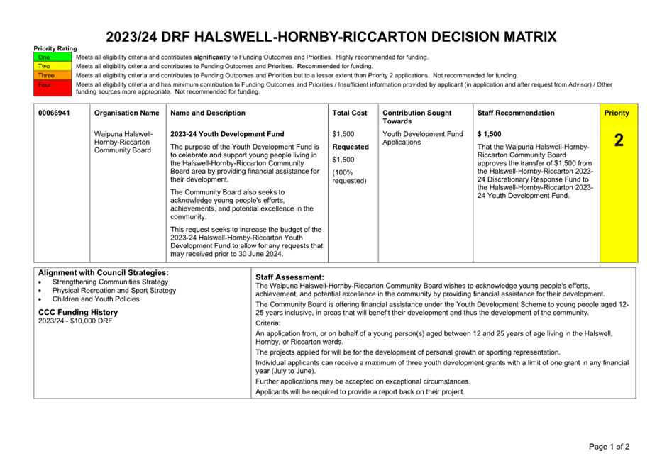
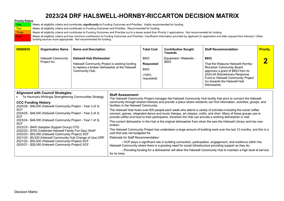
|
Waipuna Halswell-Hornby-Riccarton
Community Board
15 February 2024
|
|
|
13. Waipuna Halswell-Hornby-Riccarton Community
Board Area Report - February 2024
|
|
Reference / Te Tohutoro:
|
23/1964915
|
|
Report of / Te Pou Matua:
|
Jessica
Garrett, Community Governance Manager,
jessica.garrett@ccc.govt.nz
|
|
Senior Manager / Pouwhakarae:
|
Andrew
Rutledge, Acting General Manager Citizens and Community
(Andrew.Rutledge@ccc.govt.nz)
|
1. Purpose of Report Te
Pūtake Pūrongo
This report provides the Board with an overview on
initiatives and issues current within the Community Board area.
2. Officer Recommendations Ngā
Tūtohu
That the Waipuna
Halswell-Hornby-Riccarton Community Board:
1. Receives the Waipuna Halswell-Hornby-Riccarton
Community Board Area Report for February 2024.
3. Community Support, Governance and Partnership Activity
3.1 Community Governance Projects
|
Activity
|
Detail
|
Timeline
|
Strategic Alignment
|
|
Culture Galore
|
Culture Galore is a multicultural festival that celebrates
our city’s diversity with food, music and dance performances, and arts
and crafts from more than 35 cultures who call Christchurch home.
 This year
Culture Galore will be held from 12pm to 4pm, on Saturday 17 February at Ray
Blank Park on Maidstone Road. This year
Culture Galore will be held from 12pm to 4pm, on Saturday 17 February at Ray
Blank Park on Maidstone Road.
|
17 February 2024
|
Resilient Communities
Strengthening Communities Strategy
|
|
Community Pride Garden Awards 2024
|
Judging for the Community Pride Garden Awards 2024 took
place in January and February.
The awards encourage civic pride, acknowledging those who
have contributed to maintaining the image of Christchurch as the Garden City
by beautifying their streets and gardens.
|
Ongoing
|
Strengthening Communities Strategy
|
|
Community Service and Youth Service
Awards 2024
|
Nominations for the Community Service and
Youth Service Awards 2024 will open from 1 March and close on 31 March 2024.
Community Service Awards are given to
individuals and groups in recognition of significant voluntary service.
More information is available at www.ccc.govt.nz/csa
|
Ongoing
|
Strengthening Communities Strategy
|
3.2 Connect
Connect is a free community event that provides an
opportunity for Riccarton locals, old and new to connect over fun games,
activities and food. It is also an opportunity for local community groups to
meet and connect with the community. The event will be held at Harrington Park,
Friday 23rd February between 3-5 pm. In previous years the event has
been held on a Saturday afternoon, this year it will be held on a Friday
evening to try and capture a different audience.
3.3 Hello
Hornby
Hello Hornby is an annual community event
that celebrates Hornby. There will be community groups, stall holders, food
vendors and performances for the whole family to enjoy. This year's event is on
Saturday 9th March at Wycola Park from 12pm till 3pm.

3.4 Wycola
Hoops
Youth Cultural Development (YCD) is
organising a series of hoops events across the city called House of Hoops. On
Sunday 10th March from 12pm, there will be a hoops event at Wycola
Park as a part of this series. The local Gators basketball club, Youth Town and
some other local groups will support the event.
3.5 Riccarton
Sports Hub Holiday Festival
The annual Riccarton Sports Hub Holiday Festival took
place on Wednesday 24th and Thursday 25th January. Both days had 91 tamariki
from the Riccarton and surrounding areas. The five sports codes involved were
cricket, tennis, basketball, ultimate Frisbee and football.
3.6 Carols
event 126 on the Corner & opening of the new kitchen
126 on the Corner hosted its annual
Community Christmas Carol Service on 15 December 2023. A BBQ was held for the
community to enjoy and after the Carol service the opening of the new Kitchen
and Toilet facilities upgrade was held.
3.7 Riccarton
Community Garden and Pātaka Trust Christmas Lunch
The Riccarton Community Garden and
Pātaka Trust held a Christmas Lunch on 15 December to acknowledge and
celebrate its volunteers and supporters. Attendees enjoyed a pleasant afternoon
and a delicious lunch which included vegetables from the community garden.
The garden and pātaka are run by a
dedicated team of volunteers who donate their time to support food security
within their community.
3.8 Greater
Hornby Residents’ Association Christmas Fun Day
Another successful Christmas Fun Day,
organised by the Greater Hornby Residents’ Association, was held on 9
December 2023 at Gilberthorpe School. The event was well attended by the wider
local community who were able to enjoy an array of fun activities,
entertainment, food and market vendors and a visit from Santa Claus.

3.9 Children's
Day
Children’s Day is being held on Sunday 3rd March
11am-3pm at Cuthberts Green.
Children’s
Day 2024 is a FREE community event which is about celebrating children. The day
is about having fun, learning and gaining information. More importantly,
parents and caregivers don’t have to say NO, as all activities are free.
The aim is to create an environment to provide moments of joy and fun to
families that might not necessarily be able to have moments like this often.
Approximately 15,000 people are expected to attend over the 4 hours.

3.10 Halswell
Community Patrol
A Halswell Community Patrol is in the
process of getting set up, becoming a formalised organisation, and recruiting
volunteers. The Halswell Community Patrol is a voluntary organisation that
supports maintaining a safe Halswell community. Volunteers need to have a full
driver's licence and be able to commit approximately 5 hours per month. Full
training for the role will be given.
3.11 Community
Funding Summary
3.11.1 For
information, a summary is provided on the status of the Board's 2023-24 funding
as at January 2024 (refer Attachment A).
3.11.2 Funding
Accountability Report
The Halswell-Hornby-Riccarton funding
accountability report for the 2022-2023 Strengthening Communities Fund is
attached (refer Attachment B).
3.11.3 Youth Development Fund – Under authority delegated by the Community
Board the following allocation was made in January 2024:
· $350 to New Brighton
Surf Life Saving Club towards Caitlin Knudsen participating in the Trans-Tasman
Surf Boat Challenge to be held in Melbourne, Australia.
Courtney Smith
Youth Development Fund recipient,
Courtney Smith competed at the Pan Continental Curling Championships 2023 in
Kelowna, Canada. From this competition the New Zealand team qualified for the
Women’s Curling World Championships 2024 which will be held in Nova
Scotia, Canada in March.
Courtney is appreciative of the
Board’s support and continues to train for upcoming competitions,
including the Curling World Championships 2024 which will be held in Sweden and
has a goal of competing at the 2026 Winter Olympics in Italy.

3.11.4 Off the
Ground Fund
Carols, Chaos and Kai event
A group of Oakland community member
decided to organise a community Christmas event at Scott Park as an opportunity
for local people to meet each other in a relaxed setting. Invitations were
delivered to houses immediately surrounding the park and attendees enjoyed a
sausage sizzle, outdoor games (including jenga and basketball) and sang
traditional Christmas carols.
3.11.5 Summer with
your neighbours
Summer with your neighbours is well
underway with a number of events being held in the Board area. Attendees have
enjoyed BBQ lunches, a potato growing competition, a game of bowls, outdoor
games along with community conversations being held and new connections
established.
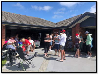
Summer with your neighbours event held
on Garforth Green, Halswell
3.12 Participation
in and Contribution to Decision Making
3.12.1 Report back
on other Activities contributing to Community Board Plan [for items not
included in the above table but are included in Community Board Plan]
· Huritini
Student Council Pool Party Activations
The Huritini Council supported the Summer
Splash Pool Party event at Te Hāpua on Saturday 13 January. The students
provided games for event, cooked and gave away 450 sausages, and did some
engagement on what other events and activities young people would like to see
in Halswell. When the students meet again in Term One 2024 they will collate
all the information and share it with the community.
Youth and Cultural Development were
invited by the Huritini Council to attend the event and they provided a DJ, MC
and Barbering for the participants.
Included at the event was an outdoor
movie screening and Manu competition.
The Te Hāpua pool facility was at
capacity for much of the event.
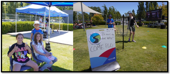
· Riccarton -
Tactile Pavers Installation
Staff have advised that installation of
the new tactile pavers in Riccarton as part of the Christchurch Regeneration
Acceleration Facility (CRAF) package of works has started. The new pavers are
being installed on all Riccarton Road intersections between Matipo Street and
Balgay Street, one of the busier pedestrian areas in Riccarton. This will
ensure that the majority of intersections on Riccarton Road are safe for all
pedestrians crossing at these locations and contributes to Community Board Plan
priority to Support initiatives that provide for social cohesion, community
connectedness and safety in the Riccarton Ward.
The work is expected to take
approximately four weeks to complete the and staff will provide another update
once works are finished.
· Kennedy's
Bush Neighbourhood Group Christmas Event
The Kennedys Bush Neighbourhood Gorup
hosted their annual Christmas Party event in December. The event had
approximately 80 people in attendance and provided a great afternoon for the
neighbourhood to connect with one another and share games and kai.
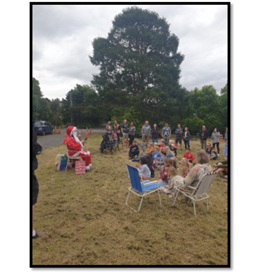
3.12.2 Council
Engagement and Consultation.
· Tree
Planting Plans
Tree Planting Plans were open for
feedback from 15 December 2023 to 1 February 2024 which included Tree Plans for
Bishops Green, Harrington Park, Fanshaw Reserve, Marcella Reserve and Runnymede
Reserve.
4. Advice Provided to the Community Board Ngā Kupu Tohutohu ka
hoatu ki te Poari Hapori
4.1 Matatiki
Hornby Centre
Community Board Members attended a site
visit to Matatiki Hornby Centre on Thursday 1 February 2024.


Construction update
There continues to be a large amount of
work occurring in the exterior spaces of the site. The remaining carpark spaces
to the south are being prepared for asphalt along with the hard landscaping
works to the north western courtyard. Planting within both stormwater basins
alongside Waterloo Road, and the carpark islands, are complete.
Within the building, there has been
significant progress in all areas. All pool liners have been installed,
pre-commissioning activities are underway, and the final preparations are being
made before beginning to fill the pools.
The Library wing is now substantially
complete with only minor works to be completed before to the final clean.
Library shelving has been erected and furniture installation is imminent. IT
workstreams are ramping up in preparation for the digital fitout.
Behind the scenes
Work on the programme development and
marketing workstreams are also progressing well, with the opening date to be
endorsed early February via the projects governance group. The date will then
be communicated to this forum, and then to the wider public.
The community continues to be updated as
the project progresses, with regular Newsline stories, e-newsletters, and
social media posts.
The manawhenua representative from
Whitiora is also working through the names that will be gifted to six spaces
within the facility. These include the Creative Activities Space, multi-purpose
room and the four publicly available meeting rooms. We will advise of these
names in the near future.
4.2 Ngā
Puna Wai Access Review
Staff have advised that an ‘access
review’ is currently being undertaken at Ngā Puna Wai to investigate
the parking challenges and consider short term and long term solutions.
Individual meetings are being undertaken
with neighbours, sports partners, event organisers and the NPW operations team
to identify the problems, when they occur, what the impacts are and then
consider short term and long term solutions.
A report will be completed once the
investigative discussions have taken place, to present the findings and
recommendations.
4.3 Pedestrian
Crossing Facility at Jones Road, Templeton
At its meeting on 10 August 2023 the Board
requested staff advice on the possible installation of a pedestrian crossing
facility on Jones Road, Templeton in the vicinity of Globe Bay Drive. Staff
have responded (see attachment C) advising that the scheme design for
the South Express Major Cycle Route allows for a pedestrian crossing facility
across Jones Road.
The scheme design was approved by the
Infrastructure, Transport and Environment Committee in July 2019 and traffic
resolutions for Section 1 of the cycleway route were approved by Council on 21
June 2023.
Delivery of this work is dependant on
additional funding being secured through the Long Term Plan. Subject to
the additional funding construction of the crossing facility will be
incorporated into the cycleway works scheduled for 2024.
4.4 Vehicle
speed on Murphys Road, Halswell
At its meeting on 15 June 2023 the Board
requested that staff investigate the speed of vehicles travelling on Murphys
Road, Halswell and provide advice on any measures needed to address this.
Staff have now advised that a variable 30
kilometres per hour speed limit has been approved for Murphys Rd in the
vicinity of Seven Oaks School. This was part of the Interim Speed Management
Plan, and is awaiting installation. A forthcoming traffic calming feature north
of Seven Oaks School and works at the Murphys/Quaifes intersection- being
installed as part of Subdivision works, are both anticipated to support lower
operating speeds in the vicinity. A repeat tube count was undertaken in
Murphys Road (Caulfield to Quaifes) which indicates vehicle speeds- both
average and 85%- have fallen by approximately 4 kilometres per hour in the last
two years. As there are some road users travelling at higher than desirable
speeds staff have contacted Hornby Police and asked that they consider this
site for enforcement if resources permit.
No further action is recommended at this
stage until after the traffic calming, intersection and variable speed limit
works are implemented.
4.5 Stop
signage - Jarnac Boulevard and John McKenzie Drive, Yaldhurst
At its meeting on 15 June 2023 the Board
requested staff advice on whether there is a current proposal to install stop
signage on Jarnac Boulevard and John McKenzie Drive where they intersect with
Millesimes Way.
Staff have responded advising that there
are no plans to install stop signage at the intersection of Jarnac
Boulevard/Millesimes Way. This intersection arrangement is consistent with the
treatments applied to the rest of this stage of the subdivision development and
reflects the treatments applied at Champagne Avenue and Charente Way –
all intersections show no recorded history of crashes suggesting that they
perform safely.
Millesimes Way is a low volume section of
road that predominantly serves access to a relatively small amount of houses
– it is not a through route and is likely to be used primarily by those
familiar with the arrangement.
There are several features that offer cues
to the driver that they are approaching an intersection including:
· Different surface
textures on the minor arm approach,
· Presence of broken
white lines delineating cycle way on Jarnac Boulevard,
· Presence of lighting
at the intersection,
· Obvious termination
of the road with buildings established opposite the minor arm of the
intersection,
Millesimes Way is constructed to the lower
range of complying road widths for an urban residential road suggesting that
approach speeds would be low with adequate time to acknowledge and react to the
intersection ahead.
Stop control signage is used when sight
distances are constrained, which is usually when the sight distance constraint
is outside of council control (such as an existing fence or embankment on
private land) and cannot be otherwise mitigated or removed. Millesimes Way does
not have such a constraint and meets visibility requirements therefore the
intersection does not meet the criteria for a Stop control.
4.6 Ishwar
Ganda Park Signs
The wording for signage at Ishwar Ganda
Park in Longhurst subdivision has now been finalised and the signage is ready
to be installed.
Some members will recall that towards the
end of the last term staff sought feedback from Board members on signage to be
installed at Ishwar Ganda Park in Longhurst subdivision. In particular they
wondered whether given that the park is named after a former Board member there
should be additional text to the standard name to acknowledge the person and
his community contribution.
The wording has now been finalised and
signage is ready to be installed.
The sign will read:
“Ishwar Ganda Park
Named after Ishwar Ganda Q.S.O who served
as a Paparua County and Hornby District Councillor, a respected long serving
Christchurch City Councillor and local community Board member, Ishwar was a
local entertainer, businessman and a leader in sporting and community
groups.”
4.7 Improvements
to rubbish disposal facilities at Halswell Domain and Te Kahu Park
At its 10 August 2023 meeting the Board
requested staff advice on the installation of additional smart rubbish bins at
Halswell Domain and investigate and advise on the improvement to the rubbish
bin located on Te Kahu Park, Wigram.
Staff have advised that New
‘smart’ bins are being rolled out across the city this summer, as
part of the Council’s bin rationalisation programme with busy community
parks, such as those used for sport, and open spaces like beach fronts are
being prioritised for new smart bins. Feedback from rangers, maintenance
contractors, and park users (only received one complaint about litter issues in
Halswell Domain has been received in the last six months) suggests that the
current number of litter bins at Halswell Domain is sufficient and the
installation of an additional bin there would be at the expense of another
park, which may require additional litter provision.
The Council asks that the community help
keep public places tidy and asks that if they can’t find a bin, they take
any rubbish home and put it in the appropriate kerbside collection wheelie bin,
so it is sent to the right place for processing. This system works well in
regional and national parks.
The need for additional bins will continue
to be monitored.
The litter bin at Te Kahu Park is an
older-style open-topped bin and is scheduled for replacement with a new, fully
enclosed Smart Bin as part of this summer’s roll out.
4.8 Franco
Road Vehicle Access
At its 29 March 2022 meeting the Board
requested staff to investigate vehicle access on Franco Road, Halswell and
provide advice on measures that can be taken to regulate parking where this is
impeding access.
Urban Field Rangers have attended this
road and cut back shrubs that were impeding the visibility on the road and near
the preschool.
4.9 Elsie
Street Parking
At its 14 September 2023 meeting the Board
requested staff advice on possible measures that can be implemented to deter
drivers from parking motor vehicles too close to driveways on Elsie Street,
Halswell, including parking ticks.
Staff have provided the attached memorandum in response
(see Attachment D).
The advice notes that installation of
parking ticks is considered in situations where there has been an ongoing
history of obstructed or blocked vehicle crossings, and where parking
enforcement action has been unsuccessful in resolving the issue. However,
parking ticks is not always successful in deterring the parking behaviour and
ongoing enforcement action may be required by Council Parking Compliance during
business hours, seven days a week, by Council Contractor outside of business
hours but excluding Public Holidays or by Police on Public Holidays.
Apart from an issue reported over
Show weekend no other requests for enforcement action with regard to Parking in
Elsie Street have been recorded in the Council’s System (HYBRIS).
Staff recommend that residents of Elsie
Street should continue to report instances of parked cars blocking driveways to
enable the relevant parking enforcement to respond. If enforcement does not
resolve the problem then parking ticks could be considered.
4.10 Dunbars
Road & Sabys Road – Pedestrian Improvements
At its 13 July 2023 meeting the Board
agreed to request staff to investigate and provide advice on safe pedestrian
access between Halswell School and Country Palms (Sabys Road) as well as
between Oaklands School and Aidanfield (Dunbars Road).
Staff have provided the attached memorandum in response
(see Attachment E). The advice identifies the issues for pedestrian
concerns on both Dunbars Road and Sabys Road and indicates that safety
improvement projects needed to address these are currently without an allocated
budget. It is noted that there are possible lower cost and shorter term
improvements identified which may be able to be progressed in the meantime
until capital works funding is available.
4.11 Graffiti
Snapshot
For the
Board’s information, attached is a Graffiti Snapshot, an update on
graffiti as of November 2023 (refer Attachment F).
4.12 Customer
Service Requests/Hybris Report
For the Board’s information,
attached is a copy of the November and December 2023 Hybris Reports (refer Attachment
G).
The report provides an overview of the
number of Customer Service Requests that have been received, including the
types of requests being received and a breakdown of how they are being
reported.
Attachments Ngā Tāpirihanga
|
No.
|
Title
|
Reference
|
Page
|
|
a ⇩
|
Waipuna
Halswell-Hornby-Riccarton Community Board Funding Update - January 2024
|
24/142132
|
800
|
|
b ⇩
|
2022-23
Halswell-Hornby-Riccarton Strengthening Communities Fund - End of Project
Report
|
24/98810
|
803
|
|
c ⇩
|
Internal or
External Memos Pedestrian Crossing Facility at Jones Road, Templeton
|
23/2001863
|
824
|
|
d ⇩
|
Staff
Memorandum - Elsie Street Parking
|
24/25025
|
825
|
|
e ⇩
|
Staff
Memorandum - Dunbars Road & Sabys Road - Pedestrian Improvements
|
24/25027
|
827
|
|
f ⇩
|
Graffiti
Snapshot - November 2023
|
24/141676
|
830
|
|
g ⇩
|
Halswell-Hornby-Riccarton
Hybris Reports - November and December 2023
|
24/104927
|
832
|
Signatories Ngā Kaiwaitohu
|
Authors
|
Noela Letufuga
- Support Officer
Sam Savage -
Community Recreation Advisor
Bailey
Peterson - Community Development Advisor
Marie Byrne -
Community Development Advisor
Hannah Martin
- Community Support & Events Coordinator
Faye Collins -
Community Board Advisor
Jess Garrett -
Manager Community Governance, Halswell Hornby Riccarton
|
|
Approved By
|
Jess Garrett -
Manager Community Governance, Halswell Hornby Riccarton
Matthew
McLintock - Manager Community Governance Team
John Filsell -
Head of Community Support and Partnerships
|
|
Waipuna Halswell-Hornby-Riccarton
Community Board
15 February 2024
|
|
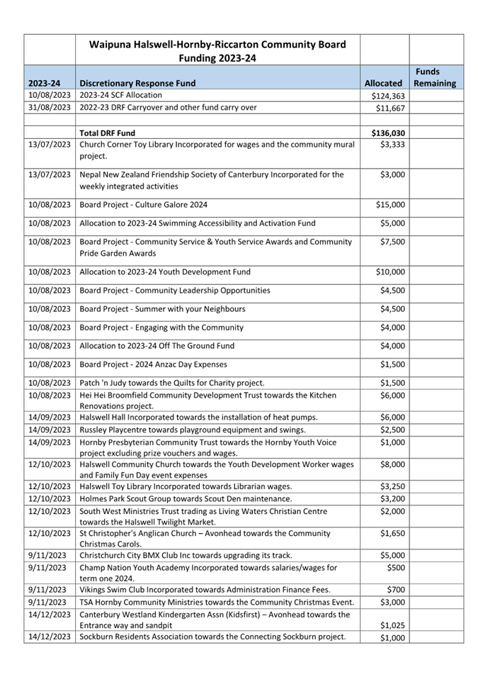
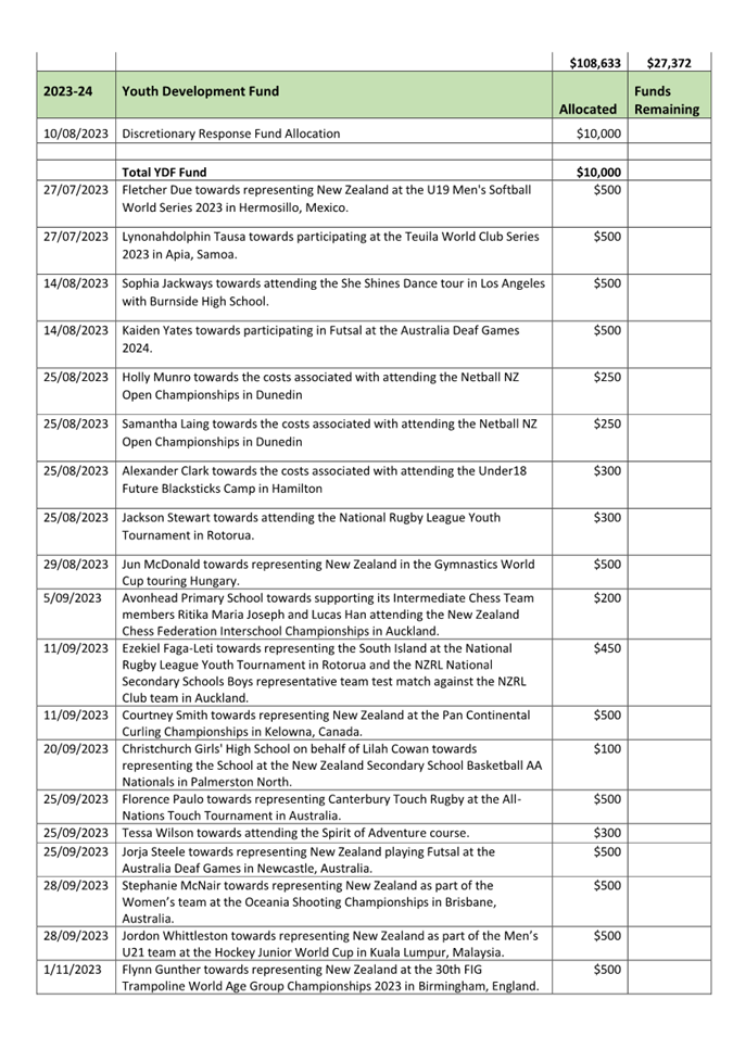
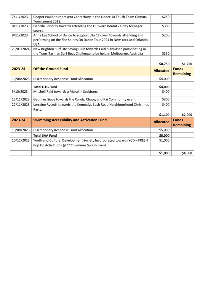
|
Waipuna Halswell-Hornby-Riccarton
Community Board
15 February 2024
|
|
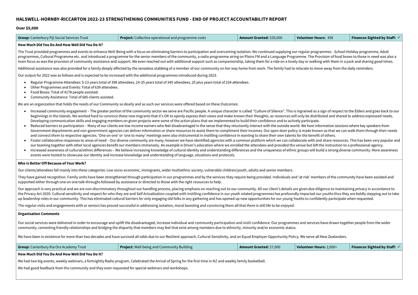
|
Waipuna Halswell-Hornby-Riccarton
Community Board
15 February 2024
|
|
|
Waipuna Halswell-Hornby-Riccarton
Community Board
15 February 2024
|
|
|
Waipuna Halswell-Hornby-Riccarton
Community Board
15 February 2024
|
|
|
Waipuna Halswell-Hornby-Riccarton
Community Board
15 February 2024
|
|

|
Waipuna Halswell-Hornby-Riccarton
Community Board
15 February 2024
|
|
|
Waipuna Halswell-Hornby-Riccarton
Community Board
15 February 2024
|
|
|
14. Elected
Members’ Information Exchange Te Whakawhiti Whakaaro o Te
Kāhui Amorangi
|
This item provides an opportunity for Board Members to
update each other on recent events and/or issues of relevance and interest to
the Board.
Karakia Whakamutunga
|
Unuhia, unuhia
Unuhia ki te uru tapu
nui
Kia wātea, kia
māmā, te ngākau,
Te tinana te wairua i
te ara takatā
Koia rā e Rongo,
whakairia ake ki runga
Kia tina! TINA! Hui e!
TĀIKI E!
|
Draw on, draw on,
Draw on the supreme sacredness
To clear, to free the heart, the body and the spirit of mankind
Rongo, suspended high above us (i.e. in ‘heaven’)
Draw together! Affirm!
|